Embed Size (px)
Citation preview
Sea-level changes and depositional environments in theI�zmit Gulf, eastern Marmara Sea, during the late
glacial^Holocene period
M.N. C agflatay a;�, N. Go«ru«r b, A. Polonia c, E. Demirbagfl a, M. Sak|nc a,M.-H. Cormier d, L. Capotondi c, C. McHugh d, Oº . Emre e, K. Eris a
a ITUº , MadenFaku«ltesi, Ayazagfla, 8062 Istanbul, Turkeyb ITUº , MadenFaku«ltesi and TUBITAK Marmara Research Centre, Gebze, Turkey
c Institute of Marine Geology, CNR, Bologna, Italyd Lamont-Doherty Earth Observatory, New York, NY, USA
e MTA Genel Mu«du«rlu«gflu«, Ankara, Turkey
Received 2 September 2002; received in revised form 29 April 2003; accepted 31 July 2003
Abstract
Offshore and onshore stratigraphic studies, together with high-resolution shallow seismic reflection profiling andmultibeam bathymetric mapping, were carried out in the western and central part of the I�zmit Gulf. These studiesindicate that the I�zmit Gulf was a lacustrine environment as part of the Marmara ‘Lake’ during the late glaciation andearly deglaciation until V12 kyr BP, when the Marmara Basin was inundated by the Mediterranean waters.Correlation of 14C-dated onshore and offshore stratigraphic units in the Western I�zmit Gulf indicates that generallycoarse late glacial sediments overlie a marked erosional surface formed during the low water level of the Marmara‘Lake’. These coarse sediments are succeeded by 10.4^7 kyr BP old transgressive, and by late Holocene post-transgression mud units. The bathymetry and sub-bottom Chirp profiles clearly show that the paleoshoreline of theGulf was located at 385 m, having been controlled by the bedrock sill depth of the C anakkale Strait. Anotherpaleoshoreline observed at 365 m on the northern margin of the Western I�zmit and Karamu«rsel basins was probablyformed during the Younger Dryas sea-level stillstand. The shelf areas during this time were colonized by bioherms,which were subsequently drowned and disappeared after a further rise of the sea level. The presence of a 365 mmarine paleoshoreline in the Karamu«rsel Basin indicates that the sill restricting this basin to the west was much deeperthan its present 355 m level and was located further south. The Go«lcu«k Basin, restricted by a 338 m sill to its west,was probably not flooded by marine waters until V9 kyr BP.D 2003 Published by Elsevier B.V.
Keywords: Marmara Sea; I�zmit Gulf; sea-level change; late glacial^Holocene; sediment cores; seismic pro¢ling
1. Introduction
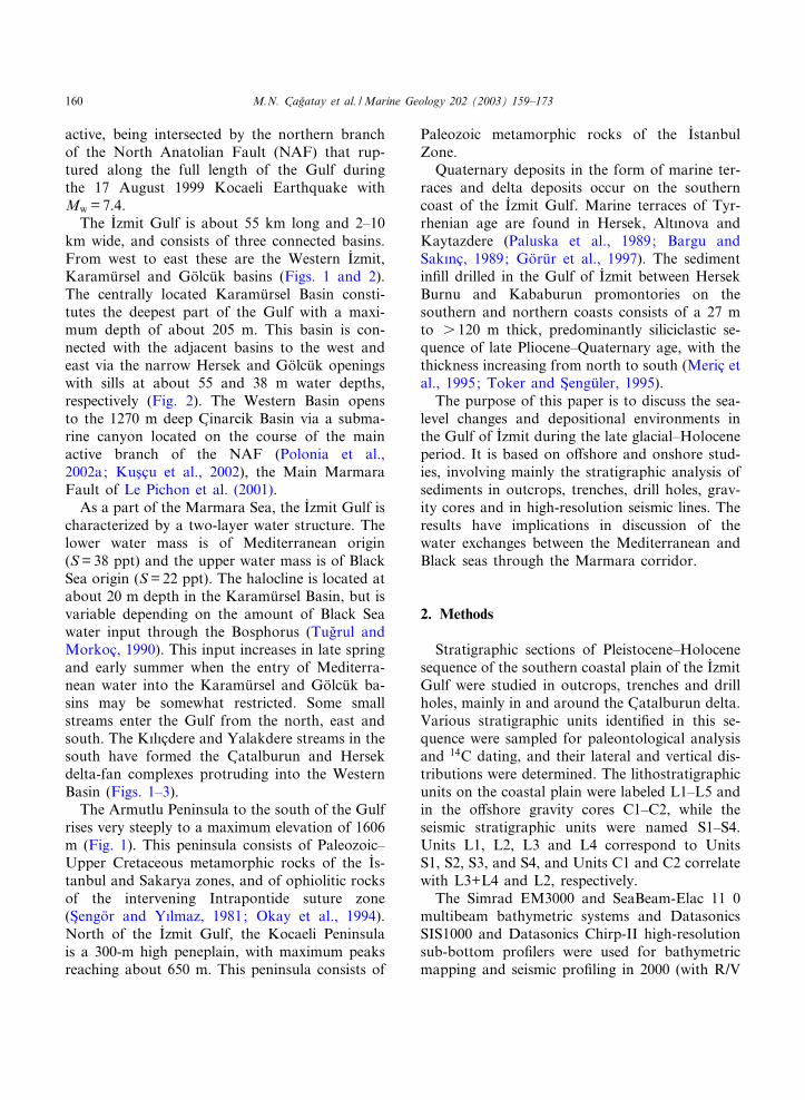
I�zmit Gulf is an E^W elongated inlet in the eastof the Marmara Sea (Fig. 1). It is tectonically
0025-3227 / 03 / $ ^ see front matter D 2003 Published by Elsevier B.V.doi:10.1016/S0025-3227(03)00259-7
* Corresponding author.E-mail address: [email protected] (M.N. C agflatay).
MARGO 3388 5-11-03 Cyaan Magenta Geel Zwart
Marine Geology 202 (2003) 159^173
R
Available online at www.sciencedirect.com
www.elsevier.com/locate/margeo
active, being intersected by the northern branchof the North Anatolian Fault (NAF) that rup-tured along the full length of the Gulf duringthe 17 August 1999 Kocaeli Earthquake withMw = 7.4.
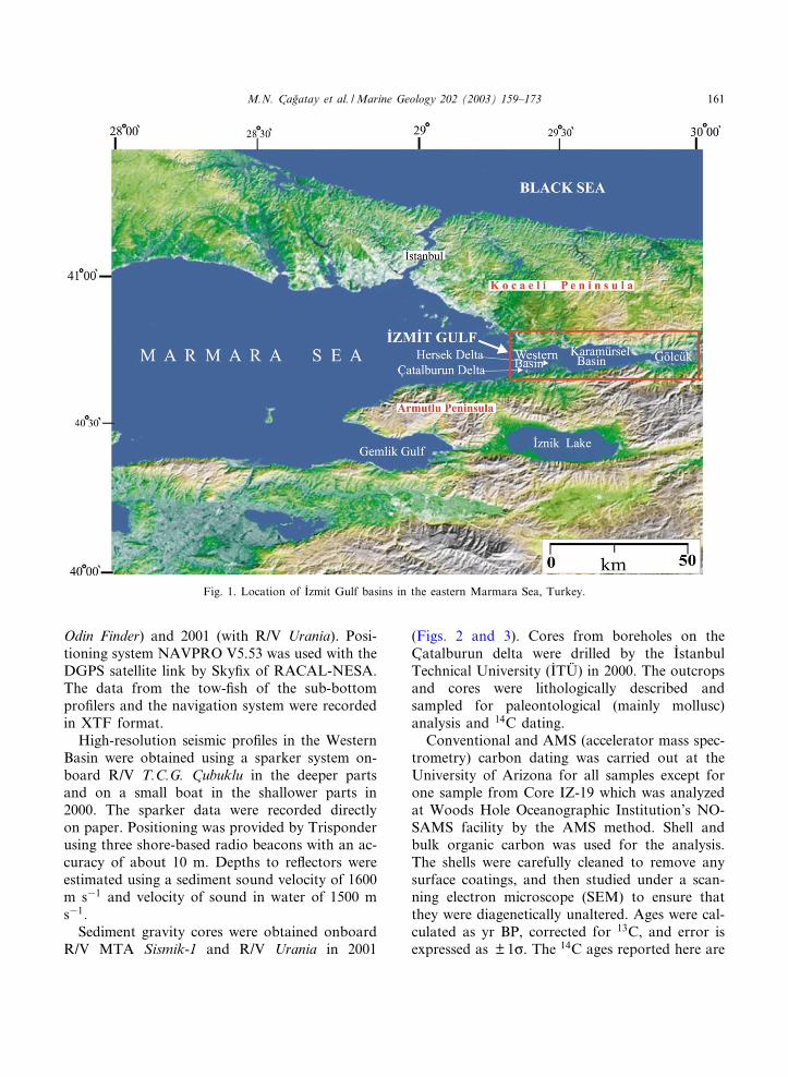
The I�zmit Gulf is about 55 km long and 2^10km wide, and consists of three connected basins.From west to east these are the Western I�zmit,Karamu«rsel and Go«lcu«k basins (Figs. 1 and 2).The centrally located Karamu«rsel Basin consti-tutes the deepest part of the Gulf with a maxi-mum depth of about 205 m. This basin is con-nected with the adjacent basins to the west andeast via the narrow Hersek and Go«lcu«k openingswith sills at about 55 and 38 m water depths,respectively (Fig. 2). The Western Basin opensto the 1270 m deep C inarcik Basin via a subma-rine canyon located on the course of the mainactive branch of the NAF (Polonia et al.,2002a; Kus c u et al., 2002), the Main MarmaraFault of Le Pichon et al. (2001).
As a part of the Marmara Sea, the I�zmit Gulf ischaracterized by a two-layer water structure. Thelower water mass is of Mediterranean origin(S= 38 ppt) and the upper water mass is of BlackSea origin (S= 22 ppt). The halocline is located atabout 20 m depth in the Karamu«rsel Basin, but isvariable depending on the amount of Black Seawater input through the Bosphorus (Tugflrul andMorkoc , 1990). This input increases in late springand early summer when the entry of Mediterra-nean water into the Karamu«rsel and Go«lcu«k ba-sins may be somewhat restricted. Some smallstreams enter the Gulf from the north, east andsouth. The K|l|c dere and Yalakdere streams in thesouth have formed the C atalburun and Hersekdelta-fan complexes protruding into the WesternBasin (Figs. 1^3).
The Armutlu Peninsula to the south of the Gulfrises very steeply to a maximum elevation of 1606m (Fig. 1). This peninsula consists of Paleozoic^Upper Cretaceous metamorphic rocks of the I�s-tanbul and Sakarya zones, and of ophiolitic rocksof the intervening Intrapontide suture zone(S engo«r and Y|lmaz, 1981; Okay et al., 1994).North of the I�zmit Gulf, the Kocaeli Peninsulais a 300-m high peneplain, with maximum peaksreaching about 650 m. This peninsula consists of
Paleozoic metamorphic rocks of the I�stanbulZone.
Quaternary deposits in the form of marine ter-races and delta deposits occur on the southerncoast of the I�zmit Gulf. Marine terraces of Tyr-rhenian age are found in Hersek, Alt|nova andKaytazdere (Paluska et al., 1989; Bargu andSak|nc , 1989; Go«ru«r et al., 1997). The sedimentin¢ll drilled in the Gulf of I�zmit between HersekBurnu and Kababurun promontories on thesouthern and northern coasts consists of a 27 mto s 120 m thick, predominantly siliciclastic se-quence of late Pliocene^Quaternary age, with thethickness increasing from north to south (Meric etal., 1995; Toker and S engu«ler, 1995).
The purpose of this paper is to discuss the sea-level changes and depositional environments inthe Gulf of I�zmit during the late glacial^Holoceneperiod. It is based on o¡shore and onshore stud-ies, involving mainly the stratigraphic analysis ofsediments in outcrops, trenches, drill holes, grav-ity cores and in high-resolution seismic lines. Theresults have implications in discussion of thewater exchanges between the Mediterranean andBlack seas through the Marmara corridor.
2. Methods
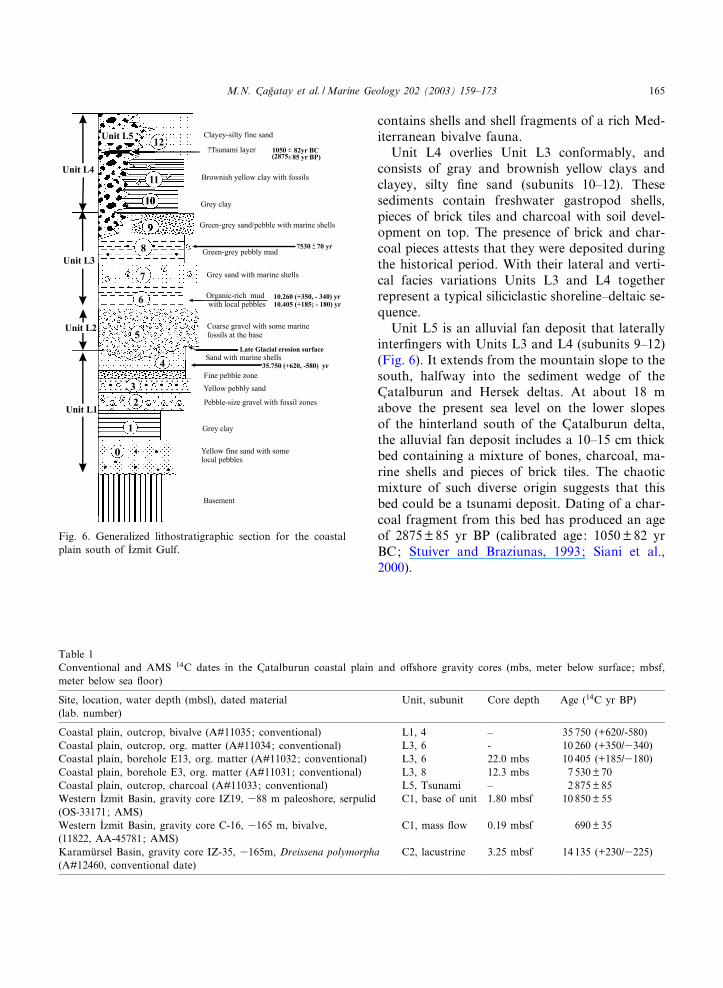
Stratigraphic sections of Pleistocene^Holocenesequence of the southern coastal plain of the I�zmitGulf were studied in outcrops, trenches and drillholes, mainly in and around the C atalburun delta.Various stratigraphic units identi¢ed in this se-quence were sampled for paleontological analysisand 14C dating, and their lateral and vertical dis-tributions were determined. The lithostratigraphicunits on the coastal plain were labeled L1^L5 andin the o¡shore gravity cores C1^C2, while theseismic stratigraphic units were named S1^S4.Units L1, L2, L3 and L4 correspond to UnitsS1, S2, S3, and S4, and Units C1 and C2 correlatewith L3+L4 and L2, respectively.
The Simrad EM3000 and SeaBeam-Elac 11 0multibeam bathymetric systems and DatasonicsSIS1000 and Datasonics Chirp-II high-resolutionsub-bottom pro¢lers were used for bathymetricmapping and seismic pro¢ling in 2000 (with R/V
MARGO 3388 5-11-03 Cyaan Magenta Geel Zwart
M.N. C agflatay et al. /Marine Geology 202 (2003) 159^173160
Odin Finder) and 2001 (with R/V Urania). Posi-tioning system NAVPRO V5.53 was used with theDGPS satellite link by Sky¢x of RACAL-NESA.The data from the tow-¢sh of the sub-bottompro¢lers and the navigation system were recordedin XTF format.
High-resolution seismic pro¢les in the WesternBasin were obtained using a sparker system on-board R/V T.C.G. C ubuklu in the deeper partsand on a small boat in the shallower parts in2000. The sparker data were recorded directlyon paper. Positioning was provided by Trisponderusing three shore-based radio beacons with an ac-curacy of about 10 m. Depths to re£ectors wereestimated using a sediment sound velocity of 1600m s31 and velocity of sound in water of 1500 ms31.
Sediment gravity cores were obtained onboardR/V MTA Sismik-1 and R/V Urania in 2001
(Figs. 2 and 3). Cores from boreholes on theC atalburun delta were drilled by the I�stanbulTechnical University (I�TUº ) in 2000. The outcropsand cores were lithologically described andsampled for paleontological (mainly mollusc)analysis and 14C dating.
Conventional and AMS (accelerator mass spec-trometry) carbon dating was carried out at theUniversity of Arizona for all samples except forone sample from Core IZ-19 which was analyzedat Woods Hole Oceanographic Institution’s NO-SAMS facility by the AMS method. Shell andbulk organic carbon was used for the analysis.The shells were carefully cleaned to remove anysurface coatings, and then studied under a scan-ning electron microscope (SEM) to ensure thatthey were diagenetically unaltered. Ages were cal-culated as yr BP, corrected for 13C, and error isexpressed as Y 1c. The 14C ages reported here are
Fig. 1. Location of I�zmit Gulf basins in the eastern Marmara Sea, Turkey.
MARGO 3388 5-11-03 Cyaan Magenta Geel Zwart
M.N. C agflatay et al. /Marine Geology 202 (2003) 159^173 161
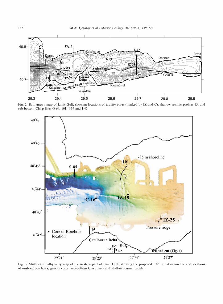
Fig. 3. Multibeam bathymetry map of the western part of I�zmit Gulf, showing the proposed 385 m paleoshoreline and locationsof onshore boreholes, gravity cores, sub-bottom Chirp lines and shallow seismic pro¢le.
Fig. 2. Bathymetry map of I�zmit Gulf, showing locations of gravity cores (marked by IZ and C), shallow seismic pro¢les 15, andsub-bottom Chirp lines O-64, 101, I-19 and I-42.
MARGO 3388 5-11-03 Cyaan Magenta Geel Zwart
M.N. C agflatay et al. /Marine Geology 202 (2003) 159^173162
without reservoir correction or calibration to cal-endar years, unless otherwise stated.
3. Coastal geology
The coastal plain around the Gulf of I�zmit ismostly less than a few hundred meters wide, ex-cept in the east along the I�zmit^Sapanca corridorand in the southwest where the Hersek andC atalburun fan-delta complexes have developed(Figs. 1^3). The hinterlands along the coasts ofthe Kocaeli and Armutlu peninsulas rise steeply.This rise is especially marked in the south wherethe oblique Armutlu Fault clearly separates thecoastal plain in the north from the steeply ele-vated main part of the Armutlu Peninsula in thesouth.
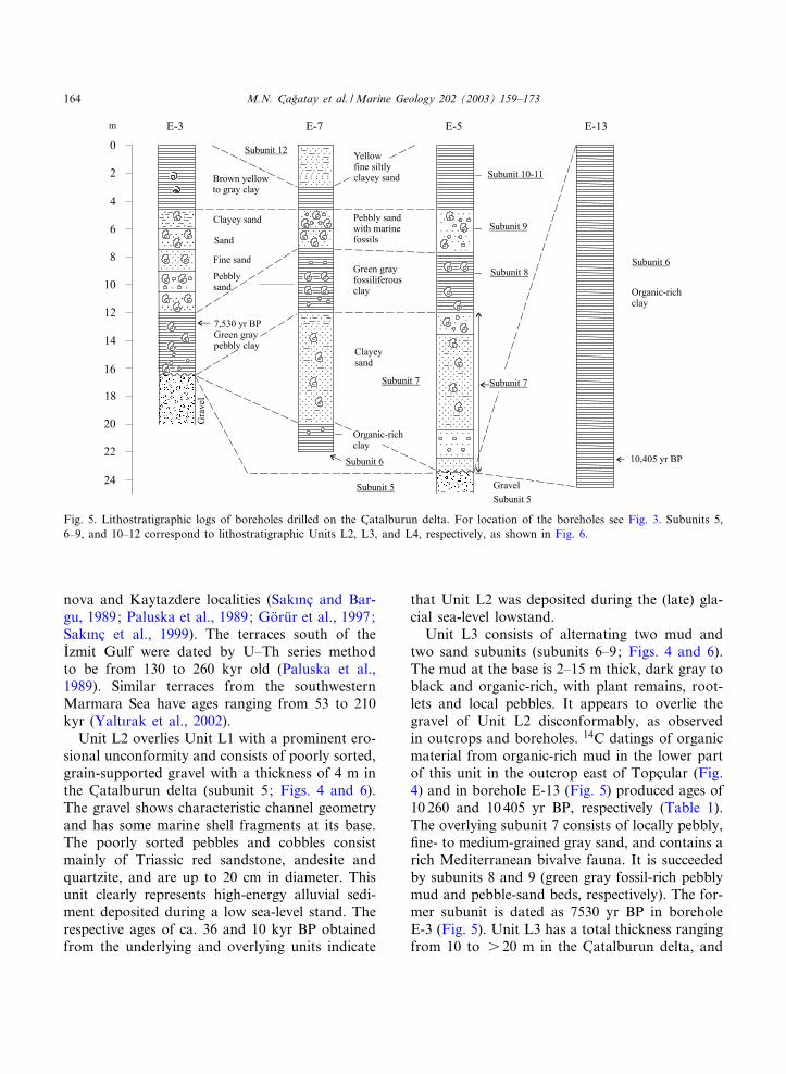
The C atalburun and the Hersek fan deltas havewidths of about 800 and 1350 m, respectively. Thesediment wedge of these fan deltas is exposed wellin road cuts near the southern coast (Fig. 4). Itwas also intersected in boreholes and trenchesopened for paleoseismological studies on theC atalburun delta (Fig. 5). The Quaternary sedi-ment wedge constituting the coastal plain overliesthe Miocene^upper Pliocene sediments, which inturn overlie the Paleozoic rocks. The topmost unitbelow the Quaternary wedge is composed ofpoorly cemented conglomerate, sand and clay al-ternation, containing some pelecypod shell frag-ments. The maximum thickness of this unit isabout 30 m in the C atalburun delta. Sak|nc andBargu (1989) studied the clays in the topmost
basement unit in Yalakdere in the east, and as-signed an upper Pliocene age.
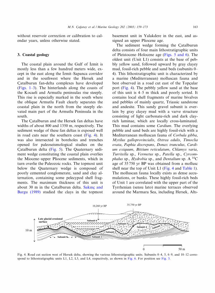
The sediment wedge forming the C atalburundelta consists of four main lithostratigraphic unitsof Pleistocene^Holocene age (Figs. 5 and 6). Theoldest unit (Unit L1) consists at the base of peb-bly yellow sand, followed upward by gray clayeymud, fossil-rich pebble and sand beds (subunits 0^4). This lithostratigraphic unit is characterized bya marine (Mediterranean) molluscan fauna andbest observed in a road cut east of the Topc ularport (Fig. 4). The pebbly yellow sand at the baseof this unit is 4^5 m thick and poorly sorted. Itcontains local shell fragments of marine bivalvesand pebbles of mainly quartz, Triassic sandstoneand andesite. This sandy gravel subunit is over-lain by gray clayey mud with a varve structureconsisting of light carbonate-rich and dark clay-rich laminae, which are locally cross-laminated.This mud contains some Cardium. The overlyingpebble and sand beds are highly fossil-rich with aMediterranean molluscan fauna of Corbula gibba,Mytilus galloprovincialis, Ostrea edulis, Timocliaovata, Paphia discrepans, Donax trunculus, Cardi-um exiquum, Bittium reticulatum, Chlamys varia,Turritella sp., Vermetus sp., Patella sp., Cyrcom-phalus sp., Hydrobia sp., and Dentalium sp. A 14Cage of 35 750 yr BP was obtained from a molluscshell near the top of Unit L1 (Fig. 4 and Table 1).The molluscan fauna locally exists as dense accu-mulations, or banks. These highly fossil-rich bedsof Unit 1 are correlated with the upper part of theTyrrhenian (sensu lato) marine terraces observedaround the Marmara Sea, including Hersek, Alt|-
Fig. 4. Road cut section west of Hersek delta, showing the various lithostratigraphic units. Subunits 0^4, 5, 6^9, and 10^12 corre-spond to lithostratigraphic units L1, L2, L3, and L4, respectively, as shown in Fig. 6. For position see Fig. 3.
MARGO 3388 5-11-03 Cyaan Magenta Geel Zwart
M.N. C agflatay et al. /Marine Geology 202 (2003) 159^173 163
nova and Kaytazdere localities (Sak|nc and Bar-gu, 1989; Paluska et al., 1989; Go«ru«r et al., 1997;Sak|nc et al., 1999). The terraces south of theI�zmit Gulf were dated by U^Th series methodto be from 130 to 260 kyr old (Paluska et al.,1989). Similar terraces from the southwesternMarmara Sea have ages ranging from 53 to 210kyr (Yalt|rak et al., 2002).
Unit L2 overlies Unit L1 with a prominent ero-sional unconformity and consists of poorly sorted,grain-supported gravel with a thickness of 4 m inthe C atalburun delta (subunit 5; Figs. 4 and 6).The gravel shows characteristic channel geometryand has some marine shell fragments at its base.The poorly sorted pebbles and cobbles consistmainly of Triassic red sandstone, andesite andquartzite, and are up to 20 cm in diameter. Thisunit clearly represents high-energy alluvial sedi-ment deposited during a low sea-level stand. Therespective ages of ca. 36 and 10 kyr BP obtainedfrom the underlying and overlying units indicate
that Unit L2 was deposited during the (late) gla-cial sea-level lowstand.
Unit L3 consists of alternating two mud andtwo sand subunits (subunits 6^9; Figs. 4 and 6).The mud at the base is 2^15 m thick, dark gray toblack and organic-rich, with plant remains, root-lets and local pebbles. It appears to overlie thegravel of Unit L2 disconformably, as observedin outcrops and boreholes. 14C datings of organicmaterial from organic-rich mud in the lower partof this unit in the outcrop east of Topc ular (Fig.4) and in borehole E-13 (Fig. 5) produced ages of10 260 and 10 405 yr BP, respectively (Table 1).The overlying subunit 7 consists of locally pebbly,¢ne- to medium-grained gray sand, and contains arich Mediterranean bivalve fauna. It is succeededby subunits 8 and 9 (green gray fossil-rich pebblymud and pebble-sand beds, respectively). The for-mer subunit is dated as 7530 yr BP in boreholeE-3 (Fig. 5). Unit L3 has a total thickness rangingfrom 10 to s 20 m in the C atalburun delta, and
Fig. 5. Lithostratigraphic logs of boreholes drilled on the C atalburun delta. For location of the boreholes see Fig. 3. Subunits 5,6^9, and 10^12 correspond to lithostratigraphic Units L2, L3, and L4, respectively, as shown in Fig. 6.
MARGO 3388 5-11-03 Cyaan Magenta Geel Zwart
M.N. C agflatay et al. /Marine Geology 202 (2003) 159^173164
contains shells and shell fragments of a rich Med-iterranean bivalve fauna.
Unit L4 overlies Unit L3 conformably, andconsists of gray and brownish yellow clays andclayey, silty ¢ne sand (subunits 10^12). Thesesediments contain freshwater gastropod shells,pieces of brick tiles and charcoal with soil devel-opment on top. The presence of brick and char-coal pieces attests that they were deposited duringthe historical period. With their lateral and verti-cal facies variations Units L3 and L4 togetherrepresent a typical siliciclastic shoreline^deltaic se-quence.
Unit L5 is an alluvial fan deposit that laterallyinter¢ngers with Units L3 and L4 (subunits 9^12)(Fig. 6). It extends from the mountain slope to thesouth, halfway into the sediment wedge of theC atalburun and Hersek deltas. At about 18 mabove the present sea level on the lower slopesof the hinterland south of the C atalburun delta,the alluvial fan deposit includes a 10^15 cm thickbed containing a mixture of bones, charcoal, ma-rine shells and pieces of brick tiles. The chaoticmixture of such diverse origin suggests that thisbed could be a tsunami deposit. Dating of a char-coal fragment from this bed has produced an ageof 2875 Y 85 yr BP (calibrated age: 1050 Y 82 yrBC; Stuiver and Braziunas, 1993; Siani et al.,2000).
Table 1Conventional and AMS 14C dates in the C atalburun coastal plain and o¡shore gravity cores (mbs, meter below surface; mbsf,meter below sea £oor)
Site, location, water depth (mbsl), dated material(lab. number)
Unit, subunit Core depth Age (14C yr BP)
Coastal plain, outcrop, bivalve (A#11035; conventional) L1, 4 ^ 35 750 (+620/-580)Coastal plain, outcrop, org. matter (A#11034; conventional) L3, 6 - 10 260 (+350/3340)Coastal plain, borehole E13, org. matter (A#11032; conventional) L3, 6 22.0 mbs 10 405 (+185/3180)Coastal plain, borehole E3, org. matter (A#11031; conventional) L3, 8 12.3 mbs 7 530Y 70Coastal plain, outcrop, charcoal (A#11033; conventional) L5, Tsunami ^ 2 875Y 85Western I�zmit Basin, gravity core IZ19, 388 m paleoshore, serpulid(OS-33171; AMS)
C1, base of unit 1.80 mbsf 10 850Y 55
Western I�zmit Basin, gravity core C-16, 3165 m, bivalve,(11822, AA-45781; AMS)
C1, mass £ow 0.19 mbsf 690Y 35
Karamu«rsel Basin, gravity core IZ-35, 3165m, Dreissena polymorpha(A#12460, conventional date)
C2, lacustrine 3.25 mbsf 14 135 (+230/3225)
Fig. 6. Generalized lithostratigraphic section for the coastalplain south of I�zmit Gulf.
MARGO 3388 5-11-03 Cyaan Magenta Geel Zwart
M.N. C agflatay et al. /Marine Geology 202 (2003) 159^173 165
4. O¡shore geology
4.1. Paleoshorelines and other bathymetric features
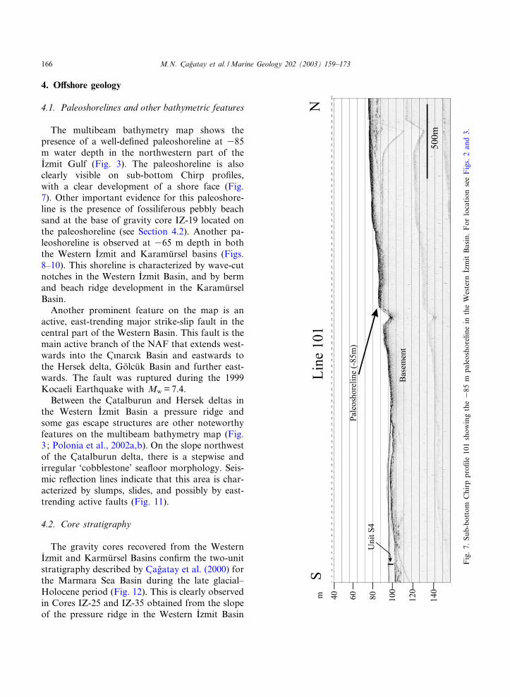
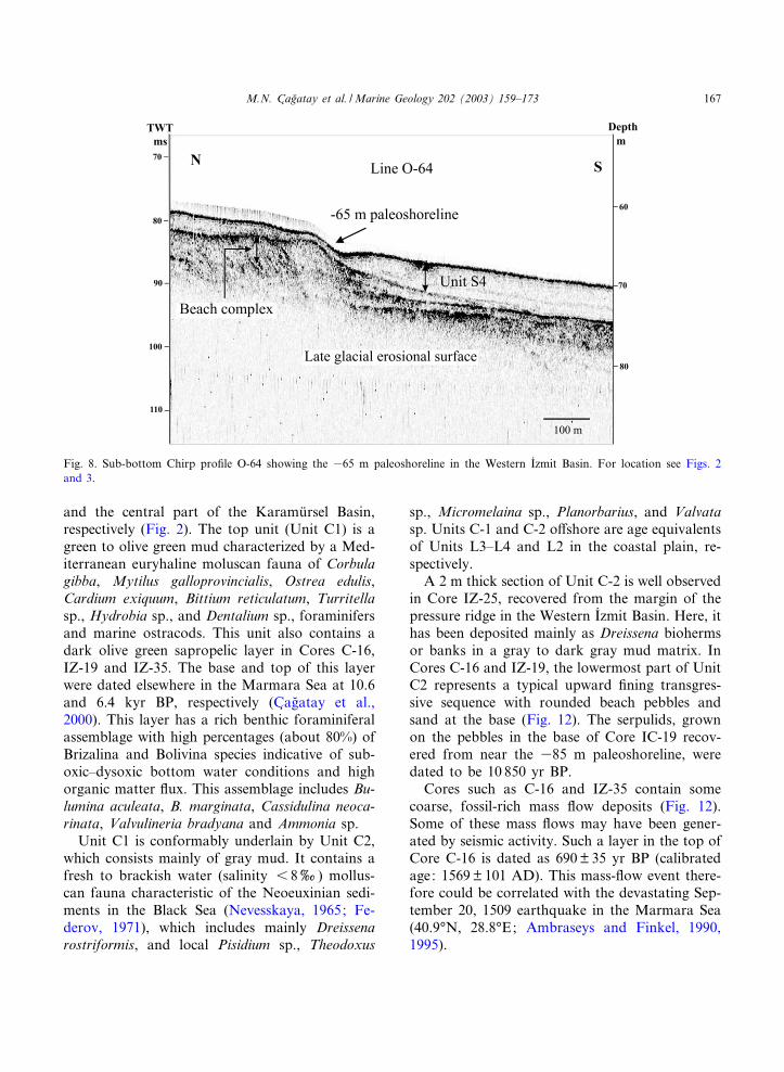
The multibeam bathymetry map shows thepresence of a well-de¢ned paleoshoreline at 385m water depth in the northwestern part of theI�zmit Gulf (Fig. 3). The paleoshoreline is alsoclearly visible on sub-bottom Chirp pro¢les,with a clear development of a shore face (Fig.7). Other important evidence for this paleoshore-line is the presence of fossiliferous pebbly beachsand at the base of gravity core IZ-19 located onthe paleoshoreline (see Section 4.2). Another pa-leoshoreline is observed at 365 m depth in boththe Western I�zmit and Karamu«rsel basins (Figs.8^10). This shoreline is characterized by wave-cutnotches in the Western I�zmit Basin, and by bermand beach ridge development in the Karamu«rselBasin.
Another prominent feature on the map is anactive, east-trending major strike-slip fault in thecentral part of the Western Basin. This fault is themain active branch of the NAF that extends west-wards into the C |narc|k Basin and eastwards tothe Hersek delta, Go«lcu«k Basin and further east-wards. The fault was ruptured during the 1999Kocaeli Earthquake with Mw = 7.4.
Between the C atalburun and Hersek deltas inthe Western I�zmit Basin a pressure ridge andsome gas escape structures are other noteworthyfeatures on the multibeam bathymetry map (Fig.3; Polonia et al., 2002a,b). On the slope northwestof the C atalburun delta, there is a stepwise andirregular ‘cobblestone’ sea£oor morphology. Seis-mic re£ection lines indicate that this area is char-acterized by slumps, slides, and possibly by east-trending active faults (Fig. 11).
4.2. Core stratigraphy
The gravity cores recovered from the WesternI�zmit and Karmu«rsel Basins con¢rm the two-unitstratigraphy described by C agflatay et al. (2000) forthe Marmara Sea Basin during the late glacial^Holocene period (Fig. 12). This is clearly observedin Cores IZ-25 and IZ-35 obtained from the slopeof the pressure ridge in the Western I�zmit Basin
Fig
.7.
Sub-
bottom
Chi
rppr
o¢le
101
show
ing
the3
85m
pale
osho
relin
ein
the
Wes
tern
I� zm
itBas
in.For
loca
tion
see
Fig
s.2
and
3.
MARGO 3388 5-11-03 Cyaan Magenta Geel Zwart
M.N. C agflatay et al. /Marine Geology 202 (2003) 159^173166
and the central part of the Karamu«rsel Basin,respectively (Fig. 2). The top unit (Unit C1) is agreen to olive green mud characterized by a Med-iterranean euryhaline moluscan fauna of Corbulagibba, Mytilus galloprovincialis, Ostrea edulis,Cardium exiquum, Bittium reticulatum, Turritellasp., Hydrobia sp., and Dentalium sp., foraminifersand marine ostracods. This unit also contains adark olive green sapropelic layer in Cores C-16,IZ-19 and IZ-35. The base and top of this layerwere dated elsewhere in the Marmara Sea at 10.6and 6.4 kyr BP, respectively (C agflatay et al.,2000). This layer has a rich benthic foraminiferalassemblage with high percentages (about 80%) ofBrizalina and Bolivina species indicative of sub-oxic^dysoxic bottom water conditions and highorganic matter £ux. This assemblage includes Bu-lumina aculeata, B. marginata, Cassidulina neoca-rinata, Valvulineria bradyana and Ammonia sp.
Unit C1 is conformably underlain by Unit C2,which consists mainly of gray mud. It contains afresh to brackish water (salinity 6 8x) mollus-can fauna characteristic of the Neoeuxinian sedi-ments in the Black Sea (Nevesskaya, 1965; Fe-derov, 1971), which includes mainly Dreissenarostriformis, and local Pisidium sp., Theodoxus
sp., Micromelaina sp., Planorbarius, and Valvatasp. Units C-1 and C-2 o¡shore are age equivalentsof Units L3^L4 and L2 in the coastal plain, re-spectively.
A 2 m thick section of Unit C-2 is well observedin Core IZ-25, recovered from the margin of thepressure ridge in the Western I�zmit Basin. Here, ithas been deposited mainly as Dreissena biohermsor banks in a gray to dark gray mud matrix. InCores C-16 and IZ-19, the lowermost part of UnitC2 represents a typical upward ¢ning transgres-sive sequence with rounded beach pebbles andsand at the base (Fig. 12). The serpulids, grownon the pebbles in the base of Core IC-19 recov-ered from near the 385 m paleoshoreline, weredated to be 10 850 yr BP.
Cores such as C-16 and IZ-35 contain somecoarse, fossil-rich mass £ow deposits (Fig. 12).Some of these mass £ows may have been gener-ated by seismic activity. Such a layer in the top ofCore C-16 is dated as 690 Y 35 yr BP (calibratedage: 1569Y 101 AD). This mass-£ow event there-fore could be correlated with the devastating Sep-tember 20, 1509 earthquake in the Marmara Sea(40.9‡N, 28.8‡E; Ambraseys and Finkel, 1990,1995).
Fig. 8. Sub-bottom Chirp pro¢le O-64 showing the 365 m paleoshoreline in the Western I�zmit Basin. For location see Figs. 2and 3.
MARGO 3388 5-11-03 Cyaan Magenta Geel Zwart
M.N. C agflatay et al. /Marine Geology 202 (2003) 159^173 167
4.3. Seismic stratigraphy
The seismic re£ection lines reveal the presenceof four seismic stratigraphic units (Fig. 11). Thelowermost two units (Units S1 and S2) are sepa-rated by an erosional surface that can be corre-lated with the late glacial erosional surface ob-served onshore. Unit S1 consists of very gentlyfolded, highly re£ective beds that can be corre-lated with the coarse, fossil-rich Tyrrhenian de-posits (Unit L1) on the coastal plain. Unit S2above the erosional surface has a subparallel dis-continuous re£ection con¢guration and shows re-£ections characteristic for a coarse lithology. Thisunit can be correlated with lithostratigraphic UnitL2 (subunit 5) on the coast, which was depositedduring the late glacial period. Unit S3 onlaps Unit
S2 and was clearly deposited during the Flandrianmarine transgression. It is therefore the equivalentof Unit L3 on the coastal plain. The topmost unit(Unit S4) shows a clear parallel re£ection con¢g-uration and thickening of beds towards the o¡-shore. It was deposited during the middle Holo-cene to Recent sea-level highstand and iscorrelatable with ¢ne clastics of Unit L4 on thecoast.
On the sub-bottom Chirp pro¢les more detailscan be seen of the units identi¢ed on the shallowseismic lines (Figs. 9 and 10). In the Karamu«rselBasin, such pro¢les show that the very gentlyfolded Unit S1 (Tyrrhenian) and the overlyingre£ective sediments of Unit S2 are separated bythe (late) glacial unconformity. Unit S2 representsa prograding deltaic wedge with a divergent re-
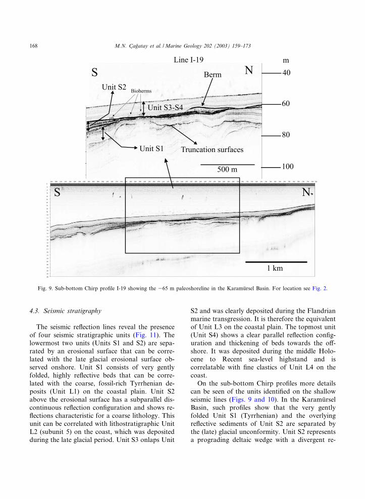
Fig. 9. Sub-bottom Chirp pro¢le I-19 showing the 365 m paleoshoreline in the Karamu«rsel Basin. For location see Fig. 2.
MARGO 3388 5-11-03 Cyaan Magenta Geel Zwart
M.N. C agflatay et al. /Marine Geology 202 (2003) 159^173168
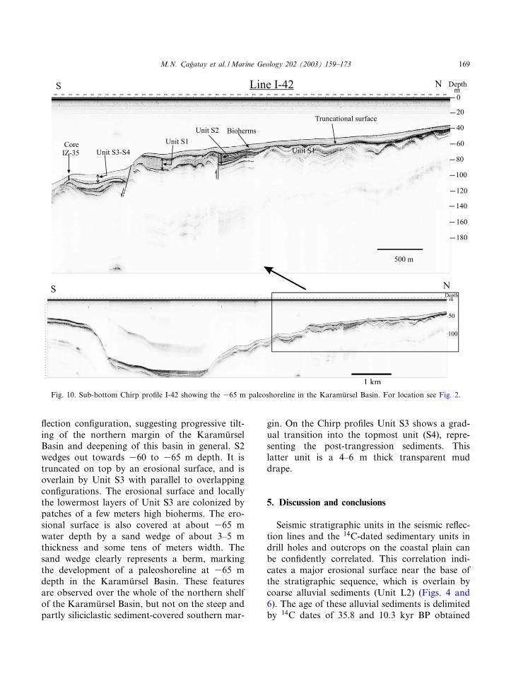
£ection con¢guration, suggesting progressive tilt-ing of the northern margin of the Karamu«rselBasin and deepening of this basin in general. S2wedges out towards 360 to 365 m depth. It istruncated on top by an erosional surface, and isoverlain by Unit S3 with parallel to overlappingcon¢gurations. The erosional surface and locallythe lowermost layers of Unit S3 are colonized bypatches of a few meters high bioherms. The ero-sional surface is also covered at about 365 mwater depth by a sand wedge of about 3^5 mthickness and some tens of meters width. Thesand wedge clearly represents a berm, markingthe development of a paleoshoreline at 365 mdepth in the Karamu«rsel Basin. These featuresare observed over the whole of the northern shelfof the Karamu«rsel Basin, but not on the steep andpartly siliciclastic sediment-covered southern mar-
gin. On the Chirp pro¢les Unit S3 shows a grad-ual transition into the topmost unit (S4), repre-senting the post-trangression sediments. Thislatter unit is a 4^6 m thick transparent muddrape.
5. Discussion and conclusions
Seismic stratigraphic units in the seismic re£ec-tion lines and the 14C-dated sedimentary units indrill holes and outcrops on the coastal plain canbe con¢dently correlated. This correlation indi-cates a major erosional surface near the base ofthe stratigraphic sequence, which is overlain bycoarse alluvial sediments (Unit L2) (Figs. 4 and6). The age of these alluvial sediments is delimitedby 14C dates of 35.8 and 10.3 kyr BP obtained
Fig. 10. Sub-bottom Chirp pro¢le I-42 showing the 365 m paleoshoreline in the Karamu«rsel Basin. For location see Fig. 2.
MARGO 3388 5-11-03 Cyaan Magenta Geel Zwart
M.N. C agflatay et al. /Marine Geology 202 (2003) 159^173 169
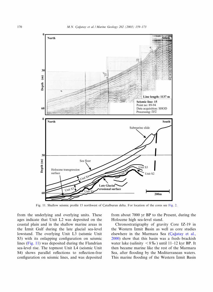
from the underlying and overlying units. Theseages indicate that Unit L2 was deposited on thecoastal plain and in the shallow marine areas inthe I�zmit Gulf during the late glacial sea-levellowstand. The overlying Unit L3 (seismic UnitS3) with its onlapping con¢guration on seismiclines (Fig. 11) was deposited during the Flandriansea-level rise. The topmost Unit L4 (seismic UnitS4) shows parallel re£ections to re£ection-freecon¢guration on seismic lines, and was deposited
from about 7000 yr BP to the Present, during theHolocene high sea-level stand.
Chronostratigraphy of gravity Core IZ-19 inthe Western I�zmit Basin as well as core studieselsewhere in the Marmara Sea (C agflatay et al.,2000) show that this basin was a fresh^brackishwater lake (salinity 6 8x) until 11^12 kyr BP. Itthen became marine like the rest of the MarmaraSea, after £ooding by the Mediterranean waters.This marine £ooding of the Western I�zmit Basin
Fig. 11. Shallow seismic pro¢le 15 northwest of C atalburun delta. For location of the cores see Fig. 2.
MARGO 3388 5-11-03 Cyaan Magenta Geel Zwart
M.N. C agflatay et al. /Marine Geology 202 (2003) 159^173170
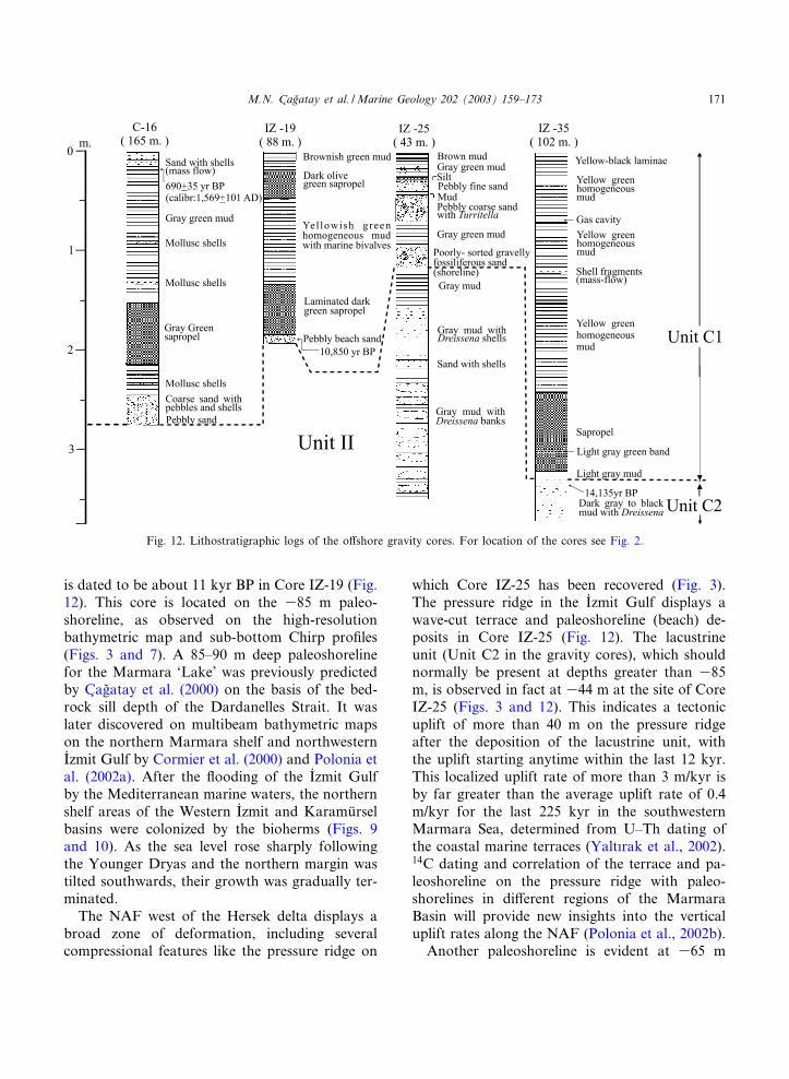
is dated to be about 11 kyr BP in Core IZ-19 (Fig.12). This core is located on the 385 m paleo-shoreline, as observed on the high-resolutionbathymetric map and sub-bottom Chirp pro¢les(Figs. 3 and 7). A 85^90 m deep paleoshorelinefor the Marmara ‘Lake’ was previously predictedby C agflatay et al. (2000) on the basis of the bed-rock sill depth of the Dardanelles Strait. It waslater discovered on multibeam bathymetric mapson the northern Marmara shelf and northwesternI�zmit Gulf by Cormier et al. (2000) and Polonia etal. (2002a). After the £ooding of the I�zmit Gulfby the Mediterranean marine waters, the northernshelf areas of the Western I�zmit and Karamu«rselbasins were colonized by the bioherms (Figs. 9and 10). As the sea level rose sharply followingthe Younger Dryas and the northern margin wastilted southwards, their growth was gradually ter-minated.
The NAF west of the Hersek delta displays abroad zone of deformation, including severalcompressional features like the pressure ridge on
which Core IZ-25 has been recovered (Fig. 3).The pressure ridge in the I�zmit Gulf displays awave-cut terrace and paleoshoreline (beach) de-posits in Core IZ-25 (Fig. 12). The lacustrineunit (Unit C2 in the gravity cores), which shouldnormally be present at depths greater than 385m, is observed in fact at 344 m at the site of CoreIZ-25 (Figs. 3 and 12). This indicates a tectonicuplift of more than 40 m on the pressure ridgeafter the deposition of the lacustrine unit, withthe uplift starting anytime within the last 12 kyr.This localized uplift rate of more than 3 m/kyr isby far greater than the average uplift rate of 0.4m/kyr for the last 225 kyr in the southwesternMarmara Sea, determined from U^Th dating ofthe coastal marine terraces (Yalt|rak et al., 2002).14C dating and correlation of the terrace and pa-leoshoreline on the pressure ridge with paleo-shorelines in di¡erent regions of the MarmaraBasin will provide new insights into the verticaluplift rates along the NAF (Polonia et al., 2002b).
Another paleoshoreline is evident at 365 m
Fig. 12. Lithostratigraphic logs of the o¡shore gravity cores. For location of the cores see Fig. 2.
MARGO 3388 5-11-03 Cyaan Magenta Geel Zwart
M.N. C agflatay et al. /Marine Geology 202 (2003) 159^173 171
depth on the sub-bottom Chirp pro¢les in theWestern I�zmit and Karamu«rsel Basins (Figs. 8^10). This paleoshoreline probably represents asea-level stillstand during the Younger Dryas(e.g. Fairbanks, 1989). Stratigraphy of Core IZ-35 in the Karamu«rsel Basin exhibits the same two-unit stratigraphy of the Marmara Sea. The pres-ence of the 365 m shoreline in both the Karamu«r-sel and the Western I�zmit basins indicates that the55-m deep Hersek sill separating the two basinswas much deeper prior to the Younger Dryasthan its present level. This in turn implies thatthe Western I�zmit and Karamu«rsel basins were£ooded by marine waters at about the sametime. It seems that the sill depth has become shal-lower with time by the northward progradation ofthe Hersek delta sediments. If the Go«lcu«k sill hadits present sill depth of 338 m in the past, accord-ing to the global sea-level curve (e.g. Fairbanks,1989) the marine waters would have spilled overthe Go«lcu«k Sill at about 9 14C kyr BP (10.5 kyr,Th/U age) and converted the Go«lcu«k Basin into amarine realm.
Presently the Dardanelles^Marmara Sea^Bos-phorus corridor forms a spillway transportingthe marine waters of the Mediterranean Sea andbrackish waters of the Black Sea in a two-way£ow system. The core and seismic data fromthis study indicate that the Marmara Sea (andthe Black Sea) were disconnected from the Med-iterranean Sea during the late glacial period andthe connection was established at about 12 kyrBP. Marine deposits dated at ca. 36 kyr BP onthe southern coast of the I�zmit Gulf indicate thatthe global sea level was above the Dardanelles silland the Marmara Sea was marine during at leastpart of the oxygen isotopic stage 3 (23^59 kyr).These results are in agreement with the global sea-level curve (Chappell and Shackleton, 1986) andrecent studies in the Marmara Sea (C agflatay et al.,2000; Aksu et al., 2002; Hiscott et al., 2002; Yal-t|rak et al., 2002). The data from the I�zmit Gulfcontribute no direct evidence concerning the cur-rent debate on the abrupt £ooding of the BlackSea at 7150 yr BP (Ryan et al., 1997; C agflatay etal., 2000; Go«ru«r et al., 2001; Hiscott et al., 2002;Aksu et al., 2002).
Onshore alluvial fan deposits include a 10^15
cm thick layer at 18 m containing a mixture ofbones, charcoal, marine shells and brick tiles. Thislayer, dated at 2875 Y 85 yr BP (1049 Y 82 BC), isbelieved to be a possible tsunami deposit. Alter-natively it could represent an archeological levelof the Bronze Age. A detailed regional study isnecessary to determine the true origin of this de-posit.
Acknowledgements
The data used in this study were obtained dur-ing the course of various projects, including the‘Earthquake Risk Assessment in the Aksa PlantArea’ supported by the Aksa Company, ‘Subma-rine Earthquake Geology of the Marmara Sea’supported by TUº BI�TAK, Italian CNRS, La-mont-Doherty Observatory and NATO (EST.CLG.978322), and YDABAG 101Y072 projectsupported by TUº BI�TAK. The high-resolutionseismic study was carried out by SHOD andI�TUº . The cores were collected onboard by R/VsUrania, Odin Finder and MTA Sismik-1. We aregrateful to all the above organizations and scien-tists, technicians, captains and crews of the aboveresearch vessels for their support. N.G. Acknowl-edges TUBA support. We thank the Marine Geol-ogy referees Drs. H.K. Wong and T.C.E. vanWeering for their useful suggestions.
References
Aksu, A.E., Hiscott, R.N., Kaminski, M.A., Mudie, P.J., Gil-lespie, H., Abrajano, T., Yas ar, D., 2002. Last glacial-Ho-locene paleoceanography of the Black Sea and MarmaraSea: stable isotopic, foraminiferal and coccolith evidence.Mar. Geol. 190, 119^149.
Ambraseys, N.N., Finkel, C.F., 1990. The Marmara Sea earth-quake of 1509. Terra Nova 2, 167^174.
Ambraseys, N.N., Finkel, C.F., 1995. The seismicity of Turkeyand adjacent areas, a historical review, 1500-1800. Eren,I�stanbul, 240 pp.
Bargu, S., Sak|nc , M., 1989. Geology and structural features ofthe area between I�zmit Gulf and I�znik Lake (in Turkish).I�st. Uº niv. Mu«h. Fak. Yerbilimleri Dergisi 6, 45^76.
C agflatay, M.N., Go«ru«r, N., Algan, O., Eastoe, C.S., Tchapa-lyga, A., Ongan, D., Kuhn, T., Kus cu, I�., 2000. Late Gla-cial-Holocene palaeoceanography of the Sea of Marmara:
MARGO 3388 5-11-03 Cyaan Magenta Geel Zwart
M.N. C agflatay et al. /Marine Geology 202 (2003) 159^173172
timing of connections with the Mediterranean and the BlackSea. Mar. Geol. 167, 191^206.
Chappell, J., Shackleton, N.J., 1986. Oxygen isotopes and sealevel. Nature 324, 137^140.
Cormier, M.-H., Polonia, A., Seeber, L., McHugh, C.M.G.,Ryan, W.B.F., Bonatti, E., Ligi, M., Gasperini, L., Capo-tondi, L., Demirbagfl, E., C agflatay, M.N., Dolan, J.F., 2000.Active strands of the North Anatolian Fault beneath theeastern Marmara Sea. AGU Meeting, San Franasisco, 15^19 December 2000.
Fairbanks, R.G., 1989. A 17,000-year glacio-eustatic sea levelrecord: in£uence of glacial melting rates on the YoungerDryas event and deep-ocean circulation. Nature 342, 637^642.
Federov, P.V., 1971. Post-glacial transgression of the BlackSea. Int. Geol. Rev. 14, 160^164.
Go«ru«r, N., C agflatay, M.N., Emre, Oº ., Alpar, B., Sak|nc , M.,I�slamogfllu, Y., Algan, A., Kec er, M., Erkal, T.Akko«k,R.,2001. Is the abrupt drowning of the Black Sea shelf at7150 yr BP a myth? Mar. Geol. 176, 65^73.
Go«ru«r, N., C agflatay, M.N., Sak|nc , M., Su«mengen, M.,S entu«rk, K., Yalt|rak, C., Tchpalyga, A., 1997. Origin ofthe Sea of Marmara from Neogene to Quaternary paleogeo-graphic evolution of its frame. Int. Geol. Rev. 39, 342^352.
Hiscott, R.N., Aksu, A.E., Yaar, D., Kaminski, M.A., Mudie,P.J., Kostylev, V.E., MacDonald, J.C., Ileri, F.I., Lord,A.R., 2002. Deltas south of the Bosphorus Strait recordpersistent Black Sea out£ow to the Marmara Sea sinceV10 ka. Mar. Geol. 190, 95^118.
Kus c u, I., Okamura, M., Matsuoka, H., Awata, Y., 2002.Active faults in the Gulf of I�zmit on the North AnatolianFault, NW Turkey: a high resolution shallow seismic study.Mar. Geol. 190, 421^443.
Le Pichon, X., S engo«r, A.M.C., Demirbagfl, E., Rangin, C.,Imren, C., Armijo, R., Go«ru«r, N., C agflatay, N., de Lepinay,B.M., Meyer, B., Saatc |lar, R., Tok, B., 2001. The activeMain Marmara fault. ESRL 192, 595^616.
Meric , E., Yanko, V., Avs ar, N., 1995. Foraminiferal fauna ofthe Quaternary sequence in the Gulf of I�zmit (Hersek Bur-nu-Kababurun) (in Turkish). In: E. Meric (Ed.), QuaternarySequence in the Gulf of I�zmit. Deniz Harp Okulu Bas|mevi,pp. 105^151.
Nevesskaya, L.A., 1965. Late Quaternary bivalve mollusks ofthe Black Sea: Their systematics and ecology. Akad. NaukS.S.S.R. Palaeontol. Inst. Tr. 105, 1^390.
Okay, A.I., S engo«r, A.M.C., Go«ru«r, N., 1994. Kinematic his-tory of the opening of the Black Sea and its e¡ect on thesurrounding regions. Geology 22, 267^270.
Paluska, A., Poetsch, S., Bargu, S., 1989. Tectonics, paleoseis-mic activity and recent deformation mechanism in the Sa-panca-Abant region (NW Turkey, North Anatolian FaultZone). Turkish-German Earthquake Research Project.Earth Research Institute, Ankara, and Univ. of Kiel, Kiel,pp. 18^33.
Polonia, A., Cormier, M.-H, C agflatay, N., et al., 2002. Explor-ing submarine earthquake geology in the Marmara Sea,EOS Trans. AGU 83, 229 and 235^236.
Polonia, A., Cormier, M.-H, C agflatay, N., et al., 2002. Holo-cene slip rate of the North Anatolian Fault in the Gulf ofI�zmit. I�stanbul Technical University Faculty of Mining In-ternational Meeting of Earth Sciences, May 2002, I�stanbul,Abstracts, p. 12.
Ryan, W.B.F., Pitman, W.C., III, Major, C.O., Shimkus, K.,Moskalenko, V., Jones, J.A., Dimitrov, P., Go«ru«r, N.,Sak|nc , M., Yu«ce, H., 1997. An abrupt drowning of BlackSea shelf. Mar. Geol. 138, 119^126.
Sak|nc , M., Bargu, S., 1989. Late Pleistocene (Tyrrhenian)stratigraphy and neotectonic features of the area south ofthe I�zmit Gulf (in Turkish). Tu«rkiye Jeoloji Kurumu Bu«lteni32, 51^64.
Sak|nc , M., Yalt|rak, C., Oktay, F.Y., 1999. Paleogeographicalevolution of the Thrace Neogene basin and the Tethys-Para-tethys relations at northwestern Turkey (Thrace). Palegeogr.Paleoclimatol. Paleoecol. 153, 17^40.
S engo«r, A.M.C., Y|lmaz, Y., 1981. Tethyan evolution of Tur-key: A plate tectonic approach. Tectonophysics 75, 181^241.
Siani, G., Paterne, M., Arnold, M., Bard, E., Me¤tivier, B.,Tisnerat, N., Bassinot, F., 2000. Radiocarbon reservoirages in the Mediterranean Sea and Black Sea. Radiocarbon42, 271^280.
Stuiver, M., Braziunas, T.F., 1993. Modelling atmospheric 14Cages of marine samples to 10,000 BC. In: Stuiver, M., Long,A., Kra, R.S. (Eds.), Calibration 1993. Radiocarbon 35,137^189.
Toker, V., S engu«ler, I�., 1995. Nannoplankton £ora of the Qua-ternary sequence in the Gulf of I�zmit (Hersek Burnu-Kaba-burun) (in Turkish). In: E. Meric (Ed.), Quaternary Se-quence in the Gulf of I�zmit. Deniz Harp Okulu Bas|mevi,pp. 173^199.
Tugflrul, S., Morkoc , E., 1990. Transport and water qualitymodeling in the Bay of I�zmit. NATO TU-WATERS project,TUº BI�TAK-MRC Publ., Gebze.
Yalt|rak, C., Sak|nc , M., Aksu, A.E., Hiscott, R.N., Galleb,B., Ulgen, U.B., 2002. Late Pleistocene uplift history alongthe southwestern Marmara Sea determined from raisedcoastal deposits and global sea-level variations. Mar. Geol.190, 283^305.
MARGO 3388 5-11-03 Cyaan Magenta Geel Zwart
M.N. C agflatay et al. /Marine Geology 202 (2003) 159^173 173
All in-text references underlined in blue are linked to publications on ResearchGate, letting you access and read them immediately.


