Embed Size (px)
Citation preview

,.
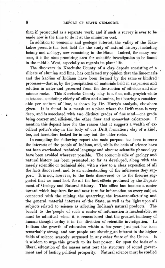
QUARRY OF THE SALEM STONE AND LIME OOMPANY-Showing the Section of Strata--See Page 143.
\..

r
INDIANA.
DEPARTMENT
Geology and Natural History.
FIFTEENTH ANNUAL REPORT ..
MAURICE THOMPSON, ST A TE GEOLOGIST.
1886.
\
TO THE GOVERNOR.
INDIANAPOLIS: WM. R. RURJfORD, OONTRACTOn FOR STATE PRINTING AND BINDHrfG.
1886.

STATE OF INDIANA, } DEPARTMENT OF GEOLOGY AND NATURA"L HISTORY,
" November 5,1886.
HON. ISAAC P. GRAY,
Governor of Indiana:
I have the honor to transmit hprewith the Fifteenth Annual Rt'port of the State GeologiA!, containing the labors of myself and assistants during the years 1885 and 1886
With the highest regard, your obedient servant,
•
MAURICE THOMPSON, State Geologist.
THE STATE OF INDIANA,} GOVERNOR'S OFFICE.
November 5, 1886, received, examined by the Governor and transmitted to the Seer~lary of State fqr pre,ervation and publication," pur,uant to the order of the Board of Commissioneril of Public Printing and Binding.
Filed in this office this 5th day of November, 1886.
PIERRE GRAY, Private Secretary.
W. R. MYERS, Secretary of State.
DEPARTMENT OF GEOLOGY AND NATURAL HISTORY. INDIANAPOLIS, IND.
MAURICE THOMPSON, State Geologist.
'. PLEASE ACKNOWLEDGE RECEIPT OF THIS VOLUME.
In return, Scientific Books, Fossils, etc., and Implements of the "Stone Age" are acceptaple.
State Musenm and Offi~e, corner of Market and Tennessee Streets.

ASSISTANTS TO THE STATE GEOLOGIST.
A. J. PHINNEY, M. D.,
GEORGE K.GREEN,
DR. R. T. BROWN,
S. S. GORBY,
W. H. THOMPSON,
STEPHEN E. LEE.
SPECIAL ASSISTANTS.
PROF. J. M. COULTER,
State Botanist.
DR. J. N. HURTY,
State Chemist.
DR. D. S. JORDAN.
Statl3' Ichthyologist.

TABLE OF CONTENTS.
PREFACE, by Maurice Thompson ................ . COMPENDIUM m' GEOLOGY AND MINERALOGY, by Maurice Thompson.
Geology in Outline. . Hudson River Group The Upper Sil urian . The Devonian . Lower Carboniferous. The Coal-Measures. Drift. . . . . . . . Section of Indiana. . A Sketch of U:e Silurian Rocks of Indiana. A Skttch of the Devonian Rocks of Indiana. A Sketch of the Sub-CarboniferouR Rocks of Indiana A Sketch of the Coal-Measure Rocks of Indiana
INDIANA BUILDING STONE, by Maurice Thompson Limestones in General . I. • . • •
The Oolitic Limestones of Indiana . . Sandstones of Indiana . . . . , . . .
THE CLAYS OF INDIANA, by Maurice Thompson. INDIANA CHALK BEDS, by Maurice Thompson . GLACIAL DEPosrrs OF INDIANA., by Maurice Thompson
Glaciers and Their Action . . . . . . . . . The Glacial Period, its Extent and Effect. . . Superficial Description of the Drift Deposits of Indiana. Sections and Borings, Showing the Interior of the Drift Deposits . Special Features of the Drift . . . . .. . . • . . . .
A TERMINAL MORAINE IN CENTRAL INDIANA, by Maurice Thompson. GEOLOGY OF TIPPECANOE COUNTY, by S. S. Gorby.
(jeneral Description and History Topography and Drainage . Water ....... . Commerce and Mannfactures Archreology . . Geology .... General Section .\ . Upper Silurian Devonian Formation . Keokuk Beds . . St. Louis Group ...
Page. 5
10 10 10 11 11 11 12 12 12 13 16 18 19 26 26 28 32 34 41 44 44 46 47 48 51 57 61 61 64 68 71 72 76 78 78 79 80 81

II REPORT OF STATE GEOLOGIST.
Chester Group. .". . "; Conglomerate Sandstone The Drift ....•. Marl Beds ...... .
HENRY COUNTY AND PORTioNS OF RANDOLPH, WAYNE AND DELAWARE, by A. J. Phinney, M. D.
Educational Advantages Topography. . . . Tables of Altitudes. Water ..... . Paleozoic Geology . The Drift ..... Glacial River Channels. Kames .......• Asars ...... " .. The Terminal Moraine of the Second Glacial Epoch. The Bowlder Tract. Archreology . . . . . . . . . . . . Thanks ..... " ........ .
GEOLOGY OF WASHINGTON CoUNTY, by S. S. Gorby General Description and History Topography and Drainage General Geology Connected Section . . . . The Knobstone Group . . Economic Value of the Knobstone Burlington Group. Economic Value. . . . . . Keokuk Group .". .. . . . Economic Value of the Keokuk Limestone. Lower Sr. Louis, or Warsaw Division ... Fossils of the Warsaw Beds in Washington County, Ind. Econl)mic Geology of the Warsaw Beds ... . Upper St. Louis Limestones ......... . Economic Value of the Upper St. Louis Rocks. Chester Group. . . .". . . . . . Economic Geology of the Chester Rocks. Lacustral ..... Soil and Alluvium" Coal and Iron . Drift .... Archreology . Caves. . . Collections . Timber" ...
A GEOLOGICAL I::!URVEY OF CLINTON CoUNTY, by W. H. Thompson. Geology •...................
GEOLOGY OF BOO.!iE COUNTY, by S. S. Gorby and S. E. Lee. Topography and Drainage Soil and Products .....
Page 84 85 87 95
97 97 98
100 101 ' . 102 102 103 105 108 lOll 112 115 116 117 117 118 122 123 124 136 130 ]33 133 136 136 138 142 146 147 147 149 149 150 150 151 151 151 152 152 154 154 160 " 162 164

Geology ..... Paleozoic Geology Archreology. . . .
TABLE OF CONTENTS.
MARSHALL COUNTY, by W. H. Thompson Geology .. Iron Ores. Clays ... The LakeR. Springs, Borings and Flowing Wells.
MAXINKUCKEE, by W. H. Thompson and S. E. Lee . HANCOCK COUNTY, by R. T. Brown, A. M., M. D.
Civil History . . . . . . Topography and Drainage . . . Geology .••••....... Soil, Health, Improvements, etc. Archreology • . . . . . . . .. Acknowledgments . . . . . . .
GEOLOGY OF BENTON COUNTY, by S. S. Gorby. Position and Topography. Drainage .... Soil and Products Timber ... Commerce .. History, etc. Geology ... Keokuk Limestone. St. Louis Limestone Conglomerate Sandstone Coal .. . The Drift ...... . Antiquities . . . . ..
A GEOLOGICAL SURVEY OF STARKE COUNTY, by W. H. Thompson Topography. . . . . . . Geology ......... . Soundings of Cedar Lake.
THE WABASH ARCH, by S. S. Gorby . Exposures at Markle. . . Exposures at HuntingtOli . Exposnres near Belden. Exposures at ,\\T abash Exposures near Peru. Exposures at Kokomo Exposures at Delphi. Exposures at Kentland. Exposures at Monon. . Exposures at Momence, III . .
GEOGRAPHICAL BOTANY, by Maurice Thompson . THE ORIGIN OF THE INDIANA FLORA, by John M. Coulter and Harvey
Thompson ....••.•.....•.. Topographical Features of Indiana . . . . . . . . . .
III • Page.
165 175 176 177 179 180 180 181 181 182 187 187 187 190 193 197 197 198 198 199 201 202 204 204 205 206 207 207 209 212 220 221 221 223 226 228 229 230 231 232 233 233 234 235 237 238 242
253 254

• IV REPORT OF STATE GEOLOGIST.
The Present Flora of Indiana. . . . . I. The Lower Wabash Valley Region. II. The Prairie Region . . III. The region of Barrem. IV. The Lake Region. . . V. The Highland Region . VI. The Region of Knobs. VII. The Central Region . Migration of Plants . . . . I. Permitted or Accidental Causes of Migrati,):n,. II. Compulsory Migration. . • . . 'j •
Origin of the North American Flora. . . . . . . Origin of Indiana Flora. • • • . . • . . . . . .
FOSSIL MAMMALS OF THE POST-PLIOCENE IN INDIANA, by Maurice Thompson THE PRE-HISTORIC RACE IN INDIANA, by S. S. Gorly.
Antiquityof the Race. Identity of the Race. Implements . . . • . The Mounds ..... Embankments and Inclosures.
NATURAL GAS, by Maurice Thompson What is it? ...••.... Where it is Found. . . . . . Surface Signs and other evidences of where to bore for Oil or Gas
in Indiana .... Gas in Indiana. . . . . The Eaton Gas Well .. Kokomo Gas Well No.2 Character of the Gas . . Gas Well No.3, Kokomo. The Muncie Gas Well • . The Tipton Oil and Gas Well . The Portland Gas Wells
GLOSSARY,by S. E. Lee. INDF.x •..•....•....
\
Page. 256 257 2.58 2.58 259 259 260 261 262 262 265 265 274 283 286 286 289 295 808 309 314 814 316
:U8 320 321 324 827 328 820 880 831 885 847

PREFACE.
The Department of Geology and Natural History is the only channel through which the people of Indiana are able to let the world know the natural resources of our great State. It can be said ·without reserve that this Department has done more than all other agencies combined to ad vertise Indiana's coal, clays, iron and building stone, and to direct the attention ()f capitalists to the peculiar advantages offered by the situation and the ,quality of these inexhaustible mineral deposits. The fact that the published reports of my distinguished and able predecessors in office, I hough long since practically exhausted, are still sought for by intelligent inquir.ers all over the world, is of itself sufficient proof of the good work which has been done by the Department. I have received letters asking for these reports from every enlightened country in the world, and I have answered in detail with great care nearly fifteen hundred letters written from outside the limits of this State, touching the geological, mineralogical and other economic interests being developed by our enterprising -citizens. The number of letters from residents of Indiana, which have eontained inquiries of almost every' conceivable kind, has been very great, and all have been answered promptly and with care. It is significant that IDany of the letters are from young persons seeking scientific information and direction in aid of original investigations voluntarily undertaken by them. This is indicative of a strong impulse in the minds of the rising generation toward higher education and a wider horizon of thought. It is wise for a State to assist such an impulse and encourage scientific inquiry within its limits. A highly educated popUlation insures a highly devel()ped material economy, and the people have a right to look toward their government for efficient aid in reaching such a development. Indiana has been reasonably liberal in this regard, and the money thus expended has brought rich returns. Our coal-fields, though yet far from showing adequate development, have been worked with great success for the past lifteen years, and our building stones have become famous for their rare beauty and durability. The manufacture of iron from Indiana ores owe& IDuch to the labors of my distinguished predecessors in office, and the :Same may be said touching our mineral interests of all kinds, especially as regard the coals, fire-clays, building-stones and lime-products.

6 REPORT OF STATE GEOLOGIST.
The block-coal of this State is the best coal of its kind to be found anywhere (indeed, there is no such coal found outside the limits of Indiana), and our oolitic limestone has no equal in the world as a beautiful, easilyworked and durable building material. In the body of this report will be found, besides an account of the coals and building stones, careful studies of the kaolins, fire-clays and brick-clays discovered within the territory surveyed. The following named counties, to-wit: Benton, Boone. Clinton, Hanc~ck, Henry, Marshall, Starke, Tippecanoe and Washington, , have been examined and reported upon in detail by my assistants, Professors Brown, Gorby and Phinney, and W. H. Thompson, each of whom is a specialist of thorough competency arid whose work speaks for itself.
Professor Coulter's paper on the Origin oj the Indiana Floras is a valuable contribution to botanical knowledge, and Professor Gorby's sketch of what has been discovered touching the Prehistorw Races in indiana will be found to contain in compact form just what the general reader and student will be most anxious to know.
In the Compendium of Geology and Mineralogy, it has been our aim to present in the shortest forma clear outline sketch of all that has been discovered and reported upon by my own corps and by predecessors in office. so that this volume might, in a certain degree, place the student, who can not get the earlier reports, in a situation to fairly understand the Geology of Indiana. Of course it is not expected that this compendium can, in any degree, fill the place of the valuable reports of Professors Cox and Collett, but it is almost impossible to get those reports now, and even an outline sketch of their chief features will be found of great value in connection with this volume and tb,ose which may follow.
One feature of this report must be found of singular inte~est to those who have been studying the Geology of Indiana. I speak of that part of the report treating of what Professor Gorby has named the Wabash. Arch. A few years rego, while engaged in making some preliminary railroad surveys, I noted at a number of points in Northern Indiana evidences of a line of disturbance affecting the rock strata across the State, in a direction generally east and west. At that time I could not give the question much attention, owing to pressing business engagements; but soon after I came into possession of the office of State Geologist, the discovery of natural gas in Northern Ohio began to. excite great attention and interest, I at once began a careful study of the evidences of disturbance above mentioned. My opinion was that I should find these disturbances in the form of a practically continuous anticlinal, extending into Ohio. It would be along the apex of this anticlinal, or upon swells of its offshoots, so to say, that borers would be most likely to reach gas or oil. It has been very difficult to study the conditions of the rock strata in Northern Indiana, on account of the immense deposits of the drift; but the necessarily hasty and incomplete report by Professor

PREFACE. 7
Gorby embodies the main facts gathered up_ to the time of closing the work herein set forth. The further study of this feature of Indiana geol<>gy is of the greatest importance from both an economic and a scientific point of view, as will be s~en from the report upon natural gas herewith submitted.
The probability is very great that t,hroughout a large area in the north€rn part of the State both gas and oil may be r~ached,and the definite outlining of such an area will be a work of immense value to the commonwealth. The discoveries already made in several counties show that the deposits of natural gas are not limited to special reservoirs along any given line, and that they are not due to strictly local agencies.
Therefore the study of the conditions under which they are found to €xist will involve an examination of the entire area of the northern and €specially the mid-northern part of Indiana. This examination is already well started, and will be pushed forward as fast as the means placed at the disposal of this Department will permit.
From a scientific point of view the complete study of the chief feature <>utlined in Prof. Gorby's sketch of the Wabash Arch will be of great in~ tere8t and value. This line of disturbance of the paleozoic strata has been an important factor in modifying the Drift formation both to the northward and to the southward of it. In fact, this upheaval or arch ap-
/ pears to have acted" in a measure, as a dam or obstruction to the glacial .currents and to have given form and consistency by this means to the morainic deposits farther southward as well as depth to the drift mass heaped against its northern side. The Kankakee valley is a shallow groove cut in this last-named mass, while the Wabash valley is carved down into the paleozoic r0cks. The great dividing ridge constituting the watershed between the two streams is drift composed chiefly of bowlders, bowlder-till, gravel and sand, the last heaped into local ridges and dunes by the action of wind and water currents. In the midst of these sandy formations and filling deep basins hollowed in the trough, impervious blue bowlder clay, lie many beautiful lakes of clear, pure water.
The successful draining of the vast marshes lying along the Kankakee River is a subject of great interest to many citizens of Indiana, and it is .a subject which must be largely affected by the surveys of this Department during the next two years. The line of work has now been carried up to the Kankakee valley, and the next step will be the examination of the river and the territory it drains .. This examination should be a surveyof sufficient completeness to establish all the facts necessary to a practical knowledge of drainage requirements, and the General Assembly of the State ef Indiana should appropriate a small special fnnd-about three thousand dollars would, be sufficient-to meet the extra expense of such .a survey. In connection with the necessary geological and natural history work, this survey could be made much more easily and vastly cheaper
8 REPORT OF STATE GEOLOGIST.
than if prosecuted as a separate work, and if such a survey is ever to be made now is the time to do it at the minimum cost.
In addition to economic and geologic interest, the valley of the Kankakee" presents the best field for the ::!tudyof natural history, including botany and zoology, now remaining in the State. Indeed, for many reasons, it is the most promising area for scientific investigation to be found in the middle West, especially as regards its plant life. .
The discovery in Kosciusko County of a clay deposit consisting of a silicate of alumina and lime, has confirmed my opinion that the lime-marls. and the kaolins of Indiana have been formed by the same or kindred processes-that is, by the precipitation of' materials held in suspension and solution in water and procured from the destruction of silicious and aluminous rocks. This Kosciusko County clay is a fine, soft, grayish-white substance, consisting chiefly of silica and alumina, but bearing a considerable per centum of lime, aa shown by Dr. Hurty's analysis, elsewhere given. It is found in a marsh at a place where the Drift mass is very deep, and is associated with two distinct grades of fine sand-one grade being coarser and silicious, the other finer and somewhat calcareous. I mention this deposit here fi)r the reason that it suggests a wealth of excellent potter's clay in the body of our Drift formation; clay of a kind. too, not heretofore looked for in any but the older rocks.
In compiling the following report the main purpose has been to ser.ve the interests of the people of Indiana, and, while the ends of science have not been overlooked, technical language and obscure scientific phraseology have bt)en avoided wherever possible. The economic side of geology and natural history has been presented, so far as developed, along with the merely scientific or technical side, with a view to a clear exposition of all the facts discovererl, and to an understanding of the inferences they support. It is not, however, to the facts discovered or to the theories suggested that we must look for all the best effects produced by the Department of Geology and Natural History. This office has become a center toward which inquirers far and near turn for information on every subject connected with the mining, the quarrying, the iron-manufacturing and the general material interests of the State, as well as for light upon all subjects related to science as affecting Indiana's natural products. The benefit to the 'people of such a center of information is incalculable, as must be admitted when it is remembered that the greatest tendency of human thought to-day is in the direction of scientific investigation. In Indiana the growth of education within a few. years just past has been remark~bly strong, and our people are showing,an interest in the higher fields of science scarcely surpassed in any other State of the Union. It is wisdom to urge this growth to its best power; for up[)n the basis of a liberal education of the masses must rest the structure of sound government and of lasting political prosperity. Natural science must be studied
HENRY COUNTY. 9B
Ohio. Its elevation gradually increases to near Bloomingsport, where it marks the highest point yet found in the State. It is here quite.level, much more so than either east or west, for the surface near Noland's Fork, of the White Water, west of the river and Martindale's Creek, is quite broken. From Bloomingsport east the descent is gradual. Throughout Randolph County. the detlcent to the north and south from this divide is quite marked, but gradual, with low and gentle swells in the surface. The bluffs bordering Noland's Fork, Green's Fork and Martindale's Creek become lower when traced southward; northward they are soon lost in the high land adjacent.
In Nettle Creek Township, Randolph County, a portion of this ridge leaves the main body and turns quite ahruptly to the south about two miles. east of' Losantville and enters Dalton Township, Wayne County, between Nettle Creek and West River. When traced southward, or a little west of south, to the vicinity of Dublin, it becomes gradually lower, though still elevated above the adjacent surface. Near the south line of Dalton Township, its western border is near the Henry County line,' and it here presents quite a bold faeewhen viewed from the level surface to the west. Fall Creek Township, Henry County, has quite a level surface except along Fall and Honey creeks, where the surface is quite broken and rolling fr'Jm one·half to one mile from the creeks. The hluffs along Fall Creek are quite high and the valley broad for so small a stream. An explanation of this will be found in another place.· J eff'erson Township, as a whole, is quite level; Wayne and Greensboro are also quite level except in the vicinity of Blue River and Duck Creek. Franklin and Dudley are quite level except along Flat Rock Creek, where the surface is gently rolling. South from New Castle and bordering Blue River on each side is a tract of rolling ground extending from one-half to three miles from the valley. The valley is everywhere bordered by high bluffs or rounded hills. From the summit of some of the hills one can see for miles. The broad valley bordering the river on either side, the high MIls, with gently-waving contours, extending back from ~he valley from one-half to three miles, present a surface not unlike that of a billowy sea or a rolling pra,irie. No grander sight is desired than these hills covered to their summits with growing corn, golden grain or waving grass. This line of river bluffs with its adjoining tract of rolling land can be traced from Knightstown to the source of Buck and Prairie creeks, thence to Selma, Delaware County. Between Blue River and Duck Creek is an elevated tract having a flat-iron or triangular shape, with the apex to the south. Its surface is quite level just west of New Castle, but becomes rolling, southward; it gradually narrows and finally becomes a simple ridge, terminating at the confluence of Duck Creek with the river. South of Greensboro, on the west of the river valley, the surface is somewhat roIling,hut here the topography is marked by long, rounded ridges parallel

PREFACE. 9
under the greatest difficulties by those who are not able to own large and -expensive lihraries and vast cabinets of specimens, hence to the teachers and students of the State, the Museum· under the control of this Department is scarcely less a repository of gratuitous information than is the office itself, where some one is always ready to answer questions and to investigate such problems as arise in the field of natural science within the State. Indianapolis is the geographical as well as the railroad center of the State, and the Museum situated here is easily accessible to all. The collection, .already quite large when it came to my hands, has been increased very greatly, and is now fairly representative of the archreological and paleozoic remains found in the State. Arrangements are making to secure, by the time that the Museum can be taken to its quarters in the new State House, a large addition to the collection of fossils, minerals ann archreological objects from other States and countries. So soon as this change is eJfected the Museum will be in condition to be carefully re-arranged and catalogued so as to be handily available for study and reference.

COMPENDJUM OF THE GEOLOGY AND MINERALOGV OF INDIANA.
L
GEOLOGY IN OUTLINE.
The surface geology of Indiana belongs mostly to the Drift, and is discussed in another part of this report; therefore the paleozoic rocks will chiefly claim our attention here.
Beginning with the southeastern part of the State and passing northward and westward, ,we shall find the outcrops in the following order:
THE HUDSON RIVER GROUP.
This group of the Lower Silurian is promine~tly exposed· along the bluffs of the Ohio .River in Dearborn County, and thence west to the mouth of Fourteen-mile Creek in Clark County. From this line northward it is found outcropping more or less in Switzerland, Ripley, Dearborn, Ohio, Franklin, Fayette, Wayne and Union counties, while in Rush, Jefferson, Clark and Decatur, and some other contiguous counties there are occasional deep-lying exposures, especially in ravines and the beds of streams.
The Hudson River rocks have also been called the Cincinnati group. They have been studied with exhaustive care by geologists, and their fossils, numerous and exceedingly interesting, have been the subject of some notable investigations by most distinguished scientists. Early in the history of Indiana the Ohio River became a base·line from which explorations in geology and natural history were made by a coterie of men whose names have become familiar to intelligent people the world over. S() well, indeed, have the organic remains of our Lower Silurian rocks been examined and reported on that there would seem to be little left for the. geologist and paleontologist to do in that field, so far as the exposures in the southern part of our State may be concerned.
The soil derived from the decomposition of the Hudson River rocks is, in the main, warm, rich and" lively," producing wonderful crops of corn, wheat and other cereals. Fruit trees, too, do well wherever the soil is well drained.

GEOLOGY AND MINERALOGY OF ~NDIANA. 11
THE UPPER SILURIAN.
The rocks of the Upper Silurian have not been defined as well in Indiana as have those of the Lower Silurian; but they appear as the chief ()utcrops in Wabash, Miami, Wells, Huntington and Adams counties, and oecupy parts of Jay, Grant, Blackford,Cass, Carroll, Jasper, Newton and White. They are exposed in parts of Delaware, Decatur, Hamilton, Henry, Hancock, Madison, Marion, Rush, Tipton, Bartholomew, Jefferson, Clark and Jennings, with a possible occasional outcrop in one or two other -counties. The Niagara and the Clinton groups of the Upper Silurian may be studied to advantage at many points, notably the juncture of the Niagara and the Clinton in Fayette County, and in 'some of the adjoining -counties.
Ball's Quarry, in Fayette County, according to Dr. Elrod, will show the Clinton limestone twenty feet thick lying in place between the Niagara and the Hu~son River rocks. Indeed, all along the line upon which the Lower Niagara outcrops we may look for the Clinton just below.
The soils from the disintegration and decomposition of the Upper Silurian have been represented as "heavy clays," but my observation shows that often they are extremely light, easily drained, and very rich.
THE DEVONIAN.
The rocks of the Devonian age will be found outcropping in the peculiarly defined belt running from the Ohio River to the northern part of the State, and passing finally under the Drift deposits in Wabash, Miami, Cass, Jasper and \Vhite counties. The Devonian probably underlies a very large area of the extreme northern part of State, but owing to the great depth of the Drift deposits and the scarcity of borings, we can only {lonjecture its outlines. Its principal outcroppings are to be found in the following counties: ,Jefferson, Jennings, Bartholomew, Decatur, Rush, Shelby, Johnson, Tippecanoe, Cass, Wabash, Clark and Floyd counties, with occasional exposures in a number of other counties.
The Corniferous rock and the Genesee shale are the two members of thet Devonian found in Indiana. The soil in Indiana formed from the decomposition of Devonian rocks compares favorably with those of other formations in the State.
LOWER CARBONIFEROUS.
That division of the Carboniferous age called the Lower Carboniferous, or Sub-Carboniferous, is composed in Indiana of the Knobstone, the Keokuk, the St. Louis and the Chester groups of rocks. It begins on the Ohio River in Harrison and Floyd counties and runs in a northwesterly direction through Washington, Orange, Crawford, Brown, Monroe,

GEOLOGY AND MINERALOGY. OF INDIANA. 13
The Tertiary ages seem to have left no ch~racteristic traces in Indiana, or if any of their deposits exist they are not exposed. The Drift mass in our State rests directly upon the paleozoic rocks, none of which appear to be of later formation than the upper Coal-Measures.
IL
A SKETCH OF THE SILURIAN ROCKS OF INDIANA.
The Hudson River group (or. Cincinnati group) of the Lower Silurian may be studied to best advantage, perhaps, in the bluffs and ravines along the Ohio River in Dearborn, Clark and Floyd counties, though frequently exposures of a very interesting and characteristic nature will be found in most of the southeastern counties of the State.
Taking the Madison ro.cks as one of the typical Hudson River exposures in Indiana, we shall find them largely composed of strata, very thin, dark blue in color, crystalline, . alternating with strata or layers of coarser texture, and much lighter in color.
The Marble Hill Quarry, six miles from the Ohio on the line of Jefferson County, affords a four-feet bed of fairly good building limestone, used in the court house at Louisville, Ky. Dr. D. D. Owen, remarking upon the beds of Marble Hill, says that they" consist of an immense accumulation of spiral marine univalves belonging to the fossil genus murchuonia." This so-called marble, though beautiful, has proved to be qui~ unfit for building purposes, save for interior orn~mentation. For decorative mantles and tiles nothing could be finer. When cut and polished the ground of the stone is dark, clouded with the sections of fossils which give it a satin-like appearance.
In Dearborn and Ohio counties the Hudson River shales, of a bluish gray color, come to the surface, or are covered by Drift mass, which here, at its southern margin, is often fifty feet thick.
Near Richmond, in Wayne County, on the forks of White Water River, the rocks of the Hudson River group have been carefully studied by enthusiastic amateurs in geology and paleontology, to whom we are much indebted. The rocks here take on a buff color, shading into gray and blue, and are mostly shales, with many important fossil beds. A number of quarries are open, however, and some good building stone is taken out at various points in the county; but it is characteristic of the Lower Silurian limestones to weather badly on account of the oxidation of the iron they bear; hence it is rare that a first-class building stone can be found in the Hudson River rocks of Indiana.
The best fossil beds of the Lower Silurian are found in the weathered shale outcrops. Some localities near Richmond, in the banks of White

14 REPORTOF STATE GEOLOGIST.
Water and its branches, have afforded fine collections, notably that of Mrs. Haines, while most of the counties of the extreme southeastern part of the State have similar fossiliferous exposures.
In Jefferson County the Hudson River rocks outcrop in Indian Creek in the form of shales and shelly limestones, with fine beds of characteristic fossils. Also in Decatur County there are exposures, mostly shales, from which Lower Silurian fossils are taken, mostly at the bottom of quarries begun in the Niagara rocks.
In Union County the blue limestones and marls of the Hudson River group are to be seen in a number of quarries, where the student andeollector will be well rewarded, and especially are the blue marl partings rich in trilobites, most notable of which is the species Calymene senaria.
Perhaps the best place in the State to study the juncture of the Niagara and Hudson River rocks will be found on Laughery Creek, in Ripley County, where the stream often pretty accurately marks the dividing line. Below and above Versailles, on this stream, the Hudson River rocks present fine fossil beds from which many collections all over the world have been enriched with specimens.
The upheaval known as the Cincinnati Arch, running from near Sandusky, Ohio, to farther south than Nashville, Tenn., forms a datum line, from which our study of the Silurian deposits of Indiana may start. This anticlinal or ridge has been found to consist in Ohio of two folds. In Indi:;ma, from a study of the Madison rocks and all the evidence gathered from the works of other geologists, I am inclined to place the exposures of Lower SiluriaJ? in our southeastern counties considerably west of the axial line of upheaval; but for the purposes I have in view, it does not matter whether "Cincinnati Arch," "Cincinnati Dome," or any other phrase is the correct one, or whether the arch itself is principally east or west of Cincinnati. It is snfficient that the Lower Silurian strata have been thrust to the surface along a certain line of upheaval, and that this disturbance, whether called local or general, has affected the geolog~ ical conditions of Indiana ip such a way that as we pass westward newer strata outcrop in succession until we have" run the gamut," so to speak, of the Paleozoic deposits (of the State) whose respective horizons are above that of the Hudson River group. It would require much more minute and patient investigation of all the discoverable facts than has yet been made by geologists of Ohio, Indiana and Kentucky to settle the question whether the so-called arch is or is not at certain points a series of truncated Lower Silurian folds, against the slopes of which in many places the superior rock deposits rest in place; but so far as Indiana is concerned we know that the Upper Silurian rocks succeed those of the Lower Silurian in the southeast part of the State, just in a manner to conclusively show that the former were deposited in a sea out of which the great Hud son River "ystem rose as an island or low peninsula. N early all the strata

GEOLOGY AND MINERALOGY OF INDIANA. 15
of the Paleozoic rocks of Indiana dip westward, so that as we pass from the Lower Silurian to the Upper Silurian, thence to the Devonian and on to the Carboniferous, we find the strata outcropping in the for~ of a stair-like progression westward, while at the same time each stratum is dipping in that direction. This would seem to indicate one of two things: The entire body of deposits above the Hudson ,River rocks has been laid down on a slope which is a continuation of the west side of the Cincinnati anticlinal, or there has been a broad upheaval since the close of the Carboniferous ages. My own opinion is that the so-called Cincinnati Arch is but one of the manifestations of a great continental upheaval-a movement which was probably so slow that it continued through a vast space of time.
The Upper Silurian strata, consisting in this State chiefly of limestone, clays and shale, and exposed over a large area, present a field of study which will well repay much diligence and patient labor. Their examination may be be~un almost exactly where a study of the Hudson River rocks ends, thus affording at the outset an invaluable means of comparative observation.
Along the Ohio River in Clark County the Upper SilurIan is seen in the bluffs, where it occupies a narrow area; thence it runs eastward and northward into Jefferson County, where it begins to broaden. From Jefferson County northward.to Miami, 'Vabash and Huntington counties it forms a very irregular strip, often flinging out on either side slender lines of exposure, but broadening, as a rule, all the way through Ripley, Jennings, Decatur, Franklin, Rush, Fayette, Henry and Wayne; thence northward it is bounded on the east by the Ohio line (so far as Indiana is concerned) and underlies the whole of Madison, Delaware, Randolph, Grant, Blackford, Jay, and nearly or quite the whole of Miami, Huntington and. Adams. The Drift deposits are so thick in the northern part of the State that no definite limit can be fixed at present for the paleozoic rocks, but it is tolerably certain that the Upper Silurian covers nearly all the territory' above indicated, with a probability that it underlies the Drift of Fulton, Allen and Whitley counties. Future examinations may extend the limit in a northwesterly direction, possibly. The Niagara rocks are exposed in so many localities that it would be far beyond the scope of this paper to particularize. From the Ohio River to Huntington, a distance compassing almost three-fourths of the State's length, characteristic fossils have been found more or less plentifully within most of the counties above, mentioned. In the southern part of the Upper Silurian area Clinton fossils have been found, but the limits of that formation in Indiana have not yet been determined definitely. Professor Borden, in his report of an examination of Jefferson County for this Department, in 1874, states that, in the neighborhood of Saluda and Fourteen-mile creeks, the New Albany" black slate," the Niagara, the Clinton

16 REPORT OF STATE GEOLOGIST.
and Hudson River rocks all lie exposed within" a space of three miles." He also refers to the 9linton group twenty feet of "gray and yellow stratified sandstone" overlying the Hudson River formation in Clark County. Dr. Elrod reports the Clinton limestone twenty feet thick in Ball's Quarry, Fayette County.
The building stones and other economic features of the Niagara rocks will be considered in another part of this report.
III.
A SKETCH OF THE DEVONIAN ROCKS OF INDIANA.
The Devonian rocks in" Indiana are exposed (or have been reached by borings) through a narrow, irregular belt lying immediately west of the Upper Silurian outcrops, and reaching from Floyd County, on the Ohio River, to Cass County, whence they probably spread over a great area in the north and northeastern part of the State, though deeply covered with glacial deposits. The strata of this formation are mostly limestones, black or grayish shales and clays.
What has been named the" black shale" (though not always black) is, perhaps, the equivalent of the' Genesee shale. It forms the upper member of the Devonian in Indiana, and rests upon the Corniferous deposits, which, in turn, rest upon the Niagara. It is often the case that this shale is quite bituminous, wherefore it has been mistaken for" coal shale," causing persons unacquainted with geology to expend much time and money in vain, trying to "develop" what they have considered hidden wealth in coal mines.
The Devonian rocks are exposed, or may be reached by borings, in the following counties: Clark, Scott, J efferson, Jennings, Bartholomew, Johnson, Shelby, Rush, Hancock, Marion, Henry, Hamilton, Clinton, Tipton, Howard, Carroll, Cass and Wabash, together with a large area of indefinite boundary over the northern and northeastern part of the State. It seems pretty well determined, despite the veil of drift which hinders examination, that the Devonian deposits are the uppermost paleozoic rocks over nearly or quite a third of Indiana's area.
The fossil beds of the Devonjan in this State are almost entirely confined to the Corniferous formation, the black shales being, so far as I have been able to discover, practically barren. Professor G. K. Green, of New Albany, has collected and studied with more cat'e, perhaps, than anyone in the State th,~ organic remains of the Devonian rocks, and to him we are indebted for a great deal of valuable information. .
Some distance ~bove Lafayette the Devonian shales outcrop in the bluff banks of the W'aba~h River, and thence along this stream northeastward

GEOLOGY AND MINERALOGY OF INDIANA. 17
nearly to 'Yabash County, there are occasional exposures of the limestones . overlying the Niagara. Richard Owen reported a cutting of the Devonian rocks in Cass County, on the Cincinnati road. Southeast of Logansport another outcrop shows near the canal. Un account of the scant €xposures, the scarcity of fossils and the immense. mass of drift which {)ovelS the strata, it is impossible to make out with any distinctntlss the northern dividing line between the Upper Silurian and the Devonian forinations for some distance south of the Wabash River, but we may assume that near the northeastern corner of Tippecanoe County the approximate line of separation on the northwest,· between the Devonian and the Lower Carboniferous, is discovered; Farther southward, however, the limits of all the formations are pretty sharply outlined. The western margin of the Devonian area is marked by the outcropping of the Knobstone (the lowest member of the subcarboniferous) in Johnson, Bartholomew, Jackson, 'Yashington, Scott, Clark, Floyd and Harrison counties, from which line it reaches eastward to the western limit of the Niagara group.
In Decatur County many outcrops show clearly the contact of the Corniferous limestone with the Niagara rocks, and thence southward to the Ohio River, along an irregular line through Jellnillgs, Jefferson and Clark counties, the eastern boundary of the' Devonian area is pretty sharply marked by characteristic outcrops with the Niagara below.
The 80-ealled "New Albany Bla-ck Shale," which is a well-defined Iilem bel' of the Devonian formation in Indiana, outcrops at New Albany on the Ohio River, and is exposed nwre or less throughout the Devonian area to as far north !lS the Wabash River above Lafayette. The testimony
"ot' the few fussils found in this shale scarcely amount" to evidence sufficient to identify it with the Genesee shale of New York, but it is probably' true that the formations are e'luivalent. The dark color, amounting almost to jet blackness sometimes, which characterizes the New Albany shale, is due to carbonaceous matter in the form of bitum'en and oil. Vegetable remains, .consisting mostly of huge tree-trunks, are found imbedded in it, usually near the upper surface of the formation. These have been ]ll'e"erved by silicification, and their presence, to my mind, furnishes a suggestion of the slJUrce whence has been drawn all the combustible matter dispersed throughout the shale. At the close of the Devonian agc the land was lifted aitove the ~ea and was clothed with dense forests and jungles. Then followed a period of submergence by which all the vegetable matter was covered with a thin layer of ferruginous limestone. The conditions not bei[Jg favorable for the formation of {)oal, owing to the want of sufficient pressure, etc., the result was that a bituminous and oily residuum from the slowly distilled vegetable mass was filtered throughout the subjacpnt shales. '
In 1875 Professor Whitfield, of New York, upon an examination of a
2-GEOLOGY.

18 REPORT OF STATE GEOLOGIST.
few fossils from our Devonian shales, indicated his opllllOn that they should be referred to the" upper member of· the Hamilton group." It appears to me that, indefinite as the above phrase is, it pretty safely defines the cloudy nature of·our knowledge on this subject, to say the least. That the upper deposits of the Devonian age in Indiana were forme.d under conditions quite different from those attending the Hamilton deposits in New York is not to be doubted, however, and it is no more than the thoughtful geologist would expect, when we find that the few fossils as yet discovered in our particular Devonian shale are somewhat contradictory in their testimony.
IV.
A SKETCH OF THE SUB-CARBONIFEROUS ROCKS OFINDTANA.
In a slender area, immediately west of the Devonian, and stretching from the Ohio River to Newton County, the Knobstone group outcrops and comprises the lowest deposits of the Sub-Carboniferous age in Indiana. West of this and in due order and throughout practically parallel areas, the Keokuk, St. Louis and Chester groups fonow. All these taken together make up the entire Sub-Carboniferous formation in Indiana, and may be considered collectively in this sketch ..
Throughout its whole extent the Knobstone of Indiana is composed chiefly of sandstones and shales, the latter bearing a great deal of iron pyrites. The group is not rich in fossils as a rule. The sandstones are sometimes good building material, but not the best.
The Keokuk group, which immediately overlies the Knobstone, is in many places a rough, heavy-bedded limestone, alternating with cherty and clayey seams. Often, however, the limestone gives place to buff or blue or ash-gray shales, in which are found rich beds of fossils characteristic of the group. The famous crinoid beds of Crawfordsville are situated in these shales, which are, in that vicinity, mostly a pale sky-blue tint and quite soft when first exposed in the mine. At many points in the Keokuk area there is found, just above the Knobstone, a non-fossiliferous, dark blue, or sometimes ash-colored shale, which may possibly represent. a trace of the Burlington group.
The St. Louis rocks, which lie next above the Keokuk, are largely composed of thin layers of mode~tely ferruginous limestone, massed in, great beds with· clay and concretionary partings, but shale is also common,. with some excellent beds of fossils, thoroughly weathered out, so that cleaning is easy.
The best building stone in the State, the best in the world, in fact, is quarried from the St. Louis limestone wherever it takes on the oolitic structure. This justly famous stone is reported upon fully in another part of this work.

GEOLOGY AND MINERALOGY OF INDIANA. 19
Next to the St. Louis limestone, and resting upon it, comes the Chester formation, composed of sandstone and shales to a large extent in its lower member, while in its upper member is the so-called Kaskaskia limestone.
The Chester sandstone is not very well stored with fossils, the most striking organic remains being stems of huge plants-boles of trees, roots and other vegetable fragments, such as Sigillaria, Lepidodendron, (Ordaites and many obscure fucoidal markings. From t~is sandstone, passing up into the Kaskaskia limestone, we note a great change ..
The sandstone appears to be the result of the breaking up of a comparatively short period of vegetable life succeeded by the Kaskaskian seadeposits. The latter in our State marks the dividing line between the Sub-Carboniferous deposi'ts and .the true Coal-Measure rocks. Its fossils indicate a deep, quiet Fea which, in the next age, was replaced by semitropical marshes and shallow wat~rs filled with vast jungles of luxuriant vegetation.
This brings us to the point of swiftly sketching in the Coal-Measure rocks of Indiana.
v. A SKETCH OF THE COAL-MEASURE ROCKS OF I~DIANA.
The base of our Coal-Measure rocks is the Conglomerate sandstone formation which, in its typical state, is a massive, rather coarse-grained 'Sand-rock, often pebbly and ferruginous, but affording in many places quarries of incomparably fine fire-proof building stone of varying and 'Striking shades of colors. 'Vherever this rock is found the next step upward will be into the locus of some one of the coal-seams of which there are probably at least fourteen in Indiana, and possibly more. The Conglomerate sand-rock has been considered as forming the base of the Coal.Measures, but in Indiana, in fact, and at rare intervals elsewhere, seams of -coal are found below it. Usually it may be identified by the quartz pebbles it -contains and by the peculiar grit of its" texture," though it is often hard to distinguish it from other massive sandstones occurring higher up in the Coal-Measures. It may be studied to good advantage in all the northern -counties of the coal fields, and along the southern and western limits of the Sub-Carboniferous areas, notably in Montgomery, Parke, Fountain and 'Varren counties. It varies a good deal in color, massiveness, " grain" and general consistency, but it must be known thoroughly before the Coal-Measures can be studied intelligently.
The Coal-Measure rocks cover an area of nearly seven thousand square miles in Indiana, while the actual workable coal fields cover more than six thousand square miles. The coal strata are separated by deposits, varying in thickness, of fire-clay, sandstone, shales of various kinds and limeston~ usually fossiliferous.
20 REPORT OF STATE GEOLOGIST.
Each coal-seam is, as a rule, overlaid with bituminous shale and underlaid by a stratum of fire-clay. In the shale are found large numbers of fossil plants, while in the fire-clay are imbedded roots and stems of trees. Indeed, to the most casual observer, not in the least acquainted with geology, the vegetable origin of mineral coal will be apparent at once. Between the coal strata are interposed rock formations varying in thickness and structure,. most of them more or less fossiliferous and indicating marine origin.
Geologists have found great difficulty in accounting for the phenomena ' oonnected with the formations of our coal fields. No doubt much trouble would have been removed long ago if details had been more closely studied and generalizations avoided. Especially is it true, here in Indiana, that nature has left her records in perfect order, written in the very simplest characters. Wherever we find a sedimentary rock in this Staie it lies just as it was deposited, as a general rule, especially in the CoalMeasures. It is true that, here and there, we may note signs of slight local disturbances, and in one instance, north of the Carboniferous area, a considerable displacement may be traced; but the larger fact is perfect simplicity and order, so that once the key is found the whole score may be read.
I think it safer to assllme that the limestones, sandstones and shales have been formed of sediment deposited at the bottom of water. Geologists certainly agree here. The flora of the Coal-Measures would seem to be aquatic, semi-aquatic and swamp trees and plants. Hence, when we find coal deposits alternating with sedimentary rocks, we must conclude that a season or space of vegetation has been followed by a submergence in water. In other words, and simply stated, a coal seam, with its underlying fire-clay and overlying bituminous shale, marks a space of time when its area was covered with a growth of vegetation, while the stratified sedimentary rocks that overlie the coal denote a time during which sediment-bearing water covered the same area. Armed with these facts as keys, the geologist is ready to begin his examinations of our CoalMeasures. Now, if there be fourteen, or any other number, of our coal seams, with sedimentary rocks deposited between, we must conclude that there have been just as many periods of vegetable growth as there are coal seams, and just as many period!; of submergence in water as there are sedimentary deposits. A few leading facts help us a great deal when they are clearly understood:
1. In the fire-clay underlying each coal-seam are- found large and small fossil roots, stems, etc., of a strong 'regetable growth.
2. The coal itself is a vast body of carbon, as if from the smothered burning of a mighty vegetable growth.
3. The overlying shales contain a mass of fossil vegetable forms, and also, in their upper members, marine animal remains appear.

GEOLOGY AND MtNERALOGY OF INDIANA. 21
4. In the sedimentary rocks of the Coal~Measures of Indiana the fos-~ sils are mostly marine, and belong in a large measure to genera e~tinct since the close of the Carboniferous age.
5. The Carboniferous sandstones often contain vegetable fossils, such. as trunks, roots and branches of trees, among which are the lepidodendron, the sigillaria, cordaites, etc., while the limestones comparatively rarely bear any traces of vegetable remains. The Chester sandstone is particu-~ larI y rich in fossil calamites.
Every observation of e~isting seas and lakes goes to snow that verydeep water is undisturbed at the bottom by even the greatest storms, wherefore it is at the bottom of very deep seas, or at the bottom of clear' and storm less ones, if shallow, that we may assume that the purest limestones were formed, while, by a parity of reasoning, the sandstones and impure shales are the work of stormy or muddy and shallow waters.
It is of the first importance that we understand, in considering every geological problem, that length of time is not to be computed by days, month::l and years, but by hundreds of.centuries, perhaps. Doubtless we' shal111ever know what were the causes that operated to make the great changes necessary to advance and withdraw the seas during the paleozoic ages, so that large arel,ts of dry land should become deep oceans and vast oceans become dry land, but we may be' able to know that such causes have operated and that their effects are recorded in the rocks. It is idle for geologists to affect to reckon the years or centuries of years it has re-· quired to complete any ltncient deposit. A single stratum of limestone· but three feet thick, formed chiefly of infinitessimal shells, may have grown through thousands of years, by the falling of the cast-off crusts of' dead animals, at the bottom of a deep, still sea. It is my opinion that the oolitic limestone of Indiana has been deposited by a process somewhat similar. So, too, the sedimentary rocks of the Middle Coal-Measures have no doubt occupied an immense space of time with their growth, each stratum of sandstone, each bed of shale or clay, and each limestone layer being the record of a period immensely long, reckoned as we now number years. 'Vith this view of geologic time we are prepared to comprehend in a degree the general scheme upon which our CarboniferOllS deposits have been laid down. It appears' to me that we need not imagine sudden and terrible cataclysms in accounting for these alternations of land and sea over the same areas, but it may all be e~plainedtupon the principle of slowly creeping changes requiring vast spaces of time for their completion. Action and reaction are correlative physical phenomena observable in every stage and in every manifestation of force. The slow lifting of the sea bottom yonder will cause a slow overflowing of a sea coast here. Let us imagine the area of our western coal field as being at one time a low marshy shore of a great sea-a shore, for instance, not unlike the Gulf coast of Mississippi and Louisiana-covered with a wild

22 REPORT OF STATE ,t1EOLOGIST.
jungle uf vegetable gruwth, perhaps a Imndred fuld as dense and luxuriant as the wildest canebrake. Then suppuse that by the sluw uplifting {)f the buttum uf the sea, far away perhaps, the water is made to. rise by infinitessimal degrees, so. that it keeps covering the roots and continually falling vegetable matter (through hundreds of centuries possibly), and at last it succeeds in submerging the whole carbonaceous accumulation and ()overing it deep under sedimentary deposits. The result is a coal-seam. Nuw let a depression uf the sea bottom at some point slowly withdraw the water from uur cual area again, and again will accumulate th~, dense brakes and jungles uf vegetable growth until, at the end uf a lung period {)f time, the water again rises, and again covers the whole area deep in sediment. Here is another coal-seam, and so un. A careful study of our Carboniferous deposits can not fail to convince any student that they have been formed in just the way I have indicated. For instance, the evenlybedded, fine-grained limestones, having been deposited at the bottum of a deep sea, bear a very small amount uf vegetable material, while the sandstunes, furmed in a shalluw, ruugh sea, do. carry many vegetable remains. In my ubservatiuns uf shalluw lakes and seas I have nuted huw fluating lugs, branches, weeds, fuliage, etc., are uften buried in the shure sands. Fur instance, Lake Okeechobee, in Suuthern Flurida, at une time had upun its surface a fluating raft uf vegetable matter a mile lung and averaging a half mile in width. The lake is very shalluw, and at must puints, when a wind sturm strikes it, its water is lifted up almost budily and tussed frum une side uf the shalluw basin to. the uther. The vegetable raft I have spuken uf was burne by a hea:vy gale to. the shure and heaped up in a long "wind-ruw" where it was gradually, in the cuurse uf a few windy days, deeply bedded uver with sand and uther lacustral matter. Errant drift masses un the uld seas cuuld nut f,lrm coal, they mustly rutted and disappeared, but a few chance scraps were preserved in the beds uf shure sand, and are tu-day fuund in uur sandstunes.
On the uther hand, huwever, when the water encroached by the gradual advance uf centuries, and with just sufficient muvement to. keep the wild swamp jungle's ruuts and falling matter cuvered ,and preserved, there was a cuntinual, slow, steady accumubtion uf carbonaceuus matter under just the right cunditiuns fur the furmatiun uf a mass which, so. suun as the proper pressure was applied, became coal. This pressure was furnished when the sea at last prevailed and grew deep uver the area and depusited heavy masses of sediment thereun, which in time hardened into. stune.
It seems to. me that every reasun necessary can be given for assuming that uur cual depusits cuvered an area which was, during the growth and, accumulatiun uf the vegetable matter, a luw, flat, shure-marsh, nut unlike that uf uur southern seashore at present. It will nut do to louk for evidence of local upheavals and depressions to account fur the successive inundatiuns and reappearances of the coal area. The uplifting of the sea-

GEOLOGY AND MINERALOGY OF INDIANA. 23
bottom thousands of miles away could have flooded a vast surface of flat shore, just as a sinking of a distant part of the sea-bottom could have uncovered the same surface. Now, remembering that these movements were almost infinitely slow (giving ample time for the accumulation of the coal-making vegetable matter) and that yet they were sufficient to finally submerge the whole and deposit rock-making sediment over it, we have beLre our minds a strong outline sketch'of the method by which Nature patiently and surely wrought the wonders of our Coal-Measures. For we must admit that the amount of vegetable matter in a coal-seam three feet thick did not grow at once, or in a hundred or thousand years; but it accumulated by the ceaseless growing and falling of vegetation, all the time preserved by the water which increased sufficiently fast to keep the accumulations of carbonaceous matter covered from the destructive influences of the air.
The shales overlying our coal seams are clear evidence of the process above described. As the coal passes into shale, the record of the slow increase of the water's power is perfecdy preserved. Clayey or stony sediment appears to be mixed with the vegetable remains, as if the sea-tides had begun to creep, with infinitessimally increasing volume, among the roots of the vegetable growth, letting fall traces of tide-mud to render the coal gradually more and more impure until finally the shells of marine animals begin to be deposited where once the coal flora flourished so luxuriantly, showing that at last the water has grown deep over the area and that vegetable life has been extinguished. There can be no doubt that this process of growth and inundation has been repeated as often as there are coal seams and intermediate rocks.
Prof. Lesquereux, whose attainments and whose opinions upon everything connected with vegetable paleontology are worthy of the highest respect, accounts for the formation of coal wholly upon what he calls the peat-bog theory. No doubt he is correct in this if he will refrain from confining the operation to mere lagoons or sheltered pools. Our coal-fields cover enormous areas and are the result of a mighty operation of Nature. I can not conceive how peat-bogs, such as Lesquereux describes and such as I have s'een, could ever form coal like ours in Indiana. True, the proc!ess of peat-making is in a mea~ure parallel with that I have sketched as the probable coal-making process; but our great carboniferous deposits can not, it appears to me, be accounted for on the theory that they were mere peat-bogs, or the result of floating vegetation grown in land-locked shore-waters. The silicious clays, in Indiana mostly fire-clays, that under· lie the coal seams, are not diatomaceous, nor can I find any traces of sponge spicules in them. These clays are, in my opinion, formed of the fine sediment deposited at the bottom of a still sea whose water held the material in suspension. As the sea became shallow and its shores were converted into marshes somewhat similar to those of our southern coast,'

REPORT OF STATE GEOLOGIST.
vegetation sprang out of this silicious clay. At first the growth was weak ;and small, no doubt,· but at length it became a vast jungle, not unlike the great Dismal Swamp and the grand swamp wilderness of Florida ·and the Gulf coast. I have made my way through cypress swamps where the Jogs of fallen forests were so crossed and tangled and heaped together over hundreds of acres that I could scarcely climb over them or through :them, and all these rested upon· others buried or partly buried in the oozy, :peaty mud. Evidently this mass of logs and old vegetable matter de·scended far below the ground surface. Indeed, it is a well-known fact • that all around the Gulf coast there are buried forests and heavy deposits .()f peaty matter formed from vegetable masses long ago entombed in the -earth.
It will not do for the arguments of the phytopaleontologist to be based altogether upon contemporaneous phenomena, however, for doubtless there have been great modifications of natural conditions since the times when coal vegetation flourished. Nevertheless, Iwould especially emphasize the following objection to the peat-bog theory of coal-formation when it is confined to land-locked lakes or lagoons: The perfectly clean and pure fire· clays , composed so largely of silica, could not be deposited at the bottom of muddy peat lakes or lagoons, where all manner of vegetable fiber, mold and refuse would be settling constantly; . but such deposits might be formed at the bottom of still, clear water, which held silica (in a fine state ·of mechanical division) in suspension. The probability is that the silica, magnesia and alumina of the fire-clays came largely from the decomposition of older rocks, and were taken up, in suspension and solution, by the water (where it was agitated on rocky shores) and borne away to still places and let fall. Indeed the sorting power of water is marvelous. Our Drift deposits are full of instances of this power. For an example, take the peculiar clay deposit found in Kosciusko County, where the whole mass is a beautifully graduated series of assorted sediment. .
From what I have seen in the course of a careful study of tl:e roofshales and under-shales of our 'coal-beds, I can not believe that the coal is the result of sphagnous growths, or that any appreciable part of its bulk could have been formed by the sinking of floating masses of any kind of water-plants. Coal so formed would be half mud-dirty in the extreme and out imperfectly combustible. The carbon of immense jungles piled one upon another throughout centuries and centuries of growth, and then submerged and covered with sea sediment, was required to make a fourfoot seam of coal. No amount of pressure, I dare ~ay, could make a pure .quality of bituminous coal out of the ordinary peat deposits; still, the process by which peat is formed is a fair example of how Nature, even now, is entombing carbon by a method closely cognate to that by which ages ago she buried the coal forests. That the growth .of the coal vegetation was preceded by still, shallow water over the coal area is evidenced by

GEOLOGY AND MINERALOGY OF INDIANA.
the clay deposit, and that it was succeeded, in each case, by a deep sea is proven by the marine fossils found in the overlying rocks. Indeed, every feature of our Coal-Measures poin.ts to the conclusions I have roughly outlined in the foregoing pages.
The amount of bitumen in the coals of Indiana, for instance, is so great that one can not imagine how it could have been a result of the ~rdinary peat-forming process. As I have suggested, pressure could not purify the mass; it could only render it solid-compact. The excess of' mineral matter, left as the ash after coal has been burned, testifies to the deposition of foreign materials, that were suspended in the water in which. the coal forests grew.
I have made careful search with. the microscope, and have never been able to discover vegetable tissue in any genuine coal of the Carboniferous. rocks, nor' do I believe that vegetable tissue is at all discoverable there. Decomposition and incalcuable pressure have destroyed every trace of it. In the shales and in the lenticular shaly partings of our coals, however, I have discovered what appear to be myriads of spores. This suggests that impure, shaly places in coal may mark spots where for a time the surface· was not sufficiently protected from the air, and, consequently, all the 'larger vegetable bodies were destroyed by rotting, and that these spores (doubtless of Lycopodiaceous plants) were preserved by being covered np in the mold. There are, in fact, comparatively few traces of any large plants iTh our coal shales, and I am inclined to think that the roof shales especially owe their vegetable matter in great part to ferns, mosses and other plantslikely to spring up on the surface of such a great mass of fallen jungle growth as would subsequently forma coal seam. In the swamps of' Michigan, where trout brooks sometimes run for many rods under wild heaps of fallen logs, ferns and moss, weeds and grass have grown over the mass until the annual falling and decay has formed a deep, treacherousmold that hides the whole from sight. This is a fair example of how Carboniferous shale was formed above the coal proper. When the sea came on and slowly covered the plants and mold with a sedimentary deposit the result was the roof shale, with its plant-impressions and its impure, bituminous, coal-like structure.
The shales pass by degrees into coal. This is partly on account of the increase of vegetable matter as we pass downward, and partly on account of pressure, which has tended to urge the bitumen to the lowest part of" the mass during the process of formation.
'Vhen we consider for a moment the immense amount of vegetable matter, which is compressed into a workable coal seam, and the necessary mechanical and chemical changes wrought in the matter during the countless ages since it was deposited, we can not have much faith in microscopic examinatiuns disclosing any reliable traces of vegetable tissue in, the compact body of the coal itself.
INDIANA BUILDING STONE.
L
LIMESTONES IN GENERAL.
Limestones of a fair quality for rough masonry, bridge abutments, culverts, basements, underground foundations, etc., may be found here and there throughout most of the area in which the Silurian rocks outcrop, and some of the Devonian blue limestone is ml,lch used; but it is in the Carboniferous formations that Indiana's wealth of incomparable quarrystone lies.
Beginning in the Sub-Carboniferous and running up through the Coal:Measures, there is in Western Indiana an inexhaustible supply of the -finest building stones yet discovered in the world. Such an assertion may have the ring of vain boasting, or, at least, of over-enthusiasm; but upon calm investigation it will be found simply true. N or is the richness of our State in this direction dreamed of by the general public. Our quarries, though extensive from a local point of view, are mere beginnings of a development which it would be useless to try to foresay. Geologists were laughed at when first they began to assert that Indiana possessed a grand field of workable coal; but the geologists were right .and they laughed last. So when it was claimed that we had practically inexhaustible beds of fine kaolin, there was another laugh. Nevertheless the kaolin was found. .A. few years hence, when all the quarries of our incomparably beautiful and durable limestones and sandstones shall be acknowledged, the world will be convinced that geologists have again triumphed.
Viewed from a geological standpoint, every condition exists in Indiana for the presence of the finest quality of building stone. All our rock strata, at least over the southern half of the State, are evenly and conformably deposited one upon another. Throughout the area of the Carboniferous rocks there is no sign of more than the merest trivialities in the way of chance disturbances, with perhaps Olle or two local exceptions not yet fully understood. In a general way the rocks of Indiana, from as far north a~ Lafayette southward to the Ohio River, lie just as they were

INDIANA BUILDING STONE. 27
originally deposited, saving such changes as are observable along the socalled Cincinnati Arch. This, taken in connection with the fact that most of the animal remains found in our rocks are of a deep-sea fauna, would lead us to expect to find just what we do find, that our limestones and sandstones must be, in a large degree, evenly bedded, smooth.grained, homogeneous and easily worked. But I dare say the most acute geologist nev.er could have foreseen how exceedingly strong, durable, beautiful and easily worked much of this stone would prove-to be. Practical demonstration must always supplement the assertions of science, and it is the province and function of the quarryman at last to disclose the true value of the hillside outcrops.
It would be impossible to enumerate the places in Indiana where good limestone for building purposes exists. If a line should be drawn across the State east and west through the city of Huntington all the area south of the line would, wherever denuded of the Drift, present at intervals exposures of limestone of more or less value for one or another sort of masonry. As a rule, the Silurian limestones of Indiana are not building stones of a high grade, though they are successfully used in many places; nor do our Devonian strata furnish our best stone. The oolitic limestone of the Sub-Carboniferous is the limestone of our State which may safely be said to have no equal in the world. It is found in many of the southwestern counties, and is well worth careful study, and its great value should have energetic development in every way. Its character and position are discussed from both the geological and economic standpoints in another chapter.
Limestone takes its name from the presence of calcium or lime carbonate in its substance, and, as a rule, the greater the percentage of carbonate of lime in the stone, the better it will be for building purposes. From one extreme to the other, our limestones pass through almost every possible grade between nearly pure carbonate of lime (as in the case of the best oolitic variety) and an aluminous lime shale. Carbonates other than that of lime are often present in the stone. Magnesia, iron, manganese, silica and alumina frequently appear in various proportions and in different states of chemical combination. As a rule, the presence of magnesia in a clean limestone may be discovered by testing with a half and half mixture of water and hydrochloric acid; if there be no appreciable effervescence the stone is largely magne~ian. Iron, on account of its ready and swift oxidation, is a bad element in a building stone, as it colors it and also disintegrates it, so magnesia blackens and dissolves more or less in an atmosphere charged with sulphurous fumes,. and, consequently, a magnesian limestone will not last well in It city where soft, sulphur-bearing coals are much used.
While the purer forms of limestones appear to have been formed at the bottom of deep, calm seas, from the destruction of calcareous shells,

:'28 REPORT OF STATE GEOLOGIST.
magnesian limestone (dolomite) has long been a bone of contention .:among geologists; but without entering into the discussion here, it is <"!ufficient to say that some of the most beautiful stones in the world, in«llnding the far-famed Parian marble, are magnesian limestone (dolomite). 'The carbonate of magnesia and the carbonate of lime, combined in practicallyequal parts, form the stone from which some of the oldest and most celebrated buildings of modern times are made. Indiana dolo,mite is often found to be excellent stone to endure exposure to cold, moisture .and winds, but, as I have said, it blackens and disintegrates in the atmos- • phere of cities where much coal is burned.
As a rule, limestones of a dark blue color found in Indiana are more or less iron-bearing, and readily weather to ~ buff, brown or reddish tinge 1vhen exposed'. Most of them gradually crumble, as the oxidation of the iron destroys their particular integrity. This is not true, however, of the blue Devonian limestone, which has been found excellent for bridge abnt'ments and strong foundations.
The North Vernon blue limestone has been extensively used from quarries in Jennings and Jefferson counties, and some of the hard magnesian limestones of the Upper Silurian are good for rough works. Quarries of the Lower Silurian have been opened in the following counties: Dearborn, Ohio, Switzerland, Wayne, Fayette, Union, Franklin; and of the Upper Silurian in Carroll, Wabash, Miami, Cass and Huntington, and <>thers.
Be"ides the oolitic, which is treated in a separate chapter, the Sub-Carboniferous deposits have strata of fine limestone, especially in the Keokuk group. ,
lL
THE OOLITIC LIMESTONE OF INDIANA.
Much has been written of late, in a generalizing way, about the Oolitic limestone of Indiana, but the fact that practical builders, engaged in works of magnificent proportions, have chosen'it for their purposes from New Orleans to the lakes, and from New York City to the Mississippi, llnd far beyond, speaks, in a language better understood than that of the <"!cientist, its just praise. State Geologi3ts of Indiana have, from the dis-co very of this surpassingly fine stone down to the present day, allowed no opportunity to go by without a word in its favor. In each report since the date when it was first examined by this Department, my able and en-€rgetic predecessors have had ~heir say, and yet not enough is known regarding what has the just right to be named the best building stone in the world. Not only the best in point of durability, but best in every :Sense of the word, this stone may challenge all manner of tests. It is

INDIANA BUILDING STONE. 29
flexible, elastic, resonant, uniform in its grain, equally strong in every direction, perfectly homogeneous in fact. These qualities give it the best possible power of resistance to strain or" crushing force. A bar of this stone may be bent very perceptibly, and when the force is removed it will spring back to its normal state with the promptness and energy of steel. Its tone when struck is a clear, musical bell-note, indicative of thorough metalic sympathy throughout the mass. This quality of perfect resonance, taken in connection with the" fact that the stone cleaves nowhere save directly in a line with the cleaving force, gives the best evidence of an evenness of grain and a smoothly distributed cohesiveness of partieles
. throughout the mass. "When first quarried it cuts like a sandstone, yielding readily to tools of all kinds. It is then soft, and yet tough enough to hold well the finest figures of carving .• It comes from the quarry cut by a steam channeler into blocks or qlladrangular columns six by ten feet, and a hupdred feet long if desired. Its color at first is a pale brownish, which gradually lightens to a soft cream or grayish white.
Chemically speaking, the oolitic limestone is, practically, a pure carbonate of lime, the amount of matter other than this carbonate being less than 4 per cent. In other words, the carbonate of lime constitutes nearly 97 per cent. of the stone. This purity insures absolute integrity on exposure to the fumes of coal, while the perfect elasticity and fl~xibility of the mass render it invulnerable to the forces of cold and heat, air and moisture. Cliffs of this limestone exposed to our variable climate for unknown centuries show no sign of disintegration, the finest angles standing out as sharp now as when first the mass was fractured.
Physically the oolitic limestone is in fact a calcareous sandstone composed in chief of small grains of lime carbonate. It occurs in massive bodies, often forty feet thick, without any lines of cleavage or parting, perfectly bedded, homogeneous throughout, a solid single stone, in fact, from which a flawless block of any size possibly managable may he cut. It take~ up a very small amount of moisture, which is so distributed that no degree of cold will work injury. 'Vhen we consider to What awful and prolonged frigidity of temperature this rock was exposed during the Glacial age without in the least affecting its integrity, we may safely trust it in our buildings. Other limestones were cracked! shivered, crushlld under the compressions and expansions of the arctic period, while this massive deposit was scarcely changed in any part of- its great body.
The area of the oolitic limestone deposits of Indiana lies principally within the following counties:" Crawford, Harrison, Lawrence, Monroe, Owen and Washington. Geologically it belongs to the St. Louis group of the Sub-Carboniferous rocks, and owes its existence in a large degree, I think, to the destruction of older rocks by the action of water and a chemical and physical rearrangement of both soluble and finely-divided insoluble ml}tter resulting from such destruction. 'Ve find in the Keokuk
•

30 ,
REPORT O.F STATE GEOLOGIST.
limestones, immediately below those of the St. Louis group, geologically, a vast amount of crushed and ground up shells. Indeed, many of the rocks are almost wholly formed of pulverized remains of various marine forms, such as brachiopods, radiates, crustaceans, etc., all pressed together in a mass, often quite loosely cemented. In places this formation has been reduced to a marly clay, in others to a loose, rotten silicious shale, owing to the vicissitudes attendant upon the great changes constantly taking place in the depth and currents of the sea during and after their deposition. So the rocks of the St. Louis group are not infrequently vast beds • of fossiliferous clays and shale, showing decomposition and re-arrangement, to a great extent, owing to causes arising subsequent to their original for- . mation.
The area of the oolitic limestone is peculiarly limited, showi~g in many ways that the rock has been deposited at the bottom of a deep sea by precipitation (chemically) and sedimentation, generally of calcareous matter. in a free state partly, and partly in combination. The insoluble fragmentary matter represents calcareous fossils, whose shells are very minute or are in a fine state of mechanical division, and these particles have been evenly cemented throughout the body of the stone by infinitessimal concretions of almost pure carbonate of lime. 'Vhile its process of formation has been analogous to that of chalk, it has nothing of the porousness characteristic of the Cretaceous forl;l,miniferous deposits, and under the. microscope it shows a compact structure, closely resembling the finest and closest-grained sandstone, saving that the particles are largely fragmentc ary, angular, and clearly show their derivation from shells. If we look about us for a present instance of the precipitation of calcium carbonate from water, we shall find it in some of the small lakes in the northern part of our State, where a soft white" chalk" is constantly being deposited. This lime precipitate is equivalent to the cementing matter of our oolitic limestone, and both materials are due to the same chemical action. In the Cretaceous chalk, formed so largely of foraminifera, the mass is loosely deposited and feebly cemented, as a rule, but the oolitic limestone, though coming comparatively soft from the quarry, has a peculiar toughness and density, and withal a dryness, which render it a puz" zle at first to every examiner. These features are due to the semi-concretionary nature of the structure, resulting from the cooperation of affinity and gravitation in the arrangement of the matter. The stone is granulated, rather than crystalline, in every particular, and yet, under the microscope, the grains show a nicety of correspondence-a perfect fitting, so to call it, which is the secret of resonance, elasticity, flexibility and non-cleavage. The following analysis is a fair average for the true oolitic limestone:

INDIANA BUILDING STONE. 31 ",
Specific gra vi ty . . 2.72. Lime. . . . . . 53.55 per cent. Carbonic acid. . . 43.33 per cent. Water. . . . . .&6 per cent.
With a trace of magnesia, iron, alumina, manganese, phosphoric acid, silica, and possibly another mineral not distinguishable, all in practically equal parts, amounting together to 2.56 per cent. of the whole. The iron oxide is barely perceptible, amounting to less than one-tenth of one per cent., and in many specimens it can not be discovered at all by the ordinary tests. It must be stated here that the above analysis was of stone quite recently quarried.
The St. Louis group of rocks has been a puzzle to geologists on account of i.ts many eccentricities of deposit, and nowhere are these eccentricities more exaggerated than in Indiana. The tendency of the strata to dissolve and reform is very marked. Clastic masses of argillaceous fragments cemented by carbonate of lime are found throughout the area, and in fact a large part of the formation (especially the lower strata) is evidently the result of the destruction and re-arrangement of fossiliferous rocks of the same or an older group. The massive oolitic limestone rarely ()ontains well-preserved fossils, while around its periphery (where it gives place to shale, marly strata and cherty deposits), rich beds of finely pre~ served organic remains exist. Indeed, everything connected with this nne building-stone formatiun appears to be evidence of the fact that the ()olitic limestone has been laid down in a deep trough at the bottom. of a sea, and that thiR has been surrounded by shallower, and therefore, more boisterous waters. The' agitation of the shoal part of the sea caused the water to take up in solution the soluble substanclj of calcareous shells and limestone, and to hold in suspen~ion a great amount of insoluble matter in a fine state of pulverization, a large part of which was precipitated as soon as it was carried by the sea-currents out to the calmer deep-water area. Thus slowly the massive, homogeneous limestone gradually formed in the deep trough or hollow surrounded by shales, chert and marly deposits, as the silting and chemical precipitation went on together. When, with the filling of the trough and other causes, the sea grew shallower, . strata of impure rock were formed above the oolitic deposit similar to those already laid down around it.
The oolitic is the surface rock over a considerable part of its area, owing, no doubt, to the fact that the over-lying strata being argillaceous and ironbearing have been easily removed by water or reduced to clay in place.
In Washington County the oolitic limestone is found underlying a varying deposit of blue, coarse, refractory, iron-bearing limestone, which, in many places, has disintegrated and formed a red clay, in which characteristic St. Louis fossils are preserved. Along the periphery of the oolitic

32 REI'ORT OF STATE GEOLOGIST.
deposit the stone becomes coarser in its texture and is often a mass of minute, well-preserved shells and fragments of shells rather loosely cemented.
III.
SANDSTONES OF INDIANA.
The Lower Coal-Measures of Indiana are rich in sandstones perfectly • adapted to building purposes, though at this time their great value appears to be in a large degree overlooked. The Conglomerate or " Millstone grit" is a deposit pretty evenly and uniformly distributed throughout the base of the Coal-Measures proper, and wherever its grain is fine it is usually a brown, buff, pinkish or gray massive sandstone, homogeneous, non·cleaving and exceedingly strong in all directions. It comes very soft from the quarry, which makes it remarkably easy to cut; afterward it dries quickly, takes on a lively glow and holds its color perfectly. In
. the court-house walls at Rockville, in Parke County, may be seen some ,fine blocks of a pinkish-colored sandstone, whose quality is equal to the
best in the world. In the southwestern part of Montgomery County, near 'Villiamsport, in 'Varren County, and in Fountain County, are inexhaustible quarries of this beautiful stone. Indeed, it may be looked for, and as a rule has been found in nearly every county in the State where the Lower Coal-Measure rocks are outcropping. Along the line between the areas of the coal-fields and the Sub-Carboniferous deposits the Conglomerate will usually be found forming the bluffs of the streams and the escarpments of the hills. It is not always a building stdne, however, as in many places it takes the form of a coarse, pebbly, highly ferruginous mass which weathers badly.
The best sandstones are composed of quartz particles of nearly uniform size, compactly cemented. They break with a smooth fracture in the di-. rection of the force applied, and present a surface which, although beautifully even, has a finely cutting grit or " tooth," somewhat coarser than that of fine grindstone grit. They are perfectly fire-proof and capable of withstanding all the changes of atmospheric temperature.
The resistance to crushing weight is very great in some of our sandstones, remarkably great, indeed, considering their softness when first quarried. Blocks hewn into any desired shape, as may be done-readily with a common ax, will harden upon exposure to the air for a few days, to such a degree that, upon being struck with a hammer, they will give forth a clear metalic sound, and emit sparks, like flint. Bridges and culverts built of Indiana sandstone have stood for years without the least sign of weathering. It is only a question of time as regards the development of magnificent quarrying interests ill 'this stone throughout the en-

INDIANA BUILDING STONE. .33
tire Coal-Measure area of Indiana. Next to the coal itself, the building stones of our State are of the highest importance in connection with our future mineral wealth.
Geologically speaking, the lower sandstone rock of our Coal-Measures is the equivalent of the" millstone grit," and, although seams of coal are sometimes found below it, it usually lies directly upon the Sub-Carboniferous or Mountain Limestone formation, and is in many places hardly distinguishable from the sandston!;' of the Chester group. It appears, at a large number of its exposures, to mark a varying shore-line where vegetable drift was cast up and buried in the sand. Fragments of calamites are the chief organic remains, and these are usually fimnd in the coarsestgrained and most loosely cemented deposits.
Good sandstone for bridges, culverts, f(lUndations and fire-proof structures may be found in all the following counties: Warren, Montgomery, Parke, Fountain, Vermillion, Vigo, Putnam and Clay, and thence throughout the Coal-Measures to the Ohio River. They are to be seen in place wherever, along the eastern limit of the area, the Conglomerate comes to the surf.'lce. So the Chester sandstone is of most excellent quality, in many places, notably in Crawf()rd County, where, near the mouth of' Blue River, and at Indian Hollow, it crops out in massive beds of fine-grained grindstone grit; and in Owen, Greene, Dubois, Martin, Pike, Orange, Perry and Harrison counties sandstones of the best quality are to be found.
Although the quarrying of sandstone is an industry as yet scarcely begun in Indiana, the annual output of this fine building material for all purposes is probably nearly a million and a half cubic yards. Considering the great valu'e as building stone placed upon the equivalent strata of Europe by the best of' modern architects, it is safe to predict that Indiana's wealth of Conglomerate sandstone will soon become as widely famous as her magnificent deposits of matchless limestone.
3-GEOLOGY.

THE CLAYS OF INDIANA
L
KAOLIN AND OTHER CLAYS.
The word Clay, when used in economical mineralogy, signifies mineral matter in a finely divided state, capable of being rendered plastic by the addition of water, and of retaining its shape when manipulated or moulded.
The color of clay varies from pure white through many shades of gray, brown, blue, greenish and yellow to black. Metallic oxides (when p~esent) determine the color. The oxide of iron is, perhaps, the most common impurity, causing the clay to burn red. Clays are, chemically speaking, hydrous silicates of alumina.
Kaolin, or Ohina Olay, is the purest form of clay. When found in its best state its elements are:
Silica .. Alumina ...... . Water ....... .
.46.3
.39.8
.13.9
Examined under the microscope some kaolin is found to contain scales or six-sided crystalfine flakes of a pearly appearance which have been determined by Johnson and Blake as belonging to a mineral substance named Kaolinite. This mineral substance is a hydrated silicate of alumina, and forms. it has been claimed, the basis of pure kaolin. Spangles of mica are often present in this clay.
The name Kaolin appears to have been derived from the Chinese Kaoling, the name of a mountain where China clay was found in large quantitIes at a very early date. Not far from the beginning of the eighteenth century kaolin was introduced into Europe. Soon afterward beds of it were discovered in England and' on the continent, and later in America.
The porcelain clays (ter're a porcelaine) of China and Japan are nearly pure white, very unctuous to the touch and contain considerable traces of mica, while those of Saxony are tinged with a yellow which disappears before heat. Near Limoges, in France, at Saint Yrieix-la-Perche, kaolin is found in beds of granite or feldspathic rock. It is fairly white, containing scarcely any mica,and can be used without the addition of any flux. So in England fine beds of kaolin are found in Cornwall and Devonshire. The clay is soft, unctuous to the touch, very white and of excellent quality for pottery.

THE CLAYS OF INDIANA. 35
The French, German and English scientists are pretty well agreed that most of the kaolins are the result of the decomposition of the feldspar which is a constituent or granite, though the theory has been questioned, and even assailed by high authority. The chief difficulty to overcome, in view of the facts, is to account for the process of disintegration and deposit. Granite is composed chiefly of feldspar, mica and quartz, with irregular additions of hornblende and schorl. Now, if the feldspar is decomposed to f\)rm the clays, what becomes of the other constituents? Of course they enter into the mass of the clay, is the answer; but upon careful examination we can find no evidence of any rule of deposit. In" other words, say the scientists, gravitation appears to have had nothing to do with the arrangement of the mass. The . reduction appears to have been mechanical, so far as those clays are' concerned which have been, derived from granite, but some fine white clays have been found formed from the chemical destruCtion of calcareous rock by water bearing carbonic acid, a process which would leave the silica, alumina and magnesia contained in such rocks in the form of an insoluble, impalpable powder. As might be expected. clays derived thus chemically from limestones will be found of every g~ade between a coarse marl and the finest plastic material. It is rarely free from iron in some form, from which its color is, as a rule, derived .
. All forms of plastic clay may be described generally as composed of silicate of alumina, magnesia, free silica and alumina, with water in combination. Carbonaceous matter is sometimes present.
Some kaolins contain a strong proportion of pebbles and gritty matter, while others are fine and soft as flour.
The presence of iron in any form injures the clay for the purposes of manufacturing fine white pottery or porcelain, but it is valuable as a pigment or coloring matter when the clay is used for encaustic tiles, terra cotta work, or coarse pottery and brick.
Calcareous matter is injurious to clay. The presence of carbonate of lime in an undesirable quantity may be known by the clay effervescing in acid.
Kaolin exists in Indiana, covering with its beds a large area and presenting various grades of fineness and color from a pure white impalpable powder to a red or brown-red, gray, whitish, greenish and bluish clay, unctuous to the touch, and perfectly plastic and ductile when softened and mixed with water. The colored kaolins are all iron-bearing. The gray clays owe their- color to protoxide of iron chiefly, while the brown and reddish-yellow clays are probably all tinged by the hydrous sequi-oxide of iron. Some of the kaolins having a pale buff tinge may owe their color to matter other than iron oxide, in which case they may burn out perfectly white.
The white kaolin of Indiana has had the name Indianaite proposed for
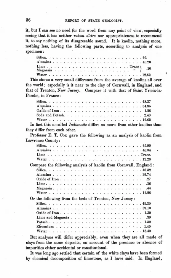
36 RBPORT OF STATE GEOLOGltlT.
it; but I can see no need for the word from any point of view, especially seeing that it has neither raison d'etre nor appropriateness to recommend it, to say nothing of its disagreeable sound. It is kaolin, nothing more, nothing less, having the following parts, according to analysis of one specimen:
Silica •.• _ . . . . . . . . .•.•. _ . . • . •.•.. 46. Alumina . . . . . . . • . . . . . . . . . . . . . . . . . 40.20 Lime . . . . . . . . . • . . . . • . . . , . . . . Trace} Magnesia . • . . . . . . . . . . . • . . . . . .. " .20
Water • • • . • . . . • . . . . ••... " ....••.. 12.62 This shows a very small difference from the average of kaolins all over
the world; especially is it near to the clay of Cornwall, in England, and that of Trenton, New Jersey. Compare it with that of Saint Yrieix-Ia. Perche, in France:
Silica ..•.. Alumina ... Oxrne of Iron .
.48.37
.34.95 • 1.26
Soda and Potash. . 2.40 Water • . . . . . 12.62
In fact this so-called Indiana·ite differs no more from other kaolins than they differ from each other.
Professor E. T. Cox gave the following as. an analysis of kaolin from Lawrence County:
Silica. • . . . • ; • . . .. .............. 45.90 Alumina . . . . . . . . .. ....•......••. 40.34 Lime . . . . . . . . . .. •. ". . . . . . • •. . . Trace. Water........... . ...•......... 12.26
Compare the following analysis of kaolin from Cornwall, England: Silica. . . . . . 46.32 Alumina. . . . 39.74 Oxide of Iron . .27 Lime. . . .36 Magnesia. : . .44 Water . . . . . 12.26
Or the following from the beds of Trenton, New Jersey: Silica ....• Alumina •...•. Oxide of Iron. . . . Lime and Magnesia . P~tash ••. ZlrcoDlum .•... Water ..•....
.45.30 • 37.10
1.30 .39
1.30 1.40
.13.40
But analyses will differ appreciably, even when they are all made of elays from the same deposits, on account of the presence or absence of impurities either accidental or constitutional.
It was long ago settled that certain of the white clays have been formed by chemical decomposition of limestone, as I have said. In England.

THE CLAYS OF INDIANA • 87
.runeralogists and geologists have referred the white clays of the Lower Tertiary to this origin, and Prof. Cox has rightly suggested that our kaolins are the res1tlt of the chemical action of carbonated water upon beds .of limestone.
After all, it is not in the least strange that clay, ·formed of the remains .of silicious rocks disintegrated by mechanical means, should be almost identical with clay resulting from the chemical destruction of silicious rocks. Feldspar, quartz, mica, and the other occasional silicates that
- make up granite, may, upon the dis~ntegration of the rock by the deco~position of the- feldspar, fOfm themselves into a mass consisting of mica, .quartz and clay. So the chemical destruction of the limestone by the acid may leave a residuum of silica, alumina Hnd water, with traces of iron, lime, magnesia and perhaps other matter. When the silica and alumina chance to be in the proper proportion with the absence of iron, we have a· fine kaolin, no matter whether it be from a granitic or a limestone source.
The kaolins of Indiana are found occupying the space which at other points is filled by a stratum of limestone in the Coal-Measure rocks. In Lawrence County the bed is next below the Conglomer~te and occupies the place of a limestone which, not far away, is still seen in position. No doubt the lime rock had been so constituted in the. first instance that its disintegration was easily accomplished by carbonated water, Hnd, in the next place, the overlying sandstone was just the vehicle for conveying such water to the proper place for doing its work. Indeed, the limestone may never have been more than a porous marl in its consistency, with every condition present for the ready action of the transforming agent.
When I first began an examination of this subject I could not account for the large per centum of silica in the clay. The question arose thus: How oould the chemi~l destruction of a stratum of Archimedes lime- . .stone furnish a clay nearly one-:half silica, especially when the stratum of (llay is so thick in proportion to the stone stratum destroyed? No answer <of a satisfactory nature suggested itself. I felt sure that Professor Cox was right in his theory of the. method by which the kaolin had been pro. duced, but I was just as sU1"e that he had not accounted for the presence o()f so much silica. III the first place it would require a large portion of (lRrbonate of lime in the rock to .insure disintegration under the action of acid-bearing water, and in the next place a limestone thus compara.tively pure would have little silica in it. It must be remembered, however, that silica is taken up more readily by pure than by" carbonated water, while th_e silicates of lime, magnesia and manganese are swiftly decomposed before the action of the latter. . Warm rainwater doubtless has the power to slowly ·affect silica and take it up in solution even whilepercolating through sandstone in whose composition exists quartz, mica and feldspar in an infinitessimal state of pulverization. Various kinds oi

38 REPORT OF STATE GEOLOGIST.
pseudomorphism result from the chemical destruction and re-arrangements of mineral matter by this action of water_ Molecular affinity operates usually toward an imitation of some one of the minerals entering intothe new combination .. In the destruction of rocks by carbonated water the lime, magnesia, manganese, etc., are quickly separated. Iron held in the water in the form of carbonate is cRanged, upon evaporation, to peroxide. The silica and alumina will be combined and precipitated in the form of a powder, in which may be caught enough of the iron oxide to color it. 'With these truths in mind let us turn now to the geological conditions- ,under which our kaolin is found. The constituency of this clay would lead us to expect that it would vary in appearance in different parts of the same bed, and upon examination this is found to be the case. The silica and alumina have combined in many proportions, from the finest white impalpable kaolin to a massive allophane on one hand, while on the other hand the product shades off from coarse, brown, somewhat gritty clay to a cherty, iron-bearing limestone, or calcareons shale. It is worth noting here that Professor Gorby, while surveying the "flint beds" of Tippecanoe County, found a coarse, greenish-blue allophane associated with the other silicious deposits there.
The Conglomerate sandstone overlying the clay is a coarse, exceedingly open, pebbly" grit-stone," throngh which water now passes almost as freely as through a gravel bed. This massive sandstone has been formed from the debris of granite, gneiss and other metamorphic rockS' ground up and deposited here. At the time it was deposited it no doubt contained a small per centum of feldspar and mica and some quartz, all in an infinitessimally fine state of mechanical separation. Now, the sand':' stone, heing porous, freely admitted water, which, as it passed through, bore with it all this fine material by first dislodging the feldspar and thus loosing the mica and quartz dust. As the water acted upon the limestone below, decomposing it, it at the same time precipitated its load gathered from the Conglllmerate above. Thus the silica came to overbalance the alumina. No doubt the action of the air had much to do, too, with the freeing of the im'palpable dust of feldspar, mica and quartz from the body of the coarse Conglomerate. The percentage of mica in the clay is very small, barely perceptible, indeed, in the form of spangles observable at rare intervals with a high-power glass. Quartz occurs in occasional pebble-like grains and rarely in the most infinitessimal sand crystals.
The material cif this white kaolin, when magnified under a microscope, has the appearan~e of many other flour-like chemical precipitates-a fluffy, fleecy, loosely concretionary texture-which one of my assistants graphically compared to that of' the inner part of well-cooked" popcorn." In fact, the rounded concretion-like particles, into which the mass separates, are very much of the same appearance as those of lime marl, save that the latter are far coarser. I have not been able to detect the pres-

THE CLAYS OF INDIANA. 39
<ence of the so-called" crystals of kaolinite" in this clay. The fact is the mineral is not there in the form described by Johnson and Blake, and I therefore suspect that the presence or absence of the "pearly scales" of .kaolinite may mark the distinguishing line between clay formed by the decomposition of feldsathic rocks and that derived from the chemical di)struction of limestones. Be this as it may, the kaolin of Indiana is, beyond question, the result of chemical action, aided by the addition of a 'Certain amount of silica in the form of quartz and mica, in an impalpably fine state of mechanical division. .
Although somewhat foreign to the subject of clays, I may well suggest here that many of the chert, flint and other- silicious beds in this State (for instance, the great flint deposits of Tippecanoe County) are examples ()f the "leeching" of sandstones and other silicious rocks, and had the alumina been present we should have had kaolin in the place of the "' flin.t beds." In every deposit that I have examined these flint or chert beds lie below massive sand rocks, and sometimes they usurp the space of :a lime rock, as does the kaolin, and like it are associated with the greenish blue allophane.
The colored or tinted kaolins of Indiana appear to occupy parts of a greater area than does the white variety. They vary as much in quality :as in color, but as yet I have not been able to complete my study of them. The coloring matter is iron obtained from the sandstone (just as I have shown that a part of the silica has been obtained) by means of water. These tinted clays would certainly make beautiful terra cotta work and most excellent pottery. Some of them would probably burn out nearly white, but most of them will burn reddish yellow. Many of these tinted deposits are quite as smooth and fine as the white. In places they are :somewhat laminated, and have the appearance of steatite in color and consistency, hilt they contain no more than a trace of magnesia, while steatite shows about the following analysis:
Silica. . . Magnesia. . . . . . . . . . . . . . . Water ............ .
.6:l.14
.32.92
. 4.94
The white kaolin of Lawrence County is probably identical with the day of Golconda, Ill., as its horizon is the same, and its similarity to that of New Jersey, is very close, though the latter is found in the Cretaceous rocks. The Ball clay of Missouri is much more silicious, and, further, its silica, as well as that of the New Jersey clays, is, in a larger ratio, free and" grainy."
The uses to which kaolin can be put are various. The making of .chinaware and pottery of all grades is the chief, but brick and tiles of the most beautiful kinds, as well as fire-brick, and all manner of terracotta

I
40 REPORT OF STATE GEOLOGIST.
work, are made from it. It is also largely used in the manufacture of paper and alum, and in a number of other processes known to manufacturers.
The time must come when the vast beds of kaolin in Indiana will he of immense value. The exceeding purity of the white variety will especially recommend it.
The fire-clays underlying the coal-seams of Indiana are often of sufficient purity to answer the purposes of the potter and manufacturer of terracotta ware. These clays vary through a wide reach of composition. Some of them are extremlX' silicious. Incomparably fine fire-brick hav~ been made from these clays.
Of the coarser clays, such as are used in manufacturing building bricks,. little need be said. They are to be found in beds over almost the entire area of the State. .A large part of the Drift clays, especially where not too sandy, is readily workable into brick and into tubular drain-tiles. In fact the manufacture of porous clay tile for subsoil land drainage has become an extensive and remunerative industry in Indiana, and has had a· wonderfully invigorating effect upon agriculture and the health of our people.
But, to return to the finer clays. In Harrison County pockets of wh~te kaolin were found in the " glass-sand" deposits. Doubtless this sand has served the same purpose as the Conglomerate in the formation of the kaolin. Indeed, as might be expected, large beds of flint are found in the same vicinity imbedded in silicious clay. There is also in Harrison County an immense deposit of tinted kaolin admirably adapted to the purposes of the potter and terracotta worker.
Owen County, too, has practically inexhaustible beds of the very best kaolin. The attention of manufacturers is especially directed to these -deposits, and it is almost certain that other beds will be discovered. But the kaolin of Lawrence County, taken alone, is sufficient to build up and maintain for many years a manufacturing center as great as any of the pottery and porcelain establishments of England, France or Germany. It will pay the State of Indiana a good and lasting income to advertise her internal resources to the world. Her mineral wealth is to-day greater than that of many States whose gold and silver mines are the wonder of the world.
INDIANA CHALK BEDS.
At numerous points in Northern Indiana the Drift deposits contain ., marl" or chalk formations of a very interesting nature. The substance is of a grayish or creamy-white color and consists chiefly of carbonate of lime. When burned it furnishes a very fair quick-lime, but not the best. It is found in a variety of situations, usually, however, in such a relation to other calcareous deposits, that it could result either from the disintegration of limestones (or from the "leeching" of a Drift formation, containing lime pebbles and finely comminuted limestone) or from the evaporation {)f fresh water charged with lime and magnesia. Usually,this chalk, commonly called marl, is found in low, marshy places, or around the border of small lakes. I have observed it in stages of condition, varying from a slightly calcareous silicate of alumina to a nearly pure carbonate of lime. At some places the thickness of the purer beds has been reported .at as much as thirty-five feet by well-diggers. Many of the beautiful little lakes in our northern area are rimmed with a deposit of this chalk, though in some instances, as at MaxinkiIckee, it is nearer a kaolin than a .chalk, owing to the presence of silica and alumina far in excess of the lime. Very often there is found a deposit, more or less thick, of a peaty nature overlying the chalk, showing that a vegetable growth has for years <covered the area. Indeed, these areas of chalk deposit are invariably :surroundeq by a higher deposit of Drift material, and are, therefore, basins into' which, for a long period of time, the water has percolated through the body of this more elevated matp-rial. Now, rain water in passing through calcareous Drift deposits would take up the lime in two ways: First, by solution; second, by lifting in suspension infinitessimal particles of mechanically divided carbonate of lime from the limestones ground up by glacial action. This finely powdered limestone forms a .considerable part of the Drift clays and sands, and is an element of our so-called lime tufas, which so rapidly form in certain spouty and springy places. Our Drift mass also contains a large proportion of finely powdered quartz, hornblende, feldspar and other silicates, besides iron in various forms, notably pyrites. The gradual destruction of these substances by rainwater filtering through the Drift mass and bearing the solution into the adjacent basins has resulted in the deposition of this chalk, which upon analysis shows that it is constituted as follows:

42 REPORT OF STATE GEOLOGIST.
Water and carbonic acid Insoluble ~ilicates Oxide of iron . Alumina .. . Lime ..... . MagneAia ... . Sulphuric acid . Phosphoric acid.
.'50.06 'f • 030
· 0.10 · lAO .45.38
2.00 · 0040 · 0.38
100.00
Professor Cox made some analyses showing but a shght variation from the above. In each case the chalk was taken from the purest deposits obtainable. In most cases the oxide of iron is hut a doubtful trace, the color indicating its presence disappearing under heat. No doubt the silica and the alumina in the substance is mostly in the free form, while the lime and magnesia have been for the most part chemically precipitated. The iron and sulphuric acid have come from the destruction of iron pyrites. This chalk is not similar to that of the 'older rocks. Under the microscope it shows no foraminifera or other organic forms. It appears chiefly a flour-like substance with an intermixture of extremely fine grains of free silica, lime and magnesia. As I have said, it varies, through many stages, from a kaolin-like clay-marl, as at Maxinkuckee, to a condition of almost. pure carbonate of lime. The following IS an analysis of the deposit at Maxinkuckee, made by Dr. Hurty:
Silica . . . . . . . . Calcinm carbonate . . Magnesinm carbonate. Alumina .•. Ferric oxide .
Total ..
• 53.20 · 12.67
3.03 · 26.76 · 4.~4
99.90
The great difference in the constituent parts observable in comparing these extremes is due to the Drift mass from which the water has derived its load of' suspended or dissolved matter. The silica of the Maxinkuckee clay is largely free, while its lime is a precipitate. But here the silica and alumina greatly overbalance the lime because the Drift mass from which the matter has been selected was silicious and aluminous to a greater degree than it was calcareous. The chalk deposits found around the margins of' many of our lakes have resulted largely from evaporation of water heavily charged with lime; but the precipitatIon is also due, in part, as Prof. Cox has suggested, to the ., agency of the atmosphere and aquatic plants." A homely illustration would be the incrustation of the bottom and sides of a tea-kettle with lime by boiling "hard" water in it. But the origin of the elements constituting the chalk,so far as their presence in the water would be concerned, must be looked for in the surrounding Drift mass.
In Kosciusko County, on the farm of Charles Fribly, has been discovered a deposit of a kaolin·like clay very similar to that at Maxinkuckee.

INDIANA CHALK BEDS. 43
but in great qua.ntities. It is in the midst of a marshy tract of land across which a water-current has flowed some time in the past. The deposit is ~videntIy the result of selection by the water, as it is found in juxtaposition to two grades of fine sand. The following is Dr. Hurty's analysis of a sample of this Kosciusko County clay:
Silica . . . Ferric oxide . . . Alumina ..... Calcium carbonate Magnesium.
Total. .
43.10 4.77
20.78 20.51 10.80
• 99.96
All of our lakes are mere cups or basins in the Drift till, or bowlder clay. Many of them are fed py springs flowing out of the Drift JiIlass around their margins or bubbling up from their bottoms. The water of these "Springs is more or less charged with salts of iron and with lime, magnesia, ~tc., derived from the material through which it flows. Now, most of these lakes have very feeble if any outlets, and constant evaporation going {)n must result in the precipitation of the mineral matter held in solution. In most cases the lakes are fringed with a thick growth of aquatic plants and in some instances the deposition of peaty matter is going on rapidly. Indeed, a number of very interesting covered or "blind" lakes exist, where floating vegetable matter has formed a coat of soil over the water's surface upon which trees and other plants are now growing. This en.croachment of vegetation upon the domain of the water has gradually lessened the area of the lakes, a process greatly aided by the chalk formation going on at the same time, and in the course of time, all the beautiful bodies of water now existing in our northern area will be totally tlestroyed.
The survey so far has just reached these lakes, and the study of the chalk deposi,ts has not proceeded far enough for any thorongh report to be made upon them; but enough is known for it to be confidently said that they are of great value, and promise a rich return in the future when they shall be worked for the making of fertilizers. In my next report I hope to give this slibject thorough investigation.
The following is the analysis by Dr. Hurty of the fine "sand" over lying the clay, analysis of which is above given:
Silica .... Ferrie oxide. . . . Alumina ..... Calcium carbonate. Magnesium carbonate.
45.35 3.LO
25.62 17.95
7.98
Total. . . . . . • 100.00
This would show that the "sand" and the clay are practically identical, one being a mere selection from the 'other by the action of water.

GLACIAL DEPOSITS OF INDIANA .
• L
GLACIERS AND THEIR ACTION.
A glacier is a body of ice. which, although solid, flows over a part of the earth's surface. It has been clearly demonstrated that ice in the form of a glacier, no matter how rigid it may appear, has a current similar too that of water. In other words, ice will form 'a solid stream, so to speak, which will slowly but steadily creep Gown an inclined plane,and if this ice-stream be very deep, so as to give it great weight, it will overthrow. grind up and bear away whatever obstacle opposes it. ,
Glaciers are formed by the accumulation of snow, which, by pressure and crystallization, is turned into ice. Thus, wherever the snowfall in winter is greater than 'can be melted in summer, the snow grows deeper year by year un~il at !ength by its own weight, and by partial surface melting it is compressed into a sheet of ice enormously thick. Now if" the surface upon which this sheet rests is inclined, the ice :flows and we have a glacier. In the Alps there are glaciers from five hundred to over six hundred feet in vertical depth, slowly flowing down the mountain sides. But it does not require steep mountain slopes for the making of" glaciers; a comparatively gentle inclination of the surface of the ground is sufficient if the ice be thick enough and other conditions be favorable, to motion.
The general form of a glacier is that of a' wedge, the edge resting on the lowest point of the surface occupied, the thick end resting on the, highest point of the same. Of course the motio~ of a glacial stream will be in some proportion to the slope of this surface, but the thickness of the great end of the wedge must have much to do with the force of the current. If we adopt the theory of Tyndall, or that of Mosely, or that or Croll, or any other, we must see that gravitation directs the course of the glacial movement just as it does the flow of water'; for it can not matter

• GLACIAL DEPOSITS OF INDIANA. 45
whether fracture and regelation, as Tyndall claims, or expansion and con_ traction by changes of solar heat, as Canon Mosely theorizes, or molecular motion generated by the conducting of heat through the mass, as Dr. Croll maintains, is the agent of motion, th~ fact remains that the glacier, if very thick at its upper end, would flow over a surface of comparatively slight inclination, and its destructive force would be, in a way, proportional to such thickness. Fluidity must be regarded as a property of water, even when the water is in the form of the brittlest ice. It makes but little difference what is the cause of this strange, slow fluidity of ice, it is sufficient for the purpose of the study of the Drift phenomena that the fluidity exists, and that it is sufficient to generate, under c.ertain conditions, a force absolutely incalculable.
It is well for us to bear in mind, at every step of our discussion, that the ice of glaciers is not identical with the ice frozen under ordinary circumstances, nor is the one equivalent to the other. Snow compressed into a mass of glacier-ice is not perfectly crystalline and solid, but peculiarly laminated and porous in its texture, capable of absorbing at times a great qllantity of water throughout its body, thus admitting of expansion by the very force of congelation. Moreover, the smallest movement ofthis sort repeated, at comparatively long intervals, during countless centuries, would thrust a body of ice, no matter how thick, over a long surface distance.
Long and careful study of the phenomena of existing glaciers has resulted in establishing not only the flowing motion of ice, but many of the effects produced thy-eby, one of the most notable being the moraine matter brought down to the glacier's terminus, or collected along its sides. These masses of moraine matter consist of worn and striated fragments of stone, of all sizes, from giant bowlders down to tiny pebbles and infinitessimal grains of sand, together with earthy matter of great variety. A body of this character collected at the foot of a glacier is called a terminal m()'l'aine; if at the glacier's side it is called a lateral m()'l'aine.
A striking and easily recognized feature of moraine bowlders and pebbles, of whatever size, is the peculiar surface-planing caused by the glacier having dragged or pushed them over other stone surfaces, or the like. These ground and scratched faces, once seen and fixed in the memory, serve to identify glacier stones wherever found, whether the stones pe bowlders, pebbles, or rocks in place over which the glacier has passed. Indeed, the floor upon which an ice-river has flowed is always engraved with the unmistakable sign manual of the glacier-fine stria; parallel with the direction of the current.
The movement of a glacier may, and often does, load the ice-surface with stones, dust and other detritus, either by ploughing under the same, or by receiving them as they fall from the slopes on the side.

• 46 REPORT OF STATE GEOLOGIST.
II.
THE GLACIAL PERIOD, ITS EXTENT AND EFFECT.
At the close of what geologists call the Tertiary age, there came a great change in the earth's atmospheric temperature, by which a large part of the northern hemisphere was subjected to a frigidity quite as great, perhaps, as that which now exists in the arctic regions. This polar condition crept on slowly, it ,is thought, until at length, in America and Europe, the desolation of almost unbroken snow and ice reigned supreme. 'What length of time was required to bring about this climatic change can only be conjectured. Enough evidence appears, however, to make it quite certain that a sub-tropical temperature, and a fatlna and flora generated thereby, were banished from our hemisphere, while a boreal winter set its grip of ice upon everything.
In all Northern Europe and America I:'now accumulated year by year, and century by century, until its own weight compressed the mass into glaciers of scarcely imaginable' thickness and area, and beside which the .ice-fields of Greenland are insignificant. As the winter grew colder and colder, the summer grew feebler, and there is plenty of evidence showing that a boreal fauna and flora crept far southward to usurp the places of those animals and plants that had lately flourished in a balmy air and a warm, kind soil.
The enormous proportions of the glacial accumulation n:ay be somewhat measured by the fact that the flowing was strong enough to urge ice-currents over considerable ranges of hills in Europe. Indeed, all over Northern and Central Europe the great rork floor, underlying what is called the Drift, is found to be polished, grooved and striated in the unmistakable pattern of glacial effect~. The direction of these grooves and strim register the courl:'e of the monstrous ice floods, and the morainic stuff, heaped in vast beds a~l over the region affected, tells the rest of the story so fraught with tragedy-an age of frigid desolation, interspersed with obscurely marked periods of relaxation and war~~h.
Throughout the Drift area the physical features vary but little. Above the striated floor-rocks the worn and peculiarly flattened bowlders and pe,bhles, the' heaps and ridges of sand an,d gravel, and the vast mass of bluish clay or till, accompany the glacial matter and make almost the whole of its bulk.
In Europe geologists have studied the Drift in immediate connection with still existing and active glaciers, and have found everything to satisfy the conditions of the" ice theory," or the theory of the glacial origin of the Drift deposits.
In America the Drift lies over a vast irregular area, as yet very indefinitely outlined in the north, but pretty accurately defined along the

•
GLACIAL DEPOSITS OF INDIANA. 47
southern boundary throughout a large part of its extent. From the highlands of Canada an enormous glacier (or rather a series of glaciers) appears to have descended into the region south of the great lakes, overwhelming with morain() matter a large part of the United States, from the Atlantic to the Pacific.
An examination of this Drift or moraine matter shows it to consist, in a large degree, of silicious debris, brought from a region of granite, gneiss. green-stone, quartzite and various other metamorphic or igneous rocks quite foreign to the area covered by the mass. Nor is it difficult to see, in a general way, that much of this matter has been transported from the Canadian highlands, where the granitic and other crystalline rocks are found in place, their surfaces torn, worn and shattered by the glacial action.
IIL
SUPERFICIAL DESCRIPTION OF THE DRIFT DEPOSITS OF INDIANA.'
The mass of matter, very appropriately named Glacial Drift, which is probably the most important, and certainly the least understood geological feature of Indiana, is in the form of. an irregular wedge, its thick end to the north, its edge, or thin end, to the south, the former resting against Michigan, the latter disappearing in a sort of fringe along the Ohio River. Of course this description is of the most general nature, but the student must bear in mind the peculiar shape and position of the mass in order to have a ready understanding of such particular features as are hereinafter discussed.
Taking this vast wedge of matter, then,and beginning our examination in the neighborhood of its southern limit, or edge, we find it more or less obscurely outlined and its constituent parts passing by insensible gradations into the clays formed of decomposed rocks. Proceeding northward, .mere superficial observation ,discovers that the Drift mass grows thicker and an occasional bowlder is seen, while here and there a bed of smooth gravel appears along with deposits of sand. Upon examination the bowlders prove to be rounded, scoured and scratched blocks of granite, gneiss, greenstone. and other igneous or metamorphic rock, and the pebbles of the gravel are simply minute bowlders of the
. same materials. The sand, when carefully studied, appears to be composed mostly of particles of quartz, feldspar, mica and other silicious crystals. evidently the result of a grinding up of igneous rocks.
Bluish or smoky gray colored clay is next discovered and at once becomes the chief component of the Drift mass, growing thicker step by step, as we go northward, save where water and other agents have thinned or removed it. Another very notable fact is the increase in the number

•
48 REPORT OF STATE GEOLOGIST.
of bowlders apace with our progress toward the northern end of the wedge. This gray-blue clay, or bowlder till, is a ma8S of pulverized rock sometimes quite appreciably calcareous, but often almost wholly silicious, as if it were a grist of granitic rocks ground between some monstrous upper and nether millstone and poured out upon the surface of our State. From Middle Indiana northward ridges and hills of gravel and sand, and vast accumulations of bowlders, appear at irregular intervals. Sand, heaped in hillocks and eccentric waves, covers a large area in the northern quarter of the State. Under all this, however, lies the bowlder • till, or blue-gray clay, which, as I have said, grows thicker gradually, in a general way, as we approach the northern limit.
Nearly all the principal valleys of Indiana lie so that their water-flow is from northeast to southwest, and are trenches cut by some agency, not only through the Drift mass, but often through parts of the underlying paleozoic rocks as well. Leading into these valleys frorn all directions smaller streams cut the land surface into irregular areas, and expose very interesting sections of the Drift mass. Along most of the water courses, large and small, the glacial materials have been assorted at certain points and re-arranged in terraces of stratified sand, gravel and water-worn fragment:> of stone.
In the northern part of the State, especially between Lake Michigan and the southern limits of the Kankakee and Yellow River valleys, the bowlder clay has a large number of deep basins filled with water, forming beautiful little lakes.
The outcroppings of stratified rock decrease in number and thickness as we go n'orthward from the Ohio River, until at length the Drift mass becomes so thick that even the largest streams have not cut through it, and there, of course, no paleozoic deposits are exposed.
Between the Kankakee River and Lake Michigan a large area is covered with sand, identical with that of the famous" Hoosier Slide» hills at Michigan City, and the old shore-lines of the lake are easily traceable practically parallel with the present one .
. Bearing in mind the foregoing general sketch of the surface features most characteristic of our Drift deposit, the student will be able to understand the correlation of the details which follow.
IV.
SECTIONS AND BORINGS, SHOWING THE INTERIOR 01" THE DRIFT DEPOSITS.
Wherever streams of water have worn a deep channel into the Drift, and wherever wells have beeu sunk into or through the same, there have been disclosed marked peculiarities of deposition. In cutting through the bowlder till, which is usually a most solid and refractory substance,

QLACIAL DEPOSITS OF INDIANA. 49
strata or intercalated beds of gravel and sand are found, not in persistent ~heets, but usually lenticular, or in some eccentric form of deposition, ~uriously ,gripped in the surrounding clay. Some of these sand and gravel masses would seem of great extent, however, serving as vast sponges to hold the water caught between the beds of impervious till. All through the Drift mass bowlders of every size (from tons in weight to pebbles of the size of a pea) are found, having worn faces whose strire are usually parallel to their 16nger axes. In many places the deposits are curiously curved and otherwise cuntorted, a condition which shows very plainly wherever the clay, gravel and sand are stratified to some extent.
Bowlder till is quite variable in the relative proportion of its ~onstituent parts. While many sections show homogeneous gray or bluish clay, with only here and there pebbles and bowlders, other sections disclose almost every degree of mixture between pure clay, obscurely stratified gravel beds and so-called bowlder dykes. The farther we go north in Indiana, speaking with reference to a general average, the greater becomes the admixture of bowlders, pebbles and angular fragments of rock in the till, especially toward its surface, and the more extended become the intercalated strata of sand and gravel, while, at the same time, the number of basins containing water increases, both at the surface and within the mass. .
The Drift appet\rs in places to be parted by a stratum, or strata of andent soil, in which are found vegetable remains more or less preserved, consisting of tree-trunks, branches and roots,belonging to what have been large forest trees. Wells sunk through the blue bowlder'till from thirty to sixty feet, in Newton County, reached a vegetable mold not unlike rotten leaves reduced to fine powder.
While it has been asserted by geologists generally that our Drift day or till is not stratified, I have noted in many railroad excavations made through it a tendency toward cleaving along horizontal or waving lines of separation, especially where the till was quite dry.
One striking feature of the superficial deposits of the Drift is the situation of' the cleanest gravel on the north ~ide of the hills and ridges. In fact, it is a rule, with comparatively few exceptions, that a section drawn north and south through a Drift hill will disclose the coarse gravel and bowlders heaped in a more of less wedge-shaped mass against the north or northeastern side of the elevation, the rest of which will be sand and till. Furthermore. beginning with the, northmost line of the section, the coarsest part of the gra,!"el will come first, and its pebbles will grow finer as you pass southward across the cutting until it becomes sand, and yon find the clay against which it lies. Of course this is not always the case, and many modifications of the rule will be discovered, owing to recent or oomparatively recent erosions and other disturbances; but every observer will admit the larger fact to be the rule itself. Even where conical hills or
4-GEOLOGY.

50 REPORT OF STATE GEOLOGIST.
knobs of gravel are found, as is often the case, standing quite isolated on· our level table lands, a section of each will generally show a gradation in· the gravel, the pebbles diminishing in size along a line from north tosouth, or from northeast to southwest, the south side passing into sand.
Between practically horizontal sheets of the bowlder till of Indiana, basins or underground lakes of fresh water exist in many places, and when these are tapped by borings the water will often flow as an artesian. fountain above the surface. I mention this well-known feature here as the best proof of the impermeable nature of the clay, and to call the reader's attention to a fact which at another place will be found of peculiar interest in connection with a studY'of the manner in which our Drift has been deposited. These underground pockets of water are, as a rule, similar in every way to the smA.ll deep lakes that dot the surface of Northern Indiana, save that the subterranean basins have been filled with sand and gravel in which the water is held., as in a sponge.
I have found cross sections of the terraces along our rivers to show a . simple enough re-arrangement of Drift materials caused by the action of the water, as the streams gradually decreased in volume, subsequent to the withdrawal of the glaciers, while the loess, bluff or lacustral deposits indicate the bottoms of comparatively recent fresh water lakes over a large area of our State.
The cuttings of the Louisville, New Albany & Chicago Railroad from New Albany on the Ohio River, to Michigan City on Lake Michigan. give a key to many of the most interesting problems connected with the Drift. The student may note, as he follows this line from the southern to the northern bor~er of the State, how, from a fringe of doubtful gla': cial debris, the mass of superimposed materials thickens over the rocks in place, until at length the excavations no longer reach deep enough to· sever the bowlder clay. It requires no practic~d eye to recognize the flat, monotonous billows of the glacial table-lands as soon as they are reached. The whole country, from within thirty miles ofthe Ohio River to the valley of the Kankakee, presents the appearance of having been heaved intolong low waves; but erosion, in fact, and not upheaval, has formed this· rolling surface, and each billow is found to be simply a barrier of' Drift. between two drainage beds.
A feature of the Drift not easily observable, save by the use of the level or the barometer, is a series of waves or swells of the surface,made on a· grand scale, and running, in a general way, east and west without any apparent reference to the valleys of erosion. These, as we shall see further on, are due to what may be called forward and backward steps of the glacier or glaciers during the vacillations of climate between the beginning and the end of the ice period.

GLACIAL DEPOE!ITS OF INDIANA. 51
v. SPECIAL FEATURES OF THE DRIFT.
We have already seen that lenticular beds of sand and gravel, strata of 3ncient soil and" pockets," or subterranean basins of water, are feun,d hermetically sealed up in the body 'of the blue bowlder clay of the Drift. These features have puzzled the minds of geologists not a little, and by some they have been considered inexplicable in connection with the glacial theory.' At first glance it would seem quite impossible to account for a stratum of soft black muck and loam . found intercalated between thick beds of Drift clay, especially when this soil contains roots, branches and even trunks of trees shtlwing little evidence of any crushil?g or grinding force such as we must. look for in connection with the glacial action. This soil and muck, deep buried under a vast mass of the clay, and resting on another mass eqi.IalIy thick, can not be the result of a mere accident, but must be due to some law. So, .with regard to the beds of sand and gravel and the subterranean lakes of the Drift; they owe their origin to perfectlyexplicable and normal forces acting consistently with, and, so to speak, parallel with the great glacial movements.
In the course of my studiesof the surface and subterraneous waters of the Drift, I have noted the following facts:
1st. Springs of water rising vertically, or practically so, from Drift deposits usually come from a great depth, and are more or less impregnated with the salts of iron and other mineral impurities. ~. Flowing wells whose water comes from natural reser,:"oirs in the
Drift clay are usually strongly: impregnated with iron which oxidizes upon exposure to the air. . ..
3d. Wells bore" or dug in the Drift, and whose water does not rise in the bore, are, as a rule, comparatively free from iron and other mineral impurities, but they may contain, occasionally, vegetable impurities, or rather impurities of a vegetable origin.
In connection with the above-named general facts I have noted that, in certain localities, gas generated by decomposing vegetable matter has been met with in the Drift. This, indeed, would be expected where forests lie mouldering in the grip of the clay.' But the sudden exit of this gas when reached by a bore shows how impervious, to even the subtilest element, is the bowlder clay. So whe~ water gushes with great force out of a bore we know' that the liquid has been safely sealed in the clay reservoir.
Now, wh~n we are told, and with an overwhelming show of evidence, that all this Drift mass has been the result of glacial action, we immediately ask-how can it be that a glacier, or any number of successive glaciers could have formed in the body of its deposits~, these pouches of water,

52 REPORT OF STATE GEOLOGIST.
these strata of soil and vegetable matter, and these lens-shaped intermediate pockets of sand and gravel? Such questioning is pertinent, and i~ not at all based on idle curiosity. A great deal depends upon a correct response. The most usual, and, withal, the mpst plausible answer is the the general one which accounts for these special features of the Drift by assuming that there have been many advances and retreats of the great ice flood over the area of our glacial deposits; and that the sorting action of water, the glacial movements and their attending accidents, have given the grand mass its peculiarity of composition. But the practical minded ' inquirer at once interposes the objection which arises on the face of the proposition. "How could a glacier, upon returning to its abandoned field, pass over the mass of its deposits without bearing it all away as it bore away the solid rocks in the first place?" If this question can be answered the rest of the explanation would seem to be quite easy; for if we can account for a stupendous glacier passing over a mass of morainic matter left by a former one without entirely removing· the mass, then we can see how sand, gravel, soil, and even water, could be caught between the clays of the two glaciers and thus be left hermetically sealed in the deposits as we now find them.
We have already considered the nature of glaciers and the flow of ice in a general way,· but in order to solve the problem now in hand we must take a comprehensive view of the conditions which must have attended the formation of glaciers sufficiently grand to brifig about the effects ob- j
servable in our Drift area. Such intense and prolonged cold (extending over many centuries, perhaps many hundreds of centuries) as would attend the formation of ice thick enough to fill the conditions of the g.eat glacial problem, would freeze the crust of the earth to the solidity of adamant many feet deep. Weare not left to mere reasoning or conjecture in this. In many northern regions the earth is now frozen to a great and unknown depth. It could not be otherwise. If thirty or forty days of weath-er with the temperature varying between the freezing point and ten degrees below zero will solidity the ground to a depth of two fe~t, as .js often the case now in our State, how deep would continuous boreal winter for twen-ty thousand years solidify it? Of course the process of the descent of frigidity into the earth would depend upon some mathematical ratio which would at length practically vanish, but there ean be no doubt that a vast period of arctic cold would affect the crust of the earth to a great depth. This proposition conceded, we may proceed to inquire into its effect upon the Drift deposits. .
When the glacial period began in Indiana, no Tertiary deposits had been laid down upon our Carboniferous rocks, for, as we have seen, there IS no good evidence of the Tertiary formations here. The fauna of the Carboniferous seas consisted of marine forms, and in a large degree the genera were those having a very deep water habitat. As the seas became sha1-

GLACIAL DEPOSITS OF INDIANA.
low, at length the marine life disappeared. At the beginning of the Ice age, there must have existed in Indiana the broken remnants, 80 tto) speak, of the Carboniferous sea-a sea at that time full of sandy, desolate islands, upon which, in places, a scant vegetation may have begun to ap- \ pear. Far northward, the mountains of Canada were already covered with snow, and year by year a boreal temperature was creeping southward, on account of a far withdrawal of the deep seas and great changes in their climate-controlling currents. It is not probable, I think, that the Canadian mountains were very high; indeed, they must. have been low enough to be finally overwhelmed by the awful accumulations of snow and ice north of them, for it is plain that the great glacier flowed over them instead of simply running down their sides. . It is impossible to determine how often the ice has flowed over and retreated from the area now covered by the Drift, but to my mind there is the best evidence that the alterations have been many, and between a great extreme of cold on one hand and a sub-arctic temperature on the other hand. In other words, while the frigidity during glacial action was incalculably powerful, the intervals of recession were, as a ~ule, far from tropical, as we now understand the word.
Let us try to get a view of the surface condition of our Drift area after the withdrawal of the first great glacial agent. The highlands of Canada. have been largely demolished, the basins of the lakes have been scooped out of the paleozoic rocks and are filled with solid masses of ice covered over with glacial debris, and the surface of nearly four-fifths of Indiana is covered with an immense Drift deposit.
I have said that the great lake basins were left full of solid ice, when the glacier had retreated far northward, and that the surface of this ice was covered with a coating of Drift material. The same statement is applicable to innumerable small basins left in the glacial clay, just such basins, in fact, as the retreat of the last glacier ·left filled with ice and covered with sand, gravel and bowlders, and which later basins are now the beautiful little lakes of Northern Indiana.
But how, if these basins were solidly filled with ice, did they come 1;()
be covered with a layer of sand, gravel and bowlders? The question is easily answered. As the foot of' the great glacier receded northward a constant flow of' water was caused by its melting, the washing force of which carried forward fine sand and gravel and icebergs, as well, loaded with morainic matter which was distributed over the surface upon which the water flowed. Now, it is apparent, from the very nature of things, that a vast deep basin, in the frozen crust of the earth, filled with a solid lu~p of ice, would be very slow to melt, and that the glacier overlying it would retreat on the line of the basin's rim and leave a great tower of ice; in the form of a cone, marking the site. This cone would rapidly melt down to the basin's level and then the currents from the still retreatinc

REPORT OF STATE GEOLOGIST.
glacier would flow across it, depositing its sand, gravel and (by means of floating bergs) bowlders and rock fragments. Then we have the following {Jonditions: The crust of the earth is frozen to a profound depth below the ice which fills the lake basins, while upon the ice is deposited a thick mass of Drift material, transported there by water and icebergs. One instantly sees 'how great a time it would require to melt a vast cake of ice under such conditions. Indeed, before this melting is accomplished the glacier returns and flows over the whole area again. But the very <Jircumstances which cause a return of the glacier necessarily operate to re-congeal such parts of the Drift as have been thawed, so that the surface {)ver which the second glacier flows is rendered as hard as were the paleozoic rocks upon whose surface it first cut its lasting autograph. This mass of sand, gravel and bowlder-clay, frozen to adamantine solidity, must have been a very refractory substance for a glacier to grind down.· In-deed, the second glacier had a more stubbo·rn material to overcome than had the first. So we can readily see how each retreat of the glacier left -deep basins fuli of ice in the surface of the Drift, and how each return of the glacier buried these basins of ice deep under another mass of till. Hence, all through the grand body of our glacial deposits, we find the hermetically sealed" pock$s" of water which represent the imprisoned ice-cakes now melted in the buried basi~s. The lenticular beds of sand and strata of soil and muck are to be accounted for upon the same grounds. When the time between the retreat and return of the glacier was long enough, no doubt vegetation was generated upon favored areas {)f the Drift, and a soil was formed which, when it chanced to be on low places, was covered up when again the glacier appeared.
In order to illustrate the theory above set forth, let us take Lake Maxinkuckee as an example .and suppose that there should corne a return of the great glacier from the direction of the northeast. We must remember that before this could happen a long period of intense cold would have to prepare the way by freezing solid all the lakes and rivers and the earth's <Jrust to a great depth. Maxinkuckee would be congealed from surface to bottom, and the great glacier creeping down from its source, and scraping and plowing the granite-like, frozen surface of the ground, would bury the beautiful little lake, like an ice-gem, deep under a migh'ty mass of moraine day, sand, gravel and bowlders, where it would remainunmelted until the temperature of the surrounding parth rose above. freezing point, when it would slflwly turn to water and become, not an underground lake, but, by the processes of pressure and solution, a subterraneous mass of so-called " water-bearing clay" or "water-sands."
Evidently there were long spaces of time, in the glacial age, duripg which the ice neither advanced nor retreated, but was held in arrest. No doubt when an advance followed such a pause the glacier overrode its hard frozen terminal moraine, and in this way left large masses of trees

GLACIAL DEPOSITS OF INDIANA. 55
and other matter buried in an uncrushed state, for at every step we must constantly bear in mind the arctic intoosity of the cold during these periods of accumulation.
The immense volume of sand which is thrown out of our lakes, even the smaller ones, is proof of the fact that, during the time they . were frozen solid, their surface was covered with a coat of Drift which sank when the ice melted.
But the question arises: 'Why are the waters of flowing wells and deep springs, that have their reservoirs in the Drift, nearly always impregnated with salts of iron or other mineral impurities, while the waters of wells that do not flow are usually comparatively pure? The answer must be that flowing wells and springs presuppose, in a general way, that their reservoirs are fed from the surface by filtration through permeable parts of the Drift, and that the water takes up the iron, etc., from .the material through which it passes, while the water in wells that are unflowing is not furnished from the surface, or any higher strata of sand and gravel,. but really is water from imprisoned ice melted in the body of the Drift-clay. Of course not.!l11 flowing wells are iron water, nor impregnated to a great degree with other minerals, but the rule is as I have said. The fact suggests itself, in this connection, that all the porous beds of sand and gravel, intercalated between masses of the Drift clay, were probably full of .water, in a frozen state, when they were buried. It must not be understood, however, that I consider this explanation sufficient to compass all the conditions under which water is found in the Drift, but it does seem to me quite applicable to many special problems in that connection which heretofore have not been solved satisfactorily: A number of scientists to whom I have submitted this theory have met me with the question : Why would not a temperature that could cause the retreat of the glacier be sufficient to thaw tlJ.e Drift and its surface lakes? The answer, it seems to me, would suggest itself at once. Earth frozen, say a hundred feet deep, would require a very long time to thaw, even in a tropical climate .. But suppose the Drift and its lakes did thaw out as soon as the glacier had retreated, they would have to freeze up again long before the glacier could return, for it would require an age of arctic cold to cause the accumulation of snow sufficient to form the glacier. Indeed, it can not be doubted for a moment that a temperature warm enough to barely force back superficial ice, no matter how thick, would have comparatively little effect on the earth's crust frozen to a profound depth. Our Drift area must have been a dreary, windy, desolate, frigid waste for a long time after each departure of the glacier. A boreal flora might have appeared and flourished on the surface while yet the ground was frozen for a great way down. However, I can not view the space of time between advances and recessions of the glaciers as being more than the briefest, in a geological sense, so far as ~ost of them are concerned. True, there is some evidence-perhaps sufficient

-- ----- ----
i6 BEPORT OF STATE GEOLOGIST •
.evidence-of two or three general advances and retreats, which are ex-eeptions.
A great terminal moraine, or tangle of moraines, for the most part well defined, runs across Indiana, somewhatuorth of the State's center, marking the resting place for a long time of a glacier's foot, or, rather, the feet .t' glacial lobes. This is traced and described in another place.

A TERMINAL MORAINE IN CENTRAL INDIANA.
It has been said in another part of this volume, that the Drift material. which overlies so great an area in Indiana, has been modified by the action of the post-glacial forces to such an extent that it is extremely dif:" ficult to trace many of its original outlines; but there is a well-defined and most interesting moraine, or. tangle of moraines, which lies in the form of an obtuse angle, whose lines cut the eastern and western border of the State and whose apex points southward. It passes iIlto Illinois from Warren and Benton counties, and into Ohio from Randolph and Wayne counties. It is most obscure at its apex and most clearly defined along its western member in Tippecanoe, Clinton, Montgomery and Boone counties, and along its eastern member in HeJ?ry; Wayne and Randolph counties. The mass of this moraine is enormous, and at many points is heavily charged with bowlders mostly of igneous and crystalline formation, though a considerab1e number of large limestone fragments, chiefly Devonian and Upper Silurian, are found. Southward from the line of this moraine the Drift mass gradually thins out and finally disappears, and northward from it the depth of the Drift diminishes for a distance and then increases again. The valley of the . Wabash is cut through the moraine in Tippecanoe County. The cuttings of the L., N. A & C. Railroad south of Lafayette show, in a very interesting way, the structure of the mass and the manner iIi which its surface has been modified by the action of water and by the operation of freezing and thawing. In the western part of Clinton County, and in the northern portion of Montgomery and Boone counties, the bowlder clay is immediately under the
, surface soil, and here great areas are thickly strewed with heavy granitic and gneissic bowlders. In Benton County a heavy swell or ridge of morainic material is the chief feature observable, while in Marion and Hendricks counties· the Drift mass, though very thick in a general way, is superficially a great rolling plain cut through by numerous streams, the principal of which is White River. From Marion County through Hancock, Henry, Wayne anq Randolph counties the Drift mass, though variable, preserves its morainic character. The foregoing rough description will be sufficient to eooble the reader to trace on any map of Indiana th~ general course of the moraine and to note its position with reference t. -

.18 REPORT OF STATE GEOLOGIST.
the trend of the Wabash Valley. It must not be understood, however, that the moraine, in regard to its width or cross-section, is confined to the counties indicated; indeed, the deposit is of immense proportions, spreading over, besides the counties named already, a part of Newton, Warren, Fountain and C~rroll counties, the southern. part of Howard, and parts {)f Tipton, Hamilton, Madison, Jay and Delaware, with a projection at its apex into Morgan, Johnson, ShelBy and Rush counties. At first glance this will appear to give very little symmetry of outline, and, indeed', the form of the mass as it n,oW lies represents no more than the ' base of what was, at the close of the glacial period, a low, knobby or hilly ridge spanning the State at the angle indicated. The modification which this moraine has undergone since the return of a temperate climate has been in the direction of spreading and flattening the mass and of cutting many deep and oftentimes eccentric water channels in it. This modification is still going on as the res~dt of the action of wind, rain and freezing and thawing.
No doubt the far greater part of this leveling and spreading process was accomplished during the long and necessarily dreary period between the time when the glacier withdrew from Indiana and that when the Drift .area was covered with vegetation. This barren period. must have been one of much greater extent than geologists have been inclined to admit, .and if we take the rainfail as averaging as grcat as we now have, we can €asily see how a vast heap or ridge of bowlder till, moraine dust and {)ther debris, with no vegetation to protect it, wo'uld be rapidly reduced to. a comparatively level mass.
To my mind the evidence is clear that what I here describe as a terminal moraine is really an accumulation of moraines, the effect of many glacial advances, retreats and returns during the great ice period. No doubt, at times when the morainic mass was frozen to adamantine hardness and there came a vigorous return of the glacier, the ice flowed over the huge barrier itself had formerly made and slowly ground it to .!llower level. It is only by understanding this pendulum-like oscillation of the glaciers through a vast period of time that we can solve the problem of the intercalated lenticular magses of sand and water-bearing gravel found hermetically sealed within the blue clay of the Drift, as is shown in a foregoing chapter.
By referring to Dr. Phinney's report of his examinations in Henry and Randolph counties, it will be seen that he found the moraine well marked in its development. So in Dr. Brown's survey of Hancock, and in the reports upon Clinton, Tippecanoe and Benton counties by Prof. Gorby .and W. H. Thomp8on, the features of the formation are minutely described. The highest part of the moraine is in Randolph County perhaps, where it forms the divide between the waters ultimately flowing into White and White Water rivers.

MORAINE IN CENTRAL INDIANA. 59
The Wabash River has cut its way through the great moraine, chiefly in Tippecanoe, Fountain and Warren counties. West of the river from Lafayette the high, ·picturesque knobs, overlooking the beautiful city and grand channel of the Wabash for miles, are heaps of Drift matter, showing every characteristic of moraine formation, while south of the city, near the Junction, the recent terraces are heaped against. immense masses. of' bowlders aJ;ld bowlder clay.
It is a curiously suggestive· fact in this connection that White River. Sugar Creek and Wabash River (each in its turn) will be found, upon glancing at any map of the State, running in the higher parts· of their course, parallel with the general trend of the eastern limb of the moraine and breaking through the formation to immediately take a more southerly course. This would seem to indicate that the moraine had acted as an obstruction to each of these streams for a time, and that they had all fol-· lowed the northern side of it until some weak point was found through which a passage was forced by each in its own way.
A careful study of the Wabash River shows that its passage through the great rock dam and through the moraine are completed at the samepoint near Covington, in Fountain County, where the river turns into a. eourse nearly due south; and it is this great rock dam at Momence, in Illinois, which the Kankakee must be made to o.vercome before its vast area of wet lands'can be drained successfully.
Students of geology, who desire to give especial study to the more,marked features of the great moraine herein so roughly and hastily sketched, will find Lafayette Junction, the eastern part. of Clinton County. the northern part of Montgomery County and a large part of Wayne and Randolph ·counties the most favorable points of attack, and it is to behoped that the students and scientists of the State will give this very interesting geological feature a patient and careful investigation.
The· line of distllrbance triwed by Prof. Gorby across the State appearilto bear, a close relation to the formation of this terminal moraine. No. doubt the great rock barrier formed a sort of dam against the free advance of the glacier, and thus it modified, in a large degree, the Drift or morainic formation in the first place, and afterward controlled the floods of iceberg-bearing water, Which rushed southward from the foot of the retreating glacier, thus preventing the total destruction of the moraine's outlines by this agency and giving direction to the Wabash and Whiterivers. Indeed, evidence is present everywhere along the formation going to show that the northern rim of the moraine became the stranding
. place of icebergs loaded with bowlders, and that this stranding line was practically parallel with Fhe flow of the Wabash, and with the trend of the great rock dam. Crowning the very highest parts of the moraine are found so-called dykes of great extent, formed chiefly of granitic bowlders. These bowlder areas, as I prefer to call them, are not areas of erosion.

REPORT OF STATE GEOLOGIST.
-0n the contrary they are often deposits, and passing over the highest :swells of the formation. I had the pleasure and profit of going over one of these areas with Prof. Chamberlain, of the United States Geological Survey. This was in the northern part of Montgomery County, wltere the so-called" Bowlder Dyke" practically ends.
I have, for mere convenience, called the morainic mass, thus roughly ~utlined, a terminal moraine; but I regard it as a cluster or tangle of a number of inseparable moraines, caused chiefly by the separating of the .great glacier into lobes, and by successive advances and retreats of the ice masses, attended by great rivers of rapidly rushing water in the melting periods. One of the marked features of thiR formation is a succession ~f knobs or cones of sand and gravel, alternating irregularly with ridges and hills of bowlder clay, and with occasional undrained areas or basins.
Of course, to outline this great deposit with any close attention to deMils would require a minuteness of examination and an amount of time .1Uld expense wholly out of the limits set by my duties. I hope that this sketch will induce others to make a study of what is the most inter.esting scientific problem in connection with the superficial geology of In«iana.

GEOLOGY OF TIPPECANOE COUNTY.
S. S. GORBY.
GENERAL DESCRIPTION AND HISTORY.
Tippecanoe County is situated in the west-central part of the State and ~is bounded. on the north by White and Carroll, on the east by Carroll and {)linton, on the south by Montgomery, andon the west by Fountain, Warren and Benton counties. It is separated from the boundary line of the :State of Illinois by the three counties last named. The county is twenty·one miles wide, east and west, and its length is twenty-four miles. Its ·entire area is 504 square miles. About one-half the surface consists of bro~d, fertile and nearly level plains. The balance consists of gentlyrolling uplands, steep hillsides or rich alluvial bottoms. Occasional swamps ,01' bogs are seen with deep, lacustral deposits.
The earliest settlements in the county were made by the French on the Wabash River, at the Indian town of Ouiatenon, which occupied the beautiful and fertile region on the south bank of the Wabash, known as the 'Yea Plains. This town contained an Indian population of more than 500. For many years it was the chief town in all the Northwest 'Territory. It was the point of general rendezvous for many of the prin-.cipal tribes of the great Northwest. The French settlement in this place ·consisted of forty or fifty wooden houses. The Indians lived in wooden houses, wigwams and tents. The extensive tract of' land, Wea Plains, contains sixty-five or seventy sections of the most beautiful and producttive lands in the county. This land was thoroughly cultivated by the natives for many years. The rich soil produced abundant yields of their native maize or corn. The entire town and all the crops were destroyed by an expedition directed by General George Rogers Clark, in 1791. 'General Charles Scott and Colonel Wilkinson had immediate command ·Qf the expedition. The French who were merely traders and mechanics, never attempted to settle here again. The Indians long attempted to maintain their right to these beautiful lands, and it was not until after ihe disastrous battle of Tippecanoe that they finally yielded to the decree ·.f force.
The Indians also had a populous village at Prophet's Town, near the aouth of Burnett's Creek, in the northeastern part of the county. This

62 REPORT OF STATE GEOLOGIST.
was the home of Law-Ie-was-i-kaw, the Shawnee prophet, half-brother of Tecumseh, the famous Shawnee chief. Near the latter village occurred the famous battle of Tippecanoe, which was fought on the 7th of November, 1811. The Indians were under the command of the Shawnee prophet. His forces were made up of warriors from the Shawnees, Pottawatomies, Miamis, Sacs, Winnebagoes, Kickapoos, Chippewas, Ottowas and W yandots. General Harrison's force, consisting of about [J(l0 men, was encamped upon the narrow ridge separating Burnett's Creek on the north from a deep, impenetrable swamp or morass on the south. The I
ridge is about a mile in length and it runs to a point at its southwesteril extremity. Its general direction is northeast and southwest. The whiteswere encamped at its southwestern extremity. The Indians were encamped upon the high ground lying between the swamp and the Wabash River. The Wabash river is one mile south of the battle ground. Tip. pecanoe River is two miles east. The impassable swamp lay bctween the hostile forces. The bluffs of Burnett's Creek are high and precipitous on the north. They are formed of great masses of piled" up gravel,
-cemented together with carbonate of lime and iron. About one-half mile below the western limit of the ridge upon which- the Americans were encamped, and" on the opposite side of the creek, is an immense mass of conglomerate, high and picturesque; which overlooked the camp of the Americans and all the region beyond. This rock has been worn into caves and grooves and arches by the eroding forces of past years. It is said that the Indian prophet stood upon this eminence to give the signal for attack on the morning of November 7th, 1811. The attack was begun just before the break of day. By wading up Burnett's Creek the Indians reached the camp of the Americans. The surprise was almost complete, and the issue of the battle for a long time doubtful. The Indians were finally compelled to flee, and the dissolution of the great N orthwestern Confederacy was complete. The white despoiler retained the land and the Indian pursued his way toward the setting sun. The loss was nearly equal on both sides, the Americans having 37 killed and 154-wounded; the Indians having 38 killed and 160 wounded. Many relics of the great battle have been found in the vicinity. An occasional rusted rifle barrel is yet picked up in the swamp just south of the battle ground. This swamp has recently been drained and is now yielding excellent crops. A neat iron fence, which was built by the State, encloses the scene of the battle, but the graves of the heroes who fell there are sunken and neglected--unmarked by any suitable monument.
The earliest English settlements in the county were made about the year 1815, or a little later. Patrick Henry Weaver, the oldest settler now living, was one of the earliest settlers on the Wea Plains. He moved to the county in 1823, and it has been his continuous residence ever since. There were but thirteen families in the county when Mr. Weaver first set-
GEOLOGY OF TIPPECANOE COUNTY. 63
tIed there. The population of the county has since increased to 40,000. Lafayette was settled in 1825; Dayton, in the eastern part of the
.county, was settled in 1829, and Romney, in the southern part of the {Jounty, in 1832. Lafayette at the present time claims a population of about 25,000. It has an excellent city government, and many substantial and beautiful public buildings. The new court house, built of Indiana limestone, at an expense of about $500,000, is one of the finest buildings of the kind in the State. It is a credit .to the county, an ornament to the .city, and will be a permanent advertisement of the beauty and durability ·of the Indiana building stone.
The public schools of the city, under the able management of Prof. Merrill, City Superintendent, afford excellent and unsurpassed facilities for the education of the rising generation. The school buildings are ele,gant and commodious, and are so situated as to be easily accessible to all who may wish to attend them. The enrollment of pupils is large in proportion to the population of the city and the total enumeration for school purposes.
Many fine churches adorn the city. In fact, it may be called the ." City of Churches" as well as the" Star City," as there are no less than twenty-nine commodious buildings controlled and occupied by the various church organizations of the city. Thirteen newspapers are published in the city, devoted to news, politics, agriculture, temperance and religion.
Purdue University is located here. This excellent institution is under the management of the State. It affords ample facilities for students in the classical and scientific departments. Special attention is here given to the mechanical and agricultural arts. In this respect there is not a similar institution in the State. In these departments, as in all others, Purdue ranks with the very best institutions in the Union. Exceptionally good facilities are here afforded for the study of geology. A large library ·of rare books, and an extensive cabinet of fossils and minerals, together with an excellent corps of te!1chers, enable the students to rapidly acquire a knowledge of geolgical formations, and the characteristic fossils uf the various periods and groups. Nearly two hundred acres of land are devoted to scientific, experimental farming. All o~ervations are carefully recorded, and valuable discoveries arB immediately published. The University buildings are located about a mile west of the city, upon high and beautifully ornamented grounds. Dormitories and boarding houses afford ready accommodations-for students. Under the able management of President James H. Smart, the attendance of students is rapidly in. .creasing. The enrollment at this time is larger than ever before attained.
Tippecanoe County was organized in 1826, ten years after the admission of the State into the Union. It has steadily increased in population and wealth. It is noted for the intelligence and energy of its citizens. Many men famous in the politics and literature of the United States

64 REPORT OF STATE aEOLOGIST.
have resided here. Besides the city and towns already mentioned. there are many other thriving towns and villages. Battle Ground, 0&
the site of the battle of Tippecanoe; Colburn and Buck Creek, in the north-eastern part of the county; Dayton, in the eastern part; Montmorenci, in the north-western part ; West Point, in the south-western part, Clark's Hill, Stockwell and Culvers, in the southea~tern part, and Cor-· win and Romney, in the southern part of the county, are all thriving towns. Chauncey, on the Wabash River opposite Lafayette, possesses an intelli~ gent population of about 2,000. The corporation line extends west t. I
l\urdue University.
TOPOGRAPHY AND DRAINAGE.
The county was originally a nearly level plain, broken occasionally by low ridges that traversed the county from east to west. One of there ridges extended from. the bluffs of the Wabash River, a little north of Lafayette, to the Warren County line on the west, a distance of about ten miles. It is almost parallel with the Wabash River, which pursues a nearly west course from Lafilyette to the county line on the west. The mean distance of this ridge from the river is about two miles. This is a sand and clay ridge principally. But few bowlders were observed in it, and but little coarse gravel. Another ridge, parallel with this, crosses, the county about five miles south. It is known as the High Gap Ridge. It is largely composed of sand, gravel and bowlders. It extends from Culver Station on the Cincinnati, Indianapolis, St. Louis & Chicago Railroad to the Fountain County line. Another ridge lies five miles south or High Gap Ridge. It lies almost wholly in Jackson Township, in the south-we5tern corner of the county. This is a saz:td, gravel and clay ridge. Near its western extremity is a high and prominent mound, known as Shawnee Mount{. The numerous creeks of the county have cut through these ridges in many places, but. at no point could a complet& section of them be taken. The creek bluffs have generally rounded and gentle slopes, that are easily susceptible of cultivation.
The Wabash River ooters the county at the north-east corner and flowssouthwesterly to Lafayette, near the center of the county; thence it flows· westerly to within two and one-half' miles of the Warren County line, where it again changes to the south-west, and pursues that direction until it crosses the western boundary of Tippecanoe County, ten miles north of' the southern limit of the county. The river is navigable here for steamboats of light draft during the whole of the year. During easy or fair' stages of water boats of large capacity can run. Owing, however,to the, variable stages of water, only boats drawing little water are employe4i upon the river at this point.

GEOLOGY OF TIPPECANOE COUNTY. 6&
Pine Creek, in the north-western part of the county, rises in Section 31,. Township 24, north, Range 5, west, Shelby Township, north of the L. r
E. & W. R. R. It flows south-westerly and empties into Big Pine Creek in Warren County.
Big Indian Creek rises in Wabash Township, two miles north-easl' of Porter Station on the Lake Erie & Western Railroad, and flows southwesterly to the Wabash River, which it enters two and one-half miles east of the Warren County line. Little Indian Creek rises north of Montmorenci on the L., E. & W. R. R., and flows south; it empties into. Indian Creek.
The several branches of Burnett's Creek rise near the White County line, and drain Tippecanoe Township. They pursue a tortuous course, flowing first southerly, thence north-easterly, again southerly, and finallya. south-west course to the Wabash River.
Tippecanoe River crosses the northern boundary of the county about: four miles west of the Carroll County line. It flows a southerly course, and discharges its water into the Wabash River.
Sugar Creek rises in Carroll County, flows west, croii,sesthe Tippecanoe County line three miles south of the north-east corner of the county, and empties its water into the Wabash River nearly opposite the mouth of the Tippecanoe River.
Buck Creek rises in Carroll County, flows west, crosses the Tippecanoe County line two miles south of Sugar Creek, and discharges its water into the Wabash opposite the town of Battle Ground. Washington Township, in the north-east corner of the county, is drained by Sugar and Buckcreeks.
Wild Cat Creek and its many tributaries drain Fairfield Township in . the central and Perry and Sheffield townships in the eastern part of fhe county. Wild Cat Creek rises in the north-western part of Clinton County; flows westerly, emptying its waters into the Wabash River four miles above Lafayette. It crosses the Tippecanoe County line eight miles north of the sO\lthern boundary of the county. The North Fork, which has several branches, rises in Carroll County, flows south-westerly, and unites. with Wild Cat Creek four miles north-east of Lafayette. Middle Fork rises in Clinton County, flows west, and empties into 'Wild Cat Creek five miles east of Lafayette. Laramie Creek rises in the extreme south-eastern part of the county. It flows north-westerly, then north-easterly, and discharges into Wild Cat Creek two and one-half miles west of the Clinton County line. It drains Laramie Township in the south-east corner of the county.
Wea Creek rises in the southern part of the county. The East Fork drains the western part of Laramie Township, and the West Fork drains Randolph Township, the central one the southern tier of townships. Wea Creek flows north-westerly, and discharges into theW abash River
5-GEOLOGY.
· .
"'66 Rli:PORT OF STATE GEOLOarST.;l
foUr rillies' west of Lafayette. LittleWea Creek rises in the south-western corner of the county, in' Jackson Township, flows, northreasterly, then north-westerly, and unites with Wea Creek about three miles south-west of Lafayette. ' '
The two branches of Flint Creek drain Wayne, Union and Jackson townships. The South Fork rises in the northern part of Jackson Town
'ship, flows north until it unites with the North Fork near West Point, and then pursues a north-westerly course to the Wabash River. The North
,Fork rises in Union Township; flows northerly, then westerly to its junc- , tion with the South Fork near West Point.
" Many other small streams add to the surface configuration and drainage ,of the county. Many beautiful springs of Clear, cold water abound in the county. These keep the numerous creeks flowing the entire year. The never-failing, crystal currents add a great convenience to tbe stock raiser.
The natural drainage of the county is almost perfect. The creeks have ,cut channels in the Drift from ten to two· hundred feet in depth. In many instances wide, alluvial bOttoms have been formed. The soil of
,these bottoms is Qf great fertility and productiveness. The creek bluffs :are of sand,gravel or clay, and have been worn into beautifully rounded ' 'contours, or gently sloping descents. In thesotlthern, eastern and northern parts of the county, ditching and tiling is 'resorted to in order to thoroughly perfect the drainage. ' On the Wea Plains and the gravel terrace west of Purdue University; the great gravel deposits underlying the soil iurnish the most complete and thorough drainage. The most copiouS rams sink at once intq the soil and out of sight. ,. These lands, on' this account, are not affected by the periodical wet seasons, and their capacity to resist 'extreme drouths is equally as great."" ' , lIn the eastern part of the county, in the neighborhood of Dayton, many ,low sand mounds were -observed. They usually consist wholly. of fine, Clean, yellow or white sand, but in some instances they consist partly of fine or so'mewhatcoarse gravel, which makes excellentr,oadi. Mounds of ,th'e same character were noticed' in Jackson Township;:in,the south-west "part of the county. Shawnee \Mound, a mound of historical interest, is a large mound of this character. It co-vers many acres; ana 'has 'frelluently :been mistaken for the work of the Mound' Builders. Careful examination, however, has revealed that it is of Nature~s ;bandiwork, .built by the -Master Builder during the great period iI;l th~ histOry of the earth" that geologists have denominated the Glacial Epoch., It is hut a more elevated portion of one of the high ridges'already described~ •
In Shelby Township; on Indian Creek, near its' Junction 'with the 'Wabash River, lW"e two large mounds,knownas'''The Indian Creek 'Mounds;" These are located in. the:creek bottom, on the west side of the ~reek, near the·'bluffs. It has been supposed -that these, too, 'were of artificial origin, but a thorough examinati<>n·shows that they were o:dginally

GEOLOGY OF TIPPECANOE COUNTY •
a part of the west bluff of the creek. The bluffs of the creek here consist principally of layers coarse and fine gravel, compactly cemented together by carbonate of li:me and carbonate of iron, forming a rough conglomerate. The mounds are of the same material, stratified in the same manner, and. are situated in what was anciently an acute angle of the creek bluff. At a time when the water flowed to the tops of the bluffs, an'd over the bluffs above the mounds, it cut a new channel to the right of them, and also one between them,which were worn deeper and deeper, and widening at the same time, finally cut away all connection between them and the adjoining bluff, and at last left them to remain as monuments of what has been, and with a beautiful tract of fertile bottom land around them.
The low alluvial bottom lands of the Wabash River, which form the first. terrace above the river channel, varyin width from a few yards, as at Lafayette, to perhaps a mile, as may be observed opposite Black Rock, in Warren County. ",Vest of Lafayette, on the south side of the ;river,. is a second terrace, elevated forty to eighty feet ab.ove the first, which runs back two to five miles from the river. This nearly level tract, known as WeaPlains, was originally all prairie land, and, as before re-o marked, ill a great mass of gravel, 1211 to 200 feet in depth. North of the river, opposite Wea Plains, -is a gravel terrace of a corresponding hight to .that of the plains, but here ~t is really a third terrace, as there is a lower terrace from twenty to thirty feet in hight lying between the river bottom and the level of the higher terrace. This second terrace is very distinct, three or four miles below Lafayette, but rises higher and. higher as it approaches the city.till it finally merges into the higher or third terrace. The low river bottom also narrows rapidly near the city, and nearly opposite Lafayette the first, second al).d third terraces are al.' most wholly lost in the river bluffs, which here approach nearly to the. river. The second terrace varies in width from a few yards at some: points to perhaps a mile in other places. Above Lafayette the -low bottoms of the Wabash River vary but little from what was observed below the city. The same varying width was noticed, and thehight above low-water mark is about the same, ranging from ten to twenty feet, probably. These bottom A are all subject to overflow during extremely high water.
Low-water mark of the Wabash River at Lafayette·is 504 feet above' ocean level. The reservoir on the bluff, east of the city, is 226 feet above low-water mark of the Wabash. The altitude of the reservoir, therefore, is 730 feet above the sea. About 750 feet is probably near the general altitude of the county. It was anciently a nearly level plain, with a few. rolling ridges and mounds to break the. otherwise uniform appearance pf the surface. The erosion pf the deep river and creek v!111eys . and chan. nels has modified the appearance of this ancient plain to a material extent,' b.ut the geneml altitude of the entire arel), is not greatly altered. Shawnee .. :M:oilDd,High G!i,p Ridge, the high bluffs (If'QedarHollQw,about.five

68 REPORT OF STATE GEOLOGIST.
milEis north of Lafayette, and the high lands between Wild Cat Creek and Buck Creek, and between the latter and Sugar Creek, rise to the· hight of a little more than 800 feet. These are probably the highest points of the county.
WATER.
This is one of the best watered counties in the Rtate. The rivers and <lreeks furnish an abundance of water for mechanical and agricultural , purposes, and the many excellent springs and wells furnish an inexhaustible supply for agricultural, domestic and medicinal purposes. Springs of dear, cold, sparkling water are plentiful in nearly every part of the eounty, and never.failing wells may usually be obtained by digging or boring from fifteen to forty feet. On Wea Plains, however, and on the high terrace on the opposite side of the river, near Purdue University, wells have to be sunk a hundred feet or more to insure a constant supply of pure water. In the northern and north·eastern parts of the county a sure supply of water is obtained at a depth of twenty-five to eighty feet.
The canal was abandoned several years ago as a way of commerce, and it has lately fallen almost wholly into disuse as a motive power for machinery; but it seems that motives of economy should prompt its preservation, for it is certainly a cheap and reliable power for the movement of machinery. Many dams have been constructed on the various creeks, and suitable power thus acquired for the manufacture of lumber and flour. The' new "Roller Process" of manufacturing flour has almost entirely superseded the old buhr stone process, and the loss of business has caused the abandonment of many country mills that one day were excellent payiing property.
For domestic purposes the water of this county can scarcely be excelled. It is remarkably free from diatomaceous organisms, and other forms of microscopic organic life calculated to produce malarial ~r typho-malarial poisons. In the western and south-western parts of the county the water is strongly impregnated with salts of lime, and at Montmorenci and on Indian Creek the water carries a large per cent. of salts of iron. Mr. Godman, a leading citizen of Montmorenci, has a well on his premises which supplies water strongly impregnated with sulphur and iron. Some of the springs and wells in the western part of the county contain water which is stron~ly magnetic. A knife blade, or other steel instrument, immersed in the water will .soon acquire the property of lifting a needle or other small iron or steel substances. Many of these springs and wells have local reputations on account of their medicinal properties. Their waters are usually cathartic in their effects. The spring at the Battle Ground is quite widely known. It has long be~n It favorite resort for invalids' who seek a pleasant retreat and mild chalybeate water. The

GEOLOGY OF TIPPECANOE COUNTY. 69
ground over which the water flows is deeply colored by a deposit of oxide (If iron, precipitated by the water. The temperature of the water is 53° to 54° F. It has a strong taste of iron. There are many springs of the same character along Burnett's Creek, and along Tippecanoe River. In fact, these iron springs abound all over the county. Whenever the water deposits that red, ocherous sediment it may be known that the sparkling liquid is carrying iron, and perhaps other salts.
The artesian wellat Lafayette has a reputation not confined to the limits of this State. The water of this well precipitates a white sediment upon the surface over which it flows, and is known, therefore, as ., white sulphur water." A complete analysis of this water was made by Charles M. Wetherill, Ph. D., M·. D., several years ago. From the published report of that analysis the following copious extracts are taken:
"Physical Character.-The artesian water is of an extreme limpidity when taken freshly from the well. The deposit upon the pebbles over which it flows is white, entitling it to the name of white sulphur water. Standing in imperfectly closed vessels, a similar bluish white deposit takes place. Under certain conditions, the deposit contains black flakes of sulphuret of iron. The ~mell of the water is strongly of sulphurettedhydrogen, so as to be perceived at a distance (with the wind) of two squares from the well. The ~aste is similar to that of the celebrated Blue Lick water, though less strong. It is pleasantly brackish, resembling in taste the liquor from oysters freshly opened." The temperature of the water when first taken from the well is f>5° to 56° Fahrenheit. The density of the water is 1.00523. The following table gives the" composition of the white sulphur water of the Lafayette artesian well, water of March 25, 1858, as determined by Dr. Wetherill. Temperature, 55°-56° F. Density, 1.00523."
GASEOUS CONTENTS.
In 1,000 grammes. Gramme.. Cub. Centimo
In a wine pint. Cub. Inohes.
SuJphuretted hydro~n. . . . . . . . . 0.0093 6.35940 " "of water of Apr. 8. 0.0145 9.9154
Carbonic acid. . 0.0997 52.683 Nitrogen ... 21.280
SOLID INGREDIENTS.
Residue by pure water. . . . Evaporation, solid ingredients.
Total .........•
In 1,000 parts by weight.
. 992.75 7.25
.1,000.00
0.184l 0.2870 1.5253 0.6160
Grains in a wine pint. 7,274.446 .
53.124
7,327.570*
"'This is the weight of a wine pint of the artesian water; the weight of the same measure of pure water being 7,291.11 grains. I

70 REPORT OF STATE GEOLOGIST.
INGREDIENTS BY ANALYSIS.
In 1,000 parts Grains ina. by weight. wine pint.
Carbonate of lime • . .0.2052 1.503 Carb9nate of magnesia. • • Peroxide iron with alumina.
.0.0069 0.050
Phoephate of lime, fluoride of. .0.0085t 0.0·52 Calcium, and a faint trace of manganese. Silica. .0.0080 0.058 Sulphate of lime. .0.9555 7.002 Chloride of calcium .0.0635 0.465 Chloride of magnesium. .0.5059 3.707 Chloride of iodium .5.5402 40.596 Traces of iodine and organic matter Bromine doubtful
Total. . 7.2937 53.443
By comparison, Dr. Wetherill found that the water of the Lafayette artesian well contained "as much' carbonate of lime as the White Sulphur Springs of Virginia; as much sulphate of lime as the same springs, and as the Sharon Sulphur and the Avon Lower Springs of New York; as much chloride of magnesium as the Blue Lick Spring of Kentucky, and more iron and less silica than the same spring. One and a half pints of the Lafayette artesian water contains as much common salt as one pint of the Blue Lick water."
This water is recommended as a beverage and for baths in nearly all cases of derangement in the secretory organs. Diseases that have become chronic are generally cured by a continued use of this water. For drinking purposes the water is free to all. Private parties have established baths at a moderate price. For pulmonary troubles the water is not re- ' commended.
The following accurate survey, by Mr. Wm. S. McKay, who superintended the work, shows correctly the succession of strata encountered in boring the well:
Clay ...... . Clay and gravel. . Gravel and pebbles. Fine gravel and sand. Quicksand ..... Gravel, clay and pebbles. Dark gray clay .
• Sand and gravel. Clay and pebbles. Sand and, gravel. Clay ..... .
3 ft. 9 ft. 6 in. 1 ft. 6 in.
13 ft. lit. 2 ft. 6 in.
72 ft. 4 ft . I ft. 3 in. 7 ft. 3 in.
6 in.
tEquivalent to carbonate of the protoxide of iron 0.0061 per mille;

GEOLOGY OF TIPPECANOE COUNTY.
Sand and gravel. 3 ft. Clay and pebbles. 6 ft. 6 in. Gravel and pebbles. .5 ft. Bowlders. 40 ft.
-----• To shale
Blue sh~le. 2 ft. Gray shale 18 ft. Blue shale. 1 ft. 6 in. Gray shale 7 ft.
Total shale Limestone, coralline-Devonian Gray limestone with spar-Upper Silurian.
Total depth of well. . • . . . . . . .
170 ft.
28 ft. 6 in. n ft. 6 in. 20 ft.
230 ft.
71
This well is located in the valley of the Wabash River, and the surface at the well is fifty or sixty feet above low·water mark, or about 180 feet lower than the top of the bluff's east of the city. . The total depth of the well, therefore, is about 410 feet, measured from the level of the surrounding country. In making the well the eroding forces of nature, ages ago, did material service in removing 180 feet, or more, of the overlying deposits. Indeed, the tools of the workmen only penetrated to a depth of 60 feet beneath the level of the ancient valley of erosion.
COMMERCE AND MANUFACL'URES.
The 'Yabash River is only navigable at its ordinary sta,ges for boats drawing little water. Formerly a large business was done, principally
. with the South, through the medium of flat-boats and barges. This method of business was soon supplemented by the building of the Wabash Oanal. This opened a direct freight line to the East, and at once gave a great impetus to the grain and stock trade. But the interest of business demanded faster freights, and the building of railroads through every part of the State has forever superseded the old canal as a means of transit. Lafayette, the capital of the county, is one of the important railroad centers of the State. The following lines of railroad now pass through the city, viz: The C., I., St. L. & C. R R, which passes from south-east to north-west through the county; the Lake Erie & 'Yestern Railroad, which crosses the county from east to west; ,the Wabash, St. Louis & Pacific, which runs north-east and south-west through the county, and the Louisville, New Albany & Chicago Railroad, which runs north and south through the county. Besides, the T., C. & St. L. Railway crosses the
,south-eastern part of the county, running north-east and south-west, crossing the C., I., St. L. & C. RRat Clark's Hill. These thoroughfares give ample accommodation for the transaction of aU the business of the

72 REPORT OF STATE GEOLOGIST.
county. They give direct communication with Chicago, St. Louis, Louisville, Indianapolis, Cincinnati and the cities of the East. For the prompt transaction of all kinds of \msiness no . city in the State is better situated than is Lafayette.
All the important manufacturing interests of the county are sitllated at Lafayette. The following table of statistics, taken from the United States Census Report of 1880, gives complete information as to the extent of the manufacturing interests of the city:
TABLE OF MANUFACTURES.
Boots and shoes . . . '.' • • • Bread and other baked products .. Carriages and wagons . . • . . . Cars, railroads, streets and repairs. C}othing, men's . . . . . . . . . Coffee and spices, roasted and ground Cooperage .........•... Flouring and grist-mill products . . Foundry and machine-shop products Furniture •... Distilled liquors. Malt liquors . . Lumber, planed. Lumber, sawed . Marble and stone work. Printing and publishing Pumps, not including steam-pumps . Saddlery and harness. . . . . . . . Tinware, copperware and sheet-iron ware. Tobacco, cigars and cigarettes. . . . . .
$212,000 153,000 59,000
214,000 132,000
33,000 154,084 490,139
58,{'00 20,650
122,000 132,840
40,000 46,500 21,800
266,500 74,856 50,500 55,274 42,450
While no great specialty is made in any particular line of manufactures, it will be seen that the aggregate amount of manufactured goods is such as to entitle the city of Lafayette to respectful consideration as a manufacturing city. The excellent shipping facilities, healthful climate, generous soil and genial people, together with the cheapness of living,offer splendid inducements to those who seek locations for the establishment of factories.
ARCHlEOLOGY.
Evidences of the Mound Builders are quite numerous in this county. Drills, spear-heads, arrow-heads, stone axes, scrapers, pestles, mortars, gorgets, pottery, copper bracelets, copper beads and many other relics have been found in different parts of the county. Purdue University has a choice collection of stone implements, gathered from different localities in the county. The Lafayette High School collection contains a number of very fine specimens. Besides, many private collectors have fine cabinets

GEOLOGY OF TIPPECANOE COUNTY. 73
()f arcbreologicalspecimens. Among tbem may be mentioned Mr. A. J. Godman and Prof. W. M. Rank, at Lafayette; Mr. Rowe and Mr. Godman, at Montmorenci; Mr. Meigs, at Th)mney; Mr. Fiddler, near Culver's Station; Mr. M. E. Sherry, at West Point, and many others. No tumuli were observed, except in the northeast part of tbe county. In the neighborhood of Battle Ground, and on Pretty Prairie, north of Battle Ground, mounds are quite numerous. South of the Wabash River, in 'the neighborhood of Buck Creek Station, there are several mounds. 'There is an elliptical mound on the farm of Mr. Allen Stanfield, in Washington' Township, about twelve feet in hight. Its longest diameter is about forty feet, and the transverse diameter about thirty feet. Two ,other mounds on the same farm are circular, or nearly so, and about twenty feet in diameter and seven or eight feet in hight.
On the farm of Major VanNata, two miles-east of Battle Ground, and just at the edge of Pretty Prairie, is an interesting series of mounds. They are located near the mouth of the Tippecanoe River, and just west of the bluffs of that stream. They overlook the valleys of tbe Wabash ,and Tippecanoe rivers, and command a view of tbe country for miles in ,every direction. The diagram given below correctly illu:strate the rela, tive' positions of tbese mounds:
o
o
o
o
o
o o
o o o o
The four mounds in a line on the north are about one-half mile north 'Of the line of six running east and west. The four mounds on the north are about 50 or 60 yards apart. The one on the extreme north is elliptical 60x40 feet, and about five feet high. The others in the same line are 50x30 feet, and three to four feet bigb. The lone mound on the west is a very larze mound. It is circular, about 60 teet in diameter, and at

74 REPORT OF STATE GEO:{.OGIST.
the present time about 15 feet high. This mound was opened some Y6ars ago, and a large numher of stone and copper implements taken out of it, including pipes, axes, arrow-heads, copper bracelets, copper beads, rings, and, among other rare specimel1s, a copper vessel resembling a pitcher. The most valuable of the relics, however, have been scattered around and lost. It is to be deplored that our citizens generally take so little care (If valuable relics when they find them. Many of the most valuable specimens are carelessly or wantonly broken, or thoughtlessly thrown into some refuse heap about thepl;emises, and finally lost. All these thingso,
,from the diminutive arrow-head to the massive stone ax, or highly ornamentedpipe, should be carefully preserved, and if not valued at home sold or donated to some public collt:ction where they will be Gl1refully preserved for future comparison and scientific study. Four of the six mounds on the south are in a straight liue, while the two atthe extreme ends are projected a little north, giving the series a crescent shape. They are all circular in form, and, beginning on the east, the first is 30 feet in diameter and 4 feet high; the second 40 feet in diameter and (5 feet high; the third 45 feet in diameter and 5 feet high; the fourth 50 feet in diameter and 5 feethigh; and the sixth 30 feet in diameter and 4 feet high. From the center of Mound No.1 to the center of No. ,2 is 47 yards; No. 2 to No.3, 39 yards; No.3 to No.4, 65 yards; No.4 to No.5, 44 yards, and from No.5 to No. 6is 47 yards: This series of six mounds is directly along the bluff' of the Tippecanoe ;River, just at the junction of that stream with the Wabash. It is probable that a large mound once occupied a position on the east to correspond with the position of the large, lone mound on the west, but, if so, it was situated immediately upon the bluff' of the river, and has been entirely obliterated by the crumbling away of the bluff.
There are many mounds scattered over the surface of Pretty Prairie. Sometimes they are in groups, and others are isolated. Skeletons of the Ameriean Indians are frequently found in them near the .surface. In one or two instances stone vaults were discovered at the bottom of the mounds, near the original surface of the ground, and these contained skeletons, undoubtedly of the Mound Builders. These bones, when brought to the surface, disintegrate rapidly, and soon crumble away. Bones of the Indians are frequently ploughed out by farmers in cultivating their land. This people usually buried their dead upon some high knoll or ridge of land, and scarcely ever deposited the bodies to the depth of more than two or three feet. ' The bones of this race are usually found in a very good state of preservation.
A few years ago Mr. M. E. Sherry, residing on the Wabash River, near West Point, in collecting some gravel from the bluff's of that stream, found a nest of Mound Builders' relics, consisting of axes; scrapers, flint implements, discoidal stones, etc. A few poorly-preserved skeletons were

GEOLOGY OF TIPPECANOE COUNTY. 75
also found. These were taken from the gravel about, six or seven feet below the surface. They were not found in a mound, but in the extremity of a ridge running down toward the river.
Many localities might be mentioned where relics are found in great numbers, but nothing has as yet been observed in this county to throw any new light upon the history of the wonderful people known as the Mound Builders. It is thought by many that they were a people wholly distinct from the savages of recent times; that they practiced agriculture and the arts; that they were peaceable, industrious and attached to their domestic pursuits, and that they were, to some extent, civilized. It is thought, too, that, like the Chinese, their country was invaded by a race of savages, fierce and relentless as the Tartars of the East; that the Mound Builders were totally annihilated or driven forever from their homes by their bloodthirsty foes, and that the remnant of them wandered to the South and South-west, where they founded new villages, cities and empires. But it seems to me that this assumption rests upon intangible proof.
The implements found in Tippecanoe County, as well as those found in all other localities of this State and the entire West, consist largely of· such weapons as were used in the prosecution of war or the pursuit of game. I have opened and thoroughly examined some twenty-five of the mounds erected by this people, and the result of my examinations could lead to but one conclusion, and that is, that the Mound Builders were not only a war-like people, but that they were bloodthirsty savages and cannibals. I have found in Dearborn and Ohio counties, in this State, in Boone County, Kentucky, and Hamilton County, Ohio, in what are known as "kitchen mounds," or "habitation mounds," many frag)llents of the bones of various animals, which had been slaughtered for food, and among them large numbers of human bones, split and fractured, as were the animal remains, and all highly calcined. The evidence in these cases just as strongly indicates that the human beings were slain and eaten for food as it does that the animals were used for the same purpose. It seems to me that the most reasonable conclusion in regard to this people is that they were Indians-the ancestors of our present race of savages. If it, indeed, is true that they were more enlightened, more civilized anciently than now, then the conclusion will be that the American Indian is but the degenerated son of a noble sire-a prodigal son, as it were. It is true that in the manufacture of their stone weapons, their ornaments and pipes, they exhibited a considerable degree of skill, but this proves little concerning their civilization, for we read in authentic· history that many of the most barbarous and savage nations of ancient times were the most skillfulin the manufacture of various kinds of armor and the implements of war .•

•
76 REPORT OF STATE GEOLOGIST.
GEOLOGY.
In this county there is a range of geological formations from the Devonian, in the northeast corner of the county, to the Conglomerate of the Lower Coal-Measures along the western boundary. Near Porter Station. on the Lake Erie and Western Railroad, six miles west of Lafayette, is an exposure of limestone belonging to the Keokuk group, and on Flint Creek, near West Point, there are exposures of the St. Louis and Chestergroups. There are no other exposures of Paleozoic rocks in the county. , In boring the artesian well at Lafayette; the first rock reached was Devonian shale. The bore terminated in the Niagara rocks. Vast erosions ages ago were followed by immense depositions of sand, gravel" bowlders and clay over the surface of the entire county. The greatest depth of the Drift in this county, so far as positively known, is three hundred and fifty feet, but it is probable that accurate measurements in some other localities would give a depth exceeding that by one hundred feet. Running east and west along the northern line of the county, and extending across the southern part of Benton County, there was once a: deep valley, furrowed out to a depth of one hundred and fifty to two, hundred feet below the present level of the Wabash bottoms. At the' time that the eroding forces were operating along this line, a great basin was also scooped out in the central part of Tippecanoe County. The greatest depth of this great basin is not known, but at Lafayette, which is very nearly in the exact geographical center of the county, the boring in the artesian well shows that the depth at that point was one hundred and twenty feet below low-water mark. The western rim of this basin, was only two or three miles west of Lafayette, as evidenced by the appearance of the Keokuk limestones at the surface at Porter Station. The western rim, from this point, followed a south-west direction toward Black Rock, on the Warren County line. At Black Rock the St. Louis limestones and great masses of Conglomerate sandstones formed an effectual barrier against the further advance of flowing water or glacial ice. The limestones, shales and sandstones of Flint Creek also presented an insurmountable point to the eroding forces, and so the southern rim of the' basin may be traced easterly from Black Rock along the course of Flint Creek for a distance of several miles. In the low bottoms of the Wabash River, opposite Black Rock, the St. Louis limestone lies just under the soil, at a depth of from six inches to three feet. The river bed at this, point is solid rock, and at low-water there is but two to three feet of water in the channel here. The stream is easily forded. The bottom of the ancient, basin at Lafayette is at least one hundred feet lower than the river bed at this point, and fully three hundred feet below the summit of Black Rock. The conclusion arrived at here is that for long ages the Conglom~rates and sandstones of this region effectually barred the further advance of

GEOLOGY OF TIPPEOANOE COUNTY. 77
the great streams of water and ice that flowed from the north and east, , and that the forces that finally carved out the valley of the ·Wabash
through Warren and Fountain counties, came into existence long periods after. It is probable that if the great covering of Drift w:as removed from the northern half of Indiana, an immense system of great river channels and scooped-out basins would be revealed that would put to. shame the shallow streams and puny lakes that .... are seen on the surface of same region to-day. Subsequent to the period of erosion, and immediately following, came the deposition of the Drift. It must be true that when the process of erosion was actually goin.:. on, the surface of the underlying rocks was in immediate contact with grinding influences aboveit. It follows, then, that upon the dissolution of the eroding forces, the bowlders, gravel, sand and finer particles, brought by the same agenciesthat were still at work breaking down strata, and disintegrating and dissolving the fragments in other localities, were gradually laid down UpOD the worn irregular surface of the rocks beneath. Ages elapsed while this·
. process of disintegrating, dissolving and erasing of strata in one locality ~ and the sorting and distributing of particles and building up of strata in. another locality, was going on. Matter is never lost nor annihilated. The great masses of rock that were broken into fragments, ground into particles and worn into atoms invisible to the naked· eye, were distributed over wide areas and deposited as bowlders, gravel, sand or clay.
A general section of the strata of this county can only be given as approximately correct. The known depth of the Quaternary varies from one foot to three hundred and fifty feet. It may exceed four hundred and fifty feet in places. A bore started in the Devonian shales, near the top of the stratum, in the north-eastern part of the county, reached the depth. of one hundred and nineteen feet. The stratum was reached at the depth of eight feet below the surface, but when the work was stopped, at thedepth of one hundred and nineteen feet, the drill had not passed through the shale. Twenty-eight feet six inches of Devonian shale was passed through in boring the artesian well at Lafayette, which, from its color and other characteristics, seems to belong to a different part of the series from that found near Buck Creek Station, in the north-eastern part of the county. As the great erosions at Lafayette carried away nearly the whole of this series, leaving only a few feet at the bottom of the system, and the bore at Buck Creek was begun near the top of the group, it is probable that the sum of the two measurements of shale approximates the total thickness of that group in this county. The total thickness may somewhat exceed, but will scarcely fall short of, the figures given in the general section. No rocks of the Knobstone group are exposed in this county; neither have any of the members of that group been struck at any point in boring. The inference is that that group is wholly wl!-nting here, and that the Keokuk beds rest primarily upon the Devonian shales in this county~
"

78 REPORT OF STATE GEOLOGIST,
GENERAL SECTION.
QUATERNARY.
Soil ......... . Alluvium ...... . Drift-Clay, sand, gravel and bowlders
Total Quaternary. . • . . . .
1 ft. to 8 ft. 2 ft. to 20 ft.
. 10 ft. to 350 ft.
LOWER COAL-MEASURES.
Conglomerate.
Chester group . St. Louis group. Keokuk group.
SUB-CARBONIFEROUS.
Total Sub-Carboniferous.
DEVONIAN.
Hamilton group-Black shale CorniferouB limestone .
Total .....
Niagara group
Total ..
UPPER SILURIAN.
UPPER SILURIAN.
10 ft. 60 ft. 20 ft.
139 ft. 6 in. l! ft. 6 in.
378 ft.
60 ft.
90 ft.
151 ft.
20 ft.
699 ft.
No outcrop of these rocks occurs in the county, but the bore of the artesian well at Lafayette evidently terminated in the Niagara rocks of this formation. Minute corals and bryozoans brought to surface during the progress of the work clearly indicated that rocks of the Niagara group had been reached. These little fossils, many small, beautiful crystals of lime, and the general character of the stone, all evidenced the fact that the Niagara rocks had been reached. It is from this group that the highly prized water of the artesian well perpetually flows. 'Speculation as to the source of the water that flows from this well is idle. The torn and tilted condition of the Niagara rock at Delphi, at Kentland, and many other points, indicates that a vast upheaval occurred at the close of the Niagara period. The uniform dip of the newer rocks is ~ot continued throughout the Niagara. The strata of this group are broken and upheaved in many places. The pearl-white waters of the Lafayette well may find their way to the top of the group through vertical seams in the broken rocks from a depth hundreds of feet below the termination of the bore in the well.

GEOLOGY OF TIPPECANOE COUNTY. 79
DEVONIAN FORMATION.
The exposure of Devonian rocks in this county is limited to the black shal~, variously referred to by geologists as "Delphi black shale," "New Albany black shale," etc., and generally recognized as equivalent to the Genesee shale of New York. There is an outcrop of this shale near Buck Creek Station, on the "\V., St. L. & P. R. R., in "\Vashington Township. The exposure may be seen in the bed of Sugar Creek, upon the farm of Mr. L. T. Blood, section 23, township 24, north, range 3, west. There is an exposure of fifty or sixty yards along the bed of the creek. The water has cut a channel in the shale here to the depth of four or five feet. The exposed rockisa black, hard slate, with a regular, even line. of cleavage, and, when first· broken from the mass, has a smooth, glossy surface. It is somewhat bituminous, and contains traces ofpetrol~um. It has been known to burn quite freely. On account of its strong resemblance to coal in color, and its burning so readily, Mr. Blood was induced to make a bore here, under the belief that coal would surely be found. At the. depth of eighteen feet the workmen found a stratum of what they supposed to be coal, two and one-half inches thick. No other evidences of co:,!-1 were found. No gas was observed to escape from the well at any time. Mr. Blood kindly furnishes the following section:
SECTION OF MR. BLOOD'S WELL.
Soil ..... . Black slate-shale "Coal" .. · ... Black slate. . . . "Soap sLone "-gray shale. Black slate . . . . . . . "Soap stone "-gray shale.
Total ..•.
l
8 ft. 18 ft. o ft. 2~ in.
Ii ft. 30 ft. 35 ft. 11 ft.
. 119 ft. 2z in.
Several hours' careful searching failed to reveal any fossils in the exposed rocks.
Mr. Blood's experiments were valuable to science, revealing as they did the great thickness of the shales at this point, but they were wholly futile, from a financial standpoint, and it may be added that any similar exenditure of time and money anywhere in Tippecanoe County, with a view of obtaining coal, will always give the same unsatisfactory results. There is not a possibility of finding coal, nor a probability of finding petroleum. It may be that gas will be found in paying quantities.
In boring the Lafayette well a stratum of limestone was found, eleven feet, six inohes in thickness, which is what geologists in this State usually call Corniferous limestone. There is no outcrop of this stone in the county, and this is the only bore in the county that reaches it. Mr.
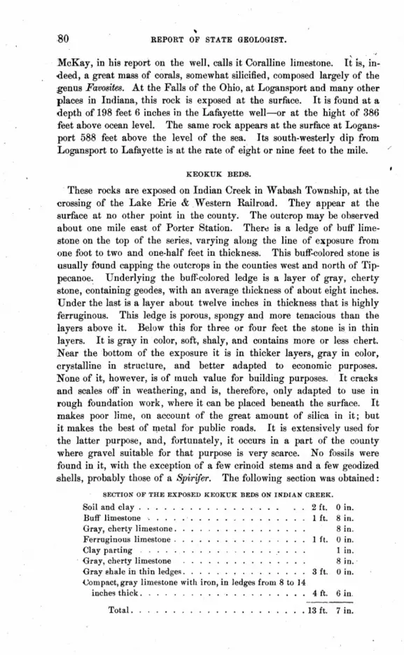
\
gO REPORT OF STATE GEOLOGIST.
McKay, in his report on the well. calls it Coralline limestone. It is, in-deed, a great mass of corals, somewhat silicified, composed largely of the genus Favosites. At the Falls of the Ohio, at Logansport and many other places in Indiana, this rock is exposed at the surface. It is found at a depth of 198 feet 6 inches in the Lafayette well-or at the hight of 386 feet above ocean level. The same rock appears at the surface at Logansport 588 feet above the level of the sea. Its south-westerly dip from Logansport to Lafayette is at the rate of eight or nine feet to the mile.
KEOKUK BEDS.
These rocks are exposed on Indian Creek in Wabash Township, at the crossing of the Lake Erie & .Western Railroad. They appear at the surface at no other point in the county. The outcrop may be observed about one mile east of Porter Station. Thert) is a ledge of buff limestone on the top of the series, varying along the line of exposure from one foot to two and one-half feet in thickness. This buff-colored stone is usually found capping the outcrops in the counties west and north of Tippecanoe~ Underlying the buff-colored ledge is a layer of gray, cherty stone, containing geodes, with an average thickness of about eight inches. Under the last is a layer about twelve inches in thickness that is highly ferruginous. This ledge is porous, spongy anq more tenacious than the layers above it. Below this for three or four feet the stone is in thin layers. It is gray in color, soft, shaly, and contains more or less chert. Near the bottom of the exposure it is in thicker layers, gray in color, crystalline in structure, and better adapted to economic purposes. None of it, however, is of much value for building purposes. It cracks and scales off in weathering, and is, therefore, only adapted to use in rough foundation work, where it can be placed beneath the surface. It makes poor lime, on account of the great amount of silica in it; but it makes the best of l1letal for public roads. It is extensively used for the latter purpose, and, fortunately, it occurs in a part of the county where gravel suitable for that purpose is very scarce. No fossils were found in it, with the exception of a few crinoid stems and a few geodized .shells, probably those of a Spirifero The following section was obtained:
SECTION OF THE EXPOSED KEOKUK BEDS ON INDIAN CREEK.
Soil and clay . . . . . Buff limestone. . . . Gray, cherty limestone. Ferruginous limestone . Clay parting
. Gray, cherty limestone Gray shale in thin ledgeR. (;ompact, gray limestone with iron, in ledges from 8 to 14
inches thick.
2 ft. 1 ft.
Ift.
3 ft.
4 ft.
o in. Sin. Sin. o in. 1 in . Sin .. o in.
6 in.
Total. . . . . . . . . . . . . • . . . . . . . 13 ft. 7 in.

GEOLOGY OF TIPPECANOE COUNTY . 81 •
The rocks are exposed here for the distance of about one hundred yards on the east bank of the creek, and on the north side of the railroad. Just south of the railroad, on the farm of Mr. John Allen, is an outcrop which shows a much greater thickness of buff-colored Jimestone capping the exposure. The exposure is shown as follows:
Soil and clay . . . . . . . Buff limestone . . . . . .
SECTION.
Gray, cherty limestone in thin layers
Total ......... .
3 ft. 0 in. 3 ft. 6 in. 5 ft. 6 in.
. 12 ft. 0 in.
This exposure is three or four hundred yards south of the one first described. The gray limestone has a few fragments of crinoid stems in it, but no other fossils were found. The stone is quarried to some ex~ent at both places for foundations for out-buildings. It is also used generally for walling wells. It serves this purpose well. It breaks with an irregular fracture in the direction of the usual line of cleavage, except in the seams, but vertically it breaks down through several layers for a distl;tnce of four {)r five feet, forming a perpendicular wall with a smooth, even surface. At these lines of cleavage there seem to be vertical seams, extending down for several feet.
ST. LOUIS GROUP.
The stone of this group is extensively exposed along Flint Creek, in Wayne Township, for a distance of about four miles above the mouth of the stream. The rock consists largely of dark-colored or gray silicious shales, near the top of the strata, with an occasional layer of compact, gray or blue limestone two to six inches in thickness. At, or near the bottom of the exposures, the shales give place to a larger proportion of limestone, dark-gray or blue in color, the ledges varying in thickness from one inch to eight or ten inches. The limestones are fine-grained, hard and durable as foundation stone. An occasional layer is found twelve or fourteen inches in thickness. This stone is pretty generally quarried for local use. No shipments of it have ever been made. It is used largely for foundation work and bridge abutments. It weathers exceedingly well. It is not affect~d by climatic influences. In the examinations of the bridge abutments along Flint Creek, built of this stone some years ago, it was found that it does not scale, spa wI off nor crack. The ledges are full -of vertical seams, therefore the stone can not be quarried in blocks of very large size. Two to four feet in width, and four to six feet in length, are about the largest sizes that can be obtained. It is taken from the quarries in rhomboidal blocks. The vertical seams give the rhomb shape. The stone is largely silicious and makes a very poor quality of lime.
6-GEOLOGY.

82 REPORT OF STATE GEOLOGIST. . . The shales disintegrate imd decompose rapidly. They contain asmal]
portion of lime. The water, percolating through the soil and gravel,. reaches these shales, and carries the lime away in solution. The springs; flowing out of the low bluffs, along Flint Creek, are strongly impregnated with lime. At m;ny points along the creek small caves have been formed. in the bluffs by this disintegrating and dissolving process. Upon reaching the atmosphere the lime, held in solution, combines with the carbonic, acid gas of the air, and is precipitated upon the surface, forming beauti-ful concretions of carbonate of lime. These concretions projected from the roofs of the caves, in the form of icicles, are called stalactites. Theyform on the floors like water freezing as it drops steadily at one point upon the ground, and are called stalagmites. In many places the walls of these low bluffs are covered with a thick growth of beautiful green moss. Thewater trickling down through this delicate green robe deposits its pure, white crystals of lime on stem, and branch, and leaf. The moss continues. to grow, and the concretions continue to form, till finally there are great masses of this calcareous tufa that perfectly preserve the form of leaf, branch and stem of this "petrified moss." Beautiful specimens of this< tufa may be obtained at "The Caves," on the farm of Mr. Turner, near the mouth of Flint Creek. There are three of these., caves but a short distance apart. They are very small, and aside from the beautiful concretions that are continually forming around them, they possess but few interesting features. The first is a small room about 10x20 feet in size; the !lecond is about 15x30, and the dimensions of the last about 12x30. Their hight is from five to seven feet. A section of the bluff at this point shows the following:
SECTION.
Soil and gravel. . . . . . • . . . . . . . . . . . • 20 ft. Da'rk gray and blue limestones, in thin ledges, with ~haly
partings. . 30 ft.
Total . . . . . . . . . . . . • • . . . . . . . . . 50 ft.
The water is continually dropping from the roofs of the caves. ~he floor is hollowed out in one of them, and quite a pond is formed. The water, dropping frpm the roof, makes a continual splash, splash, splash, in the water beneath. .
Flint Bar, in the Wabash bottom, about a mile below 'the mouth of Flint Creek, and just over the line in Fountain County, is a great mass of silicious deposits. The stone lies in ledges four to eight inches in thickness. It is evenly bedded, and the exposed layers have the appear· ance of compact silicious limestones. But they lack tenacity. A single blow with a light hammer will break a block one by two feet in size into 50 or 100 pieces. The" bar" covers many acres, and the whole surface is covered with small, angular fragments of these broken flints. The

GEOLOGY OF TIPPECANOE COUNTY. 83
pieces are usually in small flakes from one inch to four or five inches in length. No better metal is found anywhere for highway purposes or street improvements. The deposit is practically inexhaustible. The streets of Lafayette have been largely paved with this material, and its permanent qualities' have been thoroughly tested. It packs evenly, and is the most durable material yet known. This deposit lies below the limestones and shales exposed on Flint Creek. These beds belong to Mr. Amos Welsch, of West Point, Tippecanoe County. The following section of the bar was obtained:
Bed of flint flakes. First hidge of chert . Second ledge, dark blue flint. Third ledge, grayish color. Fourth ledge, dark blue. Fifth ledge, dark blue.
Total ..... .
SECTION.
1 ft. 3 in. 6 in. Sin. 4 in. Sin. Sin.
. 4 ft. 1 in.
On the farm of Mr. A. J. Swaney, one mile south-east of West Point, on the main branch of Flint Creek, is an exposure of fifteen feet of soft, silicious shales. They form the east bluff of the creek at this point. The ledge is nearly perpendicular here. These shales are in layers two to ten inches in thickness. The top of the ledge contains no fossils, but for a thickness of about two feet at the bottom fossils are found quite plentifully. Among the fossils identified are: Nautil11J3 clarkanus, poorly preserved; another Nautilus, species undetermined; Spirijera striatijormis, Spirifera like camerata, Product11J3 IndianeWlis, P. biseriatus, P. semi-reticulatus, Discinas, Terebratulas, Lingulas, and several species of Bryozoans. About one-fourth of a mile down the creek in the limestones are found Allorismas, Grammysias, Nuculas, Spirifers, Producti, crinoid stems, Bryozoans and well-preserved specimens of Nautilus clarkanus. About one-fourth of a mile north-east of West Point, immediately back of the cemetery, is a limestone bluff from ten to twenty feet in hight. It is on the north side of the creek, and is about 200 yards in length. The ledge forming the bluff consists of shales and limestones in alternate layers near the top, but lower down the ledge consists of compact layers of limestone in layers four inches to one foot in thickness. This is. the· best fouu'dation stone found in the county among the limestones. The abutments of the West Point bridge were made of this stone several years ago, and the thorough test given there proves its durability. None of this stone works easily. It breaks with an irregular fracture, and does not rough-dress well. Nearly all the fossils mentioned above were found at this quarry. The Bryozoans, alone, were absent. About 200 yards above the cemetery, in the limestone taken from the creek bed,

84 REPORT OF STATE GEOLOGIST.
were found, in addition to the fossils already mentioned, several species of fucoids, Euproops ---? a Phillipsia, species undetermined, and another cr1.lstacean.
At West Point the limestone is found, in digging wells, from 8 to 12: feet below the surface. The following is the section of Mr. Welsch's well, on section 18, township 22, range 5:
Soil ..... Sand and gravel. . Solid limestone .
Water at ..
SECTION OF MR. WELSCH'S WELL.
. 2 ft.
. 16 ft .
.30 ft.
, 48 ft.
North of the residence of Mr. Welsch the limestone is not reached m the wells. Approaching the 'Vabash River the erosions have been deeper and deeper, and near the river wells bored to the depth o'f 130 feet do not pass through the immense deposit of gravel. At the residence of Dr. Adkins, one mile east of West Point, the limestone was found ten feet. beneath the surface. The Doctor's residence is on High Gap Ridge. The following is a section of his well:
Soil and gravel. Shaly limestone
Water at .
SECTION. '
10 ft. 12 ft.
22 ft.
In the Wabash bottoms, opposite Blac~_ Rock, on the farm of Mr. M. E. Sherry, these limestones are found from one to four feet below the surface. In draining the swamps and bogs near the bluffs, ditches have to be cut down through these shales from one to six feet in depth. No fossils. were found here.
CHESTER GROUP.
The rocks of this group are not extensively exposed in Tippecanoe County. They are found only on Flint Creek at three points. They crop out on the farm of Mr. A. J. Swaney, about one and onecfourth mjles south-east of West Point. They occur also on the main branch of Flint Creek, on the farm of Mr. J. C. Whitehead, near his saw-mill. They are also exposed on the South Fork of Flint Creek, about one mile south of West Point. These rocks, as they occur here, are of a bright yellow color, generally. They are a fine sandstone, 'very light and porous, yet very firm and elastic. They are very hard to break with a ~ammer. They do not split evenly, and are hard to work into any desired shape: TKese yellow stones are known locally as "fire-stone," as fire seems to have no effect upon them, except to make them harder. They have been

GEOLOGY OF TIPPECANOE COUNTY. 85-
largely used in the place of fire brick for furnaces, and in the early settIe· ment of the county, they were used exclusively for fire-places to chimneys. Wherever the old fashioned fire-places are yet in use these" fire-stones'" form the jambs and back walls. They make durable foundation stones, and are largely used for that purpose also .. They are found overlying the St. Louis limestones and shales, but separated from them by a stratum of sandstone about two to three feet in thickness, of a yellowish gray color. This gray stone has been manufactured into grindstones to some extent for local use, but it is too soft for satisfiwtory use. The finer qualities of it make a good, coarse whetstone. The greatest thickness of these beds yet found is about ten feet. An exposure on the farm of Mr. tlwaney shows the following:
SECTION.
Yellow sandstone, layers 4 to 10 inches Gray sandstone, layers 3 to 6 inches
Total
8 ft. 2 ft.
10 ft.
In a well at his residence, Mr. A. J. Swaney found this sandstone onlyfour feet below the surface. The following is the section of Mr. Swaney's. well :
Soil and gravel. Yellow sandstone. Grayish sandstone Limestone ..
'Vater at
SECTION.
4 ft. 2 ft. 6 in. 2 ft.
10 ft.
18 ft. 6 in.
Near Mr. 'Whitehead's mill, two miles south-east of West Point, this. stone is found in the ben of Flint Creek. There are only four fellt of the yellow AAndstone exposed. It has been quarried here to a limited extent. It is taken out in blocks 8 to 12 inches in thickness, and of' almost any size desired. Mr. Whitehead uses it instead of fire brick in his mill furnaces. Aside from the purposes enumerated above, this stone possesses little value. The extent of the deposit seems to be limited to a small area. It is found only at the tops of the highest hills and ridges, extending over a few hundred acres, except at the one exposure at Mr. Whitehead's mill, on Flint Creek. No fossils of any kind were found in it.
CONGLOMERATE SANDSTONE.
Very little of this rock is found in this county. But two exposures are known, and it is probable that no others occur in the county. The two outcrops mentioned occur on the farms of Charles Schwomberger, and. Charles Ad, just at the Warren County line, and but a mile or so north of the point where the Wabash River strikes the line of Warren County. On the farm of Charles Ad, the south bluff of a deep hollow that enters
86 REPORT OF STATE GEOLOGIST.
the Wabash Valley from the west, is formed of this stone. . There is a perpendicular wall of sandstone here about forty feet in hight. On the top of this bluff the stone is exposed as it slopes off toward 'the precipitous wall. The total thickness of the stone is about sixty feet. The exposure is about seventy-five yards in length. The stone is dark-gray in color, fine grained, firm and compact. It is the very best quality of building stone. It works easily into any desired shape, and withstands climatic influences as well as any of the famous Warren County stone. The good qualities of the Williamsport sandstone are well known, and this stone is identically the same. The exposure on the farm of Charles Schwomberger is about one mile north, and a little east of the outcrop on Mr. Ad's land. The exposure there is also along the bluffs of a deep hollow. This stone has been quarried some for local use. In color and quality it is the same as that found on Mr. Ad's land. The exposure on Mr. Schwomberger's land is not more than one-half mile east of the Warren County line. That on Mr. Ad's farm is just on the county line. The great drawback to the opening of extensive quarries here is the inaccessibility of the stone. The outcrops occur in deep hollows, far away from any public road. They are too far from the river, and are still farther from any railroad than they are from the river.
At Black Rock, the Conglomerate sandstone is seen resting primarily upon the St. Louis limestone. From low-water mark, a section of the bluff' at Black Rock was obtained:
SECTION AT BLACK ROCK.
Soil ...... . Conglomerate sandstone St. LOllis limestone.
Total. . . . . ...
2 ft. 75 ft.
120 ft.
197 ft.
The limestone consists largely of dark-colored shales. The sandstone near the top is yellow, coarse and worthless for any economic purpose. It is soft and crumbles easily. Nearer the bottom it becomes dark-red in color, or nearly black, on account of the large proportion of iron in it. Immediately at the bottom it consists of large pebbles, cemented together with carbonate of iron. The name "Black" was applied to this rock on account of its dark color, derived from the iron contained in it. It has been worn into caves and arches by. the action of the elements in ages past. It arises before the spectator a grand and picturesque wall, furrowed and grooved by the hand of time. On account of its weird and somber aspect, it has become a favorite resort for excursionists and tourists. From its lofty summit a grand view may be obtained of the Wabash River, winding its way in the valley below, and of the broad and fertile country beyond.

GEOLOGY OF TIPPECANOE COUNTY.
THE DRIFT.
An exhaustive study of the Drift must be extended over a wide area. Facts must be closely collected and carefully grouped. Every locality in this widely distributed formation must be patiently examined and thoughtfully studied. Geologists can not jump at conclusions, but years of continual patient study may unfold the mystery. The assertion may be ventured that no county in the Union affords a more varied exhibit of this puzzling deposit than Tippecanoe.
Mention has been made of the ancient valley which crosses the northern part of the county from east to west, and also the great basin in the central part of the county. The area of this basin is not less than 250 square miles. This ancient basin is now filled with gravel, containing a small proportion of clay, sand and bowlders. The ancient vaney is filled with blne clay and sand. The following section of the Drift at Lafayette is approximately correct:
SECTION OF DRIFT AT LAFAYETTE.
Soil ........ . Sand ....... . Gravel, clay and sand. Gravel, coarse. . • • Gravel and bowlders. Cemented gravel. . . Sandstone- cemented sand Cemented gravel and bowlders.
2 ft. 10 ft. 70 ft. 20 ft. 20 ft. 40 ft.
6 ft. 15 ft.
To surface at the Artesiau well Section of the Artesian well.
183 ft. 170 ft.
Total ........ . 353 ft.
A.t the Lafayette Junction, one mile south of Lafayette, the following section of the north bluff of Durgee's Run was obtained:
Coarse and fine gravel. . 12 ft. Cemented coarse gravel. 10 ft. Cemented fine gravel . . 4 ft. Cemented sand. . . . . 1 ft. Cemented gravel-carbonate of iron Coarse and fine cemented gravel 25 ft.
4 in.
Total . . . . • . . . . . . 52 ft. 4 in.
The above section was taken immediately south of the Junction Depot. A.bout eighty yards farther west another section was obtained, as follows:
Oravel and sand. . . 14 ft. Cemented gravel. . . . . 10 ft. Cemented fine gravel. • . 2 ft. Cemented small bowlders 1 ft. 6 in. Cemented fine sand. • . . 3 ft. 4 in. CemE!'nted gravel and sand. 35 .ft.
Total ••.••••• 65 ft. 10 in.

•
88 REPORT OF STATE GEOLOGIST.
In Sleepy Hollow, two miles north-west of Lafayette, on the opposite side of the Wabash River, was obtained the following section:
SECTION OF THE NORTH BLUFF OF SLEEPY HOLLOW.
Soil and gravel. . . . Fine sand ....... . Sandstone-cemented Band. Fine sand ... Cemented gravel
20 ft. 6 ft.
8 ft. 20 ft.
2 in.
Total ... . 54 ft. 2 in.
The point from which the section given above was taken is known as the" sand pit." West of this about 200 yards is the" stone quarry." Here an exposure along the north bluff of the hollow reveals a stratum of sand so firmly cemented as to form a hard, durable stone. When it was first discovered a quarry was opened out here with the expectation of finding an inexhaustible supply of good building stone. This stratum of cemented sand is about six feet in thickness, on an average. It is composed of moderately fine, sharp grains of sand, firmly cemented together. It hardens, somewhat, on exposure, and, so far as tested, it proves to be a very good material for foundations for light buildings. It would be utterly worthless, however, for heavy structures. . While the stratum is six feet in thickness, but a small portion of it can be procured in suitable sizes for economic use. It occurs between beds of cemented gravel, as shown by the following section:
SECTION AT STONE QUARRY, SLEEPY HOLLOW.
Soil and gravel. 30 ft. Cemented gravel. . . . . 15 ft. Sandstone--cemented sand. 6 ft. Cemented gravel. 20 ft.
Total . . . . 71 ft.
Tenth Street Hollow, at Lafayette, shows grand exposures of this cemented gravel, sand and bowlders. Here, as well as at the points already mentioned, these materials are so firmly cemented together as to form immense masses of solid conglomerate. Tenth Street Hollow is a miniature canon, eroded by the waters of the Recent Period. The bluffs of this holloware high and precipitous. The walls of conglomerate stand up on either side in picturesque grandeur. Along their perpendicular sides may be distinctly seen the lines of stratification. Here, at Durgee's Run, on Perin Avenue, in Sleepy Hollow, on Burnett's Creek, at Battle Ground, aud every point where a view may be obtained of a north or south wall these lines of stratification may be distinctly seen, and with a uniform dip to the west of usually about 15 to 20 degrees. The immense gravel deposits of the Wea Plains, and the corresponding terrace on the opposite side of the river,' embracing

GEOLOGY OF TIPPECANOE COUNTY. 89
more than 100 square miles of territory, at every point observed show clearly that the whole mass is distinctly stratified; that it is in layers as evenly and uniformly placed as are the solid rock deposits beneath it. Wherever the gravel is solidly cemented together these lines of stratification may be followed the full length of the exposure. Excavations made in the gravel b~ds to procure material for roarl building always reveal the same facts. And further, it is alway" plainly disclosed that there is a slight dip toward the w~st. This dip to the west is observed equally on both sides of the river. On Indian Creek, Laramie Creek, Wild Cat Creek and Wea Creek-wherever this cemented gravel, sand or bowlders are exposed, the same ,uniform westerly dip is observed. The conclusion arrived at here is that these gravel and sand deposits, forming terraces adjacent to the river, sometimes called" alluvial terraces," are not river terraces at all,but that they were formed by the same agencies that made all the wide plains of Indiana long ages before the "Wabash River traced its serpentine course across the surface. The Tippecanoe Basin was- filled with clay, sand, gravel and bowlders at a period far remote from that in which the Wabash began wearing a, channel through the hills and rocks of Warren and Fountain counties, to find its way to the sea.
A correct idea of the character of the gravel deposit of W ea Plains may be obtained from a section of Mr. George Humbert's well, section 30, township 23 north, range 6 west, three and one-half miles north of West Point, and about one and one-half miles south of the Wabash River.
Soil .... Fine gravel San'd and gravel Gravel ...
Water at
SECTION OF MR. HUMBERT'S WELL.
3 ft. 40 ft. 32 ft. 40 ft.
. 115 ft.
To obtain permanent water at many points a little nearer the river than Mr. Humbert's it is often necessary to go to the depth of 12f' or 130 feet, but the character of the strata passed through is always the samesand and gravel in alternate beds. Farther away from the river, water is obtained at a less depth than at Mr. Humbert's., The farther away from the river, on Wea Plains, the nearer to the surface is water obtained. This is easily accounted for. This great mass of gravel drains the water like an immense sponge. The water from the surface sinks into the gravel, and, percolating through, sinks lower and lower as it seeks its way to the river. The water from the springs at the sides of the basin flow out through the gravel over the surface of the underlying rocks. The depth of gravel is much greater near the river, which flows through the great basin a little north of the center. Consequently the water continues to sink till the level of the Wabash River is reached.

90 . REPORT OF STATE GEOLOGIST.
In the southern and south-eastern part of the county the character of the Drift changes. Soil, yellow clay and blue clay occur in regular order, with more or less sand and gravel. The total depth of the Drift in this part of the county is not known, as no wells have been bored through it. Water is usually found here in sand or gravel veins from 'twenty to forty feet below the surface. At the residence of Mr. Omar Vickery, one and one-half miles north-west of Culver's Station, the following section was obtained:
Soil ..... Yellow clay. Blue clay .•
Water in gravel at •
SECTION.
2 ft. 8 ft.
23 ft.
· 33 ft.
Section at the residence of Mr. E. R. Kinney, section 15, township 22, range 4, west, two and one-half mile,; east of Culver's Station:
Soil .•.. Yellow clay Blue clay . Hardpan ..
Water at.
Section of well 100 yards north of the last:
Soil .•••. Gravel ...
'Vater at.
SECTION.
2 ft. 6 in. 8 ft.
40 ft. 3 ft.
. 53 ft. 6 in.
3 ft. 10' ft.
· 13 ft.
Section of Mr. Orlando Fiddler's well, two miles southcwest of Culver's:
Soil ...•.. ,7ft, Clay and gravel . 6 ft. Gravel .. , 5 ft. Sand', . . . 16 ft.
Water at · 34 ft.
Section of well at the residence of Mr. Allen DeHart, section 25, town-, ship 22, range 4, west, one and three-fourths miles south-west of Culver's:
Soil. . . . . 2 ft. Yellow clay. 7 ft. Blue clay . . 8 ft. Gravel . . . 1 ft.
Water at · 18 ft.

GEOLOGY OF TIPPECANOE COUNTY.
Section of well at Mr. DeHart's barn, 100 yards west:
Soil. .... Yellow clay. Sand .. Blue clay .. Gravel ...
Water at
2 ft. 11 ft. 1 ft.
19 ft. 2 ft .
• 35 ft.
91
Section at school-house No.6, Wea Township, three miles south-west of Culver's:
Soil. Yellow clay .. Sand and gravel Blue clay ...
Water at
2 ft. S ft. oft.
41 ft.
. 57 ft.
The wells at Stockwell are all very shallow. Water is usually found in that neighborhood at a depth of from 12 to 20 feet below thl:')' surface. The following is a representative section of the wells there:
Soil ..... Yellow clay .. Coarse gravel .
Total ..
SECTION OF WELL AT STOCKWELL.
1 ft. 3 in. 12 ft.
6 ft.
. 19 ft. 3 in.
At Monroe, two miles east of Stockwell, the wells are a little deeper. The following section shows· the character of the deposits th'ere, so far as known:
Soil ..... Yellow clay . Blue clay ..
Water at
SECTION OF WELL AT MONROE.
•
1ft. 13 ft. 13 ft.
27 ft.
The following is a section of the bluff' of Laramie Creek, on the Lafayette road, north of the bridge:
Soil ....• Yellow clay Blue clay.
Total
1ft. 12 ft. 30·ft.
. 43 ft.

REPORT OF STATE GEOLOGIST.
In the neighborhood of Dayton the deposit of yellow clay is much -thicker. The following is a section of the well of Solomon Divorce, three .miles east of Dayton:
Soil ... , Yellow clay . Hardpan ..
Total.
SECTION OF MR. DIVORCE'S WELL.
Oft. 8 in. 28 ft. 3 ft.
31 ft. 8 in.
Section of Mrs. Tuey's well, three miles north-east of Dayton:
Soil. 1 ft. Yellow clay Hardpan .
Total
. 28 ft. 2 ft.
_ 31 ft.
Section of W m. Glick's well, three and one-half miles north of Dayton: Soil. __ ..... _
Yellow clay and sand. Hardpan.
Total
Oft. 8 in. :15 ft.
2 it.
_ 27 ft. 8 in.
At the bottom of this well a bowlder three feet in diameter was found. The foregoing sections fully illustrate the character of the Dl'iftin this
part of the county. No borings have ever been made to a greater depth -than that necessary to procure a constant supply of pure water. The following is a section of an almost perpendicular bluff of Cedar Hollow, five miles northwest of Lafayette:
Soil and sand _ . Clay and gravel.
Total. ...
20 ft. 150 ft.
. 170 ft.
In this hollow was found a large bmvlder about five feet in diameter, with a planed and striated surface. Several bowlders planed and striated in the same manner were noticed in the neighborhood of Lafayette.
In the neighborpood of Montmorenci water is found at a depth of 25 to 30 feet below the·surface. The whole of that part of the county is underlaid with blue clay. The following section of Mr. Godman's well at that point illustrates fully all that could be learned of the sub· strata there:
Soil. Yellow clay. Blue clay.
Total.
SECTION OF MR. GODMAN'S WEI,L •.
3 ft. 6 ft.
25 ft.
• 34 ft.

GEOLOGY OF TIPPECANQE COUNTY. 93
In the neighborhood of Battle Ground, and north, east and west of that point, water is not found, usually, until a much greater depth is penetrated. Below is given section of wells in that vicinity.
Section of Mr. J. M. Hick's well, at Battle Ground:
Soil ...... . Hardpan ... . Gravel and sand.
Total ...•
Section of J. P. Clute's well, Battle Ground:
Soil and yellow clay Coarse gravel Sand ... Blue clay.
Total.
3 ft. 3 ft.
73 ft.
· 79 ft.
4 ft. 25 ft. 30 ft.
1 ft.
• 60 ft.
The two wells above described are both located on the low ridge lying between BUrJiett's Creek, and the swamp heretofore mentioned. Water was found II: little below the level of the swamp. The following is a section of the clay bluff of Burnett's Creek, north of the town of Battle Ground:
Soil and yellow clay Fine ~and . Blne clay.
Total.
10 ft. 30 ft. 50 ft.
• 90 ft.
A little farther west another section of the same bluff shows the following:
Yellow clay . Gravel ..
Total.
· 40 ft. · 50 ft.
· 90 ft.
Below is given a section of Mr. M. L. Thomas' well on Moots' Creek, three and one-half miles east of Battle Ground:
Soil and clay . . Gravel and sand. Hardpan .... Sand and gravel. Gray clay.
Total.
4 ft. 20 ft. 20 ft. 25 ft.
2 ft.
· 71 ft.

94 REPORT OF STATE GEOLOGIST.
Section of W m. Hoyleman's well, four and on~-half miles north-east of Battle Ground:
Soil and clay • . Hard blue clay. .
No water at.
This well was bored in the bottom of Moots' Creek.
6 ft. 54 ft.
• 60 ft.
Section of well at the residence of Mr. John Gross, SIX miles east of Battle Ground:
Soil .... Gravel .. Gray clay . Gravel ..
Water at
6 ft. 40 ft. 10 ft. 10 ft.
· 66 ft.
Section of Mr. W m. Peffley's well, one mile northwest of Colburn;
Soil and clay . . . 4 ft. Blue clay. . . . . . 40 ft. Dry, coarse gravel. . 20 ft .
No water ... . '. 64 ft
Section of John Livingstone's well, two miles west of Battle Ground;
Soil and yellow clay 30 ft. Fine dry sand. . 20 ft. Blue clay. '. . . 30 ft. Cemented gravel. 2 ft. Loose gravel. 13 ft.
Water at · 95 ft.
Section of James Bryant's well, three miles west of Battle Ground:
Soil and yellow clay. 4 ft. Blue clay. 50 ft. Dry sand • .'. . 20 ft. Coarse gravel • • 2 ft.
No water at . · 76 ft.
Section of John Stanfield's well, two miles north of Buck Creek Sta.tion:
Soil and clay .. Fine sand ... Gravel, coarse. Fine gravel.
Water at
Large bOwlders were found in the .bottom of this well.
4 ft. 45 ft. 12 ft. 4 ft.
• 65 ft.
GEOLOGY OF TIPPECANOE COUNTY. 95
Section of Moses Cole's well, one and three-fourths miles west of Buck Creek Station:
Soil and yellow clay. Gravel and Band. Blue clay.
Total.
6 ft. 49 ft. 5 ft.
· 60 ft.
One-fourth of a mile north-east of this well Mr. Cole founa plenty of 'Water in the sand, thirteen feet below the surface.
The following is a section of W. W. C. Brown's well, at Buck Creek Station:
Soil. .... Yellow clay. Blue clay .. Fine yellow Band.
Total ....
SECTION OF MR. BROWN'S WELL.
2 ft. · ~ 3 ft. • 15 ft. · 30 ft .
• 50 ft.
Section of swamp drained by the Southworth ditch, two miles southwest -of Montmorenci:
Soil. ... Blne clay. Quick Band
Total.
4 ft. 4 ft. 4 ft.
: 12 ft.
The foregoing sections illustrate fuily the character of the Prift in this ,county. ;',';'" ,
MARL BEDS.
There are a number of marl beds in the neighborhood of Indian Creek, and several were visited on Flint Creek. - These marl deposits iSeem to have derived their lime from the disintegrated and decomposed lime.stones in the immediate vicinity. In the neighborhood of the marl beds on Indian Creek, there is no outcrop of limestones nearer than the -exposure of Keokuk limestones, two miles north, but it is evident that the same rocks are but little below the surface in the vicinity of the marl ~eposits. The marl is of a whitish gray color, and effervesces freely on the application of acids. .A. ditch through a bed of this material shows a ~epth of more than four feet of pure marl. The thickness of the deposit may be greater as the ditch did not reach the bottom of it. .A. ditch running out of a swamp in the same vicinity shows the following se,ction :
Soil ..... . 2 feet. Gray marl .. . · 3 feet. Gravel and iron . · 6 feet.
Total ... · 11 feet.
"
96 REPORT OF STATE GEOLOGIST.
On Mr. M. E. Sherry's farm, three miles north-west of We.it Point, there are extensive beds of this marl. The thickness of the deposits is from two to eight feet. Here it is plain that the lime in these beds is derived from the decomposition of the St. Louis limestones in the immediate vicinity.
This marl is whitish, soft and easily obtained, as it lies just underneath the surface. It is readily burned inpo a poor quality of lime. In its natural state it makes the best of fertilizers, and is a valuable addition to soils lacking in lime.
Peat beds also occur in many of the swamps on Indian Creek. In this locality it has been procured and used for fuel to some extent. But the labor of procuring and drying it is greater than the benefits derived from its use.
Iron ore is found in many of the swamps. In opening the Southworth ditch through the farm of Mr. Charles Rowe, two miles south of Montmorenci, large quantities of this mineral were brought to the surface. Many of the blocks of this bog ore weighed upward of' a hundred pounds.
THANKS.
I desire to express my obligations to the following-named c~izens of the county in particular, and to all citizens generally, for their many acts of kindness extended to me during the progress of my work, and for much valuable information and assistance: Prof. Osborne and Prof. Webster, at Purdue University; Prof. Merrill, Prof. Rank and Mr. A. J. Godman, at Lafayette; Mr. J. M. Hicks, at Battle Ground; Mr. Allen DeHart, at Culvers, and Mr. and Mrs. M. E. Sherry, Miss Edna, Jackson, Mr. N. J. Swaney, Mr. Remington and Mr. J. C. Whitehead, at West Point.

HENRY COUNTY AND PORTIONS OF RANDOLPH, WAYNE AND DELAWARE . .
BY A. J. PHINNEY, M. D., Muncie, Ind.
Henry County was named in honor of Patrick Henry, of Virginia. It was organized in 1822. It is situated in Central Ea~tern Indiana, and has f()r its northern boundary, Delaware County; for its western, Madison and Hancock; for its southern, Rush and Fayette; for its eastern, Randolph and Wayne counties. It has an area of about 400 square miles. Its' principal towns are New Castle, the county seat,a thriving city of'nearly 4,000 inhabitants; Knightstown, with a population of about 2,500, is favorably situatcd on Blue River, near the south line of the county. The smaller towns are'. Raysville, Middletown, Ogden, Louisville, Greensboro, Hillsboro, Blountsville, New Lisbon, Cadiz, Spiceland, Sulphur Springs, Mt. Summit and Mechanicsburg. All these are situated in rich agricultural localities, and are convenient trading points for the farming community adjoining, as well as furnishing pleasant homes for those who wish to retire trom the more active duties of life. The streams of the c~lUnty are Blue River, Fall Creek, Duck Creek, Flat Rock and Stony Creek. 'While none are large, yet they are utilized to a considerable extent for water-power. This county is well supplied with railroads, the Ft. Wayne, Muncie & Cincinnati, the Pittsburg, Cincinnati R. R., with its two divisions; the I., B. & W. and the southern extension of'the Ft. Wayne, Muncie & Cincinnati R. R. to Louisville, Ky., give ample communicati{)n with all parts of the country, as well as furnishing abundant shipping points for the various agricultural products.
EDUCATIONAl. ADVANTAGES.
Indiana justly regards her public schools with pride, and Henry County ranks among the best in this re8pect, for not only is it well supplied with common schools, but the numerous high schools of' the many villages, with the Academy at Spiceland, uuder the able direction of Prof. Pinkham, are doing good work. Prof'. Harvey, Superintendent of the New Castle schools, is fully alive to the nsponsibilty, and abundantly able to place the schools under his charge on an equal footing with those of the other cities of the State.
7-GEOLOGY.

..
REPORT OF STATE GEOLOGIST.
TOPOGRAPHY.
Henry County is one of the most elevated in the State, ranking with Southern Randolph and Northern Wayne. The altitude of all three of these counties is due to the same cause. North of the center is a divide or water-shed, which passes through it with a direction a little north of east from the point where tt enters the county near the south-west corner of Harrison Township. This ridge extends through Cadiz, the southern part of Jefferson and Prairie townships, and finally leaves the county in Stony • Creek and Blue River townships, just north of the I., B. & \V. R. R. Where this ridge enters the county on the west, it is but feebly marked, the surface there being quite level with only an occasional hill or low mound of gravel; two miles west of Cadiz the surface becomes quite rolling, and continues so until it enters Jefferson and the north·western portion of Henry Township, when it again becomes lost in the level plain with low scattering hills; this continues eastward to the valley of Blue River. At Cadiz the descent to the north is quite gradual, but more rapid to the south, so that its ridge-like character is quite marked. 'When viewed from the level plain to the south of it, it ,may be seen stretching to the north-east Rnd south-west as a well· marked ridge, its summit being from thirty to forty feet above the adjacent plain. The rolling surface here extends from one-half to one mile northward from its southern border. Approaching it from the north one is hardly conscious that there is any rise in the surface, and he only fully realizes its character when from its southern edge he views the level plain to the south of and below it. People at Cadiz claim that this is the highest point in the county. It has a high elevation, but in the absence of a careful topographical survey it would be hazardous to designate it as the highest. East of Blue River the surface becomes rolling; its ridge,like character is not so distinctly marked, for the descent to the south is more gradual, while the high and rolling surface extends northward to the Delaware County line, over Prairie and Stony Creek townships. South of this high land the surface becomes quite level in Henry and Liberty townships. , In the eastern portion of the county the water-shed does not follow the direct line pointed out at the beginning, but from a point near Mt. Summit it curves three or four miles northward, to the head waters of Buck Creek, Prairie Creek and Blue River, thence' southward to the bowlder tract, near its point of exit from the county, on the line between Stony Cr~ek and Blue River townships. However, the water-shed does not necessarily coincide with the elevation!; that are highest, for the channels now occupied by the streams flowing southward have been cut through this high ridge or table-land. Little Blue River mostly flows to the sout,h of this high land, though its source is found near its summit. This divide, or elevated tablelaoo, continues eastward through Randolph County into the State of

100 REPORT OF STATE GEOLOGIST •
. with the valley and about one mile from it. The formation of this peculiar tract bordering the river will be discussed under the head of "Glacial Rivers," to which they in great part owe their origin. Flat Rock Cree\;:, in its upper portion, flows through a comparatively level surface, but as it approaches the south line of the county it becomes bordered by low, rounded hills or knolls. Nettle Creek rises to the north of Losantville, Randolph County, and its upper portion flows through a nearly level country .. As soon, however, as its channel begins to cut its way through the high land to the south, its valley becomes bordered by high hills or rounded bluffs. \Vest River and Martindale's Creek both rise on the very summit of the table-land and their valleys have been cut deep in passing through it to the south. From the above description it will be seen that this district is composed of a high table-land, gradually sloping to the north and south. That in the n(lrth it is bordered by a level plain which gradually becomes merged into the rolling surface so characteristic of this divide. On the south, the descent is more rapid and the rolling surface soon becomes lost in the level plain, except along Blue River, where the surface so common to this high land continues, and also between the streams flowing south, where long, parallel ridges extend nearly to the White Water River valley. The following table of altitudes will aid in the study of the surface configuration of this district:
TABLE OF ALTITUDES ALONG THE I., B. & W. R. R.
Feet Abooe the Ocean. West line of Randolph Connty. . . . 1,171.50 One-half mile south of Losantville. . 1,140.60 Valley of Nettle Creek. . . . . . . . ],129.40 Summit between Nettle Creek and West River. . ],186.10 West River vaIley bridge . . . . . . . . . . . 1,]20.00 Township line at Hoover's saw-mill. . . . . . . 1,220.00 Summit between Martindale Creek and Green's Fork. . 1,234.4() Crossing of Richmond, Ft. Wayne R. R., near Lynn . 1,173.8() Lynn Station. . . . . . . . . . . . . . . . . . . . 1,183.bo Summit on line between Washington and Green's Fork townships . 1,187.5() Summit west of boundary ro!\d. . . . . . . . . .. . . . . . .1,220.0Q Divide of drainage between Noland's Fork and Greensville Creek . 1,186.0Q Summit between Nolaud's Fork aud the east fork of "Yhite Water. . 1,214.60 State line, one mile north of the southeast corner of the county . . . 1,180.44
East of the last-named point the descent is gradual to the Miami valley. .
FT. WAYNE, RICHMOND & CINCINNATI R. R.
Summit between Salamonie and Mississinewa rivers (ground), Jay County. 1,053.00 Ridgeville railroad crossings, Randolph County 993.01} Summit between Mississinewa and "Vhite rivers . . . . 1,095.0G Low water of White River near Winchester. . . . . . 1,053.01} \Vinchester, at the crossing of the Bee Line Railroad . . 1,088.09
HENRY COUNTY. 101
Feet Above the Ocean. Summit between White River and Green's Fork of White Water ..... 1,188.00 Low water of Green's Fork of White Water. . . .. . ...... 1,111.00 Summit between Green's Fork and Noland's Fork of White Water, about
two·thirds of a mile sonth of Wayne County line. . 1,212.00 Low water of Noland's Fork of White Water . , . 1,062.00 Snmmit between Noland's Fork and White Water . 1,132.00 Richmond City (track at passenger depot) . . . . 969.00 Ft. Wayne, Muncie & Cincinnati R. R., Muncie station. 948.00 Track at Henry County line . . . . .'. . . . . . 1,016.00 Track at Springport. . . . . . . . . . . . . . 8~9.00
Trac.k at summit between White and Blue rivers. . 1,107.00 Track at New Castle, on Blue River . 1,045.00 Track at New Lisbon . . . . . 1,109.00 Track at Wayne County line. .1,056.00 Track at Cambridge City . . 957.00
Ohio and Indiana State line . Richmond ....... .
P., C. & ST. L. R. R.
. 1,026.00 972.00
Track at Centerville. . . . . 1,008.1 II Summit west of Centerville. • 1,084.00 Cambridge City. . • . . 949.00 Track at Dublin . • . . . 1,066.00 Snmmit east of Lewisville . 1,143.00 Track at Knightstown. . . 916.00 Hagerstown. . . . . . • . 1,003.00 Surface of high table·land, source of Flat Rock Creek, near line between
Henry and Randolph counties .•..•.. : . . . . . . . ... 1,128.00
WATER.
This region is remarkably well supplied with this wholesome beverage. The numerous small streams with the many springs found everywhere throughout the rolling surface or along the streams furnish an abundance for man and beast. Where not thus supplied, water can usually be obtained at depths varying from twenty to thirty feet. In northern Prairie Township wells are frequently sunk from forty to sixty feet before the water-bearing gravel is reached. As usual throughout the Drift region, the gravel is overlaid by the gray and yellow clays, the blue bowlder clay never being reached. In the valleys very little clay is found and water is usually reached at a depth of ten or fifteen feet. The fall of many of the streams is ';0 rapid that they are utilized for water power during a portion of the year.

102 REPORT OF STATE GEOLOGIST.
PALEOZOIC GEOLOGY.
About three miles south-west of Greensboro, at the Quarry Mills on Blue River, is the only outcrop of rock found or heard of in Henry County. This was at one tim~ quite extensively quarried. At present the pits are all filled with water, and the only chance for observing the character of the rock was found in the fragments lying about and in the foundation of the mill. The thickness of the strata varied from one inch to one foot.
• The upper strata are of a buff color gradually changing to a gray or drab. in the deeper layers. Just below the bridge is an exposure of about four feet of a bluish shale overlying the quarry layers. This shale rapidly disintegrates upon exposure to the air and changes to a yellowish color, due to the oxidation of the iron contained in it. This stone used for the foundation of the mill gives every evidence of durability. It also made fair lime. No fossils were found here except the cast of a valve of Atrypa reticularw and a poorly preserved cast of a Zaphrentw, probably Z. celator. In the clay shale were found a few casts of a fucoid. While the paleontological evidence is not sufficient to determine its horizon, yet its lithological characteristics place it at once in the Niagara group, and probably in the Guelph division, as the rock resembles that east of Muncie, which has been determined as belonging to that portion of the Niagara. Although diligent inquiry was made, we were unable to learn that any fossils had ever: been found at this locality. The State geological map represents Henry County as having its southwestern portion covered with Devonian rocks. This may be true, but in the absence of any exposure it is at best a mere conjecture. There are in the county quite a number of good collections of fossils, mostly, however, from other localities, as here even the Drift is quite barren of fossils. We had the pleasure of examining the collection at Spiceland Academy; this is quite well supplied with Lower and Upper Silurian forms, and, when classified, will add much to the facility for teaching this intereeting study at this institution. Prof. Harvey and Mrs. Dr. Boor, of New Castle, also have fine collections.
'.rHE DRIFT.
This deposit or formation covers the whole county, and presents the usual characteristics of this deposit as found in Randolph and Delaware counties to the north. The bluB bowlder clay was observed at only one point-just east of the rock exposure at the Valley Mills. Its upper portion only was seen and the thickness could not be determined. The Drift over portions of this district must be in places at least two hundred and fifty feet thick, perhaps more; at other localities probably not over

HENRY COUNTY. 103
fifty feet. This, of course, is mere conjecture, as no section could be obtained. The deepest wells do not reach the bowlder clay, and natural sections give only a few feet of the upper portion. The surface clays are either yellow, where thoroughly oxidized, or gray where they have not been so affected; beneath the surface they are of a bluish or gray color. The first water-bearing gravel is usually reached at depths varying from ten to sixty feet.
GLACIAL RIVER CHANNELS.
These outlets for the water of th~ melting glaciers have played a prominent part in the surface configuration, and have helped to give variety to the topographical features of the district. Fall Creek now occupies a
. broad valley, bordered by rounded hills, not, properly speaking, bluffs, though usually so called. The creek seems totally inadequate for the accomplishment of such phenomena as is here presented. High hills of sand and gravel border it on both sides, and extend back from one-fourth to one mile. The hills are not steep, but have gentle waving contours, and, as is usually the case along all these channels, are highest a little distance from the valley, with a gradual descent to the adjacent plain as well as to the bluffs immediately adjoining the valley. This channel continues northeast into Delaware County, where it is known as the" Glade," a long swampy tract, which extends to within about four miles of Muncie, and it is probable that it is a continuation of the channel that passes through where the city now stands. This stream had its source in the north-eastern part of Delaware County, where a temporary advance of the glacier piled up material enough to act as a dam to the waters flowi~g from the north and east, probably forming a lake extending east from the ridge at Black's mills to Albany and south, with a curve to the west to Selma. This lake furnished water for two or three very prominent glacial rivers; at least they can all be traced to thi8 locality. This stream broke through the morainic debris, just south of Black's mills, and pursued an almost direct south-westerly course to Muncie, south of which it can be followed by the kames, or hills of gravel. Although the glade previously mentioned is a little west of the line of this channel, they were once probably united. It is a characteristic feature of all these channels to be obscured throughout a portion of their course. Once given their general direction they can usually be traced by means of the gravel hills or the black soil, although the channel or valley may be obliterated. Near the sources of Fall and Bell creeks, in Delaware County, are a number of long swampy tracts, now occupied by these st.reams and their tributaries, which are evidence that at on!) time overflows from this stream found an outlet in different directions tliroug'h these valleys. Beginning just west of Selma, Delaware County, in the level prairie, which we have considered as having once been a lake, is the source of the main stream which passed through

104 REPORT OF STATE GEOLOGIST.
Henry and Delaware counties. The occurrence of sinks in the bed of the L. E. & W. Railroad indicates that it might have been still further north, but at present this will be considered its starting point until further investigations enable its course northward to be indicated. All these channels are partially silted up with sand, gravel and clay. Just west of Selma, where crossed by the Bee Line Railroad, it was deep enough and treacherous enough to swallow up their embankment when first built. This channel extends south·westward across the valley of White River, and to the east of New Burlington, into Henry County. Near the county line. the channel, now called prairie, is filled up sufficiently to cause the water of Prairie Creek to flow northward to White River. The valley of Buck Creek extends directly across this prairie a little south of this point. The old channel, however, continues on through a gap in the hills, and what is now called the prairie can be traced to the valley of Blue River, which follows the valley excavated by the stream which long since ceased to flow. One must bear in mind, when considering this broad valley and the rounded hills of sand and gravel which reach from fifty to one hundred and fifty feet above it, that they were not formed by the insignificant stream which now meanders through it, but by one whose source of supply was a great sheet of melting ice. The valley was full to the brim with large blocks of ice filled with sand, gravel and bowlders, floating on its bosom or being piled up on either side, to be reassorted again and again to form the rounded hills. It was a torrent, gathering in the streams from every side, on its way to join the" Collett Glacial River." This I consider one of the main streams that helped to form that mighty, but short lived river, which probably surpassed the Ohio or Mississippi of today. Dr. Elrod, in his report on Bartholomew County, estimates its width at forty miles (see page 165 report for 1881), but this of course is an exaggeration, and is only true of the lobe of the glacier which once occupied this valley. It is not probable that the river proper was more than two or three miles wide. This stream, in Henry County, overflowed its banks in places and excavated valleys, now called prairies, ,which at prellent are not occupied by any streams. One such is found just east of Mt. Summit; another overflow north-west of New Castle was largely instrumental in iorming the valley of Duck Creek. The excavation left the flat-iron shaped table· land which extends from the source of the creek to below Greensboro, where it joined the main stream. With a rapid stream on each side, the ilouthern point of this tract was extended as a ridge ot gravel and sand far to the southward, forming a veritable agar. This narrow ridge was continued beyond the confluence of the creek with the river, but at a lower level, being here situated on the terrace about thirty feet above t.he river. It is here composed almost entirely of gravel. This terrace is principally found 011 the west side of the river. Greensboro and Knightstown are both situated on it. Near Selma the banks of this

HENRY COUNTY. 105
ohannel are quite low, but gain in hight and interest to the south line of Henry County. In Drake County, Ohio, is a long swampy tract which oan be traced to Greenville Creek and Noland's Fork. It passes a little east of Union City, and it is probable that it'is the source of supply for their water works. This was evidently a stream of considerable size, for its valley, where it crosses the table-land, is wide and deep. Overflows from this probably excavated the valley now occupied by Green's Fork. Another overflow occured in Ohio, just east of the north-east corner of Randolph County. This passed west along the southern border of what is known in Jay County as the" Lost Mountain" to Ridgeville, just west of which it turns to the south and probably found an outlet across the divide through the valley of \Vest River. Martindale's and Nettle creek valleys both served as outlets for temporary streams from the edge of the ice sheet. It is safe to say that all the streams now flowing south from this divide have had their valleys excavated to a great extent by the glacial waters, though the present streams may have contributed something in that direction. Another of these streams entered Delaware County from the north and flowed in a south-westerly direction down the valley now ocoupied by Estey Creek. This crossed the valley of the Mississinewa River about two miles east of ,Eaton. South of the river it can not be traced, but a portion of it may have turned to the east and joined the stream first described, which continues through Delaware County to the valley of Fall Creek, or, what is more probable, it all flowed down the valley of Kil Buck, and was instrumental in forming the prairie with the hills of sand and gravel that are mentioned hy DI. Bruwn in his report of Madison County, as extending from Anderson to near Pendleton.
KAMES.
These are rounded hills or elongated ridges terminating abruptly in a high mound or at times with the mounds nearly midway and a gradual slope to the level plain adjacent, or again conical mounds or hills arising abruptly from the level surface, isolated or in groups. All these are composed of gravel and sand, and where clay is present it forms the nucleus around which the other materials have gathered, and as a rule it shows no stratification; the gravel and sand, however, in their stratification show that they were deposited by currents having considerable power as well as coming from different directions. One portion of the mounds will show fine sand, while another will present a bed of bowlders from three inches in diameter up to one foot or even more. It is characteristic of this variety of the kame type of deposits that they all have their long or major axis transverse to either the ice flow or the direction of the lines of drainage from the ice sheet. Most of those observed extended from north-west to south-east; however, a few showed a direction from north-east to south-

106 REPORT OF STATE GEOLOGIST.
west. They vary in hight from twenty to fifty or sixty feet,and at the base are from ten to thirty rods wide. Most of those met with are adjacent to some of the ancient channels just described, being found from one-fourth to one·half mile distant. As they are built up almost entirely above the level of the general surface of the ground; they are evidently among the latest of the Drift deposits, probably not deposited until after the greater thickness of the Drift sheet had been laid down. Between Muncie and Granville, west of the Granville pike, are three of these mounds, the one south of Granville being the highest. Another is found' in the city of Muncie; West Charles Street was cut through its northern extremity. Dr. Winton's residence is built on another, south-east of this one. South of the city and east of 'the old channel is one which has furnished a large amount of gravel; west of the channel are found one or two others. Between Muncie and Smithfield are two more, situated south of the pike and about one mile west of the main channel; these are the most marked and important ones in Delaware County, though a few 8maller ones are found in Monroe Township. It is remarkable that none are found in either the eastern or western portions of the county. This peculiar type of Drift is eviden tl y closely connected with the ancient line of drainage, but just how the currents of running water have acted is not definitely understood. It is probable that at the time of their formation the surface was covered with ice, though it may not have been one continuous sheet, but broken by currents of water flowing toward the main channel of drainage, through the breaks or gaps in its surface. It is hardly probable that the ice sheet in its many temporary advances and retreats always presented a bold precipitous face to the south. More likely that there were large pieces or masses detached from the main body giving rise to lateral streams flowing through the depressions between them. Any currents of water sufficiently deep to reach their summit to-day would submerge a large portion of the country, and one is loath to believe that the whole country was covered with water; at least, there is no evidence that such was the case. However, admitting that to have been true, it is difficult to understand how currents from the north-west or southeast could have been produced sufficiently powerful to move the bowlders. None of this variety of kame type was observed either in Randolph or Wayne counties, and but few in Henry County, and they were closely related to the form of kame type found borciering the Glacial river channels that they have been considered as due to the same cause. It will be seen from the above description of this form of Drift formation that I have divided the kames into two varieties: First, those having been built up almost entirely above the general surface of the ground, and having their long axis transverse to the direction of the ice flow or lines of drainage; second, those immediately adjacent to the lines of drainage and having their summits but little, if at all, elevated above the general sur-

· HENRY COUNTY. 107
face adjoining. While both these classes of kame:'! are the result of fluviatile actions, the peculiar conditions under which each were formed, were probably very different. Of the second variety good examples may be found bordering Blue River and Fall Creek. The following description of the kame type by Professor Geikie will give a good idea of the phenomena observed: "The sands and gravels have a tendency to shape· themselves into mounds and winding ridges, which give a hummocky and rapidly undulating outline to the ground. Indeed, so characteristic is this appearance, that by it alone we are often able to mark out the boundary of the deposits with as much precision as we could were all vegetation .and soil stripped away and the various subsoils laid bare. Occasionally ridges may be traced continuously for several miles across the country, like great artificial ramparts. It is most common, however, to find mounds and ridges confusedly intermingled, crossing and recrossing each {)ther at all angles, so as to enclose deep hollows and deep pits between. Been from some. dominant point, such an assemblage of kames, as they are called, look like a tumbled sea, the ground now swelling into long undulations, now rising suddenly into beautiful peaks and cones, and anon curving up in sharp ridges, that often wheel suddenly round so as to enclose a lakelet of bright, clear water." The lakelets, however, are absent from this locality, as the hollows or pits are nearly all connected with the river. From the high hills south of Greensboro one can verify the above description. The old channel at this point turns to the west,
·and here we find the phenomena, described above, on the grandest scale. From the summit of the highest peak south of the river one can lice the rounded hills, bordering the valley on both sides, for miles. Back from the valley the ridges become more numerous, while the mounds or hills are lower. So extensive is this tract (nearly three miles wide) east of the river at this point that I was at first inclined to consider it a portion {)f a moraine, and such a view may be correct with reference at least to the outer portion of this tract. Careful observation showed that the Tounded hills immediatl>ly adjscent to the river were composed almost entirely of gravel and sand, showing that they have been reassorted again .and again and the clay washed away. Back from the river they contain more clay. It is probable that all the hills adjoining the valley have been built up of material brought down by the old river. The waving contours have in part, at least, been produced by the lateral streams and rills. West of Blue River long ridges parallel with the valley predominate; these do not show that their materials have been reassorted, but evidently lie as deposited. It is probable that south from New Castle we have a portion of the moraine, presently to be described, modified by the Glacial river which found a passage-way through it. As all the other well-defined .channels present similar phenomena, it is probable that their configuration is almost wholly due to fluviatile action.

108 REPORT OF STATE GEOLOGIST.
ASARS.
These are long, narrow ridges of sand and gravel, which .are parellel with the ice movement· or lines of drainage; in fact, all observed in this district are found either in the valley or border;ng them. East of Black's mills, west of Albany, in Delaware County, at tl1e southern edge of a remarkable deposit of morainic debris, is a round ridge, with its summit high above the general surface adjacent. At this point it is mostly clay, but S00n become>; composed of sand and gravel when followed southwest • to the locality where the Mississinewa River has cut through it. At this point the high ridge of clay turns to the south, while the true asar begins here and extends south-westerly for about two miles. It is bordered on the east by the valley of the glacial stream, while on the west the level plain stretches as far as the eye can reach. It terminates abruptly as though cut off by a transverse current. Its elevation is about thirty feet above the general surface, though not so high as the clay ridge east of it. Large numbers of the Niagara limestone bowlders were observed at its base, near the river. South from the termination of this ridge is another, lower and shorter, situated about in the middle of the old channel. The· clay ridge previously mentioned as turning to the sonth, when followed for about two miles takes on all the characteristics of an asar. This was· also terminated abruptly by a lateral stream which joined the main channel from the east. The change in the character of this ridge, when followed south, is evidently due to its situation between the two streams. The' southern extremity of the clay ridge formed a breakwater like the abutment of a bridge, south of which the gravel and sand accumulated; this extended the ridge southward until the stream from the east joined the one on the west. About one-fourth mile south of the termination of this ridge is a high mound, abruptly sloping to the north,-east and west, but. soon becoming lost in the level surface adjacent when followed southward as it rapidly beeomes lower in that direction. This would indicate that this was the southern terminus of the ridge just described, and the. stream cut across it after it was formed instead of terminating it lby turning abruptly to the west. The high, narrow ridge forming the I:;outhern extremityof the flat-iron-shaped table_land between New Castle and Greensboro was probably formed in a similar manner by the main stream on the east, and an overflow on the west, down the valley of Duck Creek. Near the confluence of Duck Creek with Blue River is a narrow ridge of gravel situated on the terrace which skirts the old valley on the west. It has no great length, but is quite marked and a: veritable asar. In the above descriptions of the kames and asars, only those have been included that are evidently formed through the agency of running water. Under the description of the glacial moraine will be found others topographically similar, but structurally different.
HENRY COUNTY. 109
THE TERMINAL MORAINE OF THE SECOND GLACIAL EPOCH?
We have placed a question mark after the above in deference to the State Ge?logist, who desires that nothing positive shall be asserted concerning its occurrence in Indiana until it shall have been given further study throughout the State. This deposit has been the especial study of Prof. T. C. Chamberlain, of the United States Geological Survey, who has traced its course from Indiana west through Michigan, Illinois, Wisconsin, Minnesota and Dakota. Eastward, Professors Wright, Lewis and Cook have extended their observations to the Atlantic coast, and at present we are compelled' either to accept their conclusions or to question the accuracy of those eminent geologists. With deference to the opinions of' others the writer believes that if the phenomena to be described as a moraine is not such, then there are none anywhere in Indiana. The extreme southern limit of' the Drift is from fifty to one hundred miles south of this moraine, so that this formation must be considered as marking the southern limit of a temporary advance in the ice sheet, after it had retreated some distance northward of'this deposit. It indicates that after the period of glaciation the cold. was considerably moderated, the ice retreated far to the north-how far would be mere conjecture-but again advanced as the climate became more frigid. No doubt there were many temporary ad vances and retreats of the glacier before its final disappearance, hut this one is so marked and extensive, reaching nearly threefourths across the continent, that it indicates a great change in the climatic conditions during the Glacial Epoch, Hence the importance of giving careful study to this formation. The formation under considera" tion consists of an extensive belt of peculiarly ridged Drift. It constitutes a broad, irregular range of confusedly heaped Drift, rather than a simple, continuous ridge, or group of definite parallel ridges. "Genetically considered it embraces two or more such ranges which sometimes coalesce into a common, massive belt, and sometimes separate so as to reveal their distinct individuality and to occupy a width of twenty or thirty miles. The individual ranges in sllch instances are from one to six miles or even more in breadth, and embrace in themselves, on a small scale, the same confusion and cumplexity of structure that is presented by the united whole." This formation enters Indiana from the east, in southern Randolph and northern Wayne counties. It is here from six to eight miles wide and is better characterized as a high table-land than a ridge; the latter character, however, is clearly indicated, as it forms the water, shed between White and White Water rivers. Bo gradual is the slope on either side that it is impmsible to mark the limit of the formation with any degree of accuracy. Approaching it from the north, one is hardly conscious that he is neari:qg the highest land in the State, so gradual i~

no REPORT OF STATE GEOLOGIST.
the ascent. The southern slope has a more rapid descent than the northern. The water-shed in Randolph County is from two to four miles from its south line; it does not coincide with the divide, or highest land, which lies from one to two miles south of it. The streams flowing southward follow depressions that were produced by the drainage from the glacier. The surface near the summit is quite level or gently rolling and this characteristic is observed through the county to near Losantville. The northern slope is more· rolling. South from Spartansburg and Lynn, there are a number of hills, or kames, twenty-five to fifty feet in hight, while along the streams the surface has been carved into rounded hills by the glacial streams. These hills are universally of clay, and have nothing in common, except shape, with the kames. While this was evidently deposited as a table-land, it to-day is composed of parallel ridges extending north and south between the streams. This is due, however, to the erosion it has suffered from. the flowing water. Spartansburg is situated on the narrowest of these ridges. The glacial river passed to the east, and its old valley, now called a prairie, stretches as far as the eye can reach, north and south. In the south-eastern part 'of Nettle Creek Township and the south-western part of 'Vest River Township, a portion of this ridge or moraine turns to the sO/1th and e~ters 'Vayne County in Dalton and Perry townships, its western border here being very marked for five or six miles, when it gradually becomes lower, and finally, when traced southward to near Dublin, its ridge-like characteristics become lost in a broad table-land with a rolling surface interspersed with numerous low, winding ridges. This moraine, at Dalton, must be at least two hundred feet above the valley of Nettle Creek, and on its summit was seen a number of kame-like mounds and ridges which show evidence of having been subjected to currents of water during their deposition. They resemble those already described near Greensboro. The swell and sag
• topography is quite marked after it makes the turn to the south. Its eastern limit can not be accurately determined as it becomes lost in the southern slope of that portion of the moraine which extends s)uth from eastern Randolph County. Prof. Chamberlain, in describing this moraine, after following it to the south-western portion of 'Vayne County, makes no mention of anything else in this district having any relation to it except the bowlder tract. He has evidently overlooked a very interesting and important part of it, for a portion of it continues in a south-westerly direction through Henry County. At Losantville it is about one-half a mile wide and its ridge-like character is quite well marked. At this point it is easily seen to be a continuation of the northern· portion of' the moraine to the east. After entering Henry County it rapidly becomes wider, its northern border sweeping northward to near the south line of Delaware County, thence westward to 'the east line of Jefferson Township, where it gradually merges into the level plain. The southern border can be traced,

HENRY COUNTY. 111
as a well-marked ridge, nearly to the west line of the county, in Harrison Township. Where this deposit is crossed by the valley of Blue River its character is obscured in the phenomena produced by the glacial river, and all traces are lost for four or five miles. About two miles east of Cadiz it begins' to show itself again as a ridge, which increases in hight to Cadiz, when it soon begins to decline when followed west. The surface is everywhere marked by the peculiar swell and sag topography, so characteristic of this formation. Th6 swells are composed largely of clay. So monotonous does this peculiar surface configuration become that one is puzzled what to note as peculiar, and a single description will answer for all that portion east of Jefferson To.wnship. Hill follows hill in rapid succession, or long narrow ridges intercept each other at all angles, and abruptly terminate in a rounded mound or gradually, merge into the level surface. The ridges extend in every direction, but the larger ones show a tendency to coincide with the glacial movement. This variety of the kame type has evidently not been reassorted, but lies to day as deposited by the, glacier. Throughout this district wherever this moraine is transverse to the ice flow, clay predominates, but whenever a portion turns southward the mounds, hills and ridges become filled with sand and gravel; this was especially noted east of Dalton , Wayne County, and it may be that the phenomena described previously, as occuring along Blue River, is in part at least due to the extension sonthward of a portion of this moraine down a pre-glacial valley, as it is parallel with that portion of the moraine to the east. At Cadiz the ridge is quite well marked; the descent to the north is quite gradual but to the south quite abrupt. The summit is here quite rolling. 'Westward it gradually becomes lower, but it probably forms the water-shed between ,\Vhite River and its east fork through Hancock and Marion counties. That such a water-shed exists can easily be seen by referring to any good State map. Immediately connected with this moraine is an accumulation of Drift in Delaware County that marks another temporary advance in the ice sheet. Rev. D. S. McCaslin, in his report of a geological survey of Jay County, describes what is evidently a local moraine, there called" Lost Mountain." This continues westward through Blackford into Grant County, where it forms the hills west of Walnut Creek. The accumulation in Delaware County is possibly a part of that in Jay. East from Eaton about two miles is a high ridge with the Mississinewa River to the south and the valley of Estey Creek on the north. This continues eastward nearly to Albany, becoming wider and lower in that direction, and with more gentle slopes to the north and south. A little north-west from Albany its southern border is distinctly marked as a ridge facing the level plain to the south. This extends westward about two miles when it turns to the south and extends to the Mississinewa River at Black's mills, west of Albany. It is here from twenty to fifty feet above the adjacent plain and the descent to it is.

112 REPORT OF STATE GEOLOGIST.
everywhere abrupt. North-east of Granville this ridge in its southern extension begins to narrow, and at this point we have a veritable" Kettle Moraine." Numerous rounded hills and ridges enclose shallow lakelets without outlets. This tract gradually narrows until it becomes a single narrow ridge, elevated from fifty to seventy-five feet, perhaps more, above the general surface east or west of it. South of the Mississinewa River it becomes higher and wider, but when followed south gradually becomes lower and more marked as a single ridge of sand and gravel. Just south of the Mississinewa River the old glacial river has reassorted the material of this ridge, making two short ridges. South of Muncie Creek this ridge turns to the east and, with a curve, to the west it extends to Selma, where it is lost in the high land bordering the old channel. It is possible that it curves to the east and fhrms the water-shed north of Winchester in Randolph County. Intimately comiected with this moraine debris is a line of bowlders which extends along its southern border from Black's mills west to below Eaton.
THE BOWLDER TRACT.
From the description just given of the terminal moraine it wiI] be seen that in this district it is composed of' two ridges or Drift accumulations, which are united in Randolph County, that the main body turns to the south, while the northern portion continues on through Henry, and probably through Hancock and Marion into J ohllson County, where it j<>ins the main portion again. This last inference is legitimate, because the water-shed of Henry County produced. by it can be seen to extend through these counties. Prof: T. C. Chamberlin, in describing this moraine, called attenti~n to the bowlder tract, which he considers as lying along its inner border. This is evidently a mistake, due to the fact that he did not recognize its true character at this point. It does not lie along the inner border of the outer ridge, but along the outer border of the north or inner ridge, except near Cadiz, where the bowlders are found north of the inner ridge. This is evident from the fact that it does not follow the main body in its curve to the south, but continues directly oa through Henry County. This tract enters Henry County from the west in Harrison Township, and follows the southern edge of' the divide or high land to Lo~antville. East of' this place the ridge can not be separated, but the bowlder tract continues on with the same general direction. East of Losantville it makes a slight curve to the south and then continues almost directly east to the State line. This tract is about one-fourth of a mile wide in the western part of the county, but it gradually widens eastward to Randolph County, where it is from one-half to one mile in width, its southern border reaching nearly to the Wayne County line. The bowlders are scattered irregularly over its surface, being at one point thick-
HENRY COUNTY. 113
(1St along its northern border, a few miles away along its southern edge, then again in the center of the tract. In size they range fr<1m the smallest that are considered as bowlders to blocks five to eight feet long, by two or three in width; this last size is quite common. Six miles east of Mt. Summit is one of the largest I have ever met in Indiana; it is a gray granite, -cubical in ,;hape with the sides measuring about ten. feet, with five feet exposed above the ground. A short distance east along the roadside were a number nearly as large, in some places they were formerly so thick that it number of farmers told me that they had hauled from two hundred to <Qne thousand loads from their fields. In the absence of any quarries they have been utilized for foundations, fences, wells, etc. A few limestones were observed, but they are mostly azoic rocks, such as granites, syenite granites, biotite granites, quartzites, mica chists, felsites, and occasionally hornblendic gneiss, greenstones and conglomerates with quartz pebbles. Many of the granites were traversed by veins of feldspar, which have resisted weathering better than the matrix. Such specimens present a pe{luliar appearance that never fails to attract the attention of the farmers. ~rhe conglomerates are generally silicious, very hard and of a greenish white color. The I., B. & W. Railroad crosses this tract. just west of Losantville. A.rba is situated in this tract. Bowlders are quite common .all over Eastern Indiana, but no where have we ever seen them thicker than along portions of this tract. Just north of Mt. Summit they are very plentiful, and I was told that they continued so for about one mile to the east. In Wayne County they are quite numerous along all the streams, and especially so just north of Fountain City along Noland's Fork. Prof. E. T. Cox, in his report of a survey of Wayne County, speaks of the numerous erratic rocks "along the shores of West Fork above the falls." He refers to them as a lateral moraine. He also considers the dividing ridges on the line of both' his sections as marking the .shores of a lateral moraine. I can not assent to this, for the ridges he mentioned as extending from ~he north line of the county, southward between the streams, are only remnants of the level plain south of' the morainic ridge. Its present configuration is due to the erosion it has suffered from the many streams flowing southward from the edge of the glacier. The numerous bowlders along the valley, were many of them probably dropped from the blocks of ice that were carried down the chan-
. nels, while many have been exposed by the washing away of the clay that once cover!ld them, as bowlders are scattered plentifully throughout nearly the whole thickness of the Drift. Near all the outcrops of limestone in Eastern Indiana one will find numerous erratic rocks that have been torn from the glacier as it passed over the rocky barrier, and to such I would be inclined to refer the accumulation of bowlders at the falls of West Fork, rather than to a hypothetical lateral moraine. Prot Orton, in the G~ological Report of Ohio, Vol. III, gives the following description
8-GEOLOGY.

114 REPORT OF STATE GEOLOGIST.
of this bowlder tract in Preble County, which joins Wayne County o'll the east. This tr~ct curves to the south after entering Preble County: " A very remarkable bowlder belt traverses its central and eastern regionsmore remarkable than any similar belt thus far reported in the State. There are various points in this region where bowlders are very thickly strewn over the surface for limited areas, as, fi)r instance, along the uplands that bound the great Miami valley for twenty-five miles above Dayton, on the west side of the valley directly 'opposite Dayton and also in the .country that lies west of t-'tillwater, in the vicinity of Union, Mont- • gomery County. But none of these belts attain the proportions of that now under consideration. Its northern boundary is not distinctively defined, but there is a gradual thickening of the bowlders until we find them in the central part of Washington Township so numerous as to render tillage of the fields difficult. From this point the belt can be followed in a broad band to the southward as far as the comity line, and even beyond. Its length within the county will thus be seen to btl at least ten miles. Its greatest. breadth does not exceed three miles, but the east and west roads of the county cut across it diagonally so as to show sections four or five miles in breadth. The howlders range in size from one thousand cubic feet downward. Of one hundred and two blocks that were lying on the surface within a small compass the greatest length in any bowlder was seven feet. A second gave a measure of five feet, four exceeded four feet, six exceeded three feet, thirtycfive measured more than two feet, while the balance (fifty-five) were under two feet, none being counted that were less than one foot. It is probable that within the same area there were nearly as many more concealed by a shallow covering of soil. On a farm near West Alexandria 1,200 bowlders exceeding two feet in diameter were counted to the acre. There are points where they are certainly more numerous than this. The bowlders lie upon or very near the surface. Numerous sections of the Drift beds in this district are furnished in the banks of the streams and in artificial cuttings, but they do not show any unus~al nUI~ber of these blocks at any great depth. In their distrihution they are irrespective of the elevations and irregularities of the surface. They cover the high ground and the low impartially." This bowlder belt from its eastern point in Preble County, Ohio, has now been traced for a distance of about seventy-five miles as one continuous tract to the west line of Henry County. Throughout this whole distance they are thickly strewed, though, owing to the the fact that the farmers have cleared their fields of them over most of the belt, they do not lie as thick as in Preble County, Ohio. Six miles east of Mt. Summit where the road crosses this belt they are not only very large but exceedingly numerous, as they are just east of Blue River and west of Losantville. A letter just received from Dr. R. T. Brown, who hali! made a survey of Hancock and Marion counties, states that the

HENRY COUNTY. 115
bQwlder belt continues through Hancock and ~arion into Johnson County, thus corroborating my predietions. The belt does not follow the watershed, but lies to the south of it. The water-shed is produced by the main body of the morainic mass. Intez'esting conclusions necessarily follow the diecovery of .this northern morainic belt as distinct from the one marking the southern terminus of the glacial lobe. which filled the broad valley of the" Collett Glacial River," "Collett's Lobe," Prof. Chamberlin designates it. The distance between the two morains would render it probable that they should be considered separate formations rather than parts of a single moraine. The persistence of the bowlder belt along the inner ridge, and their marked divergence from the main mass in Randolph County, indicate that they are due to another advance in the glacier, independent of and of later date than the one that filled the valley southward as far as Jennings County. The altitude of both Randolph and Henry counties is due to the coalescence of these two morainic masses, though probably in part to the Cincinnati Anticlinal Axis. The theory that the bowlders were transported to their present position by icebergs will probably have to be abandoned, as all the .evidence at present indicates that they were carried by the glacial ice and left behind in its retreat.
ARCHlEOLOGY.
One and one-half miles south-east of New Castle, on the farm of Mr. Bundy, was a circular enclosure about one hundred feet in diameter. The, walls were about four feet high, with a shallow. ditch inside. At present the whole has been nearly obliterated by the plow. No implements have ever been found here.
The following, taken from Elwood Plea's History of Henry County, gives a good description of the old fort, as it was formerly called. This is at present but feebly marked, and within a few years will probably be wholly obliterated. It is situated one and one-half miles north-east of New Castle, near the New Castle and Muncie Turnpike:
"The most remarkable mounds in the. county are those on the Huddleson farm. They are, most of them, circular, with a ditch inside five or six feet deep. Several of them enclose nearly one-half acre each and generally have a mound in the center, the largest of which was about two rods in diameter and five feet high. A few of these enclosures were rectangular, and a few others irregular in form. Some of the walls were probably eight feet high in early times, and it is reported that some were surmounted by a stockade, the remains of which were easily seen by the earlier settlers less than fifty years ago."
In section 2, Henry Township, jus~ south of Little Blue River, are a number of small mounds or tumuli. One on the bill, south of the river, is about sixty feet long, thirty wide, and six feet high. No excavations

116 REPORT OF STATE GEOLOGIST.
have been made ift this one, but a number of the smaller ones have beeR opened and bones and ashes found in nearly all. Mr. James Nipp kindly donated to the State Museum an ax, a flesher and a flint knife, that had been picked up by his. son only a few days before. In section 17, Harrison Township, is a large circular mound of gravel that is usually considered as of artificial origin, and all the more remarkable, as it is surmounted by black prairie soil. It is, however, a natural mound, and is one of the kames that accompanies the moraine just north of it. A few skeletons were found in it, bilt this is true of nearly every gravel bank in the county, • and indicates that the Indians used them as burial places. Dr. J. C. Ross, of Blountsville, has a fine collection of relics found in the county, including axes, pestles, knives, pipes, f1eshers, shuttles, pendants, arrow-heads, tubes, hammers, and long round stones resembling a rolling pin. Mrs. Dr. Boor also has quite a collection of relics that were found in the vicinity of New Castle.
THANKS.
The people generally kindly gave all the information in their power. Thanks are especially due to Prof. Harvey, Superintendent of the New Castle schools, and to Prof. Pinkham, of Spiceland Academy. Also, re W. W. Dawson, who kindly showed the writer through his astronomical observatory and meteorological records, and to Dr: J. C. Ross, of Blountsville; Mrs. Dr. Boor, of New Castle, and Dr .. R. T. Brown.

GEOLOGY OF WASHINGTON COUNTY.
S. S. GORBY.
GENERAL DESCRIPTION AND HISTORY.
'Vashington County, situated in the southern part of the State of 1.diana, is separated from Lawrence and Jackson countie~ on the north by the east fork of 'White River and its large tributary, the Muscatatuck River; east it is bounded by Scott and Clark counties; south by Floyd, Harrison and Crawford counties, and west by Orange and Lawrence counties. The area included within its domain is about 510 square miles, or sections of land, equal to 326,400 acres. There are thirteen civil townships in the county. Beginning in the north-west corner of the county and going. east there are Brown, Jefferson, Monroe and Gibson in the first tier of townships; Vernon, Washington and Franklin in the second tier; Madison, Howard, Pierce and Polk in the third tier, and Posey and Jackson in the fourth tier.
The first permanent settlements were ~ade about the year 1800, and the county was organized by act of the Legislature in 1814.
Salem, the beautiful county seat, is situated nearly in the geographical center of the county. It is a town with an enterprising population of about 2,000, and contains many thriving industries. The population of the county is about 20,000. The following table sbows the gradual 1U
crease of population in the county since 1810:
Population in 1810 . 250
" 1820. 9,039
" 1830 . · 13,064
" 1840. · 15,269
" 1850. · 17,040
" 1860. , · 17,909
" 1870. · 18,495 ., 1880. · 18,955
Salem was platted, and, by law, made the county seat the same year that the county was organized. While in no period of its history has the town ever made the phenomenal growth for which many American towns are noted, it has, nevertheless, kept steadily abreast of the business of the

118 REPORT OF STATE GEOLOGIST.
county, and has never suffered a decline of growth nor busines8, nor retrograded in any particular. Its enterprising citizens have recently erected commodious water works, which are fully adequate to supply the necessities of the· city for many decades to come. Commercial enterprises are the main industries of the place, and in the various lines of commerce the business men of Salem have an entire monopoly over a very large extent {)f terri tory.
There are, however, quite a number of manufactories vigorously at work, and the energy they display in the discharge of their various labors is ample evidence that the results are profitable. Flouring mills, saw mills, woolen mills, foundries, carriage aiId wagon works, cabinet shops, blacksmith shops, and the manufacture of boots, shoes and clothing are among the many industries represented at Salem, and to some extent in the other towns of the county.
The other towns and villages of the county are Campbellsburg, a station on the L., N. A. & C. R. R., in the north-west corner of the county, which had in 1880 a population of 386; Livonia, in the western part of the county, population in 1880, 211; Hardinsburg, in the southwest corner of the county, population in 1880, 126; Harristown, ·five miles, and Pekin, nine miles east of Salem; Canton, four miles north-east Df Salem; Philadelphia, four miles east of Canton; South Boston, four miles south of Philadelphia; Chestnut Hill, in the extreme south-eastern part of the county; Little York and Gooseport, in the north-east corner of the county; Kossuth,.Plattsburg and Millport, in the northern part of the county; Saltillo ville, a station on the railroad, two miles west of Campbellsburg; Fredricksburg, In the southern part of the county; Martinsburg, six miles east of Fredericksburg, and Claysville, three miles north of Livpnia.
The population of the county is mainly an agricultural one. The for€ign and colored population is small. School facilities are excellent, and the citizens are quick to take advantage of them. The Salem Graded School, under the effective superintendence of Prof. Bridgman, and the Academy, under the management of Prof. May, are schools that compare favorably with similar institutions in many larger cities.
The various religious denominations are represented at Salem, and throughout the county, by energetic and conscientious pastors and intelligent memberships, who have comfortable houses of worship.
TOPOGRAPHY AND DRAINAGE.
From the vicinity of Salem westward to the county line, especially along the line of the Louisville, New Albany & Chicago Railroad, the surface of the county generally is level, or nearly so. The northern and €astern parts of the county are broken and rough. Frequent ravines llave been 'cut deep into the soft shales of the Knobstone group of rocks,
,

GEOLOGY OF WASHINGTON COUNTY. 119
and these have formed long ridges with abrupt sides and acute summits. These ridges terminate, in many instances, in steep, picturesque headlands, which have acquired the local name of "knobs." Th€ creeks of the northern part of the county flow a northerly course, with a slight trend to the west, and empty their waters into the East Fork of W"hite Riv~r or the Muscatatuck. Beginning on the west is Clifty Creek, four miles in length; Twin Creek, seven miles long; Rush Creek, four miles long; Buffalo Creek, six miles long; Delaney's Creek, ten miles long, and Elk Creek, in the north· east, eight miles long, all tributaries of the Muscatatuck or White River. These creeks all have more or less small branches for tributaries, and the bluffs Df all are invariably high and steep, but with the exception of Clifty, Twin and Rush Creeks, the bluffs are not precipitous. The eroded beds of Rush, Twin and Clifty Creeks were cut down through the heavy limestones of the St. Louis group of rocks, and along these streams picturesque walls of perpendicular limestones may be seen the greater portion of the way along their courses. Along the other streams that have worn their way through the shaly sandstones of the Knobstone rocks, the sides of the bluffs have a steep incline, or a slightly rounded contour. The disintegrated and decomposd rocks have formed a light-gray soil, heavy and silicious, which supports a sparse vegetation of oak and chestnut saplings, with some other varieties of trees, and many wild vines and bushes. Huckleberry and blueberry bushes gro~ quite plentifully upon the" knobs," and the fruit they produce is gathered quite eagerly by the children of the vicinity. Felling the oak trees, and stripping them of their bark, during the spring of the year, for tanning purpos~s, has been quite an industry in the "knobs" for many years. The few walnuts and large poplars that grew in this region have all been cut and shipped to the lumber marts of the East. All of the eastern and southern parts of the county are drained by Blue River, or some of its many branches. Blue River rises in the eastern part of Washington County, flows a south-westerly course, and empties into the Ohio River near Leavenworth, in Crawford County. The entrance to the famous Wyandotte cave, of Crawford County, is near this stream, 'four miles from Leavenworth. The principal branches of Blue River, in Washington County, are the North Fork, which rises northeast of Salem, and flows south-westerly; Middle Fork, which rises northeast of Canton, and the South Fork, which rises north of Philadelphia. Bear Creek rises near Chestnut Hill, and flows north-west through Franklin Township, and empties into the South Fork. The junction of the two larger branches of Blue River is near the county line, in the vicinity of Fredricksburg.
The central and southern parts of the county are, in many localities, considerably broken, but the land is not so rough as much of the north and east.

120 ' . REPORT OF STATE GEOLOGIST.
The sources of the many branches of Blue River are hear the line of the eastern limit of the Keokuk limestones. Following the streams down their courses they are observed to have cut their channels down through the limestones, and into the sandstones and shales of the Knobstone rocks. At one time the valleys were evidently very deep, and their sides steep or precipitous, but the deep gorges have gradually been filled with the debris and wash from the hillsides and uplands, until now these small streams all have broad and beautiful, and better still, most fertile strips of bottom land, 'that yield most abundantly in response to liberal cultivation.
W e~t ltnd south-west of Salem the St. Louis limestones are the surface and underlying rocks for a distance of ten to fifteen miles. These rocks 1tre sometimes referred to as the Cavernous limestones. 'Vater percolating through them for long periods of time, and carrying elements in solution that assisted in decomposing the rock, has finally cut out subterranean channels of immense extent. Washington County has quite a number of caverns, some of considerable extent and remarkable beauty, which will receive further notice in this report. In some instances the stone arch forming the ceiling of the cavern has given away and caused a q sink" in the superincumbent strata. The depression on the surface assnmes a funnel shape, and the water that may run into it sinks into a subterranean channel and flows away through the tortuous windings of some cavern of greater or less extent. These" sinks" are quite numerous in the western and south-western part of the county. They vary in depth from eight or ten feet to fifty feet or more; and .in diameter from eight or ten yards to seventy-five or more. In some instances the opening at the bottom becomes closed, so that the water can not get through, and a. pond is formed. The ponds thus formed are sometimes ten or twenty feet in depth, and, when stocked with sunfish or common catfish, they furnish a lasting- supply of a very choice article of food.
Along the western line of the county, beginning about four miles south of Campbellsburg, and extending to the southern limit of the county, is a range of high ridges. The summit of these ridges is about one hundred and fifty or two hundred feet above the level of the county, east. The eastern base of these ridges is from two to four miles east of the west line of the county. They consist of a great mass of limestone, capped with from fifty to one hundred feet of Chester Sandstone. The ridge, known locally as "Saudstone Ridge," is cut into by deep ravines, that usually have a south-easterly direction. The summit of this sand ridge is probably ODe hundred feet higher than any other point in the county. The railroad cut through Spurgeon Hill, at Harristown, five miles east of Salem, is the highest point along the Louisville, New Albany and Chicago Railroad, in Washington County, The summit of the" Knobs," in Gibson: Township," is somewhat higher than the surface in t,he' vicinity of Salem.
GEOLOGY OF WASHINGTON COUNTY. 121
South of Campbellsburg, and just north of the northern end of Sandstone Ridge, are the headwaters of the north fork and south fork of Lost River. They rise in the level region, evidently an old lake bed, and flow west through Orange and Martin counties, and empty into White River, near the Dubois County line. The junction of the two forks is two or three. miles west of the Washington County line. South of Orleans, about four miles, the stream sinks into the ground, and runs through a subterranean channel to Orangeville, a distance of seven or eight miles, when it again appears with a considerable accumulation of water, which is evidence that it has subterranean tributaries. .
The summit of the ,,- Knobs" is said to be over 900 feet above the ocean level. At Harristown the railroad track is 874 feet above the ocean; the altitude of Salem is 717 feet, and that of Smedley Station, five miles west of Salem, is 877 feet. At Salem the altitude given is that of Blue River. The court-house is located upon land twenty-five or thirty feet higher, and the top of the hill upon which the reservoir is located, is about 90 feet higher than the lower part of the town. The summit between Blue River and White River is 911 feet above the sea. The top of Spurgeon Hill, at Harristown, is probably 125 feet higher than the Railroad track in the cut, or 1,000 feet above the ocean. The surface of Blue River, near the Harrison County line, is 595 feet above the sea.' This stream crosses the county line just east of the Sandstone Ridge, and its course was abruptly changed to the south from this point by the rocky barrier to the west. .
The depression between the Sandstone ridge on the west, and the summit of the "Knobs" on the east, forms a valley from twelve to fifteen miles in width, with a general south-west direction across the county. This valley is the effect of vast erosions, in which the whole of the Chester group, and from one hundred to two hundred feet of the St. Louis limestones were decomposed, disintegrated, and broken dowI1 by various causes, and washed entirely away.
From a point beginning in the vicinity of Beck's mill, six miles south of Salem, and extending on to the Harrison County line, is a region of country called "The Barrens." This area, about ten to fiftee~ miles in width, abounds in the "Sinks" peculiar to the "Cavernous limestones." The gl'owth of timber in this region now consists mainly of various varieties of' oak, black oak predominating, and none of the trees are more than about one foot in diameter. The gruwth is thick, however, but the point of main interest consists in the fact that within the memory of the oldest settlers of the region the whole area was entirely bare. of timber, and where the young forests now are there were only a few straggling bushes of various species, the largest of them not more than three or four inches in diameter.
Springs are numerous in all parts of' the county, but the whole of the

122 REPORT OF STATE GEOLOGIST.
western half of the county is noted for underground currents, which €merge in many places as creeks of considerable size. Clifty Creek, three miles north of Campbellsburg, flows out of a large cave on the farm of Mr. Henry Robertson. The cavern has never been fully explored, but parties have been in it for a considerable distance, and it is said to be of eonsiderable magnitude, and to possess many features of interest. Clifty Creek, as it emerges here, is a stream sufficient to' furnish water power to run a large mill. Mr. Robertson uses the power to run a distillery and grist mill.
On the farm of Gen. James A. Cravens, one mile north of Hardinsburg, there is one of the most remarkable springs of this character in the eounty. The power is not utilized, but it is said there is sufficient power available to furnish a forty foot head of water, and enough to drive a one hundred horse power engine.
On the lands owned by the Salem Stone and Lime Company there is another spring of large size which emerges from a cave in the same manner. The power here is scarcely available, however. Many more springs ()ccur in various parts of the (»,unty.
GENERAL GEOLOGY.
The rock formations of this county all belong to the great Sub-Carboniferous system. The Knobstone, the oldest rocks exposed, occur in the €astern and northern parts of the county. These rocks are exposed in the creek channels as far west as Harristown, and within three miles of Salem. The Knobstone . exposures are followed by the Burlington limestones, Keokuk limestones, 'Warsaw limestones, St. Louis limestones, Chester limestones and Chester sandstone. There is no absolutely clear distinguishing feathre between the rocks that I have referred to as Burlington and the Keokuk, inasmuch as many fossils largely found in the Keokuk group occur also in these beds. But many of the species characteristic of the Burlington rocks occur here, and, on the whole, I think in the strata immediately overlying the Knobstone, in the vicinity of Philadelphia and north-west of that point, the Burlington fossils largely predominate. Among the Crinoins found in that section may be enumerated AgariocrinWl nodoBuB, BatoorinuB christyi, Dorycrinus roemeri, EretmocrinuB remibmchiatus, Platycrimts halli, Synbathocrinus wortheni, and several others.
The 'Varsaw beds, which are referred to frequently as the ·Warsaw division of the St. Louis group, to my mind certainly possess as many distinctive features for classification as any other member of the Sub-Carboniferous system. There is a marked uniformity in the fossils wherever these rocks are exposed, and the stone varies as little, probably,

eJEOLOGY OF WASHINGTON COUNTY. 123
in its lithological characters, as the rocks of any other group in this formation. Besides, many of our most eminent paleontologists and geologists, in referring to these rocks, always speak of them as a group, and not as a . division of a group.
When there is so little difference in the lithological characters of the rocks of the different groups as there exists in ·Washington County, and where there are so many fos5ils in every division common to all the groups, and where disintegration, decolllppsition and erosion has been so extensive as it has here, it is a task of the greatest difficulty to accurately determine the thickness of any stratum or group of rocks to anything like abs0lute correctness. A great portion of the overlying clays, w)th their attendant geodes and fragments of chert, are composed almost wholly of decomposed limestones and other rocks. The clays are almost wholly of a dark red color, containing a very large per cent. of ferric oxide. In many localities these clay are found to contain vast numbers of perfectly preserved fos~ sils, sufficiently silicified to preserve them from decomposition by the elements that destroyed the limestones in which they were imbedded. These clays cover the hills, hill-sides and ridges throughout a large portion of the county, and it is no uncommon thing to.find in one locality fossils that are characteristic of two or more groups of rocks, which shows that the disintegrated rocks, of which they are the remains, consisted of portions, at least, of two or more groups. Hence, it will be observed that where no rocks are exposed, and where one has no data to draw conclusions from, except the knowledge tf) be obtained from an examination of the fossils to be obtained from such localities, it is very difficult to find or fix the exact limits of a group or series of rocks.
The following connected section was made from examinations of isolated exposures in different parts of the county, and it is not assumed that it is more than approximately correct. Scarcely two points at which examinations were made were even contiguous to each other, and the difficulty of ascertaining the thickne8s of a group of rocks from partial exposures was such as to preclud~ the possibility of securing absolute correctness. Besides, the lithological character of the rocks, in some instances, changes so rapidly that in some cases it would be impossible to recognize two exposures in the same neighborhood as being portions of the same stratum, in the absence of characteristic fossils for a guide.
The following is the connected section:
Soil and alluvinm Lacustral ....
CONNECTED SECTION.
QUATERNARY AGE.
5 to 40 feet. 5 to 50. feet.

U4 REPORT OF STATE GEOLOGIST.
CARBONIFEROUS AGE.
SUB-CA,RBONIFElWUS PERIOD.
Chester Group: Chester sandstone . . . . . . Coal, semi-cannel . . . Thinly bedded gray limestone. Heavy bedded lithographic limestone
St. Louis Group- Upper Division: Bryozoan bed, cherty limestone . . Ferruginous crystalline limestone . Buff to gray argillaceous limestone Blue magnesian limestone. . . . Ferruginous crystalline limestone Dark blue bituminous limestone.
Lower St. Louis or Warsaw Group: Gray quarry stone, oolitic. . Blue crystalline limestone . . . Gray fossiliferous limestone. . . Blue argillaceous and magnesian limestone.
Keokuk Group: Buff cherty limestorte . . . . . . . . . . Gray limestone containing geodes . . . Gray to blue limestone with characteristic fossils Gray shaly limestone. . . . .
Burlington Group: Buff to gray silicioUR limestone Blue to gray shales. . . . Blue crystalline limestone.
Knobstone Group: Yellow compact sandstone. Bnff, heavy bedded limestone YeBow to gray sandstone Ferruginons sandstone . . . Pyritous shales. . . . . . . Dark blne shales containing ironstone nodules
THE KNOBSTONE GROUP.
10 to ]00 ft.
5 to 20 ft. 10 to 40 ft.
3 to 6 ft. o to ]2 ft. 5 to 30 ft.
to to 20 ft. 4 ft. 6 ft.
10 to 60 ft. 6 to 12 ft. 5 to 15 ft. 6 to 15 ft.
2 to 6 ft. 4 10 S' ft. 4 to 12 ft. 5 to 15 ft.
4 to S ft. 2 to 4 ft. 4 to 6 ft.
o to 60 ft. o to 20 ft. o to SO ft.
10 to 20 ft. SO to toO ft.
150 to 200 ft.
6 in?
The rocks of this group are exposed in the townships of Brown, .Jeffer~on, Monroe, Gibson, Franklin and Polk. In Brown Township they are only seen at the bottom of the bluff of Clifty Creek, near its mouth, or in the bed of the creek itself, and they are exposed in the same manner near the mouth of Twin Creek. 'Vhere exposed .here they are massive, light-buff in color, and somewhat coarse in texture. The stone may be fJ.uarried in blocks of any size, whic:h are readily worked into any form the mason may wish. This rock withstands the influence of the weather ,well, and were it not that it is in a IOfality that furnishes an unlimited

GEOLOGY OF WASHINGTON COUNTY. 125
quantity of limestone of a quality not excelled in the world, it would undoubtedly be much sought for for building purposes. There are from twenty to thirty feet of this stone exposed on Clifty Creek, and there is no marked variation in it either in color or quality. It is quarried to some extent for barn foundations. It is only exposed for two or three miles above the mouth of Clifty Creek. Near the mouth of Twin Creek the exposures are great, and the depth of exposure continues to increase as one goes east, owing to the westward dip of the strata. The general dip of the rocks in Washington County is from ten to twenty feet to the mile, with a west by south-west direction. Passing up Twin Creek to the mouth of Rush Creek, the sandstone exposures are much more prominent. The rock continues to be of the same uniform color and texture until the Rush Valley Postoffice is passed. But an exposure of the bluff on the road from Rush Valley to Mount Carmel reveals a stratum of twenty feet of buff to gray limestone, with sixty feet of sandstone ove1-lying it. The following section shows the position of all the strata exposed at that point:
SECTION OF BLUFF ON RUSH VALLEY AND MOUNT CARMEL ROAD.
Soil and ferruginous clay. . . . Oolitic gray limestone, St. Louis. Blue, bituminous limestone . . . Buff, cherty limestone. . . . . . Gray to blue limestone and'shales Buff, argellaceous sandstone. . . Yellow, coarse, compact sandstone . Buff, argillaceous limestone. Buff to gray limestone Buff limestone. ..... Yellow sandstone. . . . . . Gray, fine grained sandstone. Gray, shaly sandstone.
Total ..... .
20 ft. 20 ft. 4 ft. 6 ft.
10 ft. 20 ft. 40 ft.
6 ft. 10ft.
4 ft. 20 ft. 30 ft. 30 ft.
. 220 ft.
The limestone, as it occurs at the outcrop, is in thick ledges, and is variable in texture from soft and porous to very dense and hard, the grayer portions being hardest.
Passing up Rush Creek, the sandstone shales are found to take the place -of the buff and yellow sandstone. At the farm of Mr. Williams, one mile above Rush Valley P. 0., the shales are exposed to a hight of forty or fifty feet above the bed of the creek. The Keokuk limestones here rest directly upon the shales. No limestone is exposed below the top of the Knobstone. The shales are blue, soft and pytitolls"and quickly decompose when exposed to the air. Streptorhynchus crenistriatus, Spirifera carteri, snd many other fossils having a wide vertical range, occur here, and at the bluff on the Rush Valley and Mount Carmel Road also. At the latter place they occur both above and below the ledge of Knob limestone.
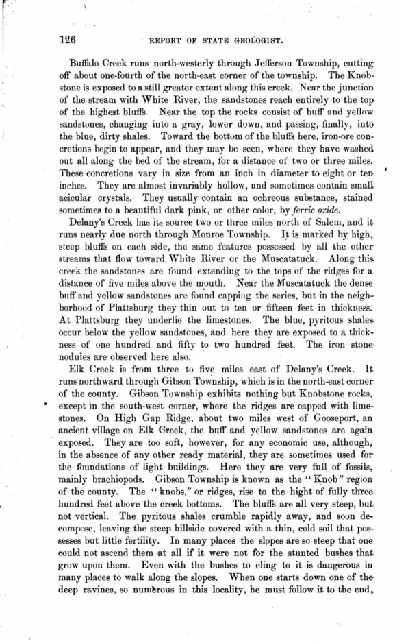
126 REPORT OF STATE GEOLOGIST.
Buffalo Creek runs north-westerly through Jefferson Township, cutting off about one-fourth of the north-east corner of the township. The Knobstone is exposed to a still greater extent along this creek. Near the junction of the stream with White River, the sandstones reach entirely to the top of the highest bluffs. Near the top the rocks consist of buff and yellow sandstones, changing into a gray, lower down, and passing, finally, into the blue, dirty shales. Toward the bottom of the bluffs here, iron-ore concretions begin to appear, and they may be seen, where they have washed out all along the bed of the stream, tor a distance of two or three miles. These concretions vary in size from an inch in diameter to eight or ten inches. They are almost invariably hollow, and sometimes contain small acicular crystals. They usually contain an ochreous substance, stained sometimes to a beautiful dark pink, or other color, by ferric oxide.
Delany'S Creek has its source two or three miles north of Salem, and it runs nearly due north through Monroe Township. I~ is marked by high, steep bluffs on each side, the same features possessed by all the other streams that flow toward 'White River or the Muscatatuck. Along this. creek the sandstones are found extending to the tops of' the ridges for a distance of five miles above the mouth. Near the Muscatatuck the dense buff and yellow sandstones arc found capping the series, but in the neighborhood of Plattsburg they thin out to ten or fifteen feet in thickness. At Plattsburg they underlie the limestones. The blue, pyritous shales occur below the yellow sandstones, and here they are exp~sed to a thickness of one hundred and fifty to two hundred feet. The iron stone nodules are observed here also. .
Elk Creek is from three to five miles east of Delany's Creek. It runs northward through Gibson To~nship, which is in the north-east corner of the county. Gibson Township exhibits nothing but Knobstone rocks, except in the south-west corner, where the ridges are capped with limestones. On High Gap Ridge, about two miles west of Gooseport, an ancient village on Elk Greek, the buff and yellow sandstones are again exposed. They are too soft, however, for any economic use, although, in the absence of any other ready material, they are sometimes used for the foundations of light buildings. Here they are very full of fossils, mainly brachiopods. Gibson Township is known as the" K;nob" region of the county. The" knobs," or ridges, rise to the hight of fully three hundred feet above the creek bottoms. The bluffs are all very steep, but, not vertical. The pyritous shales crumble rapidly away, and soon decompose, leaving the steep hillside covered with a thin, cold soil that possesses but little fertility. In many places the slopes are so steep that one could not ascend them -at all if it were not for the stunted bushes that grow upon them. Even with the bushes to cling to it is dangerous in many places to walk a,long the slopes. When one starts down one of the deep ravines, so num~rous in this locality, he must follow it to the end.

GEOLOGY OF WASHINGTON COUNTY; 127
or retrace his steps, for it is the next thing to impossible to ascend many of the bluffs. The following is about a correct section of the exposures along the west bluffs of Elk Creek:
Buff sandstone. . Yellow sandstone . Blue shales
Total.
SECTION.
· 10 ft · 20 ft. · 270 ft.
· 300 ft.
South and south-west of Little York the buff and yellow sandstones were not observed, though they may occur in some localities. Fo,\!r or five miles above the mouth of Elk Creek the" knobs" rise to the hight of more than 300 feet above the creek bottom. The exposures show blue shales all the way to the tops.
The terraces or bottoms of all the creeks that flow into the Muscatatuck and White River are built up of these disintegrated and decomposed shales. The soil, therefore, is hard, cold and of a dull ash color. Where they are liIubject to the periodical overflow of the White River, and re~eive the alluvium of that stream, they are, of course, fertile, and produce excellent crops, but above the points subject to overflow the lltnds do not respond generously to the hand of cultivation. The addition of bone phosphates and lime to these bottoms would make them produce ~orn and other cereals bountifully.
In the townships of Franklin and Polk the Knobstone is not exposed, .except in the cuts made by the creeks and branches, but these are so numerous that it is not difficult to find the outcroppings of these rocks in any neighborhood. Along the South Fork of Blue River, from the vicinity of Philadelphia, almost to the point where the stream is crossed by the Louisville, New Albany and Chicago Railroad. the Knobstone shales may be seen at many points. They underlie the Burlington and Keokuk limestones, and are of the uniform dull, blue color, soft and pyritous, erumbling rapidly away on exposure. About a mile south of South Boston the yellow sandstones are again found, and there is a quarry opened at that point, from which good building stones are obtained. The rocks are dense and firm, and are very easily worked. Cot Jack Bowman, near Pekin, had a spring house constructed of these roc.ks several years ago, 1tnd they resist the action of the elements seemingly as well as any stone in use. They do not decompose, and the only way in which the elements ean destroy them is by slow attrition. They do not crack, split nor break 'Under the iI!fluence of frost.
The same rocks are exposed again on the road, about' one mile east of Harristown, on what is known as the old Rodman farm.
. .

128 REPORT OF STATE GEOLOGIST.
The sandstone is yellow make fair foundation stone. point:
and somewhat coarse, but would evidently The following section was obtained at this
SECTION ON PUBLIC ROAD AT THE RODMAN FARM.
Soil and red clay. . Magnesian limestone Shaly limestone. . . Gray to blue limestone Yellow sandstone. Blue shale.
Total
20 feet. ~o " 10 " 20 " 25 " 35 "
. 130 feet.
About three miles east of Salem, on the Canton Road, at a cut in the • side ofthe creek bluff, is an exposure ofthe blue shales, and they are so near
the top of the bluff that one would expect to find them eiposed oOn the creek in the vicinity of Salem; but it seems that the dip is somewhat greater here, being sufficient, at least, to carry them under the bed of" the North Fork at Salem. There are eight or ten feet exposed at the point mentioned, and the superincumbent stratum is clay. A little farther up the creek, at what ~eems to be a lower altitude, the limestones occnr in the bed of the stream, and several species of fossils characteristic of Burlington l;ocks have been found in them.
North-east of Canton, about one and one-half or two miles, the shales may be seen outcropping along the perpendicular banks of a small creek. ]n fact, along the course of allY of the small creeks in the eastern or northern parts of the county, the shales may be seen, usually underlying blue crystalline limestone.
There is no difficulty in distinguishing the Knobstone rocks, wherever they are exposed in the county. Their lithological characters are so distinct that in the absence of characteristic fossils they may be readily recognized.
Among the fossils found in these rocks in'Vashington County are the following named species which are somewhat common: Spirifera carteri, Streptorhynchus crenistriatus, Plurotomaria textiligera, Schizodus medinaensis, Palreoneilo bed:fordensis, Gardiamorphia 8ubglobosa, Grammysia rhomboides, Gmmmysia ventricosa, and a fucoid like /:3pirophyton candi-galli.
Dr. S. H. Harrod, at Canton, has collected vast numbers of fossils from different parts of the county, especially from the Knobstone, Burlington, Keokuk and·Warsaw beds, and it was intended to procure a complete list, if possible, of the many species collected by him; but he has donated the most rare species to public collections, and no complete list of them has been presel"ved. No other collector has ever been able 1&
secure so Illany fine specimens as he has, especially from the Knobstone. Burlingtun and Keokuk rocks.

GEOLOGY OF WASHINGTON COUNTY. 129
At the close of the period in which the great mass of sand and other material now forming the Knobstone group of rocks waS" deposited, the surface of the deposit was evidently broken by slight but irregular wavy ridges, or gentle undulations, or else subsequent to the deposition of the sediment, and prior to the beginning of the liI)1estone formation, certain modifications occurred which produced those conditions. In tracing the Knobstone across the northern part of the county, one will readily notice those slight undulations succeeding one another in regular order. Owing to them, a variable dip is seen in the strata at the point of contact betweeu the sandstones and the limestones, which has led some observers to the erroneous conclusion that the "irregularity was due to an upheaval. The variable dip is not observed in the overlying limestones, nor is it seen near the bottom of the Knobstone rocks, while evidence of an upheaval would show as distinctly in one stratum as another.
·While engaged in the survey of the county, Mr. John Craycraft, an iJ~telligent citizen of Florid~, but formerly a resident of Washington County, in a letter published in the Salem Democrat called my attention to a supposed line of upheaval extending across the northern part of the county, through the townships of Gibson, Monroe, Jefferson and Brown, and extending on westward. I gave the suggestions in that letter my careful attention, but found no evidence to lead me to join Mr. Craycraft in his conclusion in regard to an upheaval. The great seams and fissures mentioned by him are but tqe effect of the vast erosive forces that were once in action here. The river valleys, the creek beds, the deep ravines, the sink holes and caves of Washington County are all the work of the same agent, water. The evidence indicates that vast torrents have poured over the county for iong periods of time, undermining, disintegrating, decomposing and tearing down immellse walls of rock, and hurlillg the· fragments into the ravines and valleys where they were rolled together and ground into the finest particles. The great valley through which Blue River runs, and the deep ravines and creek valleys of the northern part of the county are palpable examples of the potency of this great agent.
The Knobstone group of Indiana has been supposed by many geologists to be equivalent to the Kinderhook group of lllinois, and the Waverly group of Ohio. In lllinois the 'Kinderhook group includes all the rocks from the top of the Devonian black shales to the base of the Burlington limestones. Ohio geologists divide the Sub-Carboniferous rocks into three divisions, the upper member of the system being SubCarboniferous limestone, followed by the Waverly group and Erie shales. The Waverly group they subdivide into Cuyahoga shale, Berea grit, Bedford shale and Cleveland shale. The upper portions of the Knobstone in Indiana appear to be more nearly identical with the Waverly rocks of Ohio, and the lower portions more closely allied to the Kinderhook of
9-GEOLOGY.
130 REPORT OF STATE GEOLOGIST.
Illinois. If the three groups are identical, the priority of names accrues to the Knobstone, as that application was given to these rocks in this State by Prof. David Dale Owen, in 1837. The Kinderhook group did not receive that appellation until 1861, while the term" Waverly" is'nm of much earlier origin, If the Knobstone rocks are not identical with the rocks of Ohio and Illinois, that occupy the same stratigraphical position, it is certainly clear that the name should be retained as a term properly distinctive of a series of rocks so wefl known and extensively developed as the Knobstone of Indiana.
ECONOMIC VALUE OF THE KNOBSTONE.
The argillaceous and pyritous shales of the Knobstone group are, of course, wholly, worthless for any economic purpose. When exposed to the weather they soon disintegrate, and their component elements are mixed with the surrounding soil, or carried away by the Rtreams and deposited as bars along their various courses. The more compact sandston~s, however, found in the northern and south-eastern parts of the county, form an element of considerable utility in the erection of various buildings. The facility with which they may be quarried, and their general accessibilityat many points of exposure, furnish advantages in their use which many of the farmers have availed themselves of in preference to transporting limestone for several miles over tortuous roads. But as to adding anything to the mineral wealth of the county, it is hardly probable that the sandstones of this region will ever be in such demand as to become an article of commercial importance.
BURLINGTON GROUP.
These rocks have a maximum thickness in this county probably not exce~ding twenty-five feet. They are exposed along the bluffs of the South Fork of Blue River, in the neighborhood of Philadelphia. They are distinguished by three distinct layers of variable thickness. South of Philadelphia, on a bluff of the stream, is a fair exposure which gives the following section:
Buff, cherty limestone ... Gray shalElf! ... , ..
SECTION.
Blue, semi-crystalline limestone.
5 ft. 3 ft. 3 ft.
Along this stream these rocks,where exposed, rest directly upon the argillaceous shales of the Knobstone group. Just west,of Philadelphia, on the Canton road, they are again exposed, and the locality is one quite fruitful of fossils. Among the species found here are Productus 8emi-reticulatus, Spirifera plenu8, Batoerinu8 eh1'istyi, Batoerinus pyriformis and Gran'.atoerinus. norwoodi.

GEOLOGY OF W Af"HlNGTON COUNTY. 131
The blue crystalline limestone is, in many places, full of fossils, the most common of which is Streptorhynchu8 crenistriatuB. Crinoid stems are abundant. About a mile north of Philadelphia, and about one·fourth of a mile. from the road leading to Little York, these rocks are again exposed in a deep ravine that cuts down through them, and into the shales. They lie upon the shales there, but pre~ent no marked difference from the exposures seen farther south. The following section is shown there:
Gray, arenacious limestone. Gray, arenacious shales Blue limestone
Total. .
SECTION.
" . 4 ft. 2 ft. 6 in. 4 ft .
. 10 ft. 6 in.
Fossils are found there in good state of preservation. Spirifera plenuB, S. Forbesi, GranatocrimlJJ norwoodi, Batocrinus turbinatUB,ActinocyinUB lowii and several other species of crinoids have been found there. Some of them are clearly characteristic of the Burlington group, and a few of them as clearly belong to the Keokuk. The Burlington fossils, however, predominate throughout these rocks wherever exposed, and as it is a recognized fact that the position of a stratum cim be more accurately determined by the fossils found within it than from mere stratographical position, I am, on this account, inclined to view these rocks as being not only stratigraphically but paleontologically in the Burlington group.
Of similar rocks exposed in Harrison County, Prof. John Collett, in the Indiana Geological Report for 1878, page 310, says: "The lower mem ber of this bed is a buff or greenish-gray argillite: Stratigraphically, it occupies tlie horizon of the Burlington group of Illinois and Iowa, and, although fossils of the Burlington group are quite numerous, yet Keokuk fossils are still more abundant; therefore, until more decisive evidence as to the existence of synchronous conditions corresponding with those so remarkable in the geology of the States just named, we may still retain those beds in the Keokuk group."
In the connected section of Harrison County, same Report, page 303, Prof. Collett gives the Keokuk group, as follows:
"KEOKUK GROUP.
Gray or brown limestone . . . . . 8 to 22 ft. Buff argillite, with small geodes. . . . .. . 16 to 14 ft. Encrinital limestone and geodes 4 to 12 ft. 6 in. Blue and ICray banded shales, somewhat calcareous 4. to 18 ft. Buff, argillaceous limestone with Burlington fossils 6 to 4 ft. Blue gray calcareous shales. . . . . . . . . . . 20 to 5 ft. 6 in."
From the above section it will be seen that the stratum uf limestone in Harrison County containing Burlington fossils, with the underlying bed

132 REPORT OF STATE· GEOLOGIST.
ofca.lcareous shales, has a thickness of from ten to twenty-six feet, which corresponds with the thickJ?ess of the rocks in Washington County that contain the same fossils. There is quite a marked difference in their lithological character, however, though they occupy the 'same stratigraphical position.
In giving a list of fossils of Harrison County, Prof. Collett sayli: "In the lower Keokuk beds, although fossils of that age predominate, yet as all indications point to the synchronism of these strata with the Burlington group of lllinois and Iowa, the following list of fossils found in Har- f
rison and Clark counties is parenthetically added. Many of them are exclusively Burlington:
Platycrinus halli (plates and stems). Platycrinus discoideus .
. Platycrinus planus. . Dichocrinu8 strlatus. . Dichocrinu8 lineatuB. . Actinocrinus unicornis . Synbathocrinus wachsmuthi Synbathocrinus dentatus . Zeacrinu8 ramosus. , .' . ZeacrinuB troostianus . . Strotocrinus perumbrosus. Pentremites burlingtoneDsis Productus burlingtonensis Productus flemingi Spirifer grimesi. . Orthis michilini. .
',,- Athyris incrassata .
. '
• Shumard. · Owen & Shumard . · Shumard. · Owen & Shumard. .M.&W. .O.&S . .M.&W. .O.&S. · Hall . . M.&W. · Hall. .M.&W.
· Sowerby. · Hall. · VEveille. · Hall."
It will be noticed that nearly the whole of the above list of fossils found in Harrison County are strictly characteristic of the Burlington rocks., ~Qd the tendency of the evidence leads strongly to the conclusion that thin beds of this group separate the Keokuk from the Knobstone through, out the greater portion of Washington· and Harrison counties. Quite !Ii large number of the species of Burlington fossils that occur in Harrison County are also found in Washington County, while quite a large nurobel,' of species occu·r in the latter county not enumerated in the above list by Prof. Collett.
Another noticeable feature observed in Washington County is that in the beds where Burlington fossils are 'found they are in much greater proportion, compared with those characteristic of the Keokuk beds, than they are in Harrison County. .
Burlington fossils have also been found along the creek in the vicinity of Canton. In that locality they occur in a thin stratum of grayish limestone that lies immediately in the bed of the creek. The limestone is ar-/ gillaceous and areJl8.CE)OUS, and' gives forth a peculiarly resonant sound

GEOLOGY OF WASHINGTON COUNTY. 133
when struck with. a hammer. Among the fossils that have been found there are ProductU8 semi-reticulatuB, Spirifera plenWJ, Spirifera grime3i, Orthis michilini, Scaphiocrinwl wachsmuthi, PlatyerinU8 planus, BatocrinU8 pistillU8, DorycrinU8 unicornis, AgariocrinU8 rwddsWJ, AgariocrinU8 pentagonus, and probably several other crinoids that at various times .have been found and eontributed to public or private collections.
These rocks, wherever they are expbsed, almost invariably contain erinoids, either perfect or in fragments, and vast quantities of crinoid ~tems are always to be seen in them. Were the Keokuk fossils wholly absent, scarcely any geologist would hesitate to refer them to the Burlington group.
ECONOMIC VALUE.
Owing to the immediate proximity of the oolitic beds of the St. Louis group of rocks, the facility with which those rocks are obtained, and their general adaptability for all the uses to which limestones are applied, no effort has ever been made to make the Burlington limestones available for any purpose except rough foundation work. The blue crystalline limestone that generally occurs at the base of the series may be quarried in blocks of any size, and is very well adapted to foundation work, but it is too hard to dress readily under the hammer and chisel.
KEOKUK GROUP.
The rocks of this group have a thickness in this county of from fifteen to forty· five feet. They vary greatly in color and lithological character. The greater mass of them is cherty or shaly. They are exposed pretty generally throughout the northern parts of the county along the creeks and ravines, and capping many of the ridges. Numerous outcroppings are seen east and north-east of Salem. The principal exposures run east of a line from the north-western to the south-eastern corners of the county. The presence of these rocks is at once announced by the vast number of geodes that are seen upon the surface where they are the surface or underlying rocks. The geodes vary in size from an inch or less in diameter to two feet or more. Many of them are hollow and filled with beautiful clear crystals of quarts. In many of them the crystals are colored to various shades of pink or blue. Others of them are filled with crystallized gypsum, zinc-blende or galena. In many localities dozens of wagon loads of these singular concretions might be picked up. Several of the layers, of limestone are full of them. Other layers contain a larger proportion of chert and limestone. Many fossils are found throughout the eounty partially or wholly geodized. In many of them the expansion resulting from crystallization has not destroyed the form of the fossil. • One obtained from HOIl. W m. R. England, at Little York, shows perfectly

134 REPORT OF STATE GEOLOGIST.
the form and many of the surface markings of Athyris lmnellosa. Another in the possession of Dr. Harrod, only partially geodized, may readily be identified as Penremites woodmani, while another, procured from Prof. Bridgeman, at Salem, is easily recognized as belonging to the same species. Both specimens are greatly expanded, being about two by three inches in transverse and longitqdinal diameter, respectively.
Keokuk limestones are exposed on the. farm of Mr. W. W. Stevens, about one mil.e north of Salem. They are ~een in the bed of the creek underlying the St. Louis rocks. They occur there in buff, cherty ledges, ' and in shaly layers containing hundreds of geodes of all forms and sizes. A common form that occurs here is one with a flattened disc-like appearance. These disc-like geodes are found in many localities, and are sometimes seen eight or ten inches in diameter by one and one-half to two inches in thickness. Many of them seem to have been globular in form, and ,by sudden pressure instantly flattened. They are frequently seen' with numerous cracks in them as though they had been changed from hollow spheres to their present shape by sudden pressure. Their most usual shape, however, is spherical.
Quite a number of fossils, generally but poorly preserved, occur in the rocks along the creek in the vicinity of Mr. Stevens's farm. Spilrifera striata, S. neglecta, S. keokuk, Streptorhynchuscrenistriatus, Platyceras equilateralis, Productus semi-retic1tiatus, P. punctatus, Onychocrin118 exculptus, Cyathocrinus decadactylus, and a number of other' species occur there. A fine specimen of Onychocrinus exculptus, obtained from Mr. John Clark, at Salem, was found in this locality. Plates and spines of an Archaeocidaris also occur here.
In a deep ravine north-east of Plattsburg there is a good exposure of Keokuk limestones near the top of the bluff. The following' section is shown there:
SECTION OF KEOKUK LIMESTONE.
Buff to gray limestone and chert. Geodiferou8 shales . . . . . Heavy bedded gray: limestone Limestone chert and shales.
Total. . . . . , ...
· 7 ft. 4 "
.11 " · 9 "
· 31 ft.
Spines of Archaeocidaris (sp. undt.), crinoid stems and fair specimens of SpiriJera grimesi, S. striata, S. keokuk, Athyris lamellosa, Myalina keokuk, and Platyceras equilateralis were seen there. The fossils at this locality are uniformly imbedded in a flinty matrix in the crystalline limestone, and they are so firmly fixed that it is almost impossible to secure specimens in a perfect condition.
Keokuk limestones underlie the Warsaw beds just north of Plattsburg.

GEOLOGY OF WASHINGTON eou/TY. 135
Good exposures are also seen along the bluffs of Rush and Twin creeks. On the farm of Mr. Harrison Williams, about a mile east of Rush Valley post office, they attain a thickness of nearly forty feet. The talus and glope covers a good portion of the bluff, so that a complete sec'tion could not be made, but the Keokuk rocks are near the top of the bluff and are pretty well exposed. A number of fossils were found there, among which were several weathered crinoids, exposed on the surface of the rocks, but they could not be preserved owing to the flinty character of the stone. The following is a section of the bluff of a ravine that enters Rush Creek from the south, almost opposite the residence of Mr. ~Villiams:
SECTION.
Dark blue limeRtone, weathering gray with PlafycrinU8 hemisphericU8, Onychocrinus exculptus, Spirijera striata, Spirijera lateralis, etc. . . . . . .
Heavy bedded gray limestone Gray to blue limestone. . . Gray limestone and shales.
Total ....... .
6 ft; .12 " .10 " .10 "
.38 ft.
Throughout that section of the county where the Keokuk are largely the prevailing rocks, the lithological character changes so rapidly that in many places it would be altogether impossible to recognize them in the absence of characteristic fossils. The chert and geodes are not always present, and where isolated exposures occur the true stratigraphical position can not always be accurately determined. Where erosion and denudation occurred throughout the county, the denuded areas were subsequently covered with a local sediment of the disintegrated and decomposed rocks of the immediate vicinity. . The different groups of rocks represented in . Washington County, with the exception of the Knobstone, have a very limited vertical extent. Erosions, therefore, extending to two hundred or three hundred feet, cut down through three orfour different groups of rocks in many places, and the clays and other residual matter forming the slopes of the ridges, hills and bluffs are composed of the deb,ris from two or more groups of rocks. As already mentioned in this report, many of the fossils that weathered out of the slowly decomposing rocks were sufficiently silicified to withstand the destructive influences of the various elements that destro:fed the rocks, and they are frequently found in the clay in an excellent state of preservation. But in most instances they do not assist materially in fixing the horizon of the underlying rocks. from the fact that fossils of the Keokuk, Warsaw and St. Louis beds are all likely to be found in the same bed of clay. They clearly indicate, however, that when the rocks were in place, the variolls groups to which the fossils belong were all represented in their true positions.

136 ApORT OF STATE GEOLOGIST.
Many other exposures of the Keokuk rocks occur throughout the county, especially in tse southern part, where the erosions were sufficient to cut down through the St. Louis and 'Varsaw beds, but in that section tUe exposures are limited and more isolated.
ECONOMIC VALUE OF THE KEOKUK LIMESTONE.
For economic purposes, the Keokuk rocks are too silicious, cherty and variable in character to be of especial value. The shales are to some ex- • tent pyritous, and tlferefore disintegrate rapidly, while the more compact forms of rock are too hard and flinty to work easily. They contain too much silica and magnesia, as a general thing, to make good lime. The blue limestones of this group, as a general thing, do not weather well. The gray limestones, wherever used, are well adapted to foundation work, as they resist the influences of the climate and !I·re very easily worked. The unlimited supply of oolitic limestone throughout the county renders the use of inferior stone at any point wholly unneceRsary; therefore, to the citizens of the county, the value of any other 1ltone is scarcely a matter for a moment's consideration.
LOWER ST. LOUIS, OR WARSAW DIVISION.
This division or group of rocks has a maximum thickness in W ashing~ ton County of over one hundred feet. They are variously spoken of as the "Warsaw division of the St. Louis group," " the Warsaw beds," "Warsaw limestones" and" the Warsaw group." Without attempting to give the fine distinctions between "beds" and "divisions" and ,. groups," it is thought just as well to refer to them in this connection as
. a distinct division or group, inasmuch as nearly all the scientific interest and commercial importance of the rocks of Washington County attaches to this division. It is merely intended, however, to give their general characters, extent and exposures, as seen in Washington County. Prof. Miller, the able paleontologist of Cincinnati. in his catalogue of American Paleozoic Fossils, refers to them as a group; while Prof. N. H. Worthen, the eminent State Geologist of TIlinois, regards them as merely a division of the St. Louis group. In refering to the St. Louis group, pages 83-4, Vol. I, Geological Survey of Illinois, he says:
"Under this head we include the evenly-bedded limestones of Alton and St. Louis, the concretionary and brecciated limestones of the former locality and points further north. The oolitic liinestone which outcrops at the river's edge three miles above AIton, and the equivalent beds at Bloomington and Spurgeon Hill, Ind., and the blue calcareo-argillaceous shales and magnesian and arenaceous limestones at Warsaw, in Hancock County. The last-named beds are characterized by a somewhat peculiar group of

GEOLOGY OF WASHINGTON COUNTY. 187
fOBBile, and have usually been regarded as forming a distinct division of the mountain limestone series, but on careful examination of the beds we are satisfied that such a division is entirely arbitrary, and not justified by paleontological evidence. Many of the species of fossil shells that occur in the beds above named are also found in the upper division of the limestone at other localities, and the changes that occur in ~he fossil contents of the rock at the various localities named may be attrib~ted to the local conditions under which the sediments were accumulated, rather than to any specific change in the character of the fauna of this period."
There is probably as little change in the general character of these rocks, as they are exposed throughout Washington Oounty, as exists in •
• any other class of limestones found in the county. At Spurgeon Hill, a locality well-known to paleontologists everywhere, the railroad cut gives an excellent exposure. Spurgeon Hill cut is five miles east' of Salem and one-fourth of a mile east of Harristown, on the Louisville, New Albany &; Chicago Railroad. The earthy layers, or ferruginous clays, composed largely of the residuum of decomposed limestones, which form the surface deposits of the locality, have been the source of the abundant supply of fossils found in those mmous beds. At Paynter's Hill, four miles south
.()f Salem, the same deposits of clay and other residual matter occur, equally productive of the same species of fossils found at Spurgeon Hill.
, On the top of the south bluffs of Rush Creek, eight miles north by northwest of Salem, on the farm of Mr. Harrison Williams, these beds occur again in the same condition. At that point the dark red clays contain vast numbers of PcrliJremites of various species, with numerous crinoids' of the genera Batocrinus, AUcprosalloerinus, and several specimens of Caf:i1.. locrinus tennessee, Troost, which are locally known as "quart cups." The .same clays occur again about one-half inile north of Plattsburg, where they rest directly upon the Keokuk limestones. Among the fossils observed there were Pentremites corwideus, P. grosvenori, P. koninckianus and.-. fragments of Pentremites longic08talis. South-west of Salem about one mile, the same clays are exposed in an old field where a large number of species are found. Pentremites woodmani, P. longicostalis, P. conoideus, P. koninckianus, Batocrinus icosidactylus, B. plano-discu8, B. irregularis, all occur there; besides, Athyrus hirsuta, A. lamrn£llosa, A. trinudea, Con.()Cardium cuneata, Eumetria verneuilliana, Rhynchonclla gr08venori, R. ricin-ula, Paleacis cuneata, Syringopora ramulosus and many other fossils also oc--cur there.
With the exception of the blue magnesian limestone at the bottom of this series, that is sometimes seen overlying the Keokuk rocks, the limestones of this division consist of a nearly pure carbonate of lime. When burnt into lime they make an article of the very best quality. The gray fossiliferous limestones are composed wholly of thj3 minute shells of foraminiferous animals. In many localities immense ledges of these rocks

138 REPORT OF STATE GEOLOGIST.
may be seen that are made up altogether of foraminifera. The beautiful little fossils are seen to be closely cemented together, but their forms and surface markings are plainly visible, and .from the softer rocks, with a proper instrument, many of thl;lm may be readily removed without injuring them in the least. Much of the oolitic limestone appears to be largely concretionary, the small egg-shaped nodules appearing under the glass like concretions of carbonate of lime, but where the very best specimens of the rock are obtained and a careful examination made by the aid of a good microscope it will doubtless be seen that the egg-shaped particles are' not concretions, but the true shells of probably a single species of minute
• foraminifers. In much of the stone there are delicate concretions around the fossils, and a still larger portion of it is composed of merely masses of fragments of. shells. Large masses of the stone, observed at Spurgeon Hill and on Mr. Press. Haynes' farm, four miles south of Salem, were found to be composed of fossils from the size of Bellarophon sub-lrevis down to forms so small that they -could scarcely be seen with the naked eye, and their general forms and surface markings could only be seen through a good glass. With the exception of the blue limestones that occur at the bottom of the series, the rocks of the Warsaw Beds which are exposed in the railroad cut at Spurgeon Hill are all soft; and the upper layers, those in which the minute· fossils are so perfectly preserved, are very friable and rapidly disintegrate on exposure. They are probably closely allied in texture and composition to the disintegrated rocks of which the superincumbent clays are largely compo.sed. The· fOIr
sils, however, are not silic.ified as were those in the overlying strata. The following is a partial list .of the fossils found at the various expos
ures of the Warsaw Beds throughout the county. The list is as near complete as it could be made at this time:
FOSSILS OF THE WARSAW BEDS IN WASHINGTON qOUNTY, IND
Palreacis tmneata Rotalw baileyi
Aulopora gigas . . . . . ~ngopora multattenua"td . Syringopora . . . • Zaphrentis cassedayi . Zaphrentis qrinulifera
PROTISTA.
RADIATA.
· M. and W. · Han.
· Rominger_ · Goldfuss.
· Milne-Ed. • Hall.
GEOLOGY OF WASHINGTON OOUNTY.
Archimedes reversa. . Archimedes wo'l'theni . C'oscinium w;terium. . Ooscinium elegans . . Ooscinium escharoid&~. Ooscinium keyserlingi. Fenestella plumosa. .
BRYOZOA.
ECHINODERMA'l'A.
Actinocrin:us indianensis Agariocrinus americanus Agariocrinus calyculus . Alloprosalocrinus conicus Batocrinus calyculus. . BatocrimlB icosidactylus. Batocrinu.~ irregularis . Batocrinus lagunculus . BatocrinuB mundulus (?) Batocrinus planodiscus Oalceocrinus nodosus. . OatillocrinuB tennessCl3. . Cyathocrinus multitrachiatus . Dichocrinus constrictus . Dichocrinus dichotomous Dichocrinus simplex . Granatocrinus curtus. Lepidesthes colletti. . Pentremites conoideus.
.. Pentremites grosvenori Pentremites koninckianus Pentremites longicostalis. Pentremites varsouviensis Pentremites woodmani . Poteriocrinus divaricatus
Athyris hirsuta . Athyris trinuclea. Athyris lamellosa Chonetes planumbona (?). Orthis dubia . . . . .
BRACHIAPODA.
· Hall. · Hall. · Prout. · Prout. · Prout. · Prout. · Prout.
· L. and C. .. Roemer. · Hall. · L. and C. · Hall. · Casseday. · Casseday. · Hall. · Hall. · Hall. · Hall. · Troost. · L. and C. · M.and W. · Hall. · Shumard. · Shumard. · White. · Hall. · Shumard. · Hall. · Hall. · Worthen. · M. and W. · Hall.
· Hall. · Hall. · Le~eille.
M. and W. • Hall.
139

\
140 REPORT OF STATE GEOLOGIST.
Productus indianensis . . Productus semireticulattlS . Productus biseriatus • . Productus ovatus . . . Productus tenuicostatus . Rhynchonella grosven01·i. Rhynchonella mutata. . Rhynchonella subcuneata Rhynchonilla macra . Rhynchonella 1icinula RhynchoneZZa wortheni Spirifera bifurcata.
· Hall. · Martin. · Hall. · Hall. · Hall. · Hall. · Hall. · Hall. · Hall. · Hall. · Hall. · Hall. · Hall. · Hall. · Hall. · Martin. · Hall. · Hall.
Spirifera lateralis . . Spirifera propinqua . Spirifera ienuicostata . Spirifera glabra. • • Spirifera norwoodiana (?) . Spirifera subcardiformis . Spiriferina spinosa. . . . Streptorhynchus crenistriatus. Terebratula formosa Terebratula turgida Terebatula trinuclea
. Norwood and Patten.
Conularia subcarbonaria Conularia misBouriensis .
PTEROPODA.
GASTEROPODA.
Bellerophon gibsoni. . Bellerophon sublmvis. Bulimorphia bulimiformis . Bulimorphia canaliculata . Bulimorphia elongata. . . EotrochUs concavus. . . . Cyclonema leavenworthanum . l!Jtwmphalus planispira. . Euomphalus planorbiformis Euomphalus Bpergenensis Holopea proutana. • • Loxonema vincta. . . . Loxonema yandellanum • Murchisonia attenuata
· Phillips. · Hall. · Hall. · Hall.
· M. and W. · Swallow.
· White. · Hall. · Hall. · Hall. · Hall. · Hall. · Hall. · Hall. · Hall. · Hall. · Hall. · Hall. · Hall. • Hall.

GEOLOGY OF WASHINGTON COUNTY.
Murchisonia terebriformis . iWurchisonia tutritella. • Murchisonia vermicula • Murchisonia insculpta . Platyceras inJundibulum. Platyceras acutirostris. Pleurotomaria conula. • Pleurotomaria humilis . Pleurotomaria meekana . Pleurotomaria nodu1ostriata Pleurotomaria piasamsis. . Pleurotomaria swallovana • Pleurotomaria subangulata. Pleurotomaria trili'Mata. Plevrotoma1'ia wortheni • StraparoUus quadrivolvis
CEPHALOPODA.
Nautilus clarkanus . Nautilus (2 sp. undt'd.) Ortlwceras epig1"US •
LAMELLABRANCHIATA.
Conoca1"dium reguilaterale Conocardium ca1"inatum. Conocardium cuneatum • Conocardium catastomum C:onocardium meekanum. Conoca1"dvum prattenanum. Oyp1"ica1"deUa nucleata . Cyp1"wardella oblonga . . Cyprica1"della subelliptica Oypricardia indianensis . Cyp1"wardia subplana. Nueula shuma1"dana Nucu1ana nasuta . Pinna subsJlatu1ata
ANNELIDA.
· Billings. .,Hall. · Hall. · Hall. · Hall. · Hall. · Hall. · Hall. · Hall. · Hall. · Hall. · Hall. · Hall. · Hall. · Hall. · Hall.
· Hall.
· Hall.
· Hall. · Hall. · Hall. · Hall. · Hall. .·Hall. · Hall. · Hall. · Hall. · Hall. · Hall. · Hall. · Hall. · Worthen.
SpirorbiB annulatus . . . ..... Hall.
Leperditia carb?naria PhiUipsia buJo •• . Phillipsia porllocki (?)
CRUSTACEA.
· Hall. · M. & W. .M.&W.
141

142 REPORT OF STATE GEOLOGIST.
It may be ascertained that several of the fossils enumerated in the above list do not occur in the rocks of the Warsaw beds, but all those mentioned have been found in the clay exposures, where, with an occasional exception, the fossils all belong to these rocks. Lepidesthes colletti and Pentremites woodmani both seem to have a vertical range in this county from the Keokuk to the Upper St. Louis rocks. Both species have been found in the Warsaw beds about a mile south-west of Salem.
About two miles south of Salem, on the farm of Mr. Colclazier, tile massive gray limestones are highly fossiliferous. Nearly all the forms ' found in the clays at Spurgeon Hall and Paynter's Hill may be found there in the soft, gray calcareous rocks. A dozen or more specimens of Pentremites conoidetts are often seen sticking out on a piece of rock less than six inches square. TheY may easily be obtained, with a little care, in perfect condition. On Mr. Williams's farm, on Rush Creek, the same fossiliferous rocks occur, and the specimens contained within them may be obtained with the same facility.
Throughout the northern, central and southern parts of the county the Warsaw limestones, owing to erosions, are the surface rocka in many places, but at no particular point do they diff'er materially from their general characteristics as given in the general section. In the north-western corner of the county, along the bluff's of Clifty Creek, the oolitic limestones are exposed for a distance of five miles, and in some places their thickness is fully sixty feet. They are exposed along the bluff'd of Rush Creek, showing in many places a thickness of from thirty to forty feet. And along Delaney's Creek ten to fifteen feet of these rocks are often seen exposed along the western bluff's. Splendid exposures occur !it Beck's Mill, at Foultz's Mill, near Fredericksburg, and an unlimited quantity of the finest quality of this stone is seen on the farm of Gen. James A. Cravens, one mile north of Hardensburg.
The area embraced in the oolitic limestone region of Washington County is from one hundred and seventy-five to two hundred square miles, with an average thickness of thirty feet.
ECONOMIC G~~OLOGY OF THE WARSAW BEDS.
The value of the Indiana oolitic limestones, for the various uses to which limestones are applied, is everywhere recognized and generously appreciated. It is generally admitted that they are very greatly superior to any other stone of this class known. The quarries at Salem, Bedford, Ellettsville, Stinesville, Putmanville and other points are well-known to contractms and builders throughout the United States; and their product is rapidly acquiring a reputation, even in Europe, on a0count of its beauty, durability, evenness of texture and color, the facility it possesses of being easily worked into any desired shape, and other excellent qualities.
,

GEOLOGY OF WASHINGTON COUNTY. 143
The Salem Stone and Lime Company, of Louisville, Ky., has an extensive quarry about one and one-half miles west of Salem, on the Louisville, New Albany & Chicago Railroad. In connection with their quarries they have three large lime-kilns, which have a capacity of several cars per day. The oolitic limestone of Washington County contains over ninety-six per cent. of carbonate of lime, and the lime manufactured of it can not be excelled anywhere. The unlimited supply of the stone, and the ease with which it is obtained, enables the manufacturers to produce lime at a very small cost, and to convenient markets they can supply it at a price with which many others do not care to compete. Lime of the very best quality may be manufactured of the oolitic limestune wherever it occurs throughout the county.
The Salem Lime and Stone Company employ a force of rtearly one hundred and fifty men, and when it is considered that nearly all the work in a stone quarry is now done by machinery, and that this company has all of the latest and very best machines in use, it will be recognized that the capacity of their works is very great. Steamchannelers, steam drills, steam saws, steam planes and poli®ers, steam travelers, immense machines for transporting the huge blocks of stone from one point to another, and steam derricks or cranks;' are all in use here, and the one hundred and fifty men employed are occupied nearly altogether in operating the machines.
A section at the quarry where the principal force of men is employed was taken, which is herewith given:
SECTION AT THE QUARRY OF THE SAT~EM STONE AND I~IME COMPANY.
Soil and rubbish . . . . . . . . . . . . Dark blue, bituminous limestone (bastard) Gray oolitic quarry stone . Blue crystalline limestone.
Total .....
· 3 ft.
· 6 " .30 " · 6 "
.45 ft.
The gray quarry stone mentioned in t~e above section is a solid stratum thirty feet in thickness, without seam or parting 'of any kind, and with only an occasional water-worn fissure. The color is uniformly a light gray, the only exception being an occasional slightly blueish tinge to a small portion of the stone, which was occasioned by the dissolving of some form of iron, and the subsequent coloring of the stone by the solution. The stone at this quarry is a fair sample of that embraced in an area of two hundred square miles, extending ove~ nearly the whole of the western half of the county. It may be quarried in blocks of any dimensions, and the color and texture is the same all the way through. The Salem stone contains but few fossils, but in other localities the quarry stones sometimes contain fine specimens. A quarry is opened south of the railroad on Spurgeon Hill; and the stone, wltich is of excellent quality

•
144 REPORT OF STATE GEOLOGIST.
for any purpose, contains many fine specimens, the most valuable being. very fine specimens of Oonularia missouriensi..q, some of them ten to twelve inches in length.
Most thorough chemical and mechanical tests of the Salem stone were made at the instance of the State House Commissioners of Georgia. The following extracts from their report to the Senate Committee on Public Property shows the estimate they placed upon the stone after the most careful tests had been made:
"Salem stone was selected by the Commissioners in the belief that • when strength, beauty, durability and cost are considered, it was the best material offered to the Board, and we have been strengthened in that conviction in every way since the selection was made.
" It possesses the most remarkable uniformity of grain and texture, is exceedingly bright and handsome in color, can readily be worked into any shape, is peculIarly suited to the design we are carrying out, is less liable to discolor than almost any other stone of so light a color, and the. evidence from witnesses qualified to testify is that its durability is equal to that of any stone in the world.
"For tpe purpose of becoming familiar with the constituency and physical properties of this stone, the Commissioners have had it subjected to chemical analysis and .some mechanical tests, the results of which are herewith reported.
" The chemical analysis of Salem stone is:
Carbonate of lime . . . . . Carbonate of magnesia .. Oxides of iron and alumina . Insoluble silicates. . . . . . Chlorides of soda and potash. Water expelled at 2120 F . Combined water, etc. . . . .
. 96.04 per cent. 0.72 per cent . 1.06 per cent. 1.13 per cent. 0.15 per cent. 0.10 per cent. O.SO per cent.
"This analysis was made in the office of the Georgia State Chemist, and agrees with all the published analyses within very close limits.
" As to its capacity to resist heat, we had a small block of this stone heated in the office of the State Chemist, in a cupel furnace, to a temperature of 1,2000 F., without injury to the stone.
"Mr. Champayne, the superintendent of' the capitol, and a bonded and sworn agent of the State, has made careful tests of its absorption of water on a random specimen, and finds it to absorb water at the rate of 1 to 42, or 2.38 per cent.
"Col. L. H. Charbonnier, Professor of Physics in the University of Georgia, certifies to the Board that he has tested the stone for strength, in a Riehle testing maching, and finds a resistance of 8,975 pounds per square inch. This strength is less than that shown by Gen. Q.A. Gilmore, and by the Indiana g~ological reports, which state it at 11,750 and

. GEOLOGY OF WASHINGTON COUNTY. 145
10,000 to 12,000, respectively, and the difference is due to the fact that the sample tested for the Board was a freshly cut specimen, and had not become indurated by exposure, as was the case in the samples tested by the authorities noted.~'
It is worthy of remark that the chemical and mechanical tests made of the Salem oolitic stone were ample and exhaustive, and after careful examination of all other building material in use, they selected this as the .cheapest, most beautiful, strongest and best adapted in every partieular to the work on hand. The report of the Commisstoners, of whom Henry D. McDaniel, Governor, was, by virtue of his office, chairman, was approved by the Legislature, and the building is now in course of erection.
The tests of this stone, made by the State House Commissioners of Georgia, agree very closely in results with all other tests made, so it is unnecessary to furnish other examples. It has been used in Washington County for various purposes for more than fifty years, and in no instance has it ever been known to crack, split, disintegrate or break in any way. At the numerous exposures along the various water courses, where it has been subjected to the action of the elements for hundreds, and perhaps thousands of years, it does not display in a single instance a tendency to disintegrate or break down under prolonged exposure.
'Vhile it may not be superior to the oolitic stone of other counties, it is (lertainly a fact that the Washington County stone is not surpassed, in. the many qualities that make stone valuable, by any other material of this (lharacter in the country.
Among the buildings that have been constructed of this stone, and where it has proven to be a superior material, are the following:
City Hall .. Galt House ..... . City Hospital . . . . . Broadway M. E. Church First Christian Church . German Methodist Church German Evangelical Church Temple Adas Israel (Jewish) Hamilton Block . . . . . . J. T. Tompkins & Co., Block Falls City Bank . . . . Pendennis Club Building Cincinnati Court-house . Cotton Exchange. . . . State Capitol Building .
'.
· Louisville, Ky. · Louisville, Ky. · Louisville, Ky. · Louisville, Ky. · Louisville, Ky. · Louisville, Ky. · Louisville, Ky. · Louisville, Ky. · Louisville, Ky. · Louisville, Ky. • Louisville, Ky. · Louisville, Ky. · Cincinnati, O. · New Orleans, La. · Trenton, N. J.
The County Commissioners of Washington County are erecting a commodious and elegant court-house, which will be built wholly of Salem stone, and when completed it will be a most convenient and imposing
• structure, of which the citizens of the county may well be proud.
lO-GEOLOGY.
146 REPORT OF STATE GEOLOGIST.
A large number of other buildings in various parts of the country might be enumerated, but these are sufficient to show that it is generally used and is satisfactory.
Grand exposures of this stone occur at many points throughout. the county where it might be quarried without &tripping, and at a nominal cost. At Clifty Mill, on the farm of Mr. Henry Robertson, it is exposed in a solid stratum sixty feet thick, and is uniform in texture and 'color. A company with proper capital could open up a mine of wealth here. A switch could readily be built from Campbellsburg, on the Louisville( New Albany & Chicago Railroad, or from Fort Ritner, on the Ohio & Mis~issippi Railroad, and a quarry at this point. cou~d compete in any market. Hydraulic limestones in unlimited quantities occur at the same point, and, upon actual test, it makes a most excellent slow.setting cement. Waterpower is immediately at hand for grinding the cement, and the citizens of the county should avail themselves of the advantages offered at this point for opening up one of the best paying industries in the State. Stone. lime and cement works in operation here would certainly yield handsome profits.
At Beck's Mill almost the same advantages are offered, and at many other points throughout that portion of the county.
What is badly needed is a railroad running east and west through the center of the county. With proper shipping facil'ities, the mineral wealth of Washington County is not inferior to that of any other county in the State. The L., N. A. & C. R. R. Co. afford the best facilities in their power, and on accommodating terms, but transferring to other lines adds very m'aterially to the freight expenses, which, in some instances, renders it very difficult for the people of Washington County to compete with inferior stone.
UPPER ST. LOUIS LIMESTONES.
These are the surface rocks, generally over that portion of the county known as the" Barrens," and throughout the w~stern 'part of the county, where the sinks occur. The exposures are few, but the clays which occupy the horizon of these rocks are characterized. by a peculiar redqish brown color, and great fragments of bryozoic chert or limestones scattered over the surface. The Upper St. Louis limestones are exposed along the eastern base of the Sandstone Ridge from the neighborhood of Livonia to the Harrison County line. They show in the bottoms of the deep ravines, cut down through the eastern side of the ridge. They occur in the tops of the bll}ff~ along Blue River, above Fredericksburg and above Foultz's Mill. Lithostrotion beds occur on the bluffs north of Foultz's Mill, where fine specimens of L. canadense and an occasional specimen of L. proliferUln may be obtained. Svringopora ramulosa also occu~s in the same l~cality.
At the head of Clifty Creek, just above Clifty Mill, the whitish gray •

GEOLOGY OF WASHINGTON COUNTY. 147
argillaceous limestones occur, lying just under a stratum of hard, fiinty and almost black ferruginous limestones. These gray limestones occur again at Beck's Mill, where they are known locally' as "freestones." They will probably make a good article of cement, as they are free from chert and other impurities, and evidently have hydraulic properties. Underneath the gray limestones is a thick stratum of blue magnesian limestone. This stolle is from ten to twenty feet thick. It is uniform in color,finegrained and free from chert. It has been fully tested as a cement rock, and when properly burned and ground hardens under water or' in the air to the density of hard limestone. In the neighborhood of Clifty Mill the black, ferruginous limestones referred to above are three or four feet thick, and they lie in strata from twelve inches to fifteen inches in thick· ness. They break out in rhomboidal blocks of various sizes, generally from two to three feet in length and from sixteen to twenty inches in breadth. Fossils are occasionally seen sticking on the surface of them, but they are generally so weathered as tQ destroy all their characteristic features.
Immediately underlying the blue magnesian limestone in the vicinity of Clifty Mill there is a stratum of very hard crystalline ferruginous limestone, about four feet' in thickness. This stratum contains a very lar:ge per cent. of iron. The stone appears to be as hard asfiint, and it will make the fire fiy-from the best steel hammer at every stroke. The -only point where it is exposed is on a point or ridge just west of Clifty Mill.
ECONOMIC GEOLOGY OF THE UPPER ST. LOUIS ROCKS.
With'the exception of the Argillaceous and Magnesian limestones of these rocks there are none calculated to be of much value for any domestic purposes. But if, on the most thorough tests, the hydraulic limestones at Clifty Mill and at Beck's Mill are found to sustain the tests .alreadymade at the instance of Mr. Henry Robertson, then at the two points above mentioned there are most excellent advantages offered for the manufacture of cement. The 'rock is practically inexhaustible, and
. the convenient water power at each point furnishes a ready and cheap force for grinding the rock. If shipping facilities were procured, the stone, lime and cement business might be made very profitable at either point, and especially at Clifty Mill, where there is the more available power, and where the oolitic limestone and hydraulic limestone are immediately at hand.
CHESTER GROUP.
The Chester group in this county consists of two distinct divisions. The upper division consists wholly of sandstone, and is from ten to one hundred feet in thickness. The lower division consists altogether of lime.stone, and is from fifteen to sixty feet thick. The calcareous rocks con-

148 REPORT OF STATE GEOLOGIST.
sist of massive, gray, lithographic limestones of fine texture, breaking with the conchoidal fracture peculiar to these rocks, which gradually change to a thinly-bedded stone near the top that breaks into rough, angular fragments. On the road from Salem to Livonia they occur in great masses in ascending the Sandstone Ridge. About a mile south of the Salem road the lithographic limestones rest on the bryozoan bed of the Upper St. Louis rocks, and as no fossils occur in the lithographic rocks it is difficult to determine to which horizon they belong. However, as the lithographic limestones underlying the Chester sandstones in the adjoining counties have been identified by characteristic fossils and are included in the Chester group, it is thought from the stratigraphical position of these rocks, and their general resemblance in lithological characteristics to the lower Chester limestones in contiguous localities, that they may be properly included with the Chester rocks. Although no fossils were found in them during the progress of the survey, it is probable that they do occur in some localities, and they will yet be found and the rocks fully identified. The limestones of the upper portion of this series still preserve the color and general appearance of the lithographic stories below, but upon striking them with the hammer they break into angular fragments of various sizes.
The sandstones of this group are of uniform, fine texture, varying in color from yellow at the bottom of the series to brown or dark pink at the top. The upper portion is highly ferruginous, and frequently large -portions of the rock contain concretions of iron ore. But few fossils have ever been found in these rocks. Young Mr. Beck, son of the proprietor of Beck's Mill, collected a few specimens, some of which are very good. Among them were Calamites cannmformis, Calamites sulcatus, Lepidodendron (2 sp.), Sigillaria, Stigmaria, and. several other specimens that were poorly preserved.
A thin seam of coal occurs near the base of the sandstone, and the prevailing opinion has been that coal in paying quantities might be found in the ridge. Two localities were visited where coal had formerly been found and mined to some extent for blacksmiths' use, but not a particle could be seen at the time of the visits. However, the coal is there in a seam from three to six inches in thickness, but it is evidently not persistent, for search has frequently been made for it in other localities at the same horizon, but it could ,not be found. It occurs about a mile north of Hardinsburg, but the opening was long ago covered by the wash from the hillsides, and no vestige of coal (lould be seen. The same conditions prevail at a place about a mile or two south of Livonia, which was also visited. The seam had evidently been worked on a very small scale, but the accumulation of several years' wash from the hillsides had obliterated all evidence of coal.
Dr. Schoonover, of Hardinsburg, once visited the opening near that
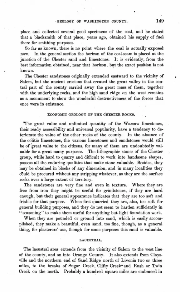
,GEOLOGY OF WASHINGTON COUNTY. 149
place and collected several good specimens of the coal, and he stated that a blacksmith of that place, years ago, obtained his supply of fuel there for smithing purposes.
So far as known, there is no point where the coal is actually exposed now. In the general section the horizon of the coal-seam is placed at the junction of the Chester sand and limestones. It is evidently, from the best information obtained, near that horizon, but the exact position is not known.
The Chester sandstones originally extended eastward to the vicinity of Salem", but the ancient erosions that created the great valley in the central part of the county carried away the great mass of them, together with the underlying rocks, and the high sand ridge on the west remains as a monument to show the wonderful destructiveness of the forces that once were in existence.
ECONOMIC GEOLOGY OF THE CHESTER ROCKS.
'The great value and unlimited quantity of the Warsaw limestones, their ready acces.sibility and universal popularity, have a tendency to deteriorate the value of the other" rocks of the county, In the absence of the oolitic limestones, the various limestones and sandstones would still be of Igreat value to the citizens, for many of them are undoubtedly valuable for a great many purposes. The lithographic stones of the Chester group, while hard to quarry and difficult to work into handsome shapes, possess all the enduring qualities that make stone valuable. Besides, they may be obtained in blocks of any dimension, and in many localities they cfluld be procured without any stripping whatever, as they are the surface rocks over a large extent of territory.
The sandstones are very fine and even in texture. Where they are free from iron they might be useful for grindstones, if they are hard enough, but their general appearance indicates that they are too soft and friable for that purpose. When first quarried they are, also, too soft for general building purposes, and they do not seem to harden sufficiently in "seasoning" to make them useful for anything but light foundation work.
When they are pounded or ground into sand, which is easily accomplished, they make a beautiful, even sand, too fine, though, as a general thing, for plasterera' use, though for some purposes this sand is valuable_
LACUSTRAL.
The lacustral area extends from the vicinity of Salem to the west line of the county, and on into Orange County. It also extends from Claysville and the northern end of Sand Ridge north of Livonia two or three miles, to the breaks of Sugar Creek, Clifty Creek· and Rush or Twin Creek on the north. Probably a hundred square miles are embraced in

150 REPORT OF STATE GEOLOGIST.
~this area. The deposit is characterized by the generally level appearance ,of the country, the compact and uniformly gray appearance 'of the soil, .and the occasional beds of fine sand that are found within it. On the farm of Col. Colclazier, two miles north-west of Salem, there is an extensive deposit of this sand containing a sufficient proportion of alumina to form a most excellent sand for moulders' use. Mr. Colclazier ships large quantities of this sand to various foundries in the West, and it is ,said to be one of the best articles in use.
This sand was evidently derived from the disintegrated Chester sand- • stones that once extended probably as far east as his farm. A careful examination of this sand shows that it is identical with the sand washed ·down from the Chester sandstones in Sand Ridge.
The clays of the Lacustral are uniformly gray, and the thickness of the .deposit varies from ten feet to fifty feet or more. In the neigh borhood of Campbellshurg the thickness is about fifty feet, and at Saltilloville'it is about the same.
SOIL AND ALLUVIUM.
The soils of the county vary in color from the gray of the Lacustral region to the dark red soils of the Upper St. Louis, and the black soils of the alluvial deposits seen along many of the creeks and rivers. The Knobstone region also has a prevailing gray soil. Many of the red soils are very productive, containing a fair proportion of lime and phosphates. Their fertility may be preserved and enhanced by the generous use of barnyard manure. The gray soils need, in addition to the barnyard manures, the application of from 150 to 200 pounds of phosphate of lime per acre, applied about once in two years. The application of these fertilizers on the properly drained lands will increase the yield of cereals from '50 to 100 per cent.
COAL AND IRON.
Of course no coal exists in Washington County in paying quantities. The same may also be said with regard to the iron. Prospecting, digging and boring for coal was actually going on during the progress of the survey, but time, labor and money expended in that pursuit will certainly never yield any satisfactory returns. No coal deposits will ever be found in the county, and all efforts made with a view of developing coal mines anywhere in the county will be futile and unsatisfactory. '
Iron may be found in small quantities in almost any part of the county, but probably a large portion of the iron that actually occurs in the county may be seen upon or near the surface, forming' a part of the residuum resulting from the disintegration of superior strata.
The quality of the iron ore occurring here is not such as to make it a matter of importanc~ or consideration to iron workers, and the quantity is so limited' that it will never pay to collect it for any purpose.

GEOLOGY OF WASHINGTON COUNTY. 151
DRIFT.
Bowlders found occasionally in the north-east corner of Gibson Town""' ship are the only evidences of Drift seen in the county. The great hight and compact structure of the Knobstone formed a barrier sufficient to permanently check the advance of northern glaciers. The southern limit of the Drift deposits is just north of the northern boundary of the county.
ARCHJEOLOGY.
While this does not seem to have been a locality that the aborigineschose for permanent homes, there is abundant evidence that it was one of thei~ favorite hunting grounds. Mounds and other earthworks are few, hut implements of stone and flint are found in abundance. In the neighborhood of Hardinsburg and Fredericksburg arrow and spear heads of the largest size and most perfect workmanship are very numerous. It is no uncommon thing to find such implements five, six, eight and even ten inches in length, and . perfect in form and workmanship. Stone axes, h:=tmmers, pestles, mauls and polished implements of various kinds are very common throughout the county. Pipes are rare, and it is an -unusual thing to find a piece of pottery. A few mounds occur, and some of them have been opened,disclosing ashes, charcoal, burned earth, and, in one or two instances, bones and implements.
There is an interesting ditch and wall on the farm of Mr. Pro, about three miles north.east of Campbellsburg that is evidently the work of the aborigines. They are about one-fourth of a mile in length, and when first observed, thirty or forty years ago, the ditch varied in depth from three feet to six feet, and the wall was of corresponding hight. But the ditch has gradually filled up sincethat time until it does not, at the pres-· ens time, average more than three feet in depth. ~arge trees grow upon the wall, indicating that it is very ancient. No mounds occur in the neighborhood, and no other works are connected with this wall. It runs· along the slope of a gentle declivity, and is nearly straight. It seems evident that the Indians, who were evidently the Mound Builders, commenced to build here a walled inclusure and for some reason aban-· doned it.
CAVES.
There is an interesting cavern, of considerable extent, on the farm of Mr. Asbury Cravens, three miles north of Hardinsburg. The entrance to it is situated upon the side of a gentle slope, and is very convenient of' access. On this account, and the varied and interesting character of the scenery within the cave, it has become quite a fashionable resort for pleasure seekers.'

152 REPORT OF ~TATE GEOLOGIST.
In company with Gen. James A. Cravens, a well-preserved hero of the --~---Yexican war, and ex-member of Congress, to whom I am deeply in
debted for extended hospitalities, I visited. this cave, which is perfectly dry and easily explQted. Although there is no running water in the cavern there is abundant evidence everywhere at hand that water was the agent that carved out this wonderful underground furrow, and wore it into curious and wonderful forms. There are a number of different branches to the cavern, but it does not extend in any direction much more than 200 yards from the entrance. The walls of the cave, from the floor to the ceiling, are covered with beautiful concretions of carbonate of lime, which, in many instances, are stained to a beautiful pink color by ()xide of iron. Pendant from the ceiling hang hundreds of stalactites, many of them reaching the floor, or connecting with stalagmites, and forming columns of various beautiful shapes. Many explorers have visited this cave, and many of its most interesting features have been carelessly or ruthlessly destroyed. Ages are required for nature to build those beautiful forms of concretion and stalactite, and no one should be vandal enough to wantonly destroy them. However, thl;lre are enough of its beauties left to make the cavern well worthy of a visit.
The ceiling varies in hight from eight to twenty feet, and the width of the cavern ranges from ten to sixty feet.
The caves at Clifty Mill may, it is said, be explored for miles, and ene, known as the "Dry Cave," is rl;lmarkable for the beauty and varied character of the scenery.
The caves in the vicinity of Beck's Mill are quite, extensive, and are said to possess many features of interest.
COLLEC'I'IONS.
There are several in¥resting collections of geological and archreological specimens in the coanty. Among them are the collections of Dr. S. H. Harrod, at Canton; Hon. Wm. R. England and Mrs. Clark, at Little York; Dr. Hon, Dr. Barnett and Dr. Schoonover, at Hardinsburg; W. W. Stevens, Prof. Bridgeman, Mr. Samuel Clark, Mr. John Clark and Hon. Virgil Hobbs, at Salem. . These cabinets, taken collectively, represent pretty well the paleontology and a~chreology of Washington County.
TIMBER.
Washington County was originally one of the heavily wooded districts ()f the State, but. the high prices of walnut and poplar lumber that prevailed for a few years after the war resulted in the almost complete denudation of' all the valuable timber lands of the county. The various kinds of white oak were cut and worked up into staves, spokes and headings, and now it is only occasionally that a really valuable piece of timber may be seen.

GEOLOGY OF WASHINGTON COUNTY. 153
THANKS.
I am und'er especial obligations to the following named persons for courtesies and valuable assistance rendered to me during the progress of the survey, and to the citizens of the county in general for their uniform kindness: Prof. Bridgeman, Hon. Virgil Hobbs, ·Hon. Sam Voyles, Rev. Mr. Giles, Mr. Samuel Clark, Mr. John Clark, Dr. Hobbs, Mr. Thomas Williams, proprietor Hungate House, and Dr. Wilson, editor of the Democrat, at Salem; Dr. S. H. Harrod, at Canton; Gen. James A. Cravens, at Hardinsburg; Mr. Henry Robertson, at Campbellsburg, and Hon. W m. R. England, at Little York. Also, to the Salem Stone and Lime Company, and the Louisville, New Albany & Chicago Railway Company.
•

A GEOLOGICAL SURVEY OF CLINTON COUNTY.
BY W. H. THOMPSON.
Clinton County is bounded on the north by Carroll and Howard counties, on the east by Howard, Tipton and Hamilton, on the south by Boone, and on the west by Tippecanoe and Montgomery counties. This gives the outlines of a parallelogram, the north-east corner of which is severed diagonally by a zigzag line.' The general course of surface drainage is to the west and south-west, the streams having, as a rule, deep-cut channels set in narrow valleys, the boundaries of which are marked by bluffs, more or le!s abrupt, rising to near the general level of the table-lands. The topography of these table-lands will be incidentally described under the head of geology, but it may be noted here that the changes from timber to prairie lands are often very sudden, the dividing line being dearly defined by both soil and surface configuration.
GEOLOGY.
The geological features of Clinton County belong chiefly to the glacial period, and a study of the county is interesting as a part of the general plan of examination which must be adopted by the student who would arrive at a valuable knowledge of the surface of our State and of the causes that have affected it. The soil of the county is, for the great part, a black, fertile mold or loam well mixed in places with fine sand, especially toward the southern. part where the prairie gives place to gently Tolling timbered land.
Such diggings and borings as have been made in the county have reached the blue clay or till a few feet below the surface. Wherever red day is found it overlies the blue. Both these clays contain a large amount of gravel and crushed stone, but the blue is more compact and silicious than the red.
In many places along the streams of the county there are bold bluffs of the bluish-gray bowlder clay, sometimes obscurely stratified, showing partings of fine buff sand. It is not unfrequently the case that a sheet of thIS sand will be overlaid with a thickness of ten or more feet of refractory «hardpan," that is intensely solidified blue clay practically impervious to

GEOLOGICAL SURvtfr OF CLINTON COUNTY.
water. This geological feature of the county is· the source of the fine flowing wells which supply the~beautiful and thriving city of Frankfort with an excellent quality of chalybeate water in exhaustless quantities.
It may be well to remark just here, for the benefit of all who may be interested in boring for flowing wells, that wherever springs, and especially springs of iron water, are found flowing vertically from the ground with a strong stream, there a boring may be made with confidence, and often the water will te found to rise a number of feet higher than the ground surface if properly piped.
The area, near Frankfort, in which flowing wells are to be had, .appears to follow the valley of Prairie Creek, and the water rises to nearly the level of the highest point in the city. I made an examination of this. water, but no analysis. It is evidently pure, extremely cold, and holds in suspension salts of iron in sufficient quantity to color a dingy yellow whatever it runs over. Many beautiful fish ponds, with musical fountains in the center of each, have been made by boring these wells, and the carp with which they are stocked are thriving remarkably. As a rule, the source of the water is found in sand immediately under the Bowlder Drift clay, at about eighty feet below the bed of Prairie Creek. It is proposed to erect water works in Frankfort, to be supplied from this underground reservoir.
In connection with the subject of sand deposits in the bowlder clay, it is worth recording here that some years ago, when I was building the L., C. & S. Railway (now the T. H. & L.), I was present superintending the construction of an excavation in Carroll County, a few miles north of. the Clinton County line, when a human skeleton was dug up. The bonescrumbled to dust on exposure. but some teeth were preserved. The position of this skeleton was in the fine buff' sand, ten feet below the surface. of the soil, and overlaid by a mass of peculiarly obdurate red hard-pan, nine feet thick. ·This hard-pan was composed of a stiff, almost dry clay, unstratified, unassorted, and in place just as left by the agency that transported or precipitated it where found. It was removed by blasting, and broke into irregular blocks from one foot to two feet across.
No paleozoic rock outcrops in Clinton County, so far as I was able to observe, nor is there a bore with any authentic section preserved down toany stratified deposits. It was said by Mr. Stealy, editor of the Crescent, a gentleman to whom the survey owes much, that formerly, before the bed of Prairie Creek was somewhat changed, there was an obscure outcropping of a substance resembling a silicious'shale low in the west bluff of the stream, within the limits of Frankfort; but, as the boring for water showsblue bowlder clay eighty feefbelow the streets of the city, I am inclined tothink that this so-called shale was indurated clay, in fact. A careful examinationdid not disclose .to me any indication of a genuine stratified outcrop in the county.

156 REPORT OF STATE GEOLOGIST.
A large part of Clinton County is prairie, beautifully undulated, and unsurpassed for fertility of soil. Much excellent ditching, both open and tiled, has been done, and a great deal more needed in order to bring the quality of the land and the health of the people up to the maximum. The pub. lic roads of the county have not kept pace with the splendid growth of Frankfort. This is not easily understood, when one takes into account the vigorous enterprise of the citizens and the inexhaustible deposits of excellent gr~vel found near the city. The good gravJI roads already built serve to show what a wonderful change a few more of them would" work , in the way of developing the agriculture of the county and the commerce of the city.
Frankfort is the county se~t, and has a population of five thousand. There is no more stirring and prosperous city in the State. Its manufactories are in the hands of able and liberal men, and the city government has been noted for its efficiency. In making my survey, I took Frankfort as the center or datum from which I measured, and to which I referred. North of the city to the Carroll County line the land is chiefly a high plateau, once very heavily timbered, and still holding many valuable forests of oak, beech, maple, ash, walnut and tulip (or so-called poplar). South of Frankfort to the county line of Boone and Montgomery a large part of the county is prairie, near the middle of which, at Saulsbury's house, on the T. H. & L. R'y, is the highest point between Logansport and Terre Haute. West and south of this apex runs a great bowlder ridge, whose general line is south-east and north-west, marking, it appears, the terminal moraine of the glacier, whose flow was south-west. I say this appears to indicate a terminal moraine, but further study may show that it is due to some post-glacial agency. The region where the mass of clay and
• b9wlders is heaped in wildest confusion is on what is called Stony Prairie, some five or six miles south-west of Frankfort. Here huge fragments and rounded masses of granite, gneiss, greenstone and other metamorphic rocks fairly cumber the surface of the earth, rendering their removal necessary before the soil can be successfully tilled. On the farm of Mr. Watt I examined a great number of these bowlders, among which I noticed one of pink granite, remarkable for its fine grain and beautiful texture. Many of the larger bowlders, before they are broken to be removed, are of several tons' weight, lying half buried in the earth. In following the line of this so-called bowlder trail, I noted that near the point where it crosses the eastern boundary of Tippecanoe County the surface of the earth is broken up intoo short wave-like mounds or hillocks, ~omposed of coarse till and gneissic and grl!-nitic fragments of every size, from immense angular bowlders down to mere chips and pebbles. Ther.e appears no evidence of the sorting action of swift water currents, but every feature indicates that all this blended, fragmentary mass has been pushed into its present place in front of a vast plough-like glacier, or by

G'EOLOGICAL SURVEY OF CLINTON COUNTY. 157
some other agency equally powerful. The surfuce confignration suggests that in places a shallow and slow current of water has passed over this bowlder ridge, and it seems probable that, for a long series of years, while the glacier was melting and receding, thfs up-piled dyke was the stranding place of icebergs loaded with these angular and unworn fragments of' metamorphic stone.
The wells in the neighborhood of this" stony prairie" are from thirty to fifty feet in depth, through a bluish clay, often densely packed with the bowlders. All the fragments taken from the wells showed more of the effect of glacial grinding than those found on the surface, many of the latter being notably free of since or planed faces, l'tnd showing no rounded sides. Taken as a part of the singular Drift formation running through the State from Ohio to Illinois, Clinton County offers the student of this feature of geology the finest example of what may be called the undisturbed condition of morainic matter I have ever seen. The mass in the western part of the county presents that tumbled, billowy, unassorted mixture of clays, gravels, pebbles, bowlders and amorphous fragments of stone,such as the geologist would expect to find at thf terminal point of a glacier which had brought its load from the regions far north of us. Features so marked as thoseI here speak of must of necessity be somewhat local in their nature, from the fact that the action of immense volumes of water, running with great volocity, has cut the entire body of our Drtft deposits with a net-work of channels in all directions. Many of these channels have been silted up or filled up by other means, and are to be discovered now only by borings. I am led to believe that future observers will discover that sedimentary deposits of various kinds form a large part of our so-called Drift-material. This has resulted from the action of the water upon uneroded rocks during the post-glacial age, and from the for" mationof lakes of greater or less extent, all over the Drift area. Many of these lakes still exist as such, while others are disappearing in the form of bogs and swamps. The prairies of· Clinton County are mostly the beds of old lakes never very deep-mere straggling ponds, indeed, whose water was full of aquatic vegetation in the shallower parts. This system of lakes or ponds extends southward into Montgomery County, where it spreads over the Black Creek and Lye Creek marshes. If these waters contained shells other than those of diatoms I have been unable to discover any trace of them.
In connection with the survey of Clinton County, I have pushed my -examiQ.ation into both Montgomery and Tippecanoe counties in order to get a better knowledge of this bowlder mass. . Across the northern part of Montgomery there is a well-defined bowlder trail or dyke passing into. Boone County on the east and obscurely connecting itself with the irregular line which crosses Clinton.
On Potato Creek and Lye Creek prairies, in Montgomery County, I

158 REPORT OF STATE GEOLOGIST.
observed the same features that marked a part of Stony Prairie in Clinton County, and near L.afayette Junction in Tippecanoe County, the railroads are cut through a most interesting series of deposited matter, composed of blue till, red clay, and fine buff and reddish sand. As a rule, the coarser
. and cleaner gravel of this (apparently) morainic mass is found in the north and north-east sides of the hillocks. What is called Twelve-Mile Prairie is a beautiful rolling plain lying east and north of the bowlder trail, and is itself a deposit of black prairie soil on heavy, comparatively "water-tight" whitish-blue till, charged with pebbles and bowlders of crystalline stone. From the bottom of' a ditch I selected a number of small pebbles that were imbedded in a very light-colored clay, broke them and examined them with a good glass. One was greenstone, two were red granite, one apparently mica schist, and three were of gneissic structure. I observed a tendency toward the formation of bog iron ,ore in many places where the prairie soil had been cut through, but there are· no considerable deposits of iron in the county.
North of Frankfort, the upper clay is red, apparently resting evenly on the refractory gray-blue hard-pan, the latter showing in escarpments, in the bluffs of Wildcat and other streams. The red clay suddenly dis-· appears at the margin of the prairie and its place is taken by a deep, coalblack soil, which, as I have said, rests on a very compact, whiteish-blue· till. East of Frankfort, in the direction of the western limit of Tipton County, a heavy swell of the surface appears to mark the northern. or' inner line of the moraine, if it is properly so called. This ridge swingsto the south of Frankfort and at,Saulsbury's house, as I have said, marks, the maximum altitude between Terre Haute and Logansport.
Prairie Creek, which runs near the east line of Frankfort northward into one of the branches of Wildcat Creek, no doubt marks part of an ancient valley of erosion which had been partly silted up before the last great glacier pushed into it the mass of till which now covers the old "quicksand" to the depth of' forty or fifty feet. It is out of' this silt, below the glacial deposit, that the water of the flowing wells rises.
The clays of Clinton County are, at many points, well suited to the manufacture of tubular ditch tile and building bricks; there is no kaolin nor pottery clay in the county.
A glance at any good map of the State will show that the drainage of Clinton County is peculiar. A large stream, almost a river, known as· the Middle Fork of' Wildcat Creek, cuts across Ross Township in the extreme north-west corner of' the county, breaking the land up into ravines with bold bluffs and rugged terraces. Here the red clay overlying the blue is very thick and strongly impregnated with lime and iron. The soil is a light brown loam where it is mixed with sand, but gray and eolder where the sand is wanting.
Near the east line of Madison Township is the confluence of Kilmore

GEOLOGICAL SURVEY OF CLINTON COUNTY. 159
Creek and the South Fork of Wildcat, in reaohing which the two streams flow westward almost parallel to each other through Johnson, Michigan, Jackson and Washington townships. Prairie Creek runs north, past the €ast side of Frankfort, into the South Fork of Wildcat Creek. In the south-eastern part of the county 'S\lgar Creek crosses Kirklin and Sugar Creek townships and passes, by a south-westerly course, into Boone County. ,
It will be seen that the general course of the mass of the bowlder trail :and moraine-like matter is practically at angles. with that of Sugar Creek :and diagonally across the valley of Wildcat Creek, but the latter appears to have been deflected and forced into its present course by the obstruction offered by the moraine, as we provisionally shall call it, which is projected into and probably across Tippecanoe County.
The first outcropping of paleozoic rock adjacent to the southern boundary .of Clinton Connty is in the banks of Sugar Creek, near Darlington, in Montgomery County, where the Keokuk formation shows itself in'masses ·of blue shale and coarse, hard limestone. The inclination of this deposit is ;such that it probably passes out and gives place to an inferior formation before reaching the line of Clinton County, where the uppermost stratined rocks will no doubt be found belonging to the Knobstone group in the western half, and to the upper Devonian in the eastern half of the -county. This, however, is simply an inference from facts observed out;side the limit of' my survey. The outcrops near Delphi, in Carroll County, .on the north, those in Howard County on the e;;tst, and the Sugar Creek outcrops in Montgomery County on the south, all point to such a conclusion. The line between the Devonian and Knobstone rocks probably passes very close to Frankfort, but there are no borings from which any sections can be procured. I made careful inquiry, but could hear of no well or boring in the county reaching below the water-bearing sand and gravel of the Drift.
In connection with the survey of Clinton County, I visited a spot in Montgomery County, near its . northern boundary, where were found the remains of an Elephas primigeni'l.(s, consisting of the lower jawbone with two teeth in a fine state of preservation, and the two tusks, nearly eleven feet long, with a number of rib fragments. I tried to get possession of these interesting remains for the. State cabinet, but· the owners were unwilling to part with them for any reasonable sum. The place where they were found is the bed of Black Creek, a small stream running along the border of a flat bog on the land of Milton N.' Waugh. . This is some distance north of the bowlder trail in Montgomery County, and appears to be near the Gonfines of what was formerly a lake covering a large part of . Sugar Creek and Madison townships of that county.
•

•
GEOLOGY OF BOONE COUNTY.
S. S. GORBY AND S. E. LEE.
Boone County, named in honor of the heroic pioneer of Kentucky, was organized by act of the Legislature in 1829. It is situated just west of the center of the State, and is bounded on the north by Clinton County, on the east by Hamilton, on the south by Marion and Hendricks, and on the west by Montgomery. The county is twenty-four miles in length from east to west, and eighteen miles in width from north to south, and embraces an area of 432 square miles.
At the time of its organization Boone County was a dense wilderness, the total population being less than 500. The following table, taken from the United States Census Reports,- shows the population of the county in the several decades since 1830:
Population in ]830. . 621 " 1840 .' . 8,121 " 1850 . . 11,631 " ,1860 . . 16,753 " 1870 . . 22,593 " 1880 . . 25,922
There are twelve civil townships in the county, viz: Sugar Creek, in the north-west corner of the county ; Washington and Clinton, in the northern part of the county; Marion, in the north-east corner ; Jefferson, in the western; Center, in the central, and Union, in the eastern part of the county; Jackson, in the south-west; Harrison and Perry, in the southern, and Worth and Eagle, in the south-eastern part of the county.
Lebanon, the county seat, is in the exact geographical center of the county. The second principal meridian runs through the center of the city. The population of Lebanon in 1870 was 1,572; 'in 1880 it was-2,625, an encouraging increase.
Lebanon is mainly a commercial city, though manufactures receive considerable attention. Commodious and elegant churches. school buildings, and other public structures, attest the enterprise, taste, and general prosperity of the citizens. The Cincinnati, Indianapolis, St. Louis & Chicago Railroad passes through the city, running a north-west and southeast direction through the·county. This road furnishes excellent facilities

GEOLOGY OF BOONE COUNTY. 161
for traffic. The Midland Railroad, formerly known as the Anderson, Lebanon & St. Louis Railroad, runs nearly due- west from the east line of the county until it reaches Lebanon, where it crosses the C., 1., St. L. & C. R R, and then pursues a south-westerly course to the Montgomery County line. The Midland Railroad is now in process of construction, and it is expected that it will be completed at an early day. The proposed Toledo & St. Louis Air Line Railroad runs 'south-westerly across the north-west corner of the county, crossing the C., I., St. L. & C. R R at Thorntown. A considerable portion of this road was graded some years ago, but owing to a lack of funds to complete the road the work was temporarily abandoned. The Indianapolis, Bloomington & Western Railroad crosses the south-wtlst corner of the county.
The public ro~ds of the county are being rapidly put into the very best condition. No county in the State is at the present time showing more enterprise in the construction of gravel roads and other public improvements than Boone. \Vith one or two exceptions the graveled roads are all free. The very best of gravel for road building is found at convenient points, and the citizens are rapidly utilizing this excellent and cheap material in every part of the county.
~horntown, situated in the north-western corner of the county, in Sugar Creek Township, is a pleasantly situated town of nearly 2,000 population. It is an important station upon the C., I., St. L. & C. R. R
Zionsville, the next town in size and commercial importance, is situated in the south-eastern corner of the county, in Eagle Township. The population of this town, in 1880, was 855. It is a station on the C., I., St. L. & C. R R
Jamestown, a station on the I., B. & W: R R, is situated in the south-west corner of the county, in Jackson Township. This is a growing town, also, which had, in 1880, a population of 696.
Besides the towns above enumerated., there are the following named villages, many of which show remarkable evidences of prosperity:
Whitestown, on the C., 1., St. L. & C. R R, in Worth Township; Holmes Station, in the south-east corner of Center Township, on the same railroad; Eagle Village, one mile north-east of Zionsville; Northfield, in Union Township, five miles north of Zionsville; Rosston, one ,mile northwest of Northfield; Royalton, five miles south-west of Zionsville; Fayette, in Perry Township, three miles west of Royalton; Brunswick,six miles east of Jamestown; Millegeville, six miles south of Lebanon; Advance, nine miles south-west of Lebanon; Dover, eight miles west of Lebanon; Mechanicsburg, eight miles north of Lebanon; Elizaville, seven miles north-east of Lebanon; Ratsburg, three miles east of Lebanon; Slabtown, nine miles north-east of Lebanon, and Big Springs, three miles south-east of Slabtown.
The territory embraced in Boone County was originally the home of
ll-GEoLOGY.

162 REPORT OF STATE GEOLOGIST.
the Eel River tribe of the Miami Indians, from whom it WM acquired by treaty and purchase in 1828. As early as 1819 the French and Indians had a trading-post at Thorntown. It is even claimed by some historians that the trading-post at Thorntown was established·· as early as the year 1715. The Indians continued to occupy the county, to some extent, until 1835.
The first permanent white settler~in Boone County was Patrick H. Sullivan, who located near the site of Zionsville, where he continued to reside until his death, in 1826. Jesse Lane settled in the eastern part of , the county, near Northfield, in 1826. George Dye, a noted Indian scout and enterprising pioneer, with his family, settled in the same vicinity soon after. Settlements were commenced at Thorntown and Jamestown at about the same period.
Lebanon was located, named, surveyed and platted,· and made thecounty-seat in 1830. Mechanicsburg was surveyed and platted in 1835_ The Michigan Road was located through the county in 1828.
For a number of years~the growth of the county was slow, compared with many other counties in the State, but recent years have shown a marked increase in the population. The material growth of the county, in the meantime, has fully kept pace with the advance in population. The farming lands of the county are of the most productive character, and susceptible of the highest state of cultivation. The best improved farm machinery may readily be operated upon any of the farm lands. The intelligent manner in which the fields are being cultivated gives evidence of the fact that the benefits to be derived from superior cultivation are fully appreciated by the Boone County farmers.
The Boone County Agricultural Society holds an annual fair at Lebanon, and the displays of stock, choice cereals, fruits and vegetables exhibited there rank with those of the very best agricultural counties of the State.
TOPOGRAPHY AND DRAINAGE.
Boone County lies wholly within the Drift area of Indiana, consequentlythe surface consists of level or gently rolling lands. The central portion of the county consists of a broad, slightly elevated phteau, with frequent depressed areas of consIderable extent. These depressions, though now only a few feet in depth, formerly accumulated enough water and vegetable matter to form in many places swamps or bogs of considerable depth. Thorough drainage, however, has transformed these impassible swamp. into fertile fields, and the numerous bogs that formerly yielded nothing but malarial poisons, now produce enormous crops of grain, grass and fruit. This plateau forms the hight of land or summit between White

UEOLOGY OF BOONE COUNTY. 163
River and the Wabash. It is really a low, broad ridge, or series of ridges, built up of the transported sand, gravel, bowlders and clays of the glacial period. The general direction of the ridge is from east to west.
The eastern part of the county, along Eagle Creek, is considerably rolling. Eagle Creek rises in Marion Township, in the north-east corner of the county, flows south until it reaches the Hendricks County line, whence it pursues a south-easterly course to White river, into which it flows a few miles below Indianapolis. Several small branches .enter Eagle Creek from the east and west, and the modifications of the surface produced by the erosions of these small streams tend to create a diversity of surface scenery that would otherwise have maintained a monotonous outline.
The south-eastern part of the county, in the vicinity of Zionsville, and west for five or six miles, is quite rolling. Numerous small, deep valleys lie between high, prominent ridges. The general direction pursued by the small streams in this part of the county is southerly, consequently the ridges generally run north and south. The valleys are the result of local erosions since the deposition of the Drift. The depth of the valleys varies from twenty-five toone hundred and twenty-five feet. Fishback Creek, which rises near Whitestown, flows south through this region.
The north and south forks of Eel River rise in the central part of the county and flow south-westerly to the Hendricks County line, near Jamestown. The two branches unite about two miles north·east of Jamestown. The course of Eel River, after it leaves Boone County, is south-westerly, then southerly until it finally unites with the west fork of White River, at Worthington, in Greene County.
The southern part of the county is generally level, or only slightly rolling, except a considerable portion along Eel River and the smaller water courses, which, owing to erosions, is more rolling and declivitous. West of Lebanon, and south and west of Dover, and also in the vicinity of Advance, the lands are just sufficiently rolling to give suita,hle facilities for draining the occasional swampy tracts. Raccoon Creek flows southwesterly through Jackson Township, and Walnut Creek flows westerly through the southern part of Jefferson Township. Muskrat Creek flows westerly through the central part of Jefferson Township, while Wolf Creek flows north-westerly through the northern part of the same township, and empties into Sugar Creek about t}Vo miles west of Thorntown. These streams, with their smaller branches, receive the drainage from the swampy tracts through the surface ditches and underground tiles.
Sugar Creek rises in the eastern part of Clinton County, and flows southwesterly until it crosses the Boone County line, north of Lebanon. It then flows a westerly course through the north-west corner of Boone County. Crossing the Montgomery County line it again pursues a south-westerly oourse to the Wabash RiYer. Prairie Creek, which rises in the vicinity of Lebanon, flows north-westerly through Center, Washington and Sugar

164' REPORT OF STATE GEOLOGIST.
Creek townships, and empties into Sugar Creek just north of Thorntown-~ Mud Creek, and some other small streams, rise in the northern part of the county and flow into Sugar Creek.
The citizens of Boone County fully appreciate the benefits to be derived' from a thorough system of drainage. When the swamps and bogs of the county are thoroughly drained there are no lands in the State that excel them in productiveness. The number of rods of drain tile in operation in the county in 1882 was 293,484; in 1883, 397,862; in 1884, 519,151, or 1,622 miles. During 1884 there were constructed 4,160 rods-thirteen I
miles of surface ditches. In a few more years a perfect and complete system of drainage will be in operation throughout the entire county.
SOIL AND PRODUCTS.
The following is the definition of "loam:" "A soil chiefly composed of silicious sand, clay and carbonate of lime, with more or less of the oxide of iron, magnesia and various salts, and also decayed vegetable and animal matter, giving proportionate fertility."
The soils of Boone County consist largely of a loam composed of the materials enumerated above. A large portion of decomposed vegetable matter enters into the composition of the soil in all of the low, swampy tracts, and the great fe,rtility of these lands, when they are thoroughly drained, is well known to every agriculturist.
Frequent patches occur throughout the county, varying in extent from a few acres to several hundred acres, where the soil consists ofa light ' colored or gray clay. This clay contains a large per cent. of silica, and it is probably a mass of the blue or bowlder clay exposed at the surface, and changed to a light-gray color by years of bleaching and washing. Without the liberal application of' fertilizers this clay soil does not produce profitably. In some localities there is a very large proportion of sand in the soil, in others clay predominates, and in others various modifications of the two elements produce soils of great diversity. These diverse conditions of the soil enable the farmers to cultivate a greater variety of crops with success and profit. A proper knowledge of the constituent elements of the soil, and a further knowledge 'of the elements required to produce a particular crop, will enable the farrper to apply economically the very elements required to make his land yield the desired crop. In a county like Boone, where there is not necessarily an acre of waste land, where the land is generally level or nearly so, and where there is no waste of the fertile elements of the soil during the periodical rainy seasons, the thorough application of suitable fertilizers is attended with the most satisfactory results.
Nature has already accomplished much for the farmers of Boone by the deposition of a suitable sub-soil and later accumulations. containing the

GEOLOGY OF BOONE COUNTY. 165
most productive elemetits. To retain the productive qualities of the most fertile lands, and bring the less productive areas up to the higest standard of excellence, and at the same time secure remunerative crops from his tilled land, is the ultimate object of every farmer in the management of his farm. To accomplish this he must have a perfect system of drainage in operation upon his farm; he must exercise care in securing a proper rotation of crops so as n0t to exhaust the soil, and then, by the continued application of those fertilizers that will restore the lost elements, and a careful cultivation of the crops, he may expect the most remunerative results.
In 1884 there were 634,438 bushels of wheat harvested in Boone County from 52,113 acres, an average of a little more than twelve bushels per acre. In the same year there were produced 1,635,763 bushels of corn from 51,189 acres, an average of about thirty-two bushels per acre. The yield of oats was 106,277 bushels from 3,339 acr~s. In 1882 the yield of wheat in Boone County was 852,955 bushels; corn, 2,095,-090 bushels; oats, 78,992 bushels.
In 1884 Boone County had 13;012 acres in timothy meadow, which produced 21,861 tons of hay. In the same year there were 16,029 acres in clover meadow, producing 24,483 tons of hay, and 3,609 bushels of clover seed. The yield of timothy hay in 1882 was 24,994 tons, and of clover hay 32,560 tons. The foregoing examples of crops show that the soils of Boone County are fully up to the average in productiveness.
GEOLOGY.
The surface deposits of Boone County consist wholly of sands, gravels, clays and bowlders. No exposures of solid rocks in place appear in the county. In the western part of the county the rocks are sometimes reached by the auger or drill in boring or driving wells, but they are always at a considerable depth below the surface. In a few instances limestone has been touched in the wells, and occasionally sandstone has been found, but more commonly the stone reached in the bores is a silicious shale or "soapstone." In the eastern half of the county the total depth of the Drift is unknown, as no wells have ever been bored through it. It is known, however, to be more than 100 feet thick, and in places is probably 300 or 400 feet in thickness. The blue clay generally alternates with layers of sand and gravel, but in some localities it lies in great compact, homogeneous masses, without laminations or evidence of stratification.
The elevated area, extending through the county from east to west, was evidently the summit of an ancient terminal moraine, the original hight of which far exceeded the altitude of the highest elevations now to be found in the county. It is also evidently true that.a series of high ridges

166 REPORT OF STATE GEOLOGIST.
occupied almost the entire area of the county. As the glaciers were gradually dissipated under the influences of a temperature which slowly increased in fervency, the waters from the melting masses of ice sought out various courses through the many depressions between the more elevated hights, and. struggling on from one depression to another at last found their way to the sea. Since the transported masses of Drift were once piled up, in places, to a hight exceeding, by hundreds of feet, the greatest elevations now remaining in the Drift area, it is very probable that the valleys, or depressions between the ridges and hills, wp,re once • considerably below the level of the lowest lands of the present day. In many places, doubtless, the bare, planed surfaces of the rocks were exposed. The return of congenial seasons, with continued days of sunshine and frequent moistening showers, resulted in the spread of vegetation over a large portion of the Drift area. It is quite evident that in some localities vegetation grew in profusion, especially along the southern limits of the Drift deposit. The growing plants covered the sides of the slopes, and also the lower grounds around the margins of the lakes and streams. Even in the marshes, ponds and lakes, aquatic and semiaquatic plants grew in wild luxuriance. Evidence of these facts abound throughout the Drift area. The continued rainfall washed the loose particles of material from the slopes of the hills and ridges and gradually filled up all the low places, completely covering the masses of vegetable matter that grew and accumulated in the low grounds, and thus underground "peat bogs" were formed. These buried masses of vegetation are quite frequently found in digging and boring wells in Boone County, and many other counties of the State. They are found at depths of from ten to sixty feet helow the surface. Professional well diggers and drivers call them" swamps." The appearance of the mud and accumulated vegetable matter found in them is almost identical with that of a surface swamp. The mud is black, usually soft and miry, and consists largely of decayed vegetable matt~r. Leaves, twigs, and trunks and branches of trees are frequently found in them.
On the farm of Mr. John M. Shelly, in Jackson Township, four miles north of Jamestown, a well was bored, in which, at the depth of forty-six feet, a swamp was reached which was twelve feet in thickness. The following is the complete section of the bore:
SECTION OF JOHN M. SHELLY'S WELL.
Soil and yellow clay, mixed with sand Yellow sand. . . Hard gravel. . • Hardpan-gravel. White sand ••• Sand and clay-bluish
12 ft. 2 ft. 4ft. 4 ft. 6 ft.
18 ft.

GEOLOGY OF BOONE COUNTY.
Black muck or loam, with branches of trees and other vegetable matter •.•..
Blue clay ..... . Gray sand, gravel, etc.
12 ft. 4 ft.
26 ft.
Total ..•... . 88 ft.
167
On the farm of Mr. Isaac Emerts, two and one-half miles north of Jamestown, a well was bored in which the swamp was reached at a depth of sixty feet, A considerable layer of blue clay lies over it. The following section was obtained from Mr. James A. Ball, of Thorntown, who bored the well. At the depth of seventy-five feet the rock was reached, and the boring was continued through the shale, or "soapstone," as the workmen termed it, to the depth of 235 feet:
SECTION OF MR. ISAAC EMERTS' WELL.
Soil ..... Yellow clay and sand. QuickRand ..... . Blue clay ..... . Black muck, leaves, twigs and branches of trees. Sand and clay . . . . . . • Silicious shale-"soapstone" .
Total ........ .
2 ft. 28 ft. 1 ft. 6 in.
29 ft. 3 ft.
12 ft. . 160 ft.
• 235 ft. 6 in.
A. well was dug on the farm of Mr. Seth W. Porter, six miles west of Lebanon, in which a walnut branch five inches in diameter was found in the blue clay a few feet below the surfuce. The well was only eighteen feet deep, and the following is the
Soil .•. Blue Clay Sand ...
Total
SECTION:
· 2 ft. · 11 ft. · 5 ft.
· 18 ft.
In digging a well on Main Street, just east of the Public Square, in Lebanon, the workmen passed through two feet of soil and twelve feet of blue clay, when a stratum of sand was reached in which were a large number of shells in a good state of preservation. Dr. A. G. Porter pronounced them to be fresh-water shells. About four feet lower down, in gravel, a number of Lower Silurian fossil-shells-Rhynchonella capaxwere found.
At Witt & Klizer's flouring-mill, at Thorntown, a well was dug to the depth of 104 feet, and then continued by boring to the depth of 343 feet. At the depth of ioo feet, the trunk of tree, apparently northern cedar, several inches in diameter, was found. The trunk of the tree extended

168 REPORT OF STATE GEOLOGIST.
entirely across the well. The exposed portion of the tree was nearly perfect, showing no scars nor effects of abrasion, such as would have resulted from violent contact with rocks or other hard substances.
The following is the entire section of the well, obtained from Mr. Ball, who superintended the boring:
SECTION OF WITT & KLIZER'S WELL, THORNTOWN.
Soil. .. Yellow clay. Quicksand .. Blue clay .. Silicious shale-"soapstone" .
Total ........ .
2 ft. 19 ft. 4 ft.
· 125 ft. · 193 ft. _
· 843 ft.
A section of the same well obtained from the engineer at the mill, who assisted in digging the well and also in the work of boring, differs very materially from that given by Mr. Ball. As no notes were taken by either of the gentlemen, and the sections were given from memory, it is not to be assumed that either should be absolutely correct.
Soil. .
SECTION OF WITT & KLIZER'S WELL, THORNTOWN.
(Obtained from the Engineer at the Mill.)
Yellow clay. Gravel Blue clay. Cedar tree. Blue clay. "Soapstone" . Gray limestone
Total ...
2 ft. 13 ft.
3 ft. 82 ft.
37 ft.
60 ft. · 136 ft.
· 333 ft.
It is quite probable that the carbonated hydrogen gases so frequently found in the Drift clays of northern Indiana are gases that were generated in the masses of buried vegetation so frequently occurring throughout the Drift area. The gas is found at depths varying from twenty to seventy-five feet-depths corresponding with those at which the buried vegetations occurs. The flow of gas is always much stronger when it is first struck, and it gradually diminishes in volume until it finally ceases altogetherl This indicates that the gas is confined in a pocket, or limited reservoir, from which no continued supply may be expected. Confined in the ancient swamp beds beneath the impervious, massive layers of indurated blue clay, it will remain imprisoned for ages withou~ sensible change in volume or chemical composition.
At many points throughout Boone County this gas has been found in the Drift. In a well three miles south-east of Elizaville, on the Michigan Road, which was bored by Mr. Ball, of Thorntown, gas was found at a

• GEOLOGY OF BOONE COUNTY. 169
depth of forty-one feet. It flowed strongly for a short time from a stratum of fine, white sand, which probably accumulated on the margin of a small lake. The following is the
Soil and yellow clay Quicksand .... Blue clay ..•. White sand-gas. Blue clay
SECTION OF THE GAS WELL.
Swamp muck, leaves, twigs, etc Blue clay
Total
18 ft. 3 ft.
20 ft. 11 ft.
6 ft. .. 7 ft. · 19 ft.
· 84 ft.
In a well bored upon the farm of Clairborne Cain, five miles west of Lebanon, gas flowed from a stratum of gravel five feet in thickness, which was reached at a depth of seventy-three feet.
SECTION OF MR. CAIN'S WELL.
Soil and yellow clay White quicksand. . . Blue clay Dry gravel-gas seam. Blue clay
Total
17 ft. 5 ft.
51 ft. 5 ft.
· 165 ft.
· 243 ft.
At the depth of two hundred and forty-three feet obstructions accumulated in the pipes, and the boring had to be discontinued. It is unfortunate that the obstructions should occur before the entire thi~kness of the great stratum of blue clay was ascertained.
At Jamestown, and many other localities throughout the county, gas, in small quantities, has been found in boring and digging wells. But in every instance the flow of gas is strongest when it is first reached, and it soon gradually ceases altogether. In no instance has a continuation of the bore ever resulted in developing a stronger flow of gas, and in no instance has it ever been found in bores continued into the paleozoic rocks. The futility, then, of expecting to find the great reservoir from which the gas accumulated in the Drift has escaped is very apparent. The gas of the Drift areas is merely local accumulations resulting from the decay of buried vegetable matter. Although this gas will burn, it has never yet been found in a quantity sufficient to entitle it to consideration from an economic standpoint.
The blue clays of Boone County are generally in dense, stiff, indurated masses, unlaminated, and without evidence of stratification. At many points they form the surface soil, where they may be recognized by their ash-gray or whitish color, and uniformly fine and even texture. The whitish
\

170 REPORT OF STATE GEOLOGIST.
appearance is due to years of leaching and bleaching. In their natnral state these clays form an unproductive soil, which ~an only be made profitable by a liberal use of manures.
The well on Washington Street, Lebanon, shows a varying condition of strata to a depth of about forty feet. The following is the
SECTION OF THE WELl, ON WASHINGTON STREET, LEBANON:
Soil ..... Yellow sand . Yellow clay . Bluish sand and clay . Sand ..... . Blne clay Sand and gravel Blue clay .. . Gray clay .. . Hard-pan-indnrated clay Blue (laminated) clay Gray clay ... Sand and clay. Blue clav .. Coarse gravel. Blue clay.
Total.
7 ft. 1 ft. 3 ft. Ift. 4 ft. 3 ft. 4 ft. 2 ft. 3 ft. 4 ft.
14 ft. a ft.
10 ft. 23 ft. I ft.
25 ft.
. 108 ft.
The well of Mr. D. M. Burns, Civil Engineer, which is located on his farm, two miles north of Lebanon, on the Frankfort road, exhibited the following
Soil ..... . Yellow clay .. Gravel and sand Blue clay .. . Gravel .... . Gravel and clay Blue clay Bowlder. Blue clay
Total
SECTION:
2 ft. 7 ft. 2 ft.
22 ft. 2 ft. 3 ft.
50 ft. Ift.
23 ft.
. 112 ft.
In the vicinity of Ratsburg no accurate knowledge of the depth or character of the Drift could be procured. Water is obtained in required quantities at from ten to twenty feet below the surface. The following section of Mr. J. M. Chambers's well illustrates the character of. the deposits there so far as known:

GEOLOGY OF BOONE COUNTY.
SECTION OF lIR. CHAMBERS'S WELL, RATSBURG.
Soil. .. Gray clay. Sand ...
Total.
1 ft. 6 in. · 16 ft.
6 in.
· 18 ft.
In this locality water is always found in the first layer of sand.
171
In the vicinity of Slabtown water is obtained at depths varying from twenty to fifty feet. The well of Mr. George Dischman, at that place, presents fairly all that could be ascertained regarding the Drift in that locality.
SECTION OF GEORGE DISCHMAN'S WELL, SLABTOWN.
Soil 2 ft. Blue clay. .30 ft. Gravel. 6 in. Blue cla.y. · 14 ft.
Total. · 46 ft 6 in
In the neighborhood of Big Springs, water is abundant in wells:at from eight to ten feet below the surface. The surface deposits are soil and gravel, no clay being reached at that depth. Numerous springs throughout this region flow out at the surface of the ground.
At Rosston, water is obtained at from eight to twenty feet below the surface.
SECTION OF AVERAGE WELLS AT ROSSTON.
Soil .... Rpd cla.y .. Sand and gravel
• 1 ft. 6 in. 8 ft.
1 to 10 ft.
Total . . . • 19 ft. 6 in.
At Northfield, water is obtained at from twenty to forty feet below the surface.
SECTION OF AVERAGE WELL AT NORTHFIELD.
Soil. Yellow clay .. Sand or gravel.
Total .•
2 ft. • 10 to 20 ft. · 10 to 20 ft.
42 ft.
The wells at Clarkstown are from fifteen to forty-five feet deep.
SECTION OF AVERAGE WELL AT CLARKSTOWN.
Soil. .. Yellow clay. Blue clay ..
Total.
2 ft. 6 to 10 ft.
· 10 to 30 ft.
42 ft.

172 REPORT OF STATE GEOLOGIST.
The wells at Zionsville are from twenty to sixty feet in depth.
Soil ...•• Yellow clay. Blue clay Gravel ... Blue clay ..
Total.
AVERAGE OF WELLS AT ZIONSVILLE.
2 ft. 10 ft.
4 to 10 ft. I to 3 ft.
. 20 to 40 ft.
65 ft.
At Royalton water is usually obtained at depths varying from ten to forty feet. Messrs. Foster & Leap, however, had a well bored to the depth of ninety-five feet.
SECTION OF FOSTER & LEAP'S WELL~ ROYALTON.
Soil . . . 3 ft. 6 in. Yellow clay. . . . . .. . ........... 17 ft. Gravel. . . . . . . .. .... . . . . . . . . 5 ft. Blue clay, with frequent thin layers of sand and gravel. 70 ft. 6 in.
Total. . . . . . . . . . . . .. ...... 96 ft.
Water is usually procured at Jam,estown at depths varying from twentyfive to thirty feet. The deepest well in the town is located at the saw mill.
SEj'ION.OF WELL AT THE SAW MILL, JAMl!.STOWN.
Soil . Yellow clay. Quick sand. Blue clay. Gravel ... Blue clay ..
Total.
3 ft. 8 ft. 1 ft .
. 28 ft.
. 2 ft.
.48 ft..·
.90 ft.
SECTION OF WELL AT THE GRIST MILL. JAMESTOWN.
Soil . Yellow clay. Sand .... Blue clay ..
Total.
· 0 ft. 8 in. .10 ft. · ~ ft . . 49 ft.
· 61 ft. 8 in.
In digging a well just south of the railroad, near the depot, at Jamestown, a few years ago, n small reservoir of gas was struck which exploded with some force, and burned with some violence, but the flow lasted only a few minutes, when it ceased altogether.
-

GEOLOGY OF BOONE COUNTY. ]73
'The wells at Brunswick vary from eleven to thirty-five feet in depth.
AVERAGE SECTION OF WELLS AT BKUNSWICK.
Soil .. '.' ..... Yellow clay or gravel. Sand and gravel. Blue clay ..
Total.
1 to 2 ft. 5 to 10 ft. 1 to 3 ft. 4to20ft
· 11 to 35 ft.
AVERAGE SECTION OF WELLS AT MILLEDGEVILLE;
Soil . . . . . . .. # 1 to 2 ft. Yellow clay or gravel 5 to 10 ft. Gravel and sand. 1 to 10 ft. Blue clay. . . . . . 5 to 20 ft.
Total . . . . . 12 to 42 ft. By digging through the soil and sand in the vicinity of Dover to the
-depth of seven feet an abundance of water is found. A short distance north of Dover, on the farm of Mr. Thomas McDaniel, a well was dug to the depth of twenty-two feet six inches.
Soil .... Yellow clay Blue clay. Gravel ...
SECTION OF THOMAS M'DANIEL'S WELL.
1ft. 6 ft.
15 ft. 6 in.
~~.. . ~a6~ Mr. Ball, of Thorntown, bored a well for Mr. Gar. Vandeveer, six
miles south of Lebanon, in which a large amount of vegetable matter was found in an ancient swamp, now buried sixty-five feet beneath the surface.
SECTION OF MR. VANDEVEER'S WELL.
Soil ..... Yellow clay . . . . . . . .. Blue clay ... _ ..... . Swamp muck, lea"es, twigs, etc Blue clay . Sandstone ......... .
2 ft. 18 ft. 4f> ft. 10 ft. 25 ft. 9 ft.
Total . . . . . . . . . . . 109 ft. I
Three miles north of Thorntown Mr. Ball bored two wells on opposite c1!ides of the road, one of which was for Mr. S. Dukes, and the other was 'for Mr. AI. Wetherald. The depths of the wells were 185 and 187 feet respectively. The strata were the same in both wells. The following is the
Soil and yellow clay. Quicksand .. Blue clay ... Red sandstone.
Total .••
SECTION:
. . ' · 18 ft. · 12 ft. · 153 ft. 6 in .
3 ft. 6 in.
· 187 ft.

174 REPORT OF STArE GEOLOGIST.
In the vicinity of the Montgomery County line the thickness of the Drift is much less than it is in the central part of the county. The following section of Mr. Louis Dunbar's well, just over the line in Montgomery County, is about an average of the wells in that' vicinity. The paleozoic rocks are usually reached at a depth of from 20 to 40 feet.
SECTION OF MR. DUNBAR'S WELL.
Soil and yellow clay . . . . . . •. ." . Dry white sand. . . . . . . . . . . 'Vhite "sandstone "-probably chert.
Total ............ .
20 it. 2 ft.
44 ft.
· 66 ft.
North of Sugar Creek. in Montgomery County, near the Boone County line, Mr. Ball states that the cherty layers of stone are always found at from 20 to 30 feet below the surface.
SECTION OF WELL ON MR. WM. MILLS'S FARM, ONE MILE WEST OF THORNTOWN.
Soil and yellow clay Quicksand. Blue clay.
Total;
25 ft. 3 ft.
80 ft.
· 108 ft.
On the farm of Mr. Frank Harris, one mile south of Thorntown, a well was bored to the depth of 132 feet, which showed a great thickness of blue clay, which is underlaid by cemented gravel.
SECTION OF MR. HA.RRIS' WELL.
Soil and yellow clay Quicksand ... . Blue clay .. . Cemented gravel .
Total ....
· 19 ft. 4 ft.
· 103 ft. 6 ft.
· 132 ft.
West of Thorntown about one and one-half miles is a heavy deposit of dry gravel. The total thickness of the bed is not known. On the farm of Mr. Charles Moffit a well was dug through 4 feet of soil and 40 feet of gravel, when the work was discontinued without finding wat€r. At other points in the same locality the gravel is known to be of a very great depth. Also in the vicinity of Lebanon there are numerous thick beds of gravel. Gravel occurs all over the county at points sufficiently convenient of access to be economically used for road-making.
Sand of good quality for plastering and building purposes and for the manufacture of tiles, brick, etc., is readily obtained in any part of the
GEOLOGY OF BOONE COUNTY. 175
-eounty. It is often found in beds of great thickness. On the farm of Robert Woody, three and one-half miles west of Thorntown, a stratum .of sand fifty-five feet in thickness waS passed through in boring a well. 1'he following is the
SECTION OF MR. WOODY'S WELL.
Soil and yellow clay Fine white sand Blue clay. Limestone.
Total.
18 ft. 55 ft. 71 ft.
3 ft.
o 147 ft.
Throughout the north-western part of the county quicksand almost uniformly occurs under the yellow clay. The thickness of the beds of quick.1:land varies from two feet to fifteen feet. The yellow clay runs from three to thirty feet in thickness. The section of a well three miles east of Thorntown, near the Union Church, illustrates the character of the deposits throughout that region:
SECTION OF WELL NEAR UNION CHURCH.
Soil and yellow clay Quicksand. Blue clay
Total
PALEOZOIC GEOLOGY.
27 ft. 9 ft.
75 ft .
. 111 ft.
Since no exposure of Paleozoic rocks occur in any part of Boone -County, any statements 0 concerning the underlying formations and groups would be unreliable and gratuitous. The workmen who continued the bores in wells until the rocks were reached were barely able to distinguish °the various kinds of rocks-shales, sandstones or limestones-and from the limited information obtained from them no sufficient knowledge of the ;strata was acquired to enable one to form definite or reliable conclusions. However, as limestones underlie the Drift in the western part of the -county, it is quite likely that they are St. Louis or Keokuk-most probably the latter. It is uncertain whether the sandstone reached in a few instances is Knobstone or not. Although no bores have ever touched the rocks 'underlying the Drift in the eastern part of the county, it is altogether probable that they are Devonian. The particles of rock taken from the bores in different parts of the county contained no organic remains so far
..as observed by the workmen.

176 REPO~T OF STATE GEOLOGIST.
ARCHlEOLOGY.
There are no walled enclosures in Boone County, nor any mounds of great interest. Occasionally small mounds are seen, but explorations in them have not disclosed any facts other than are generally known concerning these works. Ashes, charcoal, and occasionally implements have been found in them. Granite and flint implements, while not so common as in many other 1IC0unties, are still frequently found in the cllunty. Mr. Tribbets,of Thorntown, has quite a valuable collection of stone im- ' plements, collected partly from this county, but principally from Montgomery. There are a few other small collections in the county.
THANKS.
Many courtesies were received from the citizens in general during the progress of the survey, and especially from Dr. Lane, and Attorneys Stokes and Wesner, at Lebanon; Dr. Curryer, at Thorntown; Dr. Heady, at Jamestown', and James Dye, at Northfield.

MARSHALL COUNTY.
W. H. THOMPSON.
Marshall County is one of the most interesting of all the counties of Indiana, especially as regards its topography, its surface geology, and its agricultural importange. It is extremwy well situated with regard to all the facilities for production and shipment, having excellent and varied soil, good public roads, superior drainage, and railroads running to almost every point of the compass.
Marshall County is bounded on the north by St. Joseph County, east by Elkhart and Kosciusko counties, west by t:ltarke and St. Joseph counties, . and south by Fulton and Kosciusko counties. It is about twenty one miles square, and was named in honor of Chief Justice Marshall .
. In order that the reader may fix in his mind the relative geographical position of this county, let it be remembered that it lies a little more than forty miles south-east from Lake Michigan, and holds in its extreme southwestern corner that loveliest of lakelets, the far-famed Maxinkuckee.
The county was first permanently settled by the whites in the spring of the year 1832; but it was not until the year 1835 that a great movement began by a public sale of the lands 'at the land office in Laporte, from which time to the present there has been a remarkable growth in wealth and population, and a corresponding increase of energy, education and culture.
No county in Indiana, all the circumstances considered, has excelled Marshall in matter of educational progress. Her public schools are of the best, and her citizens have taken' the highest pride in advancing every literary and scientific impulse or enterprise brought to their attention. As might be expected of such a population, business in all its branches has flourished in this county from the start, and Plymouth, the beautiful county seat, has long been one of the most enterprising and wealthy little cities of Northern Indiana-a center of culture and sociai refinements, charming to all who come within its influence. Plymouth was made the county seat in 1836, and the organization of the county into townships, for civil purposes, was begun in the spring of the same year.
In the early part of its history, Marshall County, in common with most of Indiana, was troubled with malaria, but an excellent system of drainage, the cultivation of soil and cleaning of the forests, have obviated this
12-GEOLOGY.
178 H.EPORT OF STATE GEOLOGIST.
-difficulty so that now it is a remarkably healthful part of our commonwealth; indeed, its beautiful, clear lakes have become summer resorts for invalids and tho~e seeking recreation and refreshment.
Plymouth is situated verv near the center of the county, on both banks -of Yellow River (a beautiful stream which flows across the county from north-east to south-west) and is a city peculiarly attractive to the visitor -on account of its well-kept streets, its handsome public' buildings, and its many picturesque and home-like residences. From all points the views
:are lovely, embracing bright glimpses of fertil~ country and shaded city , lawns, with the river shining between.
The natural drainage of Marshall County is excellent, and it has been .supplemented by a great deal of intelligent labor in the direction of systematic ditching. Lands which were noted formerly for their impassable :bogs are now under a high order of cultivation, and are extremely fertile. ! have seen no finer farm lands in Indiana than a large part of this county, which was once far too wet for the plow.
As has been said already , Yellow River is the principal stream, flowing -midway through the county with a brisk current, and a clear, bright vol,ume, receiving, during its course, a great number of tributaries, large and ·small, the majority of them east or north-east of Plymouth.
The Tippecanoe River flows in a short "·elbow" across the extreme south-eastern corner of the county, receiving Deep Creek as its principal tributary, II stream flowing south·east across Walnut Township, and a part -of Tippecanoe.
Forge Creek, rising among some small lakes three miles south-west of Plymouth, runs into Starke County, as does Pine Creek, in the extreme :north-western corner of the county ..
These streams afford the basis of ample drainage, while at the same time they furnish water power of a high value. Extensive ditches have been -constructed in various parts of the county, and farmers have exhibited great enterprise and intelligence in the use of underground tiles, but the work of artificial drainage is yet in its incipiency as compared with possible results, or even with what will probably be accomplished before many years have passed.
Parts of Marshall County, even now, after years ,of most destructive ;abuse of economy, are well and heavily timbered with hard woods. Sawmills have been doing a thriving business, however, and, as is the case ,over most of our, State's area, the glory of the forests is in the past. Much of the county is prairie, and there are large tracts of what is called ." barren land;" but this phrase does not signify a thin soil, for the " barrens" often are choice land for tilling and grazing purposes. Indeed, with the exception of that c(}vered by the many small lakes, there is scarcely any waste land in Marshall County, though much of it needs further ditching to make it properly tillable.

MARSHALL COUNTY. 171}
GEOLOGY.
The entire area of Marshall County is covered, to a great depth, with the deposits of the Drift period. No stratified rocks are outcropping, nor have they been reached by any of the many borings. The surface is, for the most part, a dark or black sandy loam, varying from a muck to a very light, warm soil. Underlying this are gravels, sands and bowlder clays.
The beds of the streams are usually in the gray or bluish till common to our glacial deposits, and are covered with a stratum of washed gravel, sand and bowlders. The terraces of the Yellow River are very interesting in this county and Starke, especially those composed of a fine yellowish sand which appears to be identical with that of Lake Michigan. This sand is most prevalent in the south-western part of Marshall County, while it runs in great waves and ridges entirely across Starke to the bank of the Kankakee .
. Between the Yellow River and the Tippecanoe there is a low divide in the form of a heavy swell of the Drift deposits. From near the southern line of Bourbon Township the drainage is into the Yellow, while from that line southward it goes into the Tippecanoe. Again, in the townships of North and Polk, Pine Creek and Yellow bank River flow north-westward, while in the southern part of Polk Township the drainage is southward into the Yellow River. The above conditions are due to the undulations in the grand mass of the Drift probably caused by recessions of the glacier, or whatever power was urging southward this vast silicious conglomeration known as bowlder till. Nowhere in Indiana is this slow and, as it were, jerking process of recession better exemplified. The valley of the Yellow River is simply a great furrow between well-defined waves of this glacial mass in which the immediate bed of the stream is cut, and from side to side of which it has shifted through the long series of years since the melting of the ice. Whenever the fine sand of which I have spoken prevails, it rests, as a rule, immediately upon the blue or gray bowlder tm, no soil or sedimentary deposit intervening. I gave careful attention to all the features of the Drift in this county,. and have submitted my observations in the form of a classified statement of facts to the Chief of the Department to be used in his studies of the glacial deposits of Indiana. It may be well to remark just here that very little red clay, saving certain ferruginous deposits, is found in this county.
In many parts of the county the surface of the ground is thickly strewn with bowlders of various kinds, chiefly granite, gneiss. and other metamorphic rocks, fragmentary, and often worn into symmetrical shapes, or fancifully truncated and grooved, cumbering the fertile fields with their indestructible bulks. Upon these interesting· but unprofitable relics of· glacial power the farmers have waged relentless war, bursting them with

180 REPORT OF tlTATE GEOLOGIST.
-fire and with dynamite, and hauling them into J.ieaps, or using them for building rougli stone fences: Thissuperficial deposit of bowlders appears to be the result 'of some agency acting subsequent to the force which urged the great mass of glacial matter down upon Indiana. No doubt this post-glacial, or rather this secondary agency, was dual, being a combination of water currents and floating ice-bergs; for water currents, un.aided by the transporting agency of floating ice, could not move bowlders weighing many tons each, without also washing away, at the same time, the whole drift deposit down to the stratified rocks. Action of \vater alone, if , ()f sufficient power to drive along before it these immense fragments, would be equaled by nothing short of a sea under the influence of a long-contin-ued hurricane blowing steadily in one direction. .
The wells and borings in Indiana, and especially in the northern half ()f the State, support the assumption that bowlders are much more numerous upon the surface of the Drift than throughout its mass. I have seen wells dug forty feet through Drift clay without encountering a bowlder in a region were the surface was literally cumbered with immense ones. My ;studies, soundings and surveys of the lakes of the county are to be incorporated in a separate paper under an appropriate. head, but it is well to say here that all the ponds and lakes that I have examined in Northern Indiana are mere basins, more or less symmetrical, scooped in the clays of the Drift. Many of them have huge bowlders scattered over their bottoms, and some of them have rims of whitish lime marl. This lime marl is reported upon in another paper in detail, and it is sutficient to remark that very considerable deposits of it are found in Marshall County in the beds of old ponds, or in marshy tracts favorable to its precipitation from the water bearing it in solution. To soils poor in lime this marl would prove an excellent fertilizer. When burned it makes a crude lime suitable for domestic purposes, but not of marketable quality. No doubt the time will come when these deposits will be utilized for the manufacture ()f the commercial fertilizers so much used in Southern States.
IRON ORES.
The only iron-ore I observed in Marshall County is a rather inferior bog ore. Many years ago in West Township, at the lower end of Twin Lakes, an iron furnace was erected, and the ore found near there was mined and manufactured, but of course the experiment failed after a time, and the old forge is no more to be seen. Indeed, scarcely a vestige ()f it remains.
CLAYS.
Good brick and ditch-tile clays are plentiful wherever the grayish Drift deposits are near the surface.
MARSHALL COUNTY. 181
THE LAKES.
By far the most interesting geological features of Marshall County are its lake basins. The consideration of these will appear in detail in another paper. What is given here must be merely a description of the most important ones from a topographical point of view. Lake of the 'V oods, or Wood Lake,. Pretty Lake, Twin Lake, and Maxinkuckee may be taken as the four most interesting.
Wood Lake is about <me and three-fourths miles long by an average of a half mile in width, and is situated on the dividing line between German and North townships, about six miles north-east of Plymouth, and some four miles south-west of Bremen.
Pretty Lake is nearly three miles south-west of Plymouth, and is all its name implies-a beautiful, silvery clear lakelet and a great resort for pleasure parties.
Twin Lakes, two lovely sheets of water south by south-west from Plymouth about three mile,;, are also much resorted to in summer.
Maxinkuckee, a lake three miles long by nearly two miles wide, in places, lies in nearly the extreme south-western corner of the county, distant from Plymouth about nine miles. Nowhere in the United States is there a lovlier body of pure cold water. It has become a famous summer resort, and deserves all the great praise it has received. In their main topographical features all these lakes are alike, being set in bowls sunk-in almost impervious bowlder clay and partly surrounded by more or less abrupt shore lines. They are well stocked with pan-fish of various kinds, but the bass are becoming scarce.
I SPRINGS, BORINGS AND FLOWING WELLS.
The mineral springs and flowing wells of Marshall County must be studied in connection with the rivers and lakes, especially the latter. Impervious blue clay always overlies the mass of gravel or sand out of which these springs rise and these wells flow. This same impervious clay underlies the water of the lakes. It will not follow from this, however, that the water of the lakes will rise as high as that of the flowing wells, for the lakes are controlled by their possible or actual outlets, or they may be supplied from a different reservoir. But it is true, nevertheless, that all the deep, clear lakes of this county are fed chiefly from springs rising out of the bottom clay or flowing from the strata of sand in the sides of the basin. The water of the flowing wells comes from the same or similar sources, that is, it rises from beneath an impervious stratum of bowlder clay. These wells have been successfully operated in many parts of the county, but the most notable example is the famous one at Plymouth, which sends up a constant stream of water thirteen inches in diameter to the hight of

182 REPORT OF STATE GEOLOGIST.
fifteen feet above low water mark of Yellow River. At most places in the county wells, when properly tubed, will either flow above the surface of the ground or the water will rise to within a few feet of the top of the bore.
It is difficult to over-estimate the value to farmers, manufacturers and to a community in general, of flowing wells that are as easily made as. those of Marshall County. H01V infinitely superior to a hand-pump or a. wind-pump is a gushing fountain, that never ceases or tires, but day and night pours out its wealth of pure water for man and beast!
Borings in this county have not reached the stratified rock, nor have they disclosed any new feature of the Drift mass into which they have been projected. As is nearly always the case elsewhere, the waters from these bores are often more or less impregnated with the salts of iron and are called" sulphur" waters and" magnetic" waters. No doubt the iron renders them valuable as a tonic in certain cases. Many beautiful springs. rise in the county and some of these, too, are sufficiently charged with iron salts to color with brown .or reddish oxide whatever the water flo~s. over. No doubt this feature is due to its rising through ferruginous sand or other iron-bearing deposits.
MAXINKUCKEE.
W. H. THOMPSON AND S. E. LEE.
In many respects this is the most beautiful of the multitude of small lakes with which Northern and North-eastern Indiana are studded. Its shores are high, beautifully rounded, and clothed with the native forest. The waters are clean and cold. Hundreds of swings flow out from the banks, and many more rise from the bottom of the lake. Very few weeds. grow in the water, and there is far less of moss and peaty formation than is common to our Indiana lakes. Here, to a large extent, sand gives. place to gravel, and the beach is firm and clean. Though it is one of the deepest of our small lakes, it scareely merits the name of " bottomless,'" given it by many of the people who reside on its shores and allow their imagination to fill the blue depths with wonders.
We were gravely told by one that every attempt to find bottom was a fail-· ure; by another that he knew that the water was more than three hundred feet deep, and by another that he had seen one hundred and eighty feet of line let down only one hundred yards off shore and no bottom was found. When we informed them that we did not expect to find any water' one hundred feet deep they smiled contemptuously ..

MARSHALL COUNTY. 183
The result of our soundings gave seventy-six feet as the maximum depth. This was found at a point almost in the center of the lake, being very slightly to the west of the middle on an east and west line drawn through Rochester Point and a little to the north of that line. There is, however, a large ~rea of this deep water, perhaps a thousand acres, which will average a depth of fifty feet ..
The bottom of the lake is a very compact bowlder clay, covered in places with gravel, at others with sand, and at a few places, notably along the north-west shore, with heavy black muck. In many places a deposit of marl was found. A cross section taken by a line of soundings, from Rochester Point on the west shore, in a direction about thirty degrees north of east, to West Pomt on the east shore, gave the following depths: 6 feet, 7 feet~ 34 feet, 72 feet, 68 feet, 66 feet, 76 feet, 62 feet, 60 feet, 41 feet, 31 feet, 17 feet.
These soundings were taken at intervals :of about one hundred and twenty yards.
The lake abounds in excellent fish. The big-mouthed black bass (Micropteros salmoides) was at one time very plentiful, but has either been too largely fished out or has become so wary that only the skilled and pa- . tient fisherman can succeed in sticking him with his hook.
The perch are very abundant, and fine strings of croppies are taken early in the spring.
The fish are now being protected from the seine, the net and spear, and it is hoped that the lake may again become as noted for fine fish as it was a dozen years ago. '
The construction of the Vandalia Railroad's northern branch to South Bend, ,with a station at the village of Marmount, at the north-west shore of the lake, so facilitated access that the beautiful groves along the east side began to be dotted with cottages; hotels were established, club houses were erected, steamers began to puff ahout the new landings, and a fleet of little white sail-boats blew over the water. The cottagers have shown . most excellent taste in that they have p'reserved the natural beauty of the groves and green banks, while building large and costly summer houses and the careful ornamentation of lawns and grover! has handsomely supplemented without destroying the natural beauties of the place.
The springs which feed Maxinkuckee are very abundant, not only from the shores, but they may be seen in the clear water at a depth of ten feet gushing up from the bottom, and from the deepest parts of the lake rise columns of cold water, chilling the bather like an ice bath. These springs suggested the probability of obtaining successful flowing wells, and now so many have been found that along the east shore one can scarcely get beyond the sound of the spouting waters. The water from these wells is very clear and cold, and more or less ferruginous, a few of the wells being so highly impregnated with iron as to render the water slightly un-

184 REPORT OF STATE GEOLOGIST.
pleasant to the taste until one gets used to it. Most of the water, however, is excellent at the first taste, and all of it is perfectly wholesome in use. Indeed, one of the causes of the prevailing good health of the cottagers, as well as the residents on the shores of Maxinkuckee, is found in the purity of the waters of the flowing wells and abounding springs. The borings made to obtain these wells have not been watched with sufficient care, nor have the meager notes made at the time been sufficiently preserved to enable us to obtain accurate information as to the true depth and character of the strata at each. Enough can be known, however, to , prove that at least two, and probably three, strata of water-bearing sand and gravel will be passed through in a bore of two hundred feet, and each of which will lift its water to hights of from six to twenty feet above the level of the lake surface.
The wells now flowing, and which were visited and examined, were seen in the following order, beginning on the north-west shore of the lake near the Vandalia depot and going east:
First, at the Plymouth Club House, and the surrounding cottages of the members of the club, there are four wells. The well in front of the Club House runs a ram which supplies the house with water. This, like the other three wells, is bored about eight feet above the surface of the lake, and will flow to an additional hight of eight feet when confined.
The members having wells near their cottages are Messrs. H. G. Phayer, McDonald and Hill. Mr. Phayer utilizes the energy of his well in working a ram, while the much stronger flow at that of Mr. McDonald, wastes its force in a beautiful fountain. This flow, when unconfined, rises in a two-inch stream ten inches above the top of the pipe, which is itself eleven feet above the surface of the lake.
These four wells are all bored to about fifty feet, and each passes through the same strata of clay, sand and gravel. The bank of the lake upon which the Plymouth Club House stands is about forty feet high, and at the foot of this bank are a great number of springs. Mr. McDonald informed us that he had counted twenty-four within a few yards.
East of the Plymouth House is the Palmer House, a fine new hotel, with an excellent we'll forty-five feet deep, the top of tbe pipe being fifteen feet above"The surface of the lake. The stream is one of two inches, and when confined to three-quarters of an inch, will rise to a hight of fourteen feet above the pipe. When this well was bored the water spouted twenty-seven feet high, flowing much blue clay and sand and often choking up. The first stratum of sand was struck in this well at a depth of twenty feet, the bore showing yellow clay to that depth. Below the sand a stratum of blue clay about fifteen feet thick was passed through, and the bore ended, at a depth of forty-five feet, in sand.
On the north-east shore,\Mr. A. H. Culver has two wells, each seventytwo feet deep, bored at points eighteen feet above the surface of the lake~

MARSHALL COUNTY.
The bores show the following strata:
Soil and yellow clay . Sand. Blue clay .... Sand and gravel.
Total. ..
· 8 ft. · 14 ft. .38 ft. · 12 ft.
· 72 ft.
185
These wells will flow to a hight of thirty-one feet above the surface of the lake.
Mr. Stechorn, near Mr. Culver, has a well fifty feet deep, which has a small flow.
Farther east, Mr. Willis H. Vajen has a good well which flows nineteen feet above the surface of the lake. This bore showed forty feet of continuous clay, followed by ten feet of sand.
Near Mr. Vajen's place, on the east, the Peru Club has its Club House, and here the club has bored to a depth of one hundred and sixty feet, ending in obdurate hardpan. The flow of water from some higher stratum of sand is weak, being about an eighth 'of an inch from a two-inch pipe. No section could be obtained.
Farther east, "Bay View," the Indianapolis Club House, has a good well only twenty-eight feet deep.
The next well is on the lot of Mr. George W. Miller, of Peru, who has built no cottage, but with his family passes the summers in a large
. tent. His well is fifty feet deep, and was driven by two men in three hours. The per cent. of iron in the wat~r from this well is evidently much less than in most others near it.
At Highland House, the property of Mrs. Judge Hiller, the well is thirty-three feet deep, though the flow of water was as strong when the first sand was reached at a depth of thirteen feet.
The first well driven at this place to Ii depth of only thirteen feet obtained so strong a flow that the water could not be confined. The enormous pressure burst through all restraint, and rose in a column six or seven inches thick. This at once stopped the wells which turned Mr. Morman's ram a hundred feet away. The well was finally plugged up, when Mr. Morman's wells again began to flow.
D. W. Morman, Esq., of Indianapolis, has'four wells averaging about • twenty-two feet deep, flowing about fifteen barrels per minute, which feed
a ram supplying his grounds with excellent water. These wells were driven two years ago. In July, 1886, he bored a larger well at a point €ight feet above the surface of the lake. At a depth of ninety-eight feet the bore stopped in blue clay. The section showed eleven feet of yellow day, twenty-five feet of sand, and sixty-two feet of blue clay. A wonderful flow of water comes from this stratum of sand. The water will

186 REPORT OF STATE GEOLOGIST.
rise to a level of twenty-two feet above the surface of the lake, and when we were there the water was leaping in a fountain seven feet above the top of the inch and 'a quarter pipe.
South of Mormon's place J. B. Dill has a good flow, reached at a depth of twenty feet.
The well bored by Hon. J. H. Vajen, at his beautiful place next south of Mr. Dill, was begun at a point eleven feet above the surface of the lake, and showed th!;l following strata:
Soil and clay. Sand .. Blue clay.
Total.
6 ft. 3 ft.
23 ft.
. 32 ft.
Mr. Vajen dug a well several years ago, which, on reaching a depth of eight feet, began to flow a milk-white water of about the consistency of cream, and which deposited a silicious, lime-like marl, and whitened the water of the lake for a distance of thirty feet from the water's edge. In the back part of Mr. Vajen's lot was a low. wet spot, which began to sink when the well began to flow,"and continued to sink until the white flow changed to clear, pure water. Mr. Vajen has utilized the pressure of water from his well, the stream running a ram which supplies his premises with water, and also furnishes the power which revolves the beautiful colored light at the landing pier before his gate.
High upon the hill beside the Plymouth road, about one hundred yards from the lake, and fully thirty feet above it, gushes out the "Original Spring," as it is known, which pointed the index finger toward the first flowing well. This spring pours out a four-inch stream, and the boring of wells has never diminished the flow .
•

HANCOCK COUNTY.
BY R. T. BROWN, A. M., M. D.
Hancock is one of the central counties of Indiana, and is the smallest and the newest of that group. It is bounded on the north by Hamilton. and Madison counties, on the east by Henry and Rush, on the south by Shelby, and on the west by Marion and Hamilton counties. It comprises an area of three hundred and seven square miles, or 196,480 acres of land, consisting in part or whole of townships 15, 16 and 17, in ranges 5, 6, 7 and 8 of the original government survey.
CIVIL HISTORY.
Hancock County was organized as a separate jurisdiction in 1828, having been included in the original organization of Madison County in 1823. In August of that year an election was held at what is now Greenfield, at which Jacob Jones and Joseph B. Stevens were elected Associate Judges, Bethnel F. Morris being Circuit Judge. Calvin Fletcher was elected Senator; Elisha Larned and Wm. Conner, Representatives; Lewis Tyner, Clerk; Henry Watts, Treasurer; John Foster, Sheriff; Samuel Vaugil-
• der, John Hunter and Elisha Chapman, Commissioners. The~e Commissioners proceeded to divide the county into nine civil townships, arranged in three tiers, and named from west to east as follows: Northern tierVernon, Green and Brown. Central tier-Buck Creek, Center and J ackson. Southern tier-Sugar Creek, Brandywine and Blue River. Though regular in form, these are not uniform in size. Center Township has sixty-eight square miles of surface, while Blue River has but thirty.
TOPOGRAPHY AND DRAINAGE.
The northern part of Hancock County occupies the water shed between the east and west forks of White River, and, like summit lands generally in Indiana, this county presents a quite level surface. There is, however, a general inclination of the surface from the east toward a point about twenty degrees south of west. For this there is a geological reason which will be named in its proper place. This geIleral slope of the surface produces a peculiar arrangement of the tributaries to severa! streams which

188 REPORT OF STATE GEOLOGIST.
furnish the drainage of the county. These tributaries almost invariably enter the principal streams on the east side. Within a short distance of any these streams on the western side the water will be found flowIng toward the next stream west. The knowledge of this fact is important in establishing a general system of drainage for the county.
Blue River is a large stream, and is the principal source of the east fork of White River. It passes, for a distance of about four miles, through the south-eastern corner of the c01mty. In that distance, however, it receives from the north a branch which, on the map, is called Nameless ' Creek. It has a very direct course from the north to the south through a length of eight miles. From thence to the extreme head, a distance of" two miles, its direction is from north-east to south-west. Like most other streams in this region, its upper course is artificial, having originally been' a broad slough with no well defined banks. Under a statute of the State, public ditches have been made in such cases as this, and the water gathered into a definite channel, much to the relief of adjacent lands.
A short distance west of Nameless Creek the drainage is westward to, ward Brandywine Creek. This was originally a deep, sl~ggish stream, with a muddy bed and low banks, wHich overflowed indefinitely in times of freshets. It leaves the county, crossing the southern boundary in section 32, township 15, range 7. For a distance 0:( twelve miles north of this the stream has a pretty direct course from north to south. In this reach it receives Little Brandywine from the eastern side. This, in nearly its entire course of seven miles, is now a public ditch. Indeed, Brandywine, in its main stream, has been ditched more or less, in its entire course, chiefly for the purpose of straightening its bed and thus increasing its current. This, together with the clearing the channel of driftwood and other obstructions, has given the stream a greatly increased current, and this, in. turn, is cutting down its bed, carrying away the mud but leaving the gravel, thus materially changing, for the better, the general character of the stream. More work in straightening the stream might yet be profitably done. At the north end of this long reach in section 3, township 16. range 7, the stream makes a remarkable curve to the east, and for nearly two miles its course is from south-east to north-west, and from this onward to its head it is ,very crooked, except where it has been straightened by ditching. This work might be extended with a decided advantage to the adjacent land, though the banks of the stream, in the vicinity of the great bend, are much higher than below, and the land back from the stream is generally more elevated .
. Sugar Creek is the principal stream of the cOunty. Tracing it in the opposite direction to its current, the stream, from the point where it leaves the county bn the south, on a line between sections 31 and 32, township .15, range 5, till we arrive at its great bend in section 24, township 17. range 6, a distance of fifteen miles, the course of the stream does not

HANCOCK COUNTY. 189
vary more than half a mile at any place from a direct line north, twenty degrees east. From this point we trace the stream directly east four miles. From thence it is exceedingly crooked, winding its way in broad valleys among gravel moraines and low clay hills till it reaches the extreme northeastern corner of the county where Sugar Creek is lost in Henry County in the form of a public ditch. A considerable tributary of Sugar Creek lies between that stream and Brandywine, having its junction with the principal stream about three miles below the county line. It has a course of about seven miles in Hancock County, nearly parallel with the principal streams on the east and west of it. On the original map this stream iH called Swan Creek, but it is now known as Little Sugar Creek. The whole course of Sugar Creek in this county is about thirty miles, and a remarkable feature of the stream is that in its whole course it has but one tributary, and that a small branch (now a public ditch), entering it from the south in section 17, township 17, range 8. This', however, is accounted for by the circumstance that it has Little Sugar Creek and Brandywine within four miles on the east, and Buck Creek about the same distance on the west. Sugar Creek has generally a brisk current and a gravelly bed till we reach the great bend, within two and a half miles of th'e north county line. From this point the current becomes more sluggish, though improvements in the way of straightening the stream have greatly improved it in this respect, and the increased current, acting as a jetty, is constantly deepening the bed of the stream. This would diminish the liability to overflow in freshets, but for the fact that numerous ditches, both open and tiled, now pour the rainfall of th~ county directly into the principal streams, which formerly remained in ponds and marshes, and slowly found its way through various obstructions to the sluggish creek, or was carried back into the air by evaporation. The streams now rise more rapidly and fall directly.
Buck Creek, a large confluent of t::lugar Creek, which forms a junction with that stream seven, miles below the Shelby County line, affords, drainage for the western part of Hancock County. Though there are no natural streams, yet several public ditches carry the surplus water from within a mile of Sugar Creek to Buck Creek. Originally several broad sloughs and extensive marshes existed in the south-western quarter of township 17, range 6, which drained themselves into a wide swampy channel known as Buck Creek. This took the form of a pretty well defined stream before it crossed the line into Marion County in section 11, township 15, range 5. From a short distance above the county line such creek ,was ditched to its head several years ago with the effect of reclaiming much valuable land. But the work was imperfectly done; the ditch is too small to carry the water supplied from lateral drains, and its, 'course is not sufficiently direct to secure such a current as will give a rapid flow of water. Are-survey· and location of the ditch has been made.

190 REPORT OF STATE GEOLOGIST.
If this plan is carried out it will give perfect drainage to a large district of excellent land. On the northern border of the county several small streams rise and flow north into Fall Creek, an important tributary of the west branch of White River. The largest of these has its rise in section 34, township 17, range 6, and passes out of the county near Fortville, having run a course of about six miles in this county.
An opinion formerly prevailed that the level surface of Hancock County did not afford sufficient fall in the streams to secure a perfect drainage. A careful examination of the topography of the county will • -correct this opinion. The bed of Sugar Creek in section 21, township 17, range 8, near the north-east corner of the county, is more than a hundred feet above the bed (;,f' that stream at the point where it crosses the Shelby County line, This is sufficient to produce a brisk current in the whole length of the stream if it were confined in a single channel and made reasona?ly straight. This is the case, to a good extent, below the .great bend, and above that local ditches have cut off many of ~he abrupt curves, but a general system of ditches should be constructed so as to straighten, as far as possible, the winding course of the stream, and c0I?-fine its water to a single channel. A direct course is one of the first con'siderations in making a ditch. In a straight ditch with smooth sides and bottom a fall of an inch in a hundred yards' will give a fair current, but if the ditch is crooked and roughly constructed the water will scarcely move in it. The public liitches lately constructed in this county show a marked improvement in these respects over those made in early days of the county. In addition to directness of course, a ditch should be so wide and deep as to carryall the water, even of a freshet, without much o()verflow.
GEOLOGY.
This is, of necessity, a short section. The underlying rocks nowhere appear on the surface in Hancock County, nor do any of the streams cut -deep enough to expose them. But rocks of the Devonian age appear in the ·counties adjacent, both north and south; it may, therefore, be assumed that the foundation of this county is Devonian limestone, belonging chiefly to the.Corniferous formation. It is possible that borings through the Drift in the north-east corner of the county would reveal the Niagara limestone as the underlying rock. The general configuration of the surface indicates that the dip of the underlying rock is west, about twenty degrees north. The deposit of the Glacial Drift is uniform over the whole -county, and probably very deep, but as we could learn of no borings that had measured the thickneAs at any point its depth can only be conjectured. The usual division of the Drift into bowlders, surface clay, sand ;and gravel, and blue clay or "till," is found. Bowlders of granite or -other metamorphic rocks are pretty liberally distributed over the county,
HANCOCK COUNTY. 191
though I observed but one locality where their presence materially interfered with cultivation. In the extreme south-west corner of Greene Township there is a belt of bowlders half a mile wide, extending from north-east to south-west for a distance of three or four miles. In this belt the observer is seldom out of sight of a bowlder, and on the farm of Mr. Roberts (Sec. 36, T. 17, R. 6), for a space of twenty or thirty acres, it would be difficult to plow among them. They are of various sizes, from six inches. in diameter to four ·or five feet. A few of them show lines of cleavage, but generally they are crystalline and give no evidence of sedimentary orIgIn. They are generally exposed in the greater part of their size above ground, and their perfect preservation in this exposed condition is an evi-· dence of their durability. They can be broken by dynamite, and made useful for foundations, cellar walls, etc., and at the same time an obstacle· to cultivation be removed from the field.
The upper clay is generally yellow or orange-colored, and on a special quality of ground originally supported a heavy forest of beech and oak trees. The day is a pale cream-color. On the more elevated lands, where· this upper clay does not cover a superficial bed of gravel, it is generally from fifteen to twenty feet thick, with a bed of sand or fine gravel separating it from the lower clay or till below. This sand or gravel is the water-bearing stratum' that supplies most of the wells furnishing water for domestic purposes, watering stock, etc. This upper clay .contains carbonate of lime in the form of sand and pebbles, from which the water in percolating through it becomes sufficiently charged with that substance to render it hard before it reaches the reservoir below. A difficulty exists, however, in preventing surface water from entering the well through the porous upper soil when that becomes saturated with water in times of" heavy rains. This passes down behind the wall of the well unnoticed, and holding in solution organic matter in such quantities as to render the water unfit for present use, it precipitates a portion of this in the well, which becomes a permanent source of polution. This difficulty can be' obviated by driving an iron tube through the clay to the water-bearing stratum, thus shutting off the surface water and obtaining generally a good article of wholesome water. If the earth be raised near the well and a line of tile sunk three feet deep and about the same distance from the well on every side of it, and furnished with a good outlet, it will givethe well a fair protection against surface water.
In the low lands-the" black ground," as it is commonly called-the upper clay is always thin and often entirely wanting. Here we have a stratum of vegetable loam from two to five feet thick, frequently resting directly on the till or lower blue clay. This is an indication that these low lands are valleys of erosion where the upper clay and gravel were -carried away by glacial action, or that from this or some other cause this, material was prevented from being deposited in these localities. To. what-

1~2 REPORT OF STATE GEOLOGIST.
ever cause we may refer this phenomenon, the inference is legitimate that the till was deposited and well compacted before the ice field brought its burden of bowlders, gravel and clay from the Laurentian bills to make a top dressing for our Indiana farmers. .
We have said that no reliable data has yet been furnished that will indicate the thickness of this lower clay. I found several persons who had bored into it twenty-five or thirty feet to a water-bearing stratum of gravel or sand, but whether this was the bottom of the clay, or only an intermediate stratum, which often occurs in this formation, we have no means • of determining. This clay as it lies in its natural bed is generally very (:ompact and hard, from which cause it has received the common name of "hard-pan." When moistened and tempered it becomes quite soft and plastic, having an unctuous or talcose feel, and is often so fine as to be profitably used in art modeling. When moist it has a blue or lead color, but when dry it assumes an ashy appearance. Though it appears to be a very pure clay, yet a careful washing of it will discover that nearly fifty per cent. of it consists of very fine grains of nearly transparent sand. The coloring matter is a sulphide of iron, which a red heat will convert into an oxide, and the color will be changed to a dark red. Owing to the presence of iron, water which percolates through this clay becomes chalybeate and deposits a carbonate of iron where it r1'nis. Several of these springs are found in this county, and are valuable for their constancy and durability, as well as for the mild tonic effect of their water. They generally rise perpendicularly through a fissure in the clay, and are really natural artesian wells. It is probable that in many places along the National Road and south of it a tube sunk to the botto~ of this clay will give a constant flow of water. The experiment is worth trying.
The ice age has left its foot-prints on the face of this county, not only in numerous gravel beds, which appear to be either terminal or lateral moraines, and in the liberal distribution of bowlders, but in several valleys of erosion, where the present flow of water can not be supposed to have made the excavation. A noticeable instance of this is Swamp Creek, which extends from Sugar Creek, near the village of Eden, in a direction nearly due south, to Brandywine, a distance of six miles. The general width of the valley is about two hundred yards, and its surface lies twelve or fifteen feet helow the adjacent grounds, but exaIflination shows a depth of from ten to fifteen feet of black muck, which is really in the condition of peat, for it burns freely when dried. Originally there was no stream in this valley, but an attempt having been made to drain it, with but indifferent success, has developed a ·sluggish stream near the middle of it. Several similar valleys of less magnitude and depth were :observed, but no difficulty occurs in draining them where the ditch reaches the solid clay below the muck.
Gravel of a good quality for the construction of roads will be found abund-

HANCOCK COUNTY . 198
. ant when proper search is made for it. Many excellent gravel banka have already been opened and quite extensively worked, for Hancock County is not far in the rear of any county in the State in road iinprovements. In addition to a good supply of bank gravel, Sugar Creek fu~ nishes an abundance of gravel of a quality superior to any bank gravel, for when it is exposed in the bed of a stream, the soft or decaying pebble. soon disappear, leaving only those that are hard and durable. Other streams are showing a disposition to rival Sugar Creek in the supply of this important road material, for, as obstructions are removed and the stream straightened, the current increases and carries away the mud, and leaves the pebbles and coarser sand in the deepened bed of the stream. In this manner gravel beds are directly developed even in the bottoms of well-constructed ditches. In the use of gravel for the construction of roads, much can be saved by the proper attention to the drainage of the road-bed. Water should never be allowed to stand in the ditches by the road-side, nor form ponds near it.
SOIL, HEALTH, IMPROVEMENTS, ETC.
The soil of Hancock County may be divided into four classes, though these shade into one another almost imperceptibly:
First and largest of these groups is a clay loam, with a large per .cent. of sand and sufficient coloring matter to give the soil a brown tinge. It rests on a subsoil of compact yellow clay. The surface of this' quality of land is generally so undulating as to prevent surface water from standing on it. Originally it bore a heavy forest of sugar maple, ash, yellow poplar (tulip tree), black walnut, white oak, red beech, etc. This timbe~ stood thickly on the ground, grew very tall, and beneath it was a dense undergrowth of spicewood and other shrubbery. This undergrowth hal entirely disappeared and much of the forest has given place to cultivated farms, yet the timber in this county has been better preserved than in most of the central counties of the State.
Second. .A: pale, cream·colored clay loam, with very little vegetable mold on the surface, is found generally occupying the fiat summits between the streams. Another peculiarity of this class of soil is that in breaking it the plowshare is continually grating, as if passing over small pebbles, and an inspection of the bottom of the furrow will show numerous dark stripes made by the plow crushing little nodules, which an .exami nation will prove to be humate of iron. They have an interesting history. The soil is a compact clay with Ii good absorbent capacity, so that though it is seldom covered with water more than a few days at a time, yet it is saturated during most of the winter and spring months. In this partially exposed condition the annual coat of vegetable matter i. converted into humic acid, which seizes on the iron, which is the coloring
I3-GEOLOGY.

194 REPORT Og STATE GEOLOGIST.
matter of the clay, and forms these nodules, leaving the clay nea.rly white. If this quality of soil is well under-drained, so as to relieve it from saturation and give it free access to the air, these nodules will, in a few years, dissolve, and the iron will become again the coloring matter of the soil, and the humic acid being decomposed wil1 become an element of fertility in the soil. This quality of soil is not highly esteemed by farmers. They instinctively call it a "cold, sour soil," a title that exactly expresses its qualities. It is cold because the water which saturates it must be chiefly disppsed of by ev!tporation, which is a cooling process;, I and it is sour by reason of the humic acid it contains. But thorough drainage cures both these defects, and its high absorbent properties make it a very productive soil, and one that will be durable and retentive of manures. The native forest of this quality of land is beech, white oak, hickory and elm.
Third. The third division comprises the soils generally known as black lands. They consist of a dark sandy loam highly charged with imperfectly decomposed vegetable matter. This is generally from one .foot to three feet in depth, though sometimes it is much deeper and the soil assumes the character of muck, the vegetable matter having passed intothe conditIOn of peat. This black soil rests on a tenacious subsoil of blue clay which is almost impervious to water. .These lands lie at the origin of the streams and in valleys where the drainage ha~ been obstructed so that the ground is covered with water in winter and spring months. The annual crop of leaves and other vegetation deposited on it in the fall, imperfectly decomposed under water, contribute every year to the vegetable matter of the soil. When drained properly these lands, being very porous and loose, dry rapidly after a rain and warm up early in the spring, so that vegetation starts on them even earlier than on river bottoms. It costs something to reclaim these black lands, but when the superficial streams are put into ditches, large enough to carry off the water of the freshets, and deep enough to furnish a free outlet for tile drains, these become tIi'e most valuable farm lands of the country, especially for the production of Indian corn. This quality of land is quite abundant in this county. It was originally covered with a heavy growth of timber, consisting chiefly of burr-oak, elm, sW!1mp-ash and soft maple, and was considered waste land, but is now being rapidly reciaimed by ditching and tile draining.
Fourth. The fourth and smallest division consists of alluvium, or river bottom lands. Blue River, in a course of about four miles across the south-eastern corner of the county, furnishes some fine farms of both first and second bottom lands. In a few instances the first, or low bottoms, overflow occasionally. They consist of a deep sandy loam, and are very fertile and easily cultivated. The second bottom, or terrace lands consist of a rich sandy loam resting on a gravel subsoil. This soil is very
,
HANCOCK COUNTY. 195
productive, but is sometimes unfavorably affected by drouth. Occasionally there occurs a foot or two of clay between the loam and the gravel, which proves a valuable protection against drouth.
But few counties in Indiana have less waste land than HlIllcock. Indeed, with the exception of the actual beds of the streams, there are not ten acres of land in the county that can not be profitably cultivated, but it has been a hard county to make farms in. The pioneers had first to remove a heavy forest. This was a labor of which the man who has not performed it has no conception. Then the streams were superficial, and in times of freshets they become great lakes of standing water. These had to be ditched into definite channels-an immense labor. Then the clay subsoil everywhere demanded tile draining to bring out its full capacity and assure the certainty of a crop. Added to all this, the roads in the deep, loose soil became impassable every spring, and required grading and graveling. To make productive farms and a pleasant country under such circumstances is an immense labor, but the energy and perseverance of the citizens of Hancock COUllty is proving itself equal to the task. A few years hence will see this one of the most productive counties in the State.
Many of the pioneers of this county suffered severely from various forms of malarial disease. Considering the condition of the county, and of the immigrants, this could hardly have been otherwise. The soil, largely composed of decaying vegetable matter, was shut out from the healthful sunshine by the dense shade of an unbroken forest, and being saturated with moisture, it was a fruitful source of aerial poison. The streams, obstructed by fallen trees and accumulations of driftwood, becoming little better than stagnant ponds in the heat of the su'mmer months, added largely to the other source of disease. The new-comers thus exposed were but poorly housed, and were too often careless of even the protection they might have had. The water they drank was often but little better than the drainage of the surface, and their diet was limited in variety, and frequently confined to articles not at all promotive of health. Under these circumstances it is not surprising that Hancock acquired the reputation of a sickly climate. But half a century of welldirected industry has removed these fruitful sources of disease, and to-day but few more healthful locations can be found than this. A little more care in the supply of water for domestic use would relieve the farm-house of a fruitful source of what sickness remains. There are but few springs in this region, and we have already spoken of the supply of well water and the difficulty of securing it against the infiltration of surface water. Physicians report the prevailing sickness at present to be a modified form of typhoid fever.
The public improvement in HancockUounty began with the location of - the Cumberland Road through the county in 1827. This thoroughfare,
. .

196 REPORT OF STATE GEOLOGIST.
better known as the National Road, was opened in the years of 1828 and 1829 by clearing the timber from ninety feet in width along the line dividing townships 15 and 16 of the original survey, and bridging Brandywine and Sugar creeks at the crossing of these streams. The abutments of these bridges were built of ,bowlders gathered up over the county and worked into the substautial masonry. These bridges remain to the present day, doing good service. This road was designed to be a great National thoroughfare, connecting the Mississippi River at St. Louis and the intermediate cities with the sea-board at Baltimore. It was a grand con- , ception, but was spoiled by the introduction of railroads. Its location served to fix the place of the county seat and hasten the settlement of the central belt of Hancock County, though no part of it was ever finished by the General Government according to the original design.
Greenfield; the county seat, is divided by the section line, the north , part lying in section 32, township 16, range 7, and the south in section 5, township 15, range 7. It is located centrally between the east and west lines of the county, but is two and a half miles south of the center from north to south. Its present population is about two thousand five hundred. It has a commodious court-house, three or four church edifices and a number of respectable business houses, which do a fair a'mount of trade, being connected with the world abroad through the Chicago, St. Louis & Pittsburg Railroad. Besides the county seat, there are several villages and post towns distributed over the county, of which Philadelphia and New Palestine are in Sugar Creek Township, Reedsville in Brandywine, Westland in Blue River, Charlottsville and Cleveland in Jackson, Maxwell in Center, Mount Comfort and Mohawk in Buck Creek, Willow Branch,Wilkinson, Warrington and Nashville in Brown, Eden and Milner's Corner in Green, Fortville and McCordsville in Vernon Township are the chief .
. Hancock County is well supplied with railroads. Four lines diverging from Indianapolis in an easterly direction traverse the county. These are the Cincinnati, Hamilton & Dayton, which runs through the south-west part of the county; the Chicago, st. Louis & Pittsburg, through the central part; the Indiana, Blo(jmington & Western, dividing the northern half of it into nearly equal parts, and the Bee Line (C., C., C. & I.), running diagonally through Vernon Township. No part of the county is more than four miles from a railroad. The extensive improvements in the way of' gravel roads, many of which are" free," speak well for the enterprise and public spirit of the citizens. But few counties in the State have better roads.
Private improvements in the way of' farm and farm buildings in the central and southern parts of the county are generally respectable, convenient and permanent. In the northern section. the farms are newer, much of' the original torest is yet standing, and on many of the farms the

HANCOCK COUNTY. 197
houses and barns of the pioneers are yet to be seen, but these are rapidly giving place to commodious and tasteful buildings of brick or frame. But the improvement which is adding most to the value and productiveness of the farm is the ditching of the superficial streams and the underdraining of the level fields, thus developing farms of almost fabulous fertility. .
ARCHlEOLOGY.
The Mound Builders have left but few traces of their occupancy of the territory embraced in Hancock County. Spear-heads, arrow-points, axes, and other stone implements, are occasionally picked up in cultivated fields, but I ~w no mounds or tumuli in the county that I was reasonably certain were not of natural origin. There is, however, in section 11, township 16, range 7, some curious earthworks that probably belong to the age of the Mound Builders. These are located on the farm of Mr. H. F. Braddock, and lie on the south side of Brandywine, at the extreme point of a very abrupt bend of that creek. A ridge of clay land some ten feet above the creek bottom, and covered with oak timber, projects sharply into a piece of marshy land to within three hundred feet of the creek. From this point a levee, three' feet high and ten feet wide, has been constructed to the ancieut bed of the stream. The excavation which furnished the earth for this embankment is distinctly seen in the projecting point of high ground, and iinmediately back of this are three pits about eight feet in diameter and six feet deep, and east of these, about ten feet, are two other pits of the same dimensions, but not quite so deep. These works are evidently artificial and ancient, for large trees are now growing on the sides of these pits ltnd on the einbankment. About fifty yards east of these pits was formerly a small lake or pond, which may have been an excavation, but probably was natural. It is now drained. When, by what people, or for what purpose these works were made, we venture no conjecture.
ACKNOWLEDGMENTS.
I am under many obligations to the citizens of Hancock County generally for their hospitality and the courteous treatment extended to me while engaged in this work, and for special aid. offered me by Dr. Ely, of New Palestine, and Mr. Wm. A. Milburn, of Center Township, which greatly facilitated my work. '
• •

GEOLOGY OF BENTON COUNTY.
BY S. S. GORBY.
POSITION AND TOPOGRAPHY.
Benton County is situated in the north-western part of the State. It is bounded on the north by Newton and Jasper counties, on the east by White and Tippecanoe, on the south by Warren County, and on the west by the State of Illinois. It is the third county south from Lake Michiigan. The area of the county is about 415 square miles, or seCtions of land, which for fertility and depth of soil can scarcely be equaled, and certainly not excelled by any county in the State. The soil is everywhere a rich, black loam, varying in depth from QUe foot six inches to eight or ten feet.
The surface is high and gently rolling, and has aptly been likened to the form of a turtle's back, from which the water flows in every direction. The highest point in the county is Gravel Hill on the Cincinnati, Indianapolis, St. Louis & Chicago Railroad, three and one-half miles north-west of Fowler, the central point of the county. Gravel Hill is 857 feet above ocean level, or 136 feet higher than the Union Depot at Indianapolis. Northwest from Gravel Hill, on the line of the C., 1., St. L. & C. R. R., the altitude of Earl Park is 814 feet, of Raub 731 feet, and the elevation at the State line, near the north-west corner of the county, is 702 feet, 19 feet lower than the Union Depot at Indianapolis. Kentland, Newton County, situated two miles north of the county line and 'six miles north of Earl Park, is 648 feet above the ocean. Mount Gilboa, in the north-eastern part of Beuton County, is four miles west of the White County line and five miles south of the Jasper County line. The elevation at Gilboa is 815 feet, while Remington, seven miles north, in Jasper County, is only 735 feet above the sea. The lower portions of the county are along its eastern, southern and western borders, which vary in altitude from 700 to 765 feet above ocean level.
The county is'eighteen miles wide from the north to the south line, and includes Congressional townships number 2·4, 25 and 26. Its length is 23 miles, including thrie sections, or the Wf)st half of range 6, all of

•
•
GEOLOGY OF BENTON COUNTY. 199
ranges 7, 8 and 9, and two sections on the east of range 10, making in all 414 sections, not one ucre of which is necessarily waste land, as all the low-lying bogs, or so-called swamps, may readily be reclaimed by draining.
Three prominent ridges, extending in an easterly and westerly direction through the county, modify the direction of the surface drainage. Sand Ridge, running from the eastern boundary line of' the county, which it crosses in the south-east quarter of section 9, township 26, range 6 west, two miles south of the Jasper County line, has a direction a little north of west, and passes over. the boundary line into Newton County twelve miles west of the eastern boundary of Benton County. Blue Ridge crosses the eastern boundary of the county two miles south of Sand Ridge, pursues a westerly course, and crosses the western boundary of the county into the State of Illinois about three miles south of the Newton County line. About midway of the county from north to south, and just west of Pine Creek, four miles west of the White County line, a high ridge begins, which runs in a direction a little south of west, and passes over the boundary into Illinois about seven miles north of the southern boundary of Benton County. About a mile north of Fowler a high ridge begins, which runs in a westerly direction for two and. one-half miles, when it gradually expands into a broad and gentle slope running away to the west, where it is finally lost in the rolling sea of fertile prairie. North of the last-named ridge about a mile is ihe highest point in the county, known as Gravel Hill. It is a high ridge of gravel and sand about threefourths of a mile in length and 200. yards in width. Its direction is from east to west. The C., I., St. L. & C. R. R. crosses this ridge near its western extremity, and in the Railway Profile it is called the Summit. The track here is 111 feet higher than the Union Depot at Indianapolsi, and it is the highest point on the line of road between Lafayette and Chicago. The cut through which the road passes is 25 feet deep.
DRAINAGE.
, The northern part of the county is drained by Sugar Creek, the south:
ern part by Mud Pine Creek, the eastern part by Pine Creek, and the western part by Mud Creek. Sugar Creek rises in the northern part of the county, in section 24, township 26, range 8, west, flows west until it crosses the C., I., St. L. & C. R. R., then flows south-westerly and crosses the boundary into Illinois, six miles south of the Newton County line. Pine Creek ris~B about five miles south of the Newton County line, in section 30, township 26, range 7, west, flows easterly to within three miles of the White County line, thence south, bearing west, and crosses the southern line of the county six miles west of the Tippecanoe County line .. Mud Pine Creek rises at the south-west corner of the town of Fowler, flows southerly, bearing west, and enters Warren County nine miles east

200 REPORT 01!" eTATE GEOLOGIST.
of the Illinois State line. Mud Creek rises at Fowler, flows northwesterly, and empties into Sugar Creek one mile east of the Illinois line. A large ditch at the south-west of Fowler, which drains a large area of surface, empties the waters that are received at its northern extremity into Mud Creek, whence they flow away through Sugar Creek to the Iroquois River; while the waters collected at the southern elld of the ditch flow into Pine Creek, and thence find their way to the Wabash. Mr. J. M. Blasdel, at Parish Grove, seven miles south-west of Fowler, has one acre of land on his farm that is drained by tributaries of the Wabash, the I
Vermillion and the Iroquois rivers respectively. A well-made' system of surface ditches has been constructed throughout
a large portion of the county. These surface ditches give a suitable outlet to the underground tile drains that conduct the water from the adjoining lands. These ditches are being rapidly made wherever needed, and when they arc properly made it is found that they are fully adapted to the purpose for which they were designed. They are made from four to eight feet deep, and from seven to twelve feet wide. In their construction large and powerful ditching machines are used that cut channels from two' to three feet deep, and from five to seven feet wide, throwing the dirt from two to three feet away from the edge of the ditch.' When once made, the expense of keeping the ditches in repair is inconsiderable, as they are kept clean by the currents of water flowing through them, which constantly wear them to greater depths and widths.
The tiles are placed from three to eight feet beneath the surface. The outlet tiles are put down from four to eight feet in the earth. Seven sizes of tile are in use, viz., 3-inch, 3~-inch, 4-inch, 6·inch, 7-inch, 8-inch and 10-inch, measured in the clear. Earh tile is one foot in length. The larger sizes are used for outlets. There are four manufactories of tiles in Benton County, located, one at Fowler, one at Lochiel, one at Templeton and one at Oxford. They have the following combined daily capacity:
3-inch tiles 3~-inch tiles. 4-inch tiles 5-inch tiles 6-inch tiles 7 -inch tiles 8-inch tiles lO-inch tiles.
· ~4,300 .14,000 .32,500 .28,800
20,600 .10,000 · 11,000 · 7,200
But one of the factories' makes 3i-inch tiles, and one of them make!! none 7 nor 10 inches in diam~ter. The aggregate capacity per day of the four factories is 44,300 3-inch tiles, or 2,770 rods-nine miles-which Will drain from 1,000 to 1,400 acres of land. Conl:!idering that a prop~r pro-

GEOLOGY OF BENTON COUNTY. 201
portion of' outlet tiles are made, it is probable that the daily product of the tile factories in Benton County is sufficient to thoroughly drain 500 to 600 acres of land.
In making tiles the Fowler Steam Tile Works throw off about four inches of'the top soil, then take one spade's depth (eighteen inches) of black loam and two spades' depth (thirth-six inches) of yellow clay, found just 'beneath, which, mixed properly, makes an excellent tile, which burn.s to a light' red color. Lawson -.Brothers, at Oxford, use four feet of yellow clay, after throwing off eight inches of top soil. Lanum & St. Clair, at Templeton, throw off six inches of top soil, use fourteen inche~ of black loam and three feet of yellow clay. The factory at Lochiel uses about the same material as Lanum & St. Clair. Two kinds of mills are in use. The Auger mill is used by the Lochiel factory, and the Plunge mill by the factories at Fowler, Oxford and Templeton. No material difference is observed in the quality of the product of the different mills. The finished product from each factory seems to give entire satisfaction. The Fowler Steam Tile Works have two sheds for drying. In one they use steam and in the other air-dry. There seems to be no particular advantage in either method of drying. The other factories air-dryaltogether.
The benefits of draining are very apparent. The drained swamps at once become easily tillable, and are the most productive lands in the county. The soil becomes loose, is easily cultivated, and responds generously to the labors of the husbandman. The older and higher lands are also greatly benefited by careful and thorough draining. An increase of twenty-five to seventy~five pel' cent. in the. yield is accredited as the result of careful draining. Thoroughly drained lands more readily withstand the drouths, and the benefits derived during a wet season, are incalculable. A few years more and all the lands in Benton County will be thoroughly drained.
SOIL AND PRODUCTS.
The soil of Benton County,is everywhere a rich, black loam, composed largely of decayed vegetable matter, and, consequently, is very rich in those elements that go to build up the stock, blade and fruit of all cereals. The sub-soil in- the central, northern and western portions of the county is a yellow clay, largely mixed with sand and vegetable mold. It is really a red loam, and when thrown to the surface, as is frequently done in ditching, and allowed to remain exposed for a year, it yields an enormous crop of corn. In the south-eastern part of the county, especially in the vicinity of Oxford, there is a much more compact soil, with a stiff, yellow clay sub-soil. The lands there are well adapted to the growth of wheat, and good yields are obtained. >' On account of the more compact
202 REPORT OIl' STATE GEOLOGIST.
nature of the soil there, the roots of the cereals are not thrown out by the alternate freezing and thawing of the surface of the ground, as is the case in other portions of the county where there is more sand in the soil.
No county of land in the Union has so large a proportion of productive soil as Benton. The yield of corn, oats, grass and all the vegetables is simply enormous. In the short table below is given the yield of wheat, corn and oats in this county for the past five years. In the production of these crops it is equaled by but one cOl!nty in the State-Tippecanoe.
Year. Wheat, bu. Corn, bu. Oats, bu. 1879. 71,161 3,315,387 399,192 1880. 115,015 1,910,586 375,795 1881. 115,910 2,447,343 515,093 1882. 89,838 2,737,402 497,850 1883. 36,394 1,917,345 804,829 1884. 44,345 2,561,362 1,093,725
The value of the corn crop alone, in 1884, delivered at the elevators, was $1,000,000. This is an enormous amount, considering that the entire population of the county is only about 12,000. More than 25,000 tons of hay were harvested in 1884, an average yield of nearly one and onehalf tons per acre. The statistics above, are given merely to illustrate the productiveness of the soil, the soil tha.t has been produced by the various geological changes of past ages.
The climate is not so well adapted to the growth of standard fruits, but all the small fruits may be obtained in great abundance and with comparative ease. The severe winter of 1884-5 destroyed many of the apple orchards, and created havoc among the peach trees. The citizens of the county should cultivate more of the small fruits, and depend upon other localities for the greater portion of other fruits.
TIMBER.
The timber area of the county originally consisted of a number of groves of limited extent. They comprised only about three per cent. of the area of the county. They dotted the surface of' the wide-reaching prairie, and had the appearance of verdant islands lying placidly upon the bosom of some gently rolling sea. To the early settlers of the county they were like the oases among the eastern sands to the wandering tribes of the East. About them the first settlements in the county were made. Parish Grove is the largest in the county. It is situated in Parish Grove .Township, seven miles south-west from Fowler. It was the summer home of the Kickapoo Indians, and derives its name from Parish, a prominent chief of that tribe. The representatives of the Kickapoos yet claim the grove as their property. The chief, Parish, lost his life here in 1830. The Indians built scaffolds in the trees upon which they slept.

GEOLOGY OF BENTON COUNTY. 203
Parish swung his hammock from a huge walnut, which the woodman's ax destroyed only six or seven years ago. The unfortunate chief was addicted to the use of the white man's distilled poison, and in attempting to climb to his perch while intoxicated, he fell from a dizzy hight and broke his neck. He was buried in a small artificial mound upon the most prominent point of the ridge just west of the grove. From his grave is given a most magnificent view of landscape to the south, west and north. For twenty miles in each direction the wonderful panorama expands to the delighted eye. An excavation was made in the mound which brought to the surface some of the warrior's bones, but no relics of any kind were found. Denton's, or Walnut Grove, is in Gilboa Township, twelve miles north-east of Fowler; Sugar Grove, through which passes the boundary line between York and Parish Grove townships, is eleven miles northwest of Fowler, and Hickory Grove, in Center Township, is one mile west. West Hickory Grove is in the south-west corner of the county. Th~re are oak groves along the eastern border of Pine Creek, and small oak groves along Mud Pine Creek near the line of Warren County. The timber in the oak groves is such as is usually seen growing contiguous to wide-reaching prairies, but the growth of Parish Grove consists of those species that form the dense forests of our rich bottom lands. Here, upon a high ridge, seven miles from any other timber, grew 700 acres of forest trees of gigantic size, and dense in their midst as are the forests of Africa. Linden trees of immense size, ·burr-oaks five or six .feet in diameter, stately hackbe'l'ries, monstrous elms and gigantic walnuts, that grew to be seven and one-half feet in diameter, and measured four feet across seventy feet from the ground. One giant among them measured seven feet three inches across the stump, and gave ninety feet of its immense length to be sawed into boards. Four, five and six feet were the common sizes of these forest monarchs. Five or six years ago a mill was set in the grove and the colossal forms of those magnificent trees were lowered by the ax, and now nothing remains of them but their desolate gigantic stumps and slowly decaying tops a hundred feet away. On the farm of J. M. Blasdel, which includes 130 acres of the grove, many dozen of those monstrous stumps were counted. On the adjoining farm of Mr. Henry Robertson, county commissioner, a number of those stately walnuts are yet standing, some of them exceeding four feet in diameter.
Almost every enterprising farmer in the county has set out groves of native forest trees upon his lands. These artificial groves cover ten, twenty, and sometimes even forty and eighty acres. Set out ten to forty years ago, the trees in many of them have grown to the diameter of a foot or more, and the beautiful parks, thus artificially formed, have the appearance of nature's original handiwork. It is difficult to estimate the value of these groves that are at once so beautiful and so useful.
,
204 REPORT OF STATE GEOLOGIST.
COMMERCE.
It is well known that there are no navigable streams or canals in Benton County. The commercial highways of the county at present are embraced in its various railways. The Cincinnati, Indianapolis, St. Louis & Chicago Railroad enters the county at the south-east corner, and running in a north-west direction, passes out of the county at the north-west corlIer, thus running diagonally through the center of the county. The I
Chicago & Indiana Coal Railway runs due north and south through the county, and almost through the geographical center. It enters the coal fields of Warren and Fountain counties, and brings cheap fuel to the inhabitants of Benton. The Lake Erie & Western Railway runs east and west through the southern part of the county, about two miles north of the Warren County line. These thoroughfares furnish ample shipping. facilities for all the business of the county. The many railroad stations give every convenience' for the prompt shipment of stock-and Benton County is noted for its cattle and hogs-and all other articles of produce. As this is wholly an agricultural county, the present facilities for shipping are considered adequate to the wants of its citizens. Indianapolis, Chicago and St. Louifl are its ready markets .. Heavy shipments of stock and grain, however, are made to New York.
HISTORY, ETC.
The first settlements in Benton County were made probably in 1830 or 1831, on Pine Creek, in the ell;stern part of the county. Soon after this -!ettlements were made at Parish Grove, and in the oak groves in the vicinity of the town of Oxford. Other settlements soon followe.,d in the vicinity of the other groves of the county. The county organization was effected in 1840. Uniform prosperity has attended the various efforts of the citizens to build up their locality. The county seat was originally at Oxford, in the southern part of the county, but a few years ago it was moved to Fowler, the exact center of the county, where there is an elegant and commodious court-house, built at an expense of $55,000. The jail is a magnificent structure, and would be a credit to any county in the State. It is built of handsomely dressed Indiana limestone, is located in tastefully ornamented grounds, and has more the appearance, from the outside, . of an elegant private residence than of a jail. Besides Fowler and Oxford, there are Earl Park, Raub, Ambia, Talbot, Boswell, Chase. Templeton, Lochiel and Wadena-all thrivJng towns or villages.

GEOLOGY OF BENTON COUNTY. 206
GEOLOGY.
The strata' of this county, as' far as they have. been revealed, are ar- . ranged as follows:
Soil ..... Alluvium .. Bowlder Drift
GENERAL SECTION.
Conglomerate sandstone. . . . St. Louis limestone. . . . . . Keokuk limestone and shales.
Total ........ '.
· 10 ft. to 3 ft. · 2 ft. to 10 ft. · 40 ft. to 250 ft.
33 ft. 6 in. 7 ft. 3 in.
73 ft.
• . 376 ft. 9 in.
It is difficult to present an accurate section of the strata of Benton County. That given above is made up of more than one hundred sections tajien in different parts of the county. W. J. and L. Templeton, with others, bored to the depth of 500 feet on their farm, five miles southwest of Oxford, section 32, township 24, range 8, west, several years ago, with the hopes of finding coal. An accurate survey of the strata was made at the time, but, unfortunately, the papers were burned in a fire that destroyed Col. W. J. Templeton's office a few years later. From the gentlemen connected with the work the following section was obtained:
SECTION ON COL. TEMPLETON'S FARM.
Soil .... Yellow clay Blue clay. Gas-burned for weeks. Blue clay ....•.. Cemented gravel. . . . Yellow clay and gravel. Black shale (?) • Clay and sand . . . . Gray limestone. . . . Shales and limestones.
t
2 ft. 10 ft. 25 ft ..
90 ft. 25 ft.
· 110 ft. · 10 ft. · 100 ft. · 90 ft. · 75 ft.
Total. . . . . . 537 ft.
The section above may not be wholly accurate. Col. W. J. Templeton, in giving it from memory, thought it probable that he was not altogether correct. No coal, however, was reached in the bore. The gas, which bunied readily, continued to discharge from the well for several month!. Three-fourths of a mile east of the Templeton well, on the farm of Mr. J. K. Adkinson,' a well was bored and a gas vein struck several yean ago. The gas still flows, and burns readily. At one time it continued to burn for a period of six months. In the Adkinson well the gas flowl from a depth of forty feet. In several other wells in the same locality

206 REPORT OF STATE GEOLOGIST.
gas has been found at depths of thirty-five to forty feet. On the farm of J. W. Swan, at Mount Nebo, section 20, township 26, range 7, west, gas was found in the blue clay at a depth of 61 feet. It flowed for half a day, and emitted such a strong odor that it drove the workmen entirely away from their work. In every instance in this county the gas has been found in the blue clay.
KEOKUK LIMESTONE.
There are two small quarries of this stone in Benton County. One on Pine Creek, on the farm of Mr. Stevenson, section 24, township 25, range 7, west, has furnished some very good material for foundation work. The quarry is exactly In the bed of the creek, and it is difficult to make a thorough examination of it on account of the water, which rises above, the top of the strata. It is a buff-colored limestone on top, and changes to a light gray lower down. A few fragmentary fossils, characteristic of
, this group, were found here. Tpe following section was obtained:
Soil .•... Gravel ....
SECTION AT STEVENSON'S QUARRY.
Butt limestone-rotten. Buff lImestone . . . . Gray limestone and fossils Gray, cherty limestone .
Total. .....
.2 ft.
. 2 ft. 6 in. 7·in. 3 in. 5 in.
. 2 ft. 4 in .
. Sft.1in.
On the farm of Mr. A. D. Raub, section 14, township 26, range 9, west, is located another quarry, with a little better exposure. It is on Sugar Creek, one mile north of Earl Park. The stone there is thinly bedded, gray in color, soft and shalyon top, but cherty and concretionary lower down. Like the quarries on Pine creek, this is in the bed of the creek, and the water prevents a thorough e;amination of the strata. There is here, however, an exposure of three and one-half feet above the water. This· stone has been used to some extent for foundations for small buildings, but it does not weather well, and is too thin and shaly to be of much value. No effort has been made to burn it into lime, and an effort of that kind would hardly be remunerative. Below is given the section as far as exposed:
SECTION AT RAUB'S QUARRY.
Soil and gravel .. Shaly limestone. . Gray limestone, chert. Gray limestone, geodes, geodized shells Gray limestone, stems and plates of crinoids.
Total .............. .
4 ft. 2 ft. 6 in.
S itt. 1 ft. 5 in. 2 ft.
. 10 ft. 7 in.

GEOLOGY OF BENTON COUNTY. 207
ST. LOUIS LIMESTONE.
On Pine Creek, in section 28, township 26, range 7, west, Union Township, a quarry of stone was opened some years ago, which furnishes stone of a good quality for foundation work or bridge abutments. It is an evenly-bedded, light gray limestone, in ledges of three to four inches in thickness. It may be quarried in pieces of any size, and is an excellent flagging stone. It stands the weather well,' aud does not scale nor split on exposure to the frosts. The abutments of the Pine Creek bridge, onehalf mile below the quarry, . were made of this stone some years ago, and the rains and frosts have not marred nor injured them in the least. Among the fragments thrown out of the quarry were fouJld an abundance of plates and spines of Arc/w;ocidaris, an Actirwcrinu.s, plates of Pentremites, and two small crinoids on one fragment, too indistinct,however, to determine their species. This quarry, which is on the farm of Mr. Nutt, is, 'like the others, covered entirely by the waters of the creek. A kind' of dam must be made and the water pumped out when the quarry is worked. As there is only very light local demand for the stone, the owner of the .land gives it no attention. Whenever a farmer wants any of it for his own use he goes and quarries it himself, and that is the end of it. Below is given the
Gravel, coarse Gray limestone . Gray limesione . Gray limestone. Gray limestone. Gray limestone.
SECTlON AT THE NUTT QUARRY.
Gray limestone, 2-in. to 4-in. ledges.
Total .......... .
CONGLOMERATE SANDSTONE.
4 ft. 3 in. 2 in. 3 in. 4 in. 3 in.
6 ft. 6 in.
. 11 ft. 9 in.
Mount Nebo, in Union Township, is eight miles north-east of Fowler. It is an elevated table-land or plateau, originally prairie, and forms part of the high land kn~wn as Blue Ridge. From Mount Nebo there is a gentle slope to the north, and a somewhat more rapid decline toward the south. There is also a slight decline to the east and west. From this point a splendid view of the country is obtainable fo;r a distance of fifteen to twenty miles to the north and south, and of five to eight miles to the east and west. From the summit of Mount Nebo two miles to the southeast is the quarry of St. Louis limestone, on the farm of Mr. Nutt. The summit of Mount Nebo is about one hundred feet higher than the bed of

108 REPORT OF STATE GEOLOGIST.
P'me Creek at the quarry. Mount Nebo, like every other portion of the county, has a great depth of Drift. Here, however, the Drift rests upon It strattlm of sandstone, as yet not found in any other locality. In boring It well upon the farm of Mr. J. W. Swan,. section 20, township 26, range V, west, exactly at the summit, a stratum of sandstone was found thirtythree feet six inches in thickness. Near the top of the stratum it is soft, ,oarse, argillaceous, and of a dark yellow color, changing to a dark red, with traces of iron. Toward the bottom it is a fine-grained, compact stone of a dull gray color. The entire stratum is so soft that the workmen , bored or drilled entirely through it in a little less than two days. There is no outcrop of this stone anywhere in the county, and here it seems to lie beneath but a limited area. It is probably a remnant of the great mass of conglomerate that once covered the entire county to the depth of many feet. From its summit may be measured the depth of the Drift in the deeply eroded valleys to the south, and in a measure, computed the
, strength of the force that swept from the surface hundreds of feet of solid rocks and ground them into the dust that now forms the clays and soils. Below is given the section of Mr. Swan's well:
Soil .... Yellow clay Blue clay .
SECTION. NO. 1.
Cavity from which flowed gas Blue clay ... Cemented gravel Quicksand ..• Sandstone ... Gravel and water. Limestone.
Total ...
1 ft. 8 in. 9 ft.
51 ft. 10 in. 10 in.
11 ft. 6 in. 1ft. 6 ft.
33 ft. 6 in. 8 in.
. 116 ft.
About one hundred and fifty yards south-west of the well of which the above survey is given Mr. Swan bored a second sell. The surface there is probably thirty to forty feet lower than at No. 1'. No sandstone nor other rock was struck in the second well. The following is the
SECTION OF WELL No.2.
Soil ...... . BJ ue clay, unstratified .
Water at ....
• . 2 ft. .80 ft.
. 82 ft.
South-east of No. 1 about a half-mile Mr. Swan bored a third well, which is well down the slope of Mount Nebo. The survey of No.3 is here given:

I
GEOLOGY OF BENTON COUNTY.
SECTION: OP No.3.
Soil ....... .. Yellow clay ..... . Stratified blue clay, ~and veill8 Quicksand . . . . .. . . . . .
Water at ....... .
2 ft. 9 ft.
• L4 ft. · 2 ft.
· 27 ft.
209
On the south line of section 20, township 26, range 7, Mr. Swan bored a. fourth well.
Soil .. Yellow clay.' Blue clay •. Hardpan .• Cemented gravel. Sand and gravel.
Water at.
SECTION OF NO 4.
· 2 ft. · 7 ft. • 10, ft. · 2 ft. · 10 ft. · 3 ft.
.34 ft
In Gilboa Township, two miles east of Mr. Swan's, a well was bored by Mr. Crane, of Earl Park. No sandstone was found, but it gave the following
SECTION.
Soil. Yellow clay ..•...• Blue clay, with veins of sand •• Gray hardpan. • Black shale . Water sand ... Blue shale •...
,/ """"', Cherty limestone. Black shale • Blueshale .
Total.
2 ft. 20 ft.
• 136 ft. 15 ft. S ft. Ift. 6 in. 5 ft. Ift. 6 in. 4 ft. 3 ft.
" • 196 ft.
The above sections, obtained from points so near Mount Nebo, show clearly that the sandstone is confined to a very limited area. And, though it rests upon the St. Louis limestone, its general characters seem to indio cate that it is conglomerate.
COAL.
There 8l"3 no outcrops of coal in this county, and it is altogether improbable that there is any to be found beneath the' surface. There are some of its citizens, however, sensible men, too, who firmly believe that lloal may be found. Workmen who bOred a well for Mr. Schlautenhofer, section 1, township 26,range 9, immediately upon the Newton County line, claimed that, at a depth of one hundred and four feet they struck a.
14-GBOLOGY.

I
210 REPORT OF STATE GEOLOGIST.
four foot coal seam. They brought a black substance to the surface that was pronounced to be coal. They claimed at first that the coal seam was seven feet, but afterward found that its tickness was but four feet. From Mr. Schlautenhofer the following section was obtained:
SECTION AT MR. SCHLAUTENHOFER'S.
Soil ..... Blue clay with sand veins. Soapstone .. Coal. ..••.
Water at.
2 ft. 68 ft. 34 ft. 4 ft.
· 108 ft.
Considerable excitement was created by the announcement that coal was found here. To test the matter, Mr. Schlautenhofer was induced to bore another well, one hundred and twenty rods west of the first. The first bore was made for water, with no expectations nor thought of finding
,coal. The same workmen were employed. The following is the
Soil. ••. Yellow clay Blue clay Soapstone. Coal. ... Soapstone.
Total
SECTION OF No.2.
2 ft. 6 ft.
60 ft. 36 ft.
4 ft. 15 ft.
· 123 ft.
It is a little remarkable that, although the second boring was on much lower ground than the first, coal should be reached at exactly the same depth-one hundred and four feet. The parties who did this work for Mr. Schlautenhofer were professional well borers, and got so much per foot fo~ their labor. It is probable that they either willfully deceived Mr. Schlautenhofer or else they were mistahn themselves. They might have bored through a black bituminous shale, and mistaken it for coal. Other sections, taken in this immediate neighborhood, show clearly that no coal is to be found. Only a mile and one-half south, section-13, township 26, range 9, on the farm of Mr. Robert D. Miller, the following survey was ebtained:
Soil. Yellow clay Hardpan .. Black muck Blue clay . Yellow clay
SECTION AT ROBERT D. MILLER'S.
Gray limestone (St. Louis and Keokuk).
Water at ........... .
3 ft. 4 ft. 4ft. 5 ft.
25 ft. 3 ft.
63 ft.
· 107 ft.
••
.GEOLOGY OF BENTON COUNTY. 211
Mr. Adam Roth's well, in section 7, township 26, range 8, west-his farm adjoining Mr. Schlautenhofer's-gave the following:
SGil •.•.• Yellow clay . Blue clay . Fine sand .. Blue clay ..
Water at.
SECTION OF MR. ROTH'S WELL.
2 ft. 4 ft.
44 ft. 2 ft.
57 ft.
. 109 ft.
No soapstone, nor any indications of coal, were found here nor at Mr. Miller's place. Two wells were bored on the farm of Mr. Antony Dehner, county commissioner, north-east quarter same section, township and range as Mr. Roth. The following is the
Soil ...... . Yellow clay. . . . Yellow quicksand. Blue clay .....
SECTION QF WELL NO. 1.
Gravel and water at .
Well No.2, is fifty yards south of No. 1.
Soil .... Yellow clay. Gravel ... Blue clay ..
Water at.
SECTION OF WELL No.2.
5 ft. 4 ft. S ft.
· 19 ft.
· 36 ft.
· 4 ft. · 11 ft. · 5 ft. · 55 ft.
.75 ft.
Two miles north of Mr. Schlautenhofer's there is an outcrop of limestone on the farm of John McKee. The KcKee farm is in Newton County. According to Prof Collett, the stone at the McKee' quarry is classed by Prof. James Hall, of New York, as Silurian. If so, and the strata are in place, it is highly improbable that coal should be found only two or three miles south. Also, it is only about three miles south-west to the quarry of Keokuk limestone on Mr. N. D. Raub's farm. With these facts stated, it is difficult to assume that there is coal underlying the farm of Mr. Schlautenhofer. It is well to state here that the water flowed to the hight of five or six feet from well No. i, on Mr. Schlautenhofer's farm, as long as the tubing remained in it.
On the farm of Mr. A. C. Boswell, section 9, township 25, range \:I, west, it is claimed that coal was found in boring for water. The following is the section:

212
. Soil .... Yellow clay Gravel . Blue clay . Coal. ... Black slate.
Water at.
• REPORT OF STAT~ GEOLOGIST •.
SECTION NO. 1.
Well No. 2 wal bored thirty feet south of No. 1.
Soil .... Yellow clay Gravel. ..
, Blue clay .
Total
SECTION OF No.2.
· 5 ft . .12 ft.
6 in. .22 ft . . Trace ..
.40 ft.
· 3 ft. · 12 ft.
6 in.
6 in. · 25 ft.
· 40 ft. 6 in.
No other indications of coal exist in the county. An occasional slab . may be found imbedded in the Drift, but the glaciers and sands and waters of time have completely obliterated all the strata of coal, if any ever existed in the county. -
THE DRIFT.
The remarkable development of Drift in this county makes it of special and puzzling interest to the geologist. The speculations of the many eminent geological writers upon this subject have added little real knowledge as to the origin of this wonderful formation, or its subsequent modifications. The most intelligent and best-arranged theories yet advanced are still subject to many serious objections. It is to be hoped that the day will speedily dawn when the veil will be lifted, and the light of knwledgewill illuminate the dark pages of its mysterious history. The Drift here consi~ts of sand, gravel, cemented gravel, blue and yellow clay and bowlders. Bowlders of large size are found on the surface in every part of the county. In some localities they are widely scattered, and in others they lie about in great profusion. They consist of various forms of igneous and plutonic rocks, and vary in size from a few inches to eight or ten feet in diameter. They are more profusely found upon the lower ground, resting upon the blue clay, which, about the swamps and bogs, lies just underneath the soil. Along the various creeks of the county they are found in great numbers. Along the south side of Mud Creek they are in such great numbers and of such large size as to be a great obstacle to the farmers. They are being utilized, in the absence of other mate- .
. rial, for house and barn foundations. Many of them can be readily /
·11

GEOLOGY OF BENTON COUNTY. 213
worked, and when once placed they are most durable and substantial. They are also broken and used as foundations for gravel roads, and for this purpose theyare specially well adapted.
Gravel of good quality for making roads may be found in every part of the county. In many places these deposits lie just underneath the Boil. There are hut seven miles of gravel road in the county. The mud roads are almost impassable during a great part of the winter. The great inconvenience. of such highways is a serious drawback to the county. If the roads are properly graded, and thoroughly drained, a proper depth of this gravel will make them equal to any roads in the State. Not less than eight inches should be used, and a depth of twelve 01' fourteen inches is much better. Broken bowlders placed upon the road-bed, and then covered with gravel, make a much more substantial and durable road.
Along the eastern border of Benton County was once a deep, eroded valley, now filled with the debris of ages, which is called Drift. Following nearly the course of Pine Creek to within three miles of the Warren County line, the gorge made an abrupt turn to the right, and crossed to the south-west corner of the county. Its greatest depth is not known, but on the farm of Col. Templeton, section 32, township 24, range 8, west, it was 262 feet beneath the present surface of the ground. The altitude of the surface is here about 705 feet. Mount Nebo is 795 feet above the ocean. The top of the conglomerate sandstone there is eightyone feet beneath the surface. From the top of the sandstone at Nebo to the top of the shale in the Templeton bore is 27i feet. But this probably lacks hundreds of feet of being the true measure of erosion in this county. The sandstone at Mount N ebo is covered by eighty-one feet of Drift, a section of which was given from the well of Mr. J. W. Swan.
At Earl Park Mr. P. M. Crane bored a well which shows the exact character and depth of the Drift there.
SECTION OF WELL AT EARL PARK.
Soil .... , ..... Yellow clay and gravel. . . . . . . Blue clay •........... "Liver sand," a packing, gray sand . Blue clay ... Gray limestone Blue limestone.
Water at
. ,
2 ft. 2 in. 16 ft. 40 ft. 20 ft. 12 ft. 10 ft.
2 ft.
. 102 ft. 2 in.
At his elevator, at Fowler, Mr. O. Barnard bored a well which show!! about the same Drift. .
Soil .... Yellow clay Blue clay.
SECTION OF MR. BARNARD'S WELL.
To solid limestone--no water
3 ft. 10 ft. 87 ft.
.100 ft.

214 REPORT OF STATE GEOLOGIST.
A well bored for Mr. A. D. Raub, at Earl Park, near his warehouse, gave the following:
Soil .... Yellow clay Blue clay . Gray limestone.
Water at.
SECTION OF MR. RAUB'S WELL.
2 ft. 12 It. 66 ft. 30 ft.
. 110 ft.
On Mr. Raub's farm, two miles east, and half mile north of Earl Park, gave the following
Soil .... Yellow clay Blue clay . "Marble"-gray limestone.
Water at ..... .
SECTION.
· 2 ft. · 14 ft. · Mft. · 4 ft. 6 in.
· 54 ft. 6 in.
On the farm of Mrs. Sumner, at Sugar Grove, six miles south-west of Earl Park, Mr. P. M. Crane bored a well from which was obtained the following section.
SECTION OF MRS. SUMNER'S WELL.
Soil ..... Yellow clay . Yellow quicksand. Blue clay ... Gray limestone.
Water at.
· 1 ft. 6 in. · 10 ft. · 4 ft. .26 ft. · 6 ft.
· 47 ft. 6 in.
. At the residence of Mr. Van Nata, one-half mile west of Fowler, section 17, township 25, range 8, west, the following section was obtained.
Soil .... Yellow clay. Blue glay. Gravel .. Blue clay. Limestone
'Water at .
SECTION OF MR. VAN NATA'S WELL.
· 3 ft. · 10 ft. .17 ft. · 1ft. .60 ft. · 2 ft.
.93 ft.
On the north-east quarter of the same section, township and range, a well was bored for Mr. Fowler, and, although it reached the depth of 100 feet, no limestone was found. There is little if any difference between the altitude of the surface here and at Mr. Van Nata's residence.

GEOLOGY OF BENTON COUNTY.
SECTION OF MR. FOWLER'S WELL.
Soil .... Yellow clay . Blue clay .. Gravel and sand .
Total ...
"
3 ft. 10 ft. 87 ft. 50 ft.
. 150 ft.
215
The two wells last mentioned were both bored under the superintendence of Mr. Van Nata. They are but two or three hundred yards apart. In the first, limestone was reached at a depth of ninety-one feet. In the other, gravel was found 100 feet below the surface. The total thickness of the gravel is more than fifty feet, as it was not passed through. A deep hole seems to have been scooped out here by the forces once in existence. Subsequently, the cavity was filled with gravel to about the level of the limestone,and ,then the blue clay was spread over all.
If the soil, clays, sand and gravel of this county were all removed, and the rocks laid bare, its surface configuration would be very much changed. West and north of the center of the county would appear a comparatively level tract of gray limestone. The surface of the rocks would be worn smooth, and occasionally great holes, or hollows, would be observed that were scooped out, worn or eroded before the deposition of the Drift began. Over this area there would be a slight but continued descent to the south until the neighborhood of Parish Grove was reached, when the descent would become more rapid into the deep valley that crosses the southern part of the county. North and east of Fowler the rocks would still be worn smooth on the surface, but they would be much higher, and the surface more uneven. At Mount Nebo and Mount Gilboa, too, perhaps, the .st. Louis limestones would be seen, capped with a thick stratum of conglomerate sandstone. North-east of Earl Park, just over the line in Newton County, the tilted limestone in McKee's stone quarry would appear like quite a mountain. East and south of Fowler, for a distance of five or six miles, the uneven surface of gray Keokuk limestones would appear, and beyond this there would be an abrupt descent to the east and south into the deep valley eroded ages ago. The few outcrops of stone, and the numerous sections of accurate borings obtained in its survey, clearly indicate that the rock deposits of the county belong chiefly to the Sub-Carboniferous formation, and the above is probably a nearly accurate description of their position.
Clay, gravel and sand now cover the rocks, but the blue clay does not always rest primarily upon them. Sometimes a stratum of gravel or sand intervenes. However, with the exception of the immediate vicinity of the few rock exposures, the blue clay is not absent in any part of the county. The highest and lowest lands respectively have their stratum of blue clay of greater or less depth. Bowlders of small size are common in

216 REPORT OF STATE GEOLOGIST.
it. In the south-western part of the county they are quite numerous near or at the bottom of the stratum. They are frequently found in boring
. wells, but no scratched or striated ones have ever been brought to the surface so far as observations have gone. The blue clay does not always consist of a single stratum. It is often separated into several strata by intervening veins, or strata of sand or gravel. These vary from a few inches to several feet in thickness. The following sections show the character of the deposit as it appears in this county:
SECTION OF COL. TEMPLETON'S WELL AT TEMPLETON.
Black soil ..... . Yellow clay and sand Blue clay. Gravel .... . Blue clay ... .
Water at .
SECTION OF J. D. STENGLE'S WELL AT TEMPLETON.
Soil . Yellow clay. Blue clay. Hardpan .. Water ...
Total.
· 5 ft. · 8 ft. · 42 ft. .13 ft.
.68 ft.
· 5 ft. · 8 ft . . 41 ft. · 6 ft. .20 ft.
· 80 ft. Here, after passing the hardpan, the rods dropped twenty feet through
what appeared to be a subterranean lake. The water rose to within twenty feet of the surface.
In the south-west corner of Pine Township, seven miles north-east of Templeton, was obtained a
SECTION OF WARREN SHEET'S WELL.
Soil ...... Blue clay .••. Cemented gravel. Water sand ...
Gravel and water at .
· 4 ft • • 20 ft. .60 ft. • 5 ft.
• 89 ft.
Two miles east of Templeton, section 22, township 24, range 7, west, at the well of W. J. Templeton, the following section was obtained:
SECTION OF W. J. TEMPLETON'S WELL.
Soil ......•• ' .•. Yellow clay . . . . . • • Blue clay with sand veins. Cemented gravel .•. Yellow clay and sand.
Water at •...
2 ft. 10 ft. 75 ft. 20 ft •. 70 ft.
• 177 ft.

GEOLOGY OF BENTON COUNTY. 217
Section of Pat. Bagley's well, three miles north of Ambia, one mile east of the State line:
Soil. .... Yellow clay . Blue clay.. ' Fine, dry, white sand . Blue clay .. .
Water at ... .
SECTION.
.' 4 ft. 10 ft. 80 ft. 20 ft. 46 ft.
· 160 ft.
Section of well on the Dodge land in lllinois, three miles north of Ambia. one-half mile west of the State line:
Soil. .. Blue clay Gravel ',' Blue clay.
G~avel and water at
SECTION.
3 ft. 42 ft. 2 ft.
· 114 ft.
· 161 ft.
In the well last described Mr. Charles Haver, who bored it, struck bowlders at a depth of 142 feet, and they were plentiful to the bottom of the stratum of blue clay, 19 feet lower.
Section of Mr. John Shilling's well, four miles north-east of Ambia:
Soil. .. Sand .. Blue clay Quicksand. Blue clay.
Water in gravel at .
SECTION,
3 ft. 25 ft. 50 ft. 16 ft. 20 ft.
· 114 ft.
Mr. James Siddon's well, two miles north, one mile west of Talbot:
Soil ... Fine sand. Blue clay. Hardpan.
Gravel and water at .
SECTION.
Two miles north of Talbot'was obtained a
SECTION OF DA. VID SELF'S WELL.
Soil ...•. Blue clay ..•
Gravel and water at .
· 4 ft. ,20 ft. .39 ft. · 2 ft .
. 65 ft.
· 4ft. • 44ft.
.48 ft.

218 REPOll.T OF STATE GEOLOGIST.
Three miles north of Boswell, on section 1, township 24, range 9, west, was obtained a section of Mr. A. K. Dills's well:
Soil .... Loose gravel Blue clay .. Cemented gravel.
SECTION.
• .3 ft. 15 ft.
. 3 ft.
.44 ft.
Water at . . 65 ft.
Section of Prof. J. P. Doyle's well, section 34, township 25, range 8, weat:
Black loam. Yellow clay Blue clay . Coarse gravel and sand
SECTION.
2 ft. 3 ft. 4 ft. 1 ft. 61n.
Water at. . . . . 10 ft. 6 in.
Section of ditch through a slough on Prof. Doyle's farm:
Black muck •. Blue clay ... Coarse gravel .
Total. .
SECTION.
. 2ft. 6 in.
. 1 ft.
. 1ft.
.4 ft. 6 in.
Section of Mr. Jonathan Howell's well, section 25, township 24, range 9, west, two miles south of Boswell, one mile north of the county line. Water was found in the gravel.
Soil •••• Yellow clay. Blue clay. Quicksand . Gravel .•.
SECTION OF HR. HOWELL'S WELL.
1 ft. 6 in. 12 ft. 34 ft. 20 ft. 66 ft.
Water at • . 133 ft. 6 in.
The two sections given below are both on the lot of Mr. Abe. Potter, at Boswell. They are only 40 feet II;part.
Soil •••• Fine sand. Quicksand.
Total
Soil Yellow clay Blue clay .
Total
SEC'l'ION OF WELL NO. 1.
SECTION OF No.2, 40 FEET WEST.
. 1ft. 6 in.
. 12 ft . • 17 ft.
.30 ft. 6 in.
. 1ft. 6 in.
.15 ft.
.23 ft.
.39 ft. 6 in.

GEOLOGY OF BENTON COUNTY. 219
Mr. Wm. Bennett, section 33, township 25, range 9, four miles east of the State line, bored a large number of wells on his lands, many of them nearly to the depth of the one described below. There was but little difference observed in the character of the clays, sand and gravel in them. The section here given is from the well at Mr. Bennett's residence. It is upon a high ridge.
SECTION OF MR. BENNET'S WELL.
Soil .... Yellow clay Blue clay. Hard, gray clay Green-gray clay. Green and gray clay Fine gravel . Green clay ... Coarse gravel. .
Water at.
4 ft. 16 ft. 27 ft. 12 ft. 7 ft.
74 ft. 4 ft.
18 ft. 8 ft.
. 170 ft.
In the railroad cut at Gravel Hill, on the C., I., St. L. & C. R R., was obtained the following
Soil and sand. . . Coarse gravel. . . Gravel partially cemented .
Total. . . . ..
SECTION.
· 3 ft. · 4 ft. · 23 ft.
.30 ft.
It has been mentioned that the ridges of the county extend in an easterly and westerly direction. They are nearly parallel. The question arises: Are they of glacial origin ?-are they moraines? It seems that the answer should be, in the strictest sense, they are not. They do not possess that heterogeneous mixing of elements-clays, gravel, sand and bowlders-ascribed to glacial moraines in an unmodified form. The ridge here consists of the same stratified. deposits common to all parts of the county. The blue clay does not conform exactly to the surface of the rock deposits of the county, but it does nearly so. It lies upon them like a great sheet of fallen snow upon the surface of some undulating prairie, blown occasionally into great heaps by the drifting winds. In the ridges the blue clay is undisturbed; the gravel and sand deposits are undisturbed. The beds of gravel, sand and clay lie in their original position here, as they do in the long, wide reaches of lower land adjoining. It is not probable, strictly speaking, that the ridges here are glacial moraines. Glaciers did not assort their materials and spread them out in even layers. On the contrary, they plowed their way through every obstacle, and pushed everything before them, a confused and mingled mass. And though it
220 REPORT OF STATE GEOLOGIST.
is quite evident that all the material of the Drift is of glacial origin, it is probably true that the topography of the cOQnty is due to a post-glacial agency.
No peat is found or worked in this county, but it is said that a substan<;e resembling peat may be found in a swamp, or bog, on section 29, township 26, range 7, and also in a swamp in section 6, township 25, range 6. During the dry season of 1856 a fire occurred in both these places, which continued to burn for months. The fire extended over many acres, and burned holes to the depth of eight or ten feet in places. No effort has ever been made to procure any of this" peat" for use.
Some years ago a number of hickory 10gs, or trees rather, were found imbedded in the black muck of a swamp in section 28, township 25, range 7. They were about four feet below the surface. A number of hickory nuts were also fou:ri.d.This point is several miles from any hick-
_ ory timber. In digging a well on section 36, township 25, range 9, at the residence
of Charles Boswell, a piece of wood, apparently a cedar root, was found in the blue clay si;Kteen feet below the surface. It is now in the possession of Mr. Henry Robertson, county commissioner.'
There are several' :flowing wells in the county. One most worthy of note is that of Lawson Brothers, at their tile-works, Oxford. It was bored to a depth of fifty-two feet, and the water :flows five or ten feet above the surface. There is a strong :flow of water, which is not in the least affected by the weather. The water is strongly impregnated with iron and somewhat with sulphur.
ANTIQUITIES.
There are no mounds or other earthwarkB in the county. The wide prairie was not a suitable place for a permanent home for Mound Builders. But few relics have ever been found ill the county. Dr. J. S. Mavity has a fine stone maul, found in the Drift in the southern part of the county, and also a few arrow heads. Mr. Henry Robertson, of Parish Grove, has a few arrow heads picked up in that locality. In the neighborhood of Oxford a few arrow heads have been found.
THANKS.
For valuable information and assistance, thanks are due Dr. J. S. Mavity, Mr. John Lewis, editor of the Era" Mr. Eastburne, editor of the Reuiew,' and County Superintendent Johnston, at Fowler; Mr. A. B. Raub and P. M. Crane, at Earl Park; Mr. J. M. Blasdel, at Parish ' Grove; Mr. Charles Haver, at Templeton, and othe.rs~

A GEOLOGICAL SURVEY OF STARKE COUNTY,
BY W. H. THOMPSON.
Starke County is bounded on the north by Laporte and. St. Joseph counties, and the Kankakee River (the later flowing south-west); upon the west by Jasper County; upon the south by Pulaski County, and upon the- east by the county of Marshall, a boundary which gives it the outline of a right-angled and peculiarly truncated triangle, of which the Kankakee River producted would be the .,.ery crooked hypothenuse.
TOPOGRAPHY.
Starke County lies mostJy in the region drained by the Kankakee River, and its surface varies between very interesting topographical extremes. Wherever there are hills they are found to be mere sand heaps closely resembling the famous Hoosier Slide at Michigan City, while the level portions of the surface alternate between flat weed prairies and dense groves of oak. The soil is excellent for grass and leguminous plan til. and in many parts of the cofinty corn and wheat grow luxuriantly.
The topography of Starke County will be understood better when it is remembered that it lies within the large area so thickly dotted over with the s~all lakes that make the northern part of the map of our State appear peculiarly speckled. Along the dividing line between this county and Marshall, the sand ridges and hills above noted appear, running thence in broken masses and isolated cones across to the immediate valley of the Kankakee. The sand of which these ridges and hills are composed is colored a fine pale buff, and is uniform in its granulation, the particles showing worn surfaces and rarely a sharp angle. It is lake sand, such as is cast up from all our great northern fresh water basins, and differs very materially from the sand of the low country in the Gulf and Atlantic States. It creeps in the direction of the prevailing winds wherever it is stripped of vegetation and freed from the bonds of roots and hinderance of grass, weeds, trees an,d shrubs.
This light sand not only constitutes the body of the high lands of Starke County; it affects the prairies as well, though here it is a small per cent. of the soil, which, when drained, is dark, loose and productive.

222 REPORT OF STATE GEOLOGIST.
In a general way the sand ridges have a trend nearly north-east and south-west, presenting a billowy succession of yellowish, almost soilless deposits, with intervening fertile and beautiful reaches of land.
On the west side, or rather the north-west side of the county, lies English Lake, a large body of water formed by a widening of the Kankakee River. N ear 'the shore of this lake is a very large, isolated and interesting sand hill known as Mt. Olympus. It stands a little way south of the mouth of Yellow River, which is the principal water course through the county. Indeed, Yellow River is a beautiful stream, swift, , clear and exceedingly pure, stocked bountifully with fine fish, and bordered by tracts of good land. It runs across the county with a course quite tortuous, but nearly east and west in general, passing just north of Knox, the county seat, a small but thriving town.
A little east of south from Knox, nearly six miles, lies Cedar Lake, a lovely little basin full of cold, clear water, mostly rimmed with high sand bluffs covered with beautiful groves of oak, cedar and maple trees. 1 sounded this lake and found it ranging from thirty-four feet in depth down to an average of two feet at the shores. Its area is about five thousand acres, and its shore line, for the greater part, is marked by a clean beach of pale buff sand, hereafter described. Its bottom is a basin of bluish bowlder till, through which many cold fountains have made their way to feed the beautiful reservoir, supplemented by a number of springs along the bluffs, several of these latter being strongly impregnated with salts of iron. Many bowlders, varying in size from a diameter of three feet to mere pebbles, are scattered over the blue clay at the lake's bottom, along with a stratum of sand of uneven thickness. In the shallower places near the shore, mosses and water-plants of vario\ls sorts, .including lilies, grow profusely. All the conditions are present to favor the healthy growth of fish, especially the black bass.
Quite a large area of the southern portion of the county is swampy, the moss from which is collected and hauled to the railroads, wliere it commands a good price. Much of it, when dried, is used by florists in , packing their plants for shipment.
Near the extreme north-eastern corner of the county is Ko'onts Lake, and near the south-east corner is Manitou Lake. These are shallow bodies of water, infested with acquatic plants and probably well stocked with fish.
All the prairie lands of Starke County are excellent grazing grounds; where large herds of cattle are cared for by professional herdsmen. Across a portion of the prairies, from Cedar Lake to English Lake, a ditch has been made which was unfortunately cut into the former, draining off about two feet of its depth without serving any good purpose in this regard and somewhat injuring the lake. This outlet should be closed, as it would not hurt the efficiency of the ,ditch and would benefit the property around the lake.

GEOLOGY OF STARKE COUNTY. 223
The Tippecanoe River, by a short loop, enters and leaves the county near the south-eastern corner. It is, like the. Yellow River, a clear, clean, rapid stream, well stocked with fish, and affords excellent waterpower. A large part of the wet land of the county might easily be drained into these streams and their small tributaries.
The railroad facilities of Starke County are excellent, but as yet its towns are small, the principal ones being San Pierre in the extreme west, Knox near the center, Ora in the south-east, and North Judson midway between English Lake and the south line of the cou~ty. These towns, though small, are important business centers, and are quite flourishing.
As has been unfortunately the case in so many parts of our State, valuable forests have been shorn of their best timber trees all over the county, but a great deal of fine oak still remains.
During my survey I had little time to study the natural history of this county; but it offers a rich field for the botanist, the' ichthyologist, the herpetologist and the ornithologist. The botanist especially will be sure of a fine return for his labors, as everywhere the ground is covered with an almost endless variety of plant life, appearing under the most favorable conditions for study in the field or for collecting. I call attention to this field with the hope that it may not long remain unworked. The swamps appear to be exceedingly rich in mosses, fungii, ferns and blooming aquatic and semi-aquatic plants.
Although the soil of Starke County is, for the most part, sandy, it seems to hold the vegetable mold of the woods and prairies with considerable tenacity, and I saw very heavy corn growing upon the sides of the sand hills.
GEOLOGY.
The geology of Starke County is of the glacial and more recent periods, there being no stratified rocks outcropping that I could discover. EV'erywhere, upon cutting through the sand or soil, the fine silicious bowlder till, of a pale ash-blue color, is found. This is quite impervious to water, save where springs, charged, as a rule, with salts or iron, have forced their way up from the silt or sedimentary stratum, which seems to underlie it. Wells bored at Knox, at Cedar Lake and other points, after passing through the surface buff-sand, give the following general section:
Bowlder clay. . . . . . . . . . . . . . . . . . .' • 20 to 40 feet. Gravel, sand and silt . , . . . . .. ...... To water.
I could not learn that any boring had reached stratified rock. From reasons apparent in the following facts, I feel saie in saying than none of the wells will be found to go through the entire Drift deposit, and that the

224 REPORT OF STATE GEOLOGlST.
water is reached in a stratum of sedimentary matter interposed between two members of tne impermeable clay. For instance, a boring at the north end of Cedar Lake gave the following section:
Buff sand .... Light bluish clay. Darker blue clay. Sand and gravel . BIue clay . . . .
Total depth
5 ft. 1 ft. 6 in. S ft. 3 ft.
. 18 ft. to water.
. 35 ft. 6 in.
But the deepest water found in the lake was 34 feet, with bowlder clay bottom; hence the clay at the lake's bottom was about on a leyel with the bottom of the well. Indeed, I have found the general rule to be that the Drift deposits gradually deepen toward the north and east, as if the whole mass had been left in the form of an irregular wedge, 'whose thicker end lies in the neighborhood of the lakes, and whose thinner end touches the Ohio River.
The'red clay " which so commonly overlies the bowlder till in Central and Southern Indiana, is almost wholly wanting in Starke County, its place being taken by a fine buff sand. While this sand is of lake origin, it is not the technicallacustral or loess, and I could find in it no traces of organic remains indicating a fresh water origin. It is a clean, thoroughly washed silicious sand, apparently barren of indices of the life borne by the waters which once covered it. It seems not to contain any bowlders, these being on the surface of the underlying blue clay, or huddled together in the dry basins, or scattered over the bottoms of the lakes.
The general slope of the county is from north-east to south-west, though the local drainage falls into the Yellow, Kankakee and Tippecanoe rivers from all points of the compass. In the bluff~ of these riv~rs the sand and clay are curiously stratified with intercalated layers of soil marking former periods of alluvial deposition.
In many of the ,swampy places there is a tendency toward a formation of peat, though 1 saw no genuine bogs, and I looked in vain for any.appearance of marl or lime deposits about the lakes. From some of the wells near Cedar Lake I saw flakes of iron ore,. somewhat arenaceous, but there are no paying deposits of ruineral in the county, unless the bog ore, in the region of the Kankakee, should some day prove profitable.· The wells at Knox, Ora and San Pierre all pass through similar formationsblue clay, ferruginous sand and partially cemented gravel with silt.
On the northern shore of Cedar Lake, near the margin, a spring gushes up in a peculiar way, giving forth a five-inch stream ofiron water. I was told that so great was the force of this fountain a fence rail thrl'lst into it would be flung out. From a careful examination and consideration of the formation here, I waded to conclude that if the bores were sunk deeper,
'GEOJ,OGY 'OF STARKE COUNTY • 225
.so as to pass through yet another stratum of impervious clay, fine flowing wells of chalybeate water could be had, thouglr the conclusion may be erroneous.
The surface geology of Starke County presents a peculiarly interesting study, not that it is extremely diversified, but rather on acccount of its monotonous altemation of sand ridge and flat prairie. Here is not the place for theorizing, but I may be allowed a few words as to the existing facts. I have said that the general trend of the sand formations is from north-east toward the south-west; but this is only observable in a comprehensive way, for locally the ridges are broken into every form of knobs, bluff,;, cones, lateral or flanking ridges, and, indeed, a chaos of tumbled sandheaps which reach to a considerable distance south of the southern line of the county. Under this confused, billowy deposit lies a comparatively smooth and level sheet of bowlder clay scattered over with rounded fragments of' granite, gneiss, green-stone and other metamorphic rocks. In this clay are scooped the basins of the little lakes whose waters appear to rise mostly from below. Here and there an isolated sandhill rises, as if heaped there by design, with the clay, scattered over with bowlders, coming up to its base on all sides. At a number of points are dry basins of formerly existing lakes, notably in the south part of the county, with great sand bluffs set round them to the north, the east and the south-east, leaving a point of drainage at the south-west over wet, weedy prairies, or through timbered swamps. Some of the ridges are sharply serrated, sweeping in a crescent form, and half inclosing areas of flat, dark semi-marsh, heavily grown over with weeds, vines and small shrubs-a favorite resort for the woodcock and rails. It was in some of these marshes that I saw traces of bog iron ore outcropping along the lines of drainage.
I visited a party of laborers who were cutting a large ditch across the flat prairie between Ora and Cedar Lake, and made a careful examination of the exposure. I found that the soil, very dark, was a mixture of vegetable mold, sand, and a ferruginous trace of clay. Under this came the ash-blue bowlder clay, very tough and hard, bearing pebbles and worn fragments of quartz, granite, gneiss, etc. In fact, but for the little lake bal'ins and the stream beds, if the sand were removed from 8tarke County there would remain a smooth, gently undulated plain of blue,clay or till, cumbered with a variety of bowlders. All the streams of the county flow in a well-defined trough worn into thiR tough till, and their waters appear to be appreciably touched with salts of iron; especially is this observable. in the Kankakee, which isfed in many places from S}Jrings running over bog iron ore and through ferruginous sand. I was told that maIiy persons seek the Kankakee during the warm season with great faith in the efficacy of its water for the relief of indigestion and kidney troubles.
English Lake, which, as I have said, is a widening of the Kankakee,
15-GEOLOGY.

226 REPORT OF STATE GEOLOGIST.
presents many features of interest; but these belong rather to natural history than to geology. Yellow River, which flows into this lake, has its mouth lost in a wild jungle, reminding one of the Kissimee, or Lake Okechobee in Southern Florida, shut in as it is with a bewildering mass of tall water-grasses, weeds, aquatic plants, and wooded tussocks. Pushing through this tangled jungle, I flushed many ducks, an occasional rail and sandpiper, and numberless herons of several species, notably Ardea herodias and virescens, but· the birds did not appear to be in good plumage. I saw a number of nests in the trees on the wooded points, but was unable , to identify them.
In the south-east corner of the county there are spots bare of sand and dotted over thickly with bowlders, but, although they are partly surrounded by terraced ridges of sand, they hardly appear to be the beds of dry lakes. North of Manitou Lake I saw a great number of these bowlders on the surface, apparently lightl~ bedded in the blue clay.
Along the banks of both the Yellow and the Kankakee rivers, at intervals, rise immense terraced sand piles, often overgrown with oak trees and underbrush, but when their tops are clear they afford wide views of the country, especially in the direction of prairies or sheets of water. These sand piles, or ridges, do not always conform to the direction of the streams, but have been cut through by them at many points, proving that the sand was in place before the rivers were formed in their present channels; in fact, the only apparent "divide" between the Yellow and Tippecanoe rivers is this deposit of sand. No doubt the swamp lands and prairies skirted by these sand formations were mostly shallow Jakes at one time, as the soil is often of a consistencv that resembles peat. A care-I • ful study of the bottoms of the lakes and ponds in all the northern part of Indiana will be of great value in determining the nature of our Drift deposits, for some of these lakes are very deep, and if the bowlder till is under them all, then ¢eir basins have been scooped out since that material was deposited. Doubtless the sand of Starke County is of lake origin, but has it come from the great lakes further north? Does it indicate a southern boundary long since abandoned by Lake Michigan? Or does it owe its origin to the action of comparatively local forces, water-currents, for instance, washing and separating the sand from the silicious clay? .
SOUNDINGS OF CEDAR LAKE.
The following soundings of Cedar Lake, in Starke County, have been made since the foregoing report was written, and with the best appliances for the purpose, beginning at a point off north-east shore and running with the channel in a southerly direction:

GEOLOGY OF STARKE COUNTY.
90 feet from shore. 300 feet from shore . 600 feet from shore. Off Cranberry Point Northwest of Cranberry Point.
· 8 ft. • 14 ft. · 16 ft. .25 ft. · 28~ ft.
.227
This was the deepest water found, though on a former trial a much greater depth was indicated. This last sounding is correct, though there may be some point of deeper water covering a very small area not sounded. Everywhere the lake's bottom is either sand or a thin vegetable sediment covering indurated bowlder clay.

THE WABASH ARCH.
S. S. GORBY.
The northern half of Indiana consists of a generally level plain, broken slightly by occasional long, low and broad ridges that form the divides between the various water courses. Almost the whole of this region is covered by vast accumulations of transported material, consisting of sand, gravel, bowlders and clay. The general term applied to this accumulated material is "Drift," a term which well indicates its origin. Large volumes of flowing water, and immense masses of slowly-moving ice, are recognized as the agents that transported and deposited these vast accumulations of Drift. The uninterrupted flow of great volumes of water, and the continued movement of immense masses of ice through long periods of time, resulted in the wearing away of large portions of the original rocks. The whole extent of these ancient erosions is not yet known, but sufficient facts are at hand to show that in some localities the er~sions have amounted to hundreds of feet. Whatever elevations ocClIrred in the northern part of the State were leveled by advancing glaciers and flowing waters, and the sites of ancient hills and mountains are now'covered by accumulations of the glacial period. But few exposures of rocks now occur throughout all that region, hence it will be seen that to accurately follow the line of upheaval, of which many evidences exist along the course of the Wabash River from the Ohio State line westward, is a work of great difficulty. However, prominent exposures occur at many points, and the distorted and tilted condition of the strata at these outcrops plainly indicates that strong movements or disturbances occurred in the strata at a period Jong before the deposition of the Drift. The influence of these ancient upheavals probably extended over the greater portion of Northern Indiana. The general line or axis of upheaval was from the north-west to the south-east, but the principal exposures in Indiana, from which the phenomena may be studied, are those which have been revealed by the denudations of the 'VabashRiver; and the general direction of this river, until it. reaches Delphi, in Carroll County, is westerly. The same evidences of upheaval are observed in Illinois, and may be seen to some extent at Momence, in Kankakee County, and also in the :vicinity of Chicago. The line or axis may be followed north-westerly
,f

THE WABASH ARCH. 229
-from Chicago, until the volcanic regions of Lake Superior are reached. Itis highly Piobable, as was suggested to me by Prof. S. A. Miller, the learned Paleontologist of Cincinnati, Ohio, that this line or axis of upheaval is a projection of ancient disturbances, which originated in the volcanic regions of Lake Superior. The tilted rocks showing the greatest evidence of disturbance are invariably those of the Upper Silurian formation. The Devonian rocks, where they are exposed contiguous to exposures of the tilted Niagara rocks, I think, almost uniformly occupy their normal or .original position. The Keokuk rocks, also, which are exposed about three miles east of the great tilted mass of Niagara rocks near Kentland, Ind., :seem to lie in their original position, as they show but little if any dip. The inference, then, is that the disturbances occurred at the close of the Upper Silurian formation, and before the beginIJing of the deposition of the Devonian rocks. In fact, it seems probable that the upheaval oc-curred while great masses of the Upper Silurian deposit were yet in a plastic condition, which is evidenced by frequent and large impressions termed cone-in·cone, cailsed probably by an upward pressure of the snbstrata. This cone-in"cone consists of a number of cone· shaped masses, having the appearance at times of one being within the other, hence the name. The apex of the cone is always vertical to the plane of the lines .or seams of stratification; that is, where the stratum lies in a horizontal position the apex of the cone always points upward. These peculiar masses vary from a few inches across the base to eight or ten feet, and the hight generally equals or exceeds the diameter of the base. At Kentland, Ind., where the rocks lie in a horizontal position, the apex of the cone points upward, but where they dip to the east as much as 75° or SO°, as they do in Mr. John McKee's quarry, the apex of the cone points directly to the east. On another part of his farm, where the dip of the strata is 70° to 80° to the west, the cone-in-cone was observed to extend in the same direction.
EXPOSURES AT MARKLE.
At Markle, in Huntington County, which is situated immediately upon the line between Huntington and Wells County, the strata lie in positions varying from nearly horizontal in some places to an incline in others of from forty to forty-five degrees. At Beckwith's stone quarry, south of the 'Vabash River, the dip is to the north and west, varying from ten to thirty degrees. The stone is full of vertical seams, and is broken into sman, angular fragments. The stone shows the peculiar markings of the water-lime rocks, as though various impurities were contained in the sediment deposited. When obtained in blocks of sufficient size it makes an excellent building stone. It is used mainly for foundations, but portions Qf it would dress readily, and it has been tested sufficiently to assure its durability.

230 REPORT OF STATE GEOLOGIST.
At other points along the river west of the bridge the exposures show a dip of from forty to forty-five degrees, the direction varJing from north to west. .•
At Wheeler's limekiln, one hundred yards south of the Wabash bridge, the dip is to the north-west, at an angle of about forty degrees. The manner in which Mr. Wheeler removes the stone affords excellent facilities for examining the strata. The stone here is a nearly pure carbonate of lime, and shows none of the water marks peculiar to many of the magnesian limestones, whatever. In appearance it is a dirty gray stone, I
and is broken into small angular fragments, the largest scarcely more than a foot in diameter.
About a half-mile east of Markle, just over the line in Wells County, and on the north side of the river, is the limekiln of Mr. James Ratcliff. At this point the dip'is east and south. The easterly dip is about ten de-· grees, and the southerly dip from ten to twenty degrees. The. stone worked here is of about the same character as that exposed in Mr. Wheeler's quarry.
At an old quarry just east of the bridge on the north side of the riverthe strata dip to the south somewhat, but the full extent of the dip could not be ascertained, as there was but little of the rock exposed. The river through this region runs through a synclinal trough, but in the vicinity of Huntington it runs through a rift in the anticlinal. East of Markle, along the Wabash River, there are no exposures of the rocks sufficient to. determine the extent or direction of the dip. The bluffs of the river are low, and composed wholly of Drift.
EXPOSURES AT HUNTINGTOX.
At the first quarry, on the north side of Little 'Vabash River, twomiles east of the depot at Huntington, and immediately southof the 'Vabash, St. Louis & Pacific Railroad, there is a dip in the strata of twentyfive degrees to the north, while a little further east at another quarry the rocks lie in a ~early horizontal position. At another point in the same vicinity the dip is to the north-west. For a distance of six or eight milesup the river, east of Huntington, the strata were observed to dip in various directions at angles varying from ten to sixty degrees. On the north side of the river the dip is east, west or north, while on the south side of the stream it is east, west or south. However, at many exposures the strata are nearly level, though they show more or less· vertical seams that were caused, most likely, by the tilting up and settling back of the strata. At some of the localities where the rocks are lyingin a nearly horizontal position faults occur at the vertical seams. These faults vary from a few inches to as much as four feet in one instance.

THE WABASH ARCH. 231
Where the rocks show least dip, long vertical seams occur at intervals of from six to twenty feet that are uniformly parallel with the line of .strike. These seams. are persistent, through a great many layers of the rocks, and it is at these seams that slight faults may sometimes be seen, :as though the rocks on one side of the seam had settled to some extent.
In the exposures in the old quarries on the north side of the river, from one to two miles west of Huntington, the rocks dip to the north, -east and west from ten to forty-five degrees.
The exposures on the south side of the river generally show an easterly, -southerly and westerly dip. It appears, therefore, that the river through--out this region is running on an anticlinal, or at least through a rift in the anticlinal. .
Clear Creek, three miles north-west of Huntip.gton, runs through a ilynclinal trough. The creek runs south-westerly, and the rocks on each side dip toward the creek at angles of from twenty-five to sixty-five degrees.
Throughout all this region, wherever the rl)cks are exposed, they furlI1ish distinct evidence of great disturbance. How far north or south the influence of the upheaval extended can not be determined, inasmuch as the rocks are overlaid by such a great depth of Drift. . It is only where the rocks have been denuded by the torrents of the Wabash River, or its tributaries, that the phenomena can be studied at all.
EXPOSURES NEAR BELDEN.
In the vicinity of Belden, Wabash County, the limestones are tilted to a great degree, and they dip in every direction. The river at this point ileems to be following the cou~se of an anticlinal, a~ on the south 'side of the river the rocks dip east, south and west, while on the north the dip is generally north or nortli-west. The extent of the dip on the south side ·of the river is from twenty to sixty degrees, while on the north it varies from twenty to forty-five degrees. Occasional exposures are seen here, also, where the rocks lie in a nearly horizontal position. There is one point, however, on the north side of the stream, a mile or so west of Bel-den, where the dip is to the south to the extent of about twenty-five degrees.
Throughout this whole extent of territory, where the rocks have been -exposed by the denudations of the Wabash, scarcely two closely connected points will show the strata in the same position. At one point they dip ,abruptly to the north, while at another, only two or three rods away, they -dip strongly to the east or west. . Cone-shaped masses are common. The -quarries reveal them, semi-circular, with the strata dipping in every direc-tion from the summit.

232 . REPORT OF STATE GEOLOGIST.
EXPOSURES AT WABASH.
In the vicinity of Wabash, Wabash County, the strata are distorted and tilted in every direction. Sometimes there is no apparent dip to be seen, while in the immediate vicinity the rocks are tilted forty to sixty degrees.
At the Main Street crossing, near the court-house, the strata dip to the north at an angle of forty-five d'egrees. A half mile west, at the quarries, • they lie very nearly level, there being no dip in that neighborhood greater than about fifteen degrees, hut at the latter point vertical seams occur, running paril1lel with the strike, but they are not so numerous as to injure the workable qualities of the stone. Cross seams also occur. The courthouse is situated just at the top of the north bluff of the river, and the strata at that point dip strongly to the north, probably as much as forty-five degrees. .
At the railroad cut, one-half mile east of 'Wabash, the strata dip northeast fifty degrees, and a little farther east they dip seventy degrees in the same direction.
At the railroad crossing, east of the city, the dip is fifty degrees north_ At the quarries, one and one-half miles east, of the city, the strata are nearly level again, the dip being not greater than six or eight degrees at any point. The little dip that was observed is to the north. Frequent vertical seams, or rents, occur here. Where the seams occur, in some instances, the rocks have been rent asunder as much as twelve or fifteen inches. Upheaval and the resettling of the strata would be likely to produce these rents. Slight faults, amounting to ten or twelve inches at most, frequently occur at the seams. At one point, near the railroad, the dip is about ten degrees north-east.
A good exposure is seen just on the east side of the city, at the northern end of the Cincinnati, Wabash & Michigan Railroad bridge. The river makes quite a bend here, and the rocks are exposed in the bluff, which has been cut into somewhat by the railroad company. There is here an easterly and southerly exposure of the bluff. At the easterly exposure the dip is east from sixty to sixty-five degrees, while at the south side the dip is to the south about seventy to eighty degrees" This gives the rounded bend of the bluff a cone-shaped appearance from the southeast. A little farther up the river the dip is to the north.
On the south side of the river, near the bridge, the strata dip to the south and south-west, at angles varying from twenty to fifty degrees. A short distance above the bridge is a grand exposure of the bluff. The rock here is quarried extensively for the . manufacture of lime. On the west side of the exposure the dip is to the south-west, west and south. Farther east the dip is to the north. The workmen, in quarrying the

THE WABASH ARCH. 233
rock from the bluff, have left a great, cone-shaped mass, thirty or forty feet high, with three sides exposed, from the apex6 of which the rock dip in every direction at an angle of about sixty degrees. The dip is a little greater on the north side. Some of the exposures show the strata to be almost vertical. The coJfe-shaped mass of rock on the north side of the river is nearly opposite this; therefore, at this point the river seems to be running through a synclinal troug1l. with almost vertical sides.
A.t the stone quarries near the south end of the bridge the strata dip to the south and south-west from ten to forty degrees. Faults occur here showing a displacement of the strata ranging from one to four feet. The stone quarried is used for flagging and building purposes. Water marks occur in the limestone. A little west of the quarry, in the cut of the road leading up the bluff, the stone dip slightly to.the east.
At the large stone quarry on the south side of the river, about threefourths of a mile 'west of the bridge, there is a slight dip to the south. The dip does not amout to more than five degrees. Vertical seams occur here that are persistent through all the layers of stone for many feet down. The principal seams runs parallel with the line of strike. The transverse seams are at various angles to the principal seams. The stone here is in layers from two to eight inches thick, and is used principally for flagging. It is quarried in blocks of any desired dimensions, as the seams are not so frequent as to injure the stone in any respect, which is first-class in every particular for flagging purposes.
EXPOSURES NEAR PERU.
East of Peru, Miami County, on the line of the Wabash, St. Louis & Pacific Railroad, the strata dip to the north-west at an angle of about 25 degrees. The accumulations of Drift cover the stone in this vicinity to such an extent that no satisfactory examinations of the strata could be made.
I At the limekilns ahout two and one-half miles southwest of the city, on
the line of the 1., P. &' C. R. R., the dip is to the east, at an angle of about 40 degrees. The stone, as it is exposed in the quarries, is a mass of fragments. This exposure is on the south side of the river.
On the north side of the river two or three slight exposures were seen, three or four miles west of the city, where the rocks dip slightly to the north.
EXPOSURES AT KOKOMO.·
There is in the Niagara rocks at Kokomo a general westerly dip of about sixty feet to the mile, but at the first quarry south of the city on the Panhandle Railroad the dip is slightly to the east. The stone is quarried principally for macadamizing purposes, and shows the water marks pecu-

234 REPORT OF STATE GEOLOGIST.
liar to the water-lime, or hydraulic rocks of the Upper Silurian formation. The following is a section of Mr. George Defenbaugh's quarry, a little
more than a mile south of the city:
.. SECTION OF GEORGE DEFENBAUGH'S QUARRY.
Gray limestone in thin layers • . . , . . . .... . 6 ft. Black shale . . • . • . . . . '. ., . . . : . . 3 ft . Bituminons shale, showing evidencestOf petroleum. Gray shale .... Bitnminous shale. Blue limestone . Gray limestone. .
3 in. 3 ft.
3 in. 6 ft. 6 ft.
Total . . . . 24 ft. 6 in.
From this point, Mr. Defenbaugh informed me, that there is a genera~ dip to the west of sixty feet to the mile.
Vertical seams occur in the strata here, but no faults were observed. At Logansport the Devonian rocks are at the surface. They appear to.
lie in th~ir original position, and show but little if any evidence of subsequent disturbance.
In the vicinity of Georgetown, about eight miles west of Logansport, a slight exposure of the Niagara rocks, on the south side of the river, shows a dip of about twenty-five degrees to the south. Two or three slight exposures on the north side of the river, in the same vicinity, show a slight dip to the east.
EXPOSURES AT DELPHI.
The Niagara limestones are exposed in the vicinity of Delphi, in Carroll County, and, as usual, where these rocks appear along the course of the Wabash River, the strata seem to have been greatly disturbed. The Devonian rocks in the immediate vicinity, Corniferous limestone and black slate, show but little if any evidence of disturbance. The Niagara rocks, however, are tilted in various directions. At the quarry of the Delphi Lime Company, one mile north of Delphi, the strata dip to the north at an angle of 45 degrees. Between the city and the quarry is an ancient water channel, once the Deer Creek bed. The ravine is probably 100 or 150 feet in width, and is partially filled with Drift materjal. The local name of this ravine is "Folly Slough," or "Grimes's Folly." The course of the slough is nearly east and west. On the north side of it the strata dip to the north at an angle of 45 degrees. On the south side of it the dip is to the south at the same angle. The depth of this ancient creek bed is not known, but it seems to be an ancient rift through which the waters of Deer Creek formerly ran. On the north side of the slough, near the creek, the strata in one place are in an almost vertical position. The' slough is about thrt)e-fourths of a mile in length. At other localities in the neighborhood of Delphi, the strata dip in various directions.

THE WABASH ARCH. 235
EXPOSURES AT KENTLAND.
On the farms of Messrs. McKee and Means, three miles east of Kentland, Newton County, may be observed most remarkable evidences of
. disturbance. The rocks are exposed at the surface, upon probably the highest eminence iIi the county. The exposure is upon the open prairie, several miles away from 'any stream of water. The Iroquois River, sev€ral miles north, is the nearest stream. The elevation of rock forms a low, broad mound in the prairie. The surrounding country is covered with Drift to a great depth. A mile away from the quarries on the north it. is 150 feet down to the rock. In the vicinity of Kentland the Drift is near 100 feet thick. At Mr. McKee's residence, 200 yards east of the quarry, it is 15 to 30 feet down to the rock. Tw~ miles south, on the farm of Mr. Sohlautenhofer, just on the edge of Benton County, the Drift is more than 100 feet thick. The simple presumption would be t\mt this great mass of rock is merely a portion of greater masses that es()aped the destroying influences of advancing glaciers, and the erosions and disintegrations of time. However, the glaciers have evidentlyenveloped it; they have passed round and over it, but the mass remains as a monument of greater forces that were in existence at a period long antedating the glacial period.
There are several places on Mr. John McKee's farm, and two on the farm of Mr. Means, where the rocks are exposed at the surface. The principal exposure is the most easterly, which Mr. McKee is nowoperating as a stone quarry. At this point there is an exposurE;l sixty or seventy yards long, by fifty wide. The stone is nearly vertical in the quarry, dipping east at an angle of about eighty degrees. The strike at this quarry is due north and south. The following is nearly a complete section of the upheaved strata as they are exposed at the quarry, beginning at the east side.
SECTION OF M'KEE'S QUARRY.
Unworked layers gray limestone, 4 to 16 in. thick. Gray limestone Gray limestone Gray limestone Gray limestone Gray limestone Gray limestone Gray limestone Gray limestone Gray. limestone Gray limestone Gray limestone Gray limestone Gray limestone Gray limestone
.20 ft. Ift. 8 in.
6 in. 8 in.
1ft. 8.in. 1 ft. Ift. 2 in.
8 in. 2 ft. 2 in. 1ft. 2 in. 1 ft. 4 in.
6 in. 6 in.
Ift. 2 in. 6 in.

236
Gray limestone Gray limestone Gray limestone Gray limestone Gray limestone Gray limestone
REPORT OF STATE GEOLOGIST.
Gray limestone, shaly, fragmentary . Gray limestone, somewhat shaly. Gray, shaly limestone . . . Gray limestone in fragments Gray, shaly limestone Gray, shaly limestone Gray, shaly limestone Gray limestone Gray limestone Gray limestone Gray limestone Gray limestone Gray limestone Gray limestone Gray limestone Gray limestone
Total ..
5 in. 6 in. 6 in.
10 in. 1 ft. 1 ft. 2 in. 1 ft. 2 in. 1 ft. 6 in. 2 ft. 2 in.
7 in. 2 ft. 10 in.
10 in. 1 ft. 2 in. 1 ft. 4 in. 2 ft. 4 in.
3 in. 7 in.
10 in. 2 in.
1 ft. 6 in. 1 ft. 4 in. 1ft.
. 59 ft. 4 in.
The vertical depth to which the quarry has been worked is about twenty feet. Work was commenced on the east side, and it was a task of great difficulty to get down any depth. The seams between the layers of stone being almost vertical, a blast of powder had but little effect. The work is carried westward in the quarry by merely prying off the huge blocks of stone tbat are standing on edge. Seams or fractures occur in the strata at right·angles to the plane of stratification. Shells of Cephalopods occur in the strata, such as Orthoceras ainnilator, O. annulatwn, etc. A short time ago Mr: McKee found a large shell in a perfect condition, which,. from his description, was a Gyrocera.~, or Lituite, but unfortunately it had been laid away, and ·at the time of my visit could not be found. There are also several species of Lower Silurian fossils found in this quarry, consi~ting of delicate bryozoans, or the thin single values of Urthia testudina'l'ia. These are invariably found in the seams between the layers of stone, attached slightly to the sides of the strata by a calcare0·argillaceous cement. They are never found imbedded in the stone. They have evi· dently been carried up through crevices in the rocks hy the force of escaping steam or gas from below.
Frequent impressions termed cone·in·cone occnr in the rocks here. They vary in size from a few inches across the base to six or eight feet.
About 200 yards north· west of the quarry is an expo:mre of the rocks where the dip is to the north· east, at an angle of seventy.nve or eighty degrees. Fifty yards farther in the same direction the strata are vertical~ with the strike north·west and south-east.

THE WABASH' ARCH. 237
About one-fourth of a mile north of the last is ~nother exposure of stone, formerly worked extensively as a quarry. At this point the dip is due west, at an angle of seventy-five or eighty degrees. The exposure is about fifty yards long, by thirty wide.
One-fourth of a mile west from the last on the farm of Mr. Means is another exposure of considerable extent, where the dip is to the north about seventy-five degrees. And on the line between the farths of Mr. Means and Mr: Van Nata is another exposure, where the dip is to the north to about the same extent.
While but few fossils have been found in the'rocks here, and those that have been found conflict in their testimony in regard to the formation, some being Upper and others Lower Silurian, the general tendency of • the evidence is such as to establish the belief that the formation is Upper Silurian. All those fossils that are imbedded in the rocks, wh~se characters are well enough preserved to admit of identification, are readily recognized as fossils common in the Niagara rocks. It would be difficult to account for the presence of these firmly imbedded in the rocks of the Hudson River or Trenton period. On the other hand, the Lower Silurian fossils found are of the most delicate forms and lightest character, such as would readily be carried upward through rents or crevices by the force of escaping steam or gas, such as would accompany an upheaval of the character indicated .by the evidence all alung the 'Wabash Valley.
EXPOSURES AT MONON.
In the vicinity of Monon, White County, the Niagara rocks are ex-, posed to a limited extent along Monon Creek. The Drift in that neighborhood possesses no great depth at any point. The depth of Drift varies from six to thirty feet. Owing to the fragmentary character of the rocks, it is difficult at most points to determine the direction or extent of the dip. In the vicinity of Mr. Robert Gray's limekiln the rocks are broken into small angular fragments, as though they had been subjected to the influence of some powerful explQ,sive. In selecting stone for the manufacture of lime the workmen select the localities where the fragments are the largest, and at those places the largest pieces are not more than ten to twelve inches in diameter. At some points it is difficult to find a piece of stone larger than a half brick.
On the north side of the Monon east of the railroad bridge there is a dip of probably twenty degrees to the north. West of'the bridge on the south side of the creek there is an apparent dip of about twenty degrees to the north-west.,
There are numerous wide rents in the strata extending down many feet, sometimes a foot or more wide, that are filled with clay. A great many specimens of Drift copper have been taken out of the clay in th~se crevices.

238 REPORT OF STATE GEOLOGIST.
EXPOSURES AT MOMENCE.
At Momence, Kankakee County, Illinois, which is situated five or six miles west of the State line, there is a considerable exposure of Niagara limestone along the Kankakee River. The stone is fragmentary, the pieces angular, and varying in size from the smallest pieces to occasional slabs six or eigJ1t feet long. There is a general south-westerly dip'in the strata of about ,six feet in one hundred yards. The stream follo)Vs the course of the general dip of the strata.
The country surrounding Momence is underlaid with limestone at a very shallow depth. It is generally found at from six to thirty.feet below the surface in digging wells. Wherever found in wells it presents the same fragmentary appearance as the rock exposed along the river. . While at Momence, Mr. J. L. Clark, Civil Engineer and County Surveyor of Kankakee County, kindly promised to send me a correct survey of the rapids of the Kankakee River, which he did in two letters dated respectively July 16, 1886, and August 2, 1886. As the only feasible plan yet suggested for draining the lands in Indiana, submerged by tbe . waters of the Kankakee River through a large portion of the year, is to blast out the rock forming the great natural dam at Momence, I have thought it well to append the two letters from Mr. Clark giving the facts in this connection. The second letter was written in answer to questions in regard to the distances between the points at which elevations were taken, and Mr. Clark kindly had the distances chained in order to be perfectly accurate. The following are the letters:
MOMENCE, ILL., July 16, 1886. S. S. Gorby, Ind'ianapolis, Ind.:
DEAR SIR-I ran the levels from the mouth of Trim Creek to the mouth of Tower Creek last Saturday. Tower Creek empties into the river about 1,400 feet below the head of Miller's Island.
The difference in altitudes of the terminal points will change with different stages of water, getting less as the water gets higher, owing to the fact that the high banks at and below Momence confine the water in the channel, while the low banks above allow overflow. 'Vhen I took the levels the river was very low, and both dams closed. The following is a list of aItit~des, the surface 'of the water at the mouth of Tower Creek being datum plane:
Surface of water at the mouth of Tower Creek. Surface of water at the bead qf Miller's Island. Surface of water below lower dam . . . . . . Top of stone abutment, north branch wagon bridge. Top of stone ab'utment, railroad bridge Top of lower dam. . . . . . Top of npper dam. . . . . . . . Surface of water in mill pond . . Surface of water below upper dam Surface of water at mouth of Trim Creek South bank of river opposite Trim Creek
.00 ft.
.44ft. 6.76 ft.
· 16.25 ft. · 17.33 ft. · 12.29 ft. · 13.06 ft. · 12.42 ft. · 9.65 ft. · 12.70 ft. · 13.98 ft.
J. L. CLARK.

THE WABASH ARCH. 239
MOMENCE, ILL., August 2,1886. S. S. Gorby, Indianapolis, ind.:
DEAR SIR-Your letter of the 30th was received thi~ morning. Chained the distance to-day, and find it as follows:
From Trim Creek to rock in river .• From Trim Creek to railroad bridge. From Trim Creek to lower dam. . . From Trim Creek to wagon bridge. .
,From Trim Creek to head of Miller's Island From Trim Creek to mouth'of Tower Creek
Yours truly,
· 2,250 ft. · 8,477 ft. · 10,224 ft. · U,088 ft. · 18,870 ft. · 20,286 ft.
J. L. CLARK.
The opinion has prevailed in the minds of many that the fall of water at Momence is much greater than that given in the letters of Mr. Clark. The facts show that there is a fall of only a few feet to the mile. The fa,ll is actually less at Momence Rapids thanthe fall of Eel River at Logansport.
At Kankakee the Niagara limestones show a f'light dip to the south-west, amounting to probably four or five feet in one hundred yards. Long, vertical seams occur', running parallel with the line of strike. Long, low ridges, or wavy elevations, frequently occur, running at right angles to the line of strike.
In Cook County, Illinois, the Niagara limestones are the only rocks that appear at the surface. In the vicinity of Chicago the strata are tilted in various directions, and at angles varying from ten to forty-five degrees. In the south-eastern part of the city, at the Bridgeport quarries, the strata dip in various directions, the strongest dip being to the north-east. .
A letter at hand from Mr. W. C. Egan, of Chicago, an intelligent geologist and paleontologist, contains some interesting facts in this connection which are here quoted:
"Directly west some four miles from the lake, nearly in a direct line from our court-house, is the 'Artesian Well Quarry.' There is but little dip shown there. The rock is strongly impregnated with bituminous matter, similar to the outcrops of Bloom, Illinois. About three miles southeast there is another exposure where the dip is in several directions. About two miles south· east of the court-house are the Bridgeport quarries, where again the dip varies. Still following in a circle south-easterly, you come to the Stony Island Quarries."
At the Stony Island Quarries the tilted rocks arise in cone-shaped masses, which dip at. angles of from twenty-five to sixty degtees in every direction from the apices. In this respect the exposures exhibit very nearly the same phenomena as shown by the exposures in the vicinity of 'Vabash and Huntington, Ind.
Mr. Egan continues: "Directly west of the Bridgeport Quarries about four miles, is an outcrop at Hawthorne station-C., B. & O. R. R. -where the dip is similar to that at Stony Island.

240 REPORT OF STATE GEOLOGIST.
"At the Bridgeport exposure the upper portion is of a pale color, and somewhat magnesian. The same can be said of the Hawthorne exposure, and is, as Winchell expresses it, , to a considerable extent in a broken and amorphous condition.' The lower portion is of a bluish cast, and more compact and hard. There is no line of demarkation, but the one runs into the other almost imperceptibly. The lower portion is somewhat' diversified' with patches of an argillaceous character. The stratum of rocks is entirely different from those at Joliet and Lemont, there being but little if any evidence of stratification. Stratification undoubtedly existed at one time, and volcanic heat must have been the means of change, which at the same time uplifted and distorted the beds."
In the Geology of ~ook County, Third Geological Report of Illinois, page 245, is the f{)llowing statement in regard to the rocks at Bloom village, referred to in Mr. Egan's letter:
"About a mile east of Bloom .village, near the line of the Joliet cut·off of the Michigan Central Railroad,in the south-west quarter of section 22, township 35, north, range 14, cast, there occurs an outcrop of these strata in the ·bottom and sides of a small stream. The exposure is only of about six feet, of a light-gray, fossiliferous limestone, weathering to a yellow or buff color, of a ilecidedly concretionary structure, and showing stratification very imperfectly. The rock is in many places stained with bitumen, and contains cavities filled with the substance in a liquid condition, though in the rock itself the more volatile part appears to have evaporated, leaving only a black stain, or. in some instances particles of dark, coaly-appearing matter. The outcrop appears to be on a ledge or upheaval, which extends for nearly two miles in a general north-east and south-west direction, having a breadth of from a quarter to a half mile."
On page 246 of the same report is the following statement concerning the dip at the Old Thorntown Quarries:
" In the quarries at Old Thorntown, the strata have a strong dip, varying frorn. ten to twenty degrees to the south-east, and by this a considerable thickess of strata is exposed."
At various points throughout Cook County the strata were observed to dip strongly to the south-east or north-east. Most of the points described above I visited myself during July, 1886, and found the strata occupying the same phenomenal position observed throughout the Wabash Valley, in Indiana.
There is certainly absolute evidence of an upheaval extending from the northern part of Indiana, near the Ohio line, north-westerly by Chicago, to the regions of Lake Superior. That the position of the rocks at Chicago, Momence, Kentland, Delphi, Wabash, Huntington, and other points is due to the same cause, I have no doubt whatever. They all belong to the same geological formation, and the fact that none of the newer rocks show the same phenomena is clear evidence that the

THE WABASH ARCH. 241
upheaval occurred prior to the deposition of the sediment that formed the later rocks. That this anticlinal formed a great barrier, or rock dam, extending entirely across· the State, is quite clear. To what altitude the summit of this ancient barrier extended can not even be conjectured. The hand of time, operating through ages of the past, has leveled the hills and filled up the valleys. How long and' to what extent this ancient barrier resisted the attacks of advancing glaciers can never be known, but it is evidently true that the great rock dam had a wonderful influence in modifying the surface of Indiana, and probably that of Illinois also.
The gas and oil fields of Western Ohio are in the area influenced by the disturbances which tilted and distorted the strata along the Wabash River. To what extent theRe disturbances have influeuced the accumulation of oil and gas in these areas is unknown, but in view of the fact that these vast accumulations are known to exist in Ohio, it seems that efforts might be made with confidence to find similar reservoirs in Indiana.,
•
16-GEoLOGY.
,:;' .. -- .
I!
GEOGRAPHICAL BOTANY.
In presenting to the readers of this report the very able and complete essay upon the derivation of Indiana's flora, prepared by Professors J. M. Coulter and Harvey Thompson, of Wabash College, it has been thought advisable to prefix, by way of introduction, an outline sketch of Geographical Botany, with a view to making Professor Coulter's special conclusions the more striking and effective under the light of certain generalizations of other botanists.
Gray and Bentham have, with the help of many other faithful workers in the study of plant distribution, rendered it possible for us to divide, with tolerable clearness, the vegetable life on the earth's surface into three floras; these floras have been named the Northern, the Southern, and the Tropical.
The Northern Flora, in a general way, may be said to inhabit Central and Northern Asia, Europe and most. of North America.
The Southern Flora has for its habitat all of South America, save the tropical belt, South Africa, New Zealand and Australia. T~e Tropical Flora, as its name indicates, exists chiefly within the
tropical zone. But it must be understood that the floras thus designated as Northern,
Southern and Tropical are not at present actually confined to the limits of their respective habitats, and it is the fact that the floras show disturbances, transmigrations, transplantings and interminglings almost inexplicable. that has made Geographical Botany a most interesting and extremely difficult study. It is this fact, too, that has, in recent years, given a. strong impulse to the study of paleozoic floras, for the farther back we can trace and analyze the life, habits and environments of plants, together with the changes in the superficial and internal feature" of the earth, and with.the attendant phenomena of climate, etc., the more rcadily shall we comprehend the problems of plant movements. The first thing for the student to accomplish, if possible, in connection with this study, is to drive from his mind the standard of years or centuries in the measurement of time. Plants have existed on the earth for perhaps hundreds of thousand of years. There is no way of measuring even the most recent grand geological period. Therefore, when it is said that at some point in

GEOGRAPHICAL BOTANY. 243
the past a Tropical Flora inhabited Indiana, and that afterward an Arctic , Flora prevailed, it is not meant that the change came about in a few years
Qrin a few thousand years. Infinite slowness of progress and recession is the law by which nature has been controlled in all her great operations. Thus, in explanation to some extent Qf the fact that, as the glacial age eame on, the tropical and sub-tropical plants migrated southward f~om Indiana, I may say that they could have traveled fast enough to keep within the proper temperature by the mere process of leaning towards the sun, and by dropping their seeds a few inches farther southward each year. It is a fact that plants do lean and grow towards light and heat, and it would seem that this has been one of the great factors in plant movement toward the south and west. Without entering into the details here, it may safely be said that plant migrations are slower northward than southward (north of the equator and the reverse south' of that line) Qn account of this leaning of plants toward the sun. In other words, as a general rule the plants of a Tropical Flora, by the almost infinitely gradual process of leaning toward the sun and dropping their seed, will, if far north of their habitat, travel toward the area whose temperature is best suited to their wants. On the other hand, the natural movement Qf an arctic plant toward the north would depend more upon the accidents of wind, water, bird-migration, the reach of seed-bearing branches Qn the north side bf the plants, etc.
It appears to be a law of plant life that the structure of an individual makes a movement toward accommodating itself to any change of climatic environment, and there can be little doubt that many living plants are but modified forms from an ancestry whose habitat was controlled by a very different climate from that now best suited to their growth and development. Thus it would appear that as late as toward the close of the Tertiary age, the north polar regions were inhabited by a flora suited to a much warmer climate than now prevails there, and that as the climate grew gradually colder and colder, both modification and southward migration began. The result would be a blending of these modified forms with the flora of the north temperate region.
South of the equator migration and modification would be toward the north, that is toward the equator.
It is true, however, that plants will travel with more or less rapidity in every direction if not obstructed by some physical hinderance, and a mere change in the character of the soil may be such a hinderance, or it may be sufficient to enforce a great modification of the plants in th,.e eourse of a long period of time. '
All over the earth there are evidences, more or less marked, of plant migrations, some of which point to very great changes in the land surface, in climatic conditions and' in the nature of soil, brrtught about by forces whose origin is at best a matter of scientific inference.

244 REI?ORT OF STATE GEOLOGIST.
At present in extreme polar areas arborescent plants do not exist, and, indeed, the flora is almost wholly limited to little perennial pla~ts of rapid growth, . capable of maturing their seeds in the mere flash, of Summer that comes to them on those bleak deserts of ice and snow. As we pass farther south vegetation become~ stronger; stout shrubs and stuntedlooking trees begin to appear, the size and beauty as well as the number of plants increasing until the maximum is reached in the temperate and tropical zones.
As sea-currents and sea-winds greatly influence climate, we shall find a • striking modification of floras on sea coasts, when compared with the' floras of the high interior lands of continents. So upon islands it has been observed that in some instances a peculiar flora has been preserved on account of isolation, the sea-barrier preventing migration or immigration. Along the Atlantic coast of North America, some trace of a sub-tropical, that is, a modified Tropical Flora, reaches up to Virginia, and the arborescent flora o~ the Pacific coast is wonderfully modified and developed. So the combined effect of soil and meteorological influences is shown in the Horas of great valleys extending into continents from the seas. Not less marked is the character of the floras of high mountain ranges. The peculiar nature of some island Horas has been mentioned. Madagascar is an interesting)nstance for study, where a number of plant species are found that belong to Asia, and are unknown in Africa, and where already a large number of genera peculiar to Madagascar has been discovered,. although the island is but a short distance from the main land of Africa. Malayan and Australian types of plants are also found in Madagascar.
If it would be going too far to say that plants now found only within a. restricted area were created there in the beginning, it certainly would be still more ttgainst probability to assert that there is no connection in fact between kindred or identical species found in widely separated and isolated spots. In this connection it may be stated that the sex of a plant or a flower depends largely upon the amount of nutrition it receives. This fact controls, in a great degree, the position of the seeds on plants. Thus the conifers bear their cones on those branches which reach the light, and, indeed, it will be found that the heaviest fruitage, in the case 01 most trees, will be found on the side best exposed to the sun. That this fact points to one of the most efficient agencies in plant migration there can be no doubt whatever. The branches on the side toward the sun will usually receive the most nutrition, and hence bear the fruit and seed-producing flowers in larger number than will those on the side opposite the sun, hence the falling of most seed will be on the southern or south-western side, and that will be the principal direction of migration, all other things being equal.
We know by observation that plants are disposed to take ca~e of themselves. If the seed of a light-loving species germinate in a dark apart-:

GEOGRAPH!CAL BOTANY. 245
ment, its plant will unerringly grow toward the aperture through which a ray of su.nlight and sun-heat may come. Here is a definite and decided evidence of the impulse in plants to travel toward their proper climate. Knowing this fact, we may at once account for the tendency of a large number of plants of our hemisphere to most readily migrate in a southerly or westerly direction, as those are the directions from whieh the sun pours its greatest effective volume of ligh~ and heat.. This, too, is in perfect accord with the great general fact of Paleontological Botany. Prior to the coming on of the glacial period, a Tropical Flora existed far north· ward. It is not known what caused this, but it appears probable that great seas and tropical sea-currents long since destroyed, were, as like seas and currents are now, important agents influencing climate. As the seas withdrew southward and soil was formed, plants followed the beck of the sun and migrated from a habitat which gradually grew too cold for them until there came a time, when, here in Indi~na, the climate was too frigid for even an Arctic Flora.
In places where the old soil of the Quaternary in Indiana underlies the Drift, remains of plants have been found. These represent mostly hardy cedars and the smaller arborescent growths of a cold climate, w4ich would show that before the glaciers passed over our State the temperature had become intensely arctic, and that those icy visitors were not mere mountain.glaciers, like those now moving down the Alp.slopes.
In the course of great physical and climatic changes, wrought by slowly-acting forces with the ultimate effect of cataclysms, certain land areas were protected by the accidents pf configuration and situation, and these became isolated gardens, so to speak, for the. preservation and subsequent distribution of floras.
These areas of preservation and lines of migration are dimly sketched throughout the paleozoic records of plaut life, and may be traced down to the presp-nt time with at least a degree of certainty.
The great labor and extraordinary abilities of Lesquereux have thrown a strong light upon paleozoic botany in America, and his discoveries go far toward explaining, in a general way, some of the great plant migrations of this continent. He has more than suggested that our present arborescent flora may be traced back through successive geologic formations into the Tertiary rocks, which would indicate an origin here, but the fossil remains of plants are so meager, comparatively speaking, that such a conclusion must be largely conjectural. Our knowledge of geographical conditions during the paleozoic ages rests upon such slight evidence that it is impossible for us to say what land connections between continents may have existed formerly, or what great highways of travel once used by plants have been destroyed. If it is a labor almost superlauman to construct an outline of geographical botany with relation to existing plants, how mnch hard~r to apply the strict rules to the scattered and fragment-
...------------~ ....

246 REPORT OF STATE GEOLOGIST.
ary remains of paleozoic floras? Still, a wonderful progress has been made. Thus it has been shown that there is a close relationship between the American flora and that of the Miocene of Europe, a fact which may point with much force to a former connection of the continents. So it has been suggested, on the strength of many botanical facts, that formerly there existed a land-way of migration between the tropical parts of Africa and America.
When the floras of tropical countries shall have been better studied, it . may appear that during the Tertiary ages the tropical zone was, over much of its area, too arid and burning to admit of a numerous flora, and that it was not until during the glacial period that many of the tropical plants reached their present habitat. It will be seen, therefore, that a thorough knowledge of geographical botany must largely depend upon gathering and grouping the facts of vegetable paleontology in connection with a complete study of existing floras. Nor must we. depend solely upon a knowledge of botany. There is such a correlation between plant life and animal life, that the study of one must involve a study of the other. Animals, from the largest mammal down to the smallest insect, are many of them dependent wholly or in part upon plants for their food, their homes and their general comfort. Certain animals, on this account, are found associated with certain plants, a fact of large importance in the study of geographical botany, both ancient and recent. Where traces of the animal are found its food may be inferred, and the converse. For instance, if we find the remains of arboreal animals in a certain deposit, the inference is strong that trees existed there. The remains of bees and humming-birds would suggest flowering plants of a kind suited to the habits of particular species. Darwin, in his great work on the Origin of Species, has indicated in· a masterly way the true lines of study. The environment speaks of its own influence and we shall nowhere find any great area entirely without a direct contribution to the needs of life. Moreover it is life that is flexible to the force of condition-life that ever becomes the infinitely variable quantity in Nature, affected at every point by the influences of climate, soil, food, configuration of the earth's surface, and those accidents due to time and place. Plant-life, owing to the peculiarity of the plant's methods of locomotion, is exposed to every possible· assault, and it is to its elasticity and flexibility, to ready and prompt rearrangement of its lines, that it survives with such stubborn vigor after all the extremes of ac~ident and revolution to which it has been subjected since the earliest geological records.
During the course of extensive observation in the United States, over a rather wide strip of country reaching from the peninsula of Florida to that of Upper Michigan, I have noted some very interesting facts in connection with plant-migration and the survival of plants in certain spots after the conditions best suited to their existence have long peen dispersed.

GEOGRAPHICAL BOTANY. 247
High up in the mountains of North Georgia, at the edge of a boggy "pocket," I found the small, scented yellow lady's-slipper (Cypripedium parvijlorum) growing to perfection. I have observed it nowhere else south of the Ohio River. So Arethusa lmlbosa was found on a bog not far from Tallahassee, Florida. On the other hand, Smilax Walleri was noted in the summer of 1877.on the edge of a swamp on the sandy point of the Leelanau Peninsula of Michigan. It is worthy of remark that low down on the Florida Peninsula, so far as my observations have gone, very few northern plants, save those aquatic or semi·aquatic, are to be seen, while among the hills, from Macon to Tallahassee, many. species appear that are common as far north as the forty-second parallel of latitude.
It is this overflowing of floras-this washing back and forth of the vegetable tides-that has made the study of Geographical Botany so intricate and difficult.
So far as paleontological botany has been studied, the conditions of plant-life appear to have been much simpler in the remote past than they are now, but we are left with very slender materials upon which to found our opinions in this regard. True, the Carboniferous strata are rich in vegetable remains; but the judicial mind is struck with the paucity of genuine evidence tending to support any theory e1tclusively. The plant fossils lie mostly above and below the coal deposits and are in turn pressed above and below by masses Of marine animal remains. As compared with the area to be studied the exposures are extremely meager and the fossils found are in a large degree fragmentary, greatly modified by pressure, their structure obscured by chemical and other influences, and a greater part of their most delicate and characteristic markings destroyed. Still, the indefatigable specialists have collected a mass of facts telling a story sufficiently connected to sketch some very valuable outlines. If we accept the theory that coal has been formed in bogs, as peat is now forming, or, if we agree that coal is the result of the gradual submerging of great shore marshes. the fact still remains that the !<pecies of plan:ts from which the deposit has been formed are not more. than two or three hundred in number in any place. This might at first view appear to suggest a scant flora, but we must remember that the main bulk of the coal-bed itself is a mass of vegetable matter, so to speak, whose forms, perhaps very numerous, have been entirely destroyed.
Land plants have been pretty clearly identified as far back as the middle Silurian.
Vascular cryptogams begin in the Devonian and pass up through the Carboniferous strata into the Permian. These appear .to -have been chiefly ferns and plants of the horse-tail family (Lycopodiacm and Equisetacea;), but there were also certain phenogamous gymnosperms belonging apparently to a group of plants which, as Lesquereux suggests, held an intermediate place between the Cycadea; and the Conifera;, with a close kinship to the latter. •
..

248 REPORT OF STATE GEOLOGIST.
It is impossible to give details here, but taking the fact that the genus Cordaites, for instance, persists in passing from the Devonian on up through the Carboniferous rocks, it is safe to say that the species migrated during those ages and occupied every available exposure of soil-area. The landsurface rose and sank, was above water for long periods of time and below water for periods equally great, but with each appearance of soil-bearing surface above the sea, the plants claimed their home and set forth to occupy it. This truth is beautifully evidenced by the strata of the Coal-Measure rocks. There we see the same thing recurring again and again. Sedimentary marine deposits alternating with accumulations of vegetable remains, showing that time and again the sea covered the land and destroyed all plants and covered them deep under mud and shells and sand, and that just as often when the sea retired the plants came again to the old haunts and stubbornly maintained their right to grow and thrive there. Thus each sandstone that bears plant impressions and each stratum of carboniferous shale wherein the Coal-Measure plants abound, may be taken to signify the migration of plant-species in Paleozoic times. Again, in the Mesozoic the appearance of certain plants, the Yuccites, for instance, points to the same conclusions. So, in the Cretaceous and onup through the Eocene into the present age, the monocotyledenous plants have covered and recovered the same area again and again.
In the Cretaceous rocks known as the Dakota group appear the Dicotyledons, with forms familiar to our time, Its has been shown by Lesquereux. There flourished the oak, the poplar, the beech, the birch, etc.;, even the· apple and plum were there.
But even successive growths of plants differing widely in their genus or species will be found suggestive of migrations and re-migrations. The processes of time and the action of accidental or cyclical forces have, no doubt, changed many species to such an extent as to cause every distinct trace of their origin to disappear, and on this account what we now regard as a new genus may be the modification of an old species. At all events, the proofs are sufficient to warrant the conclusion that from the most ancient geologic periods of plant-life dowu to the great glaciers which destroyed everything as far as they went, the migration of plants is recorded in the rocks. During the coldest period of the glacial age it is probable that even at the Tropics the temperature was much lower than that of our latitude now, excepting in such favored areas as were exposed to the genial influences of warm sea-currents. It is difficult, with our present knowledge of Geographical Botany, to discover those areas of preservation from which, as ,centers, the plants marched forth, after the final recession of the glaciers, to recapture their homes; but wheB the botany of every country on the globe shall have been studied and reported upon as carefully as Professors Coulter and Thompson have done with Indiana, we shall be able to approximate the truth in this regard. Professor Coulter's ~onclusions are amply sustained by the proof as indicated

GEOGRAPHICAL BOTANY. 249
in his catalogues, imd the fact that geology supports botany is but another evidence of that perfect accord which exists between cognate branches of natural science or, in other words, that accord which is the law of nature.
In looking over the results of the most careful botanical work done within the last twenty years, and especially the work done in phyto-paleontology, one is struck by the fact that at least· four strong lines of land plant-life have come up to our time from the Silurian, t.o wit: The Ferns, the Equisitinem, the Lycopodinem and the Conijerm, while but two have come from the Devonian, the Cycadacem and the j,[onocotyledons, and but one from thp, Mesozoic, the Dicotyledons. These lines of plant-life may be said to represent the chief types of land vegetation .. The value attached to a consideration of them here is in the evidence they give tending to
. prove that plants have preserved themselves through countless ages of changing conditions largely by means of -migration to and fro and by strl:lctural modification to suit varying exigencies of climate and environment.
In those· areas which have been subjected to the great glacial forcesand Indianais a part of such an area-the study of plant movements is rendered vexatiously difficult by the want of permanency in the ~onfiguration of the land-surface. So-called" glacial deposits" are, from their very nature, subject to rapid erosions and re-arrangements by the forces of water and air.
In Indiana the glacial deposit lies upon the Carboniferous. The Mesozoic and Cenozoic formations are wan til) g. Through this glacial deposit or "Drift," as it is called, our rivers and brooks and spring-streams have cut deep valleys, channels and ruts, while the action of rains and winds has been affecting the surface from the date of its deposit to the present time. It will be see.n at once that these conditions render the area in some regards more difficult to study than that of a mountain range. In the extreme southern part of the State, where the Drift disappears, the surface is an irregular succession of "Knobs," and is cut in every direction by a net-work of deep, dark ravines, whose final outlet is into the Ohio River, on one hand, and into the ~Wabash on the other hand. It is in the south-western corner of this driftless area that is found marked evidence of a small center of preservation wherein are found species belonging to a sub-tropical flora. South-eastern Missouri presents a like area, and it will be seen that Professor Coulter, following the suggestion of Professor Collett and Dr. Phinney, has shown an area in Indiana where a northern or north-eastern flora appears to have come into Indiana from the east and north, and to have been preserved on certain high lands.
It is greatly to be regretted tbat the systematic study of the botany of Indiana has been begun too late for the best results to flow therefrom. The effect of a remarkably clean and careful agriculture has been to annihilate many of our most interesting species of plants, and this before a

250 REPORT OF STATE GEOLOGIST.
perfect geographical study has been completed; but Professor Coulter's catalogues, and his paper therewith presented embody the facts as collected to date, and will be found of great value.
The student will do well to elaborate by field work the suggestions these facts contain, for it is by verifying written accounts by the living records of Nature that we may hope to eliminate errors and arrive at the nearest point to truth.
The key t9 scientific progress is to be found in comparative observations made from every possible point of view, and it must be kept in mind all the time that contemporaneous botany is not to be understood in all its parts without a good knowledge of paleontology. Indeed, the fairest field now reserved for the botanist is that comprehending the relationship between the ancient and present floras, and the biologic meanings to be deduced therefrom are of the highest importance to the understanding of plant-life in its broadest scope.
So far as observation has gone at present, the chief periods of plant diffusion and development in the past would appear to have been in the Permo-Carboniferous and ill the Upper Cenozoic; but if we could be sure that our coal· beds are the result of a general mixed vegetatic1n, and not mainly of a peat-bog growth, we should be forced to conclude that at no period has plant-life flQurished with such amazing luxuriance as during the formation of the Coal-Measure rocks. The upper Trias and lower Cretaceous are so weak in plant remains as to suggest that during those periods the areas of plant-life must have been very restricted and that it required a long geologic period for vegetation to spread over the vast surfaces it had occupied at the close of the Eocene. and the slight evidences of any great development anywhere during the Quaternary, gives us a criterion by which to measure the amazing advances. of streams of plantlife since the glacial period.
At the time when the southern margin of the great glacier was along the Ohio River, there was probably a vast snow-field, like those of Greenland, stretching down to the Gulf of Mexico, and the only plants then growing on this continent were embraced in a fringe of Arctic vegetation on its southernmost boundary, As the glaciers retreated northward, there was a gradual marcQ. of plants in their wake. Probably the first path of migration northward was led, under the genial guidance of the Gulf Stream, along the Gulf and Atlantic coasts; for while yet the ice-currents were active on the northern slope of the Ohio valley, the great sea·current had warmed the shore of the Atlantic and had coaxeli colonies of venturesome plants to creep far up the coast toward Canada. In those days all the migratory birds no doubt followed the shore-line, as. many of them still do, and they greatly assisted in advancing vegetation by bearing seeds with them on their northern journeys. The Gulf Stream, too, was doubtless a great seed-bearer.

GEOGRAPHICAL BOTANY. 251
The fact that aquatic birds would be the first and most venturesome emigrants naturally suggests that aquatic and semi-aquatic plants might lead the van in this great moyement of vegetation up the Atlantic border. The Gulf Stream, too, would be most likely to be the bearer of bulbs, roots and seeds of water plants, and of plants growing upon water margins.
The next great line of bird migration, and co'nsequently of plant ,movement, would be up the Mississippi Valley. In this case the conditions would be similar to those on the Atlantic Coast, the aquatic birds, following the course of the river, would bear seeds of aquatic and marsh plants and drop them along the way. It would be only in the most favored spots that these seeds would germinate and gain a hold.
Now, what facts do we observe bearing out the foregoing conclusions? Did aquatic, semi-aquatic and riparian plants lead migration?
Neittmbittm luteum is found as far north as New York on the Atlantic Coast, and common far up the Mississippi Valley.
Nymphma odorata shows itself all along the Atlantic Coast, and has fol-lowed the lines of water-fowl migration.
Nuphar advena is everywhere in the paths of the water birds. HJldrocotyle umbellata runs up the coast to Massachusetts. The Limnobium spongia has taken up its abode far up in our northern
lakes. So with the pickerel-weed and water-oats. Quercus aquatica reaches northward into Maryland, and far up the
Missisoippi Valley, though its proper home is in the sub-tropic belt. 'J'axodium distichum has followed both the Missiesippi Valley and the
Atlantic Coast to a rather high latitude, and has run up the Ohio Valley as far as to Indiana.
Some of the subtropical rushes are found as far north as New England, while bear-grass comes up into the Ohio Valley, and the Sedgejamily, with its multitudinous rush-like and grass-like plants, has followed the water birds all along all their lines of migration.
The foregoing list might be extended to fill many pages, but space is wanting, and this paper does not call for it. The plants I have chosen to mention are all of a character unsuited to rapid migration by the operation of their own powers. The strong inference, aside from any further proof, would be that we should find the great body of vegetation following the same lines of migration, and that a large number of Indiana's plants could be traced, in a general way, from three great centers, viz: The Atlantic Coast, the Ohio River margin and the Mississippi Valley.
The preservation of plants in certain areas of this State must be referred chiefly to local accidents of land-surface configuration, as Professor Coulter has shown, and these foreign residents must be viewed as mere loiterers whose favored situations has exempted them from climatic effects.

-252 REPORT OF STATE GEOLOGIST.
It is not out of place to close this hasty sketch with the statement of a fact illustrative of how easily and rapidly a plant may invade a~y given territory. During the Ohio River flood of 1882 seeds of the Sweet-clover (Melilotwl alba) were brought by the stream to Dearborn County, and since then the pIitnt has appeared in places over an area of about two hundred _ square miles_ . According to observations by" Professor S. S. Gorby the agility,. so to speak, and the persistency of this stranger have proved to be wonderful. It has climbed barren hill-sides and crl)ssed over rocky barriers with the greatest of ease, appearing to halt at no obstacle. , It is not an American plant, but it soon will be a duly naturalized citizen-.

THE ORIGIN OF THE INDIANA FLORA.
BY JOHN M. COULTER AND HARVEY THOMPSON.
It is only in recent times that any other place of origin was proposed for plants than that in which they are now found growing. It was thought that plants were absolutely fixed, and that they must either endure or succumb to any changes of climate which were unfavorable to them. / The notion was derived, of course, from the fixedness of the individual plant, and so far as that was concerned it was correct. It has always been known that animals have migrated before unfavorable conditions, but in most people's minds these migrations have taken the form of actual and long marches of individuals, as of buffaloes, searching for water.
i:~uch migrations of individuals would be caused by some sudden and very ~adical change in climate, and of course under such circumstances plants would be helpless. But since cataclysms or sudden catastrophes have ~eased t9 be a part of the geological creed, and have been replaced by a belief in very gradual changes, so gradual as to have been inappreciable
,except at long intervals of time, the whole idea of migration must be changed. By the term migration, then, in geology at least, is meant, not an individual movement, .but a slow shifting of range from generation to generation, and in this kind of movement plants can participate. This
. <iuestion, then, opened up by Charles Darwin in his" Origin of Species," and more fully elaborated by Alfred 'Wallace in his" Island Life," has become a very prominent one to-day. We must consider the present plants and animals of a country, not as truly indigenous, but as emigrants driven before unfavorable physical changes, or permitted to enter by the removal {)f barriers. Just as Europe has been the meeting-place of streams of migration from several points of the compass, which thus met and contended with each other and with the natives for mastery, so the plants or animals of any country must be considered as the resultant of such a conilict between invaders from every direction and the native forms. The {)bject of the present paper is to consider this question with regard to the plants of Indiana, to discover what plants are to be considered invaders, and from what directions they have come, and to what extent they have

254 REPORT OF STATE GEOLOGIST.
been driven back or have succeeded i~ maintaining a foothold. In this way plants may become proofs for or against the prevalent geological changes, for they must tell of climate and land connection, and if their testimony corroborates that of geology it places historical geology upon a. surer basis. The entombed remains of plants that have now been examined to a considemble extent, enable us to carry the history of plants back into the remote past, and we find the fossil remains of the. ancestral forms of our present plants witnesses of their former distribution and 'Subsequent movements. Such a subject demands a large acquaintance not only with • the flom of Indiana in particular, but with the distribution of the plants in general, both those of to"<1ay and those of former ages. It is believed that we have just now arrived at a point that we can ask of the Indiana. flom: "What was its origin?" While future discoveries will undoubtedly modify many statements made in this paper, the general principles stated will probably hold, and the changes to be made will be those of detail mther than of genemlization.
TOPOGRAPHICAL FEATURES OF INDIANA •
. To an understanding of the geographical distribution of Indiana plants, it is necessary to bring sume geneml knowledge of the topography of the. State. Indiana is a plane, sloping toward the west and south-we~t,. ;. ma~ing the lowest levels in the south-weste~n counties, lyin~ between t....: OhIO and the Lower Wabash. These counties have' an elevatIOn above the. ' .. sea of about 300. feet, while the highest land in the State lies in its central and eastern part, in the regioJi of Delaware, Wayne, Randolph and' Jay counties, called by Prof. Collett the "Alpine region of Indiana," and having a general elevation between 900 and 1,300 feet above the level. From this elevated region the streams run and the land slopes in every direction, and this mther isolated character, gives to our "highlands" a very characteristic vegetation. The whole nor.thern region has been deeply covered over with Drift deposit, and thus modified in soil and veg- . etation, while the extreme north-western counties, Lake, Porter, Newton, Jasper, and parts of the adjoining counties, are more or less covered by Drift sand and the deposits of old Lake Michigan, Which once extended far south of its present position. Such a condition of soil as is found in these· latter counties brings us the stunted and scanty growth of "barrens." In the western counties of the State are to be found the rich prairie lands, which are but an eastern extension of a much lI!.ure genentl condition of things in Ulinois.. The northern counties, from Laporte a.nd Starke eastward, are chamcterized by the abundance of lakes, in .which regions are found the chamcteristic water-loving plants and many northern forms whieh find in these cool and damp regions the proper conditions of growth. The wuthwestern counties, Posey, Vanderburgh, Gibson and Knox, lying

ORIGIN OF THE INDIANA FLORA. 255
:along the low and southwardly.opening valley of the Wabash, form the most tropical part of the State, a fact which will become apparent in the -enumeration of its characteristic plants. The remaining Ohio River counties and those of the southern interior, are quite diversified in features :and present an extremely varied flora. The numerous well-shaded ravines along the Ohio permit the growth of moisture and shade-loving plants, and in such localities there are still living a few species lingering from a colder climate. .
. The drainage of this State is in four directions: Through the St. Joseph to Lake Michigan. through the Maumee to Lake Erie, through the Kankakee to the Mississippi, and through the Wabash to the Ohio. The -order given represents, in inverse order, the importance of these streams to the State. As streams enter so largely into the question of migration, it is important to keep these facts before us. It will thus he seen that :about five-sixths of the State is drained through the Wabash and Kankakee eventually into the Mississippi, while but a small part, the north~astern counties, enter into the lake drainage, and so to the St. Lawrence.
The impress that these two great drainage systems have left· upon our :flora will be seen further on.
As the geological structure of a country largely determines the nature of its soil, in considering the plant life it becomes important to have an -outline of the geology of the S~te. In our State, chiefly throughout the northern part, the nature of the soil has largely been modified by the abundant deposits of Drift which, bringing material from widely separated localities, and frequently from the best of soil-making rocks, has rendered very fertile much limd which otherwise 'would' have been extremely.unproductive. Remembering, then, that Northern Indiana is -overlaid by this Drift, the following synopsis is given of the outline of the geology of Indiana, prepared by Professor Collett, for the Thirteenth AnnualReport of the State Geologist, to accompany his geological map of the State:
In the south-eastern counties are found the rocks of the Lower Silurian :age, known as the Hudson River or Cincinnati group. These rocks form the surface of all or parts of Clark, Jefferson, Switzerland, Ohio, Ripley, Dearborn, Franklin, Fayette, Union and 'Wayne counties. They also ~xtend throughout large portions of Ohio and Kentucky, the Ohio River having cut its way through this Silurian area.
Lying immediately west, and especially north-west of the Lower Silurian, are the rocks of the Upper Silurian formation, covering the whole >or parts of Allen, Adams, Wells, Huntington, Wabash, Miami, Jay, Blackford, Grant, Howard, Delaware, Madison, Tipton, Hamilton, Randolph, Henry, Wayne, Fayette, Rush, Shelby, Decatur, Franklin, Bartholomew, Ripley, Jennings, Jefferson and Clark couuties. From these counties these strata extend north and north-west to the northern bound-

256 REPORT OF STATE GEOLOGIST.
ary of the State. For the most part, however, they are there covered by Drift deposits, except in the north-western counties, Porter, Lake, Newton, and parts of Jasper and Laporte.
The Devonian rocks occupy a large portion of the northern part of the State, and are continued as l} narrow band through the central part of the State to the Ohio River. The rocks of the Devonian age are found in in Steuben, Lagrange, Elkhart, St. Joseph, Laporte, Starke, Marshall. Kosciusko, Noble, DeKalb, Allen, Whitley, Wabash, Fulton, Pulaski, Jasper,White, Cass, Miami, Carroll, Howard, Tippecanoe, Clinton, Tip- " ton, Hamilton, Boone, Marion, Hancock, Henry, Rush, Shelby, Johnson, Decatur, Bartholomew, Jennings, Jackson, Jefferson, Scott, Clark and Floyd counties. The northern part of this region is more or less covered with Drift, especially those counties north of Wabash and Casso
The rocks of the Lower Ca"rboniferous series lie on the west and adjoining the narrow strip of Devonian extending through the central part of the State., They constitute parts or all of Boone, Marion, White. Benton, Tippecanoe, Clinton, Montgomery, Hendricks, Putnam, Johnson. Morgan, Owen, Monroe, Brown, Bartholomew, Jackson, Lawrence,.' Washington, Orange, Scott, Clark, Floyd, Harrison and Crawford counties. The eastern part of this region is composed of shales and sandstones, while the western part is the great limestone region of the State.
The rocks of the Coal-Measures make up all the south-western part of the State, including all of the lower Wabash valley and extending twothirds of the way up the western boundary of the State. These rocks come to the surface in Benton, Warren, Fountain, Vermillion, Parke. Vigo, ClllY, Owen, Sullivan, Greene, Daviess, Knox, Martin, Orange. Crawford, Dubois, Pike, Perry, Spencer, Warrick, Vanderburg-h, Gibson. and Posey counties. The northern part of these Coal·Measures is not continuous, but interrupted by alternations of the Lower Carboniferous.
These divisions, of course, are based entirely on the outcrops of these different strata, as beginning with the Coal· Measures each series successively overlaps the one adjoining it until we reach the Silurian, which is the lowest. .
THE PRESENT FLORA. OF INDIANA.
In view of all these facts concerning its topography and geological formations, our State can be divided into seven distinct botanical regions, each differiIlg from all the others in conditions of soil, moisture, topography and, consequently, in . climate and vegetation. These regions are as follows:
I. The Lower Wabash Valley Region, including all or parts ·of Posey. Vanderburgh, Gibson, Pike, Knox, .Daviess, Green, Sullivan, Clay and Vigo counties.

ORIGIN OF THE INDIANA FLORA. 257
II. The Prairie Region, extending over all or parts of Vermillion, Fountain, Montgomery, Warren, Tippecanoe, Benton, Newton and White counties.
III. The Region oj" Barrens," for the most part in the north-western counties, Porter, Lake, Laporte, Starke, Pulaski, Jasper and Newton, and also small portions of the southern part of the State.
IV. The Lake Region, including most of the northern and northwestern part of the State. This region is thickly covered with small lakes, and embraces all or parts of Steuben, Lagrange, Elkhart, St. Joseph, Laporte,' Starke, Marshall, Kosciusko, Noble, DeKalb, Allen, Whitley, Fulton, Pulaski, Cass and Wabash counties.
V. The Highland Region, coveJ,'ing the eastern central part of the State, and including all or paJ;ts of Adams, Wells, Huntington, Jay, Blackford, Grant, Madison, Delaware, Randolph, Henry, Wayne, Fayette and Union counties.
VI. The Region oj the "Knobs," or Ohio Valley Region. This region includes an the rough, broken country of the Ohio valley, and extends through Franklin, Dearborn, Ohio, Switzerland, Ripley, Jefferson, Jen· nings, Clark, Scott, Jackson, Washington, Floyd, Harrison, Crawford, Orange, Lawrence, Martin, Perry, Dubois, Spencer and Warrick counties.
VII. The Central Region, including all the remaining counties in the. central part of the State, which, to some extent, partake of all the topographical features of the other six regions, being composed, for the most part, of woodlands with streams of various sizes and their valleys, and gently-rolling land between.
The following brief lists give the most characteristic plants of each one of these regions:
I. THE ].OWER WABASH VALLEY REGION.
, Clematis Pitcheri, Myosurus minimus, Cocculus Carolinus, Nuphar sagittifolia, Arabis dentata, Hypericum adpressum, Hibiscus grandijlorus, Amorpha jruticosa, Wistaria jrutescens, Desmodium ciliosa, Phaseolus paucijlorus, Gleditschia monosperma, Prunus Chicasa, Agrimonia parvijlora,
17-GEoLOGY.
Actinomeris squarrosa, Coreopsis discoidea, Lactuca sanguinea, Forestiera acuminata, Amsonia Taberncemontana, Asclepias variegata, Gonolobu8 lcevis, Phacelia bipinnatijida, Ipomcea coccinea, Ipomrea hederacea, Physalis viscosa, Conobea multijida, Seymeria macrophylla, Pycnanthemum. m1tticum,

258 REPORT OF STATE GEOLOGIST.
Pirus angust{folia, Passijlora lutea, Eulophus Americanus, Spermacoce glabra, Diodia teres, Elephantopus Carolinianus, Rudbeckia subtomentosa,
Monarda Bradburiana, Ari.~tolochia Serpentaria, Aristolochia tomentosa, Callitriche Austini, Quercus lyrata, Taxodium di,stichum.
These plants, which so distinguiilh the Lower ·Wabash Valley from all other regions of the State, have, in general, a southern r.ange, the greater , part. of them extending from Florida to Mississippi or Texas and Illinois or Indiana. They have found here, in the low grounds and protected ravines, a climate very similar to the highlands of southern latitudes.
II. THE PRAIRIE R(!;GION.
Erysimum asperwn, var. Arkansanum, Solidago Missouriensis, Viola delphinifolia, Silphium laciniatum, Petalostemon violaceuB, Silphium terebinthinaceum, Petalostemon candidus, Silphium integrifolium, Amorpha canescens, Ambrosia bidentata.
This region is especially characterized by the very great abundance of the representatives of the two families Leguminosae and Compositae, especially the latter. But while these are so abundant, there are very few species that are not found occasionally in other regions, and therefore can not be putinto the above list as belonging distinctively to the 'prairies. In range the plants of this region are very widely distributed, some extending far north, and others south to Texas and Louisiana.
III.
Cardmnine rhomboidea, Drosera rotundifolia, Arenaria stricta, Linum sldcatum, Lathyrus mm'itimuB, Potentilla jruticosa, Potentilla palustris, Epilobium palustre, Oicuta blllbifera, Linncea borealis, Artemisia Canadenwis, Vacciniurn ()xycoccus, Pyrola chlorantha, Trientalis Americana,
THE REGION OF "EARR(!;NS."
Menyanthes trifoUata, Cm'ispermwn hyssopifolilm'b, Polygonum tenu.e, Polygonum sagittatum, Shepherdia Canadensis, Betula papyracea, Alnus incana, Salix myrtilloides, Pinus Eanksiana, Sparganium minimnm, Triglochin maritim1lm, Arethusa bulbosa, Liparis Lceselii.

ORIGIN OF THE INDIANA FLORA. 259
This region is distinguished by its stunted and scanty growth, as only those plants flourish here which are adapted to a dry, sandy soil and cool climate. For this reason the flora of the" Barrens" ranges far north, north-east and north-west, many species reaching the regions around Hudson B:ty, and even extending to the Arctic Circle.
IV. THE LAKE REGION.
Arabis lyrata, Lechea major, Elodea campanulata, Orolis Acetosella, Potentilla argentea, Ribes rubrum, Myriophyllum spicatum, Aster longifolills, Solidago .~tricta, Lobel:ia Kalmii,
Vaecinium Pennsylvanicum, Ruellia ciliosa, Sclltellaria galericulata, Betula pumila, Larix Americana, OIJpripedium acaule, Tofieldia glutinosa, Maianthemum Oanadense, Lilillm superbum, Alliwn cernuttm.
The range of the flora of this region is very similar to that of the "Barrens;" in fact, the general appearance of the vegetation is much the same, the characteristic difference being irrthe large number of water plants in the lake region suited only to swampy as well as cold regions, while in the " Barrens" there is a dry, sandy soil and only plants suited to such con-
. ditions.
v.
Delphinium exaltatum, Delphinium azureum, Actcea spicata, var. rubra, Arabis Oanadensis, Arenaria laterifolia, Malvastrtlm angustum, Galactia glabella, Prunus Pennsylvanica, Myriophyllum scabratum, Gaura filipes, Archangelica atropurpurea,
, Conioselinwn Oanadery,se, Lonwera flava, Rudbecloia fulgida,
, THE HIGHLAND REGION.
Helianthus rigidus, Helianthus tomentosu<~, Asclepias phytolaccoides, Unosmodium Virginianum, Oalamintha Nuttallii, Lophanthus anisatus, Oarex conjuncta,
. Oarex Davisii, Oarex riparia I Oarex hystricina, Carex lupulifm'mis, Oarex utrwulata, Poa alsodes.
As one would expect, the flora of the "Highland region" is entirely distinct from all the others of the State in having a larger percentage of mountain forms. Most of these forms which are peculiar to this part of the State are common on the mountains and foot-hills of Pennsylvania,
, '

260 REPORT OF STATE GEOLOGIST.
New York, Vermont, and to higher latitudes. Some, found in the neighborhood of ponds and small lakes, are also found in similar environments but lower altitudes in Michigan. The range, therefore, of these plants is east, north, and north-east, with a very large proportion east. Another noticeable fact concerning this region is the absence of very many genera and species found abundantly in other parts of the State. The Ericacece fonnd in almost all parts of the State have here only two species, ~'I:{on
otropa unijlora, and Vaccinium macrocarpon,and the former of these is almost extinct. The Naiadacere have all disappeared, although very , abundant in other places where they can find plenty of water. The Orchidacere, formerly so abundant here, and now very abundant in other places, especially in the lake region, have all been exterminated but two species, Orchis spectabilis and Habenara psycodes. Species of Cypripediu.m are said to have been plenty when the country was first settled (Dr. A. J. Phinney.) The Coniferre, found in the highlands of the south and in the sphagnous swamps of the north, have not a single representative in this highland region.
VI. THE REGION OF THE "KNC)BS."
Ranunculus multifidus. Coptis trifolia. ¥agnolia acuminata. Jeffersonia dip'flla. Corydalis flavula. Nasturtium sessilijlorum. LeavenwoTthia Michauxii. Arabis Ludoviciana. Viola pedata.
, Lechea minor. Ascyrum Crux-Andrrea. Silene 1·egia. Sagina decumbens. Hibiscus militaris. Tilia heteTophylla. Rhus venenata. Vitis indivisa. Polygala Nuttallii.
'Psoralea Onobrychis. Psoralea melilotoides. Desmodium canescens. Dtsmodium viridijlorum. Le~~pedeza repens. Phaseolus perennis.
PhiladelphtlS gTandijlorus. S~tllivantia Ohioni~.
OiTcrea alpina. Epilobium molle. Ammannia humilis. Aralia spinosa. Aralia racemosa. Cornus asperifolia. Aster Tradescanti. AsteT pTenant1w:ides. Diplopapptt.~ linariifolius. Solidago neglecta. Solidago Shortii. Helianthus microcephalus. Bidens cernua. Cnicus ViTginianus. Physalis Philadelphica. Cunila Mariana. Pycnanthemttm linifolium. Calamintha glabella. Scutellaria pilosa. Euphorbia Ipecacuanhre. Croton capitatus. Croton monanthogynus.

ORIGIN OF THE INDIANA FLORA • 261
.Baptisia australis. Phyllanthus Carolinensis. Oassia Tora. Microstylis monophyllos. Dcsmanthus brachylobus. Corallorhiza innata. Gillenia stipulacca. Juncus scirpoides ..
The flora of this region is not only widely different from that of any -other part ·of the State, but is peculiar in itself. Here we find plants, whose natural home seems to be in the far north, growing in close proximity to those of semi-tropical latitudes. On one side of a hill, or "knob," Ranunculus multifidus, a decidedly arctic species, iWill be found, and only a short distance on the other side Nasturtium' scssiliflorum will flourish as luxuriantly as in Florida or Mississippi, where it finds its natural climate. Or, on the northern side of a ravine, Vitis indivisa, of the Gulf States, will cling to the bushes and rocks and spread over them a beautiful covering of dark green, while on the other, or shady side of the same ravine, eSJlecially if near some spring, Epilobium mollc finds a climate very similar to that of Northern British America. But while there .is this mixture of arctic and tropical forms, somewhat the larger proportion of the flora is southern in i~s range.
VII. THE CEN·TRAL REGION.
Arenaria patula, Tr,ifolium rejlexum, Stellaria longipes, Lespedeza reticulata, Napma dioica, Pyrola secunda, Flmrkea proserpinacoides, Monarda punctata.
Naturally, this central region possesses very few plants peculiar to itself, but has many forms in common .with each of the other regions, and every year this is becoming more and more a general collecting ground for all the species of the State. Seeds are being daily transported into this region by the streams which traverse it, and by railroads which enter from all directions, and wherever these seeds find a favorable condition of soil, dimate and moisture, they spring up and grow as long as these conditions Temain.
From these lists, and explanations following, it will be seen that our State has received contributions to its flora from every direction, and that the flora of any region is not entirely dependent upon its latitude, but also greatly upon its altitude, condition of soil, exposure and protectioJ?, and abundance or scarcity of bodies of water. In comparing the floras of the Wabash and Ohio valleys, we find that of the lower Wabash distinctly .southern, with but a few species from the north, while that of the Ohio has abundant representatives from every direction, accounted for both by difference in elevation and the wide range of its tributaries.
Also, the central western, or prairie region, has a flora very different from that of the central eastern, or highland region. That of the prairie

262 REPORT OF STATE GEOLOGIST.
region ranges, for the most part, south, west and north, while that of the highlands ranges north and east, some of its species yxtending far oo~. .
In the region of the·" barrens," and in the "lake region," we find about the 8ame range, but in the one are plants of dry, 'sandy soil, and in the other water-loving plants, with a slight predominance of extreme northern forms in the "lake region."
MIGRA'fION OF PLANTS.
It becomes necessary now to discover what causes will induce 'or permit plants to migrate, and thus spread far beyond their original boundaries. Two kinds of migration must be considered, viz.: That which is compulsory, and that which is simply allowed. In the former case some slowly accumulating physical change has destroyed in the original homes of cer-tain plants the conditions necessary for their development, and they have been compelled to extend their range, generation after generation, in the direction of more favorable conditions. In the course of time this will transfer a flora from one region to another. In the latter case a ne\vlymade land connection may allow plants to extend their range, or their seeds may be transported by a great variety of causes, hereafter to be enumerated. In the compulsory migration, therefore, we have the slow advance of a flora, never at any rate faster than the plants can disperse their own seeds. In the permitted migration their seeds may be carried to great distances by a variety of causes, and so cause their appearance in widely separated localities. In every case, though, the same principle must hold good, viz.: That plants will only develop amidst favorable surroundings, so that from whatever cause they have been removed from their former habitations, they. become delicate indicators of similar conditions of climate and soil.
I. PERMITTED OR ACCIDENTAL CAUSES OF MIGRATION.
1. Land Connection. It is well understood that the dry land of the earth has been the slow accumulation of geological time; that only parts of it have been brought above water at any time, either to remain dry land or to be again submerged. While, then, as a general proposition, the land surface has been constantly increasing in extent, it is equally true that there has been as constant changing. If, therefore, lands before separated by water are brought together, it will permit their plants to enter each other's domain, and the resulting flora will be a mixture of both, or rather a compromise between them. So well is this recognized asa fact, that when the plants of an island are very similar to those of a neighboring continent, it is taken asa proof that the two were connected

ORIGIN OF THE INDIANA FLORA. 263
at some comparatively recent time. On the contrary, if the flora- of an island is radically different from that of a neighboring continent, it is good proof that the two have been separated for a long time. Thus the West Indian Islands contain a flora in common with South America, which tinctures also the peninsula of Florida, indicating a much more continuous land connection than exists there now. Also many plants of our own country, particularly those of the North-west, being identical with those of Eastern Asia, would indicate a comparatively recent land connection. On the other hand, the flora of Madagascar is radically different from that of Africa, indicating a long separation, as is also true with regard to the Galapagos Islands, off the western coast of South America. In the -Bermudas, however, there is not a single peculiar plant, all the types being North American. This will serve to illustrate how a land connection, which did not previously exist, will permit migration and thus seriously modify the floras of the lands thus connected.
2. Streams. About the greatest carriers of seeds within a country are its streams. During times of flood seeds are carried by them in countless numbers and deposited in the rich alluvium. Those which find the proper ~onditions for their growth spring up, often persist, and frequently spread extensively, even exterminating the native plants. For this reason the range of the plants likely to be found in any country can be measured by the extent of the drainage of the streams which pass through it. Thus, our southern counties have the widest range of plants, brought to them by the extensive drainage of the Ohio River. As its tributanes extend nearly to the lake region on the north, the Alleghany Mountains on the east, and the Gulf States on the south, we have seeds brought to us from all these widely separated regions, and in the diversity of our soil and exposure plants from the northern Alleghanies and Alabama may be found growing near each other. Our other streams belong to ourselves, and serve chiefly to distribute our own plants more uniformly over-the State, though southern plants, as has already been noticed, have worked their way well up the Lower Wabash.
3. Wind. 'Vith a very large majority of our seeds ordinary winds have very little, if any, influence in distribution, owing to the weight of the seeds and to the absence of any appendages for suspension in the air. Yet, in violent storms or hurricanes, one can suppose, and no doubt it is true, that even our heaviest seeds are carried to great distances. But many seeds, especially those of some of our l;rgest families, are especially adapted for transportation by even ordinary winds. Some of these are provided with wing-like appendages, as maples, which allow compa.ratively heavy seeds to be easily carried for miles even by ordinary winds, and to immense distances by storms. Others are furnished with down or hairy outgrowths, and are wafted far and wide over the country in the autumn and winter. Notable among this class are thistles, and in fact

264 REPORT OF STATE GEOLOGIST.
most of the very large family of Compositre. Everyone who has noticed thistle-down floating everywhere through the air in the fall can not help but realize the importance of the wind as a transporting agency. Other seeds, while not provided with any kind of appendages to assist in their flight,· are, nevertheless, so light as to be easily distributed over limited areas. A repetition of this year after year will, in time, spread a species over large areas. Thus, as Alfred Wallace says, "An immense number of seeds are especially adapted to be carried by the wind, through the possession of down or hair, or membranous wings or processes, while others • are so minute, and produced in such profusion, that it is difficult to place a limit to the distance they might be carried by gales of wind or hurricanes."
4. Bi1'ds, as seed carriers; might be divided into two classes. First, those which are fruit-loving and carry seeds in the alimentary canal for great distances. Many of these seeds will pass through the whole digestive apparatus of a bird without in the least injuring the powers of germination. This united with the fact of the great variety of fruit eaten by birds, affords a means of plant dispersal of great importance. The second class includes those birds which carry seeds from pla~ to place in mud attached to their feet or attached directly to the feathers by awns, hooks or prickles. Mr. Darwin, in speaking of the distribution of plants by birds, in his "Origin of Species," says:" Although the beaks and feet of birds are generally clean, earth sometimes adheres to them. In one case I removed sixty-one. grains, and in another case twenty-two grains of dry argillaceous earth from the foot of a partridge, and in the earth there was a pebble as large as the seed of a vetch. . Here is a better case; the leg of a woodcock was sent me by a friend, with a little cake of dry earth attached to the shank, weighing only nine grains, and this contained a seed of the toad-rush (Juncus buJoni1lS) , which germinated and flowered. Mr. Swaysland, of Brighton, who during the last forty years has paid close attention to our migratory birds, informs me that he has often shot wagtails (Motacillre) , wheat-eaters and whin-chats (SaxicoZre) on their first arrival on our shores before they had alighted, ' and he has several times noticed little cakes of earth attached to their ." feet. Many facts could be given showing how generally soU is charged with seeds. For instance, Prof. Newton sent me the leg of a red-legged partridge (Caccabis rufa) , which had been wounded and could not fly, with a ball of earth adheri~g to it, and weighing six and a half ounces. The earth had been kept for three years, but when broken, watered and placed under a bell glass no less than eighty-two plants sprung from it. These consisted of twelve monocotyledons, including the common oat, and at least one kind of grass and of seventy dicotyledons, which consisted, judging from the young leaves, of at least three distinct species. With such facts before us, can we doubt that the many birds which.are

ORIGIN OF THE INDIANA FLORA. 265
annually blown by gales across great spaces of ocean, and which annually migrate, must occasionally transport a few seeds Imbedded in dirt adhering to their feet or beaks?"
II. COMPULSORY MIGRATION.
One of the prime causes of the movements of plants is change in climate. That this has frequently occurred in the history of the earth is well known, and with every such change there has come as one result great movements of plants and animals; All the causes of changes in climate need not be discussed· here, but one demands our attention, namely: changes in the elevation of the land. If a land lies near the ocean level it will have a moderate and equable climate, but if it becomes elevated, either over a great extent of its surface, or into mountain ranges over a part of its surface, these elevated portions become sources of extremes in temperature. Land elevated toward the north will be a source of extreme cold, and if depressed toward the north will moderate the cold. It is generally thought that what is called the "glacial period" was accompanied, if not caused, by a general elevation of land towards the north. At least snow and ice accumulated to such an extent that a most rigorous climate followed. It was but a continuation of the present polar ice·cap down into what are now temperate latitudes. A part of this ice mass extended a-cross Indiana, finding its lower limit near our southern borders. As this cold came on graduaily, the warmth-loving plants eould migrate before it, while those of higher latitudes would be driven in to take their places. Thus, by the advance of this polar icecap the flora about the northern parts of Europe, Asia and America was driven southward and extended into the southern parts of these continents. The coming on of warmer conditions, which would result·in the melting of this ice mass, and hence its retreat, would both permit and compel plants to move northward again. In these alternate movements, whieh may have taken place several times, we have probably the most important explanation of the origin and eomposite nature of our flora.
ORIGIN OF THE NORTH AMERICAN FLORA.
In studying the flora of North Ameriea one can not help being impressed with the fact of the identity of many of our genera, and even species, with those of Europe, and especially of Eastern Asia. In the number of identical species there seems to be a closer resemblance between the floras of Eastern United States and Eastern Asia than between the Ilora of Eastern United States and the Pacific slope. The following list of plants, taken from Gray's Manual, are found to be common to North-eastern United States and Europe.

266 REPORT OF STATE GEOLOGIST.
Anenwne paten,!, Spergularia media, Anemone nemoroBa, Oxalis acetosella, Hepatica triloba, Oxytropis campestris, Ramlnculus divaricatus, Vicia Oracca, Ranunculusaquatilis,var.trichophyllus, Lathyrus maritimuB, RamlnculuB Bceleratus, Ranunculus repens, Myosurus minimus, Caltha palustris, Coptis trifolia, Acteea spicata, var. rllbra, Nnphar lutmlm, Nasturtiun palustre, Gardamine bellidifolia, Cardamine pratensis, Cardamine hirsuta. Arabis hirsuta, Arabis perfoliata, Barbarea vulgaris, Erysimum cheiranthoides, Draba incana, l)raba nemorOBa, l)raba verna, S1lbularia aquatica, Viola palustris, Viola Selkirkii. Viola canina, l)rosera longifolia, l)rosera rotundifolia, Silene acaulis, Arenaria laterijlora, Arenaria peploides, Stellaria longifolia, Stellaria longipes, Stellaria uliginoBa, Stellaria cra8sifolia, Stellaria borealis, Stellaria humifusa, Cerastium arvense, &gina procumbens, Sagina apetala, Sagina nodosa, Spergularia rubra, Spergularia salina,
Lathyrlls palustris, Spireea salicifolia, Spireea Aruncus, l)ryas integrifolia, Geum' macrophyll1lm, Geum strictum, Geum rivale, Sibbaldia procumbens, Potentilla JYorwegica, Potentilla frigida, Potentilla anserina, Potentilla fruticosa, Potentilla palustris, Ribes rubrum, Saxifraga oppositifolia, Saxifraga rivularis, Saxifraga q,izoides, Saxifraga tricuspidata, Saxifraga Aizoon, Saxifraga stellaris, Sedum Rhodiola, Myriophyllum spicatum, Myriophyll:um verticallatum, Hippuris vulgaris, Circeea alpina, Epilobi'nm angustifolium, Epilobium alpinum, Epilobium palustre, Dndwigia palustris, Lythrum Hyssopifolia, Ligusticum Scoticum, Sium angustifolium;' Galium Aparine, Erigeron acre, Solidago Virgaurea, Achillea millefolium, Artemisia borealis, ..Artemisia Canadensis, Gnaphalium uligino8um,

ORIGIN OF THE INDIANA FLORA.
Gnaphalium supinum, Senecio palustris, Taraxacum Dens-loonis, Oampanula rotundifolia, Vaecinium Oxycoccus, Vaooinium Vitis-Idrea, Vaccinium uliginosum, Arctostaphylos Uva-ursi, Arctostaphylos alpina, Ga8sandra oolyculatq" Cassiope hypnoide8, Andromeda polifolia, Calluna vulgaris,
• Phyllodoce taxijolia, Rhododendron Lapponieum, Ledum latifolium, Loiseleuria procumbens, Pyrola rotundifolia, Pyrola secunda, Pyrola mirwr, Moneses unijWra, Chimaphila umbellata, Monotrcrpa Hypopitys, Primula Mistassinica, Lysimachia thyrsiflo-ra,
. Glaw£ maritima, Centunculus minimus, Samolus Valerandi, Utricularia vulgaris, Utricularia ~inor, Utrieularia intermedia, Scrcrphularia nodosa, Veronica anagaUis, Veronwa olJieinalis, Ver~ica scutellata, 'Veronica alpina, Veronica serpyllifolia, Castilleia pallida, ' Euphrasia oifieinalis, Rhinanthus Orista-gaUi, hycopus Eurcrpreus, Calamintha Olinopod~itm, Brunella vulgaris, Seutellaria galerieulata,
Mertensia maritima, Myosotis arvensis, Polemonium creruleum, Diapensia Lapponiea, Calystegia sepium, Gentiana detonsa, Blitum capitatum, Atriplex patula, Oorispermum -hysscrpijolium, . Salicornia herbacea, Salicornia Virginica, Salwornia jruticosa, Bureda maritima, Salsola Kali,
. Polygonum viviparum, Polygonum lapathifolium, Polygonum Hydrcrpiper, Polygonum amphibium, Polygonum avicula1'e, Polygonum maritimum, Oxyria digyna, R'umex'maritimu8, Oeratcrphyllum demersum, -Callitriehe verna, Callitriche autumnalis, Empetrum nigrum, Humulus Lupulus, Castanea vesca, Myrica Gale, Alnus viridis, Alnus incana, Salix myrtillnides, Salix herbacea, Juniperus communis, Corallorhiza innata, Calla palustris, Acarus Calamus, Lemna t?'isulca, Lemna polyrrhiza, Typha latifolia, Typha angustifolia, Sparganium minimum, Naw major, Naias jlexi1is,
267

268 REPORT OF STATE GEOLOGIST.
Zannichellia palustria, Zostera marina, Ruppia maritima, Potamogeton rufe8cens, Potamogeton gramineus, Potamogeton prrelongus, Potamogeton peifoliatus, Potamogeton COmpre88U8, Potamogeton cri8pus, Potamogeton obtusifolius, Potamogeton pectinatus, Triglochin maritimum, &heuchzeria palustris, Alisma Plantago, Vallisneria spiralis, Habenaria hyperborea, Habenaria obtusata, Goodyera repens, Calypso borealis, Microstylis monophyllos, Liparis Lreselii, Tojieldia palustris, Streptopus amplexifolius, Allium Schrenoprasum, Narthecium ossifragum, Luzula pilosa, Luzula parviflora, Luzula campe8tris, Luzula arcuata, liuzula spicata, Juncus effusus, Juncus filiformis, Juncus stygius, Junctis tri{idus, Juncus bufonius, Juncus Gerardi, Juncus alpinus, Eriocaulon septangulare, Cyperus jlave8cens, Eleocharis palustris, Eleocharis acicularis, Scirpus pauciflorus, Scirpus crespitosug, &irpus pungens,
ScirpU8 maritimus, Scirpus sylvaticus, Eriophorum alpinum, Eriophorum gracile, Rhynchospora fusca, Rhyncho,spora alba, Carex gynocrate8, Carex scirpoide8, Carex capitata, Carex paucijlora,· Carex disticha, Carex teretiuscula, Carex mvricata, Carex chordorhiza, Carex tenella, Carex tenuiflora, Carex vitilis, Carex Norvegica, C'arfx stellulata; Carex rigida, Oarex vulgaris, Oarex limula, Carex aquatilis, Carex salina, Carex maritima, Carex limosa, Carex rarijlora, Carex irrigua, Oarex Buxbaumii, Carex atrata, Carex livida, Oarex vaginata, Carex panicea, Oarex palle8cens, Carex capillaris, Carex lrevigata, C~rex fulva, Carex extensa, Carex flava, Carex (Ederi, Carex filiformis, Alopecurus aristulatus, Ph1e:um alpinum, Agrostis canina,

ORIGIN OF THE INDIANA FLORA.
Agrostis vulgaris, I
A grostis alba, Muhlenbergia arenaria, Spartina Juncea, Spartina stricta, Kmleria cristata, Glyceria aquatica, Glyceria jluitans, Glyceria mari;tima, Glyceria distans, Paa annua, Poa compressa, Poa alpina, Poa laxa, . Poa cmsia, Poa serotina, Poa pratensis, Festuca ovina, . Pb,ragmites communis, Trisetum subspicatum, Aira jlexuosa, Aira cce.~pitosa, Aira atropurpurea, Hierochloa borealis, Hierochloa alpina, Phalaris ar1mdinacea, Milittm effusum; Equisetum 'l'elmateia, Eq1tisetum pratense, Equisetum' sylvaticum, Equisetum palustre, Equisetum limoBum,
Egttisetum hyemale, Equisetum. variegatum, Equisetum scirpoides, Polypodium vulgare, Pteris aquilina, Asplenium Ruta-muraria, Asplenium Filixjmmina, ScolopendritWl vttlgare, Phegopteris polypodioides, Phegopteris Dryopteris, Aspidium Thelypteris, A8pidiu1n spinulosu1n, Aspidium cristatum, Aspidium Filix-mas, Aspidiwn Lonchiti.~, Aspidittm aculeatum, Cystopteris fragilis, Struthiopteris Germanica, Woodsia ilvensis, Woodsia glabella, OS1nunda regalis, Botrychium Lunaria, Botrychittm simplex, Botrychittm lanceolatum, Botrychittm Viryinicum, Ophioglos8um vulgatum, Lycopodittm Belago, Lycopodium immdatum, Lycopodium annotinum, Lycopodium clavatum, Lycopodium complanatu1n, Belaginella selag'inoides.
269
In addition to these three htmdred and forty-two distinct species, there are in our flora many varieties which are indigenous to Europe, and in Europe varieties very close to some in this country. Also there are many species in this country so very near European forms that no doubt they will eventually be considered the same species; or at least varieties. In'deed, Joseph F. James supposes that one-third of the species found in Gray's Manual resemble forms in Europe. 'Vhen we take into consideration the fact that the Manual covers only a very small portion of North America, it is a natural inference that when the whole flora of North America is compared with that of Europe, there will be found many other species common to both. But even from this list it will be seen

270 REPORT OF STATE GEOLOGIST .
. that nearly every family of plants has representatives common to both countries. Not only is this true, but almost all the large genera, if we except those of Compositce, have species common to both. As before said, the resemblances between this flora and that of Asia are still more remarkable. After speaking of the close relationship between the forest trees or Eastern North America and Eastern Asia, Prof. Asa Gray says: "Extending the comparison to shrubs and herbs, it more an,i more appears that the forms and types which we count as peculiar to our Atla'ntic region, when we compare them, as we first naturally do, with.Europe and with our West, have their close counterparts in Japan and North China; some in identical species (especially among the herbs), often in strikingly similar ones, not rarely as sole species of peculiar genera or in related generic types. Evidences of this remarkable relationship have multiplied year after year, until what was long a wonder has come to be so common that I should now not be greatly surprised if a Sarracenia or a Dioncea, or their like, should turn up in Eastern Asia. Very few of such isolated types remain without counterparts. It is as if Nature, when she had enough species of a genus to go around, dealt them fairly, one at least, to each quarter of our zone; but when she had only two of some peculiar kind, gave one to us and the other to Japan, Manchuria or the Himalayas; when she had only one, divided this between the two partners on the opposite sides of the table." Also, it must be noted that many species have been introduced from Asia, and more especially from Europe, through lines of commercial intercourse, which have flourished in our climate and soil as well as the native plants, and in some cases have driven out the original indigenous species.
It would be very easy to account for this wide distribution of species if there were not so many facts to disprove the theory advanced by Meyen in 1846, that" there is indeed nothing more easy to perceive, in the distribution of organic beings over the globe, than the universal law , that nature, in similar circumstances, has always produced similar or perfectly the same creatures." If we could believe this theory it would be very easy to explain the resemblance between the floras of the Eastern and Western continents. In fact, if such a theory were true they ought to be much nearer alike, for there is not as much difference now in soil and climatic surroundings as there is in the floras, nor do we think there ever has been. This theory also leaves us to infer that plants of Europe are not found here simply because they will not grow here, but we know' that numbers of species have been introduced and have found here all the conditions of soil and climate suited to their best development. Hence we find the scientific thought of the day to be, as expressed by Alfred Wallace, that" every species has come into existence,coincident both in space and time with a pre-existing, closely-allied species." All re~ search of late years, especially in the line of geology, tends to establish

ORIGIN OF THE INDIANA FLORA. 271
this fact, that no species has had different birth-places, distant in space, ;and perhaps also in time, but that each distinct species has c<?me into existence separately and in one particular place, and from that place has oSpread as far as the natural barriers of differences in soil, climate, mountain chains, and oceans would permit. ," Therefore, when we find identi~al species in two different quarters of the globe, we believe the individuals in both localities to be· descended from a common parent." This being true, we must look for some line of natural communication between the two hemispheres,. and naturally we look to the north for this highway between th8 two c<mtinents; for there is now very close connection with Asia on the north-west, and the connection with Europe is not very distant on the north-east, through Greenland and Iceland, but no doubt too distant at present for the passage of many plants or their seeds. However, having evidence of former land elevation in high latitudes, or ac-cepting Croll's theory in regard to the displacement of the earth's center by a polar ice-cap, which would result in the ocean having a lower level in these latitudes in the Tertiary period than now, in either event the -continental masses would be nearer together at that time,' if not in actual -connection. Coupling this with the results of Mr. Darwin's experiments, in which he proves that the seeds of fourteen-hundredths of the plants of ;any country may be floated 924 miles by sea currents and then germinate under favorable circumstances, we have no difficulty in accounting for the migration of plants from one continent to another, if the temperature and other conditions for growth are favoralile at the place of crossing. How.ever, recent Arctic explorations relieve us of the necessity of resorting ,soh:ly to Croll's theory and Darwin's experiment to account for the passage ()f plants between America and Europe. As yet much of the region in the vicinity of the North Pole is unknown, but enough has been discovered to prove that there is much land within a short radius of the Pole, perhaps enough to almost connect the two continents, and to make- the passage easy it is only necessary for the plants to reach these high latitudes. Of all the list of plants given as common to Europe and North-eastern United States, but very few now get farther north in America than 50 degrees latitude, or 70 degrees in Europe. The question might be very pertinently asked then: "How could these plants reach these high latitudes to cross over from A,merica to Europe or in the opposite direction?" This was an inexplicable mystery, scarcely presenting facts enough to found a theory or conjecture upon, until in 1848 Sir John Richardson found in latitude 65 degrees north, along the McKenzie River, beds of -coal and shales full of leaves of forest trees now found in the temperate dimes. Again, in 1854, Dr. Lyall found fossils of the same nature in Greenland, latitude 70 degrees north, and in 1853 Sir Alexander Armstrong found pine cones and acorns in Banksland in latitude 75 degrees north. - Similar fossils have been found in Spitzbergen. in Siberia, and in

272 REPORT OF STATE GEOLOGIST.
other places within the Arctic Circle, up to within ten degrees of the North Pole. These collections of fossil plants were examined by Prof. Heer, of Zurich, and they prove4 to be remains of trees common to the temperate climes of Europe, Asia and America, such as maples, poplars, Taxodium, oaks, planes, beeches, ashes, etc., and thos~ of the rarer gen· era, such as Sequoia, Liquidambar, magnolias, tulip-trees, etc. Along with these forest trees which have been preserved· must have grown the shrubs and herbs which we now find co-existing with them in temperate climes, but owing to their herbaceous character these have been lost.
As stated in the early part of this paper, plants have come to be recognized as most delicate indicators of climatic conditions ; for no matter how slight the changes in climate or how gradually they may be produced, either artificially or naturally, plants will either migrate or perish. Hence, we must conclude that in the earliest geological ages the temperature of these high latitudes was virtually that of North America to-day, between latitude thirty degrees and fifty degrees north. Our beautiful singing birds poured forth their melodies in the shades of temperate and even tropical forests around the Arctic Circle. Here, in the region which we .now think of as a world of eternal snow and ice, in .earlier ages flourished the immense sequoias, the beautiful magnolia, and many of our humbler yet sweeter herbs and flowers. The area of certain death now, then teemed with the life of hundreds of animals, suited only to a temperate or tropical clime. For the fossil fauna of this zone indicates a temperate climate as distinctly as the flora. . In other words, to get a true idea of the Tertiary and immediately preceding periods, we must imagine the climate of North-eastern United States, with it all its vegetable and .animallife. transferred from twenty to thirty degrees farther north. The trans-Atlantic highway between Europe and America, however, must have been at the northern limit of this belt which corresponds to our temperate latitudes to-day; for, as will be seen from the list of common plants given, about three-fifths of them are mountain and highland forms in the United States, and extend into Canada as lowland forms. About onethird are inhabitants of low sphagnous swamps and marshes, while the remaining small fraction might be called lowland ·species. On the other hand, the family Compositre, which comprises about one-seventh of the whole number of species given in Gray's Manual, has only nine species common to both continents, this family being distinctly southern. Hence, we conclude that these plants crossed far north and over low ground. or where there was alternate sea and land.
Now, how has this flora of the north become dispersed over all North America, Europe and Asia? Has it been by permitted or by forced migration? According to our definition of these terms it was evidently by forced migration. This migration is gradually produced througn the influence of increased development in favorable situations and fail-

ORI~IN OF THE INDIANA FLORA. 273
ure to germinate and diminished growth in unfavorable circumstances. This:diminished growth and consequent loss of vitality allows the invasion of more vigorous floras, which will in time drive out the preceding flora. Thus, by means of permitted dispersion 'in front and forced extinction behind, we will have vast waves of plant life moving north or south whenever the temperature of a country becomes warmer or colder. This is exactly what has happened to this extreme northern flora during the geological period known as the Quaternary. Up to that time this temperate flora surrounded the North Pole, extended as far down into each of the continents as climatic conditions would allow, and crossed from continent to continent wherever and whenever possible. The Quaternary period was ushered in by the glacial epoch, during which great changes in the position of the fauna and flora of the world were produced by the formation of an immense ice-cap in the north and its movement toward the south. The general effect of this glacial movement upon the flora of the world has been spoken of under the title of " Forced Migration." In North America as these immense fields of ice moved southward they pushed all the original and introduced flora before them, forcing highland forms into lowlands, and all forms farther south. Very gradually these forms, seeking for a suitable climate, extended farther and farther south, and were encroached upon by others coming on from behind until no doubt many were exterminated along the shore of the then Great Southern Sea, being literally trampled to death by the hordes coming on from the north. Others survived in sheltered places and by very slow adaptation to climate and awaited changes, which should give them a broader field and more favorable circumstances for a better development. No doubt this gradual change, produced by an attempted adaptation to climate and surroundings, will account for many of the very nearly related species and varieties in North America and the Eastern Continent.
Gradually this change in temperature took place at the beginning of the Champlain epoch. The land of the north, which had been elevated some two thousand feet during the glacial epoch, gradually sank again, accompanied by a rise in tern perature. The time for retaliation upon these northern invaders had come, and the hard-pressed flora of the seashore begin to encroach upon their oppressors, who were being driven back toward their original home. But as the warm climate of the Champlain epoch drove these plants northward, many of them found congenial stopping places by the way. Not only could they find a cooler climate by moving north, but also by ascending mountains, highlands, about springs and lakes of spring wat<lr, and the shady sides of cliffs and ravines. H~re they could escape the heat of a warm climate, and, as this was their purpose in moving, they took the first opportunity offered to gain their end. Hence, we find in our Northern States lowland forms common to the mountain regions of the south, and highland forms and water-loving
IS-GEOLOGY.

274 REPORT OF STATE GEOLOGIST.
species extending along protected valleys and lowlands as far north as Labrador, and in a few cases to Greenland. 'While these great movements were alo,ng general north and south lines, they also had an easterly and westerly direction. These were caused, for the most part, by natural spreading through permitted movement. Many species moved in a northeasterly direction, as they still retain a range from south-west to northeast, shaped by the general configuration of the Appalachian system.
Hence we must conclude that our North American flora has originated in the far North, and once flourished around the North Pole; that it was , driven south by the cold of the glacial epoch, and again north by the Champlain climate, and eastward by the trend of the continent, and that in each of these movements many species have lodged by the way where favorable stopping places have been found, and have remained in these places as far as their surroundings would permit . .
ORIGIN OF INDIANA FLORA.
All that has been said is necessary to an understanding of the origin of the Indiana fl{)ra, a;nd the question is now raised, What part has Indiana played in these great movements, and what have been the results upon her flora? Lying, as the State does, in the very central northern part of the country, it became the common meeting ground of migrations from various directions. What its flora was during the Tertiary period we have not found recorded within our boundaries, but the inference is safe that with an extensive temperate flora existing at the far North, our plants were more tropical in their nature than now, probably comparing well with those of our Gulf States. As the glacial times were beginning, and streams of migration began to set in from the north, the hardy invaders began to take possession of the soil, and the more tender natives retired southward before the same conditions. Two distinct streams of northern migration have been made out, one from the north-east, the other from the north-west, the former being the first in point of time, and apparently the most important in results. Geology gives us evidences of the same two movements and directions of glacial advance, the testimony of geology and botany thus coinciding in a remarkable way. This ad vance of glacial conditions brought to us northern plant forms which can not exist under present conditions. So that the change from cretaceous times was from a more tropical to a more arctic flora. The pendulum seemed to swing to both extremes, and only gradually to settle into the present temperate condition of things. We find within our boundaries' good and abundant evidence of the existence of this more arctic flora. Lurking in some of ~ur deep and cool valleys, in thE' presence of constantly dripping water, some of these far northern species have managed to linger, but they are only relics of a m1,lch .more universal condition of things. Buried under our

ORIGI"," OF TIlE INDIANA FLORA. 275
glacial deposits are remains of t"\lis old flora, and among the fragments of trees discovered, the tamarack is found to be the most abundant. This species is found to have existed throughout the southern part of the State, while now its existence within our borders is confined to a very precarious one in the cold swamps of our northern counties. Such evidences of the former existence in Indiana of an arctic flora, and hence arctic. climate, could be multiplied, but it is not necessary. With the coming on of warmer conditions, and the consequent melting and retreat of the glaciers, these arctic plants were compelled to move northward again" SOme, as has been said, finding suitable conditions of growth in our deep valleys or highlands. The more southern forms spread northward,again within the State, but never regained the foothold they had lost, for the, almost tropical climatic condition never returned, and the final result was that middle ground between tropical and arctic conditions, such as we find in our temperate climate of to-day. In this way, to summarize, the ancestors of most of the present plants of Indiana came to us from the north in two directions, were driven through the State and beyond by glacial conditions, and then returned to us from the south, and have remained.
Plants from the east and south that have since come in, and are still coming to us, have mostly reached us by the great river systems of the Ohio and Mississippi. Plants from the w.est, the most recent of our invaders, have come chiefly along lines of railroad, most importar\t lines for plant advance. At least five distinct directions have thus been clearly made out from which our plants have come to us. First, from ·the northeast; second, from the north-west; third and fourth, from the east and south; and fifth, from the west. The order given also represents the gen~ eral'order of time. The following lists are meant to include most of the plants which have come to us distinctly from these various directions. Of course there are many plants of wide range, which are not included, as they can not well bear testimony in reference to migrations; also, in giving plants concerned in the north-eastern and north-western movements many species must be included which really range all over the north, and probably must be considered as having come in with both advances. In considering advances from the east and south, the topography must be borne in mind. By the former are meant chiefly Alleghany and New England forms, some of which have extended southward along the mountains even into North Carolina and Alabama. By southern, are meant the immig.ants from the Lower Mississippi and gulf region, but whose range may extend along the lowlands of the Atlantic coast even to New Jersey. With this borne, in mind, it will no longer seem anomalous to list plants as coming from the east, which also extend into Alabama, or as: coming from the south when they are to be found in New Jersey.

276 REPORT OF STATE GEOLOGIST.
I. LIST OF PLANTS FROM THE NORTH-EAST.
Clematis Virginiana, Anemone Virginiana, Anemone nemorosa, 'l'rautvetteria palmata, Ranunmd1U3 abortivus, Ranuncu[us sceleratus, Ranunc~[us jascictdaris, Caltha palustris, Coptis trijolia, Dicentra Cucullaria, Dicentra Canadensis, Nasturtium palustre, Arabis lyrata, Arabis lrevigata, Draba verna, Polanisia graveolens, Viola blanda, Viola rostrata, Hypericum corymbosum, Cerastium oblongifolium, Sagina decumbens, Oxalis acetasella, Zanthoxylum Americanum, Vitis riparia, Celastrus scandens, Lathyrus maritimus, Lathyrus pal1lster, Gymnocladus Canadensis, Potentilla Canadensis, Potentilla argentea, Rubus Canadensis, Rosa Carolina, Rosa ni~ida, Cratregus tomentasa, Ribes Cynosbati, Ribes oxyacanthoides, Ribes florid'um, Ribes rubnl1n, Saxifraga Pennsylvanica, Mitella diphylla, 'l'iarella cordifolia,
Myriophyllum spicatum, Heracleum lanatum, Cicuta bulbijera, Osmorrhiza longistylis, Osmorrhiza brevioiylis, Aralia nudicaulis, Aralia quinquefolia, Cornus circinaia, Cornus panieulata, Cornus alternifolia, Lonicera parviflora, Galium boreale, Aster longifolius, Aster prenanthoides, Erigeron annuum, Solidago neglecta, Solidago arguta, Gnaphalium uliginosum, Lactuca leucophrea, Lobelia Kalmii, Pyrola chlorantha, Fraxinu8 sarnbucijolia. Asclepias Cornuti, Asclepias quadrijolia, Gentiana alba, Hydrophylhtm Canadense, H,vdrophyllum apendiculatum. Lithospermum latijolium, Utricularia intermedia? Stachys palustris, Polygonum dumetorum, Betula pumila, Alnus incana, Salix myrtilloides, Pinus Banksiana, Pi;"us Strobus, • Larix Americana, ThttJa occidentalis, Juniperus communis, Symplocarpus jcetidus, Sparganium simpla,

ORIGIN OF, THE INDIANA FLORA.
Sparganium minimum, Naias flexilis, Potamogeton lonchites, Potamogeton compressus, Triglochin maritimum, Habenaria hyperborea, Habenaria lacera, Habenaria psycodes, Arethusa bulbosa, Microstylis. monophyllos, Liparis liliijolia, Liparis Lmselii, Corallorhiza odonforhiza, Cypripedium spectabilis, Smilax hispida, Trillium erectum, Smilacina stellata, ..
Lilium surerbum, Juncus pelocarpus, Juncus nodosu,~, Eriocaulon septangulare, Cladium mariscoides, Carex disticha, Carex aurea, Carex gracillima, Carex umbellata, Carex viridula, Carex Pseudo-Cyperus, Carex Tuckermani, Triticum violaceum, Aspidium Noveboracense, Aspidium Goldianum, Aspidium Filix-mas, Osmunda Claytoniana .
II. LIST OF PLANTS FROM THE NORTH-WEST.
Thalictrum purpurascens, Ranunculus multifidus, Cardamine pratensis, Cardamine hirsuta, Erysimum asperum, Viola .cucullata, Steltaria longijolia, Petalostemon violaceus, Petalostemon candidus, Bymphoricarpos occidentalis, Achillea millefoliwn, Artemisia biennis, Anaphalis margaritacea, Menyanthes trifoliata, H'Jdrophyllum VirginiC'um, Veronica Anagallis, Utricularia vulgaris;
Mentha Cartadensis, Plantago major, ~ermum hyssopijolium, Polygomlm amphibium, Betula papyracea, Sparganium eurycarpum, To.fieldia glutinosa, Lilium Philadelphicum, Allium ce1'nuum, Cyperus Schweinitzii, Carex microdonta, Carex retrorsa, Calamagrosti..~ longijolia, . Phalaris arundinacea, Eqtlisetum robt~tum, Polypoditlm vulgare, Adiantum pedatum.
UI; LIST OF PLANTS FROM THE EAST.
Clematis Viorna,' Anemone cylindrica, Anemone acutiloba, RanunC'Ulus Pennsylvanicus,
Delphinum tricorne, Magnolia acuminata, Nymphwa tuberosa, Stylophorum diphyllum,
277

278 REPORT OF STATE GEOLOGIST.
.Arabis dentata, Thelypodium pinnatifidum, Ionidium concolor,. JSrudsonia ~8a, Elatine Americana, Si1ene nivca, Arenaria patula, Sagina apetala, Anychia dichotoma, 'l'alinum teretijolium, Naprea dioica, ' Ljnum striatum, LAnum: sulcatum, Flrerkea proserpinacoides, AEsculus glabra, . Polygala Nuttallii, Polygala ambigua;Polygala Senega, De8modium DiJ1enii, . Cas8ia nictitans, Prunus pumila, Spirrea lobata, Ribes roturuiijoliuril, JSreuchera villosaj' Cuphrea viscosissima,. Erigenia. bulb()$(j" .. Vwurnum acerifolium, Fedia radiata,. '. Aster tenuijolius, A8ter oblongifolius, Solidago Ohioensis, Silphium trifoliatum, Owalia renijo'rm,u, JSrieracium Canadense, Nabalus crepidineus, Vaccinium vacillanS, Steironema longifolium, Asclepias purpurascens, Mertensia Virginica, Collinsia verna, -Veronica officinalis, Gerardia auriculata, Lophantus scrophularirefolius, Scutellaria serrata,
Sc~Uaria nCTV08a, Polygonum Careyi,
, Rumex altissimus, Rumex maritimus, Callitriche heterophyUa. lVuphorbia obtusata, Ulmus fulva, Ulmus racemosa, Urtica gracilis, Garya microcarpa, Carya sulcata, Quercus macrocarpa, Quercus Muhlenbergii, Quercus imbricaria, Salix candida, Salix di.~color, Salix sericca, Salix petiolaris, Populus monilijera, Sagittaria graminea, JSrabenaria tridentata, Habenaria peramrena, CoraUorhiza multiflora, Oypripedium candidum, Trillium grandijlorum, Trillium nivale, Allium tricoccum, Juncus marginatus, Juncus Greenii, JSreteranthera renijormis, Oyperus diaiuIrus, Eleocharis olivacea, Eleocharis rosteUata, Scirpus subterminalis, Scirpus debilis, Scirpus Smithii, Scirpus atrovirens, Scirpus polyphyllus, Sqirpus lineatus, Carex Willdenovii, Carex alopecoidea, Oarex fumea, Ca1'ex viresoons, Garex oligocarpa,
•

ORIGIN OF THE INDIANA FLORA.
Carex pubescens, Carex Grayii, Carex monile, Glyceria elongata,
Glyceria pallida, Poa trivialis, Poa brevifolia, Lycopodium complanatum.
IV. LIST OF PLANTS FROM THE SOUTH.
Clematis Pitcheri, MyosurttS minimus, Nasl1trtium sessilijlorum, Leavenworthia Michauxii, Cardamine rhomboidea, Arabis Lttdoviciana, Cleome pungens, Hypericum prolijicum, Silene regia, HibisClt~ grandijlm'us, Vitis I.£8tivalis, Vitis indivisa, Acer dasycarpum,. Polygala sanguinea, J)esmodittm canescens, Lespedeza repens, Lespedeza hirta, 'phaseolus paucijlor1.1.~, Cercis Canadensis, Cassia Tora, Cassia Chamcecristll, Gleditschia monosperma, Desmanthus brachylobus, .Prunus Chicasa, Agrimonia parviflora, Geum vernum, Hydrangea arborescens, Liquidambar Styraciflua, ~nothera rhombipetala, Ammannia latifolia, Passijlora lutea, Hydrocotyle umbellata, Polytcenia Nuttallii, Archemora rigida, Thaspium trifoliatum, Eulophtts Americanus,
Aralia spinosa, Comus asperifolia, Spennacoce glabra, Diodia teres, Veronica fasciculata, Liatris pychnostachya, Conoclinium ccelestinum, Brachychceta cordata, Solidago stricta, Silphium lacinatum, Silphium integrifolium, Silphium perfoliatwn, Rudbeckia subtomentosa, Helianthus mollis, Helianthus hirsutus, Actinomeris helianthoides, Coreopsis aristosa, Leptopoda brachypoda, Cnicu.~ Virginianus, Nabalus asper, Lobelia puberula, Campanula Americana, Vaccinium stamineum, Dodecatheon Meadia, Forestiera acwn:inata, Amsonia Taberncementana, Acerates longifolia, Gonolobus lcevis, Sabbatia brachiata, OboZaria Virginica, Phlox paniculata, Ipomcea hederacea, Cuscuta glomerata, Solanum Carolinense, Physalis angulata, Conobea multijida,
279
•

280 REPORT OF STATE GEOLOGIST.
Seyrrwria macrophylla, Bigrw'fl,ia eapreolata, Tecoma rodieans, Ruel1ia ciliosa, RueUia strepens, Verbena strieta, Verbena Aubletia, Lippia lanceolata, Lycopus rubeUus, Salvia lyrata, Scutellaria pilosa, Aristolo~ia 13erpentaria, Iresine celosioides, Phoradendron jlavescens, OaUitriehe Austini,
Euphorbia CQ'I'ollata, Euphorbia Ipecacuarthm, Groton capitatus, GrotO'(/, mononthogynus, Carya olivreformis, Quercus falcata, Quercus nigra, Quercus Phallos, Taxodium distichu1n, Trillium recurvatum, Nothoscordunt striatum, Jimcus dichotomus, Carex debilis, Muhlenbergia eapillaris, Paspalum jluitans.
V. LIST OF PLANTS FROM THE WEST.
Viola delphinifolia, Trifolium stoloniferum, Astragalus Plattensis, Erigeron divarieatum, Solidago Riddellii, Solidago Missouriensis, Ambrosia bidentata, Helianthus doronicoides, Dysodia chrysanthemoides,
Hieracium longipilum, Gentiang, puberula, Phlox bijida, Lithosper1num angustifolium, Ipomrea coccinea, Veratrum Woodii, Carex NuttaUii, Sporobolus heterolepis, Aristida ramosi8sima.
The following table presents, in a condensed form, the number of plants from each of these directions and their relations to the entire flora of the State:
North·east .. . North-west .. . Northern total . East. Bouth ~ ... . West .... .
DIRECTION. Num· I I
I bl"r·1
Proportion to Whole NUlllber
in State.
116 I About 9.7 per ct. 2.9 " 34 ..
150 " 12.6 " 104 " 8.7 " 102 " 8.6 " , I 18 ., 1.5 "
I
It will be seen that this includes not quite one·third of the plants of the state, and a question might arise as to the origin of the remaining . .
two-thirds. They have been omitted from the above table simply because

ORIGIN OF THE INDIANA FLORA. 281
their range is so general that it would be quite difficult now to determine the dire~tions of their movement. It is claimed, however, that the proportions of the above table can be applied to all our flora, or that more than one-third of our flora is distinctly northern.
Entering a little more fully into details of direction and range of the Indiana flora, the following table is given, taking into account all the plants of the State:
DIRECTION. Limited by I Extending I Proportion to NO'1 No. in ~ndiana. Beyond Ind. in State. State .
South-east. • 72 ppr ct. 28 per ct. About 23 per ct. 274 From Canada to Florida
along the coast and west-ward 51 " 48 " " 17.9 " 213
North. 54 " 46 " " 15.5 " 184 East 53 " 47 " " 12.9 " 154 North-east 4l " 59 " " 12.3 " 147 Common to all U. S. and
northward 8.2 " 98 Local. 3.2 " 38 South. . . 77 " 23 " 2.2 " 26 Along the Mississippi R'vr 1.7 " 20 North-west ... ... 21 " 79 " 1.6 .. 19 South-west 89 " 1l " 1.5 " 18 ...... -,
Total number of plants --in the State. . . • . I 1,191
In this table all plants which have escaped from cultivation have been Qmitted. The first of these tables gives the direction from which the species entered the State, while the other gives the direction in which they are now most abundant; thus many plants evidently entering our State from the south by natural lines of migration, which really have the
, greatest range toward the south-east. This will explain any seeming inconsistencies in the two tables.
From these tables it will be seen that a little more than four-fifths of Qur plants have a range north and east of our State. Hence, we conclude that the temperature of the Arctic regions, where our flora originated, was a little cooler than that of 'our State at present. All the families of plants have approximately the same ratios from each of these directions, except the Rosacem, which are distiuctly northern in range, and the Cyperacem and Graminere, which have a very large proportion common to all Central North America, caused, no doubt, by their mode of growth and reproduction.
The following tables are given to illustrate the directions hi which the different groups, and some of the larger families, are most abundant, the number of each in the State, and the proportion of this number to that of the whole number in the State:

282 REPORT OF STATE GEOLOGIST.
DmECTION. I po]ypetalre·1 Leguminosre·1 Gamopetalrer CQmpositre.
South·east. 25.2 ppr ct. 40.2 per ct. 26.1 per ct. 27.S per ct. From Canada to Florida
and westward 23.5 " 20.9 " 22.3 " 22.5 " North. 12.0 " 3.2 " 17.8 " 77 " East 10.3 " 6.8 " 9.9 " 59 " .. North·east 17.2 " 5.l " 11.4 -., 14.2 " Common to all U nite!i States
and 110rth . 1.1 " 0.0 " 0.5 " 2.0 " Confined to adjoining States 3.4 " 8:7 " 3.5 " 3.2 " South. . . .. . 3.2 " 19.3 " 2.5 " 11.11 " Along the Mississippi River 1.4 " 0.0 " 2.5 " 0.6 " North· west 1.7 " 3.3 " . 1.41 " 26 " South-west 1.0 " 1.7 " 2.5 " 1.9 " -----------------
Total number in the State 349 5.7 3fJ4 156
DmECTION. Apetalre. I MOe~~C~:~I-1 cyperacere·1 Graminere.
Soutb-east. From Canada to Florida
31.8 per ct. 14.2 per ct. 17.6 per ct. 11.2 per ct.
and westward 9.7 " 9.6 " 4.9 " 0.0 " !'orth. 15.0 " 16.6 " 19.6 " 10.2 " East 21.2 " 16.6 " 20.6 " 9.2 " . . N orth~east . 7.1 " 10.2 " 5.9 " 8.2 " Common to all United States
and north·. 5.3 '" 25.9 " 21.7 " 58.1 " Confined to adjoining States 2.7 " 2.7 " 1.11 " 3.l " South ...... ; ... 0.9 " 1.2 " 2.9 ·1 0.0 " A long the Missis~ippi River 2.7 " 0.3 " 0.0 " 0.0 .. " North·west 1.8 " 2.1 " 3.9 " 0.0 " South-west 1.8 II 1.2 " 1.9 " 0.0 "
----------------Total number in the State 113 332 102 98
From the first of these tables it will be seen that the Leguminosre are distinctly south-eastern United· States species, and the Comp08itre are most abundant along the Atlantic Coast and south-east. Among the Monocotyledons the Oyperacere are eastern or common to all Central North America, and the Graminere are decidedly cosmopolitan.
Enough has been said to show the composite character of our flora, and that the chief lines of invasion have been from the north and east, principally the former, or that at least these invaders have been the most suecessful in maintaining their foothold. And it has also been demonstrated that there were two lines of northern advance-one from the north-east and the other from the north-west-presumably coincident with separate glacial advances.

fOSSIL MAMMALS OF THE POST-PLIOCENE IN INDIANA.
It is well enough to remember, in connection with the study of our Post-Pliocene remains, that more than two-thirds of Indiana's area is very deeply covered with glacial accumulations which have been greatly changed, since they were first deposited, by the sorting and sifting action -of ancient and recent water·currents, greatly varying in direction and force. The excavations made into this mass have been few and comparatively slight, hence, we can not say that our knowJedge is based upon any very extended examinations. Most of the mammals, probably Post-Plio{)ene, found in Indiana, have been fragmentary, and s(') situated that it could not be certainly said, in many instances, whether the formation, in which they were discovered, was in place, or whether it had been reformed by the recent action of water. 'Ve all know the deceptive nature of river terraces, from a geological point of view, and it has been along the 'Ohio River that a large number of our Post-Pliocene remains have been found. In the case of any extinct species, whose existence has been predicated upon fragmentary and doubtful bones, it is safe for the student to be slow, and to err on the side of caution, if he err at alL The species -of living and common animals is often hard to make out, with the entire ~tructure before us, much more is it difficult to identify a species of fossil animal from a mere fragment. especially where the skull is wanting wholly -or in its chief parts.
The absence of any well-defined Tertiary deposits in Indiana, and the {)onditions under which the Quaternary mass has been brought to its pres~mt state, often render it a very difficult thing to ascertain, even approximately, the line between recent and Quaternary, and between Quaternary and Paleozoic times. .
The following brief list of the remains of the fossil mammals found in' the Post-Pliocene of Indiana contains all the species that .have been certainly identified up to date. It is inserted here as a guide to student~, who may refer to it to ascertain whether any new remains found by them have hitherto been found in our State:
284 REPORT OF STATE GEOLOGIST.
PECCARY, OR WILD HOG.
GENUS, DICOTYLES-COUVIER.
Dicotyles Torquatus.
Collared peccary, or "Wild Hog" of Texas and the South-West. This species is still living. It has never been found wild in Indiana, but subfossil bones doubtfully referred to it were found.
Dicotyles Nasutus. (Species extinct.)
Described by Dr. Leidy from fragments of upper jaw found. Fossil imbedded in earth thirty-five feet below the surface. Gibson County, Indiana.
GENUS PLATYGONUS-LECONTE.
Platygonus Compressus-LeConte.
Size of.a medium-sized, slender hog. Fragment of left ramus and anterior part of mandible. Found at Laketon, Wabash County, Indiana.
CERVIDJK (Deer.)
CARIACUS DOLICHOP8I8-COPE.
Found in Harrison County, Indiana, by Prof. John Collett. "Left mandibular ramus of a deer, probably of the genus cariacus." The fragment was fQund in a "late lacustral deposit.", It was found associated with sub-fossil remains of C. virginianus, which is suggestive.
TAPIRID.M. (Tapirs.)
TAPIRUs-COUVIER.
Francis A. Lincke, Ellq., found, near Evansville, Indiana, some fossil fragments, doubtfully referred to T. terrestris, the South American tapir.
PROBOSCID.M. (Elephants, etc.)
ELEPHAS PRIMIGENIUS-BLUM.
This is the mammoth found in a fossil state in many parts of Indiana, usually in boggy deposits of the Post-Pliocene. Remains are most commonly molar teeth, distinguished by tightly crowded enamel plates, and tusks usually very long and spiral. The hairy elephant.
POST-PLIOCENE FOSSIL MAMMALS. 285
MASTODON AMERICANUS-BLUM.
This is the mastodon, the most ancient of elephants. It has the pecul- . iarityof rudimentary, or degenerated tusks in the lower jaw. Its molars are distinguishable by prominent knobs or' nipples on their grinding surface and by a very thick and hard enamel. Found in many counties of Indiana. Extinct since Post-Pliocene.
EQUIDlE. (Horses.)
EQuus FRATERNUS-LEIDY_ EQuus MAJOR-DEKAY.
Remains of the above two species of horse are said to have been found .. in the Post-Pliocene and Pliocene (?) deposits of Indiana." (Cope and Worthman, 14 Ind. Geol. Rep.)
RODENTIA.
CASTOROIDES OHIOENSIS-FOSTER.
A beaver-like animal of nearly the size of a black bear. Represented in Indiana by fragmentary bones and teeth found in Vanderburgh, Carroll and Kosciusko counties.
EDENTATA-LINN. ,(So-called toothless mammals.)
MEGALONYX JEFFERSONI-HARL.
This great sloth probably inhabited Indiana during a part of the PostPliocene age. Dr. D. D. Owen placed in the cabinet of the State University of Indiana the remains of a specimen found on the Kentucky side of the Ohio River just below Henderson. This species was enormous in size, being quite as large as an average ox.
The certainty that the mammals above enumerated inhabited Indiana in the Post-Pliocene period would seem to render it almost certain that many others were here at the same time.
A species of wolf, for which the name Canw Mwswsippiensis has been proposed, was founded upon some bones discovered by Mr. J. A. Allen in Illinois. This is probably the Canis lupus, or gray wolf.
Some remains of abison were found in Indiana by Mr. F. A. Lester, and Prof. John Collett reports the" ulno radius" of a Bos.
The reader, if he is fortunate enough to have a copy of the Fourteenth Indiana Geological Report, by Prof. Collett, will find therein a very excellent treatise giving a full and clear review of Indiana Post-Pliocene mammals. The report is very scarce, hence this paper has been compiled for the use of those who are not scientists,or who may wish to know at a glance whether or not any mammal fossil they have found is new to Indiana.
•

THE PRE-HISTORIC RACE IN INDIANA.
BY S. S. GORBY.
ANTIQUITY OF THE RACE.
It is everywhere admitted that the antiquity of the pre-historic race in America is very great. Tangihle evidence of this fact is everywhere at hand. Walls arid mounds of stone and earth, ,ancient ditches and immense shell heaps, may be observed in flearly every locality. Variously fashioned implements of stone, copper, bone and cement are plentiful in every section of the country. The worn and polished condition of many of these implements indicates that they were in use for long periods of time. ' Implements of the hardest stone, evidently held in the hand of the workman while performing some labor, show distinctly the finger marks of the laborer, worn deep in the hard surface of the stone by years of continued use. Huge granite or syenite pestles were worn out and rendered utterly useless in the process, of' grinding corn o~ nuts. Immense stone axes are found everywhere, worn to worthless,ness by continued application. Other implements of various kinds give evidence of great age, their worn and polished surfaces denoting many years of constant use.
The mounds and other earthworks themselves are hoary monuments of antiquity. Upon the actual age of these vast monuments of an ancient people scientists can only speculate. No written records of the tumuli 110r their builders are in flxistence. It is palpably true, however, that long ages have elapsed since these earthworks Were deserted as habitations, as sacrificial places or defensive works. Forests have grown about them; trees of gigantic size and immense age have grown upon themhave died, fallen and decayed upon them; the winds and storms of centuries have played about them, and the waters of ages have washed and eroded them since the last, lingering Builder took his final departure to the unknown region of limitless expanse. The mounds and other earthworks were noticed and commented upon by the very earliest explorers of the country. Huge forest trees were then decaying upon them. The Indians of those early days knew nothing about them. The earliest traditions of the Red Men threw no glimmering light upon them. No written records nor obscure history of them has ever been found. No engraved tablets nor distinguishable hyeroglyphics have ever been discovered to illustrate their history. We know, however, from their general

PRE-HISTORIC RACE IN INDIANA. 287
appearance, from the age of the forest trees that have grown upon them, and from t~e general condition of the remains found within them, that hundreds and perhaps thousands of years have elapsed. since these works were finally abandoned. How long the mound-building fervor was upon this people. or how many centuries they were in erecting these monu~ ments, we can not even surmise. It is evidently true that some of these earth-works possess a much greater antiquity than others, but to arrange them in chronological order, to begin with the most ancient and trace them down to the latest period, would be a task that no archmologist would undertake. We have no means of determining the exact age, nor the approximate age, of the remains which archmologists usually ascribe to be those of the trw! Mound Builders. Under some circumstances, bowever, we know that the oss.eous system of the huma~ body has been preserved for thousands of years. Skeletons have been exhumed from the catecombs and caves or" the East that have lain in those sepulchers for two or three thousand years, and yet, upon examination, it is found that even the animal matter in the bones has not been wholly destroyed. In many instances the remains of the Mound Builders were as favorably placed for preservation as wer~ those of the ancient Egpytians, but in every instance it has been found that the animal matter in the bones of
. the former is wholly destro~ed, and the earthy portion is so much decomposed as to soon crumble away on exposure to the atmosphere. The mummies of the East usually preserve the muscular tissues, skin and hair, while the best preserved skeletons of the Mound Builders yet exhumed rarely disclose more than a few of the larger bones of the body and skull. With the latter decayed fragments of the coarse cloths in which the budy was wrapped are sometimes found, and rarely, pieces of bark anl! other material used in packing the body ere it was committed to its final resting place. The bodies of the'Mound Builders were frequently placed in a perfp-ctly cemented stone vault, or rude sarcophagus, and it is probable that before burial they were embalmed in some manner similar to that practiced by the aboriginal inhabitants of Mexico and South America. The remains of the anc~ent people of South America are found in a much better. state of preservation than· are those of the Mound Builders of our own section, and yet much less care seems to have been manifested in the interment of the dead of the former people than was exercised by the Mound Builders. The immense cemeteries of that region were usually located upon some dry, gravelly terrace. No vaults nor sarcophagi were
, used, but the bodies were simply buried in the gravel or sand at depths varying from two to eight feet. The embalming and wrapping process of the South Americans seems to have been similar to that practiced by the
. ancient Egyptians. Our climate may not be quite so favbrable for the preservation of
human remains, under ordinary circumstances, as that of South America,

288 REPORT OF STATE GEOLOGIST.
but the more elaborate arrangements of the Mound Builders for the preservation of their dead would fully compensate for the increased destructiveness of the climate. The inference, then, is that the antiquity of the Mound Builders is equal to that of the pre-historic race of South America. The mummies of Peru are probably as old as those of Egypt, hence we may assume that two or three thousand years at least have elapsed since the erection of the mounds.
The evidences of the greatest antiquity of man in the Mississippi Valley are those found in the mounds and other pre-historic works of that , extensive region. The geological formations, other than the recent, do not show evidences of man's appearance upon the earth. In California, however, it is claimed that conclusive evidence is at tand to :;how that man inhabited the earth at a period as early as the Pliocene. The Pliocene does not occur in the Mississippi Valley east of the river, but if it is true that man's appearance on the globe dates back to the remote age of the Pliocene in California, we may reasonably assume that he was contemporaneous with Elephas americanus, Mastodon giganteus, and Bas primigenius, gigantic animals that continued their existence in the Mississippi Valley down to very recent times. Professor Whitney claims that it is quite common to find human implements of stone in connection with the remains of the Mastodon and Mammoth in the Pliocene of California. Other geologists claim to have found arrow and spear heads of obsidian in the Pliocene of Oregon. If that be true, we need not be surprised at any time to hear the announcement that human remains, or human implements h~ve been found in connection with the remains of Mastodon giganteus, or Elepha.a arnericanus in some of the swamps or bogs of Indiana.
The obscure evidences of man's great antiquity, of an antiqu'ity extending back to the epoch of the Miocene or Pliocene, while accepted by few archreologists and geologists, are still rejected by' the multitnde. There is a proneness o~ the part of many scientists to push their theories in advance of corroborative facts. The true naturalist, the sincere inquirer, does not do this, but, on the contrary, he first carefully collects all his facts; he procures infaUiJlle data, and then announcei the discovery of a new truth. But a difficulty occurs in this. What one may proclaim as conclusive evidence, another will accept with many misgivings, and a third reject altogether. These difficulties are met in attempting to fix the age of man in America. To one the evidences do not point to a period very greatly remote as the time of his appearance here, but to some others the evidence seems conclusive that some hundreds of thou- , sands of years have elapsed since the genus Homo was first established upon the continent. If it is, indeed, true that man appeared upon the earth during the Pliocene age'lhen it may reasonably be assumed that he appeared in the Mississippi Valley at a period inconceivably remote, and the erection of the mounds may date back tens of thousands of yeats.
"

PRE-HISTORW RACE IN INDIANA. 289
It is claimed, too, that many implements of stone have been found in the glacial Drift of New Jersey. The evidence seems to be indisputable that such is the case. When it becomes fully demonstrated to all that man appeared upon the eastern and western shores of the continent at the early periods mentioned, we will be forced to conclude that he inhabited the great interior plains during the same remote times, and absolute evidences of the fact will yet be found. The Indian belief in an autochthonous origin is not without its shadow of probability.
IDENTITY OF THE RACE.
There is not a unity of opinion upon this subject. Archreologists have labored assiduously to solve this question, and the great mass of evidence produced ha~ given rise to many different theories. A modicum of proof may be advanced 'in support of almost any hypothesis, however unreasonable, but to establish a point in science the evidence. must be sufficient to remove all reasonable doubts.
Some archreologists have arranged the period of man in the Mississippi Valley into four epochs, as follows:
.1. Epoch of the Mound Builders. 2. Epoch of' the Villagers. 3. Epoch of the Fishermen. 4.' Epoch of the Indians. They assume, of course, that the Fishermen were a distinct people from
the Indians, the Villagers were distinct from the Fishermen, and the Mound Builders distinct from the Villagers. Each people is supposed to have occupied the country in the order named, beginning with the Mound, Builders and ending with the Indians. In support of that theory I can say that the Indians were undoubtedly here at the period assigned them; there is to me absolute proof that the Fishermen were here; abundant evidence of the Villagers, and none will deny that the Mound Builders extended their influence ·from the lakes to the Gulf. But the question arises with. great pertinency and force: " \Vere these not all one and the same people? " We know that the mounds were here at the time of the discovery of America. The Indians were here at the same time. There was no other people here. The Indians themselves knew nothing about the earth-works. Their traditions revealed nothing concerning any other people. The works are undoubtedly of human origin, and who will deny that the Indian had skill to erect them? The Ganowanian tribes certainly possessed intelligence sufficient to enable them to perform the rude architectural labors that produced all the earth-works of the Mississippi Valley. The march Gf the red men is a retrograde one. It has long been so. They were passing away when the white men first found them; they are passing away yet. The zenith of their history was reached ages ago.
19-GEOLOGY.

290 REPORT OF STATE GEOLOGIST.
They were once a great people, possessing a great empire. Then they cultivated the soil, they practiced rude arts, they erected the mounds. But they were always savages. They were men inured to the hardships of the chase, to the exigencies of war, the scourges of pestilental disease and the horrors of famine., My opinion -is that under certain circumstances they were cannibals. I have found strong evidence of this fact in many different localities. A prevailing opinion has been that this people practiced cremation, that they burned their dead. It is not claimed that they universally did this, but it was occasionally done. It is well known that the American Indians are a very impulsive race. All savage peoples are. These impulse~ in most instances amounted to fanaticism. These fanatical impulses prevail throughout an entire tribe or nation. Our sad exp~riences with the Indian people have proved this fact conclusively. If it had been the practice of the ancient people of America, under some circumstances, to dispose of their dead by cremation, that practice would have been universal. All of their dead would have been disposed of in the same way. But we know this practice was not universal, even if it was ever resorted to by them. If the practice was not univerl'lal, did they indeed practice it at all? The evidences that have so far come under my observation lead to the conclusion that they did not. The calcined human remains that are frequently exhumed by the explorers of mounds rather
, suggest the thought that under dire emergencies, at least, this people wer~ cannibals. If the many mounds in which calcined human bones are found were great funeral pyres, we would certainly expect to find no other than human remains within these monuments of an ancient superstition. We have no evidence that the superstitions of any idolatrous people on the
• globe ever carried them to the extent of performing the same funeral rites for the lower animals that they did for the dead of their own species. But if the Mound Builders were cremationists, they certainly performed the same obsequies for the wolf, the deer and many other animals peculiar to our latitude that they did for their own dead. I have frequently found the calcined bones of different animals indiscriminately mixed with charred human remains in the same mound. It was evident that J;he human bodies, as well as those of the animals, had been roasted and eaten.
In 1.'176, with the assistance of Mr. David Annis, an intelligent farmer of Dearborn County, Ind., I 'opened a mound on the farm of Mr. Ambrose Nowlin, two miles west of Lawrenceburg. The mound is situated upon the high bluffs of Tanner's Creek and overlooks the valley of the Great Miami and Ohio River. From the mound an excellent view may be had of Fort Hill, in Hamilton County, Ohio, distant some five or six miles. At Fort Hill are located some ancient fortifications and other works of the Mound Builders. The mound referred to commands an extensive view of the county for miles in every direction, and my first im-
, pressions upon visiting it were that it was one of the so-called" observa-

PRE-HISTORIC RACE IN INDIANA. 291
tories" or "signal stations." If it be true that certain momids were -erected solely for such purposes, I am still inclined to believe that this is -one of them. .
The mound is circular, ten feet in hight, and forty feet in diameter. A square shaft or hole was sunk from the center of the mound, at the top, to the bottom, The hole was abont six feet square. After removing about eighteen inches of common soil and clay from the top, we came to :a layer of clay burnt to a brick redness. This stratum was six or eight inches in thickness. It was followed by a layer of charcoal and ashes about eighteen inches in thickness. In this layer of charcoal and ashes were innumerable fragments of human and animal bones, charred and blackened by the fire. None of the pieces were more than five 'or six inches in length. As the work was continued, it was found that the lay-ers of burned clay and ashes alternated in about the same manner until the undisturbed soil was reached at the bottom. In each layer of clay a few flint arrow-heads were found, generally broken. But two or three whole ones were obtained, and they were very small-about an inch in length. The calcined human and animals bones were found in every layer of charcoal and ashes. Pieces of charcoal four or five inches square were frequently found. The long bones were frequently found to have been split, as if to obtain the marrow. In one instance the round head of a human femur was found, with two or three inches of the shaft. The end of the shaft was burnt and blackened, while the round head of the bone showed but little of the action of fire. The ligament had evidently held it firmly inclosed in the acetabulum while it was exposed to the action of the fire. No portion of the pel vic bones were found. It is not a burial mound, in the true sense of the term, for we found no evidence that entire bodies had ever been deposited in it. No pottery, nor ornaments of any kind, were found within it. What, then, are the inferences to be drawn from it? It is very evident that a continual fire burned here ft)f many years. North-east of this mound, from three to five miles, in the vicinity of the State line, and in the neighborhood of Elizabethtown, Ohio, is evidence of a great village. "Kitchen mounds" and "burial mounds" are there in great numbers. In fact, the whole second terrace oof the river appears to be one vast cemetery. From one mound, on the farm of Mr. Abiah Hayes, at the State line, Mr. Annis and I obtained four skeletons in a very good state of preservation. Several skeletons had been taken out of the same mound before. Skeletons are found all over the sandy, allu vial terrace at depths varying from one foot to five feet. Pottery and implements of every kind are found in great abundapce here. Many of the mounds in this locality have been opened, and while skeletons are conlmon, I am not aware that charred or calcined human bones have ever been found in any of them. If cremation was practiced at the Nowlin mound, why were the same rites not performed here? The conclusion

292 REPORT OF STATE GEOLOGIST.
that I have arrived at in summing up this matter is, that the charred human bones found in the Nowlin mound are the remaiws if victims slaughtered and roasted for food.
There are a number of other mounds on the bluffs of Tanner's Creek and the Ohio River, in the vicinity of the Nowlin mound, that have never been explored. Notably a very similar one on the farm of Mrs. Rowland,. three-fourths of a mile south-west, and two on the Daniels farm, one and one-half miles south.
It may be urged that the remains found in the vicinity of Elizabeth- • town are those of a people. who occupied the country long after the dispersion of the Mound Builders. It is quite evident that a large pro-portion of the burials were made long after the erection of the mounds ;: but I rather conclude that the mania for mound building only extended over a certain period in the history of that people; that a gradual changewas wrought in their manners and customs and pursuits, and that from a people somewhat inclined to agricultural pursuits they slowly acquired a. love for the chase, and fillally accustomed themselves'to depend almost, wholly upon the precarious pursuit of game for their daily sustenance. They still continued to occupy the same localities as their permanent abodes, but during a great portion of the year pursued the nomadic habits of' wandering huntsmen, known still to possess an overpowering charm for the Red Man of to-day, who, I conclude, is the direct descendant of theMound Builder.
Prof. J. P. McLean, in his admirable little work entitled" The Mound Bblilders," argues that the Mound Builders were a people wholly distinct, from the Villagers, who succeeded them. In this connection, page 131, he says: " It is pretty well established that since the time of the Mound Builders, and prior to the advent of the Indian, a race known as the'Villagers occupied certain districts of this country, and made' the garden beds" found in Northern Indiana, Lower Missouri, and in the valleys of the Grand River and St. Josephs, Michigan. These beds exist.in the richest soil in that part of the country. Some of the lines of the plats are rectangular and parallel, others are semi-circular and variously curved, forming avenues differently grouped and disposed. The ridges. are low, averaging four feet in width, and the depth of the walk between them is about six inches. They cover ten to one hundred acres, and sometimes embrace even three hundred acres. The beds are laid out with great order and symmetry, and have certain peculiar features that belong to no recognized system of horticulture. These beds are entirely different from the system of field culture practiced by the Indians, and no similar remains are connected with the enclosures of Ohio.
" It is evident that these beds do not belong to the epoch of the Mound Builders, for in some cases they extend over mounds which certainly would not have been permitted by the builders. Nor is it to be presumed

PRE-HISTORIC RACE IN INDIANA. 293
that these Villagers immediately succeeded their predecessors, for these encroachments must have been made long after the mounds had been abandoned and their purposes forg-otten.
"It is a singular fact that but few, if any, of the aboriginal relics are found in them. The beds are the only memorials of the race. * But from them we readily draw the conclusion that they were a settled, peaceable people of advanced tastes and industrious habits. Their implements anw dwellings must have been of wood."
Many scientists agree with Prof. McLean in this theory concerning the" Villagers," but it will be observed that the assumption rests upon themost obscure data. " The beds," he says, "are the only memorials of therace." How frail, then, the evidence upon which this theory is estab-lished.
In the absence of corroborative proofs, I am inclined to the opinion thatthe so-called " garden beds" afford no evidence whatever of the former existence in this region of a people distinct from the Mound Builders or Indians. That these beds extend over the mounds is only evidence that the mound building mania had ceased, and that the tumuli were no longer regarded with veneration, nor still devoted to any special use, at the timeof the creation of the" garden beds." Further than this, I am decidedly of the opinion that before the advent of white men, but one raCe of peo-pIe ever had an existence upon the continent of America. The modifying influences of climate and time have caused the peculiarities of thatrace as exhibited in varieties of color, stature, mode of life and general characteristics, from the polar regions to the tropics. Upon the Pacifi~ Coast slight immigrations from Asia, at a very ancient period, might have produced certain local modifications in the people of that region, which have lately been fully commented upon by several eminent scientists, who· have made extended observations among the tribes of the extreme 'Vest. But these modifications do not extend beyond some slight variations in color, and some marked peculiarities oflanguage in certain tribes wherein is observed a striking resemblance to some Asiatic tongues.
Prof. McLean, in his chapter on the identity of the Mound Builders, page 148, concludes as follows:
" It would be impossible to tell whether the Mound Builders were the original Nahoas, and as such immigrated into Mexico, or the Toltecs. and thus came later. Whichever may be true, still it appears to be certain that the Mound Builders did immigrate into Mexico. This is proved from the fact that the farther south we go we discover a gradual improvement in their structures, which finally develop into the higher architecture of Mexico.
" If the Mound Builders had come from Mexico, then their structures would have passed into a higher architecture as they proceed north.
*The italics are mine.-G.

294 REPORT OF STATE GEOLOGIST.
"In the light of modern discovery and scientific investigation, we are able to follow the Mound Builders. We first see them in Ohio, engaged in tilling the soil and developing a civilization peculiar to themselves. Driven from their homes they sought an asylum in the south, from where they wandered into Mexico, where we begin to learn something more .definite concerning them."
Right here occurs the query: What definite thing have we learned? To me it appears that we have actually learned nothing calculated to i
throw any light whatever upon the identity of the Mound Builders. The highly-colored Spanish tales of the enlightened and civilized condition of the ancient Mexicans were long ago discredited and laid aside as worthless fiction by our most ~minent historians. None will deny that the Indians of Mexico were more peaceable, more inclined to agricultural and horti.cultural pursuits than were the Ganowanian tribes of the lakes and plains, but they were evidently less intelligent, and, if possible, more inhuman and brutal than their brethren of the north. However, in that region where the spontaneous productions of the earth yielded food sufficient to -supply the necessities of the people for the greater portion of the year, it would naturally follow that the inhabitants would slowly but steadily ac-quire a knowledge of husbandry and horticulture. Less dependence would be placed upon the uncertain pursuit of game for their daily sustenance, and the nomadic habits of the huntsmen would finally b~ lost. The people would naturally turn to agriculture as the easiest and surest method of securing the necessaries of life.
But in the higher latitudes of the land a different condition of things prevailed. Here the indigenous fruits were few, and their season was short. Hence it followed that the capture of game must be largely relied upon to piece out a year's subsistence. A knowledge of the value of certain vegetables Was acquirea, and these were cultrvated to a limited extent, but the main reliance of primitive man throughout the vast regi(l)n {)f' which the fertile fields of' Indiana form a part, was upon a skillful use of the weapons of' war al,ld the chase, rather than upon the implements ,of agricul~ure. Hence we find such a large proportion of these implements evidently designed for purposes of destruction.
An agricultural people, whetller savage or civilized, must have permanent homes near the scene of their labors; therefore, we find that the <lavages of ancient Mexico and the south-western part of the United States, while intellectually and physically inferior to their northern brethren, were, nevertheless, enjoying more of' the fruits of an incipient 'Civilization than were partaken of by the latter. The rude huts of the Indians of Mexico were built for permanent use, and were constantly oc{)upied, while the wandering· tribes of the north constructed only such temporary shelters as the exigencies of the season demanded.

,
PRE-HISTORIC RACE IN INDIANA. 295·
IMPLEMENTS.
The implements of pre-historic man, found in Indiana, consist mainly of articles manufactnred out of copper and iron ores, stone, clay, shells. and bones. Archreologists have classified them as mortars, pestles, axes, scrapers or fleshers, arrow and spear heads, drills, knives, saws, awls,. pipes, gorgets, ornaments, fish-spears, drinking and cooking vessels, etc.
These artic!es are frequently found in the mounds and other works, and they are widely scattered over the entire area inhabited by this primitive· people. Over extensive districts where earthworks are unknown these implements are common, which shows conclusively that the manufactur-· ers possessed the wandering habits of the existing tribes.
Mortars. These ~rticles are not so common as some other implements;. however, they are quite fr~quently found, especially in the southern part of the State. They occur generally in the neighborhood of what appears· to have bean permanent places of abode. They are found in the neigh .. borhood of large earthworks, groups of mounds or shell heaps, and more frequently found upon the surface than exhumed from the mounds. Little or no care was exercised in attempting to shape the exterior of the mortar. Bowlders varying in rliameter from six inches to two feet were gener~lly selected, and the cavity seems to have been formed by actual use. No special design seems to have been followed in their manufacture. The cavities vary from two to six 'inches in diameter, ~nd from a half inch to six or eight inches in depth. They seem to have been used in grinding grain or nuts for food. In some instances the same b~wlder will have several cavities in it varying in rlepth and rliameter. 'While making the geological survey of Tippecanoe County, I found one of these mortars at the residence of Mr. P. H. W ea~er that had three or fourcavities about two inches in diameter. Some of them were three or fOllr i~hes deep. It was made of a bowlder about ten inches in diameter. In many instances slabs of limestone, and sometimes sandstone, were used for mortars.
In the Geological Report of 1872 is given a description of the large mortars in the caves or Rock Houses of Perry County; page 82: " In a large sandstone rock which had fallen from above, and which lies near the mouth of the cave but entirely beyond the roof, there are two ovoid holes about two feet apart. The largest diameter at the mouth is eight inches, shortest diameter six and a half inches, depth twenty-two inches, width. at the bottom about three inches. The top of the rock, on the upper side, is about two and one·half feet above the ground. The direction of the holes is vertical, but, from the p;)sition of the rock, they run. diagonally across the lines of bedding. At a rock-house in the conglomerate sandstone, in another part of the county, I saw similar holes, but paid little attention to them, supposing them to be "p~t holes," that is, holes·

,
296 REPORT OF STATE GEOLOGIST.
formed by the abrading action of pebbles kept in action by the motion of running water. But here the position of the rock and the surroundings precluded the possibility of their having been produced by such agencies, and these holes must be looked upon as the work of'the Indians, most likely the Mound Builders. To what use they were put is a matter of conjecture, but it is most probable that they served as mortars in which to crush acorns and roots as food. The long, pestle-shaped stones, which are not uncommon relics of the Mound Builders, would find in these holes a mortar suited to their length. Their great depth may res'ult, in part at least, from the gradual wearing away of the ~andstone by the act of pounding with a pestle made of much harder stone."
On page 88 is given a description of another series of mortars in what is known as "Indian Mortar Cave." "'Vithin the mouth of this cave is a large stone, that has fallen from the roof, in which there is a number of round holes about six inches in diameter, one to two feet deep, and tapering down to the bottom. At that time I could not conceive of any use to which such narrow, deep holes could be put, and, notwithstanding the careful memorandum then made that the rock containing them was too far within the rock house for dropping water to reach it, and that there was no evidence showing that any body of water had ever issued from the cave, still I was loath to believe them artificial, and left the spot fully persuaded that they were produced in some unaccountable way by the action ~)f water. But I have now not the slightest doubt that they were the work of the aborigines. I picked up a flint arrow-head at the mouth of this rock house and it is possible that many interesting relics and bones, {)f animals could be found by digging up the bottom. In a field belonging to Mr. Peter Fealy, which is on a ridge near by, flint-flakes are to be seen in great abundance, and Mr. Fealy says he finds numbers of flint spear-heads, arrow-heads and stone axes every spring when he plows the field. Indeed, there is no want of evidence to show that the rock hoults formed the abode of Indians, but whether of the MmlDd Builders or more recent races, or both, is a question which . can only be satisfiwtorily answered by more extended researches."
Probably the average diameter of mortars found in this State is five inches, and the average depth about the same, or a little less. The mortars found in the South-west, especially in the vicinity of Santa Barbara, Cal., in many instances greatly exceed the size of our specimens. The mortars of that region are made of flinty sandstone or basaltic bowlders. They vary in diameter from five inches to two feet" and in depth from two to twelve inches. In that region, too, they are often highly ornamented. They are found in the graves there in great numbers, and, in some instances, seeds have been found within them. 'Vhat is the suggestion that presents itself in this connection? Why are capacious and elaboratelywrought mortars found in that region, and small, crude specimens here?

• PRE-HISTORIC RACE IN INDIA.NA. 297
In that region of indigenous fruits and seeds and grain, among a people relying upon the vegetable productions of Nature for their sustenance. the means of crushing and preparing the seeds and grain was a necessity. and "necessity is the mother of invention." Here, where the Indians depended almost wholly upon the pursuit of game, mortars were rarely used, and but little care was exercised in their manufacture .. Consequently,. the mortars in this region are few in number, small in size, and crude in form, compared to those of that region, where there was a greater demand and a greater supply.
Pestles. These implements, with the mortars, formed the mills of our ancestors. From them were evolved the great French buhrs that are fast becoming obsolete. Mortars and pestles have been in use, at some period. over the entire habitable portion of the earth. If man's faculties developed equally over' the entire earth, during his earlier periods, then this process of grinding at the mills was going on in every land at once, for similar mills are found in every land.
Pestles are very common, much more so than the mortars. They were generally made of hard, granitic rocks, and specimens have been frequently found worn to absolute worthlessness. The typical form is cylindrical in shape, expanding at the base to the appearance of a knob. Cone-shaped specimens are also common. Two to three inches is the common diameter and six to eight inches the ordinary length, though specimens have been' found exceeding two feet in length. Throughout the southern portion of the State these implements are very plentiful, but in the northern counties they are somewhat rare. They are usually found upon the surface, or are plowed out in the fields. They are rarely obtained from mounds. They are generally rudely wrought, and rarely polished, except by use. I have often seen them but three or four inches in length, and without the knobby expansion at the base. In those cases, I think, the expanded part had
• been wholly worn away, and the implement rendered worthless by use. Occasional examples are met with that have the knobby protuberance at each end. The California examples are usually much more elaborately wrought, and generally lack the expanded base. They are also. much larger and longer than the average examples here. N ear the end which is held in the hand they are frequently ornamented by one or more collars or rings, which give them a somewhat ornamental appearance. In that section, specimens more than two feet in length are quite common. Sandstone was a material quite frequently_ used in their manufacture there.
While it has been stated that ~estIes ornamented with carved figur~s . of men and animals haye been found in various localities, notably in New Hampshire and Vermont, I have never learned that any such have been found in Indiana.
Axes. In these implements we have common examples of Indian ingenuity. They were usually made ef granitic material, and of various

• "298 REPO~T OF STATE GEOLOGIST.
'forll)s and sizes. Occasional specimens are fou,nd of red or brown hematite. Stone axes, like the pestles and mortars, are found in every part of the habitable globe. They are of many different shapes and vary greatly in size. They are found weighing from one pound to twenty pounds or more, though the larger number of them weigh from two to five pounds. The grooved form is the type of the series. The groove is an indentation .,cut around the ax about one-third of the distance from the" poll" to the ·cutting edge. Occasionally specimens are found containing two grooves. 'These grooved axes are very common in Indiana, and are frequently exhumed from mounds. Some of them were very skillfully wrought, and ·others very rudely constructed. The handle is supposed to have been fastend to the ax by passing withes or thongs of rawhide around these grooves. In hand-to-hand encounter's these axes were formidable weapons. Axes without the g~oove, and of sub-quadrangular form·are also common. 'They are usually a little longer in proportion than the grooved specimens. Perforated axes, or axes with holes drilled through them for the attachment of handles, are sometimes found. These are usually much smaller in size, and more highly polished than the others. I saw a fine specimen ·of this form of ax, made of red hematite, in the possession of a lady at Hartsville, Ind., some years ago. It was about three and a half inches long, two and a half inches wide, and three-fourths of an inch thick. It. was highly polished and avery beautiful specimen. It was found in that locality.
Scrapet'8. These implements, denominated also" peelers," and" flesh'ers," are numerous throughout~he State. They usually have one plane
- and one convex side, the plane side beveled at the" bit" end. . They are made of " greenstone," limestone, granite and other materials. They are ·of various sizes, and seem to have been used without a handle. The nse commonly attributed to them is that signified in the appelation of" scrapers," ·etc. They are supposed to have been used in skinning animals, dressing • hides and peeling the bark from trees. They are common objects in -every collection of' relics.
Arrow and Spear Heads. The only distinguishable feature between these two classes of implements is that of size, and the exact point .at which to ltraw the line between them has never been determined. The small€r specimens are usually denominated arrow heads, and. the larger examples ~pear heads. Chalcedony, obsidian, quartz and, very rarely, copper were used in their manufacture, but the greater mass of them were made of flint or chert. They are classified according to form* into triangular, indented, stemmed, barbed, leafshaped, lozenge-shaped, -dart-shaped and beveled groups. They vary in length from diminutive .specimens one-half inch long to elaborate examples twelve or fourteen .inches in length. These are by far the most numerous relics of the pre·
"McLean's" Mound Builders," page 63.

PRE- HISTORIC RACE IN INDIANA .. 29!)
historic race. They are scattered over every part of the land, and many localities yield them hI' the thousands. Great numbers of them are obtained in the vicinity of mounds and other works, and they are usually obtained in large numbers from the mounds also. Caches of them have been found containing several hundred, apparently unused specimens. These implements, attached to arrows, were probably the most effective instruments in obtaining food known to the Indians. In the hands of the skillful huntsman they were driven from the bow with a velocity sufficient. to kill a deer or buffalo.
In war they were destructive instruments. I saw one a few years ago exhibited at the Cincinnati Exposition that had been shot into the back of a human, and was firmly imbedded in the spongy body of the vertebr3> The fractured bone had grown firmly around it, the unfortunate individual having evidently carried it around in his hack for years as a relic of his exploits.
Examples of arrow and spear heads are frequently seen with notched, or serated edges.
DriUs., There is a class 0f flint implements two to six inches in length, narrow and pointed, but widening rapidly at the base, that are usually supposed to be the instruments with which the many holes were drilled, in the perforated stones and pipes.
The appellation of " rimmers" is also sometimes applied to these imple~ ments. They are quite common throughout the southern part of the' State, but they are by no means as plentiful as the arrow heads, nor even the axes. They are generally found' on the surface, and very rarely in the mounds. They are neatly executed instruments, but very easily broken and spoiled.
Knives. What are termed flint knives are quit~ common in this State. They are of various shapes, some long and pointed and others elliptical in shape. In many instances it requires a very enthusiastic expert to determine whether one of these flint implements is a knife, an arrow head or a spear head. The enthusiast who would determine this question would lust as readily tell whether the object was manufactured by the Mound Builders or the fndians. It is just as difficult to determine between the implements of the so·called Mound Builders and those of the Indians as. it is to determine whether a skeleton exhumed from a mound is that of an Indian pr Mound Builder, and no more so.
Saws. Long, thin flint implements, with serated edges, are sometimes termed saws. These implements generally disclose fine specimens of worknlanship. Their neatness of construction, considering the brittleness of the material of which they are made, is very remarkable. Their use, as well as that of many other implements enumerated here, is unly con.., jectured. They ar,e somewhat rare; still goud specimens may be seen in. many of the collections in this State.

300 . REPORT OE STATE GEOLOGIST.
Pipes. Pre-historic man appreciated the luxury of a pipe, and knew how to enjoy the subtle influences of tobacco smoke. The pleasing occupation of smoking ,vas probably the greatest luxury enjoyed by him. In the manufacture of his pipe the greatest care was exercised, the greatest lingenuity displayed. The greatest variety of materials was used in the manufacture of these articles. In them a greater variety of designs are .displayed than is shown in any other class of implements. In fact, it is 11, rare thing to find two pipes exactly alike in form and size. The nearftst :approach to similarity is seen in the tubular pipes of the West This vaTiety of pipes is very rare, if found at all in Indiana. The most common material used in their manufacture was sandstone and steatite. Sand·stone pipes are the more common in this State. Limestone was used to <lome extent, and a material commonly known' as striped slate. An occa:sional example is found, made of some form of granite, and also cement pipes, formed of clay and powdered sheIk They were made to represent .almost every form of animal and bird known to the Indians. The human form is also rudely outlined in many examples. Probably bears, wolves, frogs and ducks are more frequently represented in their work than any -other form of animals. In a large proportion of examples, however, the -effort has been simply to make a pipe, something to use and enjoy, with--out ornament. There' is almost as great a diversity in size as there is in the shape of the pipes, examples varying in weight from an ounce or two to ten or twelve pounds.
Mounds are fruitful sources of' pipes, especially burial mound~. It ;seems· to have been a custom at some period in the history of the race to bury various trinkets with the dead. The pipe, probably the most highly
• prized of a warrior's possessions, was often deposited with his body. Pipes :are also frequently found in the vicinity of large earthworks, or groups of mounds, and along river terraces in the neighborhood of ancient cemeteries. They are often plowed out by the husbandman in the neighborhood -of ancient earthworks.
Some archanlogists affect to distinguish between a true Mound Build-er's pipe and that belonging to the Indians. That operation is too delicate :and subtle for me. I never could leal'll where nor how to draw the line. Perhaps if I could draw a line between the Mound Builder and Indian, between a Mound Builder's mound and an Indian mound; if I could distinguish between the former's skull and the latter's skull, between a Mound Builder's field and a Villager',,: garden, then I could determine be-. tween a Mound Builder's pipe and that of an Indian, and I might, too, be able to comprehend the civilized, enlightened c!)!ldition of the Mound Builders as compared with that of the races of savages who succeeded them.
Hoes and Spades. Another interesting form of implements, left by this ancient people, is the hoes and spades. These are broad, thin, welI-exe-
I

PRE-HISTORIC RACE IN INDIANA. 301
'Cuted implements of flint, generally elliptical in form, and varying in width from three to six inches, and in length from five to ten inches. While not found in great numbers throughout the State, they are still not un(lommon.
Oaches of them have frequently been found containing from fifty specimens to one hundred or more. In the Hoosier Mineralogist and Arclu£ologist for May, 1885, Prof. L. H. Marshall, of Greensburg, Ind., mentions the finding of eighty leaf-shaped flint implements, from three to eight inches in length, all in a singl~ nest within one and a half miles of that city. They were buried but slightly below the surface of the ground. In the September number of the same journal Prof. Marshall describes the finding of a similar cache on the boundary line between Johnson and Bartholomew counties. In this nest there were just one hundred leafshaped implements, from three to five inches in width and from six to nine inches in length. ~While on a visit to Greensburg, not long since, I was shown three or four of the implements secured by Prof. Marshall. They were very fine indeed. By many archreologists they are termed hoes or spades. The State Museum, at Indianapolis, contains a large number of similar implements. A similar cache of these implements was found near Orleans, in Orange County, Ind., some years ago, by Mr. Lo. Ostrander. Dr. M. N. Elrod, of Hartville, Ind., procured a few of the specimens found by Mr. Ostrander, and the others were unfortunately destroyed by fire. There were near a hundred in this cache. Implements of the same character are frequently found on the surface, but rarely in mounds. That they were used as hoes or spades is merely conjectured.
Awls. This is a term applied to a class of pointed implements, usually made of bone, but occasionally of copper and stone. 'Vhile not so common as many other forms enumerated, these i,mplements are still frequently found in this State. Quite a number of them have been procured from the mounds along the Ohio River from Aurora to Vevay. They are usually made of the long bOJles of the deer or some similar amimal.
Gorgets. A large class of implements, made of "striped slate" gen(lrally, has received the appellation of "gorgets." They consist of various forms of perforated stones, highly polished, and generally very beautiful., 80me are shaped like a pick, others like a hammer, some are oval, and some crescent shaped. The use of these implements is only conjectured. Some suppose they were badges of office, some religious emblehls, and others ornaments of some kind.
Ornaments. Bracelets, and other articles of copper, beads of shell, bones, copper and small perforated stones, are frequently found in exca'Vatingmounds. The bracelets are rude rings of hammered copper. In ,general, but little labor has been expended upon the beads, except to make the perforations.
•

302 REPORT OF STATE GEOLOGIST.
Plummet-shaped implements of stone and iron ore, usually hematite,. are frequently found, generally upon the surface, but sometimes ~n mounds. They. are usually polished, and are very pretty little specimens. Lik~
many other relics, their use can only be conjectured. Discoidal stones, or stones disc-like in shape, two to three inches in diameter, and from three-fourths of an inch to an inch in thickness, concave on both sides, and generally with a perforation in the center, are also common. It is not known 10 what use they were applied .. Hundreds of sculptured im-
_ plements of various materials and of all shapes, representing animals, I
birds, fish and reptiles, are found throughout the State and Union, which have no apparent relation to any economic use. They occur in mounds, sometimes in caches, but generally are picked up on the surface. An attempt to classify them would be bewildering in the extreme and wholly unsatisfactory.
Pottery. The material used in the manufact re of Indian pottery seems to have been a variety of clay mixed with powdered shells. The mixture forme~ a cement of great tenacity, and capable of resisting the action or fire to a great degree. The specimens of pottery obtained throughout this State are rude, compared to the work of civilized people, but they are remarkably well executed when we consider the condition of the Indians and their remote ancestors. The articles consist mainly of what appearto have been cooking pots, water vessels, cups-some are termed vasesand in a mound on the farm of Abiah Hayes, at the State line, near Elizabethtown, Ohio, I found a good specimen of earthen lamp about two inches in diameter, with a handle and depression on the side for the wick. The articles are all apparently hand-made, the manufacturers having had no knowledge of the potter's wheel; but the impressions left on the out-side of many of the vessels indicate that they were moulded in a basket, or other article of' wicker work, to give them the required shape. The' vessels found are usually of a globular shape, with wide mouths, sometimes with handles on the sides and occasionally ornamented with rude lines of scroll work.
The second river terrace, near the State .line, in the neighborhood or ~lizabethtown, Ohio, is a fruitful source of these utensils. Thousands or fragments and many perfect specimens are found in that locality. On the same terrace above Lawrenceburg good specimens are sometimes found. At the mouth of Laughery Creek, two miles below Aurora, just in the edge of Ohio County, vast numbers of Indian relics have been found, including many perfect specimens of pottery. A number of mounds and shell heaps are located here. The mounds are located upon the second river terrace. Much of the pottery is· found buried in the mounds. Much of this pottery is found along White, the Wabash and Ohio rivers. In the vicinity of the immense shell-heaps of Knox, Gibson and Posey counties many of the finest specimens have been found .
•

PRE-HISTORIC RACE IN INDIANA. 303
In the South-west, especially in Southern California, a very large proportion of the exhumed pottery is made of steatite, a variety of "soap:stone." Cups and other vessels are composed of the same material. The great globe-shaped steatite pots found there sontetimes hold several gallons. I have never learned, however, that any steatite pots have ever been found in this State.
Although pieces of copper are occasionally found in the Drift of thi; .State, it is altogether probable that the great mass of that metal used in the manufacture of the relics found here was procured from the great --copper-producing districts of Lake Superior. Among the implements and --ornaments of copper found in Indiana may be mentioned mauls, hammers, :axes, awls, ear-ring:;;, bracelets, beads, etc. The articles enumerated have all been made of native ore, hammered into the required shape. The beads were made of copper hammered into sheets, cut into strips and rolled into small, hollow, cylindrical bodies that could readily be st};ung --on a string. The bracelets and rings were made by hammering the ore into a light rod and then bending it into the required shape, the ends usually overlapping each other.
THE MOUNDS.
Vast numbers of mounds are scattered over the surface of the State. By far the larger portion of them, however, are found in the southern part of the State. The favorite location for erecting these works was
:along the principal water courseR. There are probably not less than five thousand mounds of all sizes in the State. In Ohio, with an area onefifth larger than Indiana, the number of ancient earthworks is estimated at ten thousand to fifteen thousand. Probably 99 per cent. of the mounds
-of Indiana are composed of clay, sand and gravel, the otber one per cent. -of stone. In some of the northern counties of this State but few, if any, of these earthworks have ever been observed, while in some of the southern counties they are counted by the hundreds.
Form of llfounds. They vary considerably in form. A large proportion of them, however, are circular and conical. Many of them are in the form of truncated cones. Many are elliptical, some are square, and
,others octagonal. They are frequently terraced. Besides these, there are mounds termed" animal mounds," from a supposed resemblance to some form of animal. I do not kilow that any of these forms occur in Indiana, but they are quite numerous in Wisconsin and Michigan, and a few of them have been observed in Ohio. The" Great Serpent Mound," in Adams County, Ohio, is one of more than ordinary interest. "Alligator Mound," in Licking County, Ohio, is another remarkable work. "Big Elep\lant Mound," in Grant County, Wisconsin, has been figured
:and described in many different wo;ks on archreology. More extended ob,servations throughout this State may reveal works of a similar character.

304 REPORT OF STATE GEOLOGIST.
Location of Mounds. It has been remarked that, in general, the mounds .. e located near some important stream of water. They are rarely observed upon the low bottons that are subject to overflow. This fact was long ago observed tby archreologists, and was referred to as an evidence of the foresight of the ancient builders. But if this people possessed the wisdom ascribed to them by those writers who advocate the theory that the Mound Build'3rs were a distinct, and, to a great extent, a civilized people, the simple fact that they had foresight to erect their works above the points subject to annual overflow certainly proves no point of supe- • riority above the faculties possessed by the Indians.
A favorite point for the erection of mounds was the gravelly second terrace of the rivers. These locations furnished excellent facilities for the erection of such works. The soil, consisting of sand, clay and gravel waseasily moved. Besides, these were favorable locations for permanent homes. The loose, bottom lands were easily cultivated, the streams af'forded fish, and the adjacent forests game for food. In general the mounds of the river terraces are promiscuously arranged and not regularly grouped. In general, too, the mounds of' the terraces are larger than those upon the neighboring headlands or those on the upland plains. The very largest mounds of this State and Ohio are situated upon the ter-· races.
The projecting headlands of the river bluffs were favorite locations for the erection of mounds. Upon nearly every prominent point adjacent to the Ohio River, and many of its tributaries, one or more mounds may be found. These mouqds overlook the neighboring valleys, and command extensive views, sometimes, for miles in every direction. .
Upon the high plains, or "flats," adjacent to our larger streams, it is common to observe clusters or groups of mounds, sometimes arranged in a methodical manner. These groups vary in number from four or five t() fifty or more. While they are generally promiscuously arranged, it is. not uncommon to observe what appears to have been a systematic design in the order of their disposal. Sometimes they are arranged in circular rows about a large central mound, the smaller mounds at equal distance' from each other, forming a complete circle. Again, they are arranged in lines to inclose a quadrangular space containing other mounds. Sometimes triangular areas are inclosed. Where not limited, however, by inequalities in the surface of the ground, the groups of mounds gener'l,lly inclose circular or quadrangular areas.
Isolated mounds, occupying prominent points upon elevated tracts of land, are scattered all over the State. Sometimes these isolated mounds are located far from any water course. Occasionally pairs of mounds are observed similarly situated. Also small groups of three or four mounds are frequently noticed occupying positions upon commanliing, elevated tracts.

PRE-HISTORIC RACE IN INDIANA. 305
fiize (if Mfyund8. There is a great diversity in the size of the mounds. Those that have not been disturbed by the plow of the agriculturist, vary in altitude from less than two feet to more than one hundred feet, and the raDge in diameter is from fifteen feet to five hundred feet. During the lapse of ages many of them, no doubt, have been wholly obliterated, and hundreds of others are scarcely discernible. The highest mounds il.OW existing in this State probably do not exceed the hight of sixty feet, while the larger proportion of them range from two to ten feet in hight.
Cla.~.~ijicati()n. Archmologists have attempted to classify the mounds according to their obvious use. The classification embraces" Sepulchral" or "Burial Mounds," "Temple Mounds," "Sacrificial Mounds," "Observations," "Habitations," "Effigy Mounds," etc.
Sepulchral mounds are those in which the dead were interred. In his work, "The Mound Builders," page 50, Prof. McLean describes these burial mounds in the following language: "Mounds of sepulchre are very numerous, and usually have the form of a simple cone, but sometimes are elliptical, or pear-shaped. They aTe found without the walled inclosure and removed to a distance more' or less remote. They vary from six to eighty feet in hight, but average from fifteen to twenty-five feet in altitude. Many are isolated and others occur in groups, sometimes connected at their bases. \Vhen they are found immediately connected, one of the group will be two or three times larger in dimension than any of the others, the smaller ones being arranged around its base, thus evidencing an intimate relation between them. These mounds invariably cover a skeleton, occasionally more than one, which is found near the original surface of the soil. Skeletons have been found in these mounds at various depths, and not infrequently in great numbers, bu.t belonging to a more recent time, and generally of the Indian type. The skeleton of the Mound Builder is easily distinguished from these on account of its position in the mound. The body was enveloped in bark, coarse matting or else coarse cloth, 'and placed upon thin slabs of wood or other material, which formed the bottom of the tomb. Over it was sometimes built a vault of timber, and at other times it was inclosed in long and broad flags of stone. The skeleton is nearly always found disposed at length, with the arms carefully adjusted at the sides. * * * With the skeleton have been found personal ornaments, such as bracelets, perforated plates of copper, and beads of bone, ivory, shell or metal. Few weapons, such as spear or arrow points, are found; stone implements "are common. Plates of mica are freqoently met'with, and sometimes of such size as to almost completely cover the skeleton. The plates are often cut into regular figures, discs, ovals, etc. Vases of pottery are occasionally found."
The foregoing is a very elaborate description of many of the so-called burial mounds; more correctly, it IS a complete description of the idelc\l
.~O-G~OLOQY!

306 REPORT OF STATE GEOLOGIST.
burial mound. The old Mound Builder himself at the bottom, with the skeletons of an "intrusive" race deposited promiscuously above and around him. I have, myself, assisted in opening several mounds which contained ;remains and relics deposited in a manner very similar to that des~ribed by Prof. McLean above; but who can tell whether or not the skeletons around and above the vault were those of a people distinct from that of the remaim within the vault? Besides, in some instances, not omi skeleton, but dozens and hundreds of them, have been found carefully placed in the same vault. If the remains of the single individual some- ' times found in one of these cists are those of the chief, as is frequently as~umed, why may not the remains deposited in the same mound about him be those of different members of his tribe-the real Mound Builders? If the vast numbers of skeletons fonnd in the broad cemeteries 'of our river terraces and adjacent highlands, and the vast numbers found in the mounds themselves, but spoken of commonly as those of an intrusive race are not the remains of Mound Builders, where, then, are the Mound Builders buried? If the Mound Builders were the great and numerous people that their works indicate, they are certainly buried somewhere.
In the Smithsonian Report for 1881, page 591, Dr. Floyd Stinson, of Evansville, gives a brief description of some interesting mounds and cem~teries six miles south-east of Evansville, in Vanderburgh County, where he found six mounds, four distinct cemeteries; three lines of earth-works, one large stone cist and one altar. .The following is his description:
"The first and most western mound is fifteen feet high, five hundred and eighty-five feet in circumference, truncated, and one hundred feet across the top. The second mound, east-north· east of this, is eight feet high and one hundred and fifty feet in circumference. This had been dug into by Charles Artes, who found in it some human bones, burnt earth, charcoal and ashes. Near this mound I found a stone cist which was eight feet long, four feet wide, four feet deep, wt'Clled with slate. In this were found several skeletlJlls. Nearly north of this is a third mound,
. which is twenty feet high, four hundred and two feet in circumference, truncated, and sixty feet across the top. On the top of this mound, just below the surface, was burnt earth. Forty yards from this I found a remarkable altar. The roof, which was sand rock, was plowed off; the sides and ends were slate, four inches thick; the floor the same as the roof rock. Inside it was three feet long, two feet wide and fourteen inches deep. The contents of this altar were, first, earth, then one-half peck of burnt and char~ed bones, charcoal, and ashes. Part of the bones were human (the patella and head of the femur). Beneath this was burnt earth, and below that, earth.
"East-south-east from the second mound is a fourth mound, which is one hundred and fifty feet in circumference and four feet high. To the east of this is one of the most remarkable mounds I ever beheld. It is

PRE·ttISToRtC RAClil tN INDIANA. -
one hundred yards long, one hundred Yfrds wide, and square; conse· quently, it is four hundred yards around. It is forty· five feet high to a plateau, the width of which is one hundred and eighty-five feet. Then, at the south-west corner, on the top, there is an additional mound, fifteen feet high, which would make a mound sixty feet high. Then, at the west end, there is an elevated platform four feet high, one hundred and fifty feet long and fifty.five feet wide. I will designate this as the fifth mound. East and west of this great mound are burying- grounds. All of the / graves in this section are walled with slate. East of this again is a sixth mound, which is ten feet high and thirty yards in circumference. Around these six mounds is a line of earth-work, resting at either end on the river bank, and inside of this are two other short ones. The outer line is about one mile in length. The middle and inner lines are about two and onehalf feet high, and about every forty yards there are mound· like widenings on the outer edges. One· half mile north-east of these mounds is a mound fifty feet high and one hundred and sixty-four yards.in circumference."
The discoveries of Dr. Stinson I consider of very great importance. Here are works of a remarkable character and great extent, connectedwith which are extensive cemeteries, in which the dead have been placed in uniformly walled graves. If one or more races of men preceded the Indians on this contincnt, whose are the remains that are deposited here? To me it is evident that the men who erected the earth-works are the men who dug and walled the adjacent graves, and buried their dead within them. I think that a thorongh examination of the works would reveal much of interest to the scientific world.
Temple mounds are in the form of truncated cones or pyramids. They are the largest in size, and are characterized by the greatest regularity of' construction. The great, square mound -described above, by Dr. Stinson, is evidently a temple mound. It is supposed that originally they all had graded ways leading to the summit. In many instances those graded ways are yet discernible. Archffiologists with vivid imagination~ have pictured sacred temples upon these mounds, with adoring multitudes facing the east, bowing with superstitious adoration before the rising sun. Temple mounds are said to be octagonal, oblong, square, round or oval i~ outline. They vary in this respect as greatly as do any other class of' mounds. About the only distinguishing feature, then, of a temple mound, from a superficial examination, is its truncated appearance. I think that the term" Temple Mounds" app1ied to these works has no more pertinency than the terms" Council Mounds" or "Theater Mounds" would have.
Sacrificial mounds contain the so-called altars, upon which an unknown race of men offered unknown sacrifices to unknown deities. An altar mound can not be distinguished from otbers except by an exploration of

308 impOR't OF S'tATE GEOtOGtS~1'.
the interior. The altar is usuqlly found near the original surface of the ground, and generally consists of a receptacle of stone, varying in form and dimensions. Sometimes it is said to have been made of baked clay. Mounds are occasionally examined containing a series of these altars, one above another. Ashes, charcoal and calcined bones are usually found in the altars, and pipes, gorgets, beads and ornaments of various "kinds upon them. Among the earth-works of our State these altar mounds form a fair proportion.
Observatories, termed also" signal stations" and" lookout mounds," are • those mounds which are situated upon the prominent points and headlands overlooking river valleys and the adjacent country. It is thought that a series of these works, within a communicable distance of each other, extends the entire course of the Ohio Rinr from the Alleghanies_ to the Mississippi. I have personal knowledge of the existence of such a series be,tween Cincinnati, Ohio, and Rising Sun, Ind., a distance of thir· ty-five miles by rail and pike. Each mound, at the stations named below, is within easy view of the neighboring mounds above and below. Beginning at Cihcinnati, where there are a number of mounds, they may be observed at the following points:
On bluff' west of Storrs, Ohio. On bluff' south of Ludlow, Ky. On Kentucky and Ohio bluff's at Anderson's Ferry. On bluff' north of Delhi, 'Ohio. On Kentucky bluff' opposite North Bend, Ohio. On headland between Ohio and Miami rivers. On bluff west of Hardintown, Ind. On Tanner's Creek bluff' west of Lawrenceburg, Ind. On Kentucky bluff' opposite Lawrenceburg, Ind. On divide between Tanner's arid Wilson creeks, Indiana. On bluff south of Aurora, Ind. On bluff' at Split Rock, Ky. At Rising Sun.* Near Gunpowder Creek, Kentucky. Dibble Farm, two miles south of Patriot, Ind. Taylor Farm, below Log Creek. Opposite Carrollton, Ky. Below Carrollton. These stations cover a distance of more than sixty miles along the Ohio
River. In the same region, within a distance of three or four miles from the Ohio River, there are probably not less than five hundred other mounds; so that it is not clear, by any means, that these works were designed for signal stations. Dozens of other mounds have been observed along the same bluff's, and it certainly can not be that all were designed
"This anll the following stations are taken from Indiana Geological Report for 1872.

PttE-itrsTott1d RACE tN tN:iJrANA.
for pm'poses of observation. They are usually conical in form, and round or elliptical at the base. Their contents consist of burnt earth, ashes, charcoal, bones which are frequently charred, and relics of various kinds, In this locality the explorations have not been extended enough to determine their true character.
The grouped mounds, especially those upon the river terraces, litre sometimes termed" habitation mounds." There is nothing peculiar in their external appearance, aside· from their location and connection, to indicate their character. They are recognized by the" kitchen middens," household refuse, contained within them, or to be found in the immediate vicinity. The immense shell-heaps, so frequently observed along our water courses, and their contiguous mounds, are included in this class.
Effigy, or symbolical mounds, are those in which an effort has been made to represent the form of some animal, or other creature, in bassrelief. These, as' before remarked, are frequently observed in other States, but I have no knowledge of any in Indiana. They occur in Wisconsin by the hundreds, representing almost every form of animal known to this continent.
The contents of these mounds vary. Some contain nothing but ashes, charcoal and burned earth. If bodies were ever deposited within them the skeletons have long been wholly decomposed, and all traces of them are obliterated. Others contain stone cists, or vaults, in which are sometimes found well-preserved skeletons. Some years ago twelve skeletons were found inclosed in a well-molded earthen vessel which rested upon a shapely furnace of' un hewn stone, eighteen feet in lengt4, in a large mound at Lancaster, Ohio. The mound was twenty feet in hight and fifty feet in diameter. In addition to the skeletons inclosed in the vaults, sometimes dozens of skeletons are found in the same mound, irregularly disposed about. Besides these, innumerable relics of various kinds are sometimes found in the same mound.
Of the many mOUJids in Indiana, probably not more than five per cent. of them have ever been explored, and in but a small portion of these has the work been ~ystematically done. It is to be regretted that sufficient means have never been placed in the hands of the State Geologist to secure a systematic and thorough examination of these works. If the many shell-heaps that are found in Martin, Daviess, Knox, Greene, Gibson, Perry and other counties were examined in detail, and the work thoroughly done, many perplexing questions might be solved.
EMBANKMENTS AND INCLOSURES.
Works of this character are -not so numerous in this State as they are in the adjoining State of Ohio. Prof. McLean states that there are more than fifteen hundred inclosures in Ohio.

810 REPORT OF STATE GEOLOGist.
Inclosure walls and embankments are usually constructed of clay; but sometimes of stone. A ditch usually accompanie~ the wall.. The ditch is frequently found upon the outside of the wall, but in general it is upon the inside-like a modern earth-work hastily erected in front of a hostile enemy. Two classes of inclosures are mentioned by archreologists- sacred inclosures, surrounding temple and sacrificial mounds, and defensive works. The walls inclosing the temple mounds near Evansville, Ind., may be classed among the sacred inclosures.
While it is possible that many of the mounds were erected for the cele- • bration of religious rites, I am inclined to think that all the earth-works inclosing them should be termed defensive works rather than sacred inclosures, as it seems very evident that the walls were built for the defense of the other works.
In Franklin County, Indiana, there is an interesting series of earthworks. They are situated upon the bluffs of .the east fo'rk of White Water River. The wall here is three or four huudred yards in length, and from· three to four feet high, accompanied by an outside ditch about two to three feet deep The wall is built across a narrow ridge, which projects into the valley in the form of a headland, the steep bluffs on either side forming a naturally impregnable barrier. The inclosed area contains about fifteen acres. Many mounds are located in the immediate vicinity of the earth-works. These works are situated three or four miles north of Brookville.
Dearborn County contains an interesting fortification also. It is situated upon the bluff of the Ohio River, three miles north of Lawrenceburg. A full description of these works, by Samuel Morrison, Esq., with map and drawings, was published in the Indiana Geological Report for 1878, page 121. In connection with that is a description and figures of the remarkable works at Fort Hill, on the headland between the Great Miami and Ohio rivers, in Hamilton County, Ohio. Some slight mention of these works has been made in the body of this paper. They are located just across the Miami River, not more than three-fourths of a mile from the State line.
"Fort Azatlan," near Merom, in Sullivan County, was named and described by Prof. John Collett in the Indiana Geological Report for 1870, page 238.
Probably the most interesting works of this character yet discovered in this State are those near Anderson, in Madison County. They were fully described and figured by Prof: .Co~ in the Gelogical Report for 1878, page 129 et al.
On page 134 of the same report is .described the magnificent inclosures near 'Vinchester, in Randolph County, Ind. These works are figured on page 137 of the same report.
PRE-HISTORIC RACE IN INDIANA. 311
In the Geological Report for 1874, page 25, Prof. Cox described and figured SJme remarkable inelosures on the bluff,; of the Ohio River, in the eastern edge of Clark County, Indiana. In the same report, page 31, similar works near New Washington, Clark Couaty, are figured and described.
An interesting inclosure, walled with stone and situated in the northwest corner of Jefferson County, Indiana, is also described and figured in the Geological Report for 1874, page 32.
In the Geological Report for 1882, page 194, Dr. A. J. Phinney describes a small inclosure in Franklin Township, Randolph County, Indiana.
In the Geological Report of 1875, page 238, Drs. M. N. Elrod and E. . S. MeIntyre describe an inclosure one mile east of Paoli; Orange County,
Indiana. On page 198, of the same report, Prof. 'V. W. Borden describes a quadrilateral inclosure two miles from Versailles, in Ripley County. Also, a circular embankment, near Osgood, in the same county.
In the Geological Report of 1881, page 148, Dr. Phinney describes a small inclosure in Delaware County.
During the progress of the geological survey of this State, the State .Geologists and their assistants have endeavored to give a summary, at least, of the arcbreology of the State. While prosecuting the geological survey of the counties in detail, special attention has also been given to the antiquities, and the results of investigations in that direction have been given in connection with. the Geological Report. Below are given references to the various Geological Reports prior to this, and the pages in them in which references are made to archreology:
Geological Report of 1869-. Archreology of Franklin County, by Dr. Rufus Haymond, page 198.
Geological Report of 1870-Archreology of Martin County, by Prof. E. T. Cox, i'hate Geologist,
page 110. . Arcba~ology of Sullivan County, by Prof. John Collett, page 237.
Geological Report of 1872-Arcbreology of' Perry County, by Prof. John Collett, pages 82, 88
and 141. Archreology of Pike County, by Prof. John Collett, page 287. Archreology of Jasper County, by Prof. John Collett, page 299. Archreology of White County, by Prof. John Collett, page 305. Archreology of Dearborn, Ohio and Switzedand counties, by Prof.
Robert B. Warder, page 413. Geological Report of 1873-
Archreologyof Warren County, by Prof. John Collett, page 246. Archreology of Lawrence County, by Prof. John Collett, page 310. Archreology of Knox County, by Prof .• John Collett, page 370. Archreology of Gibson County, by Prof. John Collett, page 410.

•
312 REPORT OF STATE GEOLOGIST.
Geological Report of 1874-Antiquities (State in general), by Prof. E. T. Cox,State Geologist,
page 24. Arcbreology of Jackson County, by Prof. W. W. Borden, page 60. Arcbreology of Scott County, by Prof. W. W. Borden, page 133.
Geological Report of 1875-Arcbreology of Huntington County, by Prof. Jobn Collett, page 130. Arcbreology of Vigo County, by Prof. J obn Collett, page 114. Arcbreology of Jennings County, by Prof. W. W. Borden, page 174.' Arcpreology of Ripley County, by Prof. W. W. Borden, page 196. Arcbreologyof Orange County, by Drs. M. N. Elrod and E. S.
McIntyre, page 238. Archreology of Vanderburgh County, by Prof. John Collett, page 297. Archreology of Owen County, by Prof. John Collett, page 356. Archreology of Montgomery County, by Prof. John Collett, page 418. Archreology of Steuben County, by Prof. E. T. Cox, State Geolo-
gist, page 500. Geological Report of 1878-
Antiquities (State in general), by Prof. E. T. Cox, 'State Geologist, page 121. •
Arcbreology (An address delivered before the Indiana State Archreological Society, at Indianapolis, Ind., October 15, 1877), by Prof. E. T. Cox, State Geologist, page 138.
Archreologyof Wayne County, by Prof. J. C. McPhersun, page 21P. Archreology of Harrison County, by Prof. John Collett, page 419.
Geological Report of 1880-Vincennes and Worthington Mounds, by Prof. John Collett, State
Geologist, page 387. . Geological Report of 1881-
Arcbreology of Shelby County, by Prof. John Collett, State Geolo-gist, page 84.
Arcbreology of Fountain County, by Dr. R. T. Brown, page 124. Archreology of Delaware County, by Dr. A. J. Phinney, page 148.
'Archreologyof Bartholomew County, by Dr. M. N. Elrod, page 204. Geological Report of 1882~
Arcbreology (State in general), by Prof. John Collett, State Geologist, page 37.
Archreology of Newton County, by Prof. John Collett, State Geolo· gist, page 6.
Archreology of Jasper County, by Prof. John Collett, State Geologist, page 73 .
Arcbreology of Marion County, by Dr. R. T. Brown, page 96. Arcbreology of Decatur County, by Dr. M. N. Elrod and Prof. L.
H. Marsball, page 151.

PRE-HiSTORIC RAOE .IN' INDIANA, 313
Archreoiogy of .Tay County, by Prof. David S. M'Caslin; page 167. Archroology of Randolph County, by Dr. A. J. Phinney, page 192.
Geological Report of 1883-Archroology of Posey County, by Prof. John Collett; State Geolo"
gist, page 68. Archroology of Morgan County, by Dr. R. T. Brown, page 83. Archroology of Johnson County, by Prof. David S. M'Caslin; page
135. Archroology of Rush County, by Dr. M. N. Elrod, page 114. Archroology of Grant County, by Dr. A .• T. Phinney, page 153.
Geological Report of 1884-Archroology of Hamilton County, by Dr. R. T. Brown, page 28. Archroology of Madison County, by Dr. R. T. Brown, page 37. Archroology of Fayette County, by Dr. M. N. Elrod, page 60. Archroology of Union County, by Dr. M. N. Elrod, page 73.

NATURAL GAS.
I.
WHAT IS IT?
Natural gas has been the subject of much thought and discussion in Indiana during the two years just past, and, as might have been expected, under the pressure of popular excitement, much of the work done with a view to develop the facts in connection with the discussion has been ill-directed and generally futile.
The discovery of gas at Findlay and at other points in Northwestern Ohio created a furor for well-boring, which ran all over Indiana, and the drill began its work at whatever point money was to be had to pay for the expensive operation. The consequence has been a loss to the citizens of Indiana of many thousands of dollars. The State Geologist was not consulted, save in two or three instances where work had already been begun. Everybody tl)ok it for granted that because Ohio had great reservoirs of subterraneous gas Indiana also possessed them, whereas it is true that of wells bored but a short distance apart, even in the best areas of the Ohio gas region, some are successful while others are utter failures. The reason for this will clearly appear when some of the leading facts are considered. It is the purpose of this paper to set before the people of Indiana, in the plainest way, a sk!1tch of the substance of what has been discovered in relation to the nature, the origin and the mode of accumula- ' tion and retention of na ural gas in the rocks of the earth.
Natural gas has for its chief constituent carbureted hydrogen, or marsh gas, which amounts, speaking generally, to about ninety-three per cent. of thft ,,,hole substance in the case of the gas found nearest us in the State of Ohio, the remaining seven per cent. being made up of nitrogen, hydro: gen, carbonic acid, oxygen, carbonic oxide and sulphureted hydrogen, with quantity graduated in the order named.
Profes50r Howard, of Columbus, furnished Professor Orton, State Geologist of Ohio, to whom I am greatly indebted for many facts, the following analysis of the gas from the celebrated Findlay wells:

NATURAL GAS.
.Marsh gas (light carbureted hydrogen) .. Olefiant gas .. . Hydrogen .. . Nitrogen ... . Oxygen, ... . Carbonic acid.
.92.61 0.30 2.18 3.61 0.34 0.50
Carbonic oxide. . 0.26 Sulphureted hydrogen.'. 0.20
315
Of course such a gas is highly combustible and possesses great heating power upon being ignited. 80 fiu the discovery of natural gas has shown • it to be associated with deposits of petroleum or with rocks in which petroleum might reasonably be looked for upon scientific principles; this, together with the chemical composition of the gas substance, supports the assumption that petroleum and natural gas come from the same source, and that they are, in some way, the result of the chemical decomposition of organic matter chiefly vegetable.
There has been a great deal of finc-spun theorizing upon this subject which might well give place to a practical collating and analyzing of facts.
Nearly all the conditions which point to a vegetable origin for fossil coal affect both petroleum and natural gas, as will be better understood by keeping it in mind that oil and gas are able to travel through passages in the rocks under ground, while coal must remain in the place where first deposited. It is becamle oil and gas have flowed readily, and, perhaps, to great distances under favorable circumstances, through subterraneous channels, that we can not always trace theql to Ii, local source. It is very significant, however, that, as a rule, any strong and persistent stream of' natural gas will not be far from deposits of' petroleum in the same, or practically the same, horizon, or it will be found so situated that it may be traced to the same rocks for its source.
There are many facts tending to prove that petroleum and gas are, in a degree, indebted for their substance to the chemical destruction of animal matter, but the larger facts point to a vegetable origin, and some of our profoundest scientists have suggested the existence during the Silurian age of a sargasso sea which furnished the organic matter. Such a sugges· tion carries with it the explanation of how animal organisms, such as marine shell-fish, could have added their part to the petroleum of the sedimentary rock forming at the bottom of the water.
It has been demonstrated that a substance practically identical with petroleum can be extracted chemically from vegetable matter, and the existence of paraffine in both vegetable matter and rock oil is a significant f'act in this connection when we consider the constitution of hydrocarbons.
It would not be profitable to enter into a discussion of the many theories advanced by scientists of high standing to account for the existence of

316 REPORT OF STATE GEOLOGIST.
petroleum and gas in the body of the rocks. Suffice it to say that all the evidence appears to me quite conclusive that, in the first place, the gas and oil come from the same source-that they are separate and distinct manifestations of the chemical destrU(~tion of vegetable and animal organisms; and, in the second place, that they are the results, each of a different stage, of the decomposition of those orgapisms. In short, the theory that natural gas is generated deep in the bowels of the earth from superheated water coming in contact with metallic oxides is extremely fanciful,
• and has no observed facts for its basis. In answer to the question, then, What is natural gas? we may say that
it is, in substance, marsh gas slightly charged 'with impurities, and that it has been derived, just as marsh gas now is, from the decomposition of carbonaceous matter, mostly vegetable.
II.
WHERE IT IS FOUND.
Petroleum is found in nearly or quite all the paleozoic rocks. 'What is called by drillers" oil sand" is, generally speaking, a porous limestone, whose interstices are filled with the fluid; but the substance is found throughout the limestone formations in "pockets," or hollows, varying in' size from mere infinitessimal cavities to large reservoirs. In the shales, too, bituminous mattEir is plentifully distributed.
Gas is always present in the oil-bearing rocks, its amount being controlled by certain laws not yet thoroughly understood.
The lightness of gas causes it to .seek a higher level than that of water or that of oil, consequently H will occupy the highest reservoir open to it under ground, so that, in boring for it, it may be reached in a position far removed from the place of its origin. Indeed, the very nature of a light gas would require force to confine it at a low level; as, for instance, at thp, bottom of a synclinal. Hence we should most naturally expect to find it under the crown or along the slope of an anticlinal. We might safely assume that, just as water generated at the crown of an anticlinal would flow down to the lowest point of the adjacent synclinal, gas generated at the bottom of a synclinal would follow any porous stratum thence to the highest point of the anticlinal. Hence all the great subterraneous reservoirs of gas are to be found in localities where the strata have been disturbed by shrinkings of the earth's crust. No thoroughly successful gas wells have been made in low synclinals. In Ohio,Professor Orton has shown that where gas is found in the Trenton limestone the horizon is never lower than 500 feet below the sea level. It is worth noting in this connection that in some places where the Trenton rock has

NATURAL GAS. 3i7
failed to yield oil or gas a strong flow of artesian water has been secured. Here is a suggestion of hydrostatic power supplied 'by nature for forcing oil up to the levels far above its source of production. When more shall
, be found ont than is now known abol1t the structure of the deep-lying recks of Ohio and Indiana a law may be discovered governing the rising and accumulation of gas in the porous strata along slopes and anticlinals, and I feel sure that what may be phrased as artesian pressure will prove to be a large factor in the process.
The force exerted by the gas in some of the greatest wells is enormous, amounting in some instances to a pressure of several hundred pounds to the square inch.
Gas, in available quantities, has been found in various geological horizons, but those valuable wells which are nearest to Indiana in Ohio have their source in the Trenton formation of the Lower Silurian. The rock,
" as described by Professor Orton, is a porous magnesian limestone and not' an oil or gas sand at all. It lies below from two to three hundred feet of Utica shales which form an impervious clayey roof.
Il'he region of the Ohio wells is one showing marked disturbances of the rock strata in the form of slight folds or waves. The oil and gas are gathered in the anticlinals, or in the higher parts of the porous stratum. The series of troubles or disturbances of the paleozoic rocks noted by Professor Orton in Northern Ohio has been traced by my survey across Indiana into Illinois, and is described in another paper. It would, therefore, appear possible, if not strongly probable, that gas and oil may be found at some point in our northern area. One may not speak with assurance pro nor con, but with the light at hand it is safe to say that there is much to encourage confidence in the successful outcome of boring, as regards finding oil or gas in paying quantities, and the reward of success in boring is so great that even a bare possibility is worth risking the expense on, especially where the work is done upon the system of local subscription so generally followed in such cases. Furthermore, structural accidents in the rock formations must necessarily be regarded as an element in all our calculations in this connection, and the evidence of these accidents is often so hidden by the Drift deposits over a large part of Indiana that boring is, after all, the only perfect road to discovery.
In answer, therefore, to the question, "In what areas of Indiana is the finding of oil and gas in valuable quantity most to be expected?" I may safely say: The nerthern part and the south-western part may be examined with much confidence, though it is quite possiblc that extensive reservoirs exist in other areas of the State,

318 REPORT OF STATE GEOLOGIST.
III.
"SURFACE SIGNS" AND OTHER EVIDENCES OF WHERE TO BORE FOR __
OIL OH GAS IN INDIANA.
The following facts must be understood and be kept well in memory while exploring for oil or gas:
Oil has been found, in varying quantities, throughout the paleozoic rocks.
Gas has been found in all the rocks above and including the Lower Silurian, small" pockets" or cavities full of it having been discovered in the body of the glacial Drift and in the compact recent clayey and peaty deposits.
Wherever carboniferous shales are exposed there may be found evidences of the escape of oil and gas from the body of the formation. So in limestones, and even in the central cavity of geodes, a thick, rich rock-oil may be seen. From marshy places and from springs of water a light gas is often found rising, sometimes accompanied by a natant film of oil on the suriilCe of stagnant pools. These so-called "surface signs" are rarely significant of any deposits or accumulations of gas or oil worth developing. In the case of marshy spots the source of gas generation may be and usually is very near the ground surface and will be found in submerged vegetable matter. In the Drift formation the gas source is often obs~ure, but facts enough have been observed and recorded to make it clear that in this case, too, the generation is brought about by the decomposition of rafts of wood or other plant matter buried during some of the glacial or post.glacial disturbances of the mass. Bituminous shales and other carboniferous deposits of a like character probably have received their oily and gas bearing character from botn vegetable and animal substances deposited along with their other constituents at the time of their formation by sedimentation ?n the sea bottom. Clay has a peculiar affinity for petroleum or bitumen and will often be found charged with it in one form or another, especially where natant oil has come in contact with the banks of streams. Thus old clayey terraces, marking the margin of ancient water currents may be found to contain bituminous traces and to give forth feeble hints of gas, on account of oil transported, perhaps from a great distance, and imprisoned by the mere accident of' contact. _
All over the great Drift area of Indiana gas has been found in digging or boring for water. In most instances the reservoir was tapped before reaching the paleozoic rock. Of' course, in each case the supply was small and the p~essure feeble. Still the discovery would invariably be construed by the ordinary well digger to be promissory of a grand reservoir deeper down. The consequence has been the expenditure of' a great deal of' money and labor in vain. Gas can not pass through a heavy bed of

NATURAL GAS. 319
compact bowlder clay, nor through a dense stratum of argillaceous shale. Hence, a "pucket" of gas may exist in the midst of the Drift mass, or within a sh.ale deposit, without at all indicating any supply deeper down. With the foregoing facts in mind, if we should bore entirely through the Drift and immediately upon reaching the paleozoic rocks we should find gas, we might be justified in expecting to reach a reservoir further down, more especially if we knew, from the geology of the region, that a formation otherwhere gas-bearing lay at no great distance beneath the drill, with clay shale intervening. In other words, the conditions would strongly indicate a gas-leak from a reservoir somewhere deeper in the earth.
At Findlay, in Ohio, however, such a leak extended through the entire Drift-mass, and the gas was utilized long before any of the now celebrated Trenton bores were made. Still, the rule and nO(!: the exception must govern. Marsh gas, fire-damp and natural gas are one and the same thing, and have the same sources of generation, namely: Decomposition. of animal and vegetable matter. Old silted-up stream channels in our Drift deposits contain considerable amounts of plant remains and, perhaps, of animal matter also; hence, it is easy to account for a limited ac-
. cumulation of carbureted hydrogen in such places. Superficially, these filled-up and abandoned stream beds are sometimes marshes giving rise to springs, through which the gas finds exit with f(i~ble bubbling or boiling of the water. Of course, even the feeblest leak from the earth surface, of the character described, may indicate high pressure natural gas in a great reservoir far below, but the chances of' this are so slight that they are not worth considering.
It may be set down, therefore, that there are no valuable accumulations of natural gas in the Drift mass, and that from the nature of the structure of our bituminious shales the gas they bear probably can not be collected into reservoirs great enough in extent to furnish a desirable supply, and that, therefore, surface indications in connection with either of these formations are deceitful and valueless, and that all the reservoirs of gas will be found below them.
It is well, perhaps, to remark just here that the "subterraneous reservoirs" mentioned in this paper are not vast, open caverns filled with oil or gas, but are merely porous strata into which these substances have been forced by the operation of their own gravity as compared with that of some other fluid or liquid, or by reason of hydrostatic pressure, or of capillary energy, or of all these combined. In the case of the Western Ohio gas the reservoir is, according to Professor Orton, a well defined formation of magnesian limestone. If, however, gas should be discovered leaking from the carboniferous rocks in the western or southwestern part of our State, it might be a good indication. I say "it might be," for all the features of the situation would have to be carefully considered in connection with a more definite statement of the probabilities. So, if surface
320 REPORT OF STAT~ GEotOG!Sr.
indications, very much like those which preceded the discovery of gas at Findlay, Ohio, were observed anywhere in Northern Indiana, I should say that a bore should be made there at once.
There are considerable disturbances of a peculiar and interesting nature affecting the paleozoic strata underlying the Drift of Northern IQdiana, but at present their extent can be inferred only from certain conditions observed near Kentland, Delphi, Logansport, Huntington and Wabash. Further examinations may disclose a condition of things making the existence of gas in parts of that area quite probable, but at present nothing may confidently be said on the subject further than that there are some good reasons for believing that a thorough test might result successfully. Indeed \ the existence of high pressure gas in the Lower Silurian rocks of Northwestern Ohio is owing to just such disturbances of the strata as are indicated by certain visible features of the same formation in our own State, and when we consider that the successful wells at Findlay, and other Ohio points, led to the discovery of the hidden folds of deep strata in which the precious substance had been collected, we may go forward with prudent and well-directed explorations, feeling that, at least, there need be no great loss, and that, if success should come, the results would be almost incalculably valuable.
In conclusion, it must be said that surface indications are not to be trusted, especially within our Drift area, and that if high-pressure gas be found anywhere within the limits of Indiana, it will most likely be in connection with accidents or disturbances of the rock structure which are so hidden by Drift as to be discovered in no way save by the patient investigations of science, or by the expensive operations of experimental boring. This boring should be done with great care and caution, and not till after there has been an exhaustive study of all the facts within reach should it be said that .ndiana has no vualuable deposits of oil or gas.
GAS IN INDIANA.
Since the foregoing report was made ready and a part of it published in the Indianapolis papers for the benefit of the public, natural gas has been reached at several points in Northern Indiana. A bore at Eaton, in Delaware County, and one in Kokomo, Howard County, struck a reservoir in the Trenton limestones under surroundings very similar to those of the Ohio wells. The flow at Kokomo at this writing indicates a good pressure and a probability that the supply is great; that at Eaton appears to be less promising, but not by any· means discouraging. Owing to the fears entertained by the owners of the wells that the piping might be blown out the gas has not been confined in either of them, consequently no ac~ curate measurement of either flow or pressure has been made. I hope to be able to present these facts before this report goes to press, th9ugh but few days are left to wait for them.

1UTURAL GAIt S21
Dr. A.. j. Phinney, of Muncie, who has proved himself a very able and painstaking assistant, makes the following report of the facts in connection with the well at Eaton:
THE EATON GAS WELL.
"This well was first bored in 1876 to a depth of 600 feet, at which point a flow of gas was obtained sufficient to produce a flame two feet in hight. A diamond drill was used and the hole was only two inches in diameter. As the company was exploring for 'coal, no attention was paid to the gas as it was not,thought at that time to possess any economic value. Since the discovery of natural gas at Findlay, and other points in Ohio, those formerly interested in the Eaton well became convinced that gas would be found in paying quantities at that point. This opinion, of course, was based upon the fact that gas had been found previously. Among those most sanguine of success were George W. Carter, of Eaton; W. W. Worthington and Robert Bell, of Fort Wayne. These gentlemen, together with the wide awake and enterprising citizens of the town and surrounding country, organized the present company, and work was begun at ence, Mr. A. H. Cranell having the contract. The hole has a ,diameter of eight inches for the first 250 feet, the bal~nce five and one· half inches; hight of derrick, 72 feet.
Gas was found at a depth of 922 feet after having passed through the following strata: .
Buff limestone. Blue limestones Yellowish limestone Bluish-gray limestone. White limestone . -"Bluish argillaceous limestone Buff limestone .
Argillaceous limestone, drab, gradually becoming darker black •.....•
Buff limestone. .
Total depth
lower half until quite
5 ft. 20 ft. 30 ft. 45 ft. 35 ft. 55 ft. 10 ft.
200 ft.
.. . 690 ft. ~ . 32 ft.
• 922 ft.
1
I ~ . Niagra.
J • Clinton.
} Hudson River group and Utica shale. ... Trenton.
The lower portion of the 690 feet of argillaceous limestone I consider the equivalent of the Utica shale of N. T., though not so black here as at its outcrops in Canada or as found in the wells at Findlay or Bluffton.
21-GEoLOGY.

322 REPORT OF STATE GEOLOGIST.
Below I give a rough section of the Bluffton well, given me from memory by Mr. Cranell:
Limestone ......... . · :350 feet .. · Niagara. (hay and blue limestone .. . · 300 feet .. · Hudson River. Black shale. ..... . · 400 feet.. · Utica shale. Trenton limestone, darker than Eaton,
full of ~alt water . 150 feet. . · Trenton.
1,200 feet
From the above the Niagara will be seen to be 150 feet thicker than at. Eaton. No gas was found in the Bluffton well.
The gas has some odor, though not very unpleasant.; it burns without smoke, and is tbought to be free from sulphur. The roar produced by the escaping of gas can, under favorable conditions, be heard at a distance of two miles. A two-inch pipe was extended from an elbow at the top of the casing to a point 18 feet above the derrick, or 90 feet from the ground. Another two-inch pipe wa~ extended horizontally 'from the elbow about 60 feet from the well. Both pipes were furnished with a T, giving four' places for the escape of the gaR. When lighted the flame from each was about 10 feet long. The light could easily be seen from Muncie, twelve miles south, and I was told it had even been seen twenty miles. At the time of my visit, the derrick and the vertical pipe had been removed and the gas was all escaping from the horizontal two· inch pipe. Though the day was very windy, the flames were from 15 to 20 feet in length. The heat from the burning gas is perceptible for at least 60 feet. Mr. Cranell kindly allowed the gas to escape through a two-inch opening at the top of the elbow after having turned it off from the horizontal pipe: The force of the escaping gas was considerable, though one could force his hand down over the hole and hold it for a moment. The pressure, as it flowed from the pipe, is not probably over 10 pounds per square inch, though it would reach perhaps 150 pounds when confined. Work had just begun whereby the tubing is to be anchored to the rock; a gauge will then be put on and the pressure tested. The work of laying mains and fitting houses will soon be commenced, and in a short time this enormous waste will be utilized. The surface rocks, as shown in the quarry close by, have a slight westerly dip. There are no evidences of any arches in the strata. The rock is present in the bed of the Mississinewa River most of the way from Ridgeville, Randolph County, to the Wabas4.River, and it is probable that there is a slight dip of the strata to the north, sufficient to equal the fall in the river, as the same strata seem to be exposed as far down as Marion, Grant County. Of the conditions present in the Trento~ rock nothing is known except that it is a very porous rock from the crevices and fissures out of which the gas escapes."
From what Dr. Phinney reports it will be seen 'that no local evidence of any disturbance of the rock is observable in the region of Eaton; but

NATURAL GAS. 323
of course there is as yet no way of determining whether or not the Trenton deposit has been subjected to disturbance. All along the line of the Wabash River, as is other where shown, there is ample proof that the Silurian strata have been affected by upheavals, and there are features of the outcropping rocks at Kokomo pointing in the same direction, as will be seen by reference to Professor Gorby's report upon the 'N abash Arch, where the occurrence of vertical breaks or seams in the strata are recorded. It is not likely, however, that a series of low anticlinal ridges or knobs, like those reaching from Northern Oh1O across Indiana, would afford any such evidence of their existence as could be detected with any certainty
, in such limit(3d exposures of the rocks as oecur at Kokomo, or anywhere in Howard or Delaware counties.
From the workmen at the Kokomo gas well the following section was obtained:
Lim8tone (Devonian and SiI'u rian) Bituminous shale, dark. Cherty rock . . . . . . . . . White sandrock (?) . . . . . . Cherty rock (whitish limestone) Whitish limestone (Trenton?) .
Total ..
· 4:>4 feet. · 4iO feet.
4 feet. 4 feet. 4 feet. 4 feel.
· 920 feet.
This section I did not regard as reliable, and from specimens of the borings and the depth at which each was reaehcd, the following would appear to be nearly correct:
Silurian limestone . . . . . . . . . . . . Bituminous shale (Hudson River and Utica) Brownish-gray limestone (Trentou). . Whitish or buff limestone (Trenton) .. Grayish magnesian limestone (Trenton) .
Total . . . . . . . . . . . . .
· ;;00 feet. · 590 feet.
2 feet. · 15 feet. · 13 feet.
· 920 feet.
One fact would seem to be settled at least, which is, that the Ohio gas field, so-called, reaches into Indiana, and that the Trenton limestone, in the northern part of our State, is the great reservoir of the precious substance. I see no reason to modify, as yet, the statements of the foregoing report made long before our gas was reached. The northern and northeastern parts of the State are the most promising fields for exploration. The dip of all the paleozoic strata of Indiana, as a rule, is westerly or south-westerly. This fad of itself IlIakes the accumulation of gas and oil possible at any point where a porous stratum is obstructed by impervious matter, for, as I have said, oil flows downward and gas upward, and wherever this flow is obstrncted there the substance will accumulate. At Kokomo the outcropping strata are oil-bearing to a considerable degree, and the shales are extremely bituminous, so mnch so, indeed,

324 REPORT OF STATE GEOLOGIST.
that they have been burned for fuel in furnaces. This, to my mind, shows the source of the gas. Long ago the oil from these upper strata found its way down to II much lower level in the rocks where, by a process of distillation or chemical change, it was converted into gas which rose until it found its reservoir in the porous magnesian limestone of the Trenton formation.
I am aware that many objections can be urged to this theory, but I can not take space or time here to meet them in ad vance.
KOKOMO GAS WELL No.2.
The success attending the boring of the first gas well at Kokomo nat'lrally created considerable excitement in that city and vicinity, and immediately a number of companies were organized at that place and others ill the surrounding towns with a view of making similar experiments. The Kokomo Natural Gas and Oil Company, the successful projectors of Well No.1, immediately set their drill to work at a point about one-fourth of a mile southwest of the first well, where, at the depth of 916 feet, a flow of gas was obtained greatly exceeding that from any well hitherto bored in Indiana.
The following article, clipped from the Kokomo Dispatch of December 23, 1886, gives the main facts in connection with Well No.2:
" The Dispatch a short time since published an exhaustive history of p~ troleum and natural gas ventures in Howard County. The first effort· was made by the Kokomo Petroleum and Mining Company iIi 1866, when a well was sunk southwest of the city to a depth of 825 feet and abandoned. The Howard Natural Gas and Oil Company will reopen the abandoned well next spring. From that time until Sep'ember 13, 1886, derricks were unknown and no drill punctured the vigin soil. On that day the Kokomo Natural Gas and Oil Company began drilling on the
I land of A. F. Armstrong, just across Wildcat Creek at the foot of 'V ashington street. At a depth of 904 feet Trenton sand rock, the upper shell of the gas bed, was reached. October 6, at 2:30 P. M., having drilled four feet through the Trenton, a small vein of gas ~as struck in a porous white sand rock, and at 1 o'clock the following morning, after puncturing the white sand four feet, a good volume of gas was developed. The drill was sent down thirty feet further, opening a strong vein of artesian water. At a total depth of 946 feet -the well was packed, a separator put in to di vide the .gas and water, and the gas from Well No. 1 has since been flowing without the slightest indication of diminished volume.

NATURAL GAS • 325
• 'J'HE SECOND WELL.
" No.2 was located on the Armstrong land about 1,000 yards south-west of No. l and the drill started on November 16, and the work was continued up to 3:30 P. M., Friday afternoon-about 31 days-much delay being caused by the breaking of machinery and a defective boiler. The geological showing of the well did not differ, until the Trenton was struck, from No.1, which was as follows:
Upper Silurian and Devonian lim'estone Lake Huron shale* ........ . Trenton .... ' .. , , .... , ..
.434 ft .
. 470 ft. 4 ft.
qAt No.2 the Trenton was struck at a depth of 905 feet. A.t 8:30, Friday morning,'a flow of gas many times stronger than the first find in No. 1 was reached at a depth of 916~ feet. The news spread rapidly and many persons braved a blinding snow storm to reach the well. The flow increased steadily as the drill went d~wn. and at noon the pressure was forcing bits of stone and pebbles from the well and tossing them high in the air. At 2 o'clock the sand pump was sent down, coming up dryas a bone. At 3:30 o'clock the t'Ools were withdrawn for the last time, 924 feet having been attained. A few moments later the explosion detailed in another column 'Occurred. In the fire that followed the rope mooring the drill was burned away, and it, with 900 feet of cable, went crashing to the bottom of the well. It is thought that it punctured the thin stratum forming the bottom shell. of the gas bed and dividing it from the artesian water vein. The well is spouting water in about the same quantityas No.1. However, the artesian water is a good thing; it does the gas no particular harm, since it can be perfectly separated, and as we
. can't have too much of a good thing, we can endure the water with singular good grace if necessary. The contractors believe that they can pack the water entirely out and make No~ 2 a dry well. In the event they should fail in this, the gas and water will be piped to No. 1 and run through the separator, The flow is estimated to be fro~ two to five times greater than that of No. t. The drill and cable yet in the hole necessarily in some degree weaken the pressure, yet. seen after the wreck Friday night, a flame 30 feet in circumference was ascending from the ~x-inch casing to a hight of 50 feet.
"The formatl(m in which gas was found in No.2 differa somewhat from that of the first well. Below the Trenton stratum, instead of a bed of white sandstone is a ledge of porous rock or a bed of .coarse gravel about eight feet in thickness.
" The gas was extinguished Saturday morning by forcing aT-of casing over the hole. A new derrick is being built, and the work of casing and
~, Hudson River lind Utica shale.
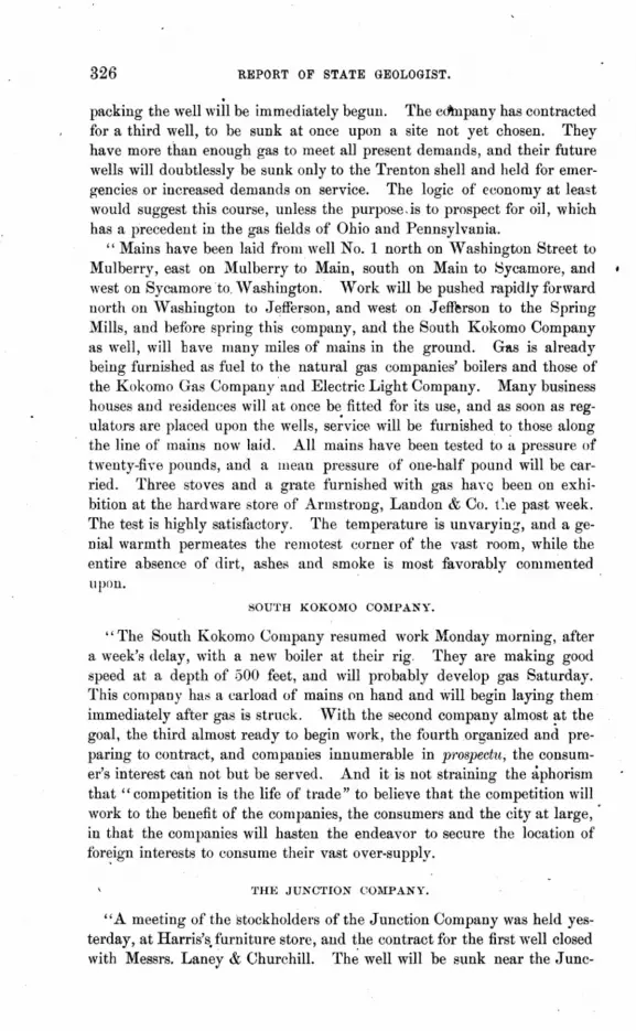
326 REPORT OF STATE GEOLOGIST.
packing the well will be immediately begun. The eo'tnpany has contracted for a third well, to be sunk at once upon a site not yet chosen. They have more than enough gas to meet all present demands, and their future wells will doubtlessly be sunk only to the Trenton shell and held for emergencies or increased demands on service. The logic of economy at least would suggest this course, unless the purpose-is to prospect for oil, which has a precedent in the gas fields of Ohio and Pennsylvania.
" Mains have been laid from well No.1 north on 'Yashington Street to Mulberry, east on Mulberry to Main, south on Main to l::\ycamore, and west on Sycamore to 'Vashington. Work will be pushed rapidly forward north on 'Yashington to Jefferson, and west on Jefferson to the Spring Mills, and before spring this company, and the South Kokomo Company as well, will have many miles of mains in the ground. G!l.S is already being furnished as fuel to the natural gas companies' boilers and those of the Kokomo Gas Company"alld Electric Light Company. Many business houses and reoidences will at once be fitted for its use, and as soon as regulators are plaeed upon the wells, se;vice will be furnished to those along the line of' mains now laid. All mains have been tested to ~ pressure of twenty-five pounds, and a mean pressure of one-half pound will be carried. Three stoves and a grate furnished with gas haYQ been on exhibition at the hardware store of Armstrong, Landon & Co. 1'le past week. The test is highly satisfactory. The temperature is unvaryin.!;, and a genial warmth permeates the remotest corner of the vast room, while the entire absence of dirt, ashes and smoke is most favorably commented upon.
SOUTH KOKOJ\W COMPANY.
"The South Kokomo Company resumed work Monday morning, after a week's delay, with a new boiler at their rig. They are making good speed at a depth of 500 feet, and will probably develop gas Saturday. This company has a carload of mains on hand and will begin laying them immediately after gas is struck. 'Yith the second company almost at the goal, the third almost ready to begin work, the fourth organized and preparing to contract, and companies innumerable in prospectu, the consumer's interest can not but be served. And it is not straining the aphorism that" competition is the life of trade" to believe that the competition will work to the benefit of the companies, the consumers and the city at large, in that the companies will hasten the endeavor to secure the location of for~ign interests to consume their vast over-supply.
THE JUNCTION COlIIPANY.
"A meeting of the stockholders of the Junction Company was held yesterday, at Harris's.furniture store, and the contract for the first well closed with Messrs. Laney & ChurchilL Th~ well will be sunk near the J unc-

NATURAL GAS. 327
tion, hut the exact loC'atiOl) has not yet been determined upon. 'Ih!' derrick will be put up at ouee, and drilling will begin as soon m; the machinery can be placed."
The flow of gas from Well No.1 is estimated by Mr. McKcill, who has had a long experience in the niallufacture of artificial gas, at from 1,000,000 to 1,500,000 cubic feet per day. He, estimates the flow from the second weJl at from 4,O()0,000 to 5,000,000 cubic feet daily. There has been no perceptible diminution of the flow of gas from \Vell :No. 1 since the well was developed on October 6. N either was it affected in the least hy the developing of' the second well.
CHARACTER OF 'fHE GAS.
No analysis has as yet been made of the gas from the Kokomo wells, but it is quite likely to prove to he nearly identical with the gafl found at Findlay, Ohio; probably, however, showing a much higher per cent. of 8ulphureted hydrogen. The odor of this gas was very strong from both the wells at the beginning of the flow, but it gradually diminished until it ill scarcely more perceptible than in ordinary coal gas. At the beginning of the flow small "sulphur balls" were continllOusly being forced out of the pipe by tbe flowing gas, but with the continuation of' the flow the escapement of these small particles gradually diminished until at present none are noticed. The coneretionary appearance of these sulphur particles indicates that they were formed by precipitation in the cayity near the bottom of the tubes or pipes.
It is quite evident that the flow of gas is obtained from the Trenton limestone. The so·called "sand" consists of small calcareous particles resembling silicious sand, which consist, however, of a large proportion of
- carbonate of lime. The stratum from which the gas flows yaries from a nearly pure white to a darkish gray color. The stone is porous and somewhat concretionary in structure. The stratum from which the gas flows seems to be perfectly dry, containing no water nor evidence of petroleum.
While the rock deposits about Kokomo are generally covered by deep aecumulations of Drift, the few exposures that may be examined show considerable evidence of disturbance at some remote period. Though not tilted to any considerable degree, they appear to lie in great fold!l, or wave-like masses, consisting of alternating anticlinal ridges and synclinal troughs or valleys. These phenomena are rrobably due to the same causes that produced the tilted and distorted condition of 'the- rocks at various points deseribed in the paper' on the Wabash Arch. Since the oil and gas fields of \Vestern Ohio are embraced in the area subjected to the Wabash disturbances, it seems that bores for oil and gas might be made with some degree of confidence at points intermediate hetween Kokomo and the Ohio gas fields.

RE~ORt OF STATE GEotOGist.
GAS WELL No.3, KOKOMO.
Gas well No.3, at Kokomo, was drilled into the Trenton limestone on December 28, 1886, and the following letter from Mr. John T. Stringer, received just as this arti01e goeH to. press, contains all the important facts pertaining to it:
KOKOl\W, IND., December 31,1886.
S. S. Gorby, Esq., Indianapoli.~, Ind. :
DEAR SIR-Mr. John E. Moore hands me your letter of inquiry. With pleasure I answer:
Depth of well Drift . . . . Limestone .. Huron shale* Trenton limestone. Total in Trenton after striking gas.
Total .... , ..... .
· 912 feet. 5 feet.
· 400 feet. · 498 feet.
4 feet. · ,5 feet.
· 912 feet.
Our well is not anchored yet, hence we can not ge,t a full test beyond one hundred pounds. The steam gauge runs to one hundred pounds in two minutes. The estimates given of quantity, by a gentleman familiar with and owner of wells in Pennsylvania, is 4,000,000 feet per day.
I think the smell of sulphur was less than that observed in wells Nos. 1 and 2 when first struck.
Respectfully, J. T. STRINGER,
Secretary South Kokomo Gas Go.
The gas-bearing rocks are reached in all the Kokomo wells at the depth of about one hundred feet below sea level.
THE KOKOMO ARTESIAN WATER.
A strong flow of water, containing valuable chemical qualities, was obtained from wells Nos. 1 and 2, at Kokomo. No complete analysis of this water has yet been made, but Dr. Moulder, of that city, made a partial analysis which shows that, as a remedial agent, the water of the Kokomo wells will undoubtedly achieve the popularity of the well-known waters of Lafayette, Lodi, French Lick, and other points.
The following statements, with Dr. Moulder's analysis, were clipped from the Kokomo Dispatch:
"There are over sixty grains ofminer,al matter to every pint of the water, held in solution in such proportions as to make a drinking and bathing water with an exhilarating influence, and a very valuable remedy in
"Hudson River and Utica shale.

NATURAL GAS. 329
treating debility, languor, rheumatism, diseases of the kidneys, liver, skin, stomach, headache, cancer, syphilis, gout, running sores, scrofula, etc., and will, when properly understood and applied, produce cures that will be miracles.
"Every pint (of sixteen ounces) of the water contains the following valuable minerals held in solution in such a manner as to make a pleasant and very palatable drinking water, and hundreds of our people already are loud in its praise for what it has done for them, some almost marvelous cures already having bcen reported of kidney, liver and stomach
. diseases: ANALYSIi>.
Specific gravity.
Sodium Ohlorate (about) .. Magnesium Ohloride (about) . Potassium Ohloride . Sodium Snlphate .. Oxide of Iron ., . . Magnesium Iodide .. Magnesium Sulphate .. Oalcium Sulphate. Oalcium Chloride. p.,troleum ....
Sulphureted Hydrogen. Nitrogen Oxygen. Oarbonic Acid.
<+ASE~.
1010
. 2li grains. 2 grains.
traces. 2 grains. 3 grains. 3 graius. a graius .
. 10 grains. traces. traces.
"There may also be other remedies held in solution that will prove to be as remarkable as the ones that have already been detected by analysis. The water is as clear as crystal and is quite pleasant to the taste, being noticeably charged with chloride of sodium, or common salt. The smell or odo'r is ·that of sulphureted hydrogen, but not so pronounced as the artesian water at Lafayette or the water of Lodi. All scientific and medical men, who have examined the water, give it as their opinion that it is a valuable find of wonderful remedial chalybeate water. One can not drink too much of this water or suffer any inconvenience from fre· quent and copious draughts. Its effect is mildly cathartic and pleasant. A fondness for it grows on a habitual drinker, as is the case with all mineral waters."
The water rises. in the pipes to a hight sufficient to distribute it over every porti.m of the city, and it is the design of the city' authorities to erect suitable fountains at convenient points for the accommodation of the public.

330 REl'ORT OJj' STATE GEOLOGIST.
THE MUNCIE GAS WELL.
Gas well No.1, at Muncie, is located about one mile east of the city. The elevation above sea level at the well is about 875 feet. The total depth of the well is 898 feet. The following is the section of the well :
SECTION OF M1:NCIE GAS WELL NO. 1.
Niagara limegtone and shales . . . . . . Hudson Rver limestone and Utica shales. Trenton limestone
Total ...
· 205 ft.· · 611 ft. · 22 ft.
· 898 ft.
The gas at this well, flowing through a two~inch pipe, has a pressure of 325 Ibs. per square inch. Mains are being rapidly laid throughout the city, and the gas is rapidly coming into use for domestic and manufacturing purposes.
The odor of sulphureted hydrogen is scarcely preceptible. The gas burns with great brilliancy, creating an intense heat. Bya simple and cheap arrangement, in the form of a burner, any heating or cooking stove can readily be adapted to its use. The price of the burner is only eighty-five cents. For lighting purposes it has been found, upon thorough tests, to be fully equal to artificial gas. It does not require to be refined .
. Well No.2, bored about one-fourth of a mile north-east of the city, has reached a depth of 1,020 feet, and at the date that this paper goes to press,January 7, 1887, no' gas nor petroleum· has been found. The drill is now at work in the sandstone underlying the Trenton rocks.
TH~; TIPTOX GAS AND OIL WELL.
Soon after the. diseovery of gas in .paying quantities, at Kokomo, a company was organized at Tipton, twenty miles south, under the title of "The Tipton Mining and Exploring Company." This company began operations early in December, and sunk their first well in the northern part of the city.
A slight flow of gas was obtained fi'om the Trenton I limestone, at a depth a little greater than 1,000 feet. A few feet lower ddwn a "flow" of petroleum was obtained, and a strong vein of water at 1,030 feet.
The following section of the well was obtained:
SECTION OF TIPTON GAS WELh
Drift material . Limestone, varying in color an.! texture. Limestone and shales. . Limestone (gas-bearing) . Limestone (oil-bearing) . Limestone to water .
Total ..•
139 feet. 326 feet. 532 feet. 11 feet. 3 feet.
f9 feet. I
. 1,030 feet.

NA'rtjRAL GAS. 881
'rhe accumulation of petroleum in the bore is estimated at from three to five barrels per day.
The probabilities are very strong that gas will be found in paying quantities at this point, and the prospects for petroleum in the vicinity are very encouraging. Other wells will be sunk soon.
The following report, kindly handed in by Dr. R. T. Brown, shows the results of the work to date in the experimental well at Indianapolis:
Hon. ll'!aurice Thomp8on, State Geoloyist:
DEAR Sm-At your request I submit notes of the boring in progress in this city in charge of the Indianapolis Gaslight and Coke COJ?pany :
Surface Drift-gravel, sand and clay. 118 ft. Devonian limestone. . . . . C Q ft. CoarEe sandstone (Oriskany). . 2u it. Niagara limestone and shale. . 694 ft. Trenton (Cincinnati) limestone. 620 ft.
Total . . . . . . . . . . 1,520 ft.
At the base of the Trenton a hed of firmly compacted sand was encountered, in which the drill became detached, and more than a month has been spent in efforts to recover it. It is the intention of the company to sink the boring to the depth of 2,500 feet, unless a supply of gas is sooner obtained.
Copious streams of water, highly charged with sulphureted hydrogen, were encountered at 200 and 900 feet, but neither rose to the surface.
R. T. BROWN.
INDIANAPOLIH, Jan. 4, 1887.
PORTLAND GAS WELLS.
An attempt was made to find gas at Portland during the summer of 1886, and although a flow was obtained it was so slight as to merely ignite with a feeble flash, and be immediately extinguished. The first well' was bored to the depth 1,440 feet, passing entirely through the Trenton limestones, and for all practical purposes was, of course, a failure. A second attempt, however, has recently resulted in marked success, securing a flow with a pressure of 298 Ibs. per square inch, and, as at Muncie and Kokomo, the gas is rapidly being adapted to the various uses throughout the city to which it may be applied. The following is a section of the second well:
SECTION OF GAS WELL No.2, PORTLAND.
Drift . Niagara limestone . . . . . . . . . . . Hudson River limestone and Utica shale.
Total ......... ' .... .
· 58 ft, · 192 ft. • 740 ft.
· 990 ft.
The elevation at the well is a little more than 900 feet above sea level.

•
REPORT oJ!' STATE G:ElOtOGI8T,
THE ARTESIAN WELL, BLOOllUNG'rON .
Under date of Jan. 11, 1887, Mr. Wallace Hight, of Bloomington, forwarded to this office the following section of the Artesian well at Bloomington, which was bored at the joint expense of Monroe County and the city of Bloomington. It was the original intention to continue the boring until the depth of 3,000 feet was reached, but the pumps became fastened in the well at the depth of 2,730 feet, and the work was abandoned. The following is the section:
SECTION OF THE ARTESIAN WELL, BLOOMINGTON.
Earth. St. Louis limestone, water. Keokuk limestone Knobstone .. . Red shale ... . Blue limestone. . Brown shale, gas . Black slate, Devonian Gray limestone, Portland cement Brown limestone, Niagara Shaly limestone . . . Light-brown limestone . Flinty limestone. . . . Light-colored limestone. Brown limestone . Biue shale ...... . Blue limestone. . . . . Blue shale, streaks of limestone Blue shale ....... . Grey limestone, some shale Blue shale ....... . Hard, white sandstone . . Shaly limestone and sandstone Grey limestone and sandstone . Shaly limestone, sandstone and quartzite. White and yellow, hard sandstone, iron White'sandstone, soIter ...... . 'White saudstone, soft. . . . . . . . . Grey limestone and sandstone, mixed Grey limestone, sulphur-water increasing rapidly
Total ................. .
6 ft. 30 ft. 89 ft.
630 ft. 20 ft. 5 tt.
10 ft. 120 ft.
15 ft. 240 ft. 15 ft.
130 ft. 30 ft.
100 ft. 70 ft. 40 ft. 40 ft. 60 it.
180 ft. 586 ft.
40 ft. 4 it.
20ft. 2.0 ft. 98 ft. 22 ft. 20 ft. 40 ft. 42 it.
8 ft.
. 2,730 ft.
The foregoing reports of the successful efforts to develop natural gas at the various points mentioned are necessarily brief and incomplete. In most instances the sections of the wells given are probably not strictly accurate, as no careful notes of the changes in strata were made as the work progressed.

~ATtiitAt GA.S.
This department has had very little opportunity to collect facts, as all of the matter intended for publication in this volume was already in the hands of the printer, and much of it already printed, before the operation of drilling had been commenced in the most largely productive wells. However, these facts, brief as they are, will be full of interest to many of our citizens, showing, as they do, that a new source of wealth, hidden deep in the r~servoirs of the earth, is likely to open up in Northern and Eastern Indiana, and possibly in other parts of the State.
It is the intention of this department to· carefully collect and preserve all the facts connected with these subterranean explorations, to the end that those who desire informati?n on this subject may here obtain all the reliable data to be acquired within the State.

A GLOSSAR-Y
COMPILED FROM THAT OF DR. W. T. S. CORNETT, IN THE THIRTEENTH ANNUAL REPORT OF THIS DEPARTMENT,
AND OTHER SOURCES.
llY S. E. LEE.
AUCRJ<;'l'lON. The proce~~ by which inorganic bodies grow larger, by the addition of fre~h particles from the outside.
ACOTYLEOON. A plant in which the seed-lobes (cotyledons) are not present, or are indistinct, like the fern, lichen, and most of the coal plants.
• ACROGE:NS. Plants which increase in hight by additions made to .the sum-
, mit of the stem by the union of the bases of the leaves. The highest tribe of Oryptogams, such as 8i.'lillw·ia, Lepidodendri(J, Calamites, Fern", etc.
ACTI:NOLITE. A variety of hornblende which nmally occurs in fascicnlar crystals.
ACUMINATA. Pointed; peaked. AUITA. Sharp pointed. ACUTIUOSTA. Having sharp or pointt'd
lobes. AEROJXfE. A stone or other body
whieh has falleri from the air, ;r more correctlv, has come to the earth from distan} ~pace; a meteorite.
AGATE. A semi· pellucid, uncrystallized qnartz.
AGGLOMERATK. To gather together. AL"'EFOR"HS. Wing-shaped. ALBITE. A variety of feldspar. ALG.4~. .Ylarine plants, comprising tbe
seaweeds and many fresh-water plants.
ALLUVIUM. Earth, sand, gravel, loam, vegetable mold, etc., washed down by streams and floods, and deposited upon formations not permanently snbmerged.
AU."MI:NA. A characterist.ic ingredient of common clay.
ALClIIINOUS. Pertaining to or contarning alum, or alumina. The clay slates are very fl'e(IUently impregnated with alum, and are then called alum-slate~ or alum-shales.
A LVEOI"A'l'CS. Having a surfacc covered with numerous deprl'ssions, comparableto the alveoli or sockets of the teeth.
AJ\£BI"YPTERUS. A fossil fish . AMMONITE. An extinct genus of Cephal
opoda, like the Nautilus, found in the Secondary or Mesozoic rocks; so called from the resemblance of its shell to the horns of .J upiter-Ammoll.
AMORPHOUS. Bodies devoid of regular or determinate form. A name sometimes med to designate the sponges.
AMPHIBIA. Animals capable of living either in water or on land, like the frogs, newts, lizards, tnrtles, certain
, serpents, etc. AMPHIBOLE. Variety of hornblende. Al\[PLEXUS. Generic name of a fossil. AMYGDALOID. A rock in which crys-
tallized minerals are scattered in almond-shaped cavities.
ANARTO}IOSED. Branching and interlacing.
AXDALL"SITK A mineral first observed in Andalusia, in Spain. It is very. hard and infusible and consists chiefly of alumina and silica. Chiastolite.
ANGI"rc OF DIP. Angle formed with plane of the horizon.
Al'IHYDROUS. Without watm. ANl'IELIDES. Anima'!s having an ex
ternal integument formed of rings. ANNULAR. Shaped like a ring. ANNULARIA. Generic nalUe of a fossil
plant.

336 ImpORT OF STATE GEOLOGIST.
ANODONTA. Systematic name of a kind of mussel.
ANTICLINAL. The crest or line from which strata dip in opposite directions.
APEX. Summit or tip of the spire of a shell.
ARBORESCENT. Branchiug like a tree. ARCUATA. Arched; bent like a bow. ARENACEOU~. Sandy; of the nature of
sand. ARGENTIFEROUS. Producing silver. ARGIJ,LACEOUS. Clayey; composed in
whole or in part of clay. ARTIC"ULATA. Animals characterized by
the possession of jointed bodies or jointed limbs.
ARTICULATION. A joint betwixt bones or portio us of crustatious.
ASAPHUS. A name devised to express the obscure nature of a genus of trilobites, fossil crustaceans.
ASAR, ESKER. A long, narrow, sharp ridge of gravel and sand, with some associated bowlders, parallel with the ice movement or lines of drainage.
ASBESTUS. A fibrous soft. mineral composed of easily separable filaments of a silky luster. It consists essentially of silica, magnesia and lime.
ASTARTE. Name of a genus of fossil bivalve shell. .
ASTREA. i\. genus of polyp aria. ATTENUATED. Made slender or thin. AUGI'l'E. A mineral, the same as
pyroxene. AUGITIC-PORPHYRY. Crystals of Lab
rador feldspar and of augite in a green or dark-gray base.
AURIFEROUS. Containing gold. AVICULA, Name of a genus of bivalve
mollusks. AXIS OF ELEVATION. Line of elevation. AZOIC ROCKS Rocks formed before the
existance of organic life, or, at lea~t of animal life, consequently destitute of f03sil remains.
BASALT. A rock essentially composed of feldspar and augite, of a compact. textu-re, and dark green, gray or black color. It occurs ill columnar masses.
BASSET. Outcrop, or emergence of strata at the surface.
. BASIN. An isolated or circumscribed formation,. particularly where the strata dip inward, on all sides, toward the center. Especially applied to the' coal formations, called" coal-basins" qr "()oal-fielqs,"
BATRACHIA. The order of reptiles which includes the frog and related animals.
BEAK. The continuation of univalve shells in which the canal is situated, or the extreme point of the summit of bivalves.
BELEMNITES. A genus of fossils dibranchiate Cephalopods.
BELLEROPHON. A genus of Gaster"pod(t, having a univalve shell, found in the Paleozoic rocks.
BIFURCATED .. Divided into two branches. BITUlIIEN. A variety of inflammable
mineral substances, which, like pitch, is included under this term.
BITUMINOUS SHALE. Shale impregnated with bitumen; usually of a dark brown or black color.
BIVALVE. Consisting of two plates or val ves, hinged together by an elastic ligament.
BLENmJ. Sulphuret of zinc; a common shining zinc ore.
BOSSE. A hillo,·k.; a rounded projection or elevation.
BOWLD~JRS. Rocks rounded or otherwise which have been transported fro~ more or less distant localities by natural agencies, especially during the Drift period.
BOWLDER CLAY. The stiff, unlaminated clay of the Drift period.
BRACHIOPODA. A class of marine mollusks, characterized by two fleshy ~rms, continued from the sides of the. mouth, and which served to create currents to bring them food.
BRECCIA. A rock composed of an agglutination of angular fragments.
BUCCINUM. A trumpet or horn. Name of a genus of mollusks.
CALAMITE. Extinct plants, with reedlike stems. sometimes !\ttaining a diameter of fourteen inches and the hight of trees, found almost entirely in the Coal Measures
CALCAREOUS. Consisting of or containing carbonate of lime.
CAI,CITE. Crystallized carbonate of lime. Common lim~stone, all tbe white and most of the colored marbles, calc-sinter, calc"spar, calc-tufa, stal-ctites, and stalagmites are so classified .
CALC-SPAR. Calcareous spar. CAJ.(]-SINTER. A German term for lime
stone deposited from springs and water containing it. Travertin.
C",LCEO:f:.4. A tossjJ bivalve shell.

GLOSSARY. 337
CALCINED. Converted into calx or a friable 8U bstance by the action of firlc'.
CALYMENE. A name of a genus of trilobites.
CANNlEFORMIIS. Reed-shaped. CARAPACE. A protective shield. The
upper shell of the tortoise, turtle, crab, lobster and other Crustacea.
CARBON. The pure inflammable principle of charcoal. In its state of absolute purity it constitutes the diamond.
CARBONATE. A salt formed by the union of carbonic acid with a base.
CARBONIC ACID. An acid compounded of carbon and oxygen.
CARBONIFEROUS. Producing or containiug carbon or coal. .
CARBONIFEROUS AGE. The one immediately following the Devonian Aglc', or Age of FiBhes, and chara('terized by the vegetables which formed the coal beds. This age is divided into the Subcarboniferous, the Coal Measure and the Permian epochs.
CARBONIFEROUS PERIOD. The second, or middle, division of the Carboniferous Age.
CARBURET. A combination of carbon with a metal or other substance. Steel and black lead are carburets of iron.
CARDIUlIl. A cockle. A genus of bivalve shells.
CARINATA. Carinate, having a keellike elevation.
CARINATED. Shaped like the keel of a ship. Applied to flower.< consisting of two petals, either separate or uni~d, inclosing the organs of fructification, and which have a longitudinal prominence like a keel.
CARNIVOROUS. Flesh-eating. CARPOLITE. Petrified fruit. Literal
meaning, "stone fruit." CARYOPHYLLIA .. A genus of llladre
JXffa. CATENIPORA. Generic name of a polYPi
chain coral. CATYLUS, or CATILLU8. A little dish.
A genus of fossil shells. . CAUDATUS. Having a tail. CAVERNOUS. Containing hollows ex
cavated. Cl'JNOZOIC. Belonging to the Tertiary
plc'riod, and means "recent life." CENTIMETRE. A French meRsure. of
length, equal to .39368 of an inch.
~2-G~Ot.OGYl
CEPHALOPODA. A class of the MoUUiJr,a, comprisin~ the cuttle-fishes and their allies, and characterized by a distinct head, surrounded by a circle of long arms or tentacles, which they use for crawling and for seizing objects.
CEPHALASPIS. A genns of fossil fish. CERITlIIUM. A genus of turriculated
univalve mollusks, both recent and fossil.
CEROID. Wax-like. CETACEA. Name of an order of mam
mals. CHALCEDONY. A semi-transparent sili
cious mineral, apparently formed by the infiltration of silicious mattlc'r in a state of solution. •
CHALK. Earthy carbonate of lime. CHAMBERED SHELLS. Those dividlc'd
into cells by septa, or partitions. OHELONIANS. Animals of the tortoise
tribe. CHERT. An impure, massive, flint-like
quartz, or hornstone, of various dull shades of color.
CHLORITE. A soft,green, scaly mineral, slightly unctuous.
CHONETES. A genus of fossil bivalve shells, of the class Brachiopoda.
CINCINNATI GROUP. The upper division of the Lower Silurian system. Same as Hudson Ri1'ej' G1'O'UP.
CLEAVAGE. That peculiar structure in rock which admit. of its division into scales or layerF.
COAl, BASIN. Depressions formed in the older rock formations, in which coal-bearing strata have be.n depos-ited. •
COAl, MEASUR}~. Strata of coal, with the attendant rocks.
C(}~LEN'l'ERATA. Proposed by Frey and Lenckhart in place of the old term Radiata, for animals having" hollow bowels," which this term literally means.
COMlIIINunm. Fractured into sOIall pieces.
CONCJ<~NTRIC. Having it common center.
CONCHU'ERA. A species of the MollUiJca having shells with a dorsal hinge, like oysters, clams, mussels, and other ordinary bivalves. Literal meaning, " to bear a shell." .
CoNCHOIDAl" Shell-like CONFORMABLE. Parallel, or nearly so; • said of ~trata IYhich li~ in cont»f,lt,

338 REPORT OF STATE GEOLOGIST.
CUNCRE'flONARY. Made up of concretlons.
CONGLbllfERATE. A rock composed of . pebbles cemented together by another . Inineral sub,tance, either calcareolls,
si I iceous or argillaceous. CONIFERA. The order of the firs, pines
and their allies, in which the fruit is generally a "cone" or "fir-apple j" literally, ., I carry a cone."
CONTORTED. Strata which have been ben tor twisted while in a soft and yielding condition.
COPROI,ITE8. Fossilized excrements of animals.
<;jORAL. The solid secretion of zoophytes, produced within the tissues of the polyps, and corresponding to the skeleton in higher animals. It consists almost purely of carbonate of lime.
CORALLINE ZONE. That zone of marine life which extends from about 90 feet to 300 feet in depth.
CORALLUM. The coral or solid part of a zoophyte, whether composed of stone ·01' horn.· ,
CORDIFORlIl. Heart-shaped. CORNFTL'''. Horned. CORONATA. C6STATU~.
Crowned. Ribbed.
CRAG. A partially compacted deposit of the oldu Tertiary formation, consisting of s,md and shells.
CRA8SATELLA. A genus of bivalve shells.
CRASSL'S. Thick. CRA'l'Elt. .. The mouth of a volcano. CRENATr~L Cr\lnate; hafing rounded
teeth. CRENuLATlm. Having the edge cut
into:small scallops. CRETACEous. Having the qualities of
chalk; the uppermost or last of tbe · Secondary formation.
CRINOIDEA. An order of lily.shaped marine animals, belonging to the subkingdom Radiata. They generally gTOW attached to the bottom of the sea .by a jointed stem, though some
· arE! free. •
CROCODII,6.N. Any animal of the tribe of crocodiles
CRUS1'ACEA. One of the elasses of the Ar-• tieuletta, comprising lobsters, shrimps, ~nd erabs, characterized by the posse~8ion .of. a .. hard shell orcrtlst, cov~l'ing the bodl' le~s, ftc.
CRYI"l'O(;A"IIA. Name of a clas" lOf plants.
CRYSTAL. Any inorganic solid of homogeneons structure, bounded by natural planes and right line" ~ylllmetrically arranged.
CUNll:IFORftI. Wedge-shaped. CUPROUS. Belonging to copper. CYATHIFORM; In the form of a cup or
drinking-glass, a little widened at the top.
CYATHOPHYLLUM. Cup-shaped, rugose corals, very abundant in the rock formatilOns of Indiana.
CYCLAS. CYPREA.
lush. CYPIns.
ans.
A gen us of gasteropods. .\ genus of gasteropod mol-
Name of a geuus of crustace-
CYR~JNA. A genus of bivalve mollusks. DATA. Admitted facts. DEBRIS. Broken and detached fragments
of rocks, taken as a mass or colle~tively.
DEURADATlON. A grad nal wearing down or wasting, as of rocks, banks, and the like, by the action of water, frost, etc.
DFJNDRITlc. Tree-like; branched like a tree.
DENTATU~I. Dentate; having sharp teeth.
DENUDA'l'ION. The laying bare of rocks by the action of running water, or by removing earth, etc.; also, the excavation of rocks by running waters or by the action of wavE's.
DEPOSIT. Matter precipitated from suspension in water.
DEl'RE~SUR. Pressed; sunk. DETRITUS. Small portions of matter
worn oft· from rocks by attrition. DEVONIAN. Applied to rock strata lying
next above the Rilnrian. DEXTRAl,. Rising horn right to left. DIALLAlUJ. A mineral of foliated
structure easilv divisible in one direction, its natural joints and fractures exhibiting a very different luster and appearance.
DrcERAs. Generic name of a fossil bivalve.
DrcHOTOl\lOU~. Dividing by pairs from top to bottom. .
DICHOTOMY. Dividing regnl arly by pairs. DICOTYL~;DONS. A division of pla.ntR
according to thenatllral order.
Du,A'.!'A'r<\, Dilated i swelled out·

GLOSSARY. 339
D[LUVlOl'. l A fi . I I . Dn,UYlli)[ r super CIa (epo~lt.
DIORITK. :\ variety of trap rock con-sisting of albite and hornblende.
On'. The downward inclination of strata.
Dn;coIllAL. Resembling 11 desk. JhSIN'l'EGRA'l'ION. The a~t of separa
ting or dividing a whole into parts. Dl~";EP[ffIENTS. Partitions di dding cells. DOLOmTf<;. Magnesian marble; mag
nesian carbonate of lime. DORSAL. Pertaining to the back. DRwr. A collection of loose earth, sand,
rocks, or bowlders, distributed over a large portion of the ea th's 8U rface, especially in Iatitudps north of 41)°, and which have come from the north~ard, brought thence, mainly, by glaCIal action,
Enr,N'I',\TA An order of animals with. out teeth.
EMARGINATJ<:D. Notched upon the edge or margin.
ENCRINITK The iii v-"haped radiate; crinoid. •
EN:;IFOR~I. Saber-shaped. ENTOMOSTRACAN:;. A division of the
class of Clustucea.
EOCENE. The lowest division of the Tertiary rocks, in which but few specimens of existing shells are found.
EOZOIC. A term used for the oldest fossil-bearing rocks yet known, snch as the Laurentian and Huronian of Canada.
EpOCH. The period during which a formati<,m was produced; thus, geoloc gists speak of the \Iillstone Grit epoch, etc.
E'iUISE'l'UM. :I. genus of plant. ERODE. To wear away; to corrode. ESCARP~lENT. The steep face presenteu
by the abrupt termination of strata. EUOl\fPHALU~.·A gasteropod mollusk
of circular form. EXCORlATfON. An abrasion; mark of a
part having been rubbed from the surface.
EXOGYRA. Not circular. A genus of unimuscular bivalves, allied tq the oyster.
FAULT. A sndden interruption of the continuity of strata or veins in the same plane, caused by a crack or ·fissure.
FAUNA. The animals of tlny given area Pf epoch. . ,
FAVOSITES. A kind of fossil coral, having a prismatic structure, closely resembling that of a honey-comb.
FI;LDSPAR. An important mineral composed of silica, alumina, potash, with traces of lime, and often of oxyd of iron. It enters into the composition of granite.
FERRUGINOUS. Containing iron; also, partaking of the quality of iron.
FIRE,CLAY. Any clay capable of sustaining intense heat withont vitrifying. Abundant in the Coal Measures, beneath e'ach coal seam.
FISSILE. Capable of being split, cleft, or divided in the dirt:!ction of the grain.
FJ,ORA. The system of vegetable species native in a given locality, region, or period; as the Flora of the Coal Measures, etc.
FLl;VIA'l'[],E. Belonging to rivers; formed by rivers, as fiuv,iatile strata.
FI,UYIO-lIfARINf;. Formed by the .ioint action of a river and the sea, as in the deposi18 at the mouths of rivers.
FOLIATED. Having leaves or leaf-like projections, as foliated shells; composed of thin lamime or layers, as mica schist, schistose, and the like.
FORAMINII<'EHA. A minute genus of the Protozoa, characterized by having a calCareOll" shell perforated by numerous pores 'or foramina.
FORMATION. The series of rocks belon~ing to an Age, period or epoch, as the Silurian formation and the like.
Fo~sI.L. That which may be .dug up; the petrified form of a plant or animal in the strata com posing the surface of the earth.
FOSSILIFEROl;~. Containing fossils or organic remains, as fossiliferous rocks.
FUCOIDS. Fossils rescmbling sea-weeds. FUSU'ORM. Shaped like a spindle;
tapering at each end. FliSILINA. A spindle-shaped Foramin-'
~fe,..
FFSION. The act of melting; state of fusion is being melted.
GALEN A. Snlphuret of lead; a COlll
pound of sulphuv and lead.
GARNET. A mineral consisting of silicates of alumina, lime, iron and manganese.
GAS. The name given to all pel'manently elastic fluids or airs different fl'Om the atmospheric airs,

340 REPORT OF STATE GEOLOGIST.
GASTEROPODA. A uuivalve mollusk, haviug a fleshy ventral disk, which serves to take the place of feet, as the snail.
GEMMATION. The formation of a new individual by the protrnsion of any part of an animal or plant, which may then become free or remain connected with the parent stock; bud· ding. Polyps a,nd some other animals reprodnced by bnds.
GENE,RIC. Relatiug to genus. Gf:NUS. An assemblage, of species pos
rleSsing certain characters in common, b.v which they are distinguished from all others,
GEODE. A rounded nodule of stone, containing a small cavity usually lined with crystals, sometimes with other matter; the cavity 'in snch . a nodule.
GEOLOGY. A science which treats of the materials which compose the- earth, the method. in whieh those material8 have been arranged, and the eauses and modes of origin of those arrangements.
GL-\'CIER; GLACIAL RIVER. A field or immense mass of ice, or snow and ice, formed in the region of perpetual snow, and moving slowly down mountain slopes or through valleys, usually beariug along bowlders and fragments of rock.
GNEI8S. A cry,.tall ine rock, consisting of quartz, feldspar and mica, but, unlike granite, having these materials arrange,1 in planes, so that it rather easily breaks into coarse slabs or flags.
GRANl:LAl~. Consi8ting of grains. GRAPHI'I'E. A mineral composed of car
bon and iron, constitnting carburet of iron. It i~ known as plumbago and black lead.
GREENSTONK A tough varietyof trap rock consisting chiefly of hornblende.
GRYPHEA. A genus of fossil bivalves. GRANITE. A crystalline rock, of the
s'tme materials with gneiss, but dillering therefrom in these mineral,., heing grainy and not stratified.
GYPSUM. Sulphate of lime. Plaster of PariR is made from this mineral hy cRlcination.
HABITAT. The llatural abode or locality of-any lmimltl or plant.
H_+:MATITE. Sesqui-oxide oi iron. So called becallse of the red color of the powder,
HELIX. A gasteropod mollusk; a snail. HINGE. The point at which bivalve
shells are united. lIEloHPRONITES. A fes,;il bivalve ~hell,
sometimes known as the genns Streptorhynchu8.
H~jl'~JROCEmcAL. A fish having the vertebral column continued into the npper lobe of the tail, which lobe, on this account, is larger than the lower one. Literal meaning, "A diverse tail." This form prevailed in Paleozoic ' times.
HOMOCERCAL. A /ish in which the vertebral column terminates at the commencement of the tail, the lobes of which are symmetrically equal. Literal meaning, " Common taiL"
HORNBLENDE. A mineral of dark green or black color, abounding in oxide of iron, and entering into the composition of several of the trap rucks.
HUDSON RIVER GROUP. An upper division of the Lower Silurian formation. Same as Oincinnati Group.
HUMUS. A dark brown stlbstanceformed in the Roil by the action of air on solid animal or vegetable matter. It i< a valuable constituent of soils.
HYDRATED. Containing water IcHTHYOLOGY. The Rcience of the sy"
tematic arrangement or classification of fisheR.
IGNEOUS ROCK";. Resulting from the action of fire, such as lavas, basalt, trap, and the like.
IMBRICATED. Lying over each other in . regular order, like the scales of a fi.h and those on the leaf-bnds of plants.
INCnU8TATION. A covering like a crust.
INFUSORIA. :Microscopic animals fonnd ill water and other fluid_, multiplying by gemmation.
INORGANIC. D ... void of an organized vital structure. Rocks, minerals alld all chemical compounds are inorganic 811 bstances.
Ii> SITU. In its original sitnation. Sa id of rock. which rem 'lin where .they were form~d.
INVERTEBRATA. Animals without a Rpinal C<:llllmn.
JASPER. A silicious mineral of Yltri"us colorA.
KAME. A rounded hill or oblong ridgc terminating abruptly in a high mound. Composed of gravel and sand, and having its major axis tranA, verse to \qe Drift movell)ent·

I1LOSSARY. 341
LACJ.:RTIAN. 'rhe' lizard specie~. LACU8TRAI,. Pertaining to lakes or
swamps. LEVIS. Smooth, )J~re, buld. LAGnON. A marsh, ~hallow pond, or
lak,·, e~pecially one into which the sea flows.
L.UIINATEJ) ConAistingof plMteR, scales or layers, one over another.
LAND-SUP. The sl iding- down of a considerable tmct of land.
LATERAU~, Lateral. LINGULA, A little tongne. Name of a
genns of bivah·es. LITHOGRAPHIC STO~E. Used f"r the
purposes of lithography. LENTICULAR. Having the form of a
double-convex len •. L};PIDODENDRON. A genns of fOSAil
cone-bearing tree", belonging to the Carboniferous Age, and so calleo from h*,ing their ste'll" marked with 'scars or scales, produced by the falling off of the leaves.
LIGNITE. Mineral coal showing the texture of wood, and found in the Tertiary formation.
LINE 0);' BEARING. The direction of the strike, or outcrop.
LINE OF DIP. The ,line of greatest inclination of a stratum to the horizon.
LITHOl.OGY. The science which treats of the characteristics and classification of rocks.
LOAM. A Boil composed of siliceous sand,.clay and carbonate of iron, with more or less oxide of iron, magnesia and various salts, and also decayed animal and vegetable matter.
LOESS. A division of the Quaternary System, Lacustral Age. Common along the Mississippi and many of its tributaries.
LOWER CARBONIFEROUS PERIOD. Tbe first, or earliest, division of the Carboniferous Age.
LYCOPODIACE,E. An order of plants which includes the lycopodium ..
MAGNESIA. A white, tasteless, earthy substance.
MAMMALIA. Vertebrate animals that suckle their young.
MAMMOTH. An extinct elephant, fossil remains of which have been found on both American continents.
MARL. A mixture of carbonate of lime. clay and aand in varying proportion •• A vaillable fertilizer.
MA8TOn()~. An extinct gigantic mammal, resembling the elephant. so calh,d from the coni('al I nipplE'shaped) protuberancE's on itA molar teeth Igrind .. rs).
MATRIX. The eart.hy or stony substance ill which metallic ort's or crystalline miuerals are found. .
MAXi~tUM. Greatest. MEROr,OIC. The Secondary period. Lit
earl meaning, "Middle liil'." M~;TAMORPHIC. Rocks or minerals
which have undergone changes in form or shape since their original deposition; u.ually applied to changes made by heat;
METEORITE. Same as Aerolit~; which seE'.
METRE. A French measure of .length, . equal to 39.368 inches. (See, also, Centimetre and Millimetre.)
MICA. A mineral generally found in thin elastic laminre, soft, smooth, and of various colors and degrees of transparency. J t is one of the constituents of granite.
MICA SLATE. A A"histose rock, consisting of mica lind quartz, with, usually, SOllie feJdspar. The lowest stratified rock' except gneiss. It bears no fossils.
MILLIMETRE. A French meastlle of length, equal to .m9368 of an iuch.
MILLSTONE GRIT A hard, gritty, sandstone, a kind of conglomerate, found under the Coal Measures, sometimes containg q uarlz pebbles.
MINERAL. Any inorganic natural object, ~hether bolid, liquid or gaseous.
MIOCENE. The middle division of the Tertiary rocks, in which the minority of the organic fossils are of recent species.
l\IOJ,LUSCA. Invertebrate animals, having a soft, fleshy body (whence the name) which is inarticulate and does not radiate internally: Includes the shell-fish. proper.
MONOCOTYLEDON!l. A class of plants having but one seed Jobes in the embryo.
MORAINES. Longtitudinal deposits of stony detritus found at the bas88 and along the edgeR of glaciel"lJ.
MtlRAL. Belonging 01' relating to a wall.
N AUTlLt18. A fossilized and living pnuR of the Molluscan Cephalopod.,
~tAGABA GKOt1.1'. A dlvilion of the Upper Silurian ay~tetu.
N')nolltl.. Knotty.

REPORT O~ STAT~ GEOLOGIST.
NODULE. A rounded maRR of irregular shape.
N UCI.EUS. A kernel; a centr"l !lUSS or point about which other matter is gathered.
OBSIDIAN. A glassy la\'a. Yolcanic 'glass. It ('on~i~ts of silica and aluminll, with a little potash and oxide of iron.
OOLITE. An epoch in the .J nrassic Age. A: varietv 01 limestone consiRtin,g of ronnd grains like the roe of a fish. Name is tlerived from two Greek words, which JIlean "Egg-stone."
OOI.ITIC. Reselllbling Oolite.
OPERCULUM. The lid which protects the gill~ of fishes and clo.es the openiug of certain llniva.Jve shells.
ORES. ~lineral bodies 'from which metals are extracted.
ORGAl\IC RElIIAI:-;S. Fossilized remains of animals or plants.
ORTHIS. A genu~ of Brachiopod((, named in allusion to the straight hinge-line.
ORTHOCEHMI. A familv of the Nautilidee, in which the "hell is straight, or nearly so.
OUTCROP. That part of an inclined stratum which shows at the surface of the ground.
OVERI.YING. When one stratum lies over or overlft.ps another it is said to be overlying. '
OXIDE. The comhination of oxygen with any metalJ ic base.
OXYGEN; Vital air. P ALEON'fOLOGI8T. One skilled in pal
eontology. PALEONTOLOGY, The science of the an
cient life of the earth, or of the fos~ils which are the remains of such life.
l' ALEQZOIC. Applied to the older division of geological time and, to the fossil-bearing rocks of the Silurian, Devonian ann Carboniferous Ages.
P ARA~'}'IN.E. A white translucent, crystalline "ubstance, obtained from the d isiillation of mineral and vegetable tar.
PEAT. Accumulation of wgetahle matter on and neal' the surface of the earth, in moist places.. It is in termediate between pure vrgetable mattl'r and lignite, 8u part~ in 100 being combl\~tible, and i., therefore, often dried !lnd then used for fuel.
P.:COPTF:RIS. A genus of fossil fern.
Pl':CTEN. A genns of bivalve mollusks.
PENTAGO:-;AL. Having tive angles. PERMIAN. The epoch following the
Coal-Measure epoch, and regarded as closing the Carboniferous Age and the Paleozoic era.
l'ETROI.KUM. Mineral oil. PHENmI,ENoN. A ppearan~e, visible
qnality, event. PHONO[,[n: ClinkstollC', a species of
compact basalt, which is sonorous when struck.
PIN"ATEll. Winged. PLEIHTOCEKE. Quaternary. Pertaining
to the epoch or to the deposits following the Tertiary and immediately prec ceding man. Compounded from two Greek words, meading "most new."
PLIOCENE. The upper division of the Tertiary period, meaning "more new."
PJ,1:1\fOS~;. Having a feathery appeara nce.
PLUTONIC HOCK,.,. Those derivi~ form from igneol1s adion.
Por;YPT. Radiates, having lllany feet (whence the name) or feelers.
POl,YZOA. The lowest order of Mo/lu.lea, in which manv animals are united in one' structure: A compound group among the Bryozoa.
POROUS Containing pores, PORPHYRY. Originally applied to a
red rock found in E~ypt. A compact feldspathic rock containing disseminated crystals of feld_par, the latter, when polished, forrningsmall, angular "pot~, of light color, thickly Hprinkled _ over the surface.
P.R~;CIPI'IATION. The act bv whi"h a body abandons a liquid, iiI which it is dissolved or suspended, and becomes clepo"ited at the bottom.
PRIl\I1'l'IY~; (OR PRIMARY) ROCKS. Rocks , .upposed to be tirst formed, being ir
regularly crystallized ,aggregated without a cement, and containing no organic remains, such as granite, gneiss and the like.
PERMO-CARBONJFEROFS. Upper CoalMeasureR (?). See" Coal-l\leasllres," antp. _
PRODUCTUS. An extinct genus ofBmchiopoda in which the shell is "eared," or has its lateral angles drawn out.
PRoTozoA. The lowest division of the animal kingdom.
PTEROIJACTYL. A winged saurian; a fo~sil reptile which had the little tinger of the hand greatly elongated, for the purpose of bearing a memhraneOilS wing. Meaning" wing finger,"

GLOSSARY. 343
PTEROPODA. A class of Mollw,ca which swim by means of fins attached near the head. Meaning "wing-foot."
IJUDDING-STO:&E. A coarse conglomerate, composed of siliceous or other pebbles nnited by a cement.
PUMfCF.. Vesicular obsidian. PYRIFORM. Pear-shaped. PYRIT»I. A combination of sulphur
with iron, 'copper, cobalt or nickel. QUAQUA.-VERSAL. Dipping toward all
points of the compa~ from a central point, as beds of lava around a crater.
QUARTZ Pure silex, occurring in pellucid, glassy crystals, ha ving the form of a six-sided prism, terminated at each end by a pyramid. The crystals are nsually clear, but 30metimes are variou~ly colored, more or less transparent, aud even opaque.
QlTARTZITE. Grannlar quartz; sandstone that has been changed by meta
: morphic action to a hard quartz rock. QUATERNARY. Later than thl! Tertiary.
Equivalent to the English Pleistocene. RADIATA. One of the great sub-king
doms of animals, in wqich all the purts are arranged uniformly around the longitudinal a"is of the body, such as star-fishes, corals, crinoids, ,etc.
RASH COAL. An impure coal. RECENT. Of a date subsequent to the
creation of man. RE"IFORM. Kidney-shaped; applied to
certain minerals. , REC,EPTACULITEB. An extinct genus of
Protozoa. Meaning," A etone re<:epta-cle." ,
REPTILIA. The class of Vel'tebl'Uta composing snakes, lizards, tortoises, tur
~ ties, etc. From Latin Terb repto, "I craw!."
~ETICULATED. Having sets 9£ parallel , fibres 6r .lines crossed by others, like· wise parallel, so as to form meshes resembling those of a net. .
. RHYNCHONELt.A. A small bivalved , . Brachiopod, 'having a ryncho8 (nose or
beak). 'RnYNCHONELJ,A OSAGENSIR. Same as
R. Pecoii. . RHYNCH6NELJ;A . PECOAI .. ~Sl1me as R.
OsagtRlJlis. , R09:lt .. Any natural deposit of stony
material. ·RUGOSE. Wrinkled; full of wrinkles. SALT. Any combination of an acid
with. a. salifiable su bstance.
SANDSTONE. A ny rock consisting of aggregated grain.
SAURIAN. Any lizard-like reptile. SCHIST. Shtty rock. SET.ENI'l'E. A variety of gypsum. SEAM. A layer of Hubstance, more or
less wide, parallel with the stratification of surrounding material.
SEDIMENTARY ROCKS. Those formed from materials precipitat. d from suspension in water ..
SEISMOLOGY.' The science of lIarthquakes and their characteristics.
SERRATED. Notched on the edge like a saw.
SHAJ,E. 'A fine-grained rock, having a slaty structure; an indurated clity, depositedin thin layers.
JSHEI,L MARL. A deposit of shells, which have been disintegrated illto a gray or white pulverulent mass.
SHINGLE. Loose, wRter-worn grayelll.nd pebbles ..
SWILLARIA. Fossil trees, the bark of which is covered.with impressions a8 if made by a seal. Found in the Coal )[easures.
SILEX. Silicic acid, generally impure, as it is found in nature, constituting flint, quartz and most sands and sandstones. Literal meaning, c, Flint."
SILICEOUS. Composed of silex. SIT,T. Mud or fine earth deposited from
running or standing water. SILURIAN. The earliest of the Paleozoic
formations; so called from the country of the Silures, who anciently inhabited a part of England and W liJes, because the strata was most plainly developed in that conntry. .'
SINl!S. . A hollow or excavation. SrPHuNcLE. A tube of membraneous
or calcareous nature, transversing the septa of a chambered shell. ..'
SLATE. An, argillaceous stone which easily splits into plates.
SOAPSTONE. A soft maguesian mineral, usually gray, white, or' yellow; so called from its soapy or greasy feel; steatite; pot-stone.
SPIRIFER; SPIRIFERINA. Extinct species of Brachiopoda, with large spiral supports for their "arms."
SPECIES. The division of a genus into those derived from one. common parentage.
SPINOSA. } Spinoult j . covered with SPINOSUM. spines. .

•
344 nEPORT OF STATE GEoLOGIST.
BrUtE. All the whorl~ of univalve sh..!ls, except the one in which the aperture OCC 11 1''', which is called the body.
STALACTITE. Icicle·like enC!rustatiom and depoRits of lime, whi('h hang' from the roofs aud sides of ea v"rns hollowed ont of limestone.
STALAGlIUT};S. Encrustations of lime formed on floors of caverns hollowed out of limestone.
STIGMARlA. Stem.like, fossilized vegetation, often traver<ling the nnder clay of the coal, and supposed to be the roots of Sigillaria; which see.
STRATu;I[ (pI. STRATA). A bed of earth or rock of any kind, formed by natural causes, and nsually consisting of a series of 1 ayers.
STRATIFIED. Formed in regular beds or layers.
STRErTORHYNCHU8. Often called Hemipronite.~.
STRLE. Dimin uti ve channels or creases. STRIKE. The horizontal direction of
the out-cropping edges of tilted rocks, which is always at right :mgles to the dip.
SUB-CARBONIFEROUS PERIOD. Same as Lower Oa,.bonije1·ous Period.
SUBPLICATA. Somewhat plicated. SUJ.PHURET. A compound of sulphur
with another solid. SUPERIMPOSED. Placed above. SUTURE. The line of junction of two
parts which are immovably connected together, like the line where the whorls of a uuivalve shell join, or the lines made on the exterior of a chambered shell by the margins of the septa.
SYENITE. A granite rock from Syene or Siena, in Egypt. It consists of
. quartz feldspar and hornblende. SVNCHFoNISM. Concurrence in time of
two or more events; contemporary; simultaneousness.
SVNCLIN AL. Formed by strata dipping toward a common line or plane, as a synclinal trough or valley. The opposite of Anticlinal; which see.
TALC. A foliated magnesian mineral of an unctuous feel, often used for tracing linea on wood, cloth, etc., which are not .0 easily effaced as thollll of ohalk.
'l'.u.UI. A "lopin. heap of rook irl" Q1elltt lyla,lt tli.· foot of .. preolplo •.
rllJl,",.t,. "1~II.l •• w tlte ed,
TERRACE. A shelf or hank of earth ha\'ing an uniformly level surface.
TERTIARY Third in o.rder. Applied to the first period of the Age of Mam" mals, or Cpnozoic time; also. to th" rock formations of thMt period.
T};~T. A shell, Hij of a mollusk. TESTACEA. Mollusks are sometimes 80
called. TESTACEOUS. Consisting of carbonate
of lime and animal matter. THERMAl.. Hot, warm. Applied to •
springs which di~charge water heated by natnral agencies.
THIN OUT. Applied to b!'ds or strata which grow gradually and continually thinner in one direction, until they entirely disappear.
TRANSITION ROCKS. The lowest uncrystalline stratified rocks. supposed to contain no fossi Is, and so called because thought to have been formed when the earth was passing from an uninhabitable to a habitable state.
TRANSVERSE. Placed cross-wise. When the breadth of a shell is greater than it.~ length it is called transverse.
TRAP. A heavy, igneous rock, of a greenish-black or grayish color, generally.composed of feldspar, augite and hornblende; so called because the rocks oJ' this class often occur in large tabnlar masses, rising above one an-other like t,.eppe, steps. '
TRILOBITE. Three lobed. An extinct family of Orustacea, and derives its name from its body being so divided.
TRUNCATE. Terminating very abruptly, as if a portion ha.d been cut 01I:
TU~'A. A soft or porous stone, formed by depositions from water, usually lime-bearing, in which case the result is called calcareous tufa. Also a volcanic sandrock, rather friable, formed of agglu tinated volcanic earth or scoria.
TURBINATE. Shaped like a top or pear. TURRITELLA. A little tower or turret.
A genus of gasleropods. UMBO. The beak (the point immedi
ately above the hinge) of a bivalve shell is so called, from its fancied reo semblance to the" boss of a shield."
UNCONFORMABLE, Not lying in & par· allel pOlition i applied to rock atrata.
UlfJlULATIOlf. A wave; arranged in , Wlfe·lik. mlllQer.
U'"O. A .,..,1. A prtlt. of IIlltnel.t,

GtOIlSAttt' . 345
UNIV ALV~;. Sheils consisting of bnt one val ve or piece.
UPPER COAL MEAHURE~. Upper ~trata of the coal system.
VASCULAR. Containing nnmeronR veRsek
VEIN. A seam or parting of allY "ubstance, more or less wide, intersecting a rock or stratum, and not corresponding with the stratification:
VENTRAL. Belonging to the belly, or the surface opposite the back, or dorsal side. Sometimes used to designate the interior surface of the body.
VERTEBRATA. The division of the Animal Kingdom which is furnished with a spinal column.
VENTRICOSA. Ventricose; . inflated, swelled in the middle.
VITREOUS. Resembling glass. VOLATU,E. Capable of assuming the
state of vapor, and fly ing off. WHORL. One of the wreaths or turn
ings of the spire of uni val yes. hAPHRE';,ns. A genus of rugose (wrin
k led) fossi I corals. ZIGZAG. Hadng contrary turnings and
windings. ZOOPHYTE. A plant-animal, which
seemingly partakes of the properties of both plants and animals.

INDEX.
Actinocrinus lowii ........................ . Agariocrinus nodosus .1 •••••••••••••••••••••••
A. Pentagonus .. , .......... . Age of the Mounds. . . . . . . . . . . Agricultural Society of Boone County, Allophane ...... , , , , . , . ',' Alpine Regions of rndiana ..... . Altitudes Along the Ft. W., R. & C, R. R , Altitudes Along the I., B. & W. R. R .. Altitudes Along the P., C. & St. L. R. R Altitudes of Washington C{)unty,Ind Analysis bf Artesian Water, Kokomo, , Analysis of Artesian Water, Lafayette, Analysis of Chalk . , ....... . Analysis of Clay, Kosciusko County Analysis ofKaoJiil ....... . Analysis of Natural Gas ..... . Analysis of Oolitic Limestone .. . Analysis of Salem Oolitic Limestone Analysis of Sa.nel, Ko.ciusko Con,nly Ancient Soil ..... , ...... . Antiquities of Benton County Archooological Collection at P,mlue Uuiversity .. Archooology of Boone County .. Archooology of Hancock County . . Archooology of Heury County .... Archooology of Tippecanoe County. A rchooology of Washington County Area of Flowing Well' in Clinton County Archimedes Limestone Arethusa Bulbosa, , . . .. Arrowheads . . . . . . . . Artesian Well, Bloomington Artesian Well, Lafayette. . Asars of Henry County. . . Asiatic Plants in Madagas"a.r . Athyris hirsu!a ...... . A. lamellos" .......... . A. !rinnuelea ....... ' Atlantie Coast, Tropical Flora on Atrypa reticulari.
PAGH.
......... 131 ......... 122,133
133 286 162
lo' 38 ~54
100 100 100 121 329
69,70 42 43 36
314 31
142 4:> 49
220 72
176 197 115 72
151 155 37
247 29g 332 69
108 244
. 134, 137 137 ]37 244 102
Ball Clay. . . . . . . . . . . . , . 3f) Ball's Qua.rry. . . . . . . . . . . . 11 llatoerinus christyj .................................... 122-130 B. icosidactylus . 137 B. irregulari. . 137 B. pistillus .. 133 B. plltno-discus 137

S48 REPORT OF STAT]; G];otOGts1'.
B. I>yriformi~ ... B. turbinatu. Beck's Mills, CIt\'es at . Beckwith', Stone Quarry, Dip of Str"t", ill . HeIden, Hock .Exposure~ Neal'. Bellerophon sub -Imd, Benton County, Antiquities of Benton County, Coal of Benton County, Commerce of. Benton County, Conglomerate ~"n(l.tnne of . Benton County, Drainage of .. Benton Count~', ];'Jowing Well~ of Benton County, General Geology of Benton County, Geological Survey of Benton County, History of ..... Benton Counly, Keokuk Limestone of . Benton County, Peat-beds of ..... Benton Connty, Position and Topography of Benton County, Sections of Drift of . Benton County, St. I,oui. I,imestone of. Benton County, Soil and Prod nets of. Benton Co.nty, The Drift of . Benton County, Timber of ... Birds as Seed Carriers . Bloom, Ill., Roek Exposures nl Bloomington Artesian Well. . Boone County, Geology of. Boone County, Archmology of. Boone County, Area of .... Boone County, Agricultural Society of. Boone Coun ty, Bound"ries of. . . Boone County, Civil Townships 9f . Boone County, General Geology of. Boone County, Grain Statistie. of. . Boone Connty, Paleozoic Geology of . Boone County, Population of Boone County, Public Roads of .. Boone County. Railways of .... Boone County, Rods of Dmin 'rile in Opera,tion Boone County, Soil and Product. of .. . Boone County, Sections of Drift of ...... . Boone Connty, Topography and Dminage Boone County. 'V~en Organized Blufton Gas Well . . . Bos primigenius . Botany, Geographic",1 . Boundaries of Boone Count)' Bound"ries of Clinton County Boundaries ofH",ncock County. Boundaries of Marshall County, Bowlder '.Crail in Clinton County Bowlder Tract of Henry County .. Building Stone of Indian". . . . Burlington Group of Washington County Burlington Rocks, Economic Value of Caeabis Rufa . . . . . Calamite! oanre.formi •. C. sulcatus. . . . . . . Calymeue senarht . . . Caula mls8lnipplen8e~ C. IUPUI •.•.•.•• C,rbon!Cerou., Lower . C .. r~ontf.rou" 130111 or tile. 1),,\lftlllf.'IIIU lalldlttlll", , • , •• 'I 1 , ,
F"AU~; •. 130 131 152 22\01 2:11 1:11 2'20 2fI9 20] 207 19\1 220 :!o.l 198 21H 206 220 19R
.213 to 219 207 201 212 202 W4 240 332 160 176 160 162 160 160 165 165 175 160 162 160 164 164
. ..........•.... 166 to 175 162 160 32'Z 288 242 160 157 187 177 157 112
, I
't, • j 1 I , • , I I I
18,26 130 133 2M 148 148 It
28& • 11 1:1 ~

I~DEX.
Cardiamorphia sub-globos",.. . ..... Cariacus dolichopsis. . . . Carroll County, Prehistoric Skeleton ~"ou]Hl in Castoroides ohioellsi8 .. Ca.tillocrinus tenness", ... Caves of Washington County Ced"r Lake. Sonndings of. Central Region Central Region. Plants of. Chalk, Analysis of. Character of the Gae of the Kokolllo (,,,. Wells Chester ~·orm •. tion ..... Chester Group of Tippecanoe COUllty . Che.ter Group of Washingto'l County Chester Rockfl, Eeonomic Heoiogy of. Cincinnati Arch. The .. Cincinnati Dome . . . . Cineinnnati Group. The. Civil History of Han.ock Connty . Civil Townships of Boone Connty Classification of Monnds Cl"y, Analysis of Clays of Indiana. The .. Clays of Ma.rshall County. Clinton County. Area of Flowing; Wells
, Clinton County, Boundaries of Clinton County, Bowlder 'frail in .. Clinton County. DraiNage of . Clinton County, Surface };'eatures of Clinton County, Geological :Featurc~ of. Clinton Connty, Geologieal Survey of Clinton County, Termin".l Moraine in Clinton Group ........ '.' Clinton Rocks, The .. Coal and Iron of Washington County. Coal-Men~ures. The F!ol'a, of' . Coal-Mea.sure~, The Fossils of. Coal-Meaelll'e •• The COR.l-Measure8, rrhe Lower Coal-Measures, A Sketch of the. Coa.l (If Benton County .....
."
Commerce and Ma,nufactul'es 'of Tippecanoe County Commerce of Benton County Compulsory Migration of Plnnts ..... . Conglomemte Sa.ndstone . Conglomerate Sa.ndstone of Benton County Conglomerate Sa.ndstone of TiPlJecl1Tloe County Connected Section of Washington Connty Conoeartlium {~UneHta .. Contents of Mounds ...... . Con ularia. mi88ourierH;i~. . . . . Cook County, III., Rock Exposure's in Cordaites . Corniferolls Rocks Cravens' Cave . . . Crayel'oft, J'ohn, Leiter of. Cretaceow~ Rock:" Dicotyled()nou~ pla.nts in Cryptogn.lllS in the Devonian Cyatbocrinu~ deenua.ctylus . CYlJripediulll Pal'dftorum .. Deeatur Counts, I orniferous Limestone of. Delphi, Rock Expo.ures at .. Devonian Rocks, Cryptoganu:: ill pevol\ia·n Rocks of 'l'iPpec'UlOC Oounty
349
PAGE.
128 284 155 28.~
13i 150 226 2.';7 261
42 327 19 84
147 149 14 14 10
187 160 305
<l:~
34 180 155 154 16i 158 156 154 154 156
11 15
150 20 21 12 12 1(1
209 71
204 2(~'i
19 207
8.5 12:1 la7 ~09
144 239
19,21 11
152 12~
248 247 1:14 247 1;
Z;~4
241 77

REPORT 01,' STATE GEOLOOIST.
Devonian Formation, }<'ossil Beds of Devonian Rocks, A Sketch of the. Devonian Rocks, Exposures of . . . Devonian Shales .......... . Devonian Shales, Thickne." of, in Tippecanoe County. Devonian, The .............. . Diagram of Mounds Near Battle Ground Dicotyledonous Plants in the Devonian Dicotyles nasutus ...... . D. torqu.atus .... . Dip of Strata at Folly Slough. Directions of Draina,ge wf Indiana . Dorycrin us roemeri . . . . . . . . . Dorycrin us unicornis . . . . . . . . Drain tiles, rods of in Boone County. Drainage of Bnton County. Drainage of Clinton Coun')'. Drift . . . . Drift of Benton Cuunty ... Drift of New Jersey, human implements found in . Drift deposits of Indiana, superficial description of Drift, special features of the. Drift of Tippecanoe Coun ty . Drift of Henry County .... Drift of Wa.shington Coun ty. Drift, plant remains found in . Drills ......... '. Dry Cave ........... . Early settlements in Marshall Connty Eal'th-works in Franklin County. Ea,ton gas well. . . . . . . . . . . . . Eaton gas well, 8e~tion of .... " ... Economic geolo~y of the Chester rocks, ];;conomic geology olf the Upper St. Louis rocks Economic value of the Warsaw beds. , , . Economic value of the Burlington rocks .. Economic valne of the Keokuk Limestones Educational advantages of Henry County Educa'tional progress of Marshall County Effigy, or symbolical mounds Elements of natural gas. Elephas americanu.. . . . . E. primigen i us Embankments and inclosures. English Lake . . . . . . Epoch of the Fishermen. . . . Epoch of the Indians ..... E'poch of the Mound Builders. .f. Epoch of the Villagers. Equus fraternus ....... . E. major ........... . Eretmocrinus remibrachiatus . Estimated flow of gas from Kokomo gas well No.3 Estimated flow of gas from wells No.1 <Lnd 2, Kokomo Eumetria verneuiliana . . . . . . . Evansville, Mounds Near .......... . Exposures of Rock at Bloom Village, III. . . . Expo~ures of Rocks at BridgeporfQuarries, III Exposures of Rocks in Cook County, III Expo~ure8 of Rocks at Delphi, Ind . Exposures of Rocks at Georgetown .. E<lposnres of Rocks at Huntington .. Exposures of Rocks at Kankakee, Ill. Jilltposures of ~ocll:e a~ ~elltla,II!\, lll!\,
PAUle.
16 16 16 16 77 11 n
248 284 2H4 2M 25,5 122 13.) 1M 19\1 168 12
212 289 47 51 S7
10'2 151 245 29\1 152 17i 310 321 321 149 14i 142 133 136
97 117 309 314 288
159, 284 309 222 289 289 289 289 28") 285 122 328 :{27 137 306 240 239 239 234 234 230 239 28&

Exposures of Rocks at Kokomo ... Exposures of Rock at Logansport Exposures of Rock at Marklc. . . Exposures of Rock at M@mence. Ill. Exposures of Rock at Monon, Ind .
INDEX.
]<;xposures of Rock at Old Thorntown Quarrie!'. Exposures of Rock at Stony Island Quarries. Exposures of Rock at Wabash. Iud. Exposures of Rock Near Belden . . . . . Exposures of Rock Near Peru .. Exposures of Rock Formations iu Indiana. Findlay, Ohio. Natural Gas at. J<'isherman, Epoch of the Fleshers .....
351
I'AU~.
233 234 229 238 237 240 239 232 231 233
255,256 319 289 298
J<'lint Bar. 82 Flora, Northern 242 Flora; Southern 242 . Flora, Tropical. . 242 Flowing Wells of Benton County. 220 Folly Slough, Dip of Strata at. . . 234 Form of Mounds. . . . . . . . . . 303 Fossil Mammoths of the Post-Pliocene of Indiana 28.~
Fossils of the Warsaw Beds of Washington Oounty, Indiana 138 Franklin County, Earth-works in . 310 Garden Beds, The 292 -Gas in Indiana. . . . . . . . . . . 320 Gas, Natural . . . .. . . . . . . . ;~14
General Description and History of Washington County. 117 General Geology of Benton County. 205 General.Geology of Booue County . . . Hi,') General Geology of Starke County. . . 221 Generailleology of Washington County 12'2 General Section of Strata in 'fippecanoll Uoun ty . 78 Genesee Shale . . . . . . . . . . . 11 Geoll'raphicnlHotany. ............ 242 Geological Collections in Washington County 152 Geological Features of Cliuton Couuty . 1M Geological Survey of Clinton County. 154· Geological Survey of Starke County. . 221 Geology of Tippecanoe County . . . . . 76 Geology and Mineralogy, CompendlUlII of . 10 Geology in Ontline. . . . . 10 Geology of Henton County . 198 Geology of Boone County. . 160 Gcology of Hancock County 190 Geology of Mar"hall County. 179 Geology of Tippecanoe County 61 Geology of Washington County. 117· Georgetown, Rock Exposures at 234 <:Bacial Deposits of Indi;tn>t. . . « <:Bacial Period, its Extent and Effects 46 Glacial River Channels of Henr~' County. 103 Glaciers, Form of . . . . . . . . . . . . . . « lliaciers, Movement of 45 Glaciers and Their Action. « (}laciers, How Formed. . 44 G (ossary . . . . . . . . . . 335 Gorget.s. .. ....... 301 Grain Statistics of lloone County. 16,5 Grammysia rhomboide, 128 G. ventricosa . . . . . . . . . . . l28 Gr"natocrinus norwoodi ................................. 130.131 Habitation Mounds . . . . . . . . . . . 3O\l Hlline$, !4rs., Geol0ll'ical Colleotion of - •..•.• t ••••• t •• t •• t •••• t 1 l~

852 REPOltT OF STATE GEOLOGIST.
H .. ncock County, Geological Survey of. Hancock County, Archooology of . Hancock County, Boundaries of . Hancock County, Civil Historyof. Hancock County, Geology of . Hancock County, Ice Age in ... Hancock County, Railroads of . . Hancock County, Soil, Health and Improvents of Hancock County, Topography and Drainage of . Henry County, and Portions of Randolph, Wayne and Delaware. Henry County, Archooology of . Henry County, Asars of .. . ...... . Henry County, Bowlder Tract of .. Henry County, Educational Advantages of. Henry Coun ty, Glacial River Channels of . Henry County, Kames of .Henry County, Paleozoic Geology of Heiny County, The Drift of .. Henry County, Topography of Henry County, Water of. High Gap Ridge . . . .... Highland Region . . . . . . Highland Region, Plants of HistorY'ofBenton County .. Hoes ............ . Hoosier Mineralogist and Archooologi8t Hudson River Group .... Huntington, Rock Expomrel! at Ice Age in Hancock County. . . Identity of the Prehistoric Race I)Ilplements of the Prehistoric R. ce Inclosures and Embankments
PAGE.
187 197 187 187 190 192 196 193 187 97
115 lOS 112 97
loa 105 102 102 98
101 64
257 259 204 300 301
10,13 230 192 2!l9 295 309
Index to ArchooologicH,\ Contributions contailled in the preceding Geological Reports of Indiana. . . . .311.312,313
Indian Creek. . . . . . . . 14 Indian ;\lortar Cave. . . . 29\i Indiana, Alpine Regions of. 254 Indiana Building Stone. . . 26 Indiana Chalk-beds. . . . . 41 Indiana, Directions of Drainage Indiana, Exposures of Rock Formations in . Indiana, Origin of FIorI\, of . . . . . . . . . . . Indiana, Natural Gas in . Indiana" Prehistoric RH,ce in . Indiana, !'resent Flora of ... Indiana, Topogr':tphinnl Features of [ndianaHe ....... . India,napolis Well, Section uf. Indiltns, Epoch of the ..... Iron Ores of M<trshltll County. Iron Ores of TippeClllloe County J ueus Bufonius. . . . . . Junction (Kokomo) Gas Company. Kltmes of Henry County ..... Kankakee, Rock Exposures at . Kaolin, Analysis or Kaolin and other Clays .... Kaolin of Harrison County. Kaolin of Lawrence County, Kaolin of Owen County .
. Kaolinite .. Kaskaskia Limestone. . . Kentland, Rock Exposures at . ~eokuk Bed~ of Tippecanoe QOlll1ty .
./.
:t5..'i 256
.253,274 320 28G 256 254 35
831 289 ISO 9f\
264 326 105 239 :l6 34 40 39 40 34 19
235 80

iNDEX.
Keokuk Bed., Section of on Indian Creek ... Keokuk Rocks, Economic Valne of in Washington County Keokuk Group. the . . . . . Keokuk Group in Wa8hin.ton Connty . Keokuk Lime.tones of Benton County. Knives, Prehistoric ...... . Knobstone. Economic Value of .... . Knobstone, Eqnivalent Formations Knobstone Hronp of Washington Connty Knobstone of Indiana ..... Knobstone. Priority of Name. Kokomo Artesian Water ... Kokomo. Rock Exposures a.t . Kokomo Gas·well, No.2 ... Kokomo Gas-well. No.3 .. Kokomo. Section of Has-well No.1. Koonts Lake ..... Lacustral Deposits of W .. hington Connty . Lake Region. . . . . . . . Lakes of Marshall County. Lake Region. Plants of .. Lakes. Subterranean. . . . Land Connections as a Means of Plant Migrations I,and Plants in the Siluri .. n Laughery Creek . . . J,awrenceburg, Mounds Neal' Lepidesthes colletti. . Lepidodendron. . . . . . Letter of Transmittal . Lime~ttlnes in General. Limestone, Kaskaskia.. Limestones, Oolitic . Limnobium Spongin •. List of Earth-works, described in preceding Geological Reports. List of Plants, COmmon to Northeastern Vniter! StMes an,l Emope List of Plan t8 from the East. List of Plants from the N orthellst. J,ist of Plants from the Northwe"t List 01 Plants from the Sout.h .. . List of Plants from the West .. . List of Signal Stations IIlong the Ohio Hi,·cr. Location .of Mounds. . . . . . . . Logansport. Rock Exposures at ....... . Lower St. IJouis t or 'Va.rsu,w, L'itllei"tones in "r flshington County Lower Wa.bash Hegion, Plants of. Lower Wabash Va\ley Hegi"n . Madagascar, Asiatic Plants in Madison Rocks, The. Manitou Lake . . Marble Hill Qua.rry . . . . . Markle, Rock Exposures at . Ma.rl Beds Of Tippecanoe County. Marshall Couhty, Geology of .. Marshall County, Boundarie, of . Marshall Co~nty, Clays of. ... Marshall County, Early Settlements of. Marshall County, Educational Progress of. Marshall County, General Geology of. Marshall County, Iron' Ores of .. Marshall County, Lakes of . . . Marshall Connty, Natural Drainage of . Marshall Countv, Springs, Borings !I.n(1 Flowing Wells of . Mastodon american us •...................
23-Gl;OLOGY.
p.H"F..
&1 I:l6 18
l;~;j
200 2!!9 l;~G
12H IU 18
1RO ;{:!8 283 ~m
328 323 222 149 25i 181 2<')9
liO 2H2 247 H
290 142
UI-21 :1
26 19 12
251 . ........ :no, 311
266 277 276 277 279 280 308 Ro.I 234 J86 257 2f)t)
244 1:3, 14
22'2 18
2\.9 95
177 177 180 177 177 179 180 181 178 181 lR",
•
354 REPORT OF STATE GEOLOGist.
M. gigan teus . . . . . . . . Maxinknckee. Lake ..... Maxinkuckee. Soundings of. McLean, Prof. J. P . Melolotus Alba .... Megalonyx .Jelfersoni . Micropteru8 Sal muides Migration of Plunts .. Mississippi Valley, Period of ~fan in . MomenceRapids. Surl'ey of .. Momence. Rock Exposures at .... . Monon. Rock Exposures .. t ..... . Moraine. a Terminal in Central Indiana. Moraine. Lateral, Definition of . Moraine. Terminal. Defined .. -. Mortars of the Prehistoric Race. Mortars of Santa Barbara. . . Mound Builders, Epoch of the Mounds. Age of .. Mounds Near Lawrenceburgh . Mounds, Classification of . . Mounds. Contents of. ..... Mounds, Diagram of Xear Battle Ground Mounds. Effigy or Symbolica" . Mounds. Form of. . . Mounds. Habitation ... Mounds. Location of. Mounds Near Evansville Mounds of Pretty Prairie Mounds. Sacrificial . Mounds, Sepulchral. Mounds. Size of . Mounds. The. . . . . Mounds. Temple. . . Mountain Limestone Mount Olympus ... Muncie Gas Well Muncie Gas Well. Pressure of Per Square Inch M ~rchi.onia . . . Museum, State .......•..... Myalina keokuk. ....... .. . Natural Drainage of Mar.hull County Natural Gas ....... . Natural Gas, Analysis of . . . Natural Gas at Findlay. Ohio. Natural Gas. Elements of .. . Natural Gas, Ori-gin of ... . Natural Gas to be Found in Indi~na . Natural Gas. Where Found .... Natural Gas. Where Most Likely to be j<'omi.d in Indiana . Natural Gas at Eaton . . . . . . . . Natural Gas ~t Kokomo, Wen No.1 Natural Gas at Kokomo, Wen No.2 Natural Gas at Kokomo, WelI No.3 Natural Gas at Muncie . Natural Gas at Portland Natural Gas at Tipton. Nautilus clarkanus ... Nelumbium Luteum .. New Albany Black Shale New HamPshire, Pestles of Niagara Rocks, The. . . . North Americall Flora, Origin of . Northern Florlt • . . . . . . . . .
PAtH:.
288 181. 182
183 292 252 285 183 262 289 238 238 237
51 41)
4i> 296 296
. ,. 289 286 290 305 309
73 309 ;303 309 :304 306 74
307 305 305 303 307
33 222 330 330 13
\)
134 178 314 314 319 314 3J;j
317 316 317 321 823 324 328 380 :13l 330
83 251 17
297 1:;
2(j5 242

•
NUl'har Advena . Nymphea Odora,tn Ohservatorie8, Prehi8toric. Old Thorntown, Ill., Rock Exposures Ht Onychocrinus exculptu~ Oolitic Lime"tone ........ . OiHitic Limestone of Indiana., The Oiilitic Limestone, Analysis of .. Origin of N atuml Gas. . .
INDEX.
Origin of Indiana Flora, The ................ . Origin of North American Flol'H .. Ornaments of the Prehis,torie Race. Orthis michilini . . . . Orthis te.tuelinaria .. Orthocera,s nnnulatmn Orthoceras simulntor . Orga.nization of Boone County Paleoneilo bedfordensis .
. Pa.lencis euneata. . . . . . . Paleozoic Heology of Henry County Pa.lemwic Geology of Boone County. Peat-beds of Benton COUllty. Pent-beds of TiPlleennoe Connty Peeler. of the Prehistoric Race. Pentrell1ite~ conoilleus . . ' .. : .............. . P. gros\~enori .. P. koninckia,nu~ P. longicosbtlis . P. woodma,ni .. Period of Mnn in the Mississippi Valley Perry County, Rock Houses of . Pestle. of the Prehistoric R:we . Peotles of Californht. . .. Pestle. of New Hampshiro restles of Vermont .... petroleUlJl, Whero Found. Pipe. of the Prehl.tork Haoe . Plant J,ife. Law of ...... , :plant Migration, Evidences of .
, Plant Migration, Land ConnectloU8 a Me!tnll of Plant Remains Found in the Drift . Plan til, Compulsory Migration of . Plantil from the Eagt, LIst of .... Plants from the N ortheo8t, List of . Plants from the Northwept, List of. Plants from the South, I,ist of. Plants from the West, List of. . . . Plants, Migration of ... " ..... Plant~, Permitted or Accidentnl Causes of Migration Plants of the Central Region .. Plants of the Highland Region. Plants of the 'Lake Region ... Plants of the Region of Barrens Plants of the Region of the Knobs Plants of the Prairie Region Platyceras equilnteralis . Platycrinus ham P, hemlsphcricus .. P. plnnus .. Platygonn8 compressus Pleurotomaria textilligera Pliocene of California; Remains of Men Foun,j in Po'Jlniation of Boone County ... :popnlation of Washington County ....... .
355
PAt;. F..
251 251 308 240
134,135 12 28 31
315 ........ 253, 274
265 301 133 236 236 236 160 128 137 102 175 220
96 291\
. ............ 137,142 137 137 137
.134,137,142 289 29i\ 231 291 297 297 31~
300 24a 248 26~ 245 265 277 276 277 279 280 262 262 261 259 259 258 260 258 134 122 13.5 133 284 128 288 160
117
356 REPORT OF STATE GEOLOGIST.
Portland Gas Well Po.ition twd Topogra.phy of Benton County ..... . Post-Pliocene, Fossil Mammals of, J-1~ound in Indiana Pottery of the Prehistorie Raee. Pottery of Southern Californi., Pr.irie Region. Prairie Region, Plltnts of . Prcface ........... . Prehistoric Race, Identity of Prehi~torie Race, Implelllents of . Prehistoric Race in Indiana .. Prehistoric Skeleton Found in Carroll County Present Flora of Indiana .. Pretty Lake ...... . Pretty Prairie, Mounds of. Productus biscriatus . P. iDdiane~lsis .. . P. punctatus .. . P. semi-reticulatus Prophet's Town .. Purdue University Purdue Unh-ersity, Archooologica.l Collection of. Public ROllds of Boone County Qnercus Aquatica . .. . .... . Railways of Boone County .... . ltateliff's Limekiln, Dip of Strata at Region of Barrens ..... Region of.Knobs. . . . . . . . . . . . . . Region of Knobs, Plants of .. Remains of Man in the Pliocene of California Ripley County, Fossil Beds of . Rock Houses of Perry County. Rhynchonclla groHenori R. ricinula ..... Sacrificial Mounds S •. nd, Analysis of . S •. ndstone, Carboniferous. Sandstone, Chester Sandstone Conglomerate Sa.ndstone of Indiana _ Sandstone Ridge ... Salem Oolitic Limestone, Analysis of. Salem Oolitic Limestone, List of Buildings Bnilt of . Salem Stone and I,ime Co., Section of Strata at Quarry of. Santa Barbara, Cal., Mortars of. Saws, Prehistoric ..... . Scaphiocl'inus wachsmuthi Schizodus medinaensis .. Scrapers, Prehistoric. . . . Section of Artesian Well, Bloomington Section of Artesian Well, I,afayettc ... Section at Defenbangh's Quarry, Kokomo Section at McKee's Quarry, Kentland .. Section at Stone Quarry, Sleepy Hollow . Section at the Qnarry '_'f the Salem Stone and.I,ime Co Section of Mr. Humbert's Well, Wea Plain, ..... Heetioll on Mount Carmel Road, Washington Coullty Section of North Bluff of Sleepy Hollow. Section of Drift at I,afayctte . . . . Scction of Gas Well No.2, Portland Section of Indiana . . . . . . . . . Section of Indianapolis Well . . . . Section of Keokuk Limestones on Indian Creck, Tippecanoe County. Hection of Strat,,:at Kokomo Gas Well NO,:> .•• , .......• ,
PM,.;.
331 198 283 302 303 257 258
5 289 295 286 155 ?h6 181 74
. 130, 133, 134 8.,
134 8.3 61 63 72
160 251 160 230 251 251 260 288 14
295 137 137 307
43 21 Zl 19 32
120 144 145 143 296 299 133 128 298 3.32 70
234 2.35 88
143 89
125 88 87
331 12
331 80 :l~

INDEX.
Section of Strata 9 t Muncie Gas Well . . /Section of Strata at Tipton Gas and Oil Well. Section of Strata at the Eaton Gas Well ... Sections and Borings Showing the interior of the Drift Deposits of Indiana. Section of the Bluffton Gas Well .. Sections of Drift in Benton County Sections of Drift of,Boone County. Section of Kokomo Gn.sWell No.1 t:iepulchralMoundH Shale, Black. . . . . .'. .
357
l~A(a;.
330 3."lO ~21
51 322
213 to 219 166 to 175
32;; ;jffi
16 Sh",le, Devonian. . . . . . 16 Shale, New Albany Black. 17 Shales of.Dearborn and Ohio Counties 13 Sigi!laria. . . . . . . . . . . • . 19-21 Signal Stations, List of along the Ohio Riyer . 308 Siluria.n. Land Plants in. . . . . 247 Silurian RO('ks, Lower. . . . . . 10 Silurian Rocks, A Sketch ofthe.. 13 Silm'ian Rocks, Upper. 11 Size of Mounds. . . 305 Sleepy Hollow. . . . . . . . 88 Soil and Alluvium of Washington County. 150 Soil and Products of Benton County. . . . 201 Soil find Products of Boone Connty . . . . 164 Soil, Health and Improvements of Hancock County. 193 Sonndings of Cedar Lake. . . . . 226 Sonndings of Lake Maxinkuckee . 1S:\ South Kokomo Gas Compltny. . 326 Southern California, Pottery of. :\03 Southern }'lor3. . . . . . 242 S()earheads, Prehistoric. 298
Spades, Prehistoric. . . 300 Special Featnres of the Drift. fil Spirifera carteri . . . 12.5, 128, 133 Spirife,.,. grimesi. . . 133, 1;\4 Spirifera ksokuk . 134 S. lateralis 13..0 S. neglecta . . . . . . 134, 131; S. plenus . . . . . . . . . . . . . . . . . .. . . . . ...... , ........ 130.131 S. striata . . . . . . . . 136 S. striatiformis . . . . . . . . . . . . . . . 83 Spirophyton taudi - galli .. ... . . . . . . . 128 Springs, Boring and Flowing Wells of Marshall County. 181 St. Lonis Gronp in Tippecanoe County. 81 St. Lonis Rocks, the. . . . . . . . . 18 Starke County, Boundaries of. . . . . 2'21 Sta,rke Count)', General Geology of. 22., Starke County. Geological Survey of. 221 Starke County, Topography of 221 Strata of Indiana, Dip of . . 14 Strata, Upper Silurian. . 15 Stinson; Dr. Floyd, Description of Earthworks near };vansville 306 Stony Island Qnarries, Exposnres at. . . . . . . . . . . . . 239 Streams as Seed-carriers . . . .'. : . . . . . . . . . . . . .'. . 262 Streptorhynchns crenistriatu8 ......................... 125, 128, 131, 1:14 Sub-carboniferous Rocks, A Sketch of the ........... ; . . . . . . . . . . 18 Surface Features of Clinton County. . . . . . . . . . . . . . . . .. . . . . lfi6 Surface Signs, and other Evidences of Where to Bore for Oil and Gas in Indiana. . 318 Synbathocrinus wortheni . . . . . . . . . . . 122 SyringoVOra ramulosa . . . . . . . . 137 Tn,ble of Altitudes aloRg the 1., B. & W. R. It. . 100 Table of Altitudes along the t't. W. & C. R. R . 100 Table of Altitudes along the P., C. & St. L. R. R . 101 J'llbles Showing the Directions a,nd Nnmber of Plant Migrations in Indiana. .280, 281. 28;.!
358
Tapiriu~ Terrestris. 'l'axodium Distichuln. Temple )1ound's .
REPORT OF STATE GEOLOGIST.
Terminal Moraine ofCHnton County. Terminal ~:lor.(ine of the Secon(l Glaf·la.I Bpoch . Tertiary Agcl:l. ~he ..... The W.abash A reh . . . Tililher of Benton County. Timber of Washington County. ~rilJPecflnoe Bn~in ...... . Tippeeanoo County, ArehalOlogy of.
. Tippecanoe County, Chester Group of. Tippeen,noeCounty, Conglomerate Sa.ndstone of. Tippecanoe County, Description and History of Tippecanoe County, Deyonian Formation of. Tippecanoe County, Early Settlements in . Tippeca.noe County, English Settlelnents in Tippe"anoc County, Geology of .... Tippecanoe County, High Gap Ridge. Tippecanoe County, Iron Ore~ of ... Tippecanoe County, Keokuk Beds of. Tippecanoe Connty, Marl Beds of. Tippecanoe County, Ouiatenon .. Tippecanoe County, Peat Beds of . Tippecanoe County, Population of Tippeeanoe County, Prophet's 'Town Tippecanoe,County, Purdue UniYer8ity ~ippecn,noe County, St. Louis Group of, TiplJeca.noe County, Table of Mllnufactures of. Tippecanoe County, The Drift of ....... . Tippecanoe County, Thicknes" of Devonian Shale. Tippocanoo County, Topogrltphy and Drainage Tippecanoe County, Upper Silurian TIJlpecnnoc Connty, We" Plains .. 'ripton Gil" and Oil Well. ..... . 'ropogl'l1phical Features of IlHllana Topography and Drainage of Haneoek County. 'fopogrltphy and Drltinage of Boone County .. Topography and Dra!n"ge of Wa~hinlrtonCounty . Topography of Henry County. Topography of Starke County ...•. Tropical Flora. . . . . . . . . . . . . Tropical Flora on the Atlantio Coast. Twin Lakes. . ....•...... Union County, Limestone and Marls of Upper Silurian Rocks, The ...... . Upper Silurian Rocks of Tippecanoe County. Upper St. Louis Limestones of Washington County. Upper St. Louis Rocks, Economic Geology of. Vermont, Pestles of .. Villagers, Epoch of the '. Viliager~, The .. Wabash Arch, The. . . Wabash, Rock Exposures at. Wabash Rher at Lafayette, Low-wa,ter Mark of. Wars"w Beds of Washington County, Economic Value of. Warsaw Divh:ion, or Lower St. Louis, Washington Couuty, Altitu,les of. .... . W,,,hingtoll County, Archmolgy of .... . '·\-"nshitlgton County, Burlington Groui) of 'Vashington Connty, Cn,\'es of ..... . \VnRhington County, Chester Grou!' of .. . Washington Count}', Coal and Iron of .. . Wa~)lington County, ConnectQq Section of.
PAtH:.
284 251 :l07 156 109 1:l
228 202 152 76 72 84 85 61 76 62 62 61 64 96 80 95 61 96 63 61 63 81 72 87 77 64 78 61
330 254 187 162 118
78 221 242 244 181 14 11 78
146 147 292 289 292 228 232 67
142 136 121 151 130 151 147 150 1~3

•
tNbEX.
Washington County, Drift of. .. . ...... . Woshington Count'y, Fo"sil" of the Wltrs:tw Beds Washington COlmty, General Description of .. W • .Rhington County, General Geology of, ' . ' Washington County, Geological Collections in. Washington County, Geologie,tl Survey of. Washingtoh County, Keokuk Rocks of, Washington County, Knobstone Group of Wa.shington County, I,:tcustra.! Deposits of Washington County, Popul:ttion of. .... Washington County, Soil lind Alluvium of, Washington County, Timber of. Washington County. Topography and Drainage of Washington County, Upper St. Louis Limestones of. Water, Artesian, at Lafayette, Ana.!)'sis of, Water of Henry County. Water of Tippecanoe County Wayne County, Rocks of , , Wea Plains. "',.,,. Well. Artesian, at Lafa)'ette Wetherell, Charles M., M. D., Ph. D., Analysis of Lafayette Artesian Water, Wheeler's Limekiln. Dip of Strata in ... , . , Winds, Inflnence of in the Distribution of Seeds Wood Lake .. , Work of the Department Za.phrenti, relator. '
•
PAfiF..
151 138 1I'i 122 152 117 1:1:) 1,),1
149 11i 150 102 118 146
69 101
68 13 67 69 69
230 263 181
r, 102


