Embed Size (px)
Citation preview

Significance of Landscape Age, Uplift, and
Weathering Rates to Ecosystem Development
ANNE E. CAREY1,*, W. BERRY LYONS2 AND JEFFREY S. OWEN3
1Department of Geological Sciences, 275 Mendenhall Laboratory, 125 South Oval Mall, The Ohio
State University, Columbus, OH 43210-1398, USA; 2Byrd Polar Research Center, 108 Scott Hall,
1090 Carmack Road, The Ohio State University, Columbus, OH 43210-1002, USA; 3Research
Center for Environmental Changes, Academia Sinica, PO Box 1-55, Nankang, Taipei 115, Taiwan
(Received 2 June 2004; accepted 29 October 2004)
Abstract. The combined roles of chemical and physical weathering have profound effects on the
development of terrestrial ecosystems. Landscapes which are tectonically active are rapidly de-
nudated and continually produce nutrient solutes from fresh bedrock. The chemical weathering
yields are related to climate, but also to geologic factors such as uplift rates. Long-term nutrient
production and the phase of ecological development are closely related to geological setting.
Until recently, this relationship has not been seriously considered by ecologists. Our analysis of
existing information suggests, however, not only that the nature and type of geologic processes
provide significant insights into landscape, but also to ecological development. In this paper, we
describe the impact of geologic uplift on the long term generation of soluble nutrients from
bedrock by evaluating long-term data from a number of forested sites and comparing it to newly
collected data from Taiwan, an area undergoing rapid tectonic uplift.
Key words: nutrients, weathering, streams, tectonic uplift, Taiwan, Puerto Rico, Oregon, North
Carolina, New Hampshire
1. Introduction
The evolution of the landscape plays an important role in ecosystem devel-opment. The production of soil from bedrock, the initial abundance ofnutrients in the parent bedrock and the gradient and topography of the landsurface all have great impact on ecosystem structure and function. The pri-mary geologic processes shaping the landscape are physical and chemicalweathering and the transport of solids by erosion. Chemical weathering, orthe dissolution and chemical alteration of minerals, is one of the mostimportant processes on the surface of the planet. Chemical weathering is alsothe primary source of most solutes to the terrestrial and aquatic ecosystems.From an ecological perspective, the chemical weathering of the landscape isthe most important source of soluble elements such as Ca, Mg, K and P to
* Author for correspondence. E-mail: [email protected]
Aquatic Geochemistry (2005) 11: 215–239 � Springer 2005
DOI 10.1007/s10498-004-5733-6

the terrestrial ecosystem (Vitousek et al., 1997; Chadwick et al., 1999; Fi-lippelli and Souch, 1999). The age of the landscape (i.e., its geological set-ting), the bedrock type and the climate all affect the rate of elemental releaseand hence nutrient limitation and plant growth (Vitousek and Farrington,1997; Vitousek et al., 1997; Hotchkiss et al., 2000). Although chemicalweathering has traditionally been regarded as a process to be investigatedonly from a geomorphological or geochemical point of view, the work ofVitousek and his co-workers, and recently that of others (e.g., Hamburget al., 2003) have recognized that chemical weathering is a very importantecological parameter to be investigated.
The development of soils and terrestrial ecosystems has been categorizedinto three broad phases of development, and summarized by Vitousek et al.(1997) as the building phase, the sustaining phase and the degrading phase. Inthe building phase, chemical weathering of primary minerals occurs, releasinggeologically-bound plant nutrients. In the sustaining phase, chemicalweathering continues, but on more recalcitrant minerals or secondary min-erals that had been produced from the initial primary weathering process.During the degrading phase, deep soils are developed, and little chemicalweathering occurs. This globally significant model implies that terrestrialecosystems should be N limited in their early stages of development but Plimited in later stages, due primarily to the lack of P production throughweathering of recalcitrant minerals (Vitousek et al., 1997). The initial workthat produced this idea was conducted in Hawaii (Crews et al., 1995; Vito-usek et al., 1997; Chadwick et al., 1999), but recent work investigating thechanges in physical form and flux of P in various other landscape typessuggests that this conceptual model may indeed be universal (Filippelli andSouch, 1999; Gudding, 2003).
The rate of chemical evolution of a landscape, the flux of geologicallyproduced solutes and the development of the biogeochemical phase of theecosystem are dependent primarily upon the precipitation rate (Filippelli,1997; Stewart et al., 2001), the rock type, and the occurrence of what arecalled resetting events on the landscape (Vitousek et al., 1997; Filippelli andSouch, 1999). The resetting events include glaciation and the production offresh bedrock via geological processes. Fresh bedrock surfaces can be pro-duced by a variety of processes, such as volcanic activity or continuous rapiduplift brought about by the Earth’s tectonic processes. Uplift occurs primarilyin regions of the Earth associated with convergent plate boundaries, whereportions of the crust collide. Therefore topography of the landscape driven bytectonic forcing can also play a very important role in landscape and eco-system development (Swanson et al., 1982). On landscapes of low topo-graphic gradient where little to no erosion occurs, thick soils develop and theloss of soluble ions from the bedrock can occur rapidly on a geologic timescale. However, when erosion maintains fresh bedrock surfaces, chemical
216 ANNE E. CAREY ET AL.

weathering continually supplies fresh nutrients to the biological communities.In Hawaii, far from plate boundaries, the lack of erosional forces allowsweathering profiles to develop more completely than in areas with higher relief(Chadwick et al., 2003). On a watershed scale, weathering fronts can beenvisioned as moving downward at a rate equal to the denudation rate(Turner et al., 2003), with higher chemical weathering rates associated withhigh physical weathering rates and rapid erosion (Lyons et al., in press). TheHawaiian work by Vitousek and his colleagues has clearly demonstrated theimportant linkage between geochemical evolution and that of ecosystemdevelopment. The depletion of labile cations (Na, K, Ca, Mg, Sr and Ba)occurs rapidly in the highest rainfall regions of Hawaii (Stewart et al., 2001),with most of the Sr and Ca lost from the bedrock in the first 20, 000 years ofsoil development (Kennedy et al., 1998). The addition of cations and P frommarine aerosol and Asian dust are needed in order to maintain the rainforests(Chadwick et al., 1999). It is clear from the work cited above that the interplaybetween climate (i.e., precipitation) and large scale geological processes has aprofound impact on long-term ecosystem development. Therefore, the rela-tionships among hydrologic, geochemical and ecosystem processes are highlyconnected and need further evaluation at additional, and different, geologicsettings than those that have been investigated in the past. The role of tectonicuplift, especially, needs to be evaluated in order to ascertain its importance inthe maintenance of important nutrient solutes to terrestrial ecosystems.
To evaluate the importance of geological setting on controls of chemicalweathering and hence solute release, a comparison of datasets collected overranges of environmental conditions, including variables of temperature,elevation, rates of tectonism and erosion, aspect, and forest types needs to bemade. Long-term studies of chemical weathering are few, but those whichexist can provide data to make such a comparison and evaluate the roles ofclimate, vegetation and land use and these factors’ relative importance incontrolling and driving chemical weathering. The long-term data sets col-lected at NSF LTER (Long-Term Ecological Research) sites have beengathered to address site-specific problems, but some of the available data areadequate for the purposes described herein, evaluating the importance ofenvironmental factors on the control of weathering. In this paper, we willutilize some LTER data as a basis for comparison to our newly collected,albeit short-term, data from Taiwan. Data from several small forestedwatersheds, all less than 100 hectares in area, are compared to data from twosmall watersheds at a site in northeast Taiwan (Figure 1). The comparisonprovides insight into the relative importance of geology, climate and generalbiology on weathering at four LTER sites and the Fu-shan ExperimentalForest site of the Taiwan Ecological Research Network (TERN). The LTERlong-term studies also provide a context for placing short-term studies suchas that conducted at Fu-shan.
WEATHERING RATES TO ECOSYSTEM DEVELOPMENT 217
1.1. SITE LOCATIONS
The LTER data sets of streamflow, throughfall and dissolved inorganic ionsand nutrients used were from the Luquillo site in eastern Puerto Rico(McDowell, 1998), the Andrews Forest site in Blue River, Oregon, in theCascade Mountains (Swanson et al., 1982), the Coweeta forest site in Otto,North Carolina, in southwestern North Carolina (Swank and Waide, 1988),and the Hubbard Brook site, West Thornton, New Hampshire, in the WhiteMountains (Likens and Bormann, 1995). These four LTER sites plus the Fu-shan site, located over a latitudinal gradient of 18–45 �N, have mean annualtemperature range of 5–23 �C, annual precipitation of 1400–4300 mm, andare located at elevations of 390–792 m (Table I).
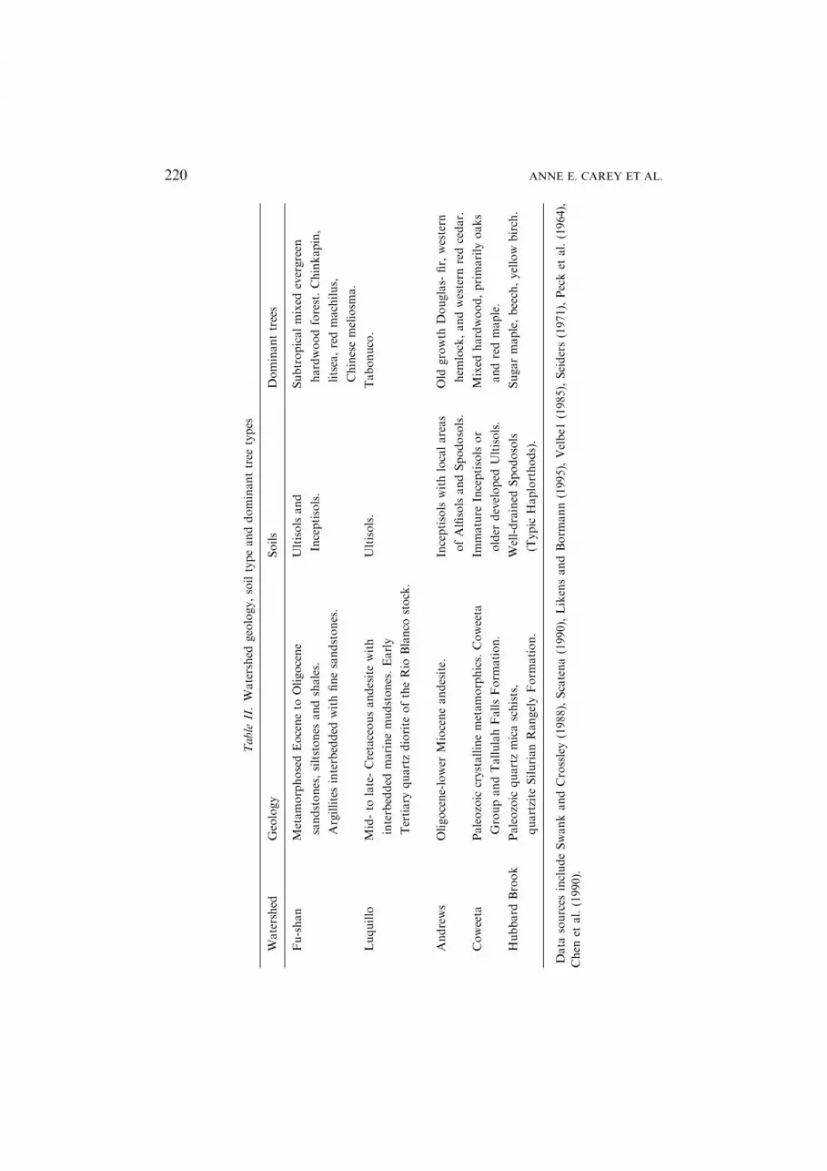
The Coweeta LTER lies in the Appalachian Blue Ridge province. Wa-tershed 2, Shope Branch, is forested with mixed hardwoods (Table II) and
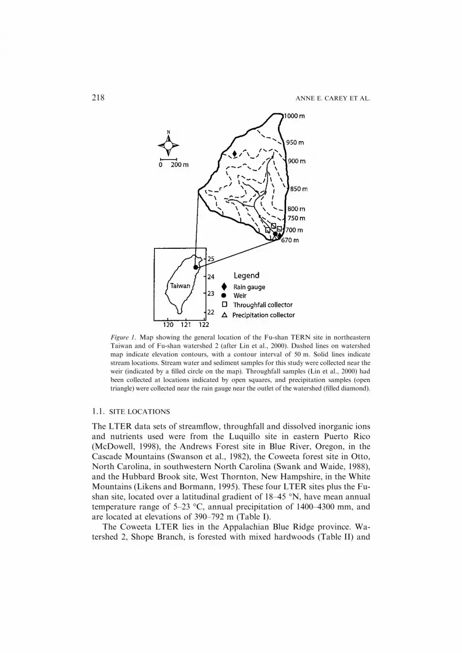
Figure 1. Map showing the general location of the Fu-shan TERN site in northeastern
Taiwan and of Fu-shan watershed 2 (after Lin et al., 2000). Dashed lines on watershed
map indicate elevation contours, with a contour interval of 50 m. Solid lines indicate
stream locations. Stream water and sediment samples for this study were collected near the
weir (indicated by a filled circle on the map). Throughfall samples (Lin et al., 2000) had
been collected at locations indicated by open squares, and precipitation samples (open
triangle) were collected near the rain gauge near the outlet of the watershed (filled diamond).
218 ANNE E. CAREY ET AL.

Table
I.Watershed
environmentaldata
Watershed
Tem
perature,
�CPrecipitation
Topography
Name
Location
Watersheds
studied
Annual
mean
January
mean
July
mean
Annual
mean,mm
Minim
um
elevation,m
Maxim
um
elevation,m
Studysite
elevation,m
Aspect
Fu-shana
NortheasternTaiwan
24�46
¢N,121�43
¢E1,2
18.2
11.8
24.1
4290
670
1100
700
SE
Luquillo
bEasternPuerto
Rico
18�15
¢N,65
�50
¢WQuebrada
Sonadora
21
25
3500
100
1079
390
NW
Andrewsc
Western
Cascades,
Oregon
44�15
¢N,122�20
¢W
10
8.5
118
2300
410
1630
450–650
SW
Coweeta
dSouthernAppalachians,
NorthCarolina
35�03
¢N,83
�25
¢W
213
1780
679
1592
709
SSE
Hubbard
Brooke
WhiteMountains,
New
Hampshire
43�56
¢N,71
�45
¢W
1,3,5,6
)9
19
1400
222
1015
488–792
S
Sources
ofdata.
aLin
etal.(2000).
bMcD
owell(1998).
cSwansonet
al.(1982),Edmonds(1982).
dSwankandCrossley(1988),Swiftet
al.(1988).
eLikensandBorm
ann(1995).
WEATHERING RATES TO ECOSYSTEM DEVELOPMENT 219
Table
II.Watershed
geology,soiltypeanddominanttree
types
Watershed
Geology
Soils
Dominanttrees
Fu-shan
MetamorphosedEoceneto
Oligocene
sandstones,siltstones
andshales.
Argillitesinterbedded
withfinesandstones.
Ultisolsand
Inceptisols.
Subtropicalmixed
evergreen
hardwoodforest.Chinkapin,
litsea,redmachilus,
Chinesemeliosm
a.
Luquillo
Mid-to
late-Cretaceousandesitewith
interbedded
marinemudstones.Early
Tertiary
quartzdiorite
oftheRio
Blanco
stock.
Ultisols.
Tabonuco.
Andrews
Oligocene-lower
Mioceneandesite.
Inceptisolswithlocalareas
ofAlfisolsandSpodosols.
Old
growth
Douglas-
fir,western
hem
lock,andwestern
redcedar.
Coweeta
Paleozoic
crystallinemetamorphics.Coweeta
GroupandTallulahFallsForm
ation.
Immature
Inceptisolsor
older
developed
Ultisols.
Mixed
hardwood,primarily
oaks
andredmaple.
Hubbard
Brook
Paleozoic
quartzmicaschists,
quartzite
SilurianRangelyForm
ation.
Well-drained
Spodosols
(Typic
Haplorthods).
Sugarmaple,beech,yellow
birch.
Data
sources
includeSwankandCrossley(1988),Scatena(1990),LikensandBorm
ann(1995),Velbe1
(1985),Seiders(1971),Pecket
al.(1964),
Chen
etal.(1990).
220 ANNE E. CAREY ET AL.

was undisturbed from 1927 through the period of data collection(1973–1983). The watershed has an area of 12 ha and has a maximum ele-vation of 1004 m. Andrews LTER Watershed 10 has an area of 10.2 ha witha maximum elevation of 650 m, and lies in an old growth (450 years old)Douglas fir forest in western Oregon (Table II). The Luquillo LTER site islocated in a Tabonuco (Dacryodes excelsa) forest, which had been loggedbetween 1860 and 1940 (Scatena, 1990) and made part of the NationalForest system in c. 1930. A water quality study (McDowell, 1998) wasconducted in a 0.0625 ha plot at 390 m elevation within the Quebrada To-ronja watershed. Stream discharge data were from the USGS gauging sta-tion at 267 m elevation. The Hubbard Brook LTER untreated watersheds(watersheds 1, 3, 5, 6) from which data are drawn for this comparison, arelocated in the White Mountains of New Hampshire. These Hubbard Brookwatersheds range in size from 11.8 to 42.4 ha, and are all SE or SW facing,with elevations ranging between 488 and 792 m. Hubbard Brook’s forestconsists primarily of mixed deciduous trees (Table II) but includes someconiferous trees (Tsuga canadensis and Picea rubens) on the north-facingslopes or ridge tops (Likens and Bormann, 1995). The Fu-shan Forest Sitewithin the Ha-pen Nature Preserve has a moist subtropical mixed evergreenand hardwood forest (Table II) within two small watersheds of 94 and37 ha, each gauged with a weir.
The geological characteristics of these five sites vary greatly. The Coweetaand Hubbard Brook watersheds are underlain by Paleozoic rocks (i.e.,286–570 million years ago). The Hubbard Brook watersheds are covered withlocally-derived glacial till which is underlain by sillimanite-grade metasedi-mentary rocks, primarily quartz-mica schists and quartzites (Likens and Bor-mann, 1995). The Silurian age (417–443 mya) rocks have been intruded byLower Devonian age (385–417 mya) granodiorite, Devonian (354–417 mya)tonalite and granite, and Cretaceous-Jurassic (65–206 mya) mafic dikes. Sur-face exposures at Hubbard Brook include weakly layered and coarse-grainedschists. At Coweeta, watershed 2 lies within the Tallulah Falls Formationwhich consists of metamorphic rocks, including metagreywackes, schists andmetavolcanic rocks derived mainly from sedimentary rocks (Velbel, 1985).Major minerals include quartz, micas, plagioclase feldspar and garnet. Theserocks were metamorphosed during the Ordovician period (�443–491 mya).These two sites represent ancientmountain chains that are presently associatedwith passive (i.e. little to no tectonic activity) portions of crustal plates. TheHubbard Brook landscape was glaciated as recently as 15, 000 years ago.
Both Luquillo and Andrews watersheds are hosted in andesitic volcanicrocks. Luquillo’s andesites are Mid- to Late-Cretaceous (�74–83 mya) inage, and have some interbedded marine mudstones (Seiders, 1971). TheTertiary volcanic rocks at Andrews are pyroxene andesite with some basaltsand dacites, all of middle to late Miocene age (5.3–10 mya) Sardine
WEATHERING RATES TO ECOSYSTEM DEVELOPMENT 221

Formation (Peck et al., 1964). The Sardine Formation consists of 50–90%flows and the remainder is flow breccia, tuff-breccia, lapilli tuff, tuff andconglomerate (Peck et al., 1964). Fu-shan bedrock is Eocene (34–55 mya) toOligocene (24–34 mya) metamorphosed marine sediments that include bothmetasandstones and mudstones.
The Fu-shan site lies in the Snow Mountain Range of northeastern Tai-wan. The watersheds lie in Tertiary age metamorphosed marine sedimentsand are primary Cenozoic cover of an accretionary wedge derived fromcontinental crustal materials (Chen et al., 1990). Taiwan is an active tectonicregion with uplift related to the oblique collision between a portion of thePhilippine Sea plate and the Asian continent (Teng, 1990).
In addition to the differences in rock type and ages, these sites vary dra-matically in their geologic province. The Luquillo, Andrews and Fu-shansites are all associated with geological areas where tectonism and volcanismare active today. The uplift and/or exhumation rates in the Central Range ofTaiwan from 1.5 to 10 mm yr)1, with values of approximately 6 mm yr)1 inthe Fu-shan region (Dadson et al., 2003). In the Luquillo Mountains, rates ofuplift as high as 0.6 mm yr)1 are observed with the average rate being0.04 mm yr)1 (Scatena, 1995). In the southern Cascade Mountains, the upliftrate is minimal, with basaltic volcanism the primary process that has led totopographic maintenance with progressive volcanic accumulation over thepast tens of millions of years (Hammond, 1979; Kohn et a1., 2002). Therelative uplift rate due to this volcanism approaches 1 mm yr)1 (Mitchellet a1., 1994). In all three of these sites, mass wasting via landsliding is a mostimportant process (Swanson et a1., 1982; Larsen, 1991; Hovius et a1., 2000).In the Luquillo Mountains, the turnover of soil due to landslides ranges froma few thousand to 25, 000 years (Scatena, 1995). Landslides are thought to bea major contributor of soil material into the streams, but rainfall amount andduration and the rock type all exert important influences on the frequency oflandslides (Swanson and Dyrness, 1975; Hovius et a1., 2000; Larsen andStallard, 2000).
2. Methods
Samples at Fu-shan watersheds 1 and 2 (Figure 1) were collected by hand inJanuary 2000 in polyethylene bottles which had been previously cleaned bysoaking for 7 days in deionized (18 MW) water, rinsed five times in deionizedwater, and stored full of deionized water. The bottles were emptied imme-diately before use, and were rinsed three times with stream water beforefilling completely with stream water, capped, and placed into plastic bags fortransport back to the laboratory (Welch et al., 1996). Immediately aftercollection, pH and temperature were measured, on a separate aliquot, in thefield using a field portable pH meter with a Ross combination electrode.
222 ANNE E. CAREY ET AL.

Samples were stored in the dark until filtering. Samples were filtered through0.4 lm pore-size polycarbonate filters (Nuclepore�) using polycarbonate belljars and dedicated polyetherimide filter funnels so that samples could befiltered directly into sample bottles which had been cleaned as describedabove or into bottles which had been soaked for 24 h in 10% HNO3 (forsamples for cation analysis) and then rinsed as described above. Samples forcation analysis were acidified to pH 2 using trace-metal grade concentratedHNO3. All samples were refrigerated in the dark until analysis by ionchromatography for major anions (F), Cl), SO2�
4 ) nutrients (NO�3 ) andmajor cations (Welch et al., 1996) or molybdate blue colorimetry for reactivesilicate (Mullin and Riley, 1955). Alkalinity was calculated by differenceusing the major ion data. Precision of the major ion data from ion chro-matography is sufficiently high that alkalinity determined by differenceagreed within a few percent of titrated alkalinities (Lyons et al., 1992). Minorelement analyses were performed on acidified samples using a Perkin ElmerElan 6000 inductivtively coupled plasma mass spectrometer (ICP-MS). Theprecision of these data was better than ± 10%. In addition to the solute datafor the Fu-shan streams, stream sediment was collected and analyzed.Analyses of the stream sediments was performed by XRAL laboratories inDon Mills, Ontario, Canada. Samples were first fused and then acid digested,with major elements and a portion of the minor elements analyzed by ICPand the rare earth elements (REEs) analyzed by ICP-MS. Precision of themajor element data was ± 11% or better, depending upon the element, whilethe precision of the minor element analyses was always better than ± 18%.
3. Results
The two Fu-shan watersheds had major ion concentrations (Table III) typ-ical of precipitation-dominated streams (Gibbs, 1970). The chloride con-centrations of 62 and 57 lmoles l)1 were similar to other Taiwan streamssampled (Carey and Lyons, unpublished data) but other anions were muchlower in the Fu-shan streams compared to other Taiwan streams. For thenine Taiwan streams sampled, the average chloride concentration was66 lmoles l)1 and average sulfate concentration was 620 lmoles l)1. Incontrast, sulfate concentrations in Fu-shan watershed 1 were 32 lmoles l)1
and in watershed 2, 25 lmoles l)1, both at the low end of the range of sulfateconcentrations observed in the other Taiwan streams. The total cationiccharges of the Fu-shan watersheds were 150 leq l)1 at watershed 1 and130 leq l)1 at watershed 2. These total cation and low TDS values place thewatersheds into the region of Si-enriched waters draining igneous andmetamorphic rocks, in the classification scheme of Stallard and Edmond(1983) and into the region between precipitation-controlled and rock-domi-nated streams region of Gibbs (1970) classification.
WEATHERING RATES TO ECOSYSTEM DEVELOPMENT 223

3.1. SOLUTE CHEMICAL WEATHERING YIELDS
The Fu-shan stream and sediment data normalized to upper continental crust(Figure 2) are presented in the manner of previous studies performed in muchlarger watersheds (Dupre et al., 1996; Gaillardet et al., 1997). We have usedthis convention in order to compare our data to those from these largerwatersheds. The elements are ordered along the x-axis from least to mostcompatible, or the order of magmatic compatibility, traditionally used bygeologists. This normalization helps to visualize the relative solubilization ofelements during the weathering process. The most soluble elements in thebedrock are rapidly lost and show depletion relative to the bedrock and thesediments, but enrichments in the stream water (Dupre et al., 1996). At Fu-shan, these include K, Sr, Na, Ca and in the case of the sediments, Ba.Normalized values close to unity for the sediments suggest little to no lossduring the weathering and erosional processes, or little to no chemicalfractionation between the sediments and the bedrock (Dupre et al., 1996).The primary reason for this lack of chemical fractionation is the lack ofstorage of these sediments within the watershed (Carey et al., in press). Thehigh uplift rates and the high frequency of severe storm events lead to veryhigh denudation rates and relatively short residence times of these particleseither in the soil zone or in the floor plains of the streams and rivers (Mil-liman and Syvitski, 1992). During high flow events the entire stream system,
Table III. Major ion and Si concentrations from Fu-shan watershed samples collected for this
study
Analyte Fu-shan watershed 1 Fu-shan watershed 2
Fluoride 0.0053 0.0051
Chloride 0.062 0.057
Bromide <0.0009 <0.0009
Nitrate-N 0.020 0.015
Phosphate <0.0004 <0.0004
Sulfate 0.032 0.025
Lithium <0.0006 <0.0006
Sodium 0.128 0.113
Potassium 0.005 0.0045
Magnesium 0.034 0.031
Calcium 0.075 0.066
Silica 0.183 0.179
pH 7.2 7.5
Alkalinity 0.198 0.184
All concentrations are in mmoles l)1 except for pH which is in standard pH units and alkalinity
which is in meq l)1.
224 ANNE E. CAREY ET AL.

floodplain and channel are flooded and sediment is transported (Kao andLiu, 1996). Ca2+ is the most depleted element in the sediments and the datasuggest that Ca2+ is rapidly solubilized in the Fu-shan system, even thoughthe residence times of the soils and sediments are short. Rapid loss of Ca2+
has been observed in other rapidly uplifting metamorphic terrains as well,
Figure 2. (a) Elemental chemistry of Fu-shan fine-grained stream sediments concentra-
tions normalized to average continental crust values. Upper continental crust data from
Taylor and McLennan (1985). Elemental order from most incompatible to most com-
patible follows the convention of Dupre et al. (1996). (b) Elemental chemistry of Fu-shan
stream water dissolved concentrations normalized to average continental crust values.
Upper continental crust data from Taylor and McLennan (1985). Elemental order uses the
convention of Dupre et al. (1996).
WEATHERING RATES TO ECOSYSTEM DEVELOPMENT 225

such as the Southern Alp of New Zealand (Jacobson and Blum, 2003). Thishas been attributed in part to the rapid dissolution of CaCO3 in these rocks(Jacobson and Blum, 2003; Lyons et al., in press).
Solute chemical weathering yields for all the watersheds are tabulated inTable IV. For those watersheds for which solute yields were not reported inthe literature, yields were calculated using published stream and throughfalldata or rainfall data where throughfall data were not available. Yields werecalculated by subtracting the throughfall concentrations from the streamconcentrations of the solutes considered (Si, total cations and HCO3
)),multiplying by the stream discharge and then dividing by the watershed area.Si weathering yields in the LTER watersheds ranged from a low value of630 moles ha)1 yr)1 at Hubbard Brook (average from four watersheds) to ahigh value of 5300 moles ha)1 yr)1 at Luquillo (Table IV). The Fu-shanshort-term values of 7700–7800 moles ha)1 yr)1 were higher than any of thefour LTER sites (Table IV).
The reported data from Fu-shan were single grab samples, but other,longer-term studies at these two watersheds show little variability in the Siconcentrations over a period of one year during a variety of hydrologicconditions, including several samples collected during typhoon conditions inlate spring (Owen and Carey, unpublished data). During that year, a series of32 stream samples (from both watersheds) had a mean reactive Si concen-tration of 204 lmoles l)1 and a range 128–252 lmoles l)1. Our values fromthe two Fu-shan streams (i.e., 179 and 183) seem representative of the longer-term conditions. Unfortunately, there are no other solute data available withwhich to compare the representativeness of our data.
Cation weathering yields (STz+) determined from the published data were
lowest at the Coweeta site, at 920 eq ha)1 yr)1. Cation yields were onlyslightly higher at Hubbard Brook, at 1050 eq ha)1 yr)1. The highest cation
Table IV. Solute weathering yields calculated from stream chemistry determined for this study
or from published data from LTER sites
Watershed H4SiO4 weathering
yield (mol ha)1 yr)1)
Cation weathering
yield (eq ha)1 yr)1)
HCO3)weathering
yield (eq ha)1 yr)1)
Reference
Fu-shan 7667–7836 6517–8117 4856–5457 This work
Luquillo 5316 8461 7707 McDowell (1998)
Andrews 3250 4598 – Swanson et a1.
(1982)
Coweeta 1357 922 747 Swank and
Waide (1988)
Hubbard
Brook
627 1049 126 Likens and
Bormann (1995)
226 ANNE E. CAREY ET AL.

weathering yields were at Luquillo, at 8500 eq ha)1 yr)1. Yields at Fu-shanwere close to that, at 6500–8100 eq ha)1 yr)1.
Our calculated Si and STþz yields for Coweeta are similar to those previ-ously reported by others (Swank and Waide, 1988; White and Blum, 1995).Previous work at Luquillo has involved the chemical yield of the Rio Icacoswatershed, which is underlain by quartz diorite bedrock (McDowell and As-bury, 1994; White et al., 1998). Si and STþz yields for this watershed are8066 moles ha)1 yr)1 and 10, 820 eq ha)1 yr)1, respectively (White and Blum,1995). This is the fastest documented chemical denudation rate of silicate richrocks on Earth (White et al., 1998). The Andrews, Fu-shan and Luquillo Siyields are within the range determined in previous studies in mountainousregions of the Pacific Northwest of 1800–11, 500 moles ha)1 yr)1 (Dethier,1986; Anderson et al., 2002).
Bicarbonate weathering yields at the four LTER sites ranged from a lowof 126 eq ha)1 yr)1 at Hubbard Brook to a high value of 7707 eq ha)1 yr)1
at Luquillo (Table V). Bicarbonate weathering yields at Fu-shan were4856–5457 eq ha)1 yr)1. Because of acid precipitation at both the HubbardBrook and Coweeta sites, it has been thought that there is a depletion ofalkaline metals such as Ca2+ in these soils (Huntington, 2000; Driscoll et al.,2001). More recent research suggests that acid rain may not be the dominantinfluence affecting changes in Ca2+ cycling (Hamburg et al., 2003). Theseauthors argue that forest age plays a more important role than acid precip-itation, and that the bioavailable Ca2+ is maintained even in the most matureforests. The throughfall fluxes of NO�3 and SO2�
4 at Fu-shan are also veryhigh, but much of the acid in the precipitation is neutralized while passingthrough the forest canopy (Lin et al., 2000) and in the soils.
Regression analysis of solute yield as a function of environmental vari-ables such as precipitation, average annual temperature and elevation andgradient were performed to evaluate the relative importance of these vari-ables on chemical weathering and solute yield. The solute yields show strongcorrelation with the average annual precipitation (Figure 3). Of all rela-tionships analyzed, the strongest correlation observed was that of H4SiO4
yield with precipitation, with R2 ¼ 0.989. Cation and bicarbonate weatheringyields also show strong relationships with the average annual precipitation,but with lesser correlation coefficients. The correlation for cation weatheringyield with precipitation had R2 ¼ 0.764. For bicarbonate weathering yield,the relationship, using four of the watersheds (no bicarbonate data wereavailable for Andrews) had R2 ¼ 0.71 (Figure 3).
Mixed relationships were observed between temperature and solute yield(Figure 4). Cation and HCO�3 yields show stronger relationships with tem-perature than does H4SiO4 yield. The HCO�3 yield showed a strong corre-lation with average annual temperature, with R2 ¼ 0.87. The cation yieldshowed a moderate correlation with temperature, with an R2 ¼ 0.65. Of the
WEATHERING RATES TO ECOSYSTEM DEVELOPMENT 227

Figure 3. Calculated solute yields for the 4 LTER sites (Andrews, Coweeta, Hubbard
Brook and Luquillo) and the Fu-shan forest site plotted as a function of mean annual
precipitation at each site. Also shown are the calculated linear regression lines and cor-
relation coefficients. (a) Calculated silica weathering yields determined from long-term
stream monitoring data for the 4 LTER sites (Andrews, Coweeta, Hubbard Brook and
Luquillo) and the Fu-shan forest site plotted as a function of mean annual precipitation at
each site. (b) Calculated Scation weathering yields determined from long-term stream
monitoring data for the 4 LTER sites (Andrews, Coweeta, Hubbard Brook and Luquillo)
and the Fu-shan forest site as a function of the mean annual precipitation at each site. (c)
Calculated bicarbonate weathering yields determined from long-term stream monitoring
data for 3 LTER sites (Coweeta, Hubbard Brook and Luquillo) and the Fu-shan forest site
as a function of the average annual precipitation at each site. No bicarbonate data were
available for the Andrews Forest site.
228 ANNE E. CAREY ET AL.

Figure 4. Calculated solute yields as a function of mean annual temperature. Also
shown are the calculated linear regression lines and correlation coefficients. (a) Cal-
culated silica weathering yields determined from long-term stream monitoring data for
the 4 LTER sites (Andrews, Coweeta, Hubbard Brook and Luquillo) and the Fu-shan
forest site as a function of mean annual temperature. (b) Calculated Scation weath-
ering yields determined from long-term stream monitoring data for the 4 LTER sites
(Andrews, Coweeta, Hubbard Brook and Luquillo) and the Fu-shan forest site as a
function of the mean annual temperature. (c) Calculated bicarbonate weathering yields
determined from long-term stream monitoring data for 3 LTER sites (Coweeta,
Hubbard Brook and Luquillo) and the Fu-shan forest site as a function of the
average annual temperature. No bicarbonate data were available for the Andrews
Forest site.
WEATHERING RATES TO ECOSYSTEM DEVELOPMENT 229

solutes, H4SiO4 yield had the lowest correlation with temperature, withR2 ¼ 0.58.
3.2. INFLUENCE OF UPLIFT RATES AND ROCK TYPE
As a landscape is uplifted, the potential for physical erosion through masswasting or gully erosion increases due to increases in slope and gradient. Thisincrease in physical erosion has a great impact on the rate of chemical ero-sion. The interplay between physical weathering and subsequent erosion andchemical weathering has important implications in relation to the geo-chemical fluxes from a landscape over time. This interplay is clearly a com-plex one, in which climate, tectonics, landscape disturbance, vegetation androck type all play a role. In environments such as Fu-shan, where uplift ratesare high and abundant rainfall occurs, the chemical weathering rates arehigh, yet the sediment particles retain a chemistry that more closely resemblesthe bedrock than in watersheds where soil and sediment residence times arelong (Dupre et al., 1996). The vast amount of physical weathering occurring,producing extremely high sediment yields, masks the high rates of chemicalweathering, if just the particles are analyzed. The rapid flux of sediments andthe loss of soil limit the extent to which particles undergo chemical weath-ering. Our work in other tectonically similar regimes supports the notion thatrapid physical weathering and erosion rates are associated with high, abso-lute rates of chemical weathering, but are a small proportion of the overallweathering (Lyons et al., in press). In other tectonically similar regions wehave studied, physical weathering dominates the total mass lost, constituting‡ 95% of the total mass loss (Lyons et al., in press). The rapid transport ofparticles limits the depth of the soil zone and enhances continued nutrientflux as fresh bedrock is exposed and chemically weathered. Thus, these high-relief areas are very different from Hawaii, for example, where deeper soilhorizons develop and hence limit the exposure of fresh bedrock (e.g.,Chadwick et al., 2003).
The Luquillo, Andrews and Fu-shan locations have high chemical yieldsin part because the high uplift rates allow the continuous exposure of freshmineral surfaces to weather. The Coweeta and the Hubbard Brook sitesclearly represent older mountainous regions with substantial topography.However, their older rocks, and a lack of resetting due to no uplift presently,limit the production of soluble weathering products, especially when com-pared to the other three sites.
The Si yields from Luquillo, Andrews and Fu-shan are similar to those wecalculated for regimes from New Zealand where uplift rates range from 0.5 to1 cm yr)l (Lyons et al., in press). Both Coweeta and Fu-shan have high Si:cation (or STz
+) ratios, of 1.5–2.0, but the other three sites have ratios <1.0.Higher ratios are indicative of more intensive chemical weathering (Huh and
230 ANNE E. CAREY ET AL.

Edmond, 1999). This is the case at Coweeta, where the weathering of pla-gioclase feldspar to saprolites of gibbsite and kaolinite (these minerals areweathering products enriched in aluminum, compared to primary minerals)has been interpreted previously to be due to the intensity of the weatheringthere (Velbel, 1985). The Fu-shan case is different in that the rocks undergoingweathering there are metamorphosed marine sediments which had undergonea previous chemical weathering event prior to the present one. Because ofthis, the material undergoing weathering has already been depleted in cations(Carey et al., in press). The Luquillo and Andrews sites have the lowestSi:STz
+ ratios indicating that more incomplete weathering, or what has beentermed surficial weathering, is occurring, with a portion of the primarymineral cations being substituted into cation-rich clay minerals or beingtransported in partially weathered rock debris as sediment. The STz
+ yieldsfor Luquillo and Andrews were 23% and 41% lower than those determinedby Horton et al. (1999) for andesitic volcanic terrain in the Yellowstoneregion of southwestern Montana. Hubbard Brook has both the lowest cationand Si yields with a ratio of �1. The STz
+ yields at Hubbard Brook aresimilar to the average long-term weathering rates in other locations withcrystalline rocks in the forested northeastern U.S. and the STz
+ yields atCoweeta are similar to areas in the northeastern U.S. where current weath-ering rates are influenced by acid rain (April et al., 1986; Stauffer andWittchen, 1991).
3.3. CHEMICAL WEATHERING AND P YIELDS AT FU-SHAN
The importance of P in maintaining terrestrial ecosystem regulation and Pavailability changing through geologic time have been significant topics inboth the soil and the ecological literature (e.g., Walker and Syers, 1976;Chadwick et al., 1999). We have determined, via XRF measurements, thetotal P concentration in Fu-shan sediments to be 13 lmoles g)1. We haveestimated the P production due to chemical weathering by comparing theSTþz yield to the STþz concentration in the stream sediments and assuming asimilar ratio of soluble P production to that of P in the sediments. Thiscalculation indicates that the soluble P production via chemical weathering is�200 moles ha)1 yr)1. The stream fluxes at Fu-shan, on the other hand, areonly £17 moles ha)1 yr)1. These data clearly demonstrate that £ 9% of the Psolubilized via chemical weathering is transported from the watershed. This isnot surprising, as the majority of the soluble P produced on an annual basis iseither utilized biologically or fixed into secondary mineral phases. Forexample, at Hubbard Brook, the vegetative uptake of P is �445 times thestream output (Likens and Bormann, 1995).
The throughfall input of atmospherically-derived fixed N in the Fu-shanwatershed is �1200 moles ha)1 yr)1 (Lin et al., 2000). The N:P input to the
WEATHERING RATES TO ECOSYSTEM DEVELOPMENT 231

watershed is �6:1, thus maintaining the ecosystem in a probable state of Ndeficiency as predicted by the Vitousek et al. (1997) model for systems inearly stages of development. Unlike Hawaii, however, continued tectonicuplift through time at Fu-shan will continue to supply P by the chemicalweathering of fresh bedrock. This geologically long-term supply of P shouldmaintain the current nutrient state (i.e., N deficiency) as long as the currentuplift rates are maintained. Thus, in areas such as Fu-shan where enhancedatmospheric deposition of N occurs due to anthropogenic activity (Lin et al.,2000), the continual production of P via geologic processes may not lead toenhanced biological P limitation, as occurs in other, non-tectonically activeregions. Clearly, further work is needed on P dynamics in these geologicallyactive areas such as Taiwan, because the importance of tectonic uplift onterrestrial ecosystems nutrient systematics has not been previously investi-gated.
In Hawaii, most of the base cations in the basalts have been weatheredaway after only 20,000 years (Kennedy et al., 1998). In a wide variety oflandscape types, Filippelli and Souch (1999) demonstrated that P is miner-alized to more bioavailable forms from bedrock within 3000–5000 years. Therate of P release decreases dramatically with landscape age, although glacialresetting, or the input of fresh geologic materials from which P can be lib-erated, does occur. This is observed in lake sediments on the AppalachianPlateau, with rapid pulses of P input during periods of soil development(Filippelli and Souch, 1999). However, by 10,000 years ago, the P flux haddecreased at these locations by �90%. Similar P dynamics probably occurredat the Hubbard Brook and Coweeta sites.
At the Kokwaskey lake site in the Coast Mountains British Columbia,however, the P flux via chemical weathering stayed relatively high until a fewthousand years ago due to the continued introduction of fresh bedrock fromtectonic uplifting and minimal soil development (Filippelli and Souch, 1999).These authors argue that at this site the terrestrial P cycle is stuck in an initialdevelopment stage, marked by high P release rates. This also appears to bethe case for the Fu-shan location, where extremely high uplift and denuda-tion rates allow for enhanced P mobilization over perhaps millions of years,rather than the tens of thousands of years observed in Hawaii system(Vitousek et al., 1997). Thus, in the terms of Vitousek et al., systems likeTaiwan continue to be supplied new bioavailable P from the fresh rocksurfaces by means of the rapid uplift rates resulting from tectonic forcing.
3.4. DENUDATION RATES AND CHEMICAL WEATHERING
The denudation rate of landscapes, especially mechanical or physical denu-dation, has long been correlated with the elevation or landscape slope, evenon a continental scale (Garrels and Mackenzie, 1971). For the Fu-shan site, a
232 ANNE E. CAREY ET AL.

denudation rate of 6 mm yr)1 was determined from empirical measurementsof Dadson et al. (2003) for areas to the south of Fu-shan. Denudation ratesfor the Andrews site from Swanson and Dyrness (1975) and Swanson et al.(1982) are based on both landslide mass measurements (0.012–0.19 mm yr)1)and sediment yields (0.03 mm yr)1). The higher values for the Andrews siterepresents areas defined as unstable forest, which in part relates to bedrockvariability (Swanson and Dyrness, 1975). The values for Coweeta(0.01 mm yr)1) and Hubbard Brook (0.0006 mm yr)1) were calculated forthis study by using sediment yields (Swank and Waide, 1988) and a sediment/rock density of 2600 kg m)3. Denudation rates in the Luquillo region havebeen estimated by a variety of techniques and have a wide range. A rate of0.012 mm yr)1 was determined from landscape mass transport (Scatena,1995); 0.043 mm yr)1 was determined from cosmogenic dating of quartz influvial sediments (Scatena, 1995); 0.09 mm yr)1 from mass balance estimates(Brown et al., 1995); and 0.041 mm yr)1 from recent sediment yield values byTurner et al. (2003). These values are within the range determined mostrecently for the Rio Icacos watershed within the Luquillo (Riebe et al., 2003).For this discussion we shall use a rate of 0.04 mm yr)1 for Luquillo.
The relationship between denudation rates and chemical weatheringindices (Figure 5a) in general shows that the highest cation yields are asso-ciated with denudation rates greater than 0.02 mm yr)1, but, there is not astrong correlation between the two. The higher cation yields at Luquillo andAndrews, relative to their denudation rate, compared to Fu-shan, reflect theinfluence of bedrock lithology. As mentioned above, the Fu-shan metamor-phic rocks are recycled marine sediments, which have already undergone aprevious weathering event (Carey et al., in press). On the other hand, there isa better relationship between denudation and Si yield (Figure 5b). The verystrong relationship between denudation and Si yield (R2 ¼ 0.89) supports thenotion that chemical and physical weathering are closely linked (Lyons et al.,in press).
The lowest chemical weathering yields determined herein were from theCoweeta and Hubbard Brook watersheds which are hosted in Paleozoicrocks. In the broadest geologic sense, the age of the landscape can berelated to the extent of tectonic activity the landscape has undergone. TheCoweeta and Hubbard Brook sites are located in older mountain rangesthat have been extensively weathered and where tectonic activity hasessentially ceased. Taylor and Blum (1995) demonstrated a strong rela-tionship between long-term weathering rates of soil profiles in graniticglacial moraines and their age. The results herein imply that landscapesdecrease their weathering yields as they age, similar to the previously dis-cussed findings of Vitousek et al. (1997) and Filippelli and Souch (1999).The rate of the weathering loss is dependent on rock type and climaticconditions (Stallard, 1985, 1995).
WEATHERING RATES TO ECOSYSTEM DEVELOPMENT 233

4. Conclusions
Precipitation, temperature, and rock type/age are all important controls onweathering yields and terrestrial landscape and ecosystem development. Ofthe sites examined, climate, and more particularly, precipitation, is mostimportant in controlling chemical weathering and solute yields. Tectonicactivity leading to landscape uplift and topography development leads toenhanced physical weathering and rapid denudation of the landscape.Chemical weathering and denudation are closely linked, producing bothsoluble and particulate material, which can be rapidly exported from theterrestrial ecosystem into connected fluvial systems. However, in tectonicallyactive regions this material is quickly replaced by fresh bedrock. Ecosystemnutrients that are derived from bedrock weathering continue to be supplied at
Figure 5. (a) Watershed denudation rates determined from stream suspended sediment
yields or landslide mass measurements plotted vs. cation chemical weathering yields at all 4
LTER sites (Andrews, Coweeta, Hubbard Brook and Luquillo) and the Fu-shan site. (b).
Watershed denudation rates determined from stream suspended sediment yields or land-
slide mass measurements plotted vs. Si chemical weathering yields at all 4 LTER sites
(Andrews, Coweeta, Hubbard Brook and Luquillo) and the Fu-shan site.
234 ANNE E. CAREY ET AL.

a rapid rate, thereby exerting an important influence on ecosystem devel-opment and maintenance. The linkage between landscape type, in a geologicsense, and ecosystem health is therefore a fundamental one. As landscapesage and fresh geologic material is weathered without replacement via tec-tonics, volcanism, or glaciation, the base cation and phosphorus fluxes de-crease. Although this is an obvious consequence of long-term geologicevolution of a landscape, it has only been considered of importance in anecological sense since the work of Vitousek and his coworkers. The investi-gation of long-term ecological development tied to geologic change willcontinue to be a fundamental one to the growing field of biogeoscience.
Acknowledgements
We would like to thank the Fu-shan TERN and Fu-shan Research Center foraccess to the experimental watersheds there. We would also like to thankNational Taiwan University and Academia Sinica, Taiwan for their kind andgenerous hospitality during our visit to Taiwan. The United States LTERdata comparison was initiated as part of a U.S. LTER Network Cross-siteexercise supported by the LTER Network Office. We would like to thankC. J. Bowser, D. T. Long, G. L. Macpherson, and W. H. McDowell whosethoughtful discussions on weathering provided the inspiration for this study.We thank C. A. Nezat for help with sample analysis and C. B. Gardner forhelp with manuscript preparation. Partial funding for this study was pro-vided by NSF EAR-9725543.
References
Anderson S. P., Dietrich W. E. and Brimhall Jr. G. H. (2002) Weathering profiles, mass balance
analysis, and rates of solute loss: Linkages between weathering and erosion in a small, steep
catchment. GSA Bull. 114, 1143–1158.
April R., Newton R. and Coles L. T. (1986) Chemical weathering in two Adirondack watersheds:
Past and present-day rates. GSA Bull. 97, 1232–1238.
Brown E. T., Stallard R. F., Larsen M. C., Raisbeck G. M. and Yiou F. (1995) Denudation rates
determined from the accumulation of in situ-produced 10Be in the Luquillo Experimental
Forest, Puerto Rico. Earth Planet. Sci. Lett. 129, 193–202.
Carey A. E., Kao S.-J., Hicks D. M., Nezat C. A. and Lyons W. B. (2004) The geochemistry of
rivers in tectonically active areas of Taiwan and New Zealand. In: Tectonics, Climate and
Landscape Evolution (eds. S. Willet, N. Hovius, M. Brandon and D. Fisher), Geological
Society of America special papers in press.
Chadwick O. A., Derry L. A., Vitousek P. M., Huebert B. J. and Hedin L.O. (1999) Changing
sources of nutrients during four million years of ecosystem development. Nature 397,
491–496.
Chadwick O. A., Gavenda R. T., Kelly E. F., Ziegler K., Olson C. G., Elliot W. C. and
Hendricks D. M. (2003) The impact of climate on the biogeochemical functioning of volcanic
soils. Chem. Geol. 202, 195–223.
WEATHERING RATES TO ECOSYSTEM DEVELOPMENT 235

Chen C.-H., Jahn B.-M., Lee T., Chen C.-H. and Cornichet J. (1990) Sm-Nd isotopic geo-
chemistry of sediments from Taiwan and implication for the tectonic evolution of southeast
China. Chem. Geol. 88, 317–332.
Crews T. E., Kitayama K., Fownes J.H., Riley R.H., Herbert D. A., Mueller-Dombois D. and
Vitousek P. M. (1995) Changes in soil phosphorus fractions and ecosystem dynamics across a
long chronosequence in Hawaii. Ecology 76, 1407–1421.
Dadson S. J., Hovius N., Chen H., Dade W. B., Hsieh M -L., Willett S. D., Hu J -C., Horng
M. -J., Chen M. -C., Stark C. P., Lague D. and Lin J. -C. (2003) Links between erosion,
runoff variability and seismicity in the Taiwan orogen. Nature 426, 648–651.
Dethier D. P. (1986) Weathering rates and the chemical flux from catchments in the Pacific
Northwest, U.S.A. In: Rates of Chemical Weathering of Rock and Minerals (eds. S. M.
Colman and D. P. Dethier), pp. 503–530. Academic Press.
Driscoll C. T., Lawrence G. B., Bulger A. J., Butler T. J., Cronan C. S., Eagar C., Lambert K. F.,
Likens G. E., Stoddard J. L. and Weathers K. C. (2001) Acidic deposition in the northeastern
U.S.: Sources and inputs, ecosystems effects, and management strategies. BioScience 51,
180–198.
Dupre B., Gaillardet J., Rousseau D. and Allegre C. J. (1996) Major and trace elements of river-
borne material: The Congo Basin. Geochim. Cosmochim. Acta 60, 1301–1321.
Edmonds R.L. (1982) Introduction. In: Analysis of Coniferous Forest Ecosystems in the Western
United States (ed. R.L. Edmonds), US/IBP Synthesis series 14, pp. 1–27. Hutchinson Ross,
Stroudsburg, Penna.
Filippelli G. M. (1997) Intensification of the Asian monsoon and a chemical weathering event in
the late Miocene–early Pliocene: Implications for late Neogene climate change. Geology 25,
27–30.
Filippelli G. M. and Souch C. (1999) Effects of climate and landscape development on the
terrestrial phosphorus cycle. Geology 27, 171–174.
Gaillardet J., Dupre B., Allegre C. J. and Negrel P. (1997) Chemical and physical denudation in
the Amazon River Basin. Chem. Geol.142, 141–173.
Garrels R. M. and Mackenzie F. T. (1971) Evolution of Sedimentary Rocks. 397 pp. W. W.
Norton and Co., New York.
Gibbs R. J. (1970) Mechanisms controlling world water chemistry. Science 170, 1088–1090.
Gudding J. A. (2003) Phosphorus in Taylor Valley, Antarctica: The connection between land-
scape age and nutrient limitation in aquatic ecosystem components. M. S. Thesis, The Ohio
State University, 118 pp.
Hamburg S. P., Yanai, R. D., Arthur M. A., Blum J. D. and Siccama T. G. (2003) Biotic control
of calcium cycling in northern hardwood forests: Acid rain and aging forests. Ecosystems 6,
399–406.
Hammond P. E. (1979) A tectonic model for evolution of the Cascade Range. In: Cenozoic
Paleogeography of the Western United States (eds. J. M. Armentrout, M. R. Cole and
H. Terbest Jr.), Pacific Coast Paleogeography Symposium 3, pp. 219–237.
Horton T. W., Chamberlain C. P., Fantle M. and Blum J. D. (1999) Chemical weathering
and lithologic controls of water chemistry in a high-elevation river system: Clark’s
Fork of the Yellowstone River, Wyoming and Montana. Water Resour. Res. 35,
1643–1655.
Hotchkiss S., Vitousek P. M., Chadwick O. A. and Price J. (2000) Climate cycles, geomorpho-
logical change, and the interpretation of soil and ecosystem development. Ecosystems 3,
522–533.
Hovius N., Stark C. P., Chu H.-T. and Lin J.-C. (2000) Supply and removal of sediment in a
landslide-dominated mountain belt: Central Range, Taiwan. J. Geol. 108, 73–89.
236 ANNE E. CAREY ET AL.

Huh Y. and Edmond J. M. (1999) The fluvial geochemistry of the rivers of Eastern Siberia: III.
Tributaries of the Lena and Anabar draining the basement terrain of the Siberian Craton and
the Trans-Baikal Highlands. Geochim. Cosmochim. Acta 63, 967–987.
Huntington T. G. (2000) The potential for calcium depletion in forest ecosystems of Southeastern
United States; review and analysis. Global Biogeochem. Cycles 14, 623–638.
Jacobson A. D. and Blum J. D. (2003) Relationship between mechanical erosion and atmo-
spheric CO2 consumption in the New Zealand Southern Alps. Geology 31, 865–868. doi:
10.1130/G19662.1.
Kao S.-J. and Liu K.-K. (1996) Particulate organic carbon export from a subtropical moun-
tainous river in Taiwan. Limnol. Oceanogr. 41, 1749–1757.
Kennedy M. J., Chadwick O. A., Vitousek P. M., Derry L. A. and Hendricks D. M. (1998)
Changing sources of base cations during ecosystem development, Hawaiian Islands. Geology
26, 1015–1018.
Kohn M. J., Miselis J. L. and Fremd T. J (2002) Oxygen isotope evidence for progressive uplift of
the Cascade Range, Oregon. Earth Planet. Sci. Lett. 204, 151–165.
Larsen M. C. (1991) Mass movement disturbance and denudation in a humid-tropical montane
forest, Puerto Rico. Geol. Soc. Am. Programs Abstracts 23, 256.
Larsen M. C. and Stallard R. F. (2000) Luquillo Mountains, Puerto Rico: A Water, Energy, and
Biogeochemical Budgets Program Site. USGS Fact Sheet 163–99, 4 pp.
Likens G. E. and Bormann F. H. (1995) Biogeochemistry of a Forested Ecosystem, 2nd edn., 159
pp. Springer-Verlag, New York.
Lin T.-C., Hamburg S. P., King H.-B. and Hsia Y.-J. (2000) Throughfall patterns in a subtropical
rain forest of Northeastern Taiwan. J. Environ. Qual. 29, 1186–1193.
Lyons W. B., Carey A. E., Hicks D. M. and Nezat C.A. (2004) Chemical weathering in high
sediment yielding watersheds. J. Geophys. Res. Earth Surf., in press.
Lyons W. B., Lent R. M., Djukic N., Maletin S., Pujin V. and Carey A. E. (1992) Geochemistry
of surface waters of Vojvodina, Yugoslavia. J. Hydrol. 137, 33–55.
McDowell W. H. (1998) Internal nutrient fluxes in a Puerto Rican rain forest. J. Trop. Ecol. 14,
521–536.
McDowell W. H. and Asbury C. E. (1994) Export of carbon, nitrogen, and major ions from three
tropical montane watersheds. Limnol. Oceanogr. 39, 111–125.
Milliman J. D. and Syvitski J. P. M. (1992) Geomorphic/tectonic control of sediment discharge
to the ocean: The importance of small mountainous rivers. Jour. Geol. 100, 525–544.
Mitchell C. E., Vincent P., Weldon II R.J. and Richards M. A. (1994) Present-day vertical
deformation of the Cascadia margin, Pacific Northwest, United States. J. Geophys. Res. 99,
12257–12277.
Mullin J. B. and Riley J. P. (1955) The spectrophotometric determination of silicate–silicon in
natural waters with special reference to sea water. Anal. Chim. Acta 12, 162–170.
Peck D. L., Griggs A. B., Schlicker H. G., Wells F. G. and Dole H. M. (1964) Geology of the
central and northern parts of the western Cascade Range in Oregon. U. S. Geological Survey
Professional Paper 449, 56 pp.
Riebe C. S., Kirchner J. W. and Finkel R.C. (2003) Long-term rates of chemical weathering and
physical erosion from cosmogenic nuclides and geochemical mass balance. Geochim. Cos-
mochim. Acta 67, 4411–4427.
Scatena F. N. (1990) Watershed scale rainfall interception on two forested watersheds in the
Luquillo Mountains of Puerto Rico. J. Hydrol. 113, 89–102.
Scatena F. N. (1995) Relative scales of time and effectiveness of watershed processes in a tropical
montane rain forest of Puerto Rico. In: Natural and Anthropogenic Influences in Fluvial
Geomorphology; the Wolman Volume (eds. A. J. Miller, K. W. Potter and P. R Wilcock),
Geophys. Monogr. 89, 103–111.
WEATHERING RATES TO ECOSYSTEM DEVELOPMENT 237

Seiders V. M. (1971) Cretaceous and lower Tertiary stratigraphy of the Gurabo and E1 Yunque
quadrangles, Puerto Rico. In: Contributions to Stratigraphy (eds. G. V. Cohee, R. G. Bates
and W. B. Wright), U. S. Geological Survey Bulletin 1294-F.
Stallard R. F. (1985) River chemistry, geology, geomorphology, and soils in the Amazon and
Orinoco basins. In: The Chemistry of Weathering (ed. J. I. Drever), pp. 293–316, Reidel,
Dordrecht.
Stallard R. F. (1995) Tectonic, environmental and human aspects of weathering and erosion.
Ann. Rev. Earth Planet. Sci. 23, 11–39.
Stallard R. F. and Edmond J. M. (1983) Geochemistry of the Amazon 2. The influence of
geology and weathering environment on the dissolved load, J. Geophys. Res. 88,
9671–9688.
Stauffer R. E. and Wittchen B. D. (1991) Effects of silicate weathering on water chemistry in
forested, upland, felsic terrane of the USA. Geochim. Cosmochim. Acta 55, 3253–3271.
Stewart B. W., Capo R. C. and Chadwick O. A. (2001) Effects of rainfall on weathering rate, base
cation provenance, and Sr isotope composition of Hawaiian soils. Geochim. Cosmochim. Acta
65, 1087–1099.
Swank W. T. and Crossley, Jr. D. A. (1988) Introduction and site description. In: Forest
Hydrology and Ecology at Coweeta (eds. W. T. Swank and D. A. Crossley), Ecological Series
66, pp. 3–16. Springer–Verlag, New York.
Swank W. T. and Waide J. B. (1988) Characterization of baseline precipitation and stream
chemistry and nutrient budgets for control watersheds. In: Forest Hydrology and Ecology at
Coweeta (eds. W. T. Swank and D. A. Crossley, Jr.), Ecological Studies 66, pp. 57–79.
Springer-Verlag, New York.
Swanson F. J. and Dyrness C. T. (1975) Impact of clear-cutting and road construction on soil
erosion by landslides in the western Cascade Range, Oregon. Geology 3, 393–396.
Swanson F. J., Fredricksen R. L. and McCorison F. M. (1982) Material transfer in a western
Oregon forested watershed. In: Analysis of Coniferous Forest Ecosystems in the Western
United States (ed. R. L. Edmonds) US/IBP Synthesis Series, 14. Hutchinson Ross, Stro-
udsburg, Penna., pp. 233–266.
Swift Jr. L. W., Cunninghan G. B. and Douglass J. E. (1988) Climatology and hydrology. In:
Forest Hydrology and Ecology at Coweeta (eds. W. T. Swank and D. A. Crossley, Jr.),
Ecological Series 66, pp. 35–56. Springer-Verlag, New York.
Taylor A. and Blum J. D. (1995) Relation between soil age and silicate weathering rates
determined from the chemical evolution of a glacial chronosequence. Geology 23,
979–982.
Taylor S. R. and McLennan S. C. (1985) The Continental Crust: Its Composition and Evolution.
Blackwell Scientific, Oxford.
Teng L. S. (1990) Geotectonic evolution of late Cenozoic arc-continental collision in Taiwan.
Tectonophysics 183, 57–76.
Turner B. L, Chudek J. A., Whitton B. A. and Baxter R (2003) Phosphorus composition of
upland soils polluted by long-term atmospheric nitrogen deposition. Biogeochemistry 65,
259–274.
Velbel M. A. (1985) Geochemical mass balances and weathering rates in forested watersheds of
the southern Blue Ridge. Am. J. Sci. 285, 904–930.
Vitousek P. M., Chadwick O. A., Crews T. E., Fownes J. H., Hendricks D. M. and Herbert D.
(1997) Soil and ecosystem development across the Hawaiian Islands. GSA Today 7, 1–8.
Vitousek P. M. and Farrington H. (1997) Nutrient limitation and soil development: Experi-
mental test of a biogeochemical theory. Biogeochemistry 37, 63–75.
Walker T. M. and Syers J. K. (1976) The fate of phosphorus during pedogenesis. Geoderma 15,
1–19.
238 ANNE E. CAREY ET AL.

Welch K. A., Lyons W. B., Graham E., Neumann K., Thomas J. M. and Mikesell D. (1996) The
determination of major element chemistry in terrestrial waters from Antarctica using ion
chromatography. J. Chromatogr. A. 739, 257–263.
White A. F. and Blum A. E. (1995) Effects of climate on chemical weathering in watersheds.
Geochim. Cosmochim. Acta 59, 1729–1747.
White A. F., Blum A. E., Schulz M. S., Vivit D. V., Stonestrom D. A., Larsen M., Murphy S. F.
and Eberl D. (1998) Chemical weathering in a tropical watershed, Luquillo Mountains,
Puerto Rico: I. Long-term versus short-term weathering fluxes. Geochim. Cosmochim. Acta
62, 209–226.
WEATHERING RATES TO ECOSYSTEM DEVELOPMENT 239


