Embed Size (px)
Citation preview

Citation: Nagle-McNaughton, T.P.;
Scuderi, L.A.; Erickson, N. Squeezing
Data from a Rock: Machine Learning
for Martian Science. Geosciences 2022,
12, 248. https://doi.org/10.3390/
geosciences12060248
Academic Editors: Alberto G. Fairén
and Jesus Martinez-Frias
Received: 24 April 2022
Accepted: 6 June 2022
Published: 15 June 2022
Publisher’s Note: MDPI stays neutral
with regard to jurisdictional claims in
published maps and institutional affil-
iations.
Copyright: © 2022 by the authors.
Licensee MDPI, Basel, Switzerland.
This article is an open access article
distributed under the terms and
conditions of the Creative Commons
Attribution (CC BY) license (https://
creativecommons.org/licenses/by/
4.0/).
geosciences
Review
Squeezing Data from a Rock: Machine Learning for Martian ScienceTimothy Paul Nagle-McNaughton 1,* , Louis Anthony Scuderi 1 and Nicholas Erickson 2
1 Department of Earth and Planetary Science, The University of New Mexico, Albuquerque, NM 87131, USA;[email protected]
2 Cloud to Street, 147 Prince St., New York, NY 11201, USA; [email protected]* Correspondence: [email protected]
Abstract: Data analysis methods have scarcely kept pace with the rapid increase in Earth observations,spurring the development of novel algorithms, storage methods, and computational techniques. Forscientists interested in Mars, the problem is always the same: there is simultaneously never enoughof the right data and an overwhelming amount of data in total. Finding sufficient data needles in ahaystack to test a hypothesis requires hours of manual data screening, and more needles and hay areadded constantly. To date, the vast majority of Martian research has been focused on either one-offlocal/regional studies or on hugely time-consuming manual global studies. Machine learning in itsnumerous forms can be helpful for future such work. Machine learning has the potential to help mapand classify a large variety of both features and properties on the surface of Mars and to aid in theplanning and execution of future missions. Here, we outline the current extent of machine learningas applied to Mars, summarize why machine learning should be an important tool for planetarygeomorphology in particular, and suggest numerous research avenues and funding priorities forfuture efforts. We conclude that: (1) moving toward methods that require less human input (i.e., self-or semi-supervised) is an important paradigm shift for Martian applications, (2) new robust methodsusing generative adversarial networks to generate synthetic high-resolution digital terrain modelsrepresent an exciting new avenue for Martian geomorphologists, (3) more effort and money must bedirected toward developing standardized datasets and benchmark tests, and (4) the community needsa large-scale, generalized, and programmatically accessible geographic information system (GIS).
Keywords: Mars; machine learning; remote sensing; geomorphology; surface processes; planetaryscience
1. Introduction
The recent increase in the development and deployment of machine learning (ML) forEarth observation has led to a wealth of new data and insights about our planet. These MLmethods—enabled by more numerous and advanced satellites, increasingly sophisticateddetection algorithms, and faster computation resources—are required since the expansionof data collected on Earth has rapidly outpaced the speed of manual analysis. As more andmore data are collected, automation of time-consuming tasks by algorithms has becomemore important. Examples of these tasks include sensor calibration, image preprocessing,image segmentation, feature extraction, and classification of features and land cover.
Given the difficulty and expense of imaging Mars, there has not been the same influxof new instruments nor the return of data at rates and quantities equal to those from Earth-orbiting satellites. That said, there are currently more instruments collecting Martian datathan there have ever been in the past: of the 18 successful orbital missions around Mars,eight are currently active, and of the seven successful lander missions on Mars, three arestill active. Furthermore, there are already large archives of Martian imagery data availablein the National Aeronautics and Space Administration’s (NASA’s) Planetary Data System(PDS) [1,2] and the European Space Agency’s (ESA’s) Planetary Science Archive (PSA) [3,4].While the quantity of the data is smaller, the Mars science community is relatively small
Geosciences 2022, 12, 248. https://doi.org/10.3390/geosciences12060248 https://www.mdpi.com/journal/geosciences

Geosciences 2022, 12, 248 2 of 34
given the lack of corporate profit incentive to analyze Mars data, leading to an outpacingof manual analysis.
Several interesting and unique problems make the application of ML approaches toMartian data an area of potentially significant value. The autonomy of rovers on the Martiansurface has long been an area of great interest due to (1) the long time delay between signalsand instructions sent between Earth and Mars, (2) an asynchronistic overlap between theEarth and Mars days, and (3) the desire for rovers to make mission progress even whenthey are not executing specific instructions from Earth. In recent years, robotic autonomyhas progressed from overcoming driving navigation problems to including tasks such asselecting sample targets [5–7] and even guiding landers to safe landing areas [8–15]. Whileefficiently managing rover time is one area of focus, rover missions to Mars are expensiveand require years of planning, but can only study an infinitesimally small fraction of theMartian surface. With these inherent limitations, there is a strong incentive to both (1) usesatellite data to effectively identify locations of the greatest interest and suitability for arover mission, and (2) use remote sensing wherever possible to learn as much as possiblewithout the need for in situ rover observations [16,17]. Thus, the need to leverage thearchives of Martian observations is an increasingly important focus for Mars researchers,and planetary scientists more broadly: “Mars is a uniquely enabling study target forinvestigations of surface processes active on other planetary bodies—both for extendingterrestrial based process models and, in some areas, for serving as a superior comparativeplanetology basis over Earth” [16]. This is especially important given the range of majoroutstanding questions that ML could potentially help answer [18,19].
Scope and Audience
We do not intend this paper to be a review of methods currently employed in Earthobservation as there are already many excellent review papers that cover that topic [20–36].Similarly, rover navigation will not be our focus here as the topic has been covered else-where [37–54]. Instead, we aim to provide a novel summary of the state of ML for Marsobservation, and to help further Martian research by highlighting under-explored domains.To that end, we set out with four goals: (1) to help to connect the planetary science andML communities, (2) to collect and categorize the current state-of-the-art research methodsused in Martian studies, (3) to offer a perspective on the future of automated methods, and(4) to identify opportunities for further studies. Our intended audience is twofold: (1) plan-etary scientists seeking to explore how ML could improve their research, or make theirexperiments more efficient, and (2) ML experts who can help collect, organize, and analyzedata for Martian studies.
For the purposes of this paper, we use a broad definition of ML: a subdomain ofartificial intelligence in which algorithms self-optimize to improve their results. Whilethere are many further subdomains within the discipline, such as deep learning, activelearning, computer vision, and natural language processing, here, we will use the umbrellaterm ML to capture the full breadth of these approaches as applied to Mars research.
2. Machine Learning Studies on Mars
Generally, there are two methods for structuring a description of different types of ML:learning-focused frameworks that center on the functioning of the algorithm in question,or task-focused frameworks that focus on the algorithm’s product rather than its method.For this paper, we have opted to use the learning-focused framework, with subsections foreach type of task which contain research in that domain.
2.1. Supervised Learning
Supervised learning requires labeled data as both the input and target when fed intothe ML algorithm; algorithms are fit to these data, and a trained model predicts targetsfor unknown inputs [55–59]. The two most common applications of supervised learningare classification and regression problems. In classification problems, the input data are

Geosciences 2022, 12, 248 3 of 34
mapped onto pre-defined categories, while in regression problems, the input data aremapped to numerical outputs. For example, a supervised classification network could betrained on images of cats and dogs, with each of the images having a corresponding labelindicating whether the image contains a cat or a dog. The network could then be given anunlabeled image of a cat and—if trained well—identify that the image contains a cat. Incontrast, a supervised regression network could be trained on several years worth of dailyweather data. The model could then predict the temperature for any given day of the year.
2.1.1. ClassificationTransfer Learning
Transfer learning is a popular method for decreasing the time required to train a modelon a new set of data [60–64]. Transfer learning is simply the application of pre-learnedweights or filters to a new dataset. In essence, a model trained for one task is appliedto another, with the assumption that the two tasks are appropriately related. In imageclassification, this is intuitive: object recognition across domains typically requires patternextraction, edge detection, and other standard image-processing steps. A model trainedto recognize cats in images could quickly be adapted to recognize dogs without having toreset the model’s weights and begin training from scratch. Many complex models havebeen published that have been pre-trained on large datasets of text or images [65–73].These off-the-shelf models allow researchers to take advantage of the complexity anddepth of the models while reducing the time required to develop and train a model. Theapplication of transfer learning is limited in Martian research, but its use is highlighted inthe following sections.
Classification Applications on Mars
At present, supervised classification models are the most common ML applied to Mars.Classification assigns inputs to an output class, and many classification algorithms alsoinclude locators that allow the network to both classify the content of an image and locatethe extent of the target, either by drawing a bounding box, masking, or segmenting thetarget [67,74–76]. The development of feature-pyramid networks [66,77–81] has been verypowerful as they allow networks to be scale-invariant; the network can recognize an objectsuch as a basketball whether it fills 90% of an image or just 5%. These network featuresare especially useful for Martian studies since many targets of interest are spatially distantfrom each other, and manually locating them is very labor-intensive.
By far the most common application of any ML method to Mars has been to segmentand count craters on the surface. Crater counting is a well-established method for estimatingthe age of planetary surfaces [82–87], first applied to the Moon, and in more recent years, toMars. There are many studies devoted to crater counting on Mars [88–105]. These paperscan be divided in two ways: by the minimum crater detection size, or by the methodologyused to extract craters. The most common datasets used in these crater counting studiesare global in coverage and relatively coarse in resolution. Crater counting requires botha significant number of craters across a range of diameters and a representative sampleof the surface, which explains why the existing emphasis has been on global datasets.Furthermore, smaller craters (up to 100 m in diameter) are less indicative of the age of thesurface than larger craters, while simultaneously being more difficult to differentiate fromsecondary craters caused by a larger primary impact [86,106–108]. In some recent work,efforts have even been made to classify craters as “preexisting” or “new,” to identify cratersthat have formed in the last ~15 years [105].
The Mars Odyssey Thermal Emission Imaging System (THEMIS) daytime infrared(DIR) dataset, with a resolution of ~100 m per pixel [109], is the most comprehensive andcommonly used imagery dataset [91–93,96,98], while the Mars Global Surveyor Mars Or-biter Laser Altimeter (MOLA) [110], with a resolution of 463 m/pixel, is the most commonlyused digital terrain model (DTM) dataset [94,95,111,112]. Recently, data from MOLA andthe Mars Express High-Resolution Stereo Camera (HRSC) have been blended to create a
Geosciences 2022, 12, 248 4 of 34
global DTM at a ~200 m/pixel resolution [113], which has begun to be used in studies [89].Other recent work has explored the potential for using even higher-resolution data fromthe Mars Reconnaissance Orbiter (MRO) High Resolution Imaging Science Experiment(HiRISE) (~0.5 m/pixel) or Context Camera (CTX) sensors (~6 m/pixels) [101], with transferlearning to adapt pretrained crater locators to new datasets. The two most common meth-ods for extracting craters can be simplified into: (1) looking for the characteristic circularcrater patterns in imagery and fitting a diameter to each crater, or (2) using elevation datato look for circular depressions and fitting a diameter to each crater. Both methods haveproved successful, helping to constrain the ages of large-scale Martian provinces.
The next most frequently used application of ML for Mars is segmenting features inMars rover imagery. Many studies focus on segmenting or classifying rocks and surfacesnominally, which works toward the goal of optimizing traversability [114–122], whileothers further group terrain classes as safe or unsafe for rovers [123]. Beyond this, work hasfocused on segmenting dust storms using MOC imagery and neural networks [124,125].Some studies have extracted volcanic features using elevation data [126] or HiRISE im-agery [127]. Gravity-driven processes are also an area of focus, including recurring slopelineae [128–130] and rockfalls [131,132]. Aeolian features have been the subject of severalstudies using HiRISE or CTX data, including transverse aeolian ridges (TARs) [127,133]and dunes [134,135] (two of these projects leveraged transfer learning with pretrainedversions of RetinaNet [133] and AlexNet [135]). Besides distinct features, efforts havealso been made to develop general terrain classifiers for the surface of Mars with broadcategories [119,133,136,137]. Looking below the surface, data from the MRO shallow radar(SHARAD) sensor have been used to train a neural network to locate discontinuities in thesubsurface [138].
2.1.2. Regression
Unlike the discrete categorization of classification models, regression models connectinputs to continuous outputs. Supervised regressions have been used in studies of Mars,but to a much more limited extent than classification models.
One study [139] used a supervised regression model to predict the true weight per-centages of SiO2, Na2O, and K2O as derived from sample data from the laser-inducedbreakdown spectroscopy (LIBS) ChemCam instrument [140–143]. The samples collectedfrom LIBS did not represent the true overall composition of the sampled rock so the modellearned to correct for under- and oversampling caused by the data collection method. Thecorrected weight percentages were then used in a supervised classifier to predict the totalalkali-silica classification of the sampled rocks. Another study used supervised regressionmodels to hindcast the conditions of Mars’ thermal evolution using current observationsand a large number of simulations [144,145]. This model approach modified parametersrepresenting past conditions, which were then fed into the simulations. The results werecompared to current observations, with the model attempting to modify past parameters tobetter fit the modern observations. By testing an extremely large number of simulationsand parameter combinations, the past parameter space that could produce the currentconditions could thus be indicated. A final study trained a model to predict five solar windvariables from three spacecraft-measured parameters using data from the Mars Atmosphereand Volatile EvolutioN (MAVEN) spacecraft [146]. In this study, the model was trained ona large amount of past data to learn the relationships between the five dependent and threemeasured variables.
2.2. Unsupervised Learning
Unsupervised learning uses unlabeled data to generate inferred—rather than explicitlydefined—classifications or mappings of the input data, which can help provide insights intothe data [147]. Perhaps the most common form of unsupervised learning comprises cluster-ing algorithms such as K-nearest neighbors [148–151], self-organizing maps [152–155], and

Geosciences 2022, 12, 248 5 of 34
mixture models [156–163]. Other common applications are in anomaly detection, where amodel can identify a data point that is significantly different from the rest [162,164–167].
Unsupervised learning is much less common in Martian research. This is likely dueto the tradeoff in unsupervised learning: while it is easier to generate a training dataset(no manual labeling is required) and the algorithms are generally very fast, it is morechallenging to align a research goal with the output of an unsupervised algorithm. Forexample, when an unsupervised algorithm is asked to create a number of classes, it maysplit or group the data in unexpected or unclear ways. An unsupervised algorithm couldnaively conclude that a Red Delicious apple is more similar to a tomato than to a greenGranny Smith apple. Only with a priori information could the algorithm connect the twotypes of apple.
Unsupervised learning is used in popular dimensionality-reduction methods such asprincipal component analysis [168–171] or autoencoders—a type of neural network that cancompress input data into a smaller but still representative version of the dataset [172–175].These unsupervised methods are frequently used in preprocessing pipelines of supervisedmethods as they can reduce the computation time by reducing the number of parametersin the data and also help mitigate “the curse of dimensionality” [176–180].
2.2.1. Clustering
Most clustering on Mars is carried out using spectral applications [181–183]. In earlywork [181], unsupervised clustering was used to verify that the spectral responses of dataformed two distinct populations, i.e., that the two different sampling areas had differentmineral compositions. In subsequent work [182,183], a two-layer Gaussian mixture modelwas used to decompose spectral responses into the probable component minerals, resultingin the likely detection of rare mineral phases. A recent application [184] of clusteringgrouped similar rover MastCam [185–187] images.
2.2.2. Anomaly Detection
To date, four published papers [43,136,188,189] and one recent preliminary blogpost [190] have focused on anomaly detection on the Martian surface. Some of the pub-lished work [43,136] does not use typical “anomaly detection” ontology, and instead, issimilar to the general supervised surface classification outlined above. However, one studyused anomaly-based detection to identify time-series changes in Martian imagery [188],and another used an anomaly-detection algorithm to discover a water-ice annulus aroundthe north polar region of Mars [189]. The blog post was focused on detecting human-causeddisturbances on the surface of Mars such as from rovers or lander impacts. It used a DCNNto locate six examples of anomaly disturbances among 10,000 sample images [43].
2.2.3. Dimensionality Reduction
An interesting application of dimensionality reduction is for testing whether manuallyextracted features contain meaningful, but disparate, information. A recent paper [191]tested different properties of landslides on Mars such as the slope angle, slide length, andthermal inertia, and similar work has been carried out on Earth-based DTMs, examiningthe characteristic properties of cirques [192]. Besides this, other Mars researchers haveused principal component analysis and sensitivity analyses to identify the most influentialfeatures in their data as a preprocessing step, including identifying issues with data trans-missions from Mars [193], segmenting Martian dust storms in satellite imagery [124,125],and a rover-based terrain classifier [116]. In the MastCam paper noted above [184], an au-toencoder was used to project the rover images into latent space where a k-means classifiercould be applied.
2.3. Semi-Supervised Learning
Semi-supervised learning is a hybrid form where both labeled and unlabeled data areused as inputs [194–196]. Typically, there are fewer labeled examples than unlabeled ones.

Geosciences 2022, 12, 248 6 of 34
At its core, semi-supervised learning includes human expertise in labeled data-processingwithout requiring that time be spent labeling every image or data point. Semi-supervisedalgorithms are stable and efficient, but sometimes suffer from lower accuracies than othermethods [197,198].
Classification
At present, semi-supervised learning is not widely used to study Mars. Two publishedstudies have applied this method [199,200], both using contrastive learning [201,202] andCuriosity rover imagery. Contrastive learning uses a unique optimization function tomaximize the agreement between two disparate views of the same target, for example, animage of an entire dog and a cropped image of just a dog’s head [201,202]. Wang et al. [199]found that supplementing their labeled training data (Mars Science Laboratory (MSL)Surface Dataset [203]) with 34,000 unlabeled images allowed their image classificationmodel to outperform a baseline model [135] trained on just the labeled data, with nearly30% greater accuracy across 24 classes. A more recent paper [200] also used contrastivelearning to segment MSL imagery. In this study, 16,000 images segmented in six classeswere fed into a network that used a semi-supervised contrastive pretraining method. Thecontrastive pretraining approach boosted accuracy scores by 5–7% overall, but greatlyimproved the recall score by up to 70% for the smallest minority class that comprised only0.03% of the dataset’s pixels. Large improvements on rare classes are difficult to achieve, sothese results are very promising.
2.4. Self-Supervised Learning
Self-supervised learning is intermediate between supervised and unsupervised learn-ing. In self-supervised learning, unlabeled data are the model input while the outputs aretypically classified in some way. For example, natural learning processing (NLP) modelsmay be fed huge amounts of text with random portions masked out to train a network toderive the content and structure of a language from context [204–207]. Perhaps the mostwell-known application of self-supervised learning in image processing is in generativeadversarial networks (GANs) [208–210], which have become increasingly powerful inrecent years with the development of user-friendly off-the-shelf networks such as Style-GAN [211,212]. These systems use two networks to generate synthetic data within thelatent space of the training data: one network learns to generate synthetic data, while theother network learns to discriminate between real and synthetic data. This adversariallearning process improves both networks simultaneously. Common applications of GANsinclude the generation of photo-real artificial human faces [211–215], images based oninput text descriptions [216–220], and “super-resolution” or upscaled images in manydomains [221–228].
The training of these upscaling models is relatively simple: a downsampled image isused as the input and a higher-resolution image is used as the target. These image pairs areused to train the model to infer the upscaling needed to generate the target resolution. Thetrained network can then be given a base-resolution image, and the model will generate“missing” data to increase the input image’s resolution. This method can also be used toadd color to panchromatic imagery or to fuse data from different sources [229,230].
Two separate projects have focused on generating super-resolution imagery of Mars,one focused on satellite imagery [231] and another on rover imagery [232]. In the satel-lite project, the network was trained on pairs of downsampled and corresponding full-resolution HiRISE images; in essence, the network learned to recreate higher-resolutionHiRISE images from the lower-resolution alternatives. The model was then applied to theColor and Stereo Surface Imaging System (CaSSIS) instrument data (via transfer learning)to generate higher-resolution multi-spectral optical imagery with an approximately threetimes greater resolution. The rover work was similar in that pairs of degraded and originalimages were fed in, and the model then learned to generate higher-resolution surfaceimages, which in theory, could be useful for further studies.
Geosciences 2022, 12, 248 7 of 34
Another GAN, dubbed MADNet, has been developed to generate high-resolutiondigital terrain models (DTMs) from imagery [233–235]. The most recent version, MADNet2.0 [233], can generate accurate DTMs from just HiRISE imagery with a 16 to 100 timesgreater resolution than dedicated DTM instruments can produce. The network was com-piled with pairs of downsampled HiRISE images (input) and their corresponding DTMsderived from stereo HiRISE coverage (target). The model was then trained to recreate thefull-resolution DTMs from the lower-resolution images. The final model could generate anative-resolution DTM for any HiRISE image.
One self-supervised project that did not use GANs was for a rover-based self-supervisingterrain classifier that combined imagery and wheel vibration data to classify terrain as safeor unsafe based on the rover’s experience in the environment [236]. However, due to tech-nical limitations, the success of the project was limited (precision scores of ~70%, 10–15%worse than a supervised classifier), and it is difficult to compare these early attempts to mod-ern ML methods with more complex architectures and vastly greater computational power.
3. The State and Future of Machine Learning on Mars3.1. Why Use Machine Learning at All?
When evaluating the possibilities for ML applications on Mars, it is important tofirst note a number of important differences between terrestrial geomorphic applicationsof ML and those found on Mars. These differences may in part explain why ML, usingcurrent approaches, may be difficult to apply to the range of Martian surface-featureidentification issues, as well as to applications associated with spacecraft landing andtraversing the Martian surface. Owing to the issues that will be presented in this section,geomorphic predictions from ML may have “low resolution”, and thus may offer weakerresults than from ground-based sampling or mapping [237]. That said, many excitingpotential applications may produce new insights into Martian geomorphic and climaticevolution, generating valuable information for future exploration work.
First—and probably most important—among the constraints on ML applications ishow researchers are dealing with a surface and subsurface that cannot be exhaustivelysampled in situ. There is, unlike terrestrial features, no true “ground truth” for Martianlandforms. We begin with assumptions about what the features are without physicallyexamining those features to determine the source processes. Therefore, many interpreta-tions start with a level of uncertainty that is quite different from when studying terrestrialenvironments where scientists can physically examine the surface themselves. On Earth,human-derived samples or observations are often complex and ambiguous, and therecan be problems with spatial and temporal extrapolation [238]. These issues are exac-erbated on Mars, where the classification of features on the Martian surface tends to bepoorly constrained relative to terrestrial research. Plus, in many, if not most, instances onMars, geomorphic processes cannot be directly observed, and remnant features may reflectprocesses no longer active [239].
Second, physical processes on the Martian surface, like those on other planetary bodies,are controlled by basic physics and chemistry. Therefore, ultimately, the manifestation ofMartian surface features should be predictable if the underlying physics and chemistryare well-known, meaning training datasets that reflect these physical properties can bedeveloped. Balaji when discussing the use of ML in the physical sciences, noted thatin recent research, it is assumed that everything can be derived from the first principlesof classical physics [240]. Along these lines, Church noted that the intention of moderngeomorphologists in seeking to understand landscapes is to “interpret features in termsof observables by the application of Newtonian mechanics.” [241]. However, currentlyon Mars, this is not directly possible, except at a few sites where rovers could samplein situ. Remotely sensed physical and chemical details of the Martian surface, whileavailable and of value, are somewhat indeterminate and fuzzy. Learning algorithms,while capable of producing interesting results from these training datasets, must respectphysical constraints, even if they are not present in the data. This may be one reason why

Geosciences 2022, 12, 248 8 of 34
unsupervised learning, relative to other types of ML, has been scarcely applied to Martianfeatures. Unsupervised learning uses unlabeled data to generate inferred—rather thanexplicitly defined—classifications or mapping of the input data, which can help provideinsights into the data. Unsupervised learning is, therefore, both a blessing, in that it mayidentify groupings of objects that might not occur to an observer with terrestrial analogs asa guide, and a curse, in that these groups may be meaningless or uninterpretable.
Third, even at sites where rovers could sample, there may be significant differencesin the interpretations of geomorphic and geologic processes and resultant landforms. Forexample, studies of the source processes of deposits sampled by the Curiosity rover inthe Gale crater produced conflicting hypotheses—lacustrine versus aeolian—about theformation of these sedimentary deposits [242–245]. In many cases, different processes canproduce similarly appearing deposits that may be difficult, if not impossible, to differentiate.This equifinality, where the same end state may be achieved via many different pathsor trajectories [238,246], produces great uncertainty. For example, rock glaciers on thenorth side of Mount Sharp in the Gale crater [247], while having a similar appearance torock glaciers on Earth, could also be produced by subtle differences in driving processes(mudflow, lahar), leading to similarly appearing forms. As geomorphic researchers havenoted [237,239,248], interpretation in geomorphology is inherently indeterminate, with“combinations of attributes, relationships, processes, drivers, legacy effects and sequencesof events creating contingent circumstances that fashion complex arrays of responses” [237].As such, considerable error can result from applying generalizations to specific cases,and a lack of objectivity may severely affect training dataset creation and subsequentinterpretation [237].
Fourth, many Martian features have no known analog on Earth. Transverse aeolianridges (TARs) are an excellent example where a feature that appears much like a transversedune at a large scale, and a ripple at a small scale, is actually neither and without a clearanalog on Earth [249–260]. This makes conceptualization of ML approaches difficult andinterpretation of results unclear. As [240] noted, “one can have understanding of thesystem without the ability to predict; one can have skillful predictions innocent of anyunderstanding. One can have a library of training data, and learn the trajectory of thesystem from that, at least in some approximate or probabilistic sense. If no analogue existsin the training data, no prediction is possible.” Held noted that to pass from simulationto understanding, ML-based modeling must learn from data comprising not just patternsbut also simpler models [261]. In many cases, the requirement for models and associatedtraining sets may necessitate the production of training sets with attributes that are moreappropriate than simple bounding-boxed examples.
Finally, most landforms are typically not discrete objects and lack universally appli-cable definitions, with such a definition relying on an “I know it when I see it” type ofexpertise. Geomorphic features typically have fuzzy ill-defined boundaries that gradeinto other features (e.g., hill-to-valley). For example, cirques normally found in moun-tainous environments are generally defined as a semicircular feature with a steep headand sidewalls, an over-deepened central area, and a low sill that defines the lower edgeof the feature. However, the poorly defined lower edge often grades into a talus slope,and the upper edges may take the form of a sharp arête or a poorly defined break in theslope [192]. Even when the prescribed features are present, the “edges” of the feature maybe diffuse/transitional. Measures of cirque size and form can thus vary from observer toobserver [192,262]. Nonetheless, even with these uncertainties, a relative novice mountain-goer can recognize a cirque. As such, while robust and verified algorithms can objectivelyand repeatably identify crisply defined objects, these identifications are currently lacking inthe geomorphic realm.
3.2. Future Machine Learning Studies on Mars
It is important to note that until recently, only relatively low-resolution data were avail-able for analysis of the Martian surface. This resulted in the creation of poorly constrained

Geosciences 2022, 12, 248 9 of 34
training datasets ill-suited to analyzing all but the largest surface features. Now though,ML approaches can be used to optimize data extraction from relatively new high-resolutionsources, to explore properties of the surface and its change over time that were until rela-tively recently of sub-pixel resolution. As [16] suggested, “To acquire observational datarelated to mapping and timing of activity, continued high-resolution orbital imagery iskey.” The following sections of this article highlight specific areas of research that couldbenefit from applying existing methods to the higher-resolution imagery.
3.2.1. Mission Planning and Landing
Mission planning considerations relate to fuel management, communications sta-bility, guidance quality, the selection of geologically interesting landing sites, and land-ing site safety. ML has been increasingly applied to these issues, specifically in detect-ing telemetry issues [193,263–265], managing fuel/power [266,267], developing guidancesystems [268–271], determining safe landing conditions (discussed in detail below), andselecting landing sites (discussed elsewhere in this review), among others [272].
Landing a spacecraft on a plain cluttered with boulders presents multiple problems,including threats to the lander safety and rover trafficability for subsequent scientificexploration [273–282]. This topic has been especially well-studied for Mars, where boulderfields have been a serious concern for landers. While multiple successful landings on Marshave taken place, an entire mission can be terminated due to rocks at the landing site.The challenge in overcoming this issue includes characterizing the boulder distribution(ideally, to identify areas with smaller boulder densities) and surface roughness duringpre-mission site selection [275,279,283–287], and then, again during the entry, descent, andlanding stages of a mission [280,286]. Enhanced recognition of boulders and other surfaceroughness obstacles is critical for mission success and subsequent exploration. Boulderfields are best resolved in HiRISE imagery, and the previous works cited in this section allused HiRISE data. In the future, more advanced supervised classifiers could be developedto help solve the problem of recognition, and data fusion between greater sensor types,such as those producing thermal inertia and elevation data, could be used as an additionalfeature to derive lander safety maps.
3.2.2. Boulder Sampling Strategies
Understanding the distribution of boulders and their properties is of significant im-portance since the boulder size-frequency distribution is critical for understanding thesurficial geology, sedimentology, and erosional/depositional processes on Mars. ThePerseverance rover landed in the Jezero crater in 2020 and will soon be sampling thedeltaic deposits within the crater for sample return and evaluation of potential past lifeon Mars. A sampling strategy [288,289] was designed to collect samples that are bothreadily accessible in situ, as well as materials that may originate from boulder falls fromthe inaccessible upper surface of the delta, which contains a collection of boulder debrisfrom the delta drainage catchment. [290] developed a customizable algorithm for boulderextraction under different brightness and contrast levels and illumination angles that canbe used for sample selection, and various other methods for extracting boulders also ex-ist [279,280,286]. Similar preplanning studies are necessary for future missions to Mars withother objectives and criteria [291–293]. In these studies, anomaly detection and supervisedclassification algorithms could be used to identify, locate, and then map boulders on theMartian surface using HiRISE data, to produce maps that could then be used in geologicaland geographic analyses.
3.2.3. Identify Shorelines and Deltas
Extracting high-water marks and deltas related to an ancient global ocean [294–296]and paleolake shorelines [297,298] is critical to understanding Mars’ climatic history. Whilethe largest of these features are easily discernable in satellite imagery, most are typicallysubtle features on the landscape, subject to interpretation issues. A supervised classification

Geosciences 2022, 12, 248 10 of 34
algorithm could be trained to locate deltas and/or terraces in HiRISE imagery, but terraceswould likely be easier to identify in high-resolution DTMs.
3.2.4. Map Unusual Aeolian Features
Transverse aeolian ridges (TARs) are wind-created landforms unique to Mars [254,255,257–259,299–302] that may provide insights into the past Martian climate [303], or more im-portantly, the nature of aeolian features in general across planetary bodies [250,252,304–306].TARs are sparse but common, whereby TAR fields are small in scale, but frequently occuracross the surface of Mars. Manually locating all of these features globally is nearly im-possible, although some representative efforts have been made [256,301]. A preliminarystudy using a supervised classification algorithm identified TARs with high precision [133]in HiRISE imagery, but a global survey is yet to be completed. Information as basic asthe density of TAR fields across Mars could provide greatly important insights into therole of the atmospheric density in shaping aeolian features [306,307], as well as the evo-lution of complex aeolian fields [304]. Other features of interest that could be mapped inhigh-resolution imagery include periodic bedrock ridges (PBRs) [308–311] and dark duneareas, which may have liquid water and astrobiological significance [312–314]. Supervisedclassification algorithms or anomaly detectors could be trained to map dark dune areas. Su-pervised classifiers can identify TARs in HiRISE imagery [133] and could likely be adaptedto locate PBRs, as well. Both TARs and PBRs could easily be detected if high-resolutionDTMs were more broadly available.
3.2.5. Map Inverted Channels
Inverted channels are raised features interpreted as exhumed fluvial paleochanneldeposits exposed by erosion. The inverted terrain represents possible cemented depositsresistant to erosion [315]. Martian channel inversion is the result of long-term aeolianerosion [316,317]. The degree of exposure can be used to determine erosion rates [318–320].Mapping these features is difficult since most are relatively small and at times indistin-guishable from non-inverted surficial channels. These features would be best extracted bya supervised classifier in high-resolution DTMs, but such extraction may be possible withHiRISE data. Once extracted, further analyses of the width, length, or branching patternsof the channels could be performed to better understand historic flow patterns.
3.2.6. Map Small Channels
The amount of water, or discharge, that flowed through Martian rivers can be used tounderstand the planet’s former climate. While large channels have been mapped [321–323],smaller channels, which likely played an important role in past Martian hydrology, arepoorly mapped [324]. Small channels are also important when identifying chloride depositson Mars, which are important since they record the last surface water present at a givenlocation on the surface, seeing as subsequent water events would dissolve them. Chloridedeposits are found in local topographic depressions, sometimes with channel-like featuresthat are often at the resolution limits of available imagery. Highly effective and simpletools to extract channels from DTM data have existed for decades, but the lack of high-resolution DTMs is again limiting. Given the likely characteristic pattern of illuminationand shadow across channels, they could also potentially be mapped in imagery by asupervised classification algorithm. Then, similar to inverted channels, characteristics ofpast flow conditions can be inferred from these channels.
3.2.7. Locate and Characterize Chaotic Terrain
Chaos terrain refers to regions of a planetary landscape characterized by irregularlyshaped, flat-topped, angular-sided blocks separated by steep valleys [325]. Several hy-potheses exist to explain their formation, including association with flooding and outflowchannels, crustal deformation, subsurface collapse, and groundwater release [326]. Map-ping the distribution of these features through the recognition and classification of Martian

Geosciences 2022, 12, 248 11 of 34
chaos terrain could help distinguish theformation mechanisms [327] on Mars, as well ason similar planetary and planetary satellite surfaces [328,329]. The irregular nature ofchaos terrain could prove challenging for a supervised classifier, but given the relativelylarge scale of chaos terrain on Mars, ML applications would not just be limited to HiRISEdata; beyond these, classifiers could incorporate greater dimensionality into the datasetby using other instruments with a greater spectral resolution. Given recent advances inML super-resolution methods [330–333] and standard panchromatic sharpening [334–336],these coarse datasets could be leveraged to help identify patterns of blocks and valleys.
3.2.8. Locate Ice/Water
Thermal and geomorphic mapping would be useful to locate accessible ice depositswithin regions located near preferred landing-sites [337]. This ice is typically covered bya layer of dust or regolith, but is exposed in some locations by fresh impact craters orin erosional scarps [338,339]. Like small channels and inverted channels, exposed scarpsare small features [338], often at the limits of imagery resolution. As such, supervisedclassification approaches may be useful to locate and analyze these features, especially sinceice and water prompt different responses from Martian regolith, which may be recordedvia a range of remote-sensing methods such as thermal, radar, and seismic sensing. Similarapproaches, using a range of geophysical sensors, have suggested significant subsurfacewater exists across much of Mars outside of the polar regions [340].
3.2.9. Identify Glacial Landforms
To return to a previous example, a cirque, normally found in mountainous environ-ments, is generally defined as a semicircular feature with a steep head and sidewalls, anoverdeepened central area, and a low sill that defines the lower edge of the feature. How-ever, many features recognized as cirques have one or more of these elements poorly definedor missing. Moreover, even when these features are present, the “edges” of the feature maybe diffuse/transitional. Measures of cirque size and form can thus vary from observer to ob-server. As described above, however, even a relative novice mountain-goer can recognize acirque. The presence of cirques on Mars indicates both past glaciation and areas of potentialfor locating subsurface remnant water or ice [341]. Other morphologically distinct glacialfeatures on Mars include U-shaped valleys [192], lineated valley fills [342–345], concentriccrater infills [342,343,346,347], and glaciers themselves [247,348]. There has already beensuccess in extracting cirques from relatively coarse DTM data [192,262] with supervisedclassifiers and simple methods, as well as mapping debris-covered (rock) glaciers with acombination of coarse imagery and DTMs [349–351]. Similar methods should be testedon Mars.
3.2.10. Detect Novel or Rare Mineral Phases
Spectral data from Mars have been used to detect rare mineral phases in the Jezerocrater [182,183]. Other rare mineral phases likely exist on Mars, and broader applications ofML methods to mine CRISM data should yield fruitful insights in novel geographic areasof interest for mineral researchers. In general, the application of multi-spectral methodsto Mars remains underexploited given the efficacy these methods have demonstrated onEarth [24,352–357]. However, the recent development of an ML toolkit for analyzing CRISMdata is a promising step in this direction [358].
3.3. Leverage Generative Adversarial Networks3.3.1. Generating Synthetic Imagery
Machine learning is challenged by class-imbalance problems [359–365] and limiteddatasets. Some ML methods will not perform well if a single class is overrepresentedwithin their training data. For example, a network that determines dogs versus cats inimages will not work well if it is trained on a dataset composed of 80% cats and 20% dogsas the network can simply guess “cat” for every image and will be correct 80% of the time.

Geosciences 2022, 12, 248 12 of 34
There are well-established methods to mitigate this imbalance in quantitative data, suchas the synthetic minority over-sampling technique (SMOTE) [366], but the options aremuch more limited when it comes to training with complex inputs like images. Recentdevelopments such as focal loss [66] and semi-supervised contrastive training [200] candrastically reduce the effects of class imbalance, but the challenge remains, especially insmall datasets where a minority class is very rare, perhaps with only a few dozen examplesin a dataset of hundreds. Most ML methods rely on having a wealth of training data tocreate robust and generalized models, but sometimes a large number of samples is simplynot available or is too time-intensive to collect.
Several studies have suggested that GANs could be used to help mitigate both theseproblems, by either generating synthetic data to supplement minority classes and reducethe imbalance, or by generating more training data from a small dataset [367–369]. Per-haps most relevant to Martian research are recent studies that demonstrate the efficacyof generating synthetic high-resolution remotely sensed data [370–373]. While it mayseem counterintuitive to generate more Martian data when so much of the existing dataremains unexplored, the ability to generate more data of a specific type or with specificcharacteristics is a promising tool for future research on Mars.
Synthetic data could help in two ways. First, the use of synthetic data could helpmitigate spillage between training, testing, and validation datasets. For example, a terrain-classifying CNN trained on NavCam imagery may have images of the same area of Marswithin its training and testing datasets. While the images themselves are unique and takenfrom different perspectives, there is overlap within the content of the images—perhapsa unique pattern or object can be seen in multiple images. This overlap could artificiallyincrease the performance of the CNN during testing. To overcome this issue, a GANcould be trained to generate synthetic imagery with the same image characteristics as theNavCam imagery (resolution, field of view, optical distortion, etc.) from training datacollected elsewhere on Mars by other rovers. Using this additional imagery in the trainingand/or testing datasets could reduce spillage and help create a more general classifier. Tothis end, a recent study showed that GANs can create realistic synthetic rover images [374].This same method could also be applied to satellite-based terrain classifiers. Even if thetraining and testing datasets are derived from disparate images, there is a possibility thatthe images have been collected from the same area and may have similar or overlappingcontent. This risk is especially high with HiRISE data as the narrow coverage and targeteduse of the camera means that some areas have extremely dense and/or repeat coverage. Inthat context, using GANs to generate synthetic terrain could be helpful in both training tomake a classifier more general, and in testing to ensure independence between the datasets.
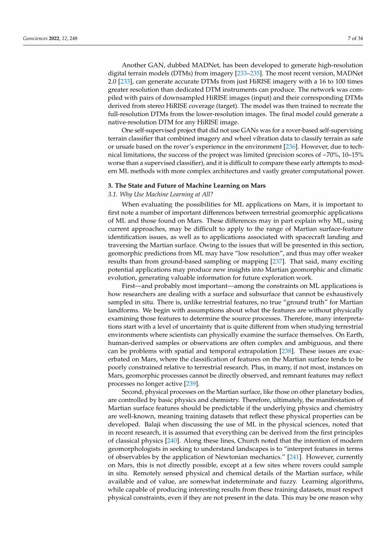
Second, class-imbalance problems and limited datasets are an issue on Mars, particu-larly the latter. HiRISE data only cover 3% of Mars, so features that are rare on Mars arelikely to be extremely rare in high-resolution imagery. The small number of features couldprohibit automated classification and location, though they support anomaly detection.GANs could be used to generate additional examples of the features to train a supervisedclassifier. For example, recurring slope lineae (RSL) were first described in 2011 in seven lo-cations [375], and in the years since, 933 more locations have been manually identified [376].There is little reason to believe that every imaged occurrence of an RSL has been identified,and GANs could help increase the training dataset for a CNN-based locator-classifier,which could then find further RSLs. In a promising study [377], Wang et al. showed that aclassifier trained with ~900 examples of RSLs was highly (92%) accurate in locating RSLs in136 other instances; looking ahead, this method could be improved and generalized withadditional data augmentation. When testing the feasibility of the approach, the authors ofthis review found that StyleGAN could be trained to create realistic HiRISE data with justconsumer hardware in a preliminary implementation (Figure 1) [378].

Geosciences 2022, 12, 248 13 of 34
Geosciences 2022, 12, x FOR PEER REVIEW 13 of 35
rover images [374]. This same method could also be applied to satellite-based terrain
classifiers. Even if the training and testing datasets are derived from disparate images,
there is a possibility that the images have been collected from the same area and may
have similar or overlapping content. This risk is especially high with HiRISE data as the
narrow coverage and targeted use of the camera means that some areas have extremely
dense and/or repeat coverage. In that context, using GANs to generate synthetic terrain
could be helpful in both training to make a classifier more general, and in testing to en-
sure independence between the datasets.
Second, class-imbalance problems and limited datasets are an issue on Mars, par-
ticularly the latter. HiRISE data only cover 3% of Mars, so features that are rare on Mars
are likely to be extremely rare in high-resolution imagery. The small number of features
could prohibit automated classification and location, though they support anomaly de-
tection. GANs could be used to generate additional examples of the features to train a
supervised classifier. For example, recurring slope lineae (RSL) were first described in
2011 in seven locations [375], and in the years since, 933 more locations have been man-
ually identified [376]. There is little reason to believe that every imaged occurrence of an
RSL has been identified, and GANs could help increase the training dataset for a
CNN-based locator-classifier, which could then find further RSLs. In a promising study
[377], Wang et al. showed that a classifier trained with ~900 examples of RSLs was highly
(92%) accurate in locating RSLs in 136 other instances; looking ahead, this method could
be improved and generalized with additional data augmentation. When testing the fea-
sibility of the approach, the authors of this review found that StyleGAN could be trained
to create realistic HiRISE data with just consumer hardware in a preliminary implemen-
tation (Figure 1) [378].
Figure 1. Synthetic imagery of polygonal terrain on Mars. (A) Real HiRISE imagery, (B) synthetic
image generated by a trained StyleGAN network. Resolution for both images is 0.5 m/pixel.
3.3.2. Feature Extraction from DTMs
DTMs of Mars are limited in either resolution or coverage, but are vital tools for
planetary scientists. There are a wealth of Earth-based studies and methods for extracting
geomorphological information from DTMs, but the domain transfer of these methods to
Figure 1. Synthetic imagery of polygonal terrain on Mars. (A) Real HiRISE imagery, (B) syntheticimage generated by a trained StyleGAN network. Resolution for both images is 0.5 m/pixel.
3.3.2. Feature Extraction from DTMs
DTMs of Mars are limited in either resolution or coverage, but are vital tools forplanetary scientists. There are a wealth of Earth-based studies and methods for extractinggeomorphological information from DTMs, but the domain transfer of these methods toMars has been limited by the small number of high-resolution DTMs available. While earlywork in this field was promising [379,380], recent efforts have stalled.
The HiRISE instrument can create 0.5–1 m-per-pixel DTMs from stereo imagery, but atpresent, only ~0.3% of Mars has stereo coverage, and less than one-tenth of those sceneshave DTMs generated. The recent development of high- and super-resolution synthesizedMartian DTMs [233–235,381] has the potential to revolutionize Martian geomorphology inyears to come.
A wide range of geomorphological features and landforms have already been shownto be identifiable and extractable from DTMs. The general methods were covered invarious reviews [382–393], but those applicable to features specifically relevant to Mars(see Section 3.2) are as follows: rock glaciers [350], glacial terraces and ridges [394],glacial cirques [192,262], polygonal terrain [395–397], drumlins [386,398,399], glaciovol-canic features [400,401], landslides [402–405], deltaic features [406], watersheds [407], loessfeatures [382,408], karst landscapes [409,410], relict patterned ground [411], fluvial ter-races [412], and thalwegs [413].
Besides those established in terrestrial studies, a further range of potential applica-tions is specific to the Martian domain. Boulders, for instance, could be automaticallyextracted from DTMs to help determine the rover-landing safety, classify ancient shorelines,or delineate geologic units [273,274,276,277,279,284,414–416]. More accurate profiles andmeasurements could be made of small-scale features such as TARs [299–301,417] PBRs [308],and models could be trained to map their locations and sizes automatically [133,259,417].Inverted channels are important markers of past fluvial activity, and their distinct topo-graphic characteristics [316,317,418–420] could be automatically detected. The mapping ofchannels too fine to be resolved at current DTM resolutions could be made possible in thissame way.

Geosciences 2022, 12, 248 14 of 34
Further theoretical applications could include the verification of human-imposedclassification schemes by unsupervised classifiers. For example, an unsupervised classifiercould group high-resolution data from craters to assess expert-estimated weathering anderosion patterns (i.e., young, old, and very old craters). If the classifier consistently groupedcraters with low estimated ages separately from those with high estimated ages, this wouldsupport the use of those markers for age estimation. Similar verification experiments couldbe performed on other top-down classification schemes.
3.4. Develop Standardized Datasets
Standardized benchmark datasets are crucial to quantify the current state-of-the-art methods across studies. There are innumerable benchmark datasets in nearly ev-ery field in the literature, and many have been used in hundreds or even thousands ofstudies [421–446]. For example, the MNIST database of handwritten digits [443] has beencited in over 5700 publications at the time of writing. Besides serving as useful prototypingtools, these datasets serve a very important purpose in allowing one-to-one comparisons ofdifferent methods. At present, only a handful of standard datasets exist for Mars, and newmethods are rarely directly compared to existing methods. Looking ahead, we proposethat a standard testing dataset containing both imagery and DTMs should be created forcrater counting methods. Then, as new algorithms or approaches are developed, theirperformance and characteristics can be directly compared. Currently, there is no easy wayto determine which crater counting method performs the best out of the dozens outlinedhere. Without this comparison, every researcher has reason to believe that their method isthe best, and a method may become the standard in related studies out of habit rather thanby merit. As the use of ML expands in planetary science, the need for these resources willincrease, and funding for their creation should be a priority.
3.4.1. Unlabeled Data
The most popular standardized dataset is Mars32k [447], which has been used inseveral studies, primarily those focused on rover navigation [123,232,374]. The dataset isrelatively simple and is intended for unsupervised learning projects. As the name implies, itcontains 32,000 images that have been downsampled via linear interpolation to a standardresolution of 560 × 500 pixels. The uniformity of the data and the dataset’s ease of use arecommonly cited reasons for its popularity. As discussed above, unsupervised learning isnot commonly utilized in Martian studies, but more unsupervised research is warranted; toadvance unsupervised research in this way, the community needs more unlabeled datasets.
3.4.2. Expert Labeling
Most of the existing benchmark datasets on Mars are derived from expert knowledge,but few have achieved widespread use. The GSMRI dataset [374] used Mars32k and a GANto generate synthetic images of Martian rocks, thereby doubling the size of the dataset,with a four-level classification structure used to label all rock images. Meanwhile, theDoMars16k [137] dataset consists of 16,150 samples across 15 general landforms in fivecategories, derived from 163 Context Camera images [448]. Further to this, AI4Mars [449]contains 35,000 images with 326,000 labeled objects intended for use in training autonomousrover navigation algorithms. Elsewhere, Rockfall Mars and Moon (RMaM) [450] contains amixture of Martian and Lunar satellite images that can be used to train and test rockfalldetectors. Then, the Mars orbital image (HiRISE) labeled data, version 3.2 [451], contains10,815 samples broken down into eight landform classes. In another example, the MSLSurface Data Set (v2) contains 6800 images with 24 classes that are mostly focused on partsof the Curiosity rover as well as rover activities. The Mars day crater detection (MDCD)dataset, meanwhile, is composed of 500 images and 12,000 craters [88].
The datasets of rover imagery are at present very good; however, creating moresatellite image-based datasets should be a priority. Satellite images cover a more diversegeographic distribution than rover images, and they are useful in wider domains. However,

Geosciences 2022, 12, 248 15 of 34
labeling satellite imagery is challenging given that a single satellite image can cover a largespatial extent and include many different types of features that might need to be re-labeledor reclassified for different projects. For example, a broad “aeolian” class might be suitablefor one classifier model, but another might need subcategories [249] such as “dunes” and“ripples,” while a third project might need to identify different types of dunes. Thus, experts’efforts to develop a more unified supervised classification hierarchy represent an importantendeavor; to date, certain work has been done in this area of semantics by looking at DTMson Earth [452]. Recent work also identified this problem and used semi-supervised learningas a solution [199,200,452], but a consensus structure should remain the priority.
3.4.3. Crowd-Sourced Data Labels
There have been a few projects seeking to leverage “the wisdom of the crowd” toclassify Martian images: LabelMars [453,454] (as part of the Novelty or Anomaly Hunter(NOAH) project [455]), AI4Mars [449], Content-based Object Summarization to Mon-itor Infrequent Change (COSMIC) [456,457], Planet Four [458–460], and Planet Four:Ridges [461,462]. LabelMars was unable to recruit enough volunteers to succeed, andit reverted to an expert-labeling method. AI4Mars used the same dataset and successfullycollected a significantly larger number of labels, likely due to the much simpler classificationscheme of six classes, versus 20 in LabelMars. COSMIC generated 151,000 classificationsfrom 4240 volunteers using a simple scheme to mark and classify araneiforms [463] inHiRISE imagery near the south polar region [456]. Planet Four generated 279,000 classifi-cations from 16,734 volunteers searching for carbon dioxide jets in HiRISE imagery [458].Planet Four: Ridges generated 514,000 classifications from 14,079 volunteers using a simpletwo-class system to locate polygonal and Meridiani-type ridges [461].
Given the huge quantity of data from Mars, using novice or amateur classifiers is animportant direction for future work. Non-experts can help expand existing datasets ormay contribute to generating novel ones. These datasets can then be used for researchdirectly or work as training datasets for ML classifiers. The classification schemes used inthe expert labeling section above were all relatively simple and accessible to non-geologists.The infrastructure for crowd-sourcing image labels and classifications is available on manyweb-based platforms such as Zooniverse [456,458,461] and LabelBox, and the growingpublic participation appears to demonstrate an appetite to help, making this an area ripefor further development.
3.5. Unify Geographic Data and Analysis Systems
The Planetary Data System (PDS) [1,2] is a distributed data storage and access systemused to house NASA data from rovers, satellites, and other instruments. Data in sevencategories (atmospheres, small bodies, etc.) are stored at different “nodes” across theUnited States, usually hosted by a university or other major institution. These nodesuse different website structures, data formats, search queries, and tools—demandingpractice and experience with each system. Further complicating the data navigation is thestratification of different products across different nodes. For example, the final one-meterDTM for the Gale crater can be found on the “cartography” node hosted by the UnitedStates Geological Survey, while the data the DTM is derived from are found there but also onthe “geosciences” node hosted by Washington University in Saint Louis. Interactive mapsshowing the spatial distributions of these data are then hosted separately on the websitesof Arizona State University (MOLA, HRSC), and the University of Arizona (CTX, HiRISE).If one wanted to use this DTM with the ground or atmospheric temperature in the Galecrater, the data could be found on the “atmospheres” node hosted by New Mexico StateUniversity, but there is no equivalent map visualization to locate ground or atmosphericsamples that spatially overlap with the DTM in question. While there are certainly benefitsof this distributed system, the disparities between different instruments’ workflows anddata storage make cross-disciplinary research challenging to all but the most experiencedusers. As noted by [16], such research is key to advancing our understanding of planetary

Geosciences 2022, 12, 248 16 of 34
surface processes: “We need coupled surface, subsurface, and atmospheric/meteorologicalmeasurements so as to enable ’full system’ studies.”
As large corporations grow increasingly interested in planetary-scale data products(e.g., Google Earth and Microsoft’s Planetary Computer, among many smaller competitors),the disparity between these holistic solutions and the PDS grows. Google Mars is a popularplatform that enables many Martian datasets and basemaps to be visualized at once. Byusing an extension of the Google Maps application programming interface (API), users canquery several basemap types: elevation, visible, and infrared. However, the API is outdatedcompared to that of Google Earth Engine, and it lacks the high-resolution products thathave revolutionized Martian science in recent years. JMARS [464] is another excellentgeographic information system designed specifically for Martian data by Arizona StateUniversity. While JMARS works with most of the common geoscience data products, it doesnot yet include other data such as atmospheric information or raw imagery. Furthermore,it lacks a robust API for large-scale programmatic analyses. At present, neither platformcould answer a query such as “return a list of all HiRISE DTMs that overlap >50% withCTX DEMs.” Funding to refine these existing tools, or develop new, more comprehensiveplatforms, should be a priority to enable further ML studies of Mars.
4. Conclusions
The collection of Martian data has outpaced the rate at which humans can meaning-fully parse and interpret each record. Leveraging the novel automated analysis methodspioneered in other fields—Earth observation, most notably—presents a natural solution tothis dilemma. As we have outlined in this article, ML studies are taking place on Mars, andthere are many fruitful avenues via which these could be further applied. As [16] recentlynoted, “Mars is a uniquely enabling study target for investigations of surface processesactive on other planetary bodies—both for extending terrestrial based process models and,in some areas, for serving as a superior comparative planetology basis over Earth.”
With greater knowledge transfer between Martian domain experts and machine learn-ing specialists, insights from ML research could increase. Here, we outlined a range ofspecific future study routes, and we offered a few broad suggestions for the community andresearch funders. We conclude that improvements to our understanding of the physicalprocesses on Mars, and potentially other non-terrestrial surfaces, can be achieved using ML.A few key findings should be noted: (1) semi-supervised and self-supervised learning areespecially important methods for Martian applications, (2) creating synthetic Martian data(especially of high-resolution, accurate digital terrain models) using generative adversarialnetworks has the potential to revolutionize Martian geomorphology studies, (3) developingstandardized datasets and benchmarks with which to test new methods should be both aresearch and funding priority, and (4) Martian research is hindered today by the lack of ascalable and programmatic analysis platform, such as Google Earth or Planetary Computer.
Challenges aside, existing and ongoing ML research on Mars has proven valuable, andthe research and methods summarized here should be used as a basis to fund, encourage,and undertake further such studies.
Author Contributions: Conceptualization, T.P.N.-M., L.A.S. and N.E.; writing—original draft, T.P.N.-M.; writing—review and editing, T.P.N.-M., L.A.S. and N.E. All authors have read and agreed to thepublished version of the manuscript.
Funding: This research received no external funding.
Institutional Review Board Statement: Not Applicable.
Informed Consent Statement: Not Applicable.
Data Availability Statement: No novel data were produced for this review.
Conflicts of Interest: The authors declare no conflict of interest.

Geosciences 2022, 12, 248 17 of 34
References1. Hughes, J.S.; Li, Y.P. The Planetary Data System Data Model. In Proceedings of the Twelfth IEEE Symposium on Mass Storage
Systems, Monterey, CA, USA, 26–29 April 1993; Institute of Electrical and Electronics Engineers (IEEE): Piscataway, NJ, USA,1993; pp. 183–189.
2. McMahon, S.K. Overview of the Planetary Data System. Planet. Space Sci. 1996, 44, 3–12. [CrossRef]3. Arviset, C.; Dowson, J.; Ortiz, I.; Parrilla, E.; Salgado, J.; Zender, J. ESA Planetary Science Archive. In Astronomical Data Analysis
Software and Systems XVI.; Astronomical Society of the Pacific: San Francisco, CA, USA, 2007; Volume 376, p. 163.4. Macfarlane, A.J.; Docasal, R.; Rios, C.; Barbarisi, I.; Saiz, J.; Vallejo, F.; Besse, S.; Arviset, C.; Barthelemy, M.; de Marchi, G.; et al.
Improving Accessibility and Discovery of ESA Planetary Data through the New Planetary Science Archive. Planet. Space Sci.2018, 150, 104–110. [CrossRef]
5. Estlin, T.A.; Bornstein, B.J.; Gaines, D.M.; Anderson, R.C.; Thompson, D.R.; Burl, M.; Castano, R.; Judd, M. Aegis AutomatedScience Targeting for the Mer Opportunity Rover. ACM Trans. Intell. Syst. Technol. 2012, 3, 1–19. [CrossRef]
6. Francis, R.; Estlin, T.; Doran, G.; Johnstone, S.; Gaines, D.; Verma, V.; Burl, M.; Frydenvang, J.; Montaño, S.; Wiens, R.C. AEGISAutonomous Targeting for ChemCam on Mars Science Laboratory: Deployment and Results of Initial Science Team Use. Sci.Robot. 2017, 2, eaan4582. [CrossRef] [PubMed]
7. Estlin, T.; Castano, R.; Bornstein, B.; Gaines, D.; Anderson, R.C.; de Granville, C.; Thompson, D.; Burl, M.; Judd, M.; Chien, S.Automated Targeting for the MER Rovers. In Proceedings of the 2009 Third IEEE International Conference on Space MissionChallenges for Information Technology, Pasadena, CA, USA, 19–23 July 2009; Institute of Electrical and Electronics Engineers(IEEE): Piscataway, NJ, USA, 2009; pp. 257–263.
8. Johnson, A.E.; Cheng, Y.; Montgomery, J.F.; Trawny, N.; Tweddle, B.; Zheng, J.X. Real-Time Terrain Relative Navigation TestResults from a Relevant Environment for Mars Landing. In Proceedings of the AIAA Guidance, Navigation, and ControlConference, Kissimmee, FL, USA, 5–9 January 2015; p. 851.
9. Wolf, A.A.; Acikmese, B.; Cheng, Y.; Casoliva, J.; Carson, J.M.; Ivanov, M.C. Toward Improved Landing Precision on Mars.In Proceedings of the 2011 Aerospace Conference, Big Sky, MT, USA, 5–12 March 2011; Institute of Electrical and ElectronicsEngineers (IEEE): Piscataway, NJ, USA, 2011; pp. 1–8.
10. Owens, C.; Macdonald, K.; Hardy, J.; Lindsay, R.; Redfield, M.; Bloom, M.; Bailey, E.; Cheng, Y.; Clouse, D.; Villalpando, C.Y.Development of a Signature-Based Terrain Relative Navigation System for Precision Landing. In Proceedings of the AIAA Scitech2021 Forum, Virtual, 11–22 January 2021; p. 376.
11. Johnson, A.; Aaron, S.; Chang, J.; Cheng, Y.; Montgomery, J.; Mohan, S.; Schroeder, S.; Tweddle, B.; Trawny, N.; Zheng, J. TheLander Vision System for Mars 2020 Entry Descent and Landing. In Proceedings of the AAS Guidance Navigation and ControlConference, Breckenridge, CO, USA, 2–8 February 2017.
12. Brugarolas, P. Guidance, Navigation and Control for the Entry, Descent, and Landing of the Mars 2020 Mission. In Proceedings ofthe 40th Annual Guidance and Control Conference, Breckenridge, CO, USA, 2–8 February 2017.
13. Shao, W.; Cao, L.; Guo, W.; Xie, J.; Gu, T. Visual Navigation Algorithm Based on Line Geomorphic Feature Matching for MarsLanding. Acta Astronaut. 2020, 173, 383–391. [CrossRef]
14. Nelessen, A.; Sackier, C.; Clark, I.; Brugarolas, P.; Villar, G.; Chen, A.; Stehura, A.; Otero, R.; Stilley, E.; Way, D. Mars 2020 Entry,Descent, and Landing System Overview. In Proceedings of the 2019 IEEE Aerospace Conference, Big Sky, MT, USA, 2–9 March2019; Institute of Electrical and Electronics Engineers (IEEE): Piscataway, NJ, USA, 2019; pp. 1–20.
15. Johnson, A.E.; Aaron, S.B.; Ansari, H.; Bergh, C.; Bourdu, H.; Butler, J.; Chang, J.; Cheng, R.; Cheng, Y.; Clark, K. Mars 2020 LanderVision System Flight Performance. In Proceedings of the AIAA SciTech 2022 Forum, San Diego, CA, USA, 3–7 January 2022;p. 1214.
16. Diniega, S.; Bramson, A.; Buratti, B.; Buhler, P.; Burr, D.; Chojnacki, M.; Conway, S.; Daubar, I.; Dinwiddie, C.L.; Galofre, A.G.; et al.Mars as a “Natural Laboratory” for Studying Surface Activity on a Range of Planetary Bodies. Bull. Am. Astron. Soc. 2021, 53, 123.
17. Diniega, S.; Bramson, A.M.; Buratti, B.; Buhler, P.; Burr, D.M.; Chojnacki, M.; Conway, S.J.; Dundas, C.M.; Hansen, C.J.;McEwen, A.S.; et al. Modern Mars’ Geomorphological Activity, Driven by Wind, Frost, and Gravity. Geomorphology 2021, 380,107627. [CrossRef]
18. Domagal-Goldman, S.D.; Wright, K.E.; Adamala, K.; de La Rubia, L.A.; Bond, J.; Dartnell, L.R.; Goldman, A.D.; Lynch, K.;Naud, M.-E.; Paulino-Lima, I.G.; et al. The Astrobiology Primer v2. 0. Astrobiology 2016, 16, 561.
19. Changela, H.G.; Chatzitheodoridis, E.; Antunes, A.; Beaty, D.; Bouw, K.; Bridges, J.C.; Capova, K.A.; Cockell, C.S.; Conley, C.A.;Dadachova, E.; et al. Mars: New Insights and Unresolved Questions. Int. J. Astrobiol. 2021, 20, 394–426. [CrossRef]
20. Maxwell, A.E.; Warner, T.A.; Fang, F. Implementation of Machine-Learning Classification in Remote Sensing: An Applied Review.Int. J. Remote Sens. 2018, 39, 2784–2817. [CrossRef]
21. Ferreira, B.; Iten, M.; Silva, R.G. Monitoring Sustainable Development by Means of Earth Observation Data and Machine Learning:A Review. Environ. Sci. Eur. 2020, 32, 120. [CrossRef]
22. Lary, D.J.; Zewdie, G.K.; Liu, X.; Wu, D.; Levetin, E.; Allee, R.J.; Malakar, N.; Walker, A.; Mussa, H.; Mannino, A.; et al. MachineLearning Applications for Earth Observation; Springer: Cham, Switzerland, 2018; ISBN 9783319656328.
23. Salcedo-Sanz, S.; Ghamisi, P.; Piles, M.; Werner, M.; Cuadra, L.; Moreno-Martínez, A.; Izquierdo-Verdiguier, E.; Muñoz-Marí, J.;Mosavi, A.; Camps-Valls, G. Machine Learning Information Fusion in Earth Observation: A Comprehensive Review of Methods,Applications and Data Sources. Inf. Fusion 2020, 63, 256–272. [CrossRef]

Geosciences 2022, 12, 248 18 of 34
24. Vali, A.; Comai, S.; Matteucci, M. Deep Learning for Land Use and Land Cover Classification Based on Hyperspectral andMultispectral Earth Observation Data: A Review. Remote Sens. 2020, 12, 2495. [CrossRef]
25. Hoeser, T.; Kuenzer, C. Object Detection and Image Segmentation with Deep Learning on Earth Observation Data: A Review-PartI: Evolution and Recent Trends. Remote Sens. 2020, 12, 1667. [CrossRef]
26. Pandey, P.C.; Koutsias, N.; Petropoulos, G.P.; Srivastava, P.K.; ben Dor, E. Land Use/Land Cover in View of Earth Observation:Data Sources, Input Dimensions, and Classifiers—A Review of the State of the Art. Geocarto Int. 2021, 36, 957–988. [CrossRef]
27. Selva, D.; Krejci, D. A Survey and Assessment of the Capabilities of Cubesats for Earth Observation. Acta Astron. 2012, 74, 50–68.[CrossRef]
28. Secades, C.; O’Connor, B.; Brown, C.; Walpole, M.; Skidmore, A.; Wang, T.; Groen, T.A.; Herkt, K.M.B.; Niamir, A. Earthobservation for biodiversity monitoring, Canadian Electronic Library. Available online: https://policycommons.net/artifacts/1189083/earth-observation-for-biodiversity-monitoring/1742209/ (accessed on 8 June 2022).
29. Merchant, C.J.; Paul, F.; Popp, T.; Ablain, M.; Bontemps, S.; Defourny, P.; Hollmann, R.; Lavergne, T.; Laeng, A.; de Leeuw, G.Uncertainty Information in Climate Data Records from Earth Observation. Earth Syst. Sci. Data 2017, 9, 511–527. [CrossRef]
30. Chuvieco, E.; Mouillot, F.; van der Werf, G.R.; San Miguel, J.; Tanase, M.; Koutsias, N.; García, M.; Yebra, M.; Padilla, M.; Gitas, I.Historical Background and Current Developments for Mapping Burned Area from Satellite Earth Observation. Remote Sens.Environ. 2019, 225, 45–64. [CrossRef]
31. Ouma, Y.O. Advancements in Medium and High Resolution Earth Observation for Land-Surface Imaging: Evolutions, FutureTrends and Contributions to Sustainable Development. Adv. Space Res. 2016, 57, 110–126. [CrossRef]
32. Richter, K.; Hank, T.B.; Mauser, W.; Atzberger, C. Derivation of Biophysical Variables from Earth Observation Data: Validationand Statistical Measures. J. Appl. Remote Sens. 2012, 6, 63557. [CrossRef]
33. Pfeifer, M.; Disney, M.; Quaife, T.; Marchant, R. Terrestrial Ecosystems from Space: A Review of Earth Observation Products forMacroecology Applications. Glob. Ecol. Biogeogr. 2012, 21, 603–624. [CrossRef]
34. Kansakar, P.; Hossain, F. A Review of Applications of Satellite Earth Observation Data for Global Societal Benefit and Stewardshipof Planet Earth. Space Policy 2016, 36, 46–54. [CrossRef]
35. Hirschmugl, M.; Gallaun, H.; Dees, M.; Datta, P.; Deutscher, J.; Koutsias, N.; Schardt, M. Methods for Mapping Forest Disturbanceand Degradation from Optical Earth Observation Data: A Review. Curr. For. Rep. 2017, 3, 32–45. [CrossRef]
36. Li, D.; Shan, J.; Gong, J. Geospatial Technology for Earth Observation; Springer Science & Business Media: Berlin/Heidelberg,Germany, 2009; ISBN 1441900500.
37. Sasiadek, J. Space Robotics and Its Challenges. In Aerospace Robotics; Springer: Berlin/Heidelberg, Germany, 2013; pp. 1–8.38. Lumia, R.; Albus, J.S. Teleoperation and Autonomy for Space Robotics. Robot. Auton. Syst. 1988, 4, 27–33. [CrossRef]39. Hambuchen, K.A.; Roman, M.C.; Sivak, A.; Herblet, A.; Koenig, N.; Newmyer, D.; Ambrose, R. NASA’s Space Robotics Challenge:
Advancing Robotics for Future Exploration Missions. In Proceedings of the AIAA SPACE and Astronautics Forum and Exposition,Orlando, FL, USA, 12–14 September 2017; p. 5120.
40. Meshka, L. Risk Considerations for Autonomy Software. In Proceedings of the 2020 Annual Reliability and MaintainabilitySymposium (RAMS), Palm Springs, CA, USA, 27–30 January 2020; Institute of Electrical and Electronics Engineers (IEEE):Piscataway, NJ, USA, 2020; pp. 1–6.
41. Gao, Y.; Chien, S. Review on Space Robotics: Toward Top-Level Science through Space Exploration. Sci. Robot. 2017, 2, eaan5074.[CrossRef]
42. Olivares-Alarcos, A.; Beßler, D.; Khamis, A.; Goncalves, P.; Habib, M.K.; Bermejo-Alonso, J.; Barreto, M.; Diab, M.; Rosell, J.;Quintas, J. A Review and Comparison of Ontology-Based Approaches to Robot Autonomy. Knowl. Eng. Rev. 2019, 34, e29.[CrossRef]
43. Read, N.; Woods, M.; Karachalios, S. Novelty or Anomaly Hunter–Driving Next Generation Science Autonomy With Large HighQuality Dataset Collection. In Proceedings of the ESA AI and Robotics at i-SAIRAS 2020, Virtual, 19–23 October 2020.
44. Volpe, R. Rover Functional Autonomy Development for the Mars Mobile Science Laboratory. In Proceedings of the 2003 IEEEAerospace Conference, Big Sky, MT, USA, 8–15 March 2003; Volume 2, pp. 643–652.
45. Volpe, R. Rover Technology Development and Mission Infusion beyond MER. In Proceedings of the 2005 IEEE AerospaceConference, Big Sky, MT, USA, 5–12 March 2005; Institute of Electrical and Electronics Engineers (IEEE): Piscataway, NJ, USA,2005; pp. 971–981.
46. Munoz, P.; R-Moreno, M.D.; Martınez, A. A First Approach for the Autonomy of the Exomars Rover Using a 3-Tier Architecture.In Proceedings of the 11th ESA Symposium on Advanced Space Technologies for Robotics and Automation, Noordwijk, TheNetherlands, 14 April 2011.
47. Shaukat, A.; Blacker, P.C.; Spiteri, C.; Gao, Y. Towards Camera-LIDAR Fusion-Based Terrain Modelling for Planetary Surfaces:Review and Analysis. Sensors 2016, 16, 1952. [CrossRef]
48. Schenker, P.S.; Huntsberger, T.L.; Pirjanian, P.; Baumgartner, E.T.; Tunstel, E. Planetary Rover Developments Supporting MarsExploration, Sample Return and Future Human-Robotic Colonization. Auton. Robot. 2003, 14, 103–126. [CrossRef]
49. Nesnas, I.A.D.; Fesq, L.M.; Volpe, R.A. Autonomy for Space Robots: Past, Present, and Future. Curr. Robot. Rep. 2021, 2, 251–263.[CrossRef]
50. Woods, M.; Shaw, A.; Barnes, D.; Price, D.; Long, D.; Pullan, D. Autonomous Science for an ExoMars Rover–like Mission. J. FieldRobot. 2009, 26, 358–390. [CrossRef]

Geosciences 2022, 12, 248 19 of 34
51. Rybus, T. Obstacle Avoidance in Space Robotics: Review of Major Challenges and Proposed Solutions. Prog. Aerosp. Sci. 2018,101, 31–48. [CrossRef]
52. Jasiobedzki, P.; Anders, C. Computer Vision for Space Robotics: Applications, Role and Performance. IFAC Proc. Vol. 1998, 31,95–102. [CrossRef]
53. Rabideau, G.; Benowitz, E. Prototyping an Onboard Scheduler for the Mars 2020 Rover. In Proceedings of the 10th InternationalWorkshop on Planning and Scheduling for Space (IWPSS 2017), Pittsburgh, PA, USA, 15–17 June 2017.
54. Daftry, S.; Abcouwer, N.; del Sesto, T.; Venkatraman, S.; Song, J.; Igel, L.; Byon, A.; Rosolia, U.; Yue, Y.; Ono, M. MLNav: Learningto Safely Navigate on Martian Terrains. IEEE Robot. Autom. Lett. 2022, 7, 5461–5468. [CrossRef]
55. Russell, S.; Norvig, P. Artificial Intelligence: A Modern Approach; Pearson: London, UK, 2002.56. Bishop, C.M.; Nasrabadi, N.M. Pattern Recognition and Machine Learning; Springer: New York, NY, USA, 2006; Volume 4.57. Jordan, M.I.; Mitchell, T.M. Machine Learning: Trends, Perspectives, and Prospects. Science 2015, 349, 255–260. [CrossRef]58. Ayodele, T.O. Types of Machine Learning Algorithms. New Adv. Mach. Learn. 2010, 3, 19–48.59. Ray, S. A Quick Review of Machine Learning Algorithms. In Proceedings of the 2019 International conference on machine
learning, big data, cloud and parallel computing (COMITCon), Faridabad, India, 14–16 February 2019; Institute of Electrical andElectronics Engineers (IEEE): Piscataway, NJ, USA, 2019; pp. 35–39.
60. Zhuang, F.; Qi, Z.; Duan, K.; Xi, D.; Zhu, Y.; Zhu, H.; Xiong, H.; He, Q. A Comprehensive Survey on Transfer Learning. Proc. IEEE2020, 109, 43–76. [CrossRef]
61. Day, O.; Khoshgoftaar, T.M. A Survey on Heterogeneous Transfer Learning. J. Big Data 2017, 4, 1–42. [CrossRef]62. Tan, C.; Sun, F.; Kong, T.; Zhang, W.; Yang, C.; Liu, C. A Survey on Deep Transfer Learning. In Proceedings of the International
Conference on Artificial Neural Networks, Rhodes, Greece, 4–7 October 2018; Springer: Berling, Germany, 2018; pp. 270–279.63. Bozinovski, S. Reminder of the First Paper on Transfer Learning in Neural Networks, 1976. Informatica 2020, 44. [CrossRef]64. Kaboli, M. A Review of Transfer Learning Algorithms. [Research Report] Technische Universität München. 2017. hal-01575126.
Available online: https://hal.archives-ouvertes.fr/hal-01575126 (accessed on 8 June 2022).65. Krizhevsky, A.; Sutskever, I.; Hinton, G.E. ImageNet Classification with Deep Convolutional Neural Networks. Commun. ACM
2017, 60, 84–90. [CrossRef]66. Lin, T.-Y.; Goyal, P.; Girshick, R.; He, K.; Dollár, P. Focal Loss for Dense Object Detection. In Proceedings of the IEEE International
Conference on Computer Vision, Venice, Italy, 22–29 October 2017; pp. 2980–2988.67. He, K.; Gkioxari, G.; Dollár, P.; Girshick, R. Mask R-Cnn. In Proceedings of the IEEE International Conference on Computer
Vision, Venice, Italy, 22–29 October 2017; pp. 2961–2969.68. Iandola, F.N.; Han, S.; Moskewicz, M.W.; Ashraf, K.; Dally, W.J.; Keutzer, K. SqueezeNet: AlexNet-Level Accuracy with 50x Fewer
Parameters and <0.5 MB Model Size. arXiv 2016, arXiv:1602.07360.69. He, K.; Zhang, X.; Ren, S.; Sun, J. Deep Residual Learning for Image Recognition. In Proceedings of the IEEE Conference on
Computer Vision and Pattern Recognition, Las Vegas, NV, USA, 27–30 June 2016; pp. 770–778.70. Mikolov, T.; Le, Q.V.; Sutskever, I. Exploiting Similarities among Languages for Machine Translation. arXiv 2013, arXiv:1309.4168.71. Pennington, J.; Socher, R.; Manning, C.D. Glove: Global Vectors for Word Representation. In Proceedings of the 2014 Conference
on Empirical Methods in Natural Language Processing (EMNLP), Doha, Qatar, 25–29 October 2014; pp. 1532–1543.72. Szegedy, C.; Liu, W.; Jia, Y.; Sermanet, P.; Reed, S.; Anguelov, D.; Erhan, D.; Vanhoucke, V.; Rabinovich, A. Going Deeper
with Convolutions. In Proceedings of the IEEE Conference on Computer Vision and Pattern Recognition, Boston, MA, USA,7–12 June 2015; pp. 1–9.
73. Zhang, X.; Zou, J.; He, K.; Sun, J. Accelerating very Deep Convolutional Networks for Classification and Detection. IEEE Trans.Pattern Anal. Mach. Intell. 2016, 38, 1943–1955. [CrossRef] [PubMed]
74. Li, Y.; Hou, X.; Koch, C.; Rehg, J.M.; Yuille, A.L. The Secrets of Salient Object Segmentation. In Proceedings of the IEEE Conferenceon Computer Vision and Pattern Recognition, Columbus, OH, USA, 23–28 June 2014; pp. 280–287.
75. Movahedi, V.; Elder, J.H. Design and Perceptual Validation of Performance Measures for Salient Object Segmentation. InProceedings of the 2010 IEEE Computer Society Conference on Computer Vision and Pattern Recognition-Workshops, SanFrancisco, CA, USA, 13–18 June 2010; Institute of Electrical and Electronics Engineers (IEEE): Piscataway, NJ, USA, 2010;pp. 49–56.
76. Chien, S.-Y.; Ma, S.-Y.; Chen, L.-G. Efficient Moving Object Segmentation Algorithm Using Background Registration Technique.IEEE Trans. Circuits Syst. Video Technol. 2002, 12, 577–586. [CrossRef]
77. Wang, T.; Zhang, X.; Sun, J. Implicit Feature Pyramid Network for Object Detection. arXiv 2020, arXiv:2012.13563.78. Kim, S.-W.; Kook, H.-K.; Sun, J.-Y.; Kang, M.-C.; Ko, S.-J. Parallel Feature Pyramid Network for Object Detection. In Proceedings
of the European Conference on Computer Vision (ECCV), Munich, Germany, 8–14 September 2018; pp. 234–250.79. Lin, T.-Y.; Dollár, P.; Girshick, R.; He, K.; Hariharan, B.; Belongie, S. Feature Pyramid Networks for Object Detection. In Proceedings
of the IEEE Conference on Computer Vision and Pattern Recognition, Honolulu, HI, USA, 21–26 June 2017; pp. 2117–2125.80. Deng, C.; Wang, M.; Liu, L.; Liu, Y.; Jiang, Y. Extended Feature Pyramid Network for Small Object Detection. IEEE Trans. Multimed.
2021, 24, 1968–1979. [CrossRef]81. Zhao, Y.; Han, R.; Rao, Y. A New Feature Pyramid Network for Object Detection. In Proceedings of the 2019 International
Conference on Virtual Reality and Intelligent Systems (ICVRIS), Jishou, China, 14–15 September 2019; Institute of Electrical andElectronics Engineers (IEEE): Piscataway, NJ, USA, 2019; pp. 428–431.

Geosciences 2022, 12, 248 20 of 34
82. Bland, P. Crater Counting. Astron. Geophys. 2003, 44, 4–21. [CrossRef]83. Öpik, E.J. Cratering and the Moon’s Surface. In Advances in Astronomy and Astrophysics; Elsevier: Amsterdam, The Netherlands,
1971; Volume 8, pp. 107–337. ISBN 0065-2180.84. Tyrie, A. Age Dating of Mare in the Lunar Crater Tsiolkovsky by Crater-Counting Method. Earth Moon Planets 1988, 42, 245–264.
[CrossRef]85. Neukum, G.; König, B.; Fechtig, H.; Storzer, D. Cratering in the Earth-Moon System-Consequences for Age Determination by
Crater Counting. In Proceedings of the Lunar and Planetary Science Conference, Houston, TX, USA, 17–21 March 1975; Volume 6,pp. 2597–2620.
86. Neukum, G.; Wise, D.U. Mars: A Standard Crater Curve and Possible New Time Scale: Cratering Links to Lunar Time SuggestThat Mars Died Long Ago. Science 1976, 194, 1381–1387. [CrossRef]
87. Baldwin, R.B. Mars: An Estimate of the Age of Its Surface. Science 1965, 149, 1498–1499. [CrossRef]88. Yang, S.; Cai, Z. High-Resolution Feature Pyramid Network for Automatic Crater Detection on Mars. IEEE Trans. Geosci. Remote
Sens. 2022, 60, 4601012. [CrossRef]89. Jin, S.; Zhang, T. Automatic Detection of Impact Craters on Mars Using a Modified Adaboosting Method. Planet. Space Sci. 2014,
99, 112–117. [CrossRef]90. Stepinski, T.F.; Ding, W.; Vilalta, R. Detecting Impact Craters in Planetary Images Using Machine Learning. In Intelligent Data
Analysis for Real-Life Applications: Theory and Practice; IGI Global: Hershey, PA, USA, 2012; pp. 146–159.91. DeLatte, D.M.; Crites, S.T.; Guttenberg, N.; Tasker, E.J.; Yairi, T. Segmentation Convolutional Neural Networks for Automatic
Crater Detection on Mars. IEEE J. Sel. Top. Appl. Earth Obs. Remote Sens. 2019, 12, 2944–2957. [CrossRef]92. Hsu, C.Y.; Li, W.; Wang, S. Knowledge-Driven Geoai: Integrating Spatial Knowledge into Multi-Scale Deep Learning for Mars
Crater Detection. Remote Sens. 2021, 13, 2116. [CrossRef]93. AlMarzooqi, M.; AlNaqbi, A.; AlMheiri, A.; Bezawada, S.; Mohamed, E.A.; Zaki, N. Increase the Exploitation of Mars Satellite
Images Via Deep Learning Techniques. In Proceedings of the 2018 International Conference on Robotics, Control and AutomationEngineering, Beijing, China, 26–28 December 2018; Association for Computing Machinery: New York, NY, USA, 2018; pp. 171–175.
94. Stepinski, T.F.; Mendenhall, M.P.; Bue, B.D. Machine Cataloging of Impact Craters on Mars. Icarus 2009, 203, 77–87. [CrossRef]95. Lee, C. Automated Crater Detection on Mars Using Deep Learning. Planet. Space Sci. 2019, 170, 16–28. [CrossRef]96. Plesko, C.; Brumby, S.; Asphaug, E.; Chamberlain, D.; Engel, T. Automatic Crater Counts on Mars. Lunar Planet. Inst. Conf. Abstr.
2004, 35, 1935.97. Vinogradova, T.; Burl, M.; Mjolsness, E. Training of a Crater Detection Algorithm for Mars Crater Imagery. In Proceedings of
the IEEE Aerospace Conference, Big Sky, MT, USA, 9–16 March 2002; Institute of Electrical and Electronics Engineers (IEEE):Piscataway, NJ, USA, 2002; Volume 7, p. 7.
98. DeLatte, D.M.; Crites, S.T.; Guttenberg, N.; Tasker, E.J.; Yairi, T. Exploration of Machine Learning Methods for Crater Counting onMars. In Proceedings of the 49th Lunar and Planetary Science Conference 2018, The Woodlands, TX, USA, 19–23 March 2018;Volume 49.
99. Bouley, S.; Craddock, R.A.; Mangold, N.; Ansan, V. Comparison of Different Crater Counting Methods Applicated to ParanaValles. In Proceedings of the 40th Annual Lunar and Planetary Science Conference, The Woodlands, TX, USA, 21–25 March 2016;p. 1097.
100. Werner, S.C.; Tanaka, K.L.; Skinner Jr, J.A. Mars: The Evolutionary History of the Northern Lowlands Based on Crater Countingand Geologic Mapping. Planet. Space Sci. 2011, 59, 1143–1165. [CrossRef]
101. Lagain, A.; Servis, K.; Benedix, G.K.; Norman, C.; Anderson, S.; Bland, P.A. Model Age Derivation of Large Martian ImpactCraters, Using Automatic Crater Counting Methods. Earth Space Sci. 2021, 8, e2020EA001598. [CrossRef]
102. Di, K.; Li, W.; Yue, Z.; Sun, Y.; Liu, Y. A Machine Learning Approach to Crater Detection from Topographic Data. Adv. Space Res.2014, 54, 2419–2429. [CrossRef]
103. Christoff, N.; Jorda, L.; Viseur, S.; Bouley, S.; Manolova, A.; Mari, J.-L. Automated Extraction of Crater Rims on 3D MeshesCombining Artificial Neural Network and Discrete Curvature Labeling. Earth Moon Planets 2020, 124, 51–72. [CrossRef]
104. Benedix, G.K.; Lagain, A.; Chai, K.; Meka, S.; Anderson, S.; Norman, C.; Bland, P.A.; Paxman, J.; Towner, M.C.; Tan, T. DerivingSurface Ages on Mars Using Automated Crater Counting. Earth Space Sci. 2020, 7, e2019EA001005. [CrossRef]
105. Gao, A.; Daubar, I.J.; Wexler, D.; Wagstaff, K.L.; Bickel, V.; Doran, G. Using Machine Learning to Complement New Martial CraterInventories. In Proceedings of the 52nd Lunar and Planetary Science Conference, Virtual, 15–19 March 2021.
106. Hartmann, W.K. Martian Cratering 8: Isochron Refinement and the Chronology of Mars. Icarus 2005, 174, 294–320. [CrossRef]107. Xiao, Z.; Strom, R.G. Problems Determining Relative and Absolute Ages Using the Small Crater Population. Icarus 2012, 220,
254–267. [CrossRef]108. Robbins, S.J.; Hynek, B.M.; Lillis, R.J.; Bottke, W.F. Large Impact Crater Histories of Mars: The Effect of Different Model Crater
Age Techniques. Icarus 2013, 225, 173–184. [CrossRef]109. Edwards, C.S.; Nowicki, K.J.; Christensen, P.R.; Hill, J.; Gorelick, N.; Murray, K. Mosaicking of Global Planetary Image Datasets: 1.
Techniques and Data Processing for Thermal Emission Imaging System (THEMIS) Multi-spectral Data. J. Geophys. Res. Planets2011, 116. [CrossRef]
110. Albee, A.L.; Arvidson, R.E.; Palluconi, F.; Thorpe, T. Overview of the Mars Global Surveyor Mission. J. Geophys. Res. Planets 2001,106, 23291–23316. [CrossRef]

Geosciences 2022, 12, 248 21 of 34
111. De, K.; Ruj, T.; Kundu, A.; Dasgupta, N.; Kawai, K. Evolution of Pyrrhae Fossae, Mars: An Explication from the Age EstimationUsing the Buffered Crater Counting Technique. Curr. Sci. 2021, 121, 906. [CrossRef]
112. Fassett, C.I.; Head, J.W., III. The Timing of Martian Valley Network Activity: Constraints from Buffered Crater Counting. Icarus2008, 195, 61–89. [CrossRef]
113. Fergason, R.L.; Hare, T.M.; Laura, J. HRSC and MOLA Blended Digital Elevation Model at 200m V2; Astrogeology PDS Annex, USGeological Survey; USGS Astrogeology Science Center: Flagstaff, AZ, USA, 2018.
114. Li, G.; Geng, Y.; Xiao, X. Multi-Scale Rock Detection on Mars. Sci. China Inf. Sci. 2018, 61, 102301. [CrossRef]115. Pan, L.; Gui, C.; Barnes, D.; Shang, C. Mars Multispectral Image Classification Using Machine Learning Techniques. In
Proceedings of the Thirty-First Annual Conference on Innovative Applications of Artificial Intelligence, Honolulu, HI, USA,28–30 January 2013.
116. Shang, C.; Barnes, D. Fuzzy-Rough Feature Selection Aided Support Vector Machines for Mars Image Classification. Comput. Vis.Image Underst. 2013, 117, 202–213. [CrossRef]
117. Rashno, A.; Nazari, B.; Sadri, S.; Saraee, M. Effective Pixel Classification of Mars Images Based on Ant Colony OptimizationFeature Selection and Extreme Learning Machine. Neurocomputing 2017, 226, 66–79. [CrossRef]
118. Haq, A.U.; Leitner, J.; Harding, S.; Forster, A.; Schmidhuber, J. Mars Terrain Image Classification Using Cartesian GeneticProgramming. In Proceedings of the 11th International Symposium on Artificial Intelligence, Robotics and Automation in Space,i-SAIRAS 2012, Turin, Italy, 4–6 September 2012; European Space Agency (ESA): Paris, France, 2012; pp. 1–8.
119. Rothrock, B.; Papon, J.; Kennedy, R.; Ono, M.; Heverly, M.; Cunningham, C. SPOC: Deep Learning-Based Terrain Classificationfor Mars Rover Missions. In Proceedings of the AIAA Space and Astronautics Forum and Exposition, SPACE 2016, Long Beach,CA, USA, 13–16 September 2016; pp. 1–12. [CrossRef]
120. Chakravarthy, A.S.; Roy, R.; Ravirathinam, P. MRSCAtt: A Spatio-Channel Attention-Guided Network for Mars Rover ImageClassification. In Proceedings of the IEEE Computer Society Conference on Computer Vision and Pattern Recognition Workshops2021, Nashville, TN, USA, 19–25 June 2021; pp. 1961–1970. [CrossRef]
121. Shang, C.; Barnes, D.; Shen, Q. Facilitating Efficient Mars Terrain Image Classification with Fuzzy-Rough Feature Selection. Int. J.Hybrid Intell. Syst. 2011, 8, 3–13. [CrossRef]
122. Huang, G.; Yang, L.; Cai, Y.; Zhang, D. Terrain Classification-Based Rover Traverse Planner with Kinematic Constraints for MarsExploration. Planet. Space Sci. 2021, 209, 105371. [CrossRef]
123. Hu, S.; Liu, J.; Kang, Z. DeepLabV3+/Efficientnet Hybrid Network-Based Scene Area Judgment for the Mars Unmanned VehicleSystem. Sensors 2021, 21, 8136. [CrossRef] [PubMed]
124. Ogohara, K.; Gichu, R. Automated Segmentation of Textured Dust Storms on Mars Remote Sensing Images Using an Encoder-Decoder Type Convolutional Neural Network. Comput. Geosci. 2022, 160, 105043. [CrossRef]
125. Gichu, R.; Ogohara, K. Segmentation of Dust Storm Areas on Mars Images Using Principal Component Analysis and NeuralNetwork. Prog. Earth Planet. Sci. 2019, 6, 19. [CrossRef]
126. Sakimoto, S.E.H.; Lewis, D.D.; Dileep, S.; Memon, P.; Beveridge, J.R.; Blanchard, N.T.; Gregg, T.K.P.; Carley, T.L.; Azari, A.;Biersteker, J.B.; et al. Deep Learning for an Inventory of Small to Midsize Volcanic Edifices on Mars. In Proceedings of the Lunarand Planetary Science Conference, Virtual, 15–19 March 2021; Volume 53, p. 1626.
127. Palafox, L.F.; Hamilton, C.W.; Scheidt, S.P.; Alvarez, A.M. Automated Detection of Geological Landforms on Mars UsingConvolutional Neural Networks. Comput. Geosci. 2017, 101, 48–56. [CrossRef]
128. Bue, B.; Wagstaff, K.; Stillman, D. Automated Mapping and Characterization of RSL from HiRISE Data with MAARSL. InProceedings of the AAS/Division for Planetary Sciences Meeting Abstracts# 49, Provo, Utah, 15–20 October 2017; Volume 49,pp. 400–402.
129. Tao, Y.; Muller, J.-P. Automated Dynamic Feature Tracking of RSLs on the Martian Surface through HiRISE Super-ResolutionRestoration and 3D Reconstruction Techniques. Eur. Planet. Sci. Congr. 2017, 11, 774. [CrossRef]
130. Tao, Y.; Muller, J.-P. Automated Feature Detection and Tracking of RSLs at Valles Marineris through Super-Resolution Restorationand Deep Learning Using HiRISE Images and 3D Terrain Models. In Proceedings of the European Planetary Science Congress,Berlin, Germany, 16–21 September 2018; p. EPSC2018-509.
131. Fanara, L.; Gwinner, K.; Hauber, E.; Oberst, J. Automated Detection of Block Falls in the North Polar Region of Mars. Planet. SpaceSci. 2020, 180, 104733. [CrossRef]
132. Bickel, V.T.; Conway, S.J.; Tesson, P.-A.; Manconi, A.; Loew, S.; Mall, U. Deep Learning-Driven Detection and Mapping of Rockfallson Mars. IEEE J. Sel. Top. Appl. Earth Obs. Remote Sens. 2020, 13, 2831–2841. [CrossRef]
133. Nagle-Mcnaughton, T.; McClanahan, T.; Scuderi, L. PlaNet: A Neural Network for Detecting Transverse Aeolian Ridges on Mars.Remote Sens. 2020, 12, 3607. [CrossRef]
134. Rubanenko, L.; Perez-Lopez, S.; Schull, J.; Lapotre, M.G.A. Automatic Detection and Segmentation of Barchan Dunes on Marsand Earth Using a Convolutional Neural Network. IEEE J. Sel. Top. Appl. Earth Obs. Remote Sens. 2021, 14, 9364–9371. [CrossRef]
135. Wagstaff, K.L.; Lu, Y.; Stanboli, A.; Grimes, K.; Gowda, T.; Padams, J. Deep Mars: CNN Classification of Mars Imagery for thePDS Imaging Atlas. In Proceedings of the 32nd AAAI Conference on Artificial Intelligence, AAAI 2018, New Orleans, LA, USA,2–7 February 2018; pp. 7867–7872.

Geosciences 2022, 12, 248 22 of 34
136. Barrett, A.M.; Balme, M.R.; Woods, M.; Karachalios, S.; Petrocelli, D.; Joudrier, L.; Sefton-Nash, E. NOAH-H, a Deep-Learning,Terrain Classification System for Mars: Results for the ExoMars Rover Candidate Landing Sites. Icarus 2022, 371, 114701.[CrossRef]
137. Wilhelm, T.; Geis, M.; Püttschneider, J.; Sievernich, T.; Weber, T.; Wohlfarth, K.; Wöhler, C. DoMars16k: A Diverse Dataset forWeakly Supervised Geomorphologic Analysis on Mars. Remote Sens. 2020, 12, 3981. [CrossRef]
138. Gupta, V.; Gupta, S.K.; Kim, J. Automated Discontinuity Detection and Reconstruction in Subsurface Environment of Mars UsingDeep Learning: A Case Study of SHARAD Observation. Appl. Sci. 2020, 10, 2279. [CrossRef]
139. Sun, C.; Xu, W.; Tan, Y.; Zhang, Y.; Yue, Z.; Zou, L.; Shabbir, S.; Wu, M.; Chen, F.; Yu, J. From Machine Learning to TransferLearning in Laser-Induced Breakdown Spectroscopy Analysis of Rocks for Mars Exploration. Sci. Rep. 2021, 11, 21379. [CrossRef]
140. Fabre, C.; Maurice, S.; Wiens, R.; Sautter, V. ChemCam LIBS Instrument: Complete Characterization of the Onboard CalibrationSilicate Targets (MSL Rover). In Proceedings of the 41st Lunar and Planetary Science Conference, The Woodlands, TX, USA,1–5 March 2010; Volume 1533, p. 1835.
141. Wiens, R.C.; Maurice, S.; Barraclough, B.; Saccoccio, M.; Barkley, W.C.; Bell, J.F.; Bender, S.; Bernardin, J.; Blaney, D.; Blank, J. TheChemCam Instrument Suite on the Mars Science Laboratory (MSL) Rover: Body Unit and Combined System Tests. Space Sci. Rev.2012, 170, 167–227. [CrossRef]
142. Clegg, S.M.; Wiens, R.C.; Anderson, R.; Forni, O.; Frydenvang, J.; Lasue, J.; Cousin, A.; Payre, V.; Boucher, T.; Dyar, M.D.Recalibration of the Mars Science Laboratory ChemCam Instrument with an Expanded Geochemical Database. Spectrochim. ActaPart B At. Spectrosc. 2017, 129, 64–85. [CrossRef]
143. Wiens, R.C.; Maurice, S.; Lasue, J.; Forni, O.; Anderson, R.B.; Clegg, S.; Bender, S.; Blaney, D.; Barraclough, B.L.; Cousin, A.Pre-Flight Calibration and Initial Data Processing for the ChemCam Laser-Induced Breakdown Spectroscopy Instrument on theMars Science Laboratory Rover. Spectrochim. Acta Part B At. Spectrosc. 2013, 82, 1–27. [CrossRef]
144. Agarwal, S.; Tosi, N.; Kessel, P.; Padovan, S.; Breuer, D.; Montavon, G. Toward Constraining Mars’ Thermal Evolution UsingMachine Learning. Earth Space Sci. 2021, 8, 1–26. [CrossRef]
145. Agarwal, S.; Tosi, N.; Breuer, D.; Padovan, S.; Kessel, P.; Montavon, G. A Machine-Learning-Based Surrogate Model of Mars’Thermal Evolution. Geophys. J. Int. 2020, 222, 1656–1670. [CrossRef]
146. Ruhunusiri, S.; Halekas, J.S.; Espley, J.R.; Eparvier, F.; Brain, D.; Mazelle, C.; Harada, Y.; DiBraccio, G.A.; Dong, Y.; Ma, Y.; et al.An Artificial Neural Network for Inferring Solar Wind Proxies at Mars. Geophys. Res. Lett. 2018, 45, 10855–10865. [CrossRef]
147. Celebi, M.E.; Aydin, K. Unsupervised Learning Algorithms; Springer: Berlin, Germany, 2016; ISBN 3319242113.148. Kataria, A.; Singh, M.D. A Review of Data Classification Using K-Nearest Neighbour Algorithm. Int. J. Emerg. Technol. Adv. Eng.
2013, 3, 354–360.149. Triguero, I.; García-Gil, D.; Maillo, J.; Luengo, J.; García, S.; Herrera, F. Transforming Big Data into Smart Data: An Insight on the
Use of the K-nearest Neighbors Algorithm to Obtain Quality Data. Wiley Interdiscip. Rev. Data Min. Knowl. Discov. 2019, 9, e1289.[CrossRef]
150. Guo, G.; Wang, H.; Bell, D.; Bi, Y.; Greer, K. KNN Model-Based Approach in Classification. In Proceedings of the OTMConfederated International Conferences “On the Move to Meaningful Internet Systems”, Sicily, Italy, 3–7 November 2003;Springer: New York, NY, USA, 2003; pp. 986–996.
151. Deng, Z.; Zhu, X.; Cheng, D.; Zong, M.; Zhang, S. Efficient KNN Classification Algorithm for Big Data. Neurocomputing 2016, 195,143–148. [CrossRef]
152. Kohonen, T. The Self-Organizing Map. Proc. IEEE 1990, 78, 1464–1480. [CrossRef]153. Kohonen, T. Essentials of the Self-Organizing Map. Neural Netw. 2013, 37, 52–65. [CrossRef]154. Hsu, C.C. Generalizing Self-Organizing Map for Categorical Data. IEEE Trans. Neural Netw. 2006, 17, 294–304. [CrossRef]155. Kohonen, T. Exploration of Very Large Databases by Self-Organizing Maps. In Proceedings of the IEEE International Conference
on Neural Networks, Houston, TX, USA, 12 June 1997. [CrossRef]156. McLachlan, G.J.; Lee, S.X.; Rathnayake, S.I. Finite Mixture Models. Annu. Rev. Stat. Appl. 2019, 6, 355–378. [CrossRef]157. Melnykov, V.; Maitra, R. Finite Mixture Models and Model-Based Clustering. Stat. Surv. 2010, 4, 80–116. [CrossRef]158. Young, D.S. An Overview of Mixture Models. arXiv 2008, arXiv:0808.0383.159. Plataniotis, K.N.; Hatzinakos, D. Gaussian Mixtures and Their Applications to Signal Processing. In Advanced Signal Processing
Handbook; CRC Press: Boca Raton, FL, USA, 2017; pp. 89–124.160. Roweis, S.; Ghahramani, Z. A Unifying Review of Linear Gaussian Models. Neural Comput. 1999, 11, 305–345. [CrossRef]
[PubMed]161. Fonseca, J.R.S.; Cardoso, M.G.M.S. Mixture-Model Cluster Analysis Using Information Theoretical Criteria. Intell. Data Anal.
2007, 11, 155–173. [CrossRef]162. Zong, B.; Song, Q.; Min, M.R.; Cheng, W.; Lumezanu, C.; Cho, D.; Chen, H. Deep Autoencoding Gaussian Mixture Model for
Unsupervised Anomaly Detection. In Proceedings of the International Conference on Learning Representations, Vancouver, BC,Canada, 30 April–3 May 2018.
163. McLachlan, G.J.; Rathnayake, S. On the Number of Components in a Gaussian Mixture Model. Wiley Interdisc. Rev. Data Min.Knowl. Discov. 2014, 4, 341–355. [CrossRef]
164. Leung, K.; Leckie, C. Unsupervised Anomaly Detection in Network Intrusion Detection Using Clusters. In Proceedings of theTwenty-eighth Australasian conference on Computer Science, Newcastle, Australia, 1 January 2005; Volume 38, pp. 333–342.

Geosciences 2022, 12, 248 23 of 34
165. Goix, N. How to Evaluate the Quality of Unsupervised Anomaly Detection Algorithms? arXiv 2016, arXiv:1607.01152.166. Kiran, B.R.; Thomas, D.M.; Parakkal, R. An Overview of Deep Learning Based Methods for Unsupervised and Semi-Supervised
Anomaly Detection in Videos. J. Imaging 2018, 4, 36. [CrossRef]167. Goldstein, M.; Uchida, S. A Comparative Evaluation of Unsupervised Anomaly Detection Algorithms for Multivariate Data.
PLoS ONE 2016, 11, e0152173. [CrossRef]168. Abdi, H.; Williams, L.J. Principal Component Analysis. Wiley Interdisc. Rev. Comput. Stat. 2010, 2, 433–459. [CrossRef]169. Wold, S.; Esbensen, K.; Geladi, P. Principal Component Analysis. Chemom. Intell. Lab. Syst. 1987, 2, 37–52. [CrossRef]170. Tipping, M.E.; Bishop, C.M. Probabilistic Principal Component Analysis. J. R. Stat. Soc. Ser. B 1999, 61, 611–622. [CrossRef]171. Bro, R.; Smilde, A.K. Principal Component Analysis. Anal. Methods 2014, 6, 2812–2831. [CrossRef]172. Girin, L.; Leglaive, S.; Bie, X.; Diard, J.; Hueber, T.; Alameda-Pineda, X. Dynamical Variational Autoencoders: A Comprehensive
Review. arXiv 2020, arXiv:2008.12595.173. Bank, D.; Koenigstein, N.; Giryes, R. Autoencoders. arXiv 2020, arXiv:2003.05991.174. Tschannen, M.; Bachem, O.; Lucic, M. Recent Advances in Autoencoder-Based Representation Learning. arXiv 2018,
arXiv:1812.05069.175. Zhang, G.; Liu, Y.; Jin, X. A Survey of Autoencoder-Based Recommender Systems. Front. Comput. Sci. 2020, 14, 430–450.
[CrossRef]176. Verleysen, M.; François, D. The Curse of Dimensionality in Data Mining and Time Series Prediction. In Proceedings of the
International Work-Conference on Artificial Neural Networks, Warsaw, Poland, 11–15 September 2005; Springer: Berlin, Germany,2005; pp. 758–770.
177. Köppen, M. The Curse of Dimensionality. In Proceedings of the 5th Online World Conference on Soft Computing in IndustrialApplications (WSC5), Virtual, 4–18 September 2000; Volume 1, pp. 4–8.
178. Poggio, T.; Mhaskar, H.; Rosasco, L.; Miranda, B.; Liao, Q. Why and When Can Deep-but Not Shallow-Networks Avoid the Curseof Dimensionality: A Review. Int. J. Automat. Comput. 2017, 14, 503–519. [CrossRef]
179. Kuo, F.Y.; Sloan, I.H. Lifting the Curse of Dimensionality. Not. AMS 2005, 52, 1320–1328.180. Friedman, J.H. On Bias, Variance, 0/1—Loss, and the Curse-of-Dimensionality. Data Min. Knowl. Discov. 1997, 1, 55–77. [CrossRef]181. Dohm, M.; Wang, R.; Dalton, B.; Scharenbroich, L.; Hare, M.; Castaño, R.; Baker, R. Are the Rock Compositions of the Ancient
Mountain Range of Mars, Thaumasia Highlands, Distinct from Tharsis Lavas? Machine Learning Evaluation of TES Data andImplications on Early Evolution of Mars. In Proceedings of the NASA Science Technology Conference, Adelphi, MD, USA,19–20 June 2007; pp. 1–6.
182. Dundar, M.; Ehlmann, B.L.; Leask, E. Rare Phase Detections in CRISM Data at Pixel-Scale by Machine Learning Generate NewDiscoveries about Geology at Mars Rover Landing Sites: Jezero and NE Syrtis. In Proceedings of the 50th Lunar and PlanetaryScience Conference 2019, The Woodlands, TX, USA, 18–22 March 2019.
183. Dundar, M.; Ehlmann, B.L.; Leask, E.K. Machine-Learning-Driven New Geologic Discoveries at Mars Rover Landing Sites: Jezeroand NE Syrtis. arXiv 2019, arXiv:1909.02387.
184. Ramachandra, V. Deep Clustering for Mars Rover Image Datasets. 2019. Available online: https://arxiv.org/abs/1911.06623(accessed on 8 June 2022).
185. Bell, J.F.; Malin, M.C.; Caplinger, M.A.; Ravine, M.A.; Godber, A.S.; Jungers, M.C.; Rice, M.S.; Anderson, R.B. MastcamMultispectral Imaging on the Mars Science Laboratory Rover: Wavelength Coverage and Imaging Strategies at the Gale CraterField Site. In Proceedings of the Lunar and Planetary Science Conference, The Woodlands, TX, USA, 19–23 March 2012; p. 2541.
186. Bell, J.F., III; Godber, A.; McNair, S.; Caplinger, M.A.; Maki, J.N.; Lemmon, M.T.; van Beek, J.; Malin, M.C.; Wellington, D.;Kinch, K.M. The Mars Science Laboratory Curiosity Rover Mastcam Instruments: Preflight and In-flight Calibration, Validation,and Data Archiving. Earth Space Sci. 2017, 4, 396–452. [CrossRef]
187. Malin, M.C.; Caplinger, M.A.; Edgett, K.S.; Ghaemi, F.T.; Ravine, M.A.; Schaffner, J.A.; Baker, J.M.; Bardis, J.D.; DiBiase, D.R.;Maki, J.N. The Mars Science Laboratory (MSL) Mast-Mounted Cameras (Mastcams) Flight Instruments. In Proceedings of the41st Annual Lunar and Planetary Science Conference, Woodlands, TX, USA, 1–5 March 2010; p. 1123.
188. Putri, A.R.D.; Sidiropoulos, P.; Muller, J.P. Anomaly Detection Performance Comparison on Anomaly-Detection Based ChangeDetection on Martian Image Pairs. Int. Arch. Photogramm. Remote Sens. Spat. Inf. Sci. ISPRS Arch. 2019, 42, 1437–1441. [CrossRef]
189. Castano, R.; Wagstaff, K.L.; Chien, S.; Stough, T.M.; Tang, B. On-Board Analysis of Uncalibrated Data for a Spacecraft at Mars. InProceedings of the 13th ACM SIGKDD International Conference on Knowledge Discovery and Data Mining, San Jose, CA, USA,12–15 August 2007; pp. 922–930. [CrossRef]
190. Sivashanmugam, M. Detecting Anomalies in Marsian Satellite Images through Object Detection. Available online: https://omdena.com/blog/mars-object-detection/?doing_wp_cron=1646425605.3414530754089355468750 (accessed on 8 June 2022).
191. Rajaneesh, A.; Vishnu, C.L.; Oommen, T.; Rajesh, V.J.; Sajinkumar, K.S. Machine Learning as a Tool to Classify Extra-TerrestrialLandslides: A Dossier from Valles Marineris, Mars. Icarus 2022, 376, 114886. [CrossRef]
192. Scuderi, L.A.; Nagle-McNaughton, T. Automated Neural Network Identification of Cirques. Phys. Geogr. 2022, 43, 24–51.[CrossRef]
193. Alimo, R.; Sam, D.; Lakhmiri, D.; Kahovec, B.; Divsalar, D. Automated Data Accountability for Missions in Mars Rover Data. InProceedings of the 2021 IEEE Aerospace Conference, Big Sky, MT, USA, 6–13 March 2021. [CrossRef]
194. van Engelen, J.E.; Hoos, H.H. A Survey on Semi-Supervised Learning. Mach. Learn. 2020, 109, 373–440. [CrossRef]

Geosciences 2022, 12, 248 24 of 34
195. Zhou, X.; Belkin, M. Semi-Supervised Learning. In Academic Press Library in Signal Processing; Elsevier: Amsterdam, TheNetherlands, 2014; Volume 1, pp. 1239–1269. ISBN 2351-9819.
196. Zhu, X.; Goldberg, A.B. Introduction to Semi-Supervised Learning. Synth. Lect. Artif. Intell. Mach. Learn. 2009, 3, 1–130.197. Li, Y.-F.; Zhou, Z.-H. Towards Making Unlabeled Data Never Hurt. IEEE Trans. Pattern Anal. Mach. Intell. 2014, 37, 175–188.198. Singh, A.; Nowak, R.; Zhu, J. Unlabeled Data: Now It Helps, Now It Doesn’t. In Proceedings of the Twenty-Second Annual
Conference on Neural Information Processing Systems, Vancouver, BC, Canada, 8–11 December 2008.199. Wang, W.; Lin, L.; Fan, Z.; Liu, J. Semi-Supervised Learning for Mars Imagery Classification. In Proceedings of the 2021 IEEE
International Conference on Image Processing, Anchorage, AK, USA, 19–22 September 2021; pp. 499–503. [CrossRef]200. Goh, E.; Chen, J.; Wilson, B. Mars Terrain Segmentation with Less Labels. arXiv 2022, arXiv:2202.00791.201. Khosla, P.; Teterwak, P.; Wang, C.; Sarna, A.; Tian, Y.; Isola, P.; Maschinot, A.; Liu, C.; Krishnan, D. Supervised Contrastive
Learning. Adv. Neural Inf. Process. Syst. 2020, 33, 18661–18673.202. Chen, T.; Kornblith, S.; Norouzi, M.; Hinton, G. A Simple Framework for Contrastive Learning of Visual Representations. In
Proceedings of the International Conference on Machine Learning, Virtual, 13–18 July 2020; pp. 1597–1607.203. Lu, S.; Wagstaff, K.L. MSL Curiosity Rover Images with Science and Engineering Classes. 2020. Available online: https:
//zenodo.org/record/4033453#.YqlotexBxPY (accessed on 8 June 2022). [CrossRef]204. Devlin, J.; Chang, M.-W.; Lee, K.; Toutanova, K. Bert: Pre-Training of Deep Bidirectional Transformers for Language Understand-
ing. arXiv 2018, arXiv:1810.04805.205. Dale, R. GPT-3: What’s It Good for? Nat. Lang. Eng. 2021, 27, 113–118. [CrossRef]206. Brown, T.; Mann, B.; Ryder, N.; Subbiah, M.; Kaplan, J.D.; Dhariwal, P.; Neelakantan, A.; Shyam, P.; Sastry, G.; Askell, A. Language
Models Are Few-Shot Learners. Adv. Neural Inf. Process. Syst. 2020, 33, 1877–1901.207. Floridi, L.; Chiriatti, M. GPT-3: Its Nature, Scope, Limits, and Consequences. Minds Mach. 2020, 30, 681–694. [CrossRef]208. Gui, J.; Sun, Z.; Wen, Y.; Tao, D.; Ye, J. A Review on Generative Adversarial Networks: Algorithms, Theory, and Applications.
IEEE Trans. Knowl. Data Eng. 2021. Preprints . [CrossRef]209. Gonog, L.; Zhou, Y. A Review: Generative Adversarial Networks. In Proceedings of the 14th IEEE Conference on Industrial
Electronics and Applications (ICIEA), Xi’an, China, 9–21 June 2019; Institute of Electrical and Electronics Engineers (IEEE):Piscataway, NJ, USA, 2019; pp. 505–510.
210. Alqahtani, H.; Kavakli-Thorne, M.; Kumar, G. Applications of Generative Adversarial Networks (Gans): An Updated Review.Arch. Comput. Methods Eng. 2021, 28, 525–552. [CrossRef]
211. Karras, T.; Laine, S.; Aittala, M.; Hellsten, J.; Lehtinen, J.; Aila, T. Analyzing and Improving the Image Quality of Stylegan. InProceedings of the IEEE/CVF Conference on Computer Vision and Pattern Recognition, Seattle, WA, USA, 13–19 June 2020;pp. 8110–8119.
212. Karras, T.; Laine, S.; Aila, T. A Style-Based Generator Architecture for Generative Adversarial Networks. IEEE Trans. Pattern Anal.Mach. Intell. 2021, 43, 4217–4228. [CrossRef] [PubMed]
213. Hussein, S.A.; Tirer, T.; Giryes, R. Image-Adaptive GAN Based Reconstruction. In Proceedings of the AAAI Conference onArtificial Intelligence, New York, NY, USA, 7–12 February 2020; Volume 34, pp. 3121–3129.
214. Shoshan, A.; Bhonker, N.; Kviatkovsky, I.; Medioni, G. Gan-Control: Explicitly Controllable Gans. In Proceedings of the IEEE/CVFInternational Conference on Computer Vision, Montreal, Canada, 11–17 October 2021; pp. 14083–14093.
215. Karras, T.; Aila, T. Training Generative Adversarial Networks with Limited Data Paper. In Proceedings of the NeurIPS 2020,Virtual, 6–12 December 2020.
216. Zhu, M.; Pan, P.; Chen, W.; Yang, Y. Dm-Gan: Dynamic Memory Generative Adversarial Networks for Text-to-Image Synthesis. InProceedings of the IEEE/CVF Conference on Computer Vision and Pattern Recognition, Long Beach, CA, USA, 15–20 June 2019;pp. 5802–5810.
217. Tao, M.; Tang, H.; Wu, S.; Sebe, N.; Jing, X.-Y.; Wu, F.; Bao, B. Df-Gan: Deep Fusion Generative Adversarial Networks forText-to-Image Synthesis. arXiv 2020, arXiv:2008.05865.
218. Wang, H.; Lin, G.; Hoi, S.C.H.; Miao, C. Cycle-Consistent Inverse Gan for Text-to-Image Synthesis. In Proceedings of the 29thACM International Conference on Multimedia, Chengdu, China, 21–25 October 2021; pp. 630–638.
219. Cai, Y.; Wang, X.; Yu, Z.; Li, F.; Xu, P.; Li, Y.; Li, L. Dualattn-GAN: Text to Image Synthesis with Dual Attentional GenerativeAdversarial Network. IEEE Access 2019, 7, 183706–183716. [CrossRef]
220. Ruan, S.; Zhang, Y.; Zhang, K.; Fan, Y.; Tang, F.; Liu, Q.; Chen, E. Dae-Gan: Dynamic Aspect-Aware Gan for Text-to-ImageSynthesis. In Proceedings of the IEEE/CVF International Conference on Computer Vision, Montreal, Canada, 11–17 October 2021;pp. 13960–13969.
221. Chu, M.; Xie, Y.; Leal-Taixé, L.; Thuerey, N. Temporally Coherent Gans for Video Super-Resolution (Tecogan). arXiv 2018,arXiv:1811.09393.
222. Demiray, B.Z.; Sit, M.; Demir, I. D-SRGAN: DEM Super-Resolution with Generative Adversarial Networks. SN Comput. Sci. 2021,2, 48. [CrossRef]
223. Park, S.-J.; Son, H.; Cho, S.; Hong, K.-S.; Lee, S. Srfeat: Single Image Super-Resolution with Feature Discrimination. In Proceedingsof the European conference on computer vision (ECCV), Munich, Germany, 8–14 September 2018; pp. 439–455.
224. Mahapatra, D.; Bozorgtabar, B.; Garnavi, R. Image Super-Resolution Using Progressive Generative Adversarial Networks forMedical Image Analysis. Comput. Med. Imaging Graph. 2019, 71, 30–39. [CrossRef]

Geosciences 2022, 12, 248 25 of 34
225. Ledig, C.; Theis, L.; Huszár, F.; Caballero, J.; Cunningham, A.; Acosta, A.; Aitken, A.; Tejani, A.; Totz, J.; Wang, Z. Photo-RealisticSingle Image Super-Resolution Using a Generative Adversarial Network. In Proceedings of the IEEE Conference on ComputerVision and Pattern Recognition, Honolulu, HI, USA, 21–26 June 2017; pp. 4681–4690.
226. Bulat, A.; Tzimiropoulos, G. Super-Fan: Integrated Facial Landmark Localization and Super-Resolution of Real-World LowResolution Faces in Arbitrary Poses with Gans. In Proceedings of the IEEE Conference on Computer Vision and PatternRecognition, Salt Lake City, UT, USA, 18–22 June 2018; pp. 109–117.
227. Yang, W.; Zhang, X.; Tian, Y.; Wang, W.; Xue, J.-H.; Liao, Q. Deep Learning for Single Image Super-Resolution: A Brief Review.IEEE Trans. Multimed. 2019, 21, 3106–3121. [CrossRef]
228. Gupta, R.; Sharma, A.; Kumar, A. Super-Resolution Using GANs for Medical Imaging. Procedia Comput. Sci. 2020, 173, 28–35.[CrossRef]
229. Ma, J.; Yu, W.; Chen, C.; Liang, P.; Guo, X.; Jiang, J. Pan-GAN: An Unsupervised Pan-Sharpening Method for Remote SensingImage Fusion. Inf. Fusion 2020, 62, 110–120. [CrossRef]
230. Diao, W.; Zhang, F.; Sun, J.; Xing, Y.; Zhang, K.; Bruzzone, L. ZeRGAN: Zero-Reference GAN for Fusion of Multispectral andPanchromatic Images. IEEE Trans. Neural Netw. Learn. Syst. 2022, 1–15. [CrossRef]
231. Tao, Y.; Conway, S.J.; Mulle, J.P.; Putri, A.R.D.; Thomas, N.; Cremonese, G. Single Image Super-Resolution Restoration of TGOCassis Colour Images: Demonstration with Perseverance Rover Landing Site and Mars Science Targets. Remote Sens. 2021,13, 1777. [CrossRef]
232. Wang, C.; Zhang, Y.; Zhang, Y.; Tian, R.; Ding, M. Mars Image Super-Resolution Based on Generative Adversarial Network. IEEEAccess 2021, 9, 108889–108898. [CrossRef]
233. Tao, Y.; Muller, J.P.; Xiong, S.; Conway, S.J. MADnet 2.0: Pixel-Scale Topography Retrieval from Single-View Orbital Imagery ofMars Using Deep Learning. Remote Sens. 2021, 13, 4220. [CrossRef]
234. Tao, Y.; Muller, J.P.; Conway, S.J.; Xiong, S. Large Area High-Resolution 3d Mapping of Oxia Planum: The Landing Site for theExomars Rosalind Franklin Rover. Remote Sens. 2021, 13, 3270. [CrossRef]
235. Tao, Y.; Douté, S.; Muller, J.P.; Conway, S.J.; Thomas, N.; Cremonese, G. Ultra-High-Resolution 1 m/Pixel CaSSIS DTM UsingSuper-Resolution Restoration and Shape-from-Shading: Demonstration over Oxia Planum on Mars. Remote Sens. 2021, 13, 2185.[CrossRef]
236. Brooks, C.A.; Iagnemma, K.D. Self-Supervised Classification for Planetary Rover Terrain Sensing. In Proceedings of the 2007 IEEEAerospace Conference, Big Sky, MT, USA, 3–10 March 2007; pp. 1–9. [CrossRef]
237. Brierley, G.; Fryirs, K.; Reid, H.; Williams, R. The Dark Art of Interpretation in Geomorphology. Geomorphology 2021, 390, 107870.[CrossRef]
238. Haines-Young, R.H.; Petch, J.R. Multiple Working Hypotheses: Equifinality and the Study of Landforms; University of Salford,Department of Geography: Salford, UK, 1983; pp. 458–466.
239. Schumm, S.A.; Schumm, S.A. To Interpret the Earth: Ten Ways to Be Wrong; Cambridge University Press: Cambridge, UK, 1998;ISBN 0521646022.
240. Balaji, V. Climbing down Charney’s Ladder: Machine Learning and the Post-Dennard Era of Computational Climate Science.Philos. Trans. R. Soc. A 2021, 379, 20200085. [CrossRef] [PubMed]
241. Church, M. The Trajectory of Geomorphology. Prog. Phys. Geogr. Earth Environ. 2010, 34, 265–286. [CrossRef]242. Banham, S.G.; Gupta, S.; Rubin, D.M.; Edgett, K.S.; Barnes, R.; van Beek, J.; Watkins, J.A.; Edgar, L.A.; Fedo, C.M.; Williams, R.M.
A Rock Record of Complex Aeolian Bedforms in a Hesperian Desert Landscape: The Stimson Formation as Exposed in theMurray Buttes, Gale Crater, Mars. J. Geophys. Res. Planets 2021, 126, e2020JE006554. [CrossRef]
243. Horvath, D.G.; Andrews-Hanna, J.C. The Hydrology and Climate of Mars during the Sedimentary Infilling of Gale Crater. EarthPlanet. Sci. Lett. 2021, 568, 117032. [CrossRef]
244. Rapin, W.; Dromart, G.; Rubin, D.; Le Deit, L.; Mangold, N.; Edgar, L.A.; Gasnault, O.; Herkenhoff, K.; le Mouélic, S.;Anderson, R.B. Alternating Wet and Dry Depositional Environments Recorded in the Stratigraphy of Mount Sharp at GaleCrater, Mars. Geology 2021, 49, 842–846. [CrossRef]
245. Liu, J.; Michalski, J.R.; Zhou, M.-F. Intense Subaerial Weathering of Eolian Sediments in Gale Crater, Mars. Sci. Adv. 2021,7, eabh2687. [CrossRef]
246. Cummings, T.G.; Worley, C.G. Organization Development and Change; Cengage Learning: Boston, MA, USA, 2014; ISBN 1305143035.247. Williams, J.M.; Scuderi, L.A.; Newsom, H.E. Numerical Analysis of Putative Rock Glaciers on Mount Sharp, Gale Crater, Mars.
Remote Sens. 2022, 14, 1887. [CrossRef]248. Church, M. Space, Time and the Mountain–How Do We Order What We See; Wiley: New York, NY, USA, 1996.249. Day, M.; Zimbelman, J.R. Ripples, Megaripples, and TARs, Oh, My! Recommendations Regarding Mars Aeolian Bedform
Terminology. Icarus 2021, 369, 114647. [CrossRef]250. Nagle-McNaughton, T.P.; Scuderi, L.A. Multistage Evolution in Transverse Aeolian Ridges. Remote Sens. 2021, 13, 1329. [CrossRef]251. Geissler, P.E.; Wilgus, J.T. The Morphology of Transverse Aeolian Ridges on Mars. Aeolian Res. 2017, 26, 63–71. [CrossRef]252. Nagle-McNaughton, T.P.; Scuderi, L.A. A Geomorphological Case for Multistage Evolution of Transverse Aeolian Ridges. Planet.
Space Sci. 2021, 200, 105192. [CrossRef]253. Geissler, P.E. The Birth and Death of Transverse Aeolian Ridges on Mars. J. Geophys. Res. Planets 2014, 2583–2599. [CrossRef]

Geosciences 2022, 12, 248 26 of 34
254. Zimbelman, J.R.; Williams, S.H. An Evaluation of Formation Processes for Transverse Aeolian Ridges on Mars. In Proceedings ofthe Seventh International Conference on Mars, Pasadena, CA, USA, 9–13 July 2007; LPI Contribution No. 1353. p. 3047.
255. Hugenholtz, C.H.; Barchyn, T.E. A Terrestrial Analog for Transverse Aeolian Ridges (TARs): Environment, Morphometry, andRecent Dynamics. Icarus 2017, 289, 239–253. [CrossRef]
256. Wilson, S.A.; Zimbelman, J.R. Latitude-Dependent Nature and Physical Characteristics of Transverse Aeolian Ridges on Mars. J.Geophys. Res. E Planets 2004, 109, 1–12. [CrossRef]
257. Foroutan, M.; Zimbelman, J.R. Mega-Ripples in Iran: A New Analog for Transverse Aeolian Ridges on Mars. Icarus 2016, 274,99–105. [CrossRef]
258. Hugenholtz, C.H.; Barchyn, T.E.; Boulding, A. Morphology of Transverse Aeolian Ridges (TARs) on Mars from a Large Sample:Further Evidence of a Megaripple Origin? Icarus 2017, 286, 193–201. [CrossRef]
259. Zimbelman, J.R.; Scheidt, S.P. Precision Topography of a Reversing Sand Dune at Bruneau Dunes, Idaho, as an Analog forTransverse Aeolian Ridges on Mars. Icarus 2014, 230, 29–37. [CrossRef]
260. Kereszturi, A.; Aszalos, J.M.; Zs, H.; Igneczi, Á.; Zs, K.; Cs, K.; Sz, L.O.; Szalai, Z.; Zs, N.; Pal, B.; et al. Wind-Snow Interactions atthe Ojos Del Salado Region as a Potential Mars Analogue Site in the Altiplano—Atacama Desert Region. Icarus 2022, 378, 114941.[CrossRef]
261. Held, I.M. The Gap between Simulation and Understanding in Climate Modeling. Bull. Am. Meteorol. Soc. 2005, 86, 1609–1614.[CrossRef]
262. Li, Y.; Zhao, Z. AutoCirque: An Automated Method to Delineate Glacial Cirque Outlines from Digital Elevation Models.Geomorphology 2022, 398, 108059. [CrossRef]
263. Fernández, M.M.; Yue, Y.; Weber, R. Telemetry Anomaly Detection System Using Machine Learning to Streamline MissionOperations. In Proceedings of the 2017 6th International Conference on Space Mission Challenges for Information Technology(SMC-IT), Virtual, 26–30 July 2017; Institute of Electrical and Electronics Engineers (IEEE): Piscataway, NJ, USA, 2017; pp. 70–75.
264. Lakhmiri, D.; Alimo, R.; le Digabel, S. Anomaly Detection for Data Accountability of Mars Telemetry Data. Expert Syst. Appl.2022, 189, 116060. [CrossRef]
265. Kostovska, A.; Petkovic, M.; Stepišnik, T.; Lucas, L.; Finn, T.; Martínez-Heras, J.; Panov, P.; Džeroski, S.; Donati, A.; Simidjievski, N.GalaxAI: Machine Learning Toolbox for Interpretable Analysis of Spacecraft Telemetry Data. arXiv 2021, arXiv:2108.01407.
266. Gaudet, B.; Furfaro, R. Adaptive Pinpoint and Fuel Efficient Mars Landing Using Reinforcement Learning. IEEE/CAA J. Autom.Sin. 2014, 1, 397–411.
267. Petkovic, M.; Boumghar, R.; Breskvar, M.; Džeroski, S.; Kocev, D.; Levatic, J.; Lucas, L.; Osojnik, A.; Ženko, B.; Simidjievski, N.Machine Learning for Predicting Thermal Power Consumption of the Mars Express Spacecraft. IEEE Aerosp. Electron. Syst. Mag.2019, 34, 46–60. [CrossRef]
268. Furfaro, R.; Scorsoglio, A.; Linares, R.; Massari, M. Adaptive Generalized ZEM-ZEV Feedback Guidance for Planetary Landingvia a Deep Reinforcement Learning Approach. Acta Astronaut. 2020, 171, 156–171. [CrossRef]
269. Izzo, D.; Sprague, C.I.; Tailor, D.V. Machine Learning and Evolutionary Techniques in Interplanetary Trajectory Design. InModeling and Optimization in Space Engineering; Springer: New York, NY, USA, 2019; pp. 191–210.
270. Ampatzis, C.; Izzo, D. Machine Learning Techniques for Approximation of Objective Functions in Trajectory Optimisation. InProceedings of the IJCAI-09 Workshop on Artificial Intelligence in Space, Pasadena, CA, USA, 11–13 July 2009; pp. 1–6.
271. Furfaro, R.; Simo, J.; Gaudet, B.; Wibben, D. Neural-Based Trajectory Shaping Approach for Terminal Planetary Pinpoint Guidance.In Proceedings of the AAS/AIAA Astrodynamics Specialist Conference 2013, Hilton Head, South Carolina, 11–15 August 2013.
272. Boumghar, R.; Lucas, L.; Donati, A. Machine Learning in Operations for the Mars Express Orbiter. In Proceedings of the 2018SpaceOps Conference 2018, Marseille, France, 28 May–1 June 2018; p. 2551.
273. Golombek, M.P.; Huertas, A.; Marlow, J.; McGrane, B.; Klein, C.; Martinez, M.; Arvidson, R.E.; Heet, T.; Barry, L.; Seelos, K.; et al.Size-Frequency Distributions of Rocks on the Northern Plains of Mars with Special Reference to Phoenix Landing Surfaces. J.Geophys. Res. E Planets 2009, 114, 1–32. [CrossRef]
274. Golombek, M.P.; Haldemann, A.F.C.; Forsberg-Taylor, N.K.; DiMaggio, E.N.; Schroeder, R.D.; Jakosky, B.M.; Mello, M.T.;Matijevic, J.R. Rock Size-Frequency Distributions on Mars and Implications for Mars Exploration Rover Landing Safety andOperations. J. Geophys. Res. E Planets 2003, 108. [CrossRef]
275. Arvidson, R.; Adams, D.; Bonfiglio, G.; Christensen, P.; Cull, S.; Golombek, M.; Guinn, J.; Guinness, E.; Heet, T.; Kirk, R. MarsExploration Program 2007 Phoenix Landing Site Selection and Characteristics. J. Geophys. Res. Planets 2008, 113. [CrossRef]
276. Grant, J.A.; Golombek, M.P.; Wilson, S.A.; Farley, K.A.; Williford, K.H.; Chen, A. The Science Process for Selecting the LandingSite for the 2020 Mars Rover. Planet. Space Sci. 2018, 164, 106–126. [CrossRef]
277. Grant, J.A.; Wilson, S.A.; Ruff, S.W.; Golombek, M.P.; Koestler, D.L. Distribution of Rocks on the Gusev Plains and on HusbandHill, Mars. Geophys. Res. Lett. 2006, 33. [CrossRef]
278. Craddock, R.A.; Golombek, M.P.; Howard, A.D. Analyses of Rock Size-Frequency Distributions and Morphometry of ModifiedHawaiian Lava Flows: Implications for Future Martian Landing Sites. In Proceedings of the 31st Annual Lunar and PlanetaryScience Conference, Houston, TX, USA, 13–17 March 2000.
279. Golombek, M.; Huertas, A.; Kipp, D.; Calef, F. Detection and Characterization of Rocks and Rock Size-Frequency Distributions atthe Final Four Mars Science Laboratory Landing Sites. Mars 2012, 7, 1–22. [CrossRef]

Geosciences 2022, 12, 248 27 of 34
280. Huertas, A.; Cheng, Y.; Madison, R. Passive Imaging Based Multi-Cue Hazard Detection for Spacecraft Safe Landing. InProceedings of the 2006 IEEE Aerospace Conference, Big Sky, Montana, USA, 4–11 March 2006; Institute of Electrical andElectronics Engineers (IEEE): Piscataway, NJ, USA, 2006; p. 14.
281. Ivanov, M.A.; Slyuta, E.N.; Grishakina, E.A.; Dmitrovskii, A.A. Geomorphological Analysis of ExoMars Candidate Landing SiteOxia Planum. Sol. Syst. Res. 2020, 54, 1–14. [CrossRef]
282. Mastropietro, M.; Pajola, M.; Cremonese, G.; Munaretto, G.; Lucchetti, A. Boulder Analysis on the Oxia Planum ExoMars 2022Rover Landing Site: Scientific and Engineering Perspectives. Sol. Syst. Res. 2020, 54, 504–519. [CrossRef]
283. Masursky, H.; Chapman, M.G.; Davis, P.A.; Dial, A.L., Jr.; Strobell, M.E. Mars Lander/Rover/Returned Sample Sites. InProceedings of the Lunar and Planetary Science Conference 1987, Houston, TX USA, 16–20 March 1987; Volume 18.
284. Ward, J.G.; Arvidson, R.E.; Golombek, M. The Size-Frequency and Areal Distribution of Rock Clasts at the Spirit Landing Site,Gusev Crater, Mars. Geophys. Res. Lett. 2005, 32, 1–4. [CrossRef]
285. Putzig, N.E.; Phillips, R.J.; Campbell, B.A.; Mellon, M.T.; Holt, J.W.; Brothers, T.C. SHARAD Soundings and Surface Roughness atPast, Present, and Proposed Landing Sites on Mars: Reflections at Phoenix May Be Attributable to Deep Ground Ice. J. Geophys.Res. Planets 2014, 119, 1936–1949. [CrossRef]
286. Matthies, L.; Huertas, A.; Cheng, Y.; Johnson, A. Landing Hazard Detection with Stereo Vision and Shadow Analysis. InProceedings of the 2007 AIAA InfoTech at Aerospace Conference, Rohnert Park, CA, USA, 7–10 May 2007; American Institute ofAeronautics and Astronautics: Reston, VA, USA; Volume 2, pp. 1284–1293, ISBN 1563478935.
287. Ishraque, F.; Levy, J.S. Detection of Boulder Banding on Martian Lobate Debris Aprons Using Regional Convolutional NeuralNetwork Analysis of HiRISE Image Data. In Proceedings of the 53rd Lunar and Planetary Science Conference, The Woodlands,TX, USA, 7–11 March, 2022. LPI Contribution No. 2678, 2022, id.2875.
288. Moeller, R.C.; Jandura, L.; Rosette, K.; Robinson, M.; Samuels, J.; Silverman, M.; Brown, K.; Duffy, E.; Yazzie, A.; Jens, E. TheSampling and Caching Subsystem (SCS) for the Scientific Exploration of Jezero Crater by the Mars 2020 Perseverance Rover. SpaceSci. Rev. 2021, 217, 5. [CrossRef]
289. Mangold, N.; Gupta, S.; Gasnault, O.; Dromart, G.; Tarnas, J.D.; Sholes, S.F.; Horgan, B.; Quantin-Nataf, C.; Brown, A.J.;le Mouélic, S. Perseverance Rover Reveals an Ancient Delta-Lake System and Flood Deposits at Jezero Crater, Mars. Science 2021,374, 711–717. [CrossRef]
290. Nagle-McNaughton, T.P.; Williams, J.M.; Gallegos, Z.E.; Wilkie, H.A.; Martinez, D.C.; Scuderi, L.A. Geographic InformationSystem Based Detection and Quantification of Boulders Using HiRISE Imagery: A Case Study in Jezero Crater. J. Appl. RemoteSens. 2020, 14, 1. [CrossRef]
291. Golombek, M.; Kass, D.; Williams, N.; Warner, N.; Daubar, I.; Piqueux, S.; Charalambous, C.; Pike, W.T. Assessment of InSightLanding Site Predictions. J. Geophys. Res. Planets 2020, 125, e2020JE006502. [CrossRef]
292. Quantin-Nataf, C.; Carter, J.; Mandon, L.; Thollot, P.; Balme, M.; Volat, M.; Pan, L.; Loizeau, D.; Millot, C.; Breton, S. OxiaPlanum: The Landing Site for the ExoMars “Rosalind Franklin” Rover Mission: Geological Context and Prelanding Interpretation.Astrobiology 2021, 21, 345–366. [CrossRef] [PubMed]
293. Kereszturi, A. Landing Site Rationality Scaling for Subsurface Sampling on Mars—Case Study for ExoMars Rover-like Missions.Planet. Space Sci. 2012, 72, 78–90. [CrossRef]
294. Fairén, A.G.; Dohm, J.M.; Baker, V.R.; de Pablo, M.A.; Ruiz, J.; Ferris, J.C.; Anderson, R.C. Episodic Flood Inundations of theNorthern Plains of Mars. Icarus 2003, 165, 53–67. [CrossRef]
295. Di Achille, G.; Hynek, B.M. Ancient Ocean on Mars Supported by Global Distribution of Deltas and Valleys. Nat. Geosci. 2010, 3,459–463. [CrossRef]
296. de Toffoli, B.; Plesa, A.; Hauber, E.; Breuer, D. Delta Deposits on Mars: A Global Perspective. Geophys. Res. Lett. 2021, 48,e2021GL094271. [CrossRef]
297. Di Achille, G.; Ori, G.G.; Reiss, D. Evidence for Late Hesperian Lacustrine Activity in Shalbatana Vallis, Mars. J. Geophys. Res.Planets 2007, 112. [CrossRef]
298. Erkeling, G.; Reiss, D.; Hiesinger, H.; Poulet, F.; Carter, J.; Ivanov, M.A.; Hauber, E.; Jaumann, R. Valleys, Paleolakes and PossibleShorelines at the Libya Montes/Isidis Boundary: Implications for the Hydrologic Evolution of Mars. Icarus 2012, 219, 393–413.[CrossRef]
299. Balme, M.; Berman, D.C.; Bourke, M.C.; Zimbelman, J.R. Transverse Aeolian Ridges (TARs) on Mars. Geomorphology 2008, 101,703–720. [CrossRef]
300. Berman, D.C.; Balme, M.R.; Michalski, J.R.; Clark, S.C.; Joseph, E.C.S. High-Resolution Investigations of Transverse AeolianRidges on Mars. Icarus 2018, 312, 247–266. [CrossRef]
301. Berman, D.C.; Balme, M.R.; Rafkin, S.C.R.; Zimbelman, J.R. Transverse Aeolian Ridges (TARs) on Mars II: Distributions,Orientations, and Ages. Icarus 2011, 213, 116–130. [CrossRef]
302. Sullivan, R.; Bridges, N.; Herkenhoff, K.; Hamilton, V.; Rubin, D. Transverse Aeolian Ridges (TARs) as Megaripples: RoverEncounters at Meridiani Planum, Gusev, and Gale. In Proceedings of the Eighth International Conference on Mars 2014, Pasadena,CA, USA, 14–18 July 2014; Volume 1791, p. 1424.
303. Scuderi, L.; Nagle-McNaughton, T.; Williams, J. Trace Evidence from Mars’ Past: Fingerprinting Transverse Aeolian Ridges.Remote Sens. 2019, 11, 1060. [CrossRef]

Geosciences 2022, 12, 248 28 of 34
304. Nagle-McNaughton, T.P.; Scuderi, L.A. Networked Configurations as an Emergent Property of Transverse Aeolian Ridges onMars. Commun. Earth Environ. 2021, 2, 217. [CrossRef]
305. Silvestro, S.; Chojnacki, M.; Vaz, D.A.; Cardinale, M.; Yizhaq, H.; Esposito, F. Megaripple Migration on Mars. J. Geophys. Res.Planets 2020, 125, e2020JE006446. [CrossRef] [PubMed]
306. Sullivan, R.; Kok, J.F.; Katra, I.; Yizhaq, H. A Broad Continuum of Aeolian Impact Ripple Morphologies on Mars Is Enabled byLow Wind Dynamic Pressures. J. Geophys. Res. Planets 2020, 125, e2020JE006485. [CrossRef]
307. Andreotti, B.; Claudin, P.; Iversen, J.J.; Merrison, J.P.; Rasmussen, K.R. A Lower-than-Expected Saltation Threshold at MartianPressure and Below. Proc. Natl. Acad. Sci. USA 2021, 118, e2012386118. [CrossRef]
308. Hugenholtz, C.H.; Barchyn, T.E.; Favaro, E.A. Formation of Periodic Bedrock Ridges on Earth. Aeolian Res. 2015, 18, 135–144.[CrossRef]
309. Silvestro, S.; Pacifici, A.; Salese, F.; Vaz, D.A.; Neesemann, A.; Tirsch, D.; Popa, C.I.; Pajola, M.; Franzese, G.; Mongelluzzo, G.Periodic Bedrock Ridges at the ExoMars 2022 Landing Site: Evidence for a Changing Wind Regime. Geophys. Res. Lett. 2021,48, e2020GL091651. [CrossRef]
310. Montgomery, D.R.; Bandfield, J.L.; Becker, S.K. Periodic Bedrock Ridges on Mars. J. Geophys. Res. E Planets 2012, 117, 1–12.[CrossRef]
311. Stack, K.; Arvidson, R.E.; Bennett, K.A.; Bryk, A.B.; Edgett, K.S.; Fedo, C.; Fox, V.K.; Fraeman, A.; House, C.H.; Rabinovitch, J.In-Situ Investigation of Periodic Bedrock Ridges in the Glen Torridon Area with the MSL Curiosity Rover, Gale Crater, Mars. InProceedings of the AGU Fall Meeting Abstracts 2019, San Francisco, CA, USA, 9–13 December 2019; Volume 2019, p. P33B-02.
312. Horváth, A.; Kereszturi, Á.; Bérczi, S.; Sik, A.; Pócs, T.; Gánti, T.; Szathmáry, E. Analysis of Dark Albedo Features on a SouthernPolar Dune Field of Mars. Astrobiology 2009, 9, 90–103. [CrossRef]
313. Kereszturi, A.; Vincendon, M.; Schmidt, F. Water Ice in the Dark Dune Spots of Richardson Crater on Mars. Planet. Space Sci. 2011,59, 26–42. [CrossRef]
314. Gánti, T.; Horváth, A.; Bérczi, S.; Gesztesi, A.; Szathmáry, E. Dark Dune Spots: Possible Biomarkers on Mars? Orig. Life Evol.Biosph. 2003, 33, 515–557. [CrossRef] [PubMed]
315. Pain, C.F.; Oilier, C.D. Inversion of Relief—A Component of Landscape Evolution. Geomorphology 1995, 12, 151–165. [CrossRef]316. Pain, C.F.; Clarke, J.D.A.; Thomas, M. Inversion of Relief on Mars. Icarus 2007, 190, 478–491. [CrossRef]317. Newsom, H.E.; Lanza, N.L.; Ollila, A.M.; Wiseman, S.M.; Roush, T.L.; Marzo, G.A.; Tornabene, L.L.; Okubo, C.H.; Osterloo, M.M.;
Hamilton, V.E. Inverted Channel Deposits on the Floor of Miyamoto Crater, Mars. Icarus 2010, 205, 64–72. [CrossRef]318. Golombek, M.P.; Bridges, N.T. Erosion Rates on Mars and Implications for Climate Change: Constraints from the Pathfinder
Landing Site. J. Geophys. Res. Planets 2000, 105, 1841–1853. [CrossRef]319. Golombek, M.P.; Grant, J.A.; Crumpler, L.S.; Greeley, R.; Arvidson, R.E.; Bell, J.F., III; Weitz, C.M.; Sullivan, R.; Christensen, P.R.;
Soderblom, L.A. Erosion Rates at the Mars Exploration Rover Landing Sites and Long-term Climate Change on Mars. J. Geophys.Res. Planets 2006, 111, E12S10. [CrossRef]
320. Williams, R.M.E.; Irwin, R.P., III; Zimbelman, J.R. Evaluation of Paleohydrologic Models for Terrestrial Inverted Channels:Implications for Application to Martian Sinuous Ridges. Geomorphology 2009, 107, 300–315. [CrossRef]
321. Hoke, M.R.T.; Hynek, B.M.; Tucker, G.E. Formation Timescales of Large Martian Valley Networks. Earth Planet. Sci. Lett. 2011,312, 1–12. [CrossRef]
322. Kite, E.S.; Mayer, D.P.; Wilson, S.A.; Davis, J.M.; Lucas, A.S.; Stucky de Quay, G. Persistence of Intense, Climate-Driven RunoffLate in Mars History. Sci. Adv. 2019, 5, eaav7710. [CrossRef]
323. Carr, M.H. The Fluvial History of Mars. Philos. Trans. R. Soc. A Math. Phys. Eng. Sci. 2012, 370, 2193–2215. [CrossRef]324. Leask, E.K.; Ehlmann, B.L. Evidence for Deposition of Chloride on Mars from Small-volume Surface Water Events into the Late
Hesperian-Early Amazonian. AGU Adv. 2022, 3, e2021AV000534. [CrossRef]325. Nizam, N.; Divola, C.; Day, M.; Yin, A.; Moon, S. Development of Chaos Terrain as Subaqueous Slide Blocks in Galilaei Crater,
Mars. Remote Sens. 2022, 14, 1998. [CrossRef]326. King, I.; Kuentz, L.; Rapoza, M.C.; Kuang, L.; Wang, H.; Levy, J. Geomorphic Analysis of Mars Chaos Terrains Using Global CTX
Mosaic, HIRISE, and MOLA-HRSC Blended DEM Global Imagery: Fracture Density and Block Thickness Suggest Basin Controlof Chaotically-Cracked Units. In Proceedings of the 53rd Lunar and Planetary Science Conference, The Woodlands, TX, USA,7–11 March 2022; Volume 2678, p. 1210.
327. Shozaki, H.; Sekine, Y.; Guttenberg, N. Classification of Martian Chaos Terrains Using Imagery Machine Learning: Implicationsfor Ground Ice Distributions and Dynamics. In Proceedings of the AGU Fall Meeting Abstracts 2020, Virtual Conference,1–17 December 2020; p. P042-0011.
328. Skjetne, H.L.; Singer, K.N.; Hynek, B.M.; Knight, K.I.; Schenk, P.M.; Olkin, C.B.; White, O.L.; Bertrand, T.; Runyon, K.D.;McKinnon, W.B. Morphological Comparison of Blocks in Chaos Terrains on Pluto, Europa, and Mars. Icarus 2021, 356, 113866.[CrossRef]
329. Trumbo, S.K.; Becker, T.M.; Brown, M.E.; Denman, W.T.P.; Molyneux, P.; Hendrix, A.; Retherford, K.D.; Roth, L.; Alday, J. A NewUV Spectral Feature on Europa: Confirmation of NaCl in Leading-Hemisphere Chaos Terrain. arXiv 2022, arXiv:2201.01333.[CrossRef]

Geosciences 2022, 12, 248 29 of 34
330. Bulat, A.; Yang, J.; Tzimiropoulos, G. To Learn Image Super-Resolution, Use a Gan to Learn How to Do Image DegradationFirst. In Proceedings of the European Conference on Computer Vision (ECCV) 2018, Munich, Germany, 8–14 September 2018;pp. 185–200.
331. Tang, Y.; Yan, P.; Yuan, Y.; Li, X. Single-Image Super-Resolution via Local Learning. Int. J. Mach. Learn. Cybern. 2011, 2, 15–23.[CrossRef]
332. Pickup, L.C. Machine Learning in Multi-Frame Image Super-Resolution. Ph.D. Thesis, University of Oxford, Oxford, UK, 2007.333. Yang, J.; Fu, X.; Hu, Y.; Huang, Y.; Ding, X.; Paisley, J. PanNet: A Deep Network Architecture for Pan-Sharpening. In Proceedings
of the 2017 IEEE Conference on Computer Vision and Pattern Recognition (CVPR), Honolulu, HI, USA, 21–26 July 2017;pp. 5449–5457.
334. Lee, J.; Lee, C. Fast and Efficient Panchromatic Sharpening. IEEE Trans. Geosci. Remote Sens. 2009, 48, 155–163.335. Rahmani, S.; Strait, M.; Merkurjev, D.; Moeller, M.; Wittman, T. An Adaptive IHS Pan-Sharpening Method. IEEE Geosci. Remote
Sens. Lett. 2010, 7, 746–750. [CrossRef]336. Shah, V.P.; Younan, N.H.; King, R.L. An Efficient Pan-Sharpening Method via a Combined Adaptive PCA Approach and
Contourlets. IEEE Trans. Geosci. Remote Sens. 2008, 46, 1323–1335. [CrossRef]337. Morgan, G.A.; Putzig, N.E.; Perry, M.R.; Sizemore, H.G.; Bramson, A.M.; Petersen, E.I.; Bain, Z.M.; Baker, D.M.H.;
Mastrogiuseppe, M.; Hoover, R.H. Availability of Subsurface Water-Ice Resources in the Northern Mid-Latitudes of Mars. Nat.Astron. 2021, 5, 230–236. [CrossRef]
338. Williams, J.; Day, M.; Chojnacki, M.; Rice, M. Scarp Orientation in Regions of Active Aeolian Erosion on Mars. Icarus 2020,335, 113384. [CrossRef]
339. Williams, J.M.; Scuderi, L.A.; Newsom, H.E. Remote Sensing Computer Automation to Detect Erosional Scarps on Mars. InProceedings of the Lunar and Planetary Science Conference 2021, Virtual conference, 15–19 March 2021; p. 1846.
340. Bishop, J.L.; Yesilbas, M.; Hinman, N.W.; Burton, Z.F.M.; Englert, P.A.J.; Toner, J.D.; McEwen, A.S.; Gulick, V.C.; Gibson, E.K.;Koeberl, C. Martian Subsurface Cryosalt Expansion and Collapse as Trigger for Landslides. Sci. Adv. 2021, 7, eabe4459. [CrossRef][PubMed]
341. Banks, M.E.; McEwen, A.S.; Kargel, J.S.; Baker, V.R.; Strom, R.G.; Mellon, M.T.; Gulick, V.C.; Keszthelyi, L.; Herkenhoff, K.E.;Pelletier, J.D.; et al. High Resolution Imaging Science Experiment (HiRISE) Observations of Glacial and Periglacial Morphologiesin the Circum-Argyre Planitia Highlands, Mars. J. Geophys. Res. Planets 2008, 113, E12015. [CrossRef]
342. Séjourné, A.; Costard, F.; Swirad, Z.M.; Łosiak, A.; Bouley, S.; Smith, I.; Balme, M.R.; Orgel, C.; Ramsdale, J.D.; Hauber, E.; et al.Grid Mapping the Northern Plains of Mars: Using Morphotype and Distribution of Ice-related Landforms to Understand MultipleIce-rich Deposits in Utopia Planitia. J. Geophys. Res. Planets 2019, 124, 483–503. [CrossRef]
343. Orgel, C.; Hauber, E.; van Gasselt, S.; Reiss, D.; Johnsson, A.; Ramsdale, J.D.; Smith, I.; Swirad, Z.M.; Séjourné, A.; Wilson, J.T.; et al.Grid Mapping the Northern Plains of Mars: A New Overview of Recent Water-and Ice-related Landforms in Acidalia Planitia. J.Geophys. Res. Planets 2019, 124, 454–482. [CrossRef]
344. Levy, J.S.; Head, J.W.; Marchant, D.R. Lineated Valley Fill and Lobate Debris Apron Stratigraphy in Nilosyrtis Mensae, Mars:Evidence for Phases of Glacial Modification of the Dichotomy Boundary. J. Geophys. Res. Planets 2007, 112. [CrossRef]
345. Morgan, G.A.; Head, J.W., III; Marchant, D.R. Lineated Valley Fill (LVF) and Lobate Debris Aprons (LDA) in the DeuteronilusMensae Northern Dichotomy Boundary Region, Mars: Constraints on the Extent, Age and Episodicity of Amazonian GlacialEvents. Icarus 2009, 202, 22–38. [CrossRef]
346. Levy, J.; Head, J.W.; Marchant, D.R. Concentric Crater Fill in the Northern Mid-Latitudes of Mars: Formation Processes andRelationships to Similar Landforms of Glacial Origin. Icarus 2010, 209, 390–404. [CrossRef]
347. Levy, J.S.; Head, J.W.; Marchant, D.R. Concentric Crater Fill in Utopia Planitia: History and Interaction between Glacial “BrainTerrain” and Periglacial Mantle Processes. Icarus 2009, 202, 462–476. [CrossRef]
348. Levy, J.S.; Fassett, C.I.; Holt, J.W.; Parsons, R.; Cipolli, W.; Goudge, T.A.; Tebolt, M.; Kuentz, L.; Johnson, J.; Ishraque, F.; et al.Surface Boulder Banding Indicates Martian Debris-Covered Glaciers Formed over Multiple Glaciations. Proc. Natl. Acad. Sci.USA 2021, 118, e2015971118. [CrossRef]
349. Lu, Y.; Zhang, Z.; Shangguan, D.; Yang, J. Novel Machine Learning Method Integrating Ensemble Learning and Deep Learningfor Mapping Debris-Covered Glaciers. Remote Sens. 2021, 13, 2595. [CrossRef]
350. Robson, B.A.; Bolch, T.; MacDonell, S.; Hölbling, D.; Rastner, P.; Schaffer, N. Automated Detection of Rock Glaciers Using DeepLearning and Object-Based Image Analysis. Remote Sens. Environ. 2020, 250, 112033. [CrossRef]
351. Xie, Z.; Haritashya, U.K.; Asari, V.K.; Young, B.W.; Bishop, M.P.; Kargel, J.S. GlacierNet: A Deep-Learning Approach forDebris-Covered Glacier Mapping. IEEE Access 2020, 8, 83495–83510. [CrossRef]
352. Ozdemir, A.; Polat, K. Deep Learning Applications for Hyperspectral Imaging: A Systematic Review. J. Inst. Electron. Comput.2020, 2, 39–56. [CrossRef]
353. Li, S.; Song, W.; Fang, L.; Chen, Y.; Ghamisi, P.; Benediktsson, J.A. Deep Learning for Hyperspectral Image Classification: AnOverview. IEEE Trans. Geosci. Remote Sens. 2019, 57, 6690–6709. [CrossRef]
354. Gewali, U.B.; Monteiro, S.T.; Saber, E. Machine Learning Based Hyperspectral Image Analysis: A Survey. arXiv 2018,arXiv:1802.08701.
355. Audebert, N.; le Saux, B.; Lefèvre, S. Deep Learning for Classification of Hyperspectral Data: A Comparative Review. IEEE Geosci.Remote Sens. Mag. 2019, 7, 159–173. [CrossRef]

Geosciences 2022, 12, 248 30 of 34
356. Signoroni, A.; Savardi, M.; Baronio, A.; Benini, S. Deep Learning Meets Hyperspectral Image Analysis: A MultidisciplinaryReview. J. Imaging 2019, 5, 52. [CrossRef]
357. Bhatt, J.S.; Joshi, M.V. Deep Learning in Hyperspectral Unmixing: A Review. In Proceedings of the IGARSS 2020-2020 IEEEInternational Geoscience and Remote Sensing Symposium, Virtual, 26 September–2 October 2020; Institute of Electrical andElectronics Engineers (IEEE): Piscataway, NJ, USA, 2020; pp. 2189–2192.
358. Plebani, E.; Ehlmann, B.L.; Leask, E.K.; Fox, V.K.; Dundar, M.M. A Machine Learning Toolkit for CRISM Image Analysis. Icarus2022, 114849. [CrossRef]
359. Maheshwari, S.; Jain, R.C.; Jadon, R.S. A Review on Class Imbalance Problem: Analysis and Potential Solutions. Int. J. Comput.Sci. Issues 2017, 14, 43–51.
360. Abd Elrahman, S.M.; Abraham, A. A Review of Class Imbalance Problem. J. Netw. Innov. Comput. 2013, 1, 332–340.361. Longadge, R.; Dongre, S. Class Imbalance Problem in Data Mining Review. arXiv 2013, arXiv:1305.1707.362. Galar, M.; Fernandez, A.; Barrenechea, E.; Bustince, H.; Herrera, F. A Review on Ensembles for the Class Imbalance Problem:
Bagging-, Boosting-, and Hybrid-Based Approaches. IEEE Trans. Syst. Man Cybern. Part C 2011, 42, 463–484. [CrossRef]363. Kotsiantis, S.; Kanellopoulos, D.; Pintelas, P. Handling Imbalanced Datasets: A Review. GESTS Int. Trans. Comput. Sci. Eng. 2006,
30, 25–36.364. Satyasree, K.; Murthy, J. An Exhaustive Literature Review on Class Imbalance Problem. Int. J. Emerg. Trends Technol. Comput. Sci.
2013, 2, 109–118.365. Ali, A.; Shamsuddin, S.M.; Ralescu, A.L. Classification with Class Imbalance Problem. Int. J. Adv. Soft Comput. Appl. 2013, 5.366. Chawla, N.V.; Bowyer, K.W.; Hall, L.O.; Kegelmeyer, W.P. SMOTE: Synthetic Minority over-Sampling Technique. J. Artif. Intell.
Res. 2002, 16, 321–357. [CrossRef]367. Wang, L.; Chen, W.; Yang, W.; Bi, F.; Yu, F.R. A State-of-the-Art Review on Image Synthesis with Generative Adversarial Networks.
IEEE Access 2020, 8, 63514–63537. [CrossRef]368. Bowles, C.; Chen, L.; Guerrero, R.; Bentley, P.; Gunn, R.; Hammers, A.; Dickie, D.A.; Hernández, M.V.; Wardlaw, J.; Rueckert, D.
GAN Augmentation: Augmenting Training Data Using Generative Adversarial Networks. arXiv 2018, arXiv:1810.10863.369. Bowles, C.; Gunn, R.; Hammers, A.; Rueckert, D. GANsfer Learning: Combining Labelled and Unlabelled Data for GAN Based
Data Augmentation. arXiv 2018, arXiv:1811.10669.370. Han, W.; Feng, R.; Wang, L.; Chen, J. Supervised Generative Adversarial Network Based Sample Generation for Scene Classifi-
cation. In Proceedings of the IGARSS 2019—2019 IEEE International Geoscience and Remote Sensing Symposium, Yokohama,Japan, 28 July–2 August 2019; pp. 3041–3044. [CrossRef]
371. Abady, L.; Barni, M.; Garzelli, A.; Tondi, B. GAN Generation of Synthetic Multispectral Satellite Images. In Proceedings ofthe Image and Signal Processing for Remote Sensing XXVI, Virtual, 21–25 September 2020; SPIE: Bellingham, WA, USA, 2020;Volume 11533, pp. 122–133.
372. Martinson, E.; Furlong, B.; Gillies, A. Training Rare Object Detection in Satellite Imagery with Synthetic GAN Images. InProceedings of the 2021IEEE/CVF Conference on Computer Vision and Pattern Recognition (CVPR), Nashville, TN, USA,20–25 June 2021; pp. 2769–2776.
373. Bosch, M.; Gifford, C.M.; Rodriguez, P.A. Super-Resolution for Overhead Imagery Using DenseNets and Adversarial Learning.In Proceedings of the 2018 IEEE/CVF Conference on Computer Vision and Pattern Recognition, Salt Lake City, UT, USA,18–23 June 2018; pp. 1414–1422. [CrossRef]
374. Wang, C.; Zhang, Z.; Zhang, Y.; Tian, R.; Ding, M. GMSRI: A Texture-Based Martian Surface Rock Image Dataset. Sensors 2021,21, 5410. [CrossRef]
375. McEwen, A.S.; Ojha, L.; Dundas, C.M.; Mattson, S.S.; Byrne, S.; Wray, J.J.; Cull, S.C.; Murchie, S.L.; Thomas, N.; Gulick, V.C.Seasonal Flows on Warm Martian Slopes. Science 2011, 333, 740–743. [CrossRef] [PubMed]
376. Howari, F.M.; Sharma, M.; Xavier, C.M.; Nazzal, Y.; Alaydaroos, F. Atmospheric, Geomorphological, and Compositional Analysisof Martian Asimov and Hale Craters: Implications for Recurring Slope Lineae. Front. Astron. Space Sci. 2022, 8, 781166. [CrossRef]
377. Wang, Y.; Di, K.; Xin, X.; Wan, W. Automatic Detection of Martian Dark Slope Streaks by Machine Learning Using HiRISE Images.ISPRS J. Photogramm. Remote Sens. 2017, 129, 12–20. [CrossRef]
378. Nagle-McNaughton, T.P. Synthetic Mars. Available online: https://doi.org/10.5281/zenodo.6338470 (accessed on 8 June 2022).[CrossRef]
379. Stepinski, T.F.; Mendenhall, M.P.; Molloy, I.; Bue, B.D.; Luo, W. Automated Identification and Characterization of Landforms on Mars;Elsevier: Amsterdam, The Netherlands, 2006.
380. Stepinski, T.F.; Ghosh, S.; Vilalta, R. Automatic Recognition of Landforms on Mars Using Terrain Segmentation and Classification.In Proceedings of the 9th International Conference on Discovery Science, Barcelona, Spain, 7–10 October 2006; Springer:Berlin/Heidelberg, Germany; pp. 255–266.
381. Tao, Y.; Muller, J.P.; Poole, W. Automated Localisation of Mars Rovers Using Co-Registered HiRISE-CTX-HRSC OrthorectifiedImages and Wide Baseline Navcam Orthorectified Mosaics. Icarus 2016, 280, 139–157. [CrossRef]
382. Li, S.; Xiong, L.; Tang, G.; Strobl, J. Deep Learning-Based Approach for Landform Classification from Integrated Data Sources ofDigital Elevation Model and Imagery. Geomorphology 2020, 354, 107045. [CrossRef]
383. Sofia, G. Combining Geomorphometry, Feature Extraction Techniques and Earth-Surface Processes Research: The Way Forward.Geomorphology 2020, 355, 107055. [CrossRef]

Geosciences 2022, 12, 248 31 of 34
384. Tarolli, P. High-Resolution Topography for Understanding Earth Surface Processes: Opportunities and Challenges. Geomorphology2014, 216, 295–312. [CrossRef]
385. Eisank, C. An Object-Based Workflow for Integrating Spatial Scale and Semantics to Derive Landforms from Digital ElevationModels (DEMs). Ph.D. Thesis, University of Salzburg, Salzburg, Austria, April 2013.
386. D’Oleire-Oltmanns, S.; Eisank, C.; Dragut, L.; Blaschke, T. An Object-Based Workflow to Extract Landforms at Multiple Scalesfrom Two Distinct Data Types. IEEE Geosci. Remote Sens. Lett. 2013, 10, 947–951. [CrossRef]
387. Szypuła, B. Digital Elevation Models in Geomorphology. In Hydro-Geomorphol. Models Trends; Dericks, P.S., Ed.; IntechOpen:London, UK, 2017. [CrossRef]
388. Seijmonsbergen, A.C.; Hengl, T.; Anders, N.S. Chapter Ten—Semi-Automated Identification and Extraction of GeomorphologicalFeatures Using Digital Elevation Data. In Geomorphological Mapping; Smith, M.J., Paron, P., Griffiths, J.S.B.T.-D., Eds.; Elsevier:Amsterdam, The Netherlands, 2011; Volume 15, pp. 297–335. ISBN 0928-2025.
389. Anders, N.S.; Seijmonsbergen, A.C.; Bouten, W. Segmentation Optimization and Stratified Object-Based Analysis for Semi-Automated Geomorphological Mapping. Remote Sens. Environ. 2011, 115, 2976–2985. [CrossRef]
390. Dragut, L.; Blaschke, T. Automated Classification of Landform Elements Using Object-Based Image Analysis. Geomorphology 2006,81, 330–344. [CrossRef]
391. Zhu, H.; Xu, Y.; Cheng, Y.; Liu, H.; Zhao, Y. Landform Classification Based on Optimal Texture Feature Extraction from DEM Datain Shandong Hilly Area, China. Front. Earth Sci. 2019, 13, 641–655. [CrossRef]
392. Nwacholundu, U.V.; Izuchukwu, I.J.; Ebele, E.J.; Onyedika, E.J.; Chinagorom, I.E. Generating and Analyzing Terrain Characteris-tics from Shuttle Radar Topographic Mission (SRTM), DEM. World J. Adv. Res. Rev. 2021, 10, 198–206. [CrossRef]
393. Shuanglin, L.; Fayuan, L. A Method of Automatic Topographic Recognition Based on Slope Spectrum. In Geomorphometryfor Geosciences; Jasiewicz, J., Zwolinski, Z., Mitasova, H., Hengl, T., Eds.; Institute of Geoecology and Geoinformation, AdamMickiewicz University in Poznan, International Society for Geomorphometry: Poznan, Poland, 2015; pp. 129–132.
394. Kharchenko, S. Automatic Recognition of Exogenic Landform Types on the Arctic Terrain Using Spectral GeomorphometricVariables (Example of the European Part of the Russia). Int. Multidiscip. Sci. GeoConf. SGEM 2019, 19, 785–791.
395. Abolt, C.J.; Young, M.H. High-Resolution Mapping of Spatial Heterogeneity in Ice Wedge Polygon Geomorphology near PrudhoeBay, Alaska. Sci. Data 2020, 7, 87. [CrossRef] [PubMed]
396. Abolt, C.J.; Young, M.H.; Atchley, A.L.; Wilson, C.J. Brief Communication: Rapid Machine-Learning-Based Extraction andMeasurement of Ice Wedge Polygons in High-Resolution Digital Elevation Models. Cryosphere 2019, 13, 237–245. [CrossRef]
397. Zhang, W.; Witharana, C.; Liljedahl, A.K.; Kanevskiy, M. Deep Convolutional Neural Networks for Automated Characterizationof Arctic Ice-Wedge Polygons in Very High Spatial Resolution Aerial Imagery. Remote Sens. 2018, 10, 1487. [CrossRef]
398. Jorge, M.G.; Brennand, T.A. Semi-Automated Extraction of Longitudinal Subglacial Bedforms from Digital Terrain Models—TwoNew Methods. Geomorphology 2017, 288, 148–163. [CrossRef]
399. Saha, K.; Wells, N.A.; Munro-Stasiuk, M. An Object-Oriented Approach to Automated Landform Mapping: A Case Study ofDrumlins. Comput. Geosci. 2011, 37, 1324–1336. [CrossRef]
400. Feizizadeh, B.; Kazemi Garajeh, M.; Blaschke, T.; Lakes, T. An Object Based Image Analysis Applied for Volcanic and GlacialLandforms Mapping in Sahand Mountain, Iran. Catena 2021, 198, 105073. [CrossRef]
401. Pedersen, G.B.M. Semi-Automatic Classification of Glaciovolcanic Landforms: An Object-Based Mapping Approach Based onGeomorphometry. J. Volcanol. Geotherm. Res. 2016, 311, 29–40. [CrossRef]
402. Martha, T.R.; Kerle, N.; Jetten, V.; van Westen, C.J.; Kumar, K.V. Characterising Spectral, Spatial and Morphometric Properties ofLandslides for Semi-Automatic Detection Using Object-Oriented Methods. Geomorphology 2010, 116, 24–36. [CrossRef]
403. Mezaal, M.R.; Pradhan, B.; Sameen, M.I.; Shafri, H.Z.M.; Yusoff, Z.M. Optimized Neural Architecture for Automatic LandslideDetection from High-Resolution Airborne Laser Scanning Data. Appl. Sci. 2017, 7, 730. [CrossRef]
404. Pawłuszek, K.; Borkowski, A. Landslides Identification Using Airborne Laser Scanning Data Derived Topographic TerrainAttributes and Support Vector Machine Classification. In Proceedings of the International Archives of the Photogrammetry,Remote Sensing and Spatial Information Sciences, XXIII ISPRS Congress, Prague, Czech Republic, 12–19 July 2016; Volume 8.
405. Chudý, F.; Slámová, M.; Tomaštík, J.; Prokešová, R.; Mokroš, M. Identification of Micro-Scale Landforms of Landslides UsingPrecise Digital Elevation Models. Geosciences 2019, 9, 117. [CrossRef]
406. Martha, T.R.; Mohan Vamsee, A.; Tripathi, V.; Vinod Kumar, K. Detection of Coastal Landforms in a Deltaic Area Using aMulti-Scale Object-Based Classification Method. Curr. Sci. 2018, 114, 1338–1345. [CrossRef]
407. Scheip, C.M. Integrating Water-Classified Returns in DTM Generation to Increase Accuracy of Stream Delineations and Geomor-phic Analyses. Geomorphology 2021, 385, 107722. [CrossRef]
408. Hughes, M.W.; Schmidt, J.; Almond, P.C. Automatic Landform Stratification and Environmental Correlation for Modelling LoessLandscapes in North Otago, South Island, New Zealand. Geoderma 2009, 149, 92–100. [CrossRef]
409. Kakavas, M.P.; Nikolakopoulos, K.G.; Zagana, E. Karst Features Detection and Mapping Using Airphotos, DSMs and GIS Tech-niques. In Earth Resources and Environmental Remote Sensing/GIS Applications VI.; SPIE: Bellingham, WA, USA, 2015; Volume 9644,pp. 174–183.
410. Kakavas, M.; Nikolakopoulos, K.G.; Kyriou, A.; Zagana, H. Assessment of Freely Available DSMs for Automatic Karst FeatureDetection. Arab. J. Geosci. 2018, 11, 388. [CrossRef]

Geosciences 2022, 12, 248 32 of 34
411. Mather, A.E.; Fyfe, R.M.; Clason, C.C.; Stokes, M.; Mills, S.; Barrows, T.T. Automated Mapping of Relict Patterned Ground:An Approach to Evaluate Morphologically Subdued Landforms Using Unmanned-Aerial-Vehicle and Structure-from-MotionTechnologies. Prog. Phys. Geogr. Earth Environ. 2019, 43, 174–192. [CrossRef]
412. Del Val, M.; Iriarte, E.; Arriolabengoa, M.; Aranburu, A. An Automated Method to Extract Fluvial Terraces from LIDAR BasedHigh Resolution Digital Elevation Models: The Oiartzun Valley, a Case Study in the Cantabrian Margin. Quat. Int. 2015, 364,35–43. [CrossRef]
413. Thommeret, N.; Bailly, J.S.; Puech, C. Extraction of Thalweg Networks from DTMs: Application to Badlands. Hydrol. Earth Syst.Sci. 2010, 14, 1527–1536. [CrossRef]
414. Levy, J.S.; Fassett, C.I.; Rader, L.X.; King, I.R.; Chaffey, P.M.; Wagoner, C.M.; Hanlon, A.E.; Watters, J.L.; Kreslavsky, M.A.;Holt, J.W. Distribution and Characteristics of Boulder Halos at High Latitudes on Mars: Ground Ice and Surface Processes DriveSurface Reworking. J. Geophys. Res. Planets 2018, 123, 322–334. [CrossRef]
415. Rodriguez, J.A.P.; Fairén, A.G.; Tanaka, K.L.; Zarroca, M.; Linares, R.; Platz, T.; Komatsu, G.; Miyamoto, H.; Kargel, J.S.; Yan, J.Tsunami Waves Extensively Resurfaced the Shorelines of an Early Martian Ocean. Sci. Rep. 2016, 6, 25106. [CrossRef] [PubMed]
416. Moscardelli, L. Boulders of the Vastitas Borealis Formation: Potential Origin and Implications for an Ancient Martian Ocean. GSAToday 2014, 24, 4–10. [CrossRef]
417. Zimbelman, J.R. Transverse Aeolian Ridges on Mars: First Results from HiRISE Images. Geomorphology 2010, 121, 22–29. [CrossRef]418. Burr, D.M.; Williams, R.M.E.; Wendell, K.D.; Chojnacki, M.; Emery, J.P. Inverted Fluvial Features in the Aeolis/Zephyria Plana
Region, Mars: Formation Mechanism and Initial Paleodischarge Estimates. J. Geophys. Res. Planets 2010, 115. [CrossRef]419. Weitz, C.M.; Milliken, R.E.; Grant, J.A.; McEwen, A.S.; Williams, R.M.E.; Bishop, J.L. Light-toned Strata and Inverted Channels
Adjacent to Juventae and Ganges Chasmata, Mars. Geophys. Res. Lett. 2008, 35. [CrossRef]420. Malin, M.C.; Edgett, K.S. Evidence for Persistent Flow and Aqueous Sedimentation on Early Mars. Science 2003, 302, 1931–1934.
[CrossRef]421. He, L.; Zhu, H.; Li, F.; Bai, H.; Cong, R.; Zhang, C.; Lin, C.; Liu, M.; Zhao, Y. Towards Fast and Accurate Real-World Depth
Super-Resolution: Benchmark Dataset and Baseline. In Proceedings of the 2021 IEEE/CVF Conference on Computer Vision andPattern Recognition (CVPR), Nashville, TN, USA, 20–25 June 2021; pp. 9229–9238.
422. Liang, Y.; Duan, N.; Gong, Y.; Wu, N.; Guo, F.; Qi, W.; Gong, M.; Shou, L.; Jiang, D.; Cao, G. Xglue: A New Benchmark Dataset forCross-Lingual Pre-Training, Understanding and Generation. arXiv 2020, arXiv:2004.01401.
423. Mu, N.; Gilmer, J. Mnist-c: A Robustness Benchmark for Computer Vision. arXiv 2019, arXiv:1906.02337.424. Deng, L. The Mnist Database of Handwritten Digit Images for Machine Learning Research [Best of the Web]. IEEE Signal Process.
Mag. 2012, 29, 141–142. [CrossRef]425. Luo, Z.; Branchaud-Charron, F.; Lemaire, C.; Konrad, J.; Li, S.; Mishra, A.; Achkar, A.; Eichel, J.; Jodoin, P.-M. MIO-TCD: A New
Benchmark Dataset for Vehicle Classification and Localization. IEEE Trans. Image Process. 2018, 27, 5129–5141.426. Xiao, H.; Rasul, K.; Vollgraf, R. Fashion-Mnist: A Novel Image Dataset for Benchmarking Machine Learning Algorithms. arXiv
2017, arXiv:1708.07747.427. Cohen, G.; Afshar, S.; Tapson, J.; van Schaik, A. EMNIST: Extending MNIST to Handwritten Letters. In Proceedings of the 2017
International Joint Conference on Neural Networks (IJCNN), Anchorage, AK, USA, 14–19 May 2017; Institute of Electrical andElectronics Engineers (IEEE): Piscataway, NJ, USA, 2017; pp. 2921–2926.
428. Wang, Y.; Jodoin, P.-M.; Porikli, F.; Konrad, J.; Benezeth, Y.; Ishwar, P. CDnet 2014: An Expanded Change Detection BenchmarkDataset. In Proceedings of the IEEE Conference on Computer Vision and Pattern Recognition Workshops, Columbus, OH, USA,23–28 June 2014; pp. 387–394.
429. Zhou, W.; Newsam, S.; Li, C.; Shao, Z. PatternNet: A Benchmark Dataset for Performance Evaluation of Remote Sensing ImageRetrieval. ISPRS J. Photogramm. Remote Sens. 2018, 145, 197–209. [CrossRef]
430. Uy, M.A.; Pham, Q.-H.; Hua, B.-S.; Nguyen, T.; Yeung, S.-K. Revisiting Point Cloud Classification: A New Benchmark Dataset andClassification Model on Real-World Data. In Proceedings of the IEEE/CVF International Conference on Computer Vision, Seoul,Korea, 27 October–2 November 2019; pp. 1588–1597.
431. Hwang, S.; Park, J.; Kim, N.; Choi, Y.; So Kweon, I. Multispectral Pedestrian Detection: Benchmark Dataset and Baseline.In Proceedings of the IEEE Conference on Computer Vision and Pattern Recognition, Boston, MA, USA, 7–12 June 2015;pp. 1037–1045.
432. Shi, B.; Wu, Z.; Mo, Z.; Duan, D.; Yeung, S.-K.; Tan, P. A Benchmark Dataset and Evaluation for Non-Lambertian and UncalibratedPhotometric Stereo. In Proceedings of the IEEE Conference on Computer Vision and Pattern Recognition, Las Vegas, NV, USA,27–30 June 2016; pp. 3707–3716.
433. Guo, Y.; Zhang, L.; Hu, Y.; He, X.; Gao, J. Ms-Celeb-1m: A Dataset and Benchmark for Large-Scale Face Recognition. InProceedings of the European Conference on Computer Vision, Amsterdam, The Netherlands, 11–14 October 2016; pp. 87–102.
434. Khan, N.Y.; McCane, B.; Wyvill, G. SIFT and SURF Performance Evaluation against Various Image Deformations on BenchmarkDataset. In Proceedings of the 2011 International Conference on Digital Image Computing: Techniques and Applications, Noosa,QLD, Australia, 18–21 July 2021; Institute of Electrical and Electronics Engineers (IEEE): Piscataway, NJ, USA, 2011; pp. 501–506.
435. Muller, M.; Bibi, A.; Giancola, S.; Alsubaihi, S.; Ghanem, B. Trackingnet: A Large-Scale Dataset and Benchmark for Object Trackingin the Wild. In Proceedings of the European Conference on Computer Vision (ECCV), Munich, Germany, 8–14 September 2018;pp. 300–317.

Geosciences 2022, 12, 248 33 of 34
436. Li, C.; Guo, C.; Ren, W.; Cong, R.; Hou, J.; Kwong, S.; Tao, D. An Underwater Image Enhancement Benchmark Dataset andBeyond. IEEE Trans. Image Process. 2019, 29, 4376–4389. [CrossRef] [PubMed]
437. Goyette, N.; Jodoin, P.-M.; Porikli, F.; Konrad, J.; Ishwar, P. Changedetection. Net: A New Change Detection BenchmarkDataset. In Proceedings of the 2012 IEEE Computer Society Conference on Computer Vision and Pattern Recognition Workshops,Providence, RI, USA, 16–21 June 2012; Institute of Electrical and Electronics Engineers (IEEE): Piscataway, NJ, USA, 2012; pp. 1–8.
438. Oh, S.; Hoogs, A.; Perera, A.; Cuntoor, N.; Chen, C.-C.; Lee, J.T.; Mukherjee, S.; Aggarwal, J.K.; Lee, H.; Davis, L. A Large-ScaleBenchmark Dataset for Event Recognition in Surveillance Video. In Proceedings of the CVPR 2011, Colorado Springs, CO, USA,20–25 June 2011; Institute of Electrical and Electronics Engineers (IEEE): Piscataway, NJ, USA, 2011; pp. 3153–3160.
439. Perazzi, F.; Pont-Tuset, J.; McWilliams, B.; van Gool, L.; Gross, M.; Sorkine-Hornung, A. A Benchmark Dataset and EvaluationMethodology for Video Object Segmentation. In Proceedings of the IEEE Conference on Computer Vision and Pattern Recognition,Las Vegas, NV, USA, 27–30 June 2016; pp. 724–732.
440. Wang, W.Y. “Liar, Liar Pants on Fire”: A New Benchmark Dataset for Fake News Detection. arXiv 2017, arXiv:1705.00648.441. Vacavant, A.; Chateau, T.; Wilhelm, A.; Lequievre, L. A Benchmark Dataset for Outdoor Foreground/Background Extraction. In
Proceedings of the Asian Conference on Computer Vision, Daejeon, Korea, 5–9 November 2012; Springer: Berlin, Germany, 2012;pp. 291–300.
442. Wu, X.; Zhan, C.; Lai, Y.-K.; Cheng, M.-M.; Yang, J. Ip102: A Large-Scale Benchmark Dataset for Insect Pest Recognition. InProceedings of the IEEE/CVF Conference on Computer Vision and Pattern Recognition, Long Beach, CA, USA, 15–20 June 2019;pp. 8787–8796.
443. LeCun, Y. The MNIST Database of Handwritten Digits. 1998. Available online: http://yann.lecun.com/exdb/mnist/ (accessedon 8 June 2022).
444. Harang, R.; Rudd, E.M. SOREL-20M: A Large Scale Benchmark Dataset for Malicious PE Detection. preprint arXiv 2020,arXiv:2012.07634.
445. Sinka, M.P.; Corne, D.W. A Large Benchmark Dataset for Web Document Clustering. Soft Comput. Syst. Des. Manag. Appl. 2002,87, 881–890.
446. Long, Y.; Xia, G.S.; Li, S.; Yang, W.; Yang, M.Y.; Zhu, X.X.; Zhang, L.; Li, D. On Creating Benchmark Dataset for Aerial ImageInterpretation: Reviews, Guidances, and Million-AID. IEEE J. Sel. Top. Appl. Earth Obs. Remote Sens. 2021, 14, 4205–4230.[CrossRef]
447. Schmidt, D. Mars32k. Available online: https://dominikschmidt.xyz/mars32k/ (accessed on 8 June 2022).448. Malin, M.C.; Bell, J.F.; Cantor, B.A.; Caplinger, M.A.; Calvin, W.M.; Clancy, R.T.; Edgett, K.S.; Edwards, L.; Haberle, R.M.; James,
P.B. Context Camera Investigation on Board the Mars Reconnaissance Orbiter. J. Geophys. Res. Planets 2007, 112. [CrossRef]449. Swan, R.M.; Atha, D.; Leopold, H.A.; Gildner, M.; Oij, S.; Chiu, C.; Ono, M. AI4MARS: A Dataset for Terrain-Aware Autonomous
Driving on Mars. In Proceedings of the 2021 IEEE/CVF Conference on Computer Vision and Pattern Recognition Workshops(CVPRW), Nashville, TN, USA, 19–25 June 2021; pp. 1982–1991. [CrossRef]
450. Bickel, V.T.; Mandrake, L.; Doran, G. A Labeled Image Dataset for Deep Learning-Driven Rockfall Detection on the Moon andMars. Front. Remote Sens. 2021, 2, 640034. [CrossRef]
451. Doran, G.; Dunkel, E.; Lu, S.; Wagstaff, K. Mars Orbital Image (HiRISE) Labeled Data Set Version 3.2. 2020. Available online:https://doi.org/10.5281/ZENODO.4002935 (accessed on 8 June 2022). [CrossRef]
452. Zhou, X.; Xie, X.; Xue, Y.; Xue, B.; Qin, K.; Dai, W. Bag of Geomorphological Words: A Framework for Integrating Terrain Featuresand Semantics to Support Landform Object Recognition from High-Resolution Digital Elevation Models. ISPRS Int. J. Geo-Inf.2020, 9, 620. [CrossRef]
453. Schwenzer, S.P.; Woods, M.; Karachalios, S.; Phan, N.; Joudrier, L. Labelmars: Creating an Extremely Large Martian Image Datasetthrough Machine Learning. In Proceedings of the 50th Annual Lunar and Planetary Science Conference, The Woodlands, TX,USA, 18–22 March 2019; p. 1970.
454. Wallace, I.; Read, N.; Woods, M. Labelmars.Net: Driving Next-Generation Science Autonomy With Large High Quality DatasetCollection. In Proceedings of the 14th Symposium on Advanced SpaceTechnologies in Robotics and Automation, Leiden, theNetherlands, 20–22 June 2017.
455. Karachalios, S.; Woods, M.; Schwenzer, S.; Joudrier, L. Novelty or Anomaly Hunter: Towards Flight Ready Autonomous ScienceUsing State of the Art Machine & Deep Learning. In Proceedings of the 15th Symposium on Advanced Space Technologies,Robotics and Automation, Noordwijk, The Netherlands, 27–28 May 2019.
456. Mandrake, L.; Braunegg, A.; Doran, G.; Horton, P.; Jeong, D.; Langert, E.; Lu, S.; Trockman, A.; Wagstaff, K.L. The Content-BasedObject Summarization to Monitor Infrequent Change (COSMIC). Available online: https://www.zooniverse.org/projects/wkiri/cosmic/about/faq (accessed on 13 May 2022).
457. Doran, G.; Lu, S.; Liukis, M.; Mandrake, L.; Rebbapragada, U.; Wagstaff, K.L.; Young, J.; Langert, E.; Braunegg, A.; Horton, P.; et al.COSMIC: Content-Based Onboard Summarization to Monitor Infrequent Change. In Proceedings of the 2020 IEEE AerospaceConference, Big Sky, MT, USA, 7–14 March 2020; pp. 1–12.
458. Aye, K.M.; Hansen, C.J.; Michaels, T.I.; Portyankina, A.; Schwamb, M. Planet Four. Available online: https://www.zooniverse.org/projects/mschwamb/planet-four/about/team (accessed on 13 May 2022).

Geosciences 2022, 12, 248 34 of 34
459. Schwamb, M.E.; Aye, K.-M.; Portyankina, G.; Hansen, C.J.; Allen, C.; Allen, S.; Calef, F.J.; Duca, S.; McMaster, A.; Miller, G.R.M.Planet Four: Terrains—Discovery of Araneiforms Outside of the South Polar Layered Deposits. Icarus 2018, 308, 148–187.[CrossRef]
460. Portyankina, G.; Michaels, T.I.; Aye, K.-M.; Schwamb, M.E.; Hansen, C.J.; Lintott, C.J. Planet Four: Derived South Polar MartianWinds Interpreted Using Mesoscale Modeling. Planet. Sci. J. 2022, 3, 31. [CrossRef]
461. Kerber, L.; Schwamb, M.; Aye, K.M.; Portyankina, A.; Hansen, C.J. Planet Four: Ridges. Available online: https://www.zooniverse.org/projects/mschwamb/planet-four-ridges/about/research (accessed on 13 May 2022).
462. Khuller, A.R.; Kerber, L.; Schwamb, M.E.; Beer, S.; Nogal, F.E.; Perry, R.; Hood, W.; Aye, K.-M.; Portyankina, G.; Hansen, C.J.Irregular Polygonal Ridge Networks in Ancient Noachian Terrain on Mars. Icarus 2022, 374, 114833. [CrossRef]
463. Portyankina, G.; Hansen, C.J.; Aye, K.M. How Martian Araneiforms Get Their Shapes: Morphological Analysis and Diffusion-Limited Aggregation Model for Polar Surface Erosion. Icarus 2020, 342, 113217. [CrossRef]
464. Christensen, P.R.; Engle, E.; Anwar, S.; Dickenshied, S.; Noss, D.; Gorelick, N.; Weiss-Malik, M. JMARS-a Planetary GIS. InProceedings of the AGU Fall Meeting Abstracts, San Francisco, CA, USA, 14–18 December 2009; Volume 2009, p. IN22A-06.