Embed Size (px)
Citation preview
E-ISSN : 2541-5794 P-ISSN : 2503-216X
Journal of Geoscience, Engineering, Environment, and Technology Vol 01 No 01 2017
Natasia N. et al./ JGEET Vol 1/2016 51
Stratigraphy Seismic and sedimentation Development of Middle Baong Sand, Aru Field, North Sumatera Basin
Nanda Natasia1,*, Ildrem Syafri
1, Muhammad Kurniawan Alfadli
1, Kurnia Arfiansyah
1
1 Faculty of Geological Engineering, Universitas Padjadjaran, Jl.Raya Bandung Sumedang Km.21 Jatinangor.
* Corresponding author : [email protected]
Tel:+62-22-7796-545 Received: Oct 1, 2016. Revised : 15 Nov 2016, Accepted: Nov 20, 2016, Published: 1 Dec 2016 DOI : 10.24273/jgeet.2016.11.7
Abstract This paper defines the stratigraphic sequence focused on Middle Baong Sand. The analyses aim to understand the
sedimentation pattern regarding to sequence stratigraphy model including its lateral and vertical succession based on seismic and well data. The study can be used in ranking the prospect for new oil field. Based on the analyses in 39 seismic sections and 2 wireline log, the area are consist of three depositional sequences, namely sequence I (consist of HST I) Sequence II (consist of TST II and LST II), and Sequence III (consist of TST III). Baong Formation are deposited when the sea level are rising regionally at Middle Miocene (N7-N15) makes the sediment deposited in deep water environment. while Middle Baong Sand are deposited in the minor falling stage placed at N13 (Middle of Middle Miocene). In this episode, there is a change in depositional setting from bathyal to middle neritic. Clastic origin of this deposits were interpreted came from South-South West direction or from Bukit Barisan where at that time is started to uplift. Keywords: Seismic Stratigraphy, Baong Formation, Aru, North Sumatera.
1. Introduction
Popular geophysical method now days in exploration is seismic reflection because it could gave valuable information to geologist about detail of subsurface condition, such as stratigraphy and the geological structure. The information extracted from seismic data further used as as tool for hydrocarbon prospecting at interesting area. Through an understanding of sequence stratigraphy, Seismic data can be used to give us the information about important geological factors which control patterns of stratigraphy layer.
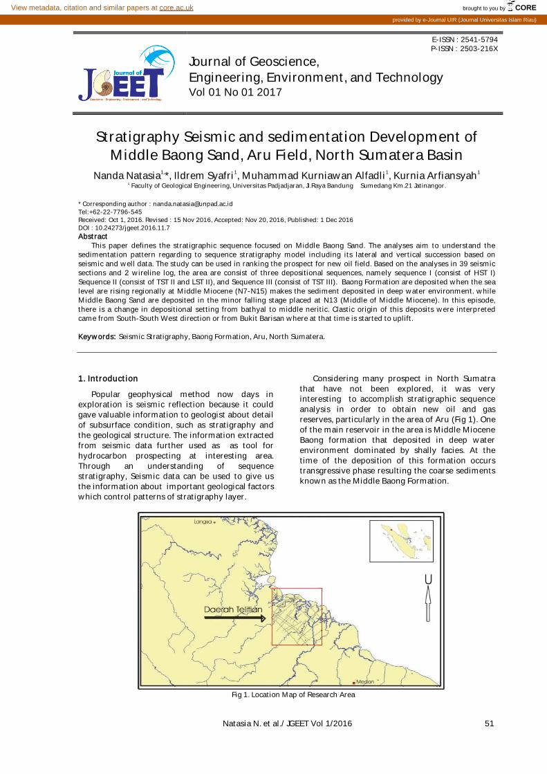
Considering many prospect in North Sumatra that have not been explored, it was very interesting to accomplish stratigraphic sequence analysis in order to obtain new oil and gas reserves, particularly in the area of Aru (Fig 1). One of the main reservoir in the area is Middle Miocene Baong formation that deposited in deep water environment dominated by shally facies. At the time of the deposition of this formation occurs transgressive phase resulting the coarse sediments known as the Middle Baong Formation.
Fig 1. Location Map of Research Area
brought to you by COREView metadata, citation and similar papers at core.ac.uk
provided by e-Journal UIR (Journal Universitas Islam Riau)
52 Natasia N. et al./ JGEET Vol 1 No 1/2016
2. Methodology
Research object included seismic reflection used in subsurface mapping and interpretation of seismic stratigraphy as well as conceptual application to obtain information about sequence stratigraphy in research area.
a. Wireline log analysis The wireline log data is used for :
Determination of depositional bed boundary used in analysis (Middle Baong Sand)
Determination of electro facies boundary based on SP Log deflection
b. Seismic Interpretation This interpretation is used to determination of
horizon boundary distribution in 2D and system tract horizons by analyze the seismic internal configuration.
3. Regional Geology
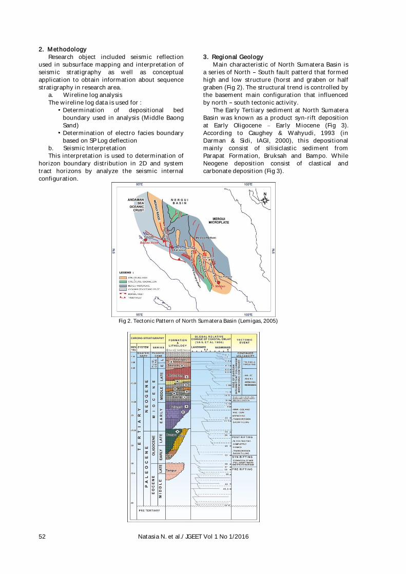
Main characteristic of North Sumatera Basin is a series of North South fault patterd that formed high and low structure (horst and graben or half graben (Fig 2). The structural trend is controlled by the basement main configuration that influenced by north south tectonic activity.
The Early Tertiary sediment at North Sumatera Basin was known as a product syn-rift deposition at Early Oligocene Early Miocene (Fig 3). According to Caughey & Wahyudi, 1993 (in Darman & Sidi, IAGI, 2000), this depositional mainly consist of silisiclastic sediment from Parapat Formation, Bruksah and Bampo. While Neogene deposition consist of clastical and carbonate deposition (Fig 3).
Fig 2. Tectonic Pattern of North Sumatera Basin (Lemigas, 2005)

Natasia N. et al./ JGEET Vol 1 No 1/2016 53
Fig 3. Regional Stratigraphy of North Sumatera Basin (Caughey & Wahyudi, 1993 (in Herman & Hasan, IAGI, 2000)
Baong Formasion was deposited coincide with
regional sea level rise. It shown with global sea level rising at 15,5 million years ago (N8-N9) and supported by depositional enviroment changing from paralic to bathyal which related to major subsidence.
4. Seismic Interpretation 39 Seismic section is used in this research
(Fig 4). Section interpretation is specially on Middle Baong Sand Depositional, marking by green horizon and the bottom is marking by red horizon (Fig 5).
Fig 4. Base Map of Research Area
Fig 5. Seismic section that shown horizon separation in Baong Formation Depositional
5. Electro Facies Depth of Well I is 2025 meters. The
position of Middle Baong Sand in 1750 2020 meters.
In the first well consist of four facies that can be difference by deflection pattern from log curve, namely :
Facies I : Found at interval between 1980 2020, identified by finning upward log
curve
Facies II : Found at interval between 1930 1980, identified by log blocky pattern
Facies III : Found at interval between 1815 1930, identified by coarsening upward
Facies IV : Found at interval between 1750 1815, identified by blocky pattern.
In the second well, Middle Baong Sand located
at 1850 2400 m. Classificated with three facies from log, namely :
Facies I : Found at interval between 1935 2040, identified by log blocky pattern
Facies II : Found at interval between 1880 1935, identified by coarsening upward
pattern
Facies III : Found at interval between 1850 1880, identified by blocky pattern.
54 Natasia N. et al./ JGEET Vol 1 No 1/2016
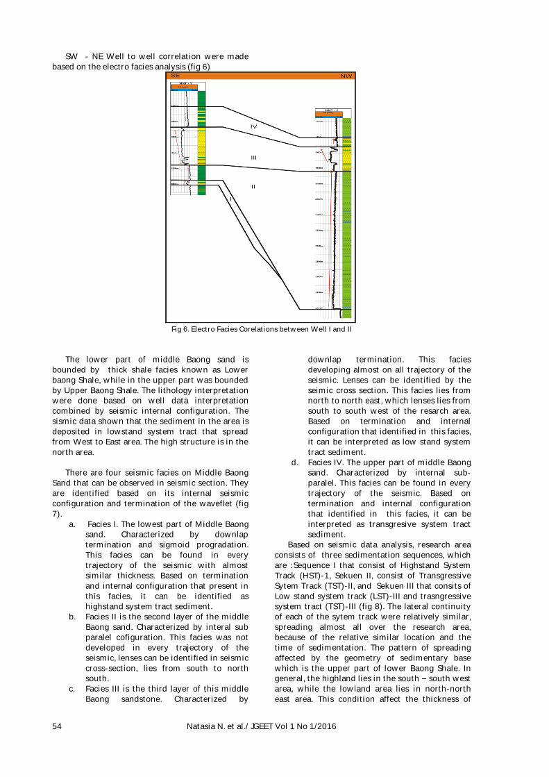
SW - NE Well to well correlation were made based on the electro facies analysis (fig 6)
Fig 6. Electro Facies Corelations between Well I and II
The lower part of middle Baong sand is
bounded by thick shale facies known as Lower baong Shale, while in the upper part was bounded by Upper Baong Shale. The lithology interpretation were done based on well data interpretation combined by seismic internal configuration. The sismic data shown that the sediment in the area is deposited in lowstand system tract that spread from West to East area. The high structure is in the north area.
There are four seismic facies on Middle Baong
Sand that can be observed in seismic section. They are identified based on its internal seismic configuration and termination of the waveflet (fig 7).
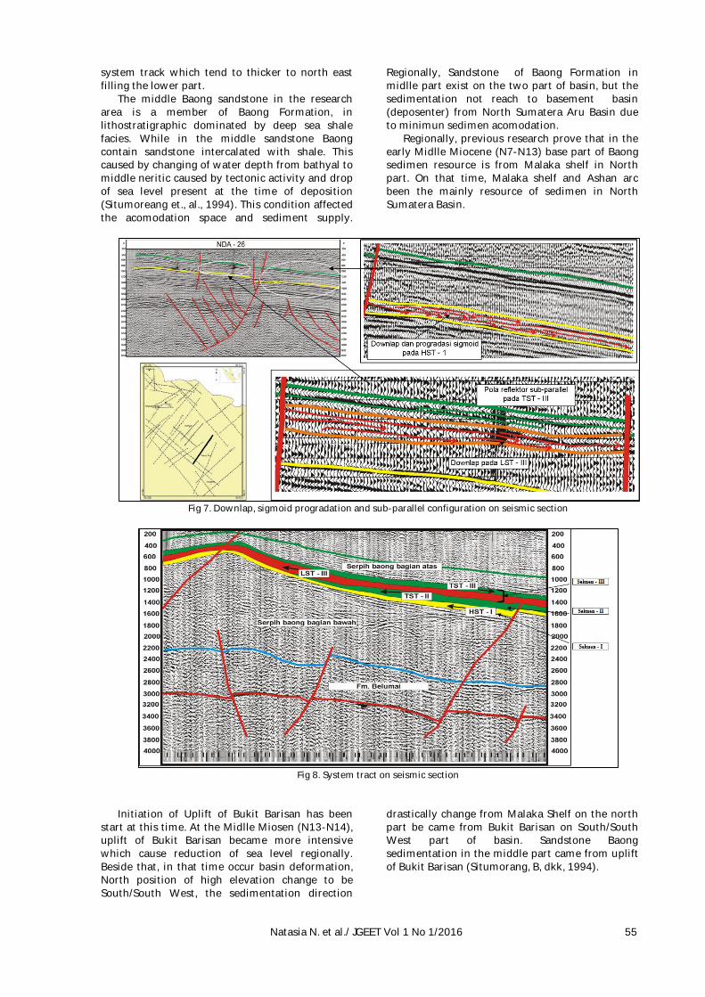
a. Facies I. The lowest part of Middle Baong sand. Characterized by downlap termination and sigmoid progradation. This facies can be found in every trajectory of the seismic with almost similar thickness. Based on termination and internal configuration that present in this facies, it can be identified as highstand system tract sediment.
b. Facies II is the second layer of the middle Baong sand. Characterized by interal sub paralel cofiguration. This facies was not developed in every trajectory of the seismic, lenses can be identified in seismic cross-section, lies from south to north south.
c. Facies III is the third layer of this middle Baong sandstone. Characterized by
downlap termination. This facies developing almost on all trajectory of the seismic. Lenses can be identified by the seimic cross section. This facies lies from north to north east, which lenses lies from south to south west of the resarch area. Based on termination and internal configuration that identified in this facies, it can be interpreted as low stand system tract sediment.
d. Facies IV. The upper part of middle Baong sand. Characterized by internal sub-paralel. This facies can be found in every trajectory of the seismic. Based on termination and internal configuration that identified in this facies, it can be interpreted as transgresive system tract sediment.
Based on seismic data analysis, research area consists of three sedimentation sequences, which are :Sequence I that consist of Highstand System Track (HST)-1, Sekuen II, consist of Transgressive Sytem Track (TST)-II, and Sekuen III that consits of Low stand system track (LST)-III and trasngressive system tract (TST)-III (fig 8). The lateral continuity of each of the sytem track were relatively similar, spreading almost all over the research area, because of the relative similar location and the time of sedimentation. The pattern of spreading affected by the geometry of sedimentary base which is the upper part of lower Baong Shale. In general, the highland lies in the south south west area, while the lowland area lies in north-north east area. This condition affect the thickness of
Natasia N. et al./ JGEET Vol 1 No 1/2016 55
system track which tend to thicker to north east filling the lower part.
The middle Baong sandstone in the research area is a member of Baong Formation, in lithostratigraphic dominated by deep sea shale facies. While in the middle sandstone Baong contain sandstone intercalated with shale. This caused by changing of water depth from bathyal to middle neritic caused by tectonic activity and drop of sea level present at the time of deposition (Situmoreang et., al., 1994). This condition affected the acomodation space and sediment supply.
Regionally, Sandstone of Baong Formation in midlle part exist on the two part of basin, but the sedimentation not reach to basement basin (deposenter) from North Sumatera Aru Basin due to minimun sedimen acomodation.
Regionally, previous research prove that in the early Midlle Miocene (N7-N13) base part of Baong sedimen resource is from Malaka shelf in North part. On that time, Malaka shelf and Ashan arc been the mainly resource of sedimen in North Sumatera Basin.
Fig 7. Downlap, sigmoid progradation and sub-parallel configuration on seismic section
Fig 8. System tract on seismic section
Initiation of Uplift of Bukit Barisan has been
start at this time. At the Midlle Miosen (N13-N14), uplift of Bukit Barisan became more intensive which cause reduction of sea level regionally. Beside that, in that time occur basin deformation, North position of high elevation change to be South/South West, the sedimentation direction
drastically change from Malaka Shelf on the north part be came from Bukit Barisan on South/South West part of basin. Sandstone Baong sedimentation in the middle part came from uplift of Bukit Barisan (Situmorang, B, dkk, 1994).
56 Natasia N. et al./ JGEET Vol 1 No 1/2016
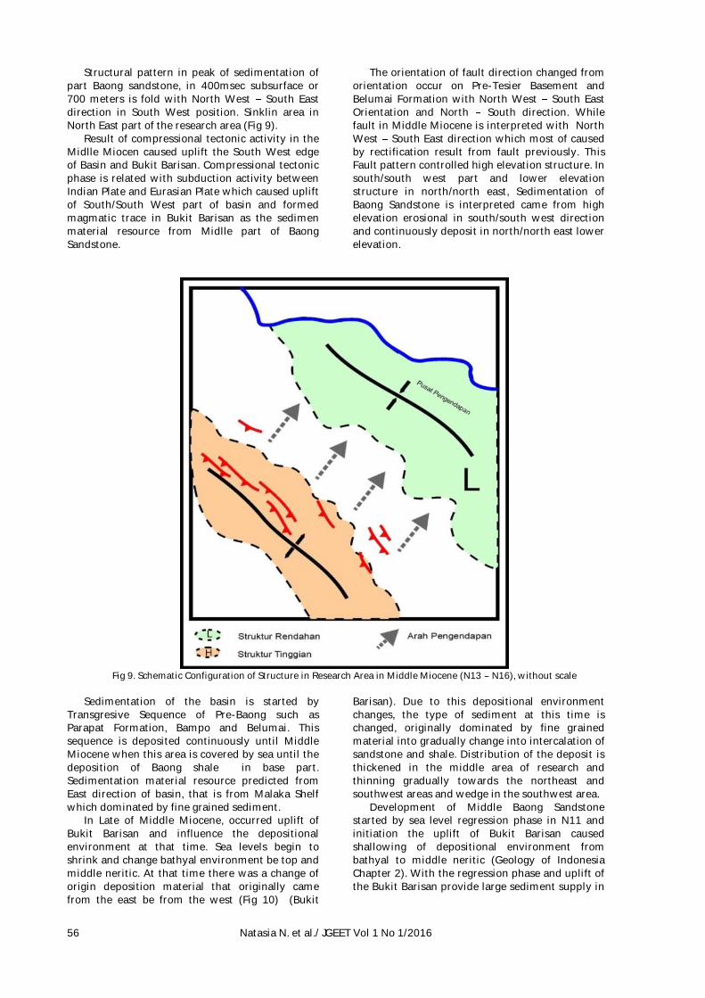
Structural pattern in peak of sedimentation of part Baong sandstone, in 400msec subsurface or 700 meters is fold with North West South East direction in South West position. Sinklin area in North East part of the research area (Fig 9).
Result of compressional tectonic activity in the Midlle Miocen caused uplift the South West edge of Basin and Bukit Barisan. Compressional tectonic phase is related with subduction activity between Indian Plate and Eurasian Plate which caused uplift of South/South West part of basin and formed magmatic trace in Bukit Barisan as the sedimen material resource from Midlle part of Baong Sandstone.
The orientation of fault direction changed from orientation occur on Pre-Tesier Basement and Belumai Formation with North West South East Orientation and North South direction. While fault in Middle Miocene is interpreted with North West South East direction which most of caused by rectification result from fault previously. This Fault pattern controlled high elevation structure. In south/south west part and lower elevation structure in north/north east, Sedimentation of Baong Sandstone is interpreted came from high elevation erosional in south/south west direction and continuously deposit in north/north east lower elevation.
Fig 9. Schematic Configuration of Structure in Research Area in Middle Miocene (N13 N16), without scale
Sedimentation of the basin is started by
Transgresive Sequence of Pre-Baong such as Parapat Formation, Bampo and Belumai. This sequence is deposited continuously until Middle Miocene when this area is covered by sea until the deposition of Baong shale in base part. Sedimentation material resource predicted from East direction of basin, that is from Malaka Shelf which dominated by fine grained sediment.
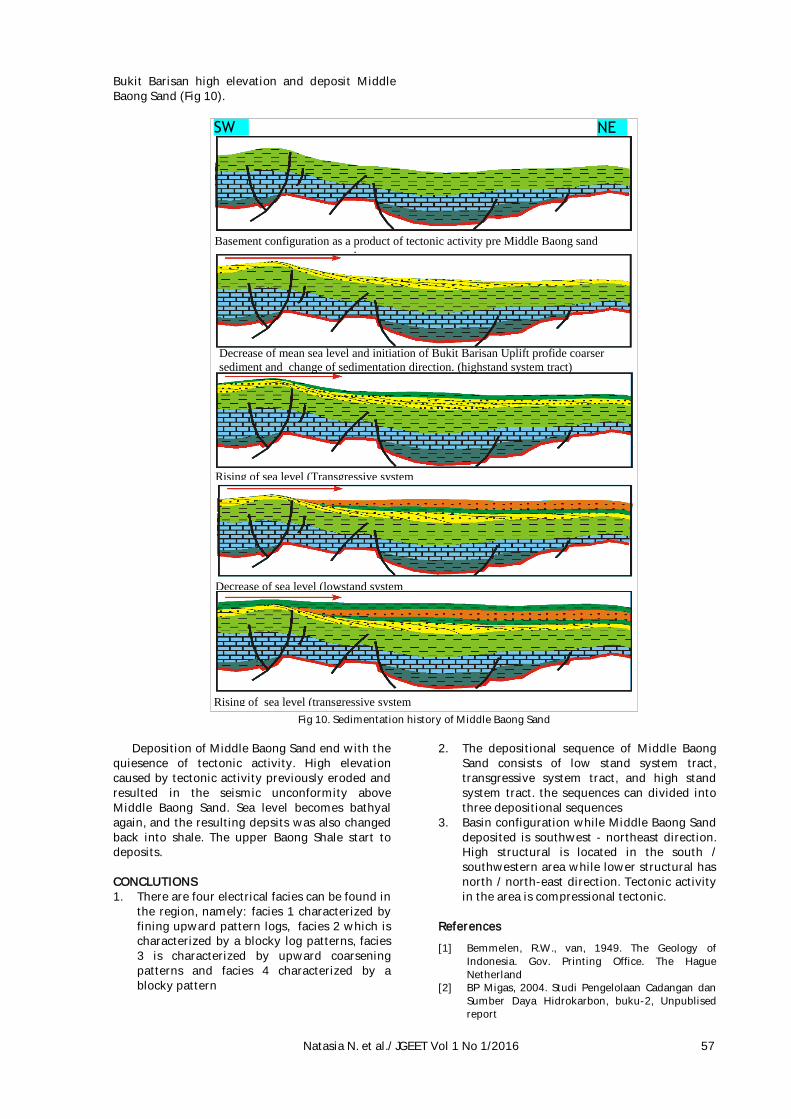
In Late of Middle Miocene, occurred uplift of Bukit Barisan and influence the depositional environment at that time. Sea levels begin to shrink and change bathyal environment be top and middle neritic. At that time there was a change of origin deposition material that originally came from the east be from the west (Fig 10) (Bukit
Barisan). Due to this depositional environment changes, the type of sediment at this time is changed, originally dominated by fine grained material into gradually change into intercalation of sandstone and shale. Distribution of the deposit is thickened in the middle area of research and thinning gradually towards the northeast and southwest areas and wedge in the southwest area.
Development of Middle Baong Sandstone started by sea level regression phase in N11 and initiation the uplift of Bukit Barisan caused shallowing of depositional environment from bathyal to middle neritic (Geology of Indonesia Chapter 2). With the regression phase and uplift of the Bukit Barisan provide large sediment supply in
Natasia N. et al./ JGEET Vol 1 No 1/2016 57
Bukit Barisan high elevation and deposit Middle Baong Sand (Fig 10).
Fig 10. Sedimentation history of Middle Baong Sand
Deposition of Middle Baong Sand end with the
quiesence of tectonic activity. High elevation caused by tectonic activity previously eroded and resulted in the seismic unconformity above Middle Baong Sand. Sea level becomes bathyal again, and the resulting depsits was also changed back into shale. The upper Baong Shale start to deposits. CONCLUTIONS 1. There are four electrical facies can be found in
the region, namely: facies 1 characterized by fining upward pattern logs, facies 2 which is characterized by a blocky log patterns, facies 3 is characterized by upward coarsening patterns and facies 4 characterized by a blocky pattern
2. The depositional sequence of Middle Baong Sand consists of low stand system tract, transgressive system tract, and high stand system tract. the sequences can divided into three depositional sequences
3. Basin configuration while Middle Baong Sand deposited is southwest - northeast direction. High structural is located in the south / southwestern area while lower structural has north / north-east direction. Tectonic activity in the area is compressional tectonic.
References
[1] Bemmelen, R.W., van, 1949. The Geology of Indonesia. Gov. Printing Office. The Hague Netherland
[2] BP Migas, 2004. Studi Pengelolaan Cadangan dan Sumber Daya Hidrokarbon, buku-2, Unpublised report
Basement configuration as a product of tectonic activity pre Middle Baong sand .
Rising of sea level (Transgressive system
tract)
Decrease of sea level (lowstand system
tract)
Rising of sea level (transgressive system
tract)
SW NE
Decrease of mean sea level and initiation of Bukit Barisan Uplift profide coarser
sediment and change of sedimentation direction. (highstand system tract)
58 Natasia N. et al./ JGEET Vol 1 No 1/2016
[3] Cameron, N.R & Aldiss, D.T, 1980. The Geological Evolution Of Northern Sumatra, 9th Annual Convention, IPA Proceeding, Jakarta.
[4] Darman, H. & Sidi, F. H. (2000), An Outline of The Geology of Indonesia, IAGI 2000
[5] Eubank & Makki, 1981, Structural Geology of Central Sumatra Back Arc Basin : Proceed 10th Ann. Conv. IPA.
[6] Harsono, A., 1997, Evaluasi Formasi dan Aplikasi Log : Sclumberger Oil Field, Edisi ke 8, Jakarta.
[7] Karig, D.E, 1980, Structural framework of the fore-arc basin, NW Sumatera, Journal Geologi Soc. London, print in Northern Ireland
[8] Koesoemadinata R.P., 2001, Petroleum Potential of Indonesia : Geology of Petroleum Basins of Indonesia, Prosiding Ikatan Ahli Geologi Indonesia, Pertemuan Ilmiah Tahunan XXX, Yogyakarta
[9] Koesoemadinata, R.P., 1980, Geologi Minyak dan Gas Bumi, jilid I dan II, ITB, Bandung.
[10] Koesoemadinata, R.P., 1971, Teknik Evaluasi Geologi Bawah Permukaan,ITB, Bandung, Indonesia.
[11] Mitchum, R.M., 1997, Seismic Stratigraphy and Global Changes of Sea Level, dalam C.E. Payton, Seismic Stratigraphy Application to Hydrocarbon Exploration : AAPG Memoir 26, p. 205 212.
[12] Mulhadiono, 1976, Depositional study of Lower Keutapang in the Aru Area, North Sumatra, 5th Annual Convention, IPA Proceeding, Jakarta.
[13] Mulhadiono, et al., 1978, The middle Baong sandstone unit as one of the most prospective units In the Aru area. North sumatra,7th annual convention, IPA Proceeding, Jakarta.
[14] Philip R. Davies., 1984, Tertiary Structural Evolution And Related Hydrocarbon Occurrences, North Sumatra Basin, 13th Annual Convention, IPA Proceeding, Jakarta.
[15] Serra, O. et al, 1989, Sedimentary Environment from Wireline Logs : Schlumberger.
[16] Situmorang, B & Yulihanto, B, 1985. The Role Of Strike Slip Faulting In Structural Development Of The North Sumatra Basin, 14th Annual Convention, IPA Proceeding, Jakarta.
[17] Sukmono, S., 1999, Interpretasi Seismik Refleksi, Jurusan Teknik Geofisika, Institut Tektologi Bandung, tidak diterbitkan.
[18] Sukmono, S., 1999, Seismik Stratigrafi, Jurusan Teknik Geofisika, Institut Teknologi Bandung, tidak diterbitkan.
[19] Tearpock, Daniel J. and Bischke, Richard E., 1991, Applied Subsurface Geological Mapping, P T R Prentice-Hall, Inc., A Simon & Schuster Company,.
[20] Wagoner Van J.C. et al., 1990, Siliciclastic Secuence Stratigraphy in Well Logs, Cores, and Outcrops, AAPG Method in Exploration Series, Tusla U.S.A.
[21] Walker G.R., dkk., 1992, Facies Models respon to sea level change, Geological association of Canada.


