Embed Size (px)
Citation preview
STRUCTURAL ANALYSIS OF THE TRANS-INDUS RANGES: IMPLICATIONS FOR THE HYDROCARBON POTENTIAL OF THE NW
HIMALAYAS, PAKISTAN
BY
AMJAD ALI
A THESIS SUBMITTED TO NCE IN GEOLOGY IN PARTIAL FULFILMENT OF THE REQUIREMENTS FOR THE DEGREE OF DOCTOR OF PHILOSOPHY (PH.D) IN GEOLOGY
NATIONAL CENTRE OF EXCELLENCE IN GEOLOGY UNIVERSITY OF PESHAWAR, PAKISTAN
2010

In the name of ALLAH, the most Beneficient, the most Merciful
i
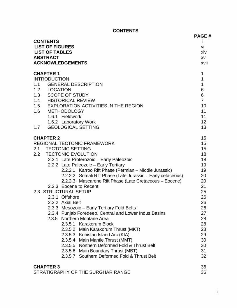
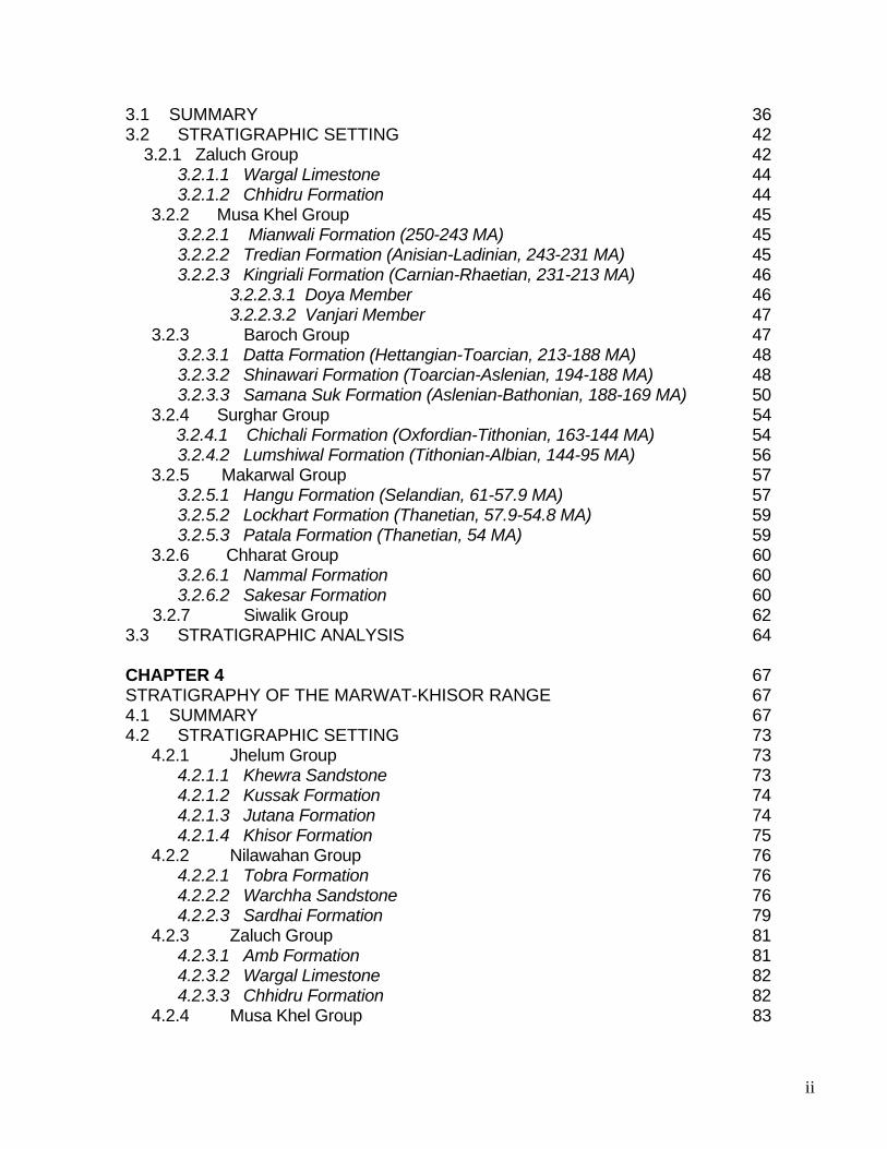
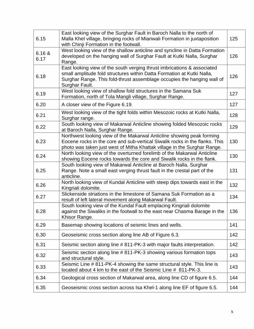
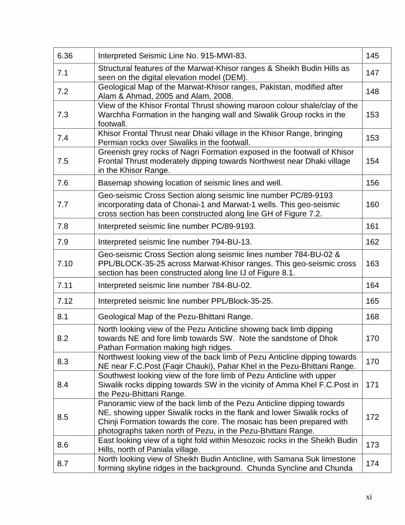
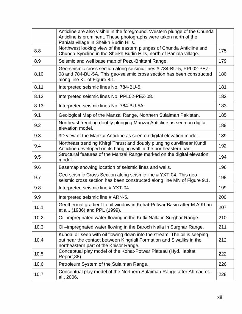
CONTENTS PAGE # CONTENTS i
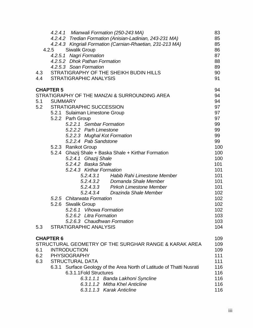
LIST OF FIGURES vii LIST OF TABLES xiv ABSTRACT xv ACKNOWLEDGEMENTS xvii CHAPTER 1 1 INTRODUCTION 1 1.1 GENERAL DESCRIPTION 1 1.2 LOCATION 6 1.3 SCOPE OF STUDY 6 1.4 HISTORICAL REVIEW 7 1.5 EXPLORATION ACTIVITIES IN THE REGION 10 1.6 METHODOLOGY 11 1.6.1 Fieldwork 11 1.6.2 Laboratory Work 12 1.7 GEOLOGICAL SETTING 13 CHAPTER 2 15 REGIONAL TECTONIC FRAMEWORK 15 2.1 TECTONIC SETTING 15 2.2 TECTONIC EVOLUTION 18
2.2.1 Late Proterozoic – Early Paleozoic 18 2.2.2 Late Paleozoic – Early Tertiary 19
2.2.2.1 Karroo Rift Phase (Permian – Middle Jurassic) 19 2.2.2.2 Somali Rift Phase (Late Jurassic – Early cetaceous) 20 2.2.2.3 Mascarene Rift Phase (Late Cretaceous – Eocene) 20
2.2.3 Eocene to Recent 21 2.3 STRUCTURAL SETUP 25
2.3.1 Offshore 26 2.3.2 Axial Belt 26 2.3.3 Mesozoic – Early Tertiary Fold Belts 26 2.3.4 Punjab Foredeep, Central and Lower Indus Basins 27
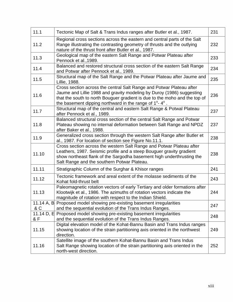
2.3.5 Northern Montane Area 28 2.3.5.1 Karakorum Block 28 2.3.5.2 Main Karakorum Thrust (MKT) 28 2.3.5.3 Kohistan Island Arc (KIA) 29 2.3.5.4 Main Mantle Thrust (MMT) 30 2.3.5.5 Northern Deformed Fold & Thrust Belt 30 2.3.5.6 Main Boundary Thrust (MBT) 31 2.3.5.7 Southern Deformed Fold & Thrust Belt 32 CHAPTER 3 36 STRATIGRAPHY OF THE SURGHAR RANGE 36
ii
3.1 SUMMARY 36 3.2 STRATIGRAPHIC SETTING 42 3.2.1 Zaluch Group 42
3.2.1.1 Wargal Limestone 44 3.2.1.2 Chhidru Formation 44 3.2.2 Musa Khel Group 45 3.2.2.1 Mianwali Formation (250-243 MA) 45 3.2.2.2 Tredian Formation (Anisian-Ladinian, 243-231 MA) 45 3.2.2.3 Kingriali Formation (Carnian-Rhaetian, 231-213 MA) 46 3.2.2.3.1 Doya Member 46 3.2.2.3.2 Vanjari Member 47 3.2.3 Baroch Group 47
3.2.3.1 Datta Formation (Hettangian-Toarcian, 213-188 MA) 48 3.2.3.2 Shinawari Formation (Toarcian-Aslenian, 194-188 MA) 48
3.2.3.3 Samana Suk Formation (Aslenian-Bathonian, 188-169 MA) 50 3.2.4 Surghar Group 54 3.2.4.1 Chichali Formation (Oxfordian-Tithonian, 163-144 MA) 54 3.2.4.2 Lumshiwal Formation (Tithonian-Albian, 144-95 MA) 56 3.2.5 Makarwal Group 57
3.2.5.1 Hangu Formation (Selandian, 61-57.9 MA) 57 3.2.5.2 Lockhart Formation (Thanetian, 57.9-54.8 MA) 59 3.2.5.3 Patala Formation (Thanetian, 54 MA) 59
3.2.6 Chharat Group 60 3.2.6.1 Nammal Formation 60 3.2.6.2 Sakesar Formation 60
3.2.7 Siwalik Group 62 3.3 STRATIGRAPHIC ANALYSIS 64 CHAPTER 4 67 STRATIGRAPHY OF THE MARWAT-KHISOR RANGE 67 4.1 SUMMARY 67 4.2 STRATIGRAPHIC SETTING 73 4.2.1 Jhelum Group 73
4.2.1.1 Khewra Sandstone 73 4.2.1.2 Kussak Formation 74 4.2.1.3 Jutana Formation 74 4.2.1.4 Khisor Formation 75
4.2.2 Nilawahan Group 76 4.2.2.1 Tobra Formation 76 4.2.2.2 Warchha Sandstone 76 4.2.2.3 Sardhai Formation 79
4.2.3 Zaluch Group 81 4.2.3.1 Amb Formation 81 4.2.3.2 Wargal Limestone 82 4.2.3.3 Chhidru Formation 82
4.2.4 Musa Khel Group 83
iii
4.2.4.1 Mianwali Formation (250-243 MA) 83 4.2.4.2 Tredian Formation (Anisian-Ladinian, 243-231 MA) 85 4.2.4.3 Kingriali Formation (Carnian-Rhaetian, 231-213 MA) 85 4.2.5 Siwalik Group 86 4.2.5.1 Nagri Formation 87 4.2.5.2 Dhok Pathan Formation 88 4.2.5.3 Soan Formation 89 4.3 STRATIGRAPHY OF THE SHEIKH BUDIN HILLS 90 4.4 STRATIGRAPHIC ANALYSIS 91 CHAPTER 5 94 STRATIGRAPHY OF THE MANZAI & SURROUNDING AREA 94 5.1 SUMMARY 94 5.2 STRATIGRAPHIC SUCCESSION 97
5.2.1 Sulaiman Limestone Group 97 5.2.2 Parh Group 97
5.2.2.1 Sembar Formation 99 5.2.2.2 Parh Limestone 99 5.2.2.3 Mughal Kot Formation 99 5.2.2.4 Pab Sandstone 99
5.2.3 Ranikot Group 100 5.2.4 Ghazij Shale + Baska Shale + Kirthar Formation 100
5.2.4.1 Ghazij Shale 100 5.2.4.2 Baska Shale 101 5.2.4.3 Kirthar Formation 101 5.2.4.3.1 Habib Rahi Limestone Member 101 5.2.4.3.2 Domanda Shale Member 101
5.2.4.3.3 Pirkoh Limestone Member 101 5.2.4.3.4 Drazinda Shale Member 102
5.2.5 Chitarwata Formation 102 5.2.6 Siwalik Group 102
5.2.6.1 Vihowa Formation 102 5.2.6.2 Litra Formation 103 5.2.6.3 Chaudhwan Formation 103
5.3 STRATIGRAPHIC ANALYSIS 104 CHAPTER 6 109 STRUCTURAL GEOMETRY OF THE SURGHAR RANGE & KARAK AREA 109 6.1 INTRODUCTION 109 6.2 PHYSIOGRAPHY 111 6.3 STRUCTURAL DATA 111
6.3.1 Surface Geology of the Area North of Latitude of Thatti Nusrati 116 6.3.1.1 Fold Structures 116
6.3.1.1.1 Banda Lakhoni Syncline 116 6.3.1.1.2 Mitha Khel Anticline 116 6.3.1.1.3 Karak Anticline 116
iv
6.3.1.1.4 Banghar Syncline 120 6.3.1.1.5 Surghar Anticline 120 6.3.1.1.6 Kalabagh Anticlinorium 121
6.3.1.2 Fault Structures 122 6.3.1.2.1 Karak Fault 122 6.3.1.2.2 Grori Fault 123 6.3.1.2.3 Mitha Khel Fault 123 6.3.1.2.4 Surghar Fault 125
6.3.2 Surface Geology of the Area South of Latitude of Thatti Nusrati 128 6.3.2.1 Fold Structures 128
6.3.2.1.1 Makarwal Anticline 128 6.3.2.1.2 Bhor Sharif Anticline 131 6.3.2.1.3 Dalwati Anticline 131 6.3.2.1.4 Kundal Syncline 132 6.3.2.1.5 Kundal Anticline 132
6.3.2.2 Fault Structures 133 6.3.2.2.1 Malla Khel Fault 133 6.3.2.2.2 Makarwal Fault 133 6.3.2.2.3 Makarwal Fault Complex 135 6.3.2.2.4 Bhor Sharif Fault 135 6.3.2.2.5 Dalwati Thrust 135 6.3.2.2.6 Kundal Fault 135
6.4 STRUCTURAL MODEL 136 CHAPTER 7 146 STRUCTURAL GEOMETRY OF THE MARWAT-KHISOR RANGES 146 7.1 INTRODUCTION 146 7.2 PHYSIOGRAPHY 146 7.3 SURFACE GEOLOGY OF THE MARWAT-KHISOR RANGES 147
7.3.1 Fold Structures 149 7.3.1.1 Marwat Anticline 149 7.3.1.2 Abdul Khel Syncline 149 7.3.1.3 Mir Ali Anticline 149 7.3.1.4 Mir Ali Syncline 150 7.3.1.5. Khisor Anticline 150 7.3.1.6 Khisor Syncline 150 7.3.1.7 Saiyiduwali Anticline 151 7.3.1.8 Paniala Anticline 151 7.3.1.9 Paniala Syncline 151
7.3.2 Fault Structures 152 7.3.2.1 Dhupsari Thrust 152 7.3.2.2 Khisor Thrust 152
7.4 STRUCTURAL MODEL 155 CHAPTER 8 166 STRUCTURAL GEOMETRY OF THE PEZU-BHITTANI RANGE 166
v
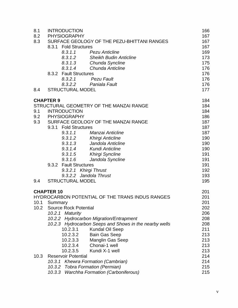
8.1 INTRODUCTION 166 8.2 PHYSIOGRAPHY 167 8.3 SURFACE GEOLOGY OF THE PEZU-BHITTANI RANGES 167
8.3.1 Fold Structures 167 8.3.1.1 Pezu Anticline 169 8.3.1.2 Sheikh Budin Anticline 173 8.3.1.3 Chunda Syncline 175 8.3.1.4 Chunda Anticline 176
8.3.2 Fault Structures 176 8.3.2.1 Pezu Fault 176 8.3.2.2 Paniala Fault 176
8.4 STRUCTURAL MODEL 177 CHAPTER 9 184 STRUCTURAL GEOMETRY OF THE MANZAI RANGE 184 9.1 INTRODUCTION 184 9.2 PHYSIOGRAPHY 186 9.3 SURFACE GEOLOGY OF THE MANZAI RANGE 187
9.3.1 Fold Structures 187 9.3.1.1 Manzai Anticline 187 9.3.1.2 Khirgi Anticline 190 9.3.1.3 Jandola Anticline 190 9.3.1.4 Kundi Anticline 190 9.3.1.5 Khirgi Syncline 191 9.3.1.6 Jandola Syncline 191
9.3.2 Fault Structures 191 9.3.2.1 Khirgi Thrust 192 9.3.2.2 Jandola Thrust 193
9.4 STRUCTURAL MODEL 195 CHAPTER 10 201 HYDROCARBON POTENTIAL OF THE TRANS INDUS RANGES 201 10.1 Summary 201 10.2 Source Rock Potential 202
10.2.1 Maturity 206 10.2.2 Hydrocarbon Migration/Entrapment 208 10.2.3 Hydrocarbon Seeps and Shows in the nearby wells 208
10.2.3.1 Kundal Oil Seep 211 10.2.3.2 Bain Gas Seep 213 10.2.3.3 Manglin Gas Seep 213 10.2.3.4 Chonai-1 well 213 10.2.3.5 Kundi X-1 well 213
10.3 Reservoir Potential 214 10.3.1 Khewra Formation (Cambrian) 214 10.3.2 Tobra Formation (Permian) 215 10.3.3 Warchha Formation (Carboniferous) 215
vi
10.3.4 Wargal & Amb Limestone (Permian) 215 10.3.5 Kingriali Formation (Triassic) 215 10.3.6 Datta Sandstone (Jurassic) 216 10.3.7 Samana Suk Formation (Jurassic) 216 10.3.8 Lumshiwal Formation (Cretaceous) 217 10.3.9 Hangu Formation (Paleocene) 218 10.3.10 Lockhart Formation (Paleocene) 218 10.3.11 Patala Limestone (Paleocene) 219 10.3.12 Sakesar and Chorgali Formations (Eocene) 219
10.4 Seal/Cap Rocks 220 10.5 Play Types 221 10.6 HYDROCARBON POTENTIAL OF THE MANZAI AREA 223
10.6.1 SOURCE ROCKS 223 10.6.2 RESERVOIR ROCKS 224 10.6.3 CAP ROCKS 225
10.7 STRUCTURAL STYLE AND HYDROCARBON TRAPS 227 CHAPTER 11 229 DISCUSSION AND CONCLUSIONS 229 11.1 STRUCTURAL STYLES OF THE TRANS INDUS RANGES 229 11.2 COMPARATIVE STATEMENT OF THE STRUCTURAL STYLES 231
IN THE SALT AND TRANS INDUS RANGES 11.3 SEDIMENTATION & DEFORMATION SCHEME 239
OF THE TRANS INDUS RANGES 11.4 ARCUATE NATURE OF THE TRANS INDUS RANGES 244 11.5 SEQUENTIAL EVOLUTION OF THE TRANS INDUS RANGES 249 REFERENCES 253
vii
LIST OF FIGURES
FIG. # TITLE PAGE No.
1.1
Tectonomorphic map of Pakistan, showing the location of the study area. 2
1.2
Generalized geological map of the NW Himalayan foreland fold and thrust belt, modified after Kazmi and Rana (1982), Yeats and Lawrence (1984), Maluski Matte (1984), Coward et al., (1986) and Lillie et al., (1987).
4
1.3 Geological Map of the Trans Indus Ranges after Raza et al., 1993. 5
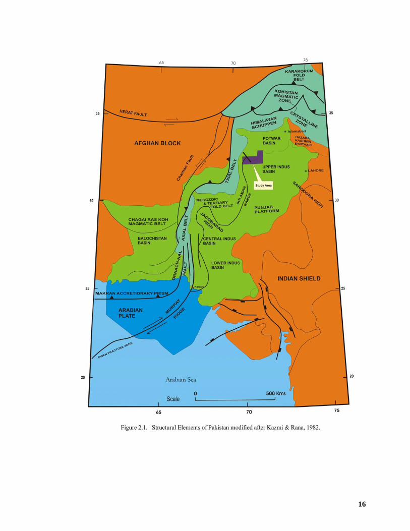
2.1 Structural Elements of Pakistan modified after Kazmi and Rana, 1982. 16
2.2 Plate Tectonics – at 70 my, 55 my and 3 my after Scotese, 1997 and Scotese et al., 1998. 22
2.3 Plate Tectonics – Present day after Scotese, 1997 and Scotese et al., 1998 23
2.4 Tectonic Map of North Pakistan (modified after Pegler & Das, 1998). 29
2.5 Tectonic Map of North Pakistan, showing major structural features (modified after Kazmi & Rana, 1982). 33
2.6
Map showing the location and extents of the geological maps prepared in different parts of the Trans Indus Ranges, after Raza et al., 1993. 35
3.1 Regional Stratigraphic Correlation from Top Eocene. 38
3.2 Map of the Potwar Basin showing truncation of Eocene to Permian strata From west to east after Siddiqui et al., 1998. 39
3.3 East-west well correlation from top Chorgali Formation. 40
3.4 Diagram summarizing relative sea level changes & tectonic history of the Kohat-Potwar Basin (Modified after Izatt, 1991). 41
3.5 Generalized Stratigraphy of the Surghar Range in the vicinity of Landa Psha area. 43
3.6 Contact between Datta & overlying Shinwari Formation at Kutki Nalla, SurgharRange. 49
3.7 View of the Datta Formation exposed in Chichali Gorge, Surghar Range. Note that coal is mined from the basal part of Datta Formation overhere. 50
3.8 Contact between Samana Suk & overlying Chichali Formation at Baroch Nalla, Surghar Range. 51
3.9
North looking view of stratigraphic succession exposed in the Chichali Gorge, Surghar Range. Note the Jurassic Shinawari & Samana Suk formations at the base, overlain by Cretaceous Chichali & Lumshiwal formations. The Eocene Nammal & Sakesar formations can be seen in the background, forming cliffs and ridges.
52
3.10 A closer view of the previous photograph. 52
viii
3.11 Stratigraphy of the Surghar Range in the vicinity of Makarwal. 53
3.12 Dark green to greenish grey sandstone of Chichali Formation exposed in the Baroch Nalla, Surghar Range. 55
3.13 Weathered rusty brown, glauconitic sandstone with dark grey shale of Chichali Formation showing Belemnite fossils in the Chichali Gorge, Surghar Range.
55
3.14 Photograph showing sandstone of Lumshiwal Formation and overlying limestone of the Lockhart and Eocene at hill top at Chichali Gorge, Surghar Range.
57
3.15 A view of the Hangu and overlying Lockhart Formation in the back limb of the Makarwal Anticline at Baroch Nalla, Surghar Range. 58
3.16 Backlimb of the Makarwal Anticline showing Eocene rocks dipping at moderate angle towards west. 61
3.17 A view of the Sakesar limestone near Mitha Khattak village in the N-S trending segment of the, Surghar Range. 61
3.18 North looking view of the overturned fore limb of the Makarwal Anticline showing Eocene (Nammal+Sakesar formations) towards the core and Siwalik rocks in the flank.
63
3.19 A view of the rocks of the Chinji Formation to the north of Chichali Dam in Chichali Gorge, Surghar Range. 63
3.20 Combined stratigraphy of Surghar Range. 65
4.1 Generalized Stratigraphy of the Khisor Range near Saiyduwali. 68
4.2 Regional East-West Stratigrahic well correlation. 72
4.3 Maroon color shale/clay of Warchha Formation in the hanging wall of Khisor frontal thrust near Dhakki village in the Khisor Range. 78
4.4 View of the Sardhai Formation showing carbonaceous clays near Dhupsari village in the Khisor Range. 80
4.5 Contact between greenish grey clay of Sardhai Formation and overlying calcareous sandstone of the Amb Formation near Dhupsari village in the Khisor Range.
82
4.6 Grey and maroon color clay and sandy limestone of the Mianwali Formation having sub-vertical beds in the Khisor Range. 84
4.7 Green color shaly sandstone of the Mianwali Formation in the Khisor Range. 84
4.8 A view of the oil-stained Kingriali Dolomite near Kundal oil seep in the Khisor Range. 85
4.9 Columnar Section of the Siwalik Group rocks mapped in the Marwat Range after (Alam et al, 2005 and Alam 2008). 87
4.10 Greenish grey rocks of the Nagri Formation exposed in the footwall of Khisor Frontal Thrust moderately dipping towards northwest near Dhakki village in the Khisor Range.
88
4.11 Slope forming rocks of Datta Formation in Sheikh Budin Hills, north of Paniala village. 91
ix
5.1 Stratigraphy of the Manzai & surrounding area, Northern Sulaiman Range. 95
5.2 Stratigraphy of Northern Sulaiman Range with chronostratigraphic equivalence in the Kohat-Potwar Region (modified after Quad Consulting, 1996).
98
5.3 Correlation of Siwalik Group rocks in the northern Sulaiman Range (modified after Hemphill et al., 1973). 105
5.4 Regional east-west well correlation from Base Eocene. 106
5.5 Regional north-south well correlation from Base Eocene. 107
5.6 Local stratigraphy between Savi Ragha-1 well and Dhodak well No.3. 108
6.1 Generalized geologic map of the NW Himalayan foreland fold and thrust belt (modified after Kazmi and Rana 1986). 110
6.2 East-west trending segment of the Surghar Range and Karak area of the southern Kohat Plateau as seen on the digital elevation model. 112
6.3 Geological Map of the East-West trending segment of the Surghar Range and Karak area, North Pakistan. 113
6.4 North-south trending segment of the Surghar Range as seen on the digital elevation model. 114
6.5 Geological Map of the North-south trending segment of the Surghar Range and Kundal area. 115
6.6 Looking west, northwest dipping back limb of the Karak Anticline. 118
6.7 Looking eastward, gently northwest dipping back limb of the Karak Anticline exposing upper Siwalik rocks. 118
6.8 East looking view of the crestal zone of Karak Anticline. The crest hosts rocks of Dhok Pathan Formation as the area is close to the western plunge of the anticline.
118
6.9 Northeast looking view of the Karak Anticline showing Stratigraphy of the forelimb of the anticline. 119
6.10 East looking view of the forelimb of the Karak Anticline showing moderately south dipping Siwalik rocks. 119
6.11 View of the Banghar syncline with stream flowing in the core of the syncline and Shinghar forming its forelimb in the southeast. 120
6.12
West looking view of the Surghar Anticline exposed along Chichali Gorge. Note that the southern limb of the anticline is overturned and faulted against Samana Suk Formation in the footwall. Several steeply dipping reverse faults verging northwards can be seen within Samana Suk Formation.
121
6.13 North looking view of the Karak Fault, emplacing Eocene Mami khel clay & Jatta Gypsum over Siwalik Group rocks in the footwall. 122
6.14 Looking east, view of the hanging wall of Mitha Khel Fault showing north dipping rocks of Chinji Formation. This photograph was taken near Mitha Khel village in the Karak area.
124
x
6.15 East looking view of the Surghar Fault in Baroch Nalla to the north of Malla Khel village, bringing rocks of Mianwali Formation in juxtaposition with Chinji Formation in the footwall.
125
6.16 & 6.17
West looking view of the shallow anticline and syncline in Datta Formation developed on the hanging wall of Surghar Fault at Kutki Nalla, Surghar Range.
126
6.18
East looking view of the south verging thrust imbrications & associated small amplitude fold structures within Datta Formation at Kutki Nalla, Surghar Range. This fold-thrust assemblage occupies the hanging wall of Surghar Fault.
126
6.19 West looking view of shallow fold structures in the Samana Suk Formation, north of Tola Mangli village, Surghar Range. 127
6.20 A closer view of the Figure 6.19. 127
6.21 West looking view of the tight folds within Mesozoic rocks at Kutki Nalla, Surghar range. 128
6.22 South looking view of Makarwal Anticline showing folded Mesozoic rocks at Baroch Nalla, Surghar Range. 129
6.23 Northwest looking view of the Makarwal Anticline showing peak forming Eocene rocks in the core and sub-vertical Siwalik rocks in the flanks. This photo was taken just west of Mitha Khattak village in the Surghar Range.
130
6.24 North looking view of the overturned forelimb of the Makarwal Anticline showing Eocene rocks towards the core and Siwalik rocks in the flank. 130
6.25 South looking view of Makarwal Anticline at Baroch Nalla, Surghar Range. Note a small east verging thrust fault in the crestal part of the anticline.
131
6.26 North looking view of Kundal Anticline with steep dips towards east in the Kingriali dolomite. 132
6.27 Slickenside striations in the limestone of Samana Suk Formation as a result of left lateral movement along Makarwal Fault. 134
6.28 South looking view of the Kundal Fault emplacing Kingriali dolomite against the Siwaliks in the footwall to the east near Chasma Barage in the Khisor Range.
136
6.29 Basemap showing locations of seismic lines and wells. 141
6.30 Geoseismic cross section along line AB of Figure 6.3. 142
6.31 Seismic section along line # 811-PK-3 with major faults interpretation. 142
6.32 Seismic section along line # 811-PK-3 showing various formation tops and structural style. 143
6.33 Seismic Line # 811-PK-4 showing the same structural style. This line is located about 4 km to the east of the Seismic Line # 811-PK-3. 143
6.34 Geological cross section of Makarwal area, along line CD of figure 6.5. 144
6.35 Geoseismic cross section across Isa Khel-1 along line EF of figure 6.5. 144
xi
6.36 Interpreted Seismic Line No. 915-MWI-83. 145
7.1 Structural features of the Marwat-Khisor ranges & Sheikh Budin Hills as seen on the digital elevation model (DEM). 147
7.2 Geological Map of the Marwat-Khisor ranges, Pakistan, modified after Alam & Ahmad, 2005 and Alam, 2008. 148
7.3 View of the Khisor Frontal Thrust showing maroon colour shale/clay of the Warchha Formation in the hanging wall and Siwalik Group rocks in the footwall.
153
7.4 Khisor Frontal Thrust near Dhaki village in the Khisor Range, bringing Permian rocks over Siwaliks in the footwall. 153
7.5 Greenish grey rocks of Nagri Formation exposed in the footwall of Khisor Frontal Thrust moderately dipping towards Northwest near Dhaki village in the Khisor Range.
154
7.6 Basemap showing location of seismic lines and well. 156
7.7 Geo-seismic Cross Section along seismic line number PC/89-9193 incorporating data of Chonai-1 and Marwat-1 wells. This geo-seismic cross section has been constructed along line GH of Figure 7.2.
160
7.8 Interpreted seismic line number PC/89-9193. 161
7.9 Interpreted seismic line number 794-BU-13. 162
7.10 Geo-seismic Cross Section along seismic lines number 784-BU-02 & PPL/BLOCK-35-25 across Marwat-Khisor ranges. This geo-seismic cross section has been constructed along line IJ of Figure 8.1.
163
7.11 Interpreted seismic line number 784-BU-02. 164
7.12 Interpreted seismic line number PPL/Block-35-25. 165
8.1 Geological Map of the Pezu-Bhittani Range. 168
8.2 North looking view of the Pezu Anticline showing back limb dipping towards NE and fore limb towards SW. Note the sandstone of Dhok Pathan Formation making high ridges.
170
8.3 Northwest looking view of the back limb of Pezu Anticline dipping towards NE near F.C.Post (Faqir Chauki), Pahar Khel in the Pezu-Bhittani Range. 170
8.4 Southwest looking view of the fore limb of Pezu Anticline with upper Siwalik rocks dipping towards SW in the vicinity of Amma Khel F.C.Post in the Pezu-Bhittani Range.
171
8.5
Panoramic view of the back limb of the Pezu Anticline dipping towards NE, showing upper Siwalik rocks in the flank and lower Siwalik rocks of Chinji Formation towards the core. The mosaic has been prepared with photographs taken north of Pezu, in the Pezu-Bhittani Range.
172
8.6 East looking view of a tight fold within Mesozoic rocks in the Sheikh Budin Hills, north of Paniala village. 173
8.7 North looking view of Sheikh Budin Anticline, with Samana Suk limestone forming skyline ridges in the background. Chunda Syncline and Chunda 174
xii
Anticline are also visible in the foreground. Western plunge of the Chunda Anticline is prominent. These photographs were taken north of the Paniala village in Sheikh Budin Hills.
8.8 Northwest looking view of the eastern plunges of Chunda Anticline and Chunda Syncline in the Sheikh Budin Hills, north of Paniala village. 175
8.9 Seismic and well base map of Pezu-Bhittani Range. 179
8.10 Geo-seismic cross section along seismic lines # 784-BU-5, PPL02-PEZ-08 and 784-BU-5A. This geo-seismic cross section has been constructed along line KL of Figure 8.1.
180
8.11 Interpreted seismic lines No. 784-BU-5. 181
8.12 Interpreted seismic lines No. PPL02-PEZ-08. 182
8.13 Interpreted seismic lines No. 784-BU-5A. 183
9.1 Geological Map of the Manzai Range, Northern Sulaiman Pakistan. 185
9.2 Northeast trending doubly plunging Manzai Anticline as seen on digital elevation model. 188
9.3 3D view of the Manzai Anticline as seen on digital elevation model. 189
9.4 Northeast trending Khirgi Thrust and doubly plunging curvilinear Kundi Anticline developed on its hanging wall in the northeastern part. 192
9.5 Structural features of the Manzai Range marked on the digital elevation model. 194
9.6 Basemap showing location of seismic lines and wells. 196
9.7 Geo-seismic Cross Section along seismic line # YXT-04. This geo-seismic cross section has been constructed along line MN of Figure 9.1. 198
9.8 Interpreted seismic line # YXT-04. 199
9.9 Interpreted seismic line # ARN-5. 200
10.1 Geothermal gradient to oil window in Kohat-Potwar Basin after M.A.Khan et al., (1986) and PPL (1999). 207
10.2 Oil–impregnated water flowing in the Kutki Nalla in Surghar Range. 210
10.3 Oil–impregnated water flowing in the Baroch Nalla in Surghar Range. 211
10.4 Kundal oil seep with oil flowing down into the stream. The oil is seeping out near the contact between Kingriali Formation and Siwaliks in the northeastern part of the Khisor Range.
212
10.5 Conceptual play model of the Kohat-Potwar Plateau (Hyd.Habitat Report,88) 222
10.6 Petroleum System of the Sulaiman Range. 226
10.7 Conceptual play model of the Northern Sulaiman Range after Ahmad et. al., 2006. 228
xiii
11.1 Tectonic Map of Salt & Trans Indus ranges after Butler et al., 1987. 231
11.2 Regional cross sections across the eastern and central parts of the Salt Range illustrating the contrasting geometry of thrusts and the outlying nature of the thrust front after Butler et al., 1987.
232
11.3 Geological map of the eastern Salt Range and Potwar Plateau after Pennock et al.,1989. 233
11.4 Balanced and restored structural cross section of the eastern Salt Range and Potwar after Pennock et al., 1989. 234
11.5 Structural map of the Salt Range and the Potwar Plateau after Jaume and Lillie, 1988. 235
11.6
Cross section across the central Salt Range and Potwar Plateau after Jaume and Lillie 1988 and gravity modeling by Duroy (1986) suggesting that the south to north Bouguer gradient is due to the moho and the top of the basement dipping northward in the range of 1o- 4o .
236
11.7 Structural map of the central and eastern Salt Range & Potwal Plateau after Pennock et al., 1989. 237
11.8 Balanced structural cross section of the central Salt Range and Potwar Plateau showing no internal deformation between Salt Range and NPDZ after Baker et al., 1988.
237
11.9 Generalized cross section through the western Salt Range after Butler et al., 1987. For location of section see Figure No.11.1. 238
11.10
Cross section across the western Salt Range and Potwar Plateau after Leathers, 1987. Seismic profile and a steep Bouguer gravity gradient show northeast flank of the Sargodha basement high underthrusting the Salt Range and the southern Potwar Plateau.
238
11.11 Stratigraphic Column of the Surghar & Khisor ranges 241
11.12 Tectonic framework and areal extent of the molasse sediments of the Kohat fold-thrust belt 243
11.13 Paleomagnetic rotation vectors of early Tertiary and older formations after Klootwijk et al., 1986. The azimuths of rotation vectors indicate the magnitude of rotation with respect to the Indian Shield.
244
11.14 A, B & C
Proposed model showing pre-existing basement irregularities and the sequential evolution of the Trans Indus Ranges. 247
11.14 D, E& F
Proposed model showing pre-existing basement irregularities and the sequential evolution of the Trans Indus Ranges. 248
11.15 Digital elevation model of the Kohat-Bannu Basin and Trans Indus ranges showing location of the strain partitioning axis oriented in the northwest direction.
249
11.16 Satellite image of the southern Kohat-Bannu Basin and Trans Indus Salt Range showing location of the strain partitioning axis oriented in the north-west direction.
252
xiv
LIST OF TABLES
3.1 Technical well data of Isa Khel-01. 37 3.2 Comparative formations thickness data from the Surghar Range. 66 4.1 Technical well data of Chonai-01. 70 4.2 Technical well data of Marwat-01. 71 4.3 Technical well data of Pezu-01. 93 5.1 Technical well data of Ramak-01. 96
10.1 Some of the reported oil seepages in Kohat-Potwar. 209
xv
ABSTRACT The Trans Indus ranges constitute the western end of the frontal ranges that border the
active foreland fold-and-thrust belt of the Himalaya in North Pakistan. Over 200 line km of
2D seismic data and sub-surface information of seven wells drilled in the surrounding
areas have been integrated with surface geological information in order to understand the
structural evolution of the Trans Indus ranges.
Cambrian to Eocene platform succession unconformably overlain by a thick pile of
fluviatile molasse deposits outcrop along the Trans-Indus ranges. The Trans-Indus
ranges display pronounced structural swings in plan view, giving rise to a pair of re-
entrants known under the name of Kalabagh and Tank. Both these re-entrants are
flanked by wrench zones in the east and west that have produced contrasting styles
within the Trans-Indus ranges. The structural styles include south-verging anticlinal-
monoclinal ridge above a frontal fault, wrenching and compression related en-echelon
anticlines and fault bend folds. The current investigations have led to the understanding
that the structural evolution of the east-west and east-north-east oriented segments of the
Trans Indus ranges is attributed to a south directed ramping whereas the north-
south/northwest trending segments are related to wrenching concomitant with
compression. The frontal bounding fault in the Trans-Indus ranges is less significant as
compared to that along the Salt Range in terms of its level of decoupling and the
magnitude of southward translation.
The Himalaya-related deformation that shaped the Trans-Indus ranges is distinguished
into three discrete episodes including pre-molasse, syn-molasse and post-molasse. The
pre-molasse deformation includes the extensional tectonic activity resulted in the
development of the normal basement faults with down thrown side to the north. The syn-
molasse deformational episode is well demonstrated by the gradual south-younging
sequence of molasse deposits in the Kohat Basin. The post-molasse deformational
episode started in the region at the time when the macroscopic thrust slab underneath
the Kohat-Bannu Basin ramped up section at the site of Trans Indus ranges. This
ramping led to the creation of the present day Trans-Indus ranges and the internal
deformation of the thrust slab which is still continuing.
xvi
The arcuate nature of the Trans Indus ranges is interpreted to be original, partly
controlled by some pre-existing basement irregularities and possible strain partitioning. It
is interpreted that the onset of compression at the northern and southern Surghar Range
and Manzai ranges was synchronous caused by north-south and east-west compression
induced by proto Main Boundary Thrust and Kurram Fault respectively. At the time when
Proto MBT was transmitting south directed stresses at the site of the northern Surghar
Range, left lateral wrenching along the Proto Kurram zone was transmitting east directed
compressive stresses resulting in the north-south oriented folds in the Manzai and
southern Surghar Range. The onset of thrusting is believed to be the earliest at the site of
Surghar and Manzai ranges followed by wrenching along Pezu, Kundal and Makarwal
faults. This wrenching episode was subsequently followed by thrusting at the site of
Khisor and Marwat ranges.
The stratigraphic succession and structural styles observed within the Trans Indus
ranges offer a complete petroleum system comprised of multiple reservoir, source, seal
rocks and traps including structural as well as stratigraphic for the accumulation of
hydrocarbons.
xvii
ACKNOWLEDGEMENTS First of all, I bow my head to Almighty Allah who bestowed me with the strength and capability to successfully complete this research work. I am greatly obliged to thank Professor Dr. Sajjad Ahmad, Department of Geology, University of Peshawar, my principal supervisor for his dedication and painstaking efforts in every phase of this research work right from motivation to get enrolled, fieldwork, laboratory work, data interpretation and review of different versions of the manuscript. He always received me with a smiling face both in the office as well as at home, even on the weekends. Without his kind assistance, this work would have not been accomplished. I would like to express special tributes to my Late supervisor Professor Dr. S. Hamidullah, ex-Director NCE Geology, who left us all in tremendous shock with his sudden and tragic death. His full support and guidance encouraged me to undertake and embark upon this challenging task. Special thanks are due to my co-supervisor Dr. Irshad Ahmad, Professor NCE Geology for his sincere efforts in supervising this thesis. The author is thankful to Professor Dr. M. Asif Khan, Director NCE Geology, University of Peshawar for his kind support and facilitating the geological fieldwork. Many thanks are also due to Professor Dr. M. Tahir Shah for his quick and timely support whenever needed. Special tributes are paid to (Late) Imtiaz Noor, Manager Exploration, OGDCL for providing incredible help in seismic interpretation. Colleagues from LMKR (Mr. Hasrat Mehmood and Ghulam Mujtaba,geophysicists) and Saif Energy Ltd. (Dr. Abdul Waheed & Hamid Mushtaq) extended encouragement and full support, which is highly appreciated. I must thank my personal friends, Dr. M. Khalid Khan, Mr. Wazir Ali & Lutfullah Bacha for their consistent moral support. Many thanks to my teachers & friends at both NCEG & Department of Geology (Prof. Dr. Fazli Rabbi Khan, Mr. Fayyaz Ali, Asstt. Professor, M. Irfan Jani, Jawad Afzal, Semi Javed & Faridoon ) who assisted me in the completion of this research work in any way. I owe a particular debt to DGPC office for the release of public domain data and the managements of LMK Resources & Saif Energy Limited for providing a very conducive & professional environment to undertake this research work. Professor Dr. Kevin R. Pogue of the Department of Geology, Whitman College, Washington USA, Professor Dr. Joseph A. DiPietro of the Department of Geology, University of Southern Indiana, USA & Professor Dr. Riaz A. Sheikh, Institute of Geology, University of the Punjab, Lahore are highly acknowledged for critically reviewing the manuscript and making fruitful suggestions. Many thanks to all my family members specially my mother & sisters who always raised their hands for my every wish coming true. I am unable to express in words the support of my elder brother (Mr. Ahmed A. Shah) throughout my educational career. Mr. Niaz A. Khan has been very supportive in managing domestic affairs and took care of my children. I am also proud of my children (Hadeeqa, Rabia & Sabaun) who were paid little attention during this period. Finally, my wife and in-laws encouraged me to accept the challenging job of conducting higher studies in geological sciences, which is highly appreciated & acknowledged. AMJAD ALI KHAN July, 2010
1
CHAPTER 1
INTRODUCTION
1.1 GENERAL DESCRIPTION
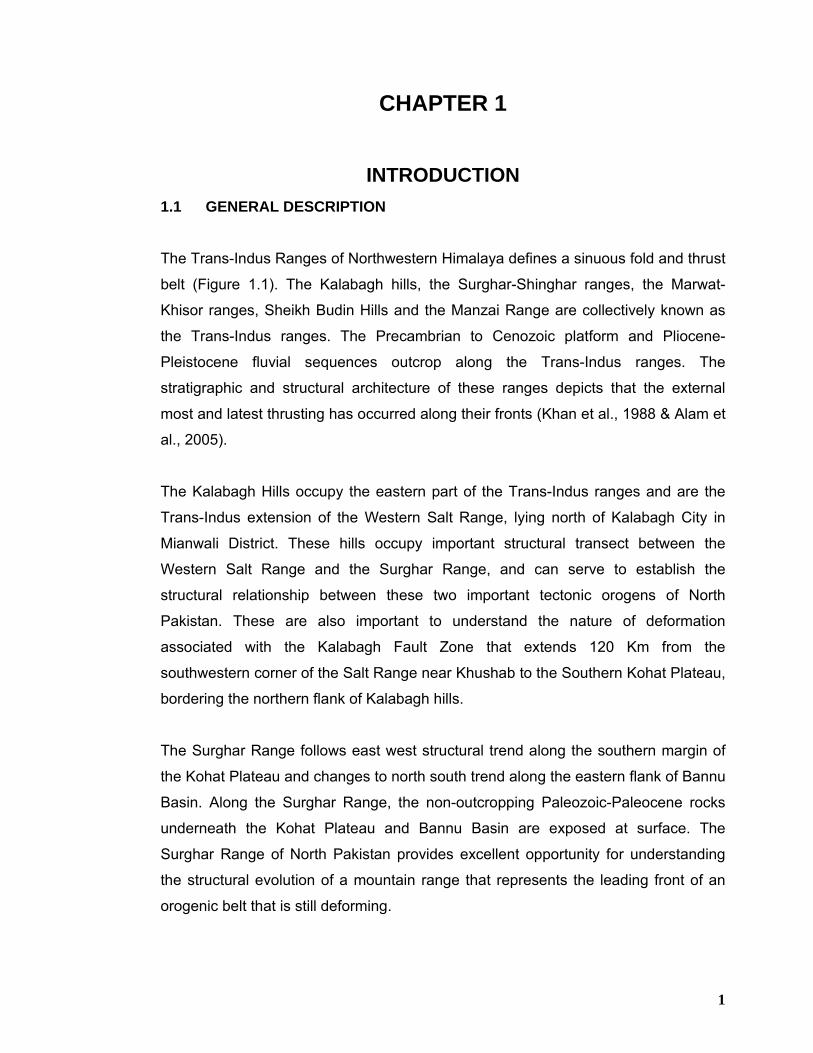
The Trans-Indus Ranges of Northwestern Himalaya defines a sinuous fold and thrust
belt (Figure 1.1). The Kalabagh hills, the Surghar-Shinghar ranges, the Marwat-
Khisor ranges, Sheikh Budin Hills and the Manzai Range are collectively known as
the Trans-Indus ranges. The Precambrian to Cenozoic platform and Pliocene-
Pleistocene fluvial sequences outcrop along the Trans-Indus ranges. The
stratigraphic and structural architecture of these ranges depicts that the external
most and latest thrusting has occurred along their fronts (Khan et al., 1988 & Alam et
al., 2005).
The Kalabagh Hills occupy the eastern part of the Trans-Indus ranges and are the
Trans-Indus extension of the Western Salt Range, lying north of Kalabagh City in
Mianwali District. These hills occupy important structural transect between the
Western Salt Range and the Surghar Range, and can serve to establish the
structural relationship between these two important tectonic orogens of North
Pakistan. These are also important to understand the nature of deformation
associated with the Kalabagh Fault Zone that extends 120 Km from the
southwestern corner of the Salt Range near Khushab to the Southern Kohat Plateau,
bordering the northern flank of Kalabagh hills.
The Surghar Range follows east west structural trend along the southern margin of
the Kohat Plateau and changes to north south trend along the eastern flank of Bannu
Basin. Along the Surghar Range, the non-outcropping Paleozoic-Paleocene rocks
underneath the Kohat Plateau and Bannu Basin are exposed at surface. The
Surghar Range of North Pakistan provides excellent opportunity for understanding
the structural evolution of a mountain range that represents the leading front of an
orogenic belt that is still deforming.
2
Fig. 1.1. Tectonomorphic map of Pakistan, showing the location of the study area.
3
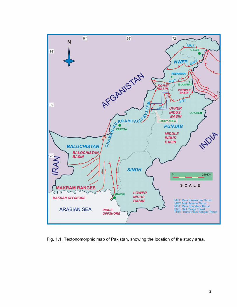
The Marwat-Khisor ranges borders the Bannu Promontory in the south, stretching
from Paniala in the west upto Dara Tang in the east (Figure 1.2). The Marwat Range
is an anticlinal feature largely covered by the Siwalik Group rocks. The Khisor Range
that lies south of the Marwat Range exposes the non-outcropping Cambrian to
Triassic rocks underneath the Bannu Basin. The Marwat-Khisor ranges are
characterized by east west to east-northeast structural trends. The structural style of
the range includes parallel to en-echelon fold trends detached at the base of Jhelum
Group rocks of Cambrian age (Alam et al., 2005). The Cambrian to Pliocene-
Pleistocene rocks of the Khisor Range are thrust southwards over the Punjab
Foreland along the Khisor Thrust that is probably the western extension of the Salt
Range Thrust (Gee, 1980). Cambrian to Triassic age shallow marine lithologies
predominantly underlies the Khisor Range that is unconformably overlain by the
Pliocene-Pleistocene Siwalik Group rocks (Figures 1.2 and 1.3). The exposed
stratigraphic sequence of the Khisor Range is broadly correlative with that of the
Western Salt Range with the exception that the Rawalpindi Group rocks (Miocene)
are missing in the Khisor Range (Alam et al., 2005).
The Manzai Range is the western most surface expression of the Trans-Indus
ranges. The Manzai Range also forms the northeastern extension of the Sulaiman
Ranges. At surface no rocks older than Siwalik Group outcrop and the range is
characterized by a broad anticlinal trend with associated east verging thrust faults.
The Trans-Indus Ranges provide key structural transects in order to assess the
subsurface structural style of the Kohat Plateau and Bannu Basin as no rocks older
than Eocene crop out in the Kohat Plateau whereas the Bannu Basin is a flat lying
basin with almost no out crops older than Quaternary. It is believed that the recent
success of oil and gas wells in the Kohat Plateau needs better understanding of its
subsurface structures that can be best accomplished by the structural understanding
of the Trans-Indus Ranges.
Geological field work carried out in the Trans-Indus Ranges suggest that a variety of
deformational features related to salt diapirism, transtensional deformation and
frontal ramping from decollement thrusting result in strong to weakly emergent thrust
fronts, tectonic wedges, antiformal stacks and back thrusts characterize these
4
Fig. 1.2. Generalized geological map of the NW Himalayan foreland fold and thrust belt (modified after Kazmi and Rana, 1982; Lillie et al., 1987; Yeats and Lawrence, 1984 and Coward et al., 1986. Inset shows the location of the study area.
5
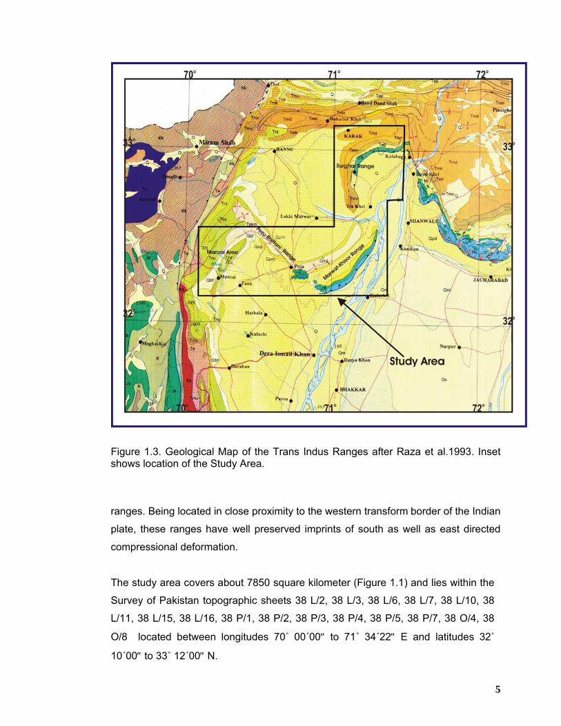
Figure 1.3. Geological Map of the Trans Indus Ranges after Raza et al.1993. Inset shows location of the Study Area.
ranges. Being located in close proximity to the western transform border of the Indian
plate, these ranges have well preserved imprints of south as well as east directed
compressional deformation.
The study area covers about 7850 square kilometer (Figure 1.1) and lies within the
Survey of Pakistan topographic sheets 38 L/2, 38 L/3, 38 L/6, 38 L/7, 38 L/10, 38
L/11, 38 L/15, 38 L/16, 38 P/1, 38 P/2, 38 P/3, 38 P/4, 38 P/5, 38 P/7, 38 O/4, 38
O/8 located between longitudes 70˚ 00΄00″ to 71˚ 34΄22″ E and latitudes 32˚
10΄00″ to 33˚ 12΄00″ N.
6
Geographically the Trans-Indus ranges are marked by the Kohat Plateau and
Bannu Basin in the north, D.I. Khan Plain and Tank Basin in the south. Indus River
forms its eastern boundary whereas its western limit is skirted against Kurram Fault
(Figure 1.2).
1.2 LOCATION The study area is extending in the east-west direction from Kalabagh in the east up
to Jandola and Manzai Range in the South Waziristan to the west. In the north-
south direction, Karak town marks its northern limit whereas the Tank is located on
its southern boundary (Figure1.3). The study area is located about 200 Kilometers
from Peshawar towards south-southwest. It is easily approachable by a network of
highways and metalled roads from Peshawar, Bannu, Kalabagh, Lakki Marwat,
Pezu, Tank and D.I.Khan. In addition, many small roads, stream courses and fair
weather tracks/paths connecting local villages provide a good chance to study the
rocks and sections from different views which are quite helpful in structural
interpretation of the region.
The relief of the area ranges from low to moderate with alternate valleys and ridges.
The ridges have been formed by resistant limestone and sandstone beds whereas
the valleys are the result of deep cuts by erosion of shale/clay of various units in the
area.
1.3 SCOPE OF STUDY Except the geological map of North-South trending segment of Surghar range by
USGS (Danilchik, 1962), no attempt has been made till date to map completely the
East-West trending segment of the Surghar range. Similarly, besides a regional
geological map (on 1:250,000 scale) covering parts of the western Khisor Range
and Pezu-Bhittani Range (Hemphill and Kidwai, 1973), no detailed geological maps
are available for the eastern parts of Marwat-Khisor ranges, Sheikh Budin Hills,
Pezu-Bhittani and Manzai ranges. There is a strong need to map the geological
details of the above-mentioned areas at 1:50,000 scale. This will help in resolving
the stratigraphic and structural related problems which would be helpful in
formulating future exploration strategies in this less-explored part of the country.
7
The present research work entails the following objectives;
1. Detailed geological mapping of the entire Surghar Range and selected
transects in Marwat-Khisor and Manzai ranges at 1:50,000 scale.
2. Recognizing key structural elements and patterns in different parts of the
Trans Indus ranges.
3. Construction of structural transects along selected seismic lines by integrating
surface geological information with available sub-surface geophysical
information and well data.
4. To find out the kinematics of deformation and relationship between
contrasting structural styles outcropping along the range front.
5. To address and highlight the hydrocarbon potential of the Trans Indus ranges
and the adjoining areas taking into account the play types and other essential
parameters for a composite petroleum system.
1.4 HISTORICAL REVIEW Previous studies in this area have been mainly concentrated on the understanding of
its stratigraphic framework and almost no consideration was given to the tectonic
evolution of this important Himalayan frontal thrust zone, whereas its eastern
analogue, the Salt Range is well studied and documented (Gee, 1980; Burbank and
Raynolds, 1984; Yeats et al., 1984., Danilchick, 1961).
The earliest reference to the geological investigations in the area dates back to 1832
when Burnes published a report on the salt occurrences of the Kohat region. These
deposits with brief geological account have also been referred to in various papers
and articles by a large number of earlier geo-scientists of the Geological survey of
India notably C.J.B. Karstau (1846), Andrew Fleming (1853), T. Oldham (1864), A.B.
Wynne (1857), P.S. Finfold (1918) and L.M. Davies (1930).
Wynne, (1880) subdivided the Jurassic sequence of the Khisor Range and Sheikh
Budin Hills into a lower “Variegated Group” and an upper “Jurassic limestone” and
8
recorded a number of fossils from these rock units. Coulson (1938) reported
bouleiceras species from Wynne’s lower Variegated Group about 2 km southeast of
Paniala in the western end of the Khisor Range. Gee (1945) first presented a
regional overview discussing in detail the age and stratigraphic relationship of the
Salt Range and the Kohat salt deposits. Later on Pascoe (1959) subdivided the
Jurassic sequence of the Trans-Indus ranges into a lower “Variegated Stage” and an
upper “Baroch Limestone”. Wadia, (1961) divided the Jurassic sequence of the
Trans-Indus ranges into Late and Middle Jurassic; however, his description is
confusing and he presumably considered rocks of Early Jurassic age to be absent
from the area.
Detailed geological studies of the Bannu and Dera Ismail Khan areas were carried
out by Hemphill and Kidwai (1973). They described the lithostratigraphic units of the
Marwat-Khisor ranges and parts of the Suleiman Range and the Waziristan area.
Siddiqui (1973) studied the silica sand deposits of the Khisor Range and Sheikh
Budin Hills and estimated reserves of about 20 million tons. Hussain, (1973)
concluded that about 31 million tons of silica sand was workable at a depth of 200
feet in the Marwat-Khisor ranges. Fatmi and Cheema (1972) and Fatmi (1977)
described the cephalopods of early Jurassic (Toarcian) age from the upper marine
“Wazir Wal Member” (now Shinawari Formation) of the Datta Formation in Khisor
Range near Paniala village. They discussed in detail the biostratigraphy of the
Jurassic sequence on the basis of fossil evidence.
The Kalabagh Fault Zone that serve as the western tectonic boundary of the Salt
Range was initially recognized by Gee (1980) in his geological maps extending from
the Eastern Salt Range to the Kalabagh area in the west. Wells (1984) carried out
detailed sedimentalogical studies on the early ocean sediments of Kohat basin.
McDougal (1985 and 1989) described the structural features related to the Kalabagh
lateral ramp structure.
As far as the geology of the Surghar Range is concerned, significant contribution
owes to Danilchik and Shah (1987) to produce a geological map of the north-south
trending segment of the Surghar Range. Most of the east-west trending segment of
the Surghar Range remains unmapped except the northern Chichali Pass, which
9
was mapped by Meissner et al. (1974) as part of the Kohat Quadrangle on 1:250,000
scale. McDougal & Khan (1990) described Quaternary deformation along the
Kalabagh Fault. According to them, Kalabagh Fault Zone is formed by transpressive
right lateral strike-slip movement along the Western Salt Range allochthon in
Northern Pakistan. Ahmad et al. (1999) later on discussed the detailed structural
account of Chichali Pass area and interpreted that the topographic expression of the
range is attributed to a south verging anticline namely Surghar Anticline that is
detached at the base of Jurassic sequence. The fore limb of the anticline is
characterized by a south verging thrust fault namely Surghar Fault with its hanging
wall deformed by break backward sequence of thrusting. Ahmad et al., (2003)
undertook some work on the structural framework of the Kalabagh Hills and
established the existence of both compressional and extensional structures. The
main compressional structures include a north–northwest trending Kalabagh
Anticlinorium whereas the extensional structures are represented by a couple of
local and one regional scale normal fault that bound Kalabagh Anticlinorium in the
east and west.
Blisniuk (1996) presented regional structural outline of the Khisor Range while
conducting palaeomagnetic studies of the Siwalik Group rocks. He interpreted that
south verging thrusting and normal faulting are responsible for the tectonic evolution
of the Khisor Range thrust front. Blisniuk et al., 1998 suggested that the range has
undergone two phases of deformation; an earlier normal faulting followed by later
thrusting.
Alam et al., (2005) and Alam (2008) studied the fold-thrust styles in the Marwat-
Khisor ranges on the basis of outcrop geology and suggested that the structural
style is thin-skinned comprising decollement thrust-fold assemblages, kinematically
related to a regional basal decollement located at the base of Jhelum Group rocks.
Ahmad et al., (2007) have highlighted the hydrocarbon prospectivity and structural
geometry of part of the Bhittani and Northern Sulaiman Ranges.
10
1.5 EXPLORATION ACTIVITIES IN THE REGION Petroleum interest in the area was first stimulated by the oil seeps around the
edges of the Salt Range and Bannu Trough. One of the first exploration wells in the
world was drilled in 1866 by the Punjab Government near the Kundal oil seep and
further attempts at providing a commercial resource were made sporadically, but
without any notable success, during colonial times at Kundal (early 1900’s, Punjab
Government), Jaba (1905, Townsends), Dalwati-1 and 2 (1927-1932), and Babai
(1932, Indo Burma Petroleum Company) four exploratory wells were drilled that
turned out to be dry.
After independence, exploration was extended west of the main Potwar Basin when
POL drilled Nandrakhi-1 in 1957 on a surface structure close to oil seeps in the
Kohat area. Further activity on this play was limited to the Karak-1 well of Texas
Gulf in 1977 and the Shakardarra well of OGDC in 1989, until Amoco showed
interest in the Kohat basin in the late 1980’s. They licensed a large area located
over the Kohat Plateau and undertook an extensive investigatory campaign,
including surface sampling, airborne geophysics, and seismic acquisition,
culminating in the drilling of three wells, all of which were abandoned: Tolanj-1
(1991), Kahi-1 (1992), and Sumari-1 (1993).
PPL have had a long involvement in the area from the drilling of Domanda-1 in
1959 on a large Eocene anticline in the northern Sulaiman Ranges, continuing
through the 1960s with wells in the Bannu/Tank area at Kundian-1 (1965), Pezu-
1(1968), and Marwat-1(1970), and culminating with the Kundi X-1 well in 1995. The
only other exploration in the Bannu area has been by Petro Canada who, after an
extensive study, drilled the Chonai-1 well in 1991 on a seismic anomaly and by
OGDC who drilled Isakhel-1 well in 1993 in the Mianwali Re-entrant on a wrench
structure.
The well that has been drilled in the geological conditions most analogous to Kundi
X-1 is Ramak-1 which was drilled by Lasmo in 1993 on a fold structure within a
deep Miocene trough in the Sulaiman Foredeep.
11
OGDCL, as a result of systematic exploration campaign, have made significant oil
and gas discoveries at Chanda-01 (1998) and Mela-01 (2005) in Shakar Darra and
Nashpa areas of south-eastern Kohat. MOL, a Hungarian company has also made
good oil and gas discoveries at Manzalai-01 (2002), Makori-01 (2004) and most
recently at Mami Khel-01 (2007) in the central and northern Kohat areas. Thus,
although activity has occurred over a period of 100 years, the Bannu/Tank and
Kohat areas have been only lightly explored and there has been no systematic
investigatory campaign. Previously, most of the oil and gas companies have drilled
one or two wells and then relinquished the area, which has then remained
unlicensed for long periods. However, the situation now seems to have changed as
the easy oil and gas is exhausted gradually and the companies are extending their
exploration efforts into high risk frontier regions all over the world. At present, Saif
Energy, Mari Gas Company, Orient Petroleum Inc., MOL and OGDC are actively
engaged in petroleum exploration in different parts of the Trans Indus ranges and
its surroundings.
1.6 METHODOLOGY Before performing fieldwork, concerned literature was extensively reviewed to
acquire knowledge regarding the geological setup of the study area. Published
papers in various national/international journals on the geology of Kohat-Potwar
and surrounding areas were obtained and thoroughly studied in order to get an in-
depth idea of the work conducted so far by the previous researchers. In addition,
published literature on the fold and thrust belts in other parts of the world was also
consulted. The relevant toposheets and satellite imageries were collected from
Survey of Pakistan and SUPARCO offices respectively.
1.6.1 Fieldwork
• Reconnaissance fieldwork was carried out in the winter season 2005 and
was followed by a detailed geological fieldwork during spring 2006 and
winter 2008 to acquire field data regarding structures, stratigraphy and
mapping of the study area.
12
• Besides studying the physical properties of the exposed rock units, detailed
structural data regarding strike and dip of the bedding, faults and attitudes of
the folds were collected and correlated with each other in order to establish
the structural pattern of the various geometries.
1.6.2 Laboratory Work
• The data collected in the geological fieldwork was utilized in the preparation
of four detailed geological maps of the Trans Indus ranges.
• Seven geological cross-sections have been constructed across the structural
trends in different parts of the Trans Indus ranges for better understanding of
the structural style and geometry of the area.
• These geological cross-sections have subsequently been integrated with the
available seismic and well data for the construction of consolidated geo-
seismic structural models.
• Stratigraphic columnar sections have been constructed to understand the
stratigraphic profiles in different parts of the study area.
The following computer softwares were used during the preparation of geological
maps, cross-sections and seismic interpretation etc;
i) ArcView GIS 3.2
ii) CorelDRAW 12
iii) Global Mapper 7
iv) Adobe Photoshop 7.0
v) GeoAtlas Geographix Discovery R2006.1 (Landmark)
vi) SeisVision Geographix Discovery R2006.1 (Landmark)
13
1.7 GEOLOGICAL SETTING Pakistan possesses the northwestern boundary of the Indian lithospheric plate. The
underthrusting of Indo-Pakistani Plate beneath the Eurasian Plate is producing
compressional thin-skinned tectonic features since Eocene time on the northern
and northwestern fringes of the Indo-Pakistani Plate. The continued underthrusting
of the Indo-Pakistani Plate since Cretaceous produced the spectacular mountain
ranges of the Himalaya and a chain of foreland fold-and-thrust belts as thick sheets
of sediments thrust over the Indian Craton (Kemal, 1991).
Foreland fold-and-thrust belts through out the world are conspicuous features of the
convergent plate tectonic habitat. The Kohat-Potwar fold and thrust belt along with
its frontal ranges of the northwestern Himalayas is one of these. The Salt and
Trans-Indus ranges constitute the mobile flank of the Kohat and Potwar fold and
thrust belt and is mostly characterized by decollement thrust-fold assemblages.
Thrusting along with associated folding is certainly the main method of
accommodating shortening within these orogenic belts. The recent most thrusting is
believed to have occurred along the frontal thrust system in the Salt Range to the
east and in the Trans-Indus ranges to the west (Blisniuk et al., 1998). The Trans-
Indus ranges represent the leading deformational front of the Kohat fold and thrust
belt and Bannu Basin in North Pakistan (Ahmad et al, 2005).
Underneath the Potwar Plateau and the frontal Salt ranges, Precambrian Salt
Range Formation forms a laterally extensive basal decollement at the basement-
sediment interface. As a result the structural style is mainly thin-skinned and the
basement is convex upward and gently north dipping. Similar basement geometry
has been interpreted for the basement underneath Eastern Kohat Plateau and
Bannu Basin (McDougall & Hussain 1991; Parwez, 1992). The geometry of the
thrust front along the Salt Range appears to be controlled by north dipping
basement involving normal faults that localize thrusting (Pennock et al., 1989).
Similar deformational style has been interpreted for the Surghar-Shinghar Range
and possibly also along the Khisor Range and the Sheikh Budin Hills (Blisniuk,
1996).
14
Based on the sedimentalogical studies of molasse deposits exposed along the
frontal ranges two scenarios have been proposed for the tectonic evolution of the
thrust front along Salt and Trans-Indus ranges that include Late Miocene normal
faulting followed by Quaternary thrusting, (Burbank & Raynolds, 1988; Burbank &
Beck, 1989a, 1989b; Mulder & Burbank, 1993; Davis & Lillie, 1994; Burbank et al.,
1996). However the timing of deformation as worked out from the
chronostratigraphy of the Siwaliks is believed to be younger in the Trans-Indus
ranges as compared to the Salt Range. It has been interpreted that the major
thrusting along the Salt Range front started at ~ 2.5 Ma (Burbank & Raynolds,
1988; Burbank & Beck, 1989a) and along the Trans-Indus ranges major
convergence started at ~ 1 Ma (Khan et al., 1988; Pivnik & Khan, 1996, Blisniuk
and Sonder, 1998).
15
CHAPTER 2
REGIONAL TECTONIC FRAMEWORK
2.1 TECTONIC SETTING Pakistan straddles the boundaries between the Indo-Pakistan, Arabian and Eurasian
plates, and its structure is predominantly affected by their past and present inter-
relationships. Two composite plates, comprising both continental and oceanic crust
(Indo-Pakistan & Arabia) are separated by an intra-oceanic transform boundary, which
within the Pakistan offshore area is expressed as the Murray Ridge. The Eurasian
Plate is a collage of three microplates which amalgamated in Iran-Afghanistan and
western Pakistan area during Cretaceous to Paleogene times (Quad Report, 1994).
The most easterly of these microplates, the Afghan Block, forms a considerable part of
Pakistan’s northwestern edge, and is bounded by the two major transform fault
systems of Herat and Chamman (Figure 2.1). The boundaries between microplates can
be traced by belts of ophiolite assemblages.
The majority of Pakistan, east of the Ornach-Nal / Chamman transform fault system
comprise the Indus Basin (including Kohat-Potwar Plateau, Hazara/Kalachitta Ranges,
Kirthar and Sulaiman ranges representing a foreland fold and thrust belt system) which
lies in the mid Tertiary collision zone formed as Indo-Pakistan Plate was obducted by
Eurasia (Figure 2.1). Several micro-continents mostly of Gondwana affinity (Searle,
1991) and more than one Island arcs (Dietrich et al., 1983) are involved in this collision
zone. The first block to collide with southern margin of the Eurasian plate was
Karakoram followed by Afghan block and lastly the Kohistan island arc came in contact
with the system (Ganser, 1964; LeFort, 1975; Windley, 1983). The convergence
boundary is characterized by both northward underthrusting of the thick Indian Shield
lithosphere (25-30 km) and southward obduction of upper crustal basement and
sediments.
16
17
This has resulted in approximately 500 km of crustal shortening since initial collision in
the late Cretaceous-Eocene (Alleman, 1979; Searle, 1985; Coward and Butler, 1985;
Dewey et al, 1988) which in northern Pakistan is accommodated between the Indian
Shield and the Kohistan Island Arc terrain (Powell and Coneghan, 1973; Molnar and
Tapponier, 1975; Quittmeyer et al, 1979) and in India between the Indian Shield and
Lhasa Block of Tibet.
The uplift of the main Himalayan Ranges is attributed to the buoyancy of the doubled
Sialic crust over the mantle material (Gupta and Narain, 1967; Kono, 1974; Chaudhary,
1975; LeFort, 1975; Mattauer, 1975; Powell and Coneghan, 1973) and imbricate
stacking of the Indian crust during collision. Closure of Paleo-Tethys (the Shyok Basin)
between the Kohistan Island Arc and Indo-Pakistani Plate would have occurred during
collision. The southern margin of Neo-Tethys was incorporated into the Indus Tsangpo
Suture Zone and the Tethyan Himalaya (LeFort, 1975; Molnar and Tapponier, 1977;
Stocklin, 1977; Malinconico, 1986; Searle, 1983, 1985). However, preservation of much
of the southern Tethyan margin is seen in the Zanskar Ranges of the High Himalaya
where the Mesozoic-Cenozoic sediments of the passive margin have been little
deformed and metamorphosed in the internal zones of the Himalayas (Izatt, 1993).
During the later stages of collision the upper crust of the Indo-Pakistani Plate became
delaminated and transported south, carrying passive margin sequences in its hanging
wall. In India there are seen to be two major zones of delamination. These being the
Main Central Thrust (MCT) and the Main Boundary Thrust (MBT), which have a
cumulative shortening of about 250 km (Izatt, 1993).
The collision tectonics along western border of the Indian craton is highly controversial.
The western boundary of the Indo-Pakistani plate is commonly taken as Chaman Fault,
which extends from Kharan to Kabul for about 850 kilometers (Kazmi, 1979a;
Lawrence et al, 1979), connecting the Owen Fracture Zone in the south west of Makran
with the Himalayan collision zone in the north (Figure 2.1). The Ninetyeast Ridge is
located towards southeast of the Indo-Pakistani subcontinent (McKenzie and Sclater,
1976).
18
2.2 TECTONIC EVOLUTION The Pakistani basins have acquired their primary structural and stratigraphic features
from events associated with plate movements that occurred latest Paleozoic to the
present. From Permian through Middle Jurassic time, the Indo-Pakistani plate was
located in the Southern Hemisphere between the African, Antarctic and Australian
plates and comprised part of southern Gondwana (Wandrey, 2004). The Lower
Permian Tobra Formation tillites in the upper Indus Basin and other basal Permian
glacial deposits on the Indo-Pakistani plate are indicative of much cooler paleoclimate
(Shah et al, 1977).
The Indo-Pakistani Plate has evolved through successive stages of plate tectonic
events which are documented for the Eo-Cambrian onwards. A brief account of these
tectonic events is presented below;
2.2.1 Late Proterozoic – Early Paleozoic To the south of the Trans-Indus and Salt ranges, basement rocks are only found in a
few isolated spots (Kirana Hills and Nagar Parkar granite). These rocks are correlated
with Proterozoic rocks of the Indo-Pakistani Plate (Wadia, 1987). In India this plate
shows the following structural trends resulting from Precambrian, Pan African tectonic
events (Biswas, 1982).
a) NE-SW Arvalli trend & its continuation into E/W Delhi trend
b) NNW-SSE Dharwar trend
c) WSW-ENE Satpura trend
Reactivation of these trends has taken place during various periods of tectonic activity
of the Phanerozoic (Biswas, 1982).
In the Trans-Indus and Salt ranges, the Indo-Pakistani Plate is unconformably overlain
by the Salt Range Formation of Eo-Cambrian age which in turn is conformably overlain
by Cambrian sediments. A major regional unconformity separates these rocks from
Permian strata. This indicates tectonic uplift and/or regression after Cambrian
deposition.
19
2.2.2 Late Paleozoic – Early Tertiary During this period, several phases of uplift/regression are indicated by the following
regional unconformities (from young to old);
a) Eocene/Miocene
b) Late Cretaceous/Paleocene
c) Middle Jurassic/Late Jurassic
d) Late Triassic/Early Jurassic
e) Late Permian/Early Triassic
On regional scale, the Upper Paleozoic – Tertiary period is dominated by extensional
tectonics related to three regional rift phases (Tectostrat, 1992). These phases are
(from young to old);
1) Mascarene Rift Phase (Late Cretaceous to Eocene)
2) Somali Rift Phase (Late Jurassic – Early Cretaceous)
3) Karroo Rift Phase (Permian – Middle Jurassic)
2.2.2.1 Karroo Rift Phase (Permian – Middle Jurassic) Regional uplift after the Permian is indicated by the unconformity at the base of Triassic
strata. An unconformity is also present at the base of the Jurassic deposits in the Indus
Basin, but there is no conclusive evidence of any break between Triassic and Jurassic
sediments in the Axial Belt, west of the Trans-Indus ranges (Tectostrat, 1992).
Kadri and Abid (1986) indicate that tectonism caused Late Triassic regression. Tectonic
activity during the Middle Jurassic is recorded from the Axial Belt west of Trans-Indus
ranges (Shah, 1977), while widespread regression during the close of the Middle
Jurassic resulted in a regional unconformity over whole of the Indus Basin. The
Permian – Middle Jurassic period is characterized by extensional tectonics in East
Africa, Southern Arabia and India (Karroo Rift Phase), with deposition concentrated in
extensional basins. This suggests that Permian – Middle Jurassic deposition in
Pakistan has likewise been influenced by movements along crustal zones of weakness
affected by Karroo activity and took place in extensional basins (Tectostrat, 1992).
20
2.2.2.2 Somali Rift Phase (Late Jurassic – Early cetaceous)
In the Trans-Indus ranges the change from marine to deltaic deposits indicates uplift
and emergence during the Early Cretaceous (Shah, 1977). This is also evident from
the absence of Late Cretaceous deposits over most of the Upper Indus Basin.
Regionally the Upper Jurassic – Lower Cretaceous is characterized by extensional
tectonics throughout East Africa, Southern Arabia and India associated with origin of
the Somali Basin. During early Cretaceous time, the Indo-Pakistani plate drifted
northward, entering into warmer latitudes.
2.2.2.3 Mascarene Rift Phase (Late Cretaceous – Eocene)
The absence of Late Cretaceous deposits over most of the Upper Indus Basin
indicates uplift & erosion which were strongest in the east and south of the Upper Indus
Basin. Sediments up to the Cambrian were eroded prior to the Paleocene (Shah, 1977;
Kadri & Abid, 1986). On plate tectonic scale, the Late Cretaceous – Eocene period is
characterized by the northward movement and anti-clockwise rotation of India breaking
away from Madagascar (Late Cretaceous) and subsequently from the Seychelles
(Early Paleocene) (Figure 2.2). The sea floor of the Bengal basin began to form and
flysch accumulated on all sides of the Indo-Pakistani plate (Scotese et al, 1988). This
movement was accommodated by subduction along a (Neo-Tethys) oceanic island arc
north of India (Powell, 1979). In East Africa, Southern Arabia and India, this tectonic
phase is represented by the operation of an extensional stress system which controlled
the outlines of developing depo-centres (Tectostrat, 1992).
Northward plate movement continued during the late Cretaceous and a transform fault
became active along the Ninetyeast Ridge (Figure 2.2). Rifting between Madagascar
and the Seychelles portion of the Indo-Pakistani plate initiated formation of the
Mascarene Basin. Extensional faulting occurred as the western part of the Indo-
Pakistani plate sheared southward relative to the main plate (Kemal et al, 1992).
Counterclockwise rotation of the Indo-Pakistani plate was initiated and the Seychelles
portion of the Indo-Pakistani plate began to break away (Waples and Hegarty, 1999)
(Figure 2.2).
21
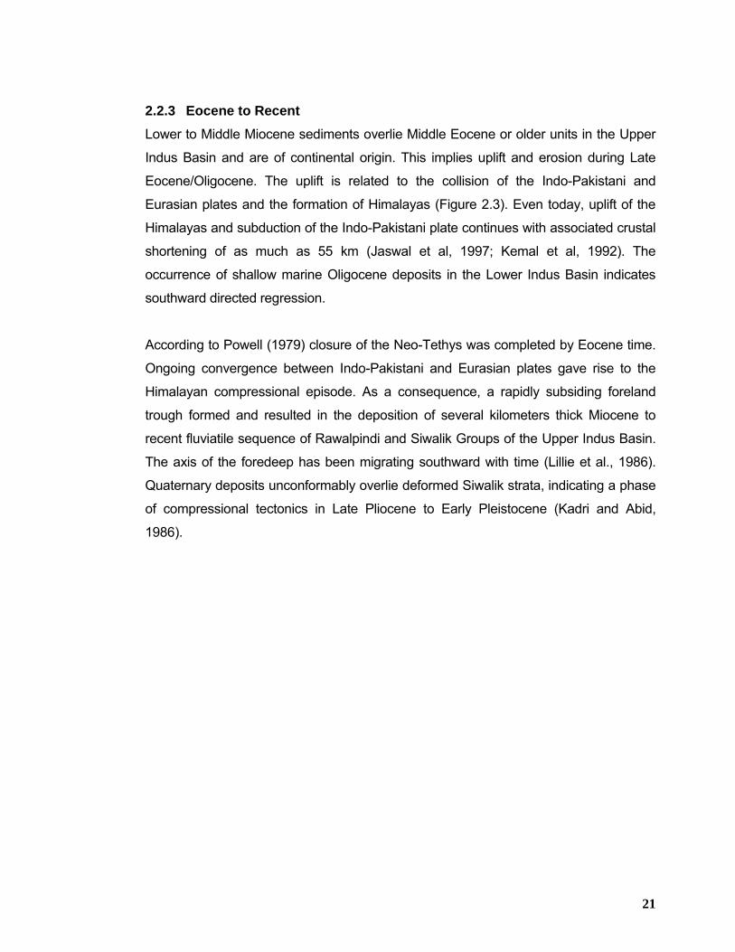
2.2.3 Eocene to Recent Lower to Middle Miocene sediments overlie Middle Eocene or older units in the Upper
Indus Basin and are of continental origin. This implies uplift and erosion during Late
Eocene/Oligocene. The uplift is related to the collision of the Indo-Pakistani and
Eurasian plates and the formation of Himalayas (Figure 2.3). Even today, uplift of the
Himalayas and subduction of the Indo-Pakistani plate continues with associated crustal
shortening of as much as 55 km (Jaswal et al, 1997; Kemal et al, 1992). The
occurrence of shallow marine Oligocene deposits in the Lower Indus Basin indicates
southward directed regression.
According to Powell (1979) closure of the Neo-Tethys was completed by Eocene time.
Ongoing convergence between Indo-Pakistani and Eurasian plates gave rise to the
Himalayan compressional episode. As a consequence, a rapidly subsiding foreland
trough formed and resulted in the deposition of several kilometers thick Miocene to
recent fluviatile sequence of Rawalpindi and Siwalik Groups of the Upper Indus Basin.
The axis of the foredeep has been migrating southward with time (Lillie et al., 1986).
Quaternary deposits unconformably overlie deformed Siwalik strata, indicating a phase
of compressional tectonics in Late Pliocene to Early Pleistocene (Kadri and Abid,
1986).
22
23
24
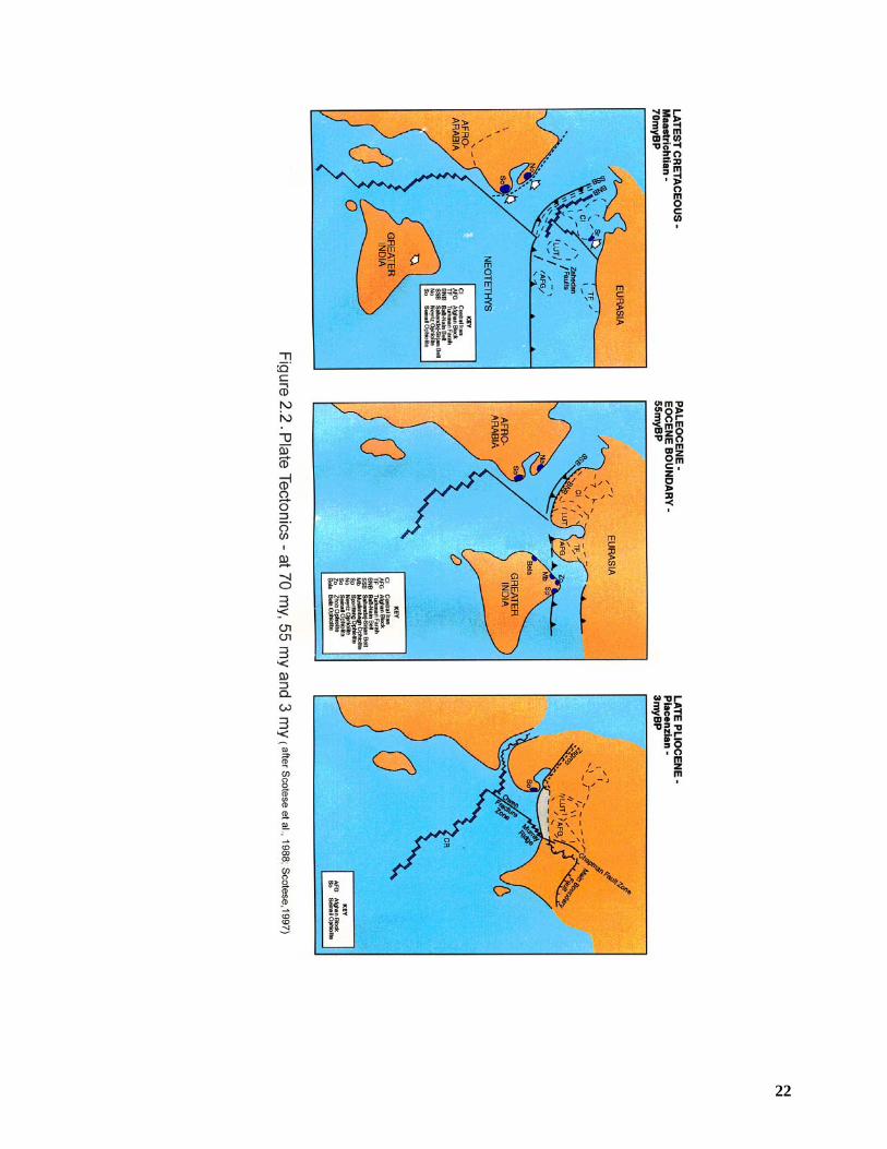
Due to the continent – continent collision the geology of the area is dominated by thrust
tectonics (Figure 2.3). A series of peculiar curved mountain ranges, known under
various names (arcs, oroclines, syntaxis, and re-entrants) dominate the topography of
the northwestern Pakistan. The origin of these curvatures is much debated (Sarwar
and DeJong, 1979). The Trans-Indus ranges comprise four of these curvatures. They
are the extreme southern toe of the frontal tectonic unit of the Himalayan thrust belt.
From seismic data it has become clear that deep basement structures of the
Himalayan system (i.e. the seismic zone underneath the Kohat and Potwar Plateau)
continue to the northwest and are at an angle (discordant) to the overlying Kohat and
Potwar basinal sediments (Seebar and Armbruster, 1979). The Kohat and Potwar
Plateau are interpreted as a thrust sheet for which the Pre-cambrian Salt Range
Formation provides a surface of decollement. Thrusting is due to a north-south
compressional stress system, which has been deduced from seismic data (Armbruster
et al., 1978). Tectonic activity in the area of the northwestern Himalayan Syntaxis is
recorded in deformation of the Oligocene/Miocene Rawalpindi Group (Pennock et al.,
1989; Abassi & McElroy, 1991).
Magnetic reversal stratigraphy and sedimentation rates from the Upper Pliocene –
Lower Pleistocene deposits of the Siwalik Group indicate that deformation is continuing
into Pleistocene and that the NW Himalayan Syntaxis controlled the deposition of the
Siwalik sediments (Johnson et al., 1979). Furthermore it is concluded from the field
evidence (Yeats et al., 1984) that active thrust faulting is still taking place at the western
Salt Range. The Peculiar re-entrants are bounded by deep basement strike slip faults
(Johnson et al., 1979; Kazmi, 1979; McDougall and Khan, 1990) which are still active
(e.g. Kalabagh and Pezu Faults). It is inferred that these strike slip movements are
responsible for the curved re-entrants (Tectostrat, 1992). Klootwijk et al. (1986)
conclude from paleomagnetic data that the Mianwali re-entrant most likely formed as a
result of obstruction of the advancing Potwar thrust sheet by the NNW trending
Sargodha Ridge. Within the outlined structural configuration of the Kohat and Potwar
Plateau, the geology of the Trans-Indus ranges is characterized by the presence of Eo-
Cambrian to Recent sedimentary succession which is detached from its underlying
basement and thrusted over existing basement ramps.
Detailed analysis and seismic profiles of the structure of the Potwar Plateau (Lillie et al.,
1986; Baker et al., 1988; Jaume and Lillie, 1988; Pennock et al., 1989; Gee, 1989)
indicate that
25
• In the north of the area the structure is dominated by an imbricate stack
of thrust faults of which some reach the surface and others terminate at
depth as blind thrusts.
• The Salt Range in the south is interpreted as the surface expression of a
structural basement ramp (with 1 km of basement offset, down to the
north) is generally believed to be the result of extensional tectonism (i.e.
loading of the Indo-Pakistani Plate in the north).
• Ramping of the thrust sheet against the basement block started between
2.1 and 1.6 my and was accompanied by considerable thickening of the
salt unit of the Salt Range Formation against this subsurface ramp.
It is inferred that the entire central Potwar Plateau and the Salt Range have been
moving as a coherent slab during the last 2 my with only minor deformation occurred in
the Soan Syncline (Tectostrat,1992). Structures in the eastern Potwar Plateau are
markedly different which is dominated by broad synclines and narrow, salt-cored
anticlines. This change of style is attributed to thinning of the salt deposits and a lesser
degree of basement dip which required thickening (by folding and thrusting) of the
overall thrust wedge (Lillie et al., 1986). In the Bannu depression anticlinal structures
similar to those of the Potwar Plateau have been delineated by means of seismic data
(Khan et al., 1986). Structures in the Kohat Salt Zone to the north are narrow, often
overturned, faulted and imbicated anticlines (Khan. A.A and Zaman. N., 2003). The
occurrence of Eocene salt has locally strongly attributed to the structural complexity in
this area (Khan et al., 1986).
2.3 STRUCTURAL SETUP The major portion of Pakistan, east of the Ornach-Nal/Chamman transform fault can be
divided into the following broad stratigraphically and tectonically separate regions
(Quad Report, 1994);
a. Offshore Indus
b. Axial Belt
c. Mesozoic – Early Tertiary Fold Belts
d. Punjab Foredeep, Central and Lower Indus Basins
e. Northern Montane Area
26
2.3.1 Offshore
The Offshore Indus is represented by thick Miocene and younger sequences, forming
part of Indus Fan Complex. To the west and northwest, the boundary is defined by the
intra-oceanic transform boundary of the Murray Ridge, and to the east by the Pakistani
coast (Figure 2.1). Rapid thickening in the offshore area reflects the vast amounts of
deltaic material that was deposited from Middle Miocene to Recent as the Indus Cone.
Most of the offshore wells did not reach sediments older than Oligocene at over 3500
meters depth. Structural features were believed to be induced by depositional loading
rather than by basement related tectonics (Quad Report, 1994).
2.3.2 Axial Belt
This region lies along the north-western border of Pakistan, against the micro-
continental block of Afghanistan, and along the eastern side of the Ornach-
Nal/Chamman fault zone. The Axial Belt is significant because of the presence of
number of ophiolites. The Bela, Muslimbagh, Zhob and Waziristan ophiolites are
fragments of metamorphosed oceanic crust which have been emplaced
contemporaneously with mélange sediments onto the Indo-Pakistan platform. These
complexes which originated at a spreading centre in Neotethys were obducted as the
Indo-Pakistan continental edge collided with Eurasia during the Paleocene to Lower
Eocene period. Included along the Axial Belt are sedimentary units which range in age
from Triassic to Late Cretaceous, and which probably form the older core of the
Sulaiman and Kirthar Fold Belts. The Axial Belt represents the western boundary of the
Indus Basin.
2.3.3 Mesozoic – Early Tertiary Fold Belts
The surface expression of the two fold belts is generally N-S trending segments, The
Kirthar and Sulaiman Ranges, offset dextrally some 250 km by the fold festoon of the
Sulaiman lobe. The origin of the fold festoons and intervening syntaxes is still not well
understood. The fold festoons are believed to have been developed where the thickest
sediments were deposited and the syntaxes wrap around basement promontories. The
edges of the Sulaiman lobe are marked by zones of en-echelon faults, indicating
forward movement of the central portion with respect to both sides. Shallow seismicity
27
also suggests that little, if any, deformation is occurring on the underlying Indo-Pakistan
Shield, which points to basement shape having controlled by later folding.
Generally, the fold belts are composed of mid Tertiary to Triassic formations which
outcrop progressively to the northwest as deeper fold and thrust wedges are exposed.
Much of the material eroded from the fold belts is now deposited on the Punjab
Platform as Miocene and younger molasse deposits.
2.3.4 Punjab Foredeep, Central and Lower Indus Basins
This structural province covers most of the central, southern and eastern parts of
Pakistan. It is bounded by the outcrop of the shallow basement of the Indian Shield to
the southeast and by the edge of the Mesozoic and Tertiary fold and thrust belt to the
west. The Punjab Platform and eastern margins of the Central and Lower Indus Basins
represent the gently north-westerly dipping leading edge of the Indo-Pakistan craton.
A number of high areas were created during the late Cretaceous. The Jacobabad,
Mari-Kandhkot and Lakhra highs all have the appearance of horst blocks and probably
formed in response to the extensional tectonic style of Lower Indus Basin (Quad
Report, 1994) which formed in response to the spreading axis between Madagascar
and the Indo-Pakistan continental mass in the mid Cretaceous. Later transpression
between the convergent Indo-Pakistan and Eurasian plates caused inversion and the
superimposition of a transform style.
South of the Salt Range and Trans Indus Ranges lies the Punjab plain in which the
metamorphic basement of the Sargodha High outcrops in the Kirana Hills at a distance
of approximately 80 Km from Salt Range Thrust. These outcrops are a portion of the
crest of the Sargodha High, a topographic ridge which corresponds to the northwest-
southeast trending set of gravity anomalies that are part of the Delhi-Lahore Ridge
(Aithal et al, 1964; Farah et al, 1977) and which eventually merges into the northeast
trending basement exposures of the Arivali Range in India. Menke and Jacob (1976)
recognized a nearly continuous zone of seismicity associated with this feature in India.
The Sargodha Ridge has been described both as a Mesozoic basement high (Higham,
1983) and a gentle basement uplift of a peripheral lithosphere bulge, developed as an
28
elastic response to the northward underthrusting of the Indian Shield (Molnar, 1976;
Karner and Watts, 1983; Lyon-Cean and Molnar, 1983; Duroy, 1986 and Duroy et al,
1989). The overall setting of the Himalayan foreland may be thought of as analogous
to a modern ocean subduction setting, with the Sargodha High corresponding to the
peripheral bulge, the Gangetic/Jhelum foredeep equivalent to the trench, and the Sub-
Himalaya/Salt Range/ Kohat-Potwar thrust belt representing the accretionary wedge
(Pennock, 1988).
2.3.5 Northern Montane Area
Four regional fault systems that are Main Karakorum Thrust (MKT), Main Mantle Thrust
(MMT), Main Boundary Thrust (MBT) and Trans-Indus Ranges Thrust has further
subdivided the Northern Montane Area into five lithotectonic domains (Figure 2.4),
which are characterized by distinctive stratigraphy and physiography. From north to
south these geological belts are Karakorum Block, Kohistan Island Arc, Northern
deformed Fold-Thrust Belt, Southern deformed Fold-Thrust Belt and Punjab Fore deep
(Ahmad et al, 2004). A brief description of these faults and structural domains from
north to south is presented below;
2.3.5.1 Karakorum Block
The Karakorum block consists of complex assemblages of heavily deformed
sedimentary, metasedimentary and igneous rocks of the southern Asian plate. It lies
between Pamirs in the north and Kohistan–Ladakh Arc in the south. The collision
between the Karakorum block and the Kohistan-Ladakh arc occurred along MKT in the
Cretaceous time (Treloar et al., 1989; Yoshida et al., 1997). This collage of arcs, the
KIA and Ladakh arc, collided with the northern margin of Indian plate along MMT in
early Tertiary age (Yoshida et al., 1997). The Main Karakorum Thrust (MKT) marks the
southern boundary of the Karakorum block.
2.3.5.2 Main Karakorum Thrust (MKT)
The Main Karakorum Thrust (MKT) is a major tectonic feature in northern Pakistan.
This has been formed as a result of collision between the Karakoram plate in the north
and Kohistan island arc in the south (Tahirkheli, 1979; 1982; 1983). It was named as
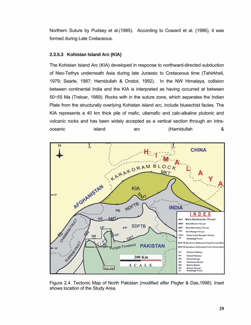
29
Northern Suture by Pudsey et al.(1985). According to Coward et al. (1986), it was
formed during Late Cretaceous.
2.3.5.3 Kohistan Island Arc (KIA)
The Kohistan Island Arc (KIA) developed in response to northward-directed subduction
of Neo-Tethys underneath Asia during late Jurassic to Cretaceous time (Tahirkheli,
1979; Searle, 1987; Hamidullah & Onstot, 1992). In the NW Himalaya, collision
between continental India and the KIA is interpreted as having occurred at between
50~55 Ma (Treloar, 1989). Rocks with in the suture zone, which separates the Indian
Plate from the structurally overlying Kohistan island arc, include blueschist facies. The
KIA represents a 40 km thick pile of mafic, ultamafic and calc-alkaline plutonic and
volcanic rocks and has been widely accepted as a vertical section through an intra-
oceanic island arc (Hamidullah &
Figure 2.4. Tectonic Map of North Pakistan (modified after Pegler & Das,1998). Inset shows location of the Study Area.
30
Onstot, 1992). It covers 36000 square kilometer area in western Himalayas, Karakorum
and eastern Hindukush. The arc is oriented east west and comprises a variety of
volcanic and plutonic rocks and subordinate sedimentary rocks that have undergone
varying degrees of deformation and metamorphism. It is divided into Ladakh and
Kohistan Arc by the north-south trending Nanga Parbat - Haramosh massif and is
underlain by the Indian crustal plate (Seeber & Armbuster, 1979). The MKT towards
north and MMT towards south bound the Kohistan island Arc which merges laterally in
India and Tibet to form a single suture, called as the Indus Tsangpo suture. In
Afghanistan, towards west of the KIA, the MKT and MMT join one another and merge
with the left lateral Kunar Fault.
2.3.5.4 Main Mantle Thrust (MMT)
The MMT marks the northern boundary of the northern deformed fold and thrust belt.
Obduction of the Kohistan Island Arc occurred along the Main Mantle Thrust (MMT)
with major uplift occurring between 30-15 MA (Tahirkheli et al, 1979; Zeitler et al,
1985). The MMT dips northwards between 25-45o (Malinconico, 1986) and is the
southernmost thrust involving lower crust (LeFort, 1975; Bard, 1983). The MMT exhibits
major swing in its trend towards northeast giving rise to a re-entrant within the Kohistan
Island Arc (KIA) sequence. This re-entrant is called as Nanga Parbat-Haramosh massif
and is composed of more than 15 km thick Proterozoic gneisses and schists (Madin,
1986).
Fission track studies by Zeitler (1982) suggest that the MMT had stopped moving by 15
MA. The MMT is the westward continuation of the Indus Tsangpo Suture Zone in India.
The convergence which resulted in continent-arc-continent collision (KaraKorum-
Kohistan-India), however, did not cease with the formation of MMT, but rather
continued since Eocene at a rate of 5 mm per year (Patriat and Archache, 1984).
2.3.5.5 Northern Deformed Fold & Thrust Belt
The northern deformed fold and thrust belt lies south of Main Mantle Thrust and is
about 300 km wide (Figure2.4). This belt comprises of heavily deformed sedimentary,
meta-sedimentary and igneous rocks. This belt stretches from Kurram area in the west
near Afghan border up to the Kashmir basin in the east. The northern fold and thrust
31
belt is bounded by Main Boundary Thrust in the south, separating it from the southern
deformed fold and thrust belt.
As a result of this gradual southward propagation of deformation, a system of south
younging faults has developed. The major members of this fault system are the Main
Boundary Thrust (MBT) and the Salt Range Thrust (SRT) (Zeitler et al. 1982; Zeitler,
1985; Yeats and Hussain, 1987).
2.3.5.6 Main Boundary Thrust (MBT)
The Main Boundary Thrust (MBT) represents the southwards migration of Himalayan
deformation from the site of MMT. From northeast to southwest, it extends along the
front of the northern fold and thrust belt around Hazara-Kashmir Syntaxes. It carries the
pre-collision Paleozoic & Mesozoic sedimentary and meta-sedimentary rocks of the
northern deformed fold and thrust belt in its hanging wall and post-collision folded
Miocene foreland-basin deposits in its footwall. The MBT zone is comprised of a series
of parallel or en-echelon thrust faults dividing the northwestern Himalayan sequence
into a deformed sedimentary southern zone or foreland zone, and a deformed and
metamorphosed northern zone or the hinterland zone (Dipietro et al., 1996; Pivinik &
wells, 1996).
MBT is thought to be connected to the Hazara and Murree Faults that bound the
northern margins of the Kalachitta and Hazara Ranges (Seebar et al, 1979; Yeats and
Lawrence, 1984). Izzat (1993) instead suggested that MBT is bedding parallel and
becomes exposed somewhere in the molasse of the northern Potwar and Kohat
plateaus. It has been suggested (LeFort, 1975; Bird,1978) that after movement on the
MCT and MMT, continental shortening was transferred along the detachment of the
Main Boundary Thrust. However in India the MBT which uplifts Cambrian to Eocene
rocks of the passive margin over Miocene to Recent molasse is represented by 4 thrust
faults (Valdiya, 1980).
32
2.3.5.7 Southern Deformed Fold & Thrust Belt
The southern deformed fold and thrust belt rims the Himalayan mountain belt from
Ganges delta in India up to the South Waziristan Agency in Pakistan (Figure 2.4). It is
oriented east west and is underlain by a thick pile of fluvial sediments. This belt was the
main depocenter of the synorogenic sediments influx, which started in early Miocene.
This fold and thrust belt can be divided into two tectonic provinces, the Potwar Plateau
to the east and Kohat Plateau to the west of Indus River, in the Trans-Indus-ranges
(Figure 2.5). The Potwar plateau is constituted by a less internally deformed fold and
thrust belt having a width of approximately 150 Km in north-south direction (Kazmi &
Rana, 1982). It is bounded to the south by the Salt Range Thrust and to the north by
Hazara/Kalachitta ranges. Most of the deformation is concentrated in the northern part
of the plateau, which is called the Northern Potwar Deformed Zone (NPDZ) (Leather,
1987; Baker et al., 1988).
The Salt Ranges and the Potwar Plateau form an allochtonous block of passive margin
carbonates and a thick Miocene foredeep sequence which has been thrust over the
foreland along a weak basal detachment in the Eo-Cambrian evaporites of the Salt
Range Formation that overlies a metamorphic basement (Wadia, 1919; Cotter, 1933;
Yeats et al, 1984; Lillie et al, 1987). In northern Pakistan most of the youngest thrusting
has occurred along the frontal thrust system in Salt Range along Salt Range Thrust
(SRT) in the east and in Trans-Indus ranges thrust (TIRT) in the west (Blisniuk et al.,
1998). The frontal thrust system has accommodated about ≥ 20 km of shortening in
Salt Range (Lillie et al., 1987; Baker et al., 1998) and ~ 10 km in the Trans-Indus
ranges (Blisniuk, 1996). Along this thrust front the Eo-Cambrian Salt Range Formation
in the Salt Range (Gee, 1980), Permian rocks in the Surghar Range (Meissner et al.,
1974) and the Cambrian Jhelum Group rocks in the Khisor Range, (Hemphill and
Kidwai, 1973) are thrust over the Punjab Fore deep in the south.
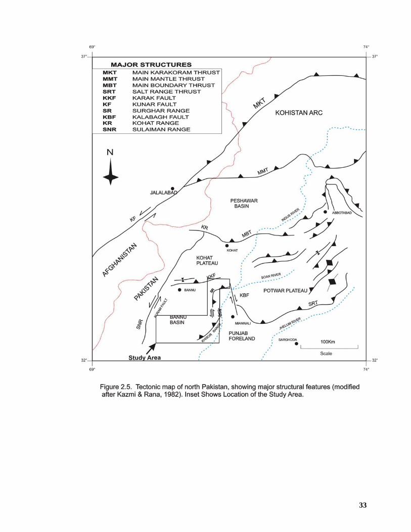
33
34
The Salt Range Thrust Sheet is characterized by re-entrants such as the Kalabagh Re-
entrant. This change in the strike of the thrust sheet is either thought to be a result of a
transpressional fault system (McDougall, 1985) or that it represents a lateral ramp in
the thrust sheet (Butler et al, 1988). The Kalabagh fault is the most prominent north
south structural feature at the boundary between Potwar and Kohat plateaus and its
trace on the surface runs for about 120 km (Figure2.5). Kalabagh Fault trends N15W
and is characterized by transpressive right lateral strike-slip movement (McDougall,
1985). Micro seismicity along the Kalabagh Fault indicates that the Salt Range
detachment is still active (Seebar and Jacob, 1979) or that there is some strike-slip
activity in the basement below.
The Kohat Plateau is the western most part of the southern deformed fold and thrust
belt (Figure 2.5). The area had been influenced by the southward progression of
deformation during late Miocene. The plateau is bounded to the north by the Main
Boundary Thrust, which brings highly deformed Mesozoic rocks of Kohat Range over
the Eocene-Miocene sediments of Kohat Plateau (Yeats & Hussain, 1987). Towards
west, the Kurram Fault Juxtaposes highly deformed Mesozoic rocks of Samana,
Darsamand, Thal and North Waziristan Agency with the Eocene to Miocene sediments
of the Kohat Plateau (Figure 2.5). The Kurram Fault is believed to be a left lateral
transpressive boundary. The southeastern boundary of the Kohat Plateau is the
Surghar Range where Paleozoic rocks emplaced southwards onto the Punjab
foredeep. Towards south, the un-deformed sediments of Bannu Basin form the
southern boundary of the Kohat plateau (Figure 2.5). The uplifted region of the Kohat
and Northern Potwar Plateau is thought to be above a “passive roof” duplex (Banks &
Warburton, 1986) similar to the structure of the Kirthar Ranges in the south.
The study area (Figure 2.6) is part of the Southern Deformed Fold-Thrust Belt covering
southern Kohat Basin along with its associated frontal ranges which include Surghar-
Shinghar, Marwat-Khisor, Pezu-Bhittani and Manzai ranges (Northern Sulaiman),
collectively called Trans-Indus ranges.
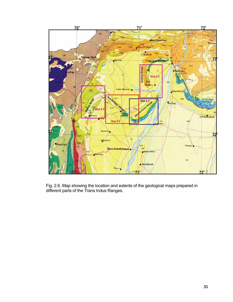
35
Fig. 2.6. Map showing the location and extents of the geological maps prepared in different parts of the Trans Indus Ranges.
36
CHAPTER 3
STRATIGRAPHY OF THE SURGHAR RANGE
3.1 SUMMARY The stratigraphy of the Trans-Indus ranges is reasonably well known and documented.
Overviews are given in a number of publications of the Geological Survey of Pakistan
(Fatmi, 1973 & Shah, 1977) and other proprietary reports generated by exploration
companies from time to time.
Detailed geology of the Surghar Range is depicted in Figures 6.3 & 6.5. Exposed rocks
in the Surghar Range are ranging in age from Late Permian, Wargal Formation to
Miocene, Chinji Formation. Isa Khel-01 well drilled (Figures 3.2 and 6.5) in 1993 by
OGDC in the southwestern part of the Surghar Range represents the deepest
penetration of the stratigraphic sequence upto Khewra Formation of early Cambrian
age (Table-3.1). A composite stratigraphic correlation (Figure 3.1) based on the wells
drilled in the Trans-Indus ranges and adjacent areas and surface geology measured at
different locations shows thickness and facies variations. It is pointed out that various
stratigraphic units (Eocene through Permian) pinch out from west to east in the Potwar
area towards the basin margin (Figures 3.2 and 3.3). This is caused due to significant
uplift which occurred towards the end of Cretaceous resulting in stripping off
Cretaceous through Permian rocks from west to east across the Potwar Basin, forming
erosional wedges (Siddiqui et al. 1998).
According to Izatt (1991), throughout the northern and southern margins of the Indian
Plate, the stratigraphy records a number of relative sea level changes that influenced
stratigraphy which are summarized in Figure 3.4. The earlier changes in sea level may
have been caused by tectonic uplift related to the break-up of Gondwanaland and later
collision, subduction and lithospheric flexure, or to world wide eustatic changes in sea
level.
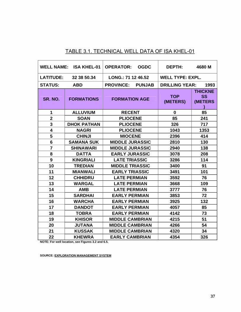
37
TABLE 3.1. TECHNICAL WELL DATA OF ISA KHEL-01
WELL NAME: ISA KHEL-01 OPERATOR: OGDC DEPTH: 4680 M
LATITUDE: 32 38 50.34 LONG.: 71 12 46.52 WELL TYPE: EXPL. STATUS: ABD PROVINCE: PUNJAB DRILLING YEAR: 1993
SR. NO. FORMATIONS FORMATION AGE TOP (METERS)
THICKNESS
(METERS)
1 ALLUVIUM RECENT 0 85 2 SOAN PLIOCENE 85 241 3 DHOK PATHAN PLIOCENE 326 717 4 NAGRI PLIOCENE 1043 1353 5 CHINJI MIOCENE 2396 414 6 SAMANA SUK MIDDLE JURASSIC 2810 130 7 SHINAWARI MIDDLE JURASSIC 2940 138 8 DATTA EARLY JURASSIC 3078 208 9 KINGRIALI LATE TRIASSIC 3286 114 10 TREDIAN MIDDLE TRIASSIC 3400 91 11 MIANWALI EARLY TRIASSIC 3491 101 12 CHHIDRU LATE PERMIAN 3592 76 13 WARGAL LATE PERMIAN 3668 109 14 AMB LATE PERMIAN 3777 76 15 SARDHAI EARLY PERMIAN 3853 72 16 WARCHA EARLY PERMIAN 3925 132 17 DANDOT EARLY PERMIAN 4057 85 18 TOBRA EARLY PERMIAN 4142 73 19 KHISOR MIDDLE CAMBRIAN 4215 51 20 JUTANA MIDDLE CAMBRIAN 4266 54 21 KUSSAK MIDDLE CAMBRIAN 4320 34 22 KHEWRA EARLY CAMBRIAN 4354 326
NOTE: For well location, see Figures 3.2 and 6.5. SOURCE: EXPLORATION MANAGEMENT SYSTEM
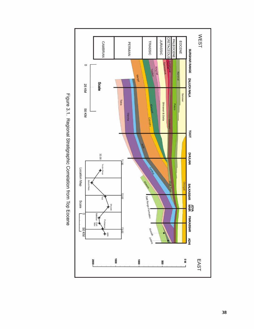
38
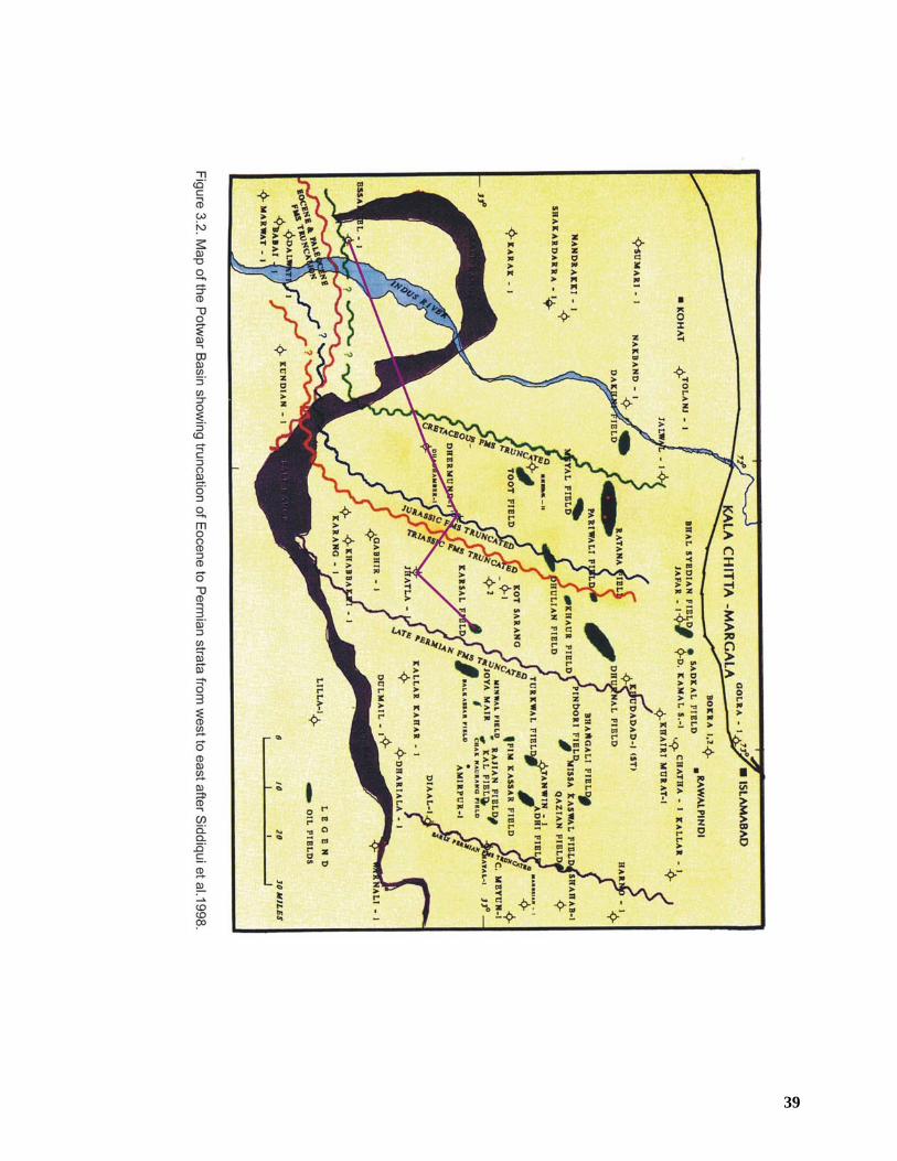
39
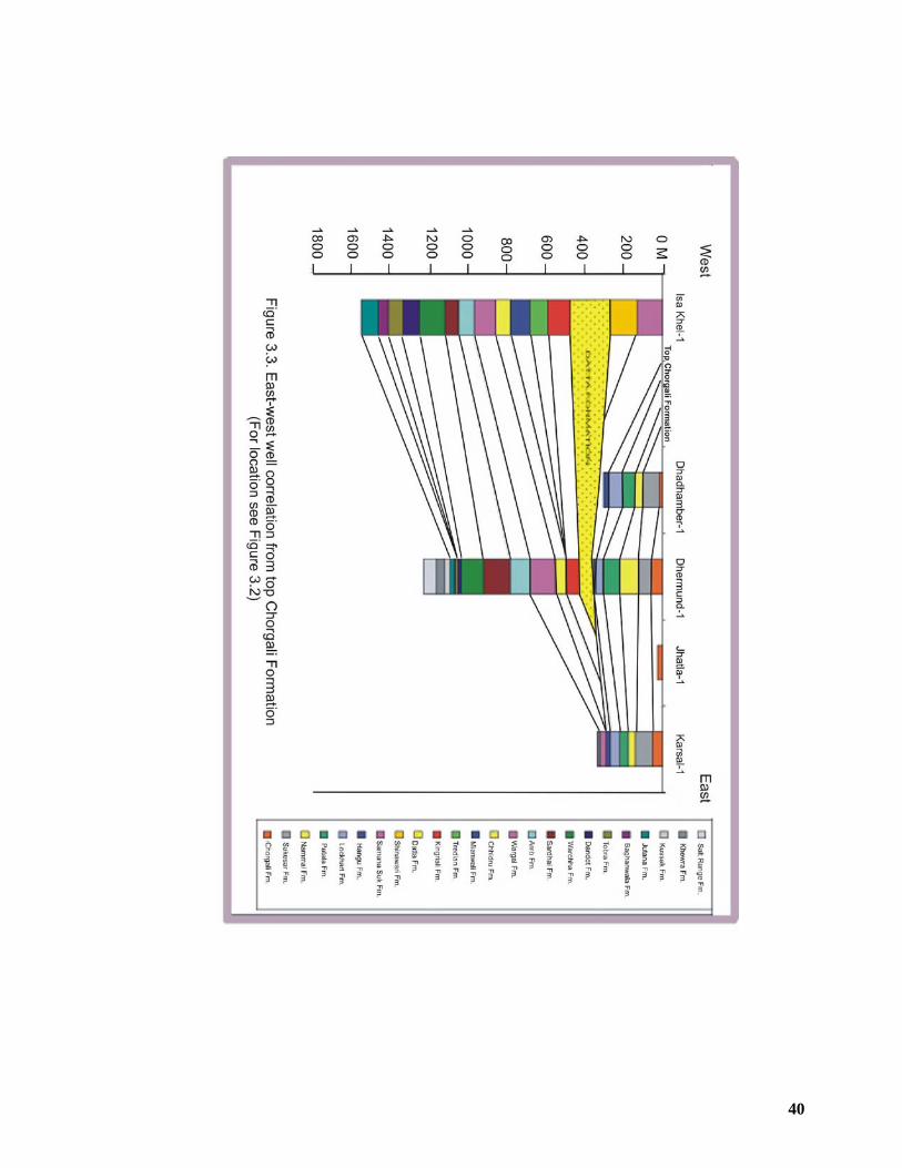
40
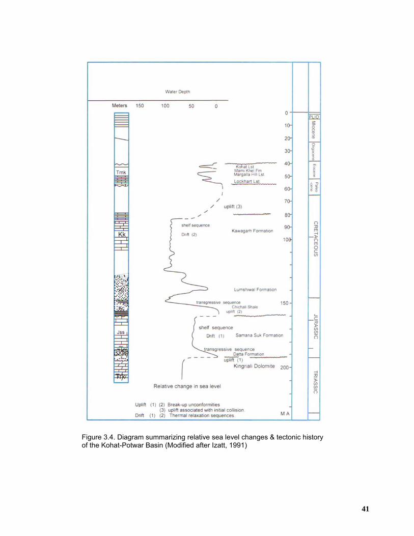
41
Figure 3.4. Diagram summarizing relative sea level changes & tectonic history of the Kohat-Potwar Basin (Modified after Izatt, 1991)
42
3.2 STRATIGRAPHIC SETTING To avoid long repetition, a brief description of the formations will be provided,
incorporating the observations made during the geological field trips to the study area.
The stratigraphic succession exposed in the Surghar Range near the locality of Landa
Psha (Figure 6.3) is represented by the following groups from base to top (Figure 3.5);
a) Zaluch Group
b) Musa Khel Group
c) Baroch Group
d) Surghar Group
e) Makarwal Group
f) Chharat Group
g) Siwalik Group
The rock description is based on observation of exposed geology and the drill cuttings
of different wells drilled in Trans-Indus ranges and surrounding area.
3.2.1 Zaluch Group The Paleozoic succession exposed in the Surghar Range belongs to the Zaluch Group
of early to late Permian age. The Zaluch Group consists of the following formations
from base to top;
1) Amb Formation 2) Wargal Limestone 3) Chhidru Formation
The name Zaluch Group was initially introduced by Teichert (1966). The Zaluch Group
represents totally marine conditions, which prevailed over the Indus Basin and Punjab
Platform areas of Pakistan in late Permian times. Thickness of the entire group at the
type section has been reported to be more than 300 meters (Shah, 1977). In the
Surghar Range, only Wargal Limestone and Chhidru Formation are exposed (Figure
3.5).
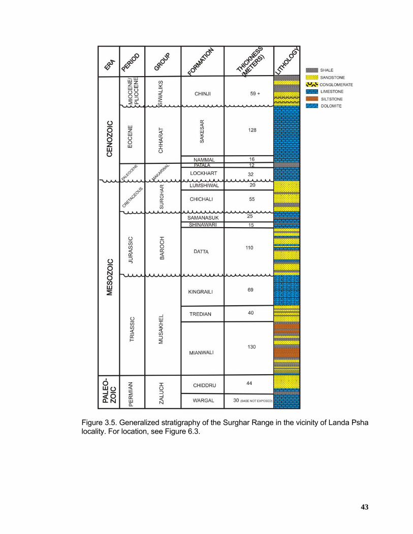
43
Figure 3.5. Generalized stratigraphy of the Surghar Range in the vicinity of Landa Psha locality. For location, see Figure 6.3.
44
3.2.1.1 Wargal Limestone
The oldest rock unit exposed in the Surghar Range is the Wargal Formation of Zaluch
Group, having Late Permian age. The Wargal Limestone is a hard, thick and relatively
uniform formation. It consists of light grey, medium to thick bedded limestone. Peloid
and oolitic pack to grainstones are predominant, but mudstone and wackstone also
occurs, representing shallow marine carbonate platform environment. The formation is
richly and diversely fossiliferous. At various levels, chert nodules are present. Base of
the Wargal Limestone is not exposed in the Surghar Range.
The thickness of the Wargal Limestone in Zaluch Nala has been reported to be 183
meters by Teichert (1966) whereas its thickness is 156 m in the Saiyiduwali section and
149 m in the Paniala section of Khisor Range (Alam et al. 2005 and Alam 2008). Its
contact with the underlying Amb Formation is conformable in the Khisor Range
whereas its upper contact with the Chhidru Formation is gradational. On the basis of
presence of brachiopods, Ustritsky (1962) placed the formation in the Late Permian.
3.2.1.2 Chhidru Formation Waagen (1891) named the formation as “Chhidru beds” and Noetling (1901) described
the formation as “Chhidru Group”. Dunbar introduced the name Chhidru Formation in
1932.
The Chhidru Formation consists of grey brown, thin to medium bedded calcareous
sandstone, sandy limestone and sandy/calcareous mudstone. The limestone is gray,
weathering brownish grey, marly, argillaceous richly fossiliferous and has black cherts
along the bedding planes in the lower part. The middle part is thin bedded, fractured
and overlain by the calcareous sandstone and sandy limestone. The sandstone is
massive and fine grained. The uppermost part is a white, massive, friable sandstone
bed (2 m thick). It is 44 meters thick in the Surghar Range near Lunda Psha area. The
thickness of the formation is 92 m in the Saiyiduwali section and 68 m in the Paniala
section in the Khisor Range (Alam et al. 2005 and Alam 2008). The Wargal Limestone
conformably underlies it and its upper contact is a well-defined paraconformity with the
Mianwali Formation of Early Triassic age. The formation is reported to have been
deposited in a shallow marine environment with varying clastic input (Tectostrat, 1992).
The formation is richly fossiliferous. It contains brachiopods and corals in the lower part
45
and crinoids and bellerophon in the upper part. The age assigned to the formation is
Late Permian (Kummel and Teichert, 1970).
3.2.2 Musa Khel Group The Musa Khel Group of Triassic age is well-exposed in the Lunda Psha section of
Surghar Range with a total thickness of 239 meters (Figure 3.5). The Musa Khel Group
comprises the following formations from base to top;
1) Mianwali Formation 2) Tredian Formation 3) Kingriali Formation
3.2.2.1 Mianwali Formation (250-243 MA) The Mianwali Formation is exposed in the Surghar Range and entire Khisor Range and
mainly consists of marl, limestone, sandstone, siltstone, and dolomite. Its total
thickness is 130 meters in the Lunda Psha section of Surghar Range (Figure 3.5). It is
127 m thick in the Saiyiduwali section and 118 m in the Paniala section of the Khisor
Range (Alam et al, 2005 and Alam 2008).
The Mianwali Formation consists of a sequence that is predominantly an alternation of
grey to brown mudstone and fine grained sandstone and siltstone, with subordinate
shales and carbonate beds. These beds are mostly thin to medium bedded with an
occasional thick limestone bed.
The Mianwali Formation is thought to have been deposited on a shallow marine shelf
with a high terrigenous influx (Tectostrat, 1992). The limestone in the Mianwali
Formation was deposited during relative quiet episodes in locations with low clastic
input. The mudstone/sandstone beds are turbiditic and related to a high clastic input
originating from a near shore delta area. Age assigned to the formation is Early Triassic
(Kummel, 1966). The lower contact of the formation with the Chhidru Formation of Late
Permian age is marked by a paraconformity, whereas its upper contact with the
overlying Tredian Formation is sharp and well defined.
3.2.2.2 Tredian Formation (Anisian-Ladinian, 243-231 MA)
The Tredian Formation is built up of brownish to white or banded, multicolored thick
bedded sandstone. At some places in the middle and upper part, mudstone intervals
46
are also reported. The sandstone is generally friable, well sorted, medium grained and
shows cross-bedding and ripples. The mudstone consists of dark grey shales or brown
siltstone and is thin to medium bedded. They show cross-lamination and are
occasionally burrowed with abundant plant remains. In the western part of the Salt
Range and in the Khisor Range dolomite beds are developed in the upper part of the
formation. Furthermore, in the Khisor Range, the formation contains no or only very
minor amounts of mudstone. The thick-bedded sandstone is interpreted as a deltaic
sequence that progrades basin wards. The mudstone intervals are thought to represent
interchannel coastal plain areas where paralic conditions prevailed.
The Tredian Formation conformably overlies the Mianwali Formation and is
conformably overlain by the Kingriali Formation. The total thickness of the Tredian
Formation is 40 meters in the Landa Psha section of the Surghar Range (Figure 3.5). It
has recorded a total thickness of 46 m in the Saiyiduwali section and 60 m in the
Paniala section of the Khisor Range (Alam et al, 2005 and Alam 2008).
No fossils are reported to have been collected from the Tredian Formation. Based on
stratigraphic position and on palynological studies by Balme (1970), a Middle Triassic
age is inferred.
3.2.2.3 Kingriali Formation (Carnian-Rhaetian, 231-213 MA) The Kingriali Formation is well-developed in the Trans-Indus ranges and in the western
part of the Salt Range. It is divisible into two members, a lower Doya and an upper
Vanjari according to the subdivision proposed for the formation in the Surghar Range
(Fatmi et al., 1972).
3.2.2.3.1 Doya Member
The Doya Member is composed of dolomite interbedded with sandstone. The dolomite
is brown, purplish white, pinkish, sugary textured, crinoidal, sandy, and marly at places.
The sandstone is brown, fine to medium grained, massive, friable, dolomitized and
flaggy. Dolomitic shale is developed in the Paniala section, where it is interbedded with
sandstone and dolomite. This member is 33 m thick in the Saiyiduwali section and 20
m in the Paniala section of the Khisor Range (Alam et al, 2005 and Alam 2008).
47
3.2.2.3.2 Vanjari Member
The Vanjari Member consists of massive dolomite in the lower part and dolomitized
marl and shale interbedded with dolomite and dolomitic limestone in the upper part.
The dolomite is gray to brownish gray, weathering brown, thick-bedded to massive,
hard, fractured, fine to coarse textured, and form vertical cliffs. It is sandy and crinoidal
at the base. The upper part consists of purplish-brown, thin to medium bedded, marly,
micritic dolomite interbedded with dolomitized marl. The dolomitic limestone is white,
fine grained, and medium bedded and breaks with conchoidal fracture. Chert is present
along the bedding planes. The uppermost bed of rusty brown dolomite has an uneven
surface. The Vanjari Member is not fully present in the Saiyiduwali section, where it
forms Kingriali Peak, but is well developed in the Paniala section. This member is more
than 68 m thick in the Saiyiduwali section and 88 m thick in the Paniala section (Alam
et al, 2005 and Alam 2008).
The Kingriali Formation is interpreted to have been deposited in a shallow marine
carbonate platform environment (Tectostrat, 1992). The total thickness of the Kingriali
Formation is 69 meters in the Landa Psha section of the Surghar Range whereas it is
more than 101 m in the Saiyiduwali section and 108 m in the Paniala section (Alam et
al, 2005 and Alam 2008). Interbedding of dolomite and sandstone marks its basal
contact with the Tredian Formation, whereas the upper contact with the Datta
Formation is disconformable as indicated by the development of rusty brown,
ferruginous dolomite and an uneven surface at the contact. With rarely and poorly
preserved fossils, the age of the formation is based on stratigraphic position and placed
in the Late Triassic.
3.2.3 Baroch Group The Baroch Group is present in the Trans-Indus ranges and the Salt Range, although it
tapers out towards the east in the central Salt Range. It unconformably overlies the
Musa Khel Group and is unconformably overlain by Surghar Group. The Baroch Group
comprises the following formations from base to top;
1) Datta Formation 2) Shinawari Formation 3) Samana Suk Formation
48
3.2.3.1 Datta Formation (Hettangian-Toarcian, 213-188 MA)
The Datta Formation predominantly consists of banded, multicolored, and medium to
thick bedded sandstone. Intercalated are shale and siltstone beds and less frequently
limestone beds (Figures 3.6 and 3.7). Thick bedded sandstone are mostly developed in
the lower parts of the formation and are friable, medium to coarse grained and
quartzose showing large scale planar and trough cross-bedding, often with high angle
foresets. The sandstone is red, purple, gray, pink and white in color. In the Kutki section
of the Surghar Range, these sandstones are overlain by a sequence of alternating
sandstone and shale with thin coal beds, often with fining upward sequences. These
sequences are again overlain by a few meters thick conglomerate unit, again followed
by alternating sandstone/mudstone units. In the Chapri section of the Surghar Range,
the formation contains limestone beds. Good quality silica sand, laterite and coal are
currently being mined at places in the Surghar Range and Khisor Range from Datta
Formation.
Generally, the sediments of the Datta Formation are of a non-marine origin. The lower
thick sandstone units are thought to be deltaic, and possibly some parts littoral. The
overlying sandstones with interbedded mudstones are interpreted to have been
deposited in a deltaic to a fluvial and floodplain with swamps environment. The
conglomerates represent a coarse grained river deposit within this sequence. The
limestone beds found in the Chapri section, most likely represent lacustrine or lagoonal
deposits that have developed on the coastal plain.
The thickness of Datta Formation is 110 meters in the Landa Psha section (Figure 3.5).
It is 128 m thick in the Paniala section (Alam et al, 2005 and Alam 2008). The
formation rests unconformably on Kingriali Formation and its contact with the overlying
Shinawari Formation is gradational. The age is considered early Jurassic, pre-Toarcian
on the basis of lower Toarcian ammonites (Danilchik and Shah 1967).
3.2.3.2 Shinawari Formation (Toarcian-Aslenian, 194-188 MA)
The Shinawari Formation is considerably thinner in the Surghar Range and in the
extreme western part of the Salt Range. In the Surghar Range, the formation consists
of grey, thin to medium bedded sandy limestone and calcareous sandstone with minor
shale intercalations (Figure 3.6). The limestone is dense, micritic, platy, silty, shelly and
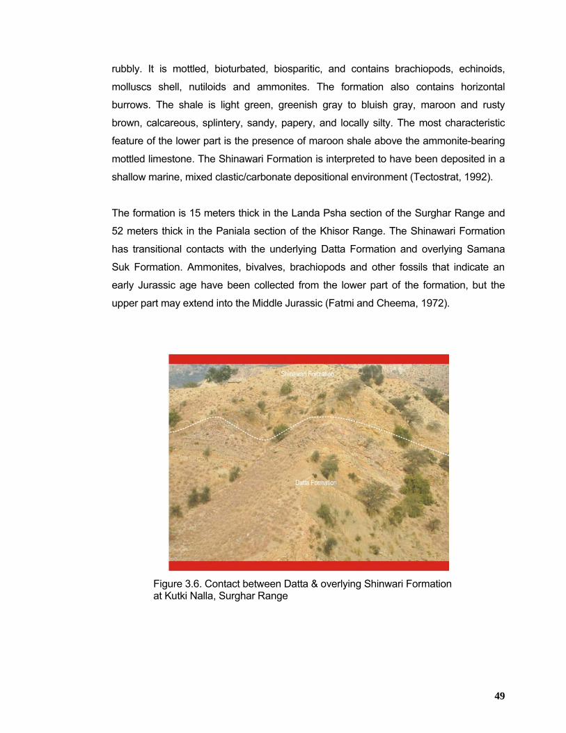
49
rubbly. It is mottled, bioturbated, biosparitic, and contains brachiopods, echinoids,
molluscs shell, nutiloids and ammonites. The formation also contains horizontal
burrows. The shale is light green, greenish gray to bluish gray, maroon and rusty
brown, calcareous, splintery, sandy, papery, and locally silty. The most characteristic
feature of the lower part is the presence of maroon shale above the ammonite-bearing
mottled limestone. The Shinawari Formation is interpreted to have been deposited in a
shallow marine, mixed clastic/carbonate depositional environment (Tectostrat, 1992).
The formation is 15 meters thick in the Landa Psha section of the Surghar Range and
52 meters thick in the Paniala section of the Khisor Range. The Shinawari Formation
has transitional contacts with the underlying Datta Formation and overlying Samana
Suk Formation. Ammonites, bivalves, brachiopods and other fossils that indicate an
early Jurassic age have been collected from the lower part of the formation, but the
upper part may extend into the Middle Jurassic (Fatmi and Cheema, 1972).
Figure 3.6. Contact between Datta & overlying Shinwari Formation at Kutki Nalla, Surghar Range
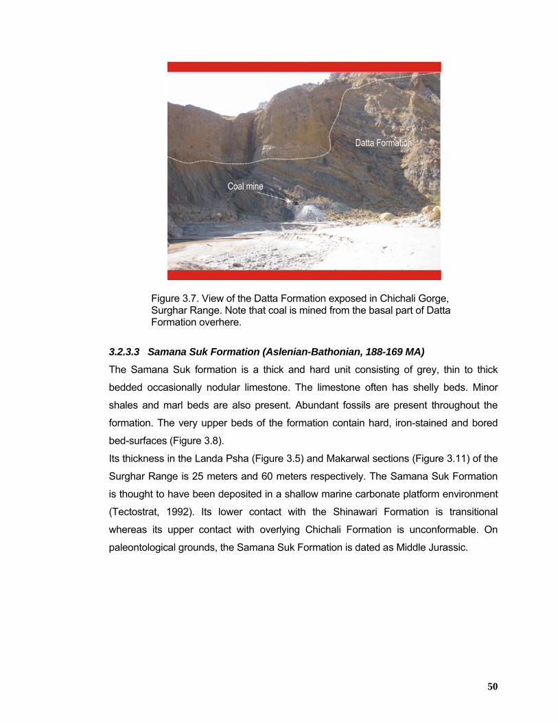
50
Figure 3.7. View of the Datta Formation exposed in Chichali Gorge, Surghar Range. Note that coal is mined from the basal part of Datta Formation overhere.
3.2.3.3 Samana Suk Formation (Aslenian-Bathonian, 188-169 MA)
The Samana Suk formation is a thick and hard unit consisting of grey, thin to thick
bedded occasionally nodular limestone. The limestone often has shelly beds. Minor
shales and marl beds are also present. Abundant fossils are present throughout the
formation. The very upper beds of the formation contain hard, iron-stained and bored
bed-surfaces (Figure 3.8).
Its thickness in the Landa Psha (Figure 3.5) and Makarwal sections (Figure 3.11) of the
Surghar Range is 25 meters and 60 meters respectively. The Samana Suk Formation
is thought to have been deposited in a shallow marine carbonate platform environment
(Tectostrat, 1992). Its lower contact with the Shinawari Formation is transitional
whereas its upper contact with overlying Chichali Formation is unconformable. On
paleontological grounds, the Samana Suk Formation is dated as Middle Jurassic.
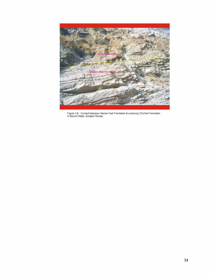
51
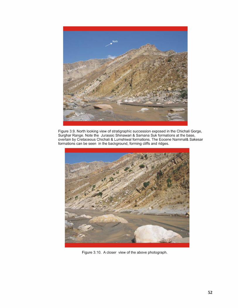
52
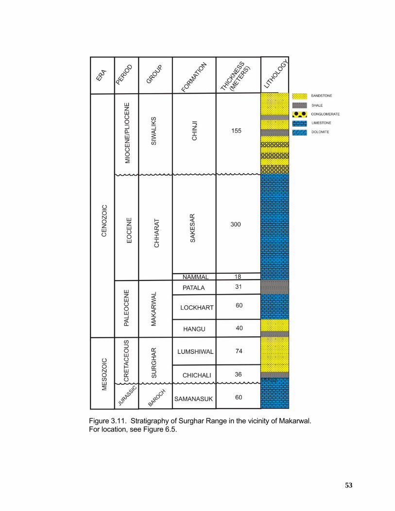
53
Figure 3.11. Stratigraphy of Surghar Range in the vicinity of Makarwal. For location, see Figure 6.5.
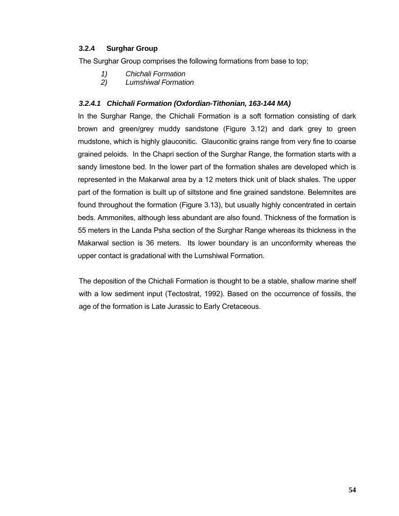
54
3.2.4 Surghar Group The Surghar Group comprises the following formations from base to top;
1) Chichali Formation 2) Lumshiwal Formation
3.2.4.1 Chichali Formation (Oxfordian-Tithonian, 163-144 MA) In the Surghar Range, the Chichali Formation is a soft formation consisting of dark
brown and green/grey muddy sandstone (Figure 3.12) and dark grey to green
mudstone, which is highly glauconitic. Glauconitic grains range from very fine to coarse
grained peloids. In the Chapri section of the Surghar Range, the formation starts with a
sandy limestone bed. In the lower part of the formation shales are developed which is
represented in the Makarwal area by a 12 meters thick unit of black shales. The upper
part of the formation is built up of siltstone and fine grained sandstone. Belemnites are
found throughout the formation (Figure 3.13), but usually highly concentrated in certain
beds. Ammonites, although less abundant are also found. Thickness of the formation is
55 meters in the Landa Psha section of the Surghar Range whereas its thickness in the
Makarwal section is 36 meters. Its lower boundary is an unconformity whereas the
upper contact is gradational with the Lumshiwal Formation.
The deposition of the Chichali Formation is thought to be a stable, shallow marine shelf
with a low sediment input (Tectostrat, 1992). Based on the occurrence of fossils, the
age of the formation is Late Jurassic to Early Cretaceous.
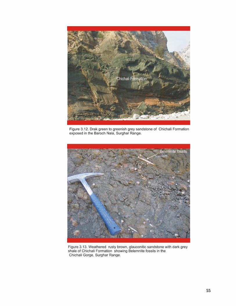
55
56
3.2.4.2 Lumshiwal Formation (Tithonian-Albian, 144-95 MA)
The Lumshiwal Formation is well exposed in the Surghar Range and is sandier than the
underlying Chichali Formation. In Makarwal area, the sequence starts with a grey unit
of mudstone and fine to medium grained sandstone with glauconite and occasionally
belemnites. This unit grades into a grey, yellow to reddish unit of rhythmically bedded
sandstone with minor mudstone. This is again overlain by a unit of brown yellow
medium to coarse grained, cross bedded sandstone which occasionally contains plant
remains. Its thickness in the Makarwal section is 74 meters.
In the Chapri and Landa Psha sections of the Surghar Range, the Lumshiwal
Formation is much thinner (only 20 meters thick) and consists of brown, often burrowed
siltstone and fine to medium grained sandstone (Figure 3.14). Generally the formation
shows a coarsening upward trend. In terms of depositional environment, the Lumshiwal
Formation represents a shallowing upward sequence. The lower part of the formation is
thought to consist of marine, prodelta muds and fine sands, which grade upward into
more proximal delta front sands. The coarse grained upper part represents a
prograding delta, at places influenced by wave action. The occurrence of plant remains
in the upper part indicates delta-plain, interchannel swamp areas which might have
developed during that time (Tectostrat, 1992).
Apart from the lowermost beds, the formation is unfossiliferous. Based on this limited
paleontological evidence, the Lumshiwal Formation is of late Cretaceous.
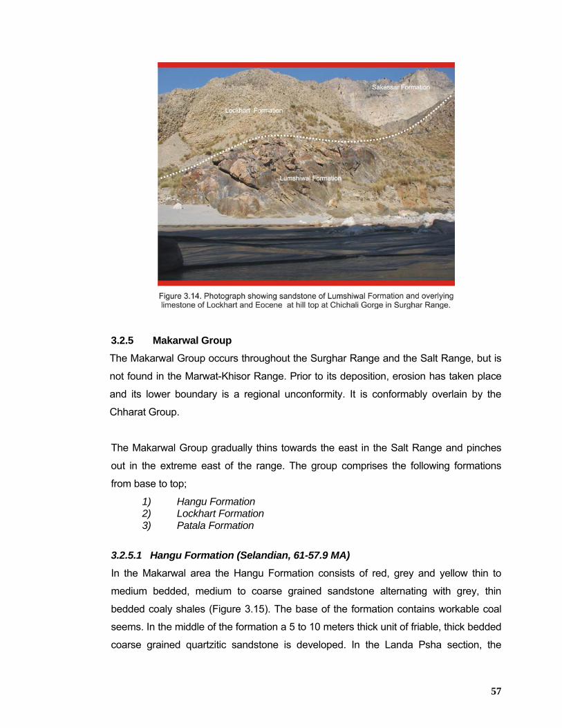
57
3.2.5 Makarwal Group The Makarwal Group occurs throughout the Surghar Range and the Salt Range, but is
not found in the Marwat-Khisor Range. Prior to its deposition, erosion has taken place
and its lower boundary is a regional unconformity. It is conformably overlain by the
Chharat Group.
The Makarwal Group gradually thins towards the east in the Salt Range and pinches
out in the extreme east of the range. The group comprises the following formations
from base to top;
1) Hangu Formation 2) Lockhart Formation 3) Patala Formation
3.2.5.1 Hangu Formation (Selandian, 61-57.9 MA)
In the Makarwal area the Hangu Formation consists of red, grey and yellow thin to
medium bedded, medium to coarse grained sandstone alternating with grey, thin
bedded coaly shales (Figure 3.15). The base of the formation contains workable coal
seems. In the middle of the formation a 5 to 10 meters thick unit of friable, thick bedded
coarse grained quartzitic sandstone is developed. In the Landa Psha section, the
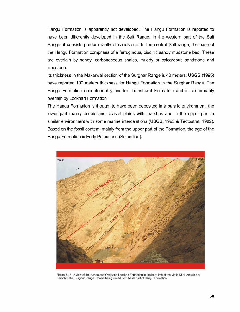
58
Hangu Formation is apparently not developed. The Hangu Formation is reported to
have been differently developed in the Salt Range. In the western part of the Salt
Range, it consists predominantly of sandstone. In the central Salt range, the base of
the Hangu Formation comprises of a ferruginous, pisolitic sandy mudstone bed. These
are overlain by sandy, carbonaceous shales, muddy or calcareous sandstone and
limestone.
Its thickness in the Makarwal section of the Surghar Range is 40 meters. USGS (1995)
have reported 100 meters thickness for Hangu Formation in the Surghar Range. The
Hangu Formation unconformably overlies Lumshiwal Formation and is conformably
overlain by Lockhart Formation.
The Hangu Formation is thought to have been deposited in a paralic environment; the
lower part mainly deltaic and coastal plains with marshes and in the upper part, a
similar environment with some marine intercalations (USGS, 1995 & Tectostrat, 1992).
Based on the fossil content, mainly from the upper part of the Formation, the age of the
Hangu Formation is Early Paleocene (Selandian).
59
3.2.5.2 Lockhart Formation (Thanetian, 57.9-54.8 MA)
The Lockhart Formation is present throughout the Surghar Range and the Salt Range
but pinches out in the eastern Salt Range. The formation consists of grey, medium to
thick bedded, nodular and marly limestone (Figures 3.14 and 3.15). In the lower part,
thin shale and marl beds are developed. The formation is highly fossiliferous and
contains abundant foraminifera.
The formation is 32 meters thick in the Landa Psha section of the Surghar Range and
60 meters thick in the Makarwal section. The Lockhart Formation is believed to have
been deposited in a shallow marine environment. Based on paleontological grounds,
the age of the Lockhart Formation is Late Paleocene.
3.2.5.3 Patala Formation (Thanetian, 54 MA)
The Patala Formation is present throughout the Surghar Range and the Salt Range. It
is a soft formation and therefore generally poorly exposed. The formation consists of
dark grey to brown, thin bedded shale, with subordinate marl, limestone and sandstone
beds. In the central and eastern Salt Range, the upper part of the formation contains
black carbonaceous shales, in which coal seems are developed (Tectostrat,1992).
Towards the top of the formation limestone beds become more abundant. The upper
and lower boundaries seem to be conformable, but due to poor exposure, this is
difficult to be established in the field. The formation is rich in fossils, which is often
concentrated in the limestone beds.
The formation is only 12 meters thick in the Landa Psha section and 31 meters thick in
the Makarwal section of the Surghar Range. The depositional environment of the
Patala Formation is entirely marine in the Surghar Range and the western part of the
Salt Range. Based on the paleontological grounds (mainly foraminifera), the Patala
Formation has a Late Paleocene age.
60
3.2.6 Chharat Group The Chharat Group is found throughout the Surghar Range and Salt Range. Towards
the east the group thins, and pinches out in the extreme eastern part of the Salt Range.
It conformably overlies the Makarwal Group and is unconformably overlain by younger
Miocene or Pliocene fluvial sediments. The Chharat Group comprises of the following
formations from base to top in the Surghar Range;
1) Nammal Formation 2) Sakesar Formation
3.2.6.1 Nammal Formation
The Nammal Formation is a soft formation and generally very poorly exposed at the
base of the steep cliffs, formed by the much harder Sakesar Formation (Figure 3.16).
Its lower boundary is most often poorly exposed but the field data indicates that it is a
gradational boundary. Its upper boundary is also gradational but conformable. The
Nammal Formation consists of bluish grey, medium bedded marls with shale and
limestone beds. It has a nodular appearance and is highly fossiliferous. It is 16 meters
thick in the Landa Psha section and 18 meters thick in the Makarwal section of the
Surghar Range. The Nammal Formation is interpreted to have been deposited in a
shallow marine carbonate environment (Tectostrat, 1992). Based on molluscs and
foraminiferal fauna, the Nammal Formation is dated as Late Paleocene to Eocene.
3.2.6.2 Sakesar Formation
The Sakesar Formation is developed throughout the Surghar Range and the Salt
Range and is a hard prominent cliff-forming formation (Figures 3.14, 3.16 and 3.17).
The formation maintains a relatively uniform character throughout the area. It consists
of grey, medium to thick bedded limestone, alternating with thin marl beds. Some
intervals are light grey to white and consist predominantly of marly limestone. In the
middle and upper part of the formation, chert concretions are common. The entire
formation is highly fossiliferous. Foraminifera are very abundant. Its thickness in the
Landa Psha section is 128 meters whereas in the Makarwal section of the Surghar
Range, its thickness is 300 meters. Its lower contact with Nammal Formation is
conformable whereas its upper contact with Chinji Formation of the Siwalik Group is
unconformable.
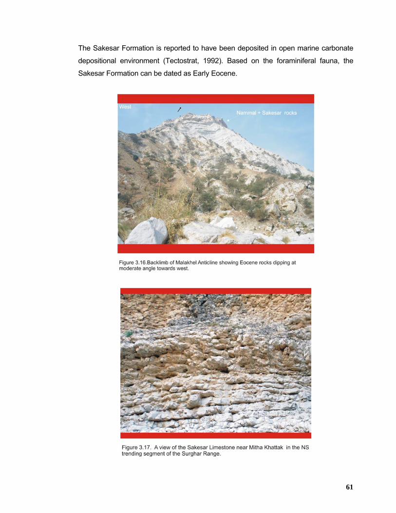
61
The Sakesar Formation is reported to have been deposited in open marine carbonate
depositional environment (Tectostrat, 1992). Based on the foraminiferal fauna, the
Sakesar Formation can be dated as Early Eocene.
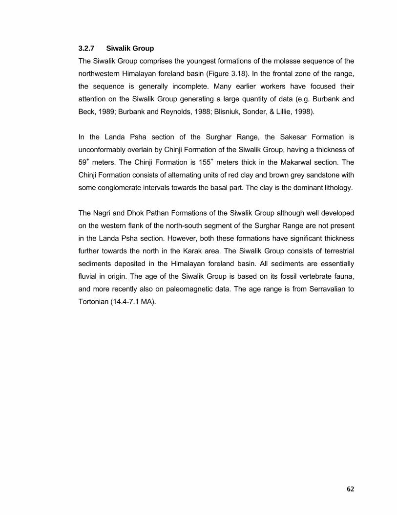
62
3.2.7 Siwalik Group The Siwalik Group comprises the youngest formations of the molasse sequence of the
northwestern Himalayan foreland basin (Figure 3.18). In the frontal zone of the range,
the sequence is generally incomplete. Many earlier workers have focused their
attention on the Siwalik Group generating a large quantity of data (e.g. Burbank and
Beck, 1989; Burbank and Reynolds, 1988; Blisniuk, Sonder, & Lillie, 1998).
In the Landa Psha section of the Surghar Range, the Sakesar Formation is
unconformably overlain by Chinji Formation of the Siwalik Group, having a thickness of
59+ meters. The Chinji Formation is 155+ meters thick in the Makarwal section. The
Chinji Formation consists of alternating units of red clay and brown grey sandstone with
some conglomerate intervals towards the basal part. The clay is the dominant lithology.
The Nagri and Dhok Pathan Formations of the Siwalik Group although well developed
on the western flank of the north-south segment of the Surghar Range are not present
in the Landa Psha section. However, both these formations have significant thickness
further towards the north in the Karak area. The Siwalik Group consists of terrestrial
sediments deposited in the Himalayan foreland basin. All sediments are essentially
fluvial in origin. The age of the Siwalik Group is based on its fossil vertebrate fauna,
and more recently also on paleomagnetic data. The age range is from Serravalian to
Tortonian (14.4-7.1 MA).
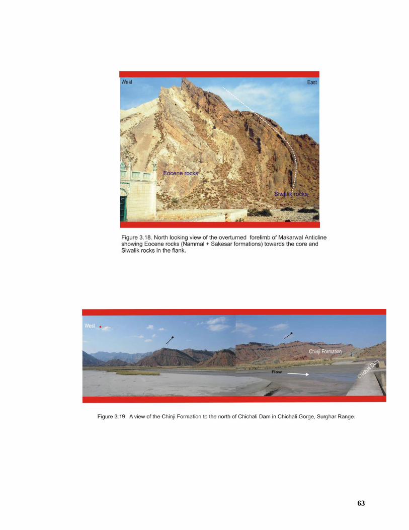
63
64
3.3 STRATIGRAPHIC ANALYSIS In the Surghar Range, the exposed stratigraphy ranges in age from late Permian
Wargal Formation to Miocene/Pliocene Siwalik Group rocks. The exposure of these
Permian rocks is limited to only western part of the east-west trending segment of the
Surghar Range. To the east in the Kutki and Chapri area, the oldest exposed rocks
belong to Triassic Kingriali Formation and Jurassic Datta Formation respectively. In the
north-south trending segment of the Surghar Range, Jurassic Datta and Samana Suk
formations are the oldest exposed rocks (Figure 3.20).
The regional east west stratigraphic correlation and stratigraphic truncation map
(Figures 3.1, 3.2 and 3.3) indicate Permian rocks belonging to both Nilawahan and
Zaluch groups encountered in the wells in the central and eastern Potwar areas show
gradual thinning to the east where these rocks are directly overlain by Paleocene and
Eocene rocks. Further to the east in the Jhelum area, even these Permian rocks are
truncated. This has been established by the stratigraphy encountered in the Diaal-1,
Hayal-1 and Harno-1 wells drilled in this area.
The overlying Triassic and Jurassic rocks also follow this trend of eastward truncation.
This is clear from their thickness in the exposed sections in the Surghar Range (Table
3.2) and Salt Range as well as drilling data from Toot and Dhulian oil and gas fields,
where substantial thickness of these rocks have been encountered (Figure 3.1). The
wells drilled in the eastern Potwar area (Balkassar, Joya Mair, Fimkassar and Adhi oil
and gas fields) have established the pinch-out of the Mesozoic strata. The Cretaceous
strata is present in the Surghar Range and Kohat area. However, in the Potwar area it
is truncated in the west of Meyal and Toot oil fields and is not present in the central and
eastern parts of the Potwar region. The Paleocene and Eocene strata are showing
persistent presence throughout the Kohat and Potwar region. However, these rocks
also show significant decrease in their thickness towards the east as is evident from the
wells drilled at Balkassar, Joya Mair, Fimkassar and Adhi oil and gas fields in the
eastern Potwar.
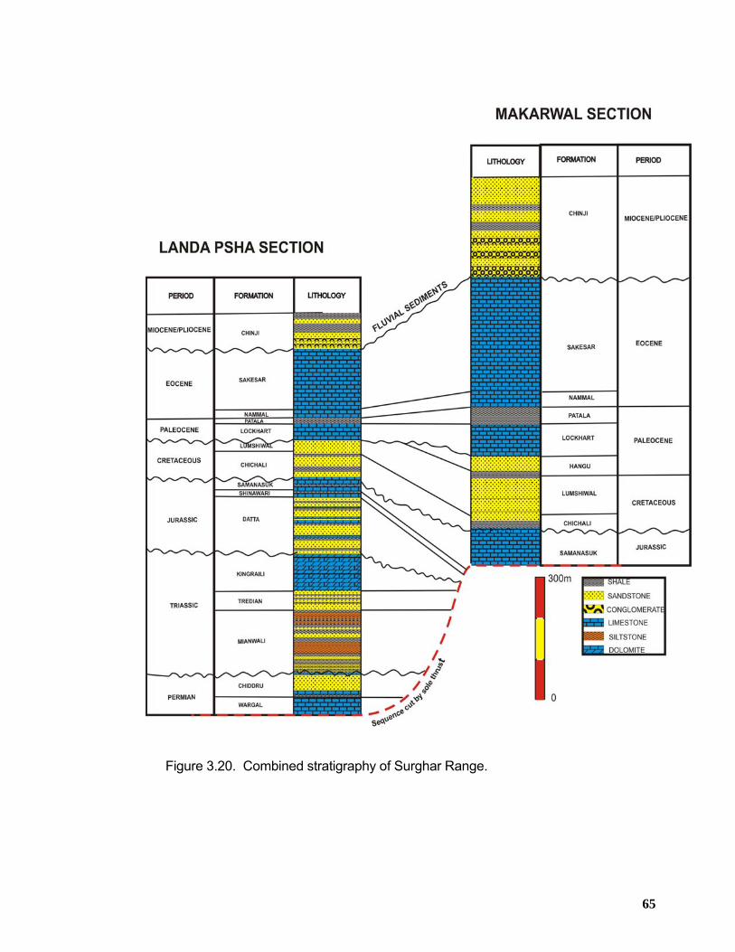
65
Figure 3.20. Combined stratigraphy of Surghar Range.
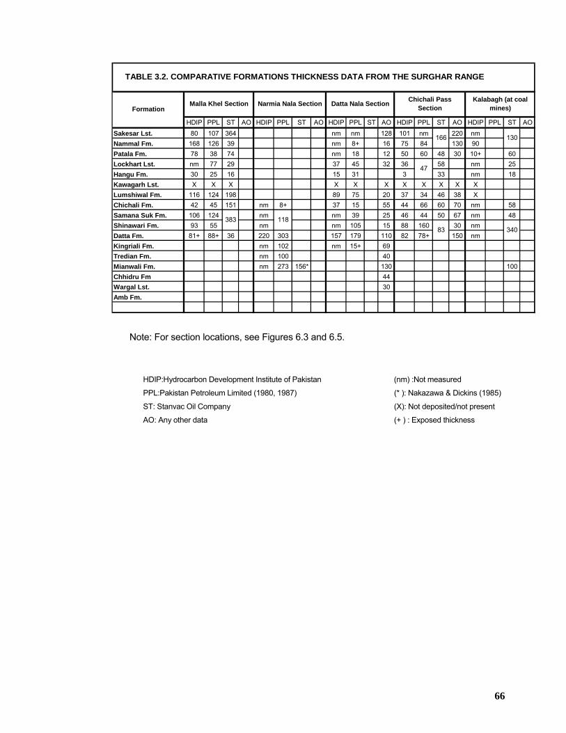
66
HDIP PPL ST AO HDIP PPL ST AO HDIP PPL ST AO HDIP PPL ST AO HDIP PPL ST AO80 107 364 nm nm 128 101 nm 220 nm
168 126 39 nm 8+ 16 75 84 130 9078 38 74 nm 18 12 50 60 48 30 10+ 60nm 77 29 37 45 32 36 58 nm 2530 25 16 15 31 3 33 nm 18X X X X X X X X X X X
116 124 198 89 75 20 37 34 46 38 X42 45 151 nm 8+ 37 15 55 44 66 60 70 nm 58
106 124 nm nm 39 25 46 44 50 67 nm 4893 55 nm nm 105 15 88 160 30 nm
81+ 88+ 36 220 303 157 179 110 82 78+ 150 nmnm 102 nm 15+ 69nm 100 40nm 273 156* 130 100
4430
Lockhart Lst.Hangu Fm.Kawagarh Lst.Lumshiwal Fm.
340
Kingriali Fm.Tredian Fm.Mianwali Fm.
Shinawari Fm.Datta Fm.
83383
Narmia Nala Section
118
Datta Nala Section
Wargal Lst.Amb Fm.
Chhidru Fm
Chichali Fm.Samana Suk Fm.
Malla Khel Section
TABLE 3.2. COMPARATIVE FORMATIONS THICKNESS DATA FROM THE SURGHAR RANGE
Kalabagh (at coal mines)
Chichali Pass Section
47
166 130
Formation
Sakesar Lst.Nammal Fm.Patala Fm.
Note: For section locations, see Figures 6.3 and 6.5.
HDIP:Hydrocarbon Development Institute of Pakistan (nm) :Not measured
PPL:Pakistan Petroleum Limited (1980, 1987) (* ): Nakazawa & Dickins (1985)
ST: Stanvac Oil Company (X): Not deposited/not present
AO: Any other data (+ ) : Exposed thickness
67
CHAPTER 4 STRATIGRAPHY OF THE MARWAT-KHISOR RANGE
4.1 SUMMARY The detailed stratigraphy of the Marwat-Khisor range has been studied in the vicinity of
Saiyiduwali village located in the south-western end of the Khisor range (Figure 7.2).
The exposed stratigraphy comprises of Cambrian to Triassic platform sediments in the
Khisor Range which are unconformably overlain by Pliocene-Pleistocene fluvial
sediments of Siwalik Group in the Marwat Range (Figure 4.1). The platform sediments
become thicker and more complete from east to west in the Khisor Range.
In the Saiyiduwali section, the base of stratigraphic succession is occupied by the rocks
of Cambrian age that include Khewra Sandstone, Kussak Formation, Jutana Formation
and Khisor Formation. The Khewra Sandstone consists of purplish-brown, thick-
bedded sandstone with coarse clay bands and concretionary layers in the upper part.
The overlying Kussak Formation is a sandy and dolomitic unit that is rich in glauconite.
The Jutana Formation is predominantly grey, massive dolomite and is overlain by the
Khisor Formation that is predominantly gypsiferous marl interbedded with shale along
with minor oil-impregnated gypsum and dolomite layers. Overlying the Cambrian rocks
is a sequence of Permian rocks that consist of the Nilawahan and Zaluch Groups. The
base of the Nilawahan Group begins at Tobra Formation which is a tillitic deposit. The
overlying Warchha Formation contains sandstone, siltstone and silty shale. The
Sardhai Formation consists of carbonaceous, silty shale with minor sandstone bands.
The overlying Zaluch Group consists of mixed sandy and carbonate units in the lower
Amb Formation and upper parts of the Chhidru Formation but a thick carbonate cliff-
forming unit i.e. Wargal Limestone, is present between these two. Brachiopods,
crinoids, bryozoans, corals and other fossils are common in this group. The upper 20 m
thick, gray, nodular marly limestone of the Wargal Limestone contains abundant
brachiopods and other fossils and underlies the Chhidru Formation. Sandy limestone is
common in the upper part of the Chhidru Formation. The contact between the Permian
Chhidru Formation and the Triassic Mianwali Formation (Kathwai Member) of the Musa
Khel Group is well exposed in the Saiyiduwali area. The basal Kathwai Member of the
Mianwali Formation is sandy and dolomitic in the lower part but is glauconitic in the
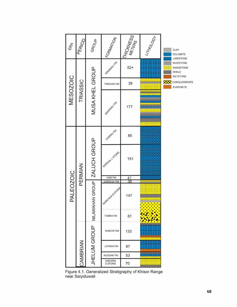
68
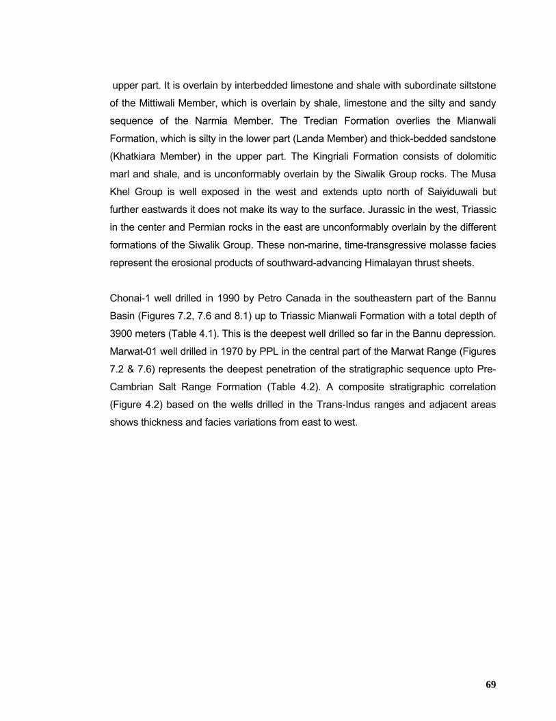
69
upper part. It is overlain by interbedded limestone and shale with subordinate siltstone
of the Mittiwali Member, which is overlain by shale, limestone and the silty and sandy
sequence of the Narmia Member. The Tredian Formation overlies the Mianwali
Formation, which is silty in the lower part (Landa Member) and thick-bedded sandstone
(Khatkiara Member) in the upper part. The Kingriali Formation consists of dolomitic
marl and shale, and is unconformably overlain by the Siwalik Group rocks. The Musa
Khel Group is well exposed in the west and extends upto north of Saiyiduwali but
further eastwards it does not make its way to the surface. Jurassic in the west, Triassic
in the center and Permian rocks in the east are unconformably overlain by the different
formations of the Siwalik Group. These non-marine, time-transgressive molasse facies
represent the erosional products of southward-advancing Himalayan thrust sheets.
Chonai-1 well drilled in 1990 by Petro Canada in the southeastern part of the Bannu
Basin (Figures 7.2, 7.6 and 8.1) up to Triassic Mianwali Formation with a total depth of
3900 meters (Table 4.1). This is the deepest well drilled so far in the Bannu depression.
Marwat-01 well drilled in 1970 by PPL in the central part of the Marwat Range (Figures
7.2 & 7.6) represents the deepest penetration of the stratigraphic sequence upto Pre-
Cambrian Salt Range Formation (Table 4.2). A composite stratigraphic correlation
(Figure 4.2) based on the wells drilled in the Trans-Indus ranges and adjacent areas
shows thickness and facies variations from east to west.
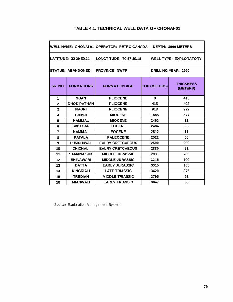
70
TABLE 4.1. TECHNICAL WELL DATA OF CHONAI-01
12345678910111213141516
290
3215 100
2522 68
2880 512931
2484 28NAMMAL EOCENE 2512 11
1885 577KAMLIAL MIOCENE 2463 22
DHOK PATHAN PLIOCENE 415 498NAGRI PLIOCENE 913 972
WELL NAME: CHONAI-01 OPERATOR: PETRO CANADA DEPTH: 3900 METERS
LATITUDE: 32 29 59.31 LONGTITUDE: 70 57 19.18 WELL TYPE: EXPLORATORY
STATUS: ABANDONED PROVINCE: NWFP DRILLING YEAR: 1990
SR. NO. FORMATIONS FORMATION AGE TOP (METERS) THICKNESS (METERS)
EARLY TRIASSIC
PLIOCENE
MIDDLE JURASSIC
EARLY JURASSICLATE TRIASSIC
EALRY CRETCAEOUS
MIOCENE
EOCENE
PALEOCENEEALRY CRETCAEOUS
3847
MIDDLE JURASSIC
53
415
285
10537552
0
MIDDLE TRIASSIC
PATALA
331534203795
LUMSHIWAL 2590
SHINAWARI
TREDIANMIANWALI
SOAN
SAMANA SUK
DATTAKINGRIALI
CHICHALI
CHINJI
SAKESAR
Source: Exploration Management System
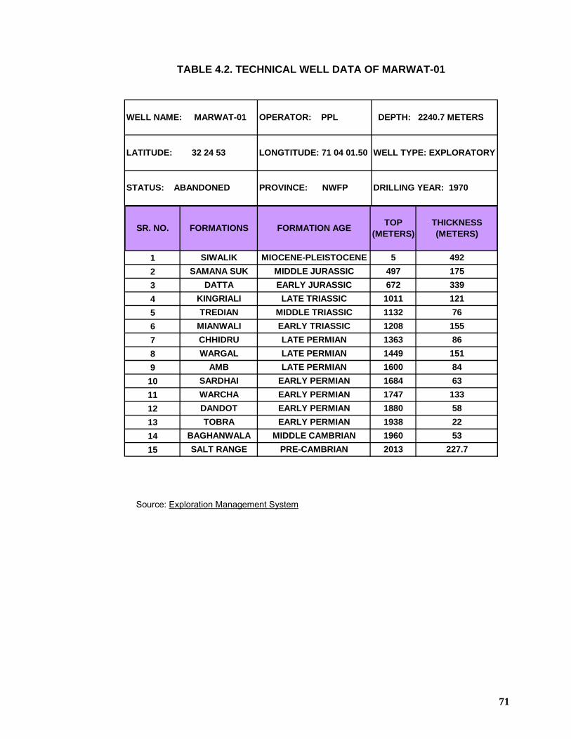
71
TABLE 4.2. TECHNICAL WELL DATA OF MARWAT-01
123456789
101112131415
WELL NAME: MARWAT-01 OPERATOR: PPL DEPTH: 2240.7 METERS
LATITUDE: 32 24 53 LONGTITUDE: 71 04 01.50 WELL TYPE: EXPLORATORY
STATUS: ABANDONED PROVINCE: NWFP DRILLING YEAR: 1970
SR. NO. FORMATIONS FORMATION AGE TOP (METERS)
THICKNESS (METERS)
LATE PERMIANEARLY PERMIAN
PRE-CAMBRIAN
EARLY PERMIANEARLY PERMIANEARLY PERMIAN
MIDDLE CAMBRIAN
MIDDLE TRIASSICEARLY TRIASSICLATE PERMIANLATE PERMIAN
MIOCENE-PLEISTOCENEMIDDLE JURASSICEARLY JURASSIC
LATE TRIASSIC
155
227.7
133582253
86151
193819602013
492175
8463
33912176
1600168417471880
SALT RANGE
5497
WARCHA
67210111132120813631449
BAGHANWALA
CHHIDRUWARGAL
AMBSARDHAI
SIWALIKSAMANA SUK
DATTAKINGRIALITREDIAN
MIANWALI
DANDOTTOBRA
Source: Exploration Management System
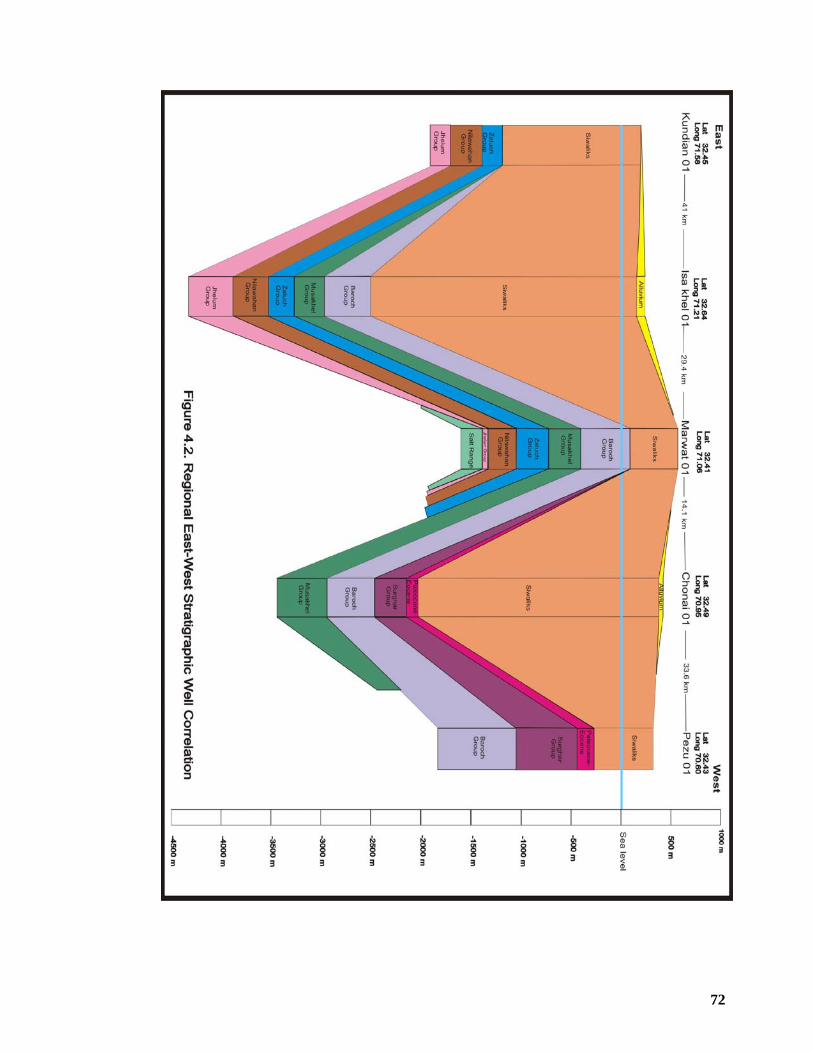
72
73
4.2 STRATIGRAPHIC SETTING The stratigraphic succession exposed in the Saiyiduwali section of Marwat-Khisor
Range is represented by the following groups from base to top;
h) Jhelum Group
i) Nilawahan Group
j) Zaluch Group
k) Musa Khel Group
l) Siwalik Group
4.2.1 Jhelum Group The Jhelum Group is widely distributed in the Trans-Indus and Salt ranges. However,
due to erosion prior to the deposition of Permian strata, the Jhelum Group is not found
between Nammal and Kalabagh in the northwestern part of the Salt Range. The
Jhelum Group is also not exposed in the Surghar Range. It is again exposed in the
Khisor Range.
In the Saiyiduwali section, the Jhelum Group comprises the following formations from
base to top;
1) Khewra Sandstone 2) Kussak Formation 3) Jutana Formation 4) Khisor Formation
4.2.1.1 Khewra Sandstone The Khewra Sandstone predominantly consists of purplish-brown, thick-bedded, fine to
medium grained, well-sorted sandstone with sparse clay bands and concretionary
layers in the upper part. Lower part of the formation consists of red, thin bedded
mudstone and fine grained sandstone.
Sedimentary structures in the lower part include trough and planar cross lamination,
ripple marks and mud cracks. In the upper part planar cross bedding and trough cross
bedding occasionally with bidirectional foresets are seen throughout the sequence. The
formation is more than 70 m thick in the Saiyiduwali section. Its base is not exposed
and its upper contact with the Kussak Formation is disconformable. Shah (1977) has
reported the exposed thickness of the Khewra Sandstone in the Khisor Range as 60
meters.
74
The persistent red color, the sedimentary structures and the absence of fossils point to
a fluvial depositional environment. It must be noted that Schindewolf and Seilacher
(1955) have described arthropod tracks that are compared with tracks of small
Trilobites. If this is correct, along with the occurrence of minor amounts of glauconite
grains, suggests the presence of marine tongues interbedded in the continental
sediments. Based on the stratigraphic position and the occurrence of the above-
mentioned arthropod tracks, an early Cambrian age is assumed.
4.2.1.2 Kussak Formation Kussak Formation consists of relatively soft, green grey and purple, glauconitic
sandstone and shales. Often beds are formed by a homogenous, poorly sorted mixture
of glauconitic sandstone and mudstone, probably due to bioturbation. The shale
intervals are more commonly present in the upper part of the formation, along with a
few thin dolomite beds. The formation conformably grades into the overlying Jutana
Formation. The basal beds of the Kussak Formation are often conglomeratic and
represent a sharp break with the underlying Khewra Formation.
The sediments of the Kussak Formation are thought to be the result of a marine
transgression. The basal conglomerate represents an unconformity. The bioturbation,
abundant presence of glauconite and the marine fauna which has been reported
(Schindewolf and Seilacher, 1955) of the overlying sediments, point to a shallow
marine environment of deposition. The formation is 53m thick in the Saiyiduwali
section. Shah (1977) has reported its thickness in the Khisor Range to be 55 meters.
The age of the formation, based on paleontological information in the eastern part of
the Salt Range, is late early Cambrian or early Middle Cambrian (Teichert, 1964).
4.2.1.3 Jutana Formation The formation dominantly consists of medium to thick bedded light coloured dolomite
and brown fine grained sandstone and shale. The dolomite occasionally shows
stromatolitic laminations. The shale and sandstone are generally carbonaceous and
often burrowed.
The Jutana Formation is 87 m thick in the Saiyiduwali section. Shah (1977) has
reported its thickness in the Khisor Range to be 50 meters.
Its contact with the underlying Kussak Formation and the overlying Khisor Formation
(equivalent to the Baghanwala Formation of the Salt Rage) are conformable. Its age is
75
late early Cambrian or early Middle Cambrian (Teichert, 1964). The formation is
fossiliferous. Schindewolf and Seilacher (in Teichert, 1964) collected and described
some fossils from the shale units in the middle part of the formation exposed in the
eastern Salt Range, including Lingulella fuchsi, Botsfordia granutala, Redlichia noetlingi
and gastropod.
The Jutana Formation is reported to have been deposited in shallow marine conditions,
with a variable clastic influx (Tectostrat, 1992).
4.2.1.4 Khisor Formation The Khisor Formation has a limited areal extent and is encountered in the
southwestern part of the Khisor Range. It occupies a similar stratigraphic position as
the Baghanwala Formation. Its lower boundary is conformable and its upper boundary
is unconformable underneath the Permian Tobra Formation.
The Khisor Formation consists of gypsum dolomite and shale with minor amounts of silt
and sandstone. These lithologies are often interbedded. The dolomite is distributed
throughout the formation, but is pre-dominant in the upper part. It is light grey,
microcrystalline, often laminated. At some locations, the dolomite has bituminous
odour. The shales are grey green, often dolomitic and occasionally black and
bituminous.
The Saiyiduwali section exposed in the north of Saiyiduwali village in Khisor Range has
been designated as type section of the formation. The Khisor Formation is 133 m thick
in the Saiyiduwali section. The formation, which is devoid of fossils, is regarded as a
lateral facies equivalent to the Baghanwala Formation (Salt Pseudomorph beds) of the
Salt Range, having a similar stratigraphic position. It is therefore assumed to be of
similar early Middle Cambrian age. The Khisor Formation is interpreted to have been
deposited in an area of local depression, possibly coastal ponds, under evaporitic
circumstances (Tectostrat, 1992).
76
4.2.2 Nilawahan Group The Nilawahan Group is generally exposed in the entire Trans-Indus and Salt ranges
except in the eastern part of the Salt Range where this group is progressively eroded.
In the western part of the Salt Range and the Surghar Range, the Nilawahan Group is
not exposed. However, its presence in the sub-surface has been established by the
stratigraphic sequence encountered in the Isa Khel-01 well. In the Khisor Range, this
group is again exposed.
The Nilawahan Group unconformably overlies the Jhelum Group, and is conformably
overlain by the Zaluch Group.
In the Saiyiduwali section, the Nilawahan Group comprises the following formations
from base to top;
1) Tobra Formation 2) Warchha Sandstone 3) Sardhai Formation
4.2.2.1 Tobra Formation The Tobra Formation is composed of poorly sorted conglomerates in a clay and sand
matrix (boulder beds) and poorly sorted sandstone. The clasts are of various types of
igneous and metamorphic rocks, often polished and scratched, and of pebble to
boulder size. The conglomerate beds often have an erosive base. In the Khisor Range,
the Tobra Formation is slightly thicker and consists of diamictite, sandstone and
boulder beds. It is 81 meters thick in the Saiyiduwali section of the Khisor Range. Shah
(1977) has reported its thickness to be 67 meters from the Khisor Range. The Tobra
Formation is deposited in a glacial or fluvio-glacial environment. In the western Salt
Range and the Khisor Range a marine or estuarine influence could be present
(Teichert, 1967). Based on palynological evidence an early Permian age is assigned to
this formation.
4.2.2.2 Warchha Sandstone This formation consists of red to brown colored friable, thick bedded and cross-bedded
sandstone alternating with red to maroon color shale/clay and siltstone units with
subordinate carbonate beds (Figure 4.3). The sandstone is medium to coarse grained.
Often the matrix is slightly calcareous. In the Khisor Range, the formation contains less
mudstone and the sandstone is generally coarse grained to gritty, whereas in the
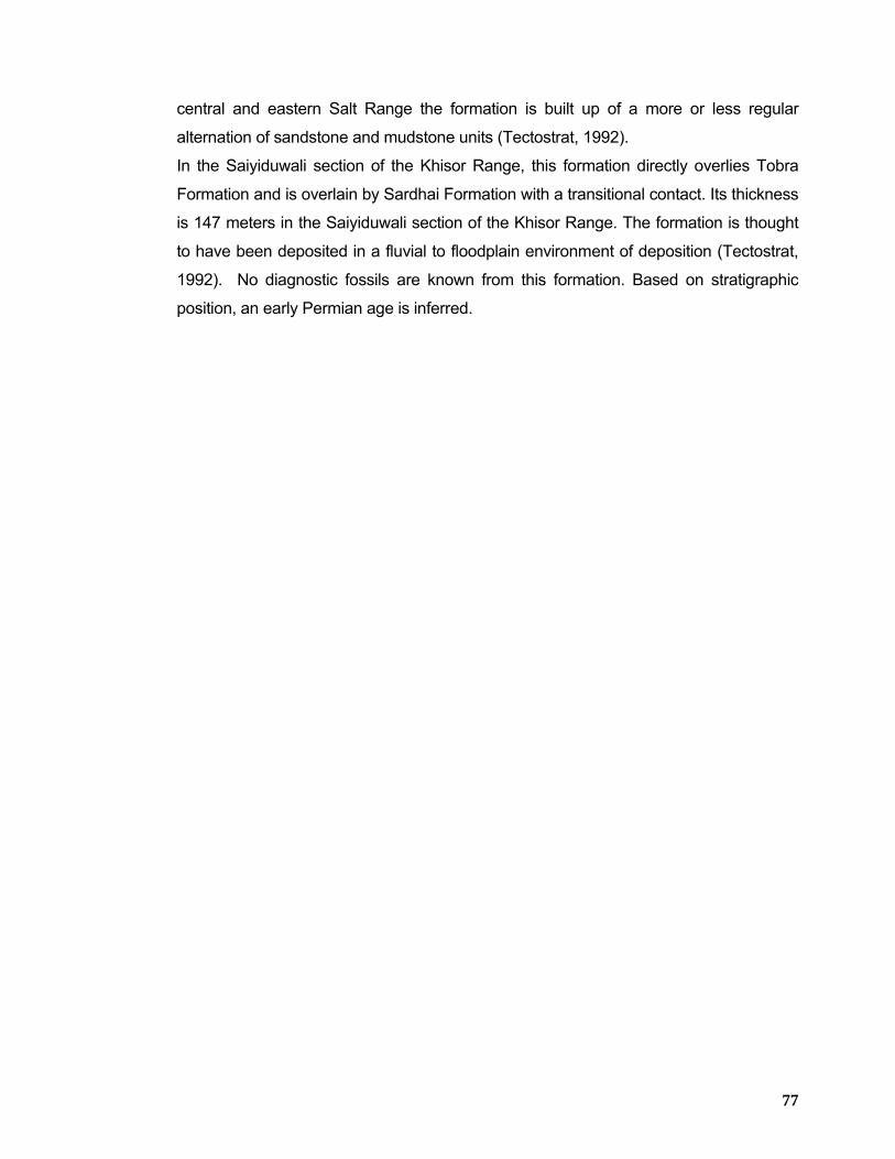
77
central and eastern Salt Range the formation is built up of a more or less regular
alternation of sandstone and mudstone units (Tectostrat, 1992).
In the Saiyiduwali section of the Khisor Range, this formation directly overlies Tobra
Formation and is overlain by Sardhai Formation with a transitional contact. Its thickness
is 147 meters in the Saiyiduwali section of the Khisor Range. The formation is thought
to have been deposited in a fluvial to floodplain environment of deposition (Tectostrat,
1992). No diagnostic fossils are known from this formation. Based on stratigraphic
position, an early Permian age is inferred.
78
79
4.2.2.3 Sardhai Formation The Sardhai Formation consists of soft, blue-greenish, lavender colored clay with minor
amounts of fine grained sandstone beds in the upper part and light brown, nodular
carbonaceous beds in the middle part of the formation. In the Khisor Range, the
formation consists of dark grey shales with thin flaggy fine grained sandstone and
limestone beds (Figures 4.4 and 4.5).
The formation is 36 meters thick in the Saiyiduwali section. Shah (1977) has reported
its thickness from the Khisor Range to be 50 meters. The formation has conformable
upper and lower boundaries.
The formation is thought to have been deposited in a lacustrine environment
(Tectostrat, 1992). In the Khisor Range, the occurrence of Bryozoans and Brachiopods
(Fatmi, 1973) from the limestone beds suggest a restricted marine environment of
deposition. Based on the above mentioned fossils, an early Permian age is assigned to
this formation.
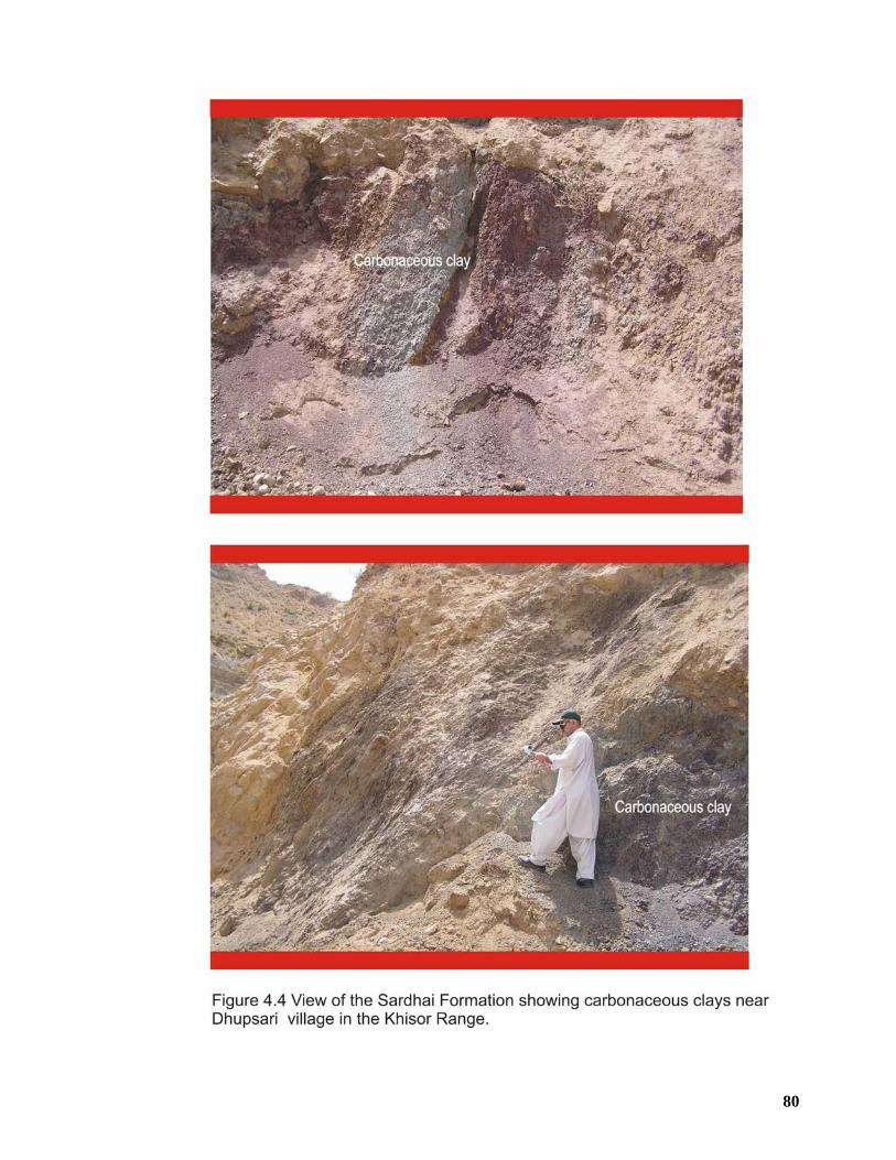
80
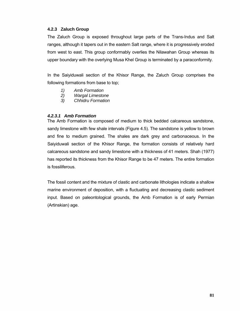
81
4.2.3 Zaluch Group The Zaluch Group is exposed throughout large parts of the Trans-Indus and Salt
ranges, although it tapers out in the eastern Salt range, where it is progressively eroded
from west to east. This group conformably overlies the Nilawahan Group whereas its
upper boundary with the overlying Musa Khel Group is terminated by a paraconformity.
In the Saiyiduwali section of the Khisor Range, the Zaluch Group comprises the
following formations from base to top;
1) Amb Formation 2) Wargal Limestone 3) Chhidru Formation
4.2.3.1 Amb Formation The Amb Formation is composed of medium to thick bedded calcareous sandstone,
sandy limestone with few shale intervals (Figure 4.5). The sandstone is yellow to brown
and fine to medium grained. The shales are dark grey and carbonaceous. In the
Saiyiduwali section of the Khisor Range, the formation consists of relatively hard
calcareous sandstone and sandy limestone with a thickness of 41 meters. Shah (1977)
has reported its thickness from the Khisor Range to be 47 meters. The entire formation
is fossiliferous.
The fossil content and the mixture of clastic and carbonate lithologies indicate a shallow
marine environment of deposition, with a fluctuating and decreasing clastic sediment
input. Based on paleontological grounds, the Amb Formation is of early Permian
(Artinskian) age.
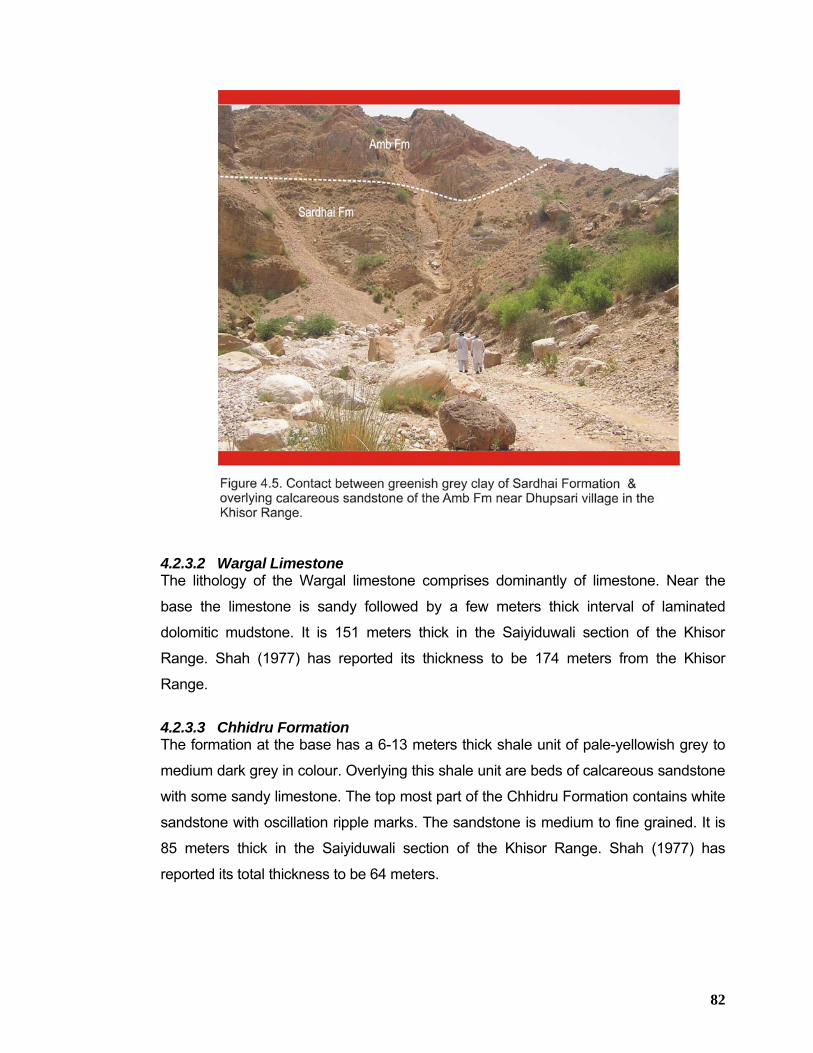
82
4.2.3.2 Wargal Limestone The lithology of the Wargal limestone comprises dominantly of limestone. Near the
base the limestone is sandy followed by a few meters thick interval of laminated
dolomitic mudstone. It is 151 meters thick in the Saiyiduwali section of the Khisor
Range. Shah (1977) has reported its thickness to be 174 meters from the Khisor
Range.
4.2.3.3 Chhidru Formation The formation at the base has a 6-13 meters thick shale unit of pale-yellowish grey to
medium dark grey in colour. Overlying this shale unit are beds of calcareous sandstone
with some sandy limestone. The top most part of the Chhidru Formation contains white
sandstone with oscillation ripple marks. The sandstone is medium to fine grained. It is
85 meters thick in the Saiyiduwali section of the Khisor Range. Shah (1977) has
reported its total thickness to be 64 meters.
83
4.2.4 Musa Khel Group The Musa Khel Group is exposed throughout the Trans-Indus and Salt ranges with the
exception of eastern Salt Range where erosion prior to deposition of the Baroch Group
and subsequently prior to the deposition of the Makarwal Group has removed this
group. In the Saiyiduwali section of the Khisor Range, total thickness of the group is
336 meters. The Musa Khel Group comprises the following formations from base to
top;
1) Mianwali Formation 2) Tredian Formation 3) Kingriali Formation
The detailed stratigraphic account of the Musa Khel Group has already been given in
the “Stratigraphy of Surghar Range” in Chapter-3. However its brief account is
presented below;
4.2.4.1 Mianwali Formation (250-243 MA) The Mianwali Formation is exposed in the Surghar Range and entire Khisor Range and
mainly consists of marl, limestone, sandstone, siltstone, and dolomite (Figures 4.6 and
4.7). It is 127 m thick in the Saiyiduwali section and 118 m in the Paniala section of the
Khisor Range (Alam et al, 2005 and Alam 2008).
The Mianwali Formation consists of a sequence that is predominantly an alternation of
grey to brown mudstone and fine grained sandstone and siltstone, with subordinate
shales and carbonate beds. These beds are mostly thin to medium bedded with an
occasional thick limestone bed.
Age assigned to the formation is Early Triassic (Kummel, 1966). The lower contact of
the formation with the Chhidru Formation of Late Permian age is marked by a
paraconformity, whereas its upper contact with the overlying Tredian Formation is
sharp and well defined.
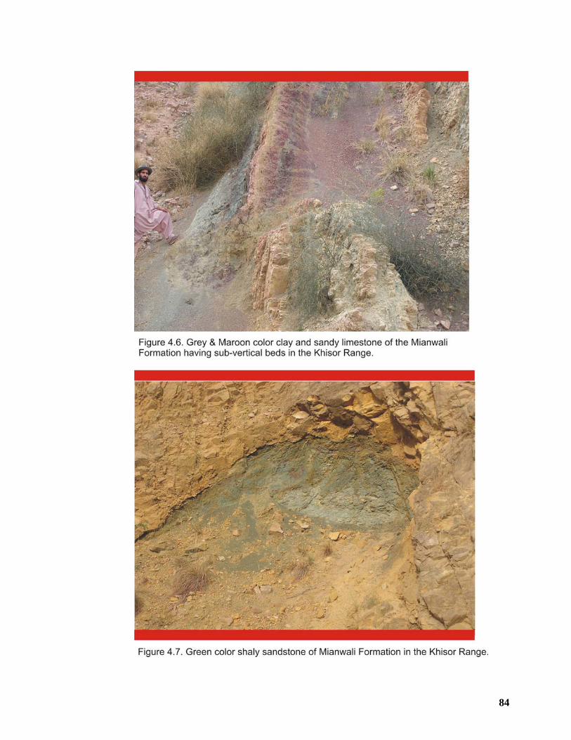
84
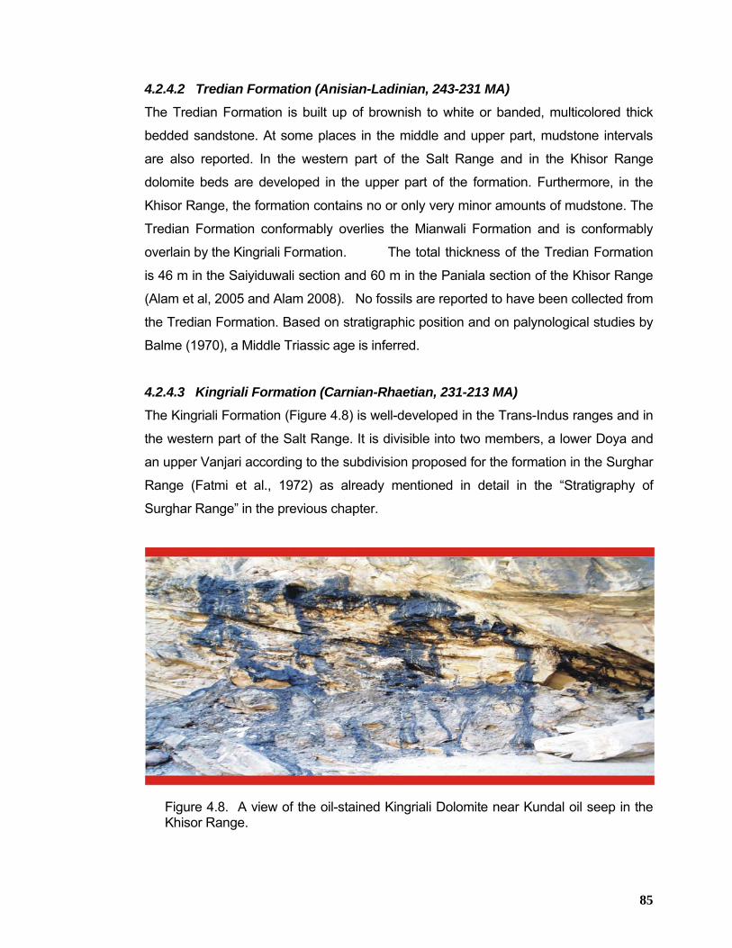
85
4.2.4.2 Tredian Formation (Anisian-Ladinian, 243-231 MA)
The Tredian Formation is built up of brownish to white or banded, multicolored thick
bedded sandstone. At some places in the middle and upper part, mudstone intervals
are also reported. In the western part of the Salt Range and in the Khisor Range
dolomite beds are developed in the upper part of the formation. Furthermore, in the
Khisor Range, the formation contains no or only very minor amounts of mudstone. The
Tredian Formation conformably overlies the Mianwali Formation and is conformably
overlain by the Kingriali Formation. The total thickness of the Tredian Formation
is 46 m in the Saiyiduwali section and 60 m in the Paniala section of the Khisor Range
(Alam et al, 2005 and Alam 2008). No fossils are reported to have been collected from
the Tredian Formation. Based on stratigraphic position and on palynological studies by
Balme (1970), a Middle Triassic age is inferred.
4.2.4.3 Kingriali Formation (Carnian-Rhaetian, 231-213 MA) The Kingriali Formation (Figure 4.8) is well-developed in the Trans-Indus ranges and in
the western part of the Salt Range. It is divisible into two members, a lower Doya and
an upper Vanjari according to the subdivision proposed for the formation in the Surghar
Range (Fatmi et al., 1972) as already mentioned in detail in the “Stratigraphy of
Surghar Range” in the previous chapter.
Figure 4.8. A view of the oil-stained Kingriali Dolomite near Kundal oil seep in the
Khisor Range.
86
4.2.5 Siwalik Group Marwat Range and Bhittani Range is entirely composed of the Siwalik Group rocks of
Pliocene-Pleistocene age exposed immediately to the south of Bannu Basin,
outcropping in the form of broad anticlines known as Marwat Anticline to the southeast
and Bhittani Anticline to the southwest in the Marwat and Pezu-Bhittani ranges
respectively. The Siwalik Group rocks represent the development of a terrestrial
foreland basin that contained generally south-flowing fluvial systems, including the
Paleo-Indus River.
The term “Siwalik” was first used by Meddlicot (1868) for the upper part of the “sub-
Himalayan system” of the Siwalik and Simla hills of India. Later on Oldham (1893) and
Holland et al. (1913) used the terms “Siwalik Series” and “Siwalik System”. The
Stratigraphic Committee of Pakistan, following Danilchik and Shah (1967) established
the Siwalik Group for the “Siwalik Series/System”. The group is mainly composed of
alternating beds of sandstone and argillaceous material. These were deposited in the
riverine belt between the sub-Himalayan hills and the Arabian Sea where a vast pile of
fresh-water sediments had started accumulating since the Miocene epoch (Pascoe,
1963). The group, as a whole, consists of sediments of clastic origin of molasse type. In
the Marwat Range, the lithology typically consists of thick sandstone with minor clay
(Nagri Formation). This is succeeded by a cyclic alternation of clay and sandstone
(Dhok Pathan Formation), followed by a conglomerate, sandstone and clay sequence
(Soan Formation) in the upper part (Figure 4.9). However, in the Pezu-Bhittani Range,
the lithology of the Siwalik Group near the base is represented by red clay with
subordinate sandstone of the Chinji Formation.
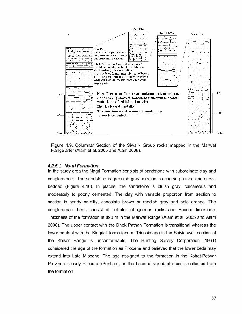
87
Figure 4.9. Columnar Section of the Siwalik Group rocks mapped in the Marwat Range after (Alam et al, 2005 and Alam 2008).
4.2.5.1 Nagri Formation In the study area the Nagri Formation consists of sandstone with subordinate clay and
conglomerate. The sandstone is greenish gray, medium to coarse grained and cross-
bedded (Figure 4.10). In places, the sandstone is bluish gray, calcareous and
moderately to poorly cemented. The clay with variable proportion from section to
section is sandy or silty, chocolate brown or reddish gray and pale orange. The
conglomerate beds consist of pebbles of igneous rocks and Eocene limestone.
Thickness of the formation is 890 m in the Marwat Range (Alam et al, 2005 and Alam
2008). The upper contact with the Dhok Pathan Formation is transitional whereas the
lower contact with the Kingriali formations of Triassic age in the Saiyiduwali section of
the Khisor Range is unconformable. The Hunting Survey Corporation (1961)
considered the age of the formation as Pliocene and believed that the lower beds may
extend into Late Miocene. The age assigned to the formation in the Kohat-Potwar
Province is early Pliocene (Pontian), on the basis of vertebrate fossils collected from
the formation.
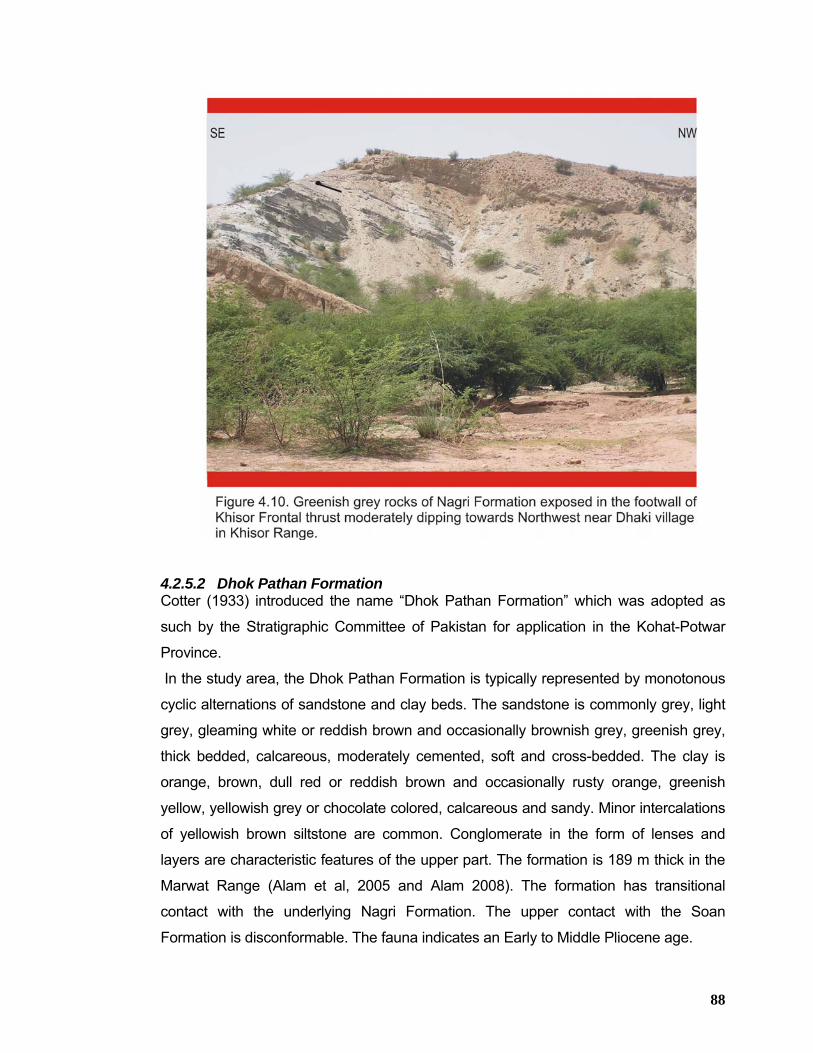
88
4.2.5.2 Dhok Pathan Formation Cotter (1933) introduced the name “Dhok Pathan Formation” which was adopted as
such by the Stratigraphic Committee of Pakistan for application in the Kohat-Potwar
Province.
In the study area, the Dhok Pathan Formation is typically represented by monotonous
cyclic alternations of sandstone and clay beds. The sandstone is commonly grey, light
grey, gleaming white or reddish brown and occasionally brownish grey, greenish grey,
thick bedded, calcareous, moderately cemented, soft and cross-bedded. The clay is
orange, brown, dull red or reddish brown and occasionally rusty orange, greenish
yellow, yellowish grey or chocolate colored, calcareous and sandy. Minor intercalations
of yellowish brown siltstone are common. Conglomerate in the form of lenses and
layers are characteristic features of the upper part. The formation is 189 m thick in the
Marwat Range (Alam et al, 2005 and Alam 2008). The formation has transitional
contact with the underlying Nagri Formation. The upper contact with the Soan
Formation is disconformable. The fauna indicates an Early to Middle Pliocene age.
89
4.2.5.3 Soan Formation The Soan Formation consists essentially of compact, massive conglomerate with
subordinate interbeds of multicolored sandstone, siltstone and clay. The proportion of
different rock type varies within short distances. The conglomerate consists of a variety
of pebbles and boulders of different sizes. The conglomerate is massive and consists
mainly of pebbles and boulders of limestone, quartzite, porphyritic rocks, sandstone,
gneiss, schist, diabase, etc. The pebbles and boulders range in size from 5 cm to 30
centimeters. Claystone and sandstone are commonly intercalated. The claystone is
orange, brown, pale pinkish to red and soft. The sandstone is grey, greenish grey,
coarse grained and soft. Thickness of the formation is about 141 meters in the Marwat
Range (Alam et al, 2005 and Alam 2008). The formation is underlain by the Dhok
Pathan Formation with an apparent disconformity which is marked by sharp coarsening
of clastics and by the appearance of massive and densely packed conglomerate. The
formation is poorly fossiliferous. The preserved fauna indicates Late Pliocene to early
Pleistocene age for the formation, (Pascoe, 1963; & Kravetchenko, 1964).
90
4.3 STRATIGRAPHY OF THE SHEIKH BUDIN HILLS The Sheikh Budin Hills expose oldest rocks belonging to Zaluch Group of early to
late Permian age. The Zaluch Group rocks are overlain by Musa Khel Group
represented by Mianwali Formation and Kingriali Dolomite in the Sheikh Budin Hills.
Unlike Khisor Range, the Triassic rocks in Sheikh Budin Hills are overlain by Jurassic
Datta and Samana Suk formations which are in turn overlain by Chichali and
Lumshiwal formations of Cretaceous age. The Siwalik rocks overlie the Cretaceous
strata. Rocks belonging to both Zaluch Group and Musa Khel Group are not well
developed in the Sheikh Budin Hills as in other parts of the Khisor Range. However,
Jurassic rocks are well developed overhere. Datta Formation consists of sandstone
and subordinate amounts of varicolored siltstone and claystone beds (Figure 4.11). The
sandstone is thin to thick-bedded, fine to coarse-grained. Its color is white, purple,
green and brown. Pure white sandstone is quarried at Sheikh Budin for making glass.
Datta Formation generally forms slopes. USGS (1973) has reported its thickness to be
448 meters in the southeastern part of Sheikh Budin Hills. The Samana Suk Formation
consists of limestone which is brown and grey in color, thin and thick-bedded and
crystalline, with abundant reported ammonite, coral and gastropods fossils. The
limestone of the Samana Suk Formation forms ridges and steep cliffs. USGS (1973)
has reported its thickness to be 314 meters in the southeastern part of Sheikh Budin
Hills.
The undifferentiated Cretaceous rocks are represented by sandstone in the upper part
and claystone/siltstone in the lower part. The sandstone is brown and grey in color. The
claystone/siltstone is dark grey, glauconitic and contains belemnites. The Cretaceous
rocks are forming slopes. USGS (1973) has reported its thickness to be 88 meters in
the eastern part of Sheikh Budin Hills. No Paleocene and Eocene strata is reported
from Sheikh Budin Hills and the Siwalik rocks are directly lying over the Cretaceous
rocks.
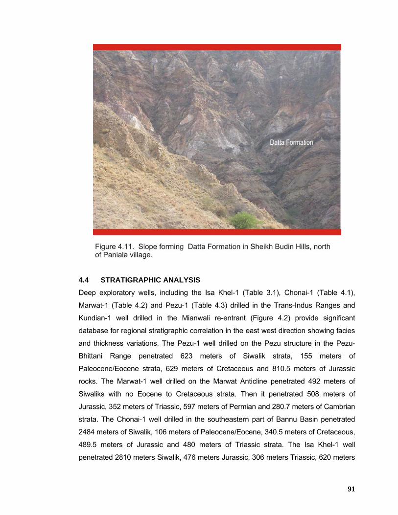
91
4.4 STRATIGRAPHIC ANALYSIS Deep exploratory wells, including the Isa Khel-1 (Table 3.1), Chonai-1 (Table 4.1),
Marwat-1 (Table 4.2) and Pezu-1 (Table 4.3) drilled in the Trans-Indus Ranges and
Kundian-1 well drilled in the Mianwali re-entrant (Figure 4.2) provide significant
database for regional stratigraphic correlation in the east west direction showing facies
and thickness variations. The Pezu-1 well drilled on the Pezu structure in the Pezu-
Bhittani Range penetrated 623 meters of Siwalik strata, 155 meters of
Paleocene/Eocene strata, 629 meters of Cretaceous and 810.5 meters of Jurassic
rocks. The Marwat-1 well drilled on the Marwat Anticline penetrated 492 meters of
Siwaliks with no Eocene to Cretaceous strata. Then it penetrated 508 meters of
Jurassic, 352 meters of Triassic, 597 meters of Permian and 280.7 meters of Cambrian
strata. The Chonai-1 well drilled in the southeastern part of Bannu Basin penetrated
2484 meters of Siwalik, 106 meters of Paleocene/Eocene, 340.5 meters of Cretaceous,
489.5 meters of Jurassic and 480 meters of Triassic strata. The Isa Khel-1 well
penetrated 2810 meters Siwalik, 476 meters Jurassic, 306 meters Triassic, 620 meters
92
Permian and 465 meters thick Cambrian strata with no Eocene to late Jurassic rocks.
The Kundian-1 well penetrated 1417 meters thick Siwalik strata, 542 meters thick
Permian and 201 meters thick Cambrian strata with no Eocene to Triassic rocks due to
truncation or stratigraphic pinch-out towards the east.
The regional east west stratigraphic well correlation (Figure 4.2) depicts that Siwalik
rocks show their maximum thickness in the Bannu Basin and adjoining area as
demonstrated by Isa Khel-1 and Chonai-1 wells and show tapering effects both to the
east and west as shown by Kundian-1 and Pezu-1 wells drilled in the Mianwali re-
entrant and Pezu-Bhittani Range respectively. The Eocene and Paleocene strata was
encountered in Pezu-1 (155 M thick) and Chonai-1 (106 M thick) only. It was not
encountered in Marwat-1 well falling between Chonai-1 and Pezu-1 wells. Since the
Marwat structure is highly uplifted and possible erosion of Eocene, Paleocene and
Cretaceous strata before the deposition of the Siwalik rocks could be one of the
reasons for their absence. Further to the east, Eocene and Paleocene strata have not
been encountered in Isa Khel-1 and Kundian-1 wells. Thick Cretaceous strata
encountered at Pezu-1 well in the west is showing decrease in thickness towards the
east. At Chonai-1, thickness of Cretaceous rocks is considerably decreased. Further to
the east from Chonai-1, these rocks are not encountered at Marwat-1 well (due to high
uplift/erosion of the Marwat Range as mentioned earlier), Isa Khel-1 and Kundian-1
wells. The Jurassic rocks also follow this general eastward truncation trend as shown
by their drilling thickness data in the above-mentioned wells. These rocks have shown
maximum thickness at Pezu-1 well in the west and then toward the east, Jurassic rocks
have shown decrease in their thickness. Subsequently, this thickness has been
maintained between Chonai-1, Marwat-1 and Isa Khel-1 wells. However, further to the
east, Jurassic rocks have not been encountered at Kundian-1 well. The Triassic rocks
also pinch-out towards the east. Their maximum thickness was encountered at Chonai-
1 well and then their thickness has decreased eastward between Marwat-1 and Isa
Khel-1 wells as evident from the well correlation (Figure 4.2). Further to the east at
Kundian-1 well, Triassic rocks have not been encountered. The Permian strata have
also demonstrated eastward pinch-out trend which is clear from their drilled
thicknesses at Marwat-1, Isa Khel-1 and Kundian-1 wells. The Cambrian strata is not
an exception to this general eastward truncation or decrease in stratigraphic
93
thicknesses. This is evident from their thickness encountered at Isa Khel-1 and
Kundian-1 wells.
TABLE 4.3. TECHNICAL WELL DATA OF PEZU-01
1
2
89111213
SIWALIKS
SAMANA SUK
DATTA
MUGHALKOT
2057
LUMSHIWAL 992
SHINAWARI
623
306
165.5
5MIOCENE-PLIOCENE-PLEISTOCENE
MIDDLE JURASSIC
EARLY JURASSIC
CRETCAEOUSEALRY CRETCAEOUS
MIDDLE JURASSIC
STATUS: ABANDONED PROVINCE: NWFP DRILLING YEAR: 1968-69
SR. NO. FORMATIONS FORMATION AGE TOP (METERS) THICKNESS (METERS)
WELL NAME: PEZU-01 OPERATOR: PPL DEPTH: 2222.5 METERS
LATITUDE: 32 26 04.50 LONGTITUDE: 70 36 25.50 WELL TYPE: EXPLORATORY
SAKESAR-LOKHART- EOCENE-PALEOCENE 623 155
420
1718 339
783 209
1412
Note: For location of Pezu-1 well, see Figure 8.1.
Source: Exploration Management System
94
CHAPTER 5 STRATIGRAPHY OF THE MANZAI RANGE
5.1 SUMMARY The Manzai area is located in the northern Sulaiman Range (Figure 9.1) where rocks
ranging in age from Jurassic to Quaternary are exposed (Figure 5.1). Rocks of
Paleocene and Eocene age are particularly well developed in the area.
The western part of northern Sulaiman Range is occupied by the rocks of Jurassic age
(undifferentiated) belonging to Sulaiman Limestone Group (Figure 9.1). This group
consists of mostly dark grey to blue, thin to thick bedded, hard and massive limestone
forming high peaks with continuous outcrops. This sequence is disconformably overlain
by a sequence of Cretaceous rocks, consisting of Sembar Formation, Parh Limestone,
Mughal Kot Formation and Pab Sandstone. The Sembar Formation consists of soft
black claystone, locally somewhat silty and sandy, with minor thin beds of dark grey to
black limestone. The Parh Limestone is light grey, hard porcelaneous, thick and thin
bedded. The Mughal Kot Formation consists of light grey calcareous sandstone in the
upper part with shaly limestone near the base. The Pab Sandstone consists of
quartzitic grey and blue sandstone, which is fine to coarse grained, sub-angular to
rounded, thin to thick bedded and commonly cross bedded. The Cretaceous sequence
is in turn disconformably overlain by a thin succession of Paleocene age rocks that
include Dunghan and Ranikot Formations. Dunghan Formation in the Northern
Sulaiman Range is composed of dark gray, thick bedded limestone towards top and
bottom with some sandstone horizons upto 5 meter thick in the middle part. The
Ranikot Formation is very thin and consisting of sandstone with interbedded shale. The
Paleocene succession is conformably overlain by thick sequence of Eocene rocks that
include Ghazij shale at the base followed by Baska Shale and Kirthar Formation
towards the top. The Eocene succession is dominantly shale in the Lower part that is
Ghazij and Baska Shale and becomes calcareous towards the top represented by
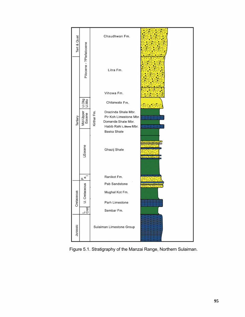
95
Figure 5.1. Stratigraphy of the Manzai Range, Northern Sulaiman.
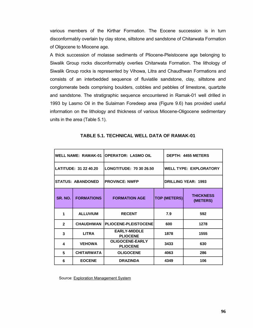
96
various members of the Kirthar Formation. The Eocene succession is in turn
disconformably overlain by clay stone, siltstone and sandstone of Chitarwata Formation
of Oligocene to Miocene age.
A thick succession of molasse sediments of Pliocene-Pleistocene age belonging to
Siwalik Group rocks disconformably overlies Chitarwata Formation. The lithology of
Siwalik Group rocks is represented by Vihowa, Litra and Chaudhwan Formations and
consists of an interbedded sequence of fluviatile sandstone, clay, siltstone and
conglomerate beds comprising boulders, cobbles and pebbles of limestone, quartzite
and sandstone. The stratigraphic sequence encountered in Ramak-01 well drilled in
1993 by Lasmo Oil in the Sulaiman Foredeep area (Figure 9.6) has provided useful
information on the lithology and thickness of various Miocene-Oligocene sedimentary
units in the area (Table 5.1).
TABLE 5.1. TECHNICAL WELL DATA OF RAMAK-01
1
2
3
4
5
6 4349 106
1878 1555
4063
PLIOCENE-PLEISTOCENE 600 1278
630
WELL NAME: RAMAK-01 OPERATOR: LASMO OIL DEPTH: 4455 METERS
LATITUDE: 31 22 40.20 LONGTITUDE: 70 30 26.50 WELL TYPE: EXPLORATORY
STATUS: ABANDONED PROVINCE: NWFP DRILLING YEAR: 1993
SR. NO. FORMATIONS FORMATION AGE TOP (METERS) THICKNESS (METERS)
3433
EOCENE
592
286
7.9RECENT
OLIGOCENE
EARLY-MIDDLE PLIOCENE
OLIGOCENE-EARLY PLIOCENE
DRAZINDA
ALLUVIUM
CHITARWATA
LITRA
VEHOWA
CHAUDHWAN
Source: Exploration Management System
97
5.2 STRATIGRAPHIC SUCCESSION The exposed stratigraphic succession of the northern Sulaiman Range (Figure 5.1) is
represented by the following groups/formations from base to top;
m) Sulaiman Limestone Group
n) Parh Group Undifferentiated
o) Ranikot Group
p) Ghazij+Baska+Kirthar Formation
q) Chitarwata Formation
r) Siwalik Group
5.2.1 Sulaiman Limestone Group This group consists of mostly dark grey to blue, thin to thick bedded, hard and massive
limestone with some calcite and chert nodules. Weathered surfaces are commonly light
grey to brownish grey. The Sulaiman Limestone Group forms the highest peaks in the
Sulaiman Range with continuous outcrops. Hemphill et al., (1973) have reported its
thickness from Mughal Kot section to be greater than 1419 meters (base is not
exposed in the area).
This group is of Jurassic age and is believed to be the chronostratigraphic equivalent of
Datta Formation, Shinawari Formation and Samana Suk Limestone of Kohat-Potwar
province (Figure 5.2).
5.2.2 Parh Group The name “Parh Group” was introduced by Hunting Survey Corporation (1961) for
Cretaceous marine sediments including the following four formations from base to top;
1. Sembar Formation 2. Parh Limestone 3. Mughal Kot Formation 4. Pab Sandstone
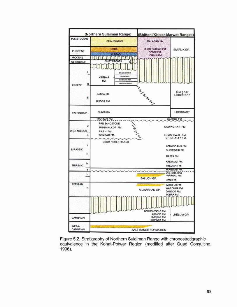
98
Figure 5.2. Stratigraphy of Northern Sulaiman Range with chronostratigraphic equivalence in the Kohat-Potwar Region (modified after Quad Consulting,
1996).
99
5.2.2.1 Sembar Formation In the northern Sulaiman Range, Sembar Formation consists of soft black claystone,
locally somewhat silty and sandy with minor thin beds of dark grey to black limestone.
Near the base, 1 meter thick conglomerate bed is present which is composed of
limestone pebbles and cobbles.
The Sembar Formation forms slopes and valleys. Its lower contact with the Sulaiman
Limestone Group is disconformable and sharp whereas the upper contact with the Parh
Limestone is transitional. Hemphill et al., (1973) have reported its thickness from
Mughal Kot section to be 284 meters. On the basis of fossils collected from the
formation, early Cretaceous age is assigned to it.
5.2.2.2 Parh Limestone
This formation is represented by light grey, hard porcelaneous, thick and thin bedded
limestone with subsidiary dark grey calcareous claystone beds in the middle part in the
Mughal Kot section. Its lower contact with Sembar Formation is transitional whereas
the upper contact with the Mughal Kot Formation is disconformable. Its reported
thickness in the Mughal Kot section is 350 meters. Its age is late Cretaceous.
5.2.2.3 Mughal Kot Formation
The Mughal Kot Formation in the study area consists of light grey around 50 meters
thick calcareous sandstone towards the top. The sandstone is calcareous, argillaceous,
hard and thick bedded to massive. This calcareous sandstone is underlain by
calcareous claystone and sandy limestone. The claystone is dark grey and silty in
places. The limestone is grey and argillaceous.
The Mughal Kot Formation overlies upper Parh Limestone with a marked erosional
unconformity characterized by a variety of mass flow deposits. Its upper contact with
the Pab sandstone is conformable in the Mughal Kot area, where its thickness is
reported to be 1134 meters. It has been assigned late Cretaceous age on the basis of
stratigraphic position.
5.2.2.4 Pab Sandstone
The Pab Sandstone consists of hard, well-cemented quartzitic sandstone of fine to
medium grains with occasional black to sometimes red/yellow silty-shale intercalations.
The sandstone is thick bedded to massive, commonly cross-bedded and conglomeratic
100
near the base. Subordinate silty claystone beds are also present which contain
abundant plant fragments. Its lower contact with the Mughal Kot Formation is
conformable and upper contact with the Dunghan Formation is reported to be
disconformable. It is reported to be 237 meters in the Mughal Kot section. Its thickness
increases towards the south. Its age is late Cretaceous.
5.2.3 Ranikot Group Blanford (1876) introduced the name “Ranikot Group” which was later on subdivided by
Vredenburg (1909 a) into “Lower Ranikot (sandstone)” and “Upper Ranikot
(limestone)”. The Ranikot Group consists of the following formations in the northern
Sulaiman Range from base to top;
1) Ranikot Formation 2) Dunghan Formation
However, in the area under study only Dunghan Formation is well-developed,
consisting of grey to dark grey hard, finely crystalline and very thick bedded limestone.
Its upper part becomes sandy downward. The lower part of the formation is composed
of dark blue micaceous silty claystone. The Dunghan Formation forms sharp ridge
along the eastern flank of the Sulaiman Range. The contact with the overlying Ghazij
Shale is distinct and conformable whereas the lower contact with the Pab Sandstone
may be disconformable. Its thickness is reported to be 191 meters in the west of
Mughal Kot section. Its age is Paleocene on the basis of fossil record.
5.2.4 Ghazij Shale + Baska Shale + Kirthar Formation
5.2.4.1 Ghazij Shale The Ghazij Shale crops out extensively throughout the eastern foothills of the Sulaiman
Range, consisting mostly of soft fissile, brown to brownish-red claystone in the upper
half with coarse grained sandstone and conglomerate near the top. Its lower half
consists of green, dark grey and brown claystone, which is carbonaceous in places.
Ripple-marked and cross-bedded sandstone and quartzitic sandstone which is
calcareous in places is also present. The Ghazij Shale forms valleys and low ridges. It
is around 2743 meters thick in the Mughal Kot section. On the basis of fossil record an
early Eocene age has been assigned to the formation.
101
5.2.4.2 Baska Shale
The Baska Shale can be recognized throughout the eastern foothills of the Sulaiman
Range, consisting mostly of green and greenish-grey claystone containing alabaster in
nodules and veins. The claystone alternate with bedded alabaster, gypsiferous
limestone and marl. Claystone is bright red and purple towards the base. Its thickness
is reported to be 185 meters in the north of Domanda Post. On the basis of fossil
record it has been assigned late early Eocene age.
5.2.4.3 Kirthar Formation
The Kirthar Formation has been subdivided into the following four members in the
eastern foothills of the Sulaiman Range from bottom to top;
1) Habib Rahi Limestone
2) Domanda Shale
3) Pirkoh Limestone
4) Drazinda Shale
5.2.4.3.1 Habib Rahi Limestone Member
This member contains grayish-brown hard limestone that weathers white in the upper
part. The limestone is fine grained, thin bedded with nodules and thin discontinuous
beds of chert. Its lower part consists of hard argillaceous limestone that is light brown
and massive. The Habib Rahi Limestone member forms a persistent ridge in the
outcrops. Its thickness from the Zam Post, northeast of Mughal Kot is reported to be 34
meters.
5.2.4.3.2 Domanda Shale Member
Domanda Shale member consists mostly of dark-brown and greenish grey claystone
with subordinate amounts of grey and brown sandstone in the upper part. Its thickness
from the northeast of Domanda Post is reported to be 311 meters.
5.2.4.3.3 Pirkoh Limestone Member
It consists of light grey and brown, fine grained and mostly thin bedded argillaceous
limestone with subordinate beds of soft shaly limestone and dark grey calcareous
claystone. The Pirkoh Limestone member forms a persistent and conspicuous ridge
102
near the Gomal Pass in the eastern foothills of Sulaiman Range. It is 33 meters thick in
the northwest of Jandola in the South Waziristan Agency.
5.2.4.3.4 Drazinda Shale Member Drazinda Shale member consists of dark brown to grey claystone and subordinate
fossiliferous marl in the upper part. A sandstone marker bed in the middle part is
persistent in the Gomal Pass area. Its thickness from the north of Domanda Post is
reported to be 381 meters whereas its thickness is 457 meters in the northeast of
Drazinda.
On the basis of fossil record, lower three members of the Kirthar Formation are of
middle Eocene age and Drazinda Shale member may be of late Eocene age (Eames,
1952 a).
5.2.5 Chitarwata Formation
The Chitarwata Formation crops out throughout the foothills of the Sulaiman Range
and appears to get thin in the northwestern part in Waziristan. It consists of red, grey
and green claystone and subordinate amounts of siltstone and sandstone. The
siltstone is variegated, friable and ferruginous. The sandstone is white, brownish
yellow, subangular to rounded, fine grained and calcareous in places. In Domanda
Post area, the upper part forms slopes and the lower part commonly forms ridges and
cliffs. Its thickness is reported to be 384 and 152 meters from Domanda Post and Litra
Nala respectively. The formation has been assigned late Oligocene to late Miocene
age on the basis of fossils record.
5.2.6 Siwalik Group In the Sulaiman Range, the Siwalik Group is divided into the following formations from
base to top;
1) Vihowa Formation 2) Litra Formation 3) Chaudhwan Formation
5.2.6.1 Vihowa Formation
The Vihowa Formation consists of grey and brown sandstone and subordinate
amounts of red and brownish-red sandy siltstone. The sandstone is subangular,
medium to coarse grained, massive to thick-bedded and cross bedded. The Vihowa
103
Formation forms ridges and slopes. The lower contact with the Chitarwata Formation
may be disconformable whereas the upper contact with the Litra Formation is
transitional. Its thickness is reported to be 430 and 701 meters from Chaudhwan Zam
and Vihowa Rud/Litra Nala respectively. Its age is Pliocene.
5.2.6.2 Litra Formation
The Litra formation consists of friable, light grey and brown, fine to medium grained,
thick bedded to massive, angular to sub-rounded sandstone which is silty and clayey in
places. Some beds contain abundant well-preserved burrows. Near Chaudhwan Zam,
conglomerates consisting of rounded pebbles and cobbles in a coarse-grained
sandstone matrix are present in the upper part. In the Litra Nala, the formation is
composed entirely of massive strongly cross-bedded sandstone. Throughout the
Sulaiman Range, the Litra Formation forms steep ridges and cliffs.
Its thickness is reported to be 1695, 1648 and 1707 meters from Chaudhwan Zam,
Gomal Pass and Litra Nala respectively. Its age is late Pliocene.
5.2.6.3 Chaudhwan Formation
The Chaudhwan Formation consists mostly of hard and massive conglomerate
composed of boulders, cobbles and pebbles of limestone, quartzite and sandstone in a
medium to coarse-grained sandstone matrix. Subordinate amounts of brown and grey
sandstone, siltstone and claystone crop out in the middle part near Chaudhwan Zam.
Throughout most of its outcrop area, the Chaudhwan Formation forms steep,
commonly impossible cliffs. The contact with the overlying surficial deposits of Tank
and Bannu Basin is commonly indistinct, whereas the lower contact with the Litra
Formation is transitional. Its thickness is reported to be 1494, 1811 and 1524 meters
from Chaudhwan Zam, Gomal Pass and Litra Nala respectively. Its age is late
Pleistocene.
104
5.3 STRATIGRAPHIC ANALYSIS The north-south stratigraphic correlation of the Siwalik Group rocks based on outcrop
data and stratigraphy encountered at Ramak-1 well in the northeastern part of the
Sulaiman Range shows thickness variations of different Siwalik units (Figure 5.3).
Generally thickness of the Siwalik Group increases towards the south taking into
consideration the total thickness of the Siwalik strata at Litra Nala (about 3600 meters)
in the south and Sheikh Budin Hills (around 2000 meters) towards the north. The upper
and lower parts of the Siwalik Group in the area are represented by Malagan Formation
and Chitarwata Formation respectively. Both these formations show localized
deposition in this part of the Sulaiman Range. The Malagan Formation is only
developed in the surrounding of Bain Pass in the Pezu-Bhittani Range. The Chitarwata
Formation shows its development in the Chaudhwan Zam and Ramak-1 well location
only and pinches out towards north and south in the Gomal Pass and Litra Nala
respectively.
Composite stratigraphic correlations (Figures 5.4 and 5.5) of the Paleocene and older
strata based on the wells drilled to the south of the study area in the east-west as well
as north-south directions show thickness and facies variations. From east to west, the
Paleocene rocks belonging to Dunghan and Ranikot formations show increase in their
thicknesses. The Ranikot Formation especially shows considerable increase in its
thickness towards the west in Savi Ragha-1 locality as compared to its thickness
encountered at Panjpir-1 towards the east in the Punjab Platform. The Cretaceous
strata also show significant thinning towards the east. The underlying older strata
presumably also follow this trend of eastward truncation/thinning towards the Indian
border because the crystalline basement rocks have been dilled in Bijnot-1, Suji-1,
Marot-1 and Krampur-1 wells at a shallow depth ranging between 1850 – 3000 meters.
The north-south well correlation depicts that Paleocene and Cretaceous strata have
shown a very mild increase in thickness towards the south over a very large distance of
approximately 200 km (Figure 5.5). However, on localized scale, these changes in the
stratigraphic thicknesses appear to be pronounced as displayed on the correlation
between Savi Ragh-1 and Dhodak-3 wells (Figure 5.6).
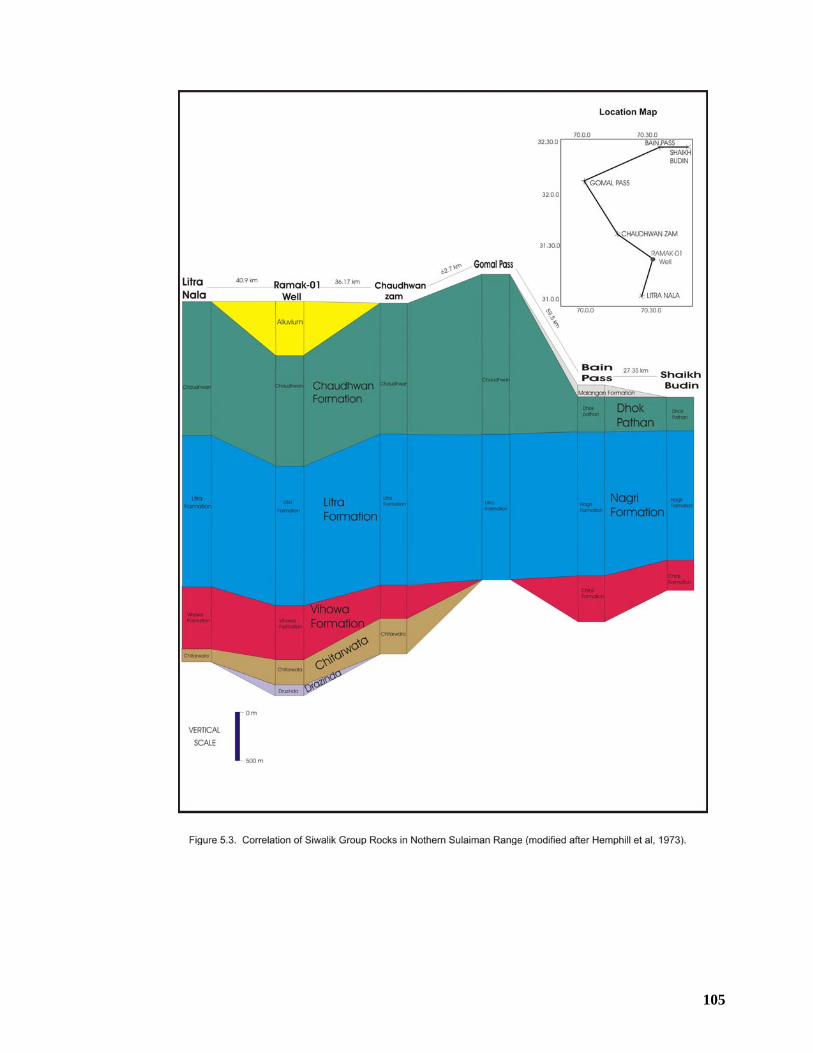
105
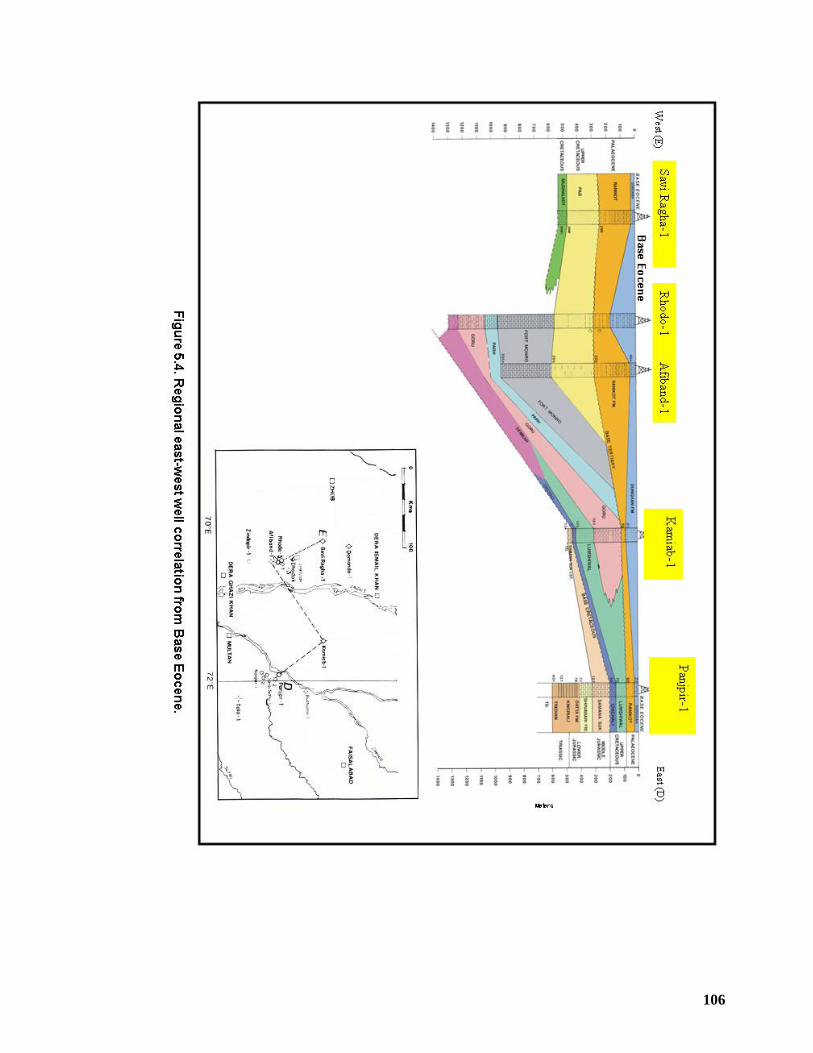
106
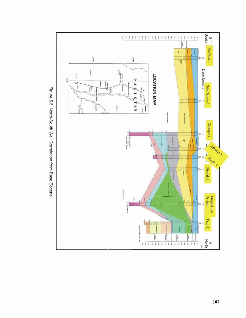
107
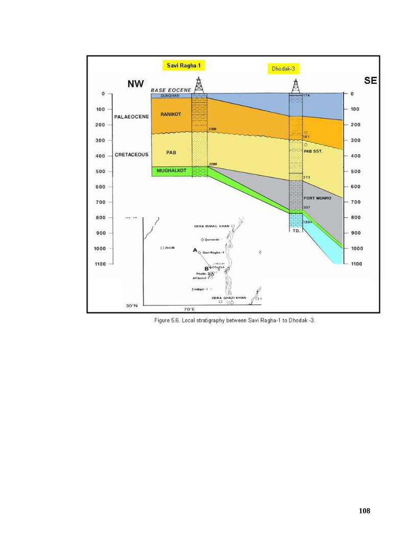
108
109
CHAPTER 6
STRUCTURAL GEOMETRY OF THE SURGHAR RANGE & KARAK AREA
6.1 INTRODUCTION Surghar Range of the northwest Pakistan is an integral part of the active
deformational front of the Salt and Trans Indus ranges which is translating southward
in response to the underthrusting of Indian craton underneath its sedimentary cover
(Ahmad et al. 1999). The Surghar Range forms the eastern end of the Trans Indus
ranges following east west structural trend along the southern margin of the Kohat
Plateau and changes to north south trend along the eastern flank of the Bannu Basin
(Figure 6.1).
Along the Surghar Range the non-outcropping Paleozoic – Paleocene rocks
underneath the Kohat Plateau and Bannu Basin are exposed at surface. However in
the Karak area lying to the north of the Surghar Range, rocks belonging to the upper
Siwalik Group are exposed. The stratigraphic sequence exposed in the Surghar
Range suggests an important petroleum system comprised of potential source, seal
and reservoir rocks for oil and gas generation and accumulation. Being located in
close proximity to the western transform border of the Indian Plate and Kalabagh
strikeslip fault in the east, it has well preserved imprints of south as well as east
directed compressional deformation associated with significant amount of strikeslip
adjustments (Ahmad et al. 2003).
The Surghar Range exhibits arcuate geometry and display contrasting mountain
front geometries all along its trace, characterized by south verging structures along
its east- west trending segment and east verging structural geometries along its
north-south oriented segment. Tectonic deformation within the southern Kohat
Plateau and surrounding area is believed to be of late Pliocene to early Pleistocene
age, initiated by south directed thrusting along the present-day thrust front, related to
outward growth of NW Himalayan thrust wedge. This has subsequently resulted in
the formation of localized structural ramps, tilting and uplift along the frontal thrust
(Blisniuk et al. 1998 & Ahmad, 2003).
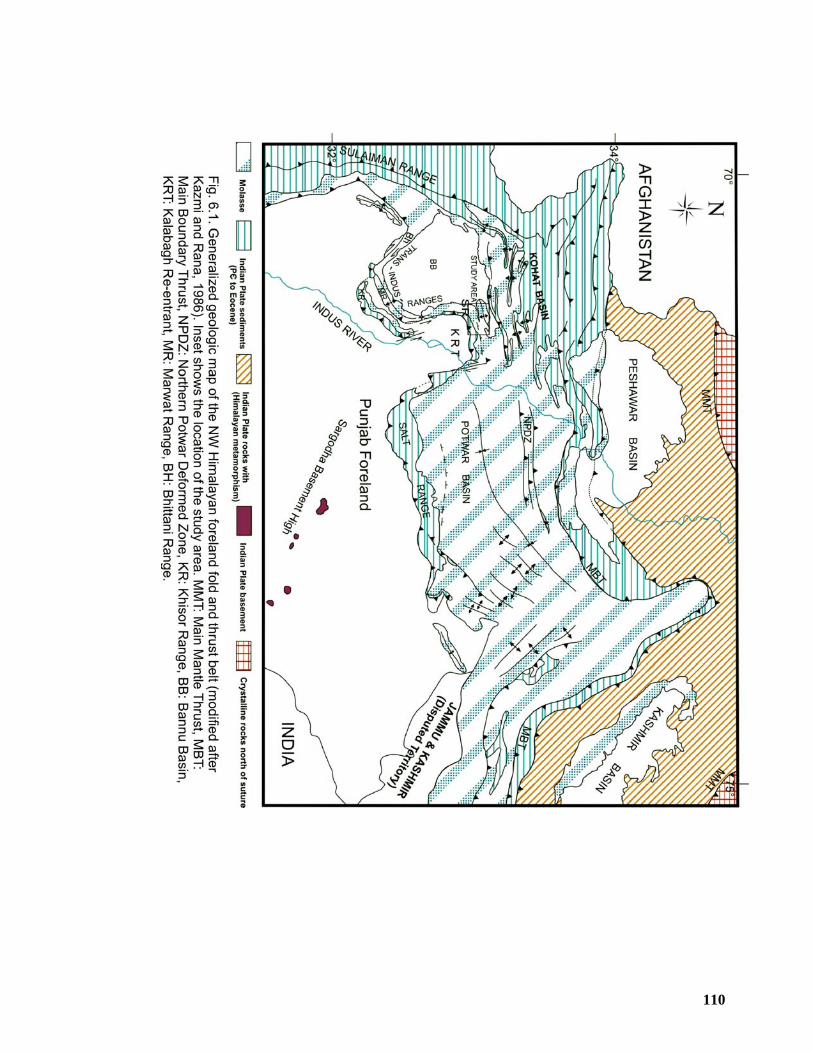
110
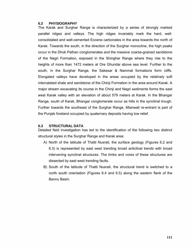
111
6.2 PHYSIOGRAPHY The Karak and Surghar Range is characterized by a series of strongly marked
parallel ridges and valleys. The high ridges invariably mark the hard, well-
consolidated and well-cemented Eocene carbonates in the area towards the north of
Karak. Towards the south, in the direction of the Surghar monocline, the high peaks
occur in the Dhok Pathan conglomerates and the massive coarse-grained sandstone
of the Nagri Formation, exposed in the Shinghar Range where they rise to the
heights of more than 1472 meters at Ore Ghundai above sea level. Further to the
south, in the Surghar Range, the Sakesar & Nammal formations form cliffs.
Elongated valleys have developed in the areas occupied by the relatively soft
intercalated shale and sandstone of the Chinji Formation in the area around Karak. A
major stream excavating its course in the Chinji and Nagri sediments forms the east
west Karak valley with an elevation of about 579 meters at Karak. In the Bhangar
Range, south of Karak, Bhangar conglomerate occur as hills in the synclinal trough.
Further towards the southeast of the Surghar Range, Mianwali re-entrant is part of
the Punjab foreland occupied by quaternary deposits having low relief.
6.3 STRUCTURAL DATA Detailed field investigation has led to the identification of the following two distinct
structural styles in the Surghar Range and Karak area;
A) North of the latitude of Thatti Nusrati, the surface geology (Figures 6.2 and
6.3) is represented by east west trending broad anticlinal trends with broad
intervening synclinal structures. The limbs and cores of these structures are
dissected by east west trending faults.
B) South of the latitude of Thatti Nusrati, the structural trend is switched to a
north south orientation (Figures 6.4 and 6.5) along the eastern flank of the
Bannu Basin.
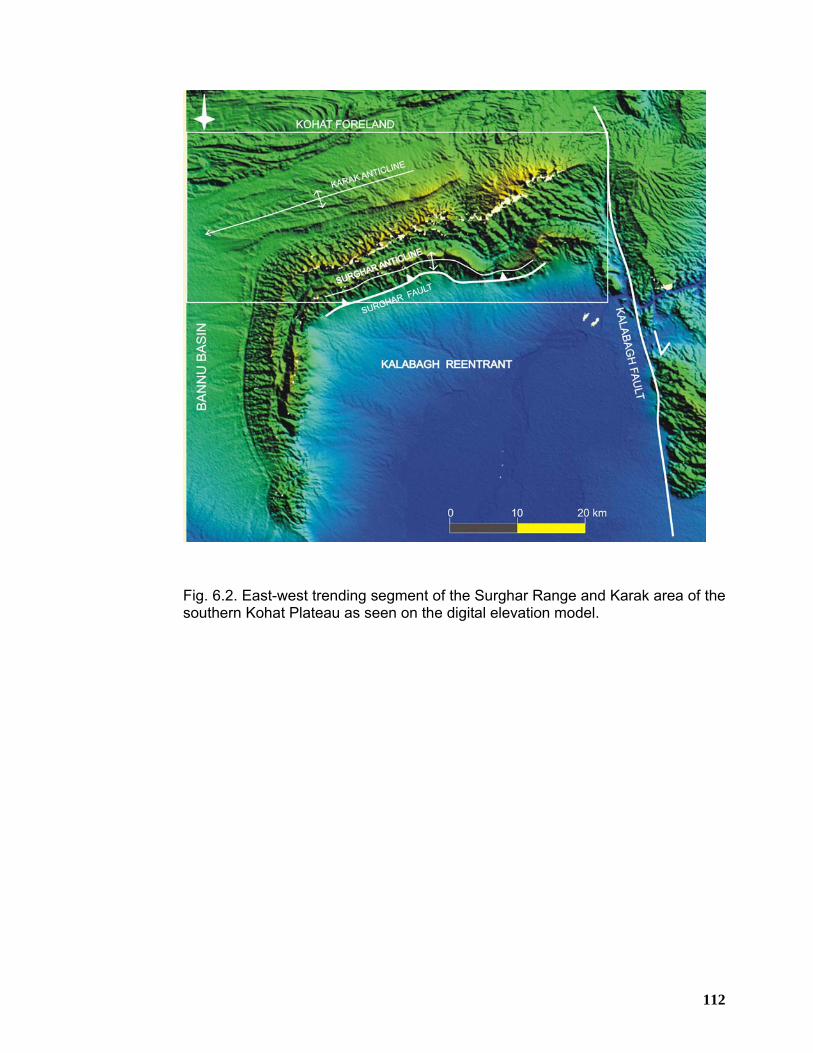
112
Fig. 6.2. East-west trending segment of the Surghar Range and Karak area of the southern Kohat Plateau as seen on the digital elevation model.
113
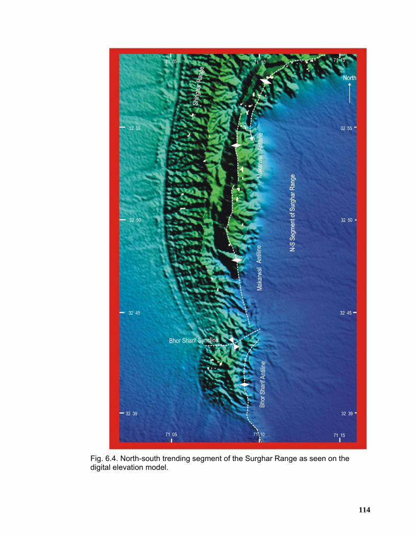
114
Fig. 6.4. North-south trending segment of the Surghar Range as seen on the digital elevation model.
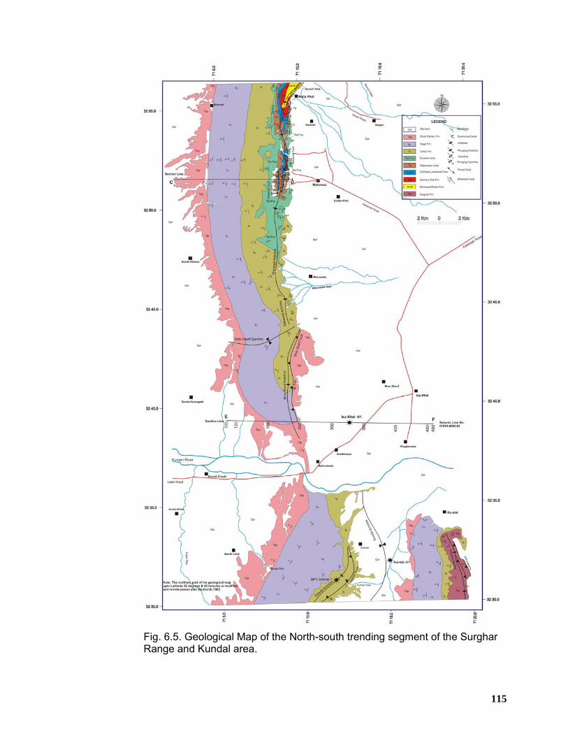
115
Fig. 6.5. Geological Map of the North-south trending segment of the Surghar Range and Kundal area.
116
6.3.1 Surface Geology of the Area North of Latitude of Thatti Nusrati The Karak area lies between Karak Fault in the north and Shinghar-Surghar ranges
in the south. The Karak area (Figure 6.3) is occupied by the Siwalik Group rocks
which are gently folded into a series of east west trending folds along with
associated thrust faults.
6.3.1.1 Fold Structures
The fold structures of the east west trending area are described below from north to
south;
6.3.1.1.1 Banda Lakhoni Syncline
This syncline is located in the northern most part of the map (Figure 6.3) having
ENE-WSW orientation. It hosts the rocks of Nagri Formation in its core and Chinji
Formation comprises its limbs. It shallowly plunges in the SW direction. Its forelimb is
steeply dipping towards north, which is terminated against Grori Fault in the south.
Its backlimb is dipping towards south with dip values ranging between 70-85o, which
is cut against Karak Fault in the north.
6.3.1.1.2 Mitha Khel Anticline
Mitha Khel Anticline lies to the immediate south of the Banda Lakhoni Syncline
having curvilinear axial trace on the surface oriented in almost latitudinal fashion
(Figure 6.3). It exposes Nagri Formation all along its surface trace. Its back limb is
steeply dipping northwards with dip values ranging from 50-75o and terminates
against Grori Fault in the north. Its forelimb is moderately dipping southwards with
dip values ranging between 20-55o. Mitha Khel Anticline appears to have been offset
from the Karak Anticline through Mitha Khel Fault, which is bounding Mitha Khel
Anticline in the south.
6.3.1.1.3 Karak Anticline
Structural investigations at surface are quite crucial in order to elucidate the
geometry at depth especially in the areas where there is a structural mismatch
between the surface and underlying structures. Complex structures at surface do not
mimic the underlying simple structures and vice versa. Detailed field investigations
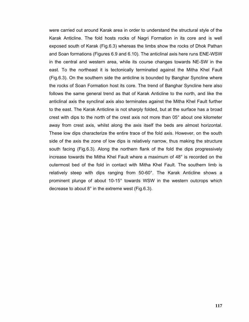
117
were carried out around Karak area in order to understand the structural style of the
Karak Anticline. The fold hosts rocks of Nagri Formation in its core and is well
exposed south of Karak (Fig.6.3) whereas the limbs show the rocks of Dhok Pathan
and Soan formations (Figures 6.9 and 6.10). The anticlinal axis here runs ENE-WSW
in the central and western area, while its course changes towards NE-SW in the
east. To the northeast it is tectonically terminated against the Mitha Khel Fault
(Fig.6.3). On the southern side the anticline is bounded by Banghar Syncline where
the rocks of Soan Formation host its core. The trend of Banghar Syncline here also
follows the same general trend as that of Karak Anticline to the north, and like the
anticlinal axis the synclinal axis also terminates against the Mitha Khel Fault further
to the east. The Karak Anticline is not sharply folded, but at the surface has a broad
crest with dips to the north of the crest axis not more than 05° about one kilometer
away from crest axis, whilst along the axis itself the beds are almost horizontal.
These low dips characterize the entire trace of the fold axis. However, on the south
side of the axis the zone of low dips is relatively narrow, thus making the structure
south facing (Fig.6.3). Along the northern flank of the fold the dips progressively
increase towards the Mitha Khel Fault where a maximum of 48° is recorded on the
outermost bed of the fold in contact with Mitha Khel Fault. The southern limb is
relatively steep with dips ranging from 50-60°. The Karak Anticline shows a
prominent plunge of about 10-15° towards WSW in the western outcrops which
decrease to about 8° in the extreme west (Fig.6.3).
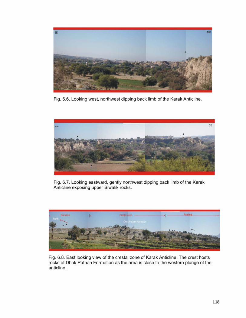
118
Fig. 6.6. Looking west, northwest dipping back limb of the Karak Anticline.
Fig. 6.7. Looking eastward, gently northwest dipping back limb of the Karak Anticline exposing upper Siwalik rocks.
Fig. 6.8. East looking view of the crestal zone of Karak Anticline. The crest hosts rocks of Dhok Pathan Formation as the area is close to the western plunge of the anticline.
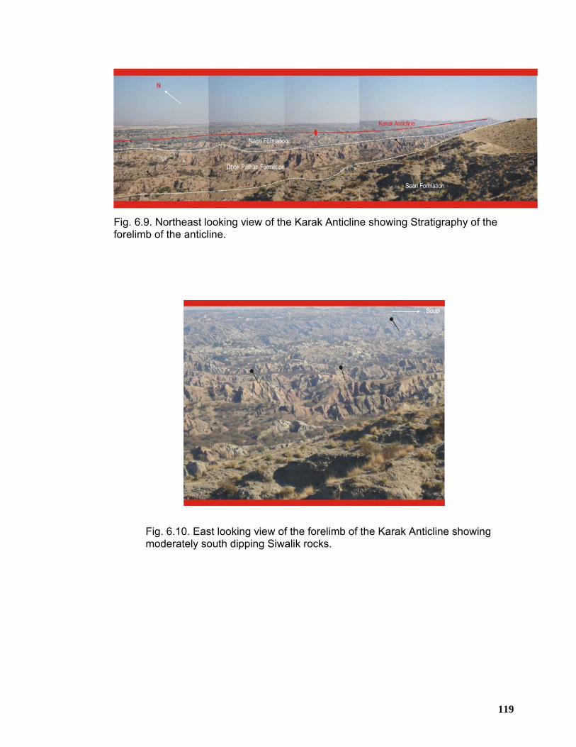
119
Fig. 6.9. Northeast looking view of the Karak Anticline showing Stratigraphy of the forelimb of the anticline.
Fig. 6.10. East looking view of the forelimb of the Karak Anticline showing moderately south dipping Siwalik rocks.
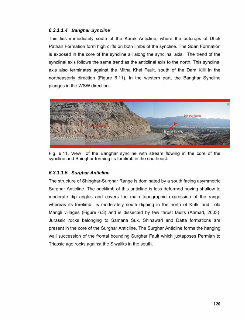
120
6.3.1.1.4 Banghar Syncline
This lies immediately south of the Karak Anticline, where the outcrops of Dhok
Pathan Formation form high cliffs on both limbs of the syncline. The Soan Formation
is exposed in the core of the syncline all along the synclinal axis. The trend of the
synclinal axis follows the same trend as the anticlinal axis to the north. This synclinal
axis also terminates against the Mitha Khel Fault, south of the Dam Killi in the
northeasterly direction (Figure 6.11). In the western part, the Banghar Syncline
plunges in the WSW direction.
Fig. 6.11. View of the Banghar syncline with stream flowing in the core of the syncline and Shinghar forming its forelimb in the southeast.
6.3.1.1.5 Surghar Anticline
The structure of Shinghar-Surghar Range is dominated by a south facing asymmetric
Surghar Anticline. The backlimb of this anticline is less deformed having shallow to
moderate dip angles and covers the main topographic expression of the range
whereas its forelimb is moderately south dipping in the north of Kutki and Tola
Mangli villages (Figure 6.3) and is dissected by few thrust faults (Ahmad, 2003).
Jurassic rocks belonging to Samana Suk, Shinawari and Datta formations are
present in the core of the Surghar Anticline. The Surghar Anticline forms the hanging
wall succession of the frontal bounding Surghar Fault which juxtaposes Permian to
Triassic age rocks against the Siwaliks in the south.
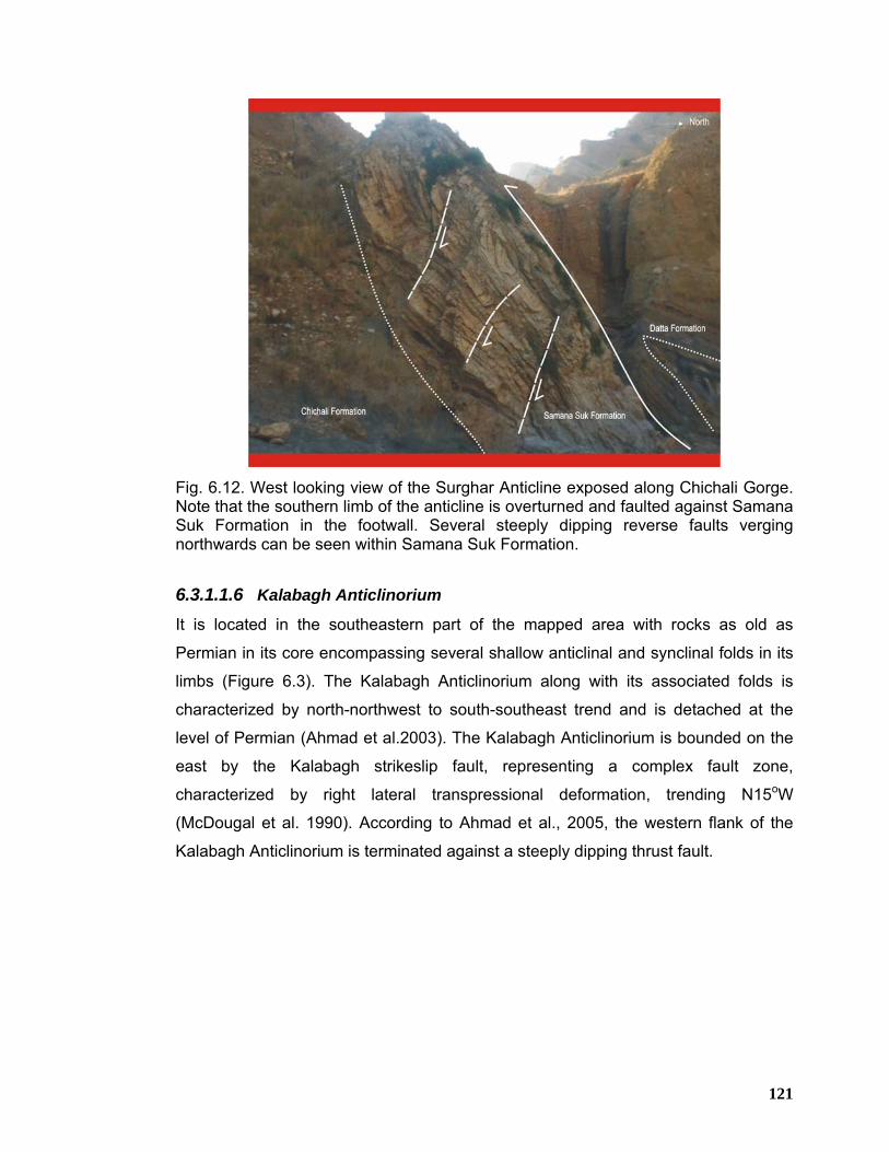
121
Fig. 6.12. West looking view of the Surghar Anticline exposed along Chichali Gorge. Note that the southern limb of the anticline is overturned and faulted against Samana Suk Formation in the footwall. Several steeply dipping reverse faults verging northwards can be seen within Samana Suk Formation.
6.3.1.1.6 Kalabagh Anticlinorium
It is located in the southeastern part of the mapped area with rocks as old as
Permian in its core encompassing several shallow anticlinal and synclinal folds in its
limbs (Figure 6.3). The Kalabagh Anticlinorium along with its associated folds is
characterized by north-northwest to south-southeast trend and is detached at the
level of Permian (Ahmad et al.2003). The Kalabagh Anticlinorium is bounded on the
east by the Kalabagh strikeslip fault, representing a complex fault zone,
characterized by right lateral transpressional deformation, trending N15oW
(McDougal et al. 1990). According to Ahmad et al., 2005, the western flank of the
Kalabagh Anticlinorium is terminated against a steeply dipping thrust fault.
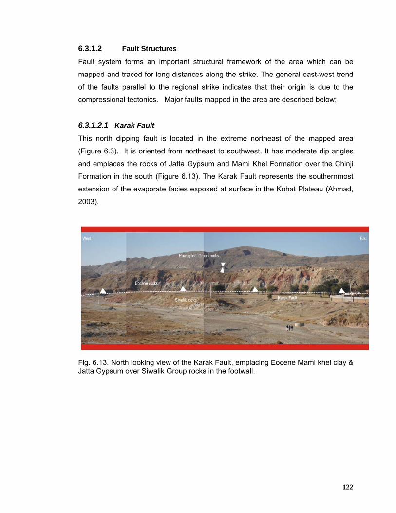
122
6.3.1.2 Fault Structures
Fault system forms an important structural framework of the area which can be
mapped and traced for long distances along the strike. The general east-west trend
of the faults parallel to the regional strike indicates that their origin is due to the
compressional tectonics. Major faults mapped in the area are described below;
6.3.1.2.1 Karak Fault
This north dipping fault is located in the extreme northeast of the mapped area
(Figure 6.3). It is oriented from northeast to southwest. It has moderate dip angles
and emplaces the rocks of Jatta Gypsum and Mami Khel Formation over the Chinji
Formation in the south (Figure 6.13). The Karak Fault represents the southernmost
extension of the evaporate facies exposed at surface in the Kohat Plateau (Ahmad,
2003).
Fig. 6.13. North looking view of the Karak Fault, emplacing Eocene Mami khel clay & Jatta Gypsum over Siwalik Group rocks in the footwall.
123
6.3.1.2.2 Grori Fault
Grori Fault is a regional scale fault dominating in the region. It is roughly east west
oriented and steeply dipping towards north. It dissects the southern limb of the
Banda Lakhoni syncline. Along this fault, rocks of the Chinji Formation are thrust
over the Nagri Formation. In the outcrops the fault is defined by steep dips and is
often marked by the development of sharp folds of small wavelengths and intense
shearing accompanied with calcite veining.
6.3.1.2.3 Mitha Khel Fault
The Mitha Khel Fault is located to the immediate south of the Grori Fault and marks
the northern limb of the Karak Anticline and Banghar Syncline. It has oblique
relationship with the associated fold structures of the area (Ahmad, 2003). It is
trending in almost latitudinal fashion. The steep angle character of this fault is
observed in the outcrops east of the Karak town where the rocks of the Nagri and
Chinji formations occurs in juxtaposition with the conglomerates of Dhok Pathan and
Soan formations in the south and southwest (Figure 6.14). Mitha Khel Anticline is
developed on the hanging wall of this fault. Both Grori and Mitha Khel faults appear
to have been integrated in the extreme northeastern part of the mapped area with
the Kalabagh strikeslip fault. These two near parallel faults, mapped on the northern
side of Karak Anticline presumably have a common origin.
The Mitha Khel Fault demarcates the northern flank of the Karak Anticline and is
found to be a high angle thrust fault. There is a lack of concordance and absence of
correlation in the structural trends on the up thrown side with that of the downthrown
side showing that the thrust might also be accompanied by some lateral translation
as well.
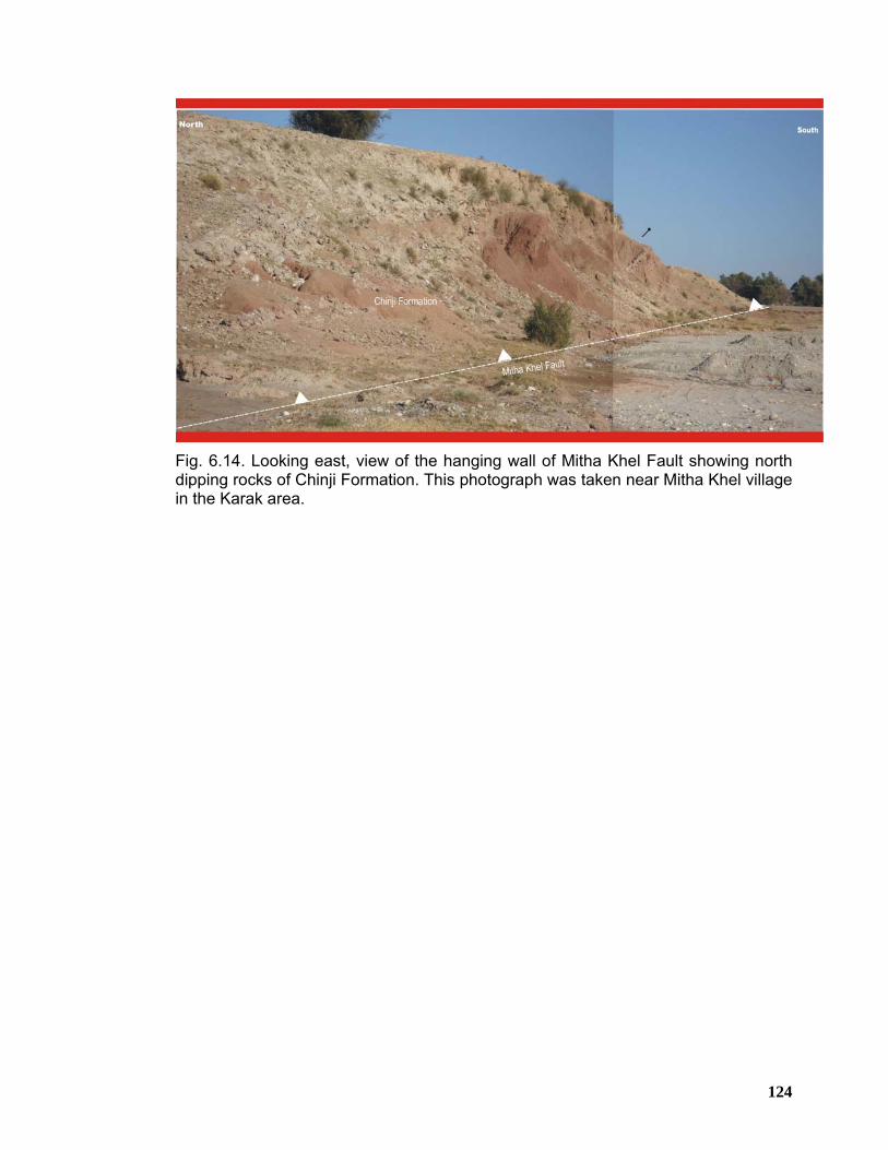
124
Fig. 6.14. Looking east, view of the hanging wall of Mitha Khel Fault showing north dipping rocks of Chinji Formation. This photograph was taken near Mitha Khel village in the Karak area.
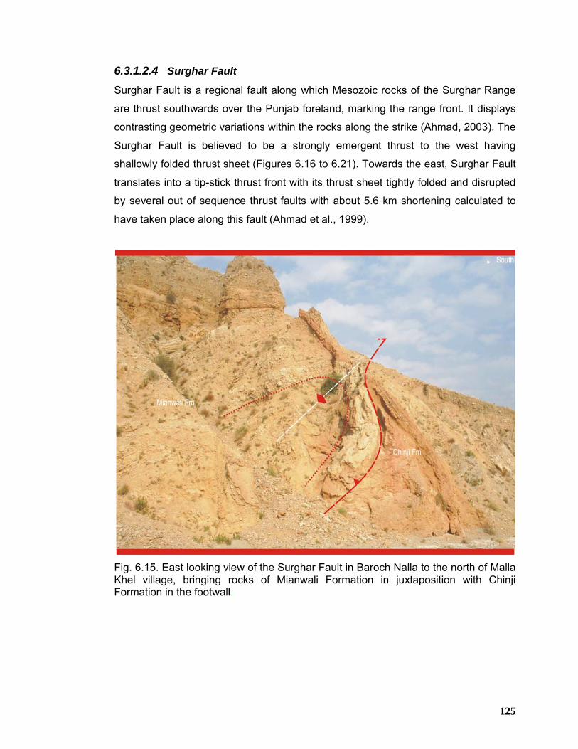
125
6.3.1.2.4 Surghar Fault
Surghar Fault is a regional fault along which Mesozoic rocks of the Surghar Range
are thrust southwards over the Punjab foreland, marking the range front. It displays
contrasting geometric variations within the rocks along the strike (Ahmad, 2003). The
Surghar Fault is believed to be a strongly emergent thrust to the west having
shallowly folded thrust sheet (Figures 6.16 to 6.21). Towards the east, Surghar Fault
translates into a tip-stick thrust front with its thrust sheet tightly folded and disrupted
by several out of sequence thrust faults with about 5.6 km shortening calculated to
have taken place along this fault (Ahmad et al., 1999).
Fig. 6.15. East looking view of the Surghar Fault in Baroch Nalla to the north of Malla Khel village, bringing rocks of Mianwali Formation in juxtaposition with Chinji Formation in the footwall.
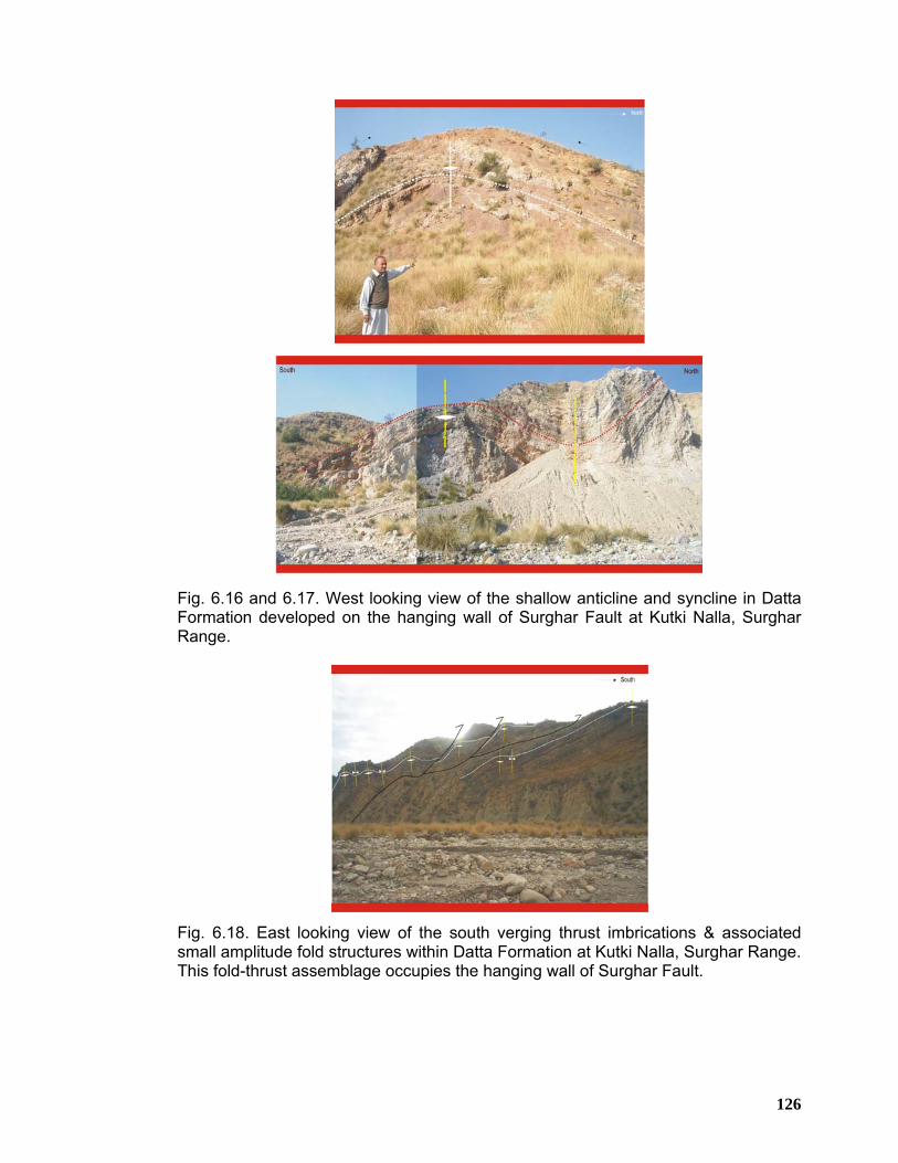
126
Fig. 6.16 and 6.17. West looking view of the shallow anticline and syncline in Datta Formation developed on the hanging wall of Surghar Fault at Kutki Nalla, Surghar Range.
Fig. 6.18. East looking view of the south verging thrust imbrications & associated small amplitude fold structures within Datta Formation at Kutki Nalla, Surghar Range. This fold-thrust assemblage occupies the hanging wall of Surghar Fault.
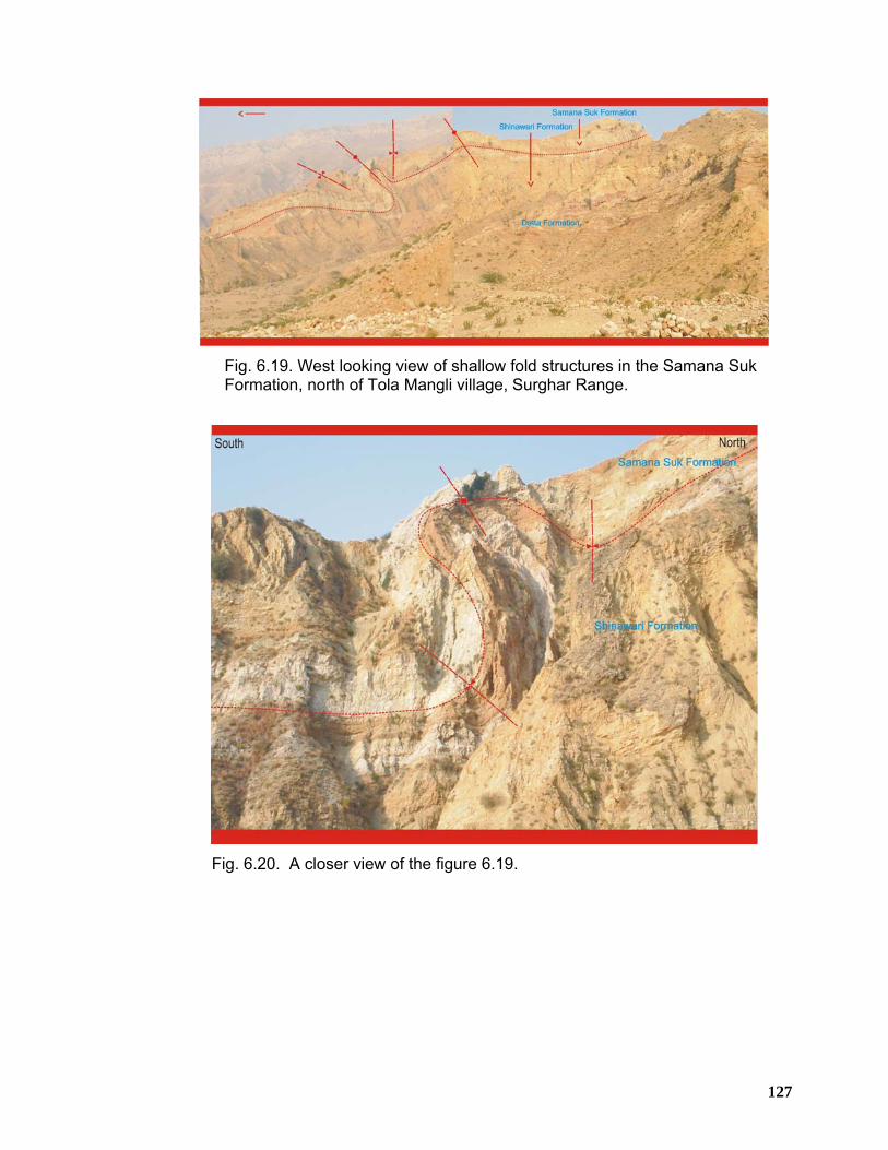
127
Fig. 6.19. West looking view of shallow fold structures in the Samana Suk Formation, north of Tola Mangli village, Surghar Range.
Fig. 6.20. A closer view of the figure 6.19.
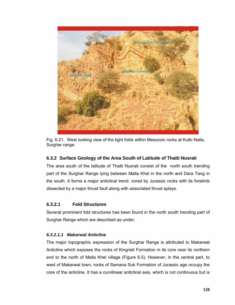
128
Fig. 6.21. West looking view of the tight folds within Mesozoic rocks at Kutki Nalla, Surghar range. 6.3.2 Surface Geology of the Area South of Latitude of Thatti Nusrati The area south of the latitude of Thatti Nusrati consist of the north south trending
part of the Surghar Range lying between Malla Khel in the north and Dara Tang in
the south. It forms a major anticlinal trend, cored by Jurassic rocks with its forelimb
dissected by a major thrust fault along with associated thrust splays.
6.3.2.1 Fold Structures
Several prominent fold structures has been found in the north south trending part of
Surghar Range which are described as under;
6.3.2.1.1 Makarwal Anticline
The major topographic expression of the Surghar Range is attributed to Makarwal
Anticline which exposes the rocks of Kingriali Formation in its core near its northern
end to the north of Malla Khel village (Figure 6.5). However, in the central part, to
west of Makarwal town, rocks of Samana Suk Formation of Jurassic age occupy the
core of the anticline. It has a curvilinear anticlinal axis, which is not continuous but is
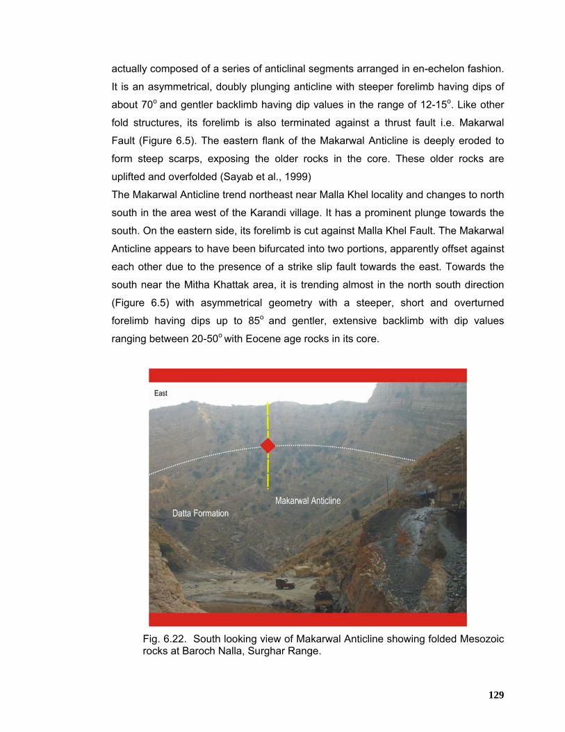
129
actually composed of a series of anticlinal segments arranged in en-echelon fashion.
It is an asymmetrical, doubly plunging anticline with steeper forelimb having dips of
about 70o and gentler backlimb having dip values in the range of 12-15o. Like other
fold structures, its forelimb is also terminated against a thrust fault i.e. Makarwal
Fault (Figure 6.5). The eastern flank of the Makarwal Anticline is deeply eroded to
form steep scarps, exposing the older rocks in the core. These older rocks are
uplifted and overfolded (Sayab et al., 1999)
The Makarwal Anticline trend northeast near Malla Khel locality and changes to north
south in the area west of the Karandi village. It has a prominent plunge towards the
south. On the eastern side, its forelimb is cut against Malla Khel Fault. The Makarwal
Anticline appears to have been bifurcated into two portions, apparently offset against
each other due to the presence of a strike slip fault towards the east. Towards the
south near the Mitha Khattak area, it is trending almost in the north south direction
(Figure 6.5) with asymmetrical geometry with a steeper, short and overturned
forelimb having dips up to 85o and gentler, extensive backlimb with dip values
ranging between 20-50o with Eocene age rocks in its core.
Fig. 6.22. South looking view of Makarwal Anticline showing folded Mesozoic rocks at Baroch Nalla, Surghar Range.
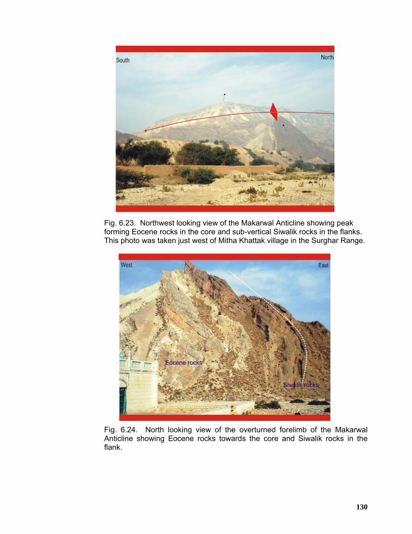
130
Fig. 6.23. Northwest looking view of the Makarwal Anticline showing peak forming Eocene rocks in the core and sub-vertical Siwalik rocks in the flanks. This photo was taken just west of Mitha Khattak village in the Surghar Range.
Fig. 6.24. North looking view of the overturned forelimb of the Makarwal Anticline showing Eocene rocks towards the core and Siwalik rocks in the flank.
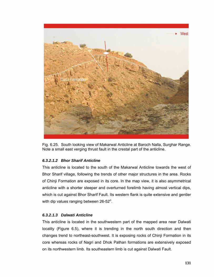
131
Fig. 6.25. South looking view of Makarwal Anticline at Baroch Nalla, Surghar Range. Note a small east verging thrust fault in the crestal part of the anticline.
6.3.2.1.2 Bhor Sharif Anticline This anticline is located to the south of the Makarwal Anticline towards the west of
Bhor Sharif village, following the trends of other major structures in the area. Rocks
of Chinji Formation are exposed in its core. In the map view, it is also asymmetrical
anticline with a shorter steeper and overturned forelimb having almost vertical dips,
which is cut against Bhor Sharif Fault. Its western flank is quite extensive and gentler
with dip values ranging between 26-52o.
6.3.2.1.3 Dalwati Anticline This anticline is located in the southwestern part of the mapped area near Dalwati
locality (Figure 6.5), where it is trending in the north south direction and then
changes trend to northeast-southwest. It is exposing rocks of Chinji Formation in its
core whereas rocks of Nagri and Dhok Pathan formations are extensively exposed
on its northwestern limb. Its southeastern limb is cut against Dalwati Fault.
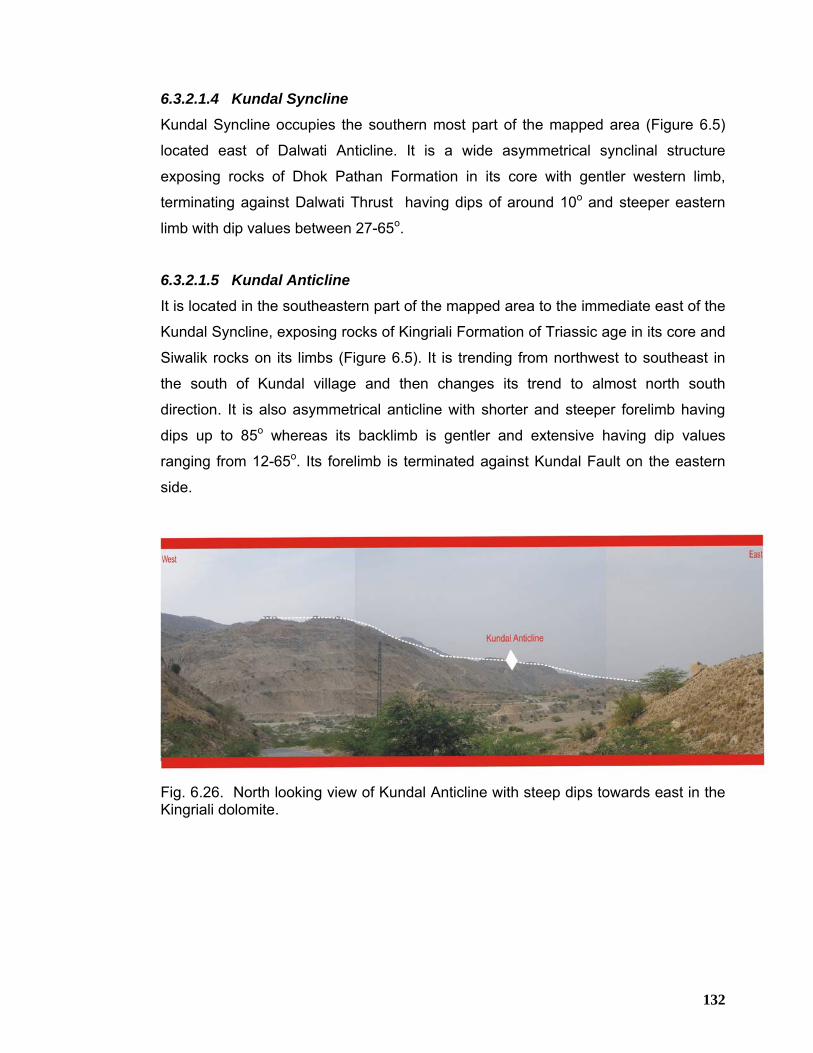
132
6.3.2.1.4 Kundal Syncline
Kundal Syncline occupies the southern most part of the mapped area (Figure 6.5)
located east of Dalwati Anticline. It is a wide asymmetrical synclinal structure
exposing rocks of Dhok Pathan Formation in its core with gentler western limb,
terminating against Dalwati Thrust having dips of around 10o and steeper eastern
limb with dip values between 27-65o.
6.3.2.1.5 Kundal Anticline
It is located in the southeastern part of the mapped area to the immediate east of the
Kundal Syncline, exposing rocks of Kingriali Formation of Triassic age in its core and
Siwalik rocks on its limbs (Figure 6.5). It is trending from northwest to southeast in
the south of Kundal village and then changes its trend to almost north south
direction. It is also asymmetrical anticline with shorter and steeper forelimb having
dips up to 85o whereas its backlimb is gentler and extensive having dip values
ranging from 12-65o. Its forelimb is terminated against Kundal Fault on the eastern
side.
Fig. 6.26. North looking view of Kundal Anticline with steep dips towards east in the Kingriali dolomite.
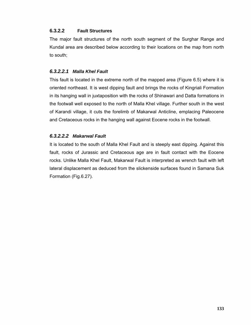
133
6.3.2.2 Fault Structures
The major fault structures of the north south segment of the Surghar Range and
Kundal area are described below according to their locations on the map from north
to south;
6.3.2.2.1 Malla Khel Fault
This fault is located in the extreme north of the mapped area (Figure 6.5) where it is
oriented northeast. It is west dipping fault and brings the rocks of Kingriali Formation
in its hanging wall in juxtaposition with the rocks of Shinawari and Datta formations in
the footwall well exposed to the north of Malla Khel village. Further south in the west
of Karandi village, it cuts the forelimb of Makarwal Anticline, emplacing Paleocene
and Cretaceous rocks in the hanging wall against Eocene rocks in the footwall.
6.3.2.2.2 Makarwal Fault
It is located to the south of Malla Khel Fault and is steeply east dipping. Against this
fault, rocks of Jurassic and Cretaceous age are in fault contact with the Eocene
rocks. Unlike Malla Khel Fault, Makarwal Fault is interpreted as wrench fault with left
lateral displacement as deduced from the slickenside surfaces found in Samana Suk
Formation (Fig.6.27).
134
Fig. 6.27. Slickenside striations in the limestone of Samana Suk Formation as a result of left lateral movement along Makarwal Fault.
135
6.3.2.2.3 Makarwal Fault Complex
This fault complex is located in the west of Makarwal town and is comprised of three
east verging thrust faults. All these faults are west dipping and having north to south
orientation. These faults have chopped the western flank of Makarwal Anticline
resulting in the repetition of Cretaceous and Paleocene rocks. All these faults show
mild displacement and uplift based on the stratigraphic cut offs.
6.3.2.2.4 Bhor Sharif Fault
This fault is located towards the west of Bhor Sharif village. It is west dipping fault
oriented in almost longitudinal fashion, cutting the forelimb of the Bhor Sharif
Anticline on the east. Along this fault, rocks of Chinji and Nagri formations in the
hanging wall are juxtaposed against the Dhok Pathan Formation in the footwall
having sub-vertical to vertical and overturned dips in the outcrops.
6.3.2.2.5 Dalwati Thrust
Dalwati Fault occupies the southwestern portion of the mapped area (Figure 6.5)
lying to the west of Kundal Syncline. Its axial trace is oriented from northwest to
southeast and changes trend to northeast-southwest direction near the Kundal Nala.
Both footwall and hanging wall of this fault are covered with the rocks of Chinji
Formation. The eastern flank of Dalwati Anticline terminates against Dalwati Fault.
6.3.2.2.6 Kundal Fault
Kundal Fault is located in the extreme southeastern part of the mapped area (Figure
6.5), south of the Kundal town. It is oriented from northwest to southeast direction.
The eastern flank of the Kundal Anticline is terminated against this fault. Along
Kundal Fault, rocks of the Kingriali Formation are thrust towards the east against the
Quaternary deposits of the Punjab foreland.
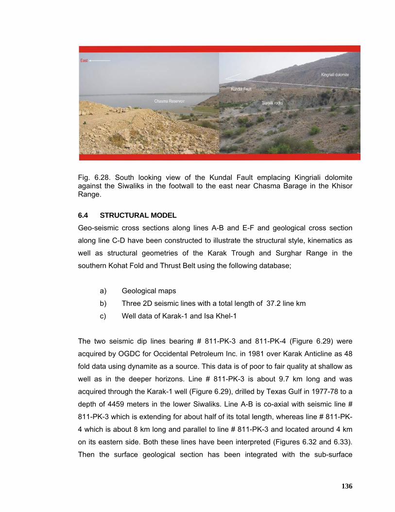
136
Fig. 6.28. South looking view of the Kundal Fault emplacing Kingriali dolomite against the Siwaliks in the footwall to the east near Chasma Barage in the Khisor Range. 6.4 STRUCTURAL MODEL
Geo-seismic cross sections along lines A-B and E-F and geological cross section
along line C-D have been constructed to illustrate the structural style, kinematics as
well as structural geometries of the Karak Trough and Surghar Range in the
southern Kohat Fold and Thrust Belt using the following database;
a) Geological maps
b) Three 2D seismic lines with a total length of 37.2 line km
c) Well data of Karak-1 and Isa Khel-1
The two seismic dip lines bearing # 811-PK-3 and 811-PK-4 (Figure 6.29) were
acquired by OGDC for Occidental Petroleum Inc. in 1981 over Karak Anticline as 48
fold data using dynamite as a source. This data is of poor to fair quality at shallow as
well as in the deeper horizons. Line # 811-PK-3 is about 9.7 km long and was
acquired through the Karak-1 well (Figure 6.29), drilled by Texas Gulf in 1977-78 to a
depth of 4459 meters in the lower Siwaliks. Line A-B is co-axial with seismic line #
811-PK-3 which is extending for about half of its total length, whereas line # 811-PK-
4 which is about 8 km long and parallel to line # 811-PK-3 and located around 4 km
on its eastern side. Both these lines have been interpreted (Figures 6.32 and 6.33).
Then the surface geological section has been integrated with the sub-surface
137
seismic and well data in order to work out consolidated structural model (Figure
6.30) for the Karak Trough and east west trending segment of the Surghar Range.
The structural style of the Karak Anticline and adjoining area is summarized by
describing a north-northwest trending dip line, A-B (Figures 6.3 and 6.30). The
location of geological transect is chosen in alignment with the available seismic data
in order to validate the subsurface structural geometry of the region. Surface data
was detailed along the available seismic line for extrapolation purpose as the seismic
image is of poor quality due to the complex nature of deformation. The structural
transect along line A-B is oriented northnorthwest, almost parallel to the regional
tectonic transport direction (Figure 6.3). Banda Lakhoni Syncline appears in the
extreme north, which is a symmetrical synclinal structure in sectional view. The
southern limb of this syncline is cut by Grori Fault, which is a steep, north dipping
south verging thrust, bringing rocks of Chinji Formation in the hanging wall over
Nagri Formation in the footwall. South of the Grori Fault lies another high angled
thrust, called Mitha Khel Fault (Figure 6.30). This is also north dipping, south verging
steep thrust emanating from the basal decollement, thrusting the rocks of Nagri
Formation over the rocks of Soan and Dhok Pathan formations in the footwall (Figure
6.30). The basal decollement is estimated to be located at a depth of around 8200
meters and 7500 meters in the northern and southern parts of the section
respectively with a regional dip of around 2-3° towards the north. Further south to
the Mitha Khel Fault, the Karak Anticline appears in the section. This is an
asymmetrical anticline with a steeper and shorter forelimb and comparatively longer
and gentler back limb both in map and sectional views. The seismic data
interpretation clearly suggests (Figures 6.31, 6.32 & 6.33) that the Karak Anticline is
developed on the hanging wall of a blind thrust, emanating from the basal
decollement and terminating in the upper Siwaliks, offsetting the core of the Banghar
Syncline lying to the south of the Karak Anticline. The Banghar Syncline is a tight
asymmetrical synclinal feature, cored by rocks of Soan Formation having steeper
northern limb and gentler southern limb in sectional view. Further southwards, the
section depicts the huge Shinghar-Surghar monocline, developed on the hanging
wall of the main Surghar Frontal Thrust. The limb of this monocline is quite extensive
and north dipping (Figure 6.30).
138
The Surghar Frontal Thrust is a south verging fault, originated from the basal
decollement and is shallow dipping in the deeper parts and become progressively
steeper near the surface. Along this fault Mesozoic and the underlying older rocks of
the Surghar Range are thrust southwards over the quaternary deposits of the Punjab
foreland. This geo-seismic transect indicates that Karak-1 well was placed around
800 m south of the hanging wall prospect and penetrated the steeply dipping
forelimb, the subcrop fault and repeated sequence of Siwaliks and was abandoned
approximately 200m above the footwall high.
The central Kohat Basin has been successfully drilled for hydrocarbons and the
exploratory as well as development wells have revealed the extremely complex
nature of tectonics in the area. It is well documented that within the Kohat Basin
surface structures do not mimic the subsurface structures. The northern and central
parts of the Kohat Basin are more tectonised as compared to that of the southern
Kohat Basin mainly due to the presence of Paleogene salt that does not extend up to
the Karak area in the south (Ahmad, 2003). The Karak Anticline is located to the
immediate south of the central Kohat Basin. An environment separating saline basin
in the north from the normal marine conditions in the south towards Surghar Range
is expected to have prevailed over the area. The Karak Anticline being a well-
developed surface feature has been validated on the basis of seismic data to have
structure at the level of Eocene-Paleocene. Keeping in view the well-established
petroleum system of the area, Karak Anticline is worth-exploring as the mystery now
appears to have been resolved.
The geology of the Karak and adjoining area indicates that it comprises a south
verging, thin-skinned deformed fold and thrust belt structural system, where the
structural style is characterized by decollement related thrusting associated with
concurrent fault bend folding within the hanging walls that are forming potential traps.
Fault-bend folds have a so-called ramp-flat geometry. Thrusts mostly propagate
along zones of weakness within a sedimentary sequence, such as mudstones or salt
layers, these parts of the thrust are called flats. If the effectiveness of the
decollement becomes reduced the thrust will tend to cut up the section to a higher
stratigraphic level, until it reaches another effective decollement where it can
continue as bedding parallel flat. The part of the thrust linking the two flats is known
139
as a ramp and typically forms at an angle of about 15°-30° to the bedding. Continued
displacement on a thrust over a ramp produces a characteristic fold geometry known
as a ramp anticline or more generally as a fault-bend fold.
The proposed structural development model for the region suggests that thin-
skinned deformation is related to a regional structural detachment, probably located
at the contact between the crystalline basement and Paleozoic sediments. Projection
of fold geometries within the exposed rocks requires buried anticlinal structures at
the base of Eocene sequence in order to equalize the amount of shortening. The
subsurface fold geometries present within the Mesozoic-Paleocene rocks are
interpreted as fault propagation folds developed in response to the motion along the
thrust splays from a regional basal decollement. The rheological contrast
between the base of Eocene succession and the sub-cropping Mesozoic-Paleozoic
sequence has played an important role in determining the contrasting structural
styles within the exposed and subsurface rocks. It is believed that the presence of a
thick sequence of Panoba-Ghazij shale at the base of Eocene has defined the zone
of strain partitioning between surface and subsurface structures where the
subsurface structural system is migrating southwards in response to the Himalayan
deformation. The Paleozoic to Mesozoic rocks are deformed by low angle listric
thrust splays and give rise to fault propagation folds within the overlying rocks. The
timing of deformation is interpreted to be late Pliocene-Pleistocene in age (Blisniuk et
al, 1998).
Geological cross section along line C-D (Figure 6.34) has been constructed across
Makarwal structure in the north south trending segment of the Surghar Range. Due
to lack of seismic data, the surface data is extrapolated to constrain deeper level
structural model. The sub-surface thickness data along this section is tied with Isa
Khel-1 well, drilled by OGDC in 1993 up to 4680 meters into Cambrian Khewra
Sandstone near the town of Isa Khel in the Mianwali re-entrant.
Section C-D (Figure 6.34) is east west oriented, almost parallel to the east west
oriented tectonic transport direction as deduced from the fault and fold hinges
orientation. Bannu Basin appears in the west on section line, covered by Quaternary
deposits. The Bannu Basin is bounded on the east by Makarwal Anticline, which is
140
the major structural high in this section, cored by Makarwal fault complex, which is
an east verging linked fault system. The back limb of the Makarwal Anticline is
relatively shallow dipping towards the west near the surface and gradually gets
steeper in the middle part and then becomes sub-horizontal in the deeper levels. The
crestal region of the Makarwal Anticline is dissected by Makarwal fault complex
which include one major fore thrust and a couple of associated thrust splays
resulting in the repetition of Paleocene and Cretaceous rocks. The Makarwal Fault is
interpreted to be an off-shoot from a subcrop fore thrust detached from the regional
basal decollement which is estimated to be located at a depth of around 6000 meters
and 5700 meters in the western and eastern parts of the section respectively. The
sub crop fore thrust which repeats the Mesozoic and older strata subsequently
terminates against the Makarwal strike slip fault. The forelimb of the Makarwal
Anticline is occupied by steeply east dipping Makarwal strike slip fault, which exhibit
sinistral translation and juxtaposes Eocene rocks against Paleocene rocks. In
sectional view, it displays an apparent normal sense displacement.
Further towards the south, geo-seismic cross section along line E-F (Figure 6.35)
has been constructed which is passing through Isa Khel-1 well (Figure 6.29). This
section incorporates surface geology, seismic data of line # 915-MWI-83 (Figure
6.29), which was acquired parallel to the dip direction by OGDC in 1991 and well
data of Isa Khel-1.This seismic line is around 19.5 km long and was acquired as 120
fold data using dynamite as a source, showing fair to good data quality. This section
is oriented east west and shows Bannu Basin in the west. Towards the east, Bannu
Basin is bounded by Bhor Sharif Anticline. This anticline is having broad and almost
horizontal crest. Its backlimb is west dipping in the direction of Bannu Basin having
shallow to moderate dips whereas its forelimb is dissected by Bhor Sharif Fault. The
Bhor Sharif Fault is a deep-rooted, east verging fault dipping towards the west. It is
originating from the basal decollement and emplaces lower Siwalik rocks over the
upper Siwaliks and quaternary deposits of the Punjab foreland towards the east.
Further eastwards a major blind back thrust originating from the basal decollement
cutting the forelimb of the Bhor Sharif Anticline. This blind back thrust is west verging
and dipping towards the east. The area between the Bhor Sharif Fault and this blind
back thrust as a whole appears to form a triangle zone in the sub-surface, which can
be seen on the interpreted seismic line as well (Figure 6.36).
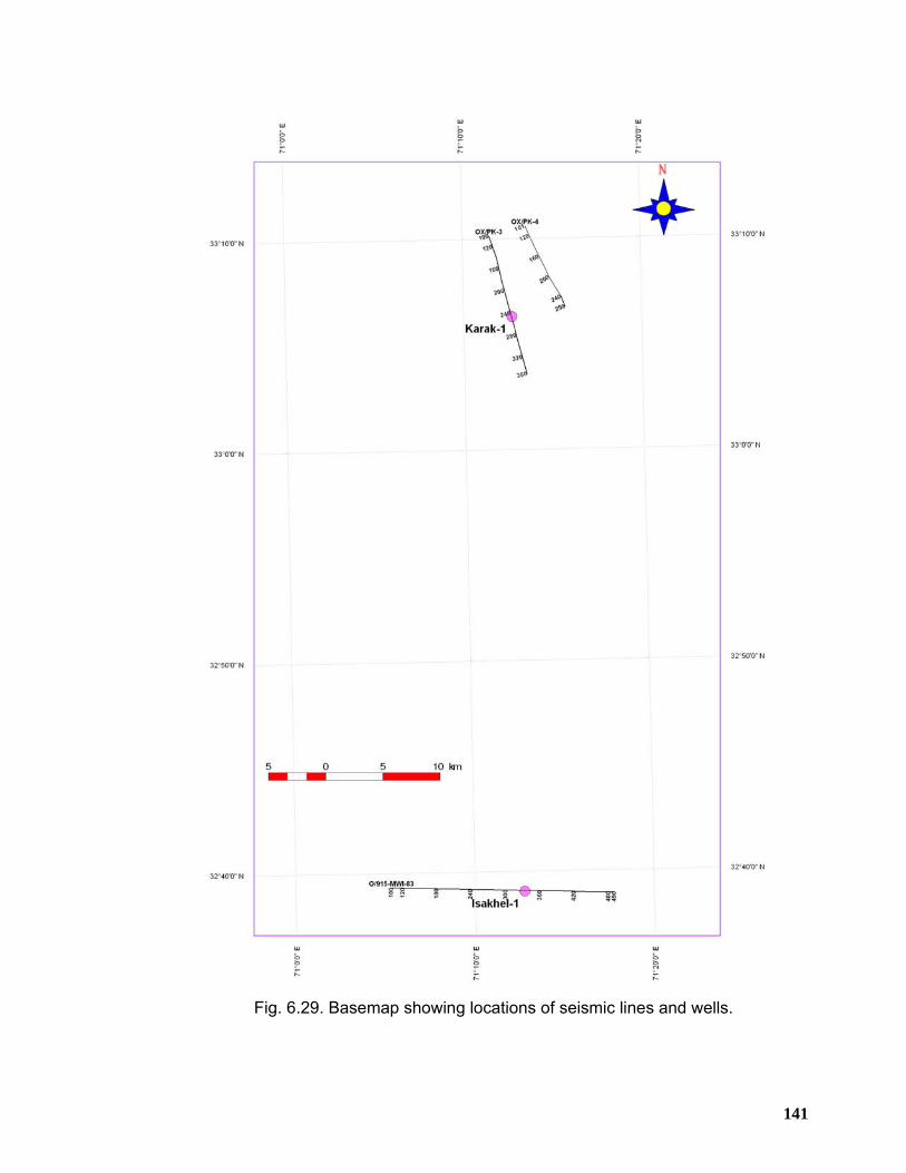
141
Fig. 6.29. Basemap showing locations of seismic lines and wells.
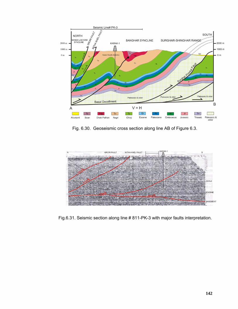
142
Fig. 6.30. Geoseismic cross section along line AB of Figure 6.3.
Fig.6.31. Seismic section along line # 811-PK-3 with major faults interpretation.
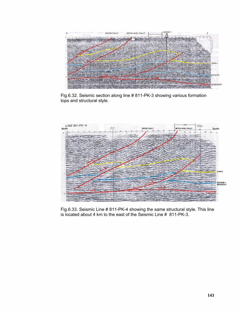
143
Fig.6.32. Seismic section along line # 811-PK-3 showing various formation tops and structural style.
Fig.6.33. Seismic Line # 811-PK-4 showing the same structural style. This line is located about 4 km to the east of the Seismic Line # 811-PK-3.
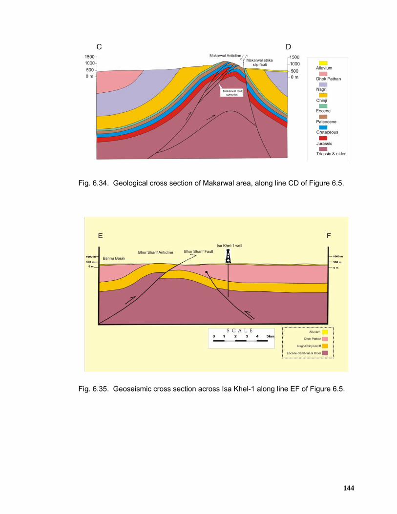
144
Fig. 6.34. Geological cross section of Makarwal area, along line CD of Figure 6.5.
Fig. 6.35. Geoseismic cross section across Isa Khel-1 along line EF of Figure 6.5.
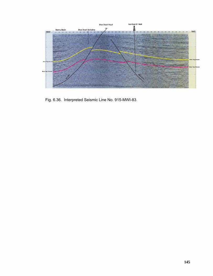
145
Fig. 6.36. Interpreted Seismic Line No. 915-MWI-83.
146
CHAPTER 7
STRUCTURAL GEOMETRY OF THE MARWAT-KHISOR RANGES
7.1 INTRODUCTION The Marwat-Khisor ranges constitute the central part of the Trans Indus ranges
where these ranges skirt the southeastern border of Bannu Basin. The Marwat
Range hosts Siwalik rocks throughout its map trace except the western most part in
the Sheikh Budin Hills, where rocks belonging to Zaluch Group of Permian age are
exposed. The Khisor Range provides an excellent exposure of the stratigraphic
succession belonging to Mesozoic and Paleozoic ages.
The structural geometry of the Marwat-Khisor ranges is characterized by south
verging, asymmetric, overturned and plunging fold structures along with associated
thrust faults, originating from the basal decollement. The tectonic history of the
Khisor Range and the Sheikh Budin Hills has been demonstrated to have undergone
two discrete episodes of Late Cenozoic tectonism comprising of initial normal faulting
in the basement followed by south directed thrusting of the sedimentary sequence
above the basal decollement (Blisniuk et al. 1998). Khisor Thrust is the youngest and
active frontal fault due to which Khisor Range has been tectonically uplifted and
moderately deformed. Structural analysis of the area suggests that the nature of
deformation is thin-skinned, comprising of thrust-fold assemblages, kinematically
related to regional basal decollement located at the base of Jhelum Group rocks
(Alam et al. 2005 and Alam, 2008).
7.2 PHYSIOGRAPHY
The Marwat-Khisor ranges stretch from Paniala village in the west up to Dara Tang
locality in the northeast. This area is characterized by two ranges i.e. Marwat Range
to the northwest and Khisor Range to the southeast separated by a broad valley.
The area is having low to moderate altitudes ranging from 200 m at the valley floor to
1300 m above mean sea level at the Kingriali peak in the Khisor Range. Further
towards the south, Marwat-Khisor ranges are bounded by Punjab foreland and
D.I.Khan Basin occupied by quaternary deposits having low relief whereas Indus
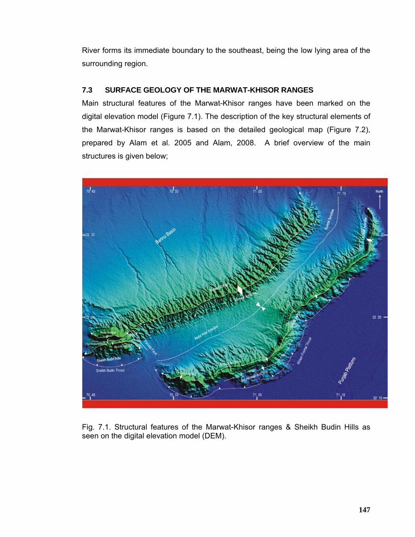
147
River forms its immediate boundary to the southeast, being the low lying area of the
surrounding region.
7.3 SURFACE GEOLOGY OF THE MARWAT-KHISOR RANGES
Main structural features of the Marwat-Khisor ranges have been marked on the
digital elevation model (Figure 7.1). The description of the key structural elements of
the Marwat-Khisor ranges is based on the detailed geological map (Figure 7.2),
prepared by Alam et al. 2005 and Alam, 2008. A brief overview of the main
structures is given below;
Fig. 7.1. Structural features of the Marwat-Khisor ranges & Sheikh Budin Hills as seen on the digital elevation model (DEM).
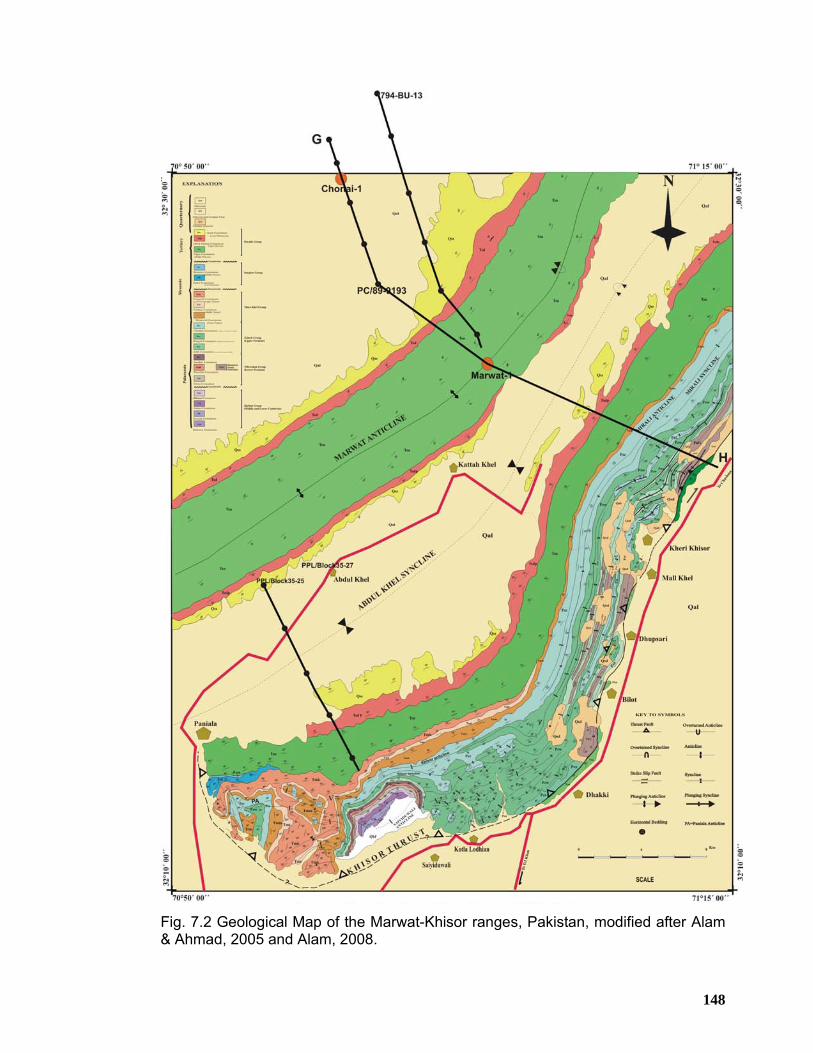
148
Fig. 7.2 Geological Map of the Marwat-Khisor ranges, Pakistan, modified after Alam & Ahmad, 2005 and Alam, 2008.
149
7.3.1 Fold Structures
Folds are the dominant structural elements of the Marwat-Khisor ranges and are
represented by open to tight, northeast to north-northeast trending anticlines and
synclines. These folded structures are mostly south facing, indicating south directed
tectonic deformation.
7.3.1.1 Marwat Anticline The topographic expression of the Marwat Range is attributed to Marwat Anticline
(Figures 7.1 and 7.2). It is bounded to the southeast by Abdul Khel Syncline and to
the northwest by Bannu Basin. The limbs of the Marwat Anticline expose rocks of
Dhok Pathan and Soan formations whereas the Nagri Formation of Siwalik Group is
exposed in the core of the anticline. The southern limb of the anticline is dipping to
the southeast at moderate to steep angle (50°~65°) and becomes overturned in the
extreme northeast whereas its northern limb dips to the northwest gently (20°~45°).
On the basis of attitude data, Marwat Anticline in the eastern part of the Marwat
Range is considered as south verging, overturned and asymmetrical anticline. Its
axial trace is oriented northeast to southwest for most of its outcrop exposure and
switches to NNE-SSW in the extreme eastern part of the Marwat Range.
7.3.1.2 Abdul Khel Syncline Abdul Khel Syncline has been mapped immediately to the southeast of the Marwat
Anticline (Figures 7.1 and 7.2). Mir Ali Anticline bounds this syncline on the
southeast. It has a wide wavelength in the west near Paniala that gets narrow
eastward. Upper Siwalik rocks are exposed along the flanks of this syncline. Attitude
data collected on the limbs indicate that its southeastern limb gently dips to the
northwest whereas its northern limb is steeply dipping to southeast.
7.3.1.3 Mir Ali Anticline It is a prominent feature of the eastern Khisor Range (Figure 7.2). The axial trend of
this anticline is north-northeast. Its map extension along the axial trend is more than
25 km (Alam et al. 2005 and Alam, 2008) . Its southeastern limb is comprised of the
rock of Chhidru Formation whereas its northwestern limb comprises of the rocks of
Chhidru and Mianwali Formation, unconformably overlain by the Siwalik strata. The
150
southeastern and northwestern limbs dip to southeast and northwest with gentle and
gentle to moderate angles respectively, making the anticline asymmetrical (Alam et
al. 2005 and Alam, 2008).
7.3.1.4 Mir Ali Syncline
Mir Ali Syncline is developed in the Chhidru Formation in the eastern part of the
Khisor Range to the immediate southeast of the Mir Ali Anticline (Figure 7.2). Its
southeastern limb gently dips towards the northwest whereas its northwestern limb
gently dips towards the southeast (Alam et al. 2005 and Alam, 2008). The axial trend
of the structure is oriented NNE to SSW parallel to that of Mir Ali Anticline which
swings to almost north-south to the west of Kheri Khisor village. The southern limb
exposes the rocks of Chhidru Formation and Wargal Limestone whereas its
northwestern limb consists of the rocks of Chhidru Formation only.
7.3.1.5 Khisor Anticline
This anticline is located in the northeast of the Saiyiduwali Anticline, characterized by
east west trending fold axis which turns to almost north-south orientation on the
western side of Bilot village (Figures 7.1 and 7.2). The southern limb comprises the
rocks of Chhidru Formation while the northern limb consists of Chhidru Formation
overlain by the Triassic rocks which in turn are unconformably overlain by the Siwalik
Group rocks. The Khisor Anticline shows highest structural relief compared to other
fold structures exposing the Kingriali Formation in the apex of fold hinge and forms
the Kingriali peak where the Khisor Range attains its highest culmination (Alam et al.
2005 and Alam, 2008).
7.3.1.6 Khisor Syncline Khisor syncline is located close to the Saiyiduwali Anticline on the northwest, sharing
its southeastern limb with Saiyiduwali Anticline (Figure 7.2). The trend of its axial
trace is curvilinear swinging from east west to northeast-southwest. Both the limbs
are dipping with almost equal angles towards each other making the syncline
symmetrical. The southern limb of this syncline hosts the same rocks as that of the
northern limb of the Saiyiduwali Anticline whereas rocks belonging to Chhidru
Formation of Zaluch Group are exposed in its northern limb.
151
7.3.1.7 Saiyiduwali Anticline
It is the largest anticline, mapped along the southern foothills of the western Khisor
Range (Figures 7.1 and 7.2). The topographic expression of the Saiyiduwali Anticline
is mainly attributed to its backlimb which comprises the rocks of Cambrian to
Permian age, whereas it’s apparently eroded forelimb seems to have been
terminated against the Khisor Thrust in the northwest of Saiyiduwali village. The
northeastern extension of this anticline preserves both of its limbs. The backlimb of
the Saiyiduwali Anticline is moderately deformed with shallow folded structures, well
developed in the Triassic rocks. The oldest rocks exposed in the core of Saiyiduwali
Anticline include Khewra Sandstone, Kussak, Jutana and Khisor Formation of
Jhelum Group overlain by the rocks of the Nilawahan Group, Zaluch Group and
Triassic rocks which are in turn unconformably overlain by the Siwalik Group rocks
(Alam et al. 2005 and Alam, 2008 ).
7.3.1.8 Paniala Anticline Paniala Anticline forms a well-developed structural feature in the western part of the
Khisor Range. This anticline is developed on the hanging wall of the Khisor Frontal
Thrust (Figures 7.1 and 7.2). Attitude data collected on its limbs indicate that its
northern limb is comparatively steeper with dip values in the range of 75° to 90° as
compared to its southern limb, attributing asymmetry to this fold structure. Its fold
axis is plunging towards northwest and trends almost in east-west direction.
Southern limb of this anticline is characterized by a couple of low amplitude small-
scale northeast to southwest trending folds (Alam et al. 2005 and Alam, 2008).
7.3.1.9 Paniala Syncline This structural element is almost sub-parallel to the Paniala Anticline exposing rocks
of Mianwali and Tredian formations in the core. The attitude data suggest that it is
asymmetrical, northwest plunging syncline. Its northern limb is steeply dipping
towards southeast whereas the southern limb is dipping moderately towards
northwest. The southern limb of this synclinal feature comprises the hanging wall
strata of the Khisor Thrust (Alam et al. 2005 and Alam, 2008).
152
7.3.2 Fault Structures Frontal thrust fault is well developed in the Marwat-Khisor ranges in addition to few
small thrust faults. A brief description of these faults is given below;
7.3.2.1 Dhupsari Thrust This fault is mapped approximately 1.5 km towards the north of Khisor Thrust near
Dhupsari village (Figure 7.2). It is oriented in north-northeast direction having limited
map exposure. It is southeast verging. Along this fault the Amb Formation in the
hanging wall is thrust over the Nagri Formation in the footwall. On the basis of
surface structural data it appears as an imbricate offshoot fault associated with the
Khisor Frontal Thrust.
7.3.2.2 Khisor Thrust
This frontal thrust is found to be fully to partially emergent in the western Khisor
Range. It is well exposed in the west of Dhakki, Bilot and Dhupsari villages, providing
good outcrop exposures (Alam et al. 2005 and Alam, 2008). Based on its known
trend from its well-exposed eastern outcrops its trend is inferred to be east west and
switches to north-northwest near Paniala where the Jurassic rocks of Datta
Formation are thrust over the Siwalik Group rocks. In the eastern Khisor Range, it is
oriented north-northeast and moderately dips towards northwest bringing Permian
rocks in its hanging wall juxtaposed against the Siwalik Group rocks in the footwall to
the southeast (Figures 7.3 to 7.5). The outcrop characteristics of this fault suggest
that it is south verging fore thrust detached at the base of the Permian rocks (Alam et
al. 2005 and Alam, 2008).
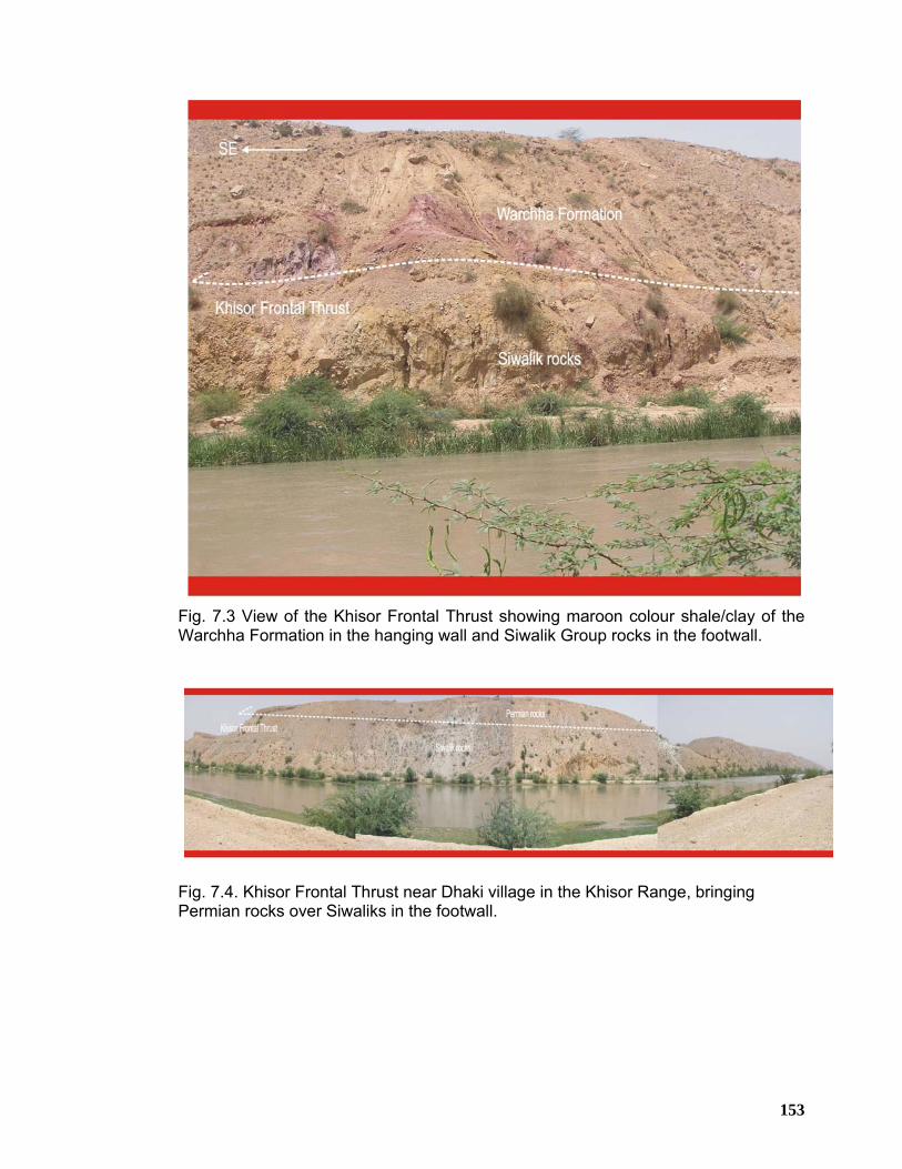
153
Fig. 7.3 View of the Khisor Frontal Thrust showing maroon colour shale/clay of the Warchha Formation in the hanging wall and Siwalik Group rocks in the footwall.
Fig. 7.4. Khisor Frontal Thrust near Dhaki village in the Khisor Range, bringing Permian rocks over Siwaliks in the footwall.
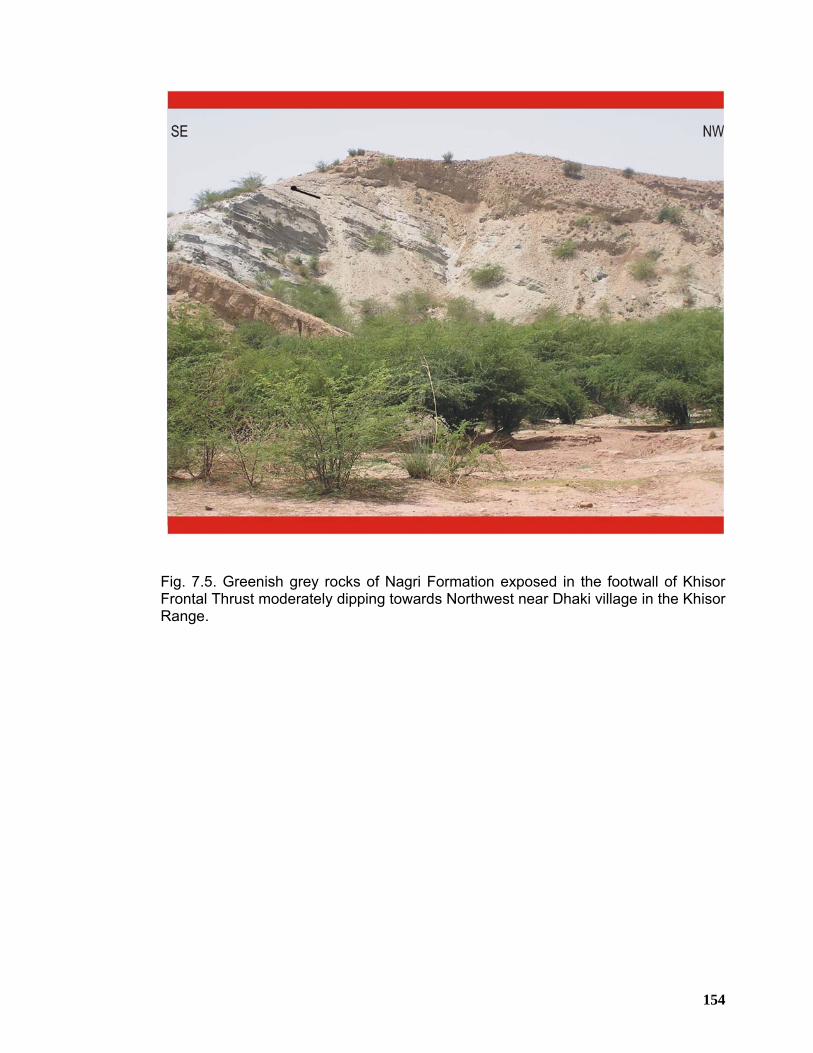
154
Fig. 7.5. Greenish grey rocks of Nagri Formation exposed in the footwall of Khisor Frontal Thrust moderately dipping towards Northwest near Dhaki village in the Khisor Range.
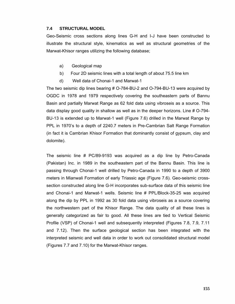
155
7.4 STRUCTURAL MODEL
Geo-Seismic cross sections along lines G-H and I-J have been constructed to
illustrate the structural style, kinematics as well as structural geometries of the
Marwat-Khisor ranges utilizing the following database;
a) Geological map
b) Four 2D seismic lines with a total length of about 75.5 line km
d) Well data of Chonai-1 and Marwat-1
The two seismic dip lines bearing # O-784-BU-2 and O-794-BU-13 were acquired by
OGDC in 1978 and 1979 respectively covering the southeastern parts of Bannu
Basin and partially Marwat Range as 62 fold data using vibroseis as a source. This
data display good quality in shallow as well as in the deeper horizons. Line # O-794-
BU-13 is extended up to Marwat-1 well (Figure 7.6) drilled in the Marwat Range by
PPL in 1970’s to a depth of 2240.7 meters in Pre-Cambrian Salt Range Formation
(in fact it is Cambrian Khisor Formation that dominantly consist of gypsum, clay and
dolomite).
The seismic line # PC/89-9193 was acquired as a dip line by Petro-Canada
(Pakistan) Inc. in 1989 in the southeastern part of the Bannu Basin. This line is
passing through Chonai-1 well drilled by Petro-Canada in 1990 to a depth of 3900
meters in Mianwali Formation of early Triassic age (Figure 7.6). Geo-seismic cross-
section constructed along line G-H incorporates sub-surface data of this seismic line
and Chonai-1 and Marwat-1 wells. Seismic line # PPL/Block-35-25 was acquired
along the dip by PPL in 1992 as 30 fold data using vibroseis as a source covering
the northwestern part of the Khisor Range. The data quality of all these lines is
generally categorized as fair to good. All these lines are tied to Vertical Seismic
Profile (VSP) of Chonai-1 well and subsequently interpreted (Figures 7.8, 7.9, 7.11
and 7.12). Then the surface geological section has been integrated with the
interpreted seismic and well data in order to work out consolidated structural model
(Figures 7.7 and 7.10) for the Marwat-Khisor ranges.
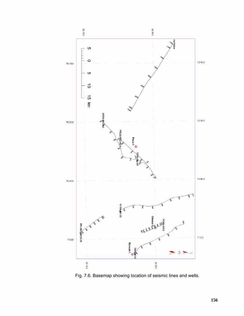
156
Fig. 7.6. Basemap showing location of seismic lines and wells.
157
The structural model along line G-H (Figure 7.7) is oriented from northwest to
southeast covering eastern part of the Marwat-Khisor ranges. Line G-H is
approximately parallel to the northwest-southeast oriented tectonic transport
direction as inferred from the trends of various structures exposed and mapped in
the area. The northwestern portion of the section is located in the Bannu Basin
covered by seismic line # PC/89-9193 (Figure 7.8). Data from the interpreted
Seismic line # O-794-BU-13 (Figure 7.9) which is located around 6.5 km to the
northeast of line # PC/89-9193 has also been incorporated in the construction of this
structural model. This line is around 26 km long extending from the Bannu Basin up
to Marwat-1 well in the Marwat Range to the southeast (Figures 7.6). The Bannu
Basin is near flat in sectional view having enormous thickness of sedimentary
package above the basal decollement with Quaternary deposits exposed on the
surface. A couple of normal faults have been identified on the seismic data (Figure
7.8) in the vicinity of Chonai-1 well. This type of normal faulting in the platform
sequence has never been reported from the Trans Indus ranges earlier. These faults
have resulted in offsetting the Permian to Cretaceous age strata with normal sense
of movement, forming localized horst and graben geometry. Another noticeable
feature of the model is the stratigraphic truncation of Eocene-Paleocene and
Cretaceous rocks against the backlimb of the Marwat Anticline. This stratigraphic
truncation has been validated on the basis of seismic and well data (Figures 7.8 and
7.9). Further to the southeast, Marwat Anticline is located, which is an asymmetrical
anticline in sectional view having short and steeply dipping forelimb and
comparatively longer and gently dipping backlimb. It exposes Siwalik rocks on its
flanks whereas the core is occupied by older rocks belonging to Infra-Cambrian to
Cambrian age. This anticline is developed on the hanging wall of a blind fore thrust
and its back limb is occupied by a non emergent back thrust forming pop-up
geometry in sectional view. The subcrop fore thrust below the Marwat Anticline is
originated from the basal decollement and tip out beneath the fore limb of Abdul Khel
Syncline to the southeast. Marwat-1 well has drilled the strata on the steeply dipping
forelimb of the Marwat Anticline. Marwat Anticline is bounded by Abdul Khel Syncline
on the southeast. This is also asymmetrical and southeast facing syncline in
sectional view exposing Quaternary deposits in the core and Siwalik rocks on the
limbs. Jurassic rocks seem to have been truncated in the forelimb of this syncline as
these are not exposed in the outcrops further to the southeast, where Siwalik rocks
158
unconformably lie directly over the Triassic rocks (Figure 7.7). On the other hand, to
the northwest stratigraphic succession drilled by Marwat-1 well shows more than 500
meters thick Jurassic rocks in the forelimb of the Marwat Anticline. In sectional view,
Abdul Khel Syncline appears to be asymmetrical, south facing having steeper and
shorter backlimb and relatively more gentle and extensive forelimb. A blind back
thrust has also been inferred from the Frontal Khisor Thrust offsetting the fore limb of
the Abdul Khel Syncline. Along this geo-seismic transect, the southeastern part of
the range front is occupied by the Nilawahan and Zaluch Group rocks that develop
small-scale shallow fold structures, characterized by short wavelengths on the
hanging wall of the Khisor Frontal Thrust. Out of the shallow folds mapped in the
Khisor Thrust Sheet, Mir Ali Anticline is the most prominent one, located to the
southeast of the Abdul Khel Syncline. Further to the southeast, Khisor Thrust brings
Permian rocks in the hanging wall in juxtaposition against the Siwalik rocks in the
footwall. It is moderately dipping towards northwest and appears as a south verging
decollement related frontal fault.
The structural model along line I-J (Figure 7.10) is oriented from NNW to SSE
located within the western part of the Marwat-Khisor ranges. Seismic data of lines #
784-BU-02 and PPL/Block35-25 and well data of Chonai-1 and Marwat-1 (Figure
7.6) has been integrated with surface geology for the construction of this structural
model. It is depicting Bannu Basin to be a deep and flat lying basin. The structural
model shows that Cretaceous rocks truncate towards the southeast where the
backlimb of the Marwat Anticline merges with Bannu Basin. Here also the Marwat
Anticline is depicted to be asymmetrical with steep and shorter forelimb and
relatively gentler and extensive backlimb exposing Siwalik rocks on flanks and Infra-
Cambrian to Cambrian rocks in the core. It is developed on the hanging wall of a
non-emergent thrust, emanating from the basal decollement and cutting across all
the rocks from Infra-Cambrian to Jurassic and subsequently terminates in the
Siwaliks beneath Abdul Khel Syncline. This fault is moderately dipping towards
northwest and a back thrust emanates from its ramp slightly offsetting the back limb
of the Marwat Anticline. Abdul Khel Syncline is comparatively much broader in
section view in this part of the Marwat-Khisor ranges. It exposes Siwalik rocks along
its flanks whereas its core is covered with Quaternary deposits. Truncation limit of
Jurassic rocks is located somewhere close to the southeastern limb of Abdul Khel
159
Syncline. The southeastern limb of the Abdul Khel Syncline has also been offset by a
non-emergent back thrust splaying from the Khisor Frontal Thrust. Further to the
southeast, the model demonstrates shallow fold structures, developed in the rocks
ranging in age from Triassic to Cambrian on the hanging wall of the Khisor Frontal
Thrust. Khisor Anticline is the most prominent anticlinal feature exposing the
Triassic rocks in the limbs whereas its core is occupied by older rocks ranging in age
from Infra-Cambrian to Permian. The model depicts Khisor Thrust to be deep-rooted,
moderate to steeply northwest dipping fault. It emplaces rocks belonging to
Cambrian age in the hanging wall against the quaternary deposits in the footwall to
the southeast.
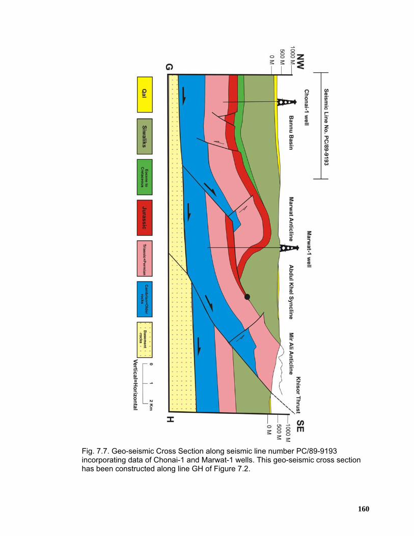
160
Fig. 7.7. Geo-seismic Cross Section along seismic line number PC/89-9193 incorporating data of Chonai-1 and Marwat-1 wells. This geo-seismic cross section has been constructed along line GH of Figure 7.2.
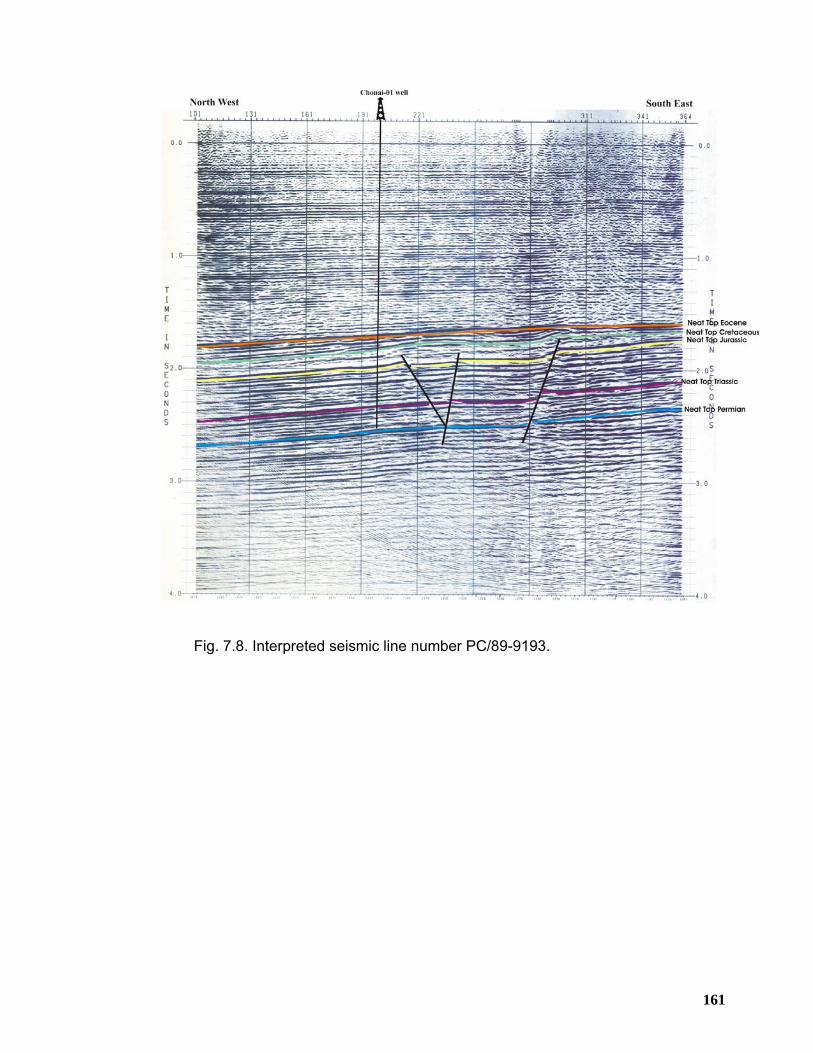
161
Fig. 7.8. Interpreted seismic line number PC/89-9193.
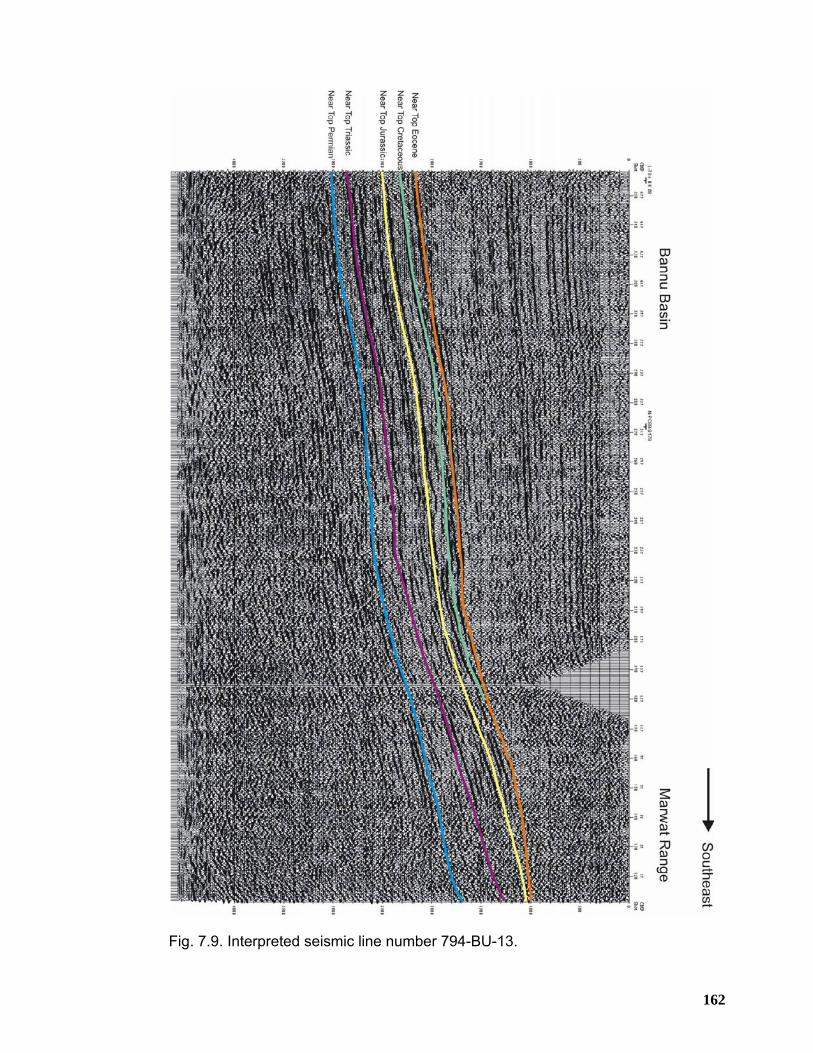
162
Fig. 7.9. Interpreted seismic line number 794-BU-13.
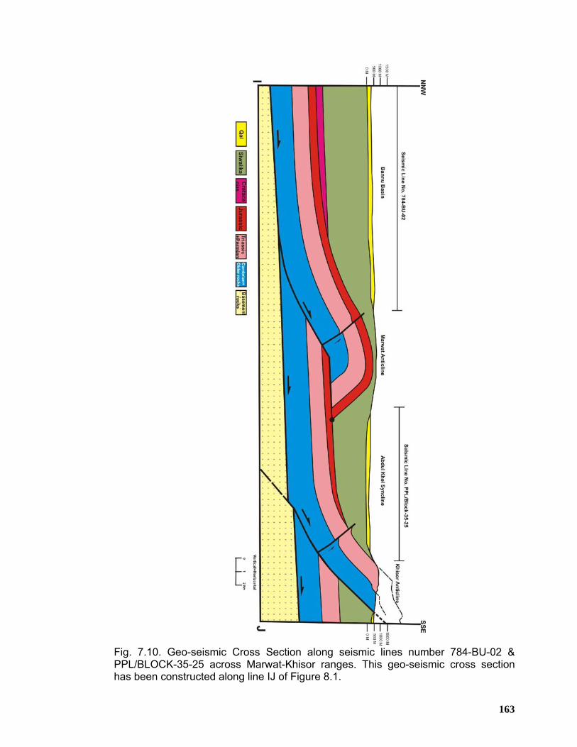
163
Fig. 7.10. Geo-seismic Cross Section along seismic lines number 784-BU-02 & PPL/BLOCK-35-25 across Marwat-Khisor ranges. This geo-seismic cross section has been constructed along line IJ of Figure 8.1.
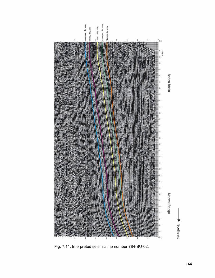
164
Fig. 7.11. Interpreted seismic line number 784-BU-02.
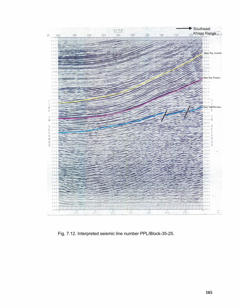
165
Fig. 7.12. Interpreted seismic line number PPL/Block-35-25.
166
CHAPTER 8
STRUCTURAL GEOMETRY OF THE PEZU-BHITTANI RANGE
8.1 INTRODUCTION The Pezu-Bhittani Range constitutes the western most along strike continuation of
the Trans Indus ranges in the northwest Himalayas. This range follows northwest-
southeast structural trend flanking the southwestern margin of the Bannu Basin
(Figure 8.1). Tank Basin lies to its south, Sheikh Budin Hills and Marwat-Khisor
ranges in the south-southeast whereas the Manzai Range is making the western
boundary of the Pezu-Bhittani Range.
The Pezu-Bhittani Range contains northwest-southeast striking topographic high,
separating the Tank depression in the south from the Bannu Basin in the northeast.
The Pezu, Chunda and Sheik Budin anticlines are the major structural elements of
this range (Figure 8.1). The Pezu Anticline is disrupted along its axial trace by a
thrust fault, with right-lateral transpressional deformation.
Siwalik sediments are exposed all along the map trace of Pezu Anticline whereas
older rocks ranging in age from Permian to Pleistocene are exposed in the Sheikh
Budin Hills. The surface geology clearly indicates that this area has undergone
complex deformation, consisting of fold-thrust assemblages where the structural
style is characterized by decollement related thrusting associated with concurrent
fault bend/propagation folding within the hanging wall and is high impedance system
(Demaison & Huizinga, 1991) related to convergent plate tectonic habitat.
A working petroleum system exists in the area. The maturity of the source rocks in
terms of hydrocarbon generation is established by burning gas seepage, found along
the Pezu Fault in the northwestern part of the Pezu-Bhittani Range, near Bain village
(Ansari et al. 2002). An exploratory well, Pezu-1 was drilled by PPL in 1968-69 in the
central valley without any seismic acquisition which penetrated over 600 meters of
Siwalik sediments before entering Eocene-Paleocene, Cretaceous and Jurassic
sediments in succession. This well was abandoned as a dry hole at 2222 meters
167
depth in the sandstone of Jurassic age Datta Formation after drill stem testing of
both Cretaceous and Jurassic reservoir rocks. Although water-bearing, Datta
sandstone was found to be of reservoir quality.
8.2 PHYSIOGRAPHY
The Pezu-Bhittani Range stretches from Pezu town in the southeast up to Kundi
Anticline in the northwest where the range switches its orientation to the north-south
(Figures 8.1 and 9.1). The Pezu-Bhittani Range is having low to moderate relief
ranging from 250-300 meters from valley floor in the north and south up to the crestal
part of the Pezu Anticline in the vicinity of the Pezu Fault. The Sheikh Budin Hills
exhibit comparatively moderate relief, where Jurassic limestone of Samana Suk
Formation forming peaks with a maximum altitude of about 1225 metes above the
mean sea level.
8.3 SURFACE GEOLOGY OF THE PEZU-BHITTANI RANGES
A detailed geological map of the Pezu-Bhittani Range has been prepared (Fig. 8.1)
showing the trend of the major structures to be oriented northwest-southeast in the
Pezu-Bhittani Range that switches to almost east-west in the Sheikh Budin Hills to
the east and southeast of Pezu town. The description of the main structures is given
below;
8.3.1 Fold Structures
Folds seem to be the dominant structural grain of the Pezu-Bhittani Range. These
folds are trending northwest to southeast over most parts of the Pezu-Bhittani Range
with a slight swing in the Sheikh Budin Hills. These fold structures are mostly south
to southwest facing, indicating the southward progression of tectonic deformation.
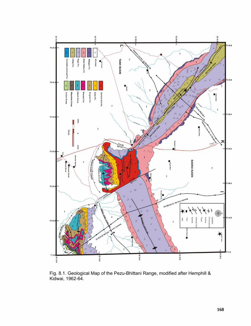
168
Fig. 8.1. Geological Map of the Pezu-Bhittani Range, modified after Hemphill & Kidwai, 1962-64.
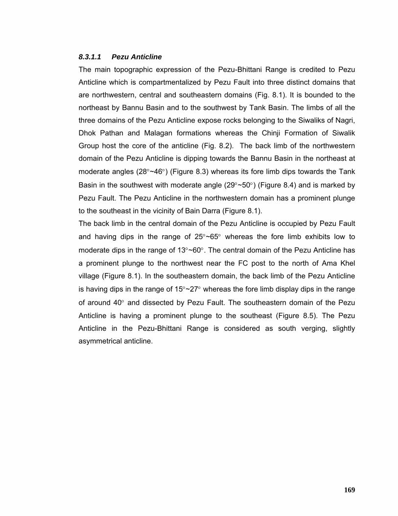
169
8.3.1.1 Pezu Anticline
The main topographic expression of the Pezu-Bhittani Range is credited to Pezu
Anticline which is compartmentalized by Pezu Fault into three distinct domains that
are northwestern, central and southeastern domains (Fig. 8.1). It is bounded to the
northeast by Bannu Basin and to the southwest by Tank Basin. The limbs of all the
three domains of the Pezu Anticline expose rocks belonging to the Siwaliks of Nagri,
Dhok Pathan and Malagan formations whereas the Chinji Formation of Siwalik
Group host the core of the anticline (Fig. 8.2). The back limb of the northwestern
domain of the Pezu Anticline is dipping towards the Bannu Basin in the northeast at
moderate angles (28°~46°) (Figure 8.3) whereas its fore limb dips towards the Tank
Basin in the southwest with moderate angle (29°~50°) (Figure 8.4) and is marked by
Pezu Fault. The Pezu Anticline in the northwestern domain has a prominent plunge
to the southeast in the vicinity of Bain Darra (Figure 8.1).
The back limb in the central domain of the Pezu Anticline is occupied by Pezu Fault
and having dips in the range of 25°~65° whereas the fore limb exhibits low to
moderate dips in the range of 13°~60°. The central domain of the Pezu Anticline has
a prominent plunge to the northwest near the FC post to the north of Ama Khel
village (Figure 8.1). In the southeastern domain, the back limb of the Pezu Anticline
is having dips in the range of 15°~27° whereas the fore limb display dips in the range
of around 40° and dissected by Pezu Fault. The southeastern domain of the Pezu
Anticline is having a prominent plunge to the southeast (Figure 8.5). The Pezu
Anticline in the Pezu-Bhittani Range is considered as south verging, slightly
asymmetrical anticline.
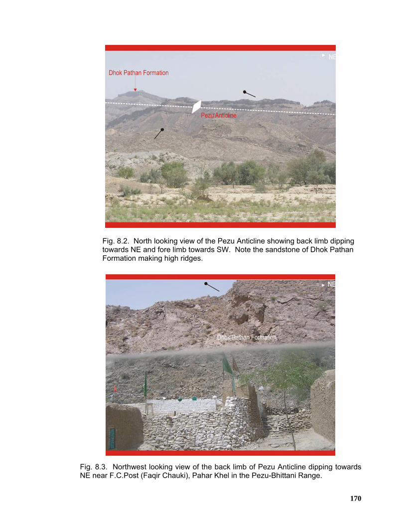
170
Fig. 8.2. North looking view of the Pezu Anticline showing back limb dipping towards NE and fore limb towards SW. Note the sandstone of Dhok Pathan Formation making high ridges.
Fig. 8.3. Northwest looking view of the back limb of Pezu Anticline dipping towards NE near F.C.Post (Faqir Chauki), Pahar Khel in the Pezu-Bhittani Range.
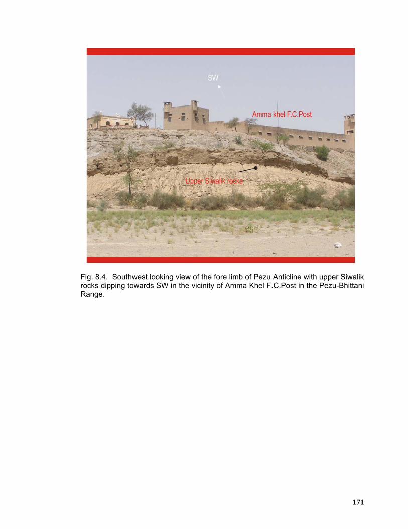
171
Fig. 8.4. Southwest looking view of the fore limb of Pezu Anticline with upper Siwalik rocks dipping towards SW in the vicinity of Amma Khel F.C.Post in the Pezu-Bhittani Range.
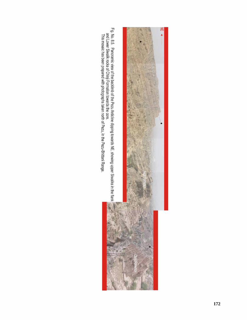
172
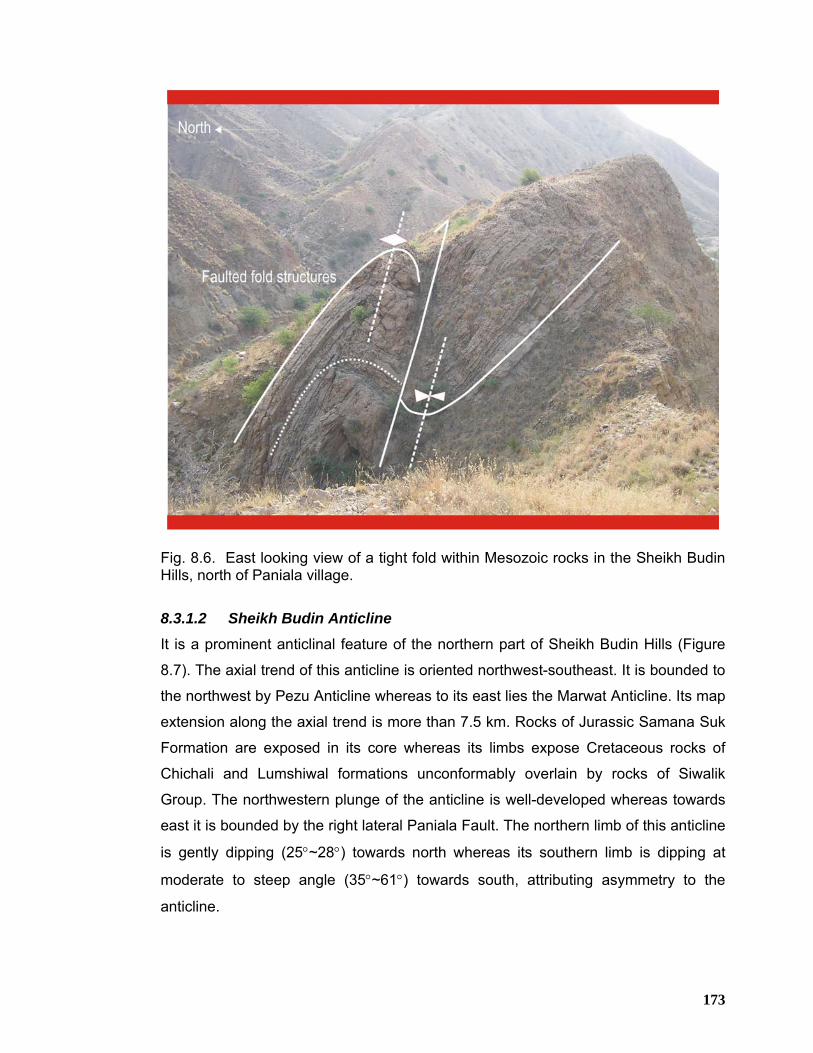
173
Fig. 8.6. East looking view of a tight fold within Mesozoic rocks in the Sheikh Budin Hills, north of Paniala village.
8.3.1.2 Sheikh Budin Anticline It is a prominent anticlinal feature of the northern part of Sheikh Budin Hills (Figure
8.7). The axial trend of this anticline is oriented northwest-southeast. It is bounded to
the northwest by Pezu Anticline whereas to its east lies the Marwat Anticline. Its map
extension along the axial trend is more than 7.5 km. Rocks of Jurassic Samana Suk
Formation are exposed in its core whereas its limbs expose Cretaceous rocks of
Chichali and Lumshiwal formations unconformably overlain by rocks of Siwalik
Group. The northwestern plunge of the anticline is well-developed whereas towards
east it is bounded by the right lateral Paniala Fault. The northern limb of this anticline
is gently dipping (25°~28°) towards north whereas its southern limb is dipping at
moderate to steep angle (35°~61°) towards south, attributing asymmetry to the
anticline.
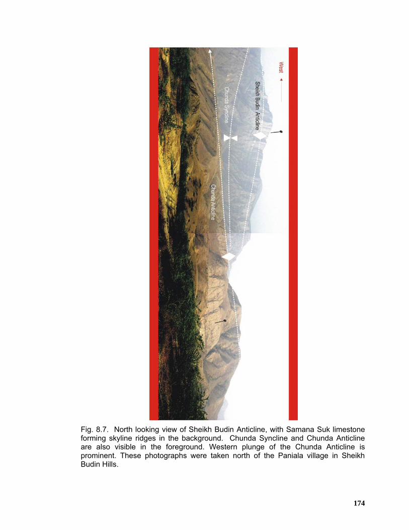
174
Fig. 8.7. North looking view of Sheikh Budin Anticline, with Samana Suk limestone forming skyline ridges in the background. Chunda Syncline and Chunda Anticline are also visible in the foreground. Western plunge of the Chunda Anticline is prominent. These photographs were taken north of the Paniala village in Sheikh Budin Hills.
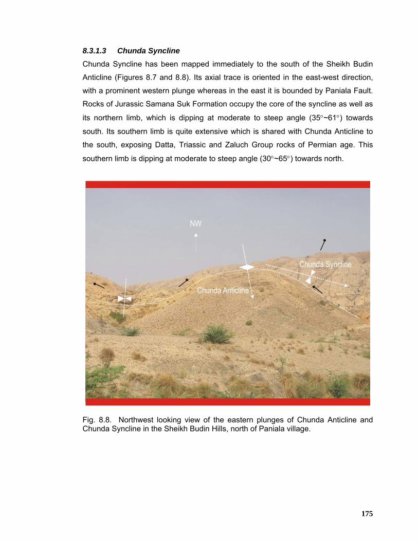
175
8.3.1.3 Chunda Syncline
Chunda Syncline has been mapped immediately to the south of the Sheikh Budin
Anticline (Figures 8.7 and 8.8). Its axial trace is oriented in the east-west direction,
with a prominent western plunge whereas in the east it is bounded by Paniala Fault.
Rocks of Jurassic Samana Suk Formation occupy the core of the syncline as well as
its northern limb, which is dipping at moderate to steep angle (35°~61°) towards
south. Its southern limb is quite extensive which is shared with Chunda Anticline to
the south, exposing Datta, Triassic and Zaluch Group rocks of Permian age. This
southern limb is dipping at moderate to steep angle (30°~65°) towards north.
Fig. 8.8. Northwest looking view of the eastern plunges of Chunda Anticline and Chunda Syncline in the Sheikh Budin Hills, north of Paniala village.
176
8.3.1.4 Chunda Anticline
This anticline is located to the south of Chunda Syncline, exposing the rocks of
Zaluch Group of Permian age in its core (Figures 8.7 and 8.8). It is characterized by
east west trending fold axis having well-developed eastern and western plunges. It
has extensive back limb exposing rocks ranging in age from Jurassic to Permian age
whereas its forelimb appears to have been eroded and exposing only Permian rocks
belonging to Zaluch Group in the south.
8.3.2 Fault Structures Two faults characterize the Pezu-Bhittani Range i.e. Pezu and Paniala faults. Brief
description of these faults is given below;
8.3.2.1 Pezu Fault
This is the major fault of the Pezu-Bhittani Ranges, passing through the crestal part
of the Pezu Anticline all along its axial trace resulting in several compartments of the
Pezu anticline (Figure 8.1). It is oriented in northwest to southeast direction and
juxtaposes rocks of Chinji Formation in the hanging wall against the rocks of Nagri
Formation in the footwall in the northwestern domain of the Pezu Anticline. In the
central domain of the Pezu Anticline, Pezu Fault juxtaposes rocks of Chinji
Formation in the hanging as well as footwall. In the southeastern domain of the Pezu
Anticline, Pezu Fault brings rocks of Nagri Formation in the hanging wall against the
rocks of Dhok Pathan Formation in the footwall. Its hanging wall is dipping towards
the Bannu Basin in the northeast at moderate to steep angle (45°~68°) whereas its
footwall is dipping towards the Tank Basin in the southwest with moderate angle
(28°~56°). Its map extension along the trend is more than 33 km. Based on its map
relationship with the Pezu Anticline, it is believed to be of transpressional nature with
dextral movement.
8.3.2.2 Paniala Fault
This fault forms the tectonic boundary between the Sheikh Budin Hills in the west
and Marwat-Khisor ranges in the east. It is oriented northwest and appears to be of
dextral nature bringing the rocks of Nagri and Dhok Pathan formations of the Siwalik
Group in the east against the Mesozoic rocks in the west. Eastern ends of Chunda
177
Anticline, Chunda Syncline and the western terminus of the Marwat Anticline are
terminated against the Paniala Fault (Figure 8.1).
8.4 STRUCTURAL MODEL
Geo-Seismic cross section along line K-L (Figure 8.10) has been constructed to
illustrate the structural style, kinematics as well as structural geometry of the Pezu-
Bhittani Range utilizing the following database;
e) Surface geological map
f) Three 2D seismic lines with a total length of about 41.5 line km
g) Well data of Pezu-1
The two seismic dip lines bearing # O-784-BU-5 and O-784-BU-5A (Figure 8.9) were
acquired by OGDC in 1978 covering the southwestern and northeastern parts of
Bannu Basin and Tank Depression respectively. These lines partially cover flank
area of the Pezu-Bhittani Range as 62 fold data using vibroseis as a source. This
data display good quality in shallow as well as in the deeper horizons. Line # PPL02-
PEZ-8-1 (Figure 8.9) was acquired as dip line crossing the Pezu-Bhittani Range in
2002 by Pakistan Petroleum Ltd. (PPL) as 80 fold data, using dynamite as a source.
Wideline seismic technique (Ansari et al. 2002) was applied for the acquisition of this
line in order to obtain better quality image in the crestal part of the Pezu-Bhittani
Range, which was not imaged properly by previous surveys due to the scattering
effects of the faults associated with steep dips. This line is passing at a distance of
about 2 km to the southeast of Pezu-1 well (Figure 8.9) drilled in the Pezu-Bhittani
Range. The geo-seismic cross-section constructed along line K-L incorporates sub-
surface data of the above-mentioned seismic lines and Pezu-1 well. Then the
surface geological section has been integrated with the interpreted seismic and well
data in order to work out consolidated structural model (Figure 8.10) for the Pezu-
Bhittani Range.
The structural model along line K-L is oriented from northeast to southwest in the
central part of the Pezu-Bhittani Range. It is roughly parallel to the northeast-
southwest oriented tectonic transport direction as inferred from the trends of different
structures exposed in the range and almost co-axial with all the three seismic lines
178
used in its construction. The northeastern portion of the section located in the Bannu
Basin is characterized by almost flat stratigraphic geometry in the sectional view,
validated by seismic line # 784-BU-5 (Figure 8.11). This line is around 12 km long,
covering the northeastern part of the model. A couple of small normal faults have
been identified on this seismic line in the southwestern margin of the Bannu Basin
where it merges with the Pezu-Bhittani Range. Such normal faults were also
interpreted on seismic line PC/89-9193 (Figure 7.6) in the vicinity of Chonai-1 well in
the southeastern margin of the Bannu Basin. These faults have resulted in offsetting
the Triassic to lower Siwalik Group strata with normal sense of displacement, giving
rise to localized horst and graben geometry.
Further to the southwest, the Pezu-Bhittani Range is fully covered by seismic line #
PPL02-PEZ-8-1, which is about 15 km long (Figure 8.12). This part of the model is
depicting the Pezu Fault to be steeply northeast dipping, southwest verging fault,
originating from the basal decollement. It brings the rocks of Chinji Formation in its
hanging wall against the same rocks in the footwall to the southwest with less
vertical uplift. This fault is cross-cutting through the stratigraphy on the backlimb of
the Pezu Anticline. The backlimb of the anticline is dipping towards the Bannu Basin
in the northeast at moderate to steep angle (45°~68°) whereas its forelimb dips
towards the Tank Basin in the southwest with moderate dip angles (28°~56°) near
the surface and steeper dips in the sub-surface, giving it slight asymmetry in
sectional view. The Pezu Anticline is a south verging anticline showing moderate
uplift as compared to the surrounding low lands. A blind, south facing thrust fault
within the Triassic and underlying older rocks tips underneath the fore limb of the
Pezu Anticline. At the extreme southwest, lies the Tank Basin, where the forelimb of
the Pezu Anticline is dipping to the southwest getting gradually deeper. This has
been established on seismic line # O-784-BU-5A (Figure 8.13), which is about 14.5
km long, covering partially forelimb of the Pezu Anticline and extending towards the
Tank Basin in the southwest.
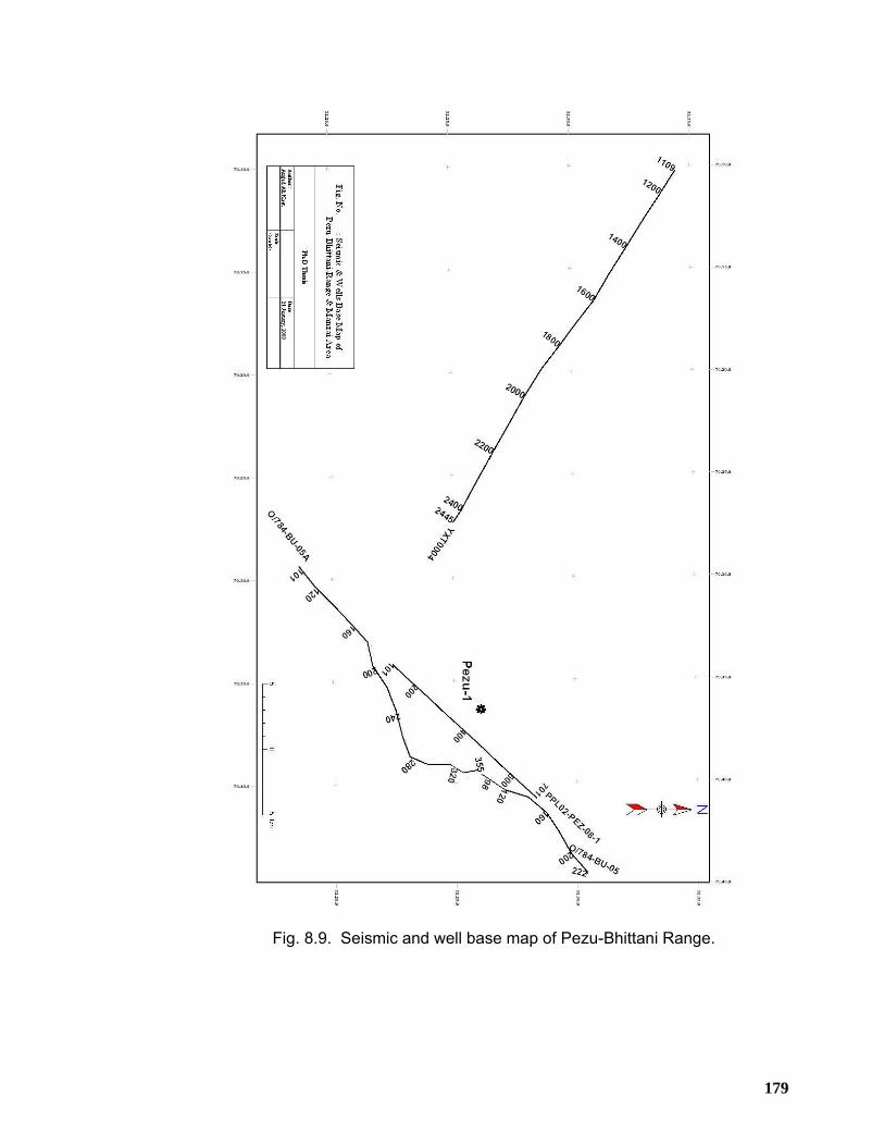
179
Fig. 8.9. Seismic and well base map of Pezu-Bhittani Range.
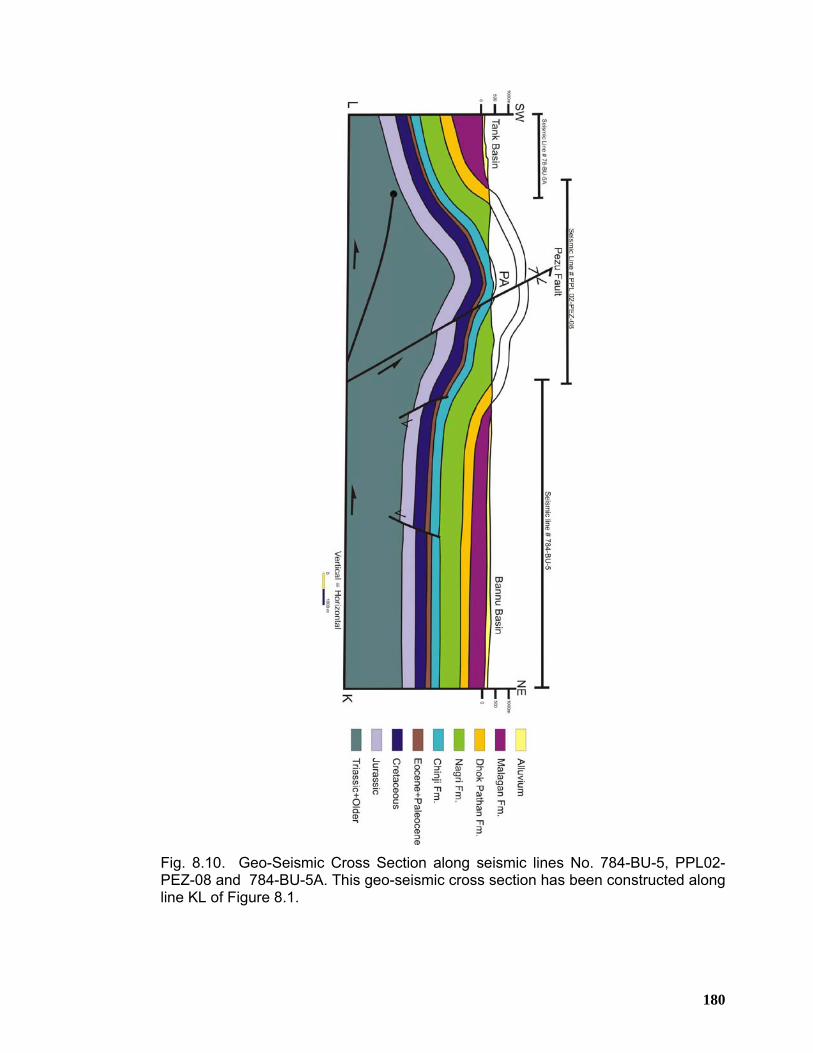
180
Fig. 8.10. Geo-Seismic Cross Section along seismic lines No. 784-BU-5, PPL02-PEZ-08 and 784-BU-5A. This geo-seismic cross section has been constructed along line KL of Figure 8.1.
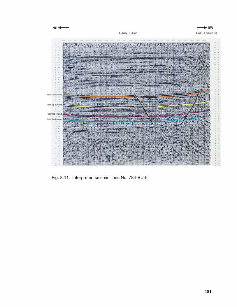
181
Fig. 8.11. Interpreted seismic lines No. 784-BU-5.
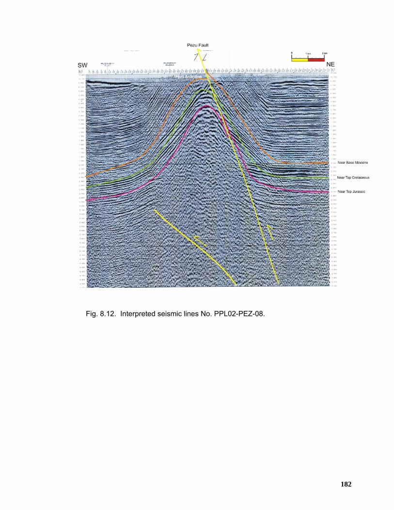
182
Fig. 8.12. Interpreted seismic lines No. PPL02-PEZ-08.
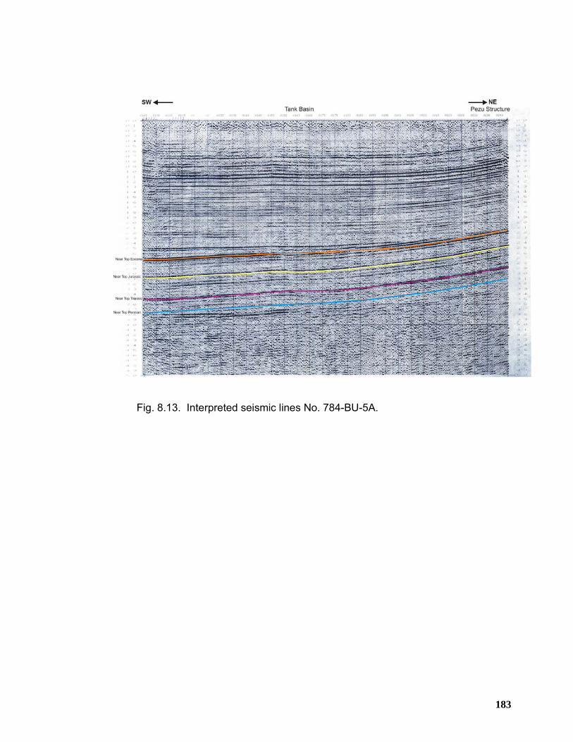
183
Fig. 8.13. Interpreted seismic lines No. 784-BU-5A.
184
CHAPTER 9
STRUCTURAL GEOMETRY OF THE MANZAI RANGE
9.1 INTRODUCTION
The Manzai Range is the western most extension of the Trans Indus ranges in north
Pakistan. It is also referred to as the northern part of Sulaiman ranges that together
forms an integral part of the Himalayan foreland folds and thrust belt. Manzai Range
along with the Pezu-Bhittani Range surrounds the northwestern apex of Tank Basin
in NWFP (Figure 9.1). Geographically, Bannu Basin lies to its northeast, Tank
Depression to the southeast, Sulaiman Range to the south whereas Kurram Fault
along with associated Mélange Zone is marking the western boundary of the Manzai
Range.
The Manzai Range is characterized by north-south structural pattern comprised of
NNE-SSW striking en-echelon anticlinal and synclinal folds, occupying the hanging
walls of the major thrust faults (Figure 9.1), mostly detached either at the base of
Siwalik Group rocks or within Ghazij shale of the Eocene age.
At surface no rocks older than Siwalik Group outcrop in the eastern part of the
Manzai Range. However, in the west, rocks ranging in age up to Cretaceous-
Jurassic are exposed. The surface geology clearly indicates that the Manzai Range
defines an east verging; thin-skinned deformed fold-thrust-belt structural system
where the structural style is characterized by decollement related thrusting
associated with hanging wall folded structures, typical of compressional tectonic
regime. Considering the structural and stratigraphic aspect of the Manzai Range, it is
believed that potential anticlinal culminations of en-echelon nature, developed due to
fault bending and/or propagation present all along the hanging walls of major thrust
faults are of prime importance for hydrocarbons exploration and exploitation. In
addition potential structures may exist beneath the synclinal folds as well which is
supported by the mechanical stratigraphy of the Manzai Range.
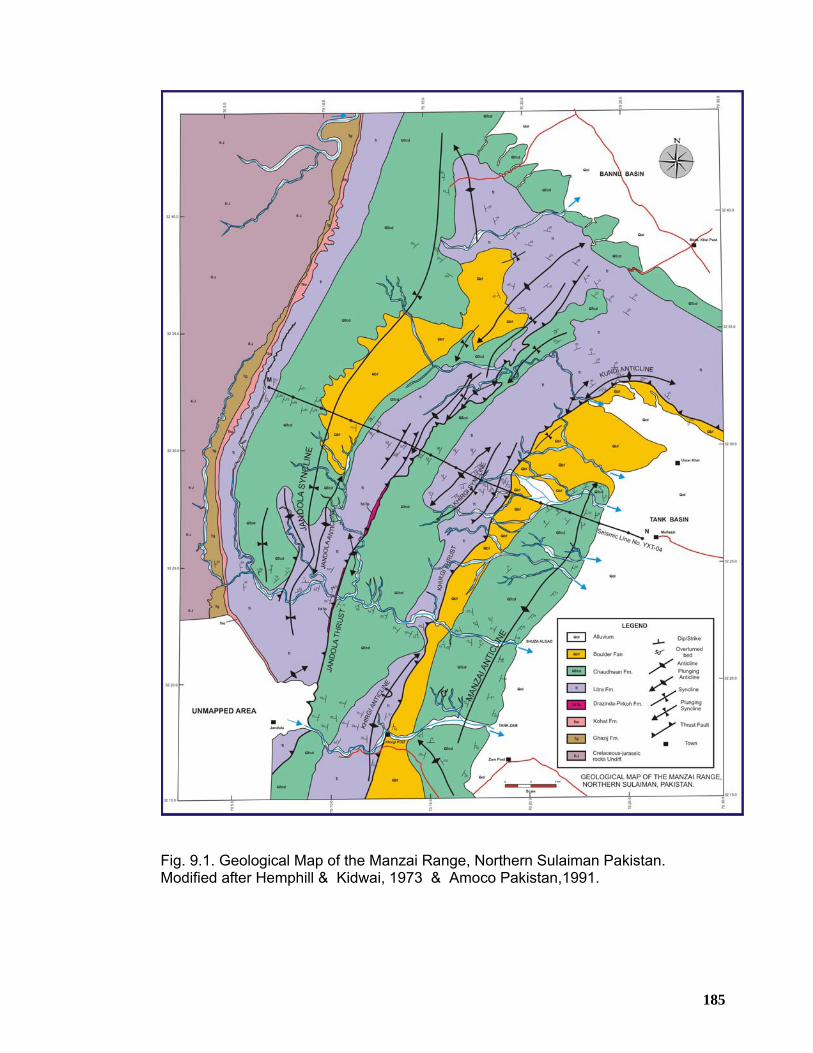
185
Fig. 9.1. Geological Map of the Manzai Range, Northern Sulaiman Pakistan. Modified after Hemphill & Kidwai, 1973 & Amoco Pakistan,1991.
186
Mechanically, the stratigraphic succession of the Manzai Range is divisible into a
lower competent group including Paleocene and older rocks and an upper
competent group including Kirthar and Siwalik Group rocks with thick horizon of
shale within Eocene that forms an intervening mobile horizon. This mobile horizon
must have behaved diapirically and logically should serve as fold detachment for the
folds within Eocene and younger and the underlying folds must have behaved
dishormonically with respect to the folding within the upper competent group. Dips of
about 20°~45° can be observed in most of the outcrops and even steeper dips occur
in places to the west, where the intensity of structural complexity gradually
increases.
Based on these structural observations, similar structural styles in addition to the
well-developed stratigraphic traps near the Base Miocene can be predicted for the
non-outcropping rocks underneath the Dera Ismail Khan Basin that is still poorly
explored part of the foreland fold and thrust belt of North Pakistan.
9.2 PHYSIOGRAPHY
The Manzai Range stretches from Tank town in the east up to Jandola town in the
west. Bannu Basin forms its northern boundary whereas the southwestern plunge of
the Manzai Range marks its southern limit. Specifically, Manzai Range is located
between longitudes 70˚ 00΄00″ to 70˚ 30΄00″ E and latitudes 32˚ 15΄00″ to 32˚ 45΄00″
N. This area is having low to moderate altitudes ranging from 250-300 meters above
sea level in the valleys, streams and plain area of the Tank Basin up to around 1000-
1500 meters in the western part where uplifted structures are present in the fold and
thrust belt.
187
9.3 SURFACE GEOLOGY OF THE MANZAI RANGE
A detailed geological map of the Manzai Range has been prepared (Figure 9.1)
showing the trend of the major fold and fault structures to be oriented NNE-SSW
which switches to NNW-SSE near the northeastern part of the map to give way to
the Pezu-Bhittani Range. The description of the main structures is given below;
9.3.1 Fold Structures
Folds are the dominant structures of the Manzai Range which are arranged in en-
echelon fashion, occupying the hanging walls of major thrust faults. These folds are
trending north-northeast to south-southwest and are mostly east verging, indicating
the eastward progression of tectonic deformation in this part of the Himalayan fold-
thrust belt.
9.3.1.1 Manzai Anticline
The Manzai Anticline is the most prominent anticline of the northern Manzai Range.
It is the eastern most fold structure of the Manzai Range (Figure 9.1). This anticline
exposes rocks of Chaudhwan Formation in its core belonging to the upper Siwalik
Group of late Miocene-Pliocene age. The trend of its axial trace all along its surface
exposure is more or less oriented NNE-SSW. Two structural culminations appear to
have developed on a common axis which is separated by an intervening saddle
located along Shuza Algad near the central part of the structure. The map extension
of Manzai Anticline along the axial trend is more than 27 km. The forelimb limb of the
anticline is dipping towards the Tank Depression at low to moderate angle (18°~34°)
whereas its backlimb dips towards the northwest with gentle angle (6°~20°), where it
is terminated against Khirgi Thrust. The crestal part of the structure is broad and flat
(Figures 9.2 and 9.3). It has a prominent northeastern plunge whereas its
southwestern plunge could not be established as it is falling outside the mapped
area. However, on the basis of satellite imagery and digital elevation model data, the
southwestern plunge of this anticline can be observed (Figures 9.2 and 9.3). On the
basis of attitude data, Manzai Anticline is considered as east verging, asymmetrical
anticline. Near its southwestern culmination, to the west of Zam FC Post, a small
anticline has developed on the backlimb of the Manzai Anticline (Figure 9.1), which
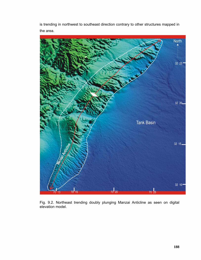
188
is trending in northwest to southeast direction contrary to other structures mapped in
the area.
Fig. 9.2. Northeast trending doubly plunging Manzai Anticline as seen on digital elevation model.
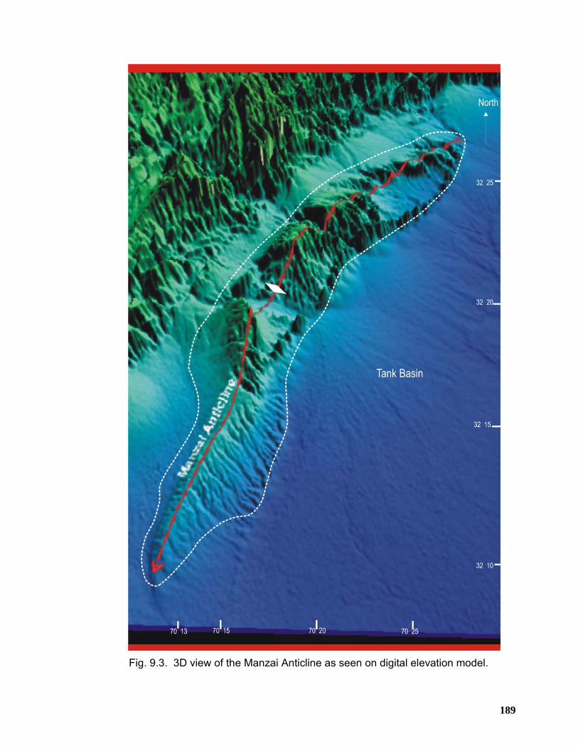
189
Fig. 9.3. 3D view of the Manzai Anticline as seen on digital elevation model.
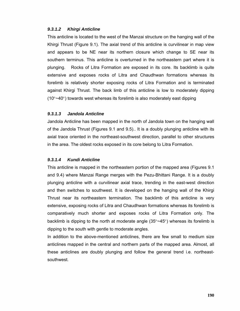
190
9.3.1.2 Khirgi Anticline
This anticline is located to the west of the Manzai structure on the hanging wall of the
Khirgi Thrust (Figure 9.1). The axial trend of this anticline is curvilinear in map view
and appears to be NE near its northern closure which change to SE near its
southern terminus. This anticline is overturned in the northeastern part where it is
plunging. Rocks of Litra Formation are exposed in its core. Its backlimb is quite
extensive and exposes rocks of Litra and Chaudhwan formations whereas its
forelimb is relatively shorter exposing rocks of Litra Formation and is terminated
against Khirgi Thrust. The back limb of this anticline is low to moderately dipping
(10°~40°) towards west whereas its forelimb is also moderately east dipping
9.3.1.3 Jandola Anticline
Jandola Anticline has been mapped in the north of Jandola town on the hanging wall
of the Jandola Thrust (Figures 9.1 and 9.5).. It is a doubly plunging anticline with its
axial trace oriented in the northeast-southwest direction, parallel to other structures
in the area. The oldest rocks exposed in its core belong to Litra Formation.
9.3.1.4 Kundi Anticline This anticline is mapped in the northeastern portion of the mapped area (Figures 9.1
and 9.4) where Manzai Range merges with the Pezu-Bhittani Range. It is a doubly
plunging anticline with a curvilinear axial trace, trending in the east-west direction
and then switches to southwest. It is developed on the hanging wall of the Khirgi
Thrust near its northeastern termination. The backlimb of this anticline is very
extensive, exposing rocks of Litra and Chaudhwan formations whereas its forelimb is
comparatively much shorter and exposes rocks of Litra Formation only. The
backlimb is dipping to the north at moderate angle (35°~45°) whereas its forelimb is
dipping to the south with gentle to moderate angles.
In addition to the above-mentioned anticlines, there are few small to medium size
anticlines mapped in the central and northern parts of the mapped area. Almost, all
these anticlines are doubly plunging and follow the general trend i.e. northeast-
southwest.
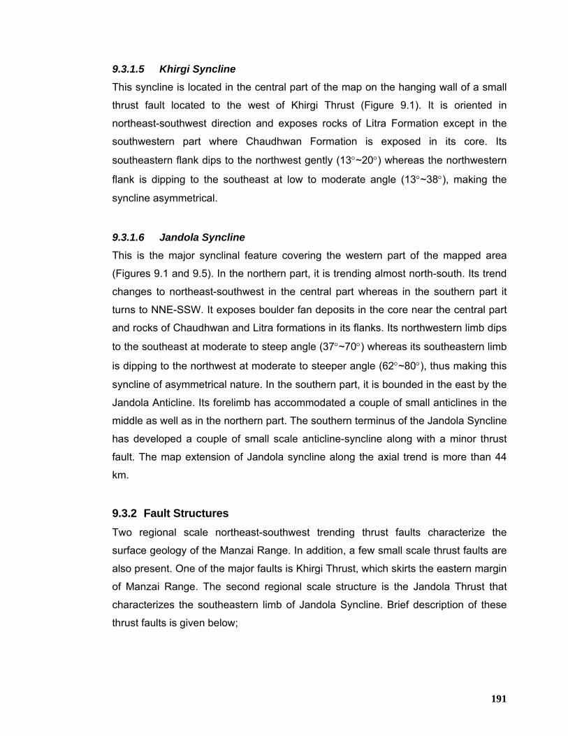
191
9.3.1.5 Khirgi Syncline
This syncline is located in the central part of the map on the hanging wall of a small
thrust fault located to the west of Khirgi Thrust (Figure 9.1). It is oriented in
northeast-southwest direction and exposes rocks of Litra Formation except in the
southwestern part where Chaudhwan Formation is exposed in its core. Its
southeastern flank dips to the northwest gently (13°~20°) whereas the northwestern
flank is dipping to the southeast at low to moderate angle (13°~38°), making the
syncline asymmetrical.
9.3.1.6 Jandola Syncline
This is the major synclinal feature covering the western part of the mapped area
(Figures 9.1 and 9.5). In the northern part, it is trending almost north-south. Its trend
changes to northeast-southwest in the central part whereas in the southern part it
turns to NNE-SSW. It exposes boulder fan deposits in the core near the central part
and rocks of Chaudhwan and Litra formations in its flanks. Its northwestern limb dips
to the southeast at moderate to steep angle (37°~70°) whereas its southeastern limb
is dipping to the northwest at moderate to steeper angle (62°~80°), thus making this
syncline of asymmetrical nature. In the southern part, it is bounded in the east by the
Jandola Anticline. Its forelimb has accommodated a couple of small anticlines in the
middle as well as in the northern part. The southern terminus of the Jandola Syncline
has developed a couple of small scale anticline-syncline along with a minor thrust
fault. The map extension of Jandola syncline along the axial trend is more than 44
km.
9.3.2 Fault Structures Two regional scale northeast-southwest trending thrust faults characterize the
surface geology of the Manzai Range. In addition, a few small scale thrust faults are
also present. One of the major faults is Khirgi Thrust, which skirts the eastern margin
of Manzai Range. The second regional scale structure is the Jandola Thrust that
characterizes the southeastern limb of Jandola Syncline. Brief description of these
thrust faults is given below;
192
9.3.2.1 Khirgi Thrust
Khirgi Thrust is located to the immediate west of Manzai Anticline in the eastern part
of the mapped area (Figures 9.1 and 9.4). This fault is trending in northeast-
southwest direction parallel to other major structures in the area. However, near the
Kundi Anticline, its trend switches to northwest-southeast direction. The hanging wall
of this fault carries a series of north-northeast trending en-echelon folds mostly
detached at the base of Siwalik Group rocks.
This fault juxtaposes rocks of Litra Formation in its hanging wall against the boulder
fan deposits in the footwall to the southeast. Its hanging wall is dipping towards the
northwest at moderate angle (40°~57°) with some overturned beds near the central
part. The map extension of this thrust fault along the surface trace is more than 45
km.
Fig. 9.4. Northeast trending Khirgi Thrust and doubly plunging curvilinear Kundi Anticline developed on its hanging wall in the northeastern part.
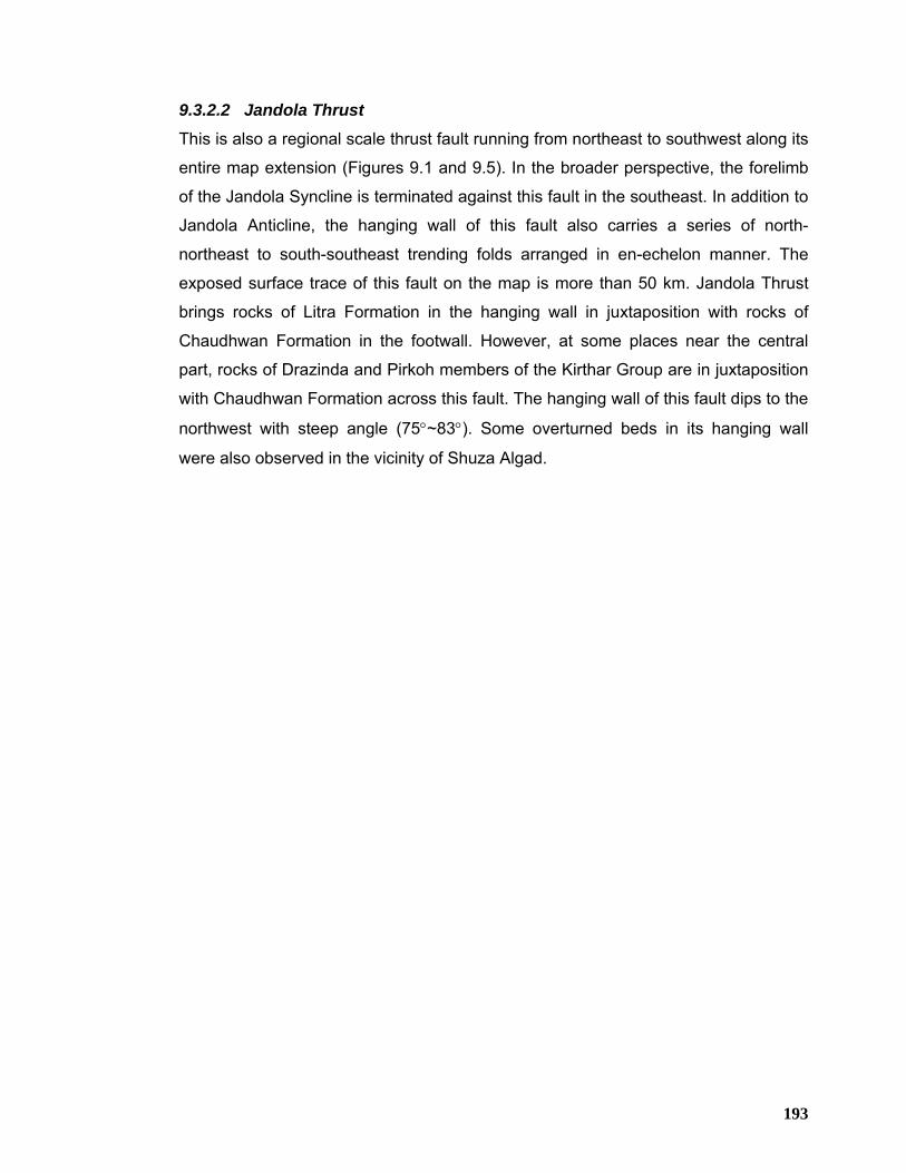
193
9.3.2.2 Jandola Thrust
This is also a regional scale thrust fault running from northeast to southwest along its
entire map extension (Figures 9.1 and 9.5). In the broader perspective, the forelimb
of the Jandola Syncline is terminated against this fault in the southeast. In addition to
Jandola Anticline, the hanging wall of this fault also carries a series of north-
northeast to south-southeast trending folds arranged in en-echelon manner. The
exposed surface trace of this fault on the map is more than 50 km. Jandola Thrust
brings rocks of Litra Formation in the hanging wall in juxtaposition with rocks of
Chaudhwan Formation in the footwall. However, at some places near the central
part, rocks of Drazinda and Pirkoh members of the Kirthar Group are in juxtaposition
with Chaudhwan Formation across this fault. The hanging wall of this fault dips to the
northwest with steep angle (75°~83°). Some overturned beds in its hanging wall
were also observed in the vicinity of Shuza Algad.
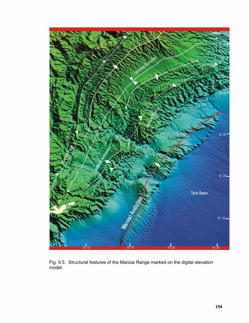
194
Fig. 9.5. Structural features of the Manzai Range marked on the digital elevation model.
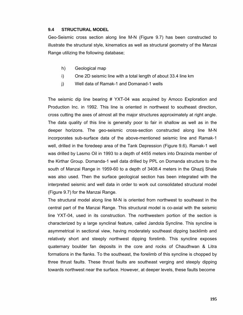
195
9.4 STRUCTURAL MODEL
Geo-Seismic cross section along line M-N (Figure 9.7) has been constructed to
illustrate the structural style, kinematics as well as structural geometry of the Manzai
Range utilizing the following database;
h) Geological map
i) One 2D seismic line with a total length of about 33.4 line km
j) Well data of Ramak-1 and Domanad-1 wells
The seismic dip line bearing # YXT-04 was acquired by Amoco Exploration and
Production Inc. in 1992. This line is oriented in northwest to southeast direction,
cross cutting the axes of almost all the major structures approximately at right angle.
The data quality of this line is generally poor to fair in shallow as well as in the
deeper horizons. The geo-seismic cross-section constructed along line M-N
incorporates sub-surface data of the above-mentioned seismic line and Ramak-1
well, drilled in the foredeep area of the Tank Depression (Figure 9.6). Ramak-1 well
was drilled by Lasmo Oil in 1993 to a depth of 4455 meters into Drazinda member of
the Kirthar Group. Domanda-1 well data drilled by PPL on Domanda structure to the
south of Manzai Range in 1959-60 to a depth of 3408.4 meters in the Ghazij Shale
was also used. Then the surface geological section has been integrated with the
interpreted seismic and well data in order to work out consolidated structural model
(Figure 9.7) for the Manzai Range.
The structural model along line M-N is oriented from northwest to southeast in the
central part of the Manzai Range. This structural model is co-axial with the seismic
line YXT-04, used in its construction. The northwestern portion of the section is
characterized by a large synclinal feature, called Jandola Syncline. This syncline is
asymmetrical in sectional view, having moderately southeast dipping backlimb and
relatively short and steeply northwest dipping forelimb. This syncline exposes
quaternary boulder fan deposits in the core and rocks of Chaudhwan & Litra
formations in the flanks. To the southeast, the forelimb of this syncline is chopped by
three thrust faults. These thrust faults are southeast verging and steeply dipping
towards northwest near the surface. However, at deeper levels, these faults become
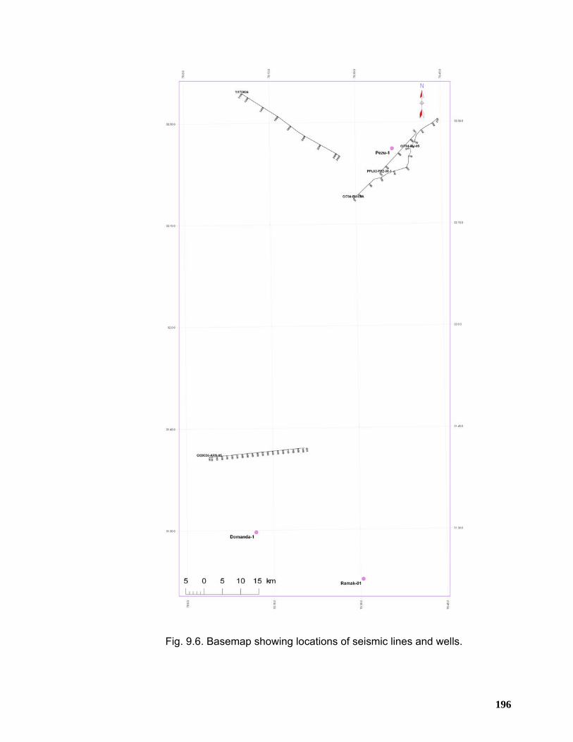
196
Fig. 9.6. Basemap showing locations of seismic lines and wells.
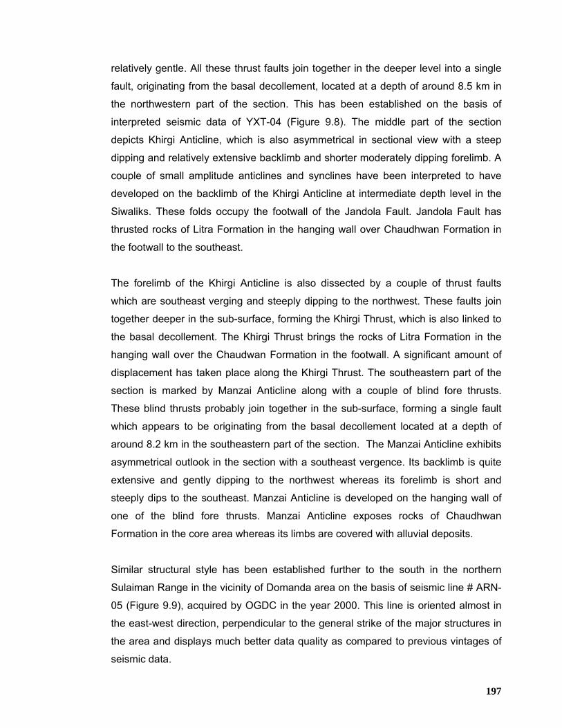
197
relatively gentle. All these thrust faults join together in the deeper level into a single
fault, originating from the basal decollement, located at a depth of around 8.5 km in
the northwestern part of the section. This has been established on the basis of
interpreted seismic data of YXT-04 (Figure 9.8). The middle part of the section
depicts Khirgi Anticline, which is also asymmetrical in sectional view with a steep
dipping and relatively extensive backlimb and shorter moderately dipping forelimb. A
couple of small amplitude anticlines and synclines have been interpreted to have
developed on the backlimb of the Khirgi Anticline at intermediate depth level in the
Siwaliks. These folds occupy the footwall of the Jandola Fault. Jandola Fault has
thrusted rocks of Litra Formation in the hanging wall over Chaudhwan Formation in
the footwall to the southeast.
The forelimb of the Khirgi Anticline is also dissected by a couple of thrust faults
which are southeast verging and steeply dipping to the northwest. These faults join
together deeper in the sub-surface, forming the Khirgi Thrust, which is also linked to
the basal decollement. The Khirgi Thrust brings the rocks of Litra Formation in the
hanging wall over the Chaudwan Formation in the footwall. A significant amount of
displacement has taken place along the Khirgi Thrust. The southeastern part of the
section is marked by Manzai Anticline along with a couple of blind fore thrusts.
These blind thrusts probably join together in the sub-surface, forming a single fault
which appears to be originating from the basal decollement located at a depth of
around 8.2 km in the southeastern part of the section. The Manzai Anticline exhibits
asymmetrical outlook in the section with a southeast vergence. Its backlimb is quite
extensive and gently dipping to the northwest whereas its forelimb is short and
steeply dips to the southeast. Manzai Anticline is developed on the hanging wall of
one of the blind fore thrusts. Manzai Anticline exposes rocks of Chaudhwan
Formation in the core area whereas its limbs are covered with alluvial deposits.
Similar structural style has been established further to the south in the northern
Sulaiman Range in the vicinity of Domanda area on the basis of seismic line # ARN-
05 (Figure 9.9), acquired by OGDC in the year 2000. This line is oriented almost in
the east-west direction, perpendicular to the general strike of the major structures in
the area and displays much better data quality as compared to previous vintages of
seismic data.
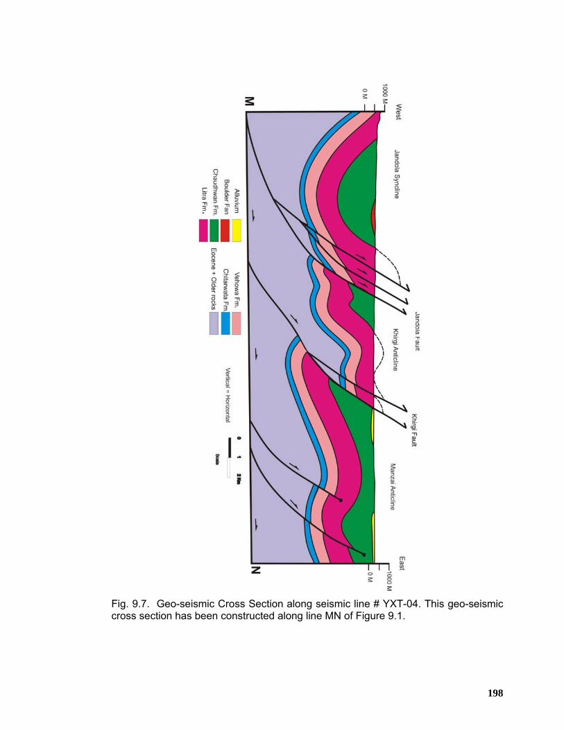
198
Fig. 9.7. Geo-seismic Cross Section along seismic line # YXT-04. This geo-seismic cross section has been constructed along line MN of Figure 9.1.
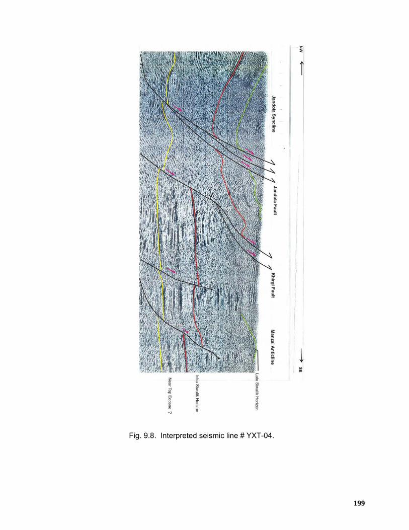
199
Fig. 9.8. Interpreted seismic line # YXT-04.
200
Fig. 9.9. Interpreted seismic line # ARN-5.
201
CHAPTER 10 HYDROCARBON POTENTIAL OF THE TRANS INDUS
RANGES 10.1 Summary Fold and Thrust Belts throughout the world are the most significant areas for
hydrocarbon exploration and exploitation. These fold and thrust belts have globally
been explored for hydrocarbons since more than a century now with mixed results
and are still challenging frontiers for hydrocarbon search despite the high exploration
risk and cost. Though the seismic data have contributed a lot to the understanding of
the complex geometries in the fold-thrust belts, challenges are still there for
exploration geoscientists. Exploration for hydrocarbons in the Himalayan foreland
fold-thrust belt of Pakistan has been an important part of major oil and gas
companies exploration strategies for years. Based on the recent discoveries in the
central Kohat fold belt and the increasing demand for hydrocarbons and the
expectation that we will continue to find large hydrocarbon reserves in the Himalayan
foreland fold-thrust belt, this is a trend that will continue for many years to come. The
Himalayan foreland fold-thrust belt of Pakistan includes Kohat foreland fold-and-
thrust belt along with its associated frontal ranges that include Surghar-Shinghar,
Marwat-Khisor, Bhittani and Manzai (Trans-Indus ranges), Northern Sulaiman Range
and the D.I. Khan Plain in the south (Figures 1.2 and 1.3). This entire belt is
geologically defined compressional structural domain, and the area involved extends
more than 15,000 square kilometers. Till date this domain has experienced several
significant discoveries of oil and gas along with more than a dozen of dry wells within
Kohat fold-thrust belt to the north and Bannu Basin in the south. These oil and gas
discoveries have proved the maturity, migration and entrapment of the hydrocarbons
in the region and demands re-appraisal as for as the complex structural evolution of
the Himalayan fold-thrust belt, Bannu depression and the D.I.Khan Basin are
concerned.
Critical review of the available literature and geological field work in the region
depicts that all the ingredients of a working “hydrocarbon machine” that are source,
reservoir, trap/seal, timing and migration exist in the area. The petroleum system of
202
the area is characterized by multiple reservoirs and sealing horizons that are likely to
be charged by multiple source rocks. Surface structural style shows that en-echelon
anticlinal closures developed within the hanging walls of major faults could provide
primary traps for hydrocarbons. In addition, sub-thrust plays as well as stratigraphic
traps (formed a result of eastward truncation of various horizons) may provide
potential drillable prospects. The presence of a regional hydrocarbon kitchen is well
supported by the stratigraphic record of the area whereas the oil and gas discoveries
along with oil/gas seepages in the surrounding area provide clear indication of the
optimum timing of hydrocarbons generation, migration and entrapment in the Trans
Indus ranges.
10.2 Source Rock Potential Some geochemical data, oil to source correlation studies and lithological
characteristics of some rocks suggest that there are multiple source rock horizons
with varying levels of maturity in the Potwar and Kohat areas. These include the
following;
• Marine shales in the Panoba/Patala formations
• Distal marine shales in the Lower Cretaceous
• Marine and deltaic shales of the Jurassic, Triassic and Permian
• Marine shales of the Infracambrian
Passive margin subsidence will undoubtedly have taken deeply buried source rocks
to hydrocarbon generating conditions prior to the onset of thrusting/folding in the
Eocene/Oligocene (Quad Report, 1996).
The oldest potential source rocks are in the Salt Range Formation, which consists of
a clastic-dominated lower part, carbonate-dominated middle part and evaporite-
dominated upper part. Potential source rock intervals are found primarily in the upper
evaporite sequence with reported TOC of about 30 %, hydrocarbon Index up to 879
and genetic potential of about 250 kg/t (Ahmad et al., 1999). The Permian Sardhai
(Figures 4.4 and 4.5) and Chhidru are although sandy, have sufficiently high TOC
values to have source rock potential (Quadri and Quadri, 1996). TOC values in the
Permian Wargal are 1.0 percent (Jaswal et al., 1997). Mianwali Formation in the
Khisor Range also contains enough carbonaceous material to qualify for a potential
203
source rocks in the Trans Indus ranges (Figures 4.6 and 4.7). Samples from Datta
Formation (Figures 3.7 and 6.22) at Chunda Syncline near the southwestern end of
the Marwat Anticline in the Sheikh Budin Hills have reported TOC ranging from 0.6 to
over 20 %. The Cretaceous Lumshiwal Formation (equivalent to Lower Goru) is
reported to have TOC consistently over 2 % and this could constitute a good source
rock. Samples of Chichali shales (Figures 3.8, 3.12 and 3.13) from Chonai-1 and
Pezu-1 wells show moderate to good source potential but are immature to early
mature (Quad Report, 1996). North of MBT, Chichali-Lumshiwal have TOC values
ranging from 0.5 – 1.6 % with vitrinite reflectance between 0.77 – 1.02 Ro indicating
peak oil generation.
Coaliferous beds in the Hangu Formation (Figure 3.15) have reported TOC and
vitrinite reflectance ranging from 6.5 – 10 % and 0.81- 1.3 % Ro respectively near
Hangu town. The TOC values from the Paleocene Lockhart in the northern Potwar
are reported to be around 1.4 percent (Jaswal et al., 1997). The presence of
Paleocene strata in the sub-surface beneath the Bannu Basin is confidently inferred
from the well and seismic data. Chonai-1 well penetrated 68 meters of Patala shale
some of which has fair to good source potential (Quad Report, 1996). The
Paleocene Patala Formation appears to be the primary source for the oil fields in the
Potwar Basin to the east. However, other potential source rocks may be contributing
in different parts of the basin. It is possible that the lacustrine facies which makes
such a rich source rock in the Potwar Basin is developed in the Bannu Trough. On
the basis of geophysical evidence, it is established that there is possible thickening
of Patala Shale to the north of Bannu Trough where anoxic conditions would have
been most likely (Quad Report, 1996). It is therefore, possible that the Patala Shale
could be an important source rock in this area. The TOC of Patala ranges from 0.5
percent to more than 3.5 percent, with an average of 1.4 percent and contains type-II
and type-III kerogens (Wandrey et al., 2004). The Panoba shales sequence of the
Eocene age could also be a potential hydrocarbon source but there is no
geochemical data to support this. Again the geophysical interpretation conducted by
Quad Consulting (1996) shows that there is the potential for thick Panoba Shale
development towards the centre of Bannu Trough. In addition, shales associated
with Jatta Gypsum in the central Kohat have reportedly yielded very high TOC
values up to 20 % but have limited aerial extent.
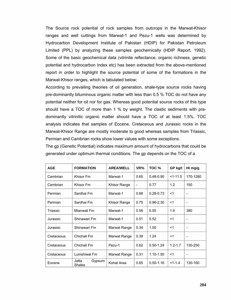
204
The Source rock potential of rock samples from outcrops in the Marwat-Khisor
ranges and well cuttings from Marwat-1 and Pezu-1 wells was determined by
Hydrocarbon Development Institute of Pakistan (HDIP) for Pakistan Petroleum
Limited (PPL) by analyzing these samples geochemically (HDIP Report, 1992).
Some of the basic geochemical data (vitrinite reflectance, organic richness, genetic
potential and hydrocarbon Index etc) has been extracted from the above-mentioned
report in order to highlight the source potential of some of the formations in the
Marwat-Khisor ranges, which is tabulated below;
According to prevailing theories of oil generation, shale-type source rocks having
pre-dominantly bituminous organic matter with less than 0.5 % TOC do not have any
potential neither for oil nor for gas. Whereas good potential source rocks of this type
should have a TOC of more than 1 % by weight. The clastic sediments with pre-
dominantly vitrinitic organic matter should have a TOC of at least 1.5%. TOC
analysis indicates that samples of Eocene, Cretaceous and Jurassic rocks in the
Marwat-Khisor Range are mostly moderate to good whereas samples from Triassic,
Permian and Cambrian rocks show lower values with some exceptions.
The gp (Genetic Potential) indicates maximum amount of hydrocarbons that could be
generated under optimum thermal conditions. The gp depends on the TOC of a
AGE FORMATION AREA/WELL VR% TOC % GP kg/t HI mg/g
Cambrian Khisor Fm Marwat-1 0.65 0.48-0.90 <1-11.5 170-1280
Cambrian Khisor Fm Khisor Range - 0.77 1.2 150
Permian Sardhai Fm Marwat-1 0.68 0.28-0.73 <1 -
Permian Sardhai Fm Khisor Range 0.75 0.96-2.30 <1 -
Triassic Mianwali Fm Marwat-1 0.56 0.50 1.9 380
Jurassic Shinawari Fm Marwat-1 0.51 0.52 <1 -
Jurassic Shinawari Fm Marwat Range 0.34 1.50 <1 -
Cretaceous Chichali Fm Marwat Range 0.39 1.24 <1 -
Cretaceous Chichali Fm Pezu-1 0.62 0.50-1.24 1.2-1.7 130-250
Cretaceous Lumshiwal Fm Marwat Range 0.31 1.10-1.50 <1 -
Eocene Jatta Gypsum Shales Kohat Area 0.65 0.50-1.16 <1-1.4 130-160
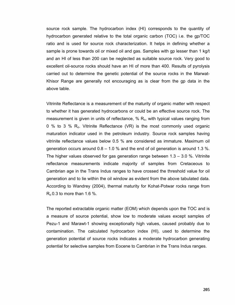
205
source rock sample. The hydrocarbon index (HI) corresponds to the quantity of
hydrocarbon generated relative to the total organic carbon (TOC) i.e. the gp/TOC
ratio and is used for source rock characterization. It helps in defining whether a
sample is prone towards oil or mixed oil and gas. Samples with gp lesser than 1 kg/t
and an HI of less than 200 can be neglected as suitable source rock. Very good to
excellent oil-source rocks should have an HI of more than 400. Results of pyrolysis
carried out to determine the genetic potential of the source rocks in the Marwat-
Khisor Range are generally not encouraging as is clear from the gp data in the
above table.
Vitrinite Reflectance is a measurement of the maturity of organic matter with respect
to whether it has generated hydrocarbons or could be an effective source rock. The
measurement is given in units of reflectance, % Ro, with typical values ranging from
0 % to 3 % Ro. Vitrinite Reflectance (VR) is the most commonly used organic
maturation indicator used in the petroleum industry. Source rock samples having
vitrinite reflectance values below 0.5 % are considered as immature. Maximum oil
generation occurs around 0.8 – 1.0 % and the end of oil generation is around 1.3 %.
The higher values observed for gas generation range between 1.3 – 3.0 %. Vitrinite
reflectance measurements indicate majority of samples from Cretaceous to
Cambrian age in the Trans Indus ranges to have crossed the threshold value for oil
generation and to lie within the oil window as evident from the above tabulated data.
According to Wandrey (2004), thermal maturity for Kohat-Potwar rocks range from
Ro 0.3 to more than 1.6 %.
The reported extractable organic matter (EOM) which depends upon the TOC and is
a measure of source potential, show low to moderate values except samples of
Pezu-1 and Marawt-1 showing exceptionally high values, caused probably due to
contamination. The calculated hydrocarbon index (HI), used to determine the
generation potential of source rocks indicates a moderate hydrocarbon generating
potential for selective samples from Eocene to Cambrian in the Trans Indus ranges.
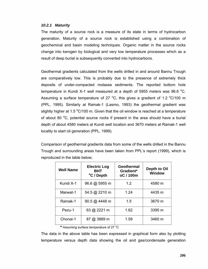
206
10.2.1 Maturity
The maturity of a source rock is a measure of its state in terms of hydrocarbon
generation. Maturity of a source rock is established using a combination of
geochemical and basin modeling techniques. Organic matter in the source rocks
change into kerogen by biological and very low temperature processes which as a
result of deep burial is subsequently converted into hydrocarbons.
Geothermal gradients calculated from the wells drilled in and around Bannu Trough
are comparatively low. This is probably due to the presence of extremely thick
deposits of under-compacted molasse sediments. The reported bottom hole
temperature in Kundi X-1 well measured at a depth of 5955 meters was 96.6 oC.
Assuming a surface temperature of 27 oC, this gives a gradient of 1.2 oC/100 m
(PPL, 1995). Similarly at Ramak-1 (Lasmo, 1993) the geothermal gradient was
slightly higher at 1.5 oC/100 m. Given that the oil window is reached at a temperature
of about 80 oC, potential source rocks if present in the area should have a burial
depth of about 4580 meters at Kundi well location and 3670 meters at Ramak-1 well
locality to start oil generation (PPL, 1999).
Comparison of geothermal gradients data from some of the wells drilled in the Bannu
Trough and surrounding areas have been taken from PPL’s report (1999), which is
reproduced in the table below;
Well Name Electric Log
BHT oC / Depth
Geothermal Gradient* oC / 100m
Depth to Oil Window
Kundi X-1 96.6 @ 5955 m 1.2 4580 m
Marwat-1 54.5 @ 2210 m 1.24 4435 m
Ramak-1 90.5 @ 4448 m 1.5 3670 m
Pezu-1 63 @ 2221 m 1.62 3395 m
Chonai-1 87 @ 3889 m 1.59 3460 m
* Assuming surface temperature of 27 oC
The data in the above table has been expressed in graphical form also by plotting
temperature versus depth data showing the oil and gas/condensate generation
207
windows (Figure 10.1). Both tabulated and graphical presentation shows that there
are variations in the geothermal gradients calculated in these wells which are directly
correlatable to the thickness of the Miocene-Pliocene molasse sediments (PPL,
1999). The geothermal gradient increases generally to the south into the Sulaiman
Foredeep. In the Sakhi Sarwar-1 well drilled by Amoco in 1976, the calculated
geothermal gradient is 2.24 oC /100 m. Similarly the geothermal gradient also
increases to the east in the Potwar Basin.
Fig. 10.1. Geothermal gradient to oil window in Kohat-Potwar Basin after M.A.Khan et al., (1986) and PPL (1999).
208
10.2.2 Hydrocarbon Migration/Entrapment
Hydrocarbon sourced in the kitchen areas will migrate either through fault conduits or
permeable carrier beds into the anticlinal structures developed on the hanging walls
of thrust faults in the fold-belt or developing foredeep structures. In the migration of
hydrocarbons, faults and associated fractures in the carbonate rocks play an
important role. Long range up-dip migration is also possible once hydrocarbons find
a suitable carrier bed. Effective horizontal migration pathways must rely on
permeable carrier beds that are regionally continuous. This kind of migration is
restricted to carrier beds close to the source rocks. However, pinch-out relationships
up-dip on the platform will allow access to higher reservoir levels.
10.2.3 Hydrocarbon Seeps and Shows in the nearby wells
During the geological fieldwork, several oil and gas seeps were observed in the
Trans Indus ranges (Figures 10.2, 10.3 and 10.4). These oil and gas seeps along
with discoveries in the surrounding areas establish the maturity levels of the source
rocks in the area. Published information is available about some of the oil and gas
seeps (Table No. 10.1). A brief overview of significant oil and gas seeps is presented
below;
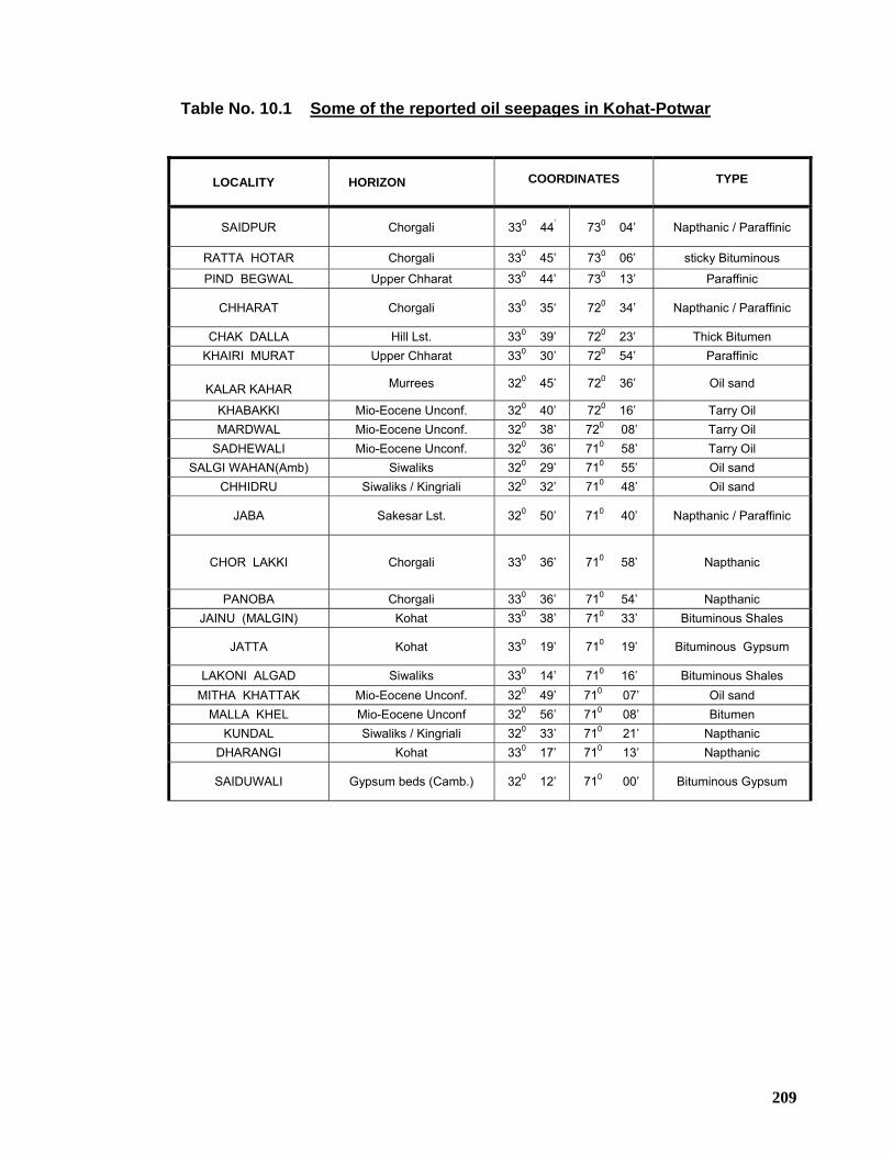
209
Table No. 10.1 Some of the reported oil seepages in Kohat-Potwar
LOCALITY HORIZON COORDINATES TYPE
SAIDPUR Chorgali 330 44’ 730 04’ Napthanic / Paraffinic
RATTA HOTAR Chorgali 330 45’ 730 06’ sticky Bituminous
PIND BEGWAL Upper Chharat 330 44’ 730 13’ Paraffinic
CHHARAT Chorgali 330 35‘ 720 34’ Napthanic / Paraffinic
CHAK DALLA Hill Lst. 330 39’ 720 23’ Thick Bitumen KHAIRI MURAT Upper Chharat 330 30’ 720 54’ Paraffinic
KALAR KAHAR Murrees 320 45’ 720 36’ Oil sand
KHABAKKI Mio-Eocene Unconf. 320 40’ 720 16’ Tarry Oil MARDWAL Mio-Eocene Unconf. 320 38’ 720 08’ Tarry Oil
SADHEWALI Mio-Eocene Unconf. 320 36’ 710 58’ Tarry Oil SALGI WAHAN(Amb) Siwaliks 320 29’ 710 55’ Oil sand
CHHIDRU Siwaliks / Kingriali 320 32’ 710 48’ Oil sand
JABA Sakesar Lst. 320 50’ 710 40’ Napthanic / Paraffinic
CHOR LAKKI Chorgali 330 36’ 710 58’ Napthanic
PANOBA Chorgali 330 36’ 710 54’ Napthanic JAINU (MALGIN) Kohat 330 38’ 710 33’ Bituminous Shales
JATTA Kohat 330 19’ 710 19’ Bituminous Gypsum
LAKONI ALGAD Siwaliks 330 14’ 710 16’ Bituminous Shales MITHA KHATTAK Mio-Eocene Unconf. 320 49’ 710 07’ Oil sand
MALLA KHEL Mio-Eocene Unconf 320 56’ 710 08’ Bitumen KUNDAL Siwaliks / Kingriali 320 33’ 710 21’ Napthanic
DHARANGI Kohat 330 17’ 710 13’ Napthanic
SAIDUWALI Gypsum beds (Camb.) 320 12’ 710 00’ Bituminous Gypsum
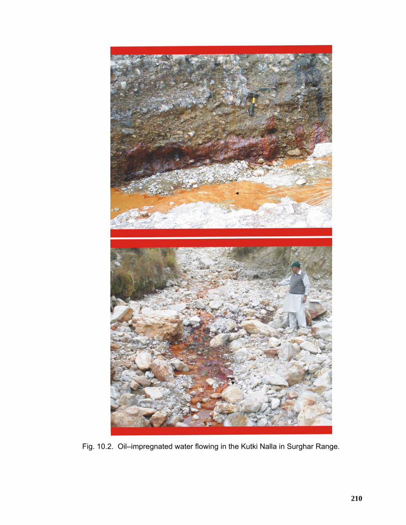
210
Fig. 10.2. Oil–impregnated water flowing in the Kutki Nalla in Surghar Range.
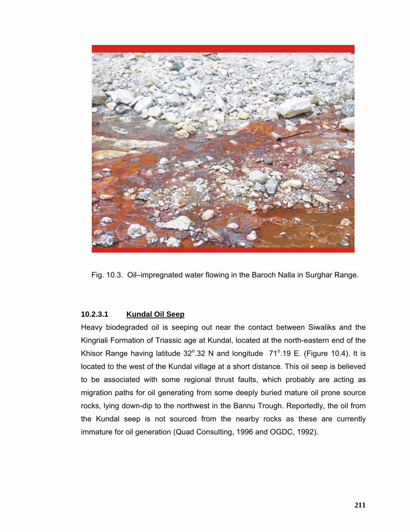
211
Fig. 10.3. Oil–impregnated water flowing in the Baroch Nalla in Surghar Range.
10.2.3.1 Kundal Oil Seep Heavy biodegraded oil is seeping out near the contact between Siwaliks and the
Kingriali Formation of Triassic age at Kundal, located at the north-eastern end of the
Khisor Range having latitude 32o.32 N and longitude 71o.19 E. (Figure 10.4). It is
located to the west of the Kundal village at a short distance. This oil seep is believed
to be associated with some regional thrust faults, which probably are acting as
migration paths for oil generating from some deeply buried mature oil prone source
rocks, lying down-dip to the northwest in the Bannu Trough. Reportedly, the oil from
the Kundal seep is not sourced from the nearby rocks as these are currently
immature for oil generation (Quad Consulting, 1996 and OGDC, 1992).
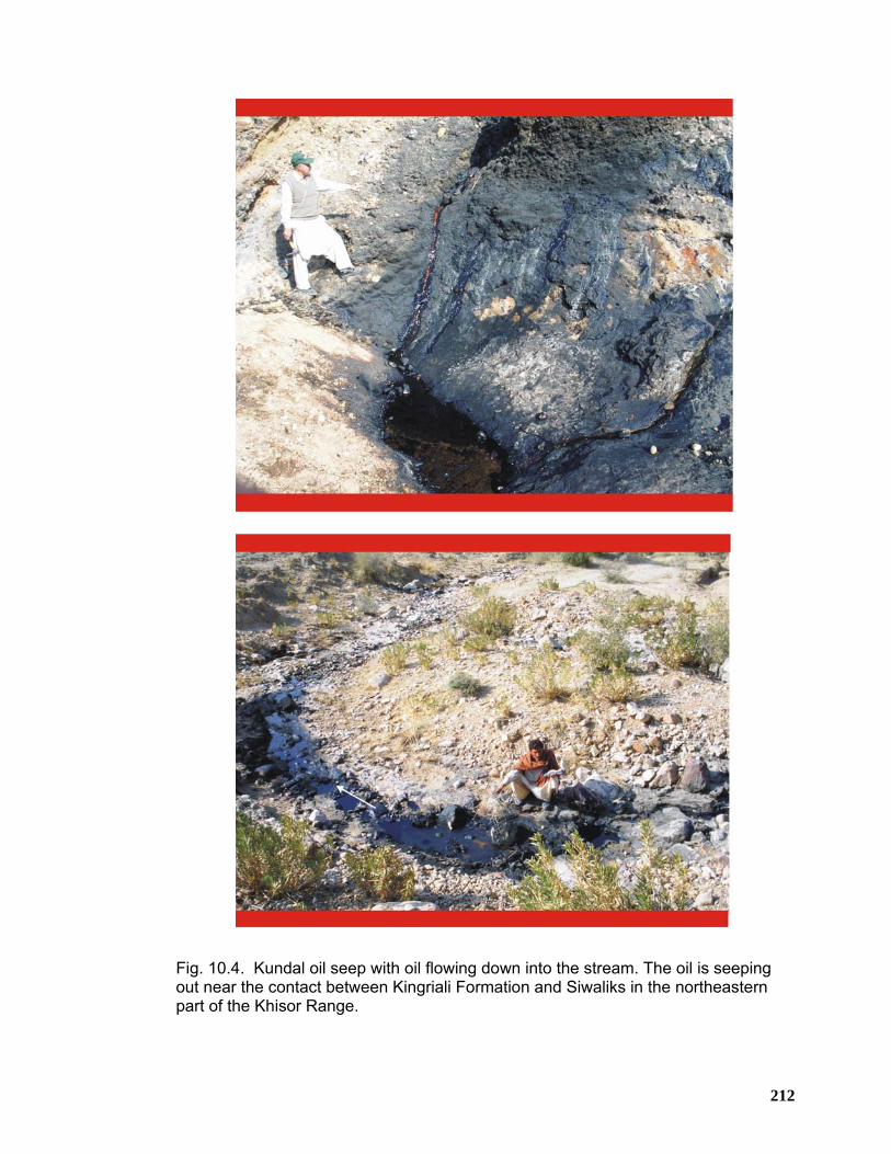
212
Fig. 10.4. Kundal oil seep with oil flowing down into the stream. The oil is seeping out near the contact between Kingriali Formation and Siwaliks in the northeastern part of the Khisor Range.
213
10.2.3.2 Bain Gas Seep This seepage is known to occur from centuries. Bain gas seep is located at the
crestal part of the Pezu Structure in the Pezu-Bhittani Range, in the close vicinity of
the Pezu-1 well location. This is an active gas seep and the gas is used by local
shepherds for cooking and heating purposes. The gas is actively coming out from
the fissures and cracks developed in the rocks of Chinji Formation. The sediments in
the vicinity of the seep are soft, friable and full of small cracks. The gas is burning
with flames of about one foot in height.
10.2.3.3 Manglin Gas Seep Manglin gas seep is also located near the crestal part of the Pezu Structure in the
Pezu-Bhittani Range about 22 km to the northwest of Bain gas seep. This gas
seepage is present along the stream bed. The sandstone of Chinji Formation is
apparently the host of both Bain and Manglin gas seepages in the Pezu-Bhittani
Range. The significance of these seeps can only be speculated on. It is not clear
whether this gas originates from deep source rocks or is of shallow biogenic origin.
In addition to the above-mentioned seepages, other seepages also exist in different
parts of the Trans Indus ranges. These seepages clearly suggest that hydrocarbons
have been generated and migrated within the Trans Indus ranges and surrounding
areas.
10.2.3.4 Chonai-1 well Minor gas readings have been reported while drilling the Lumshiwal section in the
Chonai-1 well but no oil shows were recorded. However, the electric logs over the
same section indicates water saturation around 65 % but drill stem testing of this
interval produced only water (Quad Consulting, 1996).
10.2.3.5 Kundi X-1 well Minor gas shows are reported to have been recorded in the Tertiary section below
the Base Miocene Unconformity in the Kundi X-1 well drilled in the northern part of
the Bannu Trough. Reportedly, log data also showed no significant hydrocarbon
bearing zones in the well.
214
10.3 Reservoir Potential Several potential reservoir horizons are present throughout the stratigraphic
sequence in the Trans Indus ranges ranging in age from Cambrian to Eocene. These
mainly include Paleogene shelf carbonates, Cretaceous, Jurassic and Permian
continental sandstones and Cambrian alluvial and shoreface sandstones (Shah,
1977; Iqbal and Shah, 1980). Recently Kingriali dolomite of Triassic age also proved
to be hydrocarbon bearing at Chanda Deep-2 well of OGDC. To the east in the
Potwar Plateau, oil and gas has been produced from the following formations (Khan
et al., 1986):
• Cambrian: Khewra, Kussak and Jutana formations
• Permian: Tobra, Amb, Wargal formations
• Jurassic: Datta Formation
• Cretaceous: Lumshiwal Formation
• Paleocene: Lockhart, Patala and Dhakpass (Hangu) formations
• Eocene: Chorgali, Sakesar and Margalla Hill Limestone
• Miocene: Murree sands
10.3.1 Khewra Formation (Cambrian)
The Khewra sandstone is a clastic facies and is not exposed in the Trans Indus
ranges, west of Indus River except in the western part of the Khisor Range, where
Jhelum Group rocks are partially cropping out. However, its presence in the sub-
surface can be established from the Isa Khel-1 and Kundian-1 well data in this area
and therefore could become potential reservoir in the Trans Indus ranges. Khewra
sandstone is a proven reservoir in eastern Potwar and produces hydrocarbons in
commercial quantities from Adhi, Missa Keswal, Rajian and Kal oil and gas fields
where its porosity is reported to be varying between 7 to 11 % and permeability
ranging from 1 to 15 mD. The reservoir quality is showing improvement towards the
southern part of the basin where its average porosity varies between 20-27% and
average permeability of about 1165 mD in Lilla-1 well (Aziz, 2002).
215
10.3.2 Tobra Formation (Permian)
Tobra Formation has good reservoir potential and produces commercial amounts of
petroleum at Missa Keswal and Adhi oil and gas/condensate fields. Its porosity and
permeability is reported to vary between 8 – 13 % and 1- 36 mD respectively.
Abundant clay contents in the Tobra Formation in the western Khisor Range may
adversely affect its reservoir potential.
10.3.3 Warchha Formation (Carboniferous)
The purple sandstone of Warchha Formation generally exhibit good reservoir
potential. In the Salt Range, Warchha Formation contains intercalated mudstone
which may affect its quality. However, in the Khisor Range Warchha Formation
contains much less mudstone units and is comparatively coarse-grained. The
reported porosity of the sandstone varies from 5-17 % (OGDCL, 1992). In Marwat-1
well, the sandstone have attained a porosity of about 23 %.
10.3.4 Wargal & Amb Limestone (Permian) Wargal Limestone in the Trans Indus ranges is represented by massive carbonate
facies which apparently possesses poroperm characteristics to become potential
reservoir. It is one of the prolific oil producing reservoirs in Dhurnal oil field located in
the central Potwar, reported to have initial oil in place of about 36 million barrels with
40 % recovery (Aziz, 2002). It has average porosity varying from 3-5 % with flow
rates enhanced by natural fracturing.
Amb Formation with its alternating sand and carbonate units can also be considered
to have reservoir potential. In Marwat-1 well, limestone of the Amb Formation is
reported to contain about 5-37 % porosity.
10.3.5 Kingriali Formation (Triassic)
It is represented in the area by predominant dolomite (Figure 4.8) with minor
limestone beds with thin beds of sandstone also. It is believed to have developed
secondary porosity due to leaching and solutioning. It has for the first time produced
1564 barrels per day of condensate and 2 million cubic feet per day of gas during
testing at Chanda Deep-2 well of OGDCL near Shakar Darra, Kohat. Its reported
porosity in Chanda Deep-1 well varies between 3-7 %. In Marwat-1 drilled in the
Marwat Range, limestone and sandstone of the Kingriali Formation have reported
216
porosities 5-9 % and 7-34 % respectively showing improvement in porosity towards
the south in the Trans Indus ranges.
10.3.6 Datta Sandstone (Jurassic) Datta sandstone has a wide distribution in the Trans Indus ranges forming a most
significant clastic reservoir in the Kohat and western Potwar regions. It is producing
oil and gas at Dhulian, Toot, Meyal and Ratana fields in the western Potwar. Datta
sandstone has tested about 4000 barrels per day of oil from 4 zones at Chanda
Deep-1 and about 80 barrels per day of oil at Mela-1 wells of OGDCL in the eastern
Kohat. Public information related to porosity, permeability and reservoir thickness of
Datta Sandstone is tabulated below;
10.3.7 Samana Suk Formation (Jurassic)
The lithology of Samana Suk Formation is represented by shallow marine platform
carbonates (Figure 6.12) which are coarsely crystalline and thick bedded. This
limestone appears to have low matrix porosity. It is producing gas in the Nandpur
and Punjpir gas fields of OGDC located in the Punjab Platform, near Multan.
Samana Suk Limestone is also reported to have tested heavy oil and water at
Makori-1 well and 15 million cubic feet per day of gas and 600 barrels per day of
condensate at Manzalai-2 well of MOL in the central Kohat. In Tolanj-1 and Sumari
Deep-1 wells, Samana Suk limestone is reported to have porosities of 5 % and 2-3
Well Name
Porosity %
Permeability mD
Reservoir Thickness(m) Test Results(BPD)
Toot-1 9 74 25 1554
Dhulian 8.5 1.2-869 40 2744
Chanda-1 17 - 400 1223 BPD of oil & 5.19 MMCFD gas
Sumari Deep-1
- 249 -
Chanda Deep-1
8-15 - 70 4000 BPD of oil
Pezu-1 17-21 - - -
Marwat-1 Up to 30 - - -
217
% respectively. However, it was found to be tight in Manzalai-1 and Chanda Deep-1
wells.
10.3.8 Lumshiwal Formation (Cretaceous) The Lumshiwal Formation is well developed in the western part of Trans Indus
ranges but shows thinning towards the east and pinches out in the western Salt
Range. In the field, its upper part was observed to have good porosity (Figure 3.14).
The sandstone of the Lumshiwal Formation is established reservoir in the Nandpur
and Punjpir gas fields of OGDC. Its average porosity is reported to be 20 % (OGDC,
1992). Porosity and reservoir thickness information of Lumshiwal sandstone
obtained from the wells drilled in the Kohat area is given below;
The permeability of Lumshiwal sandstone in the Chonai-1 is reported to be around
500 mD.
Well Name Porosity
% Reservoir
Thickness(m) Test Results(BPD)
Tolanj-1 6.5 49 -
Sumari
Deep-1 10-15 97 1500 BPD of water
Kahi-1 5 26 -
Manzalai-1 4.5 53 18 MMCFD gas and 222 BPD of condensate
Chanda
Deep-1 6-8 8 -
Pezu-1 15+ 420 -
Chonai-1 21 100 water
Chanda-1 8-10 12 150 BPD of oil & 0.86 MMCFD gas
Makori-1 - - 4400 BPD of condensate & 8 MMCFD gas
Mela-1 - - 625 BPD of oil
218
10.3.9 Hangu Formation (Paleocene)
The sandstone of the Hangu Formation has irregular distribution. In some areas, it is
absent due to erosion on the paleo structures. The Hangu Formation consists of
sandstone and shale with commercially mined coal seams throughout the Surghar
Range (Figure 3.15). The sandstone is fine to coarse grained, clean and cross-
bedded. Porosity and reservoir thickness information of Hangu sandstone obtained
from the wells drilled in the Kohat area is given below;
The Hangu sandstone has also tested about 1 million cubic feet per day of gas at
Kahi Deep-1 well drilled by MOL in the northern part of the Kohat. It is one of the
hydrocarbons producing reservoirs in Pariwali oil and gas field.
10.3.10 Lockhart Formation (Paleocene)
Fractured limestone of the Lockhart limestone is significant reservoir horizon in the
Kohat-Potwar regions (Figures 3.14 and 3.15). Its lithology is represented normally
by thick to massive and nodular limestone with thin shales. It exhibits good porosity
in the outcrops as it is densely jointed and fractured. Its primary porosity and
permeability are low (2-3 %, 0-1 mD), but these poroperm characteristics are
believed to have significantly enhanced by fracturing associated with folding and
thrusting. Core analysis of the Lockhart reservoir at Dhulian Field reveals slightly
porous and permeable limestone with considerable vertical fractures. Cores indicate
matrix porosity of less than 2.5 % with no measurable permeability (Khan, A.F. et al.,
1998). However, the nature of the reservoir rock and its production behavior
indicates that most of the oil in the reservoir was stored in a system of
interconnected fractures (DeGolyer & MacNaghton, 1960). It is producing
Well Name Porosity % Reservoir Thickness(m)
Test Results(BPD)
Tolanj-1 5.2-6 17-25 -
Sumari Deep-1 8-9 11 -
Kahi-1 6 7 -
Manzalai-1 5.7 13 6.9 MMCFD gas and 46 BPD of
condensate Chanda Deep-1 5-6 15 -
219
hydrocarbons at Dhulian, Dakhni, Pindori, Bhal Syedan and Sadkal oil and gas fields
in the central and western Potwar. Lockhart limestone has also tested 22.2 million
cubic feet per day of gas and 75 barrels per day of condensate at Manzalai field,
1700 barrels per day of condensate and 17 million cubic feet per day of gas at
Makori-1 and more than 4000 barrels per day of oil at Mela-1. Thickness of the oil
column at Mela-1 well is reported to be around 260 meters.
Recently at Mami Khel-1 well, Hangu and Lockhart reservoirs are reported to have
jointly produced about 1200 barrels per day of oil and 25 million cubic feet per day of
gas during initial testing.
10.3.11 Patala Limestone (Paleocene) Although Patala Formation is primarily represented by shale facies towards the south
in the Trans Indus ranges. At Dhurnal oil field in the central Potwar, it contains
mainly limestone facies with occasional shale streaks. It is one of the producing
reservoirs at some of the wells in Dhurnal and Dhulian oil fields. Its porosity is
reported to be around 3 %.
10.3.12 Sakesar and Chorgali Formations (Eocene) Fractured limestones of the Chorgali and Sakesar formations are developed
throughout the Surghar Range. These are the primary reservoirs in the Potwar basin.
The Sakesar Formation is primarily represented by foraminiferal micritic facies
(Figure 3.17) whereas Chorgali Formation comprises thin interbedded shales,
limestone and anhydrites. Limestone of both Chorgali and Sakesar formations
generally considered to be tight (average primary porosity of 2 - 4 % and
permeability 2 - 5 mD), but the fractures in the folded and faulted structures provide
sufficient secondary porosity. Its outcrops are densely jointed and fractured (fig. field
photo). Evidence from the cores taken from wells at Dhulian field indicates that
Sakesar reservoir is highly fractured with very low matrix porosity. Very few samples
showed porosities greater than 5 % and most samples averaging less than 3 %
porosity (Khan, A.F. et al., 1998). It is producing oil and gas at Dakhni, Meyal,
Ratana, Dhulian, Pariwali, Balkassar, Fimkassar, Pindori, Chak Naurang, Adhi,
Dhurnal, Toot, Joya Mair and Bhangali fields of the Potwar region.
220
10.4 Seal /Cap Rocks In the Trans Indus ranges, seals may be provided by shale units, tight carbonates,
regional unconformities and faults. Several unconformities are present in the study
area, which might have sealing capabilities to restrict hydrocarbons.
The pre-Neogene sequence in the area is generally represented by shallow to
marginal marine facies and includes numerous shaly units which provide adequate
seals for various individual reservoirs. It has been observed that argillaceous
limestone beds are ductile and not prone to fracturing. Such limestone beds if
present interbedded, can isolate and provide seal to the fractured limestone within a
single field.
At Adhi, Rajian and Kal oil and gas fields, Khewra Sandstone of Cambrian age is
sealed by shales and siltstone of the overlying Kussak Formation whereas at Missa
Keswal, three Lower Cambrian oil bearing intervals are sealed by intraformational
shales (Aziz, 2002). At Adhi field, seal to the Tobra reservoir of Lower Permian age
has been provided by the siltstone of the Dandot Formation. At Dhurnal oil field,
Wargal Limestone reservoir of Upper Permian age is sealed by the overlying
claystone of the Hangu Formation belonging to Lower Paleocene age.
Seal to the Datta sandstone reservoir of Jurassic age is provided by intraformational
shales or by an overlying laterite bed situated at the base Tertiary unconformity or
the overlying claystone of the Hangu Formation. Towards the south in the Trans
Indus ranges, the overlying Shinawari Formation can also serve as seal for the Datta
sandstone reservoir.
The shales of Chichali Formation may act as seal for the carbonate reservoir of the
Samana Suk Formation. The intraformational shale as well as the base Molasse
unconformity may provide seal for the Lumshiwal sandstone reservoir.
Top seal for the Chorgali limestone in the Potwar area is provided by marginal
marine shales/marl of the Chorgali Formation. Similarly, marginal marine shale
horizons of the Mami Khel Formation form a regional seal between the Paleocene
limestone and the overlying Neogene molasse sediments. The abnormally high
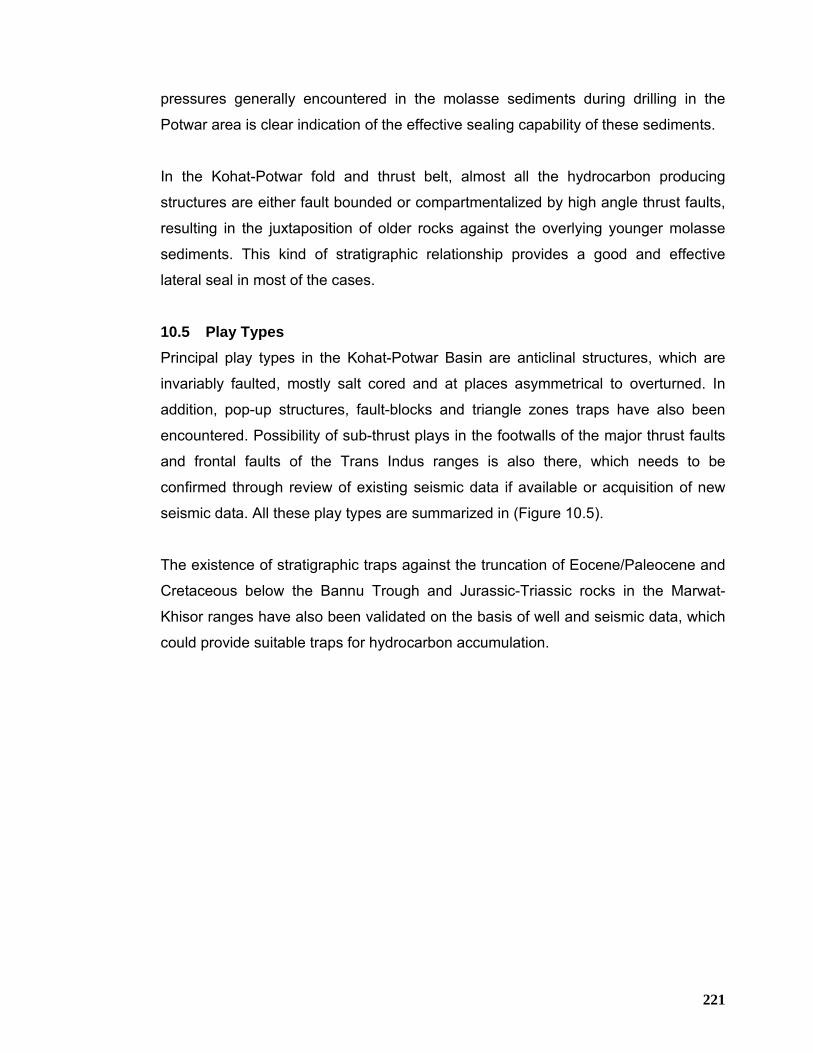
221
pressures generally encountered in the molasse sediments during drilling in the
Potwar area is clear indication of the effective sealing capability of these sediments.
In the Kohat-Potwar fold and thrust belt, almost all the hydrocarbon producing
structures are either fault bounded or compartmentalized by high angle thrust faults,
resulting in the juxtaposition of older rocks against the overlying younger molasse
sediments. This kind of stratigraphic relationship provides a good and effective
lateral seal in most of the cases.
10.5 Play Types Principal play types in the Kohat-Potwar Basin are anticlinal structures, which are
invariably faulted, mostly salt cored and at places asymmetrical to overturned. In
addition, pop-up structures, fault-blocks and triangle zones traps have also been
encountered. Possibility of sub-thrust plays in the footwalls of the major thrust faults
and frontal faults of the Trans Indus ranges is also there, which needs to be
confirmed through review of existing seismic data if available or acquisition of new
seismic data. All these play types are summarized in (Figure 10.5).
The existence of stratigraphic traps against the truncation of Eocene/Paleocene and
Cretaceous below the Bannu Trough and Jurassic-Triassic rocks in the Marwat-
Khisor ranges have also been validated on the basis of well and seismic data, which
could provide suitable traps for hydrocarbon accumulation.
222
Fig. 10.5. Conceptual play model of the Kohat-Potwar Plateau (Pakistan Hydrocarbon Habitat Report,1988).
223
10.6 HYDROCARBON POTENTIAL OF THE MANZAI AREA Till date several significant oil and gas fields have been discovered in the southern
and northwestern part of Pakistan that shows the absolute potential of hydrocarbon
in the foreland basin of Pakistan. Pre-requisites for hydrocarbon generation and
accumulation such as reservoir and source rocks are present throughout the
northern Sulaiman ranges along with the sealing horizons to prevent the escape of
oil and gas, in the form of thick shale beds at various levels. Jurassic to Paleocene
succession of the Sulaiman ranges comprise a thick sequence of carbonates,
claystone and mixed carbonate-siliciclastic rocks representing a wide variety of
shallow marine to deltaic environments of deposition. The stratigraphic sequence
constitutes an important petroleum system, including multiple source, reservoir and
sealing horizons (Figure 10.6).
10.6.1 SOURCE ROCKS A petroleum charge system containing thermally mature petroleum source rocks
capable of expelling petroleum fluids into porous and permeable carrier beds or fault
conduits which transport them to the traps is a pre-requite and must be in-place.
Based on the fact that claystone of marine origin has been found to be the most
fertile source rocks through out the world, the potential source rocks underneath
Sulaiman ranges would be Sembar Formation and Parh Limestone of Cretaceous
age (Figure 10.6). The lithostratigraphy of Sembar is dominated by dark color
claystone that is about 330 meters thick. The Parh Limestone also contains
claystone interbedded with limestone in its lower and middle parts. The third prolific
source is believed to be the Sulaiman Group rocks of Jurassic age as it is found to
be about 1200 meters thick sequence of limestone and contains several horizons of
claystone in its middle part. The limestone succession of the Sulaiman Group can be
considered as less significant source. The Sembar Formation is well proven source
rock through out the Sulaiman and Kirthar ranges in the middle and lower Indus
Basin of Pakistan (Quadri, 1980). The synclines in the area, specially the Tank
Depression to the east, Jandola Syncline to the northwest and Bannu Basin to the
north and northeast of the study area may provide suitable “Kitchen Areas” for the
generation of hydrocarbons.
Geochemical analysis of samples from Habib Rahi Limestone in northern Sulaiman
Range (Source Rock Evaluation Geochemistry Report, 1992) show its maturity level
224
within early oil window having vitrinite reflectance values ranging between 0.60-
0.70%. Organic rich argillaceous limestone within Habib Rahi contains type-II
kerogen and as such constitutes good potential source rocks for oil generation. The
reported Thermal Alteration Index (TAI) ranges between 2.0 – 2.5 with total organic
contents (TOC) in the range of 1.10 – 8.15 % by weight. The limestone and marl
units of Pirkoh member of Kirthar Formation contain TOC in the range of 0.4 – 3.5 %.
The reported geothermal gradient of Ramak-1 well is around 1.5 oC/100 meters
(Ramak-1 well Report, 1993).
10.6.2 RESERVOIR ROCKS Reservoir rocks capable of storing the petroleum fluids and producing them to the
well bore at commercial quantities form an integral part of a petroleum system.
Clastic and non-clastic reservoir rocks are well developed through out the Sulaiman
Range. The reported measured porosity and permeability of samples taken from the
outcrops of Chitarwata sandstone (Oligocene) in the northern Sulaiman Range fall
between 16-25 % and 3-1100 mD respectively (Ramak-1 well Report, 1993).
Potential reservoirs in the Eocene include Limestone of the Habib Rahi and Pirkoh
members of the Kirthar Formation. Beside these the fractured carbonate of Dunghan
and Kirthar Formation should not be overlooked as potential reservoir rocks. Ranikot
sandstone is the main reservoir in the Dhodak oil and gas field and Savi Ragha gas
condensate discovery that lies south of the study area. The Pab Sandstone along
with the sand horizons within the Mughal Kot Formation is the most potential
reservoir for the entire study area (Figure 10.6). The Pab Sandstone is well proven
reservoir through out the Sulaiman Range (Dhodak, Pirkoh and Rodho oil and gas
fields) and Kirthar Range (Zamzama and Bhit gas fields) in the middle and lower
Indus Basin respectively. At Dhodak gas/condensate field of OGDC located in the
eastern Sulaiman Range, porosities of both Ranikot and Pab sandstone range
between 8-14 % and generally decrease with depth. Log derived and core porosities
show a reasonable match. Matrix permeability ranges from 0.12 mD in Pab
sandstone to 24 mD in Ranikot Sandstone (Humayon et al., 1998). Recently,
Sembar and Lower Goru sandstone of Cretaceous age and Chiltan limestone of
Jurassic age (Figure 10.6) have tested commercial quantities of hydrocarbons at
Rodho gas field of Dewan Petroleum. Subsequently, OGDCL has also tested
225
commercial quantities of hydrocarbons from Jurassic Chiltan reservoir by drilling
deep well at Dhodak gas/condensate field.
10.6.3 CAP ROCKS To restrict the leakage, seepage and migration of hydrocarbons, impermeable
horizon or regional top seal is essential. Fine-grained rocks such as shale or
evaporites have the tendency as effective cap rocks. The Paleocene and Eocene
successions of Northern Sulaiman ranges (Figure 10.6) comprise thick shale
horizons and are the potential sealing horizons underneath these ranges in addition
to several intra-formational thick shale beds at various levels.
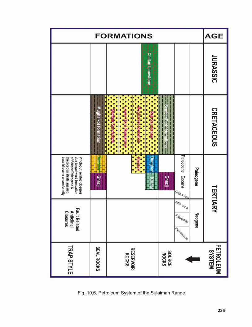
226
Fig. 10.6. Petroleum System of the Sulaiman Range.
227
10.7 STRUCTURAL STYLE AND HYDROCARBON TRAPS Considering the structural and stratigraphic aspect of the Northern Sulaiman ranges,
it is believed that potential anticlinal culminations of en-echelon nature are present all
along the hanging walls of major thrust faults in the area. These fault-related
anticlinal culminations are regarded as the most prolific structural traps.
Mechanically, the stratigraphy of the Northern Sulaiman ranges is divisible into a
lower competent group including Paleocene and older rocks and an upper
competent group including Kirthar and Siwalik Group rocks with thick horizon of clay
of Eocene age that forms an intervening mobile horizon. This mobile horizon must
have behaved diapirically and logically should serve as fold detachment for the folds
within Eocene and younger and the underlying folds must have behaved
dishormonically with respect to the folding within the upper competent group. The
hanging wall anticlinal culminations developed due to fault bending and or
propagation within the lower competent group are of prime importance for
hydrocarbons exploration and exploitation. Based on these structural observations
similar structural styles can be predicted for the non-outcropping rocks underneath
the Dera Ismail Khan Basin that is still poorly explored part of the foreland fold and
thrust belt of North Pakistan.
In addition, stratigraphic trapping potential of sub-cropping Eocene/Paleocene and
Cretaceous reservoirs beneath Base Miocene unconformity exists in the
northeastern Sulaiman Range that needs to be explored further for effective seal and
other essential pre-requisites.
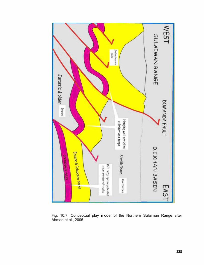
228
Fig. 10.7. Conceptual play model of the Northern Sulaiman Range after Ahmad et al., 2006.
229
CHAPTER 11
DISCUSSION & CONCLUSIONS 11.1 STRUCTURAL STYLES OF THE TRANS INDUS RANGES The northern side of the Surghar Range is characterized by an east west trending,
south-verging anticlinal-monoclinal ridge above a frontal fault (Ahmad, 2003). Close
observations from the field learns that this part of the Surghar Range formed as
south-ward thrusted sheet over the interpreted Surghar ramp. The structural style in
the west near Landa Psha area (Figures 6.3 and 6.30) indicates that the bulk
shortening of the range was mainly accomplished by thrusting, as envisaged by less
deformation within the thrust sheet. Near Landa Psha (Figures 6.3), along the
Surghar Fault, Permian rocks are thrust over the Siwalik Group rocks and the range
exhibit monoclinal geometry. In the eastern part of Surghar Range, around Kutki and
Chapri areas (Figures 6.3) the monoclinal geometry changes to anticlinal with
second order fold and thrust stacks at the level of Triassic and Jurassic suggesting
sticking of deformation along the Surghar ramp (Ahmad, 2003). The structural
geometry of this part of the range includes a south facing anticline with a weakly
emergent thrust in the front. Further east-wards of the Chapri area, the frontal fault
gradually switches to moderately emergent as it brings Jurassic rocks over the
Siwalik Group rocks with associated folds in the hanging wall strata.
The southern side of the Surghar Range consists of a north-south trending anticlinal
ridge, which swings 90° towards an east west trend at the northwestern corner of the
range around Mala Khel area. The southern Surghar Range is bounded to the east
by a major transpressional fault namely Makarwal Fault. The detailed field
investigations have revealed that the Makarwal Anticline consist of a series of ‘en-
echelon’ anticlines which is caused by the sinistral wrenching along Makarwal Fault.
The structural geometry clearly suggests east west compression alternated with later
north west compression which caused wrenching along Makarwal Fault.
Marwat-Khisor ranges occupy the central part of the Trans-Indus ranges having
north east trend. In the Marwat Range, Pliocene Nagri Formation is brought to the
230
surface by a blind ramp and associated fault-bend fold. At surface the Marwat Range
appears to be a south south-east facing fold which is more deformed in the west and
east as compared to its middle part. The Khisor Range is flanked by a strongly
emergent thrust in the south detached at the base of Cambrian to Permian
succession. The detailed field investigations have revealed that the structural
evolution of the Khisor Range is mainly attributed to south-south east directed
ramping and thrusting.
The western end of Marwat Range is characterized by a complex structural
culmination at the juncture between the Pezu Range and Marwat Range. In Shiekh
Budin area Permian to Jurassic age rocks are exposed in doubly plunging anticlines,
whereas in the Marwat and Pezu Range only the Pliocene rocks are brought to the
surface. It is interpreted that in this corner between the frontal and lateral ramps (
Sheikh Budin Thrust, Pezu Fault and Paniala Fault), deformation was concentrated
and resulted in overprinting of folding and ‘poping up’ of older strata found in the
Sheikh Budin area.
The Pezu-Bhittani Range is shaped by a northwest trending anticline which is
subdivided into several compartments by the Pezu Fault. The Pezu Fault is
interpreted to be a dextral wrench with alternate north east- south west directed
compression.
In the Manzai Range which is the westernmost extreme of the Trans-Indus ranges,
the structural style consist of fold-thrust assemblage that is dominantly east verging
and has been evolved as a result of east west contractile deformation.
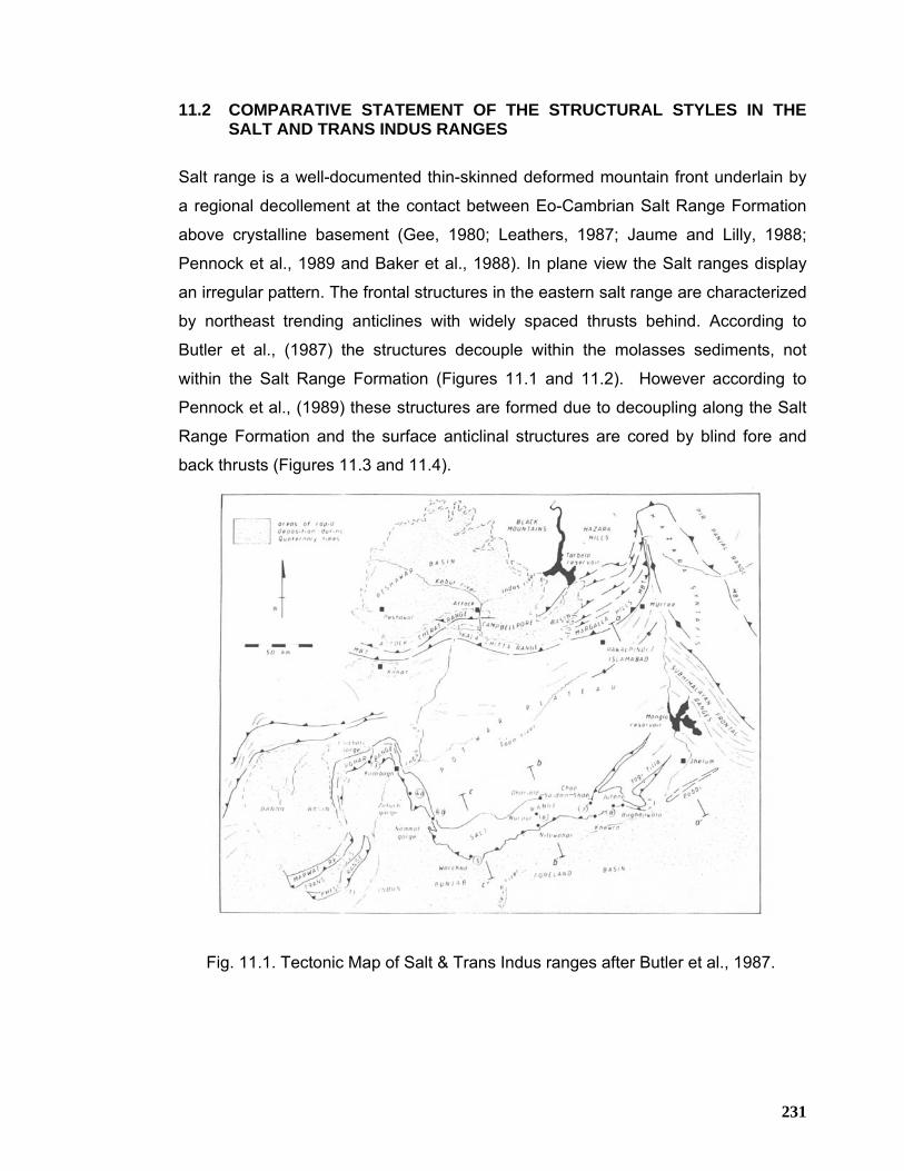
231
11.2 COMPARATIVE STATEMENT OF THE STRUCTURAL STYLES IN THE SALT AND TRANS INDUS RANGES
Salt range is a well-documented thin-skinned deformed mountain front underlain by
a regional decollement at the contact between Eo-Cambrian Salt Range Formation
above crystalline basement (Gee, 1980; Leathers, 1987; Jaume and Lilly, 1988;
Pennock et al., 1989 and Baker et al., 1988). In plane view the Salt ranges display
an irregular pattern. The frontal structures in the eastern salt range are characterized
by northeast trending anticlines with widely spaced thrusts behind. According to
Butler et al., (1987) the structures decouple within the molasses sediments, not
within the Salt Range Formation (Figures 11.1 and 11.2). However according to
Pennock et al., (1989) these structures are formed due to decoupling along the Salt
Range Formation and the surface anticlinal structures are cored by blind fore and
back thrusts (Figures 11.3 and 11.4).
Fig. 11.1. Tectonic Map of Salt & Trans Indus ranges after Butler et al., 1987.
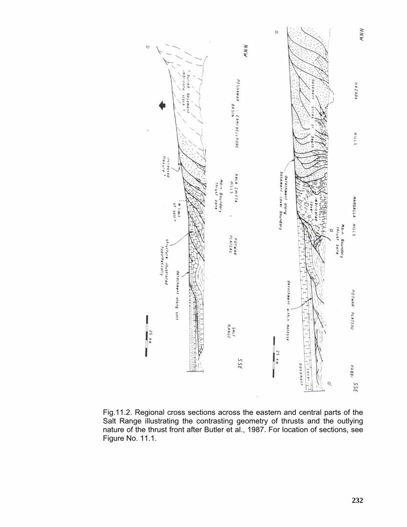
232
Fig.11.2. Regional cross sections across the eastern and central parts of the Salt Range illustrating the contrasting geometry of thrusts and the outlying nature of the thrust front after Butler et al., 1987. For location of sections, see Figure No. 11.1.
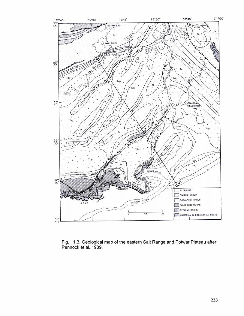
233
Fig. 11.3. Geological map of the eastern Salt Range and Potwar Plateau after Pennock et al.,1989.
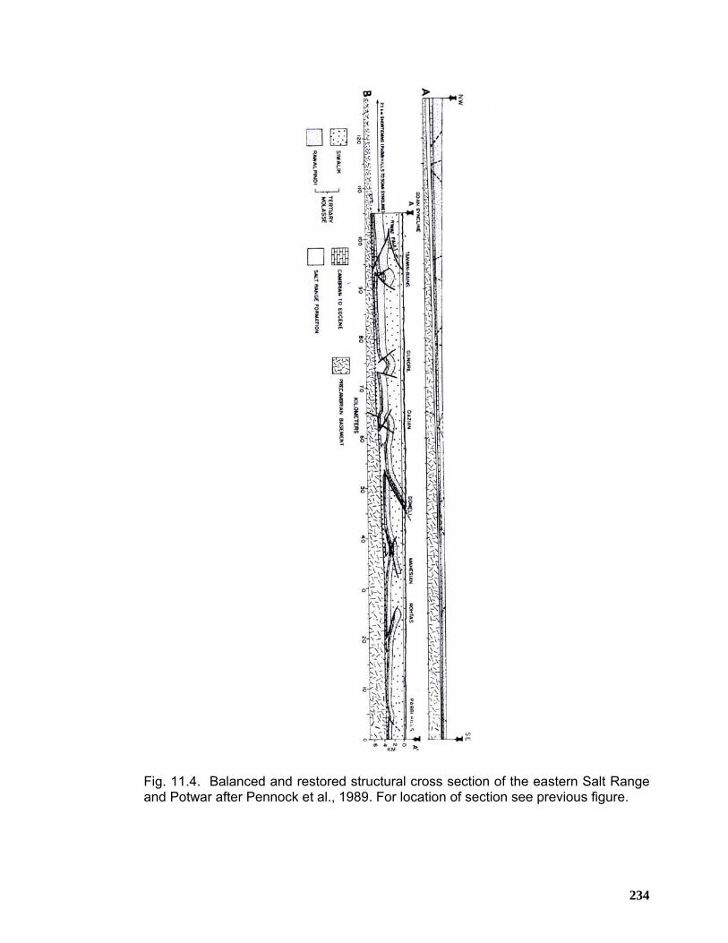
234
Fig. 11.4. Balanced and restored structural cross section of the eastern Salt Range and Potwar after Pennock et al., 1989. For location of section see previous figure.
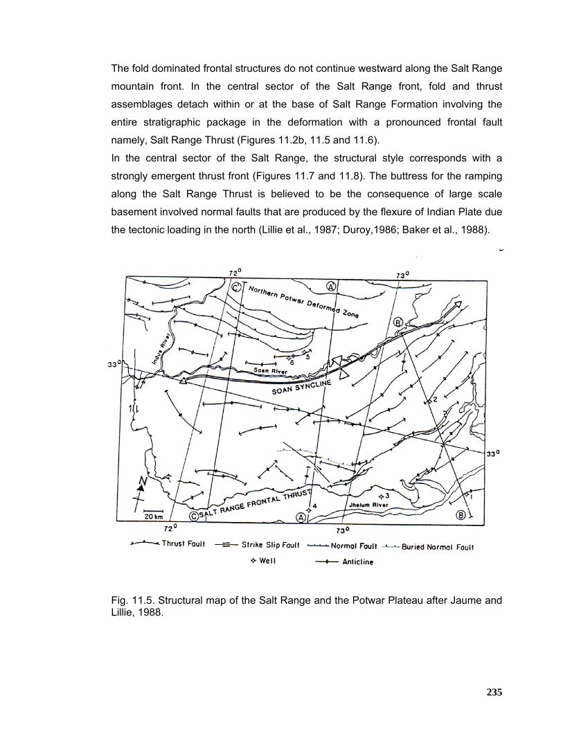
235
The fold dominated frontal structures do not continue westward along the Salt Range
mountain front. In the central sector of the Salt Range front, fold and thrust
assemblages detach within or at the base of Salt Range Formation involving the
entire stratigraphic package in the deformation with a pronounced frontal fault
namely, Salt Range Thrust (Figures 11.2b, 11.5 and 11.6).
In the central sector of the Salt Range, the structural style corresponds with a
strongly emergent thrust front (Figures 11.7 and 11.8). The buttress for the ramping
along the Salt Range Thrust is believed to be the consequence of large scale
basement involved normal faults that are produced by the flexure of Indian Plate due
the tectonic loading in the north (Lillie et al., 1987; Duroy,1986; Baker et al., 1988).
Fig. 11.5. Structural map of the Salt Range and the Potwar Plateau after Jaume and Lillie, 1988.
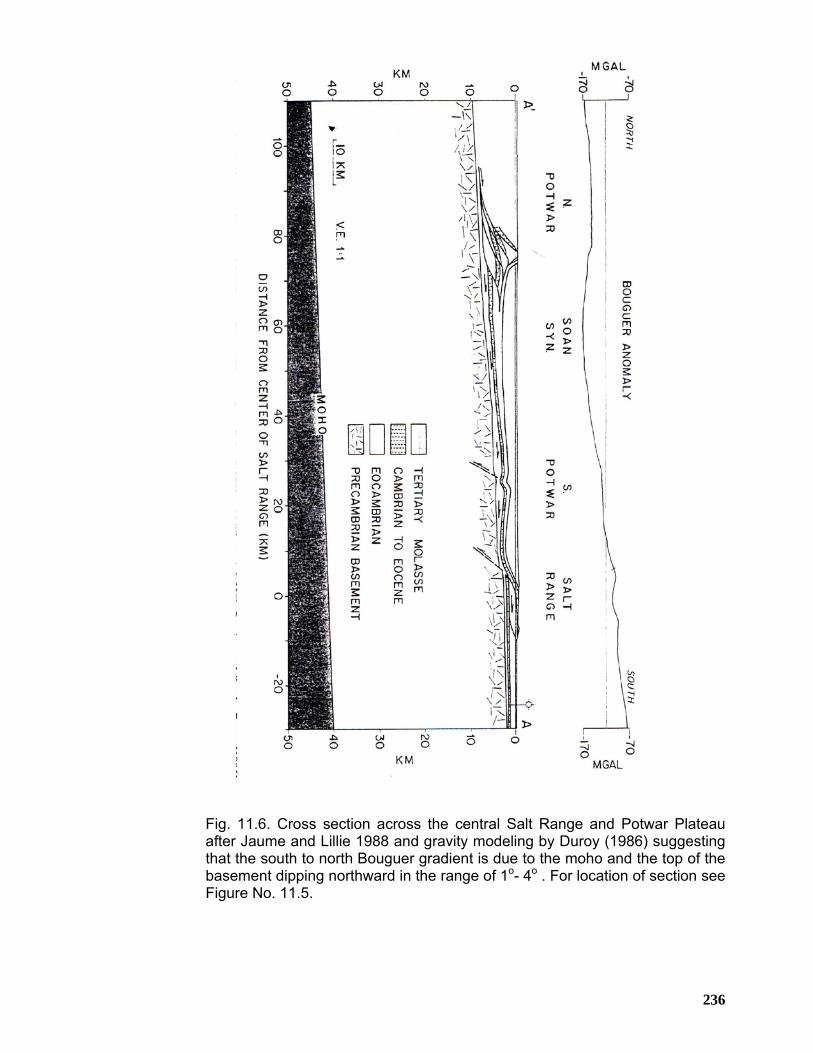
236
Fig. 11.6. Cross section across the central Salt Range and Potwar Plateau after Jaume and Lillie 1988 and gravity modeling by Duroy (1986) suggesting that the south to north Bouguer gradient is due to the moho and the top of the basement dipping northward in the range of 1o- 4o . For location of section see Figure No. 11.5.
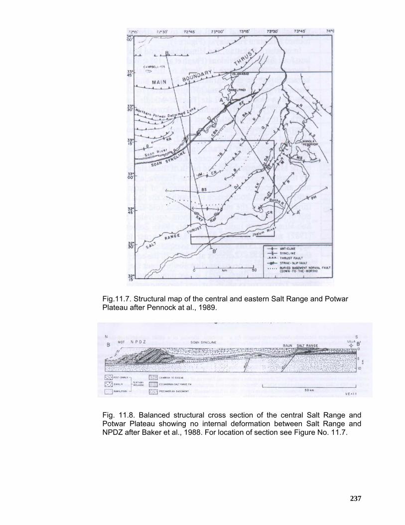
237
Fig.11.7. Structural map of the central and eastern Salt Range and Potwar Plateau after Pennock at al., 1989.
Fig. 11.8. Balanced structural cross section of the central Salt Range and Potwar Plateau showing no internal deformation between Salt Range and NPDZ after Baker et al., 1988. For location of section see Figure No. 11.7.
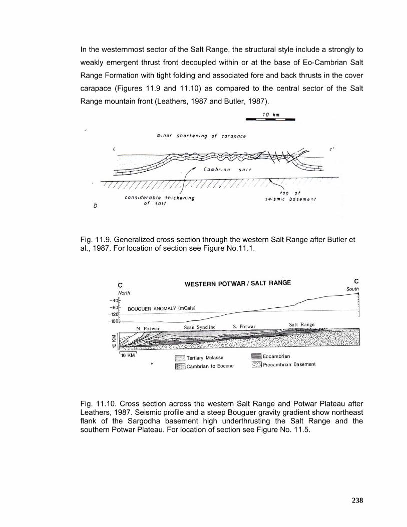
238
In the westernmost sector of the Salt Range, the structural style include a strongly to
weakly emergent thrust front decoupled within or at the base of Eo-Cambrian Salt
Range Formation with tight folding and associated fore and back thrusts in the cover
carapace (Figures 11.9 and 11.10) as compared to the central sector of the Salt
Range mountain front (Leathers, 1987 and Butler, 1987).
Fig. 11.9. Generalized cross section through the western Salt Range after Butler et al., 1987. For location of section see Figure No.11.1.
Fig. 11.10. Cross section across the western Salt Range and Potwar Plateau after Leathers, 1987. Seismic profile and a steep Bouguer gravity gradient show northeast flank of the Sargodha basement high underthrusting the Salt Range and the southern Potwar Plateau. For location of section see Figure No. 11.5.
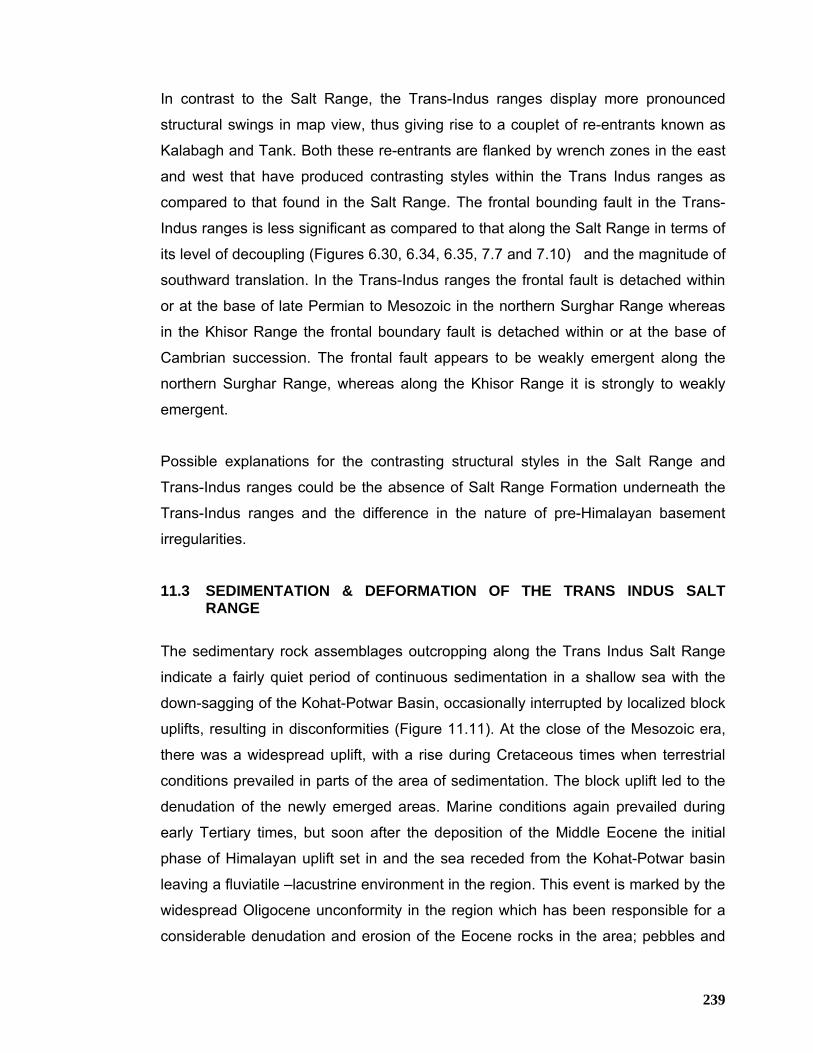
239
In contrast to the Salt Range, the Trans-Indus ranges display more pronounced
structural swings in map view, thus giving rise to a couplet of re-entrants known as
Kalabagh and Tank. Both these re-entrants are flanked by wrench zones in the east
and west that have produced contrasting styles within the Trans Indus ranges as
compared to that found in the Salt Range. The frontal bounding fault in the Trans-
Indus ranges is less significant as compared to that along the Salt Range in terms of
its level of decoupling (Figures 6.30, 6.34, 6.35, 7.7 and 7.10) and the magnitude of
southward translation. In the Trans-Indus ranges the frontal fault is detached within
or at the base of late Permian to Mesozoic in the northern Surghar Range whereas
in the Khisor Range the frontal boundary fault is detached within or at the base of
Cambrian succession. The frontal fault appears to be weakly emergent along the
northern Surghar Range, whereas along the Khisor Range it is strongly to weakly
emergent.
Possible explanations for the contrasting structural styles in the Salt Range and
Trans-Indus ranges could be the absence of Salt Range Formation underneath the
Trans-Indus ranges and the difference in the nature of pre-Himalayan basement
irregularities.
11.3 SEDIMENTATION & DEFORMATION OF THE TRANS INDUS SALT RANGE
The sedimentary rock assemblages outcropping along the Trans Indus Salt Range
indicate a fairly quiet period of continuous sedimentation in a shallow sea with the
down-sagging of the Kohat-Potwar Basin, occasionally interrupted by localized block
uplifts, resulting in disconformities (Figure 11.11). At the close of the Mesozoic era,
there was a widespread uplift, with a rise during Cretaceous times when terrestrial
conditions prevailed in parts of the area of sedimentation. The block uplift led to the
denudation of the newly emerged areas. Marine conditions again prevailed during
early Tertiary times, but soon after the deposition of the Middle Eocene the initial
phase of Himalayan uplift set in and the sea receded from the Kohat-Potwar basin
leaving a fluviatile –lacustrine environment in the region. This event is marked by the
widespread Oligocene unconformity in the region which has been responsible for a
considerable denudation and erosion of the Eocene rocks in the area; pebbles and
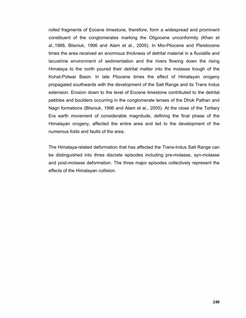
240
rolled fragments of Eocene limestone, therefore, form a widespread and prominent
constituent of the conglomerates marking the Oligocene unconformity (Khan et
al.,1988, Blisniuk, 1996 and Alam et al., 2005). In Mio-Pliocene and Pleistocene
times the area received an enormous thickness of detrital material in a fluviatile and
lacustrine environment of sedimentation and the rivers flowing down the rising
Himalaya to the north poured their detrital matter into the molasse trough of the
Kohat-Potwar Basin. In late Pliocene times the effect of Himalayan orogeny
propagated southwards with the development of the Salt Range and its Trans Indus
extension. Erosion down to the level of Eocene limestone contributed to the detrital
pebbles and boulders occurring in the conglomerate lenses of the Dhok Pathan and
Nagri formations (Blisniuk, 1996 and Alam et al., 2005). At the close of the Tertiary
Era earth movement of considerable magnitude, defining the final phase of the
Himalayan orogeny, affected the entire area and led to the development of the
numerous folds and faults of the area.
The Himalaya-related deformation that has affected the Trans-Indus Salt Range can
be distinguished into three discrete episodes including pre-molasse, syn-molasse
and post-molasse deformation. The three major episodes collectively represent the
effects of the Himalayan collision.
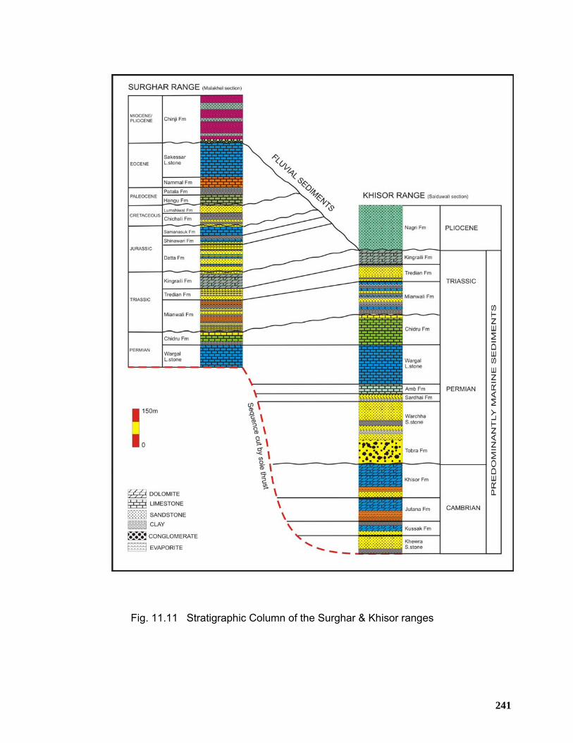
241
Fig. 11.11 Stratigraphic Column of the Surghar & Khisor ranges
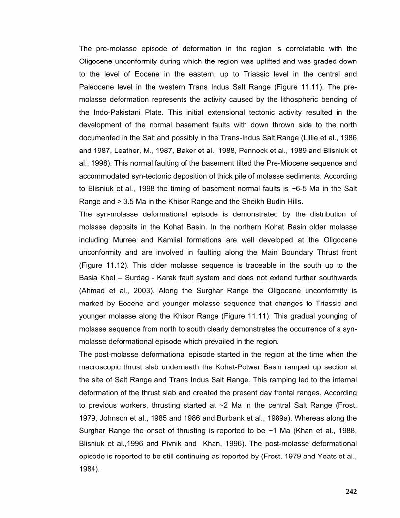
242
The pre-molasse episode of deformation in the region is correlatable with the
Oligocene unconformity during which the region was uplifted and was graded down
to the level of Eocene in the eastern, up to Triassic level in the central and
Paleocene level in the western Trans Indus Salt Range (Figure 11.11). The pre-
molasse deformation represents the activity caused by the lithospheric bending of
the Indo-Pakistani Plate. This initial extensional tectonic activity resulted in the
development of the normal basement faults with down thrown side to the north
documented in the Salt and possibly in the Trans-Indus Salt Range (Lillie et al., 1986
and 1987, Leather, M., 1987, Baker et al., 1988, Pennock et al., 1989 and Blisniuk et
al., 1998). This normal faulting of the basement tilted the Pre-Miocene sequence and
accommodated syn-tectonic deposition of thick pile of molasse sediments. According
to Blisniuk et al., 1998 the timing of basement normal faults is ~6-5 Ma in the Salt
Range and > 3.5 Ma in the Khisor Range and the Sheikh Budin Hills.
The syn-molasse deformational episode is demonstrated by the distribution of
molasse deposits in the Kohat Basin. In the northern Kohat Basin older molasse
including Murree and Kamlial formations are well developed at the Oligocene
unconformity and are involved in faulting along the Main Boundary Thrust front
(Figure 11.12). This older molasse sequence is traceable in the south up to the
Basia Khel – Surdag - Karak fault system and does not extend further southwards
(Ahmad et al., 2003). Along the Surghar Range the Oligocene unconformity is
marked by Eocene and younger molasse sequence that changes to Triassic and
younger molasse along the Khisor Range (Figure 11.11). This gradual younging of
molasse sequence from north to south clearly demonstrates the occurrence of a syn-
molasse deformational episode which prevailed in the region.
The post-molasse deformational episode started in the region at the time when the
macroscopic thrust slab underneath the Kohat-Potwar Basin ramped up section at
the site of Salt Range and Trans Indus Salt Range. This ramping led to the internal
deformation of the thrust slab and created the present day frontal ranges. According
to previous workers, thrusting started at ~2 Ma in the central Salt Range (Frost,
1979, Johnson et al., 1985 and 1986 and Burbank et al., 1989a). Whereas along the
Surghar Range the onset of thrusting is reported to be ~1 Ma (Khan et al., 1988,
Blisniuk et al.,1996 and Pivnik and Khan, 1996). The post-molasse deformational
episode is reported to be still continuing as reported by (Frost, 1979 and Yeats et al.,
1984).
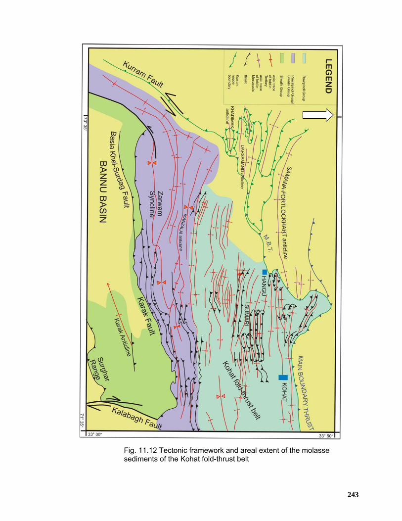
243
Fig. 11.12 Tectonic framework and areal extent of the molasse sediments of the Kohat fold-thrust belt
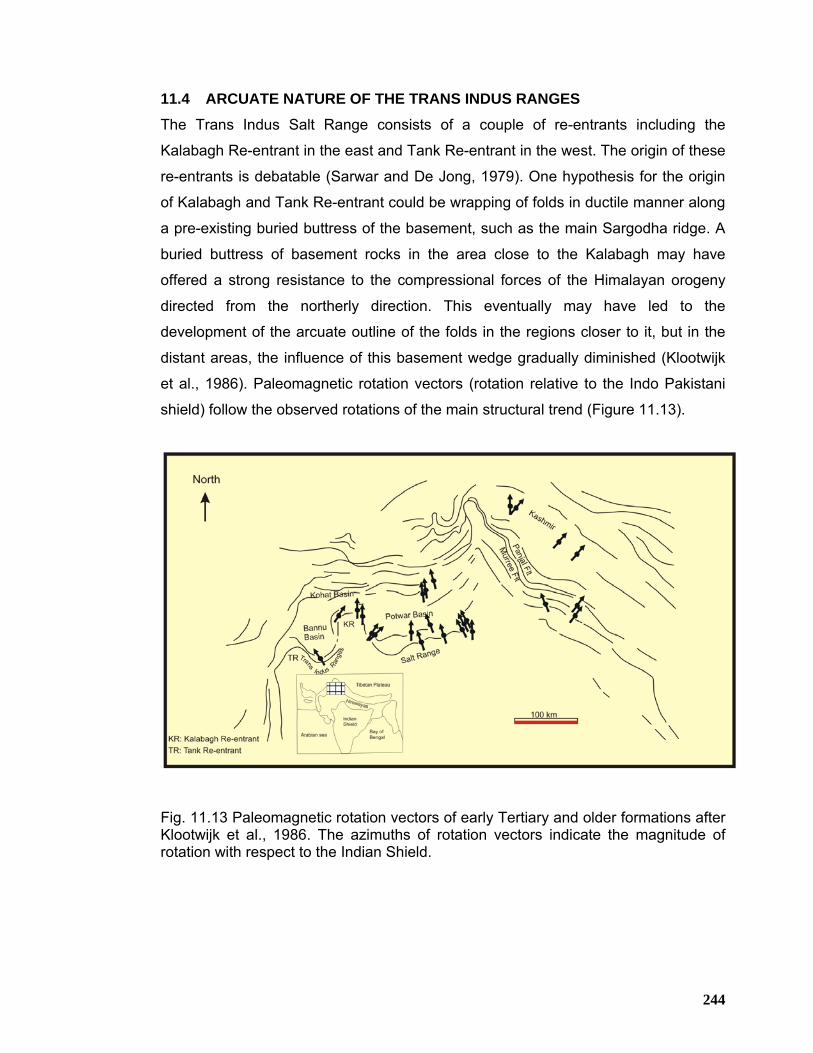
244
11.4 ARCUATE NATURE OF THE TRANS INDUS RANGES The Trans Indus Salt Range consists of a couple of re-entrants including the
Kalabagh Re-entrant in the east and Tank Re-entrant in the west. The origin of these
re-entrants is debatable (Sarwar and De Jong, 1979). One hypothesis for the origin
of Kalabagh and Tank Re-entrant could be wrapping of folds in ductile manner along
a pre-existing buried buttress of the basement, such as the main Sargodha ridge. A
buried buttress of basement rocks in the area close to the Kalabagh may have
offered a strong resistance to the compressional forces of the Himalayan orogeny
directed from the northerly direction. This eventually may have led to the
development of the arcuate outline of the folds in the regions closer to it, but in the
distant areas, the influence of this basement wedge gradually diminished (Klootwijk
et al., 1986). Paleomagnetic rotation vectors (rotation relative to the Indo Pakistani
shield) follow the observed rotations of the main structural trend (Figure 11.13).
Fig. 11.13 Paleomagnetic rotation vectors of early Tertiary and older formations after Klootwijk et al., 1986. The azimuths of rotation vectors indicate the magnitude of rotation with respect to the Indian Shield.
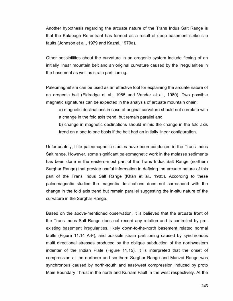
245
Another hypothesis regarding the arcuate nature of the Trans Indus Salt Range is
that the Kalabagh Re-entrant has formed as a result of deep basement strike slip
faults (Johnson et al., 1979 and Kazmi, 1979a).
Other possibilities about the curvature in an orogenic system include flexing of an
initially linear mountain belt and an original curvature caused by the irregularities in
the basement as well as strain partitioning.
Paleomagnetism can be used as an effective tool for explaining the arcuate nature of
an orogenic belt (Eldredge et al., 1985 and Vander et al., 1980). Two possible
magnetic signatures can be expected in the analysis of arcuate mountain chain;
a) magnetic declinations in case of original curvature should not correlate with
a change in the fold axis trend, but remain parallel and
b) change in magnetic declinations should mimic the change in the fold axis
trend on a one to one basis if the belt had an initially linear configuration.
Unfortunately, little paleomagnetic studies have been conducted in the Trans Indus
Salt range. However, some significant paleomagnetic work in the molasse sediments
has been done in the eastern-most part of the Trans Indus Salt Range (northern
Surghar Range) that provide useful information in defining the arcuate nature of this
part of the Trans Indus Salt Range (Khan et al., 1985). According to these
paleomagnetic studies the magnetic declinations does not correspond with the
change in the fold axis trend but remain parallel suggesting the in-situ nature of the
curvature in the Surghar Range.
Based on the above-mentioned observation, it is believed that the arcuate front of
the Trans Indus Salt Range does not record any rotation and is controlled by pre-
existing basement irregularities, likely down-to-the-north basement related normal
faults (Figure 11.14 A-F), and possible strain partitioning caused by synchronous
multi directional stresses produced by the oblique subduction of the northwestern
indenter of the Indian Plate (Figure 11.15). It is interpreted that the onset of
compression at the northern and southern Surghar Range and Manzai Range was
synchronous caused by north-south and east-west compression induced by proto
Main Boundary Thrust in the north and Kurram Fault in the west respectively. At the
246
time when Proto MBT was transmitting south directed stresses at the site of the
northern Surghar Range, left lateral wrenching along the Proto Kurram Zone was
transmitting east directed compressive stresses resulting in the north-south oriented
folds in the Manzai Range and southern Surghar Range. The stress variation is
believed to be responsible for the arcuate structural trends present at the
northwestern corner of the Bannu Basin where the north-south trending rocks of the
Sulaiman Range merge with the east-west trending rocks of the Kohat Basin. These
variations have caused a northwest oriented lineament separating the two stress
regimes in the Trans Indus Salt Range (Figure 11.15).
247
Fig. 11.14 A, B & C. Proposed model showing pre-existing basement irregularities and the sequential evolution of the Trans Indus Salt Range.
248
Fig. 11.14 D, E & F. Proposed model showing pre-existing basement irregularities and the sequential evolution of the Trans Indus Ranges.
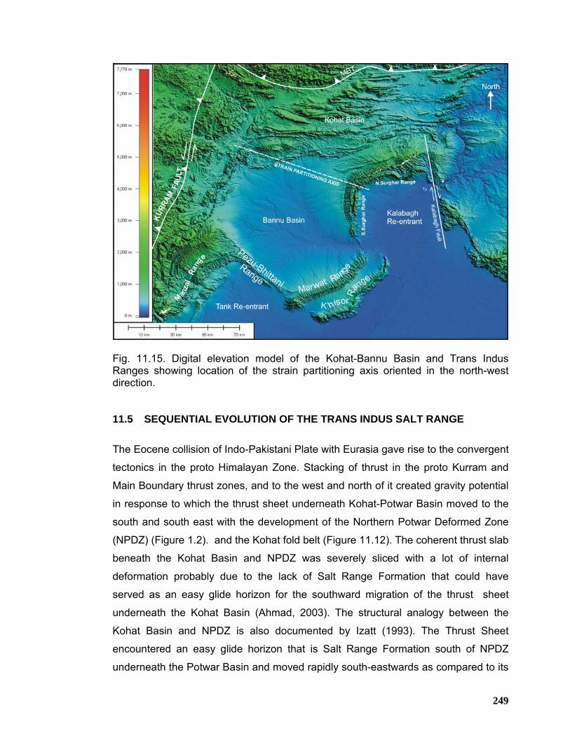
249
Fig. 11.15. Digital elevation model of the Kohat-Bannu Basin and Trans Indus Ranges showing location of the strain partitioning axis oriented in the north-west direction. 11.5 SEQUENTIAL EVOLUTION OF THE TRANS INDUS SALT RANGE
The Eocene collision of Indo-Pakistani Plate with Eurasia gave rise to the convergent
tectonics in the proto Himalayan Zone. Stacking of thrust in the proto Kurram and
Main Boundary thrust zones, and to the west and north of it created gravity potential
in response to which the thrust sheet underneath Kohat-Potwar Basin moved to the
south and south east with the development of the Northern Potwar Deformed Zone
(NPDZ) (Figure 1.2). and the Kohat fold belt (Figure 11.12). The coherent thrust slab
beneath the Kohat Basin and NPDZ was severely sliced with a lot of internal
deformation probably due to the lack of Salt Range Formation that could have
served as an easy glide horizon for the southward migration of the thrust sheet
underneath the Kohat Basin (Ahmad, 2003). The structural analogy between the
Kohat Basin and NPDZ is also documented by Izatt (1993). The Thrust Sheet
encountered an easy glide horizon that is Salt Range Formation south of NPDZ
underneath the Potwar Basin and moved rapidly south-eastwards as compared to its
250
western analog that is the Kohat Basin where no salt exist at basal decollement
(Ahmad et al., 2003). The no salt situation underneath the Kohat Basin led to the
development of an internally more deformed fold-thrust belt. It is believed that due to
lithological variations at the basal decollment underneath the Kohat and Potwar
basins caused the faster rate of thrust propagation underneath the Potwar Basin
resulting in the onset of wrenching along a pre-existing basement-involved normal
fault (Figures 11.14 A & B) that is at present recognized as Kalabagh Fault (Figure
11.12). The commencement of ramping at the Salt Range front post date the
wrenching along the Kalabagh Fault supported by the chronostratigraphy of molasse
rocks developed in Potwar and southern Kohat Basin. Along the Salt Range front,
thrusting began at ~2 Ma in the central Salt Range (Frost, 1979, Johnson et al., 1985
and 1986 and Burbank et al., 1989a.) whereas at the site of Surghar Range front the
onset of thrusting is reported to be ~1 Ma (Blisniuk, 1996, Pivnik et al., 1996 and
Yeats et al., 1984). About a 1Ma jump in timing of ramping across the Indus River
suggests early wrenching along Kalabagh Fault. The early wrenching along
Kalabagh Fault possibly helped the progression of Potwar thrust slab quite rapidly
towards south. Whereas beneath the Kohat thrust slab the basal decollement was
offered more resistance due to the lack of salt that consequently created more
internal deformation in less aerial width within the Kohat Basin as compared to the
Potwar Basin. Furthermore, the northern Surghar Range front lies in close proximity
to the MBT in the north as compared to the Salt Range front. The north Surghar
Range front may have received the impact of stresses earlier than the Salt Range
front which is not the case.
The ramping at the site of northern Surghar Range with minor sinistral wrenching
along the pre-existing Makarwal ramp in the southern Surghar Range started at
about ~1 Ma (Khan et al., 1988). This southward thrusting event was immediately
followed by an east directed compressional deformation presumably caused by the
Kurram Fault zone in the west resulted in the onset of east directed ramping along
the Makarwal wrench zone giving rise to Makarwal Anticlinal ridge with east verging
thrust fault (Figure 11.16). Based on these observations, it is interpreted that during
this event there was regional scale strain partitioning axis, oriented in northwest
direction, extending from Malla Khel area in the Surghar Range towards the
northwestern apex of the Bannu Basin in the northwest (Figures 11.15 & 11.16).
251
Synchronized with this event, south-east directed thrust related folding was also on-
going at the site of the Manzai Range. This event was followed by a general south-
eastward translation of the thrust sheet underneath Bannu Basin causing the onset
of wrenching at Kundal, Makarwal and Pezu faults, with synchronous thrusting at the
Khisor range front. These strike slip faults are believed to have facilitated the south-
eastward movement of the coherent thrust sheet underneath Kohat and Bannu
basins by providing steep lateral ramps parallel to the thrust direction.
In the final stage, south-westward thrusting along Pezu Fault with synchronous
thrusting along Marwat Fault in the subcrop initiated. The basement ramp
underneath the Marwat blind thrust started to develop probably simultaneously with
the development of the blind Marwat Thrust. As such it appears that the Khisor
Thrust is older than the Marwat Thrust disturbing the south younging sequence of
faulting in the region. The Marwat Range being the latest tectonic event is supported
by the fact that it is un-affected by the Kundal Fault whereas the Khisor Range has
been substantially offset by the Kundal Fault.

252
Fig. 11.16. Satellite image of the southern Kohat-Bannu Basin and Trans Indus Salt Range showing location of the strain partitioning axis oriented in the north-west direction.
253
REFERENCES Abbasi, I.A. and McElroy, R., (1991) Thrust kinematics in the Kohat Plateau, Trans Indus Range, Pakistan.J. of Struct.Geol., Vol. 13, No. 3, p.319-327. Ahmad, S., Ali, F., Sayab, M., Ahmad, I., and Hamidullah, S., (1999) Structural geometry of the
Himalayan Frontal Thrust Zone: Surghar Range, Pakistan. Geol. Bull. Univ. Peshawar, vol.32, p.13-23.
Ahmad, S., Rahman, I., Irfan, M., and Ali, F., (2003) Structural framework of the Kalabagh Hills, North Pakistan. PAPG, ATC 2003, conference proceedings, p.211-217. Ahmad, S., Rahman, I., Irfan, M., and Ali, F., (2003) Thrusting, active back thrusting and tectonic
wedging: An example from Surghar Range, North Pakistan. PAPG, ATC 2003, conference proceedings, p.111-131.
Ahmad, S., (2003) A comparative study of structural styles in the Kohat Plateau, North West Himalayas, NWFP, Pakistan. Unpublished Ph.D Thesis, NCE in Geology, University of Peshawar, p.1-119.
Ahmad, S., Ali, A., Irfan, M. Khan, Ali, A.Khan and Shahid. A., (2007) Hydrocarbon Prospectivity of the Bhittani and Northern Sulaiman Ranges, North-West Himalayas, Pakistan. PAPG, ATC 2007, conference proceedings.
Ahmad, S., Ali, A., and Irfan, M. Khan.,(2005) Imprints of Transtensional Deformation along Kalabagh Fault in the vicinity of Kalabagh Hills, Pakistan. Pakistan Journal of Hydrocarbon Research, vol.15, p. 35-42.
Ahmad, S., Ali, F., Khan.A.A, and Irfan, M. Khan.,(2006) Hydrocarbon Prospectivity of the Bhittani and Northern Sulaiman ranges, North-West Himalayas, Pakistan. Pakistan Journal of Hydrocarbon Research, vol.16, p. 1-10.
Ahmad, S., Hamidullah, S., Irfan, M., and Ali, A., (2004) Structural transect of the western Kohat Fold and Thrust Belt between Hangu and Basia Khel, NWFP, Pakistan. PAPG, ATC 2004, conference proceedings.
Ahmad, W., and Alam, S., (1999) Organic Geochemistry and Source Rock Characteristics of Salt Range Formation, Potwar Basin. PAPG, ATC 1999, conference proceedings.
Aithal, V.S., G. Gopalakrishnan , P. Nath, Y.K. Murty, B. Nandra and D.Das., (1964) Gravity and magnetic surveys in the Plains of Punjab: 22nd International Geological Congress, New Delhi, sec.2, pt. 2, p.179-188.
Allemann, F.(1979) Time of emplacement of the Zhob Valley and Bela Ophiolites: in Farah, A, and DeJong, K.A., eds, Geodynamics of Pakistan, Geol. Survey of Pakistan, Quetta, p.215.
Alam, I., Sajjad, A., Athar, A., and Irfan, M., (2005) Fold-thrust styles in the Marwat-Khisor Ranges, NWFP, Pakistan. PAPG, ATC 2005, conference proceedings. p. 80-93.
Alam, I., (2008) Stratigraphic and Structural Framework of the Marwat-Khisor Ranges, NWFP, Pakistan. Ph.D Thesis, National Centre of Excellence in Geology, University of Peshawar, Pakistan, p.1-142.
Amoco Pakistan Exploration Company, (1991) Geological map of the Kohat region. Ansari, A. W and Siddiqui, N. K, (2002) Wideline seismic technique for imaging structurally
complex areas – A case study. PAPG, ATC 2002, conference proceedings, p.37-45. Armbruster, J.L., Seebar and Jacob, K.H., (1978) The northwestern termination of the Himalayan
Mountain Front: active tectonics from micro-earthquakes. J.Geoph. Res., 83, p.269-282. Aziz, K., (2002) 2D Seismic interpretation and hydrocarbon potential of the thrust related plays in
Block 3371-7 (Jhamat), Potwar Sub-basin, Pakistan. M.S. Thesis, Oxford Brookes University, U.K.
Balme, B.E., (1970) Palynology of Permian and Triassic strata in the Salt Range and Surghar Range, West Pakistan: in Stratigraphic Boundary Problems: Permian and Triassic of West Pakistan, (Ed. Kummel, B. and Teichart, C):Univ. Kansas, Geol. Deptt. Sp. Pub., no. 4, p.305-454.
Bard, J.P., (1983) Metamorphism of the obducted island arc: Example of Kohistan sequence in Pakistan Himalayan Collided Range, Earth and Planetary Science Letters, 65, p.133-144.
Bird, P., (1978) Initiation of intracontinental subduction In the Himalaya: J. Geophys. Res., v. 83, p.4975-4987. Baker,D.M., Lille,R.J., Yeats,R.S., Jhonson,G.D., Yousaf,M., and Zaman,A.S.H., (1988)
Development of the Himalayan frontal thrust zone: Salt Range Pakistan: Geo.V.16,p.3-7. Banks, C.J. and Warburton, J., (1986) “Passive roof” duplex geometry in the frontal structures of
254
the Kirthar and Sulaiman mountain belts, Pakistan: J. Struct. Geol., Vol.8, p. 229-238. Blanford, W.T., (1876) On the geology of Sind : Ibid., Recs., v. 9., p. 8-22. Blisniuk, M. P., (1996) Structure and tectonics of the northwest Himalayan frontal thrust system,
Trans-Indus ranges, Northern Pakistan. Unpublished Ph.D thesis, Dartmouth College, Hanover, N.H., U.S.A.
Blisniuk, M. P., Sonder, L. J., Lillie, R. J., (1998) Foreland normal fault control on northwest Himalayan thrust front development Dartmouth College, Hanover, New Hampshire, tectonics, vol.17, No.5, p.766-779.
Biswas, S.K., (1982) Rift basins in western margin of India and their hydrocarbon prospects with special reference to Kutch basin. AAPG, 66(10), p.1497-1513.
Burbank, D.W. and Beck, R.A.(1989) Comment and reply on “Development of the Himalayan frontal thrust zone: Salt Range, Pakistan” : Geology, vol. 17, No. 4, p. 378-380.
Burbank, D.W. and Beck, R.A.(1989a) Early Pliocene uplift of the Salt Range; Temporal constraints on thrust wedge development, northwest Himalaya, Pakistan, Spec. Pap., Geol. Soc. Am., 232, p. 113-128.
Burbank, D.W. and Raynolds, R.G.H. (1988) Stratigraphic keys to the timing of thrusting in terrestrial foreland basins: application to the North-western Himalaya: in Kleinspehn, K. L. and Paola, C.,eds, Frontiers in Sedimentary Geology (New Perspective in Basin Analysis), paper 17, Springer-Verlag, NewYork.
Butler, R.W.H., Coward, M.P, Gill, M.Harwood and Robert, J. Knipe., (1987) Salt control on thrust geometry, Structural style and gravitational collapse along the Himalayan mountain front in the Salt Range of Northern Pakistan, p.339-418.
Butler, R.W.H. and Prior, D., (1988 a) Tectonic controls on the uplift the Nanga Parbat Massif, Pakistan Himalayas: Nature, Vol.333, No.6170, p.247-250.
Butler, R.W.H. and Prior, D., (1988) Anatomy of a continental subduction zone: the Main Mantle Thrust in Northern Pakistan: Geologische Rundschau, v. 77, No.1, p.239-255.
Chaudhary, S.K., (1975) Gravity and crustal thickness in the Indo-Gangetic plains and Himalayan region, India. Royal Astron. Soc. Geophys. Journ., v.40, p.441-452
Christopher, N.Izzat., (1993) Variation in thrust front geometry across the Potwar Plateau and Hazara/Karachitta Hill Ranges, Northern Pakistan. Ph.D Thesis, Imperial College of Science,Technology and Medicine, London.
Cotter, G.P., (1933) The geology of part of the Attock District west of Longitude 72 45o : Geol. Soc. India Mem., v.55, p. 63-156.
Coward, M.P., and Butler, R.W.H. (1985) Thrust tectonics and the deep structure of the Pakistan Himalaya: Geology, Vol.13, p.247-265.
Coward,M.P., Windley,B.F., Broughton,R., Luff,I.W., Petreson,M., Pudsey,C.J., Rex,D.,and Asif Khan,M.,(1986). Collision tectonics in the NW Himalayas. Special publication of the Geological Society, London, V.19, p.203-219.
Danilchik, W., & Shah, S. M., (1967) Stratigraphy nomenclature of formations in the Trans-Indus Mountains, Mianwali district, West Pakistan. U.S.G.S., Prof. Report (IR) PK-33: 45p.
DeGolyer and MacNaughton Incorporated, (1960) Production Engineering Study of the Dhulian Filed in West Pakistan.
Demaison, G. & Huizinga, B.J.1991.Genetic classification of petroleum system, AAPG Bulletin, V.75, No.10, p.1626-1643.
Dewey, J.et al, (1988) Geological evolution of Tibet: Phil. Trans. Roy. Soc. London., A327, p. 3-4. Dietrich,J.D., W.Frank and Honeggar, (1983) A Jurassic-Cretaceous Arc in the Ladakh Himalaya.
J.Volc.Geothermal Res.,18, p.405-433. Dipietro, J. A., Pogue, K. R., Hussain, A. & Ahmad, I., (1996) Geology and tectonics of the Indus
syntaxis, northwest Himalaya, Pakistan. Dunbar, C. O., (1932) Stratigraphic significance of the Fusulinids of the Lower Productus
limestone of the Salt Range. Geol. Surv. India, Rec. 66, p. 405-413. Duroy, Y., (1986) Subsurface densities and lithospheric flexure of the Himalayan foreland in
Pakistan interpreted from gravity data: M.Sc. Thesis, Oregon State University, Corvallis, Oregon, p.74.
Duroy, Y. A., Farah, and R. J. Lillie, (1989) Subsurface densities and lithospheric flexure of the Himalayan foreland in Pakistan, Spec. pap. Geol. Soc. Am., no. 232, p. 217-236. Searle 1991. Geology and Tectonics of the Karakorum Mountains, Wiley, New York.
Eames, F.E., (1952 a) A contribution to the study of Eocene in western Pakistan and western
255
India, Part A., The geology of standard sections in the Western Punjab and in the Kohat District: Geol. Soc. London, Quart. Jour., v. 107, pt. 2, p.159-172.
Eldredge, S., V. Bachtadse, and R. Van der Voo, (1985) Paleomagnetism and the orocline hypothesis, Tectonophysics, 119, p. 153-179.
Fatmi, A. N., and Cheema, M. R., (1972) Early Jurassic Cephalopods from Khisor-Marwar ranges (Shaik Budin Hills), D. I. Khan District, N.W.F.P., Pakistan: Ibid., Recs., v. 21, pt. 2, 9 p.
Fatmi, A. N., (1973) Lithostratigraphic units of the Kohat-Potwar province, Indus Basin, Pakistan. Mem.Geol. Surv. Pakistan 10, p.80.
Farah, A., Mirza, M.A., Ahmad, M. A. & Butt, M. H., (1977) Gravity field of the buried shield in the Punjab plain, Pakistan. Bull. Geol. Soc. Am. V. 88, p. 1147-1155.
Frost, C.D., (1979) Geochronology and depositional environment of late Pliocene age Siwalik sequence enclosing several volcanic tuff horizons, Pind Savikka area, eastern Salt Range,
Pakistan, B.S. thesis, 41 p., Dartmouth College, Hanover, N.H. Ganser, A., (1964) Geology of the Himalaya: New York, Interscience Pub.273 p. Gee, E. R., (1980) Pakistan geological Salt Range Series: (6 sheets, scale 1:50,000) Directorate
of Overseas surveys, U.K. for the Govt. of Pakistan & Geol. Surv. Pak. Gee, E. R., (1989) Overview of the Geology and structure of the Salt Range, with observations on
related areas of northern Pakistan. Geol. Soc. of America, Special Paper 232, p.95-112. Gupta, H.K., and H. Narain., (1967) Crustal structure in the Himalayan and Tibetan plateau region
from surface wave dispersion: Seismol. Soc. America Bull., 57, p.235-248. Halliburton Geoconsultants, Aberdeen, UK., (1992) Source Rock Evaluation Geochemistry
Report, NWFP, Pakistan. Hamidullah, S. & Onstot, T.C., (1992) Ar40/Ar39 evidence for Late Cretaceous Formation of the
Kohistan Island Arc,NW, Pakistan. Kashmir Journal of Geology, Vol. 10.p. 105-122. Hemphill, W. R. & Kidwai, A. H., (1973) Stratigraphy of the Bannu and Dera Ismail Khan area,
Pakistan. U.S.G.S., Prof. Paper 716-B: 36p. Hemphill, W. R. & Kidwai, A. H., (1973) Geological Map of the Bannu Quadrangle, Pakistan. U.S.G.S., Prof. Paper 716-B: Plate 2. Higham, J. C. (1983) Depositional models and source/reservoir assessment of the Cretaceous to
Paleocene section in the Kirthar and Sulaiman sub Basins: BP Pakistan Report No. GL-190. Holland, T. H. & Tipper, G. H., (1913) Indian geological terminology. Geol. Surv. India, Mem. 43,
1: p. 1-27. Humayon, M., Akram, M., and Malik, R.M., (1998) Dhodak Field: A Case History of First and the
Largest Condensate Discovery of Pakistan. PAPG-PPEPCA Pakistan Petroleum Convention proceedings, p. 134-174.
Hunting Survey Corporation (H. S. C.), (1961) Reconnaissance geology of part of West Pakistan (Colombo Plan Cooperative Project): Canada Govt., Toronto, p. 1-550.
Hydrocarbon Development Institute of Pakistan, (1992) Source Rock Evaluation of Bannu Depression and Adjoining Areas (PPL Concession Block-35), p.1-22. Jaume, S.C., and Lillie, R.J., (1988) Mechanics of the Salt Range – Potwar Plateau, Pakistan: a fold and thrust belt underlain by evaporates. Tectonics, 7(1), p. 57-71. Jaswal, T.M., Lillie, R.J., and Lawrence, R.D., (1997) Structure and evolution of the northern
Potwar deformed zone, Pakistan: American Association of Petroleum Geologists Bulletin, v. 81, no. 2, p.308-328.
Johnson, G.D., R. Raynolds, and D. Burbank., (1986) Late Cenozoic tectonics and sedimentation in the northwestern Himalayan foredeep, thrust ramping and associated deformation in the Potwar region, in Foreland Basins, edited by P. Allen and P. Homewood, spec. publ. Int. Assoc. Sedimentol., 8, p. 273-291.
Johnson, G.D., Johnson, N.M., Opdyke, N.D., and Tahirkheli, R.A.K., (1979) Magnetic reversal stratigraphy and sedimentary tectonic history of the upper Siwalik Group, eastern Salt Range and southwest Kashmir. In: Geodynamics of Pakistan. Ed. Farah, A. and DeJong, K.A., Geol. Surv. Pakistan. p.149-166.
Johnson, N.M., J. Stix, L. Tauxe, P.F. Cerveny, and R.A.K. Tahirkheli., (1985) Paleomagnetic chronology, fluvial processes, and tectonic implications of the Siwalik deposits near Chinji village, Pakistan, J. Geol., 93, p. 27-40.
Kadri, I.B., and Abid, S.M., (1986) Geology of hydrocarbon accumulation in Pakistan. Reprint; 6th
Offshore SE Asia Conference, Jan.1986, Singapore. Kadri, I.B., and Khan, M.R., (1992) New petroleum play concepts in Pakistan, 9th Petroleum Congress of Turkey.
256
Kadri, I.B. (1995) Petroleum Geology of Pakistan, p. 1-275. Karner, G.D. and Watts, A.B., (1983) Gravity anomalies and flexure of the lithosphere at mountain ranges: J. Geophys. Res., Vol.188, No. B12, p.10449-10477. Kazmi,A.H., and Rana,R.A.,(1982) Tectonic Map of Pakistan, 1:1,000,000. Geological Survey of
Pakistan Quetta, Pakistan. Kazmi,A.H., (1979 a) Active fault system in Pakistan. In: Farah, A and DeJong, K.A. (eds.),
Geodynamics of Pakistan: Geological Survey of Pakistan Quetta, p. 285-294. Kemal, A., (1992) Geology and new trends for hydrocarbon exploration in Pakistan, in Ahmed,G.,
Kemal, A., Zaman, A.S.H., and Humayon, M., eds., New directions and strategies for accelerating petroleum exploration and production in Pakistan: Proceedings, international petroleum seminar, November 22-24,1991: Islamabad, Pakistan, Ministry of Petroleum and Natural Resources, p.16-57.
Khan, A.A., and Najeeb-uz-Zaman, M., (2003) Stratigraphy and tectonic architecture of the northwestern part of the Kohat Basin, NWFP, Pakistan. PAPG-SPE ATC 2003 proceedings, p. 145-163.
Khan, A.F., and Hasany, T. S., (1998) Dhulian Oilfield : A Case History. PAPG-PPEPCA Pakistan Petroleum Convention proceedings, p. 1-19.
Khan, M.A., Ahmed, A., Raza, H.A., and Kemal, A., (1986) Geology of petroleum in Kohat-Potwar Depression, Pakistan. AAPG 70(4), p. 396-414.
Khan, M.A., & Raza, H.A., (1986) The role of geothermal gradient in hydrocarbon exploration in Pakistan. J. Petr. Geol., 9(3), p. 245-258.
Khan, M.J., and N. Opdyke., (1987) Magnetic polarity stratigraphy of the Siwalik Group of the Shinghar and Surghar Ranges, Pakistan, Geol. Bull. Univ. Peshawar, 20.
Khan, M.J., N. Opdyke, and R. Tahirkheli., (1988) Magnetic stratigraphy of the Siwalik Group, Bhittani, Marwat and Khisor ranges, northwestern Pakistan and the timing of Neogene tectonics of the Trans Indus, J. Geophys. Res., 93, 11, 773-11,790.
Klootwijk, C.T., Nazirullah, R., and DeJong, K.A., (1986) Paleomagnetic constraints on formation of the Mianwali Re-entrant, Trans-Indus and Western Salt Range, Pakistan. Earth Plan. Sc. Lett., 80, p.394-414.
Kono, M., (1974) Gravity anomalies in east Nepal and their implications to the crustal structure of the Himalayas: Royal Astron. Soc. Geophys. Journ., 39, p.283-300.
Kravetchenko, K. N., (1964) Soan Formation-upper unit of Siwalik Group in Potwar: Science and Industry, v. 2, no. 3, p. 230-233.
Kummel, B. & Teichert, C., (1970) Stratigraphy and paleontology of the Permian-Triassic boundary beds. Salt Range and Trans-Indus Ranges, West Pakistan. In: Stratigraphic Boundary Problems, Permian and Triassic of West Pakistan. Geol. Deptt., Univ. Kansas, Sp. Paper, 4, p. 1-110.
Lasmo Oil Pakistan Limited (1992) Geological field work report of Block-36, northeastern Sulaiman Range, p. 1-47.
Lawrence, R. D., & Yeats, R. S., Khan, S. H., Farah, A., & DeJong, K.A., (1979) Geological reconnaissance of the Chaman Fault in Pakistan: In Farah, A.and DeJong, K.A. eds, Geodynamics of Pakistan: Geological Survey of Pakistan Quetta, p. 351-358.
LeFort, P., (1975) Himalaya: the collided range; Present knowledge of the continental arc. Amer. J. Sci., 275A, p. 1-44.
Leather, M., (1987) Balanced Structural cross-section of Western Salt Range and Potwar Plateau: Deformation near the strike-slip terminus and over thrust sheet. M.S. thesis, Oregon State Univ.Corvallis, Oregon.
Lillie, R. J., Johnson, G. D., Yousaf, M., and Zaman, A. S. H., (1986) Structural and stratigraphic evolution of the Himalayan fore-deep in Pakistan. manuscript: Basins of E Canada and worldwide analogs, Symposium august 1986, Halifax, Canada (33 p).
Lillie, R. J., Johnson, G. D., Yousaf, M., Zaman, A. S. H., & Yeats, R. S., (1987) Structural Development within the Himalayan foreland fold-and-thrust belt of Pakistan. In: Beaumont & Tankard (eds.) Sedimentary Basins and Basin-forming Mechanisms. Can. Soc. Petro. Geol., Memoir 12; p. 379-392.
Lyon-Caen, H. and Molnar, P., (1983) Constraints on the structure of the Himalaya from an analysis of gravity anomaly and a flexure model of the lithosphere: J. Geophys. Res., Vol.88, p.8171-8191.
Madin, I.P., (1986) Geology and neotectonics of the northwestern Nanga Parbat-Haramosh Massif. Unpublished M.S. Thesis, Oregon State University, Corvallis, p.160.
257
Malinconico, L.L.Jr., (1986) The structure of the Kohistan arc terrain In northern Pakistan as inferred from gravity data. Tectonophysics, 124, p.297-307.
Mattauer, M., (1975) Sur Le mecanisme deformation de la schistosite daus I’Himalaya: Earth Planet. Sci. Let., p.144-154.
McDougall,J., (1985) Strike-slip faulting in a foreland fold-thrust belt, Western Salt Range, Central Pakistan:Tectonics.V.9, No.5.p.1061-1075.
McDougall,J.W., and Khan, S.H.,(1990) Strike slip faulting in a foreland fold-thrust belt; The Kalabagh fault and western Salt Range, Pakistan. Tectonics, Vol.9, No. 5, p.1061-1075.
McKenzie, D.P., and Sclater, J.G., (1976). The evolution of the Indian Ocean. In: Continents Adrift and continents Aground. Readings from Sci. Amer. Freeman and corporation, 139-148.
Medlicott, H. B., (1868) Note on the analysis of three specimens of coal from the “hills about Murree”. Geol. Surv. India. Rec. 64: p. 117-118.
Meissner, C. R., Master, J. M., Rashid, M. A. & Hussain, M., (1974) Stratigraphy of the Kohat Quardrangle, Pakistan. U.S.G.S., Prof. Paper 716-D, 30p.
Menke, W.H. and J.H.Jacob, (1976) Seismic patterns in Pakistan and northwest India associated with continental collision: Seismological Society of America Bulletin, v. 66, p. 1695-1711.
Molnar, P and Tapponier, P., (1975) Cenozoic Tectonics of Asia: effects of a continental collision: Science, Vol. 189, p.419-426.
Molnar, P., W.P.Chen, T.J.Fitch, P.Tapponier, W.E.K.Warsi, and F.T.Wu, (1976) Structure and tectonics of the Himalaya: a brief summary of relevant geophysical observations: Colloques International du Centre National de la Recherch Scientific, no. 268, p. 269-294.
Molnar, P and Tapponier, P., (1977) The collision between India and Eurasia: Sci. Amer., v. 235, p.30-41.
Noelting, F., (1901) Beitrage zur Geologic der Salt Range, insbesondere der Permichen unde Triasuchea. Ablagerungen. Venues Jahrb. Mineral. Beilage, 14; p. 369-471.
OGDC., (1992) Geological study of Isa Khel Prospect, Mianwali Re-entrant, p.1-17. Oldham, R. D., (1893) A Manual of the Geology of India. Govt. India Press, 2nd Ed. Pakistan Hydrocarbon Habitat Report (1988), OGDC and Ministry of Petroleum & Natural Resources,
Government of Pakistan. Pakistan Petroleum Limited and University of the Punjab Lahore., (1999) Geological fieldwork
report of the Manzai Block. Pascoe, E. H., (1963) A Manual of Geology of India and Burma, v. III; Ibid, Calcutta, p.
1344-2130. Patriat,P., and Archache,J., (1984) India-Eurasian collision chronology and its implication for
crustal shortening and driving mechanism of plates. Nature, V.311,p.615-621. Pegler, D., and Das, S., (1998) An enhanced image of the Pamir-Hindu Kush seismic zone from
relocated earthquake hypocenters, Geophysical Journal International, v.134, p.573-595.- ingentaconnect.com.
Pennock E.S., (1988) Structural Interpretation of Seismic Reflection Data from the Eastern Salt Range and Potwar Plateau. M.S Thesis, Oregon State University, USA.
Pennock E.S., Lillie, R.J., Zaman, A.S.H., and Yousaf, M.,(1989) Structural Interpretation of Seismic Reflection Data from the Eastern Salt Range and Potwar Plateau, Pakistan. A.A.P.G. Bull. V. 73, No.7, p.841-857.
Pivnik, D.A., and M.J.Khan., (1996) Transition from foreland to piggyback basin deposition, Plio- Pleistocene Upper Siwalik Group, Shinghar Range,Northwest Pakistan, Sedimentology, 43, p. 631-646.
Pivnik, D.A., and Wells, N.A., (1996) The translation from Tethys to the Himalaya as recorded in Northwest Pakistan, Geological Society of America Bulletin, v.108, p.1295-1311.
Powell, C. McA., and Conaghan, P. J. (1973) Plate tectonics and the Himalaya: Earth and Planet. Sci. Lett., v.20, p.1-12.
Powell, C. McA., (1979) A speculative tectonic history of Pakistan and surroundings: some constraints from the Indian Ocean. In : Geodynamics of Pakistan, ed.Farah A. and DeJong K.A., Geol. Surv. Pakistan, p.5-24.
Pudsey,C.J., Coward,M.P., Luff,I.W., Skackleton,R.M.,Windley,B.F., and Jan,M.Q., (1985) The collision zone between the Kohistan arc and the Asian Plate in NW Pakistan. Transactions of the Royal Society of Edinburgh, Earth Science,76,p.463-479.
Qayyum, M., Niem, A.R., Lawrence, R.D., (1996) Newly discovered Paleogene deltaic sequence in Katawaz Basin, Pakistan and its tectonic implication, Geology, 24, No.9, p.835-838.
Quad Consulting Limited, (1994) Pakistan Prospectivity and Activity Report, p.1-122.
258
Quad Consulting Limited, (1996) Geological and Geophysical Evaluation of Block-35 and Adjacent Areas, Northern Pakistan for Pakistan Petroleum Limited, p.1-47.
Quadri,V.N., (1980). Petroleum prospects of Pakistan and oil-oriented exploration guidelines: Petroleum Institute of Pakistan Symposium, March 19-20, p.1-13. Quadri,V.N., and Quadri, S.M.G.J., (1996). Exploration anatomy of success in oil and gas
exploration in Pakistan, 1915-94, Oil and Gas Journal, v.94, i. 20. Quittmeyer, R.C., Farah, A., and Jacob, K.H., (1979) The seismicity of Pakistan and its relation to
surface faults: in Farah, A. and DeJong, K.A., eds., Geodynamics of Pakistan: Geol. Survey of Pakistan, p.271-284.
Quittmeyer, R.I., and Jacob, K.H., (1979) The Makran region of Pakistan and Iran; trench arc system with active plate subduction, in A.Farah and DeJong, K.A., eds., Geodynamics of Pakistan: Geol. Survey of Pakistan, p.305-317.
Ramak-1 well completion Report (1993) by Lasmo Oil Pakistan Limited. Raza, S.Mahmood., Hussain, A., and Khan, S.H., (1993) Geological Map of Pakistan, Geological
Survey of Pakistan, Ministry of Petroleum & Natural Resources, Government of Pakistan. Sarwar,G., and DeJong, K.A., (1979) Arcs, Oroclines, Syntaxis: the curvatures of mountain belts
in Pakistan . in: Geodynamics of Pakistan, ed. Farah, A., and DeJong, K.A., Geol. Surv. Pakistan, p.342-349.
Sayab, M., Khan, M.A., and Butt, K.A., (1999) Analyses of joints and associated neo-tectonic deformation bands shear zones in the Siwalik Group of southern Surghar-Shinghar Range, Trans Indus Ranges, Pakistan. Geol. Bull. Univ. Peshawar, vol.32, p.25-39.
Schindewolf, O. H., and Seilacher, A., (1955) Beitrage zur Kennits des Kambriums in der Salt Range (Pakistan): Abh, Akad. Wiss. Lit. Mainz., Abh., Math-Not Kl., no. 10 p. 446.
Scotese, C.R., Gahagan, L.M. and Larson, R.L., (1988) Plate tectonic reconstructions of the Cretaceous and Cenozoic ocean basins: Tectonophysics, v.155, p.27-48.
Scotese, C.R., (1997) PLAEOMAP Software, Paleomap project (available at URL http://scotese.com)
Searl, M.P. (1985) Sequence of thrusting and origin of culminations in the north and central Oman Mountains: J. Struct. Geol., Vol. 7 No. 2, p.124-143.
Searl, M.P. (1983) Stratigraphy, structure and evolution of the Tibetan-Tethys zone in Zangksar and the Indus Suture Zone in Ladakh: Trans. Roy. Soc. Edin., Earth Sci., No. 73, p.205-219.
Seeber, L., and Armbruster, J., (1979) Seismicity of the Hazara arc in northern Pakistan: decollement versus basement faulting. In: Farah, A., and DeJong, K. A., (eds). Geodynamics of Pakistan. Geological Survey of Pakistan, Quetta, 131-142.
Shah, S.M.I., Ahmed, R., Cheema, M.R., Fatmi, A.N., Iqbal,M.W.A., Raza, H.A.,and Raza, S.M., (1977) Stratigraphy of Pakistan: Geological Survey of Pakistan, Memoirs, v. 12, p.137.
Siddiqui, S.U., Elahi, N., and Siddiqui, A.J., (1998) Ratana Field – A Case History, Proceedings of the Pakistan Petroleum Convention, Islambad, p.22-51.
Stewart, I., Slough, P., Shaw, David., and Soulsby, A., (1996) Geological and Geophysical Evaluation of Block-35 and adjacent areas, Northern Pakistan for Pakistan Petroleum Ltd., p.1-47. (Prepared by Quad Consulting Ltd. U.K.)
Stocklin, J.,(1977) Structural Correlation of the Alpine Ranges between Iran and & Central Asia: Mem. hors, Series, Soc. Geol. France, No.8, p.333.
Tahirkheli,R.A.K., (1979a). Geology of Kohistan and adjoining Eurasian and Indo Pakistan continents, Karakorum Himalaya, Northern Pakistan. Special Issue Geol.Bull.Univ.Peshawar, V.II,p.1-30.
Tahirkheli,R.A.K., (1979b) Geotectonic evolution of Kohistan. Geology of Kohistan, Karakorum, Himalaya, Northern Pakistan. Special Issue Geol.Bull.Univ.Peshawar, V.II,p.113-130. Tahirkheli,R.A.K., (1982) Geology of Himalaya, Karakorum and Hindukush in Pakistan. Geol.Bull.Univ.Peshawar, V.15,p.1-15. Tahirkheli,R.A.K., (1983) Geological evolution of Kohistan Island arc on the southern flank of Karakorum-Hindukush in Pakistan. Bull.Geofis.Teorica applicata 25.(99-100).p.351-364. Tectostrat (1992) Trans-Indus and Salt Range Study Report. Teichert, C., 1964. Recent German work on the Cambrian and Saline Series of the Salt Range, West Pakistan. Geol. Surv. Pak., Rec. 11, 1; 20p. Teichert, C., (1966) Stratigraphic nomenclature and correlation of the Permian “Products limestone”,Salt
Range, West Pakistan: Ibid., Recs., v. 15, pt. 1, p.19. Teichert, C., (1967) Nature of Permian glacial record, Salt Range and Khisor Range, West Pakistan: Neues Jahrb, Geol. Palaeont., Abh., v. 129, pt. 2, p.167-184.
259
Treloar, P. J., (1989) Imbrications and unroofing of the Himalayan thrust stack of the north Indian plate, north Pakistan. Geol. Bull. Univ. of Peshawar, v. 22, p. 25-44.
Ustritsky, V. I., (1962) Principal stages in the Permian evolution of Asian marine basins and brachiopod fauna: intern. Geol. Rev., v. 4, p. 415-426. Valdiya, K.S., (1980) Two Intracontinental boundary thrusts of Himalaya: Tectonophysics, Vol. 66, p. 323-348. Van der Voo, R., and Chanell, J.E.T., (1980) Paleomagnetism in orogenic belts. Rev. Geophys.
Space Phys., 18: p. 455-481. Vredenburg, E.W., (1909 a) Mullusca of the Ranikot series, introductory note on the stratigraphy of the Ranikot series : Ibid., Mem., Paleont. Indica. New Series, v. 3, no. 1, p.5-19. Wadia, D.N., (1919) Geology of India: London, Macmillan and Co. Ltd., p.398. Wadia, D.N., (1987) Geology of India. Tata McGraw-Hill publ. comp. Ltd. New Delhi, p.508. Waagen, W., (1889-1891) Salt Range fossils; geological results: Ibid., Mm., Palaeont. Indica, ser. 13, v. 4, pt. 1 and 2; 242 p. Wandrey, C.J., Law, B.E. and Shah, H.A., (2004) Patala-Nammal Composite Total Petroleum System, Kohat-Potwar Geologic Province,Pakistan: USGS Bulletin 2208-B, p.1-20. Waples, D.W., and Hegarty, K., (1999) Seychelles thermal history hydrocarbon generation traced: Oil & Gas Journal, v. 97, no.21, p.78-82. Warwick, P.D., Javed, S., Mashhadi, S.T.A., Shakoor, T., Khan, A.M., and Khan, A.L., (1995)
Lithofacies and Palynostratigraphy of some Cretaceous and Paleocene rocks, Surghar and Salt Range Coal Fields, Northern Pakistan. U.S.G.S., Bulletin 2096, p.33.
Yeats, R. S. & Lawrence, R. D., (1984) Tectonics of the Himalayan thrust belt in northern Pakistan. In: Haq, B. U. & Milliman, J. D., (eds.) Marine Geology and oceanography of Arabian sea and coastal Pakistan. Van Nostrand Reinhold Co., New York, 177-200.
Yeats, R. S., Khan, S.H., and Akhtar, M., (1984) Late Quaternary deformation of the Salt Range of Pakistan. Geol. Soc. Am. Bull., 95, p.985-966. Yeats,R.S., Hussain,A., (1987) Timing of structural events in the Himalayan foothills of north- western Pakistan: Geol. Soc. Am., Vol. 99, p.177-198. Yoshida, M., (1997) Paleomagnetic synthesis of three phases collision in the himalay-Karakoram
belt and surrounding terranes. In: extended Abs. international seminar on Paleomagnetic Studies in Himalaya-Karakoram collision Belt and surrounding countries. Geosci. Lab., geol. Surv. Pak., Islamabad, 23-26.
Zeitler,P.K.,Tahirkheli,R.A.K., Naeser,C.W., and Jhonson,N.M.,(1982) Unroofing history of a suture zone in the Himalayas of Pakistan by means of fission track annealing ages. Earth Planet. Sci.Lett., V.57,p.227-240.
Zeitler, P. K., (1985) Cooling history of the NW Himalaya, Pakistan. Tectonics, v. 4, p. 127-151.


