Embed Size (px)
Citation preview
6
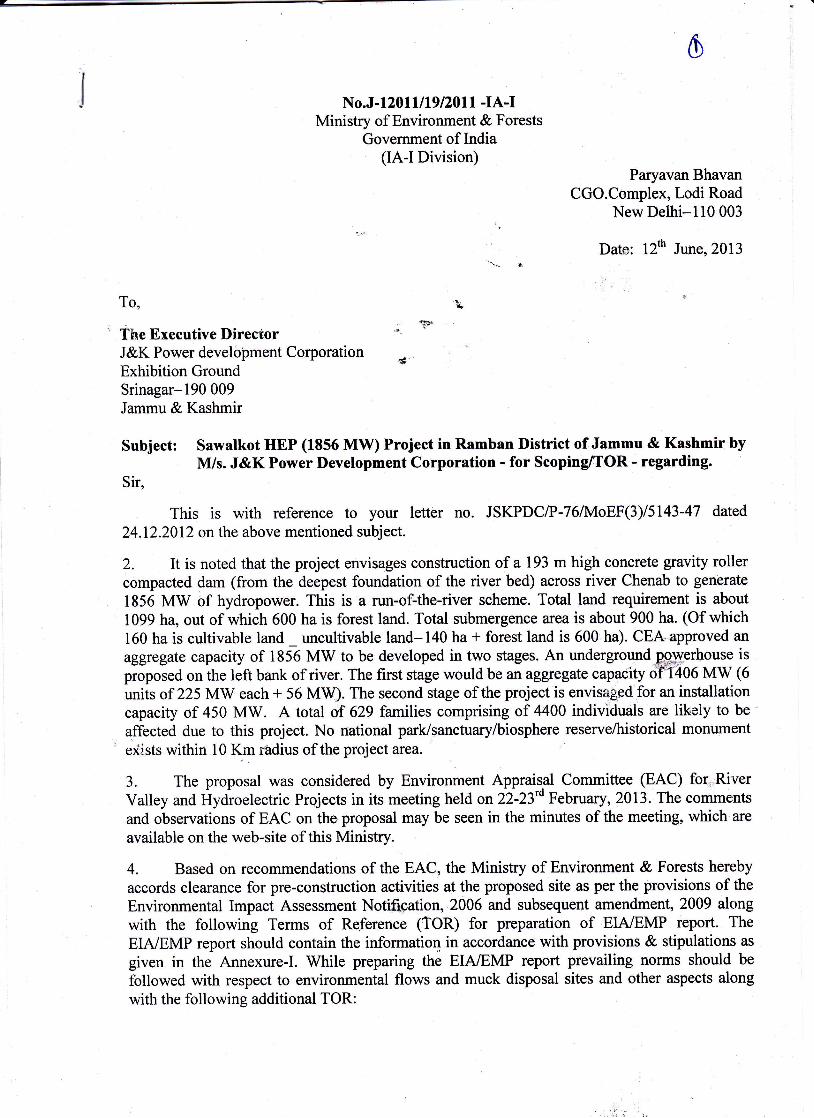
No.J-l 20 I I I 19 l20ll -IA-IMinistry of Environment & Forests
Government of India(IA-I Division)
Paryavan BhavanCGO.Complex,I odi Road
New Delhi-ll0 003
Date: l2th June,2013
To,. 'wF
The Executive DirectorJ&K Power develoilment Corporation j-Exhibition GroundSrinagar-lgO 009Jammu & Kashmir
Subject: Sawalkot HEP (1856 MW) Project in Ramban District of Jammu & Kashmir byM/s. J&K Power Development Corporation - for Scoping[OR - regarding.
Sir,
This is with reference to your letter no. JSKPDC/P-76/IvIoEF(3)15143-47 dated
24.12.2012 on the above mentioned subject.
2. It is noted that the project envisages construction of a 193 m high concrete gravity rollercompacted dam (from the deepest f,oundation of the river bed) across river Chenab to generate
1856 MW of hydropower. This is a run-of-the-river scheme. Total land requirement is about
1099 ha, out of which 600 ha is forest land. Total submergence area is about 900 ha. (Of which160 ha is cultivable land uncultivable land-140 ha * forest land is 600 ha). CEA,approved an
aggregate capacity of 1856 MW to be developed in two stages. An underground.p;-gE
proposed on the left bank of river. The first stage would be an aggregate capacity of'T406 MW (6units of 225 MW each + 56 MW). The second stage of the project is envisaged for an installationcapacity of 450 MW. A total of 629 families comprising of 4400 individuals are likely to be
affected due to this project. No national park/sanctuary/biosphere reserve/historical monument
exists within l0 Km rhdius of the project area.
3. The proposal was considered by Environrnent Appraisal Committee (EAC) for,*River
Valley and Hydroelectric Projects in its meeting held on22-23'o February, 2013. The comments
and observations of EAC on the.proposal may be seen in the minutes of the meeting, which are
available on the web-site of this Ministry.
4. Based on recommendations of the EAC, the Ministry of Environment & Forests hereby
accords clearance for pre-construction activities at the proposed site as per the provisions of the
Environmental Impact Assessment Notif*pation,.2006 and subsequent amendment, 2009 along
with the following Terms of Re,ference (TOR) for preparation of EIA/EMP report. The
EIA/EMP report should contain the information in accordance with provisions & stipulations as
given in the Annexure-I. While preparing the EIA/EMP report prevailing norms should be
followed with respect to environmental flows and muck disposal sites and other aspects along
with the following additional TOR:
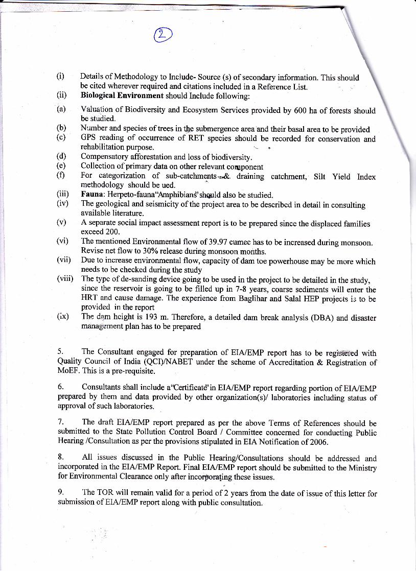
(D
(ii)
Details of Methodology to Include- Source (s) of secondary information. This shouldbe cited wherever required and citations included in a Reference List.Biological Environment should Include following:
(a) Valuation of Biodiversity and Ecosystem Services provided by 600 ha of forests shouldbe stridied.
(b) Number and species of trees i, tbe submergence area'and their basal area to be provided(c) GPS reading of occurrence of-RET rp.r1.r should be recorded for conservation and
rehabilitation purpose t(d) Compensatory afforestation and loss of biodiversity.(e) Collection of primary data on other relevant component(f) For categorization of sub-catchments"*& draining catchment, Silt Yield Index
methodology should be ued.X'auna : Herpeto-fauna"Amphibian3' shgrrld also be studied.The geological and seismicity of the project area to be described in detail in consultingavailable literature.A separate social impact assessment report is to be prepared since the displaced familiesexceed 200.
(vi) The mentioned Environmental flow of 39.97 cumec has to be increased during monsoon.Revise net flow b 3AYorelease during monsoon months.
(vii) Due to increase environmental flow, capacity of dam toe powerhouse may be more whichneeds to be checked during the study
(viii) The type of de-sanding device going to be used in the project to be detailed in the study,since the reservoir is going to be filled up in 7-8 years, coarse sediments will enter theHRT and cause damage. The experience from Baglihar and Salal HEP projects is to beprovided in the report
(ix) The dam height is 193 m. Therefore, a detailed dam break analysis (DBA) and disastermanag'ement plan has to be prepared
5. The Consultant engaged for preparation of EIA/EMP report has to be regiffied withQuality Council of India (QCI)A{ABET under the scheme of Accreditation & Registration ofMoEF. This is a pre-requisite.
6. Consultants shall include a'Certificatd'in EIA/EMP report regarding portion of EIA/EMPprepared by them and data provided by other organization(s)/ laboratories including status ofapproval of such laboratories.
7. The draft EIA/EMP report prepared as per the above Terms of References should besubmitted to the State Pollution Control Board / Committee concemed for conducting publicHearing /Consultation as per the provisions stipulated in EIA Notification of 2006.
8. All issues discussed in the Public Hearing/Consultations should be addressed andincorporated in the EIA/EMP Report. Final EIA/EMP report should be submitted to the Ministryfor Environmental Clearance only after incorpora[ing these issues.
9. The TOR will remain valid for a period of 2 years from the date of issue of this letter forsubmission of EIA/EMP report along with public consultation.
(iii)(iv)
(v)
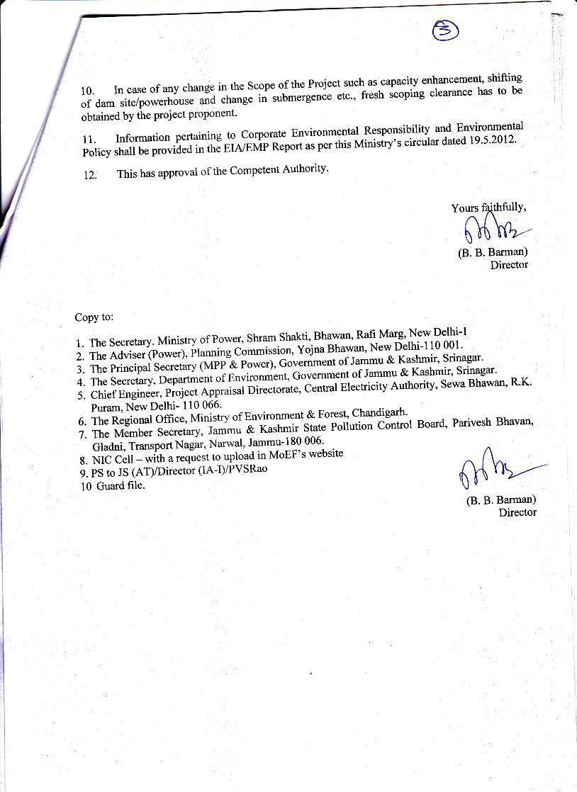
10. In case of any change in- the scope of the Project such as capacity enhancement' shifting
of dam site/powerhouse and change iri submerg"nit tt"" fttsh scoping clearance has to be
obtained by the project proponent'
,. Information pertaining to corporate Environmental Responsibitity and Environmental
poticy shall be p.ouii.J i, tfrJ ere,'evri il;;;"t per this Minisiry's circular dated 19'5'2012'
12. This has approval of the Competent Authority'
1. The Secretary. Ministry of Power, Shram shakti, Bhawan' Rafi Marg' New Delhi-l
2. TheAdviser (power), planning^cg**i$ilr, volna Bhawan, New Delhi-l10 001'
3. The principal Secretary (MPP A f.o*.r;, Col"niment of Jammu & Kashmir' Srinagar'
4. The Secretary, Department of Enviro#ent, Government of Jammu & Kashmir' Srinagar'
5. Chief Engineer, pioject Appraisal Di;;;;", Central eiectricity Authority' Sewa Bhawan' R'K'-'
p*u*,N"ewDelhi- 110 066' o F-----.6.TheRegionalOm"",Vtl'i'ttyofE^nvironment&Forest'Chandigarh'7. The Member Secretary, Jammu & [";h"rir State potiution cintror Board, parivesh Bhavan,
Copy to:
10 Guard file.
" ifrarri, it*.ponNagar, Narwal, Jammu-180 006'
g. NiCC-;fi- *itt, u,"qi'"tt to upload in MoEF's website
9. PS to JS (AT)/Director (IA-I)/PVSRao
(B.B.Barman)Director
Yours faithfullY,
(B.B.Barman)
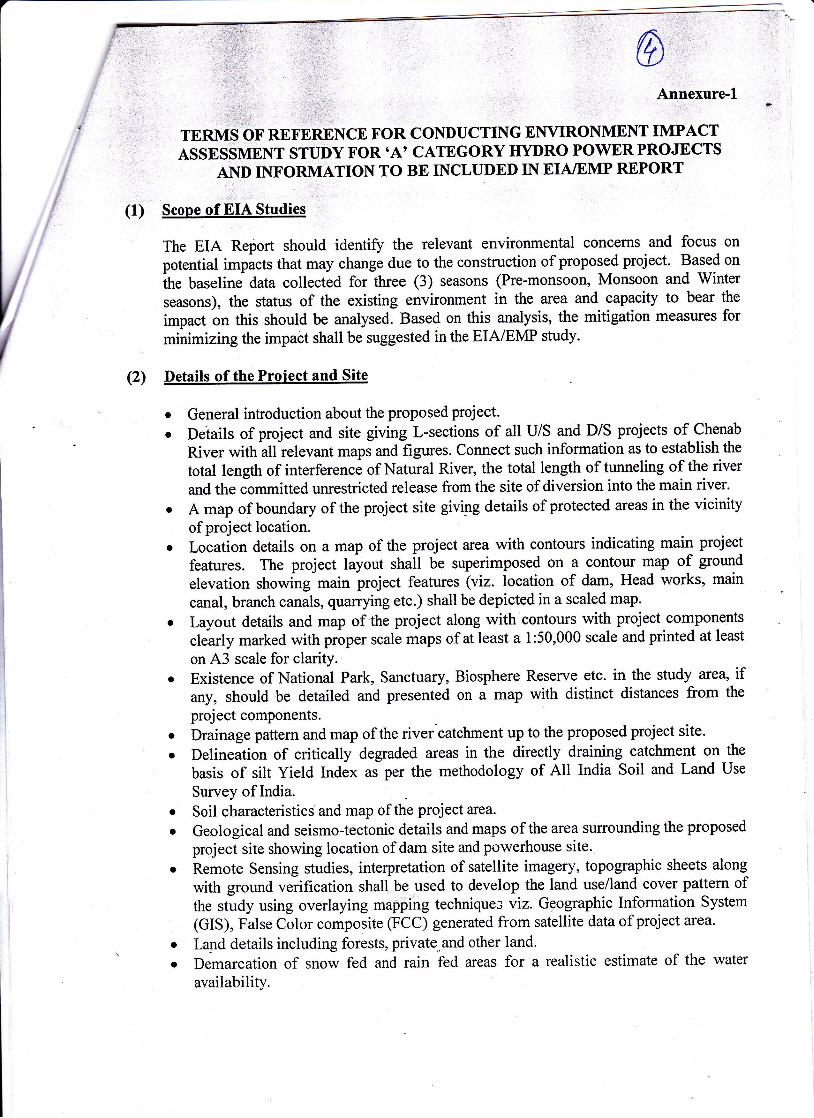
' ASSESSMENT SrUDf FoR 'A' CATEGoRY IIYDRo PowER PROJECTS. AND INFORMATION TO BE INCLUDED IN EIA/EMP REPORT
(1) Scope,of EIA Studies :
The EIA Report should identifu the relevant environmental concerns and focus on
potential impacts that may change due to the construction of proposed project. Based on
the baseline data collec6d for three (3) seasons (Pre-monsoon, Monsoon and Winter
seasons), the status of the existing environment in the area and capacity to bear the
impact on this should be analysed. Based on this analysis, the mitigation measures for
minimizing the impact shall be suggested inthe EIA/EMP study.
(2) Details of the Proiect and Site
o General introduction about the proposed project.
Deiails of project and site giving L-sections of all U/S and D/S projects of Chenab
River with all relevant maps and figures. Connect such information as to establish the
total length of interference of Natural River, the total length of tunneling of the river
and the committed unrestricted release from the site of diversion into the main river.
A map of boundary of the project site giving details of protected areas in the vicinity
of project location.Location details on a map of the project area with contours indicating main project
features. The project lJyout shall be superimposed on a contour map of ground
elevation showing-main project features (viz. location of dam, Head works, main
canal, branch canals, quarrying etc.) shall be depicted in a scaled map.
Layout details and map of the project along with contours with project components
clearly marked with proper scale maps of at least a 1:50,000 scale and printed at least
on ,A'3 scale for clarity.Existence of National Park, Sanctuary, Biosphere Reserve etc. in the study area, ifany, should be detailed and presented on a map with distinct distances from the
project components.
Drainage pattern and map ofthe river'catchment up to the proposed project site.
Delineation of critically degraded areas in the directly draining catchment on the
basis of silt Yield Index as per the methodology of All India Soil and Land Use
Survey of India.
Soil characteristics and map of the project area.
Geological and seismo-tectonic details and maps of the area surounding the proposed
project site showing location of dam site and powerhouse site.
Remote Sensing studies, interpretation of satellite imagery, topographic sheets along
with ground verification shall be used to develop the land use/land cover pattern ofthe study using overlaying mapping techniques viz. Geographic Information System
(GIS), False Color composite (FCC) generated from satellite data of project area.
Land details including forests, private,and other land.
Demarcation of snow fed and rain fed areas for a realistic estimate of the water
availability.
a
a
o
a
a
o
7:_
i..t l
" Different riverine habitats like rapids, pools, side pools and variations in the riversubstratum - bedrocks, rocks, boulders, sand/silt or clay etc. need to be covered underthe study.
Description of Environment and Baseline Data
To know the present status of environment in the are4 baseline data with respect toenvironmental components air, water, noise, soil, land and biology & biodiversity (flora& fauna), wildlife, socio-economic status etc. should be collected with 10 km radius ofthe main components of the project/site i.e. dam site and power house site. The air qualityand noise are to be monitored at such locations which are environmentally & ecologicallymore sensitive in the study area. The baseline studies should be collected for 3 r.*orrt{Pre-Monsoon, Monsoon and Post Monsoon seasons). The study area should comprise ofthe following:o Catchment area up-to the dam site.o Submergence Arear Project area or the direct impact area should comprise of aea falling within l0 km
radius from the periphery of reservoir, Iand coming under submergence and areadownstream of dam upto the point where Tail Race Tunnel (TRT) meetJthe river.
o Downstream upto 10 km from tip of Tail Race Tunnel (TRT).
0ellails of the Methodolow
'Ihe methodology followed for collection of base line data along with details of number*f samples and their locations in the map should be included. Study area should bedemarcated properly on the appropriate scale map. Sampling sites should be depicted onmap for each parameter with proper legends. For forest classification, Champion andSeth (1968) classification should be followed.
Methodolow for collection of Biodiversity Data
- T'he number of sampling locations should be adequate to get a reasonable idea of thediversity and other attributes of flora and fauna. The guiding principles should be thesize of the study area (larger area should have larger number ofsampiing locations) andirrherent diversity at the location, as known from secondary ro*."i (e.g. easternHimalayan and low altitude sites should have a larger number of sampling locationsowing to higher diversity).
- The entire area should be divided in grids of 5km X 5km preferably on a GIS domain.There after 25Yo of the grids should be randomly selected for sampling of which halfshould be in the directly affected area (grids including project cbmp-onents such asreservoir, dam, powerhouse, tunnel, canal etc.) and the remaining in the rest of the area(areas of influence in 10 km radius form project components). At such chosen location,the size and number of sampling units (e.g. quadrats in case of flora/transects in case offauna) must be decided by species area curyes and the details of the same (graphs andcumulative number of species in a tabulated form) should be provided in the EIa report.Some of the grids on the edges may not be completely overlapping with the study areahoundaries. However these should be counted and considered iorielecting25% of thegrids. The number of grids to be surveyed may come out as a decimal ,r-6., (i.e. it hasan integral and a fractional part) which should be rounded to the next whole number.
{4i
(5i
- The conventional sampling is likely to miss the presence of rare, endangered and
species are usually secretive in behaviour. Reaching the conclusion about the absence ofsuch species in the study area based on such meihodology is misleading. It is veryimportant to document the status of such species owing to lieir high conservation value.Hence fikely presence of such species shoujd be ascertained from secondaryo*.., by uproper literature survey for the said area including referring to field guides which are nowavailable for many taxonomic groups in India. Even literature frJm studies/surveys inthe larger landscapes which include the study area for the concerned project must bereferred to since most species from adjoining catchments is likely to be present in thecatchments in question. In fact such literature form the entire state can be refened to.Once a listing of possible R.E.T. species form the said area is developed, species specificmethodologies should be adopted to ascertain their presence in the stdy area whichwould be far more conclusive as compared to the conventional sampling. littre need be,modern methods like camera trapping can be resorted to, particuimf for *"u, io ,t.eastern Himalayas and for secretive/nocturnal species. A detailed listing of the literaturereferred to, for developing lists of R.E.T. species should be prwided in tie EIA reports.
- T"-\E-T. species referredto in this point should include species listed in Schedule I andII of Wildlife (Protection) Act, 1972 andthose listed in the red data books (BSI, ZSI andrucN).
(6) Components of the EIA Studv
Various aspects to be studied and provided in the EIAIEMP report are as follows:A. Physical and Chemical Environment
Geological & Geophysical Aspects and seismo - Tecionics:o Physical geography, Topography, Regional Geological-aspects and structure of
the Catchment.o Tectonics, seismicity_and history of past earthquakes in the area. A site specific
study of the earthquake parameters will be done. The results of the site specificearthquake design shall be sent for approval of the NCSDP (National committeeof Seismic Design Parameters, Cential water commission, New Delhi for largedams.
o Landslide zone or area prone to landslide existing in the study area should beexamined.
o Presence of important economic mineral deposit, if any.o Justification for location & execution of the project in relation to structuralcomponents (dam height).
o Impact of project on geological environment.
Meteorology, Air and Noise:
o Meteorology (viz. Temperature, Relative humidity, wind speed/direction etc.) tobe collected from nearest IMD station.
o Ambient Air Quality with parameters viz. Suspended Particulate Matter (SpM),Respirable Suspended Particulate Matter lnSfp l.e. suspended particulatematerials <10 microns, Sulphur Dioxide (so, and oxides of\itrog"r, 6No*; i,the study area at 6 locations.
o Existing noise levels and traffic density in the study area at6 locations.
Soil Characteristics^':^- -L.'-i^^l nara )nsiry ando Soil classification, physical parameters (viz., texture, porollty, P"F d'
' #;6di;;;;ffM *a.r,.-i"ur n*u*.tg' (viz. pH, electrical conductivitv,
, magneslum,'r.l.trrrr, total ,1k"ilid, chlorides, tobiu*, potassium, organic
carbon, available potassium, *uiruur" phosphorus, SAR, nitrogen and salinity;
etc.) (6locations).
Remote sensing and GIS Studies
o Generation of thematic maps viz., slope map, drainage map, soil map' land use
and land .o"", *up, "t".
surra *'tt "t", thematic maps, an erosion intensity map
should be PrePared.
water Quality rc rrr'r'nd rvater tablr $udy area'o History of the ground water table fluctuation in the s
o Water quality ior both surface water and groung-water for (i) Physical parameters
oH, tempeiature, electrical conductivity, TSS); (iD chemical parameters
(Alkalinity, rr*arlrr, BOD, COD;NO,,PO''CI' SO4'Na' K' Ca' Mg' Silica' oil
& Grease, phenolic compoundq t"tiarut rodi* carbonate); (iii) Bacteriological
parameter (MpN, Total coliformj *a (ir) Heavy Metals (Pb, As, Hg, cd' cr-6,
iotal Cr, Cu,Zn,fe) (6 locations)'
o Delineation of sub and mi.,o-*utersheds, their locations and extent based on the
All India Soil and Land U;;--i;;;t of India (AISLUS)' Department of
. Agricultur", Gor.*ent of lndia. Erosion levels in each micro-watershed and
prioritization-of micro-wate.tft"J through silt yield index (SYD method of
AISLUS.
B Water Environment & HYdrologr
o Hydro-Meteorology of the projec t vi1, precipitaiion .(t":ddl' rainfall)'
temperature, relative trumiditi, Ltc. Hvaro;yteorological studies in the
catchment area shoula Ue estaUtished alorrg-with real time telemetry and data
acquisition system for inflows monitoring'
. Run off, discharge, water availability for the project, sedimentation rate' etc'
o Basincharacteristicso CatastroPhic events like cloud bursts and flash floods, if any, should be
documented.o For estimation of Sedimentation Rate, direct sampling of river flow is to be done
during tne gre stuav. The study_should be conducted for minimum one year'
' Actual silt flow t;;. be expressed in ha-m km2 year-l'
oSetupaG&Dmonitoringstationandafewraingaugestationsinthecatchment*.u fo, collecting data during the investigation'
. Flow series, to ality with 90%, 75oh arrd50% dependable years discharges'
o Information on the l0-daily flow basis for the 90 per cent dependable year the
. flow intercepted u, ,rr" dam, the flow diverted to tie power house and the spill
comprising the environmental flow and additional flow towards downstream of
the dam for the project may be given'
o The minimum environmental flow shall be 200/o ofthe flow of four consecutive
lean months or gox dependable !e;ar, 30Yo of the average monsoon flow' The
flow for remaining *ortrs shall te in between 2aioo/o, depending on the site
specific requirements. A site specific study shall be carried out by an expert
organization.. Hydrological studies/data as approved by CWC shall be utilized in the preparation
of p161gMp report. Actual nyarotogical annual yield may also be given in the
report.. Sedimentation data available with CWC may be used to find out the loss in
storage over the Years'o A minimum of i m distance from the tip of the reservoir to the tail race tunnel
should be maintained between upstream and downstream projects.
C BiologicalEnvironm'ent
Besides primary studies, review of secondary data/literature published for project area
on flora A, fuu* including RET species shall be reported in EIAIEMP report.
Flora
. Characterization of forest types (as per Champion and Seth method) in the study
area and extent of each forest type as per the Forest Working Plan.
. Documentation of all plant species i.e. Angiosperm, 'Gymnospenn,
Pteriodophytes, Bryophytes (al[ groups).
. General vegetation profile and floral diversity covering all groups of flora
including lichens and orchids. A species wise list may be provided.
o Assessment of plant species with respect to dominance, density, frequency,
abundance, diveisity index, similarity index, importance value index (IVD ,
Shannon Weiner index etc. of the species to be provided. Methodology used for
calculating various diversity indices along with details of locations of quadrates,
size of quadrates etc. to be reported within the study area in different ecosystems.
o Existence of National park, Sanctuary, Biosphere Reserve etc in the study area, ifany, should be detailed.
o Economically important species like medicinal plants,'timber, fuel wood etc'
o Details of endemic species found in the project area'
o Flora under RET categories should be documented using Intemational Unioir for
the Conservation of Nature and Natural Resources (ILJCN) criteria and Botanical
Survey of India's Red Data list along-with economic significance. Species
diversity curve for RET species should be given'. Cropping pattern and Horticultural Practices in the study area.
Fauna:
o Fauna study and inventorisation should be carried out for all groups of animals in
the study area. Their present status alongwith Schedule of the species.
o Documentation of fauna plankton (phlto and zooplankton), periphyton, benthos
and fish should be done and analysed'o Information (authenticated) on Avi-fauna and wildlife in the study area.
. Status of avifauna their resident/ migratory/ passage migrants etc.
. Documentation of butterflies, if any, found in the area'
o Details of endemic species found in the project area'
. RET species-voucher specimens should be collected along-with GPS readings to
facilitate rehabilitation. RET faunal species to be classified as per IUCN Red
Data list and as per different schedule of Indian Wildlife (Protection) Act, 1972.
o Existence of barriers and corridors, if any, for wild animals.
r".o
' Compensatory afforestation to compensate the green belt area that willremoved,- if any, as part of the pioposed proj;t development and loss
beof
D
o Colledion of primary data on agricultural activity, crop and their productivity andirrigation facilities components.
o For categoization of sub-catchment into various erosion classes and for theconsequent CAT plan, the entire catchment (Indian Portion) is to be consideredand not only the directly the draining catchment
Aquatic Ecolory
o Documentation of aquatic fauna like macro-invertebrates, zooplankton,phytoplantktons, benthos etc.
o Fish and fisheries, their migration and breeding grounds.o Fish diversity composition and maximum Iength & weight of the measuredpopulations to be studies for estimation of environmental flow.r Conservation status of aquatic fauna.
t Sampling for aquatic ecology and fisheries and fisheries must be conductedduring three. seasons - Pre-monsoon (summer), monsoon and winter. Sizes(tt_rg,h & weight) of important fish species need to be collected and breeding andfeeding grounds should also be identified along the project site or in vicinity.
Socio-Economic
o Collection of baseline data on human settlements, health status of the communityand existing infrastructure facilities for social welfare including sources oflivelihood, job opportunities and safety and security of workers andiunoundingspopulation
o Collection of information with respect to social awareness about thedevelopmental activity.in the area and social welfare measures existing andproposed by project proponent.
o Collection of information on sensitive habitat of historical, cultural and religiousand ecological importance.
the study area forProfile; Agriculturalsanitation facilities;
. The socio-economic survey/ profile within l0 km ofdemographic profile; Economic Structure; DevelopmentalPractices; Infrastructure, education facilities; -health andavailable communication network etc.
o Documentation of demographic, Ethnographic,development profile of the area.
Economic Structure and
t Information on Agriculfural Practices, Cultural and aesthetic sites, Infrastructurefacilities etc.Information on the dependence of the local people on minor forest produce andtheir cattle grazingrights in the forest land.List of all the Project Affected Families with their name, age, educationalqualification, family size, sex, religion, caste, sources of incomel land & householdings, other properties, occupation, source of income, house/land to beacquired for the project and house/land left with the family, any other property,possession of cattle, type of house etc.Special attention has to be given to vulnerable groups like women, aged personsetc. and to any ethnic/indigenous groups that are getting affected by thJ project.
r-u.i:i:
(7) Impact Prediction and Mitisation Measures
The adverse impact due to the proposed project should be assessed and effectivemitigation steps to abate these impacts should be described.
Air Environmento Changes in ambient and ground level concentrations due to total emissions from
point,line and area sources.o Effect on soil, material, vegetation and human health.o Impact of emissions from DG set used for power during the construction, if any,
on air environment.o Pollution due to fuel combustion in equipments and vehicleso Fugitive emissions from various sources
Water Environmento Changes in surface and ground water qualityo Steps to develop pisci-culture and recreational facilitieso Changes in hydraulic regime and downstream flow.o Water pollution due to disposal of sewageo Water pollution from labour colonies/ camps and washing equipment
Land Environment
o Adverse impact on land stability, catchment of soil erosion, reservoirsedimentation and spring flow (if any) (a) due to considerable road construction /widening activity (b) interference of reservoir with the inflowing stream (c)blasting for commissioning of HRT, TRT and some other structures.
. Changes in land use / land cover and drainage pattemo Immigration of labour populationo Quarrying operation and muck disposal. Changes in land quality including effects of waste disposalo River bank and their stabilityo Impact due to submergence.
Biological Environment
o Impact on forests, flora, fauna including wildlife, migratory avi-fauna, rare andendangered species, medicinal plants etc.
o Pressure on existing natural resourceso Deforestation and disturbance to wildlife, habitat fragmentation and wild animal's
migratory corridors
' Compensatory afforestation-ideritification of suitable native tree species forcompensatory afforestation and green belt.
o Impact on fish migration and habitat degradation due to decreased flow of watero Impact on breeding and nesting grounds of animals and fish.
Socio-economic aspects .,,,
o Impact on local community including demographic profile.o Impact on socio-economic statusr Impact on economic status.o Impact on human health due to watei lvector bome diseaseo Impact on increase traffic
=:\
(8)
, Impacts of blasting activity during project construction which generally destabilizethe land mass and leads to landslides, damage to properties and drying up of naturalspnngs and cause noise population will be studies. Proper record shall bemaintained of the baseline information in the post project period.
o Positive and negative impacts likely to be accrued due to the project are listed.
Environmental Management Plans
I. Catchment Area Treatment (CAT) PIan should be prepared micro-watershed wise.Identification of-free draining/ directly draining catchment based upon Remote Sensing andGeographical Information System (GIS) methodology and Sediment iield Index (Sy| mithodof AISLUS, Deptt. of Agriculture, Govt. of India coupled with ground survey. Areas orwatersheds falling under 'very severe' and 'severe' erosion categories shoutd be provided andrequired to be treated. Both biological as well as engineering miasures should be proposed inconsultation with State Forest Department for areas requiring treatment. year-wiseichedule ofwork and monetary allocation should be provided. Mitigation measures to check shiftingcultivation in the catchment area with provision for alternative and better agricultural practicelshould be included
2. Compensatory Afforestation shall be prepared by the State Forest Department in lieu of the
- for€st land proposed to be diverted for construction of the project as per the Forest' (Conservation) Act, 1980. Choice of plants for afforestation shouid include native and RETspecies, if any. This will be a part of the forest clearance proposat.
3. Biodiversity and Wildlife Conservation and Management PIan for the conservation andpreservation of rare, endangered or endemic floral/faunal species or some NationalPark/Sanctuary/ Biosphere Reserve or other protected area is going to get affected directly orindirectly by construction of the projec! then suitable conservation measures should beprepared in consultation with the State Forest Department and with the phySical and financialdetails' Suitable conservation techniques (in-situ/ex-situ) will be proposed under the plan andthe areas where such conservation is proposed will be marked on a-project tayout map.
4- Fisheries Conservation and Management Plan - a specific fisheries management measures
:hol!{ be prepared for river and reservoir. If the construction of fish ladder/ fish-way etc. is notfeasible then measures for reservoir fisheries will be proposed. The plan will deiail out thenumber of hatcheries, nurseries, rearing ponds etc. proposed undei the plan with properdrawings. If any migratory fish species is getting affected then the migratory routes,timeAeason of upstream and downstream migration, sfawning grounds etc willie discussed indetailg.
5. Resettlement and Rehabilitation Plan needed to be prepared on the basis of findings of thesocio-economic survey coupled with the outcome of public consultation held. The R&Rpackage shall be prepared after consultation with the representatives of the project affectedfamilies and the State Government. Detailed budgetary estimates are to be provided.Resettlements site should be identified. The plan will Jso incorporate community devLlopmentstrategies.
6. Green Belt Development Plan along the periphery of the reservoir, approach roads around thecolonies and other project components, local plant species must be suggested with physical andfinancial details. A layout map showing the proposed sites for develof,irg the green belt shouldbe prepared.
7. Reservoir Rim Treatment Plan for stabilization of land slide / land slip zones, if any, aroundthe reservoir periphery is to be prepared based on detailed survey of geology of the reservoirrim area. Suitable engineering and biological measures for treatment oi ioeniined slip zones to
.l:;,r*;".: r 'r iil,r.:'i.4, i:ln-t!.: ,,-it: r.:
,,1i., 'i,t ,',,t
zones shall be prepAred and appended in the chapter.
I' Muck Disposal PIan suitable sites for dumping of excavated materials should be identified inconsultation with State Potlution Control Boird and State Forest Department. All muckdisposal sites should be minimum 30 m away from the HFL of river. The quantity of **f. iobe generated and the quantity of muck proposed to be utilized shali be calculated inconsultation with the project authorities. Details of each dumping site viz. area, capacity, totalquantity of muck that can be dumped etc. should be worked out and discussed in the plan. planfor rehabilitation of muck disposal sites should also be given. The L-section / cross iection ofmuck disposal sites and approach roads should be given. The plan shall have physical andfinancial details of the measures proposed. Layout map showing tt e dumping sites vis-i-visother project components will be prepared and appended in the chapter.
9. Restoration PIan for Quarry Sites and landscaping of colony areas, working areas, roads etc.Details of the coarse/fine aggregate/clay etc. required for construction of thi project and therock/clay quarries/river shoal sites identified for the project should be discussedalong-with theEngineering and Biological measures proposed for their restoration with physical and financialdetails. Layout map showing quarry sites vis-i-vis other project components, should beprepared.
l0' Study of Design Earthquake Parameters: A site specific study of earthquake parametersshould be done. Results of the site specific earthquake design parameters should bi approvedby National Committee of Seismic Design Parameters, Ceniral Water Commission (NiSOp),New Delhi.
I l. Dam Break Analysis and Disaster Management Plan The outputs of dam break modelshould be illustrate{ with appropriate graphs and maps clearly bringing out the impact of DamBreak scenario. To identifo inundation areas, population and structureslikely to be affected dueto catastrophic floods in the event of dam failure. DMP will be prepared with the help of DamBreak Analysis' Maximum water level that would be attained at various points on thedownstream in case of dam break will be marked on a detailed contour map of thL downstreamarea; to show the extent of inundation. The action plan will include Emergency Action andManagement plan including measures like preventive action notification, iarning procedureand action plan for co-ordination with various authorities.
12. Water, Air and Noise Management Plans to be implemented during construction and post-construction periods.
Public Health Delivery Plan including the provisions of drinking water supply for localpopulation shall be in the EIA/EMP Report. Status of the existing meOicat Acifities in theproject area shall be discussed. Possibilities of strengthening of existing medical facilities,construction of new medical infrastructure etc. will be explored after assesiing the need of thelabour force and local populace.
Labour Management PIan for their Health and Safety.
Sanitation and Solid waste management plan for domestic waste from colonies and labourcamps etc.
Local Areg Development Plan to be formulated in consultation with the Revenue Officialsand Village Pancahayats. Appropriate schemes shall be prepared under EMP for the Local AreaDevelopment Plan with sufficient financial provisions.
Environmental safeguards during construction activities including Road Construction.
Energy Conservation Measures for ihe work force during construction with physical andfinancial details. Alternatives will be proposed for the laboui force so that the eiploitation ofthe natural resource (wood) for the domestic and commercial use is curbed.
13.
16.
14.
15.
17.
18.
.]d:.
llj;.'
ffili
,r,ii:i
i!:.i;"i1:r,': '';:r.,i l.t1i,,l. .
." 1, il'r .''
**:f *r&*i.**.*****
![arXiv:2203.12169v1 [hep-ph] 23 Mar 2022](https://img.pdfslide.net/doc/110x75/633cd485d4e2cc224b0c56e5/arxiv220312169v1-hep-ph-23-mar-2022.jpg)
![arXiv:1609.06439v2 [hep-th] 23 Sep 2016](https://img.pdfslide.net/doc/110x75/63345342f59f4bbe810a91cd/arxiv160906439v2-hep-th-23-sep-2016.jpg)


![arXiv:1807.03805v5 [hep-ph] 25 Feb 2019](https://img.pdfslide.net/doc/110x75/6338438ff0247b37d207f0fc/arxiv180703805v5-hep-ph-25-feb-2019.jpg)
![arXiv:2003.10449v3 [hep-ph] 5 Apr 2021](https://img.pdfslide.net/doc/110x75/631ce64fc2fddc48190833be/arxiv200310449v3-hep-ph-5-apr-2021.jpg)


![arXiv:2202.01792v1 [hep-th] 3 Feb 2022](https://img.pdfslide.net/doc/110x75/633c95a691e59777c8009f0b/arxiv220201792v1-hep-th-3-feb-2022.jpg)


![arXiv:2112.10519v3 [hep-lat] 1 Apr 2022](https://img.pdfslide.net/doc/110x75/633ccb86931c63fadb03378d/arxiv211210519v3-hep-lat-1-apr-2022.jpg)


![arXiv:1604.04979v4 [hep-ph] 21 Dec 2016](https://img.pdfslide.net/doc/110x75/6333942cb91d35198e0bc000/arxiv160404979v4-hep-ph-21-dec-2016.jpg)


![arXiv:1703.01269v2 [hep-th] 19 May 2017](https://img.pdfslide.net/doc/110x75/6336501762e2e08d49036fde/arxiv170301269v2-hep-th-19-may-2017.jpg)
![arXiv:2202.04214v2 [hep-th] 21 May 2022](https://img.pdfslide.net/doc/110x75/6333be08a6138719eb0ac123/arxiv220204214v2-hep-th-21-may-2022.jpg)
