Embed Size (px)
Citation preview

Subsurface investigation of a rock glacier using ground-penetrating
radar: Implications for locating stored water on Mars
John J. Degenhardt Jr.High Alpine Research Program (HARP) and Department of Geography, Texas A&M University, College Station, Texas,USA
John R. GiardinoHigh Alpine Research Program (HARP), Department of Geology and Geophysics and Office of Graduate Studies, TexasA&M University, College Station, Texas, USA
Received 21 February 2002; revised 13 June 2002; accepted 25 June 2002; published 8 April 2003.
[1] The discovery of rock glacier-like features on Mars suggests the presence of flowing,or once-flowing, ice-rock mixtures. These landforms, which include lobate debris aprons,concentric crater fill, and lineated valley fill, hold significant promise as reservoirs ofstored water ice that could be used as fuel sources for human exploration of Mars andprovide a frozen record of the climatic history of the planet. To understand the deformationand distribution of ice within these landforms, fundamental descriptions of their internalstructure and development are required. To this end, a ground-penetrating radarinvestigation was initiated using rock glaciers in the San Juan Mountains of Colorado assurrogates for similar Martian landforms. Results obtained from one of these rock glaciersshow that the interior of the landform is composed of a layered permafrost matrix of ice,sediment, and ice lenses that comprise thicker depositional units formed through high-magnitude debris falls. Folds in the uppermost layers correspond to the surface expressionof ridges and furrows, suggesting that compressive stresses originating in theaccumulation zone are transmitted downslope through the rock glacier. Rock glacierfeatures on Mars may also consist of layered permafrost, which would suggest a history ofdevelopment involving seasonal frost accumulation and/or water influx from below. Interms of water storage within Martian analogs, consideration must include the possibilitythat some water ice may be stored in relatively pure form within lenses and vein networkssuch as observed in the surrogate rock glacier of this study. INDEX TERMS: 6225
Planetology: Solar System Objects: Mars; 6207 Planetology: Solar System Objects: Comparative planetology;
5470 Planetology: Solid Surface Planets: Surface materials and properties; 0925 Exploration Geophysics:
Magnetic and electrical methods; KEYWORDS: Planetary geology, rock glacier, Mars, GPR, ground penetrating
radar, viscous flow feature
Citation: Degenhardt, J. J., Jr., and J. R. Giardino, Subsurface investigation of a rock glacier using ground-penetrating radar:
Implications for locating stored water on Mars, J. Geophys. Res., 108(E4), 8036, doi:10.1029/2002JE001888, 2003.
1. Introduction
[2] Rock glaciers are lobate or tongue-shaped bodiescomposed of mixtures of poorly sorted angular, blocky rockdebris and ice. These landforms, whose wide distribution,occurrence, and significance often go unnoticed, move byslip, flow and/or creep deformation [Giardino, 1979; Hae-berli, 1985; Giardino and Vitek, 1988a, 1988b] and havedistinctive surface morphologies, including ridges and fur-rows perpendicular to flow direction. They generally occurin dry, continental areas rather than humid regions, perhapsbecause thin to absent snow cover and reduced glacierextension favor the existence of periglacial permafrostconditions and, hence, the preservation over long time
intervals ground ice - a primary condition of rock glacierformation [Humlum, 1997]. Ages of rock glaciers rangefrom incipient rock glaciers on Pico de Orizaba volcano[Palacios and Vazquezselem, 1996] through forms associ-ated with the Little Ice Age [Humlum, 1996], to featuresseveral thousand years old [e.g., Kaeaeb et al., 1997; Calkinet al., 1998], to relict rock glaciers that formed during and atthe end of the last Ice Age �18,000–10,000 years BP[Sandeman and Ballantyne, 1996; Humlum, 1998]. Directdating of rock glaciers using pollen analysis and C14 ages ofmoss has recently been provided by Haeberli et al. [1999].The occurrence of past or present glaciers is not necessarilya prerequisite to the formation of rock glaciers because theselandforms exist in both glacial and nonglacial areas [Giar-dino, 1979, 1983; Johnson, 1983; Haeberli, 1985].[3] Serious study of rock glaciers began with the seminal
work by Wahrhaftig and Cox [1959], who put forth the idea
JOURNAL OF GEOPHYSICAL RESEARCH, VOL. 108, NO. E4, 8036, doi:10.1029/2002JE001888, 2003
Copyright 2003 by the American Geophysical Union.0148-0227/03/2002JE001888$09.00
GDS 17 - 1
that rock glaciers represent a landform continuum in thealpine environment. Barsch [1977] and Giardino [1979]later addressed the role of rock glaciers in terms of debristransport and found that rock glaciers account for approx-imately 60% of all mass transport in the alpine environment.Our current understanding of rock glacier deformation isoutlined in the work of Haeberli [1985]. It is based on flowmodels adopted from studies of glaciers and limited physicaldata from rock glaciers around the world. Subsequent con-tinuum-based [Giardino and Vitek, 1988a, 1988b], dynam-ics-based [Johnson, 1978, 1983], and form-based [Corte,1987] classification schemes have also been developed.[4] Although the geomorphology of lobate landforms
with surficial ridges and furrows perpendicular to flowdirection is well documented, our current knowledge of theirmovement mechanics and flow behavior is based on limiteddata obtained exclusively from terrestrial rock glaciers.Knowledge of the internal composition and fabric is neces-sary to understand the flow dynamics responsible for rockglacier deformation [Fitzgerald, 1994], but the difficulty andcost associated with direct observation of the internal char-acteristics make acquisition of these data problematic. Forexample, direct rheological measurements (i.e., flow direc-tion, flow velocity, and stress fields) are time dependent andlengthy. To fully understand the movement and deformationpatterns within rock glaciers, a fundamental (i.e., generic)description of their development is required. However,before the mechanics of motion can be understood, internalstructure must be accurately identified.[5] In this study, we identify the internal structure of a
lobate rock glacier with characteristic ridges and furrowsusing ground-penetrating radar (GPR), a nonintrusivemethod of subsurface remote sensing. The investigation isdirected at understanding the movement and deformation ofice-rich, slow mass-movement forms on Mars through theuse of surrogate rock glaciers on Earth. The insightspresented in this paper have been developed through aprocess of: (1) describing the internal structure of a lobaterock glacier, (2) developing a model for rock glacierdevelopment, (3) providing a plausible explanation for theorigin of transverse ridges and furrows, and (4) mappingwater pathways within a rock glacier. The methodologyestablished here can be applied directly to investigations onMars where information about the distribution of stored icewithin landforms is paramount.
2. Similar Features on Mars
2.1. Water Ice in Regolith
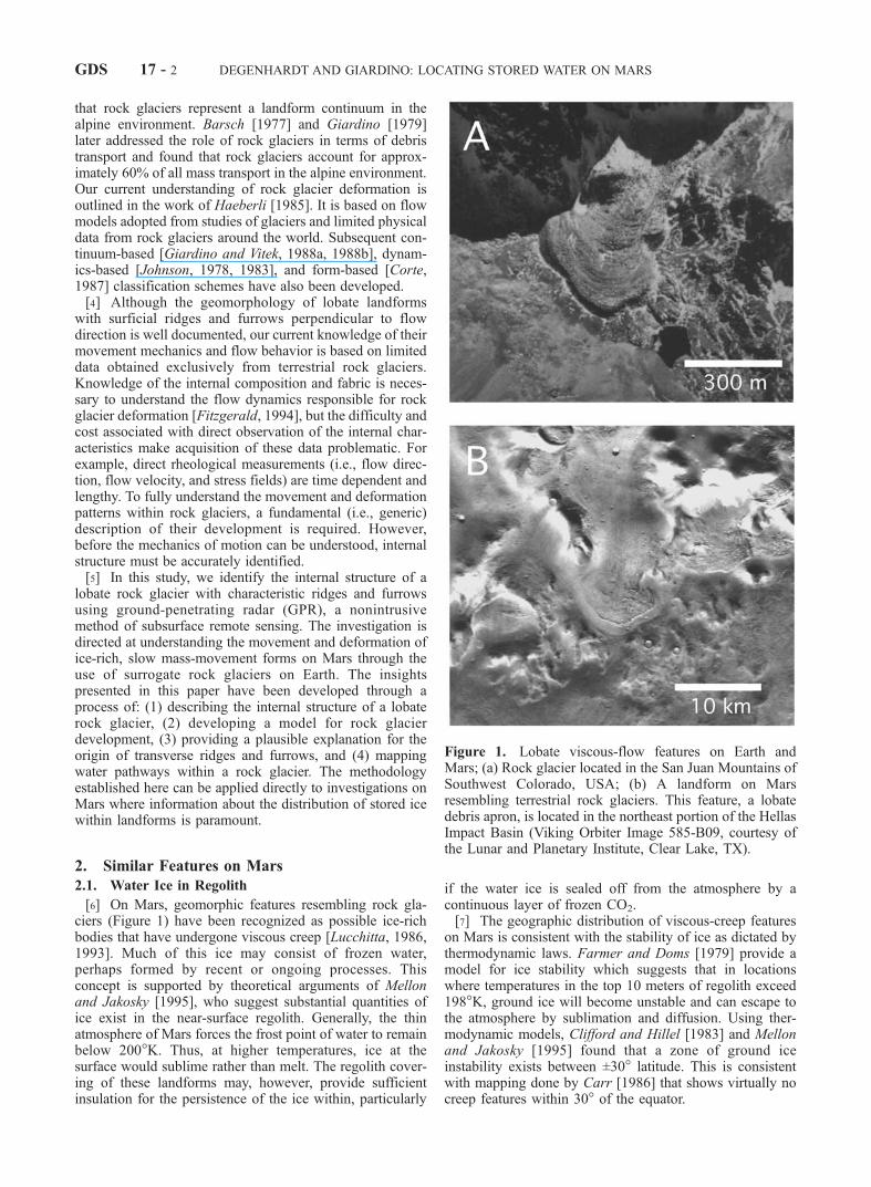
[6] On Mars, geomorphic features resembling rock gla-ciers (Figure 1) have been recognized as possible ice-richbodies that have undergone viscous creep [Lucchitta, 1986,1993]. Much of this ice may consist of frozen water,perhaps formed by recent or ongoing processes. Thisconcept is supported by theoretical arguments of Mellonand Jakosky [1995], who suggest substantial quantities ofice exist in the near-surface regolith. Generally, the thinatmosphere of Mars forces the frost point of water to remainbelow 200�K. Thus, at higher temperatures, ice at thesurface would sublime rather than melt. The regolith cover-ing of these landforms may, however, provide sufficientinsulation for the persistence of the ice within, particularly
if the water ice is sealed off from the atmosphere by acontinuous layer of frozen CO2.[7] The geographic distribution of viscous-creep features
on Mars is consistent with the stability of ice as dictated bythermodynamic laws. Farmer and Doms [1979] provide amodel for ice stability which suggests that in locationswhere temperatures in the top 10 meters of regolith exceed198�K, ground ice will become unstable and can escape tothe atmosphere by sublimation and diffusion. Using ther-modynamic models, Clifford and Hillel [1983] and Mellonand Jakosky [1995] found that a zone of ground iceinstability exists between ±30� latitude. This is consistentwith mapping done by Carr [1986] that shows virtually nocreep features within 30� of the equator.
Figure 1. Lobate viscous-flow features on Earth andMars; (a) Rock glacier located in the San Juan Mountains ofSouthwest Colorado, USA; (b) A landform on Marsresembling terrestrial rock glaciers. This feature, a lobatedebris apron, is located in the northeast portion of the HellasImpact Basin (Viking Orbiter Image 585-B09, courtesy ofthe Lunar and Planetary Institute, Clear Lake, TX).
GDS 17 - 2 DEGENHARDT AND GIARDINO: LOCATING STORED WATER ON MARS

[8] Viking images of the northern plains on Mars revealthe presence of lobate features with wrinkled surfacesassociated with rift valleys and the peripheral margins ofsplash-form craters. These landforms, which include lobatedebris aprons, lineated valley fill and concentric crater fill,have been interpreted as possible viscous ice-flow features[e.g., Carr, 1987; Lucchitta, 1993] derived from materialsloosened from their original locations. The materials appearto have been transported generally down gradient by mass-wasting processes followed by accumulation and subse-quent creep flow [Squyres, 1978].[9] Lobate debris aprons are thick, topographically con-
vex accumulations of debris at the base of escarpments. Thesurface of a debris apron slopes gently away from its source(e.g., the escarpment), and then steepens to form a distinctflow terminus analogous to the toe of a rock glacier. Thismorphology is a reliable indicator that deformation and flowhave taken place throughout a significant thickness of thedeposit [Squyres and Carr, 1986]. In terrestrial rock gla-ciers, a steep-crested toe indicates that the landform iscurrently active or was active in the recent past [Giardinoet al., 1987]. Some lobate debris aprons exhibit distinctivesurface lineations that are both parallel and transverse toflow. These features bear striking resemblance to terrestrialrock glacier counterparts. Debris aprons that are confined innarrow valleys have been termed lineated valley fill. Theyappear to be composed of the same material as lobate debrisaprons. Lobate debris aprons are very common in the frettedterrain separating the northern lowlands from the southernhighlands between 280� and 250� longitude [Colprete andJakosky, 1998]. Almost all of these types of features arerestricted to a region between 50� and 80� latitude [Squyres,1988].
2.2. Rock Glacier Analogs: Hellas Impact Basin andRegion of Fretted Terrain
[10] The Hellas region (27.5�–42.5�S, 260�–275�W),dominated by the Hellas impact basin, is topographicallyand geologically diverse. The generalized geology, recentlymapped by Tanaka [1995], includes Mid- to Upper Noa-chian-age (�3,900–3,500 Ma) Patera material to the northof the impact basin, basin rim units of late Noachian(�3,600 Ma) to the north and west, and dissected rim unitsof upper Hesperian (�2,400–1,800 Ma) and late Amazo-nian (�300–100 Ma) to the south and east of the basin.Farther south and east of the basin are ridges and plainsmaterials of upper Noachian to late Hesperian age. Thebasin was formed during the early bombardment period(�3,900 Ma), but is relatively well preserved. It makes upthe deepest and broadest depression on Mars (�9 km relief,�2,000 km across). Volcanism and channel dissection havesignificantly modified large portions of the northeastern andsouthern parts of the basin rim.[11] Large-scale examples of rock glacier-like features
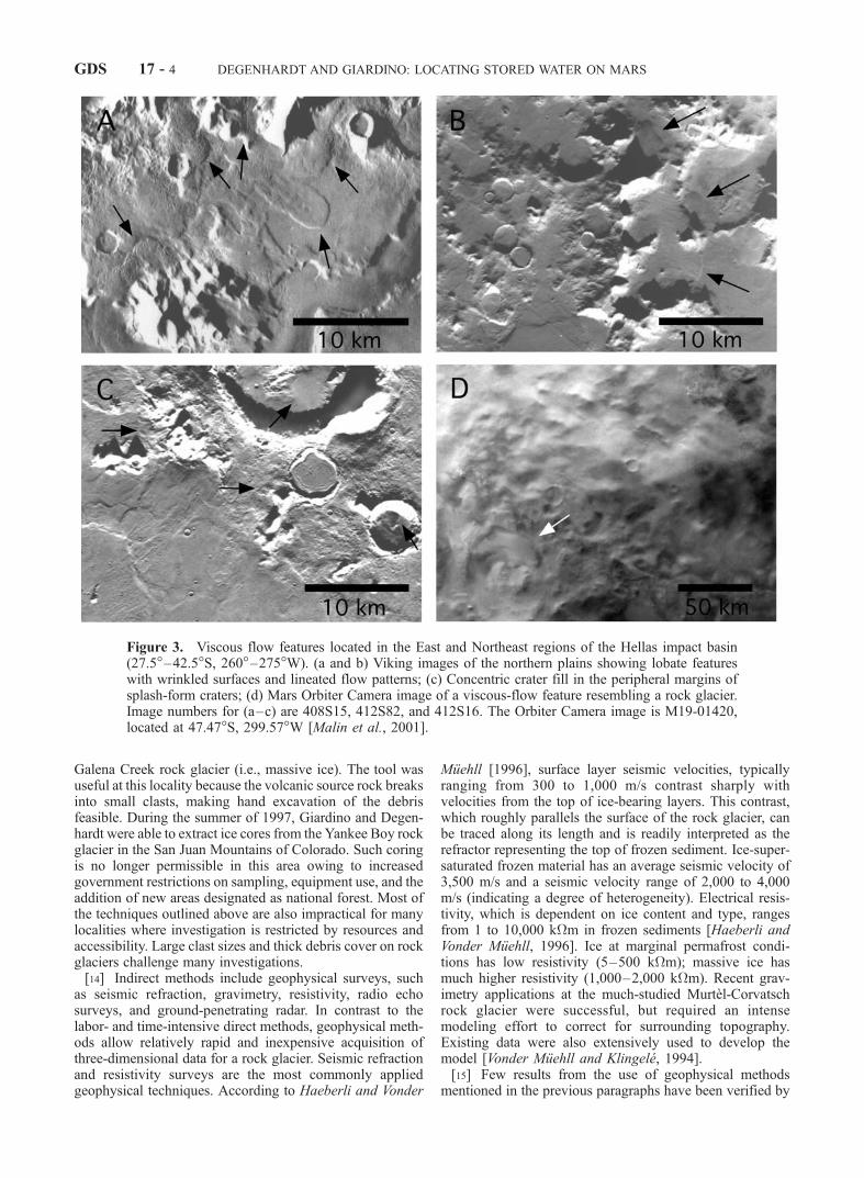
have been documented in the region surrounding the HellasImpact Basin (Figures 2 and 3) and in areas of fretted terrainextending 25� in longitudinal width, centered on 40� N.latitude and 45� S. latitude. Concentric crater fill, observedon the floors and walls of craters, exhibit concentric patternsof ridges and troughs that result from compressional stressacting inward from the crater walls (Figure 3c). The con-centric ridges are especially common in these forms, owing
to the sharp transition in slope as materials flow down thewalls of craters to the crater floors. The material also displayslarge-scale morphologic features and eolian etchings similarto those found on the other types of viscous flow bodiesdescribed in the preceding section. Some crater fill land-forms appear to be ‘‘deflated’’, a characteristic observed insome debris aprons. In the southern hemisphere, lobatedebris aprons are restricted to the mountainous terrains ofthe Argyre and Hellas impact basins (Figure 3). In the Hellasregion, debris aprons are located mainly in the mountainousterrain on the eastern side of the basin. They are mostcommon at the bases of escarpments and are less commonas concentric crater fill [Squyres and Carr, 1984].
3. Convergence of Investigative Approaches
3.1. Previous Methods of Investigation
[12] Researchers have used both direct and indirect meth-ods in their investigations of rock glacier structure [Burgeret al., 1999]. Until recently, direct investigative methodsincluded tunnels through rock glaciers [e.g., Brown, 1925],visual inspection of exposures, and shallow pits [e.g.,Wahrhaftig and Cox, 1959]. Potter [1972] successfully usedshovel and bulldozer pit excavations to investigate GalenaCreek rock glacier and Giardino [1979] used a bulldozerexcavation to study the structure of a rock glacier on MountMestas, Colorado.[13] Coring methods must negotiate the difficult surface
debris as well as interior heterogeneity. Mechanically oper-ated drills have proven to be effective in penetrating bothrock and ice by changing drill bits to meet encounteredconditions [e.g., Haeberli et al., 1988]. Clark et al. [1996]used a lightweight, hand-operated auger for studies of
Figure 2. Mars Orbiter Camera image of a lobate debrisapron located in a valley in the Tempe Terra region on Mars(black arrow). The narrow angle image (right) traverses thevalley, which appears to dissect the wall of an impact crater.The debris that has accumulated at the base of the walldisplays a wrinkled texture resembling ridges and furrows(white arrow). The area in the context image (M07-02045)is located at 47.29�N, 77.99�W and the narrow angle imagescale is 2.40 km � 30.57 km (image M07-02044). Imagescourtesy of Malin Space Systems [Malin et al., 2000].
DEGENHARDT AND GIARDINO: LOCATING STORED WATER ON MARS GDS 17 - 3
Galena Creek rock glacier (i.e., massive ice). The tool wasuseful at this locality because the volcanic source rock breaksinto small clasts, making hand excavation of the debrisfeasible. During the summer of 1997, Giardino and Degen-hardt were able to extract ice cores from the Yankee Boy rockglacier in the San Juan Mountains of Colorado. Such coringis no longer permissible in this area owing to increasedgovernment restrictions on sampling, equipment use, and theaddition of new areas designated as national forest. Most ofthe techniques outlined above are also impractical for manylocalities where investigation is restricted by resources andaccessibility. Large clast sizes and thick debris cover on rockglaciers challenge many investigations.[14] Indirect methods include geophysical surveys, such
as seismic refraction, gravimetry, resistivity, radio echosurveys, and ground-penetrating radar. In contrast to thelabor- and time-intensive direct methods, geophysical meth-ods allow relatively rapid and inexpensive acquisition ofthree-dimensional data for a rock glacier. Seismic refractionand resistivity surveys are the most commonly appliedgeophysical techniques. According to Haeberli and Vonder
Muehll [1996], surface layer seismic velocities, typicallyranging from 300 to 1,000 m/s contrast sharply withvelocities from the top of ice-bearing layers. This contrast,which roughly parallels the surface of the rock glacier, canbe traced along its length and is readily interpreted as therefractor representing the top of frozen sediment. Ice-super-saturated frozen material has an average seismic velocity of3,500 m/s and a seismic velocity range of 2,000 to 4,000m/s (indicating a degree of heterogeneity). Electrical resis-tivity, which is dependent on ice content and type, rangesfrom 1 to 10,000 k�m in frozen sediments [Haeberli andVonder Muehll, 1996]. Ice at marginal permafrost condi-tions has low resistivity (5–500 k�m); massive ice hasmuch higher resistivity (1,000–2,000 k�m). Recent grav-imetry applications at the much-studied Murtel-Corvatschrock glacier were successful, but required an intensemodeling effort to correct for surrounding topography.Existing data were also extensively used to develop themodel [Vonder Muehll and Klingele, 1994].[15] Few results from the use of geophysical methods
mentioned in the previous paragraphs have been verified by
Figure 3. Viscous flow features located in the East and Northeast regions of the Hellas impact basin(27.5�–42.5�S, 260�–275�W). (a and b) Viking images of the northern plains showing lobate featureswith wrinkled surfaces and lineated flow patterns; (c) Concentric crater fill in the peripheral margins ofsplash-form craters; (d) Mars Orbiter Camera image of a viscous-flow feature resembling a rock glacier.Image numbers for (a–c) are 408S15, 412S82, and 412S16. The Orbiter Camera image is M19-01420,located at 47.47�S, 299.57�W [Malin et al., 2001].
GDS 17 - 4 DEGENHARDT AND GIARDINO: LOCATING STORED WATER ON MARS

drilling or other methods to determine ‘‘ground truth,’’ andfew results except the depth of the boundary between anunfrozen surface layer and frozenmaterial below are unequiv-ocal. General limitations of these geophysical techniquessometimes include complex modeling efforts that can pro-duce nonunique models and may require additional ground-truthing data collection. Based on these limitations, a morepractical method of subsurface remote sensing is needed forrock glaciers. Ground-penetrating radar now provides alow-cost, accurate alternative to standard seismic techni-ques, without noise and disturbance to the environment.
3.2. Application of GPR to Rock Glaciers
[16] Ground-penetrating radar (GPR) is a relatively recentdevelopment [Morey, 1974; Annan and Davis, 1976; Ulrik-sen, 1982; Daniels et al., 1988], having reached userpracticality in the mid-1980s. This technique offers thesophistication of other geophysical techniques combinedwith portability and ease of use. It is ideally suited toapplications in the alpine, where logistics and associatedexpense are usually prohibitive. GPR has been used effec-tively in a variety of geologic and geomorphologic environ-ments including karst, glacial, periglacial, fluvial, andwetlands [e.g., McMechan et al., 1998; Murray et al.,1997; Horvath, 1998; Roberts et al., 1997; Jol and Smith,1995].[17] Digital GPR profiles are generated using transient
reflections of electromagnetic energy (EM) [Daniels et al.,1988] and are similar in appearance to standard seismicprofiles [Daniels, 1996]. EM in the frequency range of 10–1,000 MHz is transmitted into the ground in the form ofshort pulses. Profiles are generated from the return of radarsignals as a portion of the transmitted energy that isreflected back to the surface as a result of changes in bulkelectrical properties of the underlying materials [Smith andJol, 1997]. Such changes in electrical properties can beattributed to sedimentological variation (i.e., changing grainsize), facies changes, differences in state of materials (i.e.,water-rock or water-ice contacts), mineralogy, and density.Resolution of GPR at 100 MHz (assuming a velocity of0.1 m/ns) is �0.25–0.50 m, which is �10 times greaterthan conventional high-resolution shallow seismic sounding[Smith and Jol, 1997].3.2.1. Investigation of a Surrogate Rock Glacier:Yankee Boy Basin, Colorado[18] At present, indirect evaluations of landforms exhib-
iting viscous flow properties focus on rock glaciers with‘wrinkled’ surface textures. This requires that primary con-sideration be given to those rock glaciers having prominenttransverse ridge and furrow structure. Abundant examplesof such rock glaciers can be found in the San JuanMountains of Colorado. The rock glacier chosen for thisinvestigation exhibits many morphologic characteristics(i.e., transverse ridges and furrows, lobate form, oversteep-ened toe, proximity to a headwall) that make it desirable foruse as a surrogate for similar landforms on Mars. It islocated in Yankee Boy Basin between Ouray and Telluride,Colorado.[19] Yankee Boy Basin is a series of compound cirques
defined by a sharp arete extending from Gilpin Peak to Mt.Sneffels. The basin consists predominantly of Tertiaryvolcanics underlain by a block of Precambrian quartzite
[Luedke and Burbank, 1976]. Mountain peaks that flank thebasin are composed of San Juan volcanics, including GilpinPeak tephra deposits, the Picayune Formation and the SanJuan Formation. The Picayune Formation consists of aseries of flows, breccias and tephra layers of intermediatecomposition and the San Juan Formation is mainly beddedtephra deposits of felsic composition. In the area of Mt.Sneffels, and along the northern edge of the basin, themountains also include cores composed of older granodior-ite and gabbro stock containing Precambrian quartziteinclusions. Quaternary deposits comprising the San JuanFormation cover most of the basin floor with limitedexposure of the granodiorite and gabbro stock. The easilyeroded bedrock supplies the parent material for depositssuch as rock glaciers, alluvium, glacial drift, and landslidedeposits. Holocene talus deposits occur at the base of mostvalley walls and rock glaciers typically occupy the headsand valleys of cirques. The rock glacier at the head ofYankee Boy Basin is shown in Figure 4.3.2.2. Equipment and Techniques[20] A PulseEKKO2 100A radar system from Sensors &
Software, Inc. (Mississauga, Canada) was used in perpen-dicular broadside reflection mode with a constant source-receiver offset. Data for individual transects were collectedusing 2-m and 4-m source-receiver offsets for 50 MHz and25 MHz (center frequency) antennae, respectively. For theseconfigurations, 0.5-m and 1-m step intervals were used. Onall profiles, the horizontal scale is distance in meters (m), andthe vertical scale is presented as two-way travel time innanoseconds (ns; right side of profiles) and depth in meters(m; left side of profile). Profiles were acquired with a 1,000 Vtransmitter and stacked 64 times with a time sampling rate of800 ps. The profiles were processed and plotted in wiggle-trace and gray scale formats using PulseEKKO2 software.
Figure 4. Yankee Boy Basin rock glacier, located betweenOuray and Telluride in the San Juan Mountains ofsouthwest Colorado. Photo was taken from atop nearbyMount Sneffels, a 4,328 m (14,150 ft) peak. The rockglacier is approximately 500 m (1,640 ft) long from thesnow line to the toe at Wright’s Lake, and 300 m (984 ft)wide at the middle. The rock glacier flows down a cirquethat is bounded on the southwest side by Gilpin Peak ridge(4,174 m), seen in the background.
DEGENHARDT AND GIARDINO: LOCATING STORED WATER ON MARS GDS 17 - 5

[21] The raw 25 MHz reflection data were first processedusing a correction for signal saturation (DEWOW). Thiscorrection reduces the easily diffused low frequency com-ponent of the radar signal through high-pass filtering. TheDEWOWED data were then filtered using automatic gaincontrol (AGC) at GMAX = 500, and loss-pass filtered at20% for spatial correction. To accentuate amplitude varia-tions, the processed data were bandpass filtered (1,024 PTFFT) at frequencies of 10, 20, 30 and 40 MHz to removenoise. Processing of the 50 MHz data was similar to thataccomplished for the 25 MHz data with the exception thatbandpass filtering was performed for frequencies of 20–50 MHz and 60–80 MHz. Laser surveying equipment wasused to collect elevation data along the GPR transect lines.Topographic corrections were applied to the profiles prior tofiltering.
3.3. Data and Interpretations
[22] The locations of the GPR transects were chosen forthe purpose of identifying the gross morphologic andhydrologic characteristics of the rock glacier and for deter-mining if a link can be established between internal struc-ture and surface morphology. To measure the thickness ofthe rock glacier and to identify the internal structure (i.e.,the nature and distribution of ice therein), a 440-m longi-tudinal transect (A-A0) was made parallel to the long axis ofthe rock glacier using the 25 MHz antennae. The transectline, which extends from the midpoint of the head area tothe end of the toe, was routed over a prominent set of well-defined ridges and furrows on the youngest of the centralflow lobes (Figure 5).[23] Figure 6 shows the longitudinal profile prior to
topographic correction. The data were spatially filtered at20% and at 15% to determine the limit of processing thatcould be applied. At a filtering level of 20%, the reflectionhorizons are sharp and continuous, but a zone of ‘ringing’ isnoticeable at the bottom of the profile (from 95–210 m). At15%, the ringing was effectively removed. However, thereduced variation in amplitude throughout the remainingsignal eliminated much of the contrast needed to clearlyresolve individual reflection horizons. Thus, 20% spatialfiltering was used for interpreting the profile. The twoearliest continuous reflections represent air-wave andground wave arrivals, respectively, and the strong continu-ous reflection at the bottom of the profile represents thelimit of the velocity window and is not a feature detected inthe subsurface.[24] A noticeable feature of the topographically corrected
profile (Figure 7) is the sharp change in slope of thereflection horizons where the steep accumulation zone (0–60 m) transitions abruptly to ridges and furrows (�60 m).This inflection (see Figure 5) marks a change in the slope ofthe cirque floor that corresponds to the onset of compressionwithin the rock glacier. Reflection horizons in the accumu-lation zone are generally parallel to subparallel with thesurface of the rock glacier. From 60–120 m (immediatelybeyond the inflection), the reflections are clear and contin-uous, and slant upward toward the surface of the rockglacier. Beyond 120 m, the reflections are generally parallelto the surface. It is significant to note that in the latter 320 mof the longitudinal profile, bends in the reflections stronglycorrespond to topography of the rock glacier where ridges
and furrows are well pronounced. Reflections are continuousup to 100 m.3.3.1. Velocity Determinations: CommonMidpoint Profile[25] A radarwave velocity of 0.12 m/ns was established
for the rock glacier medium using a common midpoint(CMP) profile and semblance analysis (solution at 70 ns;Figure 8). The CMP, which was carried out along the first40 m of transect C-C0 using 25 MHz antennae, was used fordepth conversion and processing of the raw GPR data(Figure 9). The velocity value, which is slightly lower thanthose reported by Isaksen et al. [2000] and Berthling et al.[2000], likely represents frequency-dependent attenuationlosses caused by the effect of fresh running water within therock glacier. This reduction in velocity is expected to begreater at higher frequencies. To a lesser degree, dissipativelosses by surface or volume scattering from heterogeneitieson a scale close to the wavelength of propagation in thematerial may have been a factor. The pulse wavelengths(the product of frequency pulse period and velocity of theradarwaves) through the rock glacier medium, are 4.8 m and1.8 m at 25 MHz and 50 MHz, respectively.[26] Unpublished descriptions of shallow (7.6 m) drill
core recovered from the frontal area of the Yankee Boy rockglacier in 1997 confirm the presence of alternating 0.5–1 mthick layers of coarse ice-rich and ice-poor layers. Thelayers are composed of blocks and platy clasts that arepredominantly less than 0.5 m size in the largest dimension.The overall ratio of debris to ice ranges from 60–70% byvolume, and some ice layers are comprised of up to 20–30% silts and fines. This is generally consistent with
Figure 5. Aerial photograph of the Yankee Boy rockglacier taken in 1979 (37�590N, 107�470W). The image,cropped from a 9 � 9 inch 1:20,000 USDA photo, showsthe rock glacier flowing down valley away from theheadwall of the cirque. Cross section lines are shown for theradar profiles described in the text. Line A-A0 is 440 m long(25 MHz), and lines B-B0 and C-C0 are 90 and 75 m long,respectively. The latter were collected using 50 MHzantennae. The dashed line marks the inflection of the rockglacier. Small arrows indicate the flow path of SneffelsCreek, which runs through the toe of the rock glacier.
GDS 17 - 6 DEGENHARDT AND GIARDINO: LOCATING STORED WATER ON MARS
findings for drill core samples from other rock glaciers[Haeberli, 1985; Barsch, 1996].[27] The theoretical vertical resolution of the radar signals
was calculated using the equation [e.g., Reynolds, 1997]:
l=4 ¼ V=Fð Þ=4 ð1Þ
where l is the wavelength (m), V is the radarwave velocityof the medium (m/ns), and F is the center frequency of theantenna (MHz). Using the 25 MHz antennae, the theoreticalresolution was calculated to be 1.2 m. Therefore, any layervisible on the radar profile has a thickness greater than onemeter. The reflection patterns are consistent down to 700 ns(�45 m), which is the detectable limit of the radar achievedat this frequency. The 50 MHz antennae provided depth ofpenetration to 500 ns (�32 m) and resolution of 0.75 m,given a calculated theoretical vertical resolution of 0.60 m.3.3.2. Hydrologic Character and Water Pathways[28] The resolution and depth of penetration at 25 MHz
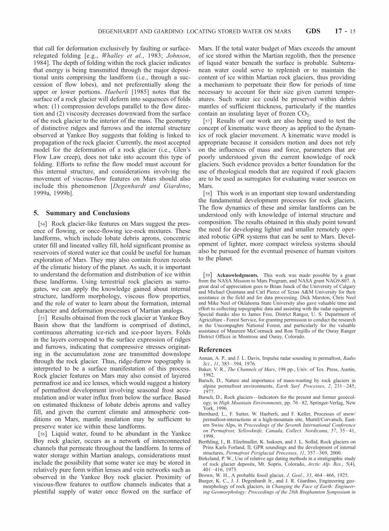
was sufficient to identify the contact between the rock
glacier and debris-covered cirque floor, as well as materials5–8 m below the cirque floor. The contact reflection isstrongly coherent from 0–190 m along the profile, beyondwhich diffusion (via attenuation) of the radar signal obscuresthe reflection patterns. In the last 50 m of the profile, thereflections are again coherent. We interpret the zone ofdiffusion, which reaches at least 5 m above the contactbetween rock glacier and cirque floor, to be a collection areafor water residing in the downvalley portion of the rockglacier. The strongly coherent reflection in the toe area isinterpreted to be a water table that is in contact with Wright’sLake. This contact is supported by the observation that waterfrom nearby Sneffels Creek enters the toe of the rock glacieron the north side and exits the toe on the south side (seeFigure 5). At the end of the GPR profile (440 m), thisreflection horizon is estimated to be 7–8 m above the rockglacier-cirque floor contact. This corresponds closely to thelevel of Wright’s Lake, which was estimated to rise 8 m onthe oversteepened toe of the rock glacier. Together withmeteoric waters, springs, seeps, and other water input
Figure 6. Longitudinal profile collected using 25 MHz antennae (uncorrected for topography). Linemarks the contact between the rock glacier and the cirque floor. The inferred (dashed) portion of the lineindicates a zone along the bottom where the radarwaves were attenuated by (running) water. The stronglycoherent reflection in the last 50 m of the profile is interpreted to be collected water that is in hydrologiccontact with Wright’s Lake, which is located at the right end of the profile.
DEGENHARDT AND GIARDINO: LOCATING STORED WATER ON MARS GDS 17 - 7

sources, the volume of water flowing in Sneffels Creek ismore than sufficient to maintain a water table at the levelsobserved within the rock glacier during the summer months.[29] In addition to the stored water, a network of water
pathways was detected in the headward portion of the rockglacier. These pathways are identifiable in the longitudinalprofile as intermediate range amplitude signals that do notconform to the characteristic horizontal reflection horizons(Figure 10). Such intermediate amplitude values are gen-
erated because the amplitude (and velocity) of radar wavesare affected mainly by differences in the dielectric proper-ties of the various phases encountered throughout the rockglacier (e.g., rock, ice and liquid water). Factors such aschemistry (i.e., salinity), state (liquid/gas/solid), distribution(pore space connectivity) and content of water also signifi-cantly affect the propagation of radar waves through therock glacier medium. These effects are manifested in valuesof permittivity (the ability of a dielectric to store electricalpotential energy under the influence of an electric field) foreach of the phases. Fresh water (80 Farads/m) has a muchhigher permittivity than either freshwater ice (4 Farads/m)or granodiorite (�5 Farads/m). Thus, the observed ampli-
Figure 7. Topographically corrected 25 MHz longitudinal profile. Corrections were made to the profilein Figure 6 using laser survey data that was collected along the same transect line as the GPR survey.Note the relationship between undulations in the reflection horizons and surface topography. ‘Processing’included 20% spatial filtering.
Figure 8. (opposite) Diagram illustrating the concept ofcollecting a common midpoint (CMP) profile for velocitydeterminations. The transmitting and receiving antennae areplaced along a traverse perpendicular to the direction ofmovement. The antennae are moved at equal distanceintervals (1/2 meter for 25 MHz antennae) from a commoncenter point and separated until an average velocity valuecan be determined (using a representative, continuousreflection event in the profile), or when the maximumlength of the fiber optic antenna cables is reached. Thevelocity value is determined by semblance analysis or bydividing the runout distance by the average two-way traveltime for the given reflection horizon. This can be done bytaking the inverse gradient of the reflection horizon asplotted on a T2-X2 graph [Reynolds, 1997]. Diagrammodified from Sensors & Software [1996].
GDS 17 - 8 DEGENHARDT AND GIARDINO: LOCATING STORED WATER ON MARS

tude variations can be attributed to the contrast betweenwater and the solid phases of rock and ice.[30] To test the validity of this means of detection,
locations were recorded along the longitudinal transectwhere running water was audibly detected just below thesurface of the rock glacier. The locations and estimated flowdirections were then plotted on an enlarged portion of thelongitudinal profile. The locations of running water detectedon the surface of the rock glacier correspond closely tolocations along the profile where branches of the waterpathway network approach the surface (see Figure 10). Theindividual pathways, estimated to be 0.5–1.5 m in width,are in some places continuous from the surface of the rockglacier down to the cirque floor.3.3.3. Ridge and Furrow Morphology[31] To determine if ridge and furrow morphology is a
manifestation of subsurface processes, two 50 MHz GPRtransects were made on a section of the Yankee Boy rockglacier where ridge and furrow structure is prominent (seeFigure 5). By providing greater resolution, these profileswere useful for interpreting the 25 MHz longitudinal profiledescribed above. Profile B, a 90-m transect (B-B0, Figure 11),was made following a line oriented normal to ridges andfurrows. The transect was located in close proximity to the440-m longitudinal transect and rotated counterclockwiseapproximately 15� to maximize normalcy to the transverseridges and furrows. Profile C, also collected using 50 MHzantennae, consists of a 75-m transect (C-C0, Figure 12) madealong the top of a prominent ridge in the sequence. It trendsin a direction orthogonal to Profile A and provides aperspective that is normal to the ridge axis.[32] The 50 MHz radar results show that the internal
structure of the rock glacier consists of parallel to subpar-allel layers of ice-rich and ice-poor strata. The laminatedand overlapping character of the material is consistentthroughout the sampling area and is continuous between
profiles B-B0 and C-C0. This indicates that layering iscontinuous in the direction of ridge and furrow developmentas well as normal to it and implies that the layers weredeposited by voluminous flows of rock debris that occa-sionally buried substantial amounts of snowpack on thesurface of the rock glacier. The layering is deformedpredominantly by folding, and fold fabric is evidentthroughout the entire thickness of the rock glacier. Minorfaulting was also detected, mainly in the upper portions ofthe profiles. This aspect, however, does not appear to be thepredominant mode of deformation within the rock glacier.
3.4. Contemporary Investigations
[33] To date, limited research involving the application ofGPR to rock glaciers has been carried out [e.g., Berthling etal., 2000; Degenhardt and Giardino, 2003; Degenhardt etal., 2000, 2001; Isaksen et al., 2000]. In a recent study,Isaksen et al. [2000] used GPR to investigate the compo-sition, flow and development of two tongue-shaped rockglaciers in the permafrost of Svalbard, Norway. Using50 MHz antennae, they obtained a 303 m longitudinalprofile following the central flowline of the Hiorthfjelletrock glacier. The results show a clear reflection horizon to15–20 m depth with reflections disappearing completely at25 m. Along the profile line reflection horizons transitionfrom parallel or slanting orientations relative to the surface,to horizons that dip upward in the mid-section (downslope)portions of the profile. These reflection horizons wereinterpreted to represent the end of a steep talus cone that
Figure 9. Common midpoint (CMP) profile used fordetermination of the representative radarwave velocitythrough the rock glacier medium. The profile was obtainedat a frequency of 25 MHz with a 1000 V transmitter. ApulseEKKO2 100A radar system from Sensors & Software,Inc. was used. The velocity value as determined from thesemblance diagram on the right is 0.12 m/ns. The origin ofthe ‘Position’ axis is 4 m, which corresponds to the initialantennae separation at 25 MHz and the two-way traveltimescale applies to the CMP profile and the semblancediagram.
Figure 10. Radar profile of the first 94 meters of thelongitudinal profile rendered in shades of black, white andgray to highlight amplitude variations corresponding tophase differences throughout the rock glacier. Alternatingice-rich and ice-poor layers are depicted in black and white.The network of gray colored lines is interpreted to representflowing liquid water. The recorded locations of audibleflowing water just below the surface of the rock glaciercorrespond well with locations where branches of thenetwork meet the surface.
DEGENHARDT AND GIARDINO: LOCATING STORED WATER ON MARS GDS 17 - 9

marks a transition between the accumulation zone and thelower part of the rock glacier [Isaksen et al., 2000]. Basedon exposures in a lobate rock glacier near Longyeardalen,Norway, reflection horizons from the Hiorthfjellet rockglacier are believed to be caused by layers of ice alternatingwith layers comprised of fine material and blocks.[34] In another study, Berthling et al. [2000] used GPR to
investigate internal structures in four rock glaciers located inthe continuous permafrost zone on Prins Karls Forland,western Svalbard. The longitudinal profiles obtained in thatstudy revealed a system of reflectors that was comparablebetween the different rock glaciers. As observed in theHiorthfjellet rock glacier, a layering structure parallel withthe surface is visible in the upper parts of the profiles wherethe talus cones above the rock glaciers are located. Fartherdown profile, toward the rock glaciers, these reflectors areoriented at a slant against the surface slope. It was con-cluded that the layering formed by mass movements ofhigher magnitude that covered snow patches or the activelayers above supersaturated permafrost.
[35] CMP velocities at Yankee Boy rock glacier aresignificantly lower than the 50 MHz values in the studiesabove. A velocity of 0.15 m/ns was obtained for the Murtel-Corvatsch rock glacier [Lehmann et al., 1998] and theBrøggerbreen rock glacier near Svalbard yielded a valueof 0.14 m/ns [Isaksen et al., 2000]. The low velocity valuesobtained in this study can be attributed to the presence ofrunning (liquid) water throughout the Yankee Boy rockglacier, and to a lesser degree, by high attenuation in theconductive sand- and silt-rich ice layers that comprise theupper portions of the rock glacier.
4. Results: Implications for Landforms on Mars
4.1. Rock Glacier Development
[36] The pioneering work of Wahrhaftig and Cox [1959]suggested that rock glaciers formed by permafrost processesto create a frozen mixture of rock debris and ice within talusor morainal deposits. Since then, it has been found that rockglaciers occur as a physical response to three types of
Figure 11. Topographically corrected GPR profile trending southwest to northeast along transect lineB-B0 (Figure 5). Top: processed data without interpretations; Bottom: processed data showinginterpretations based on mappable stratigraphic reflection horizons. Data was processed using softwareprovided by Sensors & Software, Inc. Equipment included a 1000 V transmitter and 50 MHz antennae. A2-m antenna spacing was used and data was collected using 0.5-m step intervals. The two earliestcontinuous reflections represent air-wave and ground wave arrivals, respectively.
GDS 17 - 10 DEGENHARDT AND GIARDINO: LOCATING STORED WATER ON MARS

Figure
12.
Topographically
correctedGPRprofile
trendingwestto
eastalongtransect
lineC-C
0that
runsalongasingle
prominentridge(see
Figure
5).Top:processed
datawithoutinterpretations;Bottom:processed
datashowinginterpretations
based
onmappable
stratigraphic
reflectionhorizons.Theconcavefoldingin
therighthalfoftheprofile
isinterpretedto
representinfillingofalongitudinalfurrowbyoverridingflowlobematerials.Equipmentincluded
a1000Vtransm
itterand
50MHzantennae.A
2-m
antennaspacingwas
usedanddatawas
collectedusing0.5-m
step
intervals.
Thetwoearliest
continuousreflectionsrepresentair-waveandgroundwavearrivals,respectively.
DEGENHARDT AND GIARDINO: LOCATING STORED WATER ON MARS GDS 17 - 11

geomorphic processes: (1) glacial, (2) periglacial [Johnson,1984], or (3) talus (as illustrated by Shakesby et al. [1987]).They often represent transitional forms in the landscapecontinuum, a geomorphologic concept developed by Giar-dino and Vitek [1988b] (Figure 13). With the advent of newtechnology and increased interest in recognizing and study-ing rock glaciers, these ideas have been affirmed andexpanded through subsequent studies. A few of these studiesprovide evidence of thick massive ice in the rock glacierinterior and suggest that these forms are debris-coveredglaciers [Potter, 1972; Whalley, 1974; Clark et al., 1994;Whalley et al., 1994; Potter et al., 1998] or forms that origi-nated as perennial snowbanks or glacierets Haeberli [2000].[37] Terrestrial rock glaciers are generally situated at the
bases of massive, homogeneous and fractured cliffs and arerarely found where debris is finely crushed or where head-wall fractures are excessively large [Wahrhaftig and Cox,1959; Evin, 1987]. Source material is loosened by freeze-thaw action and transported by gravity downvalley or downescarpment, where it accumulates in locations of gradientdecline [White, 1971]. A review of the general conditionsfor rock glacier formation has been given by Corte [1987]:[38] (a) Relatively young mountain ranges having bed-
rock with rock mass properties (e.g., joint spacing, weath-ering characteristics, etc.) favoring the formation of blockydebris;[39] (b) Microclimate conducive to daily freeze-thaw
cycles or frost weathering, sufficient ground moisture forperiglacial processes, low to moderate snowfall sufficientfor production of debris and avalanche, and low insulatingsnow cover;[40] (c) A combination of geographic position (e.g.,
latitude, elevation) and climate conditions (e.g., temper-ature, aspect) that promote periglacial processes and sus-tained subzero ground temperatures; and[41] (d) Talus supply promoted by steep, rough terrain,
perhaps by debris from a previous glaciation, frequentfreeze/thaw cycles, and rock mass properties.Precluding all of these is the existence of permafrostconditions (subzero mean annual ground temperature),which is the primary factor for rock glacier formation[Haeberli et al., 1999; Haeberli, 2000].[42] On Mars, the material that comprises the insulative
cover for lobate debris aprons and valley fill is also thoughtto be the product of rockfall processes [Lucchitta, 1984;Squyres, 1988; Carr, 1995]. The production of regolithmaterials suitable for development of viscous flow featuresis largely attributed to meteorite impact, a process thatplayed a major role in the structural evolution of the Martiancrust [Soderblom et al., 1974].[43] Results of this GPR investigation show that the
internal structure of the Yankee Boy rock glacier was formedby permafrost processes rather than by covering of remnantglacial ice. The distinct reflection horizons of the GPRprofiles are discernable from the surface of the rock glacierto the bottom contact with the valley floor. These horizonsdepict the accumulation of snow/ice toward the upper rea-ches of the rock glacier and creeping permafrost where thevalley slope decreases. We interpret these horizons to repre-sent units of alternating layers of talus or rockslide debris andice lenses and/or ice supersaturated sediments. The ice-richlayers are most likely formed by accumulation of seasonal
snow, which is compacted upon burial by pulses of headwalldebris (i.e., via large mass movement events), are buried andcompacted. This mechanism of ice formation is believed tobe the most important accumulation process for the rockglaciers investigated in Svalbard, Norway [Isaksen et al.,2000; Berthling et al., 2000]. Based on observations fromlimited amounts of recovered drill core and from GPRprofiles generated in this study, the overall volume of icecomprising the Yankee Boy rock glacier is 30–40%.
4.2. Ice Sustainability and Flow
[44] For ice to be sustained within a dynamic (creeping)landform, minimizing the amount of insulation is requiredto reduce ablation of the permafrost (cryolithospheric ice).Haeberli et al. [1998] found that the temperature beneaththe 3 m thick active layer of the Murtel rock glacier remainsnegative throughout the year. For example, temperaturesrecorded in a 11.6 m borehole at the Murtel/Corvatsch rockglacier showed that the mean annual ground temperaturegenerally increased from �2.3�C in 1987 to �1.4�C in1994 with intermittent cooling during the interim years of1994 to 1996 [Vonder Muehll et al., 1998]. Permafrost inalpine rock glaciers, however, is relatively warm andtypically tens of meters thick with temperatures that com-monly vary around 0�C at depth. Considering the thermalinertia of ice-rich permafrost it is reasonable to assume that,in general, permafrost conditions have existed within alpinerock glaciers since the end of the last ice age [Lunardini,1996]. The effects of snow cover may play an importantrole in regulating ground temperature and may likelyinfluence the relations between the atmosphere and perma-frost. To some degree, ventilation and cold air circulationwithin the blocky active layer also regulates the couplingbetween atmosphere and permafrost on mountain slopes androck glacier surfaces [Bernhard et al., 1998]. Vonder Muehll
Figure 13. Diagram illustrating the alpine landscapecontinuum (modified from Giardino and Vitek [1988b]).Rock glaciers are transitional forms that can develop fromtwo distinct processes and can progress to two distinct end-members. Rate of movement is related to process, not form.
GDS 17 - 12 DEGENHARDT AND GIARDINO: LOCATING STORED WATER ON MARS

et al. [1998] attribute the variability of observed permafrosttemperatures to summer radiation and air temperature influ-ences on the active layer, snow cover history, and shortenedperiods of negative temperatures during autumn months.Although the contribution and magnitude of these effectsare likely to be significantly different on Mars, it is expectedthat they do play an important role in the preservation andlocation of water within viscous flow features there.[45] A model of ice stability formulated by Farmer and
Doms [1979] suggests that anywhere temperatures in the top10 m of the Mars regolith exceed 198�K, ground ice willbecome unstable and can sublime and diffuse into theatmosphere. Thermodynamic models by Clifford and Hillel[1983] and Mellon and Jakosky [1995] produced similarresults suggesting an ice-free region between ±30� latitude.Our study shows that a blocky debris mantle 1–5 m thickinsulates the Yankee Boy rock glacier during summermonths. The mantle also serves as an interchange forcompacting snow that accumulates in the winter months(Figure 14). In cases where appreciable amounts of rockdetach from a headwall or escarpment, a much thicker debriscover could be attained. For example, terrestrial rock glaciermantles of 1–10 m are not uncommon [Clark et al., 1994].Martian analogs, which are generally an order of magnitudelarger than terrestrial rock glaciers, may have debris mantlesthat are considerably thicker. Using shadow lengths, Squyres[1988] estimated thicknesses between 500 and 900 m fordebris aprons ranging in radial length from several kilo-meters to >15 km. A mantle of such thickness may besufficient to preserve interstitial water ice or ice lenses longenough to achieve the type of flow length observed inlandforms situated poleward of ±30� latitude on Mars.[46] In a study of ice flow characteristics on Mars,
Colprete and Jakosky [1998] used a simple model basedon Glen’s flow law to demonstrate the effects of ice temper-ature, accumulation rate, and purity on ice flow velocities inviscous flowing landforms:
sxy ¼ Atnxy ð2Þ
A Tð Þ ¼ A0 � Q
RT
� �ð3Þ
A Tð Þ ¼ 2:207� 10�5 3155
T� 0:16612
273:39� Tð Þ1:17
" #n
ð4Þ
where: equation (2) represents the relation between shearstrain rate (s) and shear stress (t). The coefficient A andexponent n represent the dependence on ice temperature,crystal orientation, impurity and other factors. A(T ) is thevariation of coefficient A with respect to temperature(measured in Kelvins) according to the Arrhenius relation,where Ao is the temperature independent constant, R is theuniversal gas constant, and Q is the activation energy forcreep [Paterson, 1994]. Equation (4) is an empirical relationdeveloped by Hooke et al. [1972] for A(T ) across alltemperatures below freezing.[47] Results by Colprete and Jakosky [1998] suggest that
ice temperatures must be greater than 220�K, and the net
ice accumulation rate >1 cm/yr to produce the smallestobserved rock glaciers. They calculated that at this temper-ature and accumulation rate it would take �106 years toproduce a 15-km flow, which is the average size flowobserved on Mars. It was further concluded that formationtimes greater than 106 years are unlikely based on theclimate fluctuations caused by variations in planetary obliq-uity and inclination [Mellon and Jakosky, 1995]. Ice heldonly in debris voids (i.e., at saturation or below) will havehigh yield strength and creep rates will be very low, if itoccurs. Thus, ice within a body of debris will contribute tomovement only when contained in lenses or similar masses.Furthermore, creep will only occur when these lenses ormasses are interconnected or highly contiguous.[48] If it is accepted that lobate debris aprons are com-
monly comprised of ice-cemented soils or ice-debris mix-tures [e.g., Squyres, 1988; Carr, 1995], then considerationmust be given to the condition that small concentrations ofsolid impurities in interstitial ice (at temperatures below220�K) would reduce the flow velocities of Martian rockglaciers by an order of magnitude. For ice impurities of30% or greater, flow velocities are so low that the timerequired for ice to reach the length of the features observedwould exceed 10 Myrs [Colaprete and Jakosky, 1998].Considering this discrepancy in flow rate versus landformsize, a less viscous (i.e., soluble) component may bestrongly affecting the rheology of the ice. Such a compo-nent is needed to generate large viscous flow features suchas those observed under current Martian conditions (surfacetemperatures around 200�K for frost and accumulation ratesof �1 cm/yr). Under certain climatic and cryolithosphericconditions, liquid water may be a sustainable componentthat contributes significantly to the overall deformation.
4.3. Role of Water
[49] Numerous major geologic features on Mars appear tohave formed by the release of large volumes of water frombeneath the surface. Based on our current state of knowl-
Figure 14. Snow covered rock glacier at Yankee BoyBasin. Seasonal layers of snow are most persistent in theaccumulation zone. Permafrost is generated by accumula-tion and compaction of snow in the active layer of the rockglacier. Compaction occurs as the snow is buried by highmagnitude episodes of rockfall and/or debris fall.
DEGENHARDT AND GIARDINO: LOCATING STORED WATER ON MARS GDS 17 - 13

edge about the history of the planet in terms of water andice, there is no obvious way that such a volume of watercould have been lost from the planet since the developmentof these features [Squyres et al., 1992]. Outflow channels,however, provide persuasive evidence that a large reservoirof groundwater was stored in the Martian crust throughoutits first billion years of geologic history [Baker, 1982; Carr,1986].[50] Under the influence of gravity, groundwater will
drain to saturate the lowest porous regions of the crust. Asubpermafrost groundwater system is viable if the presentinventory of H2O on Mars exceeds the quantity required tosaturate the pore volume of the cryolithosphere. Once thepore volume of the cryolithosphere has been saturated withice, any additional subsurface H2O will inevitably be storedas groundwater [Squyres et al., 1992]. Estimates by Clifford[1993] and Clifford and Parker [2001] indicate that aplanetary inventory of H2O equivalent to a several hundredmeter-deep global ocean may satisfy this condition. Givenan exponential decline in crustal porosity with depth, agroundwater inventory equivalent to a 100-m global oceanwould then be sufficient to create a global aquifer nearly4.3 km deep, assuming reasonable values of surface poros-ity (20–50%) and an exponential decay constant of 2.82 km[Clifford, 1993]. This range of porosity values is consistentwith estimates of the bulk porosity of Martian soil asanalyzed by the Viking Landers [Clark et al., 1976].[51] The hydrologic characteristics of the Yankee Boy
rock glacier substantiate the presence of a water table andnetworks of interconnected water pathways throughout thelayers of permafrost within (Figure 15a). The input sourcesfor these water systems include streams, meteoric water/snow/ice, valley side runoff, lake water, springs, and frost.In light of the evidence provided for outflow channels onMars, and the close proximity with which lobate debrisaprons and other viscous flow bodies occur to them, it ispossible that a number of these water sources have con-tributed to the development of ice-rich landforms. Channelsor tables of liquid water and pure water ice residing withinthe permafrost (i.e., cryolithospheric material) for finiteperiods of time may be capable of initiating or sustainingthe rates of deformation demonstrated by the lobate debrisaprons and rock glaciers on Mars. It may even be possiblethat the dominant source of ice within these landformsoriginated from the subsurface as liquid water. Ice formedby the recharge of liquid water originating at depth (e.g.,from outflow channels) could conceivably compensate forthe volumes of ice lost to ablation in latitudes between 30�and 60�. Current models of rock glacier formation do notaccount for such a process. Figure 15b provides a concep-tualized model for the internal structure of a Martian rockglacier and possible sources of water ice based uponfindings from the surrogate rock glacier at Yankee BoyBasin.
4.4. Flow Dynamics and Kinematic Properties
[52] Kinematic properties have been used to describe avariety of geomorphic systems including pool and riffledevelopment, ice glacier surge, distributed streamflow, andslow mass movement [Langbein and Leopold, 1968;Gerber and Scheidegger, 1979]. Kinematic wave theory,as applied to glaciers [Lighthill and Whitman, 1955a,
1955b] and rock glaciers [Olyphant, 1987], requires that awave of increased discharge (kinematic wave) travels downthe rock glacier at a speed greater than the mean velocity ofthe surface [Nye, 1960]. The propagation of a kinematicwave can explain the discrepancies observed in rock glaciermovement (rate and distance) as compared to talus supplyrate [Birkeland, 1973; Miller, 1973; White, 1987]. Such amechanism also allows for a disproportionally high rate ofmovement in the toe of a rock glacier with little or noincrease in talus supply rate at the head. Thus, rheologicproperties that govern movement may not control morpho-logical development of the landform (i.e., kinematic wavemotion may control form development even though massand force control movement potential). Further, such devel-opment may be independent of variations in the drivingforces responsible for the overall rheological properties[Giardino and Vitek, 1988a].[53] The layering exhibited in the Yankee Boy rock
glacier is not consistent with glacial and periglacial models
Figure 15. Diagrams illustrating (top) water storage andflow through a terrestrial rock glacier (modified fromGiardino et al. [1992]) and (bottom) a conceptual Martianrock glacier based upon information obtained fromterrestrial rock glaciers. Water entering the rock glaciersystem from outflow channel sources is transmitted upwardthrough pore spaces, fractures, and zones of weakness. Anetwork of water pathways is formed when the (warmer)water exploits pore spaces and melts through areas ofweakness within the cryolithospheric material. The path-ways terminate in lens-shaped pockets, with the remainingwater forming an ice table at the base.
GDS 17 - 14 DEGENHARDT AND GIARDINO: LOCATING STORED WATER ON MARS
that call for deformation exclusively by faulting or surface-relegated folding [e.g., Whalley et al., 1983; Johnson,1984]. The depth of folding within the rock glacier indicatesthat energy is being transmitted through the major deposi-tional units comprising the landform (i.e., through a suc-cession of flow lobes), and not preferentially along theupper or lower portions. Haeberli [1985] notes that thesurface of a rock glacier will deform into sequences of foldswhen: (1) compression develops parallel to the flow direc-tion and (2) viscosity decreases downward from the surfaceof the rock glacier to the interior of the mass. The geometryof distinctive ridges and furrows and the internal structureobserved at Yankee Boy suggests that folding is linked topropagation of the rock glacier. Currently, the most acceptedmodel for the deformation of a rock glacier (i.e., Glen’sFlow Law creep), does not take into account this type offolding. Efforts to refine the flow model must account forthis internal structure, and considerations involving themovement of viscous-flow features on Mars should alsoinclude this phenomenon [Degenhardt and Giardino,1999a, 1999b].
5. Summary and Conclusions
[54] Rock glacier-like features on Mars suggest the pres-ence of flowing, or once-flowing ice-rock mixtures. Theselandforms, which include lobate debris aprons, concentriccrater fill and lineated valley fill, hold significant promise asreservoirs of stored water ice that could be useful for humanexploration of Mars. They may also contain frozen recordsof the climatic history of the planet. As such, it is importantto understand the deformation and distribution of ice withinthese landforms. Using terrestrial rock glaciers as surro-gates, we can apply the knowledge gained about internalstructure, landform morphology, viscous flow properties,and the role of water to learn about the formation, internalcharacter and deformation processes of Martian analogs.[55] Results obtained from the rock glacier at Yankee Boy
Basin show that the landform is comprised of distinct,continuous alternating ice-rich and ice-poor layers. Foldsin the layers correspond to the surface expression of ridgesand furrows, indicating that compressive stresses originat-ing in the accumulation zone are transmitted downslopethrough the rock glacier. Thus, ridge-furrow topography isinterpreted to be a surface manifestation of this process.Rock glacier features on Mars may also consist of layeredpermafrost ice and ice lenses, which would suggest a historyof permafrost development involving seasonal frost accu-mulation and/or water influx from below the surface. Basedon estimated thickness of lobate debris aprons and valleyfill, and given the current climate and atmospheric con-ditions on Mars, mantle insulation may be sufficient topreserve water ice within these landforms.[56] Liquid water, found to be abundant in the Yankee
Boy rock glacier, occurs as a network of interconnectedchannels that permeate throughout the landform. In terms ofwater storage within Martian analogs, considerations mustinclude the possibility that some water ice may be stored inrelatively pure form within lenses and vein networks such asobserved in the Yankee Boy rock glacier. Proximity ofviscous-flow features to outflow channels indicates that aplentiful supply of water once flowed on the surface of
Mars. If the total water budget of Mars exceeds the amountof ice stored within the Martian regolith, then the presenceof liquid water beneath the surface is probable. Subterra-nean water could serve to replenish or to maintain thecontent of ice within Martian rock glaciers, thus providinga mechanism to perpetuate their flow for periods of timenecessary to account for their size given current temper-atures. Such water ice could be preserved within debrismantles of sufficient thickness, particularly if the mantlescontain an insulating layer of frozen CO2.[57] Results of our work are also being used to test the
concept of kinematic wave theory as applied to the dynam-ics of rock glacier movement. A kinematic wave model isappropriate because it considers motion and does not relyon the influences of mass and force, parameters that arepoorly understood given the current knowledge of rockglaciers. Such evidence provides a better foundation for theuse of rheological models that are required if rock glaciersare to be used as surrogates for evaluating water sources onMars.[58] This work is an important step toward understanding
the fundamental development processes for rock glaciers.The flow dynamics of these and similar landforms can beunderstood only with knowledge of internal structure andcomposition. The results obtained in this study point towardthe need for developing lighter and smaller remotely oper-ated robotic GPR systems that can be sent to Mars. Devel-opment of lighter, more compact wireless systems shouldalso be pursued for the eventual presence of human visitorsto the planet.
[59] Acknowledgments. This work was made possible by a grantfrom the NASA Mission to Mars Program, and NASA grant NAG9-807. Agreat deal of appreciation goes to Brian Junck of the University of Calgaryand Michael Quintana and Carl Pierce of Texas A&M University for theirassistance in the field and for data processing. Dick Marston, Chris Neeland Mike Neel of Oklahoma State University also gave valuable time andeffort to collecting topographic data and assisting with the radar equipment.Special thanks also to James Free, District Ranger, U. S. Department ofAgriculture - Forest Service, for granting permission to conduct the researchin the Uncompaghre National Forest, and particularly for the valuableassistance of Maureen McCormack and Ron Trujillo of the Ouray RangerDistrict Offices in Montrose and Ouray, Colorado.
ReferencesAnnan, A. P., and J. L. Davis, Impulse radar sounding in permafrost, RadioSci., 11, 383–394, 1976.
Baker, V. R., The Channels of Mars, 198 pp., Univ. of Tex. Press, Austin,1982.
Barsch, D., Nature and importance of mass-wasting by rock glaciers inalpine permafrost environments, Earth Surf. Processes, 2, 231–245,1977.
Barsch, D., Rock glaciers—Indicators for the present and former geoecol-ogy, in High Mountain Environments, pp. 76–82, Springer-Verlag, NewYork, 1996.
Bernhard, L., F. Sutter, W. Haeberli, and F. Keller, Processes of snow/permafrost-interactions at a high-mountain site, Murtel/Corvatsch, East-ern Swiss Alps, in Proceedings of the Seventh International Conferenceon Permafrost, Yellowknife, Canada, Collect. Nordicana, 57, 35–41,1998.
Berthling, I., B. Elzelmuller, K. Isaksen, and J. L. Sollid, Rock glaciers onPrins Karls Forland, II, GPR soundings and the development of internalstructures, Permafrost Periglacial Processes, 11, 357–369, 2000.
Birkeland, P. W., Use of relative age dating methods in a stratigraphic studyof rock glacier deposits, Mt. Sopris, Colorado, Arctic Alp. Res., 5(4),401–416, 1973.
Brown, W. H., A probable fossil glacier, J. Geol., 33, 464–466, 1925.Burger, K. C., J. J. Degenhardt Jr., and J. R. Giardino, Engineering geo-morphology of rock glaciers, in Changing the Face of Earth: Engineer-ing Geomorphology: Proceedings of the 28th Binghamton Symposium in
DEGENHARDT AND GIARDINO: LOCATING STORED WATER ON MARS GDS 17 - 15

Geomorphology, edited by J. R. Giardino, R. A. Marston, and M. Mor-isawa, pp. 93–132, Elsevier Sci., New York, 1999.
Calkin, P. E., D. S. Kaufman, B. J. Przybyl, W. B. Whitford, and B. J. Peck,Glacier regimes, periglacial landforms, and Holocene climate change inthe Kigluaik Mountains, Seward Peninsula, Alaska, USA, Arctic Alp.Res., 30(2), 154–165, 1998.
Carr, M. H., Mars a water-rich planet?, Icarus, 68, 187–216, 1986.Carr, M. H., Mars: A water-rich planet, in MECA Symposium on Mars:Evolution of Its Climate and Atmosphere, edited by V. Baker et al., pp.23–25, Lunar and Planet. Inst., Houston, Tex., 1987.
Carr, M. H., The Martian drainage system and the origin of valley networksand fretted channels, J. Geophys. Res., 100, 7479–7507, 1995.
Clark, B. C., A. K. Baird, H. J. Rose, P. Toulmin III, K. Keil, A. J. Castro,W. C. Kelliher, C. D. Rowe, and P. H. Evans, Inorganic analysis ofMartian surface samples at the Viking landing sites, Science, 194,1283–1288, 1976.
Clark, D. H., M. M. Clark, and A. R. Gillespie, Debris-covered glaciers inthe Sierra Nevada, California, and their implications for snowline recon-structions, Quat. Res., 41, 139–153, 1994.
Clark, D. H., E. J. Steig, N. Potter Jr., J. Fitzpatrick, A. B. Updike, andG. M. Clark, Old ice in rock glaciers may provide long-term climaticrecords, Eos Trans. AGU, 77(23), 217, 221–222, 1996.
Clifford, S. M., A model for the hydrologic and climatic behavior of wateron Mars, J. Geophys. Res., 98, 10,973–11,016, 1993.
Clifford, S. M., and D. Hillel, The stability of ground ice in the equatorialregions of Mars, J. Geophys. Res., 88, 2456–2474, 1983.
Clifford, S. M., and T. J. Parker, The evolution of the Martian hydrosphere:Implications for the fate of a primordial ocean and the current state of thenorthern plains, Icarus, 154, 40–79, 2001.
Colprete, A., and B. M. Jakosky, Ice flow and rock glaciers on Mars,J. Geophys. Res., 103(E3), 5897–5909, 1998.
Corte, A. E., Rock glacier taxonomy, in Rock Glaciers, edited by J. R.Giardino, J. F. Shroder Jr., and J. D. Vitek, pp. 27–39, Allen and Unwin,Concord, Mass., 1987.
Daniels, D. J., Surface Penetrating Radar, IEEE Radar Sonar Navig. Avio-nics, 6, 300 pp., 1996.
Daniels, D. J., D. J. Gunton, and H. F. Scott, Introduction to subsurfaceradar, Proc. IEEE, 135(part F4), 277–320, 1988.
Degenhardt, J. J., Jr., and J. R. Giardino, Kinematic wave models forMartian landforms based on rock glacier analogs, Meteorit. Planet.Sci., 34(4), suppl., A31, 1999a.
Degenhardt, J. J., Jr., and J. R. Giardino, Describing lobate Martian land-forms using a terrestrial rock glacier kinematic wave model, Geol. Soc.Am. Abstr. Programs, 31, A175, 1999b.
Degenhardt, J. J., Jr., and J. R. Giardino, GPR survey of a lobate rockglacier in Yankee Boy Basin, Colorado, USA, in Ground PenetratingRadar (GPR) in Sediments: Applications and Interpretation, edited byC. Bristow and H. Jol, in press, Geol. Soc. of London, London, England,2003.
Degenhardt, J. J., Jr., J. R. Giardino, M. B. Junck, M. P. Quintana, and R. A.Marston, Evaluating the internal structure of a rock glacier using groundpenetrating radar (GPR): Yankee Boy Basin, CO, USA, Geol. Soc. Am.Abstr. Programs, 32(7), A516, 2000.
Degenhardt, J. J., Jr., J. R. Giardino, and C. Pierce, Longitudinal survey of alobate rock glacier using ground penetrating radar (GPR), Yankee BoyBasin, CO, USA, Geol. Soc. Am. Abstr. Programs, 33(6), A65, 2001.
Evin, M., Lithology and fracturing control of rock glaciers in southwesternAlps of France and Italy, in Rock Glaciers, edited by J. R. Giardino, J. F.Shroder Jr., and J. D. Vitek, pp. 83–106, Allen and Unwin, Concord,Mass., 1987.
Farmer, C. B., and P. E. Doms, Global and seasonal variation of water vaporon Mars and the implications for permafrost, J. Geophys. Res., 84, 2881–2888, 1979.
Fitzgerald, J. W., Morpho-dynamic modeling of rock glaciers: San JuanMountains, Colorado, USA, Ph.D. dissertation, 202 pp., Texas A&MUniv., College Station, 1994.
Gerber, E. K., and A. E. Scheidegger, Systematics of geomorphic surfacesand kinematics of movements thereon, Z. Geomorphol. N. F., 23(1), 1–12, 1979.
Giardino, J. R., Rock glacier mechanics and chronologies: Mt. Mestas,Colorado, 244 pp., Univ. of Nebr., Lincoln, 1979.
Giardino, J. R., Movement of ice-cemented rock glaciers by hydrostaticpressure: An example from Mt. Mestas, Colorado, Z. Geomorphol. N. F.,27, 297–310, 1983.
Giardino, J. R., and J. D. Vitek, Rock glacier rheology: A preliminaryassessment, in Proceedings of the Fifth International Conference on Per-mafrost, edited by K. Senneset, pp. 744–748, Trondheim, Norway, 1988a.
Giardino, J. R., and J. D. Vitek, The significance of rock glaciers in theglacial-periglacial landscape continuum, J. Quat. Sci., 3(1), 97–103,1988b.
Giardino, J. R., J. F. Shroder, and J. D. Vitek, Rock Glaciers, 355 pp., Allenand Unwin, Concord, Mass., 1987.
Giardino, J. R., J. D. Vitek, and J. L. Demorett, A model of water move-ment in rock glaciers and associated water characteristics, in PeriglacialGeomorphology, edited by J. C. Dixon and A. D. Abrahams, pp. 159–184, John Wiley, New York, 1992.
Haeberli, W., Creep of mountain permafrost: Internal structure and flow ofalpine rock glaciers, Mitt. Versuchsanst. Wasserb. Hydrol. Glaziol., 77,183 pp., 1985.
Haeberli, W., Modern research perspectives relating to permafrost creep androck glaciers, Permafrost Periglacial Processes, 11, 290–293, 2000.
Haeberli, W., and D. Vonder Muehll, On the characteristics and possibleorigins of ice in rock glacier permafrost, Z. Geomorphol. N. F., 104,suppl., 43–57, 1996.
Haeberli, W., J. Huder, H. Keusen, J. Pika, and H. Rothlisberger, Coredrilling through rock glacier permafrost, Proceedings of the Fifth Inter-national Conference on Permafrost, 2, 937–942, 1988.
Haeberli, W., M. Hoelze, A. Kaab, F. Keller, D. Vonder Muehll, andS. Wagner, Ten years after drilling through the permafrost of the activerock glacier Murtel, Eastern Swiss Alps: Answered questions and newperspectives, Proceedings of the Seventh International Conference on Per-mafrost, Yellowknife, Canada, Collect. Nordicana, 57, 403–410, 1998.
Haeberli, W., A. Kaab, S. Wagner, D. Vonder Muehll, P. Geissler, J. N.Haas, H. Glatzel-Mattheier, and D. Wagenbach, Pollen analysis and C14
age of moss remains in a permafrost core recovered from the active rockglacier Murtel-Corvatsch, Swiss Alps: Geomorphological and glaciolo-gical implications, J. Glaciol., 45(149), 1–8, 1999.
Hooke, R. le B., B. B. Dalin, and M. T. Kauper, Creep of ice containingdispersed fine sand, J. Glaciol., 11, 327–336, 1972.
Horvath, C. L., An evaluation of ground penetrating radar for investigationof palsa evolution, Macmillan Pass, NWT, Canada, in Proceedings of theSeventh International Conference on Permafrost, Yellowknife, Canada,edited by A. G. Lewkowicz and M. Allard, Collect. Nordicana, 57, 473–478, 1998.
Humlum, O., Origin of rock glaciers from Mellemfjord, Disko Island,Central West Greenland, Permafrost Periglacial Processes, 7, 361–380, 1996.
Humlum, O., Active layer thermal regime at three rock glaciers in Green-land, Permafrost Periglacial Processes, 8, 383–408, 1997.
Humlum, O., Rock glaciers on the Faeroe Islands, the North Atlantic,J. Quat. Sci., 13(4), 293–307, 1998.
Isaksen, K., R. S. Odegard, T. Eiken, and J. L. Sollid, Composition, flowand development of two tongue-shaped rock glaciers in the permafrost ofSvalbard, Permafrost Periglacial Processes, 11(3), 241–257, 2000.
Johnson, P. G., Rock glacier types and their drainage systems, GrizzlyCreek, Yukon Territory, Can. J. Earth Sci., 15, 1496–1507, 1978.
Johnson, P. G., Rock glaciers: A case for a change in nomenclature, Geogr.Ann., 65A, 27–34, 1983.
Johnson, P. G., Rock glacier formation by high-magnitude low-frequencyslope processes in the southwest Yukon, Ann. Assoc. Am. Geogr., 74(3),408–419, 1984.
Jol, H. M., and D. G. Smith, Ground penetrating radar surveys of peatlandsfor oilfield pipelines in Canada, J. Appl. Geol., 34(2), 109–123, 1995.
Kaeaeb, A., W. Haeberli, and G. H. Gundmundsson, Analysing the creep ofmountain permafrost using high precision aerial photogrammetry: 25years of monitoring Gruben rock glacier, Swiss Alps, Permafrost Peri-glacial Processes, 8, 408–426, 1997.
Langbein, W. B., and L. B. Leopold, River channels, bars and dunes—Theory of kinematic waves, U.S. Geol. Survey Prof. Pap., 122L, L1–L20, 1968.
Lehmann, F., D. Vonder Muhll, M. van der Veen, P. Wild, and A. Green,True topographic 2-D migration of geo-radar data, in Proceedings of theSymposium on the Application of Geophysics to Environmental and En-gineering Problems (SAGEEP), edited by R. S. Bell, M. H. Powers, andT. Larson, pp. 107–114, Environ. and Eng. Geophys. Soc., Wheat Ridge,Colo., 1998.
Lighthill, M. J., and G. B. Whitman, On kinematic waves, I, Flood move-ment in long rivers, Proc. R. Soc. London, Ser. A, 222, 281–316, 1955a.
Lighthill, M. J., and G. B. Whitman, On kinematic waves, II, A theory oftraffic flow on long crowded roads, Proc. R. Soc. London, Ser. A, 222,317–345, 1955b.
Lucchitta, B. K., Ice and debris in the fretted terrain, Mars, Proc. LunarPlanet. Sci. Conf. 14th, Part 2, J. Geophys. Res., 89, suppl., B409–B418,1984.
Lucchitta, B. K., Water and ice on Mars: Evidence from Valles Marineris, inMECA: Papers Presented to the Symposium on Mars: Evolution of ItsClimate and Atmosphere, LPI Contrib. 599, pp. 59–61, Lunar and Pla-net. Inst., Houston, Tex., 1986.
Lucchitta, B. K., Mars: Periglacial and glacial forms of relief, in Studies ofthe Quaternary Period: Selected Papers From the XI INQUA Congress,
GDS 17 - 16 DEGENHARDT AND GIARDINO: LOCATING STORED WATER ON MARS

edited by I. P. Kartashov and K. V. Nikiforova, pp. 183–193, Izd. Nauka,Moscow, 1993.
Luedke, R. G., and W. S. Burbank, Map showing types of bedrock andsurficial deposits in the Telluride Quadrangle, San Miguel, Ouray, andSan Juan counties, Colorado, U.S. Geol. Surv. Misc. Invest. Ser., MapI-973-A, 1976.
Lunardini, V. J., Climatic warming and the degeneration of warm perma-frost, Permafrost Periglacial Processes, 7(4), 311–320, 1996.
Malin, M. C., K. S. Edgett, S. D. Davis, M. A. Caplinger, E. Jensen, K. D.Supulver, J. Sandoval, L. Posiolova, and R. Zimdar, Malin Space ScienceSystems Mars Orbiter Camera Image Gallery, Image M07-02044, SanDiego, Calif., 16 Oct. 2000. (http://www.msss.com/moc_gallery/)
Malin, M. C., K. S. Edgett, S. D. Davis, M. A. Caplinger, E. Jensen, K. D.Supulver, J. Sandoval, L. Posiolova, and R. Zimdar, Malin Space ScienceSystems Mars Orbiter Camera Image Gallery, Image M19-01420, SanDiego, Calif., 8 Oct. 2001. (http://www.msss.com/moc_gallery/)
McMechan, G. A., R. G. Loucks, Z. Xiaoxian, and P. Mescher, Groundpenetrating radar imaging of a collapsed paleocave system in the Ellen-burger dolomite, central Texas, J. Appl. Geophys., 39(1), 1–10, 1998.
Mellon, M. T., and B. M. Jakosky, The distribution and behavior of Martianground ice during past and present epochs, J. Geophys. Res., 100,11,781–11,799, 1995.
Miller, C. D., Chronology of neoglacial deposits in the Northern SawatchRange, Colorado, Arctic Alp. Res., 5, 385–400, 1973.
Morey, R. M., Detection of subsurface cavities by ground penetrating radar,Highway Geol. Symp. Proc., 27, 28–30, 1974.
Murray, T., D. L. Gooch, and G. W. Stuart, Structures within the surge frontat Bakaninbreen, Svalbard, using ground-penetrating radar, Ann. Glaciol.,24, 122–129, 1997.
Nye, J. F., The response of glaciers and ice sheets to seasonal and climaticchanges, Proc. R. Soc. London, Ser. A, 256, 559–584, 1960.
Olyphant, G. A., Rock glacier response to abrupt changes in talus produc-tion, in Rock Glaciers, edited by J. R. Giardino, J. F. Shroder Jr., and J. D.Vitek, pp. 55–64, Allen and Unwin, Concord, Mass., 1987.
Palacios, D., and L. Vazquezselem, Geomorphic effects of the retreat ofJamapa glacier, Pico de Orizaba volcano (Mexico), Geogr. Ann. Ser. APhys. Geogr., 78A(1), 19–34, 1996.
Paterson, W. S. B., The Physics of Glaciers, 3rd ed., Elsevier Sci., NewYork, 1994.
Potter, N., Jr., Ice-cored rock glacier, Galena Creek, northern AbsarokaMountains, Wyoming, Geol. Soc. Am. Bull., 83(10), 3025–3057, 1972.
Potter, N., Jr., E. J. Steig, D. H. Clark, M. A. Speece, G. M. Clark, and A. B.Updike, Galena Creek Rock Glacier revisited—New observations on anold controversy, Geogr. Ann., 80A, 251–266, 1998.
Reynolds, J. M., An Introduction to Applied and Environmental Geophy-sics, 796 pp., John Wiley, New York, 1997.
Roberts, M. C., J. P. Bravard, and H. M. Jol, Radar signatures and structureof an avulsed channel: Rhone River, Aoste, France, J. Quat. Sci., 12(1),35–42, 1997.
Sandeman, A. F., and C. K. Ballantyne, Talus rock glaciers in Scotland—Characteristics and controls on formation, Scot. Geogr. Mag., 112(3),138–146, 1996.
Sensors & Software, PulseEKKO 100 Run Users Guide Ver.1.2, Tech.Manual 25, Sensors & Software, Ontario, Canada, 1996.
Shakesby, R. A., A. G. Dawson, and J. A. Matthews, Rock glaciers, pro-talus ramparts and related phenomena, Rondane, Norway: A continuumof large-scale talus-derived landforms, Boreas, 16, 305–317, 1987.
Smith, D. G., and H. M. Jol, Radar structure of a Gilbert-type delta, PeytoLake, Banff National Park, Canada, Sediment. Geol., 113(3–4), 195–209, 1997.
Soderblom, L. A., C. D. Condit, R. A. West, B. M. Herman, and T. J.Kriedler, Martian planetwide crater distributions: Implications for geolo-gic history and surface processes, Icarus, 22, 239–263, 1974.
Squyres, S. W., Martian fretted terrain: Flow of erosional debris, Icarus, 34,600–613, 1978.
Squyres, S. W., Urey Prize Lecture: Water on Mars, Icarus, 79, 229–288,1988.
Squyres, S. W., and M. H. Carr, The distribution of ground ice on Mars, EosTrans. AGU, 65(45), 979, 1984.
Squyres, S. W., and M. H. Carr, Geomorphic evidence for the distributionof ground ice on Mars, Science, 231, 249–253, 1986.
Squyres, S. W., S. M. Clifford, R. O. Kuzmin, J. R. Zimbelman, and F. M.Costard, Ice in the Martian regolith, in Mars, edited by H. H. Kieffer etal., pp. 523–554, Univ. of Ariz. Press, Tucson, 1992.
Tanaka, K. L., Geologic/geomorphologic map of the Chryse Planitia Re-gion of Mars, scale 1:5,000,000, U.S. Geol. Surv. Misc. Invest. Ser., MapI-2441, 1995.
Ulriksen, C. P. V., Application of impulse radar to civil engineering, 175pp., Geophys. Surv. Syst. Inc., Hudson, N. H., 1982.
Vonder Muehll, D., and E. E. Klingele, Gravimetrical investigation of ice-rich permafrost within the rock glacier Murtel-Corvatsch (Upper Enga-din, Swiss Alps), Permafrost Periglacial Processes, 5, 13–24, 1994.
Vonder Muehll, D., T. Stucki, and W. Haeberli, Borehole temperatures inAlpine permafrost, Proceedings of the Seventh International Conferenceon Permafrost, Yellowknife, Canada, Collect. Nordicana, 57, 35–41,1998.
Wahrhaftig, C., and A. Cox, Rock glaciers in the Alaska Range, Geol. Soc.Am. Bull., 70, 383–436, 1959.
Whalley, W. B., Rock glaciers and their formation as part of a glacierdebris-transport system, Geogr. Pap. 27, 48 pp., Univ. of Reading, Read-ing, England, 1974.
Whalley, W. B., G. R. Douglas, and A. Jonsson, The magnitude andfrequency of large rockslides in Iceland in the postglacial, Geogr.Ann., Ser. A, 65, 99–110, 1983.
Whalley, W. B., C. F. Palmer, S. J. Hamilton, and J. E. Gordon, Iceexposures in rock glaciers, J. Glaciol., 40, 427, 1994.
White, S. E., Debris falls at the front of Arapaho rock glacier, ColoradoFront Range, U.S.A., Geogr. Ann., 53A(2), 86–91, 1971.
White, S. E., Differential movement across transverse ridges on Arapahorock glacier, Colorado, Front Range, USA, in Rock Glaciers, edited byJ. R. Giardino, J. F. Shroder Jr., and J. D. Vitek, pp. 145–149, Allen andUnwin, Concord, Mass., 1987.
�����������������������J. J. Degenhardt Jr. and J. R. Giardino, Office of Graduate Studies, Texas
A&M University, 302 Williams Administration Building, MS 1113,College Station, TX 77843-1113, USA. ([email protected])
DEGENHARDT AND GIARDINO: LOCATING STORED WATER ON MARS GDS 17 - 17


