Embed Size (px)
Citation preview
^d cđunarodni znanstveni skup PROTUEROZIJSKA I VODOZAŠTITNA ULOGA ŠUME I POSTUPCI NJEZINA
OČUVANJA I UNAPREĐENJA
International Scientific Symposium ANTI-HROSlVE AND WATER-PROTECTIVE ROLE
OPTHE FOREST AND METHODS OF ITS PRESERU4TIONAND IMPROVEMENT
ajBAteosAf; 3 • '-'fisW^: ;
t&m
enti.'jr
UDC 630* ISSN
0373-1332 CODEN SULIAB
HRVATSKO ŠUMARSKO DRUŠTVO CROATIAN FORESTRY SOCIETY POSEBNI BROJ ŠUMARSKOG LISTA SPECIAL ISSUE OF FORESTRY JOURNAL GODINA - YEAR CXXIX - Zagreb, 2005.
RIJEČ GLAVNOGA UREDNIKA
PROTUEROZIJSKA I VODOZAŠTITNA ULOGA ŠUME I POSTUPCI NJEZINA OČUVANJA I UNAPREĐENJA
Ovaj suplement Šumarskoga lista predstavlja zbornik međunarodnoga skupa pod naslovom: "Protuerozijska i vodozaštitna uloga šume i postupci njezina održavanja i unapređenja" održanoga 23. studenoga 2004. godine u Zasgrebu. Skup je inicirala Akademija šumarskih znanosti Hrvatske zajedno s IUFRO grupama 8.01.00 Šumski ekosustavi i 8.01.08 Nizinski šumski ekosustavi te sa Šumarskim i drvnotehno-loškim fakultetom MZLU u Brnu (Lesnicka a drevarska fakulta MZLU Brno) i Šumarskim fakultetom Sveučilišta u Zagrebu.
Šumarski znanstvenici Hrvatske, Češke i Slovačke iznijeli su rezultate svojih istraživanja o dvije, zasigurno, najznačajnije općekorisne funkcije šume - protuerozijskoj i vo-dozaštitnoj.Te dvije funkcije šume koje pripadaju u skupinu ekološke odnosno zaštitne uloge šume zajedno s klimatskom i protuimisijskom, ali i hidrološkom koja uravnotežuje vodne odnose u prostoru i predstavlja zapravo most između proptuerozijske i vodozaštitne, najznačajnije su u zaštiti čovjekova okoliša.
Općekorisne uloge šume će u 21. stoljeću sve više dobivati na težini i gospodarskoj vrijednosti koja je danas praktički zanemarena. Skupina socijalnih funkcija šume koja se sastoji od estetske, zdravstvene, rekreacijske i turističke je vrlo značajna ali nije presudna za razliku od protuerozijske koja znači i zaštitu od bujica te vodozaštitne od koje ovisi količina i pitkost vode u podzemnim tokovima i izvorištima. To se odnosi i na vodotoke koji se napajaju podzemnim tokovima, ali i površinskim vodama koje su otjecale kroz humusom bogate površinske horizonte šumskih tala. O spomenutim ulogamas šume nerijetko ovise i ljudski životi. Iznenadne poplave i bujice odnose ljudske živote, a nedostatak pitke vode u životnome prostoru osiromašuju čovjeka i lišavaju ga civilizacijskoga načina života. U gospodarski jačim zajednicama bezvodnih prostora pitka voda se doprema iz vodom bogatih područja dok su siroašni često osuđeni na umiranje od žeđi i gladi.
Tema ovoga međunarodnoga skupa je vrlo značajna, a posebno oni referati koji se odnose na šumskouzgojne postupke za očuvanje i poboljšanje protuerozijske i vodozaštitne uloge šume (Matić i dr.). Održanju protuerozijske funkcije šume znatno doprinose tehnologije kojima se prilikom obnove sastojine i pridobivanja drva čuva tlo.(Horek i dr.). Poznato je kako samo ona šuma u kojoj su odnosi između staništa i biocenoze uravnoteženi osigurava sve općekorisne funkcije. Osim već navedenih ekoloških i socijalnih funkcija šuma će osigurati i socijalno-ekološku skupinu funkcija: genetsku, bioraznolikosnu, priro-dozaštitarsku i ekofiziološku od kojih se posljednja odnosi na vezivanje ugljičnoga dioksida i ispuštanje kisika tijekom fotosinteze kao i na alelopatske odnose (fitoncidi).
Ophodnju treba prilagoditi duljini trajanja aktivnoga života šumskoga drveća što znači do početka promjena fizioloških funkcija koje ukazuju na starenje i smanjenje fotosinteze i učinkovitosti većine općekorisnih funkcija, ali i isplativosti sirovinske i energetske funkcije. Starenjem šume vrlo značajno se smanjuje ekofiziološka (vezivanje ugljika) kao i protuerozijska funkcija zbog progala i čistina tijekom raspadanja šume. Sa suvremenoga stajališta u odnosu na spoznaje koje imamo o prašumama (Korpel, Leibuindgut, Mlinšek, Matić, Prpić i dr.) šumu bi između dvije prirodne obnove trebalo održati u optimalnoj fazi koja se pojavljuje između faze pomlađivanja i starenja.
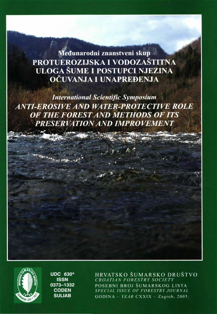
Prof dr. sc. Branimir Prpić Naslovna stranica - Front page: Nabujala rijeka A torrential river (Foto - Photo: Boris Hrašovec) Naklada 600 primjeraka Edition 600 copies
IUFRO GRUPA 8.01.00. EKOSUSTAVI IUFROGROUP8.01.nO. ECOSYSTEMS
IUFRO GRUPA 8.01.08. NIZINSKI ŠUMSKI EKOSUSTAVI IUFRO GROUP8.01.08. FLOODPLA1NFORESTECOSYSTEMS
AKADEMIJA ŠUMARSKIH ZNANOSTI ZAGREB A CADE MY OF FOREST SCIENCES ZA GREB
LESNICKÄADREVARSKÄFAKULTAMZLUBRNO FA CULTU OF FORESTRYAND WOOD TEHNOLOGY,
MENDEL UNI VERSITY OF A GRICUL TURE AND FORESTR Y BRNO ŠUMARSKI FAKULTET SVEUČILIŠTA U ZAGREBU FA CUL TY OF FORESTR Y UNI VERSITY OF ZA GREB
Međunarodni znanstveni skup PROTUEROZIJSKAIVODOZAŠTITNA ULOGA ŠUME I POSTUPCI NJEZINA
OČUVANJA I UNAPREĐENJA International Scientific Symposium
ANTI-EROSIVE AND WATER-PROTECTIVE ROLE OF THE FOREST AND METHODS OF ITS
PRESER VA TIONAND IMPROVEMENT
Zagreb, 2005.
UDK 630* (05):»54-02«/061.2 ISSN 0373-1332 CODEN SUL1AB
Š U M A R S K I L I S T Znanstveno-stručno i staleško glasilo Hrvatskoga šumarskoga društva
Journal of the Forestry Society of Croatia - Zeitschrift des Kroatischen Forstvereins - Revue de la Societe forestiere croate
Robert Abramović, dipl. ing. Dalibor Bakran, dipl. ing. Stjepan Blažičević, dipl. ing. Mr. sc. Miroslav Brnica Davor Butorac, dipl. ing. Mr. sc. Josip Dundović Ivan Duvnjak, dipl. ing. Ivan Đukić, dipl. ing. Dr. sc. Joso Gračan
Uređivački savjet:
10. Prof. dr. sc. Ivica Grbac 18. 11. Ilija Gregorović, dipl. ing. 19. 12. Dubravko Hodak, dipl. ing. 20. 13. Zvonko Kranjc, dipl. ing. 21. 14. Herbert Krauthacker, dipl. ing. 22. 15. Ivan Matasin, dipl. ing. 23. 16. Akademik Slavko Matić, 24.
predsjednik 25. 17. Mr. sc. Ivan Pentek
Vlatko Petrović, dipl. ing. Dragomir Pfeifer, dipl. ing. Prof. dr. sc. Branimir Prpić Dražen Strković, dipl. ing. Dalibor Tomljanović, dipl. Dr. se. Vlado Topić Oliver Vlainić, dipl. ing. Prof. dr. sc. Joso Vukelić
mg.
Uređivački odbor po znanstveno-stručnim područjima:
/. Šumski ekosustavi Prof. dr. sc. Joso Vukelić, urednik područja Urednici znanstvenih grana: Prof. dr. se. Zvonko Seletković, ekologija i biologija šuma Prof. dr. sc. Branimir Prpić, fiziologija i prehrana šumskog drveća Dr. se. Joso Gračan, genetika i oplemenjivanje šumskog drveća Izv. prof. dr. sc. Nikola Pernar, šumarska pedologija Doc. dr. se. Marijan Grubešić, lovstvo
2. Uzgajanje šuma i hortikultura Akademik Slavko Matić, urednik područja Urednici znanstvenih grana: Dr. se. Stevo Orlić, šumsko sjemenarstvo i rasadničarstvo Dr. se. Vlado Topić, krške šume Doc. dr. se. Željko Španjol, zaštićeni objekti prirode
3. Iskorišćivanje šuma Prof. dr. sc. Ante P. B. Krpan, urednik područja Urednici znanstvenih grana: Doc. dr. se. Dragutin Pičman, šumske prometnice Izv. prof. dr. sc. Dubravko Horvat, mahanizacija šumarstva Doc. dr. se. Slavko Govorčin, nauka o drvu i pilanska prerada drva
Članovi Uređivačkog Prof. dr. se. Vladimir Beus, Bosna i Hercegovina Prof. dr. sc. Vjekoslav Glavač, Njemačka Prof. dr. sc. Emil Klimo, Češka Doc. dr. se. Boštjan Kosir, Slovenija
Glavni i odgovorni urednik prof. dr. se. Branimir Prpić Tehnički urednik - Hranislav Jakovac, dipl. ing. šum. Lektor - Dijana Sekulić-Blažina
4. Zaštita šuma Dr. se. Miroslav Harapin, urednik područja Urednici znanstvenih grana: Prof. dr. sc. Milan Glavaš, šumarska fitopatologija Izv. prof. dr. sc. Boris Hrašovec, šumarska entomologija Mr. se. Petar Jurjević, šumski požari
5. Izmjera šuma i šumarska biometrika Urednici znanstvenih grana: Doc. dr. sc. Renata Pernar, izmjera šuma i šumarska biometrika Doc. dr. se. Vladimir Kušan, geodezija
6. Uređivanje šuma Doc. dr. se. Juro Čavlović, urednik područja Urednici znanstvenih grana: Izv. prof. dr. sc. Ivan Martinić, organizacija rada i šumarska ekonomika Branko Meštrić, dipl. ing. šum., informatika u šumarstvu
7. Šumarska politika Hranislav Jakovac, dipl. ing. šum., povijest šumarstva, bibliografija, staleške vijesti Prof. dr. se. Branimir Prpić, ekologija i njega krajolika, općekorisne funkcije šuma
odbora iz inozemstva Dr. sc. Konrad Pintarić, prof, em., Bosna i Hercegovina Prof. dr. sc. Milan Saniga, Slovačka Dr. sc. Martin Schneider-Jacoby, Njemačka Prof. dr. sc. Iztok Winkler, Slovenija
Znanstveni članci podliježu međunarodnoj recenziji. Recenzenti su doktori šumarskih znanosti u FIrvatskoj, Slovačkoj i Sloveniji, a prema potrebi i u drugim zemljama zavisno o odluci uredništva.
Časopis je referiran u (Indexed in): Forestry abstracts, Cab abstracts, Agricola, Pascal, Geobase (IM) i dr. Na osnovi mišljenja Ministarstva znanosti i tehnologije Republike Hrvatske, »Šumarski list« smatra se znanstvenim časopisom te se na njega primjenjuje 0-ta stopa PDV (članak 57. g.)
SADRŽAJ - CONTENTS
RIJEČ GLAVNOG UREDNIKA- FOREWORD BY THE EDITOR - IN - CHIEF 1. ULOGA ŠUME U SPRJEČAVANJU EROZIJE TLA 6
THE ROLE OF FORESTS IN SOIL EROSION CONTROL Predsjedava - Chaired by Slavko Ma tie
UDK 630* 116 Zdenek Vic ha:
Pedeset godina šumarskog hidro-pedološkog istraživanja u šumskim bazenima planinskih vodotoka 7 Fifty Years of Forestry Hydro-pedological Research Within the Forest Basins of Mountain Water Runs 13
UDK 630* 228+116 Slavko Matić, Igor Anić, Milan Oršanić:
Uzgojni zahvati u funkciji poboljšanja protuerozijske i vodozastitne uloge šuma 17 Silvicultural Treatments Aimed at Improving the Anti-Erosion and Water-Protective Role of Forests 25
UDK 630* 116 Petr Kantor:
Uloga planinskih šuma u redukciji visokih voda i poplava 31 Possibilities of Mountain Forests in Reducing High Waters and Floods 36
UDK 630* 116 Vlado Topic, Lukreci/a Butorac:
Utjecaj šikare bijelog graba (Carpinus orientalis Mili.) na zaštitu tla od erozije u Hrvatskoj 40 The Impact of Scrub Vegetation of Oriental Hornbeam (Carpinus orientalis Mill.) on Soil Protection Against Erosion in Croatia 47
UDK 630* 116 Vaclav Tlapäk, Jakub Caska, Jaroslav Herynek:
Utjecaj šume i vegetacije na sprječavanje erozije i zaštitu prirode od poplava 51 The Influence of Forests and Vegetation on Erosion and Flood Control of Landscape 57
UDK 630* 116 + 228 Kami Gubka:
Struktura šuma s funkcijom zaštite tla na lokalitetu Pusty hrad - Zvolen 61 The Structure of the Forest Stand with a Soil Conservation Function in the Locality Pusty Hrad - Zvolen 65
UDK 630* 116+ 114.7 Stjepan Husnjak, Nikola Pernar, Renata Pernar, Ivica Kisić:
Rizik od erozije tla vodom u šumskim ekosustavima Hrvatske 69 Risk of Water-Induced Soil Erosion in the Forest Ecosystems of Croatia 75
UDK 630* 372+ 377+116 Premysl Horek, Pavel Mauer, Lubomir Novak:
Šumska žičara Larix - njena uloga u prirodi bliskom gospodarenju šumama i posebice u sprječavanju erozije tla 78 Larix Forest Cableways - Implement of Nature Oriented Silviculture, Especially in Soil Erosion Control 85
2. BIOLOŠKA SANACIJA EROZIJE TLA 90 BIOLOGICAL CONTROL OF SOIL EROSION Predsjedava - Chaired by Joso Gračan
UDK 630* 116 + 384 + 232.4 Vice Ivančević:
Biološko-tehnički radovi na sanaciji senjske bujice "Torrente" i povećanje vodnog kapaciteta 91 Biological and Technical Regulation of the Senj Torrent "Torrente " and Increase in Water Capacity 101
UDK630*232+ 116+165 Joso Gračan, Sanja Perić, Mladen Ivanković, Hrvoje Marjanović:
Biološka sanacija erozije na području Like i Istre 110 Biological Erosion Control in the Western Part of Croatia 117
UDK 630* 232.5 Sanja Perić, Vlado Topic, Zeljko Orešković, Romana Maradin:
Biološka sanacija površinskih kopova i deponija prilikom izgradnje autocesta u Hrvatskoj 120 Biological Control of Excavations and Dumps during the Construction of Highways in Croatia 128
UDK630* 116 + 233 + 241 Anamarija Durbešić, Ivica Milković:
Pošumljavanje neobraslog šumskog zemljišta na jušnim padinama Svilaje - Muć s ciljem protuerozijskog djelovanja 133 Afforesting Unstocked Forestland on the Southern Slopes of Svila/a - Muć Mountain for Anti-Erosive Purposes 140
UDK 630* 907+ 231 +524 Stanislav Kucbel:
Struktura i prirodna obnova predplaninske šume obične smreke sa zaštitnom funkcijom u Niskim Tatrama (Slovačka) 144 The Structure and Natural Regeneration of a Subalpine Spruce Forest with Protective Function in Nizke Tatry Mountains (Slovakia) 150
3. VODOZAŠTITA- URAVNOTEŽENJE VODNIH ODNOSA U PROSTORU I PROČIŠĆAVANJE IZVORSKIH VODA 154 WATER PROTECTION - BALANCING WATER RELA TIONS IN THE SPA CE AND PURIFYING SPRING WA TERS Predsjedava - Chaired by Emil Klimo
UDK 630* 116+ 114.2 + 425 Emil Klimo, Jiri Kulhavy:
Uloga šume u zaštiti kvalitete vodnih resursa 155 The Role of Floodplain Forests in Southern Moravia in the Protection of Quality of Water Resources . . . 161
UDK 630* 425+ 114.2+ 116 Boris Vrbek, Ivan Pilaš, Tomislav Dubravac:
Praćenje kvalitete vode u šumi hrasta lužnjaka i običnoga graba protočnim lizimetrima 165 Lysimetric Monitoring of Soil Water Quality in the Forest of Pedunculate Oak and Common Hornbeam 180
UDK 630* 116 + 907 Branimir Prpić, Petar Jurjević, Hranislav Jakovac:
Procjena vrijednosti protuerozijske, hidrološke i vodozaštitne uloge šume 186 Assessing the Value of the Anti-erosive and Water-protective Role of the Forest 192
UDK 630* 116 Miloslav Janeček:
Uporaba metode CN-krivulja za procjenu utjecaja šuma na površinsko otjecanje 195 Application of the Method of Runoff Curve Numbers to Evaluate the Effect of Forest on Surface Runoff 200
UDK 630* 116 + 907.1 + 113 Ivica Tikvić, Dinko Puntarić, Zeljko Zečić, Damir Ugarković, Zvonko Seletković:
Utjecaj brdskih šumskih ekosustava na kakvoću vode u vodotocima 202 The Impact of Montane Forest Ecosystems on Water Quality of Watercourses 213
UDK 630* 181.3 Pavel Kovär:
Procjena rizika kod ekstremnih hidroloških stanja slučaj slivova Vseminke i Drevnice, Republika Češka 219 Risk Assessment of Extreme Hydrological Situations: Case Study of the Vseminka and Drevnice Catchments, Czech Republic 226
UDK630* 181.3 Peter Jaloviar:
Raspodjela sitnog korijenja u čistoj sastojini obične smreke u stadiju letvika 229 Fine Root Distribution in a Pure Pole-Stage Stand of Norway Spruce 234
N. Pernar, D. Holjević, J. Petras, D. Bakšić: Pedofiziografski odnosi na poligonu za istraživanje erozije u Abramima 238 Pedophysiographic Relations in the Erosion Testing Site of Abrami 239
D. Diminić, N. Potočić, I. Seletković, M. Gršković: Utjecaj patogene gljive Sphaeropsis sapinea na protuerozijsku zaštitnu ulogu kulture crnoga bora u Istri: Analiza zdravstvenog stanja i stanja ishrane 240 Influence of the Pathogenic Fungus Sphaeropsis sapinea on the Anti-erosive and Protective Role of Austrian Pine Plantations in Istria: Analyses of the Health and Nutrition Status 241
J. Čavlović, M. Oršanić, M. Božić: Gospodarenje privatnim šumama Hrvatske kao ograničavajući čimbenik ispunjenja općekorisnih i gospodarskih funkcija šuma nizinskog područja 242 Private Forest Management in Croatia as a Limiting Factor in the Achievement of Non-commercial and Commercial Forest Functions in Lowland Regions 243
D. Huska, L. Jurik, L. Tätosovä: Šuma kao važan dio zdravog krajobraza 244 Forest as an Important Part of a Healthy Landscape
I. Pilaš, T. Gojmerac, B. Vrbek, T. Dubravac: Unaprjeđenje monitoringa podzemnih voda u nizinskim šumskim ekosustavima Hrvatske korištenjem GlS-a i geostatistike 245 Enhancements in the Groundwater Monitoring System in Lowland Forest Ecosystems in Croatia by Using GLS and Geostatistics 246
/. Tikvić, Z. Seletković, N. Magdić, V. Sojat: Stanje i odnosi oborinskih voda u šumskim ekosustavima Nacionalnog parka Plitvička jezera 247 The Condition and Relationship of Precipitation Waters in the Forest Ecosystems of Plitvice Lakes National Park 248 ZAKLJUČCI 249 CONCLUSIONS 251
S. Matić: ULOGA ŠUME U SPRJEČAVANJU EROZIJE TLA Šumarski list - SUPLEMENT (2005), 6
1. Skupina referata:
ULOGA ŠUME U SPRJEČAVANJU EROZIJE TLA
Skupu predsjedava: Akademik Slavko Matić
Referati ove skupine odnose se na istraživanja utjecaja šume na akvatičnu eroziju tla obavljena u Češkoj (Viha, Kantor, Tlapak i dr.) i Hrvatskoj (Topić i Butorac, Husnjak i dr., Pernar, N. i dr.). Značajna su istraživanja Vicha-e i Kantora u visokoplaninskim šumama te Topića i Butorca u području Sredozemlja koja se odlikuju dugim godišnjim nizovima i daju pouzdane rezultate.
Vrlo zanimljivi su rezultati istraživanja Kantora iz kojih proizlazi kako visokoplaninske sastojine smreke i bukve učinkovito ublažavaju površinsko otjecanje neprekidne oborine do 100 mm dok kod neprekidnih oborina preko 150 mm slijedi nekontrolirano otjecanje kroz čitav profil tla.
Opisani su šumskouzgojni postupci kod različitih uzgojnih oblika sa svrhom za postizanje što boljih sirovinskih i energetskih učinaka uz istovremeno postizanje potpunoga djelovanja općekorisnih funkcija šume s posebnom pozornošću na protuerozijsku i vodozaštitnu ulogu.Takve uvjete potrebno je održavati tijekom čitavoga života šumske sastojine, odnosno između dva planirana prirodna pomlađivanja.
Horek i dr. ukazali su na način pridobivanja drva tijekom obnove sastojine koji osigurava tlo od pojave oštećenja koja izazivaju brazdastu i jaružastu eroziju tla.
1st group of papers:
THE ROLE OF FOREST IN PREVENTING SOIL EROSION
Chaired by: Academician Slavko Matić
The papers in this group relate to the study of forest effects on aquatic soil erosion. Research was conducted in the Czech Republic (Vicha, Kantor, Tlapak et al.) and in Croatia (Topic and Butorac, Husnjak et al, Pernar, N. et al.). Research by Vicha and Kantor conducted in high mountain forests and by Topic and Butorac in the Mediterranean area are characterized by long annual series and reliable results.
Very interesting research results by Kantor suggest that high mountain stands of spruce and beech efficiently mitigate surface runoff caused by continuous precipitation of 100 mm at most, whereas continuous precipitation exceeding 150 mm is followed by uncontrolled discharge throughout the soil profile.
Silvicultural treatments applied to different siIvicultural forms with the aim of achieving the best raw material and energetic effects are described, and so is the provision of a complete set of noncommercial forest functions with special emphasis on anti-erosive and water-protective roles. Such conditions should be maintained throughout the life of a forest stand; in other words, between two planned natural regenerations.
Horek et al. discussed a method of timber harvesting during stand regeneration that protects the soil against damage caused by furrow and ditch-like soil erosion.
6
IZLAGANJE NA ZNANSTVENOM SKUPU PRESENTATION AT THE INTERNATIONAL SYMPOSIUM Šumarski list SUPLEMENT (2005). 7-16 UDK 630* 116
PEDESET GODINA ŠUMARSKOG HIDRO-PEDOLOŠKOG ISTRAŽIVANJA U ŠUMSKIM BAZENIMA PLANINSKIH VODOTOKA
FIFTY YEARS OF FORESTRY HYDRO-PEDOLOGICAL RESEARCH WITHIN THE FOREST BASINS OF MOUNTAIN WATER RUNS
Zdenek VICHA*
SAŽETAK: Na dan 31. 10. 2003. godine završeno je pedesetogodišnje mjerenje hidroloških i klimatskih podataka u dvama pokusnim bazenima Cervik (CE) i Mala Raztoka (MR) u planinama Beskydy. Istraživanje je imalo za cilj procijeniti odnos između oborina i otjecanja kao elemenata vodne ravnoteže u malim šumskim slivovima. Pokus pokazuje da odnos između oborina i otjecanja u malim šumskim planinskim slivovima ovisi više o prirodnim elementima nego o metodama gospodarenja šumom. Šumska tla važni su elementi u hidrološkom režimu slivova s kvalitetama infiltracije i retencije. Željeli bismo predstaviti učinkovite prijedloge za gospodarenje šumama, koji se mogu zahvaljujući dugotrajnosti istraživanja vezati za, na primjer, ophodnju šume.
UVOD - Introduction
Mjerenje, vrednovanje i modeliranje odnosa oborina - otjecanja u šumovitim planinskim slivovima ima dugu tradiciju u mnogim zemljama. U Cehoslovačkoj je već 1928. Mr. Välek započeo šumarsko-hidrolo-ško mjerenje u bazenima Kychovä i Zdechovka u planinama Javornik. Početkom pedesetih godina prošloga stoljeća povećalo se zanimanje za gospodarske mjere, što podupiru vodne funkcije. Novi pokusni objekti postavljeni su u Moravskoslezske Beskydy. Radi se o slivu Mala Räztoka (2,08 km2) i Červik (1,85 km2). Istraživanje započeto 1. studenog 1954. još uvijek traje, što je u svjetskim razmjerima najdulje trajanje nekog
Eksperimentalni sliv CE smješten je u Zadni hory Moravskoslezske Beskydy, iznad vodnog rezervoara Šance, na visini 640-960 m iznad morske razine. Bazeni su 100 % pod šumom, u procjeni predstavljeni s 85 % četinjača. Bazen je prirodno podijeljen u dva dijela, CA (0,88 % km2) i CB (0,84 km2". U svrhu
* Ing. Zdenek Vicha, UJLHM Jilovište - Strnady, Ured Frydck - Mistek, Nadražni 2811, CZ - 738 01, e-mail [email protected]
eksperimenta. Mjerenje i vrednovanje odnosa oborina i otjecanja u malim šumskim bazenima, te utjecaj na pojedine komponente šumskog gospodarenja osnovni je cilj toga pokusa. Dugoročno je razdoblje pokusa omogućilo bolje razumijevanje međuodnosa te njihovu primjenu u šumskom razvoju (npr. razdoblje ophodnje). Međutim, problem je suviše složen, pa se nedvosmisleni zaključci teško mogu očekivati. Mjerenje treba nastaviti, a podaci se moraju temeljito analizirati. Moramo bolje i detaljnije razumijeti koji su elementi i njihove promjene/odnosi najvažniji za proces oborina-otjeca-nja u šumskim sastojinama.
istraživanja primijenjena je metoda dvaju bazena. Nakon 1965, dio A je brzo pošumljen sječom u prugama, a dio B ostavljen je kao kontrola, bez namjerne sječe, te s prirodnom obnovom.
Pokusni bazen MR nalazi se na sjeverozapadnim padinama Beskyda, na visini 602 m - 1084 m iznad mora. Između 1953. i 1965. predviđen je bez sastojinske obnove, a od 1966. sastojina je obnovljena sječom u prugama. Tijekom obnove u MR bukva je zamijenjena smrekom, a razlike u otjecanju su bilježene. Detaljne karakteristike dvaju bazena predstavljene su u Tablici.
POKUSNI SLIVOVI CE I MR - Experimental basms of CE and MR
7
Z. Vicha: PEDESET GODINA ŠUMARSKOG H1DRO-PEDOLOSKOG ISTRAŽIVANJA U ŠUMSKIM Šumarski list SUPLEMENT (2005), 7-16
METODA ISTRAŽIVANJA UNUTAR DVAJU BAZENA Metod of research within the two basins
Istraživanje u bazenima MR i CE temelje se na vrednovanju šumsko-gospodarstvenih mjera s obzirom na otjecanje i vodnu ravnotežu. Uzimaju se u obzir osnovno stanje šume, orografski i sastojinski uvjeti, različiti za dva bazena.
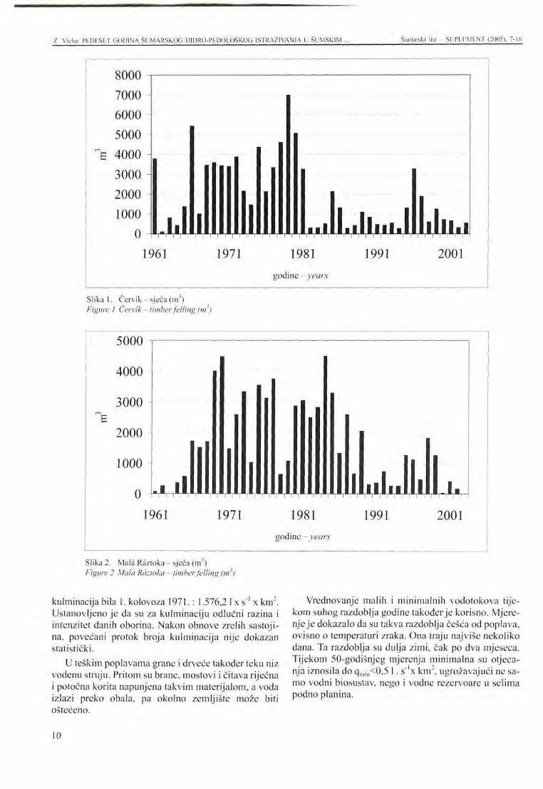
Ukupni posječeni volumen u dva bazena (Tablice 1, 2) pokazuju, daje sječa bila intenzivno motivirana s ciljevima istraživanja krajem sedamdesetih godina. U osamdesetim godinama, nakon teške štete zračnim zagađenjem, uglavnom na izloženim padinama i greben-skom dijelu bazena MR, sječa je gotovo stala. Brza obnova u bazenu CE također je zaustavljena, te je ograničena samo na najvažnije šumarske mjere, unatoč činjenici da šteta uzrokovana zračnim zagađenjem nije bila tako teška u ovom bazenu. Međutim, to nije utjecalo na cilj istraživanja, jer je obnova bila u takvom stanju da su rezultati obnove mogli utjecati na otjecanje.
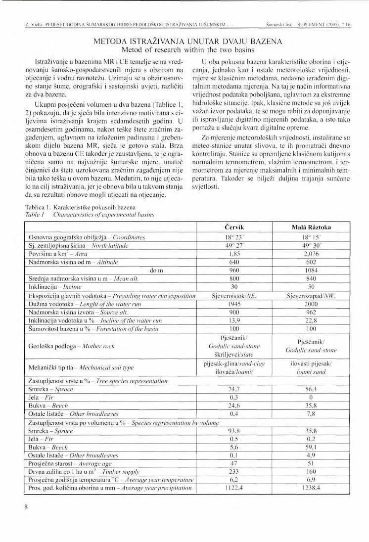
Tablica 1. Karakteristike pokusnih bazena Table 1 Characteristics of experimental basins
U oba pokusna bazena karakteristike oborina i otje-canja, jednako kao i ostale meteorološke vrijednosti, mjere se klasičnim metodama, nedavno izrađenim digitalnim metodama mjerenja. Na taj je način informativna vrijednost podataka poboljšana, uglavnom za ekstremne hidrološke situacije. Ipak, klasične metode su još uvijek važan izvor podataka, te se mogu rabiti za dopunjavanje ili ispravljanje digitalno mjerenih podataka, a isto tako pomažu u slučaju kvara digitalne opreme.
Za mjerenje meteoroloških vrijednosti, instalirane su meteo-stanice unutar slivova, te ih promatrači dnevno kontroliraju. Stanice su opremljene klasičnom kutijom s normalnim termometrom, vlažnim termometrom, i termometrom za mjerenje maksimalnih i minimalnih temperatura. Također se bilježi duljina trajanja sunčane svjetlosti.
Osnovna geografska obilježja - Coordinates Sj. zemljopisna širina - North latitude Površina u km" - Area Nadmorska visina od m -Altitude
do m Srednja nadmorska visina u m - Mean alt. Inklinacija - Incline
Červi'k
18°23 ' 49° 27'
1,85 640 960 800 30
Mala Räztoka
18° 15' 49° 30' 2,076 602 1084 840 50
Ekspozicija glavnih vodotoka - Prevailing water run exposition Sjeveroistok/M:. Sjeverozapad/AW. Dužina vodotoka - Lenght of the water run Nadmorska visina izvora - Source alt. Inklinacija vodotoka u % - Incline of the water run Sumovitost bazena u % - Forestation of the basin
Geološka podloga - Mother rock
Mehanički tip tla - Mechanical soil type
1945 900 13.9 100
Pješčanik/ Godulic sand-stone
škriljevci/.vtae pijesak-glinaAvanJ-c/ay
ilovača//oa/mV
2000 962 22,8 100
Pješčanik/ Godulic sand-stone
ilovasti pijesak/ loam i sand
Zastupljenost vrste u % - Tree species representation Smreka - Spruce Jela - Fir Bukva - Beech Ostale listače - Other broadleaves
74,7 0,3
24,6 0,4
56,4 0
35,8 7,8
Zastupljenost vrsta po volumenu u % - Species representation by volume Smreka - Spruce Jela - Fir Bukva - Beech Ostale listače - Other broadleaves Prosječna starost - A verage age Drvna zaliha po 1 ha u m - Timber supply Prosječna godišnja temperatura °C - Average year temperature Pros. god. količina oborina u m m - Average year precipitation
93,8 0,5 5,6 0,1 47
233 6,2
1122,4
35,8 0,2
59,1 4,9 51 160 6,9
1238,4
Z. Vicha: PEDESET GODINA ŠUMARSKOG IIIDRO-PEDOLOSKOG ISTRAŽIVANJA U ŠUMSKIM Šumarski list - SUPLEMENT (2005), 7-16
Mjerenje oborina je važno, radi se s više detalja nego rutinski u klimatologiji. U svakom je slivu instalirano četiri totalizera, tri na vodnoj granici, jedan u dolini, u središtu bazena. Ukupne oborine mjere se mjesečno. Oborine se bilježe pluvijalnim grafikonima tjedno, s važnim podacima o poplavama i njihovom analizom. Mjerači oborina u stanici verificiraju pouzdanost mjerenja. Zimi se mjeri sloj novog snijega, ukupni sniježni pokrov i njegova vodna vrijednost. Mjesečne ukupne oborine slivova izračunavaju se primjenom poligonske metode Horton-Thiesson. Vodno se otjecanje mjeri u betonskim mjernim lijevcima s limnigrafskim šahtom. Ovi su opremljeni s limnigrafima OTT tjednog režima. Promatrači dnevno mjere razinu vode i temperaturu. Otjecanje se vrednuje na temelju potrošnih krivulja, a vrijednosti se opetovano verificiraju. Minimalni protok mjeri se u 50-litarskom kalibriranom kontejneru, ispod žice lijevaka.
Tri lijevka u slivu CE mjere nezavisno otjecanje dvaju dijelova bazena, a također i otjecanje niz pritoku.
Detaljniji podaci o digitalnom mjerenju: Registracijski blok M4016 sa 16 kanala opremljen s
akumulatorom osnova je opservacijske stanice MS 16. Registracijski blok omogućuje povezivanje svih standardnih tipova mjernih senzora. Svi uobičajeni senzori sa standardnom, tekućom frekvencijom ili pulsnim outputom mogu se priključiti na blok. Nekoliko ultra-soničnih i clektrokemijskih pokusa s digitalnim outputom mogu se na taj način priključiti na blok. Povezanost s blokom izvodi se s programima MOST, te aktualnom verzijom MOST 32. Programi prenose podatke u radnu knjigu, konstatiraju parametre mjerenja, poh
rane podataka i obrade podataka uz uporabu outputa iz tablica i grafikona.
Za mjerenje razine vode u otvorenim lijevcima, pri-mijenjuju se ultrasonične probe US 3000. Mikroprocesor izračunava razdaljinu na temelju vremenskog intervala poslanog ultrasoničnog impulsa i njegovog odraza, korigiranog na temelju temperature zraka. Bazna rezolucija probe je 1 mm.
Zračna temperatura mjeri se termometrom platin-ske rezistencije Pt 100 s tekućim prijenosnikom u glavi. Za mjerenje kapaciteta zračne vlage rabi se senzor s tekućim outputom. Termometer i senzor vlage zaštićeni su radijacijskim pokrovom, a postavljeni su na jarbol visine 2 m iznad tla. Temperatura zraka također se mjeri platinskim termometrom Pt 100. Čitav kompleks priključen je na pulsni input registracijskog bloka. Ovaj registrira, u jednom od kanala, volumen oborina unutar vremenskog razdoblja postavljenog intervala pohrane podataka u bloku. Načelo uporabe mjerača oborina temelji se na mehanizmu čamca (dumping boat) podijeljenom u dva dijela, kako bi se dobili električni impulsi, ovisno o intenzitetu oborina. Kiša prolazi kroz otvor strogo određenog područja, izravno u lijevak, te nastavlja do gornjeg dijela čamca. Kada se gornji dio napuni određenom masom oborine, čamac se prevrne. Polovina čamca se isprazni, a druga polovina dospije pod lijevak. Ovaj se proces nastavlja do prestanka kiše. Magnet pričvršćen na tijelo čamca dovodi do kontakta pri svakom prevrtanju. Ovaj kontakt, ovisno o protoku oborine, omogućava registriranje broja prevrtanja, a time i volumen oborine.
REZULTATI DUGOROČNOG ISTRAŽIVANJA U PLANINAMA BESKYDY Results of long-term research in Beskydy Mts.
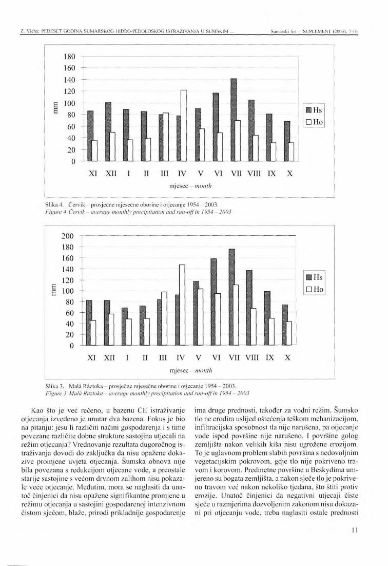
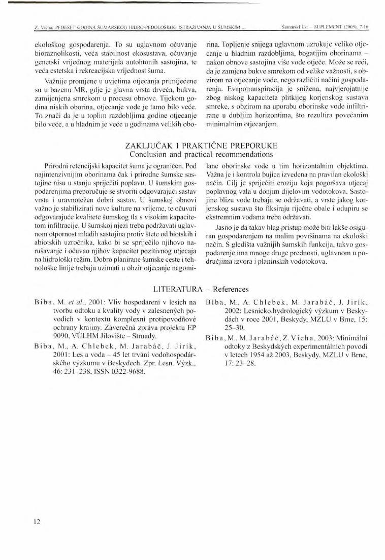
Tijekom čitavog razdoblja istraživanja u bazenu CE, prosječna godišja oborina bila je 1122,4 mm, otjecanje 646,2 mm, prosječan godišnji protok bio je 20,5 1. s"'x km2. U bazenu MR prosječna godišnja oborina bila je 1.238,4mm, otjecanje 912 mm, prosječan godišnji protok 28,9 1 s" - 1 x km2. U grafikonima su prikazane prosječne mjesečne oborine i otjecanje u razdoblju 1954 - 2003. U Beskydima snijeg se topi od ožujka do svibnja, a najviše oborina padne za vrijeme ljetnih mjeseci.
Detaljna analiza vodne ravnoteže u šumskim sasto-jinama vrlo je složen prirodni proces. Počinje mjerenjem pojedinih kiša, broja dana među njima, intercep-cije, evapotranspiracije, natapanja vode u tlu, otjecanja pod različitim klimatskim uvjetima, sezone i prirodnih uvjeta. Pri jakoj kiši dio se vode natopi u šumskom tlu, manji dio otječe, uglavnom u zemljišta nabijene i stabilizirane površine. Volumen vode upijen u šumskom tlu
ograničen je. To je razlog što se površinsko otjecanje može promatrati kada je voda koncentrirana u rovovima i vodotokovima. Ovaj tip otjecanja ima udjel od 15-20 % ukupne maksimalne količine, i ograničenje na vrlo kratko vrijeme. Veći postotak je onaj brzog površinskog otjecanja u poplavnim valovima; retencij-ski kapacitet tijekom čitavog razdoblja jedva je prelazio 2mm u minuti, što znači 33 m3 vode po kvadratnom kilometru u sekundi. Najveće specifično otjecanje bilo je izmjereno u MR : q = 3.144m3 x s" . km". Ovi podaci podvrđuju brzu vodnu retenciju šumskog tla.
Zaista velike, iznenadne kiše u Beskydima rezultirale su poplavama. Opasne su i vodne kulminacije što prelaze 1000 . s"1 x km2. Za vrijeme istraživanja, takvi su događaji primijećeni devet puta u MR i sedam puta u CE. U MR je najviša kulminacija zabilježena nakon bujice izazvane kišom 25. srpnja 1966 s već spomenutom vrijednosti od 3.144 1 s~' x km2. U CE je najveća
9
Z. Vicha: PEDESET GODINA ŠUMARSKOG HIDRO-PEDOLOŠKOG ISTRAŽIVANJA U ŠUMSKIM Šumarski list - SUPLEMENT (2005), 7-16
Slika 1. Červik-sječa (nv) Figure 1 Červik - timber felling (m )
Slika 2. Mala Raztoka-sječa (m3) Figure 2 Mala Raztoka - timber felling (m )
kulminacija bila 1. kolovoza 1971. : 1.576,2 1 x s ' x km2. Ustanovljeno je da su za kulminaciju odlučni razina i intenzitet danih oborina. Nakon obnove zrelih sastoji-na, povećani protok broja kulminacija nije dokazan statistički.
U teškim poplavama grane i drveće također teku niz vodenu struju. Pritom su brane, mostovi i čitava riječna i potočna korita napunjena takvim materijalom, a voda izlazi preko obala, pa okolno zemljište može biti oštećeno.
Vrednovanje malih i minimalnih vodotokova tijekom suhog razdoblja godine također je korisno. Mjerenje je dokazalo da su takva razdoblja češća od poplava, ovisno o temperaturi zraka. Ona traju najviše nekoliko dana. Ta razdoblja su dulja zimi, čak po dva mjeseca. Tijekom 50-godišnjeg mjerenja minimalna su otjeca-nja iznosila do qmin<0,5 1 . s"'x km2, ugrožavajući ne samo vodni biosustav, nego i vodne rezervoare u selima podno planina.
10
Z. Vicha: PEDESET GODINA ŠUMARSKOG HIDRO-PEDOLOŠKOG ISTRAŽIVANJA U ŠUMSKIM Šumarski list - SUPLEMENT (2005), 7-16
XI XII I II III IV V VI VII VIII IX X mjesec - month
Slika 4. Červik - prosječne mjesečne oborine i otjecanje 1954 - 2003. Figure 4 Červik - average monthly precipitation and run-off in 1954 - 2003
• Hs DHo
XI XII I II III IV V VI VII VIII IX X mjesec - month
Slika 3. MaläRäztoka- prosječne mjesečne oborine i otjecanje 1954-2003 . Figure 3 Mala Räztoka - average monthly precipitation and run-off in 1954 - 2003
Kao što je več rečeno, u bazenu CE istraživanje otjecanja izvedeno je unutar dva bazena. Fokus je bio na pitanju: jesu li različiti načini gospodarenja i s time povezane različite dobne strukture sastojina utjecali na režim otjecanja? Vrednovanje rezultata dugoročnog istraživanja dovodi do zaključka da nisu opažene dokazive promjene uvjeta otjecanja. Šumska obnova nije bila povezana s redukcijom otjecane vode, a preostale starije sastojine s većom drvnom zalihom nisu pokazale veće otjecanje. Međutim, mora se naglasiti da unatoč činjenici da nisu opažene signifikantne promjene u režimu otjecanja u sastojini gospodarenoj intenzivnom čistom sječom, blaže, prirodi prikladnije gospodarenje
ima druge prednosti, također za vodni režim. Šumsko tlo ne erodira uslijed oštećenja teškom mehanizacijom, infiltracijska sposobnost tla nije narušena, pa otjecanje vode ispod površine nije narušeno. I površine golog zemljišta nakon velikih kiša nisu ugrožene erozijom. To je uglavnom problem slabih površina s nedovoljnim vegetacijskim pokrovom, gdje tlo nije pokriveno travom i korovom. Predmetne površine u Beskydima umjereno su bogata zemljišta, a nakon sječe tlo je pokriveno travom već nakon nekoliko tjedana, što štiti protiv erozije. Unatoč činjenici da negativni utjecaji čiste sječe u razmjerima dozvoljenim zakonom nisu dokazani pri otjecanju vode, treba naglasiti ostale prednosti
11
Z. Vicha: PEDESET GODINA ŠUMARSKOG HIDRO-PEDOLOŠKOG ISTRAŽIVANJA U ŠUMSKIM ... Šumarski list - SUPLEMENT (2005), 7-16
ekološkog gospodarenja. To su uglavnom očuvanje bioraznolikosti, veća stabilnost ekosustava, očuvanje genetski vrijednog materijala autohtonih sastojina, te veća estetska i rekreacijska vrijednost šuma.
Važnije promjene u uvjetima otjecanja primijećene su u bazenu MR, gdje je glavna vrsta drveća, bukva, zamijenjena smrekom u procesu obnove. Tijekom godina niskih oborina, otjecanje vode je tamo bilo veće. To znači da je u toplim razdobljima godine otjecanje bilo veće, a u hladnim je veće u godinama velikih obo-
Biba , M. et ah, 2001: Vliv hospodareni v lesich na tvorbu odtoku a kvality vody v zalesnenych po-vodich v kontextu komplexni protipovodfiove ochrany krajiny. Zäverecnä zpräva projektu EP 9090, VÜLHM Jilovište - Strnady.
Biba , M, A. Ch lebek , M. J a r a b a č , J. J i r ik , 2001: Les a voda - 45 let trväni vodohospodär-skeho vyzkumu v Beskydech. Zpr. Lesn. Vyzk., 46: 231-238, ISSN 0322-9688.
rina. Topljenje snijega uglavnom uzrokuje veliko otjecanje u hladnim razdobljima, bogatijim oborinama -nakon obnove sastojina više vode otječe. Može se reći, daje zamjena bukve smrekom od velike važnosti, s obzirom na otjecanje vode, nego različiti načini gospodarenja. Evapotranspiracija je snižena, najvjerojatnije zbog niskog kapaciteta piitkijeg korjenskog sustava smreke, s obzirom na uporabu oborinske vode infiltrirane u dubljim horizontima, što rezultira povećanim minimalnim otjecanjem.
Biba , M., A. Ch l ebek , M. J a r a b a č , J. J i r ik , 2002: Lesnicko.hydrologicky vyzkum v Besky-däch v roče 2001, Beskydy, MZLU v Brnc, 15: 25-30.
Biba , M., M. J a r a b a č , Z. Vicha , 2003: Minimalni odtoky z Beskydskych experimentälnich povodi v letech 1954 až 2003, Beskydy, MZLU v Brne, 17:23-28.
ZAKLJUČAK I PRAK Conclusion and practi
Prirodni retencijski kapacitet šuma je ograničen. Pod najintenzivnijim oborinama čak i prirodne šumske sas-tojine nisu u stanju spriječiti poplavu. U šumskim gospodarenjima preporučuje se stvoriti odgovarajući sastav vrsta i uravnotežen dobni sastav. U šumskoj obnovi važno je stabilizirati nove kulture na vrijeme, te očuvati odgovarajuće kvalitete šumskog tla s visokim kapacitetom infiltracije. U šumskoj njezi treba podržavati uglavnom otpornost mladih sastojina protiv štete od biotskih i abiotskih uzročnika, kako bi se spriječilo njihovo narušavanje i očuvao njihov kapacitet pozitivnog utjecaja na hidrološki režim. Dobro planirane šumske ceste i tehnološke linije trebaju uzimati u obzir otjecanje nagomi-
LITERATURA
riCNE PREPORUKE ;al recommendations lane oborinske vode u tim horizontalnim objektima. Važna je i kontrola bujica izvedena na pravilan ekološki način. Cilj je spriječiti eroziju koja pogoršava utjecaj poplavnog vala u donjim dijelovim vodotokova. Sasto-jine blizu vode trebaju se održavati, a vrste jakog korjenskog sustava što fiksiraju riječne obale i odupiru se ekstremnim vodama treba održavati.
Jasno je da takav blag pristup može biti lakše osiguran gospodarenjem na malim površinama na ekološki način. S gledišta važnijih šumskih funkcija, takvo gospodarenje ima mnoge druge prednosti, uglavnom u područjima izvora i planinskih vodotokova.
- References
12
PRESENTATION AT THE INTERNATIONAL SYMPOSIUM Šumarski list SUPLF.MENT (2005), 7-16
FIFTY YEARS OF FORESTRY HYDRO-PEDOLOGICAL RESEARCH WITHIN THE FOREST BASINS OF MOUNTAIN WATER RUNS
Zdenek VICHA*
SUMMARY: After a period of fifty years, measurements of hydrological and climatic data in two experimental basins of Cervik (CE) and Mala Rdztoka (MR) were completed on 31 October 2003. The goal of research was to evaluate the relationship between rainfall and outflow as elements of water balance in small forested watersheds. According to the experiment, the relationship between precipitation and outflows in small forested mountain watersheds depends more on natural elements than on methods of forest management. In terms of infiltration and retention quality, forest soils are very important elements in a watershed hydrological regime. We would like to present efficient suggestions for forest management obtained from long-lasting research, which can be related to the rotation cycle of a forest, for example.
INTRODUCTION Measuring, evaluation and modelling of the precipi
tation-run-off relationship in the forested mountain basins has a long tradition in many countries. In Czechoslovakia forestry-hydrological measuring has been initiated already in 1928, by Mr. V ä 1 e k, within the basins of Kychovä and Zdechovka, Javornik Mts. At the begin ing of fifties of the last century, the interest in the management measures, supporting forest water function, was increased. Thanks to Marana and Zeleny the new experimental objects have been installed in Moravskoslezske Beskydy (Moravian-Silesian part of the Beskydy Mountains). It is the basin of Mala Räztoka (MR - 2.08 km2) and Červik (CE - 1.85 km2). Research, initiated there in November 1, 1954, is still on going, the time exceeding
The experimental basin of CE is situated in so called Zadni hory (Back-side Mts.) of Moravskoslezske Beskydy, over the water reservoir Šance, at the altitude of 640 - 960 m over the sea level. The basin is 100 % forested, in the term of calibrating 85 % of conifers was represented. The basin is naturally divided in two parts, called CA (0.88 km2) and CB (0.84 km2). For the
* Ing. Zdenek Vicha, Forestry and Game Management Research Institute, Jilovište - Strnady, office Frydek - Mistck, Nadražni2811,CZ-738 01, e-mail [email protected]
many other experiments worldwide. Measuring and evaluation of the precipitation - run-off relationship in the small forested basins, and the impact on individual components of the forest management is the primary goal of the experiment. Mainly long-term period of the research had made possible to understand better the inter-relations, and their application in forest development (e.g. rotation period). However, the problem is too complicated, and unambiguous conclusions can be hardly expected. Measuring has to go on and the data are to be deeply analysed. We need better, in more detail, understand which elements and their changes and relations, are the most important for the precipitation-run-off process in forest stands.
research purpose, the method of the pair basins was used. After 1965, part A was fastly reforested by the strip cutting, part B was left as a control, with no intentional felling, and natural regeneration.
Experimental basin of MR is situated on the NW slopes of Beskydy, at the altitude of 602-1084 m over sea level. In 1953 - 1965 it was calibrated without stand regeneration, since 1966 the stand was regenerated by the strip felling. During the regeneration in MR, beech was replaced by spruce, and the differences in run-off were recorded. Detailed characteristics of the two basins are presented in the Table.
EXPERIMENTAL BASINS OF CE AND MR
13
Z. Vicha: FIFTY YEARS Ol" THE FORESTRY HYDRO-PFDOLOGICAL RESEARCH WITHIN THE FOREST ... Šumarski list - SLJPLEMENT (2005). 7-16
METOD OF RESEARCH WITHIN THE TWO BASINS
Research within the basins of MR and CE is based on evaluating of the forest management measures with respect to the run-off, and water balance. Basic forest state, orographic and stand conditions, different in the two basins, are considered.
Total volume felled within the two basins (Tabs. 1, 2) shows, that felling was intensively motivated by the research aims by the end of seventies. In eighties, after hard damage by air pollution, mainly in the exposed slope and ridge part of the basin MR, felling was nearly stopped. Fast regeneration in CE basin was also closed, and it was limited only to the most important forestry measures, in spite of the fact that damage by air pollution was not that heavy in this basin. However, the aim of the research was not affected, as the regeneration was in such a state that the run-off could be affected by its results in measurable way.
In both experimental basins the precipitation and run-off characteristics, same as other meteorological values, are measured by classic methods, newly completed by digital methods of measuring. Thus the informative value of the data was improved, mainly for the extreme hydrological situations. Nevertheless, the classic methods are still important data source, and they can be used to complete or correct the data measured digitally, and they also help in case of the digital equipment failure.
To measure meteorological values, meteo-stations have been installed within the basins, controlled daily by the observers. The stations are equipped by classic case with normal thermometer, wet thermometer, and thermometer for measuring of maximum and minimum temperature. Also the length of sunshine is recorded.
Measuring of precipitation is of importance, done in more detail than the routine in climatology. In each basin four totalisers are installed, three of them in water divide, one in the valley, in centre of the basin. Total precipitation is measured on monthly base. Precipitations in time are recorded by pluvial-graphs on weekly base, giving important data on floods and their analyzing. The station precipitation meters verify reliability of measuring. In winter the layer of new snow is measured, total snow cover and its water value. Monthly total precipitation of the basins is calculated using the polygon method by Horton-Thiesson.
Water run-off is measured in the concrete measuring funnels with limnigraphic manhole (shaft). They are equipped with limnigraphs OTT of week regime. Water level on the scale, and water temperature are measured daily by the observer. Run-off is evaluated on the base of consumption curves, the values are verified repeatedly. Minimal flow is measured in 50 litre calibrated container, under the wire of funnels.
There are three funnels in the CE basin, measuring independently run-off of the two parts of the basin, and also run-off down the confluence.
More detailed information on digital measuring: The 16-channel registration unit M4016, supplied
by accumulator, is the base of the monitoring station MS 16.
The registration unit makes possible to connect all types of measuring sensors of standard. All common sensors with standard, current, frequency or pulse output can be connected to the unit. A number of ultrasonic and electrochemical probes with digital output can thus be connected to the unit, of digital output of data measured. Communication to the unit is done by the MOST programmes, and the actualised version of MOST 32, respective. The programmes transfer the data to the notebook, state the parameters of data measuring and storing, and data processing, using table and graph outputs.
To measure water level in the open funnels, the ultra-sound probes are used, US 3000. Microprocessor in it is calculating the distance on the base of the time interval of the ultra-sound impulse sent and its reflection, corrected on the base of air temperature. Basic resolution of the probe is 1 mm.
Air temperature is measured by platinum resistance thermometer Pt 100 with a flow transferor in the in the head. To measure absolute air moisture capacity sensor with flow output is used. Thermometer ans moisture sensor are protected by radiation cover, and they are placed in the mast, in a height of 2 m above soil surface. Water temperature is also measured by platinum thermometer Pt 100. The whole complex is packed in silicone, so it can be placed in water.
To measure volume and intensity of precipitation, meters type SR02 are used, of catching area of 200 cm2. Precipitation meter is connected to the pulse input of the registration unit. This registers, in one of the channels, volume of precipitation, within the time period given by the set interval of data storing by the unit. Principle of the use of precipitation meter is based on the mechanism of dumping boat, divided in two parts, to get the electric pulses, depending on precipitation intensity. The rain comes through the opening of strictly given area, directly to a funnel, and it goes to the upper part of a boat. Where the upper part is filled by adjustable volume of precipitation, the boat dumps. This half of the boat is empted, and the other half gets under the funnel. This process is on going by the end of rain. Magnet, fixed in the boat body, in each dumping connects the contact, placed in the boat stick. This connection, depending on flow of defined precipitation volume, makes possible to register number of dumps and so precipitation volume.
14
/ . Vicha: FIFTY YEARS OF THE FORESTRY HVDRO-PEDOLOGICAL RESEARCH WITHIN THE FOREST ... Šumarski list SUPLEMENT (2005). 7-16
RESULTS OF LONG-TERM RESEARCH IN BESKYDY MTS.
During the whole period of investigation within the CE basin, the average year precipitation was 1122.4 mm, run-off 646.2 mm, average year flow was 20.5 1 x s"' x km2. In MR basin the average year precipitation was 1238.4 mm, run-off 912.0 mm, average year flow 28.9 1 x s"1 x km2. In the graphs there are average monthly precipitation and run-off in the period of 1954 to 2003. In Beskydy snow is melting in March to May, the highest precipitation is during the summer months.
Water balance in the forest stands, hydrologic ally analysed in detail, is very complicated natural process. It starts in measuring of individual rain, number of days in between them, interception, evapotranspiration, soaking of water in soil, run-off under different climatic conditions, season, and natural conditions. In a strong rain, part of water is soaked by the forest soils, smaller part runs-off, mainly in plots of compacted and stabilised soil surface. Volume of water soaked by forest soils is limited. That is why aerial surface run-off can be observed, when water is concentrated in trenches and water runs. This type of water run-off represents about 15-20 % of the total amount in maximum, ant it is limited to very short time. Higher percentage is represented by fast surface run-off in flooding waves; its development depends on saturation of the basin, volume and length of rain, permeability and depth of the soils, slope inclination, and the tendency to concentrate run-off water. Retention capacity of the soil is confirmed also by the data measured in Beskydy research: Rain intensity over the whole period had hardly exceeded 2 mm per minute, it means 33 nr of water per square km per second, however. The highest specific run-off was measured in MR q= 3,144 m3 x s~' x km2. This data confirm fast water retention by the forest soil.
Some really heavy, sudden rains in Beskydy have resulted in fladdings. Also water culminations exceeding 1000 1 x s"' x km", are of danger. During the investigation such events were observed 9 times in MR, and 7 times in CE. In MR the highest culmination recorded was after the storm-rain in July 25, 1966, it was already mentioned value of 3,144 1 x s"' x km2. In CE the highest was culmination of August 1, 1971 - 1,576.,2 1 x s"1 x km2. It was found that for the culmination the level and intensity of given precipitation is decisive. After the regeneration of the mature stands increased number of culmination flow was not proved statistically.
In heavy fladdings also branches, parts of the trees etc. are flowing down with water stream. Than sluices, bridges, and whole river and stream beds are filled with that material, water gets out of the banks and the land around can be damaged.
To evaluate the small and minimal water runs during the dry period of the year is also useful. Measuring has proved, that such periods are repeated during a year more frequently then fladdings, irregularly, depending on air temperature. They arc lasting mostly several days, as usual; the time is longer in winter, even two months. During the 50 years of measuring the minimal run-off was reaching up to qm}n< 0,5 1 x s ' x km2, endangering not only the water bio-system, but also water reservoirs in the villages in lower part of the mountains.
As mentioned above, in the basin of CE investigation of the run-off water was done within the two pair basins. The research was focused on the problem, whether the different ways of management, and connected different age structure of the stands in the two basins, can be reflected by run-off regime. Evaluating the results of long-term investigation, it can be stated that provable change of the run-off conditions was not observed. Forest regeneration was not connected with the reduction of run-off water, and the older stands left, of higher timber supply, did not show higher run-off. However, it is to be stressed, that in spite of the fact that not significant changes in run-off regime were observed in the stand managed by intensive way of clear-cutting, more sensitive, nature close ways of forest management bring also other advantages, also in water regime. Forest soil is not eroded due to damage by heavy logging mechanisation, soil infiltration capacity is not disturbed, so under-surface water run-off is supported. Also area of bare land, and connected soil erosion after heavy rains, is not that big. This is mainly problem of poor sites, of insufficient vegetation cover, where soil is not covered by grass and weed. The two plots in Beskydy are moderately rich sites, and after felling the soil is covered by grass during several weeks, and thus protected against water erosion. In spite of the fact that negative impact of clear cutting, within the extent given by the law, on water run-off was not proved, other advantages of the nature close management have to be stressed. It is mainly bio-diversity preservation, higher stability of the ecosystem, preservation of genetically valuable material of autochthonous stands, and also higher esthetical and recreation value of forests.
More important changes in run-off conditions were observed in the MR basin, where the main tree species -beech was replaced by spruce in the regeneration process. During the years of low precipitation, water runoff was higher there. It means that in the warm period of the year water run-off is higher, in the cold period runoff is higher in the years of higher precipitation. Mainly melting snow causes higher run-off in the cold period, richer in precipitation- after stand regeneration more water of it runs-off. It can be said that change of spruce
15
Z. Vicha: FIFTY YEARS OF THF FORESTRY IIYDRO-PFDOFOGICAL RESEARCH WITHIN THE FOREST ... Šumarski list SUPLF.MF.NT (2005). 7-16
for beech is of higher importance, with respect to water lower capacity of more flat root system of spruce, to use run-off, than the different ways of forest management. the precipitation water infiltrated to deeper horizons, Evapotranspiration was lowered, most probably due to which resulted in increased minimal run-off.
CONCLUSION AND PRACTICAL RECOMMENDATIONS
Natural retention capacity of forests is limited. Under the most intensive precipitation even natural forest stand is not capable to prevent flooding. In forest management it is recommended to create suitable species composition and balanced age composition. In forest regeneration it is important to stabilize the new cultures in time, and to preserve suitable qualities of the forest soil of high infiltration capacity. In forest tending mainly the resistance of the young stands against damage by biotic and a biotic agents is to be supported, to prevent their disturbing and preserve their capacity of positive impact on hydrological regime. Well-planned forest roads and technological lines have to respect sa
ve run-off of cumulated precipitation water of these horizontal objects. Also torrent control, done in proper, nature close way, is of importance. The aim is to prevent erosion, which is than worsening the impact of flood wave in the lower parts of the water run. Stream-side stands have to be well kept, and the species of strong root system, fixing the riverbanks and resistant in culmination flows are to be supported.
It is clear that such a sensitive approach can be more easily ensured in the small-extent, nature close forest management. From the viewpoint of other important forest functions such management has many other advantages, mainly in the spring area of mountain water runs.
16
IZLAGANJE NA ZNANSTVENOM SKUPU - PRESENTATION AT THE INTERNATIONAL SYMPOSIUM Šumarski list - SUPI.EMENT (2005), 17-30 UDK 630* 228 + 116
UZGOJNI ZAHVATI U FUNKCIJI POBOLJŠANJA PROTUEROZIJSKE I VODOZAŠTITNE U L O G E ŠUMA
SILVICULTURAL TREATMENTS AIMED AT IMPROVING THE ANTI-EROSION AND WATER-PROTECTIVE ROLE OF FORESTS
Slavko MATIĆ*, Igor ANIĆ**, Milan ORŠANIĆ**
SAŽETAK: Dvije su glavne grupe uzgojnih zahvata u šumama: njega i pomlađivanje. Njega šuma ima zadaću oblikovanja i održavanja šumske sastojine s optimalnom strukturom u prirodnim i neporemećenim stanišnim prilikama. Takve uvjete nužno je održavati tijekom cijelog života sastojine, u svim fazama njezina razvoja. Njegom se utječe na sastojinsku strukturu i stanište. Njegovan šumski ekosustav u stanju je optimalno ispunjavati gospodarsku i općekorisne funkcije (ekološke i socijalne). Protuerozijska i vodozaštit-na funkcija među najvažnijim su ekološkim funkcijama koje njegovan šumski ekosustav ispunjava.
Prilikom pomlađivanja šume temeljni je zadatak sačuvati šumsko tlo od nepovoljnih utjecaja koji mogu izazvati degradacijske procese. To se postiže zaštitom tla trajnim sklopom krošanja šumske sastojine. Zato pomlađivanje šume treba obavljati pod zastorom krošanja, metodama oplodnih sječa ili prebornih sječa. Preporučuje se uporaba metoda pomlađivanja na malim po-mladnim površinama.
Hrvatsko šumarstvo od svoga nastanka razvija prirodni pristup šumi koji uključuje prirodno pomlađivanje šuma uz primjenu metoda pod zastorom krošanja i održanje optimalne strukture šumske sastojine njegom. Tako se došlo do visokog stupnja prirodnosti šuma koje dobro ispunjavaju gospodarske i općekorisne funkcije. To je jedan od razloga stoje hrvatsko šumarstvo za sve šume dobilo certifikat o ekološkoj proizvodnji drva za tržište. Značajna je činjenica da Hrvatska spada među zemlje bogate pitkom vodom. Šume koje su nastale i njegovane po načelima Zagrebačke škole uzgajanja šuma su jedan od glavnih razloga tako dobrog stanja.
Negativne promjene u okolišu šuma često otežavaju ispunjenje gospodarskih i općekorisnih funkcija šuma. Stoga je nužno posvetiti pozornost prilagodbi njege i pomlađivanja šuma u promijenjenim prilikama okoliša.
K Ij u č n e r ij eči: uzgajanje šuma, općekorisne funkcije šuma, protuerozijska uloga šume, vodozaštitna uloga šume
UVOD - Introduction Uzgajanje šuma daje odgovor na pitanje kako po
stupati sa šumskom sastojinom da bi ispunila ciljeve
Akademik Slavko Matić, Akademija šumarskih znanosti, Trg Mažuranića 11, HR- 10000 Zagreb
* Doc. dr. se. Igor Anić, Doc. dr. se. Milan Oršanić, Šumarski fakultet Sveučilišta u Zagrebu, Zavod za uzgajanje šuma, pp 422, HR - 10002 Zagreb
gospodarenja. Ciljevi gospodarenja šumama u Hrvatskoj su osigurati: - stabilnost ekosustava
održanje i poboljšavanje općekorisnih funkcija šuma
- potraj no gospodarenje
17
S. Malić. I. Anić. M. Oršanic: UZGOJNI ZAHVATI U FUNKCIJI POBOLJŠANJA
korištenje šuma i šumskih zemljišta na način i u takvoj mjeri da se održava njihova biološka raznolikost, produktivnost, sposobnost obnavljanja, vitalnost i potencijal ispunjenje, sada i u budućnosti, bitnih gospodarskih, ekoloških i socijalnih funkcija na lokalnoj i globalnoj razini, a da to ne šteti drugim ekosustavima. Ovaj redoslijed nije slučajan. Na prvome su mjestu
ciljevi koji se odnose na stabilnost šumskih ekosustava te ispunjenje općekorisnih funkcija šuma.
Općekorisne funkcije šuma dijele se na društvene ili socijalne i ekološke ili zaštitne (Prpić 1992). Protucro-zijska i vodozaštitna funkcija šume spadaju u skupinu ekoloških ili zaštitnih funkcija. O toj problematici u nas postoji opsežna znanstvena literatura, posebice kada je riječ o biološkoj sanaciji erozije i protuerozijskoj funkciji biljnoga pokrova: Topic i dr. (2005), Topic (2001, 1996, 1995), Komlenović i dr. (1992), Vi-daković i dr. (1984). Prpić (1992) navodi kako ispunjenje protuerozijske funkcije ovisi o obliku reljefa, izloženosti, tlu i oborini. Za utjecaj šume na vodozaštitu ističe kako ovisi o staništu i šumskoj sastojini. Značajnu ulogu imaju u tome reljef, geološka podloga, tlo, vrste drveća koje čine sastojinu, dob sastojine i sklop krošanja. Proizilazi kako je struktura šumske sastojine jedan od značajnih čimbenika koji utječe na ispunjenje protuerozijske i vodozaštitne funkcije šuma.
Struktura šumske sastojine rezultat je uzgojnih zahvata. Uzgojni zahvati imaju za cilj oblikovati i održavati strukturu šumske sastojine u skladu sa šumsko-uzgojnim svojstvima vrsta drveća koje tvore sastojinu, značajkama staništa i ciljevima gospodarenja. Ako uzgojnim zahvatima oblikujemo i održavamo strukturu šumske sastojine onda uz njihovu pomoć možemo utjecati na protuerozijsku i vodozaštitnu funkciju šumske sastojine.
Dvije su glavne grupe uzgojnih zahvata: njega šuma i pomlađivanje šuma. Njega šuma ima zadaću utjecati na šumsku sastojinu i njezino stanište kako bi se održavali u optimalnom strukturnom stanju koje osigurava stabilnost, raznolikost, produktivnost i mogućnost
ŠUME HRASTA LUŽNJAKA S njegom sastojina u hrvatskom šumarstvu počelo
se vrlo rano. Postupci njege šuma obavljali su se sukladno pojedinim razvojnim stadijima, usporedno s obnovom prašumskih sastojina i rastom prve generacije gospodarskih šumskih sastojina.
O njezi šuma, a posebno njezi šuma hrasta lužnjaka, u Hrvatskoj se počelo pisati krajem 19. stoljeća, nedugo nakon objavljivanja prvih članaka iz područja obnove šuma. Tako je već 1878. Pauzin objavio članak o istraživanju proreda u mladim sastojinama. Hankonyi
ROTUEROZIJSKR ... Šumarski list SL'PU-.MLNT (2005). 17-30
prirodnoga pomlađivanja. Takvo stanje u šumskom ekosustavu treba održavati trajno, bez obzira je li riječ o sastojini regularne ili preborne šume. Sposobnost prirodne obnove njegovanih sastojina sljedeći je logičan korak njihova uzgajanja, koji osigurava potrajnost uz uvjet stručno provedenih zahvata obnove. Nijedan od ciljeva gospodarenja šumama nije dar prirode i ne može se postići ako se sastojina prepusti isključivo spontanim prirodnim procesima. Ciljevi se postižu ako se sastojina njeguje. Njegom usmjeravamo razvoj sastojine sukladno prirodnim zakonitostima optimalno koristeći stanišne uvjete, biološka svojstva i ekološke zahtjeve vrsta koje njegujemo.
Pomlađivanje šuma je zamjena dviju generacija šumskih sastojina ili zamjena zreloga stabla mladim stablom. To je najosjetljiviji i najsloženiji proces u životu šume. Mora se obaviti bez šoka za šumsko stanište, primjenom metoda pomlađivanja pod zastorom krošanja. Naime, metode pomlađivanja pod zastorom krošanja omogućuju izmjenu generacija uz minimalan šok za šumsko stanište, posebice šumsko tlo. Uz stvaranje nove generacije, obveza je tijekom pomlađivanja sačuvati šumsko tlo od nepovoljnih utjecaja koji mogu izazvati degradacijske procese. Prema Vara l lyayu (1998) to su erozija tla vodom i vjetrom, zakiseljava-njc, salinizacija, alkalizacija, fizička degradacija (zbijanje, razbijanje strukture i si.), promjene u režimu vlaženja (pad razine podzemnih voda, zamočvarenje, isušenje), biološka degradacija (opadanje spektra vrsta i njihove biološke aktivnosti), nepoželjne promjene u biogeokemijskom kruženju i hranidbenom statusu, zagađenost tla toksičnim tvarima, pad adsorpcijskog kapaciteta, zakorovljenost prizemnim rašćem, invaziv-nim vrstama drveća (bagrem) i grmlja (amorfa).
Cilj je ovoga članka ukazati na neke specifičnosti uzgojnih postupaka njege i pomlađivanja kojima se može utjecati na poboljšanje protuerozijske i vodozaštitne funkcije šuma. Pri tome ćemo se posebno osvrnuti na neke od metoda koje su se upotrebljavale tijekom povijesti uzgajanja šuma u nas. Analizirat ćemo primjere šuma hrasta lužnjaka, prebornih šuma i šuma mediteranskoga područja Hrvatske.
- Forests of pedunculate oak (1890) piše o njezi hrastovih šuma čišćenjem odnosno uklanjanjem grmlja, topola, vrba i drugih vrsta. Koza-rac (1897) opisuje njegu mladih hrastovih sastojina u razvojnim stadijima pomlatka i mladika. Navodi kako je to bilo prvo čišćenje u državnim šumama Slavonije. Godine 1898. Partaš piše da se slaže s Kozarčevim postavkama o njezi hrastika i ističe da je mlade hrastove sastojine nužno više puta čistiti, a kad odrastu treba obavljati višekratne slabe prorede. Godine 1915.Zezulka piše o proredama posavskih hrastika. Po njemu niske
18
S. Matić. 1. Anić, M. Oršanić: UZGOJNI ZAHVATI U FUNKCIJI POBOLJŠANJA PROTUEROZIJSKE Šumarski l is t- SUPLEMENT (2005). 17-30
prorede imaju značajnu uzgojnu ulogu zbog uzgajanja glavne sastojinc, a ne zbog dobivanja ogrijeva. Opisuje prorede u mladim, srednjodobnim i starim lužnjako-vim sastojinama. Pet rač ić (1919) raspravlja o čišćenju i proredama u mladim razvojnim stadijima jasena i hrasta te o prirodnom izlučivanju stabala u debljinske i vrijednosne razrede. Balen (1929) u svojoj knjizi "O proredama" ističe: "Ako ne možemo ostaviti svojim nasljednicima velike zalihe zrelih šuma, moramo im ostaviti što bolje uzgojene mlade sastojine". Smatra daje praksa u proredama ispred teoretskih razmatranja.
Problematika pomlađivanja uvijek je imala značajnu ulogu u povijesti gospodarenja šumama hrasta lužnjaka u Hrvatskoj. Tako je 1846. godine, na prvoj skupštini Hrvatsko-slavonskoga šumarskog društva, raspravljano o problemima pomlađivanja starih hrastika. Daje pomlađivanje hrasta bilo značajno pitanje jasno je iz napisaKozarca (1887, 1886). Istaknuo je kako prirodno pomlađivanje mora biti osnova uzgajanja šuma hrasta lužnjaka.
U to doba su se doba upotrebljavale dvije metode prirodnoga pomlađivanja hrastika: 1. metoda "prebornih sječa' s 10-15 godišnjom pred-
zabranom 2. metoda "đovršnoga" sijeka s petogodišnjom pred-
zabranom. Prva metoda uključivala je postupnu, 'prebornu"
sječu svih vrsta drveća osim hrasta lužnjaka tijekom 10-15 godišnjega razdobljapredzabrane (razdoblje zabrane ugona stoke u šumu na žirenje i pašarenje) u kojem bi hrastovi naplodili pomladnu površinu. U stvari, bile su to nepotpune oplodne sječe (Matić 1996) s pripremnim i dovršnim sijekom, a pomladno razdoblje je trajalo 10-15 godina.
Drugom metodom sastojina je bila u "predzabranC pet godina prije sječe. Kako su hrastovi toga doba često i obilno fruktificirali, nije bilo problema u dobrom naplođenju pomladne površine žirom. Nakon pojave ponika i pomlatka posjckla bi se stara sastojina. Bila je to primitivna metoda pomlađivanja u jednom sijeku, sa skraćenim pomladnim razdobljem od pet godina. Bez obzira na to, pomlađivanje je bilo prirodno, pod zastorom krošanja, jer je pomladna površina naplođena prije
Prebornu šumu mnogi smatraju idealnim gospodarskim oblikom šume koji najbolje ispunjava općekorisne funkcije uključujući protuerozijsku i vodozaštitnu. S tog bi gledišta preborna struktura bila poželjna u svim vrstama šumskih sastojina. Međutim, problem je u činjenici što se preborna struktura u punom obliku može ostvariti redovitim prebornim gospodarenjem samo u onim šumama u kojima je glavna vrsta drveća obična jela.
sječe. Ponik i pomladak razvijali su se pod zastorom krošanja starih stabala tijekom petogodišnjega po-mladnoga (ujedno i naplodnoga) razdoblja. U slučaju slaboga uroda ili neobavljane njege dogodilo bi se da poljski jasen ili brijest potisnu hrast lužnjak, pa bi se stari hrastik pomladio kao jasenik, grabik ili brestik.
Kasnijeje Pe t rač ić (1926) naveo kako se oplodne sječe lužnjakovih šuma trebaju izvoditi u dva sijeka s dužim pomladnim razdobljem. Istraživači pomlađivanja lužnjakovih šuma u Hrvatskoj (Matić 1996, 1984, Dekanić 1961, S ta rčev ić 1990, Đur ič i ć 1986, Pe t rač ić 1926, Lončar 1949) slažu se kako je najbolje primijeniti metodu pomlađivanja pod zastorom krošanja, oplodnim sječama u dva do tri sjeka, s pomladnim razdobljem u rasponu 6-8 godina. Eventualnu umjetnu obnovu treba obavljati prema načelima prirodne obnove, što znači kako sjetvu žira, sadnju žira ili sadnju sadnica treba obavljati pod zastorom krošanja, prije dovršnoga sijeka.
Iako su šumskouzgojni postupci u gospodarenju šumama hrasta lužnjaka potvrđeni dugogodišnjom praksom i znanstvenim istraživanjima, mogući su i problemi: 1. neizvođenje njege pomlatka i mladika s obzirom na
intezitet radova i s obzirom na površinu sastojine 2. neizvođenje prve prorede u mladim sastojinama na
kon kulminacije visinskoga prirasta ili nekoliko godina nakon zadnjega čišćenja
3. neizvođenje proreda u drugom i trećem dobnom razredu
4. održavanje sastojina gdje su sušenje i propadanje smanjili obrast, a posebice onih u kojima se posušio hrast lužnjak
5. izbjegavanje saniranja svih plješina većih od 0,1 ha nastalih zbog sušenja glavne vrste drveća
6. u sušenjem narušenim sastojinama nužno je intenzivnije izlučivati odsjeke, kako bi se pravovremeno prikazalo realno stanje po odsjecima i isto tako pravovremeno interveniralo nužnim uzgojnim zahvatom (S ta rčev ić 2004)
7. neusklađenost gustoće populacije divljači sa sasto-jinskim i stanišnim mogućnostima
8. forsiranje oplodnih sječa na velikim površinama.
Neki prebornu šumu pogrešno smatraju "najprirodnijom" šumom, po izgledu najbližu prašumi. Međutim, treba se prisjetiti kako je preborna faza prašume samo jedno od razdoblja koje se pojavljuje u njezinu životnom ciklusu. Preborna šuma ne može se identificirati s prašumom, jer je ona proizvod prirode i prebornoga gospodarenja. U tom smislu treba istaći kako je preborna šuma prirodna šuma jer nastaje prirodnim pomlađi-
PREBORNE SUME - Selection forests
19
S. Malic, I. Anić, M. Oršanić: UZGOJNI ZAHVATI U FUNKCIJI POBOLJŠANJA PROTUEROZUSKE Šumarski list SUP1.F.MLNT (2005). 17-30
vanjem, ali je zato njezina preborna struktura umjetnoga karaktera. Naime, ta se struktura može trajno održavati samo prebornim gospodarenjem i prebornim sječama kao dijelom toga gospodarenja. Dakle, preborna šuma je gospodarski oblik šume koji se postupno gubi, ako se šuma izuzme iz redovitoga prebornoga gospodarenja (M at i ć idr. 2001, 1997).
Razloge nastanka i uvođenja prebornog gospodarenja šumama možemo tražiti u strahu od nestanka šuma i posljedica primitivnih prebornih sječa, čistih sječa te općenito zbog stihijskoga gospodarenja šumama prije nešto više od dva i pol stoljeća. Budući da se preborne šume uglavnom pojavljuju u gorskom području (areal obične jele), strah od erozije, lavina i problema s vodoopskrbom naveo je na razmišljanje kako gospodariti takvim šumama.
U bukovo-jelovim šumama hrvatskih Dinarida pre-borno se sjeklo, ali i organizirano preborno gospodarilo već sredinom XVIII. stoljeća. Veliki je broj hrvatskih šumarskih stručnjaka koji su njegovali preborni način gospodarenja te dali velik stručni i znanstveni doprinos njegovu unapređenju. To su, između ostalih, A. B o r o š i ć , Đ . Nenad ić ,A. Pe t rač ić ,A . Kern, M. Tordony, V. Do jkov ić , A. J o v a n o v a c , J. Ma jna r i ć ,Ž . M i l e t i ć , S. Šu r i ć , M. M a r k i ć , S . F r a n č i š k o v i ć , D . Klepac i drugi.
Preborno gospodarenje je trajno održavanje normalne drvne zalihe raspoređene u prebomu strukturu. To se postiže prebornim uzgojnim postupcima kojima istodobno njegujemo i pomlađujemo, oblikujemo i održavamo prebornu strukturu, iskorištavamo zrela stabla i ona koja se moraju užiti iz navedenih razloga. Preborno gospodarenje obuhvaća sustavno, plansko provođenje šumskouzgojnih postupaka u prebornoj sastojini, a preborna sječa je dio tog gospodarenja.
Uzgojnim postupcima nastojimo formirati prebornu sastojinu optimalne strukture koja će u omjeru smjese imati vrste s najvrjednijim i najvećim prirastom, a koja će se maksimalno koristiti produkcijskom sposobnošću tla i istovremeno obilno stvarati prirodni pomladak. Proizilazi kako gospodarenje u prebornoj šumi obuhvaća dvije skupine šumskouzgojnih postupaka, i to:
Ni u jednom području Hrvatske pitanje protuerozij-ske i vodozaštitne funkcije šuma nije tako izraženo kao u mediteranskom. Radi se o prostoru na kojemu su šume stoljećima bile izložene intenzivnom antropogenom utjecaju. Najčešće je riječ o lošem korištenju šuma, primjerice neracionalnoj i nekontroliranoj sječi za dobivanje drva kao sirovine za najrazličitije potrebe, brstu i pa-šarcnju, odnošenju listinca i leževine, kresanju grana i
a njegu mladog naraštaja (stabala i grupa pomlatka i mladika)
b prebiranje, u koje spada prorjeda stabala i grupa koljika, letvika i stupovlja te iskorištavanje zrelih stabala. Svi su postupci u prebornoj šumi vremenski i pros
torno koncentrirani te čine nerazdvojivu cjelinu. Ukoliko izostane jedna od navedenih radnji, dolazi do poremećaja u strukturi preborne sastojine koji se odražavaju na prirast, pomlađivanje i stabilnost. Može se zaključiti kako je osnovni zadatak u gospodarenju prebornom sastojinom formiranje i održavanje preborne strukture. Samo ćemo na taj način osigurati kontinuirano prirodno pomlađivanje, koje je značajna pretpostavka produktivnosti i stabilnosti prebornih jelovo-bukovih sastojina.
Danas se u prebornim šumama nerijetko zamijećuju promjene koje izazivaju probleme u prebornom gospodarenju: a) loše ili izostalo prirodno pomlađivanje jele b) na nekim područjima agresivno pomlađivanje i
širenje bukve na račun jele c) smanjenje ili povećanje drvne zalihe sastojine u od
nosu na normalu d) poremećena distribucija volumena po debljinskim
razredima e) poremećen raspored stabala po slojevima sastojine f) opadanje prirasta, starenje, fiziološko slabljenje i
sušenje najkrupnijih stabala g) slabi inteziteti sječa i njihova neusklađenost sa
stvarnim mogućnostima h) klimatske i druge promjene u okolišu prebornih
šuma koje izazivaju sušenje i) promjene u mikroklimi sastojina izazvane sječama
prilikom izgradnje autocesta, plinovoda, dalekovoda i slično, koje izazivaju sušenje i propadanje jele u svim razvojnim stadijima
j) odredivanj e trasa infrastrukturnih obj ckata koj i se grade bez učešća šumarskih stručnjaka, što izaziva nepotrebna sušenja i devastaciju u sastojini i u okolišu.
pedalenju, paležu i krčenju za proširenje poljodjelskih površina, lazinanju, prenamjeni šuma i šumskih zemljišta za potrebe razvoja infrastrukture, turizma, vinogradarstva, maslinarstva i slično. Takvi su dugotrajni utjecaji u kombinaciji s požarima, specifičnim klimatskim prilikama i erodibilnim tlima postupno doveli do opće degradacije mediteranskih šumskih ekosustava. U različitoj mjeri promijenjeni su morfologija, šumskouzgojne
ŠUME MEDITERANSKOGA PODRUČJA - Forests of the Mediterranean area
20
S. Malic, I. Anić. M. Oršanić: UZGOJNI ZAHVATI U FUNKCIJI POBOLJŠANJA PROTUEROZIJSKE ... Šumarski list - SUPI.EMENT (2005), 17-30
i strukturne značajke šumske sastojine, narušen je njezin vitalitet, stabilnost, produktivnost, sposobnost prirodne regeneracije te mogućnost ispunjenja svih funkcija koje se očekuju od šumskoga ekosustava na mediteranu.
Šumarski znanstvenici u Hrvatskoj davno su istražili i opisali različite degradacijske oblike mediteranskih šuma(Petračić 1942, 1938,Anić 1966, 1963, 1942, 1942a, Marčić 1955). Ustanovili su kakav je njihov slijed u procesu regresije i progresije odnosno dinamike šumskih ekosustava meditcrana (Anić 1959, Rauš 1987, M a t i ć i dr. 1997). Što je najvažnije, u stanju su odgovoriti na pitanje kako postupati sa svakim od degradacijskih oblika kako bi se njegov razvoj usmjerio u progresivnom smjeru (M a t i ć i dr. 1997, 1996, M a t i ć i Rauš 1986).
Sume mediterana predstavljaju trajan izazov šumarstvu, posebice kada su u pitanju pošumljavanje kamenjara, gariga, pseudogariga i šibljaka, njega i obnova novopodignutih i postojećih šumskih sastojina te aktivna zaštita degradacijskih oblika šuma kao što su makije, pseudomakije i šikare. To su ujedno i najznačajnije grupe šumskouzgojnih postupaka koje treba obavljati za poboljšanje protuerozijske i vodozaštitne funkcije šuma toga područja. Jedna od najznačajnijih pripremnih radnji koju treba obaviti prije provedbe navedenih postupaka je donošenje plana gospodarenja koji predstavlja prvi i temeljni korak u gospodarenju mediteranskim šumama, posebno degradacijskim oblicima šuma hrasta crnike i šuma hrasta medunca (makije, pseudomakije, garizi, pseudogarizi, šikare, šibljaci, blage i ljute kamenjare).
Pošumljavanje je trajna zadaća, jer je jedino povećanjem šumske površine moguće podići općekorisnu i gospodarsku vrijednost mediteranskih šuma. S obzirom da na mediteranskom kršu Hrvatske površina za pošumljavanje iznosi gotovo 400 000 ha, posebno su značajne pripremne radnje (Mati ć iP rp ić 1983): pažljivo planiranje čitavoga postupka, odabir prioritetnih površina za pošumljavanje, odabir vremena i vrsta drveća za pošumljavanje, priprema tla, planiranje tehnike rada i kontrole kvalitete izvedbe. Između ostalih, prioritet u pošumljavanju trebaju imati ona šumska zemljišta na kojima će novopodignute sastojine imati naglašenu protuerozijsku i vodozaštitnu ulogu. Jedan od najboljih primjera u nas je projekt pošumljavanja i saniranja bu-jičnoga područja Senjske drage ( Ivančević 2003).
Kako bi ispunile svoju općekorisnu i gospodarsku funkciju, sastojine nastale pošumljavanjem ili obnovom starih sastojina ne smiju se prepustiti spontanome razvoju, već ih treba njegovati od rane mladosti. Primjerice, njega tla okopavanjem te eventualno prihra-nom i malčiranjem oko posađenih biljaka mogući su postupci njege mladih šumskih kultura. Osim toga, treba obavljati zaštitu od nepovoljnih abiotskih (vjetra,
požara, suneožara i posolice) i biotskih (koza, ovaca, gljiva i štetnika) čimbenika, popunjavanje, čišćenje te prorjeđivanje.
Obnova šuma na meditaranu najčešće obuhvaća sljedeće slučajeve: 1. obnovu sastojine klimatogene vrste drveća 2. obnovu sastojine pionirske vrste drveća uz istodob
nu potpunu ili djelomičnu zamjenu pionirske kli-matogenom vrstom drveća (potpuna ili djelomična supstitucija sastojinskog oblika)
3. obnovu sastojine pionirske vrste drveća bez supstitucije
4. posrednu konverziju degradacijskih oblika 5. neposrednu konverziju uzgojnih oblika
Prvi slučaj je i najrjeđi. Naime, čini se kako je šuma hrasta crnike Kalifront (uključujući predjel Dundo) na otoku Rabu s površinom od približno 1000 ha najveći sačuvani kompleks te vrste na čitavom Mediteranu. Zbog toga je rijetkost naići na primjere obnove starih sastojina hrasta crnike. Dosadašnja su istraživanja u nas ustanovila kako s obzirom na osjetljivost ponika hrasta crnike na nagle promjene svjetlosnih prilika i vlagu na pomladnoj površini obnovu treba obavljati pod zastorom krošanja starih stabala, oplodnim sječama, postupnim doziranjem svjetla u skladu s potrebama ponika i pomlatka (Mati ć i Rauš 1986, Prp ić 1986, Krejči i Dubravac 2004).
U drugom slučaju riječ je o obnovi prijelazne šume, kada se pod sklopom pionirske sastojine bora uspješno pomlađuju elementi klimatogene šumske zajednice. U tom slučaju obnova se treba obavljati metodama pod zastorom krošanja starih stabala, najčešće oplodnim sječama na malim površinama (Anić 2003). Male površine mogu biti u obliku krugova, rjeđe pruga. Njihovu gustoću, površinu i oblik prostiranja treba pažljivo planirati šumskouzgojnim planom koji će obuhvatiti i kartogtafsku skicu rasporeda pomladnih jezgri, smjer izvoza te način njihova proširivanja ovisno o vrsti drveća koja se pomlađuje i geomorfologiji cijele pomlad-ne površine. Obnova počinje na pomladnim jezgrama koje se postupno proširuju i međusobno spajaju jednom od metoda sječe: oplodnim sječama ili rubnom sječom. U slučajevima nedovoljne gustoće prirodnoga pomlatka, obnova može biti kombinirana - prirodna i umjetna. Za umjetnu obnovu upotrebljavaju se sadnice i sjeme, u količinama koje su u nas propisane za pojedine vrste drveća (M a t i ć 1994).
U trećem slučaju riječ je o obnovi sastojine pionirske vrste drveća, najčešće alepskoga bora ili crnoga bora. Na strmim, erodibilnim padinama obnova se obavlja na malim površinama kružnoga oblika. Prekid sklopa može biti intenzivan s obzirom daje riječ o pionirskim, heliofilnim vrstama drveća. Na terenima
21
S. Matić, 1. Anić. M. Oršanic: UZGOJNI ZAHVATI U FUNKCIJI POBOLJŠANJA PROTUERQZI.ISK.E .. Šumarski list - SUPLEMENT (2005). 17-30
blažega nagiba površina pomladnih jezgri može biti nešto veća.
Posredna konverzija degradacijskih oblika zapravo je prirodni proces njihova progresivnoga razvoja koji se usmjerava i pomaže aktivnom zaštitom, o čemu će biti riječi u nastavku.
Neposredna konverzija uzgojnog oblika najčešće je prevođenje šumske sastojine niskog uzgojnog oblika u sastojinu visokog uzgojnog oblika postupkom obnove. Obavlja se pod zastorom krošanja, oplodnim sječama, najčešće kombinacijom prirodne i umjetne obnove. U mnogim našim starim panjačama hrasta medunca moguće je obaviti ovaj postupak (Matić i dr. 1996).
Aktivna zaštita obuhvaća postupke kojima se šume i degradacijski oblici šuma na mediteranskom području štite od onih čimbenika koji su izazvali degradacijske procese. To su ponajprije provedba prevencijskih mjera zaštite od požara, sprječavanje bespravne i ne-
Dvije su glavne grupe uzgojnih zahvata u šumama: njega i pomlađivanje. Njega šuma ima zadaću oblikovanja i održavanja šumske sastojine s optimalnom strukturom u prirodnim i neporemećenim stanišnim prilikama. Takve uvjete nužno je održavati tijekom cijelog života sastojine, u svim fazama njezina razvoja. Njegom se utječe na sastojinsku strukturu i stanište. Njegovan šumski ekosustav u stanju je optimalno ispunjavati gospodarsku i općekorisne funkcije (ekološke i socijalne). Protuerozijska i vodozaštitna funkcija medu najvažnijim su ekološkim funkcijama koje njegovan šumski ekosustav ispunjava.
Prilikom pomlađivanja šume temeljni je zadatak sačuvati šumsko tlo od nepovoljnih utjecaja koji mogu izazvati degradacijske procese. To se postiže zaštitom tla trajnim sklopom krošanja šumske sastojine. Zato
Anić , I., 2003: Promjena sastojinskog oblika prirodnim pomlađivanjem na primjeru šumske kulture crnoga bora (Pinus nigra Arn.) u Senjskoj dragi. Šumarski list, pos. izd., CXXV1I: 41-50, Zagreb.
A n i ć , M., 1966: Geografija šumskog drveća i šuma. Skripta, Šumarski fakultet, Zagreb.
An ić , M., 1963: Morfologija šuma. Skripta, Šumarski fakultet, 29 str., Zagreb.
An ić , M., 1959: Šumarska fitocenologija. Skripta, Šumarski fakultet, Zagreb.
An ić , M., 1942. Dendroflora otoka Brača. Glasnik za šumske pokuse 8: 239-290, Zagreb.
An ić , M., 1942a: Pogledi na dendrosociološke odno-
kontrolirane sječe, brsta i paše. U višim je degradacij-skim oblicima (prijelazni oblik između makije prema niskoj šumi i u šikarastoj niskoj šumi) moguće obavljati zahvate njege čišćenjem, čime se može ubrzati i usmjeriti proces posredne konverzije degradacijskoga oblika. Ovo je poželjno upravo na lokalitetima na kojima se traži uspijevanje šumske sastojine s naglašenom protuerozijskom i vodozaštitnom ulogom.
Navedene šumskouzgojne postupke treba obavljati planski, pažljivo i nadasve kvalitetno. Kvaliteta izvođenja šumskouzgojnih postupaka mora biti jedinim mjerilom kontrole (Matić 1989). Velika brzina ili količina obavljenih postupaka bez uvažavanja kvalitete kratkoročno stvaraju privid uštede, dok s druge strane dugoročno vode degradaciji šume i rastu troškova njezina poboljšanja. Štete koje mogu nastati obično se osjećaju dugoročno.
pomlađivanje šume treba obavljati pod zastorom krošanja, metodama oplodnih sječa ili prebornih sječa. Preporučuje se uporaba metoda pomlađivanja na malim pomladnim površinama.
Hrvatsko šumarstvo od svoga nastanka razvija prirodni pristup šumi, koji uključuje prirodno pomlađivanje šuma uz primjenu metoda pod zastorom krošanja i održanje optimalne strukture šumske sastojine njegom. Tako se došlo do visokog stupnja prirodnosti šuma, koje dobro ispunjavaju gospodarske i općekorisne funkcije. To je jedan od razloga što je hrvatsko šumarstvo za sve šume dobilo certifikat o ekološkoj proizvodnji drva za tržište. Značajna je činjenica da Hrvatska spada medu zemlje bogate pitkom vodom. Šume koje su nastale i njegovane po načelima Zagrebačke škole uzgajanja šuma jedan su od glavnih razloga tako dobrog stanja.
šaje državnih šuma na otoku Mljetu. Glasnik za šumske pokuse 8: 307-340, Zagreb.
Ba ien , J., 1929: O proredama. Tisak Zaklade tiskare Narodnih novina, 222 str., Zagreb.
D e k a n i ć , I., 1961: Osnovni principi uzgojnih zahvata u posavskim šumama. Šumarski list LXXXII (1-2): 11-17, Zagreb.
Đ u r i č i ć , I., 1986: Prilog poznavanju radova na obnovi šuma hrasta lužnjaka (Quercus robur L.). Šumarski list CX (5-6): 215-223, Zagreb.
Hankony i ,S . , 1890: Šume u slavkonskoj Podravini. Šumarski list X1V/1: 2-19; 2: 49-62; 3: 97-118; 4:145-165; 5: 193-207;6: 241-254, Zagreb.
ZAKLJUČAK - Conclusion
LITERATURA - References
22
S. Matić. 1. Anić. M. Oršanić: UZÜQJNI ZAHVATI U FUNKCIJI POBOLJŠANJA PK0TUER0Z1JSKF. - Šumarski liši - SUPLEMENT (2005). 17-30
Ivančev ić , V., 2003: 125. obljetnica osnutka "Kraljevskog nadzorništva za pošumljenje krasa krajiškog područja - Inspektorata za pošumljavanje krševa, goleti i uređenje bujica" u Senju, naše najstarije šumarske krške organizacije, 1878 - 2003. godine. Šumarski list, pos. izd., CXXV1I: 3-22, Zagreb.
Komlcnov ić , N., P. Ras tovsk i ,B . Mayer, 1992: Suzbijanje erozije na flišu Istre uzgojem alepskog bora (Pinus halepensis Mili.) i brnistre (Spartium junceum L.). Radovi, 27(1): 5-14, Jastrebarsko.
K o z a r a c , 1887: O uzgoju posavskih hrastovih sasto-jina u prvim periodima obhodnje. Šumarski list X1/1: 1-15, Zagreb.
K o z a r a c , J., 1886: O prorjcđivanju šuma. Šum. list X(8-9): 356-359, Zagreb.
Krej č i , V., T. D u b r a v a c , 2004: Oplodnom sječom od panjače do sjemenjače hrasta crnike (Querem ilex L.). Šum. list CXXVIII (7-8): 405-412, Zagreb.
Lončar , [., 1949: O pravilnoj obnovi sastoj ina lužnjaka i graba. Šumarski list LXX1II (6-7): 201-205, Zagreb.
Ma t i ć , S., I. An ić , M. O r š a n i ć , 2001: Uzgojni postupci u prebornim šumama. U: B. Prpić (ur.), Obična jela (Abies alba Mill.) u Hrvatskoj, Akademija šumarskih znanosti, 407^160, Zagreb.
Mat ić , S., 1. Anić , M. Oršan ić , 1997: Podizanje, njega i obnova šuma kao temeljni preduvjeti ekološkog, društvenog i gospodarskog napretka me-diterana, Šum. list 121(9-10): 463^172, Zagreb.
M a t i ć , S., 1996: Uzgojni radovi na obnovi i njezi sas-tojina hrasta lužnjaka. U: D. Klepac (ur.), Hrast lužnjak (Querem robur L.) u Hrvatskoj, HAZU i Hrvatske šume, p. o. Zagreb, 167-212, Zagreb.
Mat ić , S., I. Anić , M. Oršan ić , 1996: Uzgojni zahvati u submediteranskim šumama hrasta medun-ca (Querem pubescens Willd.). U: Mayer, B. (ur.), Unapređenje proizvodnje biomase šumskih ekosustava, Šumarski fakultet Sveučilišta u Zagrebu i Šumarski institut, Jastrebarsko, 343-354, Zagreb.
Mat ić , S., 1994: Prilog poznavanju broja biljaka i količine sjemena za kvalitetno pomlađivanje i pošumljavanje. Šumarski list 3-4 (CXV1II): 71-79, Zagreb.
Ma t i ć , S., 1989: Uzgojni radovi u prirodnim sastoji-nama i mogućnost njihovog normiranja. Šumarski list 1-2 (CXIII): 39-53, Zagreb.
M a t i ć , S., B. P rp ić , 1986: Pošumljavanje. Savez inženjera i tehničara šumarstva i drvne industrije Hrvatske, 79 str., Zagreb.
Ma t i ć , S., Đ. Rauš , 1986: Prevođenje makija i pa-njača hrasta crnike u sastojine višeg uzgojnog oblika. Glasnik za šumske pokuse, pos. izd. 2, 79-86, Zagreb.
Mat ić , S., 1984: Uzgojni zahvati u šumama hrasta lužnjaka Slavonije i Baranje kao mjera povećanja kvalitete drvne mase. Zbornik radova "Istraživanje, razvoj, kvaliteta proizvoda u preradi drva", 167-177, Osijek.
IVI arč i ć, 1955: Sredozemna makija na dalmatinskom kršu. Šumarski list LXX1X (3-4): 118-123, Zagreb.
P a r t a š , J., 1898: Hrast u visokoj šumi. Šumarski list XXII (8-9): 326-331, Zagreb.
Pauzin ,G. , 1878: Istraživanja posljedaka postignutih prigodom prorjeđivanja mladih sastoj ina. Šum. list, 11(4): 228-234, Zagreb.
P e t r a č i ć , A., 1942: Šumski i dendrogeografski odnosi na otoku Braču. Glasnik za šumske pokuse 8: 179-238, Zagreb.
P e t r a č i ć , A., 1938: Zimzelene šume otoka Raba. Glasnik za šumske pokuse 6: 3-60, Zagreb.
P e t r a č i ć , A., 1926: Uzgajanje šuma, I. dio, 308 str., Zagreb.
Pe t r ač i ć , A., 1919: Opažanja o prirodnom izlučivanju stabala u u debljinske i vrijednosne razrede u hrastovim, bukovim i borovim sastoj inama. Šum. listXLIII (7-8): 209-217, Zagreb.
P rp i ć , B., 1992: O vrijednosti općekorisnih funkcija šume. Šumarski list CXVI (6-8): 301-312, Zagreb.
P rp ić , B., 1986: Odnos hrasta crnike i nekih njegovih pratilaca prema vodi i svjetlu. Glas. šum. pokuse 2: 69-75, Zagreb.
Rauš , Đ., 1987: Šumarska fitocenologija. Sveučilište u Zagrebu- Šumarski fakultet, 313 str., Zagreb.
Starčević,T. , 1990: Prirodna obnova lužnj akovih sastoj ina u uvjetima slabog i neredovitog uroda sjemenom. Glasnik za šumske pokuse 26: 351-359, Zagreb.
Topić , V., I. An ić , L. B u t o r a c , 2005: Effects of stands of black pine (Pinus nigra Arn.) and alep-po pine (Pinus halepensis Mill.) on the protection of soil from erosion. Ekologia /Bratislava/, in press.
Topic , V., 2001: Utjecaj kultura crnoga bora (Pinus nigra Arn.) na zaštitu tla od erozije prouzročene kišom. U: S. Matić, A. P. B. Krpan, J. Gračan (ur.), Znanost u potrajnom gospodarenju hrvatskim šumama, Šumarski fakultet Sveučilišta u Zagrebu, Šumarski institut, Jastrebarsko, 261-268, Zagreb.
23
S. Malić, I. Anić, M. Oršanić: UZGOJNI ZAHVATI U FUNKCIJI POBOLJŠANJA PROTUEROZUSKE Šumarski liši SUPLLMLNT (2005), 17-30
Topić , V., 1996: Utjecaj različitog biljnog pokrova na zaštitu tla od erozije. U: B. Mayer (ur.), Unapređenje proizvodnje biomase šumskih ekosustava, Šumarski fakultet Sveučilišta u Zagrebu, Šumarski institut, Jastrebarsko, 361-364, Zagreb.
Top i ć, V, 1995: Utjecaj šumske vegetacije na suzbijanje erozije u bujičnim slivovima mediteranskog područja Hrvatske. Šumarski list CXIX (9-10): 299-304, Zagreb.
Vara l lyay , G., 1998: Climate changes and soil processes. U: M. Maccljski, Prilagodba poljoprivrede i šumarstva klimi i njenim promjenama, zbornik radova, HAZU, 5-16, Zagreb.
V i d a k o v i ć , M., A. Krsti n ić , 1. T r i n a j s t i ć , Ž. Borzan , J. Gračan , N. K o m l e n o v i ć , J. M a r t i n o v i ć , 1984: Prikaz dosadašnjih istraživanja na problematici biološke sanacije erozije na području izvorišta Une i na području Istre. Vodoprivreda, 1-23, Zagreb.
Z e z u l k a , 1915: Proreda posavskih hrastika. Šumarski list XXXIX (1-2): 24-37, Zagreb.
24
PRESENTATION AT THE INTERNATIONAL SYMPOSIUM Šumarski list - SUPLEMENT (2005), 17-30
SILVICULTURAL TREATMENTS A I M E D AT IMPROVING T H E ANTI-EROSION A N D WATER-PROTECTIVE ROLE OF FORESTS
Slavko MATIĆ*, Igor AMC**, Milan ORŠANIĆ**
Summary: The two principal groups of silvicultural treatments are tending and regeneration. The goal of forest tending is to regulate and sustain an optimally structured forest stand in natural and undisturbed site conditions. These conditions must be maintained in all stages of a stand's development. Tending affects both the stand structure and the site. A well-tended forest ecosystem is capable of optimal fulfilment of its commercial and non-commercial functions (ecological and social). The anti-erosion and water-protective functions are among the most important ecological functions that a well-tended forest ecosystem provides.
The vital task of regenerating a forest is to preserve the forest soil from adverse impacts which may cause degradation processes. The forest soil is protected with a permanent cover of the stand' crown canopy. This is why forests should be regenerated with the shelterwood system or the selection system. Regeneration over small areas should be recommended.
Since its beginning, the Croatian forestry has advocated a natural approach to forests. This approach involves natural forest regeneration with the shelterwood method and the maintenance of the optimal structure of the forest stand with tending. This has resulted in exceptionally natural forests capable of fulfilling their commercial and non-commercial functions. Their naturalness is one of the prime reasons for which the Croatian forestry has earned recognition for ecological production of mercantile timber from all its forests. Even more importantly, Croatia is one of the richest European countries in potable water. Forests grown and tended according to the principles of the Zagreb School of Silviculture are one of the main reasons for such a favourable condition.
Negative changes occurring in the proximity of forests frequently affect their ability of fulfilling commercial and non-commercial forest functions. Focus should, therefore, be placed on adapting forest tending and regeneration practices to changed environmental conditions.
Key words: silviculture, non-commercial forest functions, anti-erosion forest role, water-protective forest role
INTRODUCTION
Silviculture is the science and art of treating and handling a tree stand in such a manner that it can fulfil _ management objectives. Management objectives in Croatia include the achievement of:
* Academician Slavko Matić, Academy of Forestry Sciences, Trg Mažuranića 11, HR - i 0000 Zagreb
** Igor Anić, Milan Oršanić, Faculty of Forestry, University of Zagreb, Department of Silviculture, pp 422, HR - 10002 Zagreb
ecosystem stability, maintenance and improvement of non-commercial forest functions, sustainable management, use of forests and forestland in the manner and to the extent which will maintain their biological diversity, productivity, capacity of regeneration, vitality and potential,
25
S. Matić. I. Anić, M. Oršanić: SILVICULTURAL TREATMENTS AIMED AT IMPROVING THE ANTI-EROSION Šumarski list SUPLEMENT (2005). 17-30
fulfilment, at present and in the future, of fundamental commercial, ecological and social functions at the local and global level without causing harm to other ecosystems. This order is not random. As seen from the list, pri
ority is given to the stability of forest ecosystems and the fulfilment of non-commercial forest functions.
Non-commercial forest functions are divided into a) social and b) ecological or protective functions (Prpić 1992). Anti-erosion and water-protective forest functions belong to the latter group. There is extensive scientific literature dealing with this topic in Croatia, especially with relation to biological erosion control and the anti-erosion function of the plant cover: Topic et al (2005), Topic (2001, 1996, 1995), Komlenov ić et a/(1992), Vidaković et al (1984). According to Pr-pić (1992), the fulfilment of the anti-erosion function depends on the relief, exposure, soil and precipitation. This author points out that the impact of forests on water protection is determined by site and forest stand. Important factors in this respect include the relief, geological substrate, soil, the type of tree species making up a stand, stand's age and crown canopy. Hence, the structure of a forest stand is one of the distinctive factors that contribute to the anti-erosion and water-protective forest function.
The structure of a forest stand is the result of silvi-cultural treatments. Silvicultural treatments are aimed at regulating and sustaining the structure of a forest stand in accordance with the silvicultural properties of a tree species forming the stand, site characteristics and management objectives. If the structure of a forest stand is regulated and maintained with silvicultural treatments, then these treatments can also be used to regulate the anti-erosion and water-protective function of a forest stand.
There are two main groups of silvicultural treatments: forest tending and forest regeneration. Forest tending influences the forest stand and its site in such a way that it sustains the optimal structural condition that ensures its stability, diversity, productivity and capacity for natural regeneration. This condition should be maintained permanently regardless of whether the stand in question is an even-aged or an uneven-aged
forest. The next logical silvicultural step involves the ability of the tended stand to regenerate naturally, which will guarantee sustainability provided the regeneration treatments are applied professionally. No forest management objective is a gift of nature and none can be achieved if a stand is left to natural processes and spontaneous growth. The objectives can only be achieved is a stand is properly tended. Tending regulates the development of a stand in accordance with natural laws and makes optimal use of the site conditions, biological properties and ecological requirements of a species being tended.
Forest regeneration is the replacement of one generation of a forest stand with another or the replacement of a mature tree with a young tree. This is the most sensitive and the most complex process in the life of a forest. It is accomplished with the shelterwood method. Care should be taken not to inflict any stresses on forest site. The shelterwood method ensures the replacement of one generation with another at a minimal shock for the forest site and the forest soil in particular. The task of creating a new generation is complemented with that of preserving the forest soil from adverse effects which may cause degradation processes. According to Varal ly ay (1998), these effects include water- and wind-induced soil erosion, acidification, sali-nization, alkalization, physical degradation (compacting, breaking up the structure and similar), changes in the moisture regime (a drop in the groundwater table, water logging, drying), biological degradation (reduced range of species and their biological activity), unwanted changes in the bio-geo-chemical and nutritive cycle, contamination of soil with toxic substances, lessened adsorption capacity, and soil coverage with ground weed vegetation, invasive tree species (false acacia) and shrubs (false indigo).
This article explores some specific features of silvicultural tending and regeneration which are used to improve the anti-erosion and water-protection forest function. We will particularly focus on several historical silvicultural methods in Croatia. Some examples of pedunculate oak forests, selection forests and forests in the Mediterranean region of Croatia will be analysed.
FORESTS OF PEDUNCULATE OAK Tending forest stands was introduced in the Croati
an forestry practice at a very early date. Tending treatments performed according to particular developmental stages were done simultaneously with the regeneration of virgin stands and the growth of the first generation of commercial forest stands.
In Croatia, the first written sources on forest tending, and in particular on the tending of pedunculate oak, date
from the end of the 19th century, shortly after the first articles in the field of forest regeneration were published. As early as 1878, Pauz i n published an article on thinning in young stands. H an k o n y i (1890) discusses the tending of oak forests with cleaning, i.e. the removal of shrubs, poplars, willows and other species. Kozarac (1897) describes the tending of young oak stands in the seedling and young growth developmental stages. He
26
S. Matić, I. Anić. M. Oršanić: S1LVICULTURAL TREATMENTS AIMED AT IMPROVING THE ANTI-EROSION ... Šumarski list SUPLEMENT (2005), 17-30
points out that it was the first cleaning in Slavonian state forests. In 1898, Par taš agrees with Kozarac's theses on oak forest tending and points out that a young oak stand should be cleaned several times and that multiple thinning operations should be applied when the stand reaches adulthood. In 1915,Zezulka writes about the thinning practices in the oak stands in the Posavina region. According to this author, low thinning was an important silvicultural treatment aimed not at obtaining fuelwood but at enhancing the principal stand. He describes thinning in young, middle-aged and old pedunculate oak stands. Pc t rač ić (1919) discusses cleaning and thinning in young developmental stages of ash and oak, as well as the natural selection of trees into diameter and value classes. In his book "On Thinning" Baien (1929) points out: "Maybe we cannot bequeath large reserves of mature forests to our descendents, but we must leave them carefully tended young stands". He believes that thinning practices should be above theoretical discussions.
The issue of regeneration has always had an important role in the history of managing pedunculate oak forests in Croatia. The problem of regenerating old oak forests was discussed at the first assembly of the Croatian-Slavonian Forestry Society held in 1846. As seen from Kozarac's writings (1887, 1886), regeneration of oak was a very important issue. He stressed that management of pedunculate oak forests should be based on natural regeneration.
Two methods of natural regeneration of oak forests were used at that period: 1. the "selection cut" method with a 10-15-year gra
zing ban, 2. the "final cut" method with a five-year grazing ban.
The first method involved a gradual, selective removal of all the trees except pedunculate oaks during the 10-15-year grazing ban (a period in which cattle was banned from grazing and feeding on acorns). That period was intended for the oaks to seed the regeneration area. In actual fact, these were incomplete shelterwood cuts (Matić 1996) consisting of the preparatory and the final cut and a regeneration period of 10 to 15 years.
According to the second method, a stand was "excluded from use" for five years before being cut. At that time oaks fructified abundantly and frequently, so the regeneration area was well seeded with acorns. After the seedlings and the young plants had emerged, the old stand was cut down. This was a primitive method of regeneration in one cutting treatment and a shortened re-
A selection forest is considered by many an ideal commercial forest form capable of providing an array
generation period of five years. Still, regeneration was natural because it occurred in the previously seeded regeneration area under the crown shelter. The seedlings and the young growth developed under the crown shelter of old trees during the five-year regeneration (and seeding) period. When the crop was poor or tending was absent, narrow-leaved ash or elm would suppress the pedunculate oak, so the old oak stand would be regenerated as an ash, hornbeam or elm stand.
P e t r a č i ć (1926) later stated that the shelterwood harvest in pedunculate oak forest should be accomplished in two cuts with a longer regeneration period. The researchers investigating the regeneration of pedunculate oak forests in Croatia (Matić 1996, 1984, De-kanić 1961, S t a r čev i ć 1990,Đuričić 1986,Pe-t r ač i ć 1926, Lončar 1949) agree that the best method to use is the shelterwood method consisting of the seeding cutting operation in two to three cuts and a regeneration period of 6 to 8 years. Any possible artificial regeneration should be executed according to the principles of natural regeneration, which means that before the final cut acorns should be sown or planted and seedlings planted under the crown shelter.
The value of silvicultural treatments applied in the management of pedunculate oak forests has been confirmed by practice of many years and scientific research. However, the following problems may occur: 1. the absence of tending the young growth and the
young forest in terms of tending intensity and stand area,
2. the absence of first thinning in the young stands after the culmination of height increment several years after the last cleaning,
3. the absence of thinning in the second and the third age class,
4. the maintenance of stands in which dieback and decline have reduced the canopy, especially those in which pedunculate oak has suffered dieback,
5. no recovery of gaps bigger than 0.1 ha, which were caused by dieback of the main tree species,
6. the compartments should be selected more intensively in dieback-affectcd stands in order to give timely presentation of the realistic condition by compartments and to apply timely silvicultural measures (S t a r č e v i ć 2004),
7. the game population density does not accord with stand and site capacity
8. the shelterwood method is favoured over large areas.
of non-commercial functions, including the anti-erosion and water-protective function. Viewed from this
SELECTION FORESTS
27
S. Malić, I. Anić. M. Oršanić: SILVICULTURAL TREATMENTS AIMED AT IMPROVING Till: ANTI-EROSION ... Šumarski list - SUPI.FMF.NT (2005). 17-30
aspect, the selection structure is desirable in all kinds of forest stands. However, the problem is that regular selection management can achieve the selection structure only in those forests in which the principal tree species is silver fir.
A selection forest is mistakenly perceived by some foresters as the "most natural" forest, whose appearance is the closest to the virgin forest. However, it should be borne in mind that the selection stage of a virgin forest is only one of the periods in its life cycle. A selection forest cannot be identified with a virgin forest, because the former is the product of natural and selection management. In this sense, it should be stressed that a selection forest is a natural forest because it originates from natural regeneration, but its selection structure is of artificial character. This structure can only be permanently maintained with selection management and selection cuts as an integral part of this management. Therefore, a selection forest is a commercial forest form which is gradually lost if the forest is excluded from regular selection management ( M a t i ć et al. 2001, 1997).
The selection forest management was developed and introduced for fear of the disappearance of forests and of the consequences of primitive selection cutting, clearcutting and disorganized forest management two and a half centuries ago. Since selection forests generally inhabit mountainous areas (range of silver fir), the fear of erosions and avalanches, as well as the problems with water supply highlighted the issue of management with such forests.
The beech-fir selection forests in the Croatian part of the Dinara chain were selectively cut, but also selectively managed in an organized way as early as the mid-18th century. The Croatian forestry experts who advocated the selection management method and gave outstanding professional and scientific contributions to their improvement include A. B o r o š i ć , Đ. N e n a -d i ć , A . P e t r a č i ć , A . K e r n , M . T o r d o n y , V . D o j ko v i e , A. J o v a n o v a c , J. M a j n a r i ć , Ž. M i l e -t i ć , S. Š u r i ć , M. M a r k i ć , S. F r a n č i š k o v i ć , D. K1 e p a c , and many others.
Selection management involves the pennanent maintenance of a normal growing stock distributed in a selection structure. This is achieved with selection sil-vicultural treatments which simultaneously tend, regenerate, shape and sustain the selection structure, as well as harvest mature trees and trees that need to be harvested for different reasons. Selection management entails a systematic, planned application of silvicultu-ral treatments in a selection stand. A part of this kind of management is selection cutting.
The goal of silvicultural treatments is to form a selection stand with an optimal structure, whose composi
tion mix will contain species with the most valuable and the highest increment. Such a stand should make maximal use of the soil's production ability and at the same time put forth abundant natural young growth. Management in a selection forest comprises two groups of silvicultural treatments: a tending the young generation (trees and groups of
young plants and young stands) b selecting, which consists of thinning trees and
groups of trees in the sapling, pole and prop stages, as well as harvesting mature trees. All the treatments in a selection forest are concen
trated in time and space, and form an indelible whole. Should one of the above activities be absent, the structure ofa selection stand will be disturbed, which in turn reflects on the increment, regeneration and stability. It can be concluded that the primary task of the selection stand management consists of forming and maintaining the selection structure. Only by doing this will continuous natural regeneration be ensured as an important prerequisite for the productivity and stability of selection fir-beech stands.
The current selection forests infrequently manifest changes that cause problems in selection management: a) fir regenerates poorly or not at all b) in some areas beech regenerates and expands ag
gressively at the expense of fir c) the growing stock in a stand decreases or increases
in relation to the normal model d) the volume distribution by diameter classes is dis
turbed e) the tree distribution by stand layers is disturbed f) the increment is reduced, the largest trees age, phys
iologically weaken and decline g) cutting intensities are poor and differ from the rea
listic possibilities h) climatic and other changes in the environment of
selection forests cause dieback i) the stand microclimate changes due to the cutting of
trees for the needs of motorways, gas pipes, transmission lines and similar. This leads to dieback and death of firs in all developmental stages
j) the routes of infrastructural facilities are planned without consulting forestry experts, which causes unnecessary dieback and devastation in the stand and in the environment.
28
S. Matić, 1. Anić, M. Oršanić: SILV1CULTURAL TREATMENTS AIMED AT IMPROVING THE ANTI-EROSION ... Šumarski list SUPLEMRNT (2005), 17-30
FORESTS OF THE MI In no other Croatian area is the issue of anti-erosion
and water protection forest function as important as in the Mediterranean region. The forests in this area have for centuries been exposed to intensive anthropogenic influences. These influences commonly involve bad forest use, including, for example, irrational and uncontrolled felling for the purpose of obtaining raw timber material for a variety of needs, browsing and grazing, the removal of duff and leaf litter, slashing branches and pollarding, burning and clearing forests for agricultural areas, converting forests and forestland to meet the needs of infrastructure, tourism, viniculture, olive-growing and similar. In combination with fires, the specific climatic conditions and the erosive soils, these long-lasting influences have gradually led to the general degradation of Mediterranean forest ecosystems. The morphology and the silvicultural and structural characteristics of forest stands have been disturbed, and so have the vitality, stability, productivity, the ability of natural regeneration and the capacity of fulfilling all the functions expected from a Mediterranean forest ecosystem.
The Croatian forest experts investigated and described different degradation forms of Mediterranean forests many years ago (Petračić 1942, 1938, Anić 1966, 1963, 1942, 1942a, Marčić 1955). The sequence of the Mediterranean forest ecosystems in the process of regression and progression, as well as their dynamics were also established (Anić 1959, Rauš 1987, Matić et al. 1997). Even more importantly, the answers to the question concerning the treatment of each degradation form aimed at changing their development into a progressive direction were provided by Matić et al. 1997, 1996, Matić and Rauš 1986.
Mediterranean forests pose a permanent challenge to forestry, especially in terms of afforesting wasteland, garrigues, pseudogarrigues and scrub, tending and regenerating newly-established and the existing forest stands and actively protecting the degraded forest forms such as maquis, pseudomaquis and scrub. These are the most important silcivultural treatments which should be renewed in order to improve the anti-erosive and water-protective functions of the forests in this area. One of the crucial preparatory activities to be performed before the application of the above treatments is to draw up a management plan. A management plan is the first and the basic step in the management of Mediterranean forests and especially in the management of degraded forms of holm oak and pubescent oak forests (maquis, pseudomaquis, garrigues, pseudogarrigues, scrub, thickets, and mild and severe wasteland).
Afforestation is a permanent activity; only by increasing the areas under forests is it possible to increase the non-commercial and commercial value of Mediter-
HTERRANEAN AREA ranean forests. Preparatory activities have particular importance with regard to the fact that the area to be afforested in the Mediterranean karst in Croatia covers almost 400,000 ha (Matić andPrpić 1983). In order to perform these activities satisfactorily, it is necessary to plan the whole procedure carefully, select priority areas to be afforested, choose the time and the tree species for afforestation, prepare the soil, plan working techniques and control the quality of performance. Among others, priority in afforestation should be given to those forest areas in which the newly-established stands will have a distinctive anti-erosive and water-protective role. One of the best examples in Croatia is the project of afforesting and improving the torrential area of Senjska Draga ( Ivančević 2003).
In order to fulfil their commercial and non-commercial functions, the stands derived from afforestation or regeneration of old stands should not be allowed to develop spontaneously; on the contrary, they should be tended since their earliest youth. For example, some possible tending activities in young forest cultures may include ridging, fertilizing and mulching the soil around the young plants. In addition, protection measures against adverse abiotic (wind, fires, sun scorch and sea spray) and biotic (goats, sheep, fungi and pests) factors should be applied, as well as restocking, cleaning and thinning.
Regeneration of Mediterranean forests usually comprises the following cases: 1. regenerating stands with climatogenic tree species 2. regenerating stands with pioneer tree species and si
multaneous complete or partial replacement of a pioneer with a climatogenic tree species (complete or partial substitution of the stand form)
3. regenerating stands with pioneer tree species without substitution
4. indirect conversion of degraded forms 5. direct conversion of silvicultural forms.
The first case is also the rarest. The holm oak forest of Kalifront (including the area of Dundo) on the island of Rab, covering approximately 1,000 ha, is probably the largest preserved complex of this size in the whole Mediterranean region. It is very rare to come across examples of regeneration of old holm oak stands. Past research in Croatia has shown that, with regard to susceptibility of holm oak seedlings to sudden changes in the light conditions and moisture in the regeneration area, regeneration should be accomplished with the shelterwood method and with gradual dosages of light in accordance with the needs of the seedlings and the young growth (M at i ć and Rauš 1986, Prpić 1986, Krejči andDubravac 2004).
29
S. Malić. I. Aiiic, M. Oršanic: SILVICULTURAL TREATMENTS AIMliD AT IMPROVING THE ANTI-EROSION ... Šumarski list - SUPLEMF.NT {2005), 17-30
The second case involves regeneration of a transitional forest, when the elements of a climatogenic forest community are successfully regenerated under the canopy of the pioneer pine stand. In this case, regeneration must be performed using the methods under the crown cover of the old trees, usually with shelterwood cuts in small areas ( A n i ć 2003). The small areas may be in the form of circles, or less frequently in the form of strips. Their density, area and form should be listed in a carefully executed silvicultural plan, which should also contain a cartographic scheme of the initial regeneration areas, logging directions and methods of area enlargement, in dependence of the tree species being regenerated and the geomorphology of the whole regeneration area. Regeneration begins in the initial regeneration area, which is gradually expanded and joined with another using one of the cutting methods: shelter-wood cutting or marginal cutting. When young natural generation is insufficiently dense, regeneration may be a combination of natural and artificial regeneration. Artificial regeneration requires the use of seedlings and seeds in the quantities prescribed for a given tree species ( M a t i ć 1949).
The third case relates to regenerating a stand with pioneer tree species, which is usually Aleppo pine or black pine. On steep, erodible slopes, regeneration is accomplished in small circular areas. The canopy can be severely broken since these arc pioneer, heliophilic tree species. On mildly sloping terrains the size of initial regeneration areas may be larger.
Indirect conversion of degraded forms is actually a natural process of their progressive development. This process is enhanced and supported with active protection, which will be discussed later.
The two principal groups of silvicultural treatments are tending and regeneration. The goal of forest tending is to regulate and sustain an optimally structured forest stand in natural and undisturbed site conditions. These conditions must be maintained in all stages of a stand's development. Tending affects both the stand structure and the site. A well-tended forest ecosystem is capable of optimal fulfilment of its commercial and non-commercial functions (ecological and social). The anti-erosion and water-protective functions are among the most important ecological functions that a well-tended forest ecosystem provides.
The vital task of regenerating a forest is to preserve the forest soil from adverse impacts which may cause degradation processes. The forest soil is protected with a permanent cover of the stand' crown canopy. This is why forests should be regenerated under the crown cover using the shelterwood system or the selection sys-
Direct conversion of a silvicultural form usually denotes the conversion of a forest stand of a low silvicultural form into a stand of a high silvicultural form by regeneration. It is performed with the shelterwood method and commonly involves the combination of natural and artificial regeneration. This procedure is applied in many old pubescent oak coppices in Croatia ( M a t i ć etal. 1996).
Active protection comprises procedures aimed at protecting forests and degraded forest forms in the Mediterranean area from those factors which have been the agents of degradation processes. These procedures are primarily preventive measures against fires, illegal and uncontrolled felling, browsing and grazing. In higher degradation forms (a transitional form between maquis towards a low forest and in a thicket-like low forest), it is possible to apply tending treatments with cleaning, which accelerates and regulates the process of direct conversion of a degraded form. This is particularly important in the sites in which the forest stands are intended to perform anti-erosive and water-protective functions.
All the above silvicultural operations should be planned and carefully performed to achieve the highest quality. The quality of silvicultural procedures must be the only control measure ( M a t i ć 1989). The speed of execution or the number of the procedures without regard for quality may save money in the short run, but will lead to forest degradation and increased cost of forest improvement in the long run. Damage that may be incurred usually has long-term consequences.
tern. Regeneration over small areas should be recommended.
Since its beginning, the Croatian forestry has advocated the natural approach to forests. This approach involves natural forest regeneration with the shelter-wood method and the maintenance of the optimal structure of the forest stand with tending. This has resulted in exceptionally natural forests capable of fulfilling their commercial and non-commercial functions. Their naturalness is one of the prime reasons for which the Croatian forestry has earned recognition for ecological production of mercantile timber from all its forests. Even more importantly, Croatia is one of the richest European countries in potable water. Forests grown and tended according to the principles of the Zagreb School of Silviculture are one of the main reasons for such a favourable condition.
CONCLUSION
30
IZLAGANJE NA ZNANSTVENOM SKUPU - PRESENTATION AT THE INTERNATIONAL SYMPOSIUM Šumarski list SUPLEMENT (2005). 31-39 UDK 630* 116
ULOGA PLANINSKIH SUMA U REDUKCIJI VISOKIH VODA I POPLAVA
POSSIBILITIES OF MOUNTAIN FORESTS IN REDUCING HIGH WATERS AND FLOODS
Petr KANTOR*
SAŽETAK: Tijekom posljednjih 8 godina, Republika Češka pretrpjela je tri katasrofalne poplave (srpanj 1997. g., srpanj 1998. g. i kolovoz 2002. g.) prouzročene izrazito obilnim oborinama, posebice u planinskim šumskim dijelovima naše zemlje. Bespoštedne kritike uzroka i posljedica poražavajućih poplava u medijima nisu zaobišle niti šumarstvo. Negativni utjecaj šumskog gospodarenja na intenzitet i razmjer poplava posebice se ogleda u jakoj oplodnoj sječi i neodgovarajućem omjeru vrsta u našim šumama. U ovom se radu sažimaju i komentiraju rezultati dobiveni iz trajnih pokusnih ploha u planinama Orlicke horv. Vodni režim smreke i bukve, dviju glavnih vrsta naših planinskih šuma iscrpno se istražuje na primjeru neprekinute serije od 1977. g. Prikazuju se i rezultati za sve tri poplave. Rezultati istraživanja nedvojbeno pokazuju da smrekove i bukove šume učinkovito ublažavaju neprekidne oborine do 100 mm. Međutim, kod oborina iznad 150 mm, profil tla je potpuno zasićen vodom, što dovodi do nekontroliranog i spontanog utjecanja kroz cijeli profil, neovisno o omjeru smjese u šumama ili metodama obnove.
UVOD - Introduction Šume zauzimaju oko 34 % površine Republike Če- predstavljena u javnim medijima kao vrsta neprikladna
hoslovačke. Preko 50 % oborina padne na šume. Raz- s gledišta vodnog gospodarstva. S druge strane, listače log tomu nije činjenica da šume "privlače" vodu, već su predstavljene kao vrste koje značajno doprinose re-jednostavno to što visinske i planinske lokacije s viso- dukciji poplava zbog njihove velike potrošnje vode. kim godišnjim oborinama od 800 do 1500 mm imaju Međutim, to se općenito odnosi na nedokazana mišlje-najveći postotak šuma u našoj zemlji. nja i hipoteze kojima nedostaju stvarni dokazi.
U uvodu ovom članku važno je napomenuti da se ti- Pitanje je: je li moguće stručno odgovoriti na isto jekom posljednjih 200 godina sastav vrsta naših šuma indicirano u naslovu ovog članka? Kao prvo, potrebno značajno promijenio. Dok je u prirodnom sastavu vrsta je spomenuti da se to odnosi na krajnje složenu sferu postotak četinjača bio samo 34 % (norveška smreka problema s kojima se bavi šumsko istraživanje već 11 %), sada je njihov omjer više nego dvostruk, tj. 77 % više od 100 godina, (norveška smreka 54 %). Istovremeno je smreka obično
KRATAK POGLED NA POVIJEST ISTRAŽIVANJA VODNOG GOSPODARENJA U ŠUMARSTVU
A brief view of the history of water-management forest research Prva sustavna mjerenja nekih parametara vodnog Međutim, međunarodno poznati članak Engl era
režima šumskih sastojina proveli su Krutsch u nje- (1919) još se danas citira. U toj studiji su vodni režim i mačkom Tharandtu već davne 1863. (Delfs 1955). tok otjecanja uspoređeni u nešumskom i u šumskom
malom slivu u Švicarskoj. Slične su se komparativne * Prof. ing. Petr Kantor, CSc, Fakultet šumarstva i drvne tehnolo- studije postupno provodile u ostalim šumarsko razvije
jiije, Mendelcvo sveučilište poljoprivrede i šumarstva, Zemedel- • i • „ „ i - . r, , , ~, • ,• , skä 3, 613 00 Brno, Czech Republic n , m europskim zemljama. I Cehoslovacka je sudjelo-e-mail: [email protected] vala u istraživnaju. Problemi vodnog gospodarstva
31
P. Kantor: ULOGA PLANINSKIH SUMA U REDUKCIJI VISOKIH VODA I POPLAVA Šumarski list SUPLEMENT (2005). 31-39
proučavani su u šumovitom slivu rijeke Kychova, te u nepošumljenom slivu rijeke Zdechovka (V ä 1 e k 1958, 1977).
Nakon II. Svjetskog rata, na temelju poticaja akademika Marana i Lhote , istraživanje vodnog gospodarenja koncentriralo se ne regiju Moravsko-silesijskih Beskida. U neprekinutim serijama od 1953 (!) temeljni problemi "šume i voda" proučavani su u dva potpuno pošumljena djelomična sliva (sliv Mala Räztoka s autohtonim uglavnom bukovim sastojinama, te sliv Červik s
Vodni režim šumskih ekosustava ponajprije je ovisan o atmosferskim oborinama, šumskoj potrošnji vode (tzv. sumarna evaporacija, tj. intercepcija + transpi-racija + evaporacija iz tla) te promjenama u količini vode u tlu.
Na taj se način temeljna jednadžba vodne bilance može izraziti na sljedeći način:
0 = S-ITE±AVp..., gdje je: O = otjecanje S = oborine na otvorenom 1TE = ukupna evaporacija (1 = intercepcija; T = transpiracija; E = evaporacija iz tla); AVp = promjene u pritjecanju vode u tlo.
Tako je moguće ustanoviti koliko je vode isteklo iz šume koja ju nije konzumirala za fizičku evpaoraciju (intercepciju, evaporaciju iz tla), fiziološke potrebe (transpiraciju) i nadomjestak vode u tlo.
Voda što ju konzumiraju šumske sastojine - ukupna evaporacija odnosi se naravno na biomasu šumskih ekosustava, posebice na količinu organa za asimilaciju. To je uvijek znatno više u smrekovim sastojinama (u stadiju šibljaka i sastojinama velikog promjera, prosječno 15 do 20 t suhog igličastog materijala po hektaru), nego u bukovim sastojinama (prosječno 2 do 4 t
autohthonim dominirajućim norveškim smrekama). Niz beskonačno vrijednih nalaza iz terenskih eksperimentalnih stanica nalazi se u člancima autora Z e 1 e n y (1971, 1974),.Iarabač iChlebek (1988, 1996).
Slično orijentirani programi istraživanja ustanovljeni su u Njemačkoj, Švicarskoj, Rusiji i ostalim zemljama (Brech te l , H o y n i n g e n - H u e n e 1978, Ben e c k e , van der PI oeg 1978, M it scher 1 ich 1971, Schmal t z 1969, itd.).
suhog lisnatog materijala po hektaru, tj. samo tijekom 5 do 7 mjeseci sezone rasta).
Pogledajmo najprije jednostavno komparativni tijek vodne bilance obaju tipova sastojine.
Od svake pojedine oborine jedan dio kojega prihvate krošnje se kasnije ispari. S obzirom na gore spomenute podatke, krune smreka prihvate bitno više oborina nego krune bukvi. Ta je činjenica potvrđena u svim eksperimentalnim studijama (Delfs 1955, Mi t s -che r l i ch 1971, Schmal t z 1969, Välek 1958, Ze leny 1974, itd.). U smrekovoj sastojini na Orlickć hory prosječna je godišnja intercepcija dosegla 210 mm (16 % oborina), a u bukovoj sastojini samo 85 mm (7 % oborina). Preostali dio oborina prolazi kroz krošnje drveća na tlo, ili se pojavljuje kao slijevanje niz deblo. Zanimljivo je da slijevanje niz zrela bukova stabla doseže čak 1500 1 vode na oborine od 50 mm. Kod smreke, međutim, slijevanje je bitno niže (uz oborine od samo 30 do 50 1).
Nakon pada na šumsko tlo, oborinska se voda u njega snažno infiltrira.Osim natapanja pora tla i zatim iscijedivanja, infiltrirana voda prolazi kroz sustav vodnih prolaza do matične podloge (vodovi u šumskom tlu koje stvara korijenje drveća, životinje, itd.), teče dolje i akumulira se u šupljinama i depresijama matične pod-
ZAJEDNICKI PROJEKT FAKULTETA ZA ŠUMARSTVO I DRVNU TEHNOLOGIJU, MUAF U BRNU I ISTRAŽIVAČKE STANICE VULHM U OPOČNOM
A joint project of the faculty of forestry and wood technology, MUAF in Brno and of the Vulhm research station in Opočno
Gore navedena problematika odnosa "šuma/voda" proučava također jedan od istraživačkih programa Fakulteta za šumarstvo i drvnu tehnologiju u Brnu u suradnji s Istraživačkim institutom šumarstva i lovnog gospodarstva, Istraživačka stanica u Opočnom. Projekt pod naslovom "Planinski šumski ekosustavi i njihovo gospodarenje s ciljem smanjenja poplava" ima trenutno financijsku podršku Agencije za dotacije Republike Čehoslovačke (Dotacija No 526/02/0851). Trajne istraživačke plohe u katastru Deštne na planini Orlickć hory, gdje se proučava vodni režim obiju vrsta planinskih
šuma, tj. norveške smreke i bukve u standardnoj komercijalnoj šumi dio su projekta. Smreka je obično predstavljena širokoj publici kao vrsta neprikladna sa stajališta vodnog gospodarstva, dok bukva treba biti vrsta s povoljnim vodogospodarstvenim djelovanjem. Mjerenje svih parametara vodne ravnoteže šumskih sastojina izvedena su u Deštne, u neprekinutoj seriji od 1977. Trenutno, 27-godišnja serija rezultata na raspolaganju je, uključujući nalaze o poplavama bujica u srpnju 1997, srpnju 1998, te o posljednjoj poplavi na prijelazu prve i druge dekade kolovoza 2002.
VODNI REŽIM SMREKE I BUKVE - Water regime of spruce and beech
32
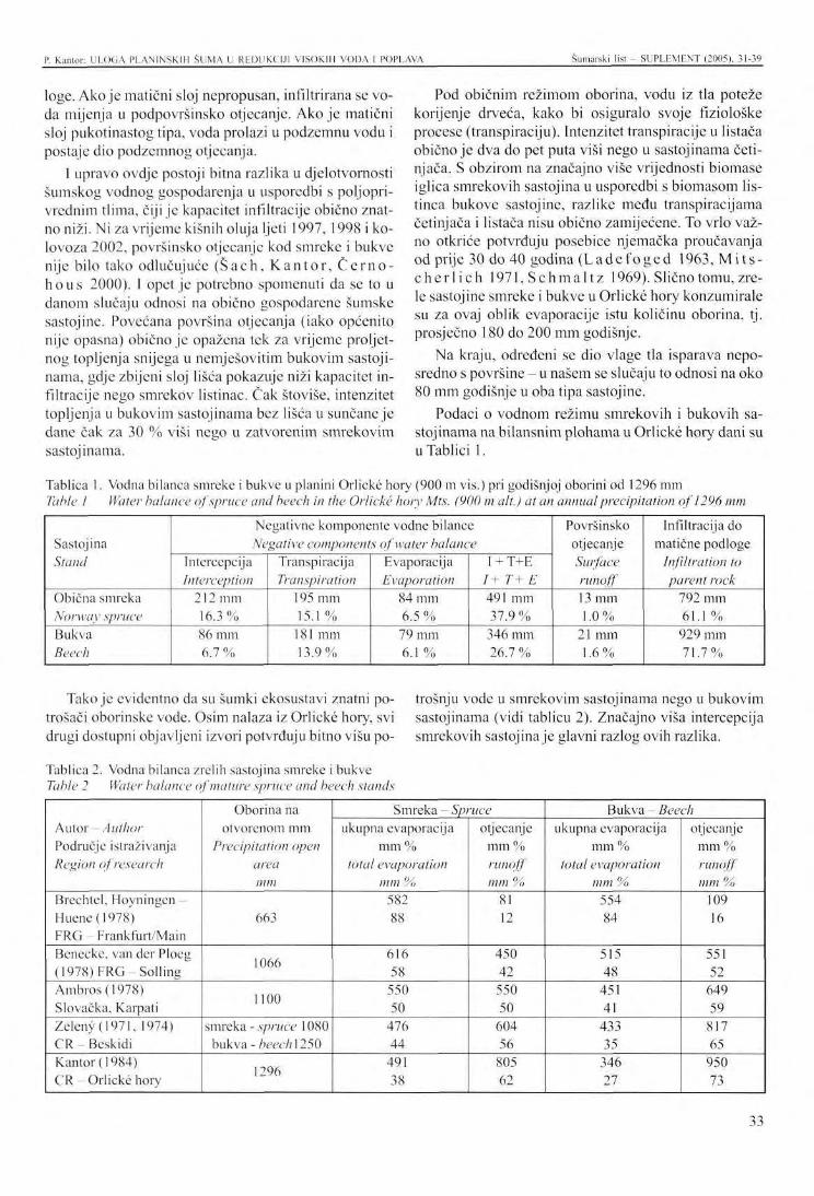
P. Kantor: ULOGA PLANINSKIH ŠUMA U REDUKCIJI VISOKIH VODA I POPLAVA Šumarski list - SUPLEMENT (2005). 31-39
loge. Ako je matični sloj nepropusan, infiltrirana se voda mijenja u podpovršinsko otjecanje. Ako je matični sloj pukotinastog tipa, voda prolazi u podzemnu vodu i postaje dio podzemnog otjecanja.
1 upravo ovdje postoji bitna razlika u djelotvornosti šumskog vodnog gospodarenja u usporedbi s poljoprivrednim tlima, čiji je kapacitet infiltracije obično znatno niži. Ni za vrijeme kišnih oluja ljeti 1997, 1998 i kolovoza 2002, površinsko otjecanje kod smreke i bukve nije bilo tako odlučujuće (Šach, Kan tor , C e r n o -h o u s 2000). I opet je potrebno spomenuti da se to u danom slučaju odnosi na obično gospodarene šumske sastojine. Povećana površina otjecanja (iako općenito nije opasna) obično je opažena tek za vrijeme proljetnog topljenja snijega u nemješovitim bukovim sastojinama, gdje zbijeni sloj lišća pokazuje niži kapacitet infiltracije nego smrekov listinac. Čak štoviše, intenzitet topljenja u bukovim sastojinama bez lišća u sunčane je dane čak za 30 % viši nego u zatvorenim smrekovim sastojinama.
Pod običnim režimom oborina, vodu iz tla poteže korijenje drveća, kako bi osiguralo svoje fiziološke procese (tran spi raciju). Intenzitet transpiracije u listača obično je dva do pet puta viši nego u sastojinama četinjača. S obzirom na značajno više vrijednosti biomase iglica smrekovih sastojina u usporedbi s biomasom lis-tinca bukove sastojine, razlike među transpiracijama četinjača i listača nisu obično zamijećene. To vrlo važno otkriće potvrđuju posebice njemačka proučavanja od prije 30 do 40 godina (Ladefoged 1963, Mi t s -che r l i ch 1971, Schmal t z 1969). Slično tomu, zrele sastojine smreke i bukve u Orlicke hory konzumirale su za ovaj oblik evaporacije istu količinu oborina, tj. prosječno 180 do 200 mm godišnje.
Na kraju, određeni se dio vlage tla isparava neposredno s površine - u našem se slučaju to odnosi na oko 80 mm godišnje u oba tipa sastojine.
Podaci o vodnom režimu smrekovih i bukovih sastojinama na bilansnim plohama u Orlickć hory dani su u Tablici 1.
Tablica 1. Vodna bilanca smreke i bukve u planini Orlicke hory (900 m vis.) pri godišnjoj oborini od 1296 mm Tahle 1 Water balance of spruce and beech in the Orlicke hory Mts. (900 m alt.) at an annual precipitation of 1296 mm
Sastojina Stand
Obična smreka Norway spruce Bukva Beech
Negativne komponente vodne bilance Negative components of water balance
Intercepcija Interception
212 mm 16.3% 86 mm 6.7 %
Transpiracija Transpiration
195 mm 15.1 %
181 mm 13.9%
Evaporacija Evaporation
84 mm 6.5 % 79 mm 6.1 %
I + T+E / + T+ E 491 mm 37.9 %
346 mm 26.7 %
Površinsko otjecanje Surface runoff 13 mm 1.0 %
21 mm 1.6%
Infiltracija do matične podloge
Infiltration to parent rock
792 mm 61.1 % 929 mm 71 .7%
Tako je evidentno da su šumki ekosustavi znatni potrošači oborinske vode. Osim nalaza iz Orlicke hory, svi drugi dostupni objavljeni izvori potvrđuju bitno višu po
trošnju vode u smrekovim sastojinama nego u bukovim sastojinama (vidi tablicu 2). Značajno viša intercepcija smrekovih sastojina je glavni razlog ovih razlika.
Tablica 2. Vodna bilanca zrelih sastojina smreke i bukve Table 2 Water balance of mature spruce and beech stands
Autor - Author Područje istraživanja Region of research
Brechtel, Hoyningen-Huene(1978) FRG - Frankfurt/Main Beneckc, van der Ploeg (1978) FRG-Soi l ing Ambros(1978) Slovačka, Karpati Zeleny (1971, 1974) CR-Besk id i Kantor (1984) CR-Or l i cke hory
Oborina na otvorenom mm
Precipitation open area mm
663
1066
1100
smreka - spruce 1080 bukva - beech\250
1296
Smreka - Spruce ukupna evaporacija
mm % total evaporation
mm % 582 88
616 58
550 50
476 44
491 38
otjecanje mm % runoff mm %
81 12
450 42 550 50
604 56
805 62
Bukva - Beech ukupna evaporacija
mm % total evaporation
mm % 554 84
515 48
451 41
433 35
346 27
otjecanje mm % runoff mm %
109 16
551 52
649 59
817 65
950 73
33
P. Kantor: ULOGA PLANINSKIH ŠUMA U REDUKCIJI VISOKIH VODA I POPLAVA Šumarski list - SUPLEMENT (2005). 31-39
Sa stajališta smanjenja plimnih voda i poplava, maksimalni vodni kapacitet šumskih tala je od izuzetne važnosti. Tu je najviša količina vode koju tlo može prihvatiti. U našem konkrcntom slučaju u Orlicke hory (pješčano-ilovasto tlo lake teksture do ilovasto-pješča-nog kambisola s 50 % primjese skeletnog tla), ta vrijednost doseže oko 270 mm na dubini tla od 70 cm. Tijekom ljetnih mjeseci, stvarna sadržina vode u tlu obiju
Na temelju dugoročnih serija eksperimentalnih proučavanja, ne samo u Orlickć hory, već također i u Beski-dima, te analizom niza stranih studija, moguće je držati sljedeće nalaze dokazanim: 1. Površinsko otjecanje i posljedična erozija tla su za
nemarive u šumskim sastojinama. Ova činjenica se ne odnosi samo na prirodne šume, nego isto tako na komercijalne šume. Čak i na posječenim čistinama procesi erozije (s iznimkom stjenovitih lokaliteta) nisu rezultat same sječe drveća, već su uvijek manifestacija loše organizirane uporabe i pokretanja teških sredstava mehanizacije i ostalih čovjekovih aktivnosti. Odsutnost površinskog otjecanja u šumi (otjecanje je također ovdje eliminirano sustavom vodnih puteva što ih stvara korijenje drveća, životinje, itd. u šumskom tlu) je u usporedbi s njegovom čestom pojavom na poljoprivrednom zemljištu tako prvi i vrlo važan uvjet za redukciju poplava u krajoliku. Kao školski primjer moguće je spomenuti lokalnu poplavu 15. srpnja 2002. u slivu rijeke Hodo-ninke (okrug Blansko). U doslovce nešumskom dijelu katastarskih općina Crhov i Olešnice, u samo dva sata palo je 100 do 170 mm oborine, koja je odmah otekla na poljopirvrednu površinu, te u vodo-tokove, prouzročivši višemilijunsku štetu, i nažalost, dvije ljudske žrtve.
2. S gledišta ekološke stabilnosti i sigurnosti prinosa i proizvodnje, jedan od očiglednih prioriteta šumar-
Ambros , Z.: Vodnä bilancia lesnych porastov Karpät. Lesnicky časopis 24, 1978, No. 3, pp. 203-221.
B e n e c k e, P., R.R. van der P1 o e g: Wald und Wasser II. Quantifizierung desWasscrumsatzes am Beispiel eines Buchen- und eines Fichtenaltbcstan-des im Soiling. Forstarchiv, 49, 1978, No. 2, pp. 26-32.
B r e c h t e l , H.M., J. H o y n i n g e n - H u e n e : Einfluß der Verdunstung verschiedener Vegetationsdecken auf den Gebietswasscrhaushalt. Gewässerpflege - Bodennutzung - Landschaftsschutz. Vorträge und Diskussionen der KWK Fachtagung
sastojina kretala se između 170 i 190 mm, a nije padala ispod 150 mm u vrijeme bez oborina. U danom je slučaju tlo sastojina planinske smreke i bukve bilo u stanju zadržati i akumulirati od 40 do 60 mm oborinskc vode, a maksimalno 100 mm. U trenutku dosizanja punog vodnog kapaciteta, tlo se može usporediti sa potpuno natopljenom spužvom, koja nije u stanju zadržati ni milimetar druge oborine.
stva je transformacija smrekinih monokultura u mješovite šume. Međutim, rezultati istraživanja pokazali su da povećani omjeri listača ne mogu smanjiti opasnost od plimnih voda i poplava. Bjelogorične vrste su u stanju zadržati i povući manje oborinske vode nego crnogorične vrste (posebice smreka), s obzirom na njihovo bezlisno stanje izvan sezone vegetacije, te malu biomasu organa asimilacije.
3. Visinske i planinske šume (za razliku od nešumskih ekosustava) ublažuju vrlo lako kišne oluje do 50 mm. Neprekinute oborine do 100 mm manifestiraju s ukupnom količinom otjecanja iz šume, ali s obzirom na vodno gospodarenje, djelotvornost je još uvijek prihvatljiva. Prag od 150 do 200 mm neprekinute oborine može se smatrati kritičnom granicom za djelotvornu redukciju poplava šumom. Pod uvjetima ove oborinske ukupnosti, šumsko tlo je uvijek potpuno natopljeno vodom uključujući depresije, kako na površini tla, tako i u matičnom sloju. Tada nekontrolirano i spontano otjecanje nastupa kroz cijeli profil tla, često se pojavljujući na površini tla, bez obzira na sastav vrsta ili metode gospodarenja. Drugim riječima, korpus šumskog tla također pokazuje, slično kao rezervoari, svoje kapacitetne mogućnosti, koje ne mogu biti dostignute.
Oktober 1978 in Bad Dürkhcim, 1978, pp. 172-231.
De If s, J.: Die Niederschlagszurückhaltung im Walde. Mitteilungen des Arbeitskreises, Wald und Wasser, 1995, No. 2, Koblenz. 54 pp.
Eng le r , A.: Untersuchungen über den Einfluß des Waldes auf den Stand der Gewässer. Mitt. d. Schw. Centralanst. f. d. Forstl. Versuchsw., Bd. XII,Zurüch, 1919.
J a r a b ä c , M., A. C h l e b e k : The effect of forests on the hydrological budget. Mitt. Forstl. Bundes-versuchsanst. Wien, No 159, 1988, pp. 239-251.
ZAKLJUČAK - Conclusion
LITERATURA - References
34
P. Kantor: ULOGA PLANINSKIH ŠUMA U REDUKCIJI VISOKIH VODA I POPLAVA Šumarski list - SUPLEMENT (2005), 31-39
J a r a b a č , M., A. Ch lebek : Vodni ücinky lesuaeko-logicke vztahy. Zprävy lesn. vyzkumu, 41,1996, No. 2, pp. \-4.
Kantor , P.: Vodohospodärskä funkce horskych smr-kovych a bukovych porost?. Lesnictvi, 30, 1984, No. 6, pp. 471-490.
Lade foged , K.: Transpiration of forest trees in closed stands. Physiol. Plantarum, 16, 1963, No. 2, pp.993-1010.
M i t s c h e r l i c h , G.: Wald, Wachstum und Umwelt. Bd. 2. Waldklima und Wasserhaushalt. Frankfurt a. M., J.D. Sauerländers Verlag 1971. 365 pp.
S c h m a l t z , J.: Die Bedeutung des Waldes für den Wasserkreislauf. Forstarchiv, 40, 1969, No. 7/8, pp.132-147.
Sach , F., P. Kantor , V. C e r n o h o u s : Lesne eko-systemy, ich obhospodarovanie človekom a po-
vodne v Orlickych horäch v lete roku 1997. Eko-lögia (Bratislava), 19, 2000, No. 1, pp. 72-91.
Vä lek , Z.: Vyzkum hydrologickeho pusobeni smrku a buku v pramennych oblastech. Vodohosp. čas., 6, 1958, No. 2, pp. 97-115.
Vä lek , Z.: Lesni dreviny jako vodohospodärsky a protierozni činitel. Praha, Stätni zemedelske na-kladatelstvi 1977.203 pp.
Ze l eny , V.: Vliv pestebnich a težebnich zäsahu v lese na odtok vody. /Zäverecnä zpräva/. VÜM Zbras-lav 1971.75 pp.
Z e 1 e n y, V.: Vliv obnovy a premen lesnich porostu na vodni režim malych horskych povodi ve stredo-horske flysove oblasti. /Zäverecnä zpräva/. VÜM Zbraslav 1974. 60 pp.
35
PRESENTATION ATTHE INTERNATIONAL SYMPOSIUM Šumarski list - SUPLEMENT (2005). 31-39
POSSIBILITIES OF MOUNTAIN FORESTS IN REDUCING HIGH WATERS A N D F L O O D S
Petr KANTOR
SUMMARY: In the course of recent 8 years, the Czech Republic was affected by three disastrous floods (July 1997, July 1998 and August 2002) induced by extremely high precipitation particularly in mountain forested locations of our country. The critique of causes and consequences of the devastating flood situations in media did not avoid even forestry. Negative effects of forest management on the intensity and extent of floods have been particularly related to high reproduction cutting and unsuitable species composition of our forests. The paper presented summarizes and comments findings obtained from permanent experimental plots in the Orlicke hory Mts. On the example of an uninterrupted series since 1977, water regime is comprehensively studied of two main species of our mountain forests, viz spruce and beech. Data are also available from all three floods. Results of the study unambiguously show that spruce and beech forests effectively mitigate continuous precipitation up to 100 mm. However, in precipitation exceeding 150 mm, the soil profile is quite saturated with water Then, uncontrolled and spontaneous runoff occurs through the whole profile irrespective of the species composition of forests or methods of regeneration.
INTRODUCTION
Forests occupy about 34 % of the area of the Czech Republic. More than 50 % of precipitation falls on the forests. It is not because forests "attract" water but simply because upland and mountain locations with high annual precipitation totals amounting to 800 - 1500 mm show the highest forest percentage in our country.
In the introduction of the paper it is necessary to mention that during the last 200 years, the species composition of our forests has been markedly changed. While in the natural species composition, the percentage of conifers was only 34 % (of this Norway spruce 11 %), at present, their proportion is more than twofold, viz 77 % (of this Norway spruce 54 %). At the same time,
The first systematic measurements of some parameters of the water regime of forest stands were car-
* Prof. Ing. Petr Kantor, CSc, Department of Forest Establishment and Silviculture FFWT, MUAF in Brno, Zemedelska 3, 613 00 Brno, Czech Republic e-mail: [email protected]
spruce is usually presented in public media as a species which is unsuitable from the viewpoint of water management. On the other hand, broadleaves are presented as species which can significantly contribute to the reduction of floods due to their high consumption of water. However, generally it refers to unsubstantiated opinions and hypotheses lacking an actual evidence.
What is a reality - is it possible to answer professionally a question indicated in the title of the paper? First, it is necessary to mention that it refers to an extremely complicated sphere of problems dealt with by forest research for a period of more than 100 years.
ried out by Krutsch in the German Tharandt as early as 1863(Del f s 1955).
However, an internationally famous paper of E n -g i e r (1919) is cited even at present. In the study, water regime and the course of runoff are compared in an unwooded and in a forested small watershed in the
A BRIEF VIEW OF THE HISTORY OF WATER-MANAGEMENT FOREST RESEARCH
36
P. Kantor: POSSIBILITIES OF MOUNTAIN FORESTS IN REDUCING HIGH WATERS AND FLOODS Šumarski list SUPLEMKNT (2005). 31-39
Switzerland. Similar comparative studies were gradually carried out in other forestry-developed European countries. Also Czechoslovakia participated in the research. Water-management problems were studied in the forested Kychova river watershed and in the un-wooded watershed of the Zdechovka river (Välek 1958, 1977).
After World War 2, based on the incentive of academicians Maran and Lhota, water-management research was concentrated on the region of the Moravian-Sile-sian Beskids. In an uninterrupted series since 1953 (!), basic problems are studied of "forest and water" in two
The field of problems mentioned above concerning "forest/water" relationships tries to study also one of the research programmes of the Faculty of Forestry and Wood Technology (FFWT) in Brno in cooperation with the Research Institute of Forestry and Game Management (RIFGM) - Research Station in Opočno. The project entitled "Mountain forest ecosystems and their management aimed at reducing floods" is at present financially supported by the Grant Agency of the Czech Republic (Grant No. 526/02/0851). Permanent research plots in the cadaster of Deštne in the Orlickć hory Mts. where the water regime is studied of both
Water regime of forest ecosystems is primarily dependent on the supply of atmospheric precipitation, on the consumption of water by the forest (so-called summary evaporation, ie: interception + transpiration + evaporation from soil) and changes in the water supply in soil.
Thus, the basic equation of water balance can be expressed as follows:
0 = S-ITE±AVp..„where O = runoff S = open area precipitation ITE = total evaporation (I = interception; T = transpiration; E = evaporation from soil) AVp = changes in the soil water supply
Thus, it is possible to state that so many water flows out the forest which is not consumed for its physical evaporation (interception, evaporation from soil), physiological requirements (transpiration) and replenishment of soil water supplies.
Consumption of water by forest stands - total evaporation is naturally related to the biomass of forest ecosystems, particularly the amount of assimilatory organs. It is always markedly higher in coniferous spruce
fully forested partial watersheds (the Mala Räztoka watershed with autochthonous mainly beech stands and the Cervik watershed with autochthonous dominant Norway spruce). A number of immensely valuable findings from the field experiment stations can be obtained from papers of Ze leny (1971, 1974), Ja ra -bač andChlebck (1988, 1996).
Similarly oriented research programmes were established in Germany, Switzerland, Russia and other countries (Brech te l , H o y n i n g e n - H u e n e 1978, B e n e c k e , van der Ploeg 1978, Mit s c h e r l i c h 1971, Schmal t z 1969 etc.).
main species of mountain forests, viz Norway spruce and beech in a standard commercial forest are part of the project. Spruce is usually presented to the general public as a species unsuitable from water-management aspects whereas beech is to be a species with favourable water-management effects. The measurement of all parameters of water balance of the forest stands is carried out at Deštne in an uninterrupted series since 1977. At present, a 27-year series of results is available including findings on torrent floods in July 1997, July 1998 and from the last flood in the turn of the first and the second decade of August 2002.
stands (in the stage of pole stands and large-diameter stands on average 15 to 20 t needle dry matter per ha) than in beech stands (on average 2 to 4 t foliage dry matter per ha, namely only in the course of 5 to 7 months of the growing season).
First, let us look at the simplified course of the water balance of both types of stands under comparison.
At each of the precipitation, part of it is intercepted in tree crowns being later evaporated. Considering the data mentioned above, crowns of spruce trees intercept substantially more precipitation than crowns of beech trees. This fact was positively corroborated in all experimental studies (Delfs 1955, Mi t sche r l i ch 1971, Schmal tz 1969, Välek 1958, Zeleny 1974 etc.). In a spruce stand in the Orlicke hory Mts., interception amounted to, in an annual average, 210 mm (16 % precipitation), in a beech stand only 85 mm (7 % precipitation). The remaining part of precipitation falls through tree crowns to soil or occurs as stcmflow. It is of interest that the stcmflow of a mature beech tree amounts to as many as 1500 1 water at a precipitation of 50 mm. In spruce, on the other hand, the stemflow is markedly lower (at the precipitation only 30 to 50 1).
A JOINT PROJECT OF THE FACULTY OF FORESTRY AND WOOD TECHNOLOGY, MLJAF IN BRNO AND OF THE VULHM RESEARCH STATION IN OPOČNO
WATER REGIME OF SPRUCE AND BEECH
37
P. Kantor: POSSIBILITIES OF MOUNTAIN FORESTS IN REDUCING HIGH WATERS AND FLOODS Šumarski list SUPLEMENT (2005) -39
After the fall on the forest soil precipitation water largely infiltrates into it. In addition to the saturation of soil pores and subsequent seepage the infiltrated water gets through the system of water paths to a parent rock (ducts in the forest soil created by roots of trees, animals etc.), runs down and accumulates in the parent rock hollows and depressions. If the parent rock stratum is impermeable the infiltrated water changes into the subsurface runoff. If the parent rock stratum is of the fissure type the water permeates to groundwater participating in underground runoff.
And just here, there is a substantial difference in the water-management effectiveness of forests as compared with agricultural soils the infiltration capacity of which being usually markedly lower. Also during rainstorms inducing floods in summer 1997, 1998 and in August 2002, surface runoff in spruce and beech was not decisive (Sach, Kantor , Černohous 2000). And once again, it is necessary to mention that in the given case it refers to ordinarily managed forest stands. Increased surface runoff (although generally not dangerous) is usually noticed only during spring snowmelt in unmixed beech stands where the compact layer of leaves shows lower infiltration capacity than spruce litter. Moreover, the intensity of thawing in leafless beech stands under sunny days is even 30 % higher than in closed spruce stands.
Under the usual regime of precipitation, water in soil is drawn by roots of trees to ensure their physiological processes (transpiration). Intensity of transpiration in broadleaves is usually 2 to 5 times higher than in coniferous stands. With respect to markedly higher values of the biomass of spruce stand needles as against the foliage biomass in beech stands differences between transpiration of conifers and broadleaves are usually not marked. This very important finding was corroborated particularly by German studies already
30 to 40 years ago (L a d e f o g e d 1963, M i t s c h e r -l ieh 1971, Schmal t z 1969). Similarly, mature stands of spruce and beech in the Orlicke hory Mts. consumed for this form of evaporation virtually the same amount of precipitation, viz on average 180 to 200 mm per year.
Finally, the certain part of soil moisture is evaporated right from the soil surface - in our case it referred to about 80 mm per year in both types of stands.
Data on the water regime of spruce and beech stands on balance plots in the Orlicke hory Mts. are given in Table 1.
Thus, it is evident that forest ecosystems are the considerable consumer of precipitation water. Not only findings from the Orlicke hory Mts. but also all available published sources have corroborated substantially higher consumption of water by spruce stands as compared with beech stands - see Table 2. Markedly higher interception in a spruce stand is unambiguously the main cause of these differences.
From the viewpoint of reducing high waters and floods the maximum water capacity of forest soils is of exceptional importance. It is the highest amount of water which can be retained by soil. In our actual case in the Orlicke hory Mts. (light-textured sandy-loam up to loamy-sandy Cambisol with a 50 % admixture of soil skeleton), its value amounted to about 270 mm at the soil depth of 70 cm. In the course of summer months, the actual water content in the soil of both stands ranged between 170 and 190 mm not decreasing below 150 mm in the period without precipitation. In the given case, the forest soil of mountain spruce and beech stands was able to retain and accumulate 40 to 60 mm precipitation water, maximally 100 mm. In the moment of achieving full water capacity, the soil can be compared to a sponge fully saturated by water which is not able to retain a millimeter of other precipitation.
CONCLUSION Based on the long-time series of experimental stu
dies not only in the Orlickć hory Mts. but also in the Beskids and through the analysis of a number of foreign studies it is possible the following basic findings to be regarded as proved: 1. Surface runoff and subsequent soil erosion are quite
negligible in forest stands. This fact refers not only to natural forests but also commercial forests. Even on clear-felled areas, erosion processes (with the exception of boulder localities) are not the result of mere felling the trees but they are always a manifestation of the poorly organised use and movement of heavy means of mechanization and other activities of man. The absence of surface runoff in the forest
(the runoff being also eliminated there by the system of water paths created by roots of trees, animals etc. in the forest soil) as against its often occurrence on agricultural land is thus the first and very important condition for the reduction of floods in the landscape. As a textbook example, it is possible to mention a local flood of 15 July 2002 in the Hodo-ninka river watershed (district of Blansko). In virtually forest-free parts of the cadaster of Crhov and Olešnice, in the course of 2 hours some 100 to 170 mm precipitation fell which immediately flew out on the surface of agricultural land into watercourses causing many-million damage to property and unfortunately even the loss of two human beings.
38

P. Kantor: POSSIBILITIES OF MOUNTAIN FORESTS IN REDUCING HIGH WATERS AND FLOODS Šumarski list SUPLEMENT (2005), 31-39
2. From the aspect of ecological stability and safety of yield and production, one of evident priorities of forestry is the transformation of spruce monocultures to mixed stands. However, research results have proved, that the increased proportion of broadlea-ves cannot decrease the danger of high waters and floods. Broadleaved species are able to retain and draw less precipitation water than coniferous species (particularly spruce) with respect to their leafless state out of the growing season and smaller biomass of assimilatory organs.
3. Upland and mountain forests (unlike all non-forest ecosystems) reduce very easily rainstorms up to 50 mm. Uninterrupted precipitation up to 100 mm manifests itself in the total amount of runoff from the
forest but from the aspect of water-management effectiveness is still acceptable. A threshold of 150 to 200 mm of uninterrupted precipitation can be considered to be a critical limit for the effective reduction of floods by the forest. Under conditions of this precipitation total, forest soil is always completely saturated by water including depressions both in the soil surface and the parent rock stratum. Then, uncontrolled and spontaneous runoff occurs through the whole soil profile appearing often on the soil surface irrespective of a species composition or the method of management. In other words, also the forest soil body shows, similarly as eg reservoirs, its capacity possibilities which cannot be exceeded.
39
IZLAGANJE NA ZNANSTVENOM SKUPU UDK 630* 116
PRESENTATION AT THE INTERNATIONAL SYMPOSIUM Šumarski list - SUPLEMENT (2005). 40-50
UTJECAJ ŠIKARE BIJELOG GRABA (Carpinus orientalis Mili.) NA ZAŠTITU TLA OD EROZIJE U HRVATSKOJ
THE IMPACT OF SCRUB VEGETATION OF ORIENTAL HORNBEAM {Carpinus orientalis Mil ON SOIL PROTECTION AGAINST EROSION IN CROATIA
Vlado TOPIC, Lukrecija BUTORAC*
SAŽETAK: U ovom radu prikazani su rezultati istraživanja utjecaja šikare bijelog graba /'Carpinus orientalis Mili.) na zaštitu tla od erozije prouzročene kišom, koje zauzimaju najveće površine na submediteranskom krškom području Hrvatske. Istraživanja su obavljena na padinama Moseća kod Muca na pokusnim plohama B6 i B7 u razdoblju od 1999. do 2003. godine. Plohe imaju nagib 26° i izgrađene su od krednih vapnenaca na kojima se nalazi plitko smeđe tlo (kalcikambisol). Pokrovnost na plohama iznosi od 61,14 % (ploha B7) do 65,34 % (ploha Br), a srednja visina bijelog graba je 1,59 m odnosno 1,79 m. Kako plohe imaju iste geološke, pedološke i vegetacijske karakteristike na koje padaju iste količine oborina i s istim intenzitetom, tijekom 2001. godine, radi potpunijeg istraživanja erozije, posječena je šikara na pokusnoj plohi B6. Prije sječe šikare vrijednosti površinskog otjecanja oborina neznatno su bile veće na pokusnoj plohi B7 koja je imala nešto manju pokrovnost.
Nakon obavljene sječe šikare, na pokusnoj plohi B6 sa sačuvanim listin-cem i humusnoakumulativnim horizontom, srednja godišnja vrijednost površinskog otjecanja oborina iznosila je 24,03 mm/m (240,3 nr /ha), s koeficijentom otjecanja od 0,019 i gubicima tla od 0,0072 t/ha, dok je na pokusnoj plohi B7 sa sačuvanom šikarom bijelog graba, površinsko otjecanje iznosilo 19,53 mm/m2 (195,3 m3/ha), s koeficijentom otjecanja od 0,0156 i gubicima tla od 0,0056 t/ha. Maksimalni koeficijent površinskog otjecanja iznosio je na pokusnoj plohi B6- 0,075, a na pokusnoj plohi B7' — 0,0295.
Klj učne r ij e č i: krš, erozija, pokusne plohe B6 i B7, šikara bijelog graba, oborine, površinsko otjecanje, gubici tla.
UVOD - Introduction
Šumska vegetacija najdjelotvornije štiti zemljište od ubrzane, eksccsivne erozije. U dobro očuvanoj šumi s kojom se pravilno gospodari nema ubrzane erozije, javlja se samo normalna erozija u kojoj je odnošenje tla znatno ispod erozijske tolerancije. Problem je u tome što su šumski ekosustavi na mediteranskom krškom području Hrvatske jako degradirani, a s time je smanjena i njihova protuerozijska funkcija. Gotovo 60 % površine pokrivaju panjačc, šikare, makije i goleti, dok visoke
Dr. se. Vlado Topic, Lukrecija Butorac, dipl. ing. šum.. Institut za jadranske kulture i melioraciju krša, PutDuilova 11. 21000 Split
šume zauzimaju samo 3,7 % (To p i ć, 1994). Ovako nepovoljna struktura šumskog fonda svakako pospješuje i daljnje erozijske procese na ovom području.
Od ukupne površine mediteranskog krškog područja Republike Hrvatske, koje iznosi 15.389 km2, različitim intenzitetom erozije tla vodom zahvaćeno je oko 95 % površine, od toga značajnijom erozijom 40 % ( T o p i ć , 2003). Prema tome, područje je jako ugroženo erozijom, a njegovi pojedini predjeli potpuno su degradirani. Na ovom ekološki vrlo osjetljivom prostoru s visokim stupnjem rizika od erozije, degradacije tla i devastacije vegetacije, registrirano je 668 bujičnih vodotoka, s ukupnom slivnom površinom od 3.024 km',
40
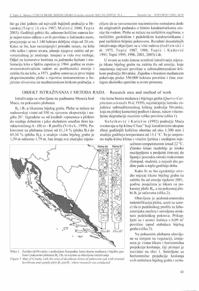
V. Topic. L. Bulorac: UTJECAJ ŠIKARE BIJELOG GRABA (Carpiiuts (mentalis Mill.) NA ZAŠTITU TLA . Šumarski list - SUPLEMENT (2005). 40-50
što ga čini jednim od najvećih bujičnih područja u Hrvatskoj (Topić i Leko 1987, Mičet ić 2000, Topić 2003). Godišnji gubici tla, odnosno količine nanosa koje nepovratno odlaze s ovih površina u Jadransko more, procjenjuje se na 1.140 hektara debljine sloja od 20 cm. Kako se tlo, kao nezamjenjivi prirodni resurs, na kršu vrlo teško i sporo stvara, pitanje njegove zaštite od prvorazrednog je značenja. Imajući u vidu ove razloge, Odjel za šumarstvo Instituta za jadranske kulture i melioraciju krša u Splitu započeo je 1964. godine sa znanstvenoistraživačkim radom na problematici erozije i zaštite tla na kršu, a 1971. godine osnovao je prve trajne eksperimentalne plohe s mjernim instrumentima u bu-jičnim slivovima na mediteranskom krškom području, s
ciljem da se suvremenim stacioniranim metodama dođe do originalnih podataka o bitnim karakteristikama erozije tla vodom. Plohe se nalaze na različitim nagibima, s različitim geološkim i pedološkim karakteristikama i pod različitim biljnim pokrovom. Rezultati dosadašnjih istraživanja objavljeni su u više radova (J e d 1 o w s k i i dr. 1975, Topić 1987, 1988; Topić i Kadović 1991; Topić 1995, 1996, 2001, 2003) i dr.
U ovom se radu iznose rezultati istraživanja utjecaja šikare bijelog graba na zaštitu tla od erozije, koje zauzimaju najveće površine u submediteranskom krškom području Hrvatske. Zajedno s hrastom meduncem pokrivaju preko 350.000 hektara površine i čine značajno ekološko uporište u ovom prostoru.
OBJEKT ISTRAŽIVANJA I METODA RADA - Research area and method of work Istraživanja su obavljena na padinama Moseća kod
Muca, na pokusnim plohama B6 i B7 u šikarama bijelog graba. Plohe se nalaze na
nadmorskoj visini od 550 m, sjeverne ekspozicije i nagiba 26°. Izgrađene su od krednih vapnenaca s plitkim do srednje dubokim i jako skeletnim smeđim tlom karakterističnog A- (B) rz - R profila (Vrbek, 1999). Po-krovnost na plohama iznosi od 61,14 % (ploha B7) do 65,34 % (ploha B6), a srednja visina bijelog graba je 1,59 m odnosno 1,79 m. Iste imaju sve značajke mješo-
Ploha B6 Ploha B7 19
Slika 1. Zemljovid Hrvatske s područjem listopadne šume hrasta medunca s bijelim grabom i pokusnim plohama B6 i B7 na kojima su obavljena istraživanja
Figure 1 Map of Croatia with the area of deciduous forest of pubescent oak with oriental hornbeam and sample plots B6 and B7, where research was conducted
vite šume hrasta medunca i bijeloga graba (Querco-Car-pinetum orientalis H-ić 1939), najznačajnije šumske zajednice submediteranskog krškog područja Hrvatske, koja na plitkoj kamenitoj podlozi i danas, nakon višestoljetne degradacije zauzima velike površine (slika 1).
S e l e t k o v i ć i Ka tuš in (1992) područje Muca svrstavaju u tip klime Cfsax" koji karakterizira ukupan zbroj godišnjih količina oborina od oko 1.300 mm i srednja godišnja temperatura od 13,1 °C. To je umjereno topla kišna klima s vrućim ljetima i srednjom mje
sečnom temperaturom iznad 22 °C. Zimsko kišno razdoblje je široko rascijepljeno u proljetni (travanj do lipanj) i jesensko-zimski maksimum (listopad, studeni), a najsuši dio godine pada u toplo godišnje doba.
Kako bi se što egzaktnije utvrdio utjecaj šikare bijelog graba na zaštitu tla od erozije tijekom 2001. godine posječena je šikara na pokusnoj plohi B6, a na pokusnoj plohi B7 je sačuvana (slika 2).
Obavljena je pedotaksonomska indentifikacija ploha, uzeti su uzorci tla iz pedološkog profila za laboratorijsku analizu i snimljena struktura pedološkog pokrova. Prikupljeni su i uzorci listinca s 0,09 m2
površine ispod stabalaca bijelog graba (slika 3).
Na pokusnim plohama obavljene su izmjere na vegetaciji, izmjerena je visina šikare i horizontalna projekcija krošanja, čiji primjer je razvidan na slici 1. Snimljene su horizontalne projekcije krošanja svih stabalaca bijelog graba i ucrta-
41
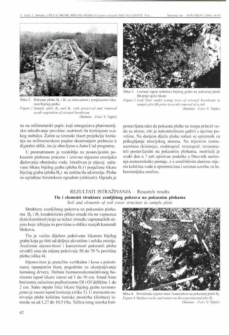
V. Topic. L. Butorac: UTJECAJ SIKARli BIJELOG GRABA (Ciirpiiuis (mentalis Mill.) NA ZAŠTITU TLA ... Šumarski list - SUPLEMENT (2005), 40-50
Slika 2. Pokusne plohe B6 i B7 sa sačuvanom i posječenom šikarom bijelog graba
Figure 2 Sample plots B6 and B7 with preserved and removed scrub vegetation of oriental hornbeam
(Snimio - Foto: V. Topic)
ne na milimetarski papir, koji omogućava planimetrij-sko određivanje površine zastrtosti tla krošnjama svakog stabalca. Zatim se terenski tlocrt projekcije krošanja na milimetarskom papiru skeniranjem prebacio u digitalni oblik, stoje obavljeno u Auto Cad programu.
U promatranom je razdoblju na postavljenim pokusnim plohama praćeno i izravno mjereno erozijsko djelovanje oborinske vode. Istraživanje utjecaj sačuvane šikare bijelog graba (ploha B7) i posječene šikare bijelog graba (ploha B6) na zaštitu tla od erozije. Plohe su ograđene betonskom ogradom (zidićem). Ograda je
Slika 3. Listinac ispod stabalaca bijelog graba na pokusnoj plohi B6 prije sječe šikare
Figure 3 Leaf litter under young trees of oriental hornbeam in sample plot B6 prior to scrub removal of scrub
(Snimio- Foto: V. Topic)
postavljena tako da pokusne plohe ne mogu primiti vodu sa strane, niti je nekontrolirano gubiti s njezine površine. Na donjem dijelu plohe nalazi se spremnik za prikupljanje erozijskog nanosa. Na mjernim instrumentima (kišomjer, ombrograf, termograf, termometri) postavljenim na pokusnim plohama, motritelj je svaki dan u 7 sati upisivao podatke u Dnevnik motrenja meteorološke postaje, a u erodibilnim danima mjerio količinu vode u spremnicima i uzimao uzorke za laboratorijsku analizu.
REZULTATI ISTRAŽIVANJA - Research results Tlo i elementi strukture zemljišnog pokrova na pokusnim plohama
Soil and elements of soil cover structure in sample plots Strukturu zemljišnog pokrova na pokusnim ploha
ma B6 i B7 karakterizira plitko smeđe tlo na vapnencu (kalcikambisol) koje se nalazi između vapnenačkih stijena koje izbijaju na površinu u obliku manjih kamenih blokova.
Tlo je većim dijelom pokriveno šikarom bijelog graba koja ga štiti od daljnje akvatične i eolske erozije. Analizom stjenovitosti i kamenitosti pokusnih ploha utvrdili smo da stijene pokrivaju 50 do 70 % površine ploha (slika 4).
Stjenovitost je pretežito vertikalna i kosa s pukotinama ispunjenim tlom, pogodnim za ukorjenjivanje šumskog drveća. Dubina humusnoakumulativnog horizonta ispod šikare iznosi od 1 do 10 cm. Iznad Amo horizonta nalazimo podhorizonte Ol i Of debljine 1 do 2 cm. Suho otpalo lišće šikare bijelog graba ravnomjerno je rasuto ispod krošanja (slika 3). U momentu osnivanja plohe količine šumske prostirke (listinca) iznosile su od 1,27 do 10,5 t/ha. Težina istog uzorka listi-
Slika 4. Površinska stjenovitost i kamenitost na pokusnoj plohi B(, Figure 4 Surface rocks and stones on the experimental plot B6
(Snimio Foto: V. Topic)
42
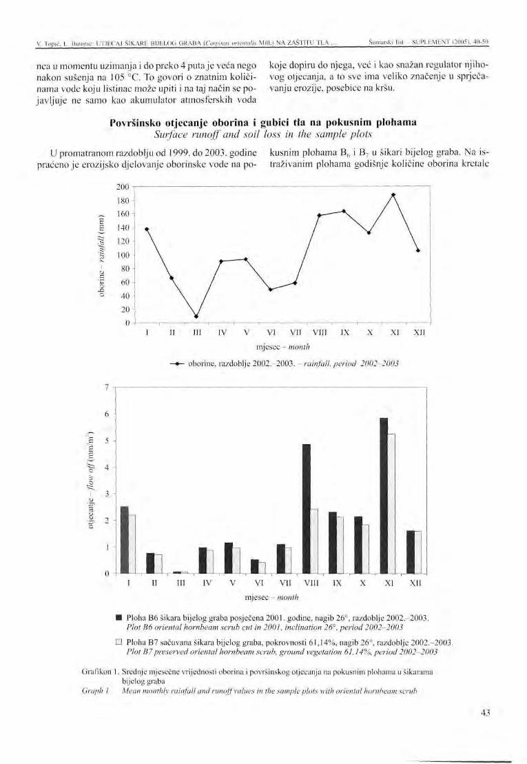
V. Topic, L. Bulorac: UTJECAJ ŠIKARE BIJELOG GRABA (Curpinus nrientalis Mili.) NA ZAŠTITU TLA . Šumarski list - SUPLEMENT (2005), 40-50
nca u momentu uzimanja i do preko 4 puta je veća nego koje dopiru do njega, već i kao snažan regulator njiho-nakon sušenja na 105 °C. To govori o znatnim količi- vog otjecanja, a to sve ima veliko značenje u sprječa-nama vode koju listinac može upiti i na taj način se po- vanju erozije, posebice na kršu. javljuje ne samo kao akumulator atmosferskih voda
Površinsko otjecanje oborina i gubici tla na pokusnim plohama Surface runoff and soil loss in the sample plots
U promatranom razdoblju od 1999. do 2003. godine kusnim plohama B6 i B7 u šikari bijelog graba. Na ispraćeno je erozijsko djelovanje oborinske vode na po- traživanim plohama godišnje količine oborina kretale
o o
II III IV V VI VII VIII IX X XI XII
mjesec - month
-*- oborine, razdoblje 2002.-2003. - rainfall, period 2002-2003
II III IV V VI VII VIII IX X XI XII mjesec - month
• Ploha B6 šikara bijelog graba posječena 2001. godine, nagib 26°, razdoblje 2002.-2003. Plot B6 oriental hornbeam scrub cut in 2001, inclination 26°, period 2002-2003
D Ploha B7 sačuvana šikara bijelog graba, pokrovnosti 61,14%, nagib 26°, razdoblje 2002.-2003. Plot B7preserved oriental hornbeam scrub, ground vegetation 61,14%, period 2002-2003
Grafikon 1. Srednje mjesečne vrijednosti oborina i površinskog otjecanja na pokusnim plohama u šikarama bijelog graba
Graph I Mean monthly rainfall and runoff values in the sample plots with oriental hornbeam scrub
43
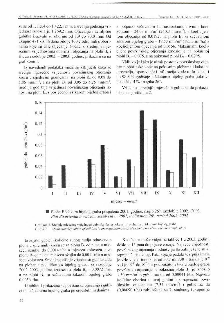
V. Topic. L. Bulorac: UTJECAJ ŠIKARU BIJELOG GRABA (Carpimts (mentalis Mill.) NA ZAŠTITU TLA ... Šumarski list - SUPLEMENT (2005). 40-50
su se od 1.115,4 do 1.422,1 mm, a srednja godišnja vrijednost iznosila je 1.269,2 mm. Otjecanje i zemljišne gubitke izazvale su oborine od 8,9 do 90,0 mm. Od ukupno 471 kišnih dana bilo je 100 erodibilnih s oborinama koje su dale otjecanje. Podaci o srednjim mjesečnim vrijednostima oborina i otjecanja na plohi B6 i B7, za razdoblje 2002. - 2003. godine, prikazani su na grafikonu 1.
Iz navedenih podataka može se zaključiti kako se srednje mjesečne vrijednosti površinskog otjecanja kreću u sljedećim granicama: na plohi B6 od 0,08 do 5,86 mm/m2, a na plohi B7 od 0,05 do 5,25 mm/m2. Srednja godišnja vrijednost površinskog otjecanja iznosi: na plohi B6 s posječenom šikarom bijelog graba i
0,16 j -
0,14 -
Erozijski gubici (količine suhog mulja odnesene s ploha u spremnik) kreću se za plohu B6 od nule, u mjesecu ožujku, do 0,0014 t/ha u mjesecu kolovozu, a za plohu B7 od nule u mjesecu ožujku do 0,0011 t/ha u mjesecu kolovozu. Srednje godišnje vrijednosti gubitaka tla na plohama pod šikarom bijelog graba, za razdoblje 2002-2003. godine, iznose: na plohi B6 - 0,0072 t/ha, a na plohi B7 sa sačuvanom šikarom bijelog graba 0,0056 t/ha.
U tablici 1 prikazana su površinska otjecanja i gubici tla u šikarama bijelog graba po erodibilnim danima.
s potpuno sačuvanim humusnoakumulativnim horizontom - 24,03 mm/m2 (240,3 mm/m2), s koeficijentom otjecanja od 0,0192; na plohi B7 sa sačuvanom šikarom bijelog graba - 19,53 mm/m" (195,3 m /ha) s koeficijentom otjecanja od 0,0156. Maksimalni koeficijent površinskog otjecanja iznosio je na pokusnoj plohi B6 - 0,075, a na pokusnoj plohi B7 - 0,0295.
Vidljivo je kako je nizak postotak površinskog otjecanja oborinske vode na pokusnim plohama i kako in-tercepcija, isparavanje i infiltracija vode u tlo iznosi i do 98,8 % godišnje u šikarama bijelog graba pokrov-nosti 61,14 % i nagiba 26°.
Vrijednost srednjih mjesečnih gubitaka tla prikazani su na grafikonu 2.
Kao što se može vidjeti iz tablice 1 u 2003. godini, došlo je 15 puta do pojave erozije. Najveće vrijednosti površinskog otjecanja i odnošenja tla zabilježene su 4. srpnja i 2. studenog. Kiša koja je padala 4. srpnja imala je vrlo visoki intenzitet od 50,7 mm/30' i trajala je 040
sati (od 940 do IO20), a pod zaštitom šikare bijelog graba površinsko otjecanje na pokusnoj plohi B7 je iznosilo 1,50 mm/m2 s gubicima tla od 0,00041 t/ha. Najveće količine oborina u ovoj godini i s najvećim površinskim otjecanjem (7,34 mm/m2) i gubicima tla (0,00090 t/ha) zabilježene su 2. studenog (ukupno je
E
c
o ••r.
t/J
II III IV V VI VII VIII IX
mjesec - month
• Ploha B6 šikara bijelog graba posječena 2001. godine, nagib 26°, razdoblje 2002.-2003. Plot B6 oriental hornbeam scrub cut in 2001, inclination 26°, period 2002-2003
Grafikon 2. Srednje mjesečne vrijednosti gubitaka tla na pokusnim plohama u šikarama bijelog graba Graph 2 Mean monthly values of soil loss in the vegetation scrub of oriental hornbeam in the sample plots
44
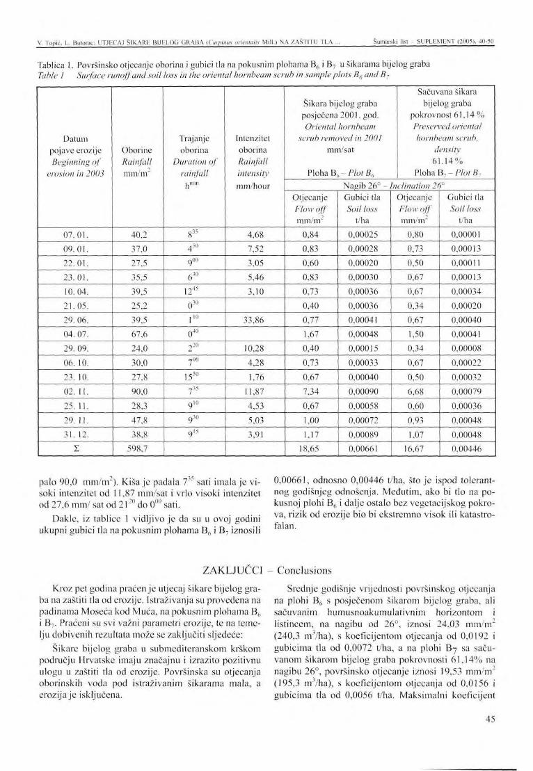
V. Topic, L. Butorac: UTJECAJ SlKARR BIJHLOG (iRABA (Carpimts orwntalis Mill.) NA ZAŠTITU TLA . Šumarski list - SUPLEMENT (2005), 40-50
Tablica 1. Površinsko otjecanje oborina i gubici tla na pokusnim plohama B6 i B7 u šikarama bijelog graba Table 1 Surface runoff and soil loss in the oriental hornbeam scrub in sample plots B6 and B7
Datum pojave erozije Beginning of
erosion in 2003
07.01. 09.01. 22.01. 23.01. 10.04. 21.05. 29. 06. 04. 07. 29. 09. 06. 10. 23. 10. 02. 11. 25. 11. 29. 11. 31. 12.
I
Oborine Rainfall mm/m
40,2
37,0
27,5
35,5
39,5
25,2
39,5
67,6
24,0
30,0
27,8
90,0
28,3
47,8
38,8
598,7
Trajanje oborina
Duration of rainfall
hmin
835
450
9oo
630
1245
030
r 040
220
-7OO
1550
? 35
9 i o
9 30
915
Intenzitet oborina Rainfall intensity mm/hour
4,68
7,52
3,05
5,46
3,10
33,86
10,28
4,28
1,76
11,87
4,53
5,03
3,91
Šikara bijelog graba posječena 2001. god. Oriental hornbeam
scrub removed in 2001 mm/sat
Ploha Bh~ PlotB6
Sačuvana šikara bijelog graba
pokrovnost 61 ,14% Preserved oriental hornbeam scrub,
density 61.14%
Ploha B-,-PlotB, Nagib 26° - Inclination 26°
Otjecanje Flow off mm/m"
0,84
0,83
0,60
0,83
0,73
0,40
0,77
1,67
0,40
0,73
0,67
7,34
0,67
1,00
1,17
18,65
Gubici tla Soil loss
t/ha
0,00025
0,00028
0,00020
0,00030
0,00036
0,00036
0,00041
0,00048
0,00015
0,00033
0,00040
0,00090
0,00058
0,00072
0,00089
0,00661
Otjecanje Flow off mm/m"
0,80
0,73
0,50
0,67
0,67
0,34
0,67
1,50
0,34
0,67
0,50
6,68
0,60
0,93
1,07
16,67
Gubici tla Soil loss
t/ha
0,00001
0,00013
0,00011
0,00013
0,00034
0,00020
0,00040
0,00041
0,00008
0,00022
0,00032
0,00079
0,00036
0,00048
0,00048
0,00446
palo 90,0 mm/m"). Kiša je padala 7 sati imala je visoki intenzitet od 11,87 mm/sat i vrlo visoki intenzitet od 27,6 mm/ sat od 2liU do 0UU sati.
Dakle, iz tablice 1 vidljivo je da su u ovoj godini ukupni gubici tla na pokusnim plohama B6 i B7 iznosili
0,00661, odnosno 0,00446 t/ha, što je ispod tolerantnog godišnjeg odnošenja. Međutim, ako bi tlo na pokusnoj plohi B6 i dalje ostalo bez vegetacijskog pokrova, rizik od erozije bio bi ekstremno visok ili katastrofalan.
ZAKLJUČCI - Conclusions
Kroz pet godina praćenje utjecaj šikare bijelog graba na zaštiti tla od erozije. Istraživanja su provedena na padinama Moseća kod Muca, na pokusnim plohama B6 i B7. Praćeni su svi važni parametri erozije, te na temelju dobivenih rezultata može se zaključiti sljedeće:
Šikare bijelog graba u submediteranskom krškom području Hrvatske imaju značajnu i izrazito pozitivnu ulogu u zaštiti tla od erozije. Površinska su otjecanja oborinskih voda pod istraživanim šikarama mala, a erozija je isključena.
Srednje godišnje vrijednosti površinskog otjecanja na plohi B6 s posječenom šikarom bijelog graba, ali sačuvanim humusnoakumulativnim horizontom i listincem, na nagibu od 26°, iznosi 24,03 mm/m" (240,3 m3/ha), s koeficijentom otjecanja od 0,0192 i gubicima tla od 0,0072 t/ha, a na plohi Bj sa sačuvanom šikarom bijelog graba pokrovnosti 61,14% na nagibu 26°, površinsko otjecanje iznosi 19,53 mm/m2
(195,3 m3/ha), s koeficijentom otjecanja od 0,0156 i gubicima tla od 0,0056 t/ha. Maksimalni koeficijent
45
V. Topic. L. Bulorac: UTJECAJ ŠIKARE BIJELOG GRABA (Carpinus orientalis Mill.) NA ZAŠTITU TEA Šumarski list - SUPLEMENT (2005), 40-50
površinskog otjccanja iznosio je na pokusnoj plohi B6 - 0,075, a na pokusnoj plohi B7 - 0,0295.
Rizik od erozije je veliki na pokusnoj plohi B6, ukoliko bi ona i dalje ostala bez vegetacije. Rezultati ovih
istraživanja mogu poslužiti za pouzdano određivanje erozije tla vodom na čitavom submediteranskom krš-kom području Republike Hrvatske, na šumskim površinama s istim ili sličnim ekološkim uvjetima.
LITERATURA - References
Jed lowski ,D. ,A. Je lav ić ,V. Topic , 1975: Proučavanje osnovnih parametara erozije i bujica na određenim slivovima mediteranskog područja, Institut za jadranske kulture i melioraciju krša, Split.
M i č e t i ć, G., 2000: Bujice i erozija na području srcd-njojadranskog krša, Sažeci znanstvenog skupa Unapređenje poljoprivrede i šumarstva s međunarodnim sudjelovanjem (Maleš Petar, Macelj-ski Milan, ur.). Hrvatska akademija znanosti i umjetnosti, 69-70, Zagreb.
Rauš , Đ., I. T r i n a j s t i ć , J. Vuke l i ć , J. Medve-dov ič , 1992: Biljni svijet hrvatskih šuma. Sume u Hrvatskoj, 33-76, Zagreb,
S e l e t k o v i ć , Z., Z. Ka tuš in , 1992: Klima Hrvatske. Šume u Hrvatskoj, 13-18, Zagreb.
Top ić , V., 1. Leko , 1987: Erozija i bujice na krškom području Dalmacije. Prvo jugoslavensko savjetovanje o eroziji i uređenju bujica, 29-38, Beograd.
Top ić , V., 1988: Zaštita tla od erozije na mediteranskom području Hrvatske, rukopis, Split.
Top ić , V., 1992: Količina i kemizam šumske prostirke pod nekim šumskim kulturama na kršu. Šumarski list, 9-10: 407-414, Zagreb.
Topić , V., 1994: Ekološka obilježja mediteranskog područja Republike Hrvatske. 100-ta obljetnica znanstvenoistraživačkog rada poljodjelsko prehrambenog sustava i šumarstva mediterana Republike Hrvatske, Split.
Top ić , V., 1996: Utjecaj različitog biljnog pokrova na zaštitu tla od erozije. Unapređenje proizvodnje biomase šumskih ekosustava. Znanstvene knjiga 1:361-364, Zagreb.
Top i ć, V., 2001: Utjecaj kultura crnog bora (Pinus nigra Arn.) na zaštitu tla od erozije prouzročene kišom, Znanost u potrajnom gospodarenju hrvatskim šumama, Znanstvena knjiga, 261-268, Zagreb.
Top i ć, V., 2003: Šumska vegetacija na kršu kao značajan čimbenik zaštite tla od erozije. Šumarski list CXXVII (poseban broj): 51-64, Zagreb.
Vrbek, B., 1998: Pedološka karakterizacija tala na pokusnim plohama (Moscć, Borovača), rukopis, Zagreb.
46
PRESENTATION AT THE INTERNATIONAL SYMPOSIUM Šumarski list - SUPLEMENT (2005), 40-50
THE IMPACT OF SCRUB VEGETATION OF ORIENTAL H O R N B E A M (Carpinus orientalis Mill.) O N SOIL PROTECTION
AGAINST EROSION IN CROATIA
Vlado TOPIC, Lukrecija BUTORAC*
SUMMARY: The paper presents research results of the effects of oriental hornbeam (Carpinus orientalis Mill.) scrub vegetation on soil protection against rain-induced erosion. Oriental hornbeam scrub covers the largest area in the sub-Mediterranean karst region in Croatia. Research was conducted in the period from 1999 to 2003 and encompassed sample plots B6 and B7
on the slopes of Mount Moseć near Muć. The plots have an inclination of 26° and are built of chalky limestones overlaid by shallow brown soil (calco-cambisol). The vegetation cover on the plots ranges from 61.14 % (Plot Bi) to 65.34 % (Plot B6). The mean height of oriental hornbeam is 1.59 m and 1.79 m respectively. Since the plots have equal geological, pedological and vegetational characteristics and receive equal amounts and intensities of precipitation, the scrub in sample plot B() was cut down for more detailed erosion research in 2001. Before the scrub was cleared, the values of surface runoff were slightly higher in Plot B?, which had a little less cover.
After the scrub in Plot B6 was cut down, but the leaf litter and the humus-accumulative horizon were preserved, the mean annual value of surface runoff was 24.03 mm/m2 (240.3 m3/ha), the runoff coefficient was 0.019 and soil loss amounted to 0.00672 t/ha. In sample plot B7 with preserved oriental hornbeam scrub, surface runoff was 19.53 mm/m2 (195.3 m3/ha), the runoff coefficient was 0.0156 and soil loss was 0.0056 t/ha.
Key words: karst, erosion, sample plots B6 and B7, oriental hornbeam scrub, precipitation, surface runoff, soil losses
INTRODUCTION
Forest vegetation is the most efficient factor in soil protection against accelerated, excessive erosion. A well preserved and properly managed forest is not subject to accelerated erosion but only normal erosion in which soil erosion rate falls far below the erosion tolerance level. However, the anti-erosion function of the forest ecosystems in the Mediterranean karst area is diminished due to their severe degradation. Nearly 60 % of the area is covered with coppices, scrub vegetation, maquis and bare ground, while high forests account for only 3.7 % ( T o p i c , 1994). Such an unfavourable structure of the forest fund definitely enhances erosion processes in the area.
* Vlado Topic, PhD, Lukrecija Butorac, BSc, Institute of Adriatic Cultures and Karst Amelioration, PutDuilova 11,21000 Split
About 95 % of the 15.383 km2 of Mediterranean karst in the Republic of Croatia is affected by varying intensities of water-induced soil erosion, of which severe erosion accounts for 40 %. Consequently, the whole area is critically threatened by erosion, while some parts are already completely degraded. The ecologically highly sensitive area in terms of erosion risk, soil degradation and vegetation devastation contains 668 torrents with a total watershed area reaching 3,024 km . This makes it one of the largest torrential areas in Croatia ( T o p i c and L e k o 1987, M i č e t i ć 2000, T o p i c 2003). The annual soil losses, or the quantities of sediments irrevocably lost to the Adriatic Sea, are estimated at 1,140 hectares of a 20-cm deep soil layer. Karst soil is an indispensable natural resource, but since its production is time-consuming and dif-
47
V. Topic, I.. Bulorac: THE IMPACT OF SCRUB VEGETATION OF ORIENTAL HORNBEAM Šumarski list SUPLEMENT (2005). 40-50
ficult, its protection is of primary importance. In view of the above, scientific research dealing with karst soil erosion and protection was launched by the Adriatic Culture and Karst Amelioration Institute in Split in 1964. The first sample plots with measuring instruments were established in torrential watersheds of the Mediterranean karst area in 1971. The objective was to obtain original data on the key features of water-induced soil erosion using modern stationary methods. The plots, established at different inclinations and in varied geological and pedological characteristics, contain di
verse plant cover. The results of past research have been published in several papers ( Jcd lowski et al. 1975; Topic 1987, 1988; Topic and Kadov ić 1991; Topic 1995, 1996, 2001, 2003) and others.
The paper deals with the results of research into the effects of oriental hornbeam scrub vegetation on soil protection against erosion. This type of vegetation covers the largest areas in the sub-Mediterranean karst of Croatia. Together with pubescent oak, they account for over 350,000 hectares and provide an important ecological stronghold.
RESEARCH AREA AND METHOD OF WORK Research was conducted in the scrub vegetation of
oriental hornbeam in sample plots B6 and B7 established on the slopes of Mount Moseć near Muć. The plots, situated at an altitude of 550 m, have a northern exposition and an inclination of 26°. They are built of cretaceous limestones with shallow to medium deep and very skeletal brown soil characteristic of the A- (B) rz - R profile (Vrbek, 1999). The plant coverage in the plots ranges from 61.14 % (plot B6) to 65.34 % (plot B7). The mean height of oriental hornbeam is 1.59 m and 1.79 m respectively. The cover has all the properties of a mixed forest of pubescent oak and oriental hornbeam (Querco-Carpinetum orientalis H-ić 1939), the most important forest community in the sub-Mediterranean karst region of Croatia. Even after several centuries of severe degradation, this community that grows on a shallow stone substrate covers very large areas (Figure 1).
S e l e t k o v i ć and Katuš ić (1992) classify the area of Muć into the Cfsax" climate type, which is characterized by a sum of annual precipitation of about 1,300 mm and a mean annual air temperature of 13.1 °C. This is temperate rainy climate with hot summers and a mean monthly air temperature above 22 °C. The winter rainy period is widely divided into spring (April to June) and autumn-winter maximum (October, November), with the driest part of the year occurring in the warm season.
In order to obtain accurate assessments of the effects of oriental hornbeam scrub on soil protection against erosion, the scrub in sample plot B„ was cut down in 2001, while that in plot B7 was preserved (Figure 2).
The plots were pedotaxonomically identified, the soil samples were taken from the pedological profile
for laboratory analysis and the structure of the pedological cover was recorded. Samples of the leaf litter were collected from below the young trees of oriental hornbeam in an area of 0.09 m (Figure 3).
Measurements of the vegetation cover in the sample plots included scrub height and horizontal crown projection, the example of which is given in Figure 1. Horizontal crown projections of all oriental hornbeam trees were recorded and entered in millimeter paper, which enabled planimetric determination of soil coverage with the crowns of each individual tree. The field ground plan of crown projections on millimeter paper was then scanned into a digital form using the Auto Cad programme.
During the determined period, the erosive action of precipitation water was monitored and directly measured in the established sample plots. Investigation was made of the effects of the preserved oriental hornbeam scrub (plot B7) and the cut oriental hornbeam scrub (plot B6) on soil protection against erosion. The plots were encircled with concrete walls in order to prevent the inflow of lateral water and its uncontrolled outflow from the area. There are containers for collecting erosive detritus in the lower part of the plots. The person in charge of monitoring collected the data from the measuring instruments placed in the sample plots (rainfall gauge, ombrograph, thermograph, thermometer) every day at 7 o'clock a.m. and entered them in the meteorological station Monitor Log. In erosion days, he measured the quantity of water in the collectors and took samples for laboratory analysis.
RESEARCH RESULTS Soil and elements of soil cover structure in sample plots
The structure of the soil cover in sample plots B6 and B7 is characterized by shallow brown soil on limestone (calcocambisol) occurring among limestone
rocks that emerge to the surface in the form of smaller stone blocks.
48
V. Topic. L. Butorac: THE IMPACT OF SCRUB VEGETATION OF ORIENTAL HORNBEAM ... Šumarski list - SUPLEMKNT (2005). 40-50
The soil is predominantly covered with scrub vegetation of oriental hornbeam, which protects it from further aquatic and eolian erosion. The rock and stone coverage analysis in the sample plots showed that 50 to 70 % of the plots were covered with rocks (Figure 4).
The rocks are generally vertical and sloping, while the cracks are filled with soil suitable for the establishment of forest trees. The depth of the humus-accumulative horizon below the scrub varies from 1 to 10 cm. Above the Amo horizon there are 1 to 2-cm thick Ol and Of sub-horizons. The dry, fallen leaves of the
The effects of oriental hornbeam scrub on soil protection against erosion were monitored over a period of five years. Research was conducted on sample plots B6 and B7 established on the slopes of Moseć near Muć. All important erosion parameters were observed. The following may be concluded on the basis of the obtained results:
oriental hornbeam scrub are evenly distributed below the crowns (Figure 3). At the moment of plot establishment the quantity of the forest cover (leaf litter) ranged from 1.27 to 10.5 t/ha. The weight of the leaf litter sample at the moment of taking was over 4 times higher than after it was dried at 105 °C. This is a proof of the ability of leaf litter to absorb large amounts of water. In this way, leaf litter not only accumulates atmospheric waters that reach it, but also regulates their runoff. All this plays a very significant role in erosion prevention, particularly on karst.
Oriental hornbeam scrub in the sub-Mediterranean karst area of Croatia has a very important and distinctly positive role in protecting the soil against erosion. Surface runoff under the studied scrub was low and erosion was excluded.
Surface runoff and soil The erosive action of precipitation was monitored in
the oriental hornbeam scrub in sample plots Bft and B7 during the period 1999 - 2003. The annual precipitation quantities in the investigated plots varied from 1,115.4 to 1,422.1 mm, while the mean annual value amounted to 1,269.2 mm. Runoff and soil losses were caused by rainfall from 8.9 to 90.0 mm. Of a total of 471 rainy days, there were 100 erodible days with runoff precipitation. Data of mean monthly rainfall values and runoff in plots B6 and B7 for the period 2002 - 2003 are shown in Figure 1.
It can be concluded from the above data that the mean monthly surface runoff values are within the following limits: in plot B6 they vary from 0.08 to 5.86 mm/m2, and in plot B7 from 0.5 to 5.25 mm/m2. The mean annual surface runoff values are as follows: in plot B6 with the removed white hornbeam scrub and with the completely preserved humus-accumulative horizon - 24.03 mm/m2 (240.3 m3/ha) with the runoff coefficient of 0.0192; in plot B7 with the preserved oriental hornbeam scrub - 19.53 mm/m2, (195.3 mVha), with the runoff coefficient of 0.0156. The maximal surface runoff coefficient in sample plot B6 is 0.075 and in sample plot B7 it is 0.0295.
The data indicate that the surface runoff percentage in the sample plots is low and that interception, evaporation and water infiltration in the soil amounts to as much as 98.8 % annually in the oriental hornbeam scrub with 61.14 % of ground cover at an inclination of 26°.
The value of mean monthly soil losses is given in Figure 2.
loss in the sample plots The erosion losses (the quantity of dry mud remo
ved from the plots into the collector) range from zero in March to 0.0014 t/ha in August for plot B6, and from zero in March to 0.0011 t/ha in August for plot B7. The mean annual soil loss values in the plots with oriental hornbeam scrub for the period 2002 - 2003 are as follows: in plot B6 it is 0.0072 t/ha, and in plot B7 with the preserved oriental hornbeam scrub it is 0.0056 t/ha.
Table 1 shows surface runoff and soil losses in oriental hornbeam scrubs per erodible days.
As seen from Table 1, in the year 2003 erosion occurred 15 times. The highest values of surface runoff and soil loss were recorded on 4th July and 2n November. The rain that fell on 4th July had very high intensity of 50.7 mm/30' and lasted for 040 hours (from 940
to 1020). Under the protection of oriental hornbeam scrub, surface runoff in sample plot B7 was 1.50 mm/m and soil loss was 0.00041 t/ha. The highest amounts of precipitation in 2003 and the highest surface runoff (7.34 mm/m2) and soil losses (0.00090 t/ha) were recorded on 2nd November (a total of 90.0 mm/m2). The rain, falling for 7 hours, had high intensity of 11.87 mm/hour and very high intensity of 27.6 mm/hour from 2120 to000 hours.
To sum up, according to the Table, the total soil losses in sample plots B6 and B7 in the year 2003 were 0.00661 and 0.00446 t/ha respectively, which is below tolerant annual loss. However, if the soil in sample plot B6 continues to be without the vegetation cover, the risk of erosion will be extremely high or even catastrophic.
49

V. Topic. L. Butorac: THE IMPACT OF SCRUB VF.GIiTATION OF ORIENTAL HORNBEAM ... Šumarski list - SUPLEMENT (2005). 40-50
In plot B6 at a slope of 26°, where oriental hornbeam scrub was removed but the humus-accumulative horizon and leaf litter were preserved, the mean annual value of surface runoff amounts to 24.03 mm/m2
(240.3 m7ha), with the runoff coefficient of 0.0192 and soil losses of 0.00072 t/ha, while in plot B7 with the preserved oriental hornbeam scrub covering 61.14 % of the ground and a slope of 26°, surface runoff is 19.53 mm/m" (195.3 m3/ha), the surface coefficient is 0.0156 and soil losses are 0.0056 t/ha. The
maximal surface runoff coefficient in sample plot B6 is 0.075, and in sample plot B7 it is 0.0295.
If sample plot B6 continues to remain without the vegetation cover, the risk of erosion will be high. The results of this research may be used for reliable assessments of water-induced erosion in forest areas with identical or similar ecological conditions in the entire sub-Mediterranean karst region of the Republic of Croatia.
50
IZLAGANJE NA ZNANSTVENOM SKUPU - PRESENTATION AT THE INTERNATIONAL SYMPOSIUM UDK 630* 116
Šumarski list SUPLEMENT (2005), 51-60
UTJECAJ SUME I VEGETACIJE NA SPRJEČAVANJE EROZIJE I ZAŠTITU PRIRODE OD POPLAVA
THE INFLUENCE OF FORESTS AND VEGETATION ON EROSION AND FLOOD CONTROL OF LANDSCAPE
Vaclav TLAPÄK, Jakub CASKA, Jaroslav HERYNEK*
SAŽETAK: Utjecaj šume i vegetacije na sprječavanje erozije i zaštitu prirode od poplava procjenjuje se kroz intercepciju, površinsku akumulaciju i posebice infiltraciju i utjecanje. Pritom važnu ulogu imaju debljina, struktura, rahlost i sastav humusa i obradivih horizonata. S time su povezani fizički i biokemijski parametri gornjih horizonata tla. Hidrološka obilježja površina tala dobivena su pomoću metode ombroloških krivulja. Ova metoda omogućuje definiranje potencijalne infiltracije, akumulacije površinskih voda i otjeca-nja. Metoda se može koristiti za određivanje potencijalnih količina erozije od kišnih kapi povezanih s učincima vegetacijskog pokrivača. Na taj se način mogu objektivizirati učinci šume i vegetacije na pojave erozija i poplava.
VAŽNOST I RAZMJER SPRJEČAVANJA Importance and extent of prevention
Sprječavanje je temelj zaštite od erozije i poplave u slivovima malih rijeka i bujica. Utjecaj prevencije temelji se na teoretskom i praktičnom iskustvu s hidrologijom malih slivova, što se intenzivno rabi u šumarstvu i poljoprivrednoj proizvodnji. Radi se o utjecaju regulacije i koordiniranja svih aktivnosti i mjera u potencijalno ugroženim slivovima u vezi sa sigurnosnom transpozi-cijom ekstremnih protoka.
Sprječavanje je obično manje ekspanzivno od saniranja štete od poplave. Takoder je važna geografska pozicija, u slučaju Republike Češke, u odnosu na glavni europski riječni bazen, te posljedice erozije i poplava u susjednim zemljama (Austrija, Njemačka, Mađarska, Poljska i Slovačka). Navedene činjenice vrednuju relevantnost i razloge za sustavni, sofisticirani i strogo multidisciplinirani pristup prema rješavanju složenih
zajedničkih ili specifičnih problema. Šume zauzimaju 34 % češkog teritorija (2.643.058 ha). Šume u vodo-zaštitnim zonama čine 15 % (400.000 ha) šumske površine Češke. Preko 1/3 njih je oštećeno imisijama posljednjih godina. Šume u područjima riječnih izvora zauzimaju 26 % (700.000 ha) šumskog zemljišta u Češkoj (Krcčmer , 1988).
U šumovitim bazenima Češke izgrađeno je 9.500 km asfaltiranih šumskih cesta i oko 53.000 km zemljanih vlaka. Ukupna duljina trajnih i privremenih cesta je oko 100.000 km. Na poljoprivrednom zemljištu to je oko 200 - 250.000 km. Vodotokovi u katastarskoj evidenciji predstavljaju daljnjih 60.700 km koncentriranih staza otjecanja. Procjenjujemo da je ukupna duljina staza otjecanja najmanje 100.000 km.
UTJECAJ ŠUMSKIH SASTOJINA I TLA NA OBORINE I UTJECANJE Effects of forest stands and soils on rainfall and runoff
Na otjecanje iz slivova najviše utječu načini i intenzitet uporabe zemljišta u smislu debljine i kvalitete hu-
Prof. Ing. Vaclav Tlapäk, CSc., Ing. Jakub Ćaska, Prof. Ing. Jaroslav Herynek, C S c , Ustav tvorby a ochrany krajiny (Ustav lesnickych staveb a melioraci). Lesnicka a drevarskä fakulta MZLU v Bine, Zemedelska 3, 613 00 Brno, Czech Republic. Tel.: +420 5454 134 094; Fax: +420 545 134 083; E-mail: [email protected] Tel.: +420 5454 134 011; Fax: +420 545 134 083; E-mail: [email protected] Tel.: +420 5454 134 090; Fax: -420 545 134 083; E-mail: [email protected]
musnih horizonata i njihovih fizičkih, kemijskih i bioloških parametara. Retencijskc sposobnosti sliva vrlo su važni retardacijski čimbenici u situacijama olujnih kiša ili lokalnih dugih kišnih razdoblja. Ostale značajke su intercepcija vegetacijskog pokrova, posebice šumskog pokrova, sve površinske akumulacije i retencije te obujam infiltracije. Vegetacija može zadržati oborine u količini od 3 do 7 mm.. Ova količina ovisi o vrstama
51
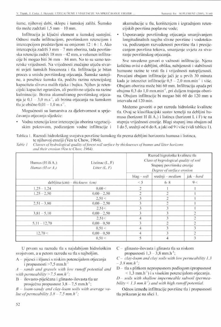
V. Tlapak, J. Ćaska, J. Herynek: UTJECAJ ŠUME 1 VEGETACIJE NA SPRJEČAVANJE EROZIJE Šumarski list SUPLEMENT (2005), 51-60
šume, njihovoj dobi, sklopu i šumskoj zalihi. Šumsko tlo može zadržati 1,5 mm - 10 mm.
Infiltracija je ključni element u šumskoj sastojini. Odnosi medu infiltracijom, površinskom retencijom i intercepcijom predstavljeni su omjerom 1 2 : 6 : 1. Ako intercepcija zadrži 3 mm - 7 mm oborina, tada površinska retencija zadrži 18 mm - 42 mm, a volumen infiltracije bi mogao biti 36 mm - 84 mm. No to su samo teoretske vrijednosti. Na vrijednosti značajno utječu stvarni uvjeti šumskih biocenoza i tla. Infiltracija je bitan proces u smislu površinskog otjecanja. Šumske sastoji-ne, a posebice šumska tla, podižu razinu retencijskog kapaciteta slivova malih rijeka i bujica. Njihov je reten-cijski kapacitet ograničen, ali pozitivno utječu na razine kulminacije. Brzina akumuliranog površinskog otjecanja je 0,1 - 3,0 m.s"1, ali brzina otjecanja na šumskom tlu je obično 0,01 - 1,0 m.s"1.
Mogućnosti su šumarstva za djelotvornost u sprječavanju otjecanja sljedeće: • Vodna retencija kroz intercepciju oborina vegetacij-
skim pokrovom, podizanjem vodne infiltracije i
akumulacije u tlu, korištenjem i izgradnjom reten-cijskih površina poplavne vode;
• Usporavanje površinskog otjecanja smanjivanjem longitudinalnih nagiba slivne površine i vodotoko-va, podizanjem razvedenosti površine tla i presijecanjem površina tokova, smanjenje uvjeta za stvaranje površinskog otjecanja. Sve navedeno govori o važnosti infiltracije. Njena
količina ovisi o debljini, obliku, nabijenosti i stabilnosti humusne razine te vrsti tla i vrijednosti natopljenosti. Povećani obujam infiltracije jači je u prvih 30 minuta kada je intenzitet infiltracije 0,5 - 2,0 mm.min ' i više. Obujam oborina može biti 60 mm. Infiltracija opada pri obujmu 0,3 do 1,0 mm.min"1, pri duljem trajanju oborina. Obujam infiltracije bi mogao biti 60 do 120 mm u intervalu od 120 min.
Možemo govoriti o pet razreda hidrološke kvalitete tla. Ovaj se klasifikacijski sustav temelji na debljini humusa (horizont H ili A,) i listinca (horizont L i F) te na stupnju vrijednosti erozije. Blagi stupanj ima obujam od 1 do 5, srednji od 6 do 8, a jaki od 9 i više (vidi tablicu 1).
Tablica 1. Razredi hidrološkog svojstva površine šumskog tla prema debljini horizonta humusa i listinca, te njihovoj eroziji (Ven te Chow, 1964).
Table 1 Classes ofhydrological quality of forest soil surface by thicknesses of humus and litter horizons and their erosion (Ven te Chow, 1964).
Humus (H ili A,) Humus (Hor A,)
Listinac (L, F) Litter (L, F)
debljina (cm) - thickness (cm)
1,25 1,24 1,25 2.50
2,51 - 3 , 8 0
3,81 - 5 , 1 0
5,11 - 12,70
12,70 <
0,00 < 0 ,00-2 ,50
2,51 < 0 ,00-2 ,50
2,51< 0 ,00-2 ,50
2,51< 0 ,00-0 ,50
0,51 < 0,00 • 0,50
0,51 <
Razred higrološke kvalitete tla Class of hygrological quality of soil
Stupanj površinske erozije Degree of surface erosion
blag- soft < 5
2 2 3 3 3 3 4 3 4 4 5
srednji -medium
6 8
1 2 2 2 3 3 3 2 3 3 4
jak -hard
9 <
1 1 1 1 1 2 2 2 3 2 3
U prvom su razredu tla s najslabijom hidrološkim svojstvom, a u petom razredu su tla s najboljim. A - pijesci i šljunci s niskim potencijalom otjecanja
i propusnosti >7,5 mm.h"1
A — sands and gravels with low runoff potential and with permeability > 7.5 mm.h'1; B - ilovasto-piješčana i glinasto-ilovasta tla uz
prosječnu propusnost 3,8 - 7,5 mm.h"1; B - loam-sandy and clay-loam soils with average value of permeability 3.8 - 7.5 mm.h'1;
C - glinasto-ilovasta i glinasta tla sa niskom propusnosti 1,3 - 3,8 mm.h" ;
C - clay-loam and clay soils with low permeability 1.3 -3.8 mm.li ; D - tla s plitkom nepropusnom podlogom (propusnost
< 1,3 mm.h"1) i s visokim potencijalom otjecanja. D - soils with shallow impermeable subsoil (permeability < 1.3 mm.h'1) and with high runoff potential.
Odnos između infiltracije površine tla i propusnosti tla prikazan je na slici 1.
52
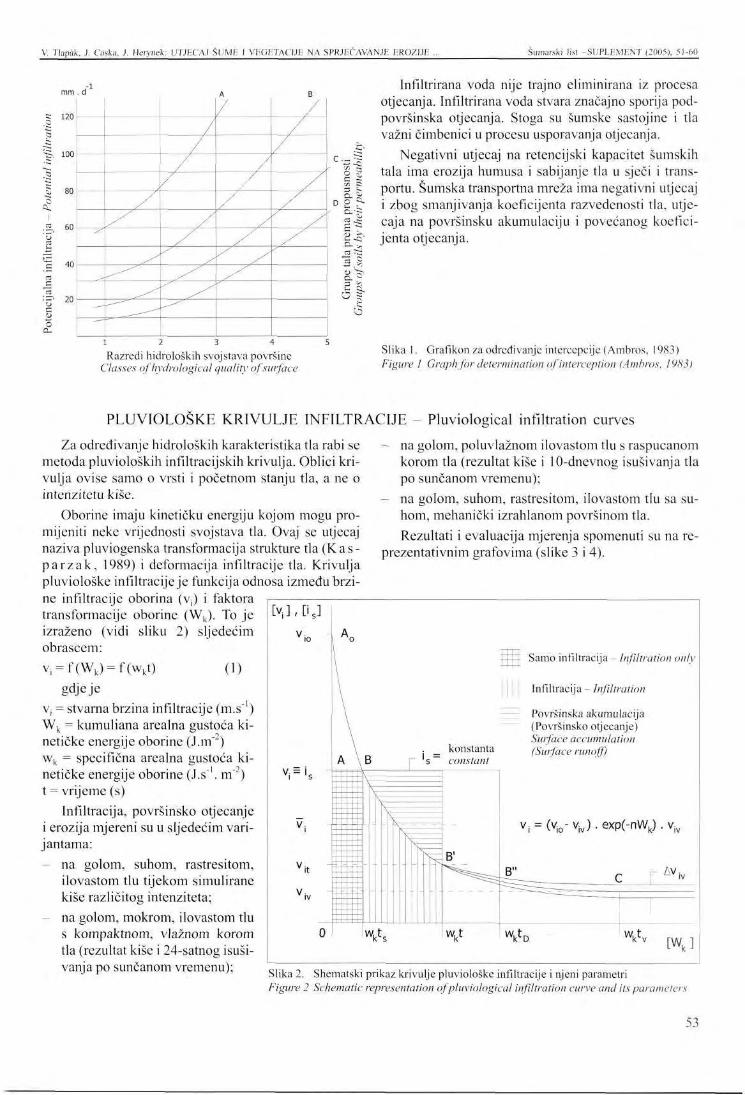
V. Tlapäk, J. Caska, J. Herynek: UTJECAJ ŠUME I VEGETACIJE NA SPRJEČAVANJE EROZIJE Šumarski list -SUPLEMENT (2005), 51-60
mm
120
100
80
60
40
20
d"1
/
/ /
/
""^—
/
/
/
/ / /
A
/ /
/
/ /
/ /-^
B
/
, /
/"
X
a D O D-
t-a cd 5
3 • —
o
£L ~ -=--- i -
r^ ; > " ~~. 5 U
Infiltrirana voda nije trajno eliminirana iz procesa otjecanja. Infiltrirana voda stvara značajno sporija pod-površinska otjecanja. Stoga su šumske sastojine i tla važni čimbenici u procesu usporavanja otjecanja.
Negativni utjecaj na retencijski kapacitet šumskih tala ima erozija humusa i sabijanje tla u sječi i transportu. Šumska transportna mreža ima negativni utjecaj i zbog smanjivanja koeficijenta razvedenosti tla, utjecaja na površinsku akumulaciju i povećanog koeficijenta otjecanja.
Razredi hidroloških svojstava površine Classes ofhydrological quality of surface
Slika 1. Grafikon za određivanje intercepcije (Ambros, 1983) Figure 1 Graph for determination of interception (Ambros, 1983)
PLUVIOLOSKE KRIVULJE INFILTRACIJE - Pluviological infiltration curves
[v,],Ds]
Za određivanje hidroloških karakteristika tla rabi se metoda pluvioloških infiltracijskih krivulja. Oblici krivulja ovise samo o vrsti i početnom stanju tla, a ne o intenzitetu kiše.
Oborine imaju kinetičku energiju kojom mogu promijeniti neke vrijednosti svojstava tla. Ovaj se utjecaj naziva pluviogenska transformacija strukture tla (K a s -parzak , 1989) i deformacija infiltracije tla. Krivulja pluviološke infiltracije je funkcija odnosa između brzine infiltracije oborina (v;) i faktora transformacije oborine (Wk). To je izraženo (vidi sliku 2) sljedećim obrascem: v, = f(Wk) = f(wkt) (1)
gdje je Vj = stvarna brzina infiltracije (m.s" ) Wk = kumuliana arealna gustoća kinetičke energije oborine (J.m2) wk = specifična arealna gustoća kinetičke energije oborine (J.s1. m"2) t = vrijeme (s)
Infiltracija, površinsko otjecanje i erozija mjereni su u sljedećim varijantama:
na golom, suhom, rastresitom, ilovastom tlu tijekom simulirane kiše različitog intenziteta; na golom, mokrom, ilovastom tlu s kompaktnom, vlažnom korom tla (rezultat kiše i 24-satnog isušivanja po sunčanom vremenu);
na golom, poluvlažnom ilovastom tlu s raspucanom korom tla (rezultat kiše i 10-dnevnog isušivanja tla po sunčanom vremenu); na golom, suhom, rastresitom, ilovastom tlu sa suhom, mehanički izrahlanom površinom tla. Rezultati i evaluacija mjerenja spomenuti su na re
prezentativnim grafovima (slike 3 i 4).
V : = i .
V;
Samo infiltracija - Infiltration only
Infiltracija - Infiltration
Površinska akumulacija (Površinsko otjecanje) Surface accumulation (Surface runoff
v i v ) . exp(-nWk)
Slika 2. Shematski prikaz krivulje pluviološke infiltracije i njeni parametri Figure 2 Schematic representation of pluviological infiltration curve and its parameters
53
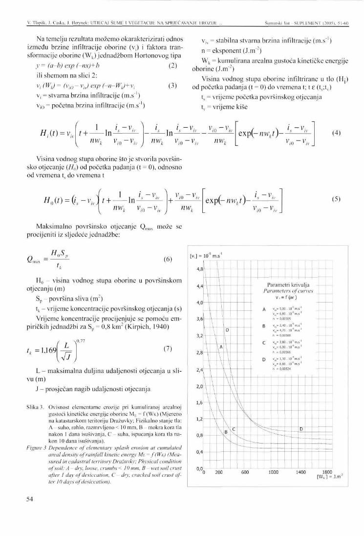
V. Tlapäk. J, Ćaska. J. Herynek: UTJECAJ ŠUME I VEGETACIJE NA SPRJEČAVANJE ERO/IJE Šumarski list -SUPLEMENT (2005). 51-60
Na temelju rezultata možemo okarakterizirati odnos između brzine infiltracije oborine (Vj) i faktora transformacije oborine (Wk) jednadžbom Hortonovog tipa
y = (a-b) exp (-nx)+b (2) ili shemom na slici 2: Vi (WO = (vi0 - v,v) exp (-n-W,J+ v, (3) Vj = stvarna brzina infiltracije (m.s"1) v i0 = početna brzina infiltracije (m.s-1)
viv = stabilna stvarna brzina infiltracije (m.s"1) n = eksponent (J.m"2) Wk = kumulirana arealna gustoća kinetičke energije
oborine (J.m"') Visina vodnog stupa oborine infiltrirane u tlo (Hj)
od početka padanja (t = 0) do vremena t; t e (t„;tv) ts = vrijeme početka površinskog otjecanja tv = vrijeme kiše
H,(t) = v„ , + _ L i n i z i V nw. ;., -v-
W 11
; i — v. - M n ^ — y
v,-o-v,-v nwk v,0-v,v nwlr
exp(-nwkt)—s- i -v...
vi0-viv
(4)
Visina vodnog stupa oborine stoje stvorila površinsko otjecanje (H0) od početka padanja (t = 0), odnosno od vremena t do vremena t
H0(t) = (i,-vjt + l n^ i. - v . \
nw,, v /o yh +
vio-viv
' J nw,. exp(- nwkt)—s-L -V:
vi0-viv
(5)
Maksimalno površinsko otjecanje Qmax može se procijeniti iz sljedeće jednadžbe:
»-•max (6)
H0 - visina vodnog stupa oborine u površinskom otjecanju (m)
Sp - površina sliva (m ) tk - vrijeme koncentracije površinskog otjecanja (s) Vrijeme koncentracije procijenjuje se pomoću em-
piričkih jednadžbi za S = 0,8 km2 (Kirpich, 1940)
h =1,169 L 77
(7)
L - maksimalna duljina udaljenosti otjecanja u slivu (m)
J - prosječan nagib udaljenosti otjecanja
Slika 3. Ovisnost elementarne erozije pri kumuliranoj arealnoj gustoći kinetičke energije oborine ME = f ( W K ) (Mjereno na katastarskom teritoriju Drazuvky; Fizikalno stanje tla: A - suho, rahlo, razmrvljeno < 10 mm, B - mokra kora tla nakon 1 dana isušivanja, C - suha, ispucanja kora tla nakon 10 dana isušivanja).
Figure 3 Dependence of elementary splash erosion at cumulated areal density of rainfall kinetic energy ME= ((WK) (Measured in cadastral territory Drazuvky; Physical condition of soil: A - dry, loose, crumbs < 10 mm, B ~ wet soil crust after 1 day of desiccation, C - dry, cracked soil crust after 10 days of desiccation).
[v,] =
4,8
4,4
4,0
3,6
3,2
2,8
2,4
2,0
1,6
U
0,8
0,4
0,0
10
\ \
\ \
\
\
\
J
'1 m.s
L \
1
I
v
\ \ \
^
\
\
\
\A
\ \
\ \
\ \
D
\
\
\ \
B \
\ \ \ \ \
^ N
\ w
Parameters of curves v , = f (>w )
A » i 0-5,00. 10s m.s"1
v„=6,80. 10'6m.s"'
B vk= 2,40. 10"S m.s"' v i v=4,75. I0'6m.s"'
Q v0= 3,80. lO^m.s"1
v j v=6,00. l o V s '
[ ) vro= 1,30 . lO^m.s"1
v | v=8,80. lO^m.s"1
D
—
200 600 1000 1400 1800 [Wk ] = J.m2
54
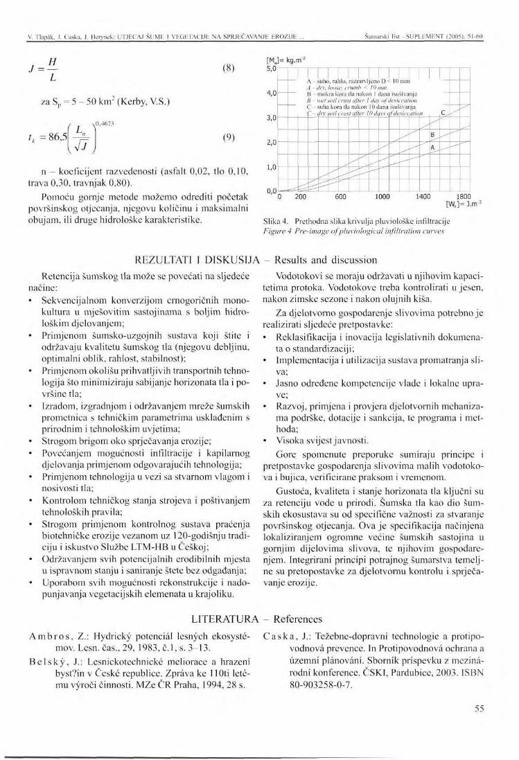
V. Tlapak, J. Ćaska, J. Herynek: UTJECAJ ŠUME I VEGETACIJE NA SPRJEČAVANJE EROZIJE Šumarski list -SUPLEMENT (2005), 51-60
H
za S = 5 - 50 km2 (Kerby, V.S.)
(8)
tk = 86,5 U ^ vV7y
(9)
n - koeficijent razvedenosti (asfalt 0,02, tlo 0,10, trava 0,30, travnjak 0,80).
Pomoću gornje metode možemo odrediti početak površinskog otjecanja, njegovu količinu i maksimalni obujam, ili druge hidrološke karakteristike.
[M„ 5,0
4,0
3,0
2,0
1,0
0,0
kg.nf
A - suno, ranio, razmrvljeno u <- i u mm A —dry, loose, crumb < 10 mm B - mokra kora tla nakon 1 dana isušivanja B - wet soil crust after I day of desiccation C - suha kora tla nakon 10 dana isušivanja f - dry soil crust after 10 dqvs qf depict ation
i 1
^ --'
B
A
C
.
0 200 600 1000 1400 1800 [Wk]= J.nr :
Slika 4. Prethodna slika krivulja pluviološke infiltracije Figure 4 Pre-image ofpluviological infiltration curves
REZULTATI I DISKUSIJA - Results and discussion Retencija šumskog tla može se povećati na sljedeće
načine: • Sekvencijalnom konverzijom crnogoričnih mono
kultura u mješovitim sastojinama s boljim hidro-loškim djelovanjem;
• Primjenom šumsko-uzgojnih sustava koji štite i održavaju kvalitetu šumskog tla (njegovu debljinu, optimalni oblik, rahlost, stabilnost);
• Primjenom okolišu prihvatljivih transportnih tehnologija što minimiziraju sabijanje horizonata tla i površine tla;
• Izradom, izgradnjom i održavanjem mreže šumskih prometnica s tehničkim parametrima usklađenim s prirodnim i tehnološkim uvjetima;
• Strogom brigom oko sprječavanja erozije; • Povećanjem mogućnosti infiltracije i kapilarnog
djelovanja primjenom odgovarajućih tehnologija; • Primjenom tehnologija u vezi sa stvarnom vlagom i
nosivosti tla; • Kontrolom tehničkog stanja strojeva i poštivanjem
tehnoloških pravila; • Strogom primjenom kontrolnog sustava praćenja
biotehničke erozije vezanom uz 120-godišnju tradiciju i iskustvo Službe LTM-HB u Češkoj;
• Održavanjem svih potencijalnih erodibilnih mjesta u ispravnom stanju i saniranje štete bez odgađanja;
• Uporabom svih mogućnosti rekonstrukcije i nado-punjavanja vegetacijskih elemenata u krajoliku.
Vodotokovi se moraju održavati u njihovim kapacitetima protoka. Vodotokove treba kontrolirati u jesen, nakon zimske sezone i nakon olujnih kiša.
Za djelotvorno gospodarenje slivovima potrebno je realizirati sljedeće pretpostavke: • Reklasifikacija i inovacija legislativnih dokumena
ta o standardizaciji; • Implementacija i utilizacija sustava promatranja sli
va; • Jasno određene kompetencije vlade i lokalne upra
ve; • Razvoj, primjena i provjera djelotvornih mehaniza
ma podrške, dotacije i sankcija, te programa i met-hoda;
• Visoka svijest javnosti. Gore spomenute preporuke sumiraju principe i
pretpostavke gospodarenja slivovima malih vodotoko-va i bujica, verificirane praksom i vremenom.
Gustoća, kvaliteta i stanje horizonata tla ključni su za retenciju vode u prirodi. Šumska tla kao dio šumskih ekosustava su od specifične važnosti za stvaranje površinskog otjecanja. Ova je specifikacija načinjena lokaliziranjem ogromne većine šumskih sastojina u gornjim dijelovima slivova, te njihovim gospodarenjem. Integrirani principi potrajnog šumarstva temeljne su pretopostavke za djelotvornu kontrolu i sprječavanje erozije.
LITERATURA References
Am b roš , Z.: Hydricky potcnciäl lesnych ekosyste-mov. Lesn. čas., 29, 1983, č.l, s. 3-13.
Be l sky , J.: Lesnickotechnicke meliorace a hrazeni byst?in v Ceske republice. Zpräva ke 1 lOti lete-mu vyroci činnosti. MZe ČR Praha, 1994, 28 s.
Ćaska , J.: Težebne-dopravni technologie a protipo-vodnovä prevence. In Protipovodnovä ochrana a üzemni plänoväni. Sbornik prispcvku z mezinä-rodni konference. ČSKI, Pardubice, 2003. ISBN 80-903258-0-7.
55
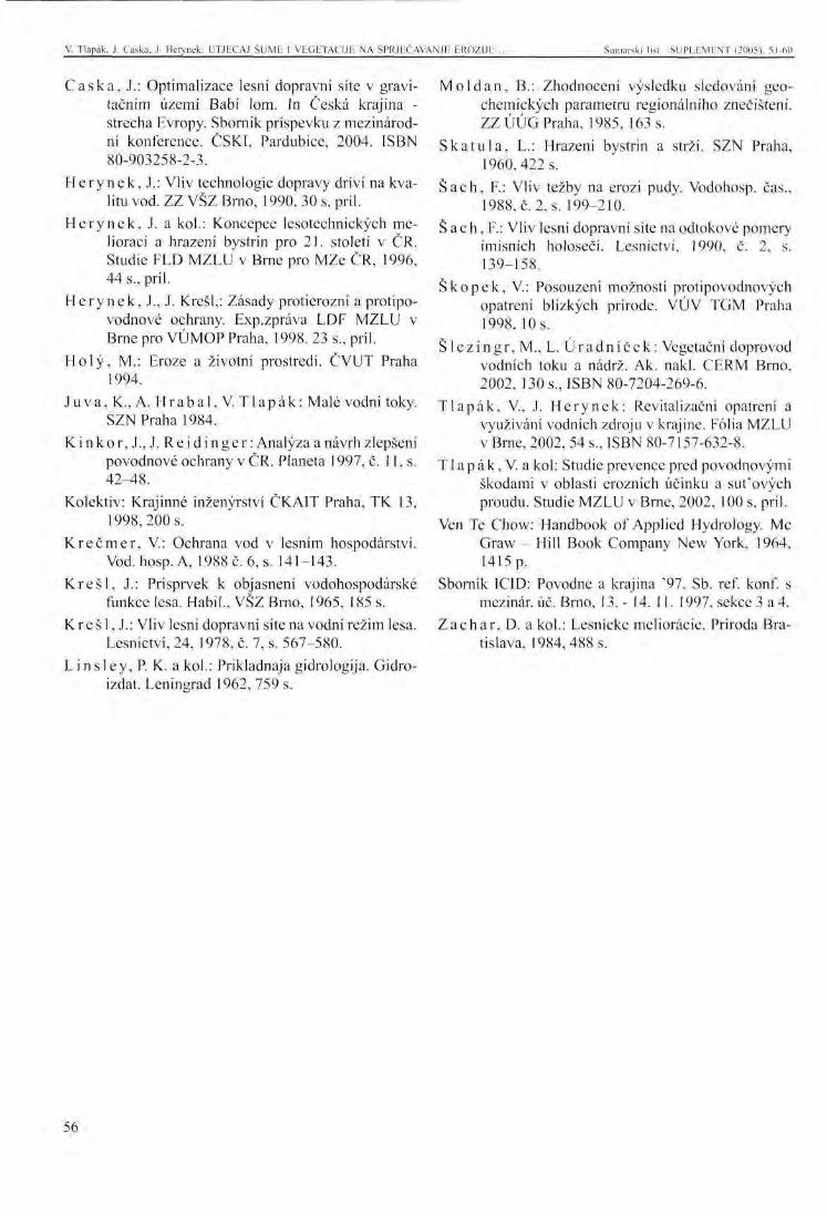
V. Tlapäk. J. Caska. J. Herynek: UTJECAJ ŠUME 1 VEGETACIJE NA SPRJEČAVANJE EROZIJE Šumarski list SUPI.F.MENT (2005). 51-60
Caska , J.: Optimalizace lesni dopravni site v gravi-tačnim üzemi Babi lom. In Češka krajina -strecha Evropy. Sbornik prispevku z mezinärod-ni konference. ČSKI, Pardubice, 2004. ISBN 80-903258-2-3.
H e r y n e k , J.: Vliv technologie dopravy drivi na kva-litu vod. ZZ VŠZ Brno, 1990, 30 s, pril.
H e r y n e k , J. a kol.: Koncepce lesotechnickych me-lioraci a hrazeni bystrin pro 21. stoleti v ČR. Studie FLD MZLU v Brne pro MZe ČR, 1996, 44 s., pril.
He rynek , J., J. Krešl,: Zäsady protierozni a protipo-vodnove ochrany. Exp.zpräva LDF MZLU v Brne pro VÜMOP Praha, 1998. 23 s., pril.
Holy , M.: Eroze a životni prostredi. ČVUT Praha 1994.
Juva , K.,A. Hrabal ,V. T lapäk : Male vodni toky. SZN Praha 1984.
K inkor , J., J. R e i d i n g e r : Analyza a navrh zlepšeni povodnove ochrany v ČR. Planeta 1997, č. 11, s. 42-48.
Kolektiv: Krajinne inzenyrstvi ČKAIT Praha, TK 13, 1998,200 s.
Krečmer , V.: Ochrana vod v lesnim hospodärstvi. Vod. hosp.A, 1988 c. 6, s. 141-143.
Kreš l , J.: Prisprvek k objasneni vodohospodarske funkce lesa. Habil., VŠZ Brno, 1965, 185 s.
K r e š 1, J.: Vliv lesni dopravni site na vodni režim lesa. Lesnictvi, 24, 1978, č. 7, s. 567-580.
L ins l ey , P. K. a kol.: Prikladnaja gidrologija. Gidro-izdat. Leningrad 1962, 759 s.
Moldan , B.: Zhodnoceni vysledku sledoväni geo-chemickych parametru regionälniho znečišteni. ZZÜÜG Praha, 1985, 163 s.
Ska tu l a , L.: Hrazeni bystrin a strži. SZN Praha, 1960,422 s.
Sach , F.: Vliv težby na erozi pudy. Vodohosp. čas., 1988, č. 2, s. 199-210.
Š ac h, F.: Vliv lesni dopravni site na odtokove pomery imisnich holoseči. Lesnictvi, 1990, č. 2, s. 139-158.
Skopek , V.: Posouzeni možnosti protipovodnovych opatreni blizkych prirode. VUV TGM Praha 1998, 10 s.
Š l ez ing r , M., L. U r a d n i č e k : Vegetačni doprovod vodnich toku a nadrž. Ak. nakl. CERM Brno, 2002, 130 s., ISBN 80-7204-269-6.
T lapäk , V, J. Herynek: Revitalizačni opatreni a vyuziväni vodnich zdroju v krajine. Folia MZLU v Brne, 2002, 54 s., ISBN 80-7157-632-8.
T1 a p ä k, V. a kol: Studie prevence pred povodnovymi škodami v oblasti eroznich učinku a sut'ovych proudu. Studie MZLU v Brne, 2002, 100 s, pril.
Ven Te Chow: Handbook of Applied Hydrology. Me Graw - Hill Book Company New York, 1964, 1415p.
Sbornik ICID: Povodne a krajina '97. Sb. ref. konf. s mezinär. üc. Brno, 13. - 14. 11. 1997, sekee 3 a 4.
Zachar , D. a kol.: Lesnicke melioräcie. Priroda Bratislava, 1984,488 s.
56
PRESENTATION AT THE INTERNATIONAL SYMPOSIUM Šumarski list -SUPLEMENT (2005), 51-60
THE INFLUENCE OF FORESTS AND VEGETATION ON EROSION AND FLOOD CONTROL OF LANDSCAPE
Vaclav TLAPÄK, Jakub CASKA, Jaroslav HERYNEK*
ABSTRACT: The effects of forest and vegetations in erosion and flood control in landscape are asserted by interception, surface accumulation and especially by uphold of infiltration and recharges. Thickness, structure, loose and integrity of humus and arable horizons have dominance. Physical and biochemical parameters of top soil horizons cooperate. Hydrological quality of soil surfaces are inferred by method of pluviological curves. This method makes possible to define potential recharge, infiltration, surface water accumulation and runoff. The method can be used for determination of potential quantities of splash erosion in relation to effects of vegetation covers. By this way can be objectified effects of forests and vegetation in erosion and flood situations.
IMPORTANCE AND EXTENT OF PREVENTION The base for erosion and flood control in small ri
vers and torrents watersheds is prevention. Effect of prevention is given by theoretical and practical experience of small watersheds hydrology, intensively used for forestry and agricultural production. It is effect of regulation and co-ordination of all activities and measures in potentially endangered watersheds in contexture at safety transposition of extreme flow. Prevention is usually les expansive then correction of flood damages. Important is also geographical position, in case of the Czech Republic, at main European watershed divide and results of erosion and flood situations for adjacent states (Austria, Germany, Hungary, Poland, and Slovak). All above mentioned facts validate relevance and reason of systematic, sophisticated and strictly multidisciplinary outlook on complex solution of common or specific problems.
Formation of runoffs from watershed is basically affected by ways, intensity and land use of area, by
* Prof. Ing. Vaclav Tlapdk, CSc , Ing. Jakub Caska, Prof. Ing. Jaroslav Herynck, C S c , Üstav tvorby a ochrany krajiny (Ustav lesnickych staveb a melioraci). Lesnickä a drevarskä" fakulta MZLU v Brne, Zemedelskä 3, 613 00 Brno, Czech Republic. Tel.: +420 5454 134 094; Fax: +420 545 134 083; E-mail: [email protected] Tel.:+420 5454 134011; Fax:+420 545 134 083; E-mail: [email protected] Tel.: +420 5454 134 090; Fax: +420 545 134 083; E-mail: [email protected]
Forest percentage of Czech is 34 % (2,643,058 ha). Forests in water protection zones make up 15 % (400,000 ha) of forest land in Czech. Over 1/3 of them was damaged by immissions in recent years. Forests in head water areas represents 26 % (700,000 ha) of forest land in Czech (Krečmer , 1988).
In wooded watersheds of Czech is constructed 9,500 km of paved forest roads and about 53,000 km of earth logging and skidding roads. Crude guess of total length of permanent and temporary roads is about 100,000 km. At agricultural land it is about 200-250,000 km of roads. Watercourses in cadastral evidence represent another 60,700 km of concentrated runoff paths. We expected that total length of runoff paths could by minimally 100,000 km.
thickness, composition, form, aeration and integrity of humus layer. It is synergy of thickness and quality of top soil horizons and their physical, chemical and biological parameters. Retention abilities of watershed are very important retardation factors in situations of rainstorms or local long-duration rains. Other attributes like interception of vegetation covers, especially forest covers, all surface accumulations and retentions and
EFFECTS OF FOREST STANDS AND SOILS ON RAINFALL AND RUNOFF
57
V. Tlapak. .1. Caska. J. Herynek: THE 1NFLUF.NCF OF FORESTS AND VEGETATION ON EROSION Šumarski list SUI'LEMENT (2005). 51-60
volumes of infiltration corresponding to them. Rainfalls can be retained by forest vegetation in quantity 3-7 mm. This quantity depended on species of woods, their age, canopy and stocking. Forest floor is able to retain 1.5-10 mm by its thickness.
Infiltration is critical element in forest stand. Relations inter infiltration, surface retention and interception is represented by ratio 12:6 : 1. If interception retained 3-7 mm of rainfalls, surface retention is 18—42 mm and infiltration volume could be 36-84 mm. But there are only theoretical values. Values are significantly affected by actual condition of forest biocenosis and soils. Infiltration is essential process from point of view of surface runoff forming. Forest stands and especially forest soils rising standard of retention capacity of small rivers and torrents watersheds. Their retention capacity is limited but evidentially positively affect lag times and culminations levels. Speeds of accumulated surface run off are 0.1-3.0 m.s"1 but speeds of run off in forest floor are usually 0.01-1.0 m.s"1.
Possibilities of forestry to intervene effectively in runoff control are:
• water retention which is achieved by rainfall interception by vegetation cover, by rise of water infiltration and accumulation in soil, by utilisation and construction of flood water retention areas
• rainfall runoff retardation by reduce of longitudinal slope of watershed surface and watercourses, by rise of soil surface roughness and cross-section areas of flow, by reducing of conditions for surface runoff creation
Above mentioned testify importance of infiltration. Its quantity is affected by thickness, form, compactness (compaction) and integrity of humus level and kind of
For determination of soil hydrological characteristics is used method of pluviological infiltration curves. Forms of curves depend only at kind and initial state of soil not at rain intensity.
Rainfall has kinetic energy and by this energy can change some volumes of soil attributes. This effect is called pluviogenous transformation of soil structure (Kasparzak, 1989) and deformation of soil infiltration. Pluviological infiltration curve is function of relation between rainfall infiltration speed (VJ) and rainfall transformation factor (W^). It applies to (see figure 2):
v, = f(Wk) = f(wkt) (1) Vj = actual speed of infiltration (m .s"1) Wk = cumulated areal density of rainfall kinetic
energy (J.m~~) wk = specific areal density of rainfall kinetic energy
(J.s'.nT2)
soil and by their water saturation value. Raised volume of infiltration is stronger in the first 30 minutes when infiltration intensity is 0.5-2.0 mm.rnin" and more. Volume of precipitation can be 60 mm. Infiltration decrease at volume from 0.3 to 1.0 mm.min'' with longer rainfall time. Volume of infiltration could be from 60 to 120 mm of rainfall in interval 120 min.
We can talk about five classes of hydrological quality of soils. This classification system is based on thickness of humus (horizon H or A,) and litter (horizons L and F) and on degree of erosion value. Soft degree has volume from 1 to 5, medium from 6 to 8, hard 9 and more (see table 1).
At the first class are soils with the worst and in the fifth class are soils with the best hydrological quality. By the soil permeability authors define four groups of soils.
Relationship between infiltration quality of soil surface and soil permeability is demonstrated on figure 1.
Infiltrated water is not permanently eliminated from runoff process. Infiltrated water creates subsurface runoff with significantly lower speeds. By this way forests and forest soils extended times of runoff concentration and raise probability than times of runoff concentration will be longer than times or rain. This is premise then peak flow is not formed by rainfalls from complete area of watershed. Therefore forest stands and soils are important factors in process of runoff retardation.
Negative effect at retention capacity of forest soils has humus erosion and soil compaction by wood harvesting and transport. Forest transport network has negative effect too because reduce roughness coefficient, affected surface accumulation and raise volume of runoff coefficients.
t = time (s) Infiltration, surface runoff and splash erosion were
measured in following variants: - at bare, dry, loose, loam soil in the course of simula
ted rains with various intensities at bare, wet, loam soil with compact, wet soil crust (result of rain and 24 hours of soil desiccation in sunny weather)
at bare, semi humid loam soil with cracked soil crust (result of rain and 10 days of soil desiccation in sunny weather)
at bare, dry, loose, loam soil with dry, mechanically loosed soil surface Results and evaluation of measuring are mentioned
at chosen representative graphs (figures 3 and 4). On the basis of results we can charakterize relation bet-
PLUVIOLOGICAL INFILTRATION CURVES
58

V. Tlapak. J. Ćaska, J. Hcrynek: THE INFLUENCE OF FORESTS AND VEGETATION ON EROSION Šumarski list SUPLEMKNT (2005), 51-60
ween rainfall infiltration speeds (v;) and rainfall transformation factor (Wk) by equation of Horton type:
y = (a-b) exp (-nx)+b (2) or by scheme at figure 2: v, (WJ = (vi0 - v,J exp (-n-W^v, (3) Vj = actual speed of infiltration (m.s-1) vi0 = initial speed of infiltration (m.s1) vjv = steady actual speed of infiltration (m.s-1)
n = exponent (J.rrf ) Wk = cumulated areal density of rainfall kinetic
energy (J.rrf2) High of water column of rainfall which infiltrated
into soil (Hi) from the beginning of rain (/ = 0) to the time t;
ts = time of beginning of surface runoff t, = time of rain
(4) Ht(t) = viv t + -nw, nw,.
K-v;„ V , 0 - V n
nw, e x p ( - nwkt)-
ViO~Vn
is = rain intensity (m.s-1) High of water column of rainfall which created sur
face runoff (H0) from the beginning of rain (t = 0), respectively from time ts to time t
(5) H0(t) = (is t + -1
nw.
i, - v.
V;„ - V, + •
nw, exp(-nwkt)-
i,. - v „
Maximal surface runoff Qmax can be evaluated from equation:
«wnax
HS 0 " , , (6)
H0 = high of water column of rainfall in surface runoff (m)
Sp = area of watershed (m2) tk = time of surface runoff concentration (s) Time of concentration is evaluated from empiric
equations for Sp = 0.8 km2 (Kirpich, 1940)
L = maximal length of runoff distance at watershed (m)
J = average slope of runoff distance
(8) J H
for 5 = 5 - 50 km2 (Kerby,V.S.)
(9) 86,5 L
(7) 1,169 f L ^
V v i J
n = roughness coefficient (pavement 0.02, soil 0.10, grass 0.30, lawn 0.80)
By the upper mentioned method we can determinate beginning of surface runoff, its quantity and maximal volume of surface runoff or other runoff hydrolo-gical characteristics.
RESULTS A N D DISCUSSION
Retention of forest soils can be raise by: sequential conversion of coniferous monocultures at mixed stands with better hydrological effect by application of silvicultural systems which protect and uphold quality of forest floor (its thickness, optimal form, loose, integrity)
by application of environmentally friendly transport technologies which minimize compaction of soil horizons and soil surface design, built and maintain forest transport network with technical parameters adequate to natural and technological conditions
59
V. Tlapäk, J. Ćaska. .1. Herynek: THE INFLUENCE OF FORESTS AND VEGETATION ON EROSION ... Šumarski list -SL1PLEMENT (2005), 51-60
• by strict care for full area erosion control and prevention
• enhance possibilities of infiltration and capillary action by application of adequate technologies
• by application of technologies in relation with actual humidity and bearing capacity of soils
• by control of machine technical condition and observation of technological regulations
• by strictly application of biotechnical erosion control system in connection with 120 years long tradition and experience of Sluzby LTM-HB (Forest Reclamation Service) in Czech
• by maintenance of all potentially erodible places in safe condition and repair all damages without delay
• by using of all possibilities for reconstruction and complementation of vegetation elements in landscape Managers of watercourses are obligate to maintain
their flow capacities. Quality of watercourses maintenance would be controlled in autumn, after winter season and after all rainstorms.
For effectively management of watersheds is necessary realisation of following assumptions:
• reclassification and innovation of legislative standardisation documents
• implementation and utilization of watershed monitoring system
• clearly defined competences of government and local administration
• creation, application and audit of effectively support, grant and sanction mechanisms, programs and methods
• good awareness of general public Upper mentioned recommendations summarize
principles and assumptions of small and torrent watersheds management verificate by practice and time.
Thickness, quality and condition of soil horizons are cardinal for retention of water in landscape. Forest soils, such a part of forest ecosystems, have specific importance for runoff forming. This specification is made by localisation of vast majority of forest stands at upper parts of watersheds and by the way of their management. Integrated forestry respecting principles of sustainable forestry is basic for effectively erosion control and prevention.
60
IZLAGANJE NA ZNANSTVENOM SKUPU - PRESENTATION AT THE INTERNATIONAL SYMPOSIUM Šumarski list SUPLEMENT (2005), 61-68 UDK 630* 116 + 228
S T R U K T U R A ŠUMA S F U N K C I J O M ZAŠTITE TLA NA L O K A L I T E T U PUSTY H R A D - ZVOLEN
THE STRUCTURE OF THE FOREST STAND WITH A SOIL CONSERVATION FUNCTION IN THE LOCALITY PUSTY HRAD - ZVOLEN
Karol GUBKA*
SAŽETAK: U Republici Slovačkoj šumsko tlo pokriva otprilike 2.008.000 hektara. Šume rastu na 1.929.000 hektara, a 12,7 % ispunjavaju primarnu funkciju zaštite tla i sprječavanje erozije (Zeleni izvještaj 2003. g). Šumske sastojim s ovom funkcijom javljaju se u određenim postocima u svim nagnutim zonama šumske vegetacije.
Lokalitet Pusty hrad smješten je na granici između intravilana i ekstravi-lana grada Zvolena, koji dominira jugozapadnim dijelom. Arheološki nalazi potvrđuju da je područje na ušću rijeka Hron i Slatina bilo naseljeno već u kameno doba. Strateški trgovački i vojnički položaj omogućio je gradu Zvole-nu dugoročne izglede. Od izgradnje Novog Dvorca godine 1238., starije dvorac počeo propadati. Danas je Pusty brad mjesto arheoloških istraživanja i turističko odredište. Odjel 186, kojeg presijecaju turističke staze, ima vrlo važnu ulogu u sprječavanju erozije. U podnožju brda (40 % - 100 % nagib) nalaze se značajne cestovne i željezničke komunikacije, električni vod, tvornica betona, rezidencijalni dio i ušće dviju rijeka. Spontana erozija ili klizanje tla mogli bi prouzročiti znatnu gospodarsku štetu. Šumska struktura na promatranom lokalitetu prilično je izdiferencirana, posebice u smislu omjera smjese u odnosu na visinu. S fito-socioloskog stajališta, ustanovili smo inverziju vegetacijskih zona: u gornjem dijelu javljaju se šumski tipovi druge šumske vegetacijske zone, dok se na nižim visinama javljaju šumski tipovi treće šumske vegetacijske zone. To se odražava u omjeru smjese drvenastih vrsta: na većim visinama (preko 450 m) javlja se hrast kitnjak fQuercus petraea,), koji prevladava u gornjem sloju krošanja, uz prisutnost malolisne lipe (Tilia cordata) / gorskog javora ('Acer pseudoplatanus,) u podstojnoj etaži. S horizontalnom zatvorenosti krošanja od 85 % i/ili pokrovom biljne sinusije od 80 %, prirodno pomlađivanje, uglavnom rast ponika vrlo je problematičan.
Na nižim visinama, zajednica šumskih vrsta je raznovrsnija, a pritom je hrast zamijenjen bukvom i grabom. Uz ove spomenute vrste, ustanovili smo i pojavu javora fAcer campestre,), javora mliječa (Acer platanoides,), divlje trešnje (Cerasus aviurrij i drugih.
Mnoge su biljke bile vegetativnog porijekla. Sa stajališta vertikalne strukture, ekosustav u ovom dijelu postaje ravna, vertikalno neizdiferencirana šumska sastojina.
Prirodna reprodukcija, posebice javora, vrlo je spontana. U uvjetima jake zasjene, prirodni ponik opstoje samo kratko vrijeme i nije u stanju stvoriti drugu etažu. Biljni pokrivač ne ometa prirodnu generativnu reprodukciju, jer
* Doc. Ing. Karol Gubka CSc, TU Zvolen, Katedra uzgajanja šuma, Šumarski fakultet TU, Zvolen, Masarykova 24, 96053 Zvolen, Slovakia
K. Gubka: STRUKTURA ŠUMA S FUNKCIJOM ZAŠTITE TLA NA LOKALITETU PLJSTY HRAD ZVOLF.N Šumarski list - ŠUPI KMLNT (2005), 61 -68
otprilike 30 % biljnog pokrova ne utječe negativno na reproduktivne procese. U zadnjih 10 godina, broj pojedinih stabala u donjim etažama smanjio se, dok je relativni udio stabala u sklopu porasao u dijelu smještenom na nižim visinama. Omjer smjese se tek neznatno promijenio. Tlo se u cijelom profilu sastojine može odrediti kao erodibilno, pri čemu se njegova fizička svojstva, boja i kemijska svojstva mijenjaju u skladu s promjenama visina.
Hitno je potrebno primijeniti mjere uzgojnih zahvata u cilju poboljšanja strukture šumske sastojine i očuvanja trajne funkcionalne djelotvornosti. Predložene mjere moraju se temeljiti na sintezi znanja o sastavu šumskih sastojina, tehničkim i ekonomskim mogućnostima i uzgojnom cilju. Cilj je na ovom lokalitetu razviti ekosustav koji će u što većoj mjeri ispuniti funkciju sprječavanja erozije. Za postizanje ovog cilja potrebno je napustiti metodu čiste sječe kao i metodu oplodne sječe. Sječa se mora obaviti po snijegu ili kad je tlo zamrznuto. Umjesto izvlačenja stabala po tlu, potrebno je koristiti žičare. Treba potpomagati prirodnu generativnu i vegetativnu obnovu. U slučaju nedostatne prirodne obnove, potrebno je osigurati buduću generaciju pomoću umjetne ili kombinirane obnove. Ovim bi se postupcima trebale postići zatvorene šumske sastojine koje su izdiferencirane horizontalno, vertikalno, po visini, promjeru i dobi, sa raznolikim omjerima smjesa, koje će maksimalno ispuniti funkciju sprječavanja erozije.
UVOD - Introduction
Lokalitet Pusty hrad kraj Zvolena, predstavlja bitnu komponentu gradske panorame. Povezan je s najstarijim razdobljem naseljavanja ove regije. Prema arheološkim istraživanjima, ovaj je lokalitet naseljen već između 2500. i 2100. godine prije Krista. Pogodnosti tokova dviju rijeka, Hron i Slatine, uvjetovale su razvoj Zvolena u trgovačko i vojno središte toga područja. Nakon izgradnje novog dvorca i proglašenja Zvolena kraljevskim gradom, vrijednost starog dvorca počinje opadati. Danas se odvija intenzivno arheološko istraživanje lokaliteta, koji je važna turistička destinacija do koje se dolazi stazama i šumskim putevima.
Čitav masiv Pusty hrad nalazi se na jugozapadnom dijelu Zvolena. Geomorfološki gledano, smješten je na sjeverozapadnoj granici planinskog lanca Javorie. Geološka podloga sastoji se od andesitnih vulkanskih stijena i tufita. Visina Pusty hradaje 571 m nad morem najugo-zapadu i 478 m na sjeveroistoku. Visina riječnog sliva je 110 m nad morem.
Šumski ekosustav na padinama spomenutog lokaliteta ispunjava važne ekološke i okolišne funkcije, od kojih su značajni zaštita tla i kontrola erozije. Nagib varira od 40 % do 100 %, tako da je erozija stvarna prijetnja.
Lokalitet Pusty hard smješten je na šumskom zemljištu kojim gospodari poduzeće Sume grada Zvolena, d.o.o. Arheološki radovi zahtijevaju diferenciran pristup gospodarenju šumskim sastojinama blizu ovog lokaliteta. Odjel 186, objekt naše analize, okrenut je prema
Dosadašnja proučavanja govore da se funkcija zaštite od erozije može najdjelotvornije osigurati pomoću šumskih sastojina s višeslojnom vertikalnom arhitekturom, oblikovanom s autohtonim prilagođenim vrstama ( M a y e r 1976, P o b e d i n s k i j - K e č n e r 1984,Mi-d r i a k 1981, K o r p c l ' 1989," P o p i č 1989, G u b k a 1996, Reh 1997). Ovaj se podatak mora razumjeti u kontekstu okolišnih osobina. U mnogim su slučajevima kontrola erozije i zaštita tla funkcije koje u dovoljnoj mjeri osiguravaju šumske sastojine sastavljene od vrsta koje nisu autohtone na danom lokalitetu, no pokazuju visoku statičku stabilnost i odgovarajuće fiziološke i/ili morfološke karakteristike.
Višeslojna šumska sastojina značajno smanjuje kinetičku energiju kišnih kapi pri njenom udaru na tlo te sprječava eroziju. Višeslojna šumska sastojina sa svojim nadzemnim i podzemnim dijelovima osigurava protočno i sigurno prenošenje površinskih padavina u podzemne vode, što nije važno samo za zaštitu tla, već i za vodno gospodarstvo. Cilj je ove studije analizirati strukturu određene šumske sastojine s funkcijama zaštite tla i kontrole erozije, te predložiti odgovarajuće šumsko-uz-gojne mjere za sprječavanje opadanja funkcionalne djelotvornosti promatranog ekosustava.
gradu. Neposredno ispod ove sastojine nalazi se važna cesta i željeznička pruga, mostovi i vijadukti, dalekovod, stambeno naselje, rijeka Slatina i njen spoj s rijekom Hron. Erozija i/ili klizanje tla u ovim bi uvjetima uzrokovali znatnu ekološku, okolišnu i gospodarsku šte-
MATERIJALI I METODOLOGIJA - Material and methodology
62
K. Gubka: STRUKTURA ŠUMA S FUNKCIJOM ZAŠTITE TLA NA LOKALITETU PUSTY HRAD - ZVOLEN Šumarski list - SUPLEMENT (20U5). 61-68
tu. Odjel 186 pokriva 64,82 hektara i proglašenje zaštitnom šumom s funkcijama kontrole erozije i klizanja tla. Održavana i prometna staza do pogleda na Zvolen siječe šumske sastojine i nastavlja se do područja Pusty hrad. Danas turisti često posjećuju čitav lokalitet. Prema šum-sko-gospodarstvenom planu i karti šumskih sastojina, to je dvoslojna sastojina klasificirana kao HS04OV, tj. visoka šuma s primarnom zaštitnom funkcijom. Prvi sloj ima djelomičnu površinu od 51,86 hektara, starost od 165 godina, zalihu 0,6, funkcionalni tip 10, zaštitni tip 13 (izvan opsega industrijskog zagađenja), tehnološki tip 34 (eksploatacija drva sustavom žičara). Nagib je jugozapadni, strmina nagiba 90 %, a grupe šumskog tipa su sljedeće: Quercetum fageto-tiliosum 60 % (3402); Tilietum acerosum 30 % (3502); Fagetum pauper 10 % (3315). Tlo je kameno s izbijajućim stijenama. Biljni pokrov su trave.
Prva trajna pokusna ploha postavljena je u gornjem dijelu šumske sastojine (450 m nad morem)
Pod dugoročnim utjecajem ekoloških čimbenika na tom staništu, stvoreni su mikroklimatski i ostali uvjeti, stvorio se ekosustav koji je danas sposoban osigurati prioritetnu zaštitu tla, kontrolu erozije i funkcije kontrole klizanja tla. Šumska je sastojina na tom lokalitetu oblikovana uglavnom od hrasta kitnjaka (Quercus pe-traea Mattusch. Licbl) koji jasno dominira. Nema znakova erozije (osim one uzrokovane turističkim stazama), što bi predstavljala prijetnju mjestu gdje je opaže-na. Sadašnja struktura šumske sastojine u odnosu na stanište, dob, sastav vrsta drveća, vertikalnu arhitekturu, stanje prirodne obnove, itd., ukazuje na potrebu ciljane šumskouzgojne obrade. Oblikovanje trajne višeslojne arhitekture šumske sastojine na ovom staništu vrlo je važno za očuvanje njegove funkcionalne djelotvornosti. Na temelju analize prirodne obnove zaključili smo daje sjemeni urod pojedinih vrsta drveća dovoljan za postizanje trajnog postojanja funkcionalno djelotvornog šumskog ekosustava, pod šumskouzgoj-nim i eksploatacijskim zahvatima temeljenim na načelu obnove sjemenom sječom.
Biljna zajednica u području Pusty hrad predstavlja primjer inverzije vegetacijskih zona. Dok je niža pokusna ploha II klasificirana kao treća vertikalna vege-tacijska zone, gornja ploha I, unatoč njenoj lokaciji na većoj nadmorskoj visini, rangirana je kao druga vege-tacijska zone. Podstojna biljna zajednica ima karakteristični travnati izgled s prevagom mezotropskih mezo-fita poput Poa nemoralis, a kiselost okoliša tla javlja se uglavnom na plitkim tlima s prisustvom Luzula luzulo-ides. Nitrofilne se vrste javljaju sporadično.
Prema klasifikaciji Zurich-Montpellier, ove zajednice pripadaju Quercion confertae-cerris (Horvat
Sama šumska sastojina je zrela panjača, raznodobna, s čestim starijim izbojcima. Prostorna se distribucija vrsta drveća kreće od stablimične do grupimične mješavine. Kvaliteta rasta i stabla je općenito slaba. Pojedina stabla imaju rezonantno drvo.
Drugim se slojem također ne gospodari. Za oba sloja se drži da nisu ugrožena.
Kako bi dobili potpunije podatke o stanju i razvoju šumske sastojine, osnovane su dvije stalne eksperimentalne plohe u odjelu 186, s ciljem istraživanja strukturalnih karakteristika šumske sastojine, stanja zajednice i značajki tla. Na temelju ovih podataka i dosljednim nadziranjem šumske sastojie, izrađene su preporuke za gospodarske mjere.
1945), zajednice Poo nemoralis-Quercetum daleeham-pii(Šomšak - H ä b e r o v ä 1989).
Ukupni pokrov je 70 % - 80 % s pojavom Poa nemoralis (+2-3), Luzula nemorosa (-2); Galium schulte-sii (-2); Veronica montana (1-2); Stellaria holostea (1); Lathyrus vernus (1); Campanula trachelium (1); Convallaria majalis (1-2); Melica uniflora (+2), i ostale vrste tipične za zajednice vegetacijske zone hrasto-vo-bukove šume (N i č 2004). Što se tiče tla, vertikalna je struktura istraživane plohe sljedeća: - 0-1 cm Ol horizont - listinac
0-10 cm Au horizont - smeđe tlo, pjeskoviti mulj, ilovasto, vlažno, 5 % šljunka, jako zakorjenjeno, s postepenom tranzicijom horizonata 15 - 70 cm Bv horizont - svijetlo smeđe tlo, pjeskoviti mulj, grudasto, mokro 40 % kameno, jako zakorjenjeno; >70 cm Cl horizont — oker smeđe tlo, muljni pijesak, mokro, 80 % kameno i stjenovito. Godine 2004. ponovljena su mjerenja. U usporedbi s prethodnim staništem, zajednica je
raznolikija s različitim listopadnim vrstama drveća. Cesti su individualni primjerci izrasli iz izbojaka, no oni su dovoljno sposobni za ispunjavanje traženih funkcija, uglavnom zaštite tla. Originalna se vertikalno diferencirana šumska sastojina postupno povlači uslijed dugotrajne zasjene i konkurentskih odnosa, te promjenom od vertikalno diferencirane sastojinske strukture na horizontalno postalvjenu šumsku sastojinu. To se pokazuje izrazitim padom broja pojedinih stabala u najdonjem (četvrtom) razredu, gdje se u desetgodišnjem razdoblju osušilo oko 100 pojedinačnih stabala. S druge strane, udjel kodominantnog drveća (daigi sloj) je osjetno povećan. Prirodna je obnova vrsta drveća na istraživanom
REZULTATI - Results
63
K. Gubka: STRUKTURA ŠUMA S FUNKCIJOM ZAŠTITE TLA NA LOKALITETU PUSTY HRAD - ZVOLEN Šumarski list - SUPLEMENT (2005). 61-68
lokalitetu vrlo dobra. Urod sjemena javora (Acerpseu-doplatanus) i javora mliječa (Acerplatanoides) obično je spontan, ali zbog jake zasjene preživljavanje javora je vrlo slabo. Uz primjenu ciljane selekcije pojedinog drveća i malih grupa, moguće je postići vertikalno diferenciranu zajednicu drveća s maksimalnom funkcionalnom djelotvornošću. Za vrijeme razdoblja 1994 -2004, predstavljanje pojedinih vrsta drveća je neznatno izmijenjeno.
Promjena sastojinske strukture s visinom rezultira promjenom prizemne vegetacije. Prema Niču (2004), te šumske sastojine predstavljaju tipične primjere zajednica s pretežno nitrofilnim vrstama. Pokrov biljke synu-siaje relativno slab (30 %), zbog utjecaja oblika terena i kamene površine. Prema Z la tn iku , ta zajednica pripada nitrofilnom edafsko-trofičnom redu C. Unatoč bogatom udjelu plemenitih listača prosječne kvalitete, većina ovih zajednica su zaštitne šume, s obzirom na visok udjel šljunka i kamena u samom tlu i na površini tla.
Sa stajališta tla, visinska se promjena odražava na karakteristikama tla, uglavnom u dubini, boji i kemijskom sastavu tla. Bogato zakorjenjivanje, uglavnom u površinskim slojevima tla, jedan je od preduvjeta stabilnosti ekosustava glede erozije tla. Stanje tla prikazano je u analizi uzorka tla.
Kontrola šume otkrila je da je statička stabilnost šumske sastojine smanjena, tako daje funkcija šumske sastojine ugrožena.
Za to postoji nekoliko razloga: U gornjem sloju šumske sastojine, gdje prevladava hrast zbog vegetacijske inverzije, nalaze se mjesta na kojima se nekoliko stabala osušilo zbog gljivičnih bolesti. Ove se grupe postupno prekidaju i sklop se otvara. Oblikovanje većih grupa sa signifikantno reduciranim zalihama smanjuju otpornost okolne šumske sastojine prema abiotičnim čimbenicima, uglavnom zimi, snijegu i mrazu. Vjetrolomi na bukvi u udubinama, uglavnom ispod točke vidljivosti. Ovi vjetrolomi mogu biti uzrokovanim nekolicinom čimbenika:
• Dugotrajnim kišama i naletima vjetra. Dugotrajna kiša destabilizira tlo, korijenje je slabo usidreno, te slučajni nalet jakog vjetra može izvaliti takvo drveće, čime nastaje lančana reakcija;
• teški napadi snijega na tlo koje nije zamrznuto, nakon čega slijede naleti vjetra.
Ovi lokaliteti kasnije postaju ishodišne točke za eroziju tla ili klizišta. - Sušenja koja smanjuju sklop krošanja uzrokovana
su mrazom i snijegom u kombinaciji s vjetrom; Prema šumsko-gospodarstvenom planu, šumska je sastojina stara 165 godina. Postoje, međutim, mnogo stariji pojedini primjerci, koji dosežu fiziološku starost. Oni trunu, ruše se, tako da oblikuju manje ili veće otvore u sklopu. To također može djelovati na stabilnost gornjeg sloja drveća. Ovo stanje ukazuje na potrebu formiranja unutarnje
strukture šumske sastojine, ne ostavljanja šumske sastojine bez intervencije, oslanjajući se na samoregulaciju.
Potrebno je primijeniti tehnološke zahvate i mjere, koji osiguravaju dinamični razvoj šumske sastojine stabilne strukture, čime se mora očuvati njena funkcionalna djelotvornost.
Predlažemo: Realizirati temeljito sanitarno obrezivanje; Ne dozvoliti čistu sječu, uglavnom duž linije padina; Ne primijeniti uniformni sustav oplodne sječe; Primijeniti grupimični sustav obnove zbog oblikovanja vertikalno i horizontalno diferencirane zajednice drveća; Obavljati sječu zimi, na snijegu ili na smrznutom tlu, kako bi se spriječila erozije, te primijeniti žične sustave izvlačenje; Gdje je izvlačenje onemogućeno, ostaviti debla u šumskoj sastojini postavljena duž konturne linije tla; Ostatke nakon sječe treba položiti u smjeru konturne linije tla; Gdje je moguće, provoditi prirodnu obnovu; Na mjestima gdje je nemoguća generativna obnova, važno je postići vegetativnu obnovu (panjača); Mjesta bez dovoljne prirodne obnove moraju se popuniti sadnjom ili kombiniranom obnovom; Mlade šumske sastojine moraju se zaštititi od divljači; Ne izvoditi nikakve zemljane radove na osjetljivim terenima.
64
PRESENTATION AT THE INTERNATIONAL SYMPOSIUM Šumarski list - SUPLEMENT (2005), 61-68
T H E S T R U C T U R E OF T H E FOREST STAND W I T H A SOIL CONSERVATION F U N C T I O N IN T H E L O C A L I T Y PUSTY H R A D - Z V O L E N
Karol GUBKA*
SUMMARY: The Forest Land surface of the Slovak Republic is 2,008,000 ha. The forests cover an area of 1,929,000 ha, 12,7 % of which fulfill a priority soil conservation and erosion control function (Green Report 2003). Forest stands with this function occur in all vertical forest vegetation zones.
The locality Fusty hrad is an important component at the boundary between the intravilan and the extravilan of the town Zvolen. It is a dominant feature of its southwestern part. The archaeological findings confirm that the area at the confluence of the rivers Hron and Slatina were settled already in the Stone Age. The strategic trading and defense role ensured Zvolen a long-term perspective.
Recently, Fusty hrad has become a place of archaeological research and a tourist destination. The forests of the compartment 186 crossed by a tourist path fulfill erosion-control function. Below the slope with the inclination of 40 to 100 %, there are important motor and rail communications, powerline, concreting plant, housing estate and confluence of two rivers. Spontaneous erosion or soil slide could lead to enormous economic damages.
The structure of the forest stand in the investigated locality is very differentiated concerning tree species composition in relation to altitude. From the phytosociological viewpoint, we found an important inversion of forest type groups: at higher elevations, there are communities of the second forest vegetation zone and at lower altitudes, there are forests of the third vegetation zone. This is reflected in the tree species representation. In the higher locations (approx. over 450 m), sessile oak is predominating (Quercus petraea,) in the upper tree layer with lime (Tilia cordataj and sycamore (Acer pseudoplatanus^ in the lower layer. With a horizontal canopy closure of approx. 85% and herb cover of 80%, natural regeneration, mainly seedling recruitment from natural seeding is very difficult. At lower elevations tree community is more diverse. In addition to the mentioned tree species, we recorded also the occurrence of maples (Acer campestre, Acer platanoidesA wild cherry fCerasus avium,) and other species. Many individuals were of sprout origin. The ecosystem in this part becomes a one-layer vertically undifferentiated forest stand. Natural regeneration, mainly that of maples, is very spontaneous. Due to a strong shading, natural seeding survives only a short time and is not capable to form a second layer. The ground vegetation does not hamper natural generative regeneration, since an approx. 30 % cover can not negatively affect the process of tree regeneration. During a ten-year period, a remarkable decline of individuals in the lower layer occurred, whereby relatively share of canopy trees increased.
* Doc. Ing. Karol Gubka CSc, TU Zvolen, Katedra pestovania lesa, Masarykova 24, 96053 Zvolen, Slovakia
K. Gubka: TUF, STRUCTURE OK TUE FOREST STAND WITH A SOU- CONSERVATION FUNCTION ... Šumarski list SUI'LEMHNT (2005). 61-6«
The tree species representation has changed only a little. The soil on the whole forest stand can be characterized as susceptible to erosion. Physical, colour, and chemical soil attributes change with the altitude.
Application of silvicultural treatments aimed at the improvement the forest stand structure and preservation of a permanent functional efficiency appears very actual. The proposal of measures must be based on a synthesis of knowledge on forest stand structure, technical and economic possibilities and planning objectives. The goal in this locality is to achieve an ecosystem, which will be capable to ensure the erosion-control function as much as possible. This means avoiding clearcuts and uniform shelterwood system, make tree felling on snow or on frozen soil, avoid gravity skidding preferring cable-ways, to support natural generative and also vegetative regeneration. In case of insufficient natural regeneration the goal is to ensure subsequent generation by artificial or combined regeneration. The final target is achieving vertically and horizontally differentiated forest stands with differentiated height, diameter, age and species structure, which will be able to fulfill the erosion-control function.
INTRODUCTION
The locality Pusty hrad near Zvolen represents an essential component of the town panorama. It is connected to the oldest era of settlement in this region. According to archaeological research, this locality has been settled since about 2500-2100 BC. The amenity of the confluence of the two rivers Hron and Slatina predestined Zvolen to be a trading and military center in this area. After building the new castle and declaration the town Zvolen a royal town, the value of the old castle started to decline. Nowadays an intensive archaeological research is being done in the locality. The locality is an important tourist destination and is accessed by paths and forest roads.
The whole massif of Pusty hrad is situated in southwestern part of Zvolen on the boundary between the extravilan and the intravilan. From the geomorpho-logical view, it is situated at the northwestern limit of the mountain range Javorie. The bedrock is made up by andesite tuffs and tuffits. The altitude of Pusty hrad is given by ground elevation 571 m a.s.l. in the Southwest and ground elevation 478 m a.s.l. in the Northeast. The altitude of the confluence of the rivers is 110 m a.s.l.
The forest ecosystems on the slopes of the mentioned locality fulfill important ecological and environmental functions, among which soil conservation and erosion control are notable. The slope inclination ranges from 40 to over 100 %, so that water erosion is an actual threat.
The locality Pusty hrad is situated on forest ground-managed by the enterprise Forests of the Town Zvolen, Ltd.. The archaeological works require a differentiated approach to the management of forest stands in the ne-
Previous studies indicate that the erosion-control function is most efficiently ensured by forest stands with multi-layer vertical architecture formed of autochtonous site-adapted species (Mayer 1976, Po-bed in sk i j Krečmer 1984, Midr i ak 1981, K o r p e T 1989, Popič 1989, Gubka 1996, Reh 1997). This information should be understood in the context of environment features. In many cases, erosion-control and soil-conservation functions are sufficiently provided by forest stands made up by species which are not autochthonus at the given locality but they exhibit high static stability and suitable physiological and/or morphological traits.
A multi-layer forest stand considerably decreases the kinetic energy of rain drops at its impact on soil and prevents erosion. A multi-layer forest stand with its above ground and underground parts ensures fluent and safe transit of surface rainfalls into subsurface water what is important not only for soil conservation but also for water management.
The aim of this study is to analyze the structure of a particular forest stand with soil-conservation and erosion-control functions and to suggest suitable silvicultural treatments to prevent decreasing functional efficiency of the monitored ecosystem.
ighbourhood of this locality. The compartment 186 which is the object of our analysis faces the town. Directly beneath this stand, there are the important road and rail communications, bridges and overbridges, po-
MATERIAL AND METHODOLOGY
66
K. Gubka: THE STRUCTURE OF THE FOREST STAND WITH A SOIL CONSERVATION FUNCTION Šumarski list - SUPLEMENT (2005), 61-68
werline, housing estate, the river Slatina and its confluence with the river Hron. Erosion and/or a soilslide in these conditions would cause remarkable ecological environmental and economic damages. The compartment 186 covers 64,82 ha and has been proclaimed a protection forest with erosion-control and soilslide-control functions. A maintained and busy path to the Zvolcn view point crosses forest stands and continues to the Pusty hrad area. Nowadays the whole locality is often visited by tourists.
According to the forest management plan and forest stand map it is a two-layer forest stand, classified as HS04OV, i.e. a high forest with a primary protection function. The first layer has a partial area of 51.86 hectares, age of 165 years, stocking 0,6, functional type 10, protection type 13 (outside of the range of industrial pollution), technological type 34 (timber extraction by cableway systems). Slope axspect is SW, slope inclination 90 %, forest type groups: Quercetum fageto-tilio-sum 60 % (3402), Tilietum acerosum 30 % (3502), Fa-
The first permanent research plot was established in the upper part of the forest stand (450 m a.s.l.).
Under a long-term influence of ecological factors within this site, mainly soil, microclimatic and other site conditions, an ecosystem has been formed, which is nowadays capable to provide the priority soil conservation, erosion-control and soilslide-control functions. The forest stand at this locality is formed mainly of sessile oak (Quercus petraea Mattusch. Liebl) which clearly predominates. No indications of erosion (except that caused by touristic paths) constituting a serious threat to the site, were recorded. The present forest stand structure in relation to site, age, tree species composition, vertical architecture, the state of natural regeneration etc., indicates a need of a targeted silvicultural treatment. The formation of a permanent multilayer architecture of the forest stand at this site is very important for the preservation of its functional efficiency. On the basis of the analysis of natural regeneration, we concluded that the seed crop of individual tree species is sufficient to achieve a permanent existence of a functionally effective forest ecosystem, under silvicultural and exploitation practices based on shelterwood system.
The plant community in the area of Pusty hrad represents an example of inversion of vegetation zones. Whereas the lower experimental plot no. II was classified to the third vertical vegetation zone, the upper plot no. I, despite its location at a higher altitude, belongs to the second vegetation zone. The ground vegetation community has a characteristic grassy appearance with the dominance of mesotrophic mesophytes like Poa nemoralis, acidity of the soil environment is indicated mainly on
getum pauper 10 % (3315). The soil is stony with protruding cliffs. The herb cover is formed of grasses.
The forest stand itself is a mature stemwood, age-differentiated, with frequent older sprouts. The spatial distribution of tree species ranges from a mixture by individuals to a mwixture by groups. Growth and stem quality are generally poor. There are individuals with resonant wood.
The second layer is not managed as well. Both layer are considered to be not endangered.
To receive a more complete information about the state and development of this forest stand, two permanent research plots were established in the compartment 186, aimed at the investigation of which structural traits of the forest stand, the state of the plat community and soil attributes. On the basis of this information and a consistent inspection throughout the forest stand, recommendations of management measures were elaborated.
shallow soils by the presence of Luzula luzuloides. Nit-rophilous species of are represented sporadically.
According to the Zurich-Montpellier classification, the communities belong to Quercion confertae-cerris (Horvat 1945), association Poo nemoralis-Quercetum dalechampii ( S o m s ä k - H ä b e r o v ä 1989).
The total cover is 70 - 80 % with the occurrence of Poa nemoralis (+2-3), Luzula nemorosa (-2); Galium schultesii (-2); Veronica montana (1—2); Stellaria ho-lostea (1); Lathyrus vernus (1); Campanula trachelium (1); Convallaria majalis (1—2), Melica uniflora (+2) and other species typical for the communities of the beech-oak forest vegetation zone (N i č 2004).
Concerning soil, the vertical structure at the investigated plot is as follows:
0-1 cm OI horizon - Leaf litter 0-10 cm Au horizon - brown, sandy silt, mellow, wet, 5 % gravel, heavily rooted, with gradual transition of horizons 15-70 cm Bv horizon - light brown, sandy silt, lumpy, wet, 40 % stones, heavily rooted >70 cm CI horizon - ocherous brown, silty sand, wet, 80 % of stones and rocks In 2004, repeated measurments were realized. As compared with the previous site, the community
is more diverse with various deciduous tree species. Individuals of sprout origin are frequent, but they are sufficiently capable to fulfill the required functions, mainly soil protection. The originally vertically differentiated forest stand is gradually withdrawing due to a long-term shading and competitive relationships and
RESULTS
67
K. Gubka: THE STRUCTURE OF THE FOREST STAND WITH A SOIL CONSERVATION FUNCTION Šumarski list SUPLEMENT (2005), 61-68
changing from a vertically differentiated stand structure to a horizontally leveled forest stand. This is manifested by a marked decrease of the counts of individuals in the lowest (fourth) tree class where during a ten-year period about 100 individuals aborted. On the other hand, the share of codominant trees (second tree class) considerably increased. Natural regeneration of tree species at the investigated locality is very good. The seed crop of sycamore (Acer pseudoplatanus) and Norway maple (Acer platanoides) is usually spontaneous, but due to a strong shading, survival rates of maples are very low. Applying a targeted selection of individual trees and small groups, it is possible to achieve a vertically and horizontally differentiated tree community with a maximum functional efficiency. During the period 1994 - 2004, the representation of individual tree species changed negligibly.
The change of the stand structure with altitude results in a change of ground vegetation. According to N i č (2004), these stands represent a typical example of hollow and scree communities with predominance of nitrophilous species. The cover of the plant synusia is relatively low (30 %) because of the influence of the terrain shape and a stony surface. According to Prof. Z l a t n i k , the community belongs to the nitrophilous edaphic-trophic order C. In spite of a rich representation of noble hardwoods of average quality, majority of these communities are protection forests, considering a high share of gravel and stones in the soil itself and on the soil surface.
From the point of view of soil, altitudinal change was reflected in soil characteristics, mainly in the depth, colour and chemical composition of soil. Rich rooting mainly in the upper soil layers is one of the prerequisites of the stability of the ecosystem concerning soil erosion.
The soil state is shown in the analysis of the soil probe.
The inspection of the forest revealed that the static stability of the forest stand is reduced, so that the function of the forest stand is endangered.
There are several reasons: In the upper part of the forest stand, where oak is predominating due to a vegetation inversion, there are places where several trees died because of fungal disease. These groups are gradually breaking up and canopy is opening. Formation of larger groups with significantly reduced stocking decrease the resistance of the surrounding forest stand against abiotic factors mainly winter, snow and hoar frost. There were windbreaks of beech in the hollows, mainly beneath the view point. These windthrows may be caused by several factors:
• Long-lasting rains and gusty winds. Long-lasting rains destabilize the soil, roots are weaklym anchored and an accidental strong wind can throw such trees, whereby a chain reaction can appear.
• Heavy snowfall on soil which is not frozen followed by gusty winds. These localities become later starting point for soil
erosion or soil slide. Terminal breaks which decrease canopy closure are caused by hoar frost and snow combined with wind According to the Forest management plan, the forest stand is 165 years old. There are, however, also much older individuals, reaching physiological senility. They die away, break up, so that they form larger or smaller gaps in the canopy. This also can affect the stability of the upper tree layer. This state indicates a necessity to form the internal
forest stand structure, avoid leaving the forest stand without intervention relying on autoregulation.
It is necessary to apply technological practices and measures which ensure a dynamic development of the forest stand with a stable structure, whereby its functional efficiency must be preserved.
We recommend: To realize thoroughly sanitary cuttings Not to allow clear cutting, mainly along the slope line Not to apply uniform shelterwood system Applying group shelterwood system of regeneration to form vertically and horizontally differentiated tree community (Baden shelterwood cutting, group shelterwood system) To accomplish tree felling during the winter, on snow or on frozen soil to prevent erosion, and to use cableway systems for skidding Where skidding is impossible, to leave trunks in the forest stand oriented along the contour line The rests after felling should be laid in the contour line direction To achieve natural regeneration everywhere possible On places where generative regeneration is impossible, it is important to achieve vegetative regeneration (coppice) Places without sufficient natural regeneration must be completed by planting or combined regeneration Young forest stand must be protected against game damage Not to perform any earth works on the vulnerable terrain.
68
IZLAGANJE NA ZNANSTVENOM SKUPU - PRESENTATION AT THE INTERNATIONAL SYMPOSIUM Šumarski list SUPLEMENT (2005). 69-77 UDK 630* 116 ¥ 114.7
RIZIK O D EROZIJE TLA V O D O M U Š U M S K I M EKOSUSTAVIMA HRVATSKE
RISK OF WATER-INDUCED SOIL EROSION IN THE FOREST ECOSYSTEMS OF CROATIA
Stjepan HUSNJAK1, Nikola PERNAR2, Renata PERNAR2, Ivica KISIĆ1
SAŽETAK: U radu se analizira rizik pojave erozijskih procesa u prostoru šumskih ekosustava Hrvatske, uz pretpostavku kad ne bi bilo šumske vegetacije. Za istraživanje potencijalnog rizika od erozije tla vodom, korištena je karta potencijalnog rizika od erozije u digitalnom obliku, koja je za cjelokupno područje Republike Hrvatske prema programu CORINE izrađena u mjerilu 1:300.000.
Na temelju karte izvršena je inventarizacija površina te je utvrđeno daje na 44,8 % površine šumskog zemljišta prisutan visok rizik od erozije tla vodom. Na 26,5 % nalazi se umjereni rizik od erozije. Ovi podaci ukazuju na važnost općekorisnih funkcija šuma na području Hrvatske, te osvjetljavaju bitna polazišta za objektivniju valorizaciju takvih resursa.
U radu se kroz raspravu ukazuje na teškoće i probleme koji su uočeni u procjeni rizika od erozije, te se predlažu rješenja za objektivniju procjenu potencijalnog i aktualnog rizika od erozije tla vodom u šumskim ekosustavima.
K lj u č n e r ij e č i: erozija tla vodom, rizik od erozije tla, erodibilnost tla, erodibilnost terena, GIS
UVOD - Introduction
Erozija tla vodom predstavljajedan od najopasnijih procesa oštećenja tla. Posljedice erozije tla vodom mogu imati vrlo nepovoljan utjecaj na sveukupni gospodarski razvoj, a isti se neposredno manifestira u poljoprivredi i vodnom gospodarstvu. Prema M a r t i n o -v i c u (1997) eroziji vodom izloženo je tlo na oko 90 % teritorija Hrvatske. G r a č a n i n (1962) kao glav-
Doc. dr. se. Stjepan Husnjak, Agronomski fakultet Sveučilišta u Zagrebu, Zavod za pedologiju, Svetošimunska 25; [email protected] Izv. prof. dr. sc. Ivica Kisić, Agronomski fakultet Sveučilišta u Zagrebu, Zavod za opću proizvodnju bilja, Svetošimunska 25; [email protected] Izv. prof. dr. sc. Nikola Pernar, Zavod za ekologiju i uzgajanje šuma, Šumarski fakultet Sveučilišta u Zagrebu, Svetošimunska 25; [email protected] Doc. dr. sc. Renata Pernar, Zavod za uređivanje šuma, Šumarski fakultet Sveučilišta u Zagrebu, Svetošimunska 25; [email protected]
ne čimbenike erozije u Hrvatskoj navodi reljef, lito-lošku gradu terena (matični supstrat), klimu, vegetacij-ski pokrov, antropogeni utjecaj te svojstva samog tla. U potrajno gospodarenoj šumi praktično nema ubrzane erozije. Javlja se samo normalna erozija, čiji degrada-cijski utjecaj dolazi manje do izražaja od progresijskih učinaka pedogenetskih procesa ( M a r t i n o v i ć 2003).
Koliko je važna uloga šumske vegetacije u zaštiti tla od erozije, pokazuju opsežna istraživanja koja provodi Topić sa suradnicima u mediteranskom i subme-diteranskom području Hrvatske ( T o p i ć 1995, 1996, 1999, 2001, T o p i ć & B u t o r a c 2004). Interesantni su i rezultati kojima isti autor ukazuje na načine posrednog antropogenog utjecaja, odnosno na izbor namjene i načina korištenja zemljišta ( T o p i ć , 2000). Pokazalo se daje povišenom riziku od erozije izloženo oko 1 mil. ha šuma i šumskog zemljišta mediteranskog i submediteranskog dijela Hrvatske, a redoviti erozij-
69
S. Husnjak. N. l'crnar. R. Pcrnar. 1. Kisić: RIZIK 0 0 UROZI.IU TLA VODOM U ŠUMSKIM EKOSUSTAVIMA ... Šumarski list - SUP1.F.MUNT (201)5). 69-77
ski procesi prate požare vegetacije koji se nerijetko javljaju u proljetnom i ljetnom razdoblju.
Općenito,erozijski procesi manifestiraju se kao gubitak tla, to jest odnošenje površinskog humusnog horizonta, nerijetko i nižih horizonata, zbog čega dolazi do sniženja razine (degradacija) ili potpunoga gubitka pojedinih funkcija tla. Sekundarni učinci su povećanje količine praškastih čestica u kanalima, rijekama, akumulacijama, i bazenima kao što su jezera i mora, te prekrivanja nižih reljefnih položaja erozijskim sedimentom. Učestala pojava sušnih razdoblja, propadanje šumske vegetacije te dezertifikacijski procesi, u uzajamnoj su povezanosti s erozijom tla, bilo da se govori o potencijalnom ili aktualnom riziku od erozije (Sassa 1998, Gee son etal. 2001).
Za kvalitetnu valorizaciju šumskog ekosustava na nacionalnoj i regionalnoj razini te za izradu gospodarskih smjernica u skladu s održivim razvojem nužno je raspolagati pokazateljima potencijalnog rizika erozije tla temeljenim na jedinstvenim kriterijima.
Potencijalni rizik od erozije tla vodom definiranje kao temeljna osjetljivost tla prema eroziji vodom i to ne uzimajući u obzir vegetacijski pokrov ili način korištenja, odnosno uz pretpostavku da tlo nema zaštitu vege-
Za istraživanje potencijalnog rizika od erozije tla vodom u šumskim ekosustavima u Hrvatskoj, korištena je karta potencijalnog rizika od erozije u digitalnom obliku izrađena u mjerilu 1:300 000 (H u s n j a k, 2000)'.
Karta teksture, dubine i kamenitosti tla izrađena je na bazi podataka danih za kartiranc jedinice tla s Osnovne pedološke karte Republike Hrvatske mjerila 1:50.000, na temelju podataka teksture tla dominantno zastupljene sustavne jedinice tla unutar pojedine kartografske jedinice s Namjenske pedološke karte Republike Hrvatske mjerila 1:300.000, te na temelju baze podataka koju čini 1088 reprezentativnih pedoloških profila, izrađene posebno za potrebe procjene rizika od erozije tla vodom. Karta erodibilnosti tla izrađena je uz proračun indeksa erodibilnosti metodom integracije karata s klasama teksture, dubine i kamenitosti tla.
Indeks varijabilnosti oborina određenje prema modificiranom Fournier indeksu (FI) a indeks aridnosti na temelju Bagnouls-Gausscnovog indeksa (BGI), oboje za 70 klimatoloških postaja. Na temelju navedenih indeksa izrađene su karte varijabilnosti oborina i aridnosti klime čijom integracijom je uz proračun indeksa izrađena karta erozivnosti oborina.
Detaljna metodologija izrade karte potencijalnog rizika od erozije prikazana je u citiranom radu, pa ju ovdje dajemo sažeto.
tacijskog pokrivača. To znači da se procjena potencijalnog rizika od erozije tla vodom bazira na pretpostavci da se cjelokupno područje istraživanja koristi kao obradivo. Poznavajući potencijalni rizik tla od erozije, zakonskim, prostornoplanerskim i gospodarskim mjerama, može se učinkovito minimalizirati stvarni rizik kao i razmjere postojećih erozijskih procesa.
Stalni pokrov šumske vegetacije održava postojanom strukturu tla i povećava njegov kapacitet infiltracije vode te brže dubinsko otjecanje suvišne vode. Svojim korjenovim sustavom prožima tlo i osigurava ga od naglog odnošenja.
U ovom radu ne bavimo se izravnim mjerenjem i učincima erozije, već izračunom pokazatelja predispo-niranosti eroziji na cjelokupnom šumskom prostoru Hrvatske.
U cilju sagledavanja razmjera opasnosti od erozije tla vodom u šumskim ekosustavima Hrvatske, u prvom dijelu rada prezentiramo rezultate procjene potencijalnog rizika od erozije tla vodom, a u nastavku se ukazuje na mogućnosti primjene modela za kvalitetniju procjenu rizika od erozije.
Karta nagiba terena izrađena je na temelju slojni-ca s ekvidistancom od 50 m.
Karta potencijalne opasnosti od erozije tla vodom izrađena je na kraju integracijom karata s klasama erodibilnosti tla, erozivnosti oborina i nagiba terena uz proračun indeksa potencijalnog rizika.
Procjena potencijalnog rizika od erozije tla vodom određena je za cjelokupno područje Republike Hrvatske prema programu CORINE (Coordination of Information on the Environment). Radi se o kvalitativnoj kartografskoj metodi koja se temelji na preklapanju pojedinih tematskih karata prema sljedećoj shemi.
Preklapanjem navedene karte s kartom rasprostranjenosti šuma (Husnjak, 1999), izrađena je karta potencijalnog rizika od erozije za područje šumskih ekosustava u Hrvatskoj. Preklapanje, kao i kasnija inventarizacija površina, izvršeni su pomoću GIS alata NT Arc Info programskog paketa.
METODIKA ISTRAŽIVANJA - Methods
70
S. Husnjak, N. Pcrnar, R. Pcrnar, I. Kisić: RIZIK OD EROZIJE TLA VODOM U ŠUMSKIM EKOSUSTAVIMA ... Šumarski list - SUPLEMENT (2005), 69-77
Karta s klasama teksture tla Map of soil
texture classes
Karta s klasama dubine tla
Map of soil depth classes
Karta s klasama kamenitosti tla
Map of stone contents classes in soil
Karta s klasama varijabilnosti oborina Map of precipitation
variability classes
Karta s klasama aridnosti klime Map of climate aridity classes
Karta s klasama erodibilnosti
Map of erodibility classes
Karta s klasama erozivnosti oborina
Map of precipitation erosiveness classes
Karta s klasama nagiba terena
Map of terrain inclination classes
Karta s klasama potencijalnog rizika od
erozije tla vodom Map with classes of water-induced soil
erosion risks
REZULTATI ISTRAŽIVANJA I RASPRAVA - Results and discussion Potencijalni rizik od erozije tla definiran je kao te
meljna osjetljivost tla prema eroziji vodom u datoj konstelaciji pedogenctskih čimbenika, ne uzimajući u obzir vegetacijski pokrov i način korištenja zemljišta. Potencijalni rizik predstavlja najgori mogući slučaj, što znači da se procjena potencijalnog rizika od erozije tla vodom bazira na pretpostavci daje cjelokupno područje istraživanja bez vegetacijskog pokrova. U takvoj pretpostavci ključni su čimbenici erodibilnost tla, erozivnost oborina te nagib terena. Preklapanjem tematskih karata ovih čimbenika u prostoru šumskih ekosustava (si. 1) dobivena je karta čije su površine indeksirane glede potencijalnog rizika od crozijskih procesa (si. 2).
Ova istraživanja pokazala su da bi u takvom slučaju 44,8 % površine šumskih ekosustava u Hrvatskoj bilo izloženo visokom potencijalnom riziku od erozije, a 26,5 % površine umjerenom riziku (tab. 1).
U klasi niskog rizika od erozije tla participiraju površine ravničar-
Tablica
Table 1
skog područja te one na blažim nagibima. I na takvim površinama u uvjetima bez vegetacije javljaju se slabije izraženi erozijski procesi, ponajprije kao "kišna erozija" (torencijalna ili splash erosion) prouzročena učinkom "bombardiranja" ili razaranja tla kišnim kapima. Takvi procesi djeluju polagano i teško ih je prepoznati. Na padinama s nagibima većim od 3 % ako je tlo "golo", počinje se javljati i plošna (površinska ili sheet erosion) erozija.
Klase potencijalnog rizika od erozije tla vodom i zastupljenost u prostoru šumskih ekosustava u Hrvatskoj Classes of potential risk of water-induced erosion and its proportions in Croatian forest ecosystems
Klasa potencijalnog rizika od erozije
Classes of potential risk of erosion
1 2 3
Ukupno
Opis rizika Description of risk
Niski rizik - Low risk Umjereni rizik - Moderate risk Visoki rizik - High risk
- Total
Površina -
ha 673 683 623 280
1 053 790 2 350 753
-Area
% 28,7 26,5 44,8 100
71
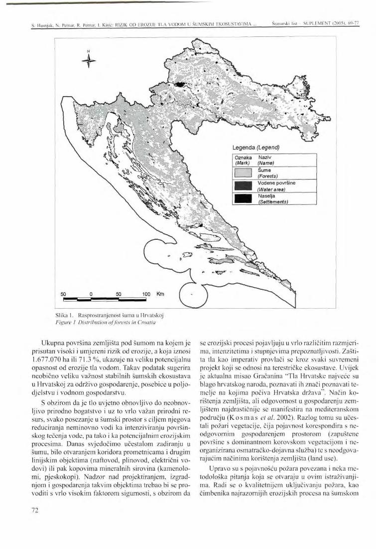
S. Husnjak. N. Pemar. R. Pernar, I. Kisić: RIZIK 01) EROZIJE TLA VODOM U ŠUMSKIM EKOSUSTAVIMA ... Šumarski list SUPLEMENT (2005). 69-77
Slika 1. Rasprostranjenost šuma u Hrvatskoj Figure 1 Distribution of forests in Croatia
Ukupna površina zemljišta pod šumom na kojem je prisutan visoki i umjereni rizik od erozije, a koja iznosi 1.677.070 ha ili 71.3 %, ukazuje na veliku potencijalnu opasnost od erozije tla vodom. Takav podatak sugerira neobično veliku važnost stabilnih šumskih ekosustava u Hrvatskoj za održivo gospodarenje, posebice u poljodjelstvu i vodnom gospodarstvu.
S obzirom daje tlo uvjetno obnovljivo do neobnovljivo prirodno bogatstvo i uz to vrlo važan prirodni resurs, svako posezanje u šumski prostor s ciljem njegova reduciranja neminovno vodi ka intenziviranju površinskog tečenja vode, pa tako i ka potencijalnim erozijskim procesima. Danas svjedočimo učestalom zadiranju u šumu, bilo otvaranjem koridora prometnicama i drugim linijskim objektima (naftovod, plinovod, električni vodovi) ili pak kopovima mineralnih sirovina (kamenolomi, pjeskokopi). Nadzor nad projektiranjem, izgradnjom i gospodarenja takvim objektima trebao bi se provoditi s vrlo visokim faktorom sigurnosti, s obzirom da
se erozijski procesi pojavljuju u vrlo različitim razmjerima, intenzitetima i stupnjevima prepoznatljivosti. Zaštita tla kao imperativ provlači se kroz svaki suvremeni projekt koji se odnosi na terestričke ekosustave. Uvijek je aktualna misao Gračanina "Tla Hrvatske najveće su blago hrvatskog naroda, poznavati ih znači poznavati temelje na kojima počiva Hrvatska država". Način korištenja zemljišta, ali odgovornost u gospodarenju zemljištem najdrastičnije se manifestira na mediteranskom području (Kosmas et al. 2002). Razlog tomu su učestali požari vegetacije, čija pojavnost korespondira s neodgovornim gospodarenjem prostorom (zapuštene površine s dominantnom korovskom vegetacijom i neorganizirana osmatračko-dojavna služba) te s neodgovarajućim načinima korištenja zemljišta (land use).
Upravo su s pojavnošću požara povezana i neka metodološka pitanja koja se otvaraju u ovim istraživanjima. Radi se o kvalitetnijem uključivanju požara, kao čimbenika najrazornijih erozijskih procesa na šumskom
72
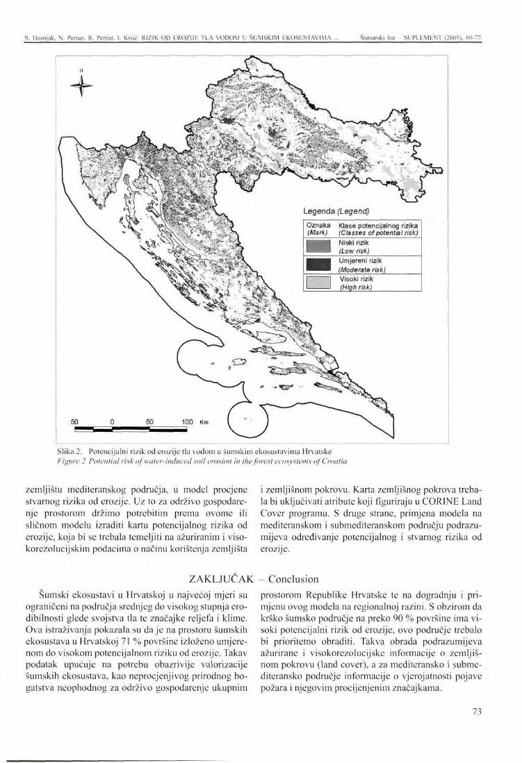
S. llusnjak. N. Pernar. R. Pernar. I. Kisić: RIZIK OD EROZIJE TLA VODOM U ŠUMSKIM EKOSUSTAVIMA Šumarski list - SUPLEMENT (2005), 69-77
i«*" J b T T
Legenda (Legend)
Klase potencijalnog rizika (Classes of potential risk) Niski rizik (Low risk) Umjereni rizik (Moderate risk) Visoki rizik (High risk)
G ?
"tS?*'
50 50 100 Km
Slika 2. Potencijalni rizik od erozije tla vodom u šumskim ekosustavima Hrvatske Figure 2 Potential risk of water-induced soil erosion in the forest ecosystems of Croatia
zemljištu mediteranskog područja, u model procjene stvarnog rizika od erozije. Uz to za održivo gospodarenje prostorom držimo potrebitim prema ovome ili sličnom modelu izraditi kartu potencijalnog rizika od erozije, koja bi se trebala temeljiti na ažuriranim i viso-korezolucijskim podacima o načinu korištenja zemljišta
i zemljišnom pokrovu. Karta zemljišnog pokrova trebala bi uključivati atribute koji figuriraju u CORINE Land Cover programu. S druge strane, primjena modela na mediteranskom i submediteranskom području podrazumijeva određivanje potencijalnog i stvarnog rizika od erozije.
ZAKLJUČAK - Conclusion Šumski ekosustavi u Hrvatskoj u najvećoj mjeri su
ograničeni na područja srednjeg do visokog stupnja ero-dibilnosti glede svojstva tla te značajke reljefa i klime. Ova istraživanja pokazala su daje na prostoru šumskih ekosustava u Hrvatskoj 71 % površine izloženo umjerenom do visokom potencijalnom riziku od erozije. Takav podatak upućuje na potrebu obazrivije valorizacije šumskih ekosustava, kao neprocjenjivog prirodnog bogatstva neophodnog za održivo gospodarenje ukupnim
prostorom Republike Hrvatske te na dogradnju i primjenu ovog modela na regionalnoj razini. S obzirom da krško šumsko područje na preko 90 % površine ima visoki potencijalni rizik od erozije, ovo područje trebalo bi prioritetno obraditi. Takva obrada podrazumijeva ažurirane i visokorezolucijske informacije o zemljišnom pokrovu (land cover), a za mediteransko i subme-diteransko područje informacije o vjerojatnosti pojave požara i njegovim procijenjenim značajkama.
73
S. Husnjak, N. Pernar. R. Pcrnar. I. Kisic: RIZIK OD EROZIJE TLA VODOM U ŠUMSKIM EKOSUSTAVIMA ... Šumarski list - SUPLHMHNT (2005). 69-77
LITERATURA - References CEC (Commission of the European Communities),
1992: COR1NE soil erosion risk and important land resources in the southern regions of the European Community. Brussels and Luxenbourgh, p97.
G e e s o n , N. A., C. J. Brand t , J. B. T h o r n e s , 2001: Mediteranean Desertification: A Mosaic of Processes and Responses. John Wiley & Sons, Ltd. 440 p.
G r a č a n i n , M., 1942: Tla Hrvatske. Zavod za Tloz-nanstvo Poljoprivrednog-šumarskog fakulteta, Zagreb.
G r a č a n i n , Z., 1962: Verbreitung und Wirkung der Bodencrozion in Kroatien. Giessener Abhandlungen zur Agrar und Wirtschaftsforschung des europaischen Ostens, Band 21, Giessen.
Husn jak , S., 1999: Digitalna karta rasprostranjenosti šuma u Republici Hrvatskoj, mjerila 1:300.000. CD, arhiva Zavoda za pedologiju na Agronom-skom fakultetu Sveučilišta u Zagrebu
H u s nj a k, S., 2000: Procjena rizika od erozije tla vodom metodom kartiranja u Hrvatskoj. Disertacija. Agronomski fakultet Sveučilišta u Zagrebu, 145 str.
K o s m a s , C, N. G. D a n a l a t o s , F. L ć p e z - B e r -müdez & M. A. Romero Diaz., 2002: The effect of Land Use on Soil Erosion and Land Degradation under Mediterranean Conditions. In: Geeson et al. (Ed): Mediteranean Desertification: A Mosaic of Processes and Responses, p. 57-70. John Wiley & Sons, Ltd. 440 p.
Mar t inov ić , J . , 1997: Tloznanstvo u zaštiti okoliša, Priručnik za inženjere, Državna uprava za zaštitu okoliša, Zagreb.
M a r t i n o v i ć , J., 2003: Gospodarenje šumskim tlima u Hrvatskoj, 1-525, Zagreb.
Sassa , K., 1998: Environmental Forest Science. Springer, 636 p.
Topic , V., 1995: Utjecaj šumske vegetacije na suzbijanje erozije u bujičnim slivovima mediteranskog područja Hrvatske, Šumarski list, 9-10: 299-304, Zagreb.
Topić , V., 1996: Utjecaj različitog biljnog pokrova na zaštitu tla od erozije, Unapređenjeproizvodnje biomase šumskih ekosustava, Znanstvena knjiga 1:361-364, Zagreb.
Top ić , V., 1999: Melioracijski učinci šumskih kultura na kršu u odnosu na pedosferu, Šumarski list, 9_10: 411-422, Zagreb.
Top i ć, V., 2000: Utjecaj ispaše i brsta koza na devastaciju šumske vegetacije i degradaciju tla na kršu (Sažeci znanstvenog skupa Unapređenje poljoprivrede i šumarstva na kršu s međunarodnim sudjelovanjem) Maleš, Petar; Maccljski, Milan (ur.). Zagreb: Hrvatska akademija znanosti i umjetnosti, 2000. 76-78
Topić , V., 2001: Utjecaj kultura crnog bora (Pinus nigra Arn.) na zaštitu tla od erozije prouzročene kišom, Znansot u potrajnom gospodarenju hrvatskim šumama, Znanstvena knjiga, 261-268, Zagreb.
Top i ć, V., 2003: Šumska vegetacija na kršu kao značajan čimbenik zaštite tla od erozije. Šumarski list CXXVII (posebni broj): 51-64. Zagreb.
Topić , V. & L. Bu to rac , 2004: Utjecaj šikare bijelog graba na zaštitu tla od erozije u Hrvatskoj. The risk of water-induced soil erosion in forest ecosystems of Croatia. Protuerozijska i vodoza-štitna uloga šume i postupci njezina očuvanja i unapređenja. Zagreb, 23. 11. 2004. Sažeci referata 5-6.
74
PRESENTATION AT THE INTERNATIONAL SYMPOSIUM Šumarski list - SUPLEMENT (2005), 69-77
RISK OF WATER-INDUCED SOIL EROSION IN THE FOREST E C O S Y S T E M S OF CROATIA
Stjepan HUSNJAK1, Nikola PERNAR2, Renata PERNAR2, Ivica KISIĆ1
Summary: The paper explores the risk of erosion processes in the forest ecosystems of Croatia, under a hypothetical assumption that there was no forest vegetation and that the areas were barren.
A digital map of potential erosion risk was used for the purpose of investigating the potential risk of water-induced soil erosion. The J:300,000 map covering the entire area of the Republic of Croatia was made in the CORINE programme.
The area was inventoried on the basis of the map. As much as 44.8 % of the forest ecosystem area faces a high risk of water-induced soil erosion, while 26.5 % of the area is threatened by a moderate erosion hazard. Apartfrom indicating the importance of non-commercial forest functions in Croatia, these data also highlight the fundamental starting points for a more objective assessment of such resources.
The paper discusses various difficulties and problems occurring in the assessment of erosion risks. Solutions are given for more objective estimates of both potential and actual hazards of water-induced soil erosion in forest ecosystems. Related to this, focus is placed on the necessity of constructing a high-resolution map of ground cover and determining potential erosion risks at a regional level. The probability of vegetation fire occurrence, as well as its features in the Mediterranean and sub-Mediterranean area should be discussed and realistic risks of erosion estimated.
Key w o rds: water-induced soil erosion, risk of soil erosion, soil erodi-bility, terrain erodibility, GIS
INTRODUCTION
Water-induced soil erosion is an extremely dangerous soil damage, which may cause most adverse im-
Stjepan Husnjak, Ph. D., Assistant Lecturer with the Faculty of Agronomy of Zagreb University, Institute of Pedology, Svetošimunska 25; [email protected] Ivica Kisić, Ph. D., Associate Professor with the Faculty of Agronomy of Zagreb University, Institute of general plant production, Svetošimunska 25; [email protected]
" Nikola Pernar, Ph. D., Associate Professor with the Faculty of Forestry of Zagreb University, Institute of Ecology and Silviculture, Svetošimunska 25; [email protected] Renata Pernar, Ph. D., Assistant Lecturer with Faculty of Forestry of Zagreb University, Institute of Silviculture; [email protected]
pacts upon the total economic development. These impacts are directly demonstrated in agriculture and water management. According t o M a r t i n o v i ć (1997), soil is exposed to water erosion on about 90 % of Croatian territory. G r a č a n i n (1962) wrote that the chief erosion factors in Croatia are relief, lithological structure (parent rock), climate, vegetation cover, anthropogenic impacts and soil properties. In a sustainably managed forest there is practically no accelerated erosion. Instead, only normal erosion takes place, with a degradation impact that is less significant than the progression effects of pedogenctic processes ( M a r t i n o v i ć 2003).
The extensive research carried out by Topic and collaborators in the Mediterranean and sub-Mediterranean regions of Croatia ( T o p i c 1995, 1996, 1999,2001,
75
S. Husnjak. N. Pcrnar. R. Pcrnar. I. Kisić: RISK OF WATER-INDUCEU SOIL EROSION IN THE FOREST ... Šumarski list SUPLEMENT (2005). 69-77
Topic andButorac 2004) witnesses the significance of forest vegetation in soil protection from erosion.
The same author used other interesting research results to point at the aspects of direct anthropogenetic impacts caused by the chosen purpose and land use (Topic, 2000). About one million hectares forests and forest lands of the Mediterranean and sub-Mediterranean region are exposed to increased risk of erosion processes, while forest fires are regularly followed by erosion in spring and summer months.
As a rule, erosion processes occur as soil loss, i.e. the removal of the surface humus horizon and, frequently, the lower horizons, causing degradation, or complete loss of the individual soil functions. The secondary effects include increased quantity of powder particles in canals, rivers, accumulations, and basins such as seas and lakes, and the covering of the lower relief locations by erosion sediments. The frequent dry periods, the loss of forest vegetation, and the desertification processes are connected with soil erosion, either as potential, or actual risks (S a s s a 1998, G e e s o n et al. 2001).
Indices of potential soil erosion risks based on common criteria are necessary for good valorisation of forest ecosystems at national and regional levels, and also for creating economic guidelines according to sustainable development.
A digital map of potential erosion risks to a scale of 1:300,000 (Husnjak, 2000)3 was used in the research.
The map of the texture, depth and stone contents of the soil was made according to the data of the mapped soil units from the Basic pedological map of the Republic of Croatia, scale 1:50,000, based on the soil texture data of the dominant systematic soil unit within the individual cartographic unit of the Practical pedological map of the Republic of Croatia, scale 1:300,000, as well as by using the database composed of 1,088 representative pedological profiles made especially for the water-induced soil erosion risk estimates. The Soil erodibility map was made by using the calculated ero-dibility index made by the method of integrating the maps with the classes of texture, depth, and stone contents of the soil.
The index of precipitation variability was determined according to the modified Fournier index (FI), while the aridity index was made on the basis of the Bagnouls-Gaussen Index (BGI), both for seventy cli-matologic stations. According to the mentioned indi-
' The detailed map-making methodology is already presented in the quoted study, so that we bring it here in a summarised form.
The potential risk of water-induced soil erosion is defined as the basic susceptibility of the soil to water-induced soil erosion, regardless of the vegetation cover and land use, i.e. presuming that the soil is not protected by vegetation. This means that the estimate of the potential risks of water-induced soil erosion is based on the assumption that the whole research area is used as arable land. By knowing the potential risks, it is possible to efficiently reduce the real risks and extents of the existing erosion processes through legal/economic measures and spatial planning.
The permanent vegetation cover maintains the structure and increases the water infiltration capacity of the soil; it also stimulates the run-off of excessive water. Permeating the soil, the root system prevents its sudden erosion.
This paper does not deal with direct measurements and effects of erosion. Instead, it presents the calculated indices of the predispositions to erosion on the whole forest area of Croatia.
The first part of the paper presents the estimates of the potential water-induced risks of soil erosion. The second suggests the possibilities of applying the model to the improved estimates of erosion risks.
ccs, wc made maps of precipitation variability and climatic aridity, the integration of which was used with the index calculation to make the Map of precipitation erosiveness.
Map of terrain inclination was made by using the contour lines with an equidistance of 50 m.
Map of potential threat of water-induced soil erosion was then made by integrating the maps of soil erodibility classes, precipitation erosiveness, and terrain inclination, with the calculation of the potential risk index.
The estimate of the potential water-induced soil erosion risk was determined for the whole territory of the Republic of Croatia, according to the programme CORINE (Coordination of Information on the Environment). This is a qualitative cartographic method based on overlapping the individual thematic maps according to the following scheme:
By overlapping this map with the map of forest distribution (Husnjak, 1999) the map of potential erosion risks was made for the forest ecosystem areas in Croatia. The overlapping and later area inventory were carried out by using the GIS tools NT Arc Info programme package.
METHODS
76
S. Husnjak. N. Pernar, R. Pernar, 1. Kisić: RISK OF WATER-INDUCED SOIL EROSION IN THE FOREST ... Šumarski list - SUPLEMENT (2005). 69-77
RESULTS AND DISCUSSION
The potential risks of soil erosion is defined as the basic susceptibility of the soil to water-induced erosion in a given constellation of pedogenic factors, regardless of the vegetation cover and land use. The potential risk is the worst possible case, where the estimate of the potential risk of water-induced erosion is based on the assumption that the whole research area has no vegetation cover. Under such presumption, the crucial factors are soil erodibility, precipitation erosiveness, and terrain inclination. By overlapping the thematic maps of these factors within the space of forest ecosystems (Figure 1), we developed a map the areas of which were indexed in relation to the potential risks of erosion processes (Figure 2).
This research revealed that under such presumptions 44.8 % of forest ecosystems in Croatia would be exposed to high potential risks of erosion, while 26.5 % of the area would be exposed to moderate risks (Table 1).
The lowland areas and those with mild inclinations belong to the low risk class. Even on such areas, where there is no vegetation, some erosion processes take place, primarily as torrential or splash erosion caused by the effect of "bombing" or "shattering" the soil by raindrops. Such processes are slow and difficult to recognise. Over the slopes with higher inclination than 3 %, where the soil is "naked", sheet erosion takes place.
The total forest area with high and moderate erosion risk amounts to 1,677,070 ha, or 71.3 %, indicating a high potential threat of water-induced soil erosion and the great significance of stable forest ecosystems for sustainable management, particularly related to agriculture and water management.
Considering that soil is a conditionally renewable nature's asset, and also a significant natural resource,
Croatian forest ecosystems arc mainly limited to the areas of moderate to high degrees of erodibility according to soil properties and relief/climate characteristics. The research has shown that 71 % of the forest ecosystem area is exposed to moderate and potentially high erosion risk. This requires more careful valorisation of forest ecosystems as priceless natural assets, indispensable for sustainable management of the whole
any exploitation of forests aimed at their reduction leads to intensified runoffs and potential erosion processes. Today we witness massive encroachments on the forest, either by opening the corridors for roads, oil/gas/electric lines, or the mineral raw material mines. The supervision of the design, construction and manangement of such developments should be carried out by applying high security factors, because erosion processes occur to various extents, intensities and degrees of recognition. Soil protection is an imperative with any modern project made for terrestrial ecosystems. We should bear in mind what Gračanin said: "Croatian soils are the greatest national riches. To know them means to understand the foundations on which Croatia lies". The land use and the responsibility of land management are most drastically illustrated by the Mediterranean region (K o s m a s etal. 2002), with the forest fires the high frequency of which corresponds with irresponsible management methods (neglected areas with dominant weed vegetation and unorganised watch-information service) and inadequate ways of land use.
The frequent fires are the objects of some methodological issues related to this research. The factor of the most destructive erosion processes on the Mediterranean forest areas, fire should be included into the model of estimating the real erosion risk. In addition, sustainable management should be supported by developing a map of potential erosion risks, based on updated and high-resolution data on the ways of land use and land cover. The map of land cover should include the attributes of the CORINE Land Cover programme. On the other hand, the application of the model to the Mediterranean and sub-Mediterranean areas presumes the assessment of both potential and real risks of erosion.
Croatian territory, and the application of this model at regional level. Considering that the 90 % of the karst area is under potential erosion risk, this region should be regarded as a priority in the process of developing the updated high-resolution data on the land cover. The Mediterranean and sub-Mediterranean regions should be treated in relation to forest fires and their estimated characteristics.
CONCLUSION
77
IZLAGANJE NA ZNANSTVENOM SKUPU - PRESENTATION AT THE INTERNATIONAL SYMPOSIUM Šumarski list - SUPLEMENT (2005), 78-89 UDK 630* 372 + 377 +116
Š U M S K A ŽIČARA LARIX - N J E N A U L O G A U PRIRODI BLISKOM G O S P O D A R E N J U Š U M A M A I POSEBICE
U SPRJEČAVANJU EROZIJE TLA
LARIX FOREST CABLEWAYS - IMPLEMENT OF NATURE ORIENTED SILVICULTURE, ESPECIALLY
IN SOIL EROSION CONTROL
Premysl HOREK, Pavel MAUER, Lubomir NOVAK*
SAŽETAK: Moderna kretanja u ekološki orijentiranom europskom šumarstvu uvode promjene u izboru metoda sječe i ističu kao najvažniji kriterij brigu za šumski okoliš. Otprilike 80 % štete na tlu, stablima i poniku nastale tijekom sječe otpada na izvlačenje - transport drva od sastojim do glavne šumske ceste. Postupci izvlačenja koji vode računa o okolišu, a stoje svakako zračni transport po žici, predstavljaju ekološku metodu iskorištavanja drva. Osim toga, šumsko tlo pošteđeno je kompresije i abrazije.
Danas se prednost daje prebornom gospodarenju, a ne obnovi čistim sječama. Cilj takvog gospodarenja je smanjiti elemente čiste sječe u češkim šumama i uvesti finije sustave gospodarenja šumama. Preborni sustav je učinkovit kod prirodne obnove u povoljnim prirodnim uvjetima. Za tu se svrhu na teškim terenima svih vrsta koristi moderno dizajnirana šumska žičara, koja općenito vodi računa o okolišu putem zračnog izvlačenja uzetom.
Model radnih postupaka koji uključuje načela ostvarivanja ciljeva prirodne obnove šumske sastojine korištenjem izvlačenja uzetom s nekoliko tipova šumskih žičara LARIX, pokazuje se na primjeru dugoročne uspješne prirodne obnove bukovih sastojina u Šumskom centru Masaryk, Krtiny, Mendelevo sveučilište poljoprivrede i šumarstva (Masaryk Forest Training Forest Enterprise Krtiny, Mendel University of Agriculture and Forestry) u Brnu, koje je provedeno bez oštećivanja stabala ili tla.
K Ij u č n e r ij e č i: prirodi blisko šumarstvo, mehanizacija sječe i privlačenja, sustavi šumskih žičara LARIX, kontrola erozije tla.
1. UVOD - Introduction
Tri su objektivna razloga što će ubrzati razvoj tehnologija privlačenja žičarom u bivšoj Čehoslovačkoj: 1. Godine 2000. sječa oblovine prelazila 15 milijuna
m , no volumen trupaca privučenih žičarama nije bio iznad 300 tisuća m3, stoje samo 2 % ukupne količine, s terenima u nagibu preko 40 % i terenima s nosivim kapacitetom nepovoljnim za traktore (trese-
* Premysl llorek, Pavel Mauer, Lubomir Noväk Mendelovo sveučilište poljoprivrede i šumarstva, Brno Pokusno šumsko poduzeće Masarykova šuma u Krtiny
tišta), što predstavlja najmanje 10 % ukupne šumske površine.
2. Postoji oko 90 šumskih žičara različitih tipova za koje se zna da trenutno rade, a većina njih je zastarjele konstrukcije. Moderne žičare domaće proizvodnje (tip LARIX) postepeno osvajaju lokalno tržište od 1996.
3. U uvjetima mijenjanja šumskog gospodarenja sve je veći naglasak na tehnologije prilagođene šumi (blage), a privlačenje žičarom je bez ikakve sumnje jedna od najblažih metoda.
78
P. Horek, P. Mauer, L. Novak: ŠUMSKA ŽIČARA LAR1X - NJENA ULOGA U PRIRODI BLISKOM ... Šumarski list - SUPLEMENT (2005), 78-89
Promjena uvjeta u češkim šumama uključuje smanjeni obujam elemenata čiste sječe, zagovaranje blažih i obzirnijih metoda gospodarenja, tj. prebornom gospodarenju daje se prednost pred obnovom čistom sječom. Dozvole li prirodni uvjeti, preborni sustav djeluje zajedno s prirodnom obnovom. Teški i nagnuti tereni traže izvlačenje žičarom. Na tim teškim terenima metoda prirodne obnove šume pomoću žičara obično se više isplati zbog većih ekoloških i ekonomskih utjecaja nego stoje to metoda prirodne obnove, budući da sustav obnove čistom sječom na nagnutim terenima nosi značajan rizik za šumski okoliš, te je skuplji. Međutim,
Model radnih postupaka i potrebnih načela za postizanje ciljeva prirodne obnove sastojina uz uporabu izvlačenja žičarom LARIX moguće je demonstrirati na primjeru dugoročne uspješne prirodne obnove bukovih sastojina u Obrazovnom šumskom poduzeću (OŠP) Masaryk u Krtiny, Mendelevog sveučilišta za poljoprivredu i šumarstvo u Brnu. Poduzeće je osnovano prije 81 godinu kao ustanova posebne namjene, služeći uglavnom Fakultetu za šumarstvo i drvnu tehnologiju za pedagoške znanstvene i verifikacijske zadatke.
OŠP djeluje na 10300 hektara šume, što tvori neprekinuti kompleks u neposrednoj vezi sa sjevernim granicama grada Brna. Šumske sastojine nalaze se na visinama između 210 m i 575 m. Prosječna godišnja temperatura je 7,5 °C, srednje godišnje oborine dosežu 610 mm, a tek 360 mm u vrijeme vegetacije. Matična podloga je granodiorit u zapadnom dijelu Poduzeća, de-vonski vapnenac u središnjem, te kulmijanski sivi pješčanik (gravaks) u istočnom. Topografija je sustavno prekidana s izrazitim dubokim dolinama rijeke Svitave i potoka Krtinsky, te brojnim postranim dolinama i va-lama. Strmine od preko 34 % čine do jedne četvrtine područja Poduzeća, što samo po sebi govori o dobrom razlogu strukovnog interesa za šumske žičare. Raznolikost prirodnih uvjeta je znatna i neupitna u Češkoj na tako malom području. Pretežito su tu mješovite sastojine u kojima su 46 % crnogorične vrste drveća, a 54 % listače. Glavne vrste drveća su smreka, bor, ariš, bukva i hrast. Obrazovno šumsko poduzeće u Krtini ima dugu tradiciju primjene blažih metoda šumskog gospodarenja specijaliziranog u primjeni prirodne obnove. Metode blagog šumskog gospodarenja primijenjivane tijekom dugog vremena uključuju sustav malih sječnih površina i njihovih oblika obnove s oplodnim sijekom i rubnom sječom, ali isto tako primjenu načela prebor-nog gospodarenja.
Mnogi su slavni šumari ovdje radili, kao Leopold G r a b n e r - š e f Šumskog područja, što je nekada bilo u
to se sprječava uporabom odgovarajućih uzgojnih postupaka kao što je sječa u prugama (prema prof. Polan-sky) i sa šumskom žičarom moderne konstrukcije (vidi slika 1). Moderna žičara mora biti vrlo mobilna i jednostavna za sastavljanje. Njena uporaba je djelotvorna čim se radi o najmanje 50 m drva u jednoj operaciji sječe. Osim toga, standardna žičara mora biti opremljena radio kontrolom od mjesta pričvršćivanja tereta u sastojini, jer je to jedini način kako odabrati radne postupke s minimalnom štetom za pomladak, razvijeni mladik i drveće matične sastojine.
vlasništvu obitelji Liechtenstein, koji je 1848-1897. g. uveo projekt prema kojemu su šume bile tako poredane, da su svakih deset godina iznova bile obrađivane u pet elaborata šumsko-gospodarstvenih planova za kontrolni sustav Saske prema Cotti. Čiste sječe bile su postupno smanjivane i zamjenjivane blagim oplodnim sječama u odjelima, tj. prebornim sječama. Jak naglasak štavljenje na mjere njege, koje su do tog vremena bile zanemarene.
Drugi istaknuti šumar bio je Julius Wiehl , koji je izradio gospodarski plan modernog koncepta na prijelazu 19. u 20. stoljeće, po kojemu je uveden sustav uravnoteženih dobnih razreda i gospodarenje prema sasto-jinama. Julius Wiehl je namjerno prihvatio oblik oplod-ne sječe u malim površinama jednodobnih sastojina. Ta je metoda značila prirodnu koncepciju kreativne i sa-moodržive šume.
Imena šumara što su radili u šumama OŠP u modernoj povijesti i danas su profesori K o n s e l , Hasa , O p l e t a l , P o l a n s k y , D o l e z a l , V y s k o t , T e s a r i Kantor . Oni su osobno doprinijeli detaljnoj preciznosti posebne metode gospodarenja bukvom u sustavu oplodne sječe, koja postupno prelazi u rubni sijek. Ta se metoda snažno proširila posljednjih deset godina čak i na teškim terenima, zahvaljujući primjeni žičara LARIX.
Dobro je gospodarenje bukovim sastojinama u OŠP također potvrđeno činjenicom, daje OŠP vlasnik certifikata Woodmark FSC za sirovo i piljeno drvo, dodijeljeno poduzeću prije sedam godina, a od 2003. posjeduje i PEFC.
Posebna metoda obnove i njege bukove sastojine primijenjena u Obrazovnom šumskom poduzeću usmjerena je na maksimalno korišćenje prirodne obnove i prirasta. Bukove sastojine obnavljaju se u relativno dugom (do 40 godina i više) razdoblju. Sa sadašnjim razdobljem ophodnje od 130 godina, prve se odrasle šume pojavljuju već u sastojinskoj dobi od 90 godina. Stoga je potrebno stvoriti uvjete za rast i samooplodnju, te
2. PRAKTIČNA ISKUSTVA IZ OBRAZOVNOG ŠUMSKOG PODUZEĆA MASARYK U KRTINY
Practical experience from the Masaryk forest training enterprise at Krtiny
79
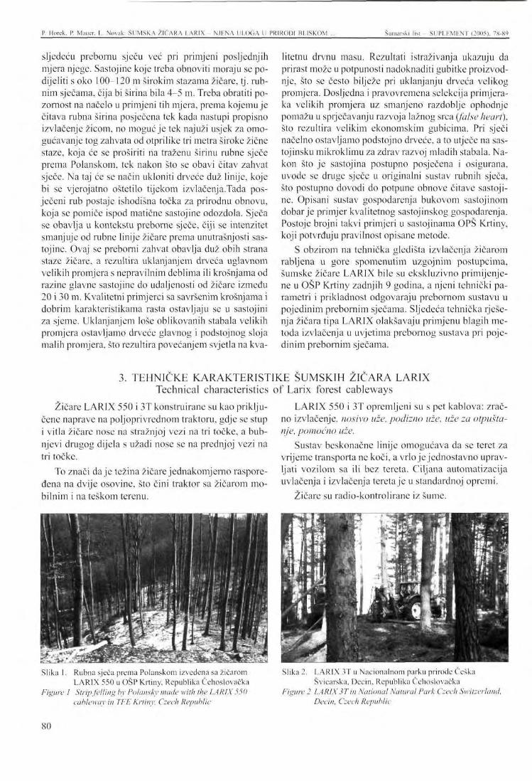
P. Horek. P. Mauer, L. Novak: ŠUMSKA Ž1ČARA LAR1X - NJENA ULOGA U PRIRODI BLISKOM ... Šumarski list - SUPLFMLNT (2005). 78-89
sljedeću prebornu sječu već pri primjeni posljednjih mjera njege. Sastojinc koje treba obnoviti moraju se podijeliti s oko 100-120 m širokim stazama žičare, tj. rubnim sječama, čija bi širina bila 4-5 m. Treba obratiti pozornost na načelo u primjeni tih mjera, prema kojemu je čitava rubna širina posječena tek kada nastupi propisno izvlačenje žicom, no moguć je tek najuži usjek za omogućavanje tog zahvata od otprilike tri metra široke žične staze, koja će se proširiti na traženu širinu rubne sječe prema Polanskom, tek nakon što se obavi čitav zahvat sječe. Na taj će se način ukloniti drveće duž linije, koje bi se vjerojatno oštetilo tijekom izvlačenja.Tada posječeni rub postaje ishodišna točka za prirodnu obnovu, koja se pomiče ispod matične sastojine odozdola. Sječa se obavlja u kontekstu preborne sječe, čiji se intenzitet smanjuje od rubne linije žičare prema unutrašnjosti sastojine. Ovaj se preborni zahvat obavlja duž obih strana staze žičare, a rezultira uklanjanjem drveća uglavnom velikih promjera s nepravilnim deblima ili krošnjama od razine glavne sastojine do udaljenosti od žičare između 20 i 30 m. Kvalitetni primjerci sa savršenim krošnjama i dobrim karakteristikama rasta ostavljaju se u sastojini za sjeme. Uklanjanjem loše oblikovanih stabala velikih promjera ostavljamo drveće glavnog i podstojnog sloja malih promjera, što rezultira povećanjem svjetla na kva-
Slika 1. Rubna sječa prema Polanskom izvedena sa žičarom LARIX 550 u OŠP Krtiny, Republika Čehoslovačka
Figure 1 Strip felling by Polansky made with the LARIX 550 cableway in TFE Krtiny, Czech Republic
litetnu drvnu masu. Rezultati istraživanja ukazuju da prirast može u potpunosti nadoknaditi gubitke proizvodnje, što se često bilježe pri uklanjanju drveća velikog promjera. Dosljedna i pravovremena selekcija primjeraka velikih promjera uz smanjeno razdoblje ophodnje pomažu u sprječavanju razvoja lažnog srca (false heart), što rezultira velikim ekonomskim gubicima. Pri sječi načelno ostavljamo podstojno drveće, a to utječe na sas-tojinsku mikroklimu za zdrav razvoj mladih stabala. Nakon što je sastojina postupno posječena i osigurana, uvode se druge sječe u originalni sustav rubnih sječa, što postupno dovodi do potpune obnove čitave sastojine. Opisani sustav gospodarenja bukovom sastojinom dobar je primjer kvalitetnog sastojinskog gospodarenja. Postoje brojni takvi primjeri u sastojinama OPŠ Krtiny, koji potvrđuju pravilnost opisane metode.
S obzirom na tehnička gledišta izvlačenja žičarom rabljena u gore spomenutim uzgojnim postupcima, šumske žičare LARIX bile su ekskluzivno primijenjene u OŠP Krtiny zadnjih 9 godina, a njeni tehnički parametri i prikladnost odgovaraju prebornom sustavu u pojedinim prebornim sječama. Sljedeća tehnička rješenja žičara tipa LAR1X olakšavaju primjenu blagih metoda izvlačenja u uvjetima prebornog sustava pri pojedinim prebornim sječama.
Slika 2. LARIX 3T u Nacionalnom parku prirode Češka Švicarska, Decin, Republika Čehoslovačka
Figure 2 LARIX 3T in National Natural Park Czech Switzerland, Decin, Czech Republic
3. TEHNIČKE KARAKTERISTIKE ŠUMSKIH ZICARA LARIX Technical characteristics of Larix forest cableways
Žičarc LARIX 550 i 3T konstruirane su kao priključene naprave na poljoprivrednom traktoru, gdje se stup i vitla žičare nose na stražnjoj vezi na tri točke, a bubnjevi drugog dijela s užadi nose se na prednjoj vezi na tri točke.
To znači daje težina žičare jednakomjerno raspoređena na dvije osovine, što čini traktor sa žičarom mobilnim i na teškom terenu.
LARIX 550 i 3T opremljeni su s pet kablova: zračno izvlačenje, nosivo uže, podizno uže, uže za otpuštanje, pomoćno uže.
Sustav beskonačne linije omogućava da se teret za vrijeme transporta ne koči, a vrlo je jednostavno upravljati vozilom sa ili bez tereta. Ciljana automatizacija uvlačenja i izvlačenja tereta je u standardnoj opremi.
Žičare su radio-kontrolirane iz šume.
S0
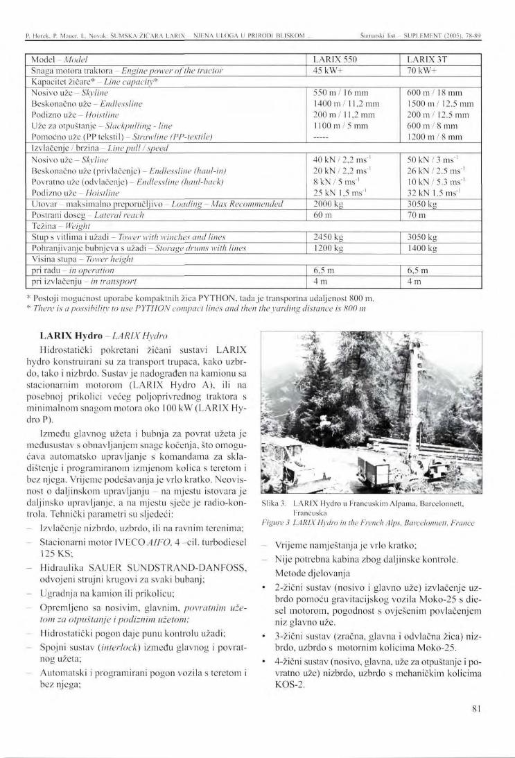
P. Horek. P. Mauer. L. Novak: ŠUMSKA ŽIČARA LARIX N.ILNA ULOGA U PRIRODI BLISKOM ... Šumarski list - SUPLF.MF.NT (2005). 78-89
Model - Model Snaga motora traktora - Engine power of the tractor
LARIX 550 45kW+
LARIX 3T 70kW+
Kapacitet žičare* - Line capacity* Nosivo uže - Skyline Beskonačno uže - Endlessline Podizno uže - Hoistline Uže za otpuštanje - Slackpulling - Une Pomoćno uže (PP tekstil) - Strawline (PP-textile)
550 m / 16 mm 1400 m / 11,2 mm 200 m/11 ,2 mm 1100 in / 5 mm
600 m / 18 mm 1500 m / 12.5 mm 200 m / 12.5 mm 600 m / 8 mm 1200 m / 8 mm
Izvlačenje / brzina - Line pull /speed Nosivo uže - Skyline Beskonačno uže (privlačenje) - Endlessline (haul-in) Povratno uže (odvlačenje) - Endlessline (haul-back) Podizno uže - Hoistline Utovar - maksimalno preporučljivo - Loading - Max Recommended Postran i doseg - Lateral reach
40 kN/2 ,2 ms-' 20 kN/2 ,2 ms"1
8 kN / 5 ms"' 25 kN 1,5 m s ' 2000 kg 60 m
50 kN / 3 ms'1
26 k N / 2.5 ms'1
10 k N / 5 . 3 ms-' 32 kN 1.5 ms'1
3050 kg 70 m
Težina - Weight Stup s vitlima i užadi - Tower with winches and lines Pohranjivanje bubnjeva s užadi - Storage drums with lines
2450 kg 1200 kg
3050 kg 1400 kg
Visina stupa Tower height pri radu - in operation pri izvlačenju - in transport
6,5 m 4 m
6,5 m 4 m
* Postoji mogućnost uporabe kompaktnih žica PYTHON, tadaje transportna udaljenost 800 m. * There is a possibility to use PYTHON compact lines and then the yarding distance is 800 m
LARIX Hydro - LARIX Hydro Hidrostatički pokretani žičani sustavi LARIX
hydro konstruirani su za transport trupaca, kako uzbrdo, tako i nizbrdo. Sustav je nadograđen na kamionu sa stacionarnim motorom (LARIX Hydro A), ili na posebnoj prikolici većeg poljoprivrednog traktora s minimalnom snagom motora oko 100 kW (LARIX Hydro P).
Između glavnog užeta i bubnja za povrat užeta je međusustav s obnavljanjem snage kočenja, što omogućava automatsko upravljanje s komandama za skladištenje i programiranom izmjenom kolica s teretom i bez njega. Vrijeme podešavanja je vrlo kratko. Neovisnost o daljinskom upravljanju - na mjestu istovara je daljinsko upravljanje, a na mjestu sječe je radio-kon-trola. Tehnički parametri su sljedeći:
Izvlačenje nizbrdo, uzbrdo, ili na ravnim terenima; Stacionarni motor IVECO AIFO, 4 -eil. turbodiesel 125 KS; Hidraulika SAUER SUNDSTRAND-DANFOSS, odvojeni strujni krugovi za svaki bubanj; Ugradnja na kamion ili prikolicu; Opremljeno sa nosivim, glavnim, povratnim uzetom za otpuštanje ipodiznim uzetom; Hidrostatički pogon daje punu kontrolu užadi; Spojni sustav (interlock) između glavnog i povratnog užeta; Automatski i programirani pogon vozila s teretom i bez njega;
Slika 3. LARIX Hydro u Francuskim Alpama, Barcelonnett, Francuska
Figure 3 LARIX Hydro in the French Alps, Barcelonnett, France
Vrijeme namještanja je vrlo kratko; Nije potrebna kabina zbog daljinske kontrole. Metode djelovanja
• 2-žični sustav (nosivo i glavno uže) izvlačenje uzbrdo pomoću gravitacijskog vozila Moko-25 s die-sel motorom, pogodnost s ovješenim povlačenjem niz glavno uže.
• 3-žični sustav (zračna, glavna i odvlačna žica) nizbrdo, uzbrdo s motornim kolicima Moko-25.
• 4-žični sustav (nosivo, glavna, uže za otpuštanje i povratno uže) nizbrdo, uzbrdo s mehaničkim kolicima KOS-2.
81
P. llorek. P. Mauer. L. Novak: ŠUMSKA ŽIĆARA LAR1X NJliNA ULOGA U PRIRODI BLISKOM ... Šumarski list - SUPLEMENT (2005). 78-89
Tehnički podaci za LARIX Hydro Technical data LARIX Hydro
Motor Engine Kapaciteti bubnja -Drum capacities Nosivo uže 0 18 mm kompakt Skyline 018 mm compact Vučno uže 0 10 mm kompakt Main line 010 mm compact Povratno uže 0 10 mm kompakt Back line 0 10mm compact Uže za otpuštanje 0 6 mm Slack pulling line 0 6 mm Podizno uže 0 8 mm polyprop. Rig up line 0 8 mm polyprop. Sidrena užad 0 18 mm - Guy lines 0 18 mm Vučna sila - Pulling capacity Nosivo uže - konstantni napon Skyline - constant tension Vučno uže - Main line Povratno uže - Haul back line Uže za otpuštanje Slack pulling line
2-žična metoda 2-line method
uzbrdo - uphill
3-žična metoda 3-line method
4-žična metoda 4-line method
uzbrdo, nizbrdo - uphill, downhill IVECO AIFO, 4-cil. turbo diesel, 95 Kw - 4-cyl. turbo diesel, 95 kW
700 m
750 m
—
—-
1100 m
4 x 60 m
90 kN
32 kN
700 m
1550 m
750 m
1100 m
4 x 60 m
90 kN
32 kN 32 kN
700 m
750 m
1500 m
700 m
1100 m
4 x 60 m
90 kN
32 kN 32 kN lOkN
Brzina - Line speed varijabla - variable 0 - 7 m.s - 1 Visina stupa - Tower height 9 m
4 žični sustav s ovješenom žicom „ .. „ . 4 line system with slack pulling line Kolica- Carriage . „ . . . •
*,^,,^ - - 2-1 3-zicm sustav s motorom M O K O - 2 5 „
2 and 3 line system with engine , _ , elektronska kontrola kabla - electronic cable control
Kontrola- Control . . . . . . . . . . ,. , , - , , , - , daljinska radio-kontrola s mjesta utovara remote radio control from the loading place
Ukupna težina bez traktora - without carrier 8600 kg Total weight s prikolicom — with trailer 11200 kg
Kolica MOKO-25 - Carriage MOKO-25 Kolica su namijenjena žičarama opremljenim no- uličnu crpku. Motor pokreće opremu za ovješeno iz-
sivim, vučnom, povratnim, ili samo nosivim i nosivom vlačenje niz glavno uže, te također hidraulični sustav užadi. Kolica MOKO-25 ima ugrađen dicscl motor od za sidrenje kolica na nosivo uže, te za osiguranje tereta 5.5 kW (Lombardini), komandnu radio-stanicu i hidra- na željenu poziciju ispod nosivog užeta.
82
P. Horek, P. Mauer, L. Novak: ŠUMSKA ŽIČARA LAR1X - NJENA ULOGA U PRIRODI BLISKOM Šumarski list SUPLFMLNT (2005), 78-89
Slika 4. Kolica MOKO-25 u Orlicke hory, Destna, Republika Čehoslovačka
Figure 4 Carriage MOKO-25 in Orlicke hory, Destna, Czech Republic
snaga motora 5,5 kW utovar maks. 2500 kg
- snaga otpuštanja 4,2 kN uporaba dizclskog ulja na 8 sati maks. 2 1
- težina 560 kg
Kolica KOS-2 - Carriage KOS -2 Kolica su mehanička. Namijenjena su žičarama
opremljenim nosivim uzetom (promjera od 16 mm do 20 mm), vučnim kablom (10-13 mm), povratnim uzetom (10-13) i uzetom za otpuštanje (5-6 mm). Kolica KOS pružaju ovješeno povlačenje kraja vučnog užeta od kolica pomoću pomoćnog kabla.
maksimalni utovar 3000 kg - težina 245 kg
Zašto dati prednost sječi sa zračnim izvlačenjem? Otprilike 80 % oštećenja tla, drveća i mlade šume
tijekom postupka sječe otpada na zahvat izvlačenja -prijevoz trupaca iz sastojine do glavne šumske ceste. Zahvat izvlačenja prilagođen okolišu stoga predstavlja ekološku metodu sječe.
Metode okolišno usklađenog izvlačenja trupaca iz šumske sastojine smanjuje ili eliminira vuču trupaca po površini šumskog tla, kao što su sustavi polupodig-nutog ili zračnog izvlačenja. Ostale metode što u tehničkom smislu dolaze u obzir uključuju helikoptersku izvlačenje, koje je krajnje skupo, jer ima ogromnu potrošnju energije, a zračno izvlačenje je oko 2 do 3 puta jeftinije, a može se primijeniti bez bitnih vremenskih ograničenja, istovremeno je bitno manje bučno, ne ometa niti izaziva stres kod divljači, ptica ili ljudi.
Slika 5. Kolica KOS u Parku prirode Cerdanya, La Molina. Španjolska
Figure 5 Carriage KOS in Cerdanya Natural Park, La Molina, Spain
Slika 6. LARIX 3T + MOKO-25 u OŠP Krtiny, Republika Čehoslovačka
Figure 6 LARIX3T+ MOKO-25 in TFE Krtiny, Czech Republic
Osim smanjenih zahtjeva u smislu gustoće mreže šumskih puteva (u slučaju zračnog izvlačenja cestovni je razmak 800 - 1000 m, a u slučaju izvlačenja traktorom, taj razmak je 100 m), sustav šumskih zračnih žica i njihovo djelovanje ne uzrokuje nikakvo oštećenje šumskog tla kompresijom ili abrazijom, kao što se često vidi pri uporabi tehnologija s kotačima (traktor) u šumskim sastojinama. Povećana erozija tla prometom zbog transmisije sila iz guma vozila na tlo, te posljedičnih dugoročnih oštećenja šumskog tla jednostavno se ne pojavljuje u slučaju uporabe šumskih žičara.
Nažalost, općenito je mišljenje šumara da su šumske žičare primijenjivc samo u planinskim regijama. To nijc sasvim istina u današnje vrijeme, jer šumske se žičare mogu rabiti s obzirom na njihov višestruki karakter, ne samo na svim terenima žičara u planinskim i
4. ZAKLJUČAK - Conclusion
83
P. Horck. P. Mauer, L. Novak: ŠUMSKA ŽIČARA LARIX NJENA ULOGA U PRIRODI BLISKOM Šumarski list - SUPLEMENT (2005). 78-89
gorskim krajevima, nego isto tako i u ravnicama, gdje tereni mogu biti nepristupačni za vozila na kotače ili prugu (traktore) zbog pojave velikih močvara, tresc-tišta, pustopoljina, procjepa, usjeka, stijena, ili su dane šumske sastojine pogođene katastrofalnim poplavama. Uzmemo li u obzir sve negativne utjecaje i kriterije uporabe traktora na padinama, te ih povežemo sa stvarnim kapacitetom nosivosti tla, udjel terena sa žičarom može se nadalje povećavati zbog okolišnih gledišta te s obirom na zaštitu tla. Na taj će način tehnologija šumske žičare često predstavljati jedino realistično rješenje za ekološki prilagođeno izvlačenje i tehnologiju prijevoza trupaca.
Obrazovno šumsko poduzeće Sume Masaryk u Kr-tiny u sklopu Sveučilišta za poljoprivredu i šumarstvo Mendel u Brnu održava dugu tradiciju primjene blažih
D o l e z a l , B., J. T ruh la r : Analysis of forest management systems used at the Training Forest Enterprise Krtiny. Vol. I - III. (in Czech) University of Agriculture in Brno, Brno, 1990: p. 858
Truh la r , J.: Silviculture in biological conception, (in Czech) Training Forest Enterprise of Masaryk Forest at Krtiny, Mendel Univ. of Agriculture and Forestry Brno, Krtiny, 1996: p. 117 + attachments
N o v ä k, L.: Development and manufacture of skyline cableways in the Training Forest Enterprise of Masaryk Forest, Krtiny (in Czech). Proceedings
gospodarskih metoda u šumskim sastojinama uporabom prirodne obnove. Takva visoka svrstanost je moguća ne samo na temelju procjena načinjenih s obzirom na šume pod konkretnim proizvodnim uvjetima, nego i s obzirom na dug život šumskih sastojina i složeno vrednovanje njihove povijesti. Nije zanemareno niti stajalište odlučnih zahvata u šumu kao što su tehnologije izvlačenja i vlake, što uključuje uporabu šumskih strojeva, pristupačnost transportu, zaštitu šume, provedbu prava lova, a jednako tako i stajalište samog šumskog gospodarenja.
Nedavno praktično iskustvo pokazuje da su žičare LARIX dobro pomagalo u ekološkom i potrajnom šumskom gospodarenju zahvaljujući njihovim podesnim tehničkim parametrima.
from International Seminar on the Use of LARIX skyline cableway in sheltcrwood system of forest management, Masaryk Forest Training Forest Enterprise Krtiny, Mendel Univ. of Agriculture and Forestry Brno. Krtiny, 2000: p. 9
Horek , P.: LARIX forest cableways in conditions of sheltcrwood system /in Czech/. Proceedings from international conference "Logistics in technical production of wood in the Carpathians", Technical University Zvolen, Zvolen 2002, pp. 73-79.
LITERATURA - References
84
PRESENTATION AT THE INTERNATIONAL SYMPOSIUM Šumarski list SUPLF.MhNT (2005), 78-89
LARIX FOREST CABLEWAYS - I M P L E M E N T OF NATURE ORIENTED SILVICULTURE, ESPECIALLY
IN SOIL E R O S I O N C O N T R O L
Premysl HOREK, Pavel MAUER, Lubomir NOVAK*
ABSTRA CT: The present trend of ecologically oriented European forestry changes conditions for the selection of logging operations with the criterion of friendliness to forest environment becoming main parameter. Approximately 80 % of damage to soil, standing trees and advance growth in the course of logging process fall to the operation of skidding- timber transportation from the stand to main forest road. Environment-friendly skidding operation, which skyline yarding undoubtedly is, therefore represents an ecologocical method of timber harvesting. Last but not least, forest soils are not disturbed by compression and abrasion.
Selection under shelterwood system is now given preference over clearcut regeneration logging in order to reduce the size of clearcut elements in Czech forests and to force in finer systems of forest management. Shelterwood system works with natural regeneration under favourable natural conditions and the modern design of the forest cableway is used for this purpose in difficult terrains of all kinds for generally environment-friendly skyline skidding.
Model work procedures including the principles necessary to achieve the objectives of the forest stand natural regeneration with the use of skyline logging by several types of LARIX forest cableway systems can be demonstrated on the example of a long-term successful natural regeneration of beech stands at the Masaryk Forest Training Forest Enterprise Krtiny, Mendel University of Agriculture and Forestry in Brno, carried out with no damage to the standing trees or soil.
Key words: environment-friendly forestry, mechanization of logging and skidding operations, Larix forest cableway systems, soil erosion control.
1. INTRODUCTION
There arc 3 objective reasons in the Czech Republic that are going to accelerate the development of cable-way skidding technologies. The reasons are as follows:
1. In 2000, the fellings of rough timber first got over 15 mil. m3 but the volume of timber skidded by cableways did not exceed 300 thousand m3. The latter is only 2 % of the total with the terrains of gradients over 40 % and terrains with unsuitable carrying capacity for tractors (peatlands) representing at least 10 % of the total forest area.
* Premysl Horek, Pavel Maucr, Lubomir Novak Mendel University of Agriculture and Forestry in Brno
Training Forest Enterprise Masaryk Forest at Krtiny C'Z 679 05 Krtiny 175, Czech Republic
2. There arc about 90 forest cableways of different types known to be in operation at the present time and most of them are of obsolete design. Modern cable-ways of domestic production (type LARIX) gradually begin to win the local market since 1996.
3. The changing conditions of forest management put an ever greater emphasis on forest-friendly (mild) logging technologies and there is no doubt that the cableway timber skidding is one of the mildest methods.
The changing conditions of Czech forests include the shrinking size of clear-felling elements, advocation of milder and more forest-friendly methods of management, i.e. that the shelterwood selection is winning
85
P. Horek. P. Mauer. L. Novak: LARIX KORBST CABLEWAYS - IMPLEMENT OP THE NATURE ORIENTED ... Šumarski list - SUPLEMENT (2005), 78-89
preference over the regeneration clear fellings. If the natural conditions allow, the shclterwood system can work with natural regeneration. Difficult and sloping terrains make use of cableway skidding. In these difficult terrains, the method of natural forest regeneration by means of cableways usually pays back with greater ecological and economic effects than the method of artificial regeneration since the clear-felling system on steep slopes brings considerable risks for the forest environment and is more costly. However, this can be prevented by using suitable silvicultural procedures
Model working procedures and necessary principles to reach the objectives of natural regeneration of stands with using LARIX cableway skidding can be demonstrated on the example of a long-term successful natural regeneration of beech stands at the Training Forest Enterprise Masaryk Forest at Krtiny (TFE Krtiny) of Mendel University of Agriculture and Forestry in Brno. The Enterprise was founded 81 years ago as a special-purpose facility serving mainly the Faculty of Forestry and Wood Technology to ensure paedagogic, research and verification tasks.
TFE operates 10.300 hectares of forests which form a continuous complex immediately linking with the northern limits of the town of Brno. The forest stands are situated at altitudes ranging from 210 to 575 m. Average annual temperature is 7.5 °C, mean annual precipitations amount to 610 mm and to merely 360 mm during the growing season. Parent rock is granodiorite in the western part of the Enterprise, Devonian limestone in the central part, and Culmian grawacks in the eastern part. The topography is heavily broken with conspicuous deep valleys of the Svitava River and Krtinsky Brook with numerous side valleys and glens. Slopes with gradients over 34 % take up a quarter of the Enterprise area, the fact which itself is a good reason to be professionally interested in forest cableways. Diversity of natural conditions is considerable and irrcpeatable in the Czech Republic on such a small area. Prevailing are mixed stands in which 46 % falls to coniferous tree species and 54 % to broadleaves. Main tree species are spruce, pine, larch, beech and oak. The Training Forest Enterprise at Krtiny has a long tradition in the application of milder methods of forest management specialized in the use of natural regeneration. The mild forest management methods applied over a long time include the system of small felling areas and its forms of shelterwood regeneration and regeneration by border felling but also the application of selection forest management principles.
There were many famous foresters working here such as Leopold Grabner - boss of Forest District run-
such as strip felling (by Prof. Polansky) with the forest cableway of modern design (sec Photo 1). A modern cableway must be highly mobile and quick-to-assem-ble; its use is efficient as soon as a single logging measure would engage at least about 50 m3 timber. Also, a standard cableway must be equipped with radio control right from the place of load fastening in the stand since this is the only way how to choose work procedures with the minimum damage to self-seeding, advance growth and standing trees of the parent stand.
ning forests formerly owned by the family of Liechtenstein, who introduced a project in 1848 1897 according to which the forests were aligned and after each ten years repeatedly treated in five elaborates of forest management plans to the Saxonian area control system by Cotta. Clear-fellings were gradually reduced and mild compartment shclterwood fellings, i.e. selection felling introduced. A great emphasis was put on all tending measures which were neglected up to that time.
Another outstanding forester was Julius Wiehl who worked out a management plan of modern concept at the turn of the 19lh and 20th centuries, in which a system of balanced age classes and management by stands was introduced. Julius Wiehl intentionally adopted a shelterwood form of the small-scale management of even-aged stands. The method augured a natural conception of the forest that would be steadily creative and sustainable.
The names of foresters working with the TFE forests in the modern history and today are those of professors K o n s e l , H a s a , O p l e t a l , P o l a n s k y , D o -l cza l , Vyskot , Tesar and Kan to r who personally contributed to the detailed precision of a special method of beech management in shelterwood system, i.e. regeneration of beech stands by group shelterwood felling which gradually melts into border cutting. The method markedly expanded in the last ten years even in difficult terrains thanks to the application of the LARIX cableways.
Good management of beech stands at the Training Forest Enterprise is also be documented by the fact that TFE is a holder of the Woodmark FSC Certificate for raw and sawn timber, awarded to the facility seven years ago and since 2003 is a holder of PEFC too.
The special method of beech stand regeneration and tending applied at the Training Forest Enterprise aims at a maximum utilization of natural regeneration and increment from the release. The beech stands arc regenerated at a relatively long (up to 40 years and more)
2. PRACTICAL EXPERIENCE FROM THE MASARYK FOREST TRAINING ENTERPRISE AT KRTINY
86
P. Horek, P. Mauer, L. Novak: LARIX FOREST CABLEWAYS - IMPLEMENT OF THE NATURE OR1KNTED ... Šumarski list SUPLHMENT (2005), 78-89
regeneration period. The present rotation period being 130 years, the first advance growths emerge as early as at the stand age of 90 years. Therefore, it is necessary that conditions are created for the rise of self-seedings and subsequent shelterwood felling already at implementing the last tending measure. The to-be regenerated stands are to be divided by approximately 100 - 120 m by inserting cableway routes, i.e. strip clear-fellings whose width would be 4 to 5 m. There is a principle to be observed at the measure implementation that the entire strip width is not cut before the proper cableway timber skidding takes place but it is only the narrowest slit possible to enable the operation of an about 3 m wide cableway which is going to be widened to the required width of the strip felling by Polansky only after the entire logging operation was accomplished. This is how trees along the line can be removed, which were possibly scratched while serving as fenders at skidding. Then the felled strip-cut becomes a starting point for the natural regeneration which shifts under the parent stand from below. The logging is made in the context with shelterwood felling the intensity of which is decreasing from the cableway line edge into the stand inside. This shelterwood treatment is made along the both sides of the cableway route and results in the removal of mainly large-diameter trees with ill-shaped stems or crowns from the main stand level up to the distance of 20 - 30 m from cableway reach. Qualitative individuals with perfect crowns and good growing characteristics are left in the stand for seed. By selecting the ill-shaped large-diameter trees, we release main-level and sub-dominant
LARIX cableways produce the Czech firm Training Forest Enterprise at Krtiny. The characteristic and parameters of modern cableways LARIX and also carriages are mentioned below.
LARIX 550 and LARIX 3T
The LARIX 550 and 3T cableways are designed as trailed implements on agricultural tractor where the tower and winches of the cableway are carried on the rear three-point linkage, and another part drums with running lines are carried on the front three-point linkage.
This means that the cableway's weight is evenly distributed onto the two axles, which makes the tractor with the cableway mobile also in the difficult terrain.
The LARIX 550 and 3T is equipped with 5 cables: skyline, running line, hoist line, slack- pulling line and straw line.
The system with endless line make possible that load during transport does not to be braked and there is
trees of smaller diameters, which respond to the release with increased light increment on qualitative mass. Research results indicate that the increment can fully compensate production losses often recorded at the selection of large-diameter trees. The consistent and timely selection of large-diameter individuals together with the reduced rotation period help to prevent the development of false heart which can result in great economic losses. At logging, we principally save the sub-dominant trees which influence the stand microclimate for the sound development of advance growths. After the stand has been gradually felled and ensured, there are other fellings inserted into the original system of strip fellings, which gradually results in complete rgeneration of the whole stand. The described system of beech stand management is a good example of qualitative increment management and there is a number of these examples in the stands of TFE Krtiny, which can document correctness of the above described method.
As to the technical aspects of cableway skidding employed at the above mentioned silvicultural procedures, it is the LARIX forest cableways which have been exclusively used at the TFE Krtiny over the last 9 years, whose technical parameters and suitability correspond the shelterwood system in individual selection fellings. The following technical solutions of the LARIX type cableways facilitate the application of mild timber skidding methods in the conditions shelterwood system in individual selection fellings.
very simple to direct the carriage with or without the load, targeted automation of in hauling or out hauling carriage is in standard equipment.
Cableways are radio-controlled right from the forest.
LARIX Hydro
Hydrostatic driven cable systems LARIX Hydro are designed for timber transport, uphill as well as downhill. The cable system is built either on a truck with stationary motor (LARIX Hydro A) or on the special trailer to a bigger agricultural tractor with minimum engine power about 100 kW (LARIX Hydro P).
Between mainline and haulback line drum is an interlock system with recuperation of braking power what enables target automatic with storage commands and programmed speed change of carriage with or without the load. The set-up time is very short. Independence of remote control - at landing place cable remote control, at logging place radio control. Technical parameters are as follow:
3. TECHNICAL CHARACTERISTICS OF LARIX FOREST CABLEWAYS
87
P. Horek, P. Mauer, L. Novak: LAR1X FOREST CABLEWAYS IMPLEMENT OK THE NATURE ORIENTED Šumarski lisl - SUPLEMENT (2005). 78-89
Yarding downhill, uphill or on the flat grounds. Stationary engine IVECO AIFO, 4 cyl. turbodiesel 125 hp Hydraulics SAUER SUNDSTRAND- DANFOSS, separate circuits for each drum
Built in either on a truck or trailer
Equipped with skyline, main line, haul back line, slack pulling line, rig up line
The hydrostatic drive gives full control of the lines
Interlock system between main and haul backline
Automatic and programmable drive of carriage with and without load
- The set-up time is very short
No cabin is needed because of remote control
The operational methods
• 2 line system (sky and main line) uphill yarding by means of gravity carriage Moko-25 with diesel engine, comfort by slack pulling down the main line
• 3 line system (sky, main, and haul back line) downhill, uphill with engine carriage Moko-25
• 4 line system (sky, main, haul back and slack pulling line)downhill, uphill with mechanical carriage KOS-2
Carriage MOKO-25 The carriage is intended for the cablcways equipped
with skyline, main line, haul-back line or only with
Why to give preference to skyline logging?
Approximately 80 % of damage to soil, standing trees and advance growth in the course of logging process fall to the operation of skidding - timber transportation from the stand to main forest road. Environment-friendly skidding operation therefore represents an ecologocical method of timber harvesting.
Methods of environment-friendly timber haulage from the forest stand reduce or eliminate timber dragging over the forest soil surface such as semisuspensi-on and air timber haulage systems. Other methods coming technically into consideration include helicopter skidding which is extremely costly and skyline logging which is about 2 to 3 times cheaper since the helicopter system is highly energy-consuming and can be applied without any substantial weather limitations, being at the same time markedly less noisy, not disturbing or stressing wildlife, birds or people.
In addition to reduced requirements on forest road network density (with road spacing in the case of skyline logging to be 800 - 1000 m, in tractor skidding
skyline and main line. The MOKO-25 carriage has a built-in diesel engine of 5,5 kW (Lombardini), a command radio station and a hydraulic pump. The motor drives the equipment for slack pulling down the main line and also the hydraulic system for anchoring the carriage to skyline and to secure the load at wanted position under skyline.
engine power 5, 5 kW
- loading max. 2 500 kg
power of slack pulling 4, 2 kN
- consumption of diesel oil per 8 hours max. 2 1
- weight 560 kg
Carriage KOS -2 The carriage is mechanical. It is intended for the ca-
bleways equipped by the skyline (of the diameter from 16 mm to 20 mm), mainline cable (10-13 mm), haul-back line (10-13) and slack pulling line (5-6 mm). The KOS carriage provides the slack pulling (dropped down) the end of the main line from the carriage by means of the auxiliary cable.
- loading max. 3000 kg
- weight 245 kg
100 m), the system of forest skylines and its operation does not cause any damage to forest soil by compression or abrasion as commonly seen when using wheeled (tractor) skidding technologies in forest stands. Increased soil erosion by traffic due to the transmission of forces from the vehicle tyre onto the soil and consequent long-term damage to forest soils simply do not occur in the case of using the forest skylines.
Unfortunately, a generally prevailing opinion of foresters considers the forest skylines to be applicable only in mountain regions. This is not entirely true at the present time as the forest skyline cablcways can be used with respect to their versatile character not only in all cableway terrains in montane and piedmont regions but also in plains where the terrain may be inaccessible to wheeled or tracked vehicles (tractors) due to the occurrence of extensive bogs, peatlands, moors, boulders, gullies, moraine incisions, or the forest stands in question were affected by disastrous floods. If we take into account all negative impacts and criteria of using tractors on slopes putting them into relation also with actual soil carrying capacity, the share of skyline ter-
4. CONCLUSION
88
P. Horek. P. Maucr. L. Novak: LARIX FOREST CABLEWAYS IMPLEMENT OF IIIK NATURU ORIENTED ... Šumarski list SUI'LhMENT (200?), 78-89
rains may further increase due to environmental and soil-control aspects. This is how the technology of forest skyline cableways can often represent the only realistic solution of environment-friendly logging and timber transport technology.
The Training Forest Enterprise Masaryk Forest at Krtiny of the Mendel University of Agriculture and Forestry in Brno maintains a long tradition in the application of milder management methods in forest stands with using natural regeneration. The statement and high rating is made possible not only on the basis of assessments made from the viewpoint of growing forests
in conrete production conditions but also with respect to the long life of the forest stands and complex evaluation of their history. Neither neglected is the viewpoint of decisive operations in the forest such as logging and skidding technologies including employed forest machines, transport accessibility, forest protection, execution of hunting rights and as a matter of course also the viewpoint of forest management itself.
The recent practical experience indicates that the cableways LARIX are a good helping hand in ecological and sustainable forest management thanks to their suitable technical parameters.
89
J. Gračan: BIOLOŠKA SANACIJA EROZIJE TLA Šumarski list SUPLF.MKNT (2005). W
2. Skupina referata:
BIOLOŠKA SANACIJA EROZIJE TLA
Skupu predsjedava: Dr. Joso Gračan
Referati ove skupine bave se pretežito pošumljavanjem površina u kojima su erozija i bujice već učinili svoje. Tu se pretežito istražuju načini pošumljavanja golih površina s eventualnim ostacima nekadašnje šumske vegetacije, a nekada i bez ikakvih njezinih tragova uz rijetku pojavu najotpornijih biljnih vrsta. Održano je 6 referata 5 su održali znanstvenici iz Hrvatske ijedan iz Slovačke.
O stručno izvrsno zamišljenoj i vrlo uspjeloj kombiniranoj sanaciji erozije i bujica Senjske drage započetoj u 18. stotjeću govorio je Ivančević. Ta sanacija erozije i bujica, ali i vodozaštite pripada zasigurno prema učinkovitosti u najuspješniji projekt takve vrste u Sredozemlju.
Gračan i dr. izložili su rezultate istraživanja biološke sanacije u Lici i Istri koje su postavili šumari genetičari. Perić i dr. obradili su načine pošumljavanja površinskih kopova i deponija nastalih prilikom izgradnje autoceste Zagreb-Split u području Dalmacije dok Durbešić i Milković referiraju o uspjesima biološke sanacije Svilaje započete 1960. godine.
Cavlović, Oršanić i Božić ukazali su na loše stanje protuerozijske, ali i ostalih općekorisnih funkcija u privatnim šumama Zagrebačke županije zbog njihove slabe stabilnosti i strukture, dok je Kucbel istraživao u planinskim šumama Niskih Tatri u Slovačkoj te ukazao na potrebu održavanja stabilne i prirodno obnovljene sastojine u kategoriji zaštite.
2'"' group of papers:
BIOLOGICAL RECOVERY OF SOIL EROSION
Chaired by: Joso Gračan, PhD
The papers in this group treat afforestation of areas already degraded by erosions and torrents. Investigations mainly deal with methods of afforesting hare areas containing some or no remnants of former forest vegetation, or some rare hut highly resistant plant species. Six papers were presented in all: five by Croatian scientists and 1 by a Slovakian scientist.
Ivančević discussed the expertly planned and successfully executed combined regulation of erosion and torrents in Senjska Draga, which began in the 18"' century. In terms of efficiency, this erosion and torrent regulation, as well as water protection activities, definitely rank among the most successful projects of this kind in the Mediterranean.
Gračan et al. presented the results of research on biological recovery in Lika and Istria undertaken by forest geneticists. Perić et al. dealt with methods of afforesting surface mines and landfills resulting from the construction of the Zagreb-Split motorway in Dalmatia, whereas Durbešić and Milković reported on the successful biological restoration ofSvilaja, begun in 1960.
Cavlović, Oršanić and Božić warned of the unsatisfactory condition of the anti-erosive and other non-commercial forest functions in private forests in Zagreb County arising from their poor stability and structure. Kucbel carried out research in montane forests of Nizke Tatre in Slovakia and stressed the need to maintain stable and naturally regenerated stands in the protection category.
90
IZLAGANJE NA ZNANSTVENOM SKUPU - PRESENTATION AT THE INTERNATIONAL SYMPOSIUM Šumarski list - SUPLEMENT (2005). 91-109 UDK 630* 116 + 3X4 + 232.4
BIOLOŠKO-TEHNIČKI RADOVI NA SANACIJI SENJSKE BUJICE "TORRENTE" I POVEĆANJE V O D N O G KAPACITETA
BIOLOGICAL AND TECHNICAL REGULATION OF THE SENJ TORRENT "TORRENTE" AND INCREASE IN WATER CAPACITY
Vice IVANČEVIĆ*
SAŽETAK: Dugotrajni negativni antropogeni i vanjski utjecaji u prošlosti na području Senjske drage (prikupištu senjske bujice) rezultirali su u drugoj polovici 18. stoljeća gotovo potpunim nestankom šuma, a zatim pojavom erozija i razornih bujica. Tako se sa šireg oborinskog područja Senjske drage 33,80 km' prosječno godišnje stvaralo 32.000 m bujičnog nanosa koji je u donjem dijelu (nanosištu) predstavljao veliku opasnost za grad Senj. Krupni građevinski zahvati krajem 18. stoljeća u gradu Senju premještanjem bu-jičnoga kanala izvan gradskih zidina samo su djelomično ublažili negativne učinke senjske bujice. Na temelju suvremenih saznanja šumarske struke započeli su u drugoj polovici 19. stoljeća kompleksni biološko-tehnički radovi na sanaciji senjske bujice u njezinom prikupištu (području Senjske drage). Istodobno se pristupilo i temeljitoj rekonstrukciji senjskoga vodovoda na području Senjske drage, koja je bila uvjetovana prethodnom sanacijom seyrjske bujice. Većinu tih radova ostvarilo je senjsko Kraljevsko nadzornistvo za pošumljenje krasa krajiškog područja, naša najstarija specijalizirana šumarska krška organizacija i posebne službe za bujice Kr. zemaljske vlade od 1879-1910. god. Medu njima ističe se osnivanje 22 kulture-branjevine crnoga bora na 320 ha u mozaičkom rasporedu, izgradnja 20 km suhozida, to 62 različita bujična objekta uključujući mnoge zemljane i građevinske radove.
Biološko-tehnički radovi presudno su utjecali na zaštitu tla, ubrzanu progresiju autohtone vegetacije, te povećanje vodnog kapaciteta i broja vrela. Prilikom zadnje temeljite rekonstrukcije senjskoga vodovoda 1957. god. srednja godišnja izdašnost 25 vrela iz područja Senjske drage iznosila je 530.000 m3
(16,9 l/s) i kretala se u rasponu od 9,17-39,0 l/s). Uključenjem u vodoopskrbni sustav većeg kapaciteta stari senjski vodovod iz Senjske drage 1964. god. je gotovo napušten. Mnoga ostvarenja biološko-tehničkih radova i vodoopskrbe na području Senjske drage zaslužuju zakonsku zaštitu uvrštenjem u spomenike tehničke kulture. Vode starog senjskog vodovoda mogle bi se koristiti za oživljavanje nekadašnje bujice koja bi kontrolirano tekla od gradskog groblja do mora. Uz to, mogle bi se ponovno staviti u funkciju i sve fontane u gradu. Na taj bi način grad Senj postao atraktivniji za svoje građane, ali i za mnoge posjetitelje. Uspješna sanacija nekadašnje veoma razorne senjske bujice "Torrentea" i povećanje vodnog kapaciteta njezinog prikupišta (područje Senjske drage) primjenom biološko-tehničkih mjera šumarske stroke može se s punim pravom uvrstiti među naša najuspješnija ostvarenja na obnovi šuma našeg krša, ali i na širim prostorima Sredozemlja.
* Dr. se. Vice Ivančević, dipl. ing. šum., Trg I. Mažuranića l/I. 31250 Novi Vinodolski
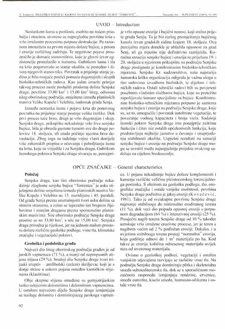
V. Ivančcvić: BIOLOSKO-TEIINIČK1 RADOVI NA SANACIJI SLNJSKR BUJICK "TORRlriNTn" ... Šumarski list SUPLLMhNT (2005), 91-109
UVOD - Introduction Nestankom šuma u prošlosti, osobito na našem prio
balju i otocima, stvorene su nepregledne površine krša s vrlo izraženim procesima potpune destrukcije. Po razornom intenzitetu na prvom mjestu dolaze bujice, a potom i erozije različitog sadržaja. Te negativne pojave prouzročilo je domaće stanovništvo, koje je glavni izvor egzistencije pronalazilo u šumama. Gubitkom šuma i tla na kršu pogoršavalo se stanje okoliša, te posredno i života njegovih stanovnika. Povratak u prijašnje stanje jedino je bilo moguće postići pomoću dugotrajnih i skupih biološko-tehničkih radova. Kao jedan izraziti primjer takvog procesa može poslužiti prodorna dolina Senjske drage, površine 33,80 km2 i 15,00 km2 šireg, odnosno užeg oborinskog područja, smještena između planinskih masiva Velike Kapele i Velebita, nadomak grada Senja.
Između nestanka šuma i pojave krša do ponovnog povratka na prijašnje stanje postoje velike razlike. Dok prvi proces teće brzo, drugi je vrlo dugotrajan i skup. Senjska draga, prikupište nekadašnje vrlo žive senjske bujice, bila je obrasla gustom šumom sve do druge polovice 18. stoljeća, ali otada počinje njezina brza devastacija. Zbog toga su tadašnje vojne vlasti donijele više zakonskih propisa o očuvanju i poboljšanju šuma na kršu, koje su vrijedile i za Senjsku dragu. Gubitkom šumskoga pokrova Senjske drage stvaraju se, ponajpri-
Položaj Senjska draga, kao šire oborinsko područje neka
dašnje zloglasne senjske bujice "Torrentea" je uska sti-ješnjena dolina smještena između planinskih masiva Velike Kapele i Velebita na 15. meridijanu i 45. paraleli. Od grada Senja prema unutrašnjosti tvori usku dolinu sa strmim stranama, a zatim se lepezasto širi brojnim žlje-bovima i manjim dragama prema spomenutim planinskim masivima. Šire oborinsko područje Senjske drage prostire se na 33,80 km", a uže na 15,00 km". Senjska draga prirodna je rijetkost, jer najednom malom prostoru dolaze različite geološke podloge, vrste tla, klimatske značajke i vegetacijski pokrovi.
Geološka i pedološka građa Najveći dio šireg oborinskog područja građenje od
jurskih vapnenaca (71 %), a manji od nepropusnih stijena trijasa (29 %). Srednji dio Senjske drage tvori tri-jaski eruptiv - amfibolski (zeleni) škriljevac koji je s donje strane u uskom pojasu omeđen karničkim stijenama (klastitima).
Obje skupine stijena omeđene su gornjotrijaskim tanko uslojenim dolomitima i dolomitnim vapnencima. U ostalom najvećem dijelu Senjske drage izmjenjuju se naslage dolomita i dominirajućeg jurskoga vapnen-
je vrlo opasne erozije i bujični nanosi, koji stalno prijete gradu Senju. To je bio razlog premještanja bujičnog kanala izvan gradskih zidina krajem 18. stoljeća. Ova parcijalna mjera donekle je ublažila opasnost za grad Senj, ali ga nipošto nije definitivno razriješila. Konačna sanacija senjske bujice i erozija na prijelazu 19. i 20. stoljeća u njezinom prikupištu na području Senjske drage postignuta je kombiniranim biološko-tehničkim mjerama. Senjsko Kr. nadzorništvo, naša najstarija šumarska krška organizacija odigrala je važnu ulogu u tim radovima izvedbom bioloških, te dijelom i tehničkih radova. Ostali tehnički radovi bili su povjereni posebnim vladinim službama bujica, koje su pretežito zapošljavale šumare specijaliste za bujice. Kombiniranim biološko-tehničkim mjerama potpuno je sanirana senjska bujica i erozija na području Senjske drage, koje su, uz to, omogućile i povratak autohtone vegetacije, te povećanje vodnog kapaciteta i broja vrela. Sadašnji šumski pokrov Senjske drage ima ponajprije zaštitnu funkciju i čitav niz ostalih općekorisnih funkcija, koje predstavljaju najbolje jamstvo u čuvanju i unaprjeđenju stabilnosti okoliša. Uspješni rezultati na sanaciji senjske bujice i erozije na području Senjske drage mogu se uvrstiti među najuspješnije projekte ovakvog sadržaja na cijelom Sredozemlju.
ca. U pojasu nekadašnje bujice dolaze konglomerati i kamenje različite veličine plcistocenskog torencijalno-ga postanka. S obzirom na geološku podlogu, tlo, oro-grafske značajke i ostale vanjske osobitosti, površina Senjske drage podložna je jakoj eroziji (Kovačev i ć , 1981). Tako je od sveukupne površine Senjske drage najmanje stabilnoga do minimalno erodiranog terena (11 %), dok veći dio pripada opasnoj eroziji s potpunom degradacijom (64 %) i intenzivnoj eroziji (25 %). Prosječni nagib terena Senjske drage od 10 % također uzrokuje vrlo izražene erozivne procese, jer je teren s nagibom većim od 2 % podložan eroziji. Dakako, i u uvjetima stabilnoga terena postoji "normalna" erozija, koja godišnje odnosi do 1 m materijala po ha. Kod takve je erozije količina odnesenog materijala uvijek niza od stvorenog materijala.
Ovisno o geološkoj podlozi, vegetaciji i ostalim vanjskim utjecajima razvijaju se različite vrste tla. Na području Senjske drage dominiraju plitka i skcietoidna smeđa submediteranska tla, dok se u sporadičnom mo-zaičnom rasporedu izmjenjuju rendzinc, crvenice, smeđa eutrofna, kiselo smeđa, humusno-silikatna i ostale vrste tla.
OPĆE ZNAČAJKE - General characteristics
92
V. Ivančević: BIOl.OSKO-Tlil IN1CKI RADOVI NA SANACIJI SENJSKE BUJICE "TORRENTE" Šumarski list - SUPLEMENT (2005), 91-109
Klima Prema Koppenovoj klasifikaciji područje Senjske
drage pripada kontinentalnoj varijanti mediteranske klime (Cfsax") odnosno Thörnthwaitovoj u zonu humidne klime. Srednja godišnja temperatura iznosi 9,1 °C s godišnjim prosjekom 1.700 mm oborina koje karakterizira naglašeni jesenski maksimum i ljetni minimum. Područje Senjske drage izloženo je naglim vremenskim promjenama koje su osobito izražajne kod premještanja velikih količina zračnih masa. Te promjene uzrokuju nastanak jakih vjetrova (bura i jugo), koji nepovoljno utječu na razvoj vegetacije i tla.
Vegetacija U fitogeografskome rasčlanjenju šumska vegetacija
Senjske drage pripada submcditeranskoj vegetacijskoj-zoni i mediteransko-montanskom vegetacijskom pojasu jadranske provincije mediteranske regije, te manjim dijelom ilirskoj provinciji sjevernoameričke šumske regije. Od mora do 700 mnv prema unutrašnjosti prostire se prva zona šuma i šikara bijeloga i crnoga graba sveze Ostryo-Carpinion orientalis Ht. s dva visinska pojasa (Pelcer , 1972). U prvom pojasu od 0-300 mnv dolaze šume hrasta medunca i bijeloga graba (Querco-Carpi-netum orientalis H-ić 1939) i degradacijske zajednice kovilja i kadulje (Stipo-Salvietum officinalis H-ić). Bijeli grab je tek djelomično zastupljen, dok se crni grab prostire do mora. Drugi pojas od 300-700 mnv zauzimaju šume hrasta medunca i crnoga graba (Ostryo-Quercetum pubescentis Ht. 1938) i to najčešće degrada-cijski oblici šikara različitih stadija sekundarne fitoce-noze Seslerio-Ostryetum. Unutar šume hrasta medunca i crnoga graba dolazi više subasocijacija i kamenjarskih zajednica, i to: šaša i žute zečine {Carici-Centauretum rupestris Ht), modroga vriska i zvonca (Satureio-Edra-eaenthetum Ht.), te nekoliko ekstrazonalnih zajednica. Kao krajnji degradacijski stadiji navedene šume dolaze šikare obične borovice (J. communis) i šmrike (./. oxy-cedrus). Šume i degradacijski stadiji drugog pojasa zauzimaju najveće površine Senjske drage. Osim zonalnih
Slika 1. Mozaični raspored kultura crnog bora u Senjskoj dragi. Figure 1 Mosaic-like arrangement of black pine cultures
in Senjska Draga. (Snimio - Photo: 1. Nekić)
dolazi i više ekstrazonalnih zajednica, i to: autohtone šume crnoga bora s dunjaricom (Cotoneastro-Pinetum nigrae Ht. 1938), šume hrasta kitnjaka s bekicom (Lu-zulo-Quercetum petraeae I Hill. 1932 / Pass. 1963), šume hrasta kitnjaka s žutilovkama (Luzulo-Quercetum petraeae geništetosum prov. Pelc.) i šume bukve s beki-cama (Luzulo-Fagetum Wrab.).
U drugoj vegetacijskoj zoni prema kontinentalnom zaleđu od 700 mnv pa naviše dolaze bukove šume s jesenskom šašikom (Seslerio-Fagetum sylvaticae /Ht. 1950./ M. Wraber 1960) do zaključno pretplaninskih šuma bukve (Fagetum illyricum subalpinum Ht.). U dominirajućim bukovim šumama s jesenskom šašikom zastupljeni su elementi kserotermnih submedite-ranskih šuma i mezofitnih bukovih šuma. Osim navedenih šumskih zajednica i njezinih degradacijskih oblika ističu se umjetno podignute 22 kulture-branje-vine crnoga bora na 320 ha u mozaičnom rasporedu diljem Senjske drage. Osim dominantne zaštitne uloge kulture-branjevine predstavljaju veoma važnu kariku u uspješnoj obnovi autohtone vegetacija (slika 1).
POVIJESNI PRIKAZ ŠUMA SENJSKE DRAGE A historical survey of forests in Senjska Draga
Od sačuvanih šuma do njihovoga nestanka Prema istraživanjima M agdića (1877) okoliša Se
nja, uključujući i Senjsku dragu, bila je na prijelazu 16. i 17. stoljeća pokrivena gustim šumama hrasta i jele! (sigurno nije riječ ojeli nego o crnom boru). Početkom 17. stoljeća spominju se sačuvane šume Senjske drage u vezi preseljenja uskoka iz Senja u unutrašnjost zemlje. Prihodi od prodaje tih šuma Mlečanima trebali su podmiriti troškove njihova preseljenja. Senjski biskup De Do-minis trebao se uključiti u ovu transakciju kao posrednik uz određenu proviziju. Međutim, nasilna smrt Raba
te, vojnog zapovjednika grada Senja, i protivljenje bečkoga dvora onemogućili su ostvarenje tog plana (Ševe r i n s ki , 1967). Čini sc, da je ipak došlo do nestanka senjskih šuma u prvoj polovici 17. stoljeća, jer je jedna razorna bujica 1647. godine pričinila velike štete gradu Senju. Tom prilikom razrušen je dio gradskih bedema i 50 kuća u gradu (Vi tczović , 1696). Očito je posvemašnji nestanak šuma na području Senjske drage prouzročio takve štete. U to je vrijeme senjska bujica (senjski ili Kriški potok) prolazila središnjim dijelom stare jezgre grada Senja, koja je često rušila kuće i bedeme, te
93
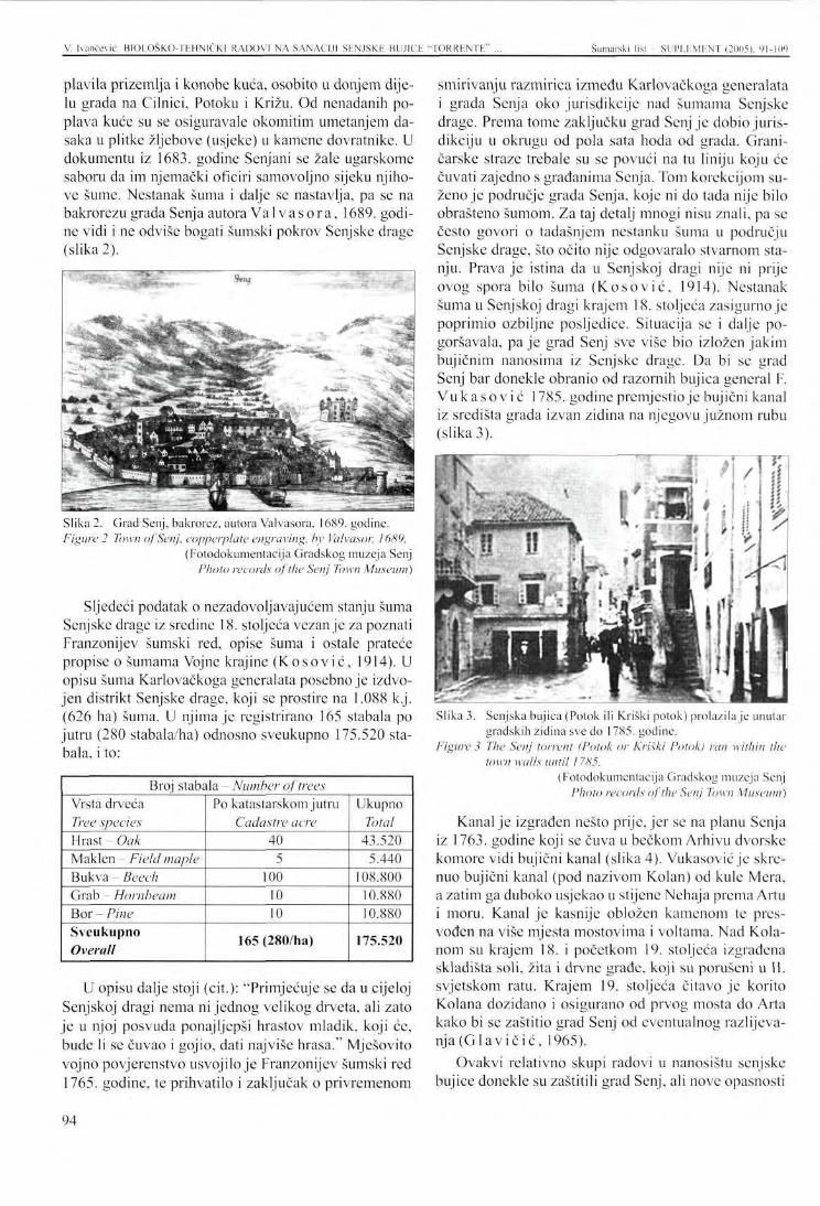
V. Ivančević: BIOLOŠKO-TEHN1ČK1 RADOVI NA SANACIJI SENJSKE BUJICE "TORRENTE" ... Šumarski list SUPI.EMENT (2005). 91-109
plavila prizemlja i konobe kuća, osobito u donjem dijelu grada na Cilnici, Potoku i Križu. Od nenadanih poplava kuće su se osiguravale okomitim umetanjem dasaka u plitke žljebove (usjeke) u kamene dovratnike. U dokumentu iz 1683. godine Senjani se žale ugarskomc saboru da im njemački oficiri samovoljno sijeku njihove šume. Nestanak šuma i dalje se nastavlja, pa se na bakrorezu grada Senja autora Va 1 v a s o r a, 1689. godine vidi i ne odviše bogati šumski pokrov Senjske drage (slika 2).
Slika 2. Grad Senj, bakrorez, autora Valvasora, 1689. godine. Figure 2 Town of Senj, copperplate engraving, by Valvasor, 1689.
(Fotodokumentacija Gradskog muzeja Senj Photo records of the Senj Town Museum)
Sljedeći podatak o nezadovoljavajućem stanju šuma Senjske drage iz sredine 18. stoljeća vezanje za poznati Franzonijev šumski red, opise šuma i ostale prateće propise o šumama Vojne krajine (K o s o v i ć, 1914). U opisu šuma Karlovačkoga generalata posebno je izdvojen distrikt Senjske drage, koji se prostire na 1.088 k.j. (626 ha) šuma. U njima je registrirano 165 stabala po jutru (280 stabala/ha) odnosno sveukupno 175.520 stabala, i to:
Broj stabala - Number of trees Vrsta drveća Tree species Hrast - Oak Maklen Field maple Bukva - Beech Grab - Hornbeam Bor - Pine Sveukupno Overall
Po katastarskom jutru Cadastre acre
40 5
100 10 10
165 (280/ha)
Ukupno Total
43.520 5.440
108.800 10.880 10.880
175.520
U opisu dalje stoji (cit.): "Primjećuje se da u cijeloj Senjskoj dragi nema ni jednog velikog drveta, ali zato je u njoj posvuda ponaj ljepši hrastov mladik, koji će, bude li se čuvao i gojio, dati najviše hrasa." Mješovito vojno povjerenstvo usvojilo je Franzonijev šumski red 1765. godine, te prihvatilo i zaključak o privremenom
smirivanju razmirica između Karlovačkoga generalata i grada Senja oko jurisdikcije nad šumama Senjske drage. Prema tome zaključku grad Senj je dobio jurisdikciju u okrugu od pola sata hoda od grada. Graničarske straže trebale su se povući na tu liniju koju će čuvati zajedno s građanima Senja. Tom korekcijom suženo je područje grada Senja, koje ni do tada nije bilo obrašteno šumom. Za taj detalj mnogi nisu znali, pa se često govori o tadašnjem nestanku šuma u području Senjske drage, što očito nije odgovaralo stvarnom stanju. Prava je istina da u Senjskoj dragi nije ni prije ovog spora bilo šuma (Kosov ić , 1914). Nestanak šuma u Senjskoj dragi krajem 18. stoljeća zasigurno je poprimio ozbiljne posljedice. Situacija se i dalje pogoršavala, pa je grad Senj sve više bio izložen jakim bujičnim nanosima iz Senjske drage. Da bi se grad Senj bar donekle obranio od razornih bujica general F. Vukasov ić 1785. godine premjestio je bujični kanal iz središta grada izvan zidina na njegovu južnom rubu
Slika 3. Senjska bujica (Potok ili Kriški potok) prolazila je unutar gradskih zidina sve do 1785. godine.
Figure 3 The Senj torrent (Potok or Kriški Potok) ran within the town walls until 1785.
(Fotodokumentacija Gradskog muzeja Senj Photo records of the Senj Town Museum)
Kanal je izgrađen nešto prije, jer se na planu Senja iz 1763. godine koji se čuva u bečkom Arhivu dvorske komore vidi bujični kanal (slika 4). Vukasović je skrenuo bujični kanal (pod nazivom Kolan) od kule Mcra, a zatim ga duboko usjekao u stijene Nehaja prema Artu i moru. Kanal je kasnije obložen kamenom te pres-vođen na više mjesta mostovima i voltama. Nad Kola-nom su krajem 18. i početkom 19. stoljeća izgrađena skladišta soli, žita i drvne građe, koji su porušeni u II. svjetskom ratu. Krajem 19. stoljeća čitavo je korito Kolana dozidano i osigurano od prvog mosta do Arta kako bi se zaštitio grad Senj od eventualnog razlijeva-nja (Glav ič i ć , 1965).
Ovakvi relativno skupi radovi u nanosištu senjske bujice donekle su zaštitili grad Senj, ali nove opasnosti
94
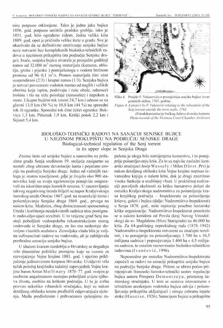
V. Ivančević: BI0L0ŠK0-TEHNIČKI RADOVI NA SANACIJI SENJSKE BUJICE "TORRENTE" . Šumarski list SUPLEMENT (2005), 91-109
nisu potpuno otklonjene. Tako je jedna jaka bujica 1856. god. potpuno uništila gradsko groblje, iako je 1851. god. bilo ograđeno zidom. Jedna velika kiša 1889. god. opet je pričinila velike štete u gradu. Sve je ukazivalo da se definitivno smirivanje senjske bujice neće ostvariti bez kompleksnih biološko-tehničkih radova u njezinom prikupištu (na području Senjske drage). Inače, senjska bujica stvarala je prosječni godišnji nanos od 32.000 m3 raznog materijala (kamena, oblu-čja, gruha i pijeska ) pomiješanoga s vodom brzinom pronosa od 96-0,1 m'/s. Pronos materijala čini sitni suspendirani (2/3) i krupni nanos (1/3). Senjska bujica je ustvari povremeni vodotok nastao od naglih i velikih oborina koje ispiru, podrivaju i ruše obale, odnoseći trošinu i tlo na niže položaje (nanosište) i napokon u more. Ukupni bujični tok iznosi 24,7 km i odnosi se na glavni 13,9 km (56 %) te 10,8 km (44 %) na sporedni tok ili ogranke. Sporedni tok čine četiri ogranka: Bukvica 1,3 km, Pištenak 1,9 km, Kriški potok 2,2 km i Sijaset 5,4 km.
Slika 4. Projekt F. Vukasovića o premještaju senjske bujice izvan gradskih zidina, 1763. godine.
Figure 4 A project by F. Vukasović relating to the relocation of the Senj torrent outside the town walls, 1763.
(Fotodokumentacija bečkog Arhiva dvorske komore Photo records of the Viennese Court Chamber Archives)
BIOLOŠKO-TEHNIČKI RADOVI NA SANACIJI SENJSKE BUJICE U NJEZINOM PRIKUPIŠTU NA PODRUČJU SENJSKE DRAGE
Biological-technical regulation of the Senj torrent in its upper slope in Senjska Draga
Znatne štete od senjske bujice u nanosištu na prilazima grada Senja sredinom 19. stoljeća zasigurno su nastali zbog ubrzane devastacije šuma i pojačane erozije na području Senjske drage. Jedan od važnijih razloga je znatna naseljenost, gdje je živjelo oko 900 stanovnika koji su svoju egzistenciju ponajviše osiguravali na iskorištavanju šumskih resursa. U zaustavljanju takvog negativnog trenda bilježi se napor Kraljevskoga šumskog ureda Otočac 1867. god. na resurekciji šuma i pošumljavanju Senjske drage 1869. god., prvoga na našem kršu. Međutim, zbog dislociranosti spomenutog Ureda i korištenja neadekvatnih sadnica nisu postignuti zadovoljavajući rezultati. U to vrijeme grad Senj nastoji poboljšati vodoopskrbu rekonstrukcijom starog vodovoda iz Senjske drage, za što mu nedostaje dovoljno vlastitih sredstava. Zemaljska vlada bila je voljna sufinancirati radove na vodovodu, ali je zahtijevala prethodnu sanaciju senjske bujice.
U idućem kraćem razdoblju u Hrvatskoj se događaju vrlo dinamične političke promjene koje su vezane za razvojačenje Vojne krajine 1881. god. i njezino priključenje jedinstvenom korpusu Hrvatske. Uvidjevši vrlo težak položaj krajišnika tadašnji zapovjednik Vojne krajine baronAntun Mol 1 i nary 1870-77. god. svojim je osobnim angažmanom nastojao poboljšati uvjete njihova života, osobito na krškom području. U tu je svrhu pozvao nekoliko vrhunskih stručnjaka, koji su nakon detaljnog obilaska terena predložili odgovarajuća rješenja. Medu predloženim i prihvaćenim rješenjima za
pažena je uloga bila namijenjena šumarstvu, i to ponajprije pošumljavanju krša. Za to su najviše zaslužni šumarski stručnjaci Josip Wessely i Milan Durs t . Prvi je nakon detaljnog obilaska krša Vojne krajine napisao izvanrednu knjigu o našem kršu, dok je drugi zauzimao visoke funkcije u središnjoj vlasti. U praktičnoj realizaciji povoljnih okolnosti za krško šumarstvo dolazi do osnutka Kraljevskoga nadzorništva za pošumljenje krasa krajiškog područja - Inspektorata za pošumljenje krševa, goleti i bujica (dalje: Nadzorništvo-lnspektorat) u Senju 1878. god., naše najstarije posebne šumarske krške organizacije. Nadzorništvo-lnspektorat prostiralo se u uskom koridoru od Povila (kraj Novog Vinodolskog) do sv. Magdalene (blizu Starigrada) na 46.000 ha krša. Za 64-godišnjeg neprekidnog rada (1878-1942) Nadzorništva-Inspektorata ostvareni su značajni rezultati, i to ponajprije na pošumljavanju 1.700 ha s 10,5 milijuna sadnica i popunjavanju 1.400 ha s 4,5 milijuna sadnica, te ostalim raznovrsnim biološko-tehničkim radovima ( Ivančev ić , 1996).
Neposredno po osnutku Nadzorništva-Inspektorata započeli su radovi na sanaciji prikupišta senjske bujice na području Senjske drage. Pritom se ubrzo počeo primjenjivati francuski šumsko-tehnički sustav regulacije bujica autora Prospera Demon tzeya , priznatog šumarskog stručnjaka. U tom se sustavu istovremeno s tehničkim uređenjem vodotoka bujica odvija i pošum-ljavanje prikupišta uključujući i strogu zabranu ispaše stoke (Haueise , 1926). Sanacijom bujice u prikupištu
95
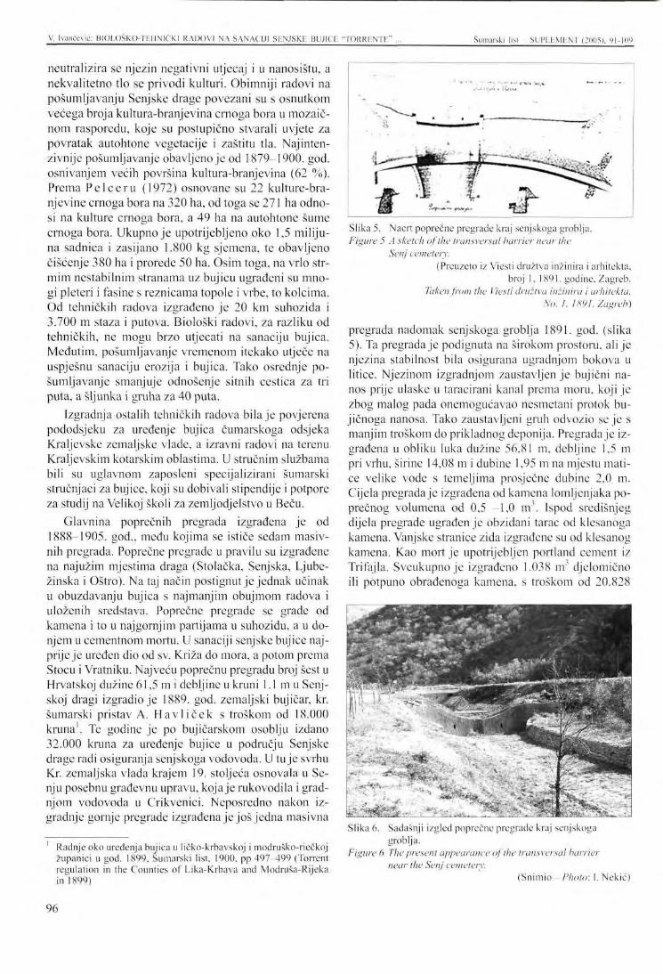
V. Ivančcvić: B10L0ŠK0-TE1IN1ČKI RADOVI NA SANACIJI SENJSKE BUJICE "TORRENTE" . Šumarski lisl SUPL1-.MENT (2005). 91 -109
neutralizira se njezin negativni utjecaj i u nanosištu, a nekvalitetno tlo se privodi kulturi. Obimniji radovi na pošumljavanju Senjske drage povezani su s osnutkom većega broja kultura-branjevina crnoga bora u mozaič-nom rasporedu, koje su postupično stvarali uvjete za povratak autohtone vegetacije i zaštitu tla. Najintenzivnije pošumljavanje obavljeno je od 1879-1900. god. osnivanjem većih površina kultura-branjevina (62 %). Prema Pelceru (1972) osnovane su 22 kulture-bra-njevine crnoga bora na 320 ha, od toga se 271 ha odnosi na kulture crnoga bora, a 49 ha na autohtone šume crnoga bora. Ukupno je upotrijebljeno oko 1,5 milijuna sadnica i zasijano 1.800 kg sjemena, te obavljeno čišćenje 380 ha i prorede 50 ha. Osim toga, na vrlo strmim nestabilnim stranama uz bujicu ugrađeni su mnogi pleteri i fasine s reznicama topole i vrbe, to kolcima. Od tehničkih radova izgrađeno je 20 km suhozida i 3.700 m staza i putova. Biološki radovi, za razliku od tehničkih, ne mogu brzo utjecati na sanaciju bujica. Međutim, pošumljavanje vremenom itekako utječe na uspješnu sanaciju erozija i bujica. Tako osrednje pošumljavanje smanjuje odnošenje sitnih cestica za tri puta, a šljunka i gruha za 40 puta.
Izgradnja ostalih tehničkih radova bila je povjerena pododsjeku za uređenje bujica čumarskoga odsjeka Kraljevske zemaljske vlade, a izravni radovi na terenu Kraljevskim kotarskim oblastima. U stručnim službama bili su uglavnom zaposleni specijalizirani šumarski stručnjaci za bujice, koji su dobivali stipendije i potpore za studij na Velikoj školi za zemljodjelstvo u Beču.
Glavnina poprečnih pregrada izgrađena jc od 1888-1905. god., među kojima se ističe sedam masivnih pregrada. Poprečne pregrade u pravilu su izgrađene na najužim mjestima draga (Stolačka, Senjska, Ljubc-žinska i Oštro). Na taj način postignut je jednak učinak u obuzdavanju bujica s najmanjim obujmom radova i uloženih sredstava. Poprečne pregrade se grade od kamena i to u najgornjim partijama u suhozidu, a u donjem u cementnom mortu. U sanaciji senjske bujice najprije je uređen dio od sv. Križa do mora, a potom prema Stocu i Vratniku. Najveću poprečnu pregradu broj šest u Hrvatskoj dužine 61,5 m i debljine u kruni 1.1 mu Senjskoj dragi izgradio je 1889. god. zemaljski bujičar, kr. šumarski pristav A. Havl ičck s troškom od 18.000 kruna1. Te godine je po bujičarskom osoblju izdano 32.000 kruna za uređenje bujice u području Senjske drage radi osiguranja senjskoga vodovoda. U tu je svrhu Kr. zemaljska vlada krajem 19. stoljeća osnovala u Senju posebnu građevnu upravu, koja je rukovodila i gradnjom vodovoda u Crikvenici. Neposredno nakon izgradnje gornje pregrade izgrađena je još jedna masivna
Radnje oko uređenja bujica u ličko-krbavskoj i modruško-riečkoj županici u god. 1899, Šumarski list, 1900, pp 497^t99 (Torrent regulation in the Counties of Lika-Krbava and Modruša-Rijeka in 1899)
. . • ' . . . ',0t.!
Slika 5. Nacrt poprečne pregrade kraj senjskoga groblja. Figure 5 A sketch of the transversal harrier near the
Senj cemetery. (Preuzeto iz Viesti družtva inžinira i arhitekta,
broj 1, 1891. godine, Zagreb. Taken from the Viesti družtva inžinira i arhitekta,
No. I, 1891. Zagreb)
pregrada nadomak senjskoga groblja 1891. god. (slika 5). Ta pregrada je podignuta na širokom prostoru, ali je njezina stabilnost bila osigurana ugradnjom bokova u litice. Njezinom izgradnjom zaustavljen je bujični nanos prije ulaske u taracirani kanal prema moru, koji je zbog malog pada onemogućavao nesmetani protok bu-jičnoga nanosa. Tako zaustavljeni gruh odvozio seje s manjim troškom do prikladnog deponija. Pregrada je izgrađena u obliku luka dužine 56,81 m, debljine 1,5 m pri vrhu, širine 14,08 m i dubine 1,95 m na mjestu matice velike vode s temeljima prosječne dubine 2,0 m. Cijela pregrada jc izgrađena od kamena lomljenjaka poprečnog volumena od 0,5 -1,0 m . Ispod središnjeg dijela pregrade ugrađen je obzidani tarac od klesanoga kamena. Vanjske stranice zida izgrađene su od klesanog kamena. Kao mort je upotrijebljen portland cement iz Trifajla. Sveukupno jc izgrađeno 1.038 m djelomično ili potpuno obrađenoga kamena, s troškom od 20.828
Slika 6. Sadašnji izgled poprečne pregrade kraj senjskoga groblja.
Figure 6 The present appearance of the transversal harrier near the Senj cemetery.
(Snimio - Photo: I. Nekić)
96
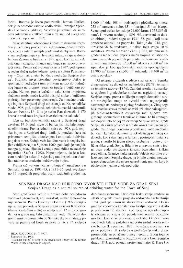
V. Ivančević: BIOLOŠKO-TEHNIČK1 RADOVI NA SANACIJI SENJSKE BUJICE "TORRENTE" ... Šumarski list - SLJPLKMENT (2005). 91-109
forinti. Radove je izveo poduzetnik Herman Ehrlich, dok je neposredne radove vodio civilni inženjer Vjeko-slav Horaček (slika 6). Vrijedno je istaknuti da su radovi ostvareni u kratkom roku u trajanju od svega šest mjeseci (Lap a i ne, 1892).
Na nestabilnim obroncima i obalnim stranama izgrađen je veći broj procjednica s drenažom, obalnih zidova, kineta i ostalih manjih građevinskih objekata. Radovi na uređenju bujica u Hrvatskoj intenziviraju se donošenjem Zakona o bujicama 1895. god., koji je, između ostaloga, razriješio financiranje bujica na zadovoljavajući način. Prema sačuvanom spisu iz 1907. god. opisan je jedan slučaj nedozvoljene ispaše u kulturi Paskvano-vac - Osornjak unutar bujičnog područja Senjske drage". Krajiško invcsticionalno povjerenstvo obišlo je spomenuto područje i tom prilikom upozorilo područnog lugara na propust vezan za ispašu a bujičnom području. Naime, prema važećim zakonskim propisima službena osoba može izvršiti odstrjel stoke u bujičnom području bez posebnog upozorenja. Za konačno uređenje bujica u Senjskoj dragi otposlan je od Kr. zemaljske vlade 1908. god. bujičarski tehničar šumarski nadzornik Stcvan Pe t rov ić . U tu je svrhu Ban doznačio 1.170 kruna iz sredstava krajiške investicionalne zaklada.
Iako su biološko-tehnički radovi u Senjskoj dragi završeni 1910. god., štete od bujica još nisu bile potpuno eliminirane. Prema jednom spisu od 1928. god. senjska bujica u Senjskoj dragi činila je ponekad štete na privatnom zemljištu odnošenjem i ono malo kultiviranog tla u more. Zadnja veća količina vode iz senjske bujice zabilježena je u Sijasetu 1960. god. koja je nanijela mnogo pijeska, šljunka i zemlje pod zidine nekadašnje lugarnice (Šafar, 1962). Napominjemo, daje u kraćem razdoblju nakon I. svjetskog rata Inspektorat obavljao radove na uređenju i održavanju bujica.
Prema sačuvanom "Katastru bujica" izgrađeno je u Senjskoj dragi od 1891-95. i 1931-35. god. sveukupno 15 poprečnih pregrada, osam uzdužnih građevina,
Stari grad Senia već je u rimsko doba posjedovao vodovod (Aquaduct), koji nažalost, makar djelomično nije sačuvan. Prema B u c z y n s k o m e (1997) Senjki-nje su išle po vodu u Senjsku dragu na izvor Kraljevice (danas Kraljičino vrelo) na udaljenosti 12 milja od grada, jer u gradu nije bilo cisterni za vodu. Na svom dugom i mukotrpnom putu do Senjske drage i natrag pjevale su pjesme od kojih su neke iz 16. i 17. stoljeća
2 HDA, 3283UOZV, 14. 7. 1907. 3 Šumarski list, 1908. 4 "Katastar bujica" is kept in the specialised library of the former
Water Utility Company in Zagreb.
1.060 m3 zida, 108 m2 podslaplja i pločnika za kinete, 253 m3 kamena u suho, 451 m3 nasipa i 514 m3 iskopa. Sveukupni trošak iznosio je 24.000 kruna i 333.853 dinara4. U prvom razdoblju 1891-95. ostvareni su daleko obimniji radovi nego od 1931-35. god., koji su se pretežno odnosili na popravke. Tako je do 1918. god. utrošeno 90 % sredstava, a nakon toga svega 10 % sredstava. Prema Kovačev iću (1981) ukupno su izgrađena 62 bujična objekta među kojima se ističe sedam masivnih poprečnih pregrada. Pri tome su izvršeni zemljani radovi od 12.000 m3 iskopa i 3.000 m3 nasipa, dok je kod građevinskih radova upotrijebljeno 13.900 m3 kamena (5.500 m3 suhozida i 8.400 m3 za ostale objekte).
Od ukupno uloženih sredstava za sanaciju Senjske drage najveći se dio odnosi na biološke (82 %), te manji na tehničke radove (18 %). Zavidni rezultati šumarske, te dijelom i građevinske struke na uspješnoj sanaciji Senjske drage, prema mišljenju mnogih domaćih i stranih stručnjaka, mogu se uvrstiti među najuspješnija ostvarenja na području cijelog Sredozemlja. Zbog toga bi šumarska struka trebala obaviti uži izbor najuspješnijih biološko-tehničkih ostvarenja radi njihova proglašenja spomenicima tehničke kulture. To bi umnogome doprinijelo boljoj valorizaciji Senjske drage, grada Senja, ali i širih prostora u turističko-rekreacijskom pogledu. Osim toga ponovno propuštanje vode uređenim bujičnim kanalom do mora iz nekadašnjeg senjskog vodovoda, kao i stavljanje u funkciju postojećih fontana u gradu, stvorilo bi jednu rijetko osebujnu i gotovo idiličnu sliku grada Senja. Bila bi to u pravom smislu jedna oaza vode, okružena s izrazito bezvodnim krškim predjelima. Granice parka prirode Velebit otprilike prolaze sredinom Senjske drage, pa bi bilo uputno poduzete potrebne zakonske mjere za proširenje granica koje bi obuhvatile njezino cijelo područje.
dan-danas sačuvane. Uvidjevši teško stanje gradske su vlasti povjerile izradu projekta vodovoda Karlu Điniju 1764. god. po uzoru na stari rimski vodovod. Do izgradnje vodovoda korištenjem Kraljičinog vrela došlo je početkom 19. stoljeća. Kod njegove izgradnje upotrijebljene su cijevi od pucolanske zemlje obložene mortom, koje su se proizvodile u okolici Otočca. Trasa vodovoda bila je položena uz cestu uzduž korita senjske bujice (Lap a i ne, 1896). Povećane sječe šuma u prvoj polovici 19. stoljeća u području Senjske drage prouzročile su pojačane bujice i eroziju. Zbog toga je prilikom rekonstrukcije Jozefmske cesta kroz Senjsku dragu 1843. god. poznati projektant major K. K ne ž i ć
SENJSKA DRAGA KAO PRIRODNO IZVORIŠTE PITKE VODE ZA GRAD SENJ Senjska Draga as a natural source of drinking water for the Town of Senj
97
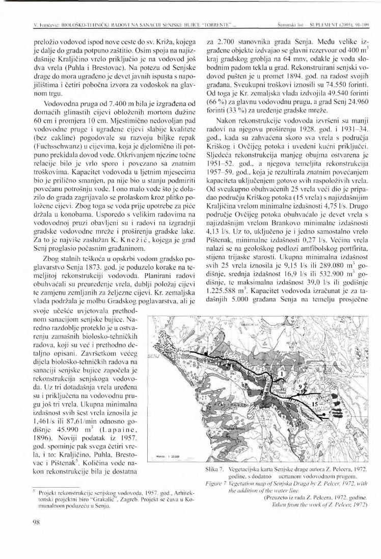
V. Ivančević: BIOLOŠKO-TEHN1ČK] RADOVI NA SANACIJI SENJSKE BUJICE "TORRENTE" Šumarski list - SUPEEMENT (2005), 91-109
preložio vodovod ispod nove ceste do sv. Križa, kojega je dalje do grada potpuno zaštitio. Osim spoja na najizdašnije Kraljičino vrelo priključio je na vodovod još dva vrela (Puhla i Brestovac). Na potezu od Senjske drage do mora ugrađeno je devet javnih ispusta s napo-jilištima i četiri pobočna izvora za vodoskok na glavnom trgu.
Vodovodna pruga od 7.400 m bila je izgrađena od domaćih glinastih cijevi obloženih mortom dužine 60 cm i promjera 10 cm. Mjestimično nedovoljan pad vodovodne pruge i ugrađene cijevi slabije kvalitete (bez cakline) pogodovale su razvoju biljke repak (Fuchsschwanz) u cijevima, koja je djelomično ili potpuno prekidala dovod vode. Otkrivanjem njezine točne relacije bilo je vrlo sporo i povezano sa znatnim troškovima. Kapacitet vodovoda u ljetnim mjesecima bio je prilično smanjen, pa nije bio u stanju podmiriti povećanu potrošnju vode. I ono malo vode stoje dolazilo do grada zagrijavalo se prolaskom kroz plitko položene cijevi. Zbog toga se voda prije upotrebe za piće držala u konobama. Usporedo s velikim radovima na vodovodnoj pruzi obavljeni su i radovi na izgradnji gradske vodovodne mreže i proširenju gradske lake. Za to je najviše zaslužan K. Knež i ć , kojega je grad Senj proglasio počasnim građaninom.
Zbog stalnih teškoća u opskrbi vodom gradsko poglavarstvo Senja 1873. god. je poduzelo korake na temeljitoj rekonstrukciji vodovoda. Planirani radovi obuhvaćali su preuređenje vrela, dublji položaj cijevi te zamjenu zemljanih za željezne cijevi. Kr. zemaljska vlada podržala je molbu Gradskog poglavarstva, ali je svoje učešće uvjetovala prethodnom sanacijom senjske bujice. Naredno razdoblje proteklo je u ostvarenju zamašnih biolosko-tehničkih radova, koji su već i prethodno detaljno opisani. Završetkom većeg dijela biolosko-tehničkih radova na sanaciji senjske bujice započela je rekonstrukcija senjskoga vodovoda. Uz tri dotadašnja vrela uređena su i priključena na vodovodnu prugu još tri vrela. Ukupna minimalna izdašnost svih šest vrela iznosila je 1,46l/s ili 87,61/min odnosno godišnje 45.990 m ( L a p a i n e , 1896). Noviji podatak iz 1957. god. spominje pak svega četiri vrela, i to: Kraljičino, Puhla, Brestovac i Pištcnak5. Količina vode nakon rekonstrukcije bila je dostatna
Projekt rekonstrukcije senjskog vodovoda, 1957. god., Arhitektonski projektni biro "Grakalić", Zagreb. Projekt se čuva u Komunalnom poduzeću u Senju.
za 2.700 stanovnika grada Senja. Među velike izgrađene objekte izdvajao se glavni rezervoar od 400 m3
kraj gradskog groblja na 64 mnv, odakle je voda slobodnim padom tekla u grad. Rekonstruirani senjski vodovod pušten je u promet 1894. god. na radost svojih građana. Sveukupni troškovi iznosili su 74.550 forinti. Od toga je Kr. zemaljska vlada izdvojila 49.540 forinti (66 %) za glavnu vodovodnu prugu, a grad Senj 24.960 forinti (33 %) za uređenje gradske mreže.
Nakon rekonstrukcije vodovoda izvršeni su manji radovi na njegovu proširenju 1928. god. i 1931-34. god., kada su zahvaćena skoro sva vrela s područja Kriškog i Ovčijeg potoka i uvedeni kućni priključci. Sljedeća rekonstrukcija manjeg obujma ostvarena je 1951-52. god., a njegova temeljita rekonstrukcija 1957-59. god., koja je rezultirala znatnim povećanjem kapaciteta uključenjem gotovo svih raspoloživih vrela. Od sveukupno obuhvaćenih 25 vrela veći dio je pripadao području Kriškog potoka (15 vrela) s najizdašnijim Kraljičina vrelom minimalne izdašnosti 4,75 l/s. Drugo područje Ovčijeg potoka obuhvaćalo je devet vrela s najizdašnijm vrelom Brankovo minimalne izdašnosti 4,13 l/s. Uz to, uključeno je i jedno samostalno vrelo Pištcnak, minimalne izdašnosti 0,27 l/s. Većina vrela nalazi se na geološkog podlozi amfibolskog portfirita, stijena trijaske starosti. Ukupna minimalna izdašnost svih 25 vrela iznosila je 9,15 l/s ili 289.080 m3 godišnje, srednja izdašnost 16,9 l/s ili 532.900 nr godišnje, te maksimalna izdašnost 39,0 l/s ili godišnje 1.225.588 nr. Kapacitet vodovoda izračunat je za tadašnjih 5.000 građana Senja na temelju prosječne
Slika 7. Vegetacijska karta Senjske drage autora Z. Pelcera, 1972. godine, s dodatno ucrtanom vodovodnom prugom.
Figure 7 Vegetation map of Senjska Draga by Z. Pelcer, 1972, with the addition of the water line.
(Preuzeto iz radaZ. Pelcera, 1972. godine. Taken from the work of Z. Pelcer, 1972)
98
V. Ivančević: BIOLOŠKO-TEHNIČKI RADOVI NA SANACIJI SENJSKE BUJICE "TORRENTE" ... Šumarski list - SUPLHMENT (2005). 91-109
dnevne potrošnje od 900 m . To odgovara izdašnosti od 10,41 l/s odnosno godišnje 328.500 nr vode koje je neznatno veća od minimalne izdašnosti. Rekonstrukcijom vodovoda osigurana je dovoljna godišnja količina vode, ali je u ljetnim mjesecima dolazilo do poremećaja zbog povećane potrošnje vode. Prilikom rekonstrukcije položene su cijevi od lijevanog željeza na vodovodnoj pruzi promjera 50, 60 i 80 mm, te na gradskoj mreži promjera 50-150 mm. Sveukupni troškovi rekonstrukcije iznosili su 63.709.926 dinara (slika 7).
Puštanjem u rad HE Senj šezdesetih godina minulog stoljeća, stvoreni su uvjeti za nesmetanu opskrbu vodom šireg južnog kopnenog primorskog područja i susjednih otoka. U to svrhu izgrađen je vodovod južnog ogranka Hrvatskog primorja velikog kapaciteta, kao i nova vodovodna pruga iz Hrmotina do Senja. Na taj je način definitivno razriješena vodoopskrba grada Senja, pa bivši stari vodovodni sustav iz područja Senjske drage danas jedino služi za opskrbu njezinih donjih zaselaka. Stara vodovodna pruga zajedno s vrelima i ostalim pratećim objektima danas je prilično zapuštena. To nipošto nije dobro, jer ovaj stari vodovod uvijek mora biti u rezervi u slučaju većih kvarova na sadašnjem vodovodu. Osim toga, njegove vode mogle bi se koristiti za oživljavanje nekadašnjeg uređenog bujičnog kanala od groblja do izlaska u more, koji bi predstavljao originalnu turističku atrakciju. Stalno povećanje broja vrela i njihovo uključivanje u senjski vodovod zasigurno je nastalo kao rezultat uspješnih biološko-tehničkih radova u prikupištu senjske bujice na području Senjske drage. Međutim, sustavna istraživanja takve naravi nisu provedena pa se i ne mogu donositi pouzdani zaključci. U ovom slučaju mogu se jedino stvarati zaključci na temelju saznanja šumarske znanosti koja potvrđuju čvrstu povezanost biološko-tehničkih radova o intenzitetu bujica i erozija.
1 tvrdnja o povećanju broja vrela s obzirom na progresiju vegetacije nije nažalost do sada bila predmetom sustavnih istraživanja. U tom segmentu nije pronađena
ZAKLJUČCI -Nestankom šuma prije nekoliko stoljeća u prodornoj dolini Senjske drage stvorena je razorna bujica i erozija. Sveukupna dužina senjske bujice od 25 km stvarala je prosječno godišnje 32.000 m nanosa u prikupištu na području Senjske drage, koja se potom kretala prema nanosištu ugrožavajući grad Senj. U otklanjanju opasnosti od bujica u nanosištu, pre-ložen je bujični kanal iz stare jezgre grada izvan njegovih zidina krajem 18. stoljeća. Ta parcijalna mjera ublažila je opasnost od bujica, ali je nipošto nije potpuno odstranila.
nikakva povijesna dokumentacija. Tu nam je donekle pomogla oskudno sačuvana projektna dokumentacija vodoopskrbe grada Senja. No, ni u njoj nažalost nema ključnog odgovora koji bi potvrdio ovisnost povećanja broja vrela o progresiji vegetacije. Ostaje ključna dvojba je li postupično povećanje broja vrela u vodoopskrbi grada Senja bilo limitirano financijskim motivima ili nije bilo potrebe za uključivanjem novih vrela. I u ovom slučaju mogli bi se prikloniti konstataciji da se broj i kapacitet vrela proporcionalno povećavao s intenzitetom biološko-tehničkih radova, uz istodobno smanjenje erozivnih procesa. Konsolidacija nekadašnje senjske bujice i pratećih erozija u Senjskoj dragi već je završena, ali bi postavljanje jednog pilot projekta dobro došlo u daljnjem praćenju tih odnosa. To bi bilo od neprocjenjive koristi za šumarsku i vodoprivred-nu struku, ali i za ostale srodne struke. Uz to, postojeća vrela bi trebalo urediti, a potom i uspostaviti trajni pokus mjerenja njihove izdašnosti. Među njima ima i vrlo uspjelih graditeljskih rješenja, koja bi se mogla uvrstiti u spomenike tehničke kulture.
Daljnja istraživanja vodnog kapaciteta Senjske drage povezana s nekadašnjom vodoopskrbom grada Senja trebala bi okupiti šumarske ali i ostale stručnjake srodnih disciplina. Koliko je poznato, ovakva uspješna i obimna sanacija bujica i erozija na području Senjske drage primjenom biološko-tehničkih mjera nije poznata na cijelom Sredozemlju. Domaći i strani stručnjaci šumarstva i ostalih srodnih struka neizostavno posjećuju Senjsku dragu, koja ostavlja snažan dojam na svakog posjetitelja. Senjska draga predstavlja eklatantan primjer vrhunskog dostignuća našeg šumarstva, a pogotovo krškog šumarstva. Njegovi se rezultati mogu ravnopravno nositi s krskim šumarstvom najrazvijenijih zemalja Sredozemlja, a u nekim segmentima zauzimaju i vodeću poziciju.
- Conclusions Uspješnu sanaciju senjske bujice i erozije započelo je u drugoj polovici 19. stoljeća Nadzorništvo-In-spektorat i posebne službe za uređivanje bujica kombiniranim biološko-tehničkim radovima u njezinom prikupištu (Senjska draga). Glavni radovi ostvareni su krajem 19. i početkom 20. stoljeća osnivanjem 22 kulturc-branjevinc crnoga bora na 320 ha u mozaičnom rasporedu, izgradnjom 20 km suhozida dužine i izvršenjem različitih uzgojnih radova. Od tehničkih radova izgrađena su 62 različita bujična objekta, među kojima se izdvaja sedam masivnih poprečnih pregrada. Uz to obavljeni su znatni zemljani i građevinski radovi.
99
V. Ivančević: BIOLOŠKO-TEHNIČKI RADOVI NA SANACIJI SENJSKE BUJICE "TORRENTE" Šumarski list - SUI'LEMENT (2005). 91-109
Ostvareni biološko-tehnički radovi potpuno su sanirali senjsku bujicu i mnogobrojne erozivne procese na području Senjske drage koji su omogućili i povratak autohtone vegetacije. Sadašnje šume ponajprije ostvaruju zaštitnu ulogu, kao i cijeli niz ostalih općekorisnih funkcija. Osnutkom kultura-branjevina i obnovom autohtone vegetacije Senjske drage, postupno se povećava vodni kapacitet i broj vrela odakle se grad Senj opskrbljivao pitkom vodom. Prije priključenja na novi vodovod 1964. god. dotadašnji stari vodovod s područja Senjske drage koristio je 25 vrela minimalne godišnje izdašnosti od 289.080 m3. Otada je uglav-
B u c z y n s k i , A., 1997.: Gradovi Vojne krajine. Hrvatski institut za povijest. Biblioteka Hrvatska povjesnica, Zagreb.
G l a v i č i ć , A., 1965.: Kulturno-povijesni vodič po Senju. Senjski zbornik I, Senj.
H a u e i s e , L., 1926.: Uređenje bujica i vododerina u Hrvatskoj i Slavoniji. Pola stoljeća šumarstva, 1876-1926., Zagreb.
I v a n č e v i ć , V, 1995.: Šume i šumarstvo dijela Hrvatskog primorskog krša tijekom 19 i 20. stoljeća. Disertacija, Senj.
K o s o v i ć , B., 1914.: Prvi šumarski stručni opis i nacrt šuma na Velebitu i Velikoj kapeli od Dalmatinske mede do Mrkoplja i Ogulina. Šum. list, Zagreb.
K o v a č e v i ć , I., 1981.: Stoljetni izazov Senja. Zagreb.
nom prestala njegova funkcija, koja bi se mogla ponovno aktualizirati korištenjem vode u komercijalne svrhe i za oživljavanje nekadašnjeg bujičnog toka. Provesti zakonsku proceduru oko uvrštenja većeg broja biološko-tehničkih ostvarenja u spomenike naše tehničke kulture. Prema nepodijeljenom mišljenju mnogih domaćih i stranih šumarskih stručnjaka uspješni biološko-tehnički radovi na području Senjske drage mogu se uvrstiti medu najuspješnija ostvarenja zelene struke na cijelom području Sredozemlja.
L a p a i n e , V, 1892.: Pregrada u Senjskoj bujici kod grada Senja. Viesti družtva inžinira i arhitekta, broj 1. Zagreb.
L a p a i n e , V, 1896.: Stare i nove vodograđevine u Hrvatskoj i Slavoniji. Zagreb.
Magd ić , M., 1877.: Topografija i poviest grada Senja. Senj.
Pe lcer , Z., 1972.: Ekološko-vegetacijske značajke Senjske drage i okolice, broj20. Zagreb.
S c v e r i n s k i , V , 1967.: Gospodarenje sjeverno-vele-bitskim šumama u prošlosti i danas. Senjski zbornik, broj 3. Senj.
Šafar, J., 1962.: Borove kulture na području Š.G. SENJ s opisom vegetacije Senjske drage i oko-liee. Zagreb.
V i t e z o v i ć , P. R., 1696.: Kronika aliti spomen vsega svieta vikov Senjski zbornik, broj 22. Senj.
LITERATURA - References
100
PRESENTATION AT TI IE INTERNATIONAL SYMPOSIUM Šumarski list - SUPLEMENT (2005), 91-109
BIOLOGICAL AND T E C H N I C A L REGULATION OF THE SENJ TOR R EN T "TORRENTE" A N D INCREASE IN WATER CAPACITY
Vice IVANČEVIĆ*
SUMMARY: Long-lasting negative anthropogenic and external impacts in the area of Senjska Draga (the upper slope of the Senj torrent) resulted in an almost complete disappearance of forests and the consequent occurrence of erosions and devastating torrents in the second half of the 18th century. The wider precipitation area of Senjska Draga of 33.80 km2 produced 32,000 m3 of torrential deposits annually on average, which represented a great threat to the Town of Senj in its lower part (the lower slope). Extensive construction activities at the end of the 18th century in the Town of Senj related to the relocation of the torrential channel outside the town walls mitigated the negative effects of the Senj torrent only partially. In the second half of the 19'h century complex biological-technical regulation of the Senj torrent in its upper slope (the area of Senjska Draga) began, drawing upon the latest insights of the forestry practice. The Senj water supply system in Senjska Draga was also completely reconstructed after the Senj torrent had previously been regulated. The major portion of the activities was performed by the Senj Royal Inspectorate for Karst Afforestation in the Military Border region, the oldest Croatian specialized forestry karst organization, and by special torrent services of the Royal Land Government. The work lasted from 1879 to 1910. The establishment of 22 cultures - enclosures of black pine over 320 ha arranged in a mosaic-like pattern, the construction of 20 km of dry wall and of 62 different torrential facilities, including earth and construction works, deserve special mention.
Biological-technical activities had a decisive impact on soil protection, accelerated the progression of autochthonous vegetation, and increased water capacity and the number of springs. During the latest thorough reconstruction of the Senj water supply system in 1957, the mean annual capacity of 25 springs from the area of Senjska Draga was 530,000 m (16.9 l/sec) and ranged from 9.17 to 39.0 l/sec. When Senj was joined to the water supply system of bigger capacity, the old Senj water supply system from Senjska Draga of 1964 was almost completely abandoned. Many of the biological-technical achievements in Senjska Draga deserve to be legally protected and pronounced monuments of technical culture. Waters from the old Senj water system could be used to renew the former torrent, which would be running from the town cemetery to the sea. All the city fountains could also be re-activated. This would make the Town of Senj more attractive both for its citizens and for the numerous visitors. The successful regulation of the formerly extremely devastating Senj torrent, "Torrentea ", and the increased water capacity of its upper slopoe (the area of Senjska Draga) using the biological-technical measures of the forestry profession may rightfully be ranked among the most successful achievements of karst afforestation not only in Croatia but also in the whole of the Mediterranean.
Vice Ivančcvić, PhD, Trg I. Mažuranića 1/1. 31250 Novi Vinodolski
101
V. [vančević: BIOLOGICAL AND TECHNICAL REGULATION OF THE SEN.I TORRENT "TORRENTE' Šumarski list - SUPLEMENT (2005), 91-109
INTRODUCTION The past disappearance of forests, particularly in
the Croatian coastal region and on the islands, resulted in vast karst areas faced with a dramatic threat of complete destruction. Torrents are by far the most destructive agents, followed by different types of erosions. The local population, who sought their principal source of existence in forests, was largely responsible for these negative past trends. The environmental conditions and, indirectly, the life of the local population were severely deteriorated by the loss of forests and soil in karst areas. The authentic condition could only be restored with time-consuming and expensive biological-technical operations. The deeply cut valley of Senjska Draga with 33.80 km2 of a wider and 15.00 km2 of a narrower precipitation area is an outstanding example of such a process. The valley is situated between the mountain massifs of Velika Kapela and Velebit near the Town of Senj.
There are big differences between the disappearance of forests and the related formation of karst, and their restoration to the original condition. Whereas the former processes evolve rapidly, the latter takes a long time and requires considerable financial means. Senjska Draga, the upper slope of the formerly highly turbulent Senj torrent, used to be covered with a dense forest until the second half of the 18th century, which marked the beginning of its rapid devastation. To curb this process, the military authorities of the time passed several legal regulations on the preservation and improvement of forests on karst, which also included
Senjska Draga. The loss of the forest cover in Senjska Draga led to dangerous erosions and torrential sediments that constantly threatened the Town of Senj. In order to decline this threat, the torrent channel was relocated outside the town walls at the end of the 1811
century. This partial measure mitigated the risk for the Town of Senj but did not remove it completely. The Senj torrent and the erosions were finally regulated with combined biological-technical measures in its upper slope in the area of Senjska Draga at the turn of the 19lh century. The Senj Royal Inspectorate, the oldest forestry karst organisation in Croatia, had a very important role in carrying out biological and a part of technical operations. The remaining technical operations were undertaken by special government torrent services that employed foresters - torrent experts. The Senj torrent and the erosion in Senjska Draga were completely regulated with combined biological-technical measures. These measures also allowed the return of autochthonous vegetation, as well as increased the water capacity and the number of springs. The present forest cover in Senjska Draga has a primarily protective function, but also multitudinous non-commercial functions, which guarantee the preservation and improvement of the stability in the environment. The highly satisfactory results obtained from the Senj torrent regulations and erosion control in Senjska Draga may rightly be considered as one of the most successful projects of this kind in the entire Mediterranean area.
GENERAL CHARACTERISTICS Position Senjska Draga, as a wider precipitation area of the
formerly notorious Senj torrent "Torrentea", is a narrow, confined valley situated between the mountain massifs of Velika Kapela and Velebit at the 15lh meridian and the 45th parallel. From the Town of Senj inland-wise it forms a narrow valley with steep sides, and then broadens fan-like through numerous grooves and smaller coves towards the mentioned mountain massifs. The wider precipitation area of Senjska Draga takes up 33.80 km", while the narrower area covers 15.00 km . Senjska Draga may be considered a natural rarity, because this small area contains diverse geological substrates, soil types, climatic features and vegcta-tional covers.
Geological and pedological structure The largest part of the wider precipitation area is
made up of Jurassic limestones (71 %), and a smaller part of impermeable Triassic rocks (29 %). The central part of Senjska Draga is composed of Triassic eruptive
- amphibolic (green) schist bordered with Carnic rocks (clastites) from the bottom part in the narrow belt. Both groups of rocks are bordered with thinly layered dolomites and dolomite limestones of the Upper Triassic. The remaining, largest part of Senjska Draga is covered with alternating deposits of dolomites and the dominating Jurassic limestone. Conglomerates and differently sized stones of Pleistocene torrential origin occur in the belt of the former torrent. With regard to the geological substrate, soil, orographic features and other external particularities, Senjska Draga is exposed to strong erosions (Kovačev ić , 1981). Stable to minimally eroded terrain accounts for only 11 % of the total area of Senjska Draga, whereas the larger part is subject to dangerous erosion causing total degradation (64 %) and to intensive erosion (25 %). The average terrain slope gradient of Senjska Draga of 10 % is also responsible for distinct erosive processes, because any terrain with a slope higher than 2 % is erosion-prone. Naturally, stable terrains are also subject to "normal erosion", which removes to 1 nrVha of material annual-
102
V. Ivančević: BIOLOGICAL AND TECHNICAL REGULATION OF THE SENJ TORRENT "TORRF.NTF." Šumarski list - SUPLEMF.NT (2005), 91-109
ly. At such a rate, the quantity of the eroded material is always lower than the quantity of the formed material.
The geological substrate, the vegetation and other external impacts determine the development of varied soil types. Senjska Draga is dominated by shallow and skeletoidal brown sub-Mediterranean soils, while ren-dzinas, red soils, brown eutrophic soils, acid brown soils, humus - silicate soils and other soil types alternate sporadically in a mosaic-like pattern.
Climate According to Köppen's classification, Senjska Dra
ga belongs to the continental variety of the Mediterranean climate (Cfsax"). According to Thörnthwait's index, it belongs to the zone of humid climate. The mean annual temperature of 9.1 °C and the annual precipitation average of 1.700 mm is characterised by a pronounced autumn maximum and summer minimum. This area suffers sudden weather changes, particularly when large quantities of air mass are on the move. These changes are responsible for strong winds (bura/nor-thcrly and y «go/southerly), which have a negative impact on the development of vegetation and soil.
Vegetation According to the phytogeographic classification,
the forest vegetation of Senjska Draga belongs to the sub-Mediterranean vegetational zone and the Mediterranean - montane vegetation belt of the Adriatic province of the Mediterranean region. To a lesser degree it also belongs to the Illyrian province of the North-American forest region. The first zone, containing forests and thickets of oriental and hop hornbeam of the alliance Ostryo-Carpinion orientalis Ht. in two altitudinal belts, extends from the sea to 700 m above the sea towards the hinterland (Pelccr , 1972). The first belt from 0-300 m is covered with forests of pubescent oak and oriental hornbeam (Querco-Carpinetum orientalis H-ić 1939) and degraded communities of ornamental grass and sage (Stipo-Salvietum officinalis H-ić). Ori-
From preserved forests to their disappearance According to research by Magdić (1877), at the
turn of the 16lh and the 17th century the surroundings of Senj, including Senjska Draga, were covered with dense forests of oak and fir! (it was most probably black pine, not fir). In the early 17th century mention was made of the preserved forests of Senjska Draga in connection with the resettlement of the uskoci (rebel fighters against the invaders) from Senj into the interior of the country. Profits from the sale of these forests were to be used by Venice to cover the costs of their resettlement. Bishop De Dominis of Senj was to receive a
ental hornbeam is only partially represented, while hop hornbeam extends as far as the sea. The second belt from 300-700 m is inhabited by forests of pubescent oak and hop hornbeam (Ostryo-Quercetum pubescen-tis Ht. 1938), mostly in the form of degraded thickets in varying stages of the secondary phytocoenosis Ses-lerio-Ostryetum. Within the forest of pubescent oak and hop hornbeam there are several subassociations and wasteland communities, including sedge and knapweed {Carici-Centauretum rupestris Ht.), savory and campanula {Satureio-Edraeaenthetum Ht.) and several extra-zonal communities. As a final degradation stage in the forest there are thickets of common juniper (./. communis) and prickly juniper (J. oxycedrus). The largest areas of Senjska Draga are covered with forests and degraded stages of the second belt. Apart from the zonal, there are also several extra-zonal communities. These include autochthonous forests of black pine with cotoneaster {Cotonaestro-Pinetum nigrae Ht. 1938), forests of sessile oak with woodrash (Luzulo-Querce-tum petraeae I Hill. 1983 / Pass. 1963), forests of sessile oak with brooms (Luzulo-Quercetum petraeae ge-nistetosum prov. Pelc.) and forests of beech with woo-drushes (Luzulo-Fagetum Wrab.).
The second vegetation zone towards the continental hinterland from 700 m upwards contains beech forests with autumn moor grass (Seslerio-Fagetum sylvaticae /Ht. 1950/ M. Wraber 1960) extending up to the sub-mountainous beech forests {Fagetum illyricum subal-pinum Ht.). The elements of xerothermal sub-Mediterranean forests and mesophytic beech forests are represented in the prevailing beech forests with autumn moor grass. Apart from the mentioned forest communities and their degraded forms, there are also 22 artificially established cultures - enclosures of black pine covering 320 ha and distributed in a mosaic-like pattern across Senjska Draga. Not only do these cultures -enclosures have a predominantly protective role, but they also play a key role in the successful regeneration of autochthonous vegetation (Figure 1).
commission as the middleman in this transaction. However, the violent death of Rabata, the military commander of Senj, and the opposition staged by the Viennese court undermined the realisation of this plan (Sever in sk i , 1967). The forests of Senj must have disappeared in the first half of the 17th century, since a highly destructive torrent in 1647 inflicted enormous damage to the Town of Senj, destroying a part of the town walls and 50 houses within the town (Vi t e zo -v ic , 1696). Clearly, the torrent caused such devastating damage because the forests in Senjska Draga had already completely disappeared. At that time, the Senj
A HISTORICAL SURVEY OF FORESTS IN SENJSKA DRAGA
103
V. Ivančević: BIOLOGICAL AND TECHNICAL REGULATION OF THE SENJ TORRENT "TORRENTE" Šumarski list - SUPI.EMENT (2005), 91-109
torrent (the Senj or the Kriški stream) ran through the central part of the old town nucleus. It frequently pulled down houses and dams and flooded ground floors and pubs, especially in the downtown on Cilnica, Potok and Križ. The houses were protected from sudden floods with vertical planks inserted into shallow grooves in stone doorposts. In a document dating from 1683, the people of Senj complained to the Hungarian parliament that German officers were unlawfully cutting down their forests. Forests continued to disappear; a copper engraving of the Town of Senj by Valvasor from 1689 shows a rather poor forest cover of Senjska Draga (Figure 2). Another data relating to the unsatisfactory condition of the forests in Senjska Draga from the mid-18th century is contained in the renowned Franzoni's Forest Order, forest descriptions and other forest regulations of the Military Border region (Koso v i ć, 1914). In the description of forests in the Karlovac Generalate, there is particular mention of the district of Senjska Draga, covering 1,088 acres (626 ha) of forests. As many as 165 trees per acre (280 trees/ha) or a total of 175,520, trees were registered:
The description states (quote): "It can be seen that there is not one single large tree in the whole of Senjska Draga, but there are very beautiful young forests of oak everywhere, which, if maintained and tended, will grow into fine oaks." Franzoni's Forest Order was adopted in 1765 by a mixed military commission. It was also concluded that conflicts between the Karlovac Generalate and the Town of Senj about the jurisdiction over the forests in Senjska Draga should be resolved. According to this conclusion, the Town of Senj gained jurisdiction over the area contained within half an hour's walk from the town. The Military Border guards were to withdraw to the new boundary and guard it together with the citizens of Senj. The area of the Town of Senj, which was not covered with forests anyway, was thus restricted. The fact that there were no forests in that area is little known; therefore, when we talk about the disappearance of forests in Senjska Draga, we are in fact making a mistake. The truth is that the forests in Senjska Draga had already disappeared before this conflict (Kosov ić , 1914). The disappearance of forests in Senjska Draga at the end of the 18th
century must have assumed severe proportions. The si
tuation grew worse, and the Town of Senj was increasingly exposed to strong torrential deposits coming from Senjska Draga. To protect the town from the destructive torrents at least partially, General F. Vukaso vie diverged the torrent channel from the centre of the town outside the town walls towards the south in 1785 (Figure 3). The channel must have been built somewhat earlier, since a torrent channel can be traced on the map of the Town of Senj from 1763, kept at the Viennese Court Chamber Archives (Figure 4). Vukasović re-directed the torrent channel (called the Kolan) from Mera Fort, and then cut it deeply into the rocks of Nehaj towards Art and the sea. The channel was later lined with stones and crossed with bridges and vaults in several places. At the end of the 18th and the beginning of the 19l century, salt, cereals and timber storages were built above Kolan, but were destroyed in the Second World War. In order to protect Senj from possible flooding, the whole channel of Kolan was repaired and fortified as far as the first bridge at Art at the end of the 19th century (G1 a v i č i ć, 1965).
These relatively costly operations in the lower slope of the Senj torrent partially protected the Town of Senj, but there was always threat of new dangers. Thus, for example, the town cemetery was completely destroyed by a strong torrent in 1856 despite having been fenced with a wall in 1851. A strong rain in 1889 again inflicted severe damage to the town. It became clear that the Senj torrent could not be harnessed without complex biological-technical operations in its upper slope (in the area of Senjska Draga). The Senj torrent deposited an average of 32,000 m of various materials (stones, pebbles, debris and sand) annually, at a flow ratio of 96-0.1 m3/s. The material flow was made up of fine suspended (2/3) and coarse deposits (1/3). In fact, the Senj torrent is a periodic watercourse caused by sudden and heavy precipitation, which leaches, cuts into and erodes the banks, carrying the material and soil to lower positions (deposits) and finally into the sea. The total torrential course of 24.7 km consists of the main course of 13.9 km (56 %) and the subsidiary course or braids of 10.8 km (44 %). The subsidiary course is made up of four braids: Bukvica 1.3 km, Pištanek 1.9 km, Kriški Potok 2.2 km and Sijaset 5.4 km.
BIOLOGICAL-TECHNICAL REGULATION OF THE SENJ TORRENT IN ITS UPPER SLOPE
Considerable damage from the Senj torrent in the lower slope at the entrance to the Town of Senj in the mid 19lh century was caused by rapid devastation of forests and increased erosion in Senjska Draga. The forests were cut down by the inhabitants of Senj (about 900 people) whose survival depended mainly on the exploitation of the forest resource. In 1867, the Otočac
IN SENJSKA DRAGA Royal Forest Office undertook to halt the negative trend by resurrecting the forests and afforesting Senjska Draga in 1869, the first such attempt on the Croatian karst. However, the results were not satisfactory due to the dislocated nature of this Office and the use of inadequate planting material. At that time, the Town of Senj attempted to improve their water supply by recon-
104
V. Ivančević: BIOLOGICAL AND TECHNICAL REGULATION OF THE SENJ TORRENT "TORRENTE" ... Šumarski list - SUPLEMENT (2005). 91-109
structing the old aqueduct from Senjska Draga, but lacked the necessary financial means. The land government was willing to assist in financing the aqueduct reconstruction on condition that the Senj torrent was regulated first.
The shorter period that followed was marked by very dynamic political changes in Croatia related to the demilitarisation of the Military Border in 1881 and its annexation to the united corpus of Croatia. Aware of the very difficult position of the inhabitants in the Military Border region, Baron Antun Mol l ina ry , Commander of the Military Border (1870-1877), personally undertook to improve their life conditions, especially in the karst area. He invited several top experts to inspect the terrain and propose suitable solutions. The proposed and adopted solutions focused on forestry and karst afforestation. Credit for this goes to forestry experts Jo-sip Wesely and Milan Durs t . The former made a detailed round of the Military Border karst area and wrote an excellent book on the Croatian karst, while the latter held high positions in the central government. A set of favourable circumstances led to the foundation of the Royal Commission for Karst Afforestation in the Military Border region - the Inspectorate for the Afforestation of Karst, Wasteland and Torrents (hereinafter: Inspectorate) in Senj in 1878, the oldest specialised forestry karst organisation in Croatia. The Inspectorate was responsible for the narrow corridor from Povila (near Novi Vinodolski) to St. Magdalena (near Stari-grad) covering 46,000 ha of karst. In the 64 years of continuous work (1878-1942) the Inspectorate achieved significant results, primarily in afforesting 1,700 ha with 10.5 million seedlings and restocking 1,400 ha with 4.5 million seedlings and in carrying out other biological-technical operations ( Ivančev ić , 1996).
Immediately after the Inspectorate was established, activities were started to regulate the upper slope of the Senj torrent in Senjska Draga. A French forestry-technical system of torrent regulation was applied, which was devised by the renowned forestry expert Prosper D e m o n t h z e y . This system involved simultaneous technical regulation of the torrent watercourse and the afforestation of the upper slope, including a strict grazing ban (H a u e i s e, 1926). The regulation of the torrent in its upper slope neutralised its negative impact in the lower slope and converted poor quality soil into fertile soil. More extensive activities on afforesting Senjska Draga are related to the establishment of a larger number of cultures - enclosures of black pine distributed in a mosaic-like pattern, which gradually created the conditions for the return of autochthonous vegetation and the protection of soil. Afforestation activities were most intensive from 1879-1900, when larger areas of cultures - enclosures (62 %) were established. According to P e 1 c e r (1972), 22 cultures - enclosures
of black pine were established over 320 ha, of which 271 ha were cultures of black pine and 49 ha of autochthonous forests of black pine. A total of about 1.5 million seedlings were planted and 1,800 kg of seeds sowed. As many as 380 ha were cleaned and 50 ha thinned. Moreover, the very steep and unstable sides along the torrent were fortified with wattles and bundles of poplar and willow cuttings and poles. A 20-km drywall was built and 3,700 m of paths and trails were constructed. Unlike these technical operations, it took much longer for biological operations to have positive effects on the torrent regulation. However, as time passed, the positive effects of afforestation on erosion and torrent regulations were increasingly felt. Thus, medium-scale afforestation decreased the erosion of fine particles by three times and of pebbles and small debris by 40 times.
Other technical operations were executed by the torrent regulation sub-department of the Royal Land Government forestry department, while field activities were performed by the Royal district authorities. These specialised services employed forestry and torrent experts, who received scholarships and subsidies for education at the High Agricultural School in Vienna. The majority of the transversal barriers were erected in the narrowest parts of the valleys (Stolačka, Senjska, Ljubežinska and Oštro) in order to achieve the best effects with a minimum amount of work and means. The transversal barriers were built of stones: the upper parts were built of drywall and the lower parts of cement mortar. The first to be regulated was a section from St. Križ to the sea, and then towards Stolac and Vratnik. The largest transversal barrier number six in Croatia, 61.5 m long and 1.1m thick in the top part, was built in Senjska Draga in 1889 by A. Hav l i ček , a certified torrent expert, at a cost of 18,000 crowns'. That same year, 32,000 crowns were invested into the regulation of the torrent in Senjska draga for the purpose of preserving the Senj water supply system. For this purpose the Royal Land Government founded a special civil engineering administration in Senj at the end of the 19th century, which also managed the construction of the water supply system in Crikvenica. Immediately after the upper barrier was built, another massive barrier near the Senj cemetery was built in 1891 (Figure 5). This barrier was erected in a wide part, but was made stable by building its sides into the cliffs. This barrier stopped the torrential debris before it entered the terraced channel going towards the sea, whose mild gradient hampered the smooth transport of torrential debris. The intercepted debris was transported to a suitable waste area at a small cost. The barrier
Torrent regulation in the Counties of Lika-Krbava and Modruša-Rijcka in 1899, Šumarski list, 1900, pp 497-499.
105
V. Ivančević: BIOLOGICAL AND TECHNICAL REGULATION OF THE SENJ TORRENT "TORRLNTF." ... Šumarski list SUPI.F.MENT (2005). 91-109
was built in the form of an arch 56.81 m long, 1.5 m thick at the top, 14.08 m wide and 1.95 m deep. It was supported by the foundations, which were built in the main current 2.0 m deep on average. The whole barrier was built of broken stone with a transversal volume of 0.5-1.0 m . A walled tcrrazzo of dressed stone was built beneath the central part of the barrier. The outer sides were built of dressed stone. Portland cement from Trifail was used as bonding material. A total of 1,038 m3 of partially or completely dressed stone was used, costing 20,828 florins. The work was done by an entrepreneur called Herman Erlich, while work in the field was managed by Vjekoslav Horaček , a civil engineer (Figure 6). It should be pointed out that the construction was completed in a very short period of only six months (Lapa ine , 1892).
A large number of drainage canals, embankments, bank walls and other smaller engineering constructions were built on the unstable slopes and banks. Torrent regulation activities in Croatia were intensified with the passing of the Torrent Act in 1895, which, among other things, solved the problem of torrent financing in a satisfactory manner. A preserved act of 1907 contains a case of unlawful grazing in the Paškvanac - Osornjak culture within the Senjska Draga torrential area." A commission of the Krajina Investment Fund inspected the mentioned area and warned the forest ranger of an omission related to grazing in the torrential area. According to the valid legal regulations of that period, an official person was authorised to kill any cattle found in the torrential area without any prior warning. In 1908, the Royal Land Government sent a torrent technician and forest supervisor Stcvan Pe t rov ić into the area to complete the regulation of the Senjska Draga torrents. The Governor (Ban) allocated 1,170 crowns from the funds of the Krajina Investment Fund for this purpose.'
Although biological and technical operations in Senjska Draga were completed in 1910, damage from torrents was not yet fully eliminated. According to a writing of 1928, the Senj torrent in Senjska Draga sometimes inflicted damage to private land by eroding the already small amounts of cultivated soil into the sea. The last bigger quantity of water from the Senj torrent was recorded in Sijaset in 1960, when large amounts of sand, pebbles and soil were brought under the walls of the former forest ranger's house (Šafar, 1962). In a short period after the First World War the Inspectorate was responsible for torrent regulation and maintenance.
2 HDA, 3283UOZV, 14. 7. 1907. 3 Šumarski list, 1908.
"Katastar bujica" is kept in the specialised library of the former Water Utility Company in Zagreb.
According to the preserved "Torrent Land Register", in the periods 1891-95 and 1931-35, a total of 15 transversal barriers were constructed, as well as eight longitudinal constructions, 1060 m3 of walls, 108 m of waterfall bases and bank supports, 253 m3 of drywall, 451 m3 of dams and 514 m3 of canals, costing 24,000 crowns and 333,853 dinars4 in all. Far more extensive work was accomplished in the first period of 1891-95 than in the second period of 1931-35, which mainly related to repairs. As much as 90 % of all the means was spent until 1918 and only 10 % was spent after this period. According to K o v a č e v i ć (1981), 62 torrential facilities were built in all, among which special mention should be made of the seven massive transversal barriers. Earthwork operations involved 12,000 m3 of canals and 3,000 m3 of dams. A quantity of 13,900 m3
of stone was used for the construction work (5,500 m3
for the drywall and 8,400 m3 for other facilities). Biological operations accounted for 82 % and tech
nical operations for only 18 % of the total means invested into the reclamation of Senjska Draga. In the opinion of many Croatian and foreign experts, the impressive results achieved by the forestry and the civil engineering profession in regulating Senjska Draga rank among the most successful endeavours in the whole Mediterranean area. The forestry profession should shortlist the most successful biological-technical achievements in order to pronounce them monuments of technical culture. This would greatly contribute to the valorisation of Senjska Draga, the Town of Senj and the wider area from the standpoint of tourism and recreation. Furthermore, allowing the water to pass through the regulated torrential channel to the sea from the former Senj aqueduct, as well as re-activating the existing town fountains would create a very particular and almost idyllic picture of the Town of Senj. This area would become an oasis of water surrounded by the arid, waterless karst landscape. As the boundaries of Velebit Nature Park run almost through the centre of Senjska Draga, it would be advisable to undertake the necessary legal measures to expand the boundaries to encompass its entire area.
106
V. Ivančević: BIOLOGICAL AND TECHNICAL REGULATION OF THE SENJ TORRENT "TORRENTF." ... Šumarski list SUPEEMENT (2005), 91-109
SENJSKA DRAGA AS A NATURAL SOURCE OF DRINKING WATER FOR THE TOWN OF SENJ
The aqueduct in the old town of Senia dated from the Roman period but has, unfortunately, not been preserved. According toBuczynsk i (1997), the women of Scnj had to get drinking water from the Kraljevica water spring (today Kraljičino Vrelo) in Senjska Draga, 12 km away from Senj because there were no water reservoirs in the town. On their long and arduous journey to Senjska Draga and back they sang songs. Some of these songs, dating from the 16lh and the 17th century, have been preserved until today. Aware of the difficult situation, in 1764 the town authority entrusted Karlo Dini with the designing of an aqueduct project fashioned after the old Roman aqueduct. The aqueduct, built at the beginning of the 19th century, used water from Kraljičino Vrelo. The pipes, manufactured in the surroundings of Otočac, were made of pozzolana soil and were lined with mortar. The aqueduct route followed the road along the Senj torrent channel (Lapaine , 1896). Severe forest felling in the first half of the 19th
century in the area of Senjska Draga resulted in increased torrents and erosion. It was for this reason that during the reconstruction of the Josephine road through Senjska Draga in 1843, Major K. Knež ić , a renowned civil engineer, proposed that the aqueduct be built below the new road to St. Križ so that the town could be completely protected. He connected the aqueduct to water-abounding Kraljičino Vrelo and to two more springs (Puhla and Brestovac). From Senjska Draga to the sea nine sluices with watering sites and four lateral sources for the fountain in the main square were built.
The covered water route of 7,400 m was built of homemade clay pipes lined with mortar. The pipes were 60 cm long and 10 cm in diameter. The occasionally unsatisfactory gradient of the water route and the pipes of poorer quality (no enamel) allowed the growth of the plant greater celandine (Fushsschwanz) in the pipes, which interfered with or completely stopped the water flow. Discovering the exact site of its growth was very time-consuming and costly. The pipeline capacity in the summer months was considerably lower and could not meet increased demands for water. The little quantities of water that managed to reach the town were warm from passing through the shallowly laid pipes. For this reason water was kept in cool places before being drunk. Parallel to extensive works on laying the water pipes, the town's water supply network was also built and the town harbour enlarged. Thanks to the effort of K. K n e ž i ć , who was proclaimed an honorary citizen of Senj, these operations were successfully completed.
Constant problems with water supply urged the Scnj city authority to completely reconstruct the water
supply network in 1873. The planned operations involved the reconstruction of the water spring, laying the pipes deeper in the ground and replacing the earthen pipes with the iron ones. The Royal Land Government granted the request of the Town Authorities on condition that the Senj torrent was previously regulated. The following period saw extensive biological-technical activities (described in detail above). When most of the biological and technical activities related to the regulation of the Senj torrent were completed, the Senj water supply network was reconstructed. The three existing springs were complemented with three more springs. The total minimal capacity of all the six springs was 1.46 1/sec or 87/6 1/min, or 45,990 m3 per year (Lap a i n e , 1896). A more recent date from 1957 mentions only four springs: Kraljičino Vrelo, Puhla, Brestovac and Pištenak . After the reconstruction, the quantity of water sufficed for the 2,700 inhabitants of Senj. The main, 400 m3 water tower built near the town cemetery at an altitude of 64 m was particularly impressive. The reconstructed Senj water supply facility started operating in 1894 to the joy of all the citizens of Senj. The overall costs amounted to 74,550 florins, of which the Royal Land Government allocated 49,540 florins (66 %) for the main water route, and the Town of Senj 24,960 florins (33 %) for the city water network.
After the reconstruction of the water supply system, small-scale operations on its enlargement were executed inl928 and in 1931-34. Almost all the springs in the area of Kriški and Ovčiji Potok were included and households were connected to the main supply. The next small-scale reconstruction was undertaken in 1951-52. The water supply system was completely reconstructed in 1957-59, which resulted in a significant increase in the capacity by the inclusion of almost all the existing springs. Of 25 springs in all, the majority were in the area of Kriški Potok (stream) (15 springs). Kraljičino Vrelo (spring) had the biggest capacity with a minimum of 4.75 1/sec. The other area of Ovčiji Potok (stream) included nine springs, among which Branko-vo Vrelo (spring) had the highest capacity with a minimum of 4.13 1/sec. One independent spring, Pištanek, was also included, with a minimum capacity of 0.27 1/sec. The majority of the springs were on the geological substrate of amphibolic porphyrite, the rocks of Triassic age. The total minimal capacity of all the 25 springs was 9.15 1/sec or 289,080 m per year, the mean capacity was 16.9 1/sec or 532,900 m3 per year, and the
The Scnj water supply project, 1957, Architectural bureau "Gra-kalić", Zagreb. The project is housed in the Senj Municipal Services Company.
107
V. Ivančević: BIOLOGICAL AND TECHNICAL REGULATION OF THE SENJ TORRENT "TORRENTE" Šumarski lisl - SUPLEMENT (2005). 91-109
maximal capacity of 39.0 1/sec or 1,225,500 m3 per year. The water system capacity was calculated to meet the needs of the 5,000 citizens of Senj on the basis of daily consumption of 900 m3. This equals the capacity of 10.41 1/sec or 328,500 m3 per annum, which is slightly higher than the minimal capacity. The reconstruction of the water supply system ensured sufficient annual quantities of water, but the increased consumption in summer months would still cause shortages. Pipes of cast iron with diameters of 50, 60 and 80 mm were laid along the water route and pipes with diameters of 50-150 mm were laid in the town network. The total reconstruction costs were 63,709,926 dinars (Figure 7).
The construction of the hydropower station Senj in the 1960s ensured undisturbed supply of water for the wider area of the southern continental and littoral area and the adjacent islands. The high-capacity water system was built in the southern part of the Croatian littoral, as was the new water route from Hrmotin to Senj. This solved the problem of water supply for the Town of Senj. The former water supply system from the area of Senjska Draga currently only serves the downstream hamlets. The old water route with the springs and other facilities is in a state of neglect, which is unwise policy. This old water supply system should always be at the disposal in case of major breakdowns in the new water system. Also, its waters could be used to enliven the formerly regulated torrential channel from the cemetery to its entry into the sea, thus providing an original tourist attraction. A constant increase in the number of springs and their inclusion in the Senj water supply system is definitely the result of successful biological-technical operations in the upper slope of the Senj torrent in Senjska Draga. However, no systematic research has been conducted and no reliable conclusions can be drawn. In this case, the only conclusions can be based on the perceptions of the forestry science on a close relationship between biological-technical operations and the intensity of torrents and erosion.
Regrettably, no systematic research has been done related to the increase in the number of springs with re
lation to vegetation progression. No historical records have been found for this segment. We have used the scarce project documentation relating to the water supply of Senj. However, the documentation does not provide a key answer that would confirm the correlation between a higher number of springs and vegetation progression. The crucial dilemma remains: was a gradual increase in the number of springs limited by financial reasons or was there no need to include new springs? In this case, too, we may stand by the claim that the number and capacity of the springs increased in proportion with the intensity of biological-technical operations, with simultaneous decrease in erosion processes. The former Senj torrent and the resulting erosions in Senjska Draga have been consolidated, but a pilot project designed to further monitor these relations would be more than welcome and would be of exceptional importance not only for the forestry and water management profession but also for other related disciplines. The existing springs should be regulated and a permanent experiment of their capacity set up. Some of them represent highly successful civil engineering solutions, which deserve to be included in the monuments of technical culture.
Forestry experts and experts from other related disciplines should gather to further investigate the water capacity of Senjska Draga linked with the former water supply of the Town of Senj. To our knowledge, such successful and extensive regulation of torrents and erosions in Senjska Draga with biological-technical measures has not been accomplished anywhere else in the Mediterranean area. Senjska Draga has become a compulsory destination for home and foreign forestry and other experts, who are invariably impressed by its grandeur. Senjska Draga is a striking example of an outstanding achievement of the Croatian karst forestry profession. It may justifiably rank among the karst forestry professions of the most developed Mediterranean countries, while in some segments it even takes up the leading position.
CONCLUSIONS The disappearance of forests in the Senjska Draga valley several centuries ago resulted in devastating torrents and erosions. In its total length of 25 km, the Senj torrent brought an average of 32,000 m3 of sediments annually in the upper slope in Senjska Draga, which then moved towards the lower slope, threatening the Town of Senj. To remove the danger of torrents in the lower slope, the torrential channel from the old city centre was
relocated outside the town walls at the end of the 18th century. This partial measure mitigated the danger of torrents, but did not remove it completely. The Inspectorate and special torrent regulation services launched a very successful regulation of the Senj torrent and erosion in the second half of the 19th century. Combined biological-technical measures in its upper slope were used for this purpose. The majority of the work was done at the end of the 19th and the beginning of the 20th century, when 22
108
V. Ivančević: BIOLOGICAL AND TECHNICAL REGULATION OF THE SENJ TORRENT "TORRENTE" Šumarski list SUPLLMENT (2005), 91-109
cultures - enclosures of black pine were established over 320 ha in a mosaic-like pattern, 20 km of dry-wall were built and different silvicultural activities were applied. Technical works included 62 different torrential facilities, among which seven massive transversal barriers deserve special mention. Extensive land and construction work was also done. The Senj torrent and the numerous erosive processes in Senjska Draga were completely regulated with the biological-technical operations. These operations also allowed the return of the autochthonous vegetation. The current forests have a primarily _ protective role, combined with a multitude of other non-commercial functions. The establishment of young cultures - enclosures and the renewal of autochthonous vegetation in Senjska Draga gradually increased the water capaci
ty and the number of springs supplying the Town of Senj with drinking water. Before being connected to the new water supply system in 1964, the former old water system in Senjska Draga used 25 springs with minimal annual capacity of 289,080 mi annually. It is currently mainly out of function, but the water could again be used for commercial purposes and for renewing the former torrential course. A legal procedure should be undertaken to include a number of biological-technical achievements in the monuments of technical culture According to the unanimous opinion of home and foreign forestry experts, the successful biological-technical operations in Senjska Draga may be ranked among the greatest achievements of the green profession in the whole Mediterranean area.
109
IZLAGANJE NA ZNANSTVENOM SKUPU - PRESENTATION AT THE INTERNATIONAL SYMPOSIUM Šumarski list - SUPLEMENT (2005). 110-119 UDK 630* 232 + 116 + 165
BIOLOŠKA SANACIJA EROZIJE NA PODRUČJU LIKE I ISTRE
BIOLOGICAL EROSION CONTROL IN THE WESTERN PART OF CROATIA
Joso GRAČAN, Sanja PERIĆ, Mladen IVANKOVIĆ, Hrvoje MARJANOVIĆ'
SAŽETAK: U ovom se radu prikazuju rezultati istraživanja biološke sanacije erozije na području izvorišta rijeke Une (Uprava šuma Podružnica Gospić, Šumarija Gračac) i Istre (Uprava šuma Podružnica Buzet, Šumarija Labin). Istraživanja su započeta 1972 godine, a provodili su ih Šumarski fakultet Sveučilišta u Zagrebu (Katedra za šumarsku genetiku i dendrologiju) i bivši Jugoslavenski institut za četinjače, Jastrebarsko (Odjel za oplemenjivanje šumskog drveća). Opće vodoprivredno poduzeće Karlovac i Opće vodo-privredno poduzeće Rijeka financirali su istraživanje, a Opće udruženje šumarstva Hrvatske i Fond za naučni rad, Zagreb su sufinancirali.
Terenski pokusi osnovani su na površini od oko 1,5 ha u proljeće (Istra) i na oko 1 ha (Lika) ujesen 1975. godine. U pokusu su presađene biljke crnog bora i hibridi crnog i japanskog crvenog bora. Prvi rezultati istraživanja su objavljeni u starosti biljaka od 15 (Lika) i 5 godina (Istra). Prosječni postotak preživljavanja na terenskom pokusu u Lici iznosio je 59 %, a prosječna visina 2,03 m. U Istri je prosječni postotak preživljavanja iznosio 80,40 %, a prosječna visina 16,6 cm u starosti od 5 godina i s 54,25 cm prosječnom visinom i 27,45 mm prosječnim promjerom u starosti od 11 godina. U pravilu hibridne biljke su manjih visina i postotka preživljavanja.
Ključne riječi: crni bor, japanski crveni bor, hibridi, erozija, biološka sanacija
UVOD - Introduction
Erozijsko područje izvorišta rijeke Une prostire se na površini od oko 170 km" i spada medu najugroženije u Hrvatskoj. Zaštita tla od erozije na tom području započela je 1957. godine izgradnjom građevinskih objekata. Međutim, i na ovom području se brzo došlo do saznanja kako se zaštita tla od erozije ne može sanirati samo tehničkim mjerama, već pri tome treba primjenjivati i biološku zaštitu tla (Vid a k o v i ć i sur. 1986, G r a č a n i sur. 1991., I v a n č e v i ć i sur. 2003.) Na ovom su području prisutni svi fenomeni erozije: površinska, brazdasta i jaružasta ( R a d u l o v i ć 1972.). Prema T o p i ću (1997) problemima krša i njegova po-šumljavanja bavili su se mnogi naši autori. U središnjoj
Dr. se. Joso Gračan, Dr. se. Sanja Pcrić, Dr. se. Mladen Ivanković, Hrvoje Marjanović, dipl. ing. Šumarski institut, Jastrebarsko
Istri, u području rijeke Botonege i Boljunšćice nalazimo karakterističan primjer erozije fliša, koja općenito u Hrvatskoj na flišu nijc toliko izražena. Erozija osim tla zahvaća i litološku podlogu ( K o m l e n o v i ć i sur. 1983). Zaštita tla od erozije i bujica na krškom području ima veliko gospodarsko, ekološko i društveno značenje (Top ić 2003).
U ovom radu prikazani su rezultati istraživanja zaštite tla od erozije na projektu "Biološka sanacija erozije u Lici i Istri". Projekt su zajednički izradili bivši Institut za četinjače, Jastrebarsko (Odjel za oplemenjivanje šumskog drveća) i Šumarski fakultet, Zagreb (Katedra za šumarsku genetiku i dendrologiju). Ova je istraživanje financirao Republički fond za naučni rad, (kasnije Ministarstvo znanosti) i Opća vodoprivredna poduzeća Karlovac i Rijeka. Opće udruženje šumarstva (kasnije Hrvatske šume) sufinanciralo je ova istraživanja. Projektom su bila planirana biološka i tehničko-hidrološka
110
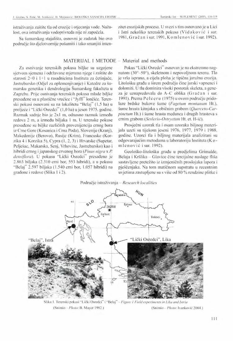
Gračan, S. Perić, M. [vanković, H. Marjanović: BIOLOŠKA SANACIJA EROZIJE Šumarski list - SUPLEMF.NT (2005). 110-119
istraživanja zaštite tla od erozije i otjecanja vode. Nažalost, ova istraživanja vodoprivreda nije ni započela.
Sa šumarskog stajališta, osnovni je zadatak bio ovo područje što djelotvornije pošumiti i tako smanjiti inten
zitet crozijskih procesa. U svezi s tim osnovano je u Lici i Istri nekoliko terenskih pokusa (Viđaković i sur. 1981, Gračan i sur. 1991,Komlenović i sur. 1992).
MATERIJAL I METODE - Material and methods Za osnivanje terenskih pokusa biljke su uzgojene
sjetvom sjemena i održavane mjerama njege i zaštite do starosti 2+0 i 1 + 1 u rasadnicima Instituta za četinjače, Jastrebarsko (Odjel za oplemenjivanje) i Katedre za šumarsku genetiku i dendrologiju Šumarskog fakulteta u Zagrebu. Prije osnivanja terenskih pokusa mlade biljke presađene su u plastične vrećice i "Jyffi" lončiće. Terenski pokusi osnovani su na lokalitetu "Belaj" (1,5 ha) u proljeće i "Lički Osredci" (1,0 ha) ujesen 1975. godine. Razmak sadnje bio je 2x1 m, odnosno razmak između redova 2 m, a između biljaka lm . U terenske pokuse presađene su biljke različitih provenijencija crnog bora iz Crne Gore (Kosanica i Crna Poda), Slovenije (Kranj), Makedonije (Berovo), Rusije (Krim), Francuske (Korzika 4 i Korzika 5), Cypra (1, 2, 3) i Hrvatske (Supetar, Pelješac, Makarska, Senj, Vrhovine, Jastrebarsko) kao i hibridi crnog i japanskog crvenog bora (Pinus nigra x P. densiflora). U pokusu "Lički Osredci" presađeno je 2.863 biljaka (2.310 crni bor, 553 hibridi), a u pokusu "Belaj" 2.597 biljaka (1.540 crni bor, 1.057 hibridi) na gradone i redove (Slika 1 i 2).
Pokus "Lički Osredci" osnovan je na ekstremno nagnutom (30°-50°), skeletnom i nepovoljnom terenu. Tlo je vrlo isprano, a cijela ploha je tipična jaružna erozija. Litološku gradu u širem području čine jurski vapnenci i dolomiti. U tlu dominira visoki postotak skeleta, a geneza je uznapredovala do A-C oblika (Gračan i sur. 1991). Prema Pelceru (1975) u ovom području pridolaze brdske bukove šume (Fagetum montanum Ht.), šume hrasta kitnjaka s običnim grabom (Querceto-Car-pinetum Ht.) i šume hrasta medunca i drugih hrastova s crnim grabom (Seslerio-Ostryetum Ht. et. H-ić).
Prosječni uzorak tla i osam uzoraka biljnog materijala uzeti su tijekom jeseni 1976, 1977, 1979 i 1988. godine. Uzorci tla i biljnog materijala analizirani su odgovarajućim metodama u laboratoriju Instituta (K o -m l e n o v i ć i sur. 1992).
Geološko-litološku građu u predjelima Grimalde, Belaja i Kršlika - Glavice čine tercijalne naslage fliša sastavljene pretežito iz izmjeničnih proslojaka lapora i pješčenjaka. Na tom matičnom supstratu u recentnim uvjetima zastupljene su s više od 80 % rendzine plitke i
Područje istraživanja -Research localities
"Belaj", Istra
Slika 1. Terenski pokusi "Lički Osredci" i "Belaj" - Figure 1 Field experiments in Lika and Istria (Snimio - Photo: B. Mayer 1982.) (Snimio - Photo: 1 vanković 2004.)
Ill
J. Graćan, S. Perić, M. Ivanković, H. Marjanović: BIOLOŠKA SANACIJA RROZIJE Šumarski list - SUPLEMF.NT (2005), 110-119
srednje duboke. Uz njih uprskano dolaze sirozemi ko-luvijalno tlo i posmeđena rendzina (Mart i no vic 1977, M a r t i n o v i ć i Vrbek 1982, M a r t i n o v i ć i Ces ta r 1984).
U ovom se području razvila šuma hrasta medunca i bjeloga graba (Orno-Carpinetum orientalis, Be r to -vić i Lovr ić 1987).
Na pokusu "Zrmanja" koji je osnovan 1957. godine sadnjom šumskih saadnica, voćaka i ostavljanjem travnatih površina, praćenje uspjeh pošumljavanja na 6 ploha i na površini od oko 20 ha (Cestar i sur. 1985).
REZULTATI I RASPRAVA - Results and discussion Rezultati istraživanja "Biološke sanacije erozije u
Lici i Istri" odnose se na preživljavanje, izmjere visina, prsnih promjera i praćenje rasta i razvoja biljaka crnoga bora u terenskim pokusima Lički Osredci, Belaj, Zrmanja). U pokuse je presađeno 18 različitih provenijencija crnog bora i 9 hibridnih familija crnog i japanskog crvenog bora. Poznato je kako crni bor ima izrazito disjunktan areal, a od prirode pridolazi u Južnoj Europi, sjeverozapadnoj Africi i Maloj Aziji.
Rezultati preživljavanja biljaka (%), prosječne visine (m i cm) i prsnih promjera (cm i mm) prikazani su u tablicama 1, 2 i 3 te slikama 1, 2 i 3. za terenski pokus u Ličkim Osredcima i tablici 3 za terenski pokus Belaj.
Lički Osredci Iz tablice 1 i 2 razvidno je kako je u terenski pokus
Lički Osredci presađeno ukupno 2863 biljke, od čega 2310 biljaka crnog bora i 533 hibrida. Postotak preživljavanja biljaka 1988. godine kretao se od 17,20 % (Cy-par 2) do 96,20 % (Berovo, Makedonija), a 2004. godine od 17,20 % (Cypar 2) do 90,77 % Pakline, Hrvatska.
Prosječne visine biljaka crnog bora 1988. godine iznosile su 2,03 m, a 2004. godine 5,75 m. Najmanje prosječne visine od 1,18 m 1988. godine imale su biljke provenijencije Cypar 1, a najveće biljke provenijencije Crna Poda u iznosu od 2,74 m. Najmanje prosječne visine ujesen 2004. godine imale su biljke provenijen-
Tablica 1. Preživljavanje i prosječne visine biljaka crnog bora i hibrida između crnog i japanskog crvenog bora za 1988 i 2004. ("Lički Osredci")
Table 1 Survival rate and heights of black pine and hybrid seedlings
R. br. Ord. No
1 2 3 4 5 6 7 8 9
10 11 12 14 15 16 17 18 19
Provenijencija (porijeklo populacija, familija) Provenance (population origin, family) Kosanica C.G. Crna poda C.G. Pelješac HR Supetar HR Pakline HR Staza HR Borov vrh HR Berovo MK Krim br. 1 SSSR Krim br. 2 SSSR Korzika br. 4 FR Korzika br. 5 FR Golzuk TU NizavTU Nac. park TU Cypar 1 Cypar 2 Cypar 3
Ukupno crni bor - Total black pine Hibridi -Hybrids Ukupno - Total
broj familija
No of families
2
5
1
2
2
3
3
18 9
27
sadeno biljaka No of
plants 865 603
81 59 65 53 34 73 70 93 51 55 31 53 27 40 29 28
2310 553
2863
Preživljavanje % Survival %
1988
50,85 62,20 75,80 81,40 95,38 84,91 73,53 96,20 78,60 45,20 56,85 54,50 51,60 58,50 66,65 67,50 17,20 67,86 65,82 40,30 64,48
2004
50,52 60,53 72,84 77,97 90,77 75,47 50,00 64,38 78,60 38,71 56,85 54,50 48,39 58,50 66,65 60,00 17,20 57,14 59,95 25,14 58,11
visine (m) Heights (m)
1988
2,55 2,74 2,12 2,03 2,03 1,69 2,16 2,69 2,67 2,27 2,11 1,82 2,32 2,33 1,61 1,38 1,18 1,53 2,03 1,85
2004
8,05 6,60 6,09 5,91 5,05 6,40 4,59
10,30 5,74 4,67 5,23 7,33 6,49 6,41 3,63 2,57 3,92 4,55 5,75 2,91
dbh (cm) Dbh (cm)
2004
12,63 12,21 10,99 7,56 8,83 8,89 7,16
13,23 12,78 8,48 8,86 8,37
12,53 10,70 9,78 5,02 7,16 6,65 9,55 5,44
112
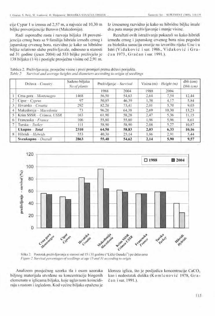
J. Gračan, S. Perić, M. Ivanković, H. Marjanovic: BIOLOŠKA SANACIJA F.ROZIJE Šumarski list - SUPLEMENT (2005), 110-119
cije Cypar 1 u iznosu od 2,57 m, a najveće od 10,30 m biljke provenijencije Berovo (Makedonija).
Radi usporedbe rasta i razvoja biljaka 18 provenijencija crnog bora sa 9 familija hibrida između crnog i japanskog crvenog bora, razvidno je kako su hibridne biljke relativno slabo preživljavale, odnosno u starosti od 31 godine (jesen 2004) od 533 biljke preživjelo je 138 biljaka (1/4) i postigle prosječnu visinu od 2,91 m.
Iz iznesenog razvidno je kako su hibridne biljke imale dva puta manje preživljavanje i manje visine.
Rezultati ovih istraživanja pokazali su kako hibridi između crnog i japanskog crvenog bora nisu pogodni za biološku sanaciju erozije na izvorištu rijeke Une i u Istri ( V i d a k o v i ć i sur. 1986., V i d a k o v i ć i G r a č a n 1973., G r a č a n i sur. 1991.).
Tablica 2. Preživljavanje, prosječne visine i prsni promjeri prema državi porijekla. Table 2 Survival and average heights and diameters according to origin of seedlings
1 2 3 4 5 6 7
8
Država - Country
Crna gora - Montenegro Cipa r - Cyprus Hrvatska - Croatia Makedonija - Macedonia Krim SSSR - Crimea, USSR Francuska - France Turska - Turkey Ukupno Total Hibridi -Hybrids Sveukupno Overall
Sađeno biljaka No of plants
1468 97
292 73
163 106 111
2310 553
2863
Preživljenje - Survival
1988 56,50 50,85 82,20 96,20 61.90 55,80 58,90 64,50 40,30 55,40
2004 54,63 46,39 73,41 64,38 58,28 55,80 58,90 58,83 25,14 54,62
Visina (m) - Height (m)
1988 2,64 1,38 2,01 2,69 2,47 1,96 2,08 2,03 1,86 2,14
2004 7,54 4.17 5.70
10,30 5.36 5.96 5,27 6,33 2,91 5,90
dbh (cm) Dbh (cm)
12,44 5,84 9,03
13,23 11,15 8,61
10,87 10,16
5,44 9,57
120
100 ŽČ
•f 40 >s
GCV <& s* «V* *f
Slika 2. Postotak preživljavanja u starosti od 15 i 31 godinu ("Lički Osredci") po državama Figure 2 Survival percentages of seedlings at age 15 and 31 according to origin
#
Analizom prosječnog uzorka tla i osam uzoraka biljnog materijala utvrđene su koncentracije biogenih elemenata u iglicama biljaka, koje uglavnom koincidiraju s rastom i izgledom. Kod većine biljaka opažena je
kloroza iglica, što je posljedica koncentracije CaC0 3
kao i nedostatak dušika ( K o m l e n o v i ć 1978, G r a č a n i sur. 1991.).
113
J. Gračan. S. Perić, M. Ivanković. H. Marjanović: BIOLOŠKA SANACIJA EROZIJK ... Šumarski list SUPLEMENT (2005), 110-119
11
Slika 3. Prosječne visine biljaka u starosti od 15 i 31 godinu ("Lički Osredci") po državama porijekla Figure 3 Average seedling heights at age 15 and 35 according to origin
Belaj osnovan u proljeće 1975, a preživljenje i izmjere visina Kada se radi o rastu i razvoju biljaka na ovom poku- obavljene su 1976 godine. Tijekom 1981. godine u sta
su, treba istaći kako je financiranje ovih istraživnja rosti biljaka od 11 godina izmjerene su visine i prsni prestalo 1981. godine. Kao stoje navedeno, pokus je promjeri (Tablica 3).
Tablica 3. Preživljavanje, prosječne visine i prsni promjeri biljaka crnog bora i hibrida između crnog i japanskog crvenog bora za 1976. ("Belaj")
Table 3 Survival, average heights and diameters of black pine and hybrids in 1976 and 1981 in the "Belaj " field experiment
R. br. Ord. No
1 2 3 4 5 6 7 8 9
10 11 12 13 14
SO broj
number
86 87
216 1076 1077 1078 1079 1080 1081 1086 1087 1083 1084
Provenijencija (porijeklo populacija, familija)
Provenance (population origin, family)
Jastrebarsko HR
Vrhovine HR
Senj HR Kranj SLO
Pelješac HR
Berovo MK. Ukupno crni bor Total black pine
1 2
1050 1053
Hibrid - Hybrids Hibrid - Hvbrids
Ukupno hibrida - Total Hybrids Sveukupno - Overall
sadeno biljaka No of
plants 145 143 347
22 63 44 20
155 91 58 42
110 190 110
1540 748 309
1057 2597
Preživljavanje % Survival %
1976 89,86 88,11 77,52
100,00 96,83 95,45 95,00 97,42 94,51 77,59 95,24 67,27 59,47 54,55 59,30 77,81 87,06 80,00
visine (cm) Heights (cm)
1976 14,10 11,90 17,00 15,50 13,90 12,50 13,70 11,40 11,50 9,50 8,60
14,10 12,70 12,80
14,70 18,80
1981 47,03 62,97 64,83 87,09 67.98 69,51 84,67 62,56 60,25 22,69 21,91 65,68 51,87 50,30 54,25 47,03 61,46 54,25 58,40
promjeri (mm) diameters
1981 24,83 38,24 26,58 32,55 35,15 40,61 44,67 36,12 34,79
9,76 8,59
33,25 28,33 21,25 29,62 22,58 27,95 25,27 27,45
114
J. Gračan, S. Perić. M. Ivankovic, II. Marjanović: BIOLOŠKA SANACIJA EROZIJE . Šumarski list - SUPLEMENT (2005), 110-119
Slika 4. Biljke crnoga bora sađene na gradone 1975, terenski pokus Belaj 2004.
Figure 4 Plants ofPinus nigra planted in gradones in 1975, the Belaj 2004 field experiment
(Snimio - Photo: Ivankovic)
Prosječni postotak preživljavanja svih biljaka na ovom pokusu iznosio je 1976. godine 69,65 %, a prosječna visina 14,80 cm. Prosječni postotak preživljavanja hibridnih biljaka iznosio je 80 % s visinama od
1. Biljke različitih provenijencija crnog bora dominiraju u preživljavanju, visinskom i debljinskom rastu i razvoju u odnosu na hibridne biljke.
2. Prosječni postotak (ponderirani) preživljavanja tih biljaka u 2004. godini iznosi 59,95 %. Prosječne visine iznose 5,75 metara, a prsni promjer 9,55 cm u terenskom pokusu Lički Osredci.
3. Hibridne biljke između crnog i japanskog crvenog bora imaju gotovo dvostruko manje preživljavanje (25,14 %), visine (2,03 m) i prsne promjere (5,44 cm).
4. U Terenskom pokusu u Istri (Belaj) biljke različitih provenijencija u starosti od 8 godina imaju nešto veće visine i prsne promjere od hibridnih biljaka.
B e r t o v i ć , S., A. Ž. Lov r i ć , 1987: Šumske zajednice u Jugoslaviji, Šumarska enciklopedija 3, Zagreb.
Ces ta r , D.,V. Hren, K. Bezak,V. Kre jč i , 1985: Inventarizacija i valorizacija pokusne plohe "Zrmanja", Stručni izvještaj za 1985., 31 pp. Šumarski institut, Jastrebarsko.
G r a č a n , J., M. V i d a k o v i ć , T. L i t tvay , N. Ko-m l e n o v i ć , P R a s t o v s k i , 1991: Prilog sanaciji erozije na području izvorišta rijeke Une. Radovi Vol. 26, broj 1:5-23.
16,75 cm. Preživljavanje biljaka crnog bora različitih provenijencija iznosio je 59,30 % s prosječnom visinom biljaka od 12,80 cm. Iz iznesenog je vidljivo kako su hibridne biljke u juvenilnom stadiju većeg postotka preživljavanja i prosječnih visina, što se i očekivalo.
Rezultati izmjera visina i prsnih promjera svih biljaka u pokusu 1981. godine su pokazali kako su prosječne visine različitih provenijencija crnog bora imale nešto više prosječne visine biljaka (58,40 cm) od hibridnih (54,25 cm). Što se tiče prsnih promjera odnos je ostao isti, odnosno prosječni promjer crnog bora iznosio je 29,62 mm, a hibrida 25,27 mm. Prosječna debljina biljaka u pokusu bila je 27,45 mm.
Rezultati dosadašnjih istraživanja pokazali su kako su tla u Istri na kojima su osnovani pokusi karbonatna, slabo alkalne reakcije, dobro opskrbljena pristupačnim kalcijem, a slabo fosforom. Stanje humizacije i opskrbljenost ukupnim dušikom je dobra. Tla imaju ekološki povoljan mehanički sastav, pretežito pripadaju u teksturne klase: glinasta ilovača i praškasta glina (Mar t inov ić 1977, M a r t i nov i ć iVrbek 1982, M a r t i n o v i ć i C e s t a r 1987).
Conclusions
5. Sa šumarskog stajališta, biološka sanacija erozije sadnjom biljaka crnoga bora omogućuje brže i djelotvornije pošumljavanje erodiranih površina i time značajno smanjuje intenzitet erozije te omogućuje povratak autohtone vegetacije. Na kraju koristimo priliku te zahvaljujemo ta
dašnjem upravitelju Šumarije Gračac dipl. ing. Davoru Zecu , dipl. ing. šumarstva i upravitelju Šumarije Labin, Krunoslavu B o ž i č e v i ć u , dipl. ing. šumarstva, koji su pomogli da se obave izmjere biljaka i dovrše istraživanja.
I v a n č e v i ć , V. 2003: 125 obljetnica osnutka "kraljevskog nadzorništva za pošumljavanje krasa krajiškog područja - inspektorata za pošumljavanje krševa, goleti i uređenje bujica" u Senju, naše najstarije šumarske krške organizacije, 1878 - 2003. godine. Šum. list - Suplement (2003)3-22.
K o m l c n o v i ć , N., Đ. Marko ja , P R a s t o v s k i : Istraživanje utjecaja sjetvenih supstrata i mineralnih gnojiva na rast i ishranu drveća i grmlja, Zagreb, Šumarski list.
ZAKLJUČCI
LITERATURA - References
115
J. Gračan, S. Pcrić, M. Ivanković. H. Marjanović: BIOLOŠKA SANACIJA EROZIJE ... Šumarski list - SUPLEMENT (2005), 110-119
K o m l e n o v i ć , N., B. Mayer , P. Ras tovsk i , 1992: Suzbijanje erozije na flišu Istre uzgojem alep-skog bora (Pinus halepensis) i brnistre (Spar-tium junceum). Rad. Šumar, inst, Vol. 27 broj 1: 5-14.
M a r t i n o v i ć , J . 1977: Osnovna pedološka karta Hrvatske, list Pazin 2, tumač.
M a r t i n o v i ć , J., B. Vrbek, 1982: Pedološka obrada sliva Botonega. Fond Šumarskog instituta, Jas-trebarsko.
M a r t i n o v i ć , J., D. Ces ta r , 1987: Tla šumskih ekosustava u Istri u ediciji Pedosfera Istre (A. Škorić i suradnici, Zagreb).
Pel cer, Z. 1975: Fitocenološko raščlanjenjc ličke visoravni i njihovo uređenje na ekološko-vegeta-cijskoj osnovi. Doktorska disertacija, Šumarski fakultet, Zagreb.
R a d u l o v i ć , H . 1972: Pedologija, Sarajevo. Top ić , V. 1982: Efekti biološko tehničkih melioracio-
nih mjera na pokusnoj plohi Klačine, Šum. list 106:11-19.
Top ić , V. 1997: Upotrebljivost listača pri pošumlja-vanju krša, Šum. list 7-8: 343-352.
To p i ć, V. 1999a: Površinski kopovi na Kaštelanskom području i mogućnosti njihove sanacije, Šumarski list 7-8: 301-309.
Topić , V. 199b: Melioracijski učinci šumskih kultura na kršu u odnosu na pedosferu, Šumarski list 9-10:411-422.
Top ić , V. 2003: Šumska vegetacija na kršu kao značajan čimbenik zaštite tla od erozije, Šumarski list - Suplement (2003): 51-64.
V i d a k o v i ć , M., J. G r a č a n , 1973: Sanacija erozije na području izvorišta rijeke Une. Stručni izvještaj, Šumarski institut, Jastrebarsko.
Vidakov ić , M., J. Mar t inov ić , I. T r ina j s t i ć , J. Gračan , N. Komlenov ić , A. Krs t in i ć , Ž. Borzan , 1981: Biološka sanacija erozije fliša Istre, Kongres biologa Hrvatske, Poreč, 1-103.
V i d a k o v i ć , M.,Ž. Borzan , N. K o m l e n o v i ć , A. K r s t i n i ć , 1986: Testiranje nekih familija čistih vrsta i povratnih križanaca dvoigličavih borova na kršu. Analiza šumarstvo 12/3, Jugoslavenska akademija znanosti i umjetnosti.
116
PRESENTATION AT THE INTERNATIONAL SYMPOSIUM Šumarski list - SUPLEMENT (2005). 110-119
B I O L O G I C A L EROSION C O N T R O L IN T H E W E S T E R N PART OF CROATIA
Joso GRAČAN, Sanja PERIĆ, Mladen IVANKOVIĆ, Hrvoje MARJANOVTĆ'
SUMMARY: The paper presents research results of biological erosion control at the source of the river Una (Forest Administration Gospić, Forest Office Gračac) and in Istria (Forest Administration Buzet, Forest Office Labin). Research was initiated in 1972 and conducted by the Faculty of Forestry, University of Zagreb (Department of Forest Genetics and Dendrology) and the former Yugoslav Conifer Institute, Jastrebarsko (Department of Forest Tree Improvement). Research was financed by Karlovac Water Management Company and Rijeka Water Management Company and co-financed by the General Forestry Association of Croatia and the Republican Scientific Fund, Zagreb.
Field experiments established in the spring covered an area of about 1.5 ha (Istria), while those established in the autumn (Lika) took up about 1 h. The experiments involved transplants of Austrian pine and hybrids of Austrian and Japanese red pine. The first research results were published when the plants reached 15 years of age (Lika) and 5 years of age (Istria). The average survival percentage in the field experiment in Lika was 59 % and the average height was 2.03 m. In Istria, the average survival percentage was 80.40% and the average height was 16.6 cm at the age of 5. As a rule, hybrids attained lower heights and survival percentages.
Key words: Pinus nigra, P. densiflora, hybrids, erosion, biological control
INTRODUCTION
The erosion area at the source of the river Una extends over about 170 km2 and is among the most seriously threatened in Croatia. Soil erosion control in the area began in 1957 with the erection of civil engineering facilities. However, it soon became clear that the soil could not be protected against erosion with technical measures only, and that biological soil protection was also required ( V i d a k o v i ć etal. 1986, G r a č a n et al. 1991, I v a n č e v i ć et al. 2003). This area contains all erosion phenomena: surface, furrow and ditch erosion ( R a d u 1 o v i ć 1972). According to Topic (1997), the problem of karst and its afforestation has been treated by a number of Croatian authors. A characteristic example of flysch erosion, which is generally not very common on flysch in Croatia, is found in the area of the rivers Botonega and Boljunšćica in
Joso Gračan, Sanja Perić, Mladen Ivanković, Hrvoje Marjanović Forest Research Institute, Jastrebarsko, Croatia
Central Istria. Apart from the soil, erosion also affects the lithological substrate ( K o m i e n o v i e etal. 1983). Soil protection against erosion and torrents has exceptional economic, ecological and social importance in karst areas ( T o p i c 2003).
The paper presents research results of soil protection against erosion within the project "Biological erosion control in Lika and Istria". The project was jointly undertaken by the former Conifer Institute Jastrebarsko (Department of Forest Tree Improvement) and the Faculty of Forestry, Zagreb (Department of Forest Genetics and Dendrology). Research was financed by the Republican Scientific Fund (later the Ministry of Science) and the Karlovac and Rijeka Water Management Companies and co-financed by the General Forestry Association (later Croatian Forests). The project involved both biological and technical-biological research in soil protection against erosion and runoff. Regrettably, the water management companies mentioned above have not even started the research yet.
117
J. Gračan, S. Pcrić. M. Ivankouć. II. Marjanović: BIOLOGICAL liROSION CONTROL ... Šumarski list SUPLKMLNT (2005). 110-11')
From the forestry standpoint, the basic task related experiments were established in Lika and Istria (Vito efficient area afforestation with the goal of reducing d a k o v i ć et al. 1981, G r a č a n et al. 1991, K o m 1 e -erosion intensity. To accomplish the task, several field n o v i ć et al. 1992).
MATERIAL A N D M E T H O D S
The plants used in field experiments were raised in the nurseries of the Conifers Institute in Jastrebarsko (Department of Improvement) and the Department of Forest Genetics and Dendrology at the Faculty of Forestry in Zagreb. They were grown from sown seeds and maintained by tending and protection measures until the age of 2+0 and 1 + 1. Prior to establishing field experiments, the young plants were transplanted in plastic bags and "Jyffi" pots. Field experiments were established in the locality of "Belaj" (1.5 ha) in the spring and in "Lički Osrcdci" (1.0 ha) in the autumn of 1975. Different provenances of Austrian pine from Crna Gora (Kosanica and Crna Poda), Slovenia (Kranj), Macedonia (Berovo), Russia (Crimea), France (Corsica 4 and Corsica 5), Cyprus (1,2, 3) and Croatia (Supetar, Pelješac, Makarska, Senj, Vrhovine, Jastrebarsko), as well as hybrids of Austrian and Japanese red pine (Pinus nigra x P. densiflora) were transplanted in field experiments. In the "Lički Osredci" experiment, 2,863 plants (2,310 black pines, 553 hybrids) and in the "Belaj" experiment 2,597 plants (1,540 Austrian pines, 1,057 hybrids) were transplanted in gradones and in rows (Figures 1 and 2).
The "Lički Osredci" experiment was established on an extremely inclined (30°-50°), skeletal and unfavourable terrain. The soil is excessively leached, and the whole plot is typical ditch erosion. The lithological composition of the wider area consists of Jurassic limestones and dolomites. There is a high percentage of skeletal soil, while genesis has reached the A-C form
The results of research entitled "Biological erosion control in Lika and Istria" relate to survival rates, measurements of heights and breast diameters and monitoring the growth and development of Austrian pine in field experiments established in Lički Osredci, Belaj and Zrmanja. A total of 18 different provenances of Austrian pine and 9 hybrid families of Austrian and Japanese red pine were transplanted in the experiments. Austrian pine is well known for its distinctly disjunct distribution range. It occurs naturally in the south of Europe, in the northwest of Africa and in Asia Minor.
The results of plant survival (%), average heights (m and cm) and breast diameters (cm and mm) are shown in Tables 1, 2 and 3 and Figures 1, 2, and 3 for the field experiment in Lički Osrcdci and in Table 3 for the field experiment Belaj.
( G r a č a n et al. 1991). According to Pe l c e r (1975), this is an area of montane beech forests (Fagetum mon-tanum Ht.), forests of sessile oak with common hornbeam (Querceto-Carpinetum Ht.) and forests of pubescent oak and other oaks with hop hornbeam (Seslerio-Ostryetum Ht. et. H-ić).
The average soil sample and eight samples of plant material were taken during the autumn of 1976, 1977, 1979, and 1988. The soil and plant material samples were analyzed with suitable methods in the Institute laboratory (Kom l e n o vi ć etal. 1992).
The geological-lithological structure in the areas of Grimalda, Belaj and Kršlika - Glavica consists of Tertiary flysch deposits mainly composed of alternative marl and sandstone interlayers. Under recent conditions, this type of parent substrate is represented with over 80 % of shallow and moderately deep rendzinas. They are accompanied with regosols, colluvium and cambic rendzina arranged in a mosaic-like pattern ( M a r t i n o v i ć 1977, M a r t i n o v i ć and Vrbek 1982, M a r t i n o v i ć and C e s t a r 1984).
The dominant community in the area is the forest of pubescent oak and oriental hornbeam (Orno-Carpine-tum orientalis, B e rt o v i ć and L o v r i č 1987).
The success of afforestation was monitored in 6 plots covering an area of about 20 ha in the "Zrmanja" experiment. The experiment was established in 1957 with seedlings of forest trees and fruits and with uncovered grass areas (C e s t a r etal. 1985).
Lički Osredci As seen in Tables 1 and 2, a total of 2,863 plants, of
which 2,310 Austrian pines and 533 hybrids, were transplanted in the field experiment of Lički Osredci. The plant survival rate ranged from 17.20 % (Cypar 2) to 96.20 % (Berovo, Macedonia) in 1988, and from 17.20 % (Cypar 2) to 90.77 % (Pakline, Croatia) in 2004.
The average height of Austrian pine was 2.03 m in 1988 and 5.75 m in 2004. In 1988, Cypar 1 attained the smallest average height of 1.18 m, while the plants of the Crni Pod provenance achieved the highest height of 2.74 m. In the autumn of 2004, the Cypar I provenance attained the smallest average height of 2.57 m, whereas the plants of the Berovo provenance (Macedonia) achieved the highest of 10.30 m.
RESULTS A N D DISCUSSION
118
J. Gračan, S. Perić, M. Ivanković, H. Marjanović: BIOLOGICAL EROSION CONTROL Šumarski list - SUPLEMENT (2005), 110-119
Comparison of growth and development of the plants of 18 Austrian pine provenances and 9 hybrid families of Austrian pine and Japanese red pine showed that hybrid plants had a relatively poor survival rate. At the age of 31 (autumn 2004), 138 plants out of 533 (1/4) survived and achieved an average height of 2.91 m. Clearly, not only was the survival rate of hybrid plants twice as low, but they also achieved lower heights.
Research results indicate that the hybrids between Austrian pine and Japanese red pine are not suitable for biological erosion control at the source of the river Una and in Istria (Vidaković et al. 1986, V idakov ić and Gračan 1973, Gračan etat. 1991).
The average soil sample and eight samples of plant material were analyzed to show biogenic element concentrations in the needles of the plants, which mostly coincides with growth and appearance. Needle chlorosis was observed in the majority of the plants as a consequence of CaC03 concentration and nitrogen deficiency (Komlenov ić 1978,Gračan etal. 1991).
Belaj Related to plant growth and development in this ex
periment, it should be stressed that the financing of this research was stopped in 1981. As mentioned earlier, the experiment was established in the spring of 1975, and survival and height measurements were performed in 1976. Heights and breast diameters were measured in the course of 1981 at plant age of 11 (Table 3).
1. Compared with hybrid plants, different provenances of Austrian pine dominate in terms of survival, height and diameter growth and development.
2. The average survival percentage (pondered) of these plants was 59.95 % in 2004. In the field experiment of Lički Osredci the average heights were 5.75 meters and breast diameter was 9.55 cm.
3. The hybrids between Austrian pine and Japanese red pine show nearly twice as low survival rate (25.14 %), height (2.03 m) and breast diameter (5.44 cm).
4. In the field experiment in Istria (Belaj), 8-year-old plants of different provenances show slightly better heights and breast diameters than hybrid plants.
The average survival rate of all the plants in this experiment was 69.65 % in 1976, and the average height was 14.80 cm. The average hybrid survival rate was 80 % at the height of 16.75 cm. The survival of Austrian pines of different provenances was 59.30 %, with the average plant height of 12.80 cm. As expected, hybrid plants in the juvenile stage had higher survival percentages and average heights.
The results of height and breast diameter measurements of all the plants in the 1981 experiment showed that the average heights of different provenances of Austrian pine were slightly higher (58.40 cm) compared to those of hybrids (54.25 cm). As for breast diameters, the ratio remained the same: the average dbh of Austrian pine was 29.62 mm and that of hybrids 25.27 mm. The average plant thickness in the experiment was 27.45 mm.
The results of past research have shown that the soils in Istria in which the experiments were established are carbonate, of weakly alcalic reaction, well supplied with accessible calcium and poor in phosphorus. The humi-zation condition and the total nitrogen supply are satisfactory. The soils have an ecologically favourable mechanical composition and belong predominantly to the textural classes of clayey loam and silty clay (Mart i-nović 1977, Mar t inov ić and Vrbek 1982, Marti nović and Cestar 1987).
5. From a forestry standpoint, biological erosion control achieved by planting seedlings of Austrian pine results in faster and more efficient afforestation of eroded areas. This considerably reduces the erosion intensity and enables the return of autochthonous vegetation. We take this opportunity to thank Mr Davor Zec,
BSc, former manager of the Forest Office Gračac, and Mr Krunoslav Božičević, BSC, manager of the Forest Office Labin, on their invaluable help in plant measurements and finalization of this research.
CONCLUSION
119
IZLAGANJE NA ZNANSTVENOM SKUPU - PRESENTATION AT THE INTERNATIONAL SYMPOSIUM Šumarski list-SUPLEMENT (2005) 120-132 UDK 630* 232.5
B I O L O Š K A SANACIJA POVRŠINSKIH KOPOVA I DEPONIJA PRILIKOM IZGRADNJE AUTOCESTA U HRVATSKOJ
BIOLOGICAL CONTROL OF EXCAVATIONS AND DUMPS DURING THE CONSTRUCTION OF HIGHWAYS IN CROATIA
Sanja PERIĆ, Vlado TOPIC, Željko OREŠKOVIĆ, Romana MARADIN*
SAŽETAK: Ovaj rad razmatra problematiku biološke sanacije površinskih kopova i deponija na dionici autoceste Maslenica-Zadar 1. Posljednjih nekoliko godina velika pozornost posvećena je prostornom planiranju trasa autocesta. Nažalost, uz njihovu izgradnju usko je povezano i narušavanje stabilnosti ekosustava kroz koji prolaze, te s ekološkog stajališta izgradnja autocesta predstavlja važan problem. Kod odabira trasa autocesta vodi se briga o minimalnom narušavanju prirode. Bez obzira na te činjenice, dolazi do izmjene krajolika koji nakon određenih zahvata u prostoru treba ponovno poprimiti svoje krajobrazne, ekološke i estetske funkcije.
Istraživanja su provedena na lokacijama Rovanjska (oko 300 m južnije od istoimenog naselja i Velebitskog kanala u podnožju Velebita) i Posedarje koja se nalazi uz samu autocestu Split-Zagreb, s njezine južne strane. Teren na kojem se nalazi površinski kop i deponija građevnog materijala ima tipičnu krašku morfologiju. Kod jačih oborina javljaju se površinska otjecanja i površinski erozijskiprocesi. Neposredno uz deponij nalazi se Novigradsku more.
U radu su obrađene prirodne značajke istraživanog područja: geološke i hidrološke karakteristike, klimatske prilike i vegetacijske karakteristike. Analizirana su osnovna načela biološke sanacije. Autori daju popis vrsta šumskog drveća, grmlja, polugrmova i penjačica koje dolaze u obzir za biološku sanaciju, te obrađuju načine sadnje po lokacijama. Za obje lokacije napravljen je shematski prikaz pošumljavanja.
Cilj rada je pošumljavanjem, kao meliorativnom mjerom u zaštiti krajobraza, pošumiti i ozeleniti to područje kako bi se spiječila erozija i oplemenila pejzažna i vizualna vrijednost krajolika.
Ključne riječi: biološka sanacija, autoceste, vrste sadnica, način sadnje, pošumljavanje, erozija
UVOD - Introduction
Posljednjih nekoliko godina u strateškim smjernicama razvoja Republike Hrvatske najveća pozornost posvećena je prostornom planiranju trasa autocesta. Povezivanje pojedinih krajeva naše zemlje jedan je od ključnih momenata. Nažalost, uz izgradnju autocesta
* Dr. se. Sanja Perić, Dr. se. Vlado Topić, Željko Orcšković, dipl. ing., Romana Maradin, dipl. ing.. Šumarski institut Jastrcbarsko
usko je povezano i narušavanje stabilnosti ekosustava kroz koje te ceste prolaze. Kod odabira trasa autoceste prihvaća se ona koja na neki način minimalno narušava prirodu. Ipak, tako izmijenjen krajolik treba ponovno poprimiti svoje krajobraznc, ekološke i estetske funkcije. Zbog toga je uz projektnu dokumentaciju o izgradnji autoceste zbog velikih zahvata u prostoru, obvezno izraditi Studiju utjecaja na okoliš, te Projekt biološke sanacije uz trase pojedinih dionica.
120
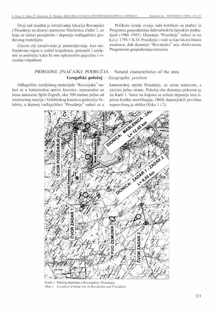
S. Pcrić. V. Topic. Ž. Orešković. R. Maradin: BIOLOŠKA SANACIJA POVRŠINSKIH KOPOVA I DEPONIJA ... Šumarski list SUPLF.MENT (2005). 120-132
Ovaj rad rezultat je istraživanja lokacija Rovanjska i Posedarje na dionici autoceste Maslenica-Zadar 1, uz koju se nalazi pozajmište i deponija (odlagalište) građevnog materijala.
Glavni cilj istraživanja je pošumljavanje, kao me-liorativna mjera u zaštiti krajobraza, pošumiti i ozeleniti to područje kako bi ono oplemenilo pejzažnu i vizualnu vrijednost.
Prilikom izrade ovoga rada korišteni su podaci iz Programa gospodarenja dalmatinskim šumskim područjem (1986-1995). Deponija "Posedarje" nalazi se na k.č.z. 1791/1 K.O. Posedarje i vodi se kao šikara hrasta medunca, dok deponija "Rovanjska" nije obuhvaćena Programom gospodarenja šumama.
PRIRODNE ZNAČAJKE PODRUČJA - Natural characteristics of the area Geogafski položaj - Geographic position
Odlagalište zemljišnog materijala "Rovanjska" na- katastarskoj općini Posedarje, uz samu autocestu, s lazi se u katastarskoj općini Jasenice, neposredno uz njezine južne strane. Položaj oba deponija prikazan je trasu autoceste Split-Zagreb, oko 300 metara južno od na Karti 1. Teren na kojemu se nalaze deponije ima ti-istoimenog naselja i Velebitskog kanala u podnožju Ve- pičnu krašku morfologiju. Oblik deponijskih površina lebita, a deponij (odlagalište) "Posedarje" nalazi se u nepravilnog je oblika (Slika 1 i 2).
- ' s UJ -• V - , » 3 d i o t-V- ,J>Y
9 sf-J 'J^?%'-- ••" '•*'
rt—_v •• öfes ^ • i j « » ' - « -
/ ' / > ' * ' ^ f/-y * ^*• • vi 2 BA '> i 2r" / bS ^
>nJ
Karta 1. Položaj deponija u Rovanjskoj i Posedarju Ma/; / Location of dump site in Rovanjska and Posedarje
121
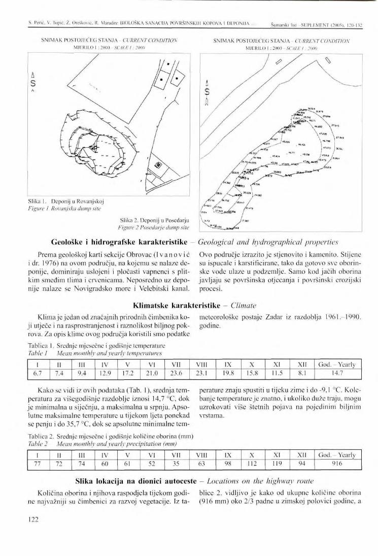
S. Perić. V. Topic, /.. Orešković, R. Maradin: BIOLOŠKA SANACIJA POVRŠINSKIH KOPOVA 1 DHPONIJA ... Šumarski list -SUPLHMENT (2005), 120-132
SNIMAK POSTOJEĆEG STANJA- CURRENT CONDITION MJERILO 1 : 2000 SCALE I : 2000
SNIMAK POSTOJEĆEG STANJA CURRENT CONDITION MJERILO 1 : 2000 - SCALE I : 2000
Slika 1. Deponij u Rovanjskoj Figure 1 Rovanjska dump site
Slika 2. Deponij u Posedarju Figure 2 Posedarje dump site
Geološke i hidrografske karakteristike - Geological and hydwgraphical properties
Prema geološkoj karti sekcije Obrovac ( I v a n o v i ć i dr. 1976) na ovom području, na kojemu se nalaze deponije, dominiraju uslojeni i pločasti vapnenci s plitkim smeđim tlima i crvenicama. Neposredno uz deponije nalaze se Novigradsko more i Velebitski kanal.
Ovo područje izrazito je stjenovito i kamenito. Stijene su ispucale i karstificirane, tako da gotovo sve oborin-ske vode ulaze u podzemlje. Samo kod jačih oborina javljaju se površinska otjecanja i površinski crozijski procesi.
Klimatske karakteristike Climate Klimaje jedan od značajnih prirodnih čimbenika ko- meteorološke postaje Zadar iz razdoblja 1961
ji utječe i na rasprostranjenost i raznolikost biljnog pok- godine, rova. Za opis klime ovog područja koristili smo podatke
Tablica 1. Srednje mjesečne i godišnje temperature Table 1 Mean monthly and yearly temperatures
1990.
1 6.7
II 7.4
III 9.4
IV 12.9
V 17.2
VI 21.0
VII 23.6
VIII 23.1
IX 19.8
X 15.8
XI 11.5
XII 8.1
God. - Yearly 14.7
Kako se vidi iz ovih podataka (Tab. 1), srednja temperatura za višegodišnje razdoblje iznosi 14,7 °C, dok je minimalna u siječnju, a maksimalna u srpnju. Apsolutne maksimalne temperature u tijekom ljeta ponekad se penju i do 35,7 °C, dok se apsolutne minimalne tem-
Tablica 2. Srednje mjesečne i godišnje količine oborina (mm) Table 2 Mean monthly and yearly precipitation (mm)
perature znaju spustiti u tijeku zime i do -9,1 °C. Kolebanje temperature je znatno, i ukoliko duže traju, mogu uzrokovati više štetnih pojava na pojedinim biljnim vrstama.
1 77
II 72
III 74
IV 60
V 61
VI 52
VII 35
VIII 63
IX 98
X 112
XI 119
XII 94
God. Yearly 916
Slika lokacija na dionici autoceste - Locations on the highway route
Količina oborina i njihova raspodjela tijekom godi- blice 2. vidljivo je kako od ukupne količine oborina ne najvažniji su čimbenici za razvoj vegetacije. Iz ta- (916 mm) oko 2/3 padne u zimskoj polovici godine, a
122
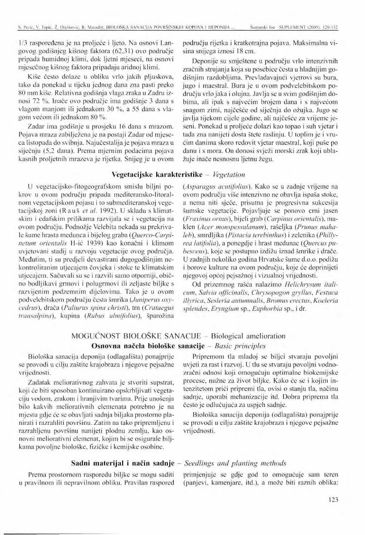
S. Pcrić. V. Topic. Ž. Oreškovic, R- Maradin: BIOLOŠKA SANACIJA POVRŠINSKIH KOPOVA I DEPONIJA ... Šumarski list SUPLKMENT (2005). 120-132
1/3 raspoređena je na proljeće i ljeto. Na osnovi Lan-govog godišnjeg kišnog faktora (62,31) ovo područje pripada humidnoj klimi, dok ljetni mjeseci, na osnovi mjesečnog kišnog faktora pripadaju aridnoj klimi.
Kiše često dolaze u obliku vrlo jakih pljuskova, tako da ponekad u tijeku jednog dana zna pasti preko 80 mm kiše. Relativna godišnja vlaga zraka u Zadru iznosi 72 %. Inače ovo područje ima godišnje 3 dana s vlagom manjom ili jednakom 30 %, a 55 dana s vlagom većom ili jednakom 80 %.
Zadar ima godišnje u prosjeku 16 dana s mrazom. Pojava mraza zabilježena je na postaji Zadar od mjeseca listopada do svibnja. Najučestalija je pojava mraza u siječnju (5,2 dana). Prema mjernim podacima pojava kasnih proljetnih mrazeva je rijetka. Snijeg je u ovom
U vegetacijsko-fitogeografskom smislu biljni pokrov u ovom području pripada mediteransko-litoral-nom vcgetacijskom pojasu i to submediteranskoj vege-tacijskoj zoni ( R a u š et al. 1992). U skladu s klimatskim i edafskim prilikama razvijala se i vegetacija na ovom području. Podnožje Velebita nekada su prekrivale šume hrasta medunca i bijelog graba (Querco-Carpi-netum orientalis H-ić 1939) kao konačni i klimom uvjetovani stadij u razvoju vegetacije ovog područja. Međutim, ti su predjeli devastirani dugogodišnjim nekontroliranim utjecajem čovjeka i stoke te klimatskim utjecajem. Sačuvali su se i razvili samo otporniji, obično bodljikavi grmovi i polugrmovi ili zeljaste biljke s razvijenim podzemnim dijelovima. Tako je u ovom podvelebitskom području česta šmrika (Juniperus oxy-cedrus), drača (Paliurus spina christi), trn (Crataegus transalpina), kupina (Rubus ulmifolius), šparožina
Prema prostornom rasporedu biljke se mogu saditi u pravilnom ili nepravilnom obliku. Pravilan raspored
području rijetka i kratkotrajna pojava. Maksimalna visina snijega iznosi 18 cm.
Deponije su smještene u području vrlo intenzivnih zračnih strujanja koja su posebice česta u hladnijim godišnjim razdobljima. Prevladavajući vjetrovi su bura, jugo i maestral. Bura je u ovom podvelebitskom području vrlo jaka i olujna. Javlja se u svim godišnjim dobima, ali ipak s najvećim brojem dana i s najvećom snagom zimi, najčešće od siječnja do ožujka. Jugo se javlja tijekom cijele godine, ali najčešće za vrijeme jeseni. Ponekad u proljeće dolazi kao topao i suh vjetar i tada zna nanijeti dosta štete raslinju. U toplim je i vrućim danima skoro redovit vjetar maestral, koji puše po danu i s mora. On donosi svježi morski zrak koji ublažuje inače nesnosnu ljetnu žegu.
(Asparagus acutifolius). Kako se u zadnje vrijeme na ovom području više intenzivno ne obavlja ispaša stoke, a nema niti sječe, prisutna je progresivna sukcesija šumske vegetacije. Pojavljuje se ponovo crni jasen (Fraxinus ornus), bijeli grab (Carpinus orientalis), ma-klen (Acer monspessulanum), rašcljka (Prunus maha-leb), smrdljika (Pistacia terebinthus) i zelenika (Philly-rea latifolia), a ponegdje i hrast medunac (Quercus pu-bescens), koje se postupno izdižu iznad šmrike i drače. U zadnjih nekoliko godina Hrvatske šume d.o.o. podižu i borove kulture na ovom području, koje će doprinijeti njegovoj općoj pejsažnoj i vizualnoj vrijednosti.
Od prizemnog rašća nalazimo Helichrysum itali-cum, Salvia officinalis, Chrysopogon gryllus, Festuca illyrica, Sesleria autumnalis, Bromus erectus, Koeleria splendes, Eryngium sp., Euphorbia sp., i dr.
Seedlings and planting methods
primjenjuje se gdje god to omogućuje sam teren (panjevi, kamenjare, itd.), a može biti raznih oblika:
Vegetacijske karakteristike Vegetation
M O G U Ć N O S T BIOLOŠKE SANACIJE - Biological amelioration Osnovna načela biološke sanacije - Basic principles
Biološka sanacija deponija (odlagališta) ponajprije se provodi u cilju zaštite krajobraza i njegove pejsažne vrijednosti.
Zadatak meliorativnog zahvata je stvoriti supstrat, koji će biti sposoban kontinuirano opskrbljivati vegetaciju vodom, zrakom i hranjivim tvarima. Prije unošenja bilo kakvih meliorativnih elemenata potrebno je na mjestu gdje će se obavljati sadnja biljaka prostorno planirati i razrahliti površinu. Zatim na tako pripremljenu i razrahljcnu površinu nanijeti plodnu zemlju, kao osnovni meliorativni elemenat, kojim bi se osigurale biljkama povoljne biološke, fizičke i kemijske osobine.
Pripremom tla mladoj se biljci stvaraju povoljni uvjeti za rast i razvoj. U tlu se stvaraju povoljni vodno-zračni odnosi koji omogućuju optimalne biokemijske procese, nužne za život biljke. Kako će se i kojim intenzitetom prići pripremi tla, ovisi o stanju tla, načinu sadnje, uporabi mehanizacije itd. Dobra priprema tla često je odlučujuća za uspjeh sadnje.
Biološka sanacija deponija (odlagališta) ponajprije se provodi u cilju zaštite krajobraza i njegove pejsažne vrijednosti.
Sadni materijal i način sadnje
123
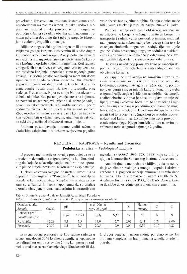
S. Pcrić. V. Topic. Ž. Orešković, R. Maradin: BIOLOŠKA SANACIJA POVRŠINSKIH KOPOVA I DEPONIJA Šumarski liši -SUPLEMENT (2005), 120-132
pravokutan, četverokutan, trokutan, šasterokutan s točno određenim razmacima između biljaka i redova. Nepravilan raspored biljaka posebno se primjenjuje na području krša, jer se sadnja obavlja samo na onim mjestima gdje ima dovoljno tla i gdje je moguće iskopati jamu zadovoljavajućih dimenzija.
Biljke se mogu saditi s golim korjenom ili s busenom. Biljkama gologa korijena s oštećenim ili suviše dugim korijenom skraćujemo korijen. Ako je potrebno reducira se i krošnja radi uspostavljanja ravnoteže između korijena i krošnje u opskrbi vodom i hranjivima. Kod sadnica cmogoričnih vrsta drveća obrczujemo, vrlo oprezno, samo oštećeno korijenje, a ponekad samo najdonje grane krošnje. Pri sadnji prostor oko korijena mora biti dobro ispunjen tlom, a sadnica dobro učvršćena u tlu. Potrebno je posvetiti pozornost dubini sadnje, koja bi nakon slijeganja zemlje trebala ostati ista kao i u rasadniku prije vađenja. Prema tomu, biljka ne smije biti posađena ni u duboko ni plitko. Kod pošumljavanja terena na kojima se na površini nalaze panjevi, stijene i si. dobro je sadnju obaviti uz takve predmete radi zaštite sadnice u prvim godinama života i boljih uvjeta u tlu za rast sadnice. Zbog osjetljivosti sadnica na isušivanje korijen treba nakon vađenja biti u vlažnoj sredini, utrapljen ili zaštićen na neki drugi način od izloženosti sunca ili vjetra.
Prilikom pošumljavanja moramo voditi računa o ekološkim zahtjevima i biološkim svojstvima pojedine
vrste drveća te o uvjetima stojbine. Sadnja sadnica može biti u jame, zasjeke i jamice, na nasipe, humke i u jarke.
Prednosti sadnje sadnicama obloženog korijena su: ne oštećivanje korijena vađenjem, zaštićen korijen pri transportu i sadnji, veliki postotak primanja, nastavak razmjernog rasta nakon sadnje bez većeg šoka te vrlo značajan čimbenik mogućnosti sadnje tijekom cijele godine. Osim navedenog, uzgojem sadnica u staklenicima i plastenicima omogućeno je odgovarajuće vlaže-nje i zaštita biljaka te je skraćen proizvodni proces.
Iz svega navedenog proizlazi kako je sanaciju deponija i pozajmišta potrebno izvršiti sadnjom sadnica obloženog korijena.
Za uspjeh pošumljavanja na šumskim i izvanšum-skim površinama, osim savjesne pripreme zemljišta, kvalitetnog sadnog materijala i stručne sadnje, potrebno je osigurati i njegu mladih kultura. Ponajprije treba osigurati zalijevanje u kritičnom razdoblju. Na temelju analize oborina vidljivo je da su to uglavnom mjeseci lipanj, srpanj i kolovoz. Međutim, to ne znači da i mjeseci travanj i svibanj u pojedinim godinama ne mogu biti kritični za vegetaciju. U svakom slučaju treba zalijevati kad to procjeni stručnjak koji će izvoditi radove i nadzor nad kulturama. Uz zalijevanje treba provoditi i ostale mjere njege. Njegu šumskih kultura na ovim površinama treba osigurati najmanje 2 godine.
REZULTATI I RASPRAVA - Results and discussion Pedološka analiza - Pedological analysis
U procesu melioracije osnovni je preduvjet da se na određenim deponijama osigura dovoljna količina plodnog tla, koja će se kasnije nanijeti na formirane laporo-vite platoe i cijelu površinu, nakon same eksploatacije.
Tijekom kolovoza ove godine uzeti su uzorci tla sa deponija "Rovanjska" i "Posedarje", te su obavljene određene kemijske analize. Rezultati tih analiza prikazani su u Tablici 3. Treba napomenuti da su analize uzoraka obavljene prema standardnim laboratorijskim
metodama (AOAC 1996, PCC 1998) koje se primjenjuju u laboratoriju Šumarskog instituta, Jastrebarsko.
Analizirajući dane podatke vidljivo je da su uzorci tla jako alkalne reakcije s mnogo ukupnih i aktivnih karbonata. U pogledu sadržaja humusa tla su vrlo slabo humusna. Tlo je siromašno dušikom (<0,06 % N). Analizom fosfora i kalija (P2Os, K20) utvrđeno je kako su tla slabo do osrednje opskrbljena tim elementima.
Tablica 3. Analize uzoraka tla na lokaciji Rovanjska i Posedarje Table 3 Analysis of soil samples on the Rovanjska and Posedarje locations
Oznaka uzorka Sample Lokacija/profil Location/profile Rovanjska Posedarje
CaC0 3
%
42,28 20,30
PH
H 2 0
8,1 8,1
n-KCl
7,5 7,5
mg/100gtla mg/100 g soil
P2°5
14,9 20,5
K 2 0
15,7 9,9
N
%
0,03 0,04
Humus Humus
%
0,41 0,30
C
%
0,24 0,17
C
N
8,00 4,25
Iz svega ovoga preporuča se kod sadnje sadnica u sadne jame dodati 50 % kvalitetne zemlje, a neposredno uz balirani korjenov sustav oko 2 litre komposta po sadnici te sredstvo za zadržavanje vlage (Stockosorb ili si.).
U drugoj vegetaciji nakon sadnje potrebno je izvršiti prihranu kompleksnim hranjivima na temelju utvrđenih potreba.
124
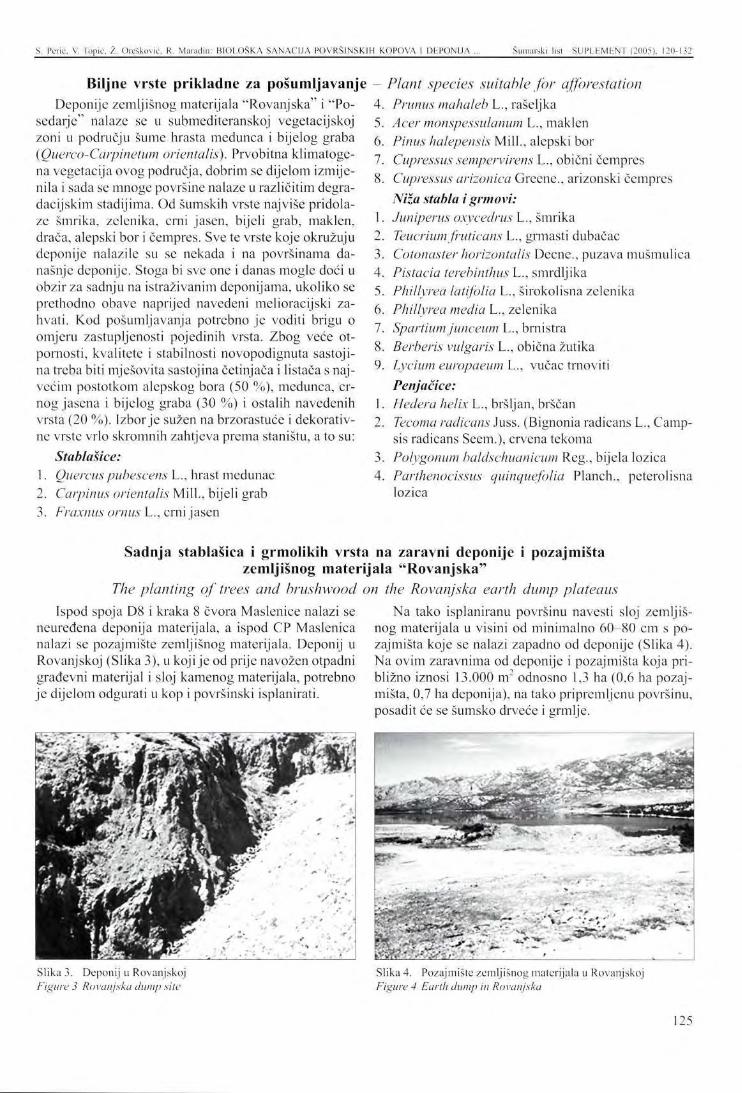
S. Perić, V. Topic, Z. Orešković. K. Maradin: BIOLOŠKA SANACIJA POVRŠINSKIH KOPOVA 1 DEPONIJA ... Šumarski list SUPLEMENT (2005), 120-132
Biljne vrste prikladne za pošumljavanje Deponije zemljišnog materijala "Rovanjska" i "Po-
sedarje" nalaze se u submediteranskoj vegetacijskoj zoni u području šume hrasta medunca i bijelog graba (Querco-Carpinetum orientalis). Prvobitna klimatoge-na vegetacija ovog područja, dobrim se dijelom izmijenila i sada se mnoge površine nalaze u različitim degra-dacijskim stadijima. Od šumskih vrste najviše pridolaze šmrika, zelenika, crni jasen, bijeli grab, maklen, drača, alepski bor i čempres. Sve te vrste koje okružuju deponije nalazile su se nekada i na površinama današnje deponije. Stoga bi sve one i danas mogle doći u obzir za sadnju na istraživanim deponijama, ukoliko se prethodno obave naprijed navedeni melioracijski zahvati. Kod pošumljavanja potrebno je voditi brigu o omjeru zastupljenosti pojedinih vrsta. Zbog veće otpornosti, kvalitete i stabilnosti novopodignuta sastoji-na treba biti mješovita sastojina četinjača i listača s najvećim postotkom alepskog bora (50 %), medunca, crnog jasena i bijelog graba (30 %) i ostalih navedenih vrsta (20 %). Izbor je sužen na brzorastuće i dekorativne vrste vrlo skromnih zahtjeva prema staništu, a to su:
Stablašice: 1. Quercuspubescens L., hrast medunac 2. Carpinus orientalis Mili., bijeli grab 3. Fraxnus ornus L., crni jasen
Plant species suitable for afforestation Prunus mahaleb L., rašeljka Acer monspessulanum L., maklen Pinus halepensis Mill., alepski bor Cupressus sempervirens L., obični čempres Cupressus arizonica Greene., arizonski čempres Niža stabla i grmovi: Juniperus oxycedrus L., šmrika Teucrium fruticans L., grmasti dubačac Cotonaster horizontalis Decne., puzava mušmulica Pistacia terebinthus L., smrdljika Phillvrea latifolia L., širokolisna zelenika Phillyrea media L., zelenika Spartium junceum L., brnistra
8. Berberis vulgaris L., obična žutika 9. Lycium europaeum L., vučac trnoviti
Penjačice: Hedera helix L., bršljan, brščan Tecoma radicans Juss. (Bignonia radicans L., Camp-sis radicans Seem.), crvena tekoma Polygonum baldschuanicum Reg., bijela lozica Parthenocissus quinquefolia Planch., peterolisna lozica
Sadnja stablašica i grmolikih vrsta na zaravni deponije i pozajmišta zemljišnog materijala "Rovanjska"
The planting of trees and brushwood on the Rovanjska earth dump plateaus Ispod spoja D8 i kraka 8 čvora Maslenice nalazi se
neuređena deponija materijala, a ispod CP Maslenica nalazi se pozajmište zemljišnog materijala. Deponij u Rovanjskoj (Slika 3), u koji je od prije navožen otpadni građevni materijal i sloj kamenog materijala, potrebno je dijelom odgurati u kop i površinski isplanirati.
Na tako isplaniranu površinu navesti sloj zemljišnog materijala u visini od minimalno 60-80 cm s pozajmišta koje se nalazi zapadno od deponije (Slika 4). Na ovim zaravnima od deponije i pozajmišta koja približno iznosi 13.000 m odnosno 1,3 ha (0,6 ha pozajmišta, 0,7 ha deponija), na tako pripremljenu površinu, posadit će se šumsko drveće i grmlje.
:: '•'. : , i
• TIM- ,
Slika 3. Deponij u Rovanjskoj Figure 3 Rovanjska dump site
Slika 4. Pozajmište zemljišnog materijala u Rovanjskoj Figure 4 Earth dump in Rovanjska
125
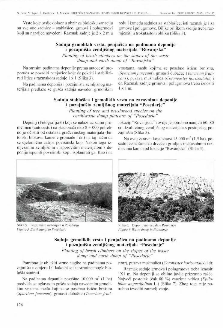
S. Pcrić, V. Topic. Z. Orešković. R. Maradin: BIOLOŠKA SANACIJA POVRŠINSKIH KOPOVA I DEPONIJA Šumarski list SUPLEMENT (2005), 120-132
Vrste koje ovdje dolaze u obzir za biološku sanaciju redu i između sadnica za stablašice, isti razmak je i za su sve one sadnice - stablašice, grmovi i polugrmovi grmove i polugrmove. Biljke prilikom sadnje treba raz-koji su naprijed navedeni. Razmak sadnje je 2 x 2 m u mjestiti u trokutastom obliku (Slika 3).
Sadnja grmolikih vrsta, penjačica na padinama deponije i pozajmišta zemljišnog materijala "Rovanjska"
Planting of brush climbers on the slopes of the waste dump and earth dump of "Rovanjska"
Na strmim padinama deponije prema autocesti pre-poruča se posaditi penjačice koje će pokriti i stabilizirati litice s razmakom sadnje 1 x 1 (Slika 3).
Na padinama deponija i pozajmišta zemljišnog materijala predlaže se gušća sadnja naveden grmolikim
vrastama, medu kojima se posebno ističu: brnistra, (Spartium junceum), grmasti dubačac (Teucrium fruti-cans), puzava mušmulica (Cotoneaster horizontalis) i dr. Razmak sadnje grmova i polugrmova treba iznositi 1x1 m.
Sadnja stablašica i grmolikih vrsta na zaravnima deponije i pozajmišta zemljišnog materijala "Posedarje"
Planting of tree and brushwood species on the earth/waste dump plateaus of "Posedarje"
Deponij (Fotografija 6) koji se nalazi uz samu prometnicu (autocestu) na stacionaži oko 8 + 000 potrebno je očistiti od ostataka građevinskog materijala (betonski blokovi, kamene gromade i dr.) na taj način da se djelomično zatrpa površinski kop. Nakon toga iz-mješanim zemljišnim i laporovitim materijalom s deponije ispuniti površinski kop i isplanirati ga. Kao i na
lokaciji "Rovanjska" i ovdje je potrebno nanijeti 60-80 cm kvalitetnog zemljišnog materijala s postojećeg pozajmišta (Slika 5).
Na ovoj zaravni koja iznosi 15.000 m2 (1,5 ha), posaditi će se šumsko drveće i grmlje s međusobnim razmacima kao i kod lokacije "Rovanjska" (Slika 3).
Slika 5. Pozajmište materijala u Posedarju Figure 5 Earth dump in Posedarje
Slika 6. Deponij materijala u Posedarju Figure 6 Waste dump in Posedarje
Sadnja grmolikih vrsta i penjačica na padinama deponije i pozajmišta zemljišnog materijala "Posedarje"
Planting of brush climbers on the slopes of the waste dump and earth dump of "Posedarje"
Potrebno je ublažiti strme nagibe na padinama pozajmišta u omjeru 1:1 kako bi se i te strmine mogle biološki sanirati.
Na padinama deponije površine 10.000 nr (1 ha) predviđa se uglavnom gušća sadnja navedenim grmolikim vrstama među kojima se posebno ističu: brnistra (Spartium junceum), grmasti dubačac (Teucrium fruti-
cans), puzava mušmulica (Cotonaster horizontalis) i dr. Razmak sadnje grmova i polugrmova treba iznositi
1X1 m. Na deponiji se obilno javlja prizemno rašće. Najveći postotak (čak 80 %) zauzima vrbica (Epilo-hium angustifolium L.) (Slika 7). Zbog toga nije potrebno izvoditi zatravljivanje.
126
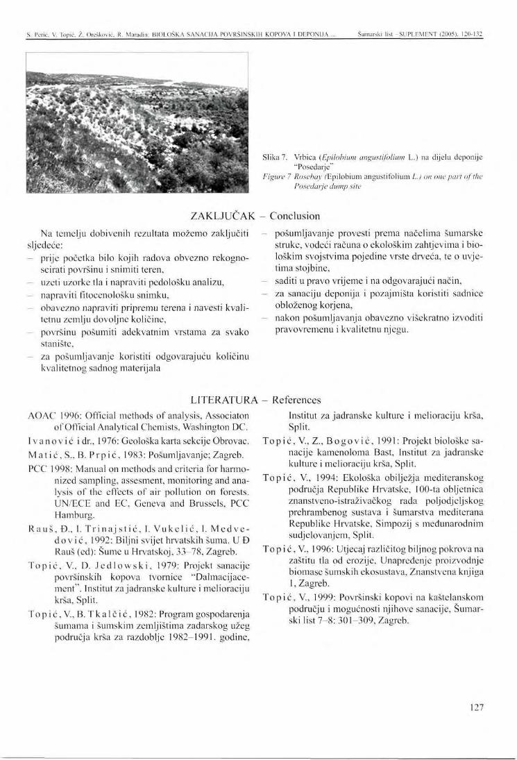
S. Pcrić. V. Topic. /.. Orešković. R. Maradin: BIOLOŠKA SANACIJA POVRŠINSKIH KOPOVA I DEPONIJA Šumarski lisl -SUPLEMENT (2005), 120-132
i' :~~-*
' • ^
r • *. i
B^^^^S^GcVii? \SKST
-'•••- • K '•- .. t< * "*
! ^4.
'{•••u" •BBE.V ^^^^E^^H
*£< 3^r "' * • • v. '*
•
.«^ !_ A
; ^ . , • • .
' - • .
Slika 7. Vrbica (Epilobium angustifolium L.) na dijelu deponije "Poscdarje"
Figure 7 Rosebay /'Epilobium angustifolium L.) on one part of the Posedarje dump site
ZAKLJUČAK - Conclusion
Na temelju dobivenih rezultata možemo zaključiti sljedeće:
prije početka bilo kojih radova obvezno rekogno-scirati površinu i snimiti teren, uzeti uzorke tla i napraviti pedološku analizu, napraviti fitocenološku snimku, obavezno napraviti pripremu terena i navesti kvalitetnu zemlju dovoljne količine, površinu pošumiti adekvatnim vrstama za svako stanište, za pošumljavanje koristiti odgovarajuću količinu kvalitetnog sadnog materijala
pošumljavanje provesti prema načelima šumarske struke, vodeći računa o ekološkim zahtjevima i biološkim svojstvima pojedine vrste drveća, te o uvjetima stoj bine, saditi u pravo vrijeme i na odgovarajući način, za sanaciju deponija i pozajmišta koristiti sadnice obloženog korjena, nakon pošumljavanja obavezno višekratno izvoditi pravovremenu i kvalitetnu njegu.
LITERATURA - References AOAC 1996: Official methods of analysis, Associaton
of Official Analytical Chemists, Washington DC. I v a n o v i ć i dr., 1976: Geološka karta sekcije Obrovac. Ma t i ć , S., B. P r p i ć , 1983: Pošumljavanje; Zagreb. PCC 1998: Manual on methods and criteria for harmo
nized sampling, assesment, monitoring and analysis of the effects of air pollution on forests. UN/ECE and EC, Geneva and Brussels, PCC Hamburg.
Rauš , Đ., I. Tri na j s t i ć , I. Vuke l i ć , I. Medve-d o v i ć , 1992: Biljni svijet hrvatskih šuma. U Đ Rauš (ed): Sume u Hrvatskoj, 33-78, Zagreb.
Top ić , V., D. J e d l o w s k i , 1979: Projekt sanacije površinskih kopova tvornice "Dalmacijace-ment". Institut za jadranske kulture i melioraciju krša, Split.
Top ić , V., B. T k a l č i ć , 1982: Program gospodarenja šumama i šumskim zemljištima zadarskog užeg područja krša za razdoblje 1982-1991. godine,
Institut za jadranske kulture i melioraciju krša, Split.
Top ić , V., Z., Bogov ić , 1991: Projekt biološke sanacije kamenoloma Bast, Institut za jadranske kulture i melioraciju krša, Split.
Topić , V., 1994: Ekološka obilježja mediteranskog područja Republike Hrvatske, 100-ta obljetnica znanstveno-istraživačkog rada poljodjeljskog prehrambenog sustava i šumarstva mediterana Republike Hrvatske, Simpozij s međunarodnim sudjelovanjem, Split.
Top i ć, V., 1996: Utjecaj različitog biljnog pokrova na zaštitu tla od erozije, Unapređenje proizvodnje biomase šumskih ekosustava, Znanstvena knjiga 1, Zagreb.
Topić , V., 1999: Površinski kopovi na kaštelanskom području i mogućnosti njihove sanacije, Šumarski list 7-8: 301-309, Zagreb.
127
PRESENTATION AT THE INTERNATIONAL SYMPOSIUM Šumarski list -SUPLEMENT (2005), 120-132
BIOLOGICAL C O N T R O L OF EXCAVATIONS A N D D U M P S DURING THE C O N S T R U C T I O N OF HIGHWAYS IN CROATIA
Sanja PERIĆ, Vlado TOPIC, Željko OREŠKOVIĆ, Romana MARADIN*
SUMMARY: This paper focuses on the subject of biological control of excavations and dumps on the Maslenica-Zadar highway section. During the last few years, great attention has been paid to the landscape planning of highway routes. However, their construction is closely connected to the degradation of the ecosystems they are passing through. From the ecological point of view, the building of highways is an extremely significant issue. In choosing the highway location, great attention is paid to the preservation of the environment. In spite of this, the landscape is undergoing changes, so that its original ecological and aesthetic functions must be restored.
The exploration was conducted on two locations, Rovanjska (around 300 m south from the town of Rovanjska, and the channel Velebitski Kanal underneath the Velebit mountain) and the town of Posedarje, close to the Split-Zagreb highway, on its southern side. The area with surface mines and building material dumps is of typical karst morphology. During heavier rainfalls, runoffs and erosion processes can be seen. Close to the landfill is the Novigradsku More bay.
This paper discusses the natural characteristics of the area explored, i.e. the geological, hydrological, climatic and vegetative characteristics. The basic principles of the biological cleanup are analysed. Presenting a list of forest trees, bushes, shrubs, and climbers, which could be used in the process of biological control, the authors analyse the planting methods in various locations. A schematic presentation of afforestation is made for both locations.
The aim of the study is to use afforestation as an ameliorating method of environmental protection, in order to prevent erosion and enhance the visual value of the landscape.
Key words: biological control, highway, seedling types, planting method, afforestation, and erosion.
INTRODUCTION
Croatian development strategy has been paying great attention to the landscape planning of highway routes. Connecting the individual regions of the country is a major issue. However, their construction is closely connected to the degradation of the ecosystems they are passing through. In choosing the motor-road routes, the main criteria are the minimum disturbance of the environment. The changed landscape by the
* Sanja Perić, PhD, Vlado Topic PhD, Željko Orcšković, BSc, Romana Maradin, BSc, Šumarski institut Jastrebarsko
road construction should regain its ecological and aesthetic functions. Therefore, a study on the environmental impacts and the project of biological amelioration of the areas along the highway route should be enclosed with the project documentation.
This study is the result of the research on the locations of Rovanjska and Posedarje on the Route 1 of the Maslenica-Zadar highway, along which there are disposal sites of building wastes. The main aim of the research is the amelioration by afforestation in order to improve the visual value of the landscape.
128
S. Pcrić. V. Topic. Ž. Orcškovic, R. Maradin: BIOLOGICAL CONTROL OF EXCAVATIONS AND DUMPS ... Šumarski list -SUPLFMFNT (2005). 120-132
While developing this study, we used the data from red as the brushwood of pubescent oak (Quercuspube-the Forest Management Programme of Dalmatia scens), while the "Rovanjska" dump site has not been (1986-1995). The waste disposal site of "Posedarje" is encompassed by the mentioned Programme, located on the cadastre unit 1791/1 Posedarje, registe-
NATURAL CHARACTERISTICS OF THE AREA Geographic position
The Rovanjska excavation site is located in the Ja- darje cadastre area is close to, and on the southern side senicc cadastre area close to the Split-Zagreb motor- of the highway. The locations of both sites are shown road route, about 300 m south of the village Jasenicc in Map 1. The terrain has typical karst morphology, and the Velebitski Kanal channel at the foot of the Ve- The shape of both sites is irregular (Photo 1 and 2).
lebit Mountain. The Posedarje dumpsite in the Pose-
Geological and hydrographical properties According to the geological map of the section bay and the Velebitski Kanal channel. The rocks are
Obrovac ( Ivanovie et al. 1976), the area where the broken and karstificd, so that the precipitation enters waste sites are located are dominated by layered and the underground. Heavy rains cause runoffs and surfa-plate chalks with shallow brown soils and red clay. The ce erosion, waste sites are located close to the Novigradsko More
Climate A significant natural factor, climate affects the flo- mum summer temperatures occasionally rise even to
ral distribution and diversity. To describe the climate of 35.7 °C, and the minimum values sometimes fall down the research area, we used the 1961-1990 data of the to -9.1 °C. The temperature oscillations are considera-Zadar meteorological station. ble, and if they last for longer periods of time, they may
The data in Table 1 show that the long-term mean c a u s e various types of damage to the individual plant temperature has been 14.7 °C, with maximum and mi- species, nimum values in January and July. The absolute maxi-
Locations on the highway route The quantity of precipitation and its distribution ary, with an average of 5.2 days. According to the mea-
throughout the year are the major factors in the deve- surements, the phenomenon of late spring frosts is rare, lopment of vegetation. Table 2 shows that of the total Snow in this area falls very seldom and is short-lived, precipitation in the research area, about two thirds fall The maximal recorded height of the snow is 18 cm. in wintertime, while one third is distributed over spring T h e d u m p s j t e s a r e located in the area of very inten-and summer months. According to Lang's annual rain s i v e a i r s t r e a m S ) w h i c h a r e particularly frequent in the factor (62.31), this area has a humid climate, while its c o , d s e a s o n s o f t h e y e a r T h c d o m i n a t i n g w i n d s a r c bo_ summer months belong to thc and climate according to ra? s o u t h w m d ? a n d m i s t r a i V e r y s t r o n g a n d s t o r m y > t h e
the monthly rain tactor. b o r a o f t n i s r e g i o n u n d e r m e Velebit mountain blows in Rain often falls in strong showers, so that it often all seasons of the year, but it lasts the longest and with
amounts to over 80 mm in one day. The relative yearly the greatest strength in winter, mainly from January air humidity in Zadar is 72 %. This area has three days unti] March. The south wind blows throughout the in a year with air moisture lower or equal to 30 %, and y e ar, but mainly in the autumn. It is sometimes wann 55 days with air moisture above, or equal to, 80 %. anci dry, but then it causes much damage to the plants.
Zadar area has an average of 16 frosty days. Frost is Coming from the sea on warm and hot summer days, recorded at the Zadar meteorological station between the mistral brings fresh sea air that soothes the otherwi-October and May. The most frequent frosts are in Janu- se unbearable summer heat.
Vegetation In terms of phytogcography, the plant cover of this 1992). The vegetation of the area has developed accor-
area belongs to the Mediterranean-littoral vegetation ding to the climatic and edaphic conditions. The bot-belt within the sub-Mediterranean zone (Raus et al. tom area of the mountain Velebit was once covered by
129
S. Pcrić. V. Topic. Ž. Orcšković. R. Maradin: BIOLOGICAL CONTROL OF EXCAVATIONS AND DUMPS Šumarski -SUPLEMENT (2005), 120-132
the forests of pubescent oak and white hornbeam (Que-rco-Carpinetum orientalis H-ić 1939), as a final and climate-conditional stage in the development of the vegetation in this area. In the past, however, these areas were devastated by long-term uncontrolled anthropo-genetic impacts (man and cattle) and climatic factors. What survived were only the prickly brushwood and bushes, or herbaceous plants with developed subsoil parts. Thus, in this area at the bottom of Velebit common species are juniper (Juniperus oxycedrus), Christ's thorn (Paliurus spina christi), blackthorn (Crategus transalpine), blackberry (Rubus ulmifolius), and wild asparagus (Asparagus acutifolius). The intensive cattle grazing tradition was abandoned quite some time ago, and so was logging, which has resulted in
progressive forest vegetation succession. Many species have returned into this area, e.g. black ash (Fraximus ornus), white hornbeam (Carpinus orientalis), Mont-pelier maple (Acer monspessulanum), perfumed cherry (Prunus mahaleb), terebinth (Pistacia terebinthus), and stone lime-tree (Phillvrea latifolia); the come-back of pubescent oak (Pubescent oak) has also been noticed. Slowly rising above the juniper and Christ's thorn, they will contribute to the beauty of the area.
The following are the commonest undergrowth species: Helichrysum italicum, Salvia officinalis, Chryso-pogon gryllus, Festuca illyrica, Sesleria autumnalis, Bromus erectus, Koeleria splendes, Eryngium sp., and Euphorbia sp.
BIOLOGICAL AMELIORATION Basic principles
The biological amelioration of the dumpsites is mainly carried out for the protection of the landscape. The task of the ameliorating operation is to create the substrate that will continuously supply the vegetation with water, air and nutrients. Before any ameliorative work begins, the area where seedlings will be planted should be spatially planned, and the surface soil loosened. The area will then be topsoiled, which is the basic ameliorating factor that will create favourable biological, physical and chemical conditions for the growth of the new plants.
Soil preparation creates optimal conditions for growth and development, i.e. the favourable water- air relations that enable the functioning of the optimal life-sustaining biochemical processes. The manner and intensity of soil preparation will depend on the soil state, planting method, use of mechanisation, etc. Good soil preparation is often a deciding factor for the success of planting.
Seedlings and planting methods Planting distance can be regular or irregular. The
former is applied whenever the terrain allows (stumps, rocky ground, etc.), and can form rectangles, squares, triangles, or hexagons, with exactly determined spaces between the plants and the rows. Irregular planting distance is particularly applied in karst areas, as planting can be done only where there is enough soil to dig a hole of satisfactory dimensions.
Planting can take place with bare roots or balls. Damaged or too long roots are cut off. Where needed, crown is also trimmed to balance the water/nutrient supply between it and the roots. With coniferous tree seedlings, damaged roots are very carefully trimmed, and sometimes also the lowest branches. The space around the root must be well filled with soil, and the seedling firmly planted. Attention should be paid to the planting depth, which should be - after the soil has settled down-same as in the nursery before the seedling was taken out. This means that the planting should be neither too deep, nor too shallow.
In the afforestation of the terrain with stumps, rocks etc., the seedlings should be planted near such objects
for their protection in the first years of their lives, and because of better soil conditions. After taken out from nurseries, seedlings are susceptible to drying, and therefore should be planted into peat, or protected otherwise from sun and wind.
In afforestation, the ecological requirements and biological properties of the individual tree species should be respected in relation to the habitat conditions. Seedlings can be planted into holes, crevices, embankments, mounds, and trenches.
The following are the advantages of planting the seedlings with coated roots: roots are not damaged when taken our; protection during transport and planting; great proportion of rooting; continued growth after planting without stress; possibility of planting throughout the year - a significant factor. In addition, greenhouse seedling production enables corresponding watering and protection of plants, which shortens the production process.
Accordingly, the dumpsite amelioration should be carried out by planting the seedlings with coated roots.
130
S. Pcrić, V. Topic. 2. Orcšković, R. Maradin: BIOLOGICAL CONTROL OF EXCAVATIONS AND DUMPS ... Šumarski list - SUPLEMF.NT (2005). 120-132
Besides careful soil preparation, quality seedling material and expert knowledge, successful afforestation requires proper tending of young cultures. In the first place, watering should be carried out regularly during critical times of the year, i.e. mainly in June, July and August. However, April and May might be also cri-
Below the junction of the D8 and 8 routes of the Maslenica intersection, there is a neglected waste dump, and earth disposal site under the CP Maslenica.
tical months in certain years. Watering should be carried out whenever the skilled supervising person decides. In addition to watering, other tending measures should be carried out as well for the duration of at least two years.
The Rovanjska dump (Photo 3) containing waste building material and a layer of rocks should be partly moved into a landfill, levelled, and topsoiled.
RESULTS A N D Pedological
In the process of ameliorating the dumpsites, the basic precondition is to apply sufficient quantities of topsoil, which will later cover the formed marly plateaus and the whole area after the exploitation.
In August of 2005 soil samples were taken from Rovanjska and Posedarje dumps. The samples were analysed (Table 3) by standard laboratory methods (AO-AC 1996, PCC 1998).
The analysis of the soil samples revealed very strong alkaline reactions with many total and active carbona-
DISCUSSION analysis
tes. The soils contain low proportions of humus and nitrogen (<0.06 %N), and are also poorly or avcragely supplied with phosphorus and potassium. (P205, K2).
It is therefore recommended that 50 % of quality soil is added while planting the seedlings into holes; close to the root ball, about two litres of compost should be added to each seedling as a moisturising agent (Stocksorb, or similar). In the second vegetation after the planting, fertilising with complex nutrients should be carried out according to the assessed needs.
Plant species suitable for afforestation The earth dumps of Rovanjska and Posedarje are
located in the sub-Mediterranean vegetation zone of pubescent oak and white hornbeam (Querco-Carpine-tum orientalis). The original climato-genetic vegetation of this area has considerable changed, so that great areas are in different degraded stages. The main tree species are juniper, stone lime-tree, black ash, white hornbeam, Montpelier maple, Christ's thorn, Aleppo pine, and cypress. All these species surround the present dump areas, but were once growing on them. They could, therefore, be the right species to be planted on the research areas, after the ameliorating operations have been completed. The proportions of the individual species should be considered. A mixed stand of conifers and broadleavcs should be selected for higher resistance, quality and stability, in the following proportions: Aleppo pine (50 %); pubescent oak, black ash, and white hornbeam (30 %), and other mentioned species (20 %). The choice is reduced to the following fast-growing and decorative species with very modest requirements from the habitat:
Tree species: 1. Quercuspubescens L., pubescent oak 2. Carpinus orientalis Mill., white hornbeam 3. Fraxnus ornus L., black ash
4. Prunus mahaleb L., perfumed cherry 5. Acer monspessulanum L., Montpelier ash 6. Pinus halepensis Mill., Aleppo pine 7. Cupressus sempervirens L., common cypress 8. Cupressus arizonica Greene., Arizona cypress
Brushwood: 1. Juniperus oxycedrus L., juniper 2. Teucrium fruticans L., shrubby germander 3. Cotonaster horizontalis Decne., cotoneaster 4. Pistacia terebinthus L., terebinth 5. Phillyrea latifolia L., crack phyllirea 6. Phillyrea media L., stone lime-tree 7. Spartium junceum L., Spanish broom 8. Berberis vulgaris L., barberry 9. Lycium europaeum L., European box-thorn
Climbers: 1. Hedera helix L., ivy 2. Tecoma radicans Juss. (Bignonia radicans
Campsis radicans Seem.), trumpet honeysuckle 3. Polygonum baldschuanicum Reg., Russian vine 4. Parthenocissus quinquefolia Planch., Virginia
creeper
U
Planting of trees and brushwood on the Rovanjska earth dump plateaus
131
S. Perić. V. Topic. Ž. Orešković. R. Maradin: BIOLOGICAL CONTROL OK EXCAVATIONS AND DUMPS ... Šumarski list SUPLEMENT (2005), 120-132
A 60 cm-80 cm-layer of earth taken from the Rovanjska earth dump will be applied upon the levelled area (Photo 4). Forest trees and shrubwood will be planted over these plateaus between the two dumps in an area of 13,000 m , i.e. 1.3 ha (0.6 ha earth dump + 0.7 ha waste dump).
The seedlings considered for this biological amelioration are all above-listed tree and shrub species. The planting distance of 2 m x 2 m in rows for both trees and shrubs will be applied. The seedlings will be planted in triangles (Figure 3).
Planting of brush climbers on the slopes of the waste dump and earth dump of Rovanjska
Climbers are recommended for covering the steep dump slopes that descend toward the highway, in order to stabilise the cliffs. The planting distance should be 1 x 1 (Figure 3).
Dense planting of the following brush species is proposed for the slopes of the waste/earth dumps: Spa
nish broom (Spartium junceum); shrubby germander (Teucrium fruticans); cotoneaster {Cotoneaser hori-zontalis), and others. The planting distance of the brushwood and semi-brush should be 1 x 1 m.
Planting of tree and brushwood species on the earth/waste dump plateaus of "Posedarje"
The dumpsite (Photo 6) located close to the highway (stationed at about 8+000) should be cleaned from the remnants of the building material (concrete blocks, rocks, etc.), in order to partly fill the surface mine. This is followed by filling and levelling the surface with earth and marly material from the dump. Then, same as
in case of the Rovanjska location, a 60 cm-80 cm layer of quality soil should be applied over the area (Photo 5).
Forest trees and brushwood will be planted at a same distance as in the Rovanjska location over this 15,000 m2 (1.5 ha)-large plateau. (Figure 3).
Planting of brush climbers on the slopes of the waste dump and earth dump of "Posedarje"
The steep slopes of the earth dump should be alleviated at a proportion of 1 : 1, so that the slopes could be ameliorated biologically.
The 10,000 m2 - area will be covered by mainly dense planting of theabove-listed brushwood species: Spanish broom (Spartium junceum); shrubby germander (Teucrium fruticans); cotoneaster (Cotoneaser horizontal), and others.
The planting distance should be 1 x 1 m. The dumpsite is covered by vigorous undergrowth with the highest proportion (80 %) of white rosebay (Epilobium angustifolium L.) (Photo 7). Grass is therefore not necessary on this site.
CONCLUSION The following can be concluded on the basis of the
research results: Before any amelioration work can begin, the area should be investigated and the terrain surveyed; Soil samples should be taken and the pedological analysis made;
- Phytocenological survey; - Terrain preparation and sufficient quantity of quali
ty soil should be applied; The area should be afforested with adequate species for each habitat; In afforestation corresponding quantity of seedling material should be applied;
The afforestation should proceed according to the principles of forestry science, and considering the ecological requirements and biological properties of each species related to the habitat conditions; Planting should proceed timely and in corresponding ways; The earth/waste dump sites should be planted with the seedlings with coated roots; Timely and proper tending should be carried out regularly after the afforestation.
132
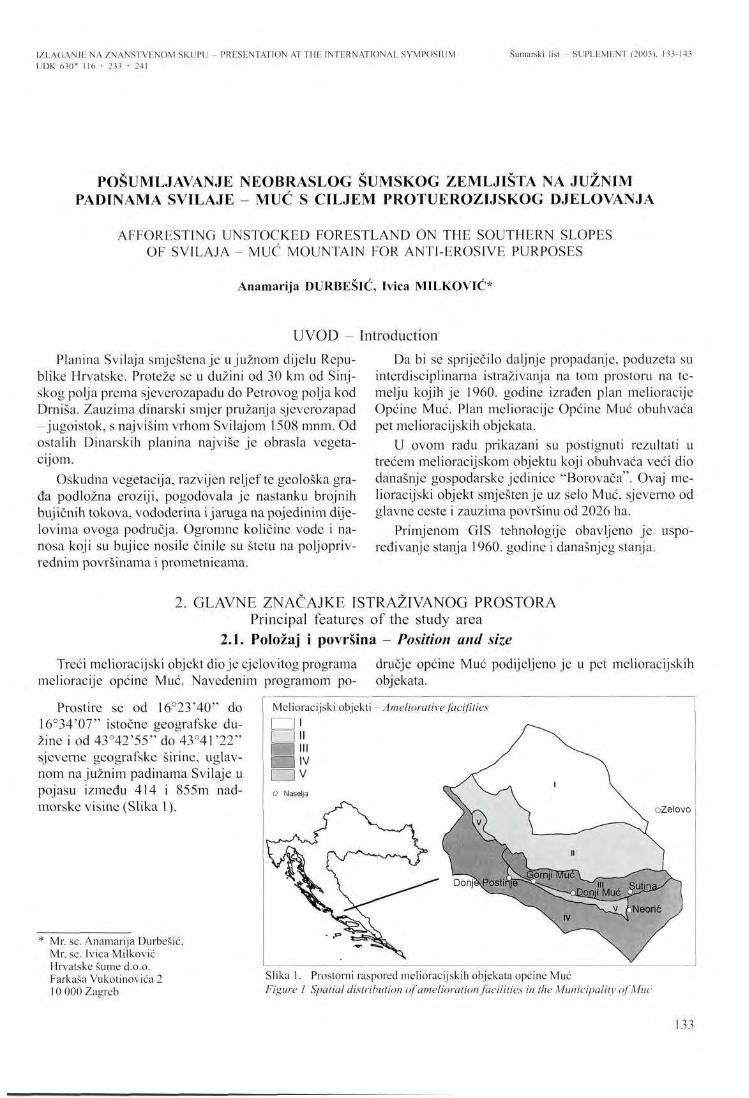
IZLAGANJE NA ZNANSTVENOM SKUPU UDK 630* 116 + 233 + 241
PRESENTATION AT THE INTERNATIONAL SYMPOSIUM Šumarski list - SUPLEMENT (2005), 133-143
POSUMLJAVANJE NEOBRASLOG ŠUMSKOG ZEMLJIŠTA NA JUŽNIM PADINAMA SVILAJE - MUĆ S CILJEM PROTUEROZIJSKOG DJELOVANJA
AFFORESTING UNSTOCKED FORESTLAND ON THE SOUTHERN SLOPES OF SV1LAJA - MUĆ MOUNTAIN FOR ANTI-EROSIVE PURPOSES
Anamarija DURBEŠIĆ, Ivica MILKOVIĆ*
UVOD - Introduction Planina Svilaja smještena je u južnom dijelu Repu
blike Hrvatske. Proteže se u dužini od 30 km od Sinj-skog polja prema sjeverozapadu do Petrovog polja kod Drniša. Zauzima dinarski smjer pružanja sjeverozapad -jugoistok, s najvišim vrhom Svilajom 1508 mnm. Od ostalih Dinarskih planina najviše je obrasla vegetacijom.
Oskudna vegetacija, razvijen reljef te geološka grada podložna eroziji, pogodovala je nastanku brojnih bujičnih tokova, vododerina i jaruga na pojedinim dijelovima ovoga područja. Ogromne količine vode i nanosa koji su bujice nosile činile su štetu na poljoprivrednim površinama i prometnicama.
Da bi se spriječilo daljnje propadanje, poduzeta su interdisciplinarna istraživanja na tom prostoru na temelju kojih je 1960. godine izrađen plan melioracije Općine Muć. Plan melioracije Općine Muć obuhvaća pet melioracijskih objekata.
U ovom radu prikazani su postignuti rezultati u trećem melioracijskom objektu koji obuhvaća veći dio današnje gospodarske jedinice "Borovača". Ovaj me-lioracijski objekt smješten je uz selo Muć, sjeverno od glavne ceste i zauzima površinu od 2026 ha.
Primjenom GIS tehnologije obavljeno je uspoređivanje stanja 1960. godine i današnjeg stanja.
2. GLAVNE ZNAČAJKE ISTRAŽIVANOG PROSTORA Principal features of the study area
2.1. Položaj i površina - Position and size Treći melioracijski objekt dio je cjelovitog programa dručje općine Muć podijeljeno je u pet melioracijskih
melioracije općine Muć. Navedenim programom po- objekata.
Prostire se od 16°23'40" do 16°34'07" istočne geografske dužine i od 43°42'55" do 43°41'22" sjeverne geografske širine, uglavnom na južnim padinama Svilaje u pojasu između 414 i 855m nadmorske visine (Slika 1).
Mr. sc. Anamarija Durbešić, Mr. sc. Ivica Milković Hrvatske šume d.o.o. Farkaša Vukotinovića 2 10 000 Zagreb
Melioracijski objekti - Ameliorative facifities
• i «I — IV Fn v O Naselja
oZelovo
Slika 1. Prostorni raspored melioracijskih objekata općine Muć Figure 1 Spatial distribution of amelioration facilities in the Municipality of Muć
133
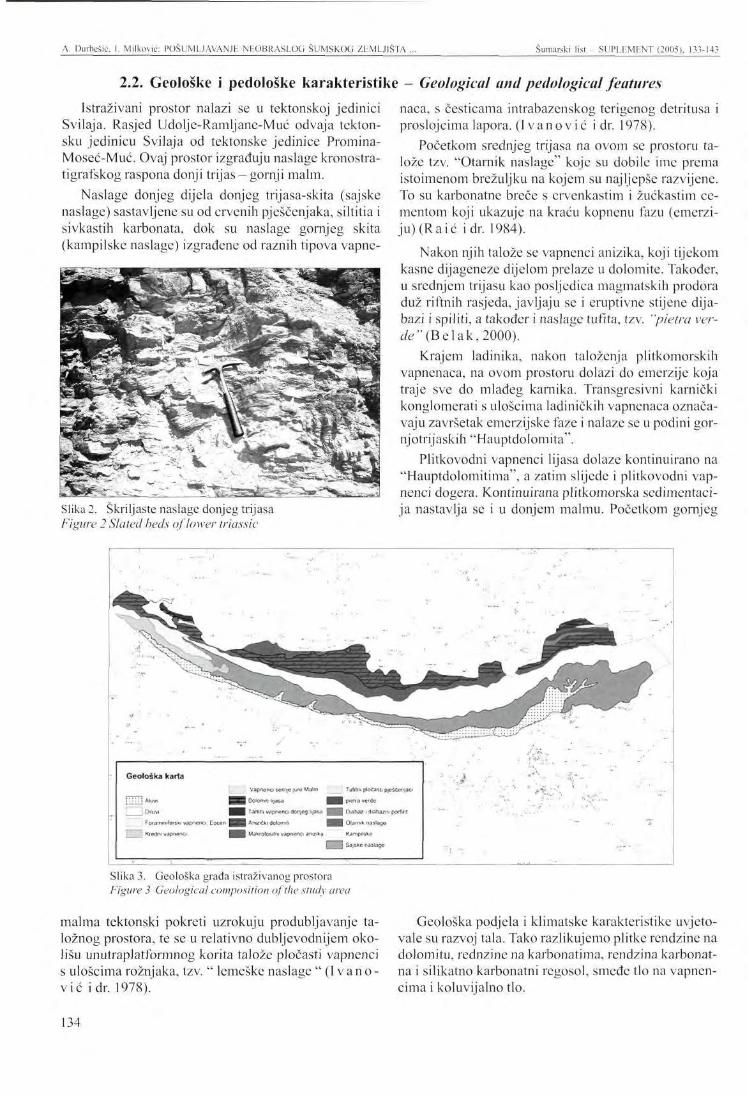
A. Durbešić, 1. Milković: POSUMLJAVANJE NHOBRASLOG ŠUMSKOG ZEMLJIŠTA . Šumarski list SUPLEMENT (2005), 133-143
2.2. Geološke i pedološke karakteristike - Geological and pedological features
Istraživani prostor nalazi se u tektonskoj jedinici Svilaja. Rasjed Udoljc-Ramljane-Muć odvaja tektonsku jedinicu Svilaja od tektonske jedinice Promina-Moseć-Muć. Ovaj prostor izgrađuju naslage kronostra-tigrafskog raspona donji trijas - gornji malm.
Naslage donjeg dijela donjeg trijasa-skita (sajske naslage) sastavljene su od crvenih pješčenjaka, siltitia i sivkastih karbonata, dok su naslage gornjeg skita (kampilske naslage) izgrađene od raznih tipova vapne-
Slika 2. Škriljaste naslage donjeg trijasa Figure 2 Slated beds of lower triassic
naca, s česticama intrabazenskog terigenog detritusa i proslojcima lapora. (Ivano vic i dr. 1978).
Početkom srednjeg trijasa na ovom se prostoru talože tzv. "Otarnik naslage" koje su dobile ime prema istoimenom brežuljku na kojem su najljepše razvijene. To su karbonatne breče s crvenkastim i žućkastim cementom koji ukazuje na kraću kopnenu fazu (emerzi-ju)(Raić idr. 1984).
Nakon njih talože se vapnenci anizika, koji tijekom kasne dijageneze dijelom prelaze u dolomite. Također, u srednjem trijasu kao posljedica magmatskih prodora duž riftnih rasjeda, javljaju se i eruptivne stijene dija-bazi i spiliti, a također i naslage tufita, tzv. "pietra verde" (Be lak , 2000).
Krajem ladinika, nakon taloženja plitkomorskih vapnenaca, na ovom prostoru dolazi do emerzije koja traje sve do mlađeg karnika. Transgresivni karnički konglomerati s ulošcima ladiničkih vapnenaca označavaju završetak emerzijske faze i nalaze se u podini gor-njotrijaskih "Hauptdolomita".
Plitkovodni vapnenci lij asa dolaze kontinuirano na "Hauptdolomitima", a zatim slijede i plitkovodni vapnenci dogera. Kontinuirana plitkomorska sedimentaci-ja nastavlja se i u donjem malmu. Početkom gornjeg
Geološka karta
l:ii:J **«* {»«VI
Vapnenci s©rc\e ;urc Malm ; Tufrtni plocasli pfufitcupo
flPBi &Ä--M: igMa m p*MT8 •'•:<•••••••
m l^-m'r vape* no 1nt*;i;g up'.n H|| |f | fXtim? i rtiafc.tm pottmt
FcMaft'titiUjrM! vdp**)tcf. E s w , jf//R Av.wiki-MOIT,U | § § Olärrufc naslage
Kff-»f>i'> '*„if»ilirci H M^fOIiKi-Ai varnWO .'>r,?^ K&mp&iki}
D P Stajsku rastag«
Slika 3. Geološka građa istraživanog prostora Figure 3 Geological composition of the study area
malma tektonski pokreti uzrokuju produbljavanje taložnog prostora, te sc u relativno dubljcvodnijem okolišu unutraplatformnog korita talože pločasti vapnenci s ulošcima rožnjaka, tzv. " lemeške naslage " ( Ivano-vić idr. 1978).
Geološka podjela i klimatske karakteristike uvjetovale su razvoj tala. Tako razlikujemo plitke rendzine na dolomitu, rednzinc na karbonatima, rendzina karbonat-na i silikatno karbonatni regosol, smeđe tlo na vapnencima i koluvijalno tlo.
134
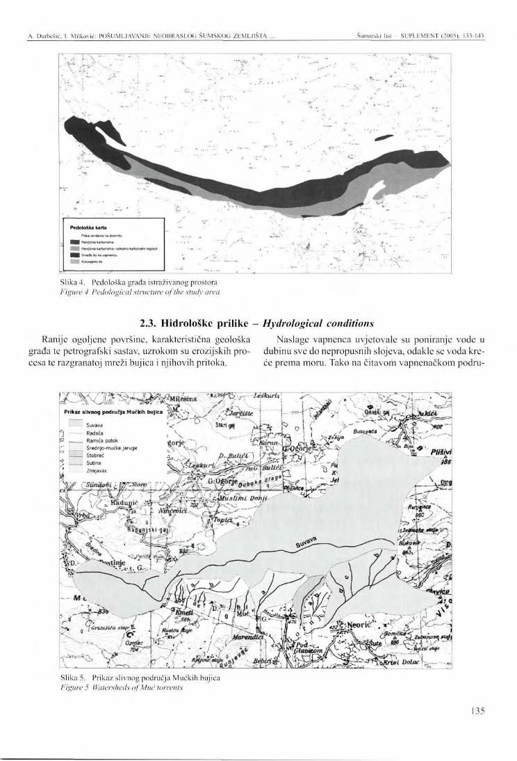
A. Durbcšić. I. Milković: POSUMIJAVANJE NEOBRASLOG ŠUMSKOG ZEMLJIŠTA . Šumarski list - SUPLEMENT (2005), 133-143
' -r,:
Peđoloaka karta
Slika 4. Pedološka grada istraživanog prostora Figure 4 Pedological structure of the study area
2.3. Hidroloske prilike - Hydrological conditions Ranije ogoljene površine, karakteristična geološka Naslage vapnenca uvjetovale su poniranje vode u
grada te petrografski sastav, uzrokom su erozijskih pro- dubinu sve do nepropusnih slojeva, odakle se voda kre-cesa te razgranatoj mreži bujica i njihovih pritoka. će prema moru. Tako na čitavom vapnenačkom podru-
T^^Ol^rW^^^ '*AT° • leikurit. T?>
Slika 5. Prikaz slivnog područja Mučkih bujica Figure 5 Watersheds ofMuć torrents
135
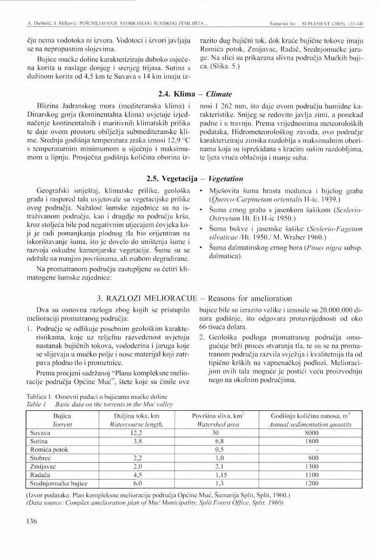
A. Durbešić, I. Milković: POSUMLJAVANJE NF.OBRASLOG ŠUMSKOG ZEMLJIŠTA . Šumarski list - SUPLEMENT (2005), 133-143
čju nema vodotoka ni izvora. Vodotoci i izvori javljaju se na nepropusnim slojevima.
Bujice mućke doline karakteriziraju duboko usječena korita u naslage donjeg i srenjeg trijasa. Sutina s dužinom korita od 4,5 km te Suvava s 14 km imaju iz
razito dug bujični tok, dok kraće bujične tokove imaju Romića potok, Zmijavac, Radač, Srednjomućkc jaruge. Na slici su prikazana slivna područja Mućkih bujica. (Slika. 5.)
2.4. Klima - Climate Blizina Jadranskog mora (mediteranska klima) i
Dinarskog gorja (kontinentalna klima) uvjetuje izjednačenje kontinentalnih i maritivnih klimatskih prilika te daje ovom prostoru obilježja submediteranske klime. Srednja godišnja temperatura zraka iznosi 12,9 °C s temperaturnim minimumom u siječnju i maksimumom u lipnju. Prosječna godišnja količina oborina iz
nosi 1 262 mm, što daje ovom području humidne karakteristike. Snijeg se redovito javlja zimi, a ponekad padne i u travnju. Prema vrijednostima meteoroloških podataka, Hidrometeorološkog zavoda, ovo područje karakteriziraju zimska razdoblja s maksimalnim oborinama koja su isprekidana s kraćim sušim razdobljima, te ljeta vruća oblačnija i manje suha.
2.5. Vegetacija Geografski smještaj, klimatske prilike, geološka
grada i raspored tala uvjetovale su vegetacijske prilike ovog područja. Nažalost šumske zajednice su na istraživanom području, kao i drugdje na području krša, kroz stoljeća bile pod negativnim utjecajem čovjeka koji je radi pomanjkanja plodnog tla bio orijentiran na iskorištavanje šuma, što je dovelo do uništenja šume i razvoja oskudne kamenjarske vegetacije. Šume su se održale na manjim površinama, ali mahom degradirane.
Na promatranom području zastupljene su četiri kli-matogenc šumske zajednice:
Vegetation Mješovita šuma hrasta medunca i bijelog graba (Querco-Carpinetum orientalis H-ic. 1939.) Šuma crnog graba s jasenkom šašikom {Seslerio-Ostryetum Ht. Et H-ic 1950.) Šuma bukve i jasenske šašike {Seslerio-Fagetum silvaticae /Ht. 1950./ M. Wraber 1960.) Šuma dalmatinskog crnog bora {Pinus nigra subsp. dalmatica).
3. RAZLOZI MELIORACIJE - Reasons for amelioration Dva su osnovna razloga zbog kojih se pristupilo
melioraciji promatranog područja: 1. Područje se odlikuje posebnim geološkim karakte
ristikama, koje uz reljefnu razvedenost uvjetuju nastanak bujičnih tokova, vododerina i jaruga koje se slijevaju u mućko polje i nose materijal koji zatrpava plodno tlo i prometnice. Prema procjeni sadržanoj "Planu kompleksne melio
racije područja Općine Muć", štete koje su činile ove
Tablica 1. Osnovni podaci o bujicama mućke doline Table 1 Basic data on the torrents in the Muć valley
bujice bile su izrazito velike i iznosile su 20.000.000 dinara godišnje, što odgovara protuvrijednosti od oko 66 tisuća dolara. 2. Geološka podloga promatranog područja omo
gućuje brži proces stvaranja tla, te su se na promatranom području razvila svježija i kvalitetnija tla od tipično krških na vapnenačkoj podlozi. Melioracijom ovih tala moguće je postići veću proizvodnju nego na okolnim područjima.
Bujica Torrent
Suvava Sutina Romića potok Stobreć Zmijavac Radača Srednjomućkc bujice
Duljina toka, km Watercourse length,
12,2 3,8
2,2 2,0 4,5 6,0
Površina sliva, km" Watershed area
30 6,8 0,5 1,0 2,1 1,15 1,3
Godišnja količina nanosa, m Annual sedimentation quantity
8000 1800
-800
1300 1100 1200
(Izvor podataka: Plan kompleksne melioracije područja Općine Muć, Šumarija Split, Split, 1960.) (Data source: Complex amelioration plan of Muć Municipality, Split Forest Office, Split, 1960)
136
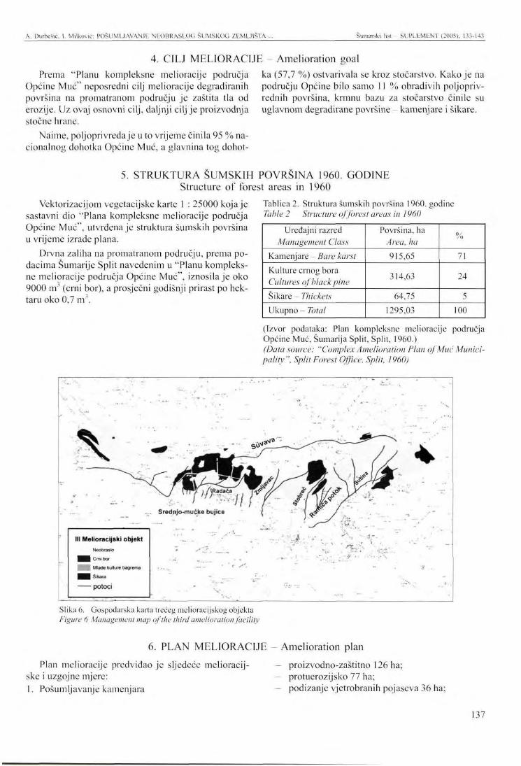
A. Durbešić, 1. Milković: POŠUMLJAVANJE NEOBRASLOG ŠUMSKOG ZEMLJIŠTA ... Šumarski list - SUPLEMENT (2005), 133-143
Prema "Planu kompleksne melioracije područja Općine Muć" neposredni cilj melioracije degradiranih površina na promatranom području je zaštita tla od erozije. Uz ovaj osnovni cilj, daljnji cilj je proizvodnja stočne hrane.
Naime, poljoprivreda je u to vrijeme činila 95 % nacionalnog dohotka Općine Muć, a glavnina tog dohot-
4. CILJ MELIORACIJE Amelioration goal ka (57,7 %) ostvarivala se kroz stočarstvo. Kako je na području Općine bilo samo 11 % obradivih poljoprivrednih površina, krmnu bazu za stočarstvo činile su uglavnom degradirane površine - kamenjare i šikare.
5. STRUKTURA ŠUMSKIH POVRŠINA 1960. GODINE Structure of forest areas in 1960
Vcktorizacijom vegetaeijske karte 1 : 25000 koja je sastavni dio "Plana kompleksne melioracije područja Općine Muć", utvrđena je struktura šumskih površina u vrijeme izrade plana.
Drvna zaliha na promatranom području, prema podacima Šumarije Split navedenim u "Planu kompleksne melioracije područja Općine Muć", iznosila je oko 9000 m (crni bor), a prosječni godišnji prirast po hektaru oko 0,7 m .
Tablica 2. Struktura šumskih površina 1960. godine Table 2 Structure of forest areas in 1960
Uređajni razred Management Class
Kamenjare - Bare karst Kulture crnog bora Cultures of black pine Šikare - Thickets Ukupno - Total
Površina, ha Area, ha 915,65
314,63
64,75 1295,03
%
71
24
5 100
(Izvor podataka: Plan kompleksne melioracije područja Općine Muć, Šumarija Split, Split, 1960.) (Data source: "Complex Amelioration Plan of Muć Municipality", Split Forest Office, Split, 1960)
" ; • • . . . - - " ;
III Melioracijski objekt NeobraaJo
| Crni bor
| Mlađe kuflure bagrema
1 Šikara
potoci
. Srednjo-mućke bujice
... . ** # , • - • " *-
--....
•• . '' •':"
& . ' - * • •
Slika 6. Gospodarska karta trećeg melioracijskog objekta Figure 6 Management map of the third amelioration facility
6. PLAN MELIORACIJE - Amelioration plan
Plan melioracije predviđao je sljedeće melioracij-ske i uzgojne mjere: 1. Pošumljavanje kamenjara
proizvodno-zaštitno 126 ha; protuerozijsko 77 ha; podizanje vjetrobranih pojaseva 36 ha;
137
A. Durbešić. I. Milković: POSUMLJAVANJh NFOBRASLOG ŠUMSKOG ZEMLJIŠTA Šumarski list - SUPLEMENT (2005), 133-143
2. Melioracija kamenjara sadnjom krmnog grmlja 447,70 ha; sadnjom krmnog bilja i šumskih vrsta 271,0 ha; regeneracijom travnog pokrova i sadnjom grupa drveća 67,40 ha;
3. Očetinjavanje šikara 51,60 ha; 4. Kontrola i ograničenje ispaše; 5. Provođenje redovitih uzgojnih zahvata u kulturama
crnog bora (popunjavanje, prorjeđivanje).
7. PODACI O OBAVLJENIM RADOVIMA U RAZDOBLJU 1960 Data on the activities accomplished in the period 1960 -
1993. GODINA 1993
Prema podacima o gospodarenju u proteklom razdoblju navedenim u Programu gospodarenja za gospodarsku jedinicu "Borovača" (važnost 1994-2003. godina) na području gospodarske jedinice "Borovača" u razdoblju 1975 - 1993. godina obavljeni su sljedeći radovi: - pošumljavanje 421,50 ha;
- čišćenje 35,52 ha; izrada protupožarnih prosjeka 22,74 ha; održavanje protupožarnih prosjeka 27,83 ha. Ne raspolažemo podacima o ranije obavljenim ra
dovima.
8. STRUKTURA ŠUMSKIH POVRŠINA 1993. GODINE Structure of forested areas in 1993
Promatrano područje obuhvaća 35 odjela i 128 odsjeka gospodarske jedinice "Borovača". Prema podacima programa gospodarenja s važnošću 1994 - 2003. godina od ukupno 1293,76 ha obraslo je 898,06 ha (69,41 %), a 395,70 ha (30,59 %) neobraslo.
Drvna zaliha na promatranom području, prema podacima Programa za gospodarenje šumama za g.j. "Borovača" (važnost 1994 - 2003. godina), iznosi oko 60 tisuća m , a godišnji tečajni prirast 3,35 m3/ha.
G.J.'
.
Borovača'"
• B r *"**-" ***
- [ za—
Slika 7. Gospodarska karta djela Gospodarske jedinice " Borovača" Figure 7 Management map of apart of the Management Unit "Borovača'
138
A. Durbešić, I. Milković: POSUMLJAVANJE NEOBRASLOG ŠUMSKOG ZEMLJIŠTA ... Šumarski list - SUPLEMENT (2005), 133-143
Tablica 3. Struktura šumskih površina 1993. godine Table 3 Structure of forested areas in 1993
Uredajni razred - Management Class Neobraslo proizvodno zemljište - Bare productive land Crni bor - Black pine Panjača medunca - Pubescent oak coppice Panjača bagrema - False acacia coppice Panjača bukve - Beech coppice Ukupno - Total
Površina, ha -Area, ha 395,70 618,77 207,01
18,85 11,06
1293,76
% 30,59 47,83
16 1,46 0,85 100
(Izvor podataka: Program gospodarenja za gospodarsku jedinicu "Borovača", važnost 1994-2003., Split, 1960.) (Data source: Management plan for the management unit "Borovača ", valid 1994 - 2003, Split, I960)
9. REZULTATI MELIORACIJE - Amelioration results Okularno promatrajući na istraživanom području ne
ma značajnijih šteta od bujica. Regionalna je prometnica Drniš-Muć-Sinj prohodna, na poljoprivrednim površinama omogućen je nesmetani uzgoj te ne dolazi do zatrpavanja prirodnih ponora, što doprinosi prirodnom odijevanju vode. To potvrđuju i rezultati istraživanja dr. Topića (2001, 2003). U radu "Utjecaj kultura crnog bora (Pinus nigra Arn.) na zaštitu tla od erozije prouzročene kišom" (Zagreb, 2001) na temelj u rezultata višego-dišnjih istraživanja na trajnim pokusnim plohama u slivu bujice Suvavc, dr. Topić zaključuje: "Kulture crnog bora u slivu bujice Suvave imaju izrazito pozitivan utje
caj u pogledu zaštite tla od erozije prouzročene kišom. Površinska su otjecanja oborinskih voda pod istraživanim kulturama mala, a erozija isključena."
Uz neprocjenjive protuerozijske učinke i povećanje vrijednosti drugih općekorisnih funkcija, provedenim meliorativnim zahvatima znatno je poboljšana i drvno-proizvodna funkcija šuma na ovom području, uz mogućnost daljnjeg poboljšanja.
U starijim sastojinama crnoga bora uočava se sukcesija autohtone vegetacije (medunac, crni jasen, bijeli grab), što će u daljnjem gospodarenju omogućiti povećanje udjela autohtonih vrsta drveća.
10. ZAKLJUČAK - Conclusion Iskustva i rezultati postignuti na ovome objektu
mogu biti dobro polazište za melioraciju bujičnih i eroziji podložnih krških područja.
11. LITERATURA - References Be lak , M. (2000): Kristaloklastični i vitroklastični
tufovi (pietra verde) s proslojcima silicificiranih dolomita, vapnenaca, tufita i rožnjaka: 2 hrvatski geološki kongres, Vodič ekskurzija, Institut za geološka istraživanja, Zagreb, 6-10 str.
I v a n o v i ć , A., V. S i k i r i c a , K. S a k a č , (1978): Osnovna geološka karta 1:100 000,. Tumač za list Drniš K 33-9, Institut za geološka istraživanja Zagreb (1972): Savezni geološki zavod, Beograd, 55 str.
J e d l o w s k i , D., Ž. Vrdol jak , P. Z ian , (1960): Plan kompleksne melioracije područja općine Muć, Uprava šuma Split, Šumarija Split, Split, 118 str.
Ra ić , V., J. Papeš , V. S i k i r i c a , N. Magaš , (1984): Osnovna geološka karta. 1 : 100 000.
Tumač za list Sinj K 33-10, Geoinženjering Institut za geologiju Sarajevo i Geološki zavod OOUR za geologiju i paleontologiju Zagreb (1982), Savezni geološki zavod, Beograd, 49 str.
Top ić , V. (2001): Utjecaj kultura crnog bora (Pinus nigra Arn.) na zaštitu tala od erozije prouzročene kišom, Znanost u potrajnom gospodarenju hrvatskim šumama, Šumarski fakultet, Šumarski institut Jastrcbarsko, Zagreb, 261-269 str.
Top i ć, V. (2003):Šumska vegetacija na kršu kao značajan čibenik zaštite tala od erozije, Šumarski list, Zagreb, 51-63 str.
* * * Odjel za uređivanje šuma, Uprava šuma Split, Hrvatske šume p.o. Zagreb (1994): Program gospodarenja za gospodarsku jedinicu "Borovača".
139
PRESENTATION A' l 'THh INTERNATIONAL SYMPOSIUM Šumarski list - SUPLEMENT (2005). 133-143
AFFORESTING UNSTOCKED FORESTLAND ON THE SOUTHERN SLOPES OF SVILAJA - MUĆ MOUNTAIN
FOR ANTI-EROSIVE PURPOSES
Anamarija DURBEŠIĆ, Ivica MILKOVIĆ*
1. INTRODUCTION
Mount Svilaja is situated in the south of the Republic of Croatia. With a length of 30 km, it stretches northwest from Sinjsko Polje to Petrovo Polje near Drniš. It takes up the Dinaric direction from the northwest to the southeast. The highest peak of Svilaja reaches 1,508 m above the sea. Of all the mountains in the Dinaric range, Svilaja is the most abundantly covered with vegetation.
The sparse vegetation, the developed relief and the geological structure prone to erosion are highly conducive to the occurrence of a large number of torrential streams, gullies and ditches in some parts of this area. Vast quantities of water and sediments brought by torrents have inflicted large-scale damage on agricultural land and communication routes.
Interdisciplinary research was conducted in the area for the purpose of preventing further decline. It resulted in an amelioration plan of Muć Municipality in 1960. The amelioration plan of Muć Municipality comprises five amelioration facilities.
This paper presents the results achieved in the third amelioration facility, which entails the larger part of the current management unit "Borovača". This amelioration facility, covering an area of 2,026 ha, is situated next to the village of Muć north of the main road. GIS technology was used to compare the situation in 1960 with the present situation.
2. PRINCIPAL FEATURES OF THE STUDY AREA 2.1 Position and size
The third amelioration facility is part of a comprehensive ameliorative programme for the Municipality of Muć. The area of this municipality is divided into five ameliorative facilities.
It stretches from 16°23'40" to 16°34'07" eastern longitude and from 43°42'55" to 43°41'22" northern
latitude and mostly covers the southern slopes of Svilaja in the belt between 414 and 855 m above the sea (Figure 1).
2.2 Geological and pedological features The study area is located in the tectonic unit of Svi
laja. The Udolje-Ramljane-Muć fault divides the Svilaja tectonic unit from the Promina-Moseć-Muć tectonic unit. This area is composed of the layers in the chronos-tratigraphic range of Lower Triassic - Upper Malm.
The layers of the lower part of Lower Triassic -Scythian (saiserbeds) are composed of red sandstones, siltites and greyish carbonates, while the layers of Upper Scythian (Camplier beds) are made up of diffe-
Anamarija Durbešić, MSc, Ivica Milković, MSc, Hrvatske šume d.o.o. Farkaša Vukotinovića 2 10 000 Zagreb
rent types of limestone with particles of intra-basin ter-rigenic detritus and marl intercalation ( Ivankovic et ah, 1978).
The so-called "Otarnik sediments" were deposited in this area at the beginning of Middle Triassic. Their name originates in a hillock of the same name, where they are the most beautifully developed. These are carbonate breccias with reddish and yellowish cement, which indicates a shorter continental phase (emersion) (Raić etal, 1984).
They are followed by Anisian limestone deposits, which were transformed into dolomites during the late
140
A. Durbešić Milković: AFFORESTING UNSTOCKED FORESTLAND ON THE SOUTHERN SLOPES ... Šumarski l is t - SUPLEMENT (2005), 133-143
diagcnesis. Also, in Middle Triassic, as a consequence of magmatic drifts along the rift faults, igneous rocks of diabases and spilites occurred here, as well as deposits of tuff, the so called "pietra verde" (B e 1 ak, 2000).
At the end of Ladinian, after sedimentations of shallow-water limestone, emersion occurred in these areas lasting until the Younger Carnian period. Transgressive Carnian conglomerates with fragments of Ladinian limestone mark the end of the emersion phase and are found in the basement of Upper Triassic "Hauptdolomites".
Shallow-water liass limestone continuously occurs on "Hauptdolomites" and is followed by shallow-water limestone dogger. Permanent shallow marine sedimen
tation continues in the Lower Malm period. In early Upper Malm, tectonic movements lead to the deepening of the sedimentary environment, resulting in the sedimentation of plated limestone with fragments of cherts, (the so-called "lemeške sediments") in the relatively deeper water environment of the intraplatform bed (I vankov ić etal. 1978).
Soil development was determined by geological classification and climatic features. Thus, soil classification discriminates shallow rendzinas on dolomites, rendzinas on carbonates, rendzinas carbonate and silicate carbonate regosol, brown soil on limestone and colluvial soil.
2.3 Hydrological conditions The previously barren areas, the characteristic geo
logical structure and the petrographic system have led to erosion processes and the formation of a rich network of torrents and their tributaries.
Limestone sediments cause water to seep down until it reaches impermeable layers, from which water heads towards the sea. As a result, there are no watercourses or water sources in the entire limestone area. Watercourses and water sources occur on impermeable layers.
The torrents in the Muć valley are characterised by channels that cut deeply into the deposits of Lower and Middle Triassic. The river Sutina with a length of 4.5 km and the Suvava with a length of 14 km have distinctly long torrential flows, while Romića Stream, Zmijavac, Radač and Srednjomućke Jaruge have shorter torrential flows. The figure shows the watersheds of Muć torrents (Figure 5).
2.4 Climate The proximity of the Adriatic Sea (Mediterranean
climate) and the Dinaric mountain range (continental climate) balances continental and maritime climatic conditions and gives this area the characteristics of the sub-Mediterranean climate. The mean annual air temperature is 12.9 °C, with the temperature minimum in January and maximum in June. The average annual
precipitation quantity amounts to 1,262 mm, which marks this area as humid. Snow regularly occurs in winter, but may sometimes fall in April. According to the Hydromcteorological Office data, this area is characterised by winter periods with maximal precipitation interspersed with shorter dry periods, and with hot, cloudy and less dry summers.
2.5 Vegetation Vegetation conditions in the area are the results of
geographic position, climatic conditions, geological structure and soil distribution. Unfortunately, the forest communities in the study area, like the communities elsewhere on karst, have for centuries been exposed to negative human impacts. Absence of fertile soil has forced man to exploit forests, resulting in their destruction and the growth of sparse vegetation of bare land. Those forests which have managed to survive over smaller areas are for the most part degraded.
There are four climatogenic forest communities in the study area:
Mixed forest of pubescent oak and oriental hornbeam (Querco-Carpinetum (mentalis H-ic, 1939). Forest of hop hornbeam and autumn moor grass (Seslerio-Ostryetum Ht. Et H-ic 1950), Forest of beech and autumn moor grass (Seslerio-Fagetum sylvaticae /Ht. 1950/ M. Wraber 1960), Forest of Dalmatian black pine (Pinus nigra subsp. dalmatica).
141

A. Durbešić, 1. Milković: AFFORESTING UNSTOCKF.D FORESTLAND ON TI Ili SOUTHERN SLOPES Šumarski list - SUPLEMENT (2005), 133-143
3. REASONS FOR AMELIORATION There are two basic reasons for undertaking amelio
rative operations in the study area: 1. The area is characterised by special geological featu
res. In combination with the indented relief, these are responsible for the occurrence of torrents, gullies and ditches that flow into the Muć valley and bring material which covers the fertile soil and the roads. According to the estimate contained in the "Com
plex Amelioration Plan of Muć Municipality", damage
inflicted by these torrents was exceptionally high and amounted to 20,000,000 dinars annually, or about 66 thousand dollars. 2. The geological substrate of the study area enables
faster soil formation. Compared with typical karst soils on limestone substrates, fresher soils of better quality were developed in the area. Their amelioration achieves better productivity than in the surrounding areas.
4. AMELIORATION GOAL According to the "Complex Amelioration Plan of
Muć Municipality", the immediate goal of ameliorating degraded areas in the study site is to protect soil against erosions. Another goal involves fodder production.
At the time of the Plan, agriculture accounted for 95% of the national income in Muć Municipality, with
the majority (57 %) realized through livestock industry. Since there were only 11 % of arable agricultural areas in the Municipality, the livestock fodder base was made up only of degraded bare karst and thickets.
5. STRUCTURE OF FOREST AREAS IN The structure of forest areas at the time of the
"Complex Amelioration Plan of Muć Municipality" was determined by vectorizing the vegetation map, a component part of the said plan, on a scale 1 : 25,000.
According to the data provided by the Split Forest Office listed in the "Complex Amelioration Plan of Muć
I960 Municipality", the growing stock in the study area amounted to about 9,000 m3 (black pine), while the average annual increment per hectare was about 0.7 m3.
The following amelioration and silvicultural mea sures were envisaged by the amelioration plan: 1. Bare karst afforestation
productive-protective 126 ha; - anti-erosion 77 ha;
establishing windthrow belts 36 ha; 2. Bare karst amelioration
planting fodder shrubs 447.70 ha;
6. AMELIORATION PLAN planting fodder and forest species 271.0 ha; regenerating the grass cover and planting groups of trees 67.40 ha;
3. Conifer planting in thickets 51.60 ha; 4. Controlling and limiting grazing; 5. Application of regular silvicultural treatments in
black pine cultures (repair planting, thinning).
7. DATA ON THE ACTIVITIES ACCOMPLISHED IN THE PERIOD 1960 1993 - afforestation 421.50 ha; According to the management data referring to
the past period referred to in the Management Plan for the management unit "Borovača" (valid in the period 1994 - 2003), the following activities were undertaken in the management unit "Borovača" in the period 1975-1993:
cleaning 35.52 ha; construction of fire lines 22.74 ha; maintenance of fire lines 27.83 ha.
No data on earlier activities are available.
8. STRUCTURE OF FORESTED AREAS IN 1993
The observed area comprises 35 compartments and 128 subcompartments of the management unit "Borovača". According to the management plans valid from
1994 - 2003, of the total 1,293.76 ha, forested areas accounted for 898.06 ha (69.41 %) and bare karst accounted for 395.70 ha (30.59 %).
142
A. Durbcšić, 1. Milković: AFFORESTING UNSTOCKED FORESTLAND ON THE SOUTHERN SLOPES ... Šumarski list - SUPLEMENT 12005). 133-143
According to the Forest Management Plan for the MU "Borovača" (valid 1994 - 2003), the growing
Ocular observation does not reveal any considerable damage from torrents in the study area. The regional Drniš-Muć-Sinj road is passable, the agricultural areas allow for undisturbed production, and there is no clogging of natural ditches, which contributes to natural water discharge. This is confirmed by research results of Dr Topic (2001, 2003). In his paper "The impact of black pine cultures (Pinus nigra Arn.) on soil protection against rain-induced erosion" (Zagreb, 2001), based on research of several years in permanent sample plots in the watershed of the Suvava torrent, Dr Topic concludes: "Cultures of black pine in the watershed of the Suvava torrent have distinctly positive ef-
The experience and results achieved in this facility provide a good starting point for amelioration of torrential and erosion-prone karst areas.
stock in the study area is about 60 thousand m , while the annual current increment is 3.35 m7ha.
fects in terms of soil protection against rain-induced erosion. Surface runoff of precipitation water under the studied culture is low, while erosion is excluded."
Along with invaluable anti-erosion effects and increased values of other non-commercial functions, the applied ameliorative treatments considerably improved the wood-productive forest function in the area and offered the possibility of further improvement.
Older stands of black pine manifest the succession of autochthonous vegetation (pubescent oak, manna ash, oriental hornbeam). This will increase the share of autochthonous tree species in future management.
10. CONCLUSION
9. AMELIORATION RESULT
143
IZLAGANJE NA ZNANSTVENOM SKUPU - PRESENTATION AT THE INTERNATIONAL SYMPOSIUM Šumarski list SUPLLMENT (2005) 144-1 UDK 630* 907 + 231 + 524
S T R U K T U R A I PRIRODNA OBNOVA PREDPLANINSKE ŠUME OBIČNE S M R E K E SA ZAŠTITNOM FUNKCIJOM U NISKIM TATRAMA (SLOVAČKA)
THE STRUCTURE AND NATURAL REGENERATION OF A SUBALPINE SPRUCE FOREST WITH PROTECTIVE FUNCTION IN NIZKE TATRY MOUNTAINS (SLOVAKIA)
Stanislav KUCBEL*
SAŽETAK: U radu se razmatra problem sastojinske strukture, prirodne obnove i uzgojnih zahvata u zaštitnim šumama u planinskom dijelu Slovačke. Primarna zaštitna funkcija (posebice zaštita od erozija, od lavina i zaštita voda) u planinskoj šumi zahtijeva trajnu prisutnost stabilne, prirodno obnovljene šume s diferenciranom strukturom. Kako bismo mogli opisati i kvantiflci-rati tu strukturu, osnovane su tri trajne pokusne plohe na lokalitetu Prašiva u Niskim Tatrama. U radu se analiziraju posebna strukturna obilježja istraživane sastojine te na temelju dobivenih rezultata kvantijiciraju osnovna strukturna obilježja za šumu na velikim visinama. Rezultati pokazuju da visinska šuma u idealnom stanju i pod sličnim ekološkim uvjetima treba imati sljedeća svojstva: gustoću stabla 1000-15000 kom/ha, padajuću distribuciju promjera, prisutnost triju jasno ocrtanih etaža - gornja 75 %, srednja 15 % i podstojna 10%, temeljnicu 34-40 m /ha, drvnu zalihu 300-400 m3/ha u skladu s proizvodnom sposobnosti staništa.
Osim svojstava strukture modela, u radu se analizira status i količina prirodne obnove, koja je neophodna za stalnu izmjenu generacija u šumi na velikoj visini. U prirodnoj obnovi prisutne su dvije vrste stabala (obična smreka i jarebika). Zbog svojih ekoloških karakteristika, jarebika je prevladavajuća vrsta stabla u prirodnoj obnovi na svim istraženim plohama. Broj prirodno obnovljene obične smreke u visinskom razredu iznad 20 cm ključanje za izmjenu generacija i može se već smatrati relativno sigurnim početkom nove generacije. Rezultati pokazuju da bi broj prirodno obnovljenih stabala u visinskim razredima iznad 20 cm trebao biti barem 600 kom/ha, pod uvjetom da postoji dovoljna rezerva u visinskom razredu ispod 20 cm.
Ključne riječi: predplaninska šuma, sastojinska struktura, obična smreka, prirodna obnova
UVOD - Introduction
Šumske sastojine s prioritetnim funkcijama zaštite tla (tj. antierozivnim i antilavinskim) zauzimaju oko 336.641 ha (16,7 %) od cjelokupne šumske površine Republike Slovačke. Sve ove sastojine pripadaju nekomercijalnim šumama, bilo u kategoriji zaštite, bilo
* Ing. Stanislav Kucbel, Katedra za uzgajanje šuma, Šumarski fakultet, Tehničko sveučilište, Zvolen, Masarykova 24, 96053 Zvolen, Slovak Republic, e-mail: [email protected]
kao šume posebne namjene. Visoka nadmorska visina šuma ima općenito muitifunkcijski učinak, a spomenute su funkcije obično najvažnije. U podkategonju zaštitnih šuma (tj. šume velike nadmorske visine) ubrajamo 49.500 ha.
Problem šumskouzgojnih zahvata u planinskim i predplaninskim sastojinama držao se jednim od marginalnih problema u slovačkom šumarstvu. Opadajuća vitalnost i relativno intenzivno sušenje pojedinih sta-
144
S. Kucbel: STRUKTURA I PRIRODNA OBNOVA PREDPEANINSKE ŠUME OBIČNE SMREKE Šumarski list SUPLEMENT (2005), 144-153
bala i čitavih sastojina na nekim lokalitetima tijekom posljednjih 15-20 godina usmjerili su pozornost na probleme planinskih šuma. Utjecaj imisija i ekstremne vremenske situacije uzrokovane globalnim klimatskim promjenama bili su vjerojatno ključni čimbenici što su aktivirali proces sušenja. Rezultati istraživanja (Gub-ka 1998, 1999) te iskustvo praktičnih šumara pokazali su, da osim spomenutih čimbenika, nestabilna sastojin-ska struktura ostaje ključni problem šuma velikih nadmorskih visina. To je posljedica nepostojećih uzgojnih regulacija, a to uzrokuje malu otpornost na ometanje i visoku vjerojatnost katastrofalnih oštećenja.
Rješenje problema šumarskih zahvata u planinskim šumama traži poznavanje i razmatranje njihovih specifičnosti prema šumama na niskim položajima. Želimo li razumjeti dinamiku planinskih šuma, trebamo primijeniti znanje dobiveno iz dugoročnog istraživanja primarnih šuma u sedmoj šumsko-vegetacijskoj fazi. Proučavanjem životnog ciklusa obične smreke primarnih šuma ustanovljene su neke prirodne tendencije s negativnim utjecajem na stabilnost tih šuma (Korpel 1989, Schmid t -Vog t 1991, Le ibundgu t 1993). To su uglavnom tendencija razvijanja manje stabilnih jednoslojnih struktura s horizontalnim sklopom tijekom dugog optimalnog stadija, stagnacija procesa obnove, te sklonost katastrofalnom uništenju, što uzrokuje gubitak tražene strukture tijekom dugog razdoblja. Na temelju tih otkrića većina autora (Le ibundgut 1978,Korpel 1980, Mayer -Ot t 1991, Schmid t -
Istraživanje je obavljano blizu Korytnice u sjevernoj slovačkoj. Na lokalitetu Prašiva u zapadnoj dijelu Niskih Tatra, tri trajne pokusne plohe postavljene su u sastojini sa zaštitnom funkcijom. Plohe su postavljene u dijelovima gdje je sastojinska sruktura najdiferencirani-ja, tako daje idealna struktura planinske šume aproksi-matizirana. Svaka ploha bila je 30 x 30 m, te je uključivala transekciju širine 10 m. Na pokusnim plohama dobivene su određene sastojinske karakteristike i stanje prirodne obnove na transekciji, pa je na temelju njih prosječno kvantificiran model sastojinske strukture.
Pokusne plohe postavljene su na zapadnoj padini na prosječnoj visini 1.300 m iznad mora. Nagib je između 50 % i 70 %, a pokriven je s čistom sastojinom obične smreke (Picea abies /U Karst.), s rijetkom prisutnošću običnog gorskog jasena (Sorbus aucuparia L.) i planinskog bora (Pinus mugo Turra). Prema šumskoj tipologiji, tri šumske zajednice mogu se ovdje naći: Sorbeto-Pi-ceetum (60 %), Fagetum abietino-piceosum (30 %), te Mughetum acidofilum (10 %). Za ovaj odjel šumskogos-podarstveni plan zaključuje prosječnu dob od 180 godina i prosječni sklop krošanja od 0.7.
Vogt 1993) mišljenja su da obična prirodna smrekina šuma nema stalnu sposobnost ispunjavanja svih zaštitnih funkcije, posebice na pogodnim položajima. Planinska šuma s optimalnom sastojinskom strukturom, što je rezultat namjernih šumarskih zahvata, stabilnija je od primarne šume obične smreke, te se tako ciljane uzgojne regulacije čine potrebnim kao trajna zaštita.
Kao trajna šumska zaštita u planinskim visinama karakteristični bi trebali biti prisutnost individualnih stabala, stabilnost pojedinih stabala i čitave sastojine te postepena prirodna obnova. To omogućuje stabilnu prirodnu obnovu te višedobnost i višeslojnost šume. Vremenski neograničena trajnost strukture i trajna obnova opći su atributi preborne šume. Stoga mnogi autori (Kuoch 1972, Trepp 1981, Bischoff 1987, Ott 1988, F rehner 1989, Ott et al 1997) drže takozvanu planinsku prebornu šumu (Gebirgsplenter-wald) idealnim uzorkom šume obične smreke na položajima velikih nadmorskih visina.
Prirodno dugoročni proces prirodne obnove je jedna od specifičnosti planinskih šuma. Trajna prirodna obnova bez ograničenja zaštitnih utjecaja, što osigurava promjenu šumskih generacija, ključni je problem u planinskim šumama. Ott (1988) drži obnovu sastojine za "slabu kariku u lancu šumske dinamike" u rastu šume blizu granice stabla. Trepp (1961) smatra da šumskouzgojnc regulacije ispunjavaju svoju svrhu u planinskim šumama samo u slučaju da su sposobne osigurati njihovu prirodnu obnovu.
Na trajnim plohama izmjeren je niz od pojedinih sljedećih parametara: vrsta drveća, DBH (preko 1 cm), drvni razred (prema gornjoj visini - gornji, srednji i donji sloj), defolijacija (vizualna procjena opadanja asimilacijskih organa je 10 %). Uz te podatke izmjerene su sljedeće varijable na transekciji: visina, visina na mjestu gdje počinje razvoj krošnje, radijus krošnje (u 4 smjera) te položaj debla na transekciji (koordinate x i y).
Na svakoj je plohi zabilježen otpadni drvni materijal te njegova duljina, promjer u sredini duljine, i stupanj raspadanja (1 - nedavno srušeno, zdravo, 2 - djelomice trulo, vrstu drva moguće odrediti, 3 - uznapredovalo raspadanje, vrsta se ne može odrediti) za svaki izmjereni trupac.
Analize prirodne obnove obavljene su na transekciji. Zabilježena su sva individualna stabla prema vrsti i visinskom razredu (do 20 cm, 21-50 cm, 51-80 cm, 81-130 cm, 131 cm do DBH lem).
METODE - Methods
145
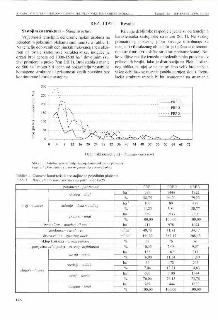
S. Kucbel: STRUKTURA I PRIRODNA OBNOVA PREDPLANINSKR ŠUME OBIČNI: SMREKE Šumarski list - SUPLEMENT (2005), 144-153
REZULTATI - Results Sastojinska struktura Stand structure Vrijednosti temeljnih dendrometrijskih osobina na
određenim pokusnim plohama sumirane su u Tablici 1. Na temelju dobivenih debljinskih frekvencija te s obzirom na ostale sastojinske karakteristike, moguće je držati broj debala od 1000-1500 ha"' dovoljnim (svi živi primjerci s preko 7cm DBH). Broj stabla s manje od 500 ha"1 mogu biti jedan od pokazatelja nestabilne homogene strukture ili prisutnosti većih površina bez kontinuirane šumske sastojine.
Krivulje debljinske raspodjele jedna su od temeljnih karakteristika sastojinske strukture (SI. 1). Na svakoj promatranoj pokusnoj plohi krivulje distribucije su manje ili više silaznog oblika, stoje tipično za diferenciranu strukturu (vrlo slično strukturi preborne šume). Neke vidljive razlike između određenih ploha proizlaze iz prikazanih brojki. Iako je distribucija na Plohi 1 silaznog oblika, na njoj se nalazi prilično velik broj stabala višeg debljinskog razreda (stabla gornjeg sloja). Regulacija strukture trebala bi biti usmjerena na smanjenje
300
S
c
1 12 16 20 24 28 32 36 40 44 48 52 56 60 64 68 72
Debljinski razred (cm) - diameter class (cm)
Slika 1. Distribucijske krivulje na pojedinim pokusnim plohama Figure 1 Distribution curves on particular research plots
Tablica 1. Osnovne karakteristike sastojine na pojedinim plohama Table l Basic stand characteristics on particular PRPs
parametar - parameter
broj - number
vitalna - vital
sušenje - dead standing
ukupno - total
broj >7cm - number >7 cm temeljnica - basal area
drvna zaliha - growing stock sklop krošanja - crown canopy
prosječna defolijacija - average defoliation
slojevi - layers
gornj i - upper
srednji -middle
donji - lower
ukupno - total
ha-1
% ha"1
% ha1
% ha"1
nr.ha"1
m .ha"1
% %
ha"1
% ha"1
% ha"1
% ha1
%
PRPI 789
88,75 100
11,25 889
100,00 411
40,78 444,22
55 10,35 133
16.90 56
7,04 600
76,06 789
100,00
PRP2 1444
94,20 89
5,80 1533
100,00 978
41,81 387,17
76 7,08 167
11,54 178
12.31 1100
76,15 1444
100,00
PRP3 1822
79,23 478
20,77 2300
100,00 1044
34,17 268,43
76 9,57 211
11,59 267
14,63 1344
73,78 1822
100,00
146
S. Kuchel: STRUKTURA I PRIRODNA OBNOVA PREDPLANINSKE ŠUME OBIČNU SMREKE ... Šumarski list - SUPLEMENT (2005). 144-153
pojedinih primjeraka gornjeg sloja u korist drveća iz srednjeg i nižeg sloja. Debljinska distribucija na Plohi 2 najviše aproksimira traženi model. Pojedina stabla iz donjeg sloja (debljinski razredi 2-4) su srednje defici-jentni. Ploha 3 pokrivena je s najmlađim sastojinama. Jedan dio te plohe je u fazi rasta guštika i šibljaka. Ovaj homogeni dio predstavlja nestabilni element koji traži šumskouzgojne mjere. Zahvati bi trebali smanjiti broj stabala i diferencirati sastojinu.
Prema dobivenim podacima bazalno područje trebalo bi se kretati između 35 nr.ha"1 i 40 nV.ha"' u danoj strukturi. Drvna zaliha ima sasvim drukčije vrijednosti na određenim pokusnim plohama (od 268,43 m'.ha"' do 444,22 m'.ha"1). S obzirom na sastojinsku strukturu kao i na utjecaj izvanrednih primjeraka (npr. jedno stablo s DBH od 88 cm na Plohi 1 povećava ukupnu drvnu zalihu za više od 80 m3.ha_1) moguće je predložiti optimalnu drvnu zalihu na razini od 300 m\ha"' do 400 m3.ha"1, u skladu s proizvodnim uvjetima položaja. Stupanj opadanja lišća kreće se ispod 10 % na svim plohama, pa se na
Osim ukupne količine GDO, omjer određenih stadija raspadanja važan je ponajprije volumen GDO u drugom i trećem stadiju raspadanja, zato što samo trupci u tom stanju osiguravaju odgovarajuće uvjete za razvoj prirodne obnove. S tog su gledišta najbolji uvjeti na Plohi 1, gdje je gotovo sav GDO barem dejlomično is-trunuo te stvara pogodnu sjemenu podlogu za smrekine sadnice. Iz danih podataka teško je kvantificirati do-
Na svim pokusnim plohama nalaze se tri vrste drveća u prirodnoj obnovi - obična smreka (Picea abies l\.l karst.) i gorski jasen (Sorbus aucuparia L.). Iako tablice 3 i 4 također prikazuju ukupni broj posebnih primjeraka (smreka + jasen), ove vrijednosti kao i komparacija brojeva prema vrstama drveća imaju samo ori-jentacijsko značenje. Prvi razlog je taj, da iako je jasen
temelju tih osobina sastojine mogu vrednovati kao vitalne i zdrave.
Analiza frekvencije drveća prema slojevima pokazuje da otprilike 3/4 svih pojedinih primjeraka koncentrirano u donjem sloju, dok je ostalih 25 % podijeljeno u različitim omjerima u srednji i gornji sloj. Nakon vrednovanja sastojinske strukture na pojedinim plohama, najprikladniji odnos slojeva čini se model 75 % donjeg sloja, 15 % srednjeg sloja i 10 % gornjeg sloja. Taj se model odnosi na omjer prema broju stabala, u slučaju omjera površine, svaki sloj bi trebao imati otprilike istu površinu (tj. 1/3 sastojinske površine).
Grub drvni otpad (GDO) važna je komponenta planinske šume, posebice sa stajališta njenih procesa obnove. Tablica 2 sumira rezultate volumena sastojine podijeljeno prema vitalnim, dubećim ili ležećim mrtvim stablima. Volumen ležećeg mrtvog drva kreće se od 43,56 m3.ha ' na Plohi 2 do 71,67 m3.ha_l na Plohi 1 u apsolutnim vrijednostima.
voljnu količinu GDO, ali se može reći da što su gori uvjeti za prirodnu obnovu u sastojini, to više mora biti količine GDO. Raspodjela čitave biomase na promatranim plohama jc sljedeća: otprilike 80-85 % otpada na vitalna stabla, ostatak se dijeli u omjeru 1:2 između dubećeg i ležećeg mrtvog drva. Drukčija je situacija samo na Plohi 3, gdje je primijećen vrlo velik broj dubećeg mrtvog drva.
važna i stalna komponenta sastava vrsta u planinskoj šumi, smreka ostaje determinantna vrsta ovih sastojina i stoga broj i struktura obnove smreke ima ključno značenje za obnovu sastojine. Drugi razlog, koji ne dozvoljava izravnu usporedbu, je ritam rasta i ekološki zahtjevi ovih triju vrsta, kao i različita dinamika procesa obnove.
Tablica 2. Drvna zaliha i volumen grubog drvnog otpada prema pojedinim plohama Table 2 Growing stock and volume of coarse woody debris according to PRP
PRP
PRPI
PRP2
PRP 3
broj number
volumen - volume
broj - number
volumen - volume
broj - number
volumen - volume
ha"1
m .ha"1
% ha 1
m'.ha"' %
ha 1
m .ha"' %
vitalna vital
789 444,22 80,57 1444
387,17 84,84 1822
268,43 66,21
sušenje - dead pozicija standing
100 35,44 6,43 89
25,6 5,61 478
88,28 21,77
lying 156
71,68 13,00
78 43,6 9,55 289
48,74 12,02
ukupno total
1045 551,34 100,00 1611
456,37 100,00 2589
405,45 100,00
PROCESI OBNOVE - Regeneration processes
147
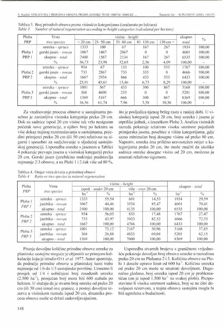
S. Kucbel: STRUKTURA I PRIRODNA OBNOVA PRKDPLANINSKE SUME OBIČNE SMREKE Šumarski list - SUPLEMENT (2005), 144-153
Tablica 3. Broj prirodnih obnova prema visinskim kategorijama (izračunato po hektaru) Table 3 Number of natural regeneration according to height categories (calculated per hectare)
Ploha PRP
Ploha 1 PRP 1
Ploha 2 PRP 2
Ploha 3 PRP 3
Vrsta tree species
smreka - spruce gorski jasen - rowan
ukupno - total 0 / /o
smreka - spruce gorski jasen - rowan
ukupno - total %
smreka - spruce gorski jasen - rowan
ukupno - total %
visina - height <20cm
1333 1067 2400 36,73 934 733 1667
25,91 1001 368 1369 16,36
21-50 cm 100
1467 1567
23,98 67
2867 2934 45,61 567
4600 5167 61,74
51-80 cm 67
2067 2134 32,65 133 733 866
13,46 433 233 666 7,96
81-130 cm 167 0
167 2,56 100 333 433 6,73 300 0
300 3,58
130cm + 267
0 267 4,09 533 0
533 8,29 867 0
867 10,36
ukupno total 1934 4601 6535
100,00 1767 4666 6433 100,00 3168 5201 8369
100,00
%
100,00 100,00 100,00
-100,00 100,00 100,00
-100,00 100,00 100,00
-
Za vrednovanje procesa obnove u sastojinama posebno je zanimljiva visinska kategorija preko 20 cm. Dok su sadnice ispod 20 cm visine tek vrlo nesiguran početak nove generacije, a njihov broj po hektaru su više dokaz trajnog razmnožavanja u sastojinama, pojedini primjerci preko 20 cm (ili 50 cm) relativno su sigurni i sposobni za sudjelovanje u sljedećoj sastojin-skoj generaciji. Usporedba smreke s jasenom u Tablici 4 pokazuje prevagu jasena u visinskoj kategoriji preko 20 cm. Gorski jasen (jarebikina mukinja) predstavlja najmanje 2/3 obnove, a na Plohi 1 i 2 čak više od 80 %,
Tablica 4. Omjer vrsta drveća u prirodnoj obnovi Table 4 Ratio or tree species in natural regeneration
stoje posljedica njenog bržeg rasta u ranijoj dobi. U visinskoj kategoriji ispod 20 cm, broj smreka i jasena je otprilike jednak, s izuzetkom Plohe 3. Analiza visinskih razreda pokazuje relativno visoku smrtnost pojedinih primjeraka jasena, posebice u višim kategorijama, gdje samo minimalan broj dosegne visinu od preko 80 cm. Naprotiv, smreka ima prilično uravnotežen omjer u kategorijama preko 20 cm, što može značiti da ukoliko sadnica smreke dosegne visinu od 20 cm, možemo ju smatrati relativno sigurnom.
Ploha PRP
Ploha 1 PRP 1
Ploha 2 PRP 2
Ploha 3 PRP 3
Vrsta tree species
smreka - spruce jarebika - rowan
ukupno - total smreka - spruce jarebika - rowan
ukupno - total smreka - spruce jarebika - rowan
ukupno - total
visina- height ispod - under 20 cm ha1
1333 1067 2400
934 733
1667 1001 368
1369
% 55,54 44,46
100,00 56,03 43,97
100,00 73,12 26,88
100,00
više - over 20 cm ha1
601 3534 4135
833 3933 4766 2167 4833 7000
% 14,53 85,47
100,00 17,48 82,52
100,00 30,96 69,04
100,00
ukupno — loiui ha1
1934 4601 6535 1767 4666 6433 3168 5201 8369
% 29,59 70,41
100,00 27,47 72,53
100,00 37,85 62,15
100,00
Pitanje dovoljne količine prirodne obnove smreke za planinske sastojine moguće je objasniti uz primjenu kalkulacije koju je izradio O t t etal. 1977. Autor spominje, da područje prirodne obnove u planinskoj šumi traba najmanje od 1/6 do 1/3 sastojinske površine. Uzmemo li prosjek od 1/4 i uobičajeni broj zasađenih smreka (2.500 ha"1), prosječan broj mora biti 600 stabala po hektaru. U slučaju daje stvarni broj smreke od preko 20 cm (ili 50 cm) iznad ove granice, a postoji dovoljna rezerva u visinskom razredu ispod 20 cm, dinamika procesa obnove može se držati zadovoljavajućom.
Usporedba stvarnih brojeva s graničnom vrijednošću pokazuje dovoljan broj obnova smreke u razredima preko 20 cm na Plohama 2 i 3. Količina obnove na Plohi 1 doseže upravo limit od 600 ha"'. Količina smreka od preko 20 cm može se smatrati dovoljnom. Dugoročno gledano, broj smreka ispod 20 cm je problematičan (on je ispod 1.500 ha"' na svakoj plohi). Pretpostavimo li visoku smrtnost sadnica, broj se ne čini dovoljnom rezervom, a trajna obnova sastojina mogla bi biti ugrožena u budućnosti.
148
S. Kucbcl: STRUKTURA I PRIRODNA OBNOVA PREDPLANINSKE SUME OBIČNE SMREKE ... Šumarski liši - SUPLEMENT (2005). 144-153
DISKUSIJA I ZAKLJUČCI -U ovom radu korišteni su podaci s pokusnih ploha.
Analiza strukture koja aproksimira idealnu sastojinsku strukturu u planinskim šumama omogućila je donošenje nekih djelomičnih zaključaka u odnosu na model planinske šumske strukture.
Rezultati se mogu usporediti s podacima iz Švicarskih Alpa koje je objavio Trepp (1961). Prema ovom autoru, najvažni atributi grupne preborne strukture planinske šume su sljedeći: nakupinasta ili grupna struktura, obnova na maloj površini, srednja drvna zaliha (340-380 m3 ha"1) i na prikladnim terenima, trajni razvoj pirrodne obnove na ekološki diferenciranim mikro-položajima. Na ovoj pokusnoj plohi broj stabala je bio 720/ha, a njegova distribucija po slojevima bila je kako slijedi: donji sloj 58,3 %, srednji 13,8 %, te gornji sloj 27,7 %. Autor vrednuje drvnu zalihu na plohi kao suviše veliku, te preporučuje maksimalnu zalihu od
Bischoff , N., 1987: Pflege des Gebirgswaldes, Bundesamt fur Forstwesen and Landschafts schütz, EDMZ Bern, 379 s.
F r e h n e r , M., 1989: Beobachtungen zur Einleitung der Naturverjungung an einem nordexponierten Steilhang im subalpinen Fichtenwald, Schweiz. Z.Forstwesen, 140 (11), s. 1013-1022.
G ubk a, K., 1998: Struktura porastov pod homou hra-nicou lesa na lokalite Jasienok, Acta Facultatis Forestalis XL., Zvolen, s. 29-39.
G übk a, K., 1999: Struktura smrekovćho porastu pod hornou hranicou lesa v dielci 105 na LS Maluzi-nä, Acta Facultatis Forestalis XLI, Zvolen, s. 107-119.
KorpeL , S., 1980: Vyvoj a struktura prirodnych smrekovych lesov Slovenska vo vzt'ahu k proti-lavinovej ochrannej funkcii, Acta facultatis forestalis XXII, Zvolen, s. 9-39.
KorpeL , Š., 1989: Pralesy Slovenska, Veda, Bratislava, 332 s.
Kuoch , R., 1972: Zur Struktur and Behandlung von subalpinen Fichtenwäldern, Schweiz. Z. Forstwesen, 123(2), s.77-89.
- Discussion and conclusions
350 m3 ha"', čak na najprikladnijim položajima. Sto se tiče prirodne obnove, izračunao je 2.160 stabala po hektaru u visinskom razredu od ispod 30 cm; u visinskom razredu 31-150 cm - 1.220 ha"', a u razredu od preko 150 cm bilo je 620 ha"1. Usporedbom s tim rezultatima, posebice se brojke u kategoriji ispod 20 cm na našim pokusnim plohama čine malima, te, kao što je rečeno prije, one nisu dovoljna rezerva za trajnu obnovu.
Osim održavanja diferencirane strukture šumskouz-gojni zahvati trebaju se usmjeriti na podršku postojećoj prirodnoj obnovi, tako da se stvore prikladni svjetlosni i termalni uvjeti za njihov daljnji rast i razvoj. Najbolji način da se to postigne je posjeći nekoliko stabala zasjene iz gornjeg sloja. Sto se tiče povećanja broja sadnica u kategoriji ispod 20 cm, bilo bi dobro ostaviti neke od posječenih stabala u sastojim, kako bi se stvorile sjemene podloge za pojavu sadnica.
L e i b u n d g u t , H., 1978: Über die Dynamik europäischer Urwälder, Allg. Forstz. 33, s. 686-690.
L e i b u n d g u t , FL, 1993: Europäische Urwälder, Verlag Paul Haupt, Bern-Stuttgart, 260 s.
Mayer , FL, E. Ott, 1991: Gebirgswaldbau - Schutzwaldpflege, Gustav Fischer Verlag, Stuttgart, 587 s.
Ott , E., 1988: Die Gebirgswaldpflege - eine Vielfalt sehr variationsreicher Optimierungsaufgaben, Schweiz. Z. Forstwesen, 139 (1), s. 23-26.
Ott , E., M. Frehner, H. Frey, P. Lüscher, 1997: Gebirg-snadelwälder, Verlag Paul Haupt, Bern, 287 s.
Schmid t -Vog t ,H . , 1991: Die Fichte, Bd.II/3, Paul Parey Verlag, Hamburg Berlin, 781 s.
T repp , W., 1961: Die Plenterform des Heidelbeer-Fichtenwaldes der Alpen, Schweiz. Z. Forstwesen, 112(10), s. 337-350.
Trepp , W., 1981: Das Besondere des Plenterns im Gebirgswald, Schweiz. Z. Forstwesen, 132 (10), s. 823-846.
LITERATURA - References
149
PRESENTATION AT THE INTERNATIONAL SYMPOSIUM šumarski list - SUPLEMENT (2005), 144-153
THE S T R U C T U R E AND NATURAL REGENERATION OF A SUBALPINE SPRUCE FOREST WITH P R O T E C T I V E F U N C T I O N
IN NIZKE TATRY MOUNTAINS (SLOVAKIA)
Stanislav KUCBEL
SUMMARY: The paper deals with issue of the stand structure, natural regeneration and silvicultural interventions in the protective forests in a mountain region of Slovakia. The priority protective function (especially anti-erosive, anti-avalanche and water-protective) of the mountain forests requires permanent presence of a stable, natural regenerating forest with a differentiated structure. To be able to describe and quantify this structure three permanent research plots have been established in locality Prasiva in Nizke Tatty Mountains. The paper analyses particular structure characteristics of researched stand and on the basis of acquired results the basic structure characteristics for a high-elevation forest are quantified. The results has shown the high-elevation forest should have in an ideal state under similar ecological conditions roughly these characteristics: stem density 1000-1500 pes./ha, falling diameter distribution, the representation of particular tree layers - upper 75 %, middle 15 %, lower 10%, basal area 35-40 m2/ha, growing stock 300-400 m3/ha according to the production ability of the site.
Besides the characteristics of model structure the paper analyses the state and the quantity of natural regeneration, which is necessarily needed for the steady exchange of generations in a high-elevation forest. In the natural regeneration two tree species (Norway spruce and rowan) are present. Because of its ecological characteristics rowan is the prevailing tree species in the natural regeneration on all researched plots. The number of Norway spruce natural regeneration in the height classes above 20 cm is crucial for the generation exchange and can already be considered as a relatively secure beginning of a new generation. The results have shown the number of natural regeneration individuals in the height classes above 20 cm should be at least 600 pes./ha, under the condition of sufficient reserve in the height class under 20 cm.
Keywords: subalpine forest, stand structure, Norway spruce, natural regeneration
INTRODUCTION
Forest stands with priority soil-protective (i.e. anti-erosive and anti-avalanche) and water-protective functions take roughly 336,641 ha (16.7 %) within the total forest area of Slovak Republic. All of these stands belong to the non-commercial forests, either to the category of protection or special purpose forests. High-ele-
Ing. Stanislav Kucbcl, Department of Silviculture, Forestry Faculty, Technical University, Masarykova 24, 96053 Zvolen, Slovak Republic, e-mail: [email protected]
vation forests have generally a multi-function effect and the mentioned functions are usually the most important ones. To the subcategory b. of protection forests (i.e. high-elevation forests) we count about 49,500 ha.
The issue of the silvicultural interventions in the high-montane and subalpine stands has
been considered one of the marginal problems for the forestry in Slovakia in the past. Decreasing vitality and relatively intensive breakdown of single trees as well as whole stands on some localities during the last
150
S. Kucbel: THE STRUCTURE AND NATURAL REGENERATION OF A SUBALPINE SPRUCE KOREST ... Šumarski list- SUPLEMENT (2005). 144-153
15-20 years have focused the attention on the problems of high-elevation forests recently. The immis-sion impact and extreme weather situations caused by global climatic changes have been probably the crucial factors which have activated the process of the breakdown. The research results (Gubka 1998, 1999) as well as the experiences of practical foresters have shown, beside the mentioned factors, the unstable stand structure remains the key problem of high-elevation forests. This is the result of absent silvicultural regulation and it causes the low resistance to the disturbances and high probability of calamity breakdown.
Solution of the problems of silvicultural interventions in high-elevation forests requires to know and to consider their specifics to the forests in lower altitudes. If we want to understand the natural dynamics of high-elevation forest we can use the knowledge obtained from the long-term research of primeval forests in the 7th forest vegetation stage. Studying the life cycle of the Norway spruce primeval forests some natural tendencies with negative impact on the stability of high-elevation forest have been found out (Korpe l ' 1989, Schmid t -Vog t 1991, L e i b u n d g u t 1993). These are mainly the tendency to develop a less stable mono-layered structure with horizontal canopy during the long-time optimum stage, the stagnation of regeneration processes and the proneness to the calamity breakdown which causes the loss of required structure for a relatively long period. On the basis of these findings the most authors (Le ibundgu t 1978, K o r p e l ' 1980, Maye r -Ot t 1991, Schmid t -Vog t 1993) tend to think a Norway spruce natural forest doesn't
The research was conducted near Korytnica in northern Slovakia. On the locality Prasivä in west part of Nizke Tatry Mountains three permanent research plots (PRP) in a stand with protective function were established. The plots were placed in the parts where the stand structure was most differentiated so that it was approximating an ideal structure of the mountain forest. Every plot had a dimension 30 x 30 m and included a transect with the width of 10 m. On the research plots particular stand characteristics as well as the state of natural regeneration on the transect were acquired and on the basis of them the model stand structure was approximately quantified.
The research plots were situated on a west slope in the average altitude 1,300 m a.s.l., the slope ranged from 50 to 70 %. The slope is covered with pure Norway spruce (Picea abies (L.) Karst.) stand with rare presence of rowan (Sorbus aucuparia L.) and mountain pine (Pinus mugo Turra). According to the forest typology three forest communities could be found -
have, especially on the convenient sites, the permanent ability to fulfil all protective functions. A high-elevation forest with optimal stand structure which is the result of intentional silvicultural interventions is more stable than a Norway spruce primeval forest and thus the pointed silvicultural regulations seem to be necessary for the permanent protective effect.
For the forest with permanent protective effect in the high altitudes the permanent presence of the tree individuals on the site, stability of single trees as well as of the whole stand and gradual natural regeneration should be characteristic. This needs satisfies a stable, natural regenerating, uneven-aged and multi-layered forest at most. Time unlimited durability of structure and permanent regeneration are in general the attributes of a selection forest. Therefor most authors (Kuoch 1972, Trepp 1981, Bischoff 1987, Ott 1988, F rehner 1989, Ott et al. 1997) consider so-called mountain selection forest ("Gcbirgsplenter-wald") the ideal pattern of a Norway spruce forest in the high-altitude sites.
Naturally long-time process of natural renewal is one of the specifics of the high-elevation forest. The permanent natural regeneration without the limitation of protective effects, which secures the change of forest generations, is the crucial problem in the high-altitude forest. Ott (1988) consider the stand renewal "the weak link in the chain of forest dynamics" in the forest growing near the tree limit. According to Trepp (1961) the silvicultural regulations fulfil their purpose in the high-elevation forests only in the case they are able to secure their natural renewal.
Sorbeto-Piceetum (60 %), Fagetum abietino-piceosum (30 %) and Mughetum acidofilum (10 %). For this compartment the forest management plan states the average age 180 years and average crown canopy 0.7.
On the PRP the set of following parameters was measured for every individual: tree species, dbh (over 1 cm), tree class (according to the top height - upper, middle and lower layer), defoliation (visual estimation of the loss of assimilation organs in 10 %). In addition to this data next variables were measured on the transect: height, height where the crown development begins, crown radius (in four directions) and the position of the stem on the transect (x, y - coordinates).
On every PRP coarse woody debris was registered as well and the length, diameter in the middle of length and the decomposition grade (1 - recently fallen, sound, 2 - partly rotted, tree species can be determined, 3 - advanced decay, tree species cannot be determined) of each log was measured.
METHODS
151
S. Kucbel: TI Ili STRUCTURE AND NATURAL REGENERATION OF A SUBALP1NF. SPRUCE FOREST ... Šumarski l is t- SUPLEMFNT (2005). 144-153
The analyses of natural regeneration was conducted cies and height classes (up to 20 cm, 21-50 cm, 51-80 on the transect. All individuals according to tree spe- cm, 81-130 cm, from 131 cm to dbh 1 cm) were noted.
RESULTS
Stand structure
The values of basic dendrometric traits on particular research plots are summarized in Table 1. On the basis of the obtained diameter frequencies and regarding other stand characteristics it is possible to consider the stem number of 1,000-1,500 ha"1 as sufficient (all living individuals with dbh over 1 cm). If only the large timber is taken into consideration (individuals with dbh over 7 cm), the stem number should range from 500 to 1,000 ha"'. The stem numbers with less than 500 ha"1 can be one of the indicators of an unstable homogenous structure or of the presence of wider parts without continuous forest stand.
Diameter distribution curves are one of the basic characteristics of a stand structure (Fig. 1). On every observed research plot the distribution curve has more or less distinctly decreasing shape, which is typical for a differentiated structure (very close to a selection forest structure). Some visible differences between particular research plots follow from the figures. Although the distribution on the PRP 1 has a decreasing shape, there is a quite high stem number in higher diameter classes (trees of the upper layer). The regulation of the structure should head to the reduction of the upper layer individuals in favour of the trees from middle and lower layer. The diameter distribution on the PRP 2 is approximating the required model at most. The individuals from the lower layer (diameter classes 2 and 4 cm) arc moderately deficient. The PRP 3 is covered with the youngest stand. A part of the plot is in the growth phase of thicket and small pole-stage stand. This homogenous part represents an unstable element which requires a silvicultural measure. The intervention should reduce the stem number and differentiate the stand.
According to obtained data the basal area should range from 35 to 40 m2 ha 1 by the given structure. The growing stock has quite different values on particular research plots (from 268.43 m3 ha 1 to 444.22 m ha 1). Considering the stand structure as well as
the influence of outliers (e.g. one stem with dbh of 88 cm on PRP 1 increases the total growing stock for
Two tree species are present in the natural regeneration on all research plots - Norway spruce {Picea abies IL.I Karst.) and rowan (Sorbus aucuparia L.). Although the tables 3 and 4 show also the total number of
more than 80 m3 ha"1) it is possible to propose the optimum growing stock on the level from 300 to 400 m3
ha"', according to the production conditions of the site. The defoliation grade ranges under 10 % on all plots and on the basis of this characteristic the stands can be evaluated as vital and healthy.
The analysis of tree frequencies according to the layers shows that approximately 3/4 of all individuals are concentrated in the lower layer, whilst other 25 % are divided by different ratio into middle and upper layer. After the evaluation of stand structure on particular plots the most appropriate ratio of the layers seems to be the model: 75 % lower layer, 15 % middle layer and 10 % upper layer. The model concerns the ratio according to the stem number, in the case of area ratio each layer should take roughly the same area (i.e. 1/3 of the stand area).
Coarse woody debris (CWD) is an important component of a high-elevation forest especially from the viewpoint of its regeneration processes. Table 2 sums up the results of the stand volume divided according to vital, standing and lying dead trees. The volume of lying deadwood ranges from 43.56 m3 ha"' on PRP 2 to 71.67 m3 ha"1 on PRP 1 in absolute values.
Besides the total amount of CWD the ratio between particular grades of decomposition is important, above all the volume of CWD in the 2nd and 3rd grade of decomposition, because only the logs in this state provide appropriate conditions for the development of natural regeneration. From this point of view the best conditions are on the PRP 1 where almost all CWD is at least partly rotted and creates a convenient seedbed for spruce seedlings. From given data it is difficult to quantify the sufficient amount of CWD but it is possible to say the worse are the conditions for the natural regeneration in the stand, the higher should be the amount of CWD. The distribution of the whole biomass on the observed plots is following: approximately 80-85 % fall on vital trees, the rest is divided in ratio 1:2 between standing and lying deadwood. Different situation is only on PRP 3, where a quite high number of standing deadwood has been observed.
individuals (spruce + rowan), this values as well as the comparison of the numbers according to the tree species have only an orientation meaning. The first reason is, that although rowan is an important and permanent
REGENERATION PROCESSES
152
S. Kucbel: THE STRUCTURE AND NATURAL REGENERATION OF A SUBALPINE SPRUCE FOREST ... Šumarski list - SUPLEMENT (2005), 144-153
component of the species composition in the high-elevation forest, spruce stays the determinant tree species of these stands and therefore the number and structure of spruce regeneration has the crucial importance for the stand renewal. The second reason which does not allow the direct comparison is the growth rhythm and ecological demands of these tree species as well as the different dynamics of the regeneration process.
For the evaluation of the regeneration processes in the stands especially the height category over 20 cm is interesting. While the seedlings under 20 cm are only a very insecure beginning of the next generation and their numbers per hectare are more the proof of the permanent breeding in the stands, the individuals over 20 cm (or 50 cm) are relatively secure and able to take part on the next stand generation. The comparison of the spruce and rowan representation in table 4 shows the prevalence of rowan in the height category over 20 cm. Rowan presents at least 2/3 of the regeneration, on PRP 1 and 2 even more than 80 % what is the consequence of her faster growth at the lower age. In the height category under 20 cm the numbers of spruce and rowan are approximately equal, excepting PRP 3. The analysis of the height classes shows relatively high mortality of rowan individuals especially in higher categories, where only a minimal number of them reaches the height over 80 cm. On the contrary, spruce has a quite balanced ratio in the categories over 20 cm
In this paper the data acquired from three research plots were used. The analysis of a structure which is approximating an ideal stand structure for the high-elevation forest allowed stating some partial conclusions regarding the model of the high-elevation forest structure.
The results can be confronted with the data from Swiss Alps published by Trepp (1961). According to this author the most important attributes of the group selection forest structure on high-elevation sites are following: cluster or group structure, small-scale regeneration, middle growing stock (340-380 m3 ha"1) also on convenient sites, continuous development of the natural regeneration on ecologically differentiated micro-sites. On this research plot the tree number was 720 ha, its distribution into layers: lower 58.3 %, middle 13.8 % and upper layer 27.7 %. The author evaluates the growing stock on to plot too high and recommends the maximum growing stock about 350m3 ha"1 even for
what let assume if the spruce seedling has reached the height of 20 cm we can consider it relatively secure.
The question of sufficient amount of spruce natural regeneration for high-elevation stand renewal can be answered according to a calculation of Ott et al. (1997). The author mentions the area of natural regeneration in a high-elevation forest should take at least from 1/6 to 1/3 of the stand area. If we use an average of 1/4 and the usual number of planted spruce (2,500 ha"1), the approximate reference number should be 600 individuals per hectare. In the case the real number of spruce over 20 cm (or 50 cm) is above this limit and there is a sufficient reserve in the height class under 20 cm, the dynamics of regeneration process can be considered satisfying.
The comparison of the real numbers with the boundary value shows a sufficient number of the spruce regeneration in the classes over 20 cm on PRP 2 and 3. The amount of the regeneration on the PRP 1 reaches just the limit 600 ha"1. Generally the amount of spruce individuals over 20 cm can be considered sufficient. From the long-term view the number of spruce individuals under 20 cm is problematic (it lies under 1,500 ha-1 on each PRP). Assuming the high seedling mortality the number seems to be no sufficient reserve and the continuous regeneration of the stand could be endangered in the future.
most convenient sites. In terms of natural regeneration he found out 2,160 individuals per hectare in the height class under 30 cm, in the height class 31-150 cm 1,220 ha"' and in the class over 150 cm 620 ha"1. Compared with these results, especially the numbers in the category under 20 cm from our research plots seem to be low and as mentioned before they are not a sufficient reserve for continuous renewal.
Besides the maintenance of the differentiated structure the silvicultural interventions should be concentrated on the support of the existing natural regeneration by means of creating appropriate light and thermal conditions for their further growth and development. The best way to do this is to cut several shading trees from upper layer. On behalf of the increase of the seedling number in the category under 20 cm it would be appropriate to leave some of the cutting stems in the stand and thus create perspective seedbeds for the seedling emergence.
DISCUSSION AND CONCLUSIONS
153
E. Klimo: VODOZAŠTITA - URAVNOTEŽENJE VODNIH ODNOSA U PROSTORU Šumarski lis! SUPLliMENT (2005), 154
3. Skupina referata:
VODOZAŠTITA - URAVNOTEŽENJE VODNIH ODNOSA U PROSTORU I PROČIŠĆAVANJE IZVORSKIH VODA
Skupu predsjedava: Prof. dr. sc. Emil Klimo
Referati gornje skupine odnose se na kakvoću vode uvjetovane utjecajem različitih šumskih ekosustava zatim na lizimetrijska istraživanja, monitoring podzemnih voda, vrijednost protuerozijske i vodo-zašitne funkcije šume, kakvoću vode u gorskim vodotocima, utjecaj šume na kemijski sastav oborinske vode te podatak o količini sitnoga korijenja obične smreke. U ovoj skupini održano je 10 referata. Tri referata održali su znanstvenici iz Češke, dva iz Slovačke i pet iz Hrvatske.
Klimo i Kulhavy referiraju o pozitivnom utjecaju nizinske i gorske šume u Češkoj na kakvoću vode. Huška referira o utjecaju šume i vode na ekologiju krajolika, Vrbek i dr. daju rezultate lizimetrijskih istraživanja u šumi hrasta lužjaka i običnoga graba u različitim područjima Hrvatske, Prpić, Jurjević i Ja-kovac izlažu rezultate obračunatih vrijednosti protuerozijske i vodozaštitne funkcije šuma za državne šume u Republici Hrvatskoj dobivene po službenoj metodologiji iz Zakona o šumama Republike Hrvatske, Pilaš i dr. izvješćuju o do sada instaliranom monitoringu podzemnih voda u Hrvatskoj, a Janeček iz Praga preporučuje CN metodu za procjenu mogućega utjecaja vode iz šumskoga sliva.
Tikvić, Seletković i dr. istražuju utjecaj različitih šumskih ekosustava na kakvoću vode u vodotocima dok Tikvić, Seletković, Magdić i Sojat istražuju stanje i odnose oborinskih voda u šumama Nacionalnoga parka Plitvička jezera. Kovar ukazuje u svome referatu na važnost "aktivne zone" tla te daje rezultate istraživanja za slivove različite šumovitosti za ekstremne godine (vlažne i sušne) u Češkoj. Jaloviar iz Zvolena referira o istraživanju raspodjele sitnoga korijenja u rizosferi kulture obične smreke sađene u različitim razmacima.
3rtl group of papers:
WATER PROTECTOIN - BALANCING WATER RELATIONS IN SPACE AND PURIFYING SPRING WATERS
Chaired by: Professor Emil Klimo, PhD
The papers in this group deal with water quality in different forest ecosystems, lyzimetric research, groundwater monitoring, the value of anti-erosive and water-protective forest functions, water quality in mountain watercourses, the impact of forests on the chemical composition of precipitation and data on the quantity of tiny roots of common spruce. Three papers were presented by Czech, two by Slovakian and five by Croatian scientists.
Klimo and Kulhavy report on the positive impact of lowland and montane forests on water quality in the Czech Republic, Huska reports on the effect of forests and water on landscape ecology, Vrbek et al. present the results of lyzimetric research in the forest of pedunculate oak and common hornbeam in different areas of Croatia, Prpić, Jurjević and Jakov ac provide the results of calculated values of anti-erosive and water-protective forest functions for state forests in the Republic of Croatia obtained by using the official methodology set down in the Forest Act of the Republic of Croatia, Pilaš et al. report on the installed groundwater monitoring in Croatia, and Janaček from Prague recommends the use of the CN method for the assessment of some possible effects of water from a forest catchment area.
Tikvić, Seletković and others investigate the impact of different forest ecosystems on the quality of water in watercourses, whereas Tikvić, Seletković, Magdić and Sojat explore the condition and relations in precipitation waters in the forests of the Plitvice Lakes National Park. Rovar points to the importance of "active soil zone " and provides research results for differently forested catchments for extreme years (wet and dry) in the Czech Republic. Jalovarfrom Zvolen reports on research into the distribution of tiny roots in the rhizosphere of a common spruce culture planted with different spacing.
154
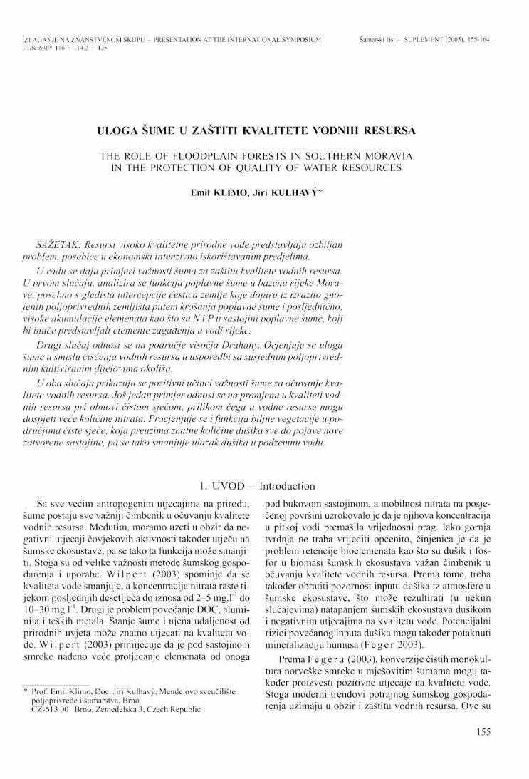
IZLAGANJE NA ZNANSTVENOM SKUPU - PRESENTATION AT THE INTERNATIONAL SYMPOSIUM Šumarski list- SUPLEMENT (2005). 155-164 UDK 630* 116 + 114.2 i 425
ULOGA ŠUME U ZAŠTITI KVALITETE VODNIH RESURSA
THE ROLE OF FLOODPLAIN FORESTS !N SOUTHERN MORAVIA IN THE PROTECTION OF QUALITY OF WATER RESOURCES
Emil KLIMO, Jiri KULHAVY*
SAŽETAK: Resursi visoko kvalitetne prirodne vode predstavljaju ozbiljan problem, posebice u ekonomski intenzivno iskorištavanim predjelima.
U radu se daju primjeri važnosti šuma za zaštitu kvalitete vodnih resursa. U prvom slučaju, analizira se funkcija poplavne šume u bazenu rijeke Mora-ve, posebno s gledišta intercepcije čestica zemlje koje dopiru iz izrazito gno-jenih poljoprivrednih zemljišta putem krošanja poplavne šume i posljednično, visoke akumulacije elemenata kao što su N i P u sastojinipoplavne šume, koji bi inače predstavljali elemente zagađenja u vodi rijeke.
Drugi slučaj odnosi se na područje visočja Drahany. Ocjenjuje se uloga šume u smislu čišćenja vodnih resursa u usporedbi sa susjednim poljoprivrednim kultiviranim dijelovima okoliša.
U oba slučaja prikazuju se pozitivni učinci važnosti šume za očuvanje kvalitete vodnih resursa. Još jedan primjer odnosi se na promjenu u kvaliteti vodnih resursa pri obnovi čistom sječom, prilikom čega u vodne resurse mogu dospjeti veće količine nitrata. Procjenjuje se i funkcija biljne vegetacije u područjima čiste sječe, koja preuzima znatne količine dušika sve do pojave nove zatvorene sastojine, pa se tako smanjuje ulazak dušika u podzemnu vodu.
1. UVOD - Introduction
Sa sve većim antropogenim utjecajima na prirodu, šume postaju sve važniji čimbenik u očuvanju kvalitete vodnih resursa. Međutim, moramo uzeti u obzir da negativni utjecaji čovjekovih aktivnosti također utječu na šumske ekosustave, pa se tako ta funkcija može smanjiti. Stoga su od velike važnosti metode šumskog gospodarenja i uporabe. W i l p e r t (2003) spominje da se kvaliteta vode smanjuje, a koncentracija nitrata raste tijekom posljednjih desetljeća do iznosa od 2-5 mg.l"1 do 10-30 mg.l" . Drugi je problem povećanje DOC, aluminija i teških metala. Stanje šume i njena udaljenost od prirodnih uvjeta može znatno utjecati na kvalitetu vode. W i l p e r t (2003) primijećuje daje pod sastojinom smreke nađeno veće protjecanje elemenata od onoga
* Prof. Emil Klimo, Doc. Jiri Kulhavy, Mendelovo sveučilište poljoprivrede i šumarstva, Brno CZ-613 00 Brno, Zemedelska 3, Czech Republic
pod bukovom sastojinom, a mobilnost nitrata na posječenoj površini uzrokovalo je daje njihova koncentracija u pitkoj vodi premašila vrijednosni prag. Iako gornja tvrdnja ne traba vrijediti općenito, činjenica je da je problem rctencije bioelemenata kao što su dušik i fosfor u biomasi šumskih ekosustava važan čimbenik u očuvanju kvalitete vodnih resursa. Prema tome, treba također obratiti pozornost inputu dušika iz atmosfere u šumske ekosustave, što može rezultirati (u nekim slučajevima) natapanjem šumskih ekosustava dušikom i negativnim utjecajima na kvalitetu vode. Potencijalni rizici povećanog inputa dušika mogu također potaknuti mineralizaciju humusa (F e g e r 2003).
Prema F e g e r u (2003), konverzije čistih monokultura norveške smreke u mješovitim šumama mogu također proizvesti pozitivne utjecaje na kvalitetu vode. Stoga moderni trendovi potrajnog šumskog gospodarenja uzimaju u obzir i zaštitu vodnih resursa. Ove su
155
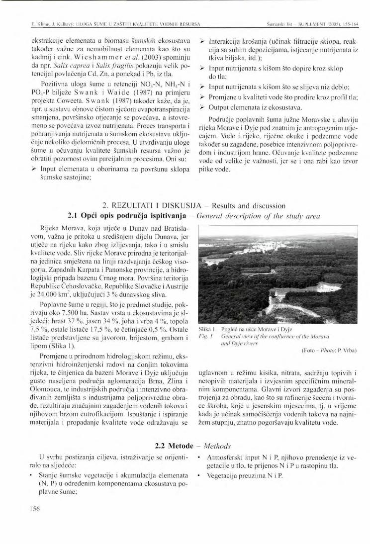
F.. Klimo. J. Kulhavy: ULOGA ŠUML U ZAŠTITI KVALITETE VODNIH RESURSA Šumarski list - SUPLLMLNT (2005). 155-164
ekstrakcije elemenata u biomasu šumskih ekosustava također važne za nemobilnost elemenata kao što su kadmij i cink. W i e s h a m m e r etal. (2003) spominju da npr. Salix caprea i Salix fragilis pokazuju velik potencijal povlačenja Cd, Zn, a ponekad i Pb, iz tla.
Pozitivna uloga šume u retenciji N03-N, NH4-N i PO4-P bilježe Swank i Waide (1987) na primjeru projekta Coweeta. Swank (1987) također kaže, daje, npr. u sustavu obnove čistom sječom evapotranspiracija smanjena, površinsko otjecanje se povećava, a istovremeno se povećava izvoz nutrijenata. Proces transporta i pohranjivanja nutrijenata u šumskom ekosustavu uključuje nekoliko djelomičnih procesa. U utvrđivanju uloge šume u očuvanju kvalitete šumskih resursa važno je obratiti pozornost ovim parcijalnim procesima. Oni su: > Input elemenata u oborinama na površunu sklopa
šumske sastojine;
Rijeka Morava, koja utječe u Dunav nad Bratislavom, važna je pritoka u središnjem dijelu Dunava, jer utječe na rijeku kako zbog izlijevanja, tako i u smislu kvalitete vode. Sliv rijeke Morave prirodna je teritorijalna jedinica smještena na liniji razdvajanja češkog viso-gorja, Zapadnih Karpata i Panonske provincije, a hidro-logijski pripada bazenu Crnog mora. Površina teritorija Republike Čehoslovačke, Republike Slovačke i Austrije je 24.000 km", uključujući 3 % dunavskog sliva.
Poplavne šume u regiji, stoje predmet studije, pokrivaju oko 7.500 ha. Sastav vrsta u ekosustavima je sljedeći: hrast 37 %, jasen 34 %, joha i vrba 4 %, topola 7,5 %, ostale listače 17,5 %, te četinjače 0,5 %. Ostale listače predstavljene su javorom, brijestom, grabom i lipom (Slika 1).
Promjene u prirodnom hidrologijskom režimu, ekstenzivni hidroinženjerski radovi na donjim tokovima rijeka, te činjenica da bazeni Morave i Dyje uključuju gusto naseljena područja aglomeracija Brna, Zlina i Olomouca, te industrijskih područja i intenzivno obrađivanih zemljišta s industrijama poljoprivredne obrade, rezultiraju značajnim zagađenjem vodenih tokova i njihovom brzom eutrofikacijom. Ispuštanje i ispiranje materijala i propadanje kvalitete vode odražavaju se
U svrhu postizanja ciljeva, istraživanje se orijentiralo na sljedeće: • Stanje šumske vegetacije i akumulacija elemenata
(N, P) u određenim komponentama ekosustava poplavne šume;
> Interakcija krošanja (učinak filtracije sklopa, reakcija sa suhim depozicijama, istjecanje nutrijenata iz tkiva biljaka, itd.);
> Input nutrijenata s kišom što dopire kroz sklop do tla;
> Input nutrijenata s kišom što se slijeva niz deblo; > Promjene u kvaliteti vode što prodire kroz profil tla; > Output elemenata iz ekosustava.
Područje poplavnih šuma južne Moravske u aluviju rijeka Morave i Dyje pod znatnim je antropogenim utjecajem. Vode i rijeke, riječne okuke i podzemne vode također su zagađene, posebice intenzivnom poljoprivredom i industrijom hrane. Očuvanje kvalitete podzemne vode od velike je važnosti, jer se i ona rabi kao izvor pitke vode.
Slika 1. Pogled na ušće Morave i Dyje Fig. 1 General view of the confluence of the Morava
and Dyje rivers (Foto - Photo: P. Vrba)
uglavnom u režimu kisika, nitrata, sadržaju topivih i netopivih materijala i izvjesnim specifičnim mineralnim komponentama. Glavni izvori zagađenja su postrojenja za obradu, kao što su rafinerije šećera i tvornice škroba, koje u jesenskim mjesecima, tj. u vrijeme kada je učinak samočišćenja vodenih tokova na najnižem stupnju, znatno pogoršavaju kvalitetu vode.
Atmosferski input N i P, njihovo prenošenje iz vegetacije u tlo, te prijenos N i P u rastopinu tla. Vegetacija preuzima N i P.
2. REZULTATI I DISKUSIJA - Results and discussion 2.1 Opći opis područja ispitivanja - General description of the study area
2.2 Metode - Methods
156
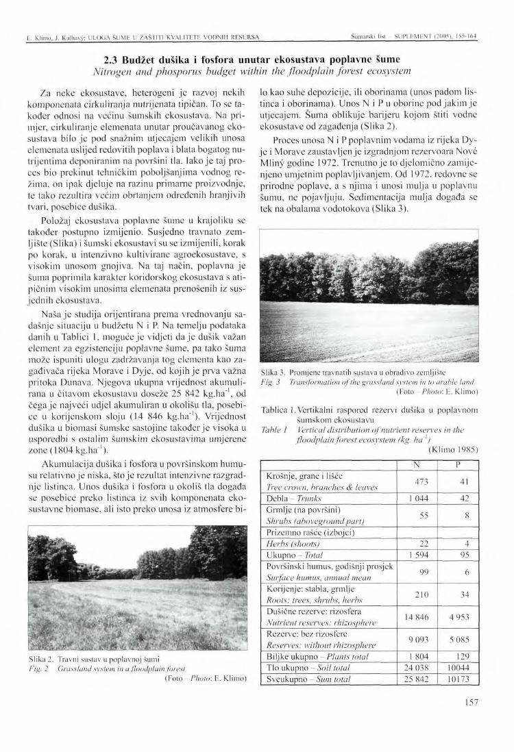
E. Klimo. .1. Kulhavy: ULOGA ŠUME U ZAŠTITI KVALITETE VODNIH RESURSA Šumarski list - SUPLEMENT (2005), 155-164
2.3 Budžet dušika i fosfora unutar ekosustava poplavne šume Nitrogen and phosporus budget within the floodplain forest ecosystem
Za neke ekosustave, heterogeni je razvoj nekih komponenata cirkuliranja nutrijenata tipičan. To se također odnosi na većinu šumskih ekosustava. Na primjer, cirkuliranje elemenata unutar proučavanog ekosustava bilo je pod snažnim utjecajem velikih unosa elemenata uslijed redovitih poplava i blata bogatog nu-trijentima deponiranim na površini tla. Iako je taj proces bio prekinut tehničkim poboljšanjima vodnog režima, on ipak djeluje na razinu primarne proizvodnje, te tako rezultira većim obrtanjem određenih hranjivih tvari, posebice dušika.
Položaj ekosustava poplavne šume u krajoliku se također postupno izmijenio. Susjedno travnato zemljište (Slika) i šumski ekosustavi su se izmijenili, korak po korak, u intenzivno kultivirane agroekosustave, s visokim unosom gnojiva. Na taj način, poplavna je šuma poprimila karakter koridorskog ekosustava s atipičnim visokim unosima elemenata prenošenih iz susjednih ekosustava.
Naša je studija orijentirana prema vrednovanju sadašnje situaciju u budžetu N i P. Na temelju podataka danih u Tablici 1, moguće je vidjeti daje dušik važan element za egzistenciju poplavne šume, pa tako šuma može ispuniti ulogu zadržavanja tog elementa kao zagađivača rijeka Moravc i Dyjc, od kojih je prva važna pritoka Dunava. Njegova ukupna vrijednost akumulirana u čitavom ekosustavu doseže 25 842 kg.ha" , od čega je najveći udjel akumuliran u okolišu tla, posebice u korijenskom sloju (14 846 kg.ha"'). Vrijednost dušika u biomasi šumske sastojine također je visoka u usporedbi s ostalim šumskim ekosustavima umjerene zone (1804 kg.ha"1).
Akumulacija dušika i fosfora u površinskom humusu relativno je niska, stoje rezultat intenzivne razgradnje listinca. Unos dušika i fosfora u okoliš tla događa se posebice preko listinca iz svih komponenata eko-sustavne biomase, ali isto preko unosa iz atmosfere bi
lo kao suhe depozicije, ili oborinama (unos padom listinca i oborinama). Unos N i P u oborine pod jakim je utjecajem. Šuma oblikuje barijeru kojom štiti vodne ekosustave od zagađenja (Slika 2).
Proces unosa N i P poplavnim vodama iz rijeka Dy-je i Morave zaustavljen je izgradnjom rezervoara Nove Mliny godine 1972. Trenutno je to djelomično zamijenjeno umjetnim poplavljivanjem. Od 1972. redovne se prirodne poplave, a s njima i unosi mulja u poplavnu šumu, ne pojavljuju. Sedimcntacija mulja događa se tek na obalama vodotokova (Slika 3).
: =
jEr.'đ
>, .. >ajgfc
Liižiđ
&*&U' : *
_ j ^ * * C
Slika 3. Promjene travnatih sustava u obradivo zemljište Fig. 3 Transformation of the grassland system in to arable land
(¥o\o-Photo: E. Klimo)
Tablica 1. Vertikalni raspored rezervi dušika u poplavnom šumskom ekosustavu
Table 1 Vertical distribution of nutrient reserves in the floodplain forest ecosystem (kg. ha'1)
(Klimo 1985)
Slika 2. Travni sustav u poplavnoj šumi Fig. 2 Grassland system in a floodplain forest
(Foto-Photo: E. Klimo)
Krošnje, grane i lišće Tree crown, branches & leaves Debla - Trunks Grmlje (na površini) Shrubs (abovegroundpart) Prizemno rašće (izbojci) Herbs (shoots) Ukupno - Total Površinski humus, godišnji prosjek Surface humus, annual mean Korijenje: stabla, grmlje Roots: trees, shrubs, herbs Dušične rezerve: rizosfera Nutrient reserves: rhizosphere Rezerve: bez rizosfere Reserves: without rhizosphere Biljke ukupno - Plants total Tlo ukupno - Soil total Sveukupno - Sum total
N
473
1 044
55
22 1 594
99
210
14 846
9 093
1 804 24 038 25 842
P
41
42
8
4 95
6
34
4 953
5 085
129 10044 10173
157
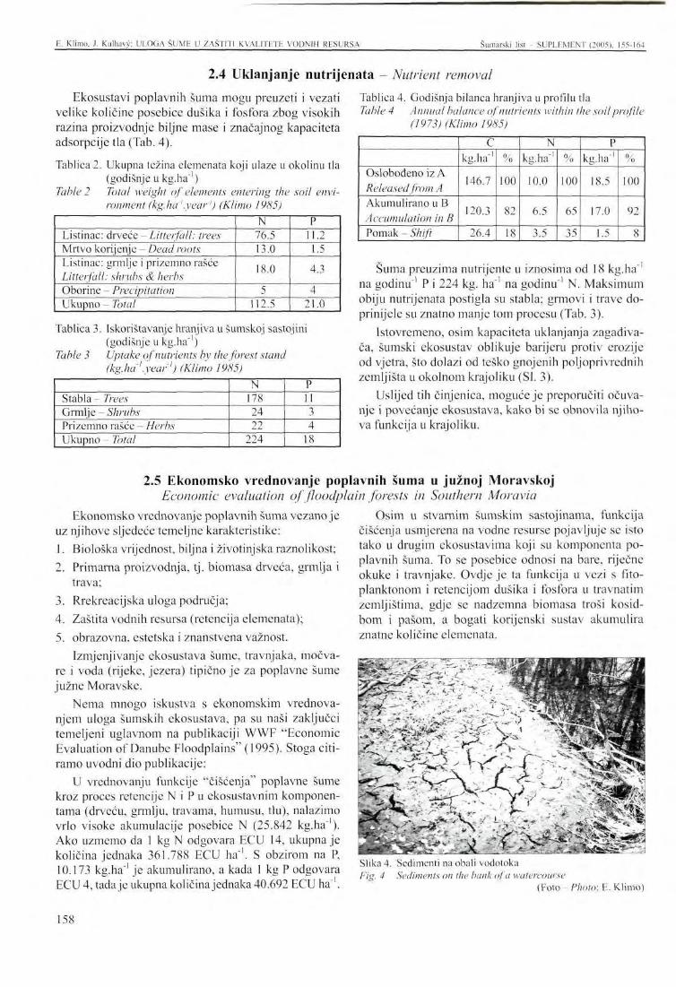
E. Klimo. J. Kulhavy: ULOGA ŠUME U ZAŠTITI KVALITETE VODNIH RESURSA Šumarski SUPLF.MENT (2005). 155-164
2.4 Uklanjanje nutrijenata - Nutrient removal Ekosustavi poplavnih šuma mogu preuzeti i vezati
velike količine posebice dušika i fosfora zbog visokih razina proizvodnje biljne mase i značajnog kapaciteta adsorpcije tla (Tab. 4).
Tablica 2. Ukupna težina elemenata koji ulaze u okolinu tla (godišnje u kg.ha"1)
Table 2 Total weight of elements entering the soil environment (kg.ha'.year') (Klimo 1985)
Listinac: drveće - Litterfall: trees Mrtvo korijenje - Dead roots Listinac: grmlje i prizemno rašće Litterfall: shrubs & herbs Oborine - Precipitation Ukupno - Total
N 76.5 13.0
18.0
5 112.5
P 11.2 1.5
4.3
4 21.0
Tablica 3. Iskorištavanje hranjiva u šumskoj sastojim (godišnje u kg.ha"1)
Table 3 Uptake of nutrients by the forest stand (kg.ha'.year') (Klimo 1985)
Stabla - Trees Grmlje - Shrubs Prizemno rašće - Herbs Ukupno - Total
N 178 24 22
224
P 11 3 4
18
Tablica 4. Godišnja bilanca hranjiva u profilu tla Table 4 Annual balance of nutrients within the soil profile
(1973) (Klimo 1985)
Oslobođeno iz A Released from A Akumulirano u B Accumulation in B Pomak - Shift
C kg.ha"'
146.7
120.3
26.4
%
100
82
18
N kg.ha"'
10.0
6.5
3.5
%
100
65
35
P kg. ha"1
18.5
17.0
1.5
%
100
92
8
Šuma preuzima nutrijente u iznosima od 18 kg.ha"' na godinu"1 P i 224 kg. ha"' na godinu ' N. Maksimum obiju nutrijenata postigla su stabla; grmovi i trave doprinijele su znatno manje tom procesu (Tab. 3).
Istovremeno, osim kapaciteta uklanjanja zagađivača, šumski ekosustav oblikuje barijeru protiv erozije od vjetra, što dolazi od teško gnojenih poljoprivrednih zemljišta u okolnom krajoliku (SI. 3).
Uslijed tih činjenica, moguće je preporučiti očuvanje i povećanje ekosustava, kako bi se obnovila njihova funkcija u krajoliku.
2.5 Ekonomsko vrednovanje poplavnih šuma u južnoj Moravskoj Economic evaluation of floodplain forests in Southern Moravia
Ekonomsko vrednovanje poplavnih šuma vezano je uz njihove sljedeće temeljne karakteristike: 1. Biološka vrijednost, biljna i životinjska raznolikost; 2. Primarna proizvodnja, tj. biomasa drveća, grmlja i
trava; 3. Rrekrcacijska uloga područja; 4. Zaštita vodnih resursa (retencija elemenata); 5. obrazovna, estetska i znanstvena važnost.
Izmjenjivanje ekosustava šume, travnjaka, močvare i voda (rijeke, jezera) tipično je za poplavne šume južne Moravske.
Nema mnogo iskustva s ekonomskim vrednovanjem uloga šumskih ekosustava, pa su naši zaključci temeljeni uglavnom na publikaciji WWF "Economic Evaluation of Danube Floodplains" (1995). Stoga citiramo uvodni dio publikacije:
U vrednovanju funkcije "čišćenja" poplavne šume kroz proces retencije N i P u ekosustavnim komponentama (drveću, grmlju, travama, humusu, tlu), nalazimo vrlo visoke akumulacije posebice N (25.842 kg.ha" ). Ako uzmemo da 1 kg N odgovara ECU 14, ukupna je količina jednaka 361.788 ECU ha"'. S obzirom na P, 10.173 kg.ha ' je akumulirano, a kada 1 kg P odgovara ECU 4, tada je ukupna količina jednaka 40.692 ECU ha"'.
Osim u stvarnim šumskim sastojinama, funkcija čišćenja usmjerena na vodne resurse pojavljuje se isto tako u drugim ekosustavima koji su komponenta poplavnih šuma. To se posebice odnosi na bare, riječne okuke i travnjake. Ovdje je ta funkcija u vezi s fito-planktonom i retencijom dušika i fosfora u travnatim zemljištima, gdje se nadzemna biomasa troši kosid-bom i pašom, a bogati korijenski sustav akumulira znatne količine elemenata.
Slika 4. Sedimenti na obali vodotoka Fig. 4 Sediments on the hank of a watercourse
(Foto- Photo: E. Klimo)
158
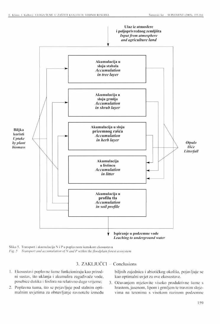
E. Klimo, J. Kulhavy: ULOGA ŠUME U ZAŠTITI KVALITETE VODNIH RESURSA Šumarski list - SUPLEMENT (2005), 155-164
Biljka koristi Uptake by plant biomass
Ulaz iz atmosfere poljoprivrednog zemljišta Input from atmosphere and agriculture land
Akumulacija u sloju stabala
Accumulation in tree layer
Akumulacija u sloju grmlja
Accumulation in shrub layer
Akumulacija u sloju prizemnog rašća
Accumulation in herb layer
Akumulacija u listincu
Accumulation in litter
Akumulacija u profilu tla
Accumulation in soil profile
Otpalo lišće
Litterfall
Y Ispiranje u podzemne vode Leaching to underground water
Slika 5. Transport i akumulacija N i P u poplavnom šumskom ekosustavu Fig. 5 Transport and accumulation ofN and P within the floodplain forest ecosystem
3. ZAKLJUČCI - Conclusions
Ekosustavi poplavne šume funkcioniraju kao prirodni sustav, što uklanja i akumulira zagađivače vode, posebice dušika i fosfora na relativno dugo vrijeme; Poplavna šuma, što se pojavljuje pod stalnim optimalnim uvjetima za obnavljanje ravnoteže između
biljnih zajednica i abiotičkog okoliša, pojavljuje se kao optimalni uvjet za ove ekosustave. Očuvanjem mješovite visoko produktivne šume s hrastom, jasenom, lipom i grmljem te travnim slojevima na terenima s visokom razinom podzemne
159
E. Klimo. .1. Kulhavy: ULOGA ŠUMP U ZAŠTITI KVALITETE VODNIH RESURSA Šumarski list SUPLEMENT (2005), 155-164
vode i obalama vodotokova na kojima dominira vrba i topola, čini se optimalnim uvjetom poplavnih šuma duž rijeka Morave i Dyje.
4. Kako bi se održavala funkcija poplavne šume s gledišta njene produktivnosti i na taj način i kao potencijalno uklanjanje zagađivača, potrebno je uvesti
Economic Evaluation of Danube Floodplains, A WWF International Discussion Paper, March 1995, 24 pp.
Feger , K.H., 2003: Water Quality and Sustainable Management of Forests: Problem and Challenges. In: Conference on Water and Society - Needs, Challenges and Restrictions, 19-21 November 2003, Vienna, BOKU.
Kl imo , E., 1985: Cycling of mineral nutrients. In: Pcnka. M. et all., Floodplain Forest Ecosystem 1, Academia, Praha, 425^158.
Present and Future Role in Nutrient Removal from Surface Water by Wetlands, Floodplains and Reservoirs, Phare project 201/91, Task 2, Intern Report Phase 1, Water Research Institute, Bratislava, 1997,41 pp.
Swank, W.T., J.B.Waide, 1988: Characterization of Baseline Precipitation and Stream Chemistry and
revitalizacijski projekt (regulaciju vodnog režima), što će pomoći u povećanju bioraznolikosti i uklanjanju zagađivača;
5. Uz šumske ekosustave, travnjaci i vodeni ekosustavi imaju važnu ulogu u očuvanju kvalitete vodnih resursa.
Nutrient Budgets for Control Watersheds. In: W.T. Swank, D.A. Crosslcy Jr., Eds. Forest Hydrology and Ecology at Coweeta, Spring-Verlag, Ecological Studies 66, 57-79.
Swank, W.T., 1988: Stream Chemistry Responses to Disturbance. In: W.T. Swank, D.A.Crossley Jr., Eds. Forest Hydrology and Ecology at Coweeta, Spring-Verlag, Ecological Studies 66, 340-357.
W i e s h a m m e r , G. at all., 2003: Phytoextraction of Cadmium and Zink Using Willows: Microbial Effects. In: Conference on Water and Society -Needs, Challenges and Restrictions, 19-21 November 2003, Vienna, BOKU.
Wi lpc r t , K. von, 2003: The Potential of Forestry for Water Preservation - Case Studies from Black Forests, Germany. In: Conference on Water and Society - Needs, Challenges and Restrictions, 19-21 November 2003, Vienna, BOKU.
4. LITERATURA - References
160
PRESENTATION ATT! IH INTERNATIONAL SYMPOSIUM Šumarski list - SUPLEMENT (2005), 155-164
THE ROLE OF FLOODPLAIN FORESTS IN SOUTHERN MORAVIA IN THE PROTECTION OF QUALITY OF WATER RESOURCES
Emil KLIMO, Jiri KULHAVY
SUMMARY: Resources of drinking water of high quality are a serious problem particularly in the intensively economically used landscape. The paper gives examples of the importance of forests for the protection of quality of water resources. In the first case, the function of a floodplain forest is analysed in the basin of the Morava River, particularly from the viewpoint of intercepting soil particles carried from markedly fertilized agricultural soils by crowns of the floodplain forest and further the high accumulation of elements such as N and P in the floodplain forest stand which otherwise could be a pollution element for the river water. High primary production capable to retain high amounts of nitrogen and phosphorus is an important factor for the role of a floodplain forest. Channelization of rivers and construction of the Nove Mlyny reservoirs bring about the need of artificial flooding which is not, however, fully identical with natural floods particularly from the viewpoint of water quality.
K ey w o rds: water quality, floodplain forests
1. INTRODUCTION
With growing anthropogenic impacts on nature forests become increasingly a more important factor for the preservation of quality of water resources. However, we have to take into account that negative impacts of human activities affect also forest ecosystems and thus this function can be reduced. Therefore, methods of forest management and use are of great importance. W i 1 -p e r t (2003) mentions that water quality decreases and as for the concentration of nitrates it increases in the course of recent decades from typical outputs of water from forest ecosystems amounting to 2-5 mg.f1 to 10-30 mg.r' . Another problem is the increase of DOC, aluminium and heavy metals. The condition of a forest and its distance from the natural condition can significantly affect water quality. W i l p e r t (2003) notices that the higher flux of elements was found under a spruce stand than under a beech stand and nitrate mobility on a clear-felled area caused that their concentration in drinking water exceeded a threshold value. Although the statement mentioned above does not have to be general, there is a fact that the problem of bioele-
* Prof. Emil Klimo, Doc. Jiri Kulhavy, Institute of Forest Ecology, Mendel University of Agriculture and Forestry CZ-613 00 Brno, Zemcdelska 3, Czech Republic
ment retention such as nitrogen and phosphorus in the biomass of forest ecosystems is an important factor for the preservation of water resources quality. Thus, attention is also paid to the input of nitrogen from atmosphere to forest ecosystems which can result (in certain cases) in the saturation of forest ecosystems by nitrogen and negative effects on water quality. Potential risks of the increased input of nitrogen can also stimulate mineralization of humus (F e g e r 2003).
According to F e g c r (2003), conversions of pure Norway spruce monocultures to mixed forests can also bring positive impacts on water quality. Therefore, modern trends of sustainable forest management take into consideration also protection of water resources. These extractions of elements by the biomass of forest ecosystems are also important for the immobility of elements such as cadmium and zinc. W i e s h a m -m c r et all. (2003) mention that eg Salix caprea and Salix fragilis show a high potential to withdraw Cd, Zn and sometimes also Pb from soil.
The positive role of a forest in the retention of N O r
N, NH4-N and P04-P note S w a n k and W a i d e (1987) on the example of Coweeta project. On the other hand, actual losses for a forest ecosystem were
161

F.. Klimo, J. Kulhavy: TI IF ROLF, OF FLOODPLAIN FORESTS IN SOUTHERN MORAVIA .Šumarski list SUPLEMENT (2005), 155-164
found in Ca, Na, K, Mg and Si02. S wan k (1987) also states that for example, in the clear-felling system of regeneration evapotranspiration is reduced, runoff increases and at the same time, exports of nutrients increase. A process of the transport and storage of nutrients in a forest ecosystem includes several partial processes. In the assessment of the role of a forest for the preservation of quality of forest resources it is necessary to pay attention to these partial processes. These are:
> input of elements in precipitation to the surface of a forest stand canopy,
> crown interactions (canopy filtration effect, reaction with dry depositions, leaching of nutrients from plant tissues, etc.),
> input of nutrients in throughfall, > input of nutrients in stemflow,
> changes in the quality of water penetrating through the soil profile,
> output of elements from the ecosystem.
The area of floodplain forests of southern Moravia in the alluvium of the Morava and Dyje rivers occurs under considerable anthropogenic impact, water in rivers, oxbows and also ground waters are polluted particularly by intensive agriculture and food industry. Preservation of the quality of ground water is of great importance because it is also used as the sources of drinking water.
2. RESULTS AND DISCUSSION 2.1 General description of the study area
The Morava river flowing into the Danube above Bratislava is an important tributary in the central part of the Danube influencing the river both from the viewpoint of discharge and water quality. The Morava river watershed is a natural territorial unit situated on the dividing line of the Bohemian Uplands, Western Carpathians and Panonian Province belonging, from
the point of hydrology, to the Black Sea Basin. The area of the territory of the Czech Republic, the Slovak Republic and of Austria amounts to 24 000 km" accounting for 3 % of the Danube watershed.
Floodplain forests in the region under study cover about 7500 ha. Species composition in the ecosystems is as follows: oak 37 %, ash 34 %, alder and willow 4 %, poplar 7.5 %, other broadleaves 17.5 % and conifers 0.5 %. Other broadleaves are represented by maple, elm, hornbeam and lime (Fig. 1).
Changes in the natural hydrological regime, extensive hydroenginecring works on the lower reaches of rivers, and the fact that the basins of the Morava and the Dyje include the densely inhabited areas of the Brno, Zlin and Olomouc agglomerations, as well as industrial areas and intensively farmed lands with agricultural processing industries result in the considerable pollution of the watercourses and their rapid eutrophi-cation. The release and washing of materials, deterioration in the water quality are reflected mainly in the oxygen regime, nitrates, the content of soluble and insoluble materials, and certain specific mineral components. Major sources of pollution are processing plants such as sugar refineries and starch factories which in the autumn months, ie at a time when the self-cleaning effect of watercourses is at its lowest, considerably worsen the water quality.
To fulfil the objectives the research is orientated as follows:
The condition of forest vegetation and element accumulation (N, P) in particular components of the floodplain forest ecosystem.
2.2 Methods Atmospheric input of N and P, their transport from vegetation into soil and N and P transport into the soil solution.
Uptake of N and P by vegetation.
2.3 Nitrogen and phosporus budget
For same ecosystems, a heterogeneous development of some components of nutrient cycling is typical. It also applies to the majority of forest ecosystems. For example, the cycling of elements within the ecosystem under study was strongly affected by high inputs of elements resulting from regular floods and mud rich in nutrients deposited on the soil surface. Although this
within the floodplain forest ecosystem
process has been interrupted by technical improvements of the water regime, it still affects the level of primary production and thus results in a greater turnover of particular nutrients especially nitrogen.
The position of the floodplain forest ecosystem within the landscape has also gradually changed. The neighbouring grassland (photo) and forest ecosystems ha-
162
E. Klimo, J. Kulhavy: THE ROLF. OF FLOODPLAIN FORESTS IN SOUTHERN MORAVIA ... Šumarski list - SUPLEMENT (2005), 155-164
ve been changed, step by step, into intensively cultivated agroecosystems, with high inputs of fertilizers. In this way, the floodplain forest has assumed the character of a corridor ecosystem, with typical high inputs of elements transported from neighbouring ecosystems.
Our study was oriented towards the evaluation of the present situation in N and P budget. Based on the data given in Tab. 1, it is possible to see that nitrogen is an important element for the existence of a floodplain forest and so the forest can also fulfil the role of retaining the element as a pollutant for the Morava and Dy-je Rivers the former being an important tributary of the Danube River. Its total value accumulated in the whole ecosystem amounts to 25 842 kg.ha"', the highest proportion of which being accumulated in the soil environment, particularly in the root layer (14 846 kg.ha"'). Nitrogen value in the forest stand biomass is also high as compared with other forest ecosystems in a temperate zone (1804 kg.ha"').
Nitrogen and phosphorus accumulation in a surface humus is relatively low the fact being the result of an intensive decomposition of litter. Nitrogen and phosphorus input into the soil environment occurs particularly through the litter from all components of the ecosystem biomass but also through the input from atmosphere either as dry depositions or as precipitation (input by litter fall and precipitation). N and P input in precipitation is markedly affected. The forest forms a barrier protecting the water ecosystems from pollution (Fig. 2).
The process of N and P input by flood waters from the Dyje and Morava Rivers was stopped by the construction of Nove Mlyny reservoirs in 1972. At present, it is partly substituted by artificial flooding. Since 1972, regular natural floods and thus also inputs of sludges into the floodplain forest do not occur. Sedimentation of the sludges occurs only on banks of watercourses (Fig. 3).
2.4 Nutrient removal The floodplain forest ecosystem can uptake and
bind large amounts of particularly nitrogen and phosphorus due to high levels of plant biomass production and considerable soil adsorption capacity (Tab. 4).
Nutrient uptake by the forest stand was 18 kg.ha"1
year"1 P and 224 kg. ha"' year"' N. Maximum of both nutrients was obtained by trees; shrubs and herbs contributed in the process markedly less (Tab.3).
At the same time, in addition to the pollutant removal capacity, the forest ecosystem forms a wind erosion barrier from heavily fertilized agricultural land in the surrounding landscape (Fig. 3).
Due to the facts, it is possible to recommend preservation and enlargement of the ecosystems their function in the landscape to be restored.
2.5 Economic evaluation of floodplain forests in Southern Moravia
Economic evaluation of floodplain forests is related to their basic characteristics which are as follows. 1. biological value, viz. plant and animal biodiversity; 2. primary production, ie tree, shrub and herb bio
mass;
3. recreational role of the region; 4. protection of water resources (retention of ele
ments); 5. educational, aesthetic and scientific importance.
Alternation of forest, grassland, wetland and water (rivers, ponds) ecosystems is typical of the floodplain forests of southern Moravia.
There is not much experience with the economic evaluation of the roles of forest ecosystems and our conclusions are based mainly upon the WWF publication "Economic Evaluation of Danube Floodplains (1995). We quote, therefore, the introductory part of the publication here:
In evaluating the "purification" function of the floodplain forest through the process of N and P reten
tion in ecosystem components (trees, shrubs, herbs, humus, soil) we can find very high accumulation particularly of N (25.842 kg.ha"1). If we consider that 1 kg N corresponds to ECU 14 then total amount is equal to 361.788 ECU ha"'. As for P, 10.173 kg.ha"' is accumulated and when 1 kg P corresponds to ECU 4 then total amount is equal to 40.692 ECU ha"'.
In addition to actual forest stands the purification function aimed at water resources occurs also in other ecosystems which are the component of floodplain forests. It refers particularly to pools, oxbows and grasslands. Here, the function is applied of phytoplankton and retention of nitrogen and phosphorus in grasslands where aboveground biomass is consumed by mowing and grazing and a rich root system accumulates considerable amounts of elements.
163

E. Klimo. J. Kulhavy: THE ROLE OF FLOODPLAIN FORESTS IN SOUTHERN MORAVIA ... Šumarski list SUPLEMENT (2005). 155-164
CONCLUSIONS
1. Floodplain forest ecosystems function as a natural system which removes and accumulates water pollutants, particularly nitrogen and phosphorus for a relatively long time.
2. A floodplain forest occurring under permanent optimum conditions for the recreation of balance between plant communities and the abiotic environment appears to be an optimum condition for these ecosystems.
3. Preserving a mixed highly productive forest with oak, ash, lime and shrub and herb layers on sites with the high level of groundwater and banks of watercourses dominated by willow and poplar appears
to be the optimum condition of floodplain forests along the Morava and Dyje Rivers.
4. In order to maintain the function of the floodplain forest from the aspect of its productivity and thus also of the potential removal of pollutants it is necessary to implement the revitalization project (water regime regulation) which will help to increase biodiversity and pollutant removal.
5. In addition to forest ecosystems grassland and aquatic ecosystems show an important role for the preservation of the quality of water resources.
164
IZLAGANJE NA ZNANSTVENOM SKUPU PRESENTATION AT THE INTERNATIONAL SYMPOSIUM Šumarski list - SUPLLMENT (2005), 165-185 UDK 630* 425 + 114.2 + 116
PRAĆENJE KVALITETE V O D E U ŠUMI HRASTA L U Ž N J A K A I O B I Č N O G A G R A B A P R O T O Č N I M L I Z I M E T R I M A
LYSIMETRIC MONITORING OF SOIL WATER QUALITY IN THE FOREST OF PEDUNCULATE OAK AND COMMON HORNBEAM
Boris VRBEK, Ivan PILAŠ, Tomislav DUBRAVAC*
SAŽETAK: U Šumarskom institutu Jastrebarsko, 1991. godine započela su lizimetrijska istraživanja u šumi hrasta lužnjaka i običnoga graba ("Carpino bctuli-Quercetum roboris, Anić 1956/emed. Rauš 1969). Praćenje kvalitete tekuće faze tla te unosa taložnih tvari, obavljalo se na 6 plohe. Modificirani Ebermayerovi lizimetri postavljeni su u pedološkom profilu tla: ispod humusnog horizonta na 10-20 cm te na nekoliko ploha u mineralnom dijelu tla na 100 cm dubine. Uzorkovanje se obavljalo jednom mjesečno, a u perkolatu su se odredili anioni i kationi: fC, Na , Ca2+, Mg2\ NH4
+, CT, NOJ, S042. Nakon
petogodišnjih istraživanja 1995 do 2000. godine na području sjeverozapadne Hrvatske u predjelu Repaša, Česme i Pokupskog bazena rezultati analiza ukazuju na povećanje količinu taloženja tvari u šumskim ekosustavima. Prema statističkoj obradi, najviše klora nađeno je u lizimetrima na 10 i 100 cm i to u predjelu Pokupskog bazena i Siljakovine. Iza tog područja sijedi Česma, a zatim Repaš. Najviše S04-S dospjelo je u lizimetre na 10 cm dubine na svim područjima, a najviše u Repašu, zatim Česmi i Pokupskom. Povećanje sumpora također je u lizimetrima na 100 cm dubine u predjelu Pokupskog i Česme, dok je kod Repaša manje. Povećanje NOrN najveće je u lizimetrima na dubini od 10 cm na područjima Česme i Pokupskog. Sadržaj natrija i klora najviše je povećan u području Pokupsko-Siljakovina i to u lizimetru na dubini od 100 cm. To je povećanje višestruko u odnosu na sva ostala mjerna mjesta i plohe. Kali
ja prosječno ima najviše u Česmi u lizimetrima na 10 cm dubine, nešto manje u predjelu Pokupskog i Repaša. Kalcija je prosječno najviše nađeno u području Česme, u lizimetrima na 100 cm dubine, što se može objasniti povećanom količinom CaC03 u dubljim slojevima profila tla. Sadržaj magnezija najviše je nađen u Česmi, u lizimetrima na dubini od 100 cm, a zatim na dubini od 10 cm. Nešto manje povećanje je u Pokupskom-Siljakovi. Prema izračunatoj tonskoj razlici u %, najlošiji puferni kapacitet tala ima područje Pokupskog bazena sa Siljakovinom, a zatim sliv Česme. U tim područjima došlo je do proboja kiselina u lizimetrima na dubini od 10 cm. Područje Repaša nema negativne ionske razlike u lizimetrima, te su prema dovoljno puferno aktivna kako bi mogla neutralizirati kiseline koje se talože suhim i mokrim taloženjem u zajednici hrasta lužnjaka i običnoga graba.
Ključne riječi: Tlo, lizimetri, otipina tla, šuma hrasta lužnjaka i običnoga graba
Dr. se. Boris Vrbek, dr. se. Ivan Pilaš, dr. se. Tomislav Dubravac Šumarski institut, Jastrebarsko e-mail: [email protected]
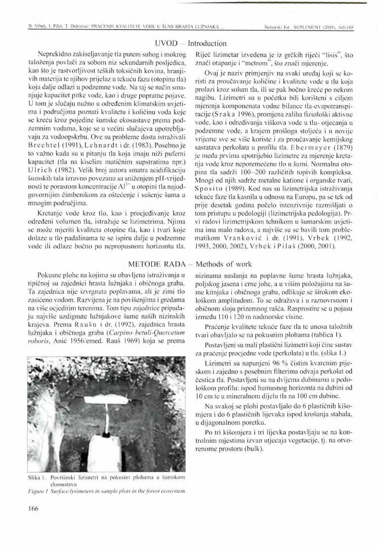
IB. Vrbek. I. Pilaš. T. Diibravac: PRAĆENJE KVALITETE VODE U ŠUMI HRASTA LUŽNJAKA Šumarski list - SUPLLMF.NT (2005). 165-1X5
UVOD -Neprekidno zakiseljavanje tla putem suhog i mokrog
taloženja povlači za sobom niz sekundarnih posljedica, kao stoje rastvorljivost teških toksičnih kovina, hranjivih materija te njihov prijelaz u tekuću fazu (otopinu tla) koja dalje odlazi u podzemne vode. Na taj se način smanjuje kapacitet pitke vode, kao i druge popratne pojave. U tom je slučaju nužno u određenim klimatskim uvjetima i područjima poznati kvalitetu i količinu voda koje se kreću kroz pojedine šumske ekosustave prema podzemnim vodama, koje se u većini slučajeva upotrebljavaju za vodoopskrbu. Ove su probleme dosta istraživali Brechtc l (1991), Lehnard t i dr. (1983). Posebno je to važno kada su u pitanju tla koja imaju niži puferni kapacitet (tla na kiselim matičnim supstratima npr.) Ul r ich (1982). Velik broj autora smatra acidifikaciju šumskih tala izravno povezanu sa sniženjem pH-vrijed-nosti te porastom koncentracije Al3+ u otopini tla najodgovornijim čimbenikom za oštećenje i sušenje šuma u mnogim područjima.
Kretanje vode kroz tlo, kao i procjedivanje kroz određeni volumen tla, istražuje se lizimetrima. Njima se može mjeriti kvaliteta otopine tla, kao i tvari koje dolaze u tlo padalinama te se ispiru dalje u podzemne vode ili odlaze bočno po nepropusnom horizontu tla.
METODE RADA Pokusne plohe na kojima su obavljena istraživanja u
tipičnoj su zajednici hrasta lužnjaka i običnoga graba. Ta zajednica nije izvrgnuta poplavama, ali je zimi tlo zasićeno vodom. Razvijenaje na povišenjima i gredama na više ocjeditim terenima. Tom tipu zajednice pripadaju najviše uzdignute lužnjakove šume naših nizinskih krajeva. Prema Raušu i dr. (1992), zajednica hrasta lužnjaka i običnoga graba (Carpino betuli-Quercetum roboris, Anić 1956/emed. Rauš 1969) koja se prema
Slika 1. Površinski lizimetri na pokusim plohama u šumskom ekosustavu
Figure I Surface lysimeters in sample plots in the forest ecosystem
Introduction Riječ lizimetar izvedena je iz grčkih riječi "lisis", što znači otapanje i "metrom", što znači mjerenje.
Ovaj je naziv primjenjiv na svaki uređaj koji se koristi za proučavanje količine i kvalitete vode u tlu koja prolazi kroz solum tla, ili se pak bočno kreće po nekom nagibu. Lizimetri su u početku bili korišteni s ciljem mjerenja komponenata vodne bilance tla-evapotranspi-racije (S r ak a 1996), promjena zaliha fiziološki aktivne vode, kao i određivanja viškova vode u tlu- otjecanja u podzemne vode, a krajem prošloga stoljeća i u novije vrijeme sve se više koriste i za proučavanje kemijskog sastatava perkolata u profilu tla. Ebermayer (1879) je među prvima upotrijebio lizimetre za mjerenje kretanja vode kroz neporemećeno tlo u šumi. Normalna otopina tla sadrži 100-200 različitih topivih kompleksa. Mnogi od njih sadrže metalne katione i organske tvari, Spo si to (1989). Kod nas su lizimetrijska istraživanja tekuće faze tla kasnila u odnosu na Europu, pa se tek od prije desetak godina počelo intenzivnije razmišljati o tom pristupu u pedologiji (lizimetrijska pedologija). Prvi radovi lizimetrijskom tehnikom u šumarskim uvjetima ima malo radova, a najviše su se bavili tom problematikom Vranković i dr. (1991), Vrbek (1992, 1993,2000,2002), Vrbek i Pilaš (2000,2001).
Methods of work nizinama naslanja na poplavne šume hrasta lužnjaka, poljskog jasena i crne johe, a u višim položajima na šume kitnjaka i običnoga graba, odlikuje se širokom ekološkom amplitudom. To se odražava i u raznovrsnom i običnom sloju prizemnog rašća. Rasprostire se u pojasu između 110 i 120 m nadmorske visine.
Praćenje kvalitete tekuće faze tla te unosa taložnih tvari obavljalo se na pokusnim plohama (tablica 1).
Postavljeni su mali plastični lizimetri koji čine sustav za praćenje procjedne vode (perkolata) u tlu. (slika 1.)
Lizimetri su napunjeni 96 % čistim kvarcnim pijeskom i zajedno s posebnim filterima odvaja perkolat od čestica tla. Postavljeni su na dvijema dubinama u pedološkom profilu: ispod humusnog horizonta na dubini od 10 cm te u mineralnom dijelu tla na 100 cm dubine.
Na svakoj se plohi postavljalo do 6 plastičnih kišo-mjera i do 6 plastičnih lijevaka ispod krošanja stabala, u dijagonalnom poretku.
Po tri kišomjera i tri lijevka postavljaju se na kontrolnim mjestima izvan utjecaja vegetacije, tj. na otvorenome prostoru (bulk).
166
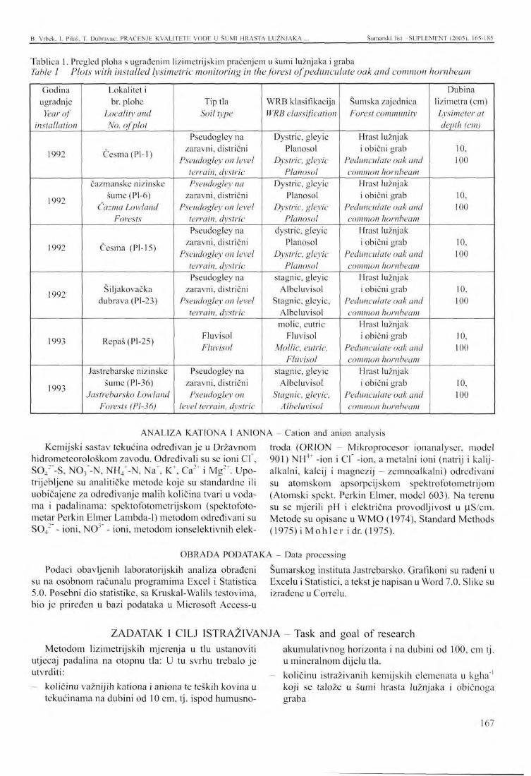
B. Vrbek. I. Pilaš. T. Dubravac: PRAĆENJE KVALITETE VODE U SUMI HRASTA LUŽNJAKA Šumarski list SUPLEMENT (2005). 165-185
Tablica 1. Pregled ploha s ugrađenim lizimetrijskim praćenjem u šumi lužnjaka i graba Table 1 Plots with installed lysimetric monitoring in the forest of pedunculate oak and common hornbeam
Godina ugradnje
Year of installation
1992
1992
1992
1992
1993
1993
Lokalitet i br. plohe
Locality and No. of plot
Česma (Pl-1)
čazmanske nizinske šume (Pl-6)
Čazma Lowland Forests
Česma (PI-15)
Šiljakovačka dubrava (Pl-23)
Repaš (Pl-25)
Jastrebarske nizinske šume (Pl-36)
Jastrebarsko Lowland Forests (Pl-36)
Tip tla Soil type
Pseudogley na zaravni, distrični
Pseudogley on level terrain, dystric Pseudogley na
zaravni, distrični Pseudogley on level
terrain, dystric Pseudogley na
zaravni, distrični Pseudogley on level
terrain, dystric Pseudogley na
zaravni, distrični Pseudogley on level
terrain, dystric
Fluvisol Fluvisol
Pseudogley na zaravni, distrični Pseudogley on
level terrain, dystric
WRB klasifikacija WRB classification
Dystric, gleyic Planosol
Dystric, gleyic Planosol
Dystric, gleyic Planosol
Dystric, gleyic Planosol
dystric, gleyic Planosol
Dystric, gleyic Planosol
stagnic, gleyic Albeluvisol
Stagnic, gleyic, Albeluvisol molic, eutric
Fluvisol Mollic, eutric,
Fluvisol stagnic, gleyic
Albeluvisol Stagnic, gleyic,
Albeluvisol
Šumska zajednica Forest community
Hrast lužnjak i obični grab
Pedunculate oak and common hornbeam
Hrast lužnjak i obični grab
Pedunculate oak and common hornbeam
Hrast lužnjak i obični grab
Pedunculate oak and common hornbeam
Hrast lužnjak i obični grab
Pedunculate oak and common hornbeam
Hrast lužnjak i obični grab
Pedunculate oak and common hornbeam
Hrast lužnjak i obični grab
Pedunculate oak and common hornbeam
Dubina lizimetra (cm) Lysimeter at depth (cm)
10, 100
10, 100
10, 100
10, 100
10, 100
10, 100
ANALIZA KATIONA 1 ANIONA - Cation and anion analysis Kemijski sastav tekućina određivanje u Državnom
hidrometeorološkom zavodu. Određivali su se ioni Cl , S04
2"-S, NCV-N, NH4+-N, Na", K\ Ca" i Mg2T. Upo
trijebljene su analitičke metode koje su standardne ili uobičajene za određivanje malih količina tvari u vodama i padalinama: spektofbtometrijskom (spektofoto-metar Perkin Elmer Lambda-1) metodom određivani su S04 ' - ioni, NO' - ioni, metodom ionselektivnih elek
troda (ORION - Mikroprocesor ionanalyser, model 901) NH4+ -ion i Cl -ion, a metalni ioni (natrij i kalij-alkalni, kalcij i magnezij - zemnoalkalni) određivani su atomskom apsorpcijskom spektrofotometrijom (Atomski spekt. Perkin Elmer, model 603). Na terenu su se mjerili pH i električna provodljivost u LiS/cm. Metode su opisane u WMO (1974), Standard Methods (1975)iMohler i dr. (1975).
OBRADA PODATAKA - Data processing Podaci obavljenih laboratorijskih analiza obrađeni Šumarskog instituta Jastrebarsko. Grafikoni su rađeni u
su na osobnom računalu programima Excel i Statistica Excelu i Statistici, a tekst je napisan u Word 7.0. Slike su 5.0. Posebni dio statistike, sa Kruskal-Walils testovima, izrađene u Correlu. bio je priređen u bazi podataka u Microsoft Access-u
ZADATAK 1 CILJ ISTRAŽIVANJA - Task and goal of research akumulativnog horizonta i na dubini od 100, cm tj. Metodom lizimetrijskih mjerenja u tlu ustanoviti
utjecaj padalina na otopnu tla: U tu svrhu trebalo je utvrditi:
količinu važnijih kationa i aniona te teških kovina u tekućinama na dubini od 10 cm, tj. ispod humusno-
u mineralnom dijelu tla. količinu istraživanih kemijskih elemenata u kgha"' koji se talože u šumi hrasta lužnjaka i običnoga graba
167
B. Vrbek, I. Pilaš, T. Dubravac: PRAĆENJE KVALITETE VODE U SUMI HRASTA LUŽNJAKA . Šumarski list SUPLEMENT (2005), 165-185
kemijski sastav padalina ispod krošanja stabala hrasta i graba kemijski sastav padalina na kontrolnim mjestima
testirati utjecaj kemijskog sastava padalina na kemijski sastav perkolata u šumskom tlu, priznatim statističkim metodama.
REZULTATI - Results Uspoređujući područja po količini kationa i aniona
u mgL"', u tablicama 2, 3 i 4, možemo zaključiti kako postoje razlike u njihovim prosječnim vrijednostima kada se usporede prosječno sve plohe. Koncentracija svih iona uvijek je najviša u području Repaša, a zatim u
Česmi pa u Pokuplju i Šiljakovini. Vrijednosti prikazuju prosječnu koncentraciju kationa i aniona u promatranom vegetacijskom razdoblju po mjernim mjestima i područjima.
Tablica 2. Prosječne količine kationa i aniona u mgL" po mjestima uzorkovanja područja Česma Table 2 Average cation and anion quantities in mgL' per sampling sites in the area of Česma
Plohe Česma Plots Česma
H G KS KO L loo L 10
KT Na' Ca2" Mg24 NH4+-N cr NO3--N so4
2--s HCO3- H' mgL"1
30,07 6,16 8,36 0,47 1,20 1,65
1,32 0,67 0.42 0,31 5,22 0,95
32,15 5,17 4,24 1,26
17,69 3,34
5,35 1,49 1,64 0,27 7,04 2,53
2,67 2,20 0,89 0,17 0,07 0,09
6,80 2,42 2,35 0,94 3,91 1,97
11,53 2,71 3,58 1,48 2,56 3,61
12,37 5,07 2,03 1,03 12,68 3,03
0,220 0,011 0,280 0,150 0,280 0,050
0,012 0,007 0,004 0,004 0,002 0,015
Tablica 3. Prosječne količine kationa i aniona u mgL ' po mjestima uzorkovanja područja Pokupski bazen-Siljakovina Table 3 Average cation and anion quantities in mgL' per sampling sites in the area of Pokuplje Basin - Šiljakovina
Plohe Pokup.-Šilj. Plots Pokup. -Silj.
H G
KS KO L loo L io
K+ Na+ Ca2+ Mg2^ NH4'-N cr NO,--N so42--s HCO3- H+
mgL"' 21,28 3,90 4,66 0,28 0,16 0,71
1,44 0,31 0,29 0,26 10,35 1,35
16,46 1,86 1,68 2,17 1,85 2,09
4,35 0,37 0,63 0,26 1,81 1,52
4,24 1,03 0,96 0,26 0,05 0,04
4,53 1,44 1,40 0,90 3,01 2,41
6,12 2,99 2,73 1,17 1,65 0,01
8,01 1,75 0,95 0,60 2,29 2,02
0,126 0,094 0,089 0,092 0,131 0,127
0,0057 0,0054 0,0061 0,0064 0,0044 0,0117
Tablica 4. Prosječne količine kationa i aniona u mgL ' po mjestima uzorkovanja područja Repaš Table 4 Average cation and anion quantities in mgL' per sampling sites in the area of Repaš
Plohe Repaš Plots Repaš
H G KS KO L loo L io
K+ Na" Ca2+ Mg2+ NH/-N cr NO3--N so42--s HCO1- H"
mgL"1
69,23 10,10 17,13 1,21 1,25 1,99
1,30 0,53 0,97 0,30 0,67 0,80
55,28 3,72 5,09 1,76
65,05 7,51
6,32 0,62 1,41 0,35 7,65 3,38
3,79 0,87 1,63 0,14 0,62 0,09
11,45 2,80 2,51 0,99 1,94 1,95
8,35 4,26 3,96 2,33 3,31 5,87
16,29 2,79 1,74 1,06 0,84 5,88
0,138 0,132 0,143 0,138 0,435 0,117
0,0257 0,0049 0,0089 0,0026 0,0617 0,0064
Uspoređujući podatke koji su dobiveni ispod krošanja po područjima, prosječni sadržaj kationa i aniona osjetno je manji na otvorenome mjestu bez utjecaja vegetacije. Opet su najveće vrijednosti na području Repaša kod aniona, dok su kod prosječnih vrijednosti za katione kod sadržaja kalcija i amonijskog iona najviše vrijednosti na području Pokuplja i Šiljakovine.
U lizimetarskim uzorcima mijenja se slika prosječnog sadržaja iona u mgL '. Najviše prosječne koncentracije kationa za kalcij, kalij i magnezij nađene su na području Repaša, dok su najviše prosječne koncentracije za natrij pronađene u području Pokupsko-Silja-kovina. Povećano ispiranje tih kationa zbog same je građe profila tla, jer je u donjem dijelu najviše karbo-
168
B. Vrbek, 1. Pilaš, T. Dubravac: PRAĆENJE KVALITETE VODE U ŠUMI HRASTA LUŽNJAKA Šumarski list SUPLEMENT (2005), 165-185
nata prisutno u tlima s područja Repaša, a zatim karbo-natni les u donjem dijelu profila kod područja Česme. Kod prosječnog sadržaja aniona u lizimetarskoj tekućini situacija je nešto drukčija. Najviše prosječne koncentracije aniona izmjerene su na području Česme, a zatim u području Repaša. Izuzetak je klor kojeg ima
na području Pokupskog-Siljakovine, približno kao i u lizimetrima na području Česme. Povišenje klora u Po-kupskom-Šiljakovini vezano je i uz pojavu natrija. Vjerojatno je u pitanju neki lokalni izvor zaslanjenja koji dolazi bočnim priticanjem voda, a koji će se trebati detaljnije istražiti.
Prosječni sadržaj kationa u lizimetrima po područjima Average cation content in lysimeters per areas
L„, gai™>
| L<» f •X —i
1 L«> ^ V}
i.+.'WW
• NH'
a Mg2
S Ca2
• Na"
• K'
-N
10 ."(I 30 40 50 60 70
mgU1
Grafikon 1. Prosječni sadržaj kationa i razlike u lizimetrima L10 i L|00 po područjima u mgL" Graph. 1 Average cation content and differences in lysimeters L10 and Lwoper areas in mgL
TO
o
o M G,
M o 0-,
s
Prosječni sadržaj kationa u lizimetrima po područjima Average cation content in lysimeters per areas
L„
L too
L,o
L ,M
L,o
L loo
IIIIIIIIIIHIIIIIIIIIIIIIIIIIIIIIIIIIIIIIIIII
MINIMI
^ ^ ^ M
. .. | B
mnOTTTTTTl
0 2 4 6 8 10 12 1
mgL 1
4
• SO/ -S
a NO,;-N
• CI
Grafikon 2. Prosječni sadržaj aniona i razlike u lizimetrima L10 i L100 po područjima u mgL"1
Graph. 2 Average anion content and difference in lysimeters L10 andLwnper areas in mgL'1
U Grafikonima 1. i 2 prikazane su razlike kationa i aniona u lizimetrima na dubinama od 10 i 100 cm. Vri
jednosti za kalcij (Ca2 ) u Repašu i za sumpor (S042"-S)
višestruko su povećane u lizimetrima na 100 cm dubine,
Tablica 4. Ukupne količine kationa i aniona u kgha" na pet glavnih ploha na hva tač ima hrasta Table 4 Total cation and anion quantities in kgha' in five main plots in oak stemflow
H | - hrast
H! - oak P-6
P-15 P-23 P-25 P-36
NH4+-N Na4 Ca2+ Mg2+ K+ CP NCV-N so4
2--s kgha '
0,07 0,01 0,10 0,03 0,04
0,11 0,01 0,03 0,01 0,02
0,78 0,22 0,39 0,52 0,33
0,18 0,05 0,10 0,06 0,07
0,65 0,44 0,46 0,64 0,41
0,21 0,09 0,06 0,10 0,09
0,27 0,11 0,07 0,08 0,12
0,26 0,07 0,20 0,12 0,12
169
B. Vrbek, I. Pilaš, T. Dubravac: PRACKNJE KVALITETE VODE U SUMI HRASTA LUŽNJAKA Šumarski list SUPLEMENT (2005). 165-185
u odnosu na ostala područja i lizimetre. Lizimetri na du- tiona i aniona od lizimetara na dubini od 100 cm. bini od 10 cm prosječno sadrže manje koncentracije ka-
Ukupni sadržaj kationa na hvataču hrasta na 5 glavnih ploha Total cation content in oak stem/low in 5 main plots
NH/-N
IP-6 IP-15 IP-23 DP-25 P-36
Ukupni sadržaj aniona na hvataču hrasta na 5 glavnih ploha Total anion content in oak stem/low in 5 main plots
NO/-N
IP-6 1P-15 IP-23 GP-25 I P-36
Grafikon 3 i 4. Ukupni sadržaj kationa i aniona u kgha" na hrastu na plohama Graph. 3 and 4 Total cation and anion content in kgha' on oak in the plots
Tablica 5. Ukupne količine kationa i aniona u kgha"' na grabu na plohama Table 5 Total cation and anion quantities in kgha'1 on hornbeam in the plots
H2 - grab H2 - hornbeam
P-6 P-15 P-23 P-25 P-36
NH4'-N Na^ Ca2+ Mg2+ K+ CT N03--N so42--s
kgha-1
0,11 0,12 0,02 0,01 0,09
0,04 0,03 0,04 0,01 0,02
0,25 0,25 0,23 0,05 0,13
0,05 0,06 0,05 0,01 0,03
0,61 0,40 0,43 0,30 0,23
0,17 0,10 0,16 0,05 0,10
0,26 0,22 0,25 0,11 0,13
0,21 0,14 0,20 0,04 0,12
Ukupni sadržaj kationa na hvataču graba na 5 glavnih ploha Total cation content in hornbeam stemflow in 5 main plots 0,7-
NH/-N
P-6 P-15 P-23 D P-25 P-36
Ukupni sadržaj aniona na hvataču graba na 5 glavnih ploha Total anion content in hornbeam stemflow in 5 main plots
NO.-N
P-6 a p-15 S P-23 D P-25 P-36
Grafikon 5 i 6. Ukupni sadržaj kationa i aniona u kgha-1 na grabu na plohama Graph. 5 and 6 Total cation and anion content in kgha on hornbeam in the plots
Tablica 6. Ukupne količine kat iona i aniona u kgha"' pod krošnjama (throughfall) Table 6 Total cation and anion quantities in kgha'1 below the crowns (throughfall)
Krošnja (KŠ) Crown
P-6 P-15 P-23 P-25 P-36
NH/-N Na+ Ca2+ Mg2+ iC cr NO3--N so42--s
kgha"' 3,00 1,46 0,31 3,23 6,80
1,19 1,45 1,28 1,11 1,10
7,20 14,56 7,18 10,18 7,09
3,61 5,45 1,48 4,28 2,87
22,02 48,72 19,98 53,35 19,73
4,94 7,23 7,48 8,16 5,82
13,30 17,57 8,75 14,65 12,56
3,15 5,46 3,85 5,60 4,16
170
B. Vrbek, I. Pilaš, T. Dubravac: PRAĆENJE KVALITETE VODE U ŠUMI HRASTA LUŽNJAKA Šumarski list -SUPLEMENT (2005), 165-185
Ukupni sadržaj kationa u uzorcima pod zastorom krošanja na 5 glavnih ploha Total cation content in samples below the crowns in 5 main plots
« ill
6 0 -
5 0 -
40- '
30-
20-
10-
n
::
L*_j i_ i JWt»J!l II NH;-N Na Ca M g '
P-6 P-15 P-23 D P-25 P-36
Ukupni sadržaj aniona u uzorcima pod zastorom krošanja na 5 glavnih ploha Total anion content in samples below the crowns in 5 main plots
NO.-N S O ; - S
P-6 a P-15 P-23 D P-25 P-36
Grafikon 7 i 8. Ukupni sadržaj kationa i aniona u kgha" na ispod krošanja Graph. 7 and S Total cation and anion content in kgha' below the crowns
Tablica 7. Ukupne količine kationa i aniona u kgha" na otvorenom (bulk) Table 7 Total cation and anion bulk quantities in kgha'
Kontrola (KO)
Control P-6 P-15 P-23 P-25 P-36
NH4+-N Na' Ca2+ Mg2+ K+ cr N03--N so4
2--s kgha"1
0,22 0,67 1,42 0,65 0,95
0,99 1,30 1,62 1,53 1,28
3,99 5,38 9,50 7,35 5,42
1,18 1,08 1,52 1,31 1,26
3,09 2,60 2,58 7,66 0,71
4,75 4,44 4,47 5,08 5,25
7,44 5,68 5,35 12,33 6,69
3,45 2,06 2,11 4,38 4,61
Ukupni sadržaj kationa u kontrolnim uzorcima na 5 glavnih ploha Total cation content in control samples in 5 main plots
10 9 8 7
03 6
a J
4 3 2 1
:
| U 1 1
NH/-N Na' Ca24 Mg:"
• P-6 ffl P-15 H P-23 • P-25 • P-36
Ukupni sadržaj aniona u kontrolnim uzorcima na 5 glavnih ploha Total anion content in control samples in 5 main plots
N03--N S042--S
I P-6 a P-15 S P-23 D P - 2 5 P-36
Grafikon 9 i 10. Ukupni sadržaj kationa i aniona u kghaL na otvorenom (bulk) Graph. 9 and 10 Total cation and anion bulk content in kgha'
Tablica 8. Ukupne količine kationa i aniona u kgha"' u lizimetrima nalO cm dubine Table 8 Total cation and anion quantities in kgha' in lysimeters at 10 cm in depth
Lizimetar na 10 cm (L10)
Lysimeter at 10 cm (L1Q) P-6
P-15 P-23 P-25 P-36
NH4+-N Na+ Ca2+ Mg24 K+ cr NOf-N so4
2--s kgha"
0,19 0,28 0,15 0,14 0,17
3,22 3,09 6,84 0,91 5,97
7,33 10,57 7,72 14,12 9,49
11,07 7,51 7,29 5,66 6,05
5,59 5,65 3,76 3,86 2,33
7,75 7,06 8,52 3,51 10,99
13,08 8,52 7,82 10,44 8,66
11,62 7,92 9,46 4,76 8,50
171
B. Vrbek, I. Pilaš. T. Dubravac: PRAĆENJU KVALITETE VODE U SUMI HRASTA LUŽNJAKA Šumarski list SUPLLMENT (2005). 165-185
Ukupni sadržaj kationa u lizimetrima L 10 cm na 5 glavnih ploha Total cation content in iysimeters LIO cm in 5 main plots
16
NH4'-N Na" Ca2'
• P-6 DEP-15 dP-23
Mg2"
• P-25
K
• P-36
Ukupni sadržaj aniona u lizimetrima L 10 cm na 5 glavnih ploha Total anion content in Iysimeters LIO cm in 5 main plots
14
NCL-N SO/-S
P-6 a p-i5 P-23 • P-25 P-36
Grafikon 11 i 12. Ukupni sadržaj kationa i aniona u kgha" u lizimetrima na 10 cm dubine Graph. 11 and 12 Total cation and anion content in kgha' in Iysimeters at 10 cm in depth
Tablica 9. Ukupne količine kationa i aniona u kgha"1 u lizimetrima nalOO cm dubine Table 9 Total cation and anion quantities in kgha' in Iysimeters at 100 cm in depth
Lizimetar na 100 cm (L100)
Lysimeter at 100 cm (L!00) P-6
P-15 P-23 P-25 P-36
NH4+-N Na+ r* 2+
Ca Mg2 ' K+ Cl" NCV-N so42--s
kgha"1
0,05 0,26 0,18 0,07 0,52
1,94 3,69 10,49 0,94 56,53
25,08 102,89 5,91
32,39 8,35
10,96 27,72 9,08 7,65 6,96
0,39 1,10 0,74 1,80 0,53
2,00 3,85 6,54 2,06 15,05
1,55 2,33 6,41 5,66 5,80
4,04 7,39 6,68 2,02 10,65
Ukupni sadržaj kationa u lizimetrima L 100 cm na 5 glavnih ploha Total cation content in Iysimeters L 100 cm in 5 main plots
120
100
80 RS
M 60
40
20
0 s ' ,Ti" ^ [_iUixJ
NH4*-N Na" Ca2 Mg2' K
P-6 B P-15 a P-23 G P-25 P-36
Ukupni sadržaj aniona u lizimetrima L 100 cm na 5 glavnih ploha Total anion content in Iysimeters L 100 cm in 5 main plots
NO.-N SCV-S
P-6 m p-15 S P-23 D P-25 P-36
Grafikon 13 i 14. Ukupni sadržaj kationa i aniona u kgha" u lizimetrima na 100 cm dubine Graph. 13 and 14 Total cation and anion content in kgha' in Iysimeters at 100 cm in depth
Tablica 10. Ukupne količine kationa i aniona u kgha" prosječno od pet glavnih ploha na uzorcima u šumi (KŠ+Hi+H2), kontrole (KO) i lizimetara (L10 + L100) na svim područjima
Table 10 Total cation and anion quantities in kgha' on average from five main plots in forest samples (CF+Hj+H^, control (CO) and Iysimeters (Lln + Llml) in all areas
Razlike po mjestima
Differences by sites Suma - Forest
Kontrola - Control Tlo - Soil
NfV-N Na1 Ca2+ M g - K+ ci- NCV-N S042"-S
kgha"1
3,08 0,78 0,40
1,29 1,34
18,72
9,87 6,33
44,77
3,67 1,27
19,99
33,67 3,33 5,15
6,95 4,80 13,47
13,69 7,50 14,05
4,73 3,32 14,61
172
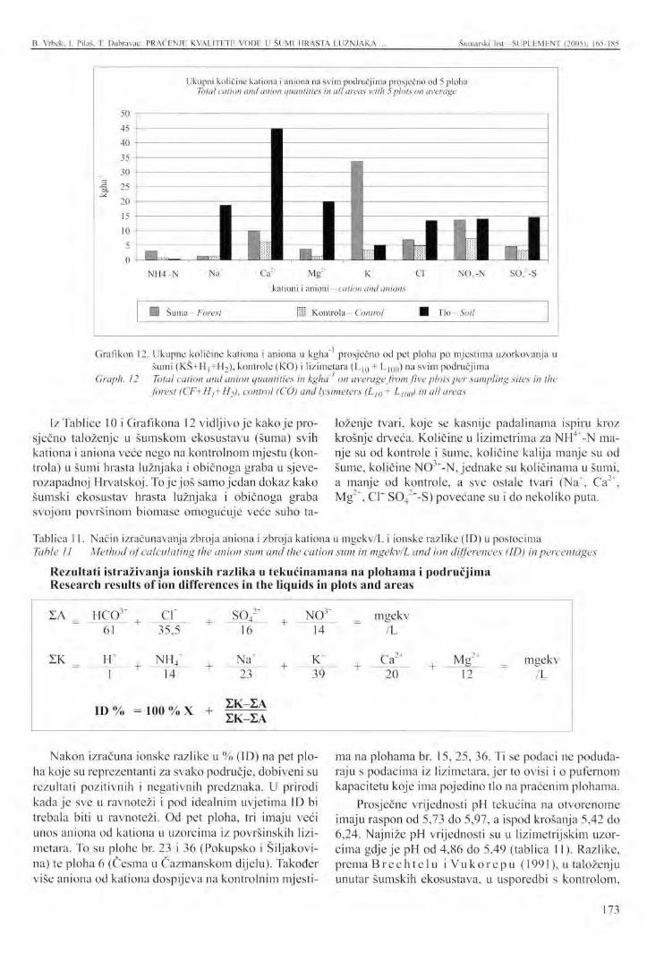
B. Vrbek. 1. Pilaš, T. Dubravac: PRAĆENJE KVALITETE VODE U SUMI HRASTA LUŽNJAKA Šumarski list -SUPLHMENT (2005). 165-185
50 45 40 35 30 25 20 15 10 5 0
Ukupni količine kationa i aniona na svim područjima prosječno od 5 ploha Total cation and anion quantities in all areas with 5 plots on average
NH4"-N Na* Ca* Mg2* KT Cl NO, -N SO/-S kationi i anioni cation and anions
Suma - Forest B Kontrola - Control Tlo - Soil
Grafikon 12. Ukupne količine kationa i aniona u kgha" prosječno od pet ploha po mjestima uzorkovanja u šumi (KS+H]+H2), kontrole (KO) i lizimetara(L10 + L10o) na svim područjima
Graph. 12 Total cation and anion quantities in kgha' on average from five plots per sampling sites in the forest (CF+H/+H2), control (CO) and lysimeters (LI0 + LI0lj) in all areas
Iz Tablice 10 i Grafikona 12 vidljivo je kako je prosječno taloženje u šumskom ekosustavu (šuma) svih kationa i aniona veće nego na kontrolnom mjestu (kontrola) u šumi hrasta lužnjaka i običnoga graba u sjeverozapadnoj Hrvatskoj. To je još samo jedan dokaz kako šumski ekosustav hrasta lužnjaka i običnoga graba svojom površinom biomase omogućuje veće suho ta
loženje tvari, koje se kasnije padalinama ispiru kroz krošnje drveća. Količine u lizimetrima za NH4+-N manje su od kontrole i šume, količine kalija manje su od šume, količine NO ~-N, jednake su količinama u šumi, a manje od kontrole, a sve ostale tvari (Na+, Ca Mg i+, Cl" S04~"-S) povećane su i do nekoliko puta.
2+
Tablica 11. Način izračunavanja zbroja aniona i zbroja kationa u mgekv /L i ionske razlike (ID) u pos tocima Table II Method of calculating the anion sum and the cation sum in mgekv/L and ion differences (ID) in percentages
Rezultati istraživanja ionskih razlika u tekućinamana na plohama i područjima Research results of ion differences in the liquids in plots and areas
LA _
IK _
HCO3" 61
H+
1
ID%
+ C1" 35,5
NH4(
14
= 100 % X
+
+
+
so42"
16
Na+
23
LK-LA LK-LA
+
+
NO3" 14
K+
39
=
+
mgekv /L
Ca2+
20 + Mg2+
12 mgekv
/L
Nakon izračuna ionske razlike u % (ID) na pet ploha koje su reprezentanti za svako područje, dobiveni su rezultati pozitivnih i negativnih predznaka. U prirodi kada je sve u ravnoteži i pod idealnim uvjetima ID bi trebala biti u ravnoteži. Od pet ploha, tri imaju veći unos aniona od kationa u uzorcima iz površinskih lizi-metara. To su plohe br. 23 i 36 (Pokupsko i Šiljakovi-na) te ploha 6 (Česma u Cazmanskom dijelu). Također više aniona od kationa dospijeva na kontrolnim mjesti
ma na plohama br. 15, 25, 36. Ti se podaci ne podudaraju s podacima iz lizimetara, jer to ovisi i o pufernom kapacitetu koje ima pojedino tlo na praćenim plohama.
Prosječne vrijednosti pH tekućina na otvorenome imaju raspon od 5,73 do 5,97, a ispod krošanja 5,42 do 6,24. Najniže pH vrijednosti su u lizimetrijskim uzorcima gdje je pH od 4,86 do 5,49 (tablica 11). Razlike, prema B r e c h t e l u i V u k o r e p u (1991), u taloženju unutar šumskih ekosustava, u usporedbi s kontrolom,
173
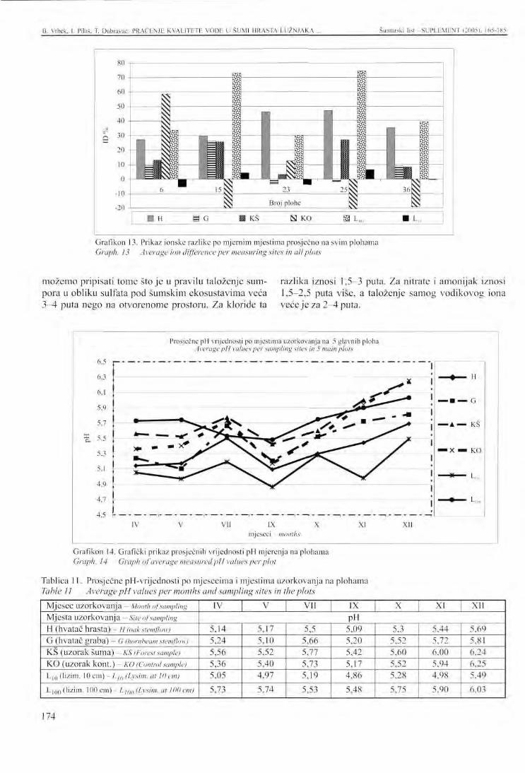
B. Vrbek, 1. Pilaš, T. Dubravac: PRAĆENJE KVALITETE VODE U SUMI HRASTA LUŽNJAKA . Šumarski list SUPLEMENT (2005), 165-185
Grafikon 13. Prikaz ionske razlike po mjernim mjestima prosječno na svim plohama Graph. 13 Average ion difference per measuring sites in all plots
možemo pripisati tome stoje u pravilu taloženje sumpora u obliku sulfata pod šumskim ekosustavima veća 3^1 puta nego na otvorenome prostoru. Za kloride ta
razlika iznosi 1,5-3 puta. Za nitrate i amonijak iznosi 1,5-2,5 puta više, a taloženje samog vodikovog iona veće je za 2-4 puta.
Prosječne pH vrijednosti po mjestima uzorkovanja na 5 glavnih ploha Average pH values per sampling sites in 5 main plots
6.5
6.3
6.1
5,9
5.7
5,5
5,3
5.1
4.9
4.7
IV
• A — KS
• X — KO
VI1 IX mjeseci months
XI XII
Grafikon 14. Grafički prikaz prosječnih vrijednosti pH mjerenja na plohama Graph. 14 Graph of average measured pH values per plot
Tablica 11. Prosječne pH-vrijednosti po mjesecima i mjest ima uzorkovanja na plohama Table 11 Average pH values per months and sampling sites in the plots
Mjesec uzorkovanja - Month of sampling Mjesta uzorkovanja - Site of sampling H (hvatač hrasta) - H (oak stemflow) G (hvatač graba) - G (hornbeam stemflow) KS (uzorak Šuma) - KŠ (Forest sample) K O (uzorak kont.) - KO (Control sample) L|Q (lizim. 10 cm) - L]() (Lysim. at 10 em)
L|QQ (lizim. 100 cm) - LJQQ (Lysim. at 100 cm)
IV V VII IX X XI XII PH
5,14 5,24 5,56 5,36 5,05
5,73
5,17 5,10 5,52 5,40 4,97
5,74
5,5 5,66 5,77 5,73 5,19
5,53
5,09 5,20 5,42 5,17 4,86
5,48
5,3 5,52 5,60 5,52 5,28
5,75
5,44 5,72 6.00 5,94 4,98 5.90
5,69 5,81 6.24 6.25 5,49
6,03
174
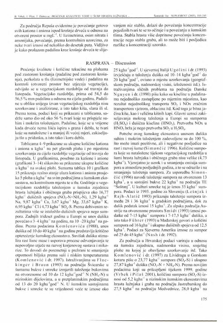
H. Vrbck, 1. Pilaš, T. Dubravac: PRAĆENJE KVALITETE VODE U ŠUMI HRASTA LUŽNJAKA Šumarski list -SUPLEMENT (2005), 165-185
Za područja Repaša evidentno je povećanje gotovo svih kationa i aniona ispod krošnje drveća u odnosu na otvoreni prostor u mgL"'. U lizimetrima, osim nitrata i amonijaka, povećanje, prema kontrolnim uzorcima, za neke tvari iznosi od nekoliko do desetak puta. Vidljivo je kako prolazom padalina kroz krošnje drveća te slije-
RASPRAVA -Praćenje kvalitete i količine tekućine na plohama
pod zastorom krošanja (padaline pod zastorom krošanja), perkolata u tlu (lizimetrijske vode) i padalina na kontroli (otvoreni prostor bez utjecaja vegetacije), odvijalo se u vegetacijskom razdoblju od travnja do listopada. Vegetacijsko razdoblje, prima od 54,5 do 56,5 % mm padalina u odnosu na cijelu godinu. Padaline u obliku snijega izvan vegetacijskog razdoblja nisu uzorkovane i analizirane, a isto tako kiša, slana ili si. Prema tomu, podaci koji su prikazani u tablicama, sadrže samo dio od oko 56 % tvari koje su prispjele suhim i mokrim taloženjem. Padaline, koje se u vrijeme kada drveće nema lišća ispiru s grana i debla, te tvari koje su nataložene i u manjoj ili većoj mjeri, zakiselju-ju tlo u pridanku, a isto tako i koru debla.
Tablicama 4-9 prikazane su ukupne količine kationa i aniona u kgha"' na pet glavnih ploha i po mjestima uzorkovanja za cijelo razdoblje vegetacije od travnja do listopada. U grafikonima, posebno za katione i anione (grafikoni 3-14) slikovito su prikazane ukupne količine u kgha"' na svakoj plohi. Sumarna tablica 10 i grafikon 15 prikazuju realno stanje ulaza kationa i aniona prosjeka 5 ploha u kgha" na svim područjima u šumskom ekosustavu, na kontrolnom mjestu te u tlu. Godišnje u vegetacijskom razdoblju taloženjem u šumsku zajednicu hrasta lužnjaka i običnoga graba prispijeva oko 16,77 kgha' dušičnih spojeva (NOrN+NH4-N), 1,29 kgha"' Na, 9,87 kgha"' Ca, 3,67 kgha"' Mg, 33,67 kgha"' K, 6,95 kgha"' Cl i 4,73 kgha"' S04-S. Prema dobivenim rezultatima više se istaložilo dušičnih spojeva nego sumpora. Zadnjih trideset godina u Europi se unos dušika povećao s 3^1 kgha"' na godinu, na 10-20 kgha"' na godinu. Prema podacima Komlenov ića (1988), unos dušika od 10 do 40 kgha"' na godinu predstavlja kritično opterećenje šumskog ekosustava. Suvišak dušika stimulira rast lisne mase i usporava procese odrvenjavanja te nepovoljno utječe na razvoj korjenovog sustava i miko-rize. To dovodi do poremetnji u prehrani te smanjenja otpornosti biljaka prema suši i niskim temperaturama (Komlenović i dr. 1997). Istraživanjima su F lue-k i n g e r i Braun (1993) na području Švicarske u šumama bukve i smreke izmjerili taloženje bukovima na otvorenome od 10 do 12 kgha"'god ' N (NH4-N) u nizinskim dijelovima, a u pretplaninskim područjima od 13 do 20 kgha'god"' N. U šumskim sastojinama bukve i smreke te su vrijednosti veće te iznose oko
vanjem niz stablo, dolazi do povećanja koncentracije pojedinih tvari te se to očituje i u povećanju u šumskim tlima. Stabla hrasta više doprinose povećanju koncentracije nego stabla graba, ali to može biti i posljedica razlike u koncentraciji uzoraka.
- Discussion 25 kgha"'god"'. U sjevernoj Italiji Ugol in i i dr. (1993) izvješćuju o taloženju dušika od 10-14 kgha'god"1 do 20 kgha"'god"', ovisno o mjestu uzorkovanja (geografskom području, nadmorskoj visini, izloženosti itd.). Istraživanjima sličnih problema na području Danske Nguyen i dr. (1990) pišu kako su kiseline u padalinama nejednoliko zastupljene po mjernim mjestima, kao rezultat nejednolikog transporta S02 i NOx zračnim transportom vjetrom, oblacima itd. Kod toga je bitna jačina kiše, kao i veličina kišnih kapi. Glavni uzroci zaki-seljavanja mokrog taloženja u Europi su sumporna (H2S04) i dušična kiselina (HN03). Pretvorba NOx u HN03 brža je nego pretvorba S02 u H2S04.
Potrebe ovog šumskog ekosustava unosom dušika suhim i mokrim taloženjem zadovoljene su do 100 %, što može imati pozitivne, ali i negativne posljedice na rast i razvoj šume (S i m o n č i ć 1996). Količine sumpora koje su nataložene tijekom vegetacijskog razdoblja u šumi hrasta lužnjaka i običnoga graba nisu velike (4,73 kgha"'). Vjerojatno je uzrok i u smanjenju emisija sumpora u atmosferu posljednjih godina, a to se odrazilo i na smanjenju taloženja sumpora. Za usporedbu Simon-čić (1996) navodi taloženje sumpora na otvorenom 13 kgha"', a u sastojini bukve 22 kgha"' na području TE "Soštanj". U kulturi smreke taj je iznos 33 kgha"' sumpora. Podaci iz 1993. godine za Sloveniju (Lešnj ak i Ra jh-Ala t ič 1993) prikazuju taloženje sumpora između 28 i 36 kgha ' u gradskim područjima, dok za dušik podatak iznosi 15 kgha"'. Za alpska područja Austrije na otvorenome prostoru Smidt (1993) iznosi podatke od 7-15 kgha"' sumpora i 7-17,5 kgha"' dušika, a isto tako Führer (1993) u Mađarskoj govori o količini sumpora od 16 kgha"' i ukupno dušičnih spojeva od 12,5 kgha"'. Podaci za Sjevernu Ameriku iznose za sumpor od 25 do 45 kgha"' (N ash i dr. 1992).
Za područja u Hrvatskoj podaci variraju u odnosu na šumsku zajednicu, nadmorsku visinu, smještaj plohe na kojoj je obavljeno uzorkovanje itd. Tako K o m l e n o v i ć i dr. (1997) za Lividragu u Gorskom kotaru pišu o 23,77 kgha ' sumpora (S04-S) i ukupno 27,87 kgha"1 dušika (NOyN + NH4-N). Prema novijim podacima koji su prikupljeni tijekom 1999. godine (Vrbek i P i l a š 2001), količina sumpora (S04-S) iznosi od 5,2 kgha"' u nizinskim šumskim ekosustavima hrasta lužnjaka i graba na području Jastrebarskog do 27,5 kgha"' na području Medvednice, 28,0 kgha"' na
175
B. Vrbek, I. Pilaš, T. Dubravac: PRAĆENJE KVALITETE VODE U ŠUMI HRASTA LUŽNJAKA ... Šumarski list SUPLEMENT (2005), 165-185
području Zavižana na Velebitu i najviše 50,2 kgha"1 na području Lividrage. Podaci za ukupni dušik još su veći. Tako je u nizini izmjerena količina od 15,2 kgha"1, na području Medvednice 27,0 kgha"1, na Zavižanu oko 26,0 kgha"', a na području Lividrage čak 74,2 kgha"1,
stoje puno više od kritičnih opterećenja za dušik. U tablici 13 pregledno su prikazane količine sumpora i dušika na raznim područjima u Europi u odnosu na sjeverozapadnu Hrvatsku u šumi hrasta lužnjaka i običnoga graba.
Tablica 12. Ukupno taloženje sumpora i dušika, prema raznim autorima u odnosu na podatke za šumu hrasta lužnjaka i običnoga graba na istraživanom području
Table 12 Total sulphur and nitrogen depositions, according to different authors, in relation to data for the forest of pedunculate oak and common hornbeam in the study area
Izvor podataka Source of data
Nguyen er. al. (1990)
Simončić (1996)
Vrbek-Pilaš(2001)
Komlenović (1997)
Führer (1993)
Smidt(1993)
Šumska zajednica lužnjaka i graba u sjeverozapadnoj Hrvatskoj Forests community of pedunculate oak and hornbeam in north-western Croatia
Ukupna količina S04-S Total S04-S quantity
Ukupna količina NOx Total NOx quantity
kgha"
28 ,5 -48 ,5
60,4 - 98,6
13,6-50,2
1 9 , 9 - 2 3 , 8 -
16,0
7 , 0 - 15,0
4,73 (+ 44%)
20,1 - 2 8 , 8
33,5-45,1
15,2-74,2
24 ,4 -27 ,9
12,5
7 , 0 - 17,5
16,77 ( + 4 4 % )
Ocjena unosa Input assesment
Povećan unos Increased input
Vrlo povećan unos Significantly increased input
Povećan do vrlo povećan unos Increased to sign, increased input
Povećan unos Increased input Povećan unos
Increased input Povećan unos
Increased input Mali unos S 0 4
Low input qfS04
Povećan unos NOx Increased input of NOx
Uspoređujući podatke vidljivo je kako je smanjeno taloženje sumpora u nizinskim šumskim ekosustavima hrasta lužnjaka i običnoga graba u odnosu na ostala područja u Hrvatskoj i u susjednim državama. Povećan je unos NH4-N i N03-N, dakle dušika. U tablici je za šumu hrasta lužnjaka i običnoga graba dodano još 44 %, jer tolika je razlika padalina za cijelu godinu, pošto se praćenje odvijalo tijekom vegetacijskog razdoblja. Prema podacima iz literature zimi taloženje može iznositi više nego ljeti. Visok sadržaj dušika znači i njegovu veću opskrbu. Stabla imaju bujniji rast, drveće postaje osjetljivije na vjetar koji ga izvaljuje, lome se krošnje i povećana jc podložnost napadu gljiva i štetnika.
U lizimetrima je nađena najveća količina iona u kgha"1 osim za nitrate i amonijak dok je kalija bilo manje. Količine u kgha"', za Ca, Mg i Na su za očekivati, jer je proces ispiranja tih kationa iz tla uvijek prisutan, a posebno pri nižim pH-vrijednostima. Tla vežu sulfatne ione i otpuštaju bazične katione (Komlenović 1988). Isto je tako dosta povećano ispiranje Ca i K s lišća. Iz podataka na kontrolnome mjernome mjestu ukupne količine kationa i aniona redovito su manje od podataka pod krošnjom drveća, a još manje u odnosu na lizimetrijsku tekućinu. Ove se količine podudaraju s podacima Hidro-meteorološkog zavoda za grad Zagreb, gdje količina klo
ra (Cl) iznosi od 4,015 do 13,83 kgha"', za sumpor 40 do 76 kgha"' te za dušikove spojeve 2,7-9,1 kgha"'.
Na kontrolnim kišomjerima u mjerenjima ukupna količina za Cl iznosi 4,80 kgha"', a uzorci ispod krošnje drveća imaju ukupnu vrijednost 6,95 kgha"'. Isto takvo povećanje , kako se vidi iz tablice 5-9, imaju i ostale tvari. Ovisno o starosti sastojine mijenja se i količina tvari u tekućinama sakupljenim u krošnjama stabala i slivenim niz deblo. Mlade sastojine puno su ugroženije depozicijama od starijih, ali to je povezano i s količinom tekućine. Starije sastojine imaju manje slijevanja niz deblo nego mlađe. Kod ovoga se mora uzeti u obzir i činjenica kako ukupne topive taložne tvari u prosjeku čine 38 % ukupne taložne prašine.
Lizimetrijska mjerenja postavljena su kako bi se ustanovila puferska sposobnost tla (u ovom slučaju pse-udoglcja i humofluvisola) na kojima raste zajednica hrasta lužnjaka i običnoga graba. Prema ionskoj razlici vidljivo je kako je na pojedinim mjestima došlo do proboja kiselina u šumska tla. Ionska razlika u % prikazana je u tablici 11 i na grafikonu 16 za pet glavnih ploha i sva mjerna mjesta.
Tla su vrlo dobre puferske sposobnosti za sada na području Repaša (ploha 25), iako je prema podacima iz
176
D. Vibck. 1. Pilaš. T. Dubravac: PRAĆhNJF. KVALITETE VODF. U SUMI HRAS"
tablice 11 na grabu i na kišomjeru otvorenome negativan rezultat (označeno žutom bojom). Isto je tako negativna ionska razlika na otvorenome prostoru kod ploha br. 15 i 36. Vrlo su važni podaci za lizimetre na dubini od 10 i 100 cm. Utjecaj zakiseljavanja vidljiv je u uzorcima iz lizimetara na dubini od 10 cm (plohe br. 6 - Čazma, 23 - Šiljakovina i 36 - Kupčina). U tlima na tim područjima došlo je do negative ionske razlike, tj. do procesa zakiseljavanja tla koji još nije dospio daleko u dubinu. U dubinskim lizimetrima (L100) vidljivo je kako su prevladali kationi nad anionima i tla još imaju dobru pufersku moć.
ZAKLJUČCI Prema podacima mjerenja padalina, u šumi hrasta
lužnjaka i običnoga graba izmjerena je prosječno manja količina tekućine u mm pod zastorom krošanja nego na otvorenome prostoru. Za područje Česme količina izmjerenih padalina pod krošnjom je 81,17 % u odnosu na kontrolu, u području Pokupskog i Šiljakovi-ne količina iznosi 89,12 % od kontrole, a u području Rcpaša 80,22 % od kontrole. Intercepcija iznosi, prema mjerenjima u 1997. godini, približno 10,9-19,8 % u starijoj šumi hrasta lužnjaka i običnoga graba na području sjeverozapadne Hrvatske.
Rezultati analiza kationa i aniona ukazuju kako nije dovoljno mjeriti samo koncentraciju pojedinih elemenata u otopini, već količinu treba svesti na g/m2 ili kgha ' kako bi se dobio uvid u količinu taloženja i ispiranja u nekom šumskom ekosustavu.
Prema statističkoj obradi, najviše klora nađeno je u lizimetrima na 10 i 100 cm i to u predjelu Pokupskog bazena i Šiljakovine. Iza tog područja sijedi Česma, a zatim Rcpaš.
Najviše S04-S dospjelo je u lizimetre na 10 cm dubine na svim područjima, a najviše u Repašu, zatim Česmi i Pokupskom. Povećanje sumpora također je u lizimetrima na 100 cm dubine u predjelu Pokupskog i Česme, dok je kod Repaša manje.
Povećanje NO rN najveće je u lizimetrima na dubini od 10 cm na područjima Česme i Pokupskog, a kontrole kod Rcpaša. Nešto manje povećanje je u lizimetrima na 100 cm i uzorcima ispod krošanja. To se povećanje pretežito odnosi na nitrate, jer se oni ispiru iz tla u podzemne vode.
LITERATURA B r e c h t e l , H. M., 1. Vukorep , 1991: Emisijsko
opterećenje šumskih ekosistema i neke posljedice na primjeru SR Njemačke. Akademija nauka i umjetnosti Bosne i Hercegovine, Posebna izdanja, knjiga XCV1II, Odjeljenje prirodnih nauka, knjiga 15: 117-131, Sarajevo.
LUŽNJAKA ... Šumarski list -SUPLEMENT (2005). 165-1X5
Unatoč još dobroj funkciji i neutraliziranju kiselina u tlu, moramo se upitati koliko to već šteti finom sitnom korijenju i prizemnom rašću u šumi. Promjene su evidentne. Područje hrasta lužnjaka i običnoga graba u sjeverozapadnoj Hrvatskoj je u trendu zakiseljavanja površinskih slojeva tala, jer su, prema nekim navodima iz literature, opterećenja iznad dopuštenih granica.
Bez ovakvih višegodišnjih detaljnih mjerenja lizi-metrijskom metodom moguće je djelomično procijeniti daljnji trend taloženja tvari i stanje naših šumskih ekosustava.
Conclusions Sadržaj natrija i klora najviše je povećan u području
Pokupsko-Šiljakovina, i to u lizimetru na dubini od 100 cm. To je povećanje višestruko u odnosu na sva ostala mjerna mjesta i plohe.
Kalija prosječno ima najviše u Česmi u lizimetrima na 10 cm dubine, nešto manje u predjelu Pokupskog i Repaša. U Repašu ima najviše kalija na kontrolnome mjernom mjestu 1 u uzorcima ispod krošanja stabala.
Kalcija je prosječno najviše nađeno u području Česme, u lizimetrima na 100 cm dubine, što se može obja-asniti povećanom količinom CaCCK, u dubljim slojevima profila tla.
Sadržaj magnezija najviše je nađen u Česmi, u lizimetrima na dubini od 100 cm, a zatim na dubini od 10 cm. Nešto manje povećanje je u Pokupskom-Šilja-kovi, dok je u Repašu to povećanje registrirano na kontroli i u šumi.
Prema izračunatoj ionskoj razlici u %, najlošiji pu-ferni kapacitet tala ima područje Pokupskog bazena sa Šiljakovinom, a zatim sliv Česme. U tim područjima došlo je do proboja kiselina u lizimetrima na dubini od 10 cm, a isto tako negativni predznak imaju i mjerna mjesta ispod krošanja stabala i na kontrolnome mjernom mjestu. Područje Repaša nema negativne ionske razlike u lizimetrima te su prema dovoljno puferno aktivna kako bi mogla neutralizirati kiseline koje se talože suhim i mokrim taloženjem u zajednici hrasta lužnjaka i običnoga graba.
- References Dekani ć, I., 1962: Utjecaj podzemne vode na prido-
lazak i uspijevanje šumskog drveća u posavskim nizinskim šumama kod Lipovljana. Glas. šum. pokuse 15: 5-118, Zagreb.
DE Vr ies , W., J. M. L e e t e r s , 1994: Effects of acid deposition on 150 forest stands in the Nether-
177
B. Vrbek. I. Pila.š. T. Dubravac: PRAĆENJE KVALITETE VODE U ŠUMI HRASTA LUŽNJAKA .. Šumarski lisl SUPLEMENT (2005). 165-185
lands. Chemical composition of the humus layer, mineral soil and soil solution. DLO Winard Staring Centre for Integrated Land, Soil and Water Research, Wageningen, the Netherlands, Rep. 69.1: 1-84.
DE Vr ies , W., G. J. Re inds , J. M. Klap , E. P. VAN Leeuwen , J. W. E r i s m a n , 2000: Effects of Environmental stress on forest crown condition in Europe, Water, Air, and Soil Pollution 119:363-386.
Eber may er, E., 1879: Wie kann man den Einfluss der Wälder auf den Quellenrcchtum ermitteln? Forstw. Centralbl., 1:77-81.
F lück ige r , W., S. Braun , 1993: Stickstoffeintrage in Waldökosysteme der Schweiz und Einfluß auf auf den Nährstoffhaushalt von Fichten und Buchen. Internationales Symposium: "Stoffeinträge aus der Atmosphäre und Waldbodenbelastung in den Ländern von Arge Alp und Alpen-Adria", Berchtesgaden, Deutschland.
Führe r , E., 1993: Dcpositionsmessungen in Waldbeständen West-Ungarns, Stoffeinträge aus der Atmosphäre und Waldbodendcbclastung in den Ländern von ARGE ALP und ALPEN-ADRIA, Kurzfassungen der Vortage und Poster, 24.
Gl a vač , V, 1953: O vlažnom tipu šume hrasta lužnjaka i običnoga graba, Šum. list 342-347, Zagreb.
G r a č a n , L, 2000: Trendovi djelovanja dugotrajnog prekograničnog onečišćenja zraka, Šum. list. 5-6: 303-312., Zagreb.
H i 11, A. C, 1971: Vegetation. A sink for atmospheric pollutants. J. Air Pollu. Control Assoc.
Ke l le r , T, 1978: How effective are forest in improving air quality? Eight World Forestry Conference, Jakarta, Indonesia, Oct. 16-28, 9 pp.
K o m l e n o v i ć , N., N. M a t k o v i ć , D. Moćan , P. R a s t o v s k i, 1997: Unos onečišćenja iz zraka u šumu bukve i jele (Abieti-Fagetum "Dinari-cum") u predjelu Lividrage u zapadnoj Hrvatskoj. Šum. list 7-8: 353-360, Zagreb.
K o m l e n o v i ć , N., P. R a s t o v s k i , 1991: Utjecaj imisija na šumske ekosisteme Hrvatske. Šum. list. CXV. 203-217, Zagreb.
K o m l e n o v i ć , N., J. Gračan , 1992: Oštećenje šuma u Europi. Šum. list. 1-2: 63-76. Zagreb.
K o m l e n o v i ć , N., J. Gračan , 1988: Kritične vrijednosti opterećenja sumporom i dušikom. Šum. list 6-8: 263-371, Zagreb.
L e h n a r d t , F, H. M. B r c c h t c l , 1983: Ergebnisse von Bodenwasserhaushalts-Untersuchungen auf grundwasserabgesenkten Walddstandorten des Lockersedimentbcreichcs in der Rhein-Main-Ebene. Hessisches Ried. Dt. geol. Ges., 134.
Lešn jak , M., Z. R a j h - A l a t i č , 1993: The wet deposition in Slovenia. Stoffeinträge aus der Atmosphäre und Waldbodendebelastung in den Ländern von ARGE ALP und ALPEN-ADRIA, Kurzfassungen der Vortage und Poster, str 17.
Moh ler, E., L. N. J a c o b , 1975: Analitycal chemistry 29, 1369.
Nash , B. L., D. D. Dav i s , J. Ske l ly , 1992: Forest health along a wet sulfatc/pH deposition gradient in North-Central Pennsylvania, Environmental Toxicology and Chemistry, Vol 11, pp 1095-1104.
Nguyen , V.D., A. G.A.Merks , P. Va l en ta , 1990: Atmospheric deposition of acid, heavy metals, dissolved organic carbon and nutrients in the Dutch delta area in 1980-1986. Sei. Tot. Environ. 99, 77-91.
Penka , M., M. Vyscot , E. K l imo , F. Vaš i ček, 1985: Floodplain forest ecosystem. Prague.
Rauš, Đ., I. Tr ina j s t i ć , J. Vuke l ić , J. Medve-dov ić , 1992: Biljni svijet hrvatskih šuma (u monografiji "Šume u Hrvatskoj"), 33-77, Zagreb.
Rauš , Đ., 1996: "Hrast lužnjak u Hrvatskoj" Šumske zajednice i sinekološki uvjeti hrasta lužnjaka, 27-54, Vinkovci-Zagreb.
S i m o n č i ć, P, 1996: Odziv gozdnega ekosistema na vplivc kislih odložin s poudarkom na preučeva-nju prehranskih razmer za smreko (Picea abies ILI Karst) in bukev (Fagus svlvatica L.) v vpliv-nem območju TE Šoštanj. Doktorska disertacija, Ljubljana, BF, Odd. gozd.
Smid t , St., 1993: Messungen der nassen frieland-deposition an alpinen Höhenprofilen. Stoffeinträge aus der Atmosphäre und Waldbodendebelastung in den Ländern von ARGE ALP und ALPEN-ADRIA, Kurzfassungen der Vortage und Poster, 16.
S m i t h, W H., 1990:Air pollution and forest. Springer Verlag, Second edition, New York.
Smith , W.H.,L. S. Doch inger , 1975: Air Pollution and metropolitan Eoody Vegetation. Pinchot Institute, consortium for Environmental Forestry Research, publ. No. 1. Forest Servce, Upper Darby, PA, 74 pp.
S p o s i t o , G., 1989: The chemistry of soils. Oxford University Press, New York.
S raka , M., 1996: Lizimetrijska mjerenje i metode proračuna bilance vode u tlu. Magisterij. Agro-nomski fakultet Sveučilišta u Zagrebu.
T i k v i ć , I., V. Šoja t , Z. S e l e t k o v i ć , 1997: Ošte-ćenost šuma u Hrvatskoj kao posljedica onečišćenja zraka, Prvi hrvatski znanstveno-stručni skup Zaštita zraka, Crikvenica.
178
B. Vrbek, I. Pilaš, T. Dubravac: PRAĆENJE KVALITETE VODE U ŠUMI HRASTA LUŽNJAKA ,., Šumarski list -SUPLEMENT (2005), 165-185
U g o 1 i n i, F. C, G. C e c c h i n i, A. B u f f o n i, G. S a -n e s i, 1993: Chimica della soluzione in suoli af-feti da piogge acide. Internationales Symposium: "Stoffeinträge aus der Atmosphäre und Waldbodenbelastung in den Ländern von Arge Alp und Alpen-Adria", Berchtesgaden, Deutschland.
U l r i c h , B., 1982: Soil acidity and its relations to acid deposition. Effects of Accumulation of Air Pollutants in Forest Ecosystems, proceedings of a Workshop held at Göttingen, May 1982. Dod-recht, D. Reidel publishing Company, s. 127-147.
Vranković ,A. , J. Mar t inov ić ,N . Pernar , 1991: Neki pokazatelji ekoloških promjena tla u Nacionalnom parku Plitvička jezera. Akademija nauka i umjetnosti Bosne i Hercegovine, Posebna izdanja, knjiga XCVI1I, Odjeljenje prirodnih nauka, knjiga 15: 133-143, Sarajevo.
Vrbek , B.,V. L ind ić ,A. Krznar , 1992: Typology in forestry od Croatia. Proceedings of IUFRO cententional, Berlin-Eberswalde.
Vrbek , B., 1992: Metoda pedoloških istraživanja u projektu ekonomsko-ekološke valencije tipova šuma (EEVTŠ). Rad. Šumar. inst. Jastrebarsko, 27(1): 65-75, Zagreb.
Vrbck , B., 1993: Praćenje depozicije taloženih tvari u zajednici hrasta lužnjaka iobičnoga graba na
području Uprave šuma Bjelovar. Rad. Šumar, inst. 28 (1-2): 129-145, Jastrebarsko.
Vrbek, B., 2000: A Method for monitoring deposited matter in forest Ecosystems. Arh. Hig Rada Tok-sikol Vol 51: No. 2 pp 207-216, Zagreb.
Vrbek, B., I. P i l a š , 2000: Praćenje taloženih tvari u nacionalnim parkovima u Hrvatskoj. 7. Hrvatski biološki kongres Hvar od 24. do 29. rujna, Zbornik, 234-235.
Vrbek , B., I. P i l a š , (2001): Praćenje utjecaja taložnih tvari na pokusnim plohama u Hrvatskoj. Znanost u potrajnom gospodarenju, znanstvena knjiga, 388-394, Zagreb.
Vrbek, B., 2002: Utjecaj padalina na kemijski sastav tekuće faze tala šumske zajednice {Carpino be-tuli-quercetum roboris), Anić 1956 ex. Rauš 1969 u sjeverozapadnoj Hrvatskoj, disertacija, Sveučilište u Zagrebu, Šumarski fakultet 1-272, Zagreb.
Warren , J. L., 1973: Green space for air pollution control. School of Forest Resources, Tech. Rep. No. 50, North Carolina State Univ., Raleigh, NC, 118 pp.
W i l l i a m s , H.S., 1990: Air Pollution and Forest interaction Between Air Contaminations and Forest Ecosystems. Second edition (Springer-Verlag).
179
PRESENTATION AT THE INTERNATIONAL SYMPOSIUM Šumarski list - SUPLEMENT (2005), 165-185
LYSIMETRIC M O N I T O R I N G OF SOIL WATER Q U A L I T Y IN T H E FOREST OF PEDUNCULATE O A K A N D C O M M O N H O R N B E A M
B. VRBEK, I. PILAŠ, T. DUBRAVAC*
SUMM AR Y: Lysimetric research was launched in the Forestry Institute of Jastrebarsko in 1991. The target site was the forest of pedunculate oak and common hornbeam (Carpino bctuli-Quercetum roboris, Anić 1956/emed. Rauš 1969). The quality of soil liquid phase and the amount of deposited matter was monitored in 6plots. ModifiedEbermayer lysimeters were set up in the penological soil profile: below the humus horizon they were placed at depths of10-20 cm and in several plots in the mineral part of the soil at a depth of 100 cm. Sampling was carried out once a month, and anions and cations were identified in the percolate: Kf, Na\ Ca2\ Mg2', NHf, CI, N03-, S04
2. After five years of research (from 1995 to 2000) conducted in the area of Repaš, Česma and the Pokupsko basin in the northwest of Croatia, the results of percolate analysis indicated increased deposition quantities in forest ecosystems. Statistical processing revealed the highest amounts of chlorine in the lysimeters placed 10 and 100 cm deep in the Pokupsko basin and Sil]akovina, followed by Cesma and Repaš. The highest amounts qfS04-S were recorded in the lysimeters placed 10 cm in depth in all areas. Repaš takes the lead in this respect, and is followed by Cesma and Pokupsko. An increase in sulphur also occurred in the lysimeters at 100 cm in depth in Pokupsko and Cesma, and less so in Repaš. An increase in NOrN was the highest in the lysimeters placed 10 cm deep the area of Cesma and Pokupsko. The highest increase in sodium and chlorine contents occurred in the lysimeters installed 100 cm deep in the area of Pokupsko-Silj akovina. Compared to all the other measuring sites and plots, this increase was manifold. On average, potassium was the most abundant in the lysimeters placed 10 cm deep in Cesma, and less so in the area of Pokupsko and Repaš. On average, the highest amount of calcium was found in the lysimeters at 100 cm in depth in the area of Cesma, which can be explained by an increased quantity ofCaCO, in the deeper layers of the soil profile. The highest magnesium content was found in the lysimeters placed 100 cm deep in Česma, followed by those placed 10 cm deep. A slightly lower increase occurred in Pokupsko-Siljakovina. According to the calculated ion difference in %, the area of the Pokupsko basin with Siljakovina showed the poorest buffer soil capacity, followed by the Česma watershed. In these areas, acid occurred in lysimeters at depths of 10 cm. There were no negative ion differences in the lysimeters in Repaš, indicating that they are sufficiently buffer active to neutralise acids deposited by dry and wet depositions in the community of pedunculate oak and common hornbeam.
Key words: soil, lysimeters, soil solution, forest of pedunculate oak and common hornbeam
* Boris Vrbck, PhD, Ivan Pilaš, PhD, Tomislav Dubravac, PhD, Forestry Institute, Jastrebarsko, e-mail: [email protected]
180
B. Vrbck, I. Pilaš, T. Dubravac: LYSIMETRIC MONITORING OF SOIL WATER QUALITY IN THE FOREST ... Šumarski list -SUPLEMENT (2005), 165-185
INTRODUCTION Persistent soil acidification through dry and wet de
positions gives rise to a series of secondary consequences, such as the dissolution of heavy toxic metals and nutritive materials and their transformation into a liquid phase (soil solution), which then penetrates the groundwater. Not only is the capacity of drinking water thus diminished, but other side effects also occur. In certain climatic conditions and areas, the quality and quantity of water that percolates through a forest ecosystem towards groundwater should be tested, since groundwater is generally used as water supply. This issue, studied in detail by Brech te l (1991) and Leh-n a r d t et al. (1983), is particularly important in case of soils with a lower buffer capacity (e.g. soils on acid parent substrates), Ul r ich (1982). Many authors claim that forest soil acidification, which is directly related to lowered pH values and increased Al3+ concentrations in the soil solution, is the most responsible factor in forest damage and decline in many areas.
Lysimeters are devices that monitor movement of water through the soil and water percolation through a particular soil volume. These instruments measure the quality of soil solutions and materials that reach the soil through precipitation and are further percolated into groundwater or flow laterally across the impermeable soil horizon. The word lysimeter is derived from
the Greek words "lisis", meaning dissolution and "metrom", meaning measurement.
This term can be applied to any instrument that monitors the quantity and quality of soil water that passes through the soil solum or moves laterally along a slope. In the beginning, lysimeters were used to measure the components of soil water balance - evapotranspiration (Sraka 1996), as well as changes in the reserves of physiologically active water. They were also used to determine excessive water in the soil - percolation into groundwater. Since the end of the 20lh century lysimeters have increasingly been used to study the chemical percolate content in the soil profile. Ebe rmaye r (1879) was among the first to use lysimeters to measure water movement through undisturbed forest soil. A normal soil solution contains 100-200 different soluble complexes, many of which contain metal cations and organic matter (Sposi to 1989). In Croatia, lysi-metric research into liquid soil phase lagged behind that in Europe. This segment of pedology received impetus only some ten years ago (lysimetric pedology). The application of lysimetric techniques in forest conditions is still insufficiently treated in specialist papers. This issue has been dealt with by Vrankov ić et al. (1991), Vrbek (1992, 1993, 2000, 2002), Vrbek and P i laš (2000,2001).
METHODS OF WORK The sample plots in which research was conducted
were set up in a typical community of pedunculate oak and common hornbeam. This community is not exposed to flooding, but in winter the soil is saturated with water. The community inhabits raised terrains and micro-elevations in drained terrains. This type of community generally encompasses pedunculate oak forests on the highest terrains in the Croatian lowland areas. According to Raus et al. (1992), the community of pedunculate oak and common hornbeam (Carpino betuli-Quercetum ro-boris, Anić 1956/emed. Rauš 1969), which continues on floodplain forests of pedunculate oak, narrow-leaved ash and black alder in lower areas and on forests of sessile oak and common hornbeam in higher positions, is characterised by a broad ecological amplitude. This is reflected in the highly diverse and typical layer of ground vegetation. The community takes up a belt between 110 and 120 m above the sea.
The quality of soil liquid phase and deposited matter was monitored in sample plots (Table 1).
A system of small plastic lysimeters was installed for the purpose of monitoring percolating soil water (Figure 1).
The lysimeters, filled with 96 % pure quartz sand and equipped with special filters, separate the percolate from the soil particles. The instruments were installed at two depths in the pedological profile: 10 cm deep below the humus horizon and 100 cm deep in the mineral soil part.
Up to 6 plastic rainfall gauges and 6 plastic funnels were placed diagonally below the tree crowns in each plot.
Three rainfall gauges and three funnels were installed in control sites in the open space outside the influence of vegetation (bulk).
CATION AND ANION ANALYSIS The chemical liquid content was analysed in the Sta
te Hydrometeorological Office. CI-, S042--S, N03~-N,
NH4-N, Na', KT, Ca" and Mg/+ ions were determined. Standard and typical analytical methods were used to identify small quantities of substances in water and
precipitation: S042"- ions, NO3"- ions were determined
spectrophotometrically (Perkin Elmer Lambda-1 spectrophotometer), NH4+- ion and Cl"-ion were determined with the ionselective electrode method (ORION -Microprocessor ionanalyser, model 901), while metal
181
B. Vrbek. I. Pilaš, T. Dubravac: LYSIMETRIC MONITORING OF SOIL WATER QUALITY IN THE FOREST ... Šumarski list - SUPLEMENT (2005), 165-1X5
ions (sodium and potassium - alkaline, calcium and ma- conductivity in uS/cm were measured in the field. The gnesium - soil alkaline) were determined with the ato- methods are described in the WMO (1974), Standard mic absorption spectrophotometric method (Perkin El- Methods (1975) and Mohler etal. (1975). mer atomic spectr., model 603). The pH and electrical
DATA PROCESSING Data obtained from the laboratory analyses were
processed on a personal computer using Excel and Statistica 5.0 programmes. A separate part of statistics using Kruskal-Wallis tests was done in the Microsoft
Access database in the Forestry Institute in Jastrebar-sko. The graphs were performed in Excel and Statistica and the text was written in Word 7.0. The figures were done in Correl.
TASK AND GOAL OF RESEARCH Research was aimed at examining the impact of
precipitation on soil solution with lysimetric measurements. To complete the task, the following parameters had to be determined:
The quantity of more important cations and anions and heavy metals in liquids at a depth of 10 cm below the humus-accumulative horizon and at a depth of 100 cm in the mineral part of the soil, The quantity of investigated chemical elements in kgha"1 deposited in the forest of pedunculate oak and common hornbeam,
The chemical content of precipitation below oak and hornbeam crowns, The chemical content of precipitation in the control sites, The impact of the chemical precipitation content on the chemical percolate content in the forest soil using the accepted statistical methods.
RESULTS
In terms of cation and anion quantity in mgL"1, Tables 2, 3 and 4 manifested some differences in their average values when all plots were compared. The concentration of all ions was always the highest in the area of Repaš, followed by Česma, Pokuplje and Šilja-kovina. The values show the average cation and anion concentration in the observed vegetation period per measuring points and areas.
Comparing the data obtained from below the crowns per areas, the average cation and anion content was found to be significantly lower in open spaces unaffected by vegetation. The Repaš area again achieved the highest anion values, whereas with regard to average cation values for calcium and ammonia ions, the highest values were recorded in the area of Pokuplje and Siljakovina.
Lysimeter samples show changes in the picture of the average ion content in mgL"1. The highest average cation concentrations for calcium, potassium and magnesium were found in the area of Repaš, while the highest average concentrations for sodium were found in the area of Pokupsko-Šiljakovina. Increased cation leaching is due to the structure of the soil profile: most carbonates occur in the lower part of the soils in Repaš. Carbonate loess occurs in the lower part of the profile in Česma. The situation is somewhat different with regard
to the average anion content in the lysimetric liquid. The highest average anion concentrations were recorded in the area of Česma, and then in the area of Repaš, with the exception of chlorine, which was found in the area of Pokupsko-Šiljakovina in approximately the same amounts as in the lysimeters from the Česma area. Increased amounts of chlorine in Pokupsko-Šiljakovina are attributed to the presence of sodium. Most probably, there is a local salinity source from lateral water discharge, which requires more detailed research.
Cation and anion differences in lysimeters installed at depths of 10 cm and 100 cm are shown in Figures 1 and 2. Calcium (Ca2 ) values in Repaš and sulphur (S04
2~ -S) values are several times higher in lysimeters placed at a depth of 100 cm in relation to other areas and lysimeters. On average, lysimeters at a depth of 10 cm contain lower cation and anion concentrations than lysimeters at a depth of 100 cm.
According to Table 10 and Figure 12, the average deposition of all cations and anions in the forest ecosystem (forest) is higher than in the control site (control site) in the forest of pedunculate oak and common hornbeam in northwest Croatia. This is yet another proof that the biomass area of the forest ecosystem of pedunculate oak and common hornbeam allows for more dry deposition of matter, which is later percolated
182
B. Vrbek, I. Pilaš, T. Dubravac: LYSIMF.TR1C MONITORING OF SOIL WATER QUALITY IN THIi FQRF.ST Šumarski list SUPLEMFNT (2005). 165-185
via throughfall. The quantities for NH4*-N in the lysimeters are lower than in the control site and in the forest, the potassium quantities are lower than in the forest, the NO3" -N are equal to the quantities in the forest, and lower than in the control site, and all other substances (Na+, Ca2+, Mg2t, CI" S04
2" -S) are several times higher.
After calculating ion differences in % (ID) in the five plots representing each area, the obtained results had positive and negative prefixes. In the nature, under a balanced status and ideal conditions, ion differences (ID) should be in balance. Of the five plots, three showed a higher anion input than cation input in the samples from surface lysimeters. These arc plots 23 and 36 (Pokupsko and Šiljakovina), and plot 6 (Česma in the Čazma area). More anions than cations were also recorded in the control sites in plots 15, 25 and 36. These data do not correspond to the data from lysimeters, because this also depends on the soil buffer capacity in the observed plots.
The average pH values of liquids vary from 5.73 to 5.97 in the open, and from 5.42 to 6.24 below the
The quality and quantity of liquids in the plots under the crown shelter (throughfall), of the percolate in the soil (lysimetric water) and of precipitation in the control site (open space free of vegetation) were monitored in the vegetation period from April to October. About 54.5 to 56.5 % of precipitation was intercepted in the vegetation period in relation to the whole year. Precipitation in the form of snow outside the vegetation period was not sampled and analysed, and neither were rain, hoarfrost or similar. Data shown in the tables contain only one part of about 56 % of the substances arriving via dry and wet depositions. Precipitation flowing down the branches and stems in the leafless period, as well as the deposited substances, acidify the soil in the stem base as well as the stem bark.
Tables 4-9 show total cation and anion quantities in kgha"' in the five main plots per sampling site for the whole vegetation period from April to October. Figures (Figure 3-14) show total quantities in kgha"1 in each plot separately for cations and anions. The summary Table 10 and Figure 15 show the real condition of the cation and anion input of the 5-plot average in kgha"' in all parts of the forest ecosystem, in the control site and in the soil. In the vegetation period, annual depositions in the forest community of pedunculate oak and common hornbeam bring about 16.77 kgha"' of nitrogen compounds (N03-N+NH4-N), 1.29 kgha"' of Na, 9.87 kgha"' of Ca, 3.67 kgha"' of Mg, 33.67 kgha"' of K, 6.95 kgha"' of CI and 4.73 kgha"' of S04-S. According to the results, depositions of nitrogen compounds were higher than
crowns. The lowest pH values were found in lysimetric samples, where pH varied from 4.86 to 5.49 (Table 11). According to B r e c h t e l and V u k o r c p a (1991), the differences in depositions within forest ecosystems, in comparison with control sites, may be attributed to the fact that, as a rule, sulphur depositions in the form of sulphate are 3 to 4 times higher in forest ecosystems than in the open. The difference for chlorides is 1-5 to 3 times higher. For nitrates and ammonia the differences are 1.5 to 2.5 higher, while the deposition of hydrogen ion itself is 2^1 times higher.
An increase in almost all cations and anions below the tree crowns in relation to the open area in mgL"' was recorded in the area of Repaš. Apart from nitrates and ammonia, the quantity of some substances in the lysimeters was several to ten times higher in comparison with the control samples. Throughfall and stem-flow increase the concentration of particular substances, which leads to their increase in the forest soil. Oak trees contribute to increased concentrations more than hornbeam trees, but this could also be due to the differences in sample concentrations.
those of sulphur. In the last thirty years, nitrogen input in Europe has increased from 3^4 87 kgha"' per year to 10-20 kgha"' per year. According to data by K o m l e -n o v i ć (1988), nitrogen input of 10 to 40 kgha"' represents critical contamination of a forest ecosystem. Excess nitrogen stimulates the growth of the leaf mass and slows down the lignification process, as well as negatively affects the development of the root system and my-corrhizae. This results in disturbed nutrition and reduced plant resistance to drought and low temperatures (K o m 1 e n o v i ć et al, 1997). In their research in beech and spruce forests in Switzerland, F l u c k i n g e r and B r a u n (1993) measured bulk depositions of 10 to 12 kgha"1 year"' N (NH4-N) in the open in lowland parts, and of 13 to 20 kgha"' year"' N in pre-mountainous parts. In forest stands of beech and spruce these values arc higher and amount to about 25 kgha"' year"'. In northern Italy U g o 1 i n i et al. (1993) report on nitrogen depositions from 10-14 kgha"1 year"' to 20 kgha"' year"', depending on a sampling site (geographical area, altitude, exposure etc.). In their research of similar problems in Denmark, N g u y e n etal.(\990) state that acids in precipitation are unequally represented per measuring sites due to different air transport of S0 2 and NOx by wind, clouds etc. The severity of rain and the size of raindrops play a vital role here. The principal causes of wet deposition acidification in Europe are sulphur (H2S04) and nitric acid (HN03). The transformation of NOx in HNO, is faster than the transformation of S02 in H2S04.
DISCUSSION
183
B. Vrbck, I. Pilaš, T. Dubravac: LYSIMETRIC MONITORING OF SOIL WAT LR QUALIFY IN THE FQRLST ... Šumarski list SUPLLMHNT (2005). 165-1X3
Nitrogen input via dry and wet deposition satisfies the requirements of this forest ecosystem up to 100 %, which may have both positive and negative consequences on forest growth and development (S imončić 1996). The quantities of sulphur deposited in the forest of pedunculate oak and common hornbeam during the vegetation period are not high (4.73 kgha"'). One possible reason for this may be attributed to a decrease in sulphur emissions in the atmosphere in the last several years, which is reflected in decreased sulphur depositions. As a comparison, S imonč ić (1996) cites sulphur depositions amounting to 13 kgha"1 in the open and to 22 kgha"1 in a beech stand in the "Šoštanj" thermal power plant. In a spruce culture the amount of sulphur is 33 kgha"1. Data from 1993 for Slovenia (Lešnjak and R a j h - A l a t i č 1993) show sulphur depositions between 28 and 36 kgha"1 in urban areas, and the amount of nitrogen of 15 kgha"'. For open alpine areas in Austria Smidt (1993) gives the following data: 7-15 kgha"' of sulphur and 7-17.5 kgha"1 of nitrogen. Führer (1993) in Hungary mentions sulphur quantities of 16 kgha"' and total nitrogen compounds of 12.5 kgha"'. For North America, sulphur quantities range from 25 to 45 kgha"' (Nash et al, 1992).
For Croatia, data vary in dependence on forest community, altitude, sampling plot position, etc. Thus, K o m l e n o v i ć et al. (1997) mention 23.77 kgha"' of sulphur (S04-S) and a total of 27.87 kgha"1 of nitrogen (NO,-N + NH4-N) for Lividraga in Gorski Kotar. According to some recent data collected during 1999 (Vrbek and Pi laš 2001), the quantity of sulphur (SO4-S) varies from 5.2 kgha"' in lowland forest ecosystems of pedunculate oak and common hornbeam in the area of Jastrebarsko and from 27.5 kgha"' in the area of Medvednica to 28.0 kgha"' in the area of Za-vižan on Velebit. The highest quantity of 50.2 kgha"' was recorded in the area of Lividraga. Data for total nitrogen are even higher. A quantity of 15.2 kgha"' was recorded in the lowland area, 27.0 kgha"' were recorded in the area of Medvednica, about 26.0 kgha"' were recorded on Zavižan and as many as 74. 2 kgha"' were recorded in Lividraga, which is much higher than critical contamination with nitrogen. Table 13 gives a survey of sulphur and nitrogen quantities in different areas in Europe in relation to the forest of pedunculate oak and common hornbeam in northwest Croatia.
The data show decreased sulphur depositions in lowland forest ecosystems of pedunculate oak and common hornbeam in relation to the other areas in Croatia and in the neighbouring countries. The input of NH4-N and NO3-N is increased. Another 44 % were added in the Table for the forest of pedunculate oak and common hornbeam as the difference in precipitation for the whole year, since monitoring was done during the ve
getation period. According to the reference data, depositions may be higher in winter than in summer. High nitrogen content means its better supply. The trees show more luscious growth, higher vulnerability to windthrows and increased susceptibility to fungi and pest attacks, while the crowns break more easily.
The lysimeters showed the highest quantities of ions in kgha"', except for nitrates and ammonia, while potassium quantities were lower. The quantities for Ca, Mg and Na in kgha"' were expected, because there is constant leaching of these cations from the soil, especially at lower pH values. Soils bind sulphate ions and release basic cations (Komlenović 1988). Ca and K leaching from the leaves is also increased. Data from the control site show that the total cation and anion quantities are regularly lower than the data referring to those under the tree crowns, and even smaller in relation to lysimetric liquid. These quantities coincide with the data of the Hydrometeorological Office for the City of Zagreb, where the quantities of chlorine (CI) reach 4.015 to 13.83 kgha"', of sulphur 40 to 76 kgha"1, and of nitrate compounds 2.7-9.1 kgha"'.
In the control rainfall gauges, the total CI quantity is 4.80 kgha"', while the samples taken under the tree crowns have a total value of 6.95 kgha"'. As seen in Table 5-9, other substances manifest the same increase. The quantity of matter in the liquids collected from tree crowns and stemflow changes in dependence on stand age. Younger stands are much more threatened by depositions than older stands, but this is also connected with the quantities of liquids. Older stands have less stemflow than younger ones. Another fact to be taken into account is that the total soluble deposited matter accounts for 38 % of the total deposited dust.
Lysimetric measurements were aimed at determining the soil buffer capacity (in this case pseudogley and hu-mofluvisol) that supports the community of pedunculate oak and common hornbeam. Ion difference shows that acids have penetrated the forest soils in some places. Ion difference in % is shown in Table 11 and in Figure 16 for five main plots and for all measuring sites.
For the moment, the soils in the area of Repaš (plot 25) have a very good buffer capacity, although according to the data from Table 11, negative results were found on hornbeam and in the bulk gauge (marked with yellow). Negative ion difference was also found in the open space near the plots 15 and 36. Data for the lysimeters at depths of 10 and 100 cm are very important. The impact of acidification is seen in the samples from the lysimeters at a depth of 10 cm (plots 6 - Čazma, 23 - Šiljakovina and 36 - Kupčina). The soils in these areas show negative ion difference; in other words, they indicate the process of soil acidification, which has not yet reached far in depth. Deep lysimeters
184
B. Vrbek. 1. Pilaš. T. Dubravac: LYSIMETRIC MONITORING OF SOIL WATER QUALITY IN THE FOREST ... Šumarski list -SUPLEMENT (2005). 165-185
(LI00) show the prevalence of cations over anions. The soils still have good buffer capacity.
Despite the still good function and acid neutralisation in the soil, the fine tiny roots and the ground vegetation in the forest may already be threatened. There are evident changes. The surface soil layers in the range of pedunculate oak and common hornbeam in
According to the data of precipitation measurements in the forest of pedunculate oak and common hornbeam, lower average liquid quantities in mm were measured under the crown cover than in the open. The precipitation quantity measured under the crown was 81.17 % in relation to the control site in the area of Cesma. For the area of Pokupsko and Šiljakovina the quantity was 89.12 % in relation to the control site, and in the area of Repaš it was 80.22 % in relation to the control site. According to the 1997 measurements, interception accounted for approximately 10.9-19.8 % in an older forest of pedunculate oak and common hornbeam in northwest Croatia.
The results of cation and anion analyses show that it is not enough to measure only the concentration of individual elements in the solution. Rather, the quantity should be reduced to g/m2 or kgha'in order to gain an insight into the quantity of depositions and leaching in a forest ecosystem.
According to statistical analysis, the highest amounts of chlorine were found in lysimeters at a depth of 10 and 100 cm in the area of Pokupsko basin and Šiljakovina. Česma and Repaš follow.
In all the sites, the highest amounts of S04-S reached lysimeters at 10 cm in depth. In this respect, Repaš takes the lead, followed by Cesma and Pokupsko. Increased sulphur was also recorded in lysimeters at 100 cm in depth in the area of Pokupsko and Česma, and less so in Repaš.
An increase in N03-N was the highest in lysimeters at a depth of 10 cm in the area of Česma and Pokupsko, and in the control plot in Repaš. Slightly lower increases were found in lysimeters at 100 cm and the samples
northwest Croatia show acidification trends due to the already unacceptable levels of contamination.
Further trends in matter depositions and the condition of the Croatian forest ecosystems can only be determined with detailed, several-year-long measurements with the lysimetric method.
under the crowns. The increase relates mainly to nitrates, since they are leached from the soil into the groundwater.
Sodium and chlorine contents were the highest in lysimeters at 100 cm in depth in the Pokupsko-Siljako-vina area. The increase is manifold in comparison with all the other measuring sites and plots.
On average, the quantities of potassium were the highest in lysimeters at 10 cm in depth in Česma and slightly lower in the Pokupsko and Repaš areas. In Repaš, most potassium was found in the control measuring point and in the samples under the tree crowns.
The highest average quantities of calcium were found in the area of Česma, in lysimeters at 100 cm in depth, which can be attributed to a higher quantity of CaC03 in the deeper soil profile layers.
The highest magnesium content was found in lysimeters at a depth of 100 cm, followed by lysimers at a depth of 10 cm in Česma. Somewhat lower increase was found in Pokupsko-Šiljakovina, while in Repaš, the increase was recorded in the control plot and in the forest.
According to the calculated ion difference in %, the poorest soil buffer capacity was recorded in the area of the Pokupsko basin with Šiljakovina, and then in the Česma watershed. In these areas, acids penetrated the lysimeters at 10 cm deep. The measuring sites below the tree crowns and the control measure site also showed a negative prefix. The Repaš area did not show negative ion difference in lysimeters; therefore, they are sufficiently buffer active to neutralise acids deposited via dry and wet depositions in the community of pedunculate oak and common hornbeam.
CONCLUSIONS
185
IZLAGANJE NA ZNANSTVENOM SKUPU - PRESENTATION AT THE INTERNATIONAL SYMPOSIUM Šumarski list - SUPLEMENT (2005) 186-194 UDK 630* 116 + 907
PROCJENA VRIJEDNOSTI PROTUEROZIJSKE, H I D R O L O Š K E I V O D O Z A Š T I T N E U L O G E ŠUME
ASSESSING THE VALUE OF THE ANTI-EROSIVE AND WATER-PROTECTIVE ROLE OF THE FOREST
Branimir PRPIĆ1, Petar JURJEVIĆ2, Hranislav JAKOVAC3
SAŽETAK: U radu se iznose podaci o učinkovitosti šume u sprječavanju erozije tla vodom, zatim njezina povoljnog utjecaja na održavanje ravnoteže hidroloških prilika u krajobrazu kao i ulozi šume u opskrbi izvorišta pitkom vodom. Autori pesebno ukazuju na učinkovitost prirodnih šuma kako na zaustavljanje erozije tako i u održavanju hidrološke i vodozaštitne funkcije.
Napominje se kako stručno njegovana šuma prirodnoga sastava a potpunosti zaustavlja eroziju tla i dobro pročišćava oborinsku i poplavnu vodu procjedenu kroz šumsko tlo u podzemne tokove. Stručno održavanje prirodne šume u njezinoj optimalnoj fazi uz potpomaganje prirodnoga pomlađivanja u što kraćem razdoblju, rezultira stvaranjem golemoga ekološko-biološkoga i sirovinsko-energetskoga kapitala šume koja u potpunosti ispunjava sve općekorisne funkcije i proizvodi drvo visoke tehničke kakvoće.
U Hrvatskoj je razvijen način vrednovanja općekorisnih funkcija šume na osnovi stručne ocjene stanja pojedinih funkcija koje zbrojene daju mogućnost dobivanja novčanoga iznosa vrijednosti. Taj način vrednovanja je ozakonjen i sprječava donedavnu, često nepotrebnu prenamjenu šume. Različiti pokušaji ekonomske procjene ekoloških i socijalno-ekofizioloških funkcija šume daju preniske vrijednosti koje bi mogle imati za posljedicu daljnje smanjenje šumske površine i povećanje rizika od umanjenja blagodati koje šuma pruža okolišu.
Ključne riječi: Erozija tla, visoki vodni valovi, pričišćavanje vode, ekološko-biološki kapital šume
UVOD - Introduction
Slatke vode, a posebno pitke sve je manje na raspolaganju čovječanstvu kojega se broj stalno povećava. Suma je vrlo usko povezana s vodom ponajprije zbog svojega opstanka te kao ekosustav koji sprema i pročišćava vodu čineći je pitkom. Oborinska i poplavna voda koja se procjedi kroz rahlo šumsko tlo pročisti se mehanički i biološki, a djelomično i kemijski te ulazi pitka u podzemne tokove opskrbljujući izvorišta i vodotoke.
Prof. em. dr. se. Branimir Prpić, Akademija šumarskih znanosti, Trg Mažuranića 11,10000 Zagreb.
~ Petar Jurjević, M.Sc., Hrvatske šume d.o.o., Farkaša Vukotinovića 2, 10000 Zagreb. Hranislav Jakovac, dipl. ing. šum., Hrvatsko šumarsko društvo, Trg Mažuranića 11,10000 Zagreb.
Voda je kao i šuma obnovljivo prirodno bogatstvo. Ona u prirodi neprekidno kruži, isparava s površine oceana, stvara oblake i kao oborina pada na površinu Zemlje i s njene kopnene površine ulazi vodotocima ponovno u mora i oceane (slika 1). To se prosječno događa 40 puta godišnje.
Suma ne može uspijevati bez vode kao ni u vrlo hladnim područjima. Voda bez topline je led, toplina bez vode je suša, tlo bez vode je pustinja, a previše vode u tlu je močvara. U tundri, stepi, pustinji i močvari šuma ne može uspijevati. U šumovitom krajobrazu šuma sprječava eroziju tla i bujice, uravnotežuje raspored u prostoru, ublažava pojavu visokih vodnih valova, utječe na čistoću vode i broj izvorišta. U odnosu na druge kopnene ekološke sustave šuma vrlo ekonomično
186
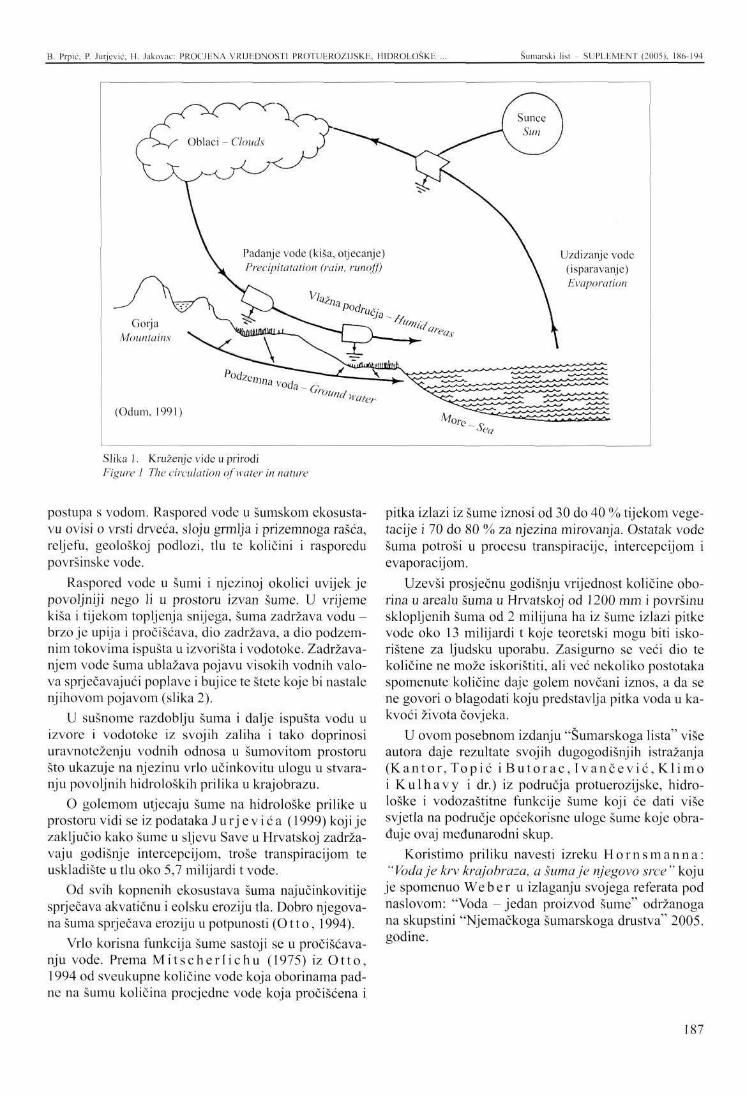
B. Prpić, P. Jurjević, H. Jakovac: PROCJENA VRIJEDNOSTI PR0TUER0Z1JSKE. HIDROLOSKE ... Šumarski l is t- SUPLEMENT (2005). 186-194
Slika 1. Kruženje vide u prirodi Figure 1 The circulation of water in nature
postupa s vodom. Raspored vode u šumskom ekosustavu ovisi o vrsti drveća, sloju grmlja i prizemnoga rašća, reljefu, geološkoj podlozi, tlu te količini i rasporedu površinske vode.
Raspored vode u šumi i njezinoj okolici uvijek je povoljniji nego li u prostoru izvan šume. U vrijeme kiša i tijekom topljenja snijega, šuma zadržava vodu -brzo je upija i pročišćava, dio zadržava, a dio podzemnim tokovima ispušta u izvorišta i vodotoke. Zadržavanjem vode šuma ublažava pojavu visokih vodnih valova sprječavajući poplave i bujice te štete koje bi nastale njihovom pojavom (slika 2).
U sušnome razdoblju šuma i dalje ispušta vodu u izvore i vodotoke iz svojih zaliha i tako doprinosi uravnoteženju vodnih odnosa u šumovitom prostoru što ukazuje na njezinu vrlo učinkovitu ulogu u stvaranju povoljnih hidroloških prilika u krajobrazu.
O golemom utjecaju šume na hidrološke prilike u prostoru vidi se iz podataka Ju r jev ić a (1999) koji je zaključio kako šume u sljevu Save u Hrvatskoj zadržavaju godišnje intercepcijom, troše transpiracijom te uskladište u tlu oko 5,7 milijardi t vode.
Od svih kopnenih ekosustava šuma najučinkovitije sprječava akvatičnu i colsku eroziju tla. Dobro njegovana šuma sprječava eroziju u potpunosti (Otto, 1994).
Vrlo korisna funkcija šume sastoji se u pročišćavanju vode. Prema M i t s c h e r l i c h u (1975) iz O t to , 1994 od sveukupne količine vode koja oborinama padne na šumu količina procjedne vode koja pročišćena i
pitka izlazi iz šume iznosi od 30 do 40 % tijekom vegetacije i 70 do 80 % za njezina mirovanja. Ostatak vode šuma potroši u procesu transpiracije, intercepcijom i evaporacijom.
Uzevši prosječnu godišnju vrijednost količine oborina u arealu šuma u Hrvatskoj od 1200 mm i površinu sklopljenih šuma od 2 milijuna ha iz šume izlazi pitke vode oko 13 milijardi t koje teoretski mogu biti iskorištene za ljudsku uporabu. Zasigurno se veći dio te količine ne može iskoristiti, ali već nekoliko postotaka spomenute količine daje golem novčani iznos, a da se ne govori o blagodati koju predstavlja pitka voda u kakvoći života čovjeka.
U ovom posebnom izdanju "Šumarskoga lista" više autora daje rezultate svojih dugogodišnjih istražanja (Kantor , Topić i B u t o r a c , I v a n č e v i ć , Kl imo i Kulhavy i dr.) iz područja protuerozijske, hidrološke i vodozaštitne funkcije šume koji će dati više svjetla na područje općekorisne uloge šume koje obraduje ovaj međunarodni skup.
Koristimo priliku navesti izreku H o r n s m a n n a : "Voda je krv krajobraza, a šuma je njegovo srce " koju
je spomenuo Weber u izlaganju svojega referata pod naslovom: "Voda - jedan proizvod šume" održanoga na skupštini "Njemačkoga šumarskoga društva" 2005. godine.
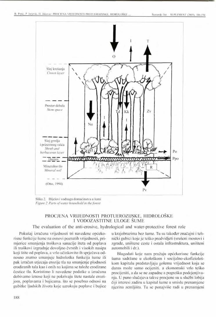
B. Prpič. P. Jurjević. II. Jakovac: PROCJENA VRIJhDNOSTI PROTUEROZIJSKE, HIDROLOŠKE Šumarski list SUPLEMENT (2005). 186-194
Sloj krošanja Crown laver
Prostor debala Stem space
Sloj grmlja i prizemnog rašća
Shrub and herbac
Mineralno tlo Mineral soil
(Otto, 1994)
TG0' srbaceous layer y | ' • / • * ; 4K^N
Slika 2. Dijelovi vodnoga domaćinstva u šumi Figure 2 Parts of water household in the forest
PROCJENA VRIJEDNOSTI PROTUEROZIJSKE, HIDROLOŠKE I VODOZASTITNE ULOGE ŠUME
The evaluation of the anti-erosive, hydrological and water-protective forest role Pokušaj izračuna vrijednosti tri navedene općeko
risne funkcije šume na osnovi poznatih vrijednosti, primjerice smanjenja troškova sanacije šteta od poplava ili troškovi izgradnje dovoljno čvrstih i visokih nasipa koji štite od poplava, a vrlo učinkovito ih sprječava odnosno znatno umanjuje hidrološka funkcija šume ili pak izračun utjecaja erozije tla na smanjenje plodnosti erodiranih tala kao i onih na kojima se talože erodirane čestice tla. Koristimo li navedene podatke u izračunu dobivamo iznose koji ne pokrivaju štete nastale erozijom, poplavama i bujicama, što se posebno odnosi na gubitke ljudskih života koje uzrokuju poplave i bujice
u krajobrazima bez šume. Tu su također značajni i tehnički gubici koje je teško predvidjeti (srušeni mostovi i zgrade, uništene ceste i ostala infrastruktura, uništeni automobili i dr.).
Blagodati koje nam pružaju općekorisne funkcije šuma sadržane u ekološkom i socijalno-ekofiziološ-kom kapitalu predstavljaju golemu vrijednost koja se danas može samo ocijeniti, a ekonomski vrlo teško procijeniti, a da se ne zapadne a pogrešku podcjenjivanja. U puno slučajeva takve procjene su u službi lobija čiji interesi zadiru u kapital šume u smislu prenamjenc njezina zemljišta. Tu se ponajviše radi u prenamjeni
188
B. Prpic, P. Jurjević. H. Jakovac: PROCJENA VRIJEDNOSTI PROTUEROZIJSKE. HIDROEQXKE ... Šumarski list - SUPLEMENT (2005). 186-194
šume u urbani ili infrastrukturni prostor. Vlasniku šume se ostavlja drvo, a zemljište se prodaje investitoru lobija po vrlo niskoj cijeni.
Da bi se u Hrvatskoj sprječila jeftina rasprodaja ekološko-biološkoga kapitala šume i očuvao njihov povoljan utjecaj na okoliš, hrvatska šumarska struka uvela je i ozakonila način ocjene pojedine općekorisne funkcije u bodovima i odredila njihovu cijenu. To je uvelike smanjilo posizanjc za šumom i prenamjenu
Slika 3. Kamena pustinja nastala erozijom poslije sječe šume i ispaše stoke u šumi hrasta crnike, otok Pag
Figure 3 Rocky desert developed by the erosion caused by cutting and pasture in a holm oak forest. The island of Pag
Slika 4. U teškim uvjetima visokoga krša šuma čuva svoje tlo, Velebit
Figure 4 Under the hard conditions of high karst, forest creates and guards its soil, Velebit
šume smanjilo na objektivnu potrebu iako se u posljednje vrijeme čine preveliki ustupci cestogradnj i i poljodjelstvu.
Metoda ocjenjivanja i procjene općekorisnih funkcija šume objavljena je u Narodnim novinama Republike Hrvatske broj 191/1997. u Pravilniku o izmjenama i dopunama Pravilnika o uređivanju šuma kao podzakonskom aktu Zakona o šumama Republike Hrvatske donesenoga 1990. godine.
Ocjena protuerozijske, hidrološke i vodozaštitne funkcija za šume u Hrvatskoj obavljena je primjenom članaka 91. i 92. spomenutoga pravilnika. Rezultati izračuna prikazani su u priloženoj tablici (tablica 1).
Ukupna površina Hrvatskih šuma iznosi 1 903 115 ha, a izračunata vrijednost tih funkcija iznosi prema Pravilniku 9 395 572 002 EUR-a. Prosječna vrijednost po ha iznosi 4937 EUR-a dok prosječna godišnja vrijednost po ha iznosi 99 EUR-a odnosno za sve šume 188 408 385 EUR-a.
Dakako ni ova metoda ne daje stvarnu vrijednost navedenih funkcija šume budući da se vrijednost boda već deset godina nije mijenjala iako su spoznaje o značenju
Slika 5. Preborna šuma bukve i jele vrlo učinkovito štiti tlo od erozije, sprječava poplave i uvjetuje pitkost vode svojih izvora
Figure 5 Selection forest of beech and fir very efficiently protects its soil from erosion, prevents floods, and maintains the drinking quality of the water from its sources
189
Prpić. P. Jurjević. H. Jakovac: PROCJENA VRIJEDNOSTI PROTUEROZI.ISKE, HIDROLOŠKE Šumarski list SUPLEMENT (2005), 186-194
i vrijednosti općekorisnih funkcija u međuvremenu porasle u skladu s porastom ekološke svijesti. To se posebice odnosi na klimatske promjene i posljedice koje one donose bilo kao sušna razdoblja ili poplave i bujice koje odnose ljudske živote, a povezane su uz blagodati koje
pruža šuma (vezivanje ugljičnoga dioksida kao značajnoga stakleničkoga plina). Usprkos tome ova je cijena dva puta veća od vrijednosti koje su za iste funkcije dobili Vule t ić i Sab adi (2004) u iznosu od 94,5 milijuna EUR-a.
Tablica 1. Procjena vrijednosti protucrozijske, hidrološke i vodozaštitne uloge šume Table 1 Valuation of the anti-erosive, hydrological and water-protective forest role
Gospodarske šume Managed forests
Visoke šume - High forests Panj ače - Coppices Šikare - Thickets Sibljaci - Pole-stage Makije - Maquis Garizi - Garrigues Plantaže - Plantations Ukupno - Total Zaštitne šume - Protective forests Ukupno - Total
Površina ha Area/ha
977 189 236 102 249 767
6 863 27 989 12 786 15 134
1 525 830 46 149 46 149
Ocjena Point value
5 4 4 2 4 2 2
7
Bodovi po 1 ha, 1 bod = 0,1325 € Points per I ha
1 point = €0.1325 40 500 34 000 34 000 17 000 34 000 17 000 17 000
48 500
Ukupna vrijednost u € Total value in €
5 243 840 471 1 063 639 510 1 125 200 335
15 458 907 126 090 445 28 800 465
3 408 168 7 637 111901
296 565 011 296 565 011
Sume posebne namjene - Special purpose forest Spomenici prirode - Nature monuments Strogo zaštićeni razervati - Strict reserves Parkovi prirode - Nature parks Posebni rezervati - Special reserves Zaštićeni krajolici - Protected landscapes Park-šume - Park forests Šume za znanstvena istražanja Forests for scientific research Vojne šume - Military forests Šume za odmor i rekreaciju Forests for relaxation and recreation Ukupno - Total Sveukupno - Overall Prosječno po 1 ha - Average per 1 ha Prosječna godišnja vrijednost po 1 ha Average annual value per 1 ha
690 48
312 668 5313
332 1 177
969
5 067
4 872
331 136 1903 115
5 4 5 6 4 4
5
2
4
40 500 34 000 40 500 44 500 34 000 34 000
40 500
17 000
34 000
3 702 712 216240
1 677 854 655 31 326 776
1 495 660 5 302 385
5 199 896
11413417
21 948 360
1 758 460 101 9 395 572 002
4 937€
99 €
ZAKLJUČCI - Conclusions Protuerozijska, hidrološka i vodozaštitna funkcija šume pripadaju u najznačajnije ekološke odnosno zaštitne funkcije šume. U zaštiti čovjekova okoliša presudne su protuerozijska i hidrološka funkcija u sprječavanju erozije, bujica i poplava, dok je vodozaštitna koja se odnosi na njezino pročišćavanje bitna za opstanak čovjeka budući da djelovanjem šume voda postaje pitka. Prilikom utvrđivanja vrijednosti općekorisnih funkcija šume što obavlja diplomirani inženjer šumarstva, potrebno je iskustvo u poznavanju općekorisnih funkcija šume. Kod procjene bitna je
stručna ocjena šumske sastojine i povezivanje komponenti njezine strukture s pojedinim općekorisnim funkcijama. Kod ocjenjivanja socijalnih funkcija šume (estetska, zdravstvena, rekreacijska, turistička) dobro će poslužiti anketa uz uvjet da anketirani budu ciljano odabrani ovisno o funkciji. Rezultati ankete mogu poslužiti kao pomoć prilikom donošenja konačne procjene estetske i turističke funkcije šume. U procjenjivanju vrijednosti općekorisnih funkcija šume prema ekonomskim načelima u smislu kako je vrijedno samo ono što se može unovčiti na tržištu
190
B. Prpić. P. Jurjević. II. Jakovac: PROCIliNA VRIJEDNOSTI PROTUEROZIJSKE. HTOROLOŠKE ... Šumarski list - SUPLEMENT (2005). 186-194
sve ekološke kao i socijalno-ekofrziološke funkcije (genetska, bioraznolikosna, prirodozaštitarska i fiziološka - vezivanje ugljika i ispuštanje kisika) bit će prema našem dosadašnjem iskustvu nisko proc-jenjene jer se ne može objektivno odrediti njihova prava vrijednost. Ekološko-biološki kapital zasigurno vee danas premašuje trideset i više puta siro-vinsko-energetsku vrijednost šume, a procjene prema enomskim načelima tek neznatno premašuju si-rovinsko-energetsku vrijednost.
5. Za današnje prilike u smislu očuvanja šumskoga fonda od nepotrebne prenamjene u druge svrhe prikladna je metoda procjene i bodovanja donesena u podzakonskom aktu Zakona o šumama Republike Hrvatske.
6. Šume u Hrvatskoj imaju zbog svojega prirodnoga sastava vrlo visoku vrijednost općekorisnih funkcija
G l a v a č , V., 1999: Uvod u globalnu ekologiju, Državna uprava za zaštitu prirode i okoliša, Zagreb: 211 str.
J u r j e v i ć , R, 1999: Vodoprivredna naknada, stanje i prijedlozi za rješenje, Šum. list, 123 (7-8), Zagreb: 359-362.
K l i m o , E., 1998: Rezultati promjena vodnih odnosa u poplavnim šumama Južne Moravske, U: B. Prpić (ur.) Zbornik radova Međunarodne konferencije: Održivo gospodarsko korištenje nizinskih rijeka i zaštita prirode i okoliša, Hrvatsko šumarsko društvo i EURONATUR, Zagreb: 113-117.
M a t i ć , S., B. P r p i ć , 1997: Program njege, obnove i održavanja te ekološke i socijalne funkcije park šuma na području Grada Zagreba, Šum. list, 120 (5-6), Zagreb: 225-242.
O t t o , H. J., 1994: Waldoekologie, Eugen Ulmer, Stuttgart: 301 str.
Pravilnik o izmjenama i dopunama Pravilnika o uređivanju šuma, broj 121, srijeda, 12. listopada 1997, Zagreb: 4051-4057.
P r p i ć , B., 1992: Ekološka i gospodarska vrijednost šuma u Hrvatskoj, U. Đ., Rauš (ur.), Šumarski fa-
koja se uz to povećava održavanjem optimalne faze razvoja šume kao i kratkom prirodnom obnovom. Uzgojnim postupcima prema zagrebačkoj školi uzgajanja šuma ona se održava od obnove do obnove u punoj općekorisnoj funkciji.
7. Izračun sveukupne vrijednosti protuerozijske, hi-drološke i vodozaštitne funkcije šuma kojima gospodare Hrvatske šume d.o.o. kojih je površina oko 80 % od šumskoga fonda Republike Hrvatske, iznosi 9 395 572 002 EUR-a izračunato po službenoj metodologiji iz Zakona o šumama Republike Hrvatske. Prosječna vrijednost po 1 ha je 4 937 EUR-a, a dogovorena prosječna godišnja vrijednost po 1 ha iznosi 99 EUR-a. odnosno za sve šume 188 408 385 EUR-a.
kultet Sveučilišta u Zagrebu i "Hrvatske šume", Zagreb: 237-256.
P r p i ć , B., H. J a k o v a c , 1998: Značenje općekorisnih funkcija nizinskih šuma u usporedbi s planiranim gospodarskim koristima H.E Novo Virje, Zbornik radova Međunarodne konferencije. Održivo gospodarsko korištenje nizinskih rijeka i zaštita prirode i okoliša, Hrvatsko šumarsko društvo i EURONATUR, Zagreb: 53-60.
S c h n e i d e r - J a c o b y , M., 1998: Ibid. Održivi razvoj Pomurja i Podravine kao mogućnost unaprjeđenja graničnoga prostora između Austrije, Slovenije, Hrvatske i Mađarske. Zagreb: 70-82.
S a b a d i , R., 1997: Vrednovanje šuma u njihovoj ukupnosti, Hrvatske šume, Zagreb: str. 17.
S u d a , M., 1989: Quantifizierung der durch Wald-schaeden beeinflussten Schutzfunkzionen, Modelstudien in bayerischen Alpenraum, Forstw. Cbl.: 45-55.
V u l e t i ć , D., R. Sabadi, 2004: Prva procjena ukupne gospodarske vrijednosti šuma Hrvatske, Rad. Šum. inst., Vol. 31, br. 1, Jastrebarsko: 79-98.
LITERATURA - References
191
PRESENTATION AT THE INTERNATIONAL SYMPOSIUM Šumarski list SUPLEMENT (2005), 1X6-194
ASSESSING THE VALUE OF THE ANTI-EROSIVE AND WATER-PROTECTIVE ROLE OF THE FOREST
Branimir PRPIĆ1, Petar JURJEVIĆ2, Hranislav JAKOVAC3
SUMMARY: The ecological, social and ecological-social function of a forest is gaining increasing importance with the passage of time. Therefore, its value considerably exceeds the income from forest wood products. The anti-erosive and water-protective role of a forest comprises the control of water erosion and torrents, balancing water relations in the landscape, cleansing and retaining water in a forest ecosystem in the sense of preventing high water tides and maintaining the potable quality of ground or spring water.
The two mentioned roles of the forest rank among the most important and may partially be expressed in monetary amounts, since forests with their impacts reduce damage to agriculture and infrastructure.
This paper uses our own and other data to calculate the value of the anti-erosive and water-protective role of forests. The calculation was based on the officially accepted method used in the Republic of Croatia, as well as on our own and other recent insights. Emphasis is laid on commercialisation and considerable prof is derived from trade with potable water, whose quality is dependent on a well tended commercial forest.
The annual values of forest wood and auxiliary products and the assessed values of other forest functions are given, as well as data on the efficiency of a natural, highly degraded pubescent oak forest on Istrian flysch in preventing water erosion.
Since forests, particularly those in the Mediterranean region, are currently being devalued in the Republic of Croatia, this paper is aimed at highlighting their true value as an ecological stronghold in the space which far exceeds the value of agrarian land which forests are being turned into.
INTRODUCTION
Potable water, particularly drinking water, is progressively less available to the ever-increasing human population. Forest is closely connected with water, primarily due to its survival as an ecosystem that stores and purifies water and makes it drinkable. Precipitation and tloodwater that filters through the loose forest soil purifies mechanically and biologically, as well as partly
Professor Emeritus Branimir Prpić, PhD, Academy of Forestry Sciences, Trg Mažuranića 11, 10000 Zagreb.
2 Petar Jurjević, MSc, Hrvatske šume Ltd., Farkaša Vukotinovića 2, 10000 Zagreb. Hranislav Jakovac, BSc, Croatian Forestry Society, Trg Mažuranića 11, 10000 Zagreb.
chemically, so that it enters the groundwater streams as drinkable, supplying the sources and water streams.
Both water and forest are renewable natural resources. Permanently circulating, water evaporates from the ocean surface, creates clouds and as precipitation falls back to the earth's surface, running through the streams back to the seas and oceans (Figure 1). This happens about forty times in a year.
A forest cannot grow without water; neither can it succeed in very cold places. Without warmth, water turns to ice, warmth without water is drought, soil without water becomes desert, and excessive water turns soil into swamp. In tundra, steppe, desert and swamp forest cannot grow. In a forested landscape, forest pre-
192
B. Prpić. P. Jurjcvić. H. Jakovac: ASSHSSINC, THE VALUE ()!• ANTI-EROSIVE ... Šumarski list SUPLEMENT (2005). 1X6-194
vents soil erosion and torrents, balances the distribution in space, alleviates the high water waves, and supports the purity of water and the number of sources. Compared to other land ecological systems, forest very economically treats water. The distribution of water in a forest ecosystem depends on the tree species, the layers of brush and undergrowth, the relief, geological rock, the soil, and the quantity and distribution of the surface water.
The distribution of water in the forest and its environment is always more suitable than it is outside the forest. In the periods of rain and slow melting, forest retains water, infiltrates it and purifies, and one part of it discharges through underground streams into the sources and water streams. By retaining water, forest reduces the possibilities of high water waves, preventing the damaging floods and torrents (Figure 2).
In dry periods, forest continues to discharge water into sources and streams from its reserves, contributing to the balance of the water regimes in forest areas, which indicates its very efficient role in creating favourable hydrological conditions in the landscape.
J u r j e v i ć (1999) presented the enormous effect of forest upon the hydrological conditions in the environment. He concluded that the forests in the Sava basin in Croatia retain annually by interception, spend through transpiration, and store in the soil about 5.7 billion t water.
Of all land ecosystems, forest most efficiently prevents the aquatic and colic soil erosion. A well-tended forest prevents erosion entirely (Otto, 1994).
There have been attempts of calculating the values of the three stated generally beneficial forest functions based on known figures, e.g. the reduction of the costs for sanation of the damage caused by flood, or the building costs of strong and high embankments for flood protection. However, the hydrological forest functions very efficiently prevent flooding, or alleviate its effects. Calculated are also the impacts of soil erosion upon the fertility of the soil that either erodes or contains sediments of eroded soil particles. By using such data in the calculation, wc get the amounts that do not cover the damage caused by erosion, floods and torrents, which particularly relates to the loss of lives in the landscapes without forests. Significant are also technical losses that are hard to predict (collapsed bridges and buildings, destroyed roads and other infrastructure, damaged cars, etc.).
The benefits of the non-commercial forest functions contained in the ecological and social/eco-phys-
A very useful forest function is the purification of water. According to M i t s c h e r l i c h (1975) (from Otto (1994), of the total water quantity that falls as precipitation to forest, the quantity of the filtered water, that purified and drinkable emerges from the forest, ranges between 30 % and 40 % during vegetation, and between 70 % and 80 % at the time of its resting. The remaining water is spent in the process of transpiration, interception and evaporation.
Considering the average annual value of the precipitation in the forest areal of Croatia amounting to 1,200 mm, and the area of closed forests of 2 million ha, about 13 billion t of drinkable water come out from the forest and can theoretically be used for human needs. The main part of this quantity certainly cannot be used, but only several percentages of it present an immeasurable money value, not to mention the benefits drinkable water presents in man's life quality.
In this special edition of "Šumarski list", a number of authors (Kantor , Topic , B u t o r a c , I vanče -v ić , K l imo , Kulhavy , and others) present the results of their long-term research in the field of erosion, hydrological and water-protection forest functions, which will throw more light on the field of the generally beneficial forest functions - the topic of this international congress.
At the assembly of the German Forestry Society in 2005 titled "Water - one forest product", while reporting his paper, Weber quoted H o r n s m a n n : "Water is the blood of the landscape, and forest is its heart".
iological capital present an immense value that can only be imagined, though economically hardly evaluated without making errors of underestimation. Such valuations are frequently the instruments of the lobbies the interest of which is the forest capital in terms of converting forestland to other purposes, most frequently to urban or infrastructure areas. The forest owner then gets the timber, while the land is sold to the investor of the lobby at very low prices.
To prevent the cheap sale of the ecological and biological forest capital and to preserve its beneficial effects on the environment, the Croatian forestry profession has introduced and legalised the method of evaluating the individual non-commercial forest functions by a point system that determines their value. This greatly reduced forest conversion to sensible needs, although exaggerated concessions have been granted for road building and agriculture in recent years.
THE EVALUATION OF THE ANTI-EROSIVE, HYDROLOGICAL AND WATER-PROTECTIVE FOREST ROLE
193
B. Prpić, P. Jurjcvić. II. Jakovac: ASSESSING THE VALUE OF ANTI-EROSIVE ... Šumarski list SUPLEMENT (2005). 186-194
The method of evaluating and estimating the noncommercial forest functions was published in the National Journal of the Republic of Croatia Nr. 191/1997 in the "Statute on changes and amendments of the Statute on forest management" as a sub law act of the Forest Law of the Republic of Croatia passed in 1990.
The valuation of the anti-erosive, hydrological and water-protective forest functions in Croatia was published by the implementation of Articles 91 and 92 of the mentioned Statute. The results of the calculation are presented in the enclosed table (Table 1).
Total area of Croatian forests is 1,903,115 ha, while the calculated value of their functions according to the Statute amounts to € 9,395,572,002. The average value
1. The anti-erosive, hydrological and water-protective forest functions belong to the most significant protective forest functions. Within the protection of the environment, the anti-erosive and hydrological functions are deciding in the prevention of erosion, torrents and floods. By making water drinkable, the water-protective function is essential for man's survival.
2. While assessing the value of the non-commercial forest functions, a forestry engineer should also have experience in understanding them. The expert valuation of a forest stand and the combining of its structural components with the individual beneficial functions are essential.
3. The valuation of the social forest functions (aesthetic, health, recreation, tourism) will require a questionnaire, provided that the examined people should be well chosen depending on their functions. The results of the questionnaire may help in making final assessments on the aesthetic and tourism-related forest functions.
4. The evaluation of the non-commercial forest functions by the principles of money value, i.e. considering that the value is assessed by market criteria, while all ecological, socio/eco-physiological functions (genetics, biodiversity, nature-conservation and physiology - binding of carbon dioxide and releasing of oxygen) will be underestimated according
per ha is € 4,937, while the average annual value per ha amounts to € 99, i.e. € 188,408,385 of all forests.
Neither this method can calculate the real value of the said forest functions, since the point value has not changed in the last ten years in spite of the growing awareness of the significance and value of the noncommercial forest functions. This particularly relates to the climatic changes and the consequences they cause either as drought or flood and life-claiming torrents. It also relates to the binding of carbon dioxide as a significant greenhouse gas. In spite of this, this price is twice as high than the value of € 94.5 million, calculated by Vule t ić and Sab ad i (2004) for the same functions.
to our to date experience. Their real value cannot be assessed objectively. The ecological and biological forest capital even today exceeds by thirty and more times the value of the raw material and energy, while the valuations by economic principles only negligibly exceed the raw material/energy value.
5. As to the conservation of the forest stock against the useless conversion to other purposes, a currently adequate evaluation method by point system has been legalised by a sub-law act within the Law on Forests of the Republic of Croatia.
6. Owing to their natural composition, Croatian forests have a very high generally beneficial value, which is constantly increasing through the maintenance of the optimal development phase and a short natural regeneration. With the silvicultural practices of the Zagreb School of Silviculture, forests are maintained from one regeneration to another, in order to retain their beneficial functions.
7. The calculation of the total anti-erosive, hydrological and water-protective forest functions managed by Hrvatske šume Ltd., upon an area of 80 % of the total Croatian growing stock, amounts to € 9,395,572,002. This was calculated by the official methodology of the Law on Forests of the Republic of Croatia. The average value per 1 ha is thus € 4,937, while the agreed average annual value of all forests per 1 ha is € 99, i.e. € 188,408,385.
CONCLUSIONS
194
IZLAGANJE NA ZNANSTVENOM SKUPU - PRESENTATION AT THE INTERNATIONAL SYMPOSIUM UDK 630* 116
Šumarski list - SUPLEMLNT (2005), 195-201
UPORABA METODE CN-KRIVULJA ZA PROCJENU UTJECAJA ŠUMA NA POVRŠINSKO OTJECANJE
APPLICATION OF THE METHOD OF RUNOFF CURVE NUMBERS TO EVALUATE THE EFFECT OF FOREST ON SURFACE RUNOFF
Miloslav JANEČEK*
SAŽETAK: Šuma općenito predstavlja vrlo djelotvoran biljni pokrov. Ona pojačava retencijski kapacitet vode nekog sliva i štiti tlo od erozije. Međutim, zbog ekstremne varijabilnosti hidroloških osobina dubljih slojeva tla, a posebice površinskog dijela (listinac), šuma ponekadprouzročuje znatne količine površinskog otjecanja, koje, između ostalog, dovode do erozije tla.
Kao sredstvo za procjenu mogućeg otjecanja iz šumskog sliva do 10 km može se preporučiti CN-metođa, a posebice nedavno izrađen HydroCad model http://www.hydrocad.net. koji se temelji na ovoj metodi.
Općenito govoreći, šumske se sastojine smatraju najboljim tlom koje pridonosi smanjenju površinskog otjecanja i erozije. Ovo se djelovanje općenito temelji na sljedećem: • Zaštita tla od razornog djelovanja jakih kiša; • Podrška vodne infiltracije u tlo; • Poboljšanje konzistencije tla; • Smanjenje prijenosne snage vode i akumulacije
površinskog otjecanja; • Zaustavljanje površinskog otjecanja i ispranog tla.
Treba napomenuti, da sve šume ne ispunjavaju potpuno ovu funkciju kako je iskazano vrednovanjem šumskih sastojina metodom krivuljnih brojeva (CN) (Kent -1971 etal.)
Hidrološki uvjeti šumskih sastojina uglavnom se odnose na gustoću pokrova — vegetacije, listinca, itd. Naravno, lišće, iglice, grančice, kora i ostali otpad vegetacije na šumskom se tlu raspada i stvara listinac iz kojega nastaje sloj šumskog tla. Vrednovanje šumskog tla metodom CN izvodi se kako slijedi:
Tablica 1. Vrednovanje površinskog sloja humusa Table 1 Evaluation of the surface layer of humus
Površinski sloj humusa - Surface layer of humus Zbijeno - Compacted Srednje zbijeno - Moderately compacted Meko ili rahlo - Mellow or loose
Razred zbijenosti - Compaction class 1 2 3
Primijene li se odgovarajući uzgojni zahvati u šumi, šumsko tlo postaje porozno, a njegov kapacitet infiltracije i akumulacije je velik. Za određivanje hidroloških uvjeta bilo koje šume, potrebno je poznavati hidrološku grupu tla, sloj listinca, humusni sloj i njegov tip.
Miloslav Jancček, Istraživački institut za kultiviranje i zaštitu tla, Prag-Zbraslav, Žabovreska 250, 156 27 Praha 5 - Zbraslav, Czech Republic, telefon: 00420 257 921 497 e-mail: [email protected]
Prema metodi CN, postoje četiri hidrološke grupe tala na temelju minimalne stope infiltracije u tlo bez pokrova nakon dugoročne zasićenosti.
Ukoliko je sloj listinca niži od 1 cm, šumsko tlo se ne smatra zaštićenim, a razred hidroloških uvjeta je umanjen za koeficijent 0.5.
Razlike u hidrološkim uvjetima općenito se izražavaju za šume prema metodi CN - vidi Tablicu 3.
195
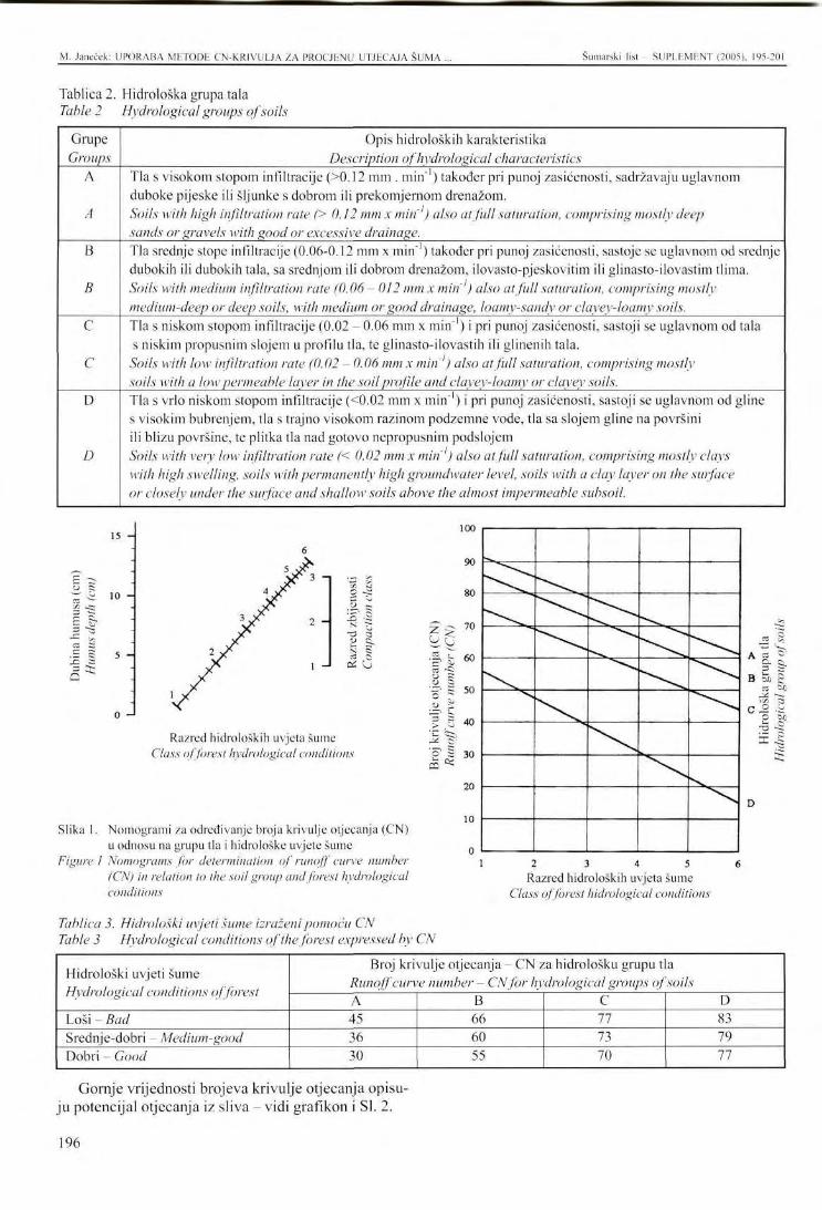
M. Janeček: UPORABA METODE CN-KRIVULJA ZA PROCJliNU UTJECAJA ŠUMA Šumarski list - SUPLEMENT (2005), 195-201
Tablica 2. Hidrološka grupa tala Table 2 Hydrological groups of soils
Grupe Groups
A
A
B
B
C
C
D
D
Opis hidroloških karakteristika Description of hydrological characteristics
Tla s visokom stopom infiltracije (>0.12 mm . min"1) također pri punoj zasićenosti, sadržavaju uglavnom duboke pijeske ili šljunke s dobrom ili prekomjernom drenažom. Soils with high infiltration rate (> 0.12 mm x min ) also at full saturation, comprising mostly deep sands or gravels with good or excessive drainage. Tla srednje stope infiltracije (0.06-0.12 mm x min" ) također pri punoj zasićenosti, sastoje se uglavnom od srednje dubokih ili dubokih tala, sa srednjom ili dobrom drenažom, ilovasto-pjeskovitim ili glinasto-ilovastim tlima. Soils with medium infiltration rate (0.06- 012 mm x min ) also at full saturation, comprising mostly medium-deep or deep soils, with medium or good drainage, loamy-sandy or clayey-loamy soils. Tla s niskom stopom infiltracije (0.02 - 0.06 mm x min"1) i pri punoj zasićenosti, sastoji se uglavnom od tala s niskim propusnim slojem u profilu tla, te glinasto-ilovastih ili glinenih tala.
Soils with low infiltration rate (0.02 - 0.06 mm x min ) also at full saturation, comprising mostly soils with a low permeable laxer in the soil profile and clayey-loamy or clayey soils. Tla s vrlo niskom stopom infiltracije (<0.02 mm x min"1) i pri punoj zasićenosti, sastoji se uglavnom od gline s visokim bubrenjem, tla s trajno visokom razinom podzemne vode, tla sa slojem gline na površini ili blizu površine, te plitka tla nad gotovo nepropusnim podslojem Soils with very low infiltration rate (< 0.02 mm x min ) also at full saturation, comprising mostly clays with high swelling, soils with permanently high groundwater level, soils with a clay layer on the surface or closely under the surface and shallow soils above the almost impermeable subsoil.
3 ~a
15 -
10 -
5 -
0 -•
100
2 -
1 - 1
II & Cj
Razred hidroloških uvjeta šume Class of forest hydrological conditions
Slika 1. Nomogrami za određivanje broja krivulje otjecanja (CN) u odnosu na grupu tla i hidrološke uvjete šume
Figure 1 Nomograms for determination of runoff curve number (CN) in relation to the soil group and forest hydrological conditions
Tablica 3. Hidrološki uvjeti šume izraženi pomoću CN Table 3 Hydrological conditions of the forest expressed by CN
2 3 4 5 Razred hidroloških uvjeta šume
Class of forest hidrological conditions
Hidrološki uvjeti šume Hydrological conditions of forest
Loši - Bad Srednje-dobri - Medium-good Dobri - Good
Broj krivulje otjecanja - CN za hidrološku grupu tla Runoff curve number - CN for hydrological groups of soils A 45 36 30
B 66 60 55
C 77 73 70
D 83 79 77
Gornje vrijednosti brojeva krivulje otjecanja opisuju potencijal otjecanja iz sliva — vidi grafikon i SI. 2.
196
M. Janeček: UPORABA METODE CN-KRIVULJA ZA PROCJENU UTJECAJA ŠUMA . Šumarski list - SUPLEMENT (2005). 195-201
E
s ¥
a
120
100
80
60
40
20
100
90
80
70
60
50
40
20 40 60 80 100 120
Fl?
H
Zbroj oborina (mm) Precipitation sum (mm)
Slika 2. Odnos izravne dubine otjecanja (Hr) s količinom oborina (Hp) i brojevima krivulje otjecanja (CN) Figure 2 The relationship of direct runoff depth (Hr) with precipitation amount (HJ and runoff
curve numbers (CN)
Gornji odnosi temelje se na pretpostavci daje omjer volumena otjecanja i količine bujica izazvanih kišom jednak omjeru volumena intercepcije za vrijeme otjecanja s potencijalnim volumenom, kojega bi prihvatilo tlo i pokrov.
Otjecanje obično dolazi nakon neke akumulacije ili kiše, što znači nakon početnog gubitka koji je zbroj intercepcije, infiltracije i površinske akumulacije procijenjene na količinu od 20 % potencijalne retencije (prema pokusnim mjerenjima).
Ova jednadžba izvedena je iz gore navedenih odnosa:
H (Hp-0.2A)2
(H+0.SA) [mm] Hp > 0.2A
A = 25.4 1000
C7V-10
Osim hidroloških osobina tla i sustava uporabe zemljišta, otjecanje ima posebnu vezu sa sadržajem vlage u tlu. Tri su situacije primijenjene u metodi CN: tlo je jako suho ili srednje natopljeno, ili prekomjerno natopljeno s vodom u odnosu na pojavu prethodne kiše.
Kao što je dokumentirano grafikonom odnosa između brojeva krivulja otjecanja CN i hidroloških grupa tala, razred hidroloških uvjeta šume i stupanj zasićenosti tla, djelovanje šume na smanjenje površinskog otjecanja i na eroziju može biti značajno drukčije (Janeček -2002).
gdje su Hr = izravno otjecanje (mm) Hp = količina bujice od kiše, obično
maksimalno tijekom 24 sata (mm) A = potencijalna retencija (mm) izražena
brojem krivulje kao
197
M. Jancček: UPORABA METODE CN-KRIVULJA ZA PROCJENU UTJECAJA SUMA . Šumarski list - SUPLEMENT (2005), 195-201
03 "S .2, §
J 2 ^
CQ
uv
yu
80
/U
60
DU
40
JU
20
1U
A
/ ^
/ / / ^
/
* r
/
/
/
/ /
/
/ '
f
s
/
s
/
¥ /
~7 /
/
/
/
&
/
/
/
/ r
. ' $
7 /
/
/ ,
/
/
0 10 20 30 40 50 60 70 80 90 100
Broj krivulje otjecanja (CN) za IPS II Runoff curve number (CN) for IPS II
Slika 3. Utjecaj sadržaja vode u tlu (IPS - suho tlo, IPS II - srednje zasićeno tolo, IPS III -zasićeno tlo) na promjenu u broju krivulje otjecanja (CN)
Figure 3 The influence of water content in the soil (IPS-city soil, IPS II - medium-satura-ted soil, IPS III - saturated soil) on a change in the runoff curve number (CN)
Gornji grafikon ilustrira utjecaj zasićenosti na promjene vrijednosti brojeva krivulja otjecanja CN, npr. CN = 30 će se smanjiti na CN = 15 na suhim tlima, a povećati će se na CN = 50 na natopljenim tlima.
Slika 4 prikazuje utjecaj promjena u krivuljama otjecanja CN, te opisuje hidrološke karakteristike šumskih zemljišta na početku površinskog otjecanja.
Grafikon prikazuje količine oborina na početku površinskog otjecanja. Ako je, npr. CN = 30, količina oborina mora prelaziti 120 mm (da bi uzrokovala površinsko otjecnaje), dok je ono samo 10 mm pri CN = 80. On također određuje kapacitet tla i pokrova za zadržavanje vode pri danim hidrološkim karakteristikama opisanim brojevima krivulja otjecanja CN.
Iako šuma može obično prihvatiti 4-5 puta veću količinu vode nego ista površina bez vegetacije, potrebno je uzeti u obzir da nakon prethodnih kiša pri punoj zasićenosti tla izravno se otjecanje iz šume povećava više puta nego s površine bez vegetacije: koliko
puta više, toliko je puta propusnije tlo. Ova činjenica bila je iznenađenje tijekom zadnje poplave u Češkoj, kada su iznimno velike količine vode istekle iz šumskih kompleksa, jer je tlo bilo natopljeno prethodnim velikim kišama.
198
M. Janeček: UPORABA METODE CN-KR1VULJA ZA PROCJENU UTJECAJA ŠUMA . Šumarski list SUPLEMENT (2005), 195-201
[mm]
1-KD
SO.
-po
Qci-
35.
4 a
SO
aa
o
'
/ /
/ /
B>G
Slika 4. Količina oborine kao početak izravnog otjecanja u uvjetima opisanim brojem krivulje otjecanja CN
Figure 4 The precipitation amount that is the incipience of direct runoff in conditions described by a runoff curve number CN
ZAKLJUČAK - Conclusion Šuma općenito predstavlja vrlo djelotvoran biljni
pokrov. Ona pojačava retencijski kapacitet vode nekog sliva i štiti tlo od erozije. Zbog ekstremne varijabilnosti hidroloških osobina dubljih slojeva tla, posebice listin-ca, iz šume ponekad otječu velike količine površinske vode, koje dovode do erozije tla.
Za procjenu mogućeg otjecanja iz šumskog sliva do 10 km2, preporučuje se metoda CN, a posebice nedavno izrađen model HydroCad http://www.hydrocad.net.. koji se temelji na ovoj metodi.
LITERATURA References K e n t, K. M. - et al, 1971: Hydrology Section 4, Na-
tional Engineering Handbook SCS. Washington D. C, USDA, s. 350.
J a n e č e k , M., 2002: Ochrana zemedelske pudy pred erozi. ISV Praha, s. 201.
199
PRESENTATION AT THE INTERNATIONAL SYMPOSIUM Šumarski list - SUPLEMENT (2005), 195-201
APPLICATION OF THE METHOD OF RUNOFF CURVE NUMBERS TO EVALUATE THE EFFECT OF FOREST ON SURFACE RUNOFF
Miloslav JANEČEK*
SUMMARY: The forest, in general, can be regarded as a very efficient vegetation cover. It enhances the water retention capacity of a catchment and protects the soil against erosion. However, because of the extreme variability of hydrological properties of underlying soils, especially their uppermost layers (the forest litter), the forest may sometimes generate a considerable amount of surface runoff causing, among other impacts, soil erosion.
The CN'-method and, in particular, the recently developed HydroCAD model (http://www.hydrocad.net), which is based on this method, can be recommended as tools for estimation of probable runoff from the forest catchments up to 10 km .
Key words: forest, retention capacity, surface runoff, hydrological conditions
In general, forest stands are considered as the best soil cover markedly contributing to a reduction of surface runoff and erosion. These effects are generally based on: • protection of soil from destructive effects of inci
dent raindrops • support of water infiltration into the soil • improvement of soil consistence • reduction of the transporting power of water and
surface runoff accumulation • retardation of surface runoff and washed soil.
It is to note that not all forest stands fully fulfil this function as indicated by the evaluation of forest stands by the method of curve numbers (CN) (Kent - 1971 et al.).
Hydrological conditions of forest stands are mainly related with the density of the cover - vegetation, litter, etc. Naturally, leaves, needles, twigs, bark and other residues of vegetation on the forest soil are decomposed to form litter from which the layer of forest floor originates. Evaluation of the forest floor by the CN method is as follows:
* Miloslav Janeček, Research Institute for Soil and Water Conservation Praha, Žabovreska 250, 156 27 Praha 5 - Zbraslav, Czech Republic, phone: 00420 257 921 497 e-mail: [email protected]
If appropriate cultural practices are applied in the forest, the forest floor is porous and its infiltration and accumulation capacity is high. To determine hydrological conditions of any forest it is necessary to know the hydrological group of soil, litter layer, humus layer and its type.
According to the CN method there exist four hydro-logical groups of soils on the basis of minimum rate of infiltration into the soil without cover after long-term saturation.
The class of hydrological conditions is determined according to the layer of litter or forest floor and its compaction.
If the litter layer is lower than 1 cm, the forest floor is not considered as protected and the class of hydrological conditions is reduced by the coefficient 0.5.
Differences in hydrological conditions are generally expressed for forests by the CN method - see Table 3.
The above values of runoff curve numbers describe the potential of runoff from the watershed - see the graph in Fig. 2.
The above relationships are based on an assumption that the ratio of runoff volume to the amount of torrential rain equals the ratio of the volume of water intercepted during runoff to potential volume that may be intercepted by the soil and cover.
200
M. Janeček: APPLICATION OF THE METHOD OF RUNOFF CURVE NUMBERS TO EVALUATE Šumarski list SUPLEMENT (2005), 195-201
Runoff usually originates after some accumulation of rainfall, that means after an initial loss that is the sum of interception, infiltration and surface accumulation that was estimated to amount to 20 % of potential retention (by experimental measurements).
This equation was derived from the above-mentioned relationships:
( / / „ -0 .2A) 2
Hr = - [mm] Hp > 0.2A (#,,+0.8/1)
where Hr= direct runoff (mm) H = amount of design torrential rain,
usually maximum over 24 hours (mm) A = potential retention (mm) expressed
by the curve number as
(CN-10)
Besides the hydrological properties of soils and systems of land use runoff is particularly related with soil moisture content. Three situations are applied in the CN method: the soil is either quite dry or medium saturated or oversaturated with water in relation with the occurrence of preceding rainfall.
As documented by the graph of the relationship between runoff curve numbers CN and hydrological
In general, forests arc a very efficient soil cover increasing the watershed retention and protecting the soil from erosion. As the range of hydrological characteristics of soils, and especially of their cover- litter is large, it is necessary to be aware of the fact that large amounts of water may leave the forest in the form of surface runoff, causing also soil erosion.
groups of soils, class of forest hydrological conditions and saturation degree of soil the effects of the forest on a reduction of surface runoff, and on erosion, may be markedly different (Janeček - 2002).
The above graph illustrates the influence of saturation on changes in the values of runoff curve numbers CN, e.g. CN = 30 will decrease to CN = 15 on dry soils and it will increase to CN = 50 on saturated soils.
Fig. 4 shows the influence of changes in runoff curve numbers CN, describing hydrological characteristics of forest lands, on the incipience of surface runoff.
The graph shows the precipitation amounts resulting in the incipience of surface runoff. If e.g. CN = 30, the precipitation amount must exceed 120 mm (to cause surface runoff) while it is only 10 mm at CN = 80. It also determines the water-retaining capacity of soil and its cover for the given hydrological characteristics described by runoff curve numbers CN.
Even though the forest can usually intercept a 4-5 times higher amount of water than the same area without vegetation, it is necessary to take into account that after preceding rains at full saturation of soil direct runoff from the forest increases more times than from the area without vegetation: the more times the more permeable is the soil. This fact was surprising during the last flood in Bohemia when unusually large amounts of water ran off forest complexes because the soil was saturated with preceding heavy rains.
To estimate potential runoffs from the forest in a watershed maximally 10 km' in size we can recommend to use the CN method or a recently derived model on the basis of this method HydroCAD http://www.hydrocad.net.
CONCLUSION
201
IZLAGANJE NA ZNANSTVENOM SKUPU - PRESENTATION AT THE INTERNATIONAL SYMPOSIUM Šumarski list SUPLEMENT (2005), 202-218 UDK 630* 116 + 907.1 + 113
UTJECAJ BRDSKIH ŠUMSKIH EKOSUSTAVA NA KAKVOĆU VODE U VODOTOCIMA
THE IMPACT OF MONTANE FOREST ECOSYSTEMS ON WATER QUALITY OF WATERCOURSES
Ivica TIKVIĆ, Dinko PUNTARIĆ, Željko ZEČIĆ, Damir UGARKOVIĆ, Zvonko SELETKOVIĆ*
SAŽETAK: Brdski šumski ekosustavi su prema površini najzastupljeniji u Hrvatskoj, te kao takvi imaju najveći utjecaj na kruženje vode, odnosno kakvoću površinskih i podzemnih voda. Taj utjecaj ovisi o ekološkim (reljef, matična podloga, tlo i klima) i biološkim čimbenicima (vrste drveća, struktura šumskog ekosustava i antropogeni utjecaji). Kakav je utjecaj pojedinih vrsta drveća, tipova tala, različitih matičnih podloga i čovjeka na kakvoću voda u vodotocima u šumskim ekosustavima u Hrvatskoj, nije istraženo. U radu su uspoređeni pokazatelji kakvoće vode u vodotocima iz nekoliko brdskih šumskih ekosustava Hrvatske. Analizirane su razlike u kakvoći voda s obzirom na stanišne i sa-stojinske uvjete. Utvrđeno je opće ekološko stanje voda na temelju dvanaest uzoraka iz različitih vodotoka sa tri lokaliteta (Papuk, Plitvice i Velebit). Analizirano je fizikalno-kemijsko stanje voda, sadržaj hranjivih tvari, kovina, organskih spojeva, mineralnih ulja i drugih pokazatelja kakvoće vode. Nisu utvrđene značajne razlike jizikalno-kemijskih pokazatelja između različitih šumskih ekosustava. Skoro svi vodotoci imali su vodu visoke kakvoće. Utvrđene su značajno veće koncentracije sadržaja hranjivih tvari, aerobnih bakterija i metala u vodi vodotoka u blizini naselja, u usporedbi sa vodotocima u šumskim ekosustavima. Nisu utvrđene razlike u kakvoći voda u vodotocima u nacionalnom parku u odnosu na vodotoke u gospodarskim šumama. Varijabilnost pokazatelja kakvoće vode iz vodotoka različitih šumskih ekosustava ukazuje na kompleksnost djelovanja šumskih ekosustava na kakvoću voda u vodotocima. Utvrđena je veća kakvoća voda vodotoka u šumskim ekosustavima bez obzira na način gospodarenja u odnosu na vodotoke izvan šuma.
Ključne riječi: kakvoća vode, brdski šumski ekosustavi, nacionalni park, gospodarske šume
UVOD - Introduction susjednih zemalja. Vode u Hrvatskoj su pod utjecajem šumskih ekosustava koji zauzimaju preko 1/3 kopnene površine Hrvatske, od čega su brdski šumski ekosustavi najzastupljeniji. Prema podacima Državnog zavoda za statistiku (Statistički ljetopis, 2003), brdski šumski ekosustavi obične bukve, hrastova kitnjaka, medunca i crnike, te običnog graba i ostalih tvrdih listača, zauzimaju površinu od preko 13 000 km2, stoje oko 2/3 šuma, odnosno % kopnenog dijela Hrvatske. U njima je naglašen utjecaj šumskog drveća na hidrološke procese. Prirodni šumski ekosustavi se smatraju hidrogeološki najstabil-
202
Hrvatska je vodama razmjerno bogata zemlja i nalazi se na petom mjestu u Europi i 42. mjestu u svijetu po bogatstvu i dostupnosti izvora slatke vode (M i 1 k o v i ć et al., 2003.). Prema podacima UNESCO-a za Hrvatsku iz 2003. godine, oko 60 % vodnog bogatstva "nastaje" u Hrvatskoj, dok se 40 % odnosi na vanjske doprinose iz
* Doc. dr. se. Ivica Tikvić, Dinko Puntarić, dipl. ing., Dr. se. Željko Zečić, Damir Ugarković dipl. ing., Prof. dr. se. Zvonko Selctković, Šumarski fakultet Sveučilišta u Zagrebu
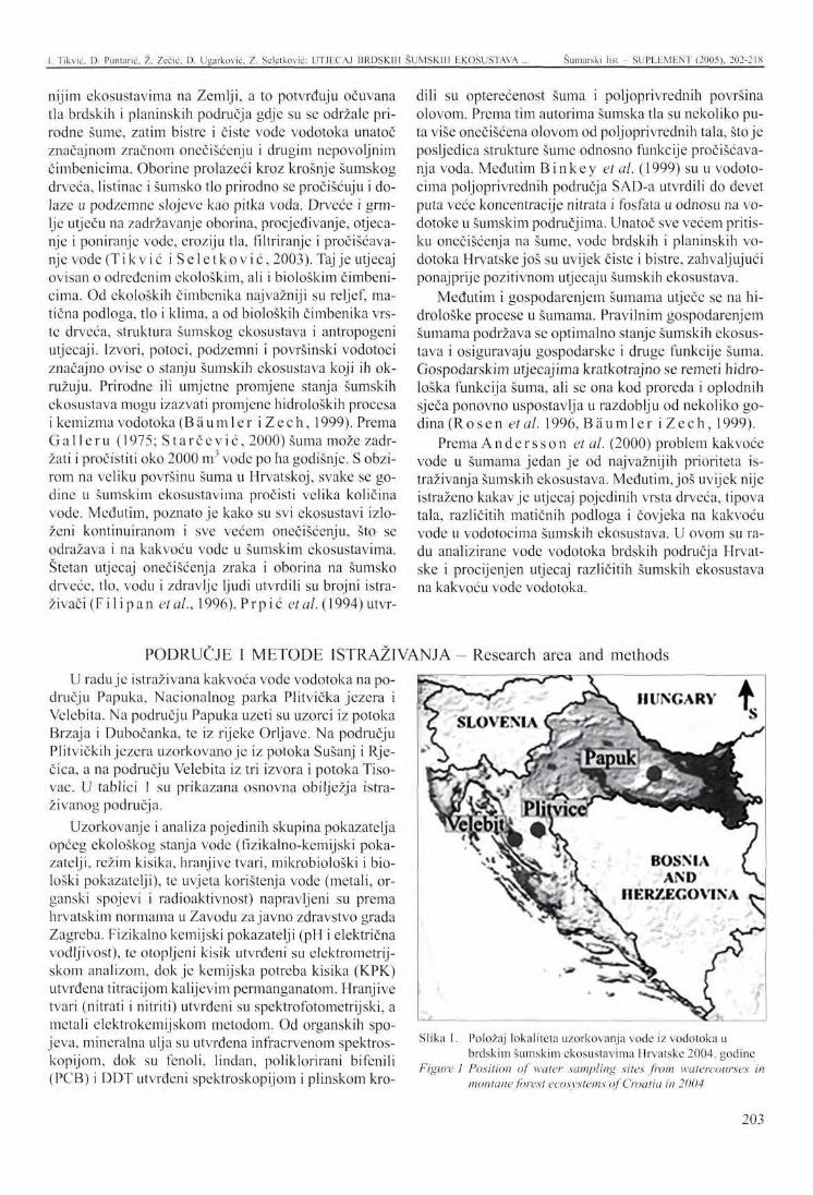
I. Tikvić, D. Puntarić, Ž. Zečić, D. Ugarković, Z. Sclclković: UTJECAJ BRDSKIH ŠUMSKIH EKOSUSTAVA ... Šumarski list - SUPLEMhNT (2005), 202-218
nijim ekosustavima na Zemlji, a to potvrđuju očuvana tla brdskih i planinskih područja gdje su se održale prirodne šume, zatim bistre i čiste vode vodotoka unatoč značajnom zračnom onečišćenju i drugim nepovoljnim čimbenicima. Oborine prolazeći kroz krošnje šumskog drveća, listinac i šumsko tlo prirodno se pročišćuju i dolaze u podzemne slojeve kao pitka voda. Drveće i grmlje utječu na zadržavanje oborina, procjedivanje, otjeca-nje i poniranje vode, eroziju tla, filtriranje i pročišćavanje vode (Tikvić i S e l e t k o v i ć , 2003). Taj je utjecaj ovisan o određenim ekološkim, ali i biološkim čimbenicima. Od ekoloških čimbenika najvažniji su reljef, matična podloga, tlo i klima, a od bioloških čimbenika vrste drveća, struktura šumskog ekosustava i antropogeni utjecaji. Izvori, potoci, podzemni i površinski vodotoci značajno ovise o stanju šumskih ekosustava koji ih okružuju. Prirodne ili umjetne promjene stanja šumskih ekosustava mogu izazvati promjene hidroloških procesa i kemizma vodotoka (Bäumler iZech , 1999). Prema Gal leru (1975; S t a r čev i ć , 2000) šuma može zadržati i pročistiti oko 2000 m vode po ha godišnje. S obzirom na veliku površinu šuma u Hrvatskoj, svake se godine u šumskim ekosustavima pročisti velika količina vode. Međutim, poznato je kako su svi ekosustavi izloženi kontinuiranom i sve većem onečišćenju, što se odražava i na kakvoću vode u šumskim ekosustavima. Štetan utjecaj onečišćenja zraka i oborina na šumsko drveće, tlo, vodu i zdravlje ljudi utvrdili su brojni istraživači (Fil ipan etal., 1996). Prpić etal. (1994) utvr-
U raduje istraživana kakvoća vode vodotoka na području Papuka, Nacionalnog parka Plitvička jezera i Velebita. Na području Papuka uzeti su uzorci iz potoka Brzaja i Dubočanka, te iz rijeke Orljave. Na području Plitvičkih jezera uzorkovano je iz potoka Sušanj i Rječica, a na području Velebita iz tri izvora i potoka Tiso-vac. U tablici 1 su prikazana osnovna obilježja istraživanog područja.
Uzorkovanje i analiza pojedinih skupina pokazatelja općeg ekološkog stanja vode (fizikalno-kemijski pokazatelji, režim kisika, hranjive tvari, mikrobiološki i biološki pokazatelji), te uvjeta korištenja vode (metali, organski spojevi i radioaktivnost) napravljeni su prema hrvatskim normama u Zavodu za javno zdravstvo grada Zagreba. Fizikalno kemijski pokazatelji (pH i električna vodljivost), te otopljeni kisik utvrđeni su elektrometrij-skom analizom, dok je kemijska potreba kisika (KPK) utvrđena titracijom kalijevim permanganatom. Hranjive tvari (nitrati i nitriti) utvrđeni su spektrofotometrijski, a metali clektrokemijskom metodom. Od organskih spojeva, mineralna ulja su utvrđena infracrvenom spektros-kopijom, dok su fenoli, lindan, poliklorirani bifenili (PCB) i DDT utvrđeni spektroskopijom i plinskom kro-
dili su opterećenost šuma i poljoprivrednih površina olovom. Prema tim autorima šumska tla su nekoliko puta više onečišćena olovom od poljoprivrednih tala, stoje posljedica strukture šume odnosno funkcije pročišćavanja voda. Međutim Binkey et al. (1999) su u vodotocima poljoprivrednih područja SAD-a utvrdili do devet puta veće koncentracije nitrata i fosfata u odnosu na vodotoke u šumskim područjima. Unatoč sve većem pritisku onečišćenja na šume, vode brdskih i planinskih vodotoka Hrvatske još su uvijek čiste i bistre, zahvaljujući ponajprije pozitivnom utjecaju šumskih ekosustava.
Međutim i gospodarenjem šumama utječe se na hi-drološke procese u šumama. Pravilnim gospodarenjem šumama podržava se optimalno stanje šumskih ekosustava i osiguravaju gospodarske i druge funkcije šuma. Gospodarskim utjecajima kratkotrajno se remeti hidro-loška funkcija šuma, ali se ona kod proreda i oplodnih sječa ponovno uspostavlja u razdoblju od nekoliko godina (Rosen etal. 1996,Bäumler i Z e c h , 1999).
Prema A n d e r s s o n et al. (2000) problem kakvoće vode u šumama jedan je od najvažnijih prioriteta istraživanja šumskih ekosustava. Međutim, još uvijek nije istraženo kakav je utjecaj pojedinih vrsta drveća, tipova tala, različitih matičnih podloga i čovjeka na kakvoću vode u vodotocima šumskih ekosustava. U ovom su radu analizirane vode vodotoka brdskih područja Hrvatske i procijenjen utjecaj različitih šumskih ekosustava na kakvoću vode vodotoka.
Slika 1. Položaj lokaliteta uzorkovanja vode iz vodotoka u brdskim šumskim ekosustavima Hrvatske 2004. godine
Figure l Position of water sampling sites from watercourses in montane forest ecosystems of Croatia in 2004
PODRUČJE I METODE ISTRAŽIVANJA - Research area and methods
203
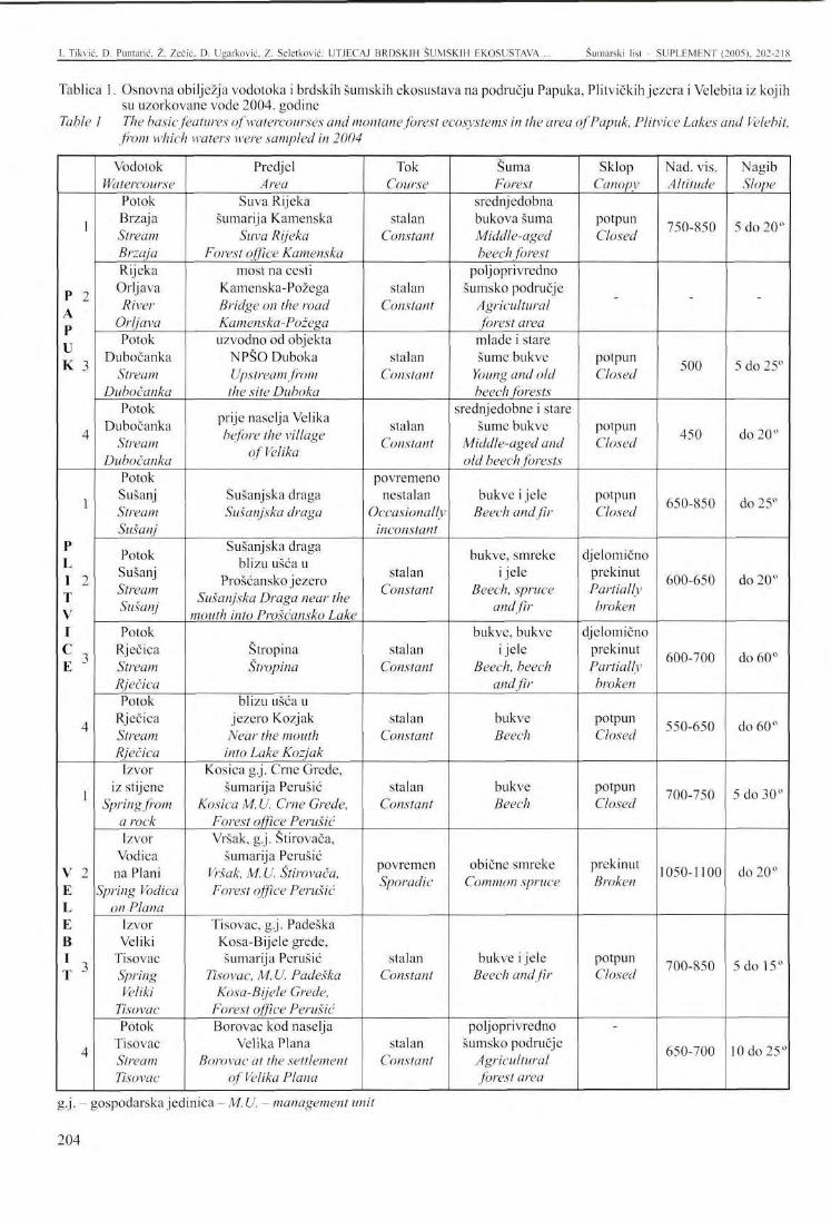
1. Tikvić, D. Punlarić, Z. Zečić, D. Ugarković. Z. Seletković: UTJECAJ BRDSKIH ŠUMSKIH EKOSUSTAVA ... Šumarski list SUPLEMENT (2005). 202-2IX
Tablica 1. Osnovna obilježja vodotoka i brdskih šumskih ekosustava na području Papuka, Plitvičkih jezera i Velebita iz kojih su uzorkovane vode 2004. godine
Table 1 The basic features ofwatercourses and montane forest ecosystems in the area of Papuk, Plitvice Lakes and Velebit, from which waters were sampled in 2004
1
P 2 A P U K 3
4
1
P L I 2 T V I
£ ' 4
1
V 2 E L E B
J>
4
Vodotok Watercourse
Potok Brzaj a Stream Brzaja Rijeka Orljava River
Orljava Potok
Dubočanka Stream
Dubočanka Potok
Dubočanka Stream
Dubočanka Potok Sušanj Stream Sušanj
Potok Sušanj Stream Sušanj
Potok Rječica Stream Rječica Potok
Rječica Stream Rječica
Izvor iz stijene
Springfrom a rock Izvor
Vodica na Plani
Spring Vodica on Plana
Izvor Veliki
Tisovac Spring Veliki
Tisovac Potok
Tisovac Stream Tisovac
Predjel Area
Suva Rijeka šumarija Kamenska
Suva Rijeka Forest office Kamenska
most na cesti Kamenska-Požega Bridge on the road Kamenska-Požega uzvodno od objekta
NPŠO Duboka Upstream from the site Duboka
prije naselja Velika before the village
of Velika
Sušanj ska draga Sušanjska draga
Sušanj ska draga blizu ušća u
Prošćanskojezero Sušanjska Draga near the
mouth into Prošćansko Lake
Štropina Štropina
blizu ušća u jezero Kozjak
Near the mouth into Lake Kozjak
Kosica g.j. Crne Grede, šumarija Perušić
Kosica M. U. Crne Grede, Forest office Perušić Vršak, g.j. Stirovača,
šumarija Perušić Vršak, M. U. Stirovača, Forest office Perušić
Tisovac, g.j. Padeška Kosa-Bijele grede, šumarija Perušić
Tisovac, M. U. Padeška Kosa-Bijele Grede,
Forest office Perušić Borovac kod naselja
Velika Plana Borovac at the settlement
of Velika Plana
Tok Course
stalan Constant
stalan Constant
stalan Constant
stalan Constant
povremeno nestalan
Occasionally inconstant
stalan Constant
stalan Constant
stalan Constant
stalan Constant
povremen Sporadic
stalan Constant
stalan Constant
Šuma Forest
srednjedobna bukova šuma Middle-aged beech forest
poljoprivredno šumsko područje
Agricultural forest area mlade i stare šume bukve
Young and old beech forests
srednjedobne i stare šume bukve
Middle-aged and old beech forests
bukve i jele Beech and fir
bukve, smreke i jele
Beech, spruce and fir
bukve, bukve i jele
Beech, beech andfir
bukve Beech
bukve Beech
obične smreke Common spruce
bukve i jele Beech andfir
poljoprivredno šumsko područje
Agricultural forest area
Sklop Canopy
potpun Closed
-
potpun Closed
potpun Closed
potpun Closed
djelomično prekinut Partially broken
djelomično prekinut Partially broken
potpun Closed
potpun Closed
prekinut Broken
potpun Closed
Nad. vis. Altitude
750-850
-
500
450
650-850
600-650
600-700
550-650
700-750
1050-1100
700-850
650-700
Nagib Slope
5 do 20°
-
5 do 25°
do 20"
do 25°
do 20°
do 60°
do 60°
5 do 30°
do 20°
5 do 15°
10do25°
g.j. - gospodarska jedinica - M.U. - management unit
204
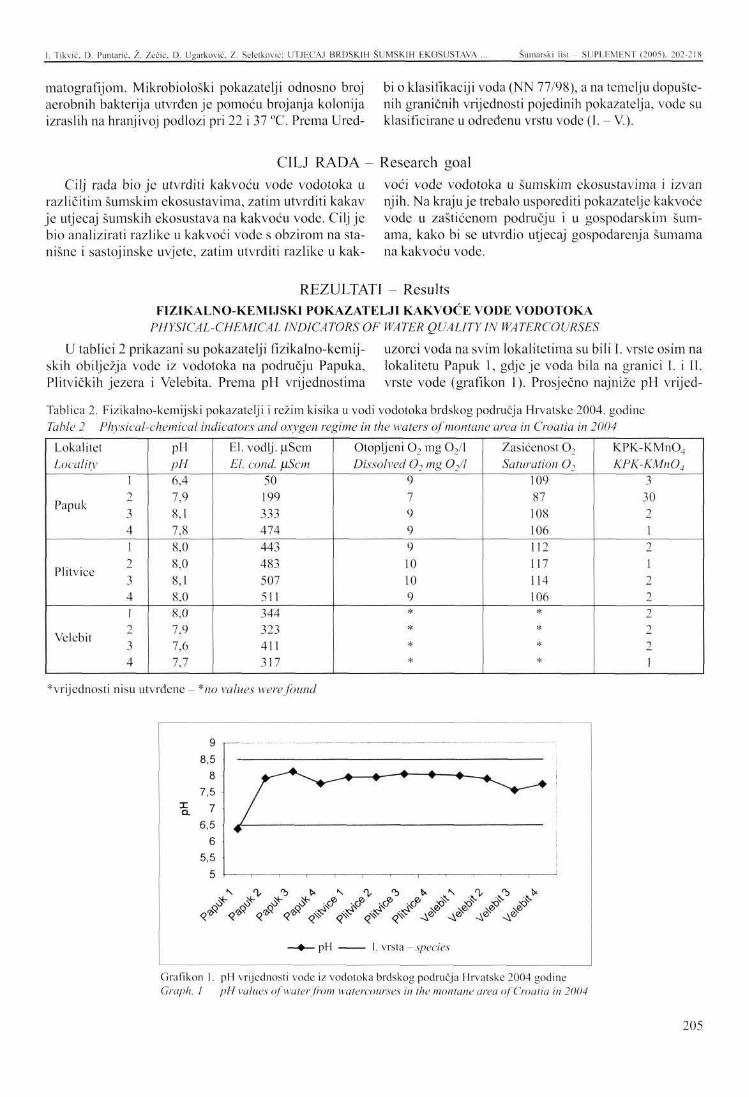
I. Tikvić. Ü. Puntane, Ž. Zečić. U. Ugarković, Z. Selclkovie: UTJECAJ BRDSKIH ŠUMSKIH EKOSUSTAVA Šumarski list - SUPLEMENT (2005), 202-218
matografijom. Mikrobiološki pokazatelji odnosno broj aerobnih bakterija utvrđen je pomoću brojanja kolonija izraslih na hranjivoj podlozi pri 22 i 37 °C. Prema Ured
bi o klasifikaciji voda (NN 77/98), a na temelju dopuštenih graničnih vrijednosti pojedinih pokazatelja, vode su klasificirane u određenu vrstu vode (I. - V.).
CILJ RADA - Research goal Cilj rada bio je utvrditi kakvoću vode vodotoka u
različitim šumskim ekosustavima, zatim utvrditi kakav je utjecaj šumskih ekosustava na kakvoću vode. Cilj je bio analizirati razlike u kakvoći vode s obzirom na sta-nišne i sastojinskc uvjete, zatim utvrditi razlike u kak
voći vode vodotoka u šumskim ekosustavima i izvan njih. Na kraju je trebalo usporediti pokazatelje kakvoće vode u zaštićenom području i u gospodarskim šumama, kako bi se utvrdio utjecaj gospodarenja šumama na kakvoću vode.
REZULTATI Results FIZIKALNO-KEMIJSKI POKAZATELJI KAKVOĆE VODE VODOTOKA
PHYSICAL-CHEMICAL INDICATORS OF WATER QUALITY IN WATERCOURSES
U tablici 2 prikazani su pokazatelji fizikalno-kemij- uzorci voda na svim lokalitetima su bili I. vrste osim na skih obilježja vode iz vodotoka na području Papuka, lokalitetu Papuk 1, gdje je voda bila na granici I. i II. Plitvičkih jezera i Velebita. Prema pH vrijednostima vrste vode (grafikon 1). Prosječno najniže pH vrijed-
Tablica 2. Fizikalno-kemijski pokazatelji i režim kisika u vodi vodotoka brdskog područja Hrvatske 2004. godine Table 2 Physical-chemical indicators and oxygen regime in the waters of montane area in Croatia in 2004
Lokalitet Locality
Papuk
Plitvice
Velebit
1 2 3 4 1 2 3 4 1 2 3 4
pH pH 6,4 7,9 8,1 7,8 8,0 8,0 8,1 8,0 8,0 7,9 7,6 7,7
El. vodlj. pScm El. cond. flScm
50 199 333 474 443 483 507 511 344 323 411 317
Otopljeni 0 2 mg 02 / l Dissolved 02 mg 02/l
9 7 9 9 9 10 10 9 * * * *
Zasićenost O-, Saturation 02
109 87 108 106 112 117 114 106 *
* *
KPK-KMn04
KPK-KMn04
3 30 2 1 2 1 2 2 2 2 2 1
^vrijednosti nisu utvrđene - *no values were found
i
9 8,5
8 7,5
7 6,5
6 5,5
*> 0- *b
if ** <r <? r^
•+—•—+.
5 tff .4? .#" J?' J"" ^ J? x?"
pH
<£* <JIV- -A® A® Aa ^ 0
- I, vrsta - species
Grafikon I. pH vrijednosti vode iz vodotoka brdskog područja Hrvatske 2004 godine Graph. I pH values of water from watercourses in the montane area of Croatia in 2004
205
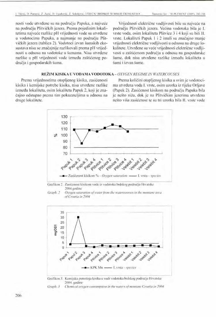
I. Tikvić. D. Puntane, Ž. Zečić, D. Ugarković, Z. Seletković: UTJECAJ BRDSKIH ŠUMSKIH EKOSUSTAVA . Šumarski list - SUPLEMENT (2005), 202-218
nosti vode utvrđene su na području Papuka, a najveće na području Plitvičkih jezera. Prema pojedinim lokalitetima najveće razlike pH vrijednosti vode su utvrđene u vodotocima Papuka, a najmanje na području Plitvičkih jezera (tablica 2). Vodotoci izvan šumskih ekosustava nisu se značajnije razlikovali prema pH vrijednosti u odnosu na vodotoke u šumama. Nisu utvrđene razlike u pH vrijednosti vode između zaštićenog područja i gospodarskih šuma.
Vrijednosti električne vodljivosti bile su najveće na području Plitvičkih jezera. Većina vodotoka bila je I. vrste voda, osim lokaliteta Plitvice 3 i 4 koji su bili II. vrste. Lokaliteti Papuk 1 i 2 imali su značajno manje vrijednosti električne vodljivosti u odnosu na druge lokalitete. Utvrđene su veće vrijednosti električne vodljivosti u zaštićenom području u odnosu na gospodarske šume, dok nisu utvrđene razlike između lokaliteta u šumi i izvan šume.
REŽIM KISIKA U VODAMA VODOTOKA - OXYGEN REGIME IN WA TERCOUSES
Prema vrijednostima otopljenog kisika, zasićenosti kisika i kemijske potrebe kisika, nisu utvrđene razlike između lokaliteta, osim lokaliteta Papuk 2, koji je značajno odstupao prema tim pokazateljima u odnosu na druge lokalitete.
Prema količini otopljenog kisika u svim je vodotocima utvrđena voda I. vrste, osim uzorka iz rijeke Orljave (Papuk 2). Zasićenost kisikom na području Papuka bila je nešto niža, dok je na Plitvičkim jezerima utvrđena nešto viša zasićenost te su tri uzorka bila II. vrste vode
130 r 120 110 100
90
80
70
^ # # - ^ ,G® ,CP :SG® vcP ^ „ # ^ . # 4& «# «# <^vv>%#vVVV • Zasićenost kisikom % - Oxygen saturation vrsta - species
Grafikon 2. Zasićenost kisikom vode iz vodotoka brdskog područja Hrvatske 2004 godine
Graph. 2 Oxygen saturation of water from the watercourses in the montane area of Croatia in 2004
O E
30 25 20 15 • 10 5
m
A
/ \
N .0- *b t» \ <\, 'b tx \ O, "> fc Ük- s^ ^~ ^" r® r<5 r& r® v ^ .rS- v^* v-y
<f <f </ «f ^ ^ </ ^ j? y ^ j?
Grafikon 3. Kemijska potrošnja kisika u vodi vodotoka brdskog područja Hrvatske 2004. godine
Graph. 3 Chemical oxygen consumption in the waters of montane Croatia in 2004
206
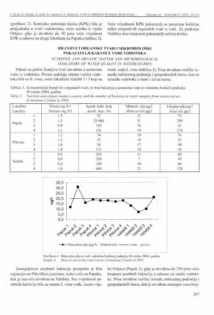
I. Tikvić, D. Punlarić, Ž. Zečić, D. Ugarković, Z. Seletković: UTJECAJ BRDSKIH ŠUMSKIH EKOSUSTAVA Šumarski list - SUPLEMENT (2005), 202-218
(grafikon 2). Kemijska potrošnja kisika (KPK) bila je podjednaka u svim vodotocima, osim uzorka iz rijeke Orljave gdje je utvrđena do 30 puta veća vrijednost KPK u odnosu na druge lokalitete na Papuku (tablica 2).
Veće vrijednosti KPK pokazatelj su povećane količine teško razgradivih organskih tvari u vodi. Za područje Velebita nisu izmjereni pokazatelji režima kisika.
HRANJIVE I ORGANSKE TVARI I MIKROBIOLOŠKI POKAZATELJI KAKVOĆE VODE VODOTOKA
NUTRITIVE AND ORGANIC MATTER AND MICROBIOLOGICAL INDICATORS OF WATER QUALITY IN WATERCOURSES
Nitrati su jedine hranjive tvari utvrđene u uzorcima imali vodu I. vrste (tablica 3). Nisu utvrđene razlike izvode iz vodotoka. Prema sadržaju nitrata većina vodo- medu zaštićenog područja i gospodarskih šuma, kao ni toka bili su II. vrste, osim lokaliteta Velebit 1 i 3 koji su između vodotoka u šumi i izvan šume.
Tablica 3. Koncentracije hranjivih i organskih tvari, te broj bakterija u uzorcima vode iz vodotoka brdskih područja Hrvatske 2004. godine
Table 3 Nutrient and organic matter content, and the number of bacteria in water samples from watercourses in montane Croatia in 2004
Lokalitet Locality
Papuk
Plitvice
Velebit
1 2 3 4 1 2 3 4 1 2 3 4
Nitrati mg N/l Nitrates mg N/l
1,5 1,3 0,9 1,1 1,1 1,2 1,0 1,0 0,4 0,9 0,4 1,0
Aerob, bakt. broj Aerob, bact. No
52 25 860
143 101 74 32 56 121 263 320 189 668
Mineral, ulja u.g/1 Mineral oils fj.g/1
12 31 16 19 18 18 17 18 13 7 10 21
Ukupna ulja u.g/1 Total oils fig/l
74 289 42 276 51 51 48 45 60 45 66 128
t- (r- t- re« ,e> ,<a re. v s. ^ss- ,JS- :<s-^ «Ö* v^° *> *^° v^° \ ^ \£> >.£> \ ^
\ 0- 'b k ^ %• '
< ( & • ^ < ^ ^ ^ ^ ^ ^
tx
Mineralna ulja (U.g/1) - Mineral oils •I. vrsta - species
Grafikon 4. Mineralna ulja u vodi vodotoka brdskog područja Hrvatske 2004. godine Graph. 4 Mineral oils in the watercourses of montane Croatia in 2004
Zastupljenost aerobnih bakterija prosječno je bila najmanja na Plitvičkim jezerima, nešto veća na Papuku, dok je najveća utvrđena na Velebitu. Sve vrijednosti aerobnih bakterija bile su unutar I. vrste vode, izuzev rije
ke Orljave (Papuk 2), gdje je utvrđena do 250 puta veća brojnost aerobnih bakterija u odnosu na ostale vodotoke. Nisu utvrđene razlike između zaštićenog područja i gospodarskih šuma, dok je utvrđena značajno veća broj-
207
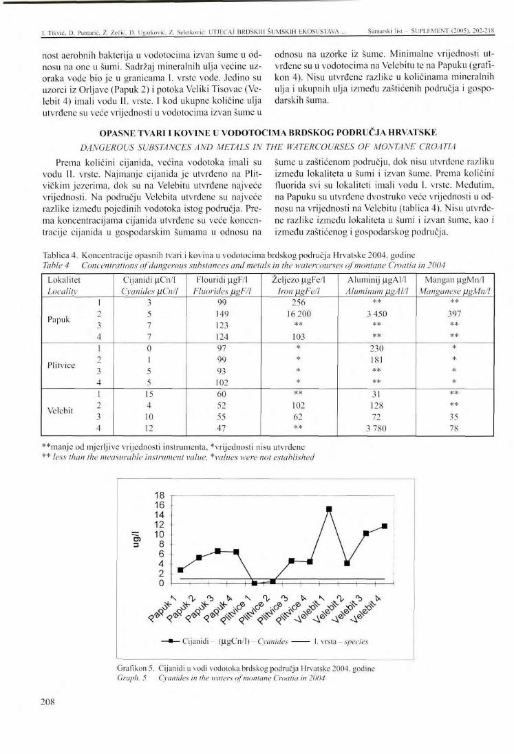
1. Tikvić, D. Puntarić, Ž. Zečić, D. Ugarković, Z. Seletković: UTJRCAJ BRDSKIH ŠUMSKIH EKOSUSTAVA Šumarski list - SUPLEMENT (2005), 202-218
nost aerobnih bakterija u vodotocima izvan šume u odnosu na one u šumi. Sadržaj mineralnih ulja većine uzoraka vode bio je u granicama I. vrste vode. Jedino su uzorci iz Orljave (Papuk 2) i potoka Veliki Tisovac (Velebit 4) imali vodu II. vrste. I kod ukupne količine ulja utvrđene su veće vrijednosti u vodotocima izvan šume u
odnosu na uzorke iz šume. Minimalne vrijednosti utvrđene su u vodotocima na Velebitu te na Papuku (grafikon 4). Nisu utvrđene razlike u količinama mineralnih ulja i ukupnih ulja između zaštićenih područja i gospodarskih šuma.
OPASNE TVARI I KOVINE U VODOTOCIMA BRDSKOG PODRUČJA HRVATSKE DANGEROUS SUBSTANCES AND METALS IN THE WATERCOURSES OF MONTANE CROATIA
Prema količini cijanida, većina vodotoka imali su vodu II. vrste. Najmanje cijanida je utvrđeno na Plitvičkim jezerima, dok su na Velebitu utvrđene najveće vrijednosti. Na području Velebita utvrđene su najveće razlike između pojedinih vodotoka istog područja. Prema koncentracijama cijanida utvrđene su veće koncentracije cijanida u gospodarskim šumama u odnosu na
šume u zaštićenom području, dok nisu utvrđene razliku između lokaliteta u šumi i izvan šume. Prema količini fluorida svi su lokaliteti imali vodu I. vrste. Međutim, na Papuku su utvrđene dvostruko veće vrijednosti u odnosu na vrijednosti na Velebitu (tablica 4). Nisu utvrđene razlike između lokaliteta u šumi i izvan šume, kao i između zaštićenog i gospodarskog područja.
Tablica 4. Koncentracije opasnih tvari i Table 4 Concentrations of dangerous
kovina u vodotocima brdskog područja Hrvatske 2004. godine substances and metals in the watercourses of montane Croatia in 2004
Lokalitet Locality
Papuk
Plitvice
Velebit
1 2 3 4 1 2 3 4 1 2 3 4
Cijanidi uCn/1 Cyanides jlCn/l
3 5 7 7 0 1 5 5 15 4 10 12
Flouridi (igF/1 Fluorides flgF/l
99 149 123 124 97 99 93 102 60 52 55 47
Željezo u.gFe/1 Iron ßgFe/l
256 16 200
**
103 * * * *
** 102 62 **
Aluminij u.gAl/1 Aluminum flgAl/l
** 3 450
** **
230 181 ** ** 31 128 72
3 780
Mangan p.gMn/1 Manganese figMn/l
** 397 ** ** * * * *
** ** 35 78
**manje od mjerljive vrijednosti instrumenta, *vrijednosti nisu utvrđene ** less than the measurable instrument value, *values were not established
3
18 16 14 12 10
8 6 4 2 0
\ N <\ <b ^ - ^ > ^ ,c? > > " / ^ x
,> .jy . ^ .J> > v-S- v-S- v-S-
<?* < r <r <?* <^ <$$- < ^ < ^ A 0 A® A® A'
• Cijanidi (U.gCn/1) - Cyanides . vrsta - species
Grafikon 5. Cijanidi u vodi vodotoka brdskog područja Hrvatske 2004. godine Graph. 5 Cyanides in the waters of montane Croatia in 2004
208
[. Tikvić, D. Punlarić, Ž. Zečić. U. Ugarković. Z. Sclctković: UTJKCAJ BRDSKIH ŠUMSKIH EKOSUSTAVA Šumarski list - SUPLEMENT (2005). 202-218
Željezo i mangan nisu utvrđeni u vodotocima na Plitvičkim jezerima, dok su ekstremne vrijednosti željeza, aluminija i mangana utvrđene u rijeci Orljavi (Papuk 2). Na području Velebita količine metala su u granicama 1. i 11. vrste vode, a ekstremne koncentracije aluminija utvrđene su na lokalitetima izvan šume (potok Tisovac i rijeka Orljava), što odgovara III. do V. vrsti vode.
U grafikonu 5 prikazane su vrijednosti cijanida u vodama iz vodotoka na istraživanim područjima. Vrijednosti cijanida na lokalitetima Plitvice 1 i 2 bile su I. vrste vode, dok su ostali lokaliteti prema sadržaju cijanida imali II. vrstu vode.
RASPRAVA - Discussion
Praćenje stanja kakvoće površinskih voda regulirano je različitim kriterijima i sustavima klasifikacije voda. Obično se voda raspodjeljuje prema kakvoći u pojedine vrste koje uvjetuju njenu uporabu za određenu namjenu. Takva se podjela temelji na uspoređivanju fizikalnih,
kemijskih, bioloških i mikrobioloških pokazatelja s graničnim vrijednostima propisanim za određenu vrstu vode (NN 77/98). Zbog unošenja štetnih i drugih tvari u površinske vode dolazi do promjene u kakvoći voda, čime se ograničava njena uporaba.
Kakvoća vode u Republici Hrvatskoj -Sustavno praćenje kakvoće voda u Hrvatskoj postoji
na nekim mjernim postajama od 60-tih godina. Kao referentna godina za opis stanja kakvoće površinskih voda rijeka, izvorišta i jezera uzima se 2000. godina (Sur-m a n o v i ć et al., 2003). Prema rezultatima ocjene kakvoće vode vodotoka, izvorišta i jezera tijekom 2000. i 2001. godine, a prema režimu kisika, hranjivim tvarima i biološkim pokazateljima, vode u Hrvatskoj su većinom II. i III. vrste (dobre i umjereno dobre kakvoće), a prema mikrobiološkim pokazateljima III. i IV vrste (odnosno umjereno dobre do slabe kakvoće), a na oko 10 % mjernih postaja V vrste (loše kakvoće). Na krškom području Hrvatske zbog smanjenih gospodarskih aktivnosti kakvoća vode zadovoljava (M i 1 k o v i ć et al., 2003). Kakvoća vode izvorišta ukazuju ne samo na stanje kakvoće u samom izvorištu, nego i na stanje vode vodonosnika. Voda izvorišta mora zadovoljavati kriterije I. vrste. Ocjena kakvoće izvorišta 2000. i 2001. godine ukazuje na najveća odstupanja od planirane I. vrste vode zbog povišenih vrijednosti mikrobioloških pokazatelja. Prema
Water quality in the Republic of Croatia većini ostalih pokazatelja kakvoće vode, većina izvorišta pripada I. ili. vrsti vode (Milković etai, 2003).
Stanje voda u Hrvatskoj je zadovoljavajuće, jedino su veća odstupanja u kakvoći vode uočena u blizini većih urbanih ili industrijskih središta, kao i u blizini većih poljoprivrednih površina, te važnijih prometnih pravaca. Rezultati ispitivanja površinskih voda u Hrvatskoj, te podzemnih voda Grada zagreba, u 2001. godini ukazuju, kao i prethodnih godina, na određena odstupanja od planirane kakvoće vode (Širac et al, 2003). Kakvoća vode većine površinskih vodotoka narušena je zbog ispuštanja nepročišćenih otpadnih voda iz naselja i industrije, dok se kakvoća podzemne vode smatra zadovoljavajućom. Primijećuju se utjecaji zagađivanja vode zbog poljoprivrednih aktivnosti i ispuštanja otpadne vode u vodotoke. U Hrvatskoj se pročišćava vrlo mali dio otpadnih voda. Zbog toga su rijeke u panonskom području Hrvatske najčešće za jednu razinu kakvoće ispod željene, uglavnom zbog bakterijskog onečišćenja (Milković et al, 2003).
Tablica 5. Kakvoća vode mjernih postaja državne mreže za praćenje kakvoće vode i istraživanih vodotoka brdskih šumskih ekosustava
Table 5 Water quality in measuring stations of the state monitoring water quality network and the studied watercourses in montane forest ecosystems
Lokaliteti Localities
Rijeka Orljava - River Orljava Vodotoci - Papuk - Watercourses - Papuk Jezero Kozjak Lake Kozjak Vodotoci - Plitv. jezera - Watercourses - Plitv. Lakes Rijeka Lika - River Lika Vodotoci - Velebit - Watercourses - Velebit
Zadano Prescribed
II 11 II U II 11
Režim kisika
Oxygen regime
III I II II / I
Hranjive tvari
Nutritive substances
V II III II / I
Mikrobiološki pokazatelji
Microbio logic a I indicators
V 1
III I / I
Biološki pokazatelji Biological indicators
* * / * * *
* vrijednosti nisu utvrđene, kurzivom su prikazane mjerne postaje državne mreže * no values were found, the state network measuring stations are indicated in italics
209
I- Tikvić, D. Puntarić. Ž. Zečić, D. Ugarković, Z. Seletković: UTJECAJ BRDSKIH
U tablici 5 prikazani su pokazatelji kakvoće vode vodotoka iz brdskih šumskih ekosustava i uspoređeni s podacima državne mreže za praćenje kakvoće vode u Hrvatskoj iz 2000. godine. Za usporedbu, uzeti su s lokaliteta koji su najbliži istraživanim vodotocima brdskih šumskih ekosustava.
Prema tablici 5 vode na području Velebita najbolje su kakvoće prema svim pokazateljima, iako su prema Glavaču et al. (1985) bukove i bukovo-jelove šume Dinarskog gorja izložene jakom imisijskom onečišćenju. To su potvrdili u svojim istraživanjima Prpić (1987), Mar t inov ić et al. (1988), Se le tkov ić (1990), Komlenović et al. (1991), Mayer (1989), Vrbck et al. (1991, 2002. 2004) i dr. S obzirom na veliku šumovitost tog područja i veliku kakvoću vode može se zaključiti da su šumski ekosustavi prirodni pročišćivači vode. Na području Plitvica i Papuka vode su malo onečišćene i ne prelaze II. vrstu voda. Na mjernim postajama državne mreže koje su u pravilu u naseljima, utvrđeno je onečišćenje u vrijednostima za III. i
Kakvoća vode u vodotocima Water quality of watercourses
Kiselost vode potječe uglavnom od ugljične kiseline i organskih i mineralnih kiselina. Prirodne vode imaju pH približno od 6 do 8. Raspon pH vrijednosti istraživanih vodotoka i izvorišta bio je od 6,4 do 8,1. Električna vodljivost je proporcionalna količini otopljenih tvari u vodi. Kemijski čista voda ima malu električnu vodljivost, dok se s povećanjem sadržaja otopljenih minerala ona povećava. Prosječno najveće vrijednosti električne vodljivosti utvrđene su u vodotocima na području Plitvičkih jezera. Općenito su zabilježene veće vrijednosti električne vodljivosti vode u šumskim ekosustavima zaštićenih područja (nacionalni park) u odnosu na vodu iz gospodarskih šuma, dok nisu utvrđene razlike između vodotoka u šumi i izvan šume.
Zasićenost kisikom posljedica je izostanka mikroorganizama u vodi. Minimalna zasićenost kisikom na istraživanim lokalitetima bila je 86 %, a minimalna količina otopljenog kisika 7,19 mg02/l. Kada se ti rezultati usporede sa rezultatima analiza voda na području Hrvatske (Hrvatske vode, 2002) uočava se znatno povoljnije stanje kakvoće vode u vodotocima šumskih ekosustava u odnosu na vodotoke u urbanim područjima.
Od hranjivih tvari u značajnim količinama utvrđeni su samo nitrati. Nitrati su bitni za rast algi i mikroorganizama. Kada su te vrijednosti male, smanjen je razvoj tih organizama, a voda je prozirna i čista. Izostanak amonijaka, nitrita i fosfora pokazatelj je izostanka biološke aktivnosti, rasta algi i fitoplanktona te eutrofikaci-je, što utječe na veću bistroću vode u potocima. Izostanak hranjivih tvari u istraživanim potocima posljedica je neposredne blizine izvora, zasjene vodotoka krošnjama
ŠUMSKIH EKOSUSTAVA ... Šumarski list SLIPLHMÜNT (2005). 202-218
V. vrstu vode (Hrvatske vode, 2002) te je razlika između kakvoće vode u naseljima i šumskim ekosustavima jasno uočljiva.
U ovom su istraživanju obuhvaćena tri izvorišta na području Velebita (lokaliteti 1, 2 i 3). S obzirom na fizi-kalno-kemijske pokazatelje i režim kisika oni pripadaju I. vrsti vode. S obzirom na hranjive i organske tvari te mikrobiološke pokazatelje, izvorišta na području Velebita pripadaju I. vrsti vode uz iznimku izvorišta na lokalitetu Velebit 2 (šuma obične smreke) koji prema koncentraciji nitrata pripada II. vrsti vode. Prema koncentracijama flourida, aluminija i željeza (NN 78/98) izvorišta imaju I. vrstu vode, uz iznimku izvorišta Velebit 2 koji prema koncentracijama željeza ima II. vrstu voda. S obzirom na koncentracije cijanida izvorišta na Velebitu imaju II. vrstu voda. Prema većini parametara kakvoće vode izvorišta brdskih šumskih ekosustava bila su I. vrste vode (uz iznimku cijanida), što potvrđuje pozitivan utjecaj šumskih ekosustava na kakvoću vode.
brdskih šumskih ekosustava in montane forest ecosystems drveća te izostanka ljudskog utjecaja. Koncentarcija nitrata na lokalitetu Velebit 4, (potok Tisovac, poljoprivredno i djelomično šumsko područje) bila je dva i pol puta veća od vrijednosti na lokalitetima Velebit 1 i 3 (izvor tog potoka u šumi bukve i jele). Nešto veće vrijednosti nitrata zabilježeni su u vodotocima izvan šume (rijeka Orljava i potok Tisovac). Prema Binkley et al. (1999) također su utvrđene nekoliko puta veće koncentracije nitrata u vodotocima poljoprivrednih područja u odnosu na vodotoke u šumskim područjima. Međutim gospodarenje šumama može utjecati na kakvoću vode u vodotocima brdskih područja. Rosen et al. (1996) istraživali su utjecaj gospodarenja šumama na kakvoću vode u vodotocima. Na jednom dijelu šumskog područja napravili su čistu sječu, a drugi dio šumskog područja bio je bez utjecaja (kontrola). Utvrdili su povećanu koncentraciju kalija (K+), amonijevih iona (NH4
+), dušikovog okskida (N03"), organskog i ukupnog dušika u vodotocima šumskog područja gdje su provedeni gospodarski zahvati, dok su promjene u koncentracijama kalcija (Ca2"), magnezija (Mg2'), natrija (Na+), sulfata (S04
2~) i klora (Cl) bile manje izražene. Najveći negativni utjecaj čistih sječa odnosio se na ispiranje, uglavnom nitrata i fosfata u podzemne i površinske vode.
Pesticidi koji se sve više upotrebljavaju u poljoprivredi nisu utvrđeni u istraživanim vodotocima. Razlog tomu je ekstezivna poljoprivredna proizvodnja u brdskim područjima Hrvatske. Povećena koncentracija bakterija u rijeci Orljavi ukazuje na onečišćenje voda izvan šumskih ekosustava u blizini naselja i prometni-
210
I. Tikvić, P. Puntane. Ž. Zečić, D. Ugarković, /.. Seletkovic: UTJECAJ BRDSKIH ŠUMSKIH KKOSUSTAVA ... Šumarski list - SUPLLMENT (2005). 202-218
ca. Veći sadržaj ulja također je utvrđen u uzorcima Papuk 2 i 4, kao i Velebit 4, koji su svi izvan šume.
Metali su utvrđeni u vrlo malim koncentracijama, a samo je koncentracija željeza bila povećana. U rijeci Orljavi utvrđeno je 160 puta više željeza od dopuštene vrijednosti, što se tumači utjecajem okolnih poljoprivred-
Monitoring kakvoće voda -S ciljem uspostavljanja uspješnog monitoringa utje
caja brdskih šumskih ekosustava na kakvoću voda, posebnu pozornost treba obratiti na odabir mjernih postaja, dinamiku uzorkovanja, mjerne pokazatelje, razvoj baza podataka o kakvoći voda i dr. Hrvatske šume d.o.o., gospodare šumama koje pokrivaju više od treći-
ZAKLJUČCI -1. Voda iz vodotoka na području Papuka bila je I vrste
prema fizikalno-kemijskim, mikrobiološkim i biološkim pokazateljima, a prema sadržaju hranjivih tvari II. vrste, uz iznimku rijeke Orljave, koja je imala vodu III. vrste. Od opasnih tvari utvrđeni su cijanidi i mineralna ulja u količinama koje su propisane za II. vrstu vode.
2. Voda vodotoka na području Plitvica također je bila I. vrste prema fizikalno kemijskim mikrobiološkim i biološkim pokazateljima, a prema režimu kisika i sadržaju hranjivih tvari II. vrste. Vodotoci iz Nacionalnog parka Plitvička jezera imali su vodu velike kakvoće. Od opasnih tvari utvrđeni su cijanidi u količinama koje su propisane za I. i II. vrstu vode.
3. Voda vodotoka na području Velebita je prema većini pokazatelja bila I. vrste. Od opasnih tvari na području Velebita također su utvrđeni cijanidi u količinama koju se propisane za I. i II. vrstu vode. Vode na području Velebita su prema svim mjerenim pokazateljima bile najbolje kakvoće.
4. Utvrđeno je povoljnije stanje kakvoće vode u vodotocima različitih šumskih ekosustava. Vodotoci izvan šume su imali veće koncentracije aerobnih bak-
nih i urbanih područja. Aluminij je utvrđen u najvećem broju uzoraka, a najveće koncentracije utvrđene su u uzorcima Papuk 2 i Velebit 4. Oba lokaliteta su izvan šume i u blizini naselja, utjecana prometom i okolnim poljoprivrednim površinama. Što se tiče mangana, nisu utvrđene veće vrijednosti od dopuštenih za I. vrstu vode.
- Water quality monitoring ne ukupne kopnene površine Hrvatske, stoga je nužno evidentirati, kartirati i zaštiti značajne vodne resurse koji se nalaze u tim šumama. Nakon toga nužno je uspostaviti organizirani monitoring fizikalnih, kemijskih i bioloških obilježja voda u sklopu državne mreže (M i 1 -ković etal.,2003.).
- Conclusions terija, ukupnih ulja i aluminija u usporedbi s vodotocima u šumskim ekosustavima.
5. Uspoređujući kakvoću vode u gospodarskim šumama s onima u zaštićenom području, nisu utvrđene značajne razlike. Samo su koncentracije cijanida bile veće u vodotocima gospodarskih šuma, te se može zaključiti kako gospodarenje šumama nema nepovoljan učinak na kakvoću vode vodotoka.
6. Stanje kakvoće voda na istraživanom području je zadovoljavajuće. Ono je puno povoljnije od stanja kakvoće voda izvan šuma. Veća odstupanja u pojedinim pokazateljima kakvoće vode (hranjivim tvarima i mikrobiološkim pokazateljima) utvrđena su na području većih urbanih sredina i poljoprivrednih površina (rijeka Orljava), te nešto manja na području jezera u nacionalnom parku Plitvička jezera zbog utjecaja intenzivnog turizma.
7. Unatoč velikoj kakvoći vode vodotoka u šumskim ekosustavima, na većini lokaliteta vodotoci su imali vrijednosti cijanida za II. vrstu vode, stoje posljedica velikog zračnog onečišćenja. To također znači da bistre i čiste vode vodotoka brdskih šumskih ekosustava nisu potpuno čiste i pogodne za piće.
Mjere zaštite kakvoće vode - W Temeljni cilj pri planiranju zaštite voda je očuvanje
još uvijek čistih voda (očuvanje postojeće kakvoće voda), tj. izvorišta, gornjih tokova rijeka u brdskim predjelima te podzemnih voda (NN 107/95). Glavna je svrha tih mjera spriječiti ili smanjiti rizik onečišćenja izvorišta ili vodocrpilišta. Najznačajniji kriterij pri određivanju granica zaštitnih zona je brzina širenja onečišćenja u vo-donosnom sloju prema vodocrpilištu. Zaštitne zone kod pasivne zaštite sprječavaju samo bakteriološke i konvencionalne oblike onečišćenja pitke vode (lako raz-gradljive organske tvari, amonij, nitriti, itd.), dok ne utječu na onečišćenja s nerazgradivim ili teško razgradi-
er quality protection measures vim tvarima (nitrati, pesticidi, organska otapala i teške kovine). Sume mogu apsorbirati teške metale posebice u zakiseljenim tlima ili tlima s malim sadržajem organske tvari, te je nužno trajno postojanje šuma oko izvorišta kao prirodnog pročistača voda. Program prostornog uređenja Republike Hrvatske (NN 50/99) predvidio je održivo gospodarenja vodama i upravljanja sustavom vodoopskrbe, s posebnom pozornošću na zaštitu izvorišnih zona, s ciljem očuvanja postojeće kvalitete voda. Takvo očuvanje podrazumijeva zaštitu voda na prirodan način, posebno u zonama izvorišta gdje šume mogu imati odlučujuću ulogu.
211
I. Tikvić. D. Puntarić, Ž. Zečić. D. Ugarković. 2. Selctković: UTJECAJ BRDSKIH ŠUMSKIH EKOSUSTAVA ... Šumarski list - SUPLEMENT (2005), 202-218
ZAHVALA - Acknowledgement: Zahvaljujemo se djelatnicima Nacionalnog parka zdravstvo grada Zagreba, koji su nam pomogli kod uz-
Plitvička jezera, Uprave šuma podružnica Požega i orkovanja i analize uzoraka vode. Uprave šuma podružnica Gospić, te Zavoda za javno
LITERATURA - References A n d e r s s o n , F. O., K. H. Fcger , R. F. Hü t t l , N.
Kräuch i , L. Ma t t s son , O. S a l i n a s , K. S jöbe rg , 2000: Forest ecosystem research -priorities for Europe, Forest Ecol. Manage. 132 (1):111-119.
Bäumle r , R., W. Zech, 1999: Effects of forest thinning on the streamwater chemistry of two forest watersheds in the Bavarian Alps, Forest Ecol. Manage. 116 (1-3): 119-128.
B ink ley , D., H. Burnham, L. H. Al l en , 1999: Water quality impacts of forest fertilization with nitrogen and phosphorus, Forest Ecol. Manage. 121 (3): 191-213.
F i l i pan , T, B. P rp ić , N. Ruž insk i , 1996: Štetne posljedice viška N- spojeva u ekosustavu šuma i opskrba pitkom vodom, Šumarski list 9-10: 411-418.
G l a v a č , V., H. K o e n i c s , B . P rp ić , 1985: O unosu zračnih polutanata u bukove i bukovo-jelove šume Dinarskog gorja sjeverozapadne Hrvatske, Šumarski list 9-10: 429-447, Zagreb.
Hrvatske vode, 2002.: Izvještaj o ispitivanju kakvoće voda u Republici Hrvatskoj u 2000 godini.
Kom lenović , N., B. Mayer, P. Ras tovsk i , 1991: Opterećenost kultura crnog bora (Pinus nigra Am) na području Istre sumporom i teškim metalima, Šumarski list 11-12: 451-461, Zagreb.
M a r t i n o v i ć , J., B. Vrbek, 1988: Istraživanje imi-sijske acidifikacije tala u Hrvatskoj, radovi Šumarskog instituta 75: 177-181, Zagreb.
Mayer , B., 1989: Antropogeni i prirodni protoci tvari u šumskom ekosistemu, Šumarski list 6-8: 299-313, Zagreb.
Mi lkov ić , I., M. S ta rčev ić , M. Pcča rcv ić , 2003: Uloga šumarstva u nacionalnom programu evidentiranja, zaštite i očuvanja slatkiv voda Republike Hrvatske, Šumarski list 5-6: 219-229, Zagreb.
Program prostornog uređenja RH. Narodne novine, br. 50, Zagreb, 1999.
P rp ić , B., 1987: Sušenje šumskog drveća s posebnim osvrtom na opterećenje Gorskog kotara kiselim kišama i s teškim metalima, Šumarski list 1-2: 52-60, Zagreb.
P rp i ć , B.,Z. S e l c t k o v i ć , J. Vukc l i ć , 1994: Promjena dosadašnjih sustavnih istraživanja propadanja šuma kod procjene kemijske opterećenosti
susjednih poljodjelskih prostora Hrvatske, Šumarski list 9-10: 283-288, Zagreb.
Rosen , K., A. J. Ar son , M. H. E r i k s s o n , 1996: Effects of clear - cutting on streamwater quality in forest catchments in central Sweden, Forest Ecol. Manage. 83 (3): 237-244.
S e l e t k o v i ć , Z., 1990: Utjecaj industrijskih polutanata na običnu bukvu (Fagus sylvatica L.) u šumskim ekosistemima Slavonskog gorja, Doktorska disertacija, Zagreb.
S t a r č e v i ć , M., 2000: Značaj šuma u konceptu održivog gospodarenja vodama, Šumarski list 3-4: 210-211, Zagreb.
Statistički ljetopis 2003. Republika Hrvatska - Državni zavod za statistiku, str. 264.
Širac ,S. ,G. Mi rkov i ć ,N . Bujaš , 2003: Kakvoća voda u Republici Hrvatskoj 2000-2001. godina, Zbornik radova 3. hrvatske konferencije o vodama, Hrvatske vode u 21. stoljeću, Osijek, Hrvatske vode, str. 463^471, Zagreb.
Šu rmanov ić ,D . ,M.Ar tukov ić ,M.Jok ić , 2003: Uloga monitoringa kakvoće voda u vodno gospodarskom planiranju, Zbornik radova 3. hrvatske konferencije o vodama, Hrvatske vode u 21. stoljeću, Osijek, Hrvatske vode, str. 673-683, Zagreb.
T ikv ić , I, Z. S e l c t k o v i ć , 2003: Utjecaj pošumlja-vanja krša na hidrološku funkciju šuma. Šum. list, Supl. 31-34, Zagreb.
Vrbek, B., M. Vrbek, J. Vuke l i ć , 1991: Zakise-ljavanje i nakupljanje Pb, Cu i Zn u jelovim zajednicama Nacionalnog parka "Risnjak", Šumarski list 3-5: 163-172, Zagreb.
Vrbek, B., 2002: Utjecaj padalina na kemijski sastav tekuće faze tla šumske zajednice hrasta lužnjaka i običnog graba (Carpino betuli-Quercetum ro-boris, Anić 1956 ex. Rauš 1969) u sjeverozapadnoj Hrvatskoj, Disertacija, Šumarski fakultet Sveučilišta u Zagrebu, 1—242, Zagreb.
Vrbek, B., I. P i l a š , V Šoj at, N. M a g d i ć , 2004: Utjecaj kiselih kiša na šumu i tlo u Nacionalnom parku Plitvička jezera, Plitvički bilten 6: 174-200, N.P. Plitvička jezera.
Uredba o klasifikaciji voda, (NN 77/98), Zagreb, 1998. Uredba o opasnim tvarima u vodama, (NN 78/98), Za
greb, 1998. Zakon o vodama (NN 107/95), Zagreb 1995.
212
PRESENTATION AT THE INTERNATIONAL SYMPOSIUM Šumarski list - SUPLEMENT (2005), 202-218
THE IMPACT OF M O N T A N E FOREST ECOSYSTEMS ON WATER QUALITY OF WATERCOURSES
Ivica TIKVIĆ, Dinko PUNTARIĆ, Željko ZEČIĆ, Damir UGARKOVIĆ, Zvonko SELETKOVIĆ*
SUMMARY: In terms of surface area, montane forest ecosystems are the most widely distributed ecosystems in Croatia. As such, they have the greatest impact on water cycle and the quality of surface and ground water. This impact depends on ecological (relief parent substrate, soil and climate) and biological factors (tree species, structure of forest ecosystem and anthropogenic impacts). No research has been made on the effects of particular tree species, soil types, different parent substrates and man on the quality of waters in the forest ecosystems in Croatia. The paper compares indicators of water quality in watercourses from several montane forest ecosystems in Croatia. Differences in water quality were analyzed with reference to site and stand conditions. The general ecological condition of water was determined on the basis of twelve samples from different watercourses in three localities (Papuk, Plitvice and Velebit). The analysis included physical-chemical water condition, nutrient content, metals, organic compounds, mineral oils and other indicators of water quality. No significant differences in physical-chemical indicators were found among the different forest ecosystems. Water quality in almost all the examined watercourses was very high. Compared to the watercourses in forest ecosystems, those in the vicinity of settlements had significantly higher concentrations of nutrients, aerobic bacteria and metals. No differences were found in water quality of the watercourses in the national parks in comparison with those in commercial forests. Variability of water quality indicators from the watercourses in different forest ecosystems indicates the complexity of the effects of forest ecosystems on water quality in watercourses. Compared to the watercourses outside forests, those in forest ecosystems manifested higher water quality regardless of management methods.
Key words: water quality, montane forest ecosystems, national park, commercial forests
INTRODUCTION
With its relatively rich supply of water, Croatia takes up the fifth place in Europe and the 42nd place in the world in terms of quantity and availability of fresh water springs (M i 1 k o v i ć et dl., 3002). According to the 2003 UNESCO records for Croatia, about 60 % of water supply "originates" in Croatia, whereas external contributions from neighboring countries account for
* Asst. Prof. Ivica Tikvić, PhD, Dinko Puntarić, BSc, Željko Zečić, PhD, Damir Ugarković BSc, Prof. Zvonko Seletković, PhD, Faculty of forestry, University of Zagreb
the remaining 40 %. Waters in Croatia are affected by forest ecosystems that cover over one third of the land area of Croatia, of which montane forest ecosystems are the best represented. According to the data of the State Bureau of Statistics (Statistički ljetopis 2003/ Statistical Almanac2003), montane forest ecosystems of European beech, sessile oak, pubescent oak and holm oak, as well as common hornbeam and other hardwoods, cover an area of over 13,000 km2, which accounts for two thirds of the forests or one fourth of the land area in Croatia. They display distinct effects of forest trees on hydrological processes. Natural forest
213
I. Tikvič. D. Puntarić. Ž. Zečić. D. Ugarković. Z. Seletković: TUF. IMPACT OF MONTANIi FOREST ... Šumarski list SUPLEMENT (2005). 202-218
ecosystems are considered the most stable hydro-geological ecosystems on Earth, which is corroborated by preserved soils in hilly and mountainous areas that sustain natural forests, and by clear and clean waters despite considerable aerial pollution and other adverse factors. Precipitation passing through the forest canopy (throughfall), leaf litter and forest soil is naturally purified and reaches underground layers in the form of drinking water. Trees and shrubs intercept precipitation and influence seepage, runoff and percolation (surface and ground runoff), soil erosion, filtering and purification (Tikvić and S e l e t k o v i ć , 2003). This influence depends on the existing ecological and biological factors. The most important ecological factors are relief, parent substrate, soil and climate whereas biological factors include tree species, forest ecosystem structure and anthropogenic impacts. Springs, streams, underground and surface waters largely depend on the condition of the surrounding forest ecosystems. Natural or artificial changes in the condition of a forest ecosystem may cause changes in hydrological processes and chemism of watercourses (Bau ml er and Zech , 1999). According to Ga l l c r (1975; S t a r č e vi ć, 2000), a forest may intercept and purify about 2,000 mJ of water per ha annually. Bearing in view the size of the forested area in Croatia, very large quantities of water are filtered by forest ecosystems annually. However, all ecosystems suffer from continuous and increasing pollution, which is reflected on water quality in forest ecosystems. Harmful effects of polluted air and rain on forest trees, soil, water and the human health have been confirmed by a number of researchers
The goal of research was to assess water quality of watercourses in different forest ecosystems and explore the effects of forest ecosystems on water quality.
(Fi lip an et al, 1996). Prpić et al. (1994) reported contamination of forests and agricultural areas with lead. According to these authors, forest soils are several times more polluted with lead than agricultural soils, which may be attributed to the structure of a forest and its role in water purification. However, B i n k e y et al. (1999) detected nitrate and phosphate concentrations in the watercourses of agricultural areas in the USA that exceeded those in forest watercourses by nine times. Despite increasing pollution in forests, waters in hilly and mountainous watercourses in Croatia have retained their purity and clarity, owing primarily to the positive effect of forest ecosystems.
Hydrological processes in forests are also affected by forest management practices. Proper management with forests sustains the optimal condition of a forest ecosystem and ensures commercial and other forest functions. Management treatments have short-term negative effects on hydrological forest function, but this function is restored several years after thinning and selection cutting (Rosen et al., 1996, Bau ml er and Zech , 1999).
According to Ander s son et al. (2000), the problem of forest water quality is one of the vital priorities in forest ecosystem research. Yet, impacts of a particular tree species, soil type, different parent substrates and man on water quality in forest ecosystem watercourses still remain to be investigated. This paper analyzes waters in montane Croatia and assesses the impact of different forest ecosystems on the quality of water in watercourses.
AND METHODS conductivity) and dissolved oxygen were determined with electrometric analysis, while chemical oxygen demand (COD) was determined with potassium permanganate titration. Nutrients (nitrates and nitrites) were determined spectrophotometrically, and metals were determined with the electrochemical method. Of organic compounds, mineral oils were determined with infrared spectroscopy, while phenols, lindane, polychlorinated byphenils (PCB) and DDT were determined with spectroscopy and gas chromatography. Microbiological indicators, or aerobic bacteria count, were determined by counting bacterial colonies growing on a nutritive medium at 22 °C and 37 °C. According to Water Classification Regulations (NN 77/98) and based on the allowed border values of individual indicators, waters were classified in different categories (I - V).
Another goal was to analyze differences in water quality with regard to site and stand conditions and establish differences in water quality of watercourses in and out
RESEARCH AREA The paper explores water quality of watercourses in
the area of Papuk, the Plitvice Lakes National Park and Velebit. Samples in the area of Papuk were taken from the streams Brzaja and Dubočanka, and from the river Orljava. In the Plitvice Lakes National Park samples were provided by the streams Sušanj and Rječica, and in the area of Velebit from three springs and from the stream Tisovac. Table 1 gives the basic characteristics of the study area.
Indicators of the general ecological water condition (physical-chemical indicators, oxygen regime, nutrients, microbiological and biological indicators), as well as the use of water (metals, organic compounds and radioactivity) were sampled and analyzed using the Croatian norms in the Institute of Public Health of the City of Zagreb. Physical-chemical indicators (pH and electrical
RESEARCH GOAL
214
1. Tikvić. D. Puntane. 2. Zečić. D. Ugarković, Z. Seletković: TI Ili IMPACT OH MONTANE FOREST Šumarski list SUPLEMENT (2005), 202-218
of forest ecosystems. Indicators of water quality in pro- compared in order to determine the effects of forest tected areas and in commercial forests were finally management on water quality.
RESULTS PHYSICAL-CHEMICAL INDICATORS OF WATER QUALITY IN WATERCOURSES
Table 2 shows indicators of physical-chemical features of water from the watercourses in the area of Papuk, Plitvice Lakes and Velebit. With regard to pH values, water samples in all the localities belong to the first category (I), except in the locality of Papuk 1, where water bordered between the first and the second category (I and II) (Fig. 1). On average, the lowest pH values were found in the area of Papuk and the highest in the area of Plitvice Lakes. By localities, the highest differences in pH values of water were found in the watercourses of Papuk, and the smallest in the area of Plitvice Lakes (Tabic 2). Values of pH in the watercourses outside the forest ecosystems did not differ significan
tly from those in the forests. No differences were found in the pH value of water between protected areas and commercial forests.
Electrical conductivity values were the highest in the area of Plitvice Lakes. The majority of the watercourses were in the first (I) water category, except for the localities Plitvice 3 and 4, which were in the second (II) category. The localities Papuk 1 and 2 had significantly lower values of electrical conductivity than other localities. Higher electrical conductivity values were found in the protected area in relation to commercial forests, while no differences were found between the localities in and outside the forest.
OXYGEN REGIME IN WATERCOUSES No differences were found between the localities in
terms of dissolved oxygen values, oxygen saturation and chemical requirements of oxygen, except for the locality Papuk 2, which showed considerable aberration from these indicators in relation to other localities.
In terms of dissolved oxygen, all watercourses contained the first-category water (I), except for the sample from the river Orljava (Papuk 2). Oxygen saturation in the area of Papuk was slightly lower and in Plit
vice Lakes slightly higher, so three samples had water quality of the second category (II) (Fig. 2). Chemical oxygen consumption (COC) was similar in all the watercourses, except for the sample from the river Orljava, where COC values were 30 times higher than those in other Papuk localities (Table 2). Higher COC values indicate an increased content of hardly soluble organic matter in water. No oxygen regime indicators were measured in the area of Velebit.
NUTRITIVE AND ORGANIC MATTER AND MICROBIOLOGICAL INDICATORS OF WATER QUALITY IN WATERCOURSES
Nitrates are the only nutrients found in water samples from the watercourses. In terms of nitrate content, the majority of the watercourses belonged to the second category (II), except for the locality Velebit 1 and 3, whose waters were in the first category (I) (Table 3). No differences were found between the protected area and commercial forests, nor were they found between watercourses in and out of forests.
The average proportion of aerobic bacteria was the lowest in Plitvice Lakes, slightly higher on Papuk and the highest on Velebit. All aerobic bacteria values were within the first-category water, except the river Orljava (Papuk 2), where the quantity of aerobic bacteria exceeded that in other watercourses by up to 250 times. No differences were found between the protected area and
commercial forests, whereas a significantly higher quantity of aerobic bacteria was found in the watercourses outside the forests compared to those in the forests. The mineral oil content in the majority of the samples was within the limits of the first-category water. Only the samples from the Orljava (Papuk 2) and the stream Veliki Tisovac (Velebit 4) had water of the second category. Higher values of total oil quantities were found in the watercourses outside the forests in relation to those in the forests. Minimal values were found in the watercourses on Velebit and on Papuk (Fig. 4). No differences in the quantity of mineral oils and total oils were established between protected areas and commercial forests.
DANGEROUS SUBSTANCES AND METALS IN THE WATERCOURSES OF MONTANE CROATIA In terms of cyanide content, water in the majority of
the watercourses belonged to the second category (II). The least cyanide was registered in Plitvice Lakes, while the most was found on Velebit. Velebit also sho
wed the highest differences between particular watercourses in the same area. In terms of cyanide content, higher cyanide concentrations were found in commercial forests compared to those in the protected area,
215
I. Tikvić, Ü. Puntarić, Ž. Zečić. D. Ugarkovic, Z. Seletković: THE IMPACT OF MONTANE FOREST ... Šumarski list - SUPLEMENT (2005). 202-218
while no differences were found between the localities in and out of the forest. In terms of fluoride, water in all the localities was of the first category. However, twice as high fluoride values were found on Papuk in relation to the values on Velebit (Table 4). No differences were found between the localities in the forest and out of the forest, and neither were there any differences between the protected area and commercial areas.
Iron and manganese were not found in the watercourses of the Plitvice Lakes area, while extreme values of iron, aluminum, and manganese were detected
in the river Orljava (Papuk 2). The quantities of metal in the area of Velebit were within the limits of the first and the second water category, while extreme aluminum concentrations were found in the localities outside forests (the stream of Tisovac and the river Orljava), which correspond to the third - fifth water category.
Figure 5 shows cyanide values in the waters from the watercourses in the study area. Cyanide values in the localities Plitvice 1 and 2 responded to the first-category water, while the other localities had the second-category water in terms of cyanide content.
DISCUSSION Surface water quality monitoring is regulated by a
number of criteria and water classification systems. Water is usually classified into categories on the basis of quality. These categories determine its use for a particular purpose. Such a classification is based on com-
Water quality in the Water quality has systematically been monitored in
several measuring stations in Croatia since the 1960s. The year 2000 is considered the reference year for the description of the quality of surface waters in rivers, springs and lakes (S u r m a n o v i ć et al. 2003). According to the results of water quality assessments in watercourses, springs and lakes during 2000 and 2001, and according to oxygen regime, nutrients and biological indicators, waters in Croatia mostly fall in the second (II) and (III) category (good to moderately good quality), according to microbiological indicators in the third (III) and fourth (IV) category (moderately good to poor quality), but in about 10 % of the measuring stations in the fifth (V) category (poor quality). The quality of water in the karst area of Croatia is satisfactory due to low intensity management activities (M i 1 -ković et al. 2003). Water quality in springs indicates not only the degree of quality in the spring itself but also the condition of water in the aquifer. Spring water must satisfy the first (I) category criteria. The biggest deviations from the planned 1st category were found in quality assessments of spring water in 2000 and 2001 due to increased microbiological indicator values. By the majority of other water quality indicators, most of the springs belong to the first (I) or the second (II) water category (M i 1 k o v i ć et al. 2003).
Water condition in Croatia is satisfactory, except for some bigger deviations in water quality in the vicinity of larger urban or industrial centers, larger agricultural areas and major roads. The 2001 results of testing surface water in Croatia and groundwater in the City of Zagreb indicate, similarly to earlier years, certain deviations from planned water quality (Š i rac et al. 2003). Water quality in the majority of surface watercourses is
parisons of physical, chemical, biological and microbiological indicators with prescribed border values for a particular water type (NN 77/98). Input of harmful and other substances in surface waters changes the quality of water and restricts its uses.
Republic of Croatia impacted by unrecycled municipal and industrial wastewater, while the quality of groundwater is considered satisfactory. Water is polluted by agricultural activities and discharge of wastewater into watercourses. In Croatia, only a very small portion of wastewater is recycled. This is the reason that rivers in the Pannonian area of Croatia are generally one category below the desired quality. Pollution is mostly of bacterial origin (Mi lković etal. 2003).
Table 5 shows water quality indicators of watercourses in montane forest ecosystems and compares them with data from the Croatian monitoring water quality network of 2000. The localities closest to the studied watercourses in montane forest ecosystems were used for comparison.
According to Table 5, waters in the area of Velebit show the highest quality in terms of all indicators, although Glavač etal. (1985) report severe immission pollution of beech and beech-fir forests in the Dinaric range. Research by Prpić (1987), M a r t i n o v i ć et al. (1988), S e l e t k o v i ć (1990), Komlenov ić et al. (1991), Mayer (1989), Vrbek et al. (1991, 2002, 2004), and others confirms the above. Bearing in mind the large degree of forest cover in the area and high water quality, it can be concluded that forest ecosystems are natural water filters. Waters in Plitvice and Papuk are slightly polluted and do not transgress the second (II) water category. Measuring stations of the state monitoring network, situated as a rule in settlements, recorded pollution approaching values for the third (III) and fifth (V) water category (Hrvatske Vode, 2002). Therefore, the difference in water quality in settlements and in forest ecosystems is clearly noticeable. This research included three springs in the area of Ve-
216
I. Tikvić, D. Puntarić, Ž. Zečić. D. Ugarković. Z. Seletković: THE IMPACT OF MONTANE FOREST Šumarski list - SUPLEMENT (2005), 202-21S
lebit (localities 1, 2 and 3). In terms of physical-chemical indicators and oxygen regime, they belong to the first-category water. In terms of nutritive and organic matter, as well as microbiological indicators, the springs in Velebit belong to the first-category water, with the exception of the spring in the locality Velebit 2 (forest of common spruce), which belongs to the second-category water with regard to nitrate concentrations. In terms of fluoride, aluminum and iron concen-
Water quality of watercourses Water acidity is predominantly due to carbon acid
and organic and mineral acids. The pH of natural waters ranges approximately between 6 and 8. The range of pH values in the studied watercourses and springs was from 6.4 to 8.1. Electrical conductivity was proportional to the quantity of dissolved matter in water. Chemically clean water has low electrical conductivity, but it increases with an increase in dissolved mineral content. The highest average values of electrical conductivity were found in the watercourses in the area of Plitvice Lakes. In general, higher values of water electrical conductivity were recorded in forest ecosystems of protected areas (national park) than in water from commercial forests. No differences were found between the watercourses in and out of forests.
Oxygen saturation is the consequence of the absence of microorganisms in water. Minimum oxygen saturation in the studied localities was 86 %, and minimum quantity of dissolved oxygen was 7.19 mg02/l. When these results are compared with the results of water analyses in the area of Croatia (Hrvatske Vode, 2002), water quality in forest ecosystem watercourses is significantly better than in the watercourses in urban areas.
Of nutrients, only nitrates were found in considerable quantities. Nitrates are essential for the growth of algae and microorganisms. When nitrate values are low, the growth of these organisms is reduced, and the water is clear and clean. The absence of ammonia, nitrites and phosphorus indicates the absence of biological activity, growth of algae and phytoplankton, and eutrophication, which has a positive effect on the clarity of water in streams. The absence of nutrients in the studied watercourses is due to the immediate vicinity of springs, shade provided by tree crowns and lack of human impacts. Nitrate concentrations in the locality Velebit 4 (the stream Tisovac, agricultural and partially forested area) were two and a half times higher compared to the values in the localities Velebit 1 and 3 (the source of this stream in the forest of beech and fir). So-
trations (NN 78/98), the springs have water in the first category, with the exception of the spring Velebit 2, where water is in the second category owing to iron concentrations. With regard to the majority of water quality parameters (with the exception of cyanide), spring water in montane forest ecosystems belonged to the first category, which confirms the positive effect of forest ecosystems on water quality.
in montane forest ecosystems mewhat higher nitrate values were recorded in the watercourses out of forests (the river Orljava and the stream Tisovac). According to B ink 1 ey et al.{\999), several times higher nitrate concentrations were recorded in the watercourses in agricultural areas in relation to those in forest areas. However, forest management may have an effect on water quality in montane watercourses. One part of the forest area was clearcut and the other part was left unaffected (control). There were increased concentrations of potassium (K+), ammonia ions (NH4
T), nitrogen oxide (N03~), organic nitrogen and total nitrogen in forest watercourses where management treatments were applied, whereas changes in the concentration of calcium (Ca~+), magnesia (Mg"+), sodium (Na+), sulphate (S04~~) and chlorine (CI) were less distinct. The highest negative impact of clearcut-ting referred to leaching, mostly of nitrates and phosphates, into ground and surface waters.
Despite the increasing use of pesticides in agriculture, no pesticides were found in the studied watercourses. The reason is extensive agricultural production in montane Croatia. Increased bacteria concentrations in the river Orljava indicate polluted waters outside forest ecosystems and in the vicinity of settlements and roads. Higher oil content was also recorded in the samples Papuk 2 and 4, as well as Velebit 4, which are all outside the forest.
Metals were found in very low concentrations, with the exception of increased iron concentrations. The amount of iron in the river Orljava exceeded the allowed value by 160 times, which is attributed to the impact of the surrounding agricultural and urban areas. Aluminum was found in the largest number of samples, and the highest concentrations were recorded in the samples Papuk 2 and Velebit 4. Both localities are outside the forest and near human settlements and are affected by traffic and the adjacent agricultural areas. As for manganese, no values exceeding the allowed values for the first-category water were detected.
Water quality monitoring To establish successful monitoring of the effects of stations, sampling dynamics, measuring indicators, de-
montane forest ecosystems on water quality, special at- velopment of water quality databases, etc. The compa-tention should be paid to the selection of measuring ny Hrvatske Šume manages forests covering over one
217
I. Tikvić. D. Puntane, Ž. Zečić. D. Ugarković. Z. Seletković: THE IMPACT OF MONTANE FOREST , Šumarski list SUPLEMENT (2005). 202-218
third of the total land area of Croatia. It is necessary to physical, chemical and biological water features shou-register, map and protect significant water resources in Id be established within the state network (M i 1 k o v i ć these forests. Following this, organized monitoring of etal. 2003).
Water quality protection measures The primary goal in planning water quality protec
tion is to preserve the still clear waters (preserve the existing water quality) in springs, upper river courses in montane areas, and in underground waters (NN 107/95). The main purpose of these measures is to prevent or reduce the risk of pollution to springs or water pumps. The most important criterion in determining the boundaries of protected areas is the rate of pollution spread in the aquifer towards the water pump. Protective zones within passive protection programs prevent only bacteriological and conventional forms of pollution of drinking water (easily dissolved organic matter, ammonia, nitrites, etc.), but do not affect pollution with undissolved or hardly dissolved substances
(nitrates, pesticides, organic dissolvents and heavy metals). Since forests are capable of absorbing heavy metals, especially in acid soils or soils with low organic matter contents, it is vitally important to retain them permanently around the sources in the capacity of natural water filters. The spatial plan program of the Republic of Croatia (NN 50/99) envisages sustainable management with water and water supply systems and places particular emphasis on the protection of source zones with the aim of preserving the current water quality. Such preservation refers to natural water protection, especially in source zones where forests may play a decisive role.
CONCLUSIONS 1. Water from the watercourses in the area of Papuk
was in the first quality category in terms of physical-chemical, microbiological and biological indicators, and in the second quality category in terms of nutrient content, with the exception of the river Orljava, whose water was in the III category. The detected harmful substances included cyanides and mineral oils in the quantities prescribed for the II water category.
2. Water from the watercourses in the area of Plitvice was also in the first category in terms of physical-chemical, microbiological and biological indicators, and in the second quality category in terms of oxygen regime and nutrient content. Water from the watercourses in the Plitvice Lakes National Park was of high quality. Harmful substances included cyanides in quantities prescribed for the first and second water category.
3. According to the majority of indicators, water quality in the watercourses from Velebit was in the first category. Harmful substances in the area of Velebit also included cyanides in quantities prescribed for the first and second water category. According to all the measured indicators, waters in the area of Velebit were of the best quality.
4. Water in the watercourses of different forest ecosystems was found to be of better quality. Watercourses
outside forests had higher concentrations of aerobic bacteria, total oils and aluminum in comparison with watercourses in forest ecosystems. No significant differences were found by comparing the quality of water in commercial forests with that in protected areas. The only difference was the higher cyanide concentrations found in the watercourses in commercial forests. It can be concluded that forest management does not have an unfavourable effect on the quality of water in watercourses. Water quality in the study area is satisfactory. It is much better than the quality of water outside forests. Some major deviations in individual water quality indicators (nutritive matter and microbiological indicators) were found around larger urban centers and in agricultural areas (the river Orljava), and slightly less in the lake area of the Plitvice Lakes National Park, which is attributed to the impacts of intensive tourism. Despite the high water quality of the watercourses in forest ecosystems, watercourses in the majority of the locations had higher cyanide values for the second category, which is the consequence of intensive air pollution. This also means that clear and clean water in the watercourses of montane forest ecosystems is not completely clean and suitable for drinking.
ACKNOWLEDGEMENT: We would like to thank the employees of the Plitvi
ce Lakes National Park, the Forest Administration Požega and the Forest Administration Gospić, as well
as the Institute of Public Health of the City of Zagreb for their invaluable help in sampling and analyzing water samples.
218
IZLAGANJE NA ZNANSTVENOM SKUPU PRESENTATION AT THE INTERNATIONAL SYMPOSIUM Šumarski list SUPLEMENT (2005), 219-228 UDK 630* 181.3
PROCJENA RIZIKA K O D E K S T R E M N I H HIDROLOSKIH STANJA SLUČAJ SLIVOVA V S E M I N K E I DREVNICE, REPUBLIKA ČEŠKA
RISK ASSESSMENT OF EXTREME HYDROLOGICAL SITUATIONS CASE STUDY OF THE VSEMINKAAND DREVNICE CATCHMENTS, CZECH REPUBLIC
Pavel KOVÄR*
SAŽETAK: Primjena modela vodne ravnoteže daje mogućnost identifikacije ekstrema u procesima padavina/otjecanja. Naime, sadržaj vlage u tlu u gornjoj zoni malih vodnih slivova može hiti pokazatelj potencijalnih poplava ili suša. Ove se zone gornjih slivova (0.20 m—0.60m) obično nazivaju "aktivnim zonama " i jako utječu na oblikovanje izravnog otjecanja, posebice kada je njihov sadržaj vlage blizu zasićenja ili vodi prema suši, kada je iscrpljen sadržaj vode. I šumsko gospodarenje, te dobra šumarska praksa, igraju značajnu ulogu u procesima padavina/otjecanja tj. u procesima održavanja vode u gornjim slojevima slivova. Ova je uloga još važnija u malim slivovima s jako fluktuirajućim izlijevanjima vode.
Članak prikazuje kako se može izvesti simulacija ovih hidroloških procesa primjenom modeliranja vodne ravnoteže. U tu svrhu primijenjen je model WBCM-5 (Water Balance Conceptual Model version 5), u jednodnevnim fazama na nekoliko pokusnih slivova u Republici Češkoj.
Prikazana su dva predpoplavna razdoblja tik pred katastrofalnim poplavama u srpnju 1997. Isto tako, iz povijesnih su zapisa identificirana razdoblja suše. Sušni se trendovi mogu naći primjenom modela, pokazujući kako su osjetljivi slivovi u bezpadavinskim razdobljima. Konceptualni sadržaj vlage u tlu odnosi se na API indeks (Antecedent Precipitation Index). Kvantitativna studija također je izrađena o utjecaju uporabe zemljišta i gospodarenja na izravnu formaciju otjecanja i na nadoknadu podzemne rezerve.
U radu se prikazuju rezultati modela za poplavno razdoblje iz srpnja 1997. u dva pokusna moravska sliva, Vseminka (48 %šume) i Drevnice (81 % šume) te ih uspoređuje s onima iz sliva Rokvtenka (24 % šume) u istočnoj Češkoj. Vidljivo je da dubina aktivne zone u slivu ima dominantan utjecaj na stupanj rizika od poplave i/ili suše. Ovi se hidrološki ekstremi mogu reducirati djelomično i samo u maloj mjeri. Međutim, racionalno gospodarenje slivom i dobro orgnaizirana uporaba zemljišta temeljena više na zaštitnu funkciju nego na proizvodnju, preduvjet je za zaštitu od opasnih hidroloških pojava s katastrofalnim posljedicama.
KIjučne riječi: model vodne ravnoteže, prethodni uvjeti vlage, hidrološki ekstremi, deficit vlage u tlu, scenarij simulacije
* Pavel Koväf, Češko poljoprivredno sveučilište Prag, Fakultet šumarstva i okoliša, Kamycka 129, 165 21 Prague 6-Suchdol, Czech Republic, E-mail: [email protected]
219
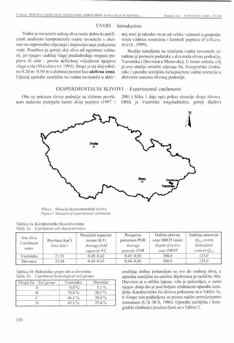
P. Kovan PROCJENA RIZIKA KOD EKSTREMNIH MIDROLOŠKIH STANJA SLUČAJ SLIVOVA ... Šumarski list SUPLEMENT (2005), 219-228
U V O D - Introduction
Vodna se ravnoteža nekog sliva može dobro kvantifi-cirati analizom komponenata vodne ravnoteže s obzirom na neposredno otjecanje i dopounjavanje podzemne vode. Posebice je gornji sloj sliva od ogromne važnosti, jer njegov sadržaj vlage predodređuje moguće poplave ili suše - prema deficitnoj vrijednosti njegove vlage u t l u ( M a i d m e n t 1993). Stoga je taj sloj (obično 0.20 m-0.50 m u dubinu) poznat kao aktivna zona. Utjecaj uporabe zemljišta na vodnu ravnotežu u aktiv
noj zoni je također stvar od velike važnosti u gospodarenju vodnim resursima i kontroli poplave ( F a l k e n m a r k , 1999).
Studija temeljena na izračunu vodne ravnoteže izrađena je pomoću podataka s dva mala slivna područja, Vseminka i Drevnice u Moravskoj. U širem smislu, cilj je ove studije istražiti utjecaje tla, fiziografske čimbenike i uporabe zemljišta na kapacitete vodne retencije u aktivnim zonama slivnog područja.
EKSPERIMENTALNI SLIVOVI - Experimental catchments
Oba su pokusna slivna područja sa sličnom površinom nedavno pretrpjela barem dvije poplave (1997. i
2001.) Slika 1 daje opći prikaz situacije dvaju slivova. Oblik je Vseminkc longitudinalan, gornji dijelovi
N
Slika 1. Situacija eksperimentalnih slivova Figure I Situation of experimental catchments
Tablica la. Karakteristike tla u slivovima Table I a. Catchment soil characteristics
Ime sliva Catchment
name
Vseminka Drevnice
Površina (km") Area (km')
21,51 22,58
Prosječni kapacitet terena (KT)
Average field capacity FC 0,40-0,42 0,40-0,43
Prosječna poroznost POR
Average porosity POR
0,45-0,50 0,44-0,48
Dubina aktivne zone DROT (mm)
Depth of active zone DROT
300,0 300,0
Sadržaj saturacije QSAT (mm) Saturation content QSÄT
123,0 125,0
Tablica lb Hidrološke grupe tala u slivovima Table 1 b. Catchment hydrological soil groups
Grupa tla - Soil group A B C D
Vseminka 0,0 %
10,8 % 46,1 % 43,1 %
Drevnice 5,1%
30,5 % 39,0 % 25,4 %
središnje doline pošumljeni su sve do vodnog sliva, a uporaba zemljišta na ostalim dijelovima je različita. Sliv Drevnice je u obliku lepeze, vrlo je pošumljen, a samo njegov donji dio je pod boljom strukturom uporabe zemljišta. Karakteristike tla slivova prikazane su u Tablici la, b. Grupe tala podijeljene su prema najšire primijenjenim metodama (U.S. SCS, 1986). Uporabe zemljišta i fizio-grafski čimbenici predstavljeni su u Tablici 2.
220
P. Kovar: PROCJENA RIZIKA KOD EKSTREMNIH HIDROLOSKIH STANJA SLUČAJ SLIVOVA ... Šumarski list - SUPLEMENT (2005). 2 19-228
MODEL - Model Model WBCM primijenjen s ciljem kvantificiranja
dinamike vlage u tlu pokusnih slivova je model s mogućnošću paramctarske distriubcije na toj površini. On se temelji na pristupu integrirane zalihe. Svaki element zalihe predstavlja intercepciju prirodne zalihe, površinu tla i aktivnu zonu. U toj verziji nisu primijenjene sve nezasićene zone i zone podzemne vode. Međutim, uzimala se u obzir samo nadopuna vode u njih kao output iz aktivne zone u obliku duboke infiltracije. Model s dnevnim stopama inputa i outputa simulira sljedeće procese (Kovar 1999. i Kovar 2000.): • potencijalna evapotranspiracija, intercepcija i nepo
sredna padavina na tlo • izravno otjecanje • dinamika aktivne zone vlage tla
Opaska: Sadržaj vlage tla čitave nezasićene zone, dinamike podzemnih voda, bazno otjecanje i ukupno
Ovaj je model primijenjivan od 1992. za izračun komponenata vodne ravnoteže. Na taj su način parametri modela već bili kalibrirani. Cilj ovog članka je proučiti dva predpoplavna razdoblja u srpnju 1997. s obzirom na sadržaj vlage u tlu u aktivnim zonama obaju pokusnih slivova. Dva poplavna vala preko teritorija istočne Češke i Moravske dogodila su se od 4. do 10.
otjecanje obračunati su samo za proces parametarske kalibracije.
Modificirana metoda Monteith-Penman primijenjena je za izračun potencijalne evapotranspiracije. Linearna distribucija lokalnih kapaciteta intercepcije je u načelu uzeta za aktualnu intercepciju i izravnu pada-vinu. Za kvantificiranje izravnog otjecanja primijenjena je metoda US Soil Conservation Service (SCS) temeljena na određivanju broja krivulje otjecanja (CN). Nadopunjavanje aktivne zone i njeno pražnjenje najviše ovise o parametrima tla (kapacitet terena, poroznost, hidrauličke provodljivosti, KS), sadržaju vlage u tlu i potencijalnim uvjetima evapotranspiracije. Za ovaj izračun primijenjena je jednodimenzionalna Richardova jednadžba u obliku konačne diferencije (Kovar 2001).
srpnja, te od 18. do 27. srpnja 1997. Glavni podaci o ovim poplavama prikazani su u Tablici 3. Zatim je primijenjen model WBCM-5 za izračun fluktuacije sadržaja vlage u tlu u obliku vrijednosti dnevnog deficita vlage (SMD), kao i dnevni indeks prethodnog poplav-ljivanja (API). Razdoblje od 1. lipnja do 3. rujna 1997. pokazuje kako se opasnom čini poplavna situacija kada
Tablica 2. Uporaba slivnog zemljišta i fiziografski faktori Table 2 Catchment land use and physiographic factors
Uporaba zemljišta - Land use Obradivo zemljište - Arable land Livade, pašnjaci - Meadows, pastures Divlje zeleni lo- Wild greenery Suma - Forest Ostalo - Others
Vseminka 9,3 %
24,2 % 14,0% 48,2 %
4,3 %
Drevnice 2,7 % 9,0 % 0,8 %
81,0% 6,5 %
Fiziografski faktori - Physiographic factors Dužina rijeke - Length of river Prosječni nagib rijeke - Average river slope Prosječni nagib sliva -A verage catchment slope Prosječna altituda sliva - Average catchment altitude
Vseminka 9,2 km 3,6 % 19,4%
400 m n.v.
Drevnice 9,1 km 3,5 %
23,0 % 495 m n.v.
Tablica 3. Glavni podaci o poplavama u srpnju 1997. Table 3 Major data on floods in 07/1997
Sliv Catchment
Vseminka
Drevnice
Datum Date
4/7-10/7 18/7-10/7 4/7-10/7 18/7-27/7
Vrhunac poplave Qmax ( m V ) Flood peak Qmax (m3.s')
11,4 7,3
11,2 5,3
Kauzalna oborina (mm)
Causal rainfall (mm)
123,3 70,4
160,6 90,1
Početni SMD Initial SMD
37,8 10,8 36,1 12,4
Indeks prethodnih oborina API30 (mm)
A n tec eden t precip ita Hon index APL3n (mm)
30,0 87,8 35,9
127,2
Završni SMD (mm)
Final SMD (mm)
1,2 0,0 0,8 0,0
REZULTATI I DISKUSIJA - Results and discussion
221
P. Kovan PROCJENA RIZIKA KOD EKSTREMNIH H1DROLOŠKIH STANJA SLUČAJ SLIVOVA Šumarski list - SUPLLMENT (2005). 219-228
vrijednosti SM D padnu ispod 10 mm i još niže, a slivno područje više nema kapacitet retencije za zalihu sljedeće kiše. Posebice je bilo opasno razdoblje od 5. srpnja do 7. kolovoza 1997. na Vseminki i Drevnicama. Došlo je do najveće poplave u posljednjih 100 godina, poplave koja je odnijela mnoge ljudske živote i uzrokovala veliku materijalnu štetu. Drugi dio ovog istraživanja bio je odabir dvaju ekstremna razdoblja: suhog i mokrog, otprilike istog trajanja. Iz zapisa podataka je za suhu godinu s najmanje oborina i najvišom temperaturom zraka u vegetacijskom razdoblju (travanj-listopad) u posljednjih 20 godina izabrana godina 1992. Slično tome je za vlažnu godinu izabrana godina 1997. s najvišim oborinama određenim iz zapisa podataka istih stanica lociranih odgovarajuće za oba eksperimentalna sliva. Međutim, sljedeći cilj ovog članka je izabrati dva razdoblja, jedno tipično suho, te drugo tipično vlažno, oba u trajanju od oko 6 do 7 tjedana, kada nije bilo nikakve kiše u suhoj sezoni, niti bitnih olujnih kiša kombiniranih s regionalnim kišama s njihovom visokom periodičnosti (p<0,01, N>100 godina) u vlažnoj sezoni. Tako su ovi zapisi o dnevnim kišama i odgovarajućim dnevnim otjecanjima analizirani za obje karakteristične godine, 1992. i 1997., te su za slivove Vseminka i Drevnice odgovarajuće određena sljedeća razdoblja:
Suho razdoblje 1992.: 16. srpanj do 31. kolovoz 1992. (47 dana)
Vlažno razdoblje 1997: 26. lipanj do 14. kolovoz 1997. (50 dana)
Ova su razdoblja dalje analizirana, te su rekonstruirane komponente njihove dnevne vodne ravnoteže. Za rekonstrukciju izabranih suhih i vlažnih razdoblja primijenjeni su ranije kalibrirani modeli parametra WBCM za čitava vegetacijska razdoblja za godine 1992. odnosno 1997 ( K o v a r et al. 2001).
Osim prethodne analize situacije u godini 1997., situacija 1992. je bila potpuno drukčija, a aktivna se zona zatvorila do točke sušenja. Dnevne vrijendosti SMD (mm) su recipročne dnevnim vrijednostima prethodnih oborina API (mm). Kada uspoređujemo oba eksperimentalna sliva, evidentno je daje sliv Vseminka bolji "držač vode" od sliva Drevnice, unatoč većoj šumskoj površini Drevnica.
Konačni cilj ovoga rada je simulirati hipotetične situacije gdje oba sliva odgovaraju na signifikantnu kišu u suhim i vlažnim uvjetima. Ove su kiše bile projektnog karaktera s vremenom ponavljanja N (godine): 2, 5, 10, 20, 50, te 100 godina. Te su kiše izvedene za stanicu Ve-likovä iz publikacije S a m a j , et al. 1983.:
Povratno razdoblje N - godina - Return period N - year N= 2 St. Velikovä (mm) 38,'
5 51,7
10 59,9
20 68,4
50 78,9
100 87,1
Zbog kratkoće izvješća, ovdje dajemo samo projektirane 100-godišnje rezultate kiše. Ovaj je kišni scenarij trebao pasti krajem suhog razdoblja, 20. kolovoza 1992. te na kraju vlažnog razdoblja 27. srpnja 1997,
jednakomjerno raspoređen na oba slivna područja Vse-minke i Drevnice.
U suhom razdoblju 1992. u slivu Vseminka, utjecaj 100-godišnje kiše povećao je izravno otjecanja s 0,5 mm na 7,3 mm, a u slivu Drevnice u istom razdoblju te vrijednosti variraju od 4,0 mm do 32,0 mm.
Tablica 4 Komparativna vodna ravnoteža u slivu Vseminka u suhom razdoblju od 16. srpnja do 31. kolovoza 1992. te vlažnom razdoblju od 26. lipnja do 14. kolovoza 1997.
Table 4 Comparative water balance in the Vseminka catchment dry period 16/7 to 31/8/1992, wet period 26/6 to 14/8/1997
Komponenta vodne ravnoteže (mm) Water balance component (mm)
Kiša, RAIN Rainfall, RAIN Ukupno otjecanje, STF Total runoff, STF Direktno otjecanje, SOF Direct runoff, SOF Stvarna evapotranspir., AE Actual evapotranspir, AE Promjene u zalihi AW Change in storage AW
Suha situacija 1992. (mm)
Dry situation 1992 (mm)
18,2
1,0
0,5
90,6
-71,8
Vlažna situacija 1997. (mm)
Wet situation 1997 (mm)
389,9
151,9
103,1
120,0
118,0
Scenarij sa 100-ljetnom kišom 1992 (mm) 1997 (mm)
Scenario with 100-year rain 1992 (mm) 1997 (mm)
105,3
7,8
7,3
101,9
-4,4
477,0
208,2
148,2
121,4
147,4
222
P. Kovär: PROCJENA RIZIKA KOD EKSTREMNIH HIDROEOŠKIII STANJA SLUČAJ SLIVOVA . Šumarski list - SUPLEMENT (2005), 219-228
Tablica 5 Komparativna vodna ravnoteža u slivu Drevnice u suhom razdoblju od 16. srpnja do 31. kolovoza 1992. te vlažnom razdoblju od 26. lipnja do 14. kolovoza 1997.
Table 5 Comparative water balance on the Drevnice catchment dry period 16/7 to 31/8/1992, wet period 26/6 to 14/8/1997
Komponenta vodne ravnoteže (mm) Water balance component (mm)
Kiša, RAIN Rainfall, RAIN Ukupno otjecanje, STF Total runoff, STF Direktno otjecanje, SOF Direct runoff, SOF Stvarna cvapotranspir, AE Actual evapotranspir., AE Promjene u zalihi AW Change in storage AW
Suha situacija 1992. (mm)
Dry situation 1992 (mm)
18,2
4,0
0,6
90,8
-76,6
Vlažna situacija 1997. (mm)
Wet situation 1997 (mm)
389,9
232,0
207,2
117,5
39,4
Scenarij sa 100-ljetnom kišom 1992 (mm) 1997 (mm)
Scenario with 100-year rain 1992 (mm) 1997 (mm)
105,3
32,0
26,1
102,2
-28,9
477,0
308,2
288,5
119,8
147,4
Ni u jednom slivu ovo povećanje izravnog otjecanja nema katastrofalni karakter. U slivu Vseminka to je bilo +6,8 mm, a u Drevnicama samo +28,0mm.
Međutim, za vrijeme vlažnog razdoblja ovo je povećanje signifikantnije. U Vseminki to je bilo +45,1 mm, a u Drevnici čak +81,3 mm. To znači da u drugom slučaju u slivu plitkog tla s potpuno natopljenom aktivnom zonom gotovo 93 % kiše može dovesti sliv u stanje izravnog otjecanja. To bi nesumnjivo dovelo do katastrofe. Povećanje potpore podzemne zalihe također je značajno u rezultatima svih četiri scenarija. Tu su prikazane
postojeća situacija i ona kada padne projektirana kiša od 87,1 mm. Niske vrijednosti deficita vlage tla, SMD (te odgovarajuće visoke vrijednosti indeksa prethodne oborine, API) predstavljaju situaciju gdje više nema re-tencije da nadopune podzemne zalihe u slivu. Slična je situacija u slivu Drevnice, čak još više zbog brze fluktuacije uslijed pliće aktivne zone. Tablice 4 i 5, te Slike 2 i 3 prikazuju rezultate vrijednosti sastojaka komparativne vodne ravnoteže. Slike što predstavljaju sliv Drevnice slične su, ali nisu priložene ovom članku zbog limitiranog prostora.
E E c '5
100
90
80
70
60
50
40
30
20
10
I
i ram I rain N=100y date
Qobs. . Q comp.sim. N=100y
Slika 2. Hidrografi u slivu Vseminka u suhom razdoblju 1992. Figure 2 Hydrograph* in the Vseminka catchment in the dry period 1992
223
P. Kovar: PROCJENA RIZIKA KOD EKSTREMNIH HIDROLOSKIH STANJA SLUČAJ SLIVOVA Šumarski list - SUPLEMENT (2005), 219-228
date
I
I rain N=100y Qobs. • Q comp.sim. N=100y
Slika 3. Hidrografi u slivu Vseminka u vlažnom razdoblju 1997. Figure 3 Hydrographs in the Vseminka catchment in the wet period 1997
ZAKLJUČCI - Conclusions
Podaci o hidrometeorološkim opservacijama, tlu, uporabi zemljišta i gospodarenju slivnim područjem provjereni su s obzirom na pouzdanost, te su zatim prostorno obrađeni s ARC/INFO u slivovima Vseminka i Drevnice. Zatim, nakon primjene modela WBCM-5 na te podatke, dobiveni se outputi analiziraju te se mogu donijeti sljedeći rezultati: • Komparacijom padavina/otjecanja srpnja 1997 u
pokusnim slivovima, unatoč relativno većem postotku pošumljenosti u slivu Drevnice (81,0 % prema 48,2 % u Vseminki), količina oborina (Drevnice oko 30 % više nego u Vseminki) i njen intenzitet su važniji čimbenici od uporabe zemljišta s obzirom na poplavu.
• Modeliranje vodne ravnoteže kao što je primjena samo "gornjih slojeva" (tj. aktivnih zona) u slivovima, može jednostavno kvantificirati vrijednosti dnevnog deficita vlage u tlu (SMD).
• U suhom razdoblju godine 1992. izravno otjecanje iz scenarijem projektiranih oborina od 87,1 mm bilo je
u pokusnom slivu Vseminka 13 %, a u Drevnicama 32 %. U vlažnom razdoblju godine 1997. izravno otjecanje iz tih oborina bilo je 52 % u Vseminki, a u Drevnicama čak 93 %. Stupanj situacije izražene bilo s API ili SMD vrlo je znatan u procesu izravnog oblikovanja otjecanja. Promjene u podzemoj vodi su logične, velika poboljšanja u nadoknadi vode u suhim razdobljima ili obim slivovima su znatna, prekomjernost u vlažnim radobljima nije opasna, jer je tok podzemnih voda iz njihovih podzemnih zaliha procijenjen kao ne suviše brz. Male promjene aktualne evapotranspiracije ovise o nekoj aktivnoj zoni i čitavom nenatopljenom vodnom sadržaju tla. Ove promjene nisu bitne. Modelom WBCM može se koristiti samo za kvanti-fikaciju individualnih komponenata vodne ravnoteže, ali isto tako za identificaciju potencijalne štete od poplave i/ili suše.
ZAHVALA - Acknowledgement
Izražavamo zahvalnost za podršku Ureda za znanstvenu podršku Ministarstva obrazovanja, Republika Češka, Projekt br. MSM 414100008 "Mogućnosti po
većanja ekološke stabilnosti, recencije i akumulacije vodnih kapaciteta u krajoliku ".
224
P. Kovär: PROCJENA RIZIKA KOD EKSTREMNIH HIDROLOSKIH STANJA SLUČAJ SLIVOVA ... Šumarski list - SUPI.F.MENT (2005), 219-228
LITERATURA - References
Cudl in , P., F. Zemek, M. Hečman, P. Kovär, (2000): Evaluation of the extreme hydrological phenomena conditions in landscape using methods of mathematical modelling and GIS (in Czech), Workshop Proceedings 2000, pp. 261-272, Publishing House: CVUT Prague, ISBN 80-01-02318-4, Grant GACR 103/99/1470 Extrcmni hydrologicke jevy v povodich,.
Fa lken m ark, M., (1999): Water, a reflection of land use, 128 pp., Published by Swedish Natural Science Research Council and UNESCO, ISBN 91546 03587,.
US SCS, (1986): Urban hydrology for small watersheds. Technical Release 55: 13, 48 pgs.
GACR Report, (1996): Implementation of Hydrological Models on the Rokytenka Catchment. In: Transport Processes in Head-Water Areas, GACR 103-94-0653, 66pgs.
Ko vär, P., (1999): Modelling of Significant Rainfall-Runoff Events. In: Hydrological Processes Mo
delling, pp. 181-207, Kluwer Academic Publisher. Amsterdam/Dordrecht, NL. ISBN-0-6285-5881-8.
Kovär , P., P. Cud l in , M. Kory tä r , F. Zemek , M. Hečman , (2001): Comparative study of water balance on the experimental catchments Všeminka and Drevnice, pp. 260-266, Rostlin-nä vyroba, 47, 2001 (6).
Ma idmen t , D.R., (1993): Handbook of Hydrology. Published by McGraw-Hill, Inc. n ISBN 0-07-039732-5.
Šamaj,F. , R. Bräzdi 1, J. Val ov i ć , (1983): Dennć ührny zräzok s mimoriadnou vydatnoscou v ČSSR v obdobi 1901-80. (in Slovak). (Daily rainfalls of maximum intensity in ČSSR in the period 1901-80, Proceedings of Slovak Hydro-meteorological Institute). Sbornik präc. SHMU, Nakladatelstvi Alfa, Bratislava.
225
PRESENTATION AT THE INTERNATIONAL SYMPOSIUM S u m a r s k i list - SUPLEMENT (2005). 219-228
RISK A S S E S S M E N T OF E X T R E M E H Y D R O L O G I C A L SITUATIONS CASE STUDY OF THE V S E M I N K A AND DREVNICE C A T C H M E N T S , CZECH REPUBLIC
Pavel KOVÄR*
SUMMARY: Use of water balance models gives an opportunity to identify extremes in the rainfall-runoff processes, namely soil moisture content in the upper soil zone of small head-water catchments can indicate potential floods or drought. These upper catchment zones (0.20-0.60 m) are usually called "active zones" and strongly influence the formation of direct runoff, particularly when their soil moisture content is close to saturation, or lead to drought when the water content is exhausted. Also forest management and good forestry practices play a significant role in rainfall-runoff processes, namely in the water-holding processes of upper catchment layers. This role is even more important on small catchments with highly fluctuating water discharges.
The paper shows how a simulation of these hydrological processes can be performed using water balance modelling. The WBCM-5 model (Water Balance Conceptual Model, version 5) running in one-day steps on several experimental catchments in the Czech Republic was implemented for this purpose.
The two preflooding periods just before the catastrophic floods in July 1997 are clearly shown. Similarly, periods of drought can also be well identified from the historical records. The trends of "drying" can be found by implementing the model, and they show how sensitive a catchment is in rainless periods. Conceptual soil moisture content is related to the Antecedent Precipitation Index (API). A quantitative study is also made of the impact of land use and management on direct runoff formation and on subsurface storage replenishment.
The paper gives the model results for the flood period of July 1997 on two Moravian experimental catchments, Vseminka (48 % forested) and Drevnice (81 % forested), and compares them with those from the Rokytenka catchment (24 % forested) in Eastern Bohemia. It is evident that the depth of the active zone on a catchment has a predominant influence on the degree of flood and/or drought risk. These hydrological extremes can be reduced partially and only to a small extent. However, rational catchment management and well organised land use and forest management based more on the protection function than on production is prerequisite for dangerous hydrological events with catastrophical consequences.
Key words: water balance model, antecedent moisture conditions, hydrological extremes, soil moisture deficit, scenario simulation.
INTRODUCTION
Water regimes of a catchment can be well quantified by an analysis of water balance components with reference to direct runoff and subsurface water recharge. In
* Pavel Koväf, Czech University of Agriculture Prague, Faculty of Forestry and Environment, Kamycka 129, 165 21 Prague 6-Suchdol, Czech Republic E-mail: [email protected]
particular, the upper soil layer in a catchment is extremely important, as its moisture content predetermines possible floods or droughts according to its soil moisture deficit value ( M a i d m e n t , 1993). Therefore, this layer (usually 0.20 m to 0.50 m in depth) is known as the active zone. The impact of land use on the water balance in an active zone is also a matter of great im-
226
P. Kovär: RISK ASSESSMENT OF EXTREME HYDROLOGICAL SITUATIONS CASE STUDY ... Šumarski list SUPLEMENT (2005). 2I9-22S
portancc in water resources management and flood control (Fa lkenmark , 1999).
A case study based on water balance computation has been carried out using data from two small catchments Vseminka and Drevnice in Moravia. The aim of
Both Moravian experimental catchments covering similar areas have suffered at least twice from floods during recent years (1997, 2001). Fig. 1 gives a general view of the situation of the catchments. The shape of the Vseminka catchment is longitudinal, the upper sides of the central valley are forested down from the water divide, and land use on the other parts is diversified. The Drevnice catchment is fan-shaped, highly forested and only its lower part has a more structured land use. The soil characteristics of the catchments are given in Table 1 a, b. The soil groups have been selected in accordance with methods widely used (U.S. SCS, 1986). The land use and physiographic factors are presented in Table 2.
The WBCM model that was implemented with the aim of quantifying the soil moisture dynamics of the experimental catchments is a lumped model with probability parameter distribution over the area. It is based on the integrated storage approach. Each storage element represents the natural storage interception, soil surface and active zone. In this version not all the unsaturated and ground water zones were used, however only a recharge to them was considered as an output from the active zone in the form of deep infiltration. The mo-
The model has been implemented annually since 1992 to compute the water balance components. Thus the model parameters had already been calibrated. The aim of this paper is to study two pre-flooding periods in July 1997 with reference to soil moisture content in the active zones of both experimental catchments. There were two flood waves over the territory of Eastern Bohemia and Moravia (4/7 to 10/7 and 18/7 to 27/7/ 1997). The major data on these floods is shown in Table 3. Then, the WBCM-5 model was implemented to compute soil moisture content fluctuation in the form of daily moisture deficit values (SMD), as well as the daily antecedent precipitation index (API). The period of June 1 to September 3, 1997, shows how dangerous flooding situation appears when the SMD values drop below 10 mm and even lower and the catchments have no more retention capacity to store next rainfall. In particular, the period 5/7 to 7/8/ 1997 on the Vseminka and Drevnice was the most hazardous. The result was a flood close to 100-year return period, which caused major loss in human life and in property. The second
this study, in a broader sense, is to investigate the effect of soil, physiographical factors and land use on water retention capacities in the active zones of the catchments.
del with daily step input/output rates simulates the following processes (Kovar 1999, Kovar 2000): • potential evapotranspiration, interception and thro-
ughfall
• direct runoff
• active soil moisture zone dynamics
Note: Soil moisture content of the whole unsaturated zone, ground water dynamics, base flow and total flow were computed only for the process of parameter calibration.
The modified Monteith-Penman method was used for computing potential evapotranspiration. A linear distribution of local interception capacities was in principle used for actual interception and throughfall. For quantifying direct runoff, the US Soil Conservation Service, SCS method based on runoff curve number (CN) assessment was used. The recharge of the active zone and its depletion depend mostly on soil parameters (field capacity FC, porosity POR, hydraulic conductivities, KS), on soil moisture content and on potential evapotranspiration conditions. For this computation, the one-dimensional Richards equation is used in the finite difference form (Kovar, 2001).
part of this research was to select two extreme periods: dry and wet ones of about the same duration. As a dry year with the least precipitation and the highest air temperature in vegetation period (April - October) in the last 20 years the year 1992 was selected in the data record. Similarly, as a wet year was selected the year 1997 with the highest precipitation determined from the data record from the same stations located appropriately for both experimental catchments. However, the next aim of this paper was to select two periods, one typically dry and the other typically wet, both of the duration about 6 to 7 weeks when there was either no rain in dry season or substantial torrential storms combined with regional rainfalls with their high periodicity (p< 0.01, N > 100 years) in the wet season. Thus these daily rain and corresponding daily runoff records were analysed in both characteristic years 1992 and 1997 and for the Vseminka and Drevnice catchments the following periods were adequately selected:
Dry period 1992: July 16 to August 31,1992 (47 days) Wet period 1997: June 26 to August 14,1997 (50 days)
EXPERIMENTAL CATCHMENTS
RESULTS AND DISCUSSION
227
P- Kovär: RISK ASSESSMENT OF EXTREME HYDROLOG1CAL SITUATIONS CASE STUDY . Šumarski list SUPLEMENT (2005), 219-228
These periods were further analysed and their daily water balance components reconstructed. For the reconstruction of the selected dry and wet periods were used the WBCM model parameters calibrated earlier for the whole vegetation periods of the years 1992 and 1997 resp. (Kovar etal, 2001).
Next to the previous analysis of the situation in 1997 the situation in 1992 was completely different and the active zone was closed to the wilting point. Daily SMD (mm) values are reciprocally to daily antecedent precipitation index values, API (mm). When we compare both experimental catchments, it is evident that the Vseminka catchment is more "water keeping" than the Drevnice catchment in spite of larger forested area on the latter case.
The final aim of this work was to simulate the hypothetical situations how both experimental catchments respond to significant rainfall in dry and wet conditions. These rainfalls were those of the design character with the recuiTcnce time N (years): 2, 5, 10, 20, 50, and 100 years.These rainfalls were derived for the Velikovä station from the publication (Samaj, et al,1983):
For the sake of brevity, only the 100-year design rain results are given here, in the paper. This scenario-design rain was supposed to fall at the end of dry period, on August 20, 1992 as well as at the end of wet period on July 27, 1997 uniformly distributed over both catchment areas of Vseminka and Drevnice. In dry pe
riod 1992 on the Vseminka catchment, the impact of 100-year rain has increased direct runoff from 0.5 mm to 7.3 mm, and on the Drevnice catchment in the same period it varies from 4.0 mm to 32.0 mm. On both catchments this direct runoff increase has no catastrophical character, on the Vseminka catchment it was +6.8 mm, on the Drevnice catchment + 28.0 mm only.
However, during the wet period this increase was more significant. On Vseminka was +45. lmm and on Drevnice even +81.3 mm. It means that on the latter case on a shallow-soil catchment with fully saturated active zone, almost 93 % of rainfall can leave the catchment in the form of direct runoff. This could undoubtedly bring a catastrophical event. The increase of subsidy to subsurface storage is also remarkable in all four scenario results. There the existing situation as well as the situation when the design rainfall of 87.1 mm has fallen are presented. Low values soil moisture deficit, SMD (and correspondingly high values of antecedent precipitation index, API) represent the situation when there is no more retention to replenish subsurface storages on the catchment. The situation on the Drevnice catchment is similar, even more sensitive for faster fluctuation because of the shallower active zone. Tables 4 and 5 and also Figures 2 and 3 give results of the comparative water balance component values. Figures representing the Drevnice catchment are similar but not attached to this paper because of its limited extent.
CONCLUSIONS
The data on hydrometeorological observations, soil, land use and on watershed management were checked for reliability and then spatially processed by ARC/INFO on the catchments of Vseminka and Drevnice. Then, after implementing the WBCM-5 model on that data, the resulting outputs were analysed and the following conclusions can be made: • Comparing rainfall-runoff events in July 1997 on the
experimental catchments, in spite of the relatively greater percentage of forestation in the Drevnice catchment (81.0 % against 48.2 % on Vseminka), the depth of rainfall (Drevnice about 30 % higher than those on Vseminka) and its intensity are more important factors than land use in a flood consideration.
• Water balance modelling such as implementing only "upper layers" (i.e. active zones) on catchments can easily quantify daily soil moisture deficit (SMD) values which signalize a degree of water saturation
• In dry period of the year 1992 was direct runoff from the scenario-design rainfall of 87.1 mm on the experi
mental catchment Vseminka 13 % and on Drevnice 32 %. In wet period of the year 1997 was direct runoff from this rainfall on Vseminka 52 % and on Drevnice as much as 93 %. A degree of situation expressed either by API or SMD is, besides the design rainfall characteristics its depth, duration and intensity, very substantial in a direct runoff formation process. Changes in subsurface water subsidy are logical, the great recharge improvements in dry periods or both catchments are remarkable, their excess in wet periods is not dangerous as groundwater flow from their subsurface storages is supposed as not too rapid. Small changes of actual evapotranspiration depend on an active zone and whole unsaturated soil water content. These changes are not essential. The WBCM model can be used only for individual water balance components quantification but also for an identification of the potential harm of floods and/or droughts.
ACKNOWLEDGEMENT
Support from the Scientific Grant Agency of the Mi- lity, retention and accumulation capacities of water in nistry of Education, Czech Republic, Project No. MSM 414100008 "Possibilities to increase ecological stabi-
the landscape " is gratefully acknowledged.
228
IZLAGANJE NA ZNANSTVENOM SKUPU - PRESENTATION AT THE INTERNATIONAL SYMPOSIUM Šumarski list SUPLEMENT (2005). 229-237 UDK 630* 181.3
RASPODJELA SITNOG KORIJENJA U ČISTOJ S A S T O J I M OBIČNE S M R E K E U STADIJU LETVIKA
FINE ROOT DISTRIBUTION IN A PURE POLE-STAGE STAND OF NORWAY SPRUCE
Peter JALOVTAR*
SAŽETAK: U radu se analizira raspodjela biomase sitnog korijenja obične smreke (korijenje s promjerom manjim od 2 mm) u tlu. Istraživane su četiri sastojine obične smreke u dobi od 21 godine, koje su nastale umjetnom obnovom na bivšoj poljoprivrednoj površini. Pri osnivanju sastojina, korištena su dva početna broja sadnica - 2.500 i 5.000 komada sadnica obične smreke po l hektaru s različitim početnim razmacima sadnje. U ovom se radu procjenjuju razmaci od 4,0 x 1,0 m, 3,0 x 1,3 m, 2,5 x 0,8 m i 2,0 x 1,0 m. Prisutnost sitnog korijenja u profilu tla istraživano je na dubini od 40 cm. Najviše vrijednosti biomase sitnog korijenja (7013 kg/ha) ustanovljene su na plohi s razmakom od 3,0 x 1,3 m, a najniže na plohi s razmakom od 2,5 x 0,8 m (3945 kg/ha). Odnos između distribucije biomase sitnog korijenja i mase odumrlog korijenja i dubine tla može se obraditi s linearnom regresijom. Smanjenje biomase sitnog korijenja uz rastuće dubine tla je različito, najsporije je na plohi s razmakom od 4,0 x 1,0 m. Za procjenu raspodjele sitnog korijenja u vodoravnom smjeru, koristili smo gustoću sitnog korijenja izračunatu na 100 ml tla. Svi razmaci analizirani su na dubini od 2,5 cm, 15 cm i 35 cm. Odnos između vodoravne udaljenosti i gustoće sitnog korijenja procijenjen je pomoću funkcije parabole. Na dubini tla od 2,5 cm, funkcija parabole ima konveksni oblik, s maksimumom u prostoru između redova stabala. Kako dubina tla raste, oblik funkcije se pretvara u konkavni, s minimumom u prostoru između redova. Ova je promjena posljedica svojstava korijenskog sustava obične smreke i ograničenih mogućnosti njezinog rasta pri različitim razmacima. Odnos između udaljenosti i gustoće sitnog korijenja nije velik, zbog općenito visoke varijabilnosti korijenske biomase u tlu.
Ključne riječi: obična smreka, sitno korijenje, biomasa, odumrlo sitno korijenje
UVOD - Introduction Dominantna funkcija finog i najfinijeg korijenja, tj. (<2,0mm) manje se istražuje nego arhitektura i morfo-
korijenja s promjerom pod 2,0 mm je upijanje vode i geneza korijenih sustava pod raznim uvjetima. Njihovo otopljenih nutrijenata. Stoga se fino korijenje drži indi- intenzivnije istraživanje potaknuto je zbog spomenute katorom zdravstvenog stanja i snage rasta drveća i sposobnosti njihove reakcije na okolišne promjene, šumskih sastojina. Funkcija absorbiranja je uvjetovana R a z v o j s i t n o g korijenja i njihov rast prema različi-anatomijom sitnog korijenja. Biomasa sitnog korijenja t i m kategorijama promjera ovisni su o vrsti drveća,
starosti, okolišnim uvjetima, bio-sociološkom položa-* Jng. Peter Jaloviar, Katedra za uzgajanje šuma, j u drveta u sastojini te intraspecifičnoj i introspecifi-
Sumarski fakultet, Tehničko sveučilište, "~ -i i ••• t v t i i /ir\ro\ v Masarykova 24, 960 53 Zvolen, Slovak Republic CI10J konkurenciji (Ko S11 e r et al. (1 968), K O r O t a e V e-mail:[email protected] (1997), W a g e n k n e c h t (1960), H e r t e l (1999),
229
P. Jaloviar: RASPODJELA SITNOG KORIJENJA U ČISTOJ SASTOJIM OBIČNE SMREKE U STADIJU LETV1KA Šumarski list - SUPLEMENT (2005). 229-237
Kodr ik (1997). Razvoj i proizvodnja korijenja u komercijalnoj šumi pod utjecajem je gospodarenja sasto-jinom (Ja loviar 1999). Iako većina ovih čimbenika nisu pod izravnim utjecajem, volumen krošnje i mikro-klimatski uvjeti u sastojini su pod velikim utjecajem šumsko-uzgojnih zahvata.
Utjecaj početnih razmaka sadnje na razvoj krošnje i rast obične smreke j e neupitan (Schmidt -Vo g t 1991, Korpel & Saniga 1995). Pod pretpostavkom daje ravnoteža nadzemnih i podzemnih dijelova drveta održavana zdravim pojedinim stablima (Schinozaki et al.
Uzorci za procjenu biomase sitnog korijenja uzeti su prema sustavnom uzorkovanju. U svakom je razmaku označena linija, na kojoj su u razmacima od 50 cm uzeti uzorci tla na dubini od 40 cm. Na plohi B8 uzeto je 8 uzoraka, a na svakoj drugoj plohi po 7 uzoraka. Uzorcima se rukovalo prema metodologiji spomenutoj, npr., u djelu Mur ach a (1984).
Uzorci su izvađeni pomoću šupljeg svrdla unutrašnjeg promjera od 80 mm i duljinom šupljeg dijela od 200 mm.
Stanje (vitalnost) većine finog korijenja može se vidjeti na mikroskopskim oznakama, a u upitnim slučajevima rabljen je dvogled povećanja 15 x ili 30 x.
1964), možemo očekivati da razmaci imaju važan utjecaj na razvoj finog korijenja i njihovu distribuciju u tlu.
Obična smreka (Picea abies L) tipični je predstavnik vrsta s plosnatim korijenskim sustavom. Dinamika rasta finog korijenja je autonomna, tj. njihov rast prestaje u ljeto, čak i u slučaju odgovarajućih uvjeta vlage. Gustoća sitnog smrekinog korijenja u tlu vrlo je ekstenzivna. Potencijal prirasta finog korijenja spada u najniže od naših običnih vrsta drveća. Pojava fiziološki aktivnog sitnog korijenja koncentrirana je u horizontu tla A.
Nakon sušenja korijenja pri 70EC, težina obih kategorija (vitalne i mrtve) je kvantificirana. Dobivene vrijednosti su konvertirane u težinu u kg na površini od 1 ha, ili u vrijednosti gustoće sitnog korijenja u mg od 100 ml tla.
PODRUČJE PROUČAVANJA I METODE 1UFRO eksperiment sa sadnjom smreke na razmake
osnovan je na lokalitetu Vrch Dobroč 1981-1982, a plohe s istraživanim razmacima postavljene su godine 1982, a sada su stare 21 godinu. Plohe su postavljene na eleva-ciji od 890 m do 910 m, nagib je između 8 % i 15 % te ima zapadni aspekt. Površina svake plohe je 0,4 ha.
Tlo na plohama je pjeskovit ilovasti kambisol razvijen na kristaličnim stjenama. Prosječna godina oborina je 900mm.
Površina sadašnjeg eksperimenta s razmacima je prvotno bilo poljoprivredno zemljište, pa stoga homogenost okoline tla osigurava jedinstvenu mogućnost komparativnih proučavanja. Mala varijabilnost okoline tla važna je prednost, zato što ne prikriva razlike u razvoju
Study area and methods korijenog sustava uslijed npr. različitih uzgojnih zahvata, razmaka, itd. Detaljni opis područja istraživanja može se naći uKorpe l &San iga (1994).
Ovaj rad analizira sljedećih 7 razmaka: Ploha A, razmak 5H0.8 m, gustoća stabala 2.500 ha"1
Ploha B, razmak 4.0H 1.0 m, gustoća stabala 2.500 ha" Ploha C, razmak 3.0H. 1.3 m, gustoća stabala 2.500 ha" Ploha D, razmak 2H2 m, gustoća stabala 2.500 ha"' Ploha E, razmak 3H0.67 m, gustoća stabala 5.000 ha" Ploha F, razmak 2.5H0.8 m, gustoća stabala 5.000 ha"1
Ploha G, razmak 20H1.0 m, gustoća stabala 5.000 ha"
Tablica 1. Pregled srednjih vrijednosti temeljnih dendrometričkih varijabli na pokusnim plohama Table 1 The mean values review of the basic dendrometric variables in sample
ploha plot
F G C B D E A
razmak (m) spacing (m) 2.5 H 0.8 m 2.0H 1.0m 3.OH 1.3m 4.0 H 1.0 m 2.0 H 2.0 m 3.0 H 0.67 m 5.0 H 0.8 m
dbh (cm) dbh (cm)
14.9 15.3 15.1 15.5 14.2 14.9 14.5
visina (m) height (m)
10.8 10.6 9.5 9.7 10.4 10.2 9.1
dužina krošnje (m) crown length (m)
7.2 7.1 7.5 7.7 7.0 7.5 7.1
širina krošnje (m) crown width (m)
1.75 1.8
2.30 2.45 2.53 2.25 2.30
volumen 3 krošnje (mVha) volume of 3 crowns (m /ha)
28,848 30,096 25,954 30,235 28,619 58,742 24,569
230
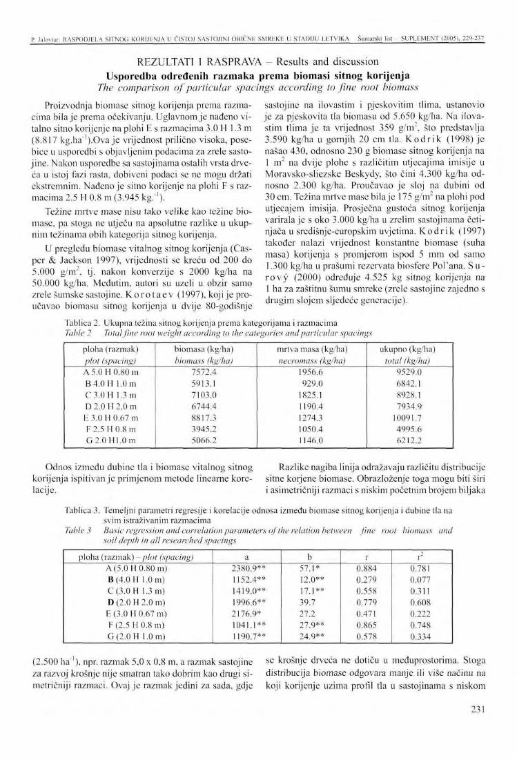
P. Jaloviur: RASPODJELA SITNOG KORIJENJA U ČISTOJ SASTOJINI OBIČNE SMREKE U STADIJU LETVIKA Šumarski list SUPLHMENT (2005). 229-237
REZULTATI I RASPRAVA - Results and discussion Usporedba određenih razmaka prema biomasi sitnog korijenja
The comparison of particular spacings according to fine root biomass
Proizvodnja biomase sitnog korijenja prema razmacima bila je prema očekivanju. Uglavnom je nađeno vitalno sitno korijenje na plohi E s razmacima 3.0 H 1.3 m (8.817 kg.ha"').Ova je vrijednost prilično visoka, posebice u usporedbi s objavljenim podacima za zrele sasto-jine. Nakon usporedbe sa sastojinama ostalih vrsta drveća u istoj fazi rasta, dobiveni podaci se ne mogu držati ekstremnim. Nađeno je sitno korijenje na plohi F s razmacima 2.5 H 0.8 m (3.945 kg/1).
Težine mrtve mase nisu tako velike kao težine biomase, pa stoga ne utječu na apsolutne razlike u ukupnim težinama obih kategorija sitnog korijenja.
U pregledu biomase vitalnog sitnog korijenja (Casper & Jackson 1997), vrijednosti se kreću od 200 do 5.000 g/m", tj. nakon konverzije s 2000 kg/ha na 50.000 kg/ha. Međutim, autori su uzeli u obzir samo zrele šumske sastojine. Koro t aev (1997), koji je proučavao biomasu sitnog korijenja u dvije 80-godišnje
sastojine na ilovastim i pjeskovitim tlima, ustanovio je za pjeskovita tla biomasu od 5.650 kg/ha. Na ilovastim tlima je ta vrijednost 359 g/m2, što predstavlja 3.590 kg/ha u gornjih 20 cm tla. Kodr ik (1998) je našao 430, odnosno 230 g biomase sitnog korijenja na 1 m~ na dvije plohe s različitim utjecajima imisije u Moravsko-sliezske Beskydy, što čini 4.300 kg/ha odnosno 2.300 kg/ha. Proučavao je sloj na dubini od 30 cm. Težina mrtve mase bila je 175 g/m" na plohi pod utjecajem imisija. Prosječna gustoća sitnog korijenja varirala je s oko 3.000 kg/ha u zrelim sastojinama četinjača u središnje-europskim uvjetima. Kodrik (1997) također nalazi vrijednost konstantne biomase (suha masa) korijenja s promjerom ispod 5 mm od samo 1.300 kg/ha u prašumi rezervata biosfere Pol'ana. S u -rovy (2000) određuje 4.525 kg sitnog korijenja na 1 ha za zaštitnu šumu smreke (zrele sastojine zajedno s drugim slojem sljedeće generacije).
Tablica 2. Ukupna težina sitnog korijenja prema kategorijama i razmacima Table 2 Total fine root weight according to the categories and particular spacings
ploha (razmak) plot (spacing) A 5.0 H 0.80 m B 4.0 H 1.0 m C3.0H 1.3 m D 2.0 H 2.0 m E 3.0 H 0.67 m F 2.5 H 0.8 m G 2.0 H 1.0 m
biomasa (kg/ha) biomass (kg/ha)
7572.4 5913.1 7103.0 6744.4 8817.3 3945.2 5066.2
mrtva masa (kg/ha) necromass (kg/ha)
1956.6 929.0
1825.1 1190.4 1274.3 1050.4 1146.0
ukupno (kg/ha) total (kg/ha)
9529.0 6842.1 8928.1 7934.9
10091.7 4995.6 6212.2
Odnos između dubine tla i biomase vitalnog sitnog korijenja ispitivanje primjenom metode linearne korelacije.
Razlike nagiba linija odražavaju različitu distribucije sitne korjene biomase. Obrazloženje toga mogu biti širi i asimetričniji razmaci s niskim početnim brojem biljaka
Tablica 3. Temeljni parametri regresije i korelacije odnosa između biomase sitnog korijenja i dubine tla na svim istraživanim razmacima
Table 3 Basic regression and correlation parameters of the relation between fine root biomass and soil depth in all researched spacings
ploha (razmak) -plot (spacing) A(5.0H 0.80 m) B(4.0H 1.0 m) C(3.0H 1.3 m) D (2.0 H 2.0 m) E (3.0 H 0.67 m) F (2.5 H 0.8 m) G(2.0H 1.0 m)
a 2380.9** 1152.4** 1419.0** 1996.6** 2176.9* 1041.1** 1190.7**
b 57.1* 12.0** 17 j * * 39.7 27.2 27.9** 24.9**
r 0.884 0.279 0.558 0.779 0.471 0.865 0.578
r 0.781 0.077 0.311 0.608 0.222 0.748 0.334
(2.500 ha"1), npr. razmak 5,0 x 0,8 m, a razmak sastojine za razvoj krošnje nije smatran tako dobrim kao drugi si-metričniji razmaci. Ovaj je razmak jedini za sada, gdje
se krošnje drveća ne dotiču u međuprostorima. Stoga distribucija biomase odgovara manje ili više načinu na koji korijenje uzima profil tla u sastojinama s niskom
231
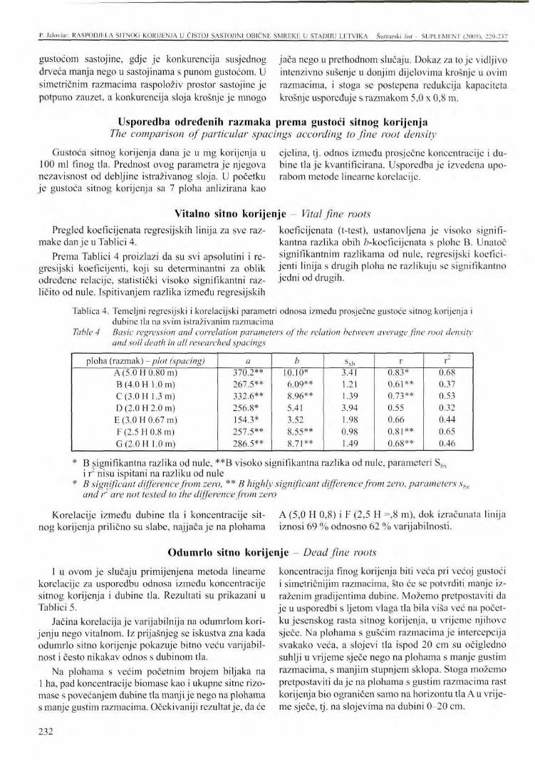
P. Jaloviar: RASPODJELA SITNOG KORIJENJA U ČISTOJ SASTOJINI OBIČNE SMREKE U STADIJU LETVIKA Šumarski list - SUPI.EMENT (2005). 229-237
gustoćom sastojine, gdje je konkurencija susjednog drveća manja nego u sastojinama s punom gustoćom. U simetričnim razmacima raspoloživ prostor sastojine je potpuno zauzet, a konkurencija sloja krošnje je mnogo
jača nego u prethodnom slučaju. Dokaz za to je vidljivo intenzivno sušenje u donjim dijelovima krošnje u ovim razmacima, i stoga se postepena redukcija kapaciteta krošnje uspoređuje s razmakom 5,0 x 0,8 m.
Usporedba određenih razmaka prema gustoći sitnog korijenja The comparison of particular spacings according to fine root density
Gustoća sitnog korijenja dana je u mg korijenja u 100 ml finog tla. Prednost ovog parametra je njegova nezavisnost od debljine istraživanog sloja. U početku je gustoća sitnog korijenja sa 7 ploha anlizirana kao
cjelina, tj. odnos između prosječne koncentracije i dubine tla je kvantificirana. Usporedba je izvedena uporabom metode linearne korelacije.
Vitalno sitno korijenje - Vital fine roots Pregled koeficijenata regresijskih linija za sve raz
make danje u Tablici 4. Prema Tablici 4 proizlazi da su svi apsolutini i re
gresijski koeficijenti, koji su determinantni za oblik određene relacije, statistički visoko signifikantni različito od nule. Ispitivanjem razlika između regresijskih
koeficijenata (t-test), ustanovljena je visoko signifikantna razlika obih ^-koeficijenata s plohe B. Unatoč signifikantnim razlikama od nule, regresijski koeficijenti linija s drugih ploha ne razlikuju se signifikantno jedni od drugih.
Tablica 4. Temeljni regresijski i korelacijski parametri odnosa između prosječne gustoće sitnog korijenja i dubine tla na svim istraživanim razmacima
Table 4 Basic regression and correlation parameters of the relation between average fine root density and soil death in all researched spacings
ploha (razmak) -plot (spacing) A (5.0 H 0.80 m) B(4.0H 1.0 m) C(3.0H 1.3 m) D (2.0 H 2.0 m) E (3.0 H 0.67 m) F (2.5 H 0.8 m) G(2.0H 1.0 m)
a 370.2** 267.5** 332.6** 256.8* 154.3* 257.5** 286.5**
b 10.10* 6.09** 8.96** 5.41 3.52 8.55** 8.71**
sxb 3.41 1.21 1.39 3.94 1.98 0.98 1.49
r 0.83* 0.61** 0.73** 0.55 0.66 0.81** 0.68**
2
r 0.68 0.37 0.53 0.32 0.44 0.65 0.46
* B signifikantna razlika od nule, **B visoko signifikantna razlika od nule, parameteri Sbx i r nisu ispitani na razliku od nule
* B significant difference from zero, ** B highly significant difference from zero, parameters sbx and r are not tested to the difference from zero
Korelacije između dubine tla i koncentracije sitnog korijenja prilično su slabe, najjača je na plohama
A (5,0 H 0,8) i F (2,5 H =,8 m), dok izračunata linija iznosi 69 % odnosno 62 % varijabilnosti.
Odumrlo sitno korijenje Dead fine roots
I u ovom je slučaju primijenjena metoda linearne korelacije za usporedbu odnosa između koncentracije sitnog korijenja i dubine tla. Rezultati su prikazani u Tablici 5.
Jačina korelacija je varijabilnija na odumrlom korijenju nego vitalnom. Iz prijašnjeg se iskustva zna kada odumrlo sitno korijenje pokazuje bitno veću varijabilnost i često nikakav odnos s dubinom tla.
Na plohama s većim početnim brojem biljaka na 1 ha, pad koncentracije biomase kao i ukupne sitne rizo-mase s povećanjem dubine tla manji je nego na plohama s manje gustim razmacima. Očekivaniji rezultat je, da će
koncentracija finog korijenja biti veća pri većoj gustoći i simetričnijim razmacima, što će se potvrditi manje izraženim gradijentima dubine. Možemo pretpostaviti da je u usporedbi s ljetom vlaga tla bila viša već na početku jesenskog rasta sitnog korijenja, u vrijeme njihove sječe. Na plohama s gušćim razmacima je intercepcija svakako veća, a slojevi tla ispod 20 cm su očigledno suhlji u vrijeme sječe nego na plohama s manje gustim razmacima, s manjim stupnjem sklopa. Stoga možemo pretpostaviti daje na plohama s gustim razmacima rast korijenja bio ograničen samo na horizontu tla A u vrijeme sječe, tj. na slojevima na dubini 0-20 cm.
232
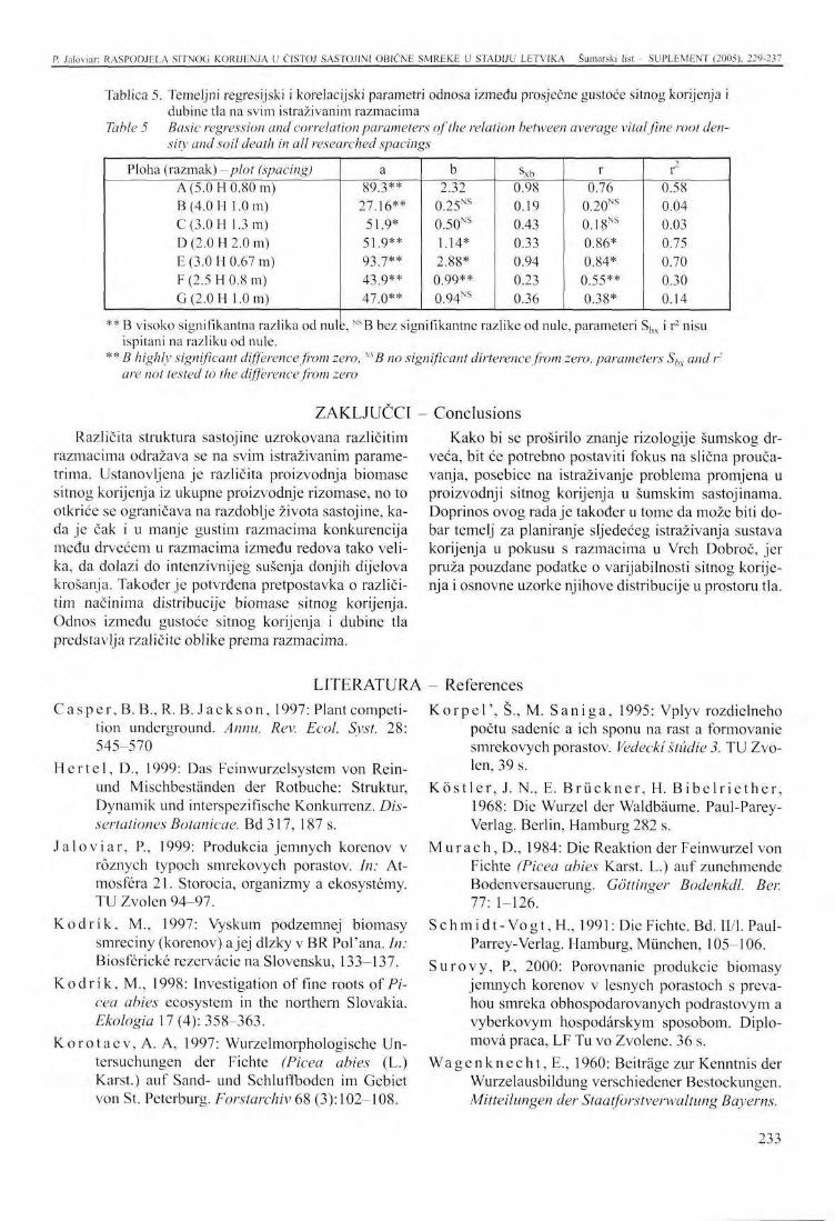
P. Jaloviar: RASPODJELA SITNOG KORIJENJA U ČISTOJ SASTOJIN1 OBIČNE SMREKE U STADIJU LETVIKA Šumarski list - SUPLEMENT (2005). 229-237
Tablica 5. Temeljni regresijski i korelacijski parametri odnosa između prosječne gustoće sitnog korijenja i dubine tla na svim istraživanim razmacima
Table 5 Basic regression and correlation parameters of the relation between average vital fine root density and soil death in all researched spacings
Ploha (razmak) - plot (spacing) A (5.0 H 0.80 m) B(4.0H 1.0 m) C(3.0H 1.3 m) D (2.0 H 2.0 m) E (3.0 H 0.67 m) F (2.5 H 0.8 m) G(2.0H 1.0 m)
a 89.3**
27.16** 51.9* 51.9** 93.7** 43 9** 47.0**
b 2.32
0.25NS
0.50NS
1.14* 2.88* 0.99** 0.94NS
sxb 0.98 0.19 0.43 0.33 0.94 0.23 0.36
r 0.76
0.20NS
0.18NS
0.86* 0.84* 0.55** 0.38*
r 0.58 0.04 0.03 0.75 0.70 0.30 0.14
** B visoko signifikantna razlika od nule, NSB bez signifikantne razlike od nule, parameteri Sbx i r2 nisu ispitani na razliku od nule.
** B highly significant difference from zero, mB no significant dirterence from zero, parameters Shx and r' are not tested to the difference from zero
ZAKLJUČCI Različita struktura sastojine uzrokovana različitim
razmacima odražava se na svim istraživanim parametrima. Ustanovljena je različita proizvodnja biomase sitnog korijenja iz ukupne proizvodnje rizomase, no to otkriće se ograničava na razdoblje života sastojine, kada je čak i u manje gustim razmacima konkurencija među drvećem u razmacima između redova tako velika, da dolazi do intenzivnijeg sušenja donjih dijelova krošanja. Također je potvrđena pretpostavka o različitim načinima distribucije biomase sitnog korijenja. Odnos između gustoće sitnog korijenja i dubine tla predstavlja rzaličite oblike prema razmacima.
Conclusions Kako bi se proširilo znanje rizologije šumskog dr
veća, bit će potrebno postaviti fokus na slična proučavanja, posebice na istraživanje problema promjena u proizvodnji sitnog korijenja u šumskim sastojinama. Doprinos ovog rada je također u tome da može biti dobar temelj za planiranje sljedećeg istraživanja sustava korijenja u pokusu s razmacima u Vrch Dobroč, jer pruža pouzdane podatke o varijabilnosti sitnog korijenja i osnovne uzorke njihove distribucije u prostoru tla.
LITERATURA - References C a s p e r , B. B.,R. B . J a c k s o n , 1997: Plant competi
tion underground. Annu. Rev. Ecol. Syst. 28: 545-570
H e r t e l , D., 1999: Das Feinwurzelsystem von Rein-und Mischbeständen der Rotbuche: Struktur, Dynamik und interspezifische Konkurrenz. Dis-sertationes Botanicae. Bd317, 187 s.
J a l o v i a r , P, 1999: Produkcia jemnych korenov v röznych typoch smrekovych porastov. In: Atmosfera 21. Storocia, organizmy a ekosystemy. TU Zvolcn 94-97.
K o d r i k , M., 1997: Vyskum podzemnej biomasy smreciny (korenov) a jej dlzky v BR Pol'ana. In: Biosfericke rezerväcie na Slovensku, 133-137.
K o d r i k , M., 1998: Investigation of fine roots of Picea abies ecosystem in the northern Slovakia. Ekologia 17 (4): 358-363.
K o r o t a c v , A . A, 1997: Wurzelmorphologische Untersuchungen der Fichte (Picea abies (L.) Karst.) auf Sand- und Schluffboden im Gebiet von St. Peterburg. Forstarchiv 68 (3): 102-108.
K o r p e l ' , Š., M. S a n i g a , 1995: Vplyv rozdiclneho počtu sadenic a ich sponu na rast a formovanie smrekovych porastov. Vedecki Studie 3. TU Zvo-len, 39 s.
K ö s t l e r , J. N., E. B r ü c k n e r , H. B i b e l r i e t h e r , 1968: Die Wurzel der Waldbäume. Paul-Parey-Verlag. Berlin, Hamburg 282 s.
M u r a c h , D., 1984: Die Reaktion der Feinwurzel von Fichte (Picea abies Karst. L.) auf zunehmende Bodenversauerung. Göttinger Bodenkdl. Ber. 77:1-126.
S c h m i d t - V o g t , EL, 1991: Die Fichte. Bd. H/1. Paul-Parrey-Verlag. Hamburg, München, 105-106.
S u r o v y , P, 2000: Porovnanie produkeie biomasy jemnych korenov v lesnych porastoch s preva-hou smreka obhospodarovanych podrastovym a vyberkovym hospodärskym sposobom. Diplo-tnovä praca, LF Tu vo Zvolene. 36 s.
W a g e n k n e c h t , E., 1960: Beiträge zur Kenntnis der Wurzelausbildung verschiedener Bestockungen. Mitteilungen der Staatforstverwaltung Bayerns.
233
PRESENTATION AT THE INTERNATIONAL SYMPOSIUM Šumarski list - SUPI.EMENT (2005), 229-237
FINE ROOT DISTRIBUTION IN A PURE POLE-STAGE STAND OF NORWAY SPRUCE
Peter JALOVIAR*
SUMMARY: The paper analyses the distribution of Norway spruce fine root (roots with diameter under 2 mm) biomass in the soil. Four Norway spruce stands of the age 21, which were established by artificial regeneration on former agricultural area have been researched. By the establishment of the stands two initial numbers of seedlings - 2500 and 5000 pes. of Norway spruce on 1 hectare and various initial spacings have been used. In this paper the spacings 4,0x 1,0 m, 3,0x 1,3 m, 2,5x 0,8 m and2,0x 1,0 m are evaluated. The presence of fine roots in the soil profile has been investigated to the depth of 40 cm. The highest value of fine root biomass (7013 kg/ha) was found out on the plot with the spacing 3,Ox 1,3 m, the lowest value had the plot with the spacing 2,5 x 0,8 m (3945 kg/ha). The relation between the distribution of fine root biomass and necromass and the soil depth could be approached with a linear regression. The decrease of the fine root biomass with the increasing soil depth is different, the slowest is on the plot with the spacing 4,0 x 1,0 m. For the assessment of the fine root distribution in the horizontal direction the fine root density calculated on 100 ml of soil has been used. All spacings were analysed in the depth 2,5 cm, 15 cm a 35 cm. The relation between horizontal distance and fine root density was estimated with the parabola function. In the soil depth of 2,5 cm the parabola function has a convex shape with a maximum in the space between the tree rows. With the increasing soil depth the function shape is turning into a concave one, with the minimum in the space between the rows. This change is caused by on the root system characteristics of Norway spruce and on the limited possibilities of his growth by the various spacings. The relation between the distance and fine root density is not strong because of generally high root biomass variability in the soil.
Keywords: Norway spruce, fine roots, biomass, necromass
INTRODUCTION
The dominant function of fine and finest foots, i.e. the roots with the diameter under 2.0 mm is the uptake of water and dissolved nutrients. Therefore the fine roots are considered a responsive indicator of health state and growth potential of trees and forest stands. The absorbing function of fine roots is conditioned by their anatomy. The fine root biomass production (roots < 2.0 mm diameter) is investigated less than the issue of architecture and morphogenesis of root systems un-
* Ing. Peter Jaloviar, PhD, Department of Silviculture, Forestry Faculty, Technical University, Masarykova 24, 960 53 Zvolen, Slovak Republic, e-mail: [email protected]
der various conditions. The impulse to more intensive research of fine roots was their mentioned ability to response on the environment changes.
The fine root development as well as the growth of particular diameter categories of roots is impacted especially by tree species, age of tree, environment conditions, biosociologicai position of the tree in the stand, intraspecific and introspecific competition K ö s t l e r etal. (1968), K o r o t a e v (1997), W a g c n -k n e c h t (1960), H e r t e l (1999), K o d r i k (1997). The root development and production in commercial forest is influenced besides mentioned factors crucially by the management of the stand from its origin to
234
P. Jaloviar: FINE ROOT DISTRIBUTION IN A PURE NORWAY SPRUCE POLE-STAGE STAND Šumarski list SUPLEMENT (2005), 229-237
the emergence of next forest generation ( Ja loviar 1999). The most of these factors can't be affected directly, but e.g. the crown volume and microclimatic conditions in the stand are decisive impacted by silvi-cultural interventions as well.
The influence of the initial spacing on the crown development and the growth of Norway spruce is indisputable (Schmidt-Vogt 1991, K o r p e l ' & Saniga 1995). Assuming that the balance between the above-ground and underground part of the tree is kept by the healthy individuals (Schinozaki etal. 1964), we can expect the spacing has an important influence on the fine root development and distribution in the soil as well.
Norway spruce {Picea abies L. Karst.) is a typical representative of the tree species with the flat root system. The growth dynamics of its fine roots is autonomous, i.e. their growth stops in the summertime also in the case of appropriate moisture conditions. The density of spruce fine roots in the soil is very extensive. The increment potential of its fine roots belongs to the lowest between our common tree species. The appearance of physiological active fine roots is concentrated in the soil horizon A.
STUDY AREA The IUFRO spruce plant spacing experiment was
established on locality Vrch Dobroč in 1981-1982, the plots with investigated spacings were established 1982 and at present they are 21 years old. The plots are located in the elevation from 890 to 910 m, the slope ranges from 8 to 15 % and it has west aspect. The area of each plot is 0.4 ha.
The soil on the plots is sandy loam cambisol that developed on crystalline rock. Average annual precipitation is 900 mm.
The area of present spacing experiment was agricultural land initially and therefore the homogeneity of the soil environment provides an unique possibility for comparative studies. The low variability of the soil environment is an important advantage, because it don't conceal the differencies of the root system development due to e.g. various silvicultural interventions, spacing etc. Detailed description of the research area can be found i n K o r p e l ' & S a n i g a (1994).
This paper analyses following 7 spacings: plot A, spacing 5H0.8 m, stem density 2,500 ha"' plot B, spacing 4.0H1.0 m, stem density 2,500 ha"1
plot C, spacing 3.OH 1.3 m, stem density 2,500 ha"'
AND METHODS
plot D, spacing 2H2 m, stem density 2,500 ha"' plot E, spacing 3H0.67 m, stem density 5,000 ha"1
plot F, spacing 2.5H0.8 m, stem density 5,000 ha"1
plot G, spacing 2.0H1.0 m, stem density 5,000 ha"' The samples for estimation of fine root biomass were
taken according to systematic sampling. In each spacing a line was marked, where in the distance of 50 cm the soil cores up to the depth 40 cm were taken. On the plot B 8 probes were established, on each other plot 7 probes. The samples were handled according to the methodology mentioned e.g. in the work of M u r a c h (1984).
The samples (soil cores) were taken by a hollow auger with the inner diameter 80 mm and the length of the hollow part 200 mm.
The state (vitality) of the most fine roots can be identified from the macroscopic marks, in the questionable cases a binocular glass with the magnification 15x or 30x was used.
After the drying of roots at 70EC the weight of both categories (vital and dead) was quantified. The acquired values were converted into the weight in kg on the area of 1 ha or into the values of fine root density in mg of 100 ml of soil.
RESULTS AND DISCUSSION The comparison of particular spacings according to fine root biomass
The production of the fine root biomass varies according to the spacing as expected. Mostly vital fine roots were found on the plot E with the spacing 3.OH 1.3 m (8,817 kg.ha"'). This value is quite high, especially in the comparison with the data published for the mature stands. After the comparison with the stands of other tree species in the same growth phase, acquired data can't be consider extreme. At least vital fine roots were found on the plot F with the spacing 2.5 H 0.8 m (3,945 kg.ha"').
The nccromass weights are not so high as the biomass weights and therefore they don't impact the absolute differencies in the total weights of both fine root categories either.
In the review of vital fine root biomass compiled by Casper & Jackson (1997) the values range from 200 to 5,000 g/m , i.e. after conversion from 2,000 kg/ha to 50,000 kg/ha. However, the authors have considered only mature forest stands. Korotaev (1997), who investigated the fine root biomass in two 80 years old stands
235
P. Jaloviar: FINE ROOT DISTRIBUTION IN A PURE NORWAY SPRUCE POLE-STAGE STAND Šumarski list - SUPLHMENT (2005), 229-237
on loam and sandy soils, states for sandy soils the bio-mass of 5,650 kg/ha. For the loam soils he states the value 359 g/m2, what presents 3,590 kg/ha in the top 20 cm of soil. K o d r i k (1998) found out 430 respectively 230 g of fine root biomass on 1 m on two plots with different immission impact in the region of Moravsko-sliezskc Beskydy, what constitutes 4,300 respectively 2,300 kg/ha, he investigated the layer with depth of 30 cm. The necromass weight was 175 g/m2 on the plot under immission impact. The average fine root density varies about 3,000 kg/ha in mature coniferous stands in central European conditions. K o d r i k (1997) also states the value of constant biomass (dry mass) of roots with diameter under 5 mm only 1,300 kg/ha for the primeval forest in Biosphere Reserve Pol'ana. S u r o v y (2000) gives 4,525 kg of fine roots on 1 ha for a spruce shelterwood forest (mature stand together with second layer of next generation).
The relation between the soil depth and vital fine root biomass was tested using the method of linear correlation.
The overview about the coefficients of regression lines for all spacings is given in Table 4.
From Table 4 results that all absolute and regression coefficients, which are determinant for the shape of particular relation, are statistically high significant different from zero. By testing of diffcrencies between the regression coefficients (t-test) a high significant difference of the b-coefficient from the plot B was found.
Also in this case the method of linear correlation was used for the comparison of relation between the fine root concentration and the soil depth. The results are shown in the Table 5.
The strength of the correlations is more variable at dead roots than vital roots. From previous experiences the state is known, when the dead fine roots shows substantially higher variability and often nearly no relation to the soil depth.
On the plots with higher initial plant number on 1 ha the decrease of biomass concentration as well as total fine rhizomass with the soil depth is less strong than on the plots with less dense spacings. The more expected
The differencics in the incline of the lines reflect the various distribution of the fine root biomass. The explanation for this can be that by wider and more asymmetric spacings with low initial plant number (2,500 ha"') e.g. by the spacing 5.0 x 0.8 m, the available stand space for the crown development is not used as good as by the other more symmetric spacings. This spacing is the only one at present, where the crowns of trees don't touch in the inter-row space. Therefore the biomass distribution corresponds more or less to the way how the roots take the soil profile in the stands with low stand density, where the competition of neighbour trees is less than in the stands with full density. In symmetric spacings the available stand space is fully used and the competition in the crown layer is much stronger than in the previous case. The proof of it is the visible more intensive drying in the lower parts of the crowns in these spacings and therefore the gradual reduction of the crown capacity compared to the spacing 5.0 x 0.8 m.
Despite the significant diffcrencies from zero the regression coefficients of the lines from other plots differ not significant from each other.
The correlations between the soil depth and fine root concentration is quite weak, the strongest is on the plot A (5.0 H 0.8) and F (2.5 H 0.8 m), while the computed line explains 69 % respectively 62 % of the variability.
result will be that at higher density and symmetric spacing the fine root concentration will be more homogenous what will be confirmed by less marked depth gradients. We can assume that compared with the summertime the soil moisture was already higher at the beginning of autumn growth of fine roots optionally in the time of their harvesting. On the plots with more dense spacings surely the interception is higher and soil layers under 20 cm were obvious more dry in the time of the harvesting than on the plots with less dense spacings with lower canopy degree. Therefore we can presume on the plots with dense spacing also the root growth was limited only on the soil horizon A in the time of harvesting i.e. on the layers in the depth 0-20 cm.
The comparison of particular spa
The fine root density is given in mg of fine roots in 100 ml of fine soil. The advantage of this parameter is its independence from the thickness of investigated layer. At first the fine root density from 7 plots was
Vital f
igs according to fine root density analysed as a whole i.e. the relation between the average concentration and the soil depth was quantified. The comparison was conducted using the method of linear correlation.
i roots
Dead fine roots
236

P. Jaloviar: FINE ROOT DISTRIBUTION IN A PbRE NORWAY SPRUCH POEH-STAGE STAND Šumarski list - SUPLEMENT (2005), 229-237
CONCLUSIONS
The different stand structure caused by a different spacing reflects on all investigated parameters. The different fine root biomass production from the total rhizo-mass production was found out, while this finding have to be limited on the period of stand's life, when even in the less dense spacings the competition between the trees in the inter-row space become to be so high, that it comes to the more intensive drying of the lower parts of crowns. The assumption about different way of fine root biomass distribution was confirmed as well. The relation between fine root density and soil depth presents different shapes according to the spacing.
To be able to enlarge the knowledge in the forest trees rhizology it will be necessary to focus similar studies especially on the investigation of the issue of changes in the fine root production of forest stands. The contribution of this paper is also that it can be a good base for the planning of next root systems research in the spacing experiment Vrch Dobroc because it provides a reliable informations about the fine root variability and basic patterns of their distribution in the soil space.
237
N. Pernar. D. Iloljević. J. Petraš. D. Bakšić: PPDOriZlOÜRAISKI ODNOSI NA POLIGONU ... Šumarski list SL'PLliMLNT 12005). 238-239
Niže navedeni referati održani na Međunarodnom skupu o protucroziji i vodozaštiti nisu tiskani u Zborniku budući da su istraživanjajoš uvijek u tijeku te se daju samo njihovi sažeci u obliku kako su poslani Uredništvu.
The papers listed below were presented at the International Conference on Anti-Erosion and Water Protection but are not contained in the Proceedings since research is still under way. Only the summaries have been printed in the form in which they were sent to the Editorial Board.
PEDOFIZIOGRAFSKI ODNOSI NA POLIGONU ZA ISTRAŽIVANJE EROZIJE U ABRAMIMA
Nikola PERNAR, Danko HOLJEVIĆ, Josip PETRAŠ, Darko BAKŠIĆ
SAŽETAK: U ovom radu dajemo prikaz istraživanja koja smo započeli na pokusnom poligonu za istraživanje erozije tla "Abrami".
Cilj istraživanja je analizirati recentne pedofiziografske odnose na pokusnim plohama, uspostavljenim u cilju testiranja nekoliko metoda biološko-tehničke sanacije erozije, da bi se ocijenila njihova primjenjivost na istarskom flišu.
Poligon za istraživanje erozije tla pored naselja Abrami u Istri uspostavljen je 1956. godine, kada su provedena i temeljita pedološka istraživanja. Ista su pokazala da su plohe uspostavljene na dvije skupine tala, različito zahvaćenih erozijom. Radilo se o eutričnim kambisolima, izloženim i karbonatnim rendzi-nama, sirozemima, erodiranim rendzinama i kambisolima te o koluvijima.
Istraživanjima smo zamislili obuhvatiti najvažnije pokazatelje evolucije tla u razdoblju postojanja pokusa, a to je stratigrafija profila tla, pH vrijednost po horizontima, zaliha i distribucija organske tvari tla, sadržaj dušika, fosfora i kalija te stabilnost strukturnih mikro i makro agregata.
Prvi nalazi upućuju na promjene ujiziografiji tla u odnosu na nulta stanja, koja se bitno razlikuju po plohama. To se posebno zapaža u formiranju i stabilizaciji O- i A- horizonta te agregatne strukture.
K lj u č n e r ij e č i: erozija tla, evolucija tla
238
N. Pernar. D. Iloljcvić. J. Petras, D. Bakšic: PEDOFIZIOGRArSKI ODNOSI NA POLIGONU ... Šumarski list - SUPLEMENT (2005), 238-239
PEDOPHYSIOGRÄPHIC RELATIONS IN THE EROSION TESTING SITE OF ABRAMI
Nikola PERNAR, Danko HOLJEVIĆ, Josip PETRAS, Darko BAKŠIĆ
SUMMARY: The paper deals with research in the experimental soil erosion research site of "Abrami".
Research was aimed at analysing recent pedophysiographic relations in sample plots established for the purpose of testing several methods of biological-technological erosion regulation so that their applicability to Istrian flisch could be assessed.
The testing site for soil erosion research near the village of Abrami in Istria was established in J 956, when detailedpedological research was carried out. The research showed that the plots were set up on two soil groups differently affected by erosion. The soils in question were eutric cambisols, dealkalised and carbonate rendzinas, regosols, eroded rendzinas and cambisols, as well as colluviums.
Research was intended to comprise the most important indicators of soil evolution throughout the duration of the test. These include the soil profile stratigraphy, pH values per horizons, stock and distribution of soil organic matter, nitrogen, phosphorus and potassium content, and the stability of structural micro and macro aggregates.
Initial results point to changes in soil physiography in relation to the zero state, which differs fundamentally from plot to plot. This is particularly visible in the formation and stabilisation ofO and A horizons and in the aggregate structure.
Key words: soil erosion, soil evolution
239
D. Uiminić, N. Potočić. 1. Suletković, M. GrSković: UTJECAJ PATOGENE GLJIVE Sphaeropsis sapinea ... Šumarski list - SUPLEMENT (2005), 240-241
UTJECAJ PATOGENE GLJIVE Sphaeropsis sapinea NA PROTUEROZIJSKU ZAŠTITNU ULOGU
KULTURE CRNOGA BORA U ISTRI: ANALIZA ZDRAVSTVENOG STANJA I STANJA ISHRANE
Danko DIMINIĆ, Nenad POTOČIĆ, Ivan SELETKOVIĆ, Maja GRSKOVIĆ
SAŽETAK: U prošlom stoljeću na području Istre, crnim borom (Tinus nigra Arnold) pošumljavani su krški tereni. Kulture su podizane na različitim tipovima tala u cilju zaštite tla od erozije tu obnavljanja šumske vegetacije. Istraživanjima zdravstvenog stanja kultura započetih 1992. godine uočeni su lokaliteti s različitim simptomima sušenja u krošnjama borova. Pojedini lokaliteti utvrđeni su sa značajno prisutnim simptomima, od sušenja dijelova krošnji do cijelih stabala. Isto tako zapaženo je da postoje značajne razlike u zdravstvenom stanju kultura crnoga bora podignutih na različitim tipovima tala. Fitopatoloska istraživanja utvrdila su izrazitu prisutnost patogene gljive Sphaeropsis sapinea (Fr.) Dyko et Sutton na oboljelim borovima. Ova gljiva pokazala se značajnim čimbenikom koji negativno utječe na stabilnost kultura crnog bora u Istri.
Patogenost gljive S. sapineu dolazi do izražaja na stablima predisponira-nim određenim čimbenikom stresa, osobito sušom i neodgovarajućim stanišnim prilikama. Analizom meteoroloških podataka za razdoblje od 1990. na području Istre, utvrđene su znakovite razlike u količinama oborina tijekom pojedinih godina te povišene srednje mjesečne temperature zraka.
Provedenim istraživanjem dobivene su razlike u prisutnosti gljive S. sapinea i njenom utjecaju na zdravstveno stanje kultura na različitim staništima u Istri. Različitost staništa potvrđena je analizama tla i kemizmom biljnog materijala. Dobiveni rezultati prilog su smjernicama za podizanje borovih kultura s ciljem zaštite tla od erozije u smislu odabira odgovarajućih staništa na području krša Hrvatske.
Ključne riječi: Pinus nigra, kulture, zdravstveno stanje, Sphaeropsis sapinea, analiza tla, analiza biljnog materijala.
240
D. Diminić, N. Potočić. I. Seletković. M. Gršković: INFLUENCE OF THE PATHOGENIC FUNCTUS ... Šumarski list - SUPLEMENT (2005), 240-241
INFLUENCE OF THE PATHOGENIC FUNGUS Sphaeropsis sapinea ON THE ANTI-EROSIVE AND PROTECTIVE ROLE
OF AUSTRIAN PINE PLANTATIONS IN ISTRIA: ANALYSES OF THE HEALTH AND NUTRITION STATUS
Danko DIMINIĆ, Nenad POTOČIĆ, Ivan SELETKOVIĆ, Maja GRŠKOVIĆ
SUMMARY: During the last century, Austrian pine (Tinus nigra Arnold) was frequently used for afforestation of karst in Istria (Croatia). Austrian pine was planted on various soil types to protect the soils from erosion and to restore the forest vegetation. The research on pine plantation health status since 1992 has revealed localities with various dieback symptoms in the pine crowns. In some of the researched localities significant dieback symptoms were observed, from the dieback of various crown parts to the dieback of whole trees. Significant differences in their health status were also observed according to different soil types. Pathological research confirmed a significant presence of the fungus Sphaeropsis sapinea (Fr.) Dyko et Sutton in the affected pines. The fungus turned out to be an important factor negatively influencing the stability of the A ustrian pine plantations in Istria.
The pathogenicity of'S. sapinea is expressed in trees predisposed by certain stress factors, especially by drought and unfavourable site conditions. The analysis of meteorological data for the region of Istria since the year 1990 shows significant annual differences in precipitation, and an increase in the average monthly air temperature.
The research results reveal the differences in the presence of S. sapinea and in its impact on the health status of Austrian pine plantations in various sites in Istria. Site differences were confirmed by soil analyses and analyses of plant material. The obtained results can be implemented in the selection of favourable sites for future afforestation with pine species in the karst region for the purpose of protecting the soil from erosion.
Key words: Pinus nigra, plantations, health status, Sphaeropsis sapinea, soil analyses, analyses of plant material
241
J. Čavluvić. M. Oršanić. M. Božić: ÜOSPODARF.NJF, PRIVATNIM ŠUMAMA HRVATSKE ... Šumarski list - SUPLHMLNT (2005). 242-243
G O S P O D A R E N J E PRIVATNIM Š U M A M A HRVATSKE KAO OGRANIČAVAJUĆI ČIMBENIK ISPUNJENJA OPĆEKORISNIH I G O S P O D A R S K I H
FUNKCIJA ŠUMA NIZINSKOG P O D R U Č J A
Jure ČAVLOVIĆ, Milan ORŠANIĆ, Mario BOŽIĆ
SAŽETAK: U Republici Hrvatskoj nalazi se 461,137 ha (19 %) šuma i šumskog zemljišta u privatnom vlasništvu, što čini 19 % od ukupne površine šuma i šumskog zemljišta. Međutim, šume u privatnom vlasništvu jako su rascjepkane. Postoji ukupno oko 600,000 sitnih privatnih šumovlasnika, dok gotovo da i nema udruga privatnih šumovlasnika. Na području Zagrebačke županije udio sitnih privatnih šuma iznosi gotovo 50 % ili 69,420 ha. S obzirom na gustu naseljenost i razvijenost prostora, značenje šuma i njihovih funkcija u tom području još je izraženije.
Istraživanje je provedeno u nizinskom i brdskom dijelu Zagrebačke županije (4 katastarske općine). Na ukupno 417ploha mjereni su elementi strukture sasto-jina. Anketirano je 366 privatnih šumovlasnika (56,5 %). Rezultati istraživanja ukazuju na veliku heterogenost sastojina, odnosno veliku varijabilnost elemenata strukture glavne vrste drveća u sastojinama. Utvrđena je veća varijabilnost pojavljivanja stabala hrasta lužnjaka po prostoru (C. V= 107 %) u odnosu na bukvu u brdskom području (C. V= 76 %). Nadalje, nepostojanje jedinstvenog pristupa gospodarenja na površini većoj nego što je prosječna površina parcele (0,43 ha) teprebirna sječa pojedinačnih zrelih stabala hrasta lužnjaka bez obnove, vodi postupnom nestajanju hrasta lužnjaka iz privatnih nizinskih šuma. Na temelju rezultata ankete dobiven je profil tipičnog sitnog privatnog šumovlasnika. U radu su istaknute preporuke za unaprjeđenje stanja i gospodarenja sitnim privatnim šumama istraživanog područja i općenito u Hrvatskoj.
Ključne r ij eči: privatne šume, funkcije šuma, elementi strukture, ekstenzivno gospodarenje, prebirne sječe, tipični šumovlasnik
242
.1. Čavlović, M. Oršanić, M. Božić: PRIVATF. FOREST MANAGF.MENT IN CROATIA AS A LIMITING ... Šumarski list - SUPLEMENT (2005), 242-243
PRIVATE FOREST M A N A G E M E N T IN CROATIA AS A LIMITING FACTOR IN THE A C H I E V E M E N T OF N O N - C O M M E R C I A L AND C O M M E R C I A L
FOREST FUNCTIONS IN L O W L A N D REGIONS
Jure ČAVLOVIĆ, Milan ORŠANIĆ, Mario BOŽIĆ
SUMMARY: Of the total forest land in the Republic of Croatia, 461,137 ha or 19 % of forests and woodland are privately owned. However, private ownership is highly fragmented. There are 600,000 small-scale private forest owners, whereas there are no forest associations of private owners. In the area of Zagreb County, the proportion of small-scale private forests amount to almost 50 % or 69,420 ha. Taking into account the population density and the spatial development, the importance of forest functions in this region is even more pronounced.
Research was carried out in the lowland and hilly region of Zagreb County (4 land register districts). The elements of stand structure were measured in a total of 417 plots. A survey was conducted on 366private forest owners (56.5 %). The results of research indicate extensive stand heterogeneity, a relatively high variability of structural elements of principal tree species in the stands. A higher variability in the incidence of pedunculate oak in the space (C V= 107 Vo) was found in relation to beech in the hilly region (C V= 76 %). Furthermore, the absence of a uniform approach to management over an area larger than the average plot (0.43 ha) and the selective cutting of individual mature trees of pedunculate oak without regeneration leads to the gradual disappearance of pedunculate oak from private lowland forests. The profile of atypical small-scale private forest owner was obtained from the survey results. Recommendations are given for the improvement of the current status and management with small-scale private forests in the study area and in Croatia in general.
243
D. Huška, L. Jurik, L. Tutošova: ŠUMA KAO VAŽAN DIO ZDRAVOG KRAJOBRAZA Šumarski list SUI'l.l-.MI-NT (201)6). 244
ŠUMA KAO VAŽAN DIO ZDRAVOG KRAJOBRAZA
D. HÜSKA, L. JURIK, L. TATOŠOVA
SAŽETAK: Stabilnost prirodnih ekosustava je funkcija stabilnosti pojedinih elemenata prirode i njihovih međusobnih interakcija koji su izloženi prirodnim i antropogenim utjecajima. Prirodni i antropogeni utjecaji nisu stabilni, oni su podložni vremenskim i kvantitativnim promjenama.
Najvažniji elementi - vanjski i unutarnji - u ovom procesu predstavljaju prirodni okoliš sa svojim prirodnim osobinama te vanjski okoliš, u kojemu najvažniju ulogu imaju klimatski parametri područja i posljedice prouzročene socio-ekonomskim utjecajima.
U uvjetima šumskog krajobraza, voda u svim oblicima i njezin utjecaj kroz ljudsko djelovanje sudjeluje u najvećoj mjeri u devastaciji prirodnog okoliša (erozija). U radu se opisuju destruktivni učinci vode nastali uslijed prirodnog ili namjernog površinskog otjecanja i promjena ravnoteže (vremenske i kvantitativne) u šumama.
FOREST AS A N IMPORTANT PART OF A HEALTHY L A N D S C A P E
D. HÜSKA, L. JURIK, L. TATOŠOVA
SUMMARY: The stability of landscape ecosystems is the function of the stability of individual landscape elements and their mutual interactions, which are influenced by natural and anthropogenic impacts. Natural and anthropogenic impacts are not stable; on the contrary, they are subject to time and quantitative changes.
Natural environment with its natural characteristics is the most important external element in this process, in which climatic parameters of an area and the consequences caused by socio-economic influences play a crucial role.
In a forest landscape, water in all forms participates to a high degree in the devastation of natural environment (erosion). The paper deals with destructive effects of water in the form of natural or induced surface runoff and changes in the balance (time and quantity) of woodlands.
244
I. Pilaš, T. Gojmerac, B. Vrbek, T. Dubravac: UNAPRJRĐF.NJF. MONITORINGA PODZEMNIH VODA ... Šumarski lis! - SUPLKMENT (2005). 245-246
UNAPRJEĐENJE MONITORINGA PODZEMNIH VODA U NIZINSKIM ŠUMSKIM EKOSUSTAVIMA HRVATSKE
KORIŠTENJEM GlS-a I GEOSTATISTIKE
Ivan PILAŠ, Tihomira GOJMERAC, Boris VRBEK, Tomislav DUBRAVAC
SAŽETAK: Osnovni ekološki čimbenik koji određuje pojavu nizinskih šumskih ekosustava je voda u tlu odnosno podzemna voda. Dosadašnje promjene klime te antropogeni utjecaji koji su djelovali na promjenu nekadašnjeg vodnog režima imali su snažan utjecaj na stabilnost tih ekosustava, koji su uslijed toga postali nestabilni/i te izloženiji djelovanju ostalih abiotskih i biotskih čimbenika. Sniženje podzemnih voda kao neposredan rezultat klimatskih promjena i različitih hidromelioracijskih zahvata utjecalo je na produktivnost tih šuma stoje bio jedan od najvažnijih razloga uspostave šumarskog hidropedo-loškog sustava monitoringa kako bi se pridobilo što više spoznaja o statusu podzemnih voda. Do sada je s oko 130 piezometarskih postaja obuhvaćena velika većina glavnih kompleksa nizinskih šuma u Hrvatskoj. U ovom radu prikazani su rezultati analize podzemnih voda iz tri različita šumska kompleksa: Kupčine, Česme i Našičkog područja tj. s 59 piezometarskih stacionara. Analiza rezultata piezometarskog monitoringa provedena je primjenom GIS-a i geostatistike, s obzirom na sljedeće ciljeve istraživanja:
1. Analizu razlika u režimu podzemnih voda između tri navedena šumska kompleksa
2. Prostornu analizu djelovanja ekstremno suhih godina na razinu podzemnih voda
3. Prostornu analizu trenda sniženja podzemnih voda Razlike u režimu podzemnih voda između istraživanih šumskih područja
vezane su uz pripadnost, bilo pluviotermičkom režimu rijeke Save, bilo glaci-jalnom režimu rijeke Drave. Prostorna analiza napravljena je korištenjem GIS alata GRASS (Geographical Resources Analysis Support System), a geo-statistička analiza, tj. prostorno modeliranje i procjena, pomoću programskog paketa Gstat.
U ovom radu također je dan prikaz prvih rezultata analize određenih kemijskih parametara u podzemnoj vodi uzetih na području šume Česma. Praćenje kemijskih svojstava podzemne vode uz dosadašnje praćenje njene dinamike predstavlja daljnji razvoj piezometarskog sustava monitoringa, s naglaskom na njegovo multidisciplinarno korištenje u što većoj mjeri.
Dosadašnji način manualnog prikupljanja podataka iz piezometarskih stacionara također predstavlja jedan od ograničavajućih razvojnih čimbenika hidropedološkog monitoringa. S tim u vezi prikazane su trenutne aktivnosti na usavršavanju samostalnih digitalnih mjerača razina podzemnih voda, koji u idućem razdoblju mogu zamijeniti visoke troškove manuelnog načina monitoringa.
Ključne riječi: nizinski šumski ekosustavi, podzemna voda, piezome-tri, GIS, geostatistika
/
1. Pilaš. T. Gojmcrac. B. Vrbek, T. Dubravac: ENHANCEMENTS IN THE GROUNDWATER MONITORING ... Šumarski list SUPLEMENT (2005). 245-246
ENHANCEMENTS IN THE GROUNDWATER MONITORING SYSTEM IN LOWLAND FOREST ECOSYSTEMS IN CROATIA
BY USING GIS AND GEOSTATISTICS
Ivan PILAŠ, Tihomira GOJMERAC, Boris VRBEK, Tomislav DUBRAVAC
SUMMARY: The main ecological factor, which determines the lowland i.e. floodplain forest ecosystems is the abundance of soil water. High groundwater tables and the groundwater regime on these sites have a key role in maintaining sufficiently high soil water content. Recent climate and anthropogenic changes in the water regime have had a strong influence on the stability of these ecosystems which have become more vulnerable in respect to other abiotic and biotic factors. Decreasing groundwater tables due to global climate changes and local hydrotechnical activities reflect on the productivity of these forests. This was the main reason that foresters established long-term groundwater monitoring studies so as to obtain deeper knowledge of these issues. The monitoring of groundwater levels has been established in main forest complexes where measurements have been taken at a large number of piezometric stations on a weekly basis. Up to the present, series of data have been collected for more than a decade. In this paper the results and analysis of collected groundwater monitoring data from different forest complexes; Kupčina, Česma and Našice area will be presented. Enhancements of data analysis using GIS and geostatistics will be presented mostly in terms of
J. Analysing differences in the groundwater regimes between these forest complexses
2. Analysing the spatial influence of seasonal drought on groundwater tables
3. A spatio-temporal analysis of groundwater decrease The differences in the groundwater regimes in these forest areas are linked
to their position either in the pluviothermic regime of Sava River catchment or glacial regime of Drava River catchment. Spatial analysis of the groundwater series was made using GRASS (Geographical Resources Analysis Support System), IDW (Inverse distance weighted average), interpolation and geostatstical analysis and predictions by the geostatistical program Gstat based on Linux.
In addition, in this paper preliminary results of particular groundwater chemistry parameters analysed from samples taken from piezometers in the Cesma forest area will be presented. Groundwater chemistry is a further step to the enhancement of the existing forest groundwater monitoring network in terms of its interdisciplinary use.
Data gathering from piezometric sets also present a major problem because of the high cost of traditional manual groundwater measurements. Therefore the current status of development of new digital cost effective groundwater data logger will be presented which in the future could fully replace field monitoring personnel.
Key words: lowland forest ecosystems, groundwater, piezometers, GIS, geostatistics
246
I. Tikvici. Z. Seletković. N. Magdić, V. Šojat: STANJF. I ODNOSI OBORINSKIH VODA U ŠUMSKIM ... Šumarski list - SUPLEMKNT (2005), 247-248
STANJE I ODNOSI OBORINSKIH VODA U ŠUMSKIM EKOSUSTAVIMA NACIONALNOG PARKA PLITVIČKA JEZERA
Ivan TIKVIĆ, Zvonko SELETKOVIĆ, Nikola MAGDIĆ, Višnja ŠOJAT
SAŽETAK: Temeljno obilježje Nacionalnog parka Plitvička jezera su prirodna jezera sa čistom i bistrom vodom te raznoliki slapovi koji se prelijevaju preko sedrenih barijera. Jedna od pretpostavki za uravnoteženo slijevanje oborinske vode, osiguravanje ciste i bistre vode, sprječavanje erozije te nastanak i održavanje jezera su šumski ekosustavi, koji zauzimaju oko 76 % površine. Kako je glavna vrsta drveća u tim ekosustavima obična bukva, a još su značajnije zastupljene obična jela i obična smreka, istraživanje je provedeno u ta tri glavna šumska ekosustava. Cilj istraživanja bio je utvrditi utjecaj šumskih ekosustava na dinamiku i kvalitetu oborinskih voda, odnosno njihov posredni utjecaj na stanje površinskih voda i proces eutrofikacije jezera, koji se sve više naglašava.
Stanje oborinskih voda utvrđeno je na temelju tjednih i dvotjetnih uzoraka oborina i njihovogfizikalno-kemijskog sastava izvan šume (kontrola) i na devet različitih mjesta u šumi. Istraživano je taloženje onečišćujučih tvari (sulfati, nitrati), odnosno suho gravitacijsko taloženje lebdećih čestica i mokro taloženje.
U šumskom ekosustavu obične bukve utvrđene su manje količine oborina (maksimalne, srednje i minimalne vrijednosti) od količina oborina izvan šume. Ušumskom ekosustavu obične jele i obične smreke, maksimalne vrijednosti količina oborina bile su veće od vrijednosti izvan šume samo u slučajevima jakih kiša, dok su prosječne vrijednosti bile manje od vrijednosti izvan šume. Slični rezultati utvrđeni su i u šumskom ekosustavu obične jele i obične bukve. Rezultati ukazuju na raznolik utjecaj krošanja šumskog drveća na slijevanje, otjecanje i procjeđivanje oborinske vode, te na različit utjecaj šumskih ekosustava na stanje oborinskih voda u odnosu na različite intezitete oborina. Prosječna intercepcija za sva tri ekosustava u vrijeme jačih kiša kretala se od 25-30 %. Utvrđena je značajna prisutnost oborina sa pH vrijednosti ispod 5,6 izvan šume i u šumi. One su bile manje zastupljene u šumskom ekosustavu obične bukve. U nekoliko slučajeva pH vrijednosti u šumskom ekosustavu bile su veće i povoljnije u odnosu na vrijednosti izvan šume, što govori o određenom pozitivnom utjecaju šumskog ekosustava na kemizam oborina i taloženje onečišćujučih tvari. To se također odnosi i na drupe tvari (Cl, S04-S, N03-N i dr.) koje su u radu analizirane.
247
1. Tikvić, Z. Sclctkovic, N. Magdić. V. Sojal: THE CONDITION AND RELATIONSHIP OF PRECIPITATION ... Šumarski list SUPLEMENT (2005), 247-24X
THE CONDITION AND RELATIONSHIP OF PRECIPITATION WATERS IN THE FOREST ECOSYSTEMS OF
PLITVICE LAKES NATIONAL PARK
Ivan TIKVIĆ, Zvonko SELETKOVIĆ, Nikola MAGDIĆ, Višnja ŠOJAT
SUMM AR Y: Plitvice Lakes National Park is characterised by natural lakes with clean and clear water and a variety of waterfalls splashing over travertine barriers. Forest ecosystems, which take up about 76 % of the area, are one of the basic prerequisites for a balanced runoff of precipitation water, the provision of clean and clear water, the control of erosion and the formation and maintenance of the lakes. Since beech is the principal tree species in these ecosystems accompanied by substantial amounts of silver fir and spruce, research was conducted in these three main forest ecosystems. Research was aimed at establishing the impact of forest ecosystems on the dynamics and quality of precipitation water, or their direct influence on the condition of surface waters and eutrophication of the lakes, which has become an increasingly important issue.
The condition of precipitation water was determined on the basis of weekly and bi-monthly precipitation samples and their physical-chemical composition outside the forest (check samples) in nine different sites in the forest. Research included depositions of pollutants (sulphates, nitrates) or dry gravitational depositions of floating particles and wet depositions.
In the forest ecosystem of common beech the precipitation quantities (maximal, medium and minimal values) were lower than those measured outside the forest. In the forest ecosystem of silver fir and common spruce, maximal values of precipitation quantities exceeded the values outside the forest only in cases of heavy rains, while the average values were lower than those outside the forest. Similar results were found in the forest ecosystem of silver fir and common beech. The results point to different impacts of forest tree crowns on runoff, discharge and percolation of precipitation water and to variable impacts of forest ecosystems on the condition of precipitation waters with regard to different precipitation intensities. The average interception for all three ecosystems during heavy rains ranged from 25-30 %. Significant precipitation with pH values below 5.6 was found both outside and in the forest. These values were less represented in the forest ecosystem of common beech. In several cases pH values in the forest ecosystem were higher and more favourable in relation to the values outside the forest, which indicates a positive impact of the forest ecosystem on precipitation chemistry and pollutant depositions. This refers to other substances as well (CI, S04-S, N03-N and others) which were analysed in the paper.
248
ZAKLJUČCI Šumarski list - SUPLHMRNT (2005), 249-250
Na temelju iznesenih referata i rasprava na ovome Međunarodnom skupu o utjecaju šume na spriječava-
1. Dugoročna, 50-godišnja istraživanja hidroloških prilika u dva sijeva u Beskidima (Češka), ukazuju kako su prirodni retencijski kapaciteti šume ograničeni kad se pojave najintenzivnije oborine. Prilikom obnove šume potrebno je što prije stvoriti šumski pokrov i očuvati šumsko tlo s visokim kapacitetom infiltracije. Tijekom ovih istraživanja nije bilo statistički značajnih razlika u površinskom otjecanju između obnovljene (dovršni sijek) i obrasle površine (Vicha).
2. Prirodne šume u Hrvatskoj koje čine 95 % državnih šuma (80 % površine svih šuma su državne) pokazuju veliku učinkovitost u smislu sprječavanja erozije tla, ublažavanja pojave visokih vodnih valova i pročišćavanja izvorskih voda do kategorije pitkosti. Uzgojne postupke njege i obnove, kako u regularnim tako i u prebornim šumama, potrebno je obavljati tako da se očuva pokrovnost šumskoga tla i njegova mogućnost upijanja i pročišćavanja vode. Očuvanjem stabilnosti šume i povoljne strukture sastojine osigurat će se potrebna sirovinsko-ener-getska funkcija i potpuno djelovanje svih općekorisnih funkcija (Matić).
3. U trajnim pokusnim plohama u planinskim šumama Orhicke hory a Češkoj istražuju se hidro-loške prilike od 1977. godine. Iz tih istraživanja proizlazi kako smrekove i bukove šume učinkovito ublažavaju nepovoljan utjecaj neprekidne oborine do 100 mm. Kod oborine iznad 150 mm profil tla se potpuno zasiti vodom što dovodi do nekontroliranoga otjecanja (Kantor).
4. Šikara bijeloga graba (Carpinus orientalis Mili.) u submediteranskom području Hrvatske vrlo učinkovito suzbijaju eroziju tla vodom. Površinska otjecanja oborinskih voda u toj degradi ranoj šumi su vrlo mala, a erozija je potpuno isključena. Istraživanja su obavljena u dvije pokusne plohe u šikari bjeloga graba od kojih je jedna posječena. Prosječni godišnji koeficijent otjecanja u posječenoj površini iznosio je 0,0192, a u neposječenoj 0,0156. Kako se vidi razlike su vrlo male. Nešto veće razlike pokazao je maksimalni koeficijent otjecanja. Autori (Topic, Butorac) upozoravaju kako posječenu površinu treba što prije sanirati jer bi moglo
nja erozije tla vodom, zatim poplava i bujica te uloge šume u pročišćavanju izvorskih voda, donose se ovi
doći do povećanja nepovoljnoga hidrološkog utjecaja na tlo. Ovaj pokus pokazuje kako degradacij-ski oblici autohtone šumske vegetacije učinkovito suzbijaju eroziju tla vodom, dok njihovo tlo zasigurno dobro pročišćava vodu koja ulazi a krško podzemlje.
5. Šume u Hrvatskoj nalazimo pretežito u prostoru čije reljefne i klimatske značajke ukazuju na srednji do visoki stupanj orodibilnosti tla. Na temelju karte Republike Hrvatske izrađene prema programu CORINE obavljena je procjena rizika od erozije. Umjereni rizik utvrđenje na 26,5 %, a visoki rizik na 44,8 % površine (Husnjak i dr.).
6. Saniranje i smirenje nekadašnje bujice u Senjskoj dragi smatra se jednim od najuspješnijih projekata u Sredozemlju kojega je ostvarila šumarska struka. Radovi su započeli u 19. stoljeću pošumljavanjem 22 kulture-branjevine crnoga bora na mozaično raspoređenoj površini od 320 ha i tehničkim zahvatima, izgradnjom 62 različita bujična objekta. Danas je Senjska draga zelena, bujice i erozija više nema, a grad Senj koristio je do nedavno za svoj vodovod 25 izvora pitke vode koji su se sukcesivno pojavljivali poslije pošumljavanja (Ivančević).
7. Šumski ekosustavi su učinkoviti pročišćivači voda. Zahvaljujući šumskom tlu, njegovaj posebnoj strukturi, kemijskom sastavu i bogatstvu živoga svijeta, šuma mehanički, biološki, a djelom i kemijski pročisti oborinsku vodu koja u podzemne tokove i izvorišta ulazi pitka. Posebna učinkovitost dakazana je u nizinskim i poplavnim šumama koje zadržavaju N i P od umjetnih gnojiva iz agrara. Kakvoća podzemne vode bila je znatno bolja u šumi nego li u poljodjelskim povšinarna na visočju Drahany u Češkoj (Klimo i Kulhavy). Lizimetrijska istraživanja u istim šumskim nizinskim ekosustavima pokazala su razlike u pročišćavanju voda a različitim područjima u Hrvatskoj (Vrbek i dr.).
8. Istraženo je opće stanje vodotoka u gorskim područjima Hrvatske u Papuku, Velebitu i Nacionalnom parku Ptitvička jezera. Analizirano je fizikalno-ke-mijsko stanje voda; sadržaj hranjivih tvari, kovina, organskih spojeva, mineralnih ulja i drugih pokazatelja kakvoće vode. Skoro svi vodotoci imali su vode visoke kakvoće. Nije. bilo razlike u-kakvoći vode između Nacionalnoga parka i višenamjenskih
ZAKLJUČCI
249
ZAKLJUČCI Šumarski list - SUP1.EMENT (2005), 249-250
šuma u kojima se provode uzgojni postupci njege. Voda manje kakvoće ustanovljena je u vodotocima u blizini naselja i izvan šume. Utvrđenoje kako nema raztika u kakvoći vode koja potječe iz različitih šumskih ekosustava, što ukazuje na opći povoljan utjecaj šume na pročišćavanje vode, bilo onene koja ulazi u vodotok povšinskim otjecanjem (pročišćavanje kroz akumulacijski horizont tla) ili iz podzemnih tokova kao i izvorska voda (Tikvić i dr.).
9. Vrijednost općekorisnih funkcija šume u posljednje vrijeme postale su predmetom sve češćih pokušaja šumarskih znanstvenika koji se bave vrednovanjem siravinsko-energetske funkcije odnosne neposredne koristi od šume. Kako se zapravo radi o neprocjenjivoj vrijednosi skrivenoga ekološkoga i biološkoga kapitala, većina takvih pokušaja koji se temelje na načelima profitne ekonomike predstavlja značajno podcjenjenu vrijednost. U izlagnju na ovome skupu iskazana je vrijednost protuerozijske i vodozaštitne uloge šume prema metodologiji danoj u podzakanskome aktu Zakona o šumama Republike Hrvatske zbog sprječavanja jeftine rasprodaje i prenamjene hrvatskoga šumskoga bogatsva (Prpić, Jurjević, Jakovac). Iako je i tako dobivena vrijednost tih dviju najznačajnijih funkcija šume također podcjenjena (iznos pokaza
telja procjene nije se mijenjao 9 godina), ona je usprkos tome dva puta veća od posljednjega objavljenog vrednovanja.
10. Izlaganja na ovome skupu pretežito potvrđuju kako šumski ekosustavi vrlo učinkovito utječu na kruženje vode u krajoliku ublažavanjem visokih vodenih valova, sprječavanjem erozije tla vodom i pojave bujica, i kako su dobar pročistač oborinskih i poplavnih voda, koje se procjeđuju u podzemne tokove ispod šume. Po učinkovitosti najbolja je prirodna šuma s višenamjenskom ulogom kaja osigurava sirovinsko-energetsku i općekorisne funkcije. To je šuma prirodnoga sastava s drvećem koje nije postiglo fiziološku prezrelost i u životu šume predstavlja optimalno stanje proizvodnje i zaštite prirode i okoliša. Kako su protuerozijska i vodozaštitna uloga šume i njihovo održavanje vrlo značajni, istraživanja u tom području potrebno je nastaviti i šumarstvu osigurati udjel u odlučivanju o prostornim planovima kao i naknadu za korištenje pitke vode, budući da njezina proizvodnja u šumi traži sofisticiran uzgojni postupak sa šumskom sastajinom. Hrvatsko šumarstvo potrebno je osloboditi vodnoga doprinosa budući, daje šuma jedan od najkorisnijih vo-doprivrednih objekata.
250
CONCLUSIONS Šumarski list - SLiPLEMENT (2005). 251-252
The following conclusion have been drawn on the forests in the prevention of water-induced soil erosion, basis of the discussions and papers presented at the floods and torrents and spring water purification: International Symposium dealing with the role of
CONCLUSIONS
1. Research of fifty years on hydrological conditions in two basins in the Beskidi Mountains (Czech Republic) has shown that extreme precipitation restricts natural retention capacities of forests. The most urgent task in the process of forest regeneration involves the establishment of the forest cover and the preservation of forest soil with high infiltration capacity. Research did not reveal any statistically significant differences in surface runoff between the regenerated (final cut) and forested area (Vicha).
2. Natural forests in Croatia, of which 95 % are state forests (80 % of all forested areas), are very efficient in preventing soil erosion, mitigating high water waves and purifying and converting spring water into drinking water. The application of silvi-cultural tending and regeneration treatments in both regular and selection forests should be aimed at preserving the forest soil cover and the soil's capacity to absorb and purify water.
3. Hydrological conditions in mountain forests of Orlicke hory in the Czech Republic have been investigated since 1977. According to research, spruce and beech forests can efficiently mitigate unfavourable impacts of continuous precipitation of up to 100 mm. Precipitation above 150 mm completely saturates the soil profile with water, which leads to uncontrolled runoff (Kantor).
4. The scrub of oriental hornbeam (Carpinus (mentalis Mill.) in the sub-Mediterranean region in Croatia efficiently curbs water-induced soil erosion. Surface runoff of precipitation water in this degraded forest is very low and erosion is completely absent. Research was conducted in two sample plots situated in the oriental hornbeam scrub, of which one was cut down. The average annual runoff coefficient in the cleared plot was 0.0192, whereas in the scrub-covered plot it was 0.0156. As seen from the above, the difference is very small. Slightly bigger differences were manifested by the maximal runoff coefficient.
The authors (Topic, Butorac) point out that the cut area should be restored as quickly as possible in order to prevent adverse hydrological impacts on the soil. This experiment shows: a) that degraded forms of autochthonous vegetation efficiently restrict water-induced soil erosion, and b) that soil
purifies the water reaching the subterranean karst area.
5. Forests in Croatia are predominantly located in areas whose relief and climatic characteristics indicate medium to high degree of soil erodibility. To assess the risk of erosion, a map of the Republic of Croatia was used, which was constructed in the CORINE programme. Moderate risk was found in 26.5 % and high risk in 44.8 % of the area (Husnjak et ai).
6. One of the most successful projects undertaken by the forestry profession in the Mediterranean area was the regulation of the former torrent in Senjska Draga. The activities started in the 19™ century and included afforestation of 22 cultures-enclosures of black pine in a mosaic-like area of 320 ha, and the construction of 62 different torrent facilities.
Today, Senjska Draga is a green area free of torrents and erosion. Until very recently, the water supply system of the town of Senj used drinking water from 25 springs that have occurred successively after afforestation (Ivančević).
7. Forest ecosystems are efficient water purifiers. Owing to the forest soil, to its special structure, chemical composition and wealth of animate world, the forest purifies precipitation water mechanically, biologically and partially chemically. Such water enters underground flows and springs in the form of drinking water. Lowland and floodplain forests have proven particularly effective in retaining N and P from agricultural artificial fertilizers. The quality of groundwater was much better in a forest than in agricultural areas in the Drahany Highlands in the Czech Republic (Klimo and Kulhavy).
Lyzimetric research in identical lowland forest ecosystems showed differences in water purification in various areas of Croatia (Vrbek et al.).
8. The general condition of watercourses was investigated in montane areas of Papuk, Velebit and the Plitvice Lakes National Park in Croatia. Investigation included the physical-chemical condition of water, as well as nutrient content, metals, organic compounds, mineral oils and other indicators of water quality. Almost all watercourses contained water of high quality. There was no difference in
251
CONCLUSIONS Šumarski list - SUPLF.MENT (2005), 251-252
water quality between the National Park and multipurpose forests subjected to silvicultural tending treatments. Water of inferior quality was found in watercourses in the vicinity of settlements and outside forests.
No differences were found in the quality of water arriving from various forest ecosystems. This is an indication of a generally favourable impact of forest on water purification, whether water enters a watercourse as surface runoff (purification through the accumulation soil horizon) or arrives from underground flows as spring water (Tikvić et al.).
9. Values of non-commercial forest functions have more recently captured the interest of forestry experts dealing with the evaluation of raw material-energetic function, or direct use of forests. Since they are in fact hidden ecological and biological capital of invaluable worth, the majority of activities based on the principles of profitable economy represent significantly underestimated values.
The value of anti-erosive and water-protective role of forests was presented at the symposium according to the methodology set down in the by-act of the Forest Act of the Republic of Croatia. The intention was to prevent cheap sale and conversion of the Croatian forest wealth (Prpić, Jurjević, Jakovac). Although the value of these two most important forest functions is also underestimated (the amount of assessment indicators has not changed for 9 years), it is still twice as high as that from the last evaluation.
10. The papers presented at this symposium have confirmed that forest ecosystems efficiently influence water cycling in the landscape by mitigating high water waves, preventing water-induced soil erosion and torrents, and purifying precipitation and flood water, which is percolated in underground flows below the forest.
The highest efficiency is manifested by a multi-purpose natural forest, which ensures both the raw material - energetic function and non-commercial forest functions. Natural forest is a forest with a natural structure whose trees have not reached physiological over-maturity. In the life of a forest, natural forest is in the optimal stage of production and protection of nature and the environment. Since the anti-erosion and water-protective role of a forest and its preservation is of prime importance, research in this field should continue. Forestry should be granted the power to make decisions related to spatial plans. It should also receive compensation for the use of drinking water, since its production in a forest requires sophisticated silvicultural treatments of forest stands. In view of the fact that forest is one of the most useful water management facilities, the Croatian forestry should be exempt from paying water fees.
252
FOREWORD BY THE EDITOR - IN - CHIEF
ANTI-EROSION AND WATER PROTECTIVE ROLE AS THE MOST IMPORTANT NON-COMMERCIAL FOREST FUNCTION
This supplement to Forest Journal (Šumarski List) represents the proceedings of the international conference held in Zagreb on 23rd November 2004 under the title "The anti-erosive and water-protective role of forest and methods of its maintenance and improvement". The initiative for the conference came from the Croatian Academy of Forestry Sciences and the IUFRO groups 8.01.00 Forest Ecosystems and 8.01.08 Lowland Forest Ecosystems, as well as from the MZLU Faculty of Forestry and Wood Technology in Brno (Lesnicka a drevarska fakulta MZLU Brno) and the Faculty of Forestry of Zagreb University.
Forestry scientists of Croatia, the Czech Republic and Slovakia presented the results of their research on the two most important non-commercial forest functions: anti-erosive and water-protective functions. These two forest roles, which belong to a group of ecological or protective forest functions together with climatic and anti-immission ones, and the hydrological function which regulates water relationships in space and in fact represents a bridge between the anti-erosive and water-protective function, are the most important agents in the protection of human environment.
The almost neglected beneficial role of forests will increasingly gain in importance and economic value in the 21st century. Social forest functions consisting of aesthetic, health, recreational and tourist functions are very important but not decisive; in contrast, the anti-erosive function, which also protects from torrents, and the water-protective function, which governs the quantity of potable water in underground flows and springs, is indispensable. This also relates to watercourses which receive water from underground flows and to surface waters which seep through humus-rich surface horizons of forest soil. The above forest functions often have a crucially important impact on human life. Sudden floods and torrents endanger people's lives, while lack of potable water in the environment impoverishes man and deprives him of a civilized way of life. In economically stronger communities existing in waterless areas, drinking water is transported from water-rich areas, whereas in poor communities people are often doomed to death from thirst and famine.
This international conference contains topics of exceptional importance, among which those relating to silvicultural treatments aimed at preserving and improving the anti-erosive and water-protective role of forests arouse particular interest (Matić et al.). Soil-preserving technologies of stand regeneration and timber harvesting greatly contribute to the maintenance of the anti-erosive forest function (Horek et al.). It is well known that only a forest with a balanced relationship between the site and the biocoenosis is capable of providing all generally beneficial functions. Apart from the already mentioned ecological and social functions, the forest will also ensure a social-ecological set of functions: genetic, bio-diverse, natural-protective and eco-physiological, of which the last relates to capturing carbon dioxide and releasing oxygen during photosynthesis, as well as to alelopathic relations (phytoncydes).
Rotation should be adjusted to the length of active life of forest trees; in other words, it should observe initial changes in physiological functions that indicate ageing and decreased photosynthesis, as well as the efficiency of most non-commercial functions. Simultaneously, profitability of raw material and energetic function should also be taken into account. With ageing, the eco-physiological (carbon sequestration) and anti-erosive functions of a forest are greatly reduced due to bare strips and clearings resulting from its decomposition. From a contemporary standpoint, to retain a forest in the optimal stage between rejuvenation and ageing we should apply concepts of virgin forests between two natural regenerations (Korpel, Leibuindgut, Mlinšek, Matić, Prpić et al.).
Professor Branimir Prpić, PhD
Hk i DP *#:
<A
• \ ,
&G^:?::Mčy«&*i'j'.
m<-v sLv
i * , - . - ; •
IZDAVAČ: HRVATSKO ŠUMARSKO DRUŠTVO uz financijsku pomoć Ministarstva znanosti i tehnologije Republike Hrvatske i Hrvatskih šuma, d.o.o.
Publisher: Croatian Forestry Society - Editeur: Societe torestiere croate -Herausgeber: Kroatischer Forstverein
Grafička priprema: ŽUPANČIĆ HR d.o.o. - Zagreb Tisak: EDOK - Zagreb


