Embed Size (px)
Citation preview
Su
rvey Re
The
eport o
e Japan
n the S
Nov
nese Dis
Seti
Seti Rive
2012)
vember 2
saster S
River F
er Floo
012
urvey Te
Flood
d,Nepa
eam for
al(May
the
y 5,
Bir
Dhaulagiri 8,1
A
ネパーNepa
rd’s eye view
167m
nnapurnaⅠ 8,0
Beni
Baglung
Machhapuchh
An
ール al
w of the Seti w
091m
Pokhara
Jomson
re 6,993m
nnapurnaⅢ 7,55
Plate
watershed (M
Da
Bharatpu
Cham55m
Annapurn
Annapurna
インド India
Modified from
Himlung 7,126
Manaslu
0 2
k
amauli
Bharatpu
r
e
aⅣ 7,525m
aⅡ 7,937m
m Google Ea
m
u 8,163m
20 40
km
ur
中国 China
arth)
5 10 15 20 25 30 35
40
45 50 55 60 65 70 75 80
The Seti Gorge formed in limestone (Mud originating from the rock avalanche can be seen 85
at the lower part.)
850m
550m
Earth pillars of lacustrine deposits (Rounded slopes appear in the right section.)
Panoramic view of the rock slide on the west-facing slopes of Annapurna Peak IV (Gentle foot slopes can be seen in the center.)
Annapurna Peak Ⅳ
Assumed areas of the rock avalanche
Rockslide on the west-facing slopes of Annapurna Peak IV (Collapsed slopes in the center right and fragmented debris can be seen on the foot slopes.)
Seti Gorge channel way
Trees falling toward downstream (There is mud
clinging to them.)
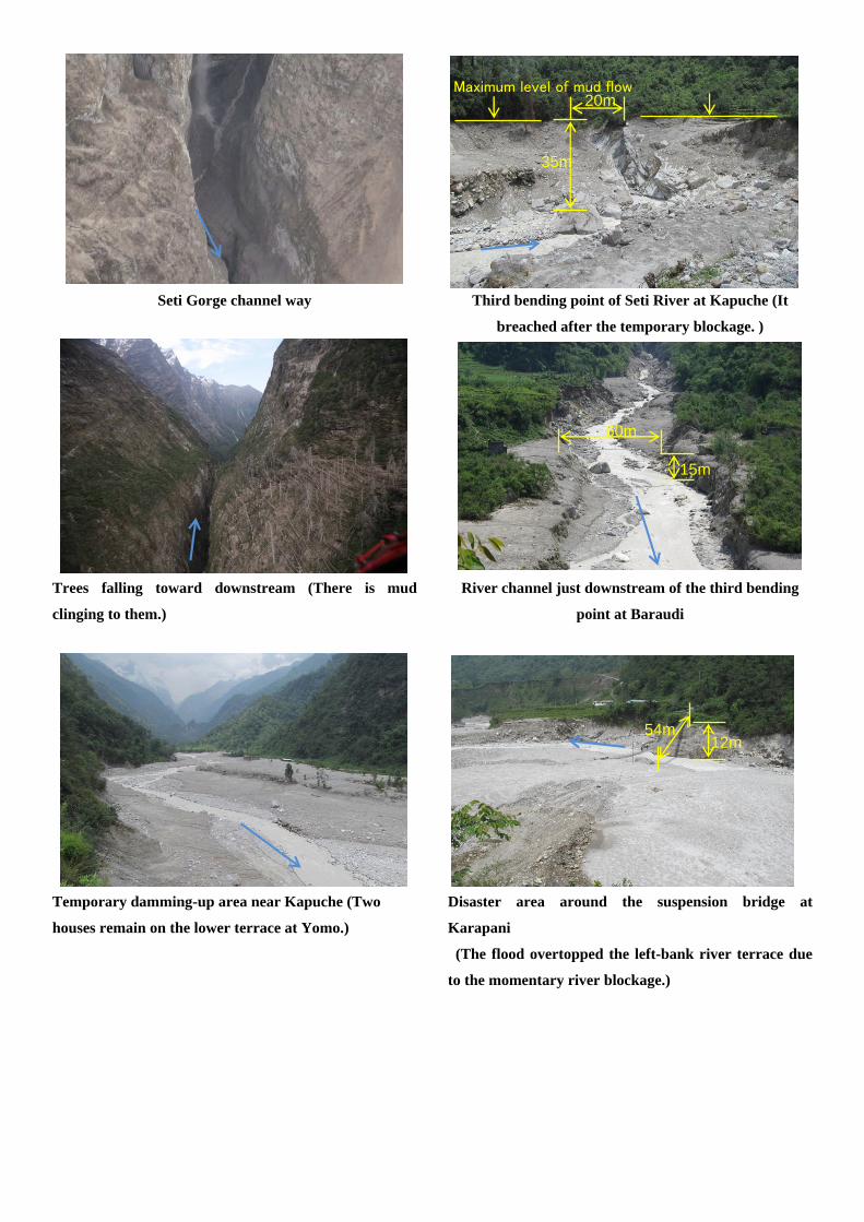
Temporary damming-up area near Kapuche (Two
houses remain on the lower terrace at Yomo.)
Third bending point of Seti River at Kapuche (It
breached after the temporary blockage. )
River channel just downstream of the third bending
point at Baraudi
Disaster area around the suspension bridge at
Karapani
(The flood overtopped the left-bank river terrace due
to the momentary river blockage.)
60m
15m
12m 54m
35m
20m Maximum level of mud flow
Contents 1. Introduction 2. Purposes and approach 3. Survey team 4. Itinerary 5. Damages and response of the government and international organizations 6. Outcome of the survey and recommendations
6.1 Preparation of the field survey 6.2 Geomorphology, geology, occurrences of rockslides and rock avalanches in the
disaster affected area 6.3 Process of rock avalanche and subsequent mud flows 6.4 Mud-flows from the Seti Gorge to Kharapani 6.5 Estimation of the peak discharge 6.6 Results of interviews with local people 6.7 Summary of r survey result 6.8 Recommendations
Annex 1 Interviews Annex 2 List of persons met Annex 3 List of reference materials Annex 4 Photos Separate attachment
1
1.Introduction On 5 May 2012, a rockslide on the western cliff of Annapurna � triggered floods1), which ran down the Seti Khola (River) causing serious damage to villages and tourist spots along the river. Information on damage, rescue operations, etc. was provided from time to time by the Japanese Embassy in Nepal and the NPO Disaster Information Research Institute as well as a series of OCHA Situation Reports. Considering the seriousness of the disaster and the necessity to investigate the phenomena for disaster mitigation in Nepal in the future, the NPO Nepal-Japan Friendship Association for Water Induced Disaster Prevention (NFAD) dispatched a five member survey team from 2 to 10 June, 2012, just one month after the disaster. There are many materials which are very useful for the preparation for the survey and analysis on the cause and process of the floods, such as a series of ICIMOD studies, Mr. Maximov’s (pilot of Avia Club Nepal) Video, Dr. Petly’s report, Dr. Fushimi’s report, the Noguchi Ken office homepage, LANDSAT images, and so on. The survey was carried out smoothly and satisfactorily owing to those materials and the kind cooperation of DWIDP2), ICIMOD3), and others. Good weather despite it being the rainy season and the carefully arranged logistic support also factored into this success. The Helicopter survey focused on the western flank of Annapurna � where the rock slides and rock avalanches occurred to trigger the disaster. Soil materials were collected for comparison with the deposits in the downstream areas. Reconnaissance along the Seti Khola confirmed that there was damming up at Jomo and severe bank erosions at places along the river. The deposits along the river were confirmed to be the same materials as those collected during the helicopter survey. Interviews at the affected villages, district offices, schools, etc. were very useful in understanding the real situation at the time of the disaster. Our questions were abrupt and without prior notice, but all interviewees responded kindly with a variety of information. On 9 June, the day when we left Nepal for Japan, a meeting was held at the residence of the Japanese Ambassador to report on the survey results. Representatives of the government and international organizations were invited. We promised to send the survey report to concerned organizations for information sharing. We hope that hat the results of the survey would be shared by all concerned for further study to mitigate this type of disaster in Nepal
2
Himalaya in the future. This report is a compilation of the data/information collected and studies conducted by individuals and organizations prior to our survey, and the findings made during our survey. We are certain that some progress has been made in the research on the mechanism of rock slides/rock avalanches/mud flows, especially through such practical approaches as helicopter survey, reconnaissance survey, and interviews. However, we recognize that there are still phenomena which have not yet been clarified, as listed in the Recommendations. We hope that this report will be useful in the further advancement of research to mitigate this type of disaster in Nepal in the future. 1) Hydraulic behavior varies from rock slides to rock avalanches, mud flows, flash floods,
and floods as descending from upstream to downstream. Therefore, the word “flood” is used here as a general expression for such phenomena. 2) Department of Water Induced Disaster Prevention, Ministry of Irrigation 3) International Center for Integrated Mountain Development
2.Purpose and Approach 1) Purpose
① Investigation on the causes and mechanism of the disaster ② Investigation on the possibility of recurrence of the disaster in Seti Khola, and
recommendations on early warning/evacuation to avoid damage in Seti Khola in the future
③ Investigation on the possibility of occurrence of similar disasters in other areas in Nepal Himalaya
2) Approach The survey is to be conducted through the following approaches in principle.
① Practical field survey involving helicopter survey, reconnaissance survey, and interviews in affected areas.
② Close coordination with government organizations, international organizations, universities etc. for a variety of information and support.
③ Publicizing the survey results for information sharing among all concerned for the further advancement of research on this type of disasters in Nepal.
3.Survey Team Hidetomi Oi, Director General of NFAD, President of International Sabo Association Daisuke Higaki (Dr.): President of Japan Landslides Association, Professor of Hirosaki

3
University, Member of NFAD Hiroshi Yagi (Dr.): Professor of Yamagata University, Member of NFAD Nobuhiro Usuki: Asia Air Survey Co., LTD, Member of NFAD Kosuke Yoshino: Asia Air Survey Co., LTD
4.Itinerary
Yagi Oi, Higaki, Usuki, Yoshino 6/2 (Sat) Haneda 0:20 → BKK 4:50 TG661
BKK 10:15 → KTM 13:30 TG319 【Stay at KTM】
6/3 (Sun) AM Information collection Haneda 0:20 → BKK 4:40 TG661 BKK10:15 → KTM 13:30 TG319
PM Meeting with the helicopter pilot Visit of Ministry of Home Affairs (Emergency Operation Center) (Oi) 【Stay at KTM】
6/4 (Mon) Move by helicopter KTM 6:40 → Karuwa 7:30 Survey by helicopter 8:00 → 9:40 Reconnaissance survey in Kapuche and Sano Khobang (Site for relocation) 【Stay at Karuwa】
6/5 (Tue) Reconnaissance survey Interview with Machapuchare VDC staff 【Stay at Karuwa】
6/6 (Wed) 6:30-8:00 Reconnaissance survey in Kapuche (Reconnaissance of the gorge was attempted but unsuccessful) AM Karuwa → Kharapani。 PM Reconnaissance survey in and around Kharapani 【Stay at Kharapani in tents】
6/7 (Thu) Kharapani → Pokhara (by land) Pokhara → KTM (by air)
【Stay at KTM】
AM Visit to an elementary school in Diplang PM Kharapani → Pokhara(by land)。
Visit to Sardi Khola VDC on the way to Pokhara。 【Stay at Pokhara】
6/8 (Fri) KTM 13:30 → BKK 18:15 TG320 Leave BKK 22:10 TG640
AM Visit to Seti Khola gorge in Pokhara Pokhara → KTM (by air)
PM Preparation of report 【Stay at KTM】 6/9 (Sat) Arrive at Narita at 6:20 9:30 – 11:00 Meeting to report on the survey at the residence of the
Japanese Ambassador KTM 13:30 → B KK 18:15 TG320 Leave BKK 22:10 TG640
6/10(日) Arrive at Narita at 6:20
4
5
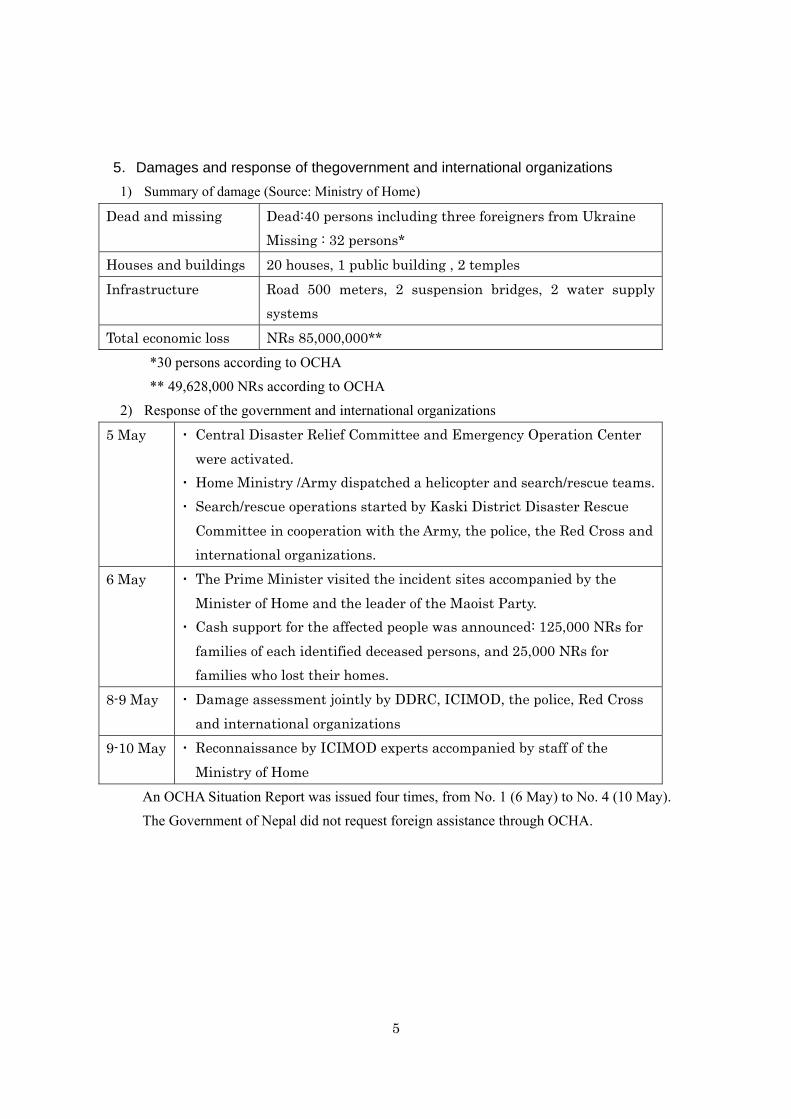
5.Damages and response of thegovernment and international organizations
1) Summary of damage (Source: Ministry of Home)
Dead and missing Dead:40 persons including three foreigners from Ukraine Missing : 32 persons*
Houses and buildings 20 houses, 1 public building , 2 temples Infrastructure Road 500 meters, 2 suspension bridges, 2 water supply
systems Total economic loss NRs 85,000,000**
*30 persons according to OCHA ** 49,628,000 NRs according to OCHA
2) Response of the government and international organizations
5 May ▪ Central Disaster Relief Committee and Emergency Operation Center were activated.
▪ Home Ministry /Army dispatched a helicopter and search/rescue teams.▪ Search/rescue operations started by Kaski District Disaster Rescue
Committee in cooperation with the Army, the police, the Red Cross and international organizations.
6 May ▪ The Prime Minister visited the incident sites accompanied by the Minister of Home and the leader of the Maoist Party.
▪ Cash support for the affected people was announced: 125,000 NRs for families of each identified deceased persons, and 25,000 NRs for families who lost their homes.
8-9 May ▪ Damage assessment jointly by DDRC, ICIMOD, the police, Red Cross and international organizations
9-10 May ▪ Reconnaissance by ICIMOD experts accompanied by staff of the Ministry of Home
An OCHA Situation Report was issued four times, from No. 1 (6 May) to No. 4 (10 May). The Government of Nepal did not request foreign assistance through OCHA.
6
6. Outcome of the survey and recommendations
6.1. Preparation of the field study
Video images and press reports of the disasters induced by the debris-mud flow were
distributed through the Internet just after its occurrence on 5th May. They indicated rock-wall
collapse or gigantic-scale snow avalanches occurring on the west wall of Annapurna IV, from
which the uppermost reach of the Seti River starts to flow. Based on such information, airborne
research using a helicopter was planned in order to investigate the cause of the debris-mud
flows along the Seti River, which also affected the city of Pokhara and its lower stream area.
Dr. Yagi, who visited Kathmandu earlier than when the other members arrived, met Dr. S.
Bajracharya of ICIMOD, who visited the Seti River area in the middle of May, and interviewed
with him about his opinion on the disaster.
6.1.1 Information collection in Kathmandu Remarks that we should focus on after the interview with Dr. Bajyacharya were summarized as
follows;
① Rock avalanches and the subsequent debris-mud flow, including rock flour that
coincidentally occurred, flew into the Seti Gorge. However, the distribution area of the rock
flour was quite limited and therefore, it is doubtful whether the volume of the rock flour
could be enough to supply the total amount of fine materials. Consequently, we had to pay
much attention to other factors such as erosion due to the passage of the rock-debris
avalanches flowed upon the slope, strong blow due to it, or mass movement induced by the
impact tremor induced by the rock-debris avalanches.
② Dr. Bajracharya saw the rock failure which occurred on the right bank of the Seti Gorge and
which seemed to be choking the Seti Gorge. That might have caused the pulse waving of the
debris-mud flow due to the damming of the stream.
③There remains another possibility of the pulse waving of the debris-mud flow along the main
stream. Damming up of the tributaries by a counter-flow of the debris-mud flow is another
possible cause. Therefore, we had to check for traces of such damming at the confluence of
tributaries to the main stream.
We discussed the issues to be checked in the field research based on the interview with Dr.
Bajracharya and decided on the subjects which we should focus on at the observation flight and
7
how to implement our field study as follows;
① We had to reconsider another source of fine materials included in the debris-mud flow
because it is too difficult to attribute the source of the fine sediments to those derived from the
failure on the neighbouring slope along the stream that were induced by the tremor caused by
the impact of the rock avalanches. There is also the possibility that the tremor caused
liquefaction of the sediments distributed along the floor bed of the gorge. We had to pay a
great deal of attention to slope failures along the gorge due to toe erosion by the passage of the
debris-mud flow and to the change of the stream bed whether the severe incision occurred
along the gorge and the surrounding slope on which the rock avalanches passed down.
② We should check whether the rockslide along the Seti Gorge was of great enough scale to
dam up the stream.
③ We should also check for traces of the tributaries damming up due to the debris-mud flow.
Based on the above mentioned remarks, we implemented the field studies as:
1) An air-borne reconnaissance study
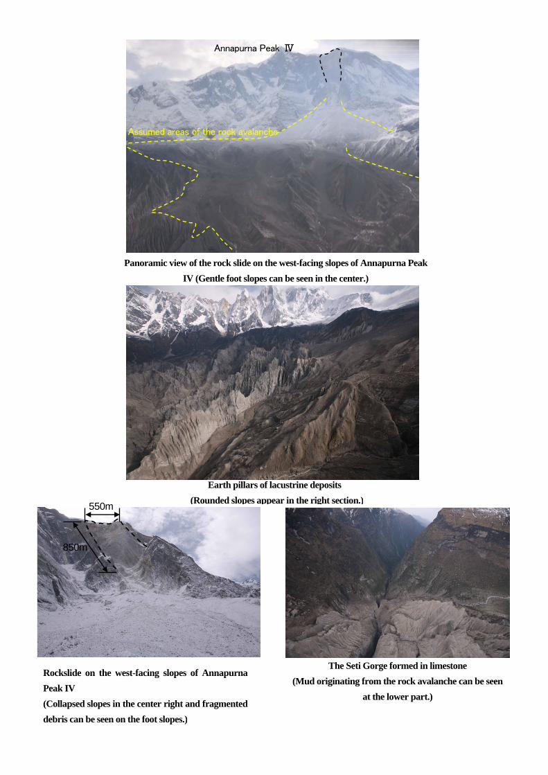
An air-borne study was carried out on 4th June. Its targets of observation were a rockslide
source area on the west-wall of Annapurna IV, the gentle slope developing on the foot of the
west-wall ranging 3500-5000m as the uppermost course of the Seti River, the Seti Gorge, and
its lower course to Karapani village.
2) Field study
The study team visited the most severely affected sites such as Sadal (the uppermost village),
Yomo, Kharapani (which belongs to Macchapuchhare VDC), and Purujung Khola (which
belongs to Sardikhola VDC) from 4th to 7th June. An outline of the topography in and around
the study area is shown Fig.6.1.1 & Fig.6.1.2.
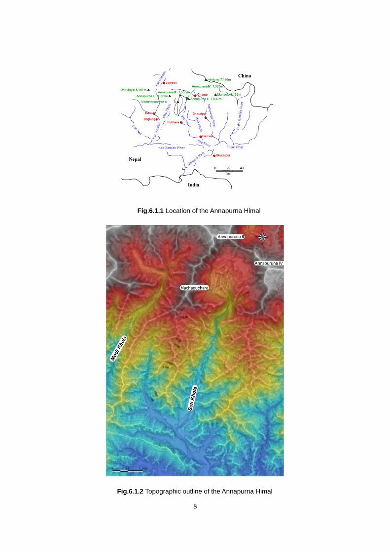
8
Fig.6.1.2 Topographic outline of the Annapurna Himal
Fig.6.1.1 Location of the Annapurna Himal
9
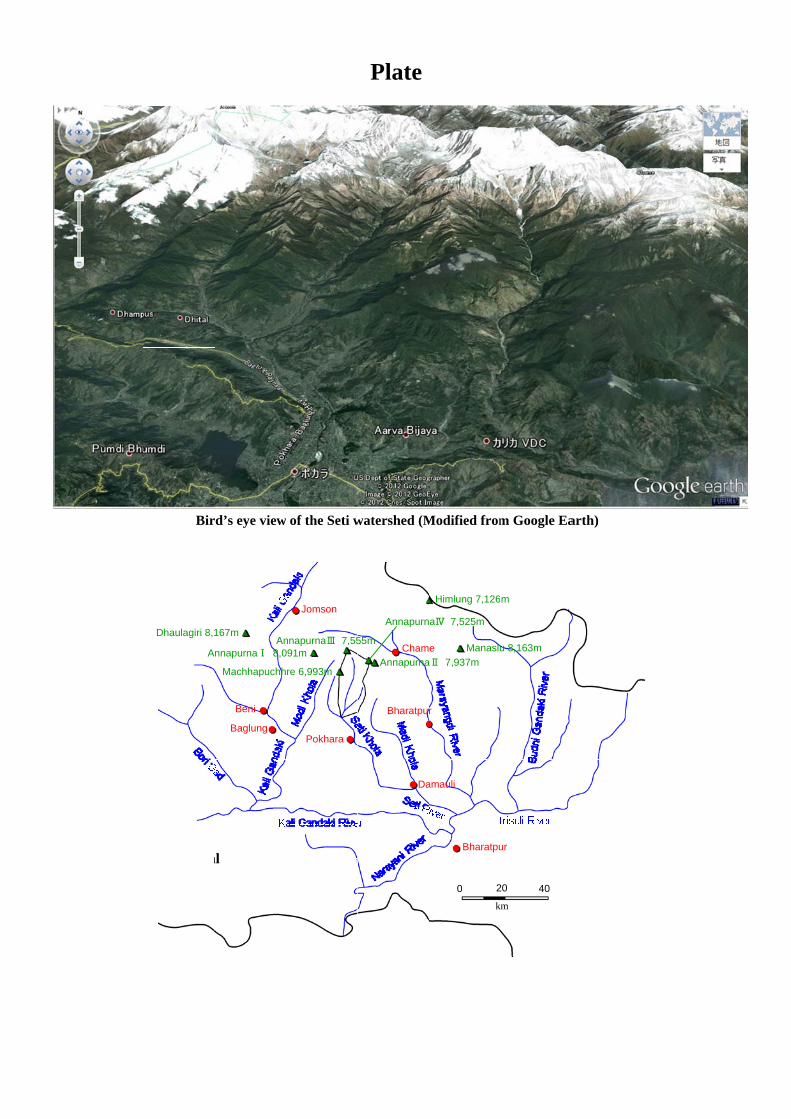
6.2. Geomorphology, Geology, occurrences of rockslides and rock avalanches
in the disaster affected area
6.2.1 Outline of Geomorphology and Geology in the uppermost course of the Seti
River
The Annapurna Himal is one of the gigantic ranges in the Himalayas which consists of ten
peaks higher than 7000m, and Annapurna I is a main peak at 8091 meters high. It continues 90
km east-westerly bordered by the Marsyandhi River to the east and the Kaligandhaki River to
the west. The southern flank of the Annapurna Himal is a source of the Modhi and Seti Rivers.
The uppermost course of the Seti River is a small round basin, with a diameter of 6 km, ranging
from 3400m to 5000m a.s.l. (Fig.6.1.2). We are tentatively calling this basin the Annapurna
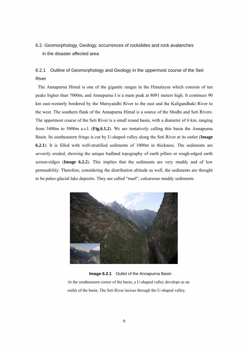
Basin. Its southeastern fringe is cut by U-shaped valley along the Seti River at its outlet (Image
6.2.1). It is filled with well-stratified sediments of 1000m in thickness. The sediments are
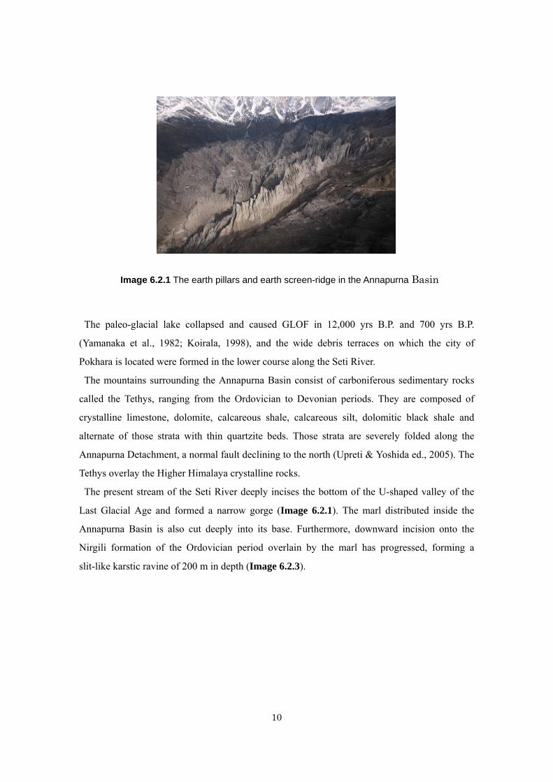
severely eroded, showing the unique badland topography of earth pillars or rough-edged earth
screen-ridges (Image 6.2.2). This implies that the sediments are very muddy and of low
permeability. Therefore, considering the distribution altitude as well, the sediments are thought
to be paleo-glacial lake deposits. They are called “marl”, calcareous muddy sediments.
Image 6.2.1 Outlet of the Annapurna Basin
At the southeastern corner of the basin, a U-shaped valley develops as an
outlet of the basin. The Seti River incises through the U-shaped valley,
10
The paleo-glacial lake collapsed and caused GLOF in 12,000 yrs B.P. and 700 yrs B.P.
(Yamanaka et al., 1982; Koirala, 1998), and the wide debris terraces on which the city of
Pokhara is located were formed in the lower course along the Seti River.
The mountains surrounding the Annapurna Basin consist of carboniferous sedimentary rocks
called the Tethys, ranging from the Ordovician to Devonian periods. They are composed of
crystalline limestone, dolomite, calcareous shale, calcareous silt, dolomitic black shale and
alternate of those strata with thin quartzite beds. Those strata are severely folded along the
Annapurna Detachment, a normal fault declining to the north (Upreti & Yoshida ed., 2005). The
Tethys overlay the Higher Himalaya crystalline rocks.
The present stream of the Seti River deeply incises the bottom of the U-shaped valley of the
Last Glacial Age and formed a narrow gorge (Image 6.2.1). The marl distributed inside the
Annapurna Basin is also cut deeply into its base. Furthermore, downward incision onto the
Nirgili formation of the Ordovician period overlain by the marl has progressed, forming a
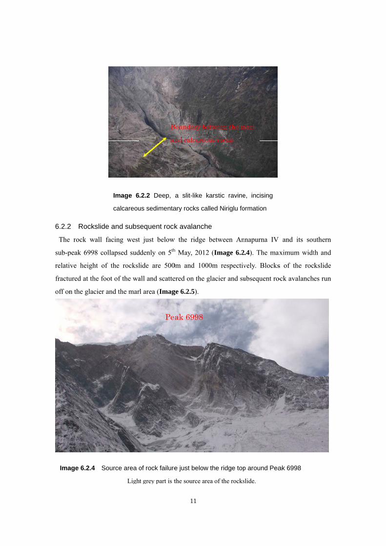
slit-like karstic ravine of 200 m in depth (Image 6.2.3).
Image 6.2.1 The earth pillars and earth screen-ridge in the Annapurna Basin
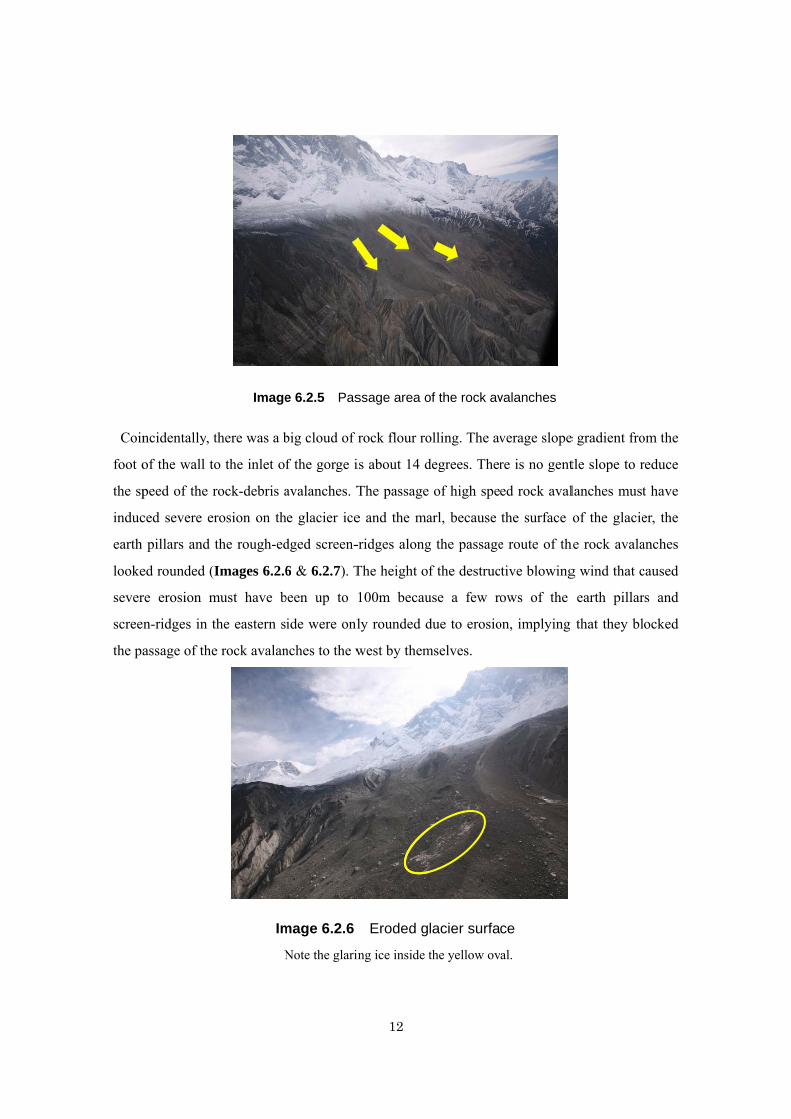
6.2.2
The
sub-p
relati
fractu
off on
Ima
2 Rockslid
rock wall
peak 6998 co
ve height o
ured at the fo
n the glacier
age 6.2.4 S
de and subs
facing west
ollapsed sud
f the rocksl
oot of the wa
and the mar
Image 6
calcareou
Source area o
Ligh
sequent rock
t just below
ddenly on 5th
lide are 500
all and scatte
l area (Imag
.2.2 Deep,
us sedimenta
of rock failure
t grey part is t
B
an
Pe
11
k avalanche
w the ridge bh May, 2012
0m and 1000
ered on the g
ge 6.2.5).
a slit-like k
ary rocks cal
e just below
the source are
Boundary bet
nd calcareou
ak 6998
e
between An
(Image 6.2
0m respectiv
glacier and su
arstic ravine
led Niriglu fo
the ridge top
ea of the rocks
tween the m
us rocks
nnapurna IV
.4). The max
vely. Blocks
ubsequent ro
e, incising
ormation
p around Pea
slide.
marl
and its sou
aximum widt
s of the roc
ock avalanch
ak 6998
uthern
th and
kslide
es run
Coin
foot o
the sp
induc
earth
looke
sever
scree
the pa
ncidentally, t
of the wall to
peed of the r
ced severe er
pillars and
ed rounded (I
re erosion m
n-ridges in t
assage of the
there was a b
o the inlet of
rock-debris a
rosion on th
the rough-ed
Images 6.2.6
must have b
the eastern s
e rock avalan
Image
Im
N
big cloud of
f the gorge i
avalanches. T
he glacier ice
dged screen-
6 & 6.2.7). T
been up to
ide were onl
nches to the w
e 6.2.5 Pas
mage 6.2.6
Note the glarin
12
rock flour ro
is about 14 d
The passage
e and the ma
-ridges along
The height of
100m becau
ly rounded d
west by them
ssage area o
Eroded g
ing ice inside t
olling. The av
degrees. Ther
of high spe
arl, because
g the passage
f the destruc
use a few ro
due to erosio
mselves.
of the rock av
lacier surfa
the yellow ov
verage slope
re is no gent
ed rock aval
the surface o
e route of th
tive blowing
ows of the
on, implying
valanches
ce
al.
e gradient fro
tle slope to r
lanches must
of the glacie
he rock avala
g wind that c
earth pillar
that they bl
om the
reduce
t have
er, the
anches
caused
rs and
ocked
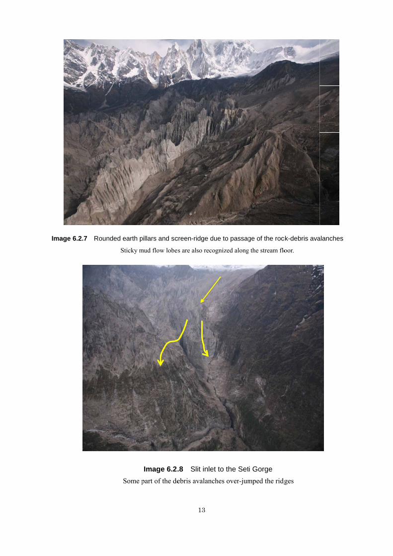
Image 6.2.7 Rounnded earth p
Sticky m
Some p
pillars and sc
mud flow lobe
Image 6.2.part of the de
13
creen-ridge d
s are also reco
.8 Slit inleebris avalanc
due to passag
ognized along
et to the Setches over-jum
ge of the roc
g the stream flo
i Gorge mped the ridg
ck-debris ava
oor.
ges
alanches
14
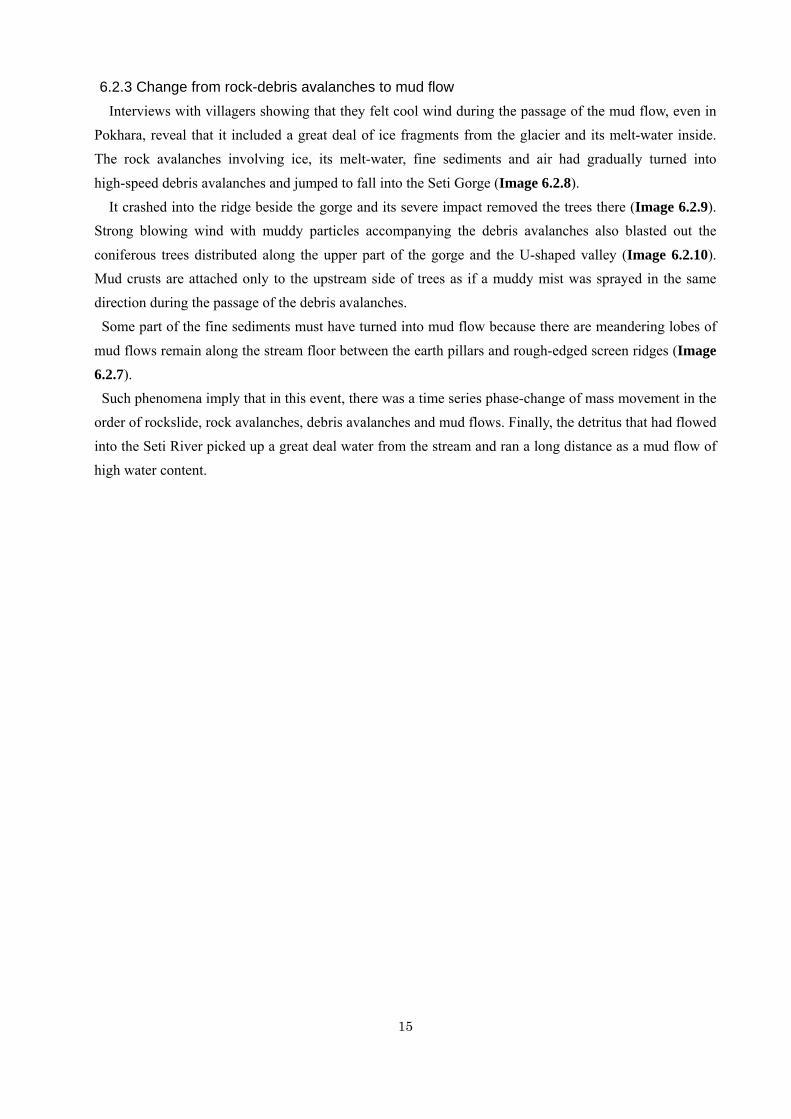
Image 6.2.9 Rock-debris avalanches impact site just beside the Seti Gorge Most of trees on the ridge were swept away by the main body of the debris avalanches and some of those
distributed in its marginal parts were blasted out by the strong wind.
Yellow arrow indicates the direction of blasted trees.
Image 6.2.10 Coniferous trees blasted out by the accompanying strong wind with the debris avalanches on the right bank of the Seti gorge
15
6.2.3 Change from rock-debris avalanches to mud flow Interviews with villagers showing that they felt cool wind during the passage of the mud flow, even in Pokhara, reveal that it included a great deal of ice fragments from the glacier and its melt-water inside. The rock avalanches involving ice, its melt-water, fine sediments and air had gradually turned into
high-speed debris avalanches and jumped to fall into the Seti Gorge (Image 6.2.8). It crashed into the ridge beside the gorge and its severe impact removed the trees there (Image 6.2.9). Strong blowing wind with muddy particles accompanying the debris avalanches also blasted out the
coniferous trees distributed along the upper part of the gorge and the U-shaped valley (Image 6.2.10). Mud crusts are attached only to the upstream side of trees as if a muddy mist was sprayed in the same direction during the passage of the debris avalanches.
Some part of the fine sediments must have turned into mud flow because there are meandering lobes of
mud flows remain along the stream floor between the earth pillars and rough-edged screen ridges (Image 6.2.7). Such phenomena imply that in this event, there was a time series phase-change of mass movement in the order of rockslide, rock avalanches, debris avalanches and mud flows. Finally, the detritus that had flowed into the Seti River picked up a great deal water from the stream and ran a long distance as a mud flow of high water content.
16
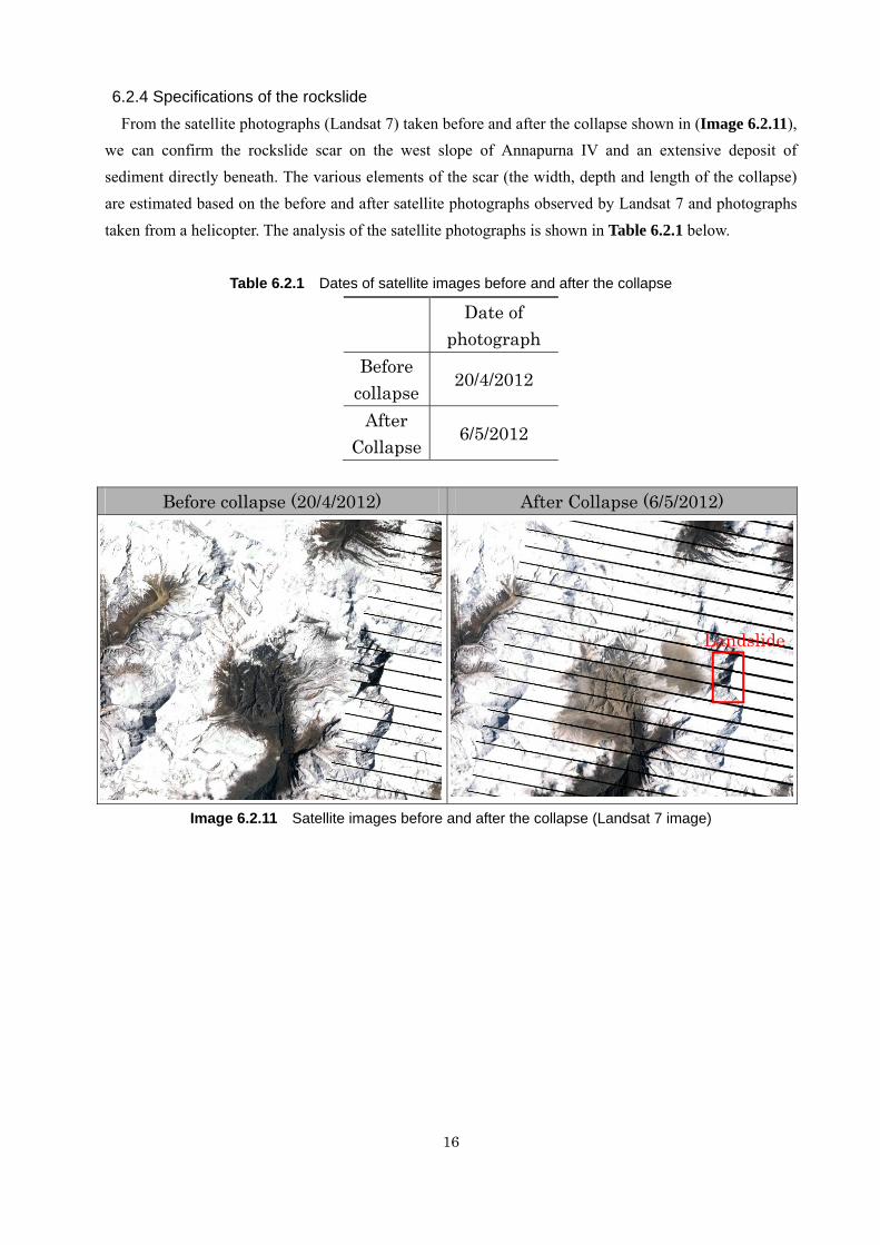
6.2.4 Specifications of the rockslide From the satellite photographs (Landsat 7) taken before and after the collapse shown in (Image 6.2.11),
we can confirm the rockslide scar on the west slope of Annapurna IV and an extensive deposit of sediment directly beneath. The various elements of the scar (the width, depth and length of the collapse) are estimated based on the before and after satellite photographs observed by Landsat 7 and photographs
taken from a helicopter. The analysis of the satellite photographs is shown in Table 6.2.1 below.
Table 6.2.1 Dates of satellite images before and after the collapse
Date of
photograph Before
collapse20/4/2012
After Collapse
6/5/2012
Before collapse (20/4/2012) After Collapse (6/5/2012)
Image 6.2.11 Satellite images before and after the collapse (Landsat 7 image)
Landslide
17
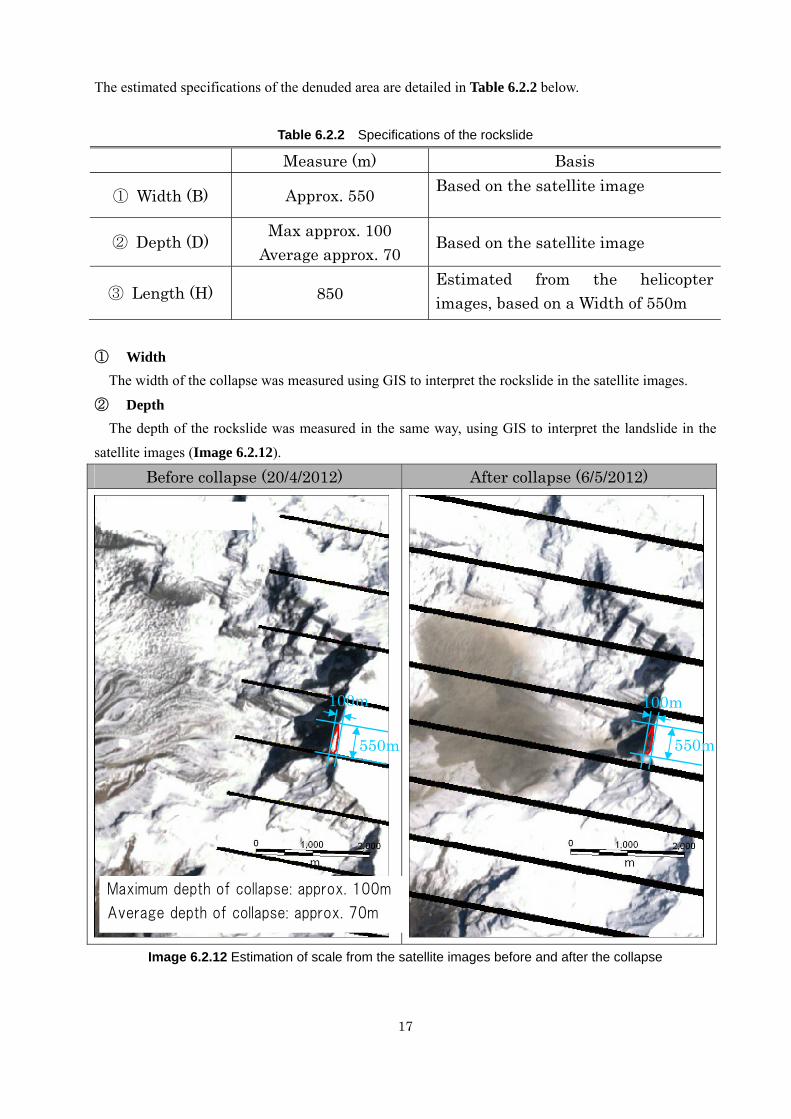
The estimated specifications of the denuded area are detailed in Table 6.2.2 below.
Table 6.2.2 Specifications of the rockslide
Measure (m) Basis
① Width (B) Approx. 550 Based on the satellite image
② Depth (D) Max approx. 100
Average approx. 70 Based on the satellite image
③ Length (H) 850 Estimated from the helicopter images, based on a Width of 550m
① Width
The width of the collapse was measured using GIS to interpret the rockslide in the satellite images.
② Depth The depth of the rockslide was measured in the same way, using GIS to interpret the landslide in the
satellite images (Image 6.2.12).
Image 6.2.12 Estimation of scale from the satellite images before and after the collapse
Before collapse (20/4/2012) After collapse (6/5/2012)
550m 550m
Maximum depth of collapse: approx. 100m
Average depth of collapse: approx. 70m
100m 100m
18
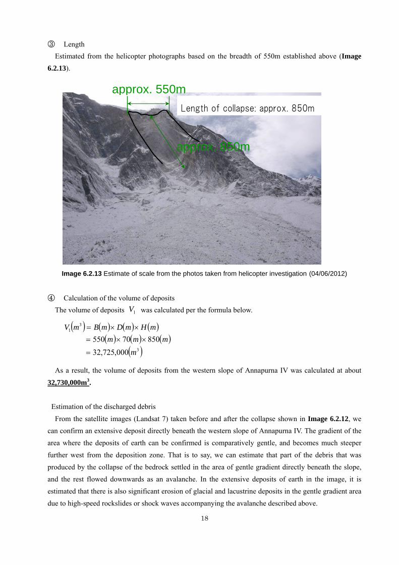
③ Length Estimated from the helicopter photographs based on the breadth of 550m established above (Image
6.2.13).
Image 6.2.13 Estimate of scale from the photos taken from helicopter investigation (04/06/2012) ④ Calculation of the volume of deposits
The volume of deposits was calculated per the formula below.
As a result, the volume of deposits from the western slope of Annapurna IV was calculated at about
32,730,000m3. Estimation of the discharged debris
From the satellite images (Landsat 7) taken before and after the collapse shown in Image 6.2.12, we can confirm an extensive deposit directly beneath the western slope of Annapurna IV. The gradient of the area where the deposits of earth can be confirmed is comparatively gentle, and becomes much steeper further west from the deposition zone. That is to say, we can estimate that part of the debris that was produced by the collapse of the bedrock settled in the area of gentle gradient directly beneath the slope, and the rest flowed downwards as an avalanche. In the extensive deposits of earth in the image, it is estimated that there is also significant erosion of glacial and lacustrine deposits in the gentle gradient area due to high-speed rockslides or shock waves accompanying the avalanche described above.
1V
( ) ( ) ( ) ( )( ) ( ) ( )
( )3
31
000,725,3285070550
mmmm
mHmDmBmV
=
××=××=
approx. 850m
Length of collapse: approx. 850m
approx. 550m
19
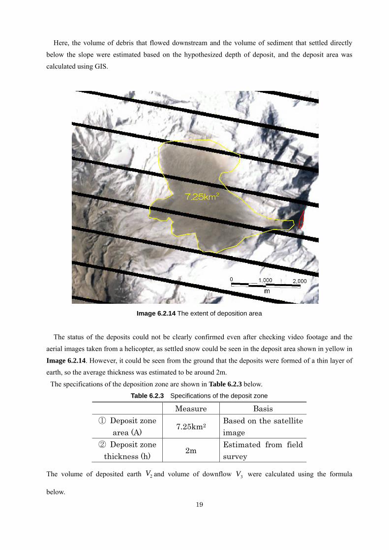
Here, the volume of debris that flowed downstream and the volume of sediment that settled directly below the slope were estimated based on the hypothesized depth of deposit, and the deposit area was calculated using GIS.
Image 6.2.14 The extent of deposition area
The status of the deposits could not be clearly confirmed even after checking video footage and the
aerial images taken from a helicopter, as settled snow could be seen in the deposit area shown in yellow in
Image 6.2.14. However, it could be seen from the ground that the deposits were formed of a thin layer of earth, so the average thickness was estimated to be around 2m.
The specifications of the deposition zone are shown in Table 6.2.3 below. Table 6.2.3 Specifications of the deposit zone
Measure Basis ① Deposit zone
area (A) 7.25km2
Based on the satellite image
② Deposit zone thickness (h)
2m Estimated from field survey
The volume of deposited earth and volume of downflow were calculated using the formula
below.
2V 3V
7.25km2
20
Volume of deposit
Volume of downflow
From the above, the volume of debris including fine materials that was deposited directly beneath the
western slope of Annapurna IV after the collapse was calculated at around 14,500,000m3, and the volume of debris which flowed into the Seti River was calculated at around 18,230,000m3. However, this value will change according to the estimate of the amount of change in terrain from the original topography, including erosion accompanying the debris flow.
2V
( ) ( ) ( )( ) ( )( )3
2
232
000,500,142000,250,7
mmm
mhmAmV
=
×=
×=
3V
( ) ( ) ( )( ) ( )( )3
332
21
33
000,225,18000,500,14000,725,32
mmm
mVmVmV
=
−=
−=
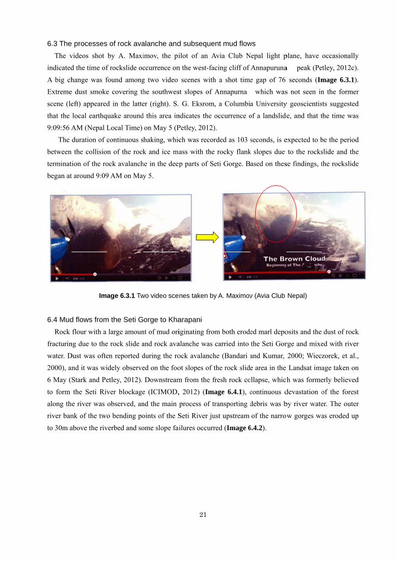
6.3 The The vindicated
A big chExtremescene (lethat the 9:09:56 A
The between terminatbegan at
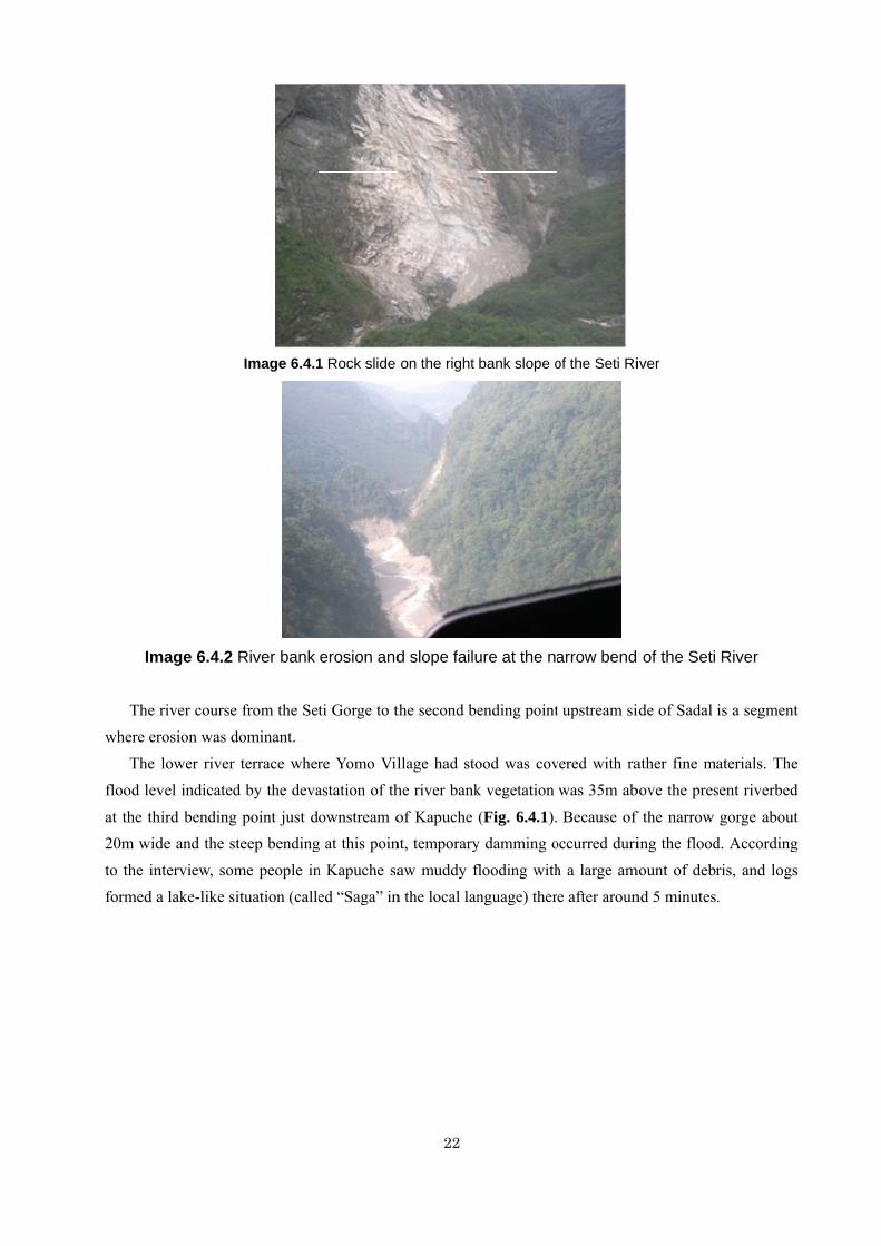
6.4 Mud Rock fracturinwater. D2000), an6 May (
to form along thriver ban
to 30m a
e processesvideos shot d the time of
hange was fe dust smokeeft) appearedlocal earthquAM (Nepal Lduration of c the collision
tion of the rot around 9:09
Ima
d flows fromflour with a
ng due to theDust was ofte
nd it was wiStark and Pe
the Seti Rivhe river was nk of the two
above the riv
of rock avaby A. Maxi
f rockslide oc
found amonge covering thd in the latteuake aroundLocal Time) continuous sn of the rock
ock avalanch9 AM on May
age 6.3.1 Tw
m the Seti Glarge amoun
e rock slide aen reported didely observeetley, 2012).
ver blockageobserved, ano bending po
verbed and so
alanche andimov, the piccurrence on
g two video he southweser (right). S.d this area in
on May 5 (Phaking, whick and ice ma
he in the deepy 5.
wo video sce
orge to Khant of mud oriand rock avaduring the roed on the fooDownstream
e (ICIMOD,nd the main oints of the S
ome slope fai
21
d subsequeilot of an An the west-fac
scenes withst slopes of A G. Eksrom,
ndicates the oPetley, 2012)ch was recorass with the p parts of Se
nes taken by
arapani iginating fromalanche was ock avalanchot slopes of tm from the fr
, 2012) (Imaprocess of trSeti River ju
ilures occurr
nt mud flowAvia Club Ncing cliff of
h a shot timeAnnapurna , a Columbioccurrence o). rded as 103 s
rocky flanketi Gorge. B
y A. Maximov
m both erodecarried into
he (Bandari athe rock slidefresh rock co
age 6.4.1), cransporting d
ust upstream
red (Image 6
ws Nepal light p
Annapuruna
e gap of 76 �which wasa Universityof a landslide
seconds, is ek slopes due ased on thes
v (Avia Club
ed marl depothe Seti Gorand Kumar, e area in the llapse, which
continuous ddebris was bof the narrow
6.4.2).
plane, have a � peak (Pe
seconds (Ims not seen iny geoscientisde, and that t
expected to bto the rocks
se findings, t
Nepal)
osits and the rge and mixe2000; Wiecz Landsat ima
ch was forme
devastation oby river wateow gorges wa
occasionallytley, 2012c).
mage 6.3.1).n the formerts suggested
the time was
be the periodslide and thethe rockslide
dust of rocked with riverzorek, et al.,age taken onerly believed
of the forester. The outeras eroded up
y .
. r d s
d e e
k r , n d
t r p
Im The where er
The flood lev
at the th20m widto the informed a
mage 6.4.2 R
river course rosion was dlower river
vel indicated
hird bending de and the stnterview, soma lake-like si
Image 6.4.1
River bank
from the Setominant. terrace wher
d by the deva
point just dteep bendingme people inituation (calle
1 Rock slide
erosion and
ti Gorge to t
re Yomo Vilastation of th
ownstream og at this poinn Kapuche saed “Saga” in
22
on the right
d slope failu
the second be
llage had stohe river bank
of Kapuche nt, temporaryaw muddy f
n the local lan
bank slope o
ure at the na
ending point
ood was covk vegetation
(Fig. 6.4.1).y damming oflooding withnguage) ther
of the Seti Ri
arrow bend
t upstream si
vered with rawas 35m ab
Because of occurred durih a large ame after aroun
iver
of the Seti
ide of Sadal
ather fine mabove the pres
f the narrow ing the flood
mount of debrnd 5 minutes
River
is a segment
aterials. Thesent riverbed
gorge aboutd. Accordingris, and logs.
t
e d
t g s
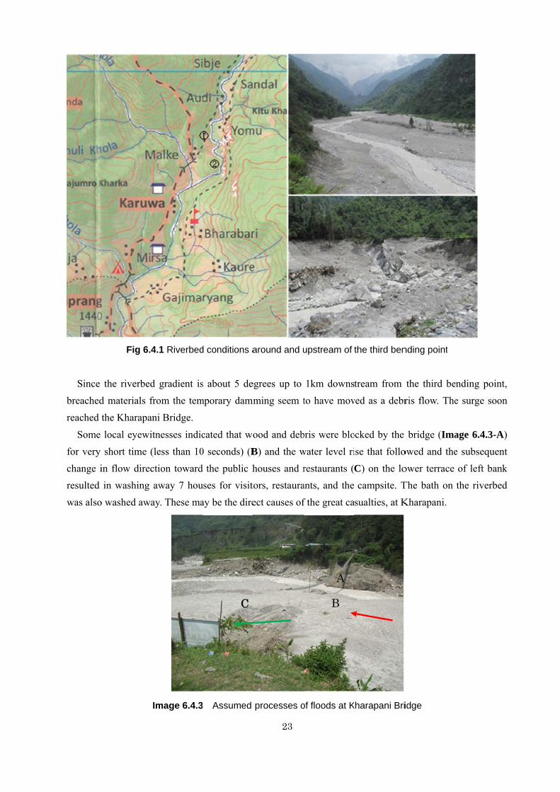
Since breachedreached
Some for very change iresulted was also
Fig 6.4
the riverbedd materials fthe Kharapa
local eyewishort time (
in flow direcin washing
o washed awa
4.1 Riverbed
d gradient isfrom the temani Bridge.
itnesses indic(less than 10ction towardaway 7 hou
ay. These ma
Image 6.4.3
d conditions a
s about 5 demporary damm
cated that wo0 seconds) (Bd the public huses for visitay be the dire
3 Assumed
C
23
around and u
egrees up to ming seem t
ood and debB) and the whouses and rtors, restauraect causes of
processes o
upstream of
1km downsto have mov
bris were blowater level rirestaurants (ants, and the f the great ca
of floods at K
B
A
the third ben
tream from ved as a debr
ocked by the ise that folloC) on the locampsite. T
sualties, at K
Kharapani Bri
nding point
the third beris flow. The
bridge (Imaowed and theower terrace The bath on Kharapani.
idge
ending point,e surge soon
age 6.4.3-A)e subsequentof left bankthe riverbed
, n
) t k d
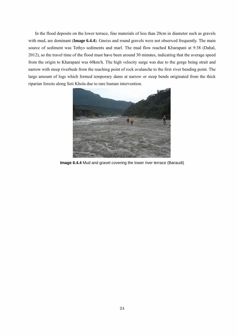
In th
with musource o2012), sofrom thenarrow wlarge amriparian
he flood depo
d, are dominof sediment o the travel te origin to Kwith steep riv
mount of logsforests along
Im
osits on the lo
nant (Image was Tethys time of the fl
Kharapani waverbeds froms which formg Seti Khola
age 6.4.4 M
ower terrace
6.4.4). Gneissediments a
lood must haas 60km/h. Tm the reachinmed temporadue to rare h
ud and grave
24
e, fine materi
ss and roundand marl. Thave been arouThe high velong point of roary dams at nhuman interv
el covering t
ials of less th
d gravels werhe mud flowund 30 minuocity surge wock avalanchnarrow or st
vention.
he lower rive
han 20cm in
re not observw reached Kh
tes, indicatinwas due to the to the first teep bends o
er terrace (Ba
diameter suc
ved frequentlharapani at 9ng that the avhe gorge beinriver bendin
originated fro
araudi)
ch as gravels
ly. The main9:38 (Dahal,verage speedng strait and
ng point. Theom the thick
s
n ,
d d e k
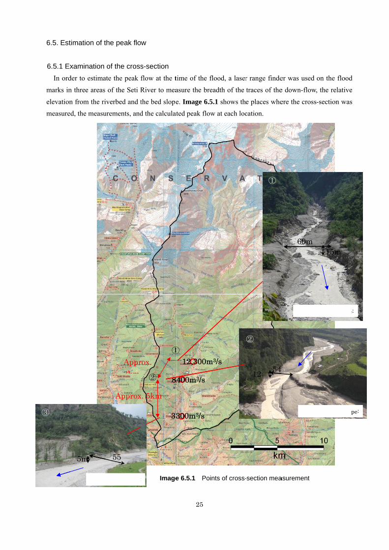
6.5. Est
6.5.1 Ex
In ordmarks in
elevationmeasure
③
timation of t
xamination der to estiman three areas
n from the rid, the measu
5m
Avera
the peak flo
of the crossate the peak
of the Seti R
iverbed and turements, and
Appr3km
Approx
55
age bed slope:
ow
s-section flow at the tRiver to mea
the bed sloped the calcula
Image
8
3
rox.
x. 5km
①
②
:
25
time of the fasure the bre
e. Image 6.5ated peak flow
e 6.5.1 Poi
12,300m
8400m3/s
300m3/s
①
flood, a lasereadth of the
5.1 shows thew at each loc
nts of cross-
m3/s
②
r range findetraces of the
e places whecation.
-section mea
②
①
5412
②
er was used e down-flow,
ere the cross
asurement
60m
Average
4
Avera
on the flood, the relative
-section was
15m
e bed slope
age bed slop
d e
s
e:
pe:
6.5.2 AnBased
mudflow
average
T=0s
T=10T=10s
T=10
T=20
T=20
nalysis of vid on the vide
w (at the poin
velocity of th
s
0s
0s
0s
0s
Fron
Front l
Fr
ideo imageseo images ta
nt ② in Ima
he head part
Image 6.5.2
nt line of th
line of the
ront line of
s aken by the
age 6.5.1) ob
of the mud f
Status of the
he flood
e flood
f the flood
26
local people
btained durin
flow (Image
e arrival of th
e from the t
ng the field s
e 6.5.2).
T=5
T=1T=1T=1
he Kharapan
Fr
approx
time of the a
study, an esti
5s
15s 15s 15s
ni mudflow
Front li
ront line o
T=20
x. 260m
A
arrival of th
imation was
ine of the
of the flood
T=0s
Approx. 1k
e Kharapani
made of the
flood
d
km
i
e
27
From the video analysis, the head part of the mudflow moved a distance of 260m ( ) over 20 seconds,
and its speed was calculated using the formula below.
From this, the average speed of the leading edge of the Kharapani flood was calculated to be about
13m/s (46.8km/h). This is about the same range as the 7.8-13.6m/s of the Sakurajima Nojiri River, and faster than the observed speed of the avalanche at Kamikamihori Creek on Mount Yakedake in Japan.
l
( ) ( ) ( )( ) ( )
( )smsm
sTmlmv
1320260
3
=÷=
÷=
28
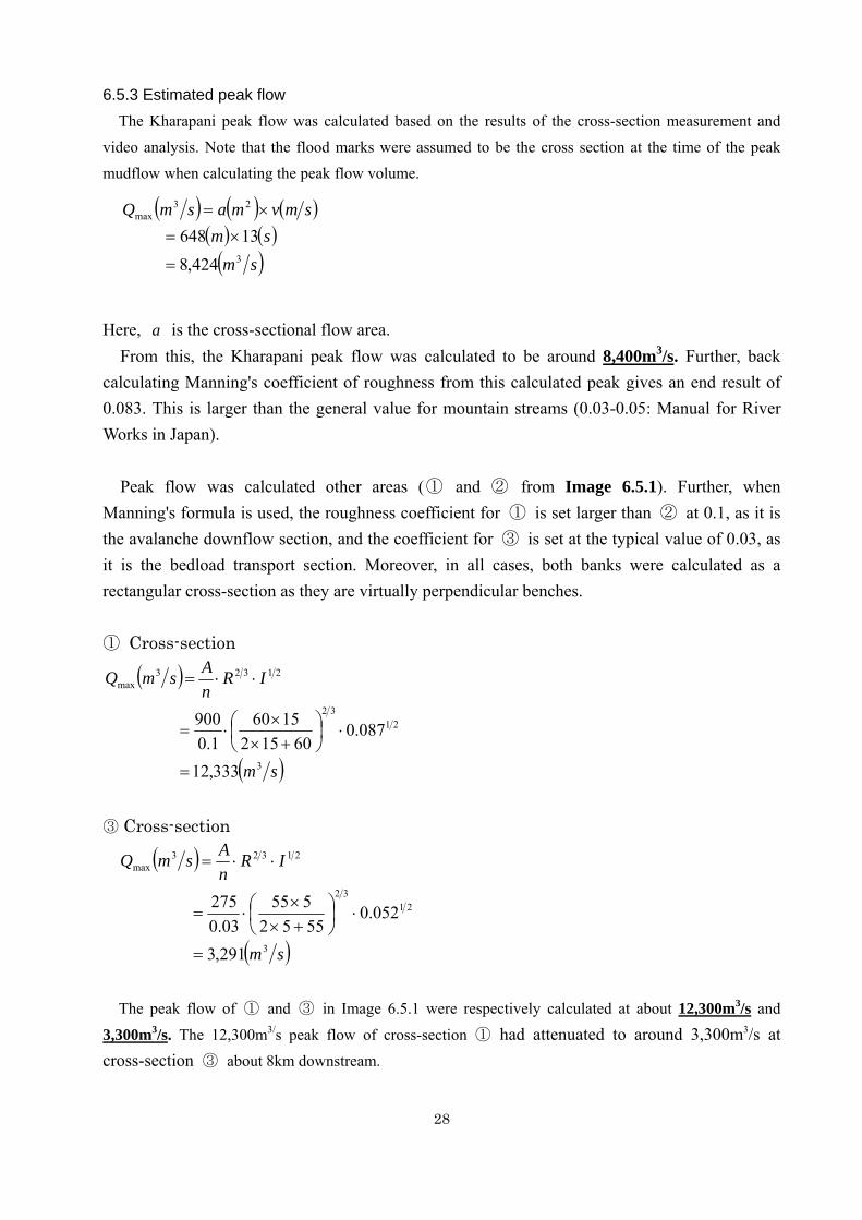
6.5.3 Estimated peak flow The Kharapani peak flow was calculated based on the results of the cross-section measurement and
video analysis. Note that the flood marks were assumed to be the cross section at the time of the peak mudflow when calculating the peak flow volume.
Here, is the cross-sectional flow area.
From this, the Kharapani peak flow was calculated to be around 8,400m3/s. Further, back calculating Manning's coefficient of roughness from this calculated peak gives an end result of 0.083. This is larger than the general value for mountain streams (0.03-0.05: Manual for River Works in Japan).
Peak flow was calculated other areas (① and ② from Image 6.5.1). Further, when
Manning's formula is used, the roughness coefficient for ① is set larger than ② at 0.1, as it is the avalanche downflow section, and the coefficient for ③ is set at the typical value of 0.03, as it is the bedload transport section. Moreover, in all cases, both banks were calculated as a rectangular cross-section as they are virtually perpendicular benches. ① Cross-section
③ Cross-section
The peak flow of ① and ③ in Image 6.5.1 were respectively calculated at about 12,300m3/s and
3,300m3/s. The 12,300m3/s peak flow of cross-section ① had attenuated to around 3,300m3/s at cross-section ③ about 8km downstream.
( ) ( ) ( )( ) ( )( )sm
smsmvmasmQ
3
23max
424,813648
=
×=×=
a
( )
( )sm
IRnAsmQ
3
2132
21323max
333,12
087.060152
15601.0
900
=
⋅⎟⎠⎞
⎜⎝⎛
+××
⋅=
⋅⋅=
( )
( )sm
IRnAsmQ
3
2132
21323max
291,3
052.05552555
03.0275
=
⋅⎟⎠⎞
⎜⎝⎛
+××
⋅=
⋅⋅=
6.5.4
The fi
river, anis though
Here,
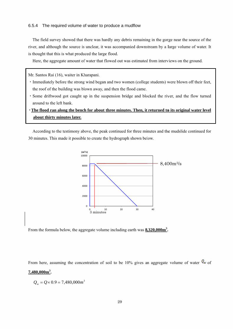
Mr. Sant
・Immethe ro
・Somearoun
・The fl
abou
Accor30 minu
From th
From he
7,480,00
Qw =
3(Q =
The require
field survey snd although tht that this isthe aggregat
tos Rai (16),
ediately beforoof of the bui
e driftwood gnd to the left
ood ran alon
t thirty min
rding to the tutes. This ma
e formula be
ere, assumin
00m3.
79.0Q =×=
260)303 ××+
ed volume o
showed that tthe source iss what produte amount of
waiter in Kh
re the strongilding was bl
got caught ubank.
ng the bench
nutes later.
testimony abade it possibl
elow, the agg
ng the conce
20
40
60
80
100
ピーク(m
3000,480,7 m
Peak
,8400,8=
×
of water to p
there was has unclear, it wuced the largef water that f
harapani.
g wind beganlown away, a
up in the sus
h for about
bove, the peae to create th
gregate volum
entration of
0
000
000
000
000
000
0 1
ク流量m3/s)
3
3 minutes
3000,320, m
29
produce a m
ardly any debwas accompae flood. flowed out w
n and two woand then the
spension bri
three minut
ak continued he hydrograp
me including
soil to be 1
10 20
経過時間(分sTime
mudflow
bris remaininanied downs
was estimated
omen (collegflood came.
idge and blo
tes. Then, it
for three minph shown bel
g earth was 8
0% gives an
30
分)
ng in the gorgstream by a l
d from interv
e students) w
ocked the riv
returned to
nutes and thelow.
,320,000m3.
n aggregate
40
8,40
rge near the slarge volume
views on the
were blown o
ver, and the
o its original
e mudslide c
volume of
00m3/s
source of thee of water. It
ground.
off their feet,
flow turned
l water level
continued for
water of
e t
,
d
l
r
f
30
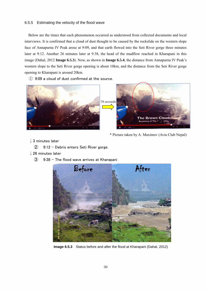
6.5.5 Estimating the velocity of the flood wave
Below are the times that each phenomenon occurred as understood from collected documents and local
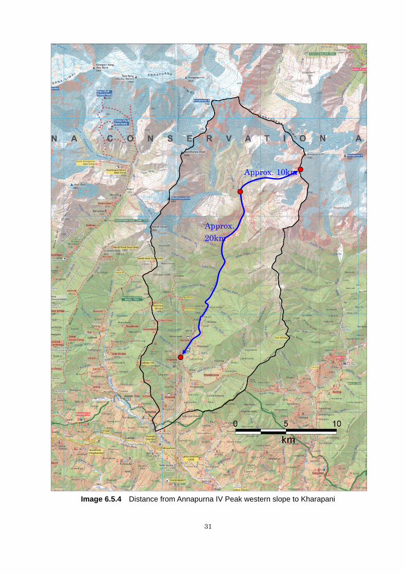
interviews. It is confirmed that a cloud of dust thought to be caused by the rockslide on the western slope face of Annapurna IV Peak arose at 9:09, and that earth flowed into the Seti River gorge three minutes later at 9:12. Another 26 minutes later at 9:38, the head of the mudflow reached in Kharapani in this
image (Dahal, 2012 Image 6.5.3). Now, as shown in Image 6.5.4, the distance from Annapurna IV Peak’s western slope to the Seti River gorge opening is about 10km, and the distance from the Seti River gorge opening to Kharapani is around 20km.
① 9:09 a cloud of dust confirmed at the source.
* Picture taken by A. Maximov (Avia Club Nepal)
↓3 minutes later
② 9:12 - Debris enters Seti River gorge.
↓26 minutes later
③ 9:38 - The flood wave arrives at Kharapani
Image 6.5.3 Status before and after the flood at Kharapani (Dahal, 2012)
78 seconds
31
Image 6.5.4 Distance from Annapurna IV Peak western slope to Kharapani
Approx. 20km
Approx. 10km
32
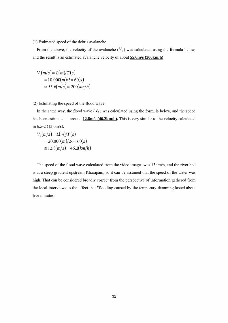
(1) Estimated speed of the debris avalanche
From the above, the velocity of the avalanche ( ) was calculated using the formula below,
and the result is an estimated avalanche velocity of about 55.6m/s (200km/h)
(2) Estimating the speed of the flood wave
In the same way, the flood wave ( ) was calculated using the formula below, and the speed
has been estimated at around 12.8m/s (46.2km/h). This is very similar to the velocity calculated
in 6.5-2 (13.0m/s).
The speed of the flood wave calculated from the video images was 13.0m/s, and the river bed
is at a steep gradient upstream Kharapani, so it can be assumed that the speed of the water was
high. That can be considered broadly correct from the perspective of information gathered from
the local interviews to the effect that "flooding caused by the temporary damming lasted about
five minutes."
1V
( ) ( ) ( )( ) ( )
( ) ( )hkmsmsm
sTmLsmV
2006.55603000,10
1
=≅×=
=
2V
( ) ( ) ( )( ) ( )
( ) ( )hkmsmsm
sTmLsmV
2.468.126026000,20
2
=≅×=
=
6.6 R
T
no bi
of the
the en
the s
avala
about
A
6.6.1)
Fig. 6
1) S
(Y
2) R
3)
fl
4) T
p
Results of in
The origin of
ig glacial lak
e rock avala
ntrance of th
ediment tran
anche debris.
t the precedin
According to
).
6.6.1 Phenom
Snow depth i
Yomo, Kapu
Rainfall occu
The color o
flood (Kapuc
The water le
people could
nterviews w
f floodwater
kes were foun
anche was ex
he Seti Gorge
nsported from
. We intervie
ng phenomen
the interview
mena discus
in the Annap
uche).
urred in late A
f the Seti Ri
he, Yomo).
vel of the S
cross the riv
ith local peo
whose peak
nd before the
xpected air b
e. One hypot
m eroded fi
ewed the loc
na of the Set
ws, the phen
ssed in Interv
purna Mount
April (Yomo,
iver had chan
Seti River ha
ver (Baraudi)
33
ople
discharge w
e flood in the
blow, a main
thesis is that
ine materials
cal people of
ti River.
nomena and
view 1 (Kabu
tains was gr
, Kapuche).
nged to blac
ad changed
).
was estimated
e upstream a
n water sourc
t the deep Se
s and breach
f Yomo, Kap
their occurre
che, Baraud
reater than th
ck and brown
several time
d at 8,400m3/
area. Since th
ce should ha
eti Gorge had
hed by the o
uche, Baraud
ence time ar
i and Kharap
he usual in w
n around 7-1
es. It had be
/s is not clea
he dominant
ave existed a
d been block
onslaught of
udi, and Khar
re as follows
pani)
winter of thi
10 days befo
ecome so low
ar, and
agent
around
ked by
f rock
rapani
s (Fig.
s year
ore the
w that
There
prece
area
surfac
While
Khara
of se
interv
Fig. 6
T
helico
wind
from
the fl
evacu
A
bendi
Khara
efore there w
eding the flo
of Annapurn
ce erosion.
e many of th
apani area m
ediment whic
views with lo
6.6.2 The res
The people o
opter from 5
and smoke
the approach
lood waves. M
uate due to th
At Baraudi an
ing points,
apani, howe
was more sn
ood. It may h
na IV. The w
he flood vict
must have pic
ch flew for
ocal people a
sults of interv
of Yomo an
5-20 minutes
in front of th
hing mud flo
Most of the p
hese phenom
nd Kharapan
people coul
ever, some
nowmelt wa
have activate
water color
tims in the d
cked up on p
the long dis
about the pre
views to loca
nd Kapuche
s before the
he approachi
ow upstream.
people in Yo
mena.
ni, standing a
ld only see
people noti
34
ater from the
ed surface er
changes in
disaster occur
pre-cautionar
stance to Kh
e-cautionary
al people abo
e noticed gr
onslaught of
ing mud flow
. The smoke
omo immedia
a short distan
the mud fl
iced the gro
e High Mou
rosion of for
late April ar
rred in Khar
ry phenomen
harapani. Fi
phenomena.
out the pre-ca
round shakin
f mud flow.
w. The shaki
is assumed t
ately rushed
nce from the
flow wave j
ound shakin
untains than
rmer lake de
re thought to
apani, the pe
na because of
ig. 6.6.2 sho
autionary ph
ng and soun
They also e
ng and soun
to have reise
to climb up t
e downstream
ust before i
ng from aro
the usual in
eposits in th
o be the res
eople of Kap
f the large am
ows the resu
henomena
nds like a
experienced s
nd may have
en and blown
the steep slo
m side of the
it approache
ound one m
n time
e foot
sult of
puche,
mount
ults of
flying
strong
come
n from
pes to
e river
ed. In
minute
35
beforehand. A few people also reported strong cold winds rushing in front of the mud flow. It is
noteworthy that an old man living in Baraudi could see the approaching mud flow and informed
his friend in Kharapani of the emergency via his mobile phone. However, this warning could not
convince the visitors in the hot spring to evacuate because they could not believe it gicen the
fine weather.
Based on the findings above, the hypothetical process of transition from the rock avalanche
to the mud flow is assumed to be as follows.
The facies of remaining debris materials indicate that the rock avalanche partially changed
into debris (mud) flow before arriving at the confluence of the Seti River. Possible origins of the
water which formed the mud flow are thought to have been not only the stream water of torrents
but the sudden failure of the ice caps which had covered the ridge slopes simultaneously with
the rockslide. Fragmented ice blocks mixed with rock debris may have melted during the
avalanche and provided water into the eroded fine marl materials. However, if the thickness, the
area of collapsed ice, and the bulk density are 60m, 550*100m, and 0.9 respectively, the
maximum volume of water from the ice, melting is assumed to be 3 million m3. This is only
40% of the assumed volume of water mentioned in 6.5.4. The eroded ice of the debris-covered
glacier on the foot slopes is not expected to be large in volume. The water from snowmelt and
rainfall in late April and eroded fine materials from marl deposits may have caused a temporary
blockage in the extremely deep and narrow gorge in of the Seti Khola limestone, and caused the
color changes in the river water at Yomo and Kapuche and the remarkable decrease in the river
water level one or two weeks before the flood. It is expected that the dammed-up water may
have breached due to the falling materials of the rock-debris avalanche, thus formulating the
mud flows. In this case, there were hardly any dammed-up materials remaining along the gorge.
36
6.7 Summary of survey results
Based on the field survey and analysis, the flood disaster of Seti Khola on May 5, 2012 is
considered to have occurred as the following processes. Time series phase changes of mass
movement occurred in this flood event.
1) A large-scale rockslide occurred on the west-facing walls of southwestern side of
Annapurna � at 9:09 AM on May 5. The ice cap on the ridge also fell down with it.
2) Rocky debris fractured at the foot of the wall and scattered on the glacier and subsequent
rock avalanche run off on the glacier and the marl deposits in the Annapurna Basin. The
marl deposits and glacier surfaces were eroded along the passage route of the rock
avalanche and the accompanying blowing wind.
3) The rock avalanche gradually turned into debris flow due to melt-water from the ice what
was involved and fell into the Seti Gorge. From there, mud flow moved downward,
damaging the villages along Seti Khola and reached Kharapani at 9:38 AM, causing grat
casualties.
The velocity of mass movements from the origin to Kharapani was approximately 60km/h.
The studies on the seismic analysis and the observation by the pilot of a light plane
indicated that the average velocity of the rock failure and rock avalanche reached around
200km/h (55.6m/s).
The scale of the rockslide was assumed to be approximately 850m in length, 550m in width,
and 30 million m3 in volume.
The interviews with local people and seismic observation data reveal that the rockslide was
not caused by earthquakes, heavy rain, or snow melting. Dip slopes consisting of the Tethys
sedimentary rocks may have induced rockslides. They also reveal that temporary damming up
of the Seti River within five minutes had occurred at the narrow river bending point at Kapuche.
Its bursting could have formulated a debris flow which may have increased the flow energy and
changed into mud flow downstream, causing the catastrophic damages at Kharapani 3km
downstream from the bursting point.
According to the local eyewitness a large amount of wood and debris at the front of mud
flow were blocked by a bridge, thus causing changes in flow direction to the lower terrace of the
left bank where the buildings for visitors had stood.
The video images taken at Kharapani indicate that the average velocity of the head part of
37
the mud flow was about 13m/s (46.8km/h), which is almost same as that of the mud flow from
Seti Gorge to Kharapani (46.2km/h). Estimated peak flow discharge by the field measurement
of highest flood marks was 12,300 m3/s at Yomo, 8,400 m3/s at Kharapani, and 3,300 m3/s at the
point 5 km downstream of Kharapani.
The surficial flood deposits along the Seti River consist of fine silty and clayey materials
with gravels. There fine materials are assumed to have originated from the dust of the rockslide,
avalanche, and eroded marl deposits. The large amount of woody debris in the mud flow was
from the dense riparian forests upstream.
According to local people, it is also expected that sediment concentration caused changes in
river water color and decreased water levels downstream around two weeks before the flood on
May 5. As the people also said that the High Mountain area of the Seti watershed had been
covered with an unusually large amount of snow in last winter, excessive snow melting also
may have induced sediment production in the marl areas. Recently, a scientific team of
Nepalese and the University of Arizona pointed out via field survey that a landslide dam had
been formed several weeks before the flood (AFP, 2012). Therefore the water source of the
mud flows is not only the eroded glacier but also the possible bursting of the previous filling
materials of the gorge (NFAD, 2012).
Several precautionary phenomena were also picked from the interview. People at Yomo and
Kapuche had noticed ground shaking and strange sounds from upstream 5-20 minutes before
the flood on May 5. Just before the arrival of the mud flow, they also saw smoke along the river.
Such phenomena were caused by the approaching mud flow. However, the people of Baraudi
and Kharapani recognized them much later because it was difficult to see far away due to the
bending Seti River.
While many flood victims who came to Kharapani for picnics, baths, or to work in shops
and stone quarrying, many of the upstream villages stood on the higher river terrace and
sustained less damage than at Kharapani. Many of the people of Yomo, which stood on the
lowest terrace and was completely overtopped by the mud flow, were able to escape up the
slopes suddenly and survive because of the precautionary phenomena. However, the emergency
information from Baraudi via mobile phone could not make the people in danger escape at
Kharapani. Because of the fine weather, most visitors could not believe the loud voice calling
for awareness of the big flood approaching.
Large-scale rockslides are not expected to occur frequently in High Himalaya, which
consists of rather hard rocks. In the Annapurna Basin, where steep slopes with earth pillars are
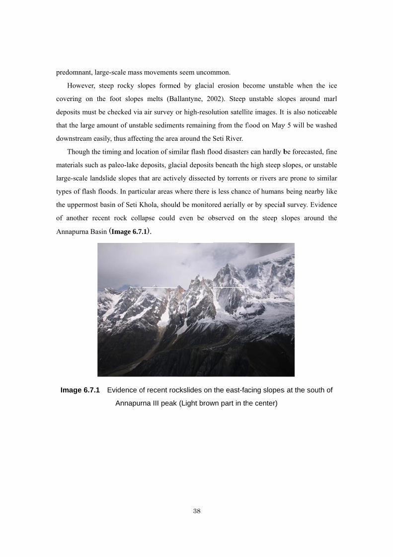
predo
H
cover
depos
that t
down
T
mater
large-
types
the up
of an
Anna
Ima
omnant, large
However, ste
ring on the
sits must be
the large amo
nstream easil
Though the tim
rials such as
-scale landsl
s of flash floo
ppermost ba
nother recen
apurna Basin
age 6.7.1
e-scale mass
eep rocky sl
foot slopes
checked via
ount of unsta
ly, thus affect
ming and loc
paleo-lake d
lide slopes th
ods. In partic
asin of Seti K
nt rock coll
n (Image 6.7.
Evidence o
Annapur
movements
lopes formed
s melts (Bal
a air survey o
able sedimen
ting the area
cation of sim
deposits, glac
hat are active
cular areas w
Khola, should
apse could
.1).
of recent roc
rna III peak
38
seem uncom
d by glacial
llantyne, 20
or high-resol
nts remaining
a around the S
milar flash flo
cial deposits
ely dissected
where there i
d be monitor
even be ob
ckslides on
(Light brow
mmon.
l erosion be
002). Steep
lution satellit
g from the fl
Seti River.
ood disasters
s beneath the
d by torrents
is less chance
red aerially o
bserved on
the east-fac
wn part in th
ecome unstab
unstable slo
te images. It
lood on May
can hardly b
high steep s
s or rivers ar
e of humans
or by special
the steep s
cing slopes
e center)
able when th
opes around
t is also notic
y 5 will be w
be forecasted
slopes, or un
re prone to s
being nearb
l survey. Evi
slopes aroun
s at the sout
he ice
d marl
ceable
washed
d, fine
nstable
imilar
by like
idence
nd the
th of
39
6.8 Recommendations
1) Causes of large-scale rock slides and avalanches and detection of highly hazardous slopes
The main cause of the rockslide on the ice-covered rocky mountain of 7,000m asl. should
be examined as ice melting and earthquakes can hardly be expected in the Seti flood case.
Any symptoms of rock slides such as cracks in glaciers or mountain slopes, should be
detected by air survey in the High Himalaya.
2) Mechanisms of mud flow formulation
The erosion volume of marl deposits due to the rock avalanche should be estimated by
comparing the topography before and after the avalanche. Topographical maps may be
prepared using the satellite. It may be also recommended to find evidence of temporary
damming-up that lasted until the flood occurrence in the Seti Gorge.
3) Confirmation of the temporary damming at the narrow bending point upstream of Sadal
which was reported in the interviews in Yomo and Kapuche.
4) Risk mapping of sudden flash floods in Nepal Himalaya
Not only dangerous glacial lakes but wide distribution areas of thick marl deposits should
be picked up below the large-scale rockslide prone slopes to perform risk zoning for sudden
flash floods. Large-scale unstable landslides should also be picked up for landslide dam and
burst risks. In particular, risky slopes in the outside areas of human activities, like the High
Himalaya zone and mountains with dense forest cover, should be surveyed by air or satellite
images because pre-caution by local people can not be expected.
5) Disaster preparedness education and simple early warning systems
Direct oral and auditory recognition of the approaching floods helped the people escape
suddenly in the Seti Flood Disaster. Mobile phones, which are widely used in Nepal, seem
to be an important communication tool for early warning. Combining such an information
system with disaster education from outside which helps the local people and visitors to
reduce the risks associate with such floods. In the case of sightseeing areas like Kharapani,
a TV monitor that monitors the upstream conditions of the risky river is useful for both
sightseeing under normal circumstances and evacuation when floods occur.
6) Countermeasures against the unstable sediments of Seti River
The areas along the Seti River have been highly susceptible to flood and sediment disasters
due to the unstable deposits remaining from this flood. This is similar to the rivers affected
by GLOFs and other big floods. Hazard zoning via aerial photo interpretation and field
surveying, early warning through both education and rainfall monitoring, and river training

40
works are recommended. Disaster preparedness and post-disaster restraint measures are
recommended along the Seti River as a model case of disaster management against the
sudden large-scale flash flood disaster. DWIDP may be one of the leading organizations for
this.
41
References
Agence France-Presse (AFP) (2012): Deadly Nepal flood due to small rockslide: Experts
http://reliefweb.int/report/nepal/deadly-nepal-flood-due- small-rockslide-experts 13 Nov. 2012.
Ballantyne, C.K. (2002) Paraglacial Geomorphology. Quaternary Science Reviews, 21,
1935-2017.
Bandari P. K. and Kumar K. (2000): Malpa rock avalanche of 18 August 1998. Landslide News
13, 18-20.
Dahal R. K.(2012) Why 1255 flash flood in the Seti River? - A brief report.
http://www.ranjan.net.np/ranjan/index.php/in-english-seti 5/27 2012
Fushimi, H. (2012) Report from the investigation into the Seti River flood and the Madi River
glacial lake outburst flood (memorandum).
Godin, L. & Brown, R.L. (1999): High strain zone in the hanging wall of the Annapuruna
detachment, central Nepal Himalaya. Geological Society of America Special Paper 328, pp.
199-210.
Higaki, D. and Sato, G. (2012) Erosion and sedimentation caused by glacial lake outburst floods
in the Nepal and Bhutan Himalayas. Global Environmental Research, vol. 16, pp. 71-76.
ICIMOD (2012a) Seti flash flood on 5th May 2012 in Seti River, Pokhara, Nepal.
http://geoportal.icimod.org/NAE/NewsDetail.aspx?NewsID=318%20 (5/7/2012)
ICIMOD (2012b) Seti flash flood reconnaissance visit, ICIMOD HP:
http://www.icimod.org/?q=7134 (5/10/2012)
Koirala, A. (1998): Report on engineering and environmental geological map of Pokhara valley.
Dept. of Mines and Geology, Kathmandu, Nepal, pp1-20.
Martineau K. (2012) Investigating Giant, Unseen Landslides. 6/12/2012 State of the Planet,
Columbia Univ., http://blogs.ei.columbia.edu/2012/06/12/investigating-giant-unseen-landslides/
Nepal-Japan Friendship Association for Water Induced Disaster Prevention (NFAD): A report on
the survey results of the Seti Flood disaster(May 5 2012) (in Japanese),
http://www.sff.or.jp/nepal/kaiin.html
Petley, D. (2012a) Flash flood in Nepal kills at least 15, with up to 36 more missing. The
Landslide Blog, 5/6/ 2012.
http://blogs.agu.org/landslideblog/2012/05/06/flash-flood-in-nepal-kills-at-least-15-with-up-to-3
6-more-missing/
Petley, D. (2012b) Using seismic data to analyse the Seti River landslide in Nepal, The
Landslide Blog. 5/9/2012.
42
http://blogs.agu.org/landslideblog/2012/05/09/using-seismic-data-to-analyse-the-seti-river-lands
lide-in-nepal/
Petley, D. (2012c) More information on the landslide that caused the Seti Flood in Nepal. The
Landslide Blog 5/12/2012,
Petley, D. (2012d) Understanding the Seti River Landslide in Nepal, The Landslide Blog.
http://blogs.agu.org/landslideblog/2012/05/23/understanding-the-seti-river-landslide-in-nepal/
5/23, 2012.
Stark C. and Petley D. (2012) Landslide and deadly flood in Nepal. NASA Earth Observatory
Subscribe Today.
Upreti, B.N. &Yoshida, Mitsuo (2005):Guidebook for Himalayan Trekkers, Series No. 1,
Geology and natural hazards along the Kaligandaki valley, Nepal. p.165, Dept.of Geology,
Trichandra Campus, Tribhuvan University, Kathmandu Nepal
Yamanaka, H., Yoshida, M. & Arita, K. (1982): Terrace landform and Quaternary deposit
around Pokhara valley, central Nepal. Journal of Nepal Geological Society, vol. 2 Special Issue,
pp.113-142.
Wieczorek, G. F., et al (2000) Unusual July 10, 1996, rock fall at Happy Isles, Yosemite
National Park, California, GSA Bulletin, vol. 112, pp. 75-85.
43
Acknowledgements
The Research Team should like to express thanks to so many persons who helped us execute the
field survey in various ways in Japan and in the field. In particular, Dr. Toshio Mori, Director
General of Sabo Frontier Foundation, made available the Kimura Fund which is a part of the
budget of the Foundation; Dr. Samjwal Bajracharya of ICIMOD and Mr. Amatya of DWIDP
provided us with valuable information and suggestions based on their expertise on disasters in
the Himalayan region; Mr. Hisashi Hoshino of the Japanese Embassy provided us with various
information collecting from government organizations, mass-media and other sources
continuously since the occurrence of the disaster; Mr. Raju Shahi, Nature Express Travels,
made the logistic arrangement attentively in a professional way which made the survey more
successful than anticipated before, covering wide areas unfamiliar to the study team; Special
acknowledgement should go to the Japanese Ambassador Mr. Kunio Takahashi who kindly
organized a briefing meeting at his official residence on the last day of the survey inviting
representatives of Government and major donors, which helped participants understand more
about the disaster and, furthermore, contributed to the promotion of coordination among
concerned organizations for disaster risk reduction in Nepal.
Annex 1: Interviews 4 June An elderly person (74 years old) in Kabuche
・I have three sons (one is in Malaysia) and a daughter. ・I had never experienced such a big disaster as this in my life. ・In Yomo Village, located on the other side of the river, there were 13 houses. Eleven of them
were completely washed away. Two remain but are uninhabitable. There was no damage in Kabuche.
・Twenty five minutes before the flood, people felt the ground shaking strongly like in an earthquake. I heard a roaring sound. I thought a big helicopter was approaching at a low altitude. I saw white smoke rising far away in the upstream area.
4 June A middle aged person (50 years old) in Sano Khoban (Sano Khoban is a place for relocation arranged by the
government. It is located in a mountain area. We arrived there after walking a foot path for about one hour, struggling with leeches under incessant rain. Six families from Yomo were in a hut surrounding a wood fire.)
・I was born in Yomo. This is the first disaster like this in my life. ・People came to live in Yomo about 70 years ago. They cut trees and settled there. People were
rich because the land was fertile and good for producing vegetables. Of the 13 families here, there came to settle in Yomo only three years ago from Dading District where they had been poor, suffering from frequent floods.
・Six families from Yomo are constructing houses here. ・All we received from the government was the land and two sacks of rice. 5 June A boy in Kabuche.
・My house is one of the two which withstand the floods, but it is inhabitable due to extensive damage inside.
・I escaped to the mountain behind Yomo together with the people of village, and stayed there for two days. Only one of the person of the village died.
5 June Mr. Arjun Bhandari, Sub-Secretary of Machapuchare VDC Tel: 9816101503
(We had informed Chairman of Machapuchare VDC of our visit in advance. He could not attend because of another appointment, but he was so kind as to send Mr. Bhandari to Karuwa to see us on his behalf. The VDC office is located in Diprang, about one hour on foot.).
・Seven people died in Machapuchare VDC: Yomo, 1), Diprang (2), Mirsa (4).
・ In Sano Khobang, the government provided land for 21 families, including families affected by the floods.
・Government support for affected families:
- Land to built a house - 100,000 NRs for totally damaged houses 50,000 NRs for partially damaged
houses 4 and 5 June A young person in Karuwa, the uppermost place we stayed
(He could speak English fluently because he had worked in Qatar for four years. He guided us along the right bank of the river,
upstream to the place in front of Yomo and downstream to the narrow gorge where sediment and wooden debris accumulated to form a temporary dam. Unfortunately, it was impossible to cross the river to Yomo because of the river water still flowing swiftly at a depth of more than one meter. According to Mr. Ram, our guide, the water of the river is relatively low in the morning because of the freezing in the high mountains, and high in the afternoon because of the melting there.)
・A suspension bridge connecting Jomo and Karuwa was washed away. A makeshift wooden bridge was constructed at the same place after the floods but was soon washed away as well.
・The color of the water of the river changed about one month before the floods. White smoke was seen upstream about 15 days before the floods.
・The river was blocked at the narrow gorge downstream of Yomo by sediment and wooden debris to form a lake-like situation (called “Saga” in the local language), which collapsed after about five minutes.
6 June Ms. Dhul Maya Tamang (55 years old) in Chipreti/Sardi Khola (Ms.
Tamang lives in a meager hut about one km downstream from Tatopani (Kharapani) and near the road leading to Pokhara.)
・My husband was killed by the floods while doing sand mining in the river. We have no
children and I am alone now. We came here from Pokhara five years ago. I received 125,000 NRs from the government.
・On that day of the disaster, the river stopped flowing and dried up temporarily (for about five minutes)
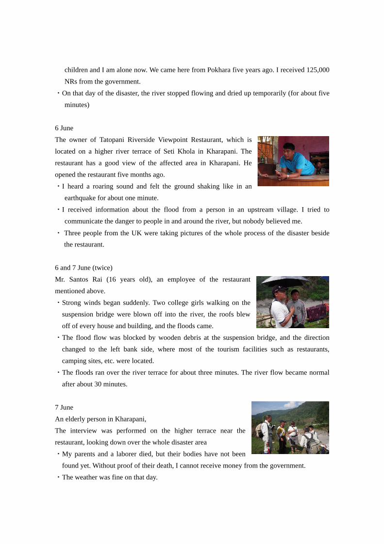
6 June The owner of Tatopani Riverside Viewpoint Restaurant, which is located on a higher river terrace of Seti Khola in Kharapani. The restaurant has a good view of the affected area in Kharapani. He opened the restaurant five months ago.
・I heard a roaring sound and felt the ground shaking like in an earthquake for about one minute.
・I received information about the flood from a person in an upstream village. I tried to communicate the danger to people in and around the river, but nobody believed me.
・ Three people from the UK were taking pictures of the whole process of the disaster beside the restaurant.
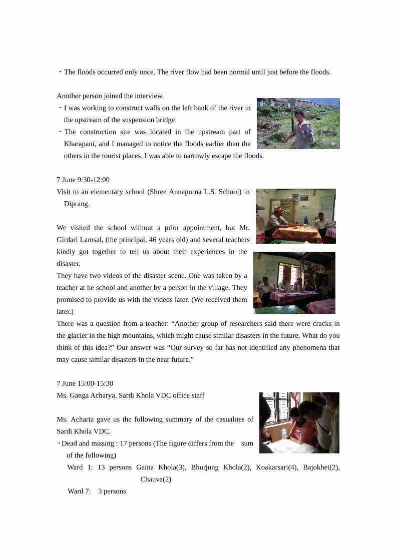
6 and 7 June (twice) Mr. Santos Rai (16 years old), an employee of the restaurant mentioned above.
・Strong winds began suddenly. Two college girls walking on the suspension bridge were blown off into the river, the roofs blew off of every house and building, and the floods came.
・The flood flow was blocked by wooden debris at the suspension bridge, and the direction changed to the left bank side, where most of the tourism facilities such as restaurants, camping sites, etc. were located.
・The floods ran over the river terrace for about three minutes. The river flow became normal after about 30 minutes.
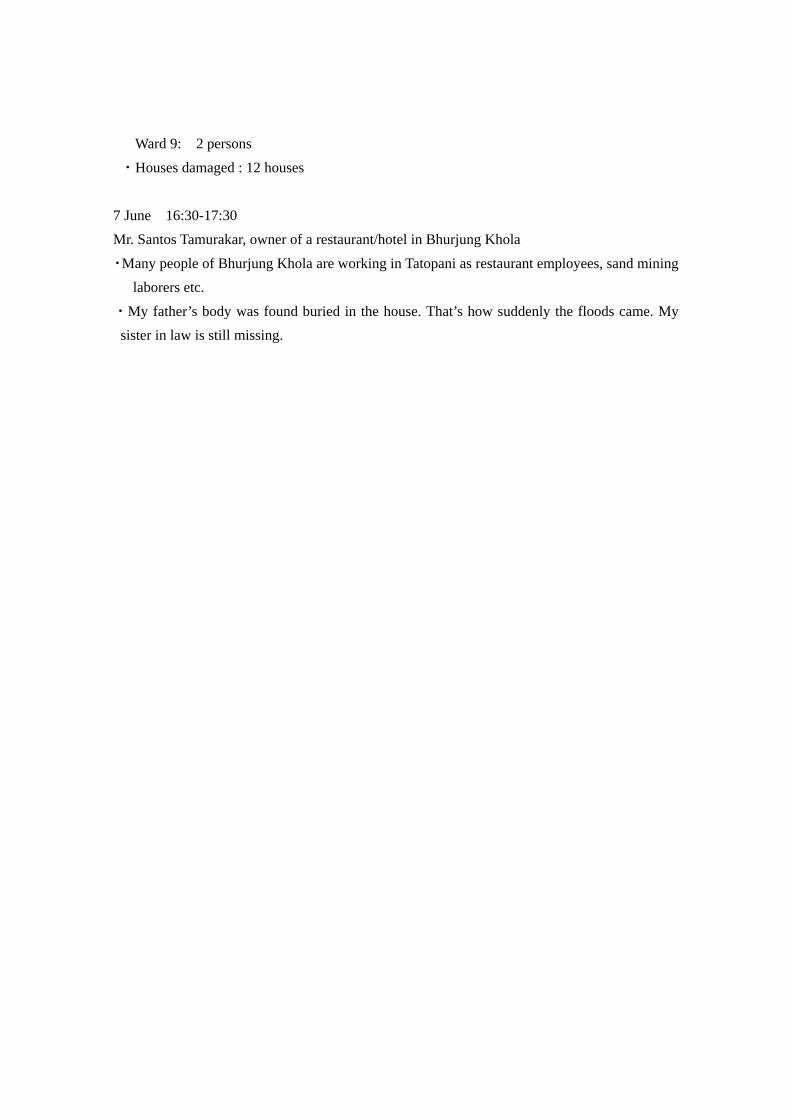
7 June An elderly person in Kharapani, The interview was performed on the higher terrace near the restaurant, looking down over the whole disaster area
・My parents and a laborer died, but their bodies have not been found yet. Without proof of their death, I cannot receive money from the government.
・The weather was fine on that day.
・The floods occurred only once. The river flow had been normal until just before the floods. Another person joined the interview.
・I was working to construct walls on the left bank of the river in the upstream of the suspension bridge.
・The construction site was located in the upstream part of Kharapani, and I managed to notice the floods earlier than the others in the tourist places. I was able to narrowly escape the floods.
7 June 9:30-12:00 Visit to an elementary school (Shree Annapurna L.S. School) in
Diprang. We visited the school without a prior appointment, but Mr. Girdari Lamsal, (the principal, 46 years old) and several teachers kindly got together to tell us about their experiences in the disaster. They have two videos of the disaster scene. One was taken by a teacher at he school and another by a person in the village. They promised to provide us with the videos later. (We received them later.) There was a question from a teacher: “Another group of researchers said there were cracks in the glacier in the high mountains, which might cause similar disasters in the future. What do you think of this idea?” Our answer was “Our survey so far has not identified any phenomena that may cause similar disasters in the near future.” 7 June 15:00-15:30 Ms. Ganga Acharya, Sardi Khola VDC office staff Ms. Acharia gave us the following summary of the casualties of Sardi Khola VDC.
・Dead and missing : 17 persons (The figure differs from the sum of the following) Ward 1: 13 persons Gaina Khola(3), Bhurjung Khola(2), Koakarsari(4), Bajokhet(2),
Chauva(2) Ward 7: 3 persons
Ward 9: 2 persons
・Houses damaged : 12 houses 7 June 16:30-17:30 Mr. Santos Tamurakar, owner of a restaurant/hotel in Bhurjung Khola
・Many people of Bhurjung Khola are working in Tatopani as restaurant employees, sand mining laborers etc.
・My father’s body was found buried in the house. That’s how suddenly the floods came. My sister in law is still missing.
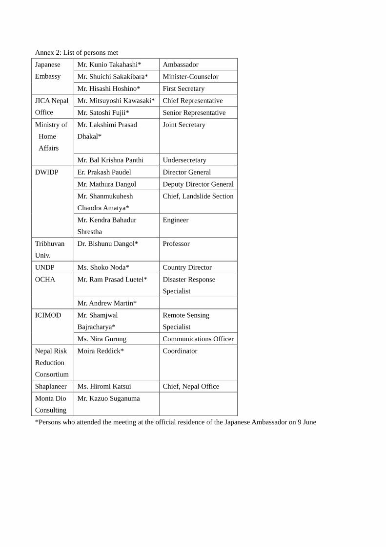
Annex 2: List of persons met
Japanese Embassy
Mr. Kunio Takahashi* Ambassador
Mr. Shuichi Sakakibara* Minister-Counselor
Mr. Hisashi Hoshino* First Secretary
JICA Nepal Office
Mr. Mitsuyoshi Kawasaki* Chief Representative
Mr. Satoshi Fujii* Senior Representative
Ministry of Home Affairs
Mr. Lakshimi Prasad Dhakal*
Joint Secretary
Mr. Bal Krishna Panthi Undersecretary
DWIDP Er. Prakash Paudel Director General
Mr. Mathura Dangol Deputy Director General
Mr. Shanmukuhesh Chandra Amatya*
Chief, Landslide Section
Mr. Kendra Bahadur Shrestha
Engineer
Tribhuvan Univ.
Dr. Bishunu Dangol* Professor
UNDP Ms. Shoko Noda* Country Director
OCHA Mr. Ram Prasad Luetel* Disaster Response Specialist
Mr. Andrew Martin*
ICIMOD Mr. Shamjwal Bajracharya*
Remote Sensing Specialist
Ms. Nira Gurung Communications Officer
Nepal Risk Reduction Consortium
Moira Reddick*
Coordinator
Shaplaneer Ms. Hiromi Katsui Chief, Nepal Office
Monta Dio Consulting
Mr. Kazuo Suganuma
*Persons who attended the meeting at the official residence of the Japanese Ambassador on 9 June
Anne
・Vid
・Vid
・Vid
ex 3 List of r
deo1; Seeti k
deo2; The fro
deo3; The fro
eference mat
ko Badi.mpg
ont of debris
ont of debris
terials
(20:30)
s flow (0:21)
s flow (01:25
(Nepal Forum
(taken by
5) (ibid.)
m of Environ
a person in D
nmental Jour
Diprang)
urnalists (NEFEJ))

・Map1; 1:50,000 (GHANDRUK, CHAME, LAMJUN HIMAL, TILICHO), Survey Department, Govt. of Nepal
・Map2; 1:25,000 (POKHARA(East), POKHARA(West), LAMACHAUR), Survey Department, Govt. of Nepal
S.S. Center Map House Thapathali, Ph.4264272
・Map3; ANNAPURNA
The
Banksecon
Ann
e Japanese su
Rockside ca
k erosion upnd bending p
nex 4 Photos
urvey team (l
an be seen at
p to 30 m ipoint of the S
s (separate at
leftmost: pilo
t the center
in height at Seti River
ttachment)
ot)
the
Surv
vey by short l
Earth pillars c
Interviews
anding in the
consisting of t
with the peop
Annapurna B
the marl depos
ple of Kapche
Basin
sits
e
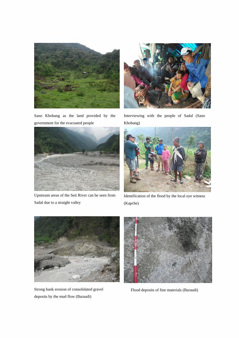
Sano Khobang as the land provided by the
government for the evacuated people
Upstream areas of the Seti River can be seen from
Sadal due to a straight valley
Strong bank erosion of consolidated gravel
deposits by the mud flow (Baraudi)
Interviewing with the people of Sadal (Sano
Khobang)
Identification of the flood by the local eye witness
(Kapche)
Flood deposits of fine materials (Baraudi)
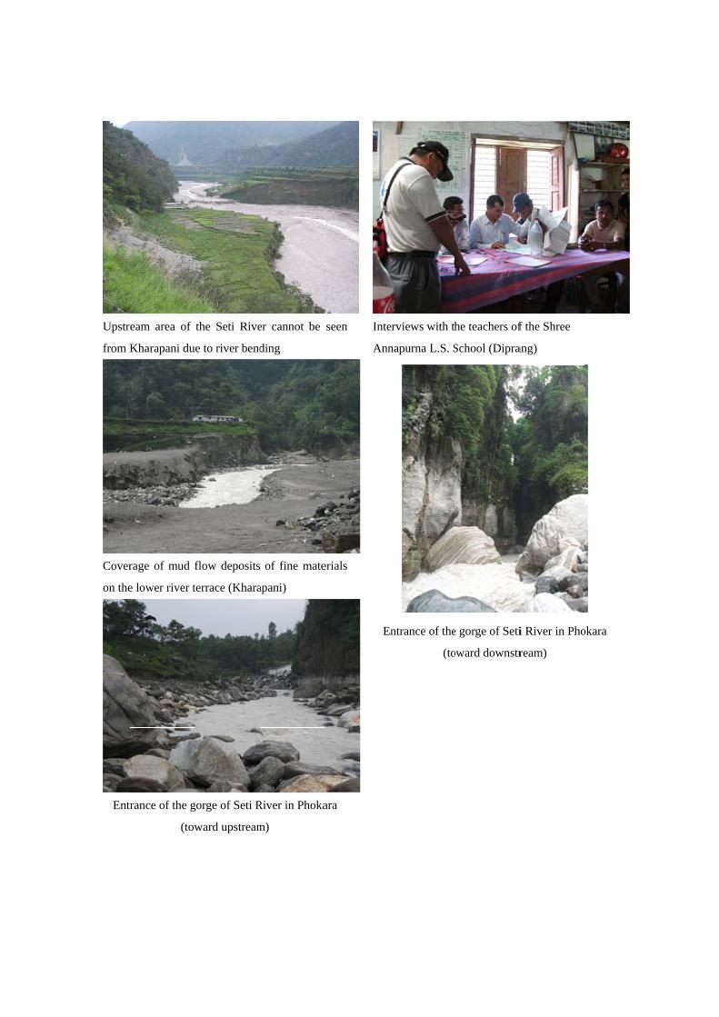
Upstr
from K
Cover
on the
Entr
eam area of
Kharapani du
rage of mud f
e lower river t
rance of the g
(tow
the Seti Rive
e to river bend
flow deposits
terrace (Khara
gorge of Seti R
ward upstream
er cannot be
ding
of fine mate
apani)
River in Phoka
m)
seen
erials
ara
Inte
Ann
E
erviews with th
napurna L.S. S
ntrance of the
(to
he teachers of
School (Dipra
e gorge of Seti
oward downstr
f the Shree
ang)
i River in Pho
ream)
okara


