Embed Size (px)
Citation preview

Journal of Paleolimnology 16: 151-167, 1996. 151 @ 1996 Kluwer Academic Publishers. Printed in Belgium.
S u s p e n d e d sed iment t ransport and deposi t ion in a high arct ic meromic t i c lake *
Michael J. Retelle & Jonathan K. Child** Department of Geology, Bates College, Lewiston, ME 04240, USA ** Present address: Fuss and O'Neill Inc., Longmeadom, Mass., USA
Received 28 March 1995; accepted 24 August 1995
Key words: laminated lacustrine sediments, density-stratified lake, overflow and interflow processes, paleoclimate, Ellesmere Island, high arctic
Abstract
A study of sedimentary processes and sediment yields in a high arctic meromictic lake (Lake C2, Taconite Inlet, northern Ellesemere Island, Canada) was undertaken from May 1990 through August 1992 to understand the links between climatic controls, hydrology, and the laminated sediment record preserved in the lake. Understanding the relationships between processes and the sediment record is critical for interpreting the climatic significance of the laminated sediments in a region where high resolution climate proxy records are quite limited.
Sediment transport to Lake C2 is dominated by fluvial processes. During the early part of the melt season slushflows transport sediment to the lake surface. Subsequently, suspended sediment is delivered to the lake by the main inlet stream and distributed lakeward by a plume emanating the main inlet channel. Due to the strong density stratification of the water column the plume distributes sediment downlake by overflows and interflows in the epilimnion. In general, overflows are generated by lower discharge events whereas interflows penetrate to the halocline during high discharge with increased suspended sediment concentration.
Sediment trap analysis demonstrates that suspended sediment transport and deposition responds to diurnal through annual changes in stream discharge. Seasonal and annual sediment trap yields agree with average accumulation rates determined from varve thickness measurements and cumulative suspended sediment discharge from the main inlet stream indicating a close link between climatological, hydrological, and sedimentological controls and varve deposition.
Introduction
Purpose This paper presents the results of a study of sedimenta- ry processes and annual sediment yield in a high arctic meromictic lake. The study was undertaken as one facet of a multi-disciplinary project, the Taconite Inlet Lakes Project (Bradley et al., 1996), initiated to resolve the climatic signal contained in laminated sediments in a high arctic meromictic lake on northern Etlesmere Island, Canada. From 1990 through 1992, complimen- tary investigations of basin climatology and hydrology,
* This is the fourth in a series of papers published in this issue on the "['aconite Inlet Lakes Project. These papers were collected by Dr R. S. Bradley.
snowmelt dynamics, limnology and lacustrine sedi- mentary processes, were undertaken on Lake C2 (Fig- ure 1) in conjunction with a detailed investigation of laminated sediments recovered in a series of sediment cores. The research presented here was guided by three questions:
1. what processes are responsible for the formation of laminated sediments;
2. does the annual sediment flux into the lake approx- imate the sediment contained in one couplet or varve; and
3. how does sediment transport and deposition in the lake reflect lake dynamics, hydrologic and climatic forcing conditions.

152
B r o m l e y
,,.. 8 3 3 m
- 8 2 ~ 5 0 '
~ ' ~ 3 ~ '"~"i~:~:~:~:~
0 5 k m '
~ il Lak e "", 1 ........ C3",, ~ /
7 8 ~
D o
F0
Figure 1. Location of field site on Northern Ellesmere Island, N.W.T., Canada. Diagonal pattern indicates alpine glaciers; dashed line shows drainage basin and dotted line indiactes approximate location of marine limit in the Taconite Inlet area.
Physical setting Lake C2 today has a mean water (ice) surface of 1.5 m asl and a surface area of approximately 1.9 km z within a catchment of approximately 28 km 2. The lake is steep-sided with a broad, flat floor at 80 to 82 meters depth across the central basin plain (Figure 2). The lake has one main inlet that delivers runoff from the high relief watershed; several smaller inlet streams around the lake contribute a minor fraction of the total runoff, predominantly during the spring snowmelt freshet. The main inlet has likely been utilized for meltwater and sediment input throughout the Holocene as evidenced by several lobate delta terraces comprised of gravel and sand. The terraces span elevations from several meters above the present delta to marine limit at approximately
70 meters asl. A more complete description of the watershed of Lake C2 is given in Bradley et al. (1995) and Hardy, (1996).
Laminated sediments in Lake C2 have been recov- ered using surface corers (Zolitschka, 1996) and per- cussion corers up to 3 meters long (Lamoureux & Bradley, 1996). In the long percussion cores, lami- nated lacustrine and marine sediments overlie massive clayey marine silt which, in turn, overlies compact red- dish brown till. The laminated sediment thickness in Lake C2 is greatest in the main basin plain of the lake between the main inlet and the outlet with up to approx- imately 185 cm at site 72 and 75 cm at site 70 (Figure 2). In a transect of cores recovered northeast of the main inlet delta (sites 81-85) laminated sediments range up
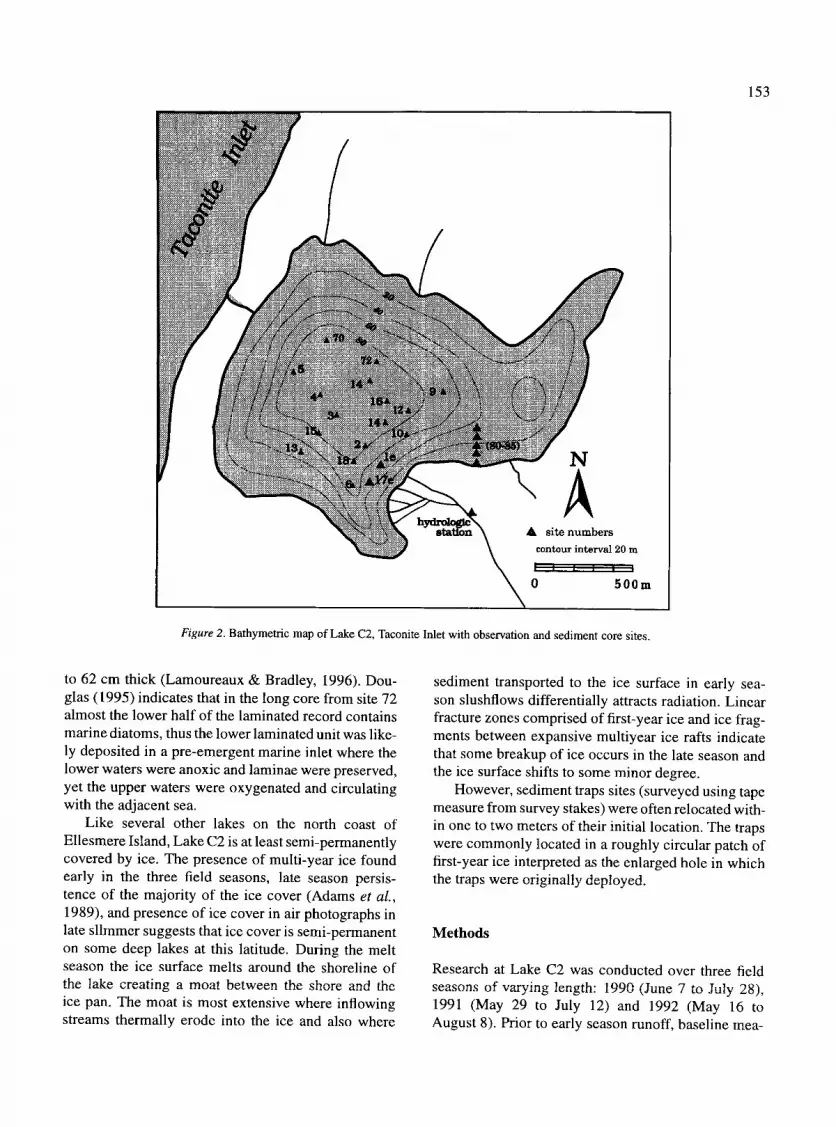
153
N
A A si te numbers
contour interva] 20 m
0 500m
Figure 2. Bathymetric map of Lake C2, Taconite Inlet with observation and sediment core sites.
to 62 cm thick (Lamoureaux & Bradley, I996). Dou- glas (1995) indicates that in the long core from site 72 almost the lower half of the laminated record contains marine diatoms, thus the lower laminated unit was like- ly deposited in a pre-emergent marine inlet where the lower waters were anoxic and laminae were preserved, yet the upper waters were oxygenated and circulating with the adjacent sea.
Like several other lakes on the north coast of Ellesmere Island, Lake C2 is at least semi-permanently covered by ice. The presence of multi-year ice found early in the three field seasons, late season persis- tence of the majority of the ice cover (Adams et al., 1989), and presence of ice cover in air photographs in late slimmer suggests that ice cover is semi-permanent on some deep lakes at this latitude. During the melt season the ice surface melts around the shoreline of the lake creating a moat between the shore and the ice pan. The moat is most extensive where inflowing streams thermally erode into the ice and also where
sediment transported to the ice surface in early sea- son slushflows differentially attracts radiation. Linear fracture zones comprised of first-year ice and ice frag- ments between expansive multiyear ice rafts indicate that some breakup of ice occurs in the late season and the ice surface shifts to some minor degree.
However, sediment traps sites (surveyed using tape measure from survey stakes) were often relocated with- in one to two meters of their initial location. The traps were commonly located in a roughly circular patch of first-year ice interpreted as the enlarged hole in which the traps were originally deployed.
Methods
Research at Lake C2 was conducted over three field seasons of varying length: 1990 (June 7 to July 28), 1991 (May 29 to July 12) and 1992 (May 16 to August 8). Prior to early season runoff, baseline mea-

Temperature (C)
0 1 2 3 4 5
g
0
10
20
30
40
50
60
70
80
154
DO (ml/ l) Salinity (0/00)
0 2 4 6 8 1012 4 0 5 1 0 1 5 2 0 2 5 3 0 3 5 _ l l , . , h , H l , JJ ,h J , , h J , , I . , , , h , H I h j j , 1 H.L I~ . , , I , ,, , lU~J~ L. &
"~ - - - -
f ~ f - - ~ . ~ ] . . \
- - ] _ -
- t
4
tJ
% Trans mission
50 60 70 80 90 100 l , * , . l l l i . l . . L l l . , , , l , , ~ l
1
A B C D
0
10
20
30
E
40
E3
50
60
70
80
Figure 3. Water column profiles of temperature, dissolved oxygen, salinity and % light transmission, measured on June 5, 1992, prior to runoff.
surements were taken and instruments and samplers that overwintered were recovered. Observations and various types of sampling were undertaken from the lake-ice surface at a series of stations located in a grid- like pattern in front of the main inlet stream. Other outlying stations were sited in peripheral locations as needed (Figure 2).
Measurement of temperature, conductivity, dis- solved oxygen and light transmission in the water col- lmn were taken using a Seabird Instruments Seacat SBE 19 profiler, equipped with a Sea Tech transmis- someter with 25-cm path length. The accuracy of the 25 cm path length Seabird transmissometer is 4- 0.5% transmission and is especial ly accurate in tow to mod- erate suspended sediment concentrations where light transmission ranges from 1-90% (Sea Tech Industries reference manual). Vertical casts were made with the instrument which was lowered at a rate of two seconds per meter from the ice surface. Values were recorded at a frequency of two measurements per second and stored on board.
Attempts were made to directly compare light transmissivity and suspended sediment concentration in the lake (cf. Domack & Will iams, 1990). Water sam- ples were collected from various depths using a peri- staltic pump and tubing system and 2.2 liter Kemmerer
bottle. The water samples were then filtered through Mill ipore type HA 0.45 micron cellulose membranes. Concentrations of suspended sediment (Css) in these samples ranged from 0 to 4.7 mg 1-1 , however these low values were considered unreliable for calibration as the measured weights of suspended sediments fell within the error of measurement of weight of the indi- vidual membranes (Hardy, pets. comm., 1993). Thus, the transmissometer data was used to measure relative changes in light transmission (as a proxy for Css) at depth and spatially in the lake over the course of each field season. In 1990 the Seacat instrument was uti- lized to provide background measurements and some water column profiles of selected runoff events. In the 1991 and 1992 field seasons, a more rigorous sam- pling program included daily or twice-daily sampling of a representative grid of samples across the lake. Dur- ing peak runoff, measurements were taken at 4-hour intervals (0100, 0500, 0900, 1300, 1700, and 2100 hrs) at two sites near the main inlet.
The data from the Seabird instrument array were downloaded and processed using the Seabird software. For analysis and plotting purposes data were averaged in 1 meter vertical bins.
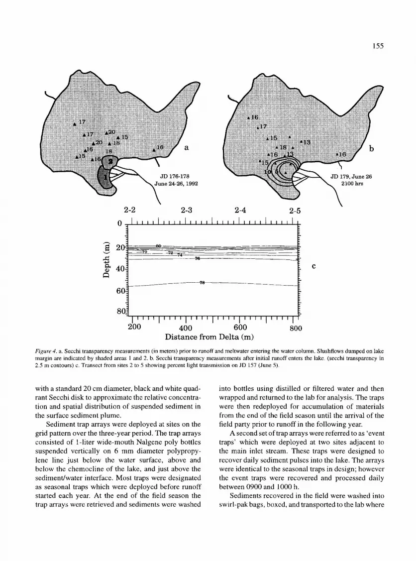
Secchi transparency surveys were also undertaken twice daily at the observation holes on the ice surface
155
2-2
0
20-:
4o4
60.
8o
2-3 2-4 2-5
l l , , , i , , i , i , , , , [ , , , , I , , , , [ , , , , ,
76
78
I ' ' " 1 ' ' ' ' 1 ' ' ' ' 1 ' ' ' ' 1 ' ' ' ' 1 ' ' ' ' 1 200 400 600 800
D i s t a n c e f r o m D e l t a (m)
Figure 4. a. Secchi transparency measurements (in meters) prior to runoff and meltwater entering the water column. Slushflows dumped on lake margin are indicated by shaded areas 1 and 2. b. Secchi transparency measurements after initial runoff enters the lake. (secchi transparency in 2.5 m contours) c. Transect from sites 2 to 5 showing percent light transmission on JD 157 (June 5).
with a standard 20 cm diameter, black and white quad- rant Secchi disk to approximate the relative concentra- tion and spatial distribution of suspended sediment in the surface sediment plume.
Sediment trap arrays were deployed at sites on the grid pattern over the three-year period. The trap arrays consisted of l-liter wide-mouth Nalgene poly bottles suspended vertically on 6 mm diameter polypropy- lene line just below the water surface, above and below the chemocline of the lake, and just above the sediment/water interface. Most traps were designated as seasonal traps which were deployed before runoff started each year. At the end of the field season the trap arrays were retrieved and sediments were washed
into bottles using distilled or filtered water and then wrapped and returned to the lab for analysis. The traps were then redeployed for accumulation of materials from the end of the field season until the arrival of the field party prior to runoff in the following year.
A second set of trap arrays were referred to as 'event traps' which were deployed at two sites adjacent to the main inlet stream. These traps were designed to recover daily sediment pulses into the lake. The arrays were identical to the seasonal traps in design; however the event traps were recovered and processed daily between 0900 and 1000 h.
Sediments recovered in the field were washed into swirl-pak bags, boxed, and transported to the lab where

156
250,0001~+. . . . . . . . . I . . . . . . . . . I ' " ' " ' " I . . . . . . . . . l " ' + i ' " ' l . . . . . . . . . I " . . . . . . . I . . . . . . . n~.
Inlet Stream Discharge (Q)
200,00~and suspended sediment (ss)
1991 t50.00~
.m
.~ 1O0,0O0
50,000
, l f i l l . , I l I I I I I I I I I I I I I i l I . I I I l I + I U l 0
150 160 170 180 190 200 210 220 230
Julian Day ] ~ , .l 'w w l w l . l . . +1111 n i l , 111 , , l i i i 11 , i n l l l l l I l l + I n I I . I . 11 l . I I . . . . . . . . . p h i . . . . .
Event trap sediment 750 Site C2-1, 1991
8 0 m t r a p
5O0
250
. . . . . . A 0 i . . . . . . . . . l ' ' ' l l * ' ' ' I H l l l l n l l . . . . . . . . . l l l S t l l ' ' ' l ' ' ' l l ' l l ' l ' l l ' l l l l l l l l ' l l l l
150 160 170 180 190 200 210 220 230
30000
2 5 ~
2oooo
15OOO ~ ?
50t)0 m
2 5 0 . 0 0 0 - rn*n,,,, t . . . . . . . . . I . . . . . . . . . u ......... I " r l " ' " l . . . . . . . . . I . . . . . . . . . p,,,,,rl1~+ 6 0 0 ~
~ 200,000-
ts00ooi
100 ,000 -
50,000"
0
1511 1611 170 180 190
Juliall I~a, 3000 .~,',m'q~+n,~.r,~m I ......... im'n
E v e n t t r a p s e d i m e n t 25~
92 C2-1 2oo0 80 m trap
"~ 151~ ,g ga II)(XI
500
0
h~lct Strealn Dischalge ( Q ) ~
and suspendeM sediment (~s) l~ll
. . . . o
200 210 220 230
1511
. . . . . . . . ~, . . . . . . . . , . . . . . . . . . . ,~ ,# , . . .%, , . , , . , , , , . , , , , . , , . - , . i . . . . .
1611 1711 180 190 20(1 210 220 23(1
5o00o
30000
lP~00 m
Juliml Day Jtdian Day
Figure 5. Comparison of inlet stream discharge and daily suspended sediment load (Hardy, 1995) with sediment trap yields from event traps deployed in summers 1991 and 1992.
the sediments were transferred to centrifuge bottles, washed in deionized water, transferred to petri dishes, evaporated and weighed.
R e s u l t s
Physical l imnology
This section provides a brief description of the water column in Lake C2 prior to runoff, as a means for comparison with conditions over the duration of the melt season. A more thorough description of the lim- nology of the Taconite Inlet lakes and other high arctic meromictic lakes is given in Ludlam (1996).
Lake C2 is density stratified, containing 'old' sea- water trapped at depth during glacioisostatic emer- gence of the coastal lowland following retreat from the last glacial maximum (Hattersley-Smith et al., 1970; Jeffries, 1984). Figure 3 illustrates water column con- ditions on June 5, 1992, typical of conditions prior to runoff entering the lake. Waters in the epilimnion (0- 16 m) are less than 0.20%0. From 16 to 21 m depth salinity increases to 5%0 increasing gradually to 40 m
depth, below which the bottom waters reach a maxi- mum of 27%0 (Figure 3c).
The lake is also thermally stratified (Figure 3a). Water temperature increases from near freezing (0.0 to 0.2 ~ just below the ice surface to approximately 3.5 ~ at 4 m depth. Water temperature increases grad- ually with depth to the thermal maximum of approx- imately 4 ~ at 18 m, illustrating a phenomena typical of other salinity-stratified lakes in the Canadian arctic (Hattersley-Smith et al., 1970; Jeffries et at., 1984, Dickman & Ouellet, 1987) and Antarctica (Angino et al., 1964; Ragotzkie & Likens, 1964; Javor, 1989) where the stable saline waters trap heat from solar radi- ation. Below the thermal maximum, temperature drops to slightly above 2 ~ (Figure 3a). The thermohaline- induced density stratification further prohibits mixing of oxygen at depth in the lake. Below 20 m depth the water column approaches anoxia (Figure 3b).
The combination of salinity and temperature strat- ification affects the sediment record in two ways: (1) because of the density stratification, in theory, sus- pended clastic sediments introduced from inlet streams should be effectively distributed across the lake basin by overflows and interflows (Ashley et al., 19851, jus- tifying correlations between lamination sequences in

157
2(
40
6(
80
2-1 2-2
J
~ - - - = ~ 0 75
75
3, 19S
\ 2 -3 2 -4
b
192)
2-18 2-2 2-14 2-15 60 55
0 . . . . . ! . ,, ! _ _ . t ~ _ _ ~ _ k _ . . . . . . L . . . . . . . . t .....
2 . . . . . . . . . . _
40i
60! d
8O'. I l l i l l J l i l l ~ l l l l l l J l t J l i l l l l l [ t t l l ] t l l l ] l l l ! r t i L t
100 200 300 400 500 }0 200 300
Dis tance from Del ta (m) l)i~ nee along Transect (m)
Figure 6. a. Secchi transparency measurements on JD 180 (June 28) 1992 showing lakeward extension of suspended sediment plume, secchi transparency in 2.5 m contours in maps a and c. b. Percent light transmission transect from sites 2 to 5 (JD 182) showing development of thin overflow plume, c. Secchi transparency measurements on JD 183 (July l ) 1992 showing northerly deflection of the sediment plume, d. Percent light t ransmission transect from sites 18 to 12, (SW to N-E) showing higher suspended sediment concentrations to ' r ight-hand' side of the sediment plume.
proximal to distal zones of the lake (Zolitschka, 1995), and (2) the density stratification and anoxic bottom waters promote the preservation of the finely laminat- ed sediments in this meromictic lake which is a critical underpinning in climatic reconstruction studies with varves (Anderson et al., 1985).
The uppermost water column averages above 80% transmission with a zone of decreased light transmis- sion (as low as 70%) from 20 to 24 m depth which occurs beneath the sharp halocline and oxycline. Lud- lam (1995) postulates that the low transmission zone in Lake C2 may reflect a bacterial mat. Dickman and Ouellet (1987) documented the occurrence of a photo-
synthesizing bacterial mat below the chemocline and oxycline in meromictic Garrow Lake, N.W.T., Cana- da. In addition, Retelle (in preparation) has noted an increase in iron as an inorganic floc created at the boundary between oxidizing and reduced conditions in meromictic Lake A on northern Ellesmere Island. In figure 3d, the bin-averaged value in this less transmis- sive zone is approximately 72% however individual instantaneous readings are as low as 4% transmission prior to runoffindicating near complete blockage of the transmissometer light path which would may occur if large sheaths of the algal mat were in the beam path (cf. Doran et aL, 1994 for a discussion of benthic and

158
09
0 - -
10-
20-
30-
40-
50-
J u l i a n Day
180 20 181 182 183 184 185 186
Figure 7. Time series of light transmission at site I from JD 179 to 186, 1992.
water column bacterial mats in saline Antarctic lakes). Attempts to sample materials from the suspected 'mat' at the depths of the transmissivity minima only yielded clean saline water. Beneath the transmission minima values return to near 80% and prior to runoffremained constant at this level to the sediment/water interface.
lntraseasonal variations in sediment transport
Although the three field seasons varied in length, sim- ilar processes and patterns of sediment transport and distribution occurred in Lake C2. The majority of the information presented in this paper will be from obser- vations made from May through August 1992, the longest field observation period, although some com- parative observations and data will be included from the 1990 and 1991 seasons.
Pre-runoff period Lake C2 and the adjacent watershed were snow- covered and air temperatures averaged below freez- ing at the commencement of each field season. Snow depths on the lake varied from year to year. In 1991, snow depths ranged from roughly 30 to 50 cm while in 1992 depths ranged from 50 to 82 cm. In May 1992 the greater snow depths hindered the relocation of sed- iment traps deployed the previous year. Multi-year ice cover on the lake in general ranged from 1.20 to 1.45 meters thick although at several locations old ice was as much as 1.7 meters thick.
Physical conditions in the water column of Lake C2 prior to runoff are shown in Figures 3 and 4. Of par- ticular importance to this study is the pre-runoff light transmission profile (Figures 3 and 4) and Secchi disk transparency measurements. These data both reflect the clarity of the epilimnion prior to runoff with disk visibility measured up to 20 meters (Figure 4), i.e. approximately down to the level of the light transmis- sion minimum.
Early runoff period The initial runoff in the basin and related sediment transport occurred as increasing solar radiation, snow- pack warming and saturation with meltwater triggered slushflows (Hardy, 1992, 1995). In 1990 through 1992, slushflows started on June 9, June 4, and June 22, respectively, and travelled down the main inlet chan- nel above the lake until reaching the various stream distributary channels of the delta. The viscous flows transported lobate masses of slush, loose sediment and eroded surface vegetation down the stream channels while bulldozing levees of dense slush towards the stream banks. Subsequent stream flow was confined by the channels until melting exposed the gravelly banks of the stream bed. The extent of the slushflows onto the ice of Lake C2 immediately after the flows in 1992 are labelled 1 and 2 in Figure 4. By this time, melt- water and suspended sediment had still not entered the water column, however with the combined accumula- tion of slush, meltwater, and sediment on the ice sur- face immediately offshore, fractures developed in the

ice. The cracking of the ice during the slush and melt- water loading was audible. Meltwater erosion enlarged the fractures and meltwater and sediment then entered the lake through vertical cylindrical holes or moulins (Retelle & Child, 1992; Doran, 1993). Secchi disk sur- veys indicate that during this early stage, meltwater and suspended sediment remained pooled in front of the delta, spreading lakeward in a northwesterly direction and decreasing Secchi transparency to approximately 2 m at stations 1 and 17 (100 meters offshore) while the water column 200 m offshore (station 2) remained almost as clear as during the pre-runoff period (Fig- ure 4b).
Hardy (1992) noted the subsequent occurrence of smaller discharge pulses that quickly followed the main slushflow event within several days of the first event. The discharge pulses were accompanied by increased amounts of slush and suspended sediment in the stream above the lake.
Inlet stream runoff In all three years of observation, the slushflow events immediately preceded increases in discharge (Hardy, 1995) with corresponding increases in suspended sed- iment transport to the lake. Figure 5 shows a com- parison of stream discharge and suspended sediment concentration with sediment recovered daily from sed- iment traps deployed at site C2-1, 100 meters from the main inlet stream. In 1991, runoff commenced on June 5 (JD 155) and subsequently built to two minor discharge peaks between JD 160 and 166. These events were two of three events that yielded the only measur- able sediments above trace quantities in the traps.
The 1992 melt season was characterized by two main pulses of discharge separated by a lull in stream flow that occurred during a period of low temperatures and snowfall. The first pulse followed the slushflow and transported a minor amount of sediment to the lake while a second substantial discharge peak from JD 202 to 210 transported an order of magnitude more sediment to the lake. On JD 196, during the low dis- charge period, the largest sediment yield of the season (approximately 2800 mg) was recovered from the trap.
During the two major sediment transport events in 1992 suspended sediment followed different paths at different levels in the lake. The first event occurred as the suspended sediment formed a turbid plume direct- ed across the lake from the inlet in a northwesterly direction. Presumably with the subsequent opening of the outlet, lake circulation drew the sediment plume
159
~ a
ly 2~-21 1~2}
2-1 O . L . . . .
20
40
60
80
2-2 i ]
2-3 2-4 k ...................................... ! ........ L ............. ~3 5
' ' ' ' l ' ' ' ' l ' l " l ' ' ' l l ' ' l ' l ' l ' ' l l l l '
Figure 8. a. Secchi transparency measurements (2.5 m contours) from JD 202 showing widespread development of suspended sedi- ment plume during second major discharge event. Note 'right hand' deflection in delta-proximal area of the plume, b. Profile of % light transmission along transect from sites 1 to 5, JD 202.
towards the outlet (Figure 6). The inflowing water at temperatures near 0 ~ travelled in the uppermost lev- els of the epilimnion as an overflow plume. Figure 6c shows the thin overflow plume on JD 182 in an early stage of development before the plume reached site 4. At this time the overflow plume is directed towards the north, as also seen in plan view from the secchi transparency transect (Figure 6b, d). The maximum sediment concentration in the plume occurred in the upper meter of water beneath the ice cover. Figure 7 illustrates a time-series of light transmission profiles measured at 4-hour intervals from JD 179 (June 27) to JD 186 (July 4) 1992 from the crest to the tail of the first discharge peak. Although the main sediment plume eventually migrated away from C2-1 to the northeast, the pattern of buildup and decay of the plume can be seen each day from JD 180 to 185 before discharge began to drop on JD 185. Plume buildup in the lake in general occurred in late afternoon to early evening (Figure 7) lagging the daily stream discharge peak by several hours.
Later in the 1992 summer season (JD 202-203), a second discharge event of greater magnitude occurred with a corresponding higher stream suspended sedi- ment concentration. Sediment was dispersed through the delta-proximal zone of the lake as an interflow con- centrated at approximately 15 meters depth. At this time of the season, secchi transparency measurements

160
_--. �9 i i : ~ i 84
I t . . . .
78 i iiiiiiiii i ill i i i iiill 7 6
~ w ~ - ~ w ~ - w ~ - ~ - -~ - , - . , - - ~ - , - - ~ ~
I80 i85 t90 195 200 205 210
Julian Day
F i g u r e 9. Light transmission at the sediment water interface at sites 2, 3, and 4 from JD 177 to 211, 1992.
showed a broad plume shape with values averaging around 6 to 7 meters (Figure 8a). The lowest Secchi transparency for this period was at station 14, indica- tive of the plume's tendency to flow as a deflection to the north. This tendency can be further seen in the light transmission profile (Figure 8b) where greater sediment concentrations occur near sites 1 and 2 but miss site 3.
Light transmission values close to the sedi- mentJwater interface at stations 2, 3, and 4 (Figure 9) decrease consistently from pre-runoff values greater than 80% to less than 75% from JD 177 to 189 (1992). Thereafter, clearing of the water column is associated with the midseason decrease in runoff (JD t90-200). A slightly decreasing transmission (with two low val- ues) occurred from day 200 through 207, most likely associated with the second discharge event.
Evidence for a similar large magnitude late sea- son discharge event was seen in the seasonal sedi- ment traps that were recovered at the beginning of the 1992 season. In all the traps, sediment recovered at the beginning of 1992 prior to runoff exceeded the sediment trapped during the preceding summer field season by over an order of magnitude (Figure 10). At site 2 sediment was found at all levels of traps within the water column, from the surface to 80 meters depth, which would not be expected if the late season deposit represented a slump-generated turbidity current. The sediment in the traps also contained a high proportion of sand-size particles indicating that the deposit was not just residual fine material settling from suspension after the early season runoff.
Interseasonal variations in sediment transport and deposition
Sediment yields from the seasonal sediment traps deployed for the length of each field season and rede- ployed for the intervening winter are shown in Fig- ure 1 l a--d. The pattern of distribution for sediment deposited in the bottom trap on each array is similar to the plume pattern observed in the Secchi transparency surveys (Figures 6, 7, 8). The maps show steep depo- sitional gradients with rapidly decreasing yields from the main inlet towards the outlet and in a southwest- northeast direction across the plume.
In two of the three summers, Site 2, located directly in front of the main inlet stream, received the most sediment and sites distal and lateral to this location trapped correspondingly less. In 1992 however, a slight variation in the pattern occurred where the focus of the plume jet (Figure 1 ld) was shifted to the northeast towards sites 14 and 12.
Of the three summer observation periods the most sediment was trapped in 1990 and the least in 1991, due to a shorter (5-week) period of observation (Table 2). As mentioned in the previous section, although both 1990 and 1992 exceeded the 1991 field season yields by almost an order of magnitude, the sediment col- lected in the traps between late July 1991 and May 1992 far exceeded the previous field season trap yields (Figure 10).
The annual sediment yield of Lake C2 was only obtained from sediment traps for the budget year May 1991 to May 1992 (Figure l lc ) because most of the traps deployed for the winter of 1990-1991 corroded from the trap line below the chemocline and were not recovered in May 1991. In addition, the traps were removed from the lake after the 1992 field season and thus were not tended after the 1992 summer season. An estimate of the total sediment deposited in Lake C2 during the three summer periods of observation and the 1991 total was calculated by contouring the bottom sediment trap yields for the set of seasonal traps. The areas between contours were determined by digitizing the contour maps, and the total sediment in each area was calculated (Figure 1 la-d, Table 1). For outlying areas in the distal zone of the sediment plume and in the northeastern corner of the lake a value of half the lowest sediment yield from the bottom sediment traps was arbitrarily assigned for each season. The results of these estimates show that the greatest sedi- ment flux during the field observation period occurred in the summer of 1990, followed by 1992 and 199I.

Table 1. Sediment budget estimated for Lake C2 (kg) for summers 1990- 1992 and annual June 1991-May 1992 (pre-runoff) compared with cumulative suspended sediment concentration for the field seasons 1990-1992 (Hardy, 1996), predicted annum suspended sediment flux (Hardy et aL, 1996), and total sediment accumulation calculated from varve thickness measurements (Zolitschka, 1996)
Year Lake sediment Stream SSC l Stream SSC 2 Varve
(kg) (kg) (kg) thickness
1990s 2.44 • 105 3.18 • 105 7.8 • 105 1.07 • 105 199Is 2.60 • 104 2.91 x 10⁴ - - 5.i • 104 1991t 5.03 • 105 - - 5.8 • 105 - - 1992s 1.49 • 105 2.60 • 105 1.9 • 105 - -
I Stream suspended sediment measured at main inlet stream station by D. Hardy (this volume) for the same period. 2 Projected suspended sediment for main inlet stream based on correlation of meteolorological data at Alert (Hardy et al., 1996) 3 Accumulation rate calculated from average varve thickness (Zolitschka, 1996).
Table 2. Sedimentation rates from sediment traps from sites 2 and 3 where annual yields were collected in 1990 and 1991 compared to mean lamination thickness at those sites and mean accumulation rates (Zolitschka, 1996)
Trap sites
Annum Lamination Core sites Mean lain. Mean accum. Year sedimentation thickness 2 thickness 3 rate 4
rate I (mm) (ram) g m -2 a - 1 g m - 2 a-1
C2-2 1990 2386 2.0 C2-15 1.66 1986 1991 2055 1.7
C2-3 1991 268 0.2 C2-17 2.6 3346
t Accumulation rate as measured in sediment traps (Table 2 and Figure 11). 2 Lamination thickness calculated using accumulation rate and dry density values (1.2 g/cm 3) 3 Mean lamination thickness as measured in thin sections from sediment core (Zolitschka, 1996). 4 Mean sedimentation rate calculated from lamination thickness and dry density of core sediments (Zolitschka, 1996).
161
The s u s p e n d e d s e d i m e n t load o f the m a i n in le t s t r eam
for e a c h s u m m e r s e a s o n (Hardy, 1995) c o m p a r e s wel l
w i th the s e d i m e n t t rap data , a l t h o u g h in e a c h case the
s u m m e r s e d i m e n t t rap y ie lds are s o m e w h a t less than
e i t he r the m e a s u r e d or p r ed i c t ed c u m u l a t i v e s t r eam
s u s p e n d e d s e d i m e n t y ie ld (Table 1).
O f all the s e d i m e n t t rap l ines r e d e p l o y e d at the end
o f the 1990 season , on ly one b o t t o m t rap was r e c o v e r e d
in sp r ing o f 1991 (site 2). T he to ta l y ie ld at tha t site
in 1990 (2386 g m - 2 ) s l ight ly e x c e e d e d tha t o f 1991
(2055 g m - 2 ) (Table 2).
T h e y ie lds f r o m these s e d i m e n t t raps wi th a full
yea r o f a c c u m u l a t i o n we re used to e s t ima te l a m i n a t i o n
t h i c k n e s s for those years o f r e c o r d (F igure 12). T he
s i m p l e r e l a t ion b e l o w was used to p red ic t s e d i m e n t
t h i c k n e s s for e a c h b u d g e t year :
Sediment Flux (from traps) gcm-2 yr- l
Dry density (from cores) g cm -3 = thickness (cm yr- 1).
A s s u m i n g an ave rage dry dens i ty o f 1.2 g c m -3 , the
th i ckness e s t ima tes for s e d i m e n t b u d g e t yea r 1 9 9 1 -
1992 r a n g e f r o m 0.17 c m to 0.01 cm. Fo r the on ly
site (site 2) w h e r e a b o t t o m t rap was r e c o v e r e d for
the 1 9 9 0 - 1 9 9 1 s e d i m e n t b u d g e t year, a s l ight ly h i g h e r
p red ic t ed t h i cknes s is e s t i m a t e d (0 .20 cm) . The resu l t s
c o m p a r e f avorab ly wi th the ave r age l a m i n a t i o n th ick-
ness m e a s u r e d in cores r e c o v e r e d a long a t r ansec t f r o m
the m a i n in le t to the outlet , s tud ied in th in sec t ion by
Z o l i t s c h k a (1996) . A c o m p a r i s o n o f s e d i m e n t t rap and
th in sec t ion ana lys i s is s h o w n for two si tes (2 a n d 3)
in Table 2. A p r e d i c t e d l a m i n a t i o n t h i cknes s ca lcu la t -
ed f r o m s e d i m e n t a t i o n rates in s e d i m e n t t raps at s i te 2

162
0
10
2O
30
40
50
60
70
80
S u m m e r 1991
125 29
98 63
128 64
_ 9 0 6 9
110 60
"Winter" 1991-1992
367
1818
1368
1452
32
56
74
68
1 9 4 6 6 5
2 2 g/m %>63 u m g/m %>63 u m
Figure 10. Sediment trap yields for 'summer' and 'winter' seasons, site 1, 1991.
N
A I
5 0 o m
2 1 Figure 11. Sediment trap yields g m - for traps deployed at the sed'ment-water interface for summers 1990, 1991, and 1992 and total of summer 1991 and winter 1991-1992.

are quite similar to the measured average lamination thickness in the cores; also for site 2 the average sed- imentation rates calculated from lamination thickness are comparable to measured sediment trap sedimen- tation rates. The results for site 3 are not as closely comparable as the average lamination thickness (and calculated sedimentation rate) is substantially greater than the predicted lamination thickness (and sedimen- tation rate) for the 1991 season.
163
Discussion
Sedimentary processes The results of this study have shown that the laminated sediments in Lake C2, and several other meromictic lakes on northern Ellesmere Island are predominant- ly transported to the lake basin by fluvial processes. These basins are situated, for the most part, in catch- ments where glacier melt is either minimal or nonex- istent and runoff is derived primarily from snowmelt (Hardy, 1996). In this high latitude setting, runoff and suspended sediment concentration is distinctly season- ally controlled and limited to summer snowmelt.
The lakes on northern Ellesmere Island, situated in a polar desert regime, are dominated by fluvial process- es and contrast markedly with Antarctic saline lakes, principally those of the Dry Valleys (Nedell et al., 1987; Squyres et al., 1991; Andersen et al., 1993) where sediment is transported predominantly by wind to the lake-ice surface from lacustrine-marginal areas such as sandur plains. Sediment is subsequently con- centrated on the ice surface and is later deposited on the lake bottom by settling through vertical channels in the ice and is then released to the water column. On Lake C2 the main inlet discharge in 1992 reached over 3 m 3 s -1 with suspended sediment concentrations up to 500 mg 1-1 (Hardy, 1994). By contrast, in January 1985 (austral summer) discharge of the main inlet of Lake Hoare, one of the Dry Valley Lakes, was approx- imately 0.06 m 3 s -1 (Needel et al., 1987).
Fluvial processes are not dominant in all high arc- tic lake systems. For example, in a quantitative study of sediment supplied to Colour Lake on Axel Heiberg Island, Doran (1993) reports that a significant amount of clastic sediment (estimated at 15 to 30%) is sup- plied annually to the lake by gelifluction. Similarly, on Sophia Lake, eastern Cornwallis Island, O'Reilly (1995) reports that during the latter part of the sum- mer season when the active layer is thickest and lake
)lmt
Figure 12. Varve thickness calculated from sedimentation rates in sediment traps for 1991.
ice breaks up and moves around the lake, material sup- plied to the edges of the lake by solifluction is reworked and carried offshore by drifting ice that makes inter- mittent contact with the shore. Wave reworking during the ice-free period also creates minor erosional bluffs on gelifluction lobes that reach the shoreline (O'Reilly, 1995).
Other arctic lakes may have significant eolian sedi- ment inputs. Heavy sediment loads can be contributed to Romulus Lake by eolian processes, especially in years when snow cover is thin and early season wind- storms transport materials to the lake surfaces from adjacent unconsolidated deposits. Such a windstorm occurred on the Fosheim Peninsula, Ellesmere Island, in the spring of 1992 (J. Desloges, pers. comm.) and eolian sediments were transported from nearby sandurs to adjacent fiord and lake surfaces. Eolian sediments subsequently collect on the ice surface, attracting and trapping radiation, and may then melt through the ice as aggregate pellets (Retelle, 1986) before being released to the underlying water column (Squyres et al., 1991). Eolian sediments are apparently negligible in Lake C2 due to lack of a close local source. Wind storms trans- porting sand and silt did not occur during the field season nor were significant amounts of eolian debris noted on the ice surface from events that may have occurred between field observations.
Sediment dispersal within Lake C2 is dominated by overflows and interflows in the water column due

164
to the highly stable density stratification. The dispersal processes and patterns result from the differences in density (as a function of temperature, sediment con- centration, and salinity) between the inflowing stream and the epilimnion of the lake. Hardy (unpublished report) calculated density of the main inlet stream for the 1991 and 1992 seasons and showed that while some increases in density can be attributed to temperature, the major density increases are a function of increased suspended sediment concentration (cf. Ashley et al.,
1985; Shiati, 1990). Early season overflows occurred during initial
snowmelt runoff when inlet water temperatures were close to freezing (0.1 to 0.3 ~ and suspended sed- iment concentrations were moderate, ranging from approximately 50 to 275 mg 1-1 (Hardy, 1996). The thin overflows travelled at 2 to 4 m depth, in the least dense water beneath the ice cover. A sharp density break at 4 meters reflects the transition from water in contact with the ice to water warmed by solar radiation (Figure 3).
By contrast, the densest inlet stream water entered the lake during the second and larger discharge peak in the latter part of the melt season (JD 202-207) when suspended sediment concentrations increased to over 500 mg 1-1 (Hardy, 1995), thus exceeding the density of the upper epilimnion. The interflows travelled across the top of the halocline at approximately 16 meters.
Pharo & Carmack, (1979) observed and described the development of interflows occurring in Kamloops Lake, British Columbia. In this lake interflows devel- oped when the inflowing river mixed at the surface with the lake water and the turbulent water mass sank to a level of neutral density. Thereafter the interflow at approximately 20 meters depth moved basinward (deflected by Coriolis forcing) along an isothermal sur- face. Likewise, in an alpine glacial setting in the Rocky Mountains of Alberta, Smith (1981) and Smith et al. (1982) have shown interflows developing in both Bow and Hector Lakes which, during the summer melt sea- son, are thermally and weakly chemically stratified. Although neither of the lakes just described are saline lakes, the density contrasts provided by the combi- nation of inflowing water density and water column density set up similar relative conditions for sediment distribution down the lake.
The most appropriate model for sediment distri- bution in a density-stratified saline lacustrine system like Lake C2 combines features described from glacial lacustrine systems (Ashley etal . , 1985, p. 179; Drewry, 1986, p. 178) and the fiord environment (Syvitski etal . ,
1987). Sediment is transported in a 'conveyor-belt' system away from the inlet source in a water mass of equal density at the time sediment is introduced into the water column. The pycnocline may be temperature- controlled, i.e. with a sharp thermocline, or as in the case of Lake C2, salinity-controlled. The latter is the case in most fiords where hypopycnal sedimentation occurs as buoyant turbid inflowing river water dis- charges over saline marine water. For a given dis- charge, suspended sediment concentration and grain size decreases away from the inlet source (cf. Syvits- ki & Murray, 1985). Coarse sediments, comprised of either single large particles, fl ocs (Kranck, 1973, 1981) or fecal pellets (Syvitski & Lewis, 1980) settle quick- ly after being introduced into the lake in the prodelta enviromnent. The buoyancy of the hypopycnal flow and the strength of the plume jet in the mixolimnion of Lake C2 is illustrated by the grain size of the parti- cles transported lakeward. In an analysis of sediment traps that were deployed from May to August 1990, Child (1991) showed that although grain size (as % sand) decreased progressively offshore from the inlet to the outlet, the sand content was as high as 9% as far as 520 meters offshore. In addition, in each set of traps, the highest sand percentages were found in the middle of three traps on each line (10 m, 25 m and lake bottom) indicating progressive downlake transport by the buoyant plume and transport and settling along the halocline.
Syvitski et al. (1985) noted that fine particles (< 10 microns) settle as flocs at rates of 30 m to 100 m day- l depending on the water depth and that the impor- tance of ftocculation decreased with increasing grain size. Syvitski and Murray (1981) noted that floccu- lation occurred in the hypopycnal waters where the inlet water mixed with brackish waters. In the study of Lake C2, flocs were noted in sediment traps in numer- ous cases during retrieval. Although studies of water column biota were not undertaken in Lake C2, a living copepod was observed in a sediment trap located above the chemocline in 1990, thus indicating the potential for pelletization, as noted in other high arctic lakes (Retelle, 1986).
Ashley et al. (1985) further describe the effect of density stratification on particle settling in lakes with special reference to the pycnocline which acts as a sed- iment 'fence' that serves to trap fine sediments in the epilimnion. The finer clay fraction that comprises the 'winter layer' of the couplet is also kept in suspension longer due to turbulence in the epilimnion that may be caused by the jet of from the inlet plume. Little wind

mixing occurs in Lake C2, except in the open mar- ginal moat around the perimeter of the lake and in the enlarged tongue-shaped opening eroded by the inlet stream jet where lakeward currents were observed for 30 to 50 meters offshore and likely continued under the ice surface.
The sedimentary record of density-stratified lakes yields distinct annually laminated couplets that thin and fine away from the inlet source (Smith et al., 1982; Pharo & Carmack, 1979; Ashley et al., 1985; Zolitschka, 1995). The lower portion of each couplet (Lamoureux & Bradley, Figure 3, 1996) represents the sediment contributed during the summer melt season and may comprise one or more laminae that corre- spond to each discharge event. In Lake C2, the coarse material introduced to the lake settles rapidly as evi- denced by a comparison of the daily yields in the event sediment traps and discharge and suspended sediment concentrations in the inlet stream (Figure 5). Sediment introduced during the overflow event (JD 180 to 190) settled rapidly in the water and the basal part of the water column quickly cleared, probably because with almost complete ice cover and little current movement in the lake, flocculation and particle settling were most efficient. Fine sediment introduced later in the sea- son is likely kept suspended in the epilimnion due to increased turbulence and higher density of the water, which may in part, be controlled by higher sediment concentrations. The fine-grained material likely settles when runoff ceases and the remainder of the ice cover refreezes in late slimmer to early fall, when turbulent eddies and mixing in the epilimnion are reduced.
Sediment budget The sediment trap surveys provide support for the hypothesis that the laminae in Lake C2 are indeed annual layers that are linked to climate. Sediment trapped each summer is proportional to the cumula- tive inlet stream discharge and suspended sediment concentration of each season (which, in turn, is strong- ly controlled by seasonal changes in radiation and summer temperatures). A comparison of annual trap yields with accumulation rates calculated from thin sections further strengthens this hypothesis. Hardy et aL (1996) demonstrated a a significant correlation between 600 m temperatures at Alert and tempera- ture and runoff at Taconite Inlet. Subsequent com- parison of the Alert temperature record and Lake C2 varve thickness showed a strong correlation demon- strating the close link between summer warmth and
165
varve thickness. Numerous studies in alpine proglacial lakes (Leonard, 1985; Desloges, 1994) have similarly demonstrated the close positive correlation of annual suspended sediment flux (and hence, varve thickness) and runoff, driven by summer temperature. By con- trast, other studies (cf. Ostrem, 1975) have shown that precipitation events are the major influence on sedi- ment flux, during the three years of study significant rain events did not occur and even storms in July and August were snowstorms that provided increased sus- pended sediment flux when eventually melted.
In each summer season, the sediment trapped was the same order of magnitude but less than either the measured or predicted fluxes from the inlet. This dif- ference may be expected since the sediment trap data represents only the portion of the runoff season that sediment traps were deployed, thus: (1) some sedi- ment introduced before the traps were pulled out is still in suspension and would not settle until later in the season (Figure 9), and (2) runoff may have con- tinued later in the season which is certainly the case for the short 1991 summer season, when the bulk of the annual sediment contribution came presumably in late summer and is represented in the 'winter' yield (Figure 10).
The sediment yields from the seasonal traps also provide a reasonable comparison with an average lam- ination thickness determined from thin section analy- sis (Zolitschka, 1996; Lamoureux & Bradley, 1996). Using data from the annual trap yields for 1991 from the network of seasonal trap sites (Figure 12) varve thicknesses from 0.1 to 1.7 mm were predicted while the average thickness measured in thin section from sites in the same parts of the lake ranged from 0.7 to 2.65 mm. Two common sites where both sediment cores and annual trap yields were recovered are sites 2 and 3. For site 2 thicknesses of 2.0 and 1.7 mm were predicted from trap sedimentation rates for 1990 and 1991, respectively while the mean varve thickness in core C2-15 (recovered from the same site as trap site 2) is 1.66 mm. Comparisons made for site 2-3 are not as clear since sediment trap yields predict an order of magnitude thinner varve than was measured in thin sections (Table 2). In each of the three study years sed- iment trap yields showed a pronounced decrease from sites 2 to 3 and likewise the decreasing yields continue across the lake. Furthermore, secchi disk surveys con- sistently indicated a distal and lateral decrease in sed- iment concentration in the sediment plume. However, the average lamination thickness in both facies defined by Zolitschka (1996) decreases from proximal facies

166
zone 1 to more distal facies zone 2 and the discrepancy that exists between the sites 2 and 3 may be the result of turbidites thicker than varves collecting further down- lake on the basal plain than site 2-3, located at the toe of main inlet delta. Indeed, Zolitschka (1996) describes surge type sediments that '... are coarse-grained, thick and unevenly distributed with their maximum thick- ness in intermediate to distal sites'. Perhaps the thick surge deposits or turbidites affect the average varve thickness calculated for site c2-3.
It should be noted that while the process studies in Lake C2 support the hypothesis that the sediments are varves, several recent studies have shown that some arctic clastic-dominated lakes in general, do not con- tain annually laminated records. In a study of a Baffin Island proglacial lake, Lemmen etal. (1988) resampled core sites after a period of several years in an effort to determine if the laminated lacustrine sediments were indeed varves. Probably due to low sedimentation rates caused by a trapping pond between the glacier meltwa- ter source and the lake, the sediments were not annu- ally laminated. However, although the laminae were not varves, the sediment cores provided a long and high resolution record of bin- and lithostratigraphic changes spanning the last ca. 7500 years.
In a recent study of hypersaline meromictic Romu- lus Lake on central Ellesmere Island, Davidge (1994) cited inconsistent and minimal fluvial input as the cause for lack of varves in the lake. Streams feeding Romulus Lake are apparently intermittent carrying low sediment concentrations primarily during the earliest spring runoff when ice cover across the lake is perva- sive and sediment is carried only to the lake margin.
Conclusions
Studies of sedimentary processes and annual sediment accumulation rates in Lake C2 demonstrate a close link to hydrologic processes. Hardy (1996) and Hardy and Bradley (1996) have, in turn, demonstrated the close linkage between climate, hydrology and suspend- ed sediment flux in the main inlet stream. In addition, this study has shown that the sediment flux into the bottom of Lake C2 approximates that contributed by the main inlet source and also the accumulation rate as determined from measurement of individual laminae.
Sediment delivery to the Lake C2 system is domi- nated by fluvial processes. The fluvial inputs are dis- tinctly seasonal and contribute sediment to Lake C2 predominantly during snowmelt runoff events, which
are, in turn, largely controlled by seasonal warm episodes (Hardy, 1996). Thus, the inputs into the lacus- trine system are closely linked to climatic controls.
Sediment transported to the lake is dispersed effi- ciently across the lake basin in a plume-shaped pattern by overflow and interflow processes emanating from the main inlet. The inlet sediment plume enters the water column along distinct density gradients. In the early season, overflows dominate the dispersal pattern as cold near-freezing meltwater with low sediment con- centrations flow in the upper 2 meters underneath the lake ice cover. In the latter part of the season higher concentration flows enter the lake and descend to the halocline and travel downlake as interflows.
Sediment trap yields for each summer field season compare well with suspended sediment concentrations measured at the main inlet stream for the same period. Annual sediment trap yields determined for May 1991 to May 1992 also quite similar to predicted annual sedi- ment flux and sediment accumulation rates determined from lamination thickness studies.
Acknowledgments
This research was supported by a grant from the National Science Foundation, Division of Polar Pro- grams grant DPP-8922082. Logistical support from Polar Continental Shelf Project, Ottawa and their field personnel in Resolute Bay is greatly appreciated. This project benefited greatly from assistance in the field from Peter Friedman, Michael Gins, Robert Wolf, Suzanne O'Brien, Doug Hardy, Janet Hardy, Ray Bradley, Stuart Ludlam, and Bernd Zolitschka. Joseph Desloges and an anonymous reviewer provided excel-_ lent and thorough reviews. This is NSF-PALE contri- bution number 45.
References
Adams, W. R, R T. Doran. M. Ecclestone, C. M. Kingsbury & C. Allen, 1989. A rare second year, lake ice cover in the Canadian high arctic. Arctic 42: 299-306.
Andersen, D. W., R. A. Wharton, Jr., 1993. Terrigneous clastic sedimentation in Antarctic Dry Valley lakes. In W. Green and E. I. Friedman (eds) Physical and Biogeochemical Processes in Antarctic Lakes, Antarcnc Research Series 59:71-81.
Anderson, R. Y., W. D. Dean, J. P. Bradbury & D. Love, 1985. Meromictic lakes and varved lake sediments in North America. U.S. Geol. Survey Bull. 1607: 1-19.

Angino, E. E., K. B. Armitage & J. C. Tash, 1964. Physicochemical limnology of Lake Bonney, Antarctica, Limnology and Oceanog- raphy 9: 207-217.
Ashley, G. M., J. Shaw & N. D. Smith, 1985. Glacial Sedimentary Enviromnents. Society of Economic Paleontologists and Miner- alogists, Short Course 16:246 pp.
Bradley, R. S., 1990, Holocene paleoclimatology of the Queen Eliz- abeth Islands, N.W.T., Canada. Quaternary Science Reviews, 9: 365-384.
Bradley, R. S., M. J. ReteUe, S. D. Ludlam, D. R. Hardy & S. F. Lam- oureux, 1996. The Taconite Inlet Lakes Project: A Systems Approach to Paleoclimatic Reconstruction, J. Paleolimnol. 16: 97-110.
Child, J. K., 1991, Sediment deposition in a high arctic meromictic lake: relationship between climatic condition and sedimentary processes. Senior Honors thesis, Bates College, Lewiston, Maine, 128 pp.
Davidge, G. D., 1994. Physical limnology and sedimentology of Romulus Lake: a meromictic lake in the Canadian high arctic. M.Sc. Thesis, Queen's University, Dept. of Geography, Kingston, Ontario, Canada, 114 pp.
Desloges, J., 1994, Varve deposition and the sediment yield record at three small lakes of the southern Canadian Cordillera. Arctic and Alpine Research 26: 130-140.
Dickman, M. & M. Ouellet, 1987, Limnology of Garrow Lake, NWT, Canalda. Polar Record 23 (146): 531-549.
Domack, E. W. & C. R. Williams, 1990, Fine structure and suspended sedilment transport in three Antarctic fiords. Contributions to Antarctic Research, Antarctic Research Series 50, Washington, D.C., American Geophysical Union, 71-89.
Doran, E T., 1993. Sedimentology of Colour Lake, a nonglacial high arctic lalke, Axel Heiberg Island, N.W.T., Canada. Arctic and Alpine Research 25: 353-367.
Doran, E T., R. A. Wharton & W. B. Lyons, 1994. Paleolimnology of the McMurdo Dry Valley Lakes. J. Paleolimnol. 10:85-114.
Douglas, M.S.V., S. Ludlam & S. Feeney, 1996, Changes in diatom assemblages in Lake C2: response to basin isolation from the sea and to environmental changes. J. Paleolimnol. 16: 217-226.
Drewry, D., 1986. Glacial Geologic Processes. Edward Arnold Press, London, 276 pp.
Hardy, D. R., 1992. Snowmelt-induced slushflows, Ellesmere Island, Canada. p. 423-431, Proceedings of 50th Eastern Snow Confer- ence, Quebec City.
Hardy, D. R., 1994. Temporal variability of streamflow and sus- pended sediment transport, northern Ellesmere Island, Canada. Proceedings, 10th Northern Research Basins Symposium and Workshop, Spitsbergen.
Hardy, D. R, 1996. Climatic influences on streamflow and sediment flux into Lake C2, northern Ellesmere Island, Canada. J. Paleolim. 16: 133-149.
Hardy, D. R., R. S. Bradley & B. Zolitschka, 1996. The climatic signal in varved sediments from Lake C2, northern Ellesmere Island, Canada. J. Paleolim. 16: 227-238.
Hattersley-Smith, G. H., J. E. Keys & H. Serson, 1970. Density stratified lakes in northern Ellesmere Island, Canada. Nature 225: 55-56.
Javor, B., 1989, Hypersaline Environments. Springer-Vedag, Berlin, 328 pp.
Jeffries, M. O., H. R. Kranse, M. A. Shakur & S. A. Harris, 1984. Iso- tope geochemistry of stratified Lake A, Ellesmere Island, N.W.T., Canada. Can. J. Earth Sci. 21: 1008-1017.
Kranck, K., 1973, Flocculation of suspended sediment in the sea. Nature 246: 348-350.
167
Kranck, K., 1981. Particulate matter grain-size characteristics and flocculation in a partially mixed estuary. Sedimentology 28: 107- 114.
Lamoureux, S. F. & R. S. Bradley, 1996. A late Holocene varved sediment record of environmental change, northern EUesmere Island, Canada, J. Paleolimnol. 16: 239-255.
Lemmen, D. S., R. Gilbert, J. P. Smol & R. I. Hall, 1988. Holocene sedimentation in glacial Tasikutaaq Lake, Baffin Island. Can. J. Earth Sci. 25: 810-823.
Leonard, E. M., 1985, Glaciological and climatic controls on lake sedimentation, Canadian Rocky Mountains. Zeitschrift fur Gletscherkunde und Glazialgeolgie 21: 35-42.
Ludlam, S. D., 1996. The comparative limnology of high arctic coastal meromictic lakes, J. Paleolinmol. 16:111-131.
Nedell, S. S., D. W. Anderson, S. W. Squyres & F. G. Love, 1987. Sedimentation in ice-covered Lake Hoare, Antarctica. Sedimen- tology 34: 1093-1106.
O'Reilly, B. S., 1995, Modem sedimentary processes and paleoen- vironmental reconstruction from laminated lacustrine and marine sediments, Sophia Lake, N.W.T., Canada. Unpublished B. Sc. honors thesis, Bates College, Lewiston, Maine, 196 pp.
Ostrem, G., 1975, Sediment transport in glacial meltwater streams. In Jopling, A.V. and MacDonald, B.C., (eds), Glaciofluvial and Glaciolacustrine Sedimentation. Special Publications 23, Soc. of Econ. Paleo. and Min., 101-122.
Pharo, C. H. & E. C. Carmack, 1979. Sedimentation processes in a short residence-time intermontane lake, Kamloops lake, British Columbia. Sedimentology 26: 523-541.
Ragotzgie, R. A. & G. E. Likens, 1964, The hear balance of two Antarctic lakes. Limnol. Oceanogr. 9: 412-425.
Retelle, M. J. & J. K. Child, 1992, Suspended sediment transport and deposition in a high arctic meromictic lake, northern Ellesmere Island, Canada. Abstract, The 22nd Arctic Workshop, Institute of Arctic and Alpine Research, University of Colorado, Boulder: 117-119.
Shiati, K., 1990. An estimator for the density of a sediment-induced stratified fluid. Earth Surface Processes and Landforms 15: 365- 368.
Smith, N. D., 1981. The effect of changing sediment supply on sedimentation in a glacier-fed lake. Arctic and Alpine Research 13: 75-82.
Smith, N. D., M. A. Venol & S. K. Kennedy, 1982. Comparison of sedimentation regimes in four glacier-fed lakes of western Alber- ta: 203-238 In Davidson-Arnott, R., Nickling, W. and Fahey, B. D., (eds) Glaciolacustrine and marine sedimentation, Geo- books, Norwich, U.K.
Squyres, S. W., D. W. Andersen, S. S. Nedell & R. A. Wharton, 1991. Lake Hoare, Antarctica: sedimentation through a thick perennial ice cover. Sedimentology 38: 363-379.
Syvitski, J. P. M. & A. G. Lewis, 1980. Sediment ingestion by Tigroipus califomicus and other zooplankton: mineral transfor- mation and sedimentological considerations. J. Sediment. Petrol. 50: 869-880.
Syvitski, J. P. M. & J. W. Murray, 1981, Particle interaction in fiord suspended sediment. Mar. Geol. 39: 215-242.
Syvitski, J. P. M., K. W. Asprey, D. A. Clattenburg & G. D. Hodge, 1985, The prodelta environment of a fiord: suspended particle dynamics. Sedimentology 32: 83-107.
Syvitski, J. P. S., D. C. Burrell & J. M. Skei, 1987. Fiords: Processes and Products. Springer-Verlag, New York, 379 pp.
Zolitschka, B., 1996. Recent sedimentation in a high arctic lake, northern Ellesmere Island. J. Paleolimnol. 16: 169-186.