Embed Size (px)
Citation preview
SUSTAINABLE DEVELOPMENT OF TOURISM IN UTTAR PRADESH
HIMALYAS
ABSTRACT
Thesis suBifiitted for the degree of
?i I*'-,
GEOGRAPHY
r- f^t
MS. SAMINA SIDDIQUI
UNDER THE SUPERVISION OF PROF. (MRS.) ABHA LAKSHMI SINGH
QEPA.aTWlEJMT QF aEQGRIkPHY ALIGARH MUSLIM UNIVERSITY
ALIGARH (INDIA)
1998

1% ^m 1J?
r -\
The main conclusion that arises from the foregoing chapters is
that tourism and travel is now world's largest industry. According to the
World Tourism Organisation (W.TO.) estimates, the world tourist arrivals
were 595 million in 1996, in the worid. Unfortunately, India with all its tourist
attractions receives only 0.4% of the worid tourists. By 2000, according to
W.TO. estimates, tourism could be the worid's largest single industry (W.TO.
1989). But just as the general economic growth has not been questioned,
so has the unbridled growth of the tourism sector. So, that tourism emerges
as a healthy and viable economic activity, it should be integrated with regional
and local development planning. Only well organised tourism can retain
the good that the tourists come to seek in the environment. Tourism acts as
a catalyst for overall socio- economic development when it grows little by
little. This is even more relevant for tourism development in the Himalayan
regions. Himalayan mountains are made up of fragile eco-systems and
represents the most wonderful and unique in nature, both biotic and aboitic,
besides cultural grandeur. These regions have been opened to tourism
with little planning and insufTicient policy with the result that it has posed
threats to the sensitive environment. That is the reason why the concept of
sustainable tourism development has come up. Sustainable tourism is a
positive approach intended to reduce the tensions and frictions created by
the complex interaction between the tourism industry, visitors, the
environment and the communities which are host to holiday makers. It is an
approach which involves working for the long- term viability and quality of
both natural and human resources. It is not anti growth, but it acknowledges
that there are limits to growth. It recognises that for many areas tourism
was, is and will bear important form of development. It seeks to ensure that
tourism developments are sustainable in the long term and whatever
possible help in turn to sustain the areas in which they operate. And, for
good measure, sustainable tourism also aims to Increase visitors satisfaction.
This dissertation is an attempt to study problem of tourism
development in the Uttar Pradesh Himalayas and to find out their solutions.
The author has made use of both primary and secondary data. Primary
data was drawn from a survey of the six selected tourist centre, one religious
centre, three centres of scenic beauty and two centres of wild life which
were surveyed during 1996.
The Uttar Pradesh Himalayas extend from 29°5' N to 3r25 '
north latitudes and 77M5' E to 81 "00' East longitudes. This well defined
geographic region is bounded by River Tons the west and River Kali in the
east. It measures on an average 357 Km. from east to west and 294 Km.
from north to south, thus covering an area of approximately 46,485 square
kilometre (Kharakwal, 1961). It comprises of Garhwal and Kumaon divisions
which includes eight administrative units of Chamoli, Uttar kashi, Tehri, Pauri,
Dehradun, (Garhwal Division), Pithoragarh, Nainital and Almora (Kumaun
Division) districts. Himalayan mountain consists of simple anticlinal structure.
They have been divided into three broad stratographical zones- (1) Higher
Himalayan zone (2) Lower Himalayan Zone and (3) Outer or sub-Himalayan
Zone, separating each other by major faults which constitute different
tectonic units.
The Uttar Pradesh Himalayas enjoys sub-tropical temperate to
very cold type of climate due to surface elevations. Generally, valleys receive
excessive heat, whereas higher ranges and mountain possess eternal frost.
The humidity in general remains greater in this region as compared to the
plains due to forest-clad slopes, valleys, lakes and other water logged
surfaces. Physiography shows a definite control over the distribution of
rainfall. The quantity of rain depends on the situation of the places of wind
ward and leeward side. The rainy season always comes sooner on the hills
than on the plains. Fogis the common phenomenon during the monsoon
months due to the western disturbances. The climate of the region has
been ideal for the Britishers and now can be treated as an asset for the
development of physical environment- oriented tourist resorts. The
Himalayas contains a natural cover of vegetation ranging from sub- tropical
forest to sub-arctic lichens. The Himalayas have vegetation richer and more
varied than of any other part of the country. The sub- Himalayan tract of
this region is covered with forest of sub-tropical zone, where 'Sal' trees are
among the most prominent species of the region. Temperate zone contains
broad leaved evergreen trees mixed with conifers, especially 'Chir', subalpine
zone is full of Oak, Cypress and Deodar trees. The alpine zone has trees
and grassland. There are a number of varieties of medieval shrubs and
flowers available in higher Himalayas.
The Uttar Pradesh Himalayas has a number of shrines, temples,
rivers, lakes and mountains of sacred and mythological importance. In this
region every rock and rivulet is dedicated to some diety or saint and has
appropriate traditional legend attached to it. During ancient period the
'Aryans' declared the region sacred and finally the 'abode of Gods'. The
region is dotted all over with old temples and famous shrines.
Shankracharyas effort in 8th century A.D. further strengthened the ties
between this region and the south.
During the medieval period a considerable number of Rajput
princes penetrated into the valleys of Uttar Pradesh Himalaya, due to the
confusion created by the Muslim invaders in the plains, and set up a number
of small principalities there.
The Indian hill resorts, as a high altitude settlements were
originally established by the Britishers of India. The Britishers in mid 19th
century felt that the cool climate at the hill resorts was an answer to their
problem of difficult adjustment with the tropical life and they regarded going
to the hills for several months of the year as necessary adjustment to their
working in India.
Despite British origin, the British hill resorts phenomenon has
become a part of Indian tradition and they have flourished even after the
departure of its creators. The recent changes in the character of hill resorts
are due to the increasing number of short time visitors and larger size of
groups going to hills.
As a cultural artifact, hill resorts make a bold appearance on the
dominantly physical landscape of the hilly and mountainous regions. Altitude
terrain, micro- climate, scenic beauty, accessibility personal interest of
founders, political constraint, strategic importance, plural societies and
reputation of a locality have also been identified as chief determinants of
the locational and distributional pattern of the hill resorts in this region.
Religion and technology available may be listed as additional factors.
- 4
The resorts have been classified into different categories for
their analysis, according to their period of commencement and influence,
i.e. (1) Ancient and medieval resorts; (2) British resorts; (3) Ancient and
medieval resorts Influenced the Britishers; (4) Post-independence resorts;
and (5) British resorts after the independence.
The ancient and medieval resorts are developed around shrines,
forts or palaces of kings. British resorts present a contrast to the pattern of
ancient and medieval resorts. The British resorts consist of a main road,
i.e. 'Mali', along which there are shops catering for the demand of Britishers
and it was used for their recreational purposes. They also serve as health
sanatorium and summer resorts due to healthier climatic conditions.
The ancient resorts are mostly religious resorts and are not
influenced by Britishers but, some medieval resorts which have strategic
positions and healthy climate have been influenced and developed by
Britishers too.
The hill resorts, having their reputation as tourist resorts as health
resort or as religious resorts etc. perform many functions. They are most
commonly multifunctional rather then unifunctional. The diversified centre,
can be classified as (1) religion centres (2) scenic centres (3) other centres
such as urbanised centre, university towns and growth resorts.
The above mentioned area has been studied with highlights on
changing process and classification of hill resorts.
It is expedient to investigate some of the selected centres in
each tourism region of Uttar Pradesh Himalayas. The selected case studieds
are Badrinath to represent religious centre, Nainital and Mussoorie in the
natural tourism region, Valley of Flowers as place of scenic beauty, Corbett
National Park and Govind Pashu Vihar as wild life sanctuary. Field survey
was conducted for the above mentioned case studies dealing with (1) Type
of visit (2) Length of stay at the resort (3) Age group (4) Reason of visit (5)
Family or Single and etc.
The resorts of Uttar Pradesh Himalayas show increasing trend
in number of tourists, tourist age- group, sex- ratio, purpose of visit, length
of stay, varies from resort to resort. Approximately number of tourists visit
Badrinath on a route of five Prayagas. To obtain a precise data on the
demographic of tourists a sample survey was conducted by the author.
The pilgrim resort attract tourist more than 45 years, females are more in
number than the males, length of stay depends upon the completion of
rites and rituals at the religious centre. Nainital and Mussoorie were visited
by of visitors anually. Most of them can be repeat visitor but could not be
identified, it is also difficult for a single researcher to find precise data.
From amongst the British resorts of Mussoorie and Nainital according to
Department of Tourism visitors came to Mussoorie and Nainital. Another
sample survey was conducted to obtain more details or to visits demographic
and other characteristics. In these resorts people who visited belong to the
age of 30 years, the ratio between males and females is almost equal, the
length of stay here is between one to seven days. These resorts are actually
visited by honeymooners. Corbett National Park and Govind Pashu Vihar
from the flora and faura resources were selected. Corbett National Park
attracts visitors. It was possible to establish tourist data of Corbett National
Park. However, no data was available on Govind Pashu Vihar wild life
Sanctuary which is farflung in the higher Himalayas reaches. Most of the
visitors are adventerous toursts, hikkers and mountaineers whose length
of stay In the Vihar is scattered.
The Valley of Flowers, the youngest National Park in the Uttar
Pradesh Himalayas is extremely flowarl exhiberence which has almost 2500
garden genera and more. The Valley blooms for a very short period of rainy
season. This is the only high mountain resort which attracts more foreign
tourists than other tourist centre bearing. While no tourist carrying capacity
exercises has been done yet according to the wild life conservator 60
persons per day are allowed to enter into valley Grazing is almost banned.
However, some of the common rites of the local has been respected. It
attracts of tourists.
The hill resorts of Uttar- Pradesh Himalayas occupy important
place on tourist map of India. Although, the tourist industry is the backbone
of the economic development of these resorts, they are failing to attract
tourist these days to their full capacity as they are experiencing a number
of problems specially in peak period related to tourism, i.e. transport,
accommodation, seasonality, congestion, concentration, publicity,
information and others. The tourist trend at the hill resorts of Uttar Pradesh
Himalayas indicates that the problems would be more acute in future, as
the number of tourists will increase enormously due to increased income
and leisure, paid holidays and awareness recreational appetite.
Apart from the tourism practice, the consequences of tourism is
studied with economic, socio- cultural and ecological impacts and strategies
for sustainable development of tourism are suggested.
For the proper development of the resorts sound tourism
management is needed. Keeping In view the problems faced by the
complexes, the remedial steps should be considered for proper planning of
the resorts. The sublime centre of the complexes must be given priority for
their studies and Master Plans must be prepared for future development
after thorough examination of the prospects, problems and incoming tourists
with their tay Satellite centres must be selected and developed as tourist
attracting spots especially to minimize the pressure of tourists at the sublime
centre. The resorts situated at the periphery or in remote areas of the
complexes or out of the complexes must be developed by providing a
number of infrastructural facilities such as energy, budget accommodation,
water supply, and excess routes so that the regional imbalances may be
minimized. The untapped tourist area in the high region in Chamoli,
Uttarkashi, need to promote rural tourism in Indian fashion. Local should
be encouraged to involve in the tourist industry. There is a very good example
set by a local in Almora, in the village of Sonargaon (Kanda) (Singh and
Singh, 1998) who serves indeginous accommodation and local food to the
foreigners. In order to decongestthe over burdened Nainital resort- Bhimtal,
Sattal, Nakuchiyatal and Khurpatal may be developed as satellite resorts.
In the same way Mussoorie also needs alternative destination for
decongestion. It is suggested that Chakrata, Kempty Fall and Dak Pathar
may be developed as complementary resorts. From the outstanding Pilgrim
resorts Badrinath and associated five Badris and Prayags should be
reestablished as a network tourism on the places of Hindu pilgrimage, this
will include the blend of sacred and secular tourism and shall afford regional
development in the economically depressed region. Ancient Pandav system
should be modernised to cater to the needs of modem tourism if this is not
possible should be taken into employment generated by tourism.
Suggested planning will no doubt create extended opportunities
for increasing incoming tourists and give the resorts relief from congestion,
environmental pollution, ecological imbalance and from further deterioration
in future. These resorts thus, shall be healthier, wealthier aesthetically
protected and ever- blooming advanced tourists centres of the country
attracting tourists even from abroad. Thus it is seen for sustainable
development of tourism, it is essential that tourism should be promoted on
regional resource base within the frame work of tourist circuits. To achieve
this objective Uttar Pradesh Himalayas need a complete institutional frame
wori<, appropriate infra- structure, efficient marketing of tourist products,
quality control and a sound tourism management. It is suggested that
privatization of tourism sub-sectors may be introduced to meet the tourism
demands. It is good that Himalayan region has taken up tourism training
programmes in some of the Universities and the Government of India is
taking interest. This would go a long way in promoting right kind of tourism.
SUSTAINABLE DEVELOPMENT OF TOURISM IN UTTAR PRADESH
HIMALYAS
Thesis suBmitted for the degree of
GEOGRAPHY
?4^
MS. SAMINA SIDDIQUI
UNDER THE SUPERVISION OF PROF. (MRS.) ABHA LAKSHMI SINGH
DEPARTMENT OF GEOGRAPHY ALIGARH MUSLIM UNIVERSITY
ALIGARH (INDIA)
1998

M L/-50 95J
T5096

fl^ka J,akxnmi <^Lnqh JFESSOR and CHAIRMAN
Phones i Ott'ce: (0571) 400683 •^"""^MRes. : (0571)402676
DEPARTMENT OF GEOGRAPHY ALIGARH MUSLIM UNIVERSITY
ALIGARH—202 002
CERTIFICATE
This is to certify tiiat Ms. Samina Siddiqui h s completed her
thesis entitled "Sustainable Development of Tourism in Uttar
Pradesh Himalayas" for the award of the degree of Ph.D. in
Geography under my supervision.
\<^ M
^
Prof. (Mrs.) Abha Lakhsmi Singh
Supervisor
7
/ii2wtcm26:7
made dem cdi, t^ mnd c4 ^ (^ c^om cnmtofie^,
'P<^€LU^ 104:24
<Jjedlcated
ov
the L^L au6e
ouri'6/n

I register my heartfelt appreciation and immense gratitude to
Prof. Abha Laxmi Singh, Chairperson, Department of Geography. Aligarh
Muslim University, Aligarh, who extended her invaluable guidance and
every possible help which a kind teacher can extend to her pupil in
completing this work. All I can say is that I owe a lot to her because without
her help and guidance, I would not have completed this assignment.
I wish to offer my sincere thanks to Professor Tej Vir Singh,
Director, Centre for Tourism Research and Development, Indiranagar,
Lucknow, who was kind enough to suggest and to support my topic and
extended exemplary help, assistance, guidance in every respect, specially
providing access to his Centre's library. Similarly, Dr. Jagdish Kaur and Dr.
Shalini Singh have ever been a helping hand at each and every stage of
working.
Thanks are due to Prof. Abul Hasan Siddiqui, Department of
Mathematics and Statistics, A.M.U. Aligarh, who went out of the way to
assist me in the completion of my dissertation.
I am indebted to Mr. AtuI Misra, Divisional Engineer of
Telecommunication Department, Lucknow, Mr. Gopal Pandey, Accounts
Officer, Dehradun, who exerted their best to escort me to various places of
my visit for data collection and field survey from various tourist offices of
Dehradun, Mussoorie, Badrinath, Rishikesh and Nainital. I owe a word of
I
thanks to Mr. S. Nigam, Director, Telecommunication, Mr. Ramchandar, PRO,
General Manager of Telephones, Lucknow, who helped me to collect the
requisite data whenever necessary from any quarter whatsoever.
I like to offer my thanks to Mrs. Neeta Shah, Director of Tourism
at the Tourist Department, Ministry of Uttar Pradesh, Tourism, Lucknow,
who supplied me with the necessary data and material of various tourist
spots of my interest. Thanks are due to Mrs. Dilvir Purl and Mr. Suresh
Chowdhury for providing me some photographic illustrations.
Thanks are due to officers of Kumaon Mandal Vikas Nigam and
Garhwal Mandal Vikas Nigam specially on the Yatra Route, who provided
necessary infomiation from the records. Appreciation is recorded for the
temple priest of Badrinath for his hospitality during my survey at Badrinath.
Last, I should not forget Mr. Aziz and family, Mr. Vasta and family,
and all my friends who one way or the other, have offered their assistance
to me in this venture. Lest I should not forget Mr. P. Chandra, who helped
me out with patience in proof reading this work.
Finally, my feelings of gratitude go to my parents and uncle
Professor T. Husain, Chaimian Department of Mathematics and Statistics,
McMaster University, Canada, who kindled the flame of learning in me and
to whose encouragement, affection and sacrificat devotion I attribute to all
my success.
(Ms.SAMINASIDDIQUI)
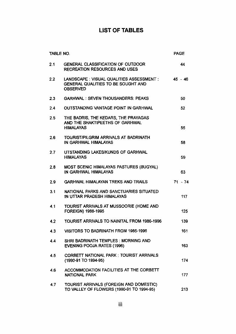
LIST OF TABLES
TABLE NO. PAGE
2.1 GENERAL CLASSIFICATION OF OUTDOOR 44 RECREATION RESOURCES AND USES
2.2 LANDSCAPE : VISUAL QUALITIES ASSESSMENT : 4 5 - 4 6 GENERAL QUALITIES TO BE SOUGHT AND
OBSERVED
2.3 GARHWAL: SEVEN THOUSANDERS: PEAKS 50
2.4 OUTSTANDING VANTAGE POINT IN GARHWAL 52 2.5 THE BADRIS, THE KEDARS, THE PRAYAGAS
AND THE SHAKTIPEETHS OF GARHWAL HIMALAYAS 55
2.6 TOURIST/PILGRIM ARRIVALS AT BADRINATH IN GARHWAL HIMALAYAS 58
2.7 UTSTANDING LAKES/KUNDS OF GARHWAL HIMALAYAS 59
2.8 MOST SCENIC HIMALAYAS PASTURES (BUGYAL)
IN GARHWAL HIMALAYAS 63
2.9 GARHWAL HIMALAYAN TREKS AND TRAILS 71 - 74
3.1 NATIONAL PARKS AND SANCTUARIES SITUATED IN UTTAR PRADESH HIMALAYAS 117
4.1 TOURIST ARRIVALS AT MUSSOORIE (HOME AND
FOREIGN) 1988-1995 125
4.2 TOURIST ARRIVALS TO NAINITAL FROM 1986-1996 139
4.3 VISITORS TO BADRINATH FROM 1985-1996 161
4.4 SHRI BADRINATH TEMPLES : MORNING AND EVENING POOJA RATES (1996) 163
4.5 CORBETT NATIONAL PARK : TOURIST ARRIVALS (1990-91 TO 1994-95) 174
4.6 ACCOMMODATION FACILITIES AT THE CORBETT NATIONAL PARK 177
4.7 TOURIST ARRIVALS (FOREIGN AND DOMESTIC) TO VALLEY OF FLOWERS (1990-91 TO 1994-95) 213
III
LIST OF FIGURES (MAPS)
MAP NO. PAGE
1.1 UTTAR-PRADESH HIMALAYAS :
LOCATION OF GARHWAL AND KUMAON HIMALAYA 10
1.2 UTTAR-PRADESH HIMALAYAS: DRAINAGE SYSTEM 24
2.1 GARHWAL HIMALAYAS: KUNDS, LAKES. WATER FALLS & SPRING 51
2.2 GARHWAL HIMALAYAS : RECREATION RESOURCES, PEAKS AND PEAKSCAPE 60
2.3 UTTARAKHAND .MOST FREQUENTED ANCIENT PILGRIM/TRADE ROUTES 65
3.1 UTTAR PRADESH HIMALAYAS : HILL RESORT
ENTRANCE MODEL 110
3.2 UTTAR PRADESH HIMALAYAS : HILL RESORT PROCESS 111
4.1 UTTAR PRADESH HIMALAYAS : MUSSOORIE 121
4.3 UTTAR PRADESH HIMALAYAS : BADRINATH, A RELIGIOUS CENTRE 147
4.4 UTTAR-PRADESH HIMALAYAS : THE CORBETT NATIONAL
PARK : WILDLIFE SANCTUARY 167
4.5 UTTAR-PRADESH HIMALAYAS : GOVIND PASHU VIHAR 184
4.6 UTTAR-PRADESH HIMALAYAS : THE VALLEY OF FLOWERS 198
4.7 UTTAR PRADESH HIMALAYAS : TREK TO THE VALLEY OF FLOWERS 201
IV
LIST OF PHOTOGRAPHS
Pix No.
1.1
4.1.1
4.1.2
4.3.1
Snow clad Himalayas in the Garhwal Region
Kempty Fall in Tehri Garhwal
Artifical lake at the entrance of Mussoorie Resort
Badrinath Temple - one of the four dhamas of Hindus
Page
13
124
128
149
4.3.2 Uttarakhand's twin famous vallies the Alaknanda and the Bhagirathi are noted for Hindus pilgrimages. 154
4.3.3 Mana- The Bhotia village is the last human settlement along the Alaknanda 155
4.3.4 Slated shingled roofed hamlet in the higher Himalayas 157
4.4.1 The herd of elephants in the Corbett National Park 179
4.5.1 Govind Pashu Vihar- the remote and extraordinary, t)eautiful landscape in the wildlife sanctuary. 189
4.6.1 The Valley of Flowers has incomparable 2500 garden genera 204
4.6.2 The beauty of Ratban Peak admist the fore ground of wonderous greenery and beautous flowers 207
LIST OF APPENDICES
PAGE
1. QUESTIONNAIRE 243 - 245
2. PILGRIM PACKAGE- GARHWAL MANDAL VIKAS
NIMGAM LTD. 246
3. BADRINATH : VISISITORS FROM 25.04.96 TO 29.05.96 247
4. LIST OF TOURIST BUNGALOWS OF KUMAON MANDAL VIKAS NIGAM LTD. 248
5. GLACIERS OF KUMAON 249
6. LOCATION AND MORPHOMETRIC ATTRIBUTES OF THE PRINCIPAL LAKES OF KUMAON 250
7. PILGRIMS CENTRE AND RELIGIOUS PLACES OF GARHWAL 251 - 253
8. LIST OF TOURIST BUNGALOWS OF GARHWAL MANDAL VIKAS NIGAM LIMITED (1996) 254
9. EXISTING ACCOMMODATION FACILITIES PROVIDED BY TOURIST DEPARTMENT TO VARIOUS TOURIST BUNGALOW (1996) 255 - 258
10. ACCOMMODATION AND CHARGES OF FOREST REST HOUSES AT GOVIND PASHU VIHAR 259
11. EXISTING, ACCOMMODATION FACILITIES PROVIDED BY TOURIST DEPARTMENT AT BADRINATH RESORT (1996) 260 - 261
12. NUMBER OF TOURISTS VISITING THE IMPORTANT
TOURIST PLACES OF UTTARAKHAND 262
13. IMPORTANT PEAKS SEEN FROM KUMAON REGION 263
14. MOST SCENIC BUGYALS OF GARHWAL 264
15. LAKES/ KUNDS IN GARHWAL REGION 265
VI
CONTENTS
PAGES
Acknowledgement
List of Tables
List of Maps
List of Photographs
List of Appendices
INTRODUCTION
1 - n
iii
iv
V
vi
1 - 7
CHAPTER-I PHYSICAL BACKGROUND OF THE STUDY AREA: UTTAR-PRADESH HIMALAYAS
8 - 40
1.1
1.2
1.3
1.4
1.5
1.6
CHAPTER - II
GEOLOGY 1.1.1 Siwaliks 1.1.2 Lesser Himalayas 1.1.3 Greater Himalayas
RELIEF
DRAINAGE SYSTEM
FLORA AND FAUNA
CLIMATE
CLIMATOLOGY OF RECREATION
TOURISM AND RECREATION
19
OF UTTAR-PRADESH HIMALAYAS
2.1 GARHWAL HIMALAYAS 2.1.1 Natural Factors 2.1.2 Socio-Cultural Factors 2.1.3 Infrastructure
2.2 KUMAON HIMALAYAS 2.2.1 Natural Factors 2.2.2 Socio-cultural Factors 2.2.3 Infrastructure
19 •
23 -
30 •
37 •
38 •
• 23
• 30
• 37
• 38
• 40
40 - 97
49
81
81
97
CHAPTER - ill DEVELOPMENT OF TOURISM IN UTTAR-PRADESH HIMALAYAN RESORTS
3.1 ANCIENT PERIOD
3.2 MEDIEVAL PERIOD
3.3 BRITISH PERIOD 3.4 POST-INDEPENDENCE PERIOD
3.5 CHANGING PROCESS OF HILL RESORTS 3.6 CLASSIFICATION AND DISTRIBUTION OF HILL
RESORTS IN UTTAR-PRADESH HIMAU\YAS 3.6.1 Religious Centres
98 - 118
99
103
105
106
108
112
- 103
- 104
- 106
- 108
- 112
- 118
VII
3.6.2 Himalayan Shrine Centres 3.6.3 Centre of Scenic Attraction 3.6.4 Other Tourist Centres 3.6.5 Parks and Sanctuaries
CHAPTER- IV TOURIST CENTRES OF UTTAR-PRADESH 119 - 2 1 3 HIMALAYAS : SELECTED CASE STUDIES
4.1 MUSSOORIE : ABODE OF IDEAL HAPPINESS 119 - 130 4.1.1 Popular Trekking Routes 4.1.2 Tourist Trends 4.1.3 Development of Tourism in Mussoorie 4.1.4 Outline for Development of Tourism
4.2 NAINITAL: THE LAKE RESORT 130 - 146 4.2.1 Historical Perspective 4.2.2 Places of Tourist Interest 4.2.3 The Satellites 4.2.4 Bhimtal 4.2.5 Naukuchiatal 4.2.6 Sattal 4.2.7 Khurpatal 4.2.8 Bhowali 4.2.9 Ranikhet 4.2.10 Almora 4.2.11 Ramgarh 4.2.12 Mukteshwar 4.2.13 Tourist Trends 4.2.14 Tourist Facilties 4.2.15 Damage to Landscape and Lake 4.2.16 Suggestions and Recommendations
4.3 BADRINATH 146 - 165 4.3.1 Religion, Myth and History 4.3.2 The Temple 4.3.3 Religious cum Recreation Resources 4.3.4 The Hosting Town 4.3.5 Pilgrim Traffic and Traffic and Patterns 4.3.6 Accommodation Facility 4.3.7 Problem of Peaking
4.4 CORBETT NATIONAL PARK 165 - 182 4.4.1 History 4.4.2 Pari Fauna 4.4.3 Parit Flora 4.4.4 Recreational use and Tourist Amenities
4.5 GOVIND PASHU VIHAR 182 - 197 4.5.1 Physical Setting 4.5.2 Climatic Conditions 4.5.3 The Salient Features 4.5.4 The Flora 4.5.5 The Fauna 4.5.6 State of Natural Environment 4.5.7 Grazing 4.5.8 Forest Fire 4.5.9 Extraction of the Forest products
Vlli
4.6 THE VALLEY OF FLOWERS 197 - 213 4.6.1 Floral Excellence 4.6.2 Access to Beauty 4.6.3 The Valley 4.6.4 The Spectrum of Flowers 4.6.5 The Way to the Valley 4.6.6 Destination Facilities 4.6.7 Visitors Aspects
CHAPTER - V STRATEGIES FOR ACHIEVING 214 - 222 SUSTAINABLE TOURISM
5.1 IMPACT ON THE PHYSICAL LANDSCAPE 215 - 218
5.2 SOCIO-CULTURAL IMPACTS 218 - 220 5.3 IMPACT ON THE ECONOMY 220 - 222
CONCLUSIONS 223 - 231
BIBLIOGRAPHY 232 - 242
APPENDIX 243 - 265
GLOSSARY 266 - 267
IX
Tourism is growing very fast and has acquired a status of the
foremost global industry. About 595 million peoples moved as tourists in
the world in 1996. Considering it's importance and financial benefits many
countries of the world are engaged in promoting tourism. Many of them
depend on this sector especially from the developing world to correct their
adverse balance of international trade, to create job opportunities and to
reduce regional imbalances. While it is true that economic effects have
caused some adverse social ecological consequences. This is the reason
why the concept of sustainable tourism has emerged so boldly in recent
years, specially in respect of ecologically, sensitive environments. Because
of aggressive tourism mountain environments gifted with spectacular eco
systems, are losing their beauty. This problem is posing a threat to the
fragile environments. Recent trends have led to the development of the
concept of "GREEN TOURISM" or "ECOLOGICAL TOURISM". Green Tour
ism is the only hope in the mountain. Native shade of the mountain ecosys
tems are green and all efforts should be made that it stays green. The
Brundtland Report (1987) following The World Commission on Environ
ment & Development, further developed and reinforced the ideas of sus
tainable development. Actually four basic principles are seen to be crucial
to the concept of sustainability; (1) the idea of holistic and strategic plan
ning; (2) the importance of preserving essential ecological processes; (3)
the need to protect bio-cultural diversity; (4) to develop in such a way that
productivity can be sustained over the long term.
1
Sustainable tourism is a positive approach intended to reduce
the tensions & friction created by the complex interactions between the
tourism industry, visitors, the environment & the local communities. It is an
approach which involves working for the long term viability and quality of
both natural and human resources. The experts believe that only well man
aged, research based and controlled tourism can afford right kind of ben
efits to the host societies.
Since tourism is multi-disciplinary, it has been studied by vari
ous disciplines belonging to social and biological groups. Contributors to
geography has been praise worthy as they have tried to comprehend the
phenomenon from different angles. Tourism is peoples industry and there
fore, its impact on the local community is of paramount importance.
At the same time people's participation is only possible when
they are directly benefitted by tourism. Dispite India's vast potential for Tour
ism promotion in unique natural and cultural heritage, her share in would
tourism is only 0.4% to worid tourist trade, whereas, some of the neigh
bouring countries like Malaysia, Singapore, Indonesia, Hong-Kong attract
more tourists. It is because India has not been able to develop tourism as
an industry and no worth while effort- has been made to assemble her
recreation resources for scientific development lack of scientific develop
ment, infrastructure and marketing appears to be the main reason. Consid
ering this drawback, the present dissertation aims at analysing the phe
nomenon of tourism with a geographer's view point.
OBJECTIVES:
The main objectives of the study are :
1. to study the physical background of Uttar Pradesh IHimalayas-
its geology, relief, drainage, system, flora- fauna and climate.
2. to study tourism and recreatorial resources of Uttar Pradesh
himalayas which includes Garhwal and Kumaon Himalayas- its
natural factors, socio- cutlural factors and infrastructure.
3. to study the development of tourism in the Uttar Pradesh
Himalayan Resorts during the ancient, medieval, British and post-
Independence period. To study the distribution of all resorts in
Uttar Pradesh Himalayas- religious centres, shrine centres, sce
nic attraction cetnre, parks and sanctuaries.
4. to study and assess the development of tourism in some se
lected tourism centres of Uttar Pradesh Himalayas- Badrinath,
Mussoorie, Nainital, The Valley of Flowers, Govind Pachu Vihar,
and Corbett National Park.
5. to design and plan strategies for achieving sustainable tourim.
Before designing such strategies we have to study the impact
on the physical landscape, socio- cultural impacts and impact
on the economy.
DATA BASE :
The data were collected both from primary and secondary
sources.
Primary sources of data have been collected through :
1) Field Surevys
2) Interviews with tourists, local people, hoteliers and officials
3) The field work was done by the writer during the year 1996. For
getting accurate information the tourists spots were visited fre
quently.
Data from secondary sources have been collected principally
from the following Government offices :
1) Garhwal Mandal Vikas Nigam
2) Kumaun Mandal Vikas Nigam
3) Tourism Department, at Lucknow, Dehradun and Nainital.
METHODOLOGY:
Since Uttar Pradesh Himalayas suffers from crisis in informa
tion and dependable data, extensive physical surveys in various environ
ments and landscape were done. Where survey research was not possible
due to difficult geographic terrain and constraint of time and money, gazetter
accounts were tallied with human memory. Sample surveys on guests and
hosts attitudes, motives and perceptions were the other methods for get
ting an insight into the phenomenology of pilgrimages and tourism. Ques
tionnaire method with self administered interviews on the visiting commu
nity were registered. Data mapping and photographic techniques were other
tools. Interviews were also organized with the resources managers and
developers of tourism to understand their constraint and difficuluties.
HYPOTHESES:
1. that Himalayan regions specially the remote and far flung areas
have suffered environmental injury due to unplanned tourism.
2. that it improves the economy of backward regions, gives new
and fresh impulses for development and urbanisies left out re
gions and creates opportunities for employment.
3. only well planned tourism can achieve the results but poor plan
ning can disturb the ecosystem and habitat.
STUDY AREA:
Uttar Pradesh Himalayas was chosen for the study mainly be
cause Himalayas is one of the most fascinating and unique creations of
nature. They are endowed with prominent shrines, tourist spots of climatic
and scenic beauty, a wide range of variegated flora and faura. They create
an immense attractions for pilgrims, tourists and mountaineers. Here both
religious and secular places are adequately juxta posed.
The Uttar Pradesh Himalayas extend from 29''5'N to 31°25'N
latitude and 77**45' E to 81°00' E longitudes. This well defined geographic
region is bounded by River Tons in the west and River Kali in the East. It
measures on an average 357 Km. from East to West and 294 Km. from
North to South, thus covering area of approximately 46,485 square kilometer
(Kharkwal, S.C. 1971). It comprises of eight administrative units of Chamoli,
Uttar kashi, Tehri, Pauri, Dehradun (Garhwal Division) Pithoragarh, Nainital,
Almora (Kumaun Division) districts. Geologically Himlayan mountains con-
sist of simple anticlinal structure. They have been divided into three broad
stratigraphical zones (1) Higher Himalayan Zone (2) Lower Himalayan Zone
and (3) Outer sub- Himalayan Zone; separating each other by major faults
vi/hich constitute different tectonic units. In the middle Himalayas beautiful
hill resorts have come up through the times. Dehradun, Mussoorie, Nainital
and Ranikhet were the off spring of British imagination, set up for their
climatic needs and environmental change.
CHAPTER SCHEME
This dissertation besides introduction consits of six chapters.
The introduction explains the choice of the problem, sets forth the aims
and objectives of the study and describes the area under consideration.
Chapter one tries to sum up the geographical setting of Uttar Pradesh with
reference to relief, drainage, climate, flora and fauna. In chapter two, the
new tourism to the region has been visualised as a landscape industry.
Efforts have been made to identify the scenic resources of the region in
different environments, physical, economic, socio- cultural and
infrastructural. Chapter three studies the development of tourism in Uttar
Pradesh Himalayas tracing its origin from ancient period till the post inde
pendent period which highlights the changing process and classification of
hill resorts. Chapter four constitutes the basic idea behind this study is to
prepare profiles of different resorts of the region and ito unravel their per
sonality in their resource make up, image and the product. These sum up
the findings of the attitudinal survey and the problems of the host and guest
6
communities. The report presents six case studies in different micro- re
gions. Badrinath registers the Yatra route phenomenon of the Himalayan
Pilgrimage. The resort of Mussoorie and Nainital represent resorts of the
Raj days. Adequately planned by the Britishers for their climatic needs,
they have witnessed fall after the independence. Many are facing satura
tion risks. Three studies of Parks and Sanctuaries have been incorporated
to establish the state of art in nature preservation and emerging ecotourism,
the Corbett National Park being the first and the oldest national Park of the
country; Valley of Flowers the youngest and the smallest park is still strug
gling to achieve the desired Park objectives; Govind Pashu Vihar is an
example of higher Himalayan wild life sanctuary. Chapter five focuses at
tention on the consequences of tourism practices and how the need for
sustainable tourism is necessary. Many environments, although endowed
with a great tourism potential, are delicately balanced and large scale un
planned expansion of tourism in such areas often manifests itself into prob
lems of serious environmental concern. Therefore, it is suggested that de
velopment of tourism be preceeded by appropriate planned strategies. The
last chapter presents the summary of the entire work with suggestions and
recommendations incoporated in the volume for an integrated and holstic
approach for scientific promotion of tourism and pilgrimages in the region.
CHAPTER - 1
PHYSICAL BACKQROUND OF THE STUDV A R E A :
UTTAR PRADESH HIMALAYAS
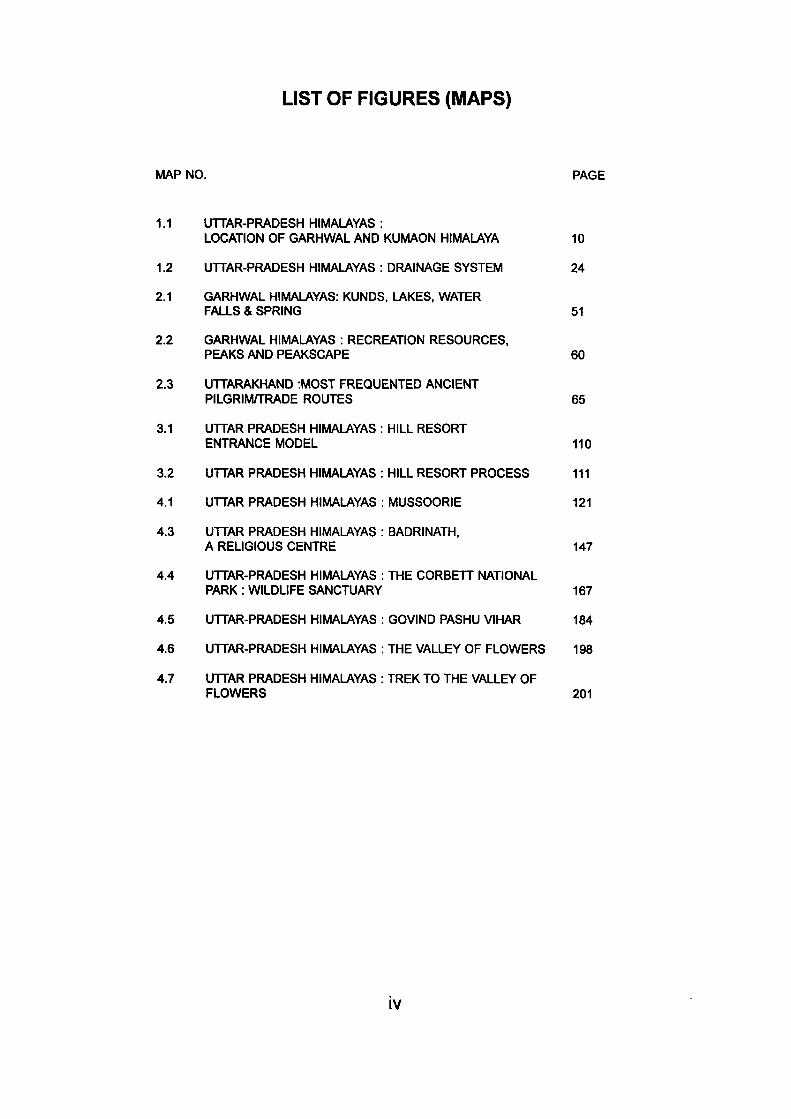
The Himalayas are the most magnificient feature on the surface
of the Earth. This mountain chain forms a gigantic arc stretching from the
Nanga Parbat peak in the north-west to the Namche Barwa massif in the
east. It extends for a length of about 24000 kms. from west to east and
varies in width from 150 to 300 kms. (Fig. 1)
The Himalayas could be divided into six physiographic regions:
1.
2.
3.
4.
5.
6.
Jammu and Kashmir
Himachal Pradesh
Garhwal
Kumaun
Nepal
Eastern Himalayas
Uttar Pradesh Himalayas
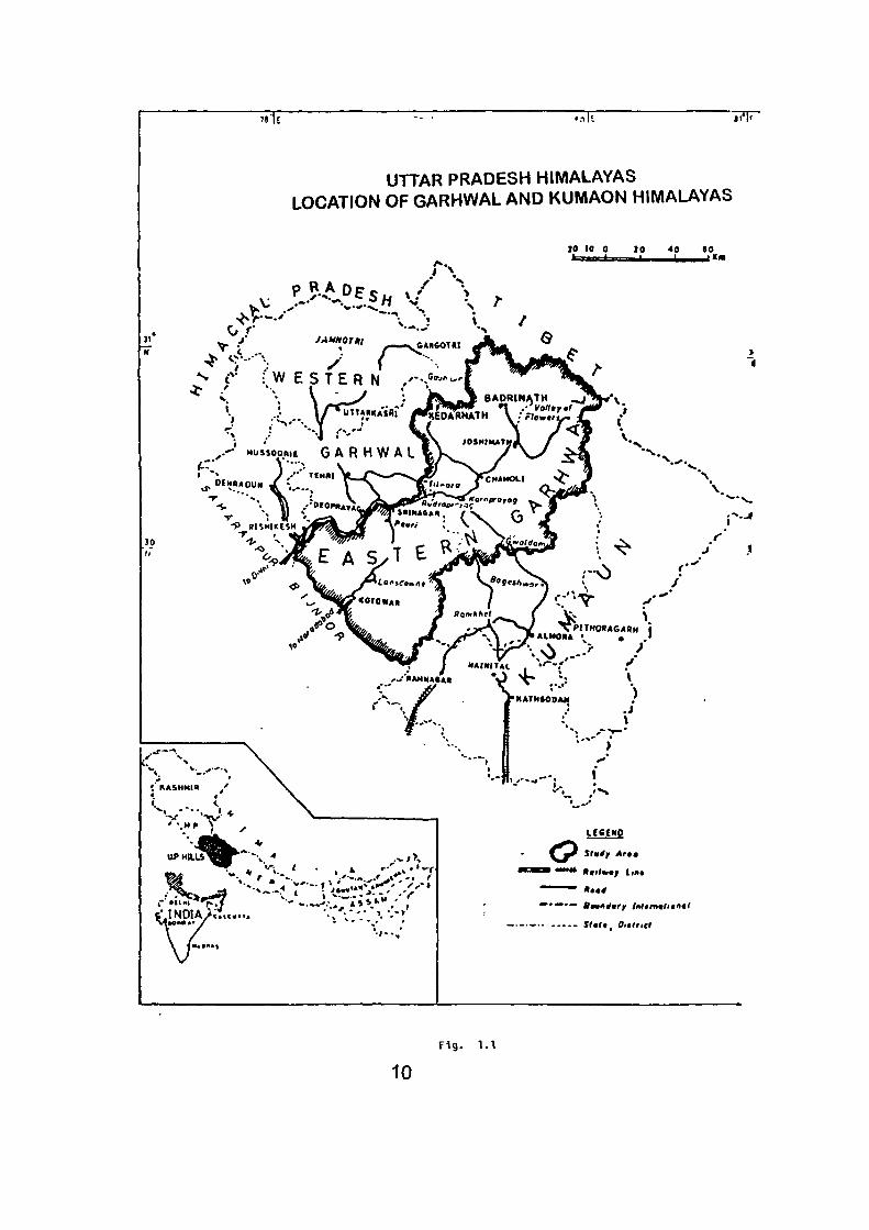
The Uttar Pradesh Himalayas comprises of Garhwal and Kumaun
regions (Fig. 1). It extends from 29°5' N to 3r25' N latitude and 71 °45' E to
81 * 00' E longitude. This well- defined physical region is bound by the river
Tons in the west and the river Kali in the east. Starting from the foothills of
the Himalayas in the south, this region extends up to Indo-Tibetan
international boundary in the north. It measures on an average 357 kms.
from east to west and 294 kms. from north to south thus covering an area
of approximately 46,485 sq. kms. It comprises of all the administrative units
of Chamoli, Uttarkashi, Tehri, Pithoragarh, Nainital, Almora, Pauri and
Dehradun Districts.
8
The Uttar-Pradesh Himalayas, hereafter Garhkum Himalaya, is
situated centrally in the long sweep of the Himalaya and forms a rather
transitional zone between the prehumid eastern and the rather dry to
subhumid eastern and the rather dry to subhumid western Himalaya. It
looks like the crown of Uttar Pradesh & stands guard to the Upper Ganga
Plain (Singh, R.L., 1971). The layout of Uttar Pradesh Himalaya is mostly
uneven, the minimum and maximum elevations being respectively 1,000 m
and 7,817 m above the mean sea level.
1.1 GEOLOGY.
The Himalaya was formed by the mightiest thrusting of the earth
layers and their rise is analogous to Nappe formation of Alps- a tangential
process. Upheavals and compression resulting in excessive rock-folds,
faults, thrust planes have changed much of their original and primitive
structure. They are young with sharp relief features viz., pyramidal peaks,
knife, edge, high ridges and deep abysmal valleys. Many geological surveys
have been made in various parts of the Himalayas, but even now geologically
much of the area is yet to be known. Wadia states that" large part of the
Himalayas is yet unexplored, not only the geology but even the main features
of the orography and geography are not well known over the years (Wadia,
D.N. 1966).
Burrard and Hyden, in 1907 presented for the first time the
structure of the Himalayan zone, based on the scattered information of the
Himalayas. Auden, J.B. (1934,1953) Heim and Ganssar (1936) and Captain
Strachey (1951) have presented their works on Kumaon region. Eminent
geologists Krishnan and Ganssar have done excellent work on the geology
7«1E • n l t
UTTAR PRADESH HIMALAYAS LOCATION OF GARHWAL AND KUWIAON HIMALAYAS
30
r\ 20 10 0 20 40 ( 0
jAMHorn . GANMTtl
^ r { W E S T E R N ,'-->-'>-'
\ ^ G
, DEHRAOUN
V-'.
t .INDIA/.:...... ' • / • / - • ^•.-»
'*%
ICCCWQ
^ » ii i i l l A«ffw«^ (ma
- Statt Oittricl
10 Fig. 1.1
of the Himalayas. Among the recent works, some regional studies done by
Pandey (1963) and Valdiya and Mishra (1961) are highly appreciable. The
advanced Centre of Palaeontology and Himalayan Geology (Chandigarh)
has also published a number of Geological studies on the Himalayas
(Saxena, M.N., 1966).
Himalayan mountains consists of simple anticlinal stmcture. Most
of the part possesses relativelysoft cretaceous and tertiary sand stones.
The major geological formation in this region are related with the age from
pre- Cambrian to cretaceous (Krishnan M.S., 1960). Wadia, (1966) divided
it into three broad stratigraphical zones :
1. Outer of sub-Himalayas (Siwaliks)
2. Central (Lower or Lesser) Himalayas (Himachal)
3. Higher or Greater Himalayas (Himadari)
The main Central Thrust demarcates the Higher and the Lesser
Himalayas and a Main Boundary Fault seperates the Lesser Himlayas from
the outer of sub-Himalaya. The altitudinal zones of this region also coincides
with this division. Outdoor activities or tourism regions, both religious and
secular, also closely alley themselves with this universal division.
1.1.1 Siwaliks:
Skirting the Upper Ganga Plain, stretches (NW to SE) the foot
hill-belt of the Siwalik ranges of low heights (300-600 m), which is composed
entirely of tertiary and upper tertiary sedimentary river deposits. The detrital
thickness of this region, abounding in miopleistocene sand, gravel and
11
conglomerates, varies from 4,570 to 6,100 m.. "The lithology is suggestive
of the deposition of water- worn debris of the Granite core of the Central
l-iimalayas in the long and broad valley of the Siwalik River (Wadia, D.N.,
1961).
As one emerges from the plains, the beds of sandstone and
pebbles (Nahan) appear on the scene in variegated hues of violet, pink,
red and green. "Subgreywakes with associated chocolate brown appear to
the west of Ramnagar in the middle Siwaliks", (Tandon, S.K., 1971).
Geologists believe that Siwalik in the south are buried under the
alluvium of the Ganga. The exposed belt, however, passes through the
northern part of Saharanpur, the southern part of Dehradun and Garhwal
and the middle part of Nainital.
To the north, Siwaliks are backed by a discontinuous series of
longitudinal vales known as Duns such as Dehra, Kontri, Chaukhamba,
Patii and Kota. Of them Dehradun (35 Km. long and 25 Km. wide) is the
biggest and most developed in urban and out-door facilities. These duns
have been filled in only recently from gravels derived from the Central
Himalaya. They rise to the height of 350 m from the plains.
The Siwaliks bear testimony to the extreme youth of the
Himalayas and promise rich recreation resource in their beautiful landscape
scenery- waterfalls, river banks, contact zones of plains and mountains
and the forested slopes. With grand Himalayan scene in the backdrop
contiguity to densely populated and urbanised area in the Upper Ganga
plain and with adequate rail- road connectivity, the entire Siwalik region
12
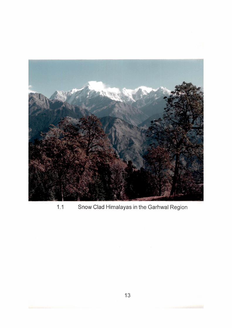
1.1 Snow Clad Himalayas in the Garhwal Region
13
can easily become an outstanding intermediate type of resource for tourism.
Indians seek recreation too religiously, and only those old religious centres
get a little spurt which sen/e as gateway to Himalayan shrines. In the eastern
region Kathgodam, being railhead and gateway to resource based area of
Kumaon, can stir good tourism activity.
On the basis of lithology and the degree of induration the Siwaliks
may be divided into three units :-
1. The Lower Siwaliks
2. The Middle Siwaliks
3. The Upper Siwaliks
1. The Lower Siwaliks
Sandstones of the lower Siwaliks are relatively more compact
and indurated than those of the Middle and Upper Siwaliks. It is composed
of medium to fine grained compact grey coloured sandstones, interbedded,
with minor siltstones, shales and some clays.
2. The Middle Siwaliks
The Middle Siwaliks consist of essentially fine to medium grained
salt and pepper sandstones with some siltstones and day beds. These
sandstones are friable due to cementation.
3. The Upper Siwaliks
The Upper Siwaliks are embedded with conglomerates and
sandstones. The pebbles of the conglomerates consist of sandstones,
quartzites, limestones, shales, phyllites and slates.
14
1.1.2 Lesser Himalayas :
Bounded by the Main Boundary Fault to the south and the Main
Central Thrust to the north, stretches the zone of Lesser Himalayas
approximately in seventy- five kilomteres. It is a crystalline zone of
unfossiliferous (or poorly fossiliferous) sediments with complex tectonics.
Rocks have Ijeen compressed and metamorphosed to such an extent that
they vary in age from Algonkian to the Eocene (Wadia, D.N., 1961).
Lithological variations present a mosaic of colours- buff, cream, white, purple,
pink, grey green, yellow and slaty presenting a feast to the eye. The variety
is pronounced in Uttarkashi region where investigations proved that Dharasu,
Singuni and Uttarkashi thrusts have affectd rock variation 'from highly
schistose cericite quartz'. Lithostratigraphical variations are pronounced in
Almora- Askot and Baijnath region in the east. The main structural feature
is the extension of Simla- Krol belt (with its overlying deposits of infra krol,
krol sandstone, krol lime and Tal quartzites) from west to east (Burrad,
S.G. and Haydon, H.H., 1907). This krol-belt constitutes most important
tourism resource base of the region. The Lower Himalayan zone may be
divided into three main structural features :
1. Krol Belt
2. Deobar Tejam Belt
3. Almora- Dudatoli Crystalline Thrust Sheet
1. Krol Belt
The Krol belt stretches from Shimla region in the northwest to
Nainital region in the south-east. This belt has overlying deposits (Auden,
15
J.B., 1934) and consists of four types of rocks namely Infra Krol, Krol
Landstones, Krol Limestones and Tal Quartzites.
The Krol thrust oversides a structural and erosionai gap in the
Siwaliks (Ganssar, A., 1964). This superimposition of relief may be compared
with the northern margin of the Alps in Europe (Singh, R.L., 1971). The
southeast region of Nainital has numerous local faults in different directions
and this region has become extremely complicated by crushing and
crumpling of faults. Thus the region is full of tectonic complications with
tectonic slips and mass glidings (Kharkwal, S.C, 1969).
2. Deobar- Tejam Belt:
The Deobar- Tejam zone is made of enomnously thick limestones
and dolomites topped by thick sections of quartzites. The main
characteristics of the area as described by Ganssar as "a peculiar steep
zone with some quartz. Conglomerates, highly crushed quartzites and
conspicuous amygdaloidal epidote diabases" (Ganssar, A., 1964).
It may be divided into two belts in the eastern Lower Kumaon
Himalaya, i.e. Badolishera- Pithoragarh zone in the south, and Chamoli-
Tejam Zone in the north which is separated by the Askot- Baijnath crystalline
thrust. This zone consists of thick- bedded dolomites and crystalline
limestones, which are invariably overlaid by quartzites and intervening
phyllites.
3. Almora- Dudatoli Crystalline Thrust Sheet
The Almora- Dudatoli thrust lies in the north of Krol thrust of
16
Nainital. Pre- Cambrian formations are represented by tlie great Almora-
Dudatoli thrust zone. It separates the liner sedimentary zone of the Lower
Himalayas, which is also called Deoban- Tajam zone. The formations of
this zone are of pre-cambrian and paleozoic era. It stretches from the Shimla
area in the nortwest to Ka//valley in the southeast. The occurrence of older
formations (Almora- Dudatoli thrust zone) over the younger one of
precambrian and paeozoic (Deoban- Tejam) is, however, a general
phenomenon throughout the Himalayas.
The Almora- Dudatoli thrust sheet forms a huge crystalline mass
metamorphosed and mostly reversed rocks with complex character. Some
important rocks of Dudatoli region are phyllites, schists, flages, quartzites
and gniesses. The lithology is much similar to metamorphosed Chandpur
of middle Jaunsar.
With verdant hills, furrowed ridges, dales and vales cataracts
and calm waters of the lakes, this region easily becomes Uttar Pradesh's
paramount tourism resource base, where average relief of ridge ranges
between 1,500 and 2,700 metres and the valley bottoms are between 500
to 1,200 metres.
As one traverses from the Siwaliks, the mountains rise abruptly
and 'the mystery and thrill of travel is upon one in the Himalayas.' In the
words of Smythe: 'Unimaginative is he who can gazeupon the Himalaya
from the lower foothills or the plains, and not sympathise with the simple,
child like adoration of the Hindu for Ganges to minister to their needs'.
(Symthe, F.S., 1932). The 'White radiance" of Grand Himalayas, the beauty
17
of glorious sunrise and sunsets and tlie grand Himalayan panorama can
be enjoyed from the ridges of Mussoorie, Ranikhet, Almora and Kausani,
developed for out door recreation.
Lakes, as compared to Alps and other mountain systems, are
not very common feature in the Himalayas. Nevertheless, an important belt
of lake- basins (25 km. long and 4 km. broad) occurs near the outer fringe
of lesser Himalayas. Nainital, as lake district, is Uttar Pradesh's outstanding
outdoor recreation resource centre with developed tourist amenities. With
Naini as nucleus, Bhimtal, Naukuchia, Sat, Puma and Malva Tals (lakes)
attract visitors in large number. The lake basis of Khurpatal, Sukhtal and
Sahatal are too small to mention. Flood- washed Gohna lake (Garhwal),
once trout fishing centre, is no more now. Diurital, lying some 16 km, to
north of Ukhimath has not been developed for outdoor recreation.
The origin of these lakes is still doubtful and uncertain. Geologists
have placed different views on the subject. Thomas believes that the recent
earth movement and diversified lithology were the two main factors
responsible for their origin. (Thomas, A.N., 1952) Ball, however, considers
the Kumaon lakes to be of landships origin. Avoiding the controversy Wadia
sums up: "while a few may be due to differential earth- movement like
faulting, others may have been produced by landships, glaciers, etc. (Wadia,
D.N., 1961).
1.1.3 Greater Himalayas
The Higher Himalaya region lies to the north of the Main Central
Thrust. It spreads over 50 km. Formed of simple tectonics, it is a region of
unsurpassing natural beauty, adorned by glaciers, huge- U- shaped valleys,
18
horns and glacial lakes. The main central thrust separating the Higher
Himalayan Zone from the Lower Himalayan Zone in well outlined by the
Kali gorge and the valleys of the Goriganga and the Pindar rivers. The
crystalline sheet of the Higher Himalayan Zone is made of old metamorphic
rocks and is composed of a series of highly fossiliferous sediments. The
main rocks of the zone are quartzites, magmatites, genisses, granites,
schists, dioritic amphibolites etc. it is however, a difficult and inaccessible
area with an average relief between 4,800 and 6,000 metres, culminating
into some of the highest peaks of Asia, viz; Bandar Ponch (6,315 m) Kamet
(7756 m) Nanda Devi (7,817 m) Dunagiri (7,066 m) and Trishul (7,120 m).
Some of the giant glaciers such as Gangotri, Milan and Kedamath (largest
after Karakuram glaciers) can be seen here (Wadia, D.N. 1961). The present
iandforms in Himalayas show ample evidence of ice- sculpture. Presence
of the fiuvioglacial drifts and matter, glacial lakes, formed of plugging of
valleys (e.g. Hemkund, Rupkund, Satopanth, Chobarital and Chaukhamba)
and broad glacial terraces are the evidence that their region was affected
by at least one glacial age (Wadia, D.N., 1961). The glaciated scenery of
this region has often been compared to the Yellowstone or Yasemite National
Parks of the U.S.A. "The entire natural landscape is well preserved for
Hindu pilgrimages" (Singh, TV., 1973).
Aryans with wonderful landscape tastes, paid homage to the
greatest and most formidable of all the mountain system that they had
come across and finally.
1.2 Relief :
This region has a varied and complex relief. There are many
19
ranges of mountains running in a general direction from northwest to
southeast. The slope is steeper towards the southern side and gentle
towards the north. The main rivers of the northern India, viz. the Ganga, the
Yamuna and the Kali, rise from this region and constitute three major river
systems. The area is studded with lakes which follow the general trend of
the ranges and is studied with their situation form a characteristic feature in
the area. On the basic of physiographic attributes this region may be divided
into three major relief zones :
i) Himadri (Greater Himalaya):
The Himadri (Greater Himalayas) ranges run nearly along the
international border of the country in this region, where glaciated topography
is well- preserved. The Himadri is 50 km. wide and has the highest elevation
which are approximately more than 4,000 metres where several high pases,
viz.; Lipu-Lek (4,966 m), Damia (5,329 m), Niti (5,579 m) Mana (5,609 m)
and Jelu Khaga (5,329 m) are situated joining the region with Tibet. Some
Himalayan peaks, famous for their heights, are situated here viz. Nanda
Devi (7,817 m), Kamet (7,756 m) Trishul (7,120 m), Nilkantha (6,597 m)
Dunagiri (7,066 m) Bandar Punch (6,315 m), Gangotri (6,141 m) and
Kedarnath (6,940 m). The slopes and peaks are covered with several
hundred metres thick ice covers, which make many glaciers like Milam,
Gangotri, Pindari, Bhaglrathi, etc.
The Greater Himalayan ranges are deeply cut by the headwaters
of the rivers Ganga (Bhagirattii and Alal<nanda) the Yamuna and the Kali
(Sarda). The cross profiles of these valleys show convex form with steep
20
valley walls reflecting the rising phase of the Himalaya and also the younger
characteristics of the rivers (Singh, R.L., 1971).
The river Ganga forms the main valley of this region and drains
a very large portion. The Ganga (Bhagirathi) rising from the Gomukh glacier
(6,614 m) which is 30 kms. long and 2 to 4 kms wide, cuts a fantastic gorge
among the granites of the central axis of the Greater Hiamalyas. The Yamuna
rises from Bandar Punch range and it has two tributaries i.e., the Tons and
the Giii. The valley of Kali (Sarda) forms the eastern boundary of the region
which ends on the Nepal border. Himadri may be divided into two relief sub
divisions- a) Himadri ranges, and b) Himadri valleys.
ii) Himanchal (Lower Himalaya):
The Himanchal (Lower Himalaya) is situated between the ranges
of Greater Himalayas in the north and the Siwaliks in the south. Lower
Himalayan ridges have a general elevation of about 1,500 m to 2,700 m
and the valley bottoms between 500 m to 1,500 m with a width of 75 kms.
The region Is full of a variety of landscapes developed in different parts.
The lacustrine basins and river terraces are dominant features
of this region. The valleys of the river Ganga and its thbutaries are in young
stage of profile development. They are immature, as they have been
subjected to rejuvenation again and again. The main Boundary Thrust
seperates this region from Duns. The ridges of the region, with highly
compressed and altered rocks are seperated from each other by deep
valleys.
21
There is a lake basin near the outer range of the Lower Himalaya
which makes a zone of approximately 25 kms in length and 4 kms. in width.
The lake region of Kumaon is dotted with big and beautiful lakes. The area
around Nalnital alone has ten lakes. Some important lakes of the region
are Naini lake, BhimTal, Naukuchiya Tal, Sat Tal, Khurpa Tal, Sukha Tal,
Sarai Tal etc.
The Sukha Tal, a lake with no water, is situated near Nalnital
while the Gohna lake is in the Garhwl Himalaya in the valley of a tributary of
Alaknanda named Birahi Ganga. The Diuri Tal is another important lake
lying 10 kms. the northeast of Ukhimath.
The origin of these lakes is still ambiguous and doubtful. Thomas
believes that the frequency of the lakes in this small region may be connected
with the recent movement. The irregularly eroded surface of Siwaliks over
which the Kml Nappe has moved must have contributed to the formation of
the surface irregularities, consequent upon the breaking up of the thrust
mass. Thus, the region has too sub- divisions : a) Himanchal ranges and
hills, and b) Himanchal valleys and lake- basins.
iii) The Siwaliks (Sub-Himalayan Tract):
The term 'Siwaliks' is used for a range of narrow and low hills
which lie almost parallel to major ranges of the Himalayas. It stretches in
north west to southeast direction and forms the outer range of the Himalayan
system. The hills of Siwaliks are broken up and are seperated from the
Lower Himalayan spurs by a series of structural lowlands. The height of the
Siwaliks varies roughly from about 550 m to 1,350 m. Ranges of Siwaliks
22
are intersected by numerous Siwalik rivers, such as Dabka, Baur, Nihal
and Bhakra at several places. These rivers have carved out their deep
valleys. These ranges are lithologically quite different from those of Lower
Himalayan ranges. The southern slopes have steep scarps and the northern
slopes descend gently to the flat floored structural valleys called Duns.
The sediments of Duns are brought recently from the upper
ranges (Himanchal and Himadri) and filled up in this region, which is 350 m
higher than the plain. Many Duns are found in Uttar Pradesh Himalayas, as
Dehradun, KothriDun, Chaukhamba Dun, Path Dun and Kota Dun. Siwaliks
may be divided as a) Duns and b) Siwalik ranges.
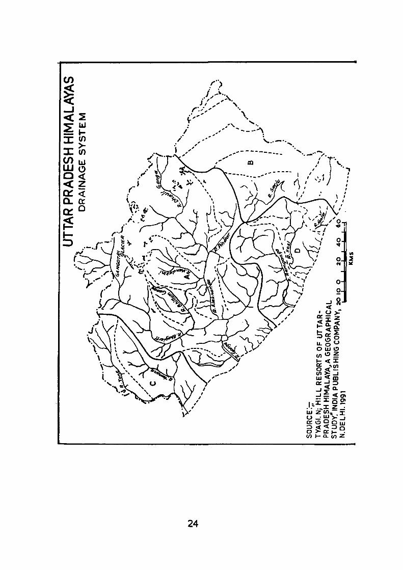
1.3 Drainage System :
Indians being essentially religious, bathing in rivers was
prescribed as an important out door religion activity. At several places ghats
were, therefore, fitted in their banks where pilgrims thronged in multitutde
to take dip periodically. Some of them are venues of national bathing
festivals. These bathing stations were carefully selected with an eye on
panoramic beauty of the surrounding landscape. Most popular sites are
where the river rises from the Himalayan glaciers meanders and the junctions
of the two streams- prayagas. These prayagas near the sources of the
rivers were held most sacred, perhaps for reasons of natural benediction,
physical charm and unique quality of waters. While the spirit of religion
flows into these rivers, their recreational value can hardly be under estimated,
particularly near congested urban centres where they are the soul venue
of "breathing out". (Even in the KAVAL towns of Uttar Pradesh, we are
almost working upto a crisis in user based out-door recreation facilities.
23
U) ^ -J uj < m
- I = < 0 >
S5gv5 ts: o 9 Oiju 3 < < 3 o o >- Q: >- . (n I - Q. en z
24
The urban explosion and the consequent centripetal growth has resulted in
the squeeze on whatever open spaces, play grounds and parks we have
had in a city area). Rivers and other minor water bodies (lakes, tanks etc.)
can play a vital role in the aesthetics and recreational life of a city water
sports, viz. Swimming, boating, angling, sking and other secondary water
contact activities can be developed.
Undoubtedly, Uttar Pradesh, has a wonderful river system in
the Ganga with her many tributaries and distributries that drain the entire
state. The Himalayan region is drained by the three streams, namely; the
Ganga System, the Yamuna system and the Kali system: the first two are
of pilgrim/ tourist importance. All of these rivers have their souces in the
Himalayan glaciers and have sculptured wonderful landforms, deep gorges,
and transverse valleys that present a spectacle of enchanted scenery. In
higher regions rapids and water falls cascading over the cliffs (sometimes
from hanging valleys) thunder down most of the day and go silent as the
freezing night advances, adding serenity, calm and mystery to the place.
The Ganga, with its parent streams of the Bhagirathi and the Alaknanda,
appears more conspicuous on the scene.
The Bhagirathi \s considered to be the main source of the Ganga
though the Alaknanda, the Dhauli Ganga, the Pindar and the Mandakini
have also been considered as good source rivers (Bose, S.C, 1968). The
Bhagimthi, ail along her course, commands a most imposing natural scenery
with beautful incised meanders, expanses of natural terraces (traces of
intermittent rise of Himalaya), truncated spurs and Himalayan meadows.
The morphoecological setting all around the valley also presents a scene
25
of pastoral and botanical beauty- wild plants, fruits trees, the paddy terraces,
nomadic Gujjars with their herds of buffalo, sheep farms and the colourful
Monal all mix into one harmonious whole.
Rising from the Gangotri glacier (30 km. long and 2 km. wide)
the river can be seen emerging from the ice cave of Gaumukh. Over the
Gangotri rise the horn- peaks of Bhagirath Parwat and Shivalinga - a pilgrim
site. Cutting the granite gorge the river turns at right angle. Beyond Gangotri
the valley is broad and choked with glacial tills. The interfluve consists of
razor sharp ridge and snow covered pinnacles. At Jangia the JADH Ganga
meets the Bhagirathiarmdsi the most spectular granite scenery. "Both rivers
are supposed as antecedent to the rise of the Himalaya (Bose, S.C, 1968).
The entire valley from Gaumukh to Jangia is a pilgrim /tourist resource
based area.
Alaknanda is the main tributary of Bhagirathi, which rises from
the eastern slopes of Chaukhamba peak (7,138 m). The river Alaknanda
flows 147.5 kms. from its origin to its confluence point. The Chaukhamba
and its satellite peaks, permanently covered with snow, form the snow parting
between the Gangofn group of glacier to the west and the Bhagirathi group
to the east. There is a popular belief that Vedas and other Hindu scriptures
were composed in this 'Valley of Gods'. Alaknanda collects the water of
such resource rivers as the Saraswati (meeting the Alaknanda at Keshav
Prayaga) the Bhyunder Ganga (the Valley of Flowers), the Dhauli (at Vishnu
Prayaga), the Mandakini (Nanda Prayaga) the Pindar (at Karan Prayaga),
the Mandakini (Rudra Prayaga) and finally dissolves herself into the
Bhagirathi at famous Deva Prayaga. All these rivers and Prayagas are
26
most sacred to Hindus and attract large number of pilgrims and tourists
every year.
Rising from the twin glaciers of Bhagirathi Karak and Satopanth,
the river skirts the Nilkantha and the Narayan Pan/at and flows past to the
holy shrine of Badrinath where the valley opens out into circular undulating
plain made of glacial till. Here Narand Narain peaks (6,500 m) stand
assentinels on either side of the valley. At Badrinathi, the Rishi Ganga meets
the Alaknanda. To the north of Badrinath, Vasudhara cascades between
the Bangneu and Pawegarh peaks from the height of 150 metres.
This glaciated scenery, including Nanda Devi, Dunagiri, Nanda
Ghunti, Trishul and many other giant peaks, has been preserved for Nanda
Devi Sanctuary, perhaps, the biggest of its kind in the world. The Nanda
Devi, National Park, at present is closed to the public.
The Mandakini rises from Chorabari glacier (Kedarnath peak)
and has another sacrosanct Hindu shrine of Kedarnatii at its source. The
temple stands on a platform of loose and unconsolidated glacial till material.
The strange phenomenon of disappearing waterfalls on the Wanda/c//?/flanks
would not seem to be mystery.
The Pindar Ganga rises from the famous Pindar glacier which
attracts trekkers from all over the country. The glacier lies in the shadow of
Nanda Devi and has accommodation facilities at Pliurkia (3,202 m), situated
8 km. away from the glacier snout. Pilgrim interest is confined to the junction
of Karn Prayaga lying enroute to Badrinath. Other valley aspects are
characterised by hanging valley, truncated spurs, and talus slopes. Green
grassed moraine platforms, known as Bugiayals, where sheep graze, add
27
pastoral charm to the landscape.
In the union of the Bhagirathi and the Alaknanda the mighty
Ganga Is bom at Devprayaga. The tortuous journey in the grand Himalaya
comes to its last phase at Lachhman Jhula and the river seems to enjoy an
interlude in the Dun-country to cut across the Siwaliks at Haridwar. The
valley aspects from Rishikesh to Devaprayaga are marked by dense forested
slopes on both the sides of the valley and panorama of natural beauty, in
wich the river chuckling and foaming over the boulders plays hide and seek
with the interlocking spurs.
The Yamuna system is related with the river Yamuna, which is
the third most important river of this region. This system covers western
portion of the region and river Yamuna flows 112.5 kms. from the origin to
the other end of the region. The Yamuna system drains parts of the district
of Dehradun, western part of Uttarkashi and Tehri districts. The Yamuna,
which rises from the Yamunotri glacier, on the southwest slopes of Bandar
Ponch, is torrentially rapid with her more turbulent tributary, Tons, in
sculpturing Himalayan landscape into beauty. In their upper reaches both
seem to have experienced rejuvenation on account of intermittent
upheavals; the paired terraces and the entrenched meanders bear ample
witness to this phenomenon. Meeting at Kaisi, the Yamuna emerges out of
the lesser Himalaya and braiols in the Dun Valley for gentle slope gradient.
The Yamunotri shrine near the source of the river, with low
geysers and hot springs around (temperature 90.4° C) is the crowning glory
of the river. For the rest, she performs well on the plains by having some of
the best historic sites and religious scenes laid on her banks.
28
The river, after collecting the waters of the Chambal from the
south dissolves finally into the mother stream at Allahabad, after running a
course of 1,376 km. to its confluence. The area existing to the west and
east of the Yamuna has been a region of perennial cultural evolution
throughout historic times.
The Tons is the biggest tributary of the river Yamuna. The volume
of water brought by this river becomes nearly double to that of the river
Yamuna. The river Yamuna and the Tons flow separately cutting Mussorrie
ranges into deep valleys and meet together at Kaisi. The Giri, another
important tributary of the river Yamuna comes from further north west of
the Tons, bringing water from southeast Himanchal Pradesh. The G/n joins
the river Yamuna in Kiarda Dun Valley.
The Kali river system is denoted by the name of the river Kali,
as this is the most important river of this system. This river system covers
eastern portion of the region, in which the river Kali flows for a distance of
195 kms. from the plan of origin to the point exit from this region. The river
Kali, which rises near the India-Nepal- Tibet, tri-junction follows a
southwesterly course and runs almost at right angle to the lower Himalayan
and Siwalik ranges. This system covers the district of Pithoragarh and the
eastern part of Almora and Nainital districts. The Kali system drains near
about one- fourth portion of the region. The river Kali has two headwaters,
i.e. the Kala Pani and the Kuti Yankti.
The Kala Pani and Kuti Yankti headwater, as a source of water
to the river Kali, are situated in the east and the west of the river respectively
29
The Kala Pani is a collection of perennial springs while the Kuti Yankti
takes its origin from the snow field of Himadri. Receiving water from these
head waters, the Kali river flows in a southwest direction upto Jauljibi (120
km. away) where it is joined by another tributary Gori Ganga. Another
important tributary of the Kali\s Sarju, which brings a large amount of water
and after flowing 105 kms. from the origin it meets Ka//at Pancheshwar, 45
kms. below Jauljibi. Further down, Lohawatian6 Ladhia\o\n Kali, which are
its two important tributaries. Kali enters into the Ganga plain at Bamles.
1.1.4 Flora and Fauna :
Flora and fauna of Uttar Pradesh are vital tourism resources.
Shomoff their green mantle, our beautiful mountains and hills would be
bare rocks and without the colourful fauna these lush green meadows and
verdant hills would be wanting in the 'romance of wilderness'; the soft twitter,
the sweet chirp and the wild cries of forest birds and animals are 'vital
feelings of delight' which a mountain sojourner would look for. They, indeed,
are our precious national heritage.
1.4 Flora:
The concept of forest recreation in India is comparatively of
recent origin. The creation of National Parks and Wildlife Sanctuaries,
borrowed concept, has taken root in India.
The forests of Uttar Pradesh show diversity in composition
because of their wide geographical and altitudinal distribution. The Himalaya
has a natural cover of vegetation ranging from subtropical forests to sub
arctic vegetation.
30
Systematic surveys about the vegetation cover of Uttar Pradesli
Himalayas have not yet been conducted properly, hence very limited
literature is available. Hooker (1909) and Champian (1909) have presented
very comprehensive material on the vegetation types of Himalayas for the
first time. Osmastan, Schweinfurth and G.S. Puri also contributed towards
the vegetation cover of Uttar Pradesh Himalayas.
According to Champian, the Himalayan region can be divided
into six vegetation belts according to height above sea level.
1. Upto 3,000 ft. Tropical moist deciduous (sal trees)
2. 3,000 - 6,000 ft. Sub-tropical, pine trees (often upto 7,500 feet
on the southern slopes)
3. 5,000 -11,000 ft. Moist temperature: mainly conifers, some oak
trees.
4. 6,500 - 8,000 ft. Dry temperature; often conifers (mainly in drier
inner valleys)
5. 9,500 -11,500 ft. Alpine; denses small crooked trees, firn and
rhododendrons.
6. Above 11,500 ft. Alpine, dry shruks.
Following the classification proposed by Champian, Rautela in
1963 classified the vegetation of Kumaon into three types according to the
altitude.
1. 248-1,350 m (800-4,500 feet) - Sub tropical zone
2. 1,350 -1,900 m (4,500-6,250 feet) - Temperate zone
3. 1,900-3,050 m (6,250-10,000 feet) - Alpine zone
31
The main feature of the forest types of Uttar Pradesh Himalaya
is that the forest stretches from northwest to southeast direction according
to the extension of mountain ranges.
In the light of above classifications, it is possible to divide Uttar
Pradesh Himalaya into four main forest zones (Singh R.L., 1971).
1. Sub-tropical zone (below 1,200 metres)
2. Temperate zone (1,200 -1,800 metres)
3. Sub-alpine zone (1,800 - 3,000 metres)
4. Alpine (3,000 - 4,500 metres)
Sub-Tropical Zone
This zone is characterised by greater rainfall (250 cms or more
annually) with fairly warm temperature (40''C). The climatic conditions of
this zone make the soil rich with humus for the growth of vegetation. The
sub- Himalayan tract oft his region is covered with plants of sub-tropical
zone. This vegetation zones occurs upto the height of 750 metres towards
northern slopes and upto the height of 1,200 metres towards the southerns
slopes.
Sal {Shorea robusta) the most prominent species of this region,
is usually found upto the height of 1,525 metres. Sal forests are typical
high forests, as trees attain a height of usually 25 metres and occasionally
35 metres. These trees shed their leaves with the beginning of dry season.
Sal trees are of great commercial value as they fulfil the needs of household
purposes. Scientific forest management has also focused largely on the
32
development of sal trees. Environmental aspects influence the distribution
of sal trees, as in 'duns', the northern aspect displays tendency towards
pure sal forest and southern aspect towards mixed forest. Sal trees are
quite prominent along the courses of rivers.
Besides sal {Shorea robusta), the other species are also found
in this zone are haldu, (Adina, cordifolia); dhuari (Largerstromia purviflora);
sain (Terminalla tomentosa) and tun (Cedrela toona). Bhyunal is another
important tree of this region which usually grows in the valleys and lower
hill slopes. Mango, pipal and banyan trees of plains are also found on the
lower slopes of the hills.
In the low rainfall and high rainfall regions dry deciduous and
moist deciduous trees appear. The floristic composition in dry deciuous is
angle marmelos, dry bamboo- break {Dendrocalamus strictus), etc., and in
the moist forest is Kanyu (Holontela integiifolia) Kuri (Nyetanth esarbotthsts)
semal (Samlia mala bariea), amaltas, dhundi, etc.
Temperate zone:
This zone of forests occurs between sub-tropical and sub-alpine
zone from 1,500 metres to 1,800 metres. The temperate forests appear
upto 1,900 metres towards the southern slopes and upto 1,800 metres
towards the northern slopes (Osmastan, A.E., 1927). Here broad leaved
evergreen trees are mixed with conifers. The dominant tree in this zone is
chir or chil {Pinus roxburghic longifolia), which is light green in colour and
forms an open forest of 20-30 metres height. There are few shrubs and
under-growth grass which appear during the monsoon. Just before the rainy
33
season, the ground is covered with the long needles (Syn. P. Longifolia)
very slippery to walk on, especially when on steep slopes. Forest fixes are
very common features during the winter when the vegetation is dry (Tyagi,
N. 1991). The chlrtrees with high quantity of resin are highly inflammable.
The Chir produce useful timber for furniture, boxes, buildings
and railway sleepers Resin is tapped extensively from these forests, from
which turpentine oil is obtained. The process of resin collection gives
employment to large number of people in Kumaon. The valley of Giri and
the Tons rivers are full of C/)/r trees. They are also found extensively in the
Yamuna, Bhagirathi and Alaknanda river valleys. Extensive forests appear
round Ranikhet and Almora. As the height increases the pine trees give
way to oak trees.
Sub- Alpine zone:
This vegetation zone starts from 1,800 metres and continues
upto 3,000 metres. The forests of this zone covers a considerable area of
the region. It can usually be divided into two strips i.e. (i) the Lower sut>-
alpine zone, and (ii) the higher sub-alpine zone.
The lower sub-alpine zone is dominated by oak trees. There are
three types of oak- Quereus incana. Quercus dilatata and Quercus
SemicarpifQlia with evergreen stiff, leathery and serrated leaves. The
prominent associates of banj Oak {Quercus hcana) in bums (Rhododerdron
aboreum). Rododerdron trees with their scarlet bloom in May and June are
found around Chakrata and in Ganga Valley when tourists arrive in large
number Rhododerdrons appear in different sizes and shapes, i.e. trees
34
and shrubs. It is not liked by animals. Banj oak is used for making agricultural
implements due to its hardened wood, it is also used as fuel. It gradually
becomes harder with the elevation and it gives place to moru oak {Quercus
dilatate) in higher altitudes. It is the mightest of the three dominant oak
trees, attaining 20-30 metres height. Kharsu Oak {Quercus Semicarpifolia)
grows just above moru oak {Quercus dilatata).
In the higher sub-alpine zone, the varieties of trees differ
according to the elevation. Cypress {Cupressus torulosa) is the most
dominant tree from 2,000 to 3,000 metres. Its fine durable wood is commonly
used in construction and also as timber and railway sleepers (Spate, O.H.K.,
1967). The tree attains a height of 20 metres. Blue pine {Pinus exce/sa),
silver fir {Abiespindrow) and Spruce {Picea morinda), may be seen from
the height of 1,900 metres to 3,000 metres. Blue pine {Pinus excelsa)
frequently grows in poor soil and on steep slopes. Birch {Betula utilis) is
found from 2,950 metres to 3,600 metres in Bhagirathi valley above Gangoth
and at some other locations. Birch trees are usually bent at the base by the
pressure of snow. Its bark is used as a substitute for paper. Some under
growth ferns and alpine herbs are also found. The conifers are rarely higher
than 20 metres. The birch trees and other broad-leaved trees are 6 to 10
metres tall. Walnut, and Chestnust also grow in the Bhagirathi, Alal<nanda
and Pindar Valleys. Thin bamboo thickets called 'ningala' are extensively
found in the area specially around Almora. All types of conifers provide
huge quantity of wood for different purposes.
Alpine Zone:
The birch {Betula utilis) of higher sub-alpine zone continues to
35
grow in the Alpine zone also. The vegetation makes the upper-most limit of
the tree line, i.e. 4,200 metres and some times may be seen in small patches
even on higher elevations. Above this line there exist temperate grasslands
upto the snowline (4,500 metres). The environmental aspects generally
give way to shrubs in the northern part and grasses in the southern part.
Alpine grasses provide highly nutritive grazing grounds. Pao, G/yceria and
Festuca are the main species of grasses. Some medicinal and plenty of
'Gaggaf, a scented shrub, grow In Pindari and Nilkanth valleys. It is collected
to produce incense. There are a number of varieties of medicinal shrubs
available in higher Himalaya which are yet to be explored and put to use.
Mamiri, a kind of root, is also collected in Uttarkhand. It is used in makings
'Surma' an ash- like material applied in the eyes. Ratan-jyot another shrub
is collected in Yamunoth region.
There is a large variety of flowers in alpine meadows as in the
Valley of Flowers. A good numer of herbs found in the region are getiana,
primula, saifraga, geranium, astem, etc. Palsatillum, aconitum are important
medicinal plants.
1.4 Flora and Fauna :
A large number of forest types, developed under wide range of
climatic conditions, have given birth to varied, colourful and fascinating
wild-life in the region. Magnificent and magestic tigers, elephants, snow-
leopard, brown bears and monal pheasant in the Alpine region, all speak of
the rich and rare wildlife treasure found here. Indeed, deprived of this
splendid fauna, these forests would only be a store house of timber and
would cease to thrill the lovers of nature and tourists.
36
Wild animals are not only integral part of national heritage but
they are potential tourism resource. Some of our best animals are threatened
with extinction, others have become rare and most of them are daily
dwindling in number. Earlier the killing of wild animals was regarded as a
sports but lately, the worldwide tourist movement has changed the outlook
of the people on wildlife. A new recreational value has begun to be attached
to wildlife and it is preserved and protected for all its aesthetic, economic
and recreational value, to protect the wild species and to enable visitors to
view them in their natural habitat, Government has created special areas.
National Parks and Sanctuaries. In Uttar Pradesh Himalayas a number of
parks and sanctuaries have come up, viz. Kedarnath Sanctuary, Valley of
Flowers National Park, Corbett National Park, Govind Wildlife Sanctuary,
Nanda Devi National Park (closed to visitors) and Rajaji National Park.
The representative wildlife of these regions are elephant (Elephas maximus),
India's tourist symbol, tiger {Panthera tigris), Panther {Panthera Pardus),
Sloth bear {Melursus wisinus), Swam deer {Cervus duvaucelli) spotted deer
{Axis axis), hog deer {Axis porcinus), barking deer {Muntiacus munjak),
four-homed antelope {Teraceros quadricornis) and many colourful birds. In
the Alpine zone there are some rarest animals found in India, Monal
pheasant, (one of the most beautiful birds) brown bear {Ursus thibetanus
only found in this region of Uttar Pradesh) snow leopard {Panttiera unica),
musk deer {Moschusmochiferus), thar {Hemitragus) are rare animals. Lakes
in Nainital district, the Ram Ganga and the Kosi rivers invite mahasheer
(Indian Salmon) anglers.
1.5 Climate:
Climate is a vital tourism factor. It works both as motivator and
37
dissuader of tourist traffic. Torust-peal< and off-peak periods, in many cases
are related to weather regimes found at the centre. An obivious fact, that
tourists seek besides other things, sparkling bracing quality of weather,
makes it a tourism merchandise. In India cool Himalayan resorts attract
large number of climate seekers during summer when the sub-continent,
particulariy the Great Indian Plain, becomes a furnance heat. People like to
relax, revitalize, and repair (often rejuvinate) after prolonged exposure to
urban life, fatigue and continued sedentary pre-occupations, at centres
which have invigorating climates with strong uplifting effect. While tourists,
the worid-over, are out to discover new lands and people, they invariably
seek the same ideal climatic conditions that promote physical or outdoor
activity.
Uttar Pradesh Himalayas with a latitudinal spread of 29°5' - 31 °25'
N and 77° 45'- 81° 00' E, have a milder and soother, approaching ideal
conditions for human comfort, while the plains bum and parch in April, May
and eariy June. Apart from Indian tourists number of foreign visitors are
seen in these regions originating from all parts of the worid.
1.6 Climatology of Recreation :
Severe hot and dry weather conditions mark the seasons
beginning from March. In the summer months, the valley experience hot
steamy tropical climate, and valley winds in narrow valleys are conspicous
features of the weather of this region. The comparatively warmer, milder
and soother climate of the hills attract visitors from hot and burning plains.
Nainital (19.7°), Mussoorie (IQ-Q^C) temp people on the plain with their
moderate tempertures and adequate amount of relative humidities.
38
and often the festival of light {Diwali) heightens the joy of it. On the Himalaya
however, snow begins to fall and shrines are closed: pilgrim flod their way
home.
In December mercury drops to as low as 3° to 4°C and there is
considerable amount of percipitation largely in the form of snow on the
northerly Himalayas. In January the cool and mainly dry season is at its
height and "all things that love the sun are out of doors". Often the night
temperatures touched the freezing point and in extreme cases goes below
it (Singh, R.L., 1971). Snow falls on the hills as low as 1220-1525 metres
(Spate, O.H.K., 1967).
It is seen that Tourists leave their homes to destination
irrespective of weather regimes, favourable or unfavourable. Practically
every month is full week tourists, whether it be scorching summer or sultry
rainy months.
40
CHAPTER - 2
TOURISM AND RECREATIONS RESOURCES OF
UTTAR PRADESH HIMALAYAS
Since tourism employs tertiary sector services viz. transport,
accommodation and the lil<e, its economics has been over emphased by
the scholars. While this is true that these services arer essential, these
however, do not wholly determine the touristic character of a country or a
region (Ferrario, F., 1978). Intact, it is the complex of attraction- natural or
man-made which generates demand in the tourist market. Natural and soci-
cultural elements in a landscape give it a tourismagnetic atmosphere (Jafari,
Jafar, 1982), which helps to shape the goods and services in a regional
pattern. Tourism, therefore be studied as a landscape industry. Considered
as a whole, landscape in tourism constitutes the capital (Krippendorf, J.,
1984).
One landfonn differs from the other not only in origin, size and
composition but differs also in geomorphology and geology. The location,
setting and juxtaposition of these natural features gives them entirely a
new apperance. To this complexity of nature, man added bewilderment by
his aesthetics of landscape. Interestingly enough, most of the Alps have
been dressed up for tourism, whereas the Himalayas stand magestically in
their primeval and severe simplicity, perhaps, to be adored, admired and
worshipped. Indeed, this element of diversity and unlikness of the
environment, both physical and cultural, is the main theme of geographical
aspect of tourism. Any change in the landscape documents the changing
attitude of man to specific landscape elements or changing views of man's
41
relationship to Nature. Landscape study must, therefore, inevitably include
consideration of values and tastes of a people (David & Hugh, 1964).
In any landscape study, two points are of important:
(i) A landscape cannot be regarded as an end in itself, but as an
emperical data with which regional/ cultural geographer has to deal in his
effort to depict the interaction of man with his environment.
(ii) Geographer has to take into account the inter relationship
between environmental behaviour and the function of 'images' in man and
transaction a field which modern geographers share with behavioural
scientists.
The physical characteristics of these natural elements of the
landscape effect their use for out-door recreation, but they become resource
for tourism or out-door recreation, only as they are useful for the purpose,
land, water, geologic froms wildlife or other natural features which for many
reasons are not, and cannot be used for recreation, are not part of out-door
recreation resource. In fact, it is the combination of natural qualities and
the man's desire to use it which gives it an attribute of resource out of what
otherwise may be more or less a meaningless combination of rocks, soils
or trees. "Resources are not, they become" (Zimmennann, E.W., 1964).
There is, therefore, nothing inherent in a physical landscape which makes
it a recreation resource unless it is hamessed for the purpose. In this respect
out-door recreation resource is no different from farming, forestry, grazing,
mining or any other natural resource (Clawson, M., 1971).
Outdoor recreation areas can be grouped according to the type
4 2
of natural resource. Thus extensive water surface, shores, mountains, rivers,
caves, islands, lakes, meadows and other natural features can be grouped
separately. Ideal and most attractive recreation areas are often those that
have more than one kind of natural resource, providing multiple tourist activity
such as sightseeing, fishing, boating, hunting etc. Some of these natural
resources may be created artificially. Reservior areas and dams are used
for water sports. Small pleateau and mounds are often built to give an
undulating effect to otherwise flat topography and bund lines and
embankments are used as play-spaces (Singh, TV., 1975).
Based on management problems, the outdoor Recreation
Resource Commission (U.S.A.) in its report (1962) made the following
classifications :
(i) High density recreation areas
(ii) General outdoor recreation areas
(iii) Natural environment areas
(iv) Unique natural area
(v) Primitive areas
(vi) Historic and cultural sites
This list makes it clear that outdoor recreation is a user of natural
resources in a big way.
Since spatial imbalance is the crucial factor in the study of
recreation resourc, Marison, Clawson's designation of facilities for outdoor
recreation as resource based, user-based and intermediate (Table-2.1)
suggests a better picture of tourism activity, involving movement of people
from the place to their residence to the place where the resource exists.
4 3
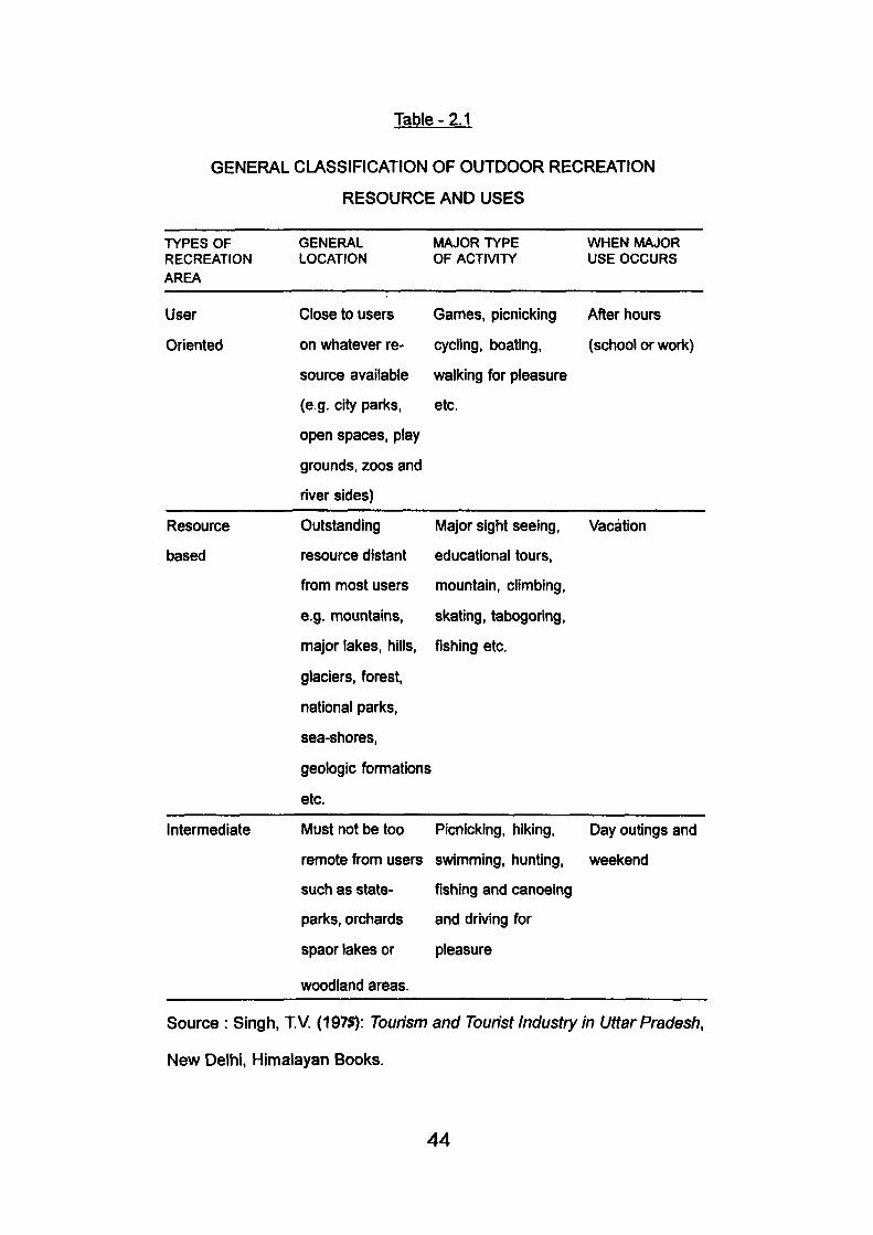
Table-2.1
GENERAL CLASSIFICATION OF OUTDOOR RECREATION
RESOURCE AND USES
TYPES OF RECREATION AREA
GENERAL LOCATION
MAJOR TYPE OF ACTIVITY
WHEN MAJOR USE OCCURS
User Close to users Games, picnicking After hours
Oriented on whatever re- cycling, boating, (school or woric)
source available walking for pleasure
(e.g. city parks, etc.
open spaces, play
grounds, zoos and
river sides)
Resource
based
Outstanding Major sight seeing,
resource distant educational tours,
from most users mountain, climbing,
e.g. mountains, skating, tabogoring,
major lakes, hills, fishing etc.
glaciers, forest,
national parks,
sea-shores,
geologic formations
etc.
Vacation
Day outings and
weekend
Intermediate Must not be too Picnicking, hiking,
remote from users swimming, hunting,
such as state- fishing and canoeing
parks, orchards and driving for
spaor lakes or pleasure
woodland areas.
Source : Singh, TV. (1975): Tourism and Tourist Industry In Uttar Pradesh,
New Delhi, Himalayan Books.
44
Table 2.1 makes its clear that spatial imbalances is greatest with
respect to resource- based facilities, comprising outstanding physical
features. To be tourism resource, these natural features should, indeed, be
outstanding by national or international standards to attract tourists and
visitors from home and abroad. Apart from the objects, the aesthetic
relationships between these objects their spacing, scale and composition
and the relationship of an object or group of objects to a setting. Since the
visual relationships of landscape components change with the distance at
which they are seen, the aesthetic experience of an observer would also
depend on the position from which the landscape is perceived. The inter
relationship among the aesthetic factors being subtle and complex it is not
very easy to assess the visual quality of the landscapes. It would require
the services of observers with high degree of discrement, visual sensitivity
and trained perception and can best be accomplished by a joint effort of
artists, landscape and art historians, writers and designers, and by a
combination of media like writings, photographs, pictures, maps and
diagrams. Observer's reaction is also taken into account. It is a complex
task.
Table 2.2
LANDSCAPE : VISUAL QUALITIES ASSESSMENT
GENERAL QUALITIES TO BE SOUGHT AND OBSERVED
1. Uniformity of character from homogeneity of vegetation and building
materials.
2. Evidence of design and composition in the landscape.
3. Richness (that is quality and quantity of natural features and incident).
45
4. Absence of incongruities and conflicts of materials scale and colour.
5. Lack of visually disturbing detractors.
6. The condition and character buildings, bridges, fences, walls, gates
and the lil<e
7. Absorption of building into the landscape
8. Relationship of linear elements to landscape
9. Dominance of quality of undisturbed natural landforms
10. Presence of trees where landform is not dominant
11. Sharp contrast of landforms and vegetation types
12. Relationships of woodland plantations to landforms
13. Good outline of water areas
14. Edge quality of water areas and water courses
15. Regularity of field and woodland patterns
16. Spatial interest and spatial pattern
17. ' Incidence and quality of panoramic views
18. Vegetation health
19. Clearliness of air and water
20. Presence of wild flower
SOURCE: Singh, TV (1975): Tourism and Tourist Industry, New Delhi, Himalayan
Bool<s.
To overcome the practical difficulties in landscape assessments,
a comprehensive checklist of aesthetic qualities and visual relationships
has been evolved by Ian C. Laurie (1975) (Table 2.2) which would be of
immense help in evaluations of scenic beauty.
Ever since the pioneering work of Clawson and Knetsch (1963)
46
a substantial body of literature has appeared on attractiveness and Clawson
Linton, Var (1977), Zube (1975) and Fen ario (1979) have made noteworthy
contributions in this field. Clawson and Knetsch and many others following
them used the intensity of usage of resource as a criterion. Others like
Linton (1968) tried to assess the intrinsic value of the landscape by
classifying its main characteristics in major categories and rating them
numerically. Aesthetic qualities, uniqueness and intensity of recreational
land use were used by them as the basis for preparing numerical indices of
attractiveness. This approach lacked universality, and was too site- specific.
None of the above mentioned criteria, takes into account the
requirements and preferences of tourists, that is, what tourists would like to
see or anticipate seeing in a destination area.
In some recent studies appearing in the Journal of Travel
Research, Ferrario, Var, Gearing, Swart and others have evolved more
meaningful and sophisticated quantitative tools for evaluating tourist
attractiveness. Ferrario's methodology for assessment of tourist
attractiveness involves four stages (Fen-ario, F., 1978).
i) A compilation of a complete inventory of all the attractions or
features of tourist significance in the country and their classification according
to the main categories.
ii) An assessment of the relative degree of tourist preferences and
interest in each of the categories of tourist attractions, by using the
percentage of tourist market to which features appeal.
iii) Assessment of the degree of availability of resources.
4 7
iv) And finally, determining the value of a resource by averaging
the pulling force of the two components, i.e. the demand and supply
Gearing, Swart, Var and others (1974, 1977) selected a set of
seventeen, more or less independent variables organised into five subgroups
and by assigning different numerical values (based on tourist preferences)
to these characteristics, came up with an index of tourist attractiveness.
The notion of tourist attractiveness has been epitomised into a
simple formula (Singh, TV., 1987).
The tourist attraction of a district or a region (J) is :
Tj = f(Nj,Sj.Hj,Rj.lj)
Where,
Tj = Tourist attractiveness
Nj = Natural factors
Sj = Social factors
Hj = Historical factors
Rj = Recreational and shopping opportunities
Ij = Accessibility and Accommodation above minimum tourist quality.
SOURCE : Singh TV. (1987)1
The criteria also provided a reasonably complete set of
considerations which came into use in judging the tourist attractiveness of
a region. The index of tourist attractiveness which has been evolved, mainly
for establishing priorties among competing tourist regions could as well be
used for assessing the touristic value of a particular region. So far it appears
48
to be the best known criteria and there is every possibility of its producing
good results of applied in the case of Uttar Pradesh Himalayas.
With the introduction on natural resources, as harnessed for
outdoor recreation in tourist countries, we now turn on to Uttar Pradesh
Himalayas to examine her physical landscape and natural features capable
ot stimulating tourist activity. To say that Himalaya is beautiful, sounds
euphemistic. Certainally not all Himalayan aspects are equally beautiful;
some factors, river fronts, bluffs and junctions are more dramatic in their
aesthetic appeal and visual quality than others. Similarly some mountain
aspects stand out more prominently to catch the eye. Such physical contents,
expressed in unity and compositions by Nature constitutes potential tourism
resource.
2.1 GARHWAL HIMALAYAS:
Here an attempt has been made to list and categories Garhwal's
potential resources for recreation. The resource identification has been
made on the following factors viz. natural factors, socio- cultural and infra -
structure that sufTiciently include the criteria suggested by Fen-ario, Gearing,
Var (1979) and others.
2.1.1. Natural Factors:
Natural factors have been studied dn three base : (i) Scenic
beauty, (ii) Flora and Fauna and (iii) Climate.
(i) Mountain scenery (outstanding mountains, snow bridges,
vantage points and panoramic vista). Special rock ' " - - ' " " -
49
Valley aspects, viz. scenic and wild rivers, V and U- shaped formations,
glaciated features, water-bodies such as lakes and kunds, water falls, white
water river fronts and confluences, warm waters, cold waters, mineral springs
and spas. Himalayan meadows (Bugyals) besides popular fauna types,
recreational wildlife in its respective zoo-geographic zones.
District Chamoli, stands out distinctly with regard to natural
assests elevation, land architecture, landform design, faunal and floristic
excellence, although these areas of scenic resources miserably suffer from
accessibility- a fact responsible for their ecological preservation against
forces of modernization that hasten decay and finally destabilise the
mountain ecosystem. In Garhwal Himalayas some of the highest peaks of
Asia are found, Nanda Devi being the loftiest in India (Table 2.3). Scenic
corridors leading to their base offer some of the most exquisite scenery
and memorable wilderness experience of mountain treks and trails, besides
ethnic and cultural values preserved in these remote pockets.
Table - 2.3
GARHWAL'S SEVEN THOUSANDERS : PEAKS
SI.No. PEAK DISTRICT HEIGHT IN m.
1. 2. 3. 4. 5. 6. 7. 8. 9. 10.
Nanda Devi Kamet Abigamin
Mana Mukut Pan/at Badrinath Sato Panth Chaukhamba Dunagari Tirsul
Chamoli Chamoli Chamoli Chamoli Chamoli Chamoli Chamoli Chamoli Chamoli Chamoli
7817 7756 7355 7272 7242 7138 7084 7068 7066 7045
SOURCE : Singh, TV. (1979): 'Impact of Tourism on Mountain Environment. A Partial
Analysis of Uttrakhand Himalaya as 'Tourism and Proceedings of the Meeting oflGU woridng
groups:, Geography of Tourism and Research, Ljubljana/Trieli Frankfurt. Goethe University.
50
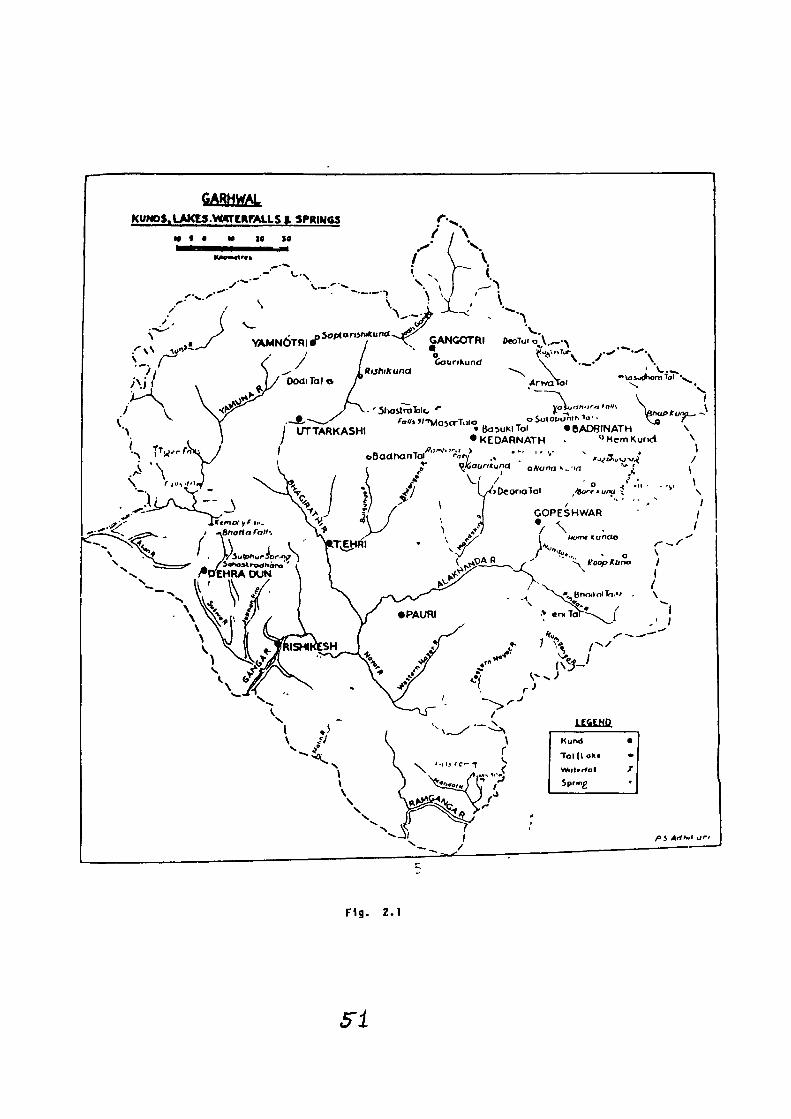
F ig . 2.1
5-1
Some of the eight thousanders like K and Naga Pdrvat have
been illegally occupied by Pakistan and hence they are not mentioned.
These indomitable peaks have thrown down the gauntlets to
world summitters like Tilman, Longstaff, Symthe. Their mountain climbing
feats read like 'epics' Symthe's 'Kamet Conquered and Tilman's 'The Ascent
ofNanda Dew'present a vivid and most readable account of these mountain
resources. Mountain viewing can best be enjoyed from hill tops and vantage
points (Table 2.4).
Table - 2.4
OUTSTANDING VANTAGE POINT IN GARHWAL
SI.No.
1.
2.
3.
4.
5.
6.
7.
8.
9.
10.
11.
12.
13.
14.
15.
16.
17.
Point
Kauri pass
Chandrashila
Rudranath
Panar
Nagtibba
Kalshila
Deoban
Surkunda
Sukhi
Top Tibba
Achhralatibba
Binsar
Chandrabadni
Gunhill
Khirsu
Ransi
Lansdwone
Height In m
3898
3680
3610
3400
3022
2910
2865
2770
2700
2612
2589
2560
2278
2142
2032
1950
1848
District
Chamoli
Chamoli
Chamoli
Chamoli
Tehri
Chamoli
Dehradun
Tehri
Uttarkashi
Dehradun
Tehri/Dehradun
Pauri
Tehri
Dehradun
Pauri
Pauri
Pauri
52
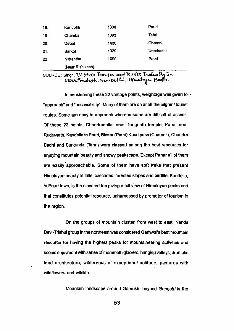
18.
19.
20.
21.
22.
Kandolia
Chamba
Debal
Barkot
Nilkantha
(Near Rishikesh)
1800
1693
1400
1329
1090
Pauri
Tehri
Chamoli
Uttarkashi
Pauri
SOURCE : Singh, TV. {WS)i Tounlv^ a>J Toanst I -KdLat^ l>v
in considering these 22 vantage points, weightage was given to
"approach" and "accessibility". Many of them are on or off the pilgrim/tourist
routes. Some are easy to approach whereas some are difficult of access.
Of these 22 points, Chandrashila, near Tungnath temple, Panar near
Rudranath, Kandolia in Pauri, Binsar (Pauri) Kauri pass (Chamoli), Chandra
Badni and Surkunda (Tehri) were classed among the best resources for
enjoying mountain beauty and snowy peakscape. Except Panar all of them
are easily approachable. Some of them have soft treks that present
Himalayan beauty of falls, cascades, forested slopes and birdlife. Kandolia,
in Pauri town, is the elevated top giving a full view of Himalayan peaks and
that constitutes potential resource, unharnessed by promoter of tourism in
the region.
On the groups of mountain cluster, from west to east, Nanda
Devi-Trishul group in the northeast was considered Garhwal's best mountain
resource for having the highest peaks for mountaineering activities and
scenic enjoyment with series of mammoth glaciers, hanging valleys, dramatic
land architecture, wilderness of exceptional solitude, pastures with
wildflowers and wildlife.
Mountain landscape around Gamukh, beyond Gangotri is the
53
best resource for its glacier- sculptured beauty of the landscape. Rugged
and savage in the aspect that it presents in contrast to other mountain
aspects found either in the Chaukhamba sunroundings of Kamet. The whole
vista beyond Chirbasa or Bhojbasa upto Gomukh and Nandanvan has extra
ordinary offerings in eskers, drumlins, peak remnants, pinnacles, black
mountains and the vast bowl scored by glacier near Bhojbasa, unmatchable
and unsurpassable in its simplicity, ruggedness and divinity. Beyond Gomukh
is white wilderness which were enjoyed by devoted pilgrims is now resource
for recreationists, mostly overseas off- beat trekkers. ShMing peaks and
Bhagirath have attracted more mountaineers after Nanda Devi.
Kedar-Badri highland region is full of religiousity and presents
some unusual natural assests. Chaukhamba peaks have attracted limited
mountain activity. But this entire middle zone can exquisitely blend trekking
and mountaineering activity, both for soft and hard trekking. This resource
has not been fully utilised. The way to Kedamath and beyond (Chorabari
lake and Swargarohni) is superb in its green aspect.
The Mandkini is the greenest valley in Garhwal and the way
from Gaurikund to Kedamath offers emrald views, full of forested slopes
both, to the northern and the southern slopes- an unusual phenomenon,
over the Himalaya.
Above 42 glaciers are identified in Garhwal Himalayas, most of
them lying in the Chamoli Hiamalyas. These glaciers not only feed streams,
they are veritable scenic resources. Of them some are of mammoth size.
Gangoth (3390 m) glacier, having a size of 30 km long 2 km. wide is fed by
a system of tributary glaciers such as Rakta-Vama, Swait-Vama, Nilamber,
54
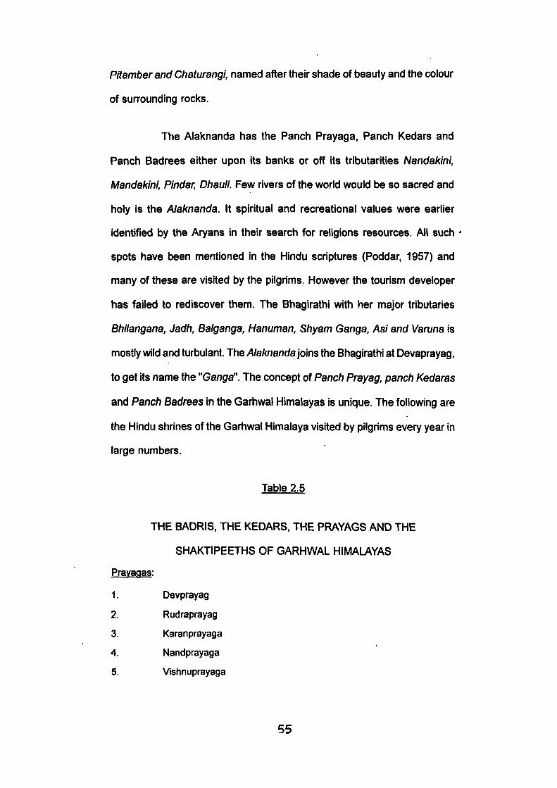
Pitamber and Chaturangi, named after their shade of beauty and the colour
of sun-ounding rocks.
The Alaknanda has the Panch Prayaga, Panch Kedars and
Panch Badrees either upon its banks or off its tributarities Nandakini,
Mandakini, Pindar, Dhauli. Few rivers of the world would be so sacred and
holy is the Alaknanda. It spiritual and recreational values were earlier
identified by the Aryans in their search for religions resources. All such
spots have been mentioned in the Hindu scriptures (Poddar, 1957) and
many of these are visited by the pilgrims. However the tourism developer
has failed to rediscover them. The Bhagirathi with her major tributaries
Bhilangana, Jadh, Balganga, Hanuman. Shyam Ganga, Asi and Vamna is
mostly wild and turisulant. The Alaknanda \o\ns the Bhagirathi at Devaprayag,
to get its name the "Ganga". The concept of Panch Prayag, panch Kedaras
and Panch Badrees in the Garhwal Himalayas Is unique. The following are
the Hindu shrines of the Garhwal Himalaya visited by pilgrims every year in
large numbers.
Table 2.5
THE BADRIS, THE KEDARS. THE PRAYAGS AND THE
SHAKTIPEETHS OF GARHWAL HIMALAYAS
Pravaqas:
1. Devprayag
2. Rudraprayag
3. Karanprayaga
4. Nandprayaga
5. Vishnuprayaga
55
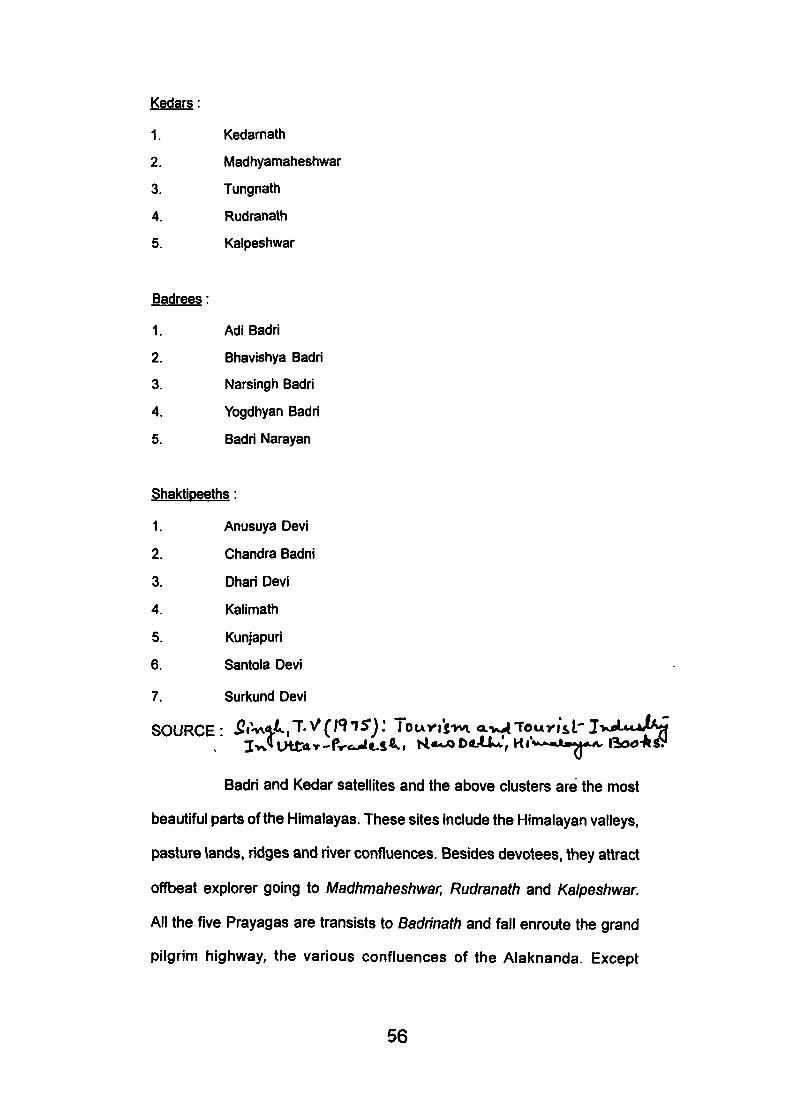
Kedars:
1.
2.
3.
4.
5.
Badrees:
1.
2.
3.
4.
5.
Kedarnath
Madhyamaheshwar
Tungnath
Rudranath
Kalpeshwar
Adi Badri
Bhavjshya Badri
Narsingh Badri
Yogdhyan Badri
Badri Narayan
Shaktioeeths:
1.
2.
3.
4.
5.
6.
7.
Anusuya Devi
Chandra Badni
Dhari Devi
Kalimath
Kunjapuri
Santola Devi
Suri(und Devi
SOURCE • ^ i W - L . T V ( l < ^ l S ) : 1 o u n i ^ v i a.^^Touria" I V ^ U J A J
Badri and Kedar satellites and the above clusters are the most
beautiful parts of the Himalayas. These sites include the Himalayan valleys,
pasture lands, ridges and river confluences. Besides devotees, they attract
offbeat explorer going to Madhmaheshwar, Rudranath and Kalpeshwar.
All the five Prayagas are transists to Badrinath and fall enroute the grand
pilgrim highv\ ay, the various confluences of the Alaknanda. Except
56
Vishnuprayaga, these have becomes crossroads pilgrim town, congested,
cramped in space and noise. Concreted structures have enveloped their
natural beauty aspects which the pilgrim fathers had so aesthetically
conceived fomiing of traverse to Badrinath. Places like Srfnagar, Ukhimath,
Joshimath, Guptkashi, Gopeshwar, Sem-mukhen, Gomukh, Kaisi have
developed urban character; utility services and adminsitrative functions.
Centre like Trijuginarayan, Sem Mukhem Gomukh, Anusuya Devi, Kalimath,
Gaurikund have retained their indigenous crust and would be visited either
by a pilgrim or a specialists as the avarice and the greed of modern
'Consumerism' has not touched them.
If Dunda expresses Buddhist culture. Home kund is the end-
point of the famous Nandajat; Lata is the last settlement enroute Nanda
Devi Park; BhoJ Basa and Cfiirbasa (enroute Gomukh, are set amidst
Himalayan wilderness). The contrast Ujali (near Uttarkashi) is an exclusive
Sadhu settlement with sophistication, Ranwain retains Korava-Pandava
cultural values but Roopkund is stillhard- access trek of frozen mummies
wrapped in mystery. Many of these centres have developed tourist attraction,
their genius is essentially religious which need to be retained and conserved
in any planning and development process of this region.
Badrinath alone is a major pull factor which attracts pilgrims and
tourists. The Kedarnath or Gangotri visitors often emerge from Badri-bound
pilgrims. Kedarnath attracted 1,04,638 and 1,05,160 tourists/ pilgrims during
the years 1994 and 1995, respectively. (Budget Shri Badrinath and Shri
Kedarnath Mandir Samiti, Badrinath Dham (Himalaya) U.P. can 1997.)
57
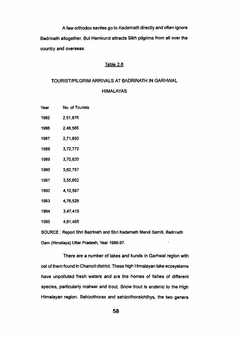
A few orthodox savites go to Kedamath directly and often ignore
Badrinath altogether. But Hemkund attracts Sikh pilgrims from all over the
country and overseas.
Table 2.6
TOURIST/PILGRIM ARRIVALS AT BADRINATH IN GARHWAL
HIMALAYAS
Year
1985
1986
1987
1988
1989
1990
1991
1992
1993
1994
1995
SOURCE
No. of Tourists
2.51,876
2,48,565
2,71,850
3,72,772
3.70.820
3.62.757
3,55,662
4.12.597
4.76.526
3.47.415
4.61.465
: Report Shri Badrinath and Shri Kedamath Mandi Samiti, Badrinath
Dam (Himalaya) Uttar Pradesh, Year 1996-97.
There are a number of lakes and kunds in Garhwal region with
ost of them found in Chamoli district. These high Himalayan lake ecosystems
have unpolluted fresh waters and are the homes of fishes of different
species, particularly mahser and trout. Snow trout is endenic to the High
Himalayan region. Sehizothorax and sehizothorarchthys, the two genera
58
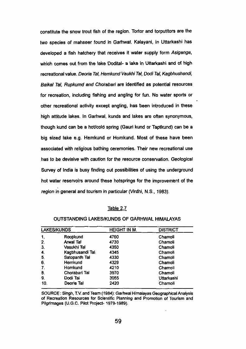
constitute the snow trout fish of the region. Tortor and torputitors are the
two species of mahseer found in Garhwal. Kalayani, in Uttarkashi has
developed a fish hatchery that receives it water supply form Asiganga,
which comes out from the lake Dodital- a lake in Uttarkashi and of high
recreational value. Deoria Tal, Hemkund Vaukhi Tal, Dodi Tal, Kagbhushandi,
Baikal Tal, Rupkumd and Chorabah are identified as potential resources
for recreation, including fishing and angling for fun. No water sports or
other recreational activity except angling, has been introduced in these
high attitude lakes. In Garhwal, kunds and lakes are often synonymous,
though kund can be a hot/cold spring (Gauri kund or Taptkund) can be a
big sized lake e.g. Hemkund or Homkund. Most of these have been
associated with religious bathing ceremonies. Their new recreational use
has to be devislve with caution for the resource conservation. Geological
Survey of India is busy finding out possibilities of using the underground
hot water reservoirs around these hotsprings for the improvemisnt of the
region in general and tourism In particular (Virdhi, N.S., 1983).
Table 2.7
OUTSTANDING LAKES/KUNDS OF GARHWAL HIMALAYAS
LAKES/KUNDS HEIGHT IN M. DISTRICT 1. 2. 3. 4. 5. 6. 7. 8. 9. 10.
Roopkund Anval Tal Vasukhi Tal Kagbhusandi Tal Satopanth Tat Hemkund Homkund Chorabari Tal Dodi Tal Deoria Tal
4760 4730 4350 4345 4330 4329 4210 3970 3055 2420
Chamoli Chamoli Chamoli Chamoli Chamoli Chamoli Chamoli Chamoli Uttarkashi Chamoli
SOURCE: Singh, TV. and Team (1984): Garhwal Himalayas Geographical Analysis of Recreation Resources for Scientific Planning and Promotion of Tourism and Pilgrimages (U.G.C. Pilot Project-1979-1989).
59
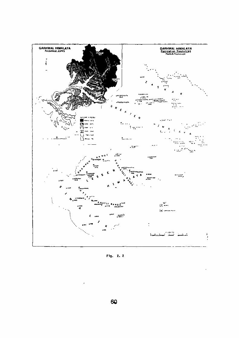
GAHHWAL HIMAUYA _ ^ M ^ ll'lutfintl lt'>fi 1 ^ ^ H ^ B * - 4 I ^ B L
^•g^^H| | .
^mmB^SP ^^^^S^H^H^BSfliv
' ^^^^^PPW^^f^MMW^^pff."' . Jfl^'^mtb rfMlH^^pJ^^J^i^
;^0*i!f^ ^h^^Pil Snl ^^^^^^r
GABHWAl HlMAlAyA Recreation Resources
^••liSftP«4k»£«pC
1
' - ^ - 1
. t < | * *• , - • , . - ! \ • • • • » •
' J . '
^ ••'•:; A ^ -.
•pCT-C^^-p .itfTinZ/ slW^^ S ' - '^?''i» T ' / lllflfr??k xn@b&KM^^5^^^^B " ' f ^ ^
. / S ' * ^ J P | ^ ^ g ^ •' •""•••• •".'-•"- ' °
' •- '' t i' ' r ( . / V-^V~""^'*>t • I ' j l " " "-JJSD ^ If
V f \ l •^'•^^•^T^ ' B * * * " * " ' . J o v - ' ^ '
- E " " ••" ' . . . . ' • A y — - [ J ' •C-HJ '
.r . :«"-. • ?' • .
' ' '.. . •! * ' " *w<
^ n ' t • »••*
' ' - > i ^ ^ •k •#«*•• O
' ^ i *» -V k»»»»*»n.t-» ,' V -* - *"*
>•" V a ^ * • .
J« . * * . ' • • •
</ •'
^ . I f .
* *• 4 T 1 1 -, * »'»• t l . '
• «
W • - " •
C SMI t l M t w
/ \ . .... "- ^ ..-• :
'- •••« ' . • tLOVt * " l * ^ ^ ^ c * » • »v . ' i
4
Fig. 2. 2
60
Higher regions of Garhwal abound in waterfalls, some falling
from great heights and that they look gauzy. Most of the Himalayan treks,
particularly to Kedarnath, the Valley of flowers, Yamunotri, present a visual
sight that soften the toil of the trail. Fourteen important and attractive falls
have been identified in Garhwal region (Singh, TV. and team, 1984).
Vasudhara (Chamoli) near jungle C/?aff/(Chamoli) near GovindGhat, Pulna
settlement and Bhyundar (Chamoli), Rambara Fall (enroute Kedarnath)
Gaurikund (near Gangotri in Uttarkashi) near Madhumaheswar (Chamoli)'
were especially noted as potential recreation resource. In the lower and
lesser Himalayas, Kempty Fall (Tehri), Bhatta Fail, Mossy Fall and Tiger
Falls in Dehradun has attracted the attention of the visitors. Waters dripping
from the caves of Sahastra Dhara (Dehradun) present a most enjoyable
spectacle of beauty which constitute outdoor recreation resource of
Dehradun.
Garhwal's vegtational cover, particularly, the forests and grasses,
is a tangible resource for recreation. Flora and fauna, together make this
region a land of wonder and curiousty to visitors who have never been to
high mountain country and Alpine zones. The wildlife and the woodland of
Garhwal are unique in their variety and gregariousness, though of late these
environments are shrinking due to demographic pressure, unwise, resource
use and deforestation.
Unfortunately, these resources have not been properly explored
and harnessed for tourism. Forest afford aesthetic pleasure and
opportunities for healthful and constructive recreation. They also provide
irreplacable laboratories of scenic as well as opportunities of formal and
informal education (Kaur, J., 1985).
61
Despite indiscriminate tree- felling, Garhwal still retains rich floral
and faunal wealth. Besides the three National Parks- The Corbett National
Park, the Nanda Devi and the Valley of Flowers- there are four wildlife
sanctuaries/ Kedarnath W.L.S., Govind Pashu Vihar, Cheela, Motichur)
where forest and forest animals enjoy free, uninhabited and close to nature
life in their preserved habitat. Rich sal forests, with enjoyable understorey
were marked in the foothill zone, particularly in Siwalik and Duns. Rich pine
forests of aesthetic appeal are marked in Lansdowne, Adwani, Khirsu in
Pauri district. Abundance of banj, oak, Won/, Kharshu, spruce and fir are
noted in Dudha Toll area. This is identified as suitable for forest recreation
and wilderness enjoyment. A colourful forest cover in between Mussoorie
and Dhanoiti which had profusion of rhododendrons of crimson shade.
These stately tree njn riot of colour as the spring heralds. They are in full
bloom in February- March. The resident population of this area has given <
the name "Burhanskund, or the rhododendron zone.
Garhwal's alpine pasture-lands- Bugyals is found in between
the tree line and the permanent snows. These are areas of wonderful
Himalayan grasses, herbs and other flowering plants, frequented and
enjoyed by trekkers and trailers. These beautiful Bugyals consist of wide
rxpanse of undultating slopes of green turfs and "annuals of different colours
and hues, fringed on one side by dark green alpine flora and on the other
by snow capped mountains. Among the plants, many belong to garden
genera, listed by Symthe 1931 in his book 'The Valley of Flowers".
Fortunately most of these Bugyals offer rock shelter and "cave
comforts" for night shelter. There are many on the passage to Nanda Devi.
62
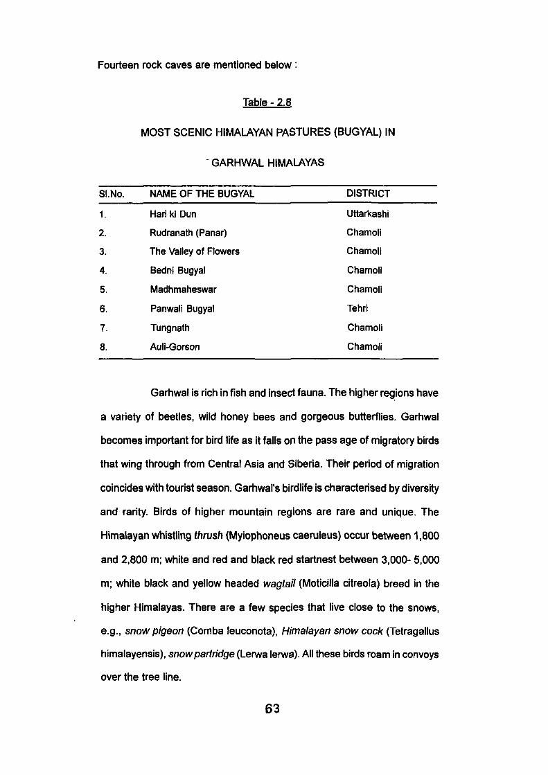
1.
2.
3.
4.
5.
6.
7.
8.
Hari ki Dun
Rudranath (Panar)
The Valley of Flowers
Bedni Bugyal
Madhmaheswar
Panwalj Bugyal
Tungnath
Auli-Gorson
Fourteen rock caves are mentioned below :
Table - 2.8
MOST SCENIC HIMALAYAN PASTURES (BUGYAL) IN
GARHWAL HIMALAYAS
SI.No. NAME OF THE BUGYAL DISTRICT
Uttarkashi
Chamoll
Chamoli
Chamoli
Chamoli
Tehri
Chamoli
Chamoli
Garhwal is rich in fish and insect fauna. The higher regions have
a variety of beetles, wild honey bees and gorgeous butterflies. Garhwal
becomes important for bird life as it falls on the pass age of migratory birds
that wing through from Central Asia and Siberia. Their period of migration
coincides with tourist season. Garhwal's birdlife is characterised by diversity
and rarity. Birds of higher mountain regions are rare and unique. The
Himalayan whistling thrush (Myiophoneus caeruleus) occur between 1,800
and 2,800 m; white and red and black red startnest between 3,000- 5,000
m; white black and yellow headed wagtail (Moticilla citreoia) breed in the
higher Himalayas. There are a few species that live close to the snows,
e.g., snow pigeon (Comba leuconota), Himalayan snow cock (Tetragallus
himalayensis), snow partridge (Lerwa lerwa). All these birds roam in convoys
over the tree line.
63
Mountain climate, particularly in tropical countries, by itself is a
resource for recreation (Singh, TV., 1983). Garhwal's best pilgrim resorts
and dhamas are generally located around 3000 m. It may be observed in
passing that not all areas with suitable climate are automatically tourist
destinations but only those among them that already have some attractive
features on the place has some sort of entertainment. Even poor climatic
conditions are not necessarily a deterrent for tourism (Fen-ario, R, 1978).
Pleasant climate and sunny weather can therefore be considered as
essential supporting features to enjoy fully what the area/ resort offers to
its visitors.
2.1.2 Socio Cultural Factors :
Garhwal's natural assets are par excellence; its socio-cultural
affects are no less wondering. Forming a religious sanctuary of the country,
it offers superb spiritual experiences. Identified as a religious core, quite
'early in time, the place genius of many a centre attracts, the saints and the
mundane. The region had pull factor In the foci of Badri-Kedar since pre-
vedic times. These sacred journeys to the Himalayan shrines {Tirth-Yatras)
constitute India's richest tradition and a precious Himalayan heritage.
It is difficult to identify all the spots of religious orientation for
they are so obiquitous, each rock, rivulet or runnel, tree or grass, peak or
plateau is Himalayanised with some myth or mystery. Nature wooes religion
in such a harmony that Garhwal becomes a unique place for visitors,
whatever be their motive.
Garhwal's religious centres, associated with deities, gods,
64
goddesses and other holy personages, attracts pilgrims from Garliwal and
other states, outside Uttar Pradesh. There are over 550 temples in the two
districts of Pauri and Chamoli dedicated to different Hindu gods and
goddesses (Singh, TV., 1985). The river fords, bluffs and junctions
particularly along the Alaknanda, were held sacred and many a pilgrim
points are dotted there. It is difficult to analysis as to why Alaknanda should
have religious superiority, over the Bhagirathi, said to be the parent stream
of the Hindus' holy Ganga. Panch Badris, Panch Kedars, Panch Prayags,
are located in the fold of the river. Badrinath tops in religiosity and ranks
high in Hindu hierarchy of the Himalayan shrine resorts. With it Kedarnath,
Shiva's abode, comes second, and is visited by pilgrims in great number
though according to principles of pilgrimology as origanized by the Hindu-
Tirtha- planners, visits to Yamunotri and Gangotri should be made first in
order to drive maximum religious merits. This was set in clockwise order-
Yamunotri, Gangotri, Kedarnath and finally Badrinath.
Six centres namely, Rishikesh, Badrinath, Kedarnath, Gangotri,
Yamnotri, Hemkund were given the highest order of importance as these
attracted regional, national and international visitors and had bold pilgrim
image.
About 33 religious centres are placed in second order of
importance. Many of them are satellites of the first order centres attracting
homogenous visiting community; there are some, who have developed their
own personality by virtue of their unique resource input or as a transit to the
first order centre. The Panch Kedars, Panch Badrees, Panch Prayagas,
Shaktipeeths assumed high religious importance, though among them a
66
few attracted pilgrims or visitors (Table 2.7).
Badri and Kedar sattlites and the above clusters are the most
beautiful parts of the Himalayas. These sites include the Himalayan valleys,
pasture lands, ridges and river confluences. Besides devotees, they attract
off beat explorer going to Madhmaheswar, Rudranath and Kalpeshwar.
Around the shrine are a number of kunds-Surya kund, Chandra kund,
Tarakund, Manas kund and Sarasvat kund besides the Baitarni flowing •
behind the temple. Rudranath is a vast green meadowscape, unparalled in
natural charm and beauty. More of trekkers than pilgrims frequent these
areas.
All the five prayags are transits to Badrinath and fall enroute the
grand pilgrim highway, the various confluences of the Alaknanda. Except
Vishnu-prayaga, these have become crossroads pilgrim town, congested,
cramped in space and noisy. Concreted structures have enveloped their
natural beauty aspects which the pilgrim fathers had so aesthetically
conceived farming as vital legs of traverse to Badrinath. Once wayside
chattis thai met the frugal needs of the pilgrims have changed their character
to negate the very purpose for which the holy journeys were performed.
From the pilgrim centres of the second order, places like Srinagar, Ukhimath,
Joshimath, Guptkashi, Gopeshwar, Sem-mukhem, Gomukh, Kaisi are
developing urban character, catering utility services and administrative
functions. Centres like Trijuginarayan, Sem mukhem, Gomukh Anusuya
Devi, Kalimath, Gaurikund have retained their indigenous crust and would
be visited either by a pilgrim or a specialists as the avarice and the greed of
modern 'consumerism' has not touched them.
67
Extension of metalled road from Joshimath to Badri Nath (1968)
has greatly increased the visitor volume. To Kedarnath, Yamnotri and
Hemkund one has to trek (hard) about 15-20 Km. to reach the destinations.
But Gangotri has been recently linked with pucca road as the bridge near
Bhaironghati was completed. Nevertheless, there is still head trek of 24
km. to Gomukh, beyond Gangotri. All these treks provides glimpses of pure
nature and the real face of the Himalaya, besides bucolic and pastoral life,
enroute.
Garhwal's other resources for recreation are its people, their
ethnicity- fairs and festivals, their lifestyle, their settlement patterns and
how they have expressed their artistic aspirations in art and architecture
particularly folk arts and the like. Unfortunately, nature often been unkind
and history indifferent to the extent that much of their substance of pitch
and nanrow has been ravaged by frequent seismic activity and Alaknanda
' Bhagirathi spates. The old capital town of Srinagar was twice innundated
by the Alaknanda (1894) and severely undone by the earth-quake (1803)
that it is no more to be seen a watery grave over which the Alaknanda flows
triumphantly. Most of the ancient temples of Garhwal are of eariy Nagara
form and design (7th-9th century A.D.). Temples of AdiBadri, Simli and
Tapoban belong to this category. Most of Garhwal's prominent temples have
Katyuii-Shikhara, belonging to 11-12th century. Temples of Devaprayaga,
Trijuginarain, Kedarnath, Badrinath Ranihat and Devalgarh can be classed
in this category.
Religion, devotion and faith brings pilgrims to Garhwal religious
edifices, few seek them architecturally, artistically or for aesthetic reasons.
These hardly constitute resource.
68
Garhwal has rich potential in her foll< traditions which can be
harnessed for indigenous or grassroots tourism. Infact, it is here that tourism
can come as a saviour of vanishing art forms and dwindling crafts and
smithies. Folk-drumming in Garhwal is age old, folk dances are fascinating.
Proficient drummers call themselves shilpis (Chandola, 1977) as they evolve
intricate rhythm with coded connotations. Unforunately, these ancient "talking
drums" are now silent and it is seldom that one comes across a genuine
drummer. The Badis and Aujis, the traditional folk dancers and musicians
are still there preserving the classic art, but would soon be an extinct tribe.
Aujis performances of Pandu Nirtuh (Dabral, 1960) is thrilling as they enact
epic scenes from the Mahabarata.
Garhwal is a land of fairs and festivals. Most of these events are
associated with the change of seasons, particularly the advent of the new
year, autumn and spring. Apart from the common Hindu festivals of Holi,
Dewali (festival of colours and lights), they invoke and please their local
gods and goddessess. Goddess Nanda, the daughter of the Himalayas,
figures boldly on occasions of Nanda Jat and "Haryair. In August/ September
people gather to celebrate the mamage of Shiva and Parvati at the village
Nauti (Chamoli) the starting point of this procession that ends up at the
Lake Homekund at the base of Nanda Ghunti. Once every twelfth year, this
festival assumes wider dimension as it is associated with the mysterious
"four horned ram" that leads the procession on to the snows. The other
month of festivity is Chait (March) when for the Garhwalis, the new year
begins. Hurkiyas and Dholia (dancers and singers) are at large, singing
and dancing and receiving gifts in return. "Phyulf is the 'festival of flowers',
young giris (under nine years) and boys (not invested with Jeneu) go round
69
the village, in small groups, offering flowers in the early hours of the morning
to receive gifts and blessings from their elders. There are other festivals of
animal sacrifices held in villages of Trijugi-jakh and Kalimath where ten-ible
form of Kali is worshipped. One of the interesting fair of touristic attraction
is held at Srinagar, in Kamleshwar temple around Vaikunth Chaturdashi
when barren women desiring offspring stand around temple with ghee-fed
lamps in their hand all through the night. Curious spectators assemble in
melange.
Garhwal seems to have miserably failed to promote her souvenir
trade and handicrafts which has a long tradition; particulariy of carpets and
woollen goods like Pankhi, Thulma, Chutka, Gudma, associated with Bhotias
who have the exquisite skill. Bhotia villages of Bhimtalla, Gamsali, Chhinka
and Gwaidam still can7 this trade which tourism can take advantage of.
Bhotias, apart from their traditional trade skills are themselves
reasons to visit upper Garhwal for their unique lifestyle, community living
and settlement patterns. The Chhinka village, enroute Badrinath, can be
promoted as tourist village. There are more interesting people in Uttarkashi
and Tehri such as Jadhs, Nilang (Uttarkashi) Khos, Siramauri orJaunsavi
(Tehri) and those living in Tons valley who attract attention in their distinctive
features and behaviouristics besides their devotion to 'Kauravas' and not
'Pandavas'. Jaunsaris are now exposed to the modem worid, though they
still preserve their uniqueness in living. Dewellers of the Tons valley seem
to be the true inheritors of Mahabharata traditions. Polyandrous, they hold
high the Pandava brothers and their communion with Dropadi (Joshi, P.C,
1984). The worid of Jaunsaris is more interesting than one can imagine.
Their settlement patterns resemble those of Kinnauri's' of Himanchal
70
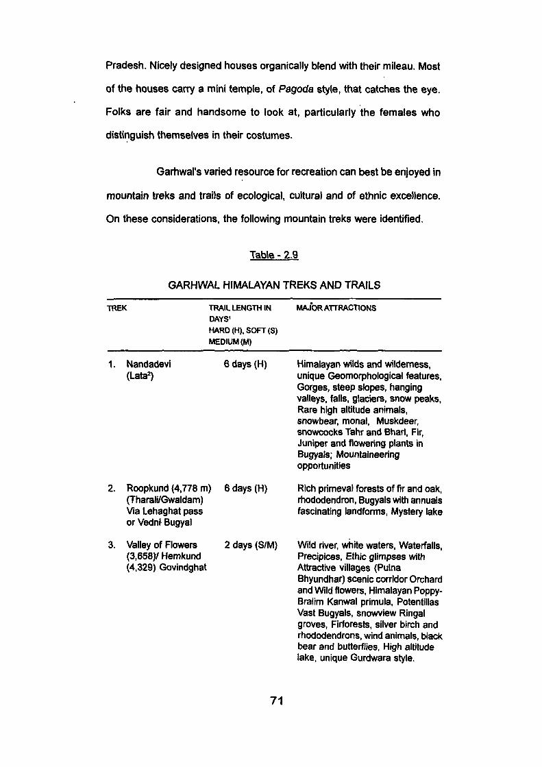
Pradesh. Nicely designed houses organically blend with their mileau. Most
of the houses can7 a mini temple, of Pagoda style, that catches the eye.
Folks are fair and handsome to look at, particularly the females who
distinguish themselves in their costumes.
Garhwal's varied resource for recreation can best be enjoyed In
mountain treks and trails of ecological, cultural and of ethnic excellence.
On these considerations, the following mountain treks were identified.
Table - 2.9
GARHWAL HIMALAYAN TREKS AND TRAILS
TREK TRAIL LENGTH IN DAYS' HARD (H). SOFT (S) MEDIUM (M)
MAJOR ATTRACTIONS
1. Nandadevi (Lata )
2. Roopkund (4,778 m) (Tharali/Gwaldam) Via Lehaghat pass or Vedni Bugyal
3. Valley of Flowers (3,658>/ Hemkund (4,329) Govindghat
6 days (H) Himalayan wilds and wik^emess, unique Geomorphological features, Gorges, steep slopes, hanging valleys, falls, glaciers, snow peaks. Rare high altitude animals, snowbear, monal, Muskdeer, snowcocks Tahr and Bhari, Fir, Juniper and flowering plants in Bugyats; Mountaineering opportunities
6 days (H) Rich primeval forests of fir and oak, rhododendron, Bugyals with annuals fascinating landforms, Mystery lake
2 days (S/M) Wild river, white waters, Waterfalls, Precipices, Ethk; glimpses with Attractive villages (Pulna Bhyundhar) scenic corridor Orchard and Wild flowers, Himalayan Poppy-Bralim Kanwal primula, Potentillas Vast Bugyals, snowview Ringal groves, Firforests, silver birch and rhododendrons, wind animals, black bear and butterflies, High altitude lake, unique Gurdwara style.
71
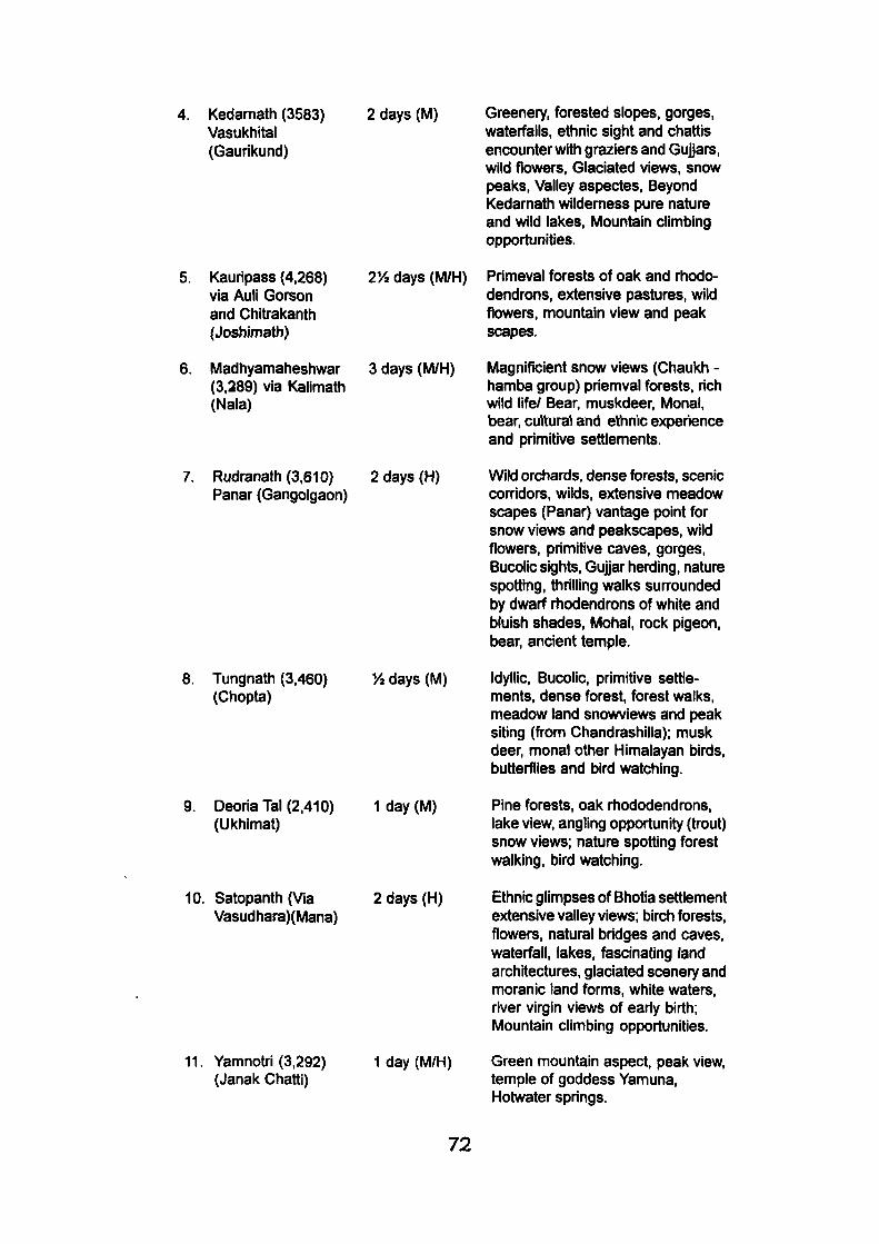
4. Kedamath (3583) Vasukhital (Gaurikund)
2 days (M) Greenery, forested slopes, gorges, waterfalls, ethnic sight and chattis encounter with graziers and Gujjars, wild flowers. Glaciated views, snow peaks. Valley aspectes. Beyond Kedamath wilderness pure nature and wild lakes, Mountain climbing opportunities.
5. Kauripass (4,268) via Auli Gorson and Chitrakanth (Joshjmath)
6. Madhyamaheshwar (3,289) via Kalimath (Nala)
7. Rudranath (3,610) Panar (Gangolgaon)
272 days (M/H)
3 days (M/H)
2 days (H)
Primeval forests of oak and rhododendrons, extensive pastures, wild flowers, mountain view and peak scapes.
Magnificient snow views (Chaukh -hamba group) priemval forests, rich wild life/ Bear, muskdeer, Monai, bear, cultural and ethnic experience and primitive settlements.
Wild orchards, dense forests, scenic conidors, wilds, extensive meadow scapes (Panar) vantage point for snow views and peakscapes, wild flowers, primitive caves, gorges, Bucolic sights, Gujjar herding, nature spotting, thrilling walks sun-ounded by dwarf rhodendrons of white and bluish shades, Mohal, rock pigeon, bear, ancient temple.
8. Tungnath (3,460) 7* days (M) (Chopta)
9. Deoria Tal (2,410) 1 day (M) (Ukhimat)
Idyllic, Bucolic, primitive settlements, dense forest, forest walks, meadow land snowviews and peak siting (from Chandrashilla); musk deer, monal other Himalayan birds, butterflies and bird watching.
Pine forests, oak rhododendrons, lake view, angling opportunity (trout) snow views; nature spotting forest walking, bird watching.
10. Satopanth (Via 2 days (H) Vasudhara)(Mana)
11. Yamnotri (3,292) 1 day (M/H) (Janak Chatti)
Ethnic glimpses of Bhotia settlement extensive valley views; birch forests, flowers, natural bridges and caves, waterfall, lakes, fascinating land architectures, glaciated scenery and moranic land forms, white waters, river virgin views of eariy birth; Mountain climbing opportunities.
Green mountain aspect, peak view, temple of goddess Yamuna, Hotwater springs.
72
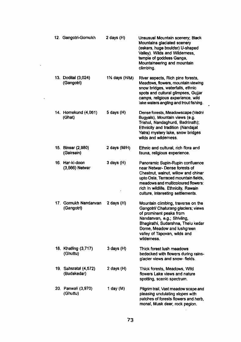
12. Gangotri-Gomukh 2 days (H)
13. Dodital (3.024) (Gangotri)
172 days (H/M)
14. Homekund (4.061) (Ghat)
5 days (H)
Unsusual Mountain scenery; Black Mountains glaciated scenery (eskers, huge boulder) U-shaped Valley). Wilds and Wilderness, temple of goddess Ganga. Mountaineering and mountain climbing.
River aspects. Rich pine forests. Meadows, flowers, mountain viewing snow bridges, waterfalls, ethnic spots and cultural glimpses. Gujjar camps, religious experience, wild lake waters angling and trout fishing.
Dense forests. Meadowscape (Vedni Bugyals), Mountain views (e.g. Trishul. Nandaghunti, Badrinath); Ethnicity and tradition (Nandajat Yatra) mystery lake, snow bridges wilds and wilderness.
15. Binsar (2,980) (Gairsain)
16. Har-ki-doon (3.566) Netwar
2 days (M/H) Ethnic and cultural, rich flora and fauna, religious experience.
3 days (H) Panoramic Supin-Rupin confluence near Netwar- Dense forests of Chestnut, walnut, willow and chinar upto Osia, Teraced mountain fields, meadows and multicoloured flowers: rich in wildlife. Ethnicity, Rawain culture, interesting settlements.
17. Gomukh Nandanvan 2 days (H) (Gangotri)
18. Khatling (3,717) 3 days (H) (Ghuttu)
Mountain climbing, traverse on the Gangotri/ Chaturang glaciers; views of prominent peaks from Nandanvan, e.g.; Shivling, Bhagirathi, Sudarshna, Thelu kedar Dome, Meadow and lushgreen valley of Tapovan. wilds and wildemess.
Thick forest lush meadows bedecked with flowers during rains-glacier views and snow- fields.
19. Sahsratal (4.572) (Budakedar)
20. Panwali (3.970) (Ghuttu)
2 days (H) Thick forests, Meadows, Wild flowers Lake views and nature spotting, scenic spectmm.
1 day (M) Pilgrim trail. Vast meadow scape and pleasing undulating slopes with patches of forests flowers and herb, monal. Musk deer, rock pegion.
73
Captivating landscape of visual spectrum, flowers, tjird life, Gujjar camps ethic glimpses.
Rich green forest. Himalayan views, rich green Buggi grass flowers and herbs ideal for sking.
Mixed nature and culture upto Bhyundar, onwards wild and virgin landscape, forests mountain views, waterfalls and wildlake, wildemess.
Ethnic, cultural and glimpses of Jaunsari folk tradition.
Scenic landscape, meadows and herbs, religious and spiritual experience, ethnic glimpses.
1. Trial length indicates total time taken trekking (one way) from the motorable / jeepable road head trekking on the last settlement from where the trekkers strarts on foot. 2. Last human settlement where from trek begins.
SOURCE: Singh, TV. and Team (1984): Garhwal Himalayas Geographical Analysis of Recreation Resources for Scientific Planning and Promotion of Tourism and Pilgrimages (U.G.C. Pilot Project-1979-1989).
21.
22.
23.
24.
25.
Bedni Bugyal (3,354) (Tharali)
Auli (2,744) Gorson (3,658) (Joshimath)
Kagbhusand (4,370) (Govind Ghat)
Lakhamandal (1,600) (KUWA)
Trijuginarain (Sonprayaga)
1 day(M)
2 days
y» day (S)
72 day
2.1.3: Infra structure
If Garhwal invites such a large number of visitors to enjoy and
use its religious and recreation resources, how should it manage its various
service, to tenned as infrastructure facilities in transport, accommodation,
restaurant, eating houses and entertainment, besides souvenir and gifts.
All these are essential to a hospitality trade. This is a question of resource
demand and resource supply. For a good visitor industry both should match.
And to achieve this balance, tourism research is a pre-requisite.
It has been repeatedly observed that Garhwal has remained,
for the most part, a peripheral zone with marginal low land and high land
74
interaction. Upto the close of the last century, it remained more or less a
'closed system', roadless and resortless except only a few pockets at the
foot hills or newly opened passage to Mussoorie. Pilgrims trekked to
Badrinath right from Rishikesh to the super resort on religious merit,
sometime as penance, and stayed in wayside modest Chattis where the
pandas cared after them. Pilgrim traffic was in groups of ten and twenty,
and there was no problem as the demand aspect was feeble and fairly met
with. Infact Chattis were quite self sufTicient, providing basic pilgrim needs
t)edding comforts, food provisions and even medicines. These Chattis were
reasonably spaced (5 to 10 km.) along the pilgrim routes, managed by
missionaries, chiefly by the Baba Kamli Walla Kshetra, headquartered in
Rishikesh. These religious organizations also setup Dharmshalas that
provided cost free boarding and lodging- a tradition in continuation with
some modernisation, supported by the Badrinath Temple Committee. The
pilgrim economy of these days was as well organised that even British
Government did not like to interfere with the setup 'except for a provision of
cleanliness' and cure by setting up hospitals along the Yatra route.
Road transport in Garhwal was the result of a zealot, G.W., Traill,
then the Commissioner (1827-35) of Kumaun and Garhwarl. A 500 km.
length of pilgrim road between Hardwar- Badrinath; Rudraprayag-
Kedarnath, Ukhimath, Chamoli, and Karanprayag Lohba was constructed
at his initiative. (Kaur, J. 1985)
The linking of Kotdwar with Najibabad railway line in 1897,
followed by the completion of Rishikesh Kirtinagar motor road (1931) and
subsequently of Srinagar- Kirtinagar (1947) heralded a new era of transport
75
in this otherwise laggard region of difficult accessibility. The two regional
motor companies, Garhwal Motor Owners Union (GMOU) and Garhwal
Motor Transport Company (GMTC) appeared on the scene in 1941 and
1945 respectively, and established their reputation. Garhwal ever since
has never looked back so far as motor transport is concerned. But tourists
want more than ordinary comforts.
Accessibility, a prime condition, for tourist development,
increased with more network of road transport, pilgrim economy dwindled;
Chattis disappeared from the scene and Panda system suffered a severe
set back. More influx of visitors was witnessed as soon as Joshimath was
linked by pucca road to Badrinath. New Tourism was officially announced
in 1974, by removing the Inner barrier line, opening Garhwal's remoter areas
of sensitive beauty and fragile economy (Singh, TV., 1980). With miserably
inadequate infrastructure which produced adverse effects both ecologically
and economically (Singh, TV., 1983).
Roads in Garhwal are increasing that one can reach as fiar-
flung as Tuni, JanakchattI (near Yamnotri) to Gangotri, to Gaurikund (near
Kedarnath), to Mana (beyond Badrinath) and Malari. Perhaps a time has
come when local people feel indifferent to roads for their tendency to kill
what may be called "indigenous" and bringing in "exogenous" forces that
have proved hamiful to the health of Mountain environment. This is more
true in the case of tourism which has been allowed to enter unplanned and
unguarded (Singh, TV , 1977).
Apart from the privately owned buses of different motor
companies, buses are mn by Uttar Pradesh State Road Transport (UPSRT);
76
private taxis and taxies of UPSRT, this did not seen enough to meet the
challenge of peak season during summers (April- October). For well to do
visitors, the Garhwal Mandal, Vikas Nigam (GMVN), a Uttar Pradesh
Government undertaking for regional development, has introduced a number
of luxury coaches that carry conducted tours to various pilgrim/ tourist
centres; viz; Rishikesh- Kedarnath- Badrinath-Valley of Flowers; Rishikesh,
Gangotri and Yamunotri. More chartered buses ply from and outside the
region Dehradun, Delhi, Saharanpur and Chandigarh. Luxury buses from
Delhi are well equipped with modern recreation facilities such as radio,
video, public address system and trained guides. With the result, local
motorists have to flight a cut thorat competition, licence- endorsement for
hill driving is a precondition for which recently Regional Transport officer
has made necessary arrangement. Directness and quickness of travel
promotes tourism. Unfortunately many of these areas are zones of
permanent land slides (near Byasi and Nandprayaga) when the pilgrims
have to pass tedious hours of uncertainity, without food and water sometimes
for days together. Such scenes are common on Yumnotri- Gangotri yatra
route. No tele-communication system has been evolved through which
landslides or slope failure could be intimated to travelling parties who quene
up endlessly.
Garhwal could not develop any railway transport perhaps for
steep mountain slopes, Kotdwar, Rishikesh, Dehradun and Hardwar in
Saharanpur serves as Garhwal. Intemal traffic is mostly confined to covering
distance on foot, due to undulating terrain. Mussoorie has facility of hand-
pulled rickshaws and here ropeway facility is availablA«MS|SQfI^]pf^cable
car linking Joshimath with the upper slopes of Aijffis^rTailable I
7 7
had developed an airstrip, at Jolly Grant near Rishlkesh, which could not
find favour with visiting community. This is popular with elite and business
class who move from Delhi to Dehradun.
In accommodation sector Garhwal has fairly made up. This
certainly is an improvement in a region where commercial hospitality was
practically unknown, mainly on the yatra route.
As tourism is emerging on the scene, better accommodations
are coming up, largely In private sector. Private sector is prominent in places
like Dehradun, Mussoorie and Rishikesh where substantial demand exists
almost all the year round. Four types of accommodation are identified that
are managed in public and private sectors viz.. Units run by Garhwal Mandal
Vikas Nigam (in public sector). Private sector Hotels, Religious Missions
run Dharamshalas/ Gurudwaras and, other state owned establishments.
Gariiwal Mandal Vikas Nigam caters to the needs of pilgrims
and tourists on the Yatra Routes, in their units as large as Srinagar (204
beds) and as small as Barkot (4 beds). Facilities also vary from sleeping
space in Dormitory to Air conditioned. Executive, Family and Deluxe rooms.
Some of them have Restaurant and Catering facility. Garhwal Mandal Vikas
Nigam provides 2674 beds in all their 64 units, located in the five districts of
Garhwal. Apart from it there are Allwyn huts/ tents dormitory and floor space
offered to tourists and pilgrims. In some places bed space is convereted to
floor to accommodate peak demand. These accommodations are fairiy good
on Indian standards and their charges per bed are also reasonable. These
have been patronised by the visitors that their occupancy rate goes very
high during the peak. There are still rooms for improvement in various
78
sectors like canteen, restaurant, room service, hygiene, souvenir sliops
and managerial skills- the latter is one thing miserably mising and that needs
a trained staff.
Accommodation provided by religious mission are modernising
with better comforts, toilet facilities, electric light, which wsis not thought of
in a Dhannshala. The best examples are to be seen in Rishikesh, Srinagar
and Badrinath- the latter is a case of abrupt change from tradition to '
modernity. Sikh Gurudwara, provide cost free boarding and lodging to
pilgrims irrespective of creed or religion. They provide floor space to sleep
in a very good environment of cleanliness. The best examples are in Govind
Ghat and Govind Dham (Ghangaria), enroute Hemkund Sahib.
The other state owned establishments are P.W.D. inspection
houses. Forest Rest Houses and Dak Bunglows. These are primarily meant
for government officers and state guests, but may be classed as
supplementary form of accommodation in higher region where no other
facility for the visitor exists. These units have been carefully sited, away
from the main settlements and afford a good view of the surroundings.
They usually consists of two to four suites, with a kitchen, pantry and toilet.
Previous permission is sought from the District Magistrate or concerning
officer for their use and charges are nominal.
Garhwal has lost ground in souvenir industry which could have
been the main source of increase to the region, besides restoring handicrafts
and smithies, and providing jobs to local people. A region rich in local crafts
such as wood craft, wood products and stone sculpturing has practically
nothing to offer, except some wollen goods that have been patronized lately,
7 9
in the name of tribal development of Bhotias and Marchhyas of Chamoli -
Srinagar has a wood work centre (Papri Kasht Kala Kendra) run by the
Government which prepares furniture than souvenirs or gifts to the tourists.
An appreciable progress has been registered in the sale of woollen products,
mainly in shawls (for men and women) Thulma and Pashmina handimades.
Carpet Industry with an indigenous touch can be other field. It is seen that
Garhwal fails to use its resource to advantage. Garhwal tourism is a story
of mishaps' and unused resource, where resources do not become
resources.
Since most of Garhwal visitor flows are on the roadside, wayside
amenities, such as petrol pump services, auto- repair, health service,
restaurants and rest room assume vital importance. Their availability
ultimately detemiine the quality of experience and consequently visitors
attitude towards recreation site or the region itself. Unhygienic and sub
standard food is served in the local dhabas and tea shops. The Yatra route
upto 200 km. suffers from summer heat as the valleys lie low and visitor is
ready to pay any reasonable price for a glass of fruit juice or ice- cream or
any food stuffs, preferably liquid that may soften his nerves and comfort his
throat.
Questionably not much effort has been made in this direction.
Centre like Srinagar because of the university, have introduced some
novelities in South Indian Dishes and cold soft drinks. Chamoli has
developed good apple orchards and other fruit gardens which can be
harnessed for tourism trade. Health services are poorly spaced.
Thus, we see that a region with such unusual and spectecular
8 0
potential for tourism has not been able to harness Its resources in a manner
that age old tradition of pilgrimage should survive side by side the new
tourism which provide good to local people and energise othenwise morbid
economy.
2.2 The Kumaon Himalayas :
The Kumaon Himalayas is seperated from Garhwal by a line
partly natural and partly artificial. The name Kumaon has its origin from
Vishnu who is his tortoise incarnation dwelt for three whole years on
Kumaon., which was later called Kunnanchal (Kurma, i.e. tortoise, achal,
i.e. mountain) and hence the modem name Kumaon.
The Kumaon Himalayas are equally beautiful and bear resource
potential for tourism, as the Garhwal Himalayas. The Kumaon Himalayas
have also been studied on the same criteria as undertaken for Garhwal
region.
2.2.1 Natural Factors:
Natural factors have been studied on three tier base; viz., scenic
beauty flora and fauna and climate.
Kumaon region, which constitute part of the central Himalayas,
presents Immense scope for the development of tourism, mainly because
of two factors. Firstly, due to the great climatic contrast between this
Himalayan area and the adjacent North Indian Plains and secondly, because
of wide variety of picturesque settings in these areas. In Kumaon region,
although the growth of tourism is comparatively a recent development, this
81
region was not unknown in the past.
The foundations of present day tourism activity in this region
may, however, be traced bacl< to the British period during .which many hill
stations like Ranikhet and Nainital came into being mainly to cater to the
climatic needs of the Britishers. Many such sites, e.g. Nainital now constitutes
most popular hill resorts and with development of roads and other facilities
new places in the interior of the region holds a still greater promise for the
growth of tourism.
The physiography of the Kumaun region is resource oriented
for tourism. The Kumaun Himalaya is divisibly into five lithotectonically and
physiographically distinct domains or sub provinces viz., the Himalayan
Front Fault, the Siwalik, the Main Central Thrust, the Trans-Himadari Fault
and the Indus Tsangposuture.
The name Kumaon is derived from Kurmachal (Kurma-tortoise;
achal-mountain). It is believed that Lord Vishnu assumed the tortoise
incarnation at X-Champawat in the Ka//valley. The Rohillas Invaded Kumaun
in 1743-44 but they could not establish a firm foothold. Thereafter, the
Gurkhas subdued the entire region only to loose it to the British later on.
Thereafter, Kumaon was annexed by the British and it became a part of the
United Provinces of British India.
The Outer Himalaya or Siwalik Hills:
The Outer Himalaya or Siwalik Hills consists of a chain of low
hills of narrow width running in a more or less NW-SE direction all along
southern Kumaun. This range is well developed in the Haldwaniand Dhikala
82
areas. A large number of perenual as well as seasonal streams drain the
Siwalik hills of Kumaun. The most prominent river of this tract is the
Ramganga, which flows for a considerably distance within the Siwalik hills
before debouching into the plains seasonal torrents ememating from the
Siwalik hills are known as sots in Kumaun. These cause wide spread erosion
during the monsoon season when a large quantity of water gushes down
the usually drybeds removing valuable top soil, boulders and rock fragments
from the upper slopes and depositing them over the fields and human
settlements in the lower reaches.
The lower or lesser Himalayas rise abruptly above the Siwalik
hills and the Dun valleys. This unit occupies the central portion of Kumaun.
The prominent ranges which from a part of this physiographic unit are - The
Ranikhet ridge, Almora ridge, Nainital ridge, Bageshwar ridge.
The lake land of Nainital also lies within the lower Himalayan
zone. It has its own characteristic features. The lakes are confined to a
tract that is about 25 kms. long and 4 kmg wide near the southern fringe of
the lower Himalayas of Kumaun, in Nainital district. The Nainital lake is the
largest amongst these basins. The others are Bhim Tal, Naukuchiya Tal,
Sat Tal and Puna Tal which lie to the east of Nainital in low lying open
basins. There are three more lake basins in this tract which are very small
and often remain devoid of water. These are Khurpa Tal, Sukha Tal and
Saria Tal.
The main or great Himalayan range occupies the north part
of Kumaun. The great Himalayan zone of Kumaun is about 50 kms.
wide. The average elevation varies from 4800 mts. to 6000 mts.,
culminating in a crest whose peaks often rise to an elevation of over
83
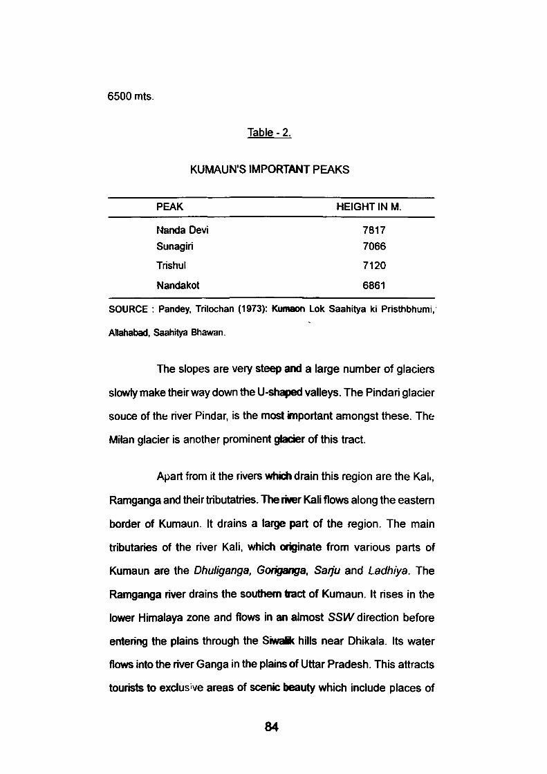
6500 mts.
Table - 2.
KUMAUN'S IMPORTANT PEAKS
PEAK HEIGHT IN M.
Nanda Devi 7817
Sunagiri 7066
Trishul 7120
Nandakot 6861
SOURCE : Pandey, Trilochan (1973): Kumaon Lok Saahitya ki Pristhbhumi,
Allahabad, Saahitya Bhawan.
The slopes are very steep and a large number of glaciers
slov»^ make their way dov\/n the U-shaped valleys. The Pindari glacier
souce of the river Pindar, is the most important amongst these. The
Milan glacier is another prominent glacier of this tract.
Apart from it the rivers which drain this region are the Kah,
Ramganga and their tributatries. The river Kali flows along the eastem
border of Kumaun. It drains a large part of the region. The main
tributaries of the river Kali, which originate from various parts of
Kumaun are the Dhuliganga, Gorigsanga. Saiju and Ladhiya. The
Ramganga river drains the southern tract of Kumaun. It rises in the
lower Himalaya zone and flows in an almost SSW direction before
entering the plains through the Siwaik hills near Dhikala. Its water
flows into the river Ganga in the plains of Uttar Pradesh. This attracts
tourists to exclusive areas of scenic beauty which include places of
84
recreation and trekking. Nainital is the premier tourist centre. It was
developed as a hill resort by the British. Later, it became the summer
capital of the state, and the British Governor used to stay at Nainital
for seven months in a year. A magnificent Raj Bhawan, with an 18
golf hole course, bears witness to its former grandeur. The visitors
can sail in 'Uinton'Hope half-rater' Yachts and rowboats on the lake.
One can take the horse ride to the lovely nooks and corners of the
lake basin and the mountain tops. The bird life in and around Nainital
is very rich, and this attracts groups of bird watchers even from abroad.
Approximately 250 species of birds can be seen in a 10 km. radius
around Nainital.
Naukuchia Tal, Sat Ta/and K^urpate/draw tourists in large
number for their attractive lakes with clean water.
Ranikhet attracts the maximum number of tourists after
Nainital. In addition to its scenic grandeur, it has numerous places for
trekking, rest and recreation such as the Chaubatia Gardens,
Chilianaula, Tarikhet and the golf ground owned by the Indian Army.
Ranikhet has the distinction of being the home of the Kumaun
Regimental Centre.
Kumaun, popularly described as the Switzerland of India,
is a focal point of conducted tours in Kumaun. Most visitors make it a
point to spend a night or two here to enjoy the unforgettable views of
the magniflcient snowy mountains at sunset and sunrise. Not only the
many splendoured spectacular peaks of Trishul and Nanda Devi are
85
viewed from Kausani, the place also commands the verdant Katyar
valley, unsurpassed in beauty and historical grandeur. Katyar valley
with its focal point at Baijnath, was once the centre of political power
when the Katiyuri kings ruled this land.
Pithoragarh has perhaps the best scenic beauty of the wild
and moderate terrain surrounded by emerald green terraced fields
with bracing climate. An airstrip have been constructed here.
Pithoragarh commands a close view of Panch Chuli and Nandakot.
Juauljibi and Thai are famous for their great fairs.
Ramgarh, Mukhteshwar, Almora, Binsar, Sitalakhet, Mamla,
Chaukori, Berinag, Lohaghat and Champawat are great scenic spots
commanding magnificient Himalayan views and offering rest and
recreation.
Pindari glacier is the most early assessible glacier in the
entire Himalayas. Visitors have to pass through Bageshwar on their
way to Kappot, the road head. A 58 Km. long 4 day trek through
enchanting scenery in the Pindar valley and thick forests takes the
visitors to the snout of the glacier. The route to the glacier Is provided
with rest houses at convenient places run by the Kumaun Mandal
Vikas Nigam.
Milam glacier is rather long and more difficult from
Bageshwar, one can drive 160 km. to Munsyari, and then trek 60 km.
to the glacier. Enroute scenes are breathtaking in beauty and grandeur.
Since this glacier is in a restricted area special permission has to
86
obtained to visit it. This permission is granted by tiie District Magistrate
at Pithoragarii or the SDM at Munsyari. For foreign naturals,
permission is required to be granted by the Government of India,
New Delhi.
Pancheshwar, Rameshwar, Betalghat, Gairal, Bageshwar
and Seraghat offer excellent opportunities for angling.
Before the British occupation of Kumaun in 1815, very little
is known of the history of the forests of the region. Except for planting
of 'Deodar' around temples, such as at Jageshwar, there seems to
have been no regulation of any kind. The forests were perhaps
extensive, very rich in wild life, and therefore were considered
inexhaustible. The self-sustaining economy of the hill people was
dependent on the forests for rearing large herds of livestock, supply
of fuel and fodder, agricultural implements, timber, medicinal herbs,
bamboos, ringals (used for making baskets, mats and pipes), and
most important for leaf- litter for the manure used in agricultural fields.
The early British travellers in this region described existence
of deep lush coniferous forests in the mountain protected by marshes
mosquitoes and tigers of the dense forest in Parai. Foresty, however
found a beginning in 1861, by which time a lot of damage had been
done due to industrial revolution of the nineteenth century and the
requirements of the British Raj. Establishment of cantonment towns,
tea-gardens and apple orchards, mining and smelting of iron-ore based
on wood-charcoal resulted in a great destruction of large area of forests
87
in the hill area. Forests of 'chir', pine and oaks particularly suffered
on this account. Coming of Bareilly on the rail map in 1872 and its
subsequent linking with Ramganga, Kathgodam and Tanakpur,
opened Kumaun to the whole country, and made its entire forest
produces available to the vast markets in the plains. With the passage
of Indian Forest Act in 1865 and its revision in 1878 resulted in the
creation of forest reserves now constituting the Haldwani, Ramnagar
and Kalagarh Forest Divisions, and thus saving the 'sal' forest. By
the turn of the nineteenth century, resin from chirpine had become an
important raw material for naval stores. Distillation of resin was started
in 1898 by establishment of a factory at Bhawali: Industries of
turpentine, rosin, bobbins, matches, camphor, railway sleepers are
dependent on the Kumaun forests. There are large variety of trees,
shrubs and grasses in a wide variety of forest ecosystems. Osmaston
(1927) described 816 species, belonging to 94 families- 290 of trees,
321 of shrubs, 112 of climbers, and the rest of herbaceous shrubs.
He identified 12 trees and 8 shrubs that are not indigenous to the
area. A number of exotic species in this region are eucalyptus, wattles,
poplars, teal, cryptomaria, exotic pines, a variety of bamboos and
grasses, fruit plants including apple etc.
Kumaun is rich in wild life also. The very fact that Kumaun
was once the land of 'man-eaters' whom Jim Corbett shot dead speak
of the rich wild life of Kumaun. The Corbett National Park (earlier
known as Hailey National Park) partly in the Nainital district and partly
in Garhwal, is indeed undoubtedly the most picturesque representative
of rich wild life in Uttar Pradesh. It shelters all the species of fauna of
88
the Bhabar and Tarai tract. Before 1950, the entire Tarai Bhabar tract
with its extensive forests and savannah lands was equally rich in wild
life as the Corbett Park is today. In fact in those times the variety of
wild life in these areas was even richer and their population density
greater than that found in the Corbett National Park today. Binsar,
this place, near Almora is developed as a wildlife sanctuary. It is
paradise for trekkers. In these regions the important species include
Panthera tigeris, Panthera pardus fusca, cuon alpinus primaevus,
Melursus ursinus, suscrofa cristatus, Elephas maximus indicus, Axis
axis axis, CervusunicolournigerandNemoifiaedusgoralgoml. Hystrix
indica indica (porcupine) and Lepus nigriocollis mficaudatus (hare)
are common in these forests. All the above mentioned animals are
generally classed as game animals.
Among the non-game animals may be mentioned as leopard
cat or 'chita billi' (Felis bengalensis horsfieldl), jungle cat 'jungli billi'
(Felis chaus affinis). Small Indian civet malpusa (Viverricula indrca
welisi) and 'langur' (Presbytis entellus schistaceus).
The bird life is equally rich. The common sea fowl or 'mor'
(Pavo cristatus) one of the most beautiful birds of the world- is quite
common and abundant owing to the religious protection it enjoys.
The red jungle fow/(Gallus gallus murghi) 'Kaleef pheasant (Lophura
leucomelana hamitonic), 'bater" (coturnix coturnix coturnix), rain quoil
(cortunix cormandelica) and 'safed titai' (Francolinus pandicerianus
interpositus) are among the very much sought after game birds. Among
the reptiles- python, rat snake, monitor lizard, king cobra, cobra.
89
common brait, russell's viper, and pit viper infest the forests. The
important fishes are 'Mahaseer' and 'Rohu' which occurs in rivers
and lakes.
The richness of the bird life in Kumaun can be best
appreciated by the fact that among the 287 species of birds of the
Indian Hills described by Sallm Ali (1949), about 230 species are
found in the western Himalaya of which Kumaun hills fomn a prominent •
part. Apart from the Corbett National Park, the Askot wild life sanctuary
(established in 1986) within an area of 600 km. in Pithoragarh district
and proposed Binsar sanctuary in the Almora district provide safe
habitats to the wild life of higher attitudes.
The Kumaun hills too experience a widely varying climate
that ranges from tropical and sub-tropical in their southern tract and
alpine or arctic at higher elevations. The hottest areas are in the
southern hills which lie adjacent to the plains of westem Uttar Pradesh.
The average temperature decreases towards north though the valleys
experience a hot climate. Bulk of the precipitation all over Kumaun.
Snow accounts for a major part of the total annual precipitation in
higher hills. This varying climatic zone and snowfall add to the interest
of the tourists to come to this beautiful region.
2.2.2 Socio-cultural Factors:
The Himalaya mountain plays very important role in the
lives of the KumauniS? having been the playground of the Gods since
very ancient times. In the Puranic age Uttarakhand was the area of
90
meditation of the 'Rishis' or sages. Lord Shiva's wife Parvati, Shaldior
Uma, is said to be the daughter of Himalaya, Charies Sherring (1906) rightly
states that to a Hindu the Himalaya means as much as Palestine means to
a devout Chnstian. Journey to the sacred places of worships and temples
have been of importance since true immemorial. The Yakshes and Nagas
as once powerful ethnic groups- have been worshipped since very ancient
times. According to Trilochan Pandey (1962) the Jakhan Devi temple of
Almora is dedicated to the Yai<shas. The eight 'Nagas' of worship include-
Berinag, Kalinag, Dhaulanag, Karbotaknag, Pinglenag, Kharharinag and
Athgulinag.
Besides these Devatas, Ghosts and Demons also occupy an
important place in the Kumani imagination.
From ancient times pilgrims have passed through Kumaun on
their way to and from Kailas Mansarovar, Badrinath and Kedamath, the
sacred places hallowed by the reverence of generations. The 'rajas' of
Garhwal and Kumaun were considered to be the 'dwarpals' (door keepers)
of Lord Badrinath, so that pilgrims sought 'darshan' of both these exalted
personages during their visits to the great 'dham' established by Adi
Shankaracharya. Religious centres like Kailas- Mansarovar, Narayan
Ashram, Mayavati Ashram Punyagiri, Gananath, Chitai, Bageshwar,
Dunagiri, Nainital Ghorakhal and Kainchi. Apart from these centres
Hanumahgartii, a religious complex dedicated to Lord Hanuman. This
complex was establsihed by a famous saint, Neem Karauli Baba. About 19
km. north of Nainital at Kainchi on the Nainital-Almora road, is another
temple complex established by Neem Karauli Baba. The visitor is struck by
91
the immaculate cleanness of the temple complex, and its atmosphere of
religiosity and spirituatism. Another important temple north east of Nainital
at Ghorakhal Is a small temple dedicated to Bhairav. The temple represents
the deification of one of the Katyuri rulers. The temples is a popular place
for local people, as is evident from thousands of bells presented in thanks
giving. Impressive Gurudwaras are located in the region, attracting the
devout in large numbers. It is strange but true that one of the branches of
the 'reetha tree' from which Guru Nanak plucked the fruit for his disciples,
bears sweet fruit in an otherwise very bitter fruit.
Kumaun has very rich tradition of art and literautre (Pandey,
1979, Pokhariya and Tiwari, 1983). The Kumari folk literature embraces
primarily folk songs and folk epics and tales. These folk songs are known
as 'Muktaks' which are placed in two categories. The first deals with customs
and traditions and the second with seasons and their festivals. From the
aesthetic point of view the 'Muktak songs are the most attractive of all the
Kumani songs. In them emotions predominate, there are imaginative flights
of fancy concerning love and beauty, as well as deep expression of sorrows,
disappointment and pity. Kumaun has a rich store of folk epics, which depict
the entire gamut of the experience in the mountains. The epics nan-ate the
valourons deeds of those who laid down their lives in combats and difficult
situations. The epics are such an amalgam of facts and fiction, that they
can neither be described as being purely imaginative, nor wholly historical.
Malu Sahi\s the most popular folk epic of Kumaun. The Jaagars occupy an
important place among the religious tales.
Kumauni customs represent the social instincts of the Kumaunis,
9 2
which they have inherited from their ancestors. These customs have
exercised great influence on the society and kept it a closely knit unit. The
customs are quite distinct from those of the rest of Uttar Pradesh or the
country. Natural environment of the Himalaya has had its deep impression
on the various customs of Kumaun and profoundly shaped the outlook of
its people. Every season has its own appropriate festival, and the ceremonies
associated with them give expression to or articulate the needs of the people
during that particular season. The arrival of winter is heralded by 'Khataruwa'
or the 'Festival of Bonfire', and the coming of spring is celebrated with
'Phool Deyf or the 'Festivals of flowers'. 'Basant Panchmi' symbolised the
end of the long, bitter and dreamy winter and resultant hardships. The festival
is held generally In the first week of February. The most important and
emotionally changed festival in Kumaun Is 'Bhitoh', also called 'Bhitana',
celebrated In the month of Chaitra (March/April). The brother takes presents
for his married sister living far away in her husband's place. 'Hariyala' is
peculiarity a Kumauni festival celebrated to mark the advent of the rainy
season. It may be called a 'festival of rains'. The celebration falls on the
first day of Shravan. Wallgiya' or 'Ghee Sankranti' and 'Khatarua' or 'the
festival of bonfires' are also Important festivals of Kumaun. In Kumaun a
number of fairs are held throughout the year, but are concentrated during
the winter. About hundred fairs are held in the district of Almora alone, out
of which neariy forty are held from October to February. The reason why
most of the fairs are held in winter is that during this period villagers are
relatively free from their agricultural chores. These fairs generally centre
round shrines. Kumaunis are highly superstitutions and observe 'Naatak
and 'Sutat^ when there are, respectively, births and deaths in the family.
93
of rail, air and water transport. Resorts of Uttar Pradesh Himalayas are not
well connected by good roads with each other and with their sunrounding
regions. There are only twd roads joining Garhwal and Kumaun i.e. the
Rudraprayag, Karnprayag, Gwaldam and Bageshwar in the north, and the
Landsowne, Dhikala, Dunagiri and Ranikhet in the south.
Rail as means of transportation has negligible importance in
transportation system of Uttar Pradesh Kumaun Himalayas, with rail head
at Tanakpur and Kathgodam. A network of roads with Tanakpur is in the
eastern part of the region. A road starts from the Tanakpur rail head in the
plain to Champawat, Lohaghat, Ghat, Pithoragarh, Askot, Dharchula and
Tawaghat. A road bifurcates from Lohaghat and goes upto Haldwani. A
road connects Ghat with Almora, Pithoragarh and Askot both are joined to
Bageshwar via Didchat, Thai and Berinag. From Bageshwar a road mns to
Kapkot and then starts the trekking route of Pindari glacier. Kapkot is the
last bus terminus on this route. A fine and wide hill road starts from
Kathgodam to Nainital a road mns to Bhowali. Almora is a very important
road junction, which is connected to Baijnath by two roads via Bageshwar
and via Someshwar and Kausani.
For well to do visitors, the Kumaun Mandal Vikas Nigam
(K.M.V.N.), a Uttar Pradesh Government undertaking for regional
development, has introduced a number of luxury coaches that carry
conducted tours to various tourist centres. Number of Tourist Bungalows/
Hotels are available for tourists run by Kumaun Mandal Vikas Nigam
(K.M.V.N.)
With the help of Tourism Grid Planning, the Uttar Pradesh
95

Government has laid down certain tourism benefit plans which include the
following :-
1. Rupees 0.4 million is to be provided for 10 seats good toilets to
be built at Jageshwar (Aimora).
2. Rupees 0.7 millions are to be granted for the construction of
toilets and bathrooms on the Punnyagiri Mela Marg. This sum of
money was granted to District Magistrate of Pithoragarh.
3. Sum of rupees 0.2 million are to be granted to the District
Magistrate of Aimora for the Rural Development of Tourism of
Metala Kasai Devi.
4. Sum of rupees 5.31 millions are granted to the District Magistrate
of Aimora for the development of electricity in pluk at Kausanl.
5. Rupees 0.25 millions has been sanctioned for the constmction
of Pithoragarh Bus Station, Pithoragarh.
6. Sum of 0.4 millions for construction of toilets at Kausani.
7. Sum of rupees 0.9 millions for the construction of wooden bridge
at Joling Kang (Pithoragarh) for the beautification of Saraswati
Mandir, Rupees 1.74 millions are to be sanctioned.
8. On Chota Kailash Marg and Joling Kang, Pithoragarh, mpees
0.6 millions have to be sanctioned for the construction of Fibre
huts.
9. At Mastmanudandak rupees 0.2 millions have been sanctioned
for the construction of park and tourist facilties.
96
Apart from these rupeees 0.5 millions have to be sanctioned for
the development of park and Mela ground around Devidas Motor Station at
Pithoragrh, Rupees 20 lakhs for the construction of Amusement Park at
Pithoragarh and rupees 20 lakhs for the construction of Amusement Right
Park at Almora.
With the implementation of 1995-96 plan the Government has
undertaken certain plans for tourism development of the hill districts of
Kumaun region also. These include the development of roads at Pithoragarh
and part from this the implementation of winter sports during tourist peak
season. In Kumaun Mandal at Kosi (Almora) and Ramgarh (Nainital) 4 beds
rooms for tourists to be constructed. At Rita Saheb (Pithoragarh) the
construction of rooms with the capacity of thirty beds are to be constructed.
Encouragement is given for developing sport centres at
Pithoragarh, Ranikhet and Kodalia in the Kumaun region. In Didihat
(Pithoragarh) encouragement sport activities plan are under Governments
plan for 1996-97 and Expedition Hostel Construction at Pithoragarh is also
undertaken by the Government. Governments action plan of tourism in the
hill districts also include special tourism development in Munsari region.
In summing up this chapter this may be observed that a region
with such unusual and spectacular potential for tourism has not been able
to harness its resources, in a manner that age old tradition of pilgrimages/
recreation should survive side by side the new tourism which promises
good to local people and energise othenvise morbid economy. It is seen
that research based planned development with an integrated approach
can do good to host and guest communities.
97
CHAPTER - 3
DEVELOPMENT OF TOURISM IN
UTTAR PRADESH HIMALAYAN RESORTS
Man at a very early stage learnt to survive by keeping constantly
on the move from one pasturing group to another, exhausting each in turn.
Perhaps, traces of nomadic urge exist in all of us. But the first travellers
were traders, and tourism as a pleasurable activity began with flamboyant
Romans. (Bridges, J.B., 1959). In India, however, it all began with pilgrims
and pilgrimages. The institution of pilgrimages has its source in our Indian
civilisation. Though the tirtha - concept (religious tourism) was quite
comprehensive, it nevertheless, symbolised the twin spirit of religion and
tourism. In its broadest sense, "pilgrimage was travelling for wanderiust"
(Shankratayan R, 1959.)
History of tourism in India, its origin growth and development, is
closely associated with our ancient civilization. Fortunately, Uttar Pradesh
has been the principal seat of country's Civilization (Chatterjee, N.L., 1957).
Almost any event, birth, wedding, harvest time and the like was an occassion
for a celebration and recreation by the ancient Indians and habit persists
even today.
The Himalaya is at present one the main tourist destinations in
South- Asia. This statement is valid for the mountain range as a whole, not
for all of its parts. A regional analysis reveals considerable difference in
intensity, forms and traditions of tourism as well as origin and activities of
tourists. During the 19th century the British introduced mountain recreation
in the form of establishing hill station. Finally, modern tourism has penetrated
98
the mountain valleys since 1974 when restrictions for visitors were lifted in
major parts of the Indian Himalayas.
In this chapter an attempt has been made to study the history of
tourism in Uttar Pradesh Himalayas, in four phases :
1. Development of tourism during ancient period.
2. Development of tourism during medieval period
3. Development of tourism during British period.
4. Development of tourism during the post Independence period.
3.1 ANCIENT PERIOD:
Beginning from the advent of the Aryan (and even before that)
to the coming of early Muslims in India in 11th cetury, this long chapter of
ancient history, full of religious effervescence and cultural renaissances,
witnessed an unprecedented growth of religious tourism, particularly among
the Hindus, Buddhist and Jains. It was nature which declared the Himalayas
sacred and as "the abode of Gods". Lofty, inaccessible, covered with purest
of snows and undefiled by human contact, they were the best and most
appropriate dwelling places for the Gods (Shanna, V.A., 1977), Uttar Pradesh
Himalayas being so close to the Gods, is a holy place and it is dotted ail
over with old temples and famous shrines.
The world, according to Hindu scriptures, is a vast ocean and
yatra to religious places is the only way to ferry across it. The northern part
of the region may be called as pilgrimage zone. This part of the Himalayas
has district cultural group, settled long long ago despite difficult access to
99
the outside world. Sensitive religious area strewn all around, it has Badrinath,
Kedarnath, Gangotri, Yamunotri, with all their satellites as the most sacred
Hindu pilgrimage resorts (Singh. TV., 1977). All the four foci are situated in
the heart of Uttar Pradesh Himalyas at an average height of 3000 metres.
Indian pilgrimage resorts in Uttar Pradesh Himalayas are dotted all along
the Alaknanda and Bhagirathi rivers and their tributaries.
Indian missionaries deifined these mountains and meadows, rock
and rivulets, wove legends, set religious scene round them and mingled
metaphysics with geography in a manner that even a duleard might hear
the call of these hills in the observance of religious duty- thirathyatra
(Pilgrimage), a journey made meritorious by untold divine gains. This
religious spirit sustains pilgrims to negotiate mysterious inaccessible and
sometime frowning Himalayas (Singh, TV., 1975). "They stand as the
material manifestations of the highest spiritual aspirations of man; as physical
symbol of supreme strength mobility and serentity" (Venkatchalam, G.,
1948). Thus whole of India has been linked with these holy centres from
ages behind by the bond of highly consecrated faith.
Given such 'tirthas', Hindu pilgrims can originate from any part
of India, irrespective of hardships and stress and strain of the journey. They
belong to all age groups and income levels. They did it in ages gone by, do
it today and would continue to do so in time to come. The Himalayas, thus,
have been a source of great inspiration to man. The sacred books of Hindus,
viz., Vedas, Upanishads, Puranas and the great epic Mahabharta etc. were
written there.
In the early Rigvedic period (1,200 - 1,000 B.C.), the Aryans
100
had little knowledge of the Garhwal Himalayas and river Ganga was yet a
distant dream (The River Ganga is mentioned only twice in Rigveda). In
later Vedic literature of the 7th and 8th century B.C., the Ganga made her
appearance as a major figure (Jaimini Brahmana, 3/183, Satapath
Brahmana 31/5. 4.11) Garhwal being clam and secluded area, attracted
another class of highly cultured and learned Brahmins, who engaged
themselves in philosophical contemplation, writing and compilling sacred
books. This tradition of theosophising, learning and writing in the Ashrams
(forest universities) of Garhwal, well established in the Vedic period,
continued through the ages down to Puranic period. (Patiram, 1916).
It may, however, be noted that the concept of pilgrimage, as it
stands today did not exist in the Vedic period. During the post- Vedic period
(600 B.C.) to the coming of Muslims (1100 A.D.), Uttarakhand particulariy
Garhwal region became the sanctorium of the Hindus. Panini has described,
in his famous book Ashtadhyaji (500 B.C.) the magnificent inland road
system that existed in his time and the famous northern highway, Uttarapath,
that ran along the foothills region of Nepal, Kumaun and Garhwal linking
Patliputra with Balhika (Baikh) (Mukherjee, R.K., 1955).
In Mahabharat period (400-200 B.C.) Tirtha- Yatra became a
recognised form of activity. The devotional movement of this age centred
on the worship of Rudra and Vishnu, and Badrikashram and Kedarnath
were the principal centres of pilgrimage for the devotees. Its been painted
by Bhardwaj, that Mahabharata has laid down a sequence of visits to the
holy places in India in a clock wise direction. Kedarnath temple is dedicated
to 'Sadasiv'- the subterranean form of Lord Shiva. The other important
101
shrines, intimetely associated with Siva- legend, are Tungnath, Rudranath,
Madh-Maheshwar and Kalpeshwar: together they constitute "Panch-
Kedars." Tungnath is the loftiest shrine in the Garhwal Himalayas.
Badrinath is one of the four most sacred places {dhamas) of the
Hindus, Badrinath occupies a supreme place among the Himalayan shrine-
centres. Badrinath bound pilgrims pass through the famous five 'Prayagas'
namely, Deva Prayaga, Rudra Prayaga, Karan Prayag, Nand Prayaga and
Vishnu Prayaga, situated all along the sacred Alaknanda. They enjoy the
sight of some of the highest peaks of Trishul and Nanda Devi to their east
until they reach Badrinath- the abode of Lord Vishnu.
The Puranas (which claimed the same sanctity as the Vedas),
during the period following the 4th century A.D. assumed the form of code
of Hindu rites and customs (Hazara, R.C., 1975) God Shiva reigns supreme
in Garhwal. Out of 550 temples in Garhwal (Pauri and Chamoli) 350 (64
percent) are dedicated to Lord Shiva and his female form (Atkinson, E.T,
1973)
During the Epic period the geographical knowledge concerning
the Himalayas increased a lot and Tirthas at Garhwal Himalaya grew in
considerable number. The number of satellite Tirthas also flourished during
this period. In 2nd and 5th century A.D., pilgrims proceeded along the Ganga
via Deoprayag and along Alaknanda to Badrinath and Kedamath. in 8th
and 10th century A.D., they passed through Jogeshwar and onwards to
Badrinath via Simli, Tapovan, Joshimath and to Kedamath via Gopeshwar.
The first route is easier as it follows the river valleys all along and many of
the major Tirthas including five Prayagas. These are the transists for the
102
Yatras. The region has also been a part of Mauryan, Kushana and Gupta
empires. In the 3rd century B.C. the great emperor Ashol<a erected a rocl<
edict on the left bank of the river Yamuna at Kaisi in Chakrata tehsH of
Dehradun district. Shankracharya's efforts in the 8th century A.D. further
strengthened the ties between north and south. He chose Kedamath and
Badrinath for the reformation of Hinduism. Badrinath was placed on the top
of Himalayan shrines. This circuit covers the most magniflcant mountain
scenery found anywhere in the worid.
As the Ganga descends to the lower Siwaliks after the holy union
of the Bhagirathi and the Alaknanda at Dev Prayag, there are two other
important hindu pilgrim centres, Rishikesh (Dehradun) and Hardwar
(Sharanpur); virtually the gateways of Himalayan shrines. They are situated
on the lower reaches of the hills, having rail- road connectivity in marked
contrast to inaccessibility of snow-bound and ridge- locked Himalayan shrine
centres. They, naturally, provide ample opportunity to many non- pilgrims
for enjoying mountain scenery without undergoing ' Himalayan Pains.'
3.2 MEDIEVAL PERIOD:
The eariy muslim period proved an era of set- back to tourism
growth in northern India, particulariy in Uttar Pradesh, but it was, however,
substantially made up by the later Muslims, chiefly the Mughals.
During the medieval period (around 17th cetury A.D.) a
considerably number of Rajput princes penetrated into the valleys of
Himalayas, due to the confusion created by the Muslim invaders in the
plains, and set-up a number of small principalities. Many places have been
103
named following the native places from where they migrated e.g. Ajmer
Patti and Udalpur Patti (Singh, R.L., 1971) Kumaon and Garhwa! were
divided into a number of petty kingdoms under the rulers of different tribes,
as Katuri, Khasia and others.
Katyuris who are known to have a long dynasty lost their
stronghold on Kumaun by about A.D. 1400 (Pande, B.D., 1973) and split
into scattered principalities. Champawat was the residence of the Chand
rulers of Kumaun (A.D. 700-1790). In the middle of the sixteenth century,
Rana Balo Kalyan Chand, a successor of the Chand Dynasty, established
his fort at Almora, Raja Udyot Chand was the last successful ruler of
Kumaun, and after him the sovereignty of the Kingdom under various Chand
successors was gradually lost. In 16th century, Raja Ajaipal integrated the
fifty-two fortresses {Gartis) and their associated territories into Garhwal (fort-
integrated territory). The Kiratas, Khasas, Seythians and Mongoloid
elements have also contributed profoundly to the culture complex of the
Garhkun Himalaya. In A.D. 1743-44, there was a Rohilla Invasion on
Kumaon, but they could not establish their foothold. By eariy nineteenth
century, the Gurkhas in their long sweep of invasion subdued Garhkun and
the temtories beyond up to Kangra.
During this period the building process was confined to the plains
of Uttar Pradesh under the Mughal rule. This period witnessed brisk business
and trade relations with neighbouring countries of Asia and Europe which
encouraged mobility of the people.
104
3.3 BRITISH PERIOD:
It was during this period that the state acquired its present political
boundary and Uttar Pradesh once again became a seat of culture and
enlightment. In 1743-44 A.D., there was a Rohilla invasion on Kumaun, but
they could not establish their foothold. By the early 19th century, the
Oaurkhas oonqu«r«d Ooriikun. Their territorial ambitions brought them into
conflict wth British. At tha and of war of 1816, the Napalase ceded the
district of Garhwal and Kumaun to the British (Majumdar, R.C.;
Raychaudhari, H.C. & Dutta, 1967). After the British occupation, Almora
became the administrative seat of Kumaun and Garhwal. The administrative
history under the British Government will find its place under the notice of
each district. The Dun was first brought into orders by Mr. Shore and Kumaon
and Garhwal by Mr. Traill. The residual state of Tehri was handed over to
the Raja of Tehri by the Britishers (Painuli, R 1959) after returning the most
populous part of Garhwal.
With all this, a new type of township emerged on the northemly
hills of Kumaon, hills and health resorts, originally meant to be the summer
seat of Uttar Pradesh Government and white man's cool comer. These hill
resorts were an answer of the problem of their difficult adjustment to trophical
life and they started going to the hills for several months of the year to
serve the needs of British civil servants and soldiers of East India Company. •
The British hill resort is a recent phenomenon representing an expansion
of colonialism in the tropics (Mitchel, Nora, 1972). According to Spencer
and Thomas, the hill resorts were developed during 19th century by the
British and Dutch Colonial Masters in order to make so journs in less
105
comfortable foreign land. Today Nainital and Mussoome are Uttar- Pradesh's
much sought after tourist resorts. They, indeed symbolise the growth of
modern tourist movement in the region. With the establishment of these
centres, road connectivity gave birth to other centres like Ranikhet. Almora
and Kausani which were developed as pleasure or leisure resorts: Many
other centres since then have sprung up in their wake. This was a period of
industrial urbanisation which was speeded up by the introduction and
expansion of rail network. Establishment of cantonments and rriilitary bases
stimulated urban growth, such as Dehradun. This period certainly
r«volutioniMd the prc-txiating non- industrial cities in their land- use pattems,
much to the advantage of tourism promotion.
3.4 POST INDEPENDENCE PERIOD :
Despite its British origin, the British hill resorts phenomenon has
become a part of Indian tradition and these have flourished even after the
large scale departure of its creators. Many Indians stay in hills for several
months and continue the tradition started by Britishers, giving continuance
to the English clubs and other recreational activities together with Europeans
who are still found there though much less in number. One can also notice
recent changes in the hill resorts character. The most apparant is the
increasing number of short time participants and the larger size of groups
going upto the hills together.
This new tourist movement assumed the responsibility of tourism
promotion. This new tourist movement was part of the world tourism which
India recognised as late as 1949 with a view to earning foreign exchange.
Modern tourism was given a big boost when in 1965 India Tourism
106
Development Corporation Ltd., was formed which initiated action in the
field of accommodation, transport, entertainment, publicity and other
ramifications of the industry which have now fairly advance both horizontally
and vertically. To-day it has acquired the status of leading export industry
of the country. A Seperate Ministry of Tourism has been formed and
development and promotion of Tourism forms an integral part of country's
regional planning.
With transport system, the ever increasing number of private
automobiles and facilities of chartered buses, hill resorts have become by
far more accessible not only to Indian elite but also to the middle class, a
factor which may have well played a significant role in the sustenance of
hill resorts. Groups of holiday- makers often ride up in the hired buses and
stay in these hill resorts for a few days or even just a few hours. For many
people, the hill resorts have become a vacational resorts, as hills are pleasant
during summer. The vertical movement to hills is frequently associated with
health, and with religious cults and rites performed in th^ temples, it also
involves comfort and recreation especially for rich, who can afford summer
villas in the hills. Now a days tourism is strongly encouraged by both Central
and State Governments, because of reusltant increase of funds brought in
with the tourists. This aspect, however, radically changes the definition of
hill resorts to include any hill resort visited by tourists. Such tourists may be
come free vacationers, people with health problems or religious pilgrims. A
summary of 'Tourist Traffic of the Hill- Station" a reference work of post-
Independence period, is summarised as follows - "Apart from foreign tourist
traffic, special steps have been taken to promote internal tourist traffic to
Kashmir and other hill stations. At other hill stations the formation of Tourist
107
Bureaus have already started functioning at Mussoorie, Darjeeling,
Ootacamand, Nainital, Kodai Kanal, Shimla and Ranikhet (Benanis) G.D.
and Rama Rao & Singh, TV., 1953)
It is only under this definition of the hill resorts that the holiday
centres of Uttar- Pradesh Himalayas can infact be classified as hill resorts.
These resorts (British) certainly fulfil the functions of the multi- functional
tourist hill resorts.
The single purpose tourist hill resort category also make it
necessary to include other hill resorts which are frequented by visitor's and
highly advertised by tourist agencies. Linked with the British hill resorts,
these include Kedarnath, Badrinath and Mussoorie in Garhwal, and
Bageshwar, Bhowali and Mukteshwar in Kumaon. These include ancient
historic and religious centres, scenic areas of great beauty and of geological
interest, tribal camps, wild animals reserves, health and agricultural research
centres. Lately, high attitude dams and reservoir sites, ornamental gardens
and coloured lights have become very popular tourist centres. The hill resorts
are regarded by many Indians as an important type of settlements.
3.5 CHANGING PROCESS OF HILL RESORTS :
Originally, the hill resorts were health sanitoria of the British elite
and military personnels. By the end of the 19th century, these resorts
included in their functions the sanatorium and some military hospitals. After
some time, some of them became government summer headquarters for
both civil services and military activities. The British East Indian Company
establsihed British schools, some of which were primarily military schools.
108
In the early years, Indian elite as part of civil services, came to the hills with
the company to the Government summer headquarters. They enjoyed the
recreational facilities, which were available for the Britishers and some of
them sent their children to British schools.
By the beginning of 20th century, many missionaries both
Americans and Europeans took part in opening recreational activities at hill
resorts. They established English schools especially for poorer Anglo- Indian
communities; which are now famous and leading schools of India. Shortly
after the turn of the century, most of the British hill resorts had formed
urban municipalities. They often encouraged local small textile industries
(cottage type) and other activities which involved the special high attitude
features. In recent years, a new function has appeared, that of quick- tourist
trips by chartered coaches. These short- term recreation holidays have
become increasingly popular in coming years.
An entrance model of hill resort has been prepared by Mitchel
Nore which depicts four stages of the development process of the hill resorts.
Stage I, shows the entrance between hill resorts and their surrounding area
from the time of their establishment to the end of 19th century. The British
elite moved upto the top of the hills and lived in large spacious compounds.
Therefore, in the model, the compound is shown on the top and bazar just
below the compound. Britishers and Indian elite both were served by entire
community.
At stage II, though all the functions of stage I continue, there are
also new institutions and groups created to serve and aid the British and
109
UTTAR PRADESH HIMALAYAS HILL RESORT ENTRANCE MODELS
STAGE-I
Cows from the MUU SUPPW plains ~r
Laundry,servic^ Washerman
Personal services
Indian handicrafts Employment seekers
Vegetable and fruit
I « outtymg hill villages
STAGE-II
ADDITIONAL NEW Fl OWS
Municipality Private public utilities
COMPOUNDS--1 i-
BAZAR
Missionaries provide 'Hospitals, Schools and Industries
STAGE-111
Specialized Indian hondicrafts
Vegetable and fruit supply • • •
Product- outlyng hill —TnT" villages d°sV\boUon y
Raw,
Hotels Bus Tours English Medium schools
Source :-Tyagl.N , Hill Resorts of Uttar Pradesh Himalaya, A Geographical study" India Publishing Company^ New Qelhi, 1991, P;69
3- i
no
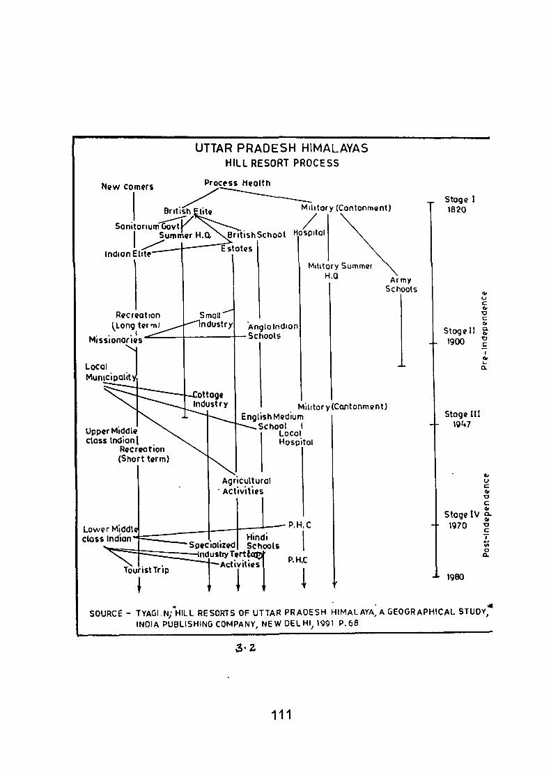
UTTAR PRADESH HIMALAYAS HILL RESORT PROCESS
New corners Process Heolth
British I
Sonitonum Govt j ^ Sunimer H.d
Indian Elite
Military (Contonmont)
ritishSchool Hospital
Estotes
Recreation (Long tcm)
.1 Missionaries'
\ i
Local Munici polity
Small Industry
ottage Industry
Upper Middle closs Indian I
Recreation (Short terrn)
Lower Middle class Indian
Anglolndion •Schools
Militory Summer H.Q Army
Schools
Militory (Cantonment) English Medium
School I Local Hospital
Agricultural Activities
Specialized Hindi Schools
Tourist Trip
Industry Tertlaj j ' -Activities
M i l
P.H.C
P.H.C
^ Stoge I 1620
01 o c <v
•o c a Stoge II S
4- 1900 ? I
0>
stage III 10U7
u c
c 01
stage IV o-
-- 1970
-»- igeo
(/I o a.
SOURCE- TYAGI.N;HILL RESORTS OF UTTAR PRADESH HIMALAYA, A GEOGRAPHICAL STUOY^ INDIA PUBLISHING COMPANY, NEW DELHI^ 1991 P.68
3 - 2
111
indigenous people. l\/lissionaries set up scliools, liospitals and agriculture
or cottage industry (especially textile groups) for Indian community. The
Municipalities were also formed, which collected taxes and provided public
utility services both for elite and bazar section.
Stage III, shows how the hill resort has taken its place in the
general economic pattern of the region. Though the basic goods and workers
for its growing industries continue to come from the plains, the hill resort
also serves an evergrowing series of hinterland as tourist, school and
agricultural distribution centres.
Stage IV (not shown in a diagrammatic form) will be projected
as continuance of present functions into the future. Because population at
the hill resorts as else where, is expected to continue to rise rapidly, there
will be considerable increase in tourist and cottage industries at the hill
resorts. It is certainly expected, that many more people will be able to visit
hill resorts during the summers, so that hill resorts are likely to remain
essentially a seasonal settlement.
3.6 CLASSIFICATION AND DISTRIBUTION OF HILL
RESORTS:
From religious, historical, cultural, and geographical point of view,
it is possible to recognise following types of tourist centres in Uttar Pradesh:
1. Religious centres
2. Centres of scenic attraction
3. Other centres (urban, university towns, industrial and
development project centres).
112
3.6.1 Religious Centres :
Uttar Pradesh is tlie land of lords Rama and Krishna it has been
the nursery of Buddhism and Jainism, besides being highly responsive to
Muslim culture. From the l-limalayas to the Ganga- Yamuna conidor the
tourist finds himself in a big religious sanctuary. The Uttarakhand region of
Uttar Pradesh is Hindus sanctum sanctorium, which include cities and
shrines of India, attracting pilgrims from the vast Indian and East Asian
World following Brahamanism, Jainism and Buddhism. Hindu centres easily
out number and they begin to cluster as one traverses from the plains to
the high Himalayas. Waterbodies, particularly stream and river junctions,
are the most popular sites.
3.6.2 Himalayan Shrine Centres :
Most of these centres are essentially pilgrim centres, set against
the grand Himalayan scene along the river- sides, river- rises and stream
junctions. The sacred Ganga, the pri-medieval divine energy, with her
numerous tributaries of the Bhagirathi and the Alaknanda system, forms
the main attraction. This is the region "where armies have rarely penetrated;
Chinese pilgrims seeking the land of Buddha, Hindus the source of the
sacred Ganges and the hidden mountain Kailash, have left the impress of
their faith in shrine and temple." (Spate, O.H.K.) All along the Alaknanda
nature is at her best and there is the Geeta in the running brooks and
'sermons on the mountains'. This, Indeed, is the valley of gods where pilgrim
centres and shrines doth easily. Forever, a facinating land for the explorers
and naturalists, this belt lying above the region of natural tourism in Uttar
113
Pradesh's pilgrim zone, where even mountaineers chain to be 'follow pilgrims
seeking the same goal (Meads, C.F.). Devoid of basic pilgrim facilities, the
study of these comfort free thirthas present an autithesis of modern tourism.
This religious spirit sustains pilgrims to negotiate mysterious, inaccessible
and some frowning Himalayas. "They stand as the material manifestations
of the highest spiritual aspirations of man; as physical symbol of supreme
strength, nobility and screntity (Venkatehalam, G., 1948). Thus whole of
India has been linked with these holy centres from ages behind by the
bond of highly consecrated faith.
3.6.3 Centres of Scenic Attraction :
Centres of potential physical attraction and scenic charm can
be found dotted in the region of Natural Tourism spread longitudinally,
immediately below the Himalayan pilgrim zone of Uttar Pradesh. This,
indeed, is resource based area of the state, rich in bounties of nature,
mountain scenery, salubrity of climate, and flora and fauna resource. This
tourist belt in the Kumaun Himalayan forms an interesting link between the
work-a-day worid of the busy plain to the south (Home- tourist maricet) and
the consecrated Himalayan zone to the north.
Development of these Himalayan cities mari<s the second phase
of unbanization in (Saxena, Suddha, 1970) Uttar Pradesh- a creation of
British enterprise around the second half of 19th century. Comatological
and health needs were chief motivations in establishing these hill- health
resorts in the sacred Himalayas, hetherto considered more religious
reservoir. These hill resorts today symbolise the growth of secular tourism
in the region. All the lakes, waterfalls, spas, ridges and valleys in the region
114
have been dressed up to become potential tourism resource.
Broadly, these centres occupy two types of sites in the region,
namely; ridges (Mussoorie, Almora, Ranikhet, Kausani and Chakrata) and
lakes and valleys (Nainital group of centres and the Corbett National Park);
Kathgodam, Kotdwar and Dehradun are gate towns, the latter has its own
personality as piedmont tourist town. Among the hill stations, Nainital and
Mussoorie occupy foremost places In the heirarchy of hill resorts. Both
emerge as rivals in their 'tourist product'catering and clinetele. Individually,
they attract between two to three hundred thousand state and out- state
visitors annually. They, however, distribute a good size of vacationists to
their satellites and secondary resorts. However, all these resorts exhibit
some common characterisics, Firstly, service- element forms the backbone
of their morphological structure. Secondly, they experience seasonal spasm-
peaks and off-peaks periods-associated with tourist cycles. Thirdly, except
the 'Mobile Market' and the 'floating population', the permanent populace is
small which often experience a "short exile" during inclement winters.
Fourthly, these tourists are mostly repeat visitors, whose recreational pattems
is well marked. Fifthly majority of them come from affluent or middle class,
seeking developed tourist infrastructure. Lastly, their measurement of stay
is comparatively longer than the tourist stays at other cultural centres.
In this belt of tourism three tourism pockets, with fairiy developed
amenities, emerge to notice attention :
(i) Dehra Dun- Mussoorie Complex
(ii) Nainital and its satellites
(iii) Almora- Ranikhet group of resorts
115
All the three pockets put a window on the grand Himalayan scene
and provide adequate tourist services.
3.6.4 Other Tourist Centres :
This group would include centres- cities, towns and townships-
which for the most part sprang up during the wake of Uttar Pradesh's (1861 -
1947) and third phase after 1947 urbanisation, characterising railway
expansion, process of industrialisation and socio- economic growth of the
State. Composed heterogenously, they are a mixed bag- urbanised,
industrial, cultural and educational centres; Some are development project
centres with fairly good resource to promote tourism activity. None of them
has been able to project their tourist Image nor are they included in tourist
itinerary or in popular conducted touris. These centres can briefly be summed
up as, Industrial centres. University towns and Development project centres.
3.6.5 Parks and Sanctuaries:
It was only in 1972 that a unified national act came Into being
under which areas could be constituted and managed as national parks,
sanctuaries, open reserves and closed areas. Entitled the Wild- life
(Protection) Act, 1972, (hereafter called the Act), this act was adopted by
all states except Jammu and Kashmir, which has its own act differing in
certain respects from the national act.
Before the enactment of a national act, some states had their
own legislations (e.g., the Hailey National Park Act of U.P., 1936, under
which the present Corbett National Park was set up as the Hailey National
116
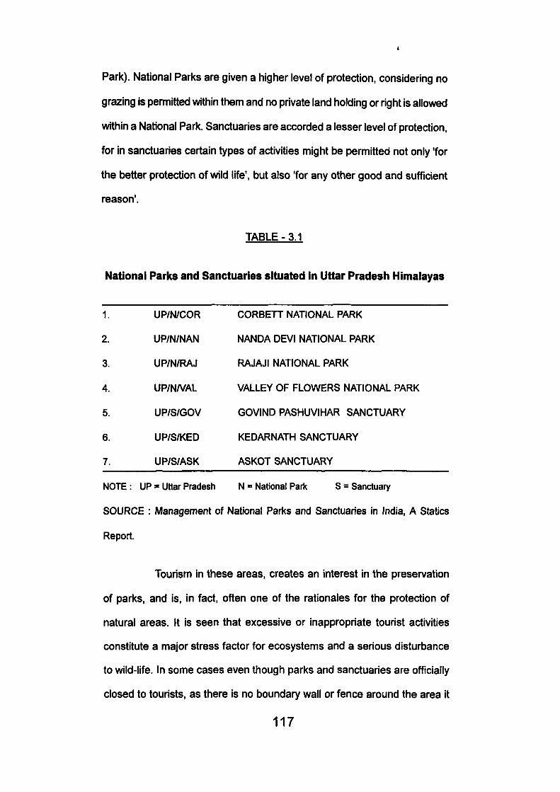
Park). National Parks are given a higher level of protection, considering no
grazing Is permitted within them and no private land holding or right is allowed
within a National Park. Sanctuaries are accorded a lesser level of protection,
for in sanctuaries certain types of activities might be permitted not only 'for
the better protection of wild life', but also 'for any other good and sufficient
reason'.
TABLE-3.1
National Parks and Sanctuaries situated in Uttar Pradesii Himalayas
CORBETT NATIONAL PARK
NANDA DEVI NATIONAL PARK
RAJAJI NATIONAL PARK
VALLEY OF FLOWERS NATIONAL PARK
GOVIND PASHUVIHAR SANCTUARY
KEDARNATH SANCTUARY
ASKOT SANCTUARY
NOTE : UP = Uttar Pradesh N = National Park S = Sanctuary
SOURCE : Management of National Parks and Sanctuaries in India, A Statics
Report.
Tourism in these areas, creates an interest in the preservation
of parks, and is, in fact, often one of the rationales for the protection of
natural areas. It is seen that excessive or inappropriate tourist activities
constitute a major stress factor for ecosystems and a serious disturbance
to wild-life. In some cases even though parks and sanctuaries are ofTicially
closed to tourists, as there is no boundary wall or fence around the area it
117
1.
2.
3.
4.
5.
6.
7.
UP/N/COR
UP/N/NAN
UP/N/RAJ
UP/N/VAL
UP/S/GOV
UP/S/KED
UP/S/ASK
is difficult to prevent people from entering it if they so desire. On the other
hand, the fact that a park or sanctuary is open does not necessarily mean
that it is visited, as it may be so remote, or so unknown to the public, that
tourism may be absent or negligible.
Also, the fact that a national park or sanctuary is open to tourists
does not mean that its entire area is open. In some parks and sanctuaries
there are separate tourist zones, from which tourists are not allowed to
stray, especially into the core zone.
Infonnation regarding the number of tourists visiting each area
may not be accurate for all areas, for a variety of reasons. A large number
of the areas cannot completely control the entry of persons, for they do not
have a wall or fencing around their boundaries, with manned entry points.
So the number of visitors may be underestimated. Many others do not even
have a system of recording the number of visitors, the tourist numbers
provided could therefore be rough estimates of the responding officials.
In most cases, the impact of tourism on the ecosystem of parks
and sanctuaries cannot be calculated without a more detailed study of each
of the areas. However, some of the areas report significant disruption due
to the quantum or nature of tourism. An example of this is the Sultanpur
Sanctuary in Haryana. However, even for this, only a detailed study would
show the exact nature of impact.
The above discussion in the foregoing chapter reveals the historic
perspective of Uttar Pradesh Himalayan resorts, classification of hill resorts
and changing process of hill resorts.
118
CHAPTER - 4
TOURIST CENTRES OF UTTAR PRADESH
HIMALAYAS: SELECTED CASE STUDIES
Uttar Pradesh Himalayas provides many places of tourist
attraction. Visitors to this grand Himalayan scene enjoy natural environment
and satisfy the needs of tourists. It is not possible to describe the
characteristic features of each and every place in a small dissertation.
Therefore of a few centres have been selected as representative of different
types of attractions for detailed study. Badrinath is selected to represent
religious centre, Mussoorie, Nainital and Valley of Flowers as places of
scenic attraction, Govind Pashu Vihar and Corbett National Park places as
wild life centres. This chapter is based on field survey.
4.1 Mussoorie: Abode of Ideal Happiness
Sited on an elongated ridge of the first range of the middle
Himalayas. Mussoorie now covers an area of 64.25 km. perched as high
as 2,006 m, It looks to the North on the snow-capped Banderpunch, Srinkant
and Gangotri Groups, and broods romantically on the Southern low lying
Doon Valley which runs parallel to the Siwaliks, Mussoorie as a hill station
is roughly 150 years old. Somewhere in the eariy nineteenth century
enthusiastic, British engineers, out to explore a range of hills where they
could send their families during hot summers, stumbled upon Mussoorie
and found It an ideal place with all its endowments of health giving climate,
mountain scenery and fascinating natural environment. The first European
119
construction was a shooting box on Camel's back (1823) and a house in
MuHinger (1827) constructed by Captain Young on whose suggestions the
British Government Developed it into a Military convalascent home (Singh,
TV., 1975). By 1829 the Park and Phoenix lodge sprang up. In 1832 the
old Brewery was started. Soon after in 1841 the Himalayan club was
established. By 1880 the Municipal Hall as completed. Thus by the turn of
the century, Mussoorie emerged as a beautiful hill resort, competing its
counter part Nainital in the Kumaun region, excelling in amenities for visitors
and recreation services viz., hotels and restaurants, entertainment centres,
skating halls, cinema houses and the like.
It will be important to describe the regions of tourist attractions
which include:
(i) The Barlow Ganj (on the bridle path from Rajpur to Mussoorie)
a peripheral area.
(ii) Mall Road and the Kuril Bazar- Constitute Mussoorie's tourist
core and fomris a cluster of tourist services.
(iii) Library Bazar- Stretches from Library to Municipal Gardens. This
is a secondary core with star hotels and fashionable shops.
(iv) Vincent Hill Station- Spreads from Savoy Hotel to Vincent Hill
including Kapurthala Palace. A teritary tourist zone with
comparatively cheaper services.
(v) Landour Bazar - (From Clock tower to Ganesh Hotel) a typical
Indian Bazar having a chain of colourful shops arrayed on both
sides of the road. %
120
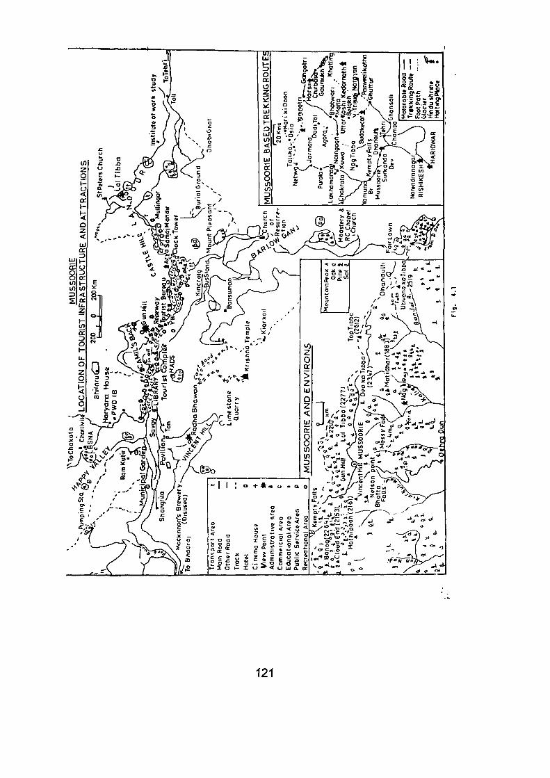
i l l
121
(vi) Landour Depot- Stretches up to Lai Tibba provides vantage
points.
vii) The Happy Valley- Another periphery to the north- west descent.
Development after 1960, provides views on Tibetan lifestyle,
and has avenues for recreation and relaxation.
Mussoorie's other attractions are various vantage points which
have developed adequate on-the-spot services. Popular of them is Gun
Hill (2142 m). These provide most fascinating views of the Himalayan
panorama of peaks in the north, and Doon-Vailey views and the Siwalik to
the south. Lai Tibba is about 5 km. up from the Uttar Pradesh Tourist Centre.
This can be trekked on foot or ponny. Banong point (2264 m) can be reached
while going to Dhanolti. Nearer to Mussoorie are other tourist resources
which have developed moderate facilities such as Kempty Fall, having stay
facilities and Dhanolti about 24 km. on Mussoorie- Tehri road. Dhanolti (2258
m) is a quiet week-end resort amidst the beautiful stands of forest with rich
rhododendron trees run a riot of colours in spring time. Surkunda Devi
(2765 m) is 35 km. from Mussoorie and far off sunroundings. It is the foremost
Shaktipith of Garhwal region which attracts pilgrims on Ganga Dasehra
festival. It is very rich in cultural resources and ethnic life style and folk
traditions.
4.1.1. Popular Trekking Routes :
Mussoorie itself has all its charm with its centripetal forces which
attracts all kinds of tourists. Apart from its magnetic charm and beauty
factors, it exercises centrifugal forces which enhances tourist activity In the
122
neighbourhood through trek and tour activity. These treks are of long and
short distances. Many of the tourists do not go out of Mussoorie and stay
there enjoying the urbanised environment and move out only for small treks.
But some young, adventurous and fun-loving tourists have special interest
in the suburban areas of Himalayas. They lose themselves to explore the
Himalayan beauty through trekking on the high. Some of the treks designed
by the Air India, with Mussoorie as the base, with long distance treks lead
into the Himalayan glory. Thirteen hard treks have been opened by the Air
India, many of them are too tedious to become popular (Kharkwal, S.C).
They are Mussoorie-Hari-ki-Dun (via Purola, Jarmola, Netwar Osia),
Mussoorie- Banderpunch base camp, via Purola, Jarmola, Netwar, Taluka,
OsIa),, Mussoorie-Yamnotri (via Purola, Jamnola, Netwar, Taluka, OsIa),
Mussoorie-Dodital (via Chamba, Tehri, Uttarkashi, Agora), Mussoorie-
Gaumukh (via Uttarkashi, Bhatwari, Gangnami, Harsil, Gangotri, Chirbasa-
Bhojbasa), Mussoorie- Khatling Glacier (Via Tehri, Malla, Belakh, Budh
Kedar, Panwali), Mussoorie-Kedamath (via Tehri, Ghansali, Panwali, Trijugi
Narain), Mussoorie- Sarkunda Devi (via Burhanskhand, Dhanoiti,
Kaddukhal), Mussoorie- Kempty Fall- (Lakhamandal, Mussoorie- Sahastratal
(Via Uttarkashi, Bhatwari, Malla, Balakh), Mussoorie- Rishikesh (via Chamba-
Tehri, Devprayag), Mussoorie- Haridwar (via Surkunda Devi, Chamba,
Narendranagar, Rishikesh), Mussoorie- Naingaon (Via Chamoli, Gauri
Yadher, Batwari).
4.1.2. Tourist Trends :
The increasing tourist activity in Mussoorie attracted as many
as 14.47 Lakhs visitors in the year 1993 whereas 1994 and 1995 saw 12.21
123
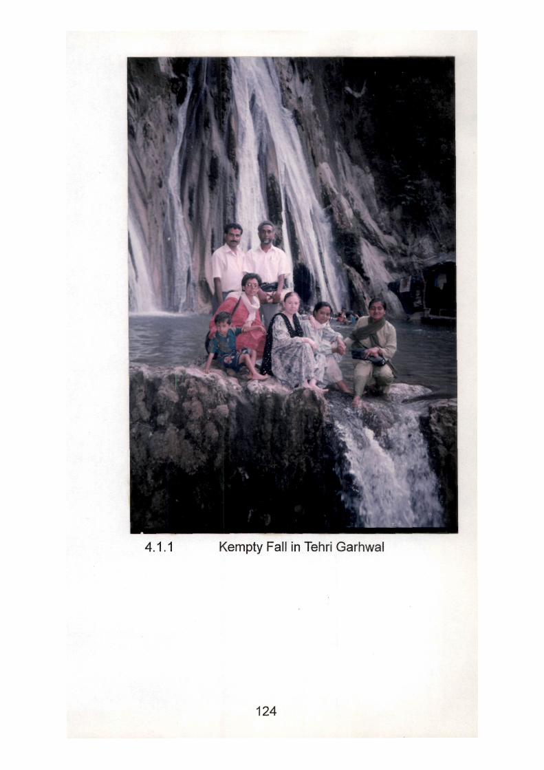
4.1.1 Kempty Fall in Tehri Garhwal
124
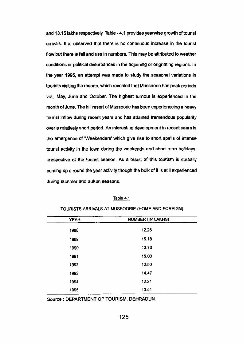
and 13.15 lakhs respectively. Table - 4.1 provides yearwise growth of tourist
arrivals. It Is observed that there Is no continuous Increase in the tourist
flow but there is fall and rise in numtsers. This may be attributed to weather
conditions or political disturbances in the adjoining or orignating regions. In
the year 1995, an attempt was made to study the seasonal variations in
tourists visiting the resorts, which revealed that Mussoorie has peak periods
viz.. May, June and October. The highest turnout is experienced in the
month of June. The hill resort of Mussoorie has been experienceing a heavy
tourist inflow during recent years and has attained tremendous popularity
over a relatively short period. An interesting development in recent years is
the emergence of 'Weekenders' which give rise to short spells of intense
tourist activity in the town during the weekends and short term holidays,
irrespective of the tourist season. As a result of this tourism is steadily
coming up a round the year activity though the bulk of it is still experienced
during summer and autum seasons.
Table 4.1
TOURISTS ARRIVALS AT MUSSOORIE (HOME AND FOREIGN)
YEAR NUMBER (IN LAKHS)
1988 12.26
1989 15.18
1990 13.70
1991 15.00
1992 12.50
1993 14.47
1994 12.21
1995 13.51
Source : DEPARTMENT OF TOURISM, DEHRADUN.
125
4.1.3 Development of Tourism in iUussoorie
Problems and Prospects:
It is now certain from Vne data presented earlier that the tourist
activity in Mussoorie has not only crossed the threshold but has apparently
crossed the tourist carrying capacity of the town. With careful planning a
major portion of this tourist flow to Mussoorie can easily be diverted to the
adjoining potential regions, awaiting appropriate development.
Some of the perplexing problems confronted by the developers
of tourism are that the essential civic services like water supply and sewage
disposal services are subjected to enormous pressure during peak tourist
season. Because the tremendous increase in construction activities, the
town has now become very congested; shops, stalls, hotels, restaurants
and building are coming up on every bit of space available. Government
has put a check on double storeyed buildings. The problems of congestion
is further compounded by vehicular and traffic jams on the roads. Road
jams and pari<ing problems are now a common occurrance during season
and even during the off season Vehicular traffic and consequent pollution
has now become a menace to the quality of experience.
Problem of pollution is directly related to increased tourism
activity. Almost all tourism related services or activities add to the pollution
of the town. Since we already have a lake resort in Nainital, there was no
reason to build an artificial lake at the entrance of Mussoorie. Construction
of a lake has come up as a traffic barrier and has further increased tourist
activity. For tourism the quality of environment is the basis for attracting
126
visitors and needs to be conserved. During peak periods, the available
accommodation in the town falls far short of the demand. According to the
Department of Tourism, Dehradun, the total number of beds in different
hotels of Mussoorie was 6,808 in 1995. This number is far short of the
tourists demand, particularly during the peak season.
Apart from the above mentioned problems, there are many other
problems. Some of the ecological damages have been caused in Mussoorie
iand-scape because of over concentration of tourists in some vulnerable
areas. Due to over construction activity and excessive tourists demand,
ecological damage has further accelerated. During personal communication
with the residents the author came to know that due to energy crisis some
of the trees and patches have been felled and burnt to meet the needs of
tourists despite total ban on tree fellings. Over-use of ground water, over
burdened sanitary and health facilities, mounting problem of litter, all
combined have created serious waste management problem. Vechicular
traffic has not only added to unbearable noise but has also accelerated
atmospheric pollution. Thus it is felt that tourist overioad has reduced the
quality of environment which eventually erodes the quality of the product.
4.1.4 Outline for Development of Tourism :
As discussed above, Mussoorie is confronting with many
perplexing problems related to tourism and development. These problems
can only be solved through proper planning and environment oriented policy
framing besides appropriate land use. In the following an attempt has been
made to identify some of the problems and possible remedies have been
suggested.
127
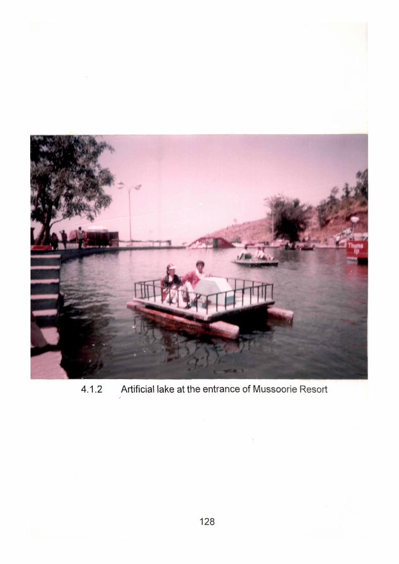
4.1.2 Artificial lake at the entrance of Mussoorie Resort
128
Permission for construction of new liotels in Mussoorie should
be banned or severely restricted. Whatever, necessary construction work
be allowed in Mussoorie should be properly regulated, particularly with regard
to maintenance of roads, sewer lines, drains and disposal of the debris
during the phase of construction. It should be ensured that the construction
activity does not damage or deform ecological features of the resort. Infact,
programmes like greening of the Himalayas should be taken up by the
residents, specially in areas of ecological erosion. In Mussoorie, instead of
building new hotels, emphasis should shift to improvement of existing
facilities. Steps also need to be taken to lengthen the tourist season in
Mussoorie to minimise the adverse impact of seasonality. This can be
achieved by improving facilities particularly during winters by organising
special events and creating decoration and lightening by giving incentives
in price of tourist services. Students and senior citizens can be motivated
to this end. Snow activities have been quite popular in Alpine mountains in
Europe. Mussoorie can also popularise such activities. Suitable parking
places should be developed and it is also necessary to regulate the traffic
in the congested areas of the town. There is a great pressure of the people
for a short duration in the town and it is therefore necessary that steps
should be taken to relieve congestion to provide maximum open space in
the town. Information system should be improved through well prepared
maps, posters, information brochures and other forms of media viz. TV.,
films or home and foreign travel magazines.
Mountain Recreation facilities should also be created for resident
population in the neighbourhood areas. Places offering a panoramic view
of the hills and recreational centres should also be developed for out-door
129
activities for the local people. This shall avoid conflict between the tourists
and residents.
Thus it may be observed that all the side effects ask for redefining
of tourism policy frame work and setting limits to growth by strong political
will and positive support and active participation of resident community. It
has become more expedient when ten'orism and insecurity in the mountain
states push tourist crowds to the peaceful Mussoorie resort. Before
Mussoorie turns into another tourist ghetto and losses its tourist appeal,
decision makers must see that they save their Himalayan heritage from
becoming a prey to predatory tourism developments (Singh, TV., 1975).
They still have choices for Green Tourism and must work for it. Suggested
planning will no doubt create extended opportunities for the growing
incoming tourists and give the resort a relief from the congestion,
environmental pollution, ecological imbalance and further deterioration in
future. Mountain tourism development ought to be organic and controlled
with sound and effective application of threshold theory. Tourism is not only
a hard currency earner it it also a potentially environment friendly industry
and resource should be made sustainable for present and future
generations. Uncontrolled tourism should not be allowed to grow. The costs
and benefits have to be analyzed in pursuit of sustainable development of
tourism.
4.2 NAINITAL : The Lake Report:
Few areas in the Himalayas are blessed with such a constellation
of lakes as these beautiful lake- basins, spread in a length of 25 kms.
Lakes as compared to Alps and other mountain systems, are not very
130
common features in the Himalayas. Nalnital as lal<e district, is Uttar Pradesh's
outstanding outdoor recreation resources centre with developed tourist
amenities. The Nainital lake Region stretches across an area approximately
17.5 km. in length and 11 km. in breadth in the mountainous part of Nainital
district. It is characterized by the presence of a group of natural fresh water
lakes extending over varying areas with diverse mountain settings. This
region is endowed within a great variety of lakes situated a midst picturesque
settings and it also abounds in other places with a great tourist potential.
The Nainital Lake Region roughly lies within 29''19' to 29°25' north latitude
and IQ'IS' to 79°36' east longitudes. The entire region has a mountain
topography, with large altitudinal variations within relatively short spatial
distances.
Nainital resort is a tribute to the beautiful lake Naini (Tal means
lake)- a natural pear shaped lake at an elevation of 1938 m with 3 km.
circumference that varies from 28 m to 463 m in depth. The lake is bounded
with peaks and ridges on three sides and opens to the South, providing
entrance. An extremly picturesque city of the Kumaon Hills, Nainital is located
in a depression around a lake of deep blue waters. The lake is divided into
two aprts- Mali Tal i.e. the upper lake site and Talli Tal i.e. the lower lake
site. Nainital is bounded on the north by China Peak, the highest and the
most imposing with Alma and Sher-ka-Danda on the east and Deopata,
Ayarpata on the west, both gradually sloping downwards. In the lap of these
mountains stretches the lake basin. This is the first view of Nainital a visitor
gets as he emerges from the overfloor of bazars extending downwards' to
reach journey's end. The lake is the unrivalled queen, though the dominating
diety is Naini- a con-upted form of Narayani, one of Parvatfs many names.
131
Rarely it is that tlie lalce greets the visitor with anything but a gracious smile
of welcome on its blue green face, the sparkle and beauty of which works
wonders on tired limb and low spirits. At all times of the day the lake presents
an aspects of bedecked freshness. If no white sails are seen decorating its
broad surface with their traingular, greenful lines, a slim streamlined colourful
and cheerful boat or tow is hardly ever absent. At night the lake turns into
an enchanting, alluring fairy land, reflectors of the row of lights dancing in
the water to weave many a mysterious fantasy.
The discovery of Nainital as hill resort is as interesting as that of
Mussoorie. Mr. Barrer, man of imagination, and aesthete, happen to visit
the lake in 1839 and got enamoured of her. Prior to the year 1839 the place
was covered with a dense forest, only resorted by the herdsmen of
surrounding villages who brought their cattle during the hot weather and
rains for the abounded forage pasturage of the valley. Mr. P. Barron
discovered the t>eauty through an article which was immediately taken notice
of by the British Government. Mr. Barron was the first man to build a house
which he named 'Pilgrim Cottage' after his pen name 'Pilgrim'. The pilgrim
cottage is located near the 'Nainital Club'. Later, Mr. Lushington (then
Commissioner) planned the early growth of the city, now known as Tallital.
Subsequently, it became the summer- headquarters of Uttar Pradesh
Government, adding necessary infrastructure in transport and
accommodation sectors. The period from 1869 to 1900 A.D. witnessed
hectic building activity and a unique lake resort with varied tourist services
springing up in the Himalayas. Most of the hotels and public buildings
overlooked the pear- shaped lake, the forms of all attractions. So
domineering is the personality of this blue- watered Naini that the entire city
132
derives its name, outlook and personality from her. Moved by the beauty of
the sparitling lake, Mr. Ban-on wrote: "It is by far the best site I have witnessed
in the course of a 1,500 miles treak in the Himalayas."
4.2.1 Historical Perspective:
The lake appears to have been known in the ancient mythological
past of India. The modern name of Nainital is however derived from an old
temple of 'Naina Devi', at the upper edge of the lake, but this lake was later
destroyed in 1980 due to land slides. It was subsequently replaced by a
modem structure.
The word 'Naini' means 'Eyes' and 'Tal' means 'Lake'. According
to a legend Panwati the daughter of King Daksha had married Lord Shiva
against the wishes of her father. King Daksha held a great 'Yajna' but did
not invite Parvati and her consort Shiva. Parvati could not bear this direct
insult. In her great fury Parvati, crashed into the 'Yajna' ground and leaped
into the high flames of the 'Yajna' fire to end her life. Later, Lord Shiva,
retrived her half chan-ed corpse himself. The majority of the local people
believe that the eyes of Sati dropped in the lake while her body was being
carried by Lord Shiva to Kailash Pan/at.
Hence, the lake was given the name of 'Naini Tal' or 'Naini Lake'.
Later on the spot became famous by this very name.
There is also a mysterious mythological background which is
shared by majority of the local people. Nainital is mentioned in the Manasa-
Khanda of the Skanda Puran under the name Thrikhi- Sarovara or the lake
133
of the three Rishis- Atri, Pulastya and Pulaha. The legend runs that the
three Rishis (sages) at their pilgrimage came to the peak of the Gagar
range now called Naina Peak formerly known as China Peak. They were
thirsty and found no water. At this, they throught of the Mansarovara and
dug a large hole, which was at once filled with water from Mana and hence
the lake thus formed by them was called the 'lake of the three Rishis'.
4.2.2 Places of tourist Interests:
There are numerous places of interest and attraction :
1. HANUMANGARHI : (1951 mts.). It is at a distance of 3.22 km.
from Nainital. Here a popular place of worshipping is the temple of Lord
Hanuman. It is a religious centre & well known for its sun-set view. Near by,
there is Uttar Pradesh Government Astronomical Observatory and a Satellite
Centre.
2. NAINA-PEAK: (2,611 mts.): It is about 6 kms. from Nainita. It is
the highest peak around Nainital. From here one can have a captivating
view of the Himalayas and the distant plains. One can trek or go on horse
back.
3. SNOW-VIEW (2,270 mts.): It is 8 kms. from Nainital. The most
scenic place, one can reach there by Ropeway (Near Mayur Restaurant,
The Mall). A powerful telescope is fixed here which enables one to view the
Himalayan ranges. The Himalayan ranges viewed from here includes Trishul,
Trishul East, nanda Devi, Nanda Ghunti. Nanda Devi which can be viewed
from here is the highest mountain peak in India and seventh highest in the
world, approximately 7,817 mts. above sea level.
134
4. DOROTHY'S SEAT (2.292 mts.): It is 12 kms. approximately
miles from Nainital. Dorothy seat is build in memorial of Mrs. Dorthy's Kellett,
an English lady, believed to have been killed in an air crash, was built by
her husband. The spot commands a sectional view of the town and the
nearby region.
5. LAND'S END : (2,118 mts.): It is about 4.08 km. from Nainital.
As the name suggests, road ending into an abysmal precipice. A magnificant
view of Khurpa Tal (Soyth Lakes) and the terraced fields on the hillside is
available from here.
6. TIFFIN TOP : At a height of 6,950 feet and about 12 km. miles
from Nainital. It gives beautiful view of the town and the lake.
7. GOVERNMENT HOUSE : It is a beautiful building with a small
zoo, lawns, gardens. Golf links, and Swimming pool. Apart from Government
House there is also a Municipal Board Building.
8. LARIYA KANTA : It is 6 km. from Nainital and at an altitude of
2,481 meters above sea level. This is the highest peak of Nainital and
commands a glorious view of the lake.
4.2.3. The Satellites:
The lake District of Nainital with its complex of secondary and
territory resorts {Bhim Tal, Sat Tal, Naukuchia Tal, Bhowali, Khurpatal)
emerges a giant Sattal, Bhimtal, Naukuchiatal which deserve special
treatment for the 'fresh thresholds' for tourism expansion. All categories of
tourists visit Nainital like honeymooners, school and college students,
135
lesiured elite coming from higher Income groups. Tourists come to nalnital
to escape from the heat of the plains or to watch the scenery all around.
Earlier tourists had longer stays at Nalnital or had a second home. But now
even the common man goes there and to cut down their expenditure they
have fewer days stay now. A single visit is for three days or even a days trip
as rail head is not far away. Apart from recreation facilities to the tourist, in
search of a 'quiet' holiday, these sateilite towns offers many attractions.
4.2.4 BHIMTAL : It is 11.26 km. from Bhowali. Bhimtal is the largest
water body among the lakes of the region, of which neariy one third portion
is shallow and dries up during the summer. The lake has an island in the
central portion which enhance the beauty of the lake. It is quite a popular
lake town presently and is visited by 80 percent of the tourists visiting Nalnital.
4.2.5 NAUKUCHITAL : It's only about 4 km. from Bhimtal. It is the
deepest among all the lakes. It derives its name from its peculiar shape. It
lies amidst characteristic rural surroundings. Boating and Yatching facilities
are available tourist Bangalow exists here.
4.2.6 SATTAL: It is about 8 kms. from Bhowali. This peaceful spot is
full of scenic beauty. Sattal once consisted of a group of seven lakes, sitauted
in close proximity to each other. However, presently there are only five
water bearing lakes in the group viz Ramtal, Sitatal, Lakshmantal, Garurtal
(also called Punatal) and Naldamayantital. All these lakes are located amidst
deep wounds within a closed valley. The environment here is least polluted.
4.2.7 KHURPATAL : It is a relatively small and shallowest among the
perennial lakes with a surface area of 0.06 Sq.km. and depth of 12 m. It is
136
a closed water body with a rural setting around the lake which carries a
special charm from the touristis point of view. So far, the place has not
gained much popularity as a tourist centre.
4.2.8 BHOWALI : It is 11.27 km. from Nainital. A celebrated health
resort and known market for its variety of fruits. Bhowali is famous for its
King Edwards Vil Tuberculosis Sanitorium.
4.2.9 RANIKHET : It is the finest hill station in the world according to
Justice William Q. Doughlas, Supreme Court, USA. The natural beauty of
the place draws the tourist all the year round with its salubrious climate,
balmy breeze and the captivating Himalayan panorama. It is 52 km. from
Almora and 83 km. from the railhead of Kathgodam.
4.2.10 ALMORA : It used to be the biggest district of the State in area
before the bifurcation of the border district of Pithoragarh. The entire district
is full of scenic beauty and religious centres. One can have a panoramic
view of the Himalayas from a number of places in the district. Whereas
most of the other hill stations of India are the creation of the Britishers,
Almora had existed even before their arrival. It was the capital of Chand
Rajas of Kumaon. It has maintained its old traditional character even today.
4.2.11 RAMGARH : It is famous for its delicious fruits. The entire area
is covered with fruit orchards. It is 14.48 km. from Bhowali.
4.2.12 MUKTESHWAR : It is situated at an elevation of 2,286 mts.
above sea level. Mukteshwar is a celebrated spot of scenic beauty and is
the seat of Indian Veterinary Research Institute.
137
4.2.13 Tourist Trends:
Characteristic of these summer hill resorts shows that Nainital
typifies two popular tourist cycles i.e. the summer cycle from May to June
and the Autumn cycle from Septemt)er to October. While the former
symbolises the climatic needs of the better provided people of enervating
plains, the latter has been a revival of an English tradition (of fun gaiety
and love of life) with a view of meeting the non seasonalities of the resort.
However, it may be attributed to people's aesthetic tastes, recreational needs
and spirit of wanderiust that they sojourn on these hills at a time when
these hill sides have put on fresher looKs and wonderful greenery after the
rains.
As the sun shines brightly and indeed harshly over the plains,
Nainital gets all too busy in dressing her 'tourism shop' the hotelier's, the
cafe and restaurant owners, the porters and cabmen all look forward for a
good business and hey-day. A slow and steady inflow of tourist gradually
begins to set in by April which speedily gathers momentum by the second
and third week of May. Precisely, the second half of May and the first half of
June constitutes the peak periods when more than 10,000 visitors anive to
beguile their insipid summers. Eariier, Nainital had its periods of set- backs,
but in the recent years Nainital has been experiencing a heavy tourist inflow
without consideration of peak season. An interesting development in recent
years is the emergence of "Week-end" tourism which gives rise to short
spells of intense tourist activity in the town, during week-ends and short
term holidays, irrespective of the tourist season. As a result of this, tourism
has emerged as a round the year activity, thrugh most of it still takes place
138
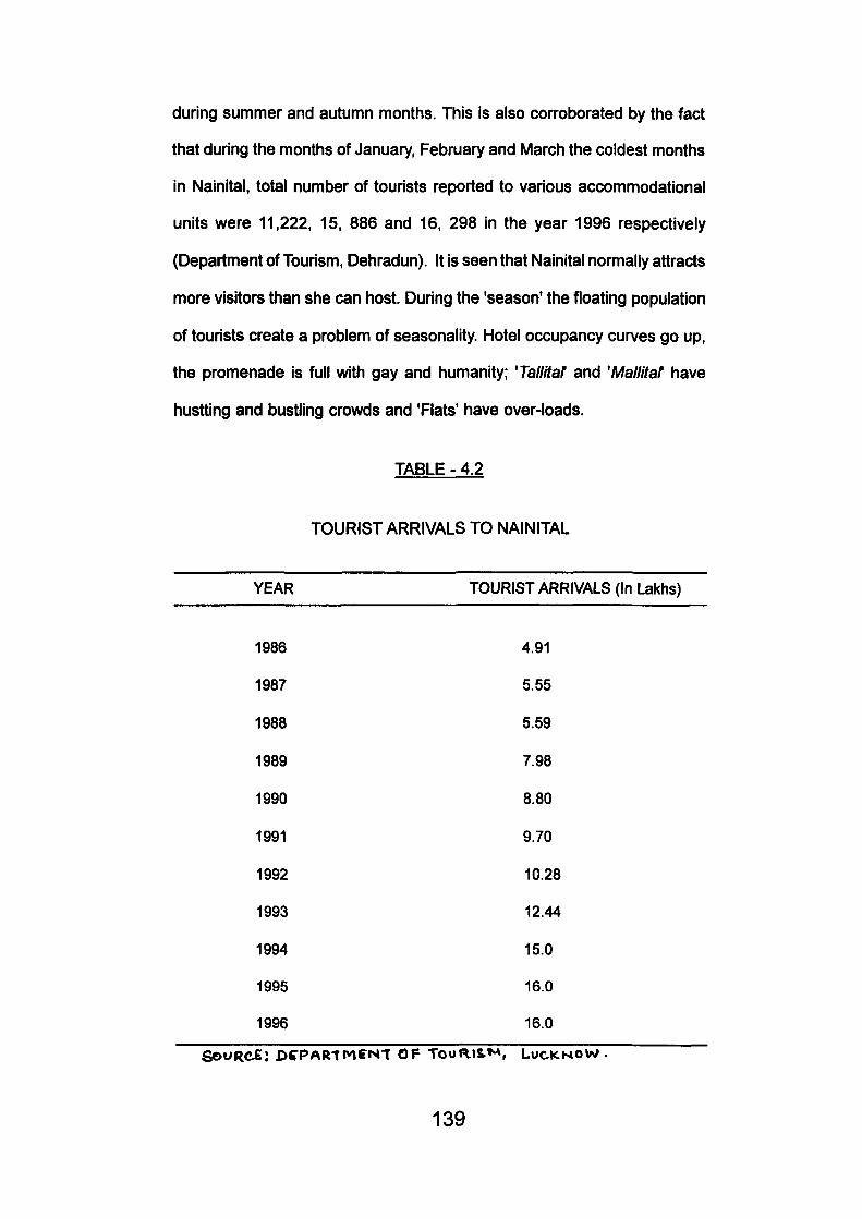
during summer and autumn months. This is also corroborated by the fact
that during the months of January, February and March the coldest months
in Nainital, total number of tourists reported to various accommodational
units were 11,222, 15, 886 and 16, 298 in the year 1996 respectively
(Department of Tourism, Dehradun). It is seen that Nainital normally attracts
more visitors than she can host. During the 'season' the floating population
of tourists create a problem of seasonality. Hotel occupancy curves go up,
the promenade is full with gay and humanity; 'Tallitaf and 'Mallitat have
hustting and bustling crowds and 'Flats' have over-loads.
TABLE - 4.2
TOURIST ARRIVALS TO NAINITAL
YEAR TOURIST ARRIVALS (In Lakhs)
1986 4.91
1987 5.55
1988 5.59
1989 7.98
1990 8.80
1991 9.70
1992 10.28
1993 12.44
1994 15.0
1995 16.0
1996 16.0
Qe>VRC£: DCPARtMFNT OF TooaiS.*^, LuciCHOW.
139

Table shows the tourists trend in Naintal from 1986 to 1996. It Is
seen from the above table that the trend is on the increase.
The survey conducted by the author during the month of June
1996 revealed some tourist trends in Nainital. Hundred tourists were
questioned by means of various questions in the form of questionairre. The
answers from the questionairre brought out the fact that average stay of
tourists in Nainital is 39.5% to 37.2% i.e. for 2 to 4 days about 9.3% and
13.9% stayed for about a week and above it respectively. It is seen that
tourist coming to Nainital were not first time visitors to this beautiful lake
resort but they came for pleasure and recreation. About 41.9% came here
with self- interest, 6.9% because of their previous visit and 34.9% came
here due to relatives and friends. 95.3% an-anged their visit independently
and 76.7% came here for pleasure. Data collected revealed that 58.14%
people had already visited this place eariier and with the previous experience
still in their minds they came back to this place. Tourists come from all
walks of life but mostly service class people came here and 55.8% tourists
had their income level above Rs. 2000. These people had preference for
Ranikhet, Almora, Kausani, Ramnagarand very few visited Corbett National
Park apart from the lake tour which includes Sattal, Naukuchiatal, Bhimtal,
Bhowali. About 41.9% preferred to visit Ranikhet, 25.6% visited Almora
and 13.9% visited Kausani.
People who visited Nainital were satisfied mostly with all spheres
of facilities. Some of them felt that things should be cheap so that it is easy
for a middle class family to stay here. Water supply is not sufficient and is
supplied for fixed time. It should be increased. People were of the view that
140
Government should build tourist bunglows, hotels, so Incoming tourists visits
with Increasing capacity be accommodated. Transport should be improved
and cheaper.
4.2.14 Tourist Facilities:
1. Accommodation Facilities :
The term accommodation is an all- inclusive term used for tourist
stay facilities, viz., hotels, motels, private residential accommodation, paying
guest accommodation, dormitories, dharamshalas etc. Hotel
accommodation is the single most form of accommodation. The
accommodation facilities have contributed a lot to the development of tourism
in Nainital. In just one decade the number of hotels in the town has increased
from 40 In 1980 to 108 in 1991. The bed capacity has also increased to
4,500 in 1991. Apart from the hotels there are two tourist reception centres
(Kumaon Mandal Vikas Nigam), guest houses, lodges and a few
dharamshalas in Nainital.
2. Transport and Communication :
The resort is connected by metalled roads to all the major towns
of India. The daily bus services of Uttar Pradesh State Road Transport
Corporation are available from Kathgodam to various places of tourist in
the Kumaon region. For sight seeing, the Kumaon Mandal Vikas Nigam
(KMVN) organises daily recreational trips to adjoining places of tourists
interest. Private tours are conducted to the following places; Bhimtal half
day; Sattal, full day; Ranikhet, full day; Observatory, three hours; Kumaon
Darshan, three days; Kausani/ Corbett, three days; Mukteshwar, full day.
141
The nearest railhead and airport are at Kathgodam and Pantnagar
respectively. Aerial Ropeway is primarily a tourist attraction for Snow view
which has proved a major tourist attraction.
3. Entertainment:
Nalnitai has many attractions to offer to the tourists such as
trekking, boating, yatching, hunting, swimming, angling, riding, golfing and
rock climbing provides healthy and delightful recreation to the visitors.
Paddling boats are seen which add extra charm for the attraction of the
tourists. Moreover, during the autumn festivals, Kumaoni folk dances, folk
songs, folk lores, folk tales and other activities provide entertainment to the
tourists.
4. Souvenir :
The hill resort of Nalnitai is well known for its handicrafts, cottage
industry horticulture and specially of woollen clothes made in the region.
However, tourists can buy from here beautiful candles of different shapes
and sizes.
4.2.15 Damage to Landscape and Lake :
Thoughtless quarrying which pays no attention to the beauty of
the landscape has permanently scarred the face of Nainital. Little or no
measures have been taken so far to redress or repair the environmental
injury caused by these activities. The condition of the lake is now such that
its pea- soup green water is now almost opaque and its surface is generally
littered with garbage as polythene bags, empty cans and cartoons, plastic,
142
shoes, etc. With increasing pollution, the aesthetic value of the lake is fast
decreasing. Eutrophication of the lake is a major concern of the population.
i) Pressure on civic amenities :
Essential civic services like water supply and sewage disposal
services are subjected to enormous pressure during peak tourist season.
During summer, the drinking water supply in Nainital falls to 40 percent of
the demand.
ii) Problem of Congestion :
Because of the tremendous increase in construction activities,
the town now becomes very congested. Shops, stalls, hotels, restaurants
and buildings are coming up on every bit of space available. The problem
of congestion is further compounded by vehicular congestion on the roads.
Road jams and parking problems are now a common occurence during
tourist season. Vehicular traffic is going to become a major hazard in near
future. Deforestation and overgrazing of the pastures have diminished the
aesthetic and scenic appeal of the resort besides causing fatal land scape.
iii) Lake Siltation:
Above all this, the greatest damage is being caused to the Lake.
On the basis of the existing rate of siltation of the lake, the life span of the
lake is likely to be reduced substantially. It is, therefore, essential to take
steps to check further silting of the lake. This calls for proper maintenance
and improvement of the existing drainage system.
143
The arrival of almost 1,00,000 tourists per month during the
summer season in a town with an installed capacity of neariy 4,500 beds
and with very little scope for further construction of accommodation due to
lack of availability of space, clearly shows that the present level of tourist
activity during peak season is behind the capacity of the town(Pushpa and
Joshi, S.C., 1996). This causes a great burden on the civic amenities and
creates a number of other problems. On the other hand, the industry
experiences a great shortfall In demand during off season. Moreover, the
adjoining Lake Region which is economically backward but has a
tremendous scope for development of tourism, gets very little advantage of
the intense tourist activity taking place in Nainital due to lack of infrastructural
facilities. This calls for a diffusion of tourist activity in whole of the Lake
Region by creating adequate Infrasturctural facilities In the resorts of the
Lake Region. This will give a boost to the economy Of the predominently
rural Lake Region and will also ease the tourist pressure on Nainital during
tourist peak season.
4.2.16 Suggestions and Recommendations:
Eco-development of the resort area is the prime need of the
hour. Nainital should work on a master plan which has an integrated
approach. In Nainital town, the problems, are most acute, many of which
should be taken on priority basis.
Need of the hour in Nainital town is the problem of pollution in
the Nainita Lake. Steps should be taken to clear the lake by the local
authorities. Existing rate of siltation, should be reduced substantially by
appropriate measures to increase the life span of the lake. Lake Region
144
inspite of being extra ordinarily beautiful is little known to the tourists. A
publicity campaign should be launched in this connection and infomiation
about it should be made available to the tourists at various tourist information
bureaus. The question as to how many tourists Nainital can host at a time
has to be answered within the frame of canrying capacity concept. Permission
for construction of new hotels in Nainital should be banned or severely
restricted. Whatever necessary construction work be allowed in Nainital
should be properly regulated particularly with regard to creation and
maintenance of roads, sewer lines, drains and disposal of the debris during
the phase of construction. It should be ensured that the construction activity
does not damage the trees and the vegetative cover of the existing drains.
Beautification of the town is necessary to attract tourists and
suitable partking places should be developed and to regulate the traffic in
the congested roads of the town. During peak season periods, the available
accommodation falls short of demand. If construction is to be done it should
be in consideration with the ecology of the area. The real need is for a large
number of small units instead of a small numer of large units. There are
many locations in an around the Lake region which can offer a varied type
of recreation to the tourists. It should be taken notice of by the planning
authorities. A number of locations are around Nainital which offer excellent
natural scenery and the picturesque view of the Himalayan ranges. These
neighbourhood places should be developed with adequate tourist facilities
to attract tourists for quiet and scenic appeal for which they had left the hot
plains.
Thus may be seen that legislation and strict law enforcement
process should be used for maintaining Nainital as a pleasant and beautiful
145
hill resort. Tourism activities should be diffused in the adjoining regions of
Nainital and Lake Region so that tourist traffic would not face the problem
of over crowding. It is for the authorities to see that Nainital does not loose
its tourist appeal and its sustainability Is not endangered.
4.3 BADRINATH : A religious centre :
Badrinath is one of the 'Four Dhamas' of the Hindus, located in
the higher Himalayan region of Chamoli (Gariiwal Himalayas) at an elevation
of 3,133 metres above the sea- level. Badrinath is guarded on either side
by the mountain ranges known as Nar and Narayan, with the towering
Neelkant Peak, providing a splendid back-drop. This holy shrine of Badrinath
has, from the earliest of time, evoked the deepest devotion from the people
of India and attracts about 4,60,000 pilgrims/ tourists every year from all
over the Indian States and territories, despite strenuous hill journey of 301
km. from Rishikesh.
Badrinath is a small township with ribbon settlement along the
banks of turbulent Alaknanda, that flows southwards, embracing the Rishi
Ganga to the south of the township, located at 30° 44'-56" North longitude,
and 79° 31'-20" East Longitude. It runs longitudinally into spacious valley
(414 km. long and 114 Km. wide) opening up northwards to the Bhotia village
of Mana, the last settlement of this region.
Badrinath landscape is undulating, with encricling high black
mountains superimosed by snow clad ranges and lofty peaks. The two
mountain ranges i.e. War and Narayan embody in them Hindu mythological
belief and breathe Puranic faith. Badrinath township should not be studied
146
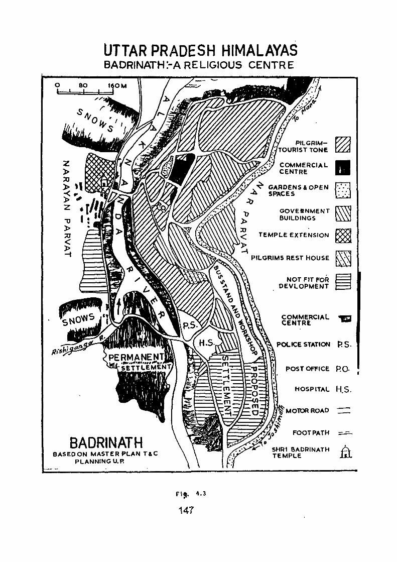
UTTAR PRADESH HIMALAYAS BADRINATHrA RELIGIOUS CENTRE
Fi^. 4.3
147
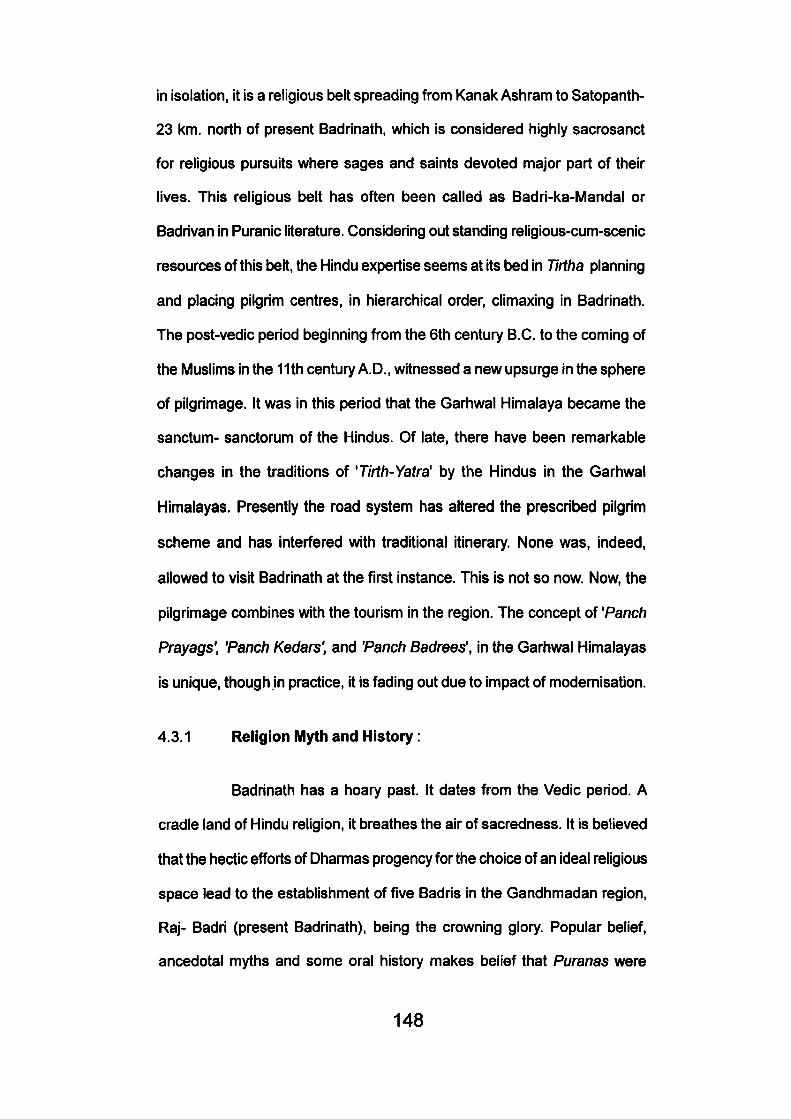
in isolation, it is a religious belt spreading from Kanak Ashram to Satopanth-
23 km. north of present Badrinath, which is considered highly sacrosanct
for religious pursuits where sages and saints devoted major part of their
lives. This religious belt has often been called as Badri-ka-Mandal or
Badrivan in Puranic literature. Considering out standing religious-cum-scenic
resources of this belt, the Hindu expertise seems at its bed in Tirtha planning
and placing pilgrim centres, in hierarchical order, climaxing in Badrinath.
The post-vedic period beginning from the 6th century B.C. to the coming of
the Muslims in the 11th century A. D., witnessed a new upsurge in the sphere
of pilgrimage. It was in this period that the Garhwal Himalaya became the
sanctum- sanctorum of the Hindus. Of late, there have been remarkable
changes in the traditions of 'Tirth-Yatra' by the Hindus in the Garhwal
Himalayas. Presently the road system has altered the prescribed pilgrim
scheme and has Interfered with traditional itinerary. None was, indeed,
allowed to visit Badrinath at the first instance. This is not so now. Now, the
pilgrimage combines with the tourism in the region. The concept of 'Panch
Prayags', 'Panch Kedars', and 'Panch Badrees', in the Garhwal Himalayas
is unique, though in practice, it is fading out due to impact of modernisation.
4.3.1 Religion iUlyth and History:
Badrinath has a hoary past. It dates from the Vedic period. A
cradle land of Hindu religion, it breathes the air of sacredness. It is believed
that the hectic efforts of Dhannas progency for the choice of an ideal religious
space lead to the establishment of five Badris in the Gandhmadan region,
Raj- Badri (present Badrinath), being the crowning glory. Popular belief,
ancedotal myths and some oral history makes belief that Puranas were
148
4.3.1 Badrinath Temple- one of the four dhamas of Hindus
149
composed in this Gandhamadanl environment. Apart from it, Badrinath
acquired fame during the Mahabharat times for its environmental values,
and for being the hermitage of the perfect sages, saints, priests, pundits,
scholars and savants all flocked to the 'Hindu Elysium' braving the hazards
of the journey. There are references to the efforts that many founders of
the Hindu School of Philosophy received inspiration in this divine wilderness
(Kaur, J., 1985). It also attracted Lord Krishna and Arjuna who perfomied
austertices at the Nar and Narayan peaks. It also inspired the celebrated
'grammanan', 'paniniya', and sages Gautam, Kapil and Kashyap, Kaiidas,
the great poet and dramatist of Sanskrit, laid the scene of 'Abliigyan
Shakuntalam' (near Nand Prayaga), and "Megh Doof (Alkapuri, North of
Badrinath) in this region (Datta, B.N., 1961).
Lord Narain, overtime acquired a big following in the work-a-
day people of mundane existence, who found necessary to move to this
beautiful Himalayas, both for religious merit and for change from hum drum
of life and living. Religious benediction bestowed upon the diety led a
movement of pilgrimage a yatra tradition. This movement of people of
Garhwal Himalayas suffered a severe set back when Budhism had its way
in this region and a queer mix of cults, Tantricism, Shaktisam, Saivaism
and magic began to be practiced. This was a period of decadence when
the iconollastic activity reached its peak. The image of Lord Vishnu was
thrown into the Alaknanda and the temple was demolished.
It was around the eight century that a young Brahmin philosopher,
Adi Guru- Shankaracharya, from Kerala, performed penance under a tree
here and after getting enlightment, established a Math (religion centre).
150
This Brahmin philosopher, installed the image in the 'Garur Gufa' (cave),
having found it in Narad Kund. Later, tradition has it, it was removed to the
present site by the ruler of Garhwal. The gold canopy of the temple is said
to be the gift of queen Ahilyabai. This marks the period of renaissance in
Badrinath pilgrimage, when the temple was dedicated to Vishnu, Shiva,
Surya, Shakti and Ganesh to integrate Hinduism and to restrict worship of
authorised gods, a practice which had come into vogue.
4.3.2 The Temples :
^#r ^^ #!#r f^, "^i^^^fm^ ^i
^ ^ ^ ^ ^ ^ n , * r f ^ ^ ^ 11
(From Sknad Purana, "Many a place of pilgrimage are on the
earth, sky and on the lowest regions but none like Badrinath, neither in the
past, nor in the future there is any likelihood of one such existing).
This temple exists from times immemorial. It is mentioned in
Atkinson's Gazetter (1886) that the present temple was built by Shri
Shankaracharya. The present temple is situated on the right bank of the
Alaknanda, standing over 15 m. high from the base built in the form of a
cone with small cupola spire. The main body is made of flat blocks of stone
and plastered with cement, that belies its entiquity.
Architecturally, the temple has taken after the early Nagar Style
with a definite hill stamp, divided into three pars - (i) Garbhgarh, the sanctum
sactorum; (ii) Darsan Mandap (Rectangular shaped where puja is perfomied;
(ill) Sabha Mandap- (outer hail where devotees stands for darshan), it has
151
square plan with number of graduated projections in the middle of each
side that lend it a cruciform shape. The colourful entrance gate has put on
a Turkish cap, comoufaging the traditional exterior. The self- existent statue
of Bhagwan Narain engraved in black stone in a sitting 'half paadmasan
pose' is found in the main 'Garbhgarh' of the temple. Only the chief preist
'Rawal' and his assistance 'Baduva' has the authority to enter the
'Garbhgarh'. But even 'Baduva' cannot touch the statue of Shri Bhagwan.
The temple stands high on Puri's dense religious core with only
a little space around for further development. The temple has been passed
from the hands of Rawal (the highest priest of the temple from the South)
to a committee of twelve members and Rawal is restricted to his religious
duties.
4.3.3 Religious cum Recreation Resources :
Essentially a religious destination Badrinath attracts both religious
and secular visitors, the latter are steadily on the Increase with the process
of modernisation and better facilities in transport and accommodation.
Badrinath with multiple outdoor recreation resource endowment, promises
an up coming tourist destinations. In fact, the Badri Yatra has been
responsible in opening up Garhwal Himalayas for tourism (Singh, TV., 1975).
In the vicinity of the temple are hot and cold cisterns {Kunds),
Ghats, engraved boulders and geologic forms, of them, Tapt Kund, a hot
spring having a temperature of 56°C and closely Surya Kund are user based
resources, associated with Panch Tirth sacrement. A bath in hot spring is
very refreshing to all travellers. For women a seperate tank is available.
152
Five giant rock formations known as Panch -Shilas are linked
up with religious myth and Puranic legends. There are boulders that are
worshipped and enjoyed as 'sites' by the visitors.
The Ganga Ghat where Mahatma Gandhi's ashes were
consigned to the holy waters of the Alaknanda, is another point of visitor
attraction. This is located midway between Brahma Kapal and Taptkund.
Away from the temple (1.6 km.) is Sheshnetra, a boulder having
engraving of a legendary snake's eye is a geological phenomenon.
Nilkantha is a pyramidal snowy peak (21,650) which towers about
Badrinath and presents a most enchanting sight, best enjoyed from the left
bank of the Alaknanda.
Charan Paduka is a beautiful meadow, about three kilometers
west of Badrinath, towards the foothills of Nilkantha Peak. In this emerald
green environment are found the footprints of the Lord. As July approaches
this beautiful meadow is carpeted with annuals and herbal blossoms.
Mana Village- 4 Kms. inhabited by an Indo- Monolian tribe is
considered as the last village on Indo- Tibet border. The Mana valley with
Bhotia settlement and with their unique life style is itself a source of attraction
and has many potential touristic attractions viz., 'Vyas Gufa'- a rock cave,
where sage Vyas is said to have compiled Puranas; 'Keshav Prayaga' (the
confluences of the Alaknanda and the Saraswati) and the natural bridge,
'Bhimpul'.
Vasudhara is an enchanting site of a waterfall at an elevation of
3658 m, from whence the water jumps from a height of 122 m in a trance-
153
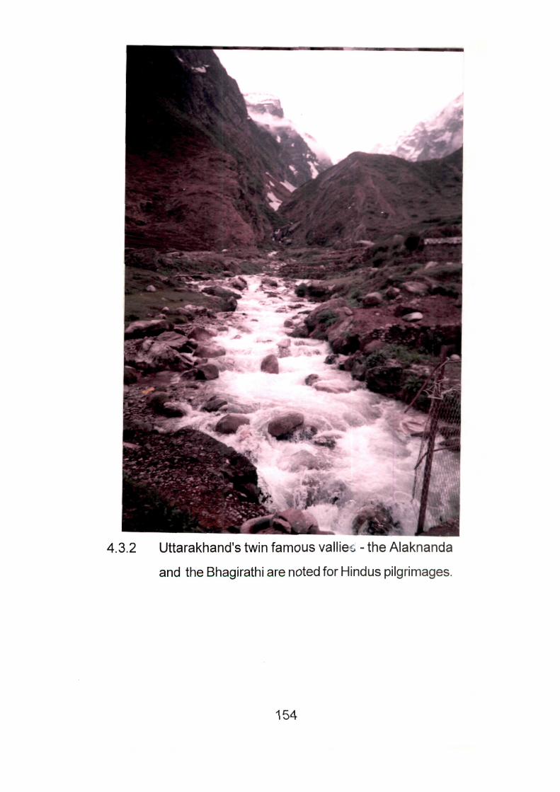
4.3.2 Uttarakhand's twin famous vallie^^ - the Alaknanda
and the Bhagirathi are noted for Hindus pilgrimages.
154
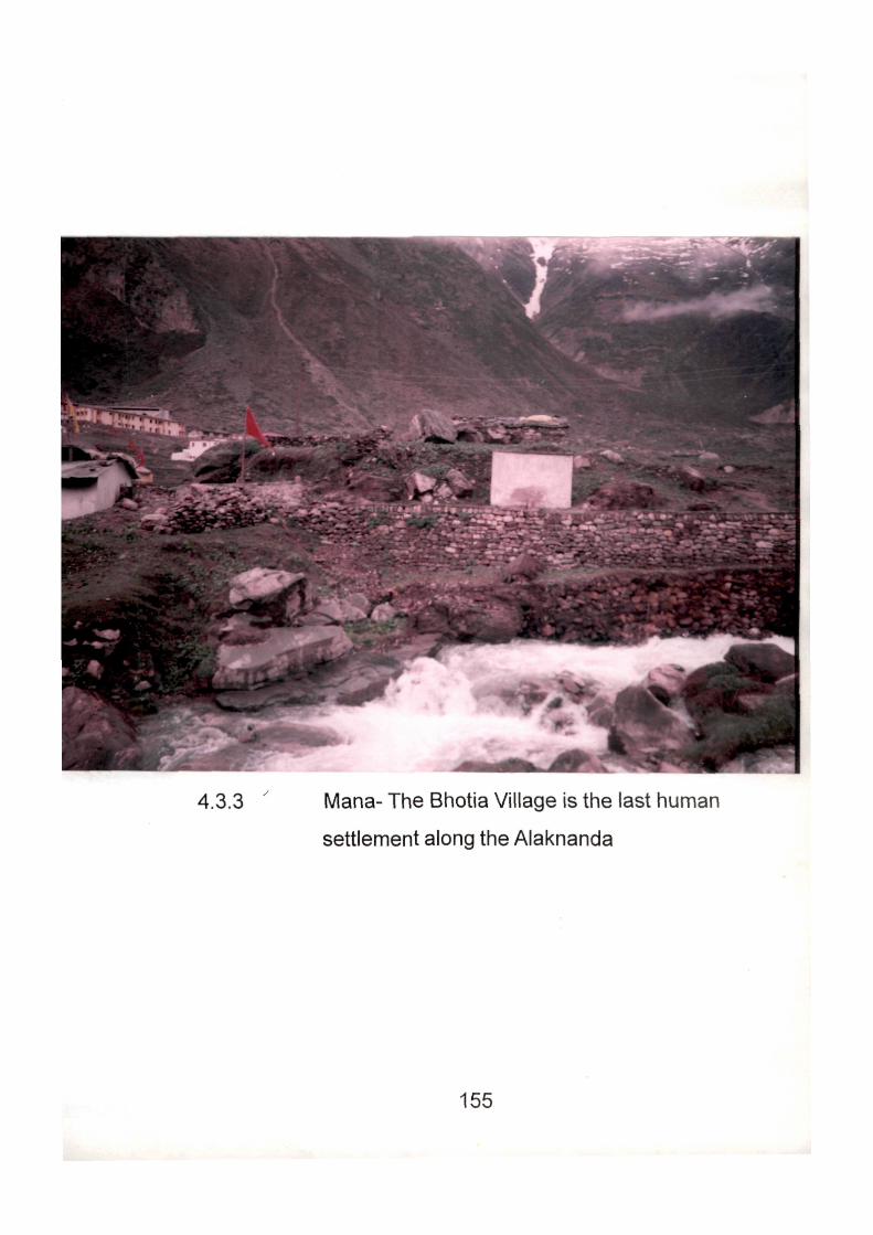
4.3.3 ' Mana- The Bhotia Village is the last human
settlement along the Alaknanda
155
inducting manner. It is 5 l m from Mana and is tlie liighest waterfall of
Garhwal.
Alakapuri: About 8 km. further away from Vasudhra is the source
of the Alaknanda, Alakapuri, from where the river gushes out from the glacier
snout of Bhagirath Kharak and Satopantha (much like Gaumukh) is the
source of Alaknanda. The Satopanth lake, with it serene water, is a potential
tourism resource from trekkers and trailers. Kalidas alludes to this point in
his famous play 'Megh doot'.
4.3.4. The Hosting Town :
Badrinath faces many constraints in meeting market demands.
The major problem is geographical in nature. A town lives only for seven
months (May - November) and the rest is the sway of the snows. This hard
seasonality of character is further accentuated by a limited land use acumen.
Manpower resource is another uniting factor for taking up any enterprise
which may benefit locally or regionally.
Badrinath has three Mohallas of Badrinathpuri, Banni Village
and Nar Parbat. Badrinathpur being the oldest settlement forms the core
where the shrine has culster of Panda population and services. Here,
practically every inch of ground has been used for religious purposes. In
this region there are hotels, eatable and sweets stores, sell clothes, medicine
and religious souveniers. Food stuff, eatables and goods for sale are largely
imported from the plains.
Badrinath has only two public hospitals- one district (Allopathic)
and the other Ayurvedic. Together they can attend to 100 patients, per day.
156
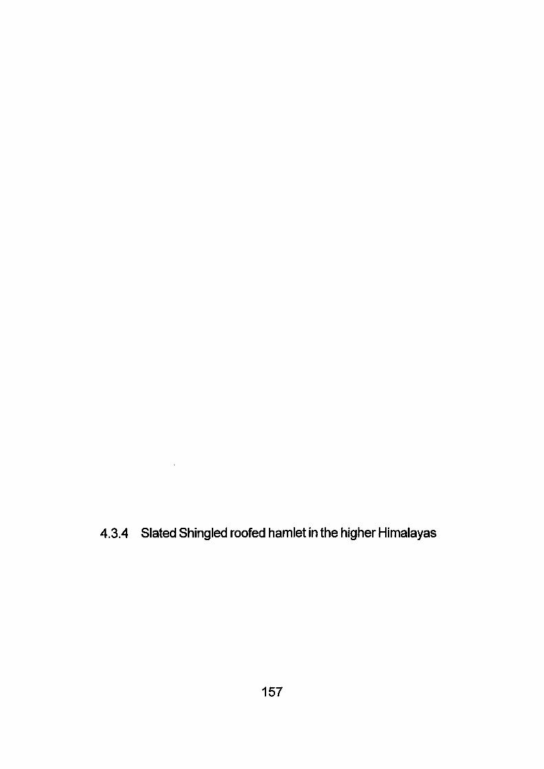
4.3.4 Slated Shingled roofed hamlet in the higher Himalayas
157
The town has one Post Office, One Telephone Exchange, One Police
Station, One Infonnation Centre, one Public Call Office (P.C.O.) and one
Gas Agency of Garhwal Mandal Vikas Nigam. The only department that
has progressed is Department of Telecommunication.
Special Police force stays during winter for the security of Mandir
and two or three persons of Mandir (Caretaker) stay during winters. If
anybody else wants to stay they have to take permission from the District
Magistrate.
These facilities, however, modest, look pretty, impressive for a
small population that stay hardly for seven months. But considering the
vast floating population of about 10-20,000 persons per day and their
heterogenous needs, these services are all two meagre besides very much
wanting in standard. The town falls short miserably in accommodation the
formost destination facility and electricity.
4.3.5 Pilgrim Traffic and Patterns :
The Badrinath pilgrimage lasts for seven months, mostly in
summers and rains (May- November). May- June being the drier months,
the majority of visitors take to pilgrimage during this period, to safeguard
against inclemency of weather and road breaches.
On an average, over 10,000 to 20,000 pilgrims visit Badrinath
per day. However, peak is touched in June, when 30,000 to 40,000 visitors
come on a single day (Chief Incharge of Badrinath Mandir Committee).
During the year 1996 till 13th June, 1996 there were about 2.50
158
lakhs pilgrims who visited the shrines of Kedarnath and Badrinath
(Newspaper Rashtriya Sahara, 13th June, 1996 Lko. Friday). The incharge
of Garhwal Vikas Nigam Mr. Vijay Mohan Madhual told UNI that during the
month of May, 1996 the arrivals of pilgrims showed low profile due to
elections in the month of May but after 5th June there has been a sudden
increase in the pilgrims. His report added that during this year there has
been an increase of tourists as against the last year. August, normally has
a low profile because rain threatens landslides and slope failures. September
picks up again when the weather is fairer sky is clearer, hills are greener
and the journey is more rewarding. November traffic- flows begin to fade
out with the onset of snows. Finally, doors, of Badrinath are closed and the
chief priest moves to Joshimath- the winter seat of Badri Narain.
Badrinath attracts visitors from all over the country and a few
tourists from overseas. Results of interviews, conducted by the author,
showed, that the largest number of visitors came from West Bengal, followed
by Maharashtra, Gujarat and Rajasthan. The flow of South Indians continues
throughout the season. Very few foreign visitors are recorded, many were
expeditionists or field scientists or nature lover.
While the Himalayan pilgrimage have gateway in Kotdwara and
Rishikesh, almost 95% visitors prefered entry from Rishikesh, both for transit
facilities and enroute attractions, particularly Devprayag (the confluences
of Bhaghirithi and Alaknanda). The 310 km. long journey is completed in
one halt- Joshimath on the onward and Srinagar on the backward journey.
Both these stopovers have developed adequate accommodation facility.
Visitors influx to Badrinath shot up after 1968 when metalled road reached
159
Badrinath for the first time. To acertain the validity of visitors stay in Badrinath
the author conducted a sample survey in the month of June of 1996 of
100 visitors. It was established that on an average visitors' stay in Badrinath
is only for a day - but some stay for more period. Above 49.3% stayed at
Badrinath only for one day, 43.7% stayed for 2 days, 2.8% stayed for 3-5
days, 1.4 percent again stayed about a week. It is seen that length of stay
is directly proportional to recreation resource attraction, facilities, hospitality
and travel costs, Badrinath being mainly a religious destination, caters to
the tourists needs also. Some interesting socio- economic facts on visitors
are worth mentioning.
The visitors income group varies considerably, though the
majority falls into middle clas.s However, 70.42 percent belonged to above
Rs. 2,001 group and 6.3 percent belonged to students category. It is seen
that 67.6 percent people were inspired by their religious santity, 18.3 percent
by relatives and friends, 7.04 percent by magazines/journals/ newspapers
and 2.82 percent by their previous visit. It is seen that 85.9 percent tourists/
pilgrims visited the place for the first time and 14.08 percent had come
earlier 54.9 percent of people belonged to the age group of 41-60 years.
Pilgrims visiting Badrinath came with a religious bent of mind
and also visited other three Dhamas of Garhwal Himalayas. By the personal
survey the author came to know that about 80 percent people visited
Kedarnath, Gangotri, Yamnotri and then came to Badrinath. Some of the
adventurous tourists visited Valley of flowers. Hemkund Sahib Gurdwara
and Auli-ski resort.
160
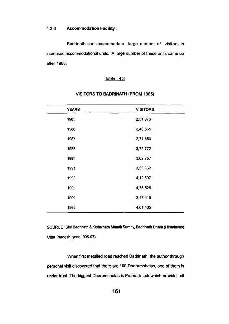
4.3.6 Accommodation Facility:
Badrinath can accommodate large number of visitors in
increased accommodational units. A large number of these units came up
after 1968,
Table - 4.3
VISITORS TO BADRINATH (FROM 1985)
YEARS VISITORS
1985 2,51.876
1986 2,48,565
1987 2,71.850
1988 3,72,772
1990 3,62,757
1991 3.55,662
199? 4,12,597
199' 4,76,526
1994 3,47.415
1995 4,61,465
SOURCE: Shri Badrinath & Kedarnath MandirSamity, Badrinath Dham (Himalayas)
Uttar Pradesh, year 1996-97).
When first metalled road reached Badrinath, the author through
personal visit discovered that there are 100 Dharamshalas. one of them is
under trust. The biggest Dharamshalas is Pramath Lok which provides all
161
necessary facilities to the tourists. IHotei Devlok is run by the Garhwal Mandal
Vil<as Nigam. Apart from it two more tourist bunglows are being constructed
by the undertalcing of Uttar Pradesh Government one by Nirman Nigam
and other by Garhwal Mandal Vikas Nigam, each with 500 beds capacity.
Apart from it there are 25-30 good hotels with necessary facilities of life.
Hotel Devlok has a total of 84 beds capacity with 10 Delux Rooms with 20
beds capacity, 20 Executive Rooms with 40 beds capacity, 12 ordinary
rooms with 24 beds capacity. The rates per one night stay are Rs. 365 for
Deluxe Rooms, Rs. 350 for Executive Rooms and Rs. 150 for ordinary
Rooms. There are seasonal rates i.e. for the months of May and June,
September and October, But there is a fall of 25 percent in the rates during
the months of July and August. All the basic and standard facilities are
provided that include attached bathrooms, hotwater on payment, laundry,
Doctor on call, parking facility. Restaurant and Catering facility. They
organize package tours for Badrinath, Kedarnath, Gangotri, Yamnotri and
Valley of Flowers. 22 Buses are in operation for this purposes from Rishikesh.
The average stay of tourists at Devlok is maximum for one night and only
few stay for 2 or 3 day and not more than that.
On the contrary there are many 'expensive' stay places with the
Pandas who look after their clients on a traditional style and charge
exorbitantly, though at the 'sweet pleasure' of their 'clients- the Hindu way
of life.
Most agonising feature of the Badrinath pilgrimage is the difficulty
in getting a chance to have a look or 'darshan' at the derty. Shri Badrinath
Temple Committee has fixed Morning and Evening Pooja Rates (See table
4.4). The premises of the temple are too small to accommodate even 200
162
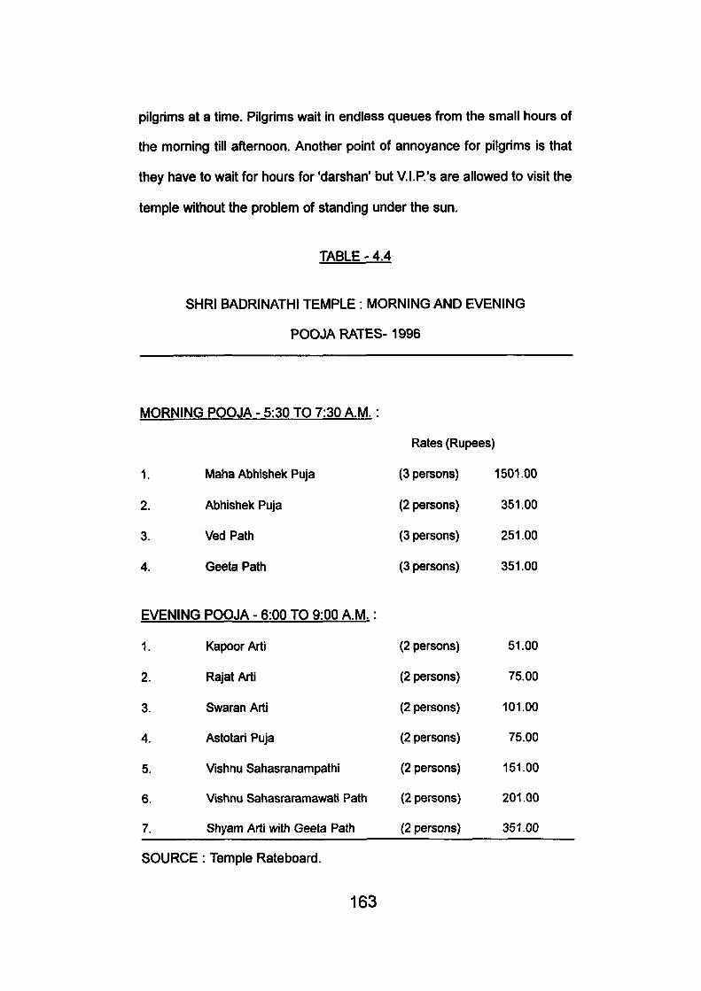
pilgrims at a time. Pilgrims wait in endless queues from the small hours of
the morning till afternoon. Another point of annoyance for pilgrims is that
they have to wait for hours for 'darshan' but V.I.P.'s are allowed to visit the
temple without the problem of standing under the sun.
TABLE - 4.4
SHRI BADRINATHI TEMPLE : MORNING AND EVENING
POOJA RATES-1996
MORNING POOJA - 5:30 TO 7:30 A.M.
1.
2.
3.
4.
Maha Abhishek Puja
Abhishek Puja
Ved Path
Geeta Path
EVENING POOJA - 6:00 TO 9:00 A.M.:
1.
2.
3.
4.
5.
6.
7.
Kapoor Arti
Rajat Arti
Swaran Arti
Astotari Puja
Vishnu Sahasranampathi
Vishnu Sahasraramawati Path
Shyam Arti with Geeta Path
Rates (Rupees]
(3 persons)
(2 persons)
(3 persons)
(3 persons)
(2 persons)
(2 persons)
(2 persons)
(2 persons)
(2 persons)
(2 persons)
(2 persons)
1
1501.00
351.00
251.00
351.00
51.00
75.00
101.00
75.00
151.00
201.00
351.00
SOURCE: Temple Rateboard.
163
4.3.7 Problem of Peaking :
This sacred centre, like any other holiday resort in the hills below,
goes full to the capacity during the 'season'. There are always too many
clamouring for accommodation in the few sub standard outmoded and, in
many cases, Improvided dharamshalas. Few get satisfactory
accommodation In some good hotels and dharamshalas providing basic
amenities.
Transport problem is no less challenging then what it is at
Rishikesh. Worst conditions prevail when an early outbrust of the monsoon
causes road breaches and landslides. Pilgrims, sometimes, have to be
stranded for weeks; over crowding filth and cholera often become the by
product of such a righteous journey. Badrinath, needs a development plan
both from religious as well as from strategic point of view.
Pilgrims/ tourists, while conducting survey by the author, came
up with suggestions and comments concerning accommodation, water,
electricity, food, transport. Most of them were satisfied of the crystal clear
water of River Alaknanda. People were dissatisfied with the supply of
electricity which is irregular. Basic commodoties are very expensive there
are no fixed rates. People were of the opinion that Government should fix
the rates so the tourists are not cheated. There are no street lights, at night
it is absolutely dark on the roads.
At some of the Hotels the food is also very expensive. It becomes
difTicult for common man to adjust to the expensive environment. Mana
Village is 3 kms. from Badrinath, approachable by Taxi by an hour. The
164
charges are two hundred rupees for an hour and expenses exceed if the
stay increased. It is seen that it too difficult for tourists to be back after an
hour from tedious heights of Himalayan ranges.
The bus stand needs proper passenger facilities and drivers
drink and create fuss at night. Local people were also of the opinion that
there should be ban on alcohol to bring down the crime rate. Tourist
Information Bureau should be therefore guidance of tourists in an unknown
place.
Badrinath, unfortunately is fast losing its character of super-
pilgrim resort with the process of modernisation, nearness to the Valley of
Flowers and recently established Auli Resort for winter sports scheme have
affected Badrinath. It is for the developers to maintain its religious character
and does not shed it's 'place genius' and 'character* altogether. Conscious
efforts in this direction have to be commissioned so that Badrinath keeps
up its personality of a Dhama.
4.4 THE CORBETT NATIONAL PARK : Wild Life Sanctuary :
The landscape and its fascinating inmates were described by
Jim Corbett as "The steel blue of the fern fringed pool where the water
rests a little before cascading over rock and shingle to draw breath again in
another pool more beautiful than the first- the flash of the gaily- coloured
kingfisher as he breaks the surface of the water, shedding a shower of
diamonds from his wings as he rises with a chrip of delight, a silver minnow
held firmly in his vermition bill. The yelling of the sambur and the clear
tuneful call of the chital apprising the jungle folk that the tiger, whose
165
pugmarks show wet on the sand where a few minutes before he crossed
the river, is out in search of his dinner. These are things that will live in my
memory, the lodestone to draw me back to that beautiful valley, as yet
unspoiled by the hand of man".
Man-eaters of Kumaon (1944):
Vast tracts of thick forests with wildlife have been more dreaded
than revered. This is, perhaps, more true of western culture, than orientalists,
who perceived nature as a part of their own. Today when the world has
grown conscious of the fast vanishing wildlife, the cry for their conservation
and protection seems so relevant. India, however, has had a rich tradition
for forests and wild life conservation. The theme is found subtly woven in
mythology, folk- cultures and the concept of Hindu pantheon. Religious
institutions, ashrams and forest universities were established to meet this
objective. This spirit pervaded untill 400 B.C. 'Kautilya' in his Arthshastra
observes. In Abhayaranyas (protected games forests) a code of conduct
was down for all and laws were enforced by strict supervision. Even the
animals (that turned dangerous) were killed only after removing then outside
the reserve, so that the inhabitants may be disturbed least." Seen historically,
we find emperors like 'Ashoka', 'Harshwardhana' embued with this spirit.
Until recently the farmers of North West India, used to aportion a piece of
land from their famns, as sanctuary for wild animals.
Such has been the wildlife legacy of India. But the change of
time, increase in human population resulting in excessive pressure on land,
this spirit seems to have been lost. Major changes occured during Mughal
period, when big game hunting became a status symbol of bravery, social
166
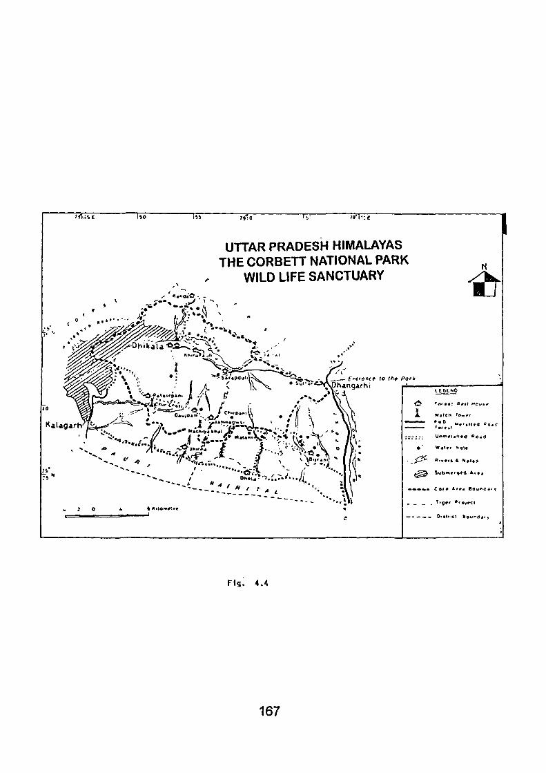
TT" "•h-.e 1 UTTAR PRADESH HIMALAYAS
THE CORBETT NATIONAL PARK WILD LIFE SANCTUARY it
•* /T* '? _ " - V V >. V " "Sf.Ti.r.,. ^ S i
ntrantt to tfif Pork
CD hangar hi
O H « U
^ f r ^ L
% Kilomvtv*
• V»*t»» n o t *
* » * « • C o r * Ar^4 B O U ' ^ C A '
Fig. 4.4
167
prestige and a major form of sports and recreation. Tlie wanton and
indiscriminate violation lords who killed the poor creatures just for fun, frolic
and fur, or for prestige and for drawing - room decorations which resulted in
extinction of many animal of rare charm and beauty, many more became
endangered species, calling forth attention of the naturalists and
conservationists.
It was in the third decade of this century that India once again
awakened to her long forgotten cove of the wilds. This time, the inspiration
came from the west.
India today hosts. National Parks and more than 421 sanctuaries
(by the information of Forest Department Uttar Pradesh, Rana Pratap Marg,
Lucknow) many of which fall under the purview of Project Tiger. Its climatinc
and geographic diversity makes it the house of over 350 mammal and 1,200
bird species, many of which are unique to the subcontinent.
India is running many wildlife rehabilitation proejcts in almost
every region, which demand a closer look, particularly the famed 'Corbett
Park' - the first and foremost in India, which has been, of late, exposed to
human intervention and unplanned developmental activities.
4.4.1 History:
Framed within the modern concept of 'National Parks', this first
Park of India was established in 1935 in the valley of Patlidun and adjacent
hills in Uttar Pradesh, Teral- an area known for its variety of fauna and
abundance of wildlife from centuries. Named as "Hailey National Park",
168
after the then governor of United Provinces, ^fter independence the park
was renamed "Ramganga National Park", (1948) after the river that flows
across the Park. Finally, it was rechristened as "Corbett National Park" to
commemorate the memory of famous naturalist, Jim Corbett. The late Jim
Corbett, the famous author helped in demarcating the park's boundaries
and setting it up. Following international appeal to the world's most
magnificient beasts. Project Tiger was launched with the help of World
Wildlife Fund on 1st April, 1973, making the Corbett Park a heaven for the
tigers. It is one of the eighteen tiger reservers in India, launched under
"Project Tiger", The Tiger is the biggest attraction of this park. The star
attraction of the park is the Royal Bengal Tiger. As per the latest census
(1996) figures, the population of tigers in park is 125 (Singh, N. Rajesh,
1996). This figure incidently is the highest amongst all the national parks.
The Corbett National Park celebrated its diamond jubilee on 12th December,
1996.
About two thirds of the park area is in Garhwal, while the rest is
in Kumaon Region. Originally the park covered an area of 99.07 sq.km. As
the area was considered small for the animals like tigers and elephants, it
was extended over to 323.75 sq.km. and at present the area of the park is
520.8 sq.km. Park stretches between 29°13' 30" to 29" 35'15" north latitude
and 78" 33' E to 78° 46' east longitude. About ten percent of the total area
is now a submerged land.
The forest covers a series of more or less parallel ridges from
north to south east, decreasing in height towards the plain. The natural
forests is confined to bhabartraci of Shiwalik formation. The altitude varies
169
between 400 m.-1,100 m, with undulating topography of many temporary
marshy depressions, ravines and plateau lands. The Ramganga enters the
park from near Gairal Forest Rest House (FRH) and takes a westerly course
up to Sarapduli Forest Rest House (FRH), t>ending in north west direction
till its crosses Dhlkala Forest Rest House and ultimately changes its course
to southwest again to come out of the Park at Kalagarh. The Park is all a
riot of colours when nature unfolds herself in new fomns and style- shisham
trees in foliage, the flame of the forest trees with glowing red-flowers, semal
in scarlet and kachnar in mauve blossoms. Along with fishing, the angler
can expect to see any of the wildlife along the river. Malani, Gairal, Sarpduli
and Dhlkala are favourate resorts of the fishermen. The park is wonderfully
rich in wild life. Corbett's faunal assemblage includes fifty species of
mammals, five ugly species of birds and twenty five species of reptiles.
The Park is generally open to visitors throughout the year, except
during the rains, when road- breaches are common and accessibility goes
poor. The tourst season is from 15th November to 15th June. The foreign
tourists would prefer to visit the Park during the months of November and
December, the ideal months both from climatic season and visibility aspects
are March and April. During the monsoon season from June to October,
the park remains closed to tourists and the animals move to the hilly areas
of Corbett at this time.
4.4.2 Park Fauna:
The tiger reserve houses almost all the major group of animals,
known to exist in Himalayan Terai i.e. bhabar. In all, 50 species of mammals.
170
580 species of birds, 25 species of reptiles, 7 species of ampliibians and
33 species of termites have been identified. Of particular significance is the
presence of some of the depleted species of mammals viz; tiger (pathera,
tigris). Hog deer (Axis porcinus), leopard cat (Fells bengalonsia), wild dog
(Cuon alpinus) and Indian Pangeleon (Manis craussicaudata). While swaup
deer (Cervus duvauceli), once a common animal in the park, has altogether
disappeared from the vicinity. Himalayan black deer (Salenarctos thibetanus)
visits the park in the winters only, descending from higher ranges. The
mountain goat (Nemorhaedus goral), restricts itself to the northern ridges
of the Ramganga. Some other bigger mammals in the park are sambhar
(Cervus unicolor), Muntjak (Muntijacus muntijak), wild bear (sus scrofa),
red fox (Vulpes Vulpes) and jackal (Canis aurius) are important. Among
smaller mammals shrews, hedgehog, squin-el, rats, mice, monkeys, civets
and Bats are noticeable.
The park abounds, a good deal, in avi- fauna including the
resident as well as the migratory birds (both winder and summer migrants).
The River Ramganga plays a significant role in attracting the winter migrants
like water- birds, waders etc. Birds of passage indulge in winter/ autumn
migration, an added attraction of the Park. About one fifths of the residents
indulge in local, altitudinal and seasonal migration. Some common birds of.
the Park are doves, pigeons, parrots, cuckoo, bea eaters, hornbills, barbets,
thrushes, shrikes, drongoes, babblers, bulbuls, finches, buntings and the
like.
Among the reptiles, the presence of the four larger threatened
species viz; Marsh Crocodile (Crocodilus Palustris), Ghariyal (Gavlalis
171
gangeticus) Indian Python (Puxthon Moulrus) and King Cobra (Naja Lunna)
is the special feature of the Park. Besides these other Important reptiles
are poisonous snakes like Kraita, Vipers, non-poisonous snakes viz;
ornamental grass and water snakes and vamases and a variety of iizzards.
The Ramganga having many Hill-stream fishes offers promise for game
fishes like Indian Mahaseer (Barbus tor) and Indian trout (Rainmus bola).
Rohu (Labeo rohita) has lately been introduced in the reservoir of hydel
project. The insect fauna is indeed very colourful and includes beautiful
butterflies, bees, bugs, beetles, termites and dragon flies.
4.4.3 Park Flora:
The vegetation is a mixed one of decicduous tropical and sub
tropical species. About 110 species of trees, 33 species of bamboo and
grass, 51 species of shrubs and 27 species of climbers have been indentified
so far.
Among the trees, the dominant Sal (Shoreambusta) is frequently
associated with Haldu (Adina cordifolia). Molan-hena antidysentrica also
occurs scattered amidst the Sal. Bakhll (Anogeisus latifolia) mostly occur in
higher ridges. Other common trees in the Park are Khetwa (Pilostigma
malabaricum), Gurial (Bauhunia racemose); Pula (Kydia calycina), Dhauri
(Legerstroemia parviflora), Amaltas (Cassia fistula), Bhilwa (Semicarpus
anacardium), Amia (Emblica officinalis) and Ber (Zizyphus mauritiana). Less
common are Papri (Holopteles integrifolia), Mahwa (Madhuca indica),
Kumbhi (Caerya arborea) and the like.
Among the dry nullahs on exposed habitat, occur Phchoniya
172
(Wendlandia heynie), Rohni (Mallotus philippensis) and Jamun (Syzyguim
cuminj). Sheesum (Dalbergia sissoo) Khair {Acaaa catechu) association in
ttie Ramganga river bordering savannah at Dhikola is an interesting feature
of the Parl< landscape. Preodminant shrubs are clerodendrum, viscosum,
colebrookea oppositi folia, Adhatoda vasica, Helicteres isora and woodfordia
fructlcosa, while Milletia auriculata, Cryptoshepia buchanani, Porana
paniculata, Phanera Vahlic, Valleris solanacea, Aspidopterys neutans, are
common climbers. Bamboos occur frequently in several blocks while, among
the palms in addition to Phoenix aculies (rare palm) Walliehia densiflora is
noticeable. Chir (Pinus roxburghii) is the only indegenous Pinus. In the
Chaud (Savannah), along the bank of Ramganga occur grasses like
Themeda Arundinacea, Thysanolena maxima and Vetiveria' zizanioidea in
abundance. While in burnt soil, these are associated with herbs viz; Vicoa
indica, Trichodesma indicum, Lactuca species, Polygala species,
Desmodium species, Crotalaria species and Tajuga species, etc. In the
other open areas grasses like eulaliopsis binata, apluda mutica, opiisanus
compositus and Eragrostis uniloides are common. Orchids, like Zeuxina
species, Eulophia species, Vanda species and Bulbophyllum species are
common. Among parasitic plants, Dendrophthoe falcata, Scurrula Cordifolia
and cascuta reflexa are noticeable. Most common slender shrubs forming
ground cover are Drymaria diandra, Justica procumbens, Borreria articulata,
Boerhaavia diffusa and Gynoglossum lancaolatum.
Purely aquantic vegetation does not exist in the Park. Plants
occuring in marshy, water logged area are Ammania species, Oenothera
species, Hypericum species and polygonum species.
173
The common weeds which are likely to effect the native
herbaceous plants. Lantana species, Acanthospermum hispidium and
Xanthium spermerium.
4.4.4 Recreational use and Tourist Amenities:
While nature conservation is central to the concept of National
Parks, recreation/ tourism and education are the other activities, which ought
to go well with it. It has been observed that well planned tourism has its
rightful place in National Park System. However, this may not always be
the case, when mass tourism, or uninvolved visitors make their in road into
these 'Protected Areas'. Studies carried out in 'Parks Canada' and several
other forest institutions in the U.S.A. have empirically proved that planning
and management in the Parks must be scientific. To achieve this objective,
the knowledge of the carrying capacity of the Park is most essential.
Since Park visitors are classed 'special tourists' the Corbett Park
attracted attention only of the few. With the growth of tourism- movement in
India, the Park began to attract attention both of the foreign visitors and the
home. By the information provided from the Tourism Department of Uttar
Pradeshin 1990-91, the Park visilation was 39,078 of which 36,161 were
Indians and 2,917 were foreigners. The number of visitors increased to
43,464 in the year 1993-94, out of which 37,265 were Indians and 6,199
were overseas visitors. However in the years 1991-92 and 1992-93 the
total number of visitors dropped to 33,047 and 31,963 respectively. This
drop in the number of visitors can be attributed to bad weather or due to the
religious roits of '92 because of Babri Masjid issue.
174
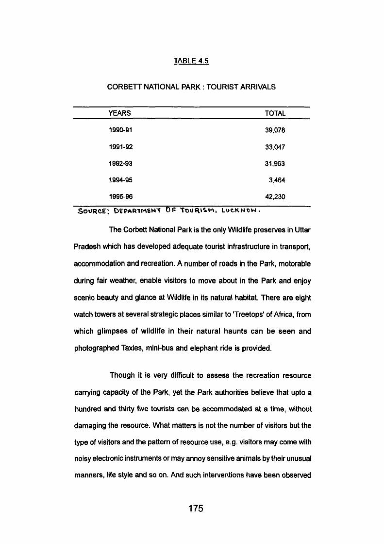
TABLE 4.5
CORBETT NATIONAL PARK : TOURIST ARRIVALS
YEARS TOTAL
1990-91 39,078
1991-92 33.047
1992-93 31,963
1994-95 3,464
1995-96 42,230
SOURCE: DEPARIMEN-T DP TtjofH^'M, LUC.KN«V4.
The Corbett National Park Is the only Wildlife preserves in Uttar
Pradesh which has developed adequate tourist infrastructure in transport,
accommodation and recreation. A number of roads in the Park, motorable
during fair weather, enable visitors to move about in the Park and enjoy
scenic beauty and glance at Wildlife in its natural habitat. There are eight
watch towers at several strategic places similar to Treetops' of Africa, from
which glimpses of wildlife in their natural haunts can be seen and
photographed Taxies, mini-bus and elephant ride is provided.
Though it is very difficult to assess the recreation resource
can7ing capacity of the Park, yet the Park authorities believe that upto a
hundred and thirty five tourists can be accommodated at a time, without
damaging the resource. What matters is not the number of visitors but the
type of visitors and the pattern of resource use, e.g. visitors may come with
noisy electronic instruments or may annoy sensitive animals by their unusual
manners, life style and so on. And such interventions have been observed
175
in core area of the Park. The Parkethics include that wild animals should
not be fed, fast driving and blowing horn is strictly prohibited. Bicycle, motor
cycles, scooters and three wheelers are not allowed in the Park, Flash
photography is also not allowed.
Tourist structurings are also important, there location and their
architectural style may also matter. It is an accepted principle that tourist
accommodation should either be on the periphery of the Park or outside
the core zone. Corbett Park however, has not observed this rule. Tourist
structure in many cases do not harmonise with the milieu, besides being
located in the core zone. This has resulted in making the animals a little
panicky. A survey conducted by the Institute of Himalayan studies and
Regional Development, Garhwal University, Srinagar (Garhwal), in March,
1980 revealed that most of the mammals do not like to come out of their
niches except for drinking water besides the bank of the Ramganga, whereto
the environment has been exposed to the Ramganga Hydel Project
activities. Things have further worsend since then.
The roads inside the Parks' sanctum- sanctorum disturb the
Park's harmony by frequent run of vehicles. One needs more than ordinary
patience, sometimes of several days, to view wildlife panorma through the
machans (Watch Towers) around the water holes. It is suggested that Corbett
Park should have its own centre of motivation, where audiovisual aids,
video tapes, brouchures, pamhiets, photographs would help visitors in
176
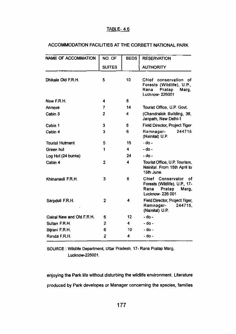
TABLE- 4.6
ACCOMMODATION FACILITIES AT THE CORBETT NATIONAL PARK
NAME OF ACCOMMATION
Dhlkala Old RR.H.
New F.R.H.
Annexe
Cabin 3
Cabin 1 Cabin 4
Tourist Hutment
Green hut
Log Hut (24 bunks)
Cabin 4
Khinanauli RR.H.
Sarpduli RR.H.
Gairal New and Old RR.H.
Sultan RR.H. Bijrani RR.H.
Randa RR.H.
NO. OF
SUITES
5
4
7
2
3 3
5
1
2
3
2
6 2
6 2
BEDS
10
8
14
4
6 6
15
4
24
4
6
4
12
4
10 4
RESERVATION
AUTHORITY
Chief conservation of Forests (Wildlife). U.P.. Rana Pratap Marg, Lucknow- 226001
Tourist OfTice, U.R Govt.
(Chandralok Building, 36, Janpath, New Delhi-1
Field Director, Project Tiger Ramnagar- 244715 (Nainital) U.R
-do-
-do-
- do-
Tourist Office, U.R Tourism, Nainital. From 15th April to 15th June.
Chief Conservator of Forests (Wildlife), U.R, 17-Rana Pratap Marg, Lucknow- 226 001
Field Director, Project Tiger, Ramnagar- 244715, (Nainital) U.R
-do-
-do--do-
-do-
SOURCE : Wildlife Department, Uttar Pradesh, 17- Rana Pratap Marg,
Lucknow-226001.
enjoying the Park life without disturbing the wildlife environment. Literature
produced by Park developes or Manager concerning the species, families
177
and group of animals and plants is found to be reliable. Wild fauna and
flora are nature's renewable resources but many of the species become
extinct or rare due to damaged ecological cycles. It is therefore necessary
for the Park developers, in this case conservators and wildlife Wardens, to
present a taxonomic list which may be checked periodically. During late
seventies and early eighties, the development activities of the Ramganga
Multipurpose Hydel Project, affected the environment seriously, it is reported
that inspite of poaching, lumbering and grazing activities (which could never
be stopped altogether), park animals were living in almost complete hannony
till the Ramganga Hydel Project threatened their peace. In 1974, Corbett
lost about 80 sq. km. of its fine riverine and flood plain habitats to the
Ramganga reservoir. While precise data on the habitat damage are not
available, It is easily assumed that it has brought change in biosphere directly,
effecting the ecosystem. In some of the vertebrates this impact is easy to
perceive. The vast expanse of water for the first few years baffled and
elephants during their annual migration. Now these intelligent giants have
learnt to live with the problem of loss of their migratory routes. Among other
mammals, the chital (Axis axis), hog deer (Axis porcinus), Indian procupine
(Hystrix indica) have been adversely affected.
As about 80 percent of submerged area is of savannah type;
the habitat of chital, a considerable decrease has been noted in their
population. However, the most abrupt change was the sharp fall in their
birth rate due to stressed condition felt by the animals. Almost similar plight
was of Hog deer, whose number first increased in 1978 but later on was
reduced, perhaps because of their growing population pressure and threat
by dominant Chital herds. Similarly the density index of porcupines (which
178
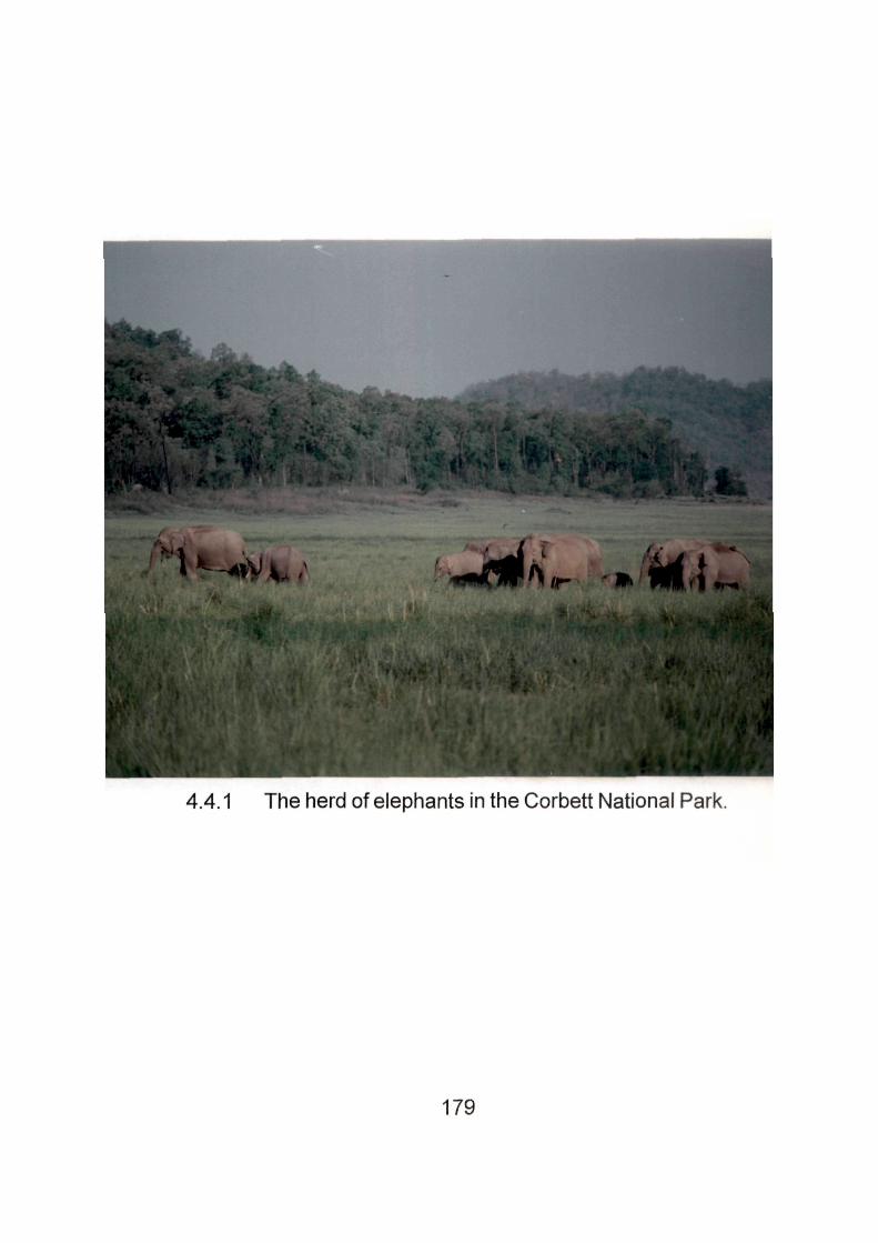
4.4.1 The herd of elephants in the Corbett National Park.
179
lives in deep underground chambers) in tlie winters of 1977-78 dropped to
sixty percent of their 1967-77 index.
For the birds, the reservoir has come up as a mixed fortune.
The relative density index of birds like Red Ardvents (Estilide amannova),
spotted Munia (Lonchura Punctuate) and Weaver birds (Pleos benghalensis)
fell, as the smaller trees, bushes and reed beds on which they roost and
breed under water. Similarly, after submergence of south west Dhikala
Chaud, no myna roosts were to be observed in the area. However, the
presence of water birds like cormorants, darters, herons, egrets, strokes,
fishing eagle, king fisher and moor hen was felt in the Park, where as they
were rarely to be seen, previously. A crocodile rehabilitation programme is
in progress. The gharial has been saved from extinction in the Park through
captive breeding. A few species of turtles and tortoises are also found in an
around the lake.
The fish fauna seems to have suffered a major loss, as their
habitat has been changed greatly due to silttrapplng, destruction of spawning
grounds and localised climatic changes as well as changes in micro and
macro life of water i.e. the food of fishes. Due to the Dam their usual migratory
activities (both seasonal and reproductive) has also been impaired. Fishing
can be done only in areas outside the National Park and Sonanadi Sanctuary
and only from 1st October to 30th June. Fishing permits are issued for one
week at rates fixed by the Government. Permits for Kosi River are issued
by Divisional Forest Offices (D.F.O.)
Sometime back in 1985 lUCN had recommended some very
180
useful tips for the park management, the Corbett Park in particular which
need be mentioned here by way of conclusion.
Conservation measures which are socially unacceptable to a
majority of the population will eventually jail, so there is an urgent need to
increase education and interpretation programmes, especially in conflict
zones. Negative impacts need to be minimised and conservation benefits
need promotion. It is perhaps this aspect of conservation planning- the
human dimension which requires the greatest thrust in years to come,
especially in the Indomalayan Realm, where dense rural population are still
dependent on many living natural resources.
The plan aims to ensure that each nation has strong and effective
wildlife conservation authorities at the centre and state or provincial levels
so that the network of conservation areas can be adequatly managed.
Recruit dedicated and highly motivated staff at all professional levels within
these departments, and provide opportunities for advancement within the
system create a specialized research coordination post at the central level
to actively promote much greater research involvement and the provision
of adequate funds for research promotion; or develop other means of
promoting research, such as publishing an official 'List of Research Priorities
in Protested Areas' for the country. To make suitable parts of the protected
areas system available to the public for recreation and educational uses.
There are some of the guidelines of the action plan.
Corbett brings to life India's rich bio-diversity. It also gives life to
its surrounding areas and the inhabitants of this area by providing regular
flow of water, miligating environmental extremes acting as a check on soil
181
erosion, floods and droughts. It is now also becoming the focal point of
ecologically sustainable development in its surrounds.
In Corbett the results of fifty years of successful conservation
can be seen and enjoyed in this fullness and glory. The Reserve is proud of
its contribution towards India's efforts to conserve her bio- diversity.
4.5 GOVIND PASHU VIHAR: Fascinating Wild Life Reserve:
Govind Pashu Vihar, with all its bewildering scenic contrasts,
rich and colourful flora and fauna and unique cultural heritage, is one of the
most fascinating wild-life reserves of the country. This high altitude sanctuary
is situated in the north- western part of the Garhwal Himalayas, in Uttar
Pradesh, lying within the co-ordinates SO'SS' and 31 "18' N north latitutdes
77°49' and TS'S?' east longitudes . This sanctuary encompasses about
953.12 sq.km. of superb Himalayan grandeur.
The Govind Pashu Vihar area was discovered for hunting,
mountaineering and trekking early in this century by the British climbers
and Shikaris. To name of few J.T.M. Gibson, J.A.K. Martin and R.L.
Holdsworth, spent several seasons, hunting and climbing during the forties
and fifties of this century. Their activities gave a wide publicity to this area.
Later, considering the bio-physical excellence of the area, it was designated
as Govind Wildlife Sanctuary in 1955. Now it enjoys a permanent legal
status. The name of the Sanctuary has been given after Pandit Govind
Ballabh Pant, the first Chief Minister of Uttar Pradesh, who himself hailed
from the Kumaon Himalayas.
182
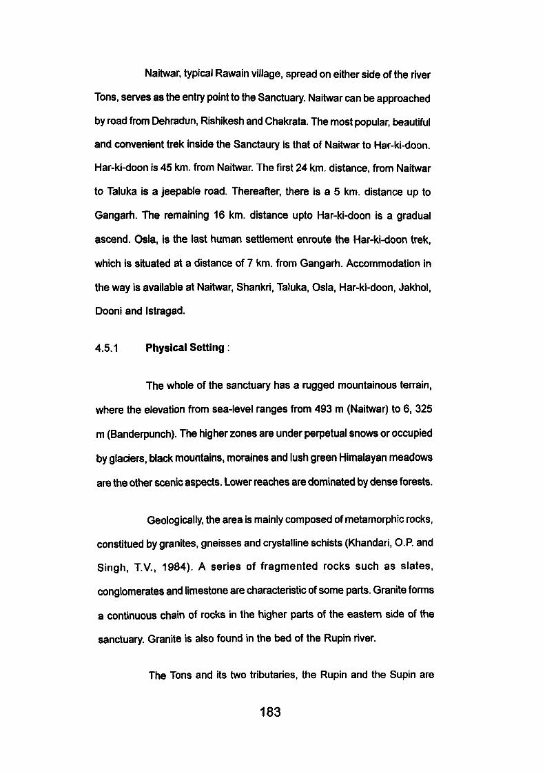
Naitwar, typical Rawain village, spread on either side of the river
Tons, serves as the entry point to the Sanctuary. Naitwar can be approached
by road from Dehradun, Rishil<esh and Chakrata. The most popular, beautiful
and convenient trek inside the Sanctaury is that of Naitwar to Har-ki-doon.
Har-ki-doon is 45 km. from Naitwar. The first 24 km. distance, from Naitwar
to Taluka is a jeepable road. Thereafter, there is a 5 km. distance up to
Gangarh. The remaining 16 km. distance upto Har-ki-doon is a gradual
ascend. Osia, is the last human settlement enroute the Har-ki-doon trek,
which is situated at a distance of 7 km. from Gangarh. Accommodation in
the way is available at Naitwar, Shankri, Taluka, OsIa, Har-ki-doon, Jakhol,
Dooni and Istragad.
4.5.1 Physical Setting:
The whole of the sanctuary has a rugged mountainous terrain,
where the elevation from sea-level ranges from 493 m (Naitwar) to 6, 325
m (Banderpunch). The higher zones are under perpetual snows or occupied
by glaciers, black mountains, moraines and lush green Himalayan meadows
are the other scenic aspects. Lower reaches are dominated by dense forests.
Geologically, the area is mainly composed of metamorphic rocks,
constitued by granites, gneisses and crystalline schists (Khandari, O.P. and
Singh, T.V., 1984). A series of fragmented rocks such as slates,
conglomerates and limestone are characteristic of some parts. Granite forms
a continuous chain of rocks in the higher parts of the eastern side of the
sanctuary. Granite is also found in the bed of the Rupin river.
The Tons and its two tributaries, the Rupin and the Supin are
183
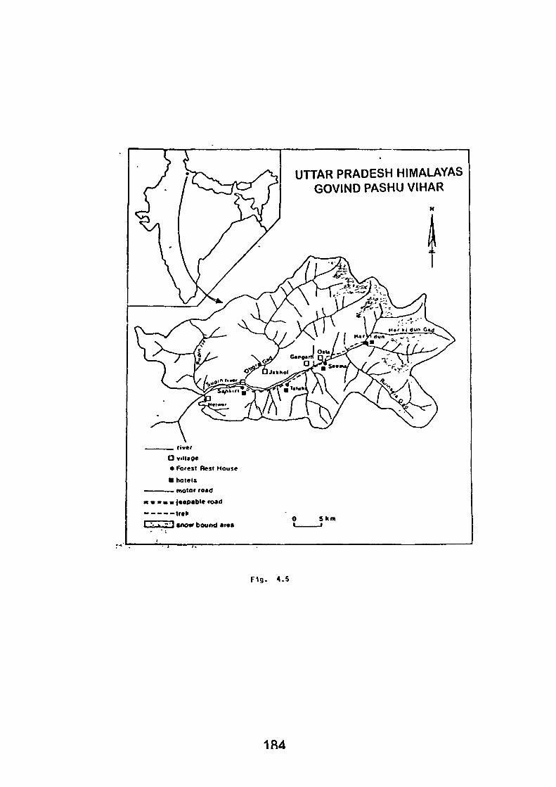
UTTAR PRADESH HIMALAYAS GOVIND PASHU VIHAR
fiver
a village
• Forest Best House
• holels
— motor ro«d
B m jeepabic road
- - t r a f
zD snow boui>d araa S k m
Fig . 4.5
184
the main rivers in the sanctuary. Numerous streams, nullahs, shrotas and
waterfalls add to the beauty of the landscape.
4.5.2 Climatic Conditions:
Because of the abrupt altitudinal gradations, the sanctuary
witnesses varying climatic conditions ranging from sub-tropical in the lower-
valleys to the Arctic conditions in the higher zones.
Broadly speaking, spring comes to the sanctaury from mid-March
to the end of May, characterised by occasional showers, after accompanied
by hail or thunder storms. Summers are wet and wann in the lower heights.
Monsoon generally reaches the lower areas towards the mid of June,
properiy set in July and generally remains up to the second week of August.
Autumn (mid September to mid November) is generally pleasant with clear
skies, though the higher areas begin to witness considerable fall in the
barometer. Frost starts approaching from first week of October. Winter (mid
November to mid Febmary) is severely cold. Snowfall occurs generally above
2,000 M. which may descend to the lower areas but does not stay longer.
Maximum snowfall occurs in January.
4.5.3 The Salient Features
The Sanctuary is specially known for its colourful Himalayan
meadows (Bugyals) dense forests and rich faunal wealth, particulariy the
unique high altitude fauna. Vegetation types change with the altitude and
conditions of the soil, adding to a large biodiversity in the protected area.
The flower spangled meadows of the sanctuary, particulariy, in Har-ki-Doon,
presents a most colourful spectrum when in full bloom, during mid July to
185
mid August. These meadows are mostly undulating with the gentle slopes,
potential recreation resources for skiing and other snow activities.
The visitor is enchanted while passing through the dense and
extensive forests of the sanctuary. Many of the forested tracts still enjoy a
state of primeval glory of the Nature.
The black mountains constitute a special attraction of the
sanctaury. These mountains virtually pose a challenge to a rock climt}er.
There are also some snow peaks, viz.- Kedar Kantha, Swargrohini and
Banderpunch, where mountaineering expeditions can be organised.
The sanctuary is no less rich in cultural endowments. The life
style, dress, dialect folk tradition, settlement pattern, besides religious
expression of the local Rawain people are marked typical of Qarhwal. So
far, there is little, if any, impact of the modernization on the Rawain cultural
ethos and thus the socio economic and cultural environment still remains
undisturbed. The residents have fair complexion with attractive features
but because of the poverty and harships they shed their grace and charm
quite early. The settlements are small and compact. Consisting of the
wooden houses, mostly doubled storeyed, these are nicely blended with
the natural environment. Every settlement has a centrally placed temple,
locally called as Ring Ghar. These temple houses remind of the Pagodas.
Strangely enough, unlike other part of the country, Kauravas are worshipped
here and not the Pandavas, Shiva, Vishnu or Shakti and the other usual
Hindu dieties. The society in these pockets is polyandrous and they retain
many strange old cultural traditions and moses which appear to be an
anachronism in the modern age, the little and internalised tradition of the
Himalaya.
186
4.5.4 The Flora
Chir pien (Pinus roxburghii) is the dominant forest type in the
sanctuary, extending upto 2100 m. However, in the colder areas of the
upper Tons valley, Chir pine is seldom found atiove 1800 m. Besides forming
pure stands, the chir pine also grows in association with Bar Oak (Quercus
leueotric Cophora), Rhododendrons (Rhododendron arboreum) and Kaphal
(Myrica esculanta). Sub-tropical scrub type of vegetation is generally found
on the dry exposed aspects in the lower chir pine forests. It is, however,
absent in the northern aspects above 1,500 m. Dense Ban Oak (Quercus
Leucotricophora) forests are found t>etween 1,500 to 2,100 m. generally
substituting the pine forests on their upper limits. Moru Oak (quercus
himalayans) is nomrially associated with leucotricophora in the lower reaches
and with Q. Semecarpifolia in the higher reaches. The other common
associated are, Betula AInoides, Aesculus indica, comus macrophylla, Acer
Acuminatum, A. caesium and AInus mepalensis. These types of forests
are generally stretched, between 2,100 m to 2,800 m. Moist Deodar Forest
{Cedra deodara) forest is generally present between 2,000 m to 2,800 m.
though it may ascend to about 3,000 m on the dry exposed aspects. Pure
stands of deodar are, however, not common in the sanctuary.
The common trees of Western mixed coniferous forests are
Picea morinda, Abies pindrow, pinus excelsa, Q. leucothicophoram, R.
alboreun, Pynjs pashia and the like. In moist sites, Aesculus indica and
Carpinus viminae, besides Acer acuminatum are also found. Moist
Temperate Deciduous forests are found between 2,100 to 2,750 m in the
cold moist areas. The dominant trees in these forests are Jugalans region,
187
Carpinus vinunae, Acer pictum, Betula ainoides, Aesculus indica, Celtis
austrelis, Cornus macrophylla, Corylus colourna, Euonymus lingers, E.
hamiltonjaus, Viburnum coinifolium, Pyrus Vestita and the lil<e.
Kharsu Oak (Q. Semecarpifolla) is dominant tree above tlie
deodar forests on the southern slopes as also in some exposed sites, and
above. Fir forests on the cooler aspects. Beginning from about 2,500 m
these forests extend up to the timber line. In these forests the dominant
Kharsu Oak is found with Q. himalayana, Sorbus llanata, R. arboreum and
Euonymus tingens. Moist Himalayan Oak fir forest are generally restricted
to the protected side on the northern aspect, usually replacing the mixed
coniferous forests. Picea morinda, Q. semecarpiforia, Acer pictun and Betula
utiles. Besides the above major vegetation types, pure stands of blue pine,
alder, silver birch, silver birch- rhododendron association and rhododendron-
juniperus associations are also prominent in the sanctuary.
Between the timberline and the permanent snowfall line, there
is a vast stretch of the Himalayan meadow lands in the sanctaury, which
generally spread over from 2,700 m to 3,500 m. These meadows are
fioristically rich in high altitude. Har-ki-doon is the astonishing of all the
meadows of the sanctuary. Though a lesser known name, Hari-ki-doon can
match with the popular Valley of Flowers in regards to the variety and
richness of the flowers, while in size it is many times more to the valley. It is
surmised that the region would certainly add to the list of species, so far
known in Garhwal. Though, little or no information exists on the taxomony
of these meadows. Aconitum, Allium, Anaphalis, Aster, Corydalis,
Cyananthus, Dactylis Gentiana, Gentianella, Iris, Leontopodium, Morina,
188
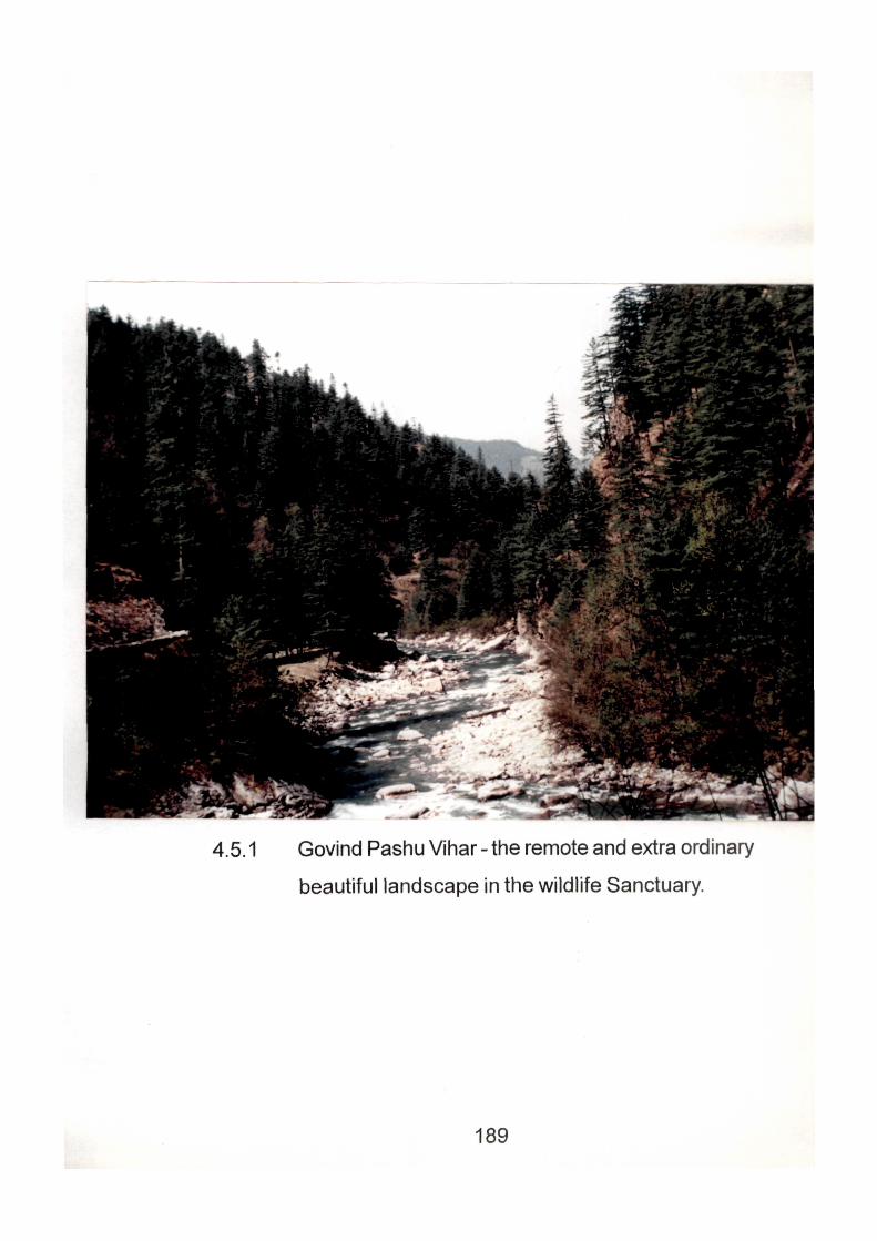
4.5.1 Govind Pashu Vihar - the remote and extra ordinary
beautiful landscape in the wildlife Sanctuary.
189
Oxyria, Pedicularis, Pleurospermum, Saxirage, Sedum, Primula, Fritillaria,
Geranum, Polygonum and the like can be easily identified.
4.5.5 The Fauna:
Faunistically also, the Govind Pashu Vlhar is considered
remarkable. While there is no check list of the wild animals, but on the
basis of reports prepared by the wild life and forest officers, the experiences
of the local people and the field observations of the project team, it can be
established that the sanctuary harbours almost all the major groups of the
high altitude mammals and the birds known to reside in other parts of the
Garhwal Himalayas.
Among the mammals, the feline are represented by leopard
(Panthera pardus), Snow leopard (Panthera Unica), Jungle cat (Felis Chaus
Affinis), Leopard Cat (Pelis begnalensia) and the Fishing Cat (F. Vivemna).
The Snow Leopard and fishing, are both rare. Among the beaks (Family
Ursidae) the area harbours the two high altitude species, viz.- Himalayan
black bear (Selenarctos thibetanus) and the brown bear (Ursus arctos
isabellinus). Family canidae is represented by Jackal (Canis aureus), Red
fox (Vulpes Vulpes montanus) and the Indian Fox (Vulpes bengalensis).
The presence of the Indian wild dog (Cuon alpinus), however, is doubtful.
Among the smaller carnivores, presence of common other (Lutra lutra
monticola) Yellow throated martin (Martes flavigule flavigula), Himalayan
Weasel (Mustela Sibrica), Small Indian Civet (Viverricula India Welisi),
Common Palm Civet (Paradoxurus hermaphroditus bonder) and Himalayan
Palm civet (Puguma lanA/ata grayi) has been confirmed from the sanctuary.
190
The various rodents, viz species of squirrels, marmots, gerbiles,
rats and mice are as common in this part as elsewhere, but were difficult to
identify except for the Indian porcupine (Hystriindica). The Indian hare (Lepus
midriocollis) and mouse hare (Ochtona roylei) represents the Logomorphs
in the area; the latter largely confined to the Himalayan meadows. Order
Artiodactyla, a varied assemblage of the game animal is represented by
the bovine like, Bharal or the blue sheep (Pseudois nayaur), Himalayan
Tahr (Hemitragus Jemlahicus) Goral (Nemorhaedus goral), serow
(Capricomis sumatraensis) and the cervines like, sambher (cen/us uniclor)
barking deer (Muntiacus Muntjak) and musk deer (Moschus moschiferus).
The Indian wild boar (Sus serofa cristatus) is a widely distributed animal in
the sanctuary. The most common mammals in the area, however, are the
two primates, i.e. the langur (Presbytis entellus) and the riiesus macaque
(Mucaca mulatta Villosa).
The sanctuary is very rich in avifauna, representing some of the
rare and unique high altitude birds. Among them phasianidae, which includes
some of the fascinating, birds of the family, observed in the area are- Koklas
pheasant (Pucrasia Macrolopha), Monal pheasant (Lophophorus
impeianus), Kalij pheasant (Lophura leucomelana) cheer pheasant (catreus
wellichii). Hill partridge (Arborophila) Chukor partridge (Alectoris graeca
chukor). The presence of Himalayan snow cock (Tetraogallus himalayensis),
snow partridge (Francilinus francolinus asiae), grey partridge (F.
pondicerianus) common quail (Perdicula asiatica) and Jungle bush quail
(Coutrnix coutrnix) could not be confirmed.
Among other birds noticed in the area were -wedge tailed green
pigeon (Treron sphenura), blue rock pigeon (Columba livia), Specled wood
191
pigeon (C. hodgsonii, C. palmbus), spotted dove (Streptopelia chinensia
suratensis), Rugous turtte dove (S. Orientalis meena), Indian ring dove (S.
Decaocto decaocto), Emrald dove (Clialeophaps indica), Slaty headed
parakeet (psittacula himalayana), Pied crested Cuckoo (Clamator jacobinus),
large lawk cuckoo (Cucutus sparverioides), Indian cuckoo (C. micropterus),
Koel cuckoo (Eudynamys scolspacea), hoopee (Hpupa epops), large piea
King-fisher (Ceryle lugubris), white breasted kingfisher (Halcyon
smymensis), blue beared bea eater (Myctyomis athertoni), Blue throated
barbet (Megalalma asiatica), large golden backed woodpecker
(Chrysocolaptes lucidus), Large sealy belled woodpeeker (Picus
squamatus), Grey crowned pigmy wood-peeker (Dendrocopes canicapillus),
ruyous bellied sapsucker (Hypopicus hyperythrus), Alpine swift (Apus
melba), rufous backed shrike (Lanius schach) Golden Oriole (Oriolus orilus)
Hair crested drongo (Dicrurus hottemtattus), Black drongo (D. adsimilis),
common myna (Acridotheres tristis), Red billed blue magpie (Cissa
erythrorhyncha), yellow billed blue magpie (C. flavirostris), Indian tree pie
(Dendrocita Vagabunda), Red billed chough (Pyrrhocorax pyrrhocorax),
Jungle crow (Corvus splendens), Dark cuckoo shrike (Coracina
melaschistos) Long tailed minivet (Pericrocotus ethologus), White cheeked
bulbul (Pycnonotus leucogenys, Red Vented bulbul (P. Cajer), Streaked
lauyling thrush (Gan'ulax lineatus), streated laughing thrush (G. striatus),
Red billed leiotrix (Leiothrix lutca), Red winged shrik babbler (Pteruthius
flaviscapis), White throated tit babbler (Alcipple vinipectus), Blue throated
flycatehe (Muscicapa rubeculsides) Paradise flycatcher (Terpsiphone
paradise) Grey headed wasbler (Seicereus Xenthoschitos), Himalayan ruby
throat (Erithacus pectoralis), Golden bush robin (Erithacus Chrysacus) little
192
forktail (Enicurus scouleri), spotted forktail (E. maculatus), Chestnut billed
rock thmsh (Monticola rufiventrls), Bled ground thrus (Zoothera wardii),
Whistling thrush (Myiophoneus caeruleus), Grey headed thrush (Turdus
rubroanus). Grey tit (Parus major) Yellow cheeked tit (P. Xanthogenys),
Red Headed tit (Aegithalos concinnus), white tailed nuthatch (Sitta
himalayansis) Fire breasted flowerpeeker (Dicaeum ignipectus), Red browed
fineh (Callacanthls burtoni), White browed rose fineh (Carpodacusthura)
and striped throated yuhina (Yuhina gularis). From among the birds of prey
identified there were (Singh, TV., 1986) upland buteo (Buteo Hemilasius),
Eastern teppe eagle (Aquila nipalensis), Himalayan golden eagle (A.
chrysaetos hodgsonii), Black eagle (Ictinaetus nalayaensis perniger),
Lammergeler (Gypaetus barbatus aureus). Henharrier (Circus cyanneus
cyanneus), Central asian hobby (Faico Subbuteo centralasial) and Curasian
kestrel (F. tinnunculus).
4.5.6 State of Natural Environment:
In most part of the sanctuary the nature, has to retain its primeval
grandeur on account of the inaccessbility and remoteness of the habitat,
but the natural environment in some areas is threatened with undesirable
human activities, such as over grazing, poaching, forest fires, herb gathering,
shifting cultivation, green felling and road building.
Despite these set backs the sanctuary is still considerably rich
in wildlife. During the field study (Singh, T.V., 1986) conducted by the UGC
pilot project team of Garhwal University, villagers of Naitwar, Shankri, Taluka,
Dhatmir, Gangarh, Osia, Lewari, Phitari and Jakhol all expressed their
serious concern over the losses alone to their crops and to the domestic
193
live stock by the wild animals- a fact in evidence that wildlife of this area is
in abundance- a fact in evidence that wildlife of this area is in abudance.
Only musk deer. Bharal, Tahr, Serow, Snow leopard and the fishing cat
were reported to be rare. In case of birds, it is difficult to evaluate their
status since it needs indepth studies. However, the longer gave birds, viz
pastridges, pheasants and quails (family phasianidae) are decreasing in
population.
Unfortunately, some adverse trends had been set in the area
which affected the fauna for the worst viz- poaching, habitat shrinkage and
increased competition with the domestic livestock. Bulk of the wild animals
were killed for protection against crops and livestock, while others were
poached for domestic use and for cladestine trade which had of late proved
very lucrative. More game killing happens during winters when the animals
migrate to lower reaches, encountering villagers near their settlements.
Some organized groups of the poaschers from the adjoining area of
Himachal Pradesh, and of other parts of Garhwal are also active in the
Sanctuary.
4.5.7 Grazing
Over of grazing has always been a major threat to sanctuary's
ecology. The local people/traditional right holders let loose their cattle within
the 8 km. diameter of their village boundaries as well as in other areas
where they had been grazing traditionally. Besides, during summers the
Kunoras from Himachal Pradesh, the Gujjars from Teral and foothills and
the shepherds of Pural range are also permitted for grazing there at
concessional rates. It was reported by the Deputy Conservator of forests,
194
in charge of the Govind Pashu Vihar, that there was two much pressure of
local residents on the natural environment of the Park.
4.5.8 Forest Fire:
The villagers and the herdsmen some times set fire to improve
the grass-cover. Natural fires are also not uncommon. Natural fires severely
affect the flora and fauna. The cA?/r pine forests in the sanctuary have largely
suffered. Deodar forests, specially on the southern aspects had also been
badly damaged.
4.5.9 Extraction of the Forest Products :
With the greater demand and higher prices commanded by the
plants of medicinal values, the herb gathering activity has already become
remunerative occupation to many village families, particularly in the villages
closer to meadow zone. The grazers also indulge in herb, gathering. The
outside contractors purchase the huge dump of the herbs at a very
substantial rate. This unchecked and selected eradication of the plants
may result in the total extermination of these plants from the area, besides
affecting the delicate ecosystem. Green felling, had been barred in hills but
sanctuary faces the menace. Further more, the local population are engaged
in collection of the minor forest products, viz.-extraction of resins, collection
of ringal, torchwood, fire-wood, and the wood for domestic and agricultural
implements. Shifting cultivation, again a detriment tot he natural eco
systems, is frequently practised inside the sanctuary. All these activities
have their disastrous impacts on the natural environment of the area, unless
the local people are not provided some viable alternatives, these activities
can hardly be stopped.
195
GovJnd Pashu Vihar, since 1988 is being managed by the wildlife
division independently (Hummet, John, 1996). Before this the Wildlife
division was part of the Forest Department, the Wildlife division has not
developed any formal management plan, work- scheme or any other
management instrument for the park area. The division uses a certain
concept of conservation. Policy- makers from the division hope that with an
active preservation strategy the snow leopard will reappear in the Govind
Pashu Vihar. They think it is in their interest to declare the uncultivated
parts of the sanctuary as National Park. This national park could become a
part of 'Project Snow leopard', an international sponsored conservation
project to protect the habitat of the snow leopard.
A consequence of this project, according the park authorities,
will be the denial of public access of higher altitudinal parts of the wildlife
sanctuary local residents, like the Rawains and Guj/ars will have a shortage
of grazing-lands for their herds, the number of possible tourist- treks in the
area will be curtailed. The park authorities state that this preservation strategy
is an efficient strategy for the protection of the natural environment of the
area (Hummel, John, 1991)
By seeing these problems, there seems to be an insufficient
'balance' between the nature conservation strategy of the wildlife division
in the park and local socio-economic participation in conservation. Also a
'balance' between tourism development and local socio-economic
participation seems absent. A comprehensive management plan for the
sanctuary should be chalked out, so as to save the natural environment
from further decay. If the department of Tourism wants to develop a
sustainable tourism development, they have to communicate and co-
196
ordinate tourism development of the park with the wild life division. In
cooperation with the wildlife division, the department of tourism might explain
the possibilities of wars for local residents to open tourist facilities. The
department of tourism claims to think about 'appropriate tourism'. The
Director General (Hummel, Jonh, 1996) of the Hill Division of the Tourism
Department even explained that he would accept that National Parks would
be closed for tourists because of environmental reasons. He did not want a
development of tourism in Garhwal which would damage the natural
environment. Yet, the department of tourism is constructing the hotels in
the park. Efforts are being made to protect, preserve and increase the flora
and fauna of the area, tourism is not a principal aim, but is only secondary.
Thus the sanctuary is still awaiting for an effective tourism development
plan which could integrate tourism with the sensitive environment.
4.6 THE VALLEY OF FLOWERS : Himalayas Floral Excellence:
Of the four National Parks in Garhwal, the Valley of Flowers is
the smallest though no less fascinating than the other three. The Corbett,
National Park, The Nanda Devi National park and the Moti Choor National
Park. The last one is the youngest, designated in 1985. The Corbett National
Park and Motichoor National Park sprawl over the foothils, while the other
two spread into the Greater Himalayan region.
4.6.1. Floral Excellence :
Floral uniqueness and ecological excellence characterise the
Park's distinction from other nature preserves of this region. It is nature's
rock garden where myriad of flowering plants bursth forth in a riot of colours
197
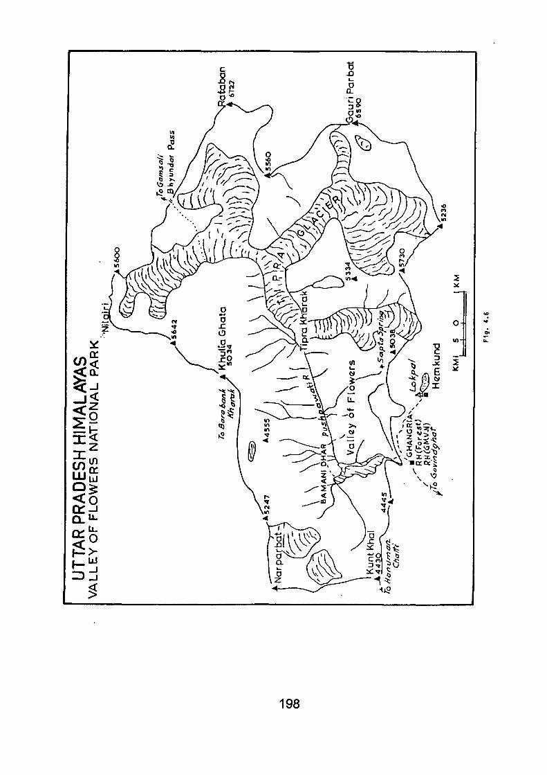
198
every midsummer between June and August. It is a virtual paradise on the
earth. Other Himalayan meadows and pasture lands (Buggyals) in Chamoli,
Uttarkashi abound in flowerful pastures, such as Auli, Gorson, Bedni
(Chamoli) Panwali (Tehri) and Kar-ki-Doon (Uttarkashi) but the valley
surpasses all of them in its most restrictive and intense distribution of plant
growth and mosaic of colour. It represents the Himalayan majesty, serenity,
solitude and divine wilderness, which Hindu sages and saints sought for
their spiritual pursuits (Singh, TV. and Kaur, J., 1980).
The Valley was known to the Hindus from the Vedic times. Frank
Smythe (1931) made it known to the world; to the tourist, the mountaineer
and the mundane. It was beyond the reach of ordinary mortals as it lay in
remoter inaccessible region, on the upper reaches of the Alaknanda,
tributary, Bhyundar. The Valley was known to Hindu sages and saints who
found an Ideal environment for solitude and meditation. It is also assciated
with Pandava- legend. To local people, it is a fairy land. In Hindu mythology,
it is named Nandan Kanan. Smythe's contribution to plant geography is
praise worthy as he was ably assisted by famous British botanist and
mountaineer- Holdsworth in bringing to light 250 representatives of garden
genera, and over 2000 varieties were exposed. Earlier to them, Strachey
and Winterbottom who made extensive floristic survey of Kumaun, Garhwal
and adjacent Tibet (1846-1849) could not identify the hidden botanical
miracle of the Bhyundar Valley. After Symthe, Margaret Legge continued
her taxonomic research, but as ill luck would have it, she succumbed to the
beauty of the valley in 1939. Sporadic research In the valley phenomenon
was carried out by a few botanists (Ghildyal, Duthie, Kapoor and others)
but the secrets of the Valley's ecosystem still eluded the grasp of the
199
mountain botanists. Not mucli information is added, after that, neither in
plant taxonomy nor in inventory, except some bio-centric cries of Valley's
decadence and extinction of many plants species affected by un-natural
use of a most natural piece of biosphene. Visitor's trampling of vegetation,
grazing of animals, building or artifacts viz broad pathway, building helipads
into the Valley core were some of the negative pronounced, causing damage
to the sensitive and fragile mountain environment.
4.6.2 Access to Beauty:
The secret of the valley ecosystem ought to be thoroughly studied
before providing access to beauty- a beauty as fragile as a flower that too
in Nautre's care where each species is suited to its particular environmental
niche and each through its life process affects the physical and chemical
properties of its immediate environment. These links are bewildering in their
intricate details. These details should be worked out with care and expertise
by a multidisciplinary team of plant ecologists, biogeographers and soil
analyst before the 'pure nature' be exposed to human visitation. Visitors
find their access possible mthless trampling of the tender plants besides a
few campers who have started littering the place with non-biodegradeable
material. Some of these trends have been held in check, of late but the
park does not have adequate manpower and trained guards to curb down
such activities. There is an urgent need to plan the Valley's environmental
resource scientifically and to open the valley on accepted principles of park
visitations and on the basis of carrying capacity.
When Symthe negotiated Garhwal Himalaya (1931) difficult
geographic terrain made the access formidable. Only an occassional
200
UTTAR PRADESH HIMALAYAS TREK TOTHE VALLEY OF FLOWERS
Fig . 4.7
201
mountain road system, with its ever increasing networl< to various Hindu-
Sikh shrines has made its easier to enjoy the valley vista. Visitors to the
valley increased after 1968 when Joshimath Badrinath Road was
constructed.
4.6.3 The Valley:
The Valley lies between 30°42' W and 30°48' E and 79°33' E
and 79''42' E encompassing an area of 87.5 Sq.Km. and occupies the
upper catchment of the Bhyundar Ganga, an eastern tributary of the river
Alaknanda. The entire park area falls under Badrinath Forest Division of
Chamoli district. The Park boundary is generally demarcated through high
ridges with an average height of about 500 m. Elevation inside the park
ranges from 3,050 m to 6,590 m the highest point being the top of Nar
Parvat (Kandari, O.P., 1985). Most of the Park area is generally above
3,500 m. The topography is rugged, intermpted by deep gorges and glaciers.
Lush green alpine slope decorates the scene. The Pushpavati, tributary of
the Bhyundar, flows across the park. It emerges from the huge Tipra glacier
and joins the Lakshman Ganga (Bhyundar's local name) at Ghangaria, the
last human settlement in this area.
The undulating valley is about 8 km. long and 2 km. wide. Major
part of the park lies to the right bank of the Pushpavati river. Beginning at
an elevation of 3,500 m the Valley slopes rise upto an elevation of 3,900 m,
with runnels and glaciers- fed streamlets with white water, inten-upted the
green meadow and the colourful environment, joining the Pushpavati.
The Valley of Flowers can be approached from Govindghat
202
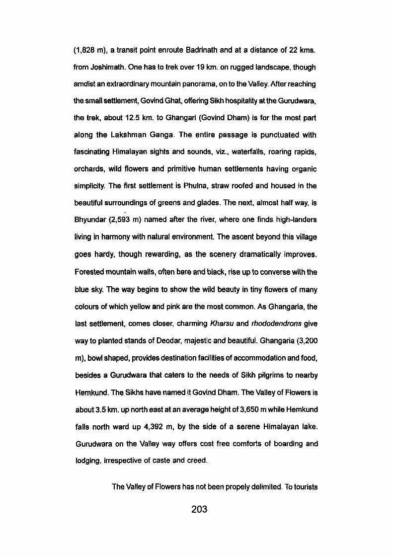
(1,828 m), a transit point enroute Badrinatli and at a distance of 22 kms.
from Joshimath. One has to trel< over 19 l<m. on rugged landscape, ttiougli
amdist an extraordinary mountain panorama, on to the Valley. After reaching
the small settlement, Govind Ghat, offering Sikh hospitality at the Gurudwara,
the trek, about 12.5 km. to Ghangari (Govind Dham) is for the most part
along the Lakshman Ganga. The entire passage is punctuated with
fascinating Himalayan sights and sounds, viz., waterfalls, roaring rapids,
orchards, wild flowers and primitive human settlements having organic
simplicity. The first settlement is Phulna, straw roofed and housed in the
beautiful surroundings of greens and glades. The next, almost half way, is
Bhyundar (2,593 m) named after the river, where one finds high-landers
living in harmony with natural environment. The ascent beyond this village
goes hardy, though rewarding, as the scenery dramatically improves.
Forested mountain walls, often bare and black, rise up to converse with the
blue sky. The way begins to show the wild beauty in tiny flowers of many
colours of which yellow and pink are the most common. As Ghangaria, the
last settlement, comes closer, charming Kharsu and rhododendrons give
way to planted stands of Deodar, majestic and beautiful. Ghangaria (3,200
m), bowl shaped, provides destination facilities of accommodation and food,
besides a Gurudwara that caters to the needs of Sikh pilgrims to nearby
Hemkund. The Sikhs have named it Govind Dham. The Valley of Flowers is
about 3.5 km. up north east at an average height of 3,650 m while Hemkund
falls north ward up 4,392 m, by the side of a serene Himalayan lake.
Gurudwara on the Valley way offers cost free comforts of boarding and
lodging, irrespective of caste and creed.
The Valley of Flowers has not been propely delimited. To tourists
203

4.6.1 The Valley of Flowers has incomparable 2,500
garden genera.
204
it is an area which comes to their view as they finish up the last cluster of
silver birch trees; to botanists its a vast stretch that commences from Bhamini
Dhar, closing at the base of Ratbanpeak. To a geographer it should constitute
the segment of the biosphere that falls into the catchment area of the
Bhyundar Ganga, and should include the entire land mass leading to
Hemkund, the Pushpavati Valley and the Valley of Pushpavati's tributary:
Lately, (1981) it has been declared as one of the Himalayan National Parks.
However, the prescribed limits for preservation of this region are yet to be
defined.
The floral aspects of the Valley becomes perceptible as one
leave Ghangaria. The 3.5 km. trek from Ghangaria to the actual Valley is
most idyllic and inspiring. It is a passage into elysian beauty having
enchanting groves of birch, resounding with whistling linets and twitter of
birds. It gives one the moments of solitude broken only by the roar of the
Pushpavati rapids. One stops at the small wooden bridge over the
Pushpavati to look at the mighty Himalayan truncated walls, and beyond
lies the fantasy of the flowers. After a strenuous, though sensuous, climbs
of a kilometre, the timber line closes with anray of silver birches that herald
the green expanse of the Valley. The beauty of the Valley lies exposed
before the visitor and he has yet to explore the mystery of this 'Eden of
Flowers'.
4.6.4 The Spectrum of Flowers:
"Dentiaseta", Valley's most charming plant, opens up its eyes in
mid-May, peeping from ledges and aannies. With its androsace, dwarfish
rhododendrons, irises, pansies, potentilla, fritilleries and many other annuals
205
burst forth miraculously carpeting the Valley floor. By June and July the
flora becomes more and more luscious untill one is wading knee-deep
through an ocean of flowers, ranging in colour from the sky-blue of the
poppies to redwine potentillas (Smythe, 1947). While green is the
predominent shade, the July mood of the valley would be so different from
June; and September has all its autumnal glory. October is a Swan song
when snow begins to cover the entire landscape and the tender floral beauty
fades out for a long slumber of days (Singh, TV., and J. Kaur, 1980).
Floral aspect of the valley can be studied in two parts (Kaur, J.
1985) I.e. along the undulating floor and along the slopes and elevations.
The floor aspect is densely rich, often muddy and rock strewn, having
flowering plants quite different from the high slopes. The first half of the
floor ranges from 3,525 m to 3,962 m which is frequented by the visitors,
the second half Is a sparse and rock filled, ending up at the base of Bhyundar
Kanta Pass (5,450 m) where to only the sturdy trekker can move. The south
facing Valley-slopes dressup with flowers of exquisite beauty and colour.
Running streamlets fomned of melt-snow are the most enchanting sight as
most plants love to grow close to them. On the higher slopes rare plants
like Himalayan Poppy (Meconopsis) and Brahma Kamal (Sausserea
Obvallata) can be seen. This could be the scene of Valley's early flowering
of Primula and the anemones which gradually descend to the floor with the
coming of rains. The north facing aspect could be reached after crossing
the snow-bridged Pushpavati. Only adventurists brave such a challenge of
the mountains. Since it is a protected area, it is a safer and secure habitat
of many wild-animals such as Black Bear, Musk Deer and Bharal, though
rarely to be seen.
206
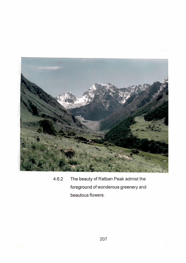
4.6.2 The beauty of Ratban Peak admist the
foreground of wonderous greenery and
beautous flowers.
207
Some of the most conspicuous flowers to be seen during the
rainy season (July- August) are; purple impomea (Ipomoea purpurea),
Stuart's primrose (Primula Stuarti), Musk thistle (Carduus nutans), Himalayan
poppies, blue and yellow (Meconopsis aculeata and robusta), Himalayan
lily (Lilium oxypetalum). Knot weed (Polygonum affine), Wallich's Poppy
(Meconopsis Wallichii), Himalayan rose (Rosa Maerophylla), Jacob's Ladder
(Potemonium Caeruleum), Symthe provides a delightful pen-portrait of
primula studded valley (Smythe, F.S., 1932). 'In all my mountain wanderings,
I had not, seen a more beautiful flower than the primula, the fine raindrops
clung to its petals like glaxies of seed pearis and frosted its leaves with
silver sometimes as many as thirty to the beautifully proportioned umbel
and in colour of the most heavily French blue, sweetly scented.'
The trek of Hemkund (Sikh resort) is no less rewarding. Though
the scene is a little different from the Valley but one enjoys hosts of blue
Himalayan poppies growing behind the grey boulders and rocks. The Brahm
Kama!, with all their heavenly fragrance, abound around the high altitude
lake. Here are more flowers of different varieties that love their undisturbed
place on sequestered elevation. Yellow and orange potenillas can be easily
mari ed. The Sikh resort at the lake is a challenging trek. One has to negotiate
one's arduous way from (3200 m) Ghangaria to Hemkund (4329 m) only in
4 km. space, the last leg of the traverse is exhausting, though flowers with
their heavenly hues beguile the trekkers fatigue. Sikh pilgrims do it, so the
tourists. Poor Brahm Kamal is every body's prey as they pluck it handful to
carry them home as a religious trophy. Wordworth's poetic concept of
ecology is well realised in the Valley when one muses with Wordsworth; 'To
her fair work did Nature link, the human soul that in me ran'.
208
Most of the flowering plants found in the Valley are annuals and
medicinal herbs, having high commercial value viz. Aconitumbelfourii (Mithe-
bish), A. heterophyelum (Atis), Viola Canescene (Banafsa), Geranium
Waliichisnum (Ratanjot), Potentilla fulgens (Bajradanti), Bergenia Straclievi
(Paktian bedh), Selinum Vaginatum (Bfioot Kestii), Nardostactiyajatamansi
(Jatamansi), Tanacetum longifloum (Guggal), Gynoglossum Wallichii
(Licfiura), Picrorhiza Kurrooa (Kami or Katul<i), Palntago bractiypliyua
(Isabgul), Polygonum macrophyllum (Kukhri), P. rumcifolium (Kanthia),
Orchis latifolia (Hathajorhi) and Allium strachevi (Pharan). Saussurea
obvallata (Brahm Kamal) is an aromatic herb, largely used in religious
ceremonies which normally gorws above 4,000 m. All these herbs were
known to ancients. The myth of Sanjeevani booti (life giving herb) associated
with Shri Lakshmana of epic time was brought by the monkey God Hanuman
from this region. Near Hemkund Gurudwara is located 'Lokpal' in the memory
of Rama's brother. Before the establishment of the Park (1982) some
commercial agencies extracted herb from this area.
4.6.5 The Way to the Valley :
Few treks to Himalayan beauty would be an enchanting as the
way to the Valley, which deserves special mention. As one ascends from
Govindghat, after crossing the bridge over the Alaknanda, one is touched
to the quick by the breath-taking natural sights, and sounds, unearthly etheral
cliffs, soul dissolving odour, captivating waterfall and nature's naked
loveliness, all around. At Govindghat the Bhyundar pours down the hues of
heaven into the Alaknanda, spraying the entire surroundings. Onwards the
trek to the valley is mostly along the roaring and foaming Bhyundar Ganga.
209
The scenery around, attracts attention and one has to be very careful as
the way is trecherous lest, one should have a slip which can be terminal.
The gradient of the Bhyundar is very steep, the floor of the water is naturally
fast and the fog generated by churned water dashing against the massive
boulders is wafted far and wide. Its cool touch is romantically soothing and
softens fatigue. The vegetational pattern that one comes across is most
engaging, beautiful forests of Maple (Acercasium), Walnust (Juglans regia),
Mulbery (Morus alba). Popular elm (Populus ciliata). Ban Oak (Quercus
incana), Wild Cherry (Litsea umbrasa), Alder (AInus nepelensis). Horse
chest nut (Aesculus indica). Rhododendron (Rhododendron campanuiatum),
Tun (Cedrela tuna), and Silver birch (Betula utilis). The vegetation changes
gradually till Ghangaria is reached where attractive, tall and elderly trees of
Himalayan fir (Abies pindrow) welcome the visitors. Villages like Pulna on
the first leg of the traverse and Bhyundar at the second present cultural
attraction in this Himalayan wilderness. From Bhyundar village a trail leads
to a huge lake known as 'Kag Bhusundi'. The trail is most challenging though
full of natural beauty.
4.6.6 Destination Facilities:
The Sikhs are responsible for opening this area, more than
tourism promoters. They offer cost-free hospitality to all, irrespective of caste
and creed, both at Govind Ghat and Ghangaria, There is a tourist rest
house, forest rest house, with two suites at 'Govind Ghat' and a P.W.D.
inspection bungalow at nearby Pandukeshwar, They have lodging facilities
only on pre-reservation.
At Ghangaria there are two suites in the forest rest house with a
210
bed capacity of 24 in Tourist Rest House/ Hotels. The Tourist Rest House
runby Garhwal Mandal Vil<as Nigam (GMVN) during tlie year 1996 charges
Rupees 500 for Deluxe, 350 for Executive and 100 for Dormitory. Tariff for
single occupancy is 75% of the double bed room and extra bed will be
charged at the rates of rupees 40/- per bed. During the visitor's peak tents
are pitched but the camping facility is also limited. The Gurudwara at
Ghangaria offers sleeping space for the pilgrims. No beds are provided.
Recently, local people have come up with modest sleeping space to meet
the peak demand. The doors of Gurudwara are open to ail, but one has to
sleep on floor with other fellow travellers/ pilgrims. Privacy would be a luxury
in a place where roofed space is a most desired comfort. The Garhwal
Mandal Vikas Nigam (CMVN) has also set up a Canteen for breakfast and
meals. Tourist Rest House has restaurant facility. As the valley has been
advertised on a big scale during the previous years, visitors to the Valley
Hemkund have increased. The Valley destination demands more
comfortable lodges of standard than that the Garhwal Mandal Vikas Nigam
has offered.
Leaving Dehradun and Mussoorie in the lower and middle
Himalayas' "the Valley" has been the foremost tourist point in while of
Garhwal region. The unkind fact is that the Valley has been oversold. The
gap between the demand and supply causes conflicts. There had been
cases, when the survey team of Institute of Himalayan and Regional
Development, Garhwal University, Srinagar under the Supervision of TV.
Singh, Director, revisited the valley for monitoring (1981), the benighted
211
travellers faced severe discomforts in that far flung and remote environment,
uncared for and unlocked after.
4.6.7 Visitors Aspects:
The Valley attracts visitors from home and overseas. The
Garhwal Mandal Vikas Nigam (Garhwal Development Corporation) in
association with Uttar Pradesh Tourism, Air India and India Tourism has
made quite good efforts to popularise the valley. The Sikh pilgrim influx to
Hemkund, with all their cost free hospitality, is perhaps the major factor of
motivation. It is noticed that most of the visitors hail from Bengal, Maharashtra
who having performed their sacrament at Badrinath want to enjoy the floral
beauty. There are visitors from overseas also. Visitors to the Valley visit
during months of July to August, whereas Sikh devotees visit Hemkund in
September, and Hindu devotees visit Badrinath in May and June, perhaps
to avoid rain disasters and road- blockades. The Garhwal Mandal Vikas
Nigam has introduced conducted tours to the valley in its luxury coaches,
right from Delhi and Rishikesh (Muni-ka-Reti).
The increased tourist activity in Valley of Flowers attracted as
many as 5,283 persons in the year 1990-91, where as 1991-92 and 1992-
93 saw 5510 and 5745 visitors respectively. There were 7191 and 7799
visitors between 1993-94 and 1994-95 respectively. With the avilable data
it is seen that the visitors are on an increase, with the advertisement of the
valley on a big scale.
212
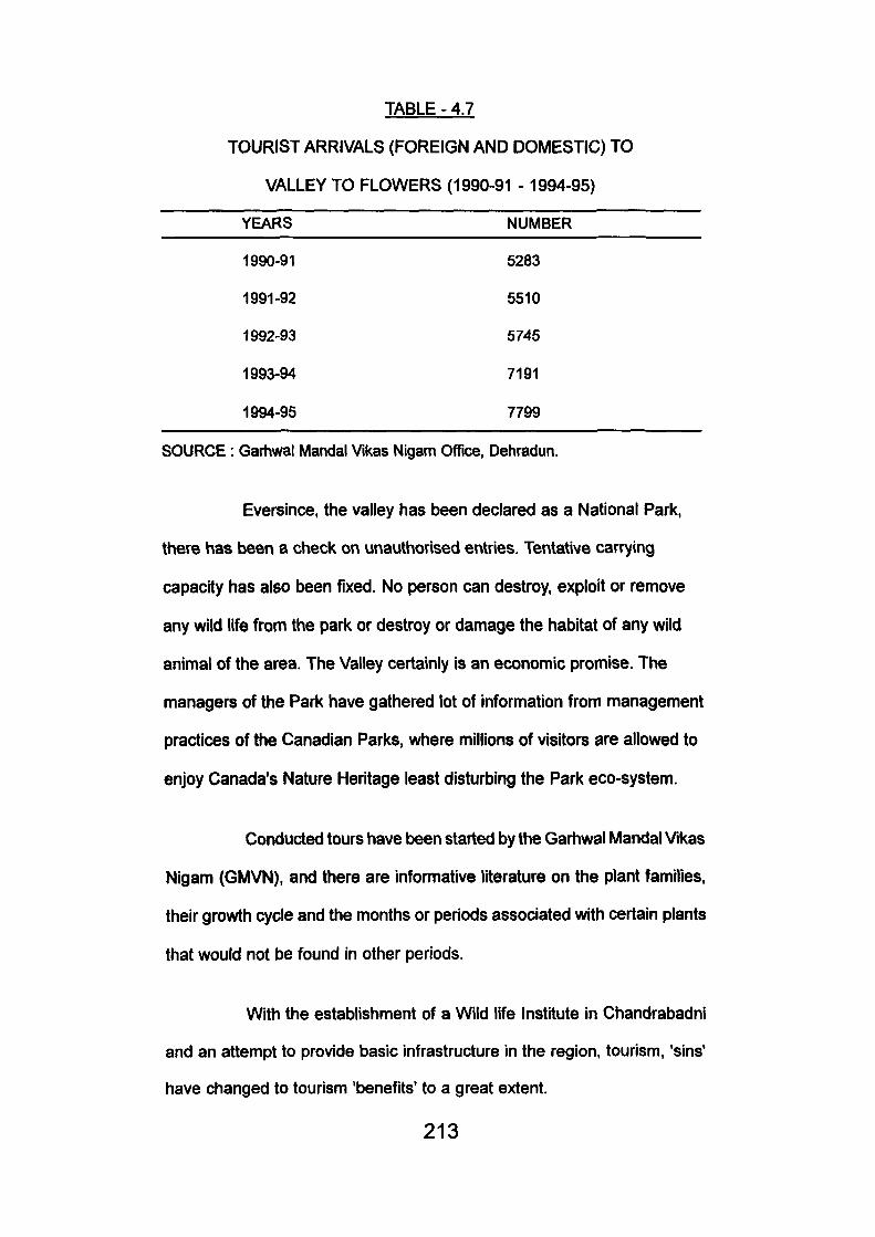
TABLE - 4.7
TOURIST ARRIVALS (FOREIGN AND DOMESTIC) TO
VALLEY TO FLOWERS (1990-91 -1994-95)
YEARS NUMBER
1990-91 5283
1991-92 5510
1992-93 5745
1993-94 7191
1994-95 7799
SOURCE: Garhwal Mandal Vikas Nigam Office, Dehradun.
Eversince, the valley has been declared as a National Park,
there has been a check on unauthorised entries. Tentative carrying
capacity has also been fixed. No person can destroy, exploit or remove
any wild life from the park or destroy or damage the habitat of any wild
animal of the area. The Valley certainly is an economic promise. The
managers of the Park have gathered lot of information from management
practices of the Canadian Parks, where millions of visitors are allowed to
enjoy Canada's Nature Heritage least disturbing the Park eco-system.
Conducted tours have been started by the Garhwal Mandal Vikas
Nigam (GMVN), and there are informative literature on the plant families,
their growth cycle and the months or periods associated with certain plants
that would not be found in other periods.
With the establishment of a Wild life Institute in Chandrabadni
and an attempt to provide basic infrastructure in the region, tourism, 'sins'
have changed to tourism 'benefits' to a great extent.
213
CHAPTER - 5
STRATEGIES FOR ACHIEVme SUSTAINABLE
TOURISM
Tourism as an industry generates a number of economic and
non-economic benefits, but it tias also some adverse repercussions. The
movement of people even for short duration as tourists from one place to
another is responsible for impacting economic, socio-cultural and ecological
set up of any hcailty.
As, the discussions in the foregoing chapters clearly bring us to
the conclusion that Indian tourism has come of age. Tourism has not only
entered metropoliton towns, historical monuments, sea-beaches and
summer resorts but entered into the sensitive Himalayan eco-systems where
environment Is most vunerable. This is true for Uttar Pradesh Himalayas,
where unguarded tourism has over lapped age old Tirthas (Pilgrimages).
This unplanned and unbridled intrusion of tourism has adverse impacts on
the physical environment, regional development and economy of the region.
Thus, it is obvious tourism has many faces; good, bad and ugly, more often
bad than good. Findings reveal that degradation of physical environment,
acculturation and social dissolution, demonstration, commercialization of
traditions, upsetting the regard for religious practices, destmction of flora
and fauna, garbage trails, withdrawal of labour from agriculture, pollution
and promotion of a 'thmwaway mentality' are among the scars that can be
seen. Tourist development takes many forms, and these forms must blend
with the milieu. It is perplexing problem of matching naturally or historically
214
given resources of actual potential, To achieve this balance planners should
know what development potential and development carrying capacity does
the region/ area possess from economic, ecological, political and cultural
point of view. (Singh, TV., 1986). In the absence of these facts mountain
tourism is in dialectical tension between economy and ecology; autonomy
and devleopment (Brugger et. al. 1984). To achieve sustainbility of touristic
development in the Himalayan areas the impacts have to be considered
very seriously. These impacts as already observed can be ecological, socio-
cultural and related to economy. It is very difficult to classify these impacts
in quantitative terms as many of then defy measurements. However, an
effort has been made to categorise some of the impacts in different sectors
of economy, ecology and socio-culture. Let it be observed that adverse or
negative impact of tourism make it unsustainable while benefical tourism
with positive impacts land it sustainability. The recreation resources are
made up of different resilience having varied degree of tolerance. Since
tourism in the Himalaya is made up of natural assests, understanding of
the phenomenon landscape- its diagnosis, analysis and dynamis is very
important. Infact, landscape is capital in Himalayan tourism and of the capital
is in danger, there are meagre chances of its survival (Knpprendrof, 1983),
Landscape, a planning medium in accord with nature, should be thoroughly
studied to achieve a balance between the natural potential and the demand
of the society.
5.1 Impact on Physical Landscape:
The core substance of tourism industry is the people- people's
industry, made up of "guests and hosts". The host must know his guest in
some details, and the guest should also know who would be his host. In the
215
absence of these answers, tourism can be a disaster, both to the 'land' and
'the people'. So whenever tourism impact on physical environment or tourist
ecology is discussed the question of threshold arises. Threshold is effective
saturation level of resource, and negative effects began to operate as soon
as threshold is crossed. It was observed that seasonality is a cruical factor,
in the concept of saturation for no tourist areas have reached saturation
throughout the year and stress mostly occurs for short peak period (WTO:
1983). The climatic resorts set up by the Britishers in the middle Himalaya,
in the case of Nainital and Mussoorie are experiencing mass tourism. The
study of Nainital and Mussoorie show that they have long crossed their
threshold and have shown stress capacity.
Mussoorie and Nainital mn the risk of saturation particulariy
during the summer months, tourist peak influx per day is high and leads to
crowding, congestion and noise are obvious. This becomes more
pronounced when too many humans, tourists and residents, concentrate
in a small area, demanding quality environment, amenities and services.
The floating population of Mussoorie and Nainital ranges between 14.3 to
16.5 lacs approximately hardly maintains the hospitable mood when tourists
make an explosive demand on scare resource supply penetrating pressure
on energy and water supply. The great influx of tourist cause unhygenic
condition, environmental pollution, black marketing, bargaining and
unpalatable behaviour of local suppliers of amenities at the resorts especially
at Nainital, Mussoorie and Badrinath. This has increased to such an extent
that Nainital is losing the attraction for tourists gradually. Mussoorie is
experiencing the problem of congestion thus rendering entire tourism
industry of Nainital and Mussoorie unsustainable.
216
The foremost need is to diffuse recreation activity into tlie other
areas after preparing tourist complex plan. The hill housing pattern of
Mussoorie resort where private houses and public buildings are rising to
three- four more storeys, are weakning earth's defence system. Legislation
and strict law enforcement process appear to be the only remedy but finally
the local people, who bear the brunt of tourism development must also rise
to the occasion. It has know been universably accepted that the interaction
of local people can make tourism industry sustainable. Area surrounding
Badrinath temple, and Kedamath, holy temples, forests and river banks
are seen littered here and there with refuse and plastic bags.
Tourism based on floristic and faunistic resources could not
attract much tourism and the little that it did was self-destructive due to
inadequate poor management practices, by siting visitor accommodation
near the 'corezones' (Corbett National Park) or by lack of prophylatic
approaches in safe guarding the park resources from the visitors.
The other National Parks such as 'the Valley of Flowers' and
'Nanda Devi' 'National Park' are still worse in the proper resource
management system. Due to economic crunch the core areas of the pari<s
have not been properiy guarded. There exists a serve shortage of travel
man power. One of the major factor making Park System sustainable is the
now involvement of local people. There is a dire of linking parks with people.
Unfortunately no serious effort has been made to prepare resource inventory
of the Park assets. The Valley of Flower is a treasure house of medicinal
herbs has not been studied taxonomically. With a result is not possible to
check the damage it has suffered by the Vandalists and outsiders.
2 1 7
The higher Himalayan zones quite vulnerable, trekking, hikking
and mountaineering have been introduced without trek management
principles. The trekkers and the adventurous tourists are not adequately
guarded and they are free to inflict injury on the sensitive parts of the region
during their trip. Not all trekkers and drifters are environment conscious
and in the absence of any energy they are liable to impact the forest cover.
In recent years some attention has been given to the aspect but then it is
not enough to control the impact to make tourism sustainable in the higher
Himalayan zones. It is mandatory to design trek along the least damagable
part of the Himalayas. Bhutan and Nepal present a very good example of
making these mountain achieve sustainability. It is obligatory for all trekkers
and mountaineers to can7 kerosene oil during their expedition. This is the
best form of Ecotrekking which is highly sustainable. Results can be obtained
only when these trekkers themselves are concious of resource sustainability.
In fine, these activities need to be developed on principles of sustainability.
These few minor environmental side effects, the tourism industry
encroachment can be corected by strict public supervision and community's
active support. If Himalayan's environmental appeal is maintained the credit
will go to environmentally conscious planners, resource managers and the
users of these othenivise fragile resources.
5.2 Socio Cultural Impacts
The Himalayan societies have retained their age old traditions
primitive in their outlook they have remained close to Nature Tourism have
not seen the modern progress of mankind. During the survey the author
came across many old aged people in the far reaches of Uttarkashi and
218
Chmaoli who have not seen a train and were unknown to the socio- political
systems of the country. When affluent visitors from the west interact with
them the result is always negative. In some cases there are good examples
of cross cultural experiences Sherpas of Nepal Himalayas present a very
positive example.
Tourism makes changes in the socio-cultural environment of the
destination communities, particularly when the guests and the hosts have
contrasting socio-economic background such as the tourists of the affluent
societies of west and and of domestic tourism. Negative impacts occur due
to variant behaviour of the tourists and residents, namely, demonstration
effects, change in residents, language, dress, life style, tradition and more
resulting In acculturation. However, only some social impacts, pertaining to
the quality of life of the host communicate can be marked in short period.
Cultural impacts are long term changes and are not easy to assess or
measure. Critics also doubt whether tourism alone shoule be held
responsible for many changes occuring at the destination in face of other
vehicles of changes, operating simultaneously. Gauchar is the biggest fair
of Garhwal representing the spirit of the people. This fair has a definite
stamp of westernisaion and modernisation. People's participation can
produce better results.
'Sufferance of local people' was due to crowding and crampling
of space, traffic snarls, noise pollution, high speed driving in the town, price
rise, shortage of water supply and kerosene, more particularly during the
high season. It is seen that tourism is also responsible for westernising the
society in peoples life style and architectural patterns. Hotels in the
2 1 9
Himalayan region have shown change in their architecture and eventually
change in settlement patterns in the region for eg. Mussoorie and Nainital.
Interaction and contact with foreign tourists has helped them In
thought exchange and cultural sharing, but at the same time it has adversly
affected 'our impressionable youth'. It is seen that few residents fear culture
identity and therefore are against 'tourist culture' which may harm the society.
Modification in settlement patterns and archictectural designs
not only confined to tourism but this aspect of change is part of technological
advancement which sometimes, saves time and reduces the cost of
construction. Infact, tourism can be special reason to resist the wave of
change for culture conservation and harnessing the resource. This is very
well established in the 'Kulu Valley of Himachal Pradesh'.
5.3 Impact on the Economy:
Improvement in the local economy, is perhaps the most important
reason for the development of tourism in the remote mountain areas. It is a
fact that tourism has been the key factor in the growth and development of
various regions in the Uttar Pradesh Himalayas. It is true that tourism has
encouraged seasonal dependence, low jobs for the locals and better jobs
for the outsiders pushing back the locals on many fronts; while on other
hand, tourism has improved standard of living of the native popluation. A
society that survives on subsistence economy can hardly afford the price
hike caused by the tourism and the rich pilgrimage.
From the economic advantage of tourism development, three
significant impacts could be at the local level; income generation, job creation
2 2 0
and diversification of economy. Creation of jobs tliough cliaracterised by
seasonality, appears to be tlie only best local benefit which the community
can hope for in tourism.
Tourism does generate employment, but in many cases
withdraws labour from agriculture. Because tourism has come unplanned
and with a speed that the corrective measures are not possible. Tourism
presents a contrast with the age old pilgrimage system prevalent in the
Uttar Pradesh Himalayas, Garhwal in particular. If the economy was
substained; it retained the economic benefits and created local jobs though
on a small scales. The economic gains are largely pocketed by the weather
section of society and outsiders especially the business class from
metropolitan towns on the plains. The local Kumauni or Garhwal! is left
behind in the race. The only benefit he gets out from the tourist economy is
that he is very lowly placed either as a porter, a guard, a driver or a cook.
This creates social conflict among the locals and eventually makes tourism
unsustainable.
Tourism is a landscape industry and a farmer is a landscape
gardener, and hence needed for the sustainable development of tourism.
The bane of tourism economy on these region are the leakages most of
the provision of articles including articles of food, and breakfast are exported
from the lowlands towns of Haldwani, Kathgodam, Bijnor and Saharanpur.
Thus tourism benefits more these rich areas of plain than the poor
highlanders. Besids, multiplier effect, is also negligible. This is true of all
the Indian Himalayan region but it is most true of Uttar Pradesh Himalayas
which is economically backward.
221
Tourism because of poor planning system has not made up
regional unbalances on the contrary it has created a kind of hiatus between
the tourism area and the non-tourism region. The development of Nainital
and Mussoorie and other British resorts has been rather monolathic and
veriicat than horizontal. These resorts have grown at the cost of their
hinteriand which suffered at the hand of the tourism. These resorts present
a unique example of how tourism can be made unsustainable.
Propers planning strategies on the basis of resource assessment
effective and implementable sustainable tourism development policies and
monitoring of development process with the help of local perhaps can load
to sustainable tourism in the area.
Ecotourism would have been perhaps the best solution to tackle
these problems in the sensitive Himalayan but unfortunately it has not been
practised in its real spirit. Ecotourism may have suffered a set back in the
west but it can redress every wrong done in the Himalayan environment
provided local people are involved. In the entire Uttar Pradesh Himalaya
one can easily observe tourism that has been promoted on bureautic
arrangements leaving the people far behind. It is good that the Indian
Government has known recognised the importance of this new form of
tourism for saving the Himalaya and it has been incorporated in the ninth
tourism plan.
Tourism should not be developed in isolation it should be
integrated with other sector of economy to make it eco-friendly. Agriculture,
foresty, horticulture, handicrafts are other many important sectors whose
co-operation or interaction can bring sustainability to tourism business.
222
The main conclusion that arises from the foregoing chapters is
that tourism and travel is now world's largest industry. According to the
World Tourism Organisation (W.T.O.) estimates, the world tourist anivals
were 595 million In 1996, in the world. Unfortunately, India with all its tourist
attractions receives only 0.4% of the world tourists. By 2000, according to
W.T.O. estimates, tourism could he the world's largest single industry (W.T.O.
1989). But just as the general economic growth has not been questioned,
so has the unbridled growth of the tourism sector. So, that tourism emerges
as a healthy and viable economic activity, it should be integrated with regional
and local development planning. Only well organised tourism can retain
the good that the tourists come to seek in the environment. Tourism acts as
a catalyst for overall socio- economic development when it grows little by
little. This is even more relevant for tourism development in the Himalayan
regions. Himalayan mountains are made up of fragile eco-systems and
represents the most wonderful and unique in nature, both biotic and aboitic,
besides cultural grandeur. These regions have been opened to tourism
with little planning and insufficient policy with the result that it has posed
threats to the sensitive environment. That is the reason why the concept of
sustainable tourism development has come up. Sustainable tourism is a
positive approach intended to reduce the tensions and frictions created by
the complex interaction between the tourism industry, visitors, the
environment and the communities which are host to holiday makers. It is an
approach which involves working for the long- term viability and quality of
223
both natural and human resources. It is not anti growth, but it acknowledges
that there are limits to growth. It recognises that for many areas tourism
was, is and will bear important form of development. It seeks to ensure that
tourism developments are sustainable in the long term and whatever
possible help in turn to sustain the areas in which they operate. And, for
good measure, sustainable tourism also aims to increase visitors satisfaction. »
This dissertation is an attempt to study problem of tourism
development in the Uttar Pradesh Himalayas and to find out their solutions.
The author has made use of both primary and secondary data. Primary
data was drawn from a survey of the six selected tourist centre, one religious
centre, three centres of scenic beauty and two centres of wild life which
were surveyed during 1996.
The Uttar Pradesh Himalayas extend from 29°5' N to 31 "25'
north latitudes and 77''45' E to SroO' East longitudes. This well defined
geographic region is bounded by River Tons the west and River Kali in the
east. It measures on an average 357 Km. from east to west and 294 Km.
from north to south, thus covering an area of approximately 46,485 square
kilometre (Kharakwal, 1961). It comprises of Garhwal and Kumaon divisions
which includes eight administrative units of Chamoli, Uttar kashi, Tehri, Pauri,
Dehradun, (Garhwal Division), Pithoragarh, Nainital and Almora (Kumaun
Division) districts. Himalayan mountain consists of simple anticlinal structure.
They have been divided into three broad stratographical zones- (1) Higher
Himalayan zone (2) Lower Himalayan Zone and (3) Outer or sub-Himalayan
Zone, separating each other by major faults which constitute different
tectonic units.
224
The Uttar Pradesh Himalayas enjoys sub-tropical temperate to
very cold type of climate due to surface elevations. Generally, valleys receive
excessive heat, whereas higher ranges and mountain possess eternal frost.
The humidity in general remains greater in this region as compared to the
plains due to forest-clad slopes, valleys, lakes and other water logged
surfaces. Physiography shows a definite control over the distribution of
rainfall. The quantity of rain depends on the situation of the places of wind
ward and leeward side. The rainy season always comes sooner on the hills
than on the plains. Fogis the common phenomenon during the monsoon
months due to the western disturbances. The climate of the region has
been ideal for the Britishers and now can be treated as an asset for the
development of physical environment- oriented tourist resorts. The
Himalayas contains a natural cover of vegetation ranging from sub- tropical
forest to sub-arctic lichens. The Himalayas have vegetation richer and more
varied than of any other part of the country. The sub- Himalayan tract of
this region is covered with forest of sub-tropical zone, where 'Sal' trees are
among the most prominent species of the region. Temperate zone contains
broad leaved evergreen trees mixed with conifers, especially 'Chir', subalpine
zone is full of Oak, Cypress and Deodar trees. The alpine zone has trees
and grassland. There are a number of varieties of medieval shrubs and
flowers available in higher Himalayas.
The Uttar Pradesh Himalayas has a number of shrines, temples,
rivers, lakes and mountains of sacred and mythological importance. In this
region every rock and rivulet is dedicated to some diety or saint and has
appropriate traditional legend attached to it. During ancient period the
'Aryans' declared the region sacred and finally the 'abode of Gods'. The
225
region is dotted ail over witii old temples and famous siirines.
Siiankracharyas effort in 8th century A.D. furtiier strengthened the ties
between this region and the south.
During the medieval period a considerable number of Rajput
princes penetrated into the valleys of Uttar Pradesh Himalaya, due to the
confusion created by the Muslim invaders in the plains, and set up a number
of small principalities there.
The Indian hill resorts, as a high altitude settlements were
originally established by the Britishers of India. The Britishers in mid 19th
century felt that the cool climate at the hill resorts was an answer to their
problem of difficult adjustment with the tropical life and they regarded going
to the hills for several months of the year as necessary adjustment to their
working in India.
Despite British origin, the British hill resorts phenomenon has
become a part of Indian tradition and they have flourished even after the
departure of its creators. The recent changes in the character of hill resorts
are due to the increasing number of short time visitors and larger size of
groups going to hills.
As a cultural artifact, hill resorts make a bold appearance on the
dominantly physical landscape of the hilly and mountainous regions. Altitude
terrain, micro- climate, scenic beauty, accessibility personal interest of
founders, political constraint, strategic importance, plural societies and
reputation of a locality have also been identified as chief determinants of
the locational and distributional pattern of the hill resorts in this region.
Religion and technology available may be listed as additional factors.
226
The resorts have been classified into different categories for
their analysis, according to their period of commencement and influence,
i.e. (1) Ancient and medieval resorts; (2) British resorts; (3) Ancient and
medieval resorts influenced the Britishers; (4) Post-independence resorts;
and (5) British resorts after the independence.
The ancient and medieval resorts are developed around shrines,
forts or palaces of kings. British resorts present a contrast to the pattern of
ancient and medieval resorts. The British resorts consist of a main road,
i.e. 'Mali', along which there are shops catering for the demand of Britishers
and it was used for their recreational purposes. They also serve as health
sanatorium and summer resorts due to healthier climatic conditions.
The ancient resorts are mostly religious resorts and are not
influenced by Britishers but, some medieval resorts which have strategic
positions and healthy climate have been influenced and developed by
Britishers too.
The hill resorts, having their reputation as tourist resorts as health
resort or as religious resorts etc. perform many functions. They are most
commonly multifunctional rather then unifunctional. The diversified centre,
can be classified as (1) religion centres (2) scenic centres (3) other centres
such as urbanised centre, university towns and growth resorts.
The above mentioned area has been studied with highlights on
changing process and classification of hill resorts.
It is expedient to investigate some of the selected centres in
each tourism region of Uttar Pradesh Himalayas. The selected case studieds
227
are Badrinath to represent religious centre, Nainital and Mussoorie in the
natural tourism region, Valley of Flowers as place of scenic beauty, Corbett
National Park and Govind Pashu Vihar as wild life sanctuary. Field survey
was conducted for the above mentioned case studies dealing with (1) Type
of visit (2) Length of stay at the resort (3) Age group (4) Reason of visit (5)
Family or Single and etc.
The resorts of Uttar Pradesh Himalayas show increasing trend
in numl)er of tourists, tourist age- group, sex- ratio, purpose of visit, length
of stay, varies from resort to resort. Approximately number of tourists visit
Badrinath on a route of five Prayagas. To obtain a precise data on the
demographic of tourists a sample survey was conducted by the author.
The pilgrim resort attract tourist more than 45 years, females are more in
number than the males, length of stay depends upon the completion of
rites and rituals at the religious centre. Nainital and Mussoorie were visited
by of visitors anually. Most of them can be repeat visitor but could not be
identified. It is also difficult for a single researcher to find precise data.
From amongst the British resorts of Mussoorie and Nainital according to
Department of Tourism visitors came to Mussoorie and Nainital. Another
sample survey was conducted to obtain more details or to visits demographic
and other characteristics. In these resorts people who visited belong to the
age of 30 years, the ratio between males and females is almost equal, the
length of stay here is between one to seven days. These resorts are actually
visited by honeymooners. Corbett National Park and Govind Pashu Vihar
from the flora and faura resources were selected. Corbett National Park
attracts visitors. It was possible to establish tourist data of Corbett National
Park. However, no data was available on Govind Pashu Vihar wild life
228
Sanctuary which is farflung in the higher Himalayas reaches. l\/lost of the
visitors are adventerous toursts, hikkers and mountaineers whose length
of stay in the Vihar is scattered.
The Valley of Flowers, the youngest National Park in the Uttar
Pradesh Himalayas is extremely flowarl exhiberence which has almost 2500
garden genera and more. The Valley blooms for a very short period of rainy
season. This is the only high mountain resort which attracts more foreign
tourists than other tourist centre bearing. While no tourist canning capacity
exercises has been done yet according to the wild life conservator 60
persons per day are allowed to enter into valley Grazing is almost banned.
However, some of the common rites of the local has been respected. It
attracts of tourists.
The hill resorts of Uttar- Pradesh Himalayas occupy important
place on tourist map of India. Although, the tourist industry is the backbone
of the economic development of these resorts, they are failing to attract
tourist these days to their full capacity as they are experiencing a number
of problems specially in peak period related to tourism, i.e. transport,
accommodation, seasonality, congestion, concentration, publicity,
information and others. The tourist trend at the hill resorts of Uttar Pradesh
Himalayas indicates that the problems would be more acute in future, as
the number of tourists will increase enormously due to increased income
and leisure, paid holidays and awareness recreational appetite.
Apart from the tourism practice, the consequences of tourism is
studied with economic, socio- cultural and ecological impacts and strategies
for sustainable development of tourism are suggested.
229
For the proper development of the resorts sound tourism
management is needed. Keeping in view the problems faced by the
complexes, the remedial steps should be considered for proper planning of
the resorts. The sublime centre of the complexes must be given priority for
their studies and Master Plans must be prepared for future development
after thorough examination of the prospects, problems and incoming tourists
with their tay Satellite centres must be selected and developed as tourist
attracting spots especially to minimize the pressure of tourists at the sublime
centre. The resorts situated at the periphery or in remote areas of the
complexes or out of the complexes must be developed by providing a
number of infrastructural facilities such as energy, budget accommodation,
water supply, and excess routes so that the regional imbalances may be
minimized. The untapped tourist area in the high region in Chamoli,
Uttarkashi, need to promote mral tourism in Indian fashion. Local should
be encouraged to involve in the tourist industry. There is a very good example
set by a local in Almora, in the village of Sonargaon (Kanda) (Singh and
Singh, 1998) who serves indeginous accommodation and local food to the
foreigners. In order to decongest the over burdened Nainital resort- Bhimtal,
Sattal, Nakuchiyatal and Khurpatal may be developed as satellite resorts.
In the same way Mussoorie also needs alternative destination *r,'
?st!on It is suggested that rhakrata, *<
should be modernised to cater to the needs of modern tourism if this is not
possible should be taken into employment generated by tourism.
Suggested planning will no doubt create extended opportunities
for increasing incoming tourists and give the resorts relief from congestion,
environmental pollution, ecological imbalance and from further deterioration
in future. These resorts thus, shall be healthier, wealthier aesthetically
protected and ever- blooming advanced tourists centres of the country
attracting tourists even from abroad. Thus it is seen for sustainable
development of tourism, it is essential that tourism should be promoted on
regional resource base within the frame work of tourist circuits. To achieve
this objective Uttar Pradesh Himalayas need a complete institutional frame
work, appropriate infra- structure, efTicient marketing of tourist products,
quality control and a sound tourism management. It is suggested that
privatization of tourism sub-sectors may be introduced to meet the tourism
demands. It is good that Himalayan region has taken up tourism training
programmes in some of the Universities and the Government of India is
taking interest. This would go a long way in promoting right kind of tourism.
231

Adhikari, P.S. (1985); Tourism industry of Dehradun Districts. A GeoQraphical
Analysis, unpublished Ph.D. Thesis, Garhwal University, Srinagar (Garhwal),
U.P. India.
Atkinson, E.T.; (1973): The Hiamalvan Gazetter. Vol. I. Part-I, New Delhi,
Cosmo Publication.
Auden, J.B. (1953): 'Almora' and Garhwal Districts. United Provinces.
Bhatia, A.K. (1978): Tourism in India : Its History and Development. New
Delhi, Sterling Publications.
— , (1982); Tourism Development. New Delhi, Steriing Publications.
Bhardwaj, J.B. (1973): Hindu Places of Pilgrimage in India. Delhi, Thomson
Press Ltd..
^^ -Blhani, G.D. and Rama Rao and Singh, TV. (1953): India at a Glance
Comprehensive Reference Book of India. Calcutta, Orient Longman Ltd.
Bridges, J.B. (1959): "Short History of Tourism" In Sales H.P. (Ed.)
Encyclopaedia of Tourism and Travel. London, Travel Worid. .
Bose, S.C. (1972): Geography of the Himalayas. New Delhi, National Book
Trust India.
Bun-ad, S.G. and Haydon, H.H. (1907); A Sketch of Geography and Geology
of the Himalayas. Calcutta, Govt, of India Press.
Clawson, M. (1971): "Recreation Resource" In Conservation of Natural
Resources, Editor, New York, Smith, G.H.I., John Willerf and Sons, Inc.
232
Chatterjee, N.L. (1957) : Glances of Uttar Pradesh. Lucknow U.P.
Information Bureau.
Chopra, S. (1991): Tourism and Development in India. New Delhi, Efficient
Press.
Cunningham; A. (1924): The Ancient Geography of India. Calcutta.
C^sgrove, I. and Jackson, R. (1972): The Geography of Recreation and
Lesiure. London, Hutchinson University Library.
Dattar, B.N. (1961): Himalayan Pilgrimage. New Delhi, Publiciation Division.
Darbal, S.P. (1960): Uttrakhand Vatra Darshan. Dogadda, Veer Gatha
Prakashan.
Department of Tourism (1993) Ministry of Tourism and Civil Aviation. New
Delhi, Govt, of India, Tourist Statistics.
Ferrario, F. (1978): An Evaluation of the Tourist Resource of South Africa.
Cape-Town, Publication No.1
— , (1982): Method Approach for Evaluating Tourist Resource : Case of
South Africa, (In Singh TV. et al. Studies on Tourism. Wildlife Parks.
Conservation New Delhi, Himalayan Book.
Fodor, E. (1958): Guide to India. New Yoric, Forests of Uttar Pradesh. (1967);
Lucknow, Department of Forest.
Fonia, K.S. (1977): Uttarakhand : Garhwal Himalaya. Dehradun, Asian
Journals.
Gansdar, A. (1964): Geology of Himalaya. London, Inter Science Publication.
Gay. J. (Ed) (1981): Travel and Tourism Bibliography and Resource Hand
book, a Vol. I. II and III, California, Travel and Tourism Press.
233
Gee. E.P. (1975): The Wildlife of India. London, Collins.
Hazra, R.C. (1975): 'Studies in tlie Puranic Records on Hindu Rites and
Customs. Delhi', Motilal Banarasidas.
Jha, M. (1985): Dimensions of Pilgrimage: An Anthropological Appraisal.
New Delhi, Inter-India Publications.
Jafari, Jafar, (1982): "The Tourism Market Basket of Goods and Services:
The components and Nature of Tourism", In Singh, TV. et al. (Eds) 1982,
Studies in Tourism Wildlife Park and Conservation. New Delhi, Metropolitan'
Book Company.
Jpshi, S.C, Joshi, D.R. and Dari, D.D. (1983): Kumaon Himalavas: A
Geographic Perspective on Resource Development. New Delhi, Himalayan
Publishing House.
^ ^ a n d a r i , O.P and Singh, TV. (1982): Corbett National Park, In Singh, TV
(Ed.) Tourism Wildlife Parks and Conservation. New Delhi, Metropolitan.
Kandari, O.P. (1985): Wildlife of Garhwal Himalaya: A study of Recreation
Resource for Tourism Promotion. Unpublished Ph.D. Dissertation, Institute
of Himalayan Studies, Garhwal University, Srinagar, Garhwal.'
Kaur, J. (1979): Bibliographical Sources for Himalavn Pilgrimages and
Tourism Studies in Uttrakhand. Vol. IV, No. 1, Lucknow, Tourism Recreation
Research.
, (1979): "The Tradition of Himalayan Pilgrimages in Garhwal".
JOSHARD, Vol. 3
— , (1980) : "bn Protecting Nature Monuments: case of Nanda Devi,"
Tourism Recreation Research, Vol. V, No. 1
— , (1980) : "Thrills of Trekking", Tourism Recreation Research. Vol. V.
No.2
234
, (1980) : "Evaluating Recreation Resources : Case of Garhwal
Himalaya." JOSHARD, Vol. 4.
Kaur, Jagdish, (1982): "Pilgrims' Progress to Badrinath, "In Singh, TV. et
al. (Eds) Tourism Wildlife. Parks Conservation. New Delhi, Metropolitan.
Kaur, J. (1982): 'The Valley of Flowers: Himalayas Youngest Park in Making,
"In Singh, TV. and Kaur J. (Eds) Himalayas Mountains and Men. Lucknow,
Prints House, India.
— , (1985): Himalayan Pilgrimages and the New Tourism. New Delhi,
Himalayan Books.
Keith, A.B. (1925): Religion and Philosophy of the Vedas and Upnishads.
Cambridge.
Khacher, L.K. (1978): 'THe Nanda Devi Sanctuary, Journals of Bombay
Natural History Society. Vol. 75, No.3, Bombay.
Krippendorf, J. (1983) "Costs and Benefits of Tourism Towards New Policies
in Developing countires" in Roy, S.K. (Ed) Problems and Prospects of
Tourism. New Delhi, Maximuller Bhavan; 63-95.
— , (1984) : The Capital of Tourism In Danger, In Briugger, E.A. et. al.
(Eds) Transformation of Swiss Mountain Regions. Bern, Haupt.
Kharkwal, S.C. (1971): U.P. Himalaya in India: A Regional Geography'
N.G.S.I., Silver Jubilee Publication.
— , (1977): 'Geographical Personality of Garhwarl'. The Himalaya Vol. I,
No.1.
Laurie, Jan, C. (1975): 'Aesthetic Factors in Visual Evaluation' in Zube H.
,^^n\x\, et al. (Eds), Landscape Assessment. Hutchnson, Storadburg..
Lea, J.P. (1988): 'Tourism and Development In the third World.' Routledge,
London.
235
Linton, D. (1968): "Assessment of Scenery As A Natural Resource, "The
Scottish Geographical Review. Vol. 54.
Lovj i nthal, David and Hugh, P.C. (1964) "The English Landscape Tastes".
Grographical Review, Vol. 54.
Mabbet, I.W. (1968): 'A Short History of India'. Sydney, Cassell Australia
Ltd..
Mackay, Ernest (1948): 'Early Indus Civilization'. London.
Madan, B.K. (1970); 'Mussoorie: A Project Report.' unpublished, Dehradun.
D.B.S. College.
Maiumdar, R.C. and Pusalkar, A.D. (Eds). (1951): The Vedic Aoe. London,
George Allen and Unwin Ltd.
^ JVtejumdar, R.C, Raychandhari, H.C. and Dutta, (1967): An Advanced History
of India'. London, Macmillan and Company.
;:?-=', (1956) : 'The Age of Imperial Unity'. Vol. II, Bombay, Bhartiya Vidya
Bhawan.
Mazoomdar, A. (1964): Tourism and the Balance of Payment in a Developing
Country". lUOTO, Geneva, Travel Research Jounmal.
Methews: (1962): 'The Economics of Parks and Tourism", Proceeding of
First National Park Conferences. 113-124.
Messerii, P. (1983): The concept of Stability and Unstability of Mountain
Ecosystem, MAB-6 Studies of the Acetscho Area, Mountain Research and
Development. Vol. 2, No.3, Boulder.
Mukherjee, Radha Kamal (1955): 'The Culture and Art of India'. London,
George Allen and Unwin Ltd.
236

Murphy, R.E. (1963): 'Geography and Outdoor Recreation: An Opportunity
and an Obligation,' Professional Geographer. Vol. 15, No. 5.
Muqbil, I., (1985): 'Himalayan Tourism: Economy Vs Ecology : Tourism
Recreation Research. Lucknow, Vol. X. No. 1.
Nature and Significances of Tourism (1970), lUOTO Technical Bulletin.
Geneva.
Nautiyal, G.P. (1962): 'Call of Badrinath'. Chamoli, Badrinath Temple
Committee.
Naronha, R. (1977): Social and Cultural Dimensions of Tourism: A Review
of the Literature in English, New York.
Negi, S.S. (1990) : 'A Handbook of the Himalaya'. New Delhi, Indus
Publishing Company.
Ogilvie, F.W. (1941): 'The Tourist Movement' London, Staple Press.
Osmaston, A.E. (1978): A forest Flora For Kumaon. Bishan Singh Mahendra
Pal Singh, Dehradun.
Pande, B.D. (1973): 'Kumaon ka Itihas'. Almora, Almora Shakti Press.
Painulli, P.N.D. (1959): A Tourists view of the Valley of Gods. Dehradun,
Vanguard Press.
Pandey, Trilochan (1973); Kumaon Lok Saahitya ki Prishtbhumi. Allahabad,
Saahitya Bhawan.
^Hlokhariya, D.S. and Tiwari, D.D. (1983) Kumaun Lok Saahitva. Nainital,
Nanda Prakashan.
Patiram (1916): Garhwal Ancient and Modern. Simla, Army Press.
237
Pauw, E.K. (1890): Report on the Tenth Settlement of the Garhwal Districts.
Allahabad, Govt. Press.
Pawson, I.G. et al. (1984) (a) "Growth of Tourism In Nepal's Everest Region;
Impact on the Physical Environment and Structure of Human Settlement,
Mountain Research and Development Vol. 4, No. 3, Boulder, 237-246.
----. (1984) (b) "Effect of Modernisation on Nepal's Khumbu Region.
'Changes in Population Structure, 1970-1982" Mountain Research and
Development. 4(1), 73-81.
Pearce, Douglas, G. (1981): Tourist Development (topic in applied
Geography) London, Longman.
Perly, R. (1924): Studies In Human Biology'. Baltimore, Johns Hopkins Press.
Pigram, J.J. (1980): "Environmental Implication of Tourism Development,"
Annals of Tourism Research. Stout, Vol. VII, No.4, 554-583.
. Rizam, A. et al. (1984): The Social Impacts of Tourism, Industry and
Environment. Vol. 7, U, N.E.P., Paris.
Plog, S.C. (1972): 'Why Destinations Rise and Fall in Popularity'. San
Francisco, Plog Ass.
Poddar, H.R (Ed) (1957): 'Kalvan Tirthank' Gorakhpur, Geeta Press.
Patmore, J.A.; (1970): Land and Leisure. London, Oxford University Press.
Quigg, Philip, W. (1978): 'Protecting Natural Areas'. New York, The National
Andubon Society.
Robinson, H. (1976): A Geography of Tourism'. London, Mc Donald and
Evans.
Sankratyayan, R. (1953): 'Himalaya Parichava' Part-1, Garhwal, Part II,
Kumaon, Allahabad, Law Journal Press.
238
— , (1959): ^H4+^ W^ (Ghummakar Shastra), Allahabad, Katab Mahal.
Saxena, Suddha, (1970): 'Trends of Urbanisation in Uttar Pradesh". Agra,
Satish Book Enterprise.
Schmidt, C.J. (1960): 'Sacrecf Sites. Secular Seers' Michigan, University
Microfilms International.
Sinnhuber, K.A. (1982): "Recreation in the Mountains: Case of Austrial Alps
in reference to elite activities, "In Singh, TV. et al.. (Eds) Studies in Tourism
Wildlife Parks Conservation. Delhi. Metropolitan.
Singh, TV. f l 975):' Tourism and Tourist Industry in Uttar Pradesh'. (Originally
entitled the Geographic Basis of tourist Industry in U.P.) New Delhi.
— , (1977): "Opening Garhwal for Tourism". Towards Research Based
Planned Development, Srinagar (Garhwal). The Himalaya. Journal of
Himalayan Studies and Regional Development. Vol. I.
— , (1978): "The Valley of Flowers in Garhwal:" A case for a Biosphere
Reserve", Srinagar (Garhwal), The Himalaya Journal of Himalayan Studies
and Regional Development Vol. 2
— , (1979): "Impact of Tourism on Mountain Environment, A Partial Analysis
of Uttrakhand Himalaya," Tourism and Borders. Proceedings of the meetings
of the IGU working Groups : Geography of Tourism and Recreation.
Ljubljana/ Triesti, Frankfurt, Goethe University.
--r-, et al. (1979) : "Gaucher: Garhwal's Grand Fair JOSHARD. Vol. 3,
Srinagar, Garhwal.
-~?<(1980): Tourism and Environment: Partial Analysis of Uttrakhand
Himalayan," The National Geographical Journal of India. (Special issue on
Environmental Perception and Problems) Varanasi, N.G.S.I., Vol. 26, Part
1-2.
239
-/-, (1980): 'Tourism Takes a leap into the Himalaya Planners Predicament"
in Hawkins, D.E., et al. (Eds), 1980 Tourism Planning and Development
Issues, Washington. George Washington University.
^—, (Ed) (1980): Studies in Himalayan Ecology and Development
Strategies. New Delhi, The English Book Store.
Kaur, J., Singh, D.P. (Eds) (1982): Studies in Tourism Wildlife. Parks and
•Conservation. New Delhi, Metropolitan Book Company.
— , (1985): 'In Search of Holistic Tourism for the Himalaya' In Singh TV.
^ ^ d J. Kaur (Eds). Integrated Mountain Development. New Delhi, Himalayan
Book.
^ ; r - , (1986) : Paradox of Mountain Tourism: Case Reference from the
Himalaya Industry and Environment. Vol. IX No. 1, Paris, U.N.E.P.
Singh, TV. and Shalini Singh (1998); Tourism and Himalayas Tribes:
Searching for Sustainable Development option for the Bhotias of Bhyundar
Valley. In Pearce, Douglas, G. and Richard W. Butler (Eds.): Comolementav
issues in Tourism Development analysis and application. Rotledge, London.
Sharma, V.A. (1977): A Window on Garhwal Himalaya. New Delhi, Vision
Books.
Sharma, M.M. (1985): The Valley of Flowers. New Delhi, Vision Books.
Smythe, F.S. (1974): The Valley of Flowers. London, Hodder and Stoughton
Ltd.
Spate, O.H.K. and Learmonth (1967): India and Pakistan. Suffolk, Methuen
and Co. Ltd., Chaucer Press.
Taun, Yi Fug. (1976): "Geopiety: A Theme in Mar's Attachment to Nature
and to Place," In Lowenthal David et al. (Eds.), Geography of the Mind.
London. Oxford University Press.
240
Tandon, S.K. (1971): 'Himalayan Geology (Editor, Jhingran A.G.), Delhi,
Wadia Institute of Himalayan Geology.
Thompson, P.T. (1971): The use of Mountain Recreation at Resources: A
Comparison of Recreation and Tourism in the Colorado Rocbies and the
Swiss Alps.. Business Research Division, Graduate School of Business
Administration, Boulder, University of Colorads.
Thomas, A.N. (1952): 'On the Origin of Kumaon Lakes in the Himalayas'
Calcutta, Geographical Magazine.
Tichy, H. (1970): 'Himalayas' Delhi, Vikas Publication.
Turner, L and Ash, J. (1975): 'The Golden Hordes: International Tourism
'"'and the Pleasure Periphery. London, Constable.
Tyagi, N. (1991): 'Hill Resorts of Uttar Pradesh Himalayas: A Geographical
Study.' New Delhi, Indus Publishing Company.
Valdiya, K.A. (1988): Kumaon Land and People. Nainital, Gyanodaya
Prakashan.
Venkatachalam, G. (1948): 'Forever India'. Bombay Nalinda Publications.
yfifSU, N.S. et. al. (1983): 'Exploring on Economics of Hot Spring along the
Dhauli in Garhwal Himalaya. In Singh TV. and Kaur, J. (Eds), Himalaya
Mountain and Men. Lucknow, Print House India, 321-333.
Walton, H.G. (1910): British Garhwal- a Gazetteer. Allahabad, Govt. Press.
Wadia, D.N. (1966): Geology of India. London, Mac-Millan and Co. Ltd.
Waters, D.N. (1995-96): Travel Industry Worid Year-Book: Vol. 39, 4.
Wolfe, R.I. (1964): Perspective on outdoor Recreation; Bibiligraphical
Survey. Geographical Review. New York.
241
World Tourism Organization, (1995): Compendium of Tourism Statistics.
Madrid, Worid Tourism Organizations.
Wrath, H. (1985)-. "Ecotrekking in the Mountains, 'Tourism Recreation
Research. Lucknow, Vol. X, No.1
Yeats, M.H. (1968): An Introduction of Quantitative Analysis of Economic
Geography. London, Mc Grew Hill Book Conijiany.
Young, George, (1973): Tourism Blessing or BItaht .Hordmondsworth Middle
sex, England, Penguin Books Ltd.
Zimmennann, E.W. (1964): Introduction to Worid Resources. Hunker, H.L.
(Ed.), New Yori<, Harper- Row.
Zube, E.H. (Ed.) (1975): Landscape Assessment Value Perception and
Resources. U.S.A., Dowden, Hutchinson and Ross Inc Stroudsburg.
242
Appendix -1
QUESTIONNAIRE
Dear Visitor/ Tourist,
You are requested to fill up this questionnaire by putting a tickmark (U) in the appropriate space provided below:
I will fell personally grateful to you for your kind help and cooperation in my research work on TOURISM OF UTTAR PRADESH HIMALAYAS.
Yours,
MS. SAMINA SIDDIQUI, (RESEARCH SCHOLAR)
DEPARTMENT OF GEOGRAPHY ALIGARH MUSLIM UNIVERSITY
ALIGARH.
Date Nationality Religion case of an Indian National: District Province
in
2. Have you been here before ? Yea( ) No( )
3. Age below 20 ( ) 20-40 ( ) 41-60 ( ) 61 and above ( )
4. Sex: Male( )
5. Marital Status : Married ( )
6. Education: Primary Secondary Technical University Other
7. Profession: Educationists Students Executive/Service Farmer House wife Other
8. Religion: Hinduism Buddhism Sikhism Jainism Islam Christiarity Other
Female ( )
Unmarried ( )
243
10.
11.
Purpose of Visit: Pleasure Business Pilgrimage Study tour Official Friend/Relative Other
Accommodation in this city : Hotel Dharmshala Tourist/Dak Bangalow Friend/Relative Rental House Others
Travelling : Single With friends With family With a travelling party Others
( ) ( ) { ) ( ) ( ) ( ) ( )
( ) ( ) ( ) ( ) ( ) ( )
( ) ( ) ( ) ( ) ( )
12. Who inspired you in making your decision to visit this place Friend/Relative ( ) Previous Experience ( ) Travel Books ( ) Newspapers ( ) Journals/Magazine ( ) Govemment of India Tourist Office ( ) Self Induced ( ) Others ( )
13.
14.
15.
Duration of stay: 1 Day 2 - 3 days 3 - 4 days About a week Others
How did you arrange your visit: Through travel agent or tour operator Independently
Income For Indian National Gross Income Rs. per month 500 and less ( ) 501-1000 ( ) 1001 -1500 ( ) 1501-2000 ( ) 2001 and above ( )
( ) ( ) ( ) ( ) ( )
( ) ( )
For Froeiqners Gross annual income Clearing mentioning the currency
244
16. What other places in the adjoining region are you going to visit or visited ?
17. Did you have particular inconvenience or araoyance during your visit: Road condition Accommodation Food Theft Safety Misbehaviour Electricity Sanitary condition Health Care
18. Your opinion about: Accommodation - Excellent ( Food - Excellent ( Transport - Excellent ( People - Helpful ( )
Average ( ) Average ( ) Average ( ) Hotpitable( )
Below Average ( ) Below Average ( ) Below Average ( ) Inhospitable ( )
19. Which is your opinion are the five most interesting places in the Himalayan region. (Please give a preference wise name)
20. Your idea, suggestion and comments about people, food, lodging, accommodation, electricity, transport etc. whatever you want to give.
245
Appendix - II
Pilgrim Paclcage
TARIFF CARD
GARHWAL MANDAL VIKAS NIGAM LTD.
Package Itinerary No. Rs.
Charges U.S.$
1. Rishikesh - Kedarnath - Badrinath 2. Delhi - Kedarnath - Badrinath 3. Delhi - Kedarnath - Badrinath 4. Rishikesh - Yamunotri - Gangotri -
Kedarnath - Badrinath 5. Delhi - Chardham - Gaumukh 6. Delhi - Yamunotri - Gangotri -
Kedarnath - Badrinath 7. Rishikesh - Badrinath 8. Rishikesh - Yamunotri - Gangotri - Gaumukh 9. Rishikesh - Kedarnath - Badrinath 10. Delhi - Kedamath - Badrinath 11. Rishikesh - Yamunotri - Gangotri -
Kedarnath - Badrinath 12. Delhi - Dehradun - Yamunotri - Gangotri -
Kedarnath - Badrinath 13. Rishikesh - Valley of Flowers -
Hemkund Sahib - Badrinath
2120.00 2410.00 3450.00
3360.00 3830.00
5515.00 1330.00 2190.00 3490.00 4590.00
5815.00
7220.00
2414.00
200 220 300
350 400
400 100 200 300 400
500
600
200
KUMAON MANDAL VIKAS NIGAM LTD.
Package Itinerary No.
Charges Rs. U.S.$
1. 2. 3.
•Delhi - Kailash - Mansarovar Delhi - Om Parvat - Adi Kailash - Delhi Delhi - Almora - Bageshwar - Didihat -Jageshwar
7500.00 600
4500.00 400
Note : * Tour No. 1 - Booking is made by Extemal Affairs Ministry Govt, of India.
(Tariff valid upto March 1997 only)
SOURCE : Department of Tourism, Uttar Pradesh, Lucknow.
246
Appendix - III
BADRINATH : VISITORS FROM 25.04.96 TO 29.05.96
DATES
25.4.96 26.4.96 27.4.96 28.4.96 29.4.96 30.4.96 31.4.96
01.5.96 02.5.96 03.5.96 04.5.96 05.5.96 06.5.96 07.5.96 08.5.96 09.5.96 10.5.96 11.5.96 12.5.96 13.5.96 14.5.96 15.5.96 16.5.96 17.5.96 18.5.96 19.5.96 20.5.96 21.5.96 22.5.96 23.5.96 24.5.96 25.5.96 26.5.96 27.5.96 28.5.96 29.5.96
COMING
8000 Road Block
1765 1040 1175 750 863
796 718 827 1612 1739 2021 1927 2016 1927 1421 2003 2405 3490 3307 2802 3635 4037 4361 5027 3393 5123 4323 4545 4221 4198 4971 5329 4436 5932
GOING
8000 1830 1040 1920 915 790 833
1131 1488 1648 1904 2016 1592 1965 2298 2130 2960 2778 2491 2669 3216 3215 4350 3491 2497 3198 3620 4209 3940 4601 5184 5308
TOTAL
8000 8000 9765 10805 11980 12730 13593
14389 15101 15934 17546 19285 21306 23233 25249 26670 28673 31028 34568 37875 40677 44312 48349 52710 57737 61132 66255 70578 75123 79344 83542 88513 93842 98278 105210
Source : Yatri Ganga Register, 1996, Police Station, Badrinath
247
Appendix - IV
LIST OF TOURIST BUNGALOWS OF KUMAON MANDAL VIKAS NIGAM LTD.
CATEGORY 'A' CATEGORY 'B'
Sattal
Nanakmatta
Tanakpur
Kashipur
Purnagiri
Lohaghat
Champawat
Sitlakhet
Snowview
Almora
Bhimtal
Didihat
Ramgarh
Sukhatal
Tallital
Ranikhet
Chiliyanaula
KausanJ
Binsar
Chaubori
Naukuchiyatal
Ramnagar
Jageshwar
Bageshwar
Bhowali
Kathogodam
Source : Kumaon Mandal Vikas Nigam Office, Lucknow.
248
RIVER BASIN
GORI
DHAULI
LASSAR
KALI
KUTI
PINDAR
AoDendix -V
GLACIERS OF KUMAON
GLACIER
MILAM
KALABALAND TERAHAR
SHANKALPA
BAMLAS
BALADUNGA N. LAWAL
M. LAWAL
L. LAWAL LAWAL
LOWER LAWAL
TALKOT
BALATI
RALAMGAD UPPER
RALAMGAD LOWER
U. DHAULI
M. DHAULI
L. DHAULI
SONA BALING
SOBLA TEJANM
U. LASSAR
M. LASSAR
L. LASSAR
L KALI
U. KALI
KUTI/YANGTI
PINDARI KAPHNI
CATCHMENT AREA (km')
211.12
60.00
31.00 19.00
46.00
31.00
40.00
15.00
45.00 30.00
6.50
24.00
40.00
26.00
22.00
32.00
19.00
130.00 72.00
45.00
22.00
131.00
115.51
126.60
30.00
10.00
208.00
6.40
163.00
GLACIER AREA (km')
39.50
12.00
4.50 3.20
9.00
8.00
10.00
2.00 8.00
8.50
2.00
5.00
10.00
8.50
8.50
8.20 3.10
24.50
40.00
3.00
4.00
32.10
26.60
39.90
5.20
5.00
20.60
2.20
22.70
Source : JOSHI et a!., 1983
249
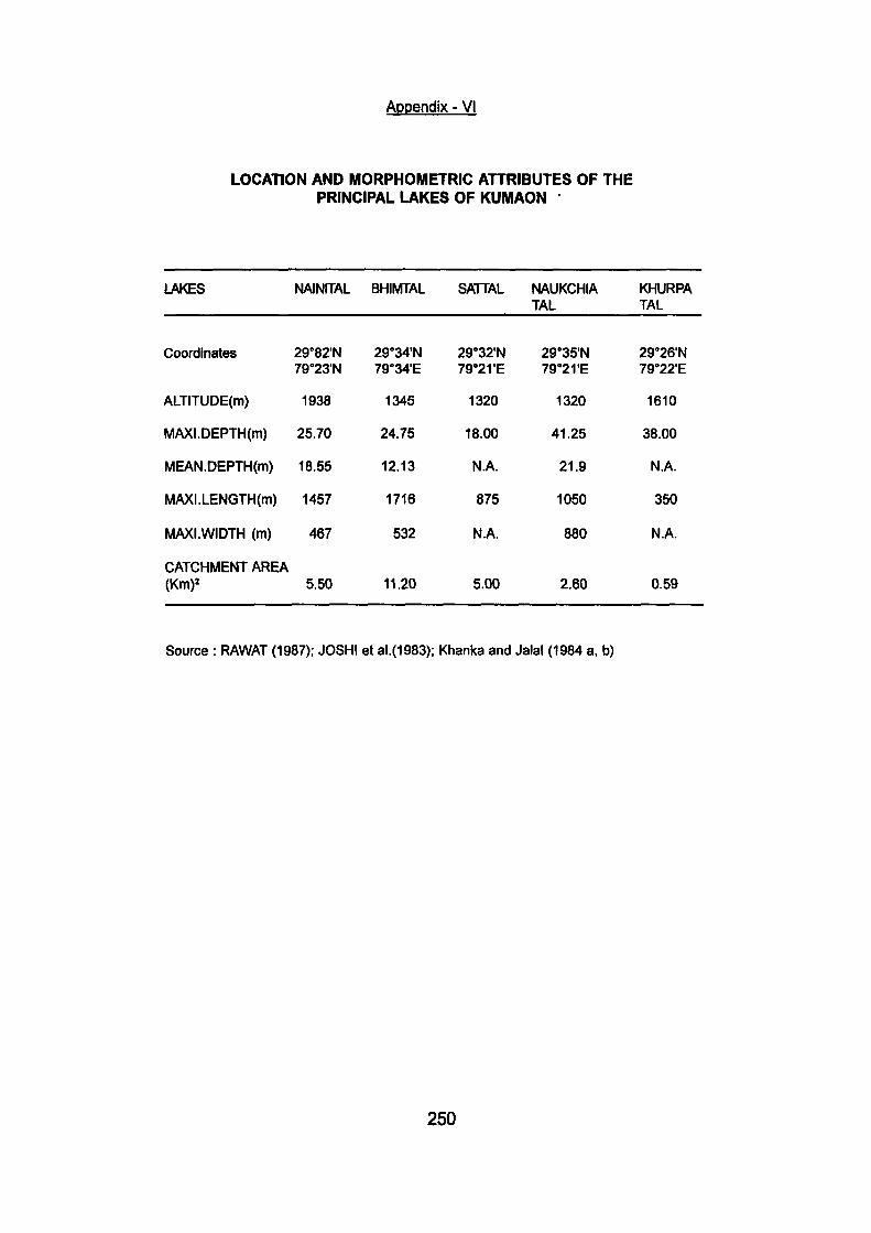
Appendix - VI
LOCATION AND MORPHOMETmC ATTRIBUTES OF THE PRINCIPAL LAKES OF KUMAON
LAKES
Coordinates
ALTITUDE(m)
MAXI.DEPTH(m)
MEAN.DEPTH(m)
MAXI.LENGTH(m)
MAXI .WIDTH (m)
CATCHMENT AREA (Km)^
NAINITAL
29°82'N 79°23'N
1938
25.70
18.55
1457
467
5.50
BHIMTAL
29"'34'N 79°34'E
1345
24.75
12.13
1716
532
11.20
SATTAL
29°32'N 79"'2rE
1320
18.00
N.A.
875
N.A.
5.00
NAUKCHIA TAL
29°35'N 79°2rE
1320
41.25
21.9
1050
880
2.60
KHURPA TAL
29°26'N 79"'22'E
1610
38.00
N.A.
350
N.A.
0.59
Source : RAWAT (1987); JOSH! et al.(1983); Khanka and Jalal (1984 a. b)
250
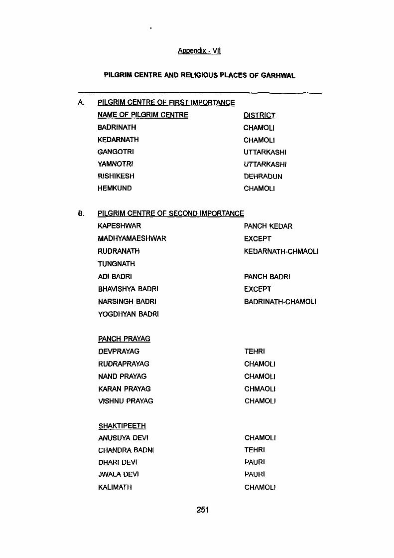
Appendix - VH
PILGRIM CENTRE AND RELIGIOUS PLACES OF GARHWAL
A. PILGRIM CENTRE OF FIRST IMPORTANCE
NAME OF PILGRIM CENTRE DISTRICT
BADRINATH CHAMOLI
KEDARNATH CHAMOLI
GANGOTRI UTTARKASHI
YAMNOTRI UTTARKASHI
RISHIKESH DEHRADUN
HEMKUND CHAMOLI
B. PILGRIM CENTRE OF SECOND IMPORTANCE
KAPESHWAR PANCH KEDAR
MADHYAMAESHWAR EXCEPT
RUDRANATH KEDARNATH-CHMAOLI
TUNGNATH
ADI BADRI PANCH BADRI
BHAVISHYA BADRI EXCEPT
NARSINGH BADRI BADRINATH-CHAMOLI
YOGDHYAN BADRI
PANCH PRAYAG
DEVPRAYAG
RUDRAPRAYAG
NAND PRAYAG
KARAN PRAYAG
VISHNU PRAYAG
TEHRI
CHAMOLI
CHAMOLI
CHMAOLI
CHAMOLI
SHAKTIPEETH
ANUSUYA DEVI
CHANDRA BADNI
DHARI DEVI
JWALA DEVI
KALIMATH
CHAMOLI
TEHRI
PAURl
PAURi
CHAMOLI
251
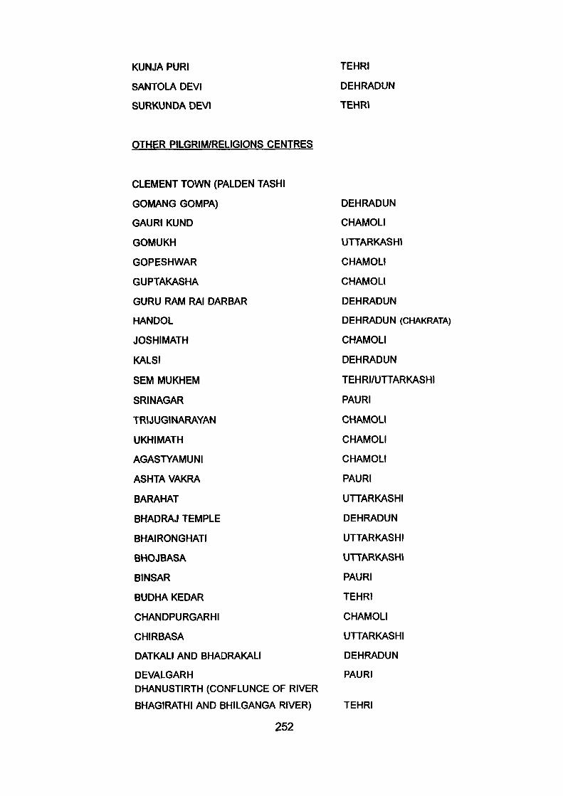
KUNJA PURI
SANTOLA DEVI
SURKUNDA DEVI
TEHRI
DEHRADUN
TEHRI
OTHER PILGRIM/RELIGIONS CENTRES
CLEMENT TOWN (PALDEN TASHI
GOMANG GOMPA)
GAURI KUND
GOMUKH
GOPESHWAR
GUPTAKASHA
GURU RAM RAI DARBAR
HANDOL
JOSHIMATH
KALSI
SEM MUKHEM
SRINAGAR
TRIJUGINARAYAN
UKHIMATH
AGASTYAMUNI
ASHTA VAKRA
BARAHAT
BHADRAJ TEMPLE
BHAIRONGHATI
BHOJBASA
BINSAR
BUDHA KEDAR
CHANDPURGARHI
CHIRBASA
DATKALI AND BHADRAKALI
DEVALGARH DHANUSTIRTH (CONFLUNCE OF RIVER
BHAGIRATHI AND BHILGANGA RIVER)
252
DEHRADUN
CHAMOLI
UTTARKASHI
CHAMOLI
CHAMOLI
DEHRADUN
DEHRADUN (CHAKRATA)
CHAMOLI
DEHRADUN
TEHRI/UTTARKASHI
PAURI
CHAMOLI
CHAMOLI
CHAMOLI
PAURI
UTTARKASHI
DEHRADUN
UTTARKASHI
UTTARKASHI
PAURI
TEHRI
CHAMOLI
UTTARKASHI
DEHRADUN
PAURI
TEHRI
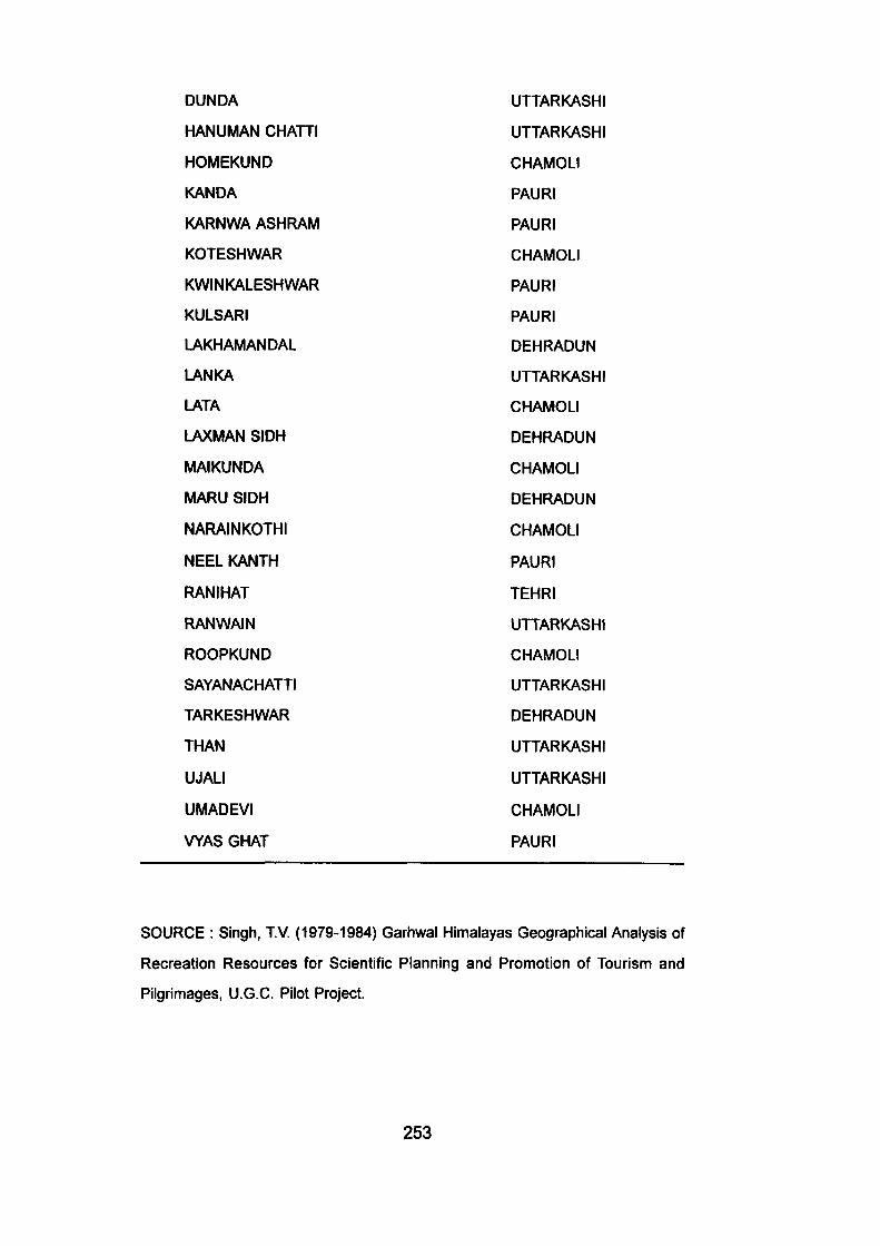
DUNDA
HANUMAN CHATTI
HOMEKUND
KANDA
KARNWA ASHRAM
KOTESHWAR
KWINKALESHWAR
KULSARI
LAKHAMANDAL
LANKA
LATA
LAXMAN SIDH
MAIKUNDA
MARU SIDH
NARAINKOTHI
NEEL KANTH
RANIHAT
RANWAIN
ROOPKUND
SAYANACHATTI
TARKESHWAR
THAN
UJALI
UMADEVI
WAS GHAT
UTTARKASHI
UTTARKASHI
CHAMOLI
PAURI
PAURI
CHAMOLI
PAURI
PAURI
DEHRADUN
UTTARKASHI
CHAMOLI
DEHRADUN
CHAMOLI
DEHRADUN
CHAMOLI
PAURI
TEHRI
UTTARKASHI
CHAMOLI
UTTARKASHI
DEHRADUN
UTTARKASHI
UTTARKASHI
CHAMOLI
PAURI
SOURCE : Singh, TV. (1979-1984) Garhwal Himalayas Geographical Analysis of
Recreation Resources for Scientific Planning and Promotion of Tourism and
Pilgrimages, U.G.C. Pilot Project.
253
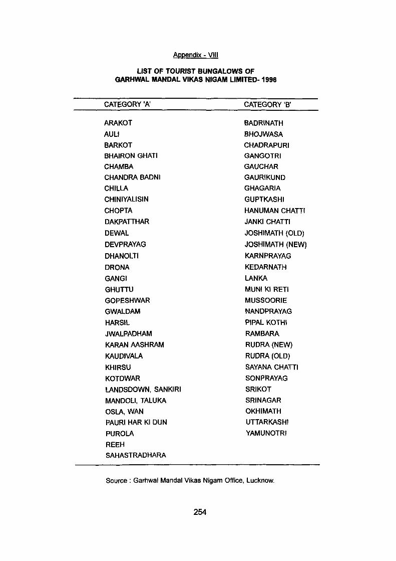
Appendix - VIII
LIST OF TOURIST BUNGALOWS OF GARHWAL MANDAL VIKAS NIGAM LIMITED- 1996
CATEGORY "A CATEGORY 'B'
ARAKOT
AULI
BARKOT
BHAIRON GHATI
CHAMBA
CHANDRA BADNI
CHILLA
CHINIYALISIN
CHOPTA
DAKPATTHAR
DEWAL
DEVPRAYAG
DHANOLTI
DRONA
GANGI
GHUTTU
GOPESHWAR
GWALDAM
HARSIL
JWALPADHAM
KARAN AASHRAM
KAUDIVALA
KHIRSU
KOTDWAR
LANDSDOWN, SANKIRI
MANDOLI. TALUKA
OSLA, WAN
PAURI HAR Kl DUN
PUROLA
REEH SAHASTRADHARA
BADRINATH
BHOJWASA
CHADRAPURI
GANGOTRI
GAUCHAR
GAURIKUND
GHAGARIA
GUPTKASHI
HANUMAN CHATTI
JANKI CHATTI
JOSHIMATH (OLD)
JOSHIMATH (NEW)
KARNPRAYAG
KEDARNATH
LANKA
MUNI Kl RETI
MUSSOORIE
NANDPRAYAG
PIPAL KOTHI
RAMBARA
RUDRA (NEW)
RUDRA (OLD)
SAYANA CHATTI
SONPRAYAG
SRIKOT
SRINAGAR
OKHIMATH
UTTARKASHI
YAMUNOTRI
Source : Garhwal Mandal Vikas Nigam Office, Lucknow.
254
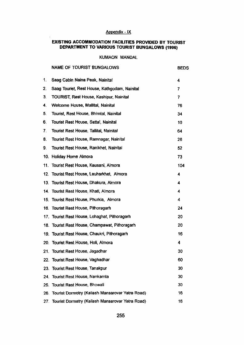
Appendix - IX
EXISTING ACCOMMODATION FACILITIES PROVIDED BY TOURIST DEPARTMENT TO VARIOUS TOURIST BUNGALOWS (1996)
KUMAON MANDAL
NAME OF TOURIST BUNGALOWS BEDS
1. Saag Cabin Naina Peak, Nainital 4
2. Saag Tourist, Rest House, Kathgodam, Nainital 7
3. TOURIST, Rest House, Kashipur, Nainital 7
4. Welcome House, Mallital, Nainital 76
5. Tourist, Rest House, Bhimtal, Nainital 34
6. Tourist Rest House, Sattai, Nainital 10
7. Tourist Rest House, Tallital, Nainital 64
8. Tourist Rest House, Ramnagar, Nainital 26
9. Tourist Rest House, Ranikhet, Nainital 52
10. Holiday Home Almora 73
11. Tourist Rest House, Kausani, Almora 104
12. Tourist Rest House, Lauharkhet, Almora 4
13. Tourist Rest House, Dhakura, Almora 4
14. Tourist Rest House, Khati, Almora 4
15. Tourist Rest House, Phurkia, Almora 4
16. Tourist Rest House, Pithoragarti 24
17. Tourist Rest House, Lohaghat, Pithoragarti 20
18. Tourist Rest House, Champawat, Pithoragarh 20
19. Tourist Rest House, Chaukri, Pithoragarh 16
20. Tourist Rest House, Holi, Almora 4
21. Tourist Rest House, Jagadhar 30
22. Tourist Rest House, Vaghadhar 60
23. Tourist Rest House, Tanakpur 30
24. Tourist Rest House, Nankamta 30
25. Tourist Rest House, Bhowali 30
26. Tourist Dormotry (Kailash Mansarovar Yatra Road) 16
27. Tourist Dormatry (Kailash Mansarovar Yatra Road) 16
255
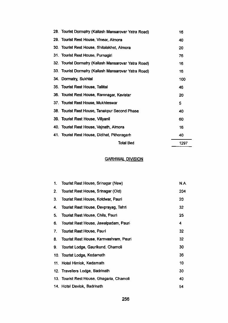
28. Tourist Dormatry (Kailash Mansarovar Yatra Road) 16
29. Tourist Rest House, Vinear, Almora 40
30. Tourist Rest House, Shitalakhet, Almora 20
31. Tourist Rest House, Purnagiri 76
32. Tourist Dormatry (Kailash Mansarovar Yatra Road) 16
33. Tourist Dormatry (Kailash Mansarovar Yatra Road) 16
34. Dormatry, Sul<htal 100
35. Tourist Rest House, Tallital 46
36. Tourist Rest House, Ramnagar, Kavistar 20
37. Tourist Rest House, Mukhteswar 5
38. Tourist Rest House, Tanakpur Second Phase 40
39. Tourist Rest House, Villyanil 60
40. Tourist Rest House, Vajnath, Almora 16
41. Tourist Rest House, Didihat, Pithoragarh 40
Total Bed 1297
GARHWAL DIVISION
1. Tourist Rest House, Srinagar (New) N.A.
2. Tourist Rest House, Srinagar (Old) 204
3. Tourist Rest House, Kotdwar, Pauri 20
4. Tourist Rest House, Devprayag, Tehri 32
5. Tourist Rest House, Chila, Pauri 25
6. Tourist Rest House, Jawalpadam, Pauri 4
7. Tourist Rest House, Pauri 32
8. Tourist Rest House, Karnvashram, Pauri 32
9. Tourist Lodge, Gaurikund, Chamoli 30
10. Tourist Lodge, Kedamath 36
11. Hotel Himlok, Kedamath 10
12. Travellers Lodge, Badrinath 30
13. Tourist Rest House, Ghagaria, Chamoli 40
14. Hotel Devlok, Badrinath 54
256
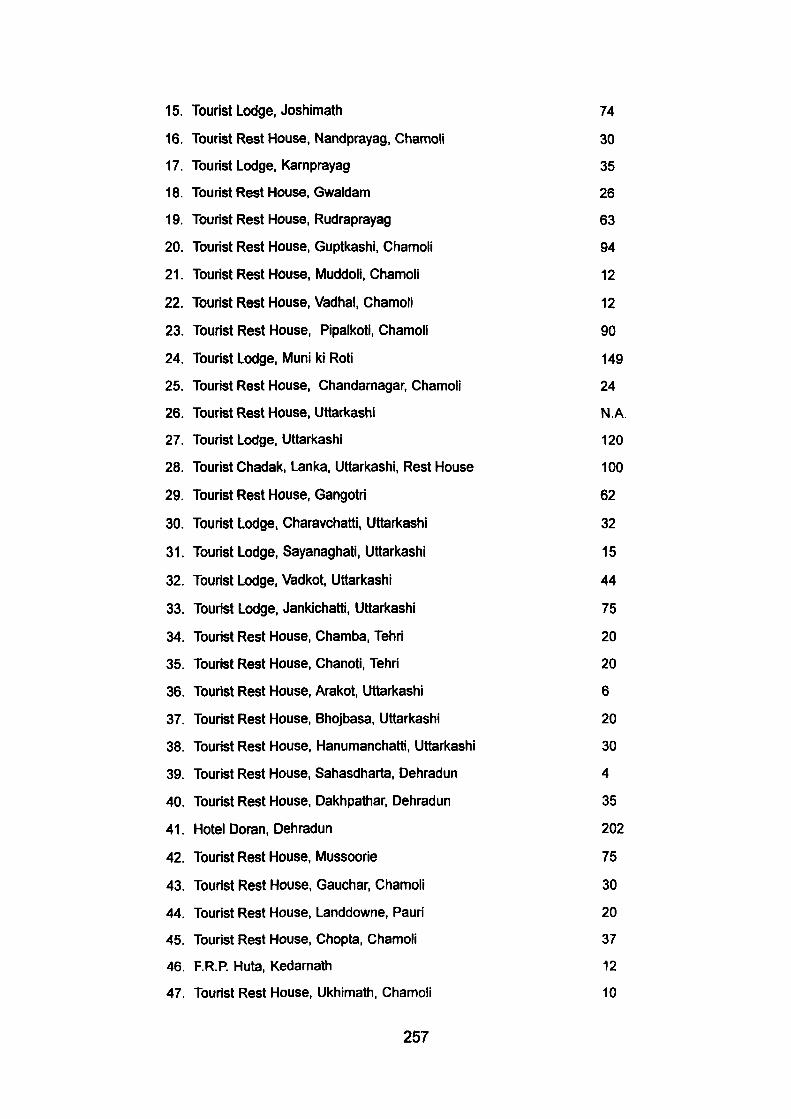
15. Tourist Lodge, Joshimath 74
16. Tourist Rest House, Nandprayag, Chamoii 30
17. Tourist Lodge, Karnprayag 35
18. Tourist Rest House, Gwaldam 26
19. Tourist Rest House, Rudraprayag 63
20. Tourist Rest House, Guptl<ashi, Chamoii 94
21. Tourist Rest House, Muddoli, Chamoii 12
22. Tourist Rest House, Vadhal, Chamoii 12
23. Tourist Rest House, Pipalkoti, Chamoii 90
24. Tourist Lodge, Muni ki Roti 149
25. Tourist Rest House, Chandamagar, Chamoii 24
26. Tourist Rest House, Uttarkashi N.A.
27. Tourist Lodge, Uttarkashi 120
28. Tourist Chadak, Lanka, Uttarkashi, Rest House 100
29. Tourist Rest House, Gangotri 62
30. Tourist Lodge, Charavchatti, Uttarkashi 32
31. Tourist Lodge, Sayanaghati, Uttarkashi 15
32. Tourist Lodge, Vadkot, Uttaricashi 44
33. Tourist Lodge, Jankichatti, Uttarkashi 75
34. Tourist Rest House, Chamba, Tehri 20
35. Tourist Rest House, Chanoti, Tehri 20
36. Tourist Rest House, Arakot, Uttari<ashi 6
37. Tourist Rest House, Bhojbasa, Uttarkashi 20
38. Tourist Rest House, Hanumanchatti, Uttarkashi 30
39. Tourist Rest House, Sahasdharta, Dehradun 4
40. Tourist Rest House, Dakhpathar, Dehradun 35
41. Hotel Doran, Dehradun 202
42. Tourist Rest House, Mussoorie 75
43. Tourist Rest House, Gauchar, Chamoii 30
44. Tourist Rest House, Landdowne, Pauri 20
45. Tourist Rest House, Chopta, Chamoii 37
46. F.R.P. Huta, Kedarnalh 12
47. Tourist Rest House, Ukhimath, Chamoii 10
257
48. Tourist Rest House, Deval, Chamoli
49. F.R.P. Huts, Sonprayag
50. Tourist Rest House, Auli, Chamoli
51. Fire Glass Cottage, Sunil Chamoli
52. Tourist Rest House, Ghutta, Tehri
53. Tourist Rest House, (Deluxe) Rudraprayag, Chamoli
54. Tourist Rest House, Gopadhar, Chamoli
55. Tourist Rest House, Chandarbadni, Tehri
56. Tourist Rest House, Purola, Uttarkashi
57. Tourist Rest House, Khirsu, Pauri
58. Tourist Rest House, Rambhara
59. Tourist Rest House, Srinagar (Shril<ot)
60. Tourist Rest House, Harsil, Uttarkashi
61. Tourist Rest House, Joshimath, Chamoli
62. Tourist Rest House, Gangi, Tehri
63. Tourist Rest House, Rehi, Tehri
64. Tourist Rest House, Sell, Uttarkashi
65. Tourist Rest House, Osala, Uttarkashi
66. Motel Chimalisoal, Uttarkashi
67. Tourist Rest House, Kedarnath
68. Tourist Rest House, Gangotri
69. Motel Bhaniyawala, Dehradun
70. Motel Agrakhal, Tehri
Total Beds
12
20
74
10
20
40
24
20
20
20
20
47
30
74
20
20
20
20
4
52
20
4
4
2674
Source : Tourist Development in the Mountainous areas (Status Magazine) Patel
Nagar, Dehradun.
258
Appendix - X
ACCOMMODATION AND CHARGES OF FOREST REST HOUSES AT GOVIND PASHU VIHAR
NAME OF FOREST REST HOUSE
NAITWAR
TALUKA
OSLA
HAR Kl DOON
ISTRAGAD
SATTA
JAKHOL
NO. OF SUITES
2
2
2
2
2
2
2
CHARGES PER SUITE / PER DAY IN RUPEES
FOR INDIAN
100
100
100
100
100
100
100
FOREIGNER
300
300
300
300
300
300
300
Source : Department of Wild-Life, Lucknow.
259
Appendix - XI
EXISTING ACCOMMODATION FACILITIES PROVIDED BY TOURIST DEPARTMENT AT BADRINATH RESORT (1996)
SLNO.
1.
2.
3.
4.
5.
6.
7.
8.
9.
10.
11.
12.
13.
14.
15.
16.
17.
18.
19.
20.
21.
22.
23.
24.
25.
26.
27.
NAME
Andhra Bhawan
Jhun Jhunwala Cottage
Modi Bhawan 1
Modi Bhawan II
Modi Bhawan II)
Mittal Cottage
Chand Cottage
Shankaracharya Sadan
Badrish Sadar
Gujarat Bhawan
Pilo Dharamshala
Kali Kamli Dharmshala
Bejoria Dharamshala
Mansingh Dharamshala
Rishiganga Dharamshala
Sadhu Bhawan
Punjab Sindh Dharamshala
Atachi
Geeta Bhawan
Balanand Ashram
Maharastra Bhawan
Raghunath Ashram
Manavakalyan Dharamshala
Parmarth Lok
Halwasia Dharamshala
Biria Dharamshala
Dhodwa Dharamshala
260
BEDS
08
04
12
12
24
06
24
20
22
04
80
150
08
160
140
50
300
48
216
84
378
225
360
200
50
50
40
28. Cadiya Dharamshala 20
29. Tantiya Dharamshala 150
30. Bangar Dharamshala 100
31. SwamJnarayan Dharamshala 50
32. Bhologiri Dharamshala 30
33. Jan Dharamshala 60
34. Jalaram Dharamshala 60
35. Roopali Dharamshala 08
36. PWD Inspection House 08
37. Jal Nigam Rest House 04
38. Jal Sansthan Rest House 04
39. Forest Rest House 04
40. DBGR Rest House 08
41. Hotel Devlok 70
RESTAURANTS :
1. Vljaya Laxml Restaurant
2. Saket Restaurant
3. Urvashi Restaurant
4. Several Other Ordinary Restaurants.
Source : Department of Tourism, Dehradun.
261
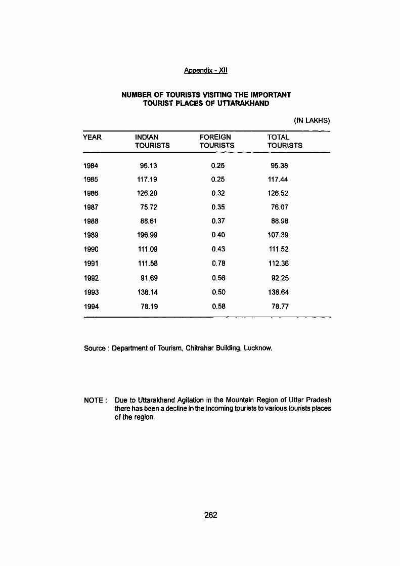
Appendix - XII
NUMBER OF TOURISTS VISITING THE IMPORTANT TOURIST PLACES OF UTTARAKHAND
(IN LAKHS)
YEAR
1984
1985
1986
1987
1988
1989
1990
1991
1992
1993
1994
INDIAN TOURISTS
95.13
117.19
126.20
75.72
88.61
196.99
111.09
111.58
91.69
138.14
78.19
FOREIGN TOURISTS
0.25
0.25
0.32
0.35
0.37
0.40
0.43
0.78
0.56
0.50
0.58
TOTAL TOURISTS
95.38
117.44
126.52
76.07
88.98
107.39
111.52
112.36
92.25
138.64
78.77
Source : Department of Tourism, Chitrahar Building, Lucknow.
NOTE : Due to Uttarakhand Agitation in the Mountain Region of Uttar Pradesh there has been a decline in the incoming tourists to various tourists places of the region.
262
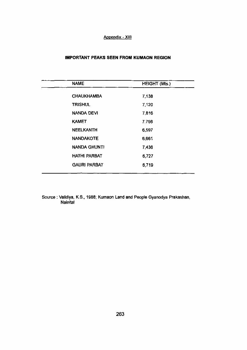
Appendix - XIII
IMPORTANT PEAKS SEEN FROM KUMAON REGION
NAME HEIGHT (Mts.)
CHAUKHAMBA 7,138
TRISHUL 7,120
NANDA DEVI 7,816
KAMET 7.756
NEELKANTH 6.597
NANDAKOTE 6,661
NANDA GHUNTI 7,436
HATH! PARBAT 6,727
GAURI PARBAT 6,719
Source : Validiya, K.S., 1988; Kumaon Land and People Gyanodya Prakashan, Nainltal
263
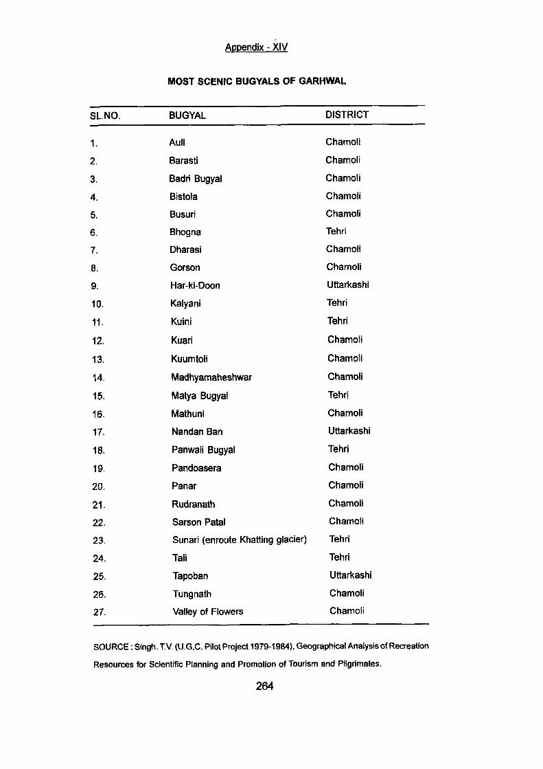
Appendix - XIV
MOST SCENIC BUGYALS OF GARHWAL
SLNO.
1.
2.
3.
4.
5.
6.
7.
8.
9.
10.
11.
12.
13.
14.
15.
16.
17.
18.
19.
20.
21.
22.
23.
24.
26.
26.
27.
BUGYAL
Auli
Barasti
Badri Bugyal
Bistola
Busuri
Bhogna
Dharasi
Gorson
Har-ki-Doon
Kalyani
Kuini
Kuari
Kuumtolj
Madhyamaheshwar
Matya Bugyal
Mathuni
Nandan Ban
Panwali Bugyal
Pandoasera
Panar
Rudranath
Sarson Patal
Sunari (enroute Khatting glacier)
Tali
Tapoban
Tungnath
Valley of Flowers
DISTRICT
Chamoli
Chamoli
Chamoli
Chamoli
Chamoli
Tehri
Chamoli
Chamoli
Uttarkashi
Tehri
Tehri
Chamoli
Chamoli
Chamoli
Tehri
Chamoli
Uttarkashi
Tehri
Chamoli
Chamoli
Chamoli
Chamoli
Tehri
Tehri
Uttarkashi
Chamoli
Chamoli
SOURCE: Singh. TV. (U.G.C. Pilot Project 1979-1984), Geographical Analysis of Recreation
Resources for Scientific Planning and Promotion of Tourism and Pilgrimates.
264
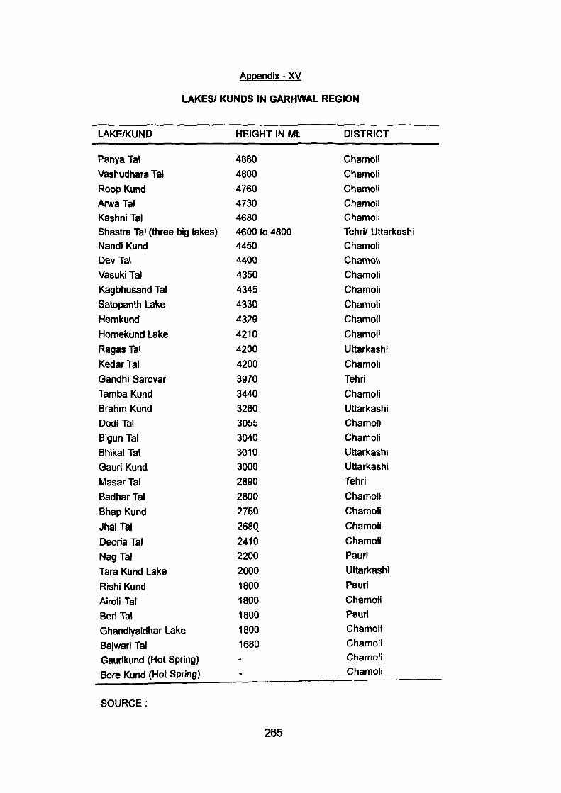
Appendix - XV
LAKES/ KUNDS IN GARHWAL REGION
LAKE/KUND
Panya Tal
Vashudhara Tal Roop Kund ArwaTal Kashni Tal Shastra Tal (three big lakes) Nandi Kund Dev Tal Vasuki Tal Kagbhusand Tal Satopanth Lake
Hemkund Homekund Lake Ragas Tal Kedar Tal Gandhi Sarovar Tamba Kund Brahm Kund Dodi Tal Bigun Tal Bhikal Tal Gauri Kund Masar Tal Badhar Tal
Bhap Kund
Jhal Tal Deoria Tal Nag Tal Tara Kund Lake
Rishi Kund Airoli Tal Beri Tal Ghandiyaldhar Lake
Bajwari Tal Gaurikund (Hot Spring) Bore Kund (Hot Spring)
SOURCE:
HEIGHT IN Mt.
4880 4800 4760 4730 4680 4600 to 4800 4450 4400 4350 4345 4330 4329 4210 4200 4200 3970 3440 3280 3055 3040 3010 3000 2890 2800 2750
2680 2410 2200 2000 1800 1800 1800 1800 1680 --
DISTRICT
Chamoli Chamoli Chamoli Chamoli Chamoli Tehri/ Uttarkashi Chamoli Chamoli Chamoli Chamoli Chamoli Chamoli
Chamoli Uttarkashi
Chamoli Tehri Chamoli Uttarkashi Chamoli Chamoli Uttarkashi Uttarkashi
Tehri Chamoli Chamoli Chamoli Chamoli Pauri Uttarkashi Pauri Chamoli Pauri Chamoli Chamoli Chamoli Chamoli
265

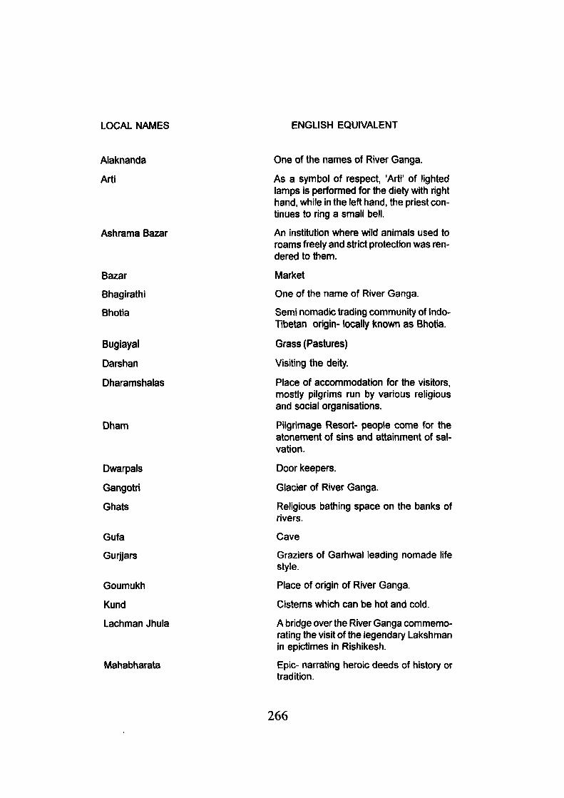
LOCAL NAMES ENGLISH EQUIVALENT
Alaknanda
Art!
Ashrama Bazar
Bazar
Bhagirathi
Bhotia
Bugiayal
Darshan
Dharamshalas
Dham
Dwarpals
Gangotri
Ghats
Gufa
Gurjjars
Goumukh
Kund
Lachman Jhula
Mahabharata
One of the names of River Ganga.
As a symbol of respect, 'Arti' of lighted lamps is perfomied for the diety with right hand, while in the left hand, the priest continues to ring a small bell.
An institution where wild animals used to roams freely and strict protection was rendered to them.
Market
One of the name of River Ganga.
Semi nomadic trading community of Indo-Tibetan origin- locally known as Bhotia.
Grass (Pastures)
Visiting the deity.
Place of accommodation for the visitors, mostly pilgrims run by various religious and social organisations.
Pilgrimage Resort- people come for the atonement of sins and attainment of salvation.
Door keepers.
Glacier of River Ganga.
Religious bathing space on the banks of rivers.
Cave
Graziers of Garhwal leading nomade life style.
Place of origin of River Ganga.
Cisterns which can be hot and cold.
A bridge over the River Ganga commemorating the visit of the legendary Lakshman in epictimes in Rishikesh.
Epic- narrating heroic deeds of history or tradition.
266
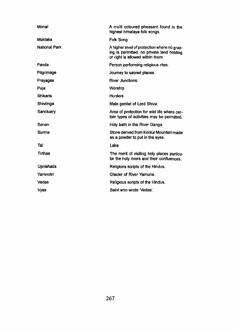
Monal
Muktaks
National Park
Panda
Pilgrimage
Prayagas
Puja
Shikaris
Shivlinga
Sanctuary
Sanan
Surma
Tal
Tirthas
Upnishads
Yamnotri
Vedas
Vyas
A multi coloured pheasant found in the highest himalaya folk songs.
Folk Song
A higher level of protection where no grazing is permitted, no private land holding or right is allowed within them.
Person performing religious rites.
Journey to sacred places.
River Junctions.
Worship
Hunters
Male genital of Lord Shiva.
Area of protection for wild life where certain types of activities may be permitted.
Holy bath in the River Ganga.
Stone derived from Kohtur Mountain made as a powder to put in the eyes.
Lake
The merit of visiting holy places particular the holy rivers and their confluences.
Religions scripts of the Hindus.
Glacier of River Yamuna.
Religious scripts of the Hindus.
Saint who wrote 'Vedas'.
267