Embed Size (px)
Citation preview
NYAME AKUMA No. 53 June 2000
Swahili Archaeology on Pemba Island, Tanzania: Pujini, Bandari ya Faraji, and Chwaka, 1997-1998
Adria La Violette Department of Anthropology Brooks Hall 100 University of Virginia Charlottesville, Virginia
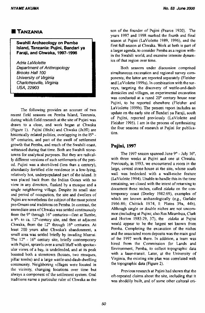
The following provides an account of two recent field seasons on Pemba Island, Tanzania, during which field research at the site of Pujini was drawn to a close, and work began at Chwaka (Figure 1 ). Pujini (HnJx) and Chwaka (JxHJ) are historically related polities, overlapping in the 15" - 16" centuries, and part of the swell of settlement growth that Pemba, and much of the Swahili coast, witnessed during that time. Both are Swahili stone- towns for analytical purposes. But they are radical- ly different versions of such settlements of the peri- od. Pujini was a short-lived (less than a century), abundantly fortified elite residence in a low-lying, relatively hot, underpopulated part of the island. It was placed back from the Indian Ocean with no view in any direction, flanked by a mosque and a single neighboring village. Despite its small size and period of occupation, the site and dwellers of Pujini are nonetheless the subject of the most potent pre-Omani oral traditions on Pemba. In contrast, the immediate area of Chwaka was settled continuously from the 9'h through 16" centuries-first at Tumbe, a 9"- to ca. 12th-century site, and then at adjacent Chwaka, from the 12" through 16" centuries. At least 200 years after Chwaka's abandonment, a small area was settled briefly by invading Mazrui. The 12" - 16" century site, briefly contemporary with Pujini, sprawls over a small bluff with spectac- ular views of a bay, is undefended, and at its peak boasted both a stonetown (houses, two mosques, pillar tombs) and a large wattle-and-daub-dwelling community. Neighboring villages were located in the vicinity, changing locations over time but always a component of the settlement system. Oral traditions name a particular ruler of Chwaka as the
son of the founder of Pujini (Pearce 1920). The years 1997 and 1998 marked the fourth and final season at Pujini (LaViolette 1989, 1996), and the first full season at Chwaka. Work at both is part of a larger agenda, to consider Pemba as a region with- in the Swahili world, and examine intersite dynam- ics of that region over time.
Both seasons under discussion comprised simultaneous excavation and regional survey com- ponents; the latter are reported separately (Fleisher and LaViolette 1999a). In combination with the sur- veys, targeting the discovery of wattle-and-daub domiciles and villages, an experimental excavation was conducted at a razed 20" century house near Pujini, to be reported elsewhere (Fleisher and LaViolette 1999b). The present report includes an update on the early site of Bandari ya Faraji, south of Pujini, reported previously (LaViolette and Fleisher 1995). I am in the process of synthesizing the four seasons of research at Pujini for publica- tion.
Pujini, 1997
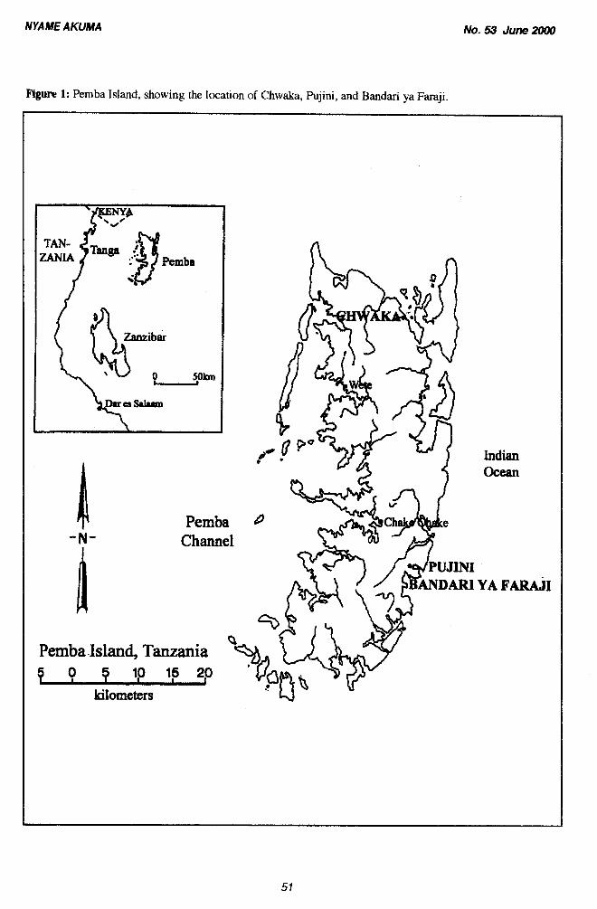
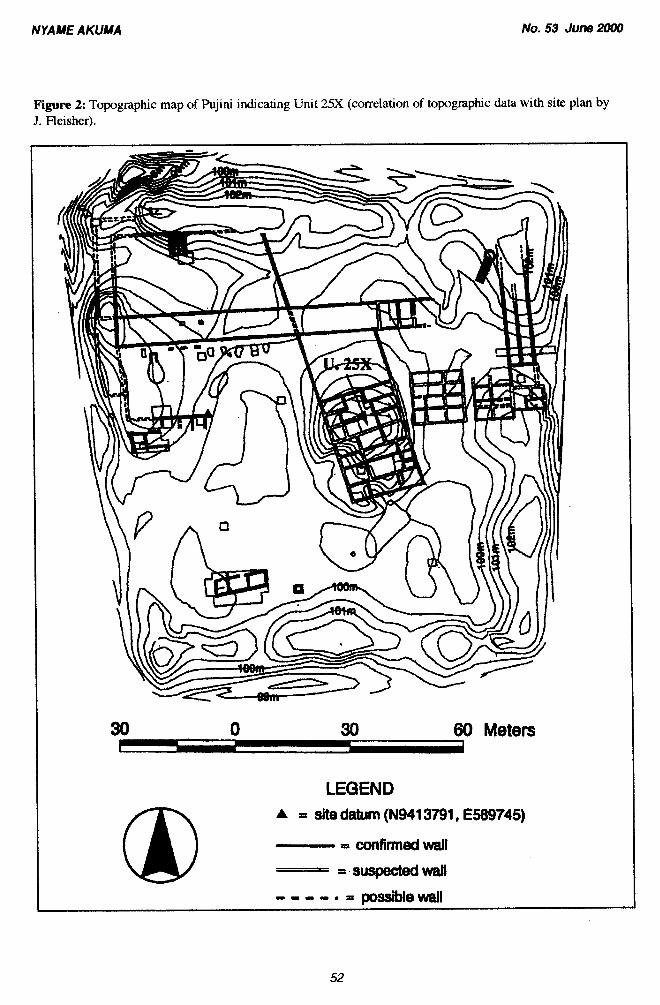
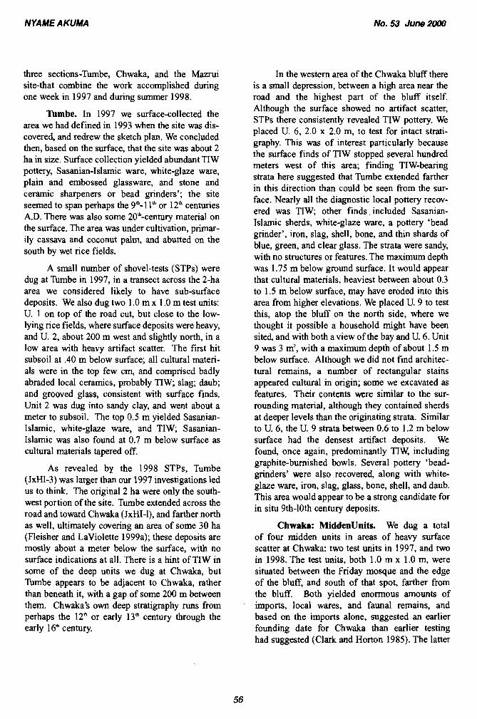
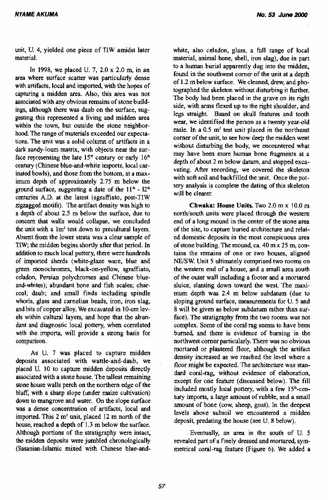
The 1997 season spanned June 9" - July 1 6", with three weeks at Pujini and one at Chwaka. Previously, in 1993, we encountered a room in the large, central stone house at the site, whose south wall was bedecked with a wall-niche feature (LaViolette 1994). Unable to handle this in the time remaining, we closed with the intent of returning to document these niches, called zidaka on the con- temporary coast (Donley 1982:69), examples of which are known archaeologically (e.g., Garlake 1966336; Chittick 1974, I: Plates 39a, 44b). Although single or double niches are not uncom- mon (including at Pujini; also Ras Mkumbuu, Clark and Horton 1985:29, 37), the zidaka at Pujini would appear to be the largest set known from Pemba. Completing the excavation of the niches and the associated room deposits was the main goal of the 1997 work there. In addition, a team was hired from the Commission for Lands and Environment, Pemba, to collect topographic data with a laser-transit. Later, at the University of Virginia, the existing site plan was correlated with the topographic data (Figure 2).
Previous research at Pujini had shown that the oft-repeated claims about the site, including that it was shoddily built, and of some other cultural ori-
NYAME AKUMA
Figure 1: Pemba Island, showing the location of Chwaka, Pujini, and Bandari ya Faraji.
No. 53 June 3WU)
Pemba
Pemba -N- Channel
Pemba .Island, Tanzania
P 0 9 l,O 15 20
kilometers
Indian Ocean
NYA ME AKUMA No. 53 June 2000
Figure 2: Topographic map of Pujini indicating Unit 25X (correlation of topographic data with site plan by J. Fleisher).
60 Meters
LEGEND A = site datum (N9413791, €589745)
= confirmed wall = - suspected wall
- - - .I. = wall
NYA ME A KUMA No. 53 June 2000
Figure 3: Carved and plastered Porites wall-niches, in situ in Unit 25X Pujini.
gin than the majority of stonetowns on the coast (Pearce 1920), were not supportable (Clark and Horton 1985; LaViolette 1996). Garlake (1 966) excluded it from his compendium of stone build- ings on the coast, without even a visit, noting it as: "the 'fortified citadel' of Pujini (from all descrip- tions quite unlike any other building, but probably late in date)" (ibid.3). This distanced it hrther from scholarly consideration within the Swahili world. Whatever the oddities of Pujini-its short life, its uniquely ambitious rampart compared to the size of the population which lived there-archaeology revealed a series of elegantly-conceived rooms and buildings within the fortification walls that changed the way we think of the site. Inside the western gate, for example, was a plaster-floored room, a bath- room, a series of elite imported goods, and buried offerings or$fingo pots, all of which suggested that the gate area was one for receiving guests, the equivalent of the front rooms of a Swahili stone house of the time, rather than a defensive structure built by invaders. I have argued that interpreting Pujini's rampart in this context, and the settlement's
raison d'stre generally, requires looking at the wider sociopolitical context on Pemba (LaViolette 1998, forthcoming). The rampart seems more understandable as a gesture for gaining the respect of other stonetown inhabitants and perhaps foreign traders, and as a way to compete with larger settle- ments, than as a defensive structure per se (ibid.). Excavation of the zidaka and the room in which they were found, at the heart of the site, was con- ceived as a final way to look into life in that settle- ment, removed from the rampart and the shadow it cast.
Thus, in 1997 we re-opened the zidaku unit, renamed 25X, to inform us about the condition, quality and archaeological context of the wall-nich- es. It began as a 5 m by 8 m unit. The unstable nature of the south wall of the unit, the fragility of the niches, and the unit's depth caused us to leave two triangular sections of the unit as baulks. An extension measuring 1 m by 2 m was added later in the northeast corner of the unit. As in all rooms excavated, the strata were dominated by wall and
N YA ME AKUMA No. 53 June ZOO0
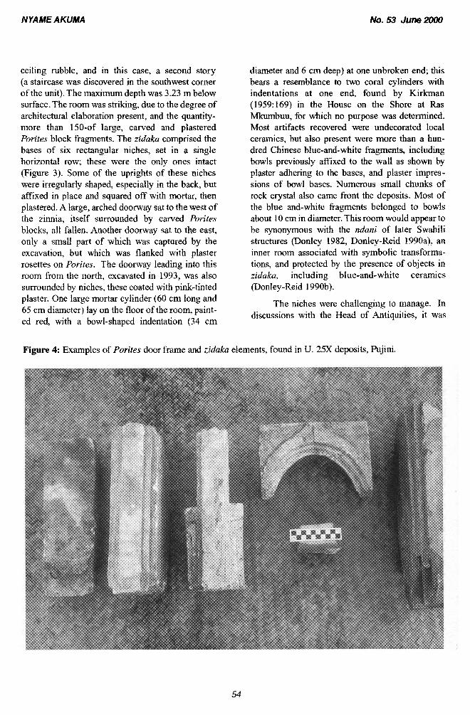
ceiling rubble, and in this case, a second story (a staircase was discovered in the southwest corner of the unit). The maximum depth was 3.23 m below surface. The room was striking, due to the degree of architectural elaboration present, and the quantity- more than 150-of large, carved and plastered Porites block fragments. The zidaka comprised the bases of six rectangular niches, set in a single horizontal row; these were the only ones intact (Figure 3). Some of the uprights of these niches were irregularly shaped, especially in the back, but affixed in place and squared off with mortar, then plastered. A large, arched doorway sat to the west of the zinnia, itself surrounded by carved Porites blocks, all fallen. Another doorway sat to the east, only a small part of which was captured by the excavation, but which was flanked with plaster rosettes on Porites. The doorway leading into this room from the north, excavated in 1993, was also surrounded by niches, these coated with pink-tinted
diameter and 6 cm deep) at one unbroken end; this bears a resemblance to two coral cylinders with indentations at one end, found by Kirkman (1959:169) in the House on the Shore at Ras Mkumbuu, for which no purpose was determined. Most artifacts recovered were undecorated local ceramics, but also present were more than a hun- dred Chinese blue-and-white fragments, including bowls previously affixed to the wall as shown by plaster adhering to the bases, and plaster impres- sions of bowl bases. Numerous small chunks of rock crystal also came front the deposits. Most of the blue and-white fragments belonged to bowls about 10 cm in diameter. This room would appear to be synonymous with the nduni of later Swahili structures (Donley 1982, Donley-Reid 1990a). an inner room associated with symbolic transforma- tions, and protected by the presence of objects in zidaka, including blue-and-white ceramics (Donley-Reid 1990b).
plaster. One large mortar cylinder (60 cm long and The niches were challenging to manage. In 65 cm diameter) lay on the floor of the room, paint- discussions with the Head of Antiquities, it was ed red, with a bowl-shaped indentation (34 cm
Figure 4: Examples of Porites door frame and zidaka elements, found in U. 25X deposits, Pujini.
NYA ME AKUMA No. 53 June 3060
decided to leave as much of the niche feature in place as its condition and documentation allowed, and then rebury it, leaving the possibility of recon- struction and display for the future. The six niches were fragile; other rows may have once sat atop this one, based on the number of carved blocks recov- ered. In the process of excavating, regrettably, it became clear that the niches would fall, because each was made of a number of elements, many of them loose, and the niches were tipped forward as a group. However, extensive drawing and pho- tographing took place before the elements were dis- lodged. The fallen blocks recovered were of multi- ple shapes and sizes, the majority rectangular, and carved and plastered on two faces (Figure 4). Blocks may have fallen from the story above. The volume of beautifully executed blocks and related plastering indicate the presence at Pujini, in the 15th to 16th centuries, of an elegant, embellished, large and multi-storied Swahili house, bearing com- parison to houses at settlements such as Songo Mnara (Garlake 1966:202), Kilwa (Chittick 1974), and Shanga (Horton 1996).
Bandari ya Faraji, 1997
Bandari ya Faraji, approximately 2 km south of Pujini (Figure I), was first found and recorded in 1989 (LaViolette 1989; LaViolette and Fleisher 1995). Associated with Tam traditionfTIW pottery (Horton 1996; Charni 1994) and thus dated to no later than the 9th century, it was the first such site noted from Pemba. At the time, its location abut- ting mangrove, the failure of a series of shovel-test pits (STPs) to yield intact deposits, and heavy defla- tion, led me to believe the site was largely destroyed. Happily, the situation is better than this. After lying unused as farmland for centuries, the land was cleared extensively and put under maize, tomato, and squash cultivation in 1996 by a family, a member of which we met during our visit. Despite deflation, at least some parts have potential for intact deposits, especially if the deposits are deeply buried, as those with TIW tend to be in other parts of the island. Bandari, named after the area, com- prised 1.5 to 2 ha of surface scatter in 1997. The only pottery on the surface was local, and all deco- rated ware was TIW. Also, in the east/ center of the site, is a square, stone-lined well, which from all appearances is contemporary with the early habita- tion period. Bandari is one of a small but growing
number of early TIW-bearing, village sites now known from Pemba (see Fleisher and LaViolette 1995, Fleisher 1999). It is the only one from the southern half of the island known to date, and to my knowledge, the only such site-small, early, probably singly component-with an intact, stone-lined well, known from anywhere on the coast.
Chwaka, 1997 and 1998
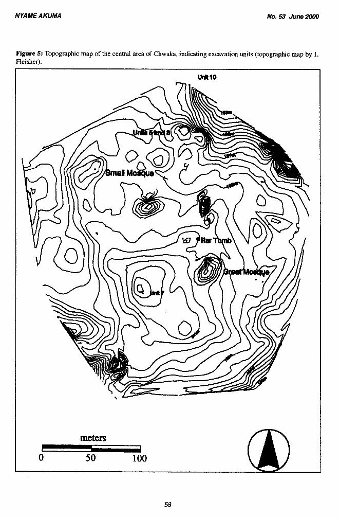
Chwaka has three components. The main site, called Chwaka, overlooks a harbor facing the Michiweni Peninsula. It comprises several above- ground stone ruins including two mosques, two houses, and ten tombs (Clark and Horton 1985: 18). That site is now designated JxHl1, denoting that it was the first of the three components to be recorded (Figure 5). Adjacent to the site, 600 m to the north- east (ibid.:20), are six stone tombs, a mound said to be part of a ruined fort, and at least one wall stump, associated with the Mazrui occupation of Pemba in the late 18th and early 19th centuries. This is referred to as the Marmi site at Chwaka, designat- ed JxHI-2. The third component of Chwaka is an early site lacking stone structures, discovered by Andrew Reid in 1993 (LaViolette 1994; LaViolette and Fleisher 1995), now designated JxHI-3 and known as Tumbe after a nearby village. Tumbe is dominated by TIW and imported pottery and other items dating to the late first, early second millenni- um A.D. Thus, although work has only begun at Chwaka, we are dealing with an area that has seen occupation from the earliest known on Pernba, the 9" century at the latest based on relative dating of the pottery. The survey team from the Commission for Lands and Environment again collected topo- graphic data from Chwaka. Due to the large size of the site, only the central part was surveyed, but groundwork was laid for extending the surveying in future years including the placement of four cement markers.
The 1998 field season spanned the period June 12"-August 14", and comprised five weeks of combined excavation and survey and two addition- al weeks of survey, reported elsewhere (Fleisher and LaViolette 1999a). Critical to the field season was a surface and subsurface survey carried out on the Chwaka peninsula itself, with a goal of deter- mining the extent of the site and the varying densi- ties of deposits. The account below is divided into
NYAME AKUMA No. 53 June 2090
three sections-Tumbe, Chwaka, and the Mazrui In the western area of the Chwaka bluff there site-that combine the work accomplished during is a small depression, between a high area near the one week in 1997 and during summer 1998. road and the highest part of the bluff itself.
Tumbe. In 1997 we surface-collected the area we had defined in 1993 when the site was dis- covered, and redrew the sketch plan. We concluded then, based on the surface, that the site was about 2 ha in size. Surface collection yielded abundant TIW pottery, Sasanian-Islamic ware, white-glaze ware, plain and embossed glassware, and stone and ceramic sharpeners or bead grinders'; the site seemed to span perhaps the 9"-1 or 12" centuries A.D. There was also some 20*-century material on the surface. The area was under cultivation, primar- ily cassava and coconut palm, and abutted on the south by wet rice fields.
A small number of shovel-tests (STPs) were dug at Tumbe in 1997, in a transect across the 2-ha area we considered likely to have sub-surface deposits. We also dug two 1.0 m x 1.0 m test units: U. 1 on top of the road cut, but close to the low- lying rice fields, where surface deposits were heavy, and U. 2, about 200 m west and slightly north, in a low area with heavy artifact scatter. The first hit subsoil at .40 m below surface; all cultural materi- als were in the top few cm, and comprised badly abraded local ceramics, probably TTW; slag; daub; and grooved glass, consistent with surface finds. Unit 2 was dug into sandy clay, and went about a meter to subsoil. The top 0.5 m yielded Sasanian- Islamic, white-glaze ware, and TIW; Sasanian- Islamic was also found at 0.7 m below surface as cultural materials tapered off.
As revealed by the 1998 STPs, Tumbe (JxH1-3) was larger than our 1997 investigations led us to think. The original 2 ha were only the south- west portion of the site. Tumbe extended across the road and toward Chwaka (JxHI-I), and farther north as well, ultimately covering an area of some 30 ha (Fleisher and LaViolette 1999a); these deposits are mostly about a meter below the surface, with no surface indications at all. There is a hint of TlW in some of the deep units we dug at Chwaka, but Tumbe appears to be adjacent to Chwaka, rather than beneath it, with a gap of some 200 m between them. Chwaka's own deep stratigraphy runs from perhaps the 12" or early 13" century through the early 1 6Ih century.
Although the surface showed no artifact scatter, STPs there consistently revealed TIW pottery. We placed U. 6, 2.0 x 2.0 m, to test for intact strati- graphy. This was of interest particularly because the surface finds of TIW stopped several hundred meters west of this area; finding TIW-bearing strata here suggested that Tumbe extended farther in this direction than could be seen from the sur- face. Nearly all the diagnostic local pottery recov- ered was TIW; other finds included Sasanian- Islamic sherds, white-glaze ware, a pottery 'bead grinder', iron, slag, shell, bone, and thin shards of blue, green, and clear glass. The strata were sandy, with no structures or features. The maximum depth was 1.75 m below ground surface. It would appear that cultural materials, heaviest between about 0.3 to 1.5 m below surface, may have eroded into this area from higher elevations. We placed U. 9 to test this, atop the bluff on the north side, where we thought it possible a household might have been sited, and with both a view of the bay and U. 6. Unit 9 was 3 m2, with a maximum depth of about 1.5 m below surface. Although we did not find architec- tural remains, a number of rectangular stains appeared cultural in origin; some we excavated as features. Their contents were similar to the sur- rounding material, although they contained sherds at deeper levels than the originating strata. Similar to U. 6, the U. 9 strata between 0.6 to 1.2 m below surface had the densest artifact deposits. We found, once again, predominantly TIW, including graphite-burnished bowls. Several pottery 'bead- grinders' were also recovered, along with white- glaze ware, iron, slag, glass, bone, shell, and daub. This area would appear to be a strong candidate for in situ 9th-10th century deposits.
Chwaka: MiddenUnits. We dug a total of four midden units in areas of heavy surface scatter at Chwaka: two test units in 1997, and two in 1998. The test units, both 1.0 m x 1.0 m, were situated between the Friday mosque and the edge of the bluff, and south of that spot, farther from the bluff. Both yielded enormous amounts of imports, local wares, and faunal remains, and based on the imports alone, suggested an earlier founding date for Chwaka than earlier testing had suggested (Clark and Horton 1985). The latter
NYAME AKUMA No. 53 June 2000
unit, U. 4, yielded one piece of TIW amidst later white, also celadon, glass, a full range of local material. material, animal bone, shell, iron slag), due in part
In 1998, we placed U. 7, 2.0 x 2.0 m, in an area where surface scatter was particularly dense with artifacts, local and imported, with the hopes of capturing a midden area. Also, this area was not associated with any obvious remains of stone build- ings, although there was daub on the surface, sug- gesting this represented a living and midden area within the town, but outside the stone neighbor- hood. The range of materials exceeded our expecta- tions. The unit was a solid column of artifacts in a dark sandy-loam matrix, with objects near the sur- face representing the late 15" century or early 16" century (Chinese blue-and-white imports, local car- inated bowls), and those from the bottom, at a max- imum depth of approximately 2.75 m below the ground surface, suggesting a date of the 11" - 12* centuries A.D. at the latest (sgraffiato, post-TIW zigzagged motifs). The artifactdensity w& high to a depth of about 2.5 m below the surface, due to concern that walls would collapse, we concluded the unit with a lm2 test down to precultural layers. Absent from the lower strata was a clear sample of TIW, the midden begins shortly after that period. In addition to much local pottery, there were hundreds of imported sherds (white-glaze ware, blue and green monochromes, black-on-yellow, sgrafTiato, celadon, Persian polychromes and Chinese blue- and-whites); abundant bone and fish scales; char- coal; daub; and small finds including spindle whorls, glass and carnelian beads, iron, iron slag, and bits of copper alloy. We excavated in 10-cm lev- els within cultural layers, and hope that the abun- dant and diagnostic local pottery, when correlated with the imports, will provide a strong basis for comparison.
As U. 7 was placed to capture midden deposits associated with wattle-and-daub, we placed U. 10 to capture midden deposits directly associated with a stone house. The tallest remaining stone house walls perch on the northern edge of the bluff, with a sharp slope (under maize cultivation) down to mangrove and water. On the slope surface was a dense concentration of artifacts, local and imported. This 2 m2 unit, placed 12 m north of the house, reached a depth of 1.3 m below the surface.
to a human burial apparently dug into the midden, found in the southwest comer of the unit at a depth of 1.2 m below surface. We cleaned, drew, and pho- tographed the skeleton without disturbing it further. The body had been placed in the grave on its right side, with arms flexed up to the right shoulder, and legs straight. Based on skull features and tooth wear, we identified the person as a twenty year-old male. In a 0.5 m2 test unit placed in the northeast corner of the unit, to see how deep the midden went without disturbing the body, we encountered what may have been more human bone fragments at a depth of about 2 m below datum, and stopped exca- vating. After recording, we covered the skeleton with soft soil and backfilled the unit. Once the pot- tery analysis is complete the dating of this skeleton will be clearer.
Chwaka: House Units. Two 2.0 m x 10.0 m northlsouth units were placed through the western end of a long mound in the center of the stone area of the site, to capture buried architecture and relat- ed domestic deposits in the most conspicuous area of stone building. The mound, ca. 40 m x 25 m, con- tains the remains of one or two houses, aligned NEISW. Unit 5 ultimately comprised two rooms on the western end of a house, and a small area south of the outer wall including a footer and a mortared sluice, slanting down toward the west. The maxi- mum depth was 2.4 m below subdatum (due to sloping ground surface, measurements for U. 5 and 8 will be given as below subdatum rather than sur- face). The stratigraphy from the two rooms was not complex. Some of the coral rag seems to have been burned, and there is evidence of burning in the northwest corner particularly. There was no obvious mortared or plaskxl floor, although the artifact density increased as we reached the level where a floor might be expected. The architecture was stan- dard coral-rag, without evidence of elaboration, except for one feature (discussed below). The fill included mostly local pottery, with a few 15"-cen- tury imports, a large amount of rubble, and a small amount of bone (cow, sheep, goat). In the deepest levels above subsoil we encountered a midden deposit, predating the house (see U. 8 below).
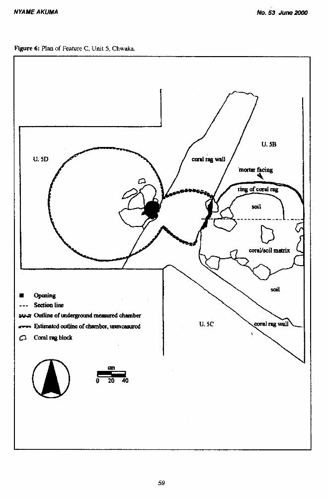
Although portions of the stratigraphy were intact, Eventually, an area in the south of U. 5 the midden deposits were jumbled chronologically revealed part of a finely dressed and mortared, syrn- (Sasanian-Islamic mixed with Chinese blue-and- metrical coral-rag feature (Figure 6). We added a
NYAME AKUMA No. 53 June 2000
Figure 5: Topographic map of the central area of Chwaka, indcating excavation units (topographic map by 1. . - . - - Fleisher).
meters m
0 50 100
NYAME AKUMA
Figure 6: Plan of Feature C , Unit 5, Chwaka
No. 53 June 2000
NYAME AKUMA No. 53 June 2000
2 mZ extension onto the west edge of the unit, to explore the feature. The feature was symmetrical, comprising two domed, round chambers, connected by another, smaller round chamber. The western chamber was intact, including its mortared-stone dome. The chamber was about 1.5 m in diameter at its widest. The central segment was about 0.7 m in diameter, and the eastern one approximated the western, though it had collapsed and the dome was no longer intact. The maximum depth reached inside the feature was 2.95 m below subdatum (not excavated to subsoil due to safety and access). Although it first seemed to be water management (a well, cistern, bathroom), its placement and some of its characteristics cast some doubt on this. Another possibility is that it was for dry storage, something rarely identified at Swahili sites.
Unit B was parallel to U. 5, to the east, sepa- rated by a baulk of 3.0 m. The maximum depth was 2.96 m below subdatum, to subsoil. Because of the northwestkoutheast axis of the house, the north end extended north of any room seen in U. 5, and had a thick, crushed white coral and mortar floor, not removed. There was considerable evidence for burning in the north end of the unit. An inverted whole pot, a possible$ngo, or buried talisman, was found in the north end, near a door frame that met the western wall of the unit. South of the door, built of carved Pon'tes blocks, was the eastern extension of the north room in U. 5. No floor was found in this room, consistent with the latter. The artifacts retrieved were similar to those from U. 5: local pot- tery increasing in number as the house floor was approached some imports. All the stone walls in this unit were in poor condition. The southern end of the unit was an area outside of the southern house wall (no footer), and contained dense midden material, below the stone structure, an extension of what was found at the lowest part of U. 5.
An intriguing aspect of this house is what appeared to be the footprint of an earthen structure, oriented on the same axis as the stone house, visi- ble in the southern part of the unit abutting midden material. Much cultural staining was evident-pits and post holes-along with the traces of plastered earthen walls. The material awaits fuller analysis; however, it would appear that the midden is associ- ated with this earlier structure.
The mound seems to represent only part of a former stone-built area, perhaps a two-story section of it. About 15 m south of U. 5 and 8, and 5 m south of the mound on flat ground, is a wall stump 10 m long, hidden by maize. It runs parallel to the north- wedsoutheast house walls, and suggests that other stone architecture, with no surface visibility, may lie in this part of the bluff. Indeed, a smaller, low mound, c a 13 d, lies about 30 m to the southwest of the long mound, on the other side of the wall stump. Stone blocks may have been removed fram the site for a variety of reasons, but Chwaka's pro- portion of stone buildings also may have been rela- tively low. The midden excavations suggest that prestigious consumption was not limited to those living in stone houses.
The Mazrai Site. In 1997, we cleared, pho- tographed, and planned the tombs. These remain surrounded by maize cultivation, overtaken with brush, and in need of conservation.
Concluding Remarks Pujini appeared on Pemba in the 15th centu-
ry, at a time when the island was dotted with large, economically successful trading centers and dozens, if not scores or even hundreds, of mixed farming and fishing villages. As a fortified, impor- tant residence rather than a town or village, Pujini was different from other settlements on the island, if not the coast-and smaller in physical size and pop- ulation than even most hamlets. But the massive effort and expense that went into enclosing the area, and providing an elegant home with numerous pop- ular architectural details of the time, suggest an attempt to gain the respect of the much larger and more established communities on the island, at a time when economic and political rivalries may have been at a high point on Pemba. It would appear now that the fortification had little to do with actual mil- itary defensiveness, and much to do with both com- fortable living, and attempting to carve out a niche, so to speak, in a set of political, economic, and social networks and circumstances on Pemba at that time. The abandonment of Pujini in the 16th centu- ry attests not to a general collapse on Pemba at that time, but to circumstances at Pujini itself. The lega- cy of the site and its ruler Mkame Ndume, however, suggest that the ideological impact of Pujini on the future generations of Pemba would be great.
NYA ME A KUMA No. 53 June 2000
The work begun at Chwaka will add a new dimension to the history and archaeology of Pemba, and provide data for comparison with the work of others who have conducted archaeology on the island. Although the picture is far from clear, the preliminary excavations conducted at Chwaka and Tumbe in 1997 indicate a long life span of settle- ment in that region (the 9"' century at the latest, uninterrupted until the 16Ih century), and focused, long-term research on that complex of sites and their regional context has tremendous potential.
The midden materials, as mentioned above, will provide a 600-700-year sequence of local pot- tery, well-stratified with imports, extending what we have presently for Pemba. Chwaka's long life invites comparison with Pujini, which, though a major site with possibly a major political impact on the island, was occupied only a short time, at the very end of Chwaka's life span. Indeed, if Chwaka was ruled by Mkame Ndume's son Harouni, as oral traditions would suggest (Pearce 1920), it was cer- tainly not founded by him, which suggests that he was able to enter a major, established town as a ruler.
Research in the area of Chwaka has several valuable trajectories. Its size and length of occupa- tion point to this being perhaps the most stable (not static), long-lived settlement system on the island. The temporal and areal scale of the deposits will permit intrasite comparative work, between the wat- tle-and-daub domestic areas on the one hand, and what appears to be the relatively small stonetown area on the top of the bluff overlooking the water, on the other. In addition to being a settlement involved in the importation and consumption of exotic goods throughout its life, Chwaka also appears to be involved in manufacturing goods including cloth, iron, and pottery. Research into specialized activity areas in the stone- and wattle- and-daub sectors of the town, and how they changed over time, will be a focus of future work. Ongoing investigations at TuinbeIChwaka, and in the rural hinterland around them (Fleisher 1999), will provide diachronic data about an entire urban system. Combined with the research at Pujini, and with the results from work at other sites on the island, Chwaka will contribute to understanding Swahili society, economy, and culture as it changed within the regional system of Pemba Island.
Acknowledgements I gratefully acknowledge grants provided by
the University of Virginia's Shannon Center for Advanced Studies, and the Wenner-Gren Foundation for Anthropological Research, for the 1997 and 1998 seasons respectively. I also thank Michael Fleisher, who provided additional support for both seasons, Peter Winkels, who was instru- mental in arranging the transit survey and provided hospitality; and Bruce McKim, for his hospitality in Chake on many occasions. My deep appreciation goes to Hamad H. Omar, Director of Museums and Archives on Zanzibar, for his continued under- standing and support; Abdurahman Juma, Head of Zanzibar Antiquities, who as always, provided many intellectual and logistical contributions, and Salim Seif and Kombo Khamis, Zanzibar Office of the President, Pemba, who provided daily help and guidance. I am grateful to Felix Chami, former Co- ordinator of the Archaeology Unit, UDSM, and his successor, the current Co-ordinator Bertram Mapunda who, along with other Unit members, provided equipment for the project, support in Dar and helpful camaraderie. I thank Saidi Killindo of the Archaeology Unit for technical support in the field. The GIs Laboratory of Alderman Library, University of Virginia, provided assistance with the topographic maps. I owe a debt to our hosts at Pujini, M. Mohammed Zahoro and M. Suleiman Mubarak, and families. In Tumbe, I thank Suleiman Ali Bakar and Suleiman Nassor al-Nabahany for their many forms of assistance. The site supervisors kept everything going: Isolde Brielmaier, Geoff Benelisha, Jamie Greene, Courtney Helfrecht, Amalie Holbauer, Amy Lawson, Melat Lemma, Deborah Levine, Allison Tillack, Rob Thornson, Jonathan Walz, and Joella Walz. I warmly thank Ernanuel Kessy, University of Dar es Salaam, who spent four field seasons as a site supervisor at Pujini. Special thanks to Jeff Fleisher, University of Virginia, who acted as Assistant Director during 1997-1998, and provided crucial time, effort, and thoughtfulness that helped lead to the success of these projects. Lastly, thanks always to Richard Handler, for his support in all research efforts.
NYA ME AKUMA No. 53 June 2000
References Cited
Chami, E
1994 The Tanzanian Coast in the First Millennium A.D. Studies in African Archaeology Volume 7. Uppsala: Societas Archaeologica Upsaliensis.
Chittick, H. N.
1974 Kihtu - An Islumic Trading City on the East African Coast. 2 vols. BIEA Memoir 5. Nairobi: British Institute in Eastern Africa.
Clark, C. and M. Horton
1985 The Zrtrizibar Archaeological Survey, 1984-5. Ministry of Information, Culture and Sports, Zanzibar.
Donley, L.W.
1982 House Power: Swahili Space and Symbolic Markers. In I. Hodder, editor, Symbolic and Structural Archaeology. Cambridge: Cambridge University Press, pp. 63-73.
Donley-Reid, L.W.
1990a A Structuring Structure: The Swahili House. In S. Kent, editor, Domestic Architecture and the Use of Space: An Interdisciplinary Cross-Cultural Study. Cambridge: Cambridge University Press, pp. 114-126.
1990b The Power of Swahili Porcelain, Beads and Pottery. In S. M. Nelson and A. B. Kehoe, editors, Powers of Observation: Allernutive Views in Archaeology. Archaeological Papers of the American Anthropological Association 2: 47-59.
Fleisher, J.
1999 Viewing Stonetowns from the Countryside: An Archaeological Approach to Swahili Urban Systems. Proposal sub- mitted to the National Science Foundation, February.
Fieisher, J. and A. LaViolette
1999a The recovery of Swahili settlements in the absence of stone architecture: Two preliminary surveys from Pemba Island, Tanzania. Nyame Akuma 52: 64-73.
1999b Elusive Wattle-and-Daub: Finding the Silent Majority in the Archaeology of the Swahili. Azania XXIV
1966 B e Early Islamic Architecture of'the East African Coast. Memoir 1, B.I.E.A. Nairobi: British Institute in Eastern Africa.
Horton, M. C.
1996 Shanga: The Archaeology of' a M~lslim Tmding Community on the Coast of East Afica. Memoir 14, B.I.E.A. London: British Institute of East Africa.
1959 Excavations at Ras Mkumbuu on the Island of Pemba. Tanganyika Notes and Recordrr 53: 161-178.
LaViolette, A.
forthcoming Peer Polities on Pemba: Swahili Archaeology and History in the Fifteenth and Sixteenth Centuries. In P. Lane and A. Reid, editors, African Historical Amhaeologies. Plenum.
1989 Preliminary Report: Excavations and Survey at Pujini, a Fortress on Pemba Island, Tanzania. Nyame Akuma 32: 35-38.
NYAME AKUMA No, 53 June 2000
Preliminary Report: Archaeological Investigations at Pujini, Pemba, 1993. Submitted to Department of Museums and Archives, Office of the President, Zanzibar.
Report on excavations at the Swahili site of Pujini, Pemba Island, Tanzania. Nyame Akuma 46:72-83.
Peer Polities on Pemba: Swahili Archaeology and History in the Fifteenth and Sixteenth Centuries. Paper presented at the Biennial Meeting of the Society of Africanist Archaeologists, Syracuse.
LaViolette, A. and J. Fleisher
1995 Reconnaissance of Sites bearing Triangular Incised (Tana Tradition) Ware on Pemba Island, Tanzania. Nyame Akuma 44: 59-65.
Pearce, Maj. F. B.
1920 Zanzibar: The Island Metropolis of Eastern Africa. London: Frank Cass and Company Limited.


