Embed Size (px)
Citation preview
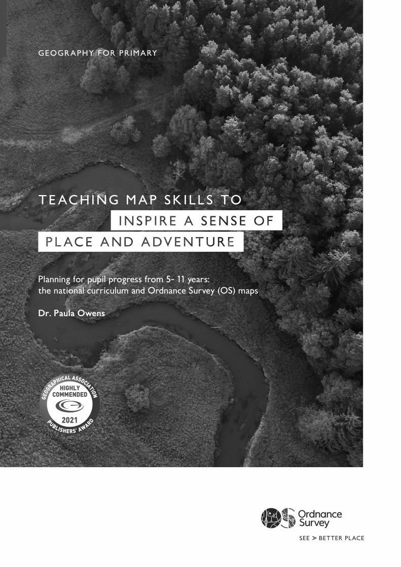
GEOGRAPHY FOR PRIMARY
TEACHING MAP SK I LLS TO
Planning for pupil progress from 5- 11 years: the national curriculum and Ordnance Survey (OS) maps
Dr. Paula Owens
2021
2
‘A high-quality geography education should inspire in pupils a curiosity and fascination about the world and its people that will remain with them for the rest of their lives.’
National Curriculum Geography Programme of Study (England)
GEOGRAPHY FOR PRIMARY
3
Contents
Using Ordnance Survey maps 5
1 What are you trying to achieve? 10
The Ofsted education inspection framework 12Pupils and maps 14
2 How will you organise learning? 18
Considerations for progression across primary 22KS1 Planner focusing on progression in map skills 23Pedagogical approaches to teaching 30Enquiry and conceptual understanding 31Some mapping ideas for early years 34
3 How well are you achieving your aims? 35
Useful pages 36
Sources 37
CONTENTS
4
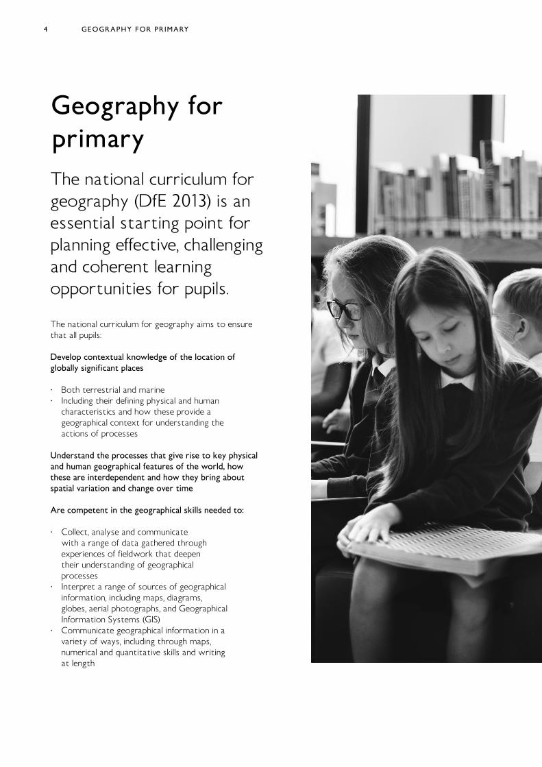
Geography for primaryThe national curriculum for geography (DfE 2013) is an essential starting point for planning effective, challenging and coherent learning opportunities for pupils.
The national curriculum for geography aims to ensure that all pupils:
Develop contextual knowledge of the location of globally significant places
· Both terrestrial and marine · Including their defining physical and human
characteristics and how these provide a geographical context for understanding the actions of processes
Understand the processes that give rise to key physical and human geographical features of the world, how these are interdependent and how they bring about spatial variation and change over time
Are competent in the geographical skills needed to:
· Collect, analyse and communicate with a range of data gathered through experiences of fieldwork that deepen their understanding of geographical processes
· Interpret a range of sources of geographical information, including maps, diagrams, globes, aerial photographs, and Geographical Information Systems (GIS)
· Communicate geographical information in a variety of ways, including through maps, numerical and quantitative skills and writing at length
GEOGRAPHY FOR PRIMARY
5
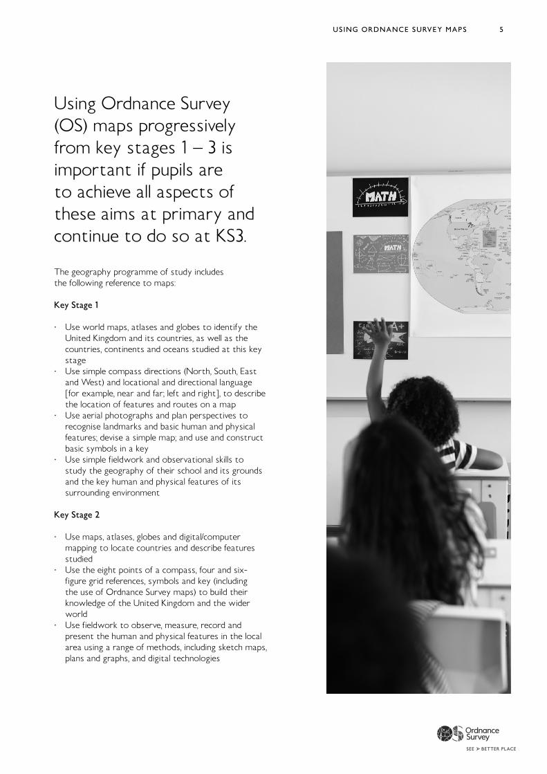
Using Ordnance Survey (OS) maps progressively from key stages 1 – 3 is important if pupils are to achieve all aspects of these aims at primary and continue to do so at KS3.
The geography programme of study includes the following reference to maps:
Key Stage 1
· Use world maps, atlases and globes to identify the United Kingdom and its countries, as well as the countries, continents and oceans studied at this key stage
· Use simple compass directions (North, South, East and West) and locational and directional language [for example, near and far; left and right], to describe the location of features and routes on a map
· Use aerial photographs and plan perspectives to recognise landmarks and basic human and physical features; devise a simple map; and use and construct basic symbols in a key
· Use simple fieldwork and observational skills to study the geography of their school and its grounds and the key human and physical features of its surrounding environment
Key Stage 2
· Use maps, atlases, globes and digital/computer mapping to locate countries and describe features studied
· Use the eight points of a compass, four and six-figure grid references, symbols and key (including the use of Ordnance Survey maps) to build their knowledge of the United Kingdom and the wider world
· Use fieldwork to observe, measure, record and present the human and physical features in the local area using a range of methods, including sketch maps, plans and graphs, and digital technologies
USING ORDNANCE SURVEY MAPS
6
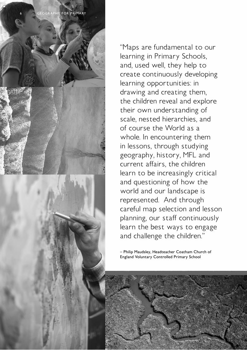
“Maps are fundamental to our learning in Primary Schools, and, used well, they help to create continuously developing learning opportunities: in drawing and creating them, the children reveal and explore their own understanding of scale, nested hierarchies, and of course the World as a whole. In encountering them in lessons, through studying geography, history, MFL and current affairs, the children learn to be increasingly critical and questioning of how the world and our landscape is represented. And through careful map selection and lesson planning, our staff continuously learn the best ways to engage and challenge the children.”
– Philip Maudsley, Headteacher Coatham Church of England Voluntary Controlled Primary School
GEOGRAPHY FOR PRIMARY6
7
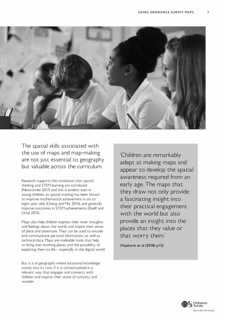
The spatial skills associated with the use of maps and map-making are not just essential to geography but valuable across the curriculum.
Research supports the conclusion that spatial thinking and STEM learning are correlated (Newcombe 2017) and this is evident even in young children, as spatial training has been shown to improve mathematical achievement in six to eight-year olds (Cheng and Mix 2014), and generally improve outcomes in STEM achievements (Stieff and Uttal 2015). Maps also help children express their inner thoughts and feelings about the world, and inspire their sense of place and adventure. They can be used to encode and communicate personal information, as well as technical data. Maps are malleable tools that help to bring ever-evolving places and the possibility of exploring them to life – especially in the digital world.
But it is in geography where locational knowledge comes into its own, if it is contextualised in a relevant way that engages and connects with children and inspires their sense of curiosity and wonder.
‘Children are remarkably adept at making maps and appear to develop the spatialawareness required from an early age. The maps that they draw not only provide a fascinating insight into their practical engagement with the world but also provide an insight into the places that they value or that worry them.’ (Vujakovic et al (2018) p.12)
USING ORDNANCE SURVEY MAPS
8
‘We have nine school years in which to help pupils develop their locational knowledge and to give their growing sense of the World geographical context. It is not isolated knowledge, for pub/TV quiz use. It is vital in not just a globalised World but also for making the most of our local, regional and national lives. We ignore locations, our knowledge of what they are like and their interrelationships at our peril.’
(Catling, S. (2014) https://www.geography.org.uk/download/ga_thinkpiece_locationalknowledgeingeogteaching.pdf)
GEOGRAPHY FOR PRIMARY8
9USING ORDNANCE SURVEY MAPS
10
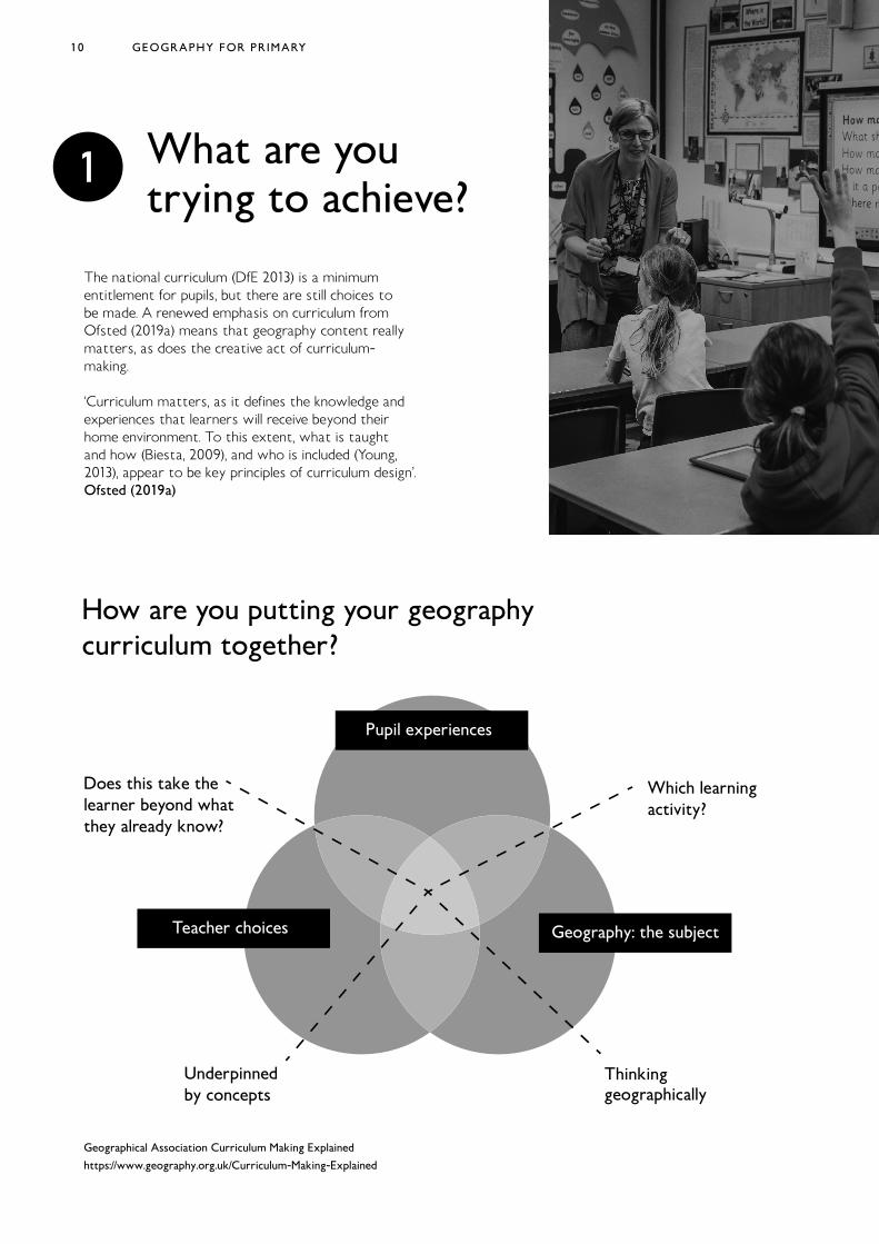
What are you trying to achieve?
The national curriculum (DfE 2013) is a minimum entitlement for pupils, but there are still choices to be made. A renewed emphasis on curriculum from Ofsted (2019a) means that geography content really matters, as does the creative act of curriculum-making.
‘Curriculum matters, as it defines the knowledge and experiences that learners will receive beyond their home environment. To this extent, what is taught and how (Biesta, 2009), and who is included (Young, 2013), appear to be key principles of curriculum design’. Ofsted (2019a)
How are you putting your geography curriculum together?
Pupil experiences
Teacher choices Geography: the subject
Which learningactivity?
Thinkinggeographically
Underpinnedby concepts
Does this take thelearner beyond whatthey already know?
1
GEOGRAPHY FOR PRIMARY
Geographical Association Curriculum Making Explained
https://www.geography.org.uk/Curriculum-Making-Explained
1 1
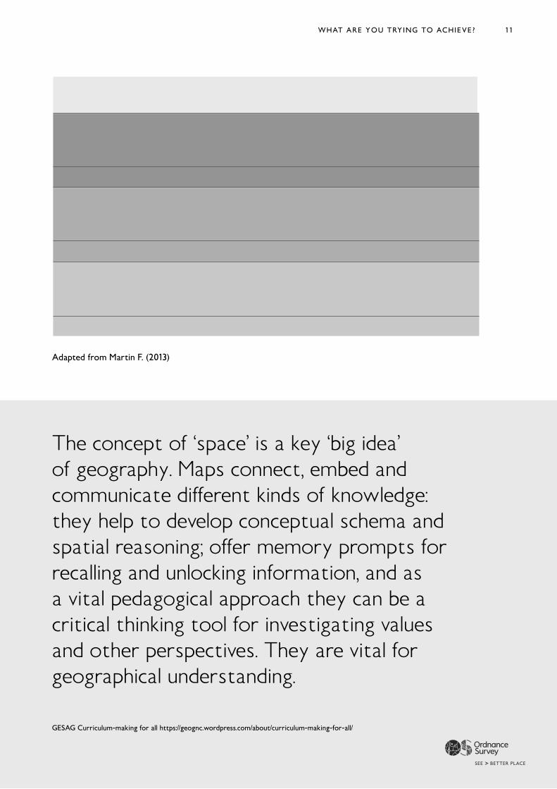
Curriculum-making question
What shall I teach? (Content)
Why am I teaching this? (Purpose)
Maps reveal spatial patterns, provide a geography focused ‘lens’ and develop core geographical vocabulary
Maps provide a rich context for dialogic debate and thinking about the significance of location.
How am I going to teach this? (Pedagogy)
Maps are part of the geographer’s toolkit. Map-skills support enquiry and critical-thinking pedagogies.
Geographical knowledge
What are the key ideas / concepts here?
What is significant content and why?
What is the best way to help pupils learn and remember these aspects of knowledge?
Teacher choices
What context and location shall I select for this knowledge?
How will my selection help pupils to make progress in their geographical thinking?
What opportunities are there for pupils to know, understand, apply and be critical thinkers?
Pupils’ experiences and interests
What do pupils already know and think? What do I need to extend and challenge?
How does it connect to pupils’ interests and / or concerns?
How will I involve the pupils to make the content memorable?
Adapted from Martin F. (2013)
The concept of ‘space’ is a key ‘big idea’ of geography. Maps connect, embed and communicate different kinds of knowledge: they help to develop conceptual schema and spatial reasoning; offer memory prompts for recalling and unlocking information, and as a vital pedagogical approach they can be a critical thinking tool for investigating values and other perspectives. They are vital for geographical understanding.
GESAG Curriculum-making for all https://geognc.wordpress.com/about/curriculum-making-for-all/
WHAT ARE YOU TRYING TO ACHIEVE?
12
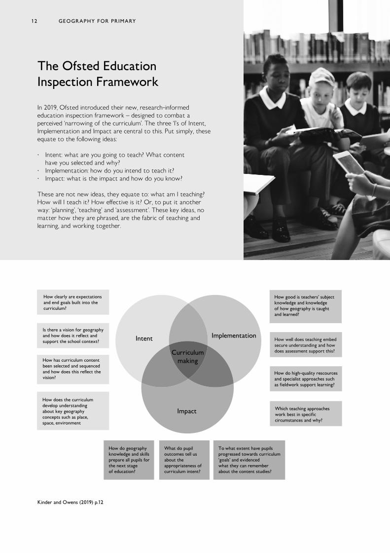
The Ofsted Education Inspection Framework
In 2019, Ofsted introduced their new, research-informed education inspection framework – designed to combat a perceived ‘narrowing of the curriculum’. The three ‘I’s of Intent, Implementation and Impact are central to this. Put simply, these equate to the following ideas:
· Intent: what are you going to teach? What content have you selected and why?
· Implementation: how do you intend to teach it? · Impact: what is the impact and how do you know?
These are not new ideas, they equate to: what am I teaching? How will I teach it? How effective is it? Or, to put it another way: ‘planning’, ‘teaching’ and ‘assessment’. These key ideas, no matter how they are phrased, are the fabric of teaching and learning, and working together.
Kinder and Owens (2019) p.12
Curriculummaking
Intent Implementation
Impact
How do geographyknowledge and skillsprepare all pupils forthe next stageof education?
What do pupiloutcomes tell usabout the appropriateness ofcurriculum intent?
To what extent have pupilsprogressed towards curriculum‘goals’ and evidencedwhat they can remember about the content studies?
How well does teaching embedsecure understanding and howdoes assessment support this?
How do high-quality rescourcesand specialist approaches suchas fieldwork support learning?
Which teaching approacheswork best in specificcircumstances and why?
How good is teachers’ subjectknowledge and knowledgeof how geography is taughtand learned?
How clearly are expectationsand end goals built into thecurriculum?
Is there a vision for geographyand how does it reflect andsupport the school context?
How has curriculum contentbeen selected and sequencedand how does this reflect thevision?
How does the curriculumdevelop understandingabout key geographyconcepts such as place,space, environment
GEOGRAPHY FOR PRIMARY12
13
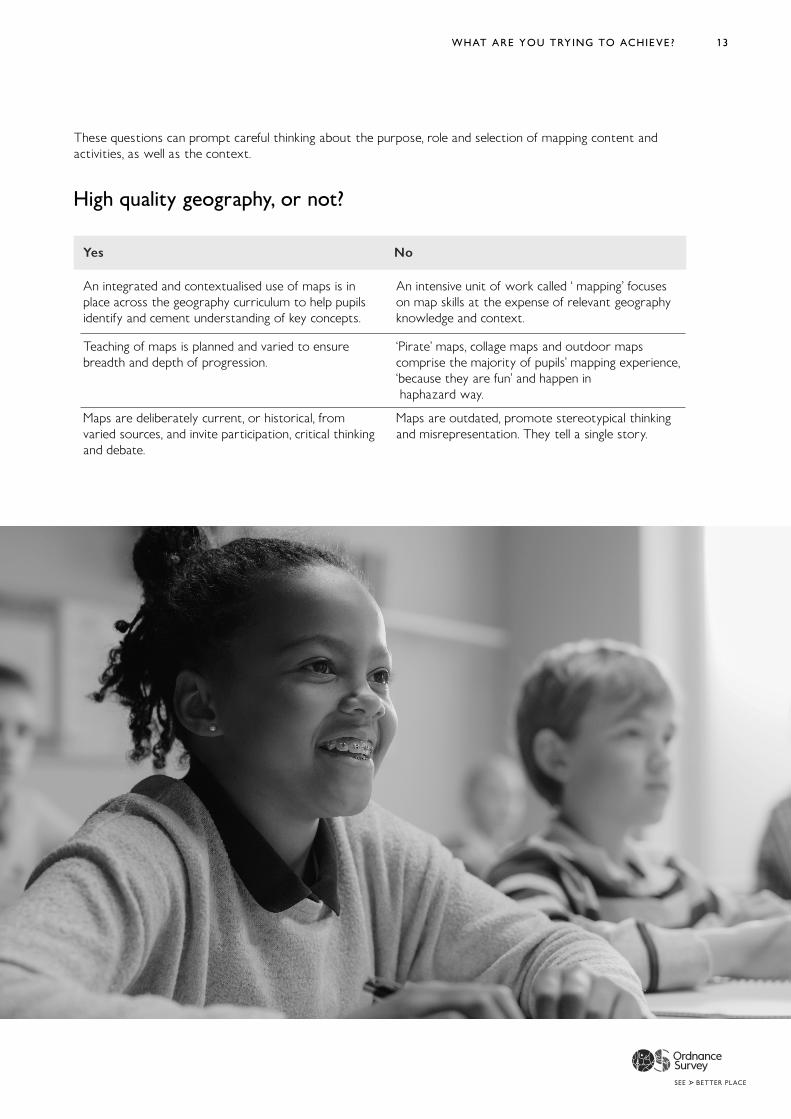
These questions can prompt careful thinking about the purpose, role and selection of mapping content and activities, as well as the context.
High quality geography, or not?
WHAT ARE YOU TRYING TO ACHIEVE?
Yes No
An integrated and contextualised use of maps is in place across the geography curriculum to help pupils identify and cement understanding of key concepts.
Teaching of maps is planned and varied to ensure breadth and depth of progression.
Maps are deliberately current, or historical, from varied sources, and invite participation, critical thinking and debate.
An intensive unit of work called ‘ mapping’ focuses on map skills at the expense of relevant geography knowledge and context.
‘Pirate’ maps, collage maps and outdoor maps comprise the majority of pupils’ mapping experience, ‘because they are fun’ and happen in haphazard way.
Maps are outdated, promote stereotypical thinking and misrepresentation. They tell a single story.
14
Pupils and Maps
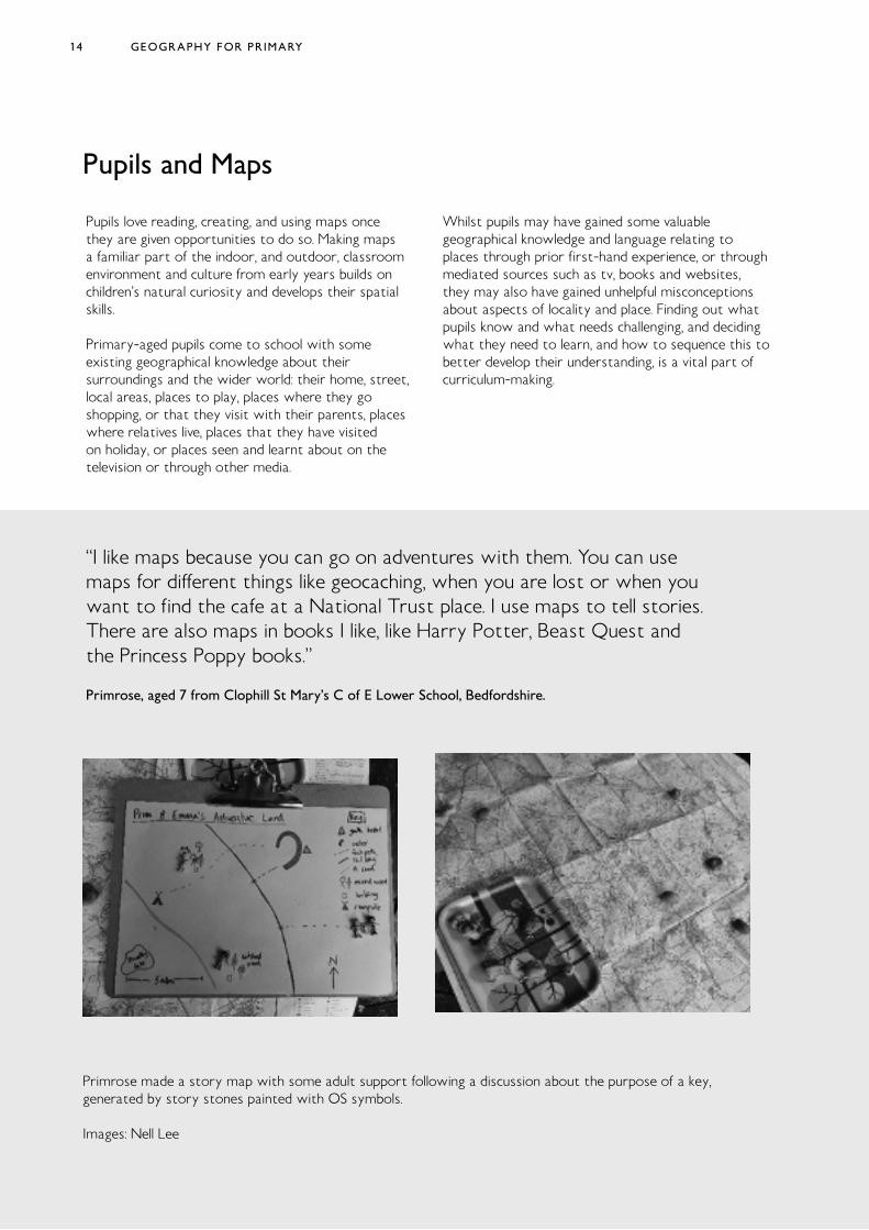
Primrose made a story map with some adult support following a discussion about the purpose of a key, generated by story stones painted with OS symbols.
Images: Nell Lee
GEOGRAPHY FOR PRIMARY
Pupils love reading, creating, and using maps once they are given opportunities to do so. Making maps a familiar part of the indoor, and outdoor, classroom environment and culture from early years builds on children’s natural curiosity and develops their spatial skills.
Primary-aged pupils come to school with some existing geographical knowledge about their surroundings and the wider world: their home, street, local areas, places to play, places where they go shopping, or that they visit with their parents, places where relatives live, places that they have visited on holiday, or places seen and learnt about on the television or through other media.
Whilst pupils may have gained some valuable geographical knowledge and language relating to places through prior first-hand experience, or through mediated sources such as tv, books and websites, they may also have gained unhelpful misconceptions about aspects of locality and place. Finding out what pupils know and what needs challenging, and deciding what they need to learn, and how to sequence this to better develop their understanding, is a vital part of curriculum-making.
“I like maps because you can go on adventures with them. You can use maps for different things like geocaching, when you are lost or when you want to find the cafe at a National Trust place. I use maps to tell stories. There are also maps in books I like, like Harry Potter, Beast Quest and the Princess Poppy books.”
Primrose, aged 7 from Clophill St Mary’s C of E Lower School, Bedfordshire.
15
‘… the learning progression for drawing maps proceeds from pictorial maps, through plans to large-scale and then small-scale maps. Pictorial maps portray the features of places by pictures of buildings, roads and rivers, while plans are more abstract maps of small areas, such as the child’s school. Large-scale maps are maps of a small area, such as a neighbourhood or suburb, because the scale is a relatively large ratio. Small-scale maps show a large area, like the whole of a state or country. Large-scale maps are taught first because they are about areas that students are familiar with, and this is how they learn to relate a map to the real world it portrays’.
Robertson et al (2019)p.20
WHAT ARE YOU TRYING TO ACHIEVE? 15
16
Pupils and Maps
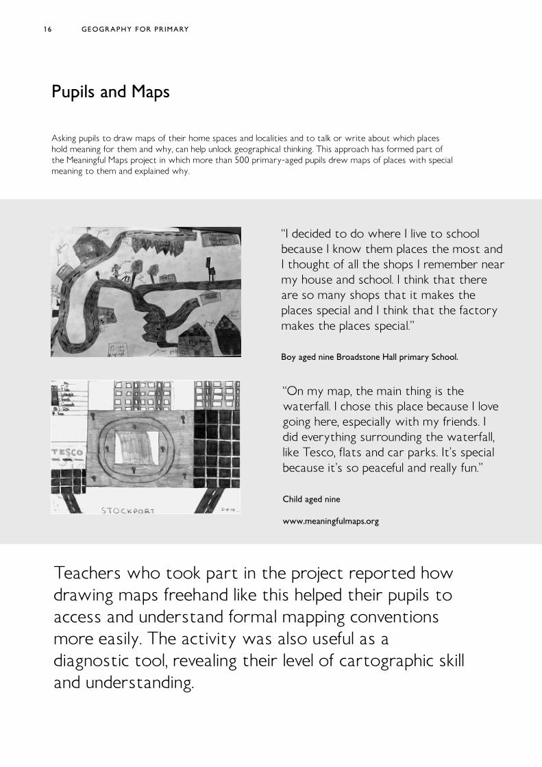
Asking pupils to draw maps of their home spaces and localities and to talk or write about which places hold meaning for them and why, can help unlock geographical thinking. This approach has formed part of the Meaningful Maps project in which more than 500 primary-aged pupils drew maps of places with special meaning to them and explained why.
“I decided to do where I live to school because I know them places the most and I thought of all the shops I remember near my house and school. I think that there are so many shops that it makes the places special and I think that the factory makes the places special.”
Boy aged nine Broadstone Hall primary School.
“On my map, the main thing is the waterfall. I chose this place because I love going here, especially with my friends. I did everything surrounding the waterfall, like Tesco, flats and car parks. It’s special because it’s so peaceful and really fun.”
Child aged nine
www.meaningfulmaps.org
GEOGRAPHY FOR PRIMARY
Teachers who took part in the project reported how drawing maps freehand like this helped their pupils to access and understand formal mapping conventions more easily. The activity was also useful as a diagnostic tool, revealing their level of cartographic skill and understanding.
17WHAT ARE YOU TRYING TO ACHIEVE?
“Typically, the teaching of geographical skills, including the use and construction of maps, is not particularly strong in primary schools. Too little attention is given to accuracy and conventions followed by geographers, such as the use of scale.”
Iain Freeland (2020)
Research shows that pupils can struggle to correctly interpret several features of maps, including:
· The use of colours to show climate or vegetation zones, different states or territories, relief (height above sea level) and other characteristics of areas, For example, they may fail to understand that the colour on a map may not correspond with the colour of what is being represented.
· The use of symbols that show roads, the location of towns, the population of cities, economic activities, and other features. For example, they may fail to understand that a dot represents the location of a place and not its size.
· The relationship between two spatial distributions when high values on one distribution are associated with low values on the other. Robertson et al (2019) p.20
Geographical skills were particularly well developed when the schools had a very comprehensive fieldwork programme and when a variety of maps, aerial photographs and other geographical resources was used frequently, as in this example.
Mapwork was threaded into teachers’ plans wherever possible and mapwork skills were developed sequentially through the school. Beginning in the Reception class, pupils used photographs of rooms and features in school and could place them accurately on a blank map of the corridor. They could describe a journey along the corridor, using appropriate vocabulary such as ‘opposite’, ‘next to’, ‘forward’, ‘right’ and ‘left’. In a Year 2 lesson, pupils were able to locate a number of physical features using coordinates and follow accurately a number of routes to enable them to arrive at destinations. By Year 6, pupils were able to recall the route they had taken to the Pennines, particularly the roads, towns and villages visited on the journey. They had then used Ordnance Survey maps to trace the route, revised key symbols and used this to draw their own maps accurately, complete with keys.
Ofsted (2011) p.10
Although they have a natural ability for spatial thinking at an early age, without specific teaching and support, children’s spatial skills may not progress further, and because of this, it is essential to include formal teaching of mapping and map interpretation throughout the primary years (Robertson et al 2019).
Maps play a central role in enabling pupils to think geographically and help them develop their knowledge and understanding of the subject. Ofsted (2011) reported that map skills were clearly evident in schools where geography was done well and they advised that to combat weaker instances of geography, map skills should be developed rather than repeated, and given genuine contexts.
In 2020, the development of mapping in primary schools still has some way to go, as Her Majesty’s Inspector for Schools (Geography) comments:
Weaker teaching was associated with:
‘.. over-use of worksheets which required pupils only to label diagrams and maps, and the work was not directly related to examples of real places.’
Ofsted (2011) p.10
18
How will you organise learning?
2
GEOGRAPHY FOR PRIMARY
Enable pupils to learn and make progress.
Build on conceptual understanding and ensure pupils remember what they have learnt through opportunities to consolidate and check learning.
Have carefully chosen content and sequencing.
Develop more complex and abstract thinking.
Evidence a broad range of opportunities and deep learning experiences, that includes fieldwork.
Combine knowledge, skills and values in relevant contexts.
Ensure enquiry is underpinned by core knowledge.
Have coherence with other subjects in the curriculum.
Have linked, relevant texts for each topic or area of learning (fiction and / or non-fiction).
Contextualise maps and mapping as part of its geographical lens on the world.
Be led by teachers who are knowledgeable and have benefit from recent Continuing Professional Development (CPD).
An effective geography curriculum will:
19HOW WILL YOU ORGANISE LEARNING?
Example
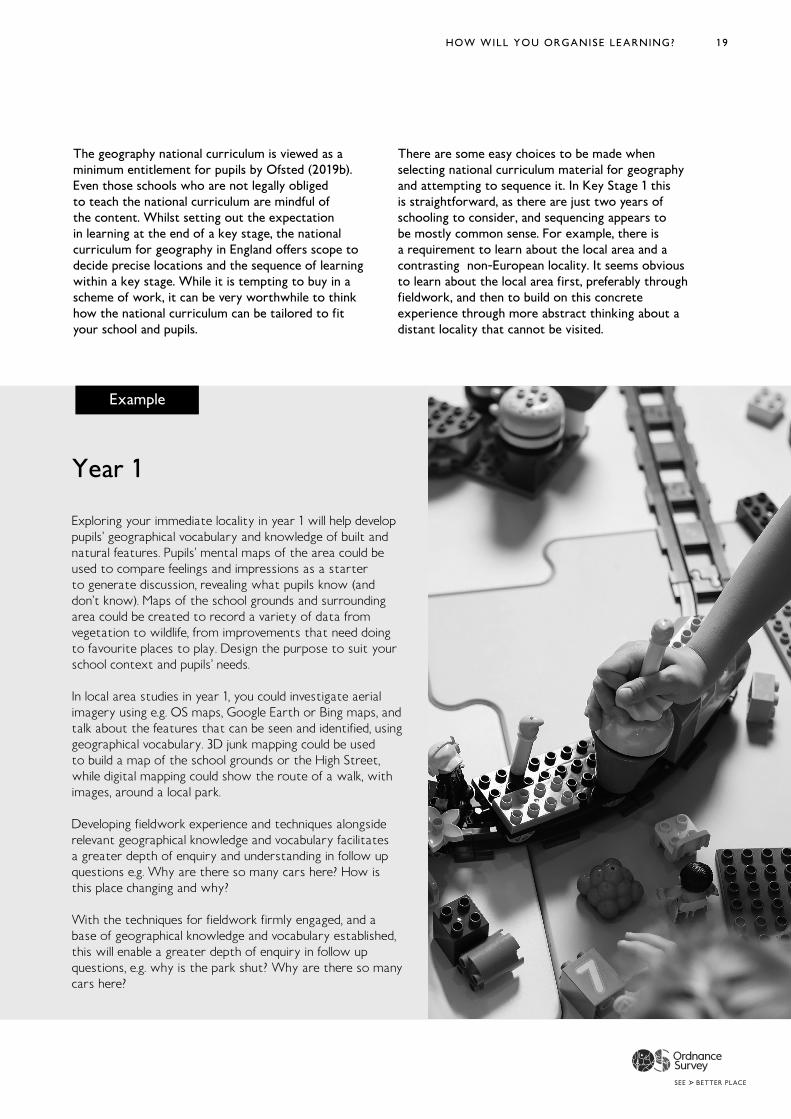
Year 1
Exploring your immediate locality in year 1 will help develop pupils’ geographical vocabulary and knowledge of built and natural features. Pupils’ mental maps of the area could be used to compare feelings and impressions as a starter to generate discussion, revealing what pupils know (and don’t know). Maps of the school grounds and surrounding area could be created to record a variety of data from vegetation to wildlife, from improvements that need doing to favourite places to play. Design the purpose to suit your school context and pupils’ needs.
In local area studies in year 1, you could investigate aerial imagery using e.g. OS maps, Google Earth or Bing maps, and talk about the features that can be seen and identified, using geographical vocabulary. 3D junk mapping could be used to build a map of the school grounds or the High Street, while digital mapping could show the route of a walk, with images, around a local park.
Developing fieldwork experience and techniques alongside relevant geographical knowledge and vocabulary facilitates a greater depth of enquiry and understanding in follow up questions e.g. Why are there so many cars here? How is this place changing and why?
With the techniques for fieldwork firmly engaged, and a base of geographical knowledge and vocabulary established, this will enable a greater depth of enquiry in follow up questions, e.g. why is the park shut? Why are there so many cars here?
The geography national curriculum is viewed as a minimum entitlement for pupils by Ofsted (2019b). Even those schools who are not legally obliged to teach the national curriculum are mindful of the content. Whilst setting out the expectation in learning at the end of a key stage, the national curriculum for geography in England offers scope to decide precise locations and the sequence of learning within a key stage. While it is tempting to buy in a scheme of work, it can be very worthwhile to think how the national curriculum can be tailored to fit your school and pupils.
There are some easy choices to be made when selecting national curriculum material for geography and attempting to sequence it. In Key Stage 1 this is straightforward, as there are just two years of schooling to consider, and sequencing appears to be mostly common sense. For example, there is a requirement to learn about the local area and a contrasting non-European locality. It seems obvious to learn about the local area first, preferably through fieldwork, and then to build on this concrete experience through more abstract thinking about a distant locality that cannot be visited.
20 GEOGRAPHY FOR PRIMARY
Example
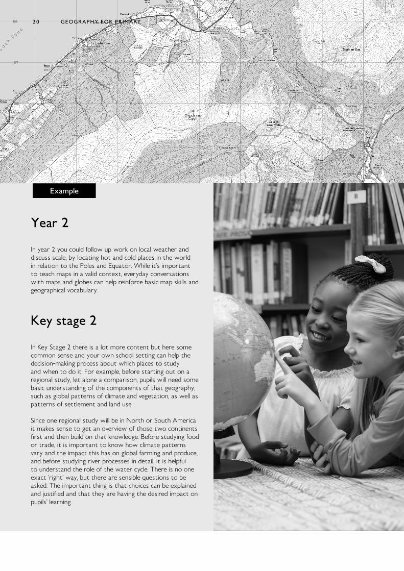
Year 2
In year 2 you could follow up work on local weather and discuss scale, by locating hot and cold places in the world in relation to the Poles and Equator. While it’s important to teach maps in a valid context, everyday conversations with maps and globes can help reinforce basic map skills and geographical vocabulary.
Key stage 2
In Key Stage 2 there is a lot more content but here some common sense and your own school setting can help the decision-making process about which places to study and when to do it. For example, before starting out on a regional study, let alone a comparison, pupils will need some basic understanding of the components of that geography, such as global patterns of climate and vegetation, as well as patterns of settlement and land use.
Since one regional study will be in North or South America it makes sense to get an overview of those two continents first and then build on that knowledge. Before studying food or trade, it is important to know how climate patterns vary and the impact this has on global farming and produce, and before studying river processes in detail, it is helpful to understand the role of the water cycle. There is no one exact ‘right’ way, but there are sensible questions to be asked. The important thing is that choices can be explained and justified and that they are having the desired impact on pupils’ learning.
20
21HOW WILL YOU ORGANISE LEARNING?
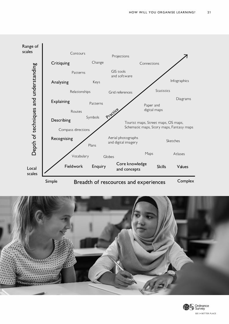
Critiquing
Analysing
Explaining
Describing
Recognising
Simple ComplexBreadth of rescources and experiences
Dep
th o
f te
chni
ques
and
und
erst
andi
ng
Range ofscales
Localscales
Fieldwork Enquiry Core knowledgeand concepts Skills Values
Practi
ce
Contours
Patterns
Relationships
Routes
Compass directions
Vocabulary
Plans
Symbols
Keys
Patterns
Change
GIS toolsand software
Grid references
Projections
Connections
Infographics
Statistics
Diagrams
Paper and digital maps
Tourist maps, Street maps, OS maps,Schematic maps, Story maps, Fantasy maps
Aerial photographsand digital imagery Sketches
GlobesMaps Atlases
22
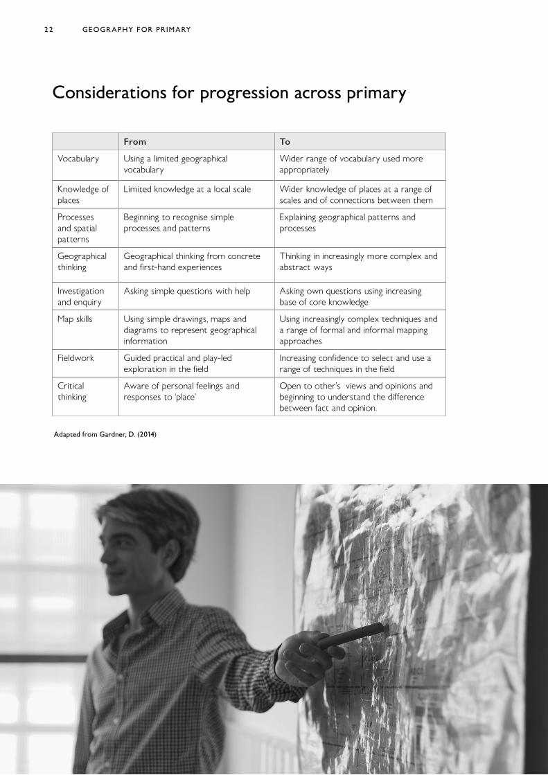
Considerations for progression across primary
Adapted from Gardner, D. (2014)
GEOGRAPHY FOR PRIMARY
From To
Vocabulary Using a limited geographical vocabulary
Wider range of vocabulary used more appropriately
Knowledge of places
Limited knowledge at a local scale Wider knowledge of places at a range of scales and of connections between them
Processes and spatial patterns
Beginning to recognise simple processes and patterns
Explaining geographical patterns and processes
Geographical thinking
Geographical thinking from concrete and first-hand experiences
Thinking in increasingly more complex and abstract ways
Investigation and enquiry
Asking simple questions with help Asking own questions using increasing base of core knowledge
Map skills Using simple drawings, maps and diagrams to represent geographical information
Using increasingly complex techniques and a range of formal and informal mapping approaches
Fieldwork Guided practical and play-led exploration in the field
Increasing confidence to select and use a range of techniques in the field
Critical thinking
Aware of personal feelings and responses to ‘place’
Open to other’s views and opinions and beginning to understand the difference between fact and opinion.
23
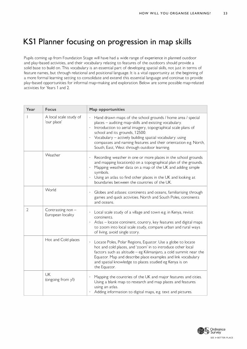
KS1 Planner focusing on progression in map skills
Pupils coming up from Foundation Stage will have had a wide range of experience in planned outdoor and play-based activities, and their vocabulary relating to features of the outdoors should provide a solid base to build on. This vocabulary is an essential part of developing spatial skills, not just in terms of feature names, but through relational and positional language. It is a vital opportunity at the beginning of a more formal learning setting to consolidate and extend this essential language and continue to provide play-based opportunities for informal map-making and exploration. Below are some possible map-related activities for Years 1 and 2.
HOW WILL YOU ORGANISE LEARNING?
Year Focus Map opportunities
1 A local scale study of ‘our place’
· Hand drawn maps of the school grounds / home area / special places – auditing map-skills and existing vocabulary.
· Introduction to aerial imagery, topographical scale plans of school and its grounds, 1:2500.
· Vocabulary – actively building spatial vocabulary: using compasses and naming features and their orientation e.g. North, South, East, West through outdoor learning.
Weather · Recording weather in one or more places in the school grounds and mapping location(s) on a topographical plan of the grounds.
· Mapping weather data on a map of the UK and adding simple symbols.
· Using an atlas to find other places in the UK and looking at boundaries between the countries of the UK.
World · Globes and atlases: continents and oceans, familiarising through games and quick activities. North and South Poles, continents and oceans.
2 Contrasting non – European locality
· Local scale study of a village and town e.g. in Kenya, revisit continents.
· Atlas – locate continent, country, key features and digital maps to zoom into local scale study, compare urban and rural ways of living, avoid single story.
Hot and Cold places · Locate Poles, Polar Regions, Equator. Use a globe to locate hot and cold places, and ‘zoom’ in to introduce other local factors such as altitude – eg Kilimanjaro, a cold summit near the Equator. Map and describe place examples and link vocabulary and spatial knowledge to places studied eg Kenya is on the Equator.
UK (ongoing from y1)
· Mapping the countries of the UK and major features and cities. Using a blank map to research and map places and features using an atlas.
· Adding information to digital maps, e.g. text and pictures.
24 GEOGRAPHY FOR PRIMARY24 GEOGRAPHY FOR PRIMARY24
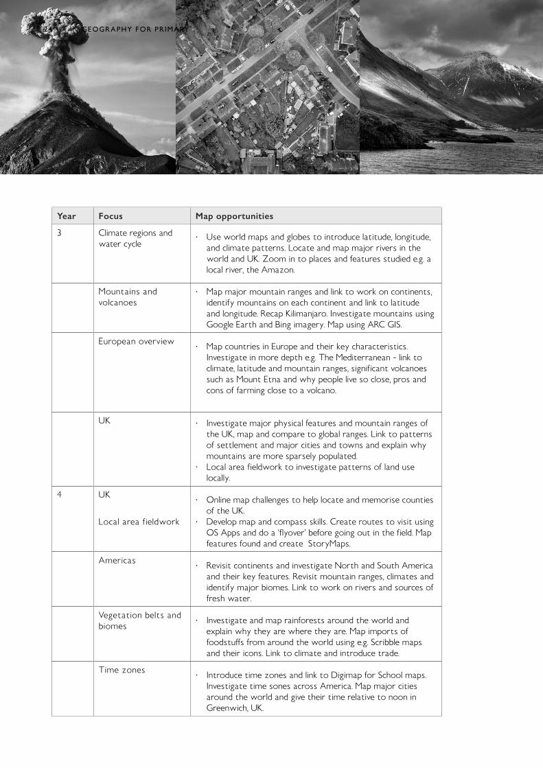
Year Focus Map opportunities
3 Climate regions and water cycle
· Use world maps and globes to introduce latitude, longitude, and climate patterns. Locate and map major rivers in the world and UK. Zoom in to places and features studied e.g. a local river, the Amazon.
Mountains and volcanoes
· Map major mountain ranges and link to work on continents, identify mountains on each continent and link to latitude and longitude. Recap Kilimanjaro. Investigate mountains using Google Earth and Bing imagery. Map using ARC GIS.
European overview · Map countries in Europe and their key characteristics. Investigate in more depth e.g. The Mediterranean - link to climate, latitude and mountain ranges, significant volcanoes such as Mount Etna and why people live so close, pros and cons of farming close to a volcano.
UK · Investigate major physical features and mountain ranges of the UK, map and compare to global ranges. Link to patterns of settlement and major cities and towns and explain why mountains are more sparsely populated.
· Local area fieldwork to investigate patterns of land use locally.
4 UK
Local area fieldwork
· Online map challenges to help locate and memorise counties of the UK.
· Develop map and compass skills. Create routes to visit using OS Apps and do a ‘flyover’ before going out in the field. Map features found and create StoryMaps.
Americas · Revisit continents and investigate North and South America and their key features. Revisit mountain ranges, climates and identify major biomes. Link to work on rivers and sources of fresh water.
Vegetation belts and biomes
· Investigate and map rainforests around the world and explain why they are where they are. Map imports of foodstuffs from around the world using e.g. Scribble maps and their icons. Link to climate and introduce trade.
Time zones · Introduce time zones and link to Digimap for School maps. Investigate time sones across America. Map major cities around the world and give their time relative to noon in Greenwich, UK.
25HOW WILL YOU ORGANISE LEARNING?
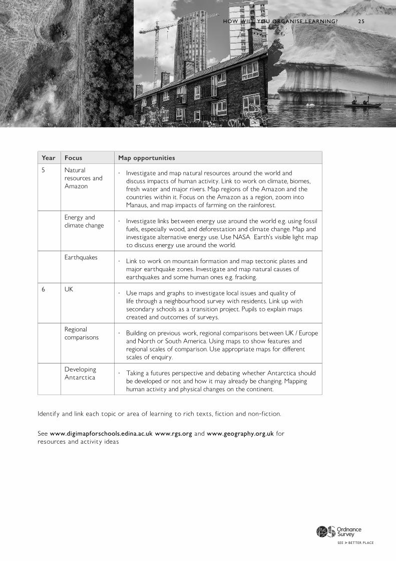
Identify and link each topic or area of learning to rich texts, fiction and non-fiction.
See www.digimapforschools.edina.ac.uk www.rgs.org and www.geography.org.uk for resources and activity ideas
25HOW WILL YOU ORGANISE LEARNING? 25
Year Focus Map opportunities
5 Natural resources and Amazon
· Investigate and map natural resources around the world and discuss impacts of human activity. Link to work on climate, biomes, fresh water and major rivers. Map regions of the Amazon and the countries within it. Focus on the Amazon as a region, zoom into Manaus, and map impacts of farming on the rainforest.
Energy and climate change
· Investigate links between energy use around the world e.g. using fossil fuels, especially wood, and deforestation and climate change. Map and investigate alternative energy use. Use NASA Earth’s visible light map to discuss energy use around the world.
Earthquakes · Link to work on mountain formation and map tectonic plates and major earthquake zones. Investigate and map natural causes of earthquakes and some human ones e.g. fracking.
6 UK · Use maps and graphs to investigate local issues and quality of life through a neighbourhood survey with residents. Link up with secondary schools as a transition project. Pupils to explain maps created and outcomes of surveys.
Regional comparisons
· Building on previous work, regional comparisons between UK / Europe and North or South America. Using maps to show features and regional scales of comparison. Use appropriate maps for different scales of enquiry.
Developing Antarctica
· Taking a futures perspective and debating whether Antarctica should be developed or not and how it may already be changing. Mapping human activity and physical changes on the continent.
2626 GEOGRAPHY FOR PRIMARY
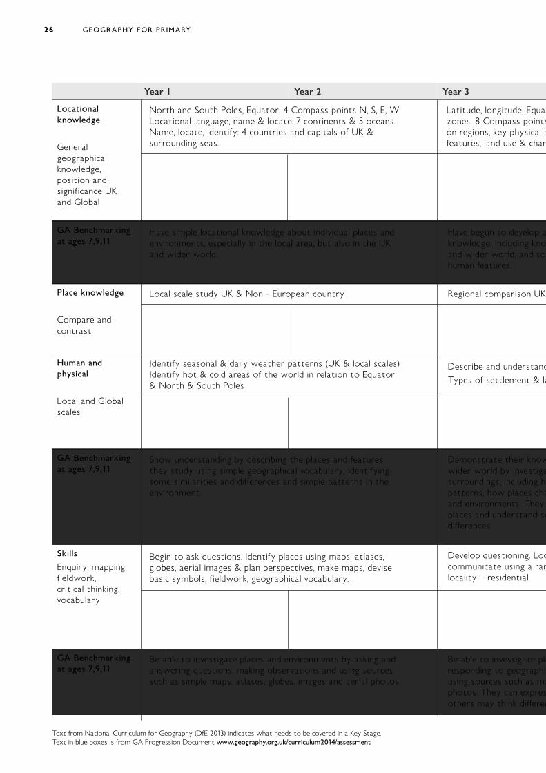
Year 1 Year 2 Year 3
Locational knowledge
General geographical knowledge, position and significance UK and Global
North and South Poles, Equator, 4 Compass points N, S, E, W Locational language, name & locate: 7 continents & 5 oceans. Name, locate, identify: 4 countries and capitals of UK & surrounding seas.
Latitude, longitude, Equator, N. & S. hemispher zones, 8 Compass points, 4 & 6 figur on regions, key physical and human char features, land use & changes ov
GA Benchmarking at ages 7,9,11
Have simple locational knowledge about individual places and environments, especially in the local area, but also in the UK and wider world.
Have begun to develop a f knowledge, including kno and wider world, and some globally significant physical and human features.
Place knowledge
Compare and contrast
Local scale study UK & Non - European country Regional comparison UK, Eur
Human and physical
Local and Global scales
Identify seasonal & daily weather patterns (UK & local scales) Identify hot & cold areas of the world in relation to Equator & North & South Poles
Describe and understand key aspects of: Climate zones, biomes, v
Types of settlement & land use, economic activity, tr
GA Benchmarking at ages 7,9,11
Show understanding by describing the places and features they study using simple geographical vocabulary, identifying some similarities and differences and simple patterns in the environment.
Demonstrate their knowledge and understanding of the wider world by investigating places bey surroundings, including human and physical f patterns, how places change and some links betw and environments. They become mor places and understand some r differences.
Skills
Enquiry, mapping, fieldwork, critical thinking, vocabulary
Begin to ask questions. Identify places using maps, atlases, globes, aerial images & plan perspectives, make maps, devise basic symbols, fieldwork, geographical vocabulary.
Develop questioning. Locate, describe, explain using maps (including OS maps), atlases, globes, digital mapping, measur communicate using a range of methods including maps, plans, gr locality – residential.
GA Benchmarking at ages 7,9,11
Be able to investigate places and environments by asking and answering questions, making observations and using sources such as simple maps, atlases, globes, images and aerial photos.
Be able to investigate places and envir responding to geographical questions, making observ using sources such as maps, atlases, globes, images and aerial photos. They can express their opinions and r others may think differently.
Text from National Curriculum for Geography (DfE 2013) indicates what needs to be covered in a Key Stage. Text in blue boxes is from GA Progression Document www.geography.org.uk/curriculum2014/assessment
Latitude, longitude, Equator, N. & S. hemispheres, Tropics Cancer & Capricorn, Arctic and Antarctic Circle, Prime / Greenwich Meridian & time zones, 8 Compass points, 4 & 6 figure grid references. Locate world’s countries, Europe, (including location of Russia), Americas, concentrating
egions, key physical and human characteristics, countries, major cities. Counties, cities, geographical regions, characteristics, topographical es, land use & changes over time.
Regional comparison UK, Eur
Describe and understand key aspects of: Climate zones, biomes, vegetation belts, rivers, mountains, volcanoes, earthquakes, water cycle
ypes of settlement & land use, economic activity, trade links, distribution of natural resources: energy, food, minerals, water cycle.
oundings, including human and physical features and
onments. They become more adept at comparing places and understand some reasons for similarities and
elop questioning. Locate, describe, explain using maps (including OS maps), atlases, globes, digital mapping, measure, record and
elop a
orld, and so
estiga
w places cha
estigate plaphi
ces such as ma
27
Latitude, longitude, Equator, N. & S. hemispher zones, 8 Compass points, 4 & 6 figur on regions, key physical and human char features, land use & changes ov
and wider world, and some globally significant physical and
Regional comparison UK, Eur
Describe and understand key aspects of: Climate zones, biomes, v
Types of settlement & land use, economic activity, tr
Demonstrate their knowledge and understanding of the wider world by investigating places bey surroundings, including human and physical f patterns, how places change and some links betw and environments. They become mor places and understand some r
Develop questioning. Locate, describe, explain using maps (including OS maps), atlases, globes, digital mapping, measur communicate using a range of methods including maps, plans, gr
Be able to investigate places and envir responding to geographical questions, making observ using sources such as maps, atlases, globes, images and aerial photos. They can express their opinions and r others may think differently.
27 HOW WILL YOU ORGANISE LEARNING?
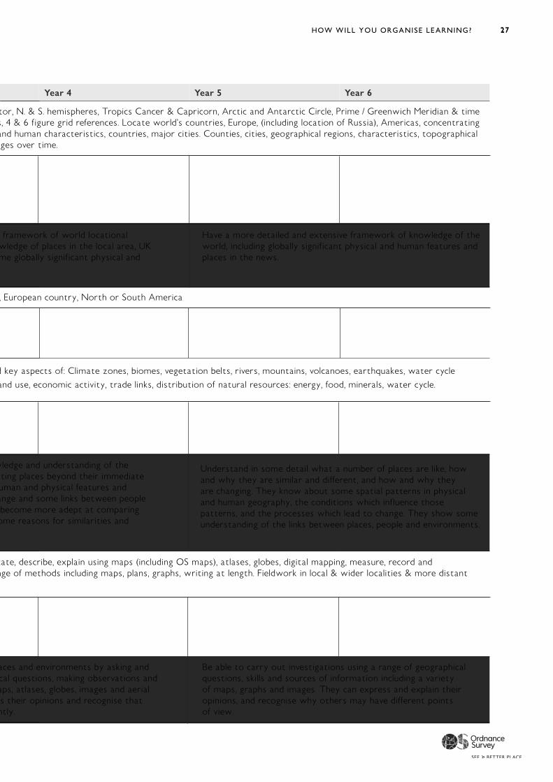
Year 4 Year 5 Year 6
Latitude, longitude, Equator, N. & S. hemispheres, Tropics Cancer & Capricorn, Arctic and Antarctic Circle, Prime / Greenwich Meridian & time zones, 8 Compass points, 4 & 6 figure grid references. Locate world’s countries, Europe, (including location of Russia), Americas, concentrating
egions, key physical and human characteristics, countries, major cities. Counties, cities, geographical regions, characteristics, topographical es, land use & changes over time.
Regional comparison UK, European country, North or South America
Describe and understand key aspects of: Climate zones, biomes, vegetation belts, rivers, mountains, volcanoes, earthquakes, water cycle
ypes of settlement & land use, economic activity, trade links, distribution of natural resources: energy, food, minerals, water cycle.
oundings, including human and physical features and
onments. They become more adept at comparing places and understand some reasons for similarities and
elop questioning. Locate, describe, explain using maps (including OS maps), atlases, globes, digital mapping, measure, record and ange of methods including maps, plans, graphs, writing at length. Fieldwork in local & wider localities & more distant
ently.
elop a
orld, and so
framework of world locational Have a more detailed and extensive framework of knowledge of the wledge of places in the local area, UK world, including globally significant physical and human features and me globally significant physical and places in the news.
estiga
w places cha
wledge and understanding of the ting places beyond their immediate
nge and some links between people
Understand in some detail what a number of places are like, how and why they are similar and different, and how and why they are changing. They know about some spatial patterns in physical and human geography, the conditions which influence those patterns, and the processes which lead to change. They show some understanding of the links between places, people and environments.
aces and environments by asking and Be able to carry out investigations using a range of geographical cal questions, making observations and ps, atlases, globes, images and aerial
questions, skills and sources of information including a variety estigate pl
aphices such as ma
esof maps, graphs and images. They can express and explain their
s their opinions and recognise that opinions, and recognise why others may have different points of view.
26 GEOGRAPHY FOR PRIMARY
Year 1 Year 2 Year 3
Locational knowledge
General geographical knowledge, position and significance UK and Global
North and South Poles, Equator, 4 Compass points N, S, E, W Locational language, name & locate: 7 continents & 5 oceans. Name, locate, identify: 4 countries and capitals of UK & surrounding seas.
Latitude, longitude, Equator, N. & S. hemispher zones, 8 Compass points, 4 & 6 figur on regions, key physical and human char features, land use & changes ov
GA Benchmarking at ages 7,9,11
Have simple locational knowledge about individual places and environments, especially in the local area, but also in the UK and wider world.
Have begun to develop a f knowledge, including kno and wider world, and some globally significant physical and human features.
Place knowledge
Compare and contrast
Local scale study UK & Non - European country Regional comparison UK, Eur
Human and physical
Local and Global scales
Identify seasonal & daily weather patterns (UK & local scales) Identify hot & cold areas of the world in relation to Equator & North & South Poles
Describe and understand key aspects of: Climate zones, biomes, v
Types of settlement & land use, economic activity, tr
GA Benchmarking at ages 7,9,11
Show understanding by describing the places and features they study using simple geographical vocabulary, identifying some similarities and differences and simple patterns in the environment.
Demonstrate their knowledge and understanding of the wider world by investigating places bey surroundings, including human and physical f patterns, how places change and some links betw and environments. They become mor places and understand some r differences.
Skills
Enquiry, mapping, fieldwork, critical thinking, vocabulary
Begin to ask questions. Identify places using maps, atlases, globes, aerial images & plan perspectives, make maps, devise basic symbols, fieldwork, geographical vocabulary.
Develop questioning. Locate, describe, explain using maps (including OS maps), atlases, globes, digital mapping, measur communicate using a range of methods including maps, plans, gr locality – residential.
GA Benchmarking at ages 7,9,11
Be able to investigate places and environments by asking and answering questions, making observations and using sources such as simple maps, atlases, globes, images and aerial photos.
Be able to investigate places and envir responding to geographical questions, making observ using sources such as maps, atlases, globes, images and aerial photos. They can express their opinions and r others may think differently.
Text from National Curriculum for Geography (DfE 2013) indicates what needs to be covered in a Key Stage. Text in blue boxes is from GA Progression Document www.geography.org.uk/curriculum2014/assessment
Latitude, longitude, Equator, N. & S. hemispheres, Tropics Cancer & Capricorn, Arctic and Antarctic Circle, Prime / Greenwich Meridian & time zones, 8 Compass points, 4 & 6 figure grid references. Locate world’s countries, Europe, (including location of Russia), Americas, concentrating
egions, key physical and human characteristics, countries, major cities. Counties, cities, geographical regions, characteristics, topographical es, land use & changes over time.
Regional comparison UK, Eur
Describe and understand key aspects of: Climate zones, biomes, vegetation belts, rivers, mountains, volcanoes, earthquakes, water cycle
ypes of settlement & land use, economic activity, trade links, distribution of natural resources: energy, food, minerals, water cycle.
oundings, including human and physical features and
onments. They become more adept at comparing places and understand some reasons for similarities and
elop questioning. Locate, describe, explain using maps (including OS maps), atlases, globes, digital mapping, measure, record and
elop a
orld, and so
estiga
w places cha
estigate plaphi
ces such as ma
28 GEOGRAPHY FOR PRIMARY
Year
1
Year
2Ye
ar 3
Year
4Ye
ar 5
Year
6
Loca
tion
al
know
ledg
e
Gen
eral
ge
ogra
phic
al
know
ledg
e,
posi
tion
and
si
gnifi
canc
e U
K an
d G
loba
l
GA
Ben
chm
arki
ng
at a
ges
7,9,
11
Plac
e kn
owle
dge
Com
pare
and
co
ntra
st
Hum
an a
nd
phys
ical
Loca
l and
Glo
bal
scal
es
GA
Ben
chm
arki
ng
at a
ges
7,9,
11
Skill
s
Enqu
iry,
map
ping
, fie
ldw
ork,
cr
itic
al t
hink
ing,
vo
cabu
lary
GA
Ben
chm
arki
ng
at a
ges
7,9,
11
Nor
th a
nd S
outh
Pol
es, E
quat
or, 4
Com
pass
poi
nts
N, S
, E, W
Lo
cati
onal
lang
uage
, nam
e &
loca
te: 7
con
tine
nts
& 5
oce
ans.
Nam
e, lo
cate
, ide
ntify
: 4 c
ount
ries
and
cap
ital
s of
UK
&
surr
ound
ing
seas
.
Hav
e si
mpl
e lo
cati
onal
kno
wle
dge
abou
t in
divi
dual
pla
ces
and
envi
ronm
ents
, esp
ecia
lly in
the
loca
l are
a, b
ut a
lso
in t
he U
K an
d w
ider
wor
ld.
Loca
l sca
le s
tudy
UK
& N
on -
Eur
opea
n co
untr
y
Iden
tify
sea
sona
l & d
aily
wea
ther
pat
tern
s (U
K &
loca
l sca
les)
Id
enti
fy h
ot &
col
d ar
eas
of t
he w
orld
in r
elat
ion
to E
quat
or
& N
orth
& S
outh
Pol
es
Show
und
erst
andi
ng b
y de
scri
bing
the
pla
ces
and
feat
ures
th
ey s
tudy
usi
ng s
impl
e ge
ogra
phic
al v
ocab
ular
y, id
enti
fyin
g so
me
sim
ilari
ties
and
diff
eren
ces
and
sim
ple
patt
erns
in t
he
envi
ronm
ent.
Beg
in t
o as
k qu
esti
ons.
Iden
tify
pla
ces
usin
g m
aps,
atl
ases
, gl
obes
, aer
ial i
mag
es &
pla
n pe
rspe
ctiv
es, m
ake
map
s, d
evis
e ba
sic
sym
bols
, fie
ldw
ork,
geo
grap
hica
l voc
abul
ary.
Be
able
to
inve
stig
ate
plac
es a
nd e
nvir
onm
ents
by
aski
ng a
nd
answ
erin
g qu
esti
ons,
mak
ing
obse
rvat
ions
and
usi
ng s
ourc
es
such
as
sim
ple
map
s, a
tlas
es, g
lobe
s, im
ages
and
aer
ial p
hoto
s.
Hav
e a
mor
e de
taile
d an
d ex
tens
ive
fram
ewor
k of
kno
wle
dge
of t
he
wor
ld, i
nclu
ding
glo
bally
sig
nific
ant
phys
ical
and
hum
an f
eatu
res
and
plac
es in
the
new
s.
Und
erst
and
in s
ome
deta
il w
hat
a nu
mbe
r of
pla
ces
are
like,
how
an
d w
hy t
hey
are
sim
ilar
and
diffe
rent
, and
how
and
why
the
y ar
e ch
angi
ng. T
hey
know
abo
ut s
ome
spat
ial p
atte
rns
in p
hysi
cal
and
hum
an g
eogr
aphy
, the
con
diti
ons
whi
ch in
fluen
ce t
hose
pa
tter
ns, a
nd t
he p
roce
sses
whi
ch le
ad t
o ch
ange
. The
y sh
ow s
ome
unde
rsta
ndin
g of
the
link
s be
twee
n pl
aces
, peo
ple
and
envi
ronm
ents
.
Be
able
to
carr
y ou
t in
vest
igat
ions
usi
ng a
ran
ge o
f ge
ogra
phic
al
ques
tion
s, s
kills
and
sou
rces
of
info
rmat
ion
incl
udin
g a
vari
ety
of m
aps,
gra
phs
and
imag
es. T
hey
can
expr
ess
and
expl
ain
thei
r op
inio
ns, a
nd r
ecog
nise
why
oth
ers
may
hav
e di
ffere
nt p
oint
s of
vie
w.
Lati
tude
, lon
gitu
de, E
quat
or, N
. & S
. hem
isph
eres
, Tro
pics
Can
cer
& C
apri
corn
, Arc
tic
and
Ant
arct
ic C
ircl
e, P
rim
e / G
reen
wic
h M
erid
ian
& t
ime
zone
s, 8
Com
pass
poi
nts,
4 &
6 f
igur
e gr
id r
efer
ence
s. L
ocat
e w
orld
’s c
ount
ries
, Eur
ope,
(in
clud
ing
loca
tion
of
Rus
sia)
, Am
eric
as, c
once
ntra
ting
on
reg
ions
, key
phy
sica
l and
hum
an c
hara
cter
isti
cs, c
ount
ries
, maj
or c
itie
s. C
ount
ies,
cit
ies,
geo
grap
hica
l reg
ions
, cha
ract
eris
tics
, top
ogra
p hic
al
feat
ures
, lan
d us
e &
cha
nges
ove
r ti
me.
Hav
e be
gun
to d
evel
op a
fra
mew
ork
of w
orld
loca
tion
al
know
ledg
e, in
clud
ing
know
ledg
e of
pla
ces
in t
he lo
cal a
rea,
UK
and
wid
er w
orld
, and
som
e gl
obal
ly s
igni
fican
t ph
ysic
al a
nd
hum
an f
eatu
res.
Reg
iona
l com
pari
son
UK
, Eur
opea
n co
untr
y, N
orth
or
Sout
h A
mer
ica
Des
crib
e an
d un
ders
tand
key
asp
ects
of:
Clim
ate
zone
s, b
iom
es, v
eget
atio
n be
lts,
riv
ers,
mou
ntai
ns, v
olca
noes
, ear
thqu
akes
, wat
er c
ycle
Typ
es o
f se
ttle
men
t &
land
use
, eco
nom
ic a
ctiv
ity,
tra
de li
nks,
dis
trib
utio
n of
nat
ural
res
ourc
es: e
nerg
y, f
ood,
min
eral
s, w
ater
cyc
le.
Dem
onst
rate
the
ir k
now
ledg
e an
d un
ders
tand
ing
of t
he
wid
er w
orld
by
inve
stig
atin
g pl
aces
bey
ond
thei
r im
med
iate
su
rrou
ndin
gs, i
nclu
ding
hum
an a
nd p
hysi
cal f
eatu
res
and
patt
erns
, how
pla
ces
chan
ge a
nd s
ome
links
bet
wee
n pe
ople
an
d en
viro
nmen
ts. T
hey
beco
me
mor
e ad
ept
at c
ompa
ring
pl
aces
and
und
erst
and
som
e re
ason
s fo
r si
mila
riti
es a
nd
diffe
renc
es.
Dev
elop
que
stio
ning
. Loc
ate,
des
crib
e, e
xpla
in u
sing
map
s (in
clud
ing
OS
map
s), a
tlas
es, g
lobe
s, d
igit
al m
appi
ng, m
easu
re, r
ecor
d an
d co
mm
unic
ate
usin
g a
rang
e of
met
hods
incl
udin
g m
aps,
pla
ns, g
raph
s, w
riti
ng a
t le
ngth
. Fie
ldw
ork
in lo
cal &
wid
er lo
calit
ies
& m
ore
dist
ant
loca
lity
– re
side
ntia
l.
Be
able
to
inve
stig
ate
plac
es a
nd e
nvir
onm
ents
by
aski
ng a
nd
resp
ondi
ng t
o ge
ogra
phic
al q
uest
ions
, mak
ing
obse
rvat
ions
and
us
ing
sour
ces
such
as
map
s, a
tlas
es, g
lobe
s, im
ages
and
aer
ial
phot
os. T
hey
can
expr
ess
thei
r op
inio
ns a
nd r
ecog
nise
tha
t ot
hers
may
thi
nk d
iffer
entl
y.
29
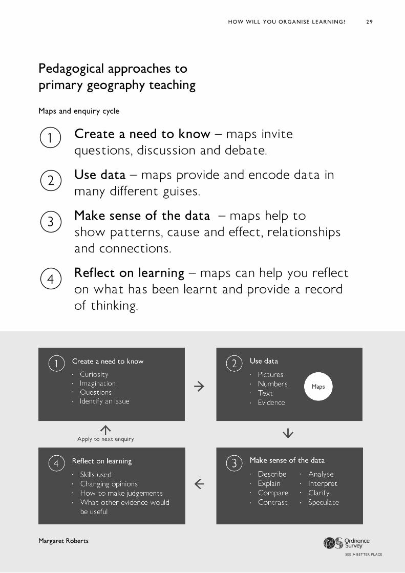
Pedagogical approaches to primary geography teaching
Create a need to know – maps invite questions, discussion and debate.
Use data – maps provide and encode data in many different guises.
Make sense of the data – maps help to show patterns, cause and effect, relationships and connections.
Reflect on learning – maps can help you reflect on what has been learnt and provide a record of thinking.
Maps and enquiry cycle
Margaret Roberts
HOW WILL YOU ORGANISE LEARNING?
30
Enquiry and conceptualunderstanding
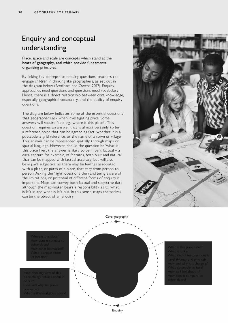
Core geography
Enquiry
Space Place
Scale
What is this place called?What is it like?What kind of features does ithave? (Human and physical)How and why is it changing?What do people do here?How do I feel about it?How does it compare toother places?
How does my view of thisplace change when I zoom inor out?How and why are placesconnected?What is the local/global story?
Where is this place?How does it connect toother places?How can it be mapped?What is unique aboutits location?
Place, space and scale are concepts which stand at the heart of geography, and which provide fundamental organising principles. By linking key concepts to enquiry questions, teachers can engage children in thinking like geographers, as set out in the diagram below (Scoffham and Owens 2017). Enquiry approaches need questions and questions need vocabulary. Hence, there is a direct relationship between core knowledge, especially geographical vocabulary, and the quality of enquiry questions.
The diagram below indicates some of the essential questions that geographers ask when investigating place. Some answers will require facts e.g. ‘where is this place?’. This question requires an answer that is almost certainly to be a reference point that can be agreed as fact, whether it is a postcode, a grid reference, or the name of a town or village. This answer can be represented spatially through maps or spatial language. However, should the question be ‘what is this place like?’, the answer is likely to be in part factual – a data capture for example, of features, both built and natural that can be mapped with factual accuracy; but will also be in part subjective, as there may be feelings associated with a place, or parts of a place, that vary from person to person. Asking the ‘right’ questions then and being aware of the limitations, or potential of different forms of enquiry is important. Maps can convey both factual and subjective data although the map-maker bears a responsibility as to what is left in and what is left out. In this sense, maps themselves can be the object of an enquiry.
GEOGRAPHY FOR PRIMARY30
31
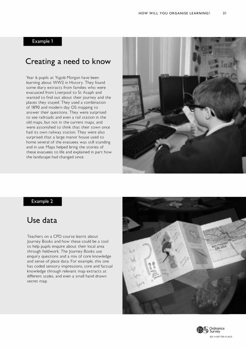
Example 1
Creating a need to know
Year 6 pupils at Ysgob Morgan have been learning about WW2 in History. They found some diary extracts from families who were evacuated from Liverpool to St Asaph and wanted to find out about their journey and the places they stayed. They used a combination of 1890 and modern day OS mapping to answer their questions. They were surprised to see railroads and even a rail station in the old maps, but not in the current maps, and were astonished to think that their town once had its own railway station. They were also surprised that a large manor house used to home several of the evacuees was still standing and in use. Maps helped bring the stories of these evacuees to life and explained in part how the landscape had changed since.
Example 2
Teachers on a CPD course learnt about Journey Books and how these could be a tool to help pupils enquire about their local area through fieldwork. The Journey Books use enquiry questions and a mix of core knowledge and sense of place data. For example, this one has coded sensory impressions, core and factual knowledge through relevant map extracts at different scales, and even a small hand drawn secret map.
Use data
HOW WILL YOU ORGANISE LEARNING?

32
Example 3
Make sense of data
Scribble Maps is used here to record where different food produce has originated from. The icons have an easy click and drag feature and can help make a quick visual representation of global food trade. When the information is laid out spatially it is easy to see patterns, such as where certain types of foodstuffs are likely to come from.
Example 4
Reflect on learning
In a collaborative project at the British Library that could be replicated across different year groups in school, or across a local community, groups were each given a kilometre square grid map of the local area to illustrate however they saw fit. These maps were then put back together to reveal an image of the rich diversity at work in the Kings Cross area of London. This patchwork map highlights how different users might map the same space.
GEOGRAPHY FOR PRIMARY
33
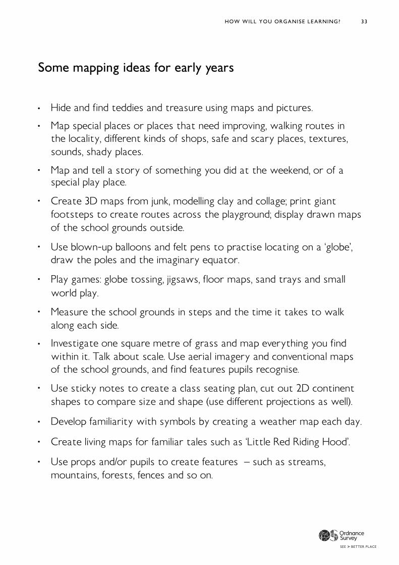
Some mapping ideas for early years
HOW WILL YOU ORGANISE LEARNING?
34
How well are you achieving your aims?
When maps are taught and used confidently, pupils and teachers can benefit from the enjoyment that greater clarity of understanding and communication can bring.
Primary Geography Quality Mark https://www.geography.org.uk/The-Primary-Geography-Quality-Mark-PGQM Chartered Geographer https://www.rgs.org/professionals/chartered-geographer/ MetMark https://www.metoffice.gov.uk/about-us/who/sustainability/community/metmark
3
Discuss what tools, resources and professional development might need to be put in place to allow the use of maps to flourish. Build this into an action plan.
Build evidence of mapwork across the school using photographs, photocopies and / or online documentation. Develop a portfolio of mapwork from a selection of pupils in each class that evidences the kinds of mapping opportunities and progression from one year-group to the next. There are Quality Marks and Chartered Geographer awards that could be achieved as part of professional development. These show recognition of work that has been done and provide tools for evaluating progress too.
Have school leader-boards for mapping awards, with badges and certificates highlighting excellent work. This could also record for example, pupils’ scores in online mapping challenges such as those highlighted in the resource section.
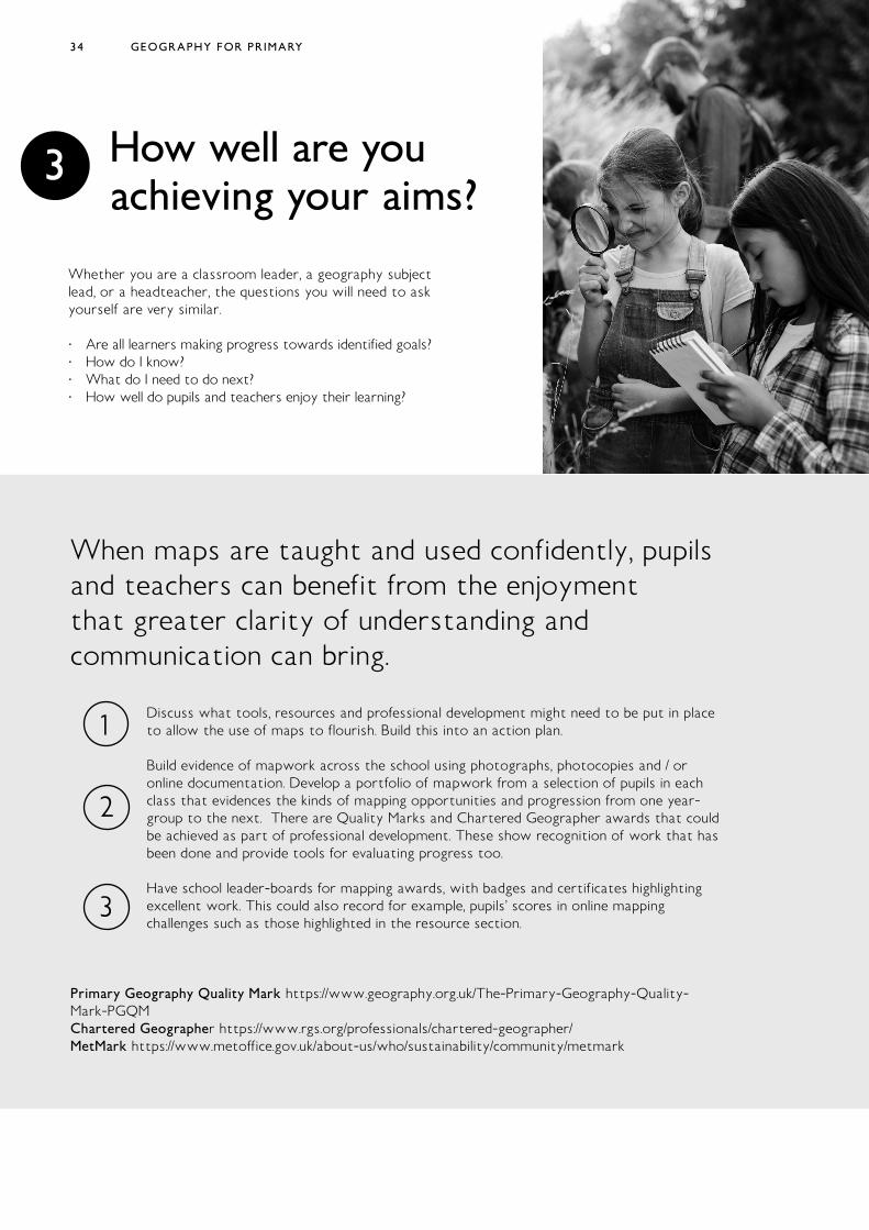
Whether you are a classroom leader, a geography subject lead, or a headteacher, the questions you will need to ask yourself are very similar.
· Are all learners making progress towards identified goals? · How do I know? · What do I need to do next? · How well do pupils and teachers enjoy their learning?
GEOGRAPHY FOR PRIMARY
35
· Arc GIS mapping for schools (Esri) www.arcgis.com · BBC Bitesize Maps https://www.bbc.co.uk/bitesize/topics/zvsfr82/articles/
zdk46v4 · Bing Maps https://www.bing.com/maps/ · Connecting Primary Geography – planning links https://www.geography.
org.uk/write/MediaUploads/Support%20and%20guidance/GA_leading_primary_purposeful_geography_download_3.pdf
· Developing early spatial skills https://www.kqed.org/mindshift/43090/steps-to-help-foster-a-preschoolers-spatial-reasoning-skills
· Digimap for Schools www.digimapforschools.edina.ac.uk · Get outside safely https://getoutside.ordnancesurvey.co.uk/ · Globe Tossing ideas from Simon Catling https://www.geography.org.uk/
download/GA_EYPInflatableGlobes.pdf · Google Earth https://maps.google.co.uk/intl/en_uk/earth/ · Google Maps https://www.google.co.uk/maps · Mapping challenges · (world) https://www.theguardian.com/global-development/
interactive/2012/dec/20/geography-game-how-well-know-world and https://world-geography-games.com/
· (Counties of England) https://online.seterra.com/en/vgp/3146 · Making map skills fun https://getoutside.ordnancesurvey.co.uk/guides/make-
maps-fun/ · Meaningful Maps www.meaningfulmaps.org · Met Office www.metoffice.gov.uk · NASA earthlights – maps of the visible light from Earth https://www.
earthobservatory.nasa.gov/images/90008/night-light-maps-open-up-new-applications
· Ordnance survey education resources (includes map outlines and map 25k flashcards, information re UK geography curricula) https://www.ordnancesurvey.co.uk/education/teacher-resources
· Ordnance survey open access zoomstack https://www.ordnancesurvey.co.uk/business-government/products/open-zoomstack
· Ordnance Survey maps (access the App from your phone on all devices) https://osmaps.ordnancesurvey.co.uk/
· Scribble maps – a free mapping and annotation service https://www.scribblemaps.com/
· Teaching young children about maps https://getoutside.ordnancesurvey.co.uk/guides/teaching-younger-children-about-maps/
· Street Map and animated mapping combined www.tripgeo.com
Useful pages
HOW WILL YOU ORGANISE LEARNING? 35
36
· Catling, S. (writing as part of the Geography Expert Subject Advisory Group (GESAG) (2013) Developing Map Skills and Understanding https://geognc.files.wordpress.com/2013/07/developing-map-skills-and-understanding-sc-may-2013.pdf
· Catling, S. (2014) Where Is It? – What is it? Why does it matter? Locational knowledge in geography teaching https://www.geography.org.uk/download/ga_thinkpiece_locationalknowledgeingeogteaching.pdf
· Cheng, Y. L., & Mix, K. S. (2014). Spatial training improves children’s mathematics ability. Journal of Cognition and Development, 15(1), 2—11
· DfE (2013) geography Ks1-3 The National Curriculum (England) https://www.gov.uk/government/publications/national-curriculum-in-england-geography-programmes-of-study
· Freeland, Iain (2020) HMI Her Majesty’s Inspector, Schools Subject Lead (Geography) Curriculum Unit pers comm. 18.08.2020
· Gardner, D. (2014) KS3 Geography Planning for Pupil Progress · Geographical Association (2020) Curriculum Making Explained https://
www.geography.org.uk/Curriculum-Making-Explained · Jasper Green Big Ideas in curriculum design (2018) https://
thescienceteacher.co.uk/big-ideas-in-the-curriculum/ · Kinder, A. & Owens, P. (2019) The new Education Inspection Framework
– through a geographical lens’ Primary Geography Autumn 2019 pp.10-13 · Martin, F. (2013) The place of knowledge in the new curriculum Primary
Geography Autumn 2013 pp.9-11. Sheffield: Geographical Association · Newcombe, N. (2017), “Harnessing Spatial Thinking to Support Stem
Learning”, OECD Education Working Papers, No. 161, OECD Publishing, Paris, https://doi.org/10.1787/7d5dcae6-en .
· Ofsted (2011) Geography: learning to make a world of difference February 2011, No. 090224 www.ofsted.gov.uk/publications/090224
· Ofsted (2019a) Education inspection framework. Overview of research January 2019, No. 180045
· Ofsted (2019b) The education inspection framework. May 2019 Reference no: 190015
· Robertson, M., Maude, A., Kriewaldt, J. (2019) Aligning Mapping Skills With Digitally Connected Childhoods to Advance the Development of Spatial Cognition and Ways of Thinking in Primary School Geography Geographical Education Volume 32, 2019 pp.15-25
· Scoffham, S., & Owens, P. (2017) Teaching Primary Geography London: Bloomsbury
· Stieff, M and Uttal, D. (2015) How Much Can Spatial Training Improve STEM Achievement?Educational Psychology Review December 2015, Vol. 27, No. 4, Special Issue: Myth or Reality? Evaluating Common Practices and Beliefs in Education (December 2015), pp. 607-615 Springer Stable URL: http://www.jstor.com/stable/24761210
· Vujakovic, P. (2017) What is a map? http://meaningfulmaps.org/what-is-a-map/
· Vujakovic, P., Owens, P. and Scoffham, S. 2018. Meaningful maps: what can we learn about ‘ sense of place’ from maps produced by children? Bulletin of the Society of Cartographers. 51 (1 & 2), pp. 9-19.
Sources
GEOGRAPHY FOR PRIMARY36