Embed Size (px)
Citation preview
Art.35 Technical Report – PL-12/03
Page 1 of 50
EUROPEAN COMMISSION DIRECTORATE-GENERAL FOR ENERGY DIRECTORATE D - Nuclear Energy Radiation Protection
TECHNICAL REPORT
VERIFICATIONS UNDER THE TERMS OF
ARTICLE 35 OF THE EURATOM TREATY
POLAND
2-6 July 2012
Reference: PL-12/03
Art.35 Technical Report – PL-12/03
Page 2 of 50
VERIFICATIONS UNDER THE TERMS OF ARTICLE 35
OF THE EURATOM TREATY
FACILITIES: Former uranium mining and milling operations in Poland and parts of the
national monitoring system for radioactivity in the surrounding area
LOCATIONS: Warsaw, Wroclaw, Jelenia Góra, Kowary, Miedzianka, Mniszków, Bobrów,
Radoniów, Wleń
DATES: 2-6 July 2012 REFERENCE: PL-12/03 INSPECTORS: Mr. G. SIMEONOV (team leader)
Mr.R. BARAŃCZYK Mr. S. MUNDIGL Mr. A. RYAN
DATE OF REPORT: 4 June 2013 SIGNATURES:
G. SIMEONOV
S. MUNDIGL
R. BARAŃCZYK
A. RYAN
Art.35 Technical Report – PL-12/03
Page 3 of 50
TABLE OF CONTENTS
1 Introduction 6
2 Preparation and Conduct of the Verification 6
2.1 PREAMBLE 6
2.2 DOCUMENTS 6
2.3 PROGRAMME OF THE VISIT 6
3 Representatives of the polish competent authority and other entities 7
4 Competent Authorities & Legal Background 8
4.1 INTRODUCTION 8
4.2 AUTHORITIES INVOLVED IN RADIOACTIVITY MONITORING 8
4.2.1 Scope, history and current situation 8 4.2.2 Statutory responsibilities 8
4.3 LEGAL FRAMEWORK 9
5 Environmental Radioactivity Monitoring 9
5.1 OVERVIEW 9
5.2 NATIONAL MONITORING PROGRAMME 10
5.2.1 Gamma dose rate monitoring systems 12 5.2.2 Airborne radioactivity (aerosols) 12 5.2.3 Precipitation / Rainwater samplers 13 5.2.4 Water monitoring 13 5.2.5 Bottom sediments of rivers and lakes taken within the national monitoring programme 13 5.2.6 Bottom sediments from the Southern Baltic Sea 14 5.2.7 Foodstuffs (incl. mixed diet) 14 5.2.8 Meteorological parameters 14
5.3 LABORATORIES AND INSTITUTIONS INVOLVED IN NATIONAL MONITORING 14
5.3.1 Central Laboratory for Radiological Protection (CLOR) 15 5.3.2 Environmental radioactivity laboratory (ERL) of the Henryk Niewodniczanski Institute of Nuclear Physics (IFJ) 15 5.3.3 WSSE basic units 15 5.3.4 IMGW stations 15 5.3.5 The CEZAR-NAEA data centre 16
6 Uranium Mining 17
6.1 LEGAL PROVISIONS 17
6.2 MINING AND MILLING FACILITIES AND ACTIVITIES 17
7 National Monitoring Programme in Relation to Former Uranium Mining Areas 19
7.1 MEASUREMENTS PERFORMED BY THE NAEA’S OFFICE FOR FINANCIAL CLAIMS OF THE FORMER WORKERS OF THE
URANIUM ORE FACILITIES 19
7.2 LABORATORIES PARTICIPATING IN THE ENVIRONMENTAL MONITORING OF FORMER URANIUM MINING AND MILLING
SITES 26
7.3 REPORTING AND STORAGE OF INFORMATION 27
8 Verifications 28
8.1 CEZAR CENTRE 28
Art.35 Technical Report – PL-12/03
Page 4 of 50
8.2 POLISH GEOLOGICAL INSTITUTE 28
8.3 WROCLAW UNIVERSITY OF TECHNOLOGY 32
8.4 WSSE WROCLAW 34
8.5 NAEA'S OFFICE FOR FINANCIAL CLAIMS OF THE FORMER WORKERS OF THE URANIUM ORE FACILITIES JELENIA GΌRA
35
8.5.1 Monitoring programme 35 8.5.2 Laboratory equipment 36
8.6 KOWARY 36
8.6.1 Kowary tailing pond and surroundings 36 8.6.2 Podgórze mine – drift No.19 and surroundings 37 8.6.3 Wolność mine – "Główna" drift 39
8.7 OTHER FORMER MINES 41
8.7.1 Miedzianka 41 8.7.2 Mniszków 43 8.7.3 Bobrów 44 8.7.4 Radoniów 44 8.7.5 Wleń 45
9 Conclusions 46
Appendix 1: References and documentation Appendix 2: The verification programme – summary Appendix 3 Former uranium mines
Art.35 Technical Report – PL-12/03
Page 5 of 50
TECHNICAL REPORT
ABBREVIATIONS
CEZAR CEntrum do Spraw ZdArzeń Radiacyjnych (Radiation Emergency Centre, of NAEA), Warsaw
CLOR Centralne Laboratorium Ochrony Radiologicznej (Central Laboratory for Radiological Protection), Warsaw
DG ENER Directorate General for Energy
EC European Commission
ECURIE European Commission Urgent Radiological Information Exchange
EMERCON EMERgency CONvention (IAEA emergency notification system)
EU European Union
EURDEP European Radiological Data Exchange Platform
GPRS General Packet Radio Service (telecommunication)
HELCOM HELsinki COMmission (governing body of the 'Convention on the Protection of the Marine Environment of the Baltic Sea Area' – more usually known as the Helsinki Convention)
HPGe High Purity Germanium (gamma detector)
IAEA International Atomic Energy Agency
IMGW Instytut Meteorologii i Gospodarki Wodnej (Institute of Meteorology and Water Management)
JRC Joint Research Centre
NAEA National Atomic Energy Agency
NaI(Tl) Sodium Iodide Thallium activated (low resolution gamma detector crystal)
PCA Polish Centre for Accreditation
PMS Permanent Monitoring Station
REM Radioactivity Environmental Monitoring (European database at JRC Ispra)
SQL Structured Query Language
WSSE Wojewódzka Stacja Sanitarno-Epidemiologiczna (Voyvodship – regional – Sanitary Inspection Laboratories)
Art.35 Technical Report – PL-12/03
Page 6 of 50
1 INTRODUCTION
Article 35 of the Euratom Treaty requires that each Member State shall establish the facilities necessary to carry out continuous monitoring of the levels of radioactivity in air, water and soil and to ensure compliance with the basic safety standards (1). Article 35 also gives the European Commission (EC) the right of access to such facilities in order to verify their operation and efficiency. The Radiation Protection Unit (ENER D3) of the EC's Directorate-General for Energy (DG ENER) is responsible for undertaking these verifications.
The main purpose of verifications performed under Article 35 of the EURATOM Treaty is to provide an independent assessment of the adequacy of monitoring facilities for:
- Liquid and airborne discharges of radioactivity into the environment by a site (and control thereof).
- Levels of environmental radioactivity at the site perimeter and in the marine, terrestrial and aquatic environment around the site, for all relevant pathways.
- Levels of environmental radioactivity on the territory of the Member State.
Taking into account previous bilateral protocols, a Commission Communication2 was published in the Official Journal on 4 July 2006 describing practical arrangements for the conduct of Article 35 verification visits in Member States.
2 PREPARATION AND CONDUCT OF THE VERIFICATION
2.1 PREAMBLE
The EC’s request to conduct an Article 35 verification was notified to the Polish government by letter on 27 January 2012 addressed to the Polish Permanent Representation to the European Union. The Polish Government subsequently designated the National Atomic Energy Agency (NAEA) which is supervised by the Ministry of Environment to lead the preparations for this visit.
2.2 DOCUMENTS
In order to facilitate the work of the verification team, a package of information was supplied in advance by the Polish authorities. Additional documentation was provided during and after the visit. All documentation received is listed in Appendix 1 to this report. The information thus provided has been extensively used for drawing up the descriptive sections of the report.
2.3 PROGRAMME OF THE VISIT
The EC and the NAEA discussed and agreed upon a programme of verification activities. During the opening meeting the verification team presented Article 35 of the Euratom Treaty and the draft programme for the verification. The NAEA made very informative presentations on the radiation monitoring in Poland and the CEZAR data centre.
1 Council Directive 96/29/Euratom of 13 May 1996 laying down basic safety standards for the protection
of the health of workers and the general public against the dangers arising from ionizing radiation (OJ L-159 of 29/06/1996)
Art.35 Technical Report – PL-12/03
Page 7 of 50
The verification team notes the quality and comprehensiveness of all presentations made and documentation provided.
The verifications were carried out in accordance with the programme in Appendix 2.
3 REPRESENTATIVES OF THE POLISH COMPETENT AUTHORITY AND OTHER ENTITIES
1) National Atomic Energy Agency (NAEA)/Radiation Emergency Centre (CEZAR), in Warsaw
Mr. Maciej Jurkowski Vice President of NAEA Mr. Krzystof Dąbrowski Director of the Radiation Emergency Centre CEZAR (Department in
the NAEA structure) Mr. Rafał Dąbrowski Head of division of monitoring and prognosis (in the structure of
CEZAR) Mr. Andrzej Merta – NAEA President’s Adviser 2) Polish Geological Institute in Warsaw
Dr. Andrzej Przybycin PGI Deputy Director, Director of the Polish Geological Survey Prof. Stanisław Wołkowicz Professor Energy Security Program Dr. Katarzyna Jarmołowicz-Szulc Head of the Central Geological Archive 3) Wroclaw University of Technology
Prof. Kazmierz Grabas Mr. Adam Żebrowski Mr. Jarosław M. Janiszewski
Radiological Protection Inspector Chancellor
4) WSSE Wroclaw
Mr. Piotr Demczuk Head of Radiological Protection Dept.
5) National Atomic Energy Agency (NAEA) Office for Financial Claims of the Former Workers of the Uranium Ore Facilities Jelenia Gόra
Mr. Jacek Kamiński Head of the Office Mr. Jerzy Wróblewski Main Specialist
The verification team acknowledges the co-operation it received from all individuals mentioned.

Art.35 Technical Report – PL-12/03
Page 8 of 50
4 COMPETENT AUTHORITIES & LEGAL BACKGROUND
4.1 INTRODUCTION
Poland has no nuclear programme implemented so far, but the country has several environmental issues related to radioactivity. Poland has a legal framework, in line with the 'EURATOM acquis' and the IAEA standards for ionizing radiation control. It has the necessary basic administrative structure for efficient monitoring of environmental radioactivity throughout the country.
The sections below provide a summary of the main elements of the Polish legal and administrative framework for radiation protection and radiological monitoring of the environment. More detailed information is included in the reports of the Article 35 verifications to Poland in 2006 and 2009.
4.2 AUTHORITIES INVOLVED IN RADIOACTIVITY MONITORING
4.2.1 Scope, history and current situation
On the basis of Articles 72-74 of the Act of Parliament of 29 November 2000 – Atomic Law (Polish
Journal of Laws of 2012, Item 264), NAEA has been designated the main responsible organisation for the Polish monitoring programme of radioactivity in the environment. NAEA is supervised by the Ministry of Environment.
The President of the NAEA, through the Radiation Emergency Centre CEZAR, co-ordinates the monitoring of environmental radioactivity in Poland and is the Competent Authority (CA) in the field of nuclear safety and radiation protection. NAEA has the responsibility to enforce the above mentioned legislation, to ensure for environmental radioactivity monitoring and for regular reporting to the European Commission (EC-JRC/ISPRA) on the basis of Article 36 of the Euratom Treaty, to ensure for emergency preparedness and response in case of radiological accidents and to deal with all matters concerning the relations of Poland with the EU, with the IAEA and other international organisations in this field.
Other organisations involved in the national monitoring programme are the Chief Sanitary Inspectorate, the Central Laboratory for Radiological Protection (CLOR), the Institute of Meteorology and Water Management (IMGW), the Centre of Contamination Analysis of the Ministry of Defence, the National Centre for Nuclear research (former Institute of Atomic Energy) in Otwock-Świerk, and the state-owned Radioactive Waste Management Plant.
4.2.2 Statutory responsibilities
The statutory responsibilities of NAEA as represented by its president to be mentioned in the context of this report are:
1. Protection of radiation workers, the general public and the environment from the risks of the use of ionising radiation through licensing and inspection facilities and activities using ionizing radiation, management of personal dosimetry data radiological monitoring of the environment.
2. Implementation, in compliance with EC Directives, of radiation protection regulations, safety standards and codes of practice for ionising radiation installations;
3. Approval of measurement programmes and methods for early warning stations and units conducting measurements of radioactive contamination
4. Organizing intercomparisons for units conducting measurements of radioactive contamination 5. Assessment of radiation situation in Poland in normal conditions and in emergency situations
Art.35 Technical Report – PL-12/03
Page 9 of 50
The Ministry of Health has the overall responsibility of controlling and monitoring of radioactivity in foodstuffs and feeding stuffs by the WSSE units supervised by the Chief Sanitary Inspector.
4.3 LEGAL FRAMEWORK
Poland has comprehensive legislation in the area of radiation and nuclear safety. The main legal acts regulating the radiation protection topics are:
a) Act of Parliament of 29 November 2000 – Atomic Law (last amendment 13 May 2011); published in: Journal of Laws of 2012, item 264.
c) Regulation of the Council of Ministers of 17 December 2002 on stations for the early detection of radioactive contamination and units which measure radioactive contamination; published in: Official Journal of Laws of 2002 no 239, item 2030.
Apart from the above legal acts, there is a specific legislation dealing with nuclear and radiological emergencies, safe management of radioactive waste and exemption/clearance of material from regulatory control.
As a member of the European Union, Poland implements the Euratom provisions on radiation protection and radiological monitoring of the environment. Recommendations of international organizations, such as the European Commission, the International Agency for Atomic Energy, the International Commission for Radiological Protection and the World Health Organization, are also used in defining national provisions and practices.
5 ENVIRONMENTAL RADIOACTIVITY MONITORING
5.1 OVERVIEW
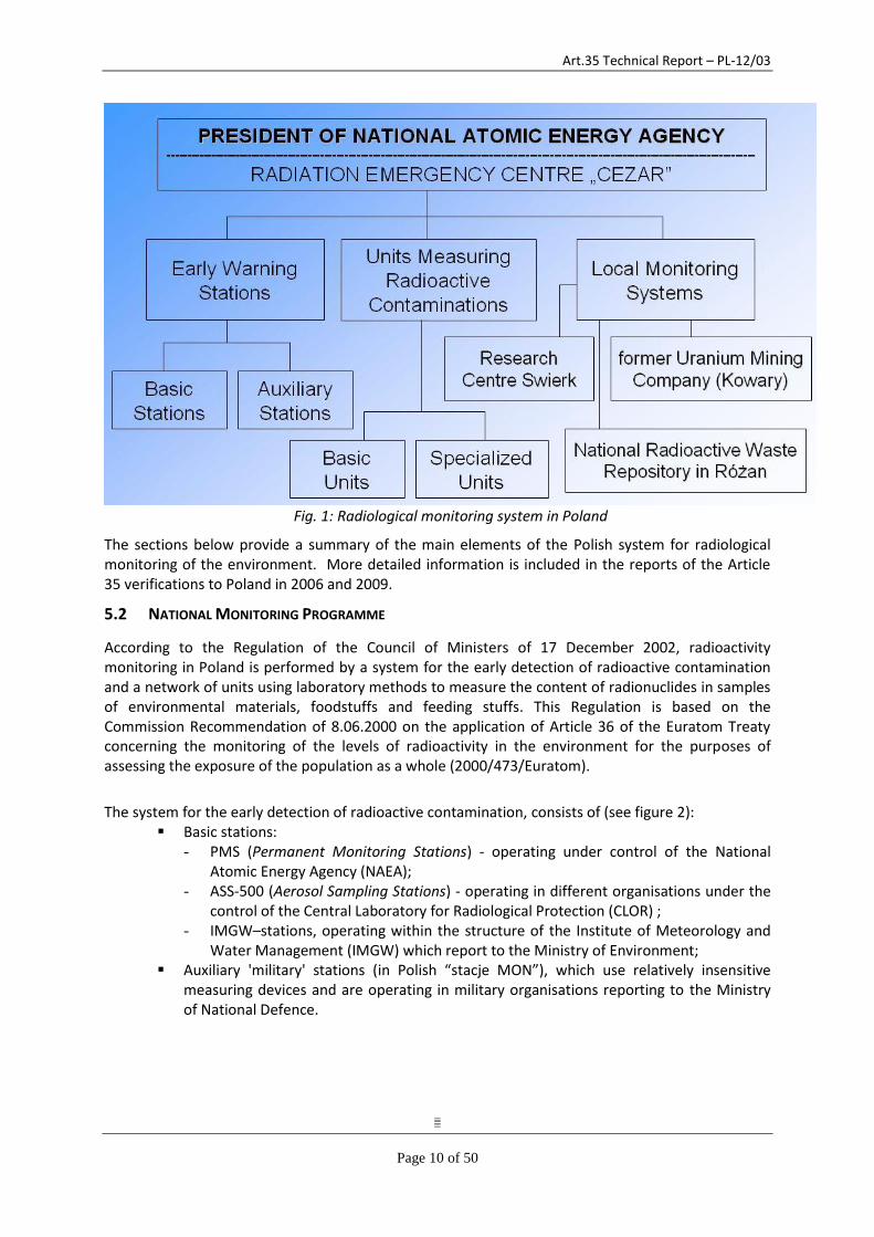
The radiological situation of the environment in Poland is monitored by systematic measurement of ambient gamma dose rate in specific places all over the country and measurements of the radionuclide content in primary components of the environment, food and feedstuffs. The system is divided into a national monitoring, providing essential data for evaluation of the radiological situation all over the country under normal conditions and in emergency situations and a local monitoring, providing data from areas where activities causing a potential increase in radiation exposure of the local population are (or were) conducted (see figure 1).
Art.35 Technical Report – PL-12/03
Page 10 of 50
Fig. 1: Radiological monitoring system in Poland
The sections below provide a summary of the main elements of the Polish system for radiological monitoring of the environment. More detailed information is included in the reports of the Article 35 verifications to Poland in 2006 and 2009.
5.2 NATIONAL MONITORING PROGRAMME
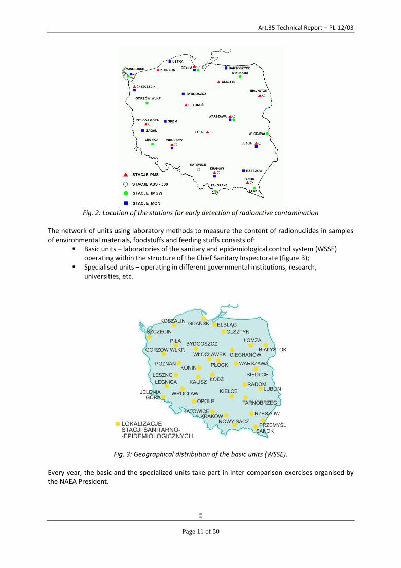
According to the Regulation of the Council of Ministers of 17 December 2002, radioactivity monitoring in Poland is performed by a system for the early detection of radioactive contamination and a network of units using laboratory methods to measure the content of radionuclides in samples of environmental materials, foodstuffs and feeding stuffs. This Regulation is based on the Commission Recommendation of 8.06.2000 on the application of Article 36 of the Euratom Treaty concerning the monitoring of the levels of radioactivity in the environment for the purposes of assessing the exposure of the population as a whole (2000/473/Euratom).
The system for the early detection of radioactive contamination, consists of (see figure 2): Basic stations:
- PMS (Permanent Monitoring Stations) - operating under control of the National Atomic Energy Agency (NAEA);
- ASS-500 (Aerosol Sampling Stations) - operating in different organisations under the control of the Central Laboratory for Radiological Protection (CLOR) ;
- IMGW–stations, operating within the structure of the Institute of Meteorology and Water Management (IMGW) which report to the Ministry of Environment;
Auxiliary 'military' stations (in Polish “stacje MON”), which use relatively insensitive measuring devices and are operating in military organisations reporting to the Ministry of National Defence.
Art.35 Technical Report – PL-12/03
Page 11 of 50
Fig. 2: Location of the stations for early detection of radioactive contamination
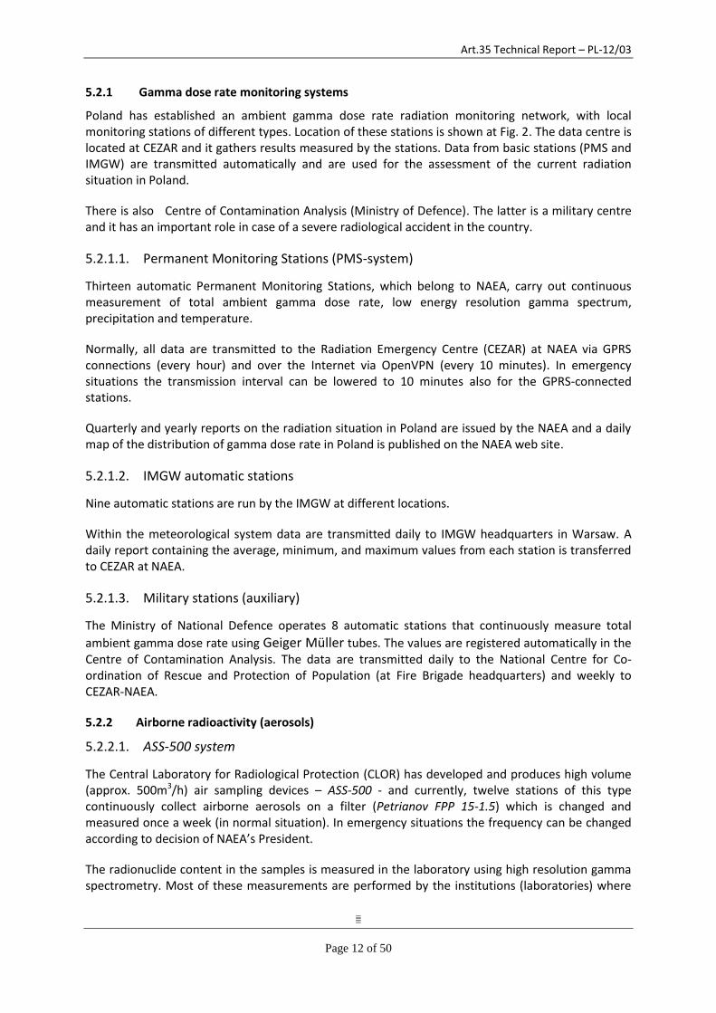
The network of units using laboratory methods to measure the content of radionuclides in samples of environmental materials, foodstuffs and feeding stuffs consists of:
Basic units – laboratories of the sanitary and epidemiological control system (WSSE) operating within the structure of the Chief Sanitary Inspectorate (figure 3);
Specialised units – operating in different governmental institutions, research, universities, etc.
Fig. 3: Geographical distribution of the basic units (WSSE). Every year, the basic and the specialized units take part in inter-comparison exercises organised by the NAEA President.
Art.35 Technical Report – PL-12/03
Page 12 of 50
5.2.1 Gamma dose rate monitoring systems
Poland has established an ambient gamma dose rate radiation monitoring network, with local monitoring stations of different types. Location of these stations is shown at Fig. 2. The data centre is located at CEZAR and it gathers results measured by the stations. Data from basic stations (PMS and IMGW) are transmitted automatically and are used for the assessment of the current radiation situation in Poland.
There is also Centre of Contamination Analysis (Ministry of Defence). The latter is a military centre and it has an important role in case of a severe radiological accident in the country.
5.2.1.1. Permanent Monitoring Stations (PMS-system)
Thirteen automatic Permanent Monitoring Stations, which belong to NAEA, carry out continuous measurement of total ambient gamma dose rate, low energy resolution gamma spectrum, precipitation and temperature.
Normally, all data are transmitted to the Radiation Emergency Centre (CEZAR) at NAEA via GPRS connections (every hour) and over the Internet via OpenVPN (every 10 minutes). In emergency situations the transmission interval can be lowered to 10 minutes also for the GPRS-connected stations.
Quarterly and yearly reports on the radiation situation in Poland are issued by the NAEA and a daily map of the distribution of gamma dose rate in Poland is published on the NAEA web site.
5.2.1.2. IMGW automatic stations
Nine automatic stations are run by the IMGW at different locations.
Within the meteorological system data are transmitted daily to IMGW headquarters in Warsaw. A daily report containing the average, minimum, and maximum values from each station is transferred to CEZAR at NAEA.
5.2.1.3. Military stations (auxiliary)
The Ministry of National Defence operates 8 automatic stations that continuously measure total
ambient gamma dose rate using Geiger Müller tubes. The values are registered automatically in the Centre of Contamination Analysis. The data are transmitted daily to the National Centre for Co-ordination of Rescue and Protection of Population (at Fire Brigade headquarters) and weekly to CEZAR-NAEA.
5.2.2 Airborne radioactivity (aerosols)
5.2.2.1. ASS-500 system
The Central Laboratory for Radiological Protection (CLOR) has developed and produces high volume (approx. 500m3/h) air sampling devices – ASS-500 - and currently, twelve stations of this type continuously collect airborne aerosols on a filter (Petrianov FPP 15-1.5) which is changed and measured once a week (in normal situation). In emergency situations the frequency can be changed according to decision of NAEA’s President.
The radionuclide content in the samples is measured in the laboratory using high resolution gamma spectrometry. Most of these measurements are performed by the institutions (laboratories) where

Art.35 Technical Report – PL-12/03
Page 13 of 50
the stations are located (usually, academic centres). Only the filters from a few stations are sent to CLOR in Warsaw for measurement. Detection limits for artificial isotopes (Cs-137 and I-131) are a few µBq/m3.
Furthermore, these stations also measure directly gamma activity of airborne aerosols. Routinely, the stations are set to give an indication for the presence of high values of Cs-137 and of I-131. Data of these 'on line' stations are transferred twice a day to CLOR and CEZAR.
5.2.2.2. IMGW automatic stations
Seven of the IMGW stations also operate automatic aerosol monitors providing data on total alpha and total beta activity of aerosols and calculated natural and artificial alpha and beta activity with detection limits of a few mBq/m3.
5.2.3 Precipitation / Rainwater samplers
All IMGW stations operate precipitation samplers (dry and wet deposition, 'fallout').
Total beta measurement is performed daily and monthly at the stations using a plastic scintillation detector. In addition the monthly collected samples from all the stations combined are analysed in Warsaw for their Cs-137 content by gamma spectrometry and in Gdynia for their Sr-90 content using radiochemistry.
Another precipitation sampler is located at IFJ in Krakow.
5.2.4 Water monitoring
5.2.4.1. Water from rivers and lakes
Samples of water are collected twice a year (in spring and autumn) from rivers and lakes located in various regions of Poland. Water samples of 20 l are taken from main streams of the rivers or from platforms on the lakes and analysed for Cs-137 and Sr-90. Sample analysis is performed by CLOR.
5.2.4.2. Drinking water
Since 2007 the drinking water monitoring is performed by CLOR and financed and supervised by the National Atomic Energy Agency (NAEA projects 23/OR/2007, 23/OR/2008, 20/OR/2009, 20/OR/2010, 26/OR/2011, 25/OR/2012). Scope of these measurements is defined each year by the NAEA’s President and it considers the main water supplies in selected cities. Samples are taken once a year and mainly Cs-137, Sr-90, H-3 and total alpha and beta activities are measured.
5.2.4.3. Sea water
Sea water is sampled and analysed within the HELCOM obligations.
5.2.5 Bottom sediments of rivers and lakes taken within the national monitoring programme
In bottom sediments of rivers and lakes Cs-137 and Pu-239,240 are determined by CLOR. Samples are collected twice a year from the same rivers and lakes where Cs-137 and Sr-90 is measured in water.
Art.35 Technical Report – PL-12/03
Page 14 of 50
5.2.6 Bottom sediments from the Southern Baltic Sea
In bottom sediments from the Southern Baltic Sea Cs-137, Pu-238 and Pu-239,240, Sr-90 and Ra-226 are determined. Bottom sediment core samples are collected from various regions of the southern part of the Baltic Sea, during sampling cruises into the Baltic Sea, organised once a year. Analysis is done by CLOR.
5.2.7 Foodstuffs (incl. mixed diet)
Milk
Cow's milk is sampled quarterly by the basic units (WSSE) under the responsibility of the Sanitary Inspection.
Generally, the samples are analysed for Cs-137 activity above 0.5 Bq/l. In some units also Sr-90 activity is determined.
The values are transmitted to the headquarters which send reports containing all data to CEZAR-NAEA.
Other foodstuffs:
Foodstuffs that are main components of the diet are collected from the local producers and also at hypermarkets and local shops.
milk products and poultry – twice per year,
fish, eggs, cereals – once per year,
fruit, vegetables – once per year during harvest,
meat (different kinds) and poultry – once per quarter. Vegetables, fruit, freshwater and sea water fish as well as feeding stuffs are measured by selected basic units of the Sanitary Inspection (WSSE).
Mixed diet:
Mixed diet samples originate from canteens preparing breakfast, dinner and supper. Meals from one day are gathered into one sample. Whole day samples are collected during five days, twice per year (during spring and autumn). Sampling is performed by CLOR.
In all of the above mentioned samples Cs-137 and Sr-90 activity concentration is determined at CLOR.
5.2.8 Meteorological parameters
Meteorological data that may be used in radiological emergency management such as wind speed, wind direction, atmospheric pressure, relative humidity and ambient temperature are obtained from the Meteorological Service of Poland.
Some meteorological parameters, eg. rain intensity, which is important for the proper assessment of the measurements of gamma dose rate, are measured by PMS stations as well.
5.3 LABORATORIES AND INSTITUTIONS INVOLVED IN NATIONAL MONITORING
Accreditation is not required for environmental radioactivity monitoring in Poland. The acceptance is granted by the President of NAEA if standard methods authorised by NAEA are used and the laboratory successfully participates in NAEA's inter-comparison exercises.
Art.35 Technical Report – PL-12/03
Page 15 of 50
5.3.1 Central Laboratory for Radiological Protection (CLOR)
5.3.1.1. General information
The Central Laboratory for Radiological Protection, established in 1957, was until 2001 under the authority of the National Atomic Energy Agency. From August 2001 onwards, CLOR has been supervised by the Ministry of Economy. Presently CLOR works on a contract basis, mostly annual contracts with NAEA.
CLOR is responsible for the sampling of environmental samples from 500 sampling locations in Poland. The main duties of CLOR within the statutory obligations of NAEA are:
monitoring of radioactive contamination in foodstuffs and environmental components;
monitoring of personal radiation doses;
calibration and attestation of radiation measurement instruments;
research on matters dealing with radiation, radiation protection, radiobiology and radioecology;
professional training in radiation protection. Its statutory duties are fulfilled by several divisions, some of them having accreditation to ISO 17025.
5.3.2 Environmental radioactivity laboratory (ERL) of the Henryk Niewodniczanski Institute of Nuclear Physics (IFJ)
The Henryk Niewodniczanski Institute of Nuclear Physics of the Polish Academy of Sciences is a research institute employing some 500 persons. It is divided into 5 divisions with 17 departments. The environmental laboratory consists of several sub-laboratories, one of which is the Environmental Radioactivity Laboratory (ERL).
5.3.3 WSSE basic units
Generally, WSSE basic units are supplied with low energy resolution gamma spectrometry systems (NaI(Tl) detectors). Some units operate high resolution gamma HPGe spectrometry systems as well as liquid scintillation counters. These units measure radioactive contamination of the samples of
water and foodstuff (mainly milk) on the levels of Bq/l. In 2012 there were 31 basic units which sent quarterly results of measurements to CEZAR NAEA.
WSSE basic units are supervised by the Chief Sanitary Inspectorate, which is a body of the central administration appointed by the Prime Minister and subordinate to the Minister of Health and it manages the State Sanitary Inspection.
5.3.4 IMGW stations
Generally, IMGW stations are supplied with ESM FHZ 621 G-L with proportional counters (gamma
dose probe). Most stations also operate automatic aerosol monitors and air pumps with iodine filters.
The IMGW stations also measure total beta activity in daily and monthly samples of fallout. The monthly samples from all the 9 stations are then combined and analysed for Cs-137 and Sr-90 activity.
Art.35 Technical Report – PL-12/03
Page 16 of 50
5.3.5 The CEZAR-NAEA data centre
General
NAEA's role in emergency arrangements is through the Radiation Emergency Centre 'CEZAR'.
CEZAR was established in 1997 and since 2005 is fully operational performing all the tasks assigned to it under the Atomic Law. CEZAR is a body of NAEA designed to observe the radiation situation in the country and as an international contact point. Furthermore it acts on behalf of the Polish Competent Authority for EC (ECURIE) and IAEA (EMERCON) working on a 24 hours a day basis. It also serves as channel for exchanging information on radiation emergencies with neighbouring countries according to bilateral agreements.
Data centre
Among other tasks CEZAR fulfils the role of a data centre. 11 persons are employed in CEZAR in the Warsaw headquarter of the NAEA (additional 4 persons are employed in the Office for financial claims of former workers of Uranium Ore Facilities in Jelenia Gora (southwest Poland)). The tasks are related to managing radiological data from automatic and laboratory based networks for normal situations as well as in emergencies. In particular, CEZAR manages data from the automatic monitoring systems, PMS and ASS-500 (on line NaI(Tl) detector). All the 13 PMS stations transmit data online (gamma dose rate, temperature, spectra, background). Data from the ASS-500 stations are transferred by public telephone line twice a day to CEZAR and are displayed on a computer screen. Results of laboratory spectrometric measurements (of filters) are prepared by CLOR each month and send to CEZAR-NAEA as a paper report. Daily report with results from the IMGW stations (daily average, minimum and maximum value of the gamma dose rate and artificial alpha and beta activity in air aerosols) is transmitted once a day from the IMGW headquarters in Warsaw. CEZAR also receives – by fax - the data collected under the responsibility of the Ministry of Defence, once per week in paper form.
The following data systems are available at CEZAR: - ECURIE system (European emergency notification and information system) - EURDEP (FTP server, where data from the early warning stations are published for the EC
and the Council of the Baltic Sea States) - REM Data Submission Tool (European laboratory data transmission system for the REM
data base at JRC/Ispra) - METEO (Polish meteorological data communication computer; results of the measurements
of the IMGW stations are sent to CEZAR/NAEA as text files once a day via internet , numerical weather prediction data for decision support systems are sent twice a day).
- MS SQL server (data from the early warning stations, data for the ARGOS decision support system)
Presentations and reports can be generated using dedicated software tools. Using these tools reports may be generated at any time if needed.
Reporting
• daily reports – data from stations - map (published on the Internet) – data from PMS - chart report – data from PMS and IMGW
• official quarterly announcements on some specific items (published in the Polish law bulletin “Monitor Polski”)
• Annual Report for the Prime Minister – data presentation and description
Art.35 Technical Report – PL-12/03
Page 17 of 50
Mobile measurement system
CEZAR-NAEA operates a radiation survey vehicle that can be used for: - continuous measurement of ambient gamma dose rate and gamma spectra along the
vehicle’s route, - searching and identification of orphan radioactive sources, - other purposes.
6 URANIUM MINING
6.1 LEGAL PROVISIONS
The legal basis for performing radiation monitoring in the area affected by former uranium mining and milling is Article 72 of the Act of Parliament of 29 November 2000 “Atomic Law”, which states that the NAEA President shall conduct systematic assessments of the radiation situation in the country. The recent, updated version of the “Atomic Law” was published in the Journal of Laws of the Republic of Poland as of 2012 No. 264 (http://www.dziennikustaw.gov.pl/du/2012/264/1 - Polish version only).
In addition, according to article 11b point 7 of the Organizational Regulations of the NAEA one of the tasks of the Office for Financial Claims of the Former Workers of the Uranium Ore Facilities in Jelenia Góra is performing environmental radiation monitoring. The monitoring program was approved by the NAEA President on 27 August 1998.
6.2 MINING AND MILLING FACILITIES AND ACTIVITIES
Mining activities connected with the exploration and extraction of uranium ores started in 1947 with the arrival in the city of Kowary of a group of Soviet geologists who conducted reconnaissance research within the area of active mines and old mine waste dumps. Positive assessment of the research became the basis for the execution, within the framework of scientific and technical cooperation, of the agreement between the USSR and Poland as of 15 September 1947 concerning the extraction and sale of uranium ore. The agreement set out that a separate state-owned enterprise would be established for the purpose of exploration and extraction of uranium ores to which the Soviet Union would supply engineering and technical staff as well as all technical materials and equipment. The Soviet Union also undertook to purchase ore containing 0.2 % uranium at the cost of extraction plus 10% profit. The conducted geological and exploration works would be included in the cost of the ore extraction. The agreement was to be valid until 1967, however it was later limited to 1959. On 16 December 1947 the Director of the Central Administration of the Smelting Industry issued an order number 118 concerning the establishment as of 1 January 1948 of the institution under the official name “Kowary Mines. State-Owned Separate Enterprise” with its seat in Kowary. In 1951 this enterprise changed its name into „Industrial Plants R-1” and under this name it functioned until its liquidation in 1972.
Mining activities were started in 1948 in “Wolność” mine in Kowary and in “Miedzianka” mine in Miedzianka, and completed in 1963 in the last active mine, which was “Radoniów” in Radoniów. At the same time special field groups were set up for conducting geological and geophysical field research within the region of the Sudety Mountains. Those groups also worked in other regions of Poland such as the Świętokrzyskie Mountains, the Carpathian Mountains and Upper Silesia.
Geological and exploration works were carried out using many radiometric methods. The main one consisted in the emanation photographs examining the concentration of radioactive gases in the ground air. The discovered anomalies were examined by means of mining works – geological pits,
Art.35 Technical Report – PL-12/03
Page 18 of 50
shafts and drifts. Most symptoms of uranium mineralization were found in the Sudety Mountains which thus became the main area of geological and mining activity.
About 90 locations with signs of uranium mineralization were discovered within the Sudety area. During the detailed examination, most parts of the region did not present any value from the viewpoint of mining –only a few locations had mineralogical importance. Fifteen locations were considered as deposits, and eight of them were dug up during exploratory works as they turned out to be very small deposits; five deposits were extracted for a few years, and two deposits were recorded as outside-balance ones and they did not become the subject of extraction.
Both deposits and mineralization points displayed a large genetic variation from pegmatic deposits through polimetalic, hydrothermal deposits to settling deposits in coal and sandstone.
The urgent need to obtain uranium ore caused the situation in which there were no separate phases for documenting deposit resources and designing drafts of mine constructions. The deposit was extracted immediately after it had been discovered. The concentrations of ores, discovered from the surface, were extracted by means of drifts or shafts. Rendered accessible in the upper sections, the deposit was excavated, and as for the lower sections – it was identified. The system which was used, consisted in the excavation of horizontal layers from the bottom upwards with the full dry backfill.
Ores containing more than 0.2% uranium were the object of interest as they could be exported directly to the USSR. Ores of lower grade were disposed separately in ore spoil dumps. In the years 1966-1972 they were processed into a chemical concentrate containing more than 50 % uranium in the experimental plant in Kowary. In this case the acid pickling method and ion-exchange resins were applied.
After finishing the uranium mining activities in 1963, the enterprise’s activity focused mainly on the continued exploratory works and the production of uranium concentrate.
The enterprise was closed due to deterioration of the quality of low-grade uranium ore deposited in the spoil dumps, unfavourable Polish to Russian currency exchange rate and changes in the strategy of nuclear power development in Poland. On 9 August 1972, the Government’s Commissioner for Nuclear Power and the Minister of Science, Higher Education and Technology issued a joint order concerning the winding up of the Uranium Ore Plants R-1 in Kowary as of 1 January 1973 and the subsequent transfer of employees, real property and other property assets to the Wrocław University of Technology.
Following the liquidation of the Uranium Ore Plants R-1, the Rector of the Wrocław University of Technology decided to establish the Experimental Plant „Hydro-Mech” as of 1 January 1973. According to the statute vested with the new organization, the plant performed tasks related to the research on hydrometallurgic methods to manufacture high purity metals and it also produced prototype devices for the purposes of environmental protection.
43 drifts and 36 shafts were drilled in the past in the region of the former Jelenia Góra’s voivodeship. At present some of them are a serious risk to humans and animals because their entrances and inlets were not closed in a proper manner. 10 drifts require urgent securing measures as they can be easily entered at any time, and so do 14 other major and minor shafts, which are actually only holes at the moment. Deep craters remaining after the shafts indicate that the wooden protection lock, which was supposed to block the entry and which had rotten and collapsed, is now resting on the old casing.
Art.35 Technical Report – PL-12/03
Page 19 of 50
Degradation of the environment in the region of Kowary and Radoniów was caused by the disposal of mining waste in spoil dumps, as well as by repeated extraction of those spoils dumps which was conducted partially in an unsupervised manner. In such cases it is necessary to level the irregular spoil dumps and at the same time profile slopes, remove the remains of foundations and walls and prepare the land for afforestation.
All the mining facilities (shafts, drifts and spoil dumps) can be easily accessed by unauthorized individuals because of the lack of proper protection. The exception to this rule is the area of the tailing pond, which has been properly fenced and is used by the Wrocław University of Technology, as well as drifts no. 19 and 19a, owned by the former “Podgórze” mine in Kowary, which have been used as tourist attraction and are regularly visited.
Currently, the only facility which underwent a complete process of restoration in 2001 was the tailing pond created at the uranium ore plant in Kowary. The scope of the restoration project included the following works:
- construction of a retaining wall at the base of the embankment along the Jedlica river, - construction of a sewage treatment plant and sewer system discharging treated sewage to
the Jedlica river, - performance of head drainage blocking the inlet of surface waters to the tailing pond, - pumping out the oversediment water from the pond’s niche, - filling in the pond’s niche with mineral material and humus, - biodevelopment.
All the other mining facilities have not been the subjected of restoration works.
7 NATIONAL MONITORING PROGRAMME IN RELATION TO FORMER URANIUM MINING AREAS
7.1 MEASUREMENTS PERFORMED BY THE NAEA’S OFFICE FOR FINANCIAL CLAIMS OF THE FORMER
WORKERS OF THE URANIUM ORE FACILITIES
a) Content of radioactive substances in surface and underground waters
Water is collected once per year from natural upwellings from the post-uranium mining headings (drifts), surface watercourses and water basins, mining wells and from the upwellings of natural springs – which in total gives 30 measurement points.
The scope of monitoring comprises measurements of total alpha and beta radioactivity in a dry residue of water samples.
The radiological analysis is preceded by the physical and chemical treatment of the water samples.
The samples’ activity is measured with the laboratory meter FHT 1100 manufactured by the German company Eberline Instruments GmbH.
b) Content of radioactive substances in drinking water
Water is collected once per year both from surface and underground public intakes of drinking water – which in total gives 30 measurement points.
The scope and method is similar to the procedure above.
Art.35 Technical Report – PL-12/03
Page 20 of 50
c) Gamma dose rate
The examination of mining waste heaps and headings includes measurements once per year of the gamma radiation dose rate in the area of drifts, shafts and spoil dumps and in their close vicinity – which in total gives 62 measurement locations. The measurement is conducted at the height of 1±0.2 meter above the ground surface in a 5- or 10-meter-long grid and the measurement time at a single point is 2-3 minutes. The equipment used for these measurements is a mobile dose rate meter FH 40 G-L 10 manufactured by a German company Eberline Instruments GmbH.
d) Concentration of radon in atmospheric air
Rn-222 concentration in the atmospheric air is measured once per year in the area of open mining headings (shafts, drifts).
The measurement of radon concentration is performed in the zone above the ground with the use of an active method (diffusion procedure) by means of a mobile radon monitor Alpha Guard PQ 2000 PRO manufactured by a German company Genitron Instruments GmbH. The measurement time is 2 hours.
e) Concentration of radon in water
Water for measurements is collected once per year from public intakes of drinking water, natural upwellings from post-uranium mining headings, springs and mining wells.
Measurements are performed with a radon monitor Alpha Guard PQ 2000 Pro and AquaKITset.
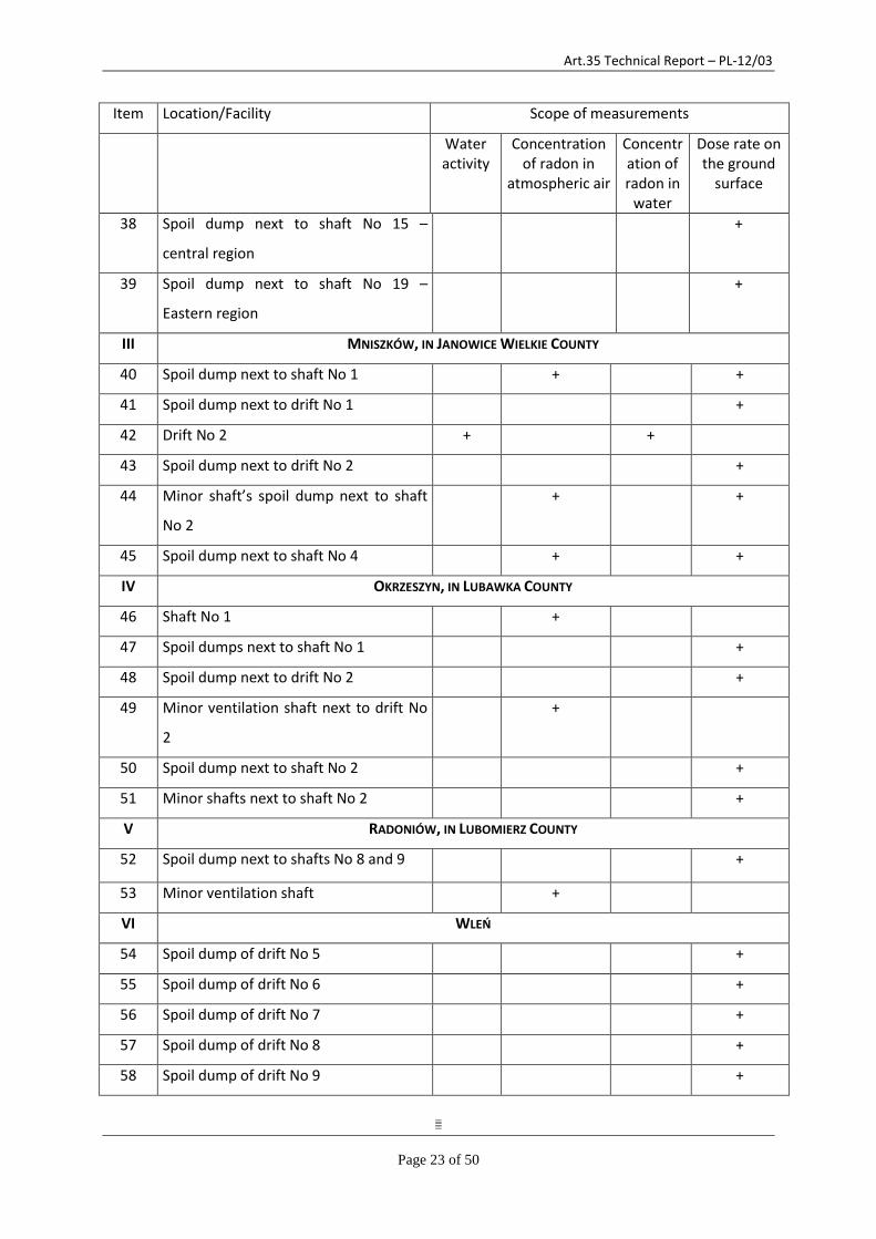
A detailed list of locations and facilities included in the monitoring program and the scope of measurements are shown below. This list is intended as an example as the particular measurement points may change each year.
Item Location/Facility Scope of measurements
Water activity
Concentration of radon in
atmospheric air
Concentration of radon in
water
Dose rate on the ground surface
I Kowary
1 Drift No 19 – “Podgórze” mine + + +
2 Drift No 19a – “Podgórze” mine + + +
3 Spoil dump next to drift No 19 +
4 Drift No 17 – “Podgórze” mine + + +
5 Spoil dump next to drift No 17 +
6 Spoil dump next to drift No 16 –
“Podgórze” mine
+
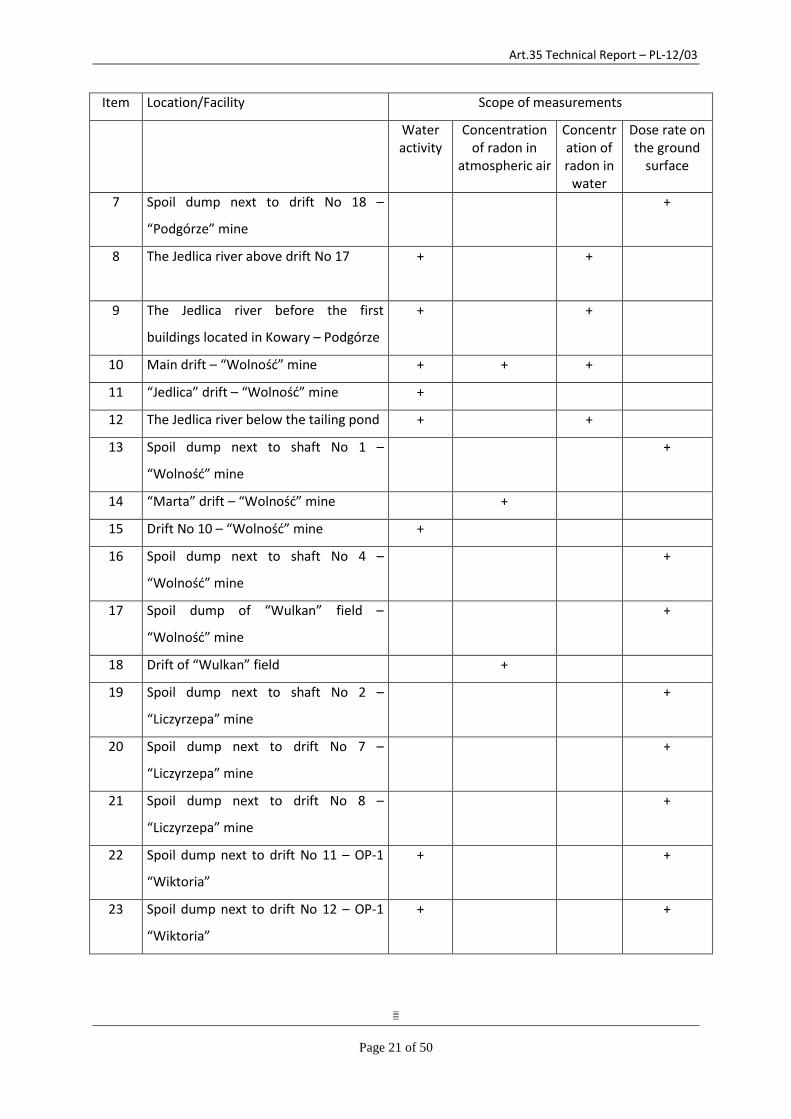
Art.35 Technical Report – PL-12/03
Page 21 of 50
Item Location/Facility Scope of measurements
Water activity
Concentration of radon in
atmospheric air
Concentration of radon in
water
Dose rate on the ground
surface
7 Spoil dump next to drift No 18 –
“Podgórze” mine
+
8 The Jedlica river above drift No 17 + +
9 The Jedlica river before the first
buildings located in Kowary – Podgórze
+ +
10 Main drift – “Wolność” mine + + +
11 “Jedlica” drift – “Wolność” mine +
12 The Jedlica river below the tailing pond + +
13 Spoil dump next to shaft No 1 –
“Wolność” mine
+
14 “Marta” drift – “Wolność” mine +
15 Drift No 10 – “Wolność” mine +
16 Spoil dump next to shaft No 4 –
“Wolność” mine
+
17 Spoil dump of “Wulkan” field –
“Wolność” mine
+
18 Drift of “Wulkan” field +
19 Spoil dump next to shaft No 2 –
“Liczyrzepa” mine
+
20 Spoil dump next to drift No 7 –
“Liczyrzepa” mine
+
21 Spoil dump next to drift No 8 –
“Liczyrzepa” mine
+
22 Spoil dump next to drift No 11 – OP-1
“Wiktoria”
+ +
23 Spoil dump next to drift No 12 – OP-1
“Wiktoria”
+ +
Art.35 Technical Report – PL-12/03
Page 22 of 50
Item Location/Facility Scope of measurements
Water activity
Concentration of radon in
atmospheric air
Concentration of radon in
water
Dose rate on the ground
surface
24 Spoil dump next to drift No 13 – OP-1
„Wiktoria”
+
25 Spoil dump next to drift No 14 – OP-1
„Wiktoria”
+ +
26 Spoil dump next to drift No 15 – OP-1
„Wiktoria”
+
27 Spoil dump next to drift No 21 – OP-2
„Budniki”
+ +
28 Spoil dump next to drift No 22 – OP-2
„Budniki”
+ +
29 Spoil dump next to drift No 23 – OP-2
„Budniki”
+ +
30 Tailing pond in Kowary +
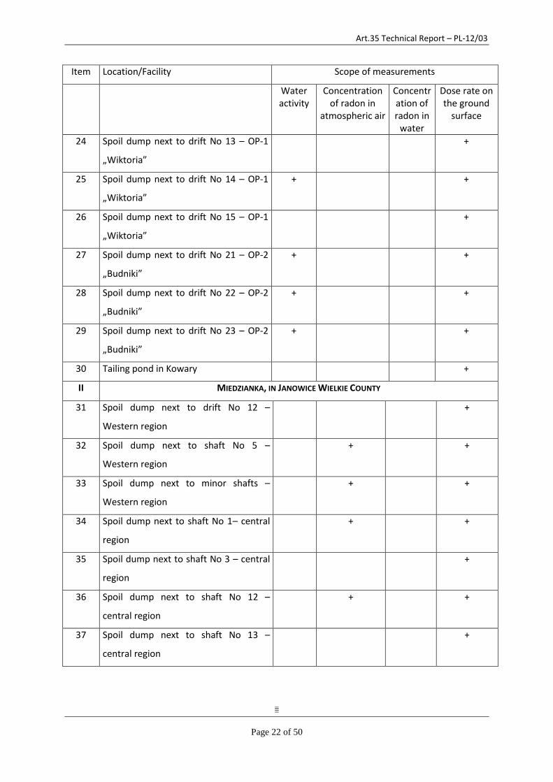
II MIEDZIANKA, IN JANOWICE WIELKIE COUNTY
31 Spoil dump next to drift No 12 –
Western region
+
32 Spoil dump next to shaft No 5 –
Western region
+ +
33 Spoil dump next to minor shafts –
Western region
+ +
34 Spoil dump next to shaft No 1– central
region
+ +
35 Spoil dump next to shaft No 3 – central
region
+
36 Spoil dump next to shaft No 12 –
central region
+ +
37 Spoil dump next to shaft No 13 –
central region
+
Art.35 Technical Report – PL-12/03
Page 23 of 50
Item Location/Facility Scope of measurements
Water activity
Concentration of radon in
atmospheric air
Concentration of radon in
water
Dose rate on the ground
surface
38 Spoil dump next to shaft No 15 –
central region
+
39 Spoil dump next to shaft No 19 –
Eastern region
+
III MNISZKÓW, IN JANOWICE WIELKIE COUNTY
40 Spoil dump next to shaft No 1 + +
41 Spoil dump next to drift No 1 +
42 Drift No 2 + +
43 Spoil dump next to drift No 2 +
44 Minor shaft’s spoil dump next to shaft
No 2
+ +
45 Spoil dump next to shaft No 4 + +
IV OKRZESZYN, IN LUBAWKA COUNTY
46 Shaft No 1 +
47 Spoil dumps next to shaft No 1 +
48 Spoil dump next to drift No 2 +
49 Minor ventilation shaft next to drift No
2
+
50 Spoil dump next to shaft No 2 +
51 Minor shafts next to shaft No 2 +
V RADONIÓW, IN LUBOMIERZ COUNTY
52 Spoil dump next to shafts No 8 and 9 +
53 Minor ventilation shaft +
VI WLEŃ
54 Spoil dump of drift No 5 +
55 Spoil dump of drift No 6 +
56 Spoil dump of drift No 7 +
57 Spoil dump of drift No 8 +
58 Spoil dump of drift No 9 +
Art.35 Technical Report – PL-12/03
Page 24 of 50
Item Location/Facility Scope of measurements
Water activity
Concentration of radon in
atmospheric air
Concentration of radon in
water
Dose rate on the ground
surface
59 Drift No 9 + +
VII WOJCIESZYCE, IN STARA KAMIENICA COUNTY
60 Drift No 1 + +
61 Spoil dump next to shaft No 3 + +
62 Spoil dump next to shaft No 1 +
63 Spoil dump next to shaft No 2 +
VIII BOBRÓW, IN MYSŁAKOWICE COUNTY
64 Drift No 1 + + +
65 Spoil dump next to drift No 1 +
IX JAGNIĄTKÓW, IN JELENIA GÓRA COUNTY
66 Spoil dump next to drift No 1 + +
X KOPANIEC, IN STARA KAMIENICA COUNTY
67 Drift No 3 + +
68 Spoil dump next to shaft No 4 +
69 Minor shaft + +
XI KROMNÓW, IN STARA KAMIENICA COUNTY
70 Spoil dump next to shaft No 5 + +
71 Spoil dump next to shaft No 6 +
XII MAJEWO, IN JANOWICE WIELKIE COUNTY
72 Spoil dump next to shaft No 1 + +
XIII POBIEDNA, IN LEŚNA COUNTY
73 Spoil dump next to drift No 4 +
74 Spoil dump next to minor shaft +
XIV RZESZÓWEK, IN ŚWIERZAWA COUNTY
75 Spoil dump next to drift No 5 + +
XV RYBNICA-WOJCIESZYCE, IN STARA KAMIENICA COUNTY
76 Spoil dump next to drift No 2 + +
77 Spoil dump next to minor shaft +
XVI STARE ROCHOWICE, IN BOLKÓW COUNTY
Art.35 Technical Report – PL-12/03
Page 25 of 50
78 Spoil dump next to drift No 8 +
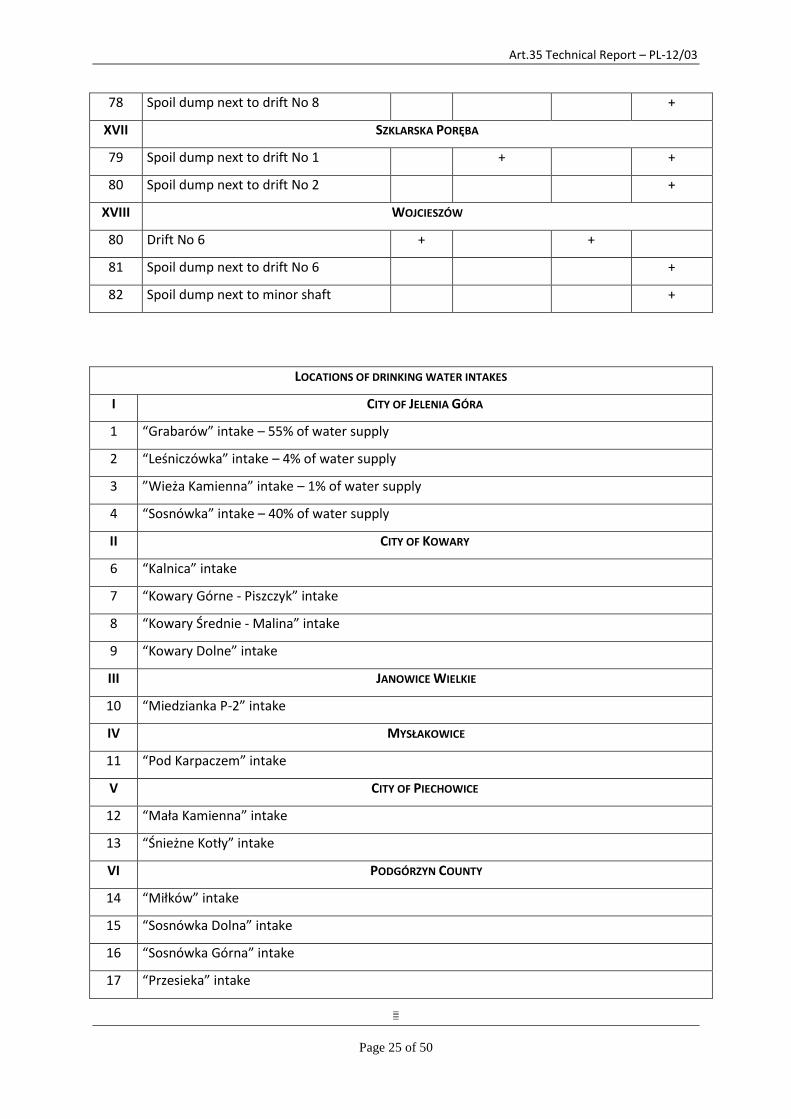
XVII SZKLARSKA PORĘBA
79 Spoil dump next to drift No 1 + +
80 Spoil dump next to drift No 2 +
XVIII WOJCIESZÓW
80 Drift No 6 + +
81 Spoil dump next to drift No 6 +
82 Spoil dump next to minor shaft +
LOCATIONS OF DRINKING WATER INTAKES
I CITY OF JELENIA GÓRA
1 “Grabarów” intake – 55% of water supply
2 “Leśniczówka” intake – 4% of water supply
3 ”Wieża Kamienna” intake – 1% of water supply
4 “Sosnówka” intake – 40% of water supply
II CITY OF KOWARY
6 “Kalnica” intake
7 “Kowary Górne - Piszczyk” intake
8 “Kowary Średnie - Malina” intake
9 “Kowary Dolne” intake
III JANOWICE WIELKIE
10 “Miedzianka P-2” intake
IV MYSŁAKOWICE
11 “Pod Karpaczem” intake
V CITY OF PIECHOWICE
12 “Mała Kamienna” intake
13 “Śnieżne Kotły” intake
VI PODGÓRZYN COUNTY
14 “Miłków” intake
15 “Sosnówka Dolna” intake
16 “Sosnówka Górna” intake
17 “Przesieka” intake

Art.35 Technical Report – PL-12/03
Page 26 of 50
18 “Borowice” intake (the Myja River)
19 “Zachełmie” intake (the Czerwień River)
VII CITY OF KARPACZ
20 “Wilcza Poręba I” intake
21 “Wilcza Poręba II” intake
22 “Majówka” intake
23 “Śląski Dom” intake
24 “Wielki Staw” intake
25 “Mały Staw” intake
VIII CITY OF SZKLARSKA PORĘBA
26 “Łabski Szczyt” intake
27 “Kamieńczyk” intake
28 “Jakuszyce” intake
29 “Wysoki Kamień” intake
30 “Biała Dolina” intake
31 “Huta Podziemny” intake
OTHER WATER INTAKES AND UPWELLINGS FROM NATURAL SPRINGS
I KOWARY REGION
1 Upwelling from a spring in the carpark area (road to Kowary Pass)
2 Upwelling from “Jola” spring in Wojkowo
3 Water intake (a well) next to the building No 51 in Kowary-Podgórze
II MIEDZIANKA REGION, JANOWICE WIELKIE COUNTY
4 Water intake above shaft No 3 in Miedzianka
III MNISZKÓW REGION, JANOWICE WIELKIE COUNTY
5 Water intake (a well) below shaft No 2 in Mniszków
7.2 LABORATORIES PARTICIPATING IN THE ENVIRONMENTAL MONITORING OF FORMER URANIUM MINING
AND MILLING SITES
The radiation monitoring of areas affected by mining activities is carried out almost entirely by the laboratory of the NAEA’s Office in Jelenia Góra.
Art.35 Technical Report – PL-12/03
Page 27 of 50
The laboratory performs measurements of total alpha and beta activity in water samples and radon concentration in water. The measurement of total alpha and beta activity is preceded by the preparation of water samples. The initial sample treatment, which consists in evaporating of water and preparing a dry residue, is performed in the laboratory of the Voivodeship Environmental Protection Inspectorate located in Jelenia Góra at 28 Warszawska Street. The cooperation with the Voivodeship Environmental Protection Inspectorate is a result of the agreement signed on 14 October 1998 by the Head of the NAEA's local office and the Voivodeship Environmental Protection Inspector in Jelenia Góra.
Measurements are conducted using the following equipment:
1) Laboratory meter FHT 1100, manufactured by Eberline Instruments GmbH Company used to measure total alpha and beta activity of water samples. A detailed method for the preparation of water samples is shown in the workstation instructions No 1/FCH-R, and a detailed method for the measurement is presented in measuring instructions No 1/BOR. The device testing is performed on the basis of two reference sources: 241Am and 90Sr holding a calibration certificate.
2) Radon monitor Alpha Guard PQ 2000 PRO, manufactured by Genitron Instruments GmbH Company and a set for the radon measurement in water AquaKIT used to designate the radon concentration in air and water. A detailed method for the preparation of water samples and measurement is shown in the measurement instruction No 2/BOR. The monitor possesses a calibration certificate.
3) Portable dose rate meter FH 40 G-L 10, manufactured by Eberline Instruments GmbH Company used to measure gamma radiation dose rate. Measurements are conducted on the height of 1±0.2 m above the ground level in the grid with the side of 5 or 10 meters. The time of measurement in a given point is 2-3 minutes. The meter possesses a calibration certificate.
7.3 REPORTING AND STORAGE OF INFORMATION
The results concerning the exploration and excavation of uranium ores were secret and as such were collected in the archives of Uranium Ore Plants R-1and included annual reports on the operations of Uranium Ore Plants R-1, reports on the results of works of exploratory groups, plans with regard to mine movement and measuring documentation. In the years 1948-57 mining and geological documentation was performed in single copies which were not submitted to other national institutions. It was not until 1957 when annual reports regarding exploratory works started to be submitted to the Central Geological Office and to the Government’s Commissioner for the Use of Nuclear Power. In 1972 after the liquidation of the Uranium Ore Plants R-1, the company’s archives were taken over by the Nuclear Technology Applications Plant “Polon” in Wrocław (the legal successor of the Uranium Ore Plant R-1) and were stored in the building of former Uranium Ore Plants R-1 in Kowary until 1990.
In 1991 by virtue of a decision by the President of the National Atomic Energy Agency, the documents from the archives were submitted to the bodies authorized to collect specialized materials, and in particular:
- materials concerning geology were sent to the National Geological Institute in Warsaw, - materials concerning mining activity were sent to the archives of the District Mining Office in
Wrocław, and at a later term to the Higher Mining Office in Katowice.
Art.35 Technical Report – PL-12/03
Page 28 of 50
Finding materials in those archives is a difficult task. It must be borne in mind that large parts of documents were in the Russian language and most of them were hand-written.
The archives of the Office for Claims of Former Workers of Uranium Ore Plants R-1 also possess fragmentary archival materials concerning manufacturing reports and radiological protection. These documents were cleared in 1993 pursuant to the NAEA President’s decision.
Management of radiological monitoring data
The measurement results obtained from the on-going radiation monitoring of uranium mining facilities are stored in electronic and traditional (paper) form in the Office for Financial Claims of the Former Workers of the Uranium Ore Facilities. Data from measurements is transmitted in the form of an annual report to the National Atomic Energy Agency in Warsaw and published in the annual report of the NAEA President.
The measurement results are also submitted in the form of an annual report to the Voivodeship Environmental Protection Inspectorate in Wrocław, and the measurement results of drinking water are made available to particular users of the public water intakes.
8 VERIFICATIONS
8.1 CEZAR CENTRE
Following the presentation given at the opening meeting the verification team visited the operational offices to see first-hand the systems in place and to gather further insight into the centre's operation.
In addition to its task of collecting of the radiation monitoring data, CEZAR is also a National Contact Point for domestic and abroad radiation emergencies, which operates 24 hours a day. The current staff is 11 people and it is going to increase in 2013.
A new UPS has been installed in the CEZAR centre which can keep all systems operational for 30 minutes, longer if not all systems connected. Currently there is no diesel generator backup but this is planned.
Following the recommendations made in the 2006 Article 35 verification report a new data centre is planned which would notably offer better visualisation of the various data. At the time of the visit the specifications were in the process of being drafted and budget was foreseen in 2013 for the purchase of new computers.
Currently data which arrives from other sources in paper format must be input to MS Excel files. In the future design of the new database it is hoped that all transmission will be automatic.
The verification does not give rise to any specific remarks. Nevertheless the verification team would appreciate to be informed about the progress of the planned improvements.
8.2 POLISH GEOLOGICAL INSTITUTE
The verification team visited the Headquarters of the Polish Geological Institute (PGI) in Warsaw. The visit included a meeting with PGI staff involved in uranium exploration in Poland and a tour of the Central Geological Archives (CGI).
Art.35 Technical Report – PL-12/03
Page 29 of 50
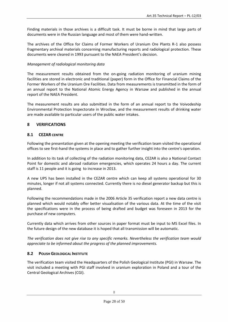
The PGI was founded in 1919 and besides its core scientific research tasks as National Research Institute it deals with practical issues, namely national geological survey and, since recently, national hydrogeological survey. The Institute issues an annual Report on Mineral Reserves and Groundwater Resources in Poland containing information on more than 11,000 mineral deposits as a serial publication since 1953.
According to Geological and Mining Law of 9 June 2011 (in force from January, 1, 2012) the PGI is supervised by the Ministry of Environment, which provides about three quarters of its budget through the National Fund for Environmental Protection and Water Management. The Institute has about 800 staff split in several Directorates, regional branches and laboratories (figure 4).
Fig. 4: Structure of the Polish Geological Institute
Uranium prospection in Poland started in 1948, and up to 1971 the prospecting works were conducted by Polish/Soviet enterprise „Kowary Mines” (Russian „Kuźnieckie Rudniki”). The exploitation of uranium ore started in 1948 and ended in 1967. Between 1956 and 1988 the geological prospection of uranium mineralization was conducted by Polish Geological Institute under state funding.
Between 1948 and 1967 the uranium exploration and exploitation included more than 15 million direct measurements (mainly emanation points), 200 000 water sample analyses, 200 000 m of
Art.35 Technical Report – PL-12/03
Page 30 of 50
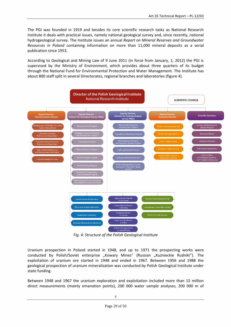
geological prospecting trenches, 50 000 m of underground mining excavations, 160 000 m of drillings and numerous radiometric verifications of old mining excavations and waste-dumps. Practically all Polish uranium deposits occur in the Sudetes, from where about 700 000 tones uranium were obtained.
Uranium production from deposits in the Sudetes
The verification team discussed with the PGI scientists the potential for renewal of uranium exploitation, following recent statements from Polish officials and the plans for construction of a nuclear power plant in Poland. An article from 2011 (Miecznik, Strzelecki and Wolkowicz. Uranium in Poland – history of prospecting and chances for finding new deposits. Prz. Geol., 59: 688-697) was given to the verification team which concluded that the known deposits cannot be considered as a potential source of uranium, and the chances to discover new uranium deposits of industrial significance are minimal.
Art.35 Technical Report – PL-12/03
Page 31 of 50
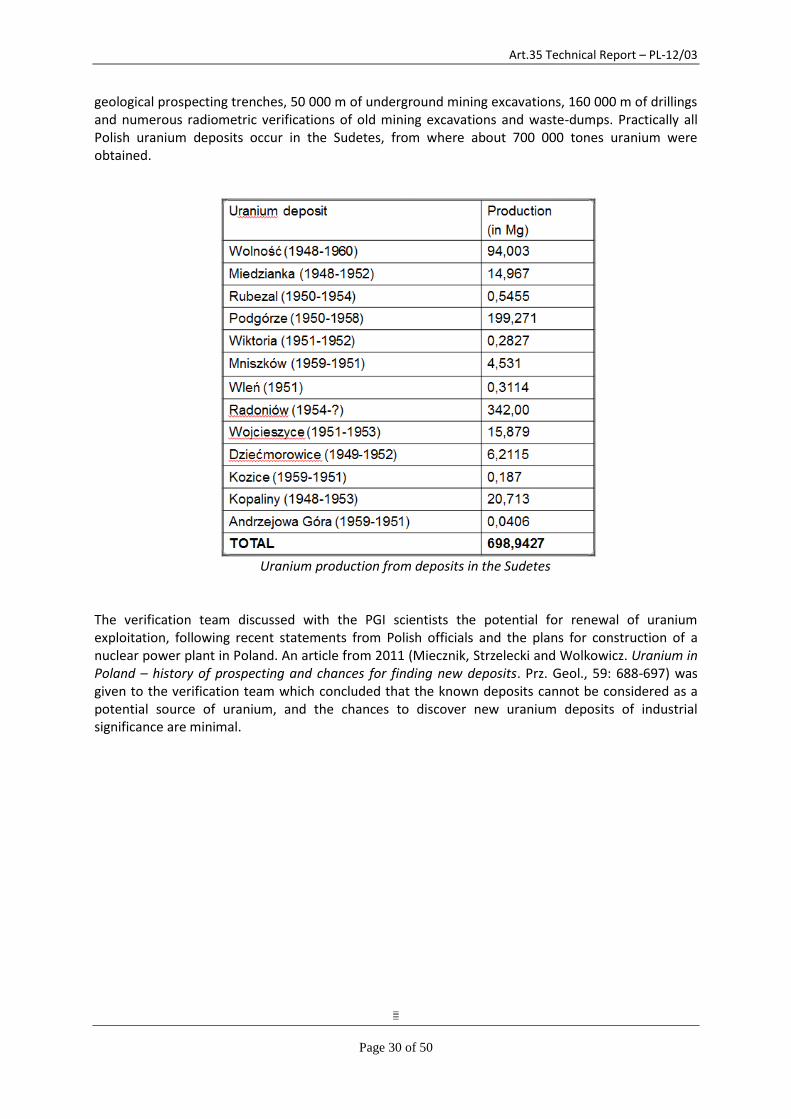
The National Geological Archives consist of several Departments, the Central Geological Archives in Warsaw and regional geological archives (figure 5). The Archives contain about 340 000 documents and reports, 450 000 geological maps and 600 km of borehole cores.
Fig. 5: Location of PGI archives
The collection, storage and access to geological information are regulated by the Geological and Mining Law and two Ordinances by the Minister of Environment. According to the Law, the right to the geological information is held by the State Treasury. However, after several changes of Mining and Geological Law, starting from 1989, some of the geological information is private property. The verification team discussed with the PGI staff the status of the geological information from uranium ore exploration and received the clarification that some of the information collected before 1956 was not made available to the Polish authorities but was kept by the USSR co-owners of the "Kowary Mines" company. As of 1956 the uranium mineralization prospection was carried out under full Polish national budget funding and all the information collected up to 1989, when the last prospection was made, should be in the Central Geological Archives and represents the property of State Treasury.
The team visited the CGA in Warsaw. The documents are kept in their original paper form in specially designed premises and a fully searchable electronic catalogue is available. A designated section
Art.35 Technical Report – PL-12/03
Page 32 of 50
containing documents from uranium ore explorations was set up at the archive and appropriately identified. The archives are equipped with a reading room, where access to the stored geological information is granted in accordance with the Ordinances from the Ministry of Environment.
Verification activities with respect to storage or geological information from uranium exploration do not give rise to particular remarks.
8.3 WROCLAW UNIVERSITY OF TECHNOLOGY
Since 1973 the Wrocław University of Technology is the owner of all the immovable properties belonging to the former uranium milling site R-1 in Kowary. The Rector of the University decided to establish there the Experimental Plant "Hydro-Mech" as of 1 January 1973. According to the statute vested with the new organization, the plant performed tasks related to the research on hydrometallurgical methods to manufacture high purity metals and it also produced prototype devices for the purposes of environmental protection. The "Hydro-Mech" was closed in 1993 and its operations transferred to a company called "Hydro-Met", which is fully owned by the University which was in operation at the time of the visit.
During the course of the visit in Wrocław, and further in Kowary there was talk of a possible future sale of the lands and buildings.
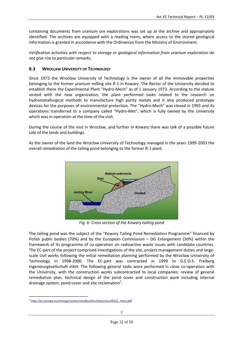
As the owner of the land the Wrocław University of Technology managed in the years 1999-2003 the overall remediation of the tailing pond belonging to the former R-1 plant.
Fig. 6: Cross section of the Kowary tailing pond
The tailing pond was the subject of the "Kowary Tailing Pond Remediation Programme" financed by Polish public bodies (70%) and by the European Commission – DG Enlargement (30%) within the framework of its programme of co-operation on radioactive waste issues with candidate countries. The EC-part of the project comprised investigations of the site, project management duties and large-scale civil works following the initial remediation planning performed by the Wroclaw University of Technology in 1998-2000. The EC-part was contracted in 1999 to G.E.O.S. Freiberg Ingenieurgesellschaft mbH. The following general tasks were performed in close co-operation with the University, with the construction works subcontracted to local companies: review of general remediation plan, technical design of the pond cover and construction work including internal drainage system, pond cover and site reclamation3.
3 http://ec.europa.eu/energy/nuclear/studies/doc/other/eur20312_main.pdf
Art.35 Technical Report – PL-12/03
Page 33 of 50
The radiological monitoring was part of the Polish contribution to the project and was the responsibility of the University. The measurements of the gamma dose rate were used for checking the remediation progress and the quality of the final pond cover. A final dose rate measurement carried out by the University in October 2001, after completion of the work, provided the proof that the remediation target of < 300 nSv/h (1 m above ground) had been achieved.
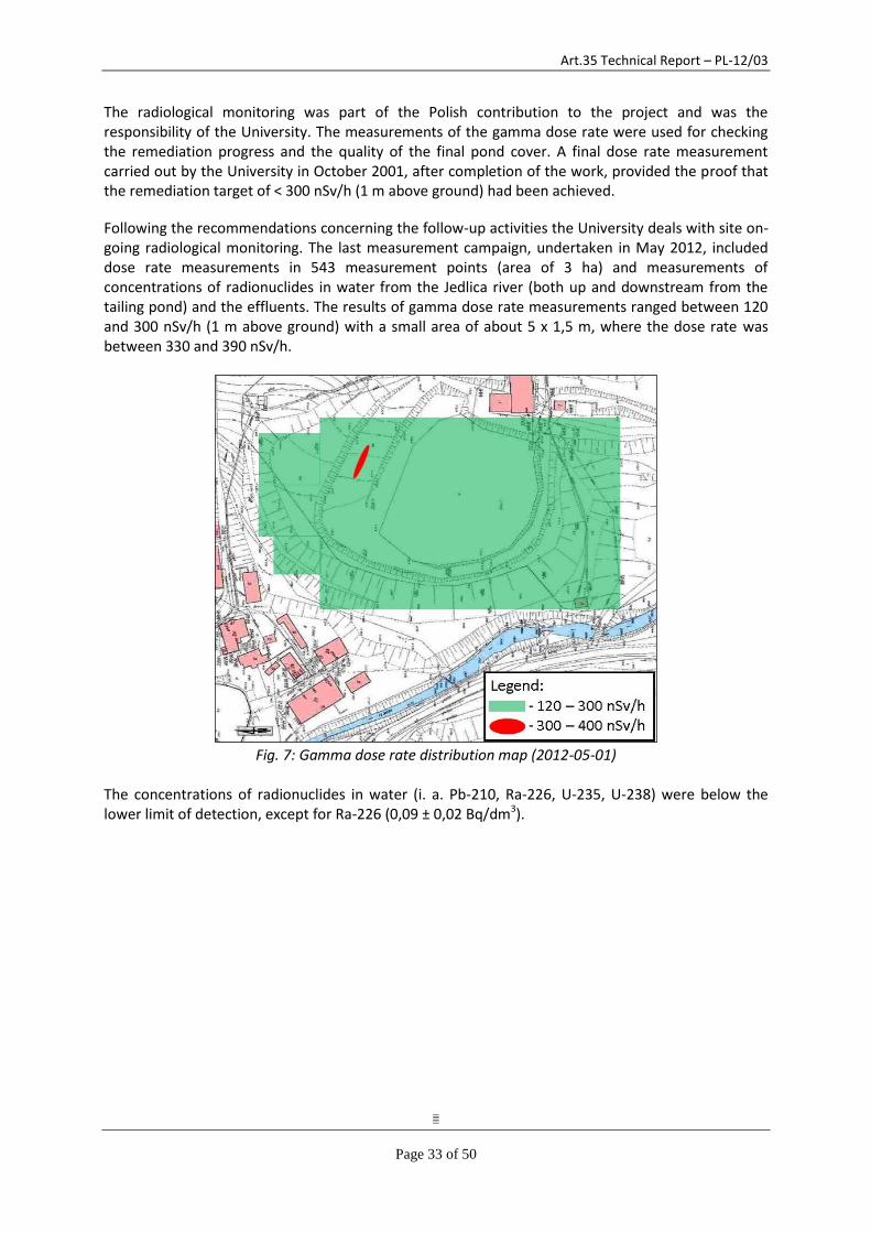
Following the recommendations concerning the follow-up activities the University deals with site on-going radiological monitoring. The last measurement campaign, undertaken in May 2012, included dose rate measurements in 543 measurement points (area of 3 ha) and measurements of concentrations of radionuclides in water from the Jedlica river (both up and downstream from the tailing pond) and the effluents. The results of gamma dose rate measurements ranged between 120 and 300 nSv/h (1 m above ground) with a small area of about 5 x 1,5 m, where the dose rate was between 330 and 390 nSv/h.
Fig. 7: Gamma dose rate distribution map (2012-05-01)
The concentrations of radionuclides in water (i. a. Pb-210, Ra-226, U-235, U-238) were below the lower limit of detection, except for Ra-226 (0,09 ± 0,02 Bq/dm3).
Art.35 Technical Report – PL-12/03
Page 34 of 50
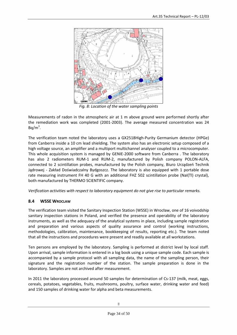
Fig. 8: Location of the water sampling points
Measurements of radon in the atmospheric air at 1 m above ground were performed shortly after the remediation work was completed (2001-2003). The average measured concentration was 24 Bq/m3.
The verification team noted the laboratory uses a GX2518High-Purity Germanium detector (HPGe) from Canberra inside a 10 cm lead shielding. The system also has an electronic setup composed of a high voltage source, an amplifier and a multiport multichannel analyser coupled to a microcomputer. This whole acquisition system is managed by GENIE-2000 software from Canberra . The laboratory has also 2 radiometers RUM-1 and RUM-2, manufactured by Polish company POLON-ALFA, connected to 2 scintillation probes, manufactured by the Polish company, Biuro Urządzeń Technik Jądrowej - Zakład Doświadczalny Bydgoszcz. The laboratory is also equipped with 1 portable dose rate measuring instrument FH 40 G with an additional FHZ 502 scintillation probe (NaI(Tl) crystal), both manufactured by THERMO SCIENTIFIC company.
Verification activities with respect to laboratory equipment do not give rise to particular remarks.
8.4 WSSE WROCLAW
The verification team visited the Sanitary Inspection Station (WSSE) in Wrocław, one of 16 voivodship sanitary inspection stations in Poland, and verified the presence and operability of the laboratory instruments, as well as the adequacy of the analytical systems in place, including sample registration and preparation and various aspects of quality assurance and control (working instructions, methodologies, calibration, maintenance, bookkeeping of results, reporting etc.). The team noted that all the instructions and procedures were present and readily available at all workstations.
Ten persons are employed by the laboratory. Sampling is performed at district level by local staff. Upon arrival, sample information is entered in a log book using a unique sample code. Each sample is accompanied by a sample protocol with all sampling data, the name of the sampling person, their signature and the registration number of the station. The sample preparation is done in the laboratory. Samples are not archived after measurement.
In 2011 the laboratory processed around 50 samples for determination of Cs-137 (milk, meat, eggs, cereals, potatoes, vegetables, fruits, mushrooms, poultry, surface water, drinking water and feed) and 150 samples of drinking water for alpha and beta measurements.
Art.35 Technical Report – PL-12/03
Page 35 of 50
The verification team noted the laboratory has a liquid scintillation counter (PerkinElmer Tri-Carb 3170TR/SL) for alpha and beta measurements, one NaI(Tl) detector for gamma spectrometry, connected to an Inter-Polon Tristan 1024 Multi-Channel Analyser with manual peak setting (Polon electronic devices) and one Inter-Polon Sapos-90 device (used for dose rate measurements). Available sample geometries for gamma measurements are Marinelli beakers and plastic boxes. A service contract is in place for all this equipment. Reference sources with the corresponding certificates were available.
The laboratory is fully accredited, including for radiological measurements. For Polish routine monitoring the NAEA system of acceptance applies (QA/QC by NAEA president, via participation in national inter-comparisons). All measurement techniques as well as the resulting data are approved by the president of NAEA. Quarterly reports are sent to NAEA.
The verification activities do not give rise to particular remarks.
8.5 NAEA'S OFFICE FOR FINANCIAL CLAIMS OF THE FORMER WORKERS OF THE URANIUM ORE FACILITIES
JELENIA GΌRA
The verification team visited the NAEA’s Office for Financial Claims of the Former Workers of the Uranium Ore Facilities located in Jelenia Góra. The office is responsible for the environmental monitoring programme in areas affected by former uranium mining activities and operates therefore a small laboratory for total alpha and total beta activity measurements in water samples and radon concentration measurements in water and in air.
8.5.1 Monitoring programme
The environmental monitoring programme in areas affected by former uranium mining activities was defined and approved by the President of the National Atomic Energy Agency on 27 August 1998. The programme comprises the monitoring of ambient gamma dose rate, of total alpha and total beta activity in water, as well as the monitoring of radon in air and in water at various sites in Kowary, Miedzianka, Mnisków, Okrzeszyn, Bobrów, Wojcieszyce, Radoniòw, Wlén, Jagniątków, Kopaniec, Kromnów, Majewo, Pobiedna, Rybnica-Wojcieszyce, Stare Rochowice, Szklarska Poręba, and Wojcieszów. In 2003, the President of the National Atomic Energy Agency approved the extension of the programme to cover also the monitoring of drinking water in several locations. The monitoring programme is described in detail in chapter 7.1.
In 2011, the analysis of drinking water samples taken in the locations listed in chapter 7.1 showed total alpha activities between 2,1 and 41,3 mBq/l, and total beta activities between 26,4 and 285,9 mBq/l. Radon in drinking water ranged between 0,9 and 362,8 Bq/l.
The NAEA Office for Financial Claims of the Former Workers of the Uranium Ore Facilities is responsible for the execution of the environmental monitoring programme (according to Article 11b point 7 of the Organizational Regulations of the National Atomic Energy Agency.)
In 1999 and in 2004, the NAEA Office in Jelena Gora engaged in extensive measurement campaigns performing all measurements defined in the above mentioned monitoring programme. Details of this extensive measurement campaign and the results of selected sites have been presented to the verification team. Although the environmental monitoring programme requires an annual repetition of all measurements, none of the gamma dose rate measurements have been repeated due to very limited human resources (the office consists of only two staff members). Measurements of total alpha and total beta activity in water and of radon in air are repeated on a regular basis.
Art.35 Technical Report – PL-12/03
Page 36 of 50
The verification team noted that the gamma dose environmental monitoring programme, as it was defined by NAEA in 1998, is appropriate for a thorough initial analysis of the environmental situation at the identified former mining sites. It is, however, very ambitious and requires more resources than currently available to perform all measurements at the frequency foreseen in the programme. The verification team therefore recommends developing, based on the results of the initial analysis, an appropriate annual measurement programme which allows to appropriately monitor the environmental situation and to identify changes over time.
8.5.2 Laboratory equipment
The verification team noted that the initial treatment of water samples for the total alpha and total beta measurement, evaporation and preparation of a dry residue, is performed by another laboratory (Voivodeship Environmental Protection Inspectorate, Jelenia Góra, 28 Warszawska Street). This laboratory has not been visited by the verification team. After receiving the dry residues, the NAEA laboratory uses a laboratory meter Eberline Instruments FHT 1100 to measure total alpha and beta activity of the dry residues. The device is regularly tested with two reference sources, 241Am and 90Sr, both holding a calibration certificate. A detailed method for the preparation of water samples is provided in the workstation instructions No 1/FCH-R, and a detailed method for the measurement is presented in measuring instructions No 1/BOR.
For the measurement of radon in air, the laboratory uses a radon monitor Genitron Instruments Alpha Guard PQ 2000 PRO. For the determination of radon concentration in water, the instrument is complemented by the AquaKIT. A detailed method for the preparation of water samples and measurement is given in the measurement instruction No 2/BOR. The monitor possesses a calibration certificate.
For gamma dose rate measurements, the laboratory is equipped with a mobile dose rate meter Eberline Instruments FH 40 GL 10. The meter possesses a calibration certificate.
The verification activities with respect to laboratory equipment do not give rise to particular remarks.
8.6 KOWARY
The verification team visited the Kowary area where major uranium mining and milling activities took place from 1948 to 1972. The team visited the Kowary tailing pond area, drifts No.19/19a and 17 of Podgórze mine and the surrounding area and the "Główna" drift of the Wolność mine.
8.6.1 Kowary tailing pond and surroundings
A general description of the tailing pond and the on-site monitoring performed by its owner, the Wrocław University of Technology, is included in section 8.3 of the report. This section deals with the observations made by the verification team during the site visit.
The verification team visited the tailing pond through an access point located on its south-west side close to the water effluent sampling points (figure 8). The access is relatively easy, through an unguarded opening in the pond's fence indicated with a "do not enter" sign. The pond, its dam and the surroundings are densely covered with vegetation, including several trees growing in the remediated pond.
The verification team visited water sampling points in the vicinity of the tailing pond located on the Jedlica river below the tailing pond. Water samples from these locations are taken annually and
Art.35 Technical Report – PL-12/03
Page 37 of 50
analysed for total alpha and beta activities in the NAEA's local office. In June 2012 the NAEA's local office also sent several water samples, including from those two locations, for more detailed radiological analysis of uranium and radium to CLOR. The results of this CLOR analysis are shown in the table below:
Sample Nr U-234, Bq/l U-238, Bq/l U-235, Bq/l Ra-226, Bq/l
1 0.570 ± 0.100 0.500 ± 0.080 0.009 ± 0.0008 0.094 ± 0.009
2 0.180 ± 0.005 0.160 ± 0.004 0.005 ± 0.0004 0.064 ± 0.006
3 0.190 ± 0.006 0.160 ± 0.005 0.003 ± 0.0004 0.034 ± 0.005
4 0.027 ± 0.002 0.010 ± 0.001 <0.0005 0.035 ± 0.006
5 0.034 ± 0.002 0.024 ± 0.002 0.001 ± 0.0003 0.012 ± 0.003
6 0.840 ± 0.020 0.700 ± 0.020 0.022 ± 0.001 0.025 ± 0.004
7 1.600 ± 0.050 1.390 ± 0.040 0.030 ± 0.001
Nr.1 - The Jedlica river before the first buildings located in Kowary Nr.2 - “Jedlica” drift – “Wolność” mine Nr.3 - The Jedlica river below the tailing pond Nr.4 - “Grabarów” intake in Jelenia Góra Nr.5 - Drift No 17, “Podgórze” mine Nr.6 - Drift No 19, “Podgórze” mine Nr.7 - Drift No 19a, “Podgórze” mine
In addition to the recommendations made in 8.5 regarding the continuity of the on-site monitoring, the verification team notes that regulatory verification of the water effluent monitoring results, including independent selective sampling and radiological analysis, should be considered. The verification team notes that trees and other deep-rooting plants can compromise the integrity of the tailing pond cover and should therefore not be allowed to grow there.
8.6.2 Podgórze mine – drift No.19 and surroundings
The "Podgórze" deposit is located in the upper part of the valley of the Jedlica River. Its exploitation began in 1951 and lasted continuously until 1958, when mining ceased due to exhaustion of the ore resources. During the seven years of mining activity a total of about 34 000 meters of excavations were carried out and 140 000 tons of ore – almost 200 tones uranium – were obtained.
The mine has five drifts - No.No.16, 17, 18, 19 and 19a - and is divided into three zones: the northern, central and southern. The most important excavations were drifts No.19 and 19a, considered to be "level 0" of the mine and providing transport routes and access to six more service levels lying beneath "level 0". A separate part of the mine located above "level 0" constitutes drift No.17. The other two drifts, No.16 and 18 were exploratory excavations of minor importance.
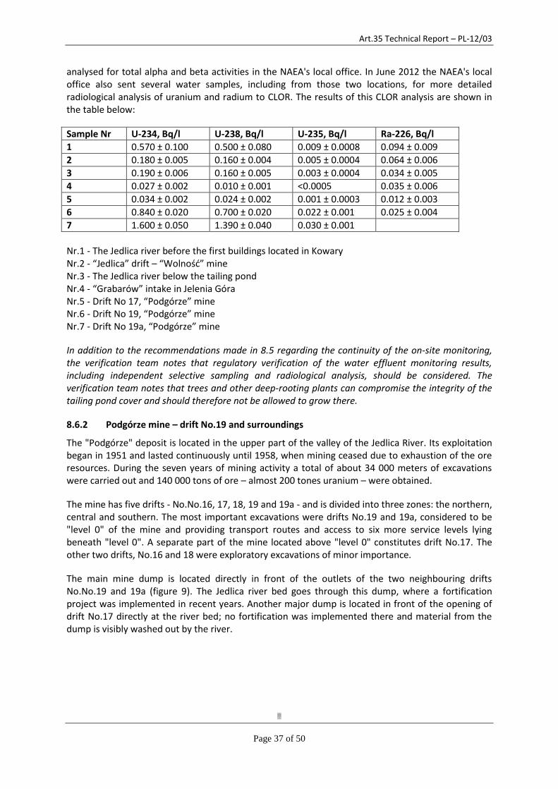
The main mine dump is located directly in front of the outlets of the two neighbouring drifts No.No.19 and 19a (figure 9). The Jedlica river bed goes through this dump, where a fortification project was implemented in recent years. Another major dump is located in front of the opening of drift No.17 directly at the river bed; no fortification was implemented there and material from the dump is visibly washed out by the river.
Art.35 Technical Report – PL-12/03
Page 38 of 50
Fig. 9: Podgórze mine, drifts No. 19 and 19a and the surrounding area
Art.35 Technical Report – PL-12/03
Page 39 of 50
A radon inhalation facility for "medical treatment" of different diseases operated in drift No.19a from the mid-1970s until the end of the 1980s. The facility consisted of two inhalation chambers, staff rooms, lavatories, technical room and emergency exit through drift No.19 and was serviced by an electric train. Following the closure of the inhalation facility, the mine was abandoned and consecutively attacked by looters who extracted valuable material, mostly steel. In 2010 a group of local enthusiasts leased the mines and arranged an underground tourist route stretching about 3 km in drifts 19a and 19.
In 2004 the area was subject of a detailed ambient gamma dose rate mapping covering 1037 measurement points. The results of the gamma dose rate measurements ranged between 100 and 1750 nSv/h (1 m above ground).
The water monitoring covers several measurement locations in the area from which samples are analysed for total alpha and beta activity and for concentration of radon. The highest activities measured in 2011 were at the mine water outlet of drift 19a – for total alpha (672.1±147.9 mBq/l) and total beta (3680.5±478.5 mBq/l) – and in the outlet of drift 17– for radon (342.2±12.6 Bq/l). All mine waters are discharged into the Jedlica River; water activity measured in 2011, upstream vs. downstream from the drifts, was 7.2±1.6 mBq/l vs. 84.3±18.5 mBq/l for alpha, 39.7±5.2 mBq/l vs. 390.8±50.8 mBq/l for beta, and 7.5±0.5 Bq/l vs. 19.1±1.1 Bq/l for radon. In addition, in June 2012 water samples from the water outlets of drifts 17, 19 and 19a were sent to the CLOR in Warsaw for radiological analysis of uranium isotopes and radium-226 (for more information, see 8.6.1).
Radon in air is measured at several locations inside drifts 17, 19 and 19a. Results from 1999 show that the highest radon concentrations occur in drift 17 (up to almost 40 000 Bq/m3), which is not accessible to the public. Radon concentrations in the accessible (as tourist attraction, i.e. under controlled condition and for a limited time) drifts 19 and 19a can reach 8 000 Bq/m3; active ventilations is operational in the parts with the highest radon concentration.
The verification activities at this location do not give rise to particular remarks with regard to the measurement programme. The verification team would support any remediation of the area, which would have the effect of lowering the dose rate measured and stabilizing the terrains affected by the former mining, in particular the spoil heaps.
8.6.3 Wolność mine – "Główna" drift
"Wolność" mine is located north of the Kowary tailing pond, and the "Główna" (main) drift is just meters away from the pond as well as from the nearest houses (figure 10). The entrance to the drift is unsealed and apparently visited by looters who left cable insulations and other waste material.
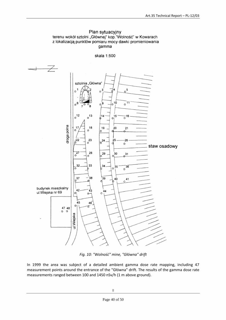
Art.35 Technical Report – PL-12/03
Page 40 of 50
Fig. 10: "Wolność" mine, "Główna" drift
In 1999 the area was subject of a detailed ambient gamma dose rate mapping, including 47 measurement points around the entrance of the "Główna" drift. The results of the gamma dose rate measurements ranged between 100 and 1450 nSv/h (1 m above ground).
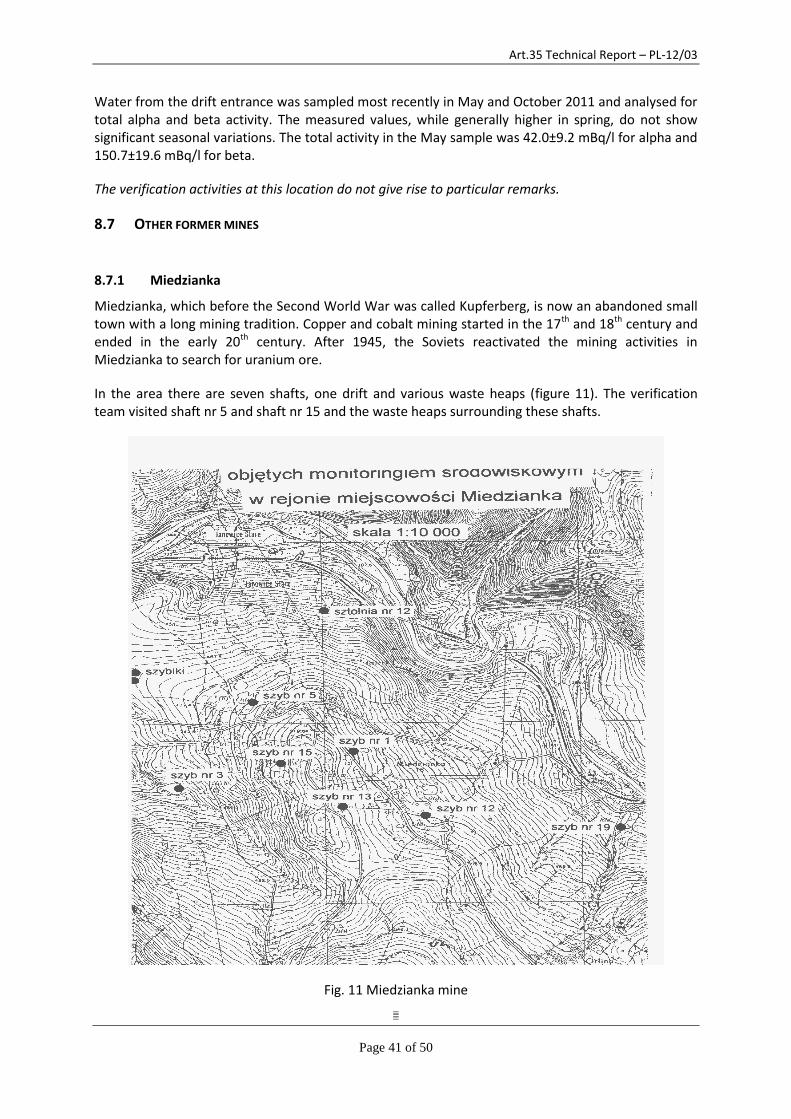
Art.35 Technical Report – PL-12/03
Page 41 of 50
Water from the drift entrance was sampled most recently in May and October 2011 and analysed for total alpha and beta activity. The measured values, while generally higher in spring, do not show significant seasonal variations. The total activity in the May sample was 42.0±9.2 mBq/l for alpha and 150.7±19.6 mBq/l for beta.
The verification activities at this location do not give rise to particular remarks.
8.7 OTHER FORMER MINES
8.7.1 Miedzianka
Miedzianka, which before the Second World War was called Kupferberg, is now an abandoned small town with a long mining tradition. Copper and cobalt mining started in the 17th and 18th century and ended in the early 20th century. After 1945, the Soviets reactivated the mining activities in Miedzianka to search for uranium ore.
In the area there are seven shafts, one drift and various waste heaps (figure 11). The verification team visited shaft nr 5 and shaft nr 15 and the waste heaps surrounding these shafts.
Fig. 11 Miedzianka mine
Art.35 Technical Report – PL-12/03
Page 42 of 50
During the 1999 measurement campaign, the ambient dose rate was measured at 216 measurement points defining a 10 m x 10 m grid in an area of 210 m x 110 m covering the waste heaps around shaft 5. The results of the gamma dose rate measurements ranged between 140 and 1200 nSv/h (1 m above ground). In addition, the radon concentration in air at shaft nr 5 was measured. The average measured radon concentration in air at shaft nr 5 was 60 Bq/m3.
Around shaft nr 15, the ambient dose rate was measured at 90 measurement points defining a 10 m x 10 m grid in an area of 80 m x 90 m covering the waste heaps around shaft nr 15. The results of the gamma dose rate measurements ranged between 110 and 200 nSv/h (1 m above ground).
Both shaft nr 5 and shaft nr 15 are secured by a concrete cover. Local residents, however, took material from the freely accessible waste heaps for use in construction.
The verification activities at this location do not give rise to particular remarks with regard to the monitoring programme. The verification team would support any remediation of the area, which would have the effect of lowering the dose rate measured and stabilizing the terrains affected by the former mining, in particular the waste heaps.
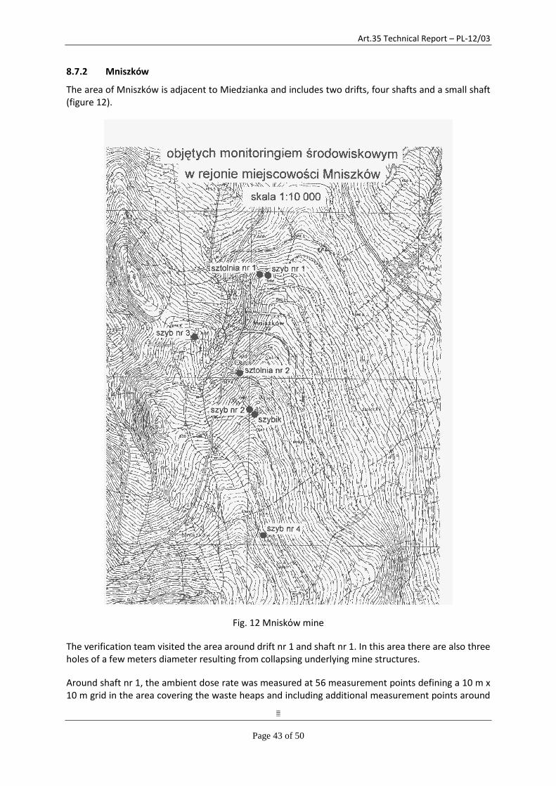
Art.35 Technical Report – PL-12/03
Page 43 of 50
8.7.2 Mniszków
The area of Mniszków is adjacent to Miedzianka and includes two drifts, four shafts and a small shaft (figure 12).
Fig. 12 Mniskόw mine
The verification team visited the area around drift nr 1 and shaft nr 1. In this area there are also three holes of a few meters diameter resulting from collapsing underlying mine structures.
Around shaft nr 1, the ambient dose rate was measured at 56 measurement points defining a 10 m x 10 m grid in the area covering the waste heaps and including additional measurement points around

Art.35 Technical Report – PL-12/03
Page 44 of 50
above mentioned craters. The results of the gamma dose rate measurements ranged between 115 and 620 nSv/h (1 m above ground). The radon concentration in air was measured at shaft nr 1 and at the bottom of the crater, where the highest dose rate was measured (point 40: 620 nSv/h). The average measured radon concentration in air at shaft nr 1 was 20 Bq/m3. The average measured radon concentration in air at the bottom of the crater (measurement point 80) was 70000 Bq/m3.
Above drift nr 1, the ambient dose rate was measured at 4 points and at the waste heap close to the drift at another 18 points. The results of the gamma dose rate measurements ranged between 130 and 420 nSv/h (1 m above ground).
The environmental monitoring programme foresees the sampling of water running out of drift nr 2. The water samples are analysed for their total alpha and total beta activity as well as for the radon concentration.
The water sample collected in March 2011 showed a total alpha activity of 35.2±7.7 mBq/l and a total beta activity of 87.0±11.3 mBq/l; the November 2011 sample a total alpha activity of 19.5±4.3 mBq/l and a total beta activity of 47.1±6.1 mBq/l.
The verification team noted that shaft nr 1 and the three craters are open, unsecured and freely accessible. There seem to remain also a risk that further underlying mine structures collapse and create additional craters. The verification team recommends to consider securing or covering at least shaft nr 1 to prevent members of the public to fall into the shaft.
The verification activities at this location do not give rise to particular remarks with regard to the measurement programme.
8.7.3 Bobrów
The verification team visited a drift in Bobròw in the Mysłakowice County which has been excavated for exploration purposes, but excavations have been stopped after some ten meters depth as the uranium yield was not sufficiently promising.
The environmental monitoring programme foresees the sampling of water running out of this drift. The water samples are analysed for their total alpha and total beta activity as well as for the radon concentration. Radon is measured in air. Ambient dose rate is measured at a few measurement points on the small waste heap close to the drift.
The water sample collected in March 2011 showed a total alpha activity of 73.2±16.1 mBq/l and a total beta activity of 342.5±44.5 mBq/l; the November 2011 sample a total alpha activity of 59.2±13.0 mBq/l and a total beta activity of 305.3±39.7 mBq/l.
The verification activities at this location do not give rise to particular remarks.
8.7.4 Radoniów
This was an important mine though little visible remained to testify to its past activity. From a distance there was little clue that any mining activities had taken place as the vegetation had taken over and hidden the spoil dumps from sight. On closer inspection the heaps of waste rock could be distinguished. (figure 13)
Art.35 Technical Report – PL-12/03
Page 45 of 50
Fig. 13 Radoniόw mine
The verification team were informed that part of the waste rock had been used in the construction of a local road and that sand from one part of the site had been taken occasionally by the local people. No records were to hand concerning the measurement of this material to ensure that it was safe to be used.
All shafts and drifts appeared to have been secured against intrusion and there was no evidence of water flowing from the mine.
In 2001 the area was subject of a detailed ambient gamma dose rate mapping. The results of the gamma dose rate measurements ranged between 100 and 1650 nSv/h (1 m above ground).
The verification activities at this location do not give rise to particular remarks with regard to the measurement programme. The verification team would support any remediation of the area, which would have the effect of lowering the dose rate measured and stabilizing the terrains affected by the former mining, in particular the spoil heaps.
8.7.5 Wleń
This mine was not an operational facility as such and only drifts were driven for exploratory purposes. A small quantity of uranium was produced from the material excavated but the reserves
Art.35 Technical Report – PL-12/03
Page 46 of 50
were not considered commercially interesting. The drifts were driven into the hillside in what is now a forest which makes it difficult to distinguish any signs of previous activity.
In 2004 the area was subject of a detailed ambient gamma dose rate mapping (in a 5 m x 5 m grid). The results of the gamma dose rate measurements ranged between 100 and 2180 nSv/h (1 m above ground). The highest values of dose rate were measured close to drift no. 6 and 7 and the lowest values close to drift no. 5, 8 and 9.
Water flows from drift no. 9 and is analysed for total alpha and beta activity and for radon content. The total activity in the June 2011 sample was 35.1±7.7 mBq/l for alpha and 182.7±23.8 mBq/l for beta.
The spoil heaps are rather insignificant and appear to blend in with the surroundings.
The verification team would support any remediation of the area which would have the effect of lowering the dose rate measured.
9 CONCLUSIONS
All verification activities that had been planned were completed successfully. In this regard, the information supplied in advance of the visit, as well as the additional documentation received during and after the verification activities, was useful.
The information provided and the verification findings led to the following observations:
(1) The operation of the CEZAR centre is satisfactory.
(2) The verifications at the Polish Geological Institute, Wroclaw University of Technology and the WSSE in Wroclaw do not give rise to any particular remarks.
(3) The verification activities that were performed demonstrated that the facilities necessary to carry out continuous monitoring of levels of radioactivity in the air, water and soil at the former uranium mining and milling sites are adequate. The Commission could verify the operation and efficacy of these facilities.
(4) At the time of the verification visit there was some discussion concerning a possible future sale of the land in Kowary belonging to the Wroclaw University of Technology, including the tailing pond. The verification team expressed some concerns regarding the future monitoring of the site.
(5) The verification team noted that the gamma dose environmental monitoring, as it was defined by NAEA in 1998, is appropriate for a thorough initial analysis of the environmental situation at the identified former mining sites. It is, however, very ambitious and requires more resources than currently available to perform all measurements at the frequency foreseen in the programme. The verification team therefore recommends developing, based on the results of the initial analysis, a realistic annual measurement programme which allows to appropriately monitor the environmental situation and to identify changes over time.
(6) In addition to the recommendations above regarding the continuity of the on-site monitoring, the verification team notes that regulatory verification of the water effluent monitoring results, including independent selective sampling and radiological analysis, should be considered.

Art.35 Technical Report – PL-12/03
Page 47 of 50
(7) From the sample of former mining sites visited it was clear that no remediation had taken place. The verification team fully support any efforts towards remediation of these sites which would have the effect of reducing radiation emissions, stabilizing the terrains affected by the former mining and ensuring public safety.
(8) The recommendations are detailed in the ‘Main Conclusions document that is addressed to the Polish competent authority through the Polish Permanent Representative to the European Union.
(9) The Commission Services ask the Polish competent authority to inform them of any achievements or significant changes with regard to the situation at the time of the verification, in particular the upgrading of the CEZAR centre, the possible sale of lands at Kowary and overall progress in the remediation of former mining areas.
(10) The verification team acknowledges the excellent co-operation it received from all persons involved in the activities it performed.
Art.35 Technical Report – PL-12/03
Page 48 of 50
APPENDIX 1
REFERENCES & DOCUMENTATION
1. Response to preliminary information questionnaire furnished by NAEA.
2. Geological and mining law of 9 June 2011.
3. Minister of the Environment Ordinance on collection and making geological information available.
4. Minister of the Environment Ordinance on the use of geological information with remuneration.
5. Remediation of the Low-level Radioactive Waste Tailing Pond at Kowary, Poland – final report by
G:E:OS: Freiburg for the European Commission, DG Enlargement, 31/10/2010.
6. Report of radiological monitoring of the area of the former uranium mines "Wolność", "Podgórze"
and "Liczyrzepa" in Kowary, 1999 (in Polish).
7. Report of radiological monitoring of the area of the of the former uranium mine "Miedzinka" in
Miedzianka and of the uranium field in Mniszków, 1999 (in Polish).
8. Report of radiological monitoring of the area of the remediated tailing pond in Kowary, 2002 (in
Polish).
9. Report of radiological monitoring in Jelenia Góra downtown and Jelenia Góra-Cieplice (the
concentration of radon in air in dwellings and buildings with public access, the concentration of
radon in drinking water, gamma dose rate), 2004 (in Polish).
10. Report of radiological monitoring of the area of the of the former uranium mine "Podgórze" in
Kowary and of the uranium field in "Wleń", 2004 (in Polish).
11. Report of radiological monitoring of surface and underground waters in the area of former
uranium mining and milling - Lower Silesian Voivodeship (total alpha and beta radioactivity in a
dry residue of water samples, concentration of radon in water), 2012 (in Polish).
12. CLOR measurement report from natural radioisotope analysis of effluent and surface water from
the area of Kowary, 28.06.2012 (in Polish).
13. Report of radiological monitoring of the area of the of the former uranium mine "Radoniów" in
Radoniów, 2001 (in Polish).
Art.35 Technical Report – PL-12/03
Page 49 of 50
APPENDIX 2
THE VERIFICATION PROGRAMME
Art. 35 verification Poland – 2-6 July 2012
Former uranium mining and milling areas
National monitoring network
Sunday 1/7
EC team travels to Warsaw
Monday 2/7
1. 09:00 – 11:00: Opening meeting at NAEA with presentations
2. 11:30 – 14:30: CEZAR centre and Polish Geological Institute
3. 16:10 – 18:00 Travel from Warsaw to Wroclaw (air)
Tuesday 3/7
4. 09:00 – 11:00: Visit to the Wroclaw University of Technology
5. 11:30 – 12:30: Visit to WSSE in Wroclaw
6. 12.30 – 15:30: Travel to Jelenia Gora
7. 15:30 – 17:30 Verification at the NAEA's Office for Financial Claims including
the laboratory responsible for analysing samples from former uranium mining sites
Wednesday 4/7
8. 09:00 – 17:00: Verification activities principally at former uranium mining sites in the Kowary area but to include elements of the National monitoring programme where present– 2 teams
Thursday 5/7
9. 09:00 – 15:00: Verification activities principally at other former uranium mining sites
Team 1 Miedzianka – Mniszków – Bobrów
Team 2 Wojcieszyce – Radoniów – Wleń
10. 15:30 – 17:30: Closing meeting at NAEA offices in Jelenia Gora
Friday 6/7 Return of EC team to Luxembourg
EC team:
Team 1 Georgi SIMEONOV (team leader) , Stefan MUNDIGL
Team 2 Remigiusz BARAŃCZYK, Alan RYAN.
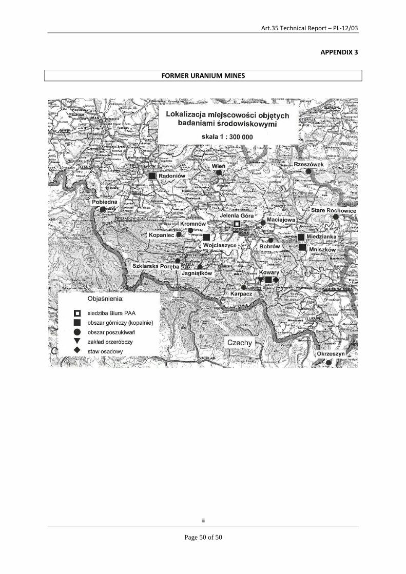
Art.35 Technical Report – PL-12/03
Page 50 of 50
APPENDIX 3
FORMER URANIUM MINES