Embed Size (px)
Citation preview

Tectonic accretion and recycling of the continental lithosphere during theAlpine orogeny along the Pyrenees
OLIVIER VANDERHAEGHE1 and ALEXIA GRABKOWIAK2
Key words. – Pyrenees, Plate convergence, Alpine orogeny, Continental subduction, Continental accretion, Continental recycling
Abstract. – The goal of this paper is to identify the fate of the continental lithosphere along the Iberia-Eurasia conver-gent plate boundary marked by the formation of the Pyrenean orogenic belt. The present-day volumes of crust and litho-sphere beneath the Pyrenees and the volume of eroded crust redistributed in neighbo ring basins are evaluated based ona synthesis of available geological and geophysical data. The volumes that are expected to have transited across the for-mer plate boundary are modeled taking into account Iberia-Eurasia convergence and making assumptions regarding theinitial lithospheric and crustal structure of the Iberia-Eurasia plate boundary at the onset of continental collision(~83 Ma).
Despite large uncertainties, the difference between the initial and present-day lithospheric structures suggests thatat 83 Ma, either the Iberia-Eurasia plate boundary was marked by a zone of thinned lithosphere (oceanic and/or conti-nental), or the lithosphere having transited across the plate boundary has for the most part been recycled into the mantle.
At the crustal-scale, the volume of tectonically accreted crust is estimated by adding the volume of crust currentlypresent in the Pyrenean orogenic belt to the volume of sediments deposited in neighboring basins, and by subtractingthe initial volume of crust at the onset of continental collision considering two end-members, namely (i) a continentalrift or (ii) a 35 km wide oceanic basin. In both cases, this tectonically accreted crustal volume is not enough to matchthe calculated volume of crust that has potentially transited across the plate boundary as a consequence of convergencesince 83 Ma. As a result, our computation suggests that at least 30% (and as much as 63%) of the continental crust hassubducted with the Iberian lithospheric slab and has been recycled into the mantle.
In addition, the synthesis of topographic and geophysical (gravity and seismic tomography) reveals a peculiarcrustal and lithospheric scale structure for the current day Pyrenees characterized by (i) an elliptical-cone-shape Pyre-nean mountain range underlain by an elliptical-cone-shaped crustal root pointing down, and (ii) two tongues of lithos-pheric mantle in the central part of the belt. These features are interpreted as reflecting redistribution of the lithosphericmantle and of the orogenic crust by ductile flow after subduction and tectonic accretion. We propose that following aperiod of subduction/collision from 83 to 35 Ma, the decrease in the convergence rate between Iberia-Eurasia favoredthermal relaxation of the Iberian slab promoting ductile flow and the development of gravitational instabilities. We sug-gest that the orogenic root has been dragged down by the dense lithospheric root and that part of it has been recycledinto the mantle. In this view, the current-day lithospheric tongues represent the remnants of the lithospheric root afterthermal relaxation and recycling by convective removal.
Accrétion tectonique et recyclage de la lithosphère continentale au cours de l’orogenèsealpine dans les Pyrénées
Mots-clés. – Pyrénées, Convergence de plaques, Orogenèse alpine, Subduction continentale, Accrétion continentale, Recyclagecontinental
Résumé. – L’objectif de cet article est d’identifier le devenir de la lithosphère continentale à l’aplomb de la zone deconvergence entre les plaques Ibérie et Eurasie. Les volumes de lithosphère et de croûte présents actuellement sous lesPyrénées et le volume de croûte érodée, redistribué dans les bassins autour des Pyrénées sont évalués sur la base d’unesynthèse des données géologiques et géophysiques disponibles. Les volumes qui sont susceptibles d’avoir été impliquésle long de la limite de plaques sont évalués (i) en prenant en compte la convergence entre les plaques Ibérie et Eurasie et(ii) en émettant des hypothèses sur la structure initiale de la limite de plaques au moment du début de la collisioncontinentale (à environ 83 Ma).
Malgré des incertitudes importantes, la différence entre les structures lithosphériques initiale et actuelle suggèreque soit à 83 Ma, la limite de plaque Ibérie-Eurasie était marquée par une zone de lithosphère mince (océanique et/oucontinentale) ou que la lithosphère qui a transité à travers la limite de plaque a été en grande partie recyclée dans lemanteau.
À l’échelle crustale, le volume de croûte tectoniquement accrétée lors de l’orogenèse alpine est estimé en faisantla différence entre le volume de croûte orogénique actuellement identifié sous les Pyrénées et le volume de croûte mo-délisé à l’état initial au début de la collision continentale à 83 Ma estimé pour deux cas limites, (i) un rift continental et(ii) un bassin océanique de 35 km de large. Dans les deux cas, le volume de croûte tectoniquement accrétée n’est pas
Bull. Soc. géol. France, 2014, t. 185, no 4, pp. 257-277
Bull. Soc. géol. Fr., 2014, no 4
1. Université de Lorraine, GéoRessources, UMR 7359, Vandoeuvre-lès-Nancy, F-54060, France2. Université de Lorraine, Ecole Nationale Supérieure de Géologie, ENSG, Vandoeuvre-lès-Nancy, F-54060, FranceManuscript received on December 4, 2012; accepted on March 6, 2014.

suffisant pour contrebalancer le volume ayant transité à travers la zone de convergence depuis 83 Ma estimé sur la basedes modèles cinématiques à l’échelle des plaques. Ces comparaisons suggèrent qu’au moins 30 % (et jusqu’à 63 %) dela croûte continentale a suivi la lithosphère ibérique subductée et a été recyclée dans le manteau. D’autre part, la syn-thèse des données topographiques et géophysiques (gravimétrie et tomographie sismique) révèlent une structure particu-lière pour les Pyrénées actuelles marquée par (i) une chaîne de montagnes en forme de cône à base elliptiquesurmontant une racine crustale également de forme conique mais pointant vers le bas, et (ii) deux langues de lithosphèrependant en dessous de la partie centrale de la chaîne. Ces caractéristiques sont interprétées comme reflétant une redistri-bution du manteau lithosphérique et de la croûte orogénique par fluage ductile à la suite de la subduction et de l’accré-tion tectonique. Nous proposons qu’après une période de subduction/collision entre 83 et 35 Ma, la diminution de lavitesse de convergence entre l’Ibérie et l’Eurasie ait favorisé la relaxation thermique de la plaque subductée permettantson fluage ductile et le développement d’instabilités gravitaires. Nous suggérons que la racine de la croûte orogéniqueait été entrainée vers le bas par la racine lithosphérique dense et qu’une partie en a été recyclée dans le manteau.
INTRODUCTION
In the early days of plate tectonics it was stipulated that plateconvergence was accommodated by oceanic subduction fol-lowed by continental collision [McKenzie, 1969]. Accordingto this model, the continental crust is supposed to be tec-tonically accreted leading to the formation of a thickenedorogenic wedge characterized by a high mountain range anda deep crustal root owing to isostatic compensation [Deweyand Bird, 1970]. The discovery of ultra-high pressure min-erals exhumed in most Phanerozic mountain belts has beeninterpreted as the evidence of subduction of continentalcrust to mantle depth [Chopin, 2003; Liou et al., 2004;Guillot et al., 2009]. Following tectonic accretion and iso-static compensation, the high mountain range is then erodedowing to the action of surface processes feeding sedimentsto foreland basins and to alluvial plains all the way to theocean [Koons, 1990; Willett, 1999; Whipple, 2009]. Re-garding the behavior of the lithospheric mantle involvedalong the convergent plate boundary, two models have beenproposed, namely (i) homogeneous deformation [Englandand McKenzie, 1982; Fleitout and Froidevaux, 1982; Eng-land and Houseman, 1988] or (ii) subduction of onelithospheric slab beneath the other [Molnar and Gray, 1979;Mattauer, 1986; Willett and Beaumont, 1994]. The behaviorof the lithospheric mantle after the onset of continental col-lision has been further investigated by analog and numericalmodeling identifying the conditions favorable for diffusedeformation or subduction [Pysklywec et al., 2000;Toussaint et al., 2004; Faccenna et al., 2007; Schellart andRawlinson, 2010]. Thanks to growing geophysical and geo-logical databases it is nowadays possible to reconstruct thelithospheric scale 3D structure of orogenic belts and assessthe pertinence of these hypotheses regarding the fate of thelithospheric mantle and of the crust along convergent plateboundaries [Vanderhaeghe, 2012]. In other words, we cannow address the question “what happens to the continentallithosphere (crust and mantle) during continental collision?”
The Pyrenees constitute a perfect target for such an in-vestigation. Indeed the Pyrenees represent a relatively nar-row rectilinear orogenic belt developed as a result of arelatively well-known kinematic framework since 83 Ma,taken as the onset of continental collision [Srivastava et al.,1990; Olivet, 1996; Sibuet, 2004; Vissers and Meijer,2012b] and for which a significant set of geophysical andgeological data are available [Teixell, 1998; Choukrouneand Team, 1990; Roure et al., 1989; Choukroune, 1992;Muñoz, 1992; Vergés et al., 1995; Souriau et al., 2008].
However, the confrontation of these different types of dataleads to distinct conclusions. Plate kinematic models implythat the Iberia-Eurasia plate boundary accommodated a re-latively large amount of convergence (from 140 km alongthe western Pyrenees to more than 200 km along the easternPyrenees since the onset of continental collision at 83 Ma)[Srivastava et al., 1990; Olivet, 1996; Rosenbaum et al.,2002; Sibuet, 2004; Vissers and Meijer, 2012b]. Crustalscale reconstructions and geological data along different 2Dsections indicate that the Pyrenees formed as a consequenceof crustal thickening during Cretaceous to Cenozoic conti-nental collision across the Pyrenees and recognize from 55to 165 km of horizontal shortening [Séguret and Dai-gnières, 1986; Teixell, 1998; Roure et al., 1989; Chou-kroune, 1992; Muñoz, 1992; Vergés et al., 1995; Beaumontet al., 2000; Vissers and Meijer, 2012a], which is signifi-cantly less than the amount of convergence. These recons-tructions also lead to the conclusion that part of thecontinental crust has subducted with the lithospheric mantlewhich is corroborated by deep seismics [Roure et al., 1989;Choukroune and Team, 1990; Souriau and Granet, 1995]and magnetotellurics [Pous et al., 1995]. On the other hand,deep seismic tomography fails to identify a laterally conti-nuous slab beneath the Pyrenees but rather indicates localizeddeep zones of high-velocity anomalies centered on the Pyre-nees surrounded by relatively thin lithosphere especially be-neath the eastern edge of the Pyrenees [Souriau and Granet,1995; Souriau et al., 2008].
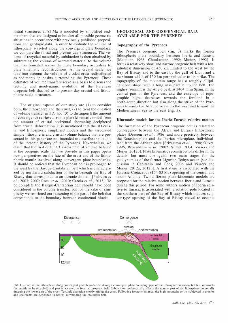
The goal of this paper is to identify the fate of the conti-nental crust and lithosphere along the Iberia-Eurasiaconvergent plate boundary marked by continental collisionand formation of the Pyrenean orogenic belt. Along aconvergent plate boundary, the fate of the continental crustis either to subduct with the lithospheric mantle or to de-couple from the downgoing slab and to tectonically accreteto form an orogenic wedge [Vanderhaeghe and Duchêne,2010] (fig. 1). Isostatic compensation of the thickened crustresults in the formation of a mountain belt and erosion cau-ses redistribution of the accreted crust to neighboring sedi-mentary basins. We make use of the geological andgeophysical data available for the Alpine Pyrenean oroge-nic belt and on the Iberia-Eurasia convergent plate bounda-ry to reconstruct a first order 3D lithospheric and crustalscale structure that provides the foundation to evaluate vo-lume transfer in this region. The rationale is to compare themodeled present day structure of the Pyrenean orogenic beltto the initial structure of the plate boundary at the onset ofcontinental collision (fig. 2). The crustal and lithospheric
258 VANDERHAEGHE O. and GRABKOWIAK A.
Bull. Soc. géol. Fr., 2014, no 4
initial structures at 83 Ma is modeled by simplified end-members that are designed to bracket all possible geometricsituations in accordance with previously published proposi-tions and geologic data. In order to evaluate the volume oflithosphere accreted along the convergent plate boundary,we compare the initial and present day structures. The vo-lume of recycled material by subduction is then obtained bysubtracting the volume of accreted material to the volumethat has transited across the plate boundary according toplate kinematic reconstructions. At the crustal scale, wetake into account the volume of eroded crust redistributedas sediments in basins surrounding the Pyrenees. Theseestimates of volume transfers serve as a basis to discuss thetectonic and geodynamic evolution of the Pyreneanorogenic belt that led to its present-day crustal and lithos-pheric-scale structures.
The original aspects of our study are (1) to considerboth, the lithosphere and the crust, (2) to treat the questionof volume transfer in 3D, and (3) to distinguish the amountof convergence retrieved from a plate kinematic model fromthe amount of crustal horizontal shortening decipheredfrom crustal deformation. It is mentioned that the 3D crus-tal and lithospheric simplified models and the associatedsimple lithospheric and crustal volume balance that are pre-sented in this paper are not intended to describe the detailsof the tectonic history of the Pyrenees. Nevertheless, weclaim that the first order 3D assessment of volume balanceat the orogenic scale that we provide in this paper opensnew perspectives on the fate of the crust and of the lithos-pheric mantle involved along convergent plate boundaries.It should be noticed that the Pyrenean belt is prolonged tothe west by the Basque-Cantabrian belt which is characteri-zed by northward subduction of Iberia beneath the Bay ofBiscay that corresponds to an oceanic domain [Pedreira etal., 2003; 2007; Roca et al., 2010; Carola et al., 2013]. Tobe complete the Basque-Cantabrian belt should have beenconsidered in the volume transfer, but for the sake of sim-plicity we restricted our reasoning to the part of the belt thatcorresponds to the boundary between continental blocks.
GEOLOGICAL AND GEOPHYSICAL DATAAVAILABLE FOR THE PYRENEES
Topography of the Pyrenees
The Pyrenees orogenic belt (fig. 3) marks the formerlithospheric plate boundary between Iberia and Eurasia[Mattauer, 1968; Choukroune, 1992; Muñoz, 1992]. Itforms a relatively short and narrow orogenic belt with a lon-gitudinal dimension of 450 km limited to the west by theBay of Biscay and to the east by the gulf of Lion, and amaximum width of 150 km perpendicular to its strike. Thetopography of the mountain range has a roughly ellipti-cal-cone shape with a long axis parallel to the belt. Thehighest summit is the Aneto peak at 3404 m in Spain, in thecentral part of the Pyrenees, and the envelope of topo-graphic highs decreases towards the foreland in anorth-south direction but also along the strike of the Pyre-nees towards the Atlantic ocean to the west and toward theMediterranean sea to the east (fig. 3).
Kinematic models for the Iberia-Eurasia relative motion
The formation of the Pyrenean orogenic belt is related toconvergence between the Africa and Eurasia lithosphericplates [Dercourt et al., 1986] and more precisely, betweenthe Eurasian plate and the Iberian microplate, individual-ized from the African plate [Srivastava et al., 1990; Olivet,1996; Rosenbaum et al., 2002; Sibuet, 2004; Vissers andMeijer, 2012b]. Plate kinematic reconstructions differ in thedetails, but most distinguish two main stages for thegeodynamics of the former Ligurian-Tethys ocean [see dis-cussion in Capitanio and Goes, 2006 and Vissers andMeijer, 2012a; 2012b]. A first stage is associated with theJurassic-Cretaceous (154-83 Ma) opening of the central andsouth Atlantic. Two different plate kinematic models areproposed for the relative motion between Iberia and Eurasiaduring this period. For some authors motion of Iberia rela-tive to Eurasia is associated with a rotation pole located inthe southern part of the Bay of Biscay which induces scis-sor-type opening of the Bay of Biscay coeval to oceanic
Bull. Soc. géol. Fr., 2014, no 4
TECTONIC ACCRETION AND RECYCLING OF THE LITHOSPHERE (PYRENEES) 259
FIG. 1. – Fate of the lithosphere along convergent plate boundaries. Along a convergent plate boundary, part of the lithosphere is subducted (i.e. returns tothe mantle to be recycled) and part is accreted to form an orogenic belt. Subduction preferentially affects the mantle part of the lithosphere potentiallydragging the lower part of the crust. Tectonic accretion mostly affects the crust. Following isostatic balance, the high mountain belt is subjected to erosionand sediments are deposited in basins surrounding the mountain belt.

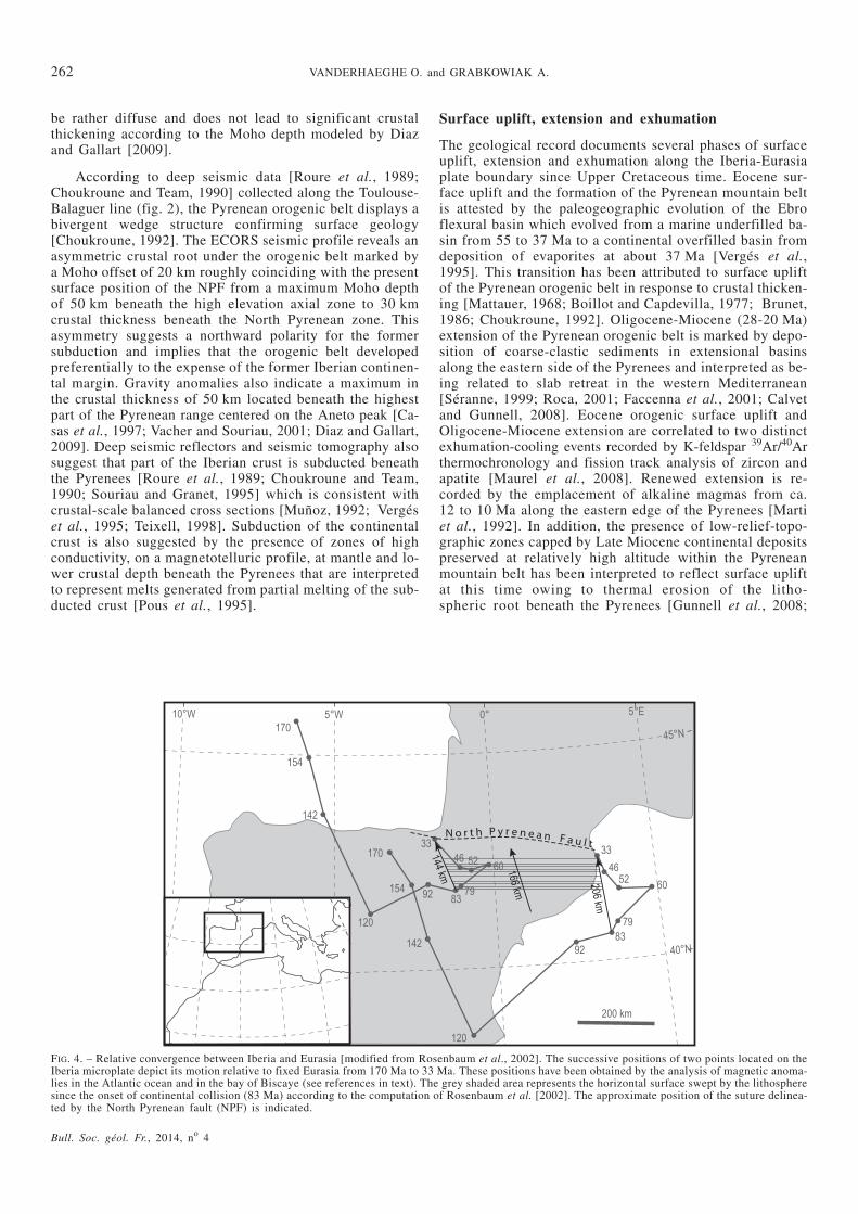
subduction along the Pyrenees [Srivastava et al., 1990;Rosenbaum et al., 2002, Vissers and Meijer, 2012a]. Forothers, the Iberia-Eurasia rotation pole is located in north-ern France and is associated with dominant sinistral strike-slip motion between Iberia and Eurasia [Le Pichon andSibuet, 1971; Olivet, 1996; Handy et al., 2010] coeval withthe opening of oceanic basins between Iberia and Eurasia[Jammes et al., 2009; Lagabrielle et al., 2010]. The secondstage corresponds to Cretaceous-Oligocene (83-35 Ma)convergence between Iberia and Eurasia and is related to achange in the Africa-Eurasia Euler rotation pole reflectedby anti-clockwise rotation of Iberia [Srivastava et al., 1990;Olivet, 1996; Rosenbaum et al., 2002; Sibuet, 2004; Vissersand Meijer, 2012b]. From 35 Ma to present-day, the amountof Iberia-Eurasia relative convergence has been limited to atmost 20 km. In this paper, we will follow the reconstructionof Rosenbaum et al. [2002], which yields an amount of con-vergence between Iberia and Eurasia across the Pyreneessince the onset of continental collision (83 Ma) varyingfrom 144 km along its western edge to 206 km along itseastern edge (fig. 4). Note that for the same time period, theother published kinematic reconstructions yield sensibly thesame amount of convergence, namely about 200 km alongthe Central Pyrenees [see synthesis in Capitanio and Goes,2006, and Vissers and Meijer, 2012b].
Lithospheric-scale structure of the Iberia-Eurasiaplate boundary
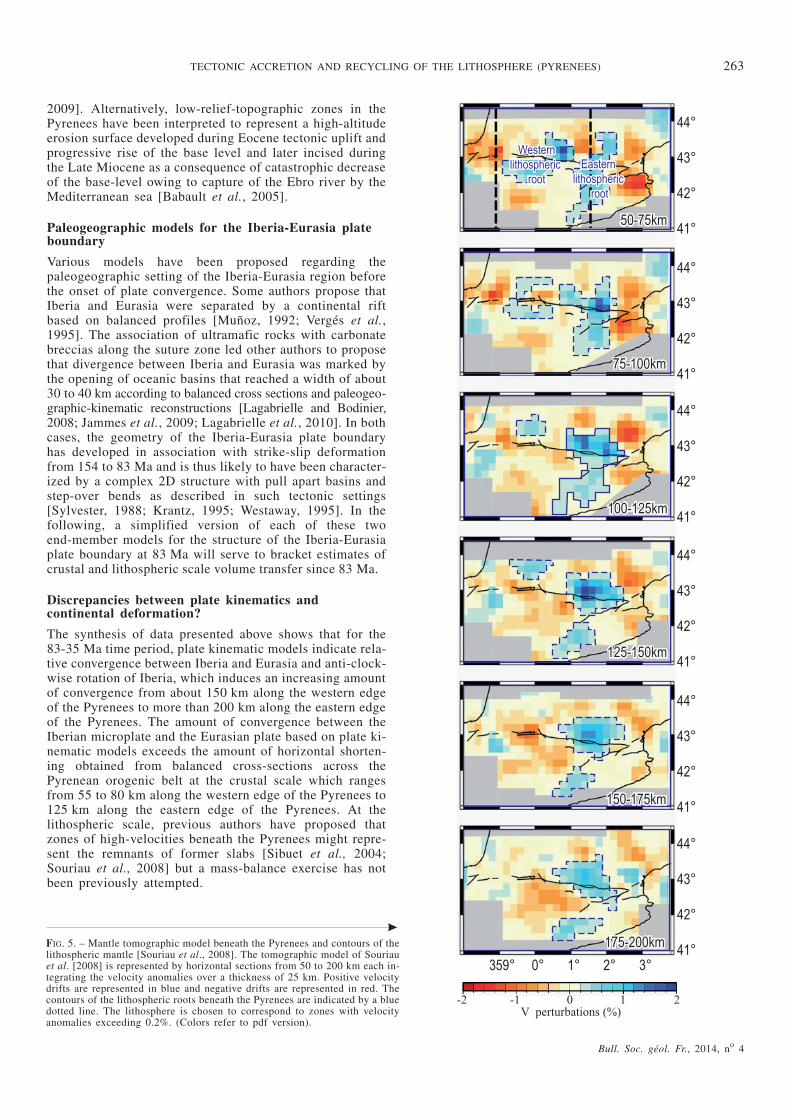
The lithospheric structure beneath western Europe is con-strained by a variety of geophysical data. Beneath theFrench Massif Central, the combination of seismic, gravityand thermal data indicate a lithospheric thickness of100-120 km [Sobolev et al., 1997] which is consistent withtomographic data [Goes et al., 2000]. Beneath the Iberianpeninsula, thermal modeling based on heat flow, gravityand topographic data also yields a lithospheric thickness ofabout 110 km [Zeyen and Fernàndez, 1994; Fernàndez etal., 1998; Gunnell et al., 2008b]. Gravity and thermal mod-eling indicates the presence of a 150 to 170 km thicklithospheric root beneath the Pyrenees [Gunnell et al.,2008a]. The shape of the lithospheric root is further con-strained by seismic tomography [Souriau and Granet, 1995;Souriau et al., 2008] documenting a steeply north-dippinghigh-velocity anomaly in the central part of the Pyreneesthat is surrounded by relatively thin lithospheric mantlealong the western and eastern edges of the belt (figs 5 and6). These lateral heterogeneities in the lithospheric struc-ture have been attributed to (i) the lateral variation of theamount of lithospheric convergence increasing from west toeast, and (ii) lithospheric thinning related to the Cenozoic
260 VANDERHAEGHE O. and GRABKOWIAK A.
Bull. Soc. géol. Fr., 2014, no 4
FIG. 2. – Volume balance rationale. This schematic representation illustrates the rationale followed in this paper to estimate volume balance along a conver-gent plate boundary. In this illustration, only the crustal scale is represented but the reasoning is similar at the lithospheric scale. VCon, the volumes of crustand lithosphere that have transited along the convergent plate boundary are estimated based on lithospheric kinematic models providing an evaluation forLCon, the amount of convergence. Vfin corresponds to the volume of present-day lithosphere and crust reconstructed based on geologic and geophysical dataand evaluated beneath a reference horizontal section X*Y. Vini designates the initial volumes of crust and lithosphere according to geologic and geodyna-mic reconstructions at about 83 Ma, marking the onset of continental accretion. In this paper, we propose two end-members situations for this initial geo-metry with the aim to embrace all possibilities (see text for details). The comparison between Vfin and Vini provides an estimate of Vaccreted, the volumesthat have been accreted from 83 Ma to present-day. The comparison between VCon and Vaccreted provides an estimate of Vrecycled, the volumes that have beenrecycled back into the mantle from 83 Ma to present-day and are detected neither by geologic nor by geophysical data.

opening of the Valencia trough [Lewis et al., 2000; Gunnellet al., 2008].
Crustal-scale structure of the Pyrenean orogenic belt
At the crustal-scale, the Pyrenees (fig. 3) form a typicalasymmetric bivergent orogenic belt with associated forelandflexural basins [Mattauer, 1968; Boillot and Capdevilla,1977; Teixell, 1998; Muñoz, 1992; Choukroune, 1992;Vergés et al., 1995]. The orogenic belt proper is subdividedinto an Axial zone, a Northern zone and a Southern zone.The highest topography Axial zone exposes granitic-gneissic Variscan basement slightly affected by Alpinemetamorphism. The northern and southern external zonesdisplay Mesozoic to Cenozoic sedimentary strata dominatedby carbonates detached from the basement and structured infold and thrust belts. The North Pyrenean fault (NPF),marked by the presence of ultramafic rocks associated witholistostromes and high-temperature/low-pressure metamor-phism [Vielzeuf and Kornprobst, 1984; Lagabrielle andBodinier, 2008; Lagabrielle et al., 2010], is interpreted tocorrespond to the suture between Iberia and Eurasia. TheNPF also subdivides the orogenic belt into two wedgesmarked by opposite vergences respectively delimited by theNorth Pyrenean frontal thrust (NPTh) to the north, and the
South Pyrenean frontal thrust (SPTh) to the south. Exhuma-tion of the Axial zone from ~250oC to less than 100oC inbetween 50 to 20 Ma has been documented by thermo-chronologic data [e.g. Fitzgerald et al., 1999; Gibson et al.,2007; Jolivet et al., 2007; Maurel et al., 2008; Gunnell et al.,2009; Rahl et al., 2011]. Outward propagation of the defor-mation fronts and progressive exhumation of the internalzone is also recorded in Cretaceous to Cenozoic clastic sedi-mentary deposits localized in the flexural Aquitanian [Brunet,1984; Deségaulx and Brunet, 1990; Deségaulx et al., 1991]and Ebro basins [Deségaulx and Moretti, 1988; Vergés etal., 1995; Garcia-Castellanos et al., 2003], respectively tothe north and south of the Pyrenees. Palinspastic recon-struction at the orogenic scale and section balancing yieldhorizontal shortening from 55 to 80 km along the ECORSArzacq deep seismic profile in the western side of the Pyre-nees [Séguret and Daignières, 1986; Teixell, 1998], from100 to 165 km in the central part along the ECORS Pyre-nees deep seismic profile [Séguret and Daignières, 1986;Roure et al., 1989; Choukroune, 1992; Muñoz, 1992] andabout 125 km along the East-Pyrenees section [Vergés etal., 1995]. The central part of Iberia has also been affectedby Cenozoic deformation as attested by crustal scale buck-ling and by block uplifts [Gomez-Ortiz et al., 2004; deVicente et al., 2007]. However, this deformation appears to
Bull. Soc. géol. Fr., 2014, no 4
TECTONIC ACCRETION AND RECYCLING OF THE LITHOSPHERE (PYRENEES) 261
FIG. 3. – Geology and topography of the Pyrenees orogenic belt. The 150 km wide Pyrenean orogenic belt is delimited by opposite vergence thrusts (NorthPyrenees thrust, NPTh, and the South Pyrenees thrust, SPTh) affecting Mesozoic sedimentary cover dominated by carbonates and in part the Cenozoicclastic deposits of the Aquitanian and Ebro foreland basins. The suture between Iberia and Eurasia is delineated by the North Pyrenean fault (NPF). ThePaleozoic Variscan basement is exposed in the Axial zone. Topographic contours are depicted by grey dashed lines (500 m, 1000 m, 1500 m, 2000 m,2500 m) and underline an elliptical-cone shaped mountain belt centered on the Aneto Peak, the highest peak of the Pyrenees, and a long axis parallel to thebelt. The Toulouse-Balaguer ECORS profile is indicated by a black line and corresponds to the location of the vertical section of figure 2. The referencehorizontal sections used for the estimations of the lithospheric and crustal volumes are indicated and designated as APyrL and APyrC, respectively.
be rather diffuse and does not lead to significant crustalthickening according to the Moho depth modeled by Diazand Gallart [2009].
According to deep seismic data [Roure et al., 1989;Choukroune and Team, 1990] collected along the Toulouse-Balaguer line (fig. 2), the Pyrenean orogenic belt displays abivergent wedge structure confirming surface geology[Choukroune, 1992]. The ECORS seismic profile reveals anasymmetric crustal root under the orogenic belt marked bya Moho offset of 20 km roughly coinciding with the presentsurface position of the NPF from a maximum Moho depthof 50 km beneath the high elevation axial zone to 30 kmcrustal thickness beneath the North Pyrenean zone. Thisasymmetry suggests a northward polarity for the formersubduction and implies that the orogenic belt developedpreferentially to the expense of the former Iberian continen-tal margin. Gravity anomalies also indicate a maximum inthe crustal thickness of 50 km located beneath the highestpart of the Pyrenean range centered on the Aneto peak [Ca-sas et al., 1997; Vacher and Souriau, 2001; Diaz and Gallart,2009]. Deep seismic reflectors and seismic tomography alsosuggest that part of the Iberian crust is subducted beneaththe Pyrenees [Roure et al., 1989; Choukroune and Team,1990; Souriau and Granet, 1995] which is consistent withcrustal-scale balanced cross sections [Muñoz, 1992; Vergéset al., 1995; Teixell, 1998]. Subduction of the continentalcrust is also suggested by the presence of zones of highconductivity, on a magnetotelluric profile, at mantle and lo-wer crustal depth beneath the Pyrenees that are interpretedto represent melts generated from partial melting of the sub-ducted crust [Pous et al., 1995].
Surface uplift, extension and exhumation
The geological record documents several phases of surfaceuplift, extension and exhumation along the Iberia-Eurasiaplate boundary since Upper Cretaceous time. Eocene sur-face uplift and the formation of the Pyrenean mountain beltis attested by the paleogeographic evolution of the Ebroflexural basin which evolved from a marine underfilled ba-sin from 55 to 37 Ma to a continental overfilled basin fromdeposition of evaporites at about 37 Ma [Vergés et al.,1995]. This transition has been attributed to surface upliftof the Pyrenean orogenic belt in response to crustal thicken-ing [Mattauer, 1968; Boillot and Capdevilla, 1977; Brunet,1986; Choukroune, 1992]. Oligocene-Miocene (28-20 Ma)extension of the Pyrenean orogenic belt is marked by depo-sition of coarse-clastic sediments in extensional basinsalong the eastern side of the Pyrenees and interpreted as be-ing related to slab retreat in the western Mediterranean[Séranne, 1999; Roca, 2001; Faccenna et al., 2001; Calvetand Gunnell, 2008]. Eocene orogenic surface uplift andOligocene-Miocene extension are correlated to two distinctexhumation-cooling events recorded by K-feldspar 39Ar/40Arthermochronology and fission track analysis of zircon andapatite [Maurel et al., 2008]. Renewed extension is re-corded by the emplacement of alkaline magmas from ca.12 to 10 Ma along the eastern edge of the Pyrenees [Martiet al., 1992]. In addition, the presence of low-relief-topo-graphic zones capped by Late Miocene continental depositspreserved at relatively high altitude within the Pyreneanmountain belt has been interpreted to reflect surface upliftat this time owing to thermal erosion of the litho-spheric root beneath the Pyrenees [Gunnell et al., 2008;
262 VANDERHAEGHE O. and GRABKOWIAK A.
Bull. Soc. géol. Fr., 2014, no 4
FIG. 4. – Relative convergence between Iberia and Eurasia [modified from Rosenbaum et al., 2002]. The successive positions of two points located on theIberia microplate depict its motion relative to fixed Eurasia from 170 Ma to 33 Ma. These positions have been obtained by the analysis of magnetic anoma-lies in the Atlantic ocean and in the bay of Biscaye (see references in text). The grey shaded area represents the horizontal surface swept by the lithospheresince the onset of continental collision (83 Ma) according to the computation of Rosenbaum et al. [2002]. The approximate position of the suture delinea-ted by the North Pyrenean fault (NPF) is indicated.
2009]. Alternatively, low-relief-topographic zones in thePyrenees have been interpreted to represent a high-altitudeerosion surface developed during Eocene tectonic uplift andprogressive rise of the base level and later incised duringthe Late Miocene as a consequence of catastrophic decreaseof the base-level owing to capture of the Ebro river by theMediterranean sea [Babault et al., 2005].
Paleogeographic models for the Iberia-Eurasia plateboundary
Various models have been proposed regarding thepaleogeographic setting of the Iberia-Eurasia region beforethe onset of plate convergence. Some authors propose thatIberia and Eurasia were separated by a continental riftbased on balanced profiles [Muñoz, 1992; Vergés et al.,1995]. The association of ultramafic rocks with carbonatebreccias along the suture zone led other authors to proposethat divergence between Iberia and Eurasia was marked bythe opening of oceanic basins that reached a width of about30 to 40 km according to balanced cross sections and paleogeo-graphic-kinematic reconstructions [Lagabrielle and Bodinier,2008; Jammes et al., 2009; Lagabrielle et al., 2010]. In bothcases, the geometry of the Iberia-Eurasia plate boundaryhas developed in association with strike-slip deformationfrom 154 to 83 Ma and is thus likely to have been character-ized by a complex 2D structure with pull apart basins andstep-over bends as described in such tectonic settings[Sylvester, 1988; Krantz, 1995; Westaway, 1995]. In thefollowing, a simplified version of each of these twoend-member models for the structure of the Iberia-Eurasiaplate boundary at 83 Ma will serve to bracket estimates ofcrustal and lithospheric scale volume transfer since 83 Ma.
Discrepancies between plate kinematics andcontinental deformation?
The synthesis of data presented above shows that for the83-35 Ma time period, plate kinematic models indicate rela-tive convergence between Iberia and Eurasia and anti-clock-wise rotation of Iberia, which induces an increasing amountof convergence from about 150 km along the western edgeof the Pyrenees to more than 200 km along the eastern edgeof the Pyrenees. The amount of convergence between theIberian microplate and the Eurasian plate based on plate ki-nematic models exceeds the amount of horizontal shorten-ing obtained from balanced cross-sections across thePyrenean orogenic belt at the crustal scale which rangesfrom 55 to 80 km along the western edge of the Pyrenees to125 km along the eastern edge of the Pyrenees. At thelithospheric scale, previous authors have proposed thatzones of high-velocities beneath the Pyrenees might repre-sent the remnants of former slabs [Sibuet et al., 2004;Souriau et al., 2008] but a mass-balance exercise has notbeen previously attempted.
Bull. Soc. géol. Fr., 2014, no 4
TECTONIC ACCRETION AND RECYCLING OF THE LITHOSPHERE (PYRENEES) 263
FIG. 5. – Mantle tomographic model beneath the Pyrenees and contours of thelithospheric mantle [Souriau et al., 2008]. The tomographic model of Souriauet al. [2008] is represented by horizontal sections from 50 to 200 km each in-tegrating the velocity anomalies over a thickness of 25 km. Positive velocitydrifts are represented in blue and negative drifts are represented in red. Thecontours of the lithospheric roots beneath the Pyrenees are indicated by a bluedotted line. The lithosphere is chosen to correspond to zones with velocityanomalies exceeding 0.2%. (Colors refer to pdf version).
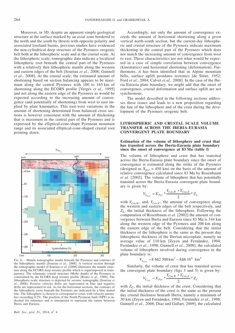
Moreover, in 3D, despite an apparent simple geologicalstructure at the surface marked by an axial zone bordered tothe north and the south by thrusts with opposite polarity andassociated foreland basins, previous studies have evidencedthe non-cylindrical deep structure of the Pyrenees orogenicbelt both at the lithospheric scale and at the crustal scale. Atthe lithospheric scale, tomographic data indicate a localizedlithospheric root beneath the central part of the Pyreneeswith a relatively thin lithospheric mantle along the westernand eastern edges of the belt [Souriau et al., 2008; Gunnellet al., 2008]. At the crustal scale, the estimated amount ofshortening based on section balancing appears to be maxi-mum along the central Pyrenees with 100 to 165 km ofshortening along the ECORS profile [Vergés et al., 1995]and not along the eastern edge of the Pyrenees as would beexpected according to the increasing amount of conver-gence (and potentially of shortening) from west to east im-plied by plate kinematics. This east-west variations in theamount of shortening determined from balanced cross sec-tions is however consistent with the amount of thickeningthat is maximum in the central part of the Pyrenees and isexpressed by the elliptical-cone-shape Pyrenean mountainrange and its associated elliptical-cone-shaped crustal rootpointing down.
Accordingly, not only the amount of convergence ex-ceeds the amount of horizontal shortening along a givenvertical north-south section, but the current-day lithosphe-ric and crustal structure of the Pyrenees indicate maximumthickening in the central part of the Pyrenees which doesnot match the increasing amount of convergence from westto east. These characteristics are not what would be expec-ted in a case of simple correlation between convergence(kinematics) and horizontal shortening (deformation). Fur-thermore, it has been identified that in Alpine mountainbelts, surface uplift postdates tectonics [de Sitter, 1952;Ford et al., 2004; Calvet et al., 2008]. In the case of the Ibe-ria-Eurasia plate boundary, we might add that the onset ofconvergence, crustal deformation and surface uplift are notsynchronous.
The model described in the following sections addres-ses these issues and leads to a new proposition regardingthe fate of the lithosphere and of the crust during the deve-lopment of the Pyrenees orogenic belt.
LITHOSPHERIC AND CRUSTAL SCALE VOLUMETRANSFER ACROSS THE IBERIA-EURASIACONVERGENT PLATE BOUNDARY
Estimation of the volume of lithosphere and crust thathas transited across the Iberia-Eurasia plate boundarysince the onset of convergence at 83 Ma (table I)
The volume of lithosphere and crust that has transitedacross the Iberia-Eurasia plate boundary since the onset ofconvergence is estimated along the strike of the Pyrenees(designed as Xpyr = 450 km) on the basis of the amount ofrelative convergence calculated since 83 Ma by Rosenbaumet al. [2002]. The volume of lithosphere that has potentiallytransited across the Iberia-Eurasia convergent plate bound-ary is given by:
V XY Y
ZL PyrCon W Con E
LCon�
�* *
, ,
2with YCon W, , and, YCon E, , the amount of convergence alongthe western and eastern edges of the belt respectively, andZL, the initial thickness of the lithosphere. Following thecomputation of Rosenbaum et al. [2002] the amount of con-vergence between Iberia and Eurasia since 83 Ma is 144 kmalong the western edge of the Pyrenees and 206 km alongthe eastern edge of the belt. Considering that the initialthickness of the lithosphere is the same as the present daylithospheric thickness of the Iberian microplate, namely anaverage value of 110 km [Zeyen and Fernàndez, 1994;Fernàndez et al., 1998; Gunnell et al., 2008], the calculatedvolume of lithosphere involved during convergence in theplate boundary is:
VLCon� 8 662 500 866 103 6 3km km~ .
Similarly, the volume of crust that has transited acrossthe convergent plate boundary (figs 3 and 5) is given by:
V XY Y
ZC PyrCon W Con E
CCon�
�* *
, ,
2with ZC, the initial thickness of the crust. Considering thatthe initial thickness of the crust is the same as the presentday crustal thickness beneath Iberia, namely a minimum of30 km [Zeyen and Fernàndez, 1994; Fernàndez et al., 1998;Gunnell et al., 2008; Diaz and Gallart, 2009], the calculated
264 VANDERHAEGHE O. and GRABKOWIAK A.
Bull. Soc. géol. Fr., 2014, no 4
FIG. 6. – Mantle tomographic model beneath the Pyrenees and contours ofthe lithospheric mantle [Souriau et al., 2008]. A vertical section throughthe tomographic model of Souriau et al. [2008] illustrates the mantle struc-ture along the ECORS deep seismic profile which is superimposed in trans-parency. The schematic crustal structure (Moho depth) of the Pyrenees isconstrained by the ECORS deep seismic profile [Roure et al., 1989]. Thelithospheric-scale structure is depicted by seismic tomography [Souriau etal., 2008]. Positive velocity drifts are represented in blue and negativedrifts are represented in red. As for the horizontal sections, the contours ofthe lithospheric roots beneath the Pyrenees are indicated by a blue dottedline. The lithosphere is chosen to correspond to zones with velocity anoma-lies exceeding 0.2%. The position of the North Pyrenean fault (NPF) is in-dicated for reference and is interpreted to represent the suture betweenIberia and Eurasia.
volume of crust involved during convergence in the plateboundary is:
VCCon� 2 362 500 236 103 6 3km km~ .
The uncertainty in these volumes is estimated conside-ring (i) a variability of +/-10 km in the amount of conver-gence for the period from 83 to 35 Ma among publishedkinematic models [Capitanio and Goes, 2006; Vissers andMeijer, 2012a], (ii) an initial thickness of the Iberian lithos-phere ranging from 100 to 120 km, and (iii) an initial thick-ness of the Iberian crust outside the plate boundary rangingfrom 28 to 32 km. Taking these minimum and maximum valuesprovides an estimate for the uncertainty on the volumes of crustof lithosphere and crust transferred across the plate bounda-ry of 8.66 +1.33/-1.24 *106 km3 and 2.36 +0.30/-0.28 *106 km3,respectively.
A 3D model for the lithospheric-scale structurebeneath the Pyrenees
In order to estimate the total volume of lithosphere cur-rently present beneath the Pyrenean orogenic belt we firsttake a base-level of homogeneously thick lithosphere towhich we add the volume of lithosphere modeled in 3Dbased on the tomographic data published by Souriau et al.[2008]. The volumes of the modeled lithospheric roots andof the lithospheric base level are quantified beneath thesame reference horizontal section defined as APyrL
. The cor-responding volume of base level lithosphere beneath thecurrent day Pyrenean orogenic belt is given by:
V X Y ZL Pyr Pyr L Lb0� � �
In order to encompass the zone covered by the tomogra-phic data, we choose a width of 250 km for Y pyr L
. Taking110 km for the lithospheric thickness, yields
VL b0312 375 000� km
The tomographic data published by Souriau et al.[2008] correspond to a 25 km size cubic cell model fromwhich six horizontal sections from 50 to 200 km have beenextracted. The velocity drifts range from +2% to –2%. Inorder to depict the lithospheric structure, we have underli-ned the +0.2% contour line considering that positive ano-malies from +0.2 to +2% correspond to the lithosphericmantle (figs 5 and 6).
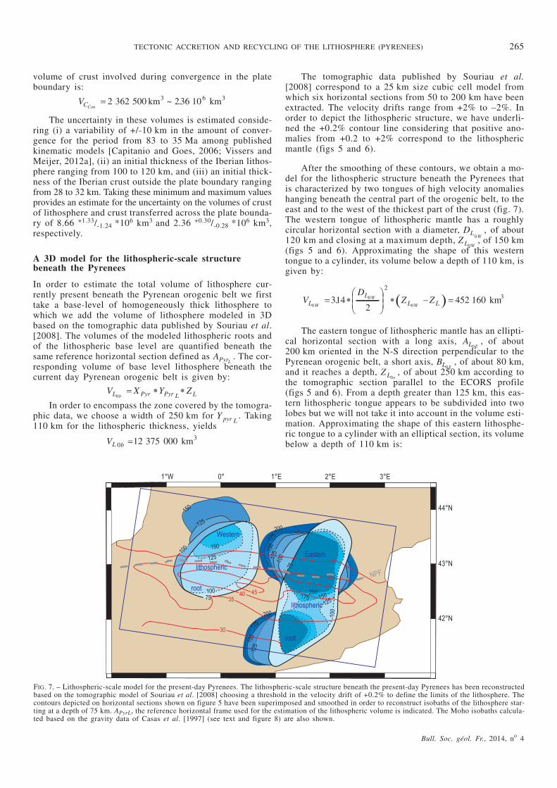
After the smoothing of these contours, we obtain a mo-del for the lithospheric structure beneath the Pyrenees thatis characterized by two tongues of high velocity anomalieshanging beneath the central part of the orogenic belt, to theeast and to the west of the thickest part of the crust (fig. 7).The western tongue of lithospheric mantle has a roughlycircular horizontal section with a diameter, DL
W0, of about
120 km and closing at a maximum depth, Z L W0, of 150 km
(figs 5 and 6). Approximating the shape of this westerntongue to a cylinder, its volume below a depth of 110 km, isgiven by:
� �VD
Z ZLL
L LW
W
W0
0
0314
2452 160
23� �
�
�
��� � �. km
The eastern tongue of lithospheric mantle has an ellipti-cal horizontal section with a long axis, AL E0
, of about200 km oriented in the N-S direction perpendicular to thePyrenean orogenic belt, a short axis, BL E0
, of about 80 km,and it reaches a depth, Z L e0
, of about 250 km according tothe tomographic section parallel to the ECORS profile(figs 5 and 6). From a depth greater than 125 km, this eas-tern lithospheric tongue appears to be subdivided into twolobes but we will not take it into account in the volume esti-mation. Approximating the shape of this eastern lithosphe-ric tongue to a cylinder with an elliptical section, its volumebelow a depth of 110 km is:
Bull. Soc. géol. Fr., 2014, no 4
TECTONIC ACCRETION AND RECYCLING OF THE LITHOSPHERE (PYRENEES) 265
FIG. 7. – Lithospheric-scale model for the present-day Pyrenees. The lithospheric-scale structure beneath the present-day Pyrenees has been reconstructedbased on the tomographic model of Souriau et al. [2008] choosing a threshold in the velocity drift of +0.2% to define the limits of the lithosphere. Thecontours depicted on horizontal sections shown on figure 5 have been superimposed and smoothed in order to reconstruct isobaths of the lithosphere star-ting at a depth of 75 km. APyrL, the reference horizontal frame used for the estimation of the lithospheric volume is indicated. The Moho isobaths calcula-ted based on the gravity data of Casas et al. [1997] (see text and figure 8) are also shown.
� �VA B
Z ZLL L
L LE
E E
e0
0 0
0314
4� �
�� .
According to this model, the total volume of the lithos-phere beneath the current day Pyrenean orogenic belt is:
V V V VL L L Lb E W0 0 0 01458 106 3� � � � �. km
The uncertainty of this modeled present-day volumemainly resides in the resolution of the tomographic datathat is controlled by a cell size of 25 km. Applying a varia-bility of 25 km on each of the dimensions of the modeledlithosphere added to the 10 km variation of the initial li-thospheric thickness leads to an uncertainty on the esti-mation of the present-day lithospheric volume of14.58 +2.70/-2.04 *106 km3. For a comparison, the lithosphericstructure modeled by Gunnell et al. [2008] based on an ana-lysis of topographic, gravity, geoid, and heat flow datashows, at first order, a similar geometry with a maximumthickness for the lithospheric root beneath the central partof the Pyrenees. However, their analysis leads to a smoothe-ned lithospheric structure beneath the Pyrenees and, as a re-sult, the lithosphere reaches a maximum thickness of onlyabout 180 km in their model.
A 3D model for the Pyrenean crustal-scale orogenic belt
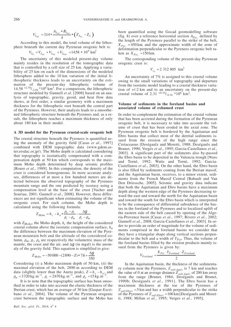
The crustal structure beneath the Pyrenees is quantified us-ing the anomaly of the gravity field [Casas et al., 1997]combined with DEM topographic data (www.gdem.as-ter.ersdac.or.jp/). The Moho depth is calculated consideringthat topography is isostatically compensated with a com-pensation depth at 50 km which corresponds to the maxi-mum Moho depth determined by deep seismic profiles[Roure et al., 1989]. In this computation, the density of thecrust is considered homogeneous. In more accurate analy-ses, differences of at most a few hundred meters are de-tected between the observed topography of the Pyreneesmountain range and the one predicted by isostasy using acompensation level at the base of the crust [Vacher andSouriau, 2001; Gunnell et al., 2008]. However, these differ-ences are not significant when estimating the volume of theorogenic crust. For each column, the Moho depth iscalculated using the following formula:
Z h hMoho c aa c
c m c m
� �
r r
r r r r
�g
with ZMoho, the Moho depth, hc the height of the consideredcrustal column above the isostatic compensation surface, hathe difference between the maximum elevation of the Pyre-nean mountain belt and the altitude of the considered co-lumn, rm, rc, ra are respectively the volumetric mass of themantle, the crust and the air, and Dg (in mgal) is the anom-aly of the gravity field. This equation is simplified to give:
Z ZMoho � � �50 000 2890 76350
( ) .�g
Considering (i) a Moho maximum depth of 50 km, (ii) themaximal elevation of the belt, 2890 m according to DEMdata (slightly lower than the Aneto peak), Z h hc a� , andrm � 3320 3kg.m , rc � 2670 3kg.m , and ra � 15 3. kg.m .
It is to note that the topographic surface has been smoo-thed in order to take into account the elastic thickness of theIberian crust, which has an average of 30 km [Gaspar-Escri-bano et al., 2004]. The volume of the Pyrenean orogeniccrust between the topographic surface and the Moho has
been quantified using the Gocad geomodelling software(fig. 8) over a reference horizontal section APyrc
defined bythe length of the Pyrenees parallel to the strike of the belt,X Pyrc
� 450 km, and the approximate width of the zone ofdeformation perpendicular to the Pyrenees orogenic belt ta-ken as X Pyrc
�150 km.
The corresponding volume of the present-day Pyreneanorogenic crust is:
Vc02 312 805 3� km
An uncertainty of 7% is assigned to this crustal volumeowing to the small variations of topography and departurefrom the isostatic model leading to a crustal thickness varia-tion of +/-2 km and to an uncertainty on the present-daycrustal volume of 2.31 +0.16/-0.16 *106 km3.
Volume of sediments in the foreland basins andassociated volume of exhumed crust
In order to complement the estimation of the crustal volumethat has been accreted during the formation of the Pyreneanorogenic belt, it is necessary to take into account the vol-ume of crust that has been eroded in the axial zone. ThePyrenean orogenic belt is bordered by the Aquitanian andEbro basins that collect most of the detrital sediments is-sued from the erosion of the high range since theCretaceaous [Deségaulx and Moretti, 1988; Deségaulx andBrunet, 1990; Vergés et al., 1995; Garcia-Castellanos et al.,2003]. A significant part of the sediments also by-passedthe Ebro basin to be deposited in the Valencia trough [Wattsand Torné, 1992; Watts and Torné, 1992; Garcia-Castellanos et al., 2003]. On the other hand, the Ebro basinis also filled by sediments coming from the Iberian massif,and the Aquitanian basin, receives, to a minor extent, sedi-ments from the French Massif Central [Babault and VanDen Driessche, 2005]. Seismic and gravity data indicatethat both the Aquitanian and Ebro basins have a maximumdepth along the western edge of the Pyrenees decreasing to-ward the east and toward the north for the Aquitanian basinand toward the south for the Ebro basin which is interpretedto be the consequence of differential subsidence of the bas-ins in the foreland of the Pyrenees and to localized uplift ofthe eastern side of the belt caused by opening of the Alge-ria-Provence basin [Casas et al., 1997; Rivero et al., 2002;Gunnell et al., 2008; Garcia-Castellanos et al., 2003]. In or-der to provide an order of magnitude for the volume of sedi-ments comprised in the foreland basins we consider thatthey have a triangular shape along vertical sections perpen-dicular to the belt and a width of YPyr. Thus, the volume ofthe foreland basins filled by the erosion products mainly is-sued from the Pyrenees is given by:
VX Y Z
ForelandPyr Foreland Foreland�
� �
2
In the Aquitanian basin, the thickness of the sedimenta-ry column near the Pyrenees, Z sed Aqui( ) is 7 km and reachesthe value of 0 at an average distance Z sed Aqui( ) of 200 km awayfrom the range [Brunet, 1984; Deségaulx and Brunet,1990b; Deségaulx et al., 1991]. The Ebro basin has amaximum thickness at the toe of the Pyrenees ofZ sed Ebro( ) � 5 km and has a width perpendicular to the strikeof the Pyrenees of Z sed Ebro( ) �100 km [Deségaulx and Moret-ti, 1988; Millan et al., 1995; Verges et al., 1995].
266 VANDERHAEGHE O. and GRABKOWIAK A.
Bull. Soc. géol. Fr., 2014, no 4
Based on these estimates, the volume of sediments intothe Aquitanian and Ebro basins are:
Z sed Aqui( ) � 315 000 3km
and
Z sed Ebro( ) �112500 3km
These volumes of sediments do not include the piggy-back basins implied in the thrusted units along the flanks ofthe Pyrenees as their volume is already included in the oneof the present-day Pyrenean orogenic crust (see § A 3D mo-del…). Piggy-back basins are particularly well-developedalong the southern flank of the Pyrenees. Accordingly, alarge part of the sediments of the southern foreland basin isinvolved in the thrust sheets and have not been included inthe sediment volume of the Ebro basin. This explains whythe volume of sediments estimated for the Ebro basin issignificantly less than the one of the Aquitanian basin.
Regarding the Valencia trough, following the compila-tion of geophysical data by Watts and Torné [1992 a, b] andthe synthesis of Banda and Santanach [1992], we consider athickness of 4 km over a width of 100 km and a length of350 km along the edge of Iberia leading to a volume for theValencia trough of:
Vsed Val( ) � � � �4 100 350 140 000 3km
The entire volume of sediments eroded from the Pyre-nees is the sum of the volumes of the Ebro and Aquitanianbasins added to the volume of the Valencia trough and co-mes to:
Vsediments � � � �315 000 112500 140 000 567500 3km
This volume of sediments is converted in a volume oferoded rocks considering a volumetric mass of sediments,rsed � 2 200 3kg.m and rgranite � 2670 3kg.m assuming thatthe eroded rocks have the density of granite. Accordingly,the volume of eroded rocks is given by:
V Veroded sedimentssediments
granite
� � �r
r467603 3km
Using a more sophisticated treatment of the same set ofseismic and gravity data, Garcia-Castellanos et al. [2003]obtain volumes of sediments that are on the same order ofmagnitude for the southern part of the Pyrenees (namelyEbro basin and Valencia trough).
We estimated the uncertainty on these volumes by va-rying the dimensions of the sedimentary basins. The thick-ness of the sedimentary deposits is varied by +/-1 km forthe Aquitanian and Ebro and by +/-0.5 km for the Valenciatrough, the width of the foreland basins by +/– 10 km andlength of the Valencia trough by +/– 20 km. In addition, wemodulated the values taken for the density of the sedimentsby +/– 0.1 kg/m3 and the ones of the granitic basement by+/– 0.02 kg/m3. The corresponding volume of eroded crustis 0.47 +0.14/-0.12 *106 km3. It is to note that the goal here isnot to provide a precise estimate of the volumes of sedi-ments but rather to provide constraints on the maximum andminimum volume of orogenic crust that has been eroded.
End-members for the lithospheric structure of theIberia-Eurasia plate boundary at 83 Ma
Within the reference horizontal section APyrL, we consider
two end-members for the initial lithospheric scale structure
Bull. Soc. géol. Fr., 2014, no 4
TECTONIC ACCRETION AND RECYCLING OF THE LITHOSPHERE (PYRENEES) 267
FIG. 8. – Crustal-scale model for the present-day Pyrenean orogenic belt. This model reconstructed with the Gocad geomodeler combines a topographicimage of the Pyrenees retrieved from DEM data (www.gdem.aster.ersdac.or.jp/) and isobath of the Moho calculated based on gravity data published by Ca-sas et al. [1997]. A crustal-scale isostatic compensation has been considered. The topography of the mountain belt has an elliptical-cone shape with amaximum altitude in the central part of the belt. The orogenic root has also an elliptical-cone shape but pointing downward which, at first order, is inverse-ly correlated to topography with a maximum depth beneath the central part of the Pyrenees and a long axis parallel to the strike of the belt. At second order,the geometry of the orogenic root also comprises to relative maxima on each side of the maximum Moho depth with a long axis delineated by arrows thatare slightly oblique to the strike of the belt. The vertical dimension has been exaggerated 3 times. XPyr and YPyr refer to the dimensions of the horizontal re-ference section used in the estimation of the crustal volume.
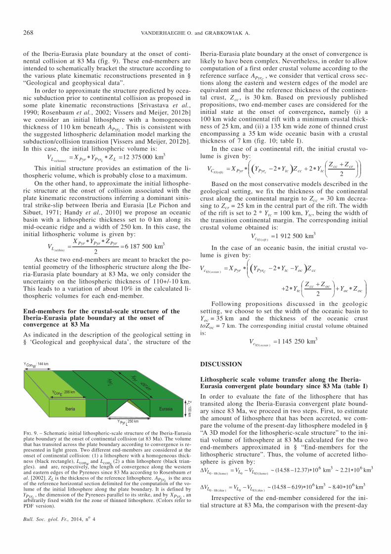
of the Iberia-Eurasia plate boundary at the onset of conti-nental collision at 83 Ma (fig. 9). These end-members areintended to schematically bracket the structure according tothe various plate kinematic reconstructions presented in §“Geological and geophysical data”.
In order to approximate the structure predicted by ocea-nic subduction prior to continental collision as proposed insome plate kinematic reconstructions [Srivastava et al.,1990; Rosenbaum et al., 2002; Vissers and Meijer, 2012b]we consider an initial lithosphere with a homogeneousthickness of 110 km beneath APyrL
. This is consistent withthe suggested lithospheric delamination model marking thesubduction/collision transition [Vissers and Meijer, 2012b].In this case, the initial lithospheric volume is:
V X Y ZL Pyr Pyr LLss(homo)� � � �12 375 000 3km
This initial structure provides an estimation of the li-thospheric volume, which is probably close to a maximum.
On the other hand, to approximate the initial lithosphe-ric structure at the onset of collision associated with theplate kinematic reconstructions inferring a dominant sinis-tral strike-slip between Iberia and Eurasia [Le Pichon andSibuet, 1971; Handy et al., 2010] we propose an oceanicbasin with a lithospheric thickness set to 0 km along itsmid-oceanic ridge and a width of 250 km. In this case, theinitial lithospheric volume is given by:
VX Y Z
LPyr Pyr Pyr
ss(thin)�
� ��
26 187 500 3km
As these two end-members are meant to bracket the po-tential geometry of the lithospheric structure along the Ibe-ria-Eurasia plate boundary at 83 Ma, we only consider theuncertainty on the lithospheric thickness of 110+/-10 km.This leads to a variation of about 10% in the calculated li-thospheric volumes for each end-member.
End-members for the crustal-scale structure of theIberia-Eurasia plate boundary at the onset ofconvergence at 83 Ma
As indicated in the description of the geological setting in§ ‘Geological and geophysical data’, the structure of the
Iberia-Eurasia plate boundary at the onset of convergence islikely to have been complex. Nevertheless, in order to allowcomputation of a first order crustal volume according to thereference surface APyrC
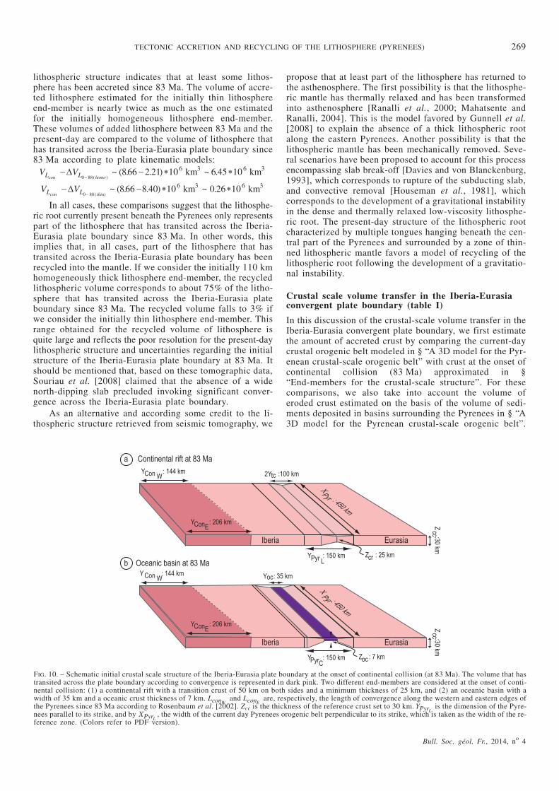
, we consider that vertical cross sec-tions along the eastern and western edges of the model areequivalent and that the reference thickness of the continen-tal crust, Z cc , is 30 km. Based on previously publishedpropositions, two end-member cases are considered for theinitial state at the onset of convergence, namely (i) a100 km wide continental rift with a minimum crustal thick-ness of 25 km, and (ii) a 135 km wide zone of thinned crustencompassing a 35 km wide oceanic basin with a crustalthickness of 7 km (fig. 10; table I).
In the case of a continental rift, the initial crustal vo-lume is given by:
� �V X Y Y Z YZ Z
C Pyr Pyr tc cc tccc cr
c83(rift)� � � � �
��
�
��2 2
2
�
�
���
Based on the most conservative models described in thegeological setting, we fix the thickness of the continentalcrust along the continental margin to Zcc = 30 km decrea-sing to Zcr = 25 km in the central part of the rift. The widthof the rift is set to 2 * Ytc = 100 km, Ytc, being the width ofthe transition continental margin. The corresponding initialcrustal volume obtained is:
Vc rift831 912 500 3
( )� km
In the case of an oceanic basin, the initial crustal vo-lume is given by:
� �V X Y Y Y Zc Pyr Pyr tc oc ccocean C832
( )� � � �
�
�
���
�
�
���
� ���
�
�� � �
�
�
���2
2Y
Z ZY Ztc
cc ococ oc
Following propositions discussed in the geologicsetting, we choose to set the width of the oceanic basin toYoc = 35 km and the thickness of the oceanic crusttoZoc = 7 km. The corresponding initial crustal volume obtainedis:
Vc ocean831 145 250 3
( )� km
DISCUSSION
Lithospheric scale volume transfer along the Iberia-Eurasia convergent plate boundary since 83 Ma (table I)
In order to evaluate the fate of the lithosphere that hastransited along the Iberia-Eurasia convergent plate bound-ary since 83 Ma, we proceed in two steps. First, to estimatethe amount of lithosphere that has been accreted, we com-pare the volume of the present-day lithosphere modeled in §“A 3D model for the lithospheric-scale structure” to the ini-tial volume of lithosphere at 83 Ma calculated for the twoend-members approximated in § “End-members for thelithospheric structure”. Thus, the volume of accreted litho-sphere is given by:�V V VL L L0 88 0 83
14 58 12 37 106 3
� �( ) ( )
~ ( . . ) ~homo homo
km 2 21 106 3. � km
�V V VL L Lt t0 88 0 8314 58 619 10 86 3
� �
( ) ( )~ ( . . ) ~
hin hinkm .40 106 3� km
Irrespective of the end-member considered for the ini-tial structure at 83 Ma, the comparison with the present-day
268 VANDERHAEGHE O. and GRABKOWIAK A.
Bull. Soc. géol. Fr., 2014, no 4
FIG. 9. – Schematic initial lithospheric-scale structure of the Iberia-Eurasiaplate boundary at the onset of continental collision (at 83 Ma). The volumethat has transited across the plate boundary according to convergence is re-presented in light green. Two different end-members are considered at theonset of continental collision: (1) a lithosphere with a homogeneous thick-ness (black rectangle), LconW
and LconE(2) a thin lithosphere (black trian-
gles). and are, respectively, the length of convergence along the westernand eastern edges of the Pyrenees since 83 Ma according to Rosenbaum etal. [2002]. ZL is the thickness of the reference lithosphere. APyrL
is the areaof the reference horizontal section delimited for the computation of the vo-lume of the initial lithosphere along the plate boundary. It is defined byYPyrL
, the dimension of the Pyrenees parallel to its strike, and by XPyrL, an
arbitrarily fixed width for the zone of thinned lithosphere. (Colors refer toPDF version).
lithospheric structure indicates that at least some lithos-phere has been accreted since 83 Ma. The volume of accre-ted lithosphere estimated for the initially thin lithosphereend-member is nearly twice as much as the one estimatedfor the initially homogeneous lithosphere end-member.These volumes of added lithosphere between 83 Ma and thepresent-day are compared to the volume of lithosphere thathas transited across the Iberia-Eurasia plate boundary since83 Ma according to plate kinematic models:
V VL Lcon � �
�
0 88866 2 21 10 6 45 106 3 6 3
( )~ ( . . ) ~ .
homokm km
V VL Lcon t � �
�
0 88866 8 40 10 0 26 106 3 6 3
(~ ( . . ) ~ .
hin)km km
In all cases, these comparisons suggest that the lithosphe-ric root currently present beneath the Pyrenees only representspart of the lithosphere that has transited across the Iberia-Eurasia plate boundary since 83 Ma. In other words, thisimplies that, in all cases, part of the lithosphere that hastransited across the Iberia-Eurasia plate boundary has beenrecycled into the mantle. If we consider the initially 110 kmhomogeneously thick lithosphere end-member, the recycledlithospheric volume corresponds to about 75% of the litho-sphere that has transited across the Iberia-Eurasia plateboundary since 83 Ma. The recycled volume falls to 3% ifwe consider the initially thin lithosphere end-member. Thisrange obtained for the recycled volume of lithosphere isquite large and reflects the poor resolution for the present-daylithospheric structure and uncertainties regarding the initialstructure of the Iberia-Eurasia plate boundary at 83 Ma. Itshould be mentioned that, based on these tomographic data,Souriau et al. [2008] claimed that the absence of a widenorth-dipping slab precluded invoking significant conver-gence across the Iberia-Eurasia plate boundary.
As an alternative and according some credit to the li-thospheric structure retrieved from seismic tomography, we
propose that at least part of the lithosphere has returned tothe asthenosphere. The first possibility is that the lithosphe-ric mantle has thermally relaxed and has been transformedinto asthenosphere [Ranalli et al., 2000; Mahatsente andRanalli, 2004]. This is the model favored by Gunnell et al.[2008] to explain the absence of a thick lithospheric rootalong the eastern Pyrenees. Another possibility is that thelithospheric mantle has been mechanically removed. Seve-ral scenarios have been proposed to account for this processencompassing slab break-off [Davies and von Blanckenburg,1993], which corresponds to rupture of the subducting slab,and convective removal [Houseman et al., 1981], whichcorresponds to the development of a gravitational instabilityin the dense and thermally relaxed low-viscosity lithosphe-ric root. The present-day structure of the lithospheric rootcharacterized by multiple tongues hanging beneath the cen-tral part of the Pyrenees and surrounded by a zone of thin-ned lithospheric mantle favors a model of recycling of thelithospheric root following the development of a gravitatio-nal instability.
Crustal scale volume transfer in the Iberia-Eurasiaconvergent plate boundary (table I)
In this discussion of the crustal-scale volume transfer in theIberia-Eurasia convergent plate boundary, we first estimatethe amount of accreted crust by comparing the current-daycrustal orogenic belt modeled in § “A 3D model for the Pyr-enean crustal-scale orogenic belt” with crust at the onset ofcontinental collision (83 Ma) approximated in §“End-members for the crustal-scale structure”. For thesecomparisons, we also take into account the volume oferoded crust estimated on the basis of the volume of sedi-ments deposited in basins surrounding the Pyrenees in § “A3D model for the Pyrenean crustal-scale orogenic belt”.
Bull. Soc. géol. Fr., 2014, no 4
TECTONIC ACCRETION AND RECYCLING OF THE LITHOSPHERE (PYRENEES) 269
FIG. 10. – Schematic initial crustal scale structure of the Iberia-Eurasia plate boundary at the onset of continental collision (at 83 Ma). The volume that hastransited across the plate boundary according to convergence is represented in dark pink. Two different end-members are considered at the onset of conti-nental collision: (1) a continental rift with a transition crust of 50 km on both sides and a minimum thickness of 25 km, and (2) an oceanic basin with awidth of 35 km and a oceanic crust thickness of 7 km. LconW
and LconEare, respectively, the length of convergence along the western and eastern edges of
the Pyrenees since 83 Ma according to Rosenbaum et al. [2002]. Zcc is the thickness of the reference crust set to 30 km. YPyrLis the dimension of the Pyre-
nees parallel to its strike, and by XPyrL, the width of the current day Pyrenees orogenic belt perpendicular to its strike, which is taken as the width of the re-
ference zone. (Colors refer to PDF version).
Bull. Soc. géol. Fr., 2014, no 4
270 VANDERHAEGHE O. and GRABKOWIAK A.
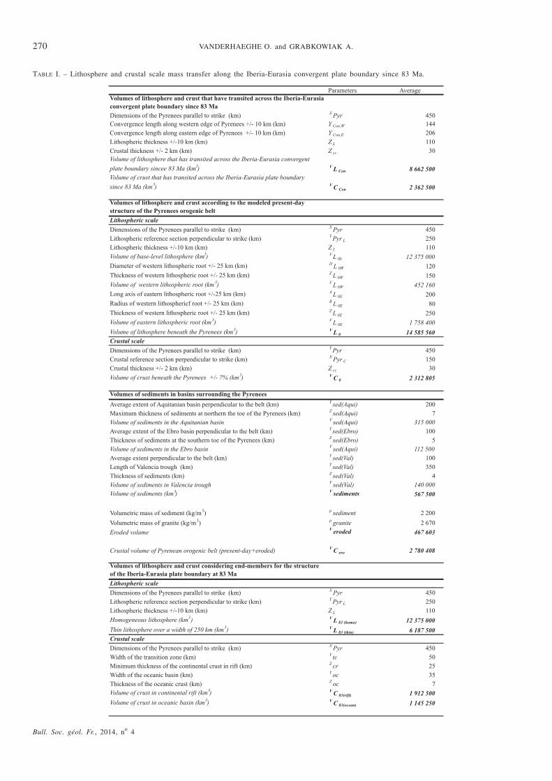
TABLE I. – Lithosphere and crustal scale mass transfer along the Iberia-Eurasia convergent plate boundary since 83 Ma.
Then, we retrieve the volume of recycled crust by compar-ing the volume of accreted crust to the volume of crust thathas transited across the Iberia-Eurasia plate boundary since83 Ma according to plate kinematic models.
For an initial state characterized by a continental rift,the difference between the initial and present-day crustalvolume is given by:
�V V VC C Crift rift0 83 0 830 40 106 3
� �
( ) ( )~ . km
Adding the volume of eroded crust to the present-dayvolume of crust beneath the Pyrenees yields a volume of ac-creted crust of:
V V Vaccreted C Crift oro rift( ) ( )~ .� �
83087 106 3km
For an initial state approximated by a 35 km wide ocea-nic basin, the difference between the initial and the pre-sent-day crustal volumes is given by:
�V V VC C Cocean ocean0 83 0 83117 106 3
� �
( ) ( )~ . km
Adding the volume of eroded crust to the present-dayvolume of crust beneath the Pyrenees yields a volume of ac-creted crust of:
V V Vaccreted C Cocean oro ocean( ) ( )~ .� �
83163 106 3km
For an initial state characterized by a continental rift,the volume of recycled crust is given by:V V Vrecycled C accreted riftCon
� �( ) ~ ( . . ) ~ .2 36 0 87 10 16 49 106 3� km
In the case of an initial structure marked by an oceanicbasin, the volume of recycled crust is:V V Vrecycled C accreted oceanCon
� �( ) ~ ( . . ) ~2 36 117 10 06 .73 106 3� km
In both cases, the volume of crust accreted to the oroge-nic belt is not sufficient to match the volume of crust thathas transited across the plate boundary during convergence.Based on this mismatch between the crustal volume addedto the Pyrenean orogenic belt during continental collisionsince 83 Ma and the volume of crust that has potentiallytransited across the Iberia-Eurasia convergent plate boundary
since 83 Ma, we propose that a significant part of the conti-nental crust has been recycled by subduction into themantle. The estimated volume of recycled crust obtainedconsidering the continental rift end-member is about twicethe one obtained considering the oceanic basin end-mem-ber. The latter probably represents a minimum for the initialcrustal volume and thus yields a minimum for the volumeof recycled crust since 83 Ma. Dividing the volume of “mis-sing” continental crust by the length of the orogenic belt pa-rallel to its strike (450 km) and by the initial thickness ofthe continental crust (taken as 30 km) yields a length ofsubducted continental crust between 54 and 110 km. Com-paring this volume of “missing” crust to the volume of crustthat has transited across the plate boundary yields a propor-tion of 30 to 63% of potentially subducted continental crustdepending on the choice of the initial structure for the Ibe-ria-Eurasia plate boundary at 83 Ma.
Subduction of the continental crust beneath the Pyre-nees has been proposed based on magnetotellurics [Pous etal., 1995]. This estimated volume of subducted continentalcrust is significantly larger than previously proposed onesthat were based on 2D structural analysis [Teixell, 1998;Roure et al., 1989; Choukroune, 1992; Muñoz, 1992; Ver-gés et al., 1995; Beaumont et al., 2000; Vissers and Meijer;2012a] and yielded a maximum surface of 900 km2 for thesubducted crust beneath the Central Pyrenees representing acrustal section with a length of 90 km and a thickness of10 km. In contrast, Souriau and Granet [1995] interpret thepresence of a 30 km thick low-velocity anomaly at a depthof 80 to 100 km to represent a strip of subducted lowercrust beneath the Pyrenees with a surface of 2400 to3000 km2. This latter proposition is closer to the estimatedvolume of subducted crust that we obtain here which cor-responds, when divided by 450 km, the width of the Pyre-nees parallel to strike, to an average vertical section rangingfrom 1600 km2 considering the oceanic basin end-member,to 3300 km2 considering the rift end-member.
Bull. Soc. géol. Fr., 2014, no 4
TECTONIC ACCRETION AND RECYCLING OF THE LITHOSPHERE (PYRENEES) 271
TABLE I. – Continued
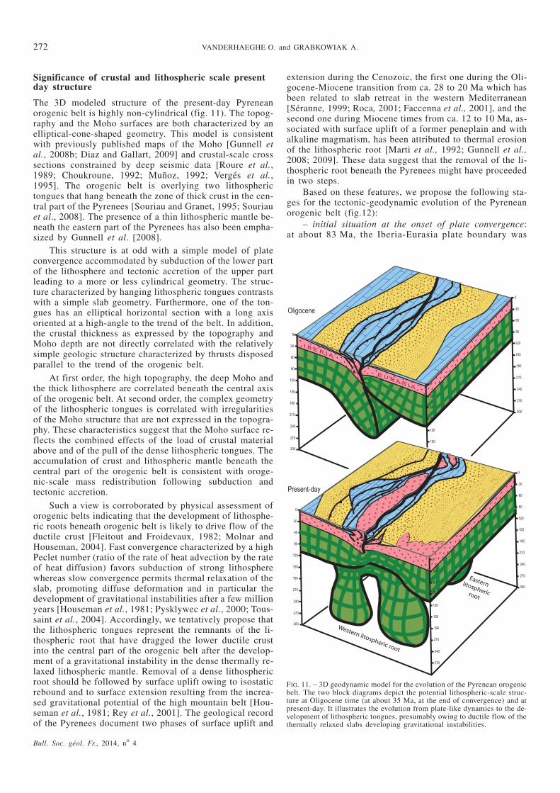
Significance of crustal and lithospheric scale presentday structure
The 3D modeled structure of the present-day Pyreneanorogenic belt is highly non-cylindrical (fig. 11). The topog-raphy and the Moho surfaces are both characterized by anelliptical-cone-shaped geometry. This model is consistentwith previously published maps of the Moho [Gunnell etal., 2008b; Diaz and Gallart, 2009] and crustal-scale crosssections constrained by deep seismic data [Roure et al.,1989; Choukroune, 1992; Muñoz, 1992; Vergés et al.,1995]. The orogenic belt is overlying two lithospherictongues that hang beneath the zone of thick crust in the cen-tral part of the Pyrenees [Souriau and Granet, 1995; Souriauet al., 2008]. The presence of a thin lithospheric mantle be-neath the eastern part of the Pyrenees has also been empha-sized by Gunnell et al. [2008].
This structure is at odd with a simple model of plateconvergence accommodated by subduction of the lower partof the lithosphere and tectonic accretion of the upper partleading to a more or less cylindrical geometry. The struc-ture characterized by hanging lithospheric tongues contrastswith a simple slab geometry. Furthermore, one of the ton-gues has an elliptical horizontal section with a long axisoriented at a high-angle to the trend of the belt. In addition,the crustal thickness as expressed by the topography andMoho depth are not directly correlated with the relativelysimple geologic structure characterized by thrusts disposedparallel to the trend of the orogenic belt.
At first order, the high topography, the deep Moho andthe thick lithosphere are correlated beneath the central axisof the orogenic belt. At second order, the complex geometryof the lithospheric tongues is correlated with irregularitiesof the Moho structure that are not expressed in the topogra-phy. These characteristics suggest that the Moho surface re-flects the combined effects of the load of crustal materialabove and of the pull of the dense lithospheric tongues. Theaccumulation of crust and lithospheric mantle beneath thecentral part of the orogenic belt is consistent with oroge-nic-scale mass redistribution following subduction andtectonic accretion.
Such a view is corroborated by physical assessment oforogenic belts indicating that the development of lithosphe-ric roots beneath orogenic belt is likely to drive flow of theductile crust [Fleitout and Froidevaux, 1982; Molnar andHouseman, 2004]. Fast convergence characterized by a highPeclet number (ratio of the rate of heat advection by the rateof heat diffusion) favors subduction of strong lithospherewhereas slow convergence permits thermal relaxation of theslab, promoting diffuse deformation and in particular thedevelopment of gravitational instabilities after a few millionyears [Houseman et al., 1981; Pysklywec et al., 2000; Tous-saint et al., 2004]. Accordingly, we tentatively propose thatthe lithospheric tongues represent the remnants of the li-thospheric root that have dragged the lower ductile crustinto the central part of the orogenic belt after the develop-ment of a gravitational instability in the dense thermally re-laxed lithospheric mantle. Removal of a dense lithosphericroot should be followed by surface uplift owing to isostaticrebound and to surface extension resulting from the increa-sed gravitational potential of the high mountain belt [Hou-seman et al., 1981; Rey et al., 2001]. The geological recordof the Pyrenees document two phases of surface uplift and
extension during the Cenozoic, the first one during the Oli-gocene-Miocene transition from ca. 28 to 20 Ma which hasbeen related to slab retreat in the western Mediterranean[Séranne, 1999; Roca, 2001; Faccenna et al., 2001], and thesecond one during Miocene times from ca. 12 to 10 Ma, as-sociated with surface uplift of a former peneplain and withalkaline magmatism, has been attributed to thermal erosionof the lithospheric root [Marti et al., 1992; Gunnell et al.,2008; 2009]. These data suggest that the removal of the li-thospheric root beneath the Pyrenees might have proceededin two steps.
Based on these features, we propose the following sta-ges for the tectonic-geodynamic evolution of the Pyreneanorogenic belt (fig.12):
– initial situation at the onset of plate convergence:at about 83 Ma, the Iberia-Eurasia plate boundary was
Bull. Soc. géol. Fr., 2014, no 4
272 VANDERHAEGHE O. and GRABKOWIAK A.
FIG. 11. – 3D geodynamic model for the evolution of the Pyrenean orogenicbelt. The two block diagrams depict the potential lithospheric-scale struc-ture at Oligocene time (at about 35 Ma, at the end of convergence) and atpresent-day. It illustrates the evolution from plate-like dynamics to the de-velopment of lithospheric tongues, presumably owing to ductile flow of thethermally relaxed slabs developing gravitational instabilities.
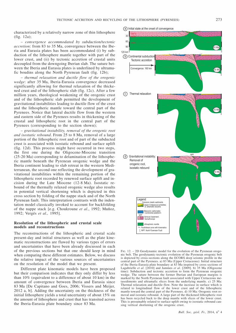
characterized by a relatively narrow zone of thin lithosphere(fig. 12a);
– convergence accommodated by subduction/tectonicaccretion: from 83 to 35 Ma, convergence between the Ibe-ria and Eurasia plates has been accommodated (i) by sub-duction of the lithosphere mantle together with part of thelower crust, and (ii) by tectonic accretion of crustal unitsdecoupled from the downgoing Iberian slab. The suture bet-ween the Iberia and Eurasia plates is underlined by ultrama-fic boudins along the North Pyrenean fault (fig. 12b);
– thermal relaxation and ductile flow of the orogenicwedge: after 35 Ma, Iberia-Eurasia convergence decreasedsignificantly allowing for thermal relaxation of the thicke-ned crust and of the lithospheric slab (fig. 12c). After a fewmillion years, rheological weakening of the orogenic crustand of the lithospheric slab permitted the development ofgravitational instabilities leading to ductile flow of the crustand the lithospheric mantle toward the central part of thePyrenees. Notice that lateral ductile flow from the westernand eastern side of the Pyrenees results in thickening of thecrustal and lithospheric root in the central part of thePyrenees (corresponding to the section shown);
– gravitational instability, removal of the orogenic rootand isostatic rebound. From 25 to 8 Ma, removal of a largeportion of the lithospheric root and of part of the subductedcrust is associated with isostatic rebound and surface uplift(fig. 12d). This process might have occurred in two steps,the first one during the Oligocene-Miocene transition(25-20 Ma) corresponding to delamination of the lithosphe-ric mantle beneath the Pyrenean orogenic wedge and theIberia continent leading to slab retreat in the western Medi-terranean, the second one reflecting the development of gra-vitational instabilities within the remaining portion of thelithospheric root recorded by renewed surface uplift and in-cision during the Late Miocene (12-8 Ma). Isostatic re-bound of the thermally relaxed orogenic wedge also resultsin potential vertical shortening which is depicted in thiscross section by folding of the nappe stack and of the NorthPyrenean fault. This interpretation contrasts with the inden-tation model classically invoked to account for backfoldingof the nappe stack [e.g. Choukroune et al., 1992; Muñoz,1992; Vergés et al., 1995].
Resolution of the lithospheric and crustal scalemodels and reconstructions
The reconstructions of the lithospheric and crustal scalepresent-day and initial structures as well as the plate kine-matic reconstructions are flawed by various types of errorsand uncertainties that have been already discussed in eachof the previous sections but that one should keep in mindwhen comparing these different estimates. Below, we discussthe relative impact of the various sources of uncertaintieson the resolution of the model that we present.
Different plate kinematic models have been proposedbut their comparison indicates that they only differ by lessthan 10% (equivalent to a difference of about 10 km) in theamount of convergence between Iberia and Eurasia since83 Ma [De Capitano and Goes, 2006; Vissers and Meijer,2012 a, b]. Adding the uncertainty on the thickness of theinitial lithosphere yields a total uncertainty of about 15% onthe amount of lithosphere and crust that has transited acrossthe Iberia-Eurasia plate boundary since 83 Ma.
Bull. Soc. géol. Fr., 2014, no 4
TECTONIC ACCRETION AND RECYCLING OF THE LITHOSPHERE (PYRENEES) 273
FIG. 12. – 2D Geodynamic model for the evolution of the Pyrenean oroge-nic belt. The geodynamic-tectonic evolution of the Pyrenean orogenic beltis depicted by cross-sections along the ECORS deep seismic profile in thecentral part of the Pyrenees. a) 83 Ma (Upper Cretaceous): Initial structureof the Iberia-Eurasia plate boundary at 83 Ma inspired by cross sections ofLagabrielle et al. [2010] and Jammes et al. [2009]. b) 35 Ma (Oligocenetime): Subduction and tectonic accretion to form the Pyrenean orogenicwedge. The suture between the former Iberian and European margins ismarked by the North Pyrenean fault associated with Upper Cretaceous me-tasediments and ultramafic slices from the underlying mantle. c) 25 Ma:Thermal relaxation and ductile flow. Note the increase in surface which isrelated to longitudinal flow of the lower crust and of the lithosphericmantle toward the central part of the Pyrenees. d) 10 Ma: Orogenic root re-moval and isostatic rebound. A large part of the thickened lithospheric roothas been recycled back to the deep mantle with slices of the lower crust.This is presumably related to surface uplift owing to isostatic rebound cau-sing vertical shortening of the orogenic crust.
At the lithospheric scale, the main source of uncertaintyin the reconstruction of the present-day lithospheric scalestructure is related to the resolution of the tomographic mo-del, which is given by the cell size of 25 km and is not wellresolved at shallow depth (above ~50 km). Uncertainties arealso introduced in choosing the threshold for the anomaliesand by smoothing their boundaries according to a cylindri-cal geometry. Our choice to define the boundary of the li-thosphere beneath the Pyrenees to correspond to the +0.2%drift of the velocity of P waves might be minimizing the vo-lume of the lithospheric roots and taking a lower thresholdfor this drift would increase the volume of lithosphere be-neath the current-day Pyrenees. These uncertainties add to atotal of less than 20% uncertainty on the volume of lithos-phere that is currently present beneath the Pyrenees. Newseismic tomography is required to improve our knowledgeof the lithospheric scale structure beneath the Pyrenees butit is expected that (i) the first order volume of the lithosphe-ric root modeled beneath the Pyrenees and (ii) the relativedistribution of the lithospheric root along the belt characte-rized by localization of high velocity anomalies localizedbeneath the highest part of the Pyrenees, will not be refutedby new tomographic data. The initial structure of the Ibe-ria-Eurasia plate boundary at 83 is also much approximatedwith end-members differing by 50% in the volume of lithos-phere involved. Despite these uncertainties, in all cases, thecomparison between the volume of lithosphere that hastransited across the Iberia-Eurasia plate boundary since83 Ma and the one that is currently present beneath the Py-renees indicates that a significant volume of lithosphere hasbeen recycled in the deep mantle. However, with currentlyavailable data, it is not reasonable to provide an estimate forthe volume of this recycled lithosphere.
At the crustal scale, the volume of the present-day crus-tal orogenic wedge has been computed using a relativelywell-defined Digital Elevation Model and a robust datasetof gravimetric anomaly [Casas, 1997]. Treatment of similardatasets by Gunnell et al., [2008] yields similar results re-garding the Moho depth and the estimated uncertainty onthe present-day crustal volume beneath the Pyrenees is 7%.The volume of eroded crust corresponds to about 20% ofthe volume of the present-day crustal volume beneath thePyrenees. According to the end-members that we proposefor the initial structure of the plate boundary at 83 Ma (re-presenting simplified versions of extreme models proposedin the literature), the uncertainty on the initial crustal vo-lume is of about 50%. We advocate that these end-membersbracket the first order possible initial geometries for theIberia-Eurasia plate boundary at 83 Ma. In all of the casesconsidered here, the volume of accreted crust in the Pyre-nees orogenic belt obtained by the comparison of the initialand present-day crustal volumes does not match the volumeof crust that has transited across the Iberia-Eurasia plateboundary since 83 Ma. In the most conservative scenario,the volume of recycled crust corresponds to 30% of the to-tal volume of crust that has transited across the plate boun-dary and it reaches a maximum of more than 60%.
CONCLUSIONS
The model that we reconstructed based on available geolog-ical and geophysical data indicates that the first order 3D
structure of the Pyrenees is characterized by an ellipti-cal-cone shape mountain belt culminating at more than3000 m underlain by an elliptical-cone-shaped crustal rootpointing downward and reaching a depth of 50 km centeredon the central part of the belt. According to tomographicdata, this crustal double-cone is underlain by two tonguesof lithospheric mantle, also centered in the middle of thePyrenees, and surrounded by a relatively thin lithosphere.
Simple mass balance computation provides a first orderestimate for the fate of the lithosphere and crust along theIberia-Eurasia convergent plate boundary since the onset ofcontinental collision at about 83 Ma. In all cases consideredin this paper, the difference between the present-day andinitial lithospheric structure at 83 Ma indicates that someamount of lithosphere has been accreted beneath the Pyre-nees. This volume of accreted lithosphere almost matchesthe calculated volume of lithosphere that has transitedacross the Iberia-Eurasia plate boundary only when maxi-mizing the amount of accreted lithosphere, namely by com-bining an initial structure at 83 Ma for the Iberia-Eurasiaplate boundary characterized by a thinned lithosphere andthe minimum volumes for the present-day lithospheric ro-ots. In turn, considering an initially homogeneous 110 kmthick lithosphere leads to as much as 74% of recycling ofthe lithosphere that has transited across the Iberia-Eurasiaplate boundary since 83 Ma. Based on these models, weconcur to the conclusions that (i) the Iberia-Eurasia plateboundary at 83 Ma was probably characterized by a relati-vely narrow domain of thinned lithosphere (oceanic orcontinental), and (ii) a significant amount of the lithospherehaving transited across the Iberia-Eurasia plate boundarysince 83 Ma has been recycled into the mantle. These con-clusions have to be taken with due caution owing to theuncertainties related to the past and present-daylithospheric structure but we hope that it will motivatefuture work in that direction.
The volume of crust that has transited across the Ibe-ria-Eurasia convergent plate boundary exceeds the volumeof crust that has been accreted during the development ofthe Pyrenean orogenic belt, even if an initial structure cha-racterized by a 35 km wide oceanic basin with a thin crustis considered. This suggests that a significant part of thecrust has been subducted and recycled back into the mantle.Our computation indicates that 37 to 70% of the continentalcrust that has transited across the Iberia-Eurasia plate boun-dary since the onset of continental collision has been tecto-nically accreted to form the Pyrenees orogenic belt, withpart of it (from 30 to 55% of the accreted crust) being redis-tributed by erosion and deposited in sedimentary basins sur-rounding the Pyrenees. In turn, from 30 to 63% of the crustthat has transited across the Iberia-Eurasia convergent plateboundary is not found in the Pyrenees orogenic belt or insurrounding sedimentary basins and thus has potentiallybeen recycled back into the mantle. Considering an initialthickness of 30 km, this represents a 54 to 110 km long ho-rizontal section of continental crust and depending on thechoice made for the structure of the plate boundary at83 Ma. Given the rather good resolution of the geophysicaland topographic data constraining the present-day crustalstructure and of geological data regarding the initialstructure of the plate boundary at the onset of continentalcollision, we consider that this conclusion is fairly robust.
Bull. Soc. géol. Fr., 2014, no 4
274 VANDERHAEGHE O. and GRABKOWIAK A.
The present-day structure, characterized by a cone-sha-ped mountain belt and crustal root does not match a simplemodel of tectonic accretion and departs from the more orless cylindrical surface structure of the Pyrenean orogenicbelt depicted by a series of thrusts. Furthermore, thetongue-shaped lithospheric slabs do not match a simple mo-del of plate subduction. This reconstruction suggests thatthe structures of the lithospheric slabs and of the orogenicbelt have been modified after subduction/tectonic accretion.At the lithospheric scale, we tentatively propose that, follo-wing subduction, the dense lithospheric slab was thermallyweakened favoring ductile flow and the development of gra-vitational instabilities leading to recycling of a large part ofthe mantle lithosphere and eventually to the formation ofthe lithospheric tongues currently identified by seismic to-mography beneath the central part of the Pyrenees. At the
crustal scale, we interpret the cone-shape crustal root asbeing formed by ductile flow of the thickened orogeniccrust pulled-down by the sinking lithospheric slabs, part ofit being dragged at depth and recycled with the lithosphericmantle into the deep mantle.
Acknowledgements. – The authors would like to acknowledge efficient edi-torial handling by Olivier Lacombe and Nicolas Bellhasen. The modelspresented in this paper were elaborated while Alexia Grabkowiak was astudent at the Ecole Nationale Supérieure de Géologie, of the Université deLorraine. A first version of this manuscript has been acutely scanned bytwo anonymous reviewers that motivated significantly improvements on themodel. The present version of the manuscript has benefited from the cons-tructive comments by François Roure and Jaume Vergés although theymight not share all the conclusions drawn from our lithospheric and crustalscale models.SGF associate editor: Nicolas Bellahsen
References
BABAULT J. & VAN DEN DRIESSCHE J. (2005). – Origin of the highly elevatedPyrenean peneplain. – Tectonics, 24(2), doi:10.1029/2004TC001697.
BANDA E. & SANTANACH P. (1992). – The Valencia trough (western Medi-terranean): an overview. – Tectonophysics, 208, 183-202.
BEAUMONT C., MUÑOZ J.A., HAMILTON J. & FULLSACK P. (2000). – Factorscontrolling the Alpine evolution of the central Pyrenees inferredfrom a comparison of observations and geodynamical models. –J. Geophys. Res., 105, 8121-8145.
BOILLOT G. & CAPDEVILLA R. (1977). – The Pyrenees, subduction and col-lision ? – Earth Planet. Sci. Lett., 35, 251-264.
BRUNET M.F. (1984). – Subsidence history of the Aquitaine basin determinedfrom subsidence curves. – Geol. Mag. London, 121, 421-428.
BRUNET M.-F. (1986). – The influence of the evolution of the Pyrenees onadjacent basins. – Tectonophysics, 129, 343-354.
CALVET M. & GUNNELL Y. (2008). – Planar landforms as markers of regio-nal topographic evolution: an inversion of long-term East Pyre-nean tectonics based on landscape and sedimentary basinanalysis. In: K. GALLAGHER, S.J. JONES and J. WAINWRIGHT,Eds., Landscape evolution: denudation, climate and tectonicsover different time and spatial scales. – Spec. Publ. Geol. Soc.,London, 296, 147-166.
CAPITANIO F.A. & GOES S. (2006). – Mesozoic spreading kinematics:consequences for Cenozoic central and western Mediterra-nean subduction. – Geophys. J. Internat., 165(3), 804-816,doi:10.1111/j.1365-246X.2006.02892.x.
CAROLA E., TAVANI S., FERRER O., GRANADO P., QUINTÀ A., BUTTILLÉ M. &MUÑOZ J.A. (2013). – Along strike extrusion at the transitionbetween thin- and thick-skinned domains in the Pyrenean orogen(northern Spain). In: M. NEMCOK, A. MORA and J.W. COSGROVE,Eds., Thick-skinned dominated orogens; From initial inversionto full accretion. – Geol. Soc. London, Sp. Publ. 377. doi:10.1144/SP377.3
CASAS A., KEAREY P., RIVERO L. & ADAM C.R. (1997). – Gravity anomalymap of the Pyrenean region and a comparison of the deep geologi-cal structure of the western and eastern Pyrenees. – Earth Planet.Sci. Lett., 150(1-2), 65-78, doi:10.1016/S0012-821X(97)00087-3.
CHOPIN C. (2003). – Ultrahigh-pressure metamorphism: tracing continentalcrust into the mantle. – Earth Planet. Sci. Lett., 212, 1-14.
CHOUKROUNE P. (1992). – Tectonic evolution of the Pyrenees. – Ann. Rev.Earth Planet. Sci., 20, 143-158.
CHOUKROUNE P. & E. P. Team (1990). – The ECORS Pyrenean deep seismicprofile. Reflection data and the overall structure of an orogenicbelt. – Tectonics, 8, 23-39.
de SITTER L.U. (1952), – Pliocene uplift of Tertiary mountain chains. – Am.J. Sci., 250, 297-307.
de VICENTE G., VEGAS R., MUÑOZ-MARTIN A., SILVA P.G., ANDRIESSEN P.,CLOETHING S., GONZALEZ-CASSADO J.M., VAN WEES J.D., ALVA-
REZ J., CARBO A. & OLAIZ A. (2007). – Cenozoic thick-skinnedand topography evolution of the Spanish Central System. – Glo-bal and Planetary Change, 58, 335-381.
DERCOURT J., RICOU L.E. & VRIELYNCK B. (1986). – Geological evolutionof the Tethys belt from Atlantic to the Pamir since the Lias. –Tectonophysics, 123, 241-315.
DESÉGAULX P., KOOI H. & CLOETHING S. (1991). – Consequences of fore-land basin development on thinned continental lithosphere: ap-plication to the Aquitaine basin (SW France). – Earth Planet.Sci. Lett., 106, 116-132.
DESÉGAULX P. & BRUNET M.-F. (1990). – Tectonic subsidence of the Aquitainebasin since Cretaceous times. – Bull Soc. géol. Fr., 8, VI, (2),295-306.
DESÉGAULX P. & MORETTI I. (1988). – Subsidence history of the Ebro basin.– J. Geodyn., 10(1), 9-24, doi:10.1016/0264-3707(88)90003-8.
DEWEY J.F. & BIRD J.M. (1970). – Mountain belts and the new global tecto-nics. – J. Geophys. Res., 75, 2625-2647.
DIAZ J. & GALLART J. (2009). – Crustal structure beneath the Iberian penin-sula and surrounding waters: A new compilation of deep seismicsounding results. – Phys. Earth Planet. Int., 173, 181-190.
ENGLAND P.C. & HOUSEMAN G.A. (1988). – The mechanics of the Tibetanplateau. – Phil. Trans. Royal Soc., A326, 301-320.
ENGLAND P.C. & MCKENZIE D.P. (1982). – A thin viscous sheet model for conti-nental deformation. – Geophys. J. Royal Astr. Soc., 70, 292-321.
FACCENNA C., HEURET A., FUNICIELLO F., LALLEMAND S. & BECKER T.W.(2007). – Predicting trench and plate motion from the dynamicsof a strong slab. – Earth Planet. Sci. Lett. 257, 29-36.
FERNÀNDEZ M., MARZÁN I., CORREIA A. & RAMALHO E. (1998). – Heatflow, heat production, and lithospheric thermal regime inthe Iberian peninsula. – Tectonophysics, 291(1-4), 29-53, doi:10.1016/S0040-1951(98)00029-8.
FITZGERALD P.G., MUÑOZ J.A., CONEY P.J. & BALDWIN S.L. (1999). –Asymmetric exhumation across the Pyrenean orogen: Implica-tions for the tectonic evolution of a collisional orogen. – EarthPlanet. Sci. Lett., 173, 157-170.
FLEITOUT L. & FROIDEVAUX C. (1982). – Tectonics and topography for a lithos-phere containing density heterogeneities. – Tectonics, 1, 21-56.
FORD M., DUCHÊNE S., GASQUET D. & VANDERHAEGHE O. (2006). –Two-phase orogenic convergence in the external and internalSW Alps. – J. Geol. Soc. London, 163, 815-826.
Bull. Soc. géol. Fr., 2014, no 4
TECTONIC ACCRETION AND RECYCLING OF THE LITHOSPHERE (PYRENEES) 275
GARCIA-CASTELLANOS D., VERGÉS J., GASPAR-ESCRIBANO J. & CLOETHING S.(2003). – Interplay between tectonics, climate, and fluvial transportduring the Cenozoic evolution of the Ebro basin (NE Iberia). –J. Geophys. Res., 108(B7), doi:10.1029/2002JB002073.
GASPAR-ESCRIBANO J.M., GARCIA-CASTELLANOS D., ROCA E. & CLOETHING
S. (2004). – Cenozoic vertical motions of the Catalan coastalranges (NE Spain): The role of tectonics, isostasy, and surfacetransport. – Tectonics, 23(1), doi:10.1029/2003TC001511.
GIBSON M., SINCLAIR H.D., LYNN G.J. & STUART F.M. (2007). – Late- topost-orogenic exhumation of the Central Pyrenees revealedthrough combined thermochronological data and modelling. – Ba-sin Res., 19(3), 323-334, doi:10.1111/j.1365-2117.2007.00333.x.
GOES S., GOVERS R. & VACHER P. (2000). – Shallow mantle temperaturesunder Europe from P and S wave tomography. – J. Geophys.Res., 105(B5), 11153, doi:10.1029/1999JB900300.
GOMEZ-ORTIZ D., TEJERO R., RUIZ J., BABIN-VICH R. & GONZALEZ-CASADO
J.M. (2005). – Estimating the effective elastic thickness of the li-thosphere of the Iberian peninsula based on multitaper spectralanalysis. – Geophys. J. Internat., 160, 729-735.
GUILLOT S., HATTORI K., AGARD P., SCHWARTZ S. & VIDAL O. (2009). –Exhumation processes in oceanic and continental subductioncontexts: A review. In: S. LALLEMAND and F. FUNICCIELLO, Eds,Subduction zones geodynamics. – Springer-Verlag, 175-205.doi.org/10.1007/978-3-540-87974-9_10
GUNNELL Y., CALVET M., BRICHAU S., CARTER A., AGUILAR J.P. & ZEYEN H.(2009), – Low long-term erosion rates in high-energy mountainbelts: Insights from thermo- and biochronology in the easternPyrenees. – Earth Planet. Sci. Lett., 278(3-4), 208-218,doi:10.1016/j.epsl.2008.12.004.
GUNNELL Y., ZEYEN H. & CALVET M. (2008). – Geophysical evidence of amissing lithospheric root beneath the eastern Pyrenees: Conse-quences for post-orogenic uplift and associated geomorphic si-gnatures. – Earth Planet. Sci. Lett., 276(3-4), 302-313, doi:10.1016/j.epsl.2008.09.031.
HANDY M.R., SCHMID S.M., BOUSQUET R., KISSLING E. & BERNOULLI D.(2010). – Reconciling plate-tectonic reconstructions of AlpineTethys with the geological-geophysical record of spreading andsubduction in the Alps. – Earth-Science Rev., 102(3-4), 121-158,doi:10.1016/j.earscirev.2010.06.002.
HOUSEMAN G.A., MCKENZIE D.P. & MOLNAR P. (1981). – Convective insta-bility of a thickened boundary layer and its relevance for thethermal evolution of continental convergent belts. – J. Geophys.Res., 86, 6115-6132.
JAMMES S., MANATSCHAL G., LAVIER L. & MASINI E. (2009). – Tectonosedi-mentary evolution related to extreme crustal thinning ahead of apropagating ocean: Example of the western Pyrenees. – Tecto-nics, 28(4), n/a-n/a, doi:10.1029/2008TC002406.
JOLIVET M., LABAUME P., MONIÉ P., BRUNEL M., ARNAUD N. & CAMPANI M.(2007). – Thermochronology constraints for the propagation se-quence of the south Pyrenean basement thrust system (France-Spain). – Tectonics, 26(5), doi:10.1029/2006TC002080.
KOONS P.O. (1990). – The two-sided orogen: collision and erosion fromthe sandbox to the southern Alps, New Zealand. – Geology, 18,679-682.
KRANTZ R.W. (1995). – The transpressional strain model applied to strike-slip, oblique-convergent, and oblique-divergent deformation. –J. Struct. Geol., 17, 1125-1137.
LAGABRIELLE Y. & BODINIER J.-L. (2008). – Submarine reworking of exhu-med subcontinental mantle rocks: field evidence from the Lherzperidotites, French Pyrenees. – Terra Nova, 20(1), 11-21,doi:10.1111/j.1365-3121.2007.00781.x.
LAGABRIELLE Y., LABAUME P. & DE SAINT BLANQUAT M. (2010). – Mantleexhumation, crustal denudation, and gravity tectonics duringCretaceous rifting in the Pyrenean realm (SW Europe): Insightsfrom the geological setting of the lherzolite bodies. – Tectonics,29(4), doi:10.1029/2009TC002588.
LEWIS C.J., VERGÉS J. & MARZO M. (2000). – High mountains in a zone ofextended crust: Insights into the Neogene-Quartenary topographicdevelopment of northeastern Iberia. – Tectonics, 19, 86-102.
LIOU J.G., TSUJIMORI T., ZHANG R.Y., KATAYAMA I. & MARUYAMA S.(2004). – Global UHP metamorphism and continental subduc-tion/collision: the Himalayan model. – Internat. Geol. Rev., 46,1-27.
MARTI J., MITJAVILA J., ROCA E. & APARICIO A. (1992). – Cenozoic mag-matism of the Valencia trough (western Mediterranean): rela-tionship between structural evolution and volcanism. –Tectonophysics, 203, 145-165.
MATTAUER M. (1968). – Les traits structuraux essentiels de la chaîne pyré-néenne. – Géogr. Phys. Géol. Dyn., 10(1), 3-11.
MATTAUER M. (1986). – Intracontinental subduction, crust-mantle decolle-ment and crustal-stacking wedge in the Himalayas and other col-lision belts. – Geol. Soc., London, Sp. Publ., 19, 37-50.
MAUREL O., MONIÉ P., PIK R., ARNAUD N., BRUNEL M. & JOLIVET M.(2008). – The Meso-Cenozoic thermo-tectonic evolution of theeastern Pyrenees: An 40Ar/39Ar fission track and (U-Th)/Hethermochronological study of the Canigou and Mont-Louis mas-sifs. – Internat. J. Earth Sci., 97, 565-584.
MCKENZIE D.P. (1969). – Speculation on the consequences and causes ofplate motions. – Geophys. J. Roy. Astr. Soc., 18, 1-32.
MILLAN H., BEZEMER T.D., VERGÉS J., ZOETEMEIJER R., CLOETINGH S.,MARZO M., MUÑOZ J.A., ROCA E. & CIRÉS J. (1995). – Palaeo-elevation and effective elastic thickness evolution at mountainranges: inferences from flexural modelling in the eastern Pyre-nees and Ebro basin. – Mar. Petrol. Geol., 12(8), 917-928.
MOLNAR P. & GRAY D. (1979). – Subduction of continental lithosphere:Some constraints and uncertainties. – Geology, 7, 58-62.
MOLNAR P. & HOUSEMAN G.A. (2004). – The effects of buoyant crust on thegravitational instability of thickened mantle lithosphere at zonesof intracontinental convergence. – Geophys. J. Internat., 158,1134-1150.
MUÑOZ J.A. (1992). – Evolution of a continental collision belt: ECORS-Py-renees crustal balanced cross section. In: K.R. MCCLAY, Ed.,Thrust tectonics. – Chapman and Hall, 235-246.
OLIVET J.L. (1996). – La cinématique de la plaque Ibérique. – Bull. CentresRech. Expl.-Prod. Elf-Aquitaine, 20, 131-195.
PEDREIRA D., PULGAR A.J., GALLART J. & DIAZ J. (2003). – Seismic evi-dence of Alpine crustal thickening and wedging from the wes-tern Pyrenees to the Cantabrian mountains (north Iberia). –J. Geophys. Res., 108(B4), 2204, doi: 10.1029/2001KB001667.
PEDREIRA D., PULGAR J.A., GALLART J. & TORNÉ M. (2007). – Three-di-mensional gravity and magnetic modeling of crustal indentationand wedging in the western Pyrenees-Cantabrian mountains. –J. Geophys. Res., 112, B1 2405, doi: 10.1029/2007JB005021.
LE PICHON X. & SIBUET J.-C. (1971). – Western extension of boundary bet-ween European and Iberian plates during the Pyrenean orogeny.– Earth Planet. Sci. Lett., 12, 83-88.
POUS J., MUÑOZ J.A., LEDO J.J. & LIESA M. (1995). – Partial melting ofsubducted continental lower crust in the Pyrenees. – J. Geol.Soc. (London), 152, 217-220.
PYSKLYWEC R.N., BEAUMONT C. & FULLSACK P. (2000). – Modeling the be-haviour of the continental mantle lithosphere during plateconvergence. – Geology, 28, 655-658.
RAHL J.M., HAINES S.H. & VAN DER PLUIJM B.A. (2011). – Links betweenorogenic wedge deformation and erosional exhumation: Evi-dence from illite age analysis of fault rock and detrital thermo-chronology of syn-tectonic conglomerates in the SpanishPyrenees. – Earth Planet. Sci. Lett., 307(1-2), 180-190,doi:10.1016/j.epsl.2011.04.036.
REY P., VANDERHAEGHE O. & TEYSSIER C. (2001). – Gravitational collapseof the continental crust: definition, regimes and modes. – Tecto-nophysics, 342, 435-449.
RIVERO L., PINTO V. & CASAS A. (2002). – Moho depth structure of the eas-tern part of the Pyrenean belt derived from gravity data. – J.Geodyn., 33(3), 315-332, doi:10.1016/S0264-3707(01)00073-4.
ROCA E. (2001). – The Northwest Mediterranean basin (Valencia trough,Gulf of Lion and Liguro-Provencal basins): structure and geody-namic evolution. In: P.A. ZIEGLER et al., Eds, Peri-Tethys Me-moir 6: Peri-Tethyan rift/wrench basins and passive margins. –Mem. Mus. Natl. Hist. Nat., 186, 671-706.
ROCA E., MUÑOZ J.A., FERRE O. & ELLOUZ N. (2010). – The role of the bayof Biscay Mesozoic extensional structure in the configuration ofthe Pyrenean orogen: Constraints from the MARCONI deepseismic reflection survey. – Tectonics, 30, 405-408.
ROSENBAUM G., LISTER G.S. & DUBOZ C. (2002). – Relative motions ofAfrica, Iberia and Europe during Alpine orogeny. – Tectonophy-sics, 359, 117-129.
Bull. Soc. géol. Fr., 2014, no 4
276 VANDERHAEGHE O. and GRABKOWIAK A.
ROURE F., CHOUKROUNE P., BERASTEGUI X., MUÑOZ J.A., VILLIEN A.,MATHERON P., BAREYT M., SÉGURET M., CAMARA P. & DERAMOND
J. (1989). – Ecors deep seismic data and balanced cross sections:Geometric constraints on the evolution of the Pyrenees. – Tecto-nics, 8(1), 41, doi: 10.1029/TC008i001p00041.
SCHELLART W.P. & RAWLINSON N. (2010). – Convergent plate margin dyna-mics: New perspectives from structural geology, geophysics andgeodynamic modelling. – Tectonophysics, 483, 4-19.
SÉGURET M. & DAIGNIERES M. (1986). – Crustal scale balanced cross-sec-tions of the Pyrenees; discussion. – Tectonophysics, 129(1-4),303-318, doi:10.1016/0040-1951(86)90258-1.
SÉRANNE M. (1999). – The gulf of Lion continental margin (NW Mediterra-nean) revisited by IBS: an overview. In: F. DURAND, L. JOLIVET,M. HORVATH and M. SÉRANNE, Eds, The Mediterranean basins:Tertiary extension within the Alpine orogen. – Sp. Publ. Geol.Soc. London, 156, 15-36.
SIBUET J.-C., SRIVASTAVA S.P. & SPAKMAN W. (2004). – Pyrenean orogenyand plate kinematics. – J. Geophys. Res., 109(B8), doi: 10.1029/2003JB002514.
SOBOLEV S.V., ZEYEN H., GRANET M., ACHAUER U., BAUER C., WERLING F.,ALTHERR R. & FUCHS K. (1997). – Upper mantle temperaturesand lithosphere-asthenosphere system beneath the French Mas-sif Central constrained by seismic, gravity, petrologic and ther-mal observations. – Tectonophysics, 275(1-3), 143-164, doi:10.1016/S0040-1951(97)00019-X.
SOURIAU A., CHEVROT S. & OLIVERA C. (2008). – A new tomographic imageof the Pyrenean lithosphere from teleseismic data. – Tectonophy-sics, 460(1-4), 206-214, doi: 10.1016/j.tecto.2008.08.014.
SOURIAU A. & GRANET M. (1995). – A tomographic study of the lithospherebeneath the Pyrenees from local and teleseismic data. – J. Geo-phys. Res., 100, 18117-18134.
SRIVASTAVA S., ROEST W., KOVACS L., OAKEY G., LÉVESQUE S., VERHOEF J.& MACNAB R. (1990). – Motion of Iberia since the Late Jurassic:Results from detailed aeromagnetic measurements in the New-foundland basin. – Tectonophysics, 184(3-4), 229-260, doi:10.1016/0040-1951(90)90442-B.
SYLVESTER A.G. (1988). – Strike-slip faults. – Geol. Soc. Amer. Bull., 100(11), 1666-1703, doi:10.1130/0016-7606(1988)100:SSF2.3.CO;2.
TEIXELL A. (1998). – Crustal structure and orogenic material budget in thewest central Pyrenees. – Tectonics, 17, (3), 395, doi:10.1029/98TC00561.
VACHER P. & SOURIAU A. (2001). – A three-dimensional model of the Pyre-nean deep structure based on gravity modelling, seismic imagesand petrological constraints. – Geophys. J. Internat., 145(2),460-470, doi:10.1046/j.0956-540x.2001.01393.x.
VANDERHAEGHE O. (2012). – The thermal-mechanical evolution of crustalorogenic belts at convergent plate boundaries: A reappraisal ofthe orogenic cycle. – J. Geodyn., 56-57, 124-145, doi:10.1016/j.jog.2011.10.004.
VANDERHAEGHE O. & DUCHÊNE S. (2010). – Crustal-scale mass transfer,geotherm and topography at convergent plate boundaries. – TerraNova, 22, 315-323.
VERGÉS J., MILLÁN H., ROCA E., MUÑOZ J.A., MARZO M., CIRÉS J.,BEZEMER T.D., ZOETEMEIJER R. & CLOETINGH S. (1995). – Eas-tern Pyrenees and related foreland basins: pre-, syn- and post-collisional crustal-scale cross-sections. – Mar. Petrol. Geol.,12(8), 903-915, doi:10.1016/0264-8172(95)98854-X.
VIELZEUF D. & KORNPROBST J. (1984). – Crustal splitting and the emplace-ment of Pyrenean lherzolites and granulites. A reply to M.W.Fischer. – Earth Planet. Sci. Lett., 70, (2), 439-443, doi:10.1016/0012-821X(84)90028-1.
VISSERS R.L.M. & MEIJER P.T. (2012a). – Iberian plate kinematics andAlpine collision in the Pyrenees. – Earth-Sci. Rev., 114(1-2),61-83, doi:10.1016/j.earscirev.2012.05.001.
VISSERS R.L.M. & MEIJER P.T. (2012b). – Mesozoic rotation of Iberia: Sub-duction in the Pyrenees? – Earth-Sci. Rev., 110, (1-4), 93-110,doi:10.1016/j.earscirev.2011.11.001.
WATTS A.B. & TORNÉ M. (1992). – Crustal structure and the mechanical pro-perties of extended continental lithosphere in the Valencia trough(western Mediterranean). – J. Geol. Soc., 149, (5), 813-827, doi:10.1144/gsjgs.149.5.0813.
WATTS A.B. & TORNÉ M. (1992). – Subsidence history, crustal structure,and thermal evolution of the Valencia trough: A young extensio-nal basin in the western Mediterranean. – J. Geophys. Res., 97,(B13), 20021, doi:10.1029/92JB00583.
WESTAWAY R. (1995). – Deformation around stepovers in strike-slip faultzones. – J. Struct. Geol., 17, (6), 831-846, doi:10.1016/0191-8141(94)00098-K.
WHIPPLE K.X. (2009). – The influence of climate on the tectonic evolutionof mountain belts. – Nature Geosciences, 2, 97-104.
WILLETT S.D. (1999). – Orogeny and orography: The effects of erosion on thestructure of mountain belts. – J. Geophys. Res., 104, 28957-28981.
WILLETT S.D. & BEAUMONT C. (1994). – Subduction of Asian lithosphericmantle beneath Tibet inferred from models of continental colli-sion. – Nature, 369, 642-645.
ZEYEN H. & FERNÀNDEZ M. (1994). – Integrated lithospheric modelingcombining thermal, gravity, and local isostasy analysis: Applica-tion to the NE Spanish Geotransect. – J. Geophys. Res., 99, (B9),18089-18102, doi:10.1029/94JB00898.
Bull. Soc. géol. Fr., 2014, no 4
TECTONIC ACCRETION AND RECYCLING OF THE LITHOSPHERE (PYRENEES) 277


