Embed Size (px)
Citation preview

ISRAEL ROLL – UZI AVNER
TETRARCHIC MILESTONES FOUND NEAR YAHEL IN THE SOUTHERN ARAVAH
aus: Zeitschrift für Papyrologie und Epigraphik 165 (2008) 267–286
© Dr. Rudolf Habelt GmbH, Bonn


267
TETRARCHIC MILESTONES FOUND NEAR YAHEL IN THE SOUTHERN ARAVAH
In February 1994 three Kibbutzim members of the southern Aravah Valley (southern Israel) discovered a milestation south of Kibbutz Yahel, ca. 60 km north of Eilat and 20 km north of the Yotvata Oasis. It was the fi rst discovery of its kind in the southern Negev. Soon afterwards, two more groups, forming a consecutive line of milestations, were found in the area, during a survey carried out by Uzi Avner and his team on behalf of the Israel Antiquities Authority (IAA). Israel Roll was invited by Avner to study the milestones, fi rst, at their fi nding-spot and later on, at the Eilat offi ce of the IAA, to which they were transferred for their safety.1
The Milestones
Altogether, 28 milestones were found in the three milestations, which are spaced approximately one Ro-man mile apart, along a theoretical line that extends from NNE to SSW. That line runs along sandy terrain east of its lowest river-bed, and at some distance from any recent thoroughfare (Figs 1 and 2). That seems to explain why these milestones have not been noticed previously by modern travellers. Although, some scattered fi eld stones are visible across the area between the milestations, no remains of Roman road en-gineering are visible on the sandy surface.2
All milestones were made of sandstone, but the location of their quarry has not yet been identifi ed. 12 milestones were found in the middle station and 8 pieces in each one of the other groups. Two types of milestones are discernible: Type A (Fig. 3), which is relatively small, rectangular in section with a base wider than the stele. Type B (Fig. 4), which is a square-sectioned vertical slab, one meter and more high and 25 x 25 cm. at the base. In all three milestations, 19 pieces are of type B, and 9 of type A. The mile-stones are listed below, each one in its respective group and according to the order of their inquiry in the fi eld. The type is mentioned in parentheses. The measures are in meters: h. – height; l. – length; w. – width. The inscriptions are presented and discussed in the following chapters.
Milestation I. I/1 (type A). Base and lower part of stele (Fig. 5). Base: h. 0.20; l. 0.32; w. 0.13. Stele: h. 0.36. The two upper corners of the remaining stele and the lower right corner of the base are damaged. A line of ham-
1 The middle group was found fi rst (Fig. 2), at Israel Grid Reference (IGR) 16145.93765, by the kibbutzim members D. Rivner, J. Hemo and R. Ya’akovi. The two other stations were found later on, by U. and R. Avner and A. Holtzer, at IGR 16230.93868 (the northern group, Fig. 1), and at IGR 16056.93645 (the southern group). For a preliminary announcement on the discovery, see: Avner and Roll 1996; 1997. The stones are located today in the Israel Antiquities Authority storage center at Beth Shemesh.
2 During subsequent surveys carried out by Avner in the southern and central Aravah, several segments of north-south pre-modern roads were found: a) a road 8 meters wide marked by curbstones spaced 4 to 6 meters apart (IGR 1654.9531); b) a road 5.2 meters wide paved with beaten lime mixed with fl int gravel, and framed between two continuous lines of margin stones (IGR 1655. 9531); c) a road up to 4.8 meters wide paved with fl at lime stones and bordered by two continuous lines of curbstones, sometimes in a double line, indicating repair (IGR 1640.9592); d) a road up to 5.8 meters wide also paved with fl at-topped lime stones and framed between two continuous lines of margin stones (IGR 1633.9602). The pavement of road d is apparently identical to other paved segments known along the western limits of the Aravah: north of Lotan, near Paran and south of Hazeva and it seems to refl ect road making of the British Mandate. Road c is paved differently and it is cut at least in one place by the British road, which means that it is older in date. As for the roads a and b, no chronological clue is available, but they do not refl ect Roman road engineering. It should be added that, during Avner’s surveys, many clusters of north-south trodden trails up to 200 meters wide have been detected almost all along the Aravah. Flint and pottery sherds collected from trails surface are dated from the Pre-Pottery Neolithic to the 19th century indicate a use for a very long span of time. However, it should be stressed that most of the identifi able pottery found along the trails belong to the Nabataean and Roman periods when, apparently, the traffi c along them was much more intense (see: Avner 1984: 127–128; 1997; 2002: 228–231).The ancient road network in the southern Aravah will be elaborated by us in a forthcoming paper.
268 I. Roll – U. Avner
mered dots divides between stele and base. The stele bears the lower part of an inscription (No. 1), upon which illegible carvings were added at a later date.
I/2 (type A). Base and lower part of stele with rounded sides (Fig. 3). Base: h. 0.28; l. 0.36; w. 0.11. Stele: h. 0.38. The stele bears the lower end of an inscription (No. 2).
I/3 (type A). Base and lower part of stele with rounded sides (Fig. 7). Base: h. 0.27; l. 0.34; w. 0.10. Stele: h. 0.50. The lower corners of the base are damaged. A line of hammered dots divides between stele and base. The stele bears the lower end of an inscription (No. 3).
I/4 (type A). Upper part of stele with rounded top. H. 0.34; l. 0.24; w. 0.13. The stele bears illegible remains of carved letters.
I/5 (type B). Straight slab (Fig. 4), h. 1.05; l. 0.28; w. 0.23. The upper end slightly narrower than the lower one. Remains of painted letters are visible, of which only one line is legible (Inscr. No. 4).
I/6 (type B). Straight slab (Fig. 9), h. 1.05; l. 0.28; w. 0.27. Lower left corner missing. The slab bears an almost fully preserved red-painted inscription (No. 5).
I/7 (type B). Straight slab, h. 1.03; l. 0.31; w. 0.20. Top and entire right side are missing. No remains of inscription. Illegible carvings were added at a later date.
I/8 (type B). Upper part of a slab. H. 0.65; l. 0.31; w. 0.28. No remains of inscription.
Milestation II. II/1 (type B). Straight slab (Fig. 11), h. 0.91; l. 0.29 (at the lower end) and 0.24 (at the upper end); w. 0.23. The slab is entirely preserved, with upper end slightly narrower than the lower. The lower end of its front is slightly protruded. The slab bears a fully preserved red-painted inscription (No. 6).
II/2 (type A). Base and lower part of stele (Fig. 13). Base: h. 0.31; l. 0.41; w. 0.17. Stele: h. 0.29; l. 0.35 (at the lower end); w. 0.17. The stele bears the lower part of a carved inscription (No. 7).
II/3 (type B). Straight slab, h. 0.77; l. 0.34 (at the lower end) and 0.29 (at the upper end); w. 0.27. The top slightly narrower than the lower end. The lower end is damaged and its upper right corner is missing. The slab bears a red-painted inscription (No. 8).
II/4 (type A). Fragment of stele, with rounded sides, h. 0.36; l. 0.26; w. 0.25, its upper and lower ends are missing. The fragment bears the middle part of a carved inscription (No. 9).
II/5 (type B). Lower part of a slab, h. 0.36; l. 0.28; w. 0.25, its lower end is missing. A line of ham-mered dots divides between the upper and lower parts of the stone, which bears no remains of inscrip-tion.
II/6 (type B). Upper part of a slab, h. 0.39; l. 0.22; w. 0.15. No remains of inscription. II/7 (type B). Straight slab, its upper end slightly narrower than the lower one, broken into two pieces.
Remains of red-painted letters, of which only a few are legible (Inscription No. 10). II/8 (type B). Upper part of a slab, h. 0.37; l. 0.21; w. 0.25. Illegible remains of red-painted letters. II/9 (type A). Upper part of stele, h. 0.38; l. 0.29; w. 0.18. It bears the upper part of a carved inscrip-
tion (No. 11). II/10 (type A). Base and lower end of a stele. Base: h. 0.30; l. 0.35; w. 0.17. Stele: h. 0.28. No remains
of inscription. II/11 (type B). Straight slab, entirely preserved, h. 1.09; l. 0.32 (at the lower end) and 0.23 (at the up-
per end); w. 0.19, with a pointed upper end and an irregular lower end. The slab bears an almost entirely preserved red-painted inscription (No. 12).
II/12 (type B). Straight slab, entirely preserved (Fig. 15), h. 0.81; l. 0.33; w. 0.20, its upper part is slightly narrower than the lower one. The slab bears illegible remains of red-painted letters. Milestation III.III/1 (type B). Upper part of a slab, h. 0.56; l. 0.25; w. 0.21, its top left corner is missing. No remains of inscription.

Tetrarchic Milestones Found in the Southern Aravah 269
III/2 (type B). Straight slab, h. 0.79; l. 0.33; w. 0.29, its lower end is missing. No remains of inscrip-tion.
III/3 (type B). Upper part of a slab, broken into two pieces. H. 0.57; l. 0.32; w. 0.16. No remains of inscription.
III/4 (type B). Straight slab, entirely preserved, with similar dimensions at both ends. H. 0.98; l. 0.28; w. 0.25. Illegible remains of red-painted letters.
III/5 (type A). Base and lower end of a stele. Base: h. 0.26; l. 0.34; w. 0.14. Stele: h. 0.12. A line of hammered dots divides between the stele and the base. No remains of inscription.
III/6 (type B). Fragment of a slab, H. 0.41; l. 0.38; w. 0.16. No remains of inscription. III/7 (type B). Upper part of a slab, h. 0.62; l. 0.42; w. 0.22. Illegible remains of a few red-painted
letters. III/8 (type B). Fragment of a slab, h. 0.50; l. 0.32; w. 0.16. Illegible remains of a few red-painted let-
ters.
The Inscriptions
Two-thirds of the milestones bear inscriptions. 14 of the stones bear carved letters accentuated with red paint – seven of them legible (I/1; I/2; I/3; II/2; II/4; II/9; II/11) and one illegible (I/4). Ten stones are in-scribed with red painted letters only – fi ve of them legible (I/5; I/6; II/1; II/3; II/7) while the other fi ve are illegible (II/8; II/12; III/4; III/7; III/8). It seems that the rest of the stones also bore inscriptions, mainly painted ones, which faded away during the centuries. This is rather evident in the southernmost milestation, where only three stones bear remains of painted inscriptions, none of them legible (III/4; III/7; III/8).
The legible inscriptions can be dated to three periods of time:1. To the First Tetrarchy, to the span of time between 293 and 305 (I/1; I/2; I/3; I/5; II/2; II/4; II/7;
II/9; II/11). 2. To the Second Tetrarchy, to the years 305 and 306 (I/6; II/1). 3. To the joint rule of Constantine and Licinius, between 317 and 324 (II/3). All the datable carved inscriptions belong to the First Tetrarchy. This group includes four inscribed
milestones of type A (base and stele: I/1; I/3; II/2; II/9), and most probably two other stones of the same type, lacking chronological clue (I/2; II/4): altogether, six pieces, which make all the inscribed milestones of type A. There are also three stones of type B (straight slab) belonging to the same period: two of them with painted inscriptions (I/5; II/7) and one – carved (II/11). All painted inscriptions are depicted on type B milestones. The dated inscriptions among them belong to all the three periods mentioned above.3
The inscriptions are presented below and include a transcription of the preserved letters, a suggested reconstruction of the entire text, and a commentary. The fi rst numeral indicates the No. of the inscription, and the second one (in parentheses) indicates the No. of the milestone which bears it. The height of the letters is in millimeters.
1 (I/1). Lower part of a carved inscription, with letters painted in red (Figs. 5 and 6). The numeral indicat-ing the distance is not carved, but painted red only. Height of letters: 45 to 75.
1 . . . . [Dominis nostris2 . . . . . . . . . . . . . Diocletiano et3 . . . . . . . . . Maximiano 4 . . . . . . . . . . Augustis et 5 . . . . . . . . . . . . Constantio et] 6 MAXIMIAN . Maximian[o]
3 For the evolution of inscribed milestones along the parallel Via Nova Traiana, see the discussion of Bauzou 1998: 145–151. For the nature of painted inscriptions on milestones from the southern Levant, see the illuminating remarks of Graf 1995.

270 I. Roll – U. Avner
7 NOBB CAESS nob(ilissimis) Caes(aribus) 8 AB-OSIA ab-Osia 9 MI XII . mi(lia passuum) XII[I]
The name and titles preserved in line 6 and 7 make it possible to attribute the inscription to the First Tetrarchy. As there are no other chronological clues, its date can be assigned to the time-span between 1 March 293 – the day when Constantius and Galerius (Maximianus) received the title Caesar – and 1 May 305 – the day when Diocletian and Maximianus abdicated.4 The case here was most probably the same as in the Inscr. No. 11 carved on a milestone of the same type, that is, the dative. There is a dot that marks the division between ab and Osia, which clearly provides the name of the caput viae. The distance, which is not carved but painted red only, is badly preserved, and it undoubtedly mentioned the distance of 13 Roman miles, as we shall learn from the inscription No. 6 discussed below.
2 (I/2). Of this inscription, only the two lower lines have been preserved (Fig. 3). These are the carved letters ab-Osia, and mi(lia passuum), and the painted fi gure X, remnant of the original numeral X[III]. Height of letters: 41 to 56. The similarity of this stone to the previous and the next ones permit us to date it to the same period of time, that is, to the First Tetrarchy (293–305). 3 (I/3). The lower part of a carved inscription with letters painted in red (Figs. 7 and 8), of similar nature to Inscr. No. 1. Height of letters: 50 to 75.
1 . . . . [Dominis nostris 2 . . . . . . . . . . . . . Diocletiano et3 . . . . . . . . . Maximiano 4 . . . . . . . . . . Augustis et 5 . . . . . . . . . . . . Constantio et] 6 . . . . MIAN . [Maxi]mian[o] 7 NOBB-CAESS nob(ilissimis)-Caes(aribus) 8 AB-OSIA ab-Osia 9 MI XI . . mi(lia passuum) XI[II]
The division between nob(ilissimis) and Caes(aribus) and between ab and Osia is marked with a dot. Of the four painted numerals, which indicated the distance from the caput viae, only two have been preserved, that is: XI[II]. The inscription dates between the years 293 to 305, of the First Tetrarchy. For commentary, see above, Inscr. No. 1.
In relation to the three stones mentioned, two general remarks are already in order: First, the dot between ab and Osia clearly provides the toponyme of the caput viae – which is Osia and not Bosia (a Bosia), as otherwise could have been implied. Second, the fact that the numeral mentioning the distance from the caput viae is only painted, while the rest of the inscription is carved, seems to indicate that the milestones could have been inscribed in one place, most probably at the quarry, and then transported to the different milestation, where the distance was added in red paint only.
4 (I/5). Remains of red-painted letters, in several lines (Fig. 4). Only the fi rst nine letters of line 2 are leg-ible, and they read: DIOCLETIA . . . Height of letters: 60. The preserved name of Diocletian indicates that the inscription was painted during the First Tetrarchy. 5 (I/6). A red-painted inscription, almost entirely preserved (Figs. 9 and 10). Height of letters: 42 to 77.
4 For the chronological frame discussed here, see: Barnes 1982: 4, 196–197; Kolb 1995; Kienast 1996: 262–273. For the political background of the period, see the overview of Chastagnol 1994: 26–30.

Tetrarchic Milestones Found in the Southern Aravah 271
1 D D N N D(ominis) n(ostris) 2 CONCTANTIO ET Conctantio et (sic!) 3 MAXIMIANO Maximiano 4 AUGG ET Aug(ustis) et 5 SEVERO ET Severo et 6 MAXIMINO Maximino 7 NOBB CAECC nob(ilissimis) Caes(aribus)8 AB OIA ab O(s)ia9 MI . . . . mi(lia passuum) [XIII]
In line 2 the name of Constantius is misspelled Conctantio, and so is the title Caecc instead of Caes(aribus) in line 7. In the caput viae’s name the letter s is missing. The mileage numeral has not been preserved, but it should read XIII (as in Inscr. No.1). The names of the rulers mentioned in the inscription indicate that it belongs to the period between 1 May 305 – when the rule of the Augusti Constantius and Maximianus and of the Caesares Severus and Maximinus was inaugurated – and 25 July 306 – when Constantius died at York.5
An additional symbol appears next to the letter M of line 9. It is either a schematic spearhead or a line-and-circle motif (see below, Inscription No. 6 and note 6). Since the symbol is paint red it was most probably added by the men who painted the mileage.
6 (II/1) Red-painted inscription entirely preserved (Figs. 11 and 12). Height of letters: 44 to 70. Below line 9 fi gures an item, which seem to represent a spearhead or a dagger that points leftward and downward. The item could represent a Roman military symbol, or a line-and-circle motif of much wider meanings.6
1 D D N N D(ominis) n(ostris) 2 CONSTANTIO . . Constantio [et] 3 MAXIMIAN . Maximian[o] 4 AUGG ET Aug(ustis) et 5 SEVERO ET Severo et 6 MAXIMINO Maximino 7 NOBB CSS nob(ilissimis) C(ae)s(aribus) 8 AB-OSIA ab-Osia 9 MI XII mi(lia passuum) XII
The formula of this inscription is similar to the previous one, without the misspellings, and it dates to the same period of time: the Second Tetrarchy. On the other hand, this is the only inscribed milestone from the entire Yahel area, in which the distance from the offi cial caput viae – Osia – is fully preserved, which is XII Roman miles. That distance converges almost accurately (only c. 100 meters shorter) upon the Roman fortress of Yotvata. Therefore, this fully preserved inscribed milestone provides a formal proof that, in Late Antiquity, the offi cial name of Yotvata was Osia. This toponym appears to be a version of the name Cos-tia, mentioned in the Imperial foundation inscription uncovered at Yotvata itself. Moreover, the preserved numeral of this stone, which belongs to the middle milestation, also permits us to reconstruct the distance
5 For a chronological summary on the four rulers of the Second Tetrarchy, see: Barnes 1982: 32–39; Kienast 1996: 276–286.
6 The depictions of items on milestones, which seem to have a symbolic meaning, are found occasionally in the Orient. For example, at the bottom of an inscribed stone found on the Nicopolis-Beth Horon road in central Judaea, which mentions the distance of two miles from the former, a palm branch is incised. This item was regarded in Classical times as a symbol of victory and it may be connected in this case with the name of the city that served as the road’s main caput viae: Nicopolis. See: Roll and Ayalon 1986: 124–125; Fischer, Isaac and Roll 1996: 294–295. On the other hand, the symbol of a line ending with a circle is well known in rock-art in the Near Eastern deserts and worldwide, for which see: Avner and Avner 1995.

272 I. Roll – U. Avner
of the other inscribed milestones, found at the other two milestations. All together, then, the three milesta-tions of the Yahel area were erected to indicate the distance of 13, 12 and 11 miles from Yotvata.7
7 (II/2). Lower part of a carved inscription (Figs. 13 and 14). Heights of letters: 44 to 55.
1 . . . . [Dominis nostris 2 . . . . . . . . . . . . . Diocletiano et3 . . . . . . . . . Maximiano 4 . . . . . . . . . . Augustis et 5 . . . . . . . . . . . . Constantio et] 6 MAXIMIAN . Maximian[o] 7 NOBB CAESS nob(ilissimis) Caes(aribus) 8 ABOSIA ab Osia 9 MI XI . mi(lia passuum) XI[I]
The inscription dates between the years 293 and 305, of the First Tetrarchy. For commentary, see above, Inscr. No. 1. In line 9, of the three numerals, which indicated the distance, badly preserved remnants of the fi rst two – XI – are still visible. In any case, the full numeral was certainly XII, as mentioned in the previous inscription (No. 6), which belongs to the same milestation.
8 (II/3). Upper part of a red-painted inscription. Height of letters: 40 to 80.
1 Δ Δ N N D(ominis) n(ostris) 2 AUGG C . .STINW E . Aug(ustis) C[on]s(tan)tino e[t] 3 LIKINIW Licinio 4 ……….. ……… 5 KOCTANTI Co(n)stanti- 6 NO . . LYKI no [et] Lici- 7 NI . . . . ni[o] . . .
The formula of the inscription is in Latin, but most of the letters are Greek. The inscription bears the name of the two Augusti – Constantine (later known as the Great) – and of his partner Licinius (the father), as well as their two Caesares – Constantine and Licinius, their respective sons. The two Caesares were granted their title in 1 March 317. Licinius the father and his son were destituted of power in 19 September 324. The inscription belongs therefore to the time span between the two dates.8
9 (II/4). Fragment of a carved inscription, of which the upper part and lower end are missing. Average height of letters: 70.
1 . . . . [Dominis nostris 2 . . . . . . . . . . . . . Diocletiano et
7 The Imperial foundation inscription found at the Late Roman fortress of Yotvata has been published at the time by I. Roll (1989), following a request from the excavator Z. Meshel (1989). In his publication, Roll suggested to reconstruct the text in line 6 of the Yotvata inscription: alam c(um) osti(o) constituerunt, on the basis of a series of circumstantial arguments, elaborated in the article. However, nowadays and following the discovery of the Tetrarchic milestones at Yahel, which are pre-sented in the present article, the above mentioned reconstruction must be reconsidered. Line 6 should be read as: alam Costia constituerunt, as suggested by Eck (1992). In sum, Osia of the Yahel milestones should be regarded as a version of Costia of the foundation inscription of the Yotvata fortress, which served as the road’s caput viae. It should be added that the renewed excavations at the fort of Yotvata, carried out since 2003 and on, have not yielded new substantial data on the Tetrarchic phase; see: Avner, Davies and Magness 2004 and, most recently: Davies and Magness 2007. As for the importance of Yotvata as an oasis, which was intensively cultivated in the Nabataean through the Byzantine times (and later), see: Avner 2002b.
8 For the chronology, see: Kienast 1996: 290–299. For a list of milestones of that period found in the Orient, see: Grüne-wald 1990: 258–263.

Tetrarchic Milestones Found in the Southern Aravah 273
3 . . . . . . . . . Maximiano 4 . . . . . . . . . . Augustis et 5 . . . . . . . . . . . . Constantio et] 6 . AXIM . . . . [M]axim[iano] 7 . OBB C . . . . [n]ob(ilissimis) C[aes(aribus)] 8 . B-OS.A [a]b-Os[i]a
The letters of the fi rst preserved name, in line 6, can be reconstructed as [M]axim[iano] or as [Ma]xim[ino]. In the fi rst case the inscription should be attributed to the First Tetrarchy and, in the second case, to the Second Tetrarchy. However, the present inscription is carved and not painted, on a milestone of type A, as it is the case with the Inscr. Nos. 1, 3 and 7, which belong to the First Tetrarchy. That makes the fi rst possibility a more plausible one and the reconstruction proposed here comes in accord with it. Inscription No. 9 should therefore be attributed to the span of time between 1 March 293 and 1 May 305.
10 (II/7). A red-painted inscription, of which only the top line and a few letters of lines 4–7 are still vis-ible. Height of letters: 50 to 70.
1 D D N N Dominis nostris 2 . . . . . . . . . . . . . [Diocletiano et3 . . . . . . . . . Maximiano] 4 A . . . . . . . . . A[ugustis et] 5 CONSTAN. . . . . Constan[tio et] 6 MAX . . . . . Max[imiano] 7 N . . . . . . . n[ob(ilissimis) Caes(aribus)]
Although, most of the letters of this inscription are missing, the remaining ones makes its reconstruction possible. It belongs to the First Tetrarchy, to the time span between 1 March 293 to 1 May 305, as the previous inscription.
11 (II/9). Upper part of a carved inscription. Height of letters: 45 to 70.
1 D D N . D(ominis) n(ostris) 2 DIOCLETIAN . . . Diocletian[o et]3 MAXIMIANO Maximiano 4 AUGUS . . . . . Augus[tis et] 5 . . . . . . . . . . . . [Constantio et 6 . . . . . . . . . Maximiano]
The preserved names point towards the First Tetrarchy, from 1 March 293 to 1 May 305. The letters pre-served in line 4 imply that the title Augus[tis] was carved in its entirety, and that seems to be the case in the other Diocletianic inscriptions discussed here.
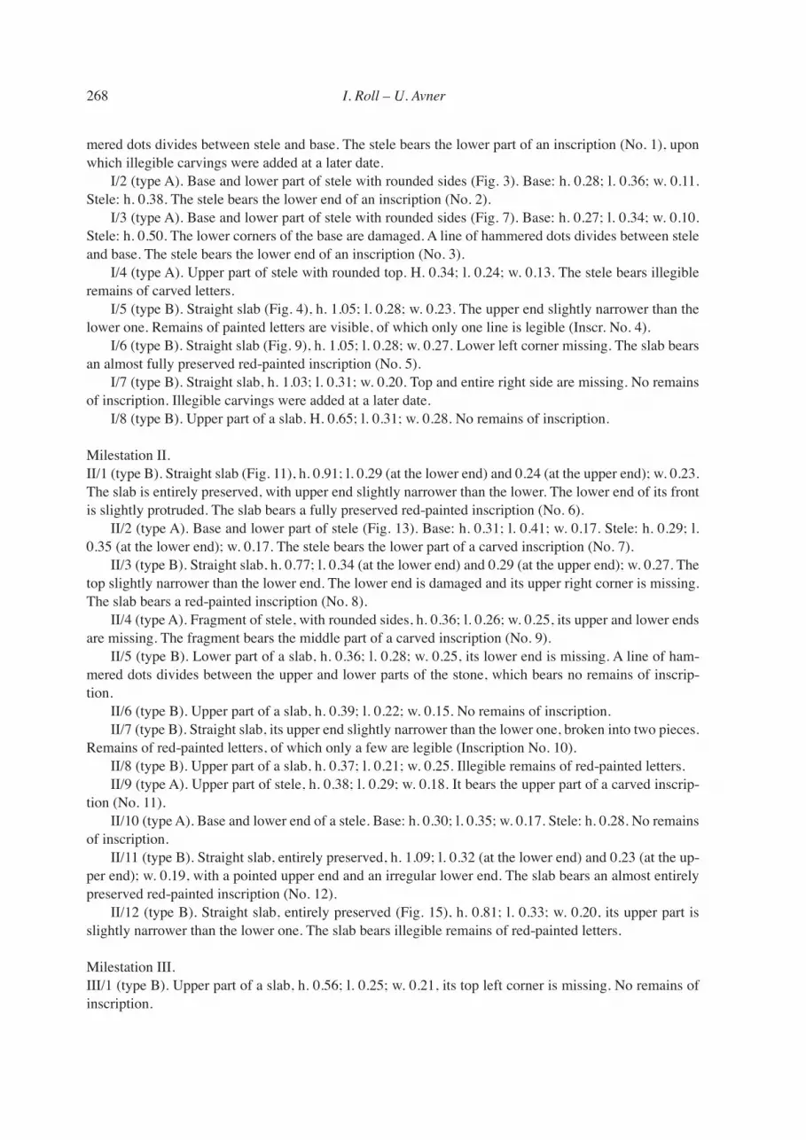
12 (II/11). Carved inscription almost entirely preserved, with letters painted in red, except the numeral distance, which was red-painted only and has not been preserved (Figs 15 and 16). Heights of letters: 60 to 80.
1 D D N N D(ominis) n(ostris) 2 DIOCLETIANI E . Diocletiani e[t] 3 MAXIMIANI Maximiani 4 AUGG ET Aug(ustorum) et 5 CONSTANTI . E . Constanti[i] e[t]

274 I. Roll – U. Avner
6 MAXIMIANI Maximiani 7 NOBB CAESS nob(ilissimorum) Caes(arum)8 ABOSIA ab Osia 9 MI mi(lia passuum) [XII]
The inscription dates to the First Tetrarchy, to the span of time between 1 March 293 and 1 May 305. How-ever, the declension of the inscription is in the genitive and it has no parallels among the other stones of the First Tetrarchy discussed here. This may indicate a date that differs from the other Tetrarchic milestones, possibly, an erection at a later Diocletianic date.9
Discussion
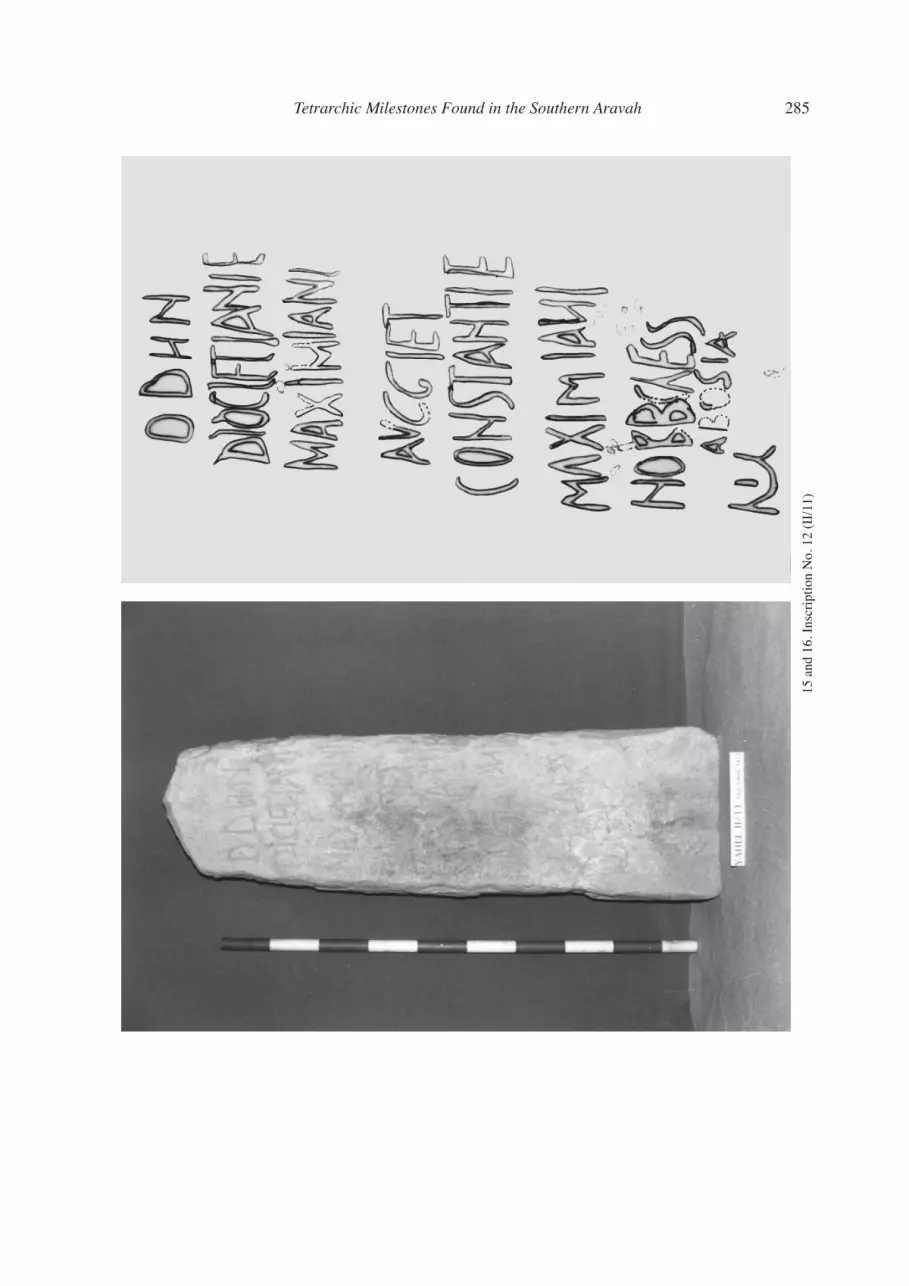
The 28 milestones found in the consecutive three milestations of the Yahel area, and especially the inscribed ones, permit us to suggest the following chronological sequence of the artery of traffi c along which they were erected. During the fi rst Tetrarchy, an Imperial thoroughfare was defi ned along the southern part of the Aravah, the technical nature of which is unknown. Milestones were erected along it, with a fl attened base and stele (type A; Fig. 3). During the same era, of the First Tetrarchy, the thoroughfare seems to have been taken care of, again and again, and each time a new milestone of the same type was added to each station. On the other hand, as there are no visible remains of an engineered road between the milestations, also another explanation comes to mind. The Yahel milestones may not refl ect real road-repair, but rather as repeated signs of loyalty of the governor and army commander towards the ruling emperors. In any case, at a certain stage, assumedly towards the end of the fi rst Tetrarchy, a new type of milestone made its appearance, which has the shape of a square-sectioned vertical slab (type B; Fig. 4), on which the carved inscriptions were gradually replaced by painted ones. The milestones of this type, which bear inscriptions of the Second Tetrarchy, and from the period of Constantine and Licinius, indicate that activity along the road under discussion continued throughout the fi rst quarter of the fourth century CE. It is worth stressing that the Yahel groups of milestones are a unique phenomenon of its kind in the southern Negev. More so, in the entire Negev, only one other inscribed milestone has been uncovered so far, to the north of Avdat. Its letters are badly preserved, their reading is hardly possible and, whatever is identifi able, has not yet been published.
The inscribed milestones of the Yahel area provide a formal proof for the existence of an Imperial north-south artery of traffi c in the southern Aravah in Late Antiquity (Fig. 17). Its attested southern caput viae is Osia, which is certainly identical, as we have seen, with Costia mentioned in the foundation in-scription of the Roman castellum at Yotvata. The other destination of the road is not mentioned in any of the preserved inscriptions. As the nearest urban center at the time was Petra, which could rather easily be approached from the south-west by the engineered ascent of Naqb Ruba’i, this important metropolis could well have served as a second terminus.10
However, the Yahel milestations make much more sense when considered in the frame of the main Imperial highway that crossed the Negev in Late Antiquity, connecting Aelia Capitolina (Jerusalem) with Aila (Aqaba). This seems to be the artery mentioned by Eusebius (Onomasticon 8, 6–9), when discussing the village called in his own days Tamara “which is located a day’s journey distant from Mampsis, on the road from Hebron to Aila, where there is now a military garrison”. Jerome, in his translation of that para-graph (Onom. 9, 6–7), explicitly uses the term “castellum Thamara”. This toponym, of Tamara, should
9 A genitive declension on Diocletianic milestones is rather unusual in the southern Levant. No such examples have been found along the northern segment of the Via Nova Traiana (for the Diocletianic milestones found along this road, see: Bauzou 1998: 207–214), nor in the provincia Palaestina (for which see: Roll forthcoming).
10 The existence of a north-south artery of traffi c along the Aravah has been maintained long time ago by U. Avner (1988; 1997) and most recently by Isaac (2006) and I. Roll (2007). The engineered ascent of Naqb Ruba’i has been surveyed and published by Lindner et al. 2000: 541–543, Frosen et al. 2001:389–391 and, most recently, by Ch. Ben David (2007).

Tetrarchic Milestones Found in the Southern Aravah 275
clearly be identifi ed with modern Hazeva, which is indeed located at one day journey from Mampsis (Kur-nub), where a Late Roman castellum, of a similar plan to that of Yotvata, has been uncovered.11
The highway under discussion extended from Jerusalem to the south along the watershed of the west-ern mountain range of Judea, to Hebron and then, to the military garrison of Chermela. Further to the south (Fig. 17), the terrain falls sharply in altitude, for some 400 meters along 4 kilometers, to the valley of Arad. To cope with this descent, an impressive engineered ascent was erected by the Romans, called today Ma’aleh Dragot, that stretched along the watershed of a series of hills which undulate gradually downwards. Along its markedly steep segments, steps have carefully been built, to attenuate the gradient and to make travel easier, for men and for beasts of burden. In the valley of Arad, no remains of the Roman highway are visible, but, its course undoubtedly continued southwards, to the fortress of Malatha, then to the town of Mampsis, and further on, to the south-eastern limits of the Negev’s high tableland. There, an even greater fall of altitude had to be overcome, of 640 meters along less than 3 kilometers, which low-ers towards Hazeva in the northern Aravah. To cope with it, a sophisticated engineered ascent has been built, and much of it practically carved out of the local limestone rock. The ascent is called today Ma’aleh ‘Aqrabim, better known in English as the Scorpion Pass, which may have been identical with the ascen-sus scorpionis, mentioned in another occasion by Jerome (Comm. in Ezech. 19). It comprises clusters of serpentines with margins carved into the rock, a road surface of leveled limestone, as well as segments of pavement made of rectangular blocks. Along particular steep sections of the ascent, series of steps were carved out of the rock, to attenuate the harshness of the gradient. Excavations carried out at the four road installations distributed along the artery indicate that these facilities, and most probably the ascent as a whole, were erected during the late third or rather the early fourth century CE. A group of anepigraphic milestones discovered north of the ascent indicates that this road was indeed considered by the Imperial authorities as an offi cial artery of traffi c.12
From the Late Roman castellum of Hazeva to the south and along most of the Aravah, no remains of the highway have been preserved. On the other hand, we should assume that an artery bifurcated from it, to the copper mines of Phaenon, and another one, to the metropolis Petra, by the ascent of Naqb Namala. Our knowledge on the segment that stretched further to the south, until Yotvata is now substantially en-riched by the 28 milestones uncovered in the three milestations of the Yahel area, discussed in the present paper. The ultimate destination of the highway was certainly Aila, located according to Jerome (Onom. 7, 25-26) “at the extreme limits of Palaestina, connected with the southern wilderness and the Red Sea” (in extremis fi nibus Palaestinae iuncta meridianae solitudini et mari rubro). This highway could also have served a major military dislocation of Late Antiquity: the transfer of the legio X Fretensis from Jerusalem, in the enlarged provincia Palaestina, to its southern limits, that is, to Aila.13
11 The texts of the inscribed milestones uncovered along the Jerusalem-Hebron have been gathered nine decades ago by Thomsen 1917: 81–83; an up-to-date study on this artery is still wanting. The identifi cation of Tamara with Hazeva is sup-ported by the discovery, near the main local spring, of a square Roman fortress of the second half of the third century, to which four projecting corner towers have been added most probably in the times of Diocletian. Among the remains found near by, those of an impressive bathhouse should be mentioned; see: Cohen and Israel 1996. For the importance of Mampsis, from the times of Diocletian onwards, see: Negev 1988: 1–3.
12 On Ma‘aleh Dragot, a topographical study based on aerial photographs has been published recently by Fixler and Kloner 2004. For the excavations carried out at the military installations distributed along the Scorpion Pass, see: Cohen 1993: 1140–1144. For the milestones found north of the ascent, see: Roll 1989: 260, n. 101. For a discussion on the date of the stepped ascents and the way they were used in Late Antiquity, see: Roll 2005.
13 Opposite Yahel and along the eastern limits of the Aravah, to the north and south of Gharandal, segments of a very well preserved longitudinal paved road have been discovered ( Smith et al. 1997: 59; see also Smith 2005a). The road is only c. 3 meters wide and its pavement is made of local unworked cobbles, edged with curbstones of similar kind. It has been suggested that this artery may belong to the Roman period. However, to us, and after we have seen the road ourselves, its too-well pre-served stretches remind more of the soling method, used during the British Mandate or the early Hashemite times. On the other hand, anepigraphic Roman milestones made of limestone have been reported in the area, in two places. These are: fi ve fractured milestones found in a limestone quarry near Qa‘a es-Saiydiyn, to the north of Gharandal (Smith et al. 1997: 62), and another one found further to the north, near an unpaved longitudinal ancient road at the west of Bir Madhkur (Smith 2005b: 64-66). These milestones differ in their material and shape from those found at Yahel and they refl ect the type of stones typical to the

276 I. Roll – U. Avner
In sum, the Yahel milestones provide a rich and, so far, unique repertoire of epigraphic documentation concerning the reforms and the building activities of the Tetrarchic rulers on the south-eastern fringe of the Roman Empire.
References
Avner, U. 1984. Ancient Cult Sites in the Negev and Sinai Deserts. Tel Aviv 11: 115–131. Avner, U. 1988. Survey of the Southern Aravah. Hadashot Arkhiologiot 62: 71–72 (Hebrew).Avner, U. 1997. Ancient Roads in the Arabah. Excavations and Surveys in Israel 16: 133–134. Avner, U. 2002a. Studies in the Material and Spiritual Culture of the Negev and Sinai Populations during the 6th –
3rd Millennia B.C. PhD thesis, The Hebrew University, Jerusalem. Avner, U. 2002b. Ancient Water Management in the Southern Negev. ARAM 13–14: 389–407. Avner, U. and Roll, I. 1996. Roman Milestones and Ancient Roads in the Arabah Valley. American Journal of Ar-
chaeology 100: 762–764. Avner, U. and Roll, I. 1997. Southern Aravah, Roman Milestones. Excavations and Surveys in Israel 16: 135. Barnes, T. D. 1982. The New Empire of Diocletian and Constantine. Cambridge, MA. Bauzou, T. 1998. Le secteur nord de la via nova en Arabie de Bostra à Philadelphia. In: J.-B. Humbert and A. Des-
reumaux (eds.), Fouilles de Khirbet es-Samra en Jordanie. Turnhout: 101–255. Ben-David, C. 2007. The Paved Roman Road from Petra to the Arabah – Commercial Nabataean or Military Ro-
man? In: A. S. Lewin and P. Pellegrini (eds.), The Late Roman Army in the Near East from Diocletian to the Arab Conquest [BAR S 1717]. Oxford: 101–110.
Chastagnol, A. 1994. L’évolution politique du règne de Dioclétien. Antiquité Tardive 2: 23–31. Cohen, R. 1993. Hellenistic, Roman and Byzantine Sites in the Negev Hills. In: E. Stern (ed.), The New Encyclo-
pedia of Archaeological Excavations in the Holy Land 3. Jerusalem: 1135–1145. Cohen, R. and Israel, Y. 1996. En Hatzeva 1990–1994. Excavations and Surveys in Israel 15: 110–116. Davies, G. and Magness, J. 2007. Yotvata 2006. Excavations and Sueveys in Israel 119. Eck, W. 1992. Alam Costia constituerunt. Klio 74: 395–400. Fischer, M., Isaac, B. and Roll. I. 1996. Roman Roads in Judaea II. The Jaffa-Jerusalem Roads [BAR S 628] Ox-
ford. Fixler, Y. and Kloner, A. 2004. Mapping and Topographical Study of Ma’aleh Dragot based on Airphotos. In: Y.
Bar-Gal et al. (eds.), Erets-Israel Studies – Aviel Ron Book. Haifa: 83–98 (Hebrew). Frösén, J. et al. 2001. The 1998–2000 Finish Harun Project: Specialized Reports. Annual of the Department of
Antiquities of Jordan 45: 377–392. Graf, D. 1995. Milestones with Uninscribed Painted Latin Texts. In: Studies in the History and Archaeology of
Jordan. Amman: 417–425. Grünewald, T. 1990. Constantinus Maximus Augustus. Stuttgart. Isaac, B. 2006. Roman Organization in the Arabah in the Fourth Century. In: P. Bienkowski and K. Galor (eds.),
Crossing the Rift. Oxford: 215–221. Kienast, D. 1996. Römische Kaisertabelle. 2nd ed. Darmstadt. Kolb, F. 1995. Chronologie und Ideologie der Tetrarchie. Antiquité Tardive 3: 21–31. Lindner et al. 2000. Nabataean and Roman Presence between Petra and Wadi Arabah Survey Expedition 1997/98;
Umm Ratam. Annual of the Department of Antiquities of Jordan 44: 535–564. Meshel, Z. 1989. A Fort at Yotvata from the Time of Diocletian. Israel Exploration Journal 39: 228–238. Negev, A. 1988. The Architecture of Mampsis, II. The Late Roman and Byzantine Periods [Qedem 27]. Jerusalem. Roll, I. 1989. A Latin Imperial Inscription from the Time of Diocletian found at Yotvata. Israel Exploration Journal
39: 239–260. Roll, I. 2005. Terrestrial Transportation of the Roman Army in the East: The Case of Judaea/Palaestina and its
Road Network. In: Z. Visy (ed.), Limes XIX. Pécs: 749–761. Roll, I. 2007. Crossing the Negev in Late Roman Times: The Administrative Development of Palaestina Tertia
Salutaris and of its Imperial Road Network. In: A. S. Lewin and P. Pellegrini (eds.), The Late Roman Army in the Near East from Diocletian to the Arab Conquest [BAR S 1717]. Oxford: 119–130.
second and third centuries. That seems to imply the existence of a north-south Imperial artery of traffi c along the central part of the Eastern Aravah prior to the Tetrarchy. On the other hand, Roman structures uncovered at En Yahav and at Beer Menuha seem to indicate that a line of traffi c also stretched along the western limits of the Aravah.

Tetrarchic Milestones Found in the Southern Aravah 277
Roll, I. Forthcoming. The Roman Milestone. In: T. Erickson-Gini and Y. Israel, Excavations at the Third Mile Es-tate near Ashkelon. Atiqot. Jerusalem.
Roll, I. and Ayalon, E. 1986. Roman Roads in Western Samaria. Palestine Exploration Quarterly 118: 113–134. Smith, A. M. 2005a. Pathways, Roadways and Highways: Networks of Communication and Exchange in the Wadi
Araba. Near Eastern Archaeology 68: 180–189. Smith, A. M. 2005b. Bir Madhkur Project: A Preliminary Report of Recent Fieldwork. Bulletin of the American
Schools of Oriental Research 340: 57–75. Smith, A. M. et al. 1997. The Southeast Araba Archaeological Survey: A Preliminary Report of the 1994 Season.
Bulletin of the American Schools of Oriental Research 305: 45–71. Thomsen, P. 1917. Die römischen Meilensteine der Provinzen Syria, Arabia und Palaestina. Zeitschrift des
Deutschen Palaestinavereins 40: 1–103.
Herzliya Israel RollEilat Uzi Avner

278 I. Roll – U. Avner
1. Yahel milestones, group I, looking south
2. Yahel milestones, group II, looking south

Tetrarchic Milestones Found in the Southern Aravah 279
3. Y
ahel
mile
ston
e of
type
A (
I/2)
4. Y
ahel
mile
ston
e of
type
B (
I/5)

280 I. Roll – U. Avner
5 an
d 6.
Ins
crip
tion
No.
1 (
I/1)

Tetrarchic Milestones Found in the Southern Aravah 281
7 an
d 8.
Ins
crip
tion
No.
3 (
I/3)

282 I. Roll – U. Avner
9 an
d 10
. Ins
crip
tion
No.
5 (
I/6)

Tetrarchic Milestones Found in the Southern Aravah 283
11 a
nd 1
2. I
nscr
iptio
n N
o. 6
(II
/1)

284 I. Roll – U. Avner
13 a
nd 1
4. I
nscr
iptio
n N
o. 7
(II
/2)
Tetrarchic Milestones Found in the Southern Aravah 285
15 a
nd 1
6. I
nscr
iptio
n N
o. 1
2 (I
I/11
)
286 I. Roll – U. Avner
17. Map of the Late Roman Roads across the Negev