Embed Size (px)
Citation preview

Jutland Archaeological Society
F A I LA K A D I L M U NT H E S E C O N D M I L L E N N I U M S E T T L E M E N T S
volume 3The Bronze Age Architecture
FAIL
AK
A D
ILM
UN
3 TH
E B
RO
NZ
E A
GE
AR
CH
ITE
CT
UR
E
84982_cover_the-bronze-age_r3_.indd 1 17-02-2013 20:02:06

The Bronze Age Architecture
In memoriamSheikh Abdullah Al Jabir Al Sabah
Abdulaziz HusseinDarwish Miqdadi
84982_failaka_001-097_.indd 1 11-10-2010 10:02:08

84982_failaka_001-097_.indd 2 11-10-2010 10:02:08

Danish Archaeological Investigations on Failaka, Kuwait
FAILAKA | DILMUNThe SecoND MILLeNNIUM SeTTLeMeNTS
volume 3
The Bronze Age Architecture
by Poul Kjærum and Flemming højlund
Jutland Archaeological Society Publications XVII:3, 2013
Jutland Archaeological SocietyMoesgård Museum, DenmarkNational Council for Culture, Arts and Letters, Kuwait
84982_failaka_001-097_r1.indd 3 21-12-2012 13:18:49

Failaka | DilmunThe Second Millennium Settlementsvolume 3The Bronze Age Architecture
Poul Kjærum and Flemming Højlund © 2013
ISBN 978-87-88415-63-6ISSN 0107-2854
Jutland Archaeological Society Publications vol. 17:3
Design: Narayana PressDrawings: Jens Aarup-Jensen, Gunnar Dokken, Palle Friis, Poul Kjærum, Jesper Pauli, Jonatan Rose Andersen, Ea RasmussenPhotos: P.V. Glob, Poul Kjærum, Lennart Larsen, Svend Aage Lorentz, Karl Vibe-Müller, Yves GuichardEnglish translation / revision: Anne Bloch and David RobinsonPrinted by Narayana Press
Published byJutland Archaeological Society in cooperation with Moesgård Museum and the National Council for Culture, Arts and Letters, Kuwait
Distributed by Aarhus University PressLangelandsgade 177DK-8200 Aarhus Nwww.unipress.dk
84982_failaka_001-097_r1.indd 4 21-12-2012 13:18:59

contents
Preface . . . . . . . . . . . . . . . . . . . . . . . . . . . . . . . . . . . . . . . . . . . . . . . . . . . . . . . . . . . . . . . . . . . . . . . . . . . . 7
Tell F3 . . . . . . . . . . . . . . . . . . . . . . . . . . . . . . . . . . . . . . . . . . . . . . . . . . . . . . . . . . . . . . . . . . . . . . . . . . . . . 11
Introduction and summary . . . . . . . . . . . . . . . . . . . . . . . . . . . . . . . . . . . . . . . . . . . . . . . . . . . . . . . . . . . . . 11Detailed description . . . . . . . . . . . . . . . . . . . . . . . . . . . . . . . . . . . . . . . . . . . . . . . . . . . . . . . . . . . . . . . . . . . . 25
Tell F6: The “Palace” . . . . . . . . . . . . . . . . . . . . . . . . . . . . . . . . . . . . . . . . . . . . . . . . . . . . . . . . . . . . 99
Introduction and summary . . . . . . . . . . . . . . . . . . . . . . . . . . . . . . . . . . . . . . . . . . . . . . . . . . . . . . . . . . . . . 99Detailed description of phases I and II . . . . . . . . . . . . . . . . . . . . . . . . . . . . . . . . . . . . . . . . . . . . . . . . . . . . 109Detailed description of phase III . . . . . . . . . . . . . . . . . . . . . . . . . . . . . . . . . . . . . . . . . . . . . . . . . . . . . . . . . 151Buildings to the west . . . . . . . . . . . . . . . . . . . . . . . . . . . . . . . . . . . . . . . . . . . . . . . . . . . . . . . . . . . . . . . . . . . 152
Tell F6: The temple . . . . . . . . . . . . . . . . . . . . . . . . . . . . . . . . . . . . . . . . . . . . . . . . . . . . . . . . . . . . . . 155
Bibliography . . . . . . . . . . . . . . . . . . . . . . . . . . . . . . . . . . . . . . . . . . . . . . . . . . . . . . . . . . . . . . . . . . . . . 161
84982_failaka_001-097_.indd 5 11-10-2010 10:02:09

Fig . 1. Aerial photo of the SW corner of Failaka with the four fenced-in archaeological excavations, Tell F5 (left), Tell F6 (foreground, middle), Tell F4 (background, close to the shore), and Tell F3 (right). On the right the new museum office and store building, looking SW (1961/62).
84982_failaka_001-097_.indd 6 11-10-2010 10:02:12

7
Preface
The Danish excavations on the island of Failaka in Kuwait took place between 1958 and 1963 and were focused on four tells located in the SW of the island: Two Bronze Age tells, Tell F3 and Tell F6, dating to the second millennium BC and two Hellenistic tells, Tell F4 and Tell F5, dating from the third century BC to the first century AD (figs. 1‑2). The results of this work have been presented in a series of mono‑graphs (Mathiesen 1982; Kjærum 1983; Hannestad 1983; Højlund 1987; Jeppesen 1989), and the present volume,1 dealing with the architecture revealed in Tells F3 and F6, is not the last. The excavation of Tell F3 was carried out over five campaigns, 1958, 1959, 1960, 1961/62 and 1962/63, and revealed several complexes of private buildings and a small temple courtyard. The work in Tell F6 took place over three campaigns, 1960, 1961/62 and 1962/63, and revealed a large building, named the “Palace”. Poul Kjærum was in charge of the last three campaigns on Failaka (fig. 3), and in 1975 he again studied the architecture of Tells F3 and F6 in situ on the island. In 1988, he carried out two small sound‑ings in Tell F6, but further studies of the architecture uncovered in Tells F3 and F6 were rendered futile by the inevitable collapse of walls and a subsequent rough restoration in 1985. General information on the excavations has been given by Kjærum (1983 pp. 7‑10) and Højlund (1987 pp. 7‑9). A survey of the architectural phases has pre‑viously been published by Kjærum (1986), and their dating has been dealt with by Højlund (1987). For a brief history of the Danish expeditions to Kuwait, see Højlund 2008. In 1973‑74 an American team from the Johns Hop‑kins University continued the excavations of the SW part of the “Palace” and uncovered, furthermore, a group of smaller buildings to the west of the “Pal‑ace” (Howard‑Carter 1984). The American team also opened up a trench on the westernmost point of Tell F6, some 100 m west of the “Palace”. The results of these excavations will be briefly summarised below. In 2007/8 a Greek team continued the excavations on the westernmost point of Tell F6 (Kottaridi n.d.).
1 The manuscript was completed in October 2009.
Immediately to the east of the “Palace”, a French mission from the Maison de l’Orient in Lyon exca‑vated in 1984‑1986 and 1988 a temple which they dated to the late third – early second millennium BC (Calvet & Salles 1986; Calvet & Gachet 1990; Callot et al. 2005. Calvet & Pic 2008). A discussion of this building and its interpretation is included here. In 2008, new excavations were begun in Tell F6 in the area between the “Palace” and the temple in collaboration between the Kuwait National Museum and Moesgård Museum, Denmark, but the results of these will be dealt with elsewhere. Since 1958, Danish archaeological research on Failaka has been most generously supported by the government of Kuwait, through the Ministry of Edu‑cation, the Ministry of Information and, recently, by the National Council for Culture, Arts and Letters. Support for preparing and printing the publications of the investigations in Failaka has been provided by the Carlsberg Foundation since 1974. The preparation of the present manuscript was generously supported by the Kuwaiti National Council for Culture, Arts and Letters through its Secretary General, Mr Ali Hussein Al Youha, and Director of Antiquities and Museums, Mr Shehab A.H. Shehab. Our warm thanks go to all our friends and colleagues in Kuwait for their great support and hospitality. The excellent cooperation with the French Failaka team: J.‑F. Salles, Yves Calvet, Marielle Pic, Olivier Callot and Mathilde Gelin has been greatly appreci‑ated. This book is dedicated to the late Sheikh Abdullah Al Jabir Al Sabah, Minister of Education, the late Ab‑dulaziz Hussein, Director of Education, and the late Darwish Miqdadi, Deputy Director of Education, the far‑sighted leaders of the Department of Education in Kuwait who invited the Danish archaeologists and thereby instigated the first archaeological investiga‑tions in Kuwait (Højlund 2008).
84982_failaka_001-097_r1.indd 7 21-12-2012 13:19:11

N
100
meters
0 50
F5
F6
F3
F4
FH1
FH2
400
350300
200
200
150
350
300
300
250
200
250200
350
500600
400
300
200
150
250
Fig . 2 . Map of the archaeological area on the SW corner of Failaka (joint plan of the Johns hopkins University expedi-tion, the French Archaeological Mission and the Danish Expedition).
84982_failaka_001-097_.indd 8 11-10-2010 10:02:12

Fig . 3 . Members of the Danish expedition discussing how to plan the excavations at the beginning of the 1960 cam-paign; from the left Geoffrey Bibby, Oscar Marseen, P.V. Glob, Poul Kjærum, Jens Aarup Jensen and Aino Kann Ras-mussen .
84982_failaka_001-097_.indd 9 11-10-2010 10:02:15

Fig. 4 . Aerial photo of Tell F3, looking Ne . In the background Tell F5 (1960).
84982_failaka_001-097_.indd 10 11-10-2010 10:02:17

11
Tell F3
Introduction and summary
Tell F3 is the westernmost of the four tells on the SW corner of the island of Failaka (figs. 1 and 4) and one of the two dating from the 2nd millennium Bc . It is almost circular, measuring c. 190 m N-S and c. 230 m e-W (fig. 2). Its greatest height above the surround-ing flat terrain is c. 5.5 m. During the Danish excavations, a total area of 1511 m2 was investigated in the south and central parts of the tell between 1958 and 1963 (fig. 5). Towards the south, east and north, the limits of the settlement appear on the whole to have been reached, whereas to the west it continues under the house of Sheikh Ahmed . In contrast to Tell F6, which is dominated by two large buildings – the “Palace” and a temple – the settlement at Tell F3 comprises mostly small houses built closely together . These have been separated into a number of architectural phases (Kjærum 1986), which were dated by their associated pottery to pe-
riod 2, 3A, 3B, 4A or 4B (Højlund 1987 pp. 131-151) (figs. 6-9). The earliest floors lie directly over sterile sand, close to the level of the present-day surround-ing plain, corresponding in the excavation survey system to level c. 5.30; the latest house floor lies al-most 2 m higher at level c. 7 .10-7 .20 . Most walls, apart from those belonging to the final phase, are 20-40 cm thick, built of irregularly alter-nating layers of beach rock (farush), partly unworked stones of a good fist size or larger, partly coarsely dressed and irregular small ashlars of up to 30-40 cm in length and a thickness of up to c. 20 cm; only a few of the larger stones extend the full thickness of the wall . Both on their outer surface and inside the rooms the walls are plastered with a yellowish-white, homogeneous fine-grained plaster and the floors are similarly plastered. The door thresholds are normally raised c. 20 cm above the floors.
houses 26-29, period 2 (figs. 7 and 10)The first houses in Tell F3, houses 26-27, belonging to period 2, are found in the northern part of the excavation, near the centre of the tell, erected on vir-gin soil at level c. 5 .35 . They were built as rowhouses, i.e. they have one long side wall in common, each measures about 5 × 15 m and is divided up into a number of small rooms, measuring from 1 × 2 m to 2 × 3.5 m, and presumably with an open courtyard in the middle. House 26 has a total floor area of 52 m2
and house 27 of 50 m2, including the courtyard . The buildings undoubtedly continue towards the east
as well as the west, but excavations have not been undertaken to this depth outside the central area . The two houses had been repaired and extensively altered during their occupation, houses 28-29, but their use does not outlast period 2, when they were abandoned . The walls belonging to this phase re-main standing to a height of c. 1.5 m, filled up with shifting sand. house 31 was probably built in period 2, but how long it continued in use is uncertain .
84982_failaka_001-097_.indd 11 11-10-2010 10:02:17

AS
AF
AB
AO
AN
AQ
BB1958
1958
1959
AKAYAA
AM
AL
Q
X
N
M
RM
B F
A
R
AU
SADAEAI
O K
G C
H D
P
AVAWAX
AJ
V
AC
AC
E
Æ
AH
Z
Ø
AG
IY
AP
AR
W
JAT
1960
1961/62
1962/63
N
10
meters
0 5
Fig . 5 . Plan showing which trenches were excavated at Tell F3 during the five campaigns, 1958, 1959, 1960, 1961/62 and 1962/63.
84982_failaka_001-097_.indd 12 11-10-2010 10:02:18

13
Houses 30 and 23(Period 4B)
Houses 26-29(Period 2)
Houses 1-11, 16-17, 22 (Period 3A)
Houses 12-15(Period 4A)
Temple III(Period 3B)
Temple I(Period 3B)
Temple II (Period 3B)
N S1000
950
900
850
800
750
700
650
600
550
500
Fig . 6 . Main stratigraphy of Tell F3 .
84982_failaka_001-097_.indd 13 11-10-2010 10:02:19

N
10
meters
0 5
period 2
period 3A
Fig. 7. General plan of Tell F3 with the architectural phases dating to periods 2 and 3A marked.
27
2628
31
22
1716B
16A
98
7
6
5
432
1
10
11
29
84982_failaka_001-097_r1.indd 14 21-12-2012 13:19:21

15
N
10
meters
0 5
period 3B
period 4A
period 4B
Fig. 8. General plan of Tell F3 with the architectural phases dating to periods 3B, 4A and 4B marked.
30
23
15
14
1312
19-21
84982_failaka_001-097_r1.indd 15 21-12-2012 13:19:29

16
FAILAKAPERIODS
»PALACE« TEMPLETELL F3
Houses 26-29
Houses 12-15
Houses 23 and 30
Houses 1-1116-17 and 22
Temple courtyardI-III
Phase II
LatePhase I
EarlyPhase I ?
Pre-»Palace«Phase
TELL F6
1
2A
2B
3A
3B
4A
4BIS
IN-L
ARS
AO
BK
ASS
ITE
BARBAR TEMPLES
2000
FH 2009
1950
1900
1850
1800
1750
1700
1650
1600
1550
1500
1450
1400
1350
III? NE T
Level V b-c ?
Level IV ?
IIb
Fig . 9 . The dating of the architectural phases of Tells F3 and F6 .
84982_failaka_001-097_.indd 16 11-10-2010 10:02:21

17
Fig . 10 . house 30 with houses 26-29 in the deep soundings, looking Se (1962/63).
houses 1-11, 16-17 and 22, period 3A (figs. 7, 11-16)In the following period 3A, the settlement moved to the south towards the shore, where the walls are usu-ally erected on sterile sand deposits normally at level c. 6 .60-6 .90 . This is more than a meter higher than the period 2 houses, possibly due to the period 3A houses being situated on a beach ridge . The houses here are similar to those just mentioned, built in the same way as rowhouses with small rooms, gener-ally measuring from 1 × 1 m to 2.5 × 3.5 m, at one or each end of a courtyard . Within the excavated area houses 1-11 were exposed in one row running along the shore continuing towards the SW, while scattered walls of further houses, houses 16-17 and 22, were exposed to the Ne . The total floor area of these houses including the courtyard varies between c. 11 m2 (house 2 with no courtyard), 25 m2 (house 5), 26 m2 (house 4), 28 m2 (house 3 and 6), 55 m2 (house 8) and 60 m2 (house 7), but the grouping of rooms into houses is not without its problems . The walls from this settlement sometimes remain standing to a height of 1 m and are filled in to this height with shifting sand.
Many houses possess a stone-set and plastered cistern (fig. 46), sometimes found covered with slabs and usually situated in a corner of the presumed courtyard or outside the house . These were prob-ably intended to catch rainwater from the flat roofs. Rectangular stone cists were also found, sometimes oddly sited in front of doors (fig. 38); in one case the cist contained a young kid/lamb, perhaps a sacrifice. Small niches were sometimes built into the walls (fig. 43). In three houses there are ovens, partly built into the wall and extending out into the room, set with tall, dressed stone slabs (fig. 44). Finally, a kind of table, plastered and raised about 20 cm above the floor, was found in two, perhaps three houses (fig. 40). All in all, it seems that many of these houses were abandoned in a hurry, quite intact and with much pottery left in the rooms (Højlund 1987 pp. 133-135).
84982_failaka_001-097_.indd 17 11-10-2010 10:02:23
18
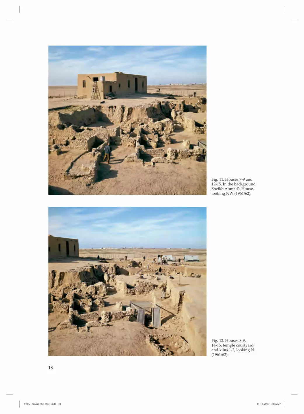
Fig . 11 . houses 7-9 and 12-15 . In the background Sheikh Ahmad’s house, looking NW (1961/62).
Fig . 12 . houses 8-9, 14-15, temple courtyard and kilns 1-2, looking N (1961/62).
84982_failaka_001-097_.indd 18 11-10-2010 10:02:27

19
Fig . 13 . houses 1-9, 12-13, looking SW (1961/62).
Fig. 14 . houses 8, 12-15, looking W (1961/62).
84982_failaka_001-097_.indd 19 11-10-2010 10:02:30
20
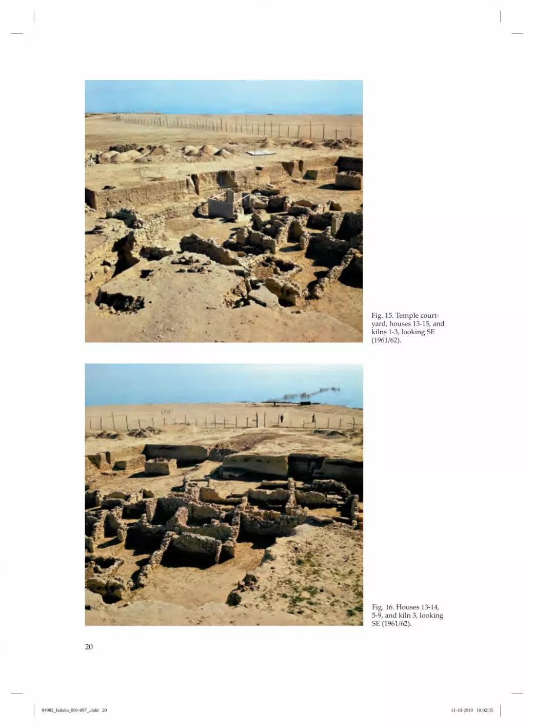
Fig . 15 . Temple court-yard, houses 13-15, and kilns 1-3, looking Se (1961/62).
Fig . 16. Houses 13-14, 5-9, and kiln 3, looking SE (1961/62).
84982_failaka_001-097_.indd 20 11-10-2010 10:02:35

21
Three kilns, periods 2‑3B (figs. 7‑8, 12, 15‑16)To the east of this row of houses was a kind of in‑dustrial area with three kilns, possibly for firing pot‑tery. Two of them, one from period 2 and one from period 2 or 3A, were heavily demolished, while the third and latest, from period 3A-3B, was preserved to a height of about 1.5 m, including the chamber. The kilns were built of stones set in clay and were
plastered with clay. They are about 2.5 m square with a stoke-hole towards the SE, and a square, 0.90 × 1.25 m, firing chamber, resting on separate ledges running along the inside of the outer wall. Each of them had been used several times, judging from the layers of red-burnt clay alternating with layers of ashes found around them.
Temple courtyard I-III, period 3B (figs. 8 and 17)The southern settlement was abandoned during pe‑riod 3A, and no civic buildings from the subsequent period 3B were found within the excavated area, but perhaps they are to be found elsewhere in the tell. The only known construction from this period is a square temple courtyard in three phases (19-21) in the eastern part of the tell at level c. 7.30-8.15, superimposed upon three to four period 3A houses. The court measures about 12.5 × 14 m with a floor area of c. 175 m2 and it is surrounded by a 40-45 cm thick stone wall which had been rebuilt twice on the same foundation. In the second phase, which is the best known, the courtyard was paved with small flat
stones and plastered and could be accessed through a doorway from the ENE. To the SW was a circular altar consisting of a stone disc, 63 cm in diameter, placed on top of a flat base. In the middle of the court was a rectangular altar, originally probably built of six pillars, set on dressed bases – of which only four are preserved. Finally, to the NE, a rectangular altar set with dressed stones was found with a stone cen‑ser in front of it. The temple seems not to have outlasted period 3B though it has been difficult to obtain reliable evi‑dence for the date of its final stage.
Houses 12-15, period 4A (figs. 8, 11‑16)Ordinary dwelling houses again occupied the area in the following period 4A. Scanty remains of a few houses (houses 12, 14 and 15) and a single, small but well preserved three-roomed house with a court‑
yard (house 13), 2.6 × 5.6 m in outer dimensions, were exposed to the west of the temple, directly super‑imposed upon the houses of period 3A at level c. 7.10-7.20.
Houses 30 and 23, period 4B (figs. 8, 10 and 18)In the final period of occupation, period 4B, the first house of more substantial size (house 30) was erected in Tell F3. During this period the settled area returned to the north, covering the earliest occupa‑tion layers. Here, the remaining walls belonging to the earlier settlement were demolished down to the new building level, which probably corresponded to the surface at that time, and then built over with houses, the base of which lies at level c. 7.00. Though only a small part of the building was ex‑posed it was sufficient to demonstrate a radical break with the earlier architectural tradition. The walls are thick, 40-50 cm, and plastered with a yellowish-
brown, sandy plaster and the large rooms are ar‑ranged around a central courtyard in Mesopotamian style. The three surviving rooms have a floor area of c. 17, 28 and 32 m2, respectively, and the courtyard could easily have been 55 m2, surrounded perhaps by further rooms. The floors comprised plaster over a pavement. With this building, which was abandoned in a good state with its walls still standing to a height of up to 1.65 m, the occupation of Tell F3 came to an end. South of house 30 the remains of a further house, house 23, were partially uncovered.
84982_failaka_001-097_r1.indd 21 21-12-2012 13:19:37

22
Fig . 17 . Temple court-yard, looking Se (1961/62).
Fig . 18 . house 30 with soundings down to house 26, looking SW (1961/62).
84982_failaka_001-097_.indd 22 11-10-2010 10:02:38

23
In the east part of Tell F3, the American mission cut a deep trench (Fh2, see fig. 2) which produced many scattered finds, but no architecture (Howard-Carter 1984).
All architecture on Tell F3 is surprisingly consis-tently oriented NNW-SSe, in fact the same orienta-tion as found in the “Palace” and temple in Tell F6 . The houses presumably turned their backs on the prevailing NW wind (Dalongeville 1990 p. 30-31) and faced the shore which was their window on the outside world . Each of the architectural phases briefly described above was, at some point, abandoned and subse-quently filled with shifting sand. When a new build-ing complex was constructed on the site, the surface was levelled, walls which still protruded vertically were either incorporated into the new constructions or demolished down to surface level and possibly used as foundations for new walls . It is a characteristic feature of the settlement in Tell F3 that it does not occupy the same area for a long time but moves round in the terrain from period to period (Højlund 1987). All houses in Tell F3, apart from the temple court-yard and house 30, seem to be private dwellings, suited to a small family. The pottery excavated in the houses covers all functional types, plates, bowls, cups, jugs, storage jars and pithoi . This points to a variety of functions having taken place in the houses and seems compatible with a family’s presence and provides a stark contrast to the more specialised, storage-related pottery assemblage from the “Pal-ace” (Højlund 1987 p. 107. 1988 p. 55-60). The string of period 3A houses confirms this pic-ture, being a phase with many intact or virtually intact pots left on the floors. In particular, was a set of vessels of related function, namely storage ves-sels for drinks, serving jugs and drinking goblets (Højlund 1987 pp. 134-35).
The building materials and method of construction of the houses resemble similar private houses ex-cavated at Qala’at al-Bahrain (højlund & Andersen 1994 pp. 59-68, plans 1-3, 1997 pp. 13-15, plan 1)
and at Sar settlement (Killich & Moon 2005 p. 25ff, p. 149ff). The rowhouse design, i.e. houses built in rows and sharing common walls, is found both at Sar and on Failaka in periods 2-3A, as is the combination of smalls rooms with an enclosed courtyard (fig. 7). The layout of the rooms is different and not so regular at Failaka as it is at Sar . In fact, the most common layout at Sar, a rectangular room built in the corner of a large room, is never seen at Failaka . The investigation at Qala’at al-Bahrain was too limited to enable comparison (fig. 19). comparing Failaka with Sar, a number of fea-tures display systematically smaller dimensions at Failaka . Many of the rooms in the period 2-3A houses at Failaka are extremely small, as little as 2 m2 . This is something rarely found at Sar where the smallest floor area of a room is normally at least 5 m2. The doorways at Failaka normally vary between 50 and 60 cm in width, whereas most doorways at Sar are between 70-80 cm. The thickness of the walls is also less at Failaka (c. 20-40 cm) compared to Sar (c. 60 cm). And the technique of reinforcing the walls with built-in buttresses, so typical at Sar, is not found in Tell F3 (but extensively used in the “Palace” in Tell F6). The impression one gains from Tell F3 is one of smaller scale, less investment of resources and, ulti-mately, less wealth . The few buildings uncovered at Qala’at al-Bahrain tend to resemble the Sar settlement and the “Palace” more than the private houses in Tell F3, with respect to wall thickness, size of rooms, width of doorways and presence of buttresses (fig. 19). The low tables and the stone-built ovens seen in several Failaka houses do not occur at Sar, where other installations were preferred . The regular occurrence in many houses in Tell F3 of a stone-set cistern, presumably intended to catch rainwater from the flat roofs, is not seen at the contemporary Sar settlement in Bahrain. This may suggest that fresh water from springs was more abundant in Bahrain than on Failaka in the Bronze Age, as indeed it has been in recent times (Dalon-geville 1990 p. 34).
84982_failaka_001-097_.indd 23 11-10-2010 10:02:38

24
5 10
meters
0
Fig . 19 . A) Rowhouses from Tell F3 (houses 2-6), c. 1700 Bc . B) Rowhouses from Saar Settlement, Bahrain (houses B100-108), c. 19-1800 BC. C) Houses inside the citywall at Qala’at al-Bahrain, c. 1800 Bc . Scale 1:200 .
A
B
c
84982_failaka_001-097_.indd 24 11-10-2010 10:02:39

25
Detailed description
house 1 (figs. 20-23)house 1, of which only the eastern part has been ex-cavated, comprises three rooms, and its total length is 8.3 m, whereas its width could not be determined. Longitudinally, the room dimensions are as follows: room 1: 4.7 m, room 2: 1.2 m and room 3: 1.3 m. The floors of all the rooms are plastered with a yellowish-white plaster, as are the walls, where five to six layers of plaster could be demonstrated . In the south wall of room 1 only the lowest course was preserved, and here, a c. 50 cm break suggests the location of a doorway . of the north wall in room 1, only a fragment to the east was preserved, with no trace of a doorway . The existence of a doorway between rooms 2 and 3 could be demonstrated; the plastered jamb on the east side is well preserved and a 20 cm high threshold forms a step between the rooms . In room 1, immediately adjacent to the wall to room 2, was a small sunken, square stone cist with an opening at floor level. This was plastered with white plaster, measured 79 × 75 cm and had a depth of 39 cm. In this lay the skeleton of a small animal, presumably a kid or a lamb, together with a quantity of potsherds . It is impossible to determine whether the animal was placed there intentionally, perhaps as a sacrifice, or whether the cist just ended its life by being filled up with rubbish. The floors of rooms 1 and 2 are at the same level (6.21-6.23), whereas the floor in room 3 lies c. 20 cm higher (6.40-6.43). The degree to which the floor in the latter room was raised during its period of use is uncertain . It is true that the dividing wall and the threshold towards room 2 are located on an underly-ing plaster floor on a level with the floors in rooms 1 and 2, but as the same was also the case with the other dividing wall, this is not an indication of a change in level . As the height of the wall founda-tions corresponds to the floor height in the rooms, the difference in level must most likely have been deliberate from its construction . The outer walls were each constructed continu-ously along the whole of their length, and both the south and the north walls continue unbroken to-wards the east where they connect with the western longitudinal wall of house 3, which had already been built at the time of the construction of the two other houses lying further west . The internal partition is not bonded with the longitudinal wall and was, as
already mentioned, built after the plaster floors had been laid in rooms 1 and 2 . The walls in the north survive to a height of about half a metre (level 6.93), whereas in the south they have been demolished to their foundation stones (level 6.58) or completely removed.
Fig . 20. Plan of house 1 (left) and house 2 (right), scale 1:100 .
200
cm
0 100
3
3
2
2
1
1
663709
653693
615678
632611
586
611
623683
631658
645
635623
621
635
643
640
621
643
84982_failaka_001-097_.indd 25 11-10-2010 10:02:39

26
Fig. 21. House 1, room 1 with stone cist, followed by rooms 2‑3, looking N. Above right house 2, rooms 2‑3 (1961/62).
Fig. 22. Left, house 1, looking N. Middle house 2, rooms 2 and 3 with niche. Right, house 3, room 4 with cistern. Background house 10 (1961/62).
84982_failaka_001-097_.indd 26 11-10-2010 10:08:28

27
Fig . 23 . Right, house 2, rooms 3-1, followed left by houses 3-4, looking SE (1962/63).
house 2 (figs. 20-23)house 2, which comprises three rooms, has a to-tal length of 8.3 m, whereas its width varies from 2.29 m in the north to only 1.7 m in the south. Room 1, which is trapezoid, measures 3.16 × 1.13-1.58 m, room 2 measures 1.68 × 0.99 m and room 3 measures 3.04 × 1.72 m. Rooms 2 and 3 have plastered walls with up to four layers of plaster. The floors are simi-larly plastered . The walls of room 1 are un-plastered and the floor was originally paved with flat stones, of which some survive . The doorways between the rooms lie displaced towards the west, but the end wall towards the south had been demolished down to the lowest course so the position of the doorway here could not be estab-lished . In room 3, there is an inbuilt niche in the west wall . It was plastered together with the wall and is 60 cm long, 16 cm deep and has its base at floor level. The height of the foundations for the floors and the walls corresponds to that of house 1, and in the
north, the walls stand to a height of half a metre, whereas the walls towards the south have been de-molished to their lowest course, or removed com-pletely . Accordingly, the dividing wall between rooms 1 and 2 could only be established by way of a plaster ridge in the plaster floor. This house was, as already mentioned, joined with house 1 and made use of house 3’s west wall as its east wall. The latter was plastered on its outer surface before houses 1 and 2 were built . houses 1 and 2 are perceived here as being two independent buildings as it was not possible to es-tablish the existence of any doorway leading from one to the other, but they could have functioned as one unit with access from a communal courtyard towards the south where the excavation was not continued .
84982_failaka_001-097_.indd 27 11-10-2010 10:02:45

28
house 3 (figs. 24-31)house 3 comprises seven rooms which lie together forming two complexes, respectively south and north of a square courtyard . In total, it measures 11.9 m from north to south and, apart from room 7 which is an extension towards the north of half width, its external E-W dimension is 4.35-3.70 m. The three rooms to the north (5-7) and the two to the south (1-2) are quite small and almost square, c. 2 × 2 m, with the exception of rooms 1 and 6, which are even smaller, only 1.4 × 1.2 m and 1.7 × 1.2 m, respectively . The only rooms which extend across the full width of the house are rooms 3 and 4. The boundary between them is, however, uncertain as it is only hinted at by the wall fragment on the east wall, which is plastered on its narrow western side and therefore presumably represents a door jamb . The remainder of the wall has, however, been com-pletely demolished . Within these limits, the room measures 3.37 × 1.7 m. Finally, room 4 is the largest room in the complex, 3.2 × 2.83 m. Room 5’s west wall had a basal course of large stones with a height of 30 cm above floor level. In all the rooms there are traces of plaster on the walls, but only rooms 2 and 5-7 have large plastered surfaces preserved with three to four layers of plas-ter; in the other rooms there are only scant traces . The floors were probably also plastered, but evi-dence only survives in the form of small horizontal patches of plaster in the corners . These could also just be due to some plaster from plastering of the walls falling onto a sand floor. All the rooms are linked by doorways which stand well preserved in the three northern rooms, with plastered jambs and thresholds . The doorway be-tween rooms 5 and 6 has a special form in that the door jamb is rabbeted with a rounded rebate towards the threshold on the south side and an angled edge at the north side which must reveal the shape of the actual door . There was, however, no trace of a door post either in the jambs nor the floor beneath it. The other doorways are only hinted at in the heav-ily demolished walls; by the plaster on the end sur-face of the piece of wall between rooms 3 and 4, and
a single surviving course of the jamb and a threshold stone between rooms 1 and 2. The latter suggests a door width of 54 cm, measured from the jamb to the end of the threshold stone . Finally, in the south wall to room 2, there are faint traces of a doorway which must have been the entrance to the whole complex . With regard to special installations, there is a plas-tered niche built into the south wall of room 6 . It has a depth of 20 cm, a width of 30 cm and is raised 15 cm over the floor. In room 3, towards the wall to room 1, the corner of a vertical plaster surface is preserved which could represent the remains of a “table” as seen in houses 5 and 6 . The cistern in room 4 is a good half metre in di-ameter and 70 cm deep, formed of four flat vertical stones and sealed with plastered dry-walling of flat stones and occasional large potsherds in the gaps . Its westernmost stone is built over by the long wall between houses 2 and 3, while its opening is at floor level . The floor levels rise from the southern rooms, at level c. 6 .23, stepwise towards the north, through room 6: 6 .36, to level 6 .73 in room 7 . Under the north-ern outer wall there are, however, traces of a vertical, plastered wall surface to level 6 .56, which suggests that the floor here has been raised. This could have happened in connection with more extensive altera-tions to the house, as the north wall of the same room is built over, following decay or demolition, at level 6.84. Just as the levels of the floor are raised from south to north, the same is the case for the bases of the walls; the level of the foundations in the south is c. 6 .17, whereas in the north they are at level 6 .67 . The walls in the north survive to a height close to 1 m (level 7.42), while in the south they have been de-molished down to the last few courses or, in places, have been completely removed . The house was built before houses 1-2, the north wall of which was built up against the NW corner of house 3 after the exter-nal wall of the latter was plastered.
84982_failaka_001-097_.indd 28 11-10-2010 10:02:46

29
Fig. 24 . Plan of house 3, scale 1:100 .
200
cm
0 100
667740
673
673
750651677721
642
652
646
636
625
564
628
629
623
648
642
631
665742
658722
663730
623683
613672
634669
649
628664
626648
617643
617656
633665
617636
629644
7
5 6
4
3
12
Fig . 25. House 3, room 4 with cistern, looking NW . Background, house 2, rooms 2-3 (1961/62).
84982_failaka_001-097_.indd 29 11-10-2010 10:02:48

30
Fig . 26 . Foreground, house 3, room 4 with cis-tern, followed by rooms 5-6, looking N. Left, house 2, room 3 . Back-ground, houses 10-12 (1961/62).
Fig . 27 . Foreground, house 3, room 4 with doorway into room 6, looking NW . From here doors into rooms 5 and 7 (1961/62).
84982_failaka_001-097_.indd 30 11-10-2010 10:02:52

31
Fig . 28 . house 3, room 5 with doorway into room 6, looking e . From here, left, doorway into room 7 and right, doorway into room 4 (1961/62).
Fig . 29 . Foreground, northwest of house 3, looking e . centre, house 3, room 7 . Right, rooms 5-6 (1961/62).
84982_failaka_001-097_.indd 31 11-10-2010 10:02:55

32
Fig . 30 . house 3, room 7 with plastered wall and doorway, followed by room 6 with doorway into room 4, looking S (1961/62).
Fig . 31 . North walls of left, house 3, room 5 and right, house 2, room 3, un-bonded, looking S (1961/62).
84982_failaka_001-097_.indd 32 11-10-2010 10:02:59

33
House 4 (figs. 32-35)This irregular and heavily demolished house has a maximum length of 12.8 m and a maximum width of 4.4 m. It comprises only two actual rooms to the north, a probable courtyard and an irregular room to the south of which, however, only a little survives, and the excavation of which is also incomplete . The northern room, room 4, is 3.6 m long and 1.2 and 1.7 m wide in the north and south, respec-tively . This room was probably originally divided by a transverse wall, which continued on from the southern wall in room 3:7. On excavation, the latter stood with an un-plastered demolition surface facing in towards the room . The adjoining room 3 is irregularly rectangular, 2.8 m long and 1.8 m wide. Its southern wall was com-pletely demolished and was only apparent through a small remnant of wall by the SW corner of room 5:1 . This room lies next to the presumed courtyard, room 2, measuring 3.8 × 2.6 m, from where there must also have been access to the southern room 1, which is irregularly square, measures 2.35 × c. 2 m, and is only partially preserved . The walls in all the rooms are plastered, but only in room 4 were there also traces of plastering of the floor. The only moderately well preserved doorway is in the e wall in room 1, with plastered jambs at each side and a threshold made up of several stones across the full width of the doorway of 60 cm. In addition to this there is the suggestion of a plastered jamb at the east side of the wall between rooms 3 and 4, but the width of the doorway cannot be determined . Towards the east wall in room 3 there has been an oven, as indicated by a fire-cracked stone measuring 50 × 30 cm and set into the wall. The special construc-tion of the wall around it suggests the presence of an oven of the same character as that in house 5, but it had apparently already been demolished before the house was abandoned . A cistern lies in the SW corner of room 2, which is presumed to be an open courtyard . It is rectangular and built of four vertical stones, the gaps between which are filled out with dry-walling, and it is plas-tered on the inside and the base . It measures inter-nally c. 70 × 60 cm and is 60 cm deep. Finally, mention should be made of a horizon-tal stone, measuring 43 × 28 cm, in the NW corner of room 3 . This could represent the remains of an original floor covering or a table construction as seen in houses 5 and 6 . Just as with the previous houses, the floor level is raised stepwise northwards from around level 6 .30 in rooms 2 and 3 to around level 6.60 in room 4. The south wall in room 4 is built on a sand layer mixed with mollusc shells, bones and potsherds .
The north wall in room 4 was, after being demol-ished to a level 28 cm above its base, built over by a wall at level 6.84. This was constructed in continua-tion of the wall built over the north wall of house 3, which forms the south wall of house 11 to the north .
200
cm
0 100
656684
684727
665742
656740
658
646 654
706
673
750
653727
629669
628701
628728
648
648717
635732
631676
697
636690
626648
676725
656
621
637
4
3
2
1
Fig . 32. Plan of house 4, scale 1:100.
84982_failaka_001-097_.indd 33 11-10-2010 10:02:59

34
Fig . 33 . Foreground, house 4, room 2, fol-lowed by house 3, rooms 1-3, looking W (1962/63).
Fig. 34. Left, house 3, rooms 4-7, looking N. Middle, house 4, rooms 3-4. Right, house 5, rooms 1-3 (1961/62).
84982_failaka_001-097_.indd 34 11-10-2010 10:03:03

35
house 5 (figs. 36-44)house 5 comprises three moderately well-preserved rooms in continuation of one another, as well as traces of a further room to the north . The preserved length of the complex’s three southern rooms is 8.5 m, while the extent of the northern room 4 is undetermined . The dimensions of three preserved rooms are, respectively, room 3: 3 × 1.8 m, room 2: 3.6 × 2.9 m and, finally, room 1, which is somewhat irregular, 3.4-3.8 × 2.6 m. The walls are plastered in all the rooms apart from room 4, where the walls are in such a poor state that the presence of plaster could not be established . con-versely, no traces were found of any floor covering, either in the form of plaster or stone paving . In the southern rooms the doorways are well pre-served with jambs constructed of plastered, dressed stones . In a number of cases these have the character of ashlars and are of a size corresponding to the full thickness of the wall . The entrance to the house complex in the south wall measures 60 cm between the jambs. The through-going dressed threshold stone, which occu-pies the whole width of the doorway, is raised 22 cm over the base of the wall and is supplemented on its inner side by a step comprising a flat dressed stone
which lies 19 cm below threshold height (level 6.81)and 26 cm over the original floor level (c. level 6.55). The doorway between rooms 1 and 2 is 56 cm wide and, similarly, has plastered jambs, but is constructed of smaller dressed stones, and the threshold consists of several flat flags. It is raised 30 cm over the base of the wall and is similarly supplemented by a step in room 2 which lies 14 cm below threshold height and 10 cm over floor level. The doorway to room 3 is only indicated by a threshold stone with a length of 56 cm, and only one jamb of the doorway to room 4 is preserved so its width cannot be determined . In addition to these doorways, which were in use when the house was abandoned, there is a walled-up doorway in the east wall of room 1 . The jambs of this are plastered and constructed of large ashlars of full wall thickness. A flat, dressed slab, a little wider than the wall and of the full width of the doorway of 60 cm, forms the threshold, raised 41 cm over the base of the wall. The doorway is filled up with a regular well-built wall, partly formed of large ashlars of full wall thickness, constructed directly on top of the threshold . In the west wall of room 2 there were two niches .
Fig . 35. Foreground, left to right, house 4, rooms 4-2, looking E. Middle house 5, rooms 2-1 (1961/62).
84982_failaka_001-097_.indd 35 11-10-2010 10:03:05

36
In the south wall of room 1, a niche had been built in c. 75 cm over the base of the wall. It is 24 cm wide and framed by flat flagstones at the base and sides. In the SW corner of the same room, a table or platform had been built up in two levels . In the corner between the south and west walls lay a stone flag measuring 70 × 46 cm, and 17 cm lower lay a similar flag measur-ing 1.15 × 0.80 m, the eastern side of which is in line with the previous flagstone. Both are 6-7 cm thick and dressed with a completely smooth surface and straight edges . on the exposed sides towards the east and north, the table is edged with vertical, flat, rectangular stone flags with a height of 15-33 cm, set in plaster and plastered on their outer surface . In the middle of the east wall in room 2 stood an oven . This was built c. 20 cm deep into the wall with a vertical, c. 50 cm wide, strongly heat-affected stone slab as the rear wall of the oven cavity itself . This was built of two vertical slabs, 80 cm in height, set at right angles to the back wall . They still stood in situ and were strongly heat-affected. Two similar stone flags, also strongly affected by fire, were found tipped over to the north and south; these had origi-nally been set in line with the two former stones . The southernmost of these was still fully preserved and measured 80 × 30 cm, and apparently reveals the size of the other crumbled and broken slabs . Accordingly, the oven originally had a depth of c. 70-80 cm and a height of 80 cm. The northern side is reinforced with a supporting wall, which is joined with the rear wall, and the actual oven is bounded towards the room by a row of stones . In front of the south doorway a rectangular stone cist measuring 70 × 35 cm had been built up. This was constructed of three vertical slabs with its base at level 6 .81 and its top at level 7 .20, i.e. 20 cm over the threshold . The function of such a cist and its relation to the doorway is uncertain . The floor levels could not be determined with the same certainty as in rooms with plaster floors. On the basis of the edges of the plaster on the walls and the stone setting around the table, the floor level in rooms 1 and 2 could, however, be determined as, respectively, c. 6 .55 and 6 .60, and in room 3 it must have lain at level c. 6 .70, judging from the threshold and the wall base . The walls are generally set at the same levels as in the adjoining house 4, i.e. at level 6 .30 in the south-ernmost room, rising towards the north to 6 .55 and 6 .75 . The secondary north wall was, however, set at level c. 6 .80 . The walls survive to a very considerable height, especially to the east and south, where their height reaches between 0.8 and 1.2 m, lowest towards the NW with only 40-50 cm. The north wall in room 3 was restructured or built anew with its foundation on top of the completely demolished west wall in the room . Along the rest
of its course, however, no underlying wall could be established as this presumably had been completely demolished . This alteration appears to have been carried out in connection with the reconstructions which were executed in the neighbouring houses 3 and 4. The southern part of room 1 was similarly altered . Breaks in the wall courses in the opposing walls to the east and west, c. 1.3 m from the outer corners, reveal the extent of the restructuring . To the north of the break, the foundation in the east wall lies 30 cm higher than to the south. In several places in the south wall a stretch of wall was also identified, demolished to the lowest course, the foundations of which lie c. 30 cm under the foundation for the wall overlying it. The latter rests, in part, on the older wall, while over short stretches it is built on a 10-15 cm thick sand layer that separates the two wall phases . This restructuring of the walls could have been connected with an extensive reconstruction of the house, which is perhaps also evident in the walling up of the doorway in the east wall of room 1, and could have been carried out in connection with the construction of house 6 .
200
cm
0 100
674759
696712
686729
676725
652745
656751
658722
628701
657
652
652
677
628728
700
667718
767
681
681 720
718
749
668
685
637
683 651
669659
682
662
691
656693
656699
682741
694794
653729
658763
656743
4
3
2
1
Fig . 36 . Plan of house 5, scale 1:100 .
84982_failaka_001-097_.indd 36 11-10-2010 10:03:05

37
Fig . 37 . house 5, room 1, west wall, looking e (1961/62).
Fig . 38 . house 5, room 1, south entrance, with stone cist in front of threshold, looking Ne . cistern south of house 6, room 1 (1960).
84982_failaka_001-097_.indd 37 11-10-2010 10:03:09

38
Fig . 39 . house 5, room 1, outer doorway with step in front, looking Se . Stone cist beyond thresh-old (cf. fig. 38) has top-pled over . To the right, niche in wall (1961/62).
Fig. 40 . house 5, room 1 with tables, looking SW (1961/62).
84982_failaka_001-097_.indd 38 11-10-2010 10:03:13

39
Fig. 41 . house 5, room 1 (earth baulk from ar-chaeological excavation in middle) with doorway into room 2, looking N . From here doorway into room 3 (1961/62).
Fig. 42 . house 5, room 1 with doorway into room 2, west wall with niches, looking NW (1961/62).
84982_failaka_001-097_.indd 39 11-10-2010 10:03:16

40
Fig. 44 . house 5, room 2 with oven, looking e (1961/62).
Fig. 43 . house 5, room 2, west wall with two niches, looking W (1961/62).
84982_failaka_001-097_.indd 40 11-10-2010 10:03:20

41
house 6 (figs. 45-53)Of house 6, only rooms 2 and 4 are preserved with full delineation of their walls . In addition to these, the complex also comprises room 3, the northern part of which has been completely demolished, and room 1, where the whole of the east wall and parts of the south wall have also been totally demolished . The original extent and arrangement of the house can, accordingly, not be determined and, as will become apparent, the original plan of the house was altered during its use . Its present length totals 8.75 m, its width 3.6-3.9 m, excluding room 4, which was probably a later ex-tension. Room 2 measures 3.15 × 2.6-3.3 m, room 4 2.9 × 1.8 m, while room 1, which presumably was a courtyard, measures c. 3.5 m in a N-S direction and must originally have had a width of c. 3 m. However, as already mentioned, the east wall has been com-pletely demolished . on the wall between rooms 2 and 3, the plaster was preserved in large continuous sections on both sides, whereas in the other rooms there were only small patches of wall plaster. None of the floors had a covering, either of stone or of plaster . Six doorways were preserved in the house, of which two were walled up . The doorway between rooms 2 and 3 had a width of 65 cm and stood well preserved with ashlar-built, plastered jambs at both sides and with a 25-30 cm wide threshold stone extending across the full width of the doorway, founded on a wall course in continuation of the low-est course of the wall . The doorway to room 4 is 52 cm wide with a threshold measuring 42 × 27 cm. Towards room 4 this is bounded by a vertical slab, set on edge, with a height of 20 cm and extending across the full width of the doorway . At the north side, two courses are preserved of the ashlar-built jamb, the basal course of which is set on a level with the upper edge of the vertical stone . on the south side only one course is preserved of a more roughly dressed stone . Judging from the setting of the jambs to the north, the door-way is a secondary construction, and the threshold stones, which are on a level with the lowest course of the wall, could have been the basal course in the breached part of the wall . The doorway, which leads out of the Se corner of room 2, is 62 cm wide with ashlar-built, un-plastered jambs and a threshold stone extending across the full width of the doorway . The threshold stone was laid 28 cm higher than the wall foundations, and its surface lies 40 cm over the original floor level in the room . This doorway is presumably also secondarily built during a late part of the period of use . The original doorway between rooms 1 and 2 lay in the west side of the dividing wall, but was walled up, probably in connection with a reconstruction of
the house. This doorway is 60 cm wide with ashlar-built jambs, on which the plaster is still preserved on the west jamb. The doorway was filled with a proper wall of dressed stones . In the SW corner of room 2, a rectangular stone table had been constructed, 1.4 × 1 m, covered by a single, flat stone flag, edged with 15-20 cm high stone flags, set vertically in plaster. On the table lay a perforated stone mortar and fragments of several pottery vessels. By its SE corner stood a dressed stone block level with the surface of the table . This mea-sured 28 × 32 cm horizontally and 16.5 cm in height, while a shallow depression in the surface measured 19 × 13 cm. East of the table stood a small rectangular limestone vessel and a pottery bowl (Højlund 1987 p. 134). In the south wall of room 3, an oven was built in of the same construction as that in house 5 . It was set 20 cm deep into the wall and was bounded at one side by a 53 cm high slab, which stood in situ at right angles to the wall, while the remainder of the structure had been demolished . An oven must, similarly, have stood in the north wall of room 1, but only a strongly burnt and reddened slab, 38 cm wide
Fig. 45 . Plan of house 6, scale 1:100 .
200
cm
0 100
733
668718
715
711740 716
700
698
669753
686698
667692
692745
683751
686763
682740
687716
695781
656743
689737
655
699
683698
686
667 695780
723700
695780
718815
674759
685775
705811
730778
674695
3
2
4
1
84982_failaka_001-097_.indd 41 11-10-2010 10:03:20

42
and 63 cm high, remained, if this did not represent the re-use of an oven stone . In the NW corner of room 1 lay a circular cistern constructed of horizontal flagstones and plastered on its sides and base. It was 55 cm in diameter and 33 cm deep. On excavation, it was still covered by flat limestone slabs. The cistern, and the doorway behind it, must be assumed not to have been in use at the same time . houses 5 and 6 were undoubtedly in use at the same time, but house 6 was constructed after house 5 was completed and during its period of use it expe-rienced both alterations and extensions . The eastern longitudinal wall of house 5 was plastered on its east side prior to construction of the north and south walls in room 6:2, which are also founded at a level between 20 and 40 cm higher. The angled cut of room 5:2 into room 6:2 suggests the same constructional se-quence . The walling up of the east doorway in room 5:1 was also most probably done in connection with the construction of house 6 .
Room 4 appears to have been a later addition to house 6. Its floor level lies c. 30 cm higher, at level 7.16, than the floor in room 2, which is at level c. 6 .85, and its east and south walls are founded c. 30 cm higher, at level 7 .18, whereas the north wall with its base at level 7 .30 overlies an earlier wall (cf. house 7). Beneath the south wall in room 4 there were cer-tainly small sections of a horizontal plaster covering at more-or-less the same level as the original floor in room 2, level 6 .85, but these most probably represent the remains of the floor covering in house 7, room 4. The floor in room 3 is at approximately the same level as in room 2, c. level 6 .90, judging from the base of the oven and the threshold height . South of house 6 lies a circular cistern constructed of small stones in horizontal layers, joined with the wall behind, the foundation stone of which is in-cluded in its construction . It measures c. 60 cm in internal diameter and just less than half a metre in depth .
Fig. 46 . house 6 with cisterns outside and in room 1, looking N (1961/62).
84982_failaka_001-097_.indd 42 11-10-2010 10:03:22

43
Fig. 47 . house 6, room 1 with cistern, looking NW . Blocked doors in west and north walls (1961/62).
Fig. 48 . house 6, south entrance into room 2 with doorway into room 3, looking NW (1961/62).
84982_failaka_001-097_.indd 43 11-10-2010 10:03:26

44
Fig. 49 . Trench G looking S . house 6, room 3 with oven and room 2 with table (1960).
84982_failaka_001-097_.indd 44 11-10-2010 10:03:28

45
Fig . 50 . house 6, room 2 with doorway into room 3, looking NW (1961/62).
Fig . 51 . house 6, entrance into room 4, looking NE (1961/62).
84982_failaka_001-097_.indd 45 11-10-2010 10:03:31

46
Fig . 52. House 6, room 4, inner Ne corner, looking Ne . earlier phase of walls uncovered in sounding (1961/62).
Fig . 53 . house 6, room 4, outer south and east walls with two build-ing phases, looking NW (1961/62).
84982_failaka_001-097_.indd 46 11-10-2010 10:03:35

47
house 7 (figs. 54-57)house 7 is, for the most part, overlain by houses 6, 12, 13 and 14 and has not been completely un-covered. A sufficient number of wall sections have, however, been established that it has been possible to reconstruct its ground plan in broad terms, although with some reservations . In a N-S direction, a length of wall of c. 17 m and a total of ten rooms, have been completely or partially uncovered, of which some (9 and 10) were probably further divided up. The house’s southernmost and northernmost parts are, however, heavily ruined . Accordingly, there are only hints of the southern boundary of room 4 preserved, and the relationship of rooms 1-3 to this house is uncertain . Room 7:1 is hypothetically separated from room 6:1 . The only trace of a presumed dividing wall is a break in the Se corner of room 6:2, where the three lowermost courses do not have the character of a corner construction, but rather a breached longitu-dinal wall . This slight indication suggests that the wall continued as a dividing wall between the two rooms . Room 7:1, in this case, measured c. 3.7 × 2.8 m. of the adjoining rooms, 2 and 3, only the lowest courses of the east and south walls are preserved, whereas the western and northern boundaries and the division between the two rooms are marked by ridges in the plaster floors, which do, however, un-equivocally reveal the course of the walls . Room 2 has an extent of 1.65 × 1.5 m and room 3 of 1.6 × 1.55 m. Of the south wall in room 4, only the SE and SW corners are preserved, whereas the other walls still stand in an intact state . The north wall was, however, built over the north wall in room 6:4, but its original course was established by a sounding (cf. below). This room measures 3.15 m N-S and 4.1 m E-W. The four rooms lying to the north (5-8), which form a block of similar size, were completely built over by house 13, and the walls demolished to the height of the latter’s foundations. The dimensions of the rooms are, for room 5: 2.6 × 1.25 m, room 6: 1.2 × 1.2 m, room 7: 1.8 × 2.6 m and room 8: 1.9 × 1.5 m. The two northernmost rooms, 9 and 10, have not been fully delimited as the course of the northern part of the west wall and the north wall in room 9 could not be established . And in room 10, the south-ern part of the east wall was completely demolished apart from a c. half metre long plastered fragment to the south . The length of the rooms N-S was c. 5 m and their width, respectively, 2.5 and 1.3 m. The hint of a demolished transverse wall indicates a division, at least, of room 10 . All the walls had been plastered with a yellowish-white plaster which, on several walls, survived in large continuous sections . In rooms 2 and 3, the plaster floors are fully pre-
served, whereas in the other rooms only the presence of smaller, continuous horizontal plaster surfaces in rooms 4 and 9 and under the walls in the secondary room 6:4 was established. eight doorways were located in the house . In the SW corner of room 4 was a 56 cm wide doorway marked by a threshold stone, bounded towards the west by stones forming a jamb, joined with the wall . Both the stones of the jamb and the threshold stone are, however, set at a level which lies more than 50 cm above the wall foundations for house 7 here, and the doorway most probably belongs to the late phase of house 6 . The doorway between rooms 2 and 3, where only a couple of stones survive from the dividing wall, lay at the east side and is indicated by the plastered west jamb, where the basal course was intact . It was c. 55 cm wide. The doorway between rooms 4 and 5 was located in the middle of the north wall and was overlain by the north wall of 6:4. The doorway was 65 cm wide with a threshold stone of full width, and the well-preserved eastern jamb was constructed of ashlars, covered by a well-preserved plaster layer . The door-way was filled up with loose sand, mollusc shells and bones up to the base of the overlying wall . The doorway to room 6 was not located due to the demolition of the wall . Between rooms 5 and 7, the doorway is indicated by a plastered jamb at its west side, beneath the SW corner of house 13. The doorway was filled up with pure sand . The doorway between rooms 7 and 8 was 52 cm wide with well-preserved plastered jambs, built of flat dressed flagstones. A threshold stone, which did not extend the full width of the doorway, was laid 20 cm above the base of the wall. The opening was filled up with loose sand, over which the wall of the overlying house 13 was constructed . Between rooms 7 and 9 the doorway was 52 cm wide with plastered jambs at each side and a thresh-old stone extending the full width of the doorway . The doorway was blocked by a wall of dressed stone . Between rooms 9 and 10, the doorway was 47 cm wide with plastered jambs built of flat, dressed flagstones and a threshold stone occupying the full width of the doorway . The doorway was walled up directly over the threshold stone . In room 10 there was a doorway in the north wall with plastered jambs and a threshold stone extending the full 50 cm width of the doorway . In the SE corner of room 4, an oven had been built in of very much the same character as that in houses 5 and 6 . It was built into the wall almost to its full depth, such that the fire-cracked stones, which formed the rear wall, stood in line with the east side
84982_failaka_001-097_.indd 47 11-10-2010 10:03:35
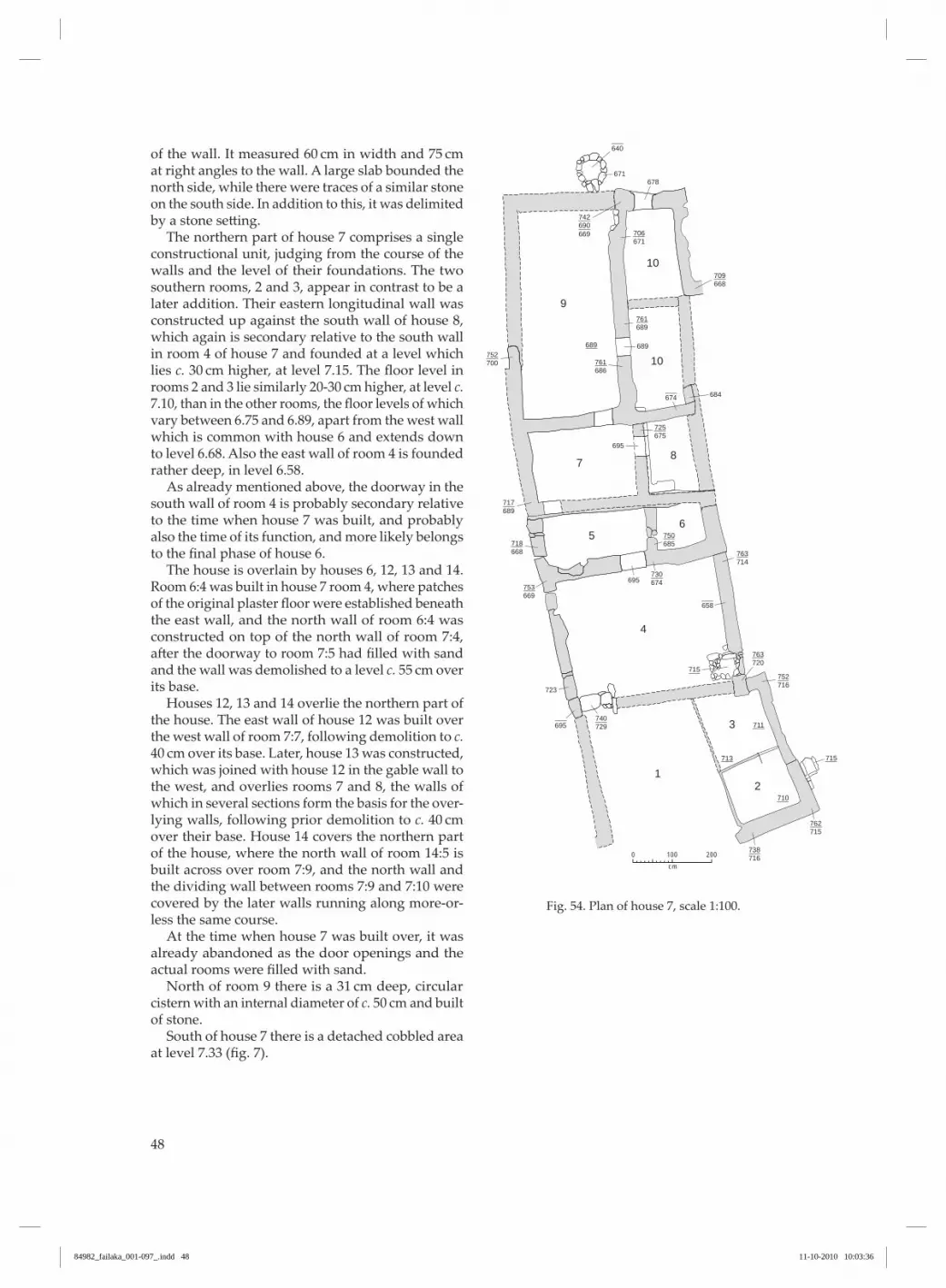
48
of the wall. It measured 60 cm in width and 75 cm at right angles to the wall . A large slab bounded the north side, while there were traces of a similar stone on the south side . In addition to this, it was delimited by a stone setting. The northern part of house 7 comprises a single constructional unit, judging from the course of the walls and the level of their foundations . The two southern rooms, 2 and 3, appear in contrast to be a later addition . Their eastern longitudinal wall was constructed up against the south wall of house 8, which again is secondary relative to the south wall in room 4 of house 7 and founded at a level which lies c. 30 cm higher, at level 7.15. The floor level in rooms 2 and 3 lie similarly 20-30 cm higher, at level c. 7.10, than in the other rooms, the floor levels of which vary between 6 .75 and 6 .89, apart from the west wall which is common with house 6 and extends down to level 6.68. Also the east wall of room 4 is founded rather deep, in level 6 .58 . As already mentioned above, the doorway in the south wall of room 4 is probably secondary relative to the time when house 7 was built, and probably also the time of its function, and more likely belongs to the final phase of house 6. The house is overlain by houses 6, 12, 13 and 14. Room 6:4 was built in house 7 room 4, where patches of the original plaster floor were established beneath the east wall, and the north wall of room 6:4 was constructed on top of the north wall of room 7:4, after the doorway to room 7:5 had filled with sand and the wall was demolished to a level c. 55 cm over its base . Houses 12, 13 and 14 overlie the northern part of the house . The east wall of house 12 was built over the west wall of room 7:7, following demolition to c. 40 cm over its base. Later, house 13 was constructed, which was joined with house 12 in the gable wall to the west, and overlies rooms 7 and 8, the walls of which in several sections form the basis for the over-lying walls, following prior demolition to c. 40 cm over their base. House 14 covers the northern part of the house, where the north wall of room 14:5 is built across over room 7:9, and the north wall and the dividing wall between rooms 7:9 and 7:10 were covered by the later walls running along more-or-less the same course . At the time when house 7 was built over, it was already abandoned as the door openings and the actual rooms were filled with sand. North of room 9 there is a 31 cm deep, circular cistern with an internal diameter of c. 50 cm and built of stone . South of house 7 there is a detached cobbled area at level 7 .33 (fig. 7).
Fig. 54 . Plan of house 7, scale 1:100 .
9
7
56
4
1
3
2
8
10
10
200
cm
0 100
668709
689761
674
658
695
671678
671706
640
689689
700752
686761
695
695
723
684
675725
685750
714763
674730
668718
669753
729740
720763
715
715
710
711
713
716752
715762
716738
689717
690742
669
84982_failaka_001-097_.indd 48 11-10-2010 10:03:36

49
Fig . 55 . house 7, rooms 2-3, looking NE (1961/62).
Fig . 56 . house 7, room 4, oven, looking NE (1961/62).
84982_failaka_001-097_.indd 49 11-10-2010 10:03:39

50
Fig . 57 . Plastered west wall in house 7, room 5, south of house 13, look-ing NW (1961/62).
house 8 (figs. 58-66)house 8 is a slightly trapezoid building with maxi-mum external dimensions of 12.9 m in a N-S direc-tion and a width of between 5.1 and 7 m. It comprises ten rooms of which, however, rooms 2, 8 and 10 are somewhat uncertain due to the extent of the exposed area and the degree of demolition . Furthermore, the connection between rooms 8-10 and the rooms to the south has not been documented . The dimensions of the rooms are, for room 1: 3.8 × 2.70-3.2 m, room 2: 2.7 × 2.4 m, room 3: 2.8 × 1.55 m, room 4: 3.7 × 2.6 m, room 5: 2.9 × 1.45 m, room 6: 1.1 × 1 m, room 7: 1.4 × 0.95 m, room 8: 2.6 × 2.5 m, room 9: 2.1 × 1.75 m and room 10: 2.6 × 2.5 m. Wall plaster of a yellowish-white colour was dem-onstrated on all the walls in room 1, on the uncov-ered wall sections of room 2, on the west and south walls of room 3, on the north wall of room 4 and on all the walls in rooms 5-7, as well as sporadically in the other rooms . For rooms 5-7 it should be par-ticularly noted that the plaster, which is exception-
ally well preserved, only covers the lower parts of the walls, not the later overlying walls belonging to house 14. And on the west wall of room 5 the plas-ter continued under and behind the transverse wall belonging to the same overlying building . The floors in rooms 5-7 were laid with plaster and survive complete and unbroken, whereas the plaster covering elsewhere has only been observed in the NE corner of room 4. Nine doorways were observed, of which seven were walled-up, and there must presumably have been a further doorway in the almost completely demolished south wall of room 1, and if rooms 8-10 belong to the house, also between the covered wall between rooms 2 and 8 . The entrance to room 3 from the south has a width of 68 cm, with a plastered west jamb, but only a few courses of both jambs remained . There was no threshold stone present . In front of the doorway and across its full width, a sunken stone cist had been
84982_failaka_001-097_.indd 50 11-10-2010 10:03:41
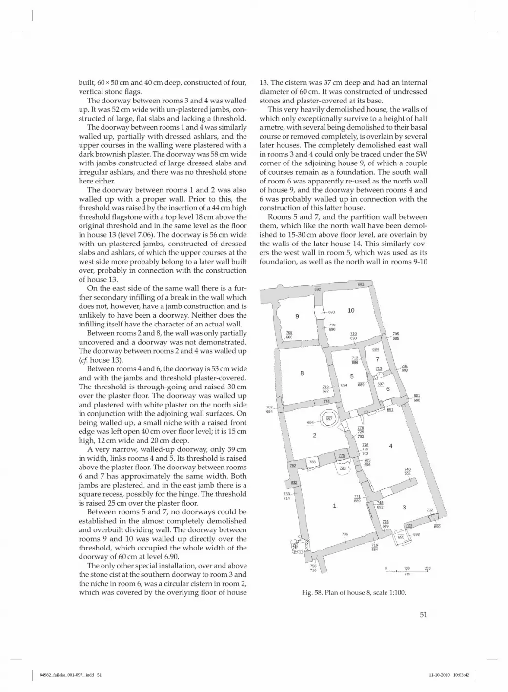
51
built, 60 × 50 cm and 40 cm deep, constructed of four, vertical stone flags. The doorway between rooms 3 and 4 was walled up. It was 52 cm wide with un-plastered jambs, con-structed of large, flat slabs and lacking a threshold. The doorway between rooms 1 and 4 was similarly walled up, partially with dressed ashlars, and the upper courses in the walling were plastered with a dark brownish plaster. The doorway was 58 cm wide with jambs constructed of large dressed slabs and irregular ashlars, and there was no threshold stone here either . The doorway between rooms 1 and 2 was also walled up with a proper wall . Prior to this, the threshold was raised by the insertion of a 44 cm high threshold flagstone with a top level 18 cm above the original threshold and in the same level as the floor in house 13 (level 7.06). The doorway is 56 cm wide with un-plastered jambs, constructed of dressed slabs and ashlars, of which the upper courses at the west side more probably belong to a later wall built over, probably in connection with the construction of house 13 . on the east side of the same wall there is a fur-ther secondary infilling of a break in the wall which does not, however, have a jamb construction and is unlikely to have been a doorway . Neither does the infilling itself have the character of an actual wall. Between rooms 2 and 8, the wall was only partially uncovered and a doorway was not demonstrated . The doorway between rooms 2 and 4 was walled up (cf. house 13). Between rooms 4 and 6, the doorway is 53 cm wide and with the jambs and threshold plaster-covered . The threshold is through-going and raised 30 cm over the plaster floor. The doorway was walled up and plastered with white plaster on the north side in conjunction with the adjoining wall surfaces . on being walled up, a small niche with a raised front edge was left open 40 cm over floor level; it is 15 cm high, 12 cm wide and 20 cm deep. A very narrow, walled-up doorway, only 39 cm in width, links rooms 4 and 5. Its threshold is raised above the plaster floor. The doorway between rooms 6 and 7 has approximately the same width . Both jambs are plastered, and in the east jamb there is a square recess, possibly for the hinge . The threshold is raised 25 cm over the plaster floor. Between rooms 5 and 7, no doorways could be established in the almost completely demolished and overbuilt dividing wall . The doorway between rooms 9 and 10 was walled up directly over the threshold, which occupied the whole width of the doorway of 60 cm at level 6.90. The only other special installation, over and above the stone cist at the southern doorway to room 3 and the niche in room 6, was a circular cistern in room 2, which was covered by the overlying floor of house
13. The cistern was 37 cm deep and had an internal diameter of 60 cm. It was constructed of undressed stones and plaster-covered at its base . This very heavily demolished house, the walls of which only exceptionally survive to a height of half a metre, with several being demolished to their basal course or removed completely, is overlain by several later houses . The completely demolished east wall in rooms 3 and 4 could only be traced under the SW corner of the adjoining house 9, of which a couple of courses remain as a foundation . The south wall of room 6 was apparently re-used as the north wall of house 9, and the doorway between rooms 4 and 6 was probably walled up in connection with the construction of this latter house. Rooms 5 and 7, and the partition wall between them, which like the north wall have been demol-ished to 15-30 cm above floor level, are overlain by the walls of the later house 14. This similarly cov-ers the west wall in room 5, which was used as its foundation, as well as the north wall in rooms 9-10
Fig . 58 . Plan of house 8, scale 1:100 .
200
cm
0 100
685705
690
690710
684
713
691
697694
775
724
723
712
792
832
690719
692692
676
657694
690
693655
668709
684702
692719
686712
698741
690801
696785
704740
788
714763
736
716758
654716
689703
692748689
771
729778
703
729776
702
689
109
8 5
7
6
2
4
31
84982_failaka_001-097_.indd 51 11-10-2010 10:03:42

52
and the partition wall between them . The north and east walls in room 2 were used as a foundation for walls in house 13 after demolition to a height of c. 30 cm, and its west wall is presumed to have run under the floor in house 13 room 2, but only its continuation as the west wall in room 8 has been uncovered . The west wall to the northern part of room 4 and the north wall of room 1 are built over by the south and east walls of house 13, room 1 . House 8, which was the first building on the spot, appears to have functioned at the same time as the neighbouring house 7, but was abandoned and com-pletely or partially demolished on the construction of houses 9, 13 and 14.
Fig . 59 . house 8, divid-ing wall between rooms 1 and 3, looking N (1961/62).
84982_failaka_001-097_.indd 52 11-10-2010 10:03:44

53
Fig . 60 . house 8, room 1, west wall with the back side of the oven in house 7, room 4, looking W. In background house 6, room 4 (1961/62).
Fig . 61 . In foreground, room 1 in house 8, look-ing NW. Left house 7, room 4 and background house 13 (1960).
84982_failaka_001-097_.indd 53 11-10-2010 10:03:48

54
Fig . 62 . house 8, room 1, east wall with blocked door, looking E (1961/62).
Fig . 63 . house 8, room 1, north wall with blocked doorway to the left, look-ing N (1961/62).
84982_failaka_001-097_.indd 54 11-10-2010 10:03:52
55
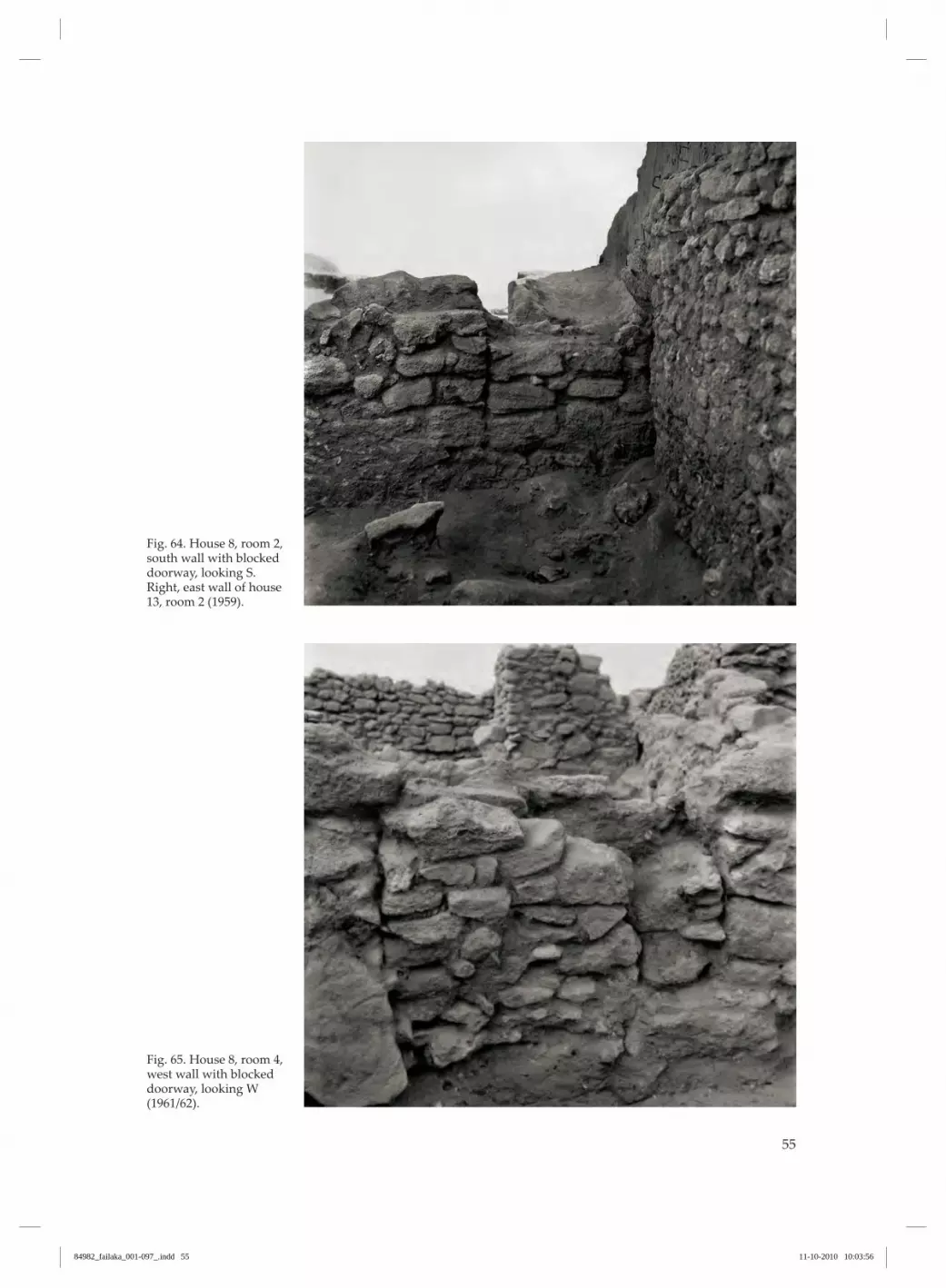
Fig. 64 . house 8, room 2, south wall with blocked doorway, looking S . Right, east wall of house 13, room 2 (1959).
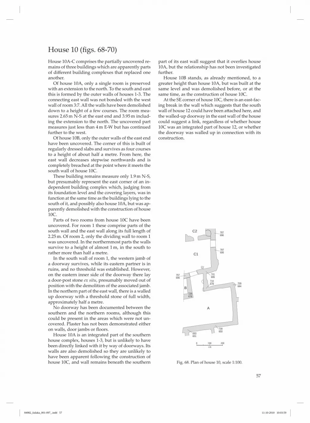
Fig . 65. House 8, room 4, west wall with blocked doorway, looking W (1961/62).
84982_failaka_001-097_.indd 55 11-10-2010 10:03:56

56
Fig . 66 . house 8, room 6, south wall with walled up doorway and niche, looking SW (1961/62).
house 9 (figs. 67 and 13)The only remains of house 9 are the southern gable with the adjoining corner walls and a further short section of the east wall, though without direct contact with the gable but in line with it and at approximately the same level as the attached east wall at the gable. The wall in the Se corner of house 8:6 is, however, interrupted and could have continued towards the east as the northern wall of house 9 . And the west wall of the house could then have been attached to the south wall in room 8:6 in continuation of the par-tition wall between 8:5 and 6, west of the walled-up door, which would probably have been closed off in connection with the construction of house 9 . Accordingly, only this one room of the house could be demonstrated, the western end of which is un-certain along some of its length . The room measures 4.45 × 2.3 m and its walls are preserved to a height of 40-50 cm. There are no traces of doorways, wall plaster or plaster covering the floor. The foundation level of the walls varies between level 6 .91 in the north and level 7 .19 in the relatively well preserved southern part . The house overlies the southern part of house 8, the east wall of which was established under the SW
corner of house 9, but was apparently joined with the northern part of house 8 (rooms 5-7) and possibly functioned at the same time as this during its second-ary period of use . The house also overlies Kiln 1 (see below), and both its northern and southern parts are built on loose sand mixed with bones, mollusc shells and pot-tery . The house probably incorporated parts of house 8 (rooms 4-7).
200
cm
0 100
719764
691
682
691
719771
775
759
785
713753
716753
690
Fig . 67 . Plan of house 9, scale 1:100 .
84982_failaka_001-097_.indd 56 11-10-2010 10:03:58
57
house 10 (figs. 68-70)house 10A-c comprises the partially uncovered re-mains of three buildings which are apparently parts of different building complexes that replaced one another . of house 10A, only a single room is preserved with an extension to the north . To the south and east this is formed by the outer walls of houses 1-3 . The connecting east wall was not bonded with the west wall of room 3:7 . All the walls have been demolished down to a height of a few courses . The room mea-sures 2.65 m N-S at the east end and 3.95 m includ-ing the extension to the north . The uncovered part measures just less than 4 m E-W but has continued further to the west . of house 10B, only the outer walls of the east end have been uncovered . The corner of this is built of regularly dressed slabs and survives as four courses to a height of about half a metre . From here, the east wall decreases stepwise northwards and is completely breached at the point where it meets the south wall of house 10c . These building remains measure only 1.9 m N-S, but presumably represent the east corner of an in-dependent building complex which, judging from its foundation level and the covering layers, was in function at the same time as the buildings lying to the south of it, and possibly also house 10A, but was ap-parently demolished with the construction of house 10c . Parts of two rooms from house 10c have been uncovered . For room 1 these comprise parts of the south wall and the east wall along its full length of 2.25 m. Of room 2, only the dividing wall to room 1 was uncovered . In the northernmost parts the walls survive to a height of almost 1 m, in the south to rather more than half a metre . In the south wall of room 1, the western jamb of a doorway survives, while its eastern partner is in ruins, and no threshold was established . however, on the eastern inner side of the doorway there lay a door-post stone ex situ, presumably moved out of position with the demolition of the associated jamb . In the northern part of the east wall, there is a walled up doorway with a threshold stone of full width, approximately half a metre . No doorway has been documented between the southern and the northern rooms, although this could be present in the areas which were not un-covered . Plaster has not been demonstrated either on walls, door jambs or floors. house 10A is an integrated part of the southern house complex, houses 1-3, but is unlikely to have been directly linked with it by way of doorways . Its walls are also demolished so they are unlikely to have been apparent following the construction of house 10c, and wall remains beneath the southern
part of its east wall suggest that it overlies house 10A, but the relationship has not been investigated further . house 10B stands, as already mentioned, to a greater height than house 10A, but was built at the same level and was demolished before, or at the same time, as the construction of house 10c . At the Se corner of house 10c, there is an east-fac-ing break in the wall which suggests that the south wall of house 12 could have been attached here, and the walled-up doorway in the east wall of the house could suggest a link, regardless of whether house 10c was an integrated part of house 12, or whether the doorway was walled up in connection with its construction .
200
cm
0 100
C2
C1
B
A
696787
695787
695741
696757
678726
684709
650730
651693
678710
Fig . 68 . Plan of house 10, scale 1:100 .
84982_failaka_001-097_.indd 57 11-10-2010 10:03:59

58
Fig . 69 . house 10A-c, looking NW (1960).
Fig . 70 . house 10B, look-ing NW (1961/62).
84982_failaka_001-097_.indd 58 11-10-2010 10:04:03

59
house 11 (figs. 71-72)House 11 is a northern extension of houses 3-4 and comprises three small rooms, of which only room 2 is completely delineated by walls . They have no con-necting doorways to the two houses further south, and as the rooms only have doorways to the north, only the interconnectedness between rooms 2 and 3 has been documented . however, room 1 is presum-ably also part of the same building, which must have continued northwards, but it was completely demol-ished in the investigated parts, which are covered by house 12 and also lie beneath the un-excavated part of the tell . Room 1 measures 2 × 1.5 m, room 2 only 1 × 1 m, while the width of room 3 is 1 m. The doorways to rooms 1 and 2 have both plas-tered jambs, of which, however, only the eastern in room 1 and the western in room 2 survive . The thresholds comprise several smaller stones, but these could have been foundations for the actual thresh-olds which do not survive . The width of the door-ways could only be determined approximately to c. 50 cm in room 1 and 60 cm in room 2. Both rooms have had plastered walls, and in room 2 traces of a plastered covering were established on the floor at level 6.83.
The walls in the north stand to a height of be-tween 25 and 50 cm, and remains of a completely demolished S-N wall in continuation of the east wall of room 3 under the south wall of house 12 suggest that house 11 was demolished prior to, or at the same time as, the construction of house 12 .
Fig . 71 . Plan of house 11, scale 1:100 .
200
cm
0 100
12
3
696712
686729
691713
686731
676725
696711
683
656684
684727
665742667
740
684709
Fig . 72. Foreground left house 11, right house 3 followed by 4, looking E (1960).
84982_failaka_001-097_.indd 59 11-10-2010 10:04:06

60
house 12 (figs. 73-75)The south and east walls, a suggestion of a parallel wall to the north and traces of two dividing walls survive from house 12. Of the latter, only the south-ernmost part of the wall, between rooms 1 and 2, is preserved and it continues beyond the limits of the excavation . The westernmost is only marked by wall remains in the northern excavation section . The preserved, excavated part of the house mea-sures 8.35 m E-W, but it continues westwards, where it was apparently joined with the only partially un-covered house 10C, so its total extent was 11.6 m. The N-S extension towards the north is only sug-gested by the wall remains in the northern corners of room 1 as having a length of 3.1 m, but the wall marked here is possibly just a dividing wall in the house . In an e-W direction the dimensions of the rooms are as follows: room 1: 2.9 m, room 2: 3.8 m and room 3: 3.2 m, in so far as an assumption of the house’s continuation to the west is correct . The N-S width in room 1 is 2.45 m, but cannot be determined for the others . on both sides of the longitudinal wall running e-W, there were traces of coarse, dark plaster cover-ing large continuous areas, whereas no form of floor covering was observed .
In the preserved walls, traces were found of a doorway between rooms 1 and 2 in the form of a plastered jamb in the south side of the dividing wall associated with a slab in the wall’s foundation, pre-sumably a threshold stone, and a walled-up doorway in the wall towards house 10c . By the south wall in room 2 there was a cistern built of horizontal stone flags with their tops on level with the base of the wall . Between the cistern and the west wall lay a square plastered trough . house 12 was joined with house 13, but was built before it and, presumably, also house 10c . It overlies the east wall of house 6 and the heavily broken down walls of houses 5 and 11 . No actual floors were established in house 12; their level is merely indicated by the top point for the cistern in room 2 (level 7.21) and the base of the wall, which in the east varies between levels 7 .12 and 7.24, in the west between 7.01 and 7.03.
200
cm
0 100
721758
724761
709794
712827
713813
721845
701747
703759
700
677709
661
721695787
3 666
21
Fig . 73 . Plan of house 12, scale 1:100 .
84982_failaka_001-097_.indd 60 11-10-2010 10:04:06

61
Fig. 74 . house 12, plas-tering of south wall in rooms 1 or 2, looking S (1961/62).
Fig . 75 . cistern in house 12, looking SE (1961/62).
84982_failaka_001-097_.indd 61 11-10-2010 10:04:10

62
house 13 (figs. 76-80)house 13 is, in contrast to all the previous houses, oriented in an e-W direction . It is trapezoid and its external dimensions are 7.8-8.3 × 2.5-3.2 m, and it comprises four rooms, 1-4. Room 1 is not, however, completely joined with the others as its south wall, which, with overbuild-ing, has made use of the north wall of the older house 8, is not joined with the other parts of the house . however, the fact that it is part of the complex, prob-ably as a courtyard, is apparent from the overall plan . The dimensions of the four rooms are, for room 1: 2.3 × 2 m, room 2: 1.9 × 1.8 m, room 3: 1.8 × 1.8 m and room 4: 1.8 × 0.8 m. The walls were not plastered and the floors were partially paved but without a plaster covering . The five doorways were all constructed with jambs of horizontally-laid, rectangular flagstones with no trace of plaster, and the thresholds were laid of smaller, regularly dressed flagstones, raised c. 10-15 cm above the floor level. Finally, both the east and the south doorways in room 1 were walled up, apparently in connection with the abandonment of the house, as they were the only exits . The east doorway was 55 cm wide, the doorway between rooms 2 and 3 was 50 cm, the others 60 cm. on being uncovered, the walls stood well pre-served to a height of up to 1.3 m above the floor level, which varies from level 7 .06 in room 1 to c. level 7 .15 in the other rooms .
The house’s outer walls are pieced together from the outer walls of several older houses which have been joined together by newly-built walls . The north-ern part of the house’s west gable is the east gable of house 12, which the southern part is built up against without being bonded to it, so a continuous crack from the surviving top to the base separates the two walls . Both walls cut over the underlying east wall in house 6, which was demolished to the level of their base (level 7.09-7.14). The remainder of the house is similarly con-structed on top of earlier walls belonging to house 7 (the south and north walls in rooms 13:2-4) and house 8, which is covered by the north and south walls in room 13:1. The latter wall continues un-interrupted in the north wall of the secondarily constructed room 4 in house 6 which again was constructed directly over the north wall of room 4 in house 7. house 13 was, accordingly, built later than houses 12 and 14, even though it most likely functioned at the same time as them, whereas it overlies houses 6, 7 and 8, which were abandoned prior to the construc-tion of house 13 .
Fig . 76 . Plan of house 13, scale 1:100 .
200
cm
0 100
12
34
720791
706844
833
704715
719821
863
714843
723736
725832
810
715
714
715730
722
717776
714841
714842
709794
729776
703
84982_failaka_001-097_.indd 62 11-10-2010 10:04:10

63
Fig . 77 . Foreground house 6, rooms 2 and 4, looking NE. Left house 13 (1960).
Fig . 78 . Foreground house 13, room 1 with doorway into room 2, looking W (1960).
84982_failaka_001-097_.indd 63 11-10-2010 10:04:14

64
Fig . 79 . house 13, room 4, west wall in two un-bonded sections, looking W (1960).
Fig . 80 . Middleground house 13, looking Se . Foreground right house 14, room 5 (1960).
84982_failaka_001-097_.indd 64 11-10-2010 10:04:18

65
House 14 (figs. 81-85)The building remains, which are grouped together as house 14, comprise very disjointed sections of walls where only the northern part provides the possibility of the recognition of an actual coherent building . The southern part, conversely, comprises a conglomerate of single rooms, the existence and form of which ap-pear to be conditional on the surrounding buildings of partially coeval, partially earlier, origin and which do not provide the opportunity for recognition of an actual constructional connection to, or relationship with, the northern section. The term house 14 may, accordingly, include building remains belonging to two or more buildings . The layout of the walls in the north suggests the ground plan of a regular, rectangular building unit, with an e-W length of c. 8 m and a width of 3.6-3.8 m, divided into four rooms, 1-4. The north wall is preserved un-interrupted along the whole length of the building and stands to a height of up to a little more than 1 m; in the east to level 8.18, in the west to level 7.42. It terminates to the east with a levelled wall surface, while the actual east gable is preserved solely in the form of a broken piece of wall jutting out. Its termination to the west appears similarly to have been levelled off and is here bonded with the corner of the west gable . The latter is, however, broken down to its foundations along the whole of its continuing course which com-prises the west wall of house 8 . The only preserved remains of the south wall com-prise a continuous section to the east with a length of 4.1 m and a maximum height of 60 cm (level 7.78). In the continuation of this wall towards the west, wall remnants were observed which suggest that it continues to the west, parallel with the north wall, presumably to the west gable . This part of the house was apparently divided up into four rooms . The division between rooms 1 and 2 is suggested by wall projections on both the north and south walls . Both projections terminate, however, in the form of a levelled-off wall surface which, together with their great relative thickness, could suggest that they merely represent pilasters in support of the roof construction, so the room was not divided by an actual wall . The wall between rooms 2 and 3 has, apart from the corner towards the north wall, been demolished to its foundations, i.e. the top of an earlier section of wall (cf. house 8) at level c. 7 .20 . The southern wall projection is, like the division between rooms 1 and 2, levelled off on the north side, but is not paralleled by a similar projection on the north wall . A dividing wall is also clearly present here, even though it has only been documented in its northern section . There are, conversely, no suggestions of the connection of any wall to the southern projection, where the ex-
isting foundation is unequivocally overlain by the south wall of house 14. The wall could, though, have been constructed up against the pilaster, without it leaving any trace, but the possibility that it served as a door jamb also exists . The boundary between rooms 3 and 4 apparently ran similarly over an earlier section of wall, but was completely broken down and was included in this building phase solely in the form of a stone from a jamb up against the north wall, which remained standing at the same height as this (level 7.67). With the above-mentioned reservations relative to their boundaries, the individual rooms have the following dimensions: room 1: 2.85 × 1.25 m, room 2: 3 × 1.6 m, room 3: 2.65 × 1.7 m and room 4: 2.55 × 1.4 m. No walls or floors show traces of plaster. The exact level of the floors could, as a consequence, not be determined, but judging from the height of the wall foundations and the fixed structures in the rooms, this lay between levels 7 .10 and 7 .20 . In the Ne corner of room 1 there is a circular, stone-built cistern with an internal diameter of 65 cm and a depth of 20 cm; it is plastered on both its sides and base . In the NW corner of room 2, a shelf has been con-structed consisting of a thin horizontally-set flag-stone (level 7.18), which on three sides is surrounded by vertical flagstones with their base a couple of cen-timetres below the flagstone and with a top level 17 cm above it. On the north side of this, directly towards the corner of the wall, there is a step-like construction made up of three horizontal slabs, with a relative difference in level of 3 cm, rising towards the west wall to level 7 .39 . The four southern rooms that are assigned here to house 14 lie parallel with the northern part of the house but, as already mentioned, with no secure re-lationship to it, apart from the section of wall which is common to both units . Room 5 is to the south bounded by the north wall of house 13, to the west by the east gable of house 12, while the north wall was constructed in connection with the creation of the room . It was built across the earlier house 7, room 9, rather more than 30 cm above the level of the latter’s floor (level 7.23). Finally, the east wall was built directly over the east wall of the same room . These walls stand preserved to a height of rather more than half a metre . In the east wall, a doorway leads into room 6, which is bounded to the south by the north wall of house 13, and to the north by the dividing wall to rooms 3-4. The east wall is preserved along its southernmost section, where it stands to a height of c. 70 cm; its northernmost course could not be established . This wall terminates towards the north in a plastered surface, indicating that it has had a
84982_failaka_001-097_.indd 65 11-10-2010 10:04:18

66
function as a jamb in a doorway leading into room 7 . Room 7’s southern boundary is house 13, and that to the east is a continuation of the east wall of house 13, with the longitudinal wall of house 8 as its base . The north wall has been completely demolished, apart from a short fragment belonging to the south wall of room 3 . The easternmost room 14:8 appears completely cut off from the others as it has not been possible to demonstrate doorways in the walls belonging to this building phase which enclose the room to a preserved height of 0.4-1.02 m. The south wall here was built on an accumulated layer of sand, mollusc
shells and other cultural remains over the floor in the earlier room 8:8, while the other walls have their base on demolished walls belonging to the same house . With the above-mentioned reservations, the rooms have the following dimensions: room 5: 2.75 × 0.9 m, room 6: 2.5 × 2.15 m, room 7: 2.1 × 1.1 m and room 8: 1.15 × 0.85 m. No definite traces were established of plaster or plaster-covered floors belonging to this building phase . The only fully preserved doorway, in the east wall of room 5, is 53 cm wide with a threshold of several dressed flagstones.
Fig . 81. Plan of house 14 (rooms 1-8) and house15 (rooms 1-3), scale 1:100.
200
cm
0 100
1
2
3 2
8
76
5
1
4
3
742808
736808
697
691711
722
690730
718
735
739
702
694
759
671
690704
704736
715732
690742
640732
693
710
710
671706
686732
688761
721764
720791
719821
710750720
778
668709
690
690719
666767
723770
700752
713818
708805
84982_failaka_001-097_.indd 66 11-10-2010 10:04:18

67
Fig . 82. House 14 with cistern, looking SE (1960).
Fig . 83. House 14, fore-ground south wall in rooms 2-3, middleground rooms 6-8, looking Se (1960).
84982_failaka_001-097_.indd 67 11-10-2010 10:04:23

68
Fig. 84. House 14, room 2 with shelf/table and stepped structure in the corner, looking NW (1959).
Fig . 85. House 14, door-way into room 5, looking W (1961/62).
84982_failaka_001-097_.indd 68 11-10-2010 10:04:27

69
house 15 (figs. 14, 81-82)only the eastern end of house 15 is preserved, which is joined with the north wall of house 14. The walls stand preserved to a height of c. 1 m, corresponding approximately to the top level of the north wall of house 14 (level 8.08). The preserved part of the north wall is only 4.75 m long, and the east wall only just over 3 m from its northern corner to where it meets house 14. continuous rows of c. 15 cm high stones set on edge divide the house up into three sections . These can probably not be perceived as actual rooms, as these stone rows could not have formed the founda-tion course in actual walls . The dimensions of the three sections are, respec-tively, section 1: 1.14-1.05 m, section 2: 1-1.6 × 1.6 m and finally section 3, which is not delimited to the
west, measures 2.25-2.6 m N-S and its preserved length is 2.5 m. The walls are un-plastered and neither was any kind of covering found on the floor. In the SE corner there is a doorway with flag-built jamb to the north, while the boundary to the south is the actual abutting wall. The threshold is formed by a single slab extending across the full 52 cm width of the doorway . Judging from the threshold height (level 7.24) and the depth of the stone rows, the floor level lay at about 7 .15-7 .20 . No traces of earlier settlement were encountered under the house, but according to the character of the link to house 14, it was most probably constructed after the latter, but they were apparently in use at the same time .
house 16 (figs. 88, 91 and 99)Of house 16A, only a section of wall 2.6 m in length was uncovered, although this did seem to be linked to a transverse wall, the west side of which was un-covered in a section below the temple courtyard (see below). The completely exposed wall to the west of the temple is, furthest to the west, preserved to a height of 88 cm. Where the temple wall crosses it, however, it has been demolished down to the base of the latter, level 7.32. The continuation of the wall to the east, which was not excavated, forms almost a right angle with the extension of the wall, the west side of which was uncovered in the above-mentioned section . This has its base at the same level and was
similarly demolished to a height on level with the base of the temple wall . The two walls probably form the Se corner of a house or a room, the relationship of which to other buildings or sections of walls was not established . The foundation level does, however, correspond to the northern part of the nearby house 8 . North of the temple runs a section of wall just less than 3 m in length, 16B, at slightly lower basal level than 16A, but at the same level and with the same orientation as the west wall of house 22, and probably belongs to a contemporary house .
house 17 (figs. 86-87)house 17 is represented solely by two parallel e-W oriented walls standing 1 m apart and with an ex-posed length of 4-4.4 m. They are joined by a trans-verse wall with a 60 cm wide doorway with a thresh-old of full width . To the south, it is bounded by a plastered jamb, whereas the jamb on the north side is completely broken down . The walls are plastered and the floor plaster-covered at a level of 7.10. The walls have a base level at c. 7 .00 and survive in their eastern extent to a height of almost 1 m,
whereas to the west they have been demolished to level c. 7 .30, where they are crossed and built over by the eastern temple wall (see below). The southernmost of the walls overlies a circu-lar, only partially excavated structure, probably a cistern, with an uncovered extent of c. 1.6 m and a height of 35 cm. Before being built over, the cistern had been filled up with, and was completely covered by a thick stratified layer of shifting aeolian sand.
84982_failaka_001-097_.indd 69 11-10-2010 10:04:27

70
Fig . 86 . Plan of house 17, scale 1:100 .
703788
687727
696746
595650
710
788
710
200
cm
0 100
Fig . 87 . house 17 with cistern below, looking NW (1961/62).
84982_failaka_001-097_.indd 70 11-10-2010 10:04:30

71
Temple courtyards I-III (192-21) (figs. 88-99)Buildings 19-21 comprise an approximately square structure bounded by walls that were established three times within the same area and with more-or-less the same ground plan . The special character of the structure provides a basis for terming it a temple courtyard .
Temple courtyard I. The first phase comprises an approximately square, wall-enclosed area with an extent of 12.25 m in a N-S direction to the east and 12.8 m to the west, while in an E-W direction it measures 13.8-13.9 m. This wall is built throughout of rather small, irregularly dressed or just raw un-worked stones and plastered with coarse, yellow-brown plaster . The foundation level for this phase of walls is maintained at a completely uniform level that only varies a few centimetres over this relatively large area (level 7.26-7.37). The preserved wall height var-ies between 35 and 69 cm (level 7.67-7.98), and in some sequences of the south and west wall it has been completely demolished or ruined, without its continuity, however, being in any doubt . The area in-side the walls is known only from soundings which, in the central part, revealed extensive secondary pits, whereas in the southern part of the west side, undis-turbed layers were preserved . Thin, continuous plaster surfaces suggest that the surface inside the walls was plaster-covered, but apart from this, no other structures could be dem-onstrated here . however, it should be mentioned that the heavily disturbed layers in trench M (fig. 5) contain a few large, finely dressed ashlars that could have been part of special structures on the temple site, as seen in phase II .
Temple courtyard II. Prior to the construction of temple II, the walls of temple I lay in ruins and the holes in the dilapidated walls, and the temple courtyard, became filled with sand. In the breaches in the south and west walls this appeared as strati-fied, sterile sand layers, containing a fair quantity of unworked stones which presumably stem from decay of the walls . With only a few centimetres deviation, the temple II wall was constructed along the same line as the temple I wall, lying directly on top of it, or on top of the sand layers which covered the more ruined areas . Its foundation level is therefore more varied than that of its predecessor, with differences of up to 35 cm (level 7.65-8.00). This wall is constructed throughout of regularly dressed flagstones or slabs and no traces of plaster were documented . The tem-
2 Number 18 is not used.
ple II walls survive to a maximum height of c. 65 cm (level 8.63). Whereas the entrance to the temple courtyard in the first phase has not been identified, in this phase it can be demonstrated in the middle of the east wall, only displaced half a doorway’s width towards the south relative to the centre line . Both jambs were broken down to threshold height, and the doorway is primarily evident by way of a 93 cm wide threshold stone, which presumably reveals the width of the doorway . It was founded on three courses of rect-angular flagstones and on its inner surface, in line with its north side, was a rectangular door-post stone preserved in situ, anchored in the floor covering. The surface of the threshold lay at level 8.34, while the top of the door-post stone was at level 8.16, only 3 cm above the floor surface here. The floor, which was preserved over parts of its surface, comprised a pavement of hand-sized flat stones laid in, and partially covered by, a plaster-clay mixture (level 8.12-8.16). Diagonally across the site, from SW to Ne, lay three alter-like constructions of finely-dressed stone, a whitish coarse sandstone containing fossils . Fur-thest to the SW lay a circular disc of conglomerate (stone), 65 cm in diameter and c. 26 cm thick. This lay horizontally in the middle of an approximately circular base stone with a diameter of c. 1.15 m and 15-20 cm thick. The latter was embedded in the floor covering with its upper surface 9 cm above floor level (here level 8.13). The second altar stood centrally, slightly offset to the south . of this, four stone bases were pre-served, embedded in the floor, on three of which stood square stone pillars . Several larger and smaller fragments of similar pillars lay alongside the bases and scattered across the site. The three southern-most bases stood in a 1.7 m long row parallel with the south wall, while the fourth stood parallel to the easternmost of these at a distance of 55 cm. The bases are very nearly square and of a uniform size, only varying a few centimetres in their horizon-tal dimensions (50 × 46, 48 × 46, 48 × 46, 46 × 46 cm). on their upper surface, a square projection had been cut out (26 × 26 cm) with a height of 3-5 cm, on two of which the pillars still stood, whereas on the third it was displaced to the west . on the fourth base, the pillar had been removed or toppled, but is possibly represented by the fragments which lay alongside the middle base . The pillars were cut out as stone planks of square cross-section corresponding to the cut-out projec-tions on the bases . The fully preserved pillar on the northernmost base is 70 cm high (top level 8.90) and was made in one piece, while the pillar on the middle base in the southern row comprises two pieces .
84982_failaka_001-097_.indd 71 11-10-2010 10:04:30
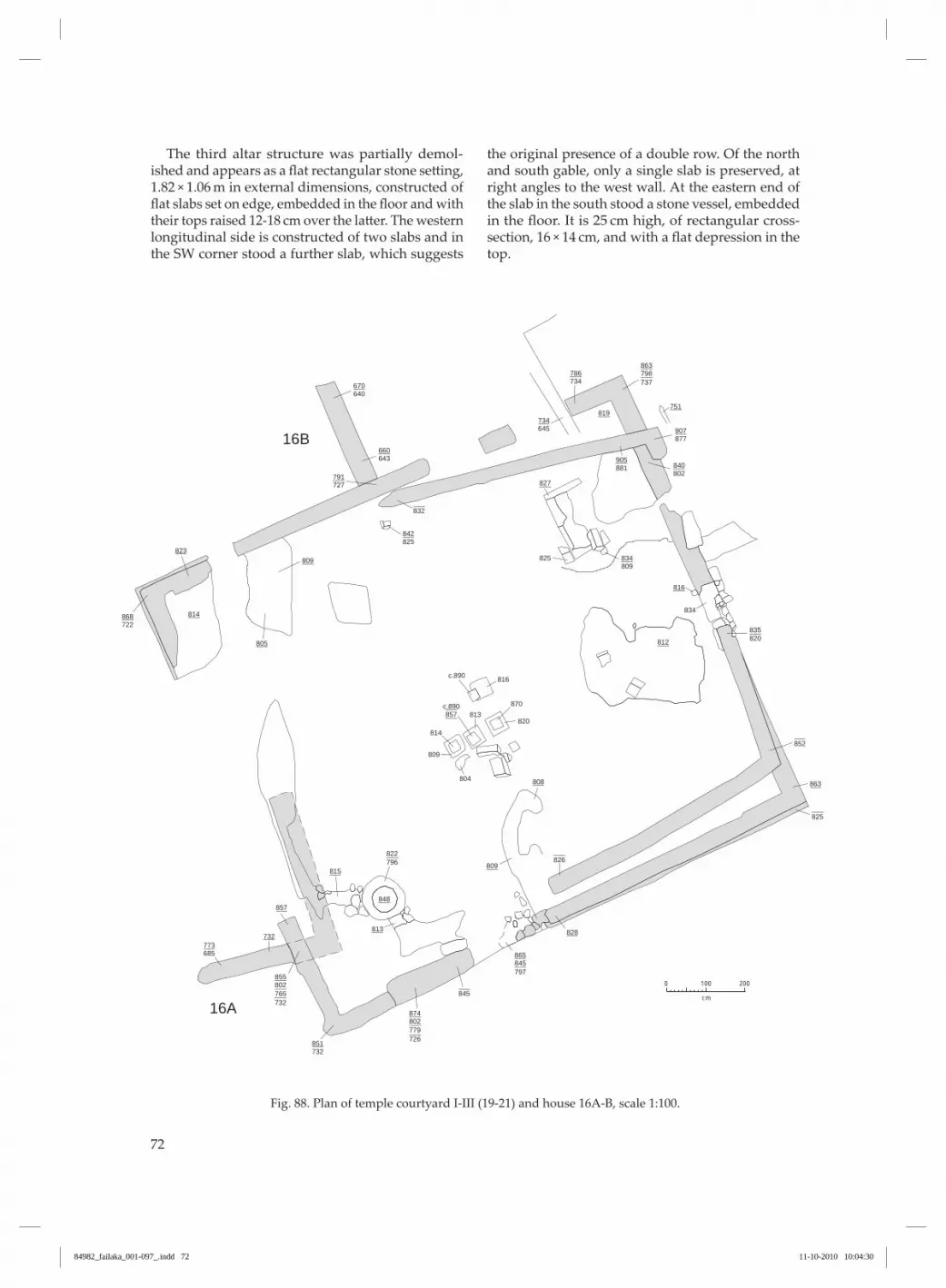
72
The third altar structure was partially demol-ished and appears as a flat rectangular stone setting, 1.82 × 1.06 m in external dimensions, constructed of flat slabs set on edge, embedded in the floor and with their tops raised 12-18 cm over the latter. The western longitudinal side is constructed of two slabs and in the SW corner stood a further slab, which suggests
the original presence of a double row . of the north and south gable, only a single slab is preserved, at right angles to the west wall . At the eastern end of the slab in the south stood a stone vessel, embedded in the floor. It is 25 cm high, of rectangular cross-section, 16 × 14 cm, and with a flat depression in the top .
Fig . 88. Plan of temple courtyard I-III (19-21) and house 16A-B, scale 1:100.
734786
819751
827
816
812
863
828
809
848
813
815
857
732
814
823809
805
808
877907
802
825
834
813
814
809
804
816
870
820
840881905
809834
820835
852
825
826
845
832
645734
643660
727791
640670
825842
722868
796822
685773
732851
798863
737
845865
797
857c.890
c.890
802874
779726
802855
765732
200
cm
0 100
16A
16B
84982_failaka_001-097_.indd 72 11-10-2010 10:04:30

73
Finally, towards the south gable, in a secondary position, stood a fragment of a rectangular stone plank with two slots or mortises in its west side .
Temple courtyard III. Whereas temple II was con-structed directly on top of the walls of temple I with only minimal deviation, the north and south walls of temple III are offset so they cut in across the temple courtyard at an oblique angle to the east wall . As a consequence, the structure is altered from having a purely square to a trapezoid form . The east wall now measures only 9.4 m, whereas the west wall follows the same course as its predecessors with a length of 12.8 m. Where the walls cross the temple courtyard, they are constructed on stratified shift-ing aeolian sand at levels 8 .26 and 8 .32 . elsewhere, where they are constructed on top of earlier walls, they are founded at various levels, dependent on the degree of decay of the wall . The maximum preserved height of walls belonging to this building phase is level 9 .05 .
No floor layers have been identified at a level that can be linked to this latest reconstruction, either in plan or in section . Where the layers have lain undis-turbed by later digging activity, between the floor at the base of the walls of temple II and walls con-structed with the establishment of temple III, they comprised exceptionally uniform, sterile layers of stratified aeolian shifting sand. At the same time, attention is drawn to the fact that the pillars on the altar structure in the middle of the temple courtyard stands in situ to a height very close to that of the high-est preserved wall of temple III, and c. 50 cm higher than its base . Accordingly, it seems very likely that the floor in temple II, after being cleared of shifting sand, was still in use in temple III . It should be noted, furthermore, that the doorway on the east side lies directly on the centre line of temple III . The temples overlie houses 16A-B, 17 and 22, and temple III is the last building on the spot .
Fig . 89 . Temple court-yard, looking W (1961/62).
84982_failaka_001-097_.indd 73 11-10-2010 10:04:32

74
Fig . 90 . Temple, Se cor-ner, phases II-III, looking SW . Round altar in back-ground (1961/62).
Fig . 91 . Temple, looking E. Left rectangular altar, middle pillared altar and right round altar . In the east section of the deep trench to the right sits the N-S going extension of house 16A (1961/62).
84982_failaka_001-097_.indd 74 11-10-2010 10:04:36

75
Fig . 92 . Temple courtyard with rectangular altar in foreground, pillared altar in middle and round al-tar in background, look-ing SW (1961/62).
Fig . 93 . Round altar in temple, looking Se (1961/62).
84982_failaka_001-097_.indd 75 11-10-2010 10:04:39

76
Fig. 94 . Pillar altar in temple, looking NW (1961/62).
Fig . 95 . Pillar altar in temple, looking SW (1961/62).
84982_failaka_001-097_.indd 76 11-10-2010 10:04:43

77
Fig . 96 . Rectangular al-tar with incense burner, looking NW (1961/62).
Fig . 97 . Rectangular altar in temple, looking Ne (1961/62).
84982_failaka_001-097_.indd 77 11-10-2010 10:04:47

78
Fig . 98 . The temple and the area north of the temple, looking SW (1961/62).
Fig . 99 . The area north of the temple, looking E. In the bottom N-S going wall of house 16B (1961/62).
84982_failaka_001-097_.indd 78 11-10-2010 10:04:51
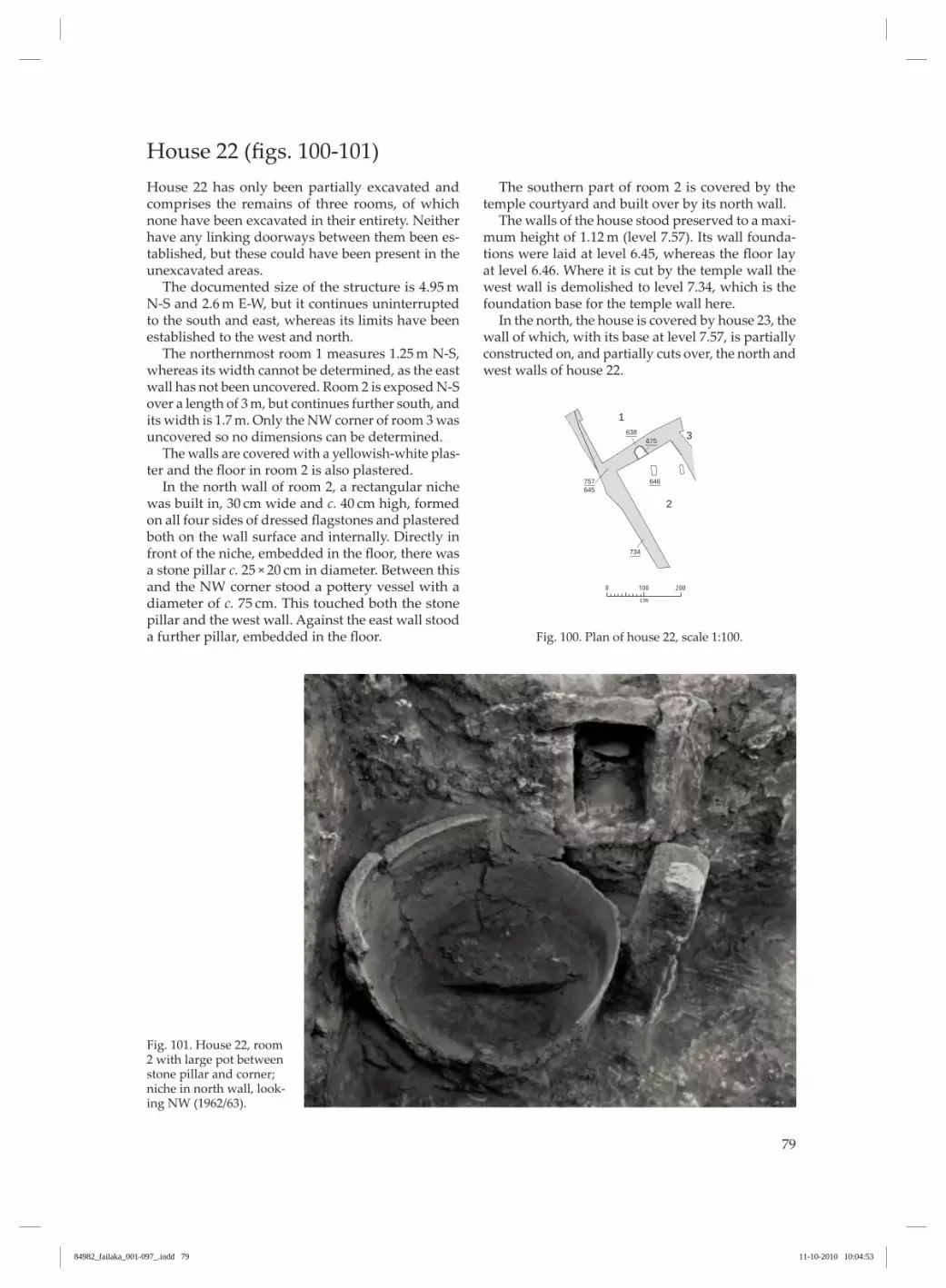
79
house 22 (figs. 100-101)house 22 has only been partially excavated and comprises the remains of three rooms, of which none have been excavated in their entirety . Neither have any linking doorways between them been es-tablished, but these could have been present in the unexcavated areas . The documented size of the structure is 4.95 m N-S and 2.6 m E-W, but it continues uninterrupted to the south and east, whereas its limits have been established to the west and north . The northernmost room 1 measures 1.25 m N-S, whereas its width cannot be determined, as the east wall has not been uncovered . Room 2 is exposed N-S over a length of 3 m, but continues further south, and its width is 1.7 m. Only the NW corner of room 3 was uncovered so no dimensions can be determined . The walls are covered with a yellowish-white plas-ter and the floor in room 2 is also plastered. In the north wall of room 2, a rectangular niche was built in, 30 cm wide and c. 40 cm high, formed on all four sides of dressed flagstones and plastered both on the wall surface and internally . Directly in front of the niche, embedded in the floor, there was a stone pillar c. 25 × 20 cm in diameter. Between this and the NW corner stood a pottery vessel with a diameter of c. 75 cm. This touched both the stone pillar and the west wall . Against the east wall stood a further pillar, embedded in the floor.
The southern part of room 2 is covered by the temple courtyard and built over by its north wall . The walls of the house stood preserved to a maxi-mum height of 1.12 m (level 7.57). Its wall founda-tions were laid at level 6.45, whereas the floor lay at level 6.46. Where it is cut by the temple wall the west wall is demolished to level 7.34, which is the foundation base for the temple wall here . In the north, the house is covered by house 23, the wall of which, with its base at level 7 .57, is partially constructed on, and partially cuts over, the north and west walls of house 22 .
Fig . 100 . Plan of house 22, scale 1:100 .
645757
734
646
675638
200
cm
0 100
2
3
1
Fig . 101 . house 22, room 2 with large pot between stone pillar and corner; niche in north wall, look-ing NW (1962/63).
84982_failaka_001-097_.indd 79 11-10-2010 10:04:53

80
house 23 (figs. 102-103)of house 23, only the west gable and short sequences of the abutting E-W walls in the north and south are preserved . In a N-S direction, the structure measures 3.2 m, whereas only 1 m is preserved E-W. It may, however, be possible to link in a short fragment of wall which lies in direct continuation and at the same
level as the north wall, c. 4 m from the end of the lat-ter. In this case, its E-W extent is extended to 5.9 m. It was built over the north end of house 22 with its base on the walls of the latter at level 7.57 and is preserved to level 9 .00 .
Fig . 102 . Plan of house 23, scale 1:100 .
757900
200
cm
0 100
Fig . 103 . The west end of house 23, looking W . In bottom of trench house 22 (1975).
84982_failaka_001-097_.indd 80 11-10-2010 10:04:55

81
house 263 (figs. 104-109)The oldest part of the settlement in the northern part of the excavation area, which was covered by the very large house 30, was only partially investi-gated, so the main features of the house’s original plan could only be broadly established . In the lowermost layer, directly on sterile sand, building remains were uncovered which probably comprise the remains of two houses, separated by a common longitudinal wall . The westernmost house complex, 26, has its walls built at level c. 5 .35 . It mea-sures 14.8 m in a N-S direction and its external width varies between 4.9 and 5.2 m, though with an exten-sion to the west in room 4, where the external width is c. 6 m. The five northernmost rooms were more-or-less completely uncovered and were, on the whole, well delineated. Room 1 measures 2 × 1.6 m. Its walls are plastered with yellowish-white plaster, within which 4-5 plastering operations could be distin-guished . The eastern wall towards room 2 was de-molished to its foundation stones, but the line of the wall is marked by a fragment in the north wall . Accordingly, it could not be determined whether or not there had been a doorway between the two rooms . Room 2 measures 3.3 × 2 m. The south wall was only preserved over a short distance . All the walls were plastered and there were no traces of a door-way . Room 3 measures 2 × 1.1 m and has, similarly, plas-tered walls. The actual floor belonging to the oldest building level was not uncovered here, as there was an unbroken plaster-laid floor at a higher level, 5.70 (cf. room 1, house 28), and the original walls were built over after being demolished to a level c. 70 cm over their base . The over-building follows, with very minor deviations, the lines of the earlier walls . The room is linked to room 1 by a well-preserved door-way which apparently functioned at both levels, and with room 2, where the doorway was, however, only documented in connection with the secondary over-building . Room 4 has plastered walls and measures c. 3 × 2.4 m. The east wall of the room has, however, not been uncovered, but judging from the position of the doorway, it must have run directly beneath the overlying wall belonging to house 30 . No con-necting doorway has been documented in the well-preserved dividing wall to room 3, while a doorway in the south wall leads to room 6 . Similarly, the wall which was not exposed could have had an opening into room 5 .
3 Numbers 24-25 were not used.
Room 5 measures 2.05 × 1.8 m with the same reser-vations as expressed above for room 4 with regard to the exact location of the dividing wall . A doorway in the south wall connects the room with room 7, and there could have been a doorway in the dividing wall to room 2 . The fragment of wall which delimits room 6 is very narrow and is only preserved to a height of 12 cm. It is unlikely to be an actual delineation of a wall but rather the remains of some other unidenti-fied fixture or fitting. Consequently, room 6 is prob-ably a part of room 7, which measures 5.1 × 4.1 m. Although there are some reservations concerning its southern boundary, which is covered by the south wall of house 30, so the longitudinal dimension can vary by plus/minus half a metre. South of the wall, two rooms were uncov-ered, 8 and 9, to which there probably was access from room 7 . These rooms measure, respectively, 2.2 × 1.55-1.8 m and 1.9 × 2.2 m, and are linked by a doorway in the southern part of the dividing wall . A doorway was also documented in the west wall of room 8, the threshold of which lies just less than half a metre over the floor level in the room and could have belonged to a later building phase (cf. house 28). of the doorways stated above, the one between rooms 1 and 3 has a width of 48 cm between the two plastered jambs and has a plastered threshold that is raised c. 30 cm above the floor level in room 3. To-wards room 1, the doorway is framed by a plastered rebate with a width and depth of 5 cm. At the right side, the angle between the vertical and the lower horizontal rebates has left a square hole which con-tinued in under the threshold and probably served to accommodate the door’s lower hinge . of the door-way between rooms 2 and 3, only the southern plas-tered jamb is preserved . of the doorway between rooms 4 and 6/7 only the eastern plastered jamb has been uncovered . The doorway between rooms 8 and 9 was 58 cm wide and had plastered jambs . The doorway in the east wall of room 8 was 52 cm wide judging from the threshold stone . In room 2, in the east wall, there is a built-in niche with a depth of 27 cm and a width of 82 cm. It is only closed by a single layer of stones in its rear wall, which is in line with the east side of the wall . Its base is covered by two flat slabs raised c. 35 cm over the base of the wall, while the sides are built up of flat, dressed flags and smaller stones. In front of the niche, a little trough had been built out using vertically-set slabs . It has a depth of c. 30 cm and is lined with plaster showing traces of bitumen . In room 7, by the east wall, a cistern was built up comprising horizontal, flat flags. This is a slightly
84982_failaka_001-097_.indd 81 11-10-2010 10:04:55

82
irregular rectangle, 85 × 56 cm, and 60 cm deep, and covered in plaster . In the Se corner of room 9, there is a step-like construction of flat slabs with its basal level imme-diately above floor level and with a top level 64 cm
higher, just less than 15 cm below the demolition level for the south wall, which stood as a ledge in front of the wall belonging to the building in the overlying layer .
Fig. 104 . Plan of houses 26-27, scale 1:100 .
560618 652
>589
541
595
574
612635
580
550
586
574
582
545
580
570
566 570
670
587
605
583
689
612
619
605
580
615
638560
618680
555
580
535
602704
560585
590628
535660
550690
540645
566625
570648
535680
535590
535575
525602
569605
563575
555695
531603
557579
535680
585695
560620
550597
550620
602704
2
1
3
2
1
3
5
6
7
4
5A
5B
7
6
9
8
4
200
cm
0 100
84982_failaka_001-097_.indd 82 11-10-2010 10:04:56
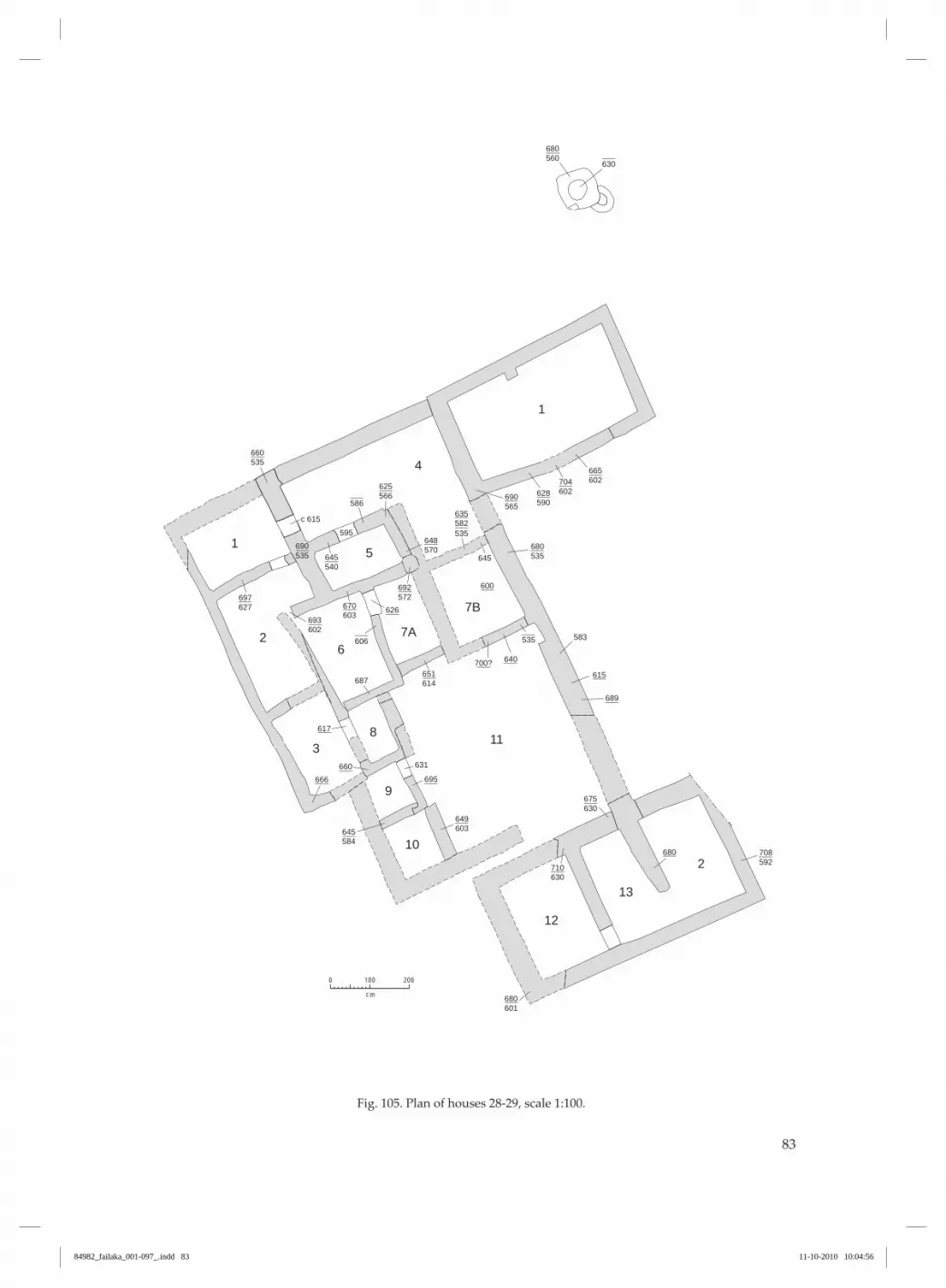
83
Fig . 105 . Plan of houses 28-29, scale 1:100 .
560680
602665
602704
565690
590628
535680
645
c 615
687
583
631
600
689
615700? 640
695660
666
617
626
680
566625
540645535
595
690 570648
582635
535
572692
603670
602693
614651
584645 603
649
601680
630710
630675
592708
627697
535660
630
535
586
606
1
4
15
3
26
7A
7B
11
2
13
12
8
9
10
200
cm
0 100
84982_failaka_001-097_.indd 83 11-10-2010 10:04:56

84
Fig . 106 . house 30 with underlying houses 26-29: In foreground room 26:1 with doorway into room 3, looking S (1975).
Fig . 107 . house 30 with underlying houses 26-29: In foreground room 26:1 with doorway into room 3, looking S (1975).
84982_failaka_001-097_.indd 84 11-10-2010 10:05:00

85
Fig . 108 . house 26, room 1 with doorway into room 3, looking S (1975).
Fig . 109 . house 26, room 2 with niche in east wall and trough in front, look-ing e (1962/63).
84982_failaka_001-097_.indd 85 11-10-2010 10:05:03

86
house 27 (figs. 104-107)The ground plan of house 27, the west wall of which is common with house 26, has only been partially uncovered, and its extent and distribution of rooms are subject to some uncertainty . The walls appear to be based at a slightly higher level than those of house 26 and do not extend deeper than level 5 .50 . Like the previous example, the house is rectangular, with a N-S length of 14.9 m. This has been documented at the west side, whereas the Se corner has not been uncovered . Its width totals 5.15 m in the north and 4.9 m in the middle . In the excavated area, four rooms are rela-tively well delimited, but the house may originally have included a further four or five rooms. The two northernmost rooms, 1 and 2, are fully delimited by walls which still stand to a height of just over 1 m in the south and 40-60 cm in the north, while the dividing wall between them is only preserved to a height of c. 25 cm. Room 1 measures 2.25 × 1.65 m and room 2 measures 2.5 × 2.4 m. Both of them have plastered walls and floors of a clay-plaster mixture. They are linked by a doorway in the north side of the dividing wall . Room 3 is delimited to the south by an almost completely demolished wall, of which only the mid-dle part remains standing to a height of 60 cm. The room measures 4 × 4 m. The walls are plastered and the floor clay covered. In the north wall, the plastered surfaces suggest the presence of a doorway leading into room 2, without it being possible to establish this securely . In the south wall the west jamb of a doorway into room 4 is preserved. Room 4 measures 1.85 m in a N-S direction and is trapezoid in form; its width is 3.3 m in the north and 3 m in the south. Of the room’s south wall, however,
only a short fragment on the east side has been un-covered . This suggests that room 5 to the south is di-vided up into two parallel rooms, of which, however, neither the north wall of room 5A, the southern part of the dividing wall nor the south wall have been documented. Although the latter must be presumed to be preserved beneath the overlying walls, cf. house 30 . With these reservations, the two rooms measure: 5A: c. 2.15 × 1.55 m and room 5B: 2.3 × 2.1 m. The latter has, furthermore, a trapezoid extension to the north with a length of 1.75 m and a width of between 0.65 and 1 m. The two southernmost rooms, 6 and 7, which are presumed to belong to the complex, are in the case of the north wall covered by later walls . Apart from the dividing wall to room 6, the east room has not been uncovered but is reconstructed on the basis of the lines of the abutting walls. The western room 6, with some reservations concerning its longitudinal dimension, measures 2.3 × 1.6 m, the eastern room 7 is calculated to have dimensions of 2.3 × 2.2 m. The doorway between rooms 1 and 2 is 50 cm wide between the plastered jambs and is the only one which is measurable in the whole complex . In the trapezoid extension of room 5B, a stone-built cistern was constructed with an internal diam-eter of 40 cm and a depth of 60 cm. Whether it be-longs to this building level or a later one is, however, uncertain as the level of its opening lies higher than the wall bases of the room and the presumed floor level . As a rule the opening is usually more-or-less at the same level as the floor.
house 28 (figs. 105-108)house 28 was built over house 26, and several walls belonging to the earlier complex were included in the building . others were built with a base on older, de-molished and levelled-off walls and yet others were constructed without any relationship to earlier wall sequences . The house was not uncovered in full, and the ground plan is blurred by later, overlying buildings (house 30). Only in the NW part was it possible to distinguish a series of rooms, of which several are definitely linked by doorways, while the association between others remains uncertain . of the NW room 1, the north wall was not un-covered, while the other walls are preserved up to a height of almost 1 m. The width of the room E-W is
2.30 m, and if the north wall is a continuation of that of room 4, its dimension N-S is 1.6 m. Doorways link the room with rooms 2 and 4. The subsequent room 2 is L-shaped where it is broken into by the abutting room 6. Its maximum length N-S is 3.1 m and in the NE angle 1 m. Its width in the north is 2.3 m, and in the south 1.6 m. of the south wall, only a short fragment was found at the west side, while the remainder is covered by later walls . The same applies to the south wall in room 3, which measures 2.25 × 1.4 m. It is linked with room 8 by a doorway in its east wall . The area south of room 3 is covered by later, overlying walls so it is unclear whether the house continues . That this is the case is, however, indicated by rooms 9 and 10 and
84982_failaka_001-097_.indd 86 11-10-2010 10:05:03

87
the sequences of the wall further to the south which continue the line of the west wall and at the same level . Room 4 corresponds to rooms 1 and 2 in house 26. In the building over of the west walls, a doorway was inserted leading to room 1, the threshold of which is the demolition surface of the original wall (level 6.15). The dividing wall towards the earlier room 2 in house 26 was probably demolished in this phase, so room 4 became an L-shaped room with a N-S length in the west of 1.6 m, in the east of 3.35 m and a width of, respectively, 4.25 and 2 m. Room 5 has similarly the same boundaries as the earlier room 3, but its north wall was demolished and levelled-off to level 6 .02 and built over . In the same operation, the east wall was realigned with the insertion of a doorway towards room 4. Room 6 is trapezoid with a length N-S of 2.5 m and widths of, respectively, 1.85 and 1.5 m. There is a doorway in the east wall towards room 7A . The room covers the western part of house 26, room 4, where its south, west and north walls are built slightly offset on top of the demolished, levelled-off walls (level 6.02-6.05), while the east wall was built on sand at the same level . All the walls remain standing to a height corresponding to the foundation of the over-lying building 30 (level 6.70-6.73) and they were ap-parently demolished after sanding up in connection with the construction of the latter. A doorway in the east wall of room 6, with a threshold at level 6 .26, opens to room 7 which, judging from the offset south wall, was split up by a dividing wall running N-S, corresponding to the presumed wall between rooms 4 and 5 in the un-derlying house 26 . With reservations concerning the
above-mentioned wall, these rooms measure 2 m in length and c. 1.25 and 1.8 m in width, respectively. No doorways were documented in the north walls of these rooms, but they could be covered. Room 8 is a small, well-delimited room measuring only 1.45 × 0.8 m and with a doorway towards room 3 . Its east wall is formed by the west wall of house 26, room 7, which here stands from the foundation, level 5.55, to the base of house 30 (level 6.95), while the west and south walls were new constructions from the base . of room 9, the western boundary is covered but must be sought under the west wall of house 30 . The room’s north and south walls were constructed on the sand fill of the underlying rooms, while the east wall was constructed on the edge of the west wall of the preceding room 7 in house 26 . The room is connected to room 11 by way of a doorway with a threshold at level 6.31. Room 9 measures 1.2 m N-S and is presumably square . Of the abutting room 10, in addition to the bound-ary towards room 9, only the east wall has been un-covered, which is founded on the earlier west wall in house 26 (level 6.03). Room 11 is, through its centre line, covered by the dividing wall between the overlying rooms 1 and 2 in house 30, so it is unknown to what degree it was further divided up . however, long, narrow rooms of this character that would be produced by such a division are unknown in the contemporary houses, so room 11 was probably one continuous area with a length of 4.5-5 m and a width of c. 4 m, just like room 7 in the underlying house 26, which is interpreted as a courtyard . South of this possible courtyard lie two rooms, 12 and 13 .
house 29 (figs. 105-107)Little of house 29 is preserved with certainty and its status as a house is quite hypothetical . Towards the north is a room, 1, with wall bases at level c. 6.02. It measures 4.4 × 2.45 and is built directly on top of rooms 1 and 2 in house 27 . South of this room, the first secure evidence lies 8.5 m to the southeast, where room 2 seems to represent a continuation of room 6 in house 27 . At a distance of 1.5 m from the north wall of the house, an oven was built of stones laid in clay, 35 cm
high, at level 6 .02-6 .32 with an internal diameter of 35 cm, and it was filled with greyish ash. Two cisterns or ovens lay 2.5 m north of the house and were also constructed of stones laid in clay . The upper one had an internal and external diameter of 50 cm and 1 m, respectively, and a depth of 38 cm, at level 6.30-6.68. It was similarly filled with grey-ish ash . The lowermost cistern was not examined in further detail .
84982_failaka_001-097_.indd 87 11-10-2010 10:05:03

88
house 30 (figs. 110-118)house 30 is the largest and best preserved house complex in Tell F3, but only its southern part has been uncovered . The exposed part of the complex is 16.25 m in length, NW-SE, and 11.9 m in width. The investigated part of the complex comprises two completely excavated rooms, 1 and 2, which apart from minor broken down areas stand intact with thick, plastered walls . They measure, respec-tively, 8.9 × 3.6 m and 8.8 × 3.2 m. Room 4 was simi-larly fully uncovered and measures 6.05 × 2.8-3.05 m. So much of room 3 has been uncovered that its width can be determined as 7.55 m, while in a lon-gitudinal direction sections of wall with a length of 6.4 m have been exposed, but the line of the wall continues into the north section . The walls in rooms 1 to 3 are between 40 and 50 cm thick throughout and only a little narrower in room 4, where they are generally c. 30-40 cm. They are all plastered with a thick covering layer of coarse-grained, brownish plaster which particularly promi-nently on the south wall stood with dense finger strokes giving an almost ornamental finish. The walls still stood to a very considerable height . They were highest in the middle of the south wall, 1.55 m above the floor level, 1.65 m over the base here, and in general the walls stood to a height of 1-1.3 m. Although almost the whole of the north wall and the northern part of the east wall in room 2 were demolished to ground level, as was most of the west wall in room 4. A rectangular pilaster had been built out in the centre of the north wall, 80 × 62 cm in ground plan, which was bonded with the wall and, like it, covered with brownish plaster . The floors in rooms 1 and 2 were covered with stone, laid in plaster . originally they must have been covered with a plaster layer which now only sur-vives under the ashlar structure in the SW corner of room 1. The actual stone floor was preserved in room 2 and in the southern and western parts of room 1, but in the northern part of this room it was broken up by a deep pit which was undoubtedly related to stone plundering. In this pit three finely cut ashlars were found, all measuring c. 80 × 30 × 30 cm. In the other rooms, remains of a plaster-laid floor were only found in the SW corner of room 4. Three doorways were found, of which two are well preserved . The doorway between rooms 1 and 2 is 70 cm wide, and the plastered jambs still stand to a height of up to 1.4 m over the plastered thresh-old stone. The latter is raised 15 cm over the abutting floor, and in front of it lay a stone flag as a low step, 4 cm over floor level, judging from the base of the ash-
lar pilaster beside it . on the south side of the doorway stands an ashlar of whitish, coarse sand stone with fossils. It is 25 cm square and has a height of just less than 1 m. It stands vertically against the jamb and is in line with its west side and, consequently, delimits the door opening to a width of 45 cm. In the corner between the east side of the south jamb and the south wall, an 1.47 m high ashlar pilas-ter has been constructed, possibly as a support for the roof construction . It comprises four ashlars of whitish, coarse sand stone with fossils, 38 × 38 cm in cross-section. It stands directly on the floor on a thin layer of plaster, probably the original floor layer. The other preserved doorway, in the east wall of room 3, was not completely uncovered, but the dis-tance between the plastered jambs is 85 cm. In the SW wall of room 3, a doorway is indicated by a plastered jamb on the north side, while the wall at the south side was breached . The entrance from room 3 to room 2 could not be located as the dividing wall between them was completely broken down, and the same was the case for the doorway between rooms 3 and 4. The house was largely constructed over earlier buildings which were sanded up to a level corre-sponding to its foundations . The uniform demoli-tion level suggests that the earlier houses had stood as ruins, partially sanded up and with their walls protruding from the sand at the time of the levelling operation connected with the construction of this house complex . As the complex now appears, with the inadequate investigation of the northern part, the entrance ap-pears to have been through room 3, to which there was access from both west and east, where there are no traces of contemporary buildings immediately adjacent to house 30 . The degree to which room 3 was roofed over or was an open courtyard is unknown . It is clear that the room was not divided up by a continuous wall as was the case with the adjoining rooms 1 and 2 . Simi-larly, it is unlikely that it was possible to build a roof construction with a span of 7.55 m. The pilaster in the centre of the south wall of the room does, however, suggest that it may have been covered over . This does not appear to have any structural function in the wall construction and most probably represents part of a load-bearing construction . Similar pilasters, built out along the walls in the “Palace” in Tell F6, were part of a system of free-standing pillars which could also have been present along the centre line of room 3 .
84982_failaka_001-097_.indd 88 11-10-2010 10:05:03

89
Fig . 110 . Plan of house 30, scale 1:100 .
721806
703817
700815
700810
698728
703810
633794
684783
661780
710805
700830
710805
695815
700865
714861
710815
710765
700825
822
826
838
703
725
714 710
800
1
4
2
3
200
cm
0 100
84982_failaka_001-097_.indd 89 11-10-2010 10:05:04

90
Fig . 111 . house 30, look-ing SE (1961/62).
Fig . 112. House 30, left room 1, right room 2, looking SE (1961/62).
84982_failaka_001-097_.indd 90 11-10-2010 10:05:08

91
Fig . 113 . house 30, rooms 1-2, looking Se . Several pillar-like ashlars found in the emptied plunder-ing hole in room 1 are piled up in the south-west corner of room 1 (1961/62).
Fig. 114 . house 30, north part of rooms 1-2, with sounding down to house 26, rooms 7 and 5, look-ing W (1961/62).
84982_failaka_001-097_.indd 91 11-10-2010 10:05:13

92
Fig . 115 . house 30, look-ing S (1962/63).
Fig . 116 . house 30, look-ing SE (1962/63).
84982_failaka_001-097_.indd 92 11-10-2010 10:05:17

93
Fig . 117 . house 30, outer plastered face of south wall, looking NW (1961/62).
Fig . 118 . Trench J, in the middle north wall of house 30, room 4. Fore-ground oven outside house 27/29, looking N (1960).
84982_failaka_001-097_.indd 93 11-10-2010 10:05:21

94
house 31 (figs. 119-120)The ground plan of this building is rectangular with a narrower extension on the east side of the north gable . As a whole, the preserved parts of the building measure 7.75 m N-S, while the width of the southern section is c. 3.75 m and that of the northern annexe 1.75 m, externally. The outer walls are preserved to a level of 6 .8-6 .89 in the east, west and north, while the south wall only stands preserved to level 6.44. The best preserved walls do, though, comprise several building phases, which are also reflected in the floor levels. The southern room measures in total c. 5 × 2.95-3.25 m and was divided up by transverse walls, of which short wall sections are preserved at the east side . The southernmost dividing wall apparently be-longs to the building’s earliest phase which has not been investigated . It was demolished to level 6 .26 and was covered by the earliest documented floor layer . It probably corresponds to the building level for the south wall, the foundation of which lies at level 6 .09, but was built over by the east wall of house 31, the foundation of which lies at the demolition level, 6 .26 . The earliest recognised floor lies at level 6.30, corresponding to the eastern N-S longitudinal wall (level 6.26), along the whole of its course, including the narrow, northern extension . A cistern in the middle of the room apparently corresponds to this building phase with its top level at 6 .30 . The subsequently documented floor is at level 6 .50-6 .55, and in this phase the room was split up by the northernmost dividing wall (level 6.47-6.66). Similarly, the annexe to the north, judging from the state of preservation of the walls, was also in use dur-ing this building phase . The doorway had a thresh-old level of 6 .81 . After the demolition of house 31, the area was built over with buildings founded on a level with the top of the demolished west wall (level 6.61-6.80) and remaining standing to a height of almost 1 m (level 7.80). The building was, however, only documented as scattered sections of wall with no demonstrable contact between them .
In the trenches around houses 26-31, including trenches BB (fig. 5) and AK (figs. 121-122), many walls were uncovered, at different levels, without it being possible to unite them into coherent units .
Fig . 119 . Plan of house 31, scale 1:100 .
659681
>633
647666
630
630
626
689
>598683
626680
609644
200
cm
0 100
Fig . 121 . Plan of trench AK, scale 1:100 .
733
767
758
784
200
cm
0 100
84982_failaka_001-097_.indd 94 11-10-2010 10:05:22

95
Fig . 120 . house 31, look-ing NE (1962/63).
Fig . 122 . Trench AK, remains of house with staircase, looking S (1961/62).
84982_failaka_001-097_.indd 95 11-10-2010 10:05:25

96
Kilns 1-2 (figs. 123-126)Three kilns were found in the Se part of the excava-tion . The two northernmost and earliest kilns, kiln 1 dating from period 2 and kiln 2 dating from period 2 or 3A, were partly demolished and only their lower parts were preserved, kiln 1 to a height of 87 cm, kiln 2 to only 33 cm. They were built of stones embedded in clay, and the interior walls of kiln 1 were coated with a 2-5 cm thick layer of fire-blackened clay. Kiln
1 was, when excavated, covered with substantial amounts of red-burnt clay in large lumps, prob-ably stemming from the superstructure of the kiln . In front of kiln 1 were five horizontal 5-10 cm thick layers containing alternately burnt clay and ashes, probably evidence of a number of firings with the subsequent dismantling of the vault and cleaning out of the fuel chamber .
Fig . 123 . Plan of kiln 1, scale 1:100 .
672
673
616
613
672
657
631610
667
668
664
677
c 5,90
200
cm
0 100
Fig. 124. Kiln 1, looking W (1960).
Fig . 125 . Plan of kiln 2, scale 1:100 .
Fig . 126. Kiln 2, looking N (1960).
200
cm
0 100
670688
659685
660683
666699
84982_failaka_001-097_.indd 96 11-10-2010 10:05:28

97
Kiln 3 (figs. 127-129)The southernmost and latest kiln, dating from peri-ods 3A-3B, stood to a height of 1.28 m with part of the superstructure preserved. It measures 2 × 1.9 m internally and has a square fuel chamber, flanked on each side by three compartments separated by side walls. There is no side wall branching off from the north wall as is the case with kiln 1 . There are instead a number of vertical stone slabs . An upper firing chamber, measuring 0.90-1.25 m, with a floor formed of a couple of stone slabs, rests on the side walls. The distance from the floor of the fuel chamber to the underside of the upper chamber is about 1 m. The vertical walls of the firing chamber are preserved to a height of about 50 cm. The entrance to the fuel chamber is flanked by two walls, probably the re-mains of a small antechamber designed to prevent un-combusted gases escaping from the fuel chamber, and thus ensuring good fuel economy . The whole structure is built of stones embedded in clay and subsequently plastered with clay both inside and out. The firing chamber may or may not have had a separate roof . The kiln roof would naturally have
had a small opening in the top to let out the fumes . The roof would have had to be dismantled, at least partly, after each firing, to extract whatever was be-ing fired from the firing chamber. Around the kiln, especially in front of the entrances, thin layers have accumulated that consist alternatively of red-burnt clay and ash (Højlund 1987 pp. 171-173).
Fig . 127 . Plan of kiln 3, scale 1:100 .
614749
618699
696
691
690
690
700
694
734
753
606640
606724
621740
582734
200
cm
0 100
Fig . 128. Kiln 3, looking NW (1961/62). Fig . 129. Kiln 3, looking N (1961).
84982_failaka_001-097_.indd 97 11-10-2010 10:05:31

Fig. 130. The excavation of Tell F6 with the excavation house in the background, looking W (1961/62).
84982_failaka_098-164_.indd 98 11-10-2010 10:16:10

99
Tell F6: The “Palace”
Introduction and summaryTell F6 is the northeasternmost of the four tells lo‑cated in the SW of the island of Failaka (figs. 1‑2 and 130). It is one of two tells, lying c. 200 m apart, that are datable to the second millennium BC. It mea‑sures c. 100 m N-S and c. 280 m E-W and is quite low, extending c. 3 m above the surrounding terrain. About 617 m2 of the tell was investigated from 1960 to 1963 (fig. 131). The vertical measurements in the excavation were taken relative to a reference point on the top surface of the threshold stone for the north gate in the Hel‑lenistic fortress of Tell F5, situated 4.2 m above sea level (Mathiesen 1982 p. 10; D/j. Jeppesen 1989 fig. 23). Measurements taken above this level are positive (+), below it negative (−) (fig. 132). The Danish level zero corresponds to level c. 3.21 in the French system (Calvet & Pic 1986). The subsoil is located at level c. −2.00, and the top of the tell in the excavated area at +1.30, i.e. the tell accumulation over the subsoil has a height of c. 3.3 m. The subsoil, in the form of sterile sand, was reached in several, rather restricted places within the excavated area. It is covered by up to 0.5 m of loose sand containing abundant shells (mainly oyster), animal bones, potsherds, pieces of copper, stamp seals and other small finds. Small patches of plaster or clay floors and short stretches of stone walls were also noted in this layer, but were not followed over longer distances due to the presence of the overlying architecture. The deepest walls have their footings at level c. −2.00 and have been demolished to a height corre‑sponding to the base of the overlying architecture, c. −1.55. Floors were recorded in connection with the deepest walls, as well as at higher levels, up to levels −1.60 to −1.70. These low-lying floors and walls were located in the area immediately below the “Palace” and to the north of it. At level c. −1.55, a large building named the “Pal‑ace” had been erected. It is almost square, measur‑ing 23 × 21.7 m and oriented NW-SE (fig. 133). The building is bisected by a transverse internal wall, giving two units of almost equal size, linked by a
gateway roughly in the middle of the transverse wall. The northern half was almost completely uncovered, apart from the western and southern corners; these were, however, subsequently uncovered through later American investigations. More limited parts of the southern half were investigated. The northern unit comprises a central hall with four roof‑bearing pillars, room 1, flanked to both the NE and the SW by a suite comprising four identical rooms, rooms 2‑5 and 6‑9. The central hall constitutes half of the total area of the northern part of the build‑ing, whereas the two suites each constitute a quarter. The southern unit comprises, as far as can be es‑tablished, two large rooms, rooms 10 and 12, on each side of a corridor, room 11, which must have led from an outer to an inner gateway. The building was constructed around a system of load-bearing elements, comprising free-standing pil‑lars as well as pillars encased within walls and pro‑truding pilaster-like. Some of the latter may be genu‑ine pilasters bonded with the wall, but they may also be encased pillars which were not clearly recognised as such. It is apparent from the plastered surfaces of the encased pillars that they were constructed before the adjoining walls were added. In-built pillars/pilas‑ters such as these have been recorded in many places in the building, but elsewhere their relationship to the walls could not be investigated. Some of the pil‑lars were also sometimes built up against walls. These bearing elements, which stand 3-4 m apart, are supplemented by the crossed walls where the internal dividing walls meet. In some cases, these are reinforced with particularly large stones or even supplemented directly with pillars. A similar building tradition is seen in the contem‑poraneous houses excavated at Qala’at al-Bahrain (Højlund & Andersen 1994 p. 59, 1997 p. 20) and at Saar (Killick & Moon 2005 p. 155), and the narrow pilasters are interpreted as supports for the main roof beams. The same building technique has been used up to the present day in countries along the Arabian Gulf (Yarwood 2005). Just like the civilian habitation at Tell F3, the “Pal‑
84982_failaka_098-164_.indd 99 11-10-2010 10:16:11

100
1960
1961/62
1962/63
FH 3-5
FH 9
D3
D2
E2
F2M2N2
N1 M1 F1 D1
A1
A2
A3 SS
20-
29
C3
SS
10-
19
C2
SS
0-9
SN
1-1
0S
N 1
1-20
SN
21-
30
C1
B2
N
10
meters
0 5
Fig. 131. Plan showing which trenches were excavated at Tell F6 during the three campaigns, 1960, 1961/62 and 1962/63. Trenches FH3‑5 and FH9 excavated by the Johns Hopkins University 1973-74.
84982_failaka_098-164_.indd 100 11-10-2010 10:16:11

101
III
II
I
Pre-I
+ 150
+ 100
+ 50
- 0
- 50
- 100
- 150
- 200
Fig. 132. Vertical measurement system and main stratigraphy of Tell F6: Small Pre-”Palace” buildings followed by phases
I and II of the “Palace” and the late phase III building.
ace” is constructed of the local beach rock (farush); either random, generally flat and approximately rect‑angular unworked stones or often coarsely shaped as roughly rectangular flagstones or ashlars. Excep‑tionally, these reach a size of 70 × 30 cm, but are more commonly 50 × 20 cm. The stones are embedded in a mortar which has, however, only sporadically been encountered, and the walls are plastered on both their inner and outer surfaces. The thickness of the walls is about 65 cm, whereas that of the walls in Tell F3 varies from 20 to 40 cm.
At an early stage of the excavation the size of this building, compared to the buildings in Tell F3, and its main structure, an outer gate with a long corridor leading to an inner gate giving access to a large pillared hall with a periphery of smaller rooms, prompted the interpretation of the building as a pal‑ace (Glob 1968 p. 132; Kjærum 1986 p. 79). This inter‑pretation will be modified below.
Two phases have been distinguished in the architec‑ture of this building:
84982_failaka_098-164_.indd 101 11-10-2010 10:16:11
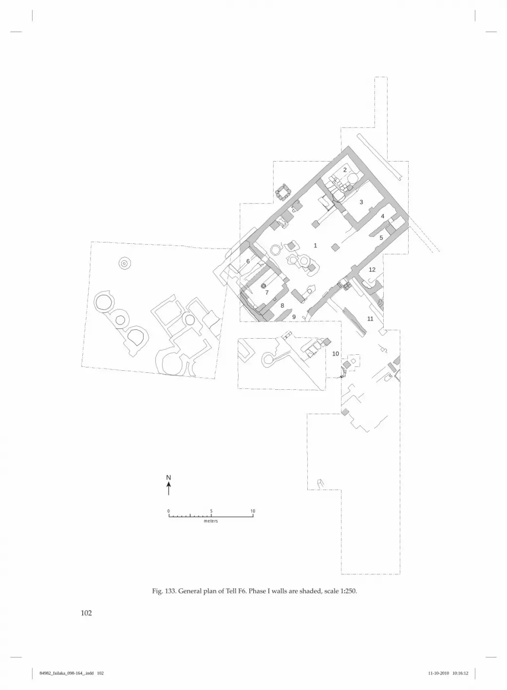
102
N
5
4
3
2
1
6
7
8
9
10
11
12
10
meters
0 5
Fig. 133. General plan of Tell F6. Phase I walls are shaded, scale 1:250.
84982_failaka_098-164_.indd 102 11-10-2010 10:16:12

103
Phase I (figs. 132‑33)The first phase of the “Palace” had its walls con‑structed at around level −1.55 and its floors at ap‑proximately the same level. The doorways of this phase had thresholds raised c. 30 cm above the floors. A second floor level has been noted at around −1.20. The walls have generally no foundations, but are built directly on the contemporary approximately flat surface at levels varying only by c. 20 cm (from level −1.75 to level −1.55). They correspond more-or-less to the general level of the first floors in the rooms. Actual sunken foundations have only been demonstrated in connection with the load‑bearing elements, pillars and pilasters. Where they are best preserved, the original walls of this phase survive up to a height of 2.5 m. This is the case with the NW outer wall of the building over much of its length (maximum height +0.92), in
addition to a few of the internal dividing walls. Gen‑erally, however, the original walls do not survive to a height greater than c. 1 m, even though the degree of the destruction varies greatly. The worst preserved walls are those in the south‑ern part, from the central dividing wall, where the height of the original walls rarely exceeds 1 m and large sections have been demolished down to their lowest courses. The floors are generally poorly preserved, but could, however, be recognised as a covering of fine, yellowish-white plaster, primarily along the walls and in the corners. Further to this, floor coverings of quadrangular flagstones survive in a few places. After a period of use, the building was abandoned and fell into disrepair; the rooms and the doorways filled partly with shifting sand.
Phase II (figs. 132 and 134)The building was reconstructed at a higher level, c. −0.70 to −0.60. The sand was levelled in the rooms, but no plastered floors have been noted. This phase has almost exactly the same ground plan as phase I, the same walls, pillars and doorways. Over large sections, the original walls are included unaltered. In other parts, where decay was far advanced, the origi‑nal walls served as foundations for the newly‑built ones. Only exceptionally – especially in the southern part – were the later walls laterally displaced, being constructed parallel relative to the earlier ones. The reconstruction is most clearly apparent where the new walls cover doorways in the phase I build‑ing, for example in the inner gateway (fig. 135), and where the new walls are displaced laterally relative to the earlier ones, as in the corridor. Wall plaster belonging to this phase has been ob‑served to be generally coarse, sandy and of a golden‑brownish colour.
Outside the “Palace”, both to the north and the south, the layers contemporary with the use of the building are horizontal and rather thin, consisting either of clayey sand, often dark from ashes and charcoal and containing potsherds, bones, shells, etc., or of shifting sand with few finds. This picture contrasts dramatically with the stra‑tigraphy of the layers overlying the “Palace” itself. This is characterised by a chaotic mixture of very large pits extending down to the upper parts of the preserved walls of the building. These pits were, in turn, filled with layers of shifting sand interrupted by thin layers coloured dark by ash and charcoal and heaps of stones. They were then disturbed by new pits, resulting in a picture which must be interpreted as representing repeated campaigns of stone plun‑dering, extending over a longer period. The upper c. 1 m-thick layer of the tell comprises rather homog‑enous shifting sand (fig. 144).
Phase III (figs. 132 and 136)In the uppermost levels of the tell there is evidence of a yet later phase comprising quite substantial walls. However, on excavation this phase proved to have been badly damaged by stone plundering and deflation. The walls have their base at +0.40 to +0.50 and their tops are visible in the surface of the tell at levels +1.20 to +1.30. Well-cut ashlars, up to
90 × 50 cm in size, give the impression of a building of monumental proportions.
Before the “Palace” was built, the area of Tell F6 had some form of occupation about which very little can be said except that it involved modest stone walls and plaster floors, as well as many finds of pottery,
84982_failaka_098-164_.indd 103 11-10-2010 10:16:12

104
N
10
meters
0 5
Fig. 134. General plan of Tell F6. Phase II walls are shaded, scale 1:250.
84982_failaka_098-164_.indd 104 11-10-2010 10:16:12

105
scraps of metal, stamp seals, beads, remains of bones and shells etc. The original interpretation of this large building as a palace with administrative functions (Glob 1968 p. 132; Kjærum 1986 p. 79) rests on the size of the building (c. 500 m2), which is very considerable com‑pared to the small houses in Tell F3 (c. 12‑50 m2) (figs. 7-8), and on its general structure, especially the long corridor leading up to an inner gate giving access to a large pillared hall. The fact that the general structure of the building was continued, with very few changes, from phase I into II is a strong argument for a stable function throughout both phases. The finds in the build‑ing are, however, not of exceptional quality, as one would expect from a palace. The installations in the building point towards more menial functions such as manufacture and storage. The pillared hall has several features suggesting manufacturing and storage of fluids: a water-proof cistern below the floor with a volume of 1300 litres (figs. 149‑150), a channel with a grid leading out to an external cistern with a volume of 500 litres (figs. 151-152), three cylindrical constructions, possibly ovens (figs. 139, 142‑143 and 154), a pithos by the doorway to room 3 (Højlund 1987 figs. 111‑112 and 629) and a great number of storage vessels in sev‑eral of the adjoining small rooms (Højlund 1987 figs. 625‑27 and 630‑32). Perhaps the central room (room 1) should be un‑derstood as a covered courtyard, lit by a light well
in the centre of the roof, rather than as a pillared hall. The dense distribution of large storage pots south of the “Palace” (Højlund 1987 fig. 621, p. 146-48) also indicates that this was an area of production. In ad‑dition, the small buildings uncovered west of the “Palace” during the American excavations, and dealt with below (p. 152), may perhaps best be interpreted as being related to production and storage (cf. Calvet in Callot 2005 p. 46). The excavators of the temple lying 10 m east of the “Palace” (fig. 206) argued that this building had its back to the NW wind and its entrance towards the SE, i.e. towards the shore. It follows then, that the “Palace” was situated quite clearly behind the temple, a location indicating lower status compatible with more menial functions.4 In conclusion, the “Palace” should more probably be interpreted as a production and storage facility related to the nearby temple.5
The dating of the architectural phases in Tell F6 has been dealt with previously (Kjærum 1986; Højlund 1987 pp. 131-151), and the results will be summarised below, supplemented by a few new observations (fig. 9).
4 Note the clearly defined front and rear of the Barbar Temple (Andersen & Højlund 2003 p. 327).5 The resemblance to the northwestern sector of the pal‑ace of Sinkasid in Uruk, suggested by Potts (1990a p. 270) does not seem compelling.
Fig. 135. SE wall of room 1 with gates I and II and buttress, looking SE (1975).
84982_failaka_098-164_.indd 105 11-10-2010 10:16:14

106
N
10
meters
0 5
Fig. 136. General plan of Tell F6. Phase III walls are shaded, scale 1:250.
84982_failaka_098-164_.indd 106 11-10-2010 10:16:14

107
Pre-”Palace” phaseThe levels below the “Palace”, i.e. below level c. −1.55, have produced a type of pottery that has so far not been found on any floor relating to the “Palace” or in any other secure “Palace” context. This pottery has been termed period 1 and is so far the oldest found on Failaka (Højlund 1987 p. 138). A sounding in room 2 of the “Palace” (see below p. 123 and fig. 166) carried out by Kjærum in 1988 produced an assemblage of pottery relevant to this discussion. The pottery lay on floor (6), which is at level −1.64, partly covered in plaster from the lower part of the stone packing of floor (4). It is described below with reference to Højlund (1987) and most likely gives a terminus post quem dating for the “Pal‑ace”, but the possibility that it dates the first floor of the “Palace” cannot be ruled out. The small pottery assemblage consists of three large rim and neck sherds and one small rim sherd from storage vessels with rims of variant 1A and 1C (fig. 137a‑d). Furthermore, there are several sherds from a deep bowl (fig. 137e) (cf. Andersen & Højlund
2003 p. 233, figs. 480‑83, 569‑70, 632), a vat rim (fig. 137f), a thick wavy-ridged side sherd of type 51 and a fragment of a flat plate of type 42, with a diameter of 29 cm. All the pottery is of reddish A/B ware, ex‑cept the bowl, which is of yellowish C/D-ware. The assemblage would be at home in Failaka period 1 (Højlund 1987 pp. 107-114). A sample of charcoal was found in the same sounding at levels −1.92 to −1.98, in a layer of sand (9) just below floor (8), i.e. a few centimetres above the subsoil. It has been identified by George Wilcox as a shrubby member of the Chenopodiaceae, prob‑ably either Hellenia glanca or Anabasis setifera; it was radiocarbon dated to 2030-1780 BC (1Σ) (K‑5152) (cf. Højlund 2007 pp. 156-157). A radiocarbon date for charred date stones (K‑4121) from trench N2, 1-2 m north of the “Palace” gave a slightly later result of 1890-1750 BC (1Σ) for a 30 cm higher level, −1.61, which is close to the level of construction of the “Palace” (Højlund 1987 p. 158, 2007 pp. 156-57).
Fig. 137. Pottery found on floor 6 in the 1988 sounding in room 2. Scale 1:3.
F- 8012, layer 4 1:2
F-8016, layer 6 (og 8012, layer 4) 1:2
F6 8017, layer 6 1:2
F- 8012, layer 4 1:2
F-8016, layer 6 (og 8012, layer 4) 1:2
F6 8017, layer 6 1:2
F- 8012, layer 4 1:2
F-8016, layer 6 (og 8012, layer 4) 1:2
F6 8017, layer 6 1:2
32 cm Ø
F6 8012, layer 4 og 8021, layer 6
Ca. 49 cm Ø
F6 8012, layer 4
F 8020, layer 6
a
b
c
d
e
f
32 cm Ø
F6 8012, layer 4 og 8021, layer 6
Ca. 49 cm Ø
F6 8012, layer 4
F 8020, layer 6
32 cm Ø
F6 8012, layer 4 og 8021, layer 6
Ca. 49 cm Ø
F6 8012, layer 4
F 8020, layer 6
84982_failaka_098-164_.indd 107 11-10-2010 10:16:16

108
“Palace” early phase INo pottery has been found in an undisturbed context linked to the earliest floor of the “Palace” at level c. −1.55. Three vessels datable to period 3A were found in the stone cist in the northern part of room 1. These
vessels were partially covered by a stone floor with its top at level −1.18, and they date the end of the first part of phase I, but not necessarily the beginning (Højlund 1987 pp. 139-140).
“Palace” late phase IThe floor level at c. −1.20 is dated by a group of ves‑sels assignable to period 3B which were found in room 4 (Højlund 1987 pp. 140-142).
“Palace” phase IIThe floor level at c. −0.70 is dated by the heap of period 4A pots found in room 2 which was accessed from this level via a staircase (Højlund 1987 pp. 143‑146).
“Palace” phase IIIThe date of this architectural phase is uncertain. No floor level was preserved and no finds could be linked to the walls. An examination of the pottery from the upper levels of the tell has produced noth‑ing which is necessarily later than phase II, apart from some Hellenistic sherds, so the building could date from any period subsequent to period 4A. Bearing in mind the remarkable size of the ex‑tant walls in this phase, it should be noted that a sizeable foundation stone was found in a modern house nearby bearing the inscription Palace of Ne‑buchadnezzar, King of Babylon (Ferrara 1975 p. 231). Ferrara suggests that this stone reached Failaka as ballast in a ship from Mesopotamia, an interpretation which is repeated by Glassner (2008 p. 193, no. 53). A more straight-forward interpretation, advocated by Kjærum (1986 p. 79), is that it originally belonged to an ancient building in the SW of Failaka from where it was looted and re‑used.
The existence of another cuneiform inscription found in Tell F3 possibly mentioning King Nebu‑chadnezzar II (604-562 BC) (Glassner 2008 p. 190, no. 45) supports the idea that there was indeed a Neo-Babylonian residence/palace somewhere on Failaka, perhaps at Tell F6, where public buildings of former periods were located. In the temple area of Tell F6 a large circular storage jar was found containing a human skeleton. Origi‑nally, it was dated to the Neo-Babylonian period (Calvet & Pic 1986 p. 18), but later referred to the Hellenistic period (Calvet & Pic 2008 p. 90). In Bah‑rain, on Qala’at al-Bahrain and elsewhere, similar cir‑cular and oblong burial pots are commonly found in the Achaemenian period (Højlund & Andersen 1994 p. 364; 1997 pp. 145-157). Besides, a modest sanctuary dating to the Achaemenian period has been uncov‑ered nearby in Tell Khazneh (Calvet & Salles 1986 pp. 107-296).
84982_failaka_098-164_.indd 108 11-10-2010 10:16:16

109
Detailed description of phases I and II
Room 1 in early phase I (figs. 138‑155)This room is approximately square with horizontal dimensions of about 10 × 10 m. It is divided up by four free-standing pillars, mirrored by pilasters, pil‑lars or buttresses standing against, or built into, the two bounding walls to the NW and SE. The distance between the two rows of pillars is 3-3.15 m SW-NE and 2.85-2.9 m NW-SE. The two westernmost free‑standing pillars NW (fig. 144) and SW (fig. 144) are both preserved to a height of c. 1.5 m above the floor, to a level of, respec‑tively, −0.10 and −0.18. At its base, pillar SW measures 72 cm SW-NE and 74 cm NW-SE and tapers in a few centimetres towards the top. Its northern side con‑sists of a whitish‑yellow, dressed rectangular stone block at a height of 85 cm from the base, whereas the south side and the uppermost preserved courses are built of dressed flagstones, like the other pillars. The flagstone parts are plastered with a yellowish-white plaster. Pillar NW has the same dimensions at its base as pillar SW, 72 cm NW-SE and 74 cm SW-NE, and it also tapers in a few centimetres towards the top. This pillar is built completely of flagstones and shows traces of plaster from base to top. Around this pillar, just like pillar NE, a raised base has been built. Here, however, it is heavily decayed, although towards the SE it is 44 cm wide. Its upper surface, which is raised 16 cm over the adjacent flagstone floor (to level −1.30), is plastered, and to the south, where the edge is pre‑served, its vertical face is plastered to floor level. The two other free‑standing pillars NE (fig. 146) and SE are both preserved to level −0.72, just over 80 cm above the original floor level. They are both built of flat, dressed flags of beach rock and were originally completely plastered with yellowish-white plaster, of which large sections are preserved. Pillar NE measures 74 cm SW-NE and 75 cm NW-SE at the base, and tapers in towards the top. It shows traces of plaster. The foot of the pillar originally had a square base around it, with sides of c. 1.25 m. This is now only preserved on the NW and NE sides, where it comprises small ashlars. It is plastered both on the horizontal surfaces at level −1.42 and on the vertical surfaces to 18 cm below the upper surface. The pillar has a foundation extending down to −1.77. Pillar SE is built of stone and plastered (fig. 140). It has a square base of 71 × 71 cm and tapers in towards its top, where it measures 65 × 65 cm. Its foundation is a stone-filled pit extending down to level −1.96. In continuation of pillars NW and SW, a pilaster consisting of a heavy flagstone has been built up against the SE wall of room 1. The flagstone is 20 cm
thick and measures 50 cm SW-NE. It has been in‑serted into the lowest course of the wall and projects 12 cm in front of this. It is overlain by a further two courses of smaller flat flagstones. In continuation of pillars NE and SE there is a cor‑responding pilaster built up against the south wall (fig. 135). Its foundation comprises a single large, 30 cm-thick, stone block, which measures 68 cm SW-NE and protrudes 41 cm from the wall to the west and 30 cm to the east, whereas the remainder forms part of the wall foundation. Its lower and upper levels are, respectively, −1.56 and −1.26. On top of this block lies a 16 cm-thick flagstone, measuring 28 cm NW-SE and 41 cm SW-NE. The pilaster is only preserved in these two courses to level −1.10, corresponding approximately to the demolition height for the wall which lies behind. In continuation of pillars SE and NE, a pillar has been identified up against the NW wall of room 1. The pillar is overlain by the later Buttress East, and only its eastern side is exposed (fig. 147). It stands free of the wall, but only a few centimetres away from it. The exposed east side, which is completely plaster-covered, is 34 cm wide. It has a base level corresponding to that of the wall located behind it (−1.56) and only stands to a height of 25 cm, to where it must have been demolished in connection with the construction of Buttress East. A corresponding pillar, in continuation of pillars NW and SW, has not been identified, but could be covered by Buttress West, where, due to the special constructions between this and Buttress Mid, no ex‑cavation took place.
The gate. The only access to the NW half of the build‑ing is through the SE wall of room 1. The two phases of this gate are the clearest evidence for it being pos‑sible to divide the history of the building into two main phases (figs. 135 and 148). The first gateway, gate I, measures 96 cm in width, and a single rectangular stone forms its threshold. It is 96 cm long and 30 cm thick, with its base at level −1.66 and upper surface at level −1.35. Two ashlars are preserved from the western jamb. The lower of the two measures 16 cm SW-NE, 60 cm NW-SE and 23 cm in height. The upper measures 32 cm SW-NE, 60 cm NW-SE and 22 cm in height. The stones of the jamb are set in yellowish-white mortar. At the east side, the first stone of the jamb over the threshold is set on edge and measures 29-30 cm in height and 12 cm in width. Whether it runs the full depth of the jamb is not known as the phase II wall
84982_failaka_098-164_.indd 109 11-10-2010 10:16:16

110
covers the east side of the gateway on its southern side. On excavation, the gateway was found to be filled with shifting sand and only preserved to level −1.00, where it is overlain by a later wall, similarly with a gateway, displaced by 25-40 cm towards the SW. The first phase of the SE wall has, at the gateway, its base at level −1.73 and has been demolished down to level −1.00, where it is overlain by the phase II wall.
The floor in the central hall was, in the earliest build‑ing phase, covered with a yellowish-white plaster. This was found to be preserved in small patches, primarily along walls and in corners, but also, espe‑cially in the NW part, over parts of the actual floor surface. Whereas it was, to a great extent, broken up or worn through in the eastern part. The level of this floor covering was, in general, −1.50 to −1.55.
The stone cist. Parallel with the wall between rooms 1 and 2 lies a stone cist, sunk down below floor level (figs. 149‑150). The stone cist is constructed of eight flags set on edge, two at each side. These enclose a rectangular space of 1.44-1.49 × 1.10-1.14 m, with a depth of 79 cm. The base of the cist, at level −2.39, is paved with flagstones of variable size, the gaps be‑tween which are filled out with smaller stones. This basal covering was laid before the setting up of the upright wall flags, which stand on the outer edges of the floor flags. The gaps between the vertical stones are, like those of the floor covering, carefully sealed with smaller stones and plaster. The vertical stones have a top level on the NE side at −1.60 and are overlain by the wall of room 2. The latter lies directly on top of them with no gaps, such that the west side of the wall is in line with the inner surface of the cist, and first course of the wall rests directly on the top of the cist flags.
-168-130
-160-142
-188-101
-153?
-161-97
-156-126
-196-72
-161-95
-93
22
-58
-30
-59
-177-72
-131-72
-146-40
-14520
-16761
-15792
-173-52
-116
-19
-91
-62
-130
-36
74
8
-68
-118stonefloor
floor -142
floor-141
floor-145
floor-152
floor -155
floor -154
-142plasterfloor
-150plasterfloor
-234
-10
-12
90
94
-173-142
-159-60
-68-38
-86
-150-3
c.-1.60-7
-17638
-6039
-158-130
-124
-169-122
-40118
-161-146-112
-84
-163-18
-173-132
-160
-159
-156
-133
-173
-239
-166
-175
-183
-116
-158-130
-169
-158
123
-157
1
-160
-132
200
cm
0 100
Fig. 138. Plan of room 1, scale 1:100.
84982_failaka_098-164_.indd 110 11-10-2010 10:16:16

111
The SE side is overlain by a wall in the same way. The stone cist, the top of which is on level with the original floor, was apparently accessible during the first phase of the building, but was subsequently cov‑ered by a substantial floor of plastered stones with a top level at −1.18 (figs. 140 and 158). The location of the cist relative to the walls indicates clearly that it must have been included in the planning of the building and
have functioned during the building’s earliest phase. Its actual construction, with careful sealing of joints, suggests that the cist was intended to hold a liquid. It had a capacity of 1300 litres. On excavation, it was found to be filled with sand containing a good number of potsherds. On level with the floor and a little lower (levels −1.69 to −1.51) lay three intact pottery vessels at the northern end (Højlund 1987 fig. 622).
Room 1, changes during phase IIn the course of the first habitation phase, a few changes were made to the organisation and construc‑tion of the building. Similarly, there are also traces of secondary floor levels. The dividing off of two smaller rooms in the NE side of room 1 was apparently not part of the original plan, even though this is subject to some uncertainty. The wall, which extends from pillar NE towards room 2, was built directly on a level with the earliest floor level and directly on the top edge of the stones forming the SE side of the stone cist. In its continua‑tion, this wall covers the side of the plastered pillar and its similarly plastered base. In itself, this is not, however, a definite indication of the wall being sec‑ondary, as pillars were incorporated as independent elements in the walls and were often plastered before the walls were built on. The wall from pillar NE to‑wards Buttress East was preserved in a single course. Its base lay at level −1.42, c. 15 cm above the general floor level, on a dark layer of refuse. It was joined to Buttress East without, however, being bonded with it. It should be noted, furthermore, that the state of preservation of the wall was so poor that its identi‑fication as such cannot be considered certain. From pillar SE, only a short section has been iden‑tified of an almost completely demolished wall in extension of the dividing wall between rooms 3 and 4. The base of this lay, as the previous one, c. 15 cm above floor level (level −1.40). No traces were found of a transverse wall between pillars SE and NE.
Buttresses. Along the NW wall of room 1, three but‑tresses had been built which are all secondary rela‑tive to the earliest floor and probably contemporary with the floors detected in the NW area of the room at levels around −1.40.
Buttress West is not bonded with the wall behind it and stands at level −1.45, c. 15 cm above the original floor level. It is constructed of robust, up to 45 × 35 cm flagstones in its basal course; in the other courses these are somewhat smaller. The buttress measures c. 90 × 90 cm in cross-section. It has traces of greyish-brown mortar between the courses, but no signs of surface-covering plaster.
Buttress Mid is, just like Buttress West, not bonded with the wall behind it. It is set at level −1.46 on a ro‑bust 20 cm-thick flagstone in the SE corner. Like the previous example, it is constructed of large dressed stones which are, however, more ashlar‑like than in Buttress West. The entire SW side is covered with greyish-brown plaster, whereas the other sides only have traces of plaster in small patches and between the flagstones. The buttress measures 1.15 m × 98 cm in cross-section. The basal flagstones extend 12 cm out to both the SW and the NE and are covered with a 3 cm-thick layer of plaster.
Buttress East stands at level −1.31, 20 cm above the nearby plaster floor. As with Buttress West, it is built of coarser stones than Buttress Mid and with‑out traces of plaster. It measures 82 cm SW-NE and 83 cm NW-SE. As mentioned above, a piece of the original pillar is preserved under its base.
In the intervals between the three buttresses, the floor was covered with plaster, in part on a cover‑ing of stone. The eastern interval had a plastered partially stone-set runnel, which must have had an outlet through the wall, even though this was not detected (fig. 151). Immediately in front of the presumed outlet through the wall, a grid had been inserted comprising a flat clay plate with circular perforations (Højlund 1987, type 45). This channel points towards a cistern lying to the north of the wall which presumably was the recipient of the outlet. The cistern is built of stones set in mortar. The stones are rather small, 10 × 8 cm, except the upper course which consists of large, 10 cm‑thick slabs. There is no description of the inside surface or base. Its depth is given as 95 cm (fig. 152). The western interval between Buttresses West and Mid has similarly runnel‑like constructions in plaster, which are not, however, interpreted so un‑equivocally (fig. 153). The level of these channels corresponds to the bases of the buttresses. In the middle of the plaster floor between Buttresses Mid and East, the neck of a large pottery vessel had been incorporated with the mouth downwards, probably by chance. Similarly,
84982_failaka_098-164_.indd 111 11-10-2010 10:16:16

112
several large rim and neck fragments from storage vessels, set into the floor (4), were uncovered in the sounding in room 2 (cf. p. 123). By the NW wall in room 1, in front of the but‑tresses, sporadic identification was made of succes‑sive applications of a thin plaster covering over the original floor at levels around −1.40. In the NE corner of room 1, an upper floor had been laid of a more permanent character. This ex‑tends from Buttress East to the corner facing towards room 2. To the south it covers parts of the stone cist which by this time had been filled in. The floor, which is stone set and plaster-covered (figs. 140 and 158), has its surface at level −1.18 and is constructed
over a c. 20 cm-thick refuse layer. Corresponding dark refuse layers were detected over the whole of the western part of room 1 reaching levels of between −1.20 and −1.10. These can be interpreted as deposits on the original floor of the building. In the western part of room 1, several horizontal floor-like stone flags were found between pillars NW and SW at levels around −1.30 to −1.46. In this small area, the stone flags were covered, and probably pro‑tected, by two deep stone-built basins (fig. 143 and 154), and it can be assumed that stone plunderers have removed stone flags originally covering large parts of the room.
Room 1 in phase IIOn excavation, the phase I gateway was found to be filled with shifting sand and only preserved to level −1.00. Here it is overlain by a later wall, similarly with a gateway, gate II, displaced 25-40 cm towards the SW. The threshold stone in gate II has its base at level −0.78 and its surface at level −0.58. The phase II wall covers the east side of the gate on its southern side. Corresponding to the re-siting of the gateway, the pilaster west of the gate is slightly displaced to the west and has now its base at −0.60 and its top at +0.39. From immediately east of the gate to the limit of the excavation to the west, the phase II wall has been reconstructed at levels between −1.00 at the gate and −0.60 to the west of it. East of this, the central divid‑ing wall is in an advanced state of decay to levels as low as −0.95, but rises towards the eastern corner to level +0.01. This demolition must undoubtedly be a late phenomenon. With regard to alterations to room 1 that can be linked to phase II, reference can only be made to a short wall remnant in extension of the dividing wall between rooms 8 and 9. It was built directly on sand without any underlying structures, at level −0.68. In the western part of room 1, near pillars NW and SW, three deep basins were found, each made of rough stones with an inner, c. 10 cm-thick plaster covering (figs. 138, 143 and 154). The inner diameter of these basins is 75, 85 and 95 cm, respectively, and their bases lie at levels −1.16 to −1.58. One is badly preserved and has a depth of only c. 26 cm from level −1.32, whereas the two others have depths of 55 and 80 cm from level −0.68 to level −0.36. The latter was originally at least 1.06 m deep as, according to a sec‑tion drawing, its upper edge is preserved to level −0.10. The basin just NW of pillar SW is described as containing many layers of charcoal, ash, pottery and
burnt clay and could, perhaps, have been an oven. It appears in section with a preserved upper part at level −0.10. From its upper part, layers of char‑coal and ash slope down to both sides, on one side covered by a layer of plaster fragments. From the position of these layers it would seem that the basin functioned in relation to a floor level around −0.60, making a connection to phase II seem likely. During the Danish excavations, the NW outer wall of the building was uncovered over a length of c 17 m and was preserved up to a height of 2.5 m. It is constructed of mostly flat, almost rectangular rough stones and of 20-50 cm ashlar-like stones, exception‑ally up to 70 cm in length and 30 cm thick (fig. 155). Especially in the eastern part of the wall, there are continuous horizontal courses of ashlars. A section near the NE corner of c. 4 m in length is, accordingly, constructed of 4-5 completely horizontal courses of ashlars with a combined height of 90 cm. In the other parts of the wall, ashlars are included in a more scat‑tered fashion, but on the whole the wall is very well built with very regular, almost horizontal courses. The wall’s general thickness is 65 cm. No breaks are seen for openings or doorways, with the exception of 1.52 m west of Buttress West where there are possible traces of a walled-up opening, 1.1 m above the floor. On both the eastern and western part of this outer wall there are large contiguous plaster surfaces, pri‑marily on the upper part of the wall, which has a basal level at −0.50, and here of a golden‑brown co‑lour; to a lesser extent on the lower part below −0.50 and here of a yellowish‑white colour.
To the NE of room 1 lie the four rooms 2-5, to which there was access from the central hall through door‑ways which have been securely demonstrated for rooms 3‑5, less securely so for room 2 (fig. 156).
84982_failaka_098-164_.indd 112 11-10-2010 10:16:16

113
Fig. 139. Room 1, in fore‑ground pillars SW and SE, looking W (1962/63).
Fig. 140. Room 1, in fore‑ground pillar SE, looking W (1962/63).
84982_failaka_098-164_.indd 113 11-10-2010 10:16:20

114
Fig. 141. Room 1, in fore‑ground room 3, looking SW (1962/63).
Fig. 142. Room 1, in fore‑ground pillar NW, look‑ing SE (1962/63).
84982_failaka_098-164_.indd 114 11-10-2010 10:16:23

115
Fig. 143. Room 1, middle‑ground pillar SW and cy‑lindrical basins, looking N (1962/63).
Fig. 144. E-W section through pillar NW in room 1, looking S (1961/62).
84982_failaka_098-164_.indd 115 11-10-2010 10:16:27
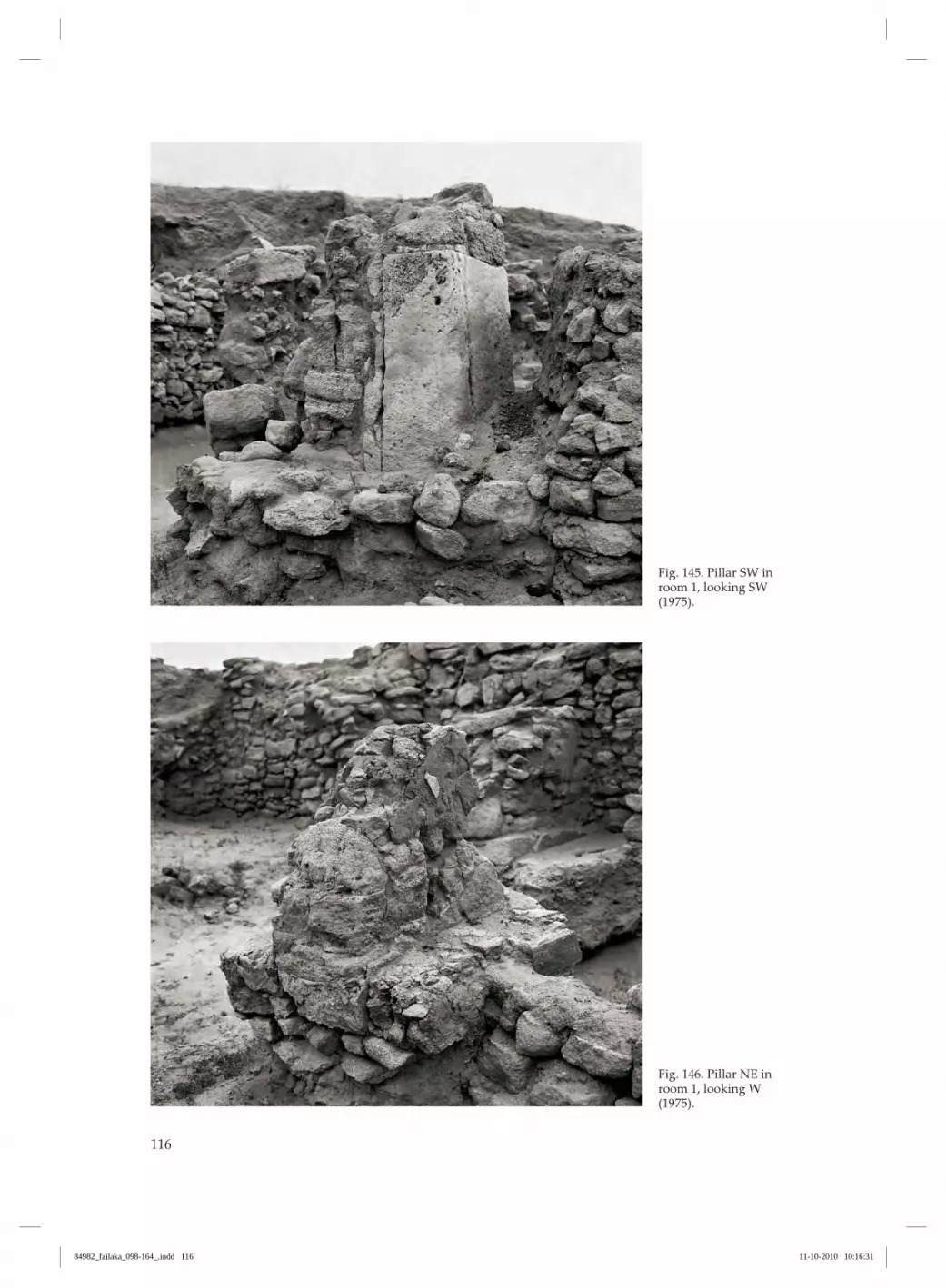
116
Fig. 145. Pillar SW in room 1, looking SW (1975).
Fig. 146. Pillar NE in room 1, looking W (1975).
84982_failaka_098-164_.indd 116 11-10-2010 10:16:31
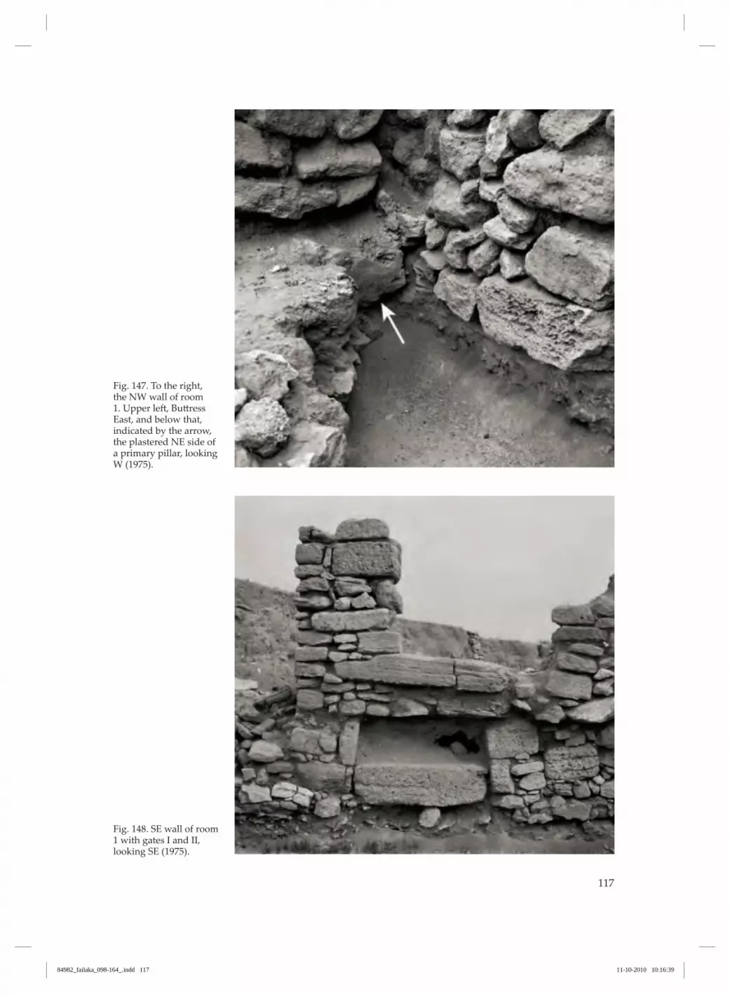
117
Fig. 147. To the right, the NW wall of room 1. Upper left, Buttress East, and below that, indicated by the arrow, the plastered NE side of a primary pillar, looking W (1975).
Fig. 148. SE wall of room 1 with gates I and II, looking SE (1975).
84982_failaka_098-164_.indd 117 11-10-2010 10:16:39
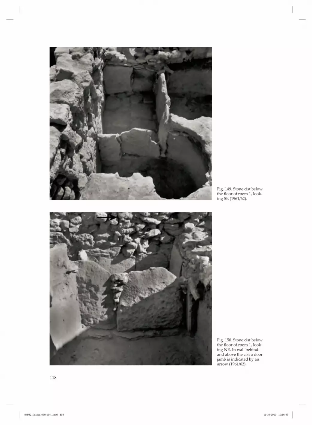
118
Fig. 149. Stone cist below the floor of room 1, look‑ing SE (1961/62).
Fig. 150. Stone cist below the floor of room 1, look‑ing NE. In wall behind and above the cist a door jamb is indicated by an arrow (1961/62).
84982_failaka_098-164_.indd 118 11-10-2010 10:16:45

119
Fig. 151. Channel with inserted grid between Buttresses Mid and East, looking NW (1961/62).
Fig. 152. Cistern lying outside the “Palace”, close to its NW wall, looking SW (1961/62).
84982_failaka_098-164_.indd 119 11-10-2010 10:16:48

120
Fig. 153. Unexplained installation between But‑tresses West and Mid, looking NW (1961/62).
Fig. 154. Base of north‑ernmost of three cylindri‑cal basins in room 1.
84982_failaka_098-164_.indd 120 11-10-2010 10:16:52
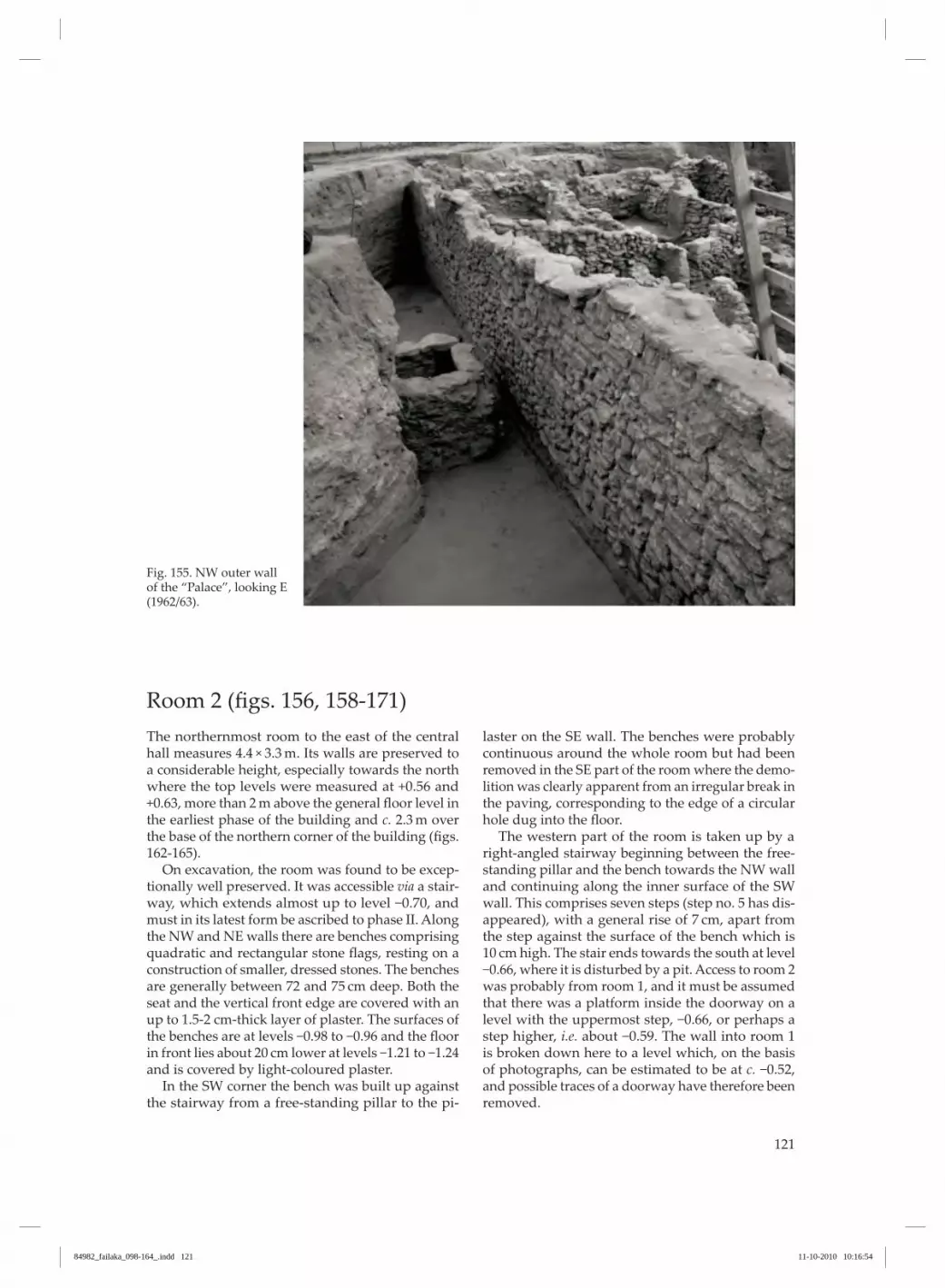
121
Fig. 155. NW outer wall of the “Palace”, looking E (1962/63).
Room 2 (figs. 156, 158‑171)The northernmost room to the east of the central hall measures 4.4 × 3.3 m. Its walls are preserved to a considerable height, especially towards the north where the top levels were measured at +0.56 and +0.63, more than 2 m above the general floor level in the earliest phase of the building and c. 2.3 m over the base of the northern corner of the building (figs. 162‑165). On excavation, the room was found to be excep‑tionally well preserved. It was accessible via a stair‑way, which extends almost up to level −0.70, and must in its latest form be ascribed to phase II. Along the NW and NE walls there are benches comprising quadratic and rectangular stone flags, resting on a construction of smaller, dressed stones. The benches are generally between 72 and 75 cm deep. Both the seat and the vertical front edge are covered with an up to 1.5-2 cm-thick layer of plaster. The surfaces of the benches are at levels −0.98 to −0.96 and the floor in front lies about 20 cm lower at levels −1.21 to −1.24 and is covered by light-coloured plaster. In the SW corner the bench was built up against the stairway from a free-standing pillar to the pi‑
laster on the SE wall. The benches were probably continuous around the whole room but had been removed in the SE part of the room where the demo‑lition was clearly apparent from an irregular break in the paving, corresponding to the edge of a circular hole dug into the floor. The western part of the room is taken up by a right‑angled stairway beginning between the free‑standing pillar and the bench towards the NW wall and continuing along the inner surface of the SW wall. This comprises seven steps (step no. 5 has dis‑appeared), with a general rise of 7 cm, apart from the step against the surface of the bench which is 10 cm high. The stair ends towards the south at level −0.66, where it is disturbed by a pit. Access to room 2 was probably from room 1, and it must be assumed that there was a platform inside the doorway on a level with the uppermost step, −0.66, or perhaps a step higher, i.e. about −0.59. The wall into room 1 is broken down here to a level which, on the basis of photographs, can be estimated to be at c. −0.52, and possible traces of a doorway have therefore been removed.
84982_failaka_098-164_.indd 121 11-10-2010 10:16:54

122
The original wall between rooms 1 and 2 is only preserved as 4-5 courses underneath a secondary wall superstructure and the original location of the doorway between the two rooms cannot be securely ascertained. However, c. 50 cm NW of the inner sur‑face of the SE side of the stone cist, the apparent edge of a vertical construction of flat flags can be seen, extending up to 60 cm over the upper edge of the NE side of the cist (fig. 150). This could be the southern jamb of a doorway, and 46 cm further to the north there is possibly a similar jamb edge. The gap between the two is filled up with rubble, and no threshold is visible. Immediately over the northernmost stone in the NE side of the cist, in the secondary superstructure of the wall between rooms 1 and 2, a doorway with a threshold can be seen at a level of c. −1.00. The doorway is c. 80 cm wide and filled up with sand and stones, but apparently not walled up. On the inner
surface, towards room 2, this doorway is, however, covered by the stairway. The top step ends at the upper course of the southern jamb, the underside of which towards the east is plastered. The width of the doorway here is 76 cm. The doorway lies op‑posite the two uppermost steps of the stair and has belonged to a phase of room 2, probably with a floor at level c. −1.20, when the stair had not yet been con‑structed. Patches of yellow-brown plaster are preserved on the walls in room 2. Similarly, the pillar by the stair is also covered with yellow-brown plaster. A pilaster has been partially built into the SE wall. Relative to a line running through the centre of the room, the pilaster is displaced by 25 cm towards the SW. It is c. 70 cm wide and extends c. 30 cm out from the wall. It is constructed of flat, dressed flags, covered with yellowish-white plaster. It is only ex‑posed to the level of the bench along the wall, but
Fig. 156. Plan of rooms 2‑5, scale 1:100.
2
3
4
5
-156-79
-168-56
-15426
-1596
-1941
-1570
-134-124
-121
-97
-87
-73-66
-16721
-174-36
-188-101
-153?
-161-97
-158-31
-156-28
-17556
-16827
-155
2748
141
-17312
-19
-98-96
-91
41
12
50
63
-62
-127
1
8
floor -155
-107
-159
-173
-175
-114
200
cm
0 100
84982_failaka_098-164_.indd 122 11-10-2010 10:16:55

123
the flagstones covering the bench appear to respect the pilaster and it could, therefore, belong to an even earlier phase. By the lowest step of the stair there is a free-stand‑ing pillar which was apparently built directly on top of the floor. The pillar is constructed of the same material as the pilaster and like the latter is plastered. It measures 45 × 40 cm. On excavation, the whole room was found to be filled with a large number of pottery vessels, many of them intact. These lay stacked up against the northern corner of the room. The lowermost stood at level −0.73, 25 cm above the benches on a sand fill mixed with a good number of sherds of the same type, whereas the uppermost lay at level −0.11, c. 0.5 m below the preserved top of the wall. This pile of ceramics must belong to phase II and must have become covered in sand as the building decayed (Højlund 1987 pp. 143-145). There can be no doubt that room 2 with the stair‑case belongs to phase II, but there was an earlier phase of the room with or without benches which was accessed from floor level c. −1.20 in room 1, i.e. without the staircase. In 1988, Kjærum carried out a re-examination of the room, by which a sounding of 1.9 × 1 m was cut through the NW part of the floor down to the subsoil (figs. 156 and 166). The plaster floor (1), at levels −1.19 to −1.24, was c. 6 cm thick and constructed over a cobbled surface (2) made of 8‑12 cm‑thick fragments
of beach rock (fig. 167), which continued in under the benches. The plaster covered the stones but did not fill out the gaps between them. Below this came a plaster floor (4), built on a foundation of stones, between levels −1.44 and −1.56 (fig. 168). In this case, the stones were completely encapsulated in plaster. This floor was covered by a yellow-brown clayey soil (3) containing a few potsherds, shells and bones, and it is most likely the first floor of the “Palace”. Below this were sandy layers (5, 7 and 9) with two floors of plaster and clay and scattered finds of sherds, shells, bones, copper slag and charcoal. The first floor (6) was at level −1.64 and consisted of patches of 1-1.5 cm-thick plaster, surrounded by hard sand containing a few lumps of plaster (fig. 169). The possibility that this floor was the first in the “Palace” cannot be entirely ruled out. The second floor of hard clayey sand (8) was at level −1.86. The subsoil (10) was reached at level −2.02. (fig. 170) A circular pit had been cut through levels 3 and 4 (fig. 171). This contained a large storage vessel in the Barbar tradition (of type 8/28 in Højlund 1987). The deep setting was possibly intended to keep its contents cool. The cross formed between the wall towards room 1 and the dividing wall between rooms 2 and 3 is, on the east side, reinforced at its base with a large ashlar, measuring 55 cm NW-SE. It is 23 cm thick and has a superstructure of flags, plastered on both its NE and the NW sides, independently of the adjoining walls.
Fig. 157. Room 1 and the cistern outside, from above, looking N (1961/62).
84982_failaka_098-164_.indd 123 11-10-2010 10:16:57
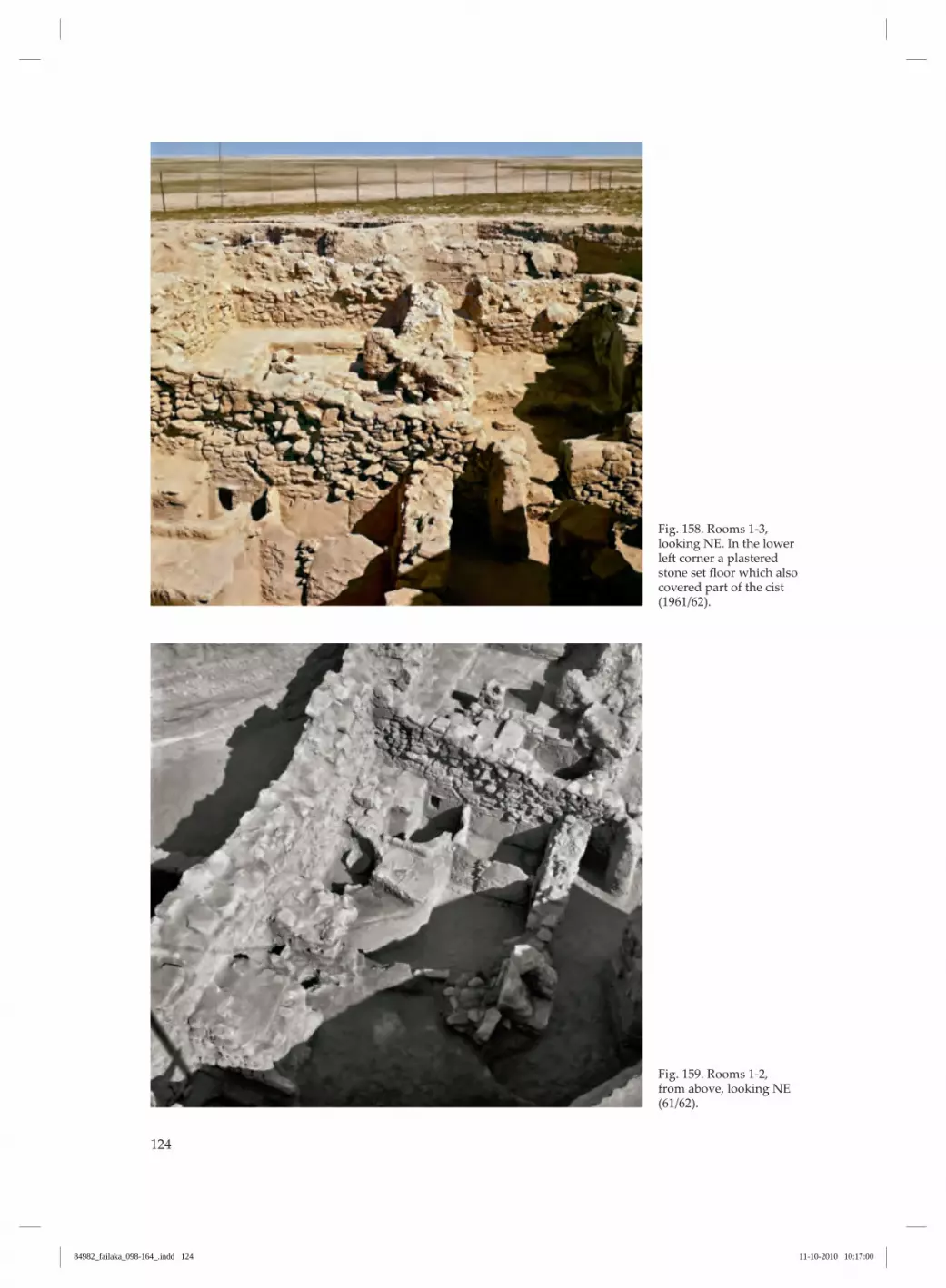
124
Fig. 158. Rooms 1‑3, looking NE. In the lower left corner a plastered stone set floor which also covered part of the cist (1961/62).
Fig. 159. Rooms 1‑2, from above, looking NE (61/62).
84982_failaka_098-164_.indd 124 11-10-2010 10:17:00

125
Fig. 160. Rooms 1‑4, from above, looking NE (1961/62).
Fig. 161. Rooms 1‑5, from above, looking E (1961/62).
84982_failaka_098-164_.indd 125 11-10-2010 10:17:04

126
Fig. 162. Room 2, looking W (1961/62).
Fig. 163. Room 2, looking SW (1960).
84982_failaka_098-164_.indd 126 11-10-2010 10:17:08
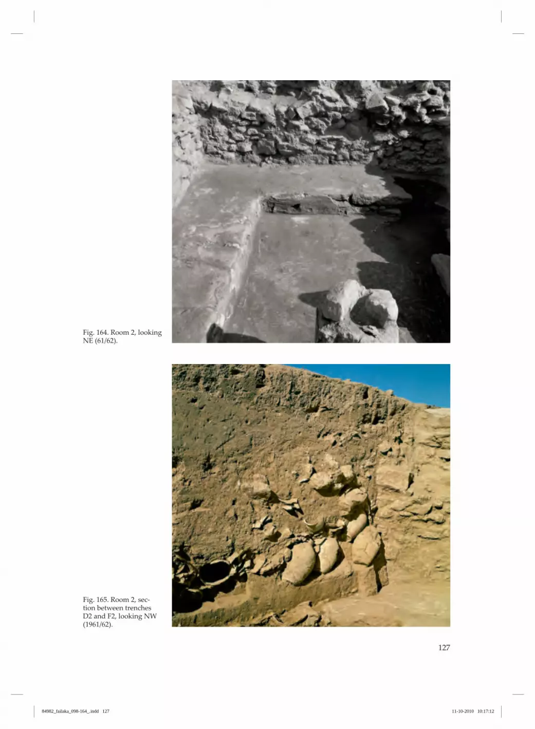
127
Fig. 164. Room 2, looking NE (61/62).
Fig. 165. Room 2, sec‑tion between trenches D2 and F2, looking NW (1961/62).
84982_failaka_098-164_.indd 127 11-10-2010 10:17:12

128
Fig. 166. Room 2, SE sec‑tion in sounding below upper plaster floor with layer numbers indicated to the right (1988).
-150
-200
10
9
8
7
6
5
4
3
2
1
SW
-100
NE
Fig. 167. Room 2, stone foundation (2) below plaster floor (1). In plaster floor, above left, stone-plundering distur‑bance, looking SE (1988).
Fig. 168. Room 2, plaster floor (4) broken by pit containing jar, looking SE (1988).
84982_failaka_098-164_.indd 128 11-10-2010 10:17:15

129
Fig. 169. Room 2, patches of plaster floor (6), look‑ing SE (1988).
Fig. 170. Room 2, section from plaster floor (1) to subsoil (10), looking SE (1988).
Fig. 171. Room 2, section from plaster floor (1) to subsoil (10), looking NW. Plaster floor (4) broken by pit with storage ves‑sel. Above, two courses of stone flags in the bench (1988).
84982_failaka_098-164_.indd 129 11-10-2010 10:17:20

130
Room 3 (figs. 156, 161, 172‑174)This room measures 4.4 × 2.9-3 m. The walls are, on the whole, well preserved, standing to a height of more than 1.6 m in the NE and SE (to levels +0.06 to +0.08), while they are most poorly preserved in the SW, where their height only reaches c. 0.5 m (levels −0.97 to −1.01) over the floor recorded at level −1.55. The plastered floor was found to be preserved in the NE half of the room, whereas it was missing in the other part, with the exception of small patches in the corners. In the northern corner, the basal parts of two large pottery vessels stood directly on the floor. A pilaster in the middle of the SE wall, 15 cm displaced towards the east, was found standing to a height of 1.3 m over the floor to level −0.28. It is 55 cm wide and extends 28 cm out from the wall to the east and 17 cm to the west. It was constructed of dressed ashlars, of which the lowermost is 13 cm
thick and measures 43 cm SW-NE. It extends 23 cm out from the pilaster, lies at floor level at −1.58 and was founded on a stone-filled pit. The pilaster was plastered in association with the wall with a yellow‑ish-white plaster. In the middle of the NW wall of the room, the remains of another pilaster were observed. The doorway, which lead to the room from room 1, is 55 cm wide with well-preserved jambs, con‑structed of large ashlars which stood un-plastered. The lowermost stone of the southern jamb measures 46 × 40 × 20 cm. The upper is slightly less, but is 23 cm thick. The doorway is only preserved in three courses above the threshold, which lies 33 cm over the basal stone. The threshold was built up of small stones. Below the level of the threshold, the wall was plas‑tered with yellowish-white plaster.
Fig. 172. Room 3 with bases of two vessels in corner, looking NE (1960).
84982_failaka_098-164_.indd 130 11-10-2010 10:17:22

131
Fig. 173. SE wall of room 3, NE section, looking SE (1961/62).
Fig. 174. SE wall of room 3, SW section, looking SE (1961/62).
84982_failaka_098-164_.indd 131 11-10-2010 10:17:26
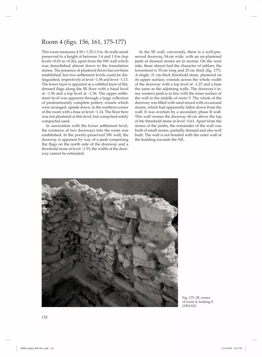
132
Fig. 175. SE corner of room 4, looking E (1961/62).
Room 4 (figs. 156, 161, 175‑177)This room measures 4.50 × 1.25-1.5 m. Its walls stand preserved to a height of between 1.6 and 1.9 m (top levels +0.01 to +0.26), apart from the SW wall which was demolished almost down to the foundation stones. The presence of plastered floors has not been established, but two settlement levels could be dis‑tinguished, respectively at level −1.56 and level −1.13. The lower layer is apparent as a cobbled layer of flat, dressed flags along the SE floor with a basal level at −1.56 and a top level at −1.36. The upper settle‑ment level was apparent through a large collection of predominantly complete pottery vessels which were arranged, upside down, in the northern corner of the room with a base at level −1.14. The floor here was not plastered at this level, but comprised solely compacted sand. In association with the lower settlement level, the existence of two doorways into the room was established. In the poorly-preserved SW wall, the doorway is apparent by way of a jamb comprising flat flags on the north side of the doorway and a threshold stone at level −1.53; the width of the door‑way cannot be estimated.
In the SE wall, conversely, there is a well-pre‑served doorway, 54 cm wide, with an un-plastered jamb of dressed stones set in mortar. On the west side, these almost had the character of ashlars; the lowermost is 55 cm long and 25 cm thick (fig. 177). A single, 31 cm-thick threshold stone, plastered on its upper surface, extends across the whole width of the doorway with a top level at −1.27 and a base the same as the adjoining walls. The doorway’s in‑ner western jamb is in line with the inner surface of the wall in the middle of room 5. The whole of the doorway was filled with sand mixed with occasional stones, which had apparently fallen down from the wall. It was overlain by a secondary phase II wall. This wall crosses the doorway 66 cm above the top of the threshold stone at level −0.61. Apart from the stones of the jambs, the remainder of the wall was built of small stones, partially dressed and also well built. The wall is not bonded with the outer wall of the building towards the NE.
84982_failaka_098-164_.indd 132 11-10-2010 10:17:29

133
Fig. 176. SE wall of room 4, looking E (1961/62).
Fig. 177. Doorway in SE wall of room 4, looking SE (1975).
84982_failaka_098-164_.indd 133 11-10-2010 10:17:33

134
Fig. 178. NE outer wall of the “Palace”, outside room 2, plastered above level −0.50, looking SW (1961/62).
Room 5 (figs. 156 and 161)This room in the SE corner is very narrow, 1-1.25 m. It is apparently not bounded by any wall towards room 1, but open across its full width. Whereas the NW and NE walls remain standing to a considerable height (levels +0.26 and +0.01), the SE wall is more heavily broken down. It is highest towards the east, −0.36, from where it falls towards the west to level −0.79 at the entrance to the room. This narrow room was divided roughly in the middle by a broad wall. The wall measures 98 cm NW-SE and therefore does not occupy the whole width of the room, but ends 20 cm from the NW wall with a well‑levelled wall surface, regardless of the fact that they are founded at the same depth (level −1.68). It is built against the south wall of the room without being bonded with it and stands to a height of 1.12 m. The wall was constructed of well-shaped flagstones and ashlars and laid in a plaster-clay mor‑tar which, on the SW side, almost has the character of plaster, but its inner fill also contained potsherds described as of “Barbar type”. The wall does not have the character of a normal wall, but corresponds, with its thickness of 85 cm, more to the buttresses by the NW wall of room 1. The eastern end of room 5, which is bounded by this wall, has, accordingly, an extent of only 1.55 × 1 m, and there was only access to this small room from room 4 through the above‑mentioned doorway. In the outermost part of room 5 there is an unex‑cavated heap of stones mixed with clay, sand and potsherds with its base at a higher level than the SE
wall of the room. This covers an area, 1.5 m in width, running along the SE wall and could possibly hide a doorway to room 12, symmetrical with the possible doorway from room 9 to room 10. At the entrance to room 5, a pilaster is indicated by a 45 cm-wide flagstone extending 12 cm out from the SE wall. On this, in yellowish mortar, lies a rect‑angular dressed stone of the same dimensions as the presumed base. It is likely that this narrow room has housed a staircase to the roof of the building and that this rested on the thick transverse wall. The doorway from room 4 has, accordingly, provided access to the room under the staircase, which would otherwise be inaccessible.
The building’s NE outer wall, running along rooms 2-5, appears generally homogeneous without any definite traces of later additions. However, there is, in its northern extent, a very slight displacement which can be interpreted as the result of an altera‑tion. At some point in time, when the level of the surrounding terrain had increased to c. −0.50, the wall was given a covering of yellowish‑brown, rather coarse plaster terminating lowermost with an edge that flares outwards and which marks the surface of the surrounding terrain at the time the plastering took place (fig. 178).
To the SW of room 1 lie four rooms, 6‑9, to which access was gained from the central hall (fig. 179).
84982_failaka_098-164_.indd 134 11-10-2010 10:17:35

135
Fig. 179. Plan of rooms 6‑9, scale 1:100.
6
7
8
9
200
cm
0 100
-30
74
8
-6
-150plasterfloor
-12
-60
-90
34
52
94
-56
575
84
61
4090 -68
-38
-86
-150-3
c.-1.60-7
-41
-169-122
-159-144
-144-107
-169-22
-158-50
-156-15
54127
2532
5995
-40118 -112
-84
-160-31
-130
-169
-175
-151-160
-74
-170
-158
-160
Room 6 (figs. 179‑180)Only the upper layers, down to level c. −0.70, were uncovered in the northernmost room, whereas the deeper layers were excavated by the American mis‑sion in 1973-74. This revealed that the NW corner of the building had been altered on several differ‑ent occasions. The room measured 4.2 m SW-NE, whereas its width can only be estimated to about 3 m as the north side of the SE dividing wall has not been uncovered. The wall between rooms 1 and 6 comprises three stages. The earliest wall was not uncovered but was, by way of a sounding, detected at level −1.60 and built over at level c. −1.30 by a new wall with a doorway in it. This wall is slightly displaced towards the east
relative to the earliest wall, which it partially overlies. The doorway is 59 cm wide between the jambs. These are both constructed of rectangular ashlars or thick flagstones which survive to a height of 3-4 courses. They bear no traces of plaster. In the doorway there is no actual threshold stone, but a covering of small stones which could have functioned as a threshold with a surface level at −0.84 and a base level at −1.12. The doorway filled up with shifting sand and was subsequently built over with a third wall at level c. −0.40. This wall was displaced c. 20-30 cm towards the west and probably completely in line with the original wall. On top of this third wall, a fourth was built, which is described below under phase III.
84982_failaka_098-164_.indd 135 11-10-2010 10:17:35

136
Fig. 180. Wall between rooms 1 and 6 with door‑way, looking S (1962/63).
Room 7 (figs. 179, 181‑182)This room, which was fully investigated to its base, measures 4.3 m SW-NE and 3 m NW-SE. The walls have a base level at −1.60 to −1.70 and are preserved up to a height of c. 2.5 m, but have all been second‑arily built over (top level for the SE wall is −0.22, for the other walls +0.61 to +0.94). Roughly in the middle of the room stood a pillar, the base of which is an irregularly circular stone, c. 53 cm in diameter and 15 cm thick, placed at level −1.59 and founded on a c. 30 cm-deep stone fill. On top of the base stands the first course of the pillar, an ashlar which measures 33 × 31 cm and 37 cm in height. The pillar was built over by a dividing wall extend‑ing from the threshold of the doorway in the NE wall of the room (the base of the wall lies on the threshold) and preserved to the east side of the pillar. It was founded at level −1.60 and is preserved to level −0.60. In addition to this pillar, there are a further two
load-bearing elements in the room. A pilaster in the corner formed by the SW and the SE walls stands im‑mediately against these walls, but is not bonded with them. It measures 86 × 49 cm and is preserved to a height of just over 1 m, at level −0.50, with a base cor‑responding to the adjoining walls. It is constructed of rectangular dressed stone blocks and shows traces of a yellowish-white plaster. It corresponds to a similar pilaster in the eastern corner of the room, immediately inside the NE wall, which it must have been built together with or up against. This wall is, however, interrupted immedi‑ately north of the pilaster and the eastern part of the pilaster is partially broken down. On being uncov‑ered, it appeared as a 43 × 43 cm wide projection on the SE wall, though without having been bonded with it. It is constructed of the same kind of flat stones as the above-mentioned pilaster, in contrast to the adjoining wall, the building stones of which
84982_failaka_098-164_.indd 136 11-10-2010 10:17:37

137
are of a coarser, more irregular character. Its base is on a level with the door threshold, but it is further founded to a depth of c. 25 cm below the adjoining wall. There was access from room 1 through a doorway in the NE wall. This was constructed of large and small ashlars, forming the jambs on both sides, and without any traces of plaster. The threshold was, at level −1.22, formed of three large, rectangular stones on a foundation of smaller stones. The distance be‑tween the stones of the jambs is 83 cm, but on the north side the above-mentioned wall limits the open‑ing to c. 50 cm. The doorway remained standing to a height of 62 cm over the threshold, where it was built over by a secondary wall construction. During this secondary construction the doorway was filled in with sand and a few fallen stones (fig. 182). No actual floor has been recognised in the room, but judging from the location of the pillar, the pri‑mary floor must have lain at level c. −1.59, whereas
for the upper floor level, corresponding to the su‑perstructure, there are no indications other than the basal level of the wall. The SW outer wall of room 7 (and room 8) has only been completely uncovered in its upper phase, corre‑sponding to the phase II restoration of the building, which is slightly displaced to the west relative to the original wall. The superstructure here was con‑structed at various levels from −0.06 to +0.31. The wall exposed at a distance of 4.44 m from the thresh‑old stone of the doorway is rather poorly constructed of small stones and stands to a height of just less than 2 m; it has a covering of white plaster. In the north‑ern part of this wall, a niche was left open c. 35 cm above floor level. This measures 36 cm in width and is 41 cm high. It is framed on all sides by flat stones, one at the base, two above and with smaller stones at the sides. These extend 5-7 cm out from the wall (cf. Killick & Moon 2005 p. 155).
Fig. 181. Pillar in room 7, looking N (1975).
84982_failaka_098-164_.indd 137 11-10-2010 10:17:39

138
Fig. 182. Doorway in wall between rooms 7 and 1, looking NE (1975).
Room 8 (figs. 179 and 183)This long, narrow room measures 4.4 × 1.5 m. The western part of the SE wall is well-preserved while the eastern part is completely broken down. One buttress by the rear wall, with a base at level −1.51, stands preserved to a height of c. 1.5 m (fig. 183). Its face towards the NE is in line with the corresponding buttress in room 7, and its width is 60 cm. The gap between this and the wall towards room 7 is occu‑pied by a wall construction which stand preserved to a height of 43 cm over its base. No actual floor was recognised in the room.
The access was through a doorway in the NE wall, where the jambs, constructed of un-plastered ashlar stones, stand preserved to a height of c. 1.1 m. At level −0.15, the doorway, which is c. 70-75 cm wide and filled up with sand and a few fallen stones, is covered by a superstructure comprising a horizon‑tal flag measuring 1.20 × 0.52 m and with a thickness of 15 cm. This must have been part of a secondary wall built on top.
84982_failaka_098-164_.indd 138 11-10-2010 10:17:41

139
Fig. 183. Buttress against SW wall of room 8, look‑ing SW (1975).
Room 9 (figs. 179 and 186)The NE part of room 9 was uncovered by the Dan‑ish expedition, while the SW part was excavated by the American team. Just as with the corresponding room to the east, room 5, no boundary was recog‑nised towards room 1. At the entrance to room 1, a pilaster is built into the SE wall (fig. 184). This is 70 cm wide at its base and 67 cm at its top. It extends 12 cm out from the wall and is preserved to a height of just over 1.5 m to level −0.07. The pilaster is built on top of a foundation of stones extending 20 cm below the level of the adjoining wall. The pilaster is constructed of well‑dressed rectangular ashlars laid in horizontal courses and plastered on its vis‑ible parts, though only above level −1.34; the lower courses are damaged. SW of the pilaster, a c. 1 m‑long stretch of a wall has been uncovered comprising a few courses with a basal level at c. −0.74. This stands directly on the clayey sand. It is not bonded with the pilaster but built up against it. This wall must belong to phase II. An original phase I wall has not been detected and this could indicate that there was an entrance to room 10 in direct relation to the pilaster, but not
enough has been uncovered here to enable a final evaluation. The continuation of the SE wall comprises a very well-built ashlar wall, preserved to a height of 1.51 m. It is built of seven regular courses in which the larg‑est ashlar measures c. 66 × 27 cm (figs. 185‑186). The ashlars are laid in mortar and this also fills out the gap to the SW outer wall of the building. The wall is built on top of the primary wall. Its base is at level −1.29, corresponding to the partly preserved paving in room 10. The room’s SW wall must belong to the recon‑struction of the palace in phase II.
The southern section of the “Palace” measures 11.2 m in a NW-SE direction, from the south side of the di‑viding wall to the south side of the concluding wall towards the SE, of which, however, only small sec‑tions have been uncovered. This limited exposure does not enable recognition of details in the layout, but the most important basic features in the build‑ing’s ground plan, both before and after the recon‑struction are, however, apparent (fig. 187).
84982_failaka_098-164_.indd 139 11-10-2010 10:17:42

140
Fig. 184. Buttress at the entrance to room 9, looking SE (1975).
Fig. 185. Elevation of NW wall of room 10, looking NW (1988).
0
-100
50
-150
-50
Fig. 186. NW wall of room 10, looking NW (1988).
84982_failaka_098-164_.indd 140 11-10-2010 10:17:46

141
Room 11, the corridor (figs. 135, 148, 187‑192)The corridor is delimited towards the NW by the central dividing wall, which is broken by a gateway leading in to the NW section (figs. 135 and 148). This gateway reflects the building’s two main phases, gate I with a threshold surface at level −1.35, and gate II displaced 25-40 cm towards the SW with a threshold surface at level −0.58. In the corridor, the earlier threshold corresponds to flagstone paving immediately in front of the gate with a basal level of −1.68 and a top level at −1.47 (fig. 188). This gives a threshold height of 12 cm over the floor. Immediately south of the gateway there is a large flagstone standing almost vertically with its base at the same level – presumably the remains of an original floor covering that has been completely removed from the rest of the corridor. At its conclu‑sion to the south, a large flagstone was, however, detected (figs. 191-192). It is 65 cm wide and at least 1 m in length, lying in continuation of the SE wall of the palace. Here, it could have occupied the entire space between the walls of the corridor, although the eastern section of this has not been exposed. Its top lies at level −1.23 and possibly forms the outer threshold in the south gate of the corridor. This has not, however, been demonstrated in any other way. A horizontal quadratic flagstone, 75 × 75 cm, lying in the middle of the corridor, and with a top level of −1.07, is unlikely to have been part of the original floor covering but could, perhaps, be the foundation for a load‑bearing element. The corridor is 3.1 m wide and displaced 30-90 cm to the SW relative to the central axis of the complex. On excavation, the original boundary walls were found to be heavily decayed and only short stretches
have been exposed on both sides. It is unknown whether the walls are continuous or broken by door‑ways to rooms 10 and 12. The eastern corridor wall departs directly from the central dividing wall but has been completely demol‑ished after a section of almost 3 m. After a break of just less than 1.5 m it does, however, continue to the limits of the excavation trench towards the south. On the west side, a section 4 m in length is preserved in the northern part of the corridor and a heavily decayed section in the southern part. With the reconstruction of the building, both walls were rebuilt but displaced in parallel laterally towards the west. The western wall is displaced c. 30-40 cm and stands on top of the west side of the earlier wall, which was demolished or had decayed down to level c. −0.90 (fig. 189). The southern part of this wall was almost completely demolished, al‑though a vertical pilaster stood in situ on the line of the wall built at level −1.07 (figs. 191‑192). This was well shaped, 1.65 m high and 34 × 34 cm in cross-section. Near its top was a 10 cm deep, 15 × 15 cm quadratic notch. In contrast, the eastern wall was, on reconstruc‑tion, built independently of the earlier wall, 90 cm further to the west, parallel with it and with basal levels corresponding approximately to the highest sections of the earlier wall (fig. 190). Both of these later walls are broken along their course, respectively 2.35 and 2.45 m from the central dividing wall. This could indicate that these origi‑nally were entrances to rooms 10 and 12, but actual doorways have not been detected either in the form of jambs or threshold stones.
84982_failaka_098-164_.indd 141 11-10-2010 10:17:46

142
Fig.187. Plan of rooms 10‑12, scale 1:100.
12
11
10
-156-126
-161-95
-59
-93
22
-58
-159-60
c.-1.60-7
-17638
-74
-165
-153
-113
-135
-6039
-6412
-6425
-10434
-6034
3233
27
-36-58
68
20
-143-123
-134-107
-130-80
-82
-1
-126-30
-154-91-91
-24 -196
-9730
-177-117
-15554
-187-147
-171-141
-98
-115
-128
-156Floor
Floor -113
-143-109
-107
-125-15
-168-147
-179-137
-147-75
200
cm
0 100
84982_failaka_098-164_.indd 142 11-10-2010 10:17:46

143
Fig. 188. Room 11 with gates I and II and large flagstone standing up‑right, looking N (1960).
Fig. 189. The west wall of room 11, phase II above phase I, looking SW (1960).
84982_failaka_098-164_.indd 143 11-10-2010 10:17:49

144
Fig. 190. NE wall of room 11, looking S (1960).
Fig. 191. Room 11, look‑ing S (1962/63).
84982_failaka_098-164_.indd 144 11-10-2010 10:17:53

145
Fig. 192. Room 11, look‑ing N (1960).
Room 10, west of the corridor (figs. 187, 191‑200)This room apparently measures c. 10.4 × 7 m, but it has only been partially exposed through first the Danish, then the American investigations. A nar‑row room had been divided off in the northernmost part and from here, a small covered channel leads out through the outer wall to a circular cistern (figs. 194‑195). The base of the cistern lies at level −1.65 and the channel has its base at −1.53, but it is unknown at which level within the building the channel starts. The SE wall has only been exposed over short sections (fig. 196), suggesting corresponding su‑perstructures to the corridor walls. Further to this, the SW corner of an extension constructed indepen‑dently of the previous building and built directly on sand at level c. −0.60 has been exposed (fig. 197). This L-shaped wall stands isolated due to the limited extent of the exposed area, but its SW section is in line with the SW wall of the “Palace”. The wall’s basal level corresponds to the general level for phase II of the building, so regardless of the limitations of the exposed area, the indications suggesting this exten‑sion of the building seem convincing. The roof was supported by two free-standing pil‑lars. One pillar was uncovered in the northern part of the room during the American investigations and
re-investigated by Kjærum in 1988. This pillar stood in situ at level −1.55 and is preserved to a height of more than 2 m to level +0.54 (figs. 195 and 198). It is built of dressed flags in a mortar. Running up to the pillar is a stone floor with its surface at level −1.35 (fig. 193). In the southern part of the room a fallen pillar was exposed in a section. This is constructed of almost quadratic, 80 × 70 cm stone flags. The base of this pil‑lar was found by Kjærum during a re-investigation in 1988. It comprises three courses of well-dressed stone slabs (fig. 199) with a base at level −1.77 and top at −1.17. The upper, fallen part of the pillar lay over a 40 cm-thick layer of debris and shifting sand with its surface at level −0.77 (fig. 200). Beside the base of the pillar lay a fine, dressed ashlar, 40 cm high, directly on the sterile subsoil level −1.87, with its top at level −1.47 (fig. 199). Its function is unknown. The two pillars stand on the room’s central axis, c. 3 m apart, corresponding to their distance from the surrounding walls. The foundation depth of these pillars reveals that they were constructed already in building phase I, but they must still have functioned in building phase II. In addition to the stone floor at level −1.35, traces of plastered floor surfaces were detected at level c. −1.40.
84982_failaka_098-164_.indd 145 11-10-2010 10:17:55

146
Fig. 193. The west corner of room 10, looking N (1975).
Fig. 194. The SW wall of the “Palace”, outside room 10, with a channel leading to the cistern, looking NW (1975).
84982_failaka_098-164_.indd 146 11-10-2010 10:17:58

147
Fig. 195. The SW wall of the “Palace”, outside room 10, with a channel leading to the cistern, looking NE (1975).
Fig. 196. Room 10, look‑ing S (1960).
84982_failaka_098-164_.indd 147 11-10-2010 10:18:01

Fig. 197. The SW outer wall of the “Palace”, looking NE (1975).
Fig. 198. The north pillar in room 10, looking NE (1988). Fig. 199. The south pillar in room 10, the basal portion, in situ, looking SW (1988).
84982_failaka_098-164_.indd 148 11-10-2010 10:18:05

149
Fig. 200. The south pillar in room 10, upper fallen portion, looking SW (1975).
Room 12, east of the corridor (fig. 201)Only the NW corner has been exposed, but room 12 probably had an original extent of 10.75 × 8.50 m, corresponding to room 10 and, as was the case in the latter, a narrow room was possibly divided off in the northernmost part. The exposed wall corner is plastered with a yellowish-white plaster on its inner surface and in the SW wall there is an inbuilt c. 40 cm deep, 75 cm wide plastered niche. Two floor layers were distinguished in the room: a lower floor at level −1.56, plastered over a dense stone layer, and an upper floor at level −1.13, appar‑ently plastered over the underlying sand and debris (fig. 201).
Northeast of the “Palace”, a 7-8 m-long wall indicates the presence of a nearby building, separated by a narrow lane (figs. 134 and 156). The wall is preserved up to levels +0.41 to +0.48 and the base is at level c. −0.19 and therefore probably belongs to phase II or later. SW of the “Palace” there may be a similar lane (fig. 131).
A number of ashlars of a fine beach rock character were found lying loose, especially in the southern part of the “Palace” (fig. 202), apparently without any connection to the latter, and therefore probably indicative of another building; perhaps the one de‑scribed below, phase III.
84982_failaka_098-164_.indd 149 11-10-2010 10:18:07
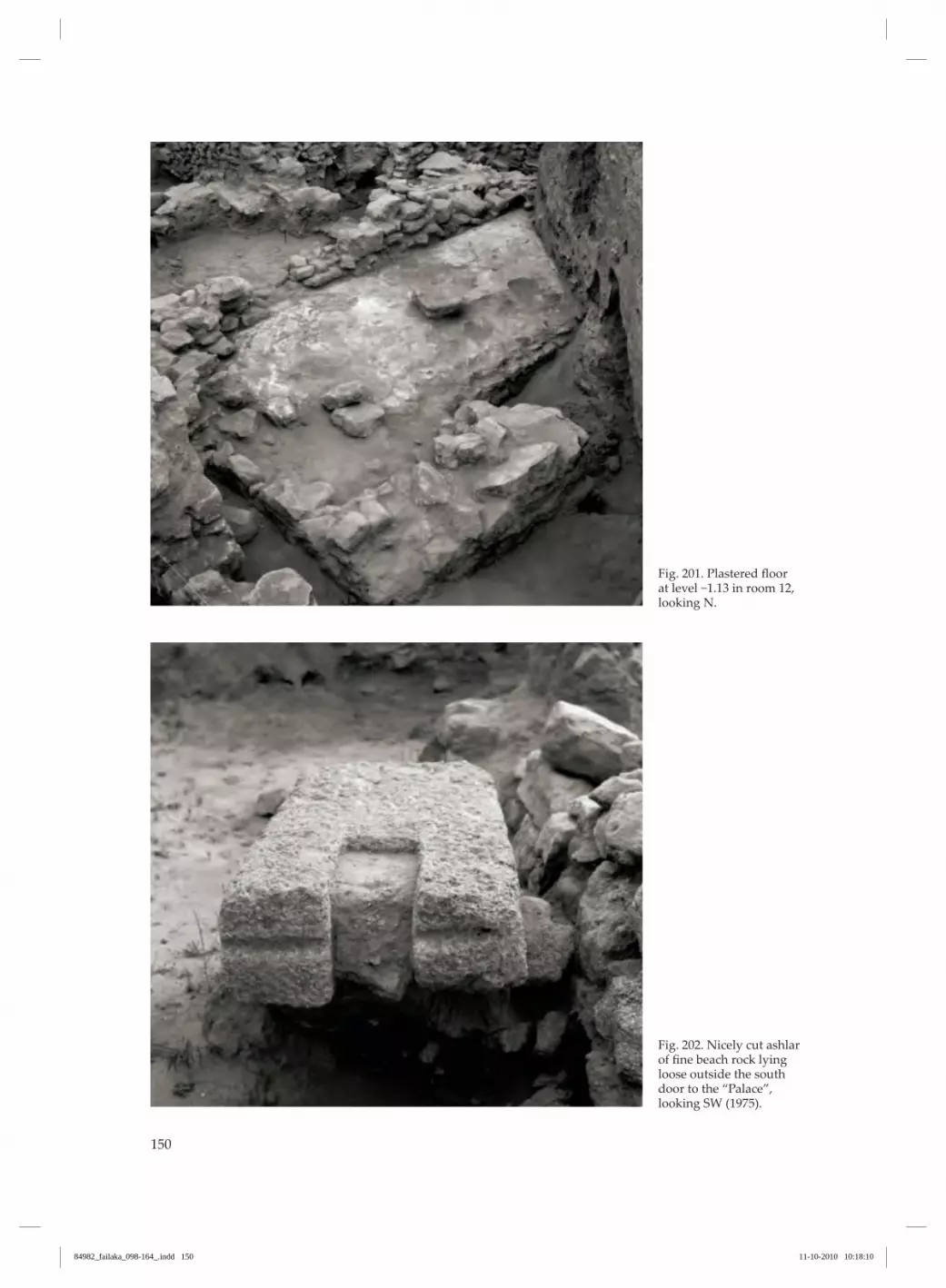
150
Fig. 201. Plastered floor at level −1.13 in room 12, looking N.
Fig. 202. Nicely cut ashlar of fine beach rock lying loose outside the south door to the “Palace”, looking SW (1975).
84982_failaka_098-164_.indd 150 11-10-2010 10:18:10

151
Fig. 203. Phase III wall running SW-NE, looking NW (1962/63).
Detailed description of phase III
The latest construction phase within this excavation is only preserved as building remains towards the NW and comprises some walls, the upper courses of which were visible on the surface of the tell (figs. 203 and 204). The walls are preserved along a NW-SE sequence of c. 6 m in length and a SW-NE sequence of c. 4 m in length. Further to these is a pillar which stands 4 m further south. No floors or deposits were detected in direct relation to these walls, which were located so high up in the tell that any stratigraphy has been destroyed by stone plundering and erosion. It is, accordingly, unknown whether the wall sections detected are sunken foundations or walls built on the surface existing at that time, as was the practice during phases I and II. The few courses of the walls that are preserved, comprise exceptionally well-dressed ashlars as much as 90 × 50 cm in size and carefully laid with screeds or levelling layers of smaller stones (fig. 203). These also fill out the gaps between the large stones. This is a building technique which is completely unknown in phases I and II and which suggests a larger monu‑mental building.
The orientation of the phase III walls completely follows that of the “Palace”. The NW-SE section was built directly over an earlier phase II wall, which it follows, whereas the other walls were built on shift‑ing sand with a slight content of stones. The basal level for the walls lies around +0.40 to +0.50 and they extend up to levels +1.20 to +1.30, i.e. the surface of the tell. The pillar was built over an earlier phase II wall, but on the layer of shifting sand which covers this (fig. 204). The pillar has its base at c. +0.40 and its top at level +0.90. It was built of dressed flagstones and plaster-covered. The external dimensions at the foot are 36 × 31 cm. In one place, the northern wall of the “Palace” reaches a level of +0.92, i.e. c. 40 cm above the base of the walls belonging to the phase dealt with here. This raises the question of whether this wall was also part of the phase III complex, but another possibil‑ity is that our phase III walls are foundations for a building.
84982_failaka_098-164_.indd 151 11-10-2010 10:18:12

152
Fig. 204. Phase III pillar on top of SE wall in room 7, looking S (1962/63).
Buildings to the west
In 1973-74, the Johns Hopkins University excavated a number of trenches in Tell F6, in the area west of the “Palace”. These excavations will be summarised here, based on a report submitted to the Kuwait De‑partment of Antiquities and Museums (Howard-Carter 1984). Trench FH-1 was located some 100 m
west of the “Palace” (fig. 2). This was followed by trenches FH‑3 and FH‑4/5, which lay a few metres from the “Palace” (fig. 131). Trench FH‑9 covered an area partly inside, and partly immediately outside, the “Palace” and is dealt with in the previous chapter (figs. 187, 193‑195).
Trench FH‑1A 10 × 10 m trench revealed two floors, 20-50 cm apart, vertically. The floors were covered with ash, shells, bones and pottery. Associated with the floors were flimsy stone walls, three to five courses in height, and plastered storage pits. Beneath the low‑
est floor was pure sand, extending down to a depth of at least 1.5 m. In 1983 the director of the American excavations, Theresa Howard‑Carter, showed one of the authors (FH) the pottery excavated from trench FH-1. It
84982_failaka_098-164_.indd 152 11-10-2010 10:18:14

153
was a very homogenous assemblage with respect to shape, ware and decoration. It was completely different from anything previously found in Tells F3 and F6, and displayed similarities to a black ware occasionally found in period IIIc at Qala’at al-Bahrain (Højlund & Andersen 1994 p. 194, figs. 868‑72, with
parallels at Tell Abraq, cf. Potts 1990b fig. 133:1‑6). From the bottom of the trench came a few sherds of Barbar ware and also a few sherds diagnostic of Failaka periods 4A-B. In 2007/8, a Greek mission carried out some exca‑vations in this area (Kottaridi n.d.).
Trenches FH‑3, FH‑4/5West of the “Palace” a c. 16 × 15 m trench revealed three different kinds of structures (fig. 131): 1) Circular buildings made of stone with an outer diameter of 2-4 m. Three of these seem to be linked by a straight wall; a fourth seems to be joined to a square room by a doorway, and the beginning of a fifth disappears into the south section. A sixth is conjoined with a rectangular room. 2) A row of square/rectangular rooms with com‑mon walls, similar to the buildings in Tell F3; no internal doorways are, however, marked on the plan. 3) Some narrow rectangular structures lying paral‑lel to the “Palace” at a distance of c. 3 m. In addition to these structures the NW corner of the “Palace” was uncovered in this trench; this is dealt with in the previous chapter. According to Howard-Carter (pers. comm. 1983), a N-S section through the trench crossing the second round building from the west revealed a thick top-soil layer, followed by three rather thin levels, levels 1-3, separated by two layers of fill and underlain at their base by sterile sand. The report indicates that the narrow rectangular structures belong to level 1 and the circular struc‑tures and the square rooms to levels 2-3. It does not describe the stratigraphic relationship between these
structures and the “Palace”. However, on the basis of a visual inspection on-site it seems reasonable to con‑nect the narrow rectangular structures to a late phase of the “Palace”, perhaps phase II, and the circular buildings and the row of rooms to the first phase of the “Palace” or even earlier, but new excavations are needed to clarify the history of this area. None of the structures was actually blackened by fire, as is normally the case in ovens, but thick layers of ash were common, as were thick layers of pearl oyster shells. The finds consisted of pottery, in‑cluding many baking plates with finger impressions (Højlund 1987 type 44), fragments of steatite vessels, nine circular Dilmun stamp seals, one bifacial Indus-inscribed rectangular stamp seal, carnelian and agate beads, copper-based metal pieces and animal bones. In the northern part of the trench, a complete pithos (described in Højlund 1987 pp. 39 and 166) was found in a pit sunk into the floor of level 3 (fig. 131). The pottery from trenches FH-3 and FH-3/4 was examined in 1983 by one of the authors (FH) result‑ing in the following rather broad indications: The top soil and level 1 yielded pottery dating from periods 3B-4A; levels 1-3 yielded pottery dating from periods 1‑2.
84982_failaka_098-164_.indd 153 11-10-2010 10:18:14

Fig. 205. The temple in Tell F6, aerial photo by Yves Guichard, from SE (2009).
84982_failaka_098-164_.indd 154 11-10-2010 10:18:19

155
Tell F6: The temple
Immediately east of the “Palace” in Tell F6, the re‑mains of an imposing monument from the Early Dilmun period were excavated by French archae‑ologists in the 1980s (figs. 205‑6). The excavators have published their results in several articles and primary excavation reports (Calvet & Pic 1986, 1990, 2008), presenting the architectural features and the associated finds. Though the monument had been robbed of its valuable limestone ashlars and razed to its founda‑tions, enough was preserved for the interpretation of the building as a temple to be convincing. It is the placing of this temple in relation to other temples along the Arabian Gulf and in the region north of Failaka that will be considered here. One of the excavators concludes: “We are in the presence of a monument which, as far as I know, has no parallels in the Gulf region. It has nothing in com‑mon with the contemporary monuments excavated in Bahrain; their dimensions are much smaller and the construction techniques belong to an architec‑
ture of smaller scale, even if they are also of a cer‑tain quality (Andersen 1986).” (Calvet 1991 p. 142). This is certainly not tenable, and in the following the opposite will be argued: The temple in Tell F6 on Failaka shows many important similarities to the Barbar temples in Bahrain. Calvet continues: “On the other hand, the temple-tower [the Failaka temple]…finds equivalents in up‑per Mesopotamia, at Mari, and more generally in the Levant, Palestine and Syrian coast: the temple of Baal at Ra’s Shamra-Ugarit is an example, although later than the temple of Failaka.” (2002 p. 266, 2008 pp. 15-19). This idea would have been more convincing had it been accompanied by some arguments and refer‑ences to specific architectural parallels. As it is, the similarity between the Failaka temple and temples found north of the Arabian Gulf is difficult to evalu‑ate, whereas the similarities to the Barbar temples in Bahrain can be described in detail.
Fig. 206. Tell F6 with the “Palace” (left) and the temple (right).
N 10
meters
0 5
84982_failaka_098-164_.indd 155 11-10-2010 10:18:19

156
The dating of the templeAccording to Calvet (2008 p. 22) “…the successive stages of construction and the modification of the building up to its complete destruction, between the very end of the 3rd millennium and the Hellenistic period, are clear.” On the other hand, the excava‑tors underline the severity of the plundering of the Failaka temple, which left almost only the founda‑tions undisturbed and, as a result, the amount of pottery recovered from secure contexts was very small. Consequently, it is not possible to arrive at a reliable date for the temple phases on the basis of the published evidence. Five occupation phases were distinguished at the site. Levels IV-V were the oldest and related to the construction and use of the building (Pic 2008 p. 50). Pic points out many convincing parallels between Barbar-tradition pottery from the oldest levels of the temple, levels Vb-c, and Failaka periods 1-2, corre‑sponding to the Isin-Larsa period (2008 p. 52, figs. 25‑28, 30‑33, 35, 37‑38). However, she refers a large group of Mesopotamian pottery (2008 figs. 15‑16) to the same levels, although the Mesopotamian forms can hardly be later than the Ur III period. These Mes‑opotamian forms do, however, often lack context or are from questionable contexts. At some point in time the temple was modified markedly by the addition, all around the original
ashlar walls, of a c. 4 m‑thick wall of uncut stones laid in clay. In the French terminology this is referred to as level Va and is dated to Failaka period 3A, i.e. the Old Babylonian period. However, the three rim‑sherds that Pic refers to as testimony to this dating (2008 fig. 14, nos. 63-65) are not diagnostic of period 3A. In fact, not a single diagnostic period 3A type has been published from level V or from the temple site as such. Level IV, above level V, contains Kassite pottery, i.e. Failaka periods 3B and 4A, but it is unknown if the temple still functioned as such at this time. Level III is interpreted as a level of abandonment, and level II shows indications of stone plundering from the Greek period. At present, the stratigraphical dating of the temple phases is uncertain and the finds provide only a gen‑eral date for levels IV‑V of late third to early second millennium BC. A comparison with the different phases of the Barbar temple (see below) reveals the closest parallels in the last phases of the latter, phases IIb and III, as well as the Northeast temple (Andersen & Højlund 2003; Højlund & Andersen 1994 p. 173; Højlund 2007 pp. 11-15) (fig. 9) indicating a date in the Isin-Larsa period, but further investigations are needed in order to resolve this question.
The dimensions of the templeCalvet states that the dimensions of the contempo‑rary monuments in Bahrain are much smaller than those of the Failaka temple (Calvet 1991 p. 142). The Failaka temple was a building measuring c. 19.5 × 19.5 m, situated on a low platform which, in one phase, may have been c. 28.5 m wide, in another c. 39.5 m. In comparison, the Barbar Northeast tem‑ple consisted of an outer platform perhaps 46 m wide and an inner platform measuring c. 19 × 19 m, upon which stood a building measuring 15 × 15 m, which has been plundered to its foundations. The third phase of the Barbar temple had an inner platform of 38 × 38 m and was at least 4 m high. The buildings that originally crowned this platform, as well as most of the platform itself, have been plun‑dered.
The second phase of the Barbar temple consisted of an outer oval platform, c. 60 × 80 m, upon which stood a c. 25 × 25 m, and almost 2 m high, inner plat‑form. Remains of several buildings crowned the platform. Comparing the dimensions of a building razed to its foundations to other buildings only slightly less damaged by stone plundering is not without its difficulties. However, the overall dimensions of the Failaka temple and phases II-III of the Barbar temples and the Northeast temple are very similar, and it is quite likely that the third Barbar temple may have outshone the Failaka temple
84982_failaka_098-164_.indd 156 11-10-2010 10:18:19

157
Fig. 207. Fragment of oolithic limestone ashlars embedded in the plas‑tered surface of the tem‑ple foundations (2008).
The construction techniques of the templeCalvet states that the construction techniques used in the monuments of the same date in Bahrain belong to an architecture of smaller scale, even if they are also of a certain quality (Calvet 1991 p. 142). Whereas the building material in Barbar temple I comprised rough stones, in Barbar temples II and III and the Northeast temple it consisted of finely-cut ashlars. And although the monuments were heavily plundered, enough remains to gain a good impres‑sion of this lavishly used material. Even though the Failaka temple was plundered to its foundations, there are clear impressions of ashlars set in the plas‑ter of these (Calvet & Pic 1990 p. 104, plan 1). In a small number of cases, corners of the ashlars in the Failaka temple (Calvet & Pic 1990 plan 1:382) were broken off during their removal. These pieces have remained in situ, embedded in the plaster foun‑dations, where they can be identified as oolithic lime‑stone (pers. obs. 2008) (fig. 207), the same material used for most of the ashlars in the Barbar temple. From their impressions in the plaster, the Failaka ashlars can be measured as having had average dimensions of 40-50 × 70-80 cm. This corresponds well to the average measurements of ashlars from
the three walls standing on the central platform of Barbar temple II, the west wall: c. 35-45 × 65-70 cm, the north wall: c. 35-50 × 70 cm and the east wall: c. 30-60 × 65-100 cm (Andersen & Højlund 2003 plan 3: 8‑10). The foundations of the Failaka temple are 1.5 m deep and 2.8 m thick. They are built of rough, local stones, set in plaster. Both faces are plastered, as well as the upper surface, which is covered by a thick layer of plaster bearing traces of ashlars as described above. In comparison, the east wall on the central plat‑form of Barbar temple II, mentioned above, rested on c. 2.0 m-deep and 2.3 m-thick foundations which also constituted the outer wall of the platform. The north wall, described above, rested on a completely embedded foundation which was 0.9 m deep and 1.8 m thick, built of finely-cut ashlars. The terrace walls of Barbar temple III were c. 3.6 m thick and at least c. 4 m high. The ashlar walls of the two internal rooms in the Failaka temple are 70-80 cm thick, corresponding well with the walls built on Barbar temple II’s plat‑form, mentioned above, which are 65-70 cm thick.
84982_failaka_098-164_.indd 157 11-10-2010 10:18:22

158
The outer walls of the Failaka temple consist of two faces of ashlars with an internal cavity fill of rough stones, giving the wall a thickness of c. 2.1 m. In both the Failaka temple and Barbar Temple II, a substantial floor was encountered, constructed of thick stone flags of oolithic limestone set in plaster. The flagstones were of irregular shape but closely fitted, their dimensions in Failaka being c. 0.6-1.1 m, and in Barbar, 60-70 × 70-80 cm (Andersen & Højlund 2003 fig. 100). In both the Failaka temple and the Barbar temple the ashlars in the walls were set in white plaster. In general, the Failaka construction techniques, the particular stone material used, the size of the ashlars, and the thickness of the foundations and walls are similar to those used in Barbar temples II-III. The outer walls of the Failaka temple are excep‑
tionally thick and built using a coffer technique not found in the Barbar temple. However, it should not be forgotten that there is no evidence relating to the walls which were constructed on top of the Barbar temple III platform. With its enormous 3.6 m-thick and 4.0 m-high terrace walls, it is to be expected that the buildings that once stood on this platform would have been extravagant. It is doubtful whether the thickness of the walls of the Failaka temple and the quality of its construction are compelling arguments for an exceptional height of the monument (a temple tower) as proposed by Calvet & Pic (1990 pp. 114-115, 2008 pp. 15-19). The solidity of temple constructions is hardly purely a technical matter, and excessive dimensions can just as well be interpreted as a display of wealth and piety.
The functions of the templeBecause of the severe plundering of the Failaka temple there is scant evidence for the various func‑tions that took place in the temple. A channel was cut through the NW wall of the building at floor level, continuing at least 10 m away from the build‑ing (Calvet & Pic 1986 fig. 39). The excavators sug‑gest that the channel may have begun in the centre of the building, close to the door to the NE room, carrying water out of the building (Calvet & Pic 1990 pp. 107-109). The way the channel has been cut through the wall ashlars, and the way it continues far away from the temple, is closely paralleled in the Barbar temple phase II (Andersen & Højlund 2003 fig. 103, plan 3:3). In the Barbar temples, several channels were observed leading from central altars and ending far away from the temple. It is argued that they trans‑
ported away water used in washing and cleaning the altars after bloody sacrifices (Andersen & Højlund 2003 pp. 323-324). A similar function could be pro‑posed for the Failaka channel. In this context it is probably no coincidence that the channel leads from the temple towards the NW, as this must have been the rear of the building, since the entrance lies to the SE (Calvet & Pic 1990 p. 106). The function of the other channel bordering the first terrace in the Failaka temple seems more uncer‑tain and has no parallel at Barbar. Below the floor level of the Failaka temple, two ba‑sins had been constructed using stone slabs with the gaps carefully sealed with plaster. They may have been intended to hold water for ritual ceremonies, like the well chamber in the Barbar temple, as sug‑gested by the excavators (Calvet & Pic 1990 p. 107).
When was the temple plundered?When the temple was uncovered in the 1980s, it was clear that the building had originally been con‑structed of finely-dressed ashlars which, at some point in time, had been plundered and removed. As a good quantity of Hellenistic pottery was found in the stone-plundering trenches (Calvet & Pic 1986 pp. 16-18, figs. 8-10), it was concluded that the plun‑dering took place in Hellenistic times, i.e. c. third century BC, when a fortified town with a fine ashlar temple was constructed at Tell F5, immediately south of Tell F6. “Finally, at the beginning of the Hellenistic period,
most of the stones were plundered, in order to build a fortress southwards. The walls were destroyed down to the top of the foundations and sometimes deeper.” (Calvet 1989 p. 6, 1987 p. 21, 1991 p. 140). One of the reasons for building the Greek fortress on the SW corner of Failaka could even have been the presence of the Dilmun temple ruins, a quarry of ready made ashlars (Callot, Gachet‑Bizollon & Salles in Callot 2005 p. 67). There are, however, several weaknesses in this theory: The Hellenistic temple which was indeed built of oolithic limestone ashlars was not very big,
84982_failaka_098-164_.indd 158 11-10-2010 10:18:22

only 11.5 × 7.5 m, with 80‑90 cm‑thick walls. The Dil‑mun temple, in contrast, was c. 20 × 20 m with c. 2 m‑thick outer walls and 70‑80 cm‑thick inner walls. Even though the present writers do not agree with the height of 8‑10 m estimated by the French excava‑tors, it would still have been a much larger building than the Greek temple. With an estimated height of 4 m for both buildings, the Bronze Age temple would have comprised about four times as many cubic metres of limestone as needed for the Helle‑nistic temple. Therefore, if the plundering of the Dilmun temple really did take place during the Hellenistic period, why was the remainder of the white ashlars not used in the contemporaneous town? There are rather few limestone ashlars or fragments of these in the for‑tifications and houses of the Hellenistic town. The stone which is used here is almost exclusively the coarser beach rock (farush) which was probably quar‑ried from the nearby coastline. “Oolithic limestone is used for the temples, but occurs only sporadically in the fortification walls and dwellings, which are con‑structed almost exclusively of broken beach‑rock.” (Jeppesen 1989 p. 13 and as observed on‑site 2008). The conclusion of these observations must be that when the Hellenistic temple and the surrounding town were built, the Dilmun temple had long since been plundered and the fine blocks transported away. Therefore, use had to be made of a coarse lo‑cal stone which could be quarried from the beach. Only the temple was built of the fine white stone which most probably was, for this purpose, obtained directly from a quarry.
This conclusion is actually supported by the French finds of Hellenistic pottery in the deep rob‑ber trenches. If the Dilmun temple still remained un‑plundered when the “Greek” town was built, the many stone blocks would have protruded up from the earth, and the builders could just have taken what they needed from the surface. The necessity of digging 3‑4 m‑deep holes in order to obtain the stone demonstrates, with all desirable clarity, that the fine ashlar building had long since been plundered and that they had to go to great lengths in order to find suitable building material. Perhaps the Dilmun temple in Tell F6 was plun‑dered in order to obtain building materials for the construction of the hypothetical Nebuchadnezzar’s palace mentioned above (p. 108 and 151). However, as yet, we do not know the site of this palace and the indications are that, even though the temple’s stone blocks were possibly first used to build Nebuchad‑nezzar’s palace, they were subsequently removed completely from Failaka. Otherwise one would pre‑sume that the “Greeks” had used the building as a quarry and that there would, consequently, be many re‑used limestone ashlars in the Greek fortifications and settlement. In conclusion, the temple in Tell F6 on Failaka follows closely the Dilmun tradition of temple archi‑tecture as known from the Barbar temples in Bahrain and this is only to be expected. So far all comparisons between Failaka and Bahrain in the first centuries of the second millennium BC indicate an overwhelm‑ing similarity in aspects of material culture such as pottery, stamp seals, and architecture.
84982_failaka_098-164_.indd 159 11-10-2010 10:21:08

84982_failaka_098-164_.indd 160 11-10-2010 10:18:23

161
Bibliography
Andersen, H.H. 1986: The Barbar Temple: stratigraphy, architecture and interpretation. In: Khalifa, H.A. Al & M. Rice (eds.) 1986: Bahrain through the Ages: the Archaeology. Kegan Paul International Ltd. London p. 166-177.
Andersen, H.H. & Højlund, F. 2003: The Barbar Temples, vols. 1‑2. Jutland Archaeological Society Publications 48. Århus.
Bibby, T. Geoffrey 1996: Looking for Dilmun. Stacey Int. Pub‑lishers, London (originally published 1969).
Callot, O. et al. 2005: L’île de Failaka. Archéologie du Kuwait. Somogy editions d’art. Lyon.
Calvet, Y. 2002: The Dilmun culture at its border with Mesopotamia. In Cleuziou, Tosi & Zarins (eds), Serie Ori‑entale Roma, XCIII, Essays on the late prehistory of the Arabian peninsula, Istituto italiano per l’Africa e l’Oriente, Rome, p. 257-271.
Calvet, Y. 2008: Le temple-tour de Failaka dans son con‑texte proche-oriental. In: Calvet & Pic 2008 p. 15-19. Lyon.
Calvet, Y. 1987: Le pays de Dilmoun au 2e millénaire: dé‑couvertes récentes. In: T. Fahd (ed), L’Arabie Préislamique et son environnement historique et culturel. Actes du Colloque de Strasbourg 24-27 juin 1987.
Calvet, Y. 1991: Un bâtiment de l’Age du Bronze à Failaka, Koweit. In: Schippmann, K., A. Herling & J.-F. Salles (eds.): Golf Archäologie. Mesopotamien, Iran, Kuwait, Bahrain, Ver‑einigte Arabische Emirate und Oman. Internationale Archäe‑ologie 6.
Calvet, Y. 1989: Failaka and the northern part of Dilmun. Proceedings of the Seminar for Arabian Studies 19.
Calvet, Y. & M. Pic 1986: Un nouveau bâtiment de l’Age du Bronze sur le Tell F6. In: Calvet & Salles 1986 p. 13-87.
Calvet, Y. & J.-F. Salles (eds.) 1986: Failaka. Fouilles Fran‑caises 1984‑1985. Travaux de la Maison de l’Orient 12. Lyon.
Calvet, Y. & J. Gachet (eds.) 1990: Failaka. Fouilles Francaises 1986‑1988. Travaux de la Maison de l’Orient 18. Maison de l’Orient. Lyon.
Calvet, Y. & M. Pic 1990: Un temple-tour de l’âge du Bronze à Failaka. In: Calvet & Gaschet (eds.) 1990 p. 103-122.
Calvet, Y. & M. Pic 2008: Failaka Fouilles Francaises 1984‑1988. Matériel céramique du temple-tour et épigraphie. Travaux de la Maison de L’Orient et de la Méditerranée 48, Lyon.
Dalongeville, R. 1990: Présentation physique générale de l’ile de Failaka. In: Calvet & Gaschet (eds.) 1990 p. 23-42.
Dickson, H.R.P. 1956: Kuwait and her neighbours. George Allen & Unwin Ltd.
Ferrara, A.J. 1975: An inscribed stone-slab of Nebuchadne‑zzar II. Journal of Cuneiform Studies 27 p. 231-232.
Glassner, J.-J. 2008: Textes cuneiformes. In: Calvet & Pic 2008 p. 171-205.
Glob, P.V. 1968. Al‑Bahrain. De danske ekspeditioner til Old‑tidens Dilmun. Gyldendal. (Arabic edition 2002 published by the Bahraini Ministry of Information).
Hannestad, L. 1983: The Hellenistic Pottery from Failaka. Ikaros-The Hellenistic Settlements 2:1-2. Jutland Archaeo‑logical Society Publications no. 16:2.
Howard‑Carter, Theresa 1984: The Johns Hopkins University Expedition to Failaka Island 1973‑1974. Unpublished report on file in the Kuwait National Museum p. 1-42.
Højlund, Flemming 1981: Preliminary remarks on the dat‑ing of the Palace at Sa’ad wa-Sa’aid on Failaka (Kuwait). Proceedings of the Seminar for Arabian Studies 11 p. 37-42.
Højlund, Flemming 1983: The 2nd mill. settlements on Failaka, Kuwait. Unpublished paper presented at the Ren‑contre Assyriologiques and the Seminar for Arabian Studies.
Højlund, Flemming 1987: The Bronze Age Pottery. (Failaka/Dilmun. The Second Millennium Settlements 2). Jutland Archaeological Society Publications 17:2.
Højlund, Flemming1988: Chronological and functional differences in Arabian Bronze Age pottery: A case study in correspondence analysis. In: T. Madsen (red.), Multivariate Archaeology. Numerical Approaches in Scandinavian Archaeol‑ogy. Jutland Archaeological Society Publications p. 55-60.
Højlund, Flemming 2007: The Burial Mounds of Bahrain. Social complexity in Early Dilmun. Jutland Archaeological Society Publications 58.
Højlund, Flemming 2008: The Danish Archaeological Expedi‑tion to Kuwait 1958-1963. A glimpse into the archives of Moes‑gård Museum. Moesgård Museum & The Kuwait National Council for Culture, Arts and Letters (Arabic version 2009).
Højlund, Flemming & H. Hellmuth Andersen 1994: Qala’at al‑Bahrain vol. 1. The Northern City Wall and the Islamic For‑tress. Jutland Archaeological Society Publications 30:1.
Højlund, Flemming & H. Hellmuth Andersen 1997: Qala’at al‑Bahrain vol. 2. The Central Monumental Buildings. Jutland Archaeological Society Publications 30:2.
84982_failaka_098-164_.indd 161 11-10-2010 10:18:23

Jeppesen, Kristian 1989: The Sacred Enclosure in the Hellenis‑tic Period. (Failaka/Ikaros. The Hellenistic Settlements 3). Jutland Archaeological Society Publications 16:3.
Killick, R. & J. Moon 2005: The Early Dilmun Settlement at Saar. London-Bahrain Archaeological Expedition. Saar Excavation Report 3. Archaeology International.
Kjærum, Poul 1983: The Stamp and Cylinder Seals. Plates and Catalogue Descriptions. (Failaka/Dilmun. The Second Mil‑lennium Settlements 1:1). Jutland Archaeological Society Publications 17:1.
Kjærum, Poul 1986: Architecture and Settlement Patterns in 2nd Mill. Failaka. Proceedings of the Seminar for Arabian Studies 16 p. 77-88.
Kottaridi, Angeliki n.d.: Archaeological site of Ikaros. Kuwaiti‑Hellenic Archaeological Mission to Failaka (KHAM). First ex‑cavation season 22/11/2007 – 12/1/2008. Report on file in the Kuwait National Museum.
Mathiesen, H.E. 1982: The Terracotta Figurines. Failaka/Ikaros-The Hellenistic Settlements 1). Jutland Archaeo‑logical Society Publications no.16:1.
Pic, M. 2008: La céramique du tell F6, fouilles francaises de 1984 à 1988. In: Calvet & Pic 2008 p. 33-170.
Potts, D.T. 1990a: The Arabian Gulf in Antiquity, vol. I. Clar‑endon Press. Oxford.
Potts, D.T. 1990b: A Prehistoric Mound in the Emirate of Umm al‑Qaiwain, U.A.E. Excavations at Tell Abraq in 1989. Munks‑gaard. Copenhagen.
Yarwood, J. 2005: Al-Muharraq. Architectural Heritage of a Bahraini City. Shaikh Ebrahim bin Mohammed Al-Khalifa Center for Culture and Research. Manamah.
84982_failaka_098-164_.indd 162 11-10-2010 10:18:23

Jutland Archaeological Society Publications on Near Eastern Archaeology
Atlas of the Stone Age Cultures of QatarHolger Kapel, 86 s. English and Arabic. 48 plates. 1967. 92,00
Preliminary Survey in East Arabia 1968T.G. Bibby, 67 p. 1973. 60,00
The Maussolleion at Halikarnassos 1Reports of the Danish Archaeological Expedition to BodrumThe Sacrificial DepositKristian Jeppesen, Flemming Højlund & Kim Aaris-Sørensen, 110 p. 1981. 140,00
The Maussolleion at Halikarnassos 2Reports of the Danish Archaeological Expedition to BodrumThe Written Sources and their Archaeological BackgroundKristian Jeppesen & Anthony Luttrell, 220 p. 1986. 240,00
The Maussolleion at Halikarnassos 3Reports of the Danish Archaeological Expedition to BodrumThe Maussolleion Terrace and Accessory Structures 1‑2Poul Pedersen, Vol. 1: Text and appendices. 208 p. Vol. 2: Cataloque. 134 p. 1991. 320,00
The Maussolleion at Halikarnassos 4Reports of the Danish Archaeological Expedition to BodrumThe QuadrangleKristian Jeppesen, 182 p. 16 plates. 2000. 240,00
The Maussolleion at Halikarnassos 5Reports of the Danish Archaeological Expedition to BodrumThe SuperstructureKristian Jeppesen, 265 p. 2002 240,00
The Maussolleion at Halikarnassos 6Subterranean and pre‑Maussollan structures on the site of theMaussolleionJan Zahle & Kjeld Kjeldsen, 250 p. 2004. 280,00
The Maussolleion at Halikarnassos 7Reports of the Danish Archaeological Expedition to BodrumThe PotteryLeif Erik Vaag, Winnie Nørskov & John Lund, 243 p. 85 plates. 2002 280,00
Failaka/IkarosDanish Archaeological Investigations on Failaka, KuwaitThe Hellenistic Settlements 1The Terracotta FigurinesHans Erik Mathiesen, 94 p. 1982. 115,00
Failaka/IkarosDanish Archaeological Investigations on Failaka, KuwaitThe Hellenistic Settlements 2The Hellenistic Pottery from Failaka 1‑2Lise Hannestad, Vol. 1: Text. 140 p. Vol. 2: Cataloque and Plates. 128 p. 1983. 183,00
Failaka/IkarosDanish Archaeological Investigations on Failaka, KuwaitThe Hellenistic Settlements 3The Sacred Enclosure in the Early Hellenistic PeriodKristian Jeppesen, 125 p. 1989. 185,00
84982_failaka_098-164_.indd 163 11-10-2010 10:24:42

Failaka/DilmunDanish Archaeological Investigations on Failaka, KuwaitThe Second Millennium Settlements 1The Stamp and the Cylinder SealsPoul Kjærum, Catalogue. 171 p. 79 plates. 1983. 150,00
Failaka/DilmunDanish Archaeological Investigations on Failaka, KuwaitThe Second Millennium Settlements 2The Bronze Age PotteryFlemming Højlund, 197 p. 1987. 200,00
The Natufian Encampment at BeidhaLate Pleistocene Adaption in the Southern LevantBrian F. Byrd, 126 p. 1989. 143,00
The Island of Umm an‑Nar 1Third Millennium GravesKaren Frifelt, 188 p. 1991. 180,00
The Island of Umm an‑Nar 2Third Millennium SettlementKaren Frifelt, 260 p. 1995. 230,00
Qala’at al‑Bahrain 1The Northern City Wall and the Islamic FortressFlemming Højlund & H. Hellmuth Andersen, 511 p. 1994. 360,00
Qala’at al‑Bahrain 2The Central Monumental BuildingsFlemming Højlund & H. Hellmuth Andersen, 288 p. 1997. 280,00
Excavations at Tepe Guran in LuristanThe Bronze Age and Iron PeriodsHenrik Thrane, 225 p. 2001. 240,00
Islamic Remains in BahrainKaren Frifelt, 207 p. 2001. 280,00
The Barbar Temples 1‑2H. Hellmuth Andersen & Flemming Højlund, 380 p. 2003 400,00
The Burial Mounds of BahrainSocial complexity in Early DilmunFlemming Højlund, 178 p. 2007 280,00
All prices are exclusive of VAT and postage. Distributed by Aarhus University Press, Langelandsgade 177, DK-8200 Aarhus N. www.unipress.dkMembers of Jutland Archaeological Society get a discount of 30% on all orders sent directly to Jutland Archaeological Society, Moesgaard, DK-8270 Højbjerg.
84982_failaka_098-164_.indd 164 11-10-2010 10:24:43


