Embed Size (px)
Citation preview

lable at ScienceDirect
Quaternary Science Reviews 109 (2015) 68e75
Contents lists avai
Quaternary Science Reviews
journal homepage: www.elsevier .com/locate/quascirev
The earliest securely-dated hominin artefact in Anatolia?
D. Maddy a, *, D. Schreve b, T. Demir c, A. Veldkamp d, J.R. Wijbrans e, W. van Gorp f,D.J.J. van Hinsbergen g, M.J. Dekkers g, R. Scaife h, J.M. Schoorl f, C. Stemerdink a,T. van der Schriek a
a School of GPS, Newcastle University, Newcastle upon Tyne NE1 7RU, UKb Department of Geography, Royal Holloway University of London, Egham TW20 0EX, UKc Department of Geography, Harran University, 63300 Sanliurfa, Turkeyd Faculty of Geo-Information Science and Earth Observation (ITC), Twente University, Enschede, The Netherlandse Department of Earth Science, VU University, De Boelelaan 1085, 1081 HV Amsterdam, The Netherlandsf Soil Geography and Landscape Group, Wageningen University, 6700 AA Wageningen, The Netherlandsg Department of Earth Sciences, Utrecht University, Budapestlaan 4, 3584 CD Utrecht, The Netherlandsh School of Geography, University of Southampton, Southampton SO17 1BJ, UK
a r t i c l e i n f o
Article history:Received 13 June 2014Received in revised form16 November 2014Accepted 28 November 2014Available online
Keywords:QuaternaryTurkeyRiver terracesHominin occupation
* Corresponding author.E-mail address: [email protected] (D. Madd
http://dx.doi.org/10.1016/j.quascirev.2014.11.0210277-3791/© 2014 Elsevier Ltd. All rights reserved.
a b s t r a c t
Anatolia lies at the gateway from Asia into Europe and has frequently been favoured as a route for EarlyPleistocene hominin dispersal. Although early hominins are known to have occupied Turkey, withnumerous finds of Lower Palaeolithic artefacts documented, the chronology of their dispersal has littlereliable stratigraphical or geochronological constraint, sites are rare, and the region's hominin historyremains poorly understood as a result. Here, we present a Palaeolithic artefact, a hard-hammer flake,from fluvial sediments associated with the Early Pleistocene Gediz River of Western Turkey. This pre-viously documented buried river terrace sequence provides a clear stratigraphical context for the findand affords opportunities for independent age estimation using the numerous basaltic lava flows thatemanated from nearby volcanic necks and aperiodically encroached onto the contemporary valley floors.New 40Ar/39Ar age estimates from these flows are reported here which, together with palaeomagneticmeasurements, allow a tightly-constrained chronology for the artefact-bearing sediments to be estab-lished. These results suggest that hominin occupation of the valley occurred within a time periodspanning ~1.24 Ma to ~1.17 Ma, making this the earliest, securely-dated, record of hominin occupation inAnatolia.
© 2014 Elsevier Ltd. All rights reserved.
1. Introduction
The Anatolian peninsula, bounded by the Black Sea to thenorth, the Aegean Sea to the west, and the Mediterranean Sea tothe south, forms the western limit of Asia and, albeit still withinmodern Turkey, shares a border with European Eastern Thrace tothe west (Fig. 1). This pathway from Asia into Europe hasfrequently been proposed as a route for Early Pleistocene hominindispersal (Dennell, 2003, 2008) but the timing of this dispersalremains poorly understood (Bar-Yosef and Belmaker, 2011). WithinTurkey, the oldest known hominin locality is that of Kocabas, inthe Büyük Menderes valley in Western Anatolia (Fig. 1), where
y).
fragments of a cranium, tentatively attributed to Homo erectus,have been found in travertine deposits (Kappelman et al., 2008).Although Kappelman et al. (2008) reported an age of 490e510 kabased upon thermoluminescence results, a revised age estimate ofbetween 1.3 and 1.1 Ma has recently been suggested on the basisof magnetic polarity measurements and modelled 26Al/10Becosmogenic isotope burial age determinations from sedimentsthat lie below and above the inferred hominin-bearing UpperTravertine (Lebatard et al., 2014. p10). Elsewhere, evidence forhuman occupation is limited to isolated finds of Lower Palaeolithicstone tools (Harmankaya and Tanındı, 1996), yet the chronology ofhominin dispersal across Anatolia has, to date, had little reliablestratigraphical or geochronological constraint (Kuhn, 2002, 2010).This stems from a scarcity of detailed description of, and sub-stantive geochronological constraint on, Plio-Pleistocene se-quences within Turkey.

Fig. 1. Location of the Gediz River, Western Anatolia. Location of the Gediz River plotted on the global ASTER Global Digital Elevation Model v2 (GDEM; ASTER GDEM is a product ofMETI and NASA) with the study area indicated. Inset shows the wider setting of the study area with the Mediterranean together with the location of the Tenaghi Philippon site (TP)discussed in the text. The grid is UTM Zone 35S.
D. Maddy et al. / Quaternary Science Reviews 109 (2015) 68e75 69
One such sequence, the Early Pleistocene sedimentary sequenceof the Gediz River valley around Kula (Figs. 1 and 2), has, however,recently been the subject of extensive studies (Maddy et al., 2005,2012a). These studies describe a staircase of 11 river terracesfrom T11 (highest and oldest) to T1 (lowest and youngest), cut atprogressively lower levels into the underlying Miocene AhmetlerFormation (Ersoy et al., 2010). The terrace deposits are ancestralfloodplains of the Gediz River, which flows from east to west, withprogressive incision driven both by fluvial system adjustment tothe on-going uplift and by climate-driven hydrological/vegetationchange. The detailed stratigraphy is complex, with the terracesoften dissected by the deposits of northerly-derived tributariesdiverted by lava incursions (Maddy et al., 2012b). Critically, how-ever, the fluvial deposits of the Gediz River and its tributaries fromthis sequence are capped by basalts that allow the terrace sequenceto be assigned an Early Pleistocene age on the basis of a limitednumber of previously published K/Ar age estimates (Westawayet al., 2004, 2006).
The most extensive exposures in this sequence lie beneath thelavas that form the Burgaz Plateau (Fig. 2). Here, the onset ofvolcanism is penecontemporaneous with a Gediz valley floor at theT6 level and all lavas appear to emanate from the same BurgazBa�gtepe volcanic neck. Episodic eruptions from this neck continuedduring the time period represented by the sediments underlyingT5eT1. Following the final blockage of the valley floor in this areaby the lavas that cap T1 on Kale Tepe, the Gediz River was divertednorthwards at the upstream end of the blockage, forming ameander loop that returned to the pre-blockage valley floordownstream of the Kale Tepe lava dam, leaving Kale Tepe to occupythe meander core.
In this paper we report the find of an artefact from within thefluvial/alluvial sediments lying in the palaeomeander section. In
addition, we establish the time period during which the palae-omeander loop was occupied by the Gediz, and from that infer thelikely period of hominin occupation. Currently there are five pub-lished age estimates for the Burgaz plateau lavas recorded in theliterature. The first reported age estimate, which lacks preciselocation, was 1100 ka (Borsi et al., 1972). Two estimates of1370 ± 100 and 1120 ± 60 ka are recorded from close to the BurgazBa�gtepe neck (Richardson-Bunbury, 1996, Fig. 2a) and estimates of1031 ± 12 and 996 ± 12 ka are suggested for a lava north of Burgazvillage (Westaway et al., 2006, Fig. 2b). However, none of theseexisting age estimates relate directly to the underlying river terracerecord or the palaeomeander sequence. Thus, in an attempt toconstrain the age of hominin occupation of the palaeomeander andthe age of the terrace record buried beneath the plateau, we havesampled a number of lavas (Fig. 2AeG) for age estimation and, aspart of a wider programme, performed palaeomagnetic measure-ments to determine the magnetic polarity during eruption.
2. Methods
2.1. Lithostratigraphy
Standard sedimentary logging procedures were deployed toestablish the stratigraphy of the artefact-bearing palaeomeanderinfill sequence. Sediment outcrops, exposed along the eroded edgesof the lavas that form the Burgaz plateau, were logged in detailusing standard lithofacies descriptors and, where possible, scaledface sections were drawn in the field in order to establish sedi-mentary architecture. Bounding surface heights were acquiredusing a Sokkia 4c Total Station. Sections located in positions toohazardous for safe reflector positioning have lower precisionheights obtained using a laser range finder. Logged sections,
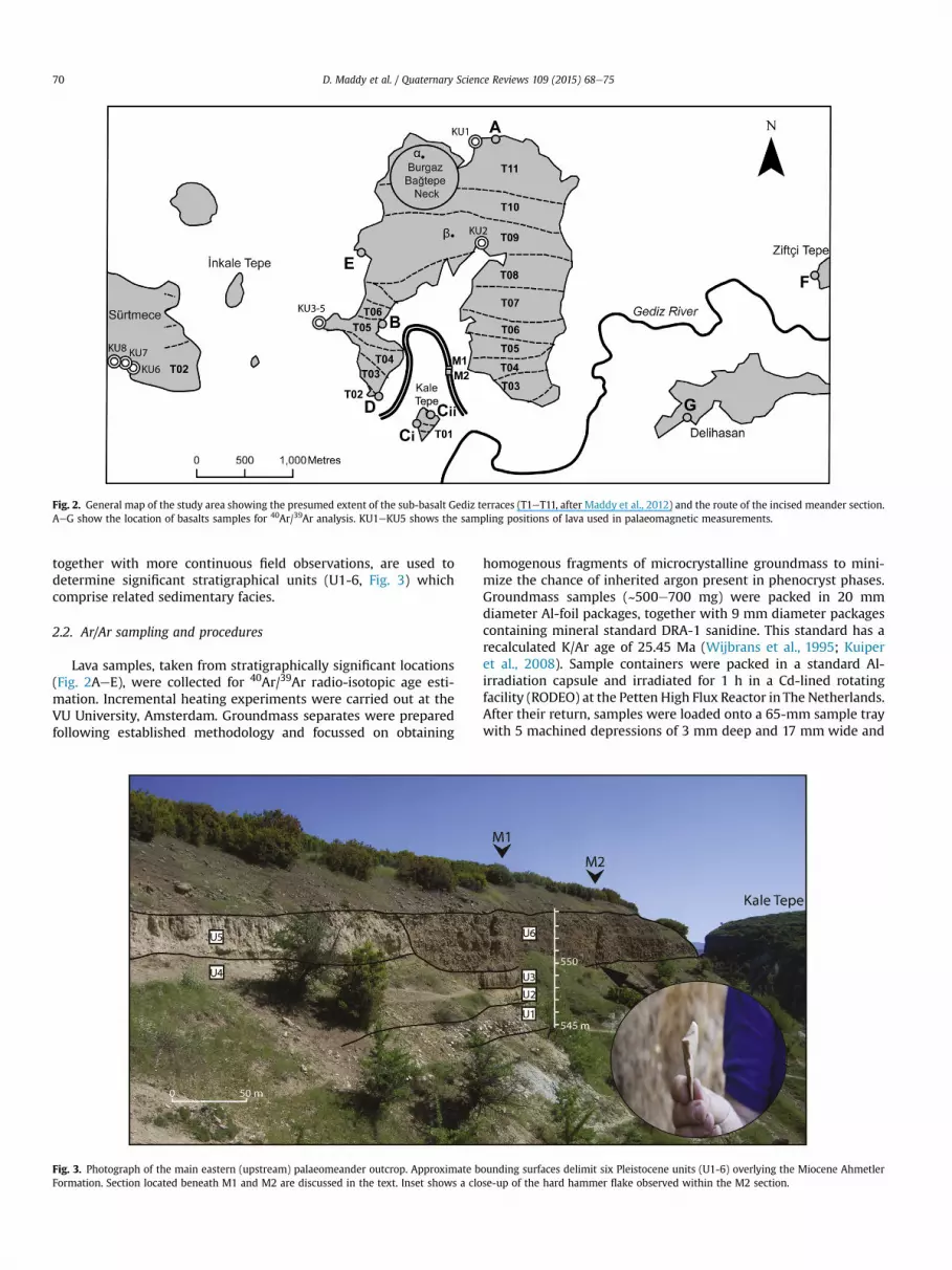
Fig. 2. General map of the study area showing the presumed extent of the sub-basalt Gediz terraces (T1eT11, after Maddy et al., 2012) and the route of the incised meander section.AeG show the location of basalts samples for 40Ar/39Ar analysis. KU1eKU5 shows the sampling positions of lava used in palaeomagnetic measurements.
D. Maddy et al. / Quaternary Science Reviews 109 (2015) 68e7570
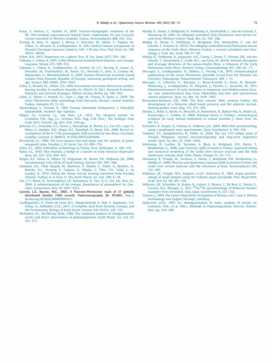
together with more continuous field observations, are used todetermine significant stratigraphical units (U1-6, Fig. 3) whichcomprise related sedimentary facies.
2.2. Ar/Ar sampling and procedures
Lava samples, taken from stratigraphically significant locations(Fig. 2AeE), were collected for 40Ar/39Ar radio-isotopic age esti-mation. Incremental heating experiments were carried out at theVU University, Amsterdam. Groundmass separates were preparedfollowing established methodology and focussed on obtaining
Fig. 3. Photograph of the main eastern (upstream) palaeomeander outcrop. Approximate bFormation. Section located beneath M1 and M2 are discussed in the text. Inset shows a clo
homogenous fragments of microcrystalline groundmass to mini-mize the chance of inherited argon present in phenocryst phases.Groundmass samples (~500e700 mg) were packed in 20 mmdiameter Al-foil packages, together with 9 mm diameter packagescontaining mineral standard DRA-1 sanidine. This standard has arecalculated K/Ar age of 25.45 Ma (Wijbrans et al., 1995; Kuiperet al., 2008). Sample containers were packed in a standard Al-irradiation capsule and irradiated for 1 h in a Cd-lined rotatingfacility (RODEO) at the Petten High Flux Reactor in The Netherlands.After their return, samples were loaded onto a 65-mm sample traywith 5 machined depressions of 3 mm deep and 17 mm wide and
ounding surfaces delimit six Pleistocene units (U1-6) overlying the Miocene Ahmetlerse-up of the hard hammer flake observed within the M2 section.

D. Maddy et al. / Quaternary Science Reviews 109 (2015) 68e75 71
placed in a vacuum housewith a 50mmdiametermultispectral ZnSwindow. Incremental heating was done by defocusing a CO2 laserbeam to a ca 2 mm straight bar using an industrial scanhead with atriangular deflection current of 200 Hz frequency. Samples wereevenly heated by applying a fine x-y raster pattern over each of thesample positions. Measurements were done using a quadrupolemass spectrometer (Schneider et al., 2009). Mass spectrometerruns consist of stepwise measurement of the argon mass spectrumfromm/e 36 to m/e 40, where on m/e 36, 39 and 40 seven readingswere taken at 0.05 m/e intervals on the flat peak top, and for m/e 37and 38 one single reading was taken. The baseline was measured atm/e 35.45. Beam signals for all peaks were measured using a pulsecounting SEM detector. Aliquots of air are measured routinelyduring the measurement programme to monitor mass discrimi-nation (Wijbrans et al., 2011).
2.3. Palaeomagnetic sampling and procedures
We collected 35 samples from 5 lava sites (Fig. 2 KU1eKU5) onthe Burgaz plateau and a further 21 samples from 3 lava sites onSürtmece (Sarniç Plateau, KU6eKU8, Fig. 2). Samples were extrac-ted using a water-cooled, gasoline-powered, motor drill. They wereoriented with a magnetic compass and all magnetic measurementswere corrected for the present-day declination of ~4�. All sampleswere demagnetized using alternating field (AF) progressive de-magnetizations with 5e10 mT increments up to 100 mT. The nat-ural remanent magnetization (NRM) of the specimens wasmeasured on a 2G Enterprises horizontal DC SQUID magnetometer(noise level 3�10e12 Am2), interfacedwith an in-house developedrobot-assisted automated measuring device at the PaleomagneticLaboratory ‘Fort Hoofddijk’ of Utrecht University. Demagnetizationdiagrams of the NRM were plotted in orthogonal vector diagrams(Zijderveld, 1967). In addition, a number of multi-componentsamples were plotted on equal-area projections. Initial NRM in-tensities typically range from 0.5 to 2.0 A/m, at the upper end of thedynamic range of the instrument. When vector end-points showeda trend towards the origin of the diagram, we determined thiscomponent to be the characteristic remanent magnetization(ChRM). ChRM's were calculated with principal component anal-ysis (Kirschvink, 1980). Because the samples plateaus are prone tolightning strikes, which create magnetic overprints, samples werecollected over an area of several tens of square meters to increasethe chance that lightning-induced overprints have different di-rections in different samples. Where a magnetic overprint led tooverlapping demagnetization spectra between two components weused the great-circle approach of McFadden and McElhinny (1988)to resolve the ChRM direction from the great circles defined by thetwo components for individual specimens from the same site. If theoverprint direction is not everywhere the same, the ChRM directioncan be deduced by the common intersection point of all great cir-cles obtained from a lava site, with two solutions (one normal, onereversed), whereby the polarity is determined by non- or onlyweakly overprinted samples within the same site. Geomagneticpolarities indicated by the ChRM directions were interpreted withrespect to the geomagnetic polarity timescale (APTS 2012: Hilgenet al., 2012).
3. Results
3.1. Lithostratigraphy and the Palaeolithic artefact
The route of the palaeomeander is identified from a laterallycontinuous sequence of coarse-medium gravels (U1, Fig. 3), over-lain in places by alluvial sands and silts (U2 and U3, Fig. 3). Thesedeposits are up to 2 m thick on the eastern, upstream, limb of the
palaeomeander, but are thinner, and more discontinuous, on thedownstream western limb. In all outcrops, the fluvial deposits liebeneath up to 8 m of non-fluviatile sediments, which form the infillof the palaeomeander post-abandonment by the Gediz. The gravelscan readily be distinguished from earlier Gediz gravels (T1e11) onthe basis of their high basalt clast content (>10%), which reflectserosion of the adjacent lava dam by a diverted Gediz River. Thegravels, which represent in-channel sediments, are, in places,overlain by finer alluvial (over-bank) sediments, suggestingmigration of the channel within the meander section with occa-sional inundation of a narrow adjacent floodplain. These overbanksediments display twoweakly-developed palaeosols at locationM1(Figs. 2 and 3), which suggests periods of reduced flood frequency,allowing pedogenesis on the adjacent floodplain.
The palaeomeander cuts into an area located between the lavasthat form the western and eastern arms of the Burgaz Plateau(Fig. 2) and lies on a flat surface incised through the terracesequence, directly cut into the underlying Miocene basin fill sedi-ments. This surface, lying at ~545 m above sea level, is within theelevation range of the sediments that form the T1 terrace(540e550 m, Maddy et al., 2012a) on Kale Tepe. It therefore seemslikely that the formation of themeander loop results from diversionof the Gediz as a response to the blockages of the T1 valley floor bythe lavas capping Kale Tepe. The preserved sequence records thelast position of this diverted route prior to abandonment and istherefore younger than the basalt dam. Thus the age of the KaleTepe dam would provide a maximum age for the sediments occu-pying the palaeomeander.
The infill sediments, overlying the fluviatile sequence in thepalaeomeander, provide some indications of the likely reasons forabandonment. Immediately overlying the fluvial and alluvial de-posits, where not removed by later erosion, is a thick (up to 4 m)sequence of calcareous sands fining upwards to silts and clays (U4,U5 Fig. 3). These sediments were deposited in a low-energy,standing water environment. Towards the top of the sequence,lenticular clusters of basaltic cobbles suggest aperiodic slumping ofupslope materials into this standing water body. The lateral andvertical extent of this unit suggests this is unlikely to be the simpleinfill of an abandoned channel i.e. an oxbow lake infill; more likelythese sediments were laid down in a deeper water body, a lakeformed in response to the downstream damming of the river. Theselake sediments are cross-cut by thick sequences of sub-aeriallydeposited slope sediments (U6, Fig. 3) that include discretecoarse landslides with basaltic boulders up to 3 m in diameter, andan apron of crudely stratified mass movement deposits composedof weathered basalt derived from the lava flow upslope. There is noevidence to suggest the presence of the Gediz River within thepalaeomeander section after the formation of the lake. The age ofthe downstream blockage of the river would thus constrain aminimum age for the sediments occupying the palaeomeander.
During our 2005 field-season, we observed a quartzitic artefactimmediately below the upper bounding surface of, and thus within,an alluvial sequence (U3, Fig. 3) overlain directly by slope-derivedmaterials at M2 (U6, Figs. 2 and 3). The artefact was removedfrom the section only to facilitate a sketch and photographic recordand was then replaced as required by visa restrictions. The artefact(inferred to be a hard hammer product) has a visible strikingplatform and a clearly-developed bulb of percussion with minorstress fissuring on the proximal ventral surface (Fig. 4a). There isevidence for at least two prior removals on the dorsal surface,including one flake scar terminating in a hinge fracture (Fig. 4b).The presence of at least two removals makes it highly unlikely thatthis results from natural processes. Although the gravels of U1,along with those from the higher terrace sequence, contain largequartzitic clasts, these tend to display flat fractures and despite the

D. Maddy et al. / Quaternary Science Reviews 109 (2015) 68e7572
counting and identification of thousands of clasts from these andsimilarly-derived gravels, we have not observed any comparableclasts within the Lower Pleistocene sequence. Furthermore, it iswidely accepted that flake-mimicking humanly-struckmaterial canonly be convincingly generated in high energy environments e.g.beaches (Bridgland et al., 1997). None of the sediments in thissequence represent high energy transport. Even the overlying slopesediment, which is composed almost entirely of basalt, results fromdepositional processes associated with low angle slides along weakshallow failure planes within the underlying Miocene AhmetlerFormation, together with less abrupt low energy mass movements.Thus, the occurrence of this flake within the fine-grained alluvialsequence is distinctive and unusual and its form is highly unlikelyto have resulted from natural erosion processes.
The dimensions of the flake were 56 mm from the platform tothe distal end and 44 mm across the maximum width. There is nosuggestion that this artefact has been transported by the river, sincethe flaking features are clear and quartzitic artefacts are notoriouslydifficult to identify when rolled and abraded (Wymer, 1999); morelikely it indicates the presence of hominins on the floodplain of theGediz within the meander section. Constraining the occupation ofthe meander by the Gediz thus provides geochronologicalconstraint for the occupation.
3.2. Geochronology
Our new age estimation data (Table 1, Fig. 5c) provide a tightchronology for these events. Conventionally, a groundmass plateauage estimate is considered acceptable if a well-defined age plateauexists at 1s with mean square weighted deviation (MSWD) valuesclose to 1 calculated for the steps included in the plateau, andconsisting of three or more contiguous steps which contain 50% ormore of the 39Ar released. Furthermore, isochron ages should agreewith the plateau ages within analytical error, and 40Ar/36Ar in-tercepts derived from regression analysis should not be signifi-cantly different from the atmospheric level of 298.56 (Lee et al.,2006). Although samples Ci, Cii, D and G failed to meet thesecriteria in full, all age estimates presented here are considered to be
Fig. 4. a. Ventral and b. Dorsal sketch of the artefact recovered
of sufficient quality (for detailed analysis and discussion seesupplemental data S1/S2).
Geochemical analysis (see supplemental data S1 for details) ofsamples Ci and Cii classifies both samples as tephrite or basanite.They have similar SiO2, Na2O þ K2O and trace element values anddisplayed similar K/Ca ratio patterns throughout the incrementalheating experiments. As both samples were taken from a lavacovering T1 on Kale Tepe, their similar chemistry may suggestthey are samples from the same flow unit. This flow unit wouldhave dammed the Gediz River and thus triggered the diversion ofthe river into the meander loop. To increase the precision of theage estimates, these samples were therefore combined to give anage estimate from two samples of 1255.8 ± 16 ka (Table 1, C).Similarly, the basal lava covering the western arm of Burgaz(location D) has a combined age estimate from two samples of1241.1 ± 9.3 ka. The geochemistry of these flow units, similarlyclassified as tephrite or basanite, suggests they are closelyrelated to the lava covering Kale Tepe and thus these estimates(C and D) can themselves be combined to give our best age es-timate for this lava of 1246.6 ± 8.2 ka. The problems with thesesamples identified above suggest, however, that this combinedestimate is likely to slightly overestimate the true age: we thusconclude that the palaeomeander section is likely to be no olderthan ~1.24 Ma.
Establishing an age for the damming event that led to theabandonment of the palaeomeander is more difficult but the datasuggest that one flow unit is younger than the Kale Tepe lava. Lavaat location E has an age estimate of 1170.2 ± 9.7 ka. This lava isconsidered to be the up-flow remnant of a flow unit that extendedsouth-westwards onto Sürtmece at the south-eastern extremity ofthe Sarnıç Plateau (Fig. 2), where it has a base which falls slightlybeneath the level of a projected T1 profile (Maddy et al., 2012a).This lava would have blocked the contemporary Gediz valley floorand caused the palaeomeander section to become flooded. It re-mains possible, however, that an earlier lava dam may have causedthe palaeomeander to be abandoned and thus the ~1.17 Ma ageestimate represents a minimum age for meander flooding andabandonment.
from the upper part of U3 at location M2 (Figs. 2 and 3).

Table 1Summary of 40Ar/39Ar analyses.
Name Sample Labcode Plateau age (ka) 1s MSWD N. Isochron age (ka) 1s Inv. Isochron age (ka) 1s
A 03E Burgaz No (above 47) VU87 WG3_A2 1299.2 17.2 0.50 1288.3 22.1 1290.9 22.0B 02R Burgaz west VU87 WG2_B1 1286.9 25.2 0.71 1277.5 27.0 1280.9 27.2Ci W6_K2 VU94 W6_1_B1 1265.9 17.8 1.57 1180.8 53.3 1181.4 53.1Cii 03c Kale Tepe VU87 WG3_B1 1251.0 25.2 6.28 1263.2 29.7 1263.9 29.4C Ci and Cii combined e 1255.8 16.0 3.73 1258.8 23.0 1259.7 22.5D W4_BW1 VU94 W4_1_C2/VU94W5_2_B3 1241.1 9.3 1.90 1214.1 13.4 1217.0 12.7
C and D combined e 1246.6 8.2 2.61 1239.4 10.6 1242.2 10.4E W11_BW2 VU94 W11_1_B1 1170.2 9.7 0.62 1163.8 20.6 1166.0 20.3F GB2 Ziftce VU87 WG2_B3 1254.8 17.4 1.26 1242.4 18.6 1249.4 19.2G GB4 Delihasan VU87 WG2_A2 1239.8 60.4 0.62 1235.2 145.1 1234.2 139.4
D. Maddy et al. / Quaternary Science Reviews 109 (2015) 68e75 73
3.3. Palaeomagnetism
Demagnetization diagrams typically demonstrate the presenceof one magnetic component that decays towards the origin. Initialmagnetic intensities were very high, between 1 and 75 A/m, asexpected for basaltic lavas. Typical demagnetization diagrams aregiven in Supplemental S3 and site average directions and statisticalparameters are given in Table 2. Many samples experienced gyro-remanent magnetization at demagnetization steps beyond
Fig. 5. Results from the AreAr analyses set within a wider framework of climate andenvironmental change. a. Palaeomagnetic timescale. M is Matuyama reversed Chron,CM is Cobb Mountain normal Event (Hilgen et al., 2012). b. LR04 stacked d180 record(Lisiecki and Raymo, 2005). MIS are shown based upon the LR04 age model. c. Plateauages for the seven sample locations shown in Fig. 2. d. Vegetation recorded (changingproportions of tree taxa) at Tenaghi Philippon, Greece (see Fig. 1 TP, Tzedakis et al.,2006).
25e30 mT (Dankers and Zijderveld, 1981). This did not influencethe determination of the magnetic polarity, and where demagne-tization steps below 30mT typically already converged towards theorigin, and were consequently interpreted as the ChRM withoutapplying great-circle analysis. Some samples of sites KU1, 3, 4, 6,and 7 clearly showed two simultaneously decaying components,one with varying orientations (likely because of lightning) and onecommon among all samples. The common component was foundusing great-circle analysis of McFadden and McElhinny (1988).
Averages and statistical parameters of each lava site weredetermined by Fisher (1953) statistics. All lava sites, except KU 5,have a Fisher precision parameter k well exceeding 50 (Table 2),which is normally taken as the lower-bound cut-off value for areliable spot reading of the geomagnetic field (Biggin et al., 2008;Johnson et al., 2008). All sites, except KU5, yielded unequivocalreversed polarities (Table 2, supplemental S3). The seven samplesof site KU 5 yielded two normal, two reversed, and three multi-component directions that span great-circles. Since the sampleswere taken from a single flow unit, this indicates that either thenormal or reversed directions are overprint directions. There is nostraightforward explanation for this result, but the site does notallow a conclusive polarity interpretation. Since lavas cool veryquickly, they record a spot reading of the paleomagnetic field di-rection, which underwent palaeo-secular variation. As a result ofsuch short-term magnetic field direction variations, the directionsmeasured in a single lava site may deviate up to ~25� from thepalaeomagnetic pole. All sites yield declinations that are deviatingclockwise from the south pole. It is important to note that partic-ularly the sites from the Burgaz plateau are very tightly clustered,and do not average palaeo-secular variation (Deenen et al., 2011).The declination should therefore not be interpreted as the result ofa tectonic rotation.
The reversed polarities are in agreement with the newgeochronology. All lavas sampled on the Burgaz plateau are thusplaced within the Matuyama chron (Fig. 5a) and in light of the newAr/Ar data it is likely that all pre-date the Jaramillo normal sub-chron (~0.99e1.07 Ma, spanning across MIS 31e27) and noneoriginate in the brief normal Cobb Mountain Event (~1.19e1.22 Ma,spanning from late MIS 37 to the MIS 36/35 boundary). On thisbasis it is likely that the lavas that predate the meander, pre-datethe Cobb-Mountain Event. Significantly, however, the lava at loca-tion E is the probable up-flow equivalent of at least one of thosewhich was sampled on Sürtmece (KU6eKU8, see Maddy et al.,2012). Thus lava at location E, with an age estimate of1170.2 ± 9.7 ka, most likely postdates the Cobb Mountain Event.
4. Discussion and conclusion
The suggested presence of hominins between ~1.24 and~1.17 Ma is significant. Specifically, these data tend to support theolder chronology for the Kocabas skull (Lebatard et al., 2014).

Table 2Summary of palaeomagnetic results and directional statistics of the 5 sites located on the Burgaz and Sarniç plateaus (Fig. 2). Lat ¼ latitude of the site; Lon ¼ longitude of thesite; Type indicates ‘gc’ when the site average was constructed using the great circle method of McFadden and McElhinny (1988), as well as the number of great circles used.The remaining samples are regular ChRM's determined using the Kirschvink (1980) procedures; Na¼ number of samples analysed; Nc ¼ number of samples used to constructthe site average; D¼ declination; I¼ inclination; k¼ Fisher (1953) precision parameter for the site; a95¼ 95% confidence limit of the site. Directions are in in situ coordinates;subordinate bedding dips of a few degrees of the plateau lavas are interpreted as non-tectonic, primary tilts. Group means per plateau are indicated in italic font.
Site Lat Lon Type Na Nc D I k a95 Polarity
Burgaz plateau 5 4 211.1 �68.7 1523.2 2.4 ReversedKU 1 38.6301 28.8128 gc (4) 7 7 214.9 �69.2 90.5 6.4 ReversedKU 2 38.6199 28.8133 7 6 214.0 �69.7 1446.2 1.8 ReversedKU 3 38.6129 28.7943 gc (5) 7 6 211.8 �67.3 741.9 2.5 ReversedKU 4 38.6129 28.7943 gc (2) 7 6 204.1 �68.3 98.9 6.8 ReversedKU 5 38.6129 28.7943 7 0 Inconclusive: both normal and reversed. See textSarniç plateau 3 3 199.6 �59.6 32.4 22.0 ReversedKU 6 38.6103 28.7717 gc (2) 7 5 209.0 �69.8 108.2 7.4 ReversedKU 7 38.6102 28.7697 gc (7) 7 7 191.1 �44.3 810.1 1.9 ReversedKU 8 38.6353 28.7660 7 7 206.1 �63.8 71.3 7.2 Reversed
D. Maddy et al. / Quaternary Science Reviews 109 (2015) 68e7574
Despite the stratigraphical uncertainty caused by the cosmogenicisotope geochronology sampling being performed many years afterthe bones were recovered, a problem acknowledged by Lebatardet al. (2014), our results suggest that hominins were indeed pre-sent in western Anatolia during this time interval.
Elsewhere in Turkey, only two localities have so far yielded ar-tefacts with independent age control and both are comparativelyinsecure. A small lithic assemblage from a fossiliferous lignite atDursunlu quarry 60 km northwest of Konya (Güleç et al., 1999) hasbeen attributed, on the basis of reversed palaeomagnetic mea-surements, to the Matuyama chron after the Jaramillo (i.e. between0.78 and 0.99 Ma). However, palaeontological evidence from thislocality has recently been used to extend this timescale, possiblyback to 1.1 Ma (Güleç et al., 2009). The Gediz flake reported herecompares well to the small core and flake industry suggested forDursunlu, where the artefacts are made of quartz, with rare piecesof flint and an igneous rock. At Kaletepe Deresi 3, located 200 kmeast of Dursunlu, Acheulean artefacts have been reported fromdeposits overlying rhyolitic bedrock that has age estimates span-ning 1.3e1.1 Ma (Slimak et al., 2008).
In the wider region, the oldest archaeological site in south-western Asia is Dmanisi in Georgia, dating to ~1.8 Ma (Gabuniaand Vekua, 1995; Gabunia et al., 2000; Ferring et al., 2011;Messager et al., 2011). Here, remains of Homo, recently attributedtoH. erectus ergaster georgicus (Lordkipanidze et al., 2013) are foundin association with a ‘Mode 1’ flake and core industry and amammalian assemblage characteristic of Mediterranean temperatewoodland but with the appearance ofMammuthus meridionalis andEquus stenonis indicating a shift towardsmore open habitats. Pollenfrom the Dmanisi area (Messager et al., 2010, 2011) records thespread of temperate steppe-forest after the Olduvai normalexcursion, with the vegetation dominated by herb taxawith steppicand xeric elements, indicating an increasing trend towards aridityas a result of the amplification of climatic oscillations at this time.The increasing presence of relatively dry and open environmentsfavoured the expansion of herds of large herbivores that are likelyto have played a key role in hominin subsistence (Dennell, 2003;Messager et al., 2010).
The time period suggested for the routing of the Gediz Riverthrough the palaeomeander section is time-equivalent to MarineOxygen Isotope Stages 38e35 (see Lisiecki and Raymo, 2005,Fig. 5b). As there are no unequivocal palaeovegetation recordscovering this time period in Turkey, the nearest record for com-parison is that from Tenaghi Philippon in north-eastern Greece(Tzedakis et al., 2006, Figs. 1, Fig. 5d). If we accept the age estimates,the Kale Tepe initial dam at ~1.24 Ma and the origins of thepalaeomeander occur during the transition fromMIS38 to MIS37, atime interval marked by a rapid rise in arboreal pollen taxa at
Tenaghi Philippon. Dense tree cover around Burgaz would havehelped to stabilise the slopes above the meander section, allowingthe river to erode freely into the Miocene basin fill withoutgenerating mass movement volumes capable of restricting lateralmigration. The timing of the meander blockage falls within MIS35after the Cobb Mountain sub-chron. It is possible that the majorityof the infill of the abandoned palaeomeander is thus a product ofslope instability during MIS34, as the proportion of slope-stabilising tree taxa falls sharply. A fragment of a lower molar ofhorse (Equus sp.) found within the slope sediment is consistentwith the development of a more open habitat.
It is tempting to assign the occupation level to MIS 35, anexceptionally long interglacial. This prolonged period of relativeclimatic stability, taken together with the attractions of volcaniclandscapes (Bailey and King, 2011), may have provided the perfectcontext for hominin dispersal across Anatolia.
Acknowledgements
This work was supported by the British Institute at Ankara andcontributes directly to their Climate Change strategic researchinitiative. DJJvH acknowledges funding through ERC Starting Grant306810 (SINK) and an NWO VIDI grant.
Appendix A. Supplementary data
Supplementary data related to this article can be found at http://dx.doi.org/10.1016/j.quascirev.2014.11.021.
References
Bailey, G.N., King, G.C.P., 2011. Dynamic landscapes and human dispersal patterns:tectonics, coastlines, and the reconstruction of human habitats. Quat. Sci. Rev.30, 1533e1553.
Bar-Yosef, O., Belmaker, M., 2011. Early and Middle Pleistocene Faunal and homininsdispersals through Southwestern Asia. Quat. Sci. Rev. 30, 1318e1337.
Biggin, A., van Hinsbergen, D.J.J., Langereis, C.G., Straathof, G.B., Deenen, M.H., 2008.Geomagnetic Secular variation in the Cretaceous Normal Superchron and in theJurassic. Phys. Earth Planet. Inter. 169, 3e19.
Borsi, S., Ferrara, G., Innicenti, F., Mazzuoli, R., 1972. Geochronology and petrology ofrecent volcanics in the eastern Aegean Sea. Bull. Volcanol. 36, 473e496.
Bridgland, D.R., Saville, A., Sinclair, J.M., 1997. New evidence for the origin of theBuchan Ridge Gravel, Aberdeenshire. Scott. J. Geol. 33, 43e50.
Dankers, P.H.M., Zijderveld, J.D.A., 1981. Alternating field demagnetization of rocks,and the problem of gyromagnetic remanence. Earth Planet. Sci. Lett. 53, 89e92.
Deenen, M.H.L., Langereis, C.G., van Hinsbergen, D.J.J., Biggin, A.J., 2011. Geomag-netic secular variation and the statistics of palaeomagnetic directions. Geophys.J. Int. 186, 509e520.
Dennell, R., 2003. Dispersal and colonisation, long and short chronologies: howcontinuous is the Early Pleistocene record for hominids outside East Africa?J. Hum. Evol. 45, 421e440.
Dennell, R., 2008. Human migration and occupation of Eurasia. Episodes 31,207e210.
D. Maddy et al. / Quaternary Science Reviews 109 (2015) 68e75 75
Ersoy, Y., Helvacı, C., S€ozbilir, H., 2010. Tectono-stratigraphic evolution of theNEeSW-trending superimposed Selendi basin: implications for late Cenozoiccrustal extension in Western Anatolia, Turkey. Tectonophysics 488, 210e232.
Ferring, R., Oms, O., Agustí, J., Berna, F., Nioradze, M., Shelia, T., Tappen, M.,Vekua, A., Zhvania, D., Lordkipanidze, D., 2011. Earliest human occupations atDmanisi (Georgian Caucasus) dated to 1.85e1.78 mya. Proc. Natl. Acad. Sci. 108,10432e10436.
Fisher, R.A., 1953. Dispersion on a sphere. Proc. R. Soc. Lond. A217, 295e305.Gabunia, L., Vekua, A., 1995. A Plio-Pleistocene hominid from Dmanisi, east Georgia.
Caucasus. Nature 373, 509e512.Gabunia, L., Vekua, A., Lordkipanidze, D., Swisher III, C.C., Ferring, R., Justus, A.,
Nioradze, M., Tvalchrelidze, M., Ant�on, S.C., Bosinski, G., J€oris, O., Lumley, M.,Majsuradze, G., Mouskhelishvili, A., 2000. Earliest Pleistocene hominid cranialremains from Dmanisi, Republic of Georgia: taxonomy, geological setting, andage. Science 288 (5468), 1019e1025.
Güleç, E., Howell, F.C., White, T.D., 1999. Dursunluda new lower Pleistocene artifact-bearing locality in southern Anatolia. In: Ullrich, H. (Ed.), Hominid Evolution:Lifestyles and Survival Strategies. Edition Archea, Berlin, pp. 349e364.
Güleç, E., White, T., Howell, F.C., €Ozer, I., Sa�gr, M., Yılmaz, H., Kuhn, S., 2009. Thelower Pleistocene lithic assemblage from Dursunlu (Konya), central Anatolia,Turkey. Antiquity 83, 11e22.
Harmankaya, S., Tanındı, O., 1996. Türkiye Arkeolojik Yerlesmeleri, 1. Paleolitik/Epipaleolitik, Istanbul: Ege Yayınları.
Hilgen, F.J., Lourens, L.J., van Dam, J.A., 2012. The Neogene period. In:Gradstein, F.M., Ogg, J.G., Schmitz, M.D., Ogg, G.M. (Eds.), The Geologic TimeScale 2012. Elsevier, pp. 923e978, 1144 pp.
Johnson, C.L., Constable, C.G., Tauxe, L., Barendregt, R., Brown, L.L., Coe, R.S., Layer, P.,Mejia, V., Opdyke, N.D., Singer, B.S., Staudigel, H., Stone, D.B., 2008. Recent in-vestigations of the 0e5 Ma geomagnetic field recorded by lava flows. Geochem.Geophys. Geosyst. 9, Q04032, 10.1029.2007GC001696.
Kirschvink, J.L., 1980. The least-squares line and plane and the analysis of palae-omagnetic data. Geophys. J. R. Astrol. Soc. 62, 699e718.
Kuhn, S.L., 2002. Paleolithic archaeology in Turkey. Evol. Anthropol. 11, 196e210.Kuhn, S.L., 2010. Was Anatolia a bridge or a barrier to early hominin dispersals?
Quat. Int. 223e224, 434e435.Kuiper, K.F., Deino, A., Hilgen, F.J., Krijgsman, W., Renne, P.R., Wijbrans, J.R., 2008.
Synchronizing rock clocks of earth history. Science 320, 500e504.Lebatard, A.E., Cihat Alçiçek, M., Rochette, P., Khatib, S., Vialet, A., Boulbes, N.,
Bourl�es, D.L., Demory, F., Guipert, G., Mayda, S., Titov, V.V., Vidal, L., deLumley, H., 2014. Dating the Homo erectus bearing travertine from Kocabas(Denizli, Turkey) at at least 1.1 Ma. Earth Planet. Sci. Lett. 390, 8e18.
Lee, J.-Y., Marti, K., Severinghaus, J.P., Kawamura, K., Yoo, H.-S., Lee, J.B., Kim, J.S.,2006. A redetermination of the isotopic abundances of atmospheric Ar. Geo-chim. Cosmochim. Acta 70, 4507e4512.
Lisiecki, L.E., Raymo, M.E., 2005. A Pliocene-Pleistocene stack of 57 globallydistributed benthic d18O records. Paleoceanography 20, PA1003. http://dx.doi.org/10.1029/2004PA001071.
Lordkipanidze, D., Ponce de Le�on, M.S., Margvelashvili, A., Rak, Y., Rightmire, G.P.,Vekua, A., Zollikofer, C.P.E., 2013. A Complete skull from Dmanisi, Georgia, andthe Evolutionary Biology of Early Homo. Science 342 (6156), 326e331.
McFadden, P.L., McElhinny, M.W., 1988. The combined analysis of remagnetisationcircles and direct observations in paleomagnetism. Earth Planet. Sci. Lett. 87,161e172.
Maddy, D., Demir, T., Bridgland, D., Veldkamp, A., Stemerdink, C., van der Schriek, T.,Westaway, R., 2005. An obliquity-controlled Early Pleistocene river terrace re-cord from Western Turkey? Quat. Res. 63, 339e346.
Maddy, D., Demir, T., Veldkamp, A., Bridgland, D.R., Stemerdink, C., van derSchriek, T., Schreve, D., 2012a. The obliquity-controlled early Pleistocene terracesequence of the Gediz River, Western Turkey: a revised correlation and chro-nology. J. Geol. Soc. Lond. 169, 67e82.
Maddy, D., Veldkamp, A., Jongmans, A.G., Candy, I., Demir, T., Schoorl, J.M., van derSchriek, T., Stemerdink, C., Scaife, R.G., van Gorp, W., 2012b. Volcanic disruptionand drainage diversion of the palaeo-Hudut River, a tributary of the EarlyPleistocene Gediz River, Western Turkey. Geomorphology 165e166, 62e77.
Messager, E., Lordkipanidze, D., Delhon, C., Ferring, C.R., 2010. Palaeoecologicalimplications of the Lower Pleistocene phytolith record from the Dmanisi site(Georgia). Palaeogeogr. Palaeoclimatol. Palaeoecol. 288, 1e13.
Messager, E., Lebreton, V., Marquer, L., Russo-Ermolli, E., Orain, R., Renault-Miskovsky, J., Lordkipanidze, D., Despri�ee, J., Peretto, C., Arzarello, M., 2011.Palaeoenvironments of early hominins in temperate and Mediterranean Eura-sia: new palaeobotanical data from Palaeolithic key-sites and synchronousnatural sequences. Quat. Sci. Rev. 30, 1439e1447.
Richardson-Bunbury, J.M., 1996. The Kula volcanic field, western Turkey: thedevelopment of a Holocene alkali basalt province and the adjacent normal-faulting graben. Geol. Mag. 133, 275e283.
Slimak, L., Kuhn, S., Roche, H., Mouralis, D., Buitenhuis, H., Balkan-Atlı, N., Binder, D.,Kuzucuo�glu, C., Guillou, H., 2008. Kaletepe Deresi 3 (Turkey): archaeologicalevidence for early human settlement in central Anatolia. J. Hum. Evol. 54,99e111.
Schneider, B., Kuiper, K., Postma, O., Wijbrans, J.R., 2009. 40Ar/39Ar geochronologyusing a quadrupole mass spectrometer. Quat. Geochronol. 4, 508e516.
Tzedakis, P.C., Hooghiemstra, H., P€alike, H., 2006. The last 1.35 million years atTenaghi Philippon: revised chronostratigraphy and long-term vegetationtrends. Quat. Sci. Rev. 25, 3416e3430.
Westaway, R., Guillou, H., Yurtmen, S., Beck, A., Bridgland, D.R., Demir, T.,Rowbottam, G., 2006. Late Cenozoic uplift of western Turkey: improved datingand numerical modelling of the Gediz river terrace staircase and the KulaQuaternary volcanic field. Glob. Planet. Change 51, 131e171.
Westaway, R., Pringle, M., Yurtmen, S., Demir, T., Bridgland, D.R., Rowbottom, G.,Maddy, D., 2004. Pliocene and Quaternary regional uplift in western Turkey: theGediz river terrace staircase and the volcanism at Kula. Tectonophysics 391,121e169.
Wijbrans, J.R., Pringle, M.S., Koppers, A.A.P., Scheveers, R., 1995. Argon geochro-nology of small samples using the Vulkaan argon laserprobe. Proc. Royal Neth.Acad. Arts Sci. 98, 185e218.
Wijbrans, J.R., Schneider, B., Kuiper, K., Calvari, S., Branca, S., De Beni, E., Norini, G.,Corsaro, R.A., Miraglia, L., 2011. 40Ar/39Ar geochronology of Holocene basalts;examples from Stromboli, Italy. Quat. Geochronol. 6, 223e232.
Wymer, J., 1999. The Lower Palaeolithic Occupation of Britain, vols. 1 and 2. WessexArchaeology and English Heritage, Salisbury.
Zijderveld, J.D.A., 1967. A.c. demagnetisation of rocks: analysis of results. In:Collinson, D.W., et al. (Eds.), Methods in Palaeomagnetism. Elsevier, Amster-dam, pp. 254e286.


