Embed Size (px)
Citation preview

Seediscussions,stats,andauthorprofilesforthispublicationat:http://www.researchgate.net/publication/235677087
Theeffectofgeologicaltransformations,ecologicalchangesandhumanactivitiesinEupfratesfloodplain(HadithaRegion)onvegetationcenosisduring11000yearshistory.
ARTICLEinRUSSIANGEOLOGYANDGEOPHYSICS·APRIL2011
ImpactFactor:1.41
DOWNLOADS
30
VIEWS
74
2AUTHORS,INCLUDING:
ThamerAl-Ameri
UniversityofBaghdad
169PUBLICATIONS358CITATIONS
SEEPROFILE
Availablefrom:ThamerAl-Ameri
Retrievedon:06September2015

ГЕОЛОГИЯ И ГЕОТЕКТОНИКА / GEOLOGY AND GEOTECTONICS
№03-04-2011 Международный научно-технический и производственный журнал «Науки о Земле»
УДК 551 Статья на английском языке
THE EFFECT OF GEOLOGICAL TRANSFORMATIONS, ECOLOGICAL CHANGES AND HUMAN ACTIVITY IN EUPHRATES FLOOD-PLAIN (HADITHA REGION) ON
VEGETATION CENOSIS DURING 11000 YEAR HISTORY
ВЛИЯНИЕ ГЕОЛОГИЧЕСКИХ ТРАНСФОРМАЦИЙ И ЭКОЛОГИЧЕСКИХ ИЗМЕНЕНИЙ И ЧЕЛОВЕЧЕСКОЙ ДЕЯТЕЛЬНОСТИ НА СМЕНУ ВЕГЕТАТИВНЫХ ЦЕНОЗОВ В
ДОЛИНЕ ЕВФРАТА В ТЕЧЕНИЕ 11000-ЛЕТНЕЙ ИСТОРИИ
Abed S. Al-Dulaimy / Абед С. Аль-Дулайми Director of the Center of Desert Studies, University of Anbar / Директор центра исследований пустыни Анбарского университета. -----------------------------------------------------------------------------------------------------------------
Абед Аль-Дулайми и В.Д.Нагорный (слева)
Thamer K. Al-Ameri / Тамер К. Аль-Амери College of Science – Dep. of Geology, University of Baghdad / Департамент геологии научно-исследовательского колледжа Багдадского университета
Аннотация. На основании серии раскопок до глубины 5 м, выполненных в долине реки Евфрат близ г. Бравана выявлены более 8 слоев, сформированных в результате геологических смещений земной коры, длительных затоплений, наводнений, аллювиальных и пролювиальных наносов. Толщина слоев, их морфологический состав, содержащиеся в них археологические артефакты, видовой состав пыльцы культурных растений и споры грибов позволили определить их возраст, примерный состав ценозов и характер деятельности поселений. Изменение экологических условий и характера использования земель людьми, населявшими долину, приводило к последовательной трансформации вегетативных ценозов. Примерно 5000 лет назад поселения людей строили плотины, прокладывали каналы и использовали воды реки для орошения. Постепенное усиление засушливости и неконтролируемое использование воды для орошения приводило к развитию опустынивания и деградации используемых земель.
Ключевые слова: геологические трансформации, экологические условия, затопляемая долина реки Евфрат, археологические артефакты, палинологический анализ.
Abstract. The study of Euphrates Flood-Plain
sediments near Brawana city, shows that there were many vegetation, climatic and archaeological evidences that point to several stages of old human living in that area. The palynological evidences shows that it was a
livelihood before the great Noah Deluge during the period 11000 Y.B.P based on the grazing animals where the steppe plants dominated the area. As a result of the great deluge and climatic variations affected the region and the people that lived there had to move for search of a new way of living by trying to settle in the areas near the Euphrates River, where they found vast areas of land with fertile soils. The evidence of fruitful cultivation of different crops on those lands has been found in many places. The deep excavation up to the depth of 475-500 cm allowed to find pollen of field crops, such as wheat barley, corn and others species. At that time (9000-5000 Y.B.P) it was possible to grow these crops under warm climate and summer precipitation. These environmental conditions favored the ancient people to cultivate crops, rear animals and sustain their living area. Many archaeological ceramic pieces were found in the sample at depth 250 cm which confirm ability of the civilization to adopt to live in harsh conditions of desertification which had place 3500 Y.B.P. The old house artifacts and remains of rock dams built perpendicular to the stream direction which were found at the depth of 1 m under the earth surface, proved the use of different irrigation systems in the region during that period. This evidence is supported by findings of pollen and spores of harmful species of plants such as Compositae, Bongardia, what may be considered as irresponsible activities of the population in the region.
Keywords: geological transformations, climatic changes, Euphrates Flood-Plain, vegetation cenosis, Palynomorphs.
8

ГЕОЛОГИЯ И ГЕОТЕКТОНИКА / GEOLOGY AND GEOTECTONICS
№ 03-04-2011 Международный научно-технический и производственный журнал «Науки о Земле»
Introduction The studied area lies on the left bank of the Euphrates river near Barwana city (6 km south to Haditha city), where the outcrop section were taken at coordination (E 43˚ 37 َ30 ً); (N 34˚ 4 َ 42 ً) and at elevation of 105 m above sea level.
The goal of the study is to identify the
ecological and climatic variations, which affected the region during 11000 Y.B.P, and their relationship with the most important stages of human settlement activity in the region and to reconstruct the paleographic distribution of paleovegetation in comparison with the current plant cover, and to correlate all facts in local and regional scope.
The depth of the studed sections was 5.33 m, 18 samples were collected for palynological study. (Fig.1).
Fig.1. Location & Geological map of studied section
The sample treated in a laboratory
according to the Bars & Willams [(1974) techniques, used for extraction of organic palynomarphs, by using HCL and HF acids, and finally 3 slides of each sample were prepared and studied by using (LEITZ LABORIUX IIPOL).
The studied area characterized by sub-tropical climatic with long dry and hot summer and short cold winter, with a significant difference between day and night temperatures.
The highest monthly temperature for the period of 1967–1996 in July was 40.30˚C, while monthly rates for minimum temperature for the same years in January was 3.1˚C.
Average annual precipitation is less than 150 mm, and the wind is moderate with the dominance of the NE direction.
Geology of studies Area
The studied area lies within the western Iraqi desert along Euphrates River in the stable shelf of Arabian shield represented by Rutba-Jazera Zone [5].
The general direction of the Euphrates River after its birth from Al-Qadisiya-Lake is North-South, the ages of the outcropped formations in the studied area ranged from Oligocene-pliocene with the presence of various Quaternary deposits.
Anah Formation (up.Oligocene) outcropped in small batches along the right bank of Euphrates river and in the vicinity of the station 3 [14]. This Formation overlaid by Euphrates Formation (L. Miocene ), which appear along both banks of the river and in deep cutting valleys south of the river, and
9

ГЕОЛОГИЯ И ГЕОТЕКТОНИКА / GEOLOGY AND GEOTECTONICS
№ 03-04-2011 Международный научно-технический и производственный журнал «Науки о Земле»
forming sharp ridge-boundaries arowned the river flood-plain and making it narrow and short-distance long (Fig.1).
Fatha Formation (M. Miocene) overlays conformably Euphrates Fn. and is outcropped in limited and isolated areas south to Qadisiyah Lake, where most of its outcrops emerged by Lake Water.
The Quaternary sediments covering large areas of the studied area, represented by residual soil, slope sediments, flood-plain sediments (sand, silt and clay). The representative samples were collected from different layers of the soil pedons (Fig.2).
There are many geomorphological units separated in the area like sinkholes which were found in Euphrates Formation, in addition to caves that dominated along the right bank of
Euphrates River south to Haditha city, within lower part of Euphrates Fn [5].
Palynological Study
The diagram of distribution of the local and regional vegetation cenosis shows big fluctuations that happened during centuries. In addition to natural distribution in place and time the vertical translocation had place also [9]. The study of the pollen and spores leads to the following conclusion. Discovered pollen and spore grains provide clear understanding of environmental changes have had place and helped to reconstruct the transformations in climate and vegetation during ages. The change of the environmental conditions in the region has induced transformation of the vegetative cenosis including all cultivated species [7].
Fig.2. Stratigraphic section of Euphrates Flood-Plain (Barwanah area).
10

ГЕОЛОГИЯ И ГЕОТЕКТОНИКА / GEOLOGY AND GEOTECTONICS
№ 03-04-2011 Международный научно-технический и производственный журнал «Науки о Земле»
The impact of climatic change is reasonable cause to all the fundamental changes recorded in pollen diagram, which were distinguished from zones used in each diagram [17]. Each layer of the soil represents a relevant historic period of land, climate vegetation, and human activity transformation.
The study focused on the pollen assemblages of non-boreal vegetations because they reflect communities that are in balance with their environment more than the boreal one, in addition to their dominance in sediments and presence in high percentages, so the oscillations in the major group of vegetations are used, such as raminae, Artemesia, Chenopodiacea and compositae…etc, which appeared in the pollen-diagram to conclude important environmental transformations.
The Graminae pollen distinguishes warm climate with satisfactory summer precipitation [19, 10], while species of Chenopodiaceae family has the ability to resist the hot summer but they need less moisture than Artemisia. In general, presence of Chenopodiaceae is inversely proportional to the amount of precipitation especially in the western and southern Iraqi desert [3].
The presence in the sediments of compositae pollens in high percentage points to their local distribution, taking into account that these species produce pollens to be transferred by insects, therefore they are poorly represented in the most regional sediments.
Generally the samples contained few preserved pollens with high percentage of compositae are good indication of rapid sediments during drought. In addition to the Centaureae pollen found in the area affected by the human activities in the fields, road sides in steppe region give indication of increased use of pasture for grazing in the areas of their presence [19].
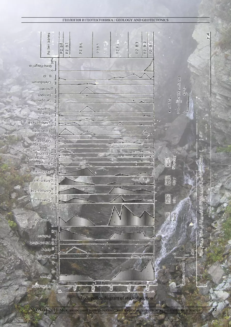
Palynological Zones and interpretation of Environmental Changes and Human History
For the purpose of facilitating interpretation and explanation of palaeoenvironmental variations, the studied section was divided to eight palynological zones, in relation to the percentage of the individual pollen species, (in addition to the
changes associated with the two pollen species at least, which belong to vegetation of different environment. The polynological zones reflect the vegetation and environmental development that are appropriate for analysis, first on the basis of characteristics of modern plants, and than deduce the evidences of changes of the local and regional palaeoclimate [18].
These Zones will be described starting from the oldest to the youngest as seen in the pollen-diagram in detail (Fig.3).
1-Zone I (PZB1)
It covers depth 500 – 540 cm, and consist of clay and light gray sand.
This zone is characterized by the presence of marine organisms palynomorph, represented by Dinoflagellate, Achritarch, Foraminiferal linning, where the percentage of dinofllagellate (12.2-26.3%) which includes different species such as: Spiniferites mirabs, S.membranacous, S.ramosus, Acomosphaera spp., Chiropteridium dispersum, Operculodinium spp., Lingulodinum machaerophorum, Hystrichokolpama rigaudiae, Leptodinium aculeatum, Oligosphaeridium cf.complex (Fig.4).
We believe that this transsegration is the Noah Deluge, which happened as a result of rush of Arabian Gulf water to the high lands in a rapid and sudden way emerged the studied area, this conclusion agreed with many studies conducted in the southern and central regions of Iraq. Comparison of vegetation assemblages and environmental conditions of that zone with different regions in the world shows that the age of this zone have been set within the period 11000-9000 Y.B.P, and this deluge reaches its peak around 10.500 Y.B.P.
Al-Ameri et-al. [1] mentioned that this deluge occurred during the same time due to the increase of temperature world-wide (5-6 ˚C), which led to melting of ice sheets in Europe, North Asia & Northern part of North America, which led to rise of sea level by about 70 m causing transsegration of Arabian Gulf and covers Al-Nasiriyah and Amarah southern Iraq, but there were many studies that pointed to the presence of marine sediments during that time such as in Razzazah Lake [21] in Najah, Hila & Kut [2], and Shari Lake-Sammara [17].
11
ГЕОЛОГИЯ И ГЕОТЕКТОНИКА / GEOLOGY AND GEOTECTONICS
№ 03-04-2011 Международный научно-технический и производственный журнал «Науки о Земле»
Fig-3: pollen diagram of studied section
12

ГЕОЛОГИЯ И ГЕОТЕКТОНИКА / GEOLOGY AND GEOTECTONICS
№ 03-04-2011 Международный научно-технический и производственный журнал «Науки о Земле»
Fig.4.: 1 - Spiniferites memberanaeous, 2- Hystrichogonyaulax sp. cf. cornigora, 3 -
Hystrichokolpoma rigaudiae, 4 - Achomosphaera sp., 5 - Dapsilidinum sp., 6 - Homotryblium sp., 7 - Artemisiaepollenites vulgaris, 8 - Bongardia chrysagonum, 9 - Quercopollenites robur, 10 - Sarcobatus vermiculatus, 11 - Zeamays (Cereals Graminae), 12 - Plantaginacea rumpollis sp.
This study confirmed the transsigration
of Arabian Gulf and when its water reached Euphrates high land in Iraq, and where the studies area located.
It is worth mentioning that a simple rise in sea level could lead to rush of sea water to far level, as Zhuo et.al. [20] pointed that rising of China sea level during the period 11000 Y.B.P by 2-3 m impact Yantzo river sediments in high land region for a distance 1600 kilometers from the mouth of current river.
The zone is also characterized by high plant diversity and by increase of individual numbers and dominance of conifers pinus
pollens where its percentages reaches 12.9-46.4%, Qak Quercus - about 8.5%.
These high percentages indicates the fact that the region during that period was covered by coniferous forests, especially in upland areas surrounding the river, which reflect the fact that the old human during that period depends on hunting of wild animals that were there in abundance, that has remained us archaeological drawing carved in quartizite rocks in different areas of Wadi Huran.
The grasses pollens ( Graminae ) represented by 22.1 %, while Chenopodiacae
13

ГЕОЛОГИЯ И ГЕОТЕКТОНИКА / GEOLOGY AND GEOTECTONICS
№ 03-04-2011 Международный научно-технический и производственный журнал «Науки о Земле»
pollen appeared at the lower part of the zone only at about 3.5 %.
The spores characteristic of wetlands and marshes represented in clear percentage, where Lycopodium reaches 2.3-5.3 % , Sphaginum 1.8-2.9 % and Laevigatosporite 1.8 %.
These evidence shows that the climatic conditions during the period of this zone may be characterized as very humid with heavy summer and winter precipitation.
2-pollen Zone II (PZB2)
This zone includes depths 500-475cm, consist of silty-clay sediments. It is characterized by interruption of marine transsegration influence on the region and dominance of continental plants, where we note decrease in the percentages of Pinus pollen which reaches 26.8% in sample no.3, and dominance of Graminae (32.5%). Also we note first appearance of pollens of field crops (Cereals) like wheat, barley, corn…etc., which characterized by its large size. This h reflects that the old man began to cultivate lands surrounding the river and trying to settle these regions after the impact of deluge and the climatic fluctuations experienced by the region and their affect on distribution of pasture. The Chenopodiacae and Artemisia appeared in a very small percentages.
This zone characterized also by the first appearance of pollen of Centaurea (7.3%), which confirms that the human start to impact on his environment, with the first appearance of Cyperacear pollen in (8.1%) which increased in the wet lands and swamps.
Through this distribution of pollens we can conclude that this zone represent wet and warm climatic conditions, with continuing summer precipitation, where the steppe vegetation dominated in the region during that period.
Through the approximate calculation of the rate of deposition, which was estimated at about (0.075 cm/year), we determine the approximate age of this zone in between 9000-8667 Y.B.P.
3-pollen Zone III (PZB3)
It cover the depth 475-400 cm, and consist of silt and silty-clay with intercalations of fine sand.
This zone differs from the previous one by increasing the percentage of Plame pollens to 19.4% with decreasing of Graminae percentages to 17.6-23% and also it is characterized by increasing of Chenopodiacea up to 4.9-6.8%), as well as the case for composite amount of pollen (5.3-8.8%), with the first appearance of plantago pollen.
These assemblages reflect warmer climatic conditions with continuing of humidity and precipitation in lower rate than the previous periods, in addition to the obvious influence of human on the environment.
The approximate period of this zone estimated to include 8667-7667 Y.B.P.
4-pollen Zone IV (PZB4)
This zone extends from depths 400-300 cm. The pollen of Grasses (Graminae) which are distinctive in humidity resumed their dominance on the vegetations of the region to reach about 45.3% in sample 9, while the amount of chenopodiaceae was between 3.5-13.6%, on the other hand the pollen of Compositae show its highest percentage in the studied section (15.4%), palame pollens was in its range and reached 15.4% at the top of this zone.
This zone differs from the previous one by increasing of Compositae and Graminae percentages, the palame conservative its ratio, which mean continuation of previous climatic conditions (moisture), but with the emergence of steppe vegetations in high percentages, that means more warmer, the presence of Graminae in high or medium rates with presence of Chenopodiacae means that the climatewas warm and humid [7].
The approximate age of this zone estimated as 7667-6334 Y.B.P.
5-pollen Zone V (PZB5)
This zone extends from the depth 300-200 cm. This zone characterized by devoid of polynomorphes. We believe that this may be due to rapid deposition, which did not give the opportunity of the polynomorphes to deposits.
14

ГЕОЛОГИЯ И ГЕОТЕКТОНИКА / GEOLOGY AND GEOTECTONICS
№ 03-04-2011 Международный научно-технический и производственный журнал «Науки о Земле»
Many archaelogical pieces of ceramic of different size has been found within the sediment of this zone, which confirmed the presence of human settlements on the banks of Euphrates river, which were trying to establish stability and civilized society after changing climatic conditions in western Iraqi desert, which led to the decline of vegetation which was present before, and which were exploited for the grazing animals.
The period of this zone was in the range from 6334 to-5000 Y.B.P.
6-pollen Zone VI (PZB6)
The sediments of this zone consist of brown silty-clay with sand intercalations. The thickness of layer 200-75 cm.
It is characterized by wide distribution of pollens and higher diversity of plants, with wide appearance of dry desert vegetations.
Where the percentages of Chenopodiacaea reaches 10.2%, the proportion of Compositae and Artemisa increased up to 12.2% and 7% respectively, while the Centaureae pollen reaches it's higher percentages in studied section 15.6%.
The Bongardia found at about 4.6%, also this zone characterized by the first appearance of Noaea pollen ( 13.3% ) and Graminae (22.5%).
In general, these vegetation assemblages reflect wide spread of steppe desert plants under semi-arid, warm conditions, and beginning of drought and desertification stages that affected the region. Human activity promoted desertification through cutting shrubs and use of it for different purposes, and irrational use of lands. We believed that these conditions prevailed in the period of 5000-1875 Y.B.P., as we found that the rate of sedimentation during that period was 0.075 cm/yr. comparing with zones of adjacent sections.
7-pollen Zone VII (PZB7)
This zone consist of brownish silty clay with sand intercalations. Thickness of the layer is about 75-40 cm.
It is characterized by wide spread of Plamae pollen, which reaches its highest rate in the studied section 20-8%, with a clear
reduction in Gramine pollen content, which has a lowest portion in the section 8.3%. The same case with Chenopodiaceae (2.3%), and clear increase in content of Cyperaceae, which reached its highest percentage in the section, which means increasing of local plants around the site of deposition, where Cyperaceae has been of great local importance more than grasses, as being deposited in swamps and wet lands located on the banks of the river [12,14]. We believe that the level of the river was declined from the previous time, as a result of drought, and possibly of human attempt to cultivate the area surrounding the river what has brought increase of the percentages of Cyperacaeae and also the spores of Sphagium.
This zone extends from 1875 to 1000 Y.B.P.
8-pollen Zone VIII (PZB8)
This zone forms the layer of 40-15 cm. The percentages of Graminae grass plants pollen increased in this zone to 18.6%, while the rate of Chenopodiaceae was 4.7%, and Compositae to 8.9%, and the part of Caryophylaceae and Centureae are 6.2% and 4-5% respectively, while Plamae continued be present 15.5 %.
Generally this zone differs from to previous by decreasing of Artemisae percentage with increasing of desert shrubs, which shows semi-arid warm climatic conditions similar to the current climate of the region, and continuing manifestations of desertification and human impact on environment. The presence of Graminae in high percentage was caused by high productivity of domestic plants, which reflect influence of local conditions [14].
This zone covers period from 1000 Y.B.P to the present time.
Conclusions
The study has proved that the flood similar to Noah Deluge has occurred in Mesopotamain plain before 10500 Y.B.P. Its flushed waters covered the region of Western Iraqi desert suddenly but for a short time and followed by continued heavy summer and winter precipitation. After that event the ancient man went from grazing and hunting to sustainable cultivation of Mesopotimain flood –
15

ГЕОЛОГИЯ И ГЕОТЕКТОНИКА / GEOLOGY AND GEOTECTONICS
№ 03-04-2011 Международный научно-технический и производственный журнал «Науки о Земле»
plain. It is noticeable by the presence of crop plants pollen (mainly cereals) in sediments and continuation of high humidity and rainfalls.
The historical studies of the first human groups that were settled there during that periods (which called palaeolithic) in the high lands plains away from the Tigris and Euphrates rivers, show that the first settlers were benefited in their demand for food and wealth of living from forests and natural vegetation that covered the plains and from diverse animals reared or hunted by them.
The archaeological evidences found in Scheinder caves (N. Iraq) as well as those found on quartizite rocks along wadi-Hauran in Western Iraqi desert support the previous conclusion. Humans began to tame and exploit wild species only about 11000 years ago after several million years of collecting plant food and hunting game [13].
Also Hole [13] mentioned that agricultural activity began as near as some 11000 years ago. It might be the end of younger Dryas when aridity had diminished wild food resources of younger Dryas, when aridity had come to the narrow strip of land, that runs from Gulf of Aqaba to SE. Turkey, including Fertile Crescent, after several million years of collecting plant and hunting game. During the pre-agricultural period human have produced little impact on the earth, except from cutting trees and shrubs for fuel. [13].
Civilization of that time in its attempt to reach stability sustainability has contributed to further development of human society as well as to speeding up of deterioration of the environment it existed. Archeological artifacts (ceramics, water reservoirs, channels, labor equipment, etc., representing period of the last 5000 years) are real confirmation of those attempts. The spreading desertification and salinization, worsening of the ecological conditions are also in some part a direct result of the man wrong doing.
References 1. Al-Ameri, T., Al-Jubowri, B., and Al-Dolaymi, A. S.
2000. Palynological evidence for events of the historical deluge on Mesopotamian People and future climatic changes. (Abstract), In: The 5th International Conference
on the Geology of the Arab World. Cairo University. Pp 1575-1584.
2. Al-Jumaliy, W.A., and Al-Sheikhly, S.S. 1997. Cyprides torosa (Jones) Jones, 1985, from the Quaternary deposits in the Southern Mesopotamian Basin, Dirasat, Natural and Engineering Science, Vol. 24, No. 3, pp.282-491..
3. Al-Khatib, M., 1978: Desert Range Land of Iraq. Ministry of Agriculture, 486p.
4. Barwary, A.M., 1978. Report about Caves in Haditha area (SOM) Rep. No. 892.
5. Bars, M. S., and Williams, G.L., 1974. Palynology and Nanofossils Processing tec. niques. Geol. Surv. Canada, Paper 73-26, pp. 1-25.
6. Buday, T. ,and Jassim, S.Z., 1987. Tectonism, Magmatism and Metamorphism. In Kassab, I.I., and Abbas, M.J. (eds). The regional Geology of Iraq. Vol. 2, 325p.
7. Dupont, L.M., Beug, H., Stalling, H., and Tidemann, R., 1989. First Palynological resut form Site 688 at 21 n off NW Africa: Pollen as Climate indicators. Proceeding of the Ocean Drilling Program, Scientific Results, Vol, 108, pp.93-111.
8. EL-Moslimany, A.P., 1986. Ecology and Late Quaternary history of the Kurdo Zagrosian Oak forest near Lake Zeribar, Westem Iran. Vegetatio, 68, pp.55-63.
9. El-Moslimany, A. P., 1987. The Late Pleistocene climates of the Lake Zeribar region (Kurdistan, W. Iran) deduced from the ecology and Pollen Production of non- arboreal vegetation. Vegetatio, 72, pp. 131-139.
10. Gasse F., and Campo, E. 1994. Abrupt post- glacial Climate event in west . sia and North Africa Moonsoon demains. Epsl. Vol. 12, pp. 435-456.
11. Harrison, T., and Harrison, T., 1989. Palynology of Late Miocene Oreopit. ecus bearing Lignite from baccinello, Italy. Palaeogeog. Palaeo. Clim., Palaeeco., 76, pp. 45-65.
12. Hole, F.,2007. Agricultural Sustainability in the Semi-Arid Near East. Clim. Past,3, 193-203.
13. Jahns, S., 1995. A Holocene pollen diagram from El Atrun, northern Sudan. Veg. Hist. Archaeobot., 4. Pp. 23-30.
14. Jassim, R.Z., 1997. Mineralogy, Geochemistry and origin of Sahari Saltern deposit, NE Samarra, Iraq. Ph. D. Thesis (Unpub), Baghdad University, p. 173.
15. Mahdi, A. H., et al., 1986. Geologyical report on Haditha area. (GEOSURV), Lib., Rep. No. 1523.
16. Moar, N. T., and Suggate, R. P., 1996. Vegetation history from the Kalhing (Last) Interglacial to the present, West Coast, south Island, New Zealand. Quaternary Sci. Rev., Vol. 15, pp. 521-547.
17. Pons, A., and Reille, M. 1988. The Holocene- and upper pleistocene pollen record from Padul (Granoda, Spain): anew study, palaeogeo. Palaeoclim. Palaeoeco, 66. pp. 243-263.
18. Van Zeist, W., and Bottema, S., 1977. Palynological invistigations in western Iran. Palaeohistiria, Vol., 19. pp. 19-85.
19. Zhou, Z., Baoyim, Y., and petit-Maire, N., 1998. Palaeoenvironments in China during the last Glacial Maximum and the Holocene Optimum. Episodes, pp.152-158.
20. Al-Tawash, B.S.,1996. Pleistocene History of Razzaza and Tharthar depressions. Centeral iraq. Phd thesis (unpub).University of Baghdad, College of Science. 124p. ( Arabic).
© Abed S. Al-Dulaimy, Thamer K. Al-Ameri, 2011
16


