Embed Size (px)
Citation preview
Project Reference Number: ARCP2013-11CMY-Yabe
The following collaborator worked on this project: 1. Shizu Yabe (Project Leader), Japan Aerospace Exploration
Agency, Japan, [email protected] 2. Toshio Koike (Collaborator), University of Tokyo, Japan,
[email protected] 3. Petra Koudelova (Collaborator), University of Tokyo, Japan,
[email protected] 4. Osamu Ochiai (Collaborator), Japan Aerospace Exploration
Agency, Japan, [email protected]
GEOSS/Asian Water Cycle Initiative/Water
Cycle Integrator (GEOSS/AWCI/WCI)

Project Refence Number: ARCP2013-11CMY-Yabe
GEOSS/Asian Water Cycle Initiative/Water Cycle Integrator (GEOSS/AWCI/WCI) Final Report Submitted to APN
©Asia-Pacific Network for Global Change Research


Final Report: ARCP2013-11CMY-Yabe 1
Part One: Overview of Project Work and Outcomes
Non Technical Summary
Building resilience to the climate change and variability is essential for achieving the final goal, the sustainable development of Earth’s societies and ecosystems. To accelerate the coordinated and integrated efforts towards this goal, the “GEOSS Water Cycle Integrator (WCI)” was proposed that recognized fundamental linkages among water, land use, carbon cycle and ecosystem services, and food-, energy- and health- securities and aimed at developing effective means for sharing coordinated, comprehensive and sustained water cycle and related Earth observations and information for sound decision making in cooperation with various partners including observation integration, science and model integration, data integration & analysis, cross-Socio Benefit Areas and Community of Practices, management system integration, and sustained education framework. With its effective regional collaborative framework of 18 Asian countries and achievements in development of some of the above functions in the water cycle arena, GEOSS Asian Water Cycle Initiative (AWCI) has become an essential component in WCI development in the Asian region. Through the activities of this project, the WCI functions have been developed and introduced in several Asian basins and the approach has been promoted for further implementation into operational use.
Keywords [5 maximum keywords]
[GEOSS], [AWCI], [Water], [Earth Observation], [Data Integration]
Objectives
The major activity of this project was to support development of the WCI functions by setting up "workbenches" where partners can share data, information and applications in an interoperable way, exchange knowledge and experiences, deepen mutual understanding and work together effectively. In order to establish the workbench function properly, this project has supported development of a platform for researchers, data experts and representatives of government organizations from Asian countries to meet, discuss, exchange ideas and arrive to agreements on necessary steps to achieve the required functions. Further aim was to utilize the established workbench functions to initiate implementation of comprehensive decision making support tools for IWRM practices into operational sectors.
Amount Received and Number of Years Supported
The Grant awarded to this project was:
US$ 45,000 for Year 1
US$ 35,750 for Year 2
Activity Undertaken
• Workbench development in collaboration with the Data Integration and Analysis System of Japan (DIAS):
o Pilot case in Cambodia
2 Final Report: ARCP2013-11CMY-Yabe
o Indus project in Pakistan o JICA project in Indonesia o SATREPS project in Myanmar o ADB and SAFE projects in Vietnam o Prototype System in Japan
• New data submissions to DIAS by collaborating countries • Development of country Project Design Matrices for proposing activities in
collaboration with ODAs and other donor organizations • Symposia and meetings:
o The 6th GEOSS Asia-Pacific Symposium in Ahmadabad, India, February 2013 o The GEOSS Joint Asia-Africa Water Cycle Symposium, Tokyo, Japan,
November 2013 o The 7th GEOSS Asia-Pacific Symposium, Tokyo, Japan, May 2014 o The 10th AWCI International Coordination Group (ICG) Meeting o The 10th GEO Integrated Global Water Cycle Observations (IGWCO)
Community of Practice (CoP) Meeting • Training course on climate change assessment techniques
Results
1. Workbenches development
The pilot case of a fully functional workbench has been developed in Cambodia under cooperation among stakeholders, space agencies and science communities on water, climate and agriculture. The resulting integrated system provides on-line information on near-real time spatial precipitation, soil moisture as well as rice production to local communities and technically is supported by DIAS and the University of Tokyo. Development of workbenches in other AWCI countries has been initiated and remarkable accomplishments were achieved in Pakistan, Indonesia, Myanmar, and Vietnam, but certain advancements have been attained in other countries too. In Pakistan, a collaborative activity among Pakistan Meteorological Department (PMD), Pakistan Agriculture Research Council (PARC), the University of Agriculture, Faisalabad (UAF), and the University of Tokyo has been launched in the Indus river basin and the Pothohar region that focuses on potential impacts of climate change on water resources and their development in the Indus basin, in particular as it pertains to the food production and disaster risk reduction. State-of-the-art models are integrated into a robust system that also includes an economy growth model and thus provides relevant information for policy makers. In Indonesia, a JICA project with the UT team support has been launched to assess climate change impacts as contribution to the Indonesia Water Resources Management Strategic Plan and the Water Resources Management Implementation Plan. This project has been conducted in compliance with the WCI approach and stemmed from the previous AWCI efforts in Indonesia and in general, including the DIAS capabilities. A capacity building project under the JICA SATREPS programme has been developed in Myanmar that also builds up on the AWCI accomplishments. AWCI activities in Vietnam have resulted in two projects in line with the WCI principles, both focusing on flood forecasting. One has been supported by Asian Development Bank and targets implementation of a flood forecasting and dam operation optimization system for the Red river basin and the second one has been proposed under the JAXA’s SAFE programme and targets an operational flood forecasting system utilizing all
Final Report: ARCP2013-11CMY-Yabe 3
available satellite data combining with numerical rainfall forecasts and ground observations for the entire Thai Binh river system.
At the same time, pilot research and development activities are on-going in Japan including prototype real-time dam operation optimization system, which is currently in test operational use in the Upper Tone river basin.
2. Contributions to DIAS system and data archive expansion
The DIAS system is a core part of the workbenches and further development of its capabilities has progressed. The on-line tool for visualization and quantitative evaluation of GCM output has been upgraded with the precipitation bias correction and statistic downscaling function. In addition, the DIAS archive has begun uploading the CMIP5 model output and it should be available through the said on-line tool in the first half of 2015. The AWCI countries have completed submission of in-situ data as planned. For the newly emerging activities, further data provision is expected, at the time being namely in Pakistan. Another function of great importance for workbench establishment is the DIAS tool for in-situ data uploading, quality control and metadata registration that enables AWCI country data providers to submit their basin observations in an effective and efficient manner while assuring high quality of the data and standardized metadata document generation. In addition, the JAXA RESTEC team has further expanded the CEOS Water Portal – an on-line system rendering an easy access to and visualization of various water related datasets from diverse sources and being archived at different centres over the world. To date, collaboration has been established with 11 partners (data centres).
3. Results through the Symposia, Meetings and the Training Course
This project supported several AWCI representatives to participate in and contribute to the three Symposia, two planning meetings and a training course. The meeting events are an indispensable component of the workbench function as they provide opportunity to researchers, data experts and representatives of government organizations from Asian developing countries to meet, discuss, and exchange ideas and to promote adoption of developed and tested approaches into operational use. The 6th GEOSS Asia-Pacific Symposium held in Ahmadabad, India, 25 – 27 February 2013 included the AWCI focused session at which the plans for second phase of AWCI have been finalized in compliance with the WCI principles and further steps were outlined. The follow up process resulted into preparation of the country Project Design Matrices (PDMs) that summarize country proposals targeting operational systems supporting water resources management based on actual country situation and needs. The PDMs were introduced to representatives of ODA and other donor agencies at the occasion of the GEOSS Joint Asia-Africa Symposium held in Tokyo, Japan, 25 – 27 November 2013, with an intention to find potential funding partners. Further elaboration of PDMs into comprehensive project proposals have been initiated in some countries. On 26 – 28 May 2014, the 7th GEOSS Asia-Pacific Symposium was held in Tokyo, Japan in conjunction with the 10th AWCI International Coordination Group Session and the 10th IGWCO Community of Practice Meeting. The Symposium resulted into a Tokyo Statement that emphasized the need of inter-disciplinary and trans-disciplinary approach in addressing water and other natural disaster issues. The AWCI training course, held in June 2013, focused on improved techniques for climate change impact assessment on watershed hydrology, in particular droughts, using on-line tools provided by DIAS. Participants carried out simplified assessment of their country basin and summarized their results in participant reports.
4 Final Report: ARCP2013-11CMY-Yabe
Relevance to the APN Goals, Science Agenda and to Policy Processes
AWCI and hence this project is a truly regional cooperation including 18 countries that focuses on regionally common as well as country specific issues related to water resources management considering impacts of climate change, which contributes to the APN Goal 1. As for the Goal 2, AWCI has been significantly contributing to the development of DIAS, which also serves to an operational sector as a tool for transferring scientific input to information required by policy- and decision-makers. Its development was implemented through collaboration between research community and the members of AWCI ICG, which consists of representatives of water-related ministries and agencies of participating countries and of international science communities and space agencies members. The DIAS functions have been designed to serve to wide international communities and other dedicated tools and methodologies are fully transferable. AWCI, including this project, has been organizing training courses on these technologies to help to improve scientific and technical capabilities of Asian countries, as it is targeted by the Goal 3. As for the Goal 4, this project is a part of establishment of the Global Earth Observation System of Systems (GEOSS) under the Group on Earth Observation (GEO). Further collaboration is promoted with ODA agencies and UN organizations. In addition, by researching on the impact assessment and adaptation measures for climate change based on the aforementioned activities, AWCI and this project is in line with the APN Science Agenda and the Policy Process.
Self-evaluation
We believe the project has accomplished the targets according to its plans as stated in the original proposal. The main functions of the workbenches that are rendered by the DIAS system in Japan have been developed and tested and are fully functional, including data collection, archiving and managing systems, on-line analysis tools, information sharing functions, etc. The dedicated functions for and in AWCI countries have been fully established in Cambodia and to a significant extent elaborated in Pakistan, Indonesia, Myanmar, and Vietnam with other countries having developed their proposals in a standardized ODA format and introduced them to representatives of these agencies at the occasion of the GEOSS Joint Asia-Africa Water Cycle Symposium. Advanced tools have been introduced in Japan with emphasis on their transferability. Climate change impact assessment studies have continued in collaboration with respective countries and also including training opportunities to assure such analyses can be further undertaken by country experts. Also, we highly value effect of face-to-face meetings that have been organized with intention to bring together scientists, practitioners, earth observation community, policy and decision makers and representatives of donor organizations. While the outcomes of these events are not immediately seen, our experience is that these have very positive impact in a longer term view.
Potential for further work
This project has been designed to establish workbenches that open a great potential for further research into climate and global change as well as proposing and evaluating adaptation measures. These workbenches enable inter-disciplinary and trans-disciplinary approach and we hope they will be fully exploited in the future, though it may take longer in some countries than others. The project achievements are key factors for further AWCI activities.
Final Report: ARCP2013-11CMY-Yabe 5
Publications
Yabe, S., P. Koudelova, A. Goda, O. Ochiai, N. Tomizawa, C. Ishida, K. Umezawa, and T. Koike, 2014; GEOSS Asian Water Cycle Initiative/Water Cycle Integrator (GEOSS/AWCI/WCI), APN Science Bulletin, Issue 4, March 2014
Koike, T., P. Koudelova, P.A. Jaranilla-Sanchez, A.M. Bhatti, C.T. Nyunt, and K. Tamagawa, 2014: River Management System Development in Asia based on Data Integration and Analysis System (DIAS) under GEOSS, SCIENCE CHINA: Earth Sciences, Accepted.
References
Bhatti A M, Koike T, Jaranilla-Sanchez P A et al. 2014. Climate change impact assessment on the hydrology of a semi-arid river basin. Annual Journal of Hydraulic Engineering, JSCE, 58: 121-126.
Saavedra O, Koike T, Yang K et al. 2010. Decision support for dam release during flood using a distributed biosphere hydrological model driven by quantitative precipitation forecasts, Water Resour. Res., 46, doi: 10.1029/2010WR009502
Shibuo Y, Ikoma E, Saavedra O et al. 2014. Development of operational realtime ensemble flood forecast system, Annual J. of Hydraulic Engineering, JSCE, 58: 397-402 (in Japanese).
Tsujimoto, K. and T. Koike, 2012: Requisite Conditions for Post-Monsoon Rainfall in Cambodia by Looking through 2009 Rainfall Data, J. of Hydroscience and Hydraulic Engineering, Vol.30, No.1.
Tsujimoto, K., K. Homma, T. Koike, and T. Ohta, 2013: Hydrological Model and A Rice Growth Model for Grasping Necessary Information for Rain-fed Agriculture. Annual J. of Hydraulic Engineering, JSCE, Vol.57 (in Japanese).
DIAS Data Access: http://www.editoria.u-tokyo.ac.jp/projects/dias/tools.php?locale=en_US
DIAS GCM data tool: http://dias.tkl.iis.u-tokyo.ac.jp/model-eval/stable/index.html
DIAS CEOS Water Portal: http://waterportal.ceos.org/
http://www.geoss6aps.org/
http://monsoon.t.u-tokyo.ac.jp/AWCI/meetings/Tokyo_Jun2013/index.htm
http://monsoon.t.u-tokyo.ac.jp/AWCI/AAWCS2013/
https://www.restec.or.jp/geoss_ap7/
http://monsoon.t.u-tokyo.ac.jp/AWCI/meetings/Tokyo_May2014/awci/index.htm
Acknowledgments
The project leader and all collaborators sincerely thank Asian Pacific Network for the Global Change for the financial and other forms of support without which the initiation and implementation of the proposed work would not have been possible.
Formatted: Heading 1, Space After: 0pt, Border: Top: (Single solid line,Custom Color(RGB(31,73,125)), 0.5 ptLine width), Bottom: (Single solid line,Custom Color(RGB(31,73,125)), 0.5 ptLine width)
6 Final Report: ARCP2013-11CMY-Yabe
Part Two: Technical Report
Preface
The inter-governmental Group on Earth Observation (GEO) was established in 2005, and has been conducting its activities according to its 10-year Implementation Plan to meet the need for timely, quality, long-term, global information as the basis for sound decision-making.
As GEO nears the end of the 10-year Implementation Plan, Geneva Ministerial Summit was held in Geneva, Swiss, on 17 January, 2014, and its progresses were reported to ministers and participants. AWCI was introduced as one of the major progresses. They decided to continue GEO through 2025, and to broaden engagement of stakeholders including decision-makers.
As for engagement of decision-makers, subsequently at the 7th GEOSS Asia-Pacific Symposium, participants noted the significance of facilitating collaborations with international initiatives such as the 3rd UN World Conference on Disaster Risk Reduction (WCDRR), and the United Nations Sustainable Development Goals (SDGs).
AWCI can collaborate especially with WCDRR through its activities of measures against floods and droughts. Its strategy following so called Water Cycle Integrator (WCI) approach that recognized fundamental linkages among water and other sectors and develops effective interdisciplinary collaborations.
Table of Contents
1. Introduction - GEOSS Water Cycle Integrator (WCI) ...................................................... 7
2. Methodology ................................................................................................................ 10
3. Results & Discussion ................................................................................................... 12
4. Conclusions ................................................................................................................. 24
5. Future Directions.......................................................................................................... 25
References ......................................................................................................................... 26
Appendix ............................................................................................................................. 28
Deleted: States
Final Report: ARCP2013-11CMY-Yabe 7
1. Introduction – GEOSS Water Cycle Integrator (WCI)
Background and Concept Design
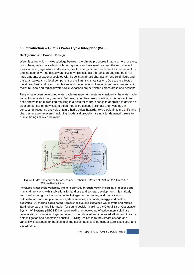
Water is a key which makes a bridge between the climate processes in atmosphere, oceans, cryosphere, terrestrial carbon cycle, ecosystems and sea level rise, and the socio benefit areas including agriculture and forestry, health, energy, human settlement and infrastructure and the economy. The global water cycle, which includes the transport and distribution of large amounts of water associated with its constant phase changes among solid, liquid and gaseous states, is a critical component of the Earth’s climate system. Due to the effects of the atmospheric and ocean circulations and the variations of water stored as snow and soil moisture, local and regional water cycle variations are correlated across areas and seasons.
People have been developing water cycle management systems considering the water cycle variability as a stationary process. But now, under the current conditions this concept has been shown to be misleading resulting in a need for radical change in approach to develop a clear consensus on how best to utilize model projections of climate and hydrology in conducting frequency analysis of future hydrological hazards. Hydrological regime shifts and changes in extreme events, including floods and droughts, are now fundamental threats to human beings all over the world.
Increased water cycle variability impacts primarily through water, biological processes and human dimensions with implications for land use and societal development. It is critically important to recognize the fundamental linkages among water; land use, including deforestation; carbon cycle and ecosystem services; and food-, energy- and health- securities. By sharing coordinated, comprehensive and sustained water cycle and related Earth observations and information for sound decision making, the Global Earth Observation System of Systems (GEOSS) has been leading in developing effective interdisciplinary collaborations for working together based on coordinated and integrated efforts and towards both mitigation and adaptation benefits. Building resilience to the climate change and variability is essential for the final goal, the sustainable development of Earth’s societies and ecosystems.
Figure 1. Model Integration for Assessment, Richard H. Moss e al., Nature, 2010, modified.
8 Final Report: ARCP2013-11CMY-Yabe
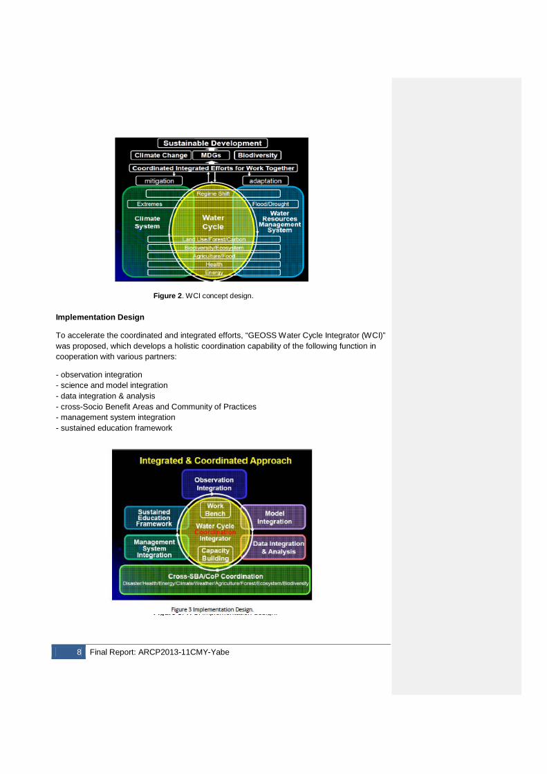
Implementation Design
To accelerate the coordinated and integrated efforts, “GEOSS Water Cycle Integrator (WCI)” was proposed, which develops a holistic coordination capability of the following function in cooperation with various partners:
- observation integration - science and model integration - data integration & analysis - cross-Socio Benefit Areas and Community of Practices - management system integration - sustained education framework
Figure 2. WCI concept design.
Figure 3. WCI implementation design.
Final Report: ARCP2013-11CMY-Yabe 9
GEOSS/WCI develops “workbenches” where partners can share data, information and applications in an interoperable way, exchange knowledge and experiences, deepen mutual understanding, and work together effectively. (A workbench is a virtual geographical or phenomenological space where experts and managers work together to use information to address a problem within that space). GEOSS/WCI also enhances the coordination of efforts to strengthen individual, institutional and infrastructure capacities, especially for effective interdisciplinary and transdisciplinary coordination and integration.
AWCI’s Key Roles in GEOSS/WCI
The GEOSS Asian Water Cycle Initiative (AWCI) is a regional collaborative framework of 18 Asian countries that has been implementing convergence and integration of data from Earth observation satellites, fields, and model cases at Asian major river basins, and researching on the impact assessment and adaptation measures for climate change using these data. AWCI was established in 2007 as a response to the recognized needs for accurate, timely, and long-term water cycle information to implement Integrated Water Resources Management (IWRM) practices and with regards to the commonality in the water-related issues and socio-economic needs in the Asia-Pacific region. This well-coordinated regional challenge of 18 countries in Asia was initiated and built up as a part of the APN ARCP 2006/2007 project called International Integrated Water Data Access and Transfer in Asia (IIWaDATA). With substantial support of further projects funded under the APN programmes ARCP and CAPaBLE, it has further evolved into a strong collaborative initiative focusing on convergence and harmonization of observation activities, interoperability arrangements for observed data and collected information, effective and comprehensive data management, and capacity building of the participating countries.
Implementing IWRM at the river basin level is an essential element to managing water resources in a more sustainable way, leading to long-term social, economic and environmental benefits. It requires wide range of disparate data from multiple disciplines and various sources and appropriate tools for processing these data and integrating and translating them into relevant information for water resources practitioners and policy decision makers. GEOSS/AWCI has been striving to develop an adequate database of local observations that complies with GEOSS interoperability standards. In-situ data from 18 selected basins of participating AWCI countries have been collected, quality controlled, equipped with appropriate metadata, and archived at the Data Integration and Analysis System (DIAS, http://www.editoria.u-tokyo.ac.jp/projects/dias/?locale=en), which was launched in 2006 as part of the Earth Observation and Ocean Exploration System, which is one of five National Key Technologies defined by the 3rd Basic Program for Science and Technology of Japan. By 2009, DIAS has begun its operational phase and become ready to support IWRM practices in AWCI countries. With its achievements in development of some of the functions of WCI, GEOSS AWCI is an essential component in GEOSS/WCI development and this project contributed to such efforts.
CEOS’s Key Roles in GEOSS/WCI
In order to implement GEOSS/WCI, Committee on Earth Observation Satellites (CEOS) has been leading “satellite observation integration” and “data integration” for GEOSS/WCI. These elements are essential components for the technical and architectural elements of WCI. To quantify the impacts and vulnerabilities and develop and assess adaptation options,
10 Final Report: ARCP2013-11CMY-Yabe
it is important to combine climate projections with integrated assessment models by utilizing comprehensive data of the climate, water cycle and resources for each societal benefit area observed by satellites. This effort would address the need for a Bridge between the current CEOS constellation projects and promote the development of a new observational and analysis integration capability.
This effort builds on the mutual cooperation between CEOSS/WGISS and WCRP/GEWEX, which successfully implemented the Coordinated Enhanced Observing Period (CEOP) and its integration capability for in-situ and satellite observation data and numerical model outputs. The CEOS Water Portal (http://waterportal.ceos.org/) has been developing a wider and deeper data integration capability under GCI framework. A GEOSS/WCI data integration function considers also incorporating developments and expertise of other systems including those in NASA, ESA and other CEOS members.
2. Methodology
2.1 Workbench establishment
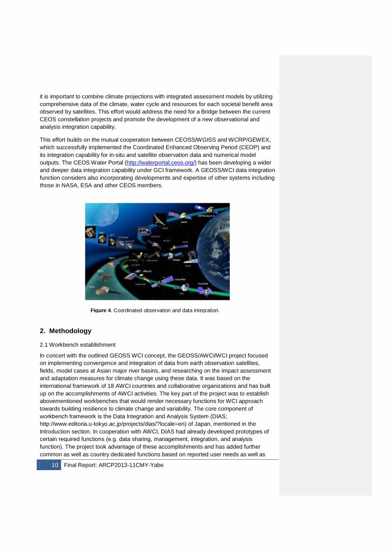
In concert with the outlined GEOSS WCI concept, the GEOSS/AWCI/WCI project focused on implementing convergence and integration of data from earth observation satellites, fields, model cases at Asian major river basins, and researching on the impact assessment and adaptation measures for climate change using these data. It was based on the international framework of 18 AWCI countries and collaborative organizations and has built up on the accomplishments of AWCI activities. The key part of the project was to establish abovementioned workbenches that would render necessary functions for WCI approach towards building resilience to climate change and variability. The core component of workbench framework is the Data Integration and Analysis System (DIAS; http://www.editoria.u-tokyo.ac.jp/projects/dias/?locale=en) of Japan, mentioned in the Introduction section. In cooperation with AWCI, DIAS had already developed prototypes of certain required functions (e.g. data sharing, management, integration, and analysis function). The project took advantage of these accomplishments and has added further common as well as country dedicated functions based on reported user needs as well as
Figure 4. Coordinated observation and data integration.
Final Report: ARCP2013-11CMY-Yabe 11
expert recommendations. In addition to DIAS, the development of workbenches was carried out in cooperation with the University of Tokyo, JAXA, and stakeholders in participating countries. Involvement of the local stakeholders is essential for making decision on, designing, and implementing the workbench functions in a country.
An important factor for the workbench establishment but also an important part of the workbench function itself is an opportunity for regular face-to-face meeting of researchers, data experts and representatives of government organizations to discuss, exchange ideas, and arrive to agreements on necessary steps to move forward. These opportunities were realized through three GEOSS Symposia and the 10th AWCI International Coordination Group Meeting. Associating AWCI ICG meetings with larger events assured that the ICG members met with broader communities of relevant fields as well as representatives of donor organizations that facilitated initiation of future cooperation between participating countries and these organizations.
The workbenches are intended to also support implementation of research outcomes into operational use. To establish necessary functions according to each country needs, countries have developed Project Design Matrices (PDMs) that summarized their plans on how to proceed with such implementation for societal benefits and that followed the standardized proposal format required by ODAs. This is expected to evolve in collaborative project activities between countries and ODAs.
2.2 DIAS data archives and analysis tools
The DIAS core system has been designed to accommodate a large volume and diversity of earth observations from inhomogeneous data sources and to provide functions for data analysis, integration and translation into information understood by wide communities including non-experts. This project considered and relied on DIAS supporting functions of life cycle data management, data search, information exploration, scientific analysis, and partial data downloading. Essential is the DIAS ontology system for identifying the relationship between data and the cross-sectoral search engine for various databases. The interoperability portal provides an important function of data/metadata search, technical term search and visualization of relations among datasets registered in the DIAS core system.
A key analysis component is the River Management System that has been developed through the APN project: ARCP2011-02CMY-Koike, River management system development in Asia based on Data Integration and Analysis System (DIAS) under GEOSS and which is in detail explained in the final report of this project and in Koike et al., 2014. The system builds on the Water and Energy Budget Distributed Hydrological Model (WEB-DHM; Wang et al., 2009; Wang and Koike, 2009; Wang et al., 2010a) that was adapted for specific conditions of studied basins, in particular snow and glacier phenomena and equipped with other functions such as dam operation optimization scheme and a set of tools for climate change impact assessment to be able to generate relevant information for policy and decision makers. The workbenches are intended to facilitate utilization of this system in the AWCI and other countries in operational use.
2.3 Capacity building
Deleted: -
12 Final Report: ARCP2013-11CMY-Yabe
Capacity building is an indispensable factor in workbench establishment and at the same time, once established, workbenches serve the education and capacity building purpose. To explain capabilities of the said river management system for climate change impact assessment, a training course was organized as a part of this project in collaboration with the CAPaBLE programme project CBA2013-01CMY-Rasul, “Impact of Climate Change on Glacier Melting and Water Cycle Variability in Asian River Basins”. Further training activities have been organized by the University of Tokyo team based on particular request by some of the countries.
3. Results & Discussion
3.1 Workbenches
3.1.1 Pilot case in Cambodia
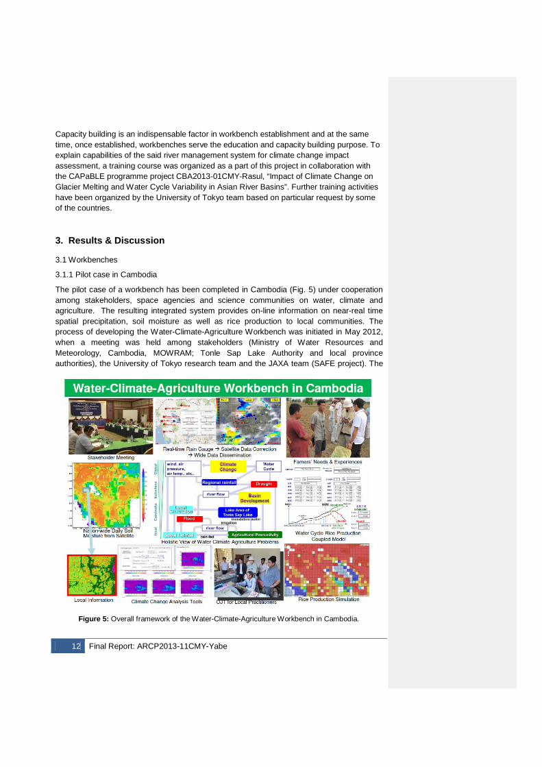
The pilot case of a workbench has been completed in Cambodia (Fig. 5) under cooperation among stakeholders, space agencies and science communities on water, climate and agriculture. The resulting integrated system provides on-line information on near-real time spatial precipitation, soil moisture as well as rice production to local communities. The process of developing the Water-Climate-Agriculture Workbench was initiated in May 2012, when a meeting was held among stakeholders (Ministry of Water Resources and Meteorology, Cambodia, MOWRAM; Tonle Sap Lake Authority and local province authorities), the University of Tokyo research team and the JAXA team (SAFE project). The
Figure 5: Overall framework of the Water-Climate-Agriculture Workbench in Cambodia.
Final Report: ARCP2013-11CMY-Yabe 13
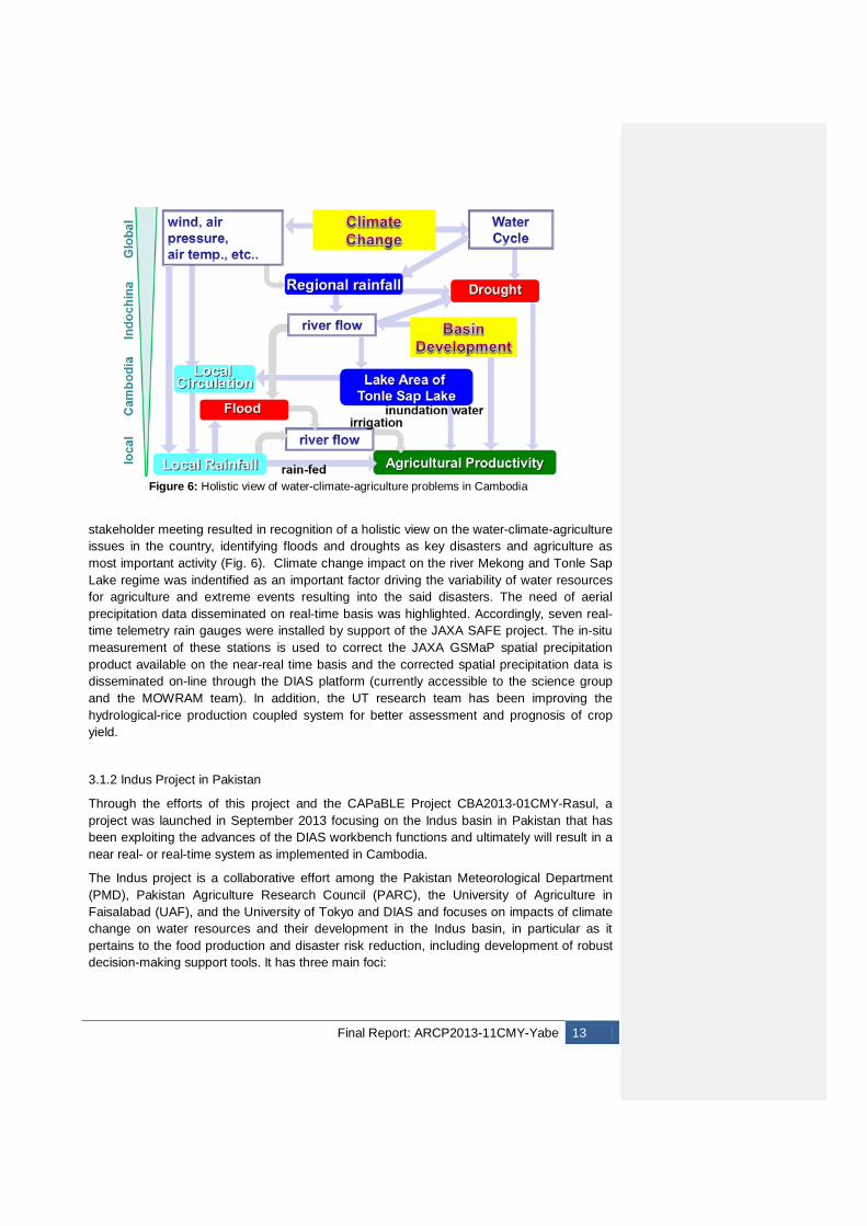
stakeholder meeting resulted in recognition of a holistic view on the water-climate-agriculture issues in the country, identifying floods and droughts as key disasters and agriculture as most important activity (Fig. 6). Climate change impact on the river Mekong and Tonle Sap Lake regime was indentified as an important factor driving the variability of water resources for agriculture and extreme events resulting into the said disasters. The need of aerial precipitation data disseminated on real-time basis was highlighted. Accordingly, seven real-time telemetry rain gauges were installed by support of the JAXA SAFE project. The in-situ measurement of these stations is used to correct the JAXA GSMaP spatial precipitation product available on the near-real time basis and the corrected spatial precipitation data is disseminated on-line through the DIAS platform (currently accessible to the science group and the MOWRAM team). In addition, the UT research team has been improving the hydrological-rice production coupled system for better assessment and prognosis of crop yield.
3.1.2 Indus Project in Pakistan
Through the efforts of this project and the CAPaBLE Project CBA2013-01CMY-Rasul, a project was launched in September 2013 focusing on the Indus basin in Pakistan that has been exploiting the advances of the DIAS workbench functions and ultimately will result in a near real- or real-time system as implemented in Cambodia.
The Indus project is a collaborative effort among the Pakistan Meteorological Department (PMD), Pakistan Agriculture Research Council (PARC), the University of Agriculture in Faisalabad (UAF), and the University of Tokyo and DIAS and focuses on impacts of climate change on water resources and their development in the Indus basin, in particular as it pertains to the food production and disaster risk reduction, including development of robust decision-making support tools. It has three main foci:
Figure 6: Holistic view of water-climate-agriculture problems in Cambodia
14 Final Report: ARCP2013-11CMY-Yabe
1. An assessment of climate change impacts on water resources, in particular droughts, and agriculture production in the Pothohar area, an important agriculture region. It involves (a) climate change impact analysis using the UT/DIAS technique employing the WEB-DHM model for hydrological analysis and (b) applying an eco-hydrological model that can calculate soil moisture, runoff, groundwater, and vegetation growth with the model parameter optimization technique assimilating satellite passive microwave observations. In addition the DR2AD economic model is also applied to integrate simulated droughts with economic losses in Pakistan. This study should provide solutions to the needs to simulate hydrological and ecological responses to severe droughts in the nationwide scale of Pakistan including the ungauged area and to estimate economic losses from severe droughts and appropriate investment against them.
2. A development and application of WEB-DHM with snow and glacier component (WEB-DHM-S; Shrestha et al., 2010; 2012) in the Upper Indus Basin to enhance the simulation of river runoff including snow and glacier melt that are dominant in the basin and to examine the impact of climate change on water resources and hydrological regime in the Upper Indus Basin. WEB-DHM-S incorporates an advanced energy-balance-based scheme to simulate snow and glacier accumulation and melting processes in the basin and has been validated in several basins in the Himalayan region.
3. An innovative-approach study of flood disaster impacts on economy in the whole Indus Basin that targets effects on economic growth rather than a disaster impact snapshot in a particular time. The study integrates the combined WEB-DHM model (WEB-DHM-S in the upper basin and WEB-DHM vertical processes part in lower part) with the powerful floodplain simulation model CaMa-Flood (Catchment-based Macro-scale Floodplain model) and then with the economic model DR2AD (Disaster Risk Reduction investment Accounts for Development, by JICA).
The project has completed its initial stage, which focused on data submission by the Pakistani collaborators to the UT research team and model development and calibration. The first results are expected to be published in 2015, however the partial achievements have already been presented to the representatives of Pakistani governmental organizations at the occasion of the AWCI Training Workshop in Islamabad, in September 2014 (http://monsoon.t.u-tokyo.ac.jp/AWCI/meetings/IslamabadTraining_Sep2014/). The high potential of these integrated systems was recognized by the audience, which is an important step for future implementation into the operational use.
3.1.3 Indonesia – water and food nexus
In Indonesia, a JICA project with the UT team technical support has been launched to assess climate change impacts as contribution to the Indonesia Water Resources Management Strategic Plan and the Water Resources Management Implementation Plan. The main objectives are (i) to contribute to the implementation of the water resources management in the Brantas and the Musi river basins by Indonesian itself, (ii) formulating recommendations for reflecting climate change impacts on water resources management plans, and (iii) preparing for guidelines to be applicable to water resources management plans in other river basins in Indonesia, taking climate change issues into account. The UT team has been providing the hydrological modelling (WEB-DHM) and techniques for climate
Deleted: economy
Final Report: ARCP2013-11CMY-Yabe 15
change impact assessment on water resources including capacity building on these tools. The activities have been conducted in compliance with the WCI approach and stemmed from the previous AWCI efforts in Indonesia and in general, including the DIAS workbench functions. It is envisioned that the capability will be transferred to other river basins in Indonesia including also a rice production model address the water and food nexus.
3.1.4 Myanmar – capacity building for flood forecast and warning
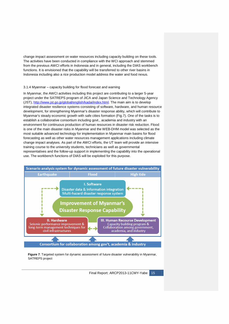
In Myanmar, the AWCI activities including this project are contributing to a larger 5-year project under the SATREPS program of JICA and Japan Science and Technology Agency (JST), http://www.jst.go.jp/global/english/kadai/index.html. The main aim is to develop integrated disaster resilience systems consisting of software, hardware, and human resource development, for strengthening Myanmar’s disaster response ability, which will contribute to Myanmar’s steady economic growth with safe cities formation (Fig.7). One of the tasks is to establish a collaborative consortium including govt., academia and industry with an environment for continuous production of human resources in disaster risk reduction. Flood is one of the main disaster risks in Myanmar and the WEB-DHM model was selected as the most suitable advanced technology for implementation in Myanmar main basins for flood forecasting as well as other water resources management applications including climate change impact analyses. As part of the AWCI efforts, the UT team will provide an intensive training course to the university students, technicians as well as governmental representatives and the follow-up support in implementing the capability into the operational use. The workbench functions of DIAS will be exploited for this purpose.
Figure 7: Targeted system for dynamic assessment of future disaster vulnerability in Myanmar, SATREPS project
16 Final Report: ARCP2013-11CMY-Yabe
3.1.5 Vietnam – flood early warning system development and training
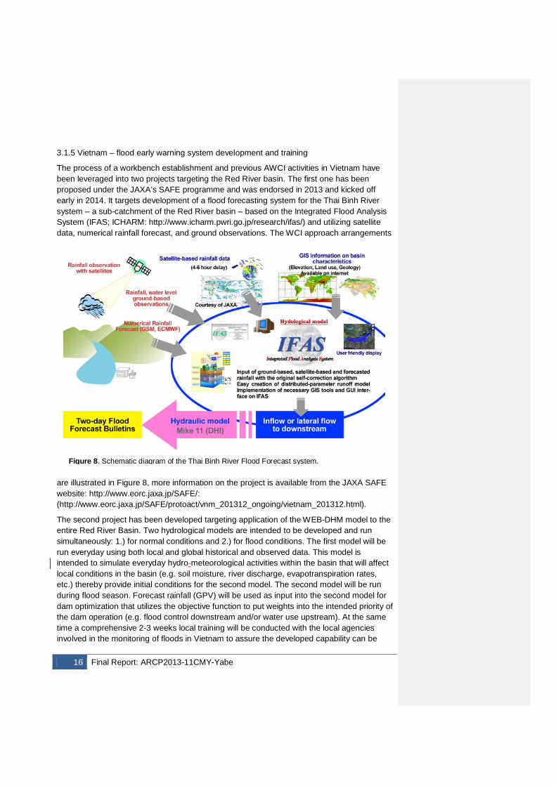
The process of a workbench establishment and previous AWCI activities in Vietnam have been leveraged into two projects targeting the Red River basin. The first one has been proposed under the JAXA’s SAFE programme and was endorsed in 2013 and kicked off early in 2014. It targets development of a flood forecasting system for the Thai Binh River system – a sub-catchment of the Red River basin – based on the Integrated Flood Analysis System (IFAS; ICHARM: http://www.icharm.pwri.go.jp/research/ifas/) and utilizing satellite data, numerical rainfall forecast, and ground observations. The WCI approach arrangements
are illustrated in Figure 8, more information on the project is available from the JAXA SAFE website: http://www.eorc.jaxa.jp/SAFE/: (http://www.eorc.jaxa.jp/SAFE/protoact/vnm_201312_ongoing/vietnam_201312.html).
The second project has been developed targeting application of the WEB-DHM model to the entire Red River Basin. Two hydrological models are intended to be developed and run simultaneously: 1.) for normal conditions and 2.) for flood conditions. The first model will be run everyday using both local and global historical and observed data. This model is intended to simulate everyday hydro-meteorological activities within the basin that will affect local conditions in the basin (e.g. soil moisture, river discharge, evapotranspiration rates, etc.) thereby provide initial conditions for the second model. The second model will be run during flood season. Forecast rainfall (GPV) will be used as input into the second model for dam optimization that utilizes the objective function to put weights into the intended priority of the dam operation (e.g. flood control downstream and/or water use upstream). At the same time a comprehensive 2-3 weeks local training will be conducted with the local agencies involved in the monitoring of floods in Vietnam to assure the developed capability can be
Figure 8. Schematic diagram of the Thai Binh River Flood Forecast system.
Final Report: ARCP2013-11CMY-Yabe 17
fully operated by the local practitioners. Real-time local data is expected to be provided by the local counterparts to replace some or all of the reanalysis datasets that will be made available during the training. A fully functional WEB-DHM will be provided to the participants on the Red River Basin for purposes of utilizing this model for dam operation optimization. The performance of the system is planned to be improved by installing new rain-gauges with real-time data transmission system. The part of the work for the Thao River Basin in Vietnam (the middle part of the Red River basin) has been conducted under the technical assistance project of the Asian Development Bank (ADB).
3.1.6 Operational dam operation optimization system in Japan, Tone basin
A part of the River management system developed through the APN project ARCP2011-02CMY-Koike was a dam operation optimization scheme embedded into the WEB-DHM models. This scheme was tested off-line at the Upper Tone basin in Japan and considered for implementation into operational use. The model has been adapted for real-time operation and linked through the DIAS system with the real-time radar precipitation observations and JMA 15-hour forecast issued every three hours (Shibuo et al., 2014). The System was provided to the Japan River Bureau for testing operational use in October 2013. The first phase testing results will be analyzed by the end of 2014 and presented to the AWCI collaborators. The system is transferable to other basins/countries under the stipulation the real-time or near real-time precipitation data and weather forecast is available for the given area. Nevertheless, an alternative implementation is possible using satellite products like GSMaP by JAXA (near real time precipitation product; http://sharaku.eorc.jaxa.jp/GSMaP/; Kubota et al., 2007).
3.1.7 Outcomes of Symposia and Meetings – platforms for communication
As emphasized in Section 2, meeting opportunities are very important factor of workbenches and have played crucial role in negotiating about country in-situ data provision and submission to DIAS. This project supported the following AWCI related meeting events by inviting AWCI country representatives to these events. Main outcomes are summarized here, detailed programmes, and reports of the events are attached as appendices below.
The 6th GEOSS Asia-Pacific Symposium, Ahmadabad, India, 25 – 27 February 2013 (http://www.geoss6aps.org/)
At the symposium, an AWCI Working Group session was held especially to discuss finalizing of the phase 2 implementation plan. The session focused on synthesis of the provided inputs from member countries into a consistent implementation plan, and strengthening the integrated cooperative framework among the member countries, the Earth observation communities, science communities and the related international activities. This project supported 7 AWCI representatives to attend this event.
The GEOSS Joint Asia-Africa Water Cycle Symposium, Tokyo, Japan, on 25-27 November 2013 (http://monsoon.t.u-tokyo.ac.jp/AWCI/AAWCS2013/)
18 Final Report: ARCP2013-11CMY-Yabe
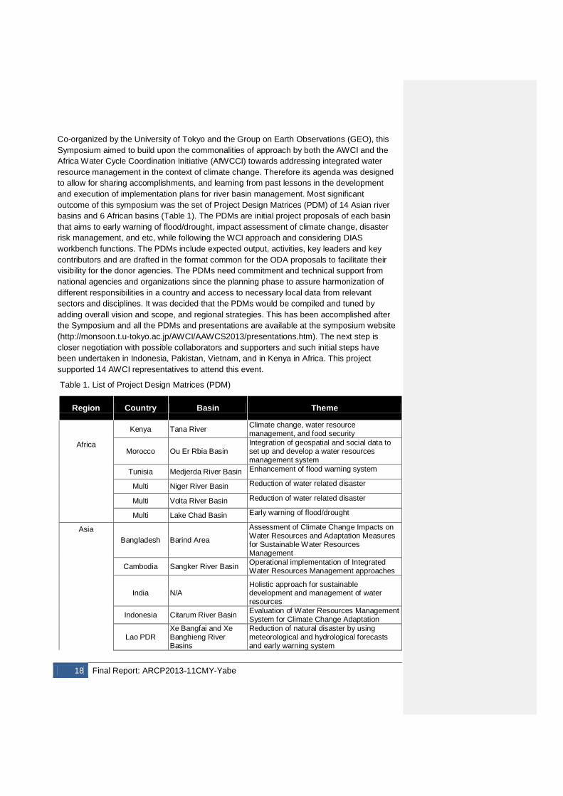
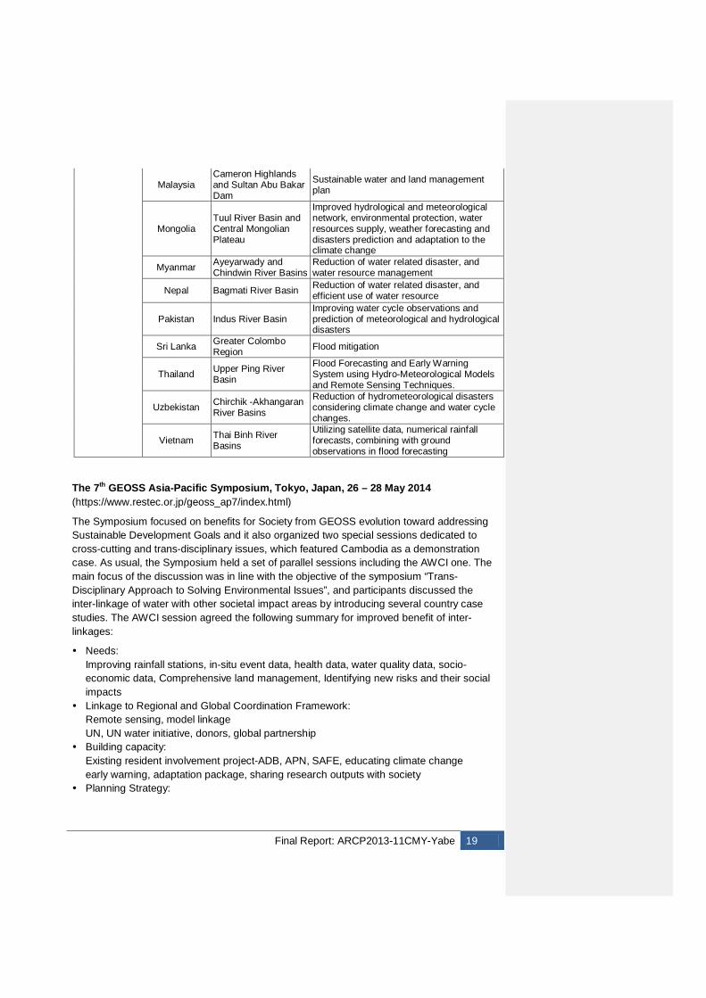
Co-organized by the University of Tokyo and the Group on Earth Observations (GEO), this Symposium aimed to build upon the commonalities of approach by both the AWCI and the Africa Water Cycle Coordination Initiative (AfWCCI) towards addressing integrated water resource management in the context of climate change. Therefore its agenda was designed to allow for sharing accomplishments, and learning from past lessons in the development and execution of implementation plans for river basin management. Most significant outcome of this symposium was the set of Project Design Matrices (PDM) of 14 Asian river basins and 6 African basins (Table 1). The PDMs are initial project proposals of each basin that aims to early warning of flood/drought, impact assessment of climate change, disaster risk management, and etc, while following the WCI approach and considering DIAS workbench functions. The PDMs include expected output, activities, key leaders and key contributors and are drafted in the format common for the ODA proposals to facilitate their visibility for the donor agencies. The PDMs need commitment and technical support from national agencies and organizations since the planning phase to assure harmonization of different responsibilities in a country and access to necessary local data from relevant sectors and disciplines. It was decided that the PDMs would be compiled and tuned by adding overall vision and scope, and regional strategies. This has been accomplished after the Symposium and all the PDMs and presentations are available at the symposium website (http://monsoon.t.u-tokyo.ac.jp/AWCI/AAWCS2013/presentations.htm). The next step is closer negotiation with possible collaborators and supporters and such initial steps have been undertaken in Indonesia, Pakistan, Vietnam, and in Kenya in Africa. This project supported 14 AWCI representatives to attend this event.
Table 1. List of Project Design Matrices (PDM)
Region Country Basin Theme
Africa
Kenya Tana River Climate change, water resource management, and food security
Morocco Ou Er Rbia Basin Integration of geospatial and social data to set up and develop a water resources management system
Tunisia Medjerda River Basin Enhancement of flood warning system
Multi Niger River Basin Reduction of water related disaster
Multi Volta River Basin Reduction of water related disaster
Multi Lake Chad Basin Early warning of flood/drought
Asia
Bangladesh Barind Area
Assessment of Climate Change Impacts on Water Resources and Adaptation Measures for Sustainable Water Resources Management
Cambodia Sangker River Basin Operational implementation of Integrated Water Resources Management approaches
India N/A Holistic approach for sustainable development and management of water resources
Indonesia Citarum River Basin Evaluation of Water Resources Management System for Climate Change Adaptation
Lao PDR Xe Bangfai and Xe Banghieng River Basins
Reduction of natural disaster by using meteorological and hydrological forecasts and early warning system
Final Report: ARCP2013-11CMY-Yabe 19
Malaysia Cameron Highlands and Sultan Abu Bakar Dam
Sustainable water and land management plan
Mongolia Tuul River Basin and Central Mongolian Plateau
Improved hydrological and meteorological network, environmental protection, water resources supply, weather forecasting and disasters prediction and adaptation to the climate change
Myanmar Ayeyarwady and Chindwin River Basins
Reduction of water related disaster, and water resource management
Nepal Bagmati River Basin Reduction of water related disaster, and efficient use of water resource
Pakistan Indus River Basin Improving water cycle observations and prediction of meteorological and hydrological disasters
Sri Lanka Greater Colombo Region Flood mitigation
Thailand Upper Ping River Basin
Flood Forecasting and Early Warning System using Hydro-Meteorological Models and Remote Sensing Techniques.
Uzbekistan Chirchik -Akhangaran River Basins
Reduction of hydrometeorological disasters considering climate change and water cycle changes.
Vietnam Thai Binh River Basins
Utilizing satellite data, numerical rainfall forecasts, combining with ground observations in flood forecasting
The 7th GEOSS Asia-Pacific Symposium, Tokyo, Japan, 26 – 28 May 2014 (https://www.restec.or.jp/geoss_ap7/index.html)
The Symposium focused on benefits for Society from GEOSS evolution toward addressing Sustainable Development Goals and it also organized two special sessions dedicated to cross-cutting and trans-disciplinary issues, which featured Cambodia as a demonstration case. As usual, the Symposium held a set of parallel sessions including the AWCI one. The main focus of the discussion was in line with the objective of the symposium “Trans-Disciplinary Approach to Solving Environmental Issues”, and participants discussed the inter-linkage of water with other societal impact areas by introducing several country case studies. The AWCI session agreed the following summary for improved benefit of inter-linkages:
Needs: Improving rainfall stations, in-situ event data, health data, water quality data, socio-economic data, Comprehensive land management, Identifying new risks and their social impacts
Linkage to Regional and Global Coordination Framework: Remote sensing, model linkage UN, UN water initiative, donors, global partnership
Building capacity: Existing resident involvement project-ADB, APN, SAFE, educating climate change early warning, adaptation package, sharing research outputs with society
Planning Strategy:
20 Final Report: ARCP2013-11CMY-Yabe
Integrated research proposal, Integrated basin water management/ assessment models, residents participation survey: crowd-sourcing, support to develop government strategy, holistic view by end-to-end cooperation
All the presentations are available at the symposium website (https://www.restec.or.jp/geoss_ap7/program.html).
The 10th AWCI International Coordination Group (ICG) Meeting, Tokyo, Japan, 28 May 2014; (http://monsoon.t.u-tokyo.ac.jp/AWCI/meetings/Tokyo_May2014/awci/index.htm)
It was as a half-day session in conjunction with the 7th GEOSS Asia-Pacific Symposium and the 10th GEO Integrated Global Water Cycle Observations (IGWCO) Community of Practice (CoP) Meeting. The ICG members deliberated on AWCI structure rearrangements for the needs of AWCI Phase 2 activities following the three main items of the agenda:
Review of Activities Identifying Core Activities Governance of the Initiative Framework.
Resulting from the planning discussions and actions before the meeting that were based on country needs and issues and considering the latest developments in the climate and water cycle science as well as current strategies of global networks, the Core Activities of AWCI Phase 2 were outlined and agreed at the meeting. These included:
a. Country Project development based on PDMs: AWCI will support e.g. stakeholder meetings as a regional partner, provides expertise and documentation.
b. Development of Inter-linkage framework: organizing workshops, inter-agency stakeholder meetings, trans-disciplinary scope considered in projects design.
c. Regional core collaborative activity: Focus on development of early warning capacity (on operational basis) as contribution to Climate adaptation efforts, including current rick management and future risk management. This will be accomplished in three steps:
Enhance spatial distribution of rainfall monitoring (satellite integrated rainfall product (GSMaP) will be calibrated (off-line) by in-situ observations to improve the accuracy)
Implement algorithms and infrastructure for producing and dissemination of near-real time rainfall information (real-time calibration algorithm, telemetric system or transmission by via mobile phones).
Early warning modeling systems for flood and drought based on outcomes of previous steps. In addition, soil moisture observation is essential for drought predictions – the activity will also include efforts to improve in-situ soil moisture observation network, which is key for validation of satellite data (GCOM-W). This data are provided by JAXA free of cost upon specific application. Also, seasonal drought prediction by GCMs is still a challenging task especially in some regions – affected by large-scale oscillations like MJO- research activities to improve this are on-going.
The participants also discussed the strategy of implementation of regional core activity and more concrete steps. The full report of the session is included in the Appendix and available
Deleted:
Final Report: ARCP2013-11CMY-Yabe 21
through the meeting website together with the presentation material. (http://monsoon.t.u-tokyo.ac.jp/AWCI/meetings/Tokyo_May2014/awci/presentations.htm)
The 10th GEO Integrated Global Water Cycle Observations (IGWCO) Community of Practice (CoP) Meeting, Tokyo, Japan, 29 – 30 May, 2014; (http://monsoon.t.u-tokyo.ac.jp/AWCI/meetings/Tokyo_May2014/igwco/index.htm)
The two-day meeting followed the Asian Pacific GEOSS Symposium and review of the Asian Water Cycle Initiative and preceded a one-day meeting on the WHO-HABITAT-UNEP Task Team for Earth observations, novel data and data integration for Water Sustainable Development Goals. Colleagues from Southeast Asian countries had a unique opportunity to engage in these international meetings and to make contributions to new initiatives that are currently being explored. Given that the IGWCO CoP meeting was held in Asia, the special IGWCO session on AWCI also allowed experts from Southeast Asia to make presentations to the IGWCO experts, enabling these international experts to gain a greater appreciation for the range of innovations that are being developed in the Asian region. There were immediate benefits from this approach. The Task Team for Earth observations, novel data and data integration for Water Sustainable Development Goal subsequently adopted inputs from Japan, Viet Nam, Bangladesh, and Pakistan into its documentation for monitoring the water Sustainable Development Goal based on presentations and discussions at this meeting. The AWCI country representatives presented their country activities relevant to the IGWCO CoP community and introduced their future plans as summarized in PDMs. All the presentations are available at the meeting website (http://monsoon.t.u-tokyo.ac.jp/AWCI/meetings/Tokyo_May2014/igwco/presentations.htm). The full report of the event that provides overview of the AWCI contributions is included in the Appendix. This project supported 2 AWCI representatives to attend the 7th GEOSS AP Symposium and associated meetings.
3.2 Expansion of DIAS data archives and functions
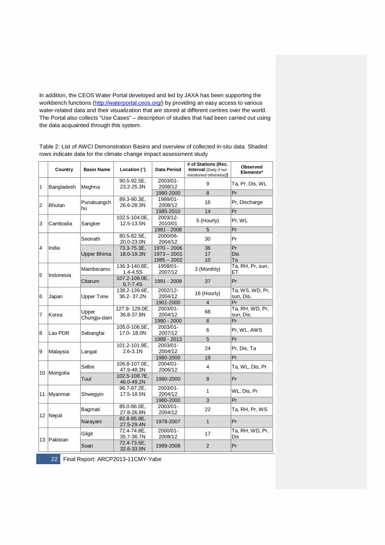
One of the AWCI accomplishments before this project was kicked off, was collection of the in-situ data from the 18 AWCI demonstration basins and archiving them at the DIAS database, as a part of earlier AWCI related projects supported by the APN ARCP programme. All the data were quality checked and equipped with adequate metadata, which included both metadata of observation and documentation metadata. During this project, DIAS has been steadily expanding its data archives including data essential for the research into climate change impacts on water nexus that also include additional, long-term precipitation data from the 18 AWCI basins. All the AWCI data submissions are summarized in Table 2. At the same time, uploading of the Coupled Model Intercomparison Project phase 5 (CMIP5; Taylor et al., 2012) output onto DIAS has been completed and the on-line tool to access and analyze these data will be available to public in 2015. Other DIAS analysis functions have been added or updated as a part of this project. These include upgrades to the River Management System through coupling with new capabilities (rice production model, Land Data Assimilation system, dynamic vegetation growth model, economic model, and dynamical downscaling technique for climate change assessment as well as weather forecast), some of which are highlighted in the Workbench development section 3.1.
22 Final Report: ARCP2013-11CMY-Yabe
In addition, the CEOS Water Portal developed and led by JAXA has been supporting the workbench functions (http://waterportal.ceos.org/) by providing an easy access to various water-related data and their visualization that are stored at different centres over the world. The Portal also collects “Use Cases” – description of studies that had been carried out using the data acquainted through this system.
Table 2: List of AWCI Demonstration Basins and overview of collected in-situ data. Shaded rows indicate data for the climate change impact assessment study
Country Basin Name Location (°) Data Period # of Stations (Rec. Interval {Daily if not
mentioned otherwise}) Observed Elements*
1 Bangladesh Meghna 90.5-92.5E, 23.2-25.3N
2003/01-2008/12 9 Ta, Pr, Dis, WL
1980-2000 8 Pr
2 Bhutan Punatsangchhu
89.3-90.3E, 26.6-28.3N
1989/01-2008/12 16 Pr, Discharge
1985-2010 14 Pr
3 Cambodia Sangker 102.5-104.0E,
12.5-13.5N 2003/12-2010/01 5 (Hourly) Pr, WL
1981 - 2008 5 Pr
4 India
Seonath 80.5-82.5E, 20.0-23.0N
2000/06-2004/12 30 Pr
Upper Bhima 73.3-75.3E, 18.0-19.3N
1970 – 2006 1973 – 2001 1985 – 2002
36 17 10
Pr Dis Ta
5 Indonesia Mamberamo 136.3-140.8E,
1.4-4.5S 1958/01-2007/12 3 (Monthly) Ta, RH, Pr, sun,
ET
Citarum 107.2-108.0E, 6.7-7.4S 1991 - 2009 37 Pr
6 Japan Upper Tone 138.2-139.6E, 36.2- 37.2N
2002/12-2004/12 16 (Hourly) Ta, WS, WD, Pr,
sun, Dis. 1901-2000 4 Pr
7 Korea Upper Chungju-dam
127.9- 129.0E, 36.8-37.8N
2003/01-2004/12 68 Ta, RH, WD, Pr,
sun, Dis. 1980 - 2000 8 Pr
8 Lao PDR Sebangfai 105.0-106.5E, 17.0- 18.0N
2003/01-2007/12 6 Pr, WL, AWS
1988 - 2013 5 Pr
9 Malaysia Langat 101.2-101.9E,
2.6-3.1N 2003/01-2004/12 24 Pr, Dis, Ta
1980-2000 19 Pr
10 Mongolia Selbe 106.8-107.0E,
47.9-48.3N 2004/01-2006/12 4 Ta, WL, Dis, Pr
Tuul 102.5-108.7E, 46.0-49.2N 1980-2000 8 Pr
11 Myanmar Shwegyin 96.7-97.2E, 17.5-18.5N
2003/01-2004/12 1 WL, Dis, Pr
1980-2000 3 Pr
12 Nepal Bagmati 85.0-86.0E,
27.8-26.8N 2003/01-2004/12 22 Ta, RH, Pr, WS
Narayani 82.8-85.8E, 27.5-29.4N 1978-2007 1 Pr
13 Pakistan Gilgit 72.4-74.8E,
35.7-36.7N 2000/01-2008/12 17 Ta, RH, WD, Pr,
Dis
Soan 72.4-73.5E, 32.6-33.9N 1999-2008 2 Pr
Final Report: ARCP2013-11CMY-Yabe 23
14 Philippines Pampanga
120.5-121.5E, 14.7-16.3N
1961/10-2005/12 4 (Daily, Monthly) Pr, Dis, WL
1961-2000 1961-2011
3 6
Pr AWS
15 Sri Lanka Kalu Ganga
80.0-80.7E, 6.4-6.8N
2003/01-2004/12 12 Pr, Dis
1980-2010 8 Pr
16 Thailand Mae Wang 98.5- 98.8E, 18.6-18.8N
2006/05-2008/12 14 (10 min) Ta, Pr, WL
1979-1992 1 Pr
17 Uzbekistan Chirchik- Okhangaran
69.3-71.3E, 40.2- 42.3N
2003/01-2004/12 18 Ta, RH, WS, Pr,
SkinT, sun, Dis 1979-2005 11 Pr
18 Vietnam Huong 107.0-108E,
16.0-17N 2003/12-2008/12
8 (Hourly, every event) WL, Pr
1976-2009 9 Pr
*Pr – precipitation, Ta – air temperature, Dis – discharge, WL – water level, RH – relative humidity, WS – wind speed, WD – wind direction, sun – sunshine duration, SkinT – surface temperature, AWS – automated weather station data
3.3 Capacity building
The AWCI training course on improved bias correction and downscaling techniques for climate change assessment including drought indices was held in Tokyo, Japan, on 18 - 20 June 2013. This project supported 14 AWCI representatives to participate in this event.
The training course was organized by the University of Tokyo, and it provided explanation of the improved techniques for climate change assessment including General Circulation Model (GCM) selection, model output (precipitation) bias correction, downscaling of the corrected output to a basin scale and generation of drought indices and drought assessment. Moreover, a system for quality control of in-situ data provided by DIAS was demonstrated. The course included several lectures provided by experts from the University of Tokyo, APN, JAXA, Japan Meteorological Agency (JMA) etc., in respective fields and hands-on training sessions, during which the participants worked individually on PCs provided by the University of Tokyo. For the analysis, participants used the data of their country demonstration basin. The course full report is available through the AWCI website at (http://monsoon.t.u-tokyo.ac.jp/AWCI/meetings/Tokyo_Jun2013/), where are also uploaded all the presentations.
In addition, the participants supported by the APN funded projects had been asked to submit a report on their work and obtained results during the course. The summary of their reports is included in the Appendix below. Also, the participants had completed a questionnaire aimed at evaluation of the course design and trainers’ performance. The replies have been compiled into an Excel sheet, provided as appendix to this report.
This training has been very well accepted and resulted in a follow-up activity held in Islamabad, Pakistan in September 2014, supported by the APN project CBA2013-01CMY-Rasul. The website of this event can be accessed at: http://monsoon.t.u-tokyo.ac.jp/AWCI/meetings/IslamabadTraining_Sep2014/.
24 Final Report: ARCP2013-11CMY-Yabe
4. Conclusions
The main aim of this project was to support development of the Water Cycle Integrator functions by setting up "workbenches" where partners can share data, information and applications in an interoperable way, exchange knowledge and experiences, deepen mutual understanding and work together effectively. In order to establish the workbench function properly, this project has supported development of a platform for researchers, data experts and representatives of government organizations from Asian countries to meet, discuss, exchange ideas and arrive to agreements on necessary steps to achieve the required functions. This included two key components, (i) developments of the analysis tools and on-line functions of DIAS and (ii) organizing face to face meeting to strengthen the AWCI collaborative framework and enable interaction of the AWCI with wider communities. Further aim was to utilize the established workbench functions to initiate implementation of comprehensive decision making support tools for IWRM practices into operational sectors.
The core part of the workbenches is the Japan Data Integration and Analysis System, DIAS that has been administered by the University of Tokyo. A number of advanced functions supporting data management life cycle (submission, quality control, metadata registration and generation, archiving, dissemination through interoperability portal), data analyses and integration with different data and information and generating usable information for IWRM practices with consideration of climate change. The analysis tools upgraded or added with support of this project include upgraded version of the WEB-DHM model, coupling it with other models and schemes into a powerful modeling system, e.g. a rice production model, economy growth model, dynamic vegetation model, land data assimilation scheme, and improved climate change impact assessment techniques. Some of the tools have been implemented in the operational use, like the dam operation optimization scheme in Japan or the climate-water-agriculture workbench in Cambodia.
Also, the DIAS data archive has been expanded including the in-situ data from AWCI countries, in particular the longer-term data for climate change impact assessment analyses, and the CMIP5 model output data for which a dedicated on-line tool is now under preparation to enable effective and efficient use of these data.
The fully functional workbench system in Cambodia based on DIAS has been developed in cooperation with the governmental and local authorities and experts and required prior-to establishment of real-time precipitation monitoring network. Another fully functional workbench function is the Upper Tone basin dam operation optimization system in Japan, which is, however, transferable to other places, conditional upon availability of real-time or near-real time data. Initiation and partial development of workbench functions has been accomplished in the Indus river basin, Pakistan, the Musi and Brantas river basin in Indonesia, the Thai Binh river and Red River basin in Vietnam and in Myanmar. In other countries, plans for the next phase have been developed and summarized in the Project Design Matrices (PDMs), which are consistent with proposal format of ODA agencies and thus provide a basis for closer collaboration with donor agencies.
The maximum use of the available funds was made to enable the AWCI representatives to attend relevant Symposia and meetings, with intention to (i) demonstrate their accomplishments and introduce the future plans to wider communities and (ii) to exchange ideas and share knowledge with these communities and seek for potentials for further
Final Report: ARCP2013-11CMY-Yabe 25
effective collaborations. At all these events, the supported AWCI representatives provided presentation contributions and actively engaged in discussions. All these presentations are available through the individual event websites.
Also, capacity building activities have been supported as these are indispensable factor for workbench establishment and function. These included mainly support to some AWCI representatives to participate in the AWCI Training Course on Improved Bias Correction and Downscaling Techniques for Climate Change Assessment including Drought Indices in Tokyo, June 2013. In addition, the UT team as well as the JAXA team has been continuing with their training activities based on the requirements from individual countries.
The developed tools and workbench functions are now being used in several studies focusing on comprehensive assessment of climate change impacts in the context of inter-linkages among various disciplines. Results of these studies are expected to be published in the near future (2015, 2016).
5. Future Directions
The plan is to continue with development of workbench functions in AWCI countries, while exploiting the DIAS capabilities and reflecting on success implementation in Cambodia and Japan and accomplishments in other countries. This task is crucial and will require more intensive negotiation at national level that will involve all relevant stakeholders and that will bring formal endorsement by governments. The implementation strategy has been outlined in country PDMs and the intention is to develop closer cooperation with ODA and other donor organizations to bring the plans into realization. Such cooperation has been initiated in some of the countries and efforts are being made to enhance it in other countries too. In general, the strategic approach of AWCI Phase 2 has been formulated at the May 2014 AWCI ICG meeting in Tokyo. The Core Activities include:
a. Country Project development based on PDMs: AWCI will support e.g. stakeholder meetings as a regional partner, provides expertise and documentation.
b. Development of Inter-linkage framework: organizing workshops, inter-agency stakeholder meetings, trans-disciplinary scope considered in projects design.
c. Regional core collaborative activity: Focus on development of early warning capacity (on operational basis) as contribution to Climate adaptation efforts, including current rick management and future risk management. This will be accomplished in three steps:
1. Enhance spatial distribution of rainfall monitoring (satellite integrated rainfall product (GPM) will be calibrated (off-line) by in-situ observations to improve the accuracy)
2. Implement algorithms and infrastructure for producing and dissemination of near-real time rainfall information (real-time calibration algorithm, telemetric system or transmission by via mobile phones).
3. Early warning modeling systems for flood and drought based on outcomes of previous steps. In addition, soil moisture observation is essential for drought predictions – the activity will also include efforts to improve in-situ soil moisture observation network, which is key for validation of satellite data (GCOM-W). This data are provided by JAXA free of cost upon specific application. Also, seasonal
26 Final Report: ARCP2013-11CMY-Yabe
drought prediction by GCMs is still a challenging task especially in some regions – affected by large-scale oscillations like MJO- research activities to improve this are on-going.
The established workbenches open a great potential for further research into climate and global change as well as proposing and evaluating adaptation measures and providing support for IWRM practices. The workbenches enable truly inter-disciplinary and trans-disciplinary approach and we believe they will be fully exploited in future, though it may take longer in some countries than others.
References GEOSS/AWCI Implementation Plan. 2008. Retrieved from: http://monsoon.t.u-tokyo.ac.jp/AWCI/doc/GEOSSAWCI_ImplPlan.pdf Jaranilla-Sanchez P A, Wang L and Koike T. 2011. Modeling the hydrologic responses of the
Pampanga river basin, Philippines: A quantitative approach for identifying droughts. Water Resour. Res., 47, W03514, doi:10.1029/2010WR009702.
Jaranilla-Sanchez P A, Wang L and Koike T. 2012. Towards managing droughts in a changing climate: A study of Southeast Asian Watersheds. Journal of Society for Social Management Systems. SMS11-9829, On-line journal retrieved from: http://management.kochi-tech.ac.jp/?content=journalpaper.
Jaranilla-Sanchez P A, Koike T, Nyunt C T et al. 2013. Hydrological impacts of a changing climate on floods and droughts in Philippine river basins, Annual J. of Hydraulic Engineering, JSCE, 57: 13-18.
Koike T. et al. 2013. River management system development in Asia based on Data Integration and Analysis System (DIAS) under GEOSS. Final report of the APN ARCP project: ARCP2011-02CMY-Koike. Retrieved from:
http://www.apn-gcr.org/resources/archive/files/10c1d69042d0e52eb658baaa4acbe2cb.pdf
Koike, T., P. Koudelova, P.A. Jaranilla-Sanchez, A.M. Bhatti, C.T. Nyunt, and K. Tamagawa, 2014: River Management System Development in Asia based on Data Integration and Analysis System (DIAS) under GEOSS, SCIENCE CHINA: Earth Sciences, Accepted.
Kubota T, Shige S, Hashizume H, et al. 2007. Global precipitation map using satelliteborne microwave radiometers by the GSMaP project: Production and Validation. IEEE Trans. Geosci. Remote Sens., 45(7): 2259-2275.
Meehl G A, Covey C, Delworth T et al. 2007. The WCRP CMIP3 multi-model dataset: A new era in climate change research, Bulletin of the American Meteorological Society, 88: 1383-1394.
Nyunt C T, Yamamoto H, Yamamoto A et al., 2012. Application of bias-correction and downscaling method to Kalu Ganga basin in Sri Lanka. Annual J. of Hydraulic Engineering, JSCE, 56: 115-120.
Nyunt C T, Koike T, Jaranilla-Sanchez P A et al. 2013a: Bias correction method for climate change impact assessments in the Philippines, Annual J. of Hydraulic Engineering, JSCE, 57.
Nyunt C T. 2013b: Development of statistical bias correction and downscaling scheme for climate change impact assessment at a basin scale. Doctoral Thesis. University of Tokyo, Graduate School of Engineering, Department of Civil Engineering.
Final Report: ARCP2013-11CMY-Yabe 27
Ohta T, Tsujimoto K, Homma K et al. 2014. A trial impact assessment on rice production by climate change and irrigation at the Granary of western Cambodia. Annual J. of Hydraulic Engineering, JSCE, 58: 265-270, (in Japanese).
Saavedra O, Koike T, Yang K et al. 2010. Decision support for dam release during flood using a distributed biosphere hydrological model driven by quantitative precipitation forecasts, Water Resour. Res., 46, doi: 10.1029/2010WR009502
Shibuo Y, Ikoma E, Saavedra O et al. 2014. Development of operational realtime ensemble flood forecast system, Annual J. of Hydraulic Engineering, JSCE, 58: 397-402 (in Japanese).
Shrestha M, Wang L, Koike T, et al. 2010. Improving the snow physics of WEB-DHM and its point evaluation at the SnowMIP sites. Hydrol. Earth Syst. Sci., 14: 2577–2594, doi:10.5194/hess-14-2577-2010.
Shrestha M, Wang L, Koike T, et al. 2012. Modeling the spatial distribution of snow cover in the Dudhkoshi region of the Nepal Himalayas. J. Hydrometeorology, 13: 204-221.
Taylor K E, Stouffer R J, and Meehl G A. 2012. A summary of the CMIP5 experiment design. Bull. Am. Meteorol. Soc., 93: 485-498.
Tsujimoto, K. and T. Koike, 2012: Requisite Conditions for Post-Monsoon Rainfall in Cambodia by Looking through 2009 Rainfall Data, J. of Hydroscience and Hydraulic Engineering, Vol.30, No.1.
Tsujimoto, K., K. Homma, T. Koike, and T. Ohta, 2013: Hydrological Model and A Rice Growth Model for Grasping Necessary Information for Rain-fed Agriculture. Annual J. of Hydraulic Engineering, JSCE, Vol.57 (in Japanese).
http://www.geoss6aps.org/ http://monsoon.t.u-tokyo.ac.jp/AWCI/meetings/Tokyo_Jun2013/index.htm http://monsoon.t.u-tokyo.ac.jp/AWCI/AAWCS2013/ http://sharaku.eorc.jaxa.jp/GSMaP/
28 Final Report: ARCP2013-11CMY-Yabe
Appendices
Appendix 1 The 6th GEOSS Asia-Pacific Symposium:
“Accelerating interlinkages in the Asia Pacific region for global Earth observations” 25 - 27 February 2013, Ahmedabad, India
Agenda Monday, 25 February 2013 09:30-10:00 Registration 10:00-10:45 Inaugural Session Opening Remarks: Ms Barbara J Ryan, GEO Secretariat Director, Welcome: Mr Satoru Ohtake, GEO Principal-Japan, Dy. Director General, MEXT Japan Dr Jai Singh Parihar, Dy. Director, SAC, India Keynote Speech: Dr K. Radhakrishnan, Chairman ISRO (via video-conferencing) Remarks by : Dr Shailesh R Nayak, Secretary MOES, India Remarks by Guest of Honour: Dr Ranganath R. Navalgund, Vikram Sarabhai Distinguished Prof. ISRO GEOSS Activity Report: Ms Barbara Ryan, GEO Secretariat Director 10:45-11:00 Coffee Break 11:00-12:30 Discussion Session: Discussion on “Data Sharing”; Theme: Experiences in data sharing and how to accelerate it among the Asia-Pacific region Chair : Dr Shailesh R. Nayak, Secretary, Ministry of Earth Sciences, Govt. of India. Speakers from 1) Bangladesh 2) India 3) Japan 4) Pakistan 5) ICIMOD 12:30-12:40 Photo Session 12:40-14:00 Lunch Break and poster presentation 14:00-16:00 Country and Regional Reports on GEOSS-related Activities (15 min. each) Australia, Bangladesh, India, Japan, Pakistan, Philippines, ICIMOD 16:00-16:15 Coffee Break 16:15-17:45 Country and Regional Reports on GEOSS-related Activities (Continued) 17:45-18:15 Presentation of Parallel Sessions by respective WG Co-Chair (5 min. each) WG1 Asian Water Cycle Initiative (AWCI) WG2 Agriculture and Food Security WG3 Forest Carbon Tracking (FCT) WG4 Asia-Pacific Biodiversity Observation Network (AP-BON) WG5 Ocean Observation and Society 19:30-21:00 Reception Dinner Tuesday, 26 February 2013 - Parallel Sessions 9:15-9:30 Registration 9:30-17:30 Parallel Sessions To streamline discussions, the Symposium will include five parallel sessions which will focus on relevant current activities in the Asia-Pacific region, identify future activities and find solutions for achieving societal benefits through the Global Earth Observation System of Systems (GEOSS) in the Asia-Pacific region WG1. Asian Water Cycle Initiative (AWCI) WG2. Agriculture and Food Security
Final Report: ARCP2013-11CMY-Yabe 29
WG3. Forest Carbon Tracking (FCT) WG4. Asia-Pacific Biodiversity Observation Network (AP-BON) WG5. Ocean Observation and Society 13:00-14:00 Lunch 14:00-17:30 Parallel sessions (contd.)
WG1: ASIA WATER CYCLE INITIATIVE (AWCI) Tuesday, 26 February, 2013 Venue: St. Laurn Towers, Ahmedabad, India 09:30‐09:45 Opening GEOSS/AWCI Breakout Session Douglas Cripe, GEO Secretariat 0945‐10:45 Observation of Water Resources in India (15 min each) Water Resources Information System (WARIS) of India J.R. Sharma, ISRO, India Issues & Challenges of Assessing Potential of West Bengal Flowing rivers of India Lakshman Nandagiri, NIT, India Kabini river observatory: Retreival of remotely sensised Hydrological variables and their assimilation for modeling the hydrology Muddu Shekar, IISc, India Water resources assessment in the Bramhaputra basin: Hillslope Experiments, remote sensing inputs and distributed hydrological modeling S. Dutta, IIT, India 10:45‐11:00 Coffee Break 11:00 ‐ 12:00 The Asian GEO Water Cycle Strategy Discussion 11:00 – 11:15 Current status of the GEO Water Strategy (Issues and Opportunities) R. Lawford, GEO Water (US) 11:15 – 11:20 CEOS and its role in the GEO Water Strategy Shizu Yube, Japan 11:20 ‐ 11:25 GEO and its expectations for the GEO Water Strategy Douglas Cripe 11:25 ‐ 11:30 Interactions between the AWCI and GEO Water Strategy Toshio Koike, Univ. of Tokyo, Japan 11:30 – 12:00 Open discussion to cover the issues of: • User needs and user engagement • Water Cycle Observations • Data Issues • Interoperability and integration • Capacity Building and regional linkages/ networks 12:00 – 12:30 Inputs from Space Agencies P.K. Gupta, ISRO, David Toll, NASA, Keiji Imaoka, JAXA 12:30 ‐ 13:00 Draft Implementation Plan for the 2nd Phase: 5 min each Bangladesh Elias Hossain and Mafizur Rahman Bhutan Karma Chhophel India Rakesh Kumar and Surinder Kaur Indonesia Muhammad Syahril Badri Kusuma Japan Toshio Koike Mongolia Gombo Davaa 13:00‐14:00 Lunch 14:00‐15:25 Draft Implementation Plan for the 2nd Phase: (Cont’d) 5 min each Myanmar Tin Yi Philippines Flaviana Hilario Sri Lanka Sumana Bandara Weerakoon Thailand Thada Sukhapunnaphan Vietnam Tinh Dang Ngoc Participants list
30 Final Report: ARCP2013-11CMY-Yabe
Report Day 1 Inaugural Session The 6th GEOSS-AP symposia kick-started in St Laurn Hotel on Feb 25th, 2013 on the focal theme of Acceleration interlinkages in the Asia-Pacific region for Global Earth Observations. The inaugural programme was presided by Dr Shailesh Nayak, Secretary of the Ministry of the Earth Sciences, Govt. of India; Guest of Honour was Dr RR Navalgund, Vikram Sarabhai Distinguished Professor; Ms Barbara J Ryan, Director GEO Secretariat, Geneva; Satoru Ohkate, GEO Principal of Japan and Dy. Director of Ministry of Education, Culture, Sports, Science and Technology (MEXT); Dr Jai Singh Parihar, Dy. Director Space Applications Centre, Ahmedabad. Dr K Radhakrishnan, Chairman, ISRO and Shri AS Kiran Kumar, Director of Space Applications Centre, Ahmedabad joined the Symposium through video conferencing mode. Dr Radhakrishnan gave the key note address and highlighted the importance of collaborative missions among space agencies e.g., Megha-Tropiques, SARAL etc., importance of NNRMS in the context of GEOSS and capacity building in the Asia Pacific region through CSSTE-AP. Dr Shailesh Nayak emphasised on the development of standards for the EO data products. He elaborated upon inter-ministerial efforts like Potential Fishery Zone Mapping, and agro-advisories using space based observations. Dr Navalgund recalled the inception of the GEO activities and emphasised on the development of EO system of systems to take the benefits of EO data to the society. Ms Barbara J Ryan gave a brief on the GEO activities in nine societal benefit areas. All the panelist emphasised for the more intense efforts needed for EO data sharing among Asia Pacific region. The purpose of this symposium is to strengthen international networking among member countries of the Asia-Pacific region. Data Sharing Session Dr. Shailesh Nayak and Prof Toshio Koike chaired the session. In his opening remarks, Dr. Nayak mentioned the Tsunami warning system and Disaster warning system operating in India. D M. Rahman from Bangladesh was the first speaker for this session. He highlighted the fact that flooding is one of the greatest hazards for Bangladesh. After describing different types of floods, he presented statistics, occurrences and areas affected by flooding. He also described the extensive damage from floods and said that Bangladesh is often downstream from flood events, as most of the floods originate in neighboring countries of Bangladesh. The Flood Forecast Warning Commission (FFWC) has been set up for early warning of floods and provides information to the administration for disaster risk mitigation. The FFWC analyses flood impacts and provides district and higher level administrators with early warning messages that can be circulated via emails, fax, website, phones, etc. The models are able to provide 1-day forecasts wtih 93% accuracy, 2-day forecasts with 88% accuracy and so on. On an experimental basis, 10-day forecast have been tested. Dr. L. S. Rathore (Director General, IMD) spoke on data sharing initiatives in India, with particular emphasis on meteorological data. Weather data collection and dissemination is crucial for various weather models. Data were collected since past 30 years and this was done using CCD tapes. IMD has done tremendous job of converting it into digital database. He also listed down all the satellites collecting weather data over Asia Pacific region such as INSAT, Megha Tropique, etc. He also mentioned India’s role for receiving foreign satellite data from MODIS, NOAA, EUMETSAT, etc and disseminating it in the global community. Regarding in-situ data collection, over 1000 Rain gauge stations and 800 Automatic weather stations have been installed throughout the country to receive regular interval data. In addition, Doppler Radars have been installed at 16 locations in the country sensing PP 7 data for every 10 minutes which is required for Numerical Weather Prediction over the country. It also provides satellite images on real time basis acquired by the different satellites. All such data can be accessed and downloaded freely from www.imd.gov.in and www.mosdac.gov.in Dr. A. Senthil Kumar (Scientist, NRSC) presented the efforts by NRSC particularly on the data provided on Bhuvan portal. He spoke about sharing of geo-spatial data from various national and regional projects/ databases. These are updated on regular basis and can be downloaded by registered users freely for any scientific purpose. It also provides disaster related data such as hazard zonation map in case of floods, Geophysical data for earthquakes, vegetation data for forest fires, etc. This is managed using 16 TB memory for visual purpose and 46 GB data for download. It also provides important parameters such as albedo which are required for various types of models. This data can be accessed from www.bhuvan.isro.gov.in and www.mosdac.gov.in . Japan initiatives on data sharing were presented by Prof Toshio Koike. He highlighted the complexity of different agencies collecting the data for different disciplines and supplying this data becomes a complex task. Data Sharing and Analysis System (DIAS) was set up for this purpose that caters to the need of users from different disciplines. The findings were also presented for IPCC 2007 report. He highlighted the increase in number of global users and need for accelerating data archival, QC, metadata registration and enriching data searching capability. He also spoke about having database that can support trans-disciplinarity and optimise operations.
Final Report: ARCP2013-11CMY-Yabe 31
Dr. Basantha Shrestha presented the data sharing efforts on behalf of ICIMOD, which is an inter- governmental organisation working across 8 different countries in the Hidukush Himalayan region. ICIMOD has, in particular, worked for problems in mountainous regions, such as fire, earthquakes, floods, glaciers, etc. It works closely with Ministry of Environment and Forests (Govt of India), ISRO and other organisations in India, providing tools for policy formation. Mountain Geoportal, aprogramme supported by NASA, shares the data across global users having over 5000 metadata entries along with data for near real time monitoring. During the discussion session, Dr. M Chakraborty asked Prof Toshio about the speed of data sharing process and ways to make it easier. Prof Toshio responded by listing different complex tasks such as Quality checking, season dependency, steps in data integration to information, etc. Dr. Chakraborty also asked Dr. Shrestha about the complexity in managing the heterogeneity and complexity of working across different countries. Dr. Shrestha responded saying that working across different governments in the Hindukush region is the core task of ICIMOD and it has been doing it for long time. As an example of the work, he mentioned the glacier inventory which was completed for the first time in this area, providing the status of 54,254 glaciers in this region, which is a baseline database creation. Prof. Ganeshaih mentioned data sharing at different levels such as remote sensing data and in-situ data. He also mentioned the need of having different policies for different levels of data. Dr. Sahu from Bangladesh asked to Dr. Senthil Kumar about having new types of data on Bhuvan. Dr. Senthil Kumar responded that the efforts are ongoing to add new types of data to the portal . During her comments, Ms Barbara Ryan spoke about having a good picture of sharing of remote sensing data but not having a mechanism for sharing in-situ data. There exist many groups for sharing satellite based observations but there is a lack of systems for sharing in-situ data across countries. There is a challenge for having such a system at national level. In his concluding remarks, Dr. Nayak mentioned the need for having one single system for all types of data dissemination which can cater to societal needs. He also mentioned policy in the UN that says that all the data is collected by public funds and hence it should be easily accessible for public use. He also mentioned that different countries have different indexing policies for different types of data, which makes the exchange and comparison complex. For this, there needs to be a common indexing policy across countries. In terms of standardising data quality checks, he mentioned ARGO as having 38 QC catalogued, and similar system can be adopted for implementing QC before data dissemination. Prof Koike concluded this session by stressing the need for developing collaboration, and accelerating inter-linkages for data sharing. He also mentioned that initially, data can be shared within a single working group and later it can be expanded to other groups and countries. Day 2 Parallel Working Group Sessions Working Group 1 – Asian Water Cycle Initiative (AWCI) Water Strategy discussions dealt with the inputs from the AWCI community to the new GEO water strategy currently under development. The AWCI will be a central component of this strategy, and provide leadership in some components. Water strategy needs to be expanded to include reanalysis of water resources information, stronger links with the WEF nexus, expanded use of remote sensing data in user services, including those using conventional data (e.g. crop insurance), and target its capacity building efforts towards young people and professionals. The space agency discussions focused on national water resources information services in the case of ISRO, and regional services in the case of JAXA and NASA. ISRO is well advanced in deriving water cycle variables over India. JAXA has developed many products such as GSMap with regional relevance and more products will be coming from GCOM-W. In addition to the products with regional relevance, NASA and USAID have launched one regional SERVIR node in Asia and may soon launch a second node in the Asia-Pacific region. While the products are very useful, there are difficulties in raising the awareness of practitioners to their availability and utilization. GEOSS/AWCI Ten countries introduced their draft implementation plan, including water-related issues and their background, objectives and actions, the comprehensive problem structures and inter-linkages. Participants recognized that flood, drought and water-scarcity, water quality, and climate change impacts are the common issues in the Asia-Pacific region. In addition, land use/cover, urbanization, and scale issues should also be addressed. We need to
32 Final Report: ARCP2013-11CMY-Yabe
share good practices and expertise, fill gaps, keep data accuracy and reduce uncertainty. To promote inter-linkages, we are requested to clarify the various levels of structure and enhance face-to-face and internet based communications. Working Group 2 – Agriculture and Food Security This Working Group covered GEOGLAM’s objectives and scope, crops to be covered, scale of coverage, and scale aggregation. National, regional and global data needs, the involvement of CEOS as broker to coordinate EO data with space agencies and initial developments were presented. The country reports brought out varying levels of maturity in terms of usage of EO data for crop assessment and forecasting. GEOGLAM Asia-Rice is an important development for the region. The horticulture sector is of paramount importance of food and livelihood security in the Asia-Pacific regional and needs to be included in the activities of the GEO Agriculture SBA. The discussions showed that there is a need to use a judicious mix of satellite and aerial EO data and satellite and in situ weather data. To accelerate the development of EO-based yield forecasting models, use of in-situ networks of sensors and imaging systems need to be explored. Levels of institutional frameworks in the region for utilising EO data for agriculture monitoring are varied. Capacity building will be needed in many countries and there are a number of institutions in the region which could facilitate capacity building. Relationships would need to be developed, and participants were encouraged to pursue linkages within their countries between space agencies, in-situ providers and data users. India, Japan, Thailand, Vietnam and ICIMOD reported on activities in their country/region on space based food security missions. UN-ESCAP, composed of 62 governments, with strategic partnerships and programmes providing evidence-based analytical studies, information and knowledge sharing, reported on the importance of agriculture in its activities, and on capacity building opportunities from ISRO, GISTDA and NRSC-China to identify gaps, connect providers and users and governments in the region. The role of horticulture to provide diversity to food and to balance nutrition was stressed. Data needs and Gap Areas in Agriculture and Food Security, as well as ground based observations and applications in agriculture were explored. It was observed that the Gates foundation and the Asia Development Bank could become examples to other development banks for raising resources. The GEOGLAM team has estimated that an initial amount of USD 45M will be needed for the project. Working Group 3 – Forest Carbon Tracking The objective of the GEO Forest Carbon Tracking (FCT) Task is to facilitate access to long-term satellite, airborne and in situ data, and to assist countries in developing their national forest carbon estimates and reporting systems. The Global Forest Observation Initiative (GFOI) was fully recognized in this session as a formal and sustained arrangement to transition from the FCT. The session’s aim was to promote the GEO FCT and GFOI concepts and activities in Asian countries, to understand country needs against each GFOI component and the interlinkages between SBAs and countries for data sharing., and to promote sustainable growth in GFOI participating countries. Indonesia and Nepal have been fully involved in the FCT’s activities as they are already ND countries, and would be future GFOI participating countries. India’s FSI regular Forest cover mapping is reported under GFOI and NCP (National Carbon Project) under FCT country activities. India’s experiences should be shared, and more AP countries should be encouraged to participate through training and workshops . India and Japan reported on national scale Integrated Carbon Monitoring activities. Data sharing over super sites for technique development was identified and requirements for interdisciplinary ground observations for Biodiversity, Water and Carbon were noted. The following country activities and needs were observed: Indonesia: LAPAN uses MODIS, Landsat, RapidEye, ALOS, Aerial Photo and their harmonization processing for deriving Land use and Land cover change. MOFF will use these outcomes by LAPAN deriving biomass and carbon. Nepal ; using Landsat, RapidEye, ALOS, Lidar and in-situ for F/NF and Land Cover and Change, but historical data gap is an issue.
Final Report: ARCP2013-11CMY-Yabe 33
Perceived Gaps : (Related to accuracy of additional requirements for REDD+) Indonesia: Accuracy and completeness of multiple satellite data are the next steps to be taken. Integration/interoperability among remote sensing data and between remote sensing data and ground measurements would provide an opportunity to vastly improve the accuracy and speed of the products. Definitions of forest, deforestation and forest degradation should be used in the country. Nepal: proper models and methodologies are needed to implement Biomass and Carbon, Comparable results with FAO, Data base management Status of Institutionalization with statement on current human and technical capacity and capacity building needs/ requirements for future monitoring demands Indonesia; International collaborations on data sharing/access and capacity building have an important role in focusing the highest priority of REDD research and operation. Nepal: difficult terrain and a lack of experts are the issue. Working Group 4 – Asia-Pacific Biodiversity Observation Network (AP BON) The meeting brought together the work undertaken on the Biodiversity databases using satellite datasets and in situ data collection by India, Japan, Malaysia and ASEAN Biodiversity Center (Philippines). There were also illustrative case studies on mapping and monitoring specific lakes and wetlands from Bangladesh, Japan, Nepal and India The group recognized that there are many strengths and network activities, specifically in India and Japan, towards building databases that could be used as opportunities for initiating similar programmes in other countries through GEO-BON. Following discussions on the available opportunities and immediate need of different countries, the following short- and long-term plans were agreed:
a) Long Term Goals: 1. Establishing linkages within and among Asia Pacific countries and with the international agencies for data sharing, methodologies and conservation activities 2. Development of inter-governmental programmes for the conservation of threatened species that are common among the Asia Pacific countries
b) Short term Goals: 1. Development of AP countries-specific data sharing on threatened species which can then be extended to other groups of organisms as well 2. Development of field guides and computer aided ID kits for use across the AP countries 3. Capacity building and technology sharing towards data gathering and data building on biodiversity in general and on threatened species in particular. 4. Organizing a workshop on developing methodology for mapping key biodiversity sites. 5. Developing supersite observation networks where not only biodiversity but also water, carbon, etc. are observed simultaneously. Interlinkages: with the Water and Agriculture SBAs. In most Asian countries biodiversity/ecosystems co-exist.. Freshwater ecosystems compete with agriculture, development and conservation. There is a conflict for freshwater systems. Working Group 5 – Ocean Observation and Society
This session reviewed the major outcomes of the 5th
GEOSS-AP Symposium in Tokyo in 2012, and noted the benefits of data sharing and dissemination in ocean and climate research through case studies. Strong needs for coastal data and its sharing for understanding local phenomena, basin-scale phenomena, interactions, were observed. Current situations of coastal data sharing were reviewed, and the importance of observation, modeling and data sharing, and substantial progresses (technology, CB) in the last ten years, and development of coordination mechanism among NEAR-GOOS, SEA-GOOS, and IO-GOOS were recognized. Large gaps between user requirements to address Societal Benefit and current existing data that should be shared or available were discussed. The current situation and user requirements are not well identified. It is also important to know what can be changed and what could be a brilliant future through data sharing if attained. Common problems among countries or region, and the type of data to be shared should be identified. It was agreed that WG5 should submit a statement to GEO plenary and Ministerial Summit in January 2014. This could be done through the newly established task Blue Planet in the 2012-2015 GEO Work Plan. Blue Planet will submit a white paper to GEO plenary, and the Asia Pacific Regional Information Center (APRIC) should be included in this white paper. Coastal zone Community of Practice holds many workshops with end users, and we need to work with the Coastal zone COP. The Ocean community has a vast amount of data, and it would be effective for us to start developing new pilot projects with relevant countries, and proposals developed to raise funds, such as from the Belmont forum, and other relevant entities.
34 Final Report: ARCP2013-11CMY-Yabe
Appendix 2
AWCI training course on improved bias correction and downscaling techniques for climate change assessment including drought indices
on 18 – 20 June 2013 at the University of Tokyo, Hongo Campus, Tokyo, Japan Agenda Tuesday 18 June: GCM Selection, Bias Correction, Downscaling 08:00 – 08:30 Registration 08:30 – 09:10 Opening Session 08:30 – 08:40 Welcome remarks: Toshio Koike (UT) 08:40 – 09:10 Opening Lecture: Climate Change Impact Assessment in Asia (Toshio Koike, UT) 09:10 – 10:45 Lectures 09:10 – 09:20 The training course design (Petra Koudelova, UT) 09:20 – 09:40 Development of Statistical Bias correction and Downscaling scheme for climate change impact assessment at a basin scale (Cho Thanda Nyunt, UT) 09:40 – 10:00 BREAK 10:00 – 10:30 Introduction of Global Satellite Mapping of Precipitation (Satoshi Kida, JAXA) 10:30 – 10:45 Asia Pacific Network for Global Change Research (APN) Activities (Taniya Koswatta, APN Secretariat) 10:45 – 18:00 Training, part 1: GCM Selection, Rainfall Bias Correction, Downscaling 10:45 – 12:00 Hands-on training session: GCM selection (DIAS on-line system, Excel sheets) 12:00 – 12:10 Group Photo (Kentaro Aida, UT) 12:10 – 13:15 LUNCH 13:15 – 18:00 Training, part 1: GCM Selection, Rainfall Bias Correction, Downscaling: Continue 13:15 – 14:00 Hands-on training session: GCM selection (DIAS on-line system, Excel sheets) – continue 14:00 – 14:15 Introduction of the on-line system for the bias correction and downscaling (Mohamed Rasmy, UT) 14:15 – 15:30 Hands-on training session: Rainfall bias correction and Downscaling for the historical baseline period (1981 – 2000) and future projection period (2046 – 2065) (DIAS on-line system) and preparation of the WEB-DHM precipitation forcing data 15:30 – 15:50 BREAK 15:50 – 17:30 Hands-on training session: Rainfall bias correction and Downscaling (DIAS on-line system) and preparation of the WEB-DHM precipitation forcing data – continue 17:30 ADJOURN 18:00 – 20:00 Cocktail and Discussion Session (UT Café) Wednesday 19 June: WEB-DHM running for historical and future periods; Drought Indices 08:30 – 12:00 Training Part 2: WEB-DHM 08:30 – 08:45 Hydrological modeling for climate change impact assessment – importance of in-situ precipitation data (Toshio Koike, UT) 08:45 – 09:00 Climate change impact assessment on water resources sector in Malaysia (Nurul Huda Md. Adnan, NAHRIM) 09:00 – 09:15 Water and Energy Budget Distributed Hydrological Model: model structure, necessary data,
Final Report: ARCP2013-11CMY-Yabe 35
model running (Patricia Ann Jaranilla-Sanchez, UT) 09:15 – 09:30 WEB-DHM with an advanced, energy balance based snow-melt scheme and glacier-melt component: WEB-DHM-S (Maheswor Shrestha, UT) 09:30 – 09:45 BREAK 09:45 – 12:00 Hands-on training session: Running WEB-DHM using bias corrected and downscaled rainfall data prepared on the previous day. 12:00 – 13:15 LUNCH 13:15 – 13:45 In-siu data management system for AWCI - Introduction and the on-line tool demonstration (Katsunori Tamagawa, Hiriko Kinutani, Misa Oyanagi, UT) 13:45 – 17:30 Training Part 3: WEB-DHM outputs, Drought Indices & Presentation on JRA55 13:45 – 14:00 Drought under the climate change (Toshio Koike, UT) 14:00 – 14:30 Drought Indices: methodology and applications for drought assessment (Patricia Ann Jaranilla- Sanchez) 14:30 – 16:00 Hands-on training session: Drought Indices generation using the bias corrected precipitation and WEB-DHM historical baseline and future period outputs (prepared in advanced by the UT team). 16:00 – 16:30 BREAK 16:30 – 16:45 JRA55 reanalysis by JMA (Kazutoshi Onogi, JMA) 16:45 – 17:30 Hands-on training session: Drought Indices generation using the bias corrected precipitation and WEB-DHM historical baseline and future period outputs. Continue. 17:30 ADJOURN Thursday 20 June: WEB-DHM output review, Drought Indices, Excursion to IIS 08:30 – 11:00 Training Part 3 - Continue: WEB-DHM outputs, Drought Indices 08:30 – 09:45 Hands-on training session: Drought Indices generation – continue; Review and discussion on the WEB-DHM results of the previous day runs. 09:45 – 10:00 BREAK 10:00 – 11:00 Hands-on training session: Result analysis, conclusions, Q&A. 11:00 – 11:20 Change of precipitation and soil moisture on the Mongolian Plateau from 2001 to 2012 (Ichirow Kaihotsu, Hiroshima University) 11:20 – 12:10 Closing Session 11:20 – 11:30 Closing Remarks 11:30 – 12:00 Certificate Ceremony 12:00 – 12:10 Logistics of the afternoon excursion 12:10 – 13:50 LUNCH 13:50 – 18:00 Excursion to the DIAS core system at the Komaba Campus of the University of Tokyo 13:50 Meeting in front of the Engineering Bldg. No.1 (ginkgo tree) 14:00 Departure to the Komaba campus (subway) 15:00 – 16:30 Visit of the DIAS core system 18:30 – 20:30 Meeting Dinner (Boat Cruise at Tokyo Bay) 20:00 ADJOURN Summary of Participants Report Introduction The event has been proposed and undertaken as a part of activities of the AWCI project "Impact of Climate Change on Glacier Melting and Water Cycle Variability in Asian River Basins", which is funded under the Asia-Pacific Network for Global Change Research (APN) CAPaBLE Programme and led by Dr. Ghulam Rasul, Pakistan Meteorological Department (PMD). The training course has also contributed to the AWCI project
36 Final Report: ARCP2013-11CMY-Yabe
"GEOSS/Asian Water Cycle Initiative/Water Cycle Integrator (GEOSS/AWCI/WCI) funded under the APN ARCP Programme and led by Ms. Shizu Yabe, Japan Aerospace Exploration Agency (JAXA). Further sponsors included the University of Tokyo (UT), who hosted the event, and the Hiroshima University. The training course website is available at: http://monsoon.t.u-tokyo.ac.jp/AWCI/meetings/Tokyo_Jun2013/index.htm. The training had two main objectives: Capacity Building. The aim was to provide explanation of and teach how to apply improved climate change assessment techniques and tools including general circulation model (GCM) output selection, model output (precipitation) bias correction, downscaling of the corrected output to a basin scale and generation of drought indices and drought assessment. Preliminary Climate Change Impact Analysis in AWCI participating basins. The results obtained during the training course are expected to be usable for regional analysis of climate change impacts on water resources, in particular droughts. Total Number of AWCI Supported Participants: 21 Participant Reports 1. In advance Questionnaire The participants had been asked to fill out a questionnaire in advance that inquired about their specialization, expectations of the course, familiarity with the AWCI activities and demonstration basins, previous experiences with climate change assessment methods. The replies were analyzed and reflected in preparation of the course design. The summary is shown here:
Research Focus of Participants: Climate Change/Meteorology: 9 participants Hydrology/Water Resources: 13 participants (2 Droughts)
Expectations – to learn: Bias correction and downscaling Drought indices WEB-DHM
Involvement in AWCI: 8 participants Involvement in any CCA study: 15 participants Experience with the methods to be taught:
Bias Correction, Downscaling: 8 participants Drought: 4 participants No experience: 12 participants
Familiarity with own country basin: 12 participants
2. Training Course Evaluation Questionnaire After the training course, the participants were asked to complete an evaluation questionnaire aimed at participants’ perception of the course merits for their future work and also at their assessment of the course design and teachers’ performance. In addition, the participants were asked to draft a brief technical report on their work and achievements during the course and also suggestions and plans for further research. The requested attachments included: Part 1: Model Selection, Bias Correction and Downscaling:
- The model selection excel sheet that you have completed using the on-line system for model output evaluation at: http://dias.tkl.iis.u-tokyo.ac.jp/model-eval/stable/index.html
- If possible, any figure of the bias corrected and downscaled precipitation data using the GrADS software.
Part 2 & 3: WEB-DHM runs and drought indices:
- The Discharge and Drought SA analysis excel file (multiple sheets) as explained by at the course. A one-month period was provided for the participants to complete their reports. The received inputs have been compiled in two files. The first one is an excel sheet summarizing the questionnaire answers (AWCI2013Training-Evaluation_Participants.xls), the second one is a compilation of technical reports (AWCI2013Training-CCA_drought-ParticipantReports.doc).
Final Report: ARCP2013-11CMY-Yabe 37
The questionnaire. The questionnaire answers showed that the training course met expectations of most of the participants and most of them felt they had learned some new and useful knowledge for their future work. On the other hand, the participants felt the time was rather limited to fully grasp all the details of the taught methods and thus further study (even self-study) or cooperation with the methodology authors would be necessary to be able to use it for future applications in their countries. Nevertheless, many of the participants expressed their further interest in these climate change assessment techniques and intention of their institutions to use these techniques. In addition, more than half of the participants could derive at least some indicative results for their basin from the standard anomaly drought indices generated during the training course. These results will be further explored and appropriately published. Technical reports summary. The training course tasks included:
- Selection of suitable GCM(s) for given study area - Bias correction and downscaling of the selected GCM output(s) using the in-situ data - Setting up the WEB-DHM runs and running WEB-DHM - Processing and analyzing the WEB-DHM output - Standard Anomaly (SA) drought indices generation from the WEB-DHM output
The climate change assessment studies are being done using an ensemble of GCM outputs, where the ensemble consists of “suitable” GCMs for the study area. The suitability of a GCM in the introduced methodology is assessed using a “scoring” method based on RMSE and Spatial correlation between the GCM output and a reference dataset (derived from observations or reanalysis). Using this method, which is incorporated in the on-line tool explained during the training course, the participants obtained a set of suitable models for their individual basins. For all basins, the model “gfdl_cm2_1” was either the first or second best and thus it was decided to use this model output for the training course purposes and only this one output due to the limited time available. The GCM outputs cannot be used directly for hydrological simulations at the basin scale because of significant biases and coarse resolution and thus bias correction and downscaling methods must be applied to the GCM output. A user-friendly on-line tool has been developed for this purpose and was introduced at the training course. The participants used the tool to generate bias corrected and downscaled precipitation data for their respective basins. While the tool is very handy, some participants felt it would be useful to also see the procedure be done step by step with explanation of the theory behind each step. After producing the suitable precipitation data for the baseline historical period (1981 – 2000) and the investigated future period (2046 – 2065), the pre-prepared and calibrated WEB-DHM models for individual basins were set up using the generated precipitation data and other forcing data pre-prepared from JRA25 reanalysis. The participants run their WEB-DHMs on the distant server, generating necessary outputs for basin water budget assessment. WEB-DHM was used to simulate past (1980-2000) and future (2046-2065) river discharge by using the selected GCM result as input. Although the simulation was conducted in daily time step, statistical analysis to capture river discharge variations throughout the year was computed in monthly basis. To evaluate the extreme event, simulation result was normalized based on the best-fit distribution for each monthly series. JMP software was used for this statistical analysis. By using the criteria of extreme event from standard deviation, the number of event with category “Extremely dry” (Stdev < -2.0), “Severely dry” (-2.0 < Stdev < -1.5), and “Moderately dry” (-1.5 < Stdev < -1.0) can be computed. In this way, most of the participants were able to generate the SA drought indices for the baseline historical period and the investigated future period. Due to the limited time, some participants were not able to complete the final step that involved the commercial statistical software JMP10 and thus were not able to finalize their work later if they were not able to obtain the software. Some Indications Tone (Japan) The participants, who worked with the Japanese Tone river basin data (because the database for their country basin has not been fully developed for this kind of study yet, namely India, Lao, Uzbekistan), have concluded that the obtained results indicated increase in the river discharge in future and decrease of the frequency of “severe” and “moderate” drought events. Citarum (Indonesia) In general, the results indicated more extreme months in past scenario than in future scenario for both for dry or wet months. However, the event in future scenario tends to be more extreme than in the past scenario, especially for wet event. For example, there were only six events in past scenario with Standard Deviation > 2.5 (very extreme wet), while in future scenario, the number of event increased to 8 events, and there were 2 events with
38 Final Report: ARCP2013-11CMY-Yabe
Standard Deviation > 4.0. The trend in extreme dry event seems not as clear as wet event. Although the average simulated discharge of future scenarios is lower than past scenarios, it seems still in range of ‘near normal event’. The Indonesian participant provided two comments. The first one is regarding the reference precipitation data used for model selection, i.e. GPCP data: Probably, GPCP is one the best data precipitation available for long term and large scale study. However, comparison with TRMM and station data in study area shows that GPCP data tend to be overestimate especially in Java Island, the location of Citarum River Basin. Comparison of multiple GCM outputs with TRMM data showed that better results for other GCMs than the selected gfdl_cm2_1 model. Secondly: WEB-DHM result showed that the average daily discharge in past scenario (1981-2000) is 89.7m3/s while in future scenario (2046-2065) the value is decrease to 66.2m3/s. This result is slightly different with figures in IPCC report which suggest that precipitation in South East Asia tend increase in the future. Langat (Malaysia) From the standardized anomaly (SA) index analysis of Langat streamflow, most of the monthly temporal distribution of SA indexes for both past period 1981-2000 and future period 2046-2065 lies within the 'normal' category. In 1981-2000, there are twenty (20) occurrences of 'moderately dry' months with the lowest SA index of -1.377 in May 1986. However, there was no drought or water stress incidents reported for the year. Whilst the second lowest index is -1.33 which is in May 1998. From historical analysis it is known there was a prolonged dry months in 1998 in the basin, the event had caused major water crisis and shortage of water supply in Klang Valley and Langat basin, which had affected 1.8 million residents. However, the calculated indexes for the months are classified as ‘moderately dry’. As for the future period, it is estimated that eighteen (18) 'moderately dry' months and two (2) 'severely dry' months would occur. The temporal distribution evaluated, although is inadequate, but could be a quick reference & rough estimate of future possible drought occurrences. Swan (Pakistan) The discharge in the past has peak values for the years 1985-1987 and in 1992-1998; in between these time slots the peak sometimes has decreasing and increasing trend otherwise. For the future simulation of discharge the peak values appear in the year 2052-2054 and 2060-2062. However the peak values are not much greater than the peak values of the past. This shows the moderate dryness of the basin in the future. The monthly discharge is prominently increasing for the August, September and October months in the future (2046-2065). The standardized anomaly index calculated for the past and future discharge simulated by WEB-DHM was calculated for three different categories (1) Extremely Dry, (2) Severely Dry and (3) Moderately Dry. The frequency of extremely dry conditions was higher for future as compared to the past whereas for the other two categories the values are equal or less to the past. Kalu Ganga (Sri Lanka) Monthly Discharges of each month in the Past and Future periods were fitted the bets statistical distribution using JMP10 software. The statistical parameters Location and Scale were derived for each month from the selected distribution. Drought indices were estimated. Number of months that extremely dry, severely dry and moderately dry conditions for past and future GCM discharge output was compared indicating increase in the river discharge in future and decrease of the frequency of “severe” and “moderate” drought events. Mae Wang (Thailand) The obtained results indicated increase in the river discharge in future and decrease of the frequency of “extremely”, “severe” and “moderate” drought events. Future work on this research should include a more extensive validation small-scale patterns with statistical methods involving height regressions, the differences of bias - corrected data. If this project has also developed algorithms combined with high resolution remote sensing and physically - based patterns, could greatly improve the realism of the resulting. Huong (Vietnam) The obtained results indicated increase in the river discharge in future and decrease of the frequency of “severe” and “moderate” drought events. Besides the work done during the training course, the introduction of satellite rainfall GSMap and the exploitation of this data are useful for all participants when they return to their country to apply to mining operations as well as exploiting data sources for research. A stark example such as Vietnam, where network of hydro-meteorological observations are lack in some basins, affects strongly on forecast as well as research of my center. Satellite rainfall GSMap is a door where we can help solve this problem.
Final Report: ARCP2013-11CMY-Yabe 39
Appendix 3
The GEOSS Joint Asia-Africa Water Cycle Symposium Ito International Research Center, Ito Hall, University of Tokyo, Hongo Campus
25 – 27 November 2013 Agenda Monday 25 November 09:30 – 10:00 Registration 10:00 – 10:30 1. Opening MC: Dr. Petra Koudelova Welcome Speech Douglas Cripe, Group on Earth Observations (GEO) Keisuke Isogai, Ministry of Education, Culture, Sports, Science and Technology (MEXT) Shizuo Yamamoto, Japan Aerospace Exploration Agency (JAXA) Akio Takemoto, Asia-Pacific Network for Global Change Research (APN) Toshio Koike, The University of Tokyo (UTokyo) Photo session 10:30 – 12:10 2. GEOSS Capability and Needs of Stakeholders Chaired by Dr. Richard Lawford Speeches: His Excellency Mr. Farukh Amil, Ambassador of Pakistan His Excellency Mr. Madan Kumar Bhattarai, Ambassador of Nepal Key Notes: Douglas Cripe, GEO: GEOSS Capability and Needs of Stakeholders Toshio Koike, The University of Tokyo (UTokyo): GEOSS Water Cycle Integrator Panel Discussion: Masami Fuwa, Japan International Cooperation Agency (JICA) Venkatachalam Anbumozhi, Asian Development Bank Institute (ADBI) Masayuki Tamagawa, African Development Bank (AfDB) Mikio Ishiwatari, World Bank (WB) Yoshiaki Kinoshita, Ministry of Education, Culture, Sports, Science and Technology (MEXT) Yusuke Amano, Ministry of Land Infrastructure and Tourism (MLIT) Douglas Cripe, Group on Earth Observations (GEO) Toshio Koike, The University of Tokyo (UTokyo) Panel Discussion Questions: 1) Considering the overall area of responsibility and trends what would you say are the information needs in your geographic area that will increase in the future? 2) What types of decisions does your organization make in relation to water and water management? Where do you get your information to assist in making these decisions? 3) How could the existing information available in the local communities for decision making be improved (quantity, accuracy, timeliness, access, etc)? 4) In assessing the priorities for supporting water activities how does your agency decide which projects should receive funding?
40 Final Report: ARCP2013-11CMY-Yabe
12:10 – 13:10 Lunch 13:10 – 15:10 3. Water cycle Observations and Integrated Water Resources Management (IWRM) Chaired by Dr. Douglas Cripe Speeches: His Excellency Mr. Francois OUBIDA, Ambassador of Burkina Faso Dr. Sivaji Chadaram, Counsellor, Embassy of India Key Notes: Srikantha Herath, United Nation University (UNU) Shigeo Ochi, Ministry of Land Infrastructure and Tourism (MLIT) Panel Discussion Srikantha Herath, United Nation University (UNU) Tadashige Kawasaki, Network of Asian River Basin Organizations (NARBO) Akio Takemoto, Asia-Pacific Network for Global Change Research (APN) Andre Nonguierma, United Nations Economic Commission for Africa (UNECA) Ghulam Rasul, Pakistan Meteorological Department (PMD) Richard Lawford, Integrated Global Water Cycle Observations (IGWCO) Chu Ishida, Japan Aerospace Exploration Agency (JAXA) Panel Discussion Questions: 1) What can the Earth observation community do to address the needs of stakeholders in terms of providing information about the water cycle for IWRM? 2) What opportunities should be provided in terms of (1) developing Capacity Building Programs for practitioners, administrators and decision makers; and (2) harmonizing Earth observation missions in the area of IWRM with funding activities of stakeholders? What role do you see for GEO to play in facilitating these activities? 3) It goes without saying that in-situ networks for water cycle variables are critically important, both for the precise nature of the information they provide, and also as a means to validate satellite retrievals and model outputs. Yet, no comparable coordination body such as the Committee on Earth Observation Satellites (CEOS) exists for in-situ networks. Moreover, it is often said that in-situ networks worldwide are not only not keeping pace, but most systems are actually in decline. How do we provide an international coordination body that would act to reverse this trend and draw attention to the importance of sustaining and expanding in-situ networks for water cycle variables? Are there specific items that AWCI and AfWCCI can address or implement to deal with this issue? 4) The concept of IWRM was refined subsequent to the World Summit on Sustainable Development in 2002, Johannesburg, and it was the Global Water Partnership's definition of IWRM that has been widely accepted. It states: “IWRM is a process which promotes the co-ordinated development and management of water, land and related resources, in order to maximize the resultant economic and social welfare in an equitable manner without compromising the sustainability of vital ecosystems.” In your opinion, is this definition still valid/relevant today? Why or why not? What can GEO do in terms of supplying Earth observations to support IWRM? 15:10 – 15:30 BREAK 15:30 – 17:30 4. Contributions by Earth Observation & Science Communities Chaired by Prof. Toshio Koike Christine Lee, National Aeronautics and Space Administration (NASA) Martin Medina, National Oceanic and Atmospheric Administration (NOAA): NOAA Satellite Activities to Monitor Water Kazuo Umezawa, Japan Aerospace Exploration Agency (JAXA): JAXA Contributions to Water Cycle Observation Bruno Meyer, South African National Space Agency (SANSA) Richard Lawford, Integrated Global Water Cycle Observations (IGWCO) Osamu Ochiai, Group on Earth Observations (GEO): GEOSS Common Infrastructure Kazutoshi Onogi, Japan Meteorological Agency (JMA): Introduction of the JRA-55 Reanalysis Yasushi Izumikawa, Japan Meteorological Agency (JMA): Introduction of Himawari-8 Yoichi Iwami, International Center for Water Hazard and Risk Management (ICHARM): ICHARM Challenges for
Final Report: ARCP2013-11CMY-Yabe 41
Contribution to Water Related Disaster Reduction and Prevention Sam Benedict, Global Energy and Water Exchanges Project (GEWEX): Global Energy and Water Exchanges Anette Johnson, Swiss Federal Institute of Aquatic Science and Technology (Eawag): Groundwater Quality; A health issue? 17:30 5. Poster Session and Cocktail Party MC: Ms. Akiko Goda Speech: His Excellency Mr. Mohamed ELLOUMI, Charge d'Affaires.a.i. Tunisia Tuesday 26 November 9:00 – 10:30 6. African Session Chaired by Prof. S.B. Weerakoon Speech: Mr. Sami Boughanmi, First Secretary, Embassy of Tunisia Key Note: Abou Amani, United Nations Educational, Scientific and Cultural Organization (UNESCO) Introduction to Projects 1. Kenya (Charles Ndegwa, David Kuria, Felix Mutua) 2. Morocco (Kamal Labbassi) 3. Tunisia (Zoubeida Bargaoui, Moncef Rekaya) 4. Niger river basin (Abdou Ali, Bachir Tanimoun Alkali) 5. Volta river basin (Jacob Tumbulto, Charles Biney) 6. Lake Chad basin (Mohammed Bila Danasabe, Ahmed Sedick) 10:30 – 10:50 BREAK 10:50 – 12:00 7. Asian Session Chaired by Prof. Zoubeida Bargaoui Key Note: Deg-Hyo Bae, Sejong University Introduction to Projects 1. Bangladesh (Elias Hossain) 2. Cambodia (So Im Monichoth) 3. India (Rakesh Kumar) 4. Indonesia (Muhammad Syahril Badri Kusuma) 5. Lao PDR (Bounteum Sysouphanthavong) 12:00 – 12:30 Poster Session – 2 12:30 – 13:30 Lunch 13:30 – 16:00 7. Asian Session –continue Chaired by Dr. Johnson Oguntola Key Notes: Masaru Kitsuregawa, The University of Tokyo (U-Tokyo) Seetharam Kallidaikurichi, Asian Development Bank (ADB) Introduction to Projects 6. Malaysia (Mohd Zaki Mat Amin) 7. Mongolia (Gombo Davaa) 8. Myanmar (Myo Tun Oo) 9. Nepal (Shiv Kumar Sharma) 10. Pakistan (Bashir Ahmad) 11. Philippines (Jorybell Masallo) 12. Sri Lanka (S.B. Weerakoon)
42 Final Report: ARCP2013-11CMY-Yabe
13. Thailand (Thada Sukhapunnaphan) 14. Uzbekistan (Irina Dergacheva) 15. Vietnam (Dang Ngoc Tinh) 16:00 – 16:20 BREAK 16:20– 18:00 8. Discussion for Implementation Planning Moderated by Richard Lawford, 18:00 Adjourn Wednesday 27 November 9:30 – 11:30 9. Toward Implementation Chaired by Dr. Richard Lawford Summary Report: Toshio Koike, The University of Tokyo (UTokyo) Panel Discussion: Masayuki Tamagawa, African Development Bank (AfDB) Yoshiaki Kinoshita, Ministry of Education, Culture, Sports, Science and Technology (MEXT) Yusuke Amano, Ministry of Land Infrastructure and Tourism (MLIT) Srikantha Herath, United Nation University (UNU) Abou Amani, United Nations Educational, Scientific and Cultural Organization (UNESCO) Kenji Someya, Network of Asian River Basin Organizations (NARBO) Douglas Cripe, Group on Earth Observations (GEO) Richard Lawford, Integrated Global Water Cycle Observations (IGWCO) Toshio Koike, The University of Tokyo (U-Tokyo) Panel Discussion Themes: A. The current status of AWCI and AfWCCI activities Based on the presentations we heard over the last two days what is our present situation with respect to current needs in different basins and nations, present programmes and capabilities, and our ability to coordinate and deliver on these programmes? B. The future plans for AWCI and AfWCCI acitivites. Emphasis should be given to the PDMs that will be circulated before the workshop. What do we want to achieve in 10 years(?) 5 years(?) 2 years(?) through the efforts of GEO activities in Asia and Africa? Special consideration should be given to the ways in which AfWCCI and AWCI could contribute to the Sustainable Development Goals. C. This discussion will provide guidance on how we move from the current situation to future milestones. This topic will be the centerpiece for the discussions. Given the needs of stakeholders, the capabilities of participating organizations and the funding interests of ODAs what steps do we need to take now? Specific issues that should be addressed include 1) the means of implementation (tools, data, funds and other resources, capacity building; 2) how to organize among agencies and on-going activities to address our needs; 3) identifying the ways in which AfWCCI can take advantage of linkages with AWCI and GEO infrastructure and vice versa. These should include steps that will involve incremental improvements in the ability of responsible services to deliver a programme. D. Given that this Symposium represents a unique opportunity to bring together Asian and African experts, what ongoing coordination functions and activities can be developed to maximize the benefits of this collaboration on an on-going long-term basis? 11:30 – 12:00 10. Summary and Closing MC: Dr. Petra Koudelova 12:00 Adjourn Report Background The Asian Water Cycle Initiative (AWCI) and the African Water Cycle Coordination Initiative (AfWCCI) have evolved as regional water resource management activities of the Global Earth Observation System of Systems (GEOSS), being implemented by the intergovernmental partnership of the Group on Earth Observations (GEO). Both initiatives have recently started the next phase of implementation planning and a joint Symposium was held
Final Report: ARCP2013-11CMY-Yabe 43
to build upon the commonalities of approach and promote an exchange of ideas. A major theme of the Symposium was addressing integrated water resource management (IWRM) in the context of climate change through principles of the GEOSS Water Cycle Integrator (WCI), which draws upon cross-SBA data and information to provide a holistic approach to IWRM. Other main themes of the Symposium deliberations included:
• Expected roles of Earth observations (EO) and data integration on water management and the Water-Energy-Food nexus in Asia and Africa;
• Capacities of the science communities and Earth observation sectors; • Possible contributions of EO to monitoring progress toward Water Sustainable Development goals; • River basin proposals of the 1st AfWCCI implementation plan in Africa; and Country proposals of the
2nd AWCI implementation plan in Asia. GEO and GEOSS post-2015: In anticipation of having its mandate renewed at the Geneva Ministerial Summit in January 2014, GEO and GEOSS will continue to address the 2002 World Summit on Sustainable Development calls for actions, in particular to provide EO data for informed decision making for society. Core functions of GEO post-2015 will include: • Strengthening observation systems (space-based, airborne and particularly in-situ) and networks among
observation systems; • Advancing interoperability and integration of Earth observations; • Promoting the GEOSS Data Sharing Principles; • Building and sustaining an information system that provides access to the data and products of its Members
and Participating Organizations; • Developing capacity to collect and use Earth observations, and promoting regional GEOSS implementation; • Supporting research and development of integrated applications of Earth observations; and • Engaging with users and decision-makers. GEOSS Capability and Needs of Stakeholders: Climate change poses a fundamental threat for water resources, and once water-plentiful societies may change into water-stressed regions (e.g. Pakistan and Nepal). GEOSS stakeholders needing data and information about the water cycle range from scientists and researchers, to managers of not only water resources, but also managers of components within the agriculture, ecosystem, energy, transportation and tourism sectors. The importance of building a strong regional and global collaboration platform for tackling water resources issues under climate change is critical, as well as forging meaningful partnerships that actually address the issues scientifically and are backed by political resolve. Capacity building opportunities available due to such frameworks are another key component necessary for successful development and management of water resources. Approaches such as the WCI emphasize the importance of data integration, interdisciplinarity and transdisciplinarity for sustainable development of water and environmental resources - particularly as they pertain to the “Water-Food-Energy nexus” - while promoting disaster risk reduction. The WCI emphasizes the importance of data integration, interdisciplinarity and transdisciplinarity for sustainable development of water and environmental while promoting disaster risk reduction. The WCI has been implemented in projects ranging from dam operation optimization for hydro-power generation and flood control, to rice production in Vietnam, Philippines and Indonesia. The core of the WCI is the Data Integration and Analysis System (DIAS), which has been developed by the University of Tokyo. Official Development Assistance Official Development Assistance (ODA) agencies respond to different types of requests. Some agencies work by agreement between the government of a recipient country and the agency, based on an official request for a specific resource management plan through diplomatic channels. Others look for pilot activities that fit development criteria and strategies, such as sustainable use of water, and emphasize an integrated approach in areas such as climate information, decision-making capacity, and adaptation finance. Still others require that Millennium Development Goals (MDGs) be addressed specifically. Usually, identification of common problems across a region or continent will then indicate the appropriate framework for collaboration. In all cases, it was acknowledged that discussions with end-users and stakeholders are critical to the success of any program. There is an urgent need to increase observation networks in order to cater to needs of climate service providers, especially in regions dominated by cryospheric processes. Water Cycle Observations and Integrated Water Resources Management One unique feature of water – its continuous recycling – is being disturbed by human activities through increasing industrialization and water demands for agriculture as well as domestic use. Some countries are facing annual
44 Final Report: ARCP2013-11CMY-Yabe
water demands that exceed natural availability of water resources. “Sustainable development is development which meets the needs of the present without compromising the ability of future generations to meet their own needs,”1 and symposia such as this one are viewed as important to bring constructive recommendations to policy makers and researchers for the promotion of sustainable development of water resources. Establishment of local water committees or Communities of Practice serving as a forum for consultation among all stakeholders and for communication with higher level entities has contributed to rationalization of water use. In addition, strategic frameworks that focus on restructuring of water management entities to assure their efficient and stable functioning through all levels of governance, from the local and city levels to the state, need to be developed. Other suggestions included:
• integrating education, research and capacity development in a sustainable approach to IWRM (GEO can provide valuable support to this strategy by providing global to local connectivity, designs for monitoring systems, information on data repositories and their use, and supporting continuity through pilot projects);
• GEO and GEOSS can play a key role in bringing together science and research to develop practical applications in IWRM and build capacity, especially at the basin level;
• resolving data gaps resulting from insufficient in-situ networks, sparse observations of the cryosphere, and limited access to satellite data and unavailability of representative data sets;
• forming a small working group to explore ways to interact with the UN and development agencies to raise the profile of in-situ observations;
• making maximum use of data portals, such as the CEOS Water portal, for discovery and access of satellite, in-situ, and model output data.
Contributions by Earth Observation & Science Communities Science/research communities were invited to inform the Symposium of their activities and explore potential avenues for collaboration with the AWCI and AfWCCI. Examples included: • NASA’s Applied Sciences Program (ASP). • NOAA’s Collaboration Opportunities for the Application of Earth Observations from Space in Water Activities;
flashflood guidance systems and supports GEONETCast as a means of disseminating environmental datasets and information for regions of the world lacking internet.
• JAXA’s Satellite Monitoring for Environmental Studies (JASMES) and Space Application For Environment (SAFE) programs.
• The South African National Space Agency (SANSA) online catalogue for search, visualization and ordering of EO data and information for the water cycle.
• The GEOSS Water Strategy Report (produced by the Integrated Global Water Cycle Observations [IGWCO] Community of Practice).
• The GEOSS Common Infrastructure (GCI) and Discovery and Access Broker (DAB). • The Japan Meteorological Agency (JMA) “JRA-55” reanalysis of global atmospheric and water cycle
variables. • The International Center for Water Hazard and Risk Management (ICHARM) Integrated Flood Analysis
System (IFAS). • The Global Energy and Water Exchanges Project (GEWEX) Regional Hydroclimate Projects (RHPs). • The Swiss Federal Institute of Aquatic Science and Technology (EAWAG) Groundwater Assessment
Platform (GAP). Discussion for Implementation Planning Main points with respect to the best way to advance the goals of the AWCI and AfWCCI: • Project Design Matrix (PDM) proposals should be aligned with national priorities (e.g. food security, flood
management), and obtain the support of the government to have a chance of success; consortia must be developed before approaching ODAs.
• To ensure commitment and sustainability, and attainment of a critical mass in terms of human resources to be successful, projects must go through “mandatory” institutions, at the national level.
• Different national departments and/or ministries follow climate change and impacts, making coordination among them difficult. Also, since funding agencies have their own sets of criteria and interests; it is not possible to generalize a process for funding.
• It is important to get national institutions commitments to collect in-situ data, since government support is essential for rehabilitation of networks. In the WMO’s World Hydrological Cycle Observing System
1 World Commission on Environment and Development, 1987
Final Report: ARCP2013-11CMY-Yabe 45
(WHYCOS), the plan has been to obtain signed MOUs with participating countries to commit to supplying data. In addition, the MOUs, wherever possible, have indicated that improving networks should be included as part of the package.
• PDM focus should be on Earth observations (EOs), emphasizing that new technology will help combat deficiencies of in-situ networks, and will be aligned with responding to climate change.
• Climate change is the appropriate framework for collaboration; important to start with a more global perspective, what is happening on the large scale, and then examine impacts at the local scale.
• Frameworks already exist in Africa; establishing links with international research organizations should be the first phase of any project to help local research institutions.
• An exchange between space agencies and ODAs would be very useful, for advancing mutual understanding and perspectives.
• International cooperation is essential to achieving SDGs, and working together on applications and demonstrating how to apply new technology to solve real problems in the river basins would go a long ways towards boosting cooperation.
• A 2-pronged approach might be helpful: at a higher level, showing how the PDMs address the SDGs, and at a lower lever, providing concrete examples of can be accomplished.
• Important to sensitize governments and administrations of the issues being addressed. • From a technological perspective, a main issue is how to effectively engage additional researchers in finding
solutions. Any viable solutions need to make use of technologies that are locally possible and feasible. • There are still instances where governments and departments sequester data and will not share them, and
the data sharing principals of GEOSS need to be reinforced. • Reliance on national research institutions is key for any long-term strategies in resolving water management
issues. • A basic need is the capability for users to communicate efficiently with servers containing data. Making use
of smartphones as a tool should be explored, and applications developed using open standards. • Specific fora should be created whereby members within a given basin can communicate and collaborate as
they seek to address the problems they are trying to solve within that basin. • Universities can contribute to issues of infrastructure in the areas of: 1) capacity building and training; and 2)
research into the scientific information needed for water and food security, and water and energy security, as both water and economic prosperity are very important to national policies. Universities can also play a role in dissemination comprehensive knowledge.
• Connect with the private sector through the provision of river basin data so that applications may be developed, (e.g. smartphone), with data exchange arranged as a stimulus.
Towards Implementation General comments: • PDMs need to be packaged in terms of comprehensive projects with all necessary elements, budgets, and
implementation strategies in such a way that there is something concrete to share with donors. • Scientific aspect and operational aspects of the PDMs need to be considered to provide tools for decision
makers (identify key partners at scientific, research institution, and operational agency levels, for each basin).
• Differentiate the needs of basins and donors, and match accordingly (from among several agencies). • Encourage discussion with stake-holders, especially with governments (primary stake-holders for scientists). • Foster regional cooperation to help exchange best-practices and promote the transition from science to
operational phases, and assist in knowledge sharing and global collaboration. • Leverage existing capacities and planned assets and resources, making use of appropriate national and
international policies and institutional arrangements. • Encourage closer cooperation with global water-related UN initiatives, such as UN-Water and the Global
Water System Project (GWSP). • Focus on SDGs and providing a means to monitor progress towards them is key, since SDGs are important
to the international community. It is possible to achieve water security and disaster risk reduction in all countries world wide, and thus water issues should take center stage in SDG discussions.
Africa: • Put in place a core networking platform, perhaps under AfriGEOSS, to strengthen coordination, engage
other initiatives, and bring together relevant stakeholders, institutions and agencies across Africa that are involved in GEO and other Earth observation activities (e.g. SERVIR, AMESD, TIGER).
46 Final Report: ARCP2013-11CMY-Yabe
• Identify challenges, gaps and opportunities for African contributions to GEO and GEOSS. • Make stronger linkage with African Union Commission, through initiatives such as Monitoring of Environment
and Security (MESA). • Set up a dialogue with the African Ministers' Council on Water (AMCOW) to obtain buy-in from member
states and governments, to give the AfWCCI the political umbrella needed to move forward with activities. • Key message: River Basin Authorities (in cooperation with individual basin member countries) should take
ownership of PDMs and responsibility for their implementation. Next steps: • Another round of compilation of the PDMs after tuning and revising by adding overall vision and scope, and
regional strategies. • PDMs circulated as widely as possible in order to raise awareness, and interact with possible collaborators
and supporters. • Demonstrate unique niche projects fill while supporting other initiatives through value-added outputs, and
thus move towards fulfilling high-level goals such as the SDGs. • Orient proposals towards national governments where ministries of foreign affairs could take responsibility to
move the proposals forward and support submission to donors such as JICA and AfDB. • Entities such as GEO, UNU and others can be used as a platform to negotiate with donors for each PDM. • Communicate with embassies, which can be an effective way to promote support for the PDMs. • Sharing research and operational experiences and joint capacity building programmes by means of large-
scale and high-level global, international frameworks, in order to foster collaboration and raise visibility. Full summary report is available at the symposium website (http://monsoon.t.u-tokyo.ac.jp/AWCI/AAWCS2013/presentations.htm).
Final Report: ARCP2013-11CMY-Yabe 47
Appendix 4
The 7th GEOSS Asia-Pacific Symposium “Benefits for Society from GEOSS Evolution Toward Addressing Sustainable Development Goals”
Kokusai Fashion Center (KFC) Hall in Tokyo 26 – 28 May 2014, Tokyo, Japan
Plenary Agenda Monday, 26 May - Plenary and Exhibition (3F KFC Hall) 10:00-10:30 Registration - Morning Coffee 10:30-10:35 Opening Douglas Cripe, GEO Secretariat 10:35-10:40 Welcome by Host Country Keisuke Isogai, Deputy Director-General, Research and Development Bureau, Ministry of
Education, Culture, Sports, Science and Technology (MEXT) 10:40-10:45 Logistics Information Local Secretariat 10:45-11:15 Keynote Speech
“Sustainable Development and Contribution of GEOSS” Akihiko Tanaka, President, Japan International Cooperation Agency (JICA) 11:15-11:35 GEOSS Activity Report Osamu Ochiai, GEO Secretariat 11:35-12:20 Country and Regional Reports on GEOSS-related Activities (10 min. each)
- Japan (Yoshiaki Kinoshita, Ministry of Education, Culture, Sports, Science and Technology (MEXT))
- Australia (Alex Held, Commonwealth Scientific and Industrial Research Organisation (CSIRO))
- China (YUE Huanyin, National Remote Sensing Center of China (NRSCC)) - China (WU Guoxiang, Beijing Normal University)
12:20-12:35 Photo Session 12:35-12:45 Exhibition Opening at KFC Hall Annex 12:45-14:00 -Hosted Lunch at Foyer - 14:00-15:25 Country and Regional Reports on GEOSS-related Activities (Continued)
- Indonesia (Orbita Roswintiarti, National Institute of Aeronautics and Space (LAPAN)) - Iran (Davood Parhizkar, Islamic Republilc of Iran Meteorological Organization (IRIMO)) - Pakistan (Jawed Ali Qureshi, Pakistan Space and Upper Atmosphere Research
Commission (SUPARCO)) - Philippines (Analisa Solis, Philippine Atmospheric, Geophysical and Astronomical Services
Administration (PAGASA)) - Thailand (Preesan Rakwatin, Geo-Informatics and Space Technology Development Agency
(GISTDA)) - Asia-Pacific Network for Global Change Research (APN) (Taniya Koswatta) - International Center for Integrated Mountain Development (ICIMOD) (Sebastian
Wesselman) - Asia-Pacific Regional Space Agency Forum (APRSAF) (Masanobu Tsuji)
15:25-15:40 -Coffee Break at KFC Hall Annex-
48 Final Report: ARCP2013-11CMY-Yabe
15:40-17:30 Special Session 1: Trans-Disciplinary Approach to Solve Environmental Issues – Case Studies in Cambodia and the Surrounding Coast
Moderator: - Ryosuke Shibasaki, The University of Tokyo Panelists: - Kumiko Tsujimoto, The University of Tokyo
- Koji Tamai, Forestry and Forest Products Research Institute (FFPRI) - Toshiya Matsuura, Forestry and Forest Products Research Institute (FFPRI) - Tetsukazu Yahara, Kyushu University - Yoichi Kato, International Rice Research Institute (IRRI) - Masao Fukasawa, Japan Agency for Marine-Earth Science and Technology
(JAMSTEC) - Sar Sophyra, Ministry of Agriculture Forestry and Fishery / Forestry
Administration, Cambodia 18:00-20:00 -Hosted Reception at KFC Hall Annex - Tuesday, 27 May - Parallel Sessions (10F KFC Rooms) and Exhibition (3F KFC Hall Annex) 09:30-09:45 Registration - Morning Coffee 09:45-17:30 Parallel Sessions WG1: Asian Water Cycle Initiative Co-chair: Richard Lawford, GEO Water
S.B. Weerakoon, University of Peradeniya Toshio Koike, The University of Tokyo WG2: Asia-Pacific Biodiversity Observation Network Co-chair: Tetsukazu Yahara, Kyushu University Tohru Nakashizuka, Tohoku University Sheila Vergara, ASEAN Centre for Biodiversity (ACB) WG3: Global Forest Observation Initiative (GFOI) Towards Long-Term Carbon Management
Co-chair: Alex Held, Commonwealth Scientific and Industrial Research Organisation (CSIRO) Nobuko Saigusa and Yoshiki Yamagata, National Institute for Environmental Studies (NIES) Ake Rosenqvist (for Japan Aerospace Exploration Agency (JAXA)) WG4: Ocean Observation and Society (toward realization of “Blue Planet” in AP
region) Co-chair: Masao Fukasawa, Japan Agency for Marine-Earth Science and Technology (JAMSTEC) Kentaro Ando, Japan Agency for Marine-Earth Science and Technology (JAMSTEC) V.V.V.S. Sarma, National Institute of Oceanography (NIO) WG5: Agriculture and Food Security (GEO GLAM) Co-chair: Seishi Ninomiya, The University of Tokyo Doan Minh Chung, Vietnam Academy of Science and Technology (VAST) 09:30-17:00 Exhibition at KFC Hall Annex (3F) Wednesday, 28 May - Plenary (3F KFC Hall) 09:30-09:45 Registration - Morning Coffee 09:45-10:45 Reports from Each Session (WG1-5)
- WG1: Asian Water Cycle Initiative (AWCI) - WG2: Asia-Pacific Biodiversity Observation Network (AP-BON)
Final Report: ARCP2013-11CMY-Yabe 49
- WG3: Global Forest Observation Initiative (GFOI) Towards Long-Term Carbon Management
- WG4: Ocean Observation and Society (toward realization of “Blue Planet” in AP region) - WG5: Agriculture and Food Security (GEO GLAM)
10:45-12:00 Special Session 2 and Symposium Summary: Benefits for Society from GEOSS Evolution Toward Addressing Sustainable Development Goals
Moderator: Ryosuke Shibasaki, The University of Tokyo Panelists: Douglas Cripe, GEO Secretariat and Chairs of Each Session 12:00-12:15 Closing Remarks Osamu Ochiai, GEO Secretariat
AGENDAS FOR PARALLEL SESSIONS
WG1: GEOSS ASIAN WATER CYCLE INITIATIVE (AWCI)
Water is essential for human life and wellbeing. It provides a bridge among atmospheric, oceanic and terrestrial natural sciences and socio-economic benefit areas including agriculture, forestry, health, energy, economy and human settlement. More than 60 percent of the world population lives in Asia. The Asian monsoon brings a rich-water environment. However, the Asian monsoon often causes serious floods, landslides, droughts, water scarcity, and water pollution problems. Climate change is now a fundamental threat in Asia.
To address the Asian water-related issues, the GEOSS Asian Water Cycle Initiative (AWCI) was established in 2005. Responding to the data needs, eighteen GEOSS/AWCI member countries collected and archived hydrological data under the open data policy of the GEOSS. The Data Integration and Analysis System (DIAS) contributes to this data integration. Soil moisture, ground water, inundation, drought, snow- and glacier- melt, vegetation growth, and rice production are simulated and predicted in demonstration river basins in Asia. GEOSS/AWCI supports capacity building through a wide range of training courses for practitioners and policy makers.
GEOSS/AWCI has stepped into the second phase. In November 2013, GEO organized the joint "GEOSS Asia - Africa Water Cycle Symposium" in Tokyo. The members introduced their ideas and the draft Project Design Matrix (PDM) and exchanged knowledge and experience with countries and river basin authorities in Africa, donors, space agencies and other key collaborators.
The objective of this breakout session will focus on the cross-cutting and inter-related nature of challenges in water nexus. By sharing planning and on-going case studies, we would identify benefits obtained by mutual linkages between water and the related socio benefit areas, including climate, agriculture, ecosystem, health and economy, and consider how to promote water-centric inter-linkage as a goal to be more widely pursued.
GEOSS/AWCI is addressing regional water-related problems in Asia as an important component of its sustainable development priority. Co-Chairs:
Richard Lawford (GEO Water) S.B. Weerakoon (University of Peradeniya) Toshio Koike (The University of Tokyo)
09:45-10:00 1. Opening GEOSS/AWCI Breakout Session
1) Opening Address Douglas Cripe, GEO
2) Report on the 1st GEOSS Asia-Africa Water Cycle Symposium Toshio Koike, UTokyo
10:00-12:00 2. Introduction to Global and Regional Water-related Activities 1) Integrated Global Water Cycle Observations (IGWCO)
Richard Lawford 2) Observations from Space
⁃ Shizuku ⁃ GPM ⁃ GSMaP Real-time Correction for Water Resources Management
3) International Centre for Water Hazard and Risk Management (ICHARM) Yoichi Iwami
50 Final Report: ARCP2013-11CMY-Yabe
4) Network of Asian River Basin Organizations (NARBO) Kentaro Kido, JWA
5) Disaster Risk Reduction investment Accounts for Development (DR2AD) Muneta Yokomatsu, Kyoto Univ.
6) From Hyogo Framework Action 2 to Post-MDGs/ SDGs Kenichiro Tachi, MLIT
7) SDGs and Global Earth Observations Norichika Kanie, Tokyo Tech (TBC)
12:00-13:00 Lunch Break 13:00-15:00 3. Inter-linkage Case Studies
1) Indonesia 2) Pakistan 3) Sri Lanka
15:05-15:25 Break 15:25-16:10 3. Inter-linkage Case Studies (continue)
4) Vietnam 16:10-17:10 4. Discussion towards Promoting Inter-linkages
1) Needs, Issues and Benefits 2) Linkage to Regional and Global Coordination Framework 3) Building capacity 4) Planning Strategy
17:10-17:30 5. Closing GEOSS/AWCI Breakout Session
1) Session Summary 2) Concluding Remarks
WG2: ASIA-PACIFIC BIODIVERSITY OBSERVATIOIN NETWORK (AP-BON)
“Integrated observation of terrestrial and aquatic ecosystems and their biodiversity” Discussions on global biodiversity issue are increasingly activated by recent developments of relevant international frameworks. IPBES has started its first work programme, and CBD-COP12 is about to summarize the interim report of Aichi Biodiversity Target. On the other hand, Future Earth is entering the phase of calling research projects, and the second term of GEOSS is now just around the corner. These opportunities have been enhancing the communication and cooperation within the Asian-Pacific Biodiversity Observation Network (AP-BON) to identify the gaps to be filled in the region. Through the previous discussions, we identified one of the most important challenges to be made is building an integrated view of linkages between terrestrial and aquatic ecosystems and their biodiversity. Although they are obviously connected with material and hydrological cycles, little attention has been paid for observation strategy or in context of causality. This point of view is of particular importance to achieve Aichi Target 10 that states “By 2015, the multiple anthropogenic pressures on coral reefs, and other vulnerable ecosystems impacted by climate change or ocean acidification are minimized, so as to maintain their integrity and functioning.” In this AP-BON session, we review the current situation of biodiversity observations of these different types of ecosystems in Asian-Pacific region in comparative and connected ways featuring the cutting-edge techniques for observation and modelling. We thus try to clarify what are needed as observing efforts for the studies of this field in the region, and to find sound and feasible ways towards the global goals. The issues identified here will be discussed in Asian-Pacific region in the 6th AP-BON meeting toward further international cooperation. At the end of meeting, we will have a discussion on “integrated study in Cambodia”, which is a cross-cut theme of 7th GEOSS AP. It is to show what we could make influence on policy makers through GEOSS activities in Cambodia as a case study. Co-Chairs:
Dr. Tetsukazu Yahara (Kyushu University) Dr. Tohru Nakashizuka (Tohoku University) Dr. Sheila Vergara (ASEAN Centre for Biodiversity)
Final Report: ARCP2013-11CMY-Yabe 51
Program 09:30-09:45 Registration - Morning Coffee 09:45-09:55 Opening address (Dr. T. Yahara) 09:55-10:00 Welcome address (Mr. Ryuji Nakayama, Director, Biodiversity Center of Japan, MOEJ) 10:00-14:05 Session 1: What we could know with current observation techniques
10:00-10:05 Session introduction (Dr. Reiichiro Ishii, Co-organizer WG2) 10:05-10:35 Dr. Hiroya Yamano “Corals reefs in a changing world: climate change and land-based
pollution issues” 10:35-11:10 Dr. Yimnang Golbuu “Effects of land-use change on watershed discharge and nearshore
reefs of Palau” 11:10-11:40 Dr. Eko Siswanto "Satellite remote sensing application for monitoring marine ecosystem in
the Asia-Pacific marginal seas" 11:40-12:10 Dr. Takanori Nakano “A new earth observation tool using multiple stable isotopes: an
example of eutrophication diagnosis in Lake Biwa, Japan” 12:10-13:00 -Lunch Break- 13:00-13:30 Dr. Masafumi Fujita “Coastal pollution and its control strategy in Funafuti atoll, Tuvalu” 13:30-14:05 Dr. Jon Brodie “Managing agricultural and port pollution for the Great Barrier Reef”
14:05-14:15 -Short Break- 14:15-15:15 Session 2 Country/Regional Reports
14:15-14:25 Dr. Eun-Shik Kim (Korea) 14:25-14:35 Dr. Dedy Darnaedi (Indonesia) 14:35-14:45 Dr. Sheila Vergara (Philippine) 14:45-14:55 Dr. Yu-Huang Wang (Taiwan) 14:55-15:05 Dr. Keping Ma (China) 15:05-15:15 Mr. Mangal Man Shakya (Nepal)
15:15-15:35 -Coffee Break- 15:35-16:35 Discussion for the integrated study in Cambodia 16:35-17:25 General discussion of WG2 17:25-17:30 Closing remarks (Dr. T. Nakashizuka)
WG3: GLOBAL FOREST OBSERVATIONS INITIATIVE (GFOI) (towards long-term carbon management)
The Global Forest Observations Initiative (GFOI) is an international collaborative initiative under the Group on Earth Observations (GEO) which aims to facilitate access to long-term satellite, in-situ data and standard forest carbon assessment methodologies, and to assist countries in the development of their national forest carbon MRV systems. This session brings together related representatives from Asia-Pacific countries to provide an update on recent progress and future plans in national and research activities associated with the implementation of national forest monitoring, carbon estimation and REDD+-related activities, focusing primarily on regional coordination of sustained and long-term forest carbon monotirong in Asia-Pacific. The expected goals of the session would be focused on the following;
• Introduction GFOI and activities in the Asia-Pacific region. • Inform participants about current national and regional programs already operating in the region • Explore better linkages between these national and regional programs and collaboration opportunities
with GFOI • Understand regional needs and issues associated with long-term GFOI operation • Promotion of exchange of experiences, research developments and ideas among countries and
52 Final Report: ARCP2013-11CMY-Yabe
participants, which enhance data access, capacity building and interdisciplinary collaborations. The first session will report on recent developments within the implementation of GFOI. The second and third sessions will focus on issues related to remote sensing-based forest and carbon monitoring, and observation-modeling integration for forest carbon budget quentification in various ecosystems in Asia-Pacific countries. The last session is a panel discussion on country plans and expectations to GFOI towards long-term carbon management, and associated future R&D requirements. Co-Chairs:
Dr. Alex Held (CSIRO, Australia) Dr. Nobuko Saigusa (Yoshiki Yamagata (NIES, Japan)) Dr. Ake Rosenqvist (for JAXA, Japan)
Programme Session 1: 9:45-10:50 Opening remarks and introduction to the GFOI session, Co-chairs
• GFOI and REDD+ and IPCC processes. Osamu Ochiai (GEO Secretariat) • Regional coordination of GFOI activities in Asia-Pacific. Alex Held (CSIRO) • Space Data Coordination and GFOI Priority R&D topics. Ake Rosenqvist (for JAXA) • ALOS/ALOS-2 contribution to GFOI. Masanobu Shimada (JAXA)
Break 10:50-11:00 Session 2: 11:00-12:20
• JICA initiatives on SFM and REDD+ – potential areas of collaboration with GFOI. Hiroki Miyazono, JICA, Japan
• NCAS and collaboration in the Asia-Pacific. Alex Held for N. Fitzgerald, Dept. of Environment, Australia • REDD+ project case studies, Mitsuo Matsumoto. REDD Research and Development Center, FFPRI,
Japan • Integration of observation and modeling. Nobuko Saigusa, NIES, Japan
Lunch 12:20-13:30
Session 3: 13:30-15:30
• Indonesia: Orbita Roswintiarti, LAPAN • Cambodia: Sophyra Sar, Forest Covers Assessment Office • Myanmar: San Win, Myanmar University of Forestry • Papua New Guinea: Elizabeth Kaidong, REDD & Climate Change Branch, Forest Policy & Planning
Directorate
Break 15:30-15:50 Session 4: 15:50-17:30
Panel Discussion • Discussions on ways where GFOI can support national governments in the region on their national
forest monitoring plans and expectations. Explore linkages between existing and future development activities in the region, and related GFOI regional capacity-building activities, satellite data access workshops and carbon assessment methodologies as well as future R&D needs. Panelists: country representatives, moderator: session co-chairs.
• Session Summary
Final Report: ARCP2013-11CMY-Yabe 53
WG4: OCEAN OBSERVATION AND SOCIETY (toward realization of “Blue Planet” in AP region)
In the Asia and Pacific, approximately 70 percent of the total population of the regions relies on coastal areas for habitation and economic activity. Hence, monitoring and assessing the health of coastal waters, including their ecosystems, have become ever-increasingly important for Asia-Pacific regions to attain sustainable development of food, economy and health security. In spite of these increasing need and importance of coastal management for human society, efforts in systematic collection and dissemination of the ocean data in coastal or jurisdictional water have not sufficiently realized in Asia-Pacific region.
In order to address societal benefits from ocean, a new task of “Oceans and Society: Blue Planet Initiative” was established in 2012. In the scope of the task, data collection and dissemination are thought to promote by three types of coordination. They are local, regional and global coordination, respectively. Through each type of coordination, any ocean observation can has a possibility to meet the variety of social requirements. The wide area of the sea in the Asian-Pacific region is occupied with jurisdictional waters of neighboring countries. As the result, even local coordination of ocean observation including data integration seem to be insufficient to realize regional and global coordination of ocean observation to secure social benefits widely all over Asia-Pacific region. In this context, the first and second WG sessions “Ocean Observation and Society” in the past AP Symposiums reviewed the data sharing mechanism in the regions and recognized it as fundamentals of GEOSS. Thus, this session aims to discuss further on: (i) To share possible contributions or good practice of data collection, dissemination and integration to societal
benefits by assessing the status and difficulties of data collection and dissemination in regional programs including regional GOOS;
(ii) To discuss on how to enhance efforts in data collection, dissemination and integration of coastal or jurisdictional water regions. The prospected goals of this session are to identify concrete actions towards the integration meta-data and
its dissemination in coastal or jurisdictional water regions, such as a possible mechanism of Asia-Pacific ocean meta-data exchanges.
Co-Chair (Japan): Masao Fukasawa (JAMSTEC), Kentaro Ando (JAMSTEC) Co-Chair (Asia): V.V.V.S. Sarma (NIO)
AGENDA 09:45-10:00 Session-1: Purpose of this session (K. Ando)
- Review of difference in the status between open ocean and coastal and jurisdictional regions - Common recognition of the importance of coastal or jurisdictional ocean data sharing, and needs for
development of meta-data for GEO - Objectives of this WG: to articulate possible mechanism for sharing of coastal and jurisdiction waters data
towards societal benefits of GEOSS 10:00-15:00 Session-2 (including 90minutes lunch): Review the Current Status of Meta-data Collection and Management in the Asia-Pacific regions - Show examples of data sharing and meta-data management
1) NEAR-GOOS (Ito, JMA) 2) FRA-Uploader (Seto, FRA) 3) Societal impact of FRA-ROMS data (Seto, FRA) 4) Societal impacts of NEARGOOS data and others (Ando)
- Ongoing observations, data managements in particular exchange with other countries, and needs and benefit of data sharing in the Asia-Pacific regions
5) India (Sarma, National Institute of Oceanography) 6) Malaysia (Idham Khalil, Insitute of Oceanography and Environment, University of Malaysia
Terengganu, Malaysian Oceanograhy Data Aggregation and Archibing System) 7) Thai (Kongkiat Kittwattanawong, Phuket Marine Biological Center Department of Marine and Coastal
Resources) 8) Vietnam (Vu Van Tac, Ocean Data Department, Vietnam Institute of Oceanography) 9) Discussion on importance of data sharing (Ando)
15:00-15:30 Break 15:30-17:30 Session-3: Discussion for developing scheme towards coastal and jurisdictional meta-data sharing in the Asia-Pacific regions (Ando)
54 Final Report: ARCP2013-11CMY-Yabe
WG5: AGRICULTURE AND FOOD SECURITY (GEO GLAM) The food demand is still increasing in the 21st century under rapid population growth, diet transition from grain to meat, use of crops for bio-fuel, etc., while facing the shortage of arable land and water resource for sufficient food production, and frequently occurring extreme weather conditions under global warming which are terrifying stable productivity of food. Moreover, we have to break the dependency of agricultural production on excessive use of chemicals which causes serious environmental impact and food safety issues. Namely, we need to simultaneously accomplish both high productivity and sustainability against several constraints. Realizing that global/local scale earth observation is one of the most important key factors to address those issues by optimizing complex conditions, several groups have been involved in providing satellite observations and ground level observations and trying to apply such data with some model for agriculture including crop yield forecast and agriculture damage assessment. In spite of the importance of merging data from different platforms such as satellite observations and ground observations for better decision support, there are just few good applications of such multi-platform data integration. In this working group, participants representing different observation platforms and decision support system developments will interact to learn about the present status and perspectives of multi-platform observations, and discuss how to provide multi-platform observation environment to achieve sustainable food production particularly focusing on the utilization of wide range of the observations from different domains such as water management, biodiversity, forest management etc., in order to fulfill the above constraints, while clarifying the short-term and long-term goals of the observations. The results of the discussion will lead us to the Input to GEO GLAM (Global Agriculture Monitoring) project for G20 action plan, especially Asia rice crop activity in GEO GLAM and other international projects including FAO AFSIS, etc. Co-Chairs: - Prof. Seishi Ninomiya, Professor, University of Tokyo - Dr. Doan Minh Chung , VAST , Vietnam 9:45-12:00 I. Integrated use of satellite observations and ground observations
Dr. Shinichi Sobue, RESTEC/JAXA 1. Collaborative strategy with GEOSS from WMO/CAgM perspective
Prof. Byong Lyol Lee, Seoul National U., WMO/CAgM 2. APAN perspective on multi-platform data integration
Takuji Kiura, NARO 3. AFSIS crop productivity prediction based on satellite observation
Dr. Toshio Okumura, RESTEC, Japan 4. Agricultural decision support system by multi-scale sensing and modeling
Prof. Kiyoshi Honda, Chubu U. 5. RECCA: Decision support system for optimal agricultural production under global environment
changes Prof. Seishi Ninomiya, U. Tokyo 6. GRENE: Climatic Changes and their effects on agriculture in Asian monsoon region
Prof. Masaru Mizoguchi, U. Tokyo 13:00-15:30 II. GEOGLAM status and perspectives Dr. Doan Minh Chung , VAST , Vietnam
2. GEO GLAM Dr. Jai S. Parihar, ISRO, India 3. Asia Rice status Dr. Shinichi Sobue,
RESTEC/JAXAIntroduction to Asia Rice technical demonstration sites I. Thailand Dr. Preesan Rakwatin, GISTDA, Thailand
4. Introduction to Asia Rice technical demonstration sites II. Japan, Indonesia, Vietnam Dr. Kei Oyoshi, JAXA, Japan
5. Discussion 16:00-17:30 III. Panel Discussion: Interdisciplinary collaboration for sustainable food production
Chair Prof. Seishi Ninomiya, U. Tokyo Topics to be discussed
Sustainable food production Multi-platform observation
Final Report: ARCP2013-11CMY-Yabe 55
Needs for interdisciplinary collaboration Development and collaboration scheme Capacity building
Panelists Dr. Doan Minh Chung Dr. Jai S. Parihar, VAST, Vietnam Dr. Shinichi Sobue, RESTEC/JAXA Dr. Preesan Rakwatin, GISTDA, Thailand Prof. Byon-Lyol Lee, CAgM/WMO Prof. Kiyoshi Honda, Chubu U.
Report
1. Summary The 7th GEOSS Asia-Pacific Symposium, held 26-28 May in Tokyo, Japan, concluded with adoption of the "Tokyo Statement" (in the annex) which, among other items, welcomed the emerging initiative to integrate Earth observations with other data and information in tackling the challenges of monitoring the complexities of the water sector in the Post-2015 Development Agenda. The initiative is led jointly by the World Health Organization (WHO), United Nations Human Settlements Programme (UN-HABITAT), and United Nations Environment Programme (UNEP), with GEO participation. The Tokyo Statement also acknowledged the agreement to establish the "GEOSS-AP ocean data networking system" to accelerate data sharing, with the view to mitigate possible weather and climate disasters in the Asia Pacific region. The Symposium was, hosted by Japan's Ministry of Education, Culture, Sports, Science and Technology (MEXT) under the theme of "Benefits for Society from GEOSS Evolution Toward Addressing Sustainable Development Goals". Participants considered how societies across the Asia-Pacific region are currently benefiting from the Global Earth Observation System of Systems (GEOSS), as well as how GEOSS can contribute over the next decade to monitoring achievements of international agreements, such as the Sustainable Development Goals (SDGs), an outcome of the United Nations Conference on Sustainable Development (Rio+20), as well as to trans-disciplinary research initiatives such as Future Earth (FE). The Symposium further strengthened international networking within the region and explored ways to extend Asia-Pacific's experiences globally. Parallel sessions were held during which countries from across the region reported on the progress in implementing GEOSS since the previous Asia-Pacific Symposium held last year in Ahmedabad, India. Parallel sessions were centered on the following topics: Asian Water Cycle Initiative (AWCI); Asia-Pacific Biodiversity Observation Network (AP-BON); Global Forest Observation Initiative (GFOI) towards long-term carbon management; Ocean Observation and Society (toward realization of Blue Planet in AP region); and Agriculture and Food Security (GEO GLAM). A special "Trans-Disciplinary Approach to Solving Environmental Issues" session focused cross-cutting, interdisciplinary methods for the application and integration of Earth observations, modeling and other information for informed decision-making in Cambodia, in areas such as water, climate and agriculture.
2. AWCI session As one of parallel sessions of the symposium, Asian Water Cycle Initiative (AWCI) session was organized. The session was one day full meeting in May 27th 2013. The main focus of the discussion was in line with the objective of the symposium “Trans-Disciplinary Approach to Solving Environmental Issues". The outcomes of the session are as follows: For key points of overview, Douglas Cripe of GEO Secretariat emphasized that many options for formulating the program are available for GEO in its next phase. Toshio Koike of Tokyo Univ. reported that the last AWCI and AfWCCI Symposium was very helpful in promoting convergence in planning methodologies and areas of collaboration between Asia and Africa. Rick Lawford representing IGWCO noted that new opportunities are emerging for Earth Observations between World Economic Forum Nexus and Sustainable Development Goals. The diverse approaches in the AWCI could provide test beds for some of these initiatives. It is important to recognize that water is central to achieve a larger sense of security, sustainability, development and human well-being. In highlighting Global/Regional Activities, Misako Kachi of JAXA reported on major advances in Earth Observations emerging from the recent satellite launches (showing 3-D Precipitation by DPR of GPM core observatory). Ken Tsutsui of NTTD demonstrated the real-time corrected GSMaP rainfall data for practical applications in WRM. Yoichi Iwami of ICHARM demonstrated examples of bringing global information to the local level and providing indicators of flood intensity for flood events under Climate Change. Kentaro Kido of NARBO described activities to advance the cause of IWRM through the development of partnerships. Muneta Yokomatsu of Kyoto Univ. demonstrated a methodology for using physical EO data to drive an
56 Final Report: ARCP2013-11CMY-Yabe
economic model that could demonstrate the return of investments in disaster reduction infrastructure. Kenichiro Tachi of MLIT emphasized that Disaster Risk Reduction be a priority in SDGs among others- WASH, with targets of building resilience, introduction of DRR measures. Rifat Hossain of WHO demonstrated the range of options available for using EO to address WASH issues and outlined plans for addressing WW, WQ and WRM as they are expressed in the UN Proposed Water SDG. The most important of the session was to discuss the inter-linkage of water with other societal impact areas by introducing several country case studies as follows: 1) Indonesia (Case studies in Citarum basin)
Inter-linkages of water to Agriculture, disaster, ecosystem, Health, hydropower, climate Issues:
• Increasing population/urbanization and associated land use changes, • life style changes, together with Climate Change cause: Water pollution (nitrogen excess,
sediment concentrations ), Floods & droughts, Ecosystem degradation, Water scarcity to meet multiple demands, e.g. hydropower
Following are the necessary coordination and arrangement for improving the decision making: • Needs: improving rainfall stations, water quality data, capacity building. • Linkage to Regional and Global Coordination Framework: Remote Sensing, WHO initiatives • Building capacity: Existing community-based projects (ADB) • Planning Strategy: Integrated research proposal, residents participation surveys
2) Pakistan (Case studies in Indus basin)
Inter-linkages of water to Disaster, Agriculture, social equality, climate Issues:
• High natural variability of precipitation & Climate Change cause: Floods, droughts, GLOF, heat wave Affected food (wheat) production Water scarcity to hamper economic growth and inequality
Following are the necessary coordination and arrangement for improving the decision making: • Needs : Data, government policies, acceptance by society, and knowledge and experience
from local/global partners • Linkage to Regional and Global Coordination Framework: UN, donors, global partnership • Building capacity: educating climate change, drought early warning, adaptation strategies, APN • Planning Strategy: Climate-smart Irrigation systems, Planning Commission of Pakistan
3) Sri Lanka (Case studies in Kelani/Kalu basins, West Coast)
Inter-linkages of water to Disaster, coastal environment, hydropower, climate Issues:
• Extreme events, Climate Change impacts cause: Floods, hydropower limitations Shore erosions due to lack of sediment supply/ transportation
Following are the necessary coordination and arrangement for improving the decision making: • Needs: Real-time rainfall data, comprehensive land management plans, early warning
systems, identifying new risks • Linkage to Regional and Global Coordination Framework: SAFE-JAXA, satellite remote
sensing • Building capacity: sharing research outputs with society, IWRM • Planning Strategy: Integrated basin water management plan
4) Viet Nam (Case studies Hue City,…)
Inter-linkages of water to Disaster, Health, Urban development, climate Issues:
• With lack of storm water drainage, wastewater treatment with Climate Change (heavy rainfall, sea level rise) floods cause contamination of water in urban areas by distributed pollutant sources.
Following are the necessary coordination and arrangement for improving the decision making: • Needs: Drainage network, sewerage system, upstream flood control works, in-situ event data • Linkage to Regional and Global Coordination Framework: UN statistics, • Building capacity: awareness of risk, urban flood control • Planning Strategy: tailor-made field survey, model linkages, holistic view by end-to-end
cooperation The session agreed the following summary for improved benefit of inter-linkages: a. Needs:
Improving rainfall stations, in-situ event data, health data, water quality data, socio-economic data, Comprehensive land management, Identifying new risks and their social impacts
b. Linkage to Regional and Global Coordination Framework:
Final Report: ARCP2013-11CMY-Yabe 57
Remote sensing, model linkage UN, UN water initiative, donors, global partnership
c. Building capacity: Existing resident involvement project-ADB, APN, SAFE, educating climate change early warning, adaptation package, sharing research outputs with society
d. Planning Strategy: Integrated research proposal, Integrated basin water management/ assessment models, residents participation survey: crowd-sourcing, support to develop government strategy, holistic view by end-to-end cooperation
Annex Tokyo Statement The participants of the 7th Global Earth Observation System of Systems (GEOSS) Asia-Pacific Symposium, hosted by the Group on Earth Observations (GEO), encourage United Nations Organizations to recognize the benefits of the application of Earth observations in the formulation of next generation UN-led initiatives, such as the post-Hyogo Framework for Actions (HFA) within the overall post-Millennium Development Goals (MDGs) agenda, the United Nations Framework Convention for Climate Change for mitigation and adaptation to climate change, and the Convention on Biodiversity (CBD, achievement of Aichi targets). In this context, the participants welcome the emerging initiative, led jointly by World Health Organization (WHO), United Nations Human Settlements Programme (UN-HABITAT), and United Nations Environment Programme (UNEP) to integrate Earth observations with other data and information in tackling the challenges of monitoring the complexities of the water sector in the Post-2015 Development Agenda, as well as activities undertaken by United Nations Economic and Social Commission for Asia and the Pacific (ESCAP). To succeed in these endeavours, and ultimately help countries achieve their goals and aspirations, development partners and donors need to extend their assistance in support of concerted efforts from both the Earth observations community, including the data providers, and the participating UN agencies. Across the Asia-Pacific region today, earthquakes and tsunamis, floods and droughts, ecosystem degradation and biodiversity loss in freshwater, coastal and terrestrial environments, high mountain ecosystems, and climate change impacts, endanger the security of water, food, energy, health and ecosystem services. As the world is closely inter-connected, the impact of an event immediately crosses borders and can lead to a cascade of consequences, even in geographically remote countries. Sustainable development must therefore be based on a comprehensive assessment of such disaster and environmental risks, along with their potential ramifications for environmental security and human well-being. Needless to say, as Asia-Pacific is home to more than sixty percent of the world population, with countries in varied levels of development, focus in this vast, diverse and complex region is critical for the achievement of next generation global goals and targets. The participants discussed a case study in Cambodia which exemplifies the cross-cutting and inter-related nature of various Societal Benefit Areas (SBAs), including climate and ocean, water, agriculture, biodiversity and ecosystems, before entering a more in-depth discussion on each individual SBA. The participants therefore recognized that, with respect to disaster risk reduction and environmental conservation, special efforts are needed in the areas of harmonizing research and operational activities. The participants agreed to establish the “GEOSS-AP ocean data networking system” to accelerate data sharing, with the view to mitigate possible weather and climate disasters in the Asia Pacific region. Further, these efforts should be conducted in a cohesive and coherent manner such that they produce integrated and actionable information and knowledge on temporal spans ranging from real-time to climate-scale and spatial scales from local to global. In this regard, the participants also noted the significance of facilitating collaborations with international initiatives such as the Third UN World Conference on Disaster Risk Reduction which will be held in Sendai, Japan, March 2015, UNFCCC (COP-21) which will be held in 2015 in Paris, and the ongoing discussions on the Sustainable Development Goals (SDGs) which will be integrated into the post-2015 Development Agenda. GEO has been promoting regional cooperation, including capacity building, networking of existing facilities, and data sharing through the Asian Water Cycle Initiative (AWCI) and the Asia-Pacific Biodiversity Observation Network (AP-BON), as well as the Asia rice crop team (Asia-RiCE) activity under the GEO Global Agriculture Monitoring initiative (GEO GLAM) and the Global Forest Observations Initiative (GFOI). Additionally, discussions have recently begun within the GEO community regarding the importance of data integration across the jurisdictional waters of multiple countries. Full documentation of these projects and activities is essential for the promotion of benefits arising from mutual linkages between SBAs, which includes collaborating and harmonizing with these international efforts and taking into account the requests from data users. Further, these projects and activates are especially important as they relate to the co-creation of value-added information, and serve as a model for regional cooperation, enabling scientists, practitioners, decision-makers, citizens and other stakeholders to work together towards achieving sustainable development. Finally, the participants encourage the development partners to break out of the silos of MDG framework and build much needed cross-sectoral linkages and add trans-disciplinary activities as they design the next development post-2015 framework.
58 Final Report: ARCP2013-11CMY-Yabe
Appendix 5 The 10th AWCI International Coordination Group (ICG) Meeting
Kokusai Fashion Center in Tokyo, Japan, 28 May 2014 Agenda The half day AWCI Session agenda will mainly consist of discussion focused on (i) reorganization of the AWCI structure to suit the needs of Phase 2 targets and (ii) suggestions for further steps in pursuing the country PDMs towards implementation. Report The 10th AWCI ICG Meeting was planned and held as a half day session in conjunction with the 7th GEOSS Asia-Pacific Symposium and the 10th GEO Integrated Global Water Cycle Observation (IGWCO) Community of Practice Meeting. The ICG members deliberated on AWCI structure rearrangements for the needs of AWCI Phase 2 activities following the three main items of the agenda:
1. Review of Activities 2. Identifying Core Activities 3. Governance of the Initiative Framework.
The meeting took place after the adjourn of the 7th GEOSS AP Symposium that focused on inter-linkages among disciplines and that also organized a parallel session dedicated to AWCI as the working group on Water. Accordingly, the outcomes of this Symposium were reflected in the ICG meeting discussion. Also, the results of the GEOSS Asia-Africa Water Cycle Symposium that was held in Tokyo in November 2013 were reiterated and referred to including the Project Design Matrices proposed by individual AWCI member countries at that occasion. The meeting discussions were supported by a summary presentation provided by Prof. Toshio Koike, which can be downloaded in the pdf format at the mentioned meeting website: http://monsoon.t.u-tokyo.ac.jp/AWCI/meetings/Tokyo_May2014/awci/presentations.htm. The individual parts of the presentation were followed by discussion. 1. Review of Activities This session summarized the process of Phase 2 planning that started in November 2011 with intention to focus on implementation of research outcomes into operational use and resulted in the set of Project Design Matrices (PDMs), which were presented at the GEOSS Joint Asia-Africa Water Cycle Symposium in Tokyo, November 2013 (http://monsoon.t.u-tokyo.ac.jp/AWCI/AAWCS2013/index.htm). The outcomes of this Symposium were presented with recommendations for further refinement of PDMs and suggestions of approaches towards successful PDM implementation. A range of activities relevant to this process were identified that reflect current AWCI status and capacities as well as directions in relevant international communities including GEO and UN institutions. 1.1 Project Design Matrices PDMs are national proposals that need commitment and technical support from national agencies and organizations since the planning phase to assure harmonization of different responsibilities in a country and access to necessary local data from relevant sectors and disciplines. The overall goal of PDMs is contribution to societal benefits, which requires mainstreaming into national priorities and plans. To assure this, capabilities and expected benefits should be appropriately demonstrated and proposals well documented and oriented towards national strategic objectives including Climate Change Adaptation and Water Disaster Risk Reduction. One of the key contribution to governments is improving understanding the phenomena and raising public awareness of the issues. The implementation of the activities considers financial support from international funding agencies (JICA, ODAs, World Bank) and thus PDMs should reflect on the areas of interest of these donors. AWCI serves as a regional and topic-oriented consortium of the member countries to facilitate the procedure of PDM development and recognition of these PDMs by donors. 1.2 Frameworks for collaboration Several international frameworks and interest areas were mentioned that are highly relevant for AWCI Phase 2 goals. These should be considered when planning particular activities as well as refining the PDMs – it will help the recognition of the AWCI activities by governments and hence the mainstreaming into action. a. Climate Change theme and climate change adaptation: demonstrate contribution of AWCI activities to
climate change adaptation efforts.
Final Report: ARCP2013-11CMY-Yabe 59
b. UN Water and Sustainable Development Goals (SDGs): demonstrate how the EO can be exploited to realize SDGs in the field of water (“EO for Water” activity).
c. Hyogo framework for action (disaster risk reduction): need to input scientific component including role of EO for disaster risk reduction. This process is now ongoing and includes the Tokyo Conference on International Study for Disaster Risk Reduction and Resilience that will be held in Tokyo, Japan, 14 – 16 January 2015. This event will result into the scientific community input into the UN World Conference on Disaster Risk Reduction that will take place in Sendai, Japan, 7 – 14 March 2015. AWCI input into the January science is desirable.
d. GEO and GEOSS: AWCI to promote exploitation of EO in the abovementioned frameworks; AWCI is a regional bridging function among countries and international/global frameworks. In addition, AWCI will also promote interlinkages among socio-benefit areas (SBAs).
1.3 Infrastructure Data sharing is essential part of the AWCI activities and it needs to be supported by appropriate infrastructure. Data sharing protocols and seamless routes are requested: (i) within government departments, (ii) among agencies and citizens, (iii) government to government, and (iv) to the world. Implementation of the desirable data sharing capabilities and infrastructure may require or be facilitated by:
a. Establishing of a consortium for data sharing within countries and starting with an example that may initiate “snowball effect” as it happened with Landsat data;
b. Improvement of basic infrastructure (internet) but at the same time, considering adaptation of the technologies for available facilities (mobile phones);
c. Coordinated training and capacity development, education – involvement of universities in the process – integrated and interdisciplinary approach, provision of scientific knowledge and tools for data processing and analysis (e.g. downscaling).
1.4 GEOSS AP Symposium highlights and on-going and planned country activities addressing interlinkages In addition to the overview of the outcomes of the Joint GEOSS Asia Africa Water Cycle Symposium in November, brief summary of the just adjourned 7th GEOSS AP Symposium was provided (https://www.restec.or.jp/geoss_ap7/index.html). The Symposium focused on the theme of Benefits for Society from GEOSS towards Sustainable Development Goals as well as the GEOSS contribution to the trans-disciplinary initiatives such as Future Earth. The potential and advantages of the trans-disciplinary approach to solve the environmental issues was demonstrated at the special panel session dedicated to the case studies in Cambodia and surrounding coast that allowed for specific insight for trans-disciplinary and trans-SBAs interlinkages and evoked suggestions for concrete collaboration among disciplines/SBAs. The continued need for sustainable in-situ observation networks was resonating through all the presentations and discussions as an indispensable basis for research as well as operational activities for disaster risk reduction and sustainable development. At the same time, the benefits of earth observation data in general for these (and other UN) targets were demonstrated (especially with new satellites launched and in preparation), while the barriers to mainstreaming advanced approaches were discussed and some strategies to overcome them articulated. The Symposium resulted into a “Tokyo Statement” document that can be downloaded from the Symposium website at: https://www.restec.or.jp/geoss_ap7/index.html. It highlights the need to recognize the benefits of EO for UN activities and the need to harmonize research and operational activities. Addressing these needs is inherent part of AWCI Phase 2 plans. In addition, four examples of the AWCI country activities that are considering or have a potential to address the interdisciplinary interlinkages were introduced at the GEOSS AP Symposium, the Working Group 1 (AWCI) parallel session, namely activities in Indonesia, Pakistan, Sri Lanka, and Vietnam (the AWCI Cambodia activities were presented at the plenary panel session of the Symposium). These presentations were summarized at the ICG session and resulted in a set of items recognized as common issues, targets and approaches that are in line with the more general highlights of the Asia-Africa Symposium mentioned above and that should be regarded when planning Phase 2 activities:
a. Needs and Issues: • Observation and data availability: Improving hydromet stations (the necessity must be understood by
governments), in-situ event data, health data, water quality data, and socio-economic data • Comprehensive land management • Visualizing capability of new risks and their social impacts to be prevented
b. Linkage to Regional and Global Coordination Framework: • Remote sensing, model linkage • UN, UN water initiative, donors, global partnership
c. Building Capacity: • Educating climate change - existing resident involvement project: ADB, APN, SAFE
60 Final Report: ARCP2013-11CMY-Yabe
• Early warning • Adaptation package: change of “loser-to-gainer” ratio • Sharing research outputs with society
d. Planning Strategy: • Integrated research proposal • Residents participation survey: crowd-sourcing • Support to develop government strategy • Holistic view by end-to-end cooperation
2. Phase 2 Core Activities Resulting from the planning discussions and actions up to present that were based on country needs and issues and considering the latest developments in the climate and water cycle science as well as current strategies of global networks, the Core Activities of AWCI Phase 2 were outlined and agreed at the meeting. These include: d. Country Project development based on PDMs: AWCI will support e.g. stakeholder meetings as a regional
partner, provides expertise and documentation. e. Development of Inter-linkage framework: organizing workshops, inter-agency stakeholder meetings, trans-
disciplinary scope considered in projects design. f. Regional core collaborative activity: Focus on development of early warning capacity (on operational basis)
as contribution to Climate adaptation efforts, including current rick management and future risk management. This will be accomplished in three steps:
4. Enhance spatial distribution of rainfall monitoring (satellite integrated rainfall product (GPM) will be
calibrated (off-line) by in-situ observations to improve the accuracy) 5. Implement algorithms and infrastructure for producing and dissemination of near-real time rainfall
information (real-time calibration algorithm, telemetric system or transmission by via mobile phones). 6. Early warning modeling systems for flood and drought based on outcomes of previous steps. In addition,
soil moisture observation is essential for drought predictions – the activity will also include efforts to improve in-situ soil moisture observation network, which is key for validation of satellite data (GCOM-W). This data are provided by JAXA free of cost upon specific application. Also, seasonal drought prediction by GCMs is still a challenging task especially in some regions – affected by large-scale oscillations like MJO- research activities to improve this are on-going.
The participants also discussed the strategy of implementation of regional core activity and more concrete steps. It was highlighted that these targets are in line with a number of country PDMs and positive outcomes of the first stages of the regional activity (c.1 – c.3) will be very helpful for having the PDM approved by governments and/or donors. Therefore the PDM efforts and regional collaborative activity tasks should be pursued in parallel manner. The regional core activity expects close collaboration with JAXA in terms of precipitation and soil moisture data. This collaboration will bring mutual benefit as the in-situ data from countries are valuable for JAXA’s satellite products calibration and validation. In addition, through the planned AWCI activities, JAXA’s datasets will be used for societal benefits. JAXA representatives mentioned that currently, JAXA and ADB were implementing projects for early warning on floods in Bangladesh, Philippines, and Vietnam; JAXA and UNESCO were collaborating on another flood project in Pakistan; and JAXA was also involved in a drought early warning project in the Mekong Delta. These activities are relevant for the AWCI plans and should be regarded and its outcomes utilized as much as possible. In addition, collaboration with WMO in terms of near-real time precipitation data was suggested (GTS network and its follow-up – advanced WMO information system) The question of funding was raised in case of regional core activity. From past experiences it was suggested and agreed that firstly proposals would be submitted for funding of smaller-scale projects (e.g. establishment of a few telemetric raingauges or soil moisture observation stations) and the benefits would be well demonstrated, which would raise interest of governments and/or donors, who would then provide further investment for the activity. In other words, funding will follow successful pilot accomplishments. The first action will be an inventory of available in-situ raingauge stations in countries that may be considered for the activity, i.e. data can be provided and shared for satellite product calibration and validation, and that are or may be providing near-real or real time data. Stations with a shorter observation interval are highly desirable. A questionnaire will be prepared for this purpose and circulated among the ICG members. 3. Governance of the AWCI Framework The need of effective and sustainable governance and management structure of the AWCI framework was recognized and possible re-organization to suit the needs of the Phase 2 targets was discussed. This includes:
Final Report: ARCP2013-11CMY-Yabe 61
- International Coordination Group, which will hold regular meetings to report the activity progress and discuss the further steps and new possibilities.
- National Task Teams are necessary for implementing the country projects proposed in PDMs and to move toward operational applications. Establishment of national task teams will be assured by the ICG country representatives.
- Leading scientific team is not a firmly defined group but include scientist, members of academia and experts (even members of ICG and national task teams), who will provide scientific leadership for targeted activities.
- Working Groups will continue from the Phase 1 - they bring together “members” (countries) solving common specific topic, including experts in that field. Interaction among the groups will be promoted during the ICG meetings.
Also, it was agreed that involvement of stakeholders into the process is necessary and opportunities for dialog with them at national as well as international level should be assured. Meeting with stakeholders from all relevant disciplines is important for sharing the concept of inter-linkages and implementing in into praxis. The efforts to assure funding for the framework management (meetings) will include proposal submission to the APN funding programmes to get support for regional core activities, which will also include ICG meeting opportunities. The AWCI Coordination Function (UT team) will cooperate with country leaders and inform them of the APN opportunities. In addition, closer collaboration with ODAs will be sought for (i) implementation of PDM activities (ICG, National task teams) and (ii) framework management (ICG, AWCI Coordination Function). Also, the membership of the coordination and leading body was discussed. While it is desirable for the mainstreaming objectives to have linkages to decision-making levels in countries, the system of organization and responsibilities vary from country to country and thus it is not possible to define the most effective approach towards nominating a country representative. It was, however, agreed that the ICG should include one representative per country as it was during Phase 1. The current members are welcome and appreciated to serve further in this function as the team has been effective in its tasks. The continuity of the team felt as an important advantage for further implementation. In addition, interest in the technical aspects of the activities is critical for motivation and keeping momentum (interest of continued involvement and bearing the responsibilities). At the same time, the ICG members were asked to subsequently provide their further views on this considering local specifics and to suggest the best approach in case of their country. The national teams will be nominated by each ICG country representative based on their particular project needs. The leading scientific team will be also nominated according to the actual plans and foci.
62 Final Report: ARCP2013-11CMY-Yabe
Appendix 6 The 10th GEO Integrated Global Water Cycle Observations (IGWCO) Community of Practice (CoP) Meeting
Koshiba Hall, School of Science, University of Tokyo, Tokyo, Japan 29-30 May 2014 Agenda Objectives of the meeting: This meeting is intended to
‐ Develop and document ideas for the GEOSS Water Strategy implementation plan. (Section F) ‐ Provide ideas and strategies to more strongly engage other SBAs. (Section H) ‐ Propose new approaches and enable commitments to strengthen IGWCO contributions to GEO in the
areas of integrated data sets, information systems, capacity development and user engagement. (Section B)
Thursday, May 29: 08:30 – 09:00: Registration 09:00 – 10:20: A. Opening Session
1. Welcoming Remarks of Local Host (Toshio Koike) 2. GEO Overview (Douglas Cripe) 3. IGWCO Highlights of the past year and Expectations for this meeting (Rick Lawford) 4. Summary of the Highlights from the AP GEOSS Symposium (Toshio Koike)
10:20 -10:45 Coffee/ Health Break 10:45 – 12:30: B. Review of Water Task Activities SB Implementation Board (Rifat Hossain) Review of Component 1 activities (Integrated Data Products and Services) Presentations (These presentations should emphasize the goal of the activity, how the activity contributes to the Water Target, what will be delivered in 2015; the obstacles encountered and (possibly) overcome in producing the integrated products).
‐ Soil Moisture (Peter van Oevelen) ‐ GEOWOW (Adrian Strauch)
System Integration:
‐ GEO Water Cycle Integrator (Toshio Koike) ‐ EartH2Observe (Jaap Schelluemer) ‐ DIAS and the CEOS Water Portal (Satoko Miura)
Activity Presentations from people unable to come: ‐ Precipitation (George Huffman), Great Lakes Water System (Gail Faveri) (RL to summarize)
Discussion: 12:20 – 12:30: Group Photo 12:30 – 13:30 Lunch 13:30 – 14:30 B. Review of the Task Components (Some of these presentations may be done remotely on Friday morning) Component 2: Droughts and floods (Will Pozzi)
‐ Floods review by ICHARM (Y. Iwami) Component 3: Cold Regions (Dr. Shi) Component 4: Water Quality Remote presentation on Friday morning.
‐ Sediments (Adrian Strauch) Component 5: Capacity Development (AWCI and AfWCCI will be addressed in the introduction of the Country Reports)
‐ CIEHLYC (Angelica Guiterrez-Magness (TBC)) 14:30 – 15:00: C. Introduction to the Asian Water Cycle Initiative and the African Water Cycle Coordination Initiative
Introduction and overview of AWCI and AfWCCI (Toshio Koike) (20 min) DRAGON (Yijian Zeng) (10 in)
15:00 – 15:20 Coffee/ Health Break
Final Report: ARCP2013-11CMY-Yabe 63
15:20 – 18:00: D. Introduction to Phase II Asian Water Cycle Initiative Individual country contributions to AWCI (Note these presentations should emphasize 1) PDMs and 2) links with GEO Water products and have no more than 5 slides and no longer than 8 minutes): a. Bangladesh – Mafizur Rahman b. Bhutan – Karma Chhophel c. Cambodia – Kumiko Tsujimoto d. Laos – Bounteum Sysouphanthavong e. Indonesia – Muhammad Syahril Badri Kusuma f. Mongolia – Dambarvavjaa Oyunbaatar g. Myanmar – Than Zaw h. Pakistan – Ghulam Rasul i. Philippines – Analiza Solis j. Sri Lanka – S.B. Weerakoon k. Thailand – Thada Sukhapunnaphan l. Viet Nam – Dang Ngoc Tinh
Discussion
18:15 – 20:00: Reception Friday, May 30:
08:30 – 10:00: E. Continued review of the Task Components with remote presentations • Water Quality – Steven Greb (20 min) • Evapotranspiration - David Toll (15 min) • World Water Services and AIP-7 - David Arctur (15 min) • WMO/GTN-H – Wolfgang Grabs (TBC) • Morocco Country Report – Kamal Labassi (15 min)
10:00 – 10:30 Break 10:30 – 11:15: F. Implementing the GEOSS Water Strategy:
‐ Overview of the GEOSS Water Strategy and the status of its Implementation (Rick Lawford) ‐ Possible contributions to ID-05 Study
- Discussion (touching on recommendations that the IGWCO COP can help address directly) 11:15 – 12:00: G. Agency contributions to GEO Water and the GEOSS Water Strategy
‐ JAXA (Shizu Yabe) ‐ NASA (David Toll or Substitute) ‐ ITC – University of Twente (Yijian Zeng)
12:00 – 13:00: Lunch 13:00 – 14:45: H. New Directions and Synergies with other GEO activities
‐ Blue Planet (Douglas Cripe) ‐ GEOGLAM and water linkages (Will Pozzi) ‐ Wetlands (GEOBON) (Adrian Strauch, Shin-ichi Nakano) ‐ Climate (Toshio Koike, Peter van Oevelen) ‐ Water and Water Borne Diseases (Rifat Hossain) ‐ Water-Energy-Food Nexus and Sustainable Water Futures (Future Earth) (Rick Lawford) ‐ Discussion
14:45 – 15:30: I. Moving forward
1. Ideas for IGWCO COP and GEO Water Outreach 2. Thoughts on potential Water contributions to the next GEO Implementation plan (Toshio Koike) 3. Meeting Summary and Preliminary Action Items (Rick Lawford) 4. Next Meeting
15:30 – 16:00 Coffee/Health Break Transition from IGWCO meeting to a Special Task Team meeting on EO and the UN proposed Water SDG 16:00-17:30: I. Special Session on Water and SDGs, Health and UN Programs
64 Final Report: ARCP2013-11CMY-Yabe
1. Introduction to opportunities for water in activities related to SDGs, Health and UN programmes (Rifat Hossain)
2. Discussion on links to SDGs 3. Short presentations on Water-Health connections at the U of Tokyo (Toshio Koike and others) 4. Discussions on water and health and other UN activities
Report
The tenth Integrated Global Water Cycle Observations (IGWCO) Community of Practice (CoP) meeting was held at the University of Tokyo on May 29 and May 30, 2014. The two-day meeting followed the Asian Pacific GEOSS Symposium and review of the Asian Water Cycle Initiative. Appendix A shows the agenda for the full meeting. The meeting also preceded a one-day meeting on the WHO-HABITAT-UNEP Task Team for Earth observations, novel data and data integration for Water Sustainable Development Goals. Colleagues from Southeast Asian countries had a unique opportunity to engage in these international meetings and to make contributions to new initiatives that are currently being explored. Given that the IGWCO CoP meeting was held in Asia, the special IGWCO session on AWCI also allowed experts from Southeast Asia to make presentations to the IGWCO experts, enabling these international experts to gain a greater appreciation for the range of innovations that are being developed in the Asian region. The agenda for the meeting is attached. There were immediate benefits from this approach. The Task Team for Earth observations, novel data and data integration for Water Sustainable Development Goal subsequently adopted inputs from Japan, Viet Nam, Bangladesh, and Pakistan into its documentation for monitoring the water Sustainable Development Goal based on presentations and discussions at this meeting. Summary of the AWCI Session: The special session was introduced by Prof. Toshio Koike of the University of Tokyo. He noted that the AWCI is moving into its second phase and plans from individual countries are being coordinated through its international office in Tokyo. Each country participating in AWCI has been developing a project plan that will become part of the overall AWCI Project Design Matrix. Functional areas being addressed through this new plan include data archiving, hydrological modeling, climate change impact assessment, and capacity building A stronger networking function among all of the participating groups will be required during AWCI Phase 2. Feedback from Stakeholders Meetings have been incorporated into many of its project plans. These plans also feature inter-linkage frameworks and areas of core collaborative activities. Core capabilities and data include spatial distributions of rainfall monitoring, near-real time rainfall, and flood, drought, snow, and glacier information. Dr. Mafizur Rahman reported on drought vulnerability in the Barind area of Bangladesh and adaptation measures. He noted that Bangladesh rivers receive runoff from a catchment of 1.72 million km2, around 12 times the land area of Bangladesh. The country project will assess climate change impacts on water resources and adaptation measures for sustainable water resources management in the Barind area of Bangladesh. This area is characterized by low rainfall, limited availability of surface water, un-utilized surface water, unfavourable geological formations and topography, and overuse of groundwater. Dr. Rahman noted that droughts not only affect water for crops but also limit the national ability to meet minimum human water availability standards. Droughts often lead to agricultural losses. Aquifers used to supply irrigation water may not be sustainable under current practices. There is potential to improve the system by putting more controls on pumping and developing some surface water reserves to supply water for food production. The objectives of the project include assessing the present state of water resources, including water demand by sector, surface and groundwater availability, and changes expected with future climate change. The project will also facilitate the development of suitable options for sustainable management and build capacity in appropriate organizations. Expected outputs from the project include information on trends of groundwater levels and river flows and their variability, assessments of surface water availability at key locations, water quality, present and future water demand by sector, and flood characteristics (e.g., flood duration, flood depth, areal extent, etc.). The project will also provide guidance on Upazila-wise groundwater resources for the project area, impact assessment of different surface water development options on groundwater resources, and assessments of socio-economic impacts and environmental impacts associated with other options. In addition, the project will lead to an automatic monitoring network of groundwater level in a pilot area, an Interactive Information System (IIS) and performance evaluation of artificial groundwater recharge in a pilot area. It will also produce trained professionals on modeling, use of IIS, water demand assessment, water quality modeling, and so on. Training modules and courses will be designed and implemented in collaboration with national and international institutions and organizations. To carry out the study, different hydrological and hydro-meteorological data and information on cropped, forest, and fishery areas, soil properties, and population will be collected from appropriate organizations. They will be analyzed and used in modeling studies. Existing reports will be reviewed and consultations held with the local public and professional communities to solicit inputs. Institutional capacity will be developed through the implementation of a network of automatic groundwater monitoring stations and an artificial recharge well.
Final Report: ARCP2013-11CMY-Yabe 65
Karma Chhophel described the Bhutan hydrometeorological studies being undertaken in areas where the Punatsangchhu and Mangdechhu Hydroelectric Projects are being constructed. The following risks and process are being considered: glacial lake outburst floods, flow variations, flash floods, and sediment management. Through the AWCI, flood risk studies in these two areas are being undertaken using various hydrologic and hydraulic models. Kumiko Tsujimoto reported on studies in Cambodia on behalf of So Im Monichoth (Ministry of Water Resources and Meteorology). Primary needs for enhanced capabilities in Cambodia include in-situ observation network and data-storing platforms, flood and drought forecasting and early warning systems, and the capacity to carry out assessments of climate change impacts. The Cambodia project for AWCI will address these needs by demonstrating improvements in the management and dissemination of water cycle observations and information. Specific data requirements include satellite sensor data/products (GSMaP, AMSR-E, AMSR2, PALSAR, PALSAR2, MODIS), model data (JRA-55, CMIP5), and in-situ data (AWCI archive). The project will also demonstrate operational flood and drought forecasts and early warning on an operational basis; improve our understanding of the current situation and assess climate change impacts on seasonal patterns of water cycle variables, floods, drought, agriculture, water quality, health, and other factors; and recommending adaptation measures based on Integrated Water Resources Management (IWRM) practices Bounteum Sysouphanthavong presented the Lao PDR project. During the past 10 years, climate change signals have become more evident, with an increased number of hot days and fewer rainy days but increased rain intensity. In addition, tropical cyclones have been increasing in frequency and intensity. The Laos project is intended to reduce damage from natural disasters by using meteorological and hydrological forecasts and early warning systems. The Xebangfai and Xebanghieng river basins are the focus areas for this project. The project will demonstrate quantitative and qualitative improvements of the value of weather and water cycle observations and the benefits of flood and drought early warning systems. Assessments of the effects of climate change on floods, droughts, and the W-E-F Nexus will be carried out. Data- and information-sharing systems will be prototyped and observational, modeling, and application capacities will be improved. Improvements will be achieved by modernizing observation networks in the Xebangfai and Xebanghieng River basins. Real-time data communication systems and hydro-meteorological monitoring and forecasting systems for the Xebangfai and Xebanghieng River basins will provide timely warning for hydro-meteorological events. End-to-end early warning systems will be developed. These systems and warning bulletins will be used in emergency response drills with government stakeholders and communities to strengthen responses in the Xebangfai and Xebanghieng River basins to early warning bulletins. In collaboration with the Group on Earth Observations (GEO), satellite data will be validated with actual data from the basin. Mr. Muhammad Syahril Badri Kusuma (Water Resources Engineering) reported on projects in Indonesia. These projects involve research (mainly data improvement), education (curriculum development), training (use of assessment tools), and community services (problem-solving by local stakeholders.) Research activities will focus on the Citarum River basin. Floods are important in the upper part of the Citarum River basin, while droughts affect both upstream and downstream areas. Water quality is also a problem in both upstream and downstream areas, especially in the vicinity of larger cities. Water allocation is a source of conflict (between hydropower, irrigation and raw water for industry/housing) with different purposes and priorities. Water pricing is also an issue. Land use and climate change also affect these problems. For example, there is a trend toward increasing dry spells in the lower reaches of the Citarum River where most of the land is irrigated agriculture. Studies will address runoff control effects in the Upper Citarum Watershed, spatial models of risk analysis in determining flood control criteria, and the evaluation of the water resources management system for climate change adaptation. Many education and capacity building activities such as an undergraduate study program on water resources engineering and management is ongoing. New initiatives include adding climate change issues into courses that involve hydrology and developing a Field Laboratory of Hydrology. Data-sharing and training is also progressing through an AWCI course on improved bias correction and downscaling techniques for climate change assessment, including drought indices, and a new course on climate change impact assessment techniques that includes hydrological modeling in cold region basins. The lack of data and reliable analytical methods affect the ability to address these issues. Data issues exist for monitoring and analysis. The adequacy of rainfall records have been evaluated and 38.7% of the stations have at least 70% of their data available. Only 6.99% have 90% of their data available. (On the other hand, 51.2% of the stations have less than 50% of their data available.) The Application Unit Hydrograph Method has been evaluated for areas with non-uniform rainfall. The results indicate that the Unit Hydrograph Method gives less runoff than the observations. The Standardized Precipitation Index (SPI) and Palmer Drought Severity Index (PDSI) are also being compared. A pilot project involving an action plan for sustainable village development as part of improving the Citarum environment is being carried out. The project addresses agriculture, water quality, solid waste, forest
66 Final Report: ARCP2013-11CMY-Yabe
management, and biodiversity issues. It also involves socio-engineering solutions aimed at improving options for the Citarum River Basin. Database development is required to improve the results’ reliability. Dambarvavjaa Oyunbaatar (Institute of Meteorology, Hydrology and Environment, Mongolia) reported on development in Mongolia. He presented the Selbe river basin water balance studies, which serve as a demonstration site of the AWCI in Mongolia. The plan includes river basin studies and related analysis activities such as studies of hydroclimatic variations in Mongolia and the Mongol AMSR/AMSR-E/ALOS Validation Experiment (MAVEX). The Selbe stream basin is located in the centre of Mongolia, in the north of Ulaanbaatar, between the latitudes of 47° 55'-48° 15' N and the longitudes 106° 50'-107° 00'. The Selbe drains an area of nearly 303 km2. Land use types are described as urban, pasture, and forest (its forested area measures 177.94 km2). Its geomorphology consists of floodplains, hilly slopes, and mountains. Selbe river basin studies will continue until 2015 as part of the national project. Scientific issues to be addressed include the compilation and synthesis of 15 years’ worth of studies, results, data records, development of rainfall intensity analysis, calibration of hydrological model parameters, interrelationship studies between surface and groundwater, assessments of urbanization, and land use changes’ effects on water quantity and quality. Efforts will be needed to obtain missing observations such as evapotranspiration, soil moisture, infiltration, snow melt contributions, groundwater level, and urban area data. Water balance studies include the following components: water level and discharge at upstream and downstream stations in the Silbe; rainfall gauges at 4 sites; soil moisture sampling; meteorological elements by AWS; estimation of evapotranspiration by different methods, water quality sampling, and basin cover changes. In 2013, automatic sensors were installed to provide new measurements of water level. National science, project technology, and automatic network extension policies still need capacity building and improvement. The Mongol AMSR/AMSR-E/ALOS Validation Experiment (MAVEX) has been developed to obtain algorithms to estimate soil moisture from satellite and supporting water balance studies. The Hydro4M model will be used for these studies. Other ongoing and planned studies include water balance studies within national science and technological projects for selected river and lake basins and anticipated expansion of the national hydrometeorological network to include 10 automatic raingauges and 20 automatic water level sensors sites. Mongolia needs to develop capacities for distributed hydrological modeling and remote sensing data applications in water balance, glacier, and climate change impact studies. Mr. Than Zaw (Department of Meteorology and Hydrology) of Myanmar presented activities relevant to AWCI. National hydrological services in Myanmar began in 1964, expanded to include acid deposition monitoring in 2003, and became a member of the Acid Deposition Monitoring Network in Asia (EANET) in 2006. Hydrological training sessions are being held annually. The current hydrometeorological network includes 30 stations. Hydrological services issues in Myanmar include cyclone warnings, storm surge warnings, flood warnings, untimely rainfall warnings, fog warnings, heavy rain warnings, aviation weather warnings, low flow water levels, tsunami warnings, and port warnings. Information is provided through an agro-meteorological bulletin, the Bay Bulletin, a flood bulletin, special weather bulletins, daily weather/water level bulletins, 10-day weather/flood forecasts, monthly weather/flood forecasts, seasonal weather/river flood forecasts, aviation weather forecasts, marine weather forecasts, special forecasts, earthquake news, cyclone news, and rainfall/temperature records. The Service also provides training programs that enable its staff to adopt new techniques, including remote sensing data and new hydrological models. One area of research has been flood hazard maps, which have been developed for Zalun and Seiktha in the Ayeyarwady region after the 2013 floods. Dr. Ghulam Rasul (Pakistan Meteorological Department) described the progress on Pakistan’s Water-Food-Energy-Socioeconomic Nexus Study. Pakistan has been experiencing greater climate variability, especially more wet events, including cloudbursts, historic river flooding, tropical cyclones, snowmelt flooding, and abnormally wet April/May periods that result in crop damage, while dry events have included multi-year and short-term droughts during the crop sowing stage. Water management is complex because a consortium of countries share the Hindu Kush Himalaya (HKH) cryosphere water resources. In this area, effective water management relies on sharing knowledge, experience, and capacity among member countries; providing training for professionals to use emerging techniques; strengthening climate change impact assessment and adaptation capabilities; developing flood and drought early warning systems. A comprehensive climate change adaptation package was developed for agriculture and other resources by combining bio-physical factors, policy considerations, socio-economic factors, and information technologies. Most farm households would adopt the climate change package due to increases in net farm incomes, improvements in family livelihoods, and a significant reduction in poverty among farm households. As part of an effective adaptation policy, they continue to create awareness among the farmers of these benefits. Climate-smart technologies like efficient irrigation systems and change in cropping patterns are part of this approach. Comprehensive research programs are needed to address food security and efficient resource management within the context of climate change and climate variability. Partners and their roles have been identified as part of the initial implementation of the Pakistan project.
Final Report: ARCP2013-11CMY-Yabe 67
Analiza Solis presented the Philippines project, titled “Establishment of Drought Early Warning and Forecasting System: Nationwide and Major River Basins in the Philippines.” The goal of this project is to utilize in-situ and remotely sensed data to improve seasonal climate forecasts and provide better climate information and service delivery. In particular, available in-situ and remotely-sensed data are being used to establish a drought early warning and forecasting system (DEWaFS) for agricultural adaptive strategies Food security in the Philippines is threatened by unpredictable changes in rainfall and extreme weather and climate events. There is a lack of an established drought alert level system to provide early warnings and forecasts for the country. At present, on seasonal climate forecasts are based only from statistical downscaling techniques without support from soil moisture and other remote sensing data. The Philippine AWCI study will use soil moisture data from remote sensing to establish a DEWaFS, including the development of new drought indices and their harmonization with earlier drought indices. Seasonal climate forecasts based on combined statistical and dynamical downscaling techniques will be developed. Delivering such climate information in critical areas that might be important to stakeholders through the Regional Climate Forum. Expected outputs from this project include new drought indices (i.e., rainfall deficit, SPI, PDSI, Cal/Val soil moisture data), improved seasonal forecasts with up to 6-month lead times, a drought alert level system, GIS-based drought maps, and drought advisories. A number of national and international data providers have been identified. For example, the Japan Aerospace Exploration Agency (JAXA) will provide satellite data and algorithms for extraction and correction of remote sensing data; data access will be provided through DIAS; APHRODITE’s gridded precipitation data will be used; and the Japan Meteorological Agency’s (JMA) Meteorological Research Institute (MRI) and the University of Tokyo will provide dynamical downscaling capacity building, verification, and model validation. Other projects of specific interest to GEO include enhancements to observational networks, wind profilers, and Doppler radar networks; use of landslide and flood data from the Sentinel Asia 3 Experimental Operation; the ICHARM flood and drought risk assessment project in the Pampanga River basin; capacity development for flood risk management with Integrated Flood Analysis System (IFAS) carried out with JICA funding; and a planned project to strengthen the capacity of comprehensive data management for the Flood Forecasting and Warning System (FFWS) through strategic formulation of the Hydrometeorological Information System. S.B.Weerakoon (University of Peradeniya) presented Sri Lanka’s project on the reduction of future flood risks in the lower Kelani River basin. The lower Kelani basin has a relatively flat topography and high population density. The Greater Colombo area has a strong economy. Flood inundation damages in the lower Kelani basin are significant. These damages are expected to increase as rainfall occurring within climate change scenarios show an increasing trend in extreme rainfall events in the basin. FLO-2D, a hydrological model for flood simulation, is being used to assess flood inundation in the lower part of the basin. Flow from the upper basin was modelled by the HEC HMS model and used as an input for the lower part of the basin. 50- and 100-year return periods are being estimated from these data. Outputs from this project are expected to include critical assessments of climate change impacts on basin water resources and incorporating/mainstreaming non-structural measures to reduce flood disasters/damages (e.g., Early Flood Warning Systems and identification and implementation of structural measures to reduce disasters/flood damage). The project will use GCM downscaled data based on the most recent model outputs and downscaling tools available from DIAS, JAXA, and AWCI. Maps of topography, land use, and socio-economic activity will be developed for the upper and lower Kelani basin. Specific activities within the project will include downscaling GCM data by using recent advancements in model outputs and downscaling tools and the development of refined, two-dimensional flood modeling to identify vulnerable areas, risk factors, and awareness programmes on potential increased risks for stakeholders. In addition, short-term solutions for disaster reduction such as warning systems based on real-time weather predictions and flood modeling will be developed. In the longer term, solutions for disaster reduction will involve the introduction of non-structural measures through planning agencies and the planning, design, and implementation of structural measures. Thada Sukhapunaphan (Royal Ministry) presented Thailand’s Implementation Plan for AWCI. The plan addresses natural disasters caused by climate change and the capacity that will be needed to assess and adapt to climate change at river basin scale/regional scale. The Ping River basin in northern Thailand has been chosen as the study area. Appropriate models and satellite data applications will be integrated with forecasting and warning systems in the Upper Ping River basin. In addition to climate change effects, flood severity is affected by debris flows. They include logging and land use change. Furthermore, an online database and services will be made available. The system will be used to assess the effects of better water resource management on income increases and decreased losses. Improved water management can provide sufficient quantities of quality water and improve efficient and appropriate water allocations for all stakeholders. Losses can be minimized by flood control, drought mitigation, and other adaptations to reduce impacts of disasters in terms of damages and casualties. Flows need to be managed for flow protection. Dam management is a critical component of water resources management. Storage must be balanced with maximizing water for irrigation.
68 Final Report: ARCP2013-11CMY-Yabe
Options such as increasing the drainage efficiency of the main channel and floodway bypasses are being considered. Public participation in the design of a flood and landslide disaster management system is also underway. The Thailand project will also provide the Ping River basin with real-time upstream flood and landslide risk assessment model and will transfer the model to other basins by testing and recalibrating it. In addition, a workshop on warning communication and dissemination will be held for the general public and a technology and geoinformatic system workshop and training will be provided for public sector experts. Dr. Dang Ngoc Tinh presented Vietnam’s contribution to the AWCI Phase 2. The Viet Nam project, titled “Utilizing satellite data, numerical rainfall forecasts, combining with ground observations in flood forecasting for the Thai Binh river system,” is designed to contribute to effective utilization of available data by combining satellite and ground observations for flood forecasting systems. This system will extend the flood forecasting area, improve the accuracy of flood forecasts, and increase lead times of flood forecasts, all of which will reduce vulnerability to disasters and sustain the economic/social development of Viet Nam. Planned project outputs include flood forecasts for main rivers of the Thai Binh River system, technical transfer to local forecasters at regional and provincial levels, building capacity of NCHMF staff for flood forecasting using remote sensing data, and holding stakeholder meetings with appropriate agencies. Initially the project will calibrate and verify hydrological and hydraulic models. The model will be calibrated and verified with in-situ rainfall and hydrological observations and field data. The accuracy of satellite rainfall estimation (GSMaP) and forecasted numerical rainfall (GSM) will also be assessed and adjusted based on comparisons with local rainfall measurements. In addition, parameters of the IFAS (PWRI) and HEC models will be calibrated and validated with different rainfall input, including satellite rainfall GSMaP, in-situ observations and forecasted rainfall. The flood forecasting system will combine a hydrological and hydraulic model. They will be calibrated and verified. Training/capacity building will be developed for flood forecasting using remote sensing data along with technology transfer to local forecasters at regional and provincial levels. Stakeholder meetings will be held to inform stakeholders of the results. Other Viet Nam projects of relevance to GEO include:
1. Improvement of the Huong River’s warning flood forecasting system using DHM with satellite data and numerical weather forecasts, including reservoir operations.
2. The “Integrated Water Resources and Environmental Management for Asian and African Mega Deltas under Climate Change” project, which features a twinning of the Mekong and the Nile basins.
3. Assessment of climate change impacts on water resources is expected to lead to recommendations for improving hydro-meteorological observation networks to monitor climate change
The other sessions of the IGWCO CoP meeting dealt with more general or global issues that also had relevance for Asia. Based on the presentations of other regional IGWCO Capacity Building activities, it was clear that the AWCI project structure and the University of Tokyo’s coordination role have given Southeast Asian countries a major advantage over other countries’ activities. Many of the final recommendations from the IGWCO CoP meeting (shown below) deal with overarching, global actions that will benefit AWCI on a number of time scales. IGWCO CoP recognizes the contributions of AWCI and looks forward to a long and fruitful collaboration. Action Items from the 10TH annual IGWCO CoP meeting
1. The IGWCO community will be asked to provide their views on the priorities for in-situ data types being considered in the CEOS Water Data Portal. (ACTION: Satoko Miura, Rick Lawford, all IGWCO)
2. A small group will discuss the future of global sediment data to explore the feasibility of developing a global sediment data system. (ACTION: Adrian Strauch, Rick Lawford, Steve Greb, etc)
3. An inventory of meta-data related to training and webinars will be developed. (Douglas Cripe) 4. Efforts will be made to develop strategies for enhancing the automatic data collection and electronic
information transfer in countries that are in need of modernization. (To be discussed with WMO) 5. A small group will be convened to discuss requirement assessment methods. (ACTION: Jijiang
Zeng/Bob Su; Jaap S; Kym Watson; Sushel Unninayar) 6. A small working group will be convened to assess the needs of water resource managers for information
on extremes. (ACTION: Sushel Unninayar) 7. A review of rationale for soil moisture measurements will be undertaken with a view to providing
countries with a white paper on the needs for strengthening soil moisture networks, archives, and information services. (ACTION: Peter van Oevelen)
8. A request will be developed and sent to GTN-H asking them to comprehensively address the need to rescue historical and local records of water data that are at risk of being lost. (ACTION: Rick Lawford)
9. Ongoing and planned efforts directed at developing an integrated groundwater data product should be documented. (ACTION: Jaap , Rick Lawford)
10. Contact should be made with OGC-Hydrology group regarding the possible role of AIP-8 in addressing some of the issues related to data provided to global data centres. (ACTION: Rick Lawford, others)
Final Report: ARCP2013-11CMY-Yabe 69
11. Contact will be made with the individuals named at the IGWCO CoP annual meeting about the role of citizen science in the GEO Water. (ACTION: Rick Lawford)
12. An effort will be made to launch a groundwater quality activity within the Water Task. (ACTION: Rick Lawford, Annette Johnson)
13. The possibility of publishing a special journal issue based on IGWCO projects will be explored. (ACTION: Rick Lawford)
14. The possibility of holding a side event on Water at the Gabon Plenary will be explored. (ACTION: Rick Lawford, Douglas Cripe)
15. The possibility of holding the 11th IGWCO CoP in Washington, DC will be explored with NASA and NOAA colleagues. (ACTION: Rick Lawford)
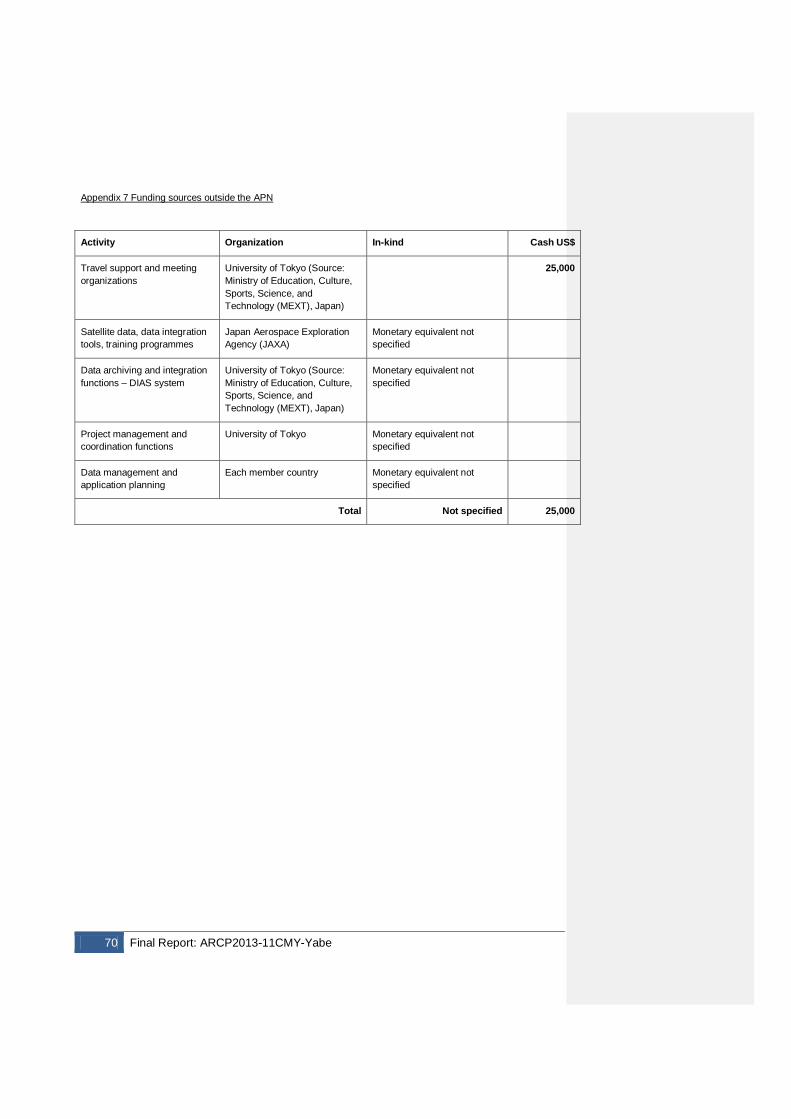
70 Final Report: ARCP2013-11CMY-Yabe
Appendix 7 Funding sources outside the APN
Activity Organization In-kind Cash US$
Travel support and meeting organizations
University of Tokyo (Source: Ministry of Education, Culture, Sports, Science, and Technology (MEXT), Japan)
25,000
Satellite data, data integration tools, training programmes
Japan Aerospace Exploration Agency (JAXA)
Monetary equivalent not specified
Data archiving and integration functions – DIAS system
University of Tokyo (Source: Ministry of Education, Culture, Sports, Science, and Technology (MEXT), Japan)
Monetary equivalent not specified
Project management and coordination functions
University of Tokyo Monetary equivalent not specified
Data management and application planning
Each member country Monetary equivalent not specified
Total Not specified 25,000
Final Report: ARCP2013-11CMY-Yabe 71
Appendix 8 Glossary of Terms
ADB Asian Development Bank AWCI Asian Water Cycle Initiative CCAA Climate Change Assessment and Adaptation CEOS Committee on Earth Observation Satellites DIAS Data Integration and Analysis System GCM General Circulation Model GEO Group on Earth Observations GEOSS Global Earth Observation System of Systems GSMaP Global Satellite Mapping of Precipitation ICG International Coordination Group IIWaDATA International Integrated Water Data Access and Transfer in Asia IWRM Integrated Water Resources Management ICHARM International Centre for Water Hazard and Risk Management JAXA Japan Aerospace Exploration Agency JICA Japan International Cooperation Agency MEXT Ministry of Education, Culture, Sports, Science, and Technology PDM Project Design Matrix R-CDTA Regional Capacity Development Technical Assistance RS Remote Sensing SAFE Space Application for Environment TRMM Tropical Rainfall Measurement Mission UT University of Tokyo UNU United Nations University WCRP World Climate Research Project WEB-DHM Water and Energy Budget Distributed Hydrological Model WEB-DHM-S Water and Energy Budget Distributed Hydrological Model – Snow (with advanced snow and glacier scheme) WMO World Meteorological Organization
WCDRR World Conference on Disaster Risk Reduction