Embed Size (px)
Citation preview
THE LAB IN THE WOMB OF A WHIRLING WORM
INDIA BASED NEUTRINO OBSERVATORY, SHEAR ZONE, AQUIFER AND TECTONICS
VT Padmanabhan1*
, R Ramesh2, V Pugazhendi
2, K Sahadevan
3,
Raminder Kaur4 and Joseph Makkolil
5*
1 European Committee for Radiation Risks (ECRR)- India Desk, PO, Pathayakkunnu, Tellicherry,
Kerala, India 670691.
2 Doctors for Safe Environment (DOSE), 78-3 Vinayagar Koil Street, Kanuvai, Coimbatore, 641108,
Tamil Nadu, India
3 Sampoorna Kranti Vidyalaya, Vedchi, Surat Gujarat, India
4 School of Global Studies, University of Sussex, Brighton BN1 9SJ, UK
5 Inter University Centre for Nanomaterials and Devices (IUCND), Cochin University of Science and
Technology, Kochi- 682022
*Corresponding authors : [email protected],[email protected]
Abstract
The proposed India-based Neutrino Observatory (INO), the largest underground
science laboratory in the world, with a finished volume of 235,000 m3, will be blasted
out in Idukki- Theni mountains of the Western Ghats. The proposed site is in the
highly deformed portion of the the Suruli ductile Shear Zone. There are 12 reservoirs
within 50 km radius of the complex, storing about 5 billion m3 of water. Idukki is the
water capital for five severely water-stressed districts in Tamil Nadu and Kerala. The
'geotechnical' study report (GTR), based on sparse and low quality primary data has
been treated as a confidential document. The impacts of blasting 800,000 tons of
rock on the aquifer, the rivers and the reservoirs were not among the endpoints of the
geotechnical study. Besides responding to the INO scientists and a geo-engineer, here
we extend our arguments against the project with a critique of the GTR, a summary
of studies on hydro-geology of the region, visible impacts of mountain tunnelling in
India and elsewhere and the regulatory regime that is evolving globally. Starting the
construction without conducting a proper, scientific impact assessment may be
suicidal. We also doubt whether the physics requirement of filtering the cosmic
background radiation, essential for a neutrino detector, will be possible at the present
site.
Keywords: Mountain tunnelling, neutrino observatory, hardrock aquifer, tunnelling
shear zone, environmental impact assessment, geotechnical study, global catastrophic
risk
1. Introduction
Water has been a political issue for a long time and scientists and politicians are
working to avert a water-driven world war. Recently, "human-induced earthquakes
have become an important topic of political and scientific discussion" due to "an
overall increase in seismicity"1, says William Ellsworth in his paper on anthropogenic
seismicity. In this background, we are grateful to BS Acharya and 21
phenomenologists (Acharya et al)2 and V Balachandran
3, engineering geologist for
joining the debate on the potential hydro-geological impacts of mountain tunnelling
for construction of the India-based Neutrino Observatory (INO), the world's largest
underground science laboratory with a finished volume of 235,000 m3
n Idukki-Theni
districts of Kerala-Tamil Nadu in the Western Ghats. Citing the experiences of the
Gran Sasso National Laboratory (LNGS) in Italy, two of us (VTP and MJ)4 had
argued that blasting out 800,000 tons of rock, using about 1000 tons of explosives
may impact the aquifers and reservoirs on the Periyar and the Vaigai river systems,
which are the lifelines for over 10 million people in five districts of Tamil Nadu and
Kerala states. Acharya et al and Balachandran stated that the site was chosen after a
detailed geotechnical study (GTS) and ruled out any negative impact on water
resources. We thank Prof NK Mondal for providing a hard copy of the GTR which
which he said is a confidential document. This document only strengthens our
argument regarding the impacts of tunnelling on the water resources.
2. Role of Science in Site Selection
2. 1 Brief history of the project
A brief history of the project will reveal the role of science in site selection. On 20
November 2009, the Central Ministry of Environment and Forests (MOEF) denied
the first site selected by INO in the Nilgiris due to its proximity to a tiger sanctuary.5
MOEF's offer of Suruliyar in Theni district which was under INO's consideration
since February 2009 was rejected "because there were less available data on the
characteristics of the rock that would need to be blasted"6. "Thevaram, the present
site, surveyed during 29-30 September 2009"7 was opted even though the site related
information was sparser than that for Suruliyar. In INO's own words, at Thevaram
the "rock quality appears to be good, but should be confirmed through detailed
geotechnical studies–local variations may be important".7 'Public hearing' for the
Thevaram site was held on 9 July 20108 and the MOEF approved the site on October
19, 20109. The Salim Ali Centre for Ornithology and Natural History (SACON)
completed the Environmental Impact Assessment (EIA) in November 2010.17
R.
Srinivasan of the Geological Survey of India (GSI) Chennai finalized the GTS report
on 14 December 2010.10
The role of the 'EIA scientists is clear from this narrative. On
December 28, 2012 the district administration handed over 27 ha of grazing land in
Pottipuram Panchayat of Theni district to the Indira Gandhi Centre for Atomic
Research, Kalpakkam of the DAE11
for construction of surface facilities.
2. 2 Critique of INO's Geo-technical Study
INO's geo-technical report (GTR) was first mentioned in an opinion piece in a
newspaper on 8th Oct 201212. The INO spokesperson also mentioned about it during
a talk at Thiruvananthapuram 10 days later.”13 The GTR is a confidential document
and as an unusual gesture, the Tata Institute for Fundamental Research (TIFR)
provided a hard copy of it in April 2013. (An OCRed version of this is placed as a
supplementary document.) (GTR for the earlier site in the Nilgiris is available on
INO's website.14)
For a mountain tunnel project, GTS is like the diagnostic study done before a major
surgery to assess the survival chances. The US Free High Way Authority (FHWA)
has evolved detailed guidelines for GTS and its website devotes 40 pages in two
sections. "The cost of a complete geotechnical investigation program for a road
tunnel project is typically about 3% to 5% of construction cost".15 INO study
involved 5 field-days, while FHWA says that "the high cost, lengthy duration, limited
access, and limited coverage of field investigations may demand that investigations
be carried out in several phases to obtain the information necessary at each stage of
the project in a more cost-efficient manner". The endpoints in a GTS can be broadly
classified into two - (i) the prospects and problems of making the tunnel and (ii) the
immediate, short term and long term impacts on the eco-system. The prospects and
problems of tunnelling was the only objective of the GTS for INO, conducted by R
Srinivasan of the GSI, Chennai. There is no mention about the impact on rivers,
aquifer or reservoirs anywhere in the report. The geologist spent five days in the site
in the months of March, April and October 2010. A site within the village grazing
land was chosen for the portal, after rejecting two others in the private and forest
lands. As per the order of the geologist, the Tamil Nadu Electricity Board drilled four
samples, all around the chosen portal.
2.2.1 The Quality of data - excerpts from GTR
(a) "Only portal area and initial reaches of the access tunnel alignment were studied
because, rest of the reach is not accessible as the hill is too steep. Hence, the
remaining reaches of the access tunnel up to the hill peak were observed only from a
distance".
(b) "The rock outcrops at the eastern side of lower slopes were only examined and
the observations are extrapolated to higher reaches."
(c) Quality of the bore-hole samples:
(i) "the cores were not arranged run-wise"
(ii) "no depth marking was done for each run, and only a cumulative depth for
certain runs given"
(iii) "many samples did not have arrow marking indicating the direction of depth"
(iv) "driller's log sheet doesn’t indicate water loss or water colour details."
(d) "The observations made in rocky slope between the bore hole No 4A and the first
vertical cliff showed the presence of weathered granite gneiss. Two additional bore
holes were recommended to know whether the weak rock is persisting at depth as the
weathering pattern is seen to be irregular in the study area. The project authorities
informed that they could not obtain forest department clearance to drill these bore
holes."
(e) "This has resulted in the approximate fixing of weathered rock and fresh rock
levels".
2. 2. 2 Observations of the Geologist
(a) "The profuse intrusion of granite with closely spaced sub-horizontal joints
probably along the margin of Suruliyar -Kambam shear zone is the rock
characterisation in the portal area of access tunnel alignment."
(b) "The regional geological map shows a shear zone trending NNE-SSW and
traversing access tunnel in middle reaches."
(c) "The only concern would the >1000 m of rock cover which would create stress
related problems like rock bursts".
(d) "The study has revealed that fresh rock is not available at uniform depth in the
holes. There is a sudden variation in the rock level between bore hole 4 and 4A and
there is a fall in the rock level to a depth of 27.41 m within 45 m distance"
(e) "Second generation geological maps prepared by GSI shows the presence of
faults. In view of these observations, it is prudent that seismic coefficients for
Magnitude 5 earthquakes is provided while designing the detector in the lab cavern".
2. 2. 3 Our comments
(a) Land above the caverns not studied
The geologist did not visit the land above the caverns, under which two-third of the
blasts will be done. The place is reachable by road via village Shantanpara in Kerala.
(b) Low quality drill data
The major component of the study is analysis and characterisation of the drilled
samples, the other components being visual observations and literature survey. The
drilling was not done professionally and two subsequent drilling ordered was not
done as they could not obtain the permission from the forest department! As the
author himself says, the main part of the geo-technical study is an approximation.
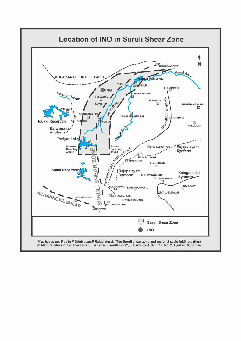
(c) Underplaying the shear zone
In plate No-5, (page 20), both the shear zone and the tunnel are shown as single lines
and they look like two roads intersecting each other in an acute angle. In fact, the
caverns and the tunnel are located in the middle of the shear zone which is 10 km
wide (see discussion and map below).
(d) Rock-bursts and their unpredictable effects
Citing the experience of tunnelling under a rock cover of 500 m for Pykara hydro-
electric project (PUSHEP) in the Nilgiris, Srinivasan observes that "similar
geological setting is expected at INO cavern also and the only concern would the
>1000 m of rock cover which would create stress related problems like rock bursts."
Incidentally, about 80% of the blasting will be done at depth >1000 m.
The significant findings of the GTS, viz., the seismicity of the region, the Suruli shear
zone and the warnings of rock-bursts during 80% of the blasts are independent of the
low quality borehole data. We will examine the implication of these issues.
2.2.4. The Ethical and legal Implications of Seismicity
According to the Bureau of Indian Standards, the site is in seismic zone 316
while the
EIA for INO has an unreferenced statement that "the project location is reported to be
situated in Seismic Zone 2"17
. INO's FAQ (English) has a question "what happens
when there is an earthquake or rock burst"18
, now a dead link as the answer, ('the site
is in zone 2') has been removed in March 2013. The FAQ in Malayalam says that a
"cave is the safest place during an earth-quake".19
An INO official, also a co-author in
Acharya et al, told the students of physics at the Cochin University for Science and
Technology (CUSAT) on October 19, 2012 that "the INO site is in seismic zone 2,
the lowest in India, and hence there is no room for any concern regarding tremors."20
Acharya et al rightly point out that "geological characterisation are important not only
for the safety of the environment around, but also for the safety of scientists working
in the underground laboratory." Besides the ethical issue related to sending the young
people to hazardous places without their informed consent, the legal issues will
surface if an unthinkable event occurs. The earthquake, will affect only few people,
that too only if the caves are completed. Blasting the shear zone can have other
serious impacts.
3. Hydro-geology of the Site
3.1. The Suruli Shear Zone
Idukki-Theni districts are part of the Madurai block of the southern granulate terrain
(SGT) in South India. V. Srinivasan and P. Rajeshdurai in their paper21
based on
satellite imageries and field checks say that "the Suruli ductile Shear Zone (SSZ)
extends from west of Kadaiyanallur in the south to Ganguvarpatti in the north
covering a length of 150 km." Its width is 200 m in the south and 10 km in the North
and INO, with a total length of 2.1 km will be inside the SSZ. They saw "veins with
perfectly developed calcite crystals" in several places, "crystalline limestone was
being quarried" at two places and they inferred "a limestone deposit in Tiruvengadam
synform". "There is no exposure of calc-granulite and these calcite crystal rich veins
are mostly aligned along the gneissosity in host charnockite. The solution rich with
calcium carbonate may have percolated downwards into the gneissosity, cracks and
crevices of the underlying charnockite." The intensity of deformation increases from
south to north along this shear zone. "In the northern end, between Vaigai River and
Ganguvarpatti, there are many exposures of mylonite (a fine-grained, compact rock
produced by dynamic recrystallization of the constituent minerals resulting in a
reduction of the grain size of the rock22
) that were not observed in the southern end.
At many places it is observed that the differentiated layering (gneissosity) in
charnockite is parallel to the layering of the associated quartzo-feldspathic gneiss, (a
major rock type from regional metamorphism23
) granite gneiss and khondalite and
this pervasive and penetrative gneissosity is also parallel to the lithological contacts."
3.2. 'A huge sheet of monolithic rock hill' in a sheer zone
The paper on the Suruli Shear Zone was published in April 2010 and GTR was
finalized in November 2010. On 18 October 2010, R Ramachandran wrote that the
scientists "finally chose a huge sheet of monolithic rock hill near Pudukkottai village
for the project".24 The implication is that the scientists studied the site with ultra-
sonograms, toposheets and satellite imageries. Even in fault-free areas, it is difficult
to find a large block of crack-free hard rock as the Swedes learnt during their efforts
to locate a granite block for a radioactive-waste repository.25 Cracks and crevices are
important from the physics aspect of the neutrino detector also, besides the hydro-
geology.
3. 3 Prior Studies on water resources and landslide
If calcium carbonate percolated down, there may be karsts and also confined or
unconfined aquifers underneath. According to the map in Srinivasan and Rajeshdurai,
the Vaigai, the Kakki and the Periyar reservoirs and the Suruli river are inside the
sheer zone. SSZ may also have invisible links with the rivers and the aquifers. Brief
summaries of a few recent path-breaking studies on the tectonics, hydrology and
landslides around the proposed site are given below.
Magesh et al26
conducted a study focusing on the identification of groundwater
potential zones in Theni district, integrating remote sensing with GIS. They prepared
various thematic layers, such as lithology, drainage density, lineament density,
rainfall, slope, soil, and land-use with assigned weightage in a spatial domain.
Ramasamy et al27
used GIS based visualization of groundwater levels of 1985, 1990
and 1995 for a part of the Western ghat hill-plain region of Tamil Nadu and
interpreted features like ridges, valleys, domes and basins. The study yielded newer
information on geosystem processes and their interface dynamics with hydrosystems.
In a review article on the remote sensing and active tectonics, Ramasamy discusses
the "ongoing land subsidence in addition to sinistral movements along the two sub
parallel lineaments, from Pondicherry in the north-east to the Kambam
valley in the south west along with youthful stage floodplain in the
Suruliyar river" .28
There is a also a serious risk of landslide as revealed in a landslide
vulnerability mapping done by Kannan et al using both satellite and field data in
Bodi-Bodimettu ghat section of the National Highway, less than 20 km from the
proposed INO site.29
3.4 Seismicity and Safe Tunnelling technology
Acharya et al say that "tunnelling is a routine activity in mountains (even in the
Himalayas which is the most seismically active region in India), under the rivers and
seas, and even under mega cities for metro rail transportation" and "it is hard to
believe that such an activity can cause major or even minor earthquakes." The US
FHWA says that "rocks with weak planes such as shear zones would clearly indicate
a potentially significant seismic risk to a tunnel"30
while Jorge et al say that "some of
the most disastrous experiences in tunnelling have been the result of interception of
large flows of water from highly fractured water-saturated rocks."31
3.4.1 Indian Experiences in Tunnelling and Aquifer - The Case of Rohtang
India has not been a major player in tunnelling. Out of 57 km of rail tunnel in India,
63% was commissioned in 1997 (all on Konkan Railways), 33% between 2005-12
and only 4% in 1982.32
Among 50 rail tunnels longer than 13 km in the world
commissioned before 2012, there is none from India.33
For the few smaller tunnels
constructed in India, no comparative studies of pre- and post tunnelling flows have
been done. A tunnel from a reservoir is on a negative gradient and if it ruptures an
aquifer, the water will flow into the generating station or the distribution network.
This will be a positive effect from the perspective of the dam builder, though this gain
of course will be matched with a loss elsewhere. Tunnelling in the 'high value
regions' like cities are done after systematic studies such as the one conducted by the
Indian Institute of Science34
for the Bangalore metro. In mountain regions, the large
overburden, logistics, low population density and the absence of an environmental
movement prompt the builders to forgo safety assessment and face the risks as the
recent experience in the Himalayas shows.
The construction of 8.8 km long Rohtang Tunnel (3,100 m MSL) in Himachal
Pradesh, under the Rohtang Pass (3,978 m MSL) in the Pir Panjal range of the
Himalayas on the Leh-Manali Highway began in June 2010. Rohtang, one of the
longest road tunnels in India, on a route vital for military supplies, will reduce the
distance between Manali and Keylong by 60 km. The Indian Army is in charge of the
Austrian technology based construction.35
Studies were reportedly conducted by
agencies like the National Hydro Power Corporation, Konkan Railways, GSI and
Snow and Avalanche Study Establishment36
, none available in the public domain. On
completion of 2 km, the builders encountered a fault line and an underground spring.
On 5 June 2012, a "rivulet gushed out",37
with an ingress of 3 million litres of water
per day.38
This has slowed the progress of excavation from 5 metre to just 0.5 metre a
day and requires 24x7 de-watering".39
Acharya et al claim that "the technology has
improved tremendously in the last few decades". True, but there are a few problems
like safe tunnelling in shear zones, disposal of high level radioactive waste and cure
for genetic diseases like Down Syndrome reserved for our F-3 generation of scientists
and inventors!
3. 5 Charnockyte aquifer, not our invention
The nomenclature charnokite aquifer is used in the Central Ground-water Board's
aquifer mapping reports for Kerala40
and Tamil Nadu41
, authored by 33 earth
scientists., By the way, about a third of the ground-water in Tamil Nadu is inside the
so-called charnockite aquifer and there is a small one in Chennai also. Scholar.google
returned 667 entries for hard-rock aquifer, 304 for granite aquifers and for 6 for
charnockite aquifer. There are 52 entries for granite aquifer in the US Geological
Services document server also. While summing up the LNGS experience,
Rajasekharan missed an important link, the sequence being rupturing an underground
spring and depletion of aquifer which might have caused the earth-quake. This is not
uncommon, its physics is the same as that of reservoir-triggered seismicity. We were
just quoting the Italian geologists who studied the Gran Sasso events and our main
concern is aquifer impact of tunnelling in an earth-quake prone area, which is an
established fact.
3. 6 The Long term and chronic impacts on hard rock aquifer.
Balachandran believes that hard rock aquifers are not prone to tunnelling impacts. In
2010, Vincenzi et.al wrote that "in hard rock aquifers it is extremely difficult to
forecast either major inflows occurrence along the tunnel or the associated effects on
surface waters and groundwater, due to the highly heterogeneous distribution of
hydraulic conductivity (K) and the consequent strong dependence of major inflows
on the interception of localized geological features.42 Besides the abrupt impact,
chronic depletion and eventual drying of hard-rock aquifers are possible. The US
Armed Forces Special Weapons Command, (AFSWC) constructed after the World
War II in Manzano Mountains which provide 70% of the water recharge for the
Estancia Basin, is an example. Though proposed as a command post for President
Dwight Eisenhower, he did not stay there, but part of the US nuclear arsenal was
there till 1990. According to one report, "over the last 50 years, well records indicate
the depth of the water table declined by several hundred feet, with total depletion of
the aquifer within as little as 40 years affecting tens of thousand of land owners
within an area the size of some small eastern states.”43
3.7 More on anthropogenic earth-quakes
Balachandran has introduced refreshingly new ideas about induced earth-quakes,
which will be keenly debated by the earth-science community. Though geology is a
matured science, the young scientists keep on springing more surprises, such as this
one by van der Elst et al44
who report that mega earthquakes in Chile (2010), Japan
(2011) and Sumatra (2012) triggered earthquakes in Oklahoma, Texas and Colorado
in USA. They say that "areas with suspected anthropogenic earthquakes are also more
susceptible to earthquake-triggering from natural transient stresses generated by the
seismic waves of large remote earthquakes" and they have named this 'triggered-
induced earthquake'. Earlier, Keranen et.al. had linked the induced 5.7 M earth-
quake near Prague, Oklahoma to waste-water injection from oil production, with
"decades-long lags between the injection and the onset of induced earthquakes"
which "modifies our common criteria for fluid-induced events."45
Again,"the amount
of waste water injected into the well was relatively small, yet it triggered a cascading
series of tremors that led to the main shock. There's something important about
getting unexpectedly large earthquakes out of small systems that we have discovered
here".46
Considering its seriousness the US NAS called for further research to
"understand, limit and respond" to induced seismic events.47
4. Discussion
4.1 Physics requirement of the neutrino detector
Neutrino detectors are placed underground or under water with a minimum
overburden of 3000 meters of water equivalent (mwe) to filter out the charged sub-
atomic particles, known as cosmic radiation, originating from the stars and other
unknown exotic places. Since the particle size is femtometer (10-15
m) even small,
invisible cracks should be avoided in all sides of the detector. Choosing a site in the
middle of a highly degraded shear zone, without even a field visit to the epicentre
raises doubts regarding the real purpose of the mission.
4.2 Free Science from politics
In 2004, Boominathan revealed that “confirmatory geological and geo-technical
investigations carried out after excavation of strata to the founding level at various
sites for nuclear facilities show the presence of weaker zones which were not
identified in the original investigation." His advice that "ecological and geotechnical
investigations shall be well planned and executed by reputed agencies at the
beginning stage of the investigation"48
seems to have fallen in deaf ears. (Italics ours)
Reputation of the agencies is important, more important is the contract. SACON and
GSI who did the EIA and GTS for INO are reputed agencies. In this case, they were
asked to lend their sciences for rationalizing a political decision. The EIA system in
India has become corrupt, because the promoters, most of whom would be the future
polluters, pay for the EIA and choose the scientists.
4. 3 Holton's self-fulfilling prophecy?
Acharya et al’s unconditional faith in technology reminds us of the physicist-
philosopher, Gerald Holton’s prophetic words during a lecture in Kashmir, in 1970
that “the 19th-century faith that science will show the way to the solution of all
problems and lead us soon to Utopia was a tragically naive illusion." Was Holton's
idea that "science and its technological offspring must come under the control of an
anthropocentric ethic if human is to survive”49 a self-fulfilling prophecy? Four
decades down the line, eminent scientists and philosophers from the Oxford50
and the
Cambridge51
universities are discussing the “global catastrophic risk” (GCR) and
“existential risk” (ER) from biotechnology, geo-engineering, nanotechnology and
artificial intelligence. As Martin Rees observes, "we’re entering an era when a few
individuals could, via error or terror, trigger societal breakdown.”52
In his essay on the anthropogenic earthquakes, Elseworth reminds us that "ignorance
of the things that we understand we should know but do not, leaves us vulnerable to
unintended consequences of our actions".1 When the ecological footprint of their own
projects were brought to light, the proponents could have studied the GTS, enquired
as to why it had to be classified as confidential, looked at the recent experiences of
such projects and the regulatory regime and practices now in vogue in other nations.
This is the tragedy of modern science and Peter Singer's observation about the latest
military applications is equally relevant in this debate also. Singer says that “our
sophisticated inventions and our crude grasp of the consequences continues to widen.
Academic journals of each field focus inward, professional conferences are attended
only by the like-minded, and those who attempt to straddle disciplines or engage the
public are viewed as less serious”.53
4. 4 The False consensus and the Crisis in modern science
What we are discussing here is a simple geological problem and one may wonder
why the earth scientists are not speaking out? In connection with the Sethusamudram
Shipping Canal Project (SSCP)54, Rajendran wondered as to why the scientists are
leaving "all these important decisions to some influential bureaucrats and politicians
who are clever enough to hide under some technicalities and poorly whetted reports?"
and on the role of "the national academies and professional bodies of Indian
scientists?"55
INO is a DAE project, and is also part of the US-India Nuclear Deal.56
In a letter published in this journal, Agoramoorthy and Chakraborty had asked "when
academicians express their scientific views with the support of data to portray the
potential dangers of earth-quakes to nuclear power plant sites, does it warrant ill-
treatment and deportation?"57 The ill-treated scientist, Roger Bilham had written on
the earthquake hazards of the proposed French nuclear park at Jaitapur in
Maharashtra.58,59
A report in Nature quotes the observation of the Washington DC
based Association for Tropical Biology and Conservation that the EIA for the earlier
site in the Nilgiris was also seriously flawed.60
. INO used reports based on falsified
or low quality data for obtaining the government's clearance and funding. This is an
affront to the environmental governance and the rule of law. Forest encroacher and
small time quarry owners do indulge in bigger violations, but a science institution
formed by collaboration of over a hundred finest minds and funded by a Department
headed by the Prime Minister of the nation should act as a role model. The first
national mega science project, a “perfect launching pad for attracting fresh blood into
basic sciences in India",61 should have been planned more meticulously, with
transparency, care and compassion.
5. Conclusion in the womb of a whirling worm?
The main reasons for selecting the proposed site in Bodi West Hills in Theni district
are the charnockite rock and the seismic stability. These are not fulfilled as the rock
type is not charnockite and the place has high earthquake risk. The cracks and faults
in the rocks of the highly degraded shear zone will increase the noise from cosmic
radiation in the lab and make any detection of the weakly interacting neutrinos
impossible. Unlike a road or rail tunnel or mine, there is no compelling reason for
INO to be located in its proposed site. Major neutrino observatories and underground
laboratories in the world are located in used mines, ocean beds, lake or ice sheet.
LNGS, the only one, located on a mountain range with a horizontal access has been a
perfect ecological disaster. INO's only reason to hang on to the present site is the
government's sanction obtained without undertaking a proper, scientific risk analysis
and bypassing the established procedures of public consultations. Writing on the neo-
tectonism in SGT, Ramasamy used the metaphor of a whirling worm. INO is
planning to place the world's biggest underground science laboratory, -that perfect
launching pad for attracting fresh blood into basic sciences in India-, its hundred odd
young particle physicists and a 100 KT magnet and assorted machines in the womb
of that whirling worm.
Reference
1 Ellsworth.,W.L., 2013, Injection-Induced Earthquakes, 12 July 2013:Vol. 341 no. 6142.
DOI: 10.1126/science.1225942
2 Acharya, B. S. et al, 2013, India-based Neutrino Observatory, Correspondence, Current Science,
Vol. 104, No. 7, 10 April 2013 811. http://www.currentscience.ac.in/Volumes/104/07/0811.pdf
3 Balachandran. V., 2013, Mountain tunnelling, aquifer and tectonics – a case study of Gran Sasso
and its implications for the India-based Neutrino Observatory by V. T. Padmanabhan and Joseph
Makkolil – a critique, CURRENT SCIENCE, VOL. 104, NO. 11, 10 JUNE 2013 pp 1479-
81http://www.currentscience.ac.in/Volumes/104/11/1479.pdf
4 Padmanabhan. V. T and Makkolil, J. 2013, Mountain tunnelling, aquifer and tectonics – a case
study of Gran Sasso and its implications for the India-based Neutrino Observatory, CURRENT
SCIENCE, VOL. 104, NO. 4, 25 FEBRUARY 2013 414.
http://www.currentscience.ac.in/Volumes/104/04/0414.pdf
5 Ramachandran, R., 2009, Ministry’s ‘no’ to Neutrino Observatory project in Nilgiris,
http://www.hindu.com/2009/11/21/stories/2009112154952000.htm
6 Jayaraman, K. S., 2009, Indian neutrino lab site rejected, Nature, 462, p 397
http://www.ino.tifr.res.in/ino/news/22%29Nature-Nov-09.pdf
7 Anonynous, 2009, Draft Notes September 2009 INO/IMSc/2009/06 India-based Neutrino
Observatory project Proposed locations in Kambam region Theni District, Tamilnadu.
8 http://www.thehindu.com/todays-paper/tp-national/tp-tamilnadu/scientists-clear-doubts-on-
neutrino-observatory/article506958.ece
9 Ramachandran, R.,2010, http://www.thehindu.com/news/national/tamil-nadu/neutrino-project-
approved-at-bodi-west-hills-in-theni/article836333.ece
10 Srinivasan, R.,2010., Preliminary Geotechnical Report On Pottipuram Site (A 1589) For
Locating Underground Laboratory Of India Based Neutrino Observatory, Theni District, Tamil
Nadu.
11 Mallady, S.V., The Hindu, January 4, 2012 http://www.thehindu.com/todays-paper/state-
government-hands-over-land-for-rs1260crore-neutrino-observatory/article2773468.ece
12 Ramachandran, R., The Hindu, October 8, 2012 http://www.thehindu.com/opinion/lead/a-
controversy-we-can-do-without/article3975090.ecN.S
13 http://www.thehindu.com/news/cities/Thiruvananthapuram/ino-to-study-atmospheric-
neutrinos/article4004991.ece
14 Balachandran, V., Thanavelu, C., and Srinivasan, R. 2009 Appendix C: Geotechnical forecast
along the preferred alignment, India based Neutrino Observatory project.
http://www.imsc.res.in/~ino/OpenReports/singara.pdf
15 http://www.fhwa.dot.gov/bridge/tunnel/pubs/nhi09010/03.cfm
16 http://ndma.gov.in/ndma/eqmeasurement.html
17 Azeez, P. A., Nikhil Raj, P. P. and Murugesan, M. 2010, Rapid EIA of the India-Based Neutrino
Observatory Project, Bodi West Hills, Theni, Tamil Nadu. Sálim Ali Centre for Ornithology
& Natural History, page 55. www.ino.tifr.res.in/ino/reports/REIA-Final_doc.pdf
18 http://www.ino.tifr.res.in/ino/faq.php#earthquake
19 http://www.ino.tifr.res.in/ino//docs/inofaq_mal.pdf
20 The Hindu, Kochi, October 19, 2012 http://www.thehindu.com/news/cities/Kochi/neutrino-
project-work-not-a- threat-to- mullaperiyar-dam/article4012326.ece
21 Srinivasan, V., Rajeshdurai, P. 2010 The Suruli shear zone and regional scale folding pattern in
Madurai block of Southern Granulite Terrain, south India, J Earth System Sc, 119, Issue 2,
pp.147-16. http://ns1.ias.ac.in/jess/apr2010/147.pdf
22 en.wikipedia.org/wiki/Mylonite
23 geology.about.com/od/rocks/ig/metrockindex/rocpicgneiss.htm
24 Ramachandran,R., The Hindu, October 18, 2010.
http://www.thehindu.com/news/national/tamil-nadu/neutrino-project-approved-at-bodi-west-
hills-in-theni/article836333.ece
25 Feiveson, H., Mian, Z., Ramana, M.V., and von Hippel, F. (ed) 2011, International Panel on
Fissile Materials,Managing Spent Fuel from Nuclear Power Reactors, Experience and Lessons
from Around the World, page 17 http://www.princeton.edu/sgs/publications/ipfm/Managing-
Spent-Fuel-Sept-2011.pdf
26
Magesh, N.S., Chandrasekar,N., Soundranayagam, J.P. 2012, Delineation of groundwater
potential zones in Theni district, Tamil Nadu, using remote sensing, GIS and MIF techniques.
http://www.hidro.ufcg.edu.br/twiki/pub/GeotecnologiaAplicada0/CASemestreAtual/Mageshetal
2012.pdf
27 Ramasamy, S.M., Kumanan, C.J, Mahalingam,S., and Nagappan,N. 2007. GIS based
visualization of groundwater level and its significance. J of Geomatics, Vol.1, No.1, pp. 17-22, I
http://www.ruraluniv.ac.in/71_3D_WATER_LEVEL.pdf
28 Ramasamy, S.M. 2006 Remote sensing and active tectonics of South India
International Journal of Remote Sensing Vol. 27, No. 20, 20 October 2006, 4397–
4431 http://www.scribd.com/doc/7182207/Active-Tectonics-South-India
29 M. Kannan,M., Saranathan,E., and Anabalaga, R. 2012 Landslide vulnerability mapping using
frequency ratio model: a geospatial approach in Bodi-Bodimettu Ghat section, Theni district,
Tamil Nadu, India Arabian Journal of Geosciences May 2012 DOI 10.1007/s12517-012-0587-
5
30 http://www.fhwa.dot.gov/bridge/tunnel/pubs/nhi09010/13.cfm
31 Molinero, J., Javier, S. and Juanes. R., "Numerical modeling of the transient hydrogeological
response produced by tunnel construction in fractured bedrocks." Engineering Geology 64.4
(2002): 369-386.ftp://ftp.unine.ch/Kiraly/Papers/Molinero02.pdf
32 http://www.lotsberg.net/data/india/list.html
33 http://en.wikipedia.org/wiki/List_of_long_tunnels_by_type
34 Sekhar, M. ,Mohankumar. M.S., 2009. Geo-Hydrological Studies Along The Metro Rail
Alignment In Bangalore, Department of Civil Engineering, Indian Institute Of Science.
http://bmrc.co.in/pdf/news/IISc-Report.pdf
35 http://en.wikipedia.org/wiki/Rohtang_Tunnel.htm
36 Chauhan P., 2003, Rohtang tunnel to affect area ecology, warn experts, Tribune News Service,
11 August 2003
37 www.dailypioneer.com. 5 June 2012.
38 http://articles.timesofindia.indiatimes.com/2012-11-19/india/35204208_1_rohtang-tunnel-
longest- tunnel-ingress
39 http://www.tribuneindia.com/2012/20120709/main6.htm
40 Dhiman, S.C. and Nandakumaran, P., Aquifer Systems of Kerala, Government of India, Central
Groundwater Board, .2012 http://cgwb.gov.in/AQM/Kerala.pdf
41 Dhiman, S.C., Thambi, D.S.C., Dhayamalar, D., Senthilkumar, M., Arumugam, R.,
Piramanayagam, S., Ramesh Kumar, N., Gnanasundar, D., Aquifer systems of Tamil Nadu and
Puducherry, Central Groundwater Board, Government of India, . 2012.
http://cgwb.gov.in/AQM/Tamil%20Nadu.pdf
42 Vincenzi, V., Piccinini, L., Gargini, A. and Sapign, M. 2010, Parametric and numerical
modelling tools to forecast
hydrogeological impacts of a tunnel, , AQUA mundi (2010) - Am02017: 135 –154. DOI
10.4409/Am-021-10-0017
43 http://www.globalsecurity.org/wmd/facility/manzano.htm
44 van der Elst, N. J., Savage, H. M., Keranen, K. M., & Abers, G. A. (2013). Enhanced remote
earthquake triggering at fluid-injection sites in the midwestern United States. Science,
341(6142), 164-167.
45 Keranen, K.M., Savage. H.M., Abers. G.A. and Cochran. E.S. (2013) Potentially induced
earthquakes in Oklahoma, USA: Links between wastewater injection and the 2011 Mw 5.7
earthquake sequence,
http://geology.gsapubs.org/content/early/2013/03/26/G34045.1.full.pdf+html. doi:
10.1130/G34045.1
46 http://phys.org/news/2013-03-wastewater-spurred-biggest-earthquake.html#nwlt
47 http://dels.nas.edu/resources/static-assets/materials-based-on-reports/reports-in-brief/Induced-
Seismicity-Report-Brief-Final.pdf
48 Boominathan, A. 2004 Geotechnics And Earthquake Hazards site characterization for nuclear
structures and power plants, Current Science, Vol. 87, NO. 10.
www.iisc.ernet.in/currsci/nov252004/1388.pdf
49 Holton, G.,The relevance of physics, Phys. Today 23(11), 40 (1970);
http://dx.doi.org/10.1063/1.3021828
50 http://www.fhi.ox.ac.uk/research
51 http://cser.org/
52 Rees, M., Denial of Catastrophic Risks, Editorial. Science, 8 March 2013: Vol. 339 no. 6124 p.
1123 DOI: 10.1126/science.1236756 http://www.sciencemag.org/content/339/6124/1123.ful
53 Singer. P. W., A world of killer apps . Leaders are ill-prepared for the ethical complications of
new ‘killer applications’, Nature, 477: 399, 2011.
www.nature.com/nature/journal/v477/n7365/abs/477399a.html
54 Ramesh R. Sethusamudram shipping canal project, CURRENT SCIENCE, VOL. 88, NO. 4, 25
FEBRUARY 2005 http://www.iisc.ernet.in/~currsci/feb252005/536.pdf
55 Rajendran, C. P , 2005, Sethusamudram shipping canal project and the eternal silence of the
Indian earth scientists, Current Science, VOL. 89, NO. 2, 25 JULY 2005.
http://www.iisc.ernet.in/currsci/jul252005/246.pdf
56 Collaboration between Indian and US laboratories on Accelerator technologies ...
sbhepnt.physics.sunysb.edu/~grannis/DOE/foreign Collaboration/ between Indian and US
laboratories on Accelerator...
57 Agoramoorthy. G. and Chakraborty,C., 2013, Is India open to scientific criticism?, Current
Science, VOL. 104, NO. 4, 25 February 2013.
http://www.currentscience.ac.in/Volumes/104/04/0406.pdf
58 Bilham, R.; Gaur, V. K. 2011, Historical and future seismicity near Jaitapur, India, Current
Science, 25 November 2011, 101 (10)
http://www.currentscience.ac.in/Volumes/101/10/1275.pdf
59 Gaur, V. K. ; Bilham, R. 2012, Discussion of seismicity near Jaitapur , Scientific
Correspondence, 10 December 2012, 103 (11)
http://www.currentscience.ac.in/Volumes/103/11/1273.pdf
60 Jairaman K. S., 2009. Elephant and the Neutrino, Nature, 461, 24 September 2009, p 459
www.nature.com/news/2009/091124/full/462397b.html

61 Kakodkar. A. quoted in Bagla, P., 2009, Indian neutrino detector hits snag on environmental
concerns. Science Vol 323 9 January 2009.
http://www.sciencemag.org/content/323/5911/197.summary. DOI:10.1126/science.323.5911.197


