Embed Size (px)
Citation preview
THE LAST GLACIATION OF ARAN ISLAND AND CRUIT ISLAND,
CO. DONEGAL, NORTH-WEST IRELAND
JASPER KNIGHT
(Received 30 July 2012. Accepted 27 September 2012.)
Abstract
This paper describes geomorphological and sedimentary evidence from Aran Island and
Cruit Island (County Donegal, north-west Ireland), informed by evidence from across west
Donegal, which helps to show the processes of ice advance and retreat and subglacial
conditions during the last (late Midlandian) glaciation. Extensive abraded rock surfaces
show clear evidence for ice overtopping of the islands. Erosional landforms include striae,
flutes developed in bedrock, whalebacks, roches mountonnees and meltwater channels.Depositional landforms include erratic boulders and a single marginal moraine on Aran
Island. Glacial or glacially-influenced sediment deposition that does not have a geomorphic
expression took place into bedrock hollows during an ice advance stage, probably around
the time of the last glacial maximum. The dominance of erosional signatures likely reflects
the stripping by ice of a surficial cover of weathered pre-glacial granite debris. The general
absence of subglacial and ice-marginal sediments across the region likely reflects the granite
substrate and coarse granitic weathering products, which did not favour development of a
thick deformable sediment pile.
Introduction
Several recent studies have highlighted the dynamic
behaviour of the last (late Midlandian) ice masses in
County Donegal, north-west Ireland, in particular
with respect to the timing of advance and retreat
phases and changes in the position of ice dispersal
centres (McCabe and Clark 2003; Ballantyne et al.
2007; Clark et al. 2009; Smith and Knight 2011).
Fewer studies have been concerned with the geo-
morphological and sedimentary evidence for glacial
processes during these phases (Knight and McCabe
1997; Knight 2009, 2011). This is in part due to the
relative paucity of depositional evidence in lowland
areas, even though drumlins, moraines and other
features have been previously mapped within moun-
tain valleys (Charlesworth 1924; Dury 1958, 1964;
Colhoun 1972) and within the larger embayments
(Wright 1912; Knight and McCabe 1997). Glacial
evidence from the rocky islands of west-coast
Donegal (which from north to south include Gola,
Owey Island, Cruit Island, Aran Island, Rutland
Island and Inishfree Upper) has been poorly studied
in comparison to the mainland. However, this
archipelago of islands is an important potential
source of evidence for reconstructing late-glacial�Holocene sea-level changes, because of the high
preservation potential of intertidal organics within
rocky embayments (Shaw and Carter 1994; Brooks
et al. 2008). These rocky embayments can also
preserve glacigenic, glacially-moved and/or Qua-
ternary slope sediments formed in association with
late Midlandian ice. Examples of such sediments are
discussed in this paper.
Large-scale models of British�Irish ice-sheet
evolution during the last glaciation all show that
Irish ice, including from Donegal mountain sources,
extended onto the western Atlantic shelf, thus
Irish Journal of Earth Sciences 30 (2012), 49�58
doi: 10.3318/IJES.2012.30.49
# 2012 Royal Irish Academy
49
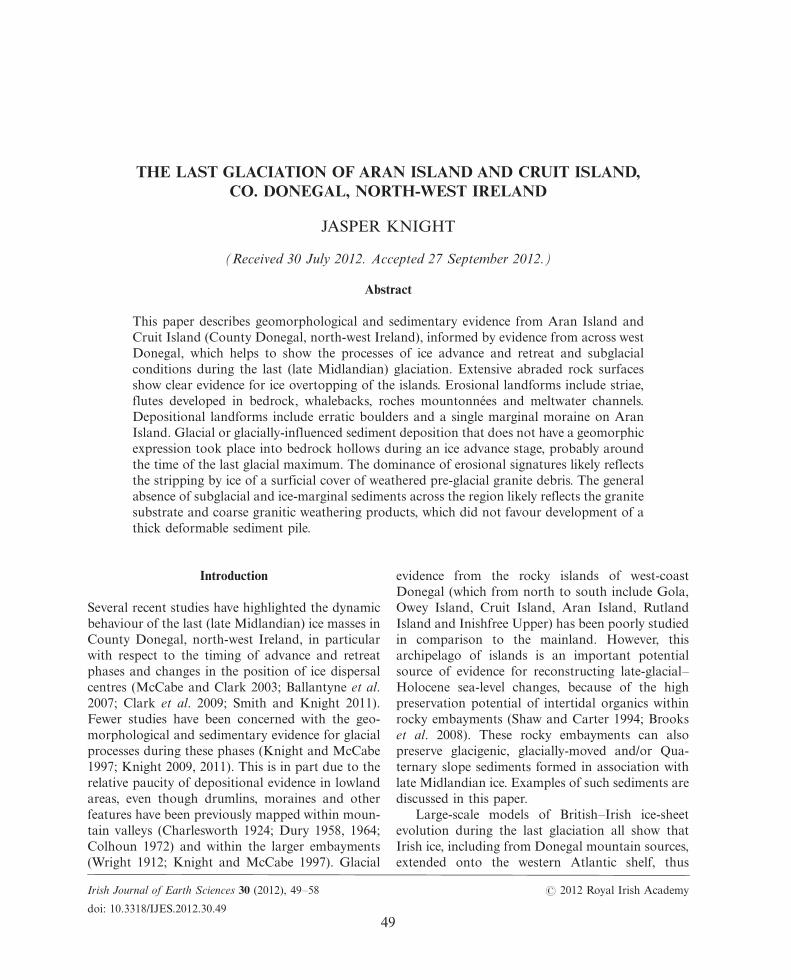
inundating the west Donegal islands (Clark et al.
2004; Fretwell et al. 2008) (Fig. 1). This fits with
geophysical evidence for landforms interpreted as
terminal moraines of likely last glacial maximum
(LGM) age on the Atlantic shelf (Benetti et al. 2010;
O Cofaigh et al. 2012). A more detailed ice sheet
model based on 10Be ages from exposed rock
surfaces suggests LGM-age maximum ice thick-
nesses of around 700m over the Donegal mountains,
and ice thickness at the west coast of around 500m
(Ballantyne et al. 2007) (Fig. 1). Together, this
evidence shows that the west Donegal islands
were completely covered by ice during the late
Midlandian. Despite this, little evidence for glacial
processes has been presented previously from these
islands.
This paper describes geomorphological and
sedimentary evidence from the two largest west
Donegal islands (Aran Island [Arainn Mhor] and
Cruit Island) (Fig. 2). A central aim is to provide
information on the processes and patterns of late
Midlandian glaciation in extreme west Donegal,
about which very little evidence is known despite the
long-acknowledged role of this glaciation in shaping
the Donegal landscape. In detail, the paper
(1) describes the geological setting and previous
work in the region; (2) presents evidence for glacial
landforms and sediments from Aran Island and
Cruit Island; and (3) interprets this evidence with
respect to the processes and patterns of late Mid-
landian ice advance and retreat in west Donegal.
Geological setting and summary of previous work
The west coast and islands of County Donegal are
underlain mainly by the Thorr granite (including
granodiorite) into which The Rosses granite was
emplaced (Stevenson et al. 2008). Both are Late
Silurian/Early Devonian in age. The majority of
Aran Island, however, is underlain by the Ards
Quartzite Formation which stratigraphically lies
within the lower part of the Precambrian Dalradian
Supergroup (Long and McConnell 1999). Grano-
diorite and granite from the Thorr granite outcrop
on the south-eastern and southern fringes of Aran
Island. Dolerite dikes aligned WNW-ESE are
locally present within all rock types in the region.
Exposed granite surfaces are present throughout the
region. These exposed surfaces are significant
because rock surface weathering during the
Tertiary�Quaternary was likely an important me-
chanism of loose sediment generation, and may
have exerted a strong influence on the dynamics of
overlying ice throughout the Quaternary, through its
control on substrate properties such as capacity for
subglacial water storage, discussed later. It is
notable that Cruit Island is relatively flat (highest
100 km
IrishSea
Malin Sea
AtlanticOcean
BBA B
BloodyForeland
Land above 200 m a.s.l.
Cruit Island
8°30′W
55°0
0′N
54°4
0′N
8°00′W
North Atlantic Ocean
TheRosses
Owey Island
Aran Island
Rutland Island
Inishfree Upper
Gola
Fig. 1*Map of (A) County Donegal showing the locations of Aran Island and Cruit Island (see Fig. 2) and other places named in thetext. Land over 200m asl is shaded. (B) Late Midlandian ice surface contours (m asl) and ice flow vectors are marked after Ballantyneet al. (2007). Note the ice margin terminates offshore (no ice surface data).
50 Irish Journal of Earth Sciences (2012)
point 32m asl) whereas Aran Island has much
greater relief (highest point 227m asl).
Bedrock surfaces throughout west Donegal are
glacially scoured and have a litter of large erratic
boulders, especially across The Rosses where they
have been used to reconstruct ice dispersal patterns
(Charlesworth 1924) (Fig. 1). Based on interpreted
patterns of striae cross-cutting (Smith and Knight
2011), westerly ice flow in Donegal was followed by
north-westerly ice flow as a result of a southward
shift in late Midlandian ice centres. The effects of
bedrock scouring are clearly evident across the
region, with whaleback summits, roches mounton-
nees and striae commonly recorded (Charlesworth
1924; Dury 1964; Colhoun 1972; Ballantyne et al.
2007; Smith and Knight 2011). Eroded bedrock
features (whalebacks and rock drumlins) are also
observed on the Atlantic shelf, immediately to the
west of Aran Island (O Cofaigh et al. 2012, their
fig. 6b). No sediments are present on the seismic data
in this offshore area, and are uncommonly observed
on land. The relative absence of constructional ice-
marginal forms in west Donegal, compared to the
north coast (Stephens and Synge 1965; McCabe and
Clark 2003), has meant that processes and patterns
of ice retreat are poorly known, but large and nested
arcuate moraines are interpreted from the offshore
data, however (O Cofaigh et al. 2012). A retreat
moraine composed of boulders at Bloody Foreland,
north of this area, was dated by the 10Be cosmogenic
exposure method to 18�20 kyr BP (Clark et al. 2009).
There have been few detailed (site-scale) investiga-
tions of subglacial and ice-marginal processes in west
Donegal. From the Loughros Beg estuary, Knight
(2009, 2011) described the formation of subglacial
meltwater scours and rock-cored drumlins. From
coastal sections around Bloody Foreland, McCabe
(2005) sketched a late Midlandian stratigraphy
comprising a raised shore platform and beach,
overlain by a diamicton of uncertain origin, and
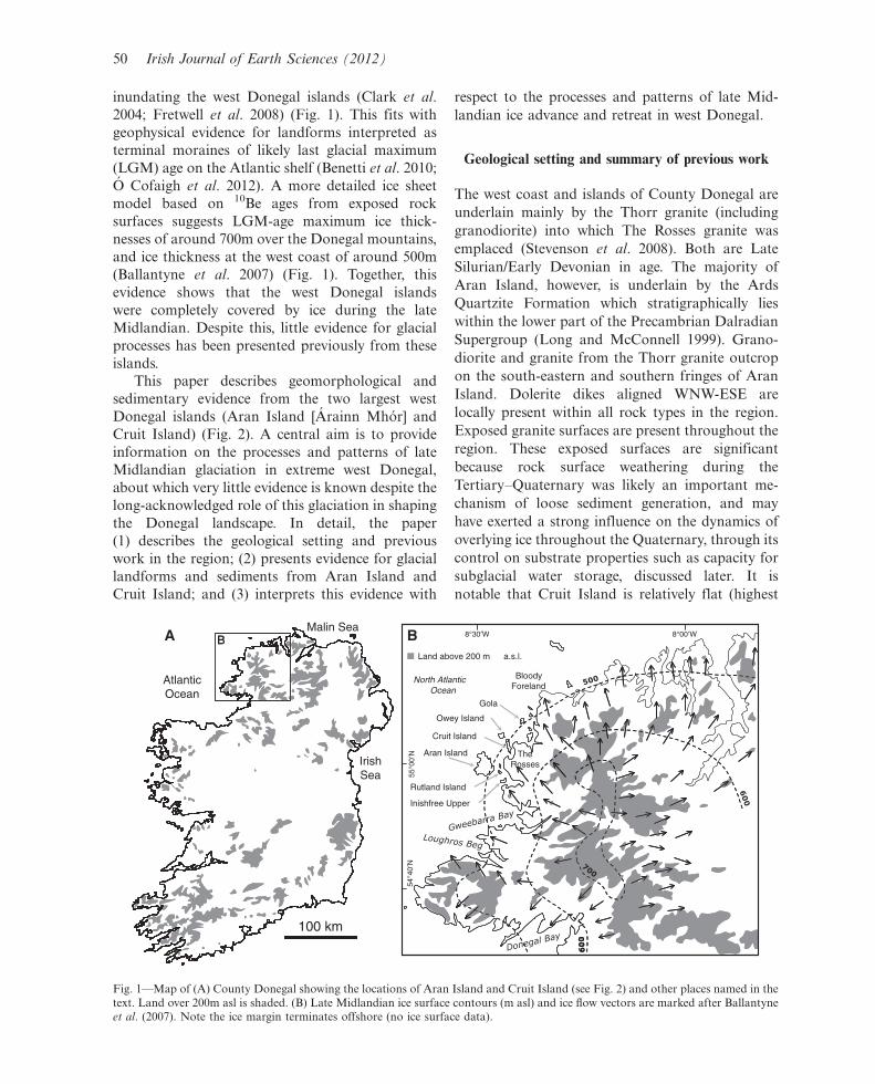
Fig. 2*Maps of (A) Aran Island and (B) Cruit Island showing the distribution of glacigenic landforms mapped by remote sensing andfield observation, and the locations of sites A�F named in the text. Contours are given in metres. Areas of ‘drift’ on Aran Island aregiven after the Geological Survey of Ireland map sheet 9 (dated 1889), although there is little support in the field for this. Hummockytopography was identified as disordered and nonaligned mounds of sediment (a few metres in height) observed in the field, andexcluding sand dune ridges.
Knight*Last glaciation of Aran Island and Cruit Island, Co. Donegal 51
overlain in turn by gravels. Such a stratigraphyappears different to that recorded in south Donegal
where two ‘head’ deposits are overlain by a glacial
diamicton (Colhoun 1973). These local stratigraphic
differences may suggest activity of a different ice
sheet sector in combination with localised sediment
sources. Despite these regional and site-scale studies,
specific mention of west Donegal islands is limited to
the description by Charlesworth (1924) of graniteerratics across all bedrock surfaces of Aran Island.
‘Banking of drift’ was also identified on south and
south-eastern slopes of Aran Island (p. 213),
although these ‘banks’ were not described in detail.
In this study, the glacial geomorphology of Aran
Island and Cruit Island was mapped from National
Coastline Survey of Ireland air photos (at a variable
scale but with a pixel resolution of � 30m), whichalso covered interior parts of the islands, and in the
field. Where available, sediment exposures were
examined for their lithological properties and sedi-
mentary structures.
Description and interpretation of glacigenic evidence
from Aran Island and Cruit Island
Geomorphological evidence
Glacial erosional features dominate across the
islands (Fig. 2). The most common property is
that of areal glacial scouring, which leaves bedrock
surfaces bare and smoothed and with moderate
local relief (a few metres in many cases). Striae
patterns are reported elsewhere (Smith and Knight
2011); this study focuses on mesoscale erosional
forms. These mesoscale forms (sensu Glasser and
Warren 1990), including whalebacks and roches
mountonnees, are relatively uncommon given that
this is a landscape dominated by erosional forms,
but mesoscale forms are best developed where the
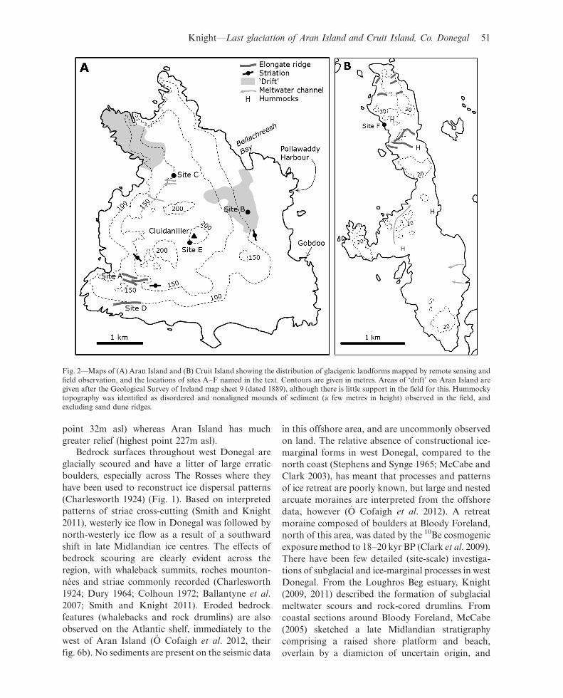
bedrock surface slopes in a down-ice direction. This
is most clearly seen on Aran Island (site A on Fig. 2)
where hairpin-shaped, elongate and curved
symmetric hills, whose forms are 400�500m long
and 40�50m wide, are developed in quartzite bed-
rock. These landforms, which are interpreted as
flutes, have their highest points located on the up-ice
(east) side of the landform and are slightly curved in
plan view (Fig. 3). Flutes of a similar shape and
length:width ratio have been described from
Alberta, Canada, where they were interpreted as a
product of subglacial outburst floods (Shaw et al.
2000). Similar landforms, termed megagrooves,
have been identified in north-west Scotland where
they are curved, developed in bedrock, and are
500�1500m long and 20�30m wide (Bradwell 2005).
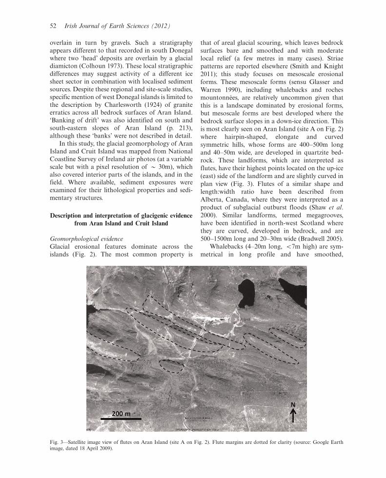
Whalebacks (4�20m long, B7m high) are sym-
metrical in long profile and have smoothed,
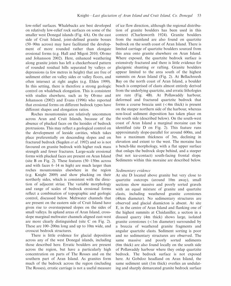
Fig. 3*Satellite image view of flutes on Aran Island (site A on Fig. 2). Flute margins are dotted for clarity (source: Google Earthimage, dated 18 April 2009).
52 Irish Journal of Earth Sciences (2012)
low-relief surfaces. Whalebacks are best developed
on relatively low-relief rock surfaces on some of the
smaller west Donegal islands (Fig. 4A). On the east
side of Cruit Island, joint-defined granite bosses
(50�90m across) may have facilitated the develop-
ment of more rounded rather than elongate
erosional forms (e.g. Hall and Migon 2010; Olvmo
and Johansson 2002). Here, enhanced weathering
along granite joints has left a checkerboard pattern
of rounded residual hills separated by valleys or
depressions (a few metres in height) that are free of
sediment either on valley sides or valley floors, and
often intersect at right angles (e.g. Ehlen 1999).
In this setting, there is therefore a strong geologic
control on whaleback elongation. This is consistent
with studies elsewhere, such as by Olvmo and
Johansson (2002) and Evans (1996) who reported
that erosional forms on different bedrock types have
different shapes and elongation ratios.
Roches mountonnees are relatively uncommon
across Aran and Cruit Islands, because of the
absence of plucked faces on the leesides of bedrock
protrusions. This may reflect a geological control on
the development of leeside cavities, which takes
place preferentially on descending slopes and on
fractured bedrock (Sugden et al. 1992) and so is not
favoured on granite bedrock with higher rock mass
strength and fewer fractures. Large-scale erosional
forms with plucked faces are present on Aran Island
(site B on Fig. 2). These features (50�150m across
and with faces 6�14 m high) are much larger than
roches mountonnees elsewhere in the region
(e.g. Knight 2009) and show plucking on their
northerly sides, which is consistent with the direc-
tion of adjacent striae. The variable morphology
and range of scales of bedrock erosional forms
reflect a combination of topographic and geologic
control, discussed below. Meltwater channels that
are present on the eastern side of Cruit Island have
given rise to oversteepened slopes on the sides of
small valleys. In upland areas of Aran Island, cross-
slope marginal meltwater channels aligned east-west
are more clearly distinguished (site C on Fig. 2).
These are 100�200m long and up to 10m wide, and
crosscut bedrock structures.
There is little evidence for glacial deposition
across any of the west Donegal islands, including
those described here. Erratic boulders are present
across the region, but have a particularly high
concentration on parts of The Rosses and on the
southern part of Aran Island. As granites form
much of the bedrock across the region (including
The Rosses), erratic carriage is not a useful measure
of ice flow direction, although the regional distribu-tion of granite boulders has been used in this
context (Charlesworth 1924). Granite boulders
from the mainland are also found on quartzite
bedrock on the south coast of Aran Island. There is
limited carriage of quartzite boulders sourced from
this area onto granite elsewhere on Aran Island.
Where exposed, the quartzite bedrock surface is
extensively fractured and there is little evidence forglacigenic shunting or rafting. Granite boulders
appear limited to the area south of the highest
summits on Aran Island (Fig. 2). At Bellachreesh
Bay on the north coast of Aran Island, a boulder
beach is comprised of clasts almost entirely derived
from the underlying quartzite, and erratic lithologies
are rare (Fig. 4B). At Pollawaddy harbour,
deformed and fractured quartzite bedrock thatforms a coarse breccia unit (B4m thick) is present
on the steeper northern side of the harbour, whereas
non-local sediment deposition has taken place on
the south side (described below). On the south-west
coast of Aran Island a marginal moraine can be
identified (site D on Fig. 2). This feature runs
approximately slope-parallel for around 600m, and
has a maximum thickness of 3m, declining inelevation and extent to the west. The moraine has
a bench-like morphology, with a flat upper surface
that onlaps the bedrock slope behind, and a steeper
(but not ice-contact) south-facing frontal slope.
Sediments within this moraine are described below.
Sedimentary evidence
At site D located above granite but very close to
quartzite outcrops (around 10m away), small
sections show massive and poorly sorted gravels
with an equal mixture of granite and quartzite
clasts, including weathered granite corestones
(40cm diameter). No sedimentary structures are
observed and glacial diamicton is absent. At siteE, in the centre of Aran Island and flanking one of
the highest summits at Cluidaniller, a section in a
disused quarry (4m thick) shows large, isolated
granite corestones (B1m diameter) surrounded by
a breccia of weathered granite fragments and
angular quartzite clasts. Sediment sorting is poor
and no sedimentary structures are observed. The
same massive and poorly sorted sediments(6m thick) are also found locally on the south side
of Pollawaddy harbour where they onlap quartzite
bedrock. The bedrock surface is not exposed
here. At Gobdoo headland on Aran Island, the
same sediment unit (1m thick) overlies an undulat-
ing and sharply demarcated granite bedrock surface
Knight*Last glaciation of Aran Island and Cruit Island, Co. Donegal 53
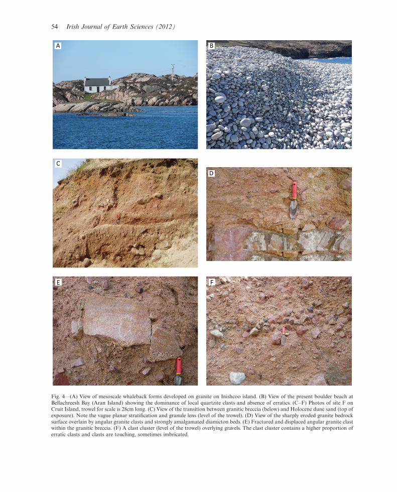
Fig. 4*(A) View of mesoscale whaleback forms developed on granite on Inishcoo island. (B) View of the present boulder beach atBellachreesh Bay (Aran Island) showing the dominance of local quartzite clasts and absence of erratics. (C�F) Photos of site F onCruit Island, trowel for scale is 28cm long. (C) View of the transition between granitic breccia (below) and Holocene dune sand (top ofexposure). Note the vague planar stratification and granule lens (level of the trowel). (D) View of the sharply eroded granite bedrocksurface overlain by angular granite clasts and strongly amalgamated diamicton beds. (E) Fractured and displaced angular granite clastwithin the granitic breccia. (F) A clast cluster (level of the trowel) overlying gravels. The clast cluster contains a higher proportion oferratic clasts and clasts are touching, sometimes imbricated.
54 Irish Journal of Earth Sciences (2012)
which shows enhanced weathering along structural
weaknesses. Rounded corestones are common with-
in the sediments, but bedrock fragments that have
been periglacially fractured and erratic materials
indicative of glacial transport are absent.
Sediments are exposed within embayments on
the western side of Cruit Island. Along this coast
(e.g. at site F on Fig. 2) a single granite-rich unit is
present below Holocene dune sand from which it is
separated by a gradational contact (Fig. 4C). The
sediments are texturally variable and include a
diamictic breccia (sensu Knight 1999, 2005) com-
posed of local bedrock fragments, matrix-dominant
diamicton, granule lenses and silt stringers. These
different facies have high lateral and vertical varia-
bility but generally sediments lower in the profile
show amalgamated and welded beds and appear
overconsolidated, whereas those higher in the pro-
file exhibit greater interbedding. The sediments
(B2m thickness) overlie a granite rock surface which
is highly undulatory with local relief of up to 1m.
The bedrock surface varies from sharply planar
erosional to showing displaced rounded granite
boulders (Fig. 4D). Sediments above this surface
are generally massive and poorly sorted with
some planar stratification observed, related to
variations in clast concentration. Isolated pods of
massive granules are also present in places (Fig. 4C).Throughout the sediments at site F, local granite
dominates the clast population (�95%). Granite
clasts occur across a wide size range but make up all
of the largest boulders (B30cm diameter) that are
present in the section. Granite clasts range from
angular to subrounded, suggesting local and more
distant source areas, respectively. More angular
clasts are usually located at the base of the section
with more rounded clasts higher up. Some angular
clasts show evidence of syndepositional clast-clast
contact and brecciation (Fig. 4E), but matrix
deformation and faulting are not observed.
Occasionally non-imbricated clasts form chaotic
clusters that are variably clast- to matrix-supported
(Fig. 4F). The clasts are of similar size and are
usually touching, occasionally imbricated. These
clusters also have a higher erratic content (5�8%)
than surrounding sediments, and include schists
derived from the south around Gweebarra Bay
(not from The Rosses to the south-east). Through-
out the sedimentary section, the matrix portion is
dominant (80 to �90%) and is composed exclu-
sively of mineral grains derived from weathered
granite, including more friable feldspars. These
mineral grains have a ‘dirty’ appearance, indicating
the presence of clay forming cutans over grainsurfaces. The clays may be a product of granite
weathering (e.g. Eppes and Griffing 2010).
Discussion
Geomorphological and sedimentary evidence from
Aran Island and Cruit Island shows that glacial
erosional processes were dominant during the Mid-
landian glaciation, forming striae, flutes developed
in bedrock, whalebacks and roches mountonnees,
and there is very limited evidence for glacialdeposition. The amount of glacial erosion is very
difficult to evaluate: ice may have merely stripped
away any pre-existing weathered debris to reveal an
unweathered bedrock surface with very minimal net
erosion. In Minnesota, smooth crystalline bedrock
surfaces were formed solely by the stripping away of
a weathered mantle, and did not require extensive
subglacial scouring (Patterson and Boerboom1999). In Scotland, granite tors were affected by a
continuum of glacial modification, from preserva-
tion beneath cold-based ice to selective block
removal (Hall and Phillips 2006). The morphology
of granite tors or exposed granite hilltops can
therefore indicate the nature of overlying ice cover
including its thermal regime. Ballantyne et al. (2007)
used this line of evidence to help identify summits inDonegal that had escaped glacial erosion.
The role of geology
The properties of the underlying granite bedrock
had a critical control on the range of landforms and
sediments produced during the last glacial cycle in
west Donegal. Pre-glacial weathering by a range of
both warm- and cold-climate processes during the
Tertiary and/or Quaternary was important in loose
sediment generation. This included (1) granular
fragments (saprolite) that are seen in situ in someplaces in Donegal and elsewhere in Ireland mantling
bedrock surfaces (Coxon 2005); (2) unweathered
bedrock boulders (corestones) surrounded by an
aureole of saprolite, which may have been the
primary mechanism of generating suitable boulders
for later carriage across Donegal; and (3) silts and
clays produced by differential chemical weathering
of feldspars (grus) (Eppes and Griffing 2010),which is seen in section at Cruit Island. The
general absence of glacigenic sediments across west
Donegal, and the presence of widespread glaciated
rock surfaces, suggests either that surficial pre-
glacial sediments were absent, or that any sediments
were glacially stripped, revealing the underlying
Knight*Last glaciation of Aran Island and Cruit Island, Co. Donegal 55
bedrock (e.g. Olvmo and Johansson 2002). The roleof pre-glacial weathering in landscape denudation of
limestones has been demonstrated elsewhere in
Ireland (Coxon 2005) but there is little information
on weathering products from granite substrates in
Donegal. One clue, however, may come from
geochemical analysis of surface sediments found
above the limits of glacial erosion on mountain tops,
including the diagnostic secondary mineral gibbsitewhich is formed by silicate weathering (Paasche
et al. 2006). The presence of this mineral may
indicate the extent to which weathered products
have remained in situ rather than having been
glacially stripped (Ballantyne 1998). Constructional
end moraines on the Atlantic shelf may support the
hypothesis of widespread glacial stripping in west
Donegal.
Sedimentary processes
On Aran Island and Cruit Island, sediments at
Pollawaddy Harbour, Gobdoo and site F are
restricted to bedrock hollows and do not have a
geomorphological expression. This may suggest thatthese sediments were deposited during ice advance,
and the tops of the hollows planed off, or that
sediments in these hollows have higher preservation
potential irrespective of formative process. The high
matrix content of these sediments also suggests that
they were formed by pre-glacial weathering. If this
timing of sediment deposition is correct, the erratic
content at site F suggests initial ice flow from thesouth or south-east. The relative chronology of
bedform flow sets in the region is too uncertain to
either prove or disprove this (Greenwood and Clark
2009).
The physical properties of these sediments
include: dominance of underlying granite and very
low erratic content; very poor sorting and angular,
fractured clasts; and no sedimentary or tectonicstructures indicative of ice-bed interaction, such as
shearing or overfolding. These properties are not
typical of glacial diamicton (till). Croot and Sims
(1996) described a continuum of glacial diamicton
types that reflects both transport distance from a
bedrock source and the extent to which materials
have experienced glacial comminution by shearing.
These diamicton types are: bedrock rafts whichgrade to glacitectonic breccias, to immature till,
and to mature till. The lack of evidence for
glacitectonic processes in west Donegal suggests
that the non-genetic term diamictic breccia is more
appropriate for such sediments, as has been used
elsewhere (e.g. Knight 1999, 2005). The sediments
observed at site F are mainly locally deriveddiamictic breccias, but in the middle of the section,
clasts within the clast cluster (Fig. 4F) reflect glacial
transport if not glacial deposition itself. The absence
of sedimentary structures, lack of clear stratification
and upward change in sediment type and source
suggest that subglacial deposition took place by
slumping into hollows on the bedrock surface which
were progressively infilled. The lack of sediment onsurrounding bedrock surfaces suggests that this is a
sediment-limited system, which has implications for
ice sheet dynamics.
Implications for late Midlandian ice advance and
retreat in west Donegal
Striae evidence from across Donegal, extended
across the west Donegal coast, argues for an initial
east�west ice flow followed by a south-east�north-
west ice flow (Smith and Knight 2011). However,
there is uncertainty in the timing and reach of these
phases, and similar patterns can be produced by
migration of the Donegal dome ice centre without
any major change in ice volume or extent. Theabsence of depositional subglacial signatures may
highlight the role of erosional stripping of any pre-
existing sediments, but it may also reflect the nature
of weathered granite itself. High subglacial pore
water pressures are hard to maintain in free-drain-
ing coarse sediments (Moore and Iverson 2002),
which do not favour the development of deforma-
tion tills and the formation of net depositionallandforms. It is likely, however, that hard and
impermeable granite surfaces with low fracture
density lead to higher subglacial meltwater avail-
ability, higher hydraulic pressure and fast ice flow by
ice surging or streaming (Kamb 1987).
There is some evidence for the development of
fast ice flow in west Donegal. Drumlin formation
within west Donegal embayments (Wright 1912;Knight and McCabe 1997; Knight 2011) is most
commonly associated with convergent and fast ice
flow (Briner 2007). Transport of sediment to west
Donegal marginal shelf positions (O Cofaigh et al.
2012) requires an integrated sediment conveyor
system, which works most efficiently under high
ice velocities (Swift et al. 2002). Streamlined bed-
forms indicative of fast ice flow are also observed offthe west Donegal coast (O Cofaigh et al. 2012). The
absence of deglacial sediments and end moraines
across west Donegal suggests that ice retreat from a
maximal shelf position was rapid and possibly took
place by in situ stagnation or collapse rather than by
retreat at an active ice margin (e.g. Dowdeswell et al.
56 Irish Journal of Earth Sciences (2012)
2008). This is consistent with likely styles of
deglaciation elsewhere in Ireland (McCabe et al.
1998). Erratic boulders were deposited during ice
retreat phases. Their seemingly random distribution
(Charlesworth 1924) shows they were not deposited
consistently at marginal stillstands, although their
precise source areas, travel paths, morphologies and
ages have not yet been determined. If they were
deposited from an ice margin, it suggests consider-
able ice thinning between modelled ice sheet thick-
ness over the region during the LGM (500m; Fig. 1),
and subsequent ice retreat on land. The marginal
moraine seen on Aran Island (site D on Fig. 2) was
formed when the retreating ice margin impinged
against emerging upland bedrock surfaces. Its posi-
tion implies that ice was in retreat towards the south
or south-east. Its relationship to deglaciation of
islands farther north and to the Bloody Foreland
moraine (Clark et al. 2009) is unclear. This remains
a problem for future studies.
Conclusions
Glacigenic landforms and sediments from Aran
Island and Cruit Island, supported by regional
evidence across west Donegal, illustrate the pro-
cesses and dynamics of the late Midlandian ice
sheet. Erosional landforms dominate, but the prop-
erties of the underlying granite substrate exerted a
strong control on pre-glacial weathering (generating
loose debris) and favoured sediment stripped by the
advancing ice sheet. These properties include its
weathering and erosional history. The absence of
depositional subglacial or ice-marginal signatures
(i.e. diamicton drumlins and moraines, respectively)
suggests that, following fast ice flow, ice down-
wasting and in situ disintegration was rapid. Erratic
boulders may have been let down passively onto
deglaciated surfaces at this time. The general
absence of glacial landforms and sediments in west
Donegal highlights the critical role of bedrock
geology on subglacial processes and ice sheet
dynamics. This is a poorly-understood control on
the Irish ice sheet (Greenwood and Clark 2010) but
it is significant because it may amplify or retard any
climate forcing on ice sheet dynamics. Ice sheet-scale
models of glacier-substrate interactions, similar to
those developed for the Laurentide ice sheet
(e.g. Marshall et al. 1996), could be usefully applied
to Ireland to better understand these controls on ice
sheet dynamics.
Acknowledgements
I thank Helene Burningham for field assistance and
Steve McCarron for his comments on this paper.
References
Ballantyne, C.K. 1998 Age and significance of mountain-top
detritus. Permafrost and Periglacial Processes 9, 327�45.Ballantyne, C.K., McCarroll, D. and Stone, J.O. 2007 The
Donegal ice dome, northwest Ireland: dimensions and
chronology. Journal of Quaternary Science 22, 773�83.Benetti, S., Dunlop, P. and O Cofaigh, C. 2010 Glacial and
glacially-related features on the continental margin of north-
west Ireland mapped from marine geophysical data. Journal
of Maps 2010, 14�29.Briner, J.P. 2007 Supporting evidence from the New York
drumlin field that elongate subglacial bedforms indicate fast
ice flow. Boreas 36, 143�7.Bradwell, T. 2005 Bedrock megagrooves in Assynt, NW
Scotland. Geomorphology 65, 195�204.Brooks, A.J., Bradley, S.L., Edwards, R.J., Milne, G.A., Horton,
B. and Shennan, I. 2008 Postglacial relative sea-level
observations from Ireland and their role in glacial rebound
modelling. Journal of Quaternary Science 23, 175�92.Charlesworth, J.K. 1924 The glacial geology of the north-west of
Ireland. Proceedings of the Royal Irish Academy 36B,
174�314.Clark, C.D., Evans, D.J.A., Khwata, A., Bradwell, T., Jordan,
C.J., Marsh, S.H., Mitchell, W. and Bateman, M. 2004 Map
and GIS database of glacial landforms and features related to
the last British Ice Sheet. Boreas 33, 359�75.Clark, J., McCabe, A.M., Schnabel, C., Clark, P.U., Freeman, S.,
Maden, C. and Xu, S. 2009 10Be chronology of the last
deglaciation of County Donegal, northwest Ireland. Boreas
38, 111�18.Colhoun, E.A. 1972 The deglaciation of the Sperrin Mountains
and adjacent areas in Counties Tyrone, Londonderry and
Donegal, Northern Ireland. Proceedings of the Royal Irish
Academy 72B, 91�147.Colhoun, E.A. 1973 Two Pleistoceme sections in south-western
Donegal and their relation to the last glaciation of the
Glengesh plateau. Irish Geography 6, 594�609.Coxon, P. 2005 The late Tertiary landscapes of western Ireland.
Irish Geography 38, 111�27.Croot, D.G. and Sims, P.C. 1996 Early stages of till genesis:
an example from Fanore, County Clare, Ireland. Boreas 25,
37�46.Dowdeswell, J.A., Ottesen, D., Evans, J., O Cofaigh, C. and
Anderson, J.B. 2008 Submarine glacial landforms and rates
of ice-stream collapse. Geology 36, 819�22.Dury, G.H. 1958 Glacial morphology of the Blue Stack area,
Donegal. Irish Geography 3, 242�53.Dury, G.H. 1964 Aspects of the geomorphology of Slieve
League Peninsula, Donegal. Proceedings of the Geologists’
Association 75, 445�59.Ehlen, J. 1999 Fracture characteristics in weathered granites.
Geomorphology 31, 29�45.Eppes, M.C. and Griffing, D. 2010 Granular disintegration of
marble in nature: A thermo-mechanical origin for a grus and
corestone landscape. Geomorphology 117, 170�80.Evans, I.S. 1996 Abraded rock landforms (whalebacks)
developed under ice streams in mountain areas. Annals of
Glaciology 22, 9�16.
Knight*Last glaciation of Aran Island and Cruit Island, Co. Donegal 57
Fretwell, P.T., Smith, D.E. and Harrison, S. 2008 The Last
Glacial Maximum British-Irish Ice Sheet: a reconstruction
using digital terrain mapping. Journal of Quaternary Science
23, 241�8.Glasser, N.F. and Warren, C.R. 1990 Medium scale landforms
of glacial erosion in South Greenland; processes and form.
Geografiska Annaler 72A, 211�15.Greenwood, S.L. and Clark, C.D. 2009 Reconstructing the last
Irish Ice Sheet 2: A geomorphically-driven model of ice sheet
growth, retreat and dynamics. Quaternary Science Reviews
28, 3101�23.Greenwood, S.L. and Clark, C.D. 2010 The sensitivity of
subglacial bedform size and distribution to substrate litho-
logical control. Sedimentary Geology 232, 130�44.Hall, A.M. and Migon, P. 2010 The first stages of erosion by ice
sheets: Evidence from central Europe. Geomorphology 123,
349�63.Hall, A.M. and Phillips, W.M. 2006 Glacial modification of
granite tors in the Cairngorms, Scotland. Journal of Qua-
ternary Science 21, 811�30.Kamb, B. 1987 Glacier surge mechanism based on linked cavity
configuration of the basal water conduit system. Journal of
Geophysical Research-Solid Earth and Planets 92, 9083�100.Knight, J. 1999 Geological evidence for neotectonic activity
during deglaciation of the southern Sperrin Mountains,
Northern Ireland. Journal of Quaternary Science 14, 45�57.Knight, J. 2005 Regional climatic versus local controls on
periglacial slope deposition: a case study from west Cornwall.
Geoscience in south-west England 11, 151�7.Knight, J. 2009 Subglacial erosion forms in northwest Ireland.
Boreas 38, 545�54.Knight, J. 2011 Drumlin formation in a confined bedrock valley,
northwest Ireland. Boreas 40, 289�302.Knight, J. and McCabe, A.M. 1997 Drumlin evolution and ice
sheet oscillations along the NE Atlantic margin, Donegal
Bay, western Ireland. Sedimentary Geology 111, 57�72.Long, C.B. and McConnell, B.J. 1999 Geology of south Donegal:
a geological description to accompany the bedrock geology
1:100,000 scale map series, sheet 3 and part of sheet 4, south
Donegal. Dublin, Geological Survey of Ireland, 116 pp.Marshall, S.J., Clarke, G.K.C., Dyke, A.S. and Fisher, D.A. 1996
Geologic and topographic controls on fast flow in the
Laurentide and Cordilleran Ice Sheets. Journal of Geophysical
Research 101, 17827�39.McCabe, M. 1995 Bloody Foreland*glacigenic sediments.
In P. Wilson (ed) North-West Donegal, 73�6. IQUA Field
Guide No. 19, IQUA, Dublin.McCabe, A.M. and Clark, P.U. 2003 Deglacial chronology from
County Donegal, Ireland: implications for deglaciation of the
British-Irish ice sheet. Journal of the Geological Society.
London 160, 847�55.McCabe, A.M., Knight, J. and McCarron, S.G. 1998 Evidence
for Heinrich event 1 in the British Isles. Journal of Quaternary
Science 13, 549�68.Moore, P.L. and Iverson, N.R. 2002 Slow episodic shear of
granular materials regulated by dilatant strengthening.Geology 30, 843�6.
O Cofaigh, C., Dunlop, P. and Benetti, S. 2012 Marinegeophysical evidence for Late Pleistocene ice sheet extentand recession off northwest Ireland. Quaternary Science
Reviews 44, 147�59.Olvmo, M. and Johansson, M. 2002 The significance of rock
structure, lithology and pre-glacial deep weathering for theshape of intermediate-scale glacial erosional landforms. Earth
Surface Processes and Landforms 27, 251�68.Paasche, O., Stromsoe, J.R., Dahl, S.O. and Linge, H. 2006
Weathering characteristics of arctic islands in northernNorway. Geomorphology 82, 430�52.
Patterson, C.J. and Boerboom, T.J. 1999 The significance of pre-existing, deeply weathered crystalline rock in interpreting theeffects of glaciation in the Minnesota River valley, U.S.A.Annals of Glaciology 28, 53�8.
Shaw, J. and Carter, R.W.G. 1994 Coastal peats from northwestIreland: implications for late-Holocene relative sea-levelchange and shoreline evolution. Boreas 23, 74�91.
Shaw, J., Faragini, D.M., Kvill, D.R. and Rains, B. 2000 TheAthabasca fluting field, Alberta, Canada: implications for theformation of large-scale fluting (erosional lineations).Quaternary Science Reviews 19, 959�80.
Smith, M.J. and Knight, J. 2011 Palaeoglaciology of the lastIrish Ice Sheet reconstructed from striae evidence. Quatern-
ary Science Reviews 30, 147�60.Stephens, N. and Synge, F.M. 1965 Late-Pleistocene shorelines
and drift limits in north Donegal. Proceedings of the Royal
Irish Academy 64B, 131�53.Stevenson, C.T.E., Hutton, D.H.W. and Price, A.R. 2008 The
Trawenagh Bay Granite and a new model for the emplace-ment of the Donegal Batholith. Transactions of the RoyalSociety of Edinburgh: Earth Sciences 97, 455�77.
Sugden, D.E., Glasser, N. and Clapperton, C.M. 1992 Evolutionof large roches moutonnees. Geografiska Annaler 74A, 253�64.
Swift, D.A., Nienow, P.W., Spedding, N. and Hoey, T.B. 2002Geomorphic implications of subglacial drainage configura-tion: rates of basal sediment evacuation controlled byseasonal drainage system evolution. Sedimentary Geology
149, 5�19.Wright, W.B. 1912 The drumlin topography of south Donegal.
Geological Magazine 9, 153�9.
JASPER KNIGHT,School of Geography, Archaeology and Environmental Studies,University of the Witwatersrand,Private Bag 3,Wits 2050,Johannesburg,South Africa.
E-mail: [email protected]
58 Irish Journal of Earth Sciences (2012)


