Embed Size (px)
Citation preview
/ אוהלו II — דו"ח ראשוני על עונות החפירה 1999—2000 The Ohalo II 1999-2000 Seasons of Excavation: A Preliminary ReportAuthor(s): DANI NADEL, ALEXANDER TSATSKIN, DANIELA E. BAR-YOSEF MAYER, MIRIAMBELMAKER, ELIZABETTA BOARETTO, MORDECHAI E. KISLEV, ISRAERL HERSHKOVITZ, RIVKARABINOVICH, TAL SIMMONS, UDI WEISS, IRIT ZOHAR, OMAR ASFUR, GIL EMMER, TUGANGHRAIEB, EHUD GRINBERG, HANAN HALABI, LIOR WEISSBROD, YOSSI ZAIDNER, דני נדל,,מרדכי כסלו ,אליזבטה בוארטו ,מרים בלמייקר ,דניאלה בר-יוסף מאייר ,אלכסנדר צצקין... ,רבקה רבינוביץ ,ישראל הרשקוביץSource: Mitekufat Haeven: Journal of the Israel Prehistoric Society / מתקופת האבן, כרך ל"בpp. 17-48 תשס"ב, 2002Published by: Israel Prehistoric Society / העמותה הישראלית לפרהיסטוריהStable URL: http://www.jstor.org/stable/23388392 .
Accessed: 31/01/2014 02:29
Your use of the JSTOR archive indicates your acceptance of the Terms & Conditions of Use, available at .http://www.jstor.org/page/info/about/policies/terms.jsp
.JSTOR is a not-for-profit service that helps scholars, researchers, and students discover, use, and build upon a wide range ofcontent in a trusted digital archive. We use information technology and tools to increase productivity and facilitate new formsof scholarship. For more information about JSTOR, please contact [email protected].
.
Israel Prehistoric Society / העמותה הישראלית לפרהיסטוריה is collaborating with JSTOR todigitize, preserve and extend access to Mitekufat Haeven: Journal of the Israel PrehistoricSociety / מתקופת האבן
http://www.jstor.org
This content downloaded from 132.74.95.21 on Fri, 31 Jan 2014 02:29:12 AMAll use subject to JSTOR Terms and Conditions
Journal of The Israel Prehistoric Society 32 (2002), 17-48
The Ohalo II1999-2000 Seasons of Excavation: A Preliminary Report
DANINADEL, DANIELA E. BAR-YOSEF MAYER ALEXANDER TSATSKIN
Peabody Museum,
Zinman Institute of Archaeology, Harvard University, Cambridge, Haifa University, 31905, Haifa, Israel. MA 02138, USA.
MIRIAM BELMAKER ELIZABETTA BOARETTO
Department of Evolution, Radiocarbon Dating Lab, Department of
Systematics and Ecology, Environmental Sciences and Energy Research,
The Hebrew University of Jerusalem, Weizmann Institute of Science,
91904, Israel 6100 Rehovot, Israel
MORDECHAIE. KISLEV ISRAERL HERSHKOVITZ
Faculty of Life Sciences and Department Sackler School of Medicine,
of Land of Israel Studies, Bar Ilan University, Tel Aviv University, Ramat Gan 52900, Israel Tel Aviv 69978, Israel
RIVKA RABINOVICH TAL SIMMONS
Department of Evolution, Department of Anthropology,
Systematics and Ecology, The Hebrew Western Michigan University,
University of Jerusalem, 91904, Israel Kalamazoo, MI 49008, USA
UDI WEISS IRIT ZOHAR
Faculty of Life Sciences and Department Department of Zoology Tel Aviv Univertsity, of Land of Israel Studies, and The Department of Maritime Civilizations
Bar Ilan University, University of Haifa, Mount Carmel, Ramat Gan 52900, Israel Haifa 31905, Israel
OMAR ASFUR, GIL EMMER, TUGAN GHRAIEB, EHUD GRINBERG, HANAN HALABI, LIOR WEISSBROD, YOSSIZAIDNER
Zinman Institute of Archaeology, Haifa University, 31905, Haifa, Israel
17
This content downloaded from 132.74.95.21 on Fri, 31 Jan 2014 02:29:12 AMAll use subject to JSTOR Terms and Conditions
18 NADEL et al.
ABSTRACT
Following three seasons of excavations (1989-1991) the Ohalo II site was submerged for six years. The western part of the site was exposed again in the fall of 1998, and
small-scale studies were conducted. In the following two years water level dropped
dramatically, the site was completely exposed, and large-scale excavations took place.
Previously sampled loci and newly discovered brush hut remains and hearth concentrations
were excavated. There was an emphasis on geoarchaeology, searching for evidence related
to past lake water levels, as well as to the depositional environment of the camp and the
bedrock lacustrine layers. Accordingly, trenches totaling more than 100 m in length were
cut through the site and studied in detail.
The current report describes fieldwork and the relevant loci, and presents a stratigraphie section with the main three units of deposition. Provided are preliminary results of studies
in botany, micromorphology, paleontology and shell-bead use. Also presented are the
finds from Ohalo II South (mostly flint, but there was one human bone and many animal
bones), located some 100 m from the central area of excavation. These material remains
resemble in many aspects the finds from the central area, including '4C dates (presented here for the first time). It is suggested that this location was occupied contemporaneously with the central area, or only a short time before/after.
INTRODUCTION
The submerged site of Ohalo II is located on the southwestern shore of the Sea of Galilee,
Dead Sea Rift, Israel. It was excavated for three successive seasons immediately following
discovery (1989-1991), as water level dropped and much of the site was exposed. The
site was re-submerged for several years, rendering fieldwork difficult. However, in 1999
2000 droughts and heavy pumping from the lake caused a new water level drop, to ca.
213.80 m below msl. During these years two long seasons (6 weeks each) were conducted.
It is the aim of this report to describe our fieldwork as well as preliminary results of
several on-going studies. For details of previous works see reference list.
Excavation of each locus was conducted using 0.5X0.5 m units, with vertical intervals
of 5 cm or less. All excavated material was collected in 5 liter buckets so that volume
calculations of loose sediments and actual excavated loci could be provided (Table 1).
All the excavated sediment was wet sieved through a 1 mm mesh that was inserted
into a special framework and immersed in the lake water. Every bucket of sediment was
poured into the mesh and the floated charcoal was collected with a 0.25 mm sieve. In
addition, a 0.5 mm mesh was used to collect fine remains from 20% of the sieved units
(see also botanical section). Material was dried in the shade and collected in plastic bags.
Unsieved samples and sediment blocks were recovered from all loci as well as from
This content downloaded from 132.74.95.21 on Fri, 31 Jan 2014 02:29:12 AMAll use subject to JSTOR Terms and Conditions
THE OHALO II 1999-2000 SEASONS OF EXCAVATION: A PRELIMINARY REPORT 19
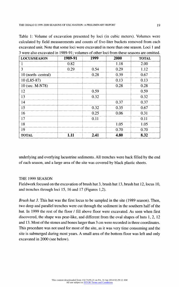
Table 1: Volume of excavation presented by loci (in cubic meters). Volumes were
calculated by field measurements and counts of five-liter buckets removed from each
excavated unit. Note that some loci were excavated in more than one season. Loci 1 and
3 were also excavated in 1989-91 ; volumes of other loci from these seasons are omitted.
LOCUS/SEASON 1989-91 1999 2000 TOTAL
1 0.82 1.18 2.00
3 0.29 0.54 0.29 1.12
10 (north- central) 0.28 0.39 0.67
10 (L85-87) 0.13 0.13
10 (sec. M-N78) 0.28 0.28
12 0.59 0.59
13 0.32 0.32
14 0.37 0.37
15 0.32 0.35 0.67
16 0.25 0.06 0.31
17 0.11 0.11
18 1.05 1.05
19 0.70 0.70
TOTAL 1.11 2.41 4.80 8.32
underlying and overlying lacustrine sediments. All trenches were back filled by the end
of each season, and a large area of the site was covered by black plastic sheets.
THE 1999 SEASON
Fieldwork focused on the excavation of brush hut 3, brush hut 13, brush hut 12, locus 10,
and trenches through loci 15, 16 and 17 (Figures 1,2).
Brush Brush hut 3. This hut was the first locus to be sampled in the site (1989 season). Then,
two deep and parallel trenches were cut through the sediment in the southern half of the
hut. In 1999 the rest of the floor / fill above floor were excavated. As seen when first
discovered, the shape was pear-like, and different from the oval shapes of huts 1,2, 12
and 13. Most of the stones and bones larger than 3 cm were recorded in three coordinates.
This procedure was not used for most of the site, as it was very time consuming and the
site is submerged during most years. A small area of the bottom floor was left and only excavated in 2000 (see below).
This content downloaded from 132.74.95.21 on Fri, 31 Jan 2014 02:29:12 AMAll use subject to JSTOR Terms and Conditions
20 NADEL et al.
TT
□
A
N
0 20 m 1 I =i
1 I I I I I 1 I I T~
\L
\a
\ V} \\ ^ \ * i i i i i i i i m
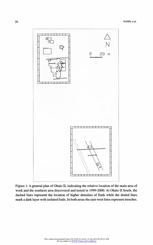
Figure 1 : A general plan of Ohalo II, indicating the relative location of the main area of
work and the southern area discovered and tested in 1999-2000. At Ohalo II South, the
dashed lines represent the location of higher densities of finds while the dotted lines
mark a dark layer with isolated finds. In both areas the east-west lines represent trenches.
This content downloaded from 132.74.95.21 on Fri, 31 Jan 2014 02:29:12 AMAll use subject to JSTOR Terms and Conditions
THE OHALOII 1999-2000 SEASONS OF EXCAVATION: A PRELIMINARY REPORT 21
„ «v ao AL ag ABCDH1MN S x 301 «— 30
40
50
60
90
-812.43m 0 5 M
0 L.14
L.13 N 40
-212.40n
Trench 58 1 ~8ie.35n
HUMAN MANDIBLE
SO
L19
60
Trench 70-72 701 —
ZZZZZZZZZZZZ1 170
1 i -eie.4<n
P; .18 , J-10
L.16 L.6 L.1
t== = === = ^
legend
1
3 L 0.
L 3CH
m
L-2
IH L.4 L.9
© <k
o L.7
L.j2 -eis-sor.
Trench
79 East
80
L.13
L.17
-ai2£8n
| Trench 104-106
4 C"-------"-" 3
Jij no
w [aq [al [ag r*i ETd hTi hTn Is fx
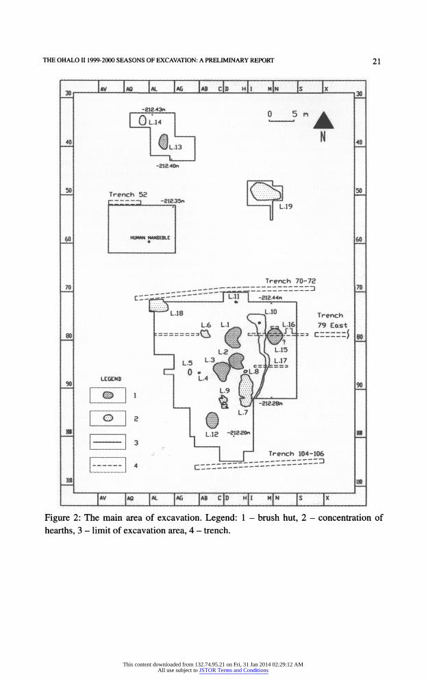
Figure 2: The main area of excavation. Legend: 1 - brush hut, 2 - concentration of
hearths, 3 - limit of excavation area, 4 - trench.
This content downloaded from 132.74.95.21 on Fri, 31 Jan 2014 02:29:12 AMAll use subject to JSTOR Terms and Conditions
22 NADEL et al.
Brush Brush hut 13. This was the first in situ feature found to the north of the central area of
excavation. During previous excavation seasons it was submerged and/or covered by sand and vegetation and thus not visible. The hut was oval in shape, with a north-south
long axis. The thickness of the deposit was ca. 10 cm in the center, and much less around
the walls. Flints were particularly abundant, and a preliminary count showed there were
more than 50 cores on the floor. Many of the flints were cracked and shattered by fire.
Gazelle mandibles, scapulae and leg bones were also common. Several limestone and
basalt implements were recovered, including a small broken bowl. One 0.5X0.5 m square was left untouched for reference and section studies.
Brush Brush hut 12. This feature appeared to be another brush hut. It was oval, deeper than
most features (up to 30-40 cm in the center) and contained the darkest black deposit found at the site. In addition, the surface contour line was hard to follow. This could be
the result of modern vegetation growth, as this part of the site was not protected by black
plastic sheets between 1991 and 1999. In terms of flints and animal bones, the sediment
appears to be less dense than other brush hut floors. A complete right mandible of a
fallow deer was found lying horizontally by a burnt branch.
Locus Locus 10. A small section of this long phenomenon, mostly in squares J-L/74-79, was
exposed with all large specimens being recorded by three coordinates. Discrete
concentrations of bones were most conspicuous, and flint was not common here. Small
hearths (in situ) were visible, indicating that this deposit could not be a secondary accumulation of debris.
Trench Trench 79 East. By the end of 1991 a short trench (2X0.5 m) at the eastern edge of the
site (as known then) showed a steep dip of the archaeological layer eastward. This trench
was extended by 4 m and deepened (0.5 m). It now became apparent that locus 10 was
cut by a natural process and later another anthropogenic layer was deposited, labeled
locus locus 15. Thus, some of the material from the 1991 trench thought to belong to locus 10
is actually part of locus 15. Consequently, publications presenting material from locus
10 are actually a mixture of loci 10 and 15. During the 2000 season a further exposure of
this area showed locus 15 to be a brush hut. Unburnt wood remains were retrieved. The
eastern section revealed yet another deposit, deeper and different in color and matrix
from locus 15, labeled locus 16. Within the small area exposed of the latter (1 m2) two
fallow deer mandibles and other bones were found in a row.
Trench Trench 79 West. In order to better understand the depositional sequence at the western
edge of the site, an 8 m long trench (0.5 m wide) was placed from locus 6 westward. No
This content downloaded from 132.74.95.21 on Fri, 31 Jan 2014 02:29:12 AMAll use subject to JSTOR Terms and Conditions
THE OHALO II 1999-2000 SEASONS OF EXCAVATION: A PRELIMINARY REPORT 23
archaeological features were recorded here. The sections showed fine laminated lacustrine
layers, almost horizontal. No stones/pebbles/bones were visible.
Trench Trench 86. This trench was cut in order to have another section through locus 10 and the
complex phenomena observed in trench 79. Again, there was a steep dip of the
archaeological layer eastward. The upper part of the layer contained many animal bones
and some flints. Further east the concentration of finds dropped rapidly (locus 17). Two
dark layers, also dipping to the east, were recorded below the archaeological layer.
The The black layer and square El 01. A wide black layer covering large portions of the
surface along the western and southern parts of the site was studied this year. The layer was usually 2-5 cm thick. Along the western edge it disappeared under fine lacustrine
sediments. It contained very low densities of finds (flints, bones, charcoal), and merged into archaeological features in various locations (e.g., locus 12).
In five locations the black layer was sampled in order to assess whether it was natural
or a part of an in situ feature (squares AD92, AH74, AI77, F105 and N66). The samples
(ca.(ca.(ca. 1 liter) were collected and sieved with the active participation of a botanist (E.
Weiss). Charcoal floatation was also carried out, and the charred remains were studied in
the filed. Thus, within several hours we had the full range of finds from each of the five
samples. Indeed, they all contained flints, small bones, charred seeds and plant fragments.
However, the densities in most cases were much lower than the typical densities on
floors or in hearths. In two squares the botanical remains were more varied and in higher
densities, similar to the finds from hut floors and hearths. Combined with field
observations, the results indicate that: 1) the dark layer contains archaeological remains,
but is not an archaeological locus senso stricto, and 2) the densities of finds within this
black layer vary considerably.
Square Square E101. The square is located at the southern area of the exposed black layer. Here
work exposed the presence of small remains (flints, bones and charcoal fragments) as
well as round root fossils. These had an inner diameter of 2-3 cm, and hundreds of
similar hard-mud fossils were observed to the south, along a beach stretch of more than
100 m (exposed only in years of low water level).
It appears that the dark layer is the beach surface during the time of occupation. The
quick cover of the beach by the rising waters buried the shore vegetation in anaerobic
conditions, creating a dark horizon of partially decomposed organic matter.
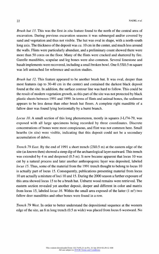
Trench Trench 104-106 (by a JCB tractor). The trench was placed at the southern edge of the
visible area of exposed features (Figure 3). It was ca. 1.5-2 m deep, except for a section
This content downloaded from 132.74.95.21 on Fri, 31 Jan 2014 02:29:12 AMAll use subject to JSTOR Terms and Conditions
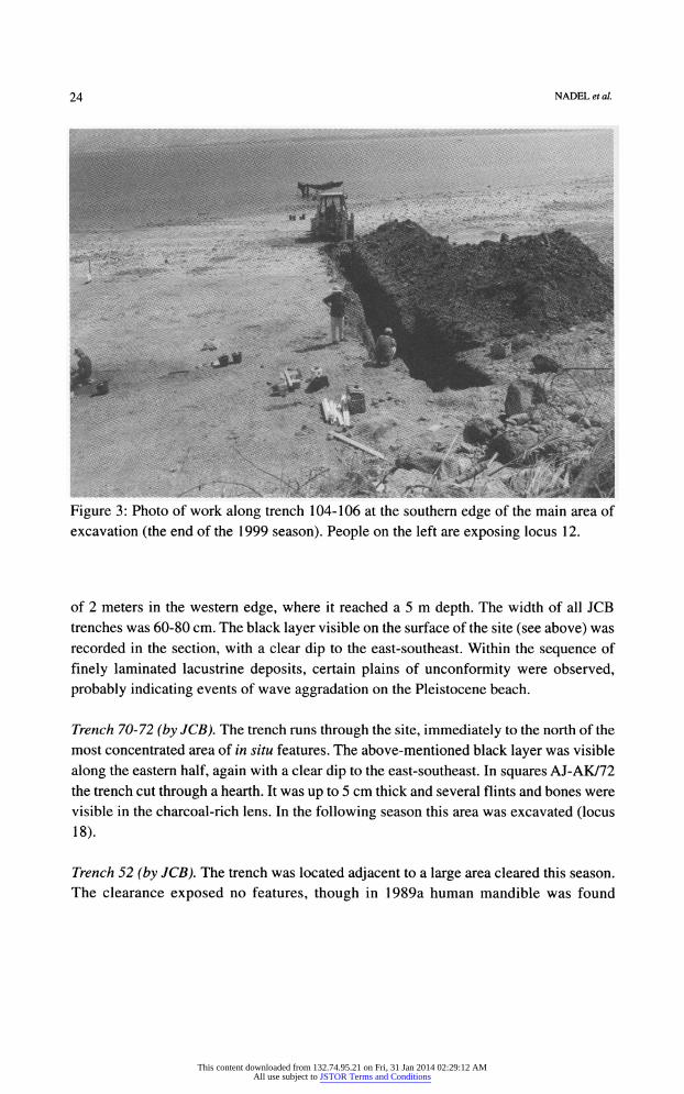
24 NADEL et al.
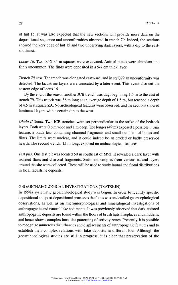
Figure 3: Photo of work along trench 104-106 at the southern edge of the main area of
excavation (the end of the 1999 season). People on the left are exposing locus 12.
of 2 meters in the western edge, where it reached a 5 m depth. The width of all JCB
trenches was 60-80 cm. The black layer visible on the surface of the site (see above) was
recorded in the section, with a clear dip to the east-southeast. Within the sequence of
finely laminated lacustrine deposits, certain plains of unconformity were observed,
probably indicating events of wave aggradation on the Pleistocene beach.
Trench Trench 70-72 (by JCB). The trench runs through the site, immediately to the north of the
most concentrated area of in situ features. The above-mentioned black layer was visible
along the eastern half, again with a clear dip to the east-southeast. In squares AJ-AK/72
the trench cut through a hearth. It was up to 5 cm thick and several flints and bones were
visible in the charcoal-rich lens. In the following season this area was excavated (locus
18).
Trench Trench 52 (by JCB). The trench was located adjacent to a large area cleared this season.
The clearance exposed no features, though in 1989a human mandible was found
This content downloaded from 132.74.95.21 on Fri, 31 Jan 2014 02:29:12 AMAll use subject to JSTOR Terms and Conditions
THE OH ALOII1999-2000 SEASONS OF EXCAVATION: A PRELIMINARY REPORT 25
here. Though this trench was only 1 -1.5 m deep, it rapidly filled with underground water.
The The pebbles trench (by JCB). An ancient alluvial fan covered by rounded flint pebbles was discovered to the north of the site, ca. 50 m from the northernmost observed feature.
The pebbles represent a channel running into the basin, but later than the local Lisan
Formation. The trench was cut through this Late Pleistocene formation, in a west-east
direction. The thickness of the pebbly layer was 20-30 cm, with underlying fine lacustrine
sediments. Later that winter 10 additional trenches were placed along the ancient exit of
the Jordan River from the lake (immediately to the north of the site).
Southern Southern Area ( Ohalo II South). Low water level exposed a flat stretch of some 200 m to
the south of the main area of excavation. Here, at elevations of 212.50-213.50 m below
msl, lacustrine layers were exposed on the surface. These are the same layers covering the site, and in some places they are dark and covered with large numbers of round plant fossils. To the south of the main part of the site, along an area of ca. 60-100 m, there
were no flints and bones visible on the surface. However, from this distance onwards, at
212.50-213.50 m below msl, flints and bones became visible again. They were not as
densely concentrated as at the main area of the site, but they were fresh and resembled in
all characteristics the Ohalo II finds. Accordingly, the area was labeled Ohalo II South.
An independent grid was placed here, similar to the one in the main area of excavation.
Three concentrations of finds were submitted to a total surface collection. This was
done by scraping the top sand and collecting it with the finds into buckets, later to be
wet-sieved through a 1 mm mesh. The concentrations are J-P/66-69 (21 m2), Z-ZC/35
39 (16 m2) and ZE-ZF/30-32 (4 m2). In addition a small test pit was sunk in AI65 (0.25
m2). In the first area, following the surface collection, small trenches in squares J66c and
L66cd were dug to a depth of 0.3 m, but no in situ features were visible. In square 067 an
oval lens (ca. 50 cm wide) appeared to be of darker material and included specks of
charcoal. However, as the sediment was wet (just exposed after the retreat of the lake), no further work was possible. A tentative conclusion suggests that an eroded hearth was
located here.
There are three dates available from here, ranging between 19,500 and 20,200 BP
uncalibrated (see Table 2 below). These dates correlate very well with the published Ohalo II dates (Nadel et al. 1995). There is also one date (12,830+80) from a post
occupation layer (Nadel et al. 2001). The finds from Ohalo II South include a large flint assemblage, very similar to the
Ohalo II assemblages (see below, flint section). Animal bones are not numerous, but
they include bones of gazelle, as well as small complete fish vertebrae. Also, a small
Dentalium bead identical to the Ohalo II beads was recovered.
This content downloaded from 132.74.95.21 on Fri, 31 Jan 2014 02:29:12 AMAll use subject to JSTOR Terms and Conditions
26 NADEL et al.
THE 2000 SEASON
Fieldwork focused on the excavations of the three brush huts: the bottom floor of hut 1, a small final portion of hut 3, and a sample of hut 15. Also, work was carried out at the
hearths of loci 14, 18 and 19, as well as at loci 10 and 16.
Brush Brush hut 1. In previous work ( 1991 ) a partially preserved top floor (floor I) and a complete second floor (II) were excavated. This year, the full exposure of floor III took place. It
extended further eastward than the upper two floors.
The use of stones is widely documented. These were not used as floor pavement or
wall alignment. Rather, in several cases small pebbles were deliberately placed in unusual
arrangements. In some places they were erect, though too small to be part of a pole or a
wall support (only 5-8 cm high). Flints and animal bones were abundant.
Brush Brush hut 3. The last part of the bottom northern layer was exposed. Here, again, several erect stones were found on the floor and outside the hut. Flints and bones
were common, and so were charred remains. A rare find was the complete upper mandible of a gazelle, placed on the floor with the teeth upwards. On the same level, about 0.5 m away, were a strange piece of a flaked tabular flint and a small polished animal bone.
Brush Brush hut 15. This is the deepest preserved hut, which was not visible on the surface like
all other hut remains. Instead, it was covered by lacustrine layers (up to 40 cm thick) and
discovered by trench 79 going through locus 10. The limits of the floor are known only from the section, and the exact size is yet unknown. Locus 15 is later than locus 10, located in a layer truncating the latter. This is the only example of stratification between
distinct archaeological features. The details and the environmental implications (water level changes, wave action and tectonics) will be presented elsewhere.
Preservation is excellent here, and unburnt wood remains were encountered. These
include a large piece (probably worked) which is now in a water tank. In addition, the
remains of leaves and small implements were recovered. At least one hearth was found
on the floor, and again stones were not used for pavement or alignment. Complete land
snails, as well as molluscan lake dwellers were common.
Locus Locus 14. A dark oval area rich with flints was observed to the northwest of hut 13
during 1999. At first it was thought to be another small brush hut. Excavations revealed
the presence of two adjacent hearths. The dark material observed on the surface included
the top layer of the two. The hearths were fully excavated. The southern one was the
larger, ca. 80 cm in diameter and 30 cm thick in the center. This is the thickest hearth
This content downloaded from 132.74.95.21 on Fri, 31 Jan 2014 02:29:12 AMAll use subject to JSTOR Terms and Conditions
THE OHALO II 1999-2000 SEASONS OF EXCAVATION: A PRELIMINARY REPORT 27
deposit discovered so far. Flints and animal bones were recovered, including small fish
vertebrae.
Locus Locus 18. An area with a concentration of several hearths was discovered by studying the sections of trench 70-72 (Figure 2). The northern part of the concentration is missing, but this could not be much - as there was no record of hearths in the northern section of
the trench (80 cm wide). The hearths were 50-80 cm in diameter and usually about 5 cm thick. Flints were
relatively scarce, though animal bones were abundant. Several polished bone points were
recovered, and it appears to be the largest concentration of such implements. One was
found 5 cm from a fox mandible, pointing to its center. Very large numbers of land snails
and lake shells were found here, both complete and fragmentary. This is the most westerly feature discovered so far. The full size of the locus is unclear,
as it continues under the sections in both south and west directions. It is also the
topographically highest locus, some 20-40 cm above most features. The depositional
sequence presents an example of a hearth truncated by an erosional process (see
geoarchaeological section, below).
Locus Locus 19. This is the only in situ feature between the main area and the northern loci 13
14 complex. A 5X5 m square was cleared at first, exposing hearth remains creating a
large semi-oval area with a dark matrix and high numbers of flints and bones. The thickness
of the remains did not exceed 10 cm. Basalt implements and fragments appeared to be
more numerous than elsewhere.
A narrow trench (0.5 m) was extended from the concentrated remains to the south. It
exposed a continuous dark layer, 5-10 cm thick and ca. 10 cm below surface, slightly
dipping to the southeast. It appears that the hearths of locus 19 were embedded or covered
by this large layer. A preliminary study of the sorted material from the trench revealed
low numbers of heavy flints and bones, and large numbers of small fish bones and other
debris. This layer could be a part of the dark layer observed elsewhere at the site,
representing the palaeo surface of the beach at the time of occupation.
Locus Locus 10. Two areas were investigated. The first was on the northwestern edge of the
exposed layer, especially in squares H-J/74-76. The ca. 10 cm thick deposit included
large specimens like a gazelle horn core and mandibles. One mandible was found lying on a long flint blade (long blades are rare at the site). The layer was excavated to bedrock,
which was a yellow sandy silt.
The second area was immediately to the north of hut 15. A small trench was placed in
squares M78b-N78ab, parallel to trench 79. It was aimed at exposing the northern edge
This content downloaded from 132.74.95.21 on Fri, 31 Jan 2014 02:29:12 AMAll use subject to JSTOR Terms and Conditions
28 NADEL et al.
of hut 15. It was also expected that the new sections will provide more data on the
depositional sequence and unconformities observed in trench 79. Indeed, the sections
showed the very edge of hut 15 and two underlying dark layers, with a dip to the east
southeast.
Locus Locus 16. Two 0.5X0.5 m squares were excavated. Animal bones were abundant and
flints uncommon. The finds were deposited in a 5-7 cm thick layer.
Trench Trench 79 east. The trench was elongated eastward, and in sq Q79 an unconformity was
detected. The lacustrine layers were truncated by a later event. This event also cut the
eastern edge of locus 16.
By the end of the season another JCB trench was dug, beginning 1.5 m to the east of
trench 79. This trench was 36 m long at an average depth of 1.5 m, but reached a depth of 4.5 m at square ZA. No archeological features were observed, and the sections showed
laminated layers with a certain dip to the west.
OhaloOhalo II South. Two JCB trenches were set perpendicular to the strike of the bedrock
layers. Both were 0.6 m wide and 1 m deep. The longer (49 m) exposed a possible in situ
feature, a black lens containing charcoal fragments and small numbers of bones and
flints. The limits were unclear, and it could indeed be an eroded or badly preserved hearth. The second trench, 15 m long, exposed no archaeological features.
Test Test pits. One test pit was located 50 m southeast of M92. It revealed a dark layer with
isolated flints and charcoal fragments. Sediment samples from various natural layers around the site were collected. These will be used to study faunal and floral distributions
in local lacustrine deposits.
GEO ARCHAEOLOGICAL INVESTIGATIONS (TSATSKIN) In 1998a systematic geoarchaeological study was begun. In order to identify specific
depositional and post-depositional processes the focus was on detailed geomorphological
observations, as well as on micromorphological and mineralogical investigations of
anthropogenic and natural lake sediments. It was previously observed that dark-colored
anthropogenic deposits are found within the floors of brush huts, fireplaces and middens, and hence show a complex intra-site patterning of activity zones. Presently, it is possible to recognize numerous disturbances and displacements of anthropogenic features and to
establish their complex relations with lake deposits in different loci. Although the
geoarchaeological studies are still in progress, it is clear that preservation of the
This content downloaded from 132.74.95.21 on Fri, 31 Jan 2014 02:29:12 AMAll use subject to JSTOR Terms and Conditions
THE OHALO II1999-2000 SEASONS OF EXCAVATION: A PRELIMINARY REPORT 29
stratigraphie sequence in the eastern side of the camp was somewhat different from that
in the western side due to erosion/deposition effect of an encroaching lake. Indeed, the
stratigraphie sections in different loci are not identical. Their variations seem to result
from the complex topography of the ancient lakeshore and from different intensities of
post-depositional erosion. Taking into account these limitations, it was attempted to
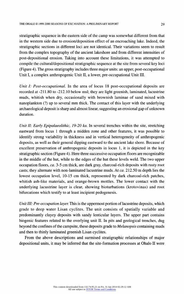
compile the cultural/depositional stratigraphie sequence at the site from several key loci
(Figure 4). The gross stratigraphy includes three major units: an upper, post-occupational Unit I, a complex anthropogenic Unit II, a lower, pre-occupational Unit III.
Unit Unit I: Post-occupational. In the area of locus 18 post-occupational deposits are
recorded at -211.80 to -212.10 below msl; they are light greenish, laminated, lacustrine
muds, whitish when dry, occasionally with brownish laminae of sand mixed with
nanoplankton (?) up to several mm thick. The contact of this layer with the underlying
archaeological deposit is sharp and almost linear, suggesting an erosional gap of unknown
duration.
Unit Unit Unit Unit II: Early Epipalaeolithic, 19-20 ka. In several trenches within the site, stretching eastward from locus 1 through a midden zone and other features, it was possible to
identify strong variability in thickness and in vertical heterogeneity of anthropogenic
deposits, as well as their general dipping eastward to the ancient lake shore. Because of
excellent preservation of anthropogenic deposits in locus 1, it is depicted in the key
stratigraphie section (Figure 4). Here three successive occupation floors are recognizable in the middle of the hut, while to the edges of the hut these levels weld. The two upper
occupation floors, ca. 3-5 cm thick, are dark gray, charcoal-rich deposits with rusty root
casts; they alternate with non-laminated lacustrine muds. At ca. 212.50 m depth lies the
lowest occupation level, 10-15 cm thick, represented by dark charcoal-rich patches, whitish ash-like materials, and orange-brown mottles. The lower contact with the
underlying lacustrine layer is clear, showing bioturbations (krotovinas) and root
bifurcations which testify to at least incipient pedogenesis.
Unit III:Unit III: Pre-occupation layer. This is the uppermost portion of lacustrine deposits, which
grade to deep water Lisan cyclites. The unit consists of spatially variable and
predominantly clayey deposits with sandy lenticular layers. The upper part contains
biogenic features related to the overlying unit II. In pits and geological trenches, dug
beyond the confines of the campsite, these deposits grade to Melanopsis containing muds
and then to thinly laminated greenish Lisan cyclites. From the above descriptions and surmised stratigraphie relationships of major
depositional units, it may be inferred that the site-formation processes at Ohalo II were
This content downloaded from 132.74.95.21 on Fri, 31 Jan 2014 02:29:12 AMAll use subject to JSTOR Terms and Conditions
30 NADEL et al.
Loc. 18
-212.0 m
-212.2 m -j
Figure 4: Composite section at the site, through loci 1 and 18. Legend: 1 - post-occupation lacustrine sediments, 2 - light-colored archaeological sediment, 3 - gray-colored
archaeological sediment, 4 - black-colored archaeological sediment, 5 - intra
occupational lacustrine marls, 6 - Lisan marls.
This content downloaded from 132.74.95.21 on Fri, 31 Jan 2014 02:29:12 AMAll use subject to JSTOR Terms and Conditions
THE OHALO II 1999-2000 SEASONS OF EXCAVATION: A PRELIMINARY REPORT 3 !
t-S* x. mr
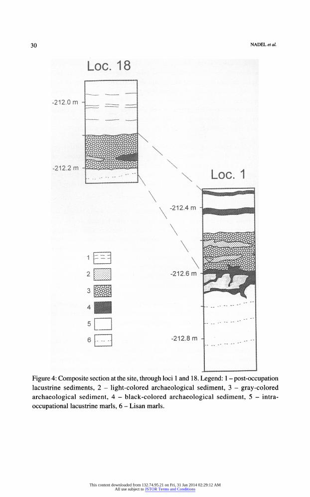
Figure 5: Microphotograph of the anthropogenic deposits upon Lisan marls in Locus 1.
Note the horizontal position of the (almost) undisturbed charred and ferruginized plant tissues from the occupation floor (top), lying upon strongly calcareous lacustrine muds
(bottom). Plane polarized light; ca. X45 magnification.
dominated by accumulation of man-made, ash-derived and charred materials at the margin
of a fluctuating lake, around 19-20 ka ago. The geological history of the lake strongly influenced human habitation on its shores, possibly causing short-time abandonment of
the site, and eventual drastic inundation.
Microscopic studies of archaeologically related deposits and their magnetic
susceptibility measurements provided some important insights into geoarchaeological
interpretations. For example, pétrographie thin sections inspected thus far from an
undisturbed floor (Unit II, floor II of hut 1), show a heterogeneous microfabric of charred
and ferruginized plant tissues, predominantly of grass and small bushes, embedded in
the strongly calcareous, light-brown, matrix (Figure 5). The section shows the contact
between 1) the occupation floor, composed of charred tissue fragments which are found
in their pristine position; they are mixed with calcite nodules 0.1-0.2 mm in size, a few
This content downloaded from 132.74.95.21 on Fri, 31 Jan 2014 02:29:12 AMAll use subject to JSTOR Terms and Conditions
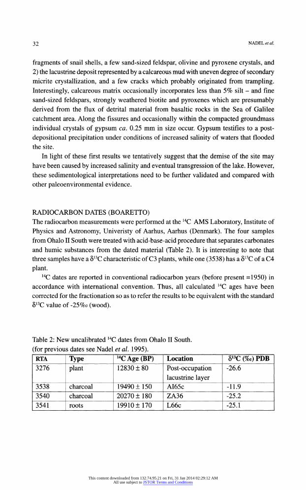
32 NADEL et al.
fragments of snail shells, a few sand-sized feldspar, olivine and pyroxene crystals, and
2) the lacustrine deposit represented by a calcareous mud with uneven degree of secondary micrite crystallization, and a few cracks which probably originated from trampling.
Interestingly, calcareous matrix occasionally incorporates less than 5% silt - and fine
sand-sized feldspars, strongly weathered biotite and pyroxenes which are presumably derived from the flux of detrital material from basaltic rocks in the Sea of Galilee
catchment area. Along the fissures and occasionally within the compacted groundmass individual crystals of gypsum ca. 0.25 mm in size occur. Gypsum testifies to a post
depositional precipitation under conditions of increased salinity of waters that flooded
the site.
In light of these first results we tentatively suggest that the demise of the site may have been caused by increased salinity and eventual transgression of the lake. However,
these sedimentological interpretations need to be further validated and compared with
other paleoenvironmental evidence.
RADIOCARBON DATES (BOARETTO) The radiocarbon measurements were performed at the 14C AMS Laboratory, Institute of
Physics and Astronomy, Univeristy of Aarhus, Aarhus (Denmark). The four samples from Ohalo II South were treated with acid-base-acid procedure that separates carbonates
and humic substances from the dated material (Table 2). It is interesting to note that
three samples have a 813C characteristic of C3 plants, while one (3538) has a 813C of a C4
plant. 14C dates are reported in conventional radiocarbon years (before present =1950) in
accordance with international convention. Thus, all calculated 14C ages have been
corrected for the fractionation so as to refer the results to be equivalent with the standard
813C value of -25%0 (wood).
Table 2: New uncalibrated 14C dates from Ohalo II South,
(for previous dates see Nadel et al. 1995).
RTA Type 14C Age (BP) Location 813C (%c) PDB
3276 plant 12830 + 80 Post-occupation lacustrine layer
-26.6
3538 charcoal 19490+ 150 AI65c -11.9
3540 charcoal 20270 ± 180 ZA36 -25.2
3541 roots 19910 ± 170 L66c -25.1
This content downloaded from 132.74.95.21 on Fri, 31 Jan 2014 02:29:12 AMAll use subject to JSTOR Terms and Conditions
THE OHALO II 1999-2000 SEASONS OF EXCAVATION: A PRELIMINARY REPORT 33
Three dates fall well within the range of the previous Ohalo II published dates (Nadel et et al. 1995). One date is stratigraphically later, and represents the continuous deposition of lacustrine layers towards the end of the Pleistocene.
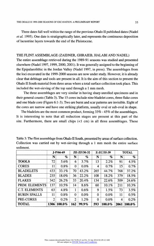
THE FLINT ASSEMBLAGE (ZAIDNER, GHRAIEB, HALABI AND NADEL) The entire assemblage retrieved during the 1989-91 seasons was studied and presented elsewhere (Nadel 1997,1999,2000,2001). It was generally assigned to the beginning of
the Epipalaeolithic in the Jordan Valley (Nadel 1997, in press). The assemblages from
the loci excavated in the 1999-2000 seasons are now under study. However, it is already clear that debitage and tools are present in all. It is the aim of this section to present the
Ohalo II South material from three areas where a total surface collection took place. This
included the wet-sieving of the top sand through a 1 mm mesh.
The three assemblages are very similar in having sharp unrolled specimens and in
their general counts (Table 3). The 15 cores include nine bladelet cores, three flake cores
and one blade core (Figure 6:1-3). Two are burnt and scar patterns are invisible. Eight of
the cores are narrow and have one striking platform, usually oval or sub-oval in shape. The bladelets are the most common product, forming 33% - 45% of the assemblages.
It is interesting to note that all reduction stages are present at this part of the
site. Furthermore, there are small chips (<1 cm) in all three assemblages. These
Table 3: The flint assemblage from Ohalo II South, presented by areas of surface collection.
Collection was carried out by wet-sieving through a 1 mm mesh the entire surface
sediment.
J-P/66-69 ZE-ZF/30-32 Z-ZC/35-39 TOTAL
N % N % N % N %
TOOLS 72 5.6% 6 3.7% 13 2.2% 91 4.5%
CORES 11 0.8% 0 0.0% 4 0.7% 15 0.7%
BLADELETS 433 33.1% 70 43.2% 265 44.7% 768 37.2%
BLADES 235 18.0% 36 22.2% 108 18.2% 379 18.5%
FLAKES 342 26.2% 33 20.4% 134 22.6% 509 24.6%
PRIM. ELEMENTS 137 10.5% 14 8.6% 60 10.1% 211 10.3%
C.T. ELEMENTS 63 4.8% 1 0.6% 9 1.5% 73 3.5%
BURIN SPALLS 11 0.8% 0 0.0% 0 0.0% 11 0.5%
PRE-CORES 2 0.2% 2 1.2% 0 0.0% 4 0.2%
TOTAL 1306 100.0% 162 99.9% 593 100.0% 2061 100.0%
This content downloaded from 132.74.95.21 on Fri, 31 Jan 2014 02:29:12 AMAll use subject to JSTOR Terms and Conditions
34 NADEL et al.
Figure 6: Flint cores from Ohalo II South.
This content downloaded from 132.74.95.21 on Fri, 31 Jan 2014 02:29:12 AMAll use subject to JSTOR Terms and Conditions
THE OHALOII 1999-2000 SEASONS OF EXCAVATION: A PRELIMINARY REPORT 35
two observations indicate that knapping took place locally. Signs of exposure to
heat, and sharp shattered fragments in various dimensions also support the contention
that the assemblage is more-or-less in situ, and not rolled to this beach from
elsewhere.
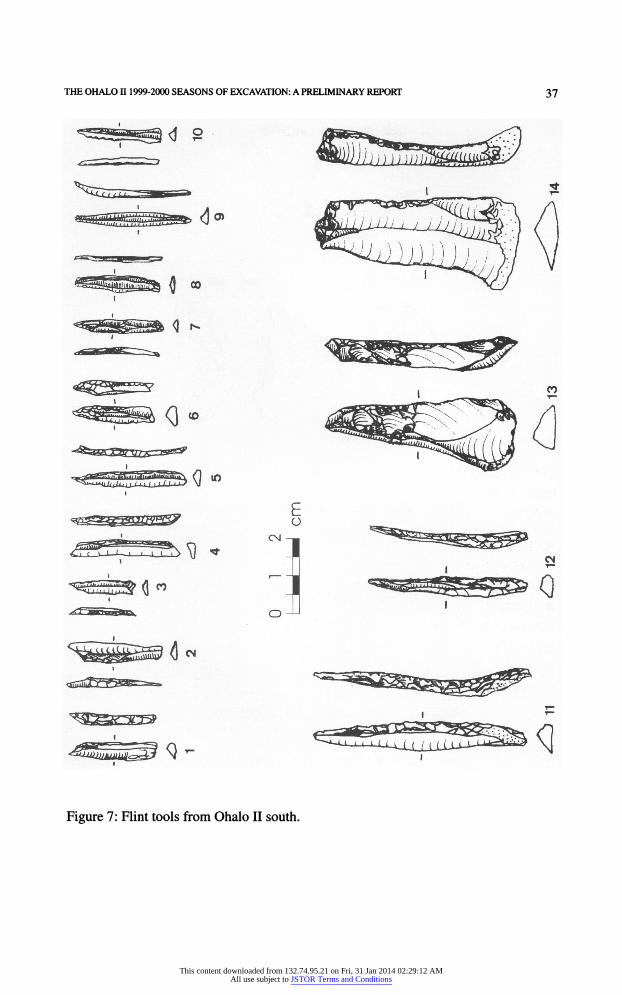
The tools are not numerous (N=91, Table 4). Within the larger tools, retouched blades
(12, Figure 7:13,14) and retouched flakes (11, Figure 8:1) are the dominant types, while
scarpers (2) and burins (3, Figure 8:2) are relatively rare.
Table 4: Retouched flint implements from Ohalo II South.
TYPE J-P/ z-zc / ZE-ZF/ TOTAL %
66-69 35-39 30-32
END SCRAPER 2 2 2.2
BURIN 3 3 3.3
RETOUCHED BLADE 9 3 12 13.2
RETOUCHED FLAKE 10 1 11 12.1
TRUNCATION 1 1 1.1
NOTCH/DENT 1 1 1.1
MICROLITH 46 9 6 61 67.0
TOTAL 72 13 6 91 100.0
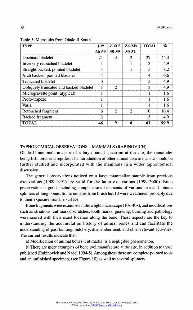
Within the microliths (N=61) the Ouchtata bladelets (partially and fully retouched) are dominant (44.3%, Table 5, Figure 7:7-10). Retouched fragments and backed fragments
comprise together a fifth of the assemblage. The backed varieties form altogether 27.8%
of the microliths (Figure 7:1-6, 12,11, the latter larger than most microliths). The
frequencies of these three groups are very similar to those recorded for the assemblages from the main area of excavation. Another similarity is the rare occurrence of obliquely truncated backed specimens (Figure 7:1,3) and the absence of micropoints. However, it
is the combination of Ouchtata bladelets with backed and pointed bladelets that is typical for all Ohalo II assemblages. It is noteworthy that proto triangles were not recovered
from the southern part and from most loci at Ohalo II (so far only present in locus 1,
Nadel 1999). Also, the presence of one complete elongated proto trapeze (Figure 7:4) is
interesting, as no such specimens were recovered elsewhere at the site.
The apparent similarities between the southern assemblage and the central ones point to one flint knapping tradition (Figure 9). Though a short time gap between the two is
possible, a long one will be hard to accept taking into account the pace of change in tool
morphology evident for the period.
This content downloaded from 132.74.95.21 on Fri, 31 Jan 2014 02:29:12 AMAll use subject to JSTOR Terms and Conditions
36 NADEL et al.
Table 5: Microliths from Ohalo II South.
TYPE J-P/ Z-ZC/ ZE-ZF/ TOTAL %
66-69 35-39 30-32
Ouchtata bladelet 21 4 2 27 44.3
Inversely retouched bladelet 1 1 1 3 4.9
Straight backed, pointed bladelet 4 1 5 8.2
Arch backed, pointed bladelet 4 4 6.6
Truncated bladelet 3 3 4.9
Obliquely truncated and backed bladelet 1 2 3 4.9
Microgravette point (atypical) 1 1 1.6
Proto-trapeze 1 1 1.6
Varia 1 1 1.6
Retouched fragment 6 2 2 10 16.4
Backed fragment 3 3 4.9
TOTAL 46 9 6 61 99.9
TAPHONOMICALTAPHONOMICAL OBSERVATIONS - MAMMALS (RABINOVICH)
Ohalo II mammals are part of a large faunal spectrum at the site, the remainder
being fish, birds and reptiles. The introduction of other animal taxa to the site should be
further studied and incorporated with the mammals in a wider taphonomical discussion.
The general observations noticed on a large mammalian sample from previous excavations (1989-1991) are valid for the latter excavations (1999-2000). Bone
preservation is good, including complete small elements of various taxa and minute
splinters of long bones. Some remains from brush hut 13 were weathered, probably due
to their exposure near the surface.
Bone fragments were examined under a light microscope (10x-40x), and modifications
such as striations, cut marks, scratches, tooth marks, gnawing, burning and pathology were scored with their exact location along the bone. These aspects are the key to
understanding the accumulation history of animal bones and can facilitate the
understanding of past hunting, butchery, dismemberment, and other relevant activities.
The current results indicate that:
a) Modification of animal bones (cut marks) is a negligible phenomenon.
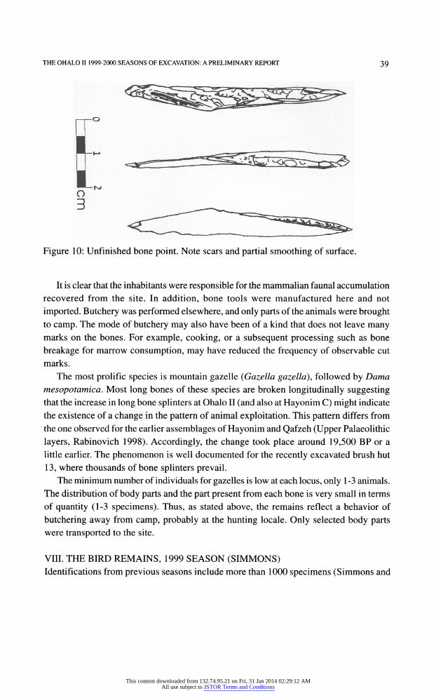
b) There are more examples of bone tool manufacture at the site, in addition to those
published (Rabinovich and Nadel 1994-5). Among these there are complete pointed tools
and an unfinished specimen, (see Figure 10) as well as several splinters.
This content downloaded from 132.74.95.21 on Fri, 31 Jan 2014 02:29:12 AMAll use subject to JSTOR Terms and Conditions
THE OHALOII1999-2000 SEASONS OF EXCAVATION: A PRELIMINARY REPORT 3 ך
Figure 7 : Flint tools from Ohalo II south.
This content downloaded from 132.74.95.21 on Fri, 31 Jan 2014 02:29:12 AMAll use subject to JSTOR Terms and Conditions
38 NADELefa/.
Figure 8: Flint tools from Ohalo II south.
■CORES
■ TOOLS
□ CTE
■ BURIN SP
B PRIMARY
m FLAKES
B BLADES
B BLDLTS
0% NORTH J-P46 D-H83 AB78
Figure 9: Flint assemblages from Ohalo II. The figure presents two in situ assemblages
(huts 1 and 3), three total surface collections from the main area (AB78, DH83 and
North) and three total surface collections from Ohalo II South. BLDLTS = bladelets, PRIMARY = primary elements, BURIN SP = burin spalls, CTE = core trimming elements.
This content downloaded from 132.74.95.21 on Fri, 31 Jan 2014 02:29:12 AMAll use subject to JSTOR Terms and Conditions
THE OHALOII 1999-2000 SEASONS OF EXCAVATION: A PRELIMINARY REPORT 39
Figure 10: Unfinished bone point. Note scars and partial smoothing of surface.
It is clear that the inhabitants were responsible for the mammalian faunal accumulation
recovered from the site. In addition, bone tools were manufactured here and not
imported. Butchery was performed elsewhere, and only parts of the animals were brought
to camp. The mode of butchery may also have been of a kind that does not leave many marks on the bones. For example, cooking, or a subsequent processing such as bone
breakage for marrow consumption, may have reduced the frequency of observable cut
marks.
The most prolific species is mountain gazelle (Gazella gazella), followed by Dama
mesopotamica.mesopotamica. Most long bones of these species are broken longitudinally suggesting that the increase in long bone splinters at Ohalo II (and also at Hayonim C) might indicate
the existence of a change in the pattern of animal exploitation. This pattern differs from
the one observed for the earlier assemblages of Hayonim and Qafzeh (Upper Palaeolithic
layers, Rabinovich 1998). Accordingly, the change took place around 19,500 BP or a
little earlier. The phenomenon is well documented for the recently excavated brush hut
13, where thousands of bone splinters prevail. The minimum number of individuals for gazelles is low at each locus, only 1-3 animals.
The distribution of body parts and the part present from each bone is very small in terms
of quantity (1-3 specimens). Thus, as stated above, the remains reflect a behavior of
butchering away from camp, probably at the hunting locale. Only selected body parts were transported to the site.
VIII.VIII. THE BIRD REMAINS, 1999 SEASON (SIMMONS) Identifications from previous seasons include more than 1000 specimens (Simmons and
This content downloaded from 132.74.95.21 on Fri, 31 Jan 2014 02:29:12 AMAll use subject to JSTOR Terms and Conditions
40 NADEL et al.
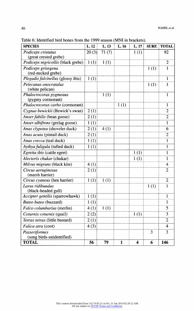
Table 6: Identified bird bones from the 1999 season (MNI in brackets). SPECIES L. 12 L. 13 L. 16 L. 17 SURF. TOTAL
Podiceps cristatus
(great crested grebe)
20 (3) 71(7) KD 92
Podiceps nigricollis (black grebe) 1(1) KD 2
Podiceps grisegena (red-necked grebe)
KD 1
Plegadis falcinellus (glossy ibis) KD 1
Pelecanus onocratalus
(white pelican) KD 1
Phalocrocorax pygmeaus (pygmy cormorant)
Id) 1
Phalocrocorax carbo (cormorant) KD 1
Cygnus bewickii (Bewick's swan) 2(1) 2 Anser fabilis (bean goose) 2(1) 2 Anser albifrons (grelag goose) 1(1) 1 Anas clypetea (shoveler duck) 2(1) 4(1) 6 Anas acuta (pintail duck) 2(1) 2 Anas crecca (teal duck) HI) 1
Ay thy a fuligula (tufted duck) Id) 1
Egretta ibis (cattle egret) Id) 1 Alectoris chukar (chukar) 1(1) 1 Milvus migrans (black kite) 4(1) 4
Circus aeruginosus (marsh harrier)
2(1) 2
Circus cyaneus (hen harrier) KD 1(1) 2 Larus ridibundus
(black-headed gull) 1(1) 1
Accipter gentilis (sparrowhawk) 1(1) 1 Buteo buteo (buzzard) 1(1) 1 Falco columbarius (merlin) 4(1) 1(1) 5 Coturnix coturnix (quail) 2(2) KD 3 Tetrax tetrax (little bustard) 2(1) 2 Fulica atra (coot) 4(3) 4
Passeriformes (song birds-unidentified)
3 3
TOTAL 56 79 1 4 6 146
This content downloaded from 132.74.95.21 on Fri, 31 Jan 2014 02:29:12 AMAll use subject to JSTOR Terms and Conditions
THE OHALO n 1999-2000 SEASONS OF EXCAVATION: A PRELIMINARY REPORT 41
Nadel 1998). The preliminary results of the 1999 season include 146 identifications
(Table 6). The current sample is very similar to the remains from the 1989-1991 loci. The only
new species are the Larus ridibundus (black headed gull) and the Pelecanus onocratalus
(white pelican). The proportions of one species to another and also the proportions of
body parts represented in each species (type of species - water birds vs. raptors, etc.)
appear to be very similar to the published results (ibid.).
THE MICROMAMMALS, 1999 SEASON (BELMAKER)
The rodents and insectivores were picked out of the sieved material and viewed under a
stereomicroscope at X10 magnification. As opposed to the finds from previous seasons,
only 13 micromammal remains were found. These could represent one specimen. Three
molars are identified as the field vole (Microtus guentheri). Field voles are one of the
most common species in the region since the Middle Pleistocene and are indicative of
the Mediterranean biome (Tchernov 1988). Other post-cranial remains were tentatively
assigned to the same species based on body size and gross morphology. An updated
species distribution for the 1989-1999 seasons is presented (Table 7).
Table 7: Micromammal species from the 1989-1999 seasons.
SPECIES NISP* MNI**
Microtus guentheri 155 18
Meriones tristrami 43 8
Mus cf. macedonicus 15 5
Rattus rattus 3 1
Erinacaeus europaeus 3 1
Rodentia gen. et sp. indet. 42 8
TOTAL 261 33
NISP * = Number of Identified Specimens
MNI** = Minimum Number of Individuals
Despite the small number of finds, the preliminary taphonomic analysis suggests similarities with the finds from previous seasons (Belmaker et al. 2001). This includes a
high percentage of loose molars and incisors, absence of maxillae and mandibles, limb
bones broken at midshaft and the absence of digestive corrosion. Such a spectrum is
indicative of a trampled assemblage (Andrews 1990). The absence of shaft fragments
This content downloaded from 132.74.95.21 on Fri, 31 Jan 2014 02:29:12 AMAll use subject to JSTOR Terms and Conditions
42 NADEL et al.
without the epiphyses suggests that the assemblage has not been fluvially transported since deposition (Andrews 1990) and is in accordance with the analyses of other finds,
indicating that the site was submerged quickly and immediately after occupation. The small size of the assemblage recovered in 1999 reinforces the uniqueness of
locus 1 (floors I and II, floor III still under analysis). Of the micromammal remains
recovered from in situ features, the overwhelming majority (72%) were found within
hut 1 (Table 8). In addition, ca. 50% of the bones were found on the surface of the
site. These isolated remains comprise very low densities (commonly less than
one specimen per square meter) and hence cannot be securely assigned to the site. A
detailed analysis of the spatial-temporal distribution of micromammals at the site is in
progress, which may further illuminate the depositional processes of micromammals at
the site.
Table 8: Micromammal NISP distribution by loci for the 1989-1999 seasons.
LOCUS NISP % % within loci
1 162 62.0 76.6
2 8 3.0 3.9
3 15 5.8 7.1
7 4 1.5 1.9
10 11 4.2 5.2
12 3 1.2 1.4
13 8 3.0 3.9
Surface squares 50 19.2 n.a.
TOTAL 261 99.9 100.00
THE FISH REMAINS (ZOHAR)
A preliminary analysis of the recovered fish remains demonstrates their presence in
large numbers in the excavated structures. The fish bones are well preserved, as
observed from the low frequency of fragmented bones (ca. 15%), and from the
scarcity of deformations (1.2%) resulting from digestion or burning. Fire signs are rare,
appearing on 3.5% of the bones. Identification of the different skeletal elements
shows that most are present, including small elements (e.g., vertebrae with 0.9 mm
diameter). Species identification is now in process and the results will be presented elsewhere.
This content downloaded from 132.74.95.21 on Fri, 31 Jan 2014 02:29:12 AMAll use subject to JSTOR Terms and Conditions
THE OHALO II 1999-2000 SEASONS OF EXCAVATION: A PRELIMINARY REPORT 43
THE CHARRED SEEDS/FRUIT (Kislev and Weiss)
One of the interesting botanical remains of the 1989-91 seasons was the extensive
discovery of algae's nucleus ("seeds") from the Chara (seaweed) species. We discovered
that these nucules were "falling between the seats" of our flotation system. The length of
the calcified Chara nucules is ca. 1 mm, their width ca. 0.5-0.7 mm and its specific
weight is heavier than water. Therefore, they had sunk in the water rather than floated to
the surface, and passed through the 1 mm holes of the heavy residue mesh. To solve this
problem, the flotation system for the 1999-2000 seasons was upgraded by placing a 0.5
mm mesh sieve under the 1 mm mesh in 20% of the samples. The improved flotation system worked very well. Not only were Chara nucules
recovered from the excavated units, but additional small and heavy finds were also found.
Within this fraction, tiny fish bones were identified, but the impression is that further
sorting will bring more discoveries.
The preliminary analysis of the 1999-2000 samples exhibits the occurrence of plant remains in all excavated loci. These plant remains show close similarity to the variety and composition of those from previous seasons. A high preservation level of charred
seeds and fruits is found in the newly excavated features.
MOLLUSC AND OTHER BEADS (BAR-YOSEF MAYER)
One hundred and forty eight specimens were submitted for study, from the 1989-1991
seasons of excavations. The molluscs were initially identified by the excavators as
originating in a marine environment, and not from the local fauna of the Sea of Galilee.
The latter assemblage is being studied by H.K. Mienis.
Molluscs included three specimens of a small marine gastropod, Columbella rustica.
The latter is very common in the Mediterranean and is commonly found in various
Epipalaeolithic sites (Bar-Yosef 1989; Hovers et al. 1988). All three had an artificially
perforated hole in the body whorl.
The most abundant type of shell was Dentalium sp., including 136 specimens from
previous seasons and tens more found now. They belong to at least two different species, one with a smooth surface and another with a ribbed surface. However, all are apparently of Mediterranean origin with two possible exceptions. These shells were very thick and
had a larger diameter, making it more likely that they originated in the Red Sea. The
most interesting phenomenon regarding the Dentalia beads, is that they were very finely cut into narrow slices, measuring 1-2 mm in length (only six specimens were longer,
measuring about 3 mm). Such finely sliced Dentalium specimens were also observed in
the Kebaran site of Urkan e-Rubb Ha (Hovers et al. 1988). Two additional specimens are noteworthy. One is a cut claw (14 mm long) of Potamon
This content downloaded from 132.74.95.21 on Fri, 31 Jan 2014 02:29:12 AMAll use subject to JSTOR Terms and Conditions
44 NADEL et al.
fluviatilis,fluviatilis, the freshwater crab, and another, even more intriguing, is a slice of such a
claw, measuring 3 mm in length, suggesting that indeed crab claws may have been
substituted (or mistaken) for Dentalium beads by the original inhabitants of Ohalo.
In addition, there were six beads made of minerals (found on the surface); four were
made of a translucent reddish stone (garnet?), a fifth was black (hematite?) and the sixth
is unidentified. Two of the beads were measured. One was 6 mm in outer diameter, 2 mm
in diameter of the hole, and 3 mm long. Another was 4 mm in outer diameter, 1 mm in
diameter of the hole, and 2 mm long. In most cases the hole is a bicone, i.e. it was drilled
from both sides.
Although currently the presence of Red Sea shells at Ohalo II is only a possibility, a
connection of northern populations during this period to the Red Sea has been suggested before. Long distance trade during the early Epipalaeolithic was observed with the
presence of several Red Sea species of Nerita spp. at Kharaneh IV in Jordan (Bar-Yosef
1989), and on the other hand, the presence of several Mediterranean shells in the Geometric
Kebaran site of Wadi Sayakh in southern Sinai (Bar-Yosef and Killebrew 1984). In various
Epipalaeolithic sites in Northern Sinai, interestingly, both Red Sea and Mediterranean
shells were present. There, too, Dentalium sp. was the dominant type. However, they were not so finely sliced. Rather, they were usually longer than 3 mm (Bar-Yosef and
Phillips 1977; Bar-Yosef Mayer in press). This phenomenon may reflect differences in
archaeological sieving practices. The presence of the six mineral beads, all of which did not originate in the vicinity of
the Sea of Galilee, in addition to shells deriving from the Mediterranean and the Red Sea
testifies to long range connections of the inhabitants with other environments and/or
other populations in the region. Also, the presence of shells from the Sea of Galilee
(Theodoxus(Theodoxus jordanï) in contemporaneous sites such as the Meged rockshelter (Kuhn et
al.al. in prep.) provides additional evidence for an exchange pattern existing during the
early Epipalaeolithic of the Levant.
HUMAN REMAINS (HERSHKOVITZ)
One small piece from the right parietal bone was found on the surface of Ohalo II South.
It is patinated, somewhat similar to other Upper Pleistocene faunal remains from this
area. It most probably belongs to a young individual.
MISCELLANEOUS
Stone implements were found both in situ and on the surface. The most conspicuous are
limestone and basalt notched pebbles. They are usually oval with two opposed notches
This content downloaded from 132.74.95.21 on Fri, 31 Jan 2014 02:29:12 AMAll use subject to JSTOR Terms and Conditions
THE OHALO II 1999-2000 SEASONS OF EXCAVATION: A PRELIMINARY REPORT 45
and their weight is 200-350 gr. It is believed that they were used as weights for fishing nets (Nadel and Zaidner 2002).
Small numbers of broken stone bowls and other types were recovered. It is noteworthy that in various places erect stones were still in situ.
Wood remains from these seasons include unburnt specimens. Some finds are small
fragments, yet there is one large specimen now in the process of drying and separation from the wet clay matrix.
CONCLUSIONS
The new sections along the western and eastern edges of the site present a detailed and
complex depositional stratigraphy. Before occupation, the area was under relatively deep water and finely laminated layers were deposited, accumulating for at least 5 m (visible in two trenches).
Then lake Lisan receded, and the exposed beach was settled by an Early Epipalaeolithic
group. There are at least three phases of alternating occupation and inundations lasting
altogether several tens of years and probably not more than a century or two. The details
of these phases are currently under study, but it is clear that most features at the site (at
least loci 1-12) belong to the middle phase. Following these phases, the site was re
submerged for a long time.
The Ohalo II South finds are identical in most characteristics to the finds from the
main area. The radiometric dates support the suggestion that this part of the beach was
one of the first places to be settled, by the group(s) occupying the main area. Preservation
here is not as good as at the main area, probably due to local topography, location of
shoreline and a relatively long exposure to the elements before water level rise.
The combined data available so far, provides a detailed picture of daily life at the
camp (Nadel 2002). The diet was composed of a wide range of animal meat
(predominantly gazelle, fish, fallow deer and waterfowl) and vegetal sources of which
wild cereals are quantitatively outstanding. Within the camp, there were no specific locations for food preparation or tool manufacture and maintenance. These activities
took place in all brush huts and in the open around fireplaces. The Ohalo II inhabitants
had long-distance connections with other areas (e.g., Mediterranean and probably even
the Red Sea area), which is not unusual for the period.
This content downloaded from 132.74.95.21 on Fri, 31 Jan 2014 02:29:12 AMAll use subject to JSTOR Terms and Conditions
46 NADEL et al.
ACKNOWLEDGMENTS
We wish to thank S. Belitzky, S. Marco, A. Agnon, N. Hazan and M. Stein for their
advice and cooperation in the study of geological aspects. For their advice and assistance
with the plant remains we thank E. Werker, T. Shick, Y. Cahanov and P. Peled. Our
sincere thanks to Z. Ortenberg and Y. Gal for their help, and Kvutzat Kinneret and Kibutz
Afikim for their continuous assistance. We also wish to thank all volunteers and students,
and especially Polina Spivak, Svetlana Zagorskaya, Gregory Leiperer and Peri Livne.
The flint and bone drawings were prepared by Polina Spivak The project was generously supported by the Irene Levi Sala CARE Archaeological
Foundation, The Jerusalem Center for Anthropological Studies, the L.S.B. Leakey
Foundation, the MAFCAF Foundation, the M. Stekelis Museum of Prehistory in Haifa, the National Geographic Society, the Israel Antiquities Authority (license numbers:
1999 - G-21 ; 2000 - G-20), The Israel Science Foundation (No. 831/0) and the Zinman
Institute of Archaeology (Haifa University). We also wish to thank Chen Lamdan and
Checkpoint for kindly supporting our work.
BIBILIOGRAPHY Andrews P. (1990), Owls, Caves and Fossils. Chicago: University of Chicago Press.
Bar-YosefBar-Yosef D. 1989. Late Palaeolithic and Neolithic marine shells in the southern Levant as cultural
markers. In Hayes C.F. (ed.), Proceedings of the 1986 Shell Bead Conference, pp. 169-174. Research
Records Vol.20. New York: Rochester Museum and Science Center.
Bar-Yosef Mayer D. in press. Mollusc shells and "other" finds from the survey and excavations of
northern Sinai prehistoric sites. In Bar-Yosef O. and Phillips J.L. (eds.), Northern Sinai, Vol.II.
Bar-Yosef O. and Killebrew A. 1984. Wadi Sayakh - a Geometric Kebaran site in southern Sinai.
PaléorientPaléorient 10(2): 95-102.
Bar-Yosef O. and Phillips J.L. 1977. Prehistoric Investigations in Gebel Meghara, Northern Sinai.
Qedem 7, Monographs of the Institute of Archaeology, The Hebrew University of Jerusalem,
Jerusalem.
Belitzky S. and Nadel D. 2002. Late Pleistocene and recent tectonic deformations at the Ohalo II
prehistoric site (19 KY) and the evolution of the Jordan River outlet from the Sea of Galilee.
GeoarchaeologyGeoarchaeology 17(5): 453-464.
Belmaker M., Nadel D. and Tchernov E. 2001. Micromammal taphonomy in the site of Ohalo II (19
Ky., Jordan Valley). Archaeofauna 10: 125-135.
Goring-Morris A.N. 1995. Complex hunter-gatherers at the end of the Palaeolithic (20,000-10,000
B.P.). In Levy T.E. (ed.), The Archaeology of Society in the Holy Land, pp. 141-164. London:
Leicester University Press.
Hershkovitz I., Edelson G., Spiers M., Arensburg B., Nadel D. and Levi B. 1993. Ohalo II man -
unusual findings in the anterior rib cage and shoulder girdle of a 19,000 years-old specimen. International International Journal of Osteoarchaeology 3: 177-188.
Hershkovitz I., Spiers M., Frayer D., Nadel D., Wish-Baratz S. and Arensburg B. 1995. Ohalo II - a
19,000 years old skeleton from a water-logged site at the Sea of Galilee. American Journal of
Physical Anthropology 96: 215-234.
This content downloaded from 132.74.95.21 on Fri, 31 Jan 2014 02:29:12 AMAll use subject to JSTOR Terms and Conditions
THE OHALO II 1999-2000 SEASONS OF EXCAVATION: A PRELIMINARY REPORT 47
Hovers E., Horwitz L.K., Bar-Yosef D.E. and Cope-Miyashiro C. 1988. The site of Urkan E Rub Ha:
a a case study of subsistence and mobility patterns in the Kebaran period in the Lower Jordan Valley.
Mitekufat Haeven,Mitekufat Haeven,Mitekufat Haeven, Journal of the Israel Prehistoric Society 21: 20-48.
Kislev M.E., Nadel D. and Carmi I. 1992. Epipalaeolithic (19,000) cereal and fruit diet at Ohalo II,
Sea of Galilee, Israel. Review of Palaeobotany and Palynology 73: 161-166.
Kuhn S.L., Belfer-Cohen A., Barzilay O., Stiner M.C., Kerry K., Munro N. and Bar-Yosef D.E. in
preparation. The Last Glacial Maximum at Meged Rockshelter, Upper Galilee, Israel.
Liphschitz N. and Nadel D. 1997. Epipalaeolithic (19,000 B.R) charred wood remains from Ohalo II,
Sea of Galilee, Israel. Mitekufat Haeven, Journal of the Israel Prehistoric Society 27: 5-18.
Nadel D. 1990. Ohalo II, a preliminary report. Mitekufat Haeven, Journal of the Israel Prehistoric
Society Society 23: 48-59.
Nadel D. 1991. Ohalo II - the third season. Mitekufat Haeven, Journal of the Israel Prehistoric Society
24: 158-163. Nadel D. 1994. Levantine Upper Palaeolithic - Early Epipalaeolithic burial customs: Ohalo II as a
case study. Paléorient 20(1): 113-121.
Nadel D. 1995. The visibility of prehistoric burials in the southern Levant: how rare are the Upper Palaeolithic / Early Epipalaeolithic graves? In: Campbell S. and Green A. (eds.), The Archaeology
of Death of Death in the Ancient Near East, pp. 1-8. Oxford: Oxbow Monograph 51.
Nadel D. 1996. The organization of space in a fisher-hunter-gatherers camp at Ohalo II, Israel. In Otte
M. (ed.), Nature et Culture, Colloque de Liege, pp. 373-388. Liege: E.R.A.U.L. 68.
Nadel D. 1997. The Spatial Organization of Prehistoric Sites in the Jordan Valley: Kebaran, Natufian and and Neolithic Case Studies. Unpublished Ph.D. Thesis, The Hebrew University, Jerusalem.
Nadel D. 1999. Scalene and proto-triangles from Ohalo II. Mitekufat Haeven, Journal of the Israel
Prehistoric Prehistoric Society 29: 5-16.
Nadel D. 2000. Brush hut floors, hearths and flints: the Ohalo II case study (19 ka, Jordan Valley,
Israel). Journal of Human Evolution 38(3): A22-A23 (abstracts of the Paleoanthropology Meeting). Nadel D. 2001. Indoor / outdoor flint knapping and microdebitage remains: the evidence from the
Ohalo II submerged camp (19 ky, Jordan Valley). Lithic Technology 26(2): 118-137.
Nadel D. 2002 (ed.). Ohalo II - a 23,000 Year-Old Fisher-Hunter-Gatherers' Camp on the Shore of the
Sea of Galilee. Haifa: Hecht Museum (English with Hebrew translation). Nadel D. in press. The Ohalo II flint assemblage and the beginning of the Epipalaeolithic in the Jordan
Valley. In A.N. Goring Morris and A. Belfer-Cohen (eds.), More than Meets the Eye: Studies on
Upper Upper Palaeolithic Diversity in the Near East. Oxford: Oxbow Monographs. Nadel D. and Hershkovitz 1.1991. New subsistence data and human remains from the earliest Levantine
Epipalaeolithic. Current Anthropology 32(5): 631-635.
Nadel D., Danin A., Werker E., Schick T., Kislev M.E. and Stewart K. 1994. 19,000 years-old twisted
fibers from Ohalo II. Current Anthropology 35(4): 451-458.
Nadel D., Carmi I. and Segal D. 1995. Radiocarbon dating of Ohalo II: archaeological and
methodological implications. Journal of Archaeological Science 22(6): 811-822.
Nadel D. and Werker E. 1999. The oldest ever brush hut plant remains from Ohalo II, Jordan Valley, Israel (19 K BP). Antiquity 73 (282): 755-764.
Nadel D. and Zaidner Y. 2002. Fishing implements: Upper Pleistocene - mid-Holocene evidence from
the Sea of Galilee, Israel. Mitekufat Haeven, Journal of the Israel Prehistoric Society 32:49-71.
Nadel D., Belitzky S., Boaretto E., Carmi I., Heinemeier J., Werker E. and Marco S. 2001. New dates
from submerged Late Pleistocene sediments in the southern Sea of Galilee. Radiocarbon 43(3):
1167-1178. Rabinovich, R. 1998a. Patterns of Animal Exploitation and Subsistence in Israel during the Upper
Palaeolithic and Epipalaeolithic (40,000-12,500 BP), Based Upon Selected Case Studies.
This content downloaded from 132.74.95.21 on Fri, 31 Jan 2014 02:29:12 AMAll use subject to JSTOR Terms and Conditions
48 NADEL et al.
Unpublished Ph.D. Thesis, The Hebrew University, Jerusalem.
Rabinovich, R. 1998b. "Drowning in Numbers" - gazelles dominance and body size groups in
archaeozoological record. In Buitenhuis H., Bartosiewicz L. and Choyke M.K. (eds.),
ArchaeozoologyArchaeozoology of the Near East. pp. 45-71. Third symposium, Budapest, 1996.
Rabinovich R. and Nadel D. 1994-5. Bone tools from Ohalo II - a morphological and functional study.
MitekufatMitekufat Haeven, Journal of the Israel Prehistoric Society 26: 32-62.
Simchoni O. 1997. Reconstruction of the Landscape and Human Economy 19,000 BP in the Upper Jordan Jordan Valley by the Botanical Remains Found at Ohalo II. Unpublished Ph.D. Thesis, Bar-Ilan
University, Ramat Gan (Hebrew).
Simmons T. and Nadel D. 1998. The avifauna of the Early Epipalaeolithic site of Ohalo II (19,400
B.P.), Israel: species diversity, habitat and seasonality. International Journal of Osteoarchaeology
8(2): 79-96. Tchernov E. (1988), The biogeographical history of the Southern Levant. In Yom-Tov Y. and Tchernov
E. (eds.), The Zoogeography of Israel, pp. 401-409. Junk: Dordrecht.
ON THE WEB:
1) The Ohalo II Page:
http://ohalo.haifa.ac.il.
2) Page news on the National Geographic Site:
http://news.nationalgeographic.com/news/2001/01/0102galilee.html
This content downloaded from 132.74.95.21 on Fri, 31 Jan 2014 02:29:12 AMAll use subject to JSTOR Terms and Conditions


