Embed Size (px)
Citation preview

The role of salt weathering in the origin of the Qattara Depression,
Western Desert, Egypt
M.A.M. Aref a,*, E. El-Khoriby b, M.A. Hamdan a
aGeology Department, Faculty of Science, Cairo University, Giza, EgyptbGeology Department, Faculty of Science, Mansoura University, Mansoura, Egypt
Received 2 January 2001; received in revised form 20 August 2001; accepted 28 September 2001
Abstract
Field studies and petrographic examinations of core samples and of the bedrock of the floor of the Qattara Depression,
Egypt, indicate that salt weathering predominates in its western part in marked contrast to its eastern part. The eastern part of the
depression is covered with more than 120-cm-thick, moist sands with sporadic occurrence of halite and gypsum due to the low
salinity of the groundwater table. At the western part of the depression, the strongly saline, sodium chloride nature of the
groundwater table favors crystallization of halite (and sometimes gypsum) at or near the surface of the outcropping bedrock of
the Moghra clastics and/or Dabaa shale. Crystallization of halite and/or gypsum generates increased pressure that leads to
mechanical disintegration of the bedrock into fine-grained debris. Features related to disintegration include blistering of the rock
surface, splitting, spalling and/or granular disintegration. Alternation of dry and wet cycles favor halite crystallization,
mechanical disintegration of the outcropping bedrock and dissolution of the halite cement, which exposes fine-grained debris to
wind deflation. Removal of the debris from the floor of the depression leads to the accumulation of lunettes and other dunes in
the downwind direction. Therefore, salt weathering provides fine-grained debris that are easily removed by deflation, which
accounts for the topographically lower level of the western part of the depression (134 m below sea level (b.s.l.)). In contrast,
the presence of moist sediments at the eastern part of the depression inhibits deflation and encourages sedimentation by
adhesion of wind-blown sand to the damp surface of the sabkha at an elevation of 45 m below sea level. The disintegration of
the bedrock of the Qattara Depression by salt weathering has been in effect since the onset of aridity in northern Egypt in
Quaternary time. Whereas the initial excavation of the depression started in Late Miocene or Pliocene time by fluvial erosion,
karstic process, mass-wasting and wind deflation. D 2002 Elsevier Science B.V. All rights reserved.
Keywords: Halite; Crystallization; Disintegration; Excavation; Qattara Depression; Egypt
1. Introduction
Salt weathering is a potent agent of rock disinte-
gration by salts that have accumulated at or near the
rock surface in coastal, urban, polar and arid environ-
ments. Important indications of the power of salt
weathering come from field observations (Chapman,
1980); field monitoring (Goudie and Watson, 1984;
Goudie et al., 1997) and laboratory simulations (Gou-
die and Viles, 1995; Goudie and Parker, 1998), and
from studies of the decay of ancient structures
(Bromblet and Bocquier, 1985) and of modern engi-
neering structures (Doornkamp et al., 1980).
0169-555X/02/$ - see front matter D 2002 Elsevier Science B.V. All rights reserved.
PII: S0169 -555X(01 )00152 -0
* Corresponding author.
E-mail address: [email protected] (M.A.M. Aref ).
www.elsevier.com/locate/geomorph
Geomorphology 45 (2002) 181–195

The Qattara Depression in the north Western Desert
of Egypt, which is the largest, natural closed depres-
sion of the eastern Sahara is a region where salt
weathering appears to be particularly effective (Fig.
1). The origin of this depression is still a geological
puzzle (Albritton et al., 1990). A common origin by
wind deflation to a base level controlled by the ground-
water table has been the generally accepted explana-
tion (Ball, 1927, 1933; Squyres and Bradley, 1964).
Other explanations include solution, mass-wasting
followed by wind deflation (Said, 1960), or the depre-
ssion was originally excavated as a stream valley,
subsequently modified by karstic activity, and was
further deepened and extended by mass-wasting,
deflation and fluviatile processes (Albritton et al.,
1990). It has been recently suggested that the depres-
sion is of structural control origin (Gindy, 1991).
Although most studies have noted the presence of an
extensive sheet of sabkha that covers the floor of the
Qattara Depression, a salt-weathering origin for the
Qattara Depression had not been proposed.
This paper describes the results of field studies of
evaporite sediments in recent sabkhas and in scattered,
isolated hills at elevations of 25, 75 and 100 m below
sea level (b.s.l.) in the Qattara Depression and petro-
graphic descriptions of core samples. The purpose of
the study was to assess the rate and nature of weath-
ering in this environment. We propose that rapid
erosion of the depression is favored by the high
sodium chloride content of the near surface ground-
water, combined with alternating wetting and drying
cycles caused by sporadic groundwater seepage and
occasional rainfall and evaporation.
2. Topography
The Qattara Depression forms one of the most
significant morphological features of the north West-
ern Desert of Egypt (Fig. 1A and B). The depression
is a closed inland basin that is bounded from the north
and west by steep escarpments, with an average
elevation of about 200 m above sea level (a.s.l.).
Towards the south and east the floor of the depression
rises gradually from 60 m b.s.l. to the general desert
level at 200 m a.s.l. (Fig. 1A). The depression has an
area of some 19500 km2 and an average depth of 60 m
b.s.l. The lowest point in the depression is 134 m
b.s.l., which lies at the southwestern part of the
depression. The depression is estimated to have an
excavated volume of 3200 km3 (Peel, 1966). Within
the depression, cones, towers, mushrooms and pla-
teau-like hills, ranging in height from 5 to 30 m, are
common, especially, near the western scarp of the
depression. Sinkholes and caves are common in the
northern Diffa Plateau. The northern and western
escarpments are dominated by large mass-wasted
blocks.
3. Geology
The Qattara Depression is excavated into northerly
dipping Miocene and Eocene rocks (Fig. 1B and C).
Sandy and clayey layers of the Lower Miocene
Moghra Formation form the bottom and the surround-
ings of the depression (Fig. 1B), where the elevation
ranges from 50 to 80 m b.s.l. In some areas, the
Moghra sediments occur as small plateau and dis-
sected hills within the sabkhas. Middle Eocene calca-
reous sediments of the Mokattam Formation form the
southern scarp of the depression. The Upper Eocene–
Oligocene Dabaa Formation underlies the southwest-
ern part of the depression, including all areas below
100 m b.s.l. It consists of black shales and contains
abundant gypsum veins and shark bones and teeth.
The northern steep escarpment is associated with the
Middle Miocene calcareous sediments of the Marmar-
ica Formation, with a thickness of a few meters at the
rim of the depression, increasing to several hundred
meters at the coast, where Pliocene carbonate rocks
are exposed.
Over large areas of the floor, the bedrock is
covered by younger deposits including wind-blown
sand, sabkhas and Quaternary evaporite sediments.
The sands that cover most of the depression are
associated with moist sand sheets with adhesion
ripples at the surface in the northeastern part of the
depression and large parallel, longitudinal, lunette,
seif and complex dune belts in the southern part of
the depression. The dune axes trend north–north-
west–south–southeast, parallel with the prevailing
wind direction. The dunes are composed mostly of
quartz sand mixed with minor carbonate, mud, shale
and gypsum fragments. Near the southwestern part of
the depression, the dunes are black (named as El
M.A.M. Aref et al. / Geomorphology 45 (2002) 181–195182

Fig. 1. (A) Topography of the Qattara Depression (after Ball, 1933). (B) Geologic map of the Qattara Depression (after El Bassyony, 1990). (C)
Geologic cross-section of the Qattara Depression (after Ball, 1933; El Bassyony, 1990).
M.A.M. Aref et al. / Geomorphology 45 (2002) 181–195 183

Ghorood El Sood, El Bassyony, 1990), due to their
high content of black shale fragments derived from
the Dabaa Formation.
The sabkha sediments also cover large areas of the
floor and lower slopes of the depression (about 5800
km2 according to Ball, 1933), generally occurring at
or below the elevation of 50 m b.s.l. At the northeast-
ern part of the depression, the sabkha is commonly
moist, and consists of loose wind-blown sand and silt
that contains sporadic halite and gypsum crystals. In
the western and southwestern part of the depression,
the sabkha sediments are wet or dry in many places
and have a rough granular salt crust that grows within
the bedrock of the Moghra and Dabaa Formations.
The Quaternary evaporite sediments cover isolated,
scattered hills, 5–30 m in height, at the lower slopes
of the western scarp as well as isolated plateau at the
ground elevations 25, 75 and 100 m b.s.l. in the
southwestern part of the depression. The hills are
scattered around the wet and dry sabkhas and consist
of the clastic facies of the Pliocene/Pleistocene Kalakh
Formation or the Lower Miocene Moghra Formation
or the shaley facies of the Upper Eocene–Oligocene
Dabaa Formation. These facies are encrusted with an
up to 50 cm thick, hard, indurated gypsum/anhydrite
crust or contain up to 30 cm in size, gypsum/anhydrite
nodules near the top.
4. Climate
The climate of the Qattara Depression is arid. The
average temperature ranges from 36.2 �C during sum-
mer months June, July and August, to 6.2 �C during
winter month January. Annual precipitation ranges
from 25 to 50 mm on the northern rim to less than 25
mm in the southern part of the depression, although
torrential winter rains have been reported (El Ramly,
1967). The humidity value ranges from 71% during
January and December, to 17% during April, May and
June. The average annual evaporation rate is 330 mm
(El Bassyony, 1995), and the daily evaporation rate
ranges from 2.8 to 5.5 mm. This exceeds the average
daily rainfall of 0.06 mm (Ball, 1933). The prevailing
wind is generally northerly varies at times from north
easterly to north westerly (Hamdan and Refaat, 1999).
The wind speed reaches a maximum of 11.5 m/s in
March and a minimum of 3.2 m/s in December.
This strongly cyclic pattern between dry summer
and relatively wet winter months accounts for evapor-
ite minerals deposition in summer months and partial
dissolution of these evaporites in winter months.
Therefore, these data reflect the generally climatic
conditions under which salt weathering is now pro-
ceeding in the Qattara Depression.
5. Hydrogeology and hydrochemistry
Since the Qattara Depression forms the deepest
point in the Western Desert of Egypt, groundwater
flow in all aquifers bordering this area is consequently
directed to this final base level (Qattara Project
Authority, 1979). Most of the groundwater that evap-
orates in the depression comes from the Moghra
Aquifer system which is recharged from four sources;
the Nubian sandstone aquifer in the south, Nile water
in the east, saline water from the Mediterranean Sea to
the north, and rain water. In contrast, in the western
part of the depression, groundwater seepage is re-
charged from Nubian and Upper Cretaceous–Eocene
aquifer systems (El Bassyony, 1995).
The Moghra aquifer water is of the sodium chloride
type (Qattara Project Authority, 1979), it increases in
salinity from a relatively fresh water zone (1650 ppm
chlorides) at a depth of 1000 m to a relatively saline
water zone (100,000 ppm) at the depth 2200 m (Ezzat,
1974). The estimated amount of groundwater flow to
the depression is 3.2 m3/s, while the total evaporation
from the depression is 7.2 m3/s (Qattara Project
Authority, 1979). Upon evaporation, the groundwater
seepage to the Qattara Depression increases in salinity.
The near surface groundwater ranges in salinity from
3.3 g/l around the Moghra Lake at the east, to 38.4 g/l
at the center to about 300 g/l in the sabkha area to the
west. An exception to this east–west increase in
salinity is found around fresh water springs such as
at Bir Qifar area. El Bassyony (1995) interpreted the
east–west increases in salinity from 43.6 to 421.0 g/l
to the leaching of salts by surface water and ground-
water, and due to excessive evaporation of ground-
water at or slightly below the surface in the lowest part
of the depression.
Results of the chemical analyses performed by the
Qattara Project Authority (1979) and El Bassyony
(1995) of the near surface groundwater in the Qattara
M.A.M. Aref et al. / Geomorphology 45 (2002) 181–195184

Depression are shown (Fig. 2). This data can be used
to determine the origin of groundwater. The data show
that most of the water samples are of the chloride type
(MgCl2 and CaCl2) of marine origin. A few samples
are, usually, of the NaHCO3 and Na2SO4 types of
meteoric origin. This indicates either the large influ-
ence of original sea-water invasion, or the dissolution
of the Moghra aquifer water of salts from the host
rocks or preexisting salts. The westward increase in
salinity of the chloride-type groundwater allows
excessive crystallization of a near-surface thick halite
crust in the western part, in contrast with the eastern
part of the depression.
6. Evaporite sediments and salt weathering
location
Evaporite sediments cover large areas of the floor
and lower slopes of the depression. Detailed classi-
fication of these evaporites based on the evaporation
rate has been elaborated by Qattara Project Authority
(1979) and El Bassyony (1995), and on the basis of
the dominant depositional environment has been done
by Aref and Hamdan (1998). For the purpose of
finding out the relation between evaporite sediments
and salt weathering, the evaporite sediments are sub-
divided into three types (1, 2 and 3) based on their
relative age and ground elevation, in relation to the
groundwater level. Distribution and impact of these
types on salt weathering differ between the eastern
and western parts of the Qattara Depression.
At the eastern part of the depression, the level of
the sabkha area is flat, and decreases gradually from
about 45 m b.s.l. in the east to about 80 m b.s.l. in the
center of the depression. The general slope of the
sabkha surface is conformable to the general ground-
water gradient (Ball, 1933; El Bassyony, 1995). No
intervening Miocene or younger hills intersect the
monotonous flat sabkha surface. This sabkha (type
Fig. 2. Sulin graph representing the water genesis in the Qattara Depression (chemical data from the Qattara Project Authority, 1979; El Bassyony,
1990).
M.A.M. Aref et al. / Geomorphology 45 (2002) 181–195 185

3) is recorded as receptacles of aeolian sediments that
consists of about 120 cm thick, medium to coarse
grained, moist sand (Fig. 3A). Growth of evaporite
minerals in the sabkha area is very sporadic or rare,
due to the low salinity of the near surface water table.
Whenever halite crystals grow within the aeolian
Fig. 3. (A) Adhesion ripple on the surface of moist sand. (B) Disintegration of the Moghra clastics by displacive growth of irregular nodular
gypsum/anhydrite. (C) A pavement surface of nodular anhydrite at the surface of the ‘‘Salt Plateau’’ area, with cone-like hills of the Moghra
clastics. (D) Dry, indurated type 2 halite crust that forms tepee polygonal structure. (E) Dark zone of outcropped Dabaa shale mixed with halite
crust in wet sabkha sediment of type 3. (F) Crenulated and crater-like blistered halite crust on the sediment surface of the Dabaa shale. M:
Moghra clastics, G: Gypsum/anhydrite nodules, Sh: Dabaa shale H: Halite.
M.A.M. Aref et al. / Geomorphology 45 (2002) 181–195186

sand, it is readily dissolved by groundwater seepage.
Therefore, the mechanism of salt weathering is not in
effect in the eastern part of the depression.
At the western part of the depression, evaporite
sediments cover some patches of the floor and lower
slopes between 25 and 100 m b.s.l. Three types of
evaporite sediments are well developed, easily sepa-
rated and their impact on salt weathering can be
observed. The outcropping bedrock (Moghra or
Dabaa Formations) beneath the sabkha surface suffer
a rapid breakdown by salt weathering due to the high
rate of evaporation of the highly saline groundwater.
Type 1 evaporite sediment is the oldest that repre-
sents the earliest record of the Quaternary aridity in
the Qattara Depression. It is recorded overlying iso-
lated, 5–30 m high hills, of the Pliocene/Pleistocene
Kalakh Formation and the Lower Miocene Moghra
Formation at the western slope of the Qattara Depres-
sion. It is recorded at levels 25 m b.s.l. at Talh
Fawakheir, Bir Abdel Nabi and Qara Oasis, at 75 m
b.s.l. at Bir Hussain area, and at 100 m b.s.l. at the
‘‘Salt Plateau’’ area, near the deepest point of the
depression (Fig. 1). The evaporite sediments are
present as: (1) random, isolated or dense, 2–15 cm
evaporite nodules that grow displacively within the
top part of the Moghra clastics (Fig. 3B). Differential
erosion has removed the clastic material of the
Moghra Formation leaving a positive relief of the
evaporite nodules (Fig. 3B). (2) Dense evaporite
nodules that form thin, 20-cm-thick crust, that caps
a mesa-like plateau (Fig. 3C) at 100 m b.s.l., extend-
ing E–W for about 35 km and averages 6 km across
near the southwestern margin of the depression (Fig.
1B). The cap-like nature of the evaporite nodules
represents a lag or a pavement surface that was
formed after removal of the friable sand and clay,
and concentration of the indurated evaporite nodules
over or within the Miocene clastics. Type 1 evaporite
sediment is regarded as an erosional remnant of a
sabkha deposit that was formed at a time when the
floor of the depression stood 5–30 m higher than at
present. This type also represents the former level of
the groundwater table which may coincide with the
arid episodes of the Quaternary (Haynes, 1980), or
may have been controlled by the groundwater dis-
charge pattern during the Quaternary.
Type 2 evaporite sediment is recorded as dry,
indurated rough sabkha surface (Fig. 3D) that extends
for hundreds of meters around the terraces of type 1. It
represents a previous stage of lowering of the ground-
water table, since the sabkha surface has no connec-
tion with the present groundwater table. It consists of
either gypsum/anhydrite or halite crusts, 7–20 cm in
thickness, that form tepee polygonal structure with
warped up margins of about 50 cm in height (Fig.
3D). The dry sabkha surface may be white when
dominated with gypsum/anhydrite or halite, or may
be reddish, yellowish, greenish or blackish when the
bedrock of the Moghra sandstone or Dabaa shale have
been exposed to the surface.
Type 3 evaporite sediment is recorded at levels
lower than types 1 and 2 evaporite sediments, as wet,
rough sabkha surface (Fig. 3E) that also extends for
hundreds of meters. It represents the last stage of a
lowering groundwater table, where the sabkha surface
is recorded in the capillary evaporation zone of near-
surface groundwater. The water table is 30–70 cm
below the sabkha surface. It consists dominantly of a
halite crust ( < 30 cm in thickness) that forms buckling
or tepee polygonal structures. Underneath these struc-
tures is a vuggy zone, which is floored with numerous
fragments of sandstone and shale. The color of the wet
sabkha surface, similar to type 2 evaporite sediments,
varies from whitish, reddish, yellowish, greenish or
blackish according to the lithology of the underlying
bedrock.
The process of salt weathering is clearly observed
when the bedrock of the Moghra clastics or Dabaa
shale has been displaced by growth of evaporite
sediments of types 1, 2 and 3. This feature is observed
only in the western part, where great excavations
occur within the floor of the depression, compared
to the eastern part. The evaporite sediments show
features such as blistering, splitting, spalling or gran-
ular disintegration on the surface of the outcropping
bedrock, which gradually grades downward into
undisturbed and fresh bedrock.
7. Nature and texture of debris liberation
Whenever bedrock exposures, impregnated with
gypsum/anhydrite or halite, are examined, clear signs
of salt weathering have been identified. The bedrock
shows extensive development of a whole range of
weathering phenomena such as blisters on the rock
M.A.M. Aref et al. / Geomorphology 45 (2002) 181–195 187

surface, as well as splitting, spalling and granular
disintegration.
Blistering of gypsum or halite (Fig. 3F) is observed
on the wet sabkha surface of type 3 that is charac-
terized by the presence of fine granules, rock flour,
thin and thick flakes clinging to the sabkha surface.
Blistering crusts are less than 1 cm in thickness and
range from 4 cm to about 15 cm across. The crusts
may form a domal closed structure, or may be a crater-
like open structure (Fig. 3F). They are formed due to
surface evaporation of groundwater seepage highly
enriched with calcium sulfate or sodium chloride.
The morphology of the liberated debris that is
produced by splitting, spalling or granular disintegra-
tion is appeared to be influenced by the original
petrological characteristics of the bedrock. Whereas
the sandstone of theMoghra Formation produces debris
composed almost entirely of floating quartz grains or
aggregates of quartz grains formed by granular disinte-
gration. Shale and carbonate rocks of the Dabaa For-
mation produce large angular fragments as well as a
large amount of very fine angular matrix produced by
splitting and spalling. The granular and angular texture
ofmuch of the liberated debris suggests that mechanical
breakdown of the rock surface by evaporite minerals,
mainly sodium chloride took place, similar to the
processes described by Goudie and Viles (1995).
Megascopic examination of the sabkha surface of
types 2 and 3 indicates initial splitting of the shale
layer parallel to primary lamination and cracking of
the shale normal to, or inclined to the lamination,
leading to the formation of angular fragments (Fig.
4A). All of these fractures are a consequence of
precipitation and growth of halite crystals, which lead
to mechanical disintegration of the shale. Clasts in the
debris produced floating in the halite cement are less
than 3 cm in length (Fig. 4A). The dispersion pattern
and morphology of the shale debris have been con-
trolled by the location of initial planes of rupture as
well as the stress direction produced by growth of
halite crystals. It is observed that the size of the clasts
in the debris generally decreases upwards. The lower
part of the halite crust encloses numerous vugs (Fig.
4A) that are produced by dissolution of halite cement
during wetting. At the surface of the halite crust, halite
cement appears to ‘plug’ near-surface pores by surface
crystallization of halite crystals, encouraging surface
sealing. The ‘plugged’ halite crust is observed only in
type 2 dry sabkha surface which is formed during dry
episodes and lowering of the water table. Plugging of
the halite crust has reduced the evaporation rate of the
sabkha surface, a feature that was observed by the
Qattara Project Authority (1979) and El Bassyony
(1995). Beneath the halite crust, a cavity separating
the bedrock from the buckled halite crust is floored
with numerous flakes of shale fragments that are very
similar to those dispersed on the sabkha surface and in
the nearby dune belts.
Microscopic examination of types 2 and 3 sabkha
sediments shows three methods of mechanical disin-
tegration of the host rock. In the first, initial splitting
of shale parallel to lamination took place at the margin
by the growth of clear halite cement (Fig. 4B). After
initial splitting of shale, continuous growth of clear
halite cement produces spalling of shale flakes to form
a tepee-like structure (Fig. 4B). With continuous
growth of halite crystals within the fissility planes
and cracks of shale, different morphologies of shale
fragments are produced, such as rhombic, rectangular,
triangular or irregular forms (Fig. 4C). The morphol-
ogy of shale fragments and their floating pattern and
direction in the halite cement are controlled by the
stress direction produced by halite growth. It ranges
from small bending of shale fragments (Fig. 4B), to
randomly floating fragments (Fig. 4C), to radial
pattern of shale debris in halite cement (Fig. 4D).
Besides the splitting and spalling, producing me-
chanical disintegration of shale by halite growth,
lenticular and nodular gypsum may also grow after
halite (Fig. 4E), which leads to further disintegration
and sporadic distribution of the shale debris. The
ability of the growing gypsum crystals to disintegrate
shale is very limited, compared with the disintegration
produced by halite growth (Fig. 4E).
Growth of halite crystals in the coarse clastic
sediment of the Moghra Formation leads to its break-
down by granular disintegration. The resultant debris
is composed of either single quartz grains (Fig. 4F), or
aggregates of quartz and glauconite grains, cemented
by argillaceous or carbonate cement (Fig. 5A). Con-
tinuous growth of halite crystals leads to separation of
quartz grains from the cementing material (Fig. 4F).
Fracturing of the sandy quartz grains by salt growth
are not observed in the studied samples, in contrast
with the observation made by Goudie et al. (1979).
This is probably related to the low matrix strength and
M.A.M. Aref et al. / Geomorphology 45 (2002) 181–195188

high porosity of the Moghra clastics, which favor the
separation of quartz grains rather than their fracturing
by salt growth.
The evaporite nodules of type 1 evaporite sedi-
ments, and the gypsum/anhydrite crust of type 2 dry
sabkha sediment are composed essentially of pris-
Fig. 4. (A) Disintegration of shale into angular, irregular fragments due to halite growth. Irregular vugs resulted from dissolution of halite. (B)
Initial splitting and spalling of shale due to crystallization pressure of halite. Plane Light. (C) Disintegration of shale into rhombic and triangular
fragments due to crystallization pressure of halite. Plane light. (D) Radial pattern of shale fragments indicates the stress direction of halite
growth. Plane light. (E) Growth of nodular gypsum/anhydrite lead to the dispersion of shale fragments that are originally broken down by halite
growth. Plane light. (F) Breakdown of the Moghra clastics into individual quartz grains by crystallization pressure of halite. Plane light. G:
Gypsum/anhydrite nodules, Sh: Dabaa shale, H: Halite, Q: Quartz grains, C: Carbonate fragment.
M.A.M. Aref et al. / Geomorphology 45 (2002) 181–195 189
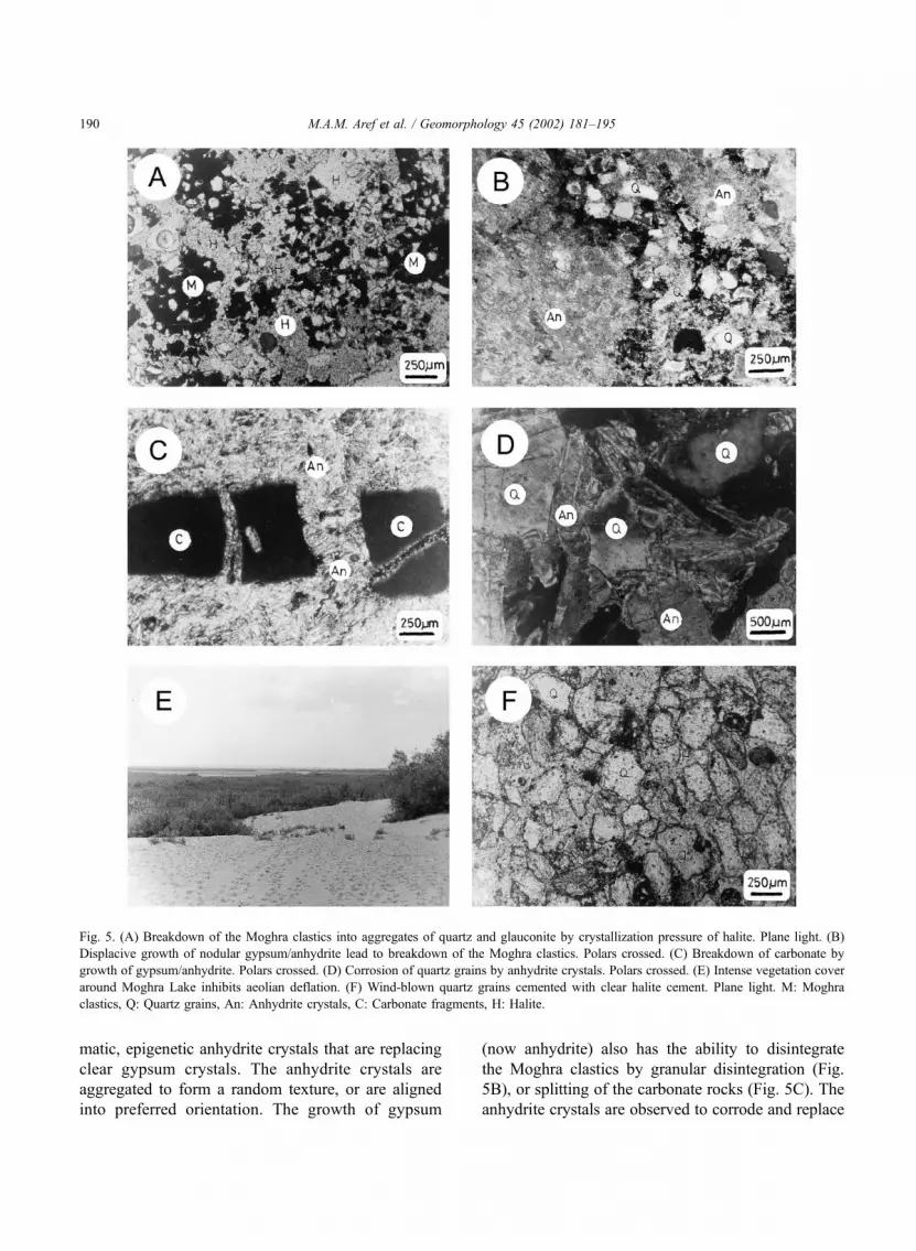
matic, epigenetic anhydrite crystals that are replacing
clear gypsum crystals. The anhydrite crystals are
aggregated to form a random texture, or are aligned
into preferred orientation. The growth of gypsum
(now anhydrite) also has the ability to disintegrate
the Moghra clastics by granular disintegration (Fig.
5B), or splitting of the carbonate rocks (Fig. 5C). The
anhydrite crystals are observed to corrode and replace
Fig. 5. (A) Breakdown of the Moghra clastics into aggregates of quartz and glauconite by crystallization pressure of halite. Plane light. (B)
Displacive growth of nodular gypsum/anhydrite lead to breakdown of the Moghra clastics. Polars crossed. (C) Breakdown of carbonate by
growth of gypsum/anhydrite. Polars crossed. (D) Corrosion of quartz grains by anhydrite crystals. Polars crossed. (E) Intense vegetation cover
around Moghra Lake inhibits aeolian deflation. (F) Wind-blown quartz grains cemented with clear halite cement. Plane light. M: Moghra
clastics, Q: Quartz grains, An: Anhydrite crystals, C: Carbonate fragments, H: Halite.
M.A.M. Aref et al. / Geomorphology 45 (2002) 181–195190

the quartz grains (Fig. 5D). The high crystalline and
durable nature of the anhydrite nodules will allow
them to survive erosion, whereas the relatively friable
Moghra sands are removed by deflation (Fig. 3B).
Therefore, the anhydrite nodules are aggregated after
the removal of the sand to form a pavement of
anhydrite nodules at the ‘Salt Plateau’ area (Fig. 3C).
8. Petrography of halite and gypsum
Evaporite minerals, mainly halite and gypsum,
grow below the sediment surface in brine-soaked
sediments of the Kalakh, Moghra and Dabaa Forma-
tions. The concentrated brines have diffused upwards
from shallow groundwater seepage. Precipitation
would occur at the level where halite or gypsum
becomes supersaturated. The dominant process of
growth of halite and gypsum is by displacive growth,
where the framework materials of the sediment are
pushed aside by the force of crystallization, leading to
the disintegration of the host rock.
Halite and gypsum crystals that nucleate from
brine-soaked sediment range in size from a few
microns up to several millimeters, they are inequigra-
nular anhedral to subhedral clear crystals that enclose
fragments from the host rock within or at crystal
boundaries (Fig. 4). Growth directions of halite and
gypsum crystals are deduced from the dispersion
pattern of the fragments. The free growth of chevron,
cornet and rafted halite, or laminated, prismatic and
arrow-head gypsum in a salina or lagoon, are not
observed in zones of disintegration of the host rock.
This is taken to indicate that disintegration of the
bedrock took place due to displacive growth of halite
and gypsum below the sabkha surface within brine-
soaked sediments.
9. Discussion
9.1. Groundwater
Several authors stressed that the role of groundwater
as an agent influencing the geomorphology of the
Qattara Depression is limited mainly to its impact as
a base level for the maximum extent of aeolian defla-
tion (Ball, 1933; Squyres and Bradley, 1964). How-
ever, the geomorphological impact of groundwater on
basin enlargement and excavation by salt weathering
was disregarded. Similar to the hypothesis of Goudie
andWells (1995), the present authors believe that, since
the onset of Quaternary aridity in Egypt, the excavation
and enlargement of the Qattara Depression have re-
sulted largely due to salt weathering and aeolian
deflation. The groundwater table controlled the depth
of deflation, and contributed to the salt weathering
processes. Groundwater is believed to have played
different roles in the eastern and western parts of the
depression in concern.
In the eastern part, the low salinity of the near
surface groundwater table (stokes surface, Stokes,
1968) acts as a factor limiting aeolian deflation in
three ways. The first, as described by Stokes (1968),
arises from the high cohesion of moist sand in
proximity to the water table, primarily as a result of
increasing the intergranular surface tension. The moist
or wet sand is less easily entrapped by the wind and
can assist in the formation of adhesion ripples (Fig.
3A) due to wind sculpturing. The second influence is
the establishment of a permanent vegetation cover
(Fig. 5E), such as around the Moghra Lake, which
acts as a base level for wind erosion. The third
influence is through the sporadic cementation of loose
sands (Fig. 5F) by precipitation of halite which acts as
a base limit to aeolian deflation and creation of
extensive planar surfaces. Therefore, the low salinity
nature of the groundwater has limited aeolian defla-
tion and deepening of the eastern part in comparison
to the western part of the depression. The presence of
moist sediments in the east Qattara inhibits deflation
and encourages sedimentation by the adhesion of
wind-blown sands to the damp surface of the sabkha
(Fig. 3A).
On the other hand, the high saline, sodium chlor-
ide-enriched groundwater at the western part of the
Qattara Depression favors the formation of a salt crust
on the sabkha surface (Fig. 3D and E). Where the
bedrock is close to, or outcrops on the sabkha surface,
the high rate of evaporation favors interstitial crystal-
lization of halite and rapid breakdown by salt weath-
ering (Fig. 4). The ingress of more saline water by
pumping evaporation leads to more precipitation of
halite which ‘plug’ near surface pores and increases
the rate of breakdown of the bedrock. This hard salt
crust also acts as a base level for deflation unless the
M.A.M. Aref et al. / Geomorphology 45 (2002) 181–195 191

halite crust is dissolved by an outflow of less saline
groundwater or rainwater during the wet period. After
dissolution of halite, the liberated debris is highly
susceptible to wind deflation. Therefore, the cyclic
pattern of dry and wet periods allows the disintegra-
tion of the bedrock, dissolution of halite cement and
the removal of the susceptible sediments by deflation.
9.2. Causes of rock breakdown
The possible causes of the observed breakdown of
the bedrock do not include frost weathering, as the
Qattara Depression lies in the hot, arid zone of north
Africa. It is likely that karst dissolutional attack
caused the rapid rate of erosion of the Marmarica
carbonates during humid climates of the Quaternary
(Glennie, 1970; Haynes, 1980). Whereas during the
arid phases of the Quaternary, crystallization of halite
near the ground surface led to its high disintegration
by salt weathering. Since sodium chloride, which
cannot be hydrated, is the abundant salt, with sporadic
occurrence of gypsum, it is obvious that most of the
stresses in the salt impregnated bedrock would be
caused by the crystallization of halite and/or gypsum
which leads to breakdown of the bedrock.
9.3. Mechanism of salt weathering
The most cited cause of mechanical weathering is
by salt crystal growth from solutions in rock pores and
cracks because of the substantial pressure that may be
exerted by the growing crystals (Winkler and Singer,
1972). Of the natural salts, sulfates (Na2SO4, MgSO4)
exert the highest pressure, and are more effective than
sodium carbonates. They are also more effective than
halite and gypsum in causing rock breakdown (Gou-
die, 1994). The groundwater in the Qattara Depression
is of the sodium chloride type. Evaporational concen-
tration of this water leads to the precipitation of the
highly soluble salt halite which generates a crystal-
lization pressure ranging from 554 to 3737 kbar/cm3,
when precipitating over a range of temperature
between 0 and 50 �C (Winkler and Singer, 1972).
Such crystallization pressure exceeds the strength of
almost all rocks (Bloom, 1998). On the other hand,
precipitation of gypsum at a temperature range
between 0 and 50 �C generates crystallization pressure
of 282 to 1900 kbar/cm3 (Winkler and Singer, 1972).
Therefore, the pressures generated from the crystal-
lization of halite and gypsum are responsible for the
observed disintegration of the Moghra and Dabaa
sediments (Figs. 4 and 5A,B and C).
9.4. Time of salt weathering
The time and the processes of the initial excavation
of the Qattara Depression have been the subject of
mush controversy for a long time. Said (1960)
believed that the initial dissolution of the Marmarica
limestone cap rock started in post-Middle Miocene
time, followed by wind erosion and mass-wasting.
Albritton et al. (1990) proposed that the initial exca-
vation of the depression started during the Late
Miocene time by fluvial erosion, followed by karstic
processes, wind deflation and mass-wasting. Ball
(1927, 1933) mentioned that the depression was
excavated by wind erosion in Pleistocene and post-
Pleistocene time.
Despite the different processes and times of the
initial excavation of the Qattara Depression, we sug-
gest that the depression is further deepened by salt
weathering when: (1) The above-mentioned processes
excavate the bedrock of the depression to a level that
meets the groundwater base level of erosion. (2) The
onset of aridity in northern Egypt in the Quaternary
time. During the wet periods of the Quaternary,
groundwater and rainfall resulted in the rise of the
water table, which fed the inland sabkhas. During the
dry periods of the Quaternary, evaporation processes
predominated, where salt weathering disintegrated the
bedrock of the Moghra or Dabaa Formations. Also,
the wind deflated and lowered the surface of the
depression. It seems that the Qattara Depression was
subjected to at least three alternating long wet–dry
phases in the Quaternary, which coincided with the
formation of the evaporites at the elevation 25, 75 and
100 m b.s.l. In addition to these aridity phases, the
present-day aridity allows the continuation of the salt
weathering mechanism and deflation of the depression
to the present time.
9.5. Deflation
The proposed hypothesis of wind as a powerful
agent of excavation of large closed depressions of the
Western Desert of Egypt has been widely accepted
M.A.M. Aref et al. / Geomorphology 45 (2002) 181–195192

(Ball, 1927, 1933; Squyres and Bradley, 1964; Glennie,
1970; Haynes, 1980). Despite the different interpreta-
tions regarding the origin of the Qattara Depression,
there is a general agreement on a strong aeolian over-
print on all assumed mechanisms. The estimated exca-
vated volume of the depression is 3200 km2 (Peel,
1966), and the presumed aeolian denudation rate in the
last 2 million years is 9 cm/1000 years, which is
impressively comparable to reported rates of fluvial
conditions (Bloom, 1998). The effective deflation
process in the Qattara Depression is reinforced by the
lack of a protective vegetation cover and the suscept-
Fig. 6. Schematic block diagram showing the role of salt weathering in the late excavation history of the origin of the Qattara Depression.
M.A.M. Aref et al. / Geomorphology 45 (2002) 181–195 193

ibility of sediments derived from salt weathering to
wind removal, similar to that described by Haynes
(1982). Similar to the criteria mentioned by Goudie
and Thomas (1985), the following evidence indicates
the role of deflation in the origin of the Qattara
Depression:
1. TheQattaraDepression has an elongated kidney
shape, transverse to the prevailing winds.
2. The presence of a relatively steep cliff on the
upwind side and a more gentle slope on the
downwind side.
3. The occurrence of crescentic dunes (lunettes)
and other dunes on the downwind side.
4. Grain composition of the dunes is closely
similar to that of the nearby bedrock.
10. Conclusions
Although salt weathering was first recognized
more than a hundred years ago, prior to this study it
was not perceived in the Qattara Depression as a
weathering mechanism of great importance. Probably
this can be attributed to two reasons: (1) a tendency of
most authors to overemphasize the importance of
deflation in rock destruction, and (2) their failure to
recognize the characteristics of weathered rock surfa-
ces that are diagnostic of salt weathering. It seems
that the high salinity and the sodium chloride nature
of the groundwater table and the high rate of evapo-
ration lead to a highly aggressive nature of the
extensive sabkha in the western part of the Qattara
Depression (Fig. 6). Crystallization of halite at or near
the surface of the outcropping bedrock generates
increased pressures, which disintegrate the bedrock.
Dissolution of halite during the wet episode leaves
fine-grained debris that is easily removed during dry
episodes by the strong northerly winds. The winds
carry the fine-grained debris to form a downwind
extensive dune fields of composition very similar to
that of the nearby Moghra clastics and Dabaa shale.
Therefore, the salt weathering mechanism provides
fine-grained debris that are easily removed by defla-
tion, with the groundwater table both controlling the
base level of deflation and contributing to salt for-
mation, with its weathering disintegrating mechanism.
In contrast, the eastern part of the depression (Fig. 6),
where there is low salinity-groundwater table, salt
weathering is not effective and the deflation process is
relatively inhibited due to the high cohesion of moist
sediment, a permanent vegetation cover and precip-
itation of halite cement between the wind-blown
sandy sediment.
The existence of the evaporite sediments overlying
the Pliocene/Pleistocene Kalakh Formation, the Lower
Miocene Moghra Formation and the Upper Eocene–
Oligocene Dabaa Formation in the western part of the
Qattara Depression at elevation 25, 75 and 100 m b.s.l.
indicates: (1) former floors of the Qattara Depression
that stood higher than present. These floors are com-
posed of sabkha sediments similar to the modern
sabkhas. (2) These evaporite sediments probably coin-
cide with Quaternary aridity phases in northern Egypt.
(3) The salt weathering mechanism is more effective as
a disintegration mechanism at the elevations 25, 75 and
100m b.s.l. in the western part of the depression, where
remnants of evaporite sediments still exist.
Acknowledgements
We wish to thank the journal reviewer Prof. Leslie
McFadden and an anonymous reviewer as well as the
journal editor Prof. Adrian Harvey for their construc-
tive comments and improvement of our language. We
also thank Prof. G. Philip and Prof. Z. Zaghloul for their
reading of the early draft of the manuscript. The first
author is grateful to Prof. Andrew Goudie who
provided him with his relevant articles.
References
Albritton, C.C., Brooks, J.E., Issawi, B., Swedan, A., 1990. Origin
of the Qattara Depression, Egypt. Geological Society of Amer-
ica Bulletin 102, 952–960.
Aref, M.A.M., Hamdan, M.A.A., 2002. Sedimentology and envi-
ronmental interpretation of the evaporite deposits in the Qattara
Depression, Western Desert, Egypt. Sedimentology of Egypt 10
(in press).
Ball, J., 1927. Problems of the Libyan Desert. Geographical Journal
70, 21–38.
Ball, J., 1933. The Qattara Depression of the Libyan Desert and the
possibility of its utilization for power production. Geographical
Journal 82, 289–314.
Bloom, A.L., 1998. Geomorphology—A Systematic Analysis of
Late Cenozoic Landforms, 3rd edn. Prentice Hall, Upper Saddle
River, NJ, 482 pp.
M.A.M. Aref et al. / Geomorphology 45 (2002) 181–195194

Bromblet, P., Bocquier, G., 1985. Donnees Petrologiques concer-
nant l’alteration des gres des Temples les Karnak (Egypte).
Proceedings 5th International Congress on Detioration and Con-
servation of stones, Lausanne, 361–370.
Chapman, R.W., 1980. Salt weathering by sodium chloride in the
Saudi Arabian Desert. America Journal of Science 280, 116–
129.
Doornkamp, J.C., Brunsden, D., Jones, D.K.C., 1980. Geology,
Geomorphology and Pedology of Bahrain. Geobooks, Norwich,
443 pp.
El Bassyony, A.A., 1990. Introduction to Qattara Depression. Jour-
nal of Electrical Energy 5, 4–12.
El Bassyony, A.A., 1995. Sabkhas of Qattara Depression, Western
Desert, Egypt—a survey. Sedimentology of Egypt 3, pp. 13–
26.
El Ramly, I.M., 1967. Contribution to the hydrological study of
limestone terrain in the U.A.R. Hydrology of Fractured Rocks,
Dubrovnik Symposium Proceedings, Oct. 1965. Publication 73,
International Association of Scientific Hydrology, vol. 1, pp.
348–377.
Ezzat, M.A., 1974. Groundwater Series in the A.R.E.—Exploration
of Groundwater in El-Wadi El-Gedid Project Area (New Valley).
Ministry of Agriculture and land reclamation, Cairo, 121 pp.
Gindy, A.R., 1991. Origin of Qattara Depression— discussion.
Geological Society of America Bulletin 103, 1374–1375.
Glennie, K.W., 1970. Desert sedimentary environments. Develop-
ments in Sedimentology, vol. 14. Elsevier, Amsterdam, 222 pp.
Goudie, A.S., 1994. Keynotes lecture— salt attack on buildings and
other structures in arid lands. In: Fookes, P.G., Parry, R.H.
(Eds.), Engineering Characteristics of Arid Soils. Balkema, Rot-
terdam, pp. 15–28.
Goudie, A.S., Parker, A.G., 1998. Experimental simulation of rapid
rock block disintegration by sodium chloride in a foggy coastal
desert. Journal of Arid Environments 40, 347–355.
Goudie, A.S., Thomas, D.S.G., 1985. Pans in southern Africa with
particular reference to South Africa and Zimbabwe. Zeitschrift
fur Geomorphologie NF 29, 1–19.
Goudie, A.S., Viles, H.A., 1995. The nature and pattern of debris
liberation by salt weathering—a laboratory study. Earth Surface
Processes and Landforms 20, 437–449.
Goudie, A.S., Watson, A., 1984. Rock block monitoring of rapid
salt weathering in southern Tunisia. Earth Surface Processes and
Landforms 9, 95–98.
Goudie, A.S., Wells, G.L., 1995. The nature, distribution and for-
mation of pans in arid zones. Earth Science Reviews 38, 1–69.
Goudie, A.S., Cooke, R.U., Doornkamp, J.C., 1979. The formation
of silt from dune sand by salt weathering processes in deserts.
Journal of Arid Environments 2, 105–112.
Goudie, A.S., Viles, H.A., Parker, A.G., 1997. Monitoring of rapid
salt weathering in the central Namib desert using limestone
blocks. Journal of Arid Environments 37, 581–598.
Hamdan, M.A.A., Refaat, A.A., 1999. Textural and mineralogical
characteristics and distributions of aeolian sand deposits at Qat-
tara–Siwa area, north Western Desert, Egypt. Proceeding of the
4th International Conference on Geology of the Arab World,
Cairo University, Egypt, pp. 684–706.
Haynes, C.V., 1980. Geological evidence of pluvial climates in the
Nabta area of the Western Desert, Egypt. In: Wendrof, F.,
Schild, R. (Eds.), Prehistory of the Eastern Sahara. Academic
Press, New York, pp. 353–371.
Haynes, C.V., 1982. Great sand sea and Selima sand sheet, Eastern
Sahara. Geochronology and desertification. Science 217, 627–
633.
Peel, R.F., 1966. The landscape in aridity. Institute British Geogra-
phers Trans 38, 1–23.
Qattara Project Authority, 1979. Study Qattara Depression—Draft
Feasibility Study-3, Topography, Regional Geology and Hydro-
geology. Ministry of Electricity and Energy, Egypt, 118 pp.
Said, R., 1960. New light on the origin of the Qattara Depression.
Societe de Geographie d’Egypte Bulletin 33, 37–44.
Squyres, C.H., Bradley, W., 1964. Notes on the Western Desert of
Egypt. Conference Petroleum Exploration Society, Libya, pp.
99–105.
Stokes, W.L., 1968. Multiple parallel truncation bedding planes—a
feature of wind deposited sandstone formations. Journal of Sedi-
mentary Petrology 38, 510–515.
Winkler, E.M., Singer, P.C., 1972. Crystallization pressure in stones
and concrete. Geological Society of America Bulletin 83, 3509–
3514.
M.A.M. Aref et al. / Geomorphology 45 (2002) 181–195 195


