Embed Size (px)
Citation preview
Bull. Soc. géol. Fr., 2008, no 6
The Upper Cenomanian-Turonian (Upper Cretaceous)of the Saharan Atlas (Algeria)
DANIÈLE GROSHENY1, FETTOUMA CHIKHI-AOUIMEUR2, SERGE FERRY3, FATIHA BENKHEROUF-KECHID1,MOHAMED JATI2, FRANÇOIS ATROPS3 and WASSILA REDJIMI-BOUROUIBA1
Key-words. – Algeria, Cenomanian, Turonian, C/T boundary, �13C anomaly, Black shales, Sequence stratigraphy, Palaeogeography,Long-distance correlations
Abstract. – A series of sections from the Ouled Nail, Hodna and Aurès massifs of Algeria have been studied to analysethe palaeogeographic evolution of the eastern part of the Saharan Atlas prior to and after the Cenomanian/Turonian(C/T) boundary event. Three periods are distinguished in the interval studied. During the middle to late Cenomanian, anoverall ramp setting prevailed from the Saharan platform to the deeper environments of the Saharan Atlas. The latestCenomanian and the earliest Turonian was marked by an episode of marked palaeogeographic change. Prior to the depo-sition of C/T boundary black shales, a rise in sea level occurred. Shallow-water carbonates were locally able to accom-modate the sea-level rise. A “keep-up” response created a palaeogeography made up of isolated carbonate platformsseparated by saddles, where a 1-20 m thick bed of deeper water mudstones was deposited as the lateral equivalent of theplatform carbonates. At a larger scale, these saddles probably acted as corridors that allowed marine communicationwith the intra-Saharan basins (Tinrhert, Tademaït basins). Correlations show that the boundary black shales later filledup the saddles of the Saharan Atlas, and onlapped the carbonate platforms, before the deposition of lower Turonian openmarine marls that everywhere blanket the successions. During the early to late Turonian, the palaeogeography againchanged to restore a N-S oriented ramp setting, similar to that of the middle Cenomanian. Correlation with the dee-per-water facies of nearby northern Tunisia, suggests that the uppermost Cenomanian mudstone immediately underlyingthe black shale facies in the Saharan Atlas is the lateral equivalent of the uppermost bed of the Fahdene Formation (theso-called “pre-Bahloul”) underlying the Bahloul black shale facies in the Tunisian Kalaat Senan reference section. Ourplatform-to-basin correlations show that the base of this bed is a regional transgressive surface, not a type II sequenceboundary as suggested by previous authors. Finally, it is proposed that this mudstone bed correlates with Bed 63 of thePueblo global reference section in the North American western Interior Basin, which also marks the beginning of thestrong C/T boundary transgression.
Le Cénomanien supérieur-Turonien de l’Atlas saharien (Algérie)
Mots-clés. – Algérie, Cénomanien, Turonien, Limite C/T, Anomalie en �13C, Black shales, Stratigraphie séquentielle, Paléogéo-graphie, Corrélations à grande distance
Résumé. – Une douzaine de coupes levées dans les massifs des Ouled Nail, du Hodna et de l’Aurès permettent de dé-crire l’évolution paléogéographique particulière de ce domaine situé sur la flexure nord-saharienne, au moment de lacrise de la limite Cénomanien-Turonien. Trois périodes sont distinguées. Au cours de la première (Cénomanienmoyen-supérieur p.p.), une paléogéographie globalement de rampe s’établit entre la plate-forme saharienne et le do-maine plus profond de l’Atlas saharien. La seconde période couvre le passage Cénomanien-Turonien (C/T). Elle estmarquée par un changement paléogéographique très net. Juste avant le dépôt des black shales de la limite C/T, une élé-vation modérée du niveau marin relatif se produit. Les carbonates de plate-forme sont localement capables d’accommo-der cette élévation. Il en résulte une paléogéographie particulière faite des plates-formes carbonatées isolées, séparéespar des ensellements où se dépose, en équivalent latéral de faciès, une couche de calcaires fins de 15 mètres à moinsd’un mètre d’épaisseur selon les endroits. A plus grande échelle, ces ensellements ont pu constituer des corridors assu-rant la communication des bassins intra-sahariens de même âge (Tinrhert, Tademaït) avec la Téthys. Nos corrélationsmontrent que les black shales qui terminent cette seconde période se sont déposés uniquement dans ces ensellementsqu’ils remplissent totalement, avant le retour à une sédimentation marneuse généralisée au cours du Turonien inférieur.Au cours de la période suivante, couvrant le reste du Turonien, s’effectue la restauration d’un profil globalement derampe orientée sud-nord, avec les carbonates de plate-forme progradant et rétrogradant régulièrement sur ce profil. Lescorrélations effectuées avec la coupe de référence de Kalaat-Senan en Tunisie du Nord suggèrent que la couche de cal-caire fin du Cénomanien terminal de l’Atlas saharien, sous les black shales, et dont l’épaisseur diminue de l’Aurès versle bassin du Mellègue, soit un équivalent latéral du banc calcaire (« pré-Bahloul ») qui surmonte la formation Fahdèneet précède l’installation du faciès Bahloul en Tunisie. Dans ce cas, la base de cette couche calcaire n’a pas la valeur ré-gionale d’une limite de séquence de type II comme il a été anciennement proposé mais au contraire une valeur de sur-
Bull. Soc. géol. Fr., 2008, t. 179, no 6, pp. 593-603
1. Université Louis Pasteur, Strasbourg 1, EOST, UMR7561, 1 rue Blessig, F67084 Strasbourg ([email protected])2. Université des Sciences et de la Technologie Houari Boumédienne, Département de Géologie, Bab Ezzouar, Algiers, Algeria ([email protected])3. UMR 5125 PEPS, CNRS, France; Université Lyon 1, Campus de La Doua, Bt. Géode, 69622 Villeurbanne cedex, France ([email protected])Manuscrit déposé le 22 juin 2007; accepté après révision le 18 février 2008
« Relations entre les marges septentrionaleet méridionale de la Téthys au Crétacé »,Réunions thématiques du Groupe Françaisdu Crétacé,Paris, 27-28 novembre 2006
face de transgression. Nous proposons également de corréler cette couche calcaire avec le banc 63 de la coupe de réfé-rence de Pueblo dans le bassin intérieur nord-américain où ce banc marque également le début de la transgression, après ledépôt des shales de Hartland.
INTRODUCTION
The first results of a France-Algeria “Tassili” cooperationprogramme on the stratigraphy of the Upper Cretaceous ofnorthern Algeria are presented. Work has focussed on theCenomanian-Turonian (C/T) boundary (CTB) event, whichremains poorly studied in northern Algeria compared to ad-jacent countries (Morocco and Tunisia). The aim is to un-derstand the relationships between the marginal basins ofnorthern Algeria bearing CTB black shales, described here,and the intra-cratonic basins of the Sahara (Tinrhert, Tade-maït basins) where black shales do not occur. A dozen sec-tions have been studied over the last two years, mostly inthe Ouled Nail and Aurès massifs (Saharan Atlas; fig. 1a).These sections, although sometimes incomplete, allow tobetter constrain the sequence stratigraphic context of theevent because they demonstrate the relationships betweencarbonate platforms and the basinal deposits hosting theboundary black shales. Carbon �13C stable-isotope curveshave been obtained in four basinal sections. Detailed stu-dies on foraminifera will appear later.
The stratigraphic interval studied has been subdividedinto three parts, the significance of which will be discussedfurther in the final synthesis. Period 1 covers the middle tolate Cenomanian, latest Cenomanian excluded. Period 2 co-vers the C/T transition, and Period 3 the remaining of theTuronian. Period 2 is also subdivided into two parts, anearly one just preceeding deposition of the black shale fa-cies, and a later one corresponding to the installation of theCTB black shales in sections where these are present.
OULED NAIL MASSIF
Four sections have been studied in this area (fig. 1b), two ofthem (Djebel Chebeibita, CHE, and Khanguet Grouz, KG)present a thick black shales facies at the C/T transition. Thetwo others (Djebel Mimouna, MIM, close to the northernedge of the Saharan craton, and Djebel Cheggaig, CHG, far-ther to the north) are quite different. Besides the lack ofblack shales, they show either rudist- or oyster-bearing cal-carenite platform facies at the C/T transition. These shal-low-water facies may be up to 110 m thick but they areabsent in the Djebel Chebeibita and Khanguet Grouz sec-tions.
Herkat [1999, 2002, 2004, 2005] showed that Cenoma-nian sections of the Saharan Atlas are usually very thick (upto 600 m). From his work the Khanguet Grouz section stu-died here (fig. 2) probably begins somewhere in the upperCenomanian. The first deposits (fig. 3A) are complex andorganized into successive shallow-water marl-limestone pa-rasequences perhaps bounded by emersion surfaces. Thiskind of depositsion, which occurred at this time all alongthe edge of the Saharan craton and extended into southernTunisia, is characteristic of what is called here Period 1 (fig.2). The next unit is made of a thick bed of white, bioturba-ted mudstones on which rest thick CTB black shales.
Ammonites recorded by Herkat [1999, p. 273] at thetransition between the white mudstones and the black shales(Metengonoceras gr. dibbleyi, Neocardioceras sp., Euom-phaloceras costatum) give a late Cenomanian age. A newcrushed ammonite (Mammites sp.) found higher in the blackshales (fig. 2) indicates the lower Turonian. So, the C/Tboundary should be somewhere in between, that is withinthe black shale interval.
The black shale facies is an alternation of hard carbo-nate-rich beds and shaly interbeds, both evenly laminated(fig. 3F), in which the thickness of beds varies from ten cen-timetres (fig. 3B) to about one metre (fig. 3C), especially inthe thicker Khanguet Grouz section (fig. 2). A nodular fa-cies (fig. 3D) may also occur at some levels. In spite of thelaminated pattern of the shales, indicative at first sight ofanoxic bottom water conditions, bivalve shells may be pre-sent (fig. 3E), especially in the upper half of the black sha-les in the Djebel Chebeibita section. These belong to thegenus Mytiloides and indicate the lower Turonian. Cherts,
Bull. Soc. géol. Fr., 2008, no 6
594 GROSHENY D. et al.
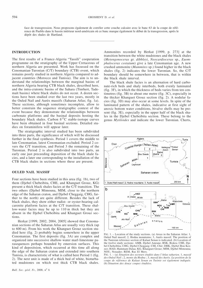
FIG. 1. – Location of the study sections. (a) Areas in the Saharan Atlas: 1,Ouled Nail massif; 2, Hodna mountains; 3, Aurès massif. The position ofthe Tunisian reference section of Kalaat Senan is indicated. (b) Location ofthe twelve study sections: AMR, Djebel Amrane; BSK, Biskra; CHE, Dje-bel Chebeibita; CHG, Djebel Cheggaig; CHI, Chir; DBK, Djebel Bou Kez-zez; HAD, Hammam Dalaa; KG, Khanguet Grouz; MIM, Djebel Mimouna;NOU, Nouader; REM, Ras El Mers.FIG. 1. – (a) Situation des secteurs étudiés dans l’Atlas saharien. 1, massifdes Ouled Nail ; 2, monts du Hodna ; 3, massif des Aurès. La position de lacoupe de référence de Kalaat Senan en Tusinie est également indiquée.(b) Situation des douze coupes étudiées.
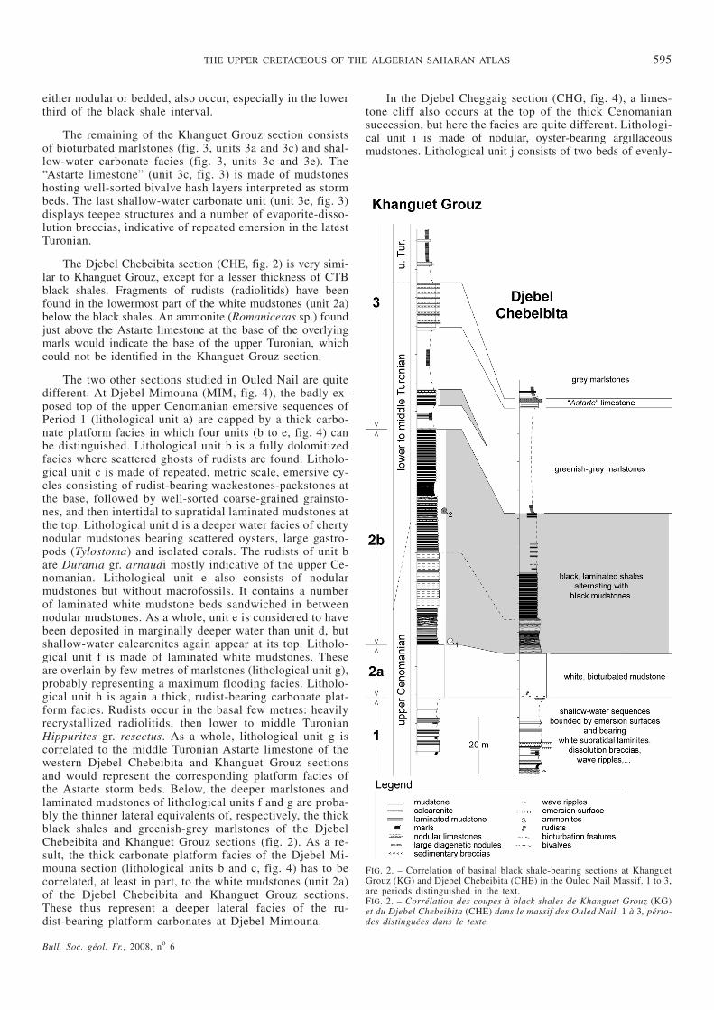
either nodular or bedded, also occur, especially in the lowerthird of the black shale interval.
The remaining of the Khanguet Grouz section consistsof bioturbated marlstones (fig. 3, units 3a and 3c) and shal-low-water carbonate facies (fig. 3, units 3c and 3e). The“Astarte limestone” (unit 3c, fig. 3) is made of mudstoneshosting well-sorted bivalve hash layers interpreted as stormbeds. The last shallow-water carbonate unit (unit 3e, fig. 3)displays teepee structures and a number of evaporite-disso-lution breccias, indicative of repeated emersion in the latestTuronian.
The Djebel Chebeibita section (CHE, fig. 2) is very simi-lar to Khanguet Grouz, except for a lesser thickness of CTBblack shales. Fragments of rudists (radiolitids) have beenfound in the lowermost part of the white mudstones (unit 2a)below the black shales. An ammonite (Romaniceras sp.) foundjust above the Astarte limestone at the base of the overlyingmarls would indicate the base of the upper Turonian, whichcould not be identified in the Khanguet Grouz section.
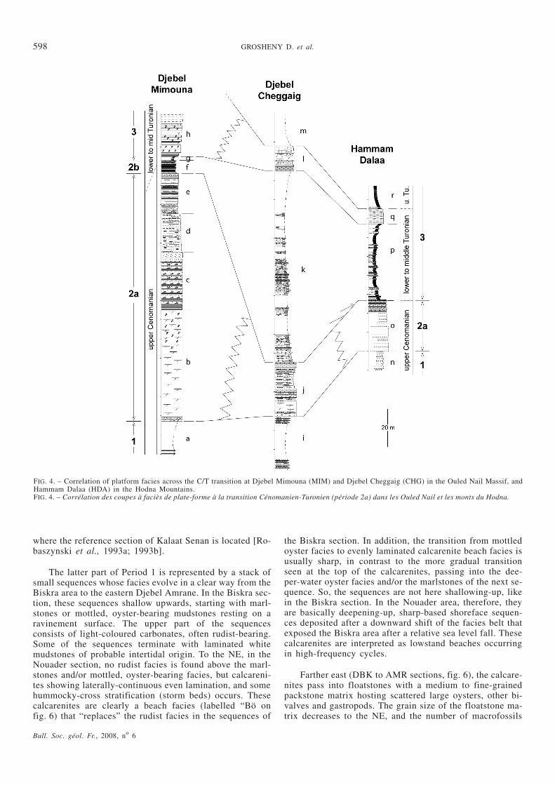
The two other sections studied in Ouled Nail are quitedifferent. At Djebel Mimouna (MIM, fig. 4), the badly ex-posed top of the upper Cenomanian emersive sequences ofPeriod 1 (lithological unit a) are capped by a thick carbo-nate platform facies in which four units (b to e, fig. 4) canbe distinguished. Lithological unit b is a fully dolomitizedfacies where scattered ghosts of rudists are found. Litholo-gical unit c is made of repeated, metric scale, emersive cy-cles consisting of rudist-bearing wackestones-packstones atthe base, followed by well-sorted coarse-grained grainsto-nes, and then intertidal to supratidal laminated mudstones atthe top. Lithological unit d is a deeper water facies of chertynodular mudstones bearing scattered oysters, large gastro-pods (Tylostoma) and isolated corals. The rudists of unit bare Durania gr. arnaudi mostly indicative of the upper Ce-nomanian. Lithological unit e also consists of nodularmudstones but without macrofossils. It contains a numberof laminated white mudstone beds sandwiched in betweennodular mudstones. As a whole, unit e is considered to havebeen deposited in marginally deeper water than unit d, butshallow-water calcarenites again appear at its top. Litholo-gical unit f is made of laminated white mudstones. Theseare overlain by few metres of marlstones (lithological unit g),probably representing a maximum flooding facies. Litholo-gical unit h is again a thick, rudist-bearing carbonate plat-form facies. Rudists occur in the basal few metres: heavilyrecrystallized radiolitids, then lower to middle TuronianHippurites gr. resectus. As a whole, lithological unit g iscorrelated to the middle Turonian Astarte limestone of thewestern Djebel Chebeibita and Khanguet Grouz sectionsand would represent the corresponding platform facies ofthe Astarte storm beds. Below, the deeper marlstones andlaminated mudstones of lithological units f and g are proba-bly the thinner lateral equivalents of, respectively, the thickblack shales and greenish-grey marlstones of the DjebelChebeibita and Khanguet Grouz sections (fig. 2). As a re-sult, the thick carbonate platform facies of the Djebel Mi-mouna section (lithological units b and c, fig. 4) has to becorrelated, at least in part, to the white mudstones (unit 2a)of the Djebel Chebeibita and Khanguet Grouz sections.These thus represent a deeper lateral facies of the ru-dist-bearing platform carbonates at Djebel Mimouna.
In the Djebel Cheggaig section (CHG, fig. 4), a limes-tone cliff also occurs at the top of the thick Cenomaniansuccession, but here the facies are quite different. Lithologi-cal unit i is made of nodular, oyster-bearing argillaceousmudstones. Lithological unit j consists of two beds of evenly-
THE UPPER CRETACEOUS OF THE ALGERIAN SAHARAN ATLAS 595
Bull. Soc. géol. Fr., 2008, no 6
FIG. 2. – Correlation of basinal black shale-bearing sections at KhanguetGrouz (KG) and Djebel Chebeibita (CHE) in the Ouled Nail Massif. 1 to 3,are periods distinguished in the text.FIG. 2. – Corrélation des coupes à black shales de Khanguet Grouz (KG)et du Djebel Chebeibita (CHE) dans le massif des Ouled Nail. 1 à 3, pério-des distinguées dans le texte.
laminated, well-sorted calcarenites, partly dolomitized, re-presenting a beach facies separated by oyster-bearing bio-turbated mudstones. These calcarenites are the shallowestwater facies found here. The lower Turonian above is again,like the upper Cenomanian, a thick series of interbedded
oyster-bearing bioturbated argillaceous mudstones andcalcarenite beds possibly representing storm deposits. Li-thological unit j is probably a topmost Cenomanian lateralequivalent of the rudist facies found at Djebel Mimouna, asindicated in figure 4.
Bull. Soc. géol. Fr., 2008, no 6
596 GROSHENY D. et al.
HODNA MOUNTAINS
Only one section (HAD, fig. 4) was studied, close to thecity of Hammam Dalaa and not very far from the DjebelDjedoug section once studied by Herkat [1999].
The upper Cenomanian (lithological unit n, fig. 4) ismade of a large number of plurimetric-scale parasequencesmade of an alternation of grey marlstones and oyster-bea-ring mudstones and/or wackestones. This facies representsdeeper water than those of the same age in Ouled Nail.
The uppermost Cenomanian (lithological unit o, fig. 4)could not be studied in detail, due to insufficient time. Ho-wever, it is represented by a more limey facies making acliff, as in many other sections of the Saharan Atlas. Onlythe uppermost part of this cliff has been studied. Thisconsists of shallow-water carbonates, mainly coarse-grai-ned packstones and shelly wackestones with some rudist re-mains. Their top is an unconformity-surface overlain by athin layer of carbonate conglomerate encrusted by oysters.Above, black shales are absent from a thick “Turonian” re-cessive interval, but an alternation of grey marlstones andlight grey, argillaceous mudstones occur at the base (litho-logical unit p, fig. 4). Unit q is a thick bed of argillaceousmudstones that represent the top of the first Turonian se-quence. This bed is considered to be a lateral, deeper waterequivalent of the Astarte limestone (fig. 2) or of the first Tu-ronian rudist limestones of Djebel Mimouna (lithologicalunit h, fig. 4). In Djebel Cheggaig, an intermediate facies ofevenly-bedded, well-sorted calcarenites interbedded withbioturbated, oyster-bearing mudstones is found (lithologicalunit l, fig. 4).
As a whole, in contrast to the Chebeibita and KhanguetGrouz sections of Ouled Nail, the top of the thick Ceno-manian succession is represented in all three other sec-tions by shallow-water carbonates but with strong faciesand thickness changes. The Turonian shallowing-up se-quence, by contrast, reveals a platform-to-basin evolutionfrom south (MIM) to north (HAD, fig. 4).
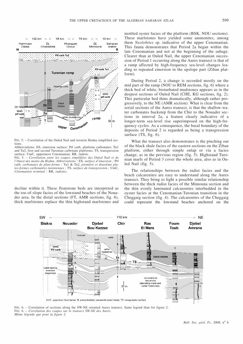
CORRELATIONS BETWEEN THE OULED NAILAND THE HODNA SECTIONS
In all three southern sections (fig. 5), Period 1 is represen-ted by shallow-water, often emersive sequences in which
the deepest facies (green marls and nodular mudstonesbearing tempestites capped by wave ripples) are relativelyshallow water. The depositional environments deepen onlyin the Hodna section where grey marls alternate with bedsof oyster floatstones scattered in a fine-grained calcarenitematrix. A similar but clearer S-N oriented ramp setting pre-vailed during Period 3. In the first Turonian prograding se-quence, rudist-bearing platform carbonates of DjebelMimouna pass to the north into the storm beds of theAstarte limestone and even (in the Hodna section) into ar-gillaceous limestones. The same is true for the second (up-per) Turonian sequence but the progradation of shallow-water facies to the north is stronger. In Djebel Chebeibita, afacies made of an alternation of carbonates and evaporitesat the parasequence scale underwent post-depositional dis-solution that led to the near-total disruption of beddingthroughout the unit. This is not encountered in more proxi-mal southern sections (KG, MIM) and may be interpreted asa result of local tectonic deformation that turned some areasof the platform into evaporite saddles.
The palaeogeography during Period 2 was quite diffe-rent, as platform carbonates deposited on the edge of theSaharan craton are found again in the Hodna section to thenorth. In between (at Ouled Nail) occur the deeper water fa-cies of white mudstones (unit 2a) that probably filled a localsaddle. What is also clear is that CTB black shales (unit 2b)occur only in this Ouled Nail saddle, not on the nearby plat-forms. The black shales pass laterally into shallower-waternodular limestones in Djebel Mimouna, but onlap the Hod-na swell, a structure that appeared briefly during Period 2and vanished in the early Turonian to restore the earlierramp setting.
AURES TRANSECT
The SW-NE platform-to-basin polarity of the transect stu-died was known previously [Herkat, 2005, Fig. 2]. Alongthis transect, the Biskra section (BSK, fig. 6) is typical ofthe Ziban carbonate platform, situated between the OuledNail and the Aurès massifs. The easternmost section studied(Djebel Amrane, AMR, fig. 6) is paleogeographically thedeepest. So, all sections are roughly situated along the dipof a platform to basin depositional system that goes evendeeper toward the Mellegue basin of northern Tunisia,
Bull. Soc. géol. Fr., 2008, no 6
THE UPPER CRETACEOUS OF THE ALGERIAN SAHARAN ATLAS 597
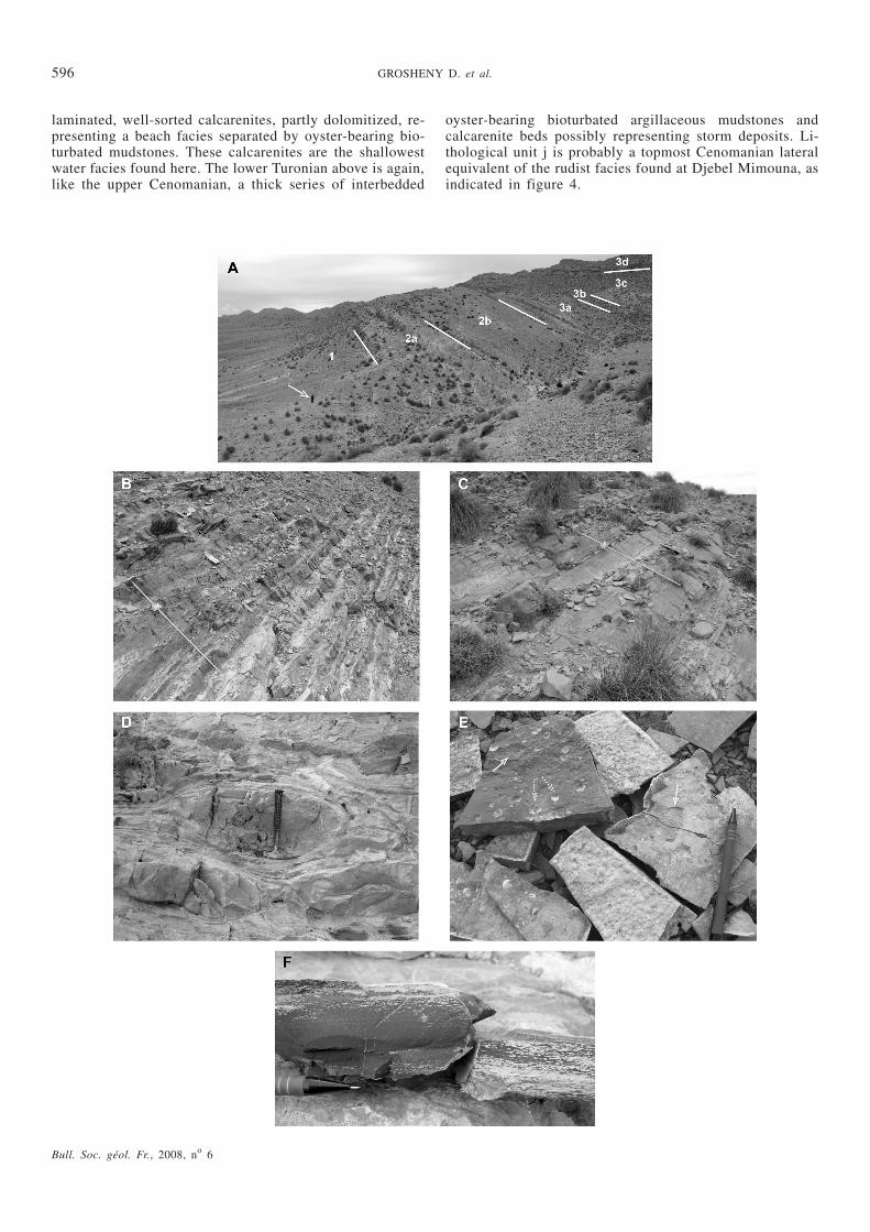
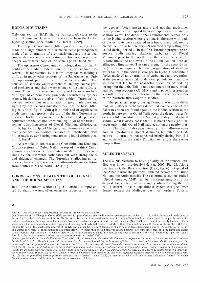
FIG. 3. – Facies of black-shale-bearing sections in the Ouled Nail Massif.(A) Overview of the Khanguet Grouz (KG) section: 1, upper Cenomanian shallow-water parasequences of Period 1; 2a, white bioturbated mudstones ofPeriod 2a; 2b, black shale facies of Period 2b; 3a, lower Turonian bioturbated marlstones; 3b, middle Turonian Astarte limestone; 3c, upper Turonian bio-turbated marlstones; 3d, uppermost Turonian shallow-water carbonates; person (white arrow) for scale. (B – D) Closer views of the evenly laminated blackshale facies that can be made of either regularly alternating hard beds and recessive interbeds (both black and laminated) (B), or of thicker beds (C) as inthe middle part of the black shale interval of the KG section (see fig. 2), or of laminated shales hosting large diagenetic nodules (D); Jacob staff (1,50 m)or hammer for scale. (E) Inoceramids (plain white arrows) or small, thin-shelled bivalves (dashed arrows) are sometimes present in the laminated shales(CHE section); pen for scale. (F) Closer view of the faintly laminated shaly interbeds (white specks are due to surficial weathering); pen for scale.FIG. 3. – Faciès des coupes à black shales dans le massif des Ouled Nail.(A) Vue générale de la coupe du Khanguet Grouz (KG) : 1, paraséquences émersives du Cénomanien supérieur (période 1) ; 2a, mudstones clairs biotur-bés de la période 2a ; 2b, black shales de la période 2b ; 3a, marnes bioturbées du Turonien inférieur ; 3b, calcaires à Astartes du Turonien moyen ; 3c,marno-calcaires d’approfondissement du Turonien supérieur ; 3d, calcaires de plate-forme du Turonien terminal ; la personne (flèche blanche) donnel’échelle. B à D, vue de détail du faciès black shale laminé qui peut se présenter soit sous la forme d’une alternance régulière de bancs et d’interbancs(photo B), de bancs plus épais (photo B) comme dans la partie moyenne de l’intervale dans la coupe KG (fig. 2), ou encore de shales laminés à larges no-dules diagénétiques (photo D) ; bâton de Jacob (1,50 m) ou marteau pour échelles. E, inocérames (flèches blanches pleines) ou petits bivalves à tests min-ces (flèches en pointillés) parfois présents dans les shales laminés (coupe CHE) ; crayon pour échelle. F, vue de détail du faciès laminé (les tachesblanches sont dues à l’altération de surface) ; crayon pour échelle.
where the reference section of Kalaat Senan is located [Ro-baszynski et al., 1993a; 1993b].
The latter part of Period 1 is represented by a stack ofsmall sequences whose facies evolve in a clear way from theBiskra area to the eastern Djebel Amrane. In the Biskra sec-tion, these sequences shallow upwards, starting with marl-stones or mottled, oyster-bearing mudstones resting on aravinement surface. The upper part of the sequencesconsists of light-coloured carbonates, often rudist-bearing.Some of the sequences terminate with laminated whitemudstones of probable intertidal origin. To the NE, in theNouader section, no rudist facies is found above the marl-stones and/or mottled, oyster-bearing facies, but calcareni-tes showing laterally-continuous even lamination, and somehummocky-cross stratification (storm beds) occurs. Thesecalcarenites are clearly a beach facies (labelled “Bö onfig. 6) that “replaces” the rudist facies in the sequences of
the Biskra section. In addition, the transition from mottledoyster facies to evenly laminated calcarenite beach facies isusually sharp, in contrast to the more gradual transitionseen at the top of the calcarenites, passing into the dee-per-water oyster facies and/or the marlstones of the next se-quence. So, the sequences are not here shallowing-up, likein the Biskra section. In the Nouader area, therefore, theyare basically deepening-up, sharp-based shoreface sequen-ces deposited after a downward shift of the facies belt thatexposed the Biskra area after a relative sea level fall. Thesecalcarenites are interpreted as lowstand beaches occurringin high-frequency cycles.
Farther east (DBK to AMR sections, fig. 6), the calcare-nites pass into floatstones with a medium to fine-grainedpackstone matrix hosting scattered large oysters, other bi-valves and gastropods. The grain size of the floatstone ma-trix decreases to the NE, and the number of macrofossils
Bull. Soc. géol. Fr., 2008, no 6
598 GROSHENY D. et al.
FIG. 4. – Correlation of platform facies across the C/T transition at Djebel Mimouna (MIM) and Djebel Cheggaig (CHG) in the Ouled Nail Massif, andHammam Dalaa (HDA) in the Hodna Mountains.FIG. 4. – Corrélation des coupes à faciès de plate-forme à la transition Cénomanien-Turonien (période 2a) dans les Ouled Nail et les monts du Hodna.
decline within it. These floatstone beds are interpreted asthe toe-of-slope facies of the lowstand beaches of the Noua-der area. In the distal sections (FT, AMR sections, fig. 6),thick marlstones replace the thin highstand marlstones and
mottled oyster facies of the platform (BSK, NOU sections).These marlstones have yielded some ammonites, amongthem Neolobites sp. indicative of the upper Cenomanian.This fauna demonstrates that Period 2a began within thelate Cenomanian and not at the beginning of the subage.Clearer than at Ouled Nail, the upper Cenomanian succes-sion of Period 1 occurring along the Aures transect is that ofa ramp affected by high-frequency sea-level changes lea-ding to repeated emersion in the upslope part (Ziban plat-form).
During Period 2, a change is recorded mostly on themid part of the ramp (NOU to REM sections, fig. 6) where athick bed of white, bioturbated mudstones appears as in thedeepest sections of Ouled Nail (CHE, KG sections, fig. 2).This particular bed thins dramatically, although rather pro-gressively, to the NE (AMR section). What is clear from theserial sections of the Aures transect, is that the shallow-wa-ter carbonates backstep from the Chir to the Nouader sec-tions in interval 2a, a feature clearly indicative of alonger-term sea-level rise superimposed on the high-fre-quency cycles. As a consequence, the basal boundary of thedeposits of Period 2 is regarded as being a transgressionsurface (TS, fig. 6).
What the transect also demonstrates is the pinching outof the black shale facies of the eastern sections on the Zibanplatform, either through simple onlap or via a facieschange, as in the previous region (fig. 5). Highstand Turo-nian marls of Period 3 cover the whole area, also as in Ou-led Nail (fig. 5).
The relationships between the rudist facies and thebeach calcarenites are easy to understand along the Aurestransect. They bring to light a possible similar relationshipbetween the thick rudist facies of the Mimouna section andthe thin evenly laminated calcarenites interbedded in theoyster facies at the Cenomanian-Turonian transition in theCheggaig section (fig. 4). The calcarenites of the Cheggaigcould represent the lowstand beaches anchored on the
Bull. Soc. géol. Fr., 2008, no 6
THE UPPER CRETACEOUS OF THE ALGERIAN SAHARAN ATLAS 599
FIG. 6. – Correlation of sections along the SW-NE oriented Aures transect. Same legend than for figure 2.FIG. 6. – Corrélation des coupes sur le transect SW-NE des Aurès.Même légende que pour la figure 2.
FIG. 5. – Correlation of the Ouled Nail and western Hodna simplified sec-tions.Abbreviations: ES, emersion surface; Ptf carb, platform carbonates; Tu1and Tu2, first and second Turonian carbonate platforms; TS, transgressionsurface; UmC, uppermost Cenomanian; RR, rudists.FIG. 5. – Corrélation entre les coupes simplifiées des Ouled Nail et del’Ouest des monts du Hodna. Abbréviations : ES, surface d’émersion ; Ptfcarb, carbonates de plate-forme ; Tu1 & Tu2, première et deuxième pla-tes-formes carbonatées turoniennes ; TS, surface de transgression ; UmC,Cénomanien terminal ; RR, rudistes.
platform slope following the emersion of the southern rudistplatform.
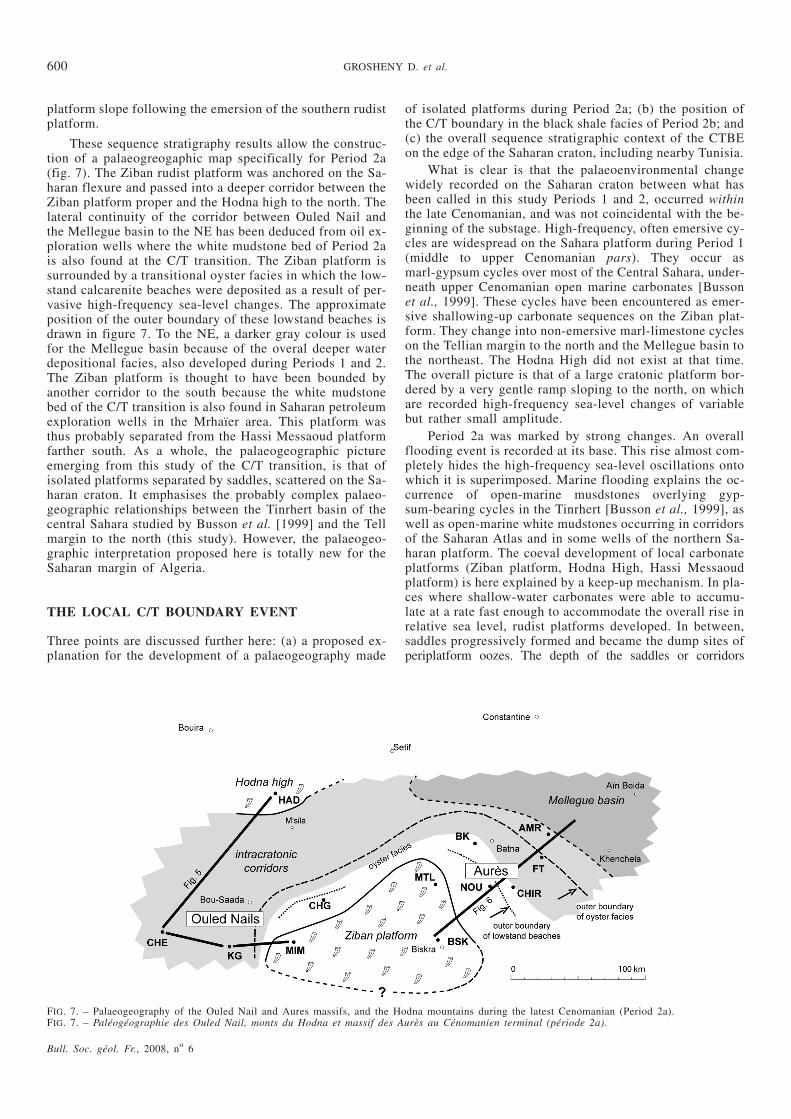
These sequence stratigraphy results allow the construc-tion of a palaeogreogaphic map specifically for Period 2a(fig. 7). The Ziban rudist platform was anchored on the Sa-haran flexure and passed into a deeper corridor between theZiban platform proper and the Hodna high to the north. Thelateral continuity of the corridor between Ouled Nail andthe Mellegue basin to the NE has been deduced from oil ex-ploration wells where the white mudstone bed of Period 2ais also found at the C/T transition. The Ziban platform issurrounded by a transitional oyster facies in which the low-stand calcarenite beaches were deposited as a result of per-vasive high-frequency sea-level changes. The approximateposition of the outer boundary of these lowstand beaches isdrawn in figure 7. To the NE, a darker gray colour is usedfor the Mellegue basin because of the overal deeper waterdepositional facies, also developed during Periods 1 and 2.The Ziban platform is thought to have been bounded byanother corridor to the south because the white mudstonebed of the C/T transition is also found in Saharan petroleumexploration wells in the Mrhaïer area. This platform wasthus probably separated from the Hassi Messaoud platformfarther south. As a whole, the palaeogeographic pictureemerging from this study of the C/T transition, is that ofisolated platforms separated by saddles, scattered on the Sa-haran craton. It emphasises the probably complex palaeo-geographic relationships between the Tinrhert basin of thecentral Sahara studied by Busson et al. [1999] and the Tellmargin to the north (this study). However, the palaeogeo-graphic interpretation proposed here is totally new for theSaharan margin of Algeria.
THE LOCAL C/T BOUNDARY EVENT
Three points are discussed further here: (a) a proposed ex-planation for the development of a palaeogeography made
of isolated platforms during Period 2a; (b) the position ofthe C/T boundary in the black shale facies of Period 2b; and(c) the overall sequence stratigraphic context of the CTBEon the edge of the Saharan craton, including nearby Tunisia.
What is clear is that the palaeoenvironmental changewidely recorded on the Saharan craton between what hasbeen called in this study Periods 1 and 2, occurred withinthe late Cenomanian, and was not coincidental with the be-ginning of the substage. High-frequency, often emersive cy-cles are widespread on the Sahara platform during Period 1(middle to upper Cenomanian pars). They occur asmarl-gypsum cycles over most of the Central Sahara, under-neath upper Cenomanian open marine carbonates [Bussonet al., 1999]. These cycles have been encountered as emer-sive shallowing-up carbonate sequences on the Ziban plat-form. They change into non-emersive marl-limestone cycleson the Tellian margin to the north and the Mellegue basin tothe northeast. The Hodna High did not exist at that time.The overall picture is that of a large cratonic platform bor-dered by a very gentle ramp sloping to the north, on whichare recorded high-frequency sea-level changes of variablebut rather small amplitude.
Period 2a was marked by strong changes. An overallflooding event is recorded at its base. This rise almost com-pletely hides the high-frequency sea-level oscillations ontowhich it is superimposed. Marine flooding explains the oc-currence of open-marine musdstones overlying gyp-sum-bearing cycles in the Tinrhert [Busson et al., 1999], aswell as open-marine white mudstones occurring in corridorsof the Saharan Atlas and in some wells of the northern Sa-haran platform. The coeval development of local carbonateplatforms (Ziban platform, Hodna High, Hassi Messaoudplatform) is here explained by a keep-up mechanism. In pla-ces where shallow-water carbonates were able to accumu-late at a rate fast enough to accommodate the overall rise inrelative sea level, rudist platforms developed. In between,saddles progressively formed and became the dump sites ofperiplatform oozes. The depth of the saddles or corridors
Bull. Soc. géol. Fr., 2008, no 6
600 GROSHENY D. et al.
FIG. 7. – Palaeogeography of the Ouled Nail and Aures massifs, and the Hodna mountains during the latest Cenomanian (Period 2a).FIG. 7. – Paléogéographie des Ouled Nail, monts du Hodna et massif des Aurès au Cénomanien terminal (période 2a).
increased until another, faster, rise in sea level killed carbo-nate production on platforms, which were unable tokeep-up. This keep-up mechanism may be sufficient to ex-plain the general palaeogeographical development of thearea, but it should be emphasized that the occurrence of theHodna High on the previous ramp has to be explained ano-ther way, probably by coeval tectonic deformation.
Both transects (figs 5, 6) show that the black shale fa-cies occurs only in the saddles between the rudist platforms.After these saddles had been filled by black shales,open-marine grey marls of early Turonian age settled eve-rywhere. Available data are still insufficient to know if theend of the black shale deposition was coeval everywhere ornot. However, interbedded marls and black shales at the topof the interval 2b in the Chebeibita section (fig. 2) suggestthat black shale deposition may have lasted longer in someplaces. In addition, it is hard to know if these black shalesreally onlap the platform edges or if they drape themthrough a facies change into open-marine marls. However,bed geometries shown in figures 5 and 6 strongly suggestthat anoxia may have been caused by water-mass isolationwithin the saddles, as proposed on a larger scale by Lüninget al. [2004].
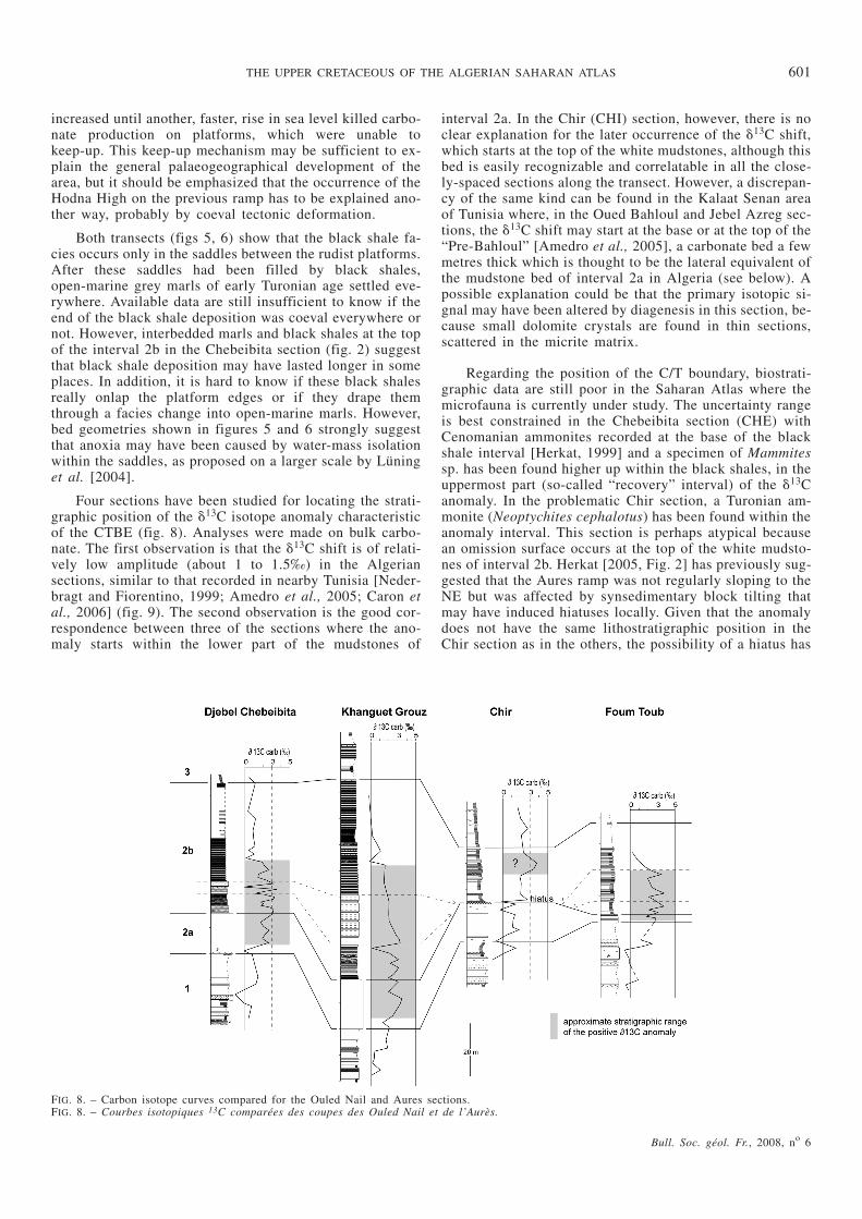
Four sections have been studied for locating the strati-graphic position of the �13C isotope anomaly characteristicof the CTBE (fig. 8). Analyses were made on bulk carbo-nate. The first observation is that the �13C shift is of relati-vely low amplitude (about 1 to 1.5‰) in the Algeriansections, similar to that recorded in nearby Tunisia [Neder-bragt and Fiorentino, 1999; Amedro et al., 2005; Caron etal., 2006] (fig. 9). The second observation is the good cor-respondence between three of the sections where the ano-maly starts within the lower part of the mudstones of
interval 2a. In the Chir (CHI) section, however, there is noclear explanation for the later occurrence of the �13C shift,which starts at the top of the white mudstones, although thisbed is easily recognizable and correlatable in all the close-ly-spaced sections along the transect. However, a discrepan-cy of the same kind can be found in the Kalaat Senan areaof Tunisia where, in the Oued Bahloul and Jebel Azreg sec-tions, the �13C shift may start at the base or at the top of the“Pre-Bahloul” [Amedro et al., 2005], a carbonate bed a fewmetres thick which is thought to be the lateral equivalent ofthe mudstone bed of interval 2a in Algeria (see below). Apossible explanation could be that the primary isotopic si-gnal may have been altered by diagenesis in this section, be-cause small dolomite crystals are found in thin sections,scattered in the micrite matrix.
Regarding the position of the C/T boundary, biostrati-graphic data are still poor in the Saharan Atlas where themicrofauna is currently under study. The uncertainty rangeis best constrained in the Chebeibita section (CHE) withCenomanian ammonites recorded at the base of the blackshale interval [Herkat, 1999] and a specimen of Mammitessp. has been found higher up within the black shales, in theuppermost part (so-called “recovery” interval) of the �13Canomaly. In the problematic Chir section, a Turonian am-monite (Neoptychites cephalotus) has been found within theanomaly interval. This section is perhaps atypical becausean omission surface occurs at the top of the white mudsto-nes of interval 2b. Herkat [2005, Fig. 2] has previously sug-gested that the Aures ramp was not regularly sloping to theNE but was affected by synsedimentary block tilting thatmay have induced hiatuses locally. Given that the anomalydoes not have the same lithostratigraphic position in theChir section as in the others, the possibility of a hiatus has
Bull. Soc. géol. Fr., 2008, no 6
THE UPPER CRETACEOUS OF THE ALGERIAN SAHARAN ATLAS 601
FIG. 8. – Carbon isotope curves compared for the Ouled Nail and Aures sections.FIG. 8. – Courbes isotopiques 13C comparées des coupes des Ouled Nail et de l’Aurès.
to be further examined when the results of foraminiferalstudies become available.
In all of the three other sections, the C/T boundary isassumed to be, as in reference sections throughout theworld, located in the upper part of the �13C shift, that isclose to the top of the more limey beds present in the blackshale facies (fig. 8).
However, particularly in the Ouled Nail saddle, blackshale deposition continued well after the C/T boundary andwell after the end of the carbon isotope shift, and thusseems not to be the cause of the �13C anomaly itself.
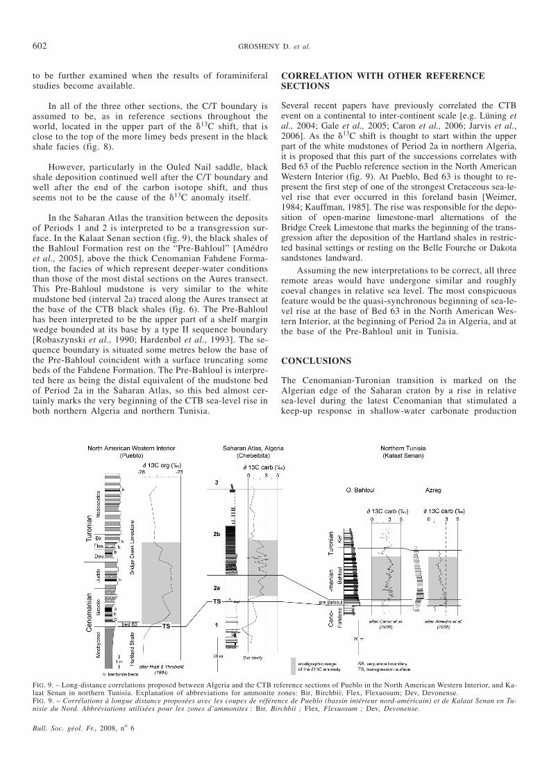
In the Saharan Atlas the transition between the depositsof Periods 1 and 2 is interpreted to be a transgression sur-face. In the Kalaat Senan section (fig. 9), the black shales ofthe Bahloul Formation rest on the “Pre-Bahloul” [Amédroet al., 2005], above the thick Cenomanian Fahdene Forma-tion, the facies of which represent deeper-water conditionsthan those of the most distal sections on the Aures transect.This Pre-Bahloul mudstone is very similar to the whitemudstone bed (interval 2a) traced along the Aures transect atthe base of the CTB black shales (fig. 6). The Pre-Bahloulhas been interpreted to be the upper part of a shelf marginwedge bounded at its base by a type II sequence boundary[Robaszynski et al., 1990; Hardenbol et al., 1993]. The se-quence boundary is situated some metres below the base ofthe Pre-Bahloul coincident with a surface truncating somebeds of the Fahdene Formation. The Pre-Bahloul is interpre-ted here as being the distal equivalent of the mudstone bedof Period 2a in the Saharan Atlas, so this bed almost cer-tainly marks the very beginning of the CTB sea-level rise inboth northern Algeria and northern Tunisia.
CORRELATION WITH OTHER REFERENCESECTIONS
Several recent papers have previously correlated the CTBevent on a continental to inter-continent scale [e.g. Lüning etal., 2004; Gale et al., 2005; Caron et al., 2006; Jarvis et al.,2006]. As the �13C shift is thought to start within the upperpart of the white mudstones of Period 2a in northern Algeria,it is proposed that this part of the successions correlates withBed 63 of the Pueblo reference section in the North AmericanWestern Interior (fig. 9). At Pueblo, Bed 63 is thought to re-present the first step of one of the strongest Cretaceous sea-le-vel rise that ever occurred in this foreland basin [Weimer,1984; Kauffman, 1985]. The rise was responsible for the depo-sition of open-marine limestone-marl alternations of theBridge Creek Limestone that marks the beginning of the trans-gression after the deposition of the Hartland shales in restric-ted basinal settings or resting on the Belle Fourche or Dakotasandstones landward.
Assuming the new interpretations to be correct, all threeremote areas would have undergone similar and roughlycoeval changes in relative sea level. The most conspicuousfeature would be the quasi-synchronous beginning of sea-le-vel rise at the base of Bed 63 in the North American Wes-tern Interior, at the beginning of Period 2a in Algeria, and atthe base of the Pre-Bahloul unit in Tunisia.
CONCLUSIONS
The Cenomanian-Turonian transition is marked on theAlgerian edge of the Saharan craton by a rise in relativesea-level during the latest Cenomanian that stimulated akeep-up response in shallow-water carbonate production
Bull. Soc. géol. Fr., 2008, no 6
602 GROSHENY D. et al.
FIG. 9. – Long-distance correlations proposed between Algeria and the CTB reference sections of Pueblo in the North American Western Interior, and Ka-laat Senan in northern Tunisia. Explanation of abbreviations for ammonite zones: Bir, Birchbii; Flex, Flexuosum; Dev, Devonense.FIG. 9. – Corrélations à longue distance proposées avec les coupes de référence de Pueblo (bassin intérieur nord-américain) et de Kalaat Senan en Tu-nisie du Nord. Abbréviations utilisées pour les zones d’ammonites : Bir, Birchbii ; Flex, Flexuosum ; Dev, Devonense.
and was superimposed on a period of gentle tectonic defor-mation. This association of mechanisms changed a ramp-type palaeogeography in the Saharan Atlas into a systemmade of isolated rudist platforms separated by saddles orcorridors that probably extended to the central Sahara. TheCenomanian-Turonian boundary (CTB) black shales filledup the lows before an open-marine ramp became re-esta-blished during the early Turonian.
The latest Cenomanian sea-level rise seems to havebeen about synchronous in distant basins, including those ofthe North American Western Interior and North Africa. Itstarted before the beginning of the positive �13C isotopeanomaly. Deposition of the CTB black shales ceased wellafter the end of the carbon isotope excursion and seems not
to have been synchronous over the whole Saharan Atlas.From available biostratigraphic data, the C/T boundary lieswithin the upper part of the �13C anomaly, as in many sec-tions worldwide.
Acknowledgements. – This is a contribution to the “Tassili” CooperationProgramme 05 MDU 652 between France and Algeria. These results werefirst presented during a thematic meeting of the French Cretaceous Wor-king Group (GFC) on the relationships between the northern and southernmargins of the Tethys Ocean, held in Paris, November 27-28th, 2006, andat the Third Algerian Meeting on Stratigraphy held in Laghouat, Algeria,February, 19-22th, 2007. We warmly thank Ian Jarvis for having spent somuch time carefully correcting and improving the manuscript, and AndyGale for his comments.
References
AMEDRO A., ACCARIE H. & ROBASZYNSKI F. (2005). – Position de la limiteCénomanien-Turonien dans la formation Bahloul de Tunisiecentrale: apports intégrés des ammonites et des isotopes du car-bone (�13C). – Eclogae Geol. Helv., 98, 2, 151-167.
BUSSON G., DHONDT A., AMEDRO F., NERAUDEAU D. & CORNEE A. (1999). –La grande transgression du Cénomanien supérieur-Turonien in-férieur sur la Hamada de Tinrhert (Sahara algérien): datationsbiostratigraphiques, environnement de dépôt et comparaisond’un témoin épicratonique avec les séries contemporaines à ma-tière organique du Maghreb. – Cret. Res., 20, 1, 29-46.
CARON M., DALL’AGNOLO S., ACCARIE H., BARRERA H., KAUFFMAN E.G.,AMEDRO F. & ROBASZYNSKI F. (2006). – High-resolution strati-graphy of the Cenomanian-Turonian boundary interval at Pueblo(USA) and wadi Bahloul (Tunisia): stable isotope andbio-events correlation. – Geobios, 39, 171-200.
GALE A.S., KENNEDY W.J., VOIGT S. & WALASZCZYK I. (2005). – Stratigra-phy of the Upper Cenomaniane-Lower Turonian Chalk succes-sion at Eastbourne, Sussex, UK: ammonites, inoceramidbivalves and stable carbon isotopes. – Cret. Res., 26, 3, 1-28.
HARDENBOL J., CARON M., AMEDRO F., DUPUIS C. & ROBASZYNSKI F.(1993). – The Cenomanian-Turonian boundary in central Tuni-sia in the context of a sequence-stratigraphic interpretation. –Cret. Res., 14, 449-454.
HERKAT M. (1999). – La sédimentation de haut niveau marin du Crétacé su-périeur de l’Atlas saharien oriental et des Aurès. Stratigraphieséquentielle. Analyse quantitative des biocénoses, évolution pa-léogéographique et contexte géodynamique. – Thèse Doct. Sci.Univ. USTHB, Alger, 802 p.
HERKAT M. (2002). – Analyse séquentielle et révision stratigraphique decoupes du Crétacé supérieur de l’Aurès occidental. – Mém. Serv.Géol. Algérie, 11, 133-154.
HERKAT M. (2004). – Contrôle eustatique et paléogéographique de la sédi-mentation du Crétacé supérieur du bassin des Aurès (Algérie). –Bull. Soc. géol. Fr., 175, 3, 273-288.
HERKAT M. (2005). – Quantitative analysis of the bioassociations and cha-racterization of the system tracts and paleogeographic zones inthe Cenomanian and Turonian series of the Aurès Mountains andeastern Tell (Algeria). – Bull. Soc. géol. Fr., 176, 2, 183-197.
JARVIS I., GALE A.S., JENKYN H.C. & PEARCE M.A. (2006). – Secular varia-tion in Late Cretaceous carbon isotopes and sea-level change: evi-dence from a new 13C carbonate reference curve for theCenomanian-Campanian (99.6-70.6 Ma). – Geol. Mag., 143,561-608.
KAUFFMAN E.G. (1985). – Cretaceous evolution of the Western Interior ba-sin of the United States. In: PRATT L.M., KAUFFMAN E.G. & ZELT
F.B., Eds, Fine-grained deposits and biofacies of the CretaceousWestern Interior seaway: Evidence of cyclic sedimentary pro-cesses. – Soc. Econ. Paleontologists Mineralogists Field-TripGuide-Book 4, IV-XIII.
LÜNING S., KOLONIC S., BELHADJ E.M., BELHADJ Z., COTA L., BARIC G. &WAGNER T. (2004). – Integrated depositional model for the Ce-nomanian-Turonian organic-rich strata in North Africa. –Earth-Sci. Reviews, 64, 1, 51-117.
NEDERBRAGT A.J. & FIORENTINO A. (1999). – Stratigraphy and palaeocea-nography of the Cenomanian-Turonian boundary event in OuedMellegue, northwestern Tunisia. – Cret. Res., 20, 1, 47-62.
PRATT L.M. & THRELKELD C.N. (1984). – Stratigraphic significance of13C/12C ratios in Mid-Cretaceous rocks of the Western InteriorU.S.A. In: STOTT D.F. & GLASS D.J., Eds, The Mesozoic ofMiddle North America. – Canadian Soc. Pet. Geol., Mem. 9,305–312.
ROBASZYNSKI F., CARON M., DUPUIS C., AMEDRO F., GONZALEZ-DONONSO
J.-M., LINARES D., HARDENBOL J., GARTNER S., CALANDRA F. &DELOFFRE R. (1990). – A tentative integrated stratigraphy in theTuronian of Central Tunisia: formations, zones and sequentialstratigraphy in the Kalaat Senan area. – Bull. Centr. Rech.Explor.-Prod. Elf-Aquitaine, 14, 1, 218-384.
ROBASZYNSKI F., HARDENBOL J., CARON M., AMEDRO F., DUPUIS C., GONZA-
LEZ-DONONSO J.M., LINARE D. & GARTNER S. (1993a). – Se-quence stratigraphy in a distal environment: the Cenomanian ofthe Kalaat Senan region (Central Tunisia). – Bull. Centr. Rech.Explor.-Prod. Elf-Aquitaine, 17, 2, 395-433.
ROBASZYNSKI F., AMEDRO F. & CARON M. (1993b). – La limite Cénoma-nien-Turonien et la formation Bahloul dans quelques localitésde Tunisie centrale. – Cret. Res., 14, 477-486.
WEIMER R.J. (1984). – Relation of unconformities, tectonics, and sea levelchanges, Cretaceous of the Western Interior, U.S.A.. – AmerAssoc. Petrol. Geol. Mem., 36, 7-35.
Bull. Soc. géol. Fr., 2008, no 6
THE UPPER CRETACEOUS OF THE ALGERIAN SAHARAN ATLAS 603


