Embed Size (px)
Citation preview

Town of Lamoine 2019 Comprehensive Plan
Lamoine Town Meeting – March 20, 2019


LAMOINE COMPREHENSIVE PLAN COMMITTEE
Andrea Ames Bonnie Marckoon (former member) Robert Christie Richard McMullen Kathryn Gaianguest, Vice Chair Valerie Sprague Brett Jones (former member) Fred Stocking, Chair Michael Jordan Wanda Whitener, Alternate
ACKNOWLEDGEMENTS
The Lamoine Comprehensive Plan Committee would like to express its appreciation to the following people who have contributed significantly to this Comprehensive Plan, recognizing that many people did so and that any such list is bound to contain significant omissions:
To Wanda Whitener for the photographs on pages 31 and 105, Rick Taintor for those on the first page of Appendix A, the Lamoine Historical Society for the view from Cousins Hill on page 10, and Georgianna Pulver for all other photographs. (Satellite photo on Appendix cover from Google Maps.)
To Stu Marckoon, Administrative Assistant, who contributed support services, statistical compilation help, and shared his deep understanding of how the Town works with us in too many ways to list.
To Rick Taintor, consultant, without whose invaluable and generous help we would have been hard-pressed to finish the Plan.
To John Holt, Chair of the Planning Board, and Larissa Thomas, Chair of the Conservation Commission, for their support and help in educating the committee.
To Dick Fennelly and the members of the Frenchmen Bay Regional Shellfish Conservation Committee for educating us on the working of this regional collaboration and on the resources it is working to nurture and protect.
To all those who gave their time to be interviewed on agriculture, conservation, forestry and shellfish resources in Lamoine.

To all those who participated in our interviews with boards, committees and community groups in Maine to educate us about what they do and what they see as important about Lamoine.
To all those who helped put together the two community meetings the committee held in March, 2015 (1) and November, 2017 (2) to gather feedback, including: For (1): the late David Sanderson, Diane Sanderson, Honeybee Heyman, David and Shannon Byers, Bonnie Marckoon, Gordon and Cynthia Donaldson, Dawn McPhail, Chris James and the eighth graders, Betty Eaton and the late Lenny Bright; For (2): Anne Stocking, Jeff Cosulich, Steve Gabel-Richards, Gordon Donaldson, Kathleen Rybarz, Larry Libby, David Schick and Anne LaBossiere.
To Phylllis Mobraaten, who compiled various kinds of comments on surveys and those left on flip charts and stickies at the community meetings into working documents.
To Anne Stocking for innumerable hours of scanning, copying, proofreading and editing the routine work of the committee.
To Elaine Eaton, a student at the University of Maine Machias in geographic information systems (GIS), for providing informative maps showing road vulnerabilities in Lamoine.
To the Lamoine Historical Society for the history of Lamoine.
To Gordon Donaldson, for providing school enrollment statistics and drafting the history of the administrative transitions at the Lamoine Consolidated School.

• i •
CONTENTS
1. INTRODUCTION ..............................................................................................................1
The Decision to Develop a New Comprehensive Plan ..................................................... 1 How the Comprehensive Plan was Developed .................................................................. 2 Public Participation in the Development of the Lamoine Comprehensive Plan ........... 2 The Purpose and Function of the Comprehensive Plan ................................................... 5
2. OUR VISION ......................................................................................................................7
3. COMMUNITY ASSESSMENT .......................................................................................9
History and Archaeology ...............................................................................................10
A Short History of Lamoine ................................................................................................ 10 Historic and Archaeological Resources in Lamoine ........................................................ 13 Archaeological Sites ............................................................................................................. 14 Historic Buildings and Structures ...................................................................................... 14 Protection of Historic and Archaeological Resources ..................................................... 15
Population and Demographics .....................................................................................17
Historic Population Growth ................................................................................................ 17 Current and Projected Population ..................................................................................... 18 Age Distribution ................................................................................................................... 20 Age Changes .......................................................................................................................... 22 Household Characteristics .................................................................................................. 24 Reasons for Living in Lamoine ........................................................................................... 25
Natural Resources ...........................................................................................................26
Introduction ........................................................................................................................... 26 Animal Habitat ...................................................................................................................... 27 Wetlands and Vernal Pools ................................................................................................. 28 Plants ...................................................................................................................................... 28 Scenic Areas and Scenic Views ........................................................................................... 29
Fresh Water Resources ...................................................................................................31
Introduction ........................................................................................................................... 31 Streams ................................................................................................................................... 32 Freshwater Bodies ................................................................................................................. 32 Household Water .................................................................................................................. 33
Marine Resources ............................................................................................................35
Introduction ........................................................................................................................... 35 Lamoine’s Shoreline ............................................................................................................. 36 Public Access ......................................................................................................................... 37 Harvesting from the Sea and Intertidal Areas .................................................................. 37

• ii •
Eelgrass Conservation .......................................................................................................... 42 Rockweed and Sea Vegetable Harvesting ......................................................................... 42 The Future of Water-Dependent Uses in Lamoine .......................................................... 43
Agricultural and Forest Resources ...............................................................................44
Introduction ........................................................................................................................... 44 Agricultural Resources ........................................................................................................ 45 Forestry ................................................................................................................................... 46
Recreation and Culture ..................................................................................................48
Recreational Facilities ........................................................................................................... 48 Cultural Opportunities ........................................................................................................ 49 Recreational Programs ......................................................................................................... 49 Trails ....................................................................................................................................... 49 Parks ....................................................................................................................................... 49 Community Needs ............................................................................................................... 50
Business and the Economy ............................................................................................51
Introduction ........................................................................................................................... 51 Employment in Lamoine Businesses ................................................................................. 52 Employment of Lamoine Residents ................................................................................... 52 Place of Work of Lamoine Residents ................................................................................. 54 Employment and Unemployment Trends ........................................................................ 55 Priorities and Issues .............................................................................................................. 55
Housing .............................................................................................................................57
Introduction ........................................................................................................................... 57 Housing Growth and Characteristics: 1990 to Present ................................................ 58 Housing Affordability .......................................................................................................... 59 Affordable Housing for Young Families with Children ................................................. 61 Rental Housing ...................................................................................................................... 62 Housing for Older Adults ................................................................................................. 64
Transportation .................................................................................................................66
Introduction ........................................................................................................................... 66 Roads ...................................................................................................................................... 67 Traffic Volumes and Flows ................................................................................................. 68 Vehicle Crashes ..................................................................................................................... 70 Road Maintenance Needs .................................................................................................... 71 Parking ................................................................................................................................... 72 Pedestrian and Bicycle Facilities ......................................................................................... 72
Public Facilities and Services ........................................................................................73
Introduction ........................................................................................................................... 73 Lamoine Public Facilities and Services .............................................................................. 74 Future Needs ......................................................................................................................... 75 Public Facilities: Education ................................................................................................. 79

• iii •
Fiscal Capacity and Capital Investment Plan ............................................................81
Overview of Town Finances ............................................................................................... 81 Tax Base and Taxes ............................................................................................................... 81 Revenue and Expenses ......................................................................................................... 81 Capital Improvements and Town Debt ............................................................................. 83 Fiscal Capacity for Comprehensive Plan Recommendations ........................................ 83
Existing Land Use ............................................................................................................85
Introduction ........................................................................................................................... 85 Existing Zoning ..................................................................................................................... 86 Existing Land Uses ............................................................................................................... 90 Development Potential ........................................................................................................ 91
4. FUTURE LAND USE PLAN ...........................................................................................93
Introduction ........................................................................................................................... 93 Growth Areas ........................................................................................................................ 94 Shared Growth Areas ........................................................................................................... 96 Transitional Areas ................................................................................................................. 96 Rural Areas ............................................................................................................................ 97 Critical Natural Resources ................................................................................................... 98 Critical Rural Areas and Critical Waterfront Areas ....................................................... 101 Future Land Use Map ........................................................................................................ 101 Plan Implementation and Monitoring Strategies ........................................................... 101
5. REGIONAL COORDINATION PROGRAM ..........................................................105
Abutting Communities ...................................................................................................... 105 Shared Resources and Facilities ........................................................................................ 106 Local and Regional Approaches to Coordinated Management of Shared
Resources and Facilities ............................................................................................. 106
6. GOALS AND POLICIES ..............................................................................................109
Historical and Archaeological Resources ........................................................................ 109 Population and Demographics ......................................................................................... 109 Natural Resources ............................................................................................................... 110 Fresh Water Resources ....................................................................................................... 110 Marine Resources ................................................................................................................ 111 Agricultural and Forest Resources ................................................................................... 112 Recreation ............................................................................................................................ 113 Business and the Economy ................................................................................................ 113 Housing ................................................................................................................................ 113 Transportation ..................................................................................................................... 114 Public Facilities and Services ............................................................................................ 114 Future Land Use ................................................................................................................. 115

• iv •
7. IMPLEMENTATION PROGRAM .............................................................................117
Historic and Archaeological Resources ........................................................................... 117 Population and Demographics ......................................................................................... 118 Natural Resources ............................................................................................................... 118 Fresh Water Resources ....................................................................................................... 121 Marine Resources ................................................................................................................ 123 Agricultural and Forest Resources ................................................................................... 126 Recreation ............................................................................................................................ 127 Business and the Economy ................................................................................................ 129 Housing ................................................................................................................................ 130 Transportation ..................................................................................................................... 131 Public Facilities and Services ............................................................................................ 132 Land Use .............................................................................................................................. 134
APPENDICES (Separate Document)
Appendix A: Public Participation
Appendix B: Natural Resources
Appendix C: Land Use
Appendix D: Roads and Transportation
Appendix E: Public Facilities and Services
Appendix F: Fiscal Capacity

• v •
LIST OF TABLES
Table 1: Age Distribution, 2010 ...........................................................................................21
Table 2: Lamoine Household Composition, 2015 .............................................................24
Table 3: Household and Family Size, 1990–2010 ..............................................................25
Table 4: Softshell Clam Landings, 2009–2016 ...................................................................39
Table 5: Lamoine Fishing Licenses, 2009–2016 .................................................................40
Table 6: Lamoine Lobster Landings ...................................................................................41
Table 7: Lamoine Lobster Harvesters Landings ...............................................................41
Table 8: Summary of Timber Harvest, Lamoine, 2000–2014 ..........................................47
Table 9: Employment by Industry, Lamoine Residents, 2000-2014 ...............................53
Table 10: Employment by Industry, Hancock County Residents, 2000–2014 ..............53
Table 11: Commuting Destination Lamoine Residents (where Residents work) ........54
Table 12: Annual Average Employment Trends, 2012-2016, Lamoine & Hancock County ..................................................................................................55
Table 13: Housing Affordability Estimates, 2015 and 2017 ............................................61
Table 14: Lamoine Valuation, 2012-2016 ...........................................................................81
Table 15: Revenues and Expenses, 2012–2016 ..................................................................82
Table 16: Mill Rate, Lamoine and Surrounding Towns in 2017 .....................................83
Table 17: Lamoine Valuation, 2012-2016 ...........................................................................83
Table 18: Estimated Growth in Population, Households and Dwelling Units ............95

• vi •
LIST OF FIGURES
Figure 1: Population Growth 1800–2010, Lamoine and Surrounding Towns ..............18
Figure 2: Lamoine Population Growth 1970–2014, and Projections to 2034 ................19
Figure 3: Population Growth 1970-2016 and Projections to 2034, Lamoine and Surrounding Towns ............................................................................................20
Figure 4: Age Distribution, 2010 .........................................................................................21
Figure 5: Age Distribution Changes, 1960–2016 ...............................................................23
Figure 6: Median Age, Lamoine, Hancock County, and State of Maine .......................24
Figure 7: Primary Reasons for Moving to or Staying in Lamoine .................................25
Figure 8: Softshell Clam Landings, 2009–2016 ..................................................................39
Figure 9: Shift in Housing Tenure by Age of Householder, Maine, 2000-2010 ...........63
Figure 10: Change in Housing Tenure, Maine, 2010-2016 ..............................................63
Figure 11: Lamoine Population – Age Trend, 1990–2016 ..........................................64
Figure 12: Annual Variation in Traffic Volumes, Statewide ...........................................69
Figure 13: Revenues and Expenditures, 2012–2016 .........................................................82
LIST OF MAPS
Map 1: Future Land Use Map ...........................................................................................103

1
1. Introduction
The Decision to Develop a New Comprehensive Plan The last Lamoine Comprehensive Plan was approved by the Town and the State in 1996. Comprehensive Plans do not expire – they are the Plan of the Town until repealed or replaced. What does expire, however, is the State of Maine’s finding that a town’s Comprehensive Plan is consistent with the Maine Growth Management Act (Title 30-A, Maine Revised Statutes, §§4311-4349-A). The amendments of that Act in 2008 provide that the finding of consistency expires twelve years after a Comprehensive Plan takes effect.
Generally speaking, a Town will not qualify for State grant funding unless the Town’s Comprehensive Plan is found consistent with the Growth Management Act. In addition, Lamoine ordinances may be more vulnerable in any Court review because they are not consistent with a Plan which has been found to be consistent with the Growth Management Act. Finally, 1996 was over 20 years ago, and it is important for the town to revisit a Comprehensive Plan to make sure that it meets the town’s needs today. Just as one example: The 1996 Plan had a “Communica-tions” section which did not list internet access. The first smart phone came on the market in 2008, and internet access in town was one of the most-discussed topics in the development of this plan.
In 2013, the Town Select Board appointed a committee to consider whether a new Comprehensive Plan was needed and, if so, to present a timeline and a budget for the project. This Committee presented its report in October of 2013, recommending that the Town move forward on a new Comprehensive Plan (Appendix A1). At

1. Introduction | 2
Town Meeting in 2014, the Town approved the appointment of a Comprehensive Plan Committee and a budget for the project of $15,000.
How the Comprehensive Plan was Developed The Select Board thereafter appointed a Lamoine Comprehensive Plan Committee (LCPC), which met for the first time in September of 2014. The original members were Andrea Ames, Robert Christie, Kathryn Gaianguest, Brett Jones, Bonnie Marckoon, Richard McMullen, Valerie Sprague and Fred Stocking. Michael Jordan and Wanda Whitener came on later as Bonnie Marckoon and Brett Jones left the LCPC.
The LCPC met at first monthly and spent its first several meetings understanding the law and process of a Comprehensive Plan, reviewing the 1996 Plan, the survey done by the Long Range Planning Committee in 2005 and The Lamoine Open Space Report and Inventory produced by the Lamoine Conservation Commission in 2013, and data provided by the State and other entities. Our work was generally organized around the required State categories: Historical and Archaeological Resources, Fresh Water Resources, Natural Resources, Agriculture and Forestry, Marine Resources, Population and Demographics, Economy, Housing, Recreation, Public Facilities, Fiscal Capacity and Capital Investment, Existing Land Use and Future Land Use Plan.
The State provides a Data Set with information, or links to information, on these categories every two years. Data relied on in a Comprehensive Plan should be, if possible, no more than three years old.
Public Participation in the Development of the Lamoine Comprehensive Plan All meetings of the LCPC were properly noticed and open to the public. Most were broadcast over community TV, either contemporaneously or later or both. Minutes were kept of all meetings, posted and available for public review.
In the Fall of 2015, the LCPC designed and circulated a survey to identify the concerns of Lamoine citizens. This survey incorporated a number of questions asked in surveys of the Town’s residents in 1992 and 2005, for comparison purposes.
Considerable care was taken to try to eliminate barriers to responding to the survey. It was primarily an online survey, but written copies were available at the town hall and, by request, by delivery to a person’s home. Written surveys were then entered into the online survey data for compilation. Each postal patron received a printed

1. Introduction | 3
notice about the survey and how to respond it. 206 of 760 were returned, a return of 27.1%. (See Appendices A2 and A3 for responses to the survey.)
Findings of the survey were then presented at a Community Meeting in March of 2016. (See Appendix A3 for the PowerPoint presentation at this meeting.) After the presentation, those attending divided into small groups for discussion of what was important to them. Responses from all the groups were written down and compiled (Appendix A4).
Also during the Fall of 2015 and early 2016, the LCPC met with 15 Town Boards and Committees, and several other community groups focused on a particular activity in Lamoine. LCPC then drafted an approved report of each meeting (See Appendices A5–A19 for the individual reports.) It was during these meetings and the Community Meeting in March 2016 when it became apparent that there was a strong community desire for a community center in Town.
The LCPC took this community input and began to work on drafting and researching individual sections on the required categories. In addition to the State Data provided, detailed resource maps from Beginning with Habitat, a state partnership with statewide nonprofits, were very helpful. Town Administrator Stu Marckoon was an invaluable resource for town-specific information.
Initial drafts of the various sections were by LCPC members, with the exception of two sections initially written by the Hancock County Planning Commission (HCPC), funded by federal grants received by HCPC. By the fall of 2016, the LCPC was far enough along to advertise for a consultant to help us finish the project. Rick Taintor, just retired as the City Planner for Portsmouth New Hampshire, started work in May 2017.
Over the next few months, the LCPC worked hard at articulating Goals, Policies and Strategies to form the Implementation Plan of the Comprehensive Plan. Goals being defined as broad objectives for the community; Policies as general paths to reach the goals, and Strategies as relatively specific action to be taken. Each Policy and Strategy has an entity designated as responsible for executing the strategy.
In November 2017, the Implementation Plan was circulated and reviewed with those attending an Open House for that purpose. The format for the Open House had the Implementation Plan on large sheets taped to the walls, along with explana-tory maps and a proposed Vision Statement. Those attending (approximately 35) were encouraged to give a traffic signal grade to each proposal: green, yellow or red. Comments were encouraged and large stickies were provided for that purpose.

1. Introduction | 4
Once again, all information was copied and incorporated into a summary (Appendix A20).
In response to the relatively small number of people who came to the Open House, the LCPC put the same information into survey form and kept the survey open until the end of the year. Respondents were encouraged to provide written comments, which were compiled (Appendices A21–A23).
The LCPC then met several times to go over this feedback and revised the Imple-mentation Plan in various ways, completing this process in March 2018. In May 2018, the consultant provided the LCPC with a draft of the whole Comprehensive Plan, which includes a Vision Statement and sections discussing each of the state-required topics, as well as the Implementation Plan and supporting materials. This draft was then reviewed and revised in a series of meetings over the summer of 2018. Updating data where appropriate and drafting of certain administrative segments of the Plan continued until September 2018 when the Plan was completed and scheduled for public hearing.
This Comprehensive Plan has several principal parts. First there is the Vision Statement, which incorporates the consensus vision of those providing input into the Comprehensive Plan. The Vision Statement is a very broad picture of the Town and its functioning. Following the Vision Statement, there are analysis sections covering the state required topics. The analysis sections set out the LCPC’s understanding of a particular area, such as the housing situation in Lamoine. In the analysis sections the data from all available sources is discussed and the basic issues confronting the town are defined. These sections provide the basis for the Implementation Plan provisions on that topic.
Following the analysis sections is the Implementation Plan, in which the goals and specific strategies for achieving those goals are set out, and what entity might take the lead in implementing them. The Implementation Plan is laid out in a consistent table format.
Finally, the Appendix sections contains many more maps, tables and exhibits than can easily be placed in the text. The Appendix is a separate document, the contents of which are set out in the Table of Contents, and citations to items in the Appendix appear throughout the Comprehensive Plan.

1. Introduction | 5
The Purpose and Function of the Comprehensive Plan The Comprehensive Plan is not an ordinance or law. It is a guide for the Select Board, the Planning Board, and other town committees in their decision-making. It is intended to provide continuity in town policy. Ordinances passed by the town should be consistent with this Plan. The Comprehensive Plan may also be used to seek funding from state and federal grant programs.
Planning is an on-going process. The Lamoine Comprehensive Plan Committee recommends that the Plan be reviewed each year by the Select Board and the Planning Board to assess implementation of the Plan.
There are challenges ahead for Lamoine, as there always are. Some seem quite predictable: Lamoine’s population, like Maine’s population generally, is growing older and older adults will have different needs to be met by the town and its public-spirited citizens. Some of these issues are explored in the Housing analysis (see pp. 57), the Recreation analysis (see pp. 48) and the Public Facilities analysis (see pp. 73). The effects of climate change on Lamoine’s extensive shoreline will emerge on an unknown timetable. Economic and technological change may make small coastal towns more attractive places to live, as work becomes disconnected from particular physical locations. Other economic or technological changes may have a negative effect on the town. Pressures from the tourist traffic in the region and nearby employers such as the Jackson Lab may affect Lamoine in ways we cannot foresee.
There is every likelihood that Lamoine will meet these challenges successfully. Lamoine is an exceptionally active town. More than sixty individuals are currently listed on the town website as members of a town board or committee. Lamoine citizens often cite the “small town atmosphere” when asked what attracted them to, or keeps them in, Lamoine. This “small town atmosphere” is the collection of contacts with other people who understand the town and care about it..
The members of the Lamoine Comprehensive Plan Committee are proud to have been able to set out some of the issues ahead for the Town and suggest ways that the Town might move forward to meet them.


7
2. Our Vision
Lamoine will continue to be prized by its citizens for its rural landscape, natural beauty and its small-town character. Its citizens will continue to participate in a wide range of community activities, from Town boards and committees to the Volunteer Fire Department, including the many groups enhancing the community by sharing particular interests, from Town history to snowmobile riding to arts events. The Town will sponsor special events such as the Lamoine 150 anniversary events to bring the townspeople together so that a sense of Lamoine flourishes. The Town will develop a Community Center to provide increased space and opportunity for community activities.
Lamoine will continue to develop its own character, defined by its citizens, its history, geography and natural resources, while recognizing that Ellsworth, Mount Desert Island and the Bangor area provide many services that do not need to be duplicated in Lamoine. Lamoine will continue to work with nearby municipalities to share resources and hold down costs. Lamoine will work with the State of Maine to assure that through traffic does not change the character of the Town.
Lamoine will maintain its own school to provide a locale for community activities and to avoid transporting our young children elsewhere for their education.

2. Our Vision | 8
Lamoine will maintain high school choice for secondary students. The Lamoine Consolidated School will continue to excel in preparing students for their lives ahead. Together with in-town programs for pre-school children, the school will become a magnet attracting families with young children to Lamoine.
Lamoine will continue to facilitate the flourishing of small and home-based busi-nesses as its economic base, recognizing that industrial development is not com-patible with its rural character. The current limitations on the growth of gravel pits will be continued. Worked-out pits will be restored for other uses or open space. Increasingly business is done from homes, home offices and small facilities and this activity will continue as the Town finds ways to spread quality internet service to all parts of Lamoine. The Town will support small business development by making sure that its ordinances accommodate small-scale, low-impact businesses in residen-tial settings. The Town will develop and maintain an online listing of products and services available in Lamoine and will encourage buying local. The Town will be friendly to local agriculture and supportive of efforts to return parts of Lamoine to its farming heritage.
Lamoine will continue to be recognized as a place defined by its rural character and natural beauty such as open fields and woodlots, ocean shorefront, scenic vistas, scenic road corridors, and an abundance of wildlife and flora. People in all parts of Lamoine, in established neighborhoods and newer subdivisions, will have conven-ient access to open space, including the ocean. The parks will be maintained as a significant component of Lamoine’s open space. The Town will encourage conserva-tion efforts, including those by regional conservation partners, that promote wildlife habitat, and wildlife corridors through the town.
The Town will plan for the effects of climate change as they become clear over time, including extreme storms, sea level rise and the disruption of road and communica-tions systems to vulnerable locations of residences and businesses.
Additional homes and roads will be built as the community grows. New residential development will be sited along the shore and existing roads and incorporate meaningful pieces of open space. Connections between open space areas will be a priority in siting new development. These connections will be for both wildlife in the form of travel corridors and interconnected habitat, and for pedestrians in the form of off-road trails. Some larger natural areas will be preserved to protect habitats of area-sensitive species and provide opportunities for traditional outdoor pursuits, such as hunting, snowmobiling, and hiking.
Lamoine recognizes that its population is aging and will plan for facilities and services for older adults.

9
3. Community Assessment
This section of the Comprehensive Plan presents current data and trends on the following topical areas:
• History and Archaeology • Population and Demographics • Natural Resources • Fresh Water Resources • Marine Resources • Agriculture and Forest Resources • Recreation and Culture • Business and the Economy • Housing • Transportation • Public Facilities and Services • Fiscal Capacity and Capital Planning • Existing Land Use
The Community Assessment provides the factual basis for understanding where the town is now and where it is going. The same topical categories reappear later in the Plan under the Future Land Use Plan (Chapter 5), Goals and Policies (Chapter 6), and the Implementation Program (Chapter 7).

3. Community Assessment: History and Archaeology | 10
History and Archaeology
Historic sites and archaeological resources provide evidence of Lamoine’s past. They are essential links to the Town’s history and prehistory, and are important for understanding how Lamoine has developed over time.
A Short History of Lamoine Lamoine’s first inhabitants were the Wabanaki who lived in the area year-round. There is still evidence of Indian shell heaps along the shore, although there has been substantial erosion. Lamoine’s first permanent European settlers arrived in the 1760s. After their arrival, the Native Americans began migrating inland during the winter months.
Lamoine was originally called East Trenton and was included within a much larger township which covered an area from Card’s Brook in Ellsworth to Hancock (then a part of Sullivan). In 1870, Lamoine separated from Trenton and was incorporated as a town. It was named after an early resident, Andre LeMoyne. The Marlboro section of the town remained a part of Hancock until 1933.
The attraction for both the Native Americans and the early settlers was the coastline and natural resources. Lamoine’s many coves and inlets made for ideal harbors. Fish and clams were plentiful. Tide mills provided energy. During the first half of the

3. Community Assessment: History and Archaeology | 11
1800s, Lamoine was a major shipbuilding area. There were over sixty vessels built here, the peak years of production being reached before the Civil War, in the 1840s.
Higgins Point, where the State Park is now, was one of the earliest sites for ship-building. Most of the larger shipyards and fishing wharves were located along the Jordan River but ships were built all around the shores of Lamoine: Raccoon Cove, Berry’s Cove and even at the site of the present cemetery at Lamoine Corner. The vessels built were primarily two-masted schooners, used for fishing and hauling freight along the coast, and to and from the Caribbean. Other businesses developed to support the shipping industry as well: logging, blacksmithing, carpentry, a lumber mill, and general stores. Residents supported themselves by a combination of fishing and farming.
Fishing was the major industry in Lamoine until the end of the 1800s. Schooners sailed to the Grand Banks during the summer months, usually with a crew of three to six men, and stayed until their holds were filled with salted fish. The cod and herring were brought back to be dried along the Jordan River, then shipped to the Boston market. Lamoine’s fisheries were second only in importance to those of Lubec during these years. During Civil War many men netted pogies (porgies) from camps on islands in Frenchmen’s Bay. The price of the oil processed from these fish increased greatly due to the war and for a number of years the oil and guano was a good source of income. It was also safer than coasting at that time.
The Civil War disrupted the economy of the area. Shipbuilding continued until the early 1900s but never again reached the peak production of the 1840s. After the War, there was an economic boom during which time the fishing industry flourished, but, as the railroads took over most of the haulage of freight, the coastal shipping trade declined.
There never was any one town center in Lamoine, but rather a collection of village areas. These corresponded to the original shipbuilding and fishing centers. At Lamoine Corner, where the Grange Hall and Baptist Church are now, there was the largest cluster of buildings, including a two-storied Grange Hall with a store on its ground floor, a post office, the church, and the Town Hall. Other village areas can be identified by their post offices: East Lamoine, North Lamoine, Marlboro, and Lamoine Beach. These areas lost their post offices when Rural Free Delivery came to Lamoine in 1904. Lamoine had six schools, and even its own high school for a few years in the late 1800s. The school population declined in the 1930s and then rose again, and in 1949 the current Lamoine Consolidated School opened.
Most travel in early Lamoine was by boat, and roads were incidental, originally secondary tracks between houses and villages. Most were approximately where they

3. Community Assessment: History and Archaeology | 12
are now. The biggest exception was the north end of Route 184 which went via what is now the MacQuinn Road to Ellsworth by way of Washington Junction. The main road to Ellsworth was the current Buttermilk Road.
The population reached a peak in 1880 with over 800 people, but it began to decline thereafter, reaching a low point in the 1920s and 1930s. As shipping and fishing disappeared, the Lamoine economy suffered. Many residents in the late 1880s migrated to Massachusetts for employment in the textile mills or as carpenters or went West. There were some attempts to promote Lamoine as a summer resort, hoping to raise property values and provide seasonal employment to the residents, but the developers met with no success. Plans to bring the railroad to Lamoine were also unsuccessful.
Hopes for the town’s economy were raised when the U.S. Navy chose Lamoine as a coaling station for its ships, located at the site of the current State Park. The station was completed in 1902 but was only in operation for a short while. Oil was already replacing coal as the major fuel used by the Navy. During World War I, the station was used for the storage of nitrates, used in making explosives. After that, much of the Station was dismantled for scrap. In the 1930s the University of Maine acquired some of the buildings for a biological laboratory. It became a State Park in the 1950s.
Around the turn of the century, ice was an important product, being harvested at Blunt’s Pond and shipped to Boston. There was also a large sardine cannery located at Lamoine Beach at this time and another smaller one at the mouth of the Skillings River at Marlboro. Neither seem to have been in operation very long. There were also two hotels in Lamoine around this time. One was Shore Acres, at Lamoine Beach; the other was the Gault Hotel, located where the State Park is now. Between the wars, many Lamoine families supported themselves with some farming and with seasonal work in neighboring resort towns, particularly Bar Harbor.
World War II brought a major change to the landscape of Lamoine as gravel pits were dug to provide gravel to build the airport in Trenton. It was not the first time that gravel had been dug and sold in Lamoine: in the 1800s there was a gravel operation near Berry’s Cove and another along the Jordan River that shipped gravel by boat. Today gravel operations have replaced fishing as Lamoine’s major natural resource industry.
After WW II when men returning from serving their country and men that had been working in Maine’s shipyards were no longer needed, Lamoine needed jobs. Many families, both husbands and wives, found themselves in the business of clamming. Men dug and women and men shucked the clams, often in their own home, then sold them to Lamoine clam dealers. Some women shucked clams at the dealers in a

3. Community Assessment: History and Archaeology | 13
building built for that purpose. The business continued into the 1950s and later. Clamming provided for many Lamoine families during that time until other work became available, and digging clams still goes on. Meanwhile some men were lobstering and still do. A few built weirs to catch herring during the 1940s as some had done in the 1800s.
The coast remained Lamoine’s greatest asset but now it was because of its scenic beauty. The population of summer residents grew, particularly after World War II. Many former residents who had had to move elsewhere to find employment continued to maintain summer homes here. From about 1950, on the year-round population again began to increase as people found work in the rapidly growing towns of Ellsworth and Bar Harbor, and there continue to be numerous small businesses in the Town of Lamoine itself.
Historic and Archaeological Resources in Lamoine The Lamoine Historical Society aims to collect and preserve items of historical interest and, insofar as possible without damage to the item, to make them available to aid the public in research on Lamoine’s history.
The Lamoine Historical Society owns the old church at 362 Lamoine Beach Road, near Coyne Field and the East Lamoine Cemetery. This church is listed on the National Register of Historic Places as “First Baptist Church” (but is not listed at all on the State Data compilation of such buildings in Lamoine). Most of the objects, as opposed to documents, which LHS owns are stored there. It is also used for occa-sional events. The Historical Society has moved it to a new foundation and repaired the roof, but it does not have running water or any climate control, which limits its uses.
In addition, the Lamoine Historical Society maintains an archive of documents, maps, photographs and other materials, currently stored in donated basement space, with more than 30 named collections, organized by donor or subject matter. Finding Aids (organized lists of collection contents) have been written for 12 of these. Developing finding aids for the remaining collections is an on-going project.
Included in the collection is the “House Book” of Arthur Reynolds, a compilation of information and stories about Lamoine houses, and three notebooks of photographs of Lamoine houses by Lamoine pastor Neal Bousfield. Both date from the 1930s. There are also two books on Lamoine, dating from the 1880s: Lamoine, A Place of Summer Sojourning, and Fountain Laval. Both include photographs and text and were published as promotional material for planned developments in Lamoine. More

3. Community Assessment: History and Archaeology | 14
recently, Lamoine resident Sylvanus (Junior) Tracy has written Downeast Baseball: My Twenty Years Playing Ball in Lamoine.
The Lamoine Historical Society meets only in the good weather months, and generally presents four well-attended programs on Lamoine History each summer. It works with the Lamoine School when requested. The group is highly motivated to find more appropriate permanent storage and display space for its documents and collections. Other ambitions include making collections more accessible, converting a cassette tape tour of historic buildings in Lamoine into CD format, and siting plaques for historic sites and buildings in Lamoine.
Archaeological Sites The Maine Historic Preservation Commission (MHPC) lists seven prehistoric archaeological sites, all shell middens in the coastal zone. Most of the shoreline in Lamoine is considered sensitive for Native American archaeology.
The MHPC also has identified seven historic archaeological sites. Two are wrecks of ships, two are a mill and dike on Mud Creek, one is the coaling station at the Lamoine State Park. The others are “St. Sauveur’s Mission,” dating from the summer of 1613, and “Madame Leval’s Colony,” a settlement from around 1790, the precise locations of which are apparently unknown (some sources locate St. Sauveur’s Mission on MDI).
The MHPC recommends that future archaeological survey focus on the identifi-cation of potentially significant resources associated with the town’s agricultural, residential and industrial heritage, particularly those associated with the earliest Euro-American settlement of the town in the 17th and 18th centuries.
Historic Buildings and Structures There are currently two structures in Lamoine on the National Register of Historic Places. One is the old church, owned by the Lamoine Historical Society which is often omitted from lists of Lamoine places because it is catalogued under “East Lamoine,” which is not and never has been a town.
The other is Shore Acres on the Lamoine Beach Road, near Lamoine Beach. It dates from at least 1887 and has elements of both the Federal and Greek Revival styles. It was the community’s only hotel during the 1880s. In the 1890s, a visitor to the nearby Gault House, James A. Herne, wrote an immensely popular play set in the area called Shore Acres, and at some point the current structure became known by that name.

3. Community Assessment: History and Archaeology | 15
Protection of Historic and Archaeological Resources Lamoine regulates Land Use through the Lamoine Building and Land Use Ordinance (“BLUO”), including its Subdivision provisions, the Lamoine Shoreland Zoning Ordinance, and the Lamoine Site Plan Review Ordinance. These ordinances contain numerous provisions relating to protection of historic and archaeological resources.
The Lamoine Building and Land Use Ordinance:
• prohibits developments requiring a permit from having “an adverse effect” on “geographic or historic sites” (Section 7.B. Application Procedure, 4.l. Review Criteria);
• requires subdivision developers to protect features deemed to be “significant public resources” from “damage and depreciation” and may require the developer to provide public access to such features (Section 12, Subdivisions, C.4. General Requirements, and Section 15, Commercial and Industrial Uses, C.3. General Requirements);
• grants the Planning Board the power to require greater minimum lot sizes “to protect natural resources or geographic and historic features” (Section 12, Subdivisions, H.3. Lot Size and Density);
• requires that subdivision open space lots be “adequate … with respect to the scenic, geographic and historic attributes to be preserved” (Section 12, Subdivisions, K.1. Open Space, Geographic and Historic Features Standards); and
• may require “the preservation of scenic or natural beauty, geographic or historic sites…” (Section 12, Subdivisions, K.3. Open Space, Geographic and Historic Features).
The Lamoine Shoreland Zoning Ordinance:
• permits placement of “sites of historic or archaeological significance” to be included in a Resource Protection District (Section 13, Establishment of Districts, E. Resource Protection Districts); and
• requires that “[a]ny proposed land use activity involving structural devel-opment or soil disturbance on or adjacent to sites listed on, or eligible to be listed on the National Register of Historic Places, as determined by the permitting authority shall be submitted by the applicant to the Maine Historic Preservation Commission for review and comment…” (Section 15, Land Use Standards, S. Archaeological Sites)

3. Community Assessment: History and Archaeology | 16
The Lamoine Site Plan Review Ordinance:
provides that “… historic buildings and sites, existing and potential archaeo-logical sites and unique natural features will be maintained and preserved to the maximum extent” (Section J. General Review Standards, 1. Preserve and Enhance the Landscape).
The Lamoine Gravel Ordinance:
provides that “... historic buildings and sites, existing and potential archaeo-logical sites … shall be maintained and preserved to the maximum extent practicable” (Section 8. Performance Standards, K. Landscape Preservation). Such sites must be noted as existing conditions on any application (Section 7. Administration, C. Application, 2. Existing Conditions {8}).
These ordinance provisions are generally adequate to protect the historic and archaeological resources of the Town.
NOTE: References are to the Shoreland Zoning Ordinance approved in 2011. There is a revised Shoreland Zoning Ordinance currently being considered. See Appendix C6.
3. Community Assessment: Population and Demographics | 17
Population and Demographics
Lamoine’s population is projected to remain stable for several years, though there are some indications it may grow in excess of projections. It is older than the population of Hancock County or the State of Maine generally and growing older each decade as the percentage of older people increases and the percentage of younger people decreases.
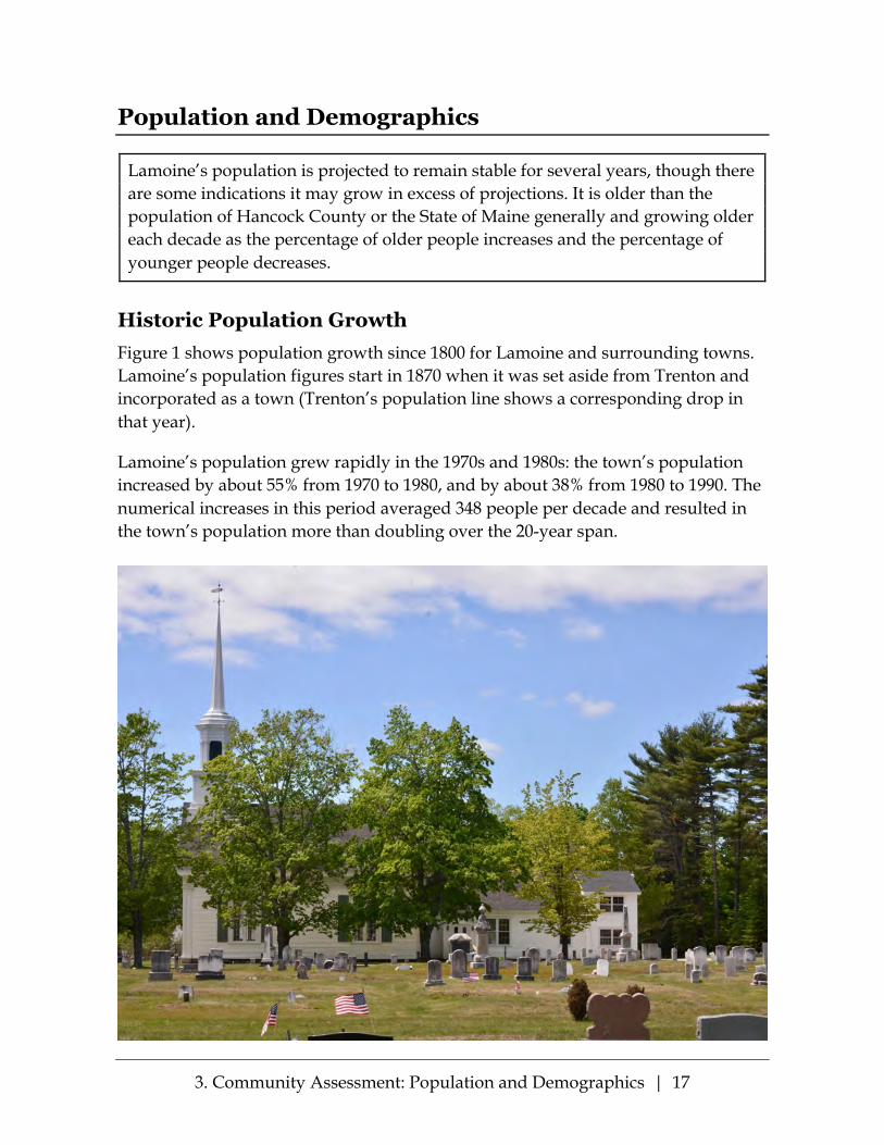
Historic Population Growth Figure 1 shows population growth since 1800 for Lamoine and surrounding towns. Lamoine’s population figures start in 1870 when it was set aside from Trenton and incorporated as a town (Trenton’s population line shows a corresponding drop in that year).
Lamoine’s population grew rapidly in the 1970s and 1980s: the town’s population increased by about 55% from 1970 to 1980, and by about 38% from 1980 to 1990. The numerical increases in this period averaged 348 people per decade and resulted in the town’s population more than doubling over the 20-year span.

3. Community Assessment: Population and Demographics | 18
Figure 1: Population Growth 1800–2010, Lamoine and Surrounding Towns
During the next two decades Lamoine’s growth slowed markedly. The town’s population rose from 1,311 in 1990 to 1,495 in 2000, an increase of 14%. From 2000 to 2010 the population increased 7% to 1,602. The numerical increases in this period averaged about 146 people per decade, or just about half the pace of growth in the previous two decades.
Current and Projected Population Figure 2 shows Lamoine’s population growth since 1970, and projected growth to 2034 based on 2014 U.S. Census Bureau estimates. The predicted population growth shown by the line that steadily rises to 3,000 is taken from the 1996 Lamoine Comprehensive Plan. However, Lamoine has not had the rising influx of people that was expected in 1996.

3. Community Assessment: Population and Demographics | 19
Figure 2: Lamoine Population Growth 1970–2014, and Projections to 2034
According to estimates by the US Census’ American Community Survey and projections, the population of Lamoine has slowed even further since the 2010 Census, and it is expected to increase even more slowly in the future. The town’s 2015 population was estimated to be 1,674, and projections by the Maine State Economist indicate that the Town’s population will level off to around 1,700 residents in the 2024-2034 period.
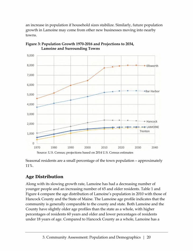
Figure 3 shows recent (1970-2016) and projected (2019-2034) population growth in Lamoine and surrounding communities. The chart indicates slow growth or decline for all five towns over the coming two decades.
However, changes in the regional economy can have unforeseen impacts on projec-tions such as these. For example, improved conditions in the economy and housing market have led to a residential building boom in Ellsworth in 2018, and that town is expecting to see even more demand and growth as a result of planned employ-ment expansion at Bar Harbor’s Jackson Laboratory. Some of this demand will likely affect the housing markets in neighboring communities such as Lamoine, and could potentially lead to greater population growth than predicted before the Jackson Labs expansion project was announced. As noted in the Housing section, there is a steady flow of building permits for new dwellings in Lamoine, which could translate into
3. Community Assessment: Population and Demographics | 20
an increase in population if household sizes stabilize. Similarly, future population growth in Lamoine may come from other new businesses moving into nearby towns.
Figure 3: Population Growth 1970-2016 and Projections to 2034, Lamoine and Surrounding Towns
Source: U.S. Census; projections based on 2014 U.S. Census estimates
Seasonal residents are a small percentage of the town population – approximately 11%.
Age Distribution Along with its slowing growth rate, Lamoine has had a decreasing number of younger people and an increasing number of 65 and older residents. Table 1 and Figure 4 compare the age distribution of Lamoine’s population in 2010 with those of Hancock County and the State of Maine. The Lamoine age profile indicates that the community is generally comparable to the county and state. Both Lamoine and the County have slightly older age profiles than the state as a whole, with higher percentages of residents 60 years and older and lower percentages of residents under 18 years of age. Compared to Hancock County as a whole, Lamoine has a

3. Community Assessment: Population and Demographics | 21
smaller percentage of residents aged 18 to 24 and a larger percentage of residents aged 45 to 54.
Table 1: Age Distribution, 2010
Age Lamoine Residents Hancock County
State of Maine Number Percent
Under 5 67 4.2% 4.8% 5.2% 5–17 219 13.7% 13.6% 15.4% 18–20 31 1.9% 3.8% 4.1% 21–24 45 2.8% 4.3% 4.7% 25–44 355 22.2% 21.7% 23.8% 45–54 317 19.8% 16.7% 16.5% 55–59 145 9.1% 8.8% 7.7% 60–64 144 9.0% 8.2% 6.7% 65–74 169 10.5% 10.0% 8.5% 75–84 86 5.4% 5.9% 5.2%
85 and Over 24 1.5% 2.3% 2.2% Total 1,602 100.0% 100.0% 100.0%
Source: 2010 Census
Figure 4: Age Distribution, 2010
Source: 2010 Census

3. Community Assessment: Population and Demographics | 22
As reported in the Lamoine Community Survey of 2015 (LCS Survey), seasonal residents were not distinct from the general population in age.
Age Changes Figure 5 presents the changes in Lamoine’s age profile from 1990 through 2015. The percentage of adults in their prime household formation and working years – the 18 to 65 age group – has been fairly stable since 1980, ranging between 59 and 65 percent of the total population. However, this apparent stability masks significant changes in both the younger and older populations:
• The percent of residents under 18 years old has declined steadily for the last 50 years. This might indicate a need to be conservative in school planning, although as noted in the Public Facilities chapter, it is anticipated that K-12 resident enrollment in Lamoine’s schools will rise from about 170 to about 200 students over the next 10 years.
• Meanwhile, the percentage of adults 65 years old and older has been on the increase since 1990. This trend will most likely continue as the population now in their late 50s and 60s age, and indicates the increasing importance of services for this population, including social services, transportation, health services, meal services (community, meals-on wheels, etc.), social events, and so on.
Our community has little infrastructure to accommodate the needs of the older population. In the past, extended families, relatives, and neighbors have given support to the aging members directly and indirectly. When there has been no family support, our town officers have handled emergencies on an ad hoc basis. Ongoing problems were, and are, referred to the appropriate state agencies. If the state agencies do not pick up the problem, our part-time government is placed in an awkward situation.

3. Community Assessment: Population and Demographics | 23
Figure 5: Age Distribution Changes, 1960–2016
Sources: 1996 Comprehensive Plan, 2010 Census, ACS 2015
As Figure 5 suggests, and as is the case regionally and nationally, Lamoine’s population is aging. Figure 6 shows the changes in median age since 1990 for Lamoine, Hancock County and the State of Maine. Between 1990 and 2010 the town’s median age increased by 11.2 years, from 36.7 to 48. Over the same period, Hancock County’s median age increased by 10.5 years to 46.3, and the State’s median age increased by 8.8 years to 42.7. Lamoine’s estimated median age in 2016 was 51 years, indicating a continuation of the trend.

3. Community Assessment: Population and Demographics | 24
Figure 6: Median Age, Lamoine, Hancock County, and State of Maine
Household Characteristics Table 2 summarizes the household types in Lamoine. About two-thirds of the households in town are family households, of which the great majority are two-parent families. Only 7 percent of the town’s households are single people living alone.
Table 2: Lamoine Household Composition, 2015
Total Households 737 Family Households 497
Married couple families 426 Single Parent female 39 Single parent male 32
Non-Family Households 240 Living alone 52 Living alone, over 65 17
Source: 2015 American Community Survey
Lamoine has a significant number of single parent households with a need for child care services (about 10 percent of the total households in the town), as well as two-

3. Community Assessment: Population and Demographics | 25
parent working households with the same need. The community should encourage child care facilities with a reasonable cost.
Table 3 presents trends in family and household sizes in Lamoine from 1990 to 2010 with comparisons to the county and the state. As is the case regionally and nation-ally, the average family and household sizes in Lamoine decreased between 1990 and 2010, corresponding to the decline in the under-18 population and the increase in the number of older residents. Lamoine’s average family and household sizes are similar to Hancock County as a whole, but smaller than the average for the state.
Table 3: Household and Family Size, 1990–2010
Persons per household 1990 2000 2010
Lamoine 2.62 2.47 2.25 Hancock County 2.48 2.31 2.20 State of Maine 2.56 2.39 2.33
Persons per family 1990 2000 2010
Lamoine 2.97 2.86 2.68 Hancock County 2.94 2.81 2.71 State of Maine 3.03 2.90 2.83 Source: U.S. Census
Reasons for Living in Lamoine Figure 7 presents the primary reasons why current residents have chosen to live in Lamoine, based on responses to the 2015 Lamoine Community Survey. The most significant factors drawing residents are the Town’s rural and coastal beauty and its small-town atmosphere, affordable housing and reasonable taxes. As shown in the Survey, 41.3% of respondents have lived in Lamoine more than 20 years forming a stable, but aging, community base.
Figure 7: Primary Reasons for Moving to or Staying in Lamoine
Source: 2015 Lamoine Community Survey

3. Community Assessment: Natural Resources | 26
Natural Resources
The citizens of Lamoine have committed resources and much voluntary time addressing the preservation of their natural surroundings. They have designated the natural beauty of the Lamoine peninsula and its many natural resources as a high priority for future preservation. Continued conservation of critical natural resources needs to be supported through government and community actions which: (a) maintain a variety of habitats supporting plants and wildlife; (b) assure the diversity of natural communities; (c) preserve ample tracts of land (e.g., unbroken blocks) for healthy wildlife populations; and (d) link both land and sea habitats through designated land areas (e.g. travel corridors).
Introduction Important natural resources in Lamoine consist of 6 habitat blocks and 12 habitat crossing connectors as seen on Beginning with Habitat maps in Appendices B2 through B6.
According to the Maine Department of Inland Fisheries and Wildlife (MIFW), “Maintaining a network of these large rural open spaces protects future opportu-

3. Community Assessment: Natural Resources | 27
nities for forestry, agriculture, and outdoor recreation.” According to the Maine Natural Areas map, there are six conservation easement properties: three parks totaling over 80 acres (Lamoine Beach Park, Marlboro Beach Park, and Lamoine State Park); three private parcels in conservation easement totaling 209 acres (Hartline Easement, Coleman Mixed Woods, and Simons. There are also four properties with a total of 175 acres in Open Space tax status.
There are numerous trails across private lands which are used for snowmobiling, hiking and other recreational uses. Lamoine has critical natural resources including wildlife habitats, deer wintering areas, scenic vistas, vernal pools, wetlands, and shorelands. Rare plants in Lamoine include American Sea-blite, Rare and Exemplary Natural Communities include Black Spruce Woodland and Brackish Tidal Marsh. As part of Lamoine’s ongoing commitment to natural resource planning and protection, there needs to be an updated inventory of critical natural resources in the Town.
Animal Habitat Lamoine’s natural features include a bald eagle’s essential habitat area located in Raccoon Cove, Kilkenny Cove, and on the Jordan River. Bald eagles are not considered endangered, but are listed as a species of special concern. They are protected by the Migratory Bird Treaty Act and the Bald and Golden Eagle Protection Act.
Other important bird species include waterfowl and wading birds. Much of Lamoine’s shore frontage is intertidal and shallow subtidal habitat for shorebirds and waterfowl. The upper portions of the Skillings and Jordan Rivers and all of Raccoon Cove have the highest possible rating with respect to habitat suitability for multiple species of shorebirds and waterfowl which are in decline or are identified as threatened or endangered. Rare birds in the Frenchmen Bay and Skillings River areas include the arctic tern, bald eagle, and upland sandpiper. The upland sand-piper is considered to be endangered, and according to the Maine Department of Inland Fisheries and Wildlife (MDIFW), require large fields, with open shortgrass areas such as blueberry barrens, meadows, pastures, hayfields, and fallow agricultural fields. (See Appendix B3.)
Great Blue Herons are also part of the shoreland habitat in Lamoine.
Along with many birds, Lamoine also has a deer population which is dispersed over the whole peninsula. Only one deer wintering area is designated by MDIFW, located south of Walker Road and west of Route 204 (see Appendix B3: High Value Plant and Animal Habitats), but there have been reports of over 30 deer crossing

3. Community Assessment: Natural Resources | 28
Martins Cove in the winter of 2015-16, which indicates that there is now more than one area.
Bear visitations to Lamoiners have become a regular summer event in several areas, and there have been annual sightings of moose. On occasion a bobcat is spotted.
Small animals include rabbits, fishers, raccoons, skunks, coyotes, fox, squirrels, woodchucks, beavers, weasels, and chipmunks. Lamoine also has a large population of turkeys.
Wetlands and Vernal Pools Wetlands and vernal pools are recognized in Lamoine’s ordinances and in the Open Space Report as important to the peninsula’s environment, providing diverse benefits such as flood flow control, sediment retention, plant and animal habitat, finfish habitat, and/or shellfish habitat. Many of the 40 wetlands serve more than one of these functions. The most common types of wetlands are inland from the shore and dispersed throughout the community (see Appendix B5: Wetlands Characterization). As depicted on the map, the largest wetland is located between the Mill Road and Lamoine Beach Road. Conservation of freshwater wetlands and stream buffers in coastal watersheds are considered a key component in marine resource conservation by the Maine Department of Inland Fisheries and Wildlife.
Vernal pools located in Maine are underrepresented in the National Wetlands Inventory (NWI) data maps because of their seasonal nature. The Department of Inland Fisheries and Wildlife advises using local knowledge and other data sources when evaluating wetlands, and should be considered relative to the watershed when assessing wetland resources. There are vernal pools located in Lamoine and are subject to setbacks.
Plants Lamoine has two plants that are ranked as being rare (Maine Department of Conservation Natural Areas Program). The Canada burnet (Sanguisorba canadensis) is considered critically imperiled because of its extreme rarity and has a ranking of S1, which is the highest ranking of scarcity. Another plant, American sea-blite (Suaeda calceoliformis), has a ranking of S2 because of its vulnerability to further decline and its rarity. It is usually found near the upper intertidal limit and has also been found in salt marshes or sandy or gravelly shores. See Appendix B3: High Value Plant & Animal Habitats.

3. Community Assessment: Natural Resources | 29
Scenic Areas and Scenic Views Several scenic areas and scenic views in Lamoine are designated in the State of Maine Downeast Coastal Inventory. The four scenic sites are:
• Marlboro Beach (public, protected) (views of Raccoon Cove and Frenchman Bay)
• Lamoine Beach (public, protected) (views of Frenchman bay) • Bloomfield Park (public, protected) (views of Blunts Pond and surrounding
area) • Mud Creek/Pinkham’s Flats (views from road over private lands of Mud
Creek tidal estuary)
Other sites with notable shoreline views:
• Lamoine State Park and Lamoine Town Harbor (public) (protected) (views of Jordan River estuary, Frenchman Bay, Mount Desert Island)
• Intersection of Route 184 and Asa’s Lane (views from road across private land of Mount Desert Narrows)
• Route 204 entering North Lamoine (view from road across private land of Jordan River tidal estuary)
• Marlboro Beach Road (views across private land, of Frenchman Bay, Mount Desert Island, and Dorr Mountain)
• Views from the water—exploration of many coves, inlets, and shores.
The Open Space Report and Inventory of the Lamoine Conservation Commission (March 2013) addresses the protection of all these views:
“Four of the above scenic areas (Lamoine State Park, Marlboro Beach, Lamoine Beach Park and Bloomfield Park) are protected by town or state ownership. The remaining four can be viewed from a public roadway. In the future these views could be impacted by development. Due to the high value of the remaining scenic areas, it is impractical to assume that the Town will purchase any of these sites outright. There may, however, be opportunities, particularly in partnership with the State or private conservation organizations, to protect some access points through purchase or donation of land or scenic easements. A small picnic area near the Mud Creek bridge, for instance might be considered.

3. Community Assessment: Natural Resources | 30
….As land development continues, it is important to know which views are most valuable and to develop strategies to protect them or access to them.” (p. 14)
As of Summer 2018, the Mud Creek bridge area is a new park development area with the Town considering seeking public ownership in order to protect and preserve it for public use.
The fields along Mud Creek Road and the area surrounding Mud Creek have been identified by the State’s Beginning with Habitat Program as Lamoine’s unique wildlife area. Various trails in Lamoine are also part of Lamoine’s scenic areas, including Simons Trail, Coleman Mixed Woods, and Bloomfield Park.
Another part of Lamoine’s natural landscape is Cousin’s Hill which is a natural and geologically relevant area, with 360-degree scenic views of Lamoine and surround-ing areas. This hill is identified on the National Science Foundation and University of Maine’s map and guide of “Maine’s Ice Age Trail—Down East”, as one of the rare remaining wave-cut bluffs. It is a significant historic geological place, in accordance with our 1996 Comprehensive Plan.

3. Community Assessment: Fresh Water Resources | 31
Fresh Water Resources
Lamoine has several fresh water streams flowing to the sea, one Great Pond, and a few private ponds used for fire protection. There is no municipal water supply. Drinking water is provided primarily through individual wells and one small consumer-cooperative water company. All water is drawn either from fractured bedrock or a formally defined sand and gravel aquifer. Continued preservation and conservation of adequate and safe fresh water for the Town will require combined efforts and participation of citizens, town committees and officials, and those who mine the gravel pits.
Introduction Lamoine is fortunate to have fresh water resources that currently meet the needs of its citizens. The town, however, does not have a town-wide water supply that can be protected by a single buffer. Most drinking water (the area around Lamoine Corner served by Cold Spring Water being the exception) is from individual wells at each home or place of business. These wells draw water from the Lamoine sand and gravel aquifer or, commonly, cracks in the granite bedrock beneath it. The town

3. Community Assessment: Fresh Water Resources | 32
must protect the aquifer from contamination or institute a public water system throughout the town, at what can only be assumed would be prohibitive expense.
Streams in Lamoine have been of exceptional purity in recent history, but have the potential to carry pollutants to the fertile intertidal area around town and to the ocean. The interconnectedness and interdependence of Lamoine’s coastal ecosys-tems (including marine estuaries and fishery resources, streams and ponds, wet-lands, and watersheds) have been discussed in the Marine Resources section. The potential impact of climate change on all these resources of fresh and salt water will need to be an important area of assessment and adaptation as we plan toward the future.
In this chapter we will focus on the underground and inland water bodies not fully discussed in the other sections.
Streams Lamoine has five primary streams, and several other flowing water resources which provide riparian habitats, especially the four flowing into the upper Jordan River estuary. See Appendix B2: Water Resources & Riparian Habitats.
Three streams are named: Spring Brook, Archer’s Brook and Martins Brook. Two are unnamed. Three of these streams—Spring Brook, Martins Brook, and an unnamed stream—originate in the town of Hancock. Two streams originate in Lamoine— Archer’s Brook from large wetlands and the other unnamed one near Needle’s Eye Road. All of these streams flow into the marine estuaries of the Lamoine peninsula.
Three streams flowing into the Mud Creek estuary—Spring and Archer’s Brook and one unnamed—are more notable in their wetland functions providing ecological benefits such as flood and storm-water runoff control, erosion control and sediment retention. In addition, they contribute individually in varying degrees to the stream bed and estuary ecosystem nurturing a range of animal and plant habitat (including emergent vegetations, forested and forested/shrub-scrub, and shrub-scrub). See Appendix B5: Wetlands Characterization.
Freshwater Bodies Lamoine has only one freshwater body—Blunts Pond, a Great Pond of about 35 acres. The adjacent Bloomfield Park provides public picnic and bathroom facilities, supporting recreational water activities of swimming, small boating, and fishing. It is managed by the Lamoine Parks Commission, which is currently reviewing

3. Community Assessment: Fresh Water Resources | 33
possibilities for researching the recharge source(s) of the pond, analysis of the small area of thick aquatic plants, and for monitoring the water quality.
Household Water As Lamoine’s 2013 Open Space Report and Inventory states: “Most, if not all, of Lamoine is over ‘water-bearing’ fractured bedrock. This water-bearing bedrock is in most places under ‘overburden’ consisting of a variety of deposited material, mostly of glacial origin. The most prominent of these deposits is the sand and gravel aquifer” wending from north to south along the more western side of Lamoine. (See Appendix B9: Mini-Handbook of Lamoine’s Groundwater Hydrology: Dr. Willem Brutsaert, published by the Lamoine Conservation Commission, 2009.)
There is no municipal water infrastructure in Lamoine. Therefore, fresh water from beneath the town is the only source of drinking water, coming from either “water-bearing” fractured bedrock or the aquifer. Almost all household and commercial sources of water are from individual wells. One public/private water company (Cold Spring Water Company) provides water for 49 homes and five organizations (the school, fire department, church, grange, and cemetery) in the center of Town.
Most individual household wells are from bedrock with greater than 20 feet of overburden, therefore placing these households in the “low risk” category for contaminants. Currently, both the quantity and quality of water are considered excellent. However, the quantity of potable water is dependent on recharging by rainfall. In the past few years, some shoreline households have experienced salt intrusion during drought-like conditions. There is an additional increasing concern that the rise in sea level will also create seasonal shifts in especially the chloride content of individual wells near the shore.
The quality of most of Lamoine’s water is dependent on protecting the aquifer from pollution and from depletion of the overburden through gravel and sand extraction, the largest industry in Lamoine. Lamoine’s gravel ordinance is therefore a signifi-cant control of water quality. It currently restricts gravel extraction to 5 feet above the water table (the state standard), and specifies protections from gravel industry-related pollutants. It requires regular monitoring and annual reporting of water levels and water quality from the gravel companies. Lamoine’s Building and Land Use Ordinance was amended in 2010 to include provisions designed to protect the aquifer and the Town’s drinking water. Included in these provisions are controls of particularly hazardous activities, and restrictions on commercial extraction of water that would exceed the recharge capacity of the town’s groundwater.

3. Community Assessment: Fresh Water Resources | 34
Cold Spring Water Company conducts regular water testing and reports to the State as part of the mandated monitoring system for its classification as a community, spring-fed system in three high risk categories. Contamination, in rare instances of identification, has been immediately corrected.
Additional monitoring of individual wells is conducted through a unique, school-based, program, GET WET!, established by the Lamoine Conservation Commission (in cooperation with The George Mitchell Center for Environmental and Watershed Research, University of Maine). This program, which has subsequently been adopt-ed by several Maine and other state communities, provides an ongoing collection of data since 2005 about groundwater over and near the aquifer. It is designed to raise awareness among students and the general public about the importance of monitor-ing our sources of potable water, along with providing important data which could offer an early warning of any significant changes in groundwater quality.
Lamoine citizens have long considered protection of drinking water and the aquifer among the higher priorities of the town. In a community survey conducted in 2006, 84% of the respondents said they were very concerned or concerned about the future quality and quantity of their drinking water. In a fall, 2015 community survey (conducted by the Comprehensive Plan Committee), there was strong support for the use of public funds to protect future quality and quantity of drinking water in Lamoine: 73% yes, 27% no. The Lamoine Conservation Commission promotes the GET WET program and has assisted the town in identifying and evaluating ways to address water quality issues. It has recommended best practices and least environ-mental impact solutions for safe road clearing and maintenance, land development, and responses to the potential impact of extreme storms and other environmental changes. These and other approaches are reflected in the policies and strategies for protecting Lamoine’s fresh water resources in the coming years. See Appendix B1: Lamoine Watersheds, 2014.

3. Community Assessment: Marine Resources | 35
Marine Resources
Lamoine’s jagged multi-faceted shoreline, jutting out into Frenchman Bay and skirted by two rivers, offers a wealth of diverse recreational, residential, and commercial uses, and presents constant challenges for planning, management and conservation. Lamoine will continue to protect and manage its marine fisheries and other resources, and to develop strategies for addressing unfolding challenges of climate change. In doing this, the Town will work with other communities, organizations in the Frenchman Bay region, and government agencies.
Introduction The Town of Lamoine is a peninsula sharing the waterways of Frenchman Bay with many towns and other peninsulas. One of the hallmarks of this shared geological area is the emergence of collaborative efforts to manage and preserve an ecological and environmental balance, while supporting multiple uses of the shores and waters. This collaboration is especially evident in Lamoine citizens’ participation in related Town committees (Conservation Commission Shoreland Access Subcommittee, Parks Committee, Frenchman Bay Regional Shellfish Committee).
3. Community Assessment: Marine Resources | 36
Lamoine residents also regularly engage through membership and other participa-tion with broader regional efforts in maintaining and enhancing marine resources of the area. (These groups, to name a few, include Frenchman Bay Partners, Frenchman Bay Conservancy, various marine water quality monitoring endeavors, and Maine Coast Heritage Trust.)
When looking at a map of Lamoine, some describe it as an elephant’s head, others as an eagle. Both images describe the jagged and multi-faceted shoreline offering small and larger coves and estuaries—some on the open sea and some along both the Jordan and Skillings rivers. Thus, the wide variations in shoreline and subsequent variations of tides and sea levels, provide both a wealth of diversified recreational, residential, and commercial uses, and constant challenges for planning, manage-ment and conservation.
Lamoine’s Shoreline Lamoine’s Shoreland Zoning Ordinance (currently under review) designates 5 state-mandated districts: limited residential, limited commercial, commercial fisheries/ maritime activities, stream protection, and resource protection (see Appendix C3: Shoreland Zoning Map). There are three commercial fisheries and maritime activi-ties areas, one limited commercial activities area, two protected streams, and four areas in resource protection. The remaining shoreline, categorized as limited resi-dential, includes approximately 18 miles of developed shore frontage (i.e., lots with building value on tax records), and approximately 9 miles of undeveloped shore frontage (lots with no building value).
Almost the entire shoreline is designated as “significant wildlife habitat” for shorebird, tidal, and waterfowl habitats. This designation is made by the Maine Department of Inland Fisheries and Wildlife (MDIFW), as directed by the Maine Endangered Species Act and subsequent rules set up by the MDIFW. Therefore, any planning or revisions of shoreland ordinances, and any projects to be developed partly or wholly within these areas must be evaluated by the MDIFW before state and/or Lamoine permits can be approved, and change or development can take place.
The 1996 Lamoine Comprehensive Plan addressed marine resources as follows:
a. Maintain marine access through Lamoine Beach and Marlboro Beach access sites and through cooperation with the state to preserve access at Lamoine State Park, with pursuit of additional sites as may become available; seek state and federal funding to assist in ramp maintenance and construction.

3. Community Assessment: Marine Resources | 37
b. Appoint a Marine Resources Committee which should “broach the possibility of separating clamming and worming areas with the Department of Marine Resources, and would explore the “steps necessary to restore clamming and the feasibility of protecting mussels.”
Since the writing of that plan, Lamoine has continued to enhance and develop its many marine resources, striving to balance the multiple interests of conservation, land ownership, fishing, recreation and tourism.
Public Access Two Town parks at Lamoine Beach and Marlboro Beach provide recreation oppor-tunities and general public access to the shore for the launching of small recreational craft. Canoes and kayaks can also be hand-carried to private property launch points along the shore with owner permission. An additional park on Mud Creek road is being considered at this writing. Marlboro Beach has been expanded through collab-oration with the Town and Frenchman Bay Conservancy to purchase additional shoreland offered by a landowner at a much lower-than-market price.
The primary public boat launch is at the Lamoine State Park, which provides a deeper water harbor for commercial fishing boats as well as larger recreational boats. The State of Maine manages access to the harbor and related grounds and facilities. Lamoine, as overseer of boat moorings, has a Harbor Ordinance which guides the management of 62 moorings, including assignment, supervision, place-ment, and fees. Lamoine supports both a Harbor Master and Deputy Harbor Master, who oversee compliance with mooring rules and assist boaters who may have mechanical or other issues. The harbor depth is sufficient for all current uses and there are no identified needs for servicing larger craft, which would require dredging. The Town and State have a positive working relationship, exemplified most recently in the State undertaking major improvements in the boat ramp and moorings following Lamoine’s proposal. The Town is currently working with Park officials to improve availability of car and trailer parking for fishermen.
Harvesting from the Sea and Intertidal Areas The intertidal zone surrounding Lamoine stretches from a high tide of above 13 feet to a low tide of below -2.0 feet. These twice-daily tidal changes provide vast areas for commercial fisheries: lobstering during high tides; and harvesting from large mud flats rich in clams, blood and sand worms, and mussels.
Lamoine has become an increasingly high-demand harvesting area, particularly in softshell clams and worms. The number of Lamoine wormers has remained steadily
3. Community Assessment: Marine Resources | 38
between 6 and 9 since 2009. However, Lamoine’s expanses of mudflats draw many wormers from outside the town, leading to parking and shore access issues for harvesters and landowners. Because worming licenses are issued by the State, Lamoine has limited ability to manage worming activities. The Town shellfish ordinance includes mussels and allows the Town to provide comments for mussel harvester practices that may be included in the mussel harvester permit issued by the Department of Marine Resources.
In contrast, Lamoine is integrally involved in softshell clam management. In 2010, Lamoine adopted the Frenchman Bay Regional Shellfish Conservation Ordinance, joining with six other communities in the Frenchman Bay estuary, to establish parallel licensing agreements for commercial and recreational harvesting designed to keep harvesting at a sustainable level. This cooperative approach to management and conservation of local marine resources is specifically authorized by State law (Title 12, Chapter 623, Section 6671). A 7-town consortium emerged to plan and implement conservation and sustainable harvesting of shellfish, guided by the Frenchman Bay Regional Shellfish (FBRS) Conservation Committee and Frenchman Bay Regional Shellfish Municipal Joint Board. The FBRS Conservation Committee, consisting of all commercial harvesters, meets monthly during off-harvesting season to assess harvesting and environmental conditions and make recommendations for management to the Municipal Joint Board.
Data comparing softshell clam harvesting in Lamoine with 5 other municipalities in Frenchman Bay shows harvesting in Lamoine increasing rapidly from 2009 to 2016. Table 4 and Figure 8 indicate that there is an overall decline in the clam landings in the six municipalities taken as a whole. However, Lamoine landings have held up well. In fact, for the entire period, more than half (57%) of all clam landings have been from Lamoine. Lamoine’s percentage of the whole increased significantly in 2015, and although decreased in 2016, is still higher than years before. Whether the general decline in the resource in Lamoine will continue is something that will have to be watched as data comes in. Based on current data, it appears that there have been clams available for harvest in Lamoine’s intertidal area and that harvesters have been able to access the flats.

3. Community Assessment: Marine Resources | 39
Table 4: Softshell Clam Landings, 2009–2016 2009 2010 2011 2012 2013 2014 2015 2016 Difference
2009-2016 Lamoine 237,576 235,697 253,978 318,661 290,533 230,594 334,592 197,648 -39,928
Franklin 68,745 48,366 42,027 45,508 24,148 17,508 15,108 30,000 -38,745
Trenton 77,174 77,293 99,324 45,714 83,460 86,707 26,974 19,189 -57,985
Sorrento 33,462 52,452 29,038 55,205 37,841 4,798 26,044 11,204 -22,258
Sullivan 69,546 52,947 46,582 50,131 22,977 15,308 15,943 3,808 -65,738
Hancock 30,431 96,118 23,232 15,424 19,907 19,584 9,785 35,876 5,445
5 Towns 279,358 327,176 240,203 211,982 188,333 143,905 93,854 100,077 -179,281
6 Town Total 516,934 562,873 494,181 530,643 478,866 374,499 428,446 297,725 -219,209 Lamoine % of total 46.0% 41.9% 51.4% 60.1% 60.7% 61.6% 78.1% 66.4%
Source: Maine Department of Marine Resources Softshell Clam Landings Data File
Figure 8: Softshell Clam Landings, 2009–2016
Source: Maine Department of Marine Resources Softshell Clam Landings Data File
Closures of flats due to pollution are a major impediment to the practice and marketing of shellfish. Therefore, pollution source/location, remedies for closures, and enforcement at the municipal level are critical for ongoing maintenance of harvesting. Through collaboration of the Maine Department of Marine Resources,
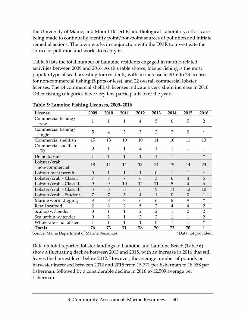
3. Community Assessment: Marine Resources | 40
the University of Maine, and Mount Desert Island Biological Laboratory, efforts are being made to continually identify point/non-point sources of pollution and initiate remedial actions. The town works in conjunction with the DMR to investigate the source of pollution and works to rectify it.
Table 5 lists the total number of Lamoine residents engaged in marine-related activities between 2009 and 2016. As this table shows, lobster fishing is the most popular type of sea harvesting for residents, with an increase in 2016 to 23 licenses for non-commercial fishing (5 pots or less), and 22 overall commercial lobster licenses. The 14 commercial shellfish licenses indicate a very slight increase in 2016. Other fishing categories have very few participants over the years.
Table 5: Lamoine Fishing Licenses, 2009–2016 License 2009 2010 2011 2012 2013 2014 2015 2016 Commercial fishing/
crew 1 1 1 4 5 6 5 2
Commercial fishing/ single 5 4 3 3 2 2 0 *
Commercial shellfish 15 13 10 10 11 10 11 13 Commercial shellfish
+70 0 1 1 2 1 1 1 1
Demo lobster 1 1 1 1 1 1 1 * Lobster/crab
non-commercial 18 11 14 13 14 15 14 23
Lobster meat permit 0 1 1 1 0 1 1 * Lobster/crab – Class I 7 7 7 6 3 6 4 5 Lobster/crab – Class II 9 9 10 12 11 5 4 6 Lobster/crab – Class III 3 3 5 6 9 11 12 10 Lobster/crab – Student 7 7 5 4 1 0 0 1 Marine worm digging 8 8 8 6 6 8 9 * Retail seafood 2 3 2 5 2 4 4 2 Scallop w/tender 0 1 1 2 2 1 2 2 Sea urchin w/tender 0 2 1 2 2 1 1 2 Wholesale – no lobster 1 1 1 1 0 1 1 * Totals 76 73 71 78 70 73 70 *
Source: Maine Department of Marine Resources. * Data not provided.
Data on total reported lobster landings in Lamoine and Lamoine Beach (Table 6) show a fluctuating decline between 2013 and 2015, with an increase in 2016 that still leaves the harvest level below 2012. However, the average number of pounds per harvester increased between 2012 and 2015 from 15,771 per fisherman to 18,658 per fisherman, followed by a considerable decline in 2016 to 12,509 average per fisherman.

3. Community Assessment: Marine Resources | 41
Table 7 presents similar data for lobster harvesters residing in Lamoine, regardless of the location of the catch. The table indicates an increase in both the total pounds and income value for a steady number of harvesters over the 10-year period 2007-2016. A notable exception is 2014, when lobster harvests declined throughout most of the fishery.
Table 6: Lamoine Lobster Landings
Year Total Pounds Total Value Number of Harvesters
Pounds per Harvester
2009 138,124 $453,879 30 4,604 2010 180,629 $665,459 19 9,507 2012 268,107 $771,738 17 15,771 2013 135,415 $400,982 9 15,046 2014 166,735 $656,798 9 18,526 2015 149,267 $666,123 8 18,658 2016 175,135 $777,272 14 12,510
Includes only landings that were reported as landed in Lamoine and Lamoine Beach. Pulled from dealer reported data (confidential data omitted). Source: Department of Marine Resources
Table 7: Lamoine Lobster Harvesters Landings
Year Total Pounds Total Value Number of Harvesters
Pounds per Harvester
2007 206,758 $941,866 16 12,922 2008 207,919 $766,790 16 12,995 2009 264,906 $876,922 16 16,557 2010 383,374 $1,409,872 18 21,299 2012 445,376 $1,543,452 16 27,836 2013 515,198 $1,496,203 17 30,306 2014 587,258 $1,661,031 16 36,704 2015 440,679 $1,687,483 16 27,542 2016 601,935 $2,383,080 17 35,408
Includes all landings that were reported for harvesters listing Lamoine as residence on their license. Pulled from dealer reported data (confidential data omitted). Source: Department of Marine Resources
It is anticipated that both lobstering and clamming will continue to be the most productive fisheries important to the economy of Lamoine and the area in the next 10 years. As clamming is an occupation continually influenced by closures of clamming areas, there is a need for continued support for pollution detection and
3. Community Assessment: Marine Resources | 42
management. Monitoring of the number of harvesting licenses, and the careful management of other marine harvesting activities—especially worming, mussel farming and dragging—will be important to sustainable fisheries into the future. Additional challenges presented by sea and climate changes are discussed below.
Eelgrass Conservation Eelgrass, a long marine grass with ribbon-like leaves, grows in undersea meadows with important functions for maintaining the ecology of the Frenchman Bay marine environment. It provides a habitat for many marine organisms, helps to stabilize sediments, and is an important element in supporting a broad range of species con-tributing to a healthy habitat for the many commercial resources in Frenchman Bay.
From 1996 to 2006 data from the Maine Department of Marine Resources indicated a sharp decrease in eelgrass in all parts of Frenchman Bay around Lamoine. Accord-ing to Frenchman Bay Partners website, “In 2010, 35 acres of eelgrass were lost from the Jordan River along Lamoine’s shores. By the spring of 2013 it was evident that there was an additional significant loss of eelgrass in the bay. There has been a great deal of effort by the Mount Desert Island Biological Laboratory and Frenchman Bay Partners, and volunteers including Lamoine citizens, to restore the eelgrass that has been lost. Possible reasons for that loss include changing water temperatures and number of extreme storms, green crabs, and mussel dragging. The MDI lab and the Frenchman Bay Partners engage in continuous exploration of ways to replant and protect this marine resource. Among other steps, they have established voluntary “no harvesting zones” with local area mussel draggers in efforts to help with the restoration. They also work on water quality, focusing on eelgrass’ need for sunlight in order to carry out photosynthesis. They will continue to replant and restore eelgrass in Lamoine along Berry Cove and the Jordan River.
Rockweed and Sea Vegetable Harvesting There are no clear data on the amount of sea vegetable harvesting that has taken place in the past in the surrounding tidal/land areas of Lamoine. However, with the increase in popularity and uses of sea vegetables, a controversy has arisen around whether rockweeds (the most common seaweeds on Maine’s coast) belong in a fish-ery classification or are “terrestrial plants” linked in the intertidal area to the land of shore property owners. A case pending in Maine Supreme Judicial Court addresses whether shore landowners have all rights to decisions regarding harvesting of rockweed associated with their property. Lamoine may be addressing the broader discussion of directions of shoreland activities, and potential conflicts over fishery rights and rockweeds rights.

3. Community Assessment: Marine Resources | 43
The Future of Water-Dependent Uses in Lamoine Three areas of change can be considered in planning for Lamoine as a seaside community: ecological/environmental, economic, and social.
Climate change patterns are contributing to rising sea-levels with the potential of eroding coastline, flood zones moving inland, and anticipated storm surges. Rapid ocean temperature rise is leading to an increase or introduction of green crabs and milky ribbon worms, both predators of clam and mussel populations. Shifts in lobster populations are needing constant study to understand the changes and impact on the ecological balance of sea life. Changes in climate patterns, including an increase in frequency and intensity of rainfall, affects the shoreland landscape, loss of shoreline and traditional access points to the shoreline, and runoff contributing to changes in mudflat ecology (see Appendix D7A-C: Predicted Roadway Vulnerability).
These changes can have an economic impact on the residents of Lamoine, contrib-uting to a decline—or shift—in shellfish and lobster harvesting and related impact on market value; increased need for management of town parks; need for increased flood and water intrusion management; loss of property for shoreland owners and increased costs in flood insurance; need for more emergency services.
Among the social areas to address are: the need for educating Lamoine residents about the potential impacts of climate and sea-level changes; continued support of co-management amongst and between various fishing persons and groups; ways to approach issues of shore access, shore management, and preparations for shoreland changes throughout the community; assessment and development of ways that the Town can plan and prepare for a changing landscape and ecology.

3. Community Assessment: Agricultural and Forest Resources | 44
Agricultural and Forest Resources
Agriculture and forest preservation has long been a high priority in Lamoine. Agriculture has transitioned from diversified family farms to smaller scale food production, including specialized and “backyard” farming. Local food security will be an important part of Lamoine’s focus, guided by sustainable food production and the development of community marketing options. The conscientious use, conservation and preservation of Lamoine’s forest resources, are necessary to maintain the nature and beauty of Lamoine. Support of both agriculture and forest resources contributes to mitigating the potential effects of climate change on the entire Lamoine peninsula.
Introduction The Lamoine zoning map, developed from recommendations of the 1996 Compre-hensive Plan, shows the majority of the Town being designated as Rural/Agricul-tural. This Comprehensive Plan continues that approach. The Open Space Report and Inventory addresses “The Forest Environment” specifically (p.5) and makes reference to the rural nature of much of Lamoine and its importance throughout the report.

3. Community Assessment: Agricultural and Forest Resources | 45
In the most recent 2015 survey, 68% would support the use of public funds for pro-tection of open spaces and environmental protection of land. In the 2016 Community Meeting participants were asked: “If you could have your three most heartfelt wishes met for the Town of Lamoine, what would they be?” Respondents were overwhelmingly in favor of preserving natural resources, maintaining open space and forests, and supporting local agricultural development. This is consistent with the state goal for community planning: “To safeguard the State’s agricultural and forest resources from development which threatens those resources.”
Agricultural Resources In the past century, agriculture in Lamoine has shifted from predominantly small family farms which sustained the family and provided some additional products for market. Currently there are several farms under 20 acres, and three properties which are leased for larger-scale vegetable production and hay harvesting. The USDA defines a small farm as selling at least $1,000 in sales and less than $250,000 in farm products; so the current farms in Lamoine would be considered small farms. There are presently 436.6 acres in the farmland taxation classification and 93.9 acres in working or open farmland (9.5% of Lamoine’s 11,000 acres.)
These small farms offer a range of products and services, including: crops for live-stock, goats’ milk products and goats; horse boarding and training, maple syrup, blueberries and cranberries. Vegetables are grown and sold at farm stands, farmer’s markets, and for restaurant use.
Both the 1996 Lamoine Comprehensive Plan and the 2013 Open Space Report and Inventory, stress the importance of determining the potential for various options of land use, considering the stated goals of maintaining a balance between housing and other development, and the preservation of land for agriculture, forestry, and recreational use. The final recommendation in the 1996 Comprehensive Plan was to “encourage landowners to develop and expand sustainable usage of suitable land for agriculture and forestry harvest.”
The demand for locally grown food is expressed by Lamoine citizens (both in the 2015 survey and at the 2016 community meeting). There is support for the develop-ment of backyard farming, and roadside and common area selling of garden products. There has been one certified organic, CSA farm in Lamoine. In addition to serving Town residents, the farmer has had further marketing resources in farmers’ markets and stores in the communities of Ellsworth and Mount Desert Island. The proximity of these markets may encourage further agricultural development.

3. Community Assessment: Agricultural and Forest Resources | 46
There is a stated need for the Town to engage in the promotion and support of small farm development and local food production.
Forestry An aerial view of Lamoine provides the striking realization that around 85% of its land mass (9,664 acres of approximately 11,000 acres) is forestland. Evergreens dominate almost half of forested acres, with the other half supporting mixed forests shared with some deciduous woods and forested wetlands. (Open Space Report, 2013). Common tree species include eastern white pine, balsam fir, red spruce, white spruce, eastern hemlock, and red maple (U.S. Department of Agriculture data).
The total number of acres registered in the State’s Tree Growth program has not changed significantly in the last 10 years, with approximately 3% of the total forested land, 307.4 acres, registered in 2015. Lamoine records for 2015 show 9 registrations in this program. A total of 209 acres are also in conservation easements. Within that 209 acres, 141 acres are jointly enrolled in the Tree Growth program, leaving 68 acres listed solely in conservation easement (open space) status.
Timber harvesting in Lamoine varies from year to year but shows a slight decline in the past 10 years (Table 8) Looking at 5 year intervals, the average annual harvest from 2000 to 2004 was 294.4 acres, declining in the 2005–2009 period to 156.4 acres, and in 2010-14 to 145.6 acres. The total number of forested acres during the period 2001 to 2014 was 2,628, or about 27.2 of the forested acreage in Lamoine.

3. Community Assessment: Agricultural and Forest Resources | 47
Table 8: Summary of Timber Harvest, Lamoine, 2000–2014
Year Selection harvest,
acres
Shelterwood harvest,
acres
Clearcut harvest,
acres
Total harvest,
acres
Land use change,
acres
Number of active
notifications 2000 226 128 0 354 3 20 2001 134 25 0 159 0 12 2002 150 0 0 150 0 14 2003 354 0 0 354 0 21 2004 255 200 0 455 19 22 2005 202 125 0 327 67 16 2006 149 0 0 149 134 10 2007 238 0 0 238 2 14 2008 36 0 0 36 29 11 2009 32 0 0 32 0 7 2010 217 0 0 217 0 12 2011 141 0 0 141 19 26 2012 157 0 0 157 0 13 2013 115 45 5 165 70 12 2014 48 0 0 48 10 7
Source: Data compiled from Confidential Year End Landowner Reports to Maine Forest Service.
Balancing preservation and conservation, and maintaining the nature and beauty of Lamoine are constant priority goals stated by Lamoiners throughout all studies and reports since the 1996 Comprehensive Plan. Lamoine’s 2011 Shoreland Zoning Ordinance includes specific regulations for shoreline tree management beyond the State’s guidelines for timber harvesting. Lamoine’s 2013 Gravel Ordinance includes specific regulations for removal of vegetation that will maintain the natural forest and woodland environment. An Open Space Report and Inventory was presented by the Lamoine Conservation Commission in 2013, identifying areas for the Town’s focus.

3. Community Assessment: Recreation and Culture | 48
Recreation and Culture
Lamoine provides access to a wide range of recreational activities, both in the town and regionally. There are three public access trails, an extensive snowmobile trail, and three Town Parks, with a fourth being planned, which provide access to the ocean, Blunt’s Pond and a tidal stream. There is a Town Parks Commission in charge of the parks, and a Town Recreation Committee which actively organizes recreational events.
The beautiful setting of Lamoine with woods and sea are important to the Town. Surveys of the Town in 1992, 2005 and 2015 consistently show this as one of the most important attributes of Lamoine.
Recreational Facilities The recreation facilities for youth activities in Lamoine are primarily located at the Lamoine Consolidated School, which has ball fields, playground equipment and a multi-purpose gymnasium. The school is receptive to wide community use of its facilities. The school fields are in decent shape, but upgrading the gymnasium has been a town goal for many years. People in Lamoine also take advantage of the

3. Community Assessment: Recreation and Culture | 49
facilities in neighboring towns, such as the YMCA, the Knowlton School playground and tennis courts in Ellsworth, and a golf course just over the line in Trenton.
Cultural Opportunities Ellsworth and Mount Desert Island also provide cultural opportunities with performances of many types at the Grand Auditorium in Ellsworth, the Criterion Theatre and the Gates Auditorium of the College of the Atlantic in Bar Harbor. There are numerous small museums and art galleries in the surrounding area, and numerous lecture series at various venues throughout the county.
Recreational Programs Organized recreational activities in the Town, not supervised by the school, are managed by a new Town Recreation Committee. The Recreation Committee has coordinated traditional activities such as youth soccer, adult basketball at the school gym and youth cheering teams. It has also sponsored Slow Ride Sundays in an attempt to encourage bicycling on town roads and enhance awareness of the need for automobile traffic to accommodate bicycle riders. Future goals of the Recreation Committee include finding events that encourage multi-generational recreation and to provide recreational opportunities for older adults.
Lamoine’s many active older adults want outdoor recreational opportunities.
Trails There are currently three trails for hikers in Lamoine, two on properties subject to Conservation Easements to Frenchman Bay Conservancy, and one at the Lamoine State Park. The Frenchman Bay Riders Snowmobile Club, with a membership of 40 to 70, maintains an extensive snowmobile trail (30 miles) through Lamoine and into Hancock and a clubhouse near Blunt’s Pond. Kayakers access the ocean from Lamoine State Park, the Town’s Lamoine Beach Park, Marlboro Beach on Raccoon Cove and from private properties. Regionally, Acadia National Park, the Maine Sunrise Trail (open to ATV use) and the trails developed by local land trusts and other groups get a lot of use. Frenchman Bay Conservancy has a brochure of short hikes available.
Parks The Town maintains three parks, under the supervision of the Parks Committee: Bloomfield Park is a swimming hole park at Blunt’s Pond, Lamoine Beach Park has a picnic area near the beach, and Marlboro Beach, newly expanded through

3. Community Assessment: Recreation and Culture | 50
community initiatives to expand the town-owned portion. The State of Maine maintains Lamoine State Park, which has an extensive campground and is busy in the summer months. The State Park provides a boat ramp for water access and a playground as well as the hiking trail. It serves as the harbor for the Town. There is a fee for use of the State Park in the summer months.
Community Needs In the Lamoine survey conducted in 2015, 90% of respondents supported further recreational opportunities for families with young children. 72% rated the current opportunities for recreation as either excellent or adequate. Suggestions for improvements included safer roads for biking and hiking, more recreational and social activities for older adults, free access for Lamoine residents to the State Park facilities, as well as calls for development of a community center and a linked trail system. The Community Meeting in 2016 generated a similar list: bikable roads and trails, trail development, a community center, and exercise groups for older adults; as well as other suggestions: tennis courts, a skating rink, a list of nearby hiking trails, and more community social events. See also Appendix E5: Resolution on the Importance of Children’s Early Years.

3. Community Assessment: Business and the Economy | 51
Business and the Economy
Lamoine is primarily a residential community without large commercial or industrial employers other than gravel companies. Although many Lamoine residents commute to employment in Ellsworth and elsewhere, much of the economic activity in town is in small businesses and home occupations. Lamoine’s natural beauty draws visitors and new residents to the town and is an economic asset.
Introduction An understanding of the economy is essential to comprehensive planning. The availability of stable, well-paying jobs is necessary in retaining people of working age. It is important to identify economic trends to use in formulating economic development strategies.

3. Community Assessment: Business and the Economy | 52
Employment in Lamoine Businesses When the last Comprehensive Plan was prepared in 1996, Lamoine was almost exclusively a residential community. Industrial activity was minor and consisted primarily of gravel pits and small marine-based operations. There were no formal stores, but there were some home-based businesses. It is difficult to find accurate data on businesses in a small town, but in the course of the public participation in the development of this plan, one community group submitted their informal research, showing more than 125 small businesses or self-employed workers (Appendix A9). There has been a general store and lunch counter in Lamoine for many years.
The number of Lamoine’s small businesses is increasing. These additional businesses need to be added to this inventory for Town planning, and an up-to-date list of businesses is recommended to be available and maintained on the Town’s website.
Employment of Lamoine Residents A review of employment trends reveals some of the changes occurring in Lamoine’s economy. While the total labor force increased by 15 percent between 2000 and 2014, there were some sectors with much higher increases (see Table 9). This information refers to where Lamoine residents work, not to the number of jobs in town.
Professional, Scientific, Management, and related services increased by about 189 percent (85 jobs), the largest percentage rate of increase. This sector accounted for 73 percent of the total labor force increase. The Financial, Insurance and Real Estate sector had the second highest rate of increase (96 percent, 23 jobs). Education, Health Care and, Social Services increased by 64 jobs (48 percent). Other sectors lost jobs. The largest numeric decreases were in manufacturing (26 jobs) and wholesale trade (20 jobs). (It should be noted that the 2014 data are based on a sample that is subject to greater error than the 2010 Census data.)
A comparison between Lamoine and county-wide trends (Table 10) reveals some of the differences in employment. First, the county labor force increased by 7.9 percent, a rate far less than the 15.7 percent rate for Lamoine. Manufacturing jobs decreased by 36 percent county-wide compared to nearly 13 percent for Lamoine. This information does not reflect the closing of the Verso Mill in Bucksport in 2014.

3. Community Assessment: Business and the Economy | 53
Table 9: Employment by Industry, Lamoine Residents, 2000-2014
Sector 2000 2014 Change 2000-2014 Number Percent
Agriculture, forestry, & fisheries 20 22 +2 +10.0% Construction 55 62 +7 +12.7% Manufacturing 95 69 -26 -27.4% Wholesale trade 33 13 -20 -60.6% Retail trade 108 105 -3 -2.9% Transportation, warehousing and utilities 29 26 -3 -10.3% Information 18 10 -8 -44.4% Finance, insurance & real estate 24 47 +23 +95.8% Professional, scientific, management, administrative & waste management services
45 130 +85 +188.9%
Educational, health and social services 154 228 +74 +48.0% Arts, entertainment, recreation, accommodation and food services 72 62 -10 -13.9%
Other services (except public administration) 70 67 -3 -4.3%
Public administration 26 25 -1 -3.8% Total 749 866 +117 +15.6% Source: U.S. Census (2000) American Community Survey (2010 -2014)
Table 10: Employment by Industry, Hancock County Residents, 2000–2014
Sector 2000 2014 Change 2000-2014 Number Percent
Agriculture, forestry, & fisheries 1,315 1,614 299 22.7% Construction 2,524 2,262 (262) -10.4% Manufacturing 2,369 1,511 (858) -36.2% Wholesale trade 575 420 (155) -27% Retail trade 3,057 3,506 449 14.7% Transportation, warehousing and utilities 883 857 (26) -3% Information 644 491 (153) -23.8% Finance, insurance & real estate 1,191 1,148 (43) -3.6% Professional, scientific, management, administrative & waste management services
2,005 2,981 976 48.7%
Educational, health and social services 5,544 6,829 1,285 23.2% Arts, entertainment, recreation, accommodation and food services 2,252 3,093 841 37.3%
Other services (except public administration) 1,672 1,449 (223) -13.3%
Public administration 1,003 860 (143) -14.3% Total 25,034 27,021 1,987 7.9% Source: U.S. Census (2000) American Community Survey (2010 -2014)

3. Community Assessment: Business and the Economy | 54
Self-employment rates in Lamoine increased from 11.2 percent in 2000 and to 16.2 percent in 2014. The county self-employment rate increased from 15.9 percent to 21.9 percent. One issue facing those who telecommute is uneven broadband service.
Lamoine had 64 percent of its population aged 18-64 in the labor force in 2014. This is close to the 63 percent rate for the county.
Place of Work of Lamoine Residents Based on a 1991 survey of residents (reported in the 1996 Comprehensive Plan), about 84 percent of working Lamoine residents in 1991 were estimated to be working in Hancock County. The most common work destinations were Ellsworth (37%), Mount Desert Island (24%), and Lamoine (20%).
Table 11 shows more recent commuting patterns for Lamoine residents based on data from the 2012 American Community Survey (ACS). The most common desti-nations were Ellsworth and Bar Harbor, which jointly accounted for 63 percent of the total labor force (with similar percentages to the 1991 survey). However, only 8.9 percent of residents were estimated to be working in Lamoine in 2012, a significant differential from the percentage in the 1991 survey. However, it should be noted that the 1991 responses are from survey responses that may not have been completely representative of the population, and the 2012 figures are from sample data which are also subject to a certain amount of error.
Table 11: Commuting Destination Lamoine Residents (where Residents work)
Destination Number Percent Lamoine 90 8.9% Bar Harbor 215 23.5% Ellsworth 366 40.0% Hancock 40 4.3% Trenton 55 6.0% Other Hancock County 73 7.9% Total County 879 95.6% Out of County 37 4.2 % Total 916
Source: 2012 American Community Survey Estimates
The estimated 90 Lamoine residents working within Lamoine in 2012 included self-employed persons and employees of the Town and the State as well as employees of private businesses. In 2016, 83 out of 837 working Lamoine residents were estimated to be working at home (2016 American Community Survey). Combined with the

3. Community Assessment: Business and the Economy | 55
2012 estimates of work locations, this suggests very few Lamoine residents are actually working for private businesses in the town.
Employment and Unemployment Trends Annual average employment trends are shown in Table 12. There is no major difference between town and county rates.
Table 12: Annual Average Employment Trends, 2012-2016, Lamoine & Hancock County
Year County/ Lamoine
Employment Unemployment Unemployment Rate
2012 County 27,372 2,651 8.80% Lamoine 832 77 8.50%
2013 County 27,796 2,425 8.00% Lamoine 845 71 7.80%
2014 County 27,709 2,092 7.00% Lamoine 845 59 6.80%
2015 County 27,331 1,665 5.70% Lamoine 837 45 5.10%
2016 County 27,819 1,371 4.70% Lamoine 852 42 4.70%
Source: Maine Department of Labor
Priorities and Issues There are no defined priorities. Citizens during public outreach meetings expressed support for businesses compatible with the town’s natural resources. These included recreational trails and allowing small businesses in the Agricultural-Rural zone.
Lamoine State Park attracts visitors, who could patronize small businesses in other parts of town. For example, there has been an increase in short-term seasonal rentals.
There has been a notable increase in the number of home occupations. While there are no firm numbers, at least a portion of the increase in self-employment may be due to home occupations. They are an important source of income for residents.
Public facilities to support development are addressed in the Public Facilities and Services chapter. There is no municipal public water or sewer system. Internet service is uneven. This limits telecommuting and home occupations. The Town

3. Community Assessment: Business and the Economy | 56
understands that high-speed internet service is an important part of today’s economy and is advocating for improvement throughout Lamoine. How to improve internet and broadband capacity is under study as this plan is being prepared.
There is a Site Plan Review Ordinance which sets standards for uses other than single and two family residential. There is a separate gravel extraction ordinance. It is amended periodically.
There are no incentives that encourage economic development. Based on the public outreach input, most residents want the town be a small business and home occupation friendly community. This means that if any incentives are enacted, they should be aimed at small businesses.
The primary way the town uses its assets is to keep the town rural. For more detail, see the various chapters that address the resources. These include Recreation, Natural, Agricultural and Forest, Marine, and Water Resources.
The area from Lamoine Corner to Mill Road is as close as Lamoine comes to a town center. The Lamoine Consolidated School, fire station, grange, a cemetery, and a church are in this area. There is also a small privately-owned water company. There is no clear mandate at this time to establish this area as a village center. The Town will be making a decision on some sort of community center in the coming years, and the siting of this facility (or cluster of functions) may clarify whether Lamoine should move towards a more formal village center.

3. Community Assessment: Housing | 57
Housing
Lamoine’s housing stock consists primarily of single-family homes occupied by their owners. There are few apartments in town and rental housing is often seasonal, including weekly rentals. Homes for purchase are affordable by Hancock County standards, and there appear to be sufficient vacant buildable lots (within approved subdivisions or along existing public roads) to accommodate population growth considerably in excess of that projected by the State of Maine.
Introduction Lamoine remains predominantly a residential community. This section will discuss the current state of housing in Lamoine and project the town’s future housing needs. Areas of special concern relate to (1) the affordability of housing in Lamoine for families with young children, which impacts the school population, and (2) the housing implications of the aging of Lamoine’s population.

3. Community Assessment: Housing | 58
Housing Growth and Characteristics: 1990 to Present The 1996 Comprehensive Plan stated that the housing in Lamoine was 99% single-family housing. This is likely true today as well. There is only one four-unit apartment building in town and it was built prior to 1996.
According to the US Census, between 1990 and 2010 Lamoine’s housing stock increased by 302 units (692 to 994, or 43.6%). This contrasts with a population increase of only 291 (1,311 to 1,602, or 22.2%). According to these data, Lamoine actually added more residential units than people during the 20-year period.
Between 2010 and 2015, 62 building permits were issued for new or replacement residences, while the State of Maine estimate is that Lamoine’s population grew by only 21 individuals. While inaccuracy or change of methodology in counting may be responsible for the State’s modest population estimates, it seems likely that there is also an underlying trend toward smaller household size. In 1990, the census figures worked out to 1.8 people per housing unit. The comparable figure in 2010 is 1.6. The State 2012 estimate for occupied housing units in Lamoine is 2.24 persons per household, slightly below the State average of 2.34.
As noted in the Demographics section, Lamoine’s growth in population has slowed and is projected to remain modest, although there is some evidence to the contrary, primarily the steady flow of new residence building permits. The aging of the population (see Population and Demographics Profile, p. 23) may also partly explain the decrease in household size. Many of the new citizens of Lamoine move to the town in “young retirement” after their children have left home but while they are young and healthy enough to enjoy an active lifestyle on the Maine coast.
Housing density in Lamoine is modest, with 90 people and 56 houses on each square mile. Corresponding densities in Trenton and Hancock, Lamoine’s small town neighbors, are comparable. Over 30% of Lamoine’s population lives near the shore and almost all development is near one of the existing roads. As in 1996, most development initiatives are by subdivision proposals for single-family dwellings. The lack of town water or sewer utilities may be a significant factor in discouraging proposals for multi-unit developments, but it is unlikely that the town will move to town water or sewer systems during the life of this Plan. The fact that many of the existing subdivisions are on the shore may impact the affordability of housing in Lamoine.
Of the 994 housing units in Lamoine in 2010, 712 units were regularly occupied (2010 US Census). About 14 were vacant rental units and 13 were vacant homes which were for sale or had recently been sold and were not yet occupied. The

3. Community Assessment: Housing | 59
remaining units, approximately 230, were owned by seasonal residents (20%). As Lamoine has few classic lakeside camps, seasonal dwellings are generally fully-equipped homes which are empty for a portion of the year.
Lamoine, unlike nearby Bar Harbor, does not have a workforce housing concern, as there is no large employer in the town. There are reports of workforce housing plans for Ellsworth, however, which may impact development in Lamoine.
The Town office reports few code enforcement matters involving substandard housing stock. State data indicates all occupied dwellings have complete kitchen facilities and all but three have complete plumbing facilities. About 35% of Lamoine’s housing stock has been built since 1989, and 15% of the town’s housing was built prior to 1940.
Housing Affordability The term “housing affordability” refers to the relationship between household incomes and housing costs, and is often measured by comparing median incomes to median house purchase prices or rents in a particular geographic area. Data from the Maine State Housing Authority (MSHA) in 2017 indicates that housing in Lamoine is about average in terms of affordability, and comparable to the affordability in most neighboring towns.
MSHA publishes an affordability index for towns and counties in the State. For 2017, Lamoine places third in affordability of all Hancock County towns. On a scale in which less than 1.0 is considered unaffordable, Lamoine gets a score of 0.94, contrasted with neighboring coastal towns such as Hancock (0.85), Surry (1.46) and Trenton (also 0.94).
As noted, housing affordability has two components: housing costs and household incomes. Data from 2017 shows a median home price in Lamoine of $235,000, which was higher than both the County ($210,000) and State ($197,000) medians. Town records show that 15 of 29 homes sold in 2017 (51.7%) were sold for less than $235,000. MSHA calculates that a house priced at the Lamoine median would be affordable to a household with an annual income of $63,485.
The State estimates that Lamoine residents have a median household income of about $59,933, substantially higher than Hancock County generally ($48,838) and higher than Maine as a whole ($53,190). These numbers are not correlated by age or family size, so they may be somewhat inflated by relatively affluent retirees.

3. Community Assessment: Housing | 60
MSHA estimates that 52.2% of Lamoine residents cannot afford a home priced at the median price for homes in town and that 63.3 percent of homes sold in Lamoine are not affordable for a household with the median household income for Lamoine. This is somewhat above the percentage for Hancock County as a whole (57.1 %), but about in the middle compared with other towns in the county. In Bar Harbor, 95.2% of homes sold are similarly unaffordable. At the other end of the scale are Orland (29.4%) and Surry (30.8%).
One conclusion from this analysis is that Lamoine is fairly close to balance in its housing market for its current residents: in 2017 almost half of the town’s residents (47.8%) could afford to purchase a median-priced home. However, the analysis does not distinguish between different household types (e.g., young families vs. affluent retirees), and does not address the issue of affordability for young families wishing to move to Lamoine.
There is also a need for caution in relying on this analysis. The upswing in house sales since 2016 has made housing more expensive throughout Hancock County and Maine generally. However, it should be noted that in small towns like Lamoine there are few home sales in any given year, and as a result the affordability estimates are subject to wide swings depending on the prices of the particular homes sold in that year. Table 13 summarizes the components of the MSHA’s housing affordability estimates for 2015 and 2017 and shows how the affordability index in Lamoine and other small towns can differ widely from the indices in the county and state.
In 2015, when both median income and median home prices were lower, 70% of homes sold in Lamoine (14 of 20) were determined to be affordable, and 67% of Lamoine households had sufficient income, by MSHA guidelines, to afford a median-priced home in the town. In Hancock County only Orland had a higher percentage in 2015. According to MSHA’s 2017 data, however, eight of 28 towns and cities in Hancock County had more affordable homes. Whether Lamoine has become significantly less affordable relative to its neighbors cannot really be determined based on these data.

3. Community Assessment: Housing | 61
Table 13: Housing Affordability Estimates, 2015 and 2017
2015 2017 % Change Median Household Income Lamoine $56,100 $59,933 7% Hancock County $44,600 $48,838 10% Maine $48,200 $53,190 10% Median Home Price Lamoine $149,000 $235,000 58% Hancock County $185,000 $210,000 14% Maine $169,000 $197,000 17% Affordability Index Lamoine 1.44 0.94 -35% Hancock 0.77 0.85 +10% Trenton 0.81 0.94 +16% Surry 0.93 1.46 +57% Hancock County 0.98 0.85 -13% Maine 1.03 0.93 -10%
Source: Maine State Housing Authority
Affordable Housing for Young Families with Children The aging of Lamoine’s population (described in detail in the Demographics section) is of concern to the town in several ways. There are concerns about the recent steady decline in the school population which, if it continued, might threaten the viability of the school. At the moment, the school’s enrollment is moving up, but it remains a concern.
Identifying the causes of the decline in schoolchildren is not easy. Certainly, large families are much less common than they were 50 or 60 years ago. In addition, the lack of good-paying jobs in the area is often cited as a reason that children who grow up on the Maine coast don’t settle and raise their families here. Finally, there is a widespread belief that because Lamoine is a coastal town, with relatively high property values and little rental housing, it is not affordable for a young family.
The Lamoine Consolidated School is working to achieve a level of excellence which will be attractive to families with children. A good school is a proven attraction for families with children. The fact that Lamoine students can attend the local high school of their choice is attractive to some families.
In the Lamoine Community Survey conducted in the fall of 2015, over 75% of respondents said that it was Somewhat Important, Important or Very Important that

3. Community Assessment: Housing | 62
Lamoine promote affordable housing for young families with children. About 25% responded that this is Very Important to them.
Rental Housing According to the U.S. Census, in 2010 there were 114 renter-occupied housing units in Lamoine, representing 16 percent of the 712 total occupied units in the town. In addition, there were 14 vacant rental units, and a total of 230 vacant units “for seasonal, recreational or occasional use,” some proportion of which would also be for rent. The Census estimates that in 2016 there were 142 renter-occupied units in Lamoine, and a rental vacancy rate of 4.7% (down from 10.9% in 2010). The increase in the number of renter-occupied units combined with the lower vacancy rate suggests increased demand and a tighter rental housing market in the town.
In the near term, the expected Jackson Lab expansion to Ellsworth in 2017 may make Lamoine attractive to employees working in that facility. That population may be looking, at least initially, for rental housing. The absence of town water and sewer make large rental developments unlikely, but there may be provisions in the Building and Land Use Code that could be modified to encourage development of rental housing.
Lamoine should consider aligning its housing future with research indicating that Maine is experiencing a sharp turn towards rental housing since 2011. Maine State Housing Authority staff noted in 2014 that the change might be attributable to the 2008-2009 recession and accompanying foreclosures. Figure 9 presents data from the MSHA report showing significant shifts from owner to rental housing occupancy across all age groups except the youngest and oldest. Figure 10 presents the most recent available data, showing the continuing shift in tenure from owner-occupied to renter-occupied units for the period from 2010 to 2016.

3. Community Assessment: Housing | 63
Figure 9: Shift in Housing Tenure by Age of Householder, Maine, 2000-2010
Source: Richard Taylor, “The Shift to Renting”, Maine State Housing Authority, September 2014.
Figure 10: Change in Housing Tenure, Maine, 2010-2016
Source: US Census, American Community Survey, 2010 and 2016

3. Community Assessment: Housing | 64
Housing for Older Adults It is relatively easy to demonstrate that Lamoine’s population is aging, as Figure 11 shows. In the 20 years between 1990 and 2010, the census figures show that people over 60 rose from 20% of Lamoine’s population to 26%. Estimates through 2016 put this figure at 30%.
Figure 11: Lamoine Population – Age Trend, 1990–2016
Survey results showed almost as much concern about affordable housing for older adults as for young families with children, with about 72% of respondents indicating it was at least Somewhat Important to them. 36% indicated assisted living was a special concern. In addition, most respondents see the need for significant services for older adults, including help with transportation, meals, health care and social contact.
As a housing issue, there has recently been an upsurge of units put into service for the older adults in Ellsworth. Ellsworth has a number of advantages for older adults, including shops and health care facilities and services. It may be that specifically older adult housing facilities will not be sited in Lamoine. There are no current plans to construct such facilities.

3. Community Assessment: Housing | 65
Lamoine should embrace the current movement to support “aging in place.” This movement assumes that most older residents would prefer to remain in their homes for the greater part of their later years. Older adults may be more capable, as well as more comfortable, in familiar surroundings. Lamoine should facilitate certain aspects of the needs of older adults, such as establishing: (1) some sort of community center where regular “senior center” events or social time could be scheduled, (2) a town committee to regularly consider the needs of the aging population, and (3) coordination of some services on a town-wide basis as the need for such coordination becomes apparent.
In addition, the town should take a look at portions of its Building and Land Use Ordinance to see if they can be made more compatible with aging in place. The concept of a mother-in-law apartment might be expanded to allow a number of arrangements, including those involving non-family members, which would make it possible to provide the necessary support for older adults to remain in their homes.

3. Community Assessment: Transportation | 66
Transportation
Lamoine’s existing road network is adequate for motor vehicles but should be improved over time to enhance safety at a few key locations and to better accommodate walking and bicycling.
Introduction A transportation system is one of the most important factors influencing a town’s growth. This section discusses the major transportation issues facing Lamoine. Specifically, it assesses the current transportation system and infrastructure in
3. Community Assessment: Transportation | 67
Lamoine and plans for the development of facilities and services to accommodate anticipated growth and economic development.
The transportation system in Lamoine relies on roads and personal automobiles. There is no direct bus service, ferry service, railroad service in Lamoine. The Trenton airport and the Island Explorer bus terminal are nearby. Long distance bus service is available in Ellsworth.
Roads The transportation system of a town is often a major determinant of growth and the pattern of development. However, the existing system is only the product of past demands for personal mobility and the movement of goods, and may not provide adequately for present or future demands. Though the present highway network was not designed with the future in mind, a careful assessment of Lamoine’s present system is vital if a proper evaluation of future demands is to be made for planning purposes.
The State Highway System defines which entity is responsible for maintenance of a public road. The three major administrative categories of public roads are state highways, state aid highways, and town ways. The state assumes complete responsibility for the year-round maintenance of state highways. State-aid roads, which connect local roads to state highways, are usually maintained by state in the summer and by the town in the winter. All other roads are town ways and are maintained by the town.
Town records show that out of a total 31.94 miles of road in Lamoine, 8.36 miles (26%) are state highways, 7.31 miles (23%) are state-aid roads, and 16.27 miles (51%) are town-maintained roads. Appendix D1: Lamoine Transportation Network shows the roads in Lamoine by jurisdiction, as well as other key elements of the transportation infrastructure.
In addition to the public roads, Lamoine has several private roads. Lamoine’s policies and standards for the design, construction and maintenance of public and private roads (but not driveways) can be found in the municipal ordinances for Building and Land Use (Section 5, and Section 12, which deals with subdivisions), Control of Traffic, Mobile Home Parks (Section VIII), and Site Plan Review (Section J). These ordinances are available on the town’s website. The Town has not accepted a subdivision road as a town road in many years.
Road condition information is important in planning for future growth in town. For example, a major subdivision may not be appropriate at a hazardous intersection.

3. Community Assessment: Transportation | 68
Similarly, stricter standards for commercial development may be needed in areas with traffic congestion. This information can also be used to identify priorities for improvements. The MDOT has limited state highway improvement monies.
Two aspects of road conditions that are useful for transportation planning are traffic volumes and vehicle crash data. These are discussed in the following two sections.
Traffic Volumes and Flows The most recently available estimates of average annual daily traffic volumes for Lamoine are presented in Appendices D2 and D3. Unsurprisingly, the highest volumes are on the roads feeding into the Route 184/Route 204 intersection. The predominant traffic flows in Lamoine are:
(1) to and from Ellsworth along Douglas Highway and Buttermilk Road (3,600 daily trips combined),
(2) to and from Mount Desert Island along Jordan River Road (3,300 daily trips), and
(3) to and from US Route 1 in Hancock along Pinkham’s Flats and Mud Creek Road (2,300 daily trips).
Multiple year counts are available for Jordan River Road (Route 204) in Lamoine and Trenton, for Douglas Highway at the Ellsworth town line, and for Buttermilk Road in Ellsworth. From 2014 to 2017, traffic volumes on Jordan River Road and Buttermilk Road grew 17.7% and 17.3% respectively, for annual increases of 5.9% and 5.8%. These increases were not seen on Douglas Highway (Route 184). By comparison, traffic volumes on Route 1 in Hancock grew 8.3% over the same period, for an annual growth rate of 2.8%.
A major component of traffic originating in Lamoine is generated by the local gravel pit operations, running continuously from sunrise to sunset. Other main generators of vehicular traffic in Lamoine include Lamoine Consolidated School, the town office and adjacent store, Lamoine State Park and its campground, and Lamoine Beach Park.
In addition to locally-generated traffic, Lamoine sees significant “cut-through” traffic between Route 1 in Hancock and Route 3 in Trenton. Vehicles leave Route 1 in Hancock, turning onto the Mud Creek Road or the MacQuinn Road, and travel via Route 204 to Route 3 in Trenton. “Near misses” are a regular occurrence at the intersection of Routes 204 and 184, where visibility is limited and speeding is common.

3. Community Assessment: Transportation | 69
Traffic volumes on this cut-through route are highest during commuting hours; presumably this serves as a quick route for commuters to Jackson Lab and other MDI employers, avoiding the congestion and bottlenecks of Ellsworth. (Some tourist traffic may be using this route as well.) Efforts to reduce commuter traffic congestion through carpooling initiatives may not be worth pursuing. Respondents to the 2015 comprehensive plan survey indicated an overwhelming lack of interest in ride-sharing.
The figures presented in Appendices D2 and D3 are estimates of average annual daily traffic, based on counts taken at particular times of the year. However, traffic volumes vary throughout the year, with higher than average volumes in the summer months and lower in the winter. Figure 12 shows the statewide annual variation for two types of roads: Group II (arterials) and Group III (recreational).
Figure 12: Annual Variation in Traffic Volumes, Statewide
Source: MaineDOT, “Weekly Group Mean Factors as percent of AADT Graph” –
https://www1.maine.gov/mdot/traffic/docs/ytc/2017/Graph2017.pdf
All of Lamoine’s roads for which traffic counts are available are classified as Group II, except for the State Park entrance road which is Group III. As the chart shows, peak summer traffic volumes are typically around 25% higher than average for arterials, and more than 50% above average for recreational roads. Given that

3. Community Assessment: Transportation | 70
Lamoine’s roads provide access both to beaches within the town and to regional recreational attractions such as Acadia National Park, it is reasonable to assume that the summer volumes on Routes 184 and 204 are between 25% and 50% above the estimated average annual daily volumes shown in Appendices D2 and D3.
Vehicle Crashes Crash data provide a window into the safety of Lamoine’s roads. Over the five-year period from 2013 through 2017, MaineDOT recorded 141 crashes in Lamoine (Appendix D4: Vehicle Crashes, 2013-20171). Some key findings from the crash data include the following:
• Most accidents were at locations on the higher-volume roads. The locations with the greatest number of crashes included:
o The area around the intersections of Douglas Highway (Route 184) with Jordan River Road and Pinkham’s Flats Road (Route 204);
o The intersection of Mud Creek Road near the bridge and at the intersection with Partridge Cove Road (Route 204);
o Partridge Cove Road (Route 204) near Walker Road; and
o Lamoine Corner, including the intersection of Douglas Highway, Lamoine Beach Road and Shore Road, and the intersection of Lamoine Beach Road and Mill Road.
• MaineDOT defines a “high crash location” as one with 8 crashes in a three-year period. The only high crash road segment in Lamoine was Partridge Cove Road (Route 204) between Mud Creek Road and Walker Road, with 14 crashes over the 5-year period.
• The great majority of crashes (79% in the 5-year period) were single-car incidents. In 44% of the cases the vehicle ran off the road, while 35% involved collisions with deer. Only 26 incidents (18% of the total) were two-vehicle crashes, and these tended to be concentrated at intersections.
1 It should be noted that this map, based on MaineDOT’s “Maine Crash Public Query Tool” (https://mdotapps.maine.gov/MaineCrashPublic/), groups incidents in general areas: for example, the “10” shown just south of the intersection of Douglas Highway and Jordan River Road includes 5 crashes at the intersection, 1 at the Douglas/Pinkham Flats intersection, and 4 on Douglas or Jordan River away from the intersection.

3. Community Assessment: Transportation | 71
• Most crashes occurred in clear weather (64%) and with dry road surface (65%). Half of the crashes took place during daylight hours.
• 79% of the crashes resulted in property damage only; the other 21% reported possible or confirmed injuries. There were no fatal accidents in Lamoine during this time.
• 57% of the crashes occurred between November and March when traffic volumes are lower than average. This suggests that tourist or summer resident traffic is not a primary factor in crashes.
• In 67% of the cases, the posted speed limit was 45 miles per hour or greater. Since most crashes are single-vehicle incidents (running off the road or hitting a deer), often in daylight and/or clear conditions and with dry pavement, excessive speed may be a factor.
The subjective impressions of residents reinforce the findings from the crash data. Those impressions have been noted in survey results and comments, community meeting input, Town office reports and its own discussions. Those issues cited most were:
• Speeding on the most heavily traveled “commuter” roads: Mud Creek Road, Pinkham Flats and the Jordan River Road (Route 204). Many noted that they are unable to walk or ride bicycles due to the many speeders and the lack of sidewalks and/or bike lanes. Other roads mentioned in complaints to Town officials include Birchlawn Drive, Buttermilk Road, Walker Road and Shore Road (see October, 2016 Lamoine Quarterly).
• Sight lines on Route 204 are inadequate at the bend near Mud Creek Road.
• Many dangerous situations where Routes 184 and 204 come together. Traffic coming from Ellsworth on Route 184 is too fast to allow a safe left turn from Route 204 by the General Store. Similarly, traffic making a left turn from 204 by the Town Hall often pulls out into traffic.
In addition to these evaluations of traffic conditions, residents have highlighted the need for bike lanes and sidewalks generally.
Road Maintenance Needs Several state-maintained roads in Lamoine have been recently repaired and resurfaced. State Route 204 has had ditching and other work done on it in 2018. There are no projects planned for Lamoine in the 2016-2017-2018 MaineDOT

3. Community Assessment: Transportation | 72
workplan. The Town maintains a Capital Needs Schedule which includes road maintenance needs going forward 10 or 12 years (Appendix F1). Lamoine has most recently paved the upper Buttermilk Road and Needles Eye Road, MacQuinn Road and Raccoon Cove Road are the next major projects scheduled. The Town budgets currently budgets in the $90,000 to $120,000 range each year for road improvements and about $175,000 for annual maintenance, including snow removal.
Appendix A contains a listing of public roads in Lamoine with maintenance records, and Appendix D6 lists the official names and detailed descriptions of all public and private roads in the town.
Parking There are few public parking areas in Lamoine. See Public Facilities and Services for a discussion of parking at the school and town hall.
Pedestrian and Bicycle Facilities The community has expressed support for walking and biking lanes, hiking trails, and bicycle-pedestrian safety measures through survey responses and feedback at community meetings. There are no specific bicycle facilities in Lamoine other than a bike rack at Lamoine Beach Park. The Lamoine Recreation Committee has been promoting Slow Ride Sunday to encourage safe bike riding in Lamoine and safe accommodation of bicycles by drivers.
There are no sidewalks in Lamoine, but there is a variety of hiking trails and walking paths (see Appendices E1 and E4). The town would like to make roads safer and more accommodating for bicyclists and pedestrians, especially around the school in the Lamoine Corner area. There are a several on-road routes to Lamoine Corner that could be improved for safer bicycle and pedestrian access. The town is interested in incorporating bicycle and pedestrian ways, traffic calming features, and improved vehicular flow. Since many of the locations where bicycling and walking can be encouraged are on state controlled roads, the Town will need to coordinate with MaineDOT to pursue these objectives as part of future maintenance and upgrade projects.

3. Community Assessment: Public Facilities and Services | 73
Public Facilities and Services
Lamoine has a Town Meeting form of government. A five-person Select Board controls operations with an Administrative Assistant, several part-time employees and many volunteer members of a variety of Boards and Committees.
Introduction Lamoine is a small, rural community, lacking in the necessity for public facilities and services associated with larger or more urban communities. As noted in the Population and Demographics Profile, Lamoine’s growth in population has slowed and is projected by State sources to remain modest, although there is some evidence to the contrary, including relatively active new residence building permits over the last two years. The effects on Lamoine of the Jackson Laboratory expansion into Ellsworth are an unknown at this time (see Housing section, pp. 19-20). Population growth projections have a direct effect on the public facilities and services needs of the town.
This section will discuss the current state of public facilities and services in Lamoine and project the town’s future needs. Areas of special concern relate to 1) retention of service providers, such as the town administrator and firefighters; 2) the need for

3. Community Assessment: Public Facilities and Services | 74
more or different public spaces, such as the school and a Community Center and 3) technology.
Lamoine Public Facilities and Services The public facilities and services provided by Lamoine today include:
• Town Office • Town staff, including town administrator • Volunteer firefighting services and fire house, including four motor vehicles,
a rescue boat and 27 volunteers • Emergency response system (social media, firefighters connected by radio,
local television) • Lamoine Consolidated School (public, K-8) • Solid waste management and recycling system (Lamoine Transfer Station) • Planned storm water runoff (in Marlboro) • Privately owned public water supply (consumer co-op, including Lamoine
Consolidated School) • Ambulance services (through contract with County Ambulance) • Historical Society • Three cemeteries • Three town parks: Bloomfield Park, Lamoine Beach Park and Marlboro Beach
(where expansion is pending), with a Mud Creek picnic area in the planning stages.
• Lamoine Beach Park (state owned) • Harbor master and moorings • Salt/sand shed and contract for road maintenance services, including
plowing and sanding • Town storage shed (the old “Anderson” garage) • Town roads
Lamoine also partners with neighboring communities to share services, reduce costs, and/or improve services. These partnerships include:
• School administration, staff, and some activities (shared superintendent and superintendent’s office, special education director, teacher evaluation team, and some sports and joint-trip activities)
• Firefighting (with Trenton, Hancock, and Ellsworth and all of Hancock County)

3. Community Assessment: Public Facilities and Services | 75
• Emergency management (with Hancock County Emergency Management Agency)
• Ambulance services (private corporation, with whom we contract) • Police services provided by the Hancock County Sheriff’s Office and the
Maine State Police • Waste management through a fifteen-year contract with the Penobscot
Energy Recovery Company (PERC) and a new recycling contract with ECOMaine.
• Propane and oil bidding program (with Hancock, Sullivan and Gouldsboro) to negotiate lower prices for public facilities
• Joint salt purchase program (through the Hancock County Planning Commission)
• Library (Ellsworth Public Library) • YMCA (Downeast Family YMCA in Ellsworth) • Frenchman Bay Regional Shellfish Ordinance (for clammers in a 7-town
region) • Participation in the Mount Desert Island League of Towns (offers an annual
government elected officials meeting, annual household hazardous waste disposal program, and other ad hoc shared programs)
• Member of the Maine Municipal Association and affiliate groups (offers some limited shared legal services, training, and legislative advocacy/lobbying)
Lamoine does not provide the following facilities and services:
• Storm water management facility • Public sewer system (primarily single-family septic fields and subsurface
waste water disposal systems, maintained by individual owners, pumped as needed by private contractors)
• Municipal water supply
Future Needs
Community Center
Throughout the Comprehensive Plan process, there has been a steady flow of feed-back from townspeople that Lamoine needs a community center. The movement towards a community center has been gaining momentum. The Town will shortly appoint a committee to explore the issue.

3. Community Assessment: Public Facilities and Services | 76
Although there is broad agreement that a community center is desirable, there is no firm consensus as to what facilities should be a part of such a Center. Among the many ideas for functions a community center should fulfill are:
• Space for events for older adults • Better parking for Town events, Town Hall and the Fire Department • More meeting space for community groups and programs • A larger gymnasium • A theater • A children’s library and day care space • A library • Increased office space for Town government • Space to store an archive of items of town history and space for people to use it
The Town will need to go through a process of prioritization among these uses and an analysis of various designs and costs before deciding what sort of Community Center the Town wants and can afford.
Digitized Tax Maps
Currently, Lamoine’s town maps, including our tax maps, are maintained by traditional, not digital, means. This makes the maps less precise and makes maintenance take longer.
As a result, the town should consider digitizing our tax maps. Given the large learning curve for current town staff, and lack of resource to maintain the maps, this might require additional staffing.
Administrative
Town Administrator
If the current Town Administrator were to retire or move on to a new position, Lamoine would be in the position of replacing 25 years of experience and familiarity with the workings of the town and all of its systems, many of which he developed. The loss of institutional memory would be significant.
As a result, a process is underway to develop and implement a succession plan for this role and to capture the duties, activities, and tasks performed by the Town Administrator to preserve institutional memory and ensure efficient operations in the event of a short-term absence, or a smooth transition in the event of a permanent personnel change in this role.

3. Community Assessment: Public Facilities and Services | 77
Town Office Parking
Actual projected growth by the state indicates that the Lamoine Town Office is adequate, as long as these growth projections hold. Parking, however, is inadequate for voting day and big-issue topics at meetings.
Public Safety
Police
Lamoine has no police force and depends on patrols and responses by the Hancock County Sheriff’s Office and the Maine State Police for crime prevention. Despite occasional events, Lamoine is generally perceived as a safe place to live. Hancock County has one of the lower crime rates in Maine, based on 2015 data. In the community survey done in 2015, 201 of 202 respondents (99.5%) reported feeling safe in their homes. This is a remarkable result by any measure, and an important component of the quality of life in Lamoine. In the community meeting held in 2016, public safety concerns focused mostly on excessive speeds on the through roads. Unless conditions change, there is no need to add a constable or police force to Town government.
Emergency Management
Violent storms create a storm surge flood management risk for Lamoine. Recent work by University of Maine at Machias professor Dr. Tora Johnson has determined that there are areas of Lamoine where roads are vulnerable. Her work points to areas which could be cut off from the greater road network and people isolated for a period of time. Emergency management personnel need to be aware of this risk, able to recognize and track storms which present such a risk, and get notice to vulnerable populations that the risk exists and what they can do to stay safe. (See Appendix D7A-C: Predicted Roadway Vulnerability.)
Code Enforcement
The town employs a properly certified Code Enforcement Officer and Licensed Plumbing Inspector on a part-time basis. With 17 permitted gravel pits to inspect and an increase in home construction, increased hours for code enforcement may be needed.
Firefighting
Facility
At this time, the Lamoine fire house is adequate. If the facility moved as a result of a community center or other development, the town could plan to enlarge it.

3. Community Assessment: Public Facilities and Services | 78
Water sources
As conditions change, for example through seasonal and year-to-year variations in waterfall, the town should explore options for more permanent water sources, such as access to clean (not stagnant) retention ponds. For example, the town could explore installing a hydrant near Archer’s Brook, acquiring water from tanks filled via the Cold Spring water system, or pursuing agreements with private property owners to install hydrants at the bottom of Asa’s Lane hill (to acquire water from Blunt’s pond) or at Latona Lane.
Volunteers
Firefighting is a rigorous task, both physically and emotionally. That, coupled with the volunteer nature of the Lamoine Volunteer Fire Department, requires a level of personal investment by the firefighters that cannot be sustained indefinitely. As firefighters opt to retire or are forced, due to age or physical infirmity, to retire, Lamoine will lose experience in the volunteer firefighting ranks. As a result, the town will develop and implement a recruitment and retention plan for volunteer firefighters.
Area Doctors
Although it is not a problem only for Lamoine, there are not enough doctors in the general Ellsworth/Mount Desert Island area, and the doctors here tend to rotate through the area quickly – sometimes for only a year – making it difficult for patients to develop a relationship conducive to excellent healthcare. This is of particular concern for Lamoine, given our significant population of older adults (see Population and Demographics Profile, p. 22). Unfortunately, the town has no practical way to control or address the situation.
High-Speed Internet Access
Through the Community Survey in 2015, the many meetings with town organiza-tions, and the March 2016 community meeting, respondents and participants have indicated that they would like more and better (higher speed, more reliable, less expensive) choices for internet access, and that they would like those choices available in more locations – even very remote ones. The data provided by the State indicates that all parts of Lamoine have broadband service with advertised speeds that meet state standards. Clearly, however, the townspeople do not find this to be adequate. The Town has contracted for a survey of broadband access throughout the town to inform future actions.

3. Community Assessment: Public Facilities and Services | 79
Solid Waste Management
Over the past few years, the town has generated a relatively stable amount of non-recyclable solid waste, between 550 and 600 tons a year, at a relatively stable cost (for all Health & Sanitation budget items) of $92,000 to $96,000 annually (see Table 15, page 82). The town has signed a new fifteen-year contract with Penobscot Energy Recovery Company (PERC) for disposal of the town’s non-recyclable solid waste. Costs for solid waste disposal are expected to increase from costs under the previous contact.
In a recent analysis of the Lamoine recycling program for the Board of Selectmen, the town administrator noted that the amount of recycling has dropped by almost 50% in the past six years in terms of tonnage, and the calculated cost per ton has more than doubled during that time. Therefore, it is not cost-effective in terms of pure dollars for the town to participate in the recycling program. There is, of course, an environmental impact to recycling, but there is no way to easily assign a cost to that.
As a result, Lamoine has recently entered into a three-year contract with Ecomaine for a single-stream/zero sort recycling program.
Public Facilities: Education
Current Conditions
The Lamoine Consolidated School was formerly part of RSU 24, but Lamoine voted in 2013 to withdraw from the RSU and re-establish its own School Committee. The Lamoine secondary students and their families regained the right to choose an accredited, non-religious-affiliated high school of their choice, and our School Committee returned to serving the interests of our families and school.
Lamoine has actively sought collaboration with neighboring school districts to hold down administrative costs. The school shares a superintendent with Hancock, provides bus service for our elementary and high school students, and pays tuition for our high school students to attend the high school of their choice. Certain administrative and financial costs are shared with Ellsworth.
In charting a course for the Lamoine School, the School Committee has identified two Central Purposes and five Core Principles. The Central Purposes are (1) Success for Every Child, leaving school well-prepared for a productive future; and (2) Surrounded by Community, Lamoine children become responsible community members, interacting with adults who nurture respect, cooperation and citizenship.

3. Community Assessment: Public Facilities and Services | 80
Five Core Principles inform decision-making for the school: (1) a Strong Work Ethic, (2) Kindling Sparks of Learning, (3) Diversified Learning Paths, (4) Parent-Educator Partnerships Maximize Learning, and (5) A Learning Center for All. These Central Purposes and Core Principles are described in more detail in Appendix E2.
The Lamoine Consolidated School, by dint of its size and through collaboration with Hancock and other neighboring schools, is able to offer a rich array of curricular and co-curricular options which further the excellence of the education given to our Lamoine students.
Future Needs
Current enrollment in the 2017-2018 school year is 122 in the Lamoine Consolidated School (elementary, K-8) and 52 in high school for a total of 174. This compares with 127 elementary and 42 in high school for a total of 169 in the 2016-2017 school year. (See Appendix E3: Lamoine Consolidated School Enrollment 2007- 2017.)
According to a professional enrollment projection study, the average enrollments over the next ten years are likely to sustain recent increases, with the K-8 enrollment holding at 120-135. High school enrollment is likely to grow from 50 to close to 80. Overall, K-12 resident enrollment will likely rise from about 170 to about 200.
A professional “Facilities Assessment Update” has been obtained to itemize a number of improvements needed in the school and identifies which are “potentially critical,” which are “necessary, but not critical,” and “recommended.” In response to this assessment, the School Committee has submitted an application to the Maine Department of Education for Major Capital Improvements that would place the school on the “construction list” for state funding. The School Committee will continue to address the identified needs to ensure that the physical school is safe and meets the needs of the community.
Facilities for the care, education and support of birth to school-age children and their caregivers need to be developed, either in the school or in a community center. See Appendix E5: Resolution on the Importance of Children’s Early Years.

3. Community Assessment: Fiscal Capacity and Capital Investment Plan | 81
Fiscal Capacity and Capital Investment Plan
Overview of Town Finances The Town is in a very stable financial position. It has an undesignated fund balance which exceeds the $300,000 goal established many years ago by the Select Board and the Budget Committee. The Town is audited annually and the audit report is pub-lished in the Lamoine Town Report and online. The audit reports indicate that the Town’s finances are properly managed.
Tax Base and Taxes Lamoine’s tax base is primarily residential with few commercial or industrial enter-prises. As a consequence it is has a reasonably stable total valuation, less vulnerable to declines suffered in communities that rely on a single industry or employer. Residential property values suffered a modest decline around 2009 and the town’s valuation has not increased significantly in five years through 2016. Table 14 below shows that the Town’s valuation has increased on 1.7% over the last five years, falling below the pace of inflation shown by the Consumer Price Index for New England of 7.7%. The State’s valuation for Lamoine over that five-year period shows a 3.9 % decline in valuation, but is still higher than the Town’s valuation.
Table 14: Lamoine Valuation, 2012-2016
Lamoine Valuation
State Valuation
Lamoine/State ratio
2012 $254,571,811 $273,750,000 0.93 2016 $259,013,500 $263,050,000 0.985
$ Change + $4,441,689 - $10,700,000
% Change + 1.74% - 3.91% Source: State Valuation from State Valuation chart, Lamoine Valuation figures from Lamoine Town
Reports Note: Consumer Price Index for New England Region is 7.716% from January 2012 to January 2017.
Revenue and Expenses The Town’s revenue and expenses remained relatively stable over the five-year period from 2012 to 2016, as shown in Table 15 and Figure 13. Over the period, revenues were up 10.1%, despite a 42.4% decline in State Revenue Sharing, and expenses matched the inflation rate, increasing by 7.7%.

3. Community Assessment: Fiscal Capacity and Capital Investment Plan | 82
Table 15: Revenues and Expenses, 2012–2016
Source: Audit Reports from Town Reports, 2012 to 2016
Figure 13: Revenues and Expenditures, 2012–2016
Change % ChangeRevenues 2012 2013 2014 2015 2016 2012-2016 2012-2016
Tax Revenues 2,424,233$ 2,378,768$ 2,421,090$ 2,640,771$ 2,647,325$ 223,092$ 9.20% Excise Taxes 275,835$ 285,737$ 310,414$ 312,437$ 328,433$ 52,598$ 19.07% State Revenue Sharing 62,715$ 58,426$ 37,709$ 34,390$ 36,112$ (26,603)$ -42.42% Investment Earnings 16,006$ (2,525)$ 16,848$ 12,275$ 24,727$ 8,721$ 54.49% Interest & Fees on Taxes 10,705$ 10,313$ 10,163$ 10,456$ 11,236$ 531$ 4.96% Intergovernmental Revenues 6,250$ 6,700$ 3,258$ 6,997$ 6,892$ 642$ 10.27% Other Revenues 43,909$ 41,827$ 71,552$ 81,781$ 70,546$ 26,637$ 60.66%
Total Revenues 2,839,653$ 2,779,246$ 2,871,034$ 3,099,107$ 3,125,271$ 285,618$ 10.06%
Expenses Administration & Planning 173,058$ 171,977$ 176,542$ 189,974$ 183,577$ 10,519$ 6.08% Protection 56,516$ 52,088$ 45,289$ 54,881$ 62,238$ 5,722$ 10.12% Health & Sanitation 86,372$ 94,535$ 92,441$ 96,678$ 93,755$ 7,383$ 8.55% Highways & Bridges 94,787$ 90,296$ 118,384$ 117,820$ 123,549$ 28,762$ 30.34% Education 2,124,191$ 2,099,253$ 2,061,267$ 1,742,797$ 2,135,670$ 11,479$ 0.54% Unclassified 23,000$ 20,828$ 31,777$ 15,845$ 17,542$ (5,458)$ -23.73% Assessments & Debt Service 112,733$ 122,569$ 150,227$ 106,522$ 103,122$ (9,611)$ -8.53% Capital Outlays 235,160$ 57,339$ 348,836$ 96,464$ 309,641$ 74,481$ 31.67% Debt Service (separate for 2016) 100,792$ N/A N/A Total Expenditures 2,905,817$ 2,708,885$ 3,024,763$ 2,420,981$ 3,129,886$ 224,069$ 7.71%
Mill Rate 9.5 9.3 9.3 10.3$ 10.1 0.6 6.316%

3. Community Assessment: Fiscal Capacity and Capital Investment Plan | 83
Over the 2012-2016 period the Town’s mill rate increased from 9.5 to 10.1, an increase of 6.3%. The mill rate for 2017 is 10.7, up 12.6% over the last six years. Lamoine’s mill rate is similar to that of neighboring towns of comparable size, as shown below in Table 16.
Table 16: Mill Rate, Lamoine and Surrounding Towns in 2017
Town Mill Rate Bar Harbor 10.96 Ellsworth 17.68 Hancock 10.4 Lamoine 10.7 Surry 7.2 Trenton 10.2 Source: Town websites and the Ellsworth American website Note: various town mill rate figures may cover different fiscal years
Capital Improvements and Town Debt The Town has modest debt obligations. Loans for a fire truck and rescue boat loans will be retired in the 2019 fiscal year, along with school renovation bonds. As of the end of June 2017, the total indebtedness of the town (short term loans and bonds) was $137,754, or less than 1/10th of 1% of 2016 Town valuation (see Table 17). This is well below applicable state rules for municipal debt which allow borrowing up to 7.5 % of valuation, which would be over $19,500,000.
Table 17: Lamoine Valuation, 2012-2016
Source: Town Reports, 2012 to 2016
The Town has a Capital Needs Schedule, showing projected improvements needed and estimated costs for a 15-year period. The Schedule is updated periodically. The Schedule presently projects renovations to the Town Hall and may be revised in the coming months to reflect plans for a community center.
Fiscal Capacity for Comprehensive Plan Recommendations Possible capital expenses arising from recommendations set out in the Comprehen-sive plan include a Community Center for the Town and bicycle lane and sidewalk construction. Any projection as to the costs of a Community Center are many
Change % Change2012 2013 2014 2015 2016 2012-2016 2012- 2016
Local Valuation 254,571,811$ 256,451,600$ 255,920,600$ 256,628,300$ 259,013,500$ 4,441,689$ 1.7%State Valuation 273,750,000$ 267,500,000$ 261,850,000$ 256,100,000$ 263,050,000$ (10,700,000)$ -3.9%
Total Debt 28,000$ 196,000$ 156,800$ 410,631$ 302,218.00$ 274,218.00$ 979.4%Debt as per cent of State Valuation 0.0102% 0.0733% 0.0599% 0.1603% 0.1149%7.5% of State Valuation (Debt Limit) 20,531,250$ 20,062,500$ 19,638,750$ 19,207,500$ 19,728,750$ Available Borrowing Capacity 20,503,250$ 19,866,500$ 19,481,950$ 18,796,869$ 19,426,532$

3. Community Assessment: Fiscal Capacity and Capital Investment Plan | 84
months away, as the community decides what needs to be in a Community Center and where it should be. These decisions may in turn have ramifications on School and Town Office needs. Clearly any Community Center and related changes will be funded by bonded indebtedness. The Town has sufficient bonded-debt capacity to take on needed debt if it chooses to do so, as shown on Table 17.

3. Community Assessment: Existing Land Use | 85
Existing Land Use
Lamoine is a balanced mix of residential, agricultural, forest, wildlife habitat and recreational uses. It is almost entirely surrounded by shoreline and has high scenic values. Much of the residential development is on or near the shoreline. Many residences also house small businesses or home occupations. Ellsworth, just a few minutes away, is the site of most access to goods and services for Lamoine residents. Lamoine does not have an existing village center with stores and a higher density of residential housing, although there is a cluster of civic buildings and residences around Lamoine Corner.
Introduction Lamoine’s land use pattern reflects the town’s historical development with lots arrayed along main roads. As in many coastal communities, many residences and some subdivisions are concentrated near the shore.
3. Community Assessment: Existing Land Use | 86
Existing Zoning Lamoine has two zoning ordinances that control land use and development: the Building and Land Use Ordinance, and the Shoreland Zoning Ordinance, as well as a number of ordinances that regulate specific uses of land.
Building and Land Use Ordinance
The Building and Land Use Ordinance was originally adopted in 1999 based on the recommendations in the town’s 1996 Comprehensive Plan. The Ordinance divides the town into three zoning districts: the Residential zone, the Development zone, and the Rural and Agricultural zone (see Zoning Districts map in Appendix C1).
The Residential Zone includes both sides of Buttermilk Road from the Trenton Line to a line parallel to and 800 feet from Route 184. The purposes of this zone are to preserve an area of relatively low cost housing and encourage new residences of all kinds (single family dwellings, two-family dwellings, and multi-family dwellings, and mobile and manufactured homes.) and home occupations convenient to the job market in Ellsworth, and to prohibit new commercial and new strip development. Building and Land Use Ordinance (BLUO), Section 4E(1). This corridor is very close to the new Jackson Laboratory facility which is expected to significantly increase the Ellsworth work force.
The Development Zone includes 800 feet on both sides of Jordan River Road (Route 204) from the Trenton line to Douglas Highway (Route 184), and on both sides of Douglas Highway from about 0.4 mile north to about 0.6 mile south of Jordan River Road, and extends to the Shoreland zone along the ocean. Its purpose is to encour-age an area of mixed residential, commercial and industrial uses. As such, the zone permits a wider range of uses through a permit from the Planning Board. (See Appendix C2: BLUO Table of Land Uses.)
The Rural and Agricultural Zone consists of all the remaining land in the town. Its purpose is to encourage a mixture of residential, agricultural and limited commercial uses.
Current lot standards per dwelling unit or principal structure are set in the BLUO and are the same in all zones, requiring a minimum lot size of 40,000 square feet and 200 feet of road frontage generally speaking and, if applicable, 200 feet of shore frontage. There is a 75-foot setback from the centerline of roads, and required side and rear setbacks of 25 feet. Residential lot areas may be reduced to 22,000 square feet if served by a public water and sewer system, and commercial and industrial uses must contain 40,000 square feet of land for every 5,000 square feet of building area.

3. Community Assessment: Existing Land Use | 87
Gravel extraction in the Rural and Agricultural Zone: A distinctive geological feature of Lamoine is large gravel deposits left as the glaciers receded over ten thousand years ago. Most of this gravel is along one of the last remaining eskers on the East coast, extending the length of one side of the Lamoine peninsula. The 1996 Comprehensive Plan authorized gravel extraction in the newly designated Rural and Agricultural Zone. Since then, large-scale extraction has continued.
The community has experienced friction regarding the existing large-scale gravel extraction. As shown in surveys of the town’s population in 1992, 2005, and 2015, residents strongly emphasize the importance of Lamoine’s rural small-town character and the natural resources of the forests and the sea. These surveys have also shown a growing discomfort with the level of gravel extraction activity. At the same time, gravel is a needed resource, mined by private companies.
Lamoine leaders and citizens have worked to create a balance between these needs for gravel, private owner rights, and preserving the natural beauty and small-town environment including protection of drinking water. The Town has enacted, and over the years revised, the Building and Land Use and Gravel ordinances. Although these changes have been disputed through lawsuits and alternative ordinance proposals, citizen votes have led to the current status: future expansion of gravel mining operations in the Rural and Agricultural Zone is now limited to those pit areas which were permitted as of March 2013. The existence of this protracted political process, leading to a generally-accepted result, is a primary reason why this proposed plan does not offer any changes in the Town’s zoning definitions or districts.
The BLUO includes the town’s subdivision regulation provisions. Amendments to the BLUO regarding cluster housing have been drafted but not yet adopted as of the date of the drafting of this Plan (see Appendix C5).
Shoreland Zoning Ordinance
Lamoine has developed a Shoreland Zoning Ordinance in compliance with State law. It was enacted in 1974 and has been amended many times. The purposes of the Shoreland Zoning Ordinance are:
to further the maintenance of safe and healthful conditions; to prevent and control water pollution; to protect fish spawning grounds, aquatic life, bird and other wildlife habitat; to protect buildings and lands from flooding and accelerated erosion; to protect archaeological and historic resources; to protect commercial fishing and maritime industries; to protect freshwater and coastal wetlands; to control building sites, placement of structures and land

3. Community Assessment: Existing Land Use | 88
uses; to conserve shore cover and visual as well as actual points of access to inland and coastal waters; to conserve natural beauty and open space; and to anticipate and respond to the impacts of development in shoreland areas. (Section 1)
The Shoreland Zoning Ordinance applies to all areas within 250 feet of the high-water line of any great pond, river or saltwater body; within 250 feet of the upland edge of a coastal or freshwater wetland; and within 75 feet of the high-water line of a stream. The Ordinance also applies to all structures extending beyond the normal high-water line of a water body or within a wetland.
All told, the Ordinance applies to 25.6 miles of tidal, pond or stream frontage. The Shoreland Zoning districts comprise about 772 acres, or about 7 percent of the town’s land area. According to town figures from 2016, about 30% of lots with dwelling units on them contain land in the Shoreland Zone.
The Ordinance divides the shoreland area into five zones: Limited Residential, Limited Commercial, Commercial Fisheries/Maritime Activities; Stream Protection, and Resource Protection (see Shoreland Zoning Districts map in Appendix C3).
The largest district is the Limited Residential zone, encompassing almost all of the tidal coastline as well as the shore of Blunts Pond. According to the Assessors database, the 408 parcels in the Limited Residential zone represent about 90 percent of the Town’s shorefront, and 73 percent of the acreage of all parcels covered by the ordinance.
The Resource Protection zone protects the Mud Creek/Archer Brook marshes upstream of Mud Creek Road; the Jordan River just below Jordan River Road; Old Point; and a section of shoreline adjacent to Lamoine Beach Park. This zone contains 23 parcels accounting for less than two percent of the town’s shorefront and about 3 percent of the area of parcels subject to the ordinance.
The Limited Commercial zone contains only one parcel and accommodates existing marine commercial uses at Seal Point.
The Stream Protection zone protects Spring Brook and the stream from Blunts Pond to Raccoon Cove (See Appendix C6 for proposed ordinance).
Finally, the Commercial Fisheries/Maritime Activities zone, with 3 parcels, accommodates the beaches at Lamoine State Park, Lamoine Beach Park, and Marlboro Beach.

3. Community Assessment: Existing Land Use | 89
Shoreland Zoning Ordinance amendments to bring Lamoine’s ordinance into compliance with State requirements have been drafted (see Appendix C6) but are not yet adopted as of the drafting of this Plan.
Land Use Regulatory Ordinances
In addition to ordinances which divide the town into zones, land use in Lamoine is also regulated by a number of ordinances which regulate specific uses.
Site Plan Review Ordinance (originally enacted March 2001) applies to proposals to construct multi-family dwellings, or construct, expand or change the use of non-residential structures with a total floor area of more than 2,000 square feet; and proposals to clear vegetation from over 10,000 square feet or to cover more than 2,000 square feet with paving or other impervious surface ancillary to non-residential structures. In Lamoine, subdivision provisions are included in the BLUO.
Floodplain Management Ordinance (most recently amended May 2016) regulates construction on the floodplain within Lamoine, as defined by the Federal Floodplain Map, to assure that Lamoine property owners may obtain flood insurance available pursuant to the National Flood Insurance Act of 1968. The ordinance regulates development in the floodplain consistent with federal standards and provides the Town with a means of enforcing these standards.
Gravel Ordinance (most recently amended May 2018): The purpose of this Ordinance is to define and regulate the excavation, extraction, processing, storage and transportation of sand, gravel, crushed stone, soil and loam in the Town of Lamoine, such that said activities so defined and regulated protect the health, safety and welfare of the public; preserve and protect the quality and quantity of surface water and ground water, and the aquifer in which the ground water is contained, for current and future use of the residents of the Town; minimize adverse impacts on neighboring properties and the quality of life of the residents of the Town; minimize adverse impacts on wildlife, existing natural features and historic areas within the Town; and preserve the usefulness of the land and its capacity to be an asset to the Town and its residents.
Waste Disposal Ordinance (originally enacted March 1982): The purpose of this Ordinance is to protect the health, safety, and general community well-being and to protect the natural resources and beauty of the Town and its environs from the pollution accompanying the unregulated disposal and discharge of wastes
Travel Trailer, Motorized Home Park and Campground Ordinance (originally enacted March 2011): The purposes of this Ordinance are to protect the public

3. Community Assessment: Existing Land Use | 90
health, safety and general welfare of residents and transients in this Town, to prevent overcrowding and unsanitary conditions on real estate and to establish minimum requirements for the construction and operation of motorized home parks, travel trailer parks, or tenting campgrounds in the Town of Lamoine.
Parks Ordinance (March 2006) to assure that these parks are used for their intended recreational purposes and neither abused nor used in ways which create a nuisance to neighbors of the parks
These ordinances are administered by the volunteer Planning Board and a part-time Code Enforcement Officer.
The above discussion of town ordinances presents the broad outlines of Lamoine's zoning and land use regulations but does not address all the details applicable to every circumstance. There are many exceptions and additions to the standards summarized in this discussion, and reference should be made to the ordinances for their applicability to specific building types, uses and situations.
Existing Land Uses Lamoine is primarily a residential community. The development pattern is defined by the existing main roads in the town. There are few residential subdivisions in the town, and these are mostly near the water.
Most commercial uses in Lamoine are home-based businesses or small-scale contractors. There are 17 gravel pits with current gravel permits, on lots encompassing approximately 778 acres. These 17 pits have a total permitted area of 322 acres for gravel extraction, sorting and transportation. Gravel pits are concentrated on the gravel ridge in the westerly part of town. There is land used in agriculture and forestry, as is more thoroughly set out in Section 3: Community Assessment—Agricultural and Forest Resources, pp. 44-47. Agricultural uses are present in all areas of the town. (See Appendix C1: Zoning Districts Map)
Areas of Conserved Lands in Lamoine are discussed in the Natural Resources portion of the Community Assessment, pp. 26-27, and shown on Appendix B7: Conserved Lands Map. The Town parks and Lamoine State Park are shown on Appendix E1: Public Facilities, Parks and Hiking Trails.

3. Community Assessment: Existing Land Use | 91
Development Potential Recent development has been by lot, with only limited new subdivision develop-ment since the recession of 2008-2009. New building is predominantly on existing roads and near the shore.
As noted in the Populations and Demographics profile, the population of Lamoine is projected by the State Economist to grow very modestly to around 1700 residents over the period from the present to 2034 (see pp. 18-20). According to the Assessors’ records for 2018, there are currently 54 approved subdivision lots without residences on them: 26 are shorefront lots and 28 are interior lots. These lots could accommodate the modest projected increase in population.
Future development potential in Lamoine is limited by a combination of soil conditions, the lack of a public water supply, and the townwide reliance on septic systems. Appendix C4 presents an analysis of estimated development potential in the town based on depth to water table, depth to bedrock and soil suitability for septic systems. As the map indicates, there are extensive areas of soils within the Town that are somewhat to very limiting for development. These areas do not present inflexible obstacles to development, because it is usually possible to find pockets that are suitable for building foundations and septic systems, or to over-come the limitations with more intensive construction techniques. Nevertheless, the map is an indication of the extent to which natural constraints would make any large-scale development problematic.


93
4. Future Land Use Plan
Lamoine’s rural character will not change significantly in the foreseeable future. In order to preserve the extensive tracts of open land that provide wildlife habitat, resource protection, and opportunities for outdoor recreation and resource-based economic activities such as farming and forestry. the Town will guide new residential development to occur along existing roads and adjacent to existing developed areas. While a small village center may evolve around the public and civic buildings in Lamoine Corner, Lamoine has no need to develop a commercial center because of the proximity and convenience of the retail and service opportunities in nearby Ellsworth. As a result, Lamoine has no need to designate a growth area, but instead will refine its land use policies to build on the Town’s character and protect its cherished natural, historic and scenic resources.
Introduction Lamoine in the future will remain a primarily residential, rural small town. Residential growth will continue at a very modest pace, about 20 houses over the next 10 years, an increase of about 2 percent. These homes will primarily be built along existing roads or in small subdivisions of less than 12 lots each. The density of new residential development will be no greater than one dwelling per acre (the current maximum density in all of Lamoine’s zoning districts), and will likely be significantly lower due to soil, slope and access constraints.
It is possible that the scenario described above could change if housing demand spilling over from Mount Desert Island makes the development of multifamily housing more financially feasible. In that case, however, the effect on land use in Lamoine would probably be to substitute multifamily dwellings for single-family dwellings, with smaller household sizes and less land consumption per dwelling unit. In any case, no significant change in the town’s rural character is anticipated over the timeline of this Plan.
As a result, this Plan proposes to retain the existing division of the town into Residential, Development, and Rural and Agricultural zones, while making adjustments to these zones where appropriate to better support the vision, goals and policies set forth in Section 2: Our Vision (pp. 7-8) and Section 6: Goals and Policies (pp. 109-115).

4. Future Land Use Plan | 94
Growth Areas The State’s Comprehensive Plan Review Criteria Rule requires communities to “identify a growth area or areas … to ensure that planned growth and development and related infrastructure are directed to areas most suitable for such growth and development” (07-105 Chapter 208, Sec. 4.3.A). However, the Rule also notes that “In some communities, conditions may make the identification of specific areas for residential, institutional, commercial, and/or industrial growth inappropriate.” The conditions for proposing growth area exemptions are (1) severe physical limitations, (2) minimal or no growth, or (3) the lack of a village or densely populated area. This Plan proposes growth area exemptions based on minimal residential growth over the next 10 to 15 years, and no significant commercial, institutional or industrial growth over the same period.
Residential Growth Area Exemption
According to the 2010 Census, nearly one-quarter of Lamoine’s dwelling units (230 out of 994, or 23.1%) were described as being “for seasonal, recreational or occasional use.” In other words, Lamoine’s dwelling units occupied year-round are only about three-quarters of the total housing stock. Assuming a continuation of the recent average housing growth of about 12 homes per year, this suggests that the increase in the number of households in town would be only about 9 households per year (the town added only 5 households per year from 2010 to 2015).
However, the State’s population projections for Lamoine show a sharp decline in the population growth rate over the next 15 years (see Figure 2 in the Population and Demographics section). Based on these projections it is expected that housing growth will also slow significantly in the coming years. Table 18 presents actual population and housing figures for 2000 and 2010, estimated figures for 2015, and projections for 2020 through 2030.
As the table shows, the State projects that Lamoine’s population will increase by only 32 residents over the 2015-2030 period. Holding the average household size at the 2015 level of 2.26 persons per household, this would mean that the total number of households (occupied dwelling units) would increase by only 16 over the same time period. Assuming that the ratio of occupied year-round dwelling units to seasonal units remains the same, the housing growth rate from 2015 through 2030 would be less than 2 new dwelling units per year, resulting in a cumulative housing stock growth of about 2 percent over the 15-year period.

4. Future Land Use Plan | 95
Table 18: Estimated Growth in Population, Households and Dwelling Units
Actual Est. Projected
2000 2010 2015 2020 2025 2030
Population 1,495 1,602 1,669 1,673 1,692 1,701
Persons per Household 2.47 2.25 2.26 2.26 2.26 2.26
Households 605 712 737 740 749 753
Households per Dwelling Unit 0.75 0.72 0.70 0.70 0.70 0.70
Dwelling Units 803 994 1,054 1,057 1,070 1,076
Persons per Dwelling Unit 1.86 1.61 1.58 1.58 1.58 1.58 Sources: 2000 & 2010: US Census; 2015: American Community Survey; 2020-2030 Population: State Economist (interpolated from 2019-2034 projections at
https://www.maine.gov/dafs/economist/demographic-projections); 2020-2030 Households and Dwelling Units: population projections and 2015 ratios.
Lamoine’s rural residential character is firmly established, and new residents will be looking for the same types of residential opportunities that now characterize the town.
Additional homes and roads will be built as the community grows. New residential development will be sited along the shore and existing roads and incorporate meaningful pieces of open space. Connections between open space areas will be a priority in siting new development. (Our Vision, p. 8)
The Housing section of the Community Assessment (p. 58) describes this as follows:
Over 30% of Lamoine’s population lives near the shore and almost all develop-ment is near one of the existing roads. As in 1996, most development initiatives are by subdivision proposals for single-family dwellings. The lack of town water or sewer utilities may be a significant factor in discouraging proposals for multi-unit developments, but it is unlikely that the town will move to town water or sewer systems during the life of this Plan.
Thus, it is inappropriate to designate a residential growth area in Lamoine.
Commercial/Institutional Growth Area Exemption
Other than home-based businesses, there has been no commercial development in Lamoine in the last 10 years. There is no demand for new commercial development in the town because Ellsworth’s service, retail and employment opportunities are so convenient to Lamoine. For example, the entire Route 1/Route 3 commercial strip in
4. Future Land Use Plan | 96
Ellsworth is within a 5- to 8-minute drive from Lamoine Town Hall and a 7- to 11-minute drive from Lamoine Corner.
For much the same reasons, there has been no growth in institutional uses over the past 10 years, and no institutional growth is expected in the foreseeable future. For example, Lamoine residents are able to access the facilities and services of the Downeast Family YMCA in Ellsworth as well as the Ellsworth Public Library, institutions that are convenient to Lamoine and could not be replicated by the town’s small population.
Based on the lack of recent or anticipated commercial or institutional growth, this Plan does not designate a commercial or institutional growth area.
Industrial Growth Area Exemption
Industrial uses in Lamoine are limited to small boat-building operations. There has been no industrial development in Lamoine in the last 10 years, nor is any expected in the foreseeable future. There is gravel mining in the town, but its future scope is limited by ordinance.
Lamoine will continue to facilitate the flourishing of small and home-based businesses as its economic base, recognizing the industrial development is not compatible with its rural character. (Our Vision, p. 8)
Shared Growth Areas The State review criteria rule allows, but does not require, a community to “enter into an interlocal agreement with one or more neighboring communities to designate regional growth areas.” This Plan does not designate any such areas.
Transitional Areas The State review criteria rule allows, but does not require, a community to designate “transitional areas” for a share of projected residential, institutional, commercial or industrial development at a level below what would be appropriate for a growth area but without the level of protections required for a rural area.
It is possible that a small village center could be developed at some time in the future around the existing cluster of public and civic buildings in Lamoine Corner, and the adjacent residences on Lamoine Beach Road and Mill Road (see Business and the Economy, page 56). However, there are no stores in this area and denser development in that area is constrained to a certain extent by surrounding land uses

4. Future Land Use Plan | 97
(cemetery and gravel pits) and natural resources. At this point in time, it is premature to designate the Lamoine Corner area as a transitional area.
Rural Areas The State review criteria for comprehensive plans require a community to “identify a rural area or areas.”
The designation of rural areas is intended to identify areas deserving of some level of regulatory protection from unrestricted development for purposes that may include, but are not limited to, supporting agriculture, forestry, mining, open space, wildlife habitat, fisheries habitat and scenic lands, and away from which most development projected over ten (10) years is diverted.”
The criteria state that “Rural areas shall not include land areas where the community actively encourages new residential, institutional, or commercial development.”
Lamoine is a primarily rural community with residences, farms and gravel pits mixed throughout the town.
The Town will be friendly to local agriculture and supportive of efforts to return parts of Lamoine to its farming heritage. (Our Vision, p. 8)
As a result of the 1996 Comprehensive Plan, the Town adopted the current Building and Land Use Ordinance which designates the majority of Lamoine as a Rural and Agricultural zone. This Plan designates the current Rural and Agricultural zone as a Rural Area.
Section 12.G.5 of the Building and Land Use Ordinance establishes standards for residential subdivisions to protect the rural and agricultural character of this zone:
• All new subdivisions: o shall have single entrances from the main road, and o shall provide 50 foot depth of screening along such main road and
wherever such development abuts existing main roads, and o may submit a cluster design for consideration. (Cluster housing
standards have been drafted, but not yet enacted as of the date of the drafting of this Plan: see Appendix C5.)
• In addition, subdivisions having 16 or more units: o shall present a cluster design;

4. Future Land Use Plan | 98
o shall provide 80,000 square feet of permanent commons for each 16 units or additional fraction thereof planned. Commons shall be held by the developer, a development association, or conveyed to the town and, however held, taxed appropriately proportionate to the degree of public access or public purpose served.
The Implementation Program includes several proposed changes to the Ordinance to strengthen the Rural and Agricultural zone while addressing the goals and policies of the Plan (Agricultural & Forestry Resources strategy 1.1, Housing strategies 1.1 and 2.2, and Land Use strategy 1.2):
• Require identification of prime farmland soils on any subdivision plans.
• Review town ordinances and building standards to assure that they meet the needs of affordable housing development and require adequate provision be made for water supply and sewage disposal and for significant open space to be set aside for buffers and recreation.
• Consider standards in the Building and Land Use Ordinance to allow accessory dwelling units in all zones, unless prohibited by DEP Resource Protection Zoning, to allow such dwelling units which will enable older adults to remain in their homes.
• Amend the Table of Uses in the BLUO [Section 4.H.] to prohibit Hotels and Motels in the Rural and Agricultural Zone.
Critical Natural Resources The State’s criteria for comprehensive plans require the Future Land Use Plan to distinguish areas where critical natural resources are present and where they are absent, and to describe proposed regulations and non-regulatory measures designed to ensure that these resources are protected from the impacts of incompatible development. “Critical natural resources” are defined as follows:
(1) Resource Protection District areas as set forth in MDEP Guidelines for Municipal Shoreland Zoning Ordinances;
(2) Wetlands of special significance as defined in MDEP Wetlands and Waterbodies Protection Rules;
(3) Significant wildlife habitat as defined in the Natural Resources Protection Act;
(4) Threatened, endangered and special concern animal species habitat as identified and mapped by MIFW pursuant to the Maine Endangered Species Act;

4. Future Land Use Plan | 99
(5) Significant freshwater fisheries spawning habitat as identified and mapped by MIFW or MDMR;
(6) Natural communities that are defined and mapped as critically imperiled, imperiled or rare;
(7) Areas containing plant species declared to be threatened or endangered by the MDACF.
(8) Coastal sand dune systems as defined in the Natural Resources Protection Act;
(9) Fragile mountain areas as defined in the Natural Resources Protection Act; or
(10) National Natural Landmarks designated by the National Park Service pursuant to its National Natural Landmark Program.
These critical resource areas are shown on the Beginning with Habitat maps in Appendices B2 through B6 and on the Shoreland Zoning Districts map in Appendix C3. The following Critical Resource Areas are present in Lamoine:
(1) Resource Protection District areas (see Appendix C3: Shoreland Zoning Districts Map) o Mud Creek/Archer’s Brook marshes upstream of Mud Creek Road; o the Jordan River just below Jordan River Road; o Old Point; and o a section of shoreline adjacent to Lamoine Beach Park.
These zones contain approximately 2,400 feet of shorefront, representing less than two percent of the town’s shorefront.
(3) Significant wildlife habitat (see Appendix B3: High Value Plant & Animal Habitats)
o Tidal waterfowl/wading bird habitats – entire shoreline except an area between Lamoine Beach and Berry Cove
o Inland waterfowl/wading bird habitats – Blunts Pond, Spring Brook, north of Woodcock Lane, and Lamoine Beach
o Shorebird areas – Raccoon Cove o Candidate deer wintering area – south of Walker Road and west of
Route 204
(4) Threatened, endangered and special concern animal species habitat (see Appendix B3: High Value Plant & Animal Habitats)
o Bald Eagle habitats – Jordan River near Bear Point Road, western end of Raccoon Cove, and Meadow Point

4. Future Land Use Plan | 100
The Natural Resources section of this Plan addresses these critical resource areas and includes additional information on habitats in and around Lamoine.
Lamoine does not have occurrences of the following Critical Natural Resources:
(2) Wetlands of special significance (5) Significant freshwater fisheries spawning habitat (6) Natural communities that are critically imperiled, imperiled or rare (7) Areas containing threatened or endangered plant species (8) Coastal sand dune systems (9) Fragile mountain areas (10) National Natural Landmarks
The Implementation Program includes the following proposed measures to protect these resources (Natural Resources strategies 3.1–3.5, Fresh Water Resources strategy 1.4, and Marine Resources strategy 3.5):
• In the Building and Land Use Ordinance and Shoreland Zoning Ordinance, designate overlay zones for Critical Natural Resource areas including wetlands, wildlife habitat areas, significant habitat types, large undeveloped habitat and natural resource blocks, and historic and geologic sites, etc.
• Develop specific land use standards and necessary zoning revisions for protection and preservation of the unique natural, historic and geologic features in the Critical Natural Resource overlay zones.
• Designate areas where residential and business development should be located along roadways or contiguous to existing development in order to limit development of wildlife habitats, wetlands and forests.
• Adopt open space zoning/conservation subdivision regulations to encourage preservation of significant open space tracts, wildlife habitats and other important natural resources, incorporating clearly defined standards for protected open spaces and connections to adjacent open spaces.
• Require all applicants under the Lamoine Site Plan Review Ordinance and the Lamoine Subdivision Ordinance to work with the Maine Department of Inland Fisheries and Wildlife (MDIFW), Maine Natural Areas Program (MNAP), and the Beginning with Habitat (BwH) Program to identify environmentally sensitive areas to be preserved and enhanced.
• Maintain and update the ordinance governing the extraction of ground water for commercial use.

4. Future Land Use Plan | 101
• Designate floodplains, as identified by the latest Federal Emergency Management Agency information, as resource protection areas within the shoreland zoning ordinances.
Critical Rural Areas and Critical Waterfront Areas The State review criteria rule allows, but does not require, a community to “identify and designate one or more critical rural areas or critical waterfront areas” and identify measures to ensure that such areas are protected from the impacts of incompatible development. This Plan does not identify or designate any such areas.
Future Land Use Map Because no change is proposed in the pattern of development in the Town, the future land use map for the Town (Map 1, p.103) will be the same as the existing zoning map.
Plan Implementation and Monitoring Strategies In addition to strategies described above and elsewhere in this Plan, the following strategies are required to ensure coordination both within the Town and with adjacent communities, and to ensure that progress on implementing the Plan is reviewed, with updates as needed:
• The Planning Board and Select Board shall be responsible for implementing the Future Land Use Plan.
• Town representatives shall meet with the appropriate representatives of Ellsworth, Hancock and Trenton to coordinate land use designations and regulatory and non-regulatory strategies.
• The Town shall track new development in Lamoine by type and location.
• The Select Board shall designate or appoint a committee to evaluate implementation of the Plan at least every two years. This review shall consider:
o The degree to which Future Land Use Plan strategies have been implemented;
o The location and amount of new development in relation to the town’s designated rural area; and

4. Future Land Use Plan | 102
o The amount of critical natural resource areas protected through acquisition, easements, or other measures.

4. Future Land Use Plan | 103
Map 1: Future Land Use Map


105
5. Regional Coordination Program
Abutting Communities Three communities abut Lamoine. The city of Ellsworth borders Lamoine on the northwest. With a population of about 7,800, Ellsworth is the county seat and largest municipality in Hancock County, and is a regional service and employment center.
Lamoine also adjoins the towns of Trenton on the west, and Hancock on the north and east.
The town of Bar Harbor is the second-largest community in Hancock Country, with a year-round population of about 5,300. Bar Harbor does not share a land border with Lamoine, but is an important neighbor because of its significance in the regional economy. Bar Harbor’s commercial area and a regular demand for new construction throughout Mount Desert Island draw from regional resources and provide employment for many throughout the area. A large research laboratory draws employees from the entire region. New expansion of this laboratory into Ellsworth is expected to increase regional housing needs which may overflow into Lamoine.

5. Regional Coordination Program | 106
Shared Resources and Facilities
Groundwater
The large aquifer under the mid-section of town extends into Hancock and Ellsworth. Lamoine has committed with these other municipalities to protect the aquifer from any possible contamination.
Coastal waters
Frenchman Bay, the Skillings River and the Jordan River are important coastal resources shared by Lamoine and the surrounding communities. Lamoine is actively involved in multiple regional programs, identified below, to coordinate manage-ment and conservation of these shared marine areas.
Trails
Frenchman Bay Riders maintains 30 miles of snowmobile trails, for public use, in Lamoine and nearby. The trail ultimately connects to the rail trail network.
Other shared resources and services
Lamoine partners with several neighboring communities and Hancock County and regional organizations to share resources and services. These services and partici-pants are identified on pages 76-77 of this Plan. They are coordinated cooperatively through the respective town management and government/service structures.
There is no public transportation system in Lamoine. There is a Hancock County airport in Trenton which serves the region.
Local and Regional Approaches to Coordinated Management of Shared Resources and Facilities As one of many small communities in the eighth largest Maine county (2010 popu-lation data), Lamoine will continue to participate in coordinated management of resources and facilities with other small Hancock County towns. Over time these towns have collaboratively established systems of services and management in essential areas that the individual communities would not be able to support alone. This coordination, including—among others—schools, fire and emergency services, and solid waste management, has been described in other sections of this Plan, e.g., Transportation, Public Facilities and Services, and the natural resources sections.
A growing need for services for our aging population has fostered the emergence of some regional efforts to provide for older adults, especially in the areas of transpor-
5. Regional Coordination Program | 107
tation and services supporting continued abilities to “stay-in-place”. These and new efforts will become more necessary within the coming years.
Lamoine participates in regional affiliate groups of the Maine Municipal Associa-tion, the Mount Desert Island League of Towns and Hancock County government.
The formation of several regional organizations has led to multi-town collaboration in management and conservation of marine water resources throughout the Frenchman Bay area. Lamoine citizens continue to participate in the Frenchman Bay Conservancy and Frenchman Bay Partners governance and activities.
The Frenchman Bay shellfish conservation project (described in the Marine Resources chapter) involves seven towns in a regional consortium to implement conservation and sustainable harvesting of shellfish in the intertidal zone shared by those towns. The project is directed by the Frenchman Bay Regional Shellfish Conservation Committee and the Frenchman Bay Regional Shellfish Municipal Joint Board. The Conservation Committee, consisting of all commercial harvesters, meets monthly during off-harvesting season to assess harvesting and environmental conditions, including pollution and shellfish area closures. The fact that several towns are involved defrays the costs of enforcement, and provides consistency across jurisdictions.
Lamoine citizens participate in Frenchman Bay Partners, a consortium of stake-holders interested in working together toward a sustainable future for Frenchman Bay. Partners consist of individuals and organizations representing marine industries, research organizations, tourism companies, education institutions, conservation groups, land trusts, and municipalities. Frenchman Bay Partners’ initiatives may provide a framework for other needed marine cooperative projects. Protection of the eelgrass “nursery” in the Jordan River between Lamoine and Trenton is one example of a coordinated effort between community conservation groups and the Mount Desert Island Biological Laboratory to plant and monitor a resource necessary to preserve the ecology of the shore area.

109
6. Goals and Policies
This section of the Comprehensive Plan lists the State goals for each chapter of the Comprehensive Plan and the corresponding goals and policies adopted by the Town. These goals and policies are derived from the analysis presented in the Community Assessment and Regional Coordination Program chapters, and serve as the foundation for the Future Land Use Plan and the Implementation Program.
In order for a local plan to be considered consistent with the Growth Management Act, the State’s Comprehensive Planning law and regulations require that municipal comprehensive plans indicate the State goals for each topic area. Local goals may be added but are not required. In this Plan, the State goal is followed by a local goal that more closely reflects the Town of Lamoine’s specific conditions and concerns.
The Comprehensive Plan is also required to incorporate the State’s minimum required policies for each topic area. The language may be altered to better suit the community, but the intent of the minimum policy must remain. The Town’s policies must reflect the desired future direction of the community as reflected in the Vision statement. The policies presented here are intended to meet the State’s minimum requirements while also reflecting the extensive dialogue that has taken place during the course of developing Lamoine’s Comprehensive Plan.
Historical and Archaeological Resources
State Goal
To preserve the State’s historic and archaeological resources.
Town Goal
To preserve and enhance Lamoine’s historic and archaeological resources for enjoyment and education, including that of future generations.
Policies
1. Lamoine celebrates its history and supports preservation and educational efforts to increase understanding and appreciation of that history.
2. Lamoine is and will continue to protect archaeologically significant sites in town.
Population and Demographics
State Goal
None

6. Goals and Policies | 110
Town Goal
Lamoine will be a town which is attractive to and serve the needs of its residents of all ages.
Policies
1. Continue to provide an excellent education system which attracts families with school-age children.
2. Ensure that older adults can age in place.
Natural Resources
State Goal
To protect the State’s other critical natural resources, including without limitation, wetlands, wildlife and fisheries habitat, sand dunes, shorelands, scenic vistas, and unique natural areas.
Town Goal
To protect the Town’s critical natural resources, including wildlife habitat, historic sites, geologic sites, habitat blocks, plants and wetlands.
Policies
1. Identify important natural resource areas as a basis for planning and protection efforts.
2. Support private conservation of identified critical natural resource areas. 3. Provide strong regulatory protection for critical natural resources. 4. Require restoration of natural resources when sites are no longer being used for
gravel extraction. 5. Collaborate with other towns and organizations to protect Lamoine’s natural
resources.
Fresh Water Resources
State Goal
To protect the quality and manage the quantity of the State’s water resources, including lakes, aquifers, great ponds, estuaries, rivers, and coastal areas.
Town Goal
To protect all of Lamoine’s fresh water resources.

6. Goals and Policies | 111
Policies
1. Protect Lamoine’s groundwater in order to provide a safe, adequate household water supply free from contamination and capable of maintaining adequate recharge capacity.
2. Continue and increase voluntary water monitoring and support for maintaining high water quality.
3. Assure that Blunts Pond is a safe place for public recreation.
Marine Resources
State Goal
To protect the State’s marine resources industry, ports and harbors from incompatible development and to promote access to the shore for commercial fishermen and the public.
State Coastal Management Policies
a. To promote the maintenance, development, and revitalization of the State’s ports and harbors for fishing, transportation and recreation;
b. To manage the marine environment and its related resources to preserve and improve the ecological integrity and diversity of marine communities and habitats, to expand our understanding of the productivity of the Gulf of Maine and coastal waters and to enhance the economic value of the State’s renewable marine resources;
c. To support shoreline management that gives preference to water-dependent uses over other uses, that promotes public access to the shoreline and that considers the cumulative effects of development on coastal resources;
d. To discourage growth and new development in coastal areas where, because of coastal storms, flooding, landslides or sea-level rise, it is hazardous to human health and safety;
e. To encourage and support cooperative state and municipal management of coastal resources;
f. To protect and manage critical habitat and natural areas of state and national significance and maintain the scenic beauty and character of the coast even in areas where development occurs;
g. To expand the opportunities for outdoor recreation and to encourage appropriate coastal tourist activities and development;
h. To restore and maintain the quality of our fresh, marine and estuarine waters to allow for the broadest possible diversity of public and private uses; and,
6. Goals and Policies | 112
i. To restore and maintain coastal air quality to protect the health of citizens and visitors and to protect enjoyment of the natural beauty and maritime characteristics of the Maine coast.
Town Goal
To protect Lamoine’s unique and diverse shoreland by supporting a balance between conservation and development, with management and preservation of the ecological integrity and diversity of marine habitats, and multiple human uses including fishing, recreation, and open scenic vistas.
Town Policies
1. Protect marine resources related to multiple commercial activities with collaborative management in all areas, including on the regional level.
2. Protect and expand public access to marine resources. 3. Develop concrete responses for meeting the challenges of extreme storms and
sea level rise.
Agricultural and Forest Resources
State Goal
To safeguard the State’s agricultural and forest resources from development which threatens those resources.
Town Goal
To safeguard the Town’s agricultural and forest resources and promote farming, forest preservation and responsible forest harvesting in the local economy.
Policies
1. Safeguard lands identified as prime farmland. 2. Support and promote small-scale agriculture. 3. Support and promote local marketing of Lamoine agricultural products. 4. Encourage the preservation and conservation of forest land, with special
attention to the natural forest and woodland environment, including along the shoreline.

6. Goals and Policies | 113
Recreation
State Goal
To promote and protect the availability of outdoor recreation opportunities for all Maine citizens, including access to surface waters.
Town Goal
To promote, protect and enhance the availability of outdoor recreation opportunities for all Lamoine citizens, across all age groups, including access to surface waters; and to promote opportunities for inter-generational family and group recreation.
Policies
1. Maintain and enhance the Town Parks. 2. Increase the opportunity to bicycle and walk along the roads in Lamoine. 3. Provide opportunities for family and multi-age recreation.
Business and the Economy
State Goal
Promote an economic climate that increases job opportunities and overall economic well-being.
Town Goal:
To encourage the development of occupations consistent with Lamoine’s small town atmosphere.
Policies
1. Continue to support small businesses and home occupations. 2. Retain Lamoine’s flexible Rural and Agricultural Zone.
Housing
State Goal
To encourage and promote affordable, decent housing opportunities for all Maine citizens.
Town Goal
To encourage and promote affordable, decent housing for a wide range of family types and ages.

6. Goals and Policies | 114
Policies
1. Explore the need for more affordable housing in the town. 2. Plan for shifting demographic demands for housing.
Transportation
State Goal
To plan for, finance and develop an efficient system of public facilities and services to accommodate anticipated growth and economic development.
Town Goal
To meet the diverse transportation needs of Lamoine residents (including children, older adults, and disabled persons) and visitors by providing a safe, efficient and adequate transportation network for all types of users (motor vehicles, pedestrians, bicyclists and other users).
Policies
1. Ensure that Roads in Lamoine will be convenient, safe and accessible for all transportation users, including pedestrians, bicyclists, transit vehicles and riders, children, the elderly, and people with disabilities.
2. Provide parking at the Lamoine Town Hall, the Fire Department and the School that is safe and adequate to requirements.
3. Ensure that older adults are able to meet their transportation needs.
Public Facilities and Services
State Goal
To plan for, finance and develop an efficient system of public facilities and services to accommodate anticipated growth and economic development.
Town Goal
To meet the public service needs of Lamoine citizens in the most cost-effective manner.
Policies
1. Continue to run Lamoine’s Town government with a small-town feel, providing services efficiently with a minimum of bureaucracy.
2. Develop a Community Center that provides a location for a wide variety of Town events for all ages.

6. Goals and Policies | 115
3. Ensure that the Lamoine Consolidated School continues to be a well-regarded school that draws young families to Lamoine.
4. Adapt to changing conditions, needs and technologies.
Future Land Use
State Goal
To encourage orderly growth and development in appropriate areas of each community, while protecting the state’s rural character, making efficient use of public services, and preventing development sprawl.
Town Goal
To maintain the rural character of Lamoine by maintaining and building on existing community facilities, accommodating moderate residential growth in limited areas, and encouraging the preservation of open space and natural resources.
Policies
1. Guide development consistent with the rural character of the town.


117
7. Implementation Program
Historic and Archaeological Resources Policies Strategies Implementation 1. Lamoine celebrates its
history and supports preservation and educational efforts to increase understanding and appreciation of that history.
1.1 Incorporate presentation of Lamoine’s history into the upcoming Lamoine 150th anniversary celebrations.
Lamoine Historical Society
Lamoine 150 Committee
1.2 Ask the Lamoine Historical Society to direct a survey of historical and archaeological resources of local significance.
Select Board Lamoine Historical
Society
1.3 Commission the writing and publication of a history of Lamoine.
Select Board Lamoine Historical
Society
1.4 Support a program of historic markers on buildings and at significant points of historic interest around Lamoine.
Lamoine Historical Society
Select Board
2. Lamoine is and will continue to protect archaeologically significant sites in town.
2.1 Require evaluation of development on sites of potential archaeological significance prior to permitting.
Planning Board to pro-pose improvements to town ordinances as experience dictates or as guided by the Maine Historic Pres-ervation Commission
2.2 Conduct archaeological survey work guided by the recommendations of the Maine Historic Preservation Commission.
Lamoine Historical Society
Select Board

7. Implementation Program | 118
Population and Demographics
Policies Strategies Implementation
1. Continue to provide an excellent education system which attracts families with school-age children.
[See Public Facilities and Services strategies 3.1 through 3.3]
2. Ensure that older adults can age in place.
[See Housing strategies 2.1 and 2.2]
Natural Resources
Policies Strategies Implementation
1. Identify important natural resource areas as a basis for planning and protection efforts.
1.1 Conduct an up-to date inventory of critical natural resources in Lamoine with the best possible information.
Conservation Commission
Planning Board Staff
1.2 Develop an inventory of parcels of land that could be considered important undeveloped blocks in the Critical Resource Areas.
Conservation Commission
2. Support private conservation of identified critical natural resource areas.
2.1 Work with regional conserva-tion partners to develop outreach plans and materials directed toward owners of undeveloped habitat blocks and important historic, geologic and natural sites.
Conservation Commission
Regional conservation organizations
2.2 Raise funds for public acqui-sition of lands through public appeal, local land bonds, grants, appropriation of town funds, or applications to private foundations or public funds.
Conservation Commission
Select Board

7. Implementation Program | 119
2.3 Explore opportunities to protect undeveloped habitat blocks, historic, geologic, and natural resource areas via conservation easement or fee ownership
Conservation Commission
Parks Commission
3. Provide strong regulatory protection for critical natural resources.
3.1 In the Building and Land Use Ordinance and Shoreland Zoning Ordinance, designate overlay zones for Critical Natural Resource Areas including wetlands, wildlife habitat areas, significant habitat types, large undeveloped habitat and natural resource blocks, and historic and geologic sites, etc.
Planning Board Select Board Conservation
Commission
3.2 Develop specific land use standards and necessary zoning revisions for protection and preservation of the unique natural, historic and geologic features in the critical natural resource overlay zones.
Planning Board Conservation
Commission
3.3 Designate areas where residential and business development should be located along roadways or contiguous to existing development in order to limit development of wildlife habitats, wetlands and forests.
Planning Board
3.4 Adopt open space zoning/ conservation subdivision regulations to encourage preservation of significant open space tracts, wildlife habitats and other important natural resources, incorporating clearly defined standards for protected open spaces and connections to adjacent open spaces.
Planning Board

7. Implementation Program | 120
3.5 Require all applicants under the Lamoine Site Plan Review Ordinance and the Lamoine Subdivision Ordinance to work with the Maine Department of Inland Fisheries and Wildlife (MDIFW), Maine Natural Areas Program (MNAP), and the Beginning with Habitat (BwH) Program to identify environmentally sensitive areas to be preserved and enhanced.
Planning Board
4. Require restoration of natural resources when sites are no longer being used for gravel extraction.
4.1 Review existing ordinances and practices for restoring natural resources and wildlife habitats in non-working areas of active gravel pits, and revise where appropriate. 4.1.1 Ensure that restoration
plans adequately address the restoration of natural resources.
4.1.2 Provide appropriate timelines for pit restoration.
4.1.3 Review penalties for noncompliance with the restoration plan and timelines, and adjust as appropriate.
Planning Board Select Board
4.2 Encourage collaboration between gravel pit owners and the Town in projects for the useful redevelopment of exhausted pits, e.g., community gardens, solar power, etc.
Planning Board Select Board
5. Collaborate with other towns and organizations to protect Lamoine’s natural resources.
5.1 Meet with neighboring towns, land trusts, and other regional, educational, and conservation organizations to plan for important conservation projects which cross municipal boundaries.
Parks Commission Conservation
Commission

7. Implementation Program | 121
5.2 Consider joint agreements between towns to establish common standards and joint protection of important shared resources using the example of the Frenchman Bay Regional Shellfish Conservation Consortium.
Conservation Commission
Select Board
Fresh Water Resources
Policies Strategies Implementation
1. Protect Lamoine’s groundwater in order to provide a safe, adequate household water supply free from contamination and capable of maintain-ing adequate recharge capacity.
1.1 Assure management of rainwater runoff in new development and redevelopment projects. 1.1.1 Assure that all subdivi-
sions and developments that require Site Plan Review have a stormwater management plan that uses best management practices (e.g. use of detention/ retention ponds).
1.1.2 Encourage the use of permeable surfaces for roads and other paved areas.
Planning Board
1.2 Encourage use of communal wells and septic systems in problem areas and subdivisions that propose cluster and/or open space development.
Planning Board
1.3 Protect freshwater resources around gravel pits, including former gravel pits that no longer have a gravel permit, and other activities determined to threaten contamination. 1.3.1 Assure regular, frequent
and objective oversight of gravel company water testing.
1.3.2 Assure public access to results of required water
Planning Board Code Enforcement
Officer

7. Implementation Program | 122
quality testing (posted on the town website, etc.)
1.3.3 Prevent contamination from dumping or deposit-ing materials which pose a threat of contamination of groundwater.
1.3.4 Inventory former gravel pits that have not been converted to any produc-tive use, and encourage research into possible uses of such pits and sources of funds for their conversion into productive use.
1.4 Maintain and update the ordi-nance governing the extraction of ground water for commercial use.
Planning Board
1.5 Use best practices to keep winter roads safe in ways which avoid groundwater contamination.
Select Board
2. Continue and increase voluntary water monitoring and support for maintaining high water quality.
2.1 Continue support for the GET WET! Program, and encourage broader participation.
Conservation Commission
Lamoine Consoli-dated School
2.2 Provide materials to the public on conservation practices that residents can employ to help assure adequate supplies of safe groundwater.
Conservation Commission
Lamoine Consoli-dated School
2.3 Encourage research to identify low-lying, undeveloped uplands where coastal marshes, beaches, and other intertidal natural communities can migrate inland with sea level rise.
Conservation Commission
Planning Board
2.4 Consider grant opportunities to determine risks to fresh water resources in Town from sea level rise and extreme weather events.
Conservation Commission
Planning Board
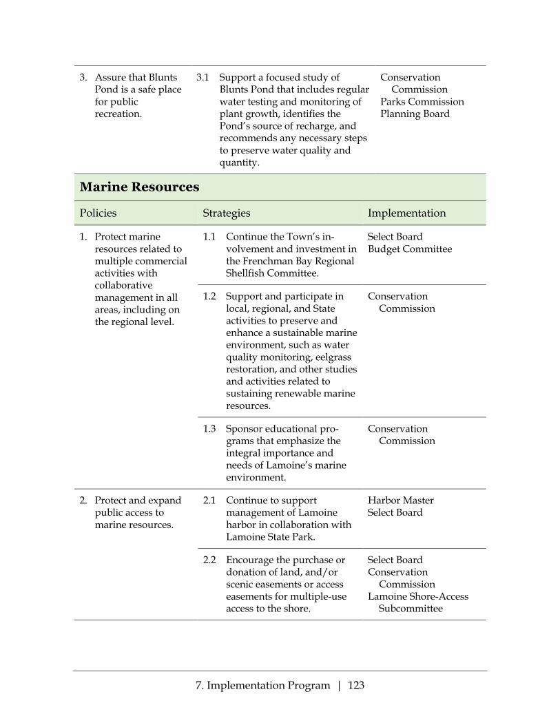
7. Implementation Program | 123
3. Assure that Blunts Pond is a safe place for public recreation.
3.1 Support a focused study of Blunts Pond that includes regular water testing and monitoring of plant growth, identifies the Pond’s source of recharge, and recommends any necessary steps to preserve water quality and quantity.
Conservation Commission
Parks Commission Planning Board
Marine Resources
Policies Strategies Implementation
1. Protect marine resources related to multiple commercial activities with collaborative management in all areas, including on the regional level.
1.1 Continue the Town’s in-volvement and investment in the Frenchman Bay Regional Shellfish Committee.
Select Board Budget Committee
1.2 Support and participate in local, regional, and State activities to preserve and enhance a sustainable marine environment, such as water quality monitoring, eelgrass restoration, and other studies and activities related to sustaining renewable marine resources.
Conservation Commission
1.3 Sponsor educational pro-grams that emphasize the integral importance and needs of Lamoine’s marine environment.
Conservation Commission
2. Protect and expand public access to marine resources.
2.1 Continue to support management of Lamoine harbor in collaboration with Lamoine State Park.
Harbor Master Select Board
2.2 Encourage the purchase or donation of land, and/or scenic easements or access easements for multiple-use access to the shore.
Select Board Conservation
Commission Lamoine Shore-Access
Subcommittee

7. Implementation Program | 124
2.3 Encourage the purchase or donation of shorefront property that links estab-lished wildlife habitats and corridors with the shore.
Select Board Conservation
Commission Lamoine Shore-Access
Subcommittee
2.4 Seek out governmental, private, and nonprofit organizational partners for shore improvement and access projects.
Conservation Commission
Parks Commission
2.5 Maintain and enhance current Town parks and other public access points.
Parks Commission
2.6 Encourage protection for scenic views of Designated Sites as defined by the Downeast Scenic Inventory, and other sites as designated by the Town.
Planning Board
3. Develop concrete responses for meeting the challenges of extreme storms and sea level rise.
3.1 Develop a shoreline management plan for the entire Town of Lamoine
Conservation Commission
3.2 Identify sources and seek funding for management plan development and implementation.
Conservation Commission
Select Board
3.3 Identify and engage in activities, including regional efforts, to support coastal and intertidal conservation, management, and restoration.
Conservation Commission
Lamoine Shore-Access Subcommittee

7. Implementation Program | 125
3.4 Review and revise emer-gency response plans to assure they include Town preparation and rapid response before and after severe weather events (plans which anticipate compro-mised communications, blocked roads, inaccessible residential properties).
Select Board
3.5 Designate floodplains, as identified by the latest Federal Emergency Manage-ment Agency information, as resource protection areas within the shoreland zoning ordinances.
Planning Board
3.6 Make available floodplain maps and projected sea level rise maps to all applicants for permits for development in the Shoreland Zone
Code Enforcement Officer
Planning Board
3.7 In any updates of land use and shoreland zoning ordinances, incorporate restrictions and protections to mitigate the effects of extreme storms, floods, shoreline erosion and runoff, sea-level rise and storm surges.
Planning Board
3.8 Develop and provide edu-cation on various responses to environmental, economic, and community changes which are anticipated with changing weather and climate conditions.
Conservation Commission

7. Implementation Program | 126
Agricultural and Forest Resources
Policies Strategies Implementation
1. Safeguard lands identified as prime farmland.
1.1 Require identification of prime farmland soils on any subdivision plans.
Planning Board
1.2 Seek assistance from the Maine Farmland Trust, local Land Trusts and other organizations that work to preserve valuable farmland.
Conservation Commission
Select Board
2. Support and promote small-scale agriculture.
2.1 Adopt agriculture-friendly ordinances, especially for small backyard livestock farming and roadside markets.
Planning Board Conservation
Commission
2.2 Assist residents in getting technical and financial advice for agriculture and livestock development (e.g., soil analysis and improvement; finding part-time assistants and paid apprentice programs).
Select Board
2.3 Assess the feasibility of developing a community garden.
Conservation Commission
3. Support and promote local marketing of Lamoine agricultural products.
3.1 Assist in developing public space for a farmers’ market and/or community sharing of garden products.
Conservation Commission
Community non-govern-ment organizations
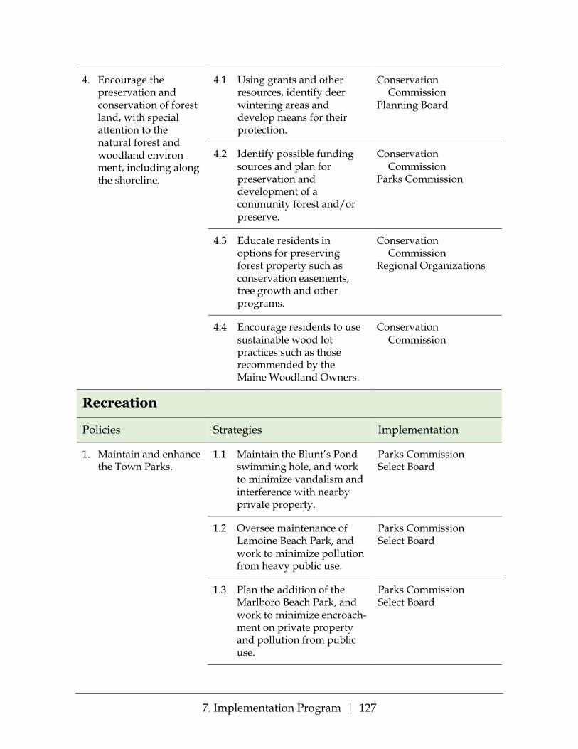
7. Implementation Program | 127
4. Encourage the preservation and conservation of forest land, with special attention to the natural forest and woodland environ-ment, including along the shoreline.
4.1 Using grants and other resources, identify deer wintering areas and develop means for their protection.
Conservation Commission
Planning Board
4.2 Identify possible funding sources and plan for preservation and development of a community forest and/or preserve.
Conservation Commission
Parks Commission
4.3 Educate residents in options for preserving forest property such as conservation easements, tree growth and other programs.
Conservation Commission
Regional Organizations
4.4 Encourage residents to use sustainable wood lot practices such as those recommended by the Maine Woodland Owners.
Conservation Commission
Recreation
Policies Strategies Implementation
1. Maintain and enhance the Town Parks.
1.1 Maintain the Blunt’s Pond swimming hole, and work to minimize vandalism and interference with nearby private property.
Parks Commission Select Board
1.2 Oversee maintenance of Lamoine Beach Park, and work to minimize pollution from heavy public use.
Parks Commission Select Board
1.3 Plan the addition of the Marlboro Beach Park, and work to minimize encroach-ment on private property and pollution from public use.
Parks Commission Select Board

7. Implementation Program | 128
1.4 Continue activity toward the acquisition of a picnic area near the Mud Creek Bridge, and work to minimize pollution from public use.
Parks Commission Conservation
Commission Select Board
1.5 Work with landowners and regional groups to establish further public-access hiking trails in town.
Conservation Commission
Select Board
1.6 Coordinate trail develop-ment, including a shore-to-shore trail, through corridor easements linking wildlife habitat areas and other landowner agreements.
Conservation Commission
Parks Commission
1.7 Review any tax-acquired parcels for recreational potential.
Select Board
2. Increase the opportunity to bicycle and walk along the roads in Lamoine.
2.1 Continue sponsorship and promotion of “Slow-Ride Sunday” to increase traffic awareness of bicyclists.
Recreation Committee
2.2 Consider whether desig-nation of some roads as a Lamoine Bicycle Trail would improve the safety of bicyclists.
Recreation Committee Select Board
2.3 Work with the Maine Department of Transpor-tation to design ways to slow down through traffic for the safety of bikers and walkers.
Select Board Recreation Committee
3. Provide opportunities for family and multi-age recreation.
3.1 Continue to hold and promote special events offering recreational opportunities for families
Recreation Committee

7. Implementation Program | 129
3.2 Work with a Town Committee on Older Adults to develop recreational and social opportunities specifically for older people
Recreation Committee Older Adults Committee
(recommended)
Business and the Economy
Policies Strategies Implementation
1. Continue to support small businesses and home occupations.
1.1 Make a current list of goods, services and vendors available on the town’s website.
Volunteers
1.2 Lead the effort to secure quality internet services throughout the town to sustain web-based and internet-based businesses and occupations.
Select Board
1.3 Consider creating a Development Committee to consider how best to promote Lamoine businesses.
Select Board
1.4 Review town ordinances and building codes to assure that they do not restrict home occupations or small businesses more than is necessary for public safety, traffic control, protection of neighbors or other important concerns.
Planning Board
2. Retain Lamoine’s flexible Rural and Agricultural Zone.
2.1 Prepare a pamphlet describing the activities permitted in the Rural and Agricultural Zone so that people understand the full range of activities that may take place near their homes and businesses.
Planning Board Town Office

7. Implementation Program | 130
2.2 Encourage farm uses of Lamoine’s traditional agricultural areas.
Conservation Commission
2.3 Actively explore appro-priate uses for gravel pits which can no longer be mined.
Select Board
Housing
Policies Strategies Implementation
1. Explore the need for more affordable housing in the town.
1.1 Review town ordinances and building standards to assure that they meet the needs of affordable housing development and require adequate provision be made for water supply and sewage disposal and for significant open space to be set aside for buffers and recreation.
Planning Board
1.2 Encourage energy audits of all buildings and seek opportunities to make them more affordable to residents
Conservation Commission
2. Plan for shifting demographic demands for housing
2.1 Consider a Town Commit-tee on Older Adults to think through issues of an aging population and advocate for older adults aging at home.
Select Board
2.2 Consider standards in the Building and Land Use Ordinance to allow acces-sory dwelling units in all zones, unless prohibited by DEP Resource Protection Zoning, to allow such dwelling units which will enable older adults to remain in their homes.
Planning Board Town Older Adults
Committee (recommended)

7. Implementation Program | 131
Transportation
Policies Strategies Implementation
1. Ensure that roads in Lamoine will be convenient, safe and accessible for all transportation users, including pedestrians, bicyclists, transit vehicles and riders, children, the elderly, and people with disabilities.
1.1 Work with the Maine Department of Transpor-tation to reduce the speed of through traffic on Buttermilk Road and Routes 184 and 204, and particularly the intersection of those routes.
Select Board Road Commissioner
1.2 Identify opportunities to create bicycle and pedestrian facilities along major roads to implement such facilities as part of ongoing maintenance and construction projects or as circumstances allow.
Select Board Road Commissioner
2. Provide parking at the Lamoine Town Hall, the Fire Department and the School that is safe and adequate to requirements.
2.1 Purchase additional land contiguous to these public buildings for additional parking or reconfiguration of functions.
Select Board School Board
3. Ensure that older adults are able to meet their transportation needs.
3.1 Work with local and regional non-profits to facilitate shopping trips, medical appointment travel and even social and cultural event travel for older adults.
Select Board Town Older Adults
Committee (recommended)

7. Implementation Program | 132
Public Facilities and Services
Policies Strategies Implementation
1. Continue to run Lamoine’s Town government with a small-town feel, providing services efficiently with a minimum of bureaucracy.
1.1 Support the Volunteer Fire Department.
The Town
1.2 Renew the population of volunteers for town com-mittees and other activities in every generation
Select Board and committees
1.3 Conduct an energy audit of the Town Hall, School, and Fire station and follow up to reduce energy use.
Select Board School Committee Contractors
1.4 Continue to explore cost-sharing and cost-savings opportunities with other towns.
Select Board
2. Develop a Community Center that provides a location for a wide variety of Town events for all ages.
2.1 Establish a Community Center Committee to determine the components, location, design and cost of a Community Center.
Select Board
2.2 Determine the Town’s administrative needs going forward and incorporate those needs in any Community Center design.
Select Board
3. Ensure that the Lamoine Consolidated School continues to be a well-regarded school that draws young families to Lamoine.
3.1 Strive to maintain the Lamoine Consolidated School under local control.
Select Board School Committee
3.2 Ensure that the School strives for success, with every child supported and participating in the community.
Select Board School Committee
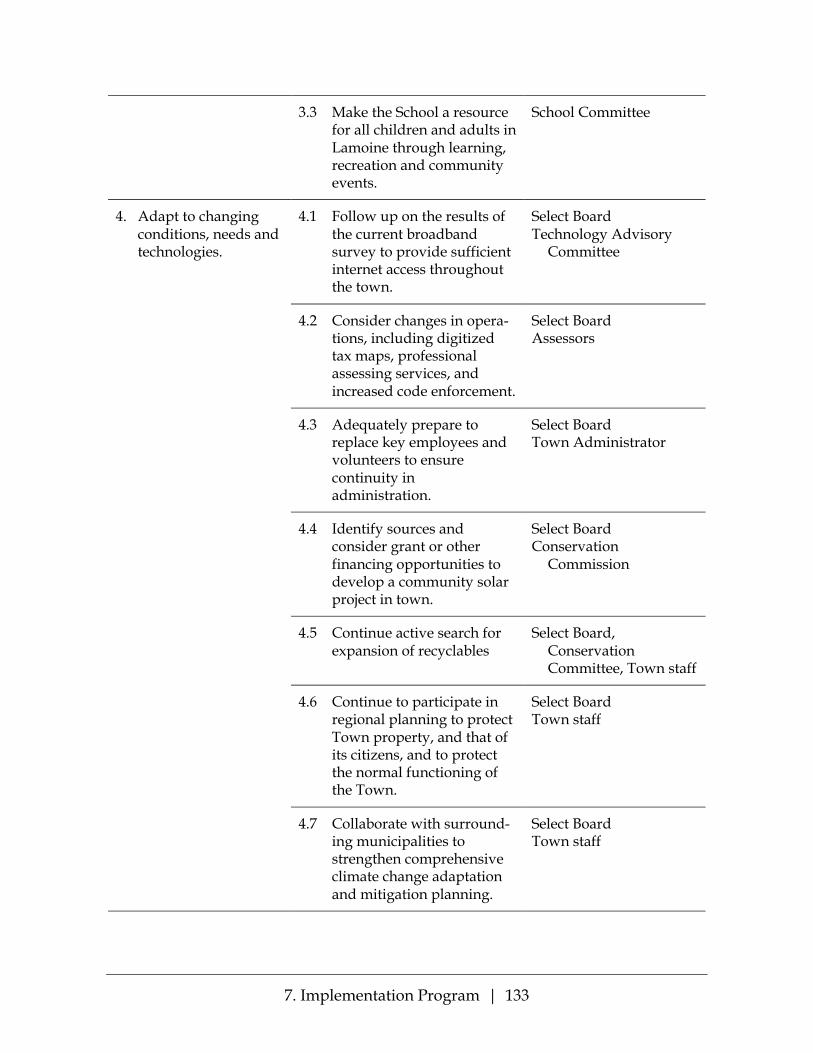
7. Implementation Program | 133
3.3 Make the School a resource for all children and adults in Lamoine through learning, recreation and community events.
School Committee
4. Adapt to changing conditions, needs and technologies.
4.1 Follow up on the results of the current broadband survey to provide sufficient internet access throughout the town.
Select Board Technology Advisory
Committee
4.2 Consider changes in opera-tions, including digitized tax maps, professional assessing services, and increased code enforcement.
Select Board Assessors
4.3 Adequately prepare to replace key employees and volunteers to ensure continuity in administration.
Select Board Town Administrator
4.4 Identify sources and consider grant or other financing opportunities to develop a community solar project in town.
Select Board Conservation
Commission
4.5 Continue active search for expansion of recyclables
Select Board, Conservation Committee, Town staff
4.6 Continue to participate in regional planning to protect Town property, and that of its citizens, and to protect the normal functioning of the Town.
Select Board Town staff
4.7 Collaborate with surround-ing municipalities to strengthen comprehensive climate change adaptation and mitigation planning.
Select Board Town staff

7. Implementation Program | 134
Land Use
Policies Strategies Implementation
1. Guide development consistent with the rural character of the town.
1.1 Maintain the zoning map which has governed Lamoine development for the past decades
Planning Board
1.2 Amend the Table of Uses in the BLUO [Section 4.H.] to prohibit Hotels and Motels in the Rural and Agricultural Zone.
Planning Board
2. Plan Implementation and Monitoring
2.1 Coordinate and monitor implementation of the Future Land Use Plan by working with and support-ing the boards, committees and individuals designated with the responsibility for specific strategies.
Select Board Planning Board
2.2 Meet with appropriate representatives of Ellsworth, Hancock and Trenton to coordinate land use designations and regulatory and non-regulatory strategies.
Town Representatives appointed by the Select Board
2.3 Track new development in Lamoine by type and location.
Planning Board Town staff

7. Implementation Program | 135
2.4 Evaluate implementation of the Comprehensive Plan at least every five years. This review shall consider: (a) The degree to which
Future Land Use Plan strategies have been implemented;
(b) The location and amount of new devel-opment in relation to the town’s designated Rural area; and
(c) The amount of critical natural resource areas protected through acquisition, easements, or other measures.
Committee designated or appointed by the Select Board
Town of Lamoine 2019 Comprehensive Plan
Appendices
Lamoine Town Meeting – March 20, 2019


i
CONTENTS
APPENDIX A: PUBLIC PARTICIPATION ___________________________________1
A1: Report of the Lamoine Comprehensive Planning Committee, October 2013 ........................................................................................................................2
A2: 2015 Community Survey – Comments ............................................................10
A3: March 2016 Community Meeting – Powerpoint Presentation .....................15
A4: March 2016 Community Meeting – Responses ..............................................29
A5: LCPC Meeting with Board of Assessors ..........................................................34
A6: LCPC Meeting with Budget Committee ..........................................................36
A7: LCPC Meeting with Conservation Commission ............................................38
A8: LCPC Meeting with Frenchman Bay Riders ...................................................44
A9: LCPC Meeting with Friends of Lamoine .........................................................46
A10: LCPC Meeting with Lamoine Community Arts ...........................................51
A11: LCPC Meeting with Lamoine Historical Society ..........................................53
A12: LCPC Meeting with Lamoine School Committee ........................................54
A13: LCPC Meeting with Lamoine’s Little Children ............................................56
A14: LCPC Meeting with Parks Commission ........................................................57
A15: LCPC Meeting with Planning Board ..............................................................58
A16: LCPC Meeting with Recreation Committee ..................................................60
A17: LCPC Meeting with Select Board ...................................................................62
A18: LCPC Meeting with Technology Committee ................................................63
A19: LCPC Meeting with Volunteer Fire Department .........................................65
A20: November 2017 Community Meeting – Dots Counts and Comments .....67
A21: 2016 Online Community Survey – Demographics of Respondents ..........76
A22: 2016 Online Community Survey – Goals ......................................................78
A23: 2016 Online Community Survey – Policies and Strategies .........................83
APPENDIX B: NATURAL RESOURCES ____________________________________97
B1: Lamoine Watersheds and Water Quality, 2014 ...............................................98
B2: Beginning with Habitat Map 1 – Water Resources & Riparian Habitat, 2018 ......................................................................................................................99

ii
B3: Beginning with Habitat Map 2 – High Value Plant & Animal Habitats, 2018 ....................................................................................................................100
B4: Beginning with Habitat Map 3 – Undeveloped Habitat Blocks, 2018 ........101
B5: Beginning with Habitat Map 7 – Wetland Characterization, 2018 .............102
B6: Beginning with Habitat – Natural Resource Co-occurrence, 2018 .............103
B7: Conserved Lands Map ......................................................................................104
B8: Taunton Bay Focus Area ...................................................................................105
B9: Mini-Handbook of Lamoine’s Groundwater Hydrology ............................106
APPENDIX C: LAND USE _______________________________________________115
C1: Zoning Districts Map ........................................................................................116
C2: BLUO Table of Land Uses ................................................................................117
C3: Shoreland Zoning Districts ..............................................................................118
C4: Development Potential .....................................................................................119
C5: Cluster Development Standards .....................................................................120
C6: Shoreland Zoning Ordinance ..........................................................................123
APPENDIX D: ROADS AND TRANSPORTATION ________________________185
D1: Lamoine Transportation Network ..................................................................186
D2: Estimated Average Annual Daily Traffic (AADT), 2015–2017 – Map .......187
D3: Estimated Average Annual Daily Traffic (AADT), 2015-2017 – Table ......188
D4: Vehicle Crashes, 2013-2017 – Map ..................................................................190
D5: Public Roads Listing – Maintenance Records ...............................................191
D6: Official Names and Detailed Descriptions of Lamoine Roads as of 2/13/15 .............................................................................................................192
D7: Highest Annual Tide (HAT 2015) Plus 6 Foot Sea Level Rise – Predicted Roadway Vulnerability .................................................................203
APPENDIX E: PUBLIC FACILITIES AND SERVICES _______________________207
E1: Public Facilities, Parks and Hiking Trails ......................................................208
E2: Lamoine Consolidated School – Central Purposes and Core Principles ...209
E3: Lamoine Consolidated School Enrollment, 2007-2017 .................................210
E4: Hiking Trails of Lamoine ..................................................................................211
E5: Resolution on the Importance of Children’s Early Years ............................214

iii
APPENDIX F: FISCAL CAPACITY ________________________________________215
F1: Capital Needs Schedule ....................................................................................216


1
Appendix A: Public Participation The documents in this Appendix A are contemporaneous records of the survey responses, meetings with groups, and community meetings described in pages 2 to 4 of the Plan.

Appendix A: Public Participation | 2
A1: Report of the Lamoine Comprehensive Planning Committee, October 2013

Appendix A: Public Participation | 3

Appendix A: Public Participation | 4

Appendix A: Public Participation | 5

Appendix A: Public Participation | 6

Appendix A: Public Participation | 7

Appendix A: Public Participation | 8

Appendix A: Public Participation | 9

Appendix A: Public Participation | 10
A2: 2015 Community Survey – Comments
Gravel Pits Lamoine must move towards a more equitable tax structure. The heavy dump truck traffic is the cause for the rapid deterioration of our roads. Therefore, for example, the sand and gravel industry should pay for the reconstruction of Rt 184 north of the town hall. Reclaim gravel pits. Creative thinking. Limit new gravel extraction. Noise reduction of the quarry, particularly before 7am. Expanding gravel industry. Gravel pits out of control and present an environmental problem while town officials appear unconcerned!!! We may want to ask if residents if gravel operations are affecting our town. If so, “How?” Do people want to see more restrictions on the gravel industry? Is the beauty of our woods being threatened? I support the limitation of large industrial activities in Lamoine – such as sand and gravel excavation – to current volume Gravel extraction monitoring is a municipal responsibility for the future. The destruction of the land by the gravel industry with little or no regard for the protection of the water systems overburden flora and fauna with no remuneration to the town for the items listed above and with the obvious bias of the selectmen and boards towards extraction industry with little or no regard to needs and desires of the voting public. Get the gravel pits out of Lamoine !! No more new ones. Discourage the opening of new, undisturbed areas within the residential zone to gravel mining operations. The gravel pits/mining: their threat to the quality/supply of our water. Continued control of the gravel industry. Would like to see the town putting a higher interest and effort in protecting the rural town atmosphere, residents, and property values from the gravel industry. Limit commercial development and mining. Please! Lamoine MUST remain a quiet residential community, no manufacturing or big businesses; STOP ALL MINING & GRAFEL EXTRACTION I do not like the way gravel pit issue has been dealt with and continues to be handled. Very concerned about town government’s double standard – to be completely confident that is has the right to regulate residents on all kinds of activities in order to preserve Lamoine’s lovely resources and character while allowing the vast increase in open-pit mining over the last 40 years with virtually no restoration of unused pits, threats to water, and persistent noise, truck traffic, and general environmental degradation. Even more concerned that the town government is willing to spend countless hours and costs to placate the industry’s desires in lieu of standing up once and for all to significantly curtail and regulate this heavy industry in a residential town. The constant threat of lawsuits against the town by the industry and its complete failure over decades to clean up its act will not end until the town stands up to it, even if that requires going to court. Re-writing of ordinances that were hard-won and giving in to industry demands in return for only trusting it to do the right thing, although it has no history of doing so, is exactly the wrong thing to do, rather than to stand up and represent and defend its resident constituents. Gravel operations.
Appendix A: Public Participation | 11
Control gravel mining and make mining companies reclaim land properly. Charge them more taxes for taking away land. I’d like the town to consider plans to redevelop abandoned/old gravel pits and restore them to a community use…. parks or ballfields. They are ugly. Gravel pits; noise concerns from gravel pits. Stop the gravel mining. It is damaging our property values, adds to noise pollution, and will change the nature of our water quality. Why do gravel trucks start so early in the AM? Final resolution of gravel pit discussions to eliminate episodic recurrence – maybe invest in a moderator to resolve and write int comp plan, ordinances, zoning etc --- to get past bad feeling and slurs, etc. from both sides Ending the property devaluation and the degrading of the land by the gravel industry Water quality degradation by gravel extraction. Property value degradation by gravel industry. Poor Town government due to gravel industry influence. You haven’t addressed the issue of the gravel industry and the deleterious effect on the town. We need to encourage limited commercial development that is compatible with the overall residential character of the town (and discourage industrial development, including unfettered (i.e. w/o restoration) gravel extraction of the sort we’ve experienced so far). Traffic and Speeding Mud Creek Rd. Pinkham Flats to Jordan River Rd offer a well-used shortcut for folks who live further east but work on the island. Is there a way to get them to take another route or at least slow down? Hopefully some of this will be alleviated when Jackson Lab open up their Ellsworth facility. Speeding/reckless driving on route 204 Partridge Cove Rd. area. Dangerous to walk or ride bikes. More patrolling of speeders on the Jordan River road! Q29: Use three routes: Douglas Highway, Buttermilk Rd. Through Trenton Why do gravel trucks get started so early in the AM? A traffic light should go on RT2 by Cheese House – too much traffic coming and going on Rt.3 – Jackson Lab. Acadia Nat’l Pk. Q29: use Douglas Highway, Buttermilk Road Through Trenton for traveling to work or shop. I would like to see a sidewalk on Shore Road to allow the many people and their pets wo walk there a safer place. In the near term a reduced speed limit on all of shore road to keep everyone walking there safe. So many people are traveling much faster than the posted speed limit. Speeding throughout the roads of Lamoine is rampant. I’m fearful of walking our roads. Housing Residential development in relation to green space preservation and access. Maintain focus on rural/residential aspects of town. I would like to see the zoning changed to *Residential” where there are a number of only residences or housing developments along a stretch of road or an area. Lorimer Road/Marlboro Beach Road would be such an area. Low income housing is non-existent and the rules and regulations in town does not promote it Change zoning to cluster housing areas. Change rules to allow denser building. Big start would be with road frontage setbacks and acreage rules. I would like to see a total rewrite of the town’s Building and Land Use ordinance and zoning map.

Appendix A: Public Participation | 12
Overbuilding in some areas, parking mobile homes for long periods of time Land use ordinance addition: no new construction or new projects (such as planting large trees) can obstruct the views of existing residences The community needs to make itself more desirable and affordable for young people and especially young families in order to remain a balanced community. Street Lights Should have a street light installed, corner of 184 & 204, in front of Lamoine store. It would also be nice to have more streetlights around town like at some intersections that are heavily used. Preservation of Land and Environment Enact a “dark sky” ordinance to protect the gorgeous stars we are fortunate to have as a resource. Restrict use of pesticides/herbicides/insecticides within XXX feet of wetlands, ocean and ponds. The conservation and beauty of Lamoine. Preservation of land, especially Pinkham Flats, remaining forests, shoreland. Keep Lamoine residential and recreational Good agricultural land being taken for housing. Zoning and residential development in relation to green space, preservation and access. Protect our ground water and aquifer. Law Enforcement/ Code Enforcement Fund the Code Enforcement position for more hours than current funding/time commitment in a growing town, there is a need. The Town should be more aware of enacting and enforcing ordinances (consistently) that increase, not decrease, the property values. The Town needs to do more to increase property values via proper ordinances and consistently enforcing them. Therefore, resulting in more revenue to fund projects. Vandalism, mailbox damaging, stealing road signs, stealing owner name signs. Drugs and alcohol usage. It would be nice if we had a local constable or officer that was dedicated to Lamoine. Also, the Buttermilk Road is a dumping ground for litterers. It’s disgusting. At least start enforcing the littering law there. I am concerned for the animals with all of the plastic. A big concern for me is public safety. I was in a car accident in Lamoine and it took an hour for a state trooper to arrive. It makes me fearful for situations in town that require urgent police presence. Road Issues Some non-paved roads are in poor condition (#29 checked all 4 instead of just one) Safety on the roads (gravel trucks) and the financial benefit that Lamoine gets for allowing this to continue? More “pull of “places with picnic tables for enjoying the beauty throughout the Town. Q17 Very poor road edges Would like to see areas near intersections trimmed back a little more i.e. Walker Rd and the Mill Road and the Walker Road and Pinkhams Flat Rd. I think line of the site is poor in these locations especially. Again, please add bike lanes to the roads. I am flipped the middle finger by rednecks at least once a ride just for biking on the road.

Appendix A: Public Participation | 13
Regulate waste water dumping from recreational vehicles after extended stays when their holding tanks are full. Disposal for yard waste (vs burning) Taxes Need new Tax Appraisal of our property. I am concerned about the valuation system for property taxes. The homestead exemption somewhat addresses this, but owners who purchased land and homes long ago should not be taxed on the resale value of their land today forcing them to sell their property, in some cases. Our taxes are out of line. They are much too high for the property we own. Other Comments Are we prepared to deal with issues of global warming? Lamoine should identify these issues that relate to a small rural town with a very distributed population (no significant neighborhoods to speak of) and to develop a plan to deal with them in order “to be resilient”. How is common core going to affect the town? More better choices in high-speed internet and access in all homes, including the most remote, esp. to open up more job possibilities. Regulation of noise/height of low-flying aircraft (like sight seeing craft) over Lamoine residential areas Need for aa wind farm ordinance that addresses setbacks, noise and view-shed protections. Q 17: Do not feel safe in my home More ways to bring all ages together to create wholistic sense of community. Promoting small businesses. I would like to see a total rewrite of the town’s Building and Land use ordinance and Zoning map. The argumentative manner in which some board meetings are conducted, particularly the Planning joard, leaves one with the feeling that Lamoine is a dysfunctional community. A “comprehensive plan” should include resolving issues, i.e. gravel pit vs environmental issues etc. with a true community sprit instead of open animosity. Someday I’d like to see a free standing library in Lamoine. Could be connected to the school but open to the general public. Also a nice space for community groups to meet. Call Ken Smith @ 667-6556 to discuss if you want Our Town meeting should be on Saturday and on day time. I have not attended one meeting since it was changed. The town has been taken over by folks that want to drive out the original people and replace them with fellow travelers. Not much we can do about it if we don’t vote. Lamoine should coordinate with neighboring towns to provide bus transportation to John Bapst High School Harbor access should be free for Lamoine residents – either via passes to state park or moving boat ramp/harbor away from state park. GET RID OF THE TREE HUGGERS We also need to continue encouraging citizens to volunteer and have a voice in making Lamoine a more fulfilling place for everyone to live in. I think Lamoine needs to be more business friendly The school needs to be mor opened to the Lamoine people it is rel hard to find out what is going on and what the school board and staff is doing (very little tv and web info). Would like to see them more open to parents.

Appendix A: Public Participation | 14
I would like the town to implement a community solar project that would allow town residents to invest in solar power generated from panels installed on the school. There are many utility poles especially on roads near the coast (ex. Seal Point Road), that are in poor condition and should be replaced. Better internet connection S the comprehensive plan committee looking at the future of Lamoine, to protect it from development, or to make it more viable for families and businesses to want to come to Lamoine. Thank you! The cell phone service is TERRIBLE for Beach Road residents!! Town government organization: Planning Board should be elected; Town manager needed. Future of the Lamoine school…. Should always evaluate opportunities to share resources and coordinate services with other communities/agencies. Please, please, please consider bringing reliable internet access to Lamoine !!! Our only choice currently is DSL with Fairpoint which is completely unreliable, on a good day. They are the only game in town, and that is not appropriate; must have access for work!!! Residents should have free access to the Lamoine State Park. Especially senior citizens and folks walking their dogs. To have to pay for this seems outrageous. Barking dogs late at night. No dump areas for brush, tree limbs and other garden debris. Lamoine needs a coffee house, café, as a gathering place.

Appendix A: Public Participation | 15
A3: March 2016 Community Meeting – Powerpoint Presentation

Appendix A: Public Participation | 16

Appendix A: Public Participation | 17

Appendix A: Public Participation | 18

Appendix A: Public Participation | 19

Appendix A: Public Participation | 20

Appendix A: Public Participation | 21

Appendix A: Public Participation | 22

Appendix A: Public Participation | 23

Appendix A: Public Participation | 24

Appendix A: Public Participation | 25

Appendix A: Public Participation | 26

Appendix A: Public Participation | 27

Appendix A: Public Participation | 28

Appendix A: Public Participation | 29
A4: March 2016 Community Meeting – Responses
Natural Resources Water
Wells – Testing Attention to quality (2)
Regulations about mining water
Protect water (3)
Protect our aquifer for the future
Conservation
Conservation easements
Resurvey of conservation areas
Save open spaces – water, forest
Conservation of Resources, open spaces (2)
Improve/Maintain environment
Open spaces
Water quality
Recreation
Be a Conservation Leader by example
Protection of land and shore from contamination – ecoli, lead, etc.
Wildlife corridors and recreation trails and habitats
Protection of shoreline as properties become available; woods – identify
Need for inventory deer yards as wildlife
Inventory wildlife protection areas
Town land purchases for open spaces/conservation
Open space; undeveloped land (2)
Maintaining (tree growth)
Beauty (land) preservation
Preserve the environmental quality and natural beauty we all value
Keep as physically beautiful as it is now
Protected Views
Balance (3)
Natural beauty and economic activities
Environment and business (eco-tourists?)
Natural resources with houses, businesses, community places (3)
Become a local example for keeping balance
Natural Recreation Areas
Tennis
Development of Trails (2) Bike Ski
Listing of walking and biking trails
Access to trails/nature (2)
Swimming places
Ability to enjoy our beaches and State Park
Promote healthy lifestyles through trail development (walking/ running/biking paths) and two local farms
Natural Restoration
Restored spaces (needing restoration)
Reclaim land along Jordan River
Gravel pit resolution/reclamation
Marine Resources
Enhanced working waterfront
Ocean fishing (future – go forward)
GONE! **could not read writing/check post-it note

Appendix A: Public Participation | 30
Herring, Cod, Pollock, Yona Crab, Flounder, Clams, Mussels, Conger Eel, Eels, Holdp Hoct
Access to the shore for
Recreation
Harvesting (2) Lobsters Clams
Governing Zoning
Planning for residential vs business vs protected areas etc.
Designate and Industrial area
A mix of residential and commercial compatibility
Sustainable and intelligent growth
Assigning certain activities to certain areas of town
Clarifying land use in town
Enforce the Zoning Law to regulate business and rural area
Zoning implications on water
Zoning to ensure protection of areas
Zone for Farmers Market Restaurants/eating places
Reclamation/Repurposing of Gravel Pits
Reclamation at least equal to expansion
Repurpose for Housing Wildlife refuge Lakes/ponds Trails
Balance: pits/reclamation/community
Currently make useless 100 feet deep holes in the ground /give pits to town and make them ready
End of mining .. restore pits
Gravel reclamation & resolution (2)
Land purchase for reclamation of pits for town use and better tax revenue
Solar
Use unreclaimed gravel pits for solar panels
Lamoine has community solar (3)
Paid for by electric company/gravel owners/ rants from federal and state governments
Establish and support more solar energy use
Community solar paired with cluster housing
School
Involved with Community
Quality education (2)
As local as possible
School!!! Keep our school
Pre-school program
Vibrant school
Participation
Auxiliary groups created based on primary interests and willingness to contribute time and energy to explore possible solutions
Volunteer opportunities for older people to work (play) with small kids
That there is a place here for me (as a 60-90 year old) to still be involved and active and feel a part of the town
Active participation of residents in town governance

Appendix A: Public Participation | 31
Communication phone/internet
Community Center/Town Center/ Community Hall
Establish a town center (2)
Location and site of Town Hall
Being able to expand
Lamoine needs a destination
Lamoine has a school that is a community center for all ages and is supported by the Town (4) Bring them together
Expanded space for community center
Near School or Use the School for programs/recreation/social events
With a stage
Involves Community Groups (Historical Society, Lamoine Community Arts) social issues and work projects
Can be used by residents senior citizens and children (2)
Include a Library Day Care Center Meeting space Social space
Recreational opportunities/facility
Especially in winter
More town activities to include all age groups; finding common ground
Hay rides, ice skating, picnics, singing
Tight knit community
Fundraising, pot luck, Organic friendly
Services for older citizens Fund renovation of Grange Classes Exercise groups Gatherings at Grange/school
Taxes
Tax stability: Not taxing out long term property owners (3)
and those who improve value
Lack of commercial tax base
Balance of income generating environment with preservation
Fixed income residents with rising costs
Reasonable taxes (2)
Affordable taxes for young families
Young Families
A place where young families would be able to afford to have a home (2) and earn a living
Commitment to children and environment; make residents aware of the commitment
Establish a community garden
A place where children can play and learn; vital young community
Strong school
Small Business
Farmers’ Market (3)
Hidden Businesses/In Home
Keeping option for small business in rural/agriculture zone
Commercial business center(s)
Become a tech center (low impact on land; bring your tech minds in with a small town feel)
Imagine! Lamoine has a great restaurant! with local food
An ice cream stand!
Town Management
A police force (a small one) (3)
Safety: brush and trees should be cleared back from roadsides more

Appendix A: Public Participation | 32
More recycling at Town Dump (2)
1 through 7 containers (2)
Make sure Town of Lamoine MAP is correct/up to date
Branch of Ellsworth Public Library
Always have “a Stu” and good Town leadership
Improved roads
Improve internet access (2)
Quality of Life Transportation Daily bus service to Ellsworth
Support for an Aging Population
Transportation (public) for people who do not drive needs to be improved (3)
Senior housing and services (like Meadowview in Ellsworth)
Support for an Aging Population
Housing
Internet access/phone
Social Cohesion
More/scheduled community events (2)
An array of activities bringing us all together
A place where you know, help and interact with neighbors
Develop ways/places to address divisiveness
Eliminate divisiveness
A more friendly community * need to move beyond issues
Respect for laws
Enforcement of ordinances
Democratic problem solving
I wish that Lamoine could go back to being a community that worked together
That residents with different viewpoints find common ground on contentious issues – like those related to gravel – and recognize our shared interest in keeping Lamoine great
That we move forward together in the knowledge that we all care about Lamoine
Maintain/improve small community feel
*community gatherings/offerings
*bridging divisive issues
Improved “town spirit” Fewer divisions Less animosity More willingness to compromise
Fostering ways to mediate controversial issues
We all have our own Opinions *and they are respected
“Issues” are resolved
People can accept other people as they are and do the best to each other for the best.
More Community, less Ideology
Retain a sense of Community
Help their neighbors and not make hardships for them
Small Town
Keep the quiet beauty (2)
Maintain rural environment (2)
Maintain character a safe, beautiful place to live a beautiful, quiet, happy, serene,
“good” place to live
Lamoine continues to be the place people want to live

Appendix A: Public Participation | 33
Keep small town values
Keep small town feel and interaction
Traffic Management
No industrial truck traffic
Less dump truck traffic
Road Safety
Improve and maintain roadways
More walkable, biking, etc. safe roads for recreation
Gravel pit road: common road to connect pits without pit traffic on other roads (2) year round
Rebuilt State Highways to modern standards
Age Diversity
Diversity in population
Maintain the natural beauty of Lamoine yet allow sufficient/smart development to attract people of all ages and diversity
Intergenerational development
Have a community that supports everyone – young and old
A balance between elderly, in-betweeners, and youth
Activities for all ages, more (2)
Housing
Incentives for “greener” residential
Cluster housing
Affordable housing
General
Figure out ways to solve the problems we currently face:
Lack of broadband More affordable housing Ensuring water quality
Respect our History and educate newcomers on our Past so as to create a happier atmosphere
Lamoine has a strong sense of place, identity, and history and is safe and beautiful

Appendix A: Public Participation | 34
A5: LCPC Meeting with Board of Assessors
Lamoine Comprehensive Plan Committee Meeting with the Lamoine Board of Assessors
Name of Group: Board of Assessors Date of Meeting: January 6, 2016 Chair or contact person: Jane Fowler, Chair Phone number: 667-5147 Number of people attending: Jane Fowler, Terry Towne and Mike Jordan
LCPC: Fred Stocking, Mike Jordan, & Kathie Gaianguest Focus or primary responsibility of group: Valuation of property in Lamoine for the purposes of taxation. Work of this group in actively planning for the future: Primarily training with respect to State law and methods of property valuation. The active work of the Assessors relates to values at any given time. Expressed concerns of group relating to focus or primary responsibility: Pressure on volunteer assessors and the drive towards computerization. Aging of current Assessors and perceived unwillingness of younger people to undergo sufficient training to do the job. Assessors go to training school during the first week of August. Volunteers have trouble staying on top of changes in the law, such as the Tree Growth Tax law changes of a few years ago. Many towns are going to professional assessors with a lay board supervising. With increasing development and complexity there are stresses on a town’s code enforcement staff. Similar to the situation with volunteer Assessors, it becomes increasingly difficult to find folks with proper training for a part-time code enforcement position. Some towns have dealt with these twin pressures by hiring a combine Assessor Code Enforcement Officer as a full-time position. This is turn might put pressure on town hall capability as full-time paid staff increases. Expressed concerns of individuals on matters not related to focus or primary responsibility: There is a concern that the town is running significantly on the volunteer energy of the middle aged and healthy elderly. As this cohort thins out due to death and infirmity, the Town may have considerable difficulty replacing its energy, commitment and acquired expertise. Interesting facts/ideas that came out of the meeting: The town’s valuation has stayed close enough to the state valuation. The last time the town had to pay for a comprehensive revaluation was 1993. Basic statistics of the Assessors: Category Year: 2012 2013 2014 2015 2016

Appendix A: Public Participation | 35
Mil rate 9.3 9.3 10.3 10.10 10.10
Tax Commitment $2,384k $2380k $2,643k $2616k 2616.7k
State Valuation $273,750k $267,500k $261,850k $255,100k $263,050k
Follow up: None noted

Appendix A: Public Participation | 36
A6: LCPC Meeting with Budget Committee
Lamoine Comprehensive Plan Committee Meeting with the Budget Committee
Name of Group: Town Budget Committee Date of Meeting: 11/30/2015 Chair or contact person: Robin Veysey, Chair (or contact Stu) Number of people attending:
LCPC: Fred, Bob, Kathie, Bonnie (Mike was there but had to leave before meeting on a fire call, as did Stu)
Budget Committee: Robin Veysey, Merle Bragdon, Marian McDevitt. Others: Gary McFarland, Jo Cooper
Focus or primary responsibility of group: Setting the annual budget for the Town. Work of this group in actively planning for the future: None, really, as the chore is a recurring annual chore. There is a capital expenses list that details which major improvements will be needed in each of the years in the near future, but this is developed primarily by the Select Board. Currently there is no bonded debt. Merle noted that a primarily residential town such as Lamoine has a very stable tax base, It is not subject to the large swings in a year due to a large mill closing, for instance. Change in the tax base is generally slow and incremental, and so are changes in the cost of services provided. The Budget Committee noted that the withdrawal from the RSU had no net effect on the Lamoine budget. Merle noted that the effect on the town of the winding down of the gravel industry is unknown and to his knowledge has not be studied. Expressed concerns of group relating to focus or primary responsibility: Revenue Concerns: Stu, before he left, noted that he was making only cautious assumptions about State revenue sharing with Towns, because so many items under this administration became “political footballs” and the normal flow of finances has been disrupted. Jo Cooper noted that she is on the Hancock County Budget Committee and that the State is currently taking the position that counties must pay all of the jail costs. Jail costs are a major expense and if these are passed on to the County, the towns will have to come up with the money. Town Needs: In response to question about the feasibility of bike or pedestrian lanes along Lamoine roads, Marian noted that the rights of way are quite wide. Merle thought the rights of way probably would provide ample room for bike lanes, but that widening the paved portion of roads and creating new shoulders would be “big ticket item.” He thought this should be a consideration if the Town should establish a new road somewhere in town. The Town office is adequate for now, and there is a plan to put a new foundation under it. Merle thinks that there is a major need in town for high speed internet throughout the town and the town may need to figure out how to get involved to make it happen.

Appendix A: Public Participation | 37
Interesting fact to come out of the meeting: Town roads are considered by accountants to be an asset of the town worth a great deal of money. Of course, we can’t sell them to raise cash, so they are a very limited kind of an asset. Follow up: None

Appendix A: Public Participation | 38
A7: LCPC Meeting with Conservation Commission
Lamoine Comprehensive Plan Committee Meeting with Lamoine Conservation Commission
Name of Group: Lamoine Conservation Commission Date of Meeting: 10/4/2015 Chair or contact person: Larry Libby Phone number: Number of people attending: 15
LCPC: Fred, Kathie, Bob, Andrea, Mike, Richard, and Val LCC: Larry Libby,, Larissa Thomas, Nancy Pochan, Anne LaBossiere, Linda
Penkalski, and Doug Stewart. Others: Carol Korty and Willem Brutsaert
Focus or primary responsibility of group: Research and Education on conservation issues and pro-active projects. The group has just finished a planning session in which it decided to seek a major project to begin. No project has yet been identified. Work of this group in actively planning for the future: Completed Open Space Report and Inventory in 2013. GET WET project in the school both exposes students to science and provides data on water quality in Lamoine that increases with usefulness over time. Expressed concerns of group relating to focus or primary responsibility: Climate change- what will be the risks and costs to Lamoine? LCC has scheduled a lecture by the State climatologist for November 10th. Trail Development- where might there be other opportunities for recreational trails in Lamoine and what role might the LCC play in developing them? Is there a way to get kids in Lamoine into the woods on the Simon trail for nature education? Rockweed, mussels, clams, worms- Are there a threats to the resources on the shore and intertidal areas in Lamoine? Should there be regional projects involving several towns? Community solar- Is there an opportunity for a project like that in Bar Harbor for Lamoine? Agriculture- Do we need to do more to encourage agriculture in Lamoine? Dark Skies- Should we be developing programs to limit light pollution? Communication- Is there a way to better coordinate projects and or disseminate information about what’s going on with natural resources- example of a survey done in town on shellfish which the LCC never heard about while it was going on. Follow up: LCC to submit written recommendations (attached).

Appendix A: Public Participation | 39

Appendix A: Public Participation | 40
Comprehensive Planning Committee C/O Fred Stocking 30 Berry Cove Road Lamoine, Maine 04605 Subject: Lamoine Conservation Commission Recommendations for Comprehensive Plan Dear Fred: In support of your efforts to prepare a new Comprehensive Plan, the Lamoine Conservation Commission is pleased to submit our thoughts on the key concerns and possible responses the Town of Lamoine can make on issues related to land management, resource stewardship, and climate change. These are presented as input to your deliberations and represent a consensus among current LCC members. Our thoughts here are consistent with many of the issues raised in the March 2013 Open Space Report and Inventory which LCC transmitted to the town. We remain committed to the overall perspectives and the open space vision contained in that report. If further discussion of this planning input would be helpful for the comp planning committee, we are willing to schedule another joint meeting. Likewise, we would be pleased to provide additional written text to help refine some of these ideas, or address topics that we may have overlooked. Thank you for your important work on behalf of the town. Sincerely, Larry Libby, Chair Lamoine Conservation Commission

Appendix A: Public Participation | 41
Input from the Lamoine Conservation Commission on the Comprehensive Plan January 2016
Land Management Possible Concerns Regarding Land Use
• Increasing conversion of undeveloped timberlands, agricultural properties, and shorefront to residential use-habitat loss and fragmentation for wildlife.
• Loss of areas where public can access the waterfront to earn a living through marine resource harvesting or for recreation.
• Inactive gravel pits not restored-threatening water supply and perpetuating habitat loss.
• Illegal dumping, unsightly junk/litter on private land.
Possible Actions to Promote Conservation and Communal Values in Lamoine Land Use
• Promote trail development and maintenance. • Town could acquire key parcels of land to maintain as open space, wildlife refuge,
recreational venues, and waterfront access. • Town could offer space for farmers market to promote farming and gardening,
provide income source for local growers, and increase availability of healthy, local food.
• Language in land use ordinance for gravel pit operators could be revised to reduce loopholes that currently allow indefinite deferral of land restoration.
• Enforce requirements that operators restrict access to gravel pits after hours. • Offer special pick-up days at private residences for large and heavy items to be
disposed of. Resource Stewardship Possible Threats to Important Communal Resources in Lamoine
• Water quality o Possible saltwater infiltration over time with rising sea level. o Risk of contamination from illicit dumping of hazardous materials,
particularly in gravel pits where the floor is just above the aquifer. o Risk of contamination from failing septic systems and/or increased
population density. o Risk of contamination from use of road salts.
• Water quantity-private wells may be vulnerable if a commercial interest began large-scale withdrawals
• Economically important marine resources o Overharvesting/illicit harvesting by non-residents and people without harvest
permits o Climate change impacting habitat and food supply o Invasive species o Pollution
• Historic architecture and landscape o Cost of maintaining/rehabilitating historic structures in need of repairs

Appendix A: Public Participation | 42
o Change in ownership of properties, with less interest in maintaining historic integrity over time
Possible Actions to Protect Important Communal Resources in Lamoine
• Water testing: encourage broader participation in Get Wet! Program and/or Town sponsored testing.
• Assure regular and frequent objective oversight of gravel company water testing. • Make the results of required water quality testing by gravel companies under the
town gravel ordinance available to the public and posted on the town website. • Because commercial extraction of gravel in the Town of Lamoine poses greater
costs to the taxpayers of the town than other land uses in terms of more frequent road maintenance, oversight of water quality, and legal defense of town regulations, impose impact fees to cover added cost burden or scale the fee for renewal of permit according to the amount extracted over a recent period.
• Enact regulation regarding maintenance of septic systems. • Have contractor employ methods to reduce use of roads salts and consider
alternative materials to the extent possible without compromising safety. • Limit impervious surfaces on town property and in new permitted developments;
encourage use of detention/retention ponds and permeable paving. • Enforce existing ordinance governing commercial water use over a threshold
amount. • Partner with Maine Department of Marine Resources and non-profit groups to
monitor the health of marine ecosystems in Lamoine and undertake restoration work as applicable.
• More stringently enforce permitting requirements for shellfish harvesting. • Create local, voluntary historic property registry and provide tax incentives for
historically sensitive rehabilitation work. Climate Change Possible Risks and Added Costs to Town from Climate Change
• More frequent and severe flooding-road improvement costs • Shoreline erosion-costs for stabilization • Higher winds, more tree damage • Emergency response hindered by flooded roads • Reduced tourism and fewer new residents due to loss of lobster and other traditional
natural resources • Fewer residents able to afford insurance in desirable coastal, flood-prone areas--
lower tax base • Residents reliant on marine resources for livelihood impacted as species are no
longer locally available Possible Actions to Reduce Lamoine Contributions to Climate Change
• Energy audit of Town Hall, School, Fire Department, with follow-up actions to reduce heat loss and energy use
• Grant/loan program beyond rebate offered by Efficiency Maine for home energy audit for town residents
• Town investment in solar power generation

Appendix A: Public Participation | 43
• Enhanced protections for eelgrass and rockweed • Enforcement of gravel pit reclamation • Measures to increase recycling participation-single stream collection, expansion of
recyclables, education Possible Actions to Mitigate Adverse Effects of Climate Change on Town
• Advance investment in road improvements to minimize flooding (increase elevation of grade in flood- prone locations, larger culverts, etc.).
• Investment in shoreline stabilization. • Identify areas of Lamoine most vulnerable to sea level rise, notify owners, and
schedule education on possible responses. • Emergency planning for severe weather events in which communications might be
compromised, some roads blocked, some residential properties made inaccessible. • Contingency planning for impacts to water supply and infrastructure. • Grant/loan program for education/job training of those whose livelihoods are
affected-lobstermen, clammers, marine worm harvesters, etc.

Appendix A: Public Participation | 44
A8: LCPC Meeting with Frenchman Bay Riders
Lamoine Comprehensive Plan Committee Meeting with the Frenchman Bay Riders Snowmobile Club
Name of Group: Frenchman Bay Riders Snowmobile Club Date of Meeting: 12/10/2015 Chair or contact person: Charlie Harding Number of people attending:
For LCPC: Fred, Kathie, Bonnie, Richard, Andrea, Val, Brett, Bob and Mike. For Frenchman Bay Riders: Charlie Harding and Josh Willard
Focus or primary responsibility of group: Maintaining 30 miles of snowmobile trails, for public use, in Lamoine and nearby. The trail ultimately connects to the rail trail network. There are 40 to 70 members. Work of this group in actively planning for the future: Recently was audited by the Maine Snowmobile Association and had to establish that it maintained 30 miles of trails and had landowner consents (three year agreements, ideally for a 15 foot wide corridor) signed for all segments of the trail. Occasionally they need to move a trail, most frequently due to beaver dams. No plans to expand at this time. Twenty miles or more of the trails are on gravel pit property and the gravel pit owners are very cooperative, both in granting permission and in supplying free materials for trail maintenance from their supplies. A map of the trail network is now being printed up and will be available through the Town shortly and on the group Facebook page. The Town of Lamoine passes on its snowmobile registration fees (one-half of the fee paid) promptly, gives the group a month of the returnable bottle proceeds and is generally supportive. Other neighboring towns have dropped out. Expressed concerns of group relating to focus or primary responsibility: The trail is open to skiers and hikers, but they need to beware of the fact that snowmobiles can’t always stop suddenly and sometimes go fast (There is no speed limit). (No injuries in such accidents in Lamoine in recent memory). There are issues with the security of the snowmobile cabin and the group would like the Town to put a gate on the road. Most landowners are OK with snowmobile and pedestrian use of the trail, but they are quite resistant to ATV use, and preventing ATV use can present practical problems. Interesting facts/ideas that came out of the meeting: The rail trail will soon get a new spur to connect into Ellsworth as far as the Comfort Inn. The Lamoine Trail uses the powerline cut to get to Trenton and so goes from the Lamoine General Store to the Trenton Marketplace.

Appendix A: Public Participation | 45
Follow up: Get a copy of the Trail Map when available.

Appendix A: Public Participation | 46
A9: LCPC Meeting with Friends of Lamoine
Lamoine Comprehensive Plan Committee Meeting with Friends of Lamoine
Name of Group: Friends of Lamoine Date of Meeting: 12/15/2015 Chair or contact person: Carol Korty, Kathleen Rybarz Number of people attending:
LCPC: Fred, Bob, Kathie, Bob, Mike and Val Friends of Lamoine: Carol Korty, Catherine de Tuede, Bruce Gillett, Kathleen
Rybarz. Focus or primary responsibility of group: Environmental protection, aquifer protection, limitation of industrial gravel pits in town, development and promotion of scenic and recreational resources. Work of this group in actively planning for the future: Crafting and supporting a No New Pits referendum approved by the Town in 2014, and opposing a proposed gravel ordinance rejected by the Town in 2015. Put together a list of over 125 small or home-based businesses in Lamoine. Expressed concerns of group relating to focus or primary responsibility: Need for balance of natural resource protection and development of town businesses around Lamoine’s beauty and recreational resources. Need for zoning which will serve to provide a areas for cluster housing and commercial development separate from rural residential and agricultural areas. Plan for reclamation and productive use of expended gravel pits. Expressed concerns of individuals not directly related to group’s primary focus: The Town should sponsor a candidate’s night with each candidate asked the same set of questions. A list of in-town businesses should be on the web and kept updated, perhaps by a new Lamoine Chamber-of-Commerce-type organization. The Town should continue to work towards wider roads to encourage bicycles and walking. A general philanthropic fund should be established for civic improvements and charitable uses within the Town. See also: Attached 5-page “Statement for Comprehensive Plan Committee.” FOL Statement for Comprehensive Plan Committee Dec. 15, 2015 Mission Statement: Friends of Lamoine advocates the preservation and enhancement of our community and its resources through education and citizen involvement. We encourage balanced social and

Appendix A: Public Participation | 47
economic development that conserves our natural resources and promotes a healthy environment for residents, small-businesses, visitors, and future generations. Issues FOL would like to see addressed in Lamoine’s new comprehensive plan: Wording that supports action to protect: 1) the geographical and geological integrity of the town; 2) the aesthetic beauty of this peninsula; 3) the balance of developed and natural places; 4) the quality of life for residents, small businesses, and visitors. 1. Protect Lamoine’s geographical and geological integrity containing a mix of high ridges
of glacial hills, fields, forests, ocean shoreline and abundant sources of freshwater which include a large sand and gravel aquifer and a Great Pond.
Lamoine’s hills are part of a unique esker system deposited by glaciers eons ago. One hill has been almost completely removed by John Goodwin, lnc.’s permitted gravel extraction. The two highest remaining hills are owned by the Town and by Harold MacQuinn, Inc. The latter is a specifically identified point on the Ice Age Trail shown on the map of glacial deposits in northern New England and Canadian Maritime Provinces. As such it is a significant historical place, and in accordance with our 1996 Comprehensive Plan, must not be removed. The fields along Mud Creek Road and the area surrounding Mud Creek have been identified by the State’s Beginning with Habitat Program as Lamoine’s unique wild life area. The U.S. Fish and Wildlife Service also rated Lamoine’s shores as having significant value for 34 species of shorebirds and waterfowl, 15 of which have been sighted there. It is a priority to protect these areas through purchase or easement of them. Forested areas in Lamoine are needed for wildlife habitat. It is important that areas large enough to support wildlife be maintained with wildlife corridors connecting them with each other and to the shore. Ways of doing this could be for the Town to:
a) develop a data base identifying current wildlife habitat, including connecting corridors;
b) consult with the U.S. Fish and Wildlife Service to determine if further areas, such as connecting corridors, need to be added;
c) develop policies to prevent encroachment of these open, natural spaces. We recommend the Town develop an ordinance that supports and facilitates sound forestry practices. The health of forested areas, as well as wildlife living there, would benefit when lumbering activity on large tracts follow management practices recommended by State Forest Service and/or Small Woodland Owners Association of Maine (SWOAM). As a peninsula, Lamoine is richly endowed with 28 miles of shoreline. It is one of the Town’s greatest assets that attract residents, visitors, and marine harvesters. Presently there are three points of public access to the shore: Lamoine State Park, Lamoine Beach, and a small section of Marlboro Beach. We recommend the Town explore possibilities for increasing the footprint of these areas through purchase, obtaining easements, or seeking donations of adjacent land. And we recommend promoting greater use of our

Appendix A: Public Participation | 48
waterways and exploring additional points of public access for the benefit of marine harvesters, launching small boats (canoes, kayaks, row boats), and recreational other uses. We are fortunate that there are several established groups working to maintain clean beaches: Lamoine State Park, Frenchman Bay Regional Shellfish Committee, Lamoine Conservation Committee, and Lamoine Parks Commission. Continuing support of and cooperation with these groups is important to assure neither refuse nor contamination pollute town shores. The Lamoine peninsula contains an abundance of excellent freshwater. The large aquifer under the mid-section of the town extends into Hancock and Ellsworth. Lamoine has committed with these other municipalities to protect the aquifer from any possible contamination. The aquifer, in and of itself and because its overburden feeds the surrounding bedrock sources of freshwater, constitutes our most critical natural resource. Therefore we recommend a regular review of our ordinances that govern activities which might compromise either the quality or the quantity of this vital resource and re-write those ordinances whenever new, relevant information becomes available. Lamoine’s freshwater pond, Blunts Pond, technically categorized as a Great Pond, is also a unique source of freshwater. Now it is a favorite swimming spot for many in the summer and a place for winter recreation. Because it has become a destination that has attracted higher use than formerly, we recommend the Parks Commission create guidelines for its use. A plan could also include regular water quality analysis, analysis of the thick aquatic plant, and its source of recharge.
2. Protect the aesthetic beauty of the Lamoine peninsula by preserving our current scenic
views, by containing the gravel industry in town, and by full restoration of expended pits.
Lamoine has many officially registered scenic views in Designated Sites of the State of Maine Downeast Coastal Scenic Inventory. They are:
* Marlboro Beach with views of Frenchman Bay and Raccoon Cove, * Lamoine Beach with views of Mount Desert Island and Eastern Bay, * Bloomfield Park with views of Blunts Pond, * Mud Creek/Pinkham Flats with views of Mud Creek, a tidal estuary, and
Pinkham Flats, * Lamoine State Park & Lamoine Town Harbor with views of Lamoine
Harbor and Mount Desert Island, * Intersection of Rt.184 & Asa’s Lane with views of Mount Desert Narrows, * Rt.204 entering North Lamoine with views of Jordan River, a tidal estuary, * Marlboro Beach Road with views of Frenchman Bay, Cadillac & Dorr Mts., * Views of Lamoine from the water on Skillings River, Jordan River, and Eastern Bay.
These views of surrounding natural landscape are important to many Lamoiners, as documented in responses to the Long Range Planning Committee 200survey. This reinforces the need to protect them. Some of these views can be accessed from Town or State owned property. Most, however, must be viewed from public roads.
Appendix A: Public Participation | 49
To protect listed view sites not already owned by the town or State, we propose the Town:
a) Approach land owners and propose conservation easements and/or outright donations of private lands which are themselves scenic or on which development could block the designated scenic views,
b) Actively solicit donations to Lamoine Conservation Fund to be used for purchase of land,
c) Form partnerships with State and private organizations, such as Maine Coast Heritage Trust and Frenchman Bay Conservancy, to acquire or establish ease ments on scenic areas or land on which development could block the designated scenic views.
Since 2013, three important votes on gravel related issues have strongly indicated that residents want this industry restricted. A more restrictive Gravel Ordinance was passed in 2013, amended in 2014, and defended in 2015. An amendment to the Building and Land Use Ordinance in 2014 prohibited new pits in the Rural & Agricultural Zone, (with the exception of those having received a Site Plan Review prior to 2013). Reclamation of expended gravel pits, including those that have been abandoned, is a general public concern. We recommend the Town utilize a professional Land Use Consultant to analyze empty pits and offer solutions and suggestions for reclamation options. We recommend the Town develop stricter policies for enforcing full implementation of reclamation plans, including severe fines for non- conformance.
3. Protect and maintain a balance of developed and natural places:
a) Identify areas within our current zones best suited for forestry, for agriculture, for residences, and for small businesses. Initial work on this was done by LCC with COA mapping in 2004. It needs to be re-visited and fine-tuned.
b) Show these areas on up-to-date maps and publicize the maps widely to help
people contemplating land purchases for any project and to charge the Planning Board to consult these maps when considering proposals for permits.
c) Strictly prohibit industry and large commercial businesses from the Rural & Agricultural Zone.
d) Assure the preservation of open spaces (wildlife blocks, forests, and farm lands) when residential subdivisions are proposed, encouraging all development to locate along existing roads, rather than cutting into natural areas, as urged in the LCC Open Space Report of 2013.
e) Work to acquire parts of Lamoine shoreline with corridors for public access to some of these natural areas. This could be accomplished by establishing a committee to explore purchases, easements, and/or collaboration with organizations like Maine Coast Heritage Trust and Frenchman Bay Conservancy.
4. Protect the quality of life for Lamoine residents, small businesses, visitors and future
generations.

Appendix A: Public Participation | 50
a) Expand Town Hall facilities for meetings, informal gatherings, and parking to support our growing population and attract new residents and visitors.
b) Widen shoulders on roads to safely accommodate walking and bicycle riding. c) Provide activities for senior residents, teenagers, and young children. d) Change Building and Land Use regulations to permit Cluster Housing where
families can live in close proximity but with access to a large common area, such as woods, fields or shore for recreation.
e) Create a Philanthropic Fund to which people could make donations to support philanthropic organizations in town, scholarships, school programs, etc.
f) Encourage and support small business development to augment and complement the over 100 business practices already in existence.

Appendix A: Public Participation | 51
A10: LCPC Meeting with Lamoine Community Arts
Lamoine Comprehensive Plan Committee Meeting with Lamoine Community Arts Name of Group: Lamoine Community Arts Date of Meeting: 12/14/2015 Chair or contact person: Honeybee Heyman Number of people attending:
LCPC: Val and Mike, Fred and Kathie for both LCA: Honeybee Heyman, Arlyss Becker, Carol Korty, Kathy McGlinchey, Carol
Duffy, Bill Reynolds, Wayne Lawrence, Lolly Lovett, and Tom St. Clair. Focus or primary responsibility of group: Providing opportunities in Lamoine for people to participate in and attend arts events. Work of this group in actively planning for the future: LCA has entered into a Lease of the Grange building for three years as of November, 2015, and is committed to fundraising for repairs and making the Grange more of a community resource. Various LCA volunteers have been active in the school, which has now got an active Drama Club. It was noted that the small Grange stage is very comfortable for school age actors. Expressed concerns of group relating to focus or primary responsibility: Like much of Lamoine, LCA has an aging base of active members and needs to find the key to involving younger people in its activities. Other issues are whether the group can raise sufficient money to undertake Grange renovations and whether code requirements will always limit the kinds of “community center” activity that can take place in the Grange building. It was noted that the age of the Grange building and everyone’s familiarity with it is part of its charm, and that extensive renovations might actually destroy that charm. There was a discussion of the likelihood of the Town investing in a Community Center near the school. Perhaps the attempt to site activities in the Grange would stimulate pressure for a community center. That led to a discussion of a sidewalk linking the school with the Grange, and the possibility of a designated Village Center. One member suggested that it made more sense to improve the school than to improve the Grange. Another noted that school gyms are really not sufficient for music and theater. LCA would like to expand its activities to include a summer art show and some summer children’s activities, not necessarily at the Grange. Since the Recreation Committee has some similar ambitions, there may be an opportunity for collaboration. Another suggestion was to have work of local artists hung in the Town Hall. It would be great to have a list of all the opportunities for participation and appreciation of the arts in the larger region. [Fred tried to get LCA to commit to doing this, without much success.]

Appendix A: Public Participation | 52
Interesting facts/ideas that came out of the meeting: The Lamoine Consolidated School has a good chess club. Follow up: Get/make a list of cultural resources of the area.

Appendix A: Public Participation | 53
A11: LCPC Meeting with Lamoine Historical Society
Lamoine Comprehensive Plan Committee Report of Meeting with the Lamoine Historical Society
Name of Group: Lamoine Historical Society Date of Meeting: 10/7/2015 Chair or contact person: Susan Hodgkins Phone number: 667-5115 Number of people attending: 10
LCPC: Fred, Bob, and Brett Lamoine Historical Society: Anne Stocking, Sue Hodgkins, Muffet and Doug
Stewart, Neila McIntyre, Brent Hutchins, and Susa Wuorinen. Focus or primary responsibility of group: To collect, preserve, and interpret objects, documents, archaeological materials and specimens which illustrate the history of the town of Lamoine and its environs, to make them available to the public for educational and research purposes and to preserve the East Lamoine Meeting House. Work of this group in actively planning for the future: Summer programs open to the public; Work with Lamoine School as requested; Search for permanent space for archives and collections; and Maintain and restore the East Lamoine Meeting House. Expressed concerns of group relating to focus or primary responsibility: Storage and display space Converting cassette tape of tour of historic buildings in Lamoine onto a CD. Promoting Lamoine’s history: Making collections more accessible Creating and siting Plaques for historic sites and buildings In Lamoine Expressed concerns of individuals on matters not related to focus or primary responsibility: Concern that gravel extraction is changing the historical landscape of the town. Follow up: The Historical Society will take responsibility for updating the History of Lamoine for inclusion in the next Comprehensive Plan.

Appendix A: Public Participation | 54
A12: LCPC Meeting with Lamoine School Committee
Lamoine Comprehensive Plan Committee Meeting with Lamoine School Committee Name of Group: Lamoine School Committee Date of Meeting: November 10, 2015 Chair or contact person: Katrina Kane, Superintendent
Brett Jones, Chair Phone number: Number of people attending:
LCPC: Fred, Kathie, Val, Bob, Richard, Andrea, Mike and Brett School Committee: Bret Jones, Val Peacock, Michael Brann, Gordon Donaldson and
Bob Pulver Others: Katrina Kane (superintendent), Dawn McPhail
Focus or primary responsibility of group: Educating Lamoine children: running a K-8 school and coordinating high school attendance. Work of this group in actively planning for the future: Much of the focus over the past year plus has been to become a school system, since Lamoine chose to withdraw from RSU 24. The library has been moved to the front portable. A Life Skills program needed to be added in a very brief period of time. Lamoine partners with Ellsworth and Hancock on a number of levels: shared Tech director, business director, and human resource department are shared with Ellsworth. Professional enhancement is shared with the RSU and there are joint extracurricular teams with Hancock. Looking 10-15 years into the future, the School Committee would like to see the school become a community resource such that even non-parents used it regularly and felt comfortable in the building. A Wi-Fi capability would help with this. The community may become a resource that staff can utilize to enrich activities available to students. Emerging Drama Club may become an example. Expressed concerns of group relating to focus or primary responsibility: Current facility improvement plans do not include expansion, but include better windows, a real door and windows in the kindergarten room and a new roof in 4-8 years. The current facility (built mostlyin1974) is considered to be in great shape. The portables have their drawbacks, including security issues and a lack of water/bathrooms. A larger gym would be a good thing. Although enrollment in the school is lower than 10-15 years ago (currently about 116), the school is nonetheless very busy and crowded. Students move around in the school environment much more than they did previously, and more and more functions demand a permanent space.

Appendix A: Public Participation | 55
High school education is expensive: should Lamoine be asking for more as buyers? Lamoine students are well-prepared for high school and sought after by the high schools. High school choice is seen as one of the primary advantages Lamoine has in attracting families with children. Other issues aspirations raised by one or more School Committee members: - Create and excellent school and it will be a draw for the community - Let the arts explode - It will be more cost-effective to hire talented, flexible teachers, rather than trying to have
every beneficial program - pre-kindergarten program should be added. Expressed concerns of individuals on matters not related to focus or primary responsibility: There should be robust regulation of commercial water extraction Housing options for families with small children is a pressing demand Set up an education fund Interesting facts/ideas that came out of the meeting: The Lamoine School has a current State evaluation of “measured improvement”. Birdsacre and Chewonki are coming to make presentations at the school. Students have written a play, with costumes and props for presentation after school November 19th. Follow up: Get a summary of the organizational changes over the last decade (Gordon Donaldson may have done this). Get current statistics and projections (for ten years) of student enrollment (from Dawn or Katrina).

Appendix A: Public Participation | 56
A13: LCPC Meeting with Lamoine’s Little Children
Lamoine Comprehensive Plan Committee Meeting with Lamoine’s Little Children Name of Group: Lamoine’s Little Children Date of Meeting: October 15, 2015 Chair or contact person: Cynthia Donaldson Phone number: Number of people attending: 7
LCPC: Fred, Andrea, and Kathie Lamoine’s Little Children: Cynthia Donaldson, Amy Duym, Anne LaBossiere,
and Lois Libby Focus or primary responsibility of group: Early childhood education and health; support for families with young children. The group is following through on the Resolution of the Select Board of March 13, 2012 in support of increased services for children in the very early years. Work of this group in actively planning for the future: Advocating for Pre-K education in the Lamoine School; moving and remodeling the school library and stocking it with books and a setting appropriate for pre-school children. Regular meetings on the 2nd Thursday of the month in the school library. Topics have included gun safety and fire safety. Established a morning play group in the church on day a week. Expressed concerns of group relating to focus or primary responsibility: Goals are: Reducing barriers to families with young children moving to, and remaining in, Lamoine; establishment of a community center on the school grounds for public meetings, a library and children’s space; adequate day care, nursery school and child care in Lamoine. Create ways/places for bringing together all ages, particularly grandparents and grandchildren. Make the school a part of community life in Lamoine for everyone. Establishment of pre- kindergarten program. Expressed concerns of individuals on matters not related to focus or primary responsibility: Day space for both old and young while parents and caregivers work; job opportunities and affordable housing for families with small children; sidewalks; events that would attract the summer people in Lamoine to community activities. Sidewalks in a village area near the school. A trial around Blunt’s Pond and more ice cream. Follow up: Get a copy of the 3/13/13 Select Board Resolution

Appendix A: Public Participation | 57
A14: LCPC Meeting with Parks Commission
Lamoine Comprehensive Plan Committee Meeting with the Parks Commission
Name of Group: Lamoine Parks Commission Date of Meeting: May 9, 2016 Chair or contact person: Cathy Goebel Phone number: 667-2318 Number of people attending:
Cathy Goebel, Doug Jones & Paula Gardner of the Parks Commission. Conservation Commission Chair Larry Libby and member Doug Stewart Administrative Assistant Stu Marckoon (briefly) LCPC: Fred Stocking
Focus or primary responsibility of group: The Parks Commission was established by the Lamoine Parks Ordinance, approved by the Town Meeting in 2005. That ordinance describes three basic responsibilities of the Parks Commission: It is to recommend the rules, including hours, of operation of Town Parks for consideration by the Select Board, to consider requests for special event permits for use of the Town Parks and to coordinate enforcement of the Ordinance with appropriate officials. The Parks Commission is not responsible for ongoing maintenance of the parks, which is the responsibility of the Town Facilities Manager and done by several contractors. Work of this group in actively planning for the future: The Parks Commission plans for the future in that it reports to the Select Board and makes recommendations about use of the parks. At the meeting attended, the group heard about the possibility of a small picnic area near the Mud Creek Bridge and the Chair agreed to work with other to assess its feasibility. Expressed concerns of group relating to focus or primary responsibility: There are three public park areas in Lamoine, Marlboro Beach, Blunt’s Pond and Lamoine Beach. Most of the special event permits are for Lamoine Beach. Dog waste at Marlboro is an issue, as is clean-up at Blunt’s Pond. Expressed concerns of individuals on matters not related to focus or primary responsibility: None Follow up: None

Appendix A: Public Participation | 58
A15: LCPC Meeting with Planning Board
Lamoine Comprehensive Plan Committee Meeting with Lamoine Planning Board
Name of Group: Planning Board Date of Meeting: September 30, 2015 Chair or contact person: John Holt 667-8733 Number of people attending: 9
LCPC: Fred, Kathie, Bonnie, Brett, Val, Richard and Bob Planning Board: John Holt and Richard McMullen Others: Jay Fowler
Focus or primary responsibility of group: Zoning and Development, generally in a permit or ordinance-drafting context rather than in planning. Ordinance drafting is the main activity of the Planning Board looking to the future. Expressed concerns of group relating to focus or primary responsibility; How is Lamoine bound to change over the next 10 years?: The zones currently in place don’t necessarily meet the Towns needs. The Buttermilk Road residential zone doesn’t look much different from the rest of the Town. The rest of the Town is mostly one Rural and Agricultural Zone. With one large zone which allows many different uses, the potential exists for conflict between residential development and quasi-industrial or agricultural development. The lack of public water and sewer is a barrier to attracting certain types of development. What to do to make gravel ordinances less contentious? Over the next 10 years, existing gravel pits will be mined completely. There is water sitting on top of a clay lens (“perched water”) below the gravel, and this water is not currently being used by residential wells. Will that water resource be developed and how? Are the Lamoine ordinances which deal with water extraction appropriate for this type of water resource? Expressed concerns of individuals on matters not related to focus or primary responsibility: What about protecting farm land? Should Lamoine’s Building and Land Use Ordinance be modified with respect to a “village center”? Cold Spring Water Co. should not need to be “rescued” over the next ten years. Interesting facts/ideas that came out of the meeting: The Conservation Commission can be asked by the Planning Board to write ordinances. Follow up:
1. Estimate the amount of land Lamoine will need for future development; 2. Estimate of 63 new households over 10 years, with approximately 50 lots in
approved subdivisions available; and 3. Re-involve Planning Board when working actively on the Land use Plan

Appendix A: Public Participation | 59

Appendix A: Public Participation | 60
A16: LCPC Meeting with Recreation Committee
Lamoine Comprehensive Plan Committee Meeting with the Lamoine Recreation Committeee
Name of Group: Lamoine Recreation Committee Date of Meeting: 12/12/2015 Chair or contact person: Greg Stone Phone number: Number of people attending:
For LCPC: Fred, Bob, Val, Mike and Kathie For Rec Committee: Greg Stone, Elizabeth Stanley, Becky Mason, Heidi Garrison
and Patti Haslam Focus or primary responsibility of group: Increasing the recreational opportunities and programs available in Lamoine for all residents. Work of this group in actively planning for the future: The Rec Committee is a new group, just set up in 2015 (Establishment of a Recreation Committee was a goal set by the 1996 Lamoine Comprehensive Plan). They felt an immediate need for youth program and set up a youth soccer program (for kids too young for the YMCA teams?), and pee wee cheering. Adult basketball pick-up games, and Slow Ride Sundays followed. The Rec Committee tried to determine which roads were safest for biking and publicize them as routes in hope of slowing traffic down. Summer Family Fun Days were an attempt to get families doing something together across the generations but they were not well attended. The Rec committee is planning a survey of town goals for a rec program [Fred gave them the relevant pages from the LCPC survey, including the separate pages of comments on recreation issues.] The Rec Committee has a means of getting things done by finding people who want to do something and then “supporting the heck out of them.” Very much in focus on older folks in need of recreation and are open to helping support a trail system. They would like to get a tennis program in the Town, perhaps on a private court as there are no public courts in town. As to the State Park, the rec Committee was able to get them to waive the entrance fee for short bike rides into and out of the park, but the issue of a fee reduction or waiver for Lamoine residents needs to be negotiated by the Select Board. Expressed concerns of group relating to focus or primary responsibility: The town needs a larger gym, and also lacks bike lanes and tennis courts and other recreational facilities other than a couple of hiking trails and the school ballfield. The Rec Committee noted, however, that the school was very supportive and helpful and willing to share its facilities for town-sponsored activities.

Appendix A: Public Participation | 61
The group hopes to come up with a comprehensive list of the recreational opportunities in not just Lamoine, but the surrounding area. More publicity about Blunt’s Pond and coordination with the Parks Commission and the Conservation Commission were other suggestions about getting the word out. The group has an active Facebook page. Interesting facts/ideas that came out of the meeting: There are maintained, but underutilized, private tennis courts down in Partridge Cove. Follow up: Get a copy of the list of recreational opportunities in the area when it is available (perhaps collaborate on it?)

Appendix A: Public Participation | 62
A17: LCPC Meeting with Select Board
Lamoine Comprehensive Plan Committee Meeting with Lamoine Select Board
Name of Group: Lamoine Select Board Date of Meeting: 10/8/2015 Chair or contact person: Gary McFarland (Stu Marckoon) Phone number: Town Hall: 667-2242 Number of people attending: 14
LCPC: Fred, Kathie, Val, Brett, Bob, Bonnie and Mike Select Board: Gary McFarland, Heather Fowler, Nathan Mason, Bernie Johnson, and
Jo Cooper, with Town Administrative Assistant Stu Marckoon Others: Jeff Cosulich.
Focus or primary responsibility of group: Governing the Town of Lamoine under the direction the Town Meeting. Work of this group in actively planning for the future: Ongoing. The School is being wired for filming meetings too large for the Town Hall. The Select Board plans capital expenditures several years out as best as possible. Expressed concerns of group relating to focus or primary responsibility: Lack of adequate internet access throughout the town Lack of mobility and connectedness among the elderly in Lamoine’s graying population Need to recruit young families Attract appropriate businesses to the Town, such as those providing services for the elderly, house construction, and marine-resource-based businesses Limitations of the current Town Hall, particularly if the population and workload grow Interesting facts/ideas that came out of the meeting: There are perhaps 40 approved subdivision lots that are unimproved and they may provide affordable housing for young families Follow up: Further Report on LCPC progress in February, 2016

Appendix A: Public Participation | 63
A18: LCPC Meeting with Technology Committee
Lamoine Comprehensive Plan Committee Meeting with the Lamoine Technology Committee
Name of Group: Lamoine Technology Committee Date of Meeting: 12/10/2015 Chair or contact person: Bill Butler Phone number: Number of people attending:
For LCPC: Fred, Kathie, Bonnie, Andrea, Val, Brett, Bob and Mike For Tech Committee: Bill Butler, Stu Marckoon, Merle Bragdon and Brett
Focus or primary responsibility of group: Meeting the technology needs of the Town and keeping Town systems in working order. The Town receives income from Time-Warner cable to run the cable operation in Lamoine (about $11,000 per year). The current contract has only 18 months remaining. Cable TV generally is moving into hard times and may be a technology that is superseded, and so the future of this income is uncertain. The Town has a free website, run by Stu with basically free software. There is off-site back-up. The website is widely held to be helpful and easy to navigate. Keeping it current does take up a lot of Stu’s time, and there may come a time when the existing software is no longer supported and the Town may need to make some sort of transition. The Town Hall acts as a Wi-Fi “hot spot” and some folks do come to work there during the day. The cable TV from Town Hall puts out live broadcasts of meetings and replays them. There is talk of a separate fiber optic cable to the school, so that there could be live broadcasts from there as well. Currently events at the school are recorded there and run on the cable station. Students get experience helping to film events at the school and can get community service credit for work on filming Town events. Work of this group in actively planning for the future: There is a sense among many that the future development of the town may require good internet access throughout the town. Another point of view is that this is not the town’s responsibility to provide it. For certain, the Town’s current infrastructure is not sufficient to manage internet access for the whole town. For the present, DSL is available in most, if not all the town, but works less well at remoter locations “at the end of the line.” There was some sense among that satellite internet does not work very well at present, though satellite TV does work well. There is a consulting firm that can do a map of the internet access in a town, but the expense may be prohibitive. The Town leases space for a cell tower, and could in theory do the same for a broadband tower.

Appendix A: Public Participation | 64
Expressed concerns of group relating to focus or primary responsibility: Constantly changing technologies create a challenge for small towns with few staff. The time may come when the town has to hire, or share, an IT person. The school shares someone with Ellsworth for school tech issues. Follow up: Discuss need for a Town GIS capability with Assessors and circle back to Stu?

Appendix A: Public Participation | 65
A19: LCPC Meeting with Volunteer Fire Department
Lamoine Comprehensive Plan Committee Meeting with Lamoine Volunteer Fire Department
Name of Group: Lamoine Volunteer Fire Department Date of Meeting: October 21, 2015 Chair or contact person: George (Skip) Smith, Chief Phone number: Number of people attending: 10+
LCPC: Fred, Brett, Val, Mike and Bob Fire Department: George Smith, John Smith, Doug Jones, Mike Jordan, Brett Jones,
Bernie Johnson, and other fire fighter gathering for clam chowder Focus or primary responsibility of group: Fire prevention and fire-fighting, water rescue, other emergency response work (emergency work coordinated by the County) Work of this group in actively planning for the future: Capital plans around equipment acquisition, planning for better sources of water for the pumper, recruiting new, and particularly younger, firefighters, consideration of need for paid staff. Expressed concerns of group relating to focus or primary responsibility: Recruitment of younger firefighters- There are 15 very active firefighters, but they are mostly older- in their 50’s. Fifteen younger fire fighters would be good. There are four new recruits and retention tends to be good once folks get involved. The last Junior Fighters were in the1980’s. Daytime coverage is a problem as most volunteers work elsewhere. Parking is a problem during school events. Getting a 10,000 gallon tank that’s on the Cold Spring Water system would be good. The tank at the Grange is smaller and has to be filed from the tank. Pond water is too hard on the equipment to be a viable source. County Emergency coordination good, but the ability to use the Lamoine School as an emergency shelter could be improved. Long Driveways are an issue, not so much because of the length, but because folks don’t cut the vegetation alongside the travelled way. A fire truck needs 14 feet from top to bottom and 14 feet from side to side. A firm ordinance requirement might be good, but would raise issues of enforcement and costs of enforcement. Interesting facts/ideas that came out of the meeting: The Fire Department would like to put a water tank about where the current front portable is at the school. Moving that portable would also provide more parking space.

Appendix A: Public Participation | 66
Follow up: None noted.

Appendix A: Public Participation | 67
A20: November 2017 Community Meeting – Dots Counts and Comments

Appendix A: Public Participation | 68

Appendix A: Public Participation | 69

Appendix A: Public Participation | 70
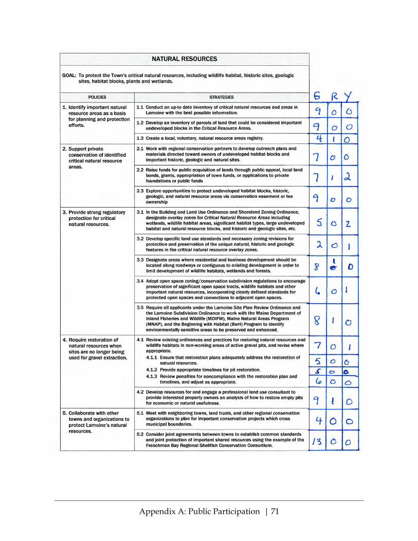
Appendix A: Public Participation | 71

Appendix A: Public Participation | 72

Appendix A: Public Participation | 73

Appendix A: Public Participation | 74
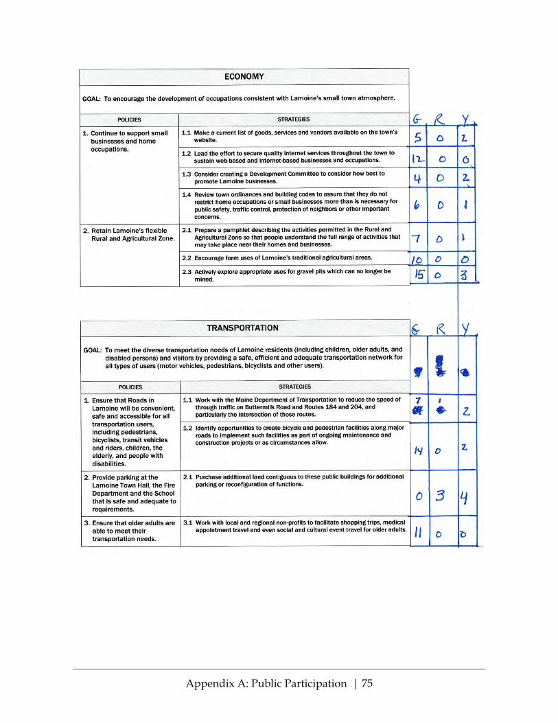
Appendix A: Public Participation | 75

Appendix A: Public Participation | 76
A21: 2016 Online Community Survey – Demographics of Respondents
Total survey responses = 46 Place of Residence
Place of Residence Respondents
East Lamoine 17 Lamoine Beach 7 Lamoine Corner 7 Marlboro 11 North Lamoine 4 Total 46
Age Age Respondents 21-50 4 51-70 25 Over 70 15 Prefer not to answer or blank 2
Total 46
East Lamoine37%
Lamoine Beach15%
Lamoine Corner
15%
Marlboro24%
North Lamoine
9%
PLACE OF RESIDENCE
21-509%
51-7054%
Over 7033%
Prefer not to answer or
blank4%
AGE

Appendix A: Public Participation | 77
School-Age Children in Household School-age children in household?
Respondents
Yes 5 No 41 Total 46
Place of Work
Place of Work Respondents At home 3 In Lamoine, not at home 4
Outside Lamoine 19 Retired or not employed 20
Total 46
Yes11%
No89%
SCHOOL-AGE CHILDREN IN HOUSEHOLD?
At home7%
In Lamoine, not at home
9%
Outside Lamoine
41%
Retired or not
employed43%
PLACE OF WORK

Appendix A: Public Participation | 78
A22: 2016 Online Community Survey – Goals
Chapter Goal Agree Concerns Disagree Blank Total
Future Land Use
To maintain the rural character of Lamoine by maintaining and building on existing community facilities, accommodating moderate residential growth in limited areas, and encouraging the preservation of open space and natural resources.
42 4 0 0 46
Historic and Archaeological Resources
To preserve and enhance Lamoine’s historic and archaeo-logical resources for enjoyment and educa-tion, including that of future generations.
41 5 0 0 46
Fresh Water Resources
To protect all Lamoine’s fresh water resources.
41 4 0 1 46
Natural Resources
To protect the Town’s critical natural resources, including wildlife habitat, historic sites, geologic sites, habitat blocks, plants and wetlands.
41 5 0 0 46
Agricultural and Forest Resources
To safeguard the Town’s agricultural and forest resources and promote farming, forest preservation and responsible forest harvesting in the local economy.
41 5 0 0 46

Appendix A: Public Participation | 79
Chapter Goal Agree Concerns Disagree Blank Total
Marine Resources
To protect Lamoine’s unique and diverse shoreland by supporting a balance between conservation and devel-opment, with management and preservation of the ecological integrity and diversity of marine habitats, and multiple human uses including fishing, recreation, and open scenic vistas.
40 5 0 1 46
Population and Demographics
Lamoine will be a town which is attractive to and serves the needs of its residents of all ages.
44 2 0 0 46
Economy To encourage the development of occupations consistent with Lamoine’s small town atmosphere.
43 3 0 0 46
Housing To encourage and promote affordable, decent housing for a wide range of family types and ages.
42 3 0 1 46
Recreation To promote, protect and enhance the availability of outdoor recreation opportunities for all Lamoine citizens, across all age groups, including access to surface waters; and to promote opportunities for inter-generational family and group recreation.
39 5 0 2 46

Appendix A: Public Participation | 80
Chapter Goal Agree Concerns Disagree Blank Total
Transportation To meet the diverse transportation needs of Lamoine residents (including children, older adults, and disabled persons) and visitors by providing a safe, efficient and adequate transportation network for all types of users (motor vehicles, pedestrians, bicyclists and other users).
42 3 0 1 46
Public Facilities and Services
To meet the public service needs of Lamoine citizens in the most cost-effective manner.
44 1 0 1 46
Climate Change To incorporate climate change considerations into Town decision-making.
37 9 0 0 46
TOTAL 537 54 0 7 598
Note:
• 31 respondents (67%) had no concerns with any of the draft goal statements—i.e., they either agreed with the goal as written or left the answer blank.
• 15 respondents expressed some concern with one or more or the draft goals: o 7 respondents had concerns with 1 goal (not always the same one). o 1 respondent had concerns with 3 goals. o 3 with 4 o 1 with 5 o 2 with 6 o 1 respondent had concerns with all 13 goals.
• No respondents indicated that they disagreed with any of the draft goals.
COMMENTS ON DRAFT GOALS Although 15 respondents stated that they agreed but with concerns, only 13 actually provided comments:
1. Really hoping we can continue to fight to strictly limit gravel mining! No hill takedown!!

Appendix A: Public Participation | 81
2. Economic development should be the lowest priority for the town – Ellsworth/ Bar Harbor are better suited and more accessible for commercial/industrial development. Lamoine should be focused on creating and maintaining a high quality of life for its current and future residents.
3. All of these items sound fine until the sanctimonious, arrogant, and zealous social justice warriors show up on YOUR land with their ideas of what fits into all of the above. Wake up folks, you are about to lose control of your land in this town.
4. MARINE RESOURCES: Under development, I would like to stop any further development of gravel pits. They and the trucks are ruining our community with noise, pollution, and breakdown of roads. For your information, eighteen-wheelers, dump trucks, and buses—including most school buses—emit 15 parts per million (ppm) of sulfur dioxide into the atmosphere while idling (Environ-mental Protection Agency (EPA): “Diesel Fuel Standards and Rulemakings.” https://www.epa.gov/diesel-fuel-standards/diesel-fuel-standards-and-rulemakings.) The Environmental Protection Agency (EPA) recommends laws that restrict the idling of large diesel trucks and buses to no more than 5 minutes because of the Group 1 carcinogenic rating that diesel has when it is burned.
5. (Residential growth in limited areas? This mean controlling where people can build homes?) (What does it mean to protect Historical and Archaeological sites? What are these sites?) (Again what does it mean to protect all freshwater resources and what are these resources?) I’m done singling out each section that I have concerns with here because the same question applies to all except Climate change. Town only owns Marlboro Beach which is in the Climate change area and no roads what so ever. FEMA determines floodplain area dealing with climate change and produces maps showing where they are.
6. My only request is that the dump have another day open during the weekday especially during the summer months. Many go away on the weekends (Friday-Sunday). Perhaps a Wednesday/Thursday afternoon.
7. The permitting of mussel dragging in Raccoon and Salisbury coves Western/ Eastern Bay results in the destruction of the floor bed, interfering with the development of fish and shellfish stocks. There needs to be a balance, and current rules allow the industry to destroy the natural environment. This is currently unacceptable.

Appendix A: Public Participation | 82
8. While it’s important that Lamoine advances quality of life through practical endeavors, its quiet bedroom community character shouldn’t be compromised. We have Ellsworth and MDI nearby for just about all our needs.
9. Many folks understand climate change as an ongoing process that seems to take place with or without human intervention. The whole issue is politically charged and the scientific community has yet to come to a clear consensus regarding the causes and possible effects of climate change. Even if human-induced climate change were proven to be the case, it is hard to imagine a plausible scenario facing the town that would require that climate change considerations be part of the decision-making process. So why include this goal in the Comprehensive Plan?
10. Do not agree with building low income housing or allowing more commercial occupations in the town.
11. As with any broad goal, the Devil is in the details. When “the Town” is men-tioned, be sure you refer to that which is Town-owned. Respect for private property rights should be at least mentioned. Only one goal mentions cost-effectiveness. Lastly, if climate change is to be even mentioned in Lamoine’s plan, I will certainly vote against adoption and will campaign against its adoption!
12. Historic and Archaeological Resources: Suggested change of wording to: “To preserve and enhance Lamoine’s historic and archaeological resources for the enjoyment and education of current and future generations.” Agricultural and Forest Resources: In opening statement, I suggest changing “backyard” farming to gardening, and to include the word gardening in the statement of Town Goal. Marine Resources: If the term fishing technically includes all marine harvesting, then leave current wording. If not, suggested change of wording to: “To protect Lamoine’s unique and diverse shoreland by supporting a balance between con-servation and development, with management and preservation of the ecological integrity and diversity of marine habitats, and multiple human uses including fishing, harvesting of other marine resources, recreation, and open scenic vistas.” Population and Demographics: Suggested change of wording to: “Lamoine will be a town which is attractive to and serve the needs of residents of all ages.”
13. The word “all” and just general description of what these areas give me problems. Define and specify these areas

Appendix A: Public Participation | 83
A23: 2016 Online Community Survey – Policies and Strategies
Summary of Responses Percent Agreeing # of Respondents
With Comments, Concerns or Questions
No Comments or
Concerns
Total (With and Without Comments)
Historic and Archaeological Resources 85% 100% 6 Fresh Water Resources 74% 91% 12 Natural Resources 72% 89% 11 Agricultural and Forest Resources 80% 100% 8 Marine Resources 76% 96% 11 Economy 80% 98% 7 Housing 87% 96% 6 Recreation 80% 100% 9 Transportation 78% 98% 13 Public Facilities and Services 72% 98% 13 Climate Change 80% 93% 10
A strong majority of respondents indicated agreement with the draft policies and strategies:
• At least 89% of respondents agreed with all the draft policies and strategies, and more than 70% of respondents agreed with all policies and strategies without any comments or questions.

Appendix A: Public Participation | 84
• More than 95% of respondents agreed with the policies and strategies for 8 of the 11 topic areas: o Historic and Archaeological
Resources o Agricultural and Forest Resources o Marine Resources o Economy
o Housing o Recreation o Transportation o Public Facilities and Services
Strongest support (more than 80% agree with no comments): • Housing (87%) • Historic and Archaeological Resources (85%)
Weakest support: • Less than 75% agree with no comments:
o Fresh Water Resources (74%) o Natural Resources (72%) o Public Facilities and Services (72%
• More than 1 respondent with significant concerns: o Natural Resources (5) o Fresh Water Resources (4) o Climate Change (3) o Marine Resources (2)
COMMENTS, CONCERNS AND QUESTIONS
SUGGESTIONS FOR CHANGES / REWORDING / CLARIFICATION CHAPTER COMMENTS
Historic and Archaeological Resources
Does 1 arrowhead on someone’s property mean that now someone can’t build there? What is the threshold that stops someone from building or doing what is a permittable in that area of their property? Need a map to detail these areas and what can and can’t be done on someone’s private property
Historic and Archaeological Resources
To #2, revise to read, “Lamoine is protecting and will continue to protect archaeologically, geographically and topographically significant sites in town.”
Historic and Archaeological Resources
“Strategies and Implementation of #2 raise two concerns. Use of the phrase “experience dictates” is unclear in meaning and the term “town actors” needs definition. My larger concern is that the Lamoine Historical Society has a small and primarily elderly membership, and at present seems unlikely to be able to implement the tasks assigned to it in this document. I express this opinion as a past Board member and a current member.
Historic and Archaeological Resources
Specify these areas and are we really going to hire an archaeologist is go onto people’s land to do research?

Appendix A: Public Participation | 85
CHAPTER COMMENTS
Fresh Water Resources
1.1.3 doesn’t work in ME. The pores of the pavement/concrete fill in by the winter sand that they stop working and become just like regular pavement/concrete so the added expense to do this makes no sense. 2.1 is a great project to teach kids something about science but how much are we really learning about the town since over half the kids bring in bottled drinking water t be tested? 3.1 — Blunt’s Pond is state regulated, we have never had any problems with Blunt’s Pond so how much tax payer money do we have to keep using to monitor nothing? In other areas of the survey you talk about protecting all Freshwater Resources, Is Blunt’s Pond the only freshwater resource or are there other and if so what are they? People need to know what you want to plan on regulating and if it will concern them or not.
Fresh Water Resources
The town should issue no new permits for gravel pits and (insofar as possible) should not allow the expansion of existing pits.
Fresh Water Resources
The town needs to employ and enforce greater lot size restrictions on new construction to avoid concentrations of home use that are detrimental to the overall well-being of the community. Because of the decentralized sourcing of fresh water, this needs to be done community wide to prevent development that destroys the current balance between water use and recharge and waste.
Fresh Water Resources
There should not be communal wells or septic systems “or” allow extraction of our water for commercial purposes/use!
Fresh Water Resources
Again the concern arises with the apparent conflict between private property rights and what an unelected committee sees as desirable. Example: 1.3.4 Perhaps the owner of a discontinued gravel pit wants it left alone. Who decides what is “productive use”?
Fresh Water Resources
The goals are good but several of the Strategies and Implementation unrealistic in my opinion. 1.3.1 — “objective oversight of gravel company water testing” should be replaced with ““objective, Town hired personnel to conduct gravel company water testing at gravel company expense.” 1.3.3 — The CEO should be specified in Implementation column as person charged with this task, and the Select Board must level strong fines for violations when CEO and/or Planning Board submit evidence of violations. 1.3.4 — Under Implementation there needs to be a financial reward for this research — either through tax breaks or actual grants. 2.1 — Broader participation of GET WET! — specify by whom? High Schools where Lamoine students are in attendance? Private homes in Lamoine? If the latter, under Implementation, might the Town provide free or low cost water testing of individual wells? 3.1 — Under Implementation, a source of funding for such a study needs to be sought. LCC has no budget, and both PB and PC allocate their budgets for other needs.

Appendix A: Public Participation | 86
CHAPTER COMMENTS
Fresh Water Resources
Most of this stuff is covered by Maine law. Writing in that you have to have detention ponds in a subdivision might not be the best way to control runoff so it’s best to use Maine best practices which has to be done anyway
Natural Resources
We need to carry out #4 and enforce laws on all gravel pit owners, especially incorrect digging and restoration. I wouldn’t mind being involved in restoration of old pits, maybe place solar panels in them for town and resident use or planting community gardens in them.
Natural Resources
Re. point #3: No longer permit the types of dragging and overfishing that have left the tidal flats nearly devoid of the immensely varied sealife that was present in the 1950s.
Natural Resources
#4 should not be limited to gravel pits but should include all sites where development has occurred. This includes areas that have been used for the storage of old automobiles, mechanical equipment, chemicals and used auto products. Any rural area that was altered by commercial activities needs to have a restoration plan built into its long-term development plan.
Natural Resources
Consider property tax relief for conserving critical open space.
Natural Resources
Do not agree with allowing any additional commercial development.
Natural Resources
4.2 — See my previous answer about owners of non-working pits. 1.1 — Who would conduct such an investigation? Is there a definition of “critical resource”? 3.4 — Definition of “significant” and “important”? For example, Kennebunkport has definitions of terms like “critical edge” which are useful to landowners and do not give the impression of arbitrariness.
Natural Resources
1.1 — Conducting an up-to-date inventory... Under Implementation, because two Boards and Staff are listed, it seems likely that it won’t get done, as each group will assume one of the others will have taken responsibility. 1.3 — The suggested Registry is good but where is it to be kept? And again under Implementation, would it be LCC or SB that reaches out to regional conservation groups to combine efforts? 2.1 — Under Implementation, there’d have to be established tax breaks to reward land owners to keep their land undeveloped as a critical natural resource. Numbers 1, 2, and 3 — Strategies are good but Implementation designates LCC for almost all. This commission needs major readjustment in order to accomplish these tasks. Their mission statement needs to reflect this expanded role from its earlier one of education and advisory to PB. Perhaps they need to be given authority to implement rather than advise or simply offer information. At present the only Board what has authority to implement and fine is SB and they tend to be reluctant to do the latter. At the very least the LCC will need a sizeable budget to carry out the research expected of them. Unless knowledgeable professionals volunteer to serve, monies will be needed

Appendix A: Public Participation | 87
CHAPTER COMMENTS
to hire consultants for some of the tasks. There also needs to be active recruitment of Associate Members of LCC, in addition to the 5 Commissioners and 2 Alternates, in order to have enough volunteers to handle the assigned tasks. 4 — Gravel Ordinance needs new provision that any application for gravel or mining permit must include a plan for how the land will be productively used once the gravel, sand, rock, and/or mineral has been removed.
Agricultural and Forest Resources
Document the economic importance of Lamoine farming — crops or products raised, how marketed, market value of commodities produced. Encourage use of easements to keep currently farmed land in agricultural use in perpetuity.
Agricultural and Forest Resources
4.2 — Even if such land were donated, it would come out of taxation along with other lands enrolled in tree growth, open space, etc. Consequences need to be considered in policy development.
Agricultural and Forest Resources
2.2 — Under Implementation, a Development Committee has been tasked. Good idea. Somewhere there needs to be a call for such a committee to be created with a mission statement. 4.1 — I think the LCC would have no idea what the deer wintering yards might be. Maine Wildlife and Inland Fisheries would be the more appropriate organization to identify these areas. Then the PB would be notified to not permit development in such areas.
Agricultural and Forest Resources
Who is supposed to do all this stuff and what land are we suppose to hire/seek out to help with putting land in a trust
Marine Resources
I’d like to see setbacks of shoreland homes to be at least 200 to 300 feet to preserve the ecology of our rivers, pond, and bay.
Marine Resources
No longer permit the types of dragging and overfishing that have left the tidal flats nearly barren in many areas.
Marine Resources
In item 3 remove references to “sea level rise.” See previous comment about climate change. The strategies suggested for “extreme storms” would pretty much cover any dramatic sea level change anyway.
Marine Resources
2.2 and 2.3 — See previous comments about taking land out of taxation. 2.6 — Totally opposed to confiscation of private property rights without compensation. 3.7 — Strike everything after “changes”.
Marine Resources
I have the same reservations about what the LCC has been tasked to take on. Until this commission has been reconstituted with more authority, a budget, and a larger number of members, it is unrealistic that they can assume these responsibilities. My assessment is based on having served on LCC for ten years.

Appendix A: Public Participation | 88
CHAPTER COMMENTS
Under Implementation, reference to Lamoine Shore-Access Committee. Good idea. Again, proposal must be made to constitute such a committee, whether or not it is a sub-committee of an existing board or commission. 2.2 — Protection of scenic view to be specified within Town ordinances sounds good but also extremely problematic. For example: If someone owns land that has a beautiful view of the mountains or the ocean and then wants to plant trees there that would grow to obstruct the view, can the Town prohibit them from doing this?
Economy There needs to be more careful consideration of the impact of commercial/industrial development on the rest of the town — road use/impact, noise/visual encroachment on residential areas, etc.
Economy 1.2 — I would like to see added somehow that all new residential subdivisions force the subdivider to wire subdivision to the main road with cable. 2.3 — This is private land so what is appropriate uses? Just going back to forest like it was before it was a gravel pit might be an appropriate use but this is determined by the owner not the town.
Housing Town doesn’t have a building code so this should be removed from 1.1.
Recreation Provide a forum for public input on creation of public recreation areas (such as the Mud Creek picnic area) to gather opinions regarding the benefits/concerns of such proposals. Consider the establishment of a controlled access, regulated and supervised public shooting range within the town—perhaps at an inactive gravel pit—a low cost means of providing a recreational activity opportunity within the town.
Transportation Work with DOT to reduce speed limit on most town roads to 35 MPH.
Transportation Need more active enforcement of speed limits, particularly on Mud Creek Road. Lamoine should actively support the ride assist program at Friends in Action.
Transportation When repaving town roads, consider painting center lines on the roadway—particularly at key areas such as intersections where a road joins another at a curve. Prime example—intersection of Mill and Walker roads, where southbound traffic tends to hug the center of Walker at the blind curve because there is no obvious delineation of a berm due to the intersection of Mill road.
Transportation Speeding is a major safety hazard, with little enforcement, how about speed cams and automatic tickets for violators
Public Facilities and Services
We need more enforcement of all laws concerning gravel pits, setbacks from roads and shore, gravel trucks ruining our roads (we can tax the gravel companies with a town vote, I hope.)

Appendix A: Public Participation | 89
CHAPTER COMMENTS
Public Facilities and Services
3.1 — Need to be careful with this statement. The town might decide that it might be better to build a school with a surrounding town so make sure this is stated so that it can happen.
Public Facilities and Services
Keeping school costs as low as possible through ordering supplies in bulk with neighboring schools and sharing of teacher and administrative costs where possible.
Public Facilities and Services
Public Facilities and Services has no suggested implementation. For instance, Support of the Volunteer Fire Department, could specify funding. Getting people to volunteer could be implemented by establishing a practice of publicizing what committees are doing and of giving more awards of recognition to people serving as volunteers. 3.3 — Implementation of making the School a resource for all children and adults: regular broadcasting of videos of activities there, using the facility for classes and/or recreation programs for adults there, recruiting volunteers to help School staff with projects. 4.2 — CEO needs more time and money to be effective in enforcement.
Public Facilities and Services
Not sure we should maintain local control for the school. Though I do believe that is a high priority it might be best at some time to join with a surrounding town to build maybe a combined school.
Public Facilities and Services
Keeping school costs as low as possible through ordering supplies in bulk with neighboring schools and sharing of teacher and administrative costs where possible.
Climate Change State of Maine’s deposit system is atrocious and 19th century. Town should establish recycling center for citizens who want to recycle their plastics and metal containers.... Also, burnable trash should also be recycled for bio-fuel generators out of town.... This could be first a local transfer station where citizens who want to recycle can bring their materials.
Climate Change See what cost would be to solarize town offices—maybe also a # of private homes in a small center of town—electricity and heat both if possible.
GENERAL POSITIVE
CHAPTER COMMENTS
Fresh Water Resources
I definitely agree but we don’t enforce safe laws on our water systems.
Recreation Completely agree and think the town has the correct goals in mind. Parks like Lamoine Beach and Marlboro Beach need protection as well as development. Both are fragile ecosystems that can easily be damaged. They must be managed well... Confident the town has the right goals in mind.

Appendix A: Public Participation | 90
GENERAL NEGATIVE CHAPTER COMMENTS
Fresh Water Resources
This has been a continuing witch hunt by a group of wing nuts.
Natural Resources
Land grab. Here it comes.
Agricultural and Forest Resources
Interesting that a number of the so called Konservation Korps have cut all the trees in front of THEIR houses. Want names? I suspect not.
Agricultural and Forest Resources
Do not agree with 2.2
Marine Resources
All of 3 is covered and done by FEMA. The town doesn’t have the resources or funds to even come close to taking this on. 2.6 — what is the map and where did it come from? This sounds really extreme.
Marine Resources
We already have several wonderful locations with scenic vistas and parks. Some of these strategies seem to overstep privacy of land/homeowners
Housing Do not agree with building any kind of low income or subsidized housing. Lamoine has always been a single family home setting and should stay that way. We do not have the infrastructure like Ellsworth to accommodate this. This will only increase traffic, public transportation, potential crime and completely change the existing small town village which attracted most of us to.
Transportation Do not agree with purchasing more land for ‘parking’. Keep it green and not blacktop these proposed parking areas which are NOT necessary.
Public Facilities and Services
Perhaps the Konservation Kommiittee members should not treat the LVFD as their own personal serfs. And, maybe they should not politically assassinate members that run for office.
Public Facilities and Services
2.1 and 2.2 is not feasible financially. The school or the Grange are perfectly good “existing” places for this and no need to ultimately raise taxes for a Community Center which will benefit very few. A waste of our money!
Public Facilities and Services
3.1 — We cannot see the future, so such a statement is not appropriate. 2.1 and 2.2 — If 3.3 is implemented, we will have our Community Center.
Climate Change Climate change is a natural cycle. It’ll take care of itself.
Climate Change I have concerns about climate change since it has been stated that much of the data has been manipulated in favor of climate change without scientific proof. More proof needed to support climate change data.

Appendix A: Public Participation | 91
CHAPTER COMMENTS
Climate Change 1.1—Town has no roads that will be affected. 4.1—FEMA already produces this and the State adopts it and mandates that the Town/s adopt it also. 4.2—Already mentioned earlier but permeable surfaces does not work in ME. 5.1—Remove Building code, we have no building code and if we do we have to use the one the State has adopted. 6.3—We are ready more strict on setbacks than the State is and we are way more strict than the Federal rules. Nothing needed here.
Climate Change Not going to beat a dead horse, but references to climate change ….
Climate Change Many of the ideas are fine but ‘no’ to anything that will greatly increase taxes, i.e., solar on 3.2. We as individuals can make a huge ‘positive’ impact on environmental issues and don’t need the town government to force this on us.
Climate Change 5.1 and 5.2 — Again it sounds like confiscation of property rights without compensation. 6.1 — Do not wish to be flippant, but are you out of your minds?
Climate Change Climate change is way over rated. FEMA makes sure we keep things out of floodplains or are built to a standard that handles it. The town owns no property except Marlboro beach that has to deal with climate change. Not sure how you can stop that one.
OTHER
CHAPTER COMMENTS
Historic and Archaeological Resources
The only problem is, will our town carry out these strategies. So far, we aren’t enforcing the referenda on which we voted for the past 2 years on gravel pits. I feel that our select representatives need to work harder on enforcing our laws.
Historic and Archaeological Resources
I think archaeological impacts must be balanced with development needs—depending on the site and importance of what might be preserved.
Fresh Water Resources
Why are gravel companies currently in operation in Lamoine allowed to crater the ground and leave it ruined? Why no amelioration?
Fresh Water Resources
I was diagnosed w/kidney cancer and had my kidney removed. The other one is only in fair shape so I have to take every precaution. We have a high level of arsenic in our well water so I can only drink bottled water which is quite an expense along with the high cost of medications and living in Maine in general. Is the state or town of Lamoine working to provide clean water for all its residents in the very near future?
Fresh Water Resources
Do we have protections against/can we protect our groundwater against any potential impacts from companies looking to tap resources for sale for profit?

Appendix A: Public Participation | 92
CHAPTER COMMENTS
Natural Resources
This would be a long comment but I have major problems with a lot of things on this page. Is the town prepared to buy out people’s land if you remove this land from being used by them. What is a critical resource area, where are they in the town and what can and can’t be done on/in these areas?
Natural Resources
It seems there are some gray areas here. Need more input to vote.
Natural Resources
Taking of people’s land for habitat blocks and stuff is all great but who is going to pay to buy this property from the people or pay the people for the taking of land because they can’t use it.
Agricultural and Forest Resources
I would love to have a local veggie market once a week in our town in addition to Chuck’s space by the Grange.
Agricultural and Forest Resources
4.1 — We have too many deer already in town. Don’t need to do 4.1 any more than we are now. Biggest threat to deer is the coyotes and land area. Farms are covered by state law so not sure how much more we have to reinvent the wheel
Marine Resources
Let Ms. Korty allow people to cross her land. We already have a shoreland management program. Who gets the make the “anticipated weather and climate change predictions’?
Marine Resources
Re. 3.5 — I do not disagree however a flood plain survey in the past was done via an out of state consultant (I was told this) when we purchased our home we had to automatically get FP insurance. We were not in a flood plain zone and had to hire a surveyor at great expense to qualify. The out of state survey clearly only looked at a map and did not consider the varied elevations. I would not like to see this happen to anyone.
Marine Resources
Current policies are a joke, and town leadership should be embarrassed by allowing the destruction of the marine habitat by invasive dragging operations. The floor bed destruction has made Lamoine’s waters sterile and uninhabitable and the town leadership knows this. While mussel farming has been supported elsewhere, and aqua farming is being supported by the State of Maine and the Canadian government, Lamoine acquiesces to the dragging and gravel industries. Shameful. The state of Florida has banned all commercial fishing and makes more money on preserving its habitat (tourism, sporting fishing, hunting) than it would have made by allowing the commercial removal and destruction of the habitat. Maine and Lamoine could learn from others.
Marine Resources
Not really concerned, but in general, what are we really wanting done here?
Economy Lamoine needs a county wide alternative to Time-Warner Spectrum in terms of community internet service. Charges for internet service are much higher in Lamoine than in other regions of the state. No competition. Future is

Appendix A: Public Participation | 93
CHAPTER COMMENTS
decentralized technology and workplace activities and Lamoine needs the infrastructure, even if it costs 1% sales tax or other revenue source.
Economy Lamoine is a bedroom community of nearby Ellsworth. Ellsworth is largely where we get many of our goods and services. Not opposed to small (home) businesses but also don’t want to compromise the quiet community or visual charm that brought many of us here and affects our property values.
Economy Lack of high speed internet is a major drawback for commercial development in Lamoine.
Housing Sounds like we already have such a committee—check the demographics on the Konservation Kommittee.
Housing I would love to have a better option of internet service than Hughes net which does not work half the time and is extremely expensive.
Housing Safe, affordable, and attractive senior housing should be a priority in every town in Maine. We have the highest aging population in the country.
Recreation The town needs to get buy-in from the state for the addition of wider margins on the many state roads in Lamoine—for bicycle/walking/other use.
Recreation 1.2 — We have to remember that this is State owned and Lamoine owned. 1.3 — ??????? expansion of Marlboro Beach? Not sure about anything here. This should be removed or reworded to what is really meant.
Recreation Would need more input to comment.
Recreation Lowering speed limits is not the answer to pedestrian/cyclist safety. Impaired and/or distracted drivers are the real problem. Law abiding Lamoine citizens already drive carefully and lowering the already low speed limits in town will do nothing to protect pedestrians and cyclists.
Recreation We have more public water access than most towns our size. We already have many local events which covers all age groups.
Recreation 1.4 — Is a Picnic area near Mud Creek Bridge desirable? Would it interfere with nesting ospreys?
Recreation Remember Lamoine Beach is also State owned and what is the expansion for Marlboro Beach?
Transportation How does one reduce speed without enforcement?
Transportation 1.1—These are already in place just need to be enforced so it’s not the job of MDOT.
Transportation I know this area is in Hancock leading to Lamoine but the turn off onto the Mudcreek Road is dangerous. One has to pull over into the breakdown lane to

Appendix A: Public Participation | 94
CHAPTER COMMENTS
make the sharp right hand turn onto the Mudcreek road otherwise traffic on Route one can rear end you because they are going 50 plus. Several times I have come close to being hit.
Transportation It would be nice if some means could be created to reduce through travel between the Bar Harbor Road and Rte 1 as a bypass of Ellsworth. The intersections discussed above are hazardous, especially with the large trucks that use those roads.
Transportation Just heard story on Maine Public Radio about use of plastic pellets in tar material for paving-esp. good for cold climates (like us)—can we explore this for our road repaving use?
Transportation Creating roadside pedestrian and cyclist trails seems the safest, yet most expensive, solution. Even safe drivers routinely exceed unreasonably low speed limits unless the threat of financially painful enforcement is in place. Why create what would be perceived by many as a speed trap?
Transportation 2.1 — Some years ago, land adjacent to the Town Hall was offered to the Town for free. Either a donation or a land swap would provide more parking space there.
Transportation State sets the speed limits and they have looked at Buttermilk Rd a few times. It’s just that people think others are driving too fast
Public Facilities and Services
As much as I understand the appeal/benefits of the Lamoine School, the tax burden placed on the town’s population has to be considered. The proportion of the town’s budget that goes to a school of 100 students simply strikes me as being excessive—as does the 4:1 student to staff ratio.
Public Facilities and Services
Re. point #2, I’m not sure that a Community Center offers enough value to justify the expense. I hope that a cost-benefit analysis will be undertaken before moving forward with this plan.
Public Facilities and Services
If Lamoine is to continue to be attractive to its younger citizens, then new technology and services must be encouraged. There are still blackout areas in Lamoine where Verizon service is unavailable (RTE 204). Internet upgrades and reasonable costs need to be a high priority.
Public Facilities and Services
I think it may make sense to consolidate/combine the school with others at some point. I understand the need for local control—but I am concerned that costs will get out of control. I know the last effort for consolidation was poorly executed by the state, but that doesn’t mean we should not consider it or other cost-saving measures, even if that means giving up some local control. We have to control the continual escalation in the cost of education, while still providing quality education for our youth. Have to also consider the older population and their ability to continue to absorb the increases.

Appendix A: Public Participation | 95
CHAPTER COMMENTS
Climate Change I like all the strategies listed but am concerned that no suggestions appear under Implementation. This again brings up the issue of how much can be done by existing boards and committees and individual volunteers.


97
Appendix B: Natural Resources The documents in this Appendix B include detailed maps from Maine’s Beginning with Habitat program, which are dense with information. They are in the Town Hall in poster size and can be accessible through the Town website. There are also other useful maps produced by the State of Maine and the Mini-Handbook of Lamoine’s Groundwater Hydrology by Lamoine resident Willem Brutsaert, Ph.D.

Appendix B: Natural Resources | 98
B1: Lamoine Watersheds and Water Quality, 2014

Appendix B: Natural Resources | 99
B2: Beginning with Habitat Map 1 – Water Resources & Riparian Habitat, 2018

Appendix B: Natural Resources | 100
B3: Beginning with Habitat Map 2 – High Value Plant & Animal Habitats, 2018

Appendix B: Natural Resources | 101
B4: Beginning with Habitat Map 3 – Undeveloped Habitat Blocks, 2018

Appendix B: Natural Resources | 102
B5: Beginning with Habitat Map 7 – Wetland Characterization, 2018

Appendix B: Natural Resources | 103
B6: Beginning with Habitat – Natural Resource Co-occurrence, 2018
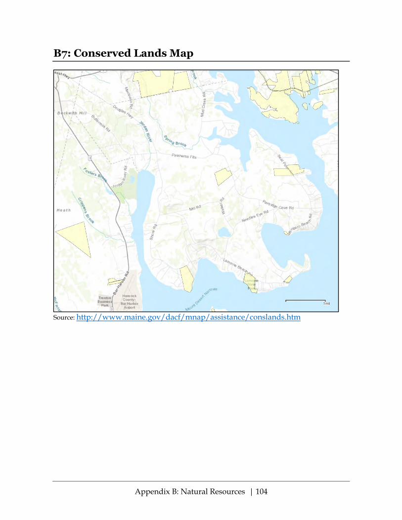
Appendix B: Natural Resources | 104
B7: Conserved Lands Map
Source: http://www.maine.gov/dacf/mnap/assistance/conslands.htm

Appendix B: Natural Resources | 105
B8: Taunton Bay Focus Area
Source: https://www.maine.gov/dacf/mnap/focusarea/taunton_bay_focus_area.pdf
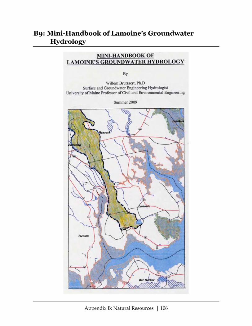
Appendix B: Natural Resources | 106
B9: Mini-Handbook of Lamoine’s Groundwater Hydrology

Appendix B: Natural Resources | 107

Appendix B: Natural Resources | 108

Appendix B: Natural Resources | 109

Appendix B: Natural Resources | 110

Appendix B: Natural Resources | 111

Appendix B: Natural Resources | 112

Appendix B: Natural Resources | 113

Appendix B: Natural Resources | 114

115
Appendix C: Land Use The documents in this Appendix C include maps showing Lamoine land use zoning and land use potential. Also included are the current Table of Land Uses in the Building and Land Use Ordinance, and two ordinance amendments that have been proposed but not yet adopted as of the writing of this Plan.

Appendix C: Land Use | 116
C1: Zoning Districts Map
Source: Adapted from printed zoning map in the Building and Land Use Ordinance.
Zone boundaries are approximate.

Appendix C: Land Use | 117
C2: BLUO Table of Land Uses
From Town of Lamoine Building and Land Use Ordinance, Section 4.H:
Land Use Descriptions
Res
iden
tial
Zone
(RZ)
Dev
elop
men
t Zo
ne (D
Z)
Rur
al &
Ag
Zone
(RA
Z)
1. Campgrounds & Travel Trailer Parks N PB PB 2. Car Washing Establishments N PB PB 3. Church, School, Library, or Public Buildings N PB PB 4. Clinic or Office, Medical, Health, or Psychiatric N PB PB 5. Cluster Housing PB PB PB 6. Commercial - General N PB PB 7. Commercial - Recreation N PB PB 8. Dwelling - Single Family CEO CEO CEO 9. Dwelling - Two Family CEO CEO CEO 10. Dwelling - Multi Family PB PB PB 11. Dwelling - Accessory Units CEO CEO CEO 12. Home Occupations CEO CEO CEO 13. Essential Services (non residential) PB PB PB 14. Industries - Assembling & Manufacturing Goods & Products N PB N 15. Industries & Business - Assembling & Manufacturing Products Related to the
Secondary Processing of Wood/Marine Products
N
PB
PB 16. Mineral Exploration2 N PB N 17. Mobile Home Parks1 N N PB 18. Motels, Hotels N PB PB 19. Nurseries & Garden Centers N PB PB 20. Nursing Homes, Congregate Care N PB PB 21. Other Uses Similar to Those Requiring Planning Board Review PB PB PB 22. Petroleum Storage, and Distillation Facilities N N N 23. Quarries N PB N 24. Restaurants N PB PB 25. Retail Business, Business & Professional Offices N PB PB 26. Salvage Yards, Junkyards, Scrap Metal Processing N PB N 27. Sand/Gravel Pits, Etc.2 N PB N3 28. Service Stations, Vehicle N PB N 29. Shops: Automobile Repair N PB PB 30. Shops: Plumbing; Electrical; Carpentry N PB PB 31. Signs CEO CEO CEO 32. Small Lodging & Tourist Bed & Breakfast (5 Rooms or Less for Rent) PB PB PB 33. Stand, Produce, Fruit & Vegetables CEO CEO CEO 34. Subdivisions PB PB PB
1. See Mobile Home Park Ordinance. Not permitted over Sand and Gravel Aquifer areas. 2. See separate standards in the Lamoine Gravel Ordinance. 3. Land within the Rural and Agricultural Zone that had received or applied for a Site Plan Review permit for gravel operations before March 13, 2013, may continue to be eligible for gravel operations upon Planning Board approval of a gravel permit.

Appendix C: Land Use | 118
C3: Shoreland Zoning Districts
Source: Adapted from map prepared by College of the Atlantic GIS Laboratory, January 2007
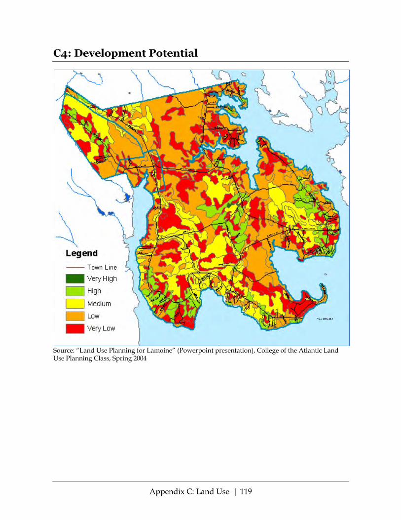
Appendix C: Land Use | 119
C4: Development Potential
Source: “Land Use Planning for Lamoine” (Powerpoint presentation), College of the Atlantic Land Use Planning Class, Spring 2004

Appendix C: Land Use | 120
C5: Cluster Development Standards
FINAL DRAFT 2018-10-01 Lamoine Planning Board BLUO - SECTION 13. CLUSTER DEVELOPMENT STANDARDS A. Purpose. The purpose of the cluster development standards is to encourage new concepts
of housing development with variations of design that will result in: 1. permanently protected open space and recreation areas; 2. the preservation of trees, outstanding natural topography and rare natural features,
and the prevention of soil erosion; 3. a development in harmony with surrounding topography and development; and 4. a development more creatively designed than would be possible through strict
application of other sections of the ordinance B. Basic Requirements
1. The uses of the land shall not differ from uses permitted in the district in which the land is located.
2. Unless otherwise provided for in this Section 13, all application procedures, review standards, and issuances of permits for Cluster Housing shall meet all requirements of Section 12. Subdivisions.
3. The minimum area of land in a cluster development shall be ten (10) acres. 4. Any lot in the development abutting a public road shall have a minimum frontage and
minimum area no less than normally required in the district. For lots abutting other than public roads, lot road frontage and lot area may be reduced by not more than 50% of the requirements of the district in which the development is located. A minimum road frontage of 75 feet is allowed on lots fronting on a cul-de-sac.
5. The Planning Board, at its discretion, may reduce minimum front, side and rear setback requirements.
6. The total area of common open space within the development shall equal or exceed the sum of the areas by which the building lots are reduced below the minimum lot area normally required in the district in which the development is located.
7. Further subdivision of common open space or its use for purposes other than those noted in C (8) below, except for easements for underground utilities, shall be prohibited. Structures and buildings accessory to permitted open space uses may be erected on the common land, subject to Planning Board approval.
8. Each building shall be an element of an overall site development plan. The plan shall identify the location of all proposed roads, structures, parking areas, footpaths, common open space, and private yard space reserved to individual dwelling units. Only developments having such a plan will be considered for a permit. In presenting such a plan, the developer shall take into consideration all requirements of this Section 13 and of other relevant sections of this ordinance.
9. The Planning Board may approve or deny the cluster development plan. Approval of the development plan does not eliminate the necessity for Planning Board approval based on Subdivision standards prior to the issuance of a permit. Any development contrary to the approved development plan shall constitute a violation of this ordinance.

Appendix C: Land Use | 121
C. Site Considerations The Cluster Development plan shall comply with the following site considerations: 1. Orientation
Buildings and other improvements shall be oriented on the site so as to preserve scenic vistas and significant natural features of the parcel.
2. Roads Access from public ways, internal circulation, and parking areas shall be designed to provide for vehicular and pedestrian safety and convenience, emergency and fire equipment, snow clearance, road maintenance, delivery and collection services.
3. Drainage Adequate provision shall be made for management of stormwater runoff, with particular concern for the effects of effluent draining from the site. Erosion resulting from any improvements on the site shall be prevented by landscaping or other means
4. Sewage Disposal All structures in the development with required plumbing shall be connected to a private central collection and treatment system or individual septic systems in accordance with standards set forth in the State of Maine Plumbing Code. The developer shall demonstrate clearly to the Planning Board that: a. adequate soils and land area are available at all locations proposed for the central
system and/or to the individual septic systems; b. the proposed system(s) shall not adversely affect ground water supplies which are
currently used as a water source for any existing development. 5. Water Supply
a. All dwelling units shall be connected to a common water supply and distribution system unless the developer demonstrates to the Planning Board that: (1) adequate ground water is available at all locations proposed for individual
water supplies; and (2) groundwater source(s) proposed for individual water systems is safe from both
on-site and off-site contamination; b. The development shall provide for any special needs for fire protection as
required in Section 12. I 6. Utilities
a. All utilities shall be installed underground unless specifically exempted by the Planning Board.
b Transformer boxes, pumping stations and meters shall be located so as to be neither unsightly nor hazardous to the public.
7. Buffering Planting, landscaping, disposition and form of buildings, fencing, and screening shall be used to integrate the proposed development with the landscape and the character of any surrounding development.
8. Common Open Space The following provisions shall apply: a. The required minimum acreage of land dedicated as common space shall not
include land described in Section 3.D of this ordinance as not suitable for development, excepting wetlands, which may comprise as much as 50% of the designated common space.

Appendix C: Land Use | 122
b. Common open space usage may include, but is not limited to, recreation (playing fields, hiking or skiing trails, playgrounds, etc.), ornamentation (garden, park areas, etc.), protection of natural resources (deer yards, wetlands, eagle nest sites, timber stands, etc.), or scenic views, or common access to the coast, or common protection, such as a fire pond. The use of open space may be further limited or controlled at the time of final subdivision approval where necessary to protect adjacent properties.
c. The common open space shall be accessible to all residents of the development. d. Where a planned unit development or cluster development abuts a water body, a
portion of the shoreline, as well as reasonable access to it, shall be a part of the common open space.
e. Whenever possible, at least a portion of the open space shall be located adjacent to the existing public road(s) serving the development so as to preserve a rural appearance from such roads.
f. Common open space shall be protected by legal arrangements, satisfactory to the Planning Board, sufficient to assure its maintenance and preservation for whatever purpose(s) it is intended. Covenants and other legal arrangements shall specify ownership of the common open space, responsibility for maintenance and liability for payment of property taxes. The developer shall submit to the Planning Board proposed language for incorporation into deeds, recorded plans and declarations designed to ensure the integrity, protection and maintenance of common open space. Such language shall be subject to the approval of the Town Attorney to ensure that it will accomplish its intended purposes.

Appendix C: Land Use | 123
C6: Shoreland Zoning Ordinance
Final Draft - 2018-10-01 – approved by Lamoine Planning Board
SHORELAND ZONING ORDINANCE Town of Lamoine, Maine
Table of Contents
Section 1. PURPOSES __________________________________________________ 124
Section 2. AUTHORITY ________________________________________________ 124
Section 3. APPLICABILITY _____________________________________________ 124
Section 5. AVAILABILITY ______________________________________________ 124
Section 6. SEVERABILITY ______________________________________________ 125
Section 7. CONFLICTS WITH OTHER ORDINANCES _____________________ 125
Section 8. AMENDMENTS ______________________________________________ 125
Section 9. DISTRICTS AND ZONING MAP _______________________________ 125
Section 10. INTERPRETATION OF DISTRICT BOUNDARIES ________________ 126
Section 11. LAND USE REQUIREMENTS _________________________________ 126
Section 12. NON-CONFORMANCE ______________________________________ 126
Section 13. ESTABLISHMENT OF DISTRICTS _____________________________ 131
Section 14. TABLE OF LAND USES _______________________________________ 133
Section 15. LAND USE STANDARDS _____________________________________ 135
Section 16. ADMINISTRATION __________________________________________ 154
Section 17. DEFINITIONS _______________________________________________ 165

Appendix C: Land Use | 124
Section 1. PURPOSES The purposes of this Ordinance are to further the maintenance of safe and healthful conditions; to prevent and control water pollution; to protect fish spawning grounds, aquatic life, bird and other wildlife habitat; to protect buildings and lands from flooding and accelerated erosion; to protect archaeological and historic resources; to protect commercial fishing and maritime industries; to protect freshwater and coastal wetlands; to control building sites, placement of structures and land uses; to conserve shore cover and visual as well as actual points of access to inland and coastal waters; to conserve natural beauty and open space; and to anticipate and respond to the impacts of development in shoreland areas.
Section 2. AUTHORITY
This Ordinance has been prepared in accordance with the provisions of Title 38 Sections 435-449 of the Maine Revised Statutes Annotated (M.R.S.A.).
Section 3. APPLICABILITY This Ordinance applies to all land areas within 250 feet, horizontal distance, of the a. normal high-water line of any great pond or river, b. upland edge of a coastal wetland, including all areas affected by tidal action, c. upland edge of a freshwater wetland, and all land areas within 75 feet, horizontal distance, of the normal high-water line of a stream.
This Ordinance also applies to any structure built on, over or abutting a dock, wharf or pier, or other structure extending or located below the normal high-water line of a water body or within a wetland.
NOTE: Coastal wetlands, by definition, include all areas affected by tidal action, not just those areas where salt marshes and salt meadows exist. Cobble and sand beaches, mudflats, and rocky ledges, below the highest annual tide are all considered to be coastal wetlands. Section 4. EFFECTIVE DATE This Ordinance, which was adopted by the Lamoine Town Meeting in March, 1974 and amended in March 1982, March 1985, October 1989, May 1993, March 7, 2007, March 16, 2011 and ____________2018, shall not be effective unless approved by the Commissioner of the Department of Environmental Protection. A certified copy of the Ordinance, or Ordinance Amendment, attested and signed by the Municipal Clerk, shall be forwarded to the Commissioner for approval. If the Commissioner fails to act on this Ordinance, or Ordinance Amendment, it shall be automatically approved. Upon approval of this Ordinance, or Ordinance Amendment, the Shoreland Zoning Ordinance as amended on March 11, 2011 is hereby amended. The effective date of this Ordinance, or Ordinance Amendment, if approved by the Commissioner, is the date when adopted by the Lamoine Town Meeting. Any application for a permit submitted within the forty-five (45) day period noted above shall be governed by the terms of this Ordinance, or Ordinance Amendment, if the Ordinance, or Ordinance Amendment, is approved by the Commissioner.
Section 5. AVAILABILITY

Appendix C: Land Use | 125
A certified copy of this Ordinance shall be filed with the Municipal Clerk and shall be accessible to any member of the public. Copies shall be made available to the public at reasonable cost at the expense of the person making the request. Notice of availability of this Ordinance shall be posted. Section 6. SEVERABILITY
Should any section or provision of this Ordinance be declared by the courts to be invalid, such decision shall not invalidate any other section or provision of the Ordinance.
Section 7. CONFLICTS WITH OTHER ORDINANCES
Whenever a provision of this Ordinance conflicts with or is inconsistent with another provision of this Ordinance or of any other ordinance, regulation or statute, the more restrictive provision shall control.
Section 8. AMENDMENTS
This Ordinance may be amended by majority vote of the Lamoine Town Meeting. Copies of amendments, attested and signed by the Municipal Clerk, shall be submitted to the Commissioner of the Department of Environmental Protection following adoption by the Town Meeting and shall not be effective unless approved by the Commissioner. If the Commissioner fails to act on any amendment within forty-five (45) days of his/her receipt of the amendment, the amendment is automatically approved. Any application for a permit submitted to the municipality within the forty-five (45) day period shall be governed by the terms of the amendment, if such amendment is approved by the Commissioner. Section 9. DISTRICTS AND ZONING MAP A. Official Shoreland Zoning Map
The areas to which this Ordinance is applicable are hereby divided into the following districts as shown on the Official Shoreland Zoning Map(s) which is (are) made a part of this Ordinance:
1. Limited Residential 2. Limited Commercial 3. Commercial Fisheries/Maritime Activities 4. Stream Protection 5. Resource Protection B. Scale of Map
The Official Shoreland Zoning Map shall be drawn at a scale of not less than: 1 inch = 2000 feet. District boundaries shall be clearly delineated and a legend indicating the symbols for each district shall be placed on the map. C. Certification of Official Shoreland Zoning Map
The Official Shoreland Zoning Map shall be certified by the attested signature of the Municipal Clerk and shall be located in the municipal office.
D. Changes to the Official Shoreland Zoning Map

Appendix C: Land Use | 126
If amendments, in accordance with Section 8, are made in the district boundaries or other matter portrayed on the Official Shoreland Zoning Map, such changes shall be made on the Official Shoreland Zoning Map within thirty (30) days after the amendment has been approved by the Commissioner of the Department of Environmental Protection. Section 10. INTERPRETATION OF DISTRICT BOUNDARIES
Unless otherwise set forth on the Official Shoreland Zoning Map, district boundary lines are property lines, the centerlines of streets, roads and rights of way and the boundaries of the shoreland area as defined herein. Where uncertainty exists as to the exact location of district boundary lines, the Board of Appeals shall be the final authority as to location. Section 11. LAND USE REQUIREMENTS
Except as hereinafter specified, no building, structure or land shall hereafter be used or occupied, and no building or structure or part thereof shall hereafter be erected, constructed, expanded, moved, or altered and no new lot shall be created except in conformity with all of the regulations herein specified for the district in which it is located, unless a variance is granted.
Section 12. NON-CONFORMANCE
A. Purpose It is the intent of this Ordinance to promote land use conformities, except that non-conforming
conditions that existed before the effective date of this Ordinance or amendments thereto shall be allowed to continue, subject to the requirements set forth in this section. Except as otherwise provided in this Ordinance, a non-conforming condition shall not be permitted to become more non-conforming.
B. General
1. Transfer of Ownership:
Non-conforming structures, lots, and uses may be transferred, and the new owner may continue the non-conforming use or continue to use the non-conforming structure or lot, subject to the provisions of this Ordinance.
2. Repair and Maintenance:
This Ordinance allows, without a permit, the normal upkeep and maintenance of non-conforming uses and structures including repairs or renovations which do not involve expansion of the non- conforming use or structure, and such other changes in a non-conforming use or structure as federal, state, or local building and safety codes may require.
C. Non-conforming Structures 1. Expansions:
All new principal and accessory structures, excluding functionally water-dependent uses, must meet the water body, tributary stream, or wetland setback requirements contained in Section 15(B)(1). A non-conforming structure may be added to or expanded after obtaining a permit from the same permitting authority as that for a new structure, if such addition or
Appendix C: Land Use | 127
expansion does not increase the non-conformity of the structure and is in accordance with subparagraphs (a) and (b) below. a. Expansion of any portion of a structure within 25 feet of the normal high-water line of a
water body, tributary stream, or upland edge of a wetland is prohibited, even if the expansion will not increase nonconformity with the water body, tributary stream or wetland setback requirement. Expansion of an accessory structure that is located closer to the normal high- water line of a water body, tributary stream, or upland edge of a wetland than the principal structure is prohibited, even if the expansion will not increase nonconformity with the water body, tributary stream, or wetland setback requirement.
b. Notwithstanding paragraph (a), above, if a legally existing nonconforming principal
structure is entirely located less than 25 feet from the normal high-water line of a water body, tributary stream, or upland edge of a wetland, that structure may be expanded as follows, as long as all other applicable municipal land use standards are met and the expansion is not prohibited by Section 12(C)(1).
(i) The maximum total footprint for the principal structure may not be expanded to a
size greater than 800 square feet or 30% larger than the footprint that existed on January 1, 1989, whichever is greater. The maximum height of the principal structure may not be made greater than 15 feet or the height of the existing structure, whichever is greater.
c. All other legally existing nonconforming principal and accessory structures that do not
meet the water body, tributary stream, or wetland setback requirements may be expanded or altered as follows, as long as other applicable municipal land use standards are met and the expansion is not prohibited by Section 12(C)(1) or Section 12(C)(1)(a), above.
i. For structures located less than 75 feet from the normal high-water line of a water
body, tributary stream, or upland edge of a wetland, the maximum combined total footprint for all structures may not be expanded to a size greater than 1,000 square feet or 30% larger than the footprint that existed on January 1, 1989, whichever is greater. The maximum height of any structure may not be made greater than 20 feet or the height of the existing structure, whichever is greater.
ii. For structures located less than 100 feet from the normal high-water line of a great
pond classified as GPA or a river flowing to a great pond classified as GPA, the maximum combined total footprint for all structures may not be expanded to a size greater than 1,500 square feet or 30% larger than the footprint that existed on January 1, 1989, whichever is greater. The maximum height of any structure may not be made greater than 25 feet or the height of the existing structure, whichever is greater. Any portion of those structures located less than 75 feet from the normal high-water line of a water body, tributary stream, or upland edge of a wetland must meet the footprint and height limits in Section 12(C)(1)(b)(i) and Section 12(C)(1)(c)(i), above.
iii. In addition to the limitations in subparagraphs (i) and (ii), for structures that are
legally nonconforming due to their location within the Resource Protection District when located at less than 250 feet from the normal high-water line of a water body or the upland edge of a wetland, the maximum combined total footprint for all structures may not be expanded to a size greater than 1,500 square feet or 30% larger than the footprint that existed at the time the Resource Protection District was established on the lot, whichever is greater. The maximum height of any structure

Appendix C: Land Use | 128
may not be made greater than 25 feet or the height of the existing structure, whichever is greater, except that any portion of those structures located less than 75 feet from the normal high-water line of a water body, tributary stream, or upland edge of a wetland must meet the footprint and height limits in Section 12(C)(1)(b)(i) and Section 12(C)(1)(c)(i), above.
d. An approved plan for expansion of a nonconforming structure must be recorded by the
applicant with the registry of deeds, within 90 days of approval. The recorded plan must show the existing and proposed footprint of the non-conforming structure, the existing and proposed structure height, the footprint of any other structures on the parcel, the shoreland zone boundary and evidence of approval by the municipal review authority.
2. Foundations.
Whenever a new, enlarged, or replacement foundation is constructed under a non-conforming structure, the structure and new foundation must be placed such that the setback requirement is met to the greatest practical extent as determined by the Planning Board or its designee, basing its decision on the criteria specified in Section 12(C)(3) Relocation, below.
3. Relocation. A non-conforming structure may be relocated within the boundaries of the parcel on which the structure is located provided that the site of relocation conforms to all setback requirements to the greatest practical extent as determined by the Planning Board or its designee, and provided that the applicant demonstrates that the present subsurface sewage disposal system meets the requirements of State law and the State of Maine Subsurface Wastewater Disposal Rules (Rules), or that a new system can be installed in compliance with the law and said Rules. In no case shall a structure be relocated in a manner that causes the structure to be more non-conforming. In determining whether the building relocation meets the setback to the greatest practical extent, the Planning Board or its designee shall consider the size of the lot, the slope of the land, the potential for soil erosion, the location of other structures on the property and on adjacent properties, the location of the septic system and other on-site soils suitable for septic systems, and the type and amount of vegetation to be removed to accomplish the relocation. When it is necessary to remove vegetation within the water or wetland setback area in order to relocate a structure, the Planning Board shall require replanting of native vegetation to compensate for the destroyed vegetation in accordance with Section 15(S). In addition, the area from which the relocated structure was removed must be replanted with vegetation. Replanting shall be required as follows:
a. Trees removed in order to relocate a structure must be replanted with at least one native tree, three (3) feet in height, for every tree removed. If more than five trees are planted, no one species of tree shall make up more than 50% of the number of trees planted. Replaced trees must be planted no further from the water or wetland than the trees that were removed.
Other woody and herbaceous vegetation, and ground cover, that are removed or destroyed in order to relocate a structure must be re-established. An area at least the same size as the area where vegetation and/or ground cover was disturbed, damaged, or removed must be reestablished within the setback area. The vegetation and/or

Appendix C: Land Use | 129
ground cover must consist of similar native vegetation and/or ground cover that was disturbed, destroyed or removed.
b. Where feasible, when a structure is relocated on a parcel the original location of the
structure shall be replanted with vegetation which may consist of grasses, shrubs, trees, or a combination thereof.
4. Reconstruction or Replacement.
Any non-conforming structure which is located less than the required setback from a water body, tributary stream, or wetland and which is removed, or damaged or destroyed, regardless of the cause, by more than 50% of the market value of the structure before such damage, destruction or removal, may be reconstructed or replaced provided that a permit is obtained within eighteen (18) months of the date of said damage, destruction, or removal, and provided that such reconstruction or replacement is in compliance with the water body, tributary stream or wetland setback requirement to the greatest practical extent as determined by the Planning Board or its designee in accordance with the purposes of this Ordinance. In no case shall a structure be reconstructed or replaced so as to increase its non-conformity. If the reconstructed or replacement structure is less than the required setback it shall not be any larger than the original structure, except as allowed pursuant to Section 12(C)(1) above, as determined by the non-conforming footprint of the reconstructed or replaced structure at its new location. If the total footprint of the original structure can be relocated or reconstructed beyond the required setback area, no portion of the relocated or reconstructed structure shall be replaced or constructed at less than the setback requirement for a new structure. When it is necessary to remove vegetation in order to replace or reconstruct a structure, vegetation shall be replanted in accordance with Section 12(C)(3) above.
Any non-conforming structure which is located less than the required setback from a water body, tributary stream, or wetland and which is removed by 50% or less of the market value, or damaged or destroyed by 50% or less of the market value of the structure, excluding normal maintenance and repair, may be reconstructed in place if a permit is obtained from the Code Enforcement Officer within one year of such damage, destruction, or removal.
In determining whether the building reconstruction or replacement meets the setback to the greatest practical extent the Planning Board or its designee shall consider, in addition to the criteria in Section 12(C)(3) above, the physical condition and type of foundation present, if any.
5. Change of Use of a Non-conforming Structure
The use of a non-conforming structure may not be changed to another use unless the Planning Board, after receiving a written application, determines that the new use will be consistent with the surrounding character and uses and will have no greater adverse impact on the water body, wetland or tributary stream, or on the subject or adjacent properties and resources than the existing use.
In determining that no greater adverse impact will occur, the Planning Board shall require written documentation from the applicant regarding the probable effects on public health and safety, erosion and sedimentation, water quality, fish and wildlife habitat, vegetative cover, visual and actual points of public access to waters, natural

Appendix C: Land Use | 130
beauty, flood plain management, archaeological and historic resources, and commercial fishing and maritime activities, and other functionally water-dependent uses.
D. Non-conforming Uses
1. Expansions:
Expansions of non-conforming uses are prohibited, except that non-conforming residential uses may, after obtaining a permit from the Planning Board, be expanded within existing residential structures or within expansions of such structures as permitted in Section 12(C)(1) above.
2. Resumption Prohibited:
A lot, building or structure in or on which a non-conforming use is discontinued for a period exceeding one year, or which is superseded by a conforming use, may not again be devoted to a non-conforming use except that the Planning Board may, for good cause shown by the applicant, grant up to a one year extension to that time period. This provision shall not apply to the resumption of a use of a residential structure provided that the structure has been used or maintained for residential purposes during the preceding five (5) year period.
3. Change of Use:
An owner may apply to the Planning Board for approval to change an existing non-conforming use to another non-conforming use provided that the proposed use has no greater adverse impact on the subject and adjacent properties and resources, including water dependent uses in the CFMA district, than the former use, as determined by the Planning Board. The determination of no greater adverse impact shall be made according to criteria listed in Section 12(C)(5) above.
E. Non-conforming Lots
1. Non-conforming Lots:
A non-conforming lot of record as of the effective date of this Ordinance or amendment thereto may be built upon, without the need for a variance, provided that such lot is in separate ownership and not contiguous with any other lot in the same ownership, and that all provisions of this Ordinance except lot area, lot width and shore frontage can be met. Variances relating to setback or other requirements not involving lot area, lot width and shore frontage shall be obtained by action of the Board of Appeals.
2. Contiguous Built Lots:
If two or more contiguous lots or parcels are in a single or joint ownership of record at the time of adoption of this Ordinance, if all or part of the lots do not meet the dimensional requirements of this Ordinance, and if a principal use or structure exists on each lot, the non-conforming lots may be conveyed separately or together, provided that the State Minimum Lot Size Law (12 M.R.S.A. sections 4807-A through 4807-D) and the State of Maine Subsurface Wastewater Disposal Rules are complied with.
If two or more principal uses or structures existed on a single lot of record on the effective date of this ordinance, each may be sold on a separate lot provided that the

Appendix C: Land Use | 131
above referenced law and rules are complied with. When such lots are divided each lot thus created must be as conforming as possible to the dimensional requirements of this Ordinance.
3. Contiguous Lots - Vacant or Partially Built:
If two or more contiguous lots or parcels are in single or joint ownership of record at the time of or since adoption or amendment of this Ordinance, if any of these lots do not individually meet the dimensional requirements of this Ordinance or subsequent amendments, and if one or more of the lots are vacant or contain no principal structure the lots shall be combined to the extent necessary to meet the dimensional requirements.
This provision shall not apply to 2 or more contiguous lots, at least one of which is non- conforming, owned by the same person or persons on May 8, 1993 and recorded in the registry of deeds if the lot is served by a public sewer or can accommodate a subsurface sewage disposal system in conformance with the State of Maine Subsurface Wastewater Disposal Rules; and
(a) Each lot contains at least 100 feet of shore frontage and at least 20,000 square feet of
lot area; or (b) Any lots that do not meet the frontage and lot size requirements of Section
12(E)(3)(a) are reconfigured or combined so that each new lot contains at least 100 feet of shore frontage and 20,000 square feet of lot area.
Section 13. ESTABLISHMENT OF DISTRICTS The Town of Lamoine establishes Shoreland Zone Districts to permit the orderly development of different shoreland uses. In doing so, the Town recognizes the need to encourage diverse uses including residential, economic and resource protection and to balance these one with another. Shoreland Zone Districts are established by vote of the Town according to the following definitions and guidelines. The Town of Lamoine Shoreland Zoning Map, as most recently amended, assigns a district designation to all the town’s shoreland -- the land area located within two hundred and fifty (250) feet, horizontal distance, of the normal high-water line of any great pond, river or saltwater body and within two hundred and fifty (250) feet of the upland edge of a coastal or freshwater wetland; or within seventy-five (75) feet of the normal high-water line of a stream. The Map is available in the Town Office. A. Limited Residential District
The Limited Residential District includes those areas suitable for residential and recreational development. It includes areas other than those in the Resource Protection District or Stream Protection District, and areas which are used less intensively than those in the Limited Commercial District or the Commercial Fisheries/Maritime Activities District.
B. Limited Commercial District
The Limited Commercial District includes areas of mixed light commercial and residential uses which can coexist compatibly so as not to intrude upon one another. This district includes areas of two or more contiguous acres in size devoted to a mix of residential and low intensity business and commercial uses. Excluded from this district are those areas which:

Appendix C: Land Use | 132
1. Fall within the 100 year flood plain; 2. Are designated as Resource Protection District; or 3. Are located in a Stream Protection District.
C. Commercial Fisheries/Maritime Activities District
The Commercial Fisheries/Maritime Activities District includes areas where the existing predominant pattern of development is consistent with the allowed uses for this district as indicated in the Table of Land Uses, Section 14, and other areas which are suitable for functionally water-dependent uses. The following factors will be taken into consideration by the Board and Town when making a decision:
1. Shelter from prevailing winds and waves; 2. Slope of the land within 250 feet, horizontal distance, of the normal high-water line; 3. Depth of the water within 150 feet, horizontal distance, of the shoreline; 4. Available support facilities including utilities and transportation facilities; 5. Compatibility with adjacent upland uses; 6. Historic uses, prevailing current uses, and future uses as projected in the Town of Lamoine
Comprehensive Plan; 7. Compatibility of uses within the District. The Planning Board may restrict certain
functionally water-dependent uses if they are incompatible with the dominant uses projected in the Town of Lamoine Comprehensive Plan.
D. Stream Protection District
The Stream Protection District includes all land areas within seventy-five (75) feet, horizontal distance, of the normal high-water line of a stream, exclusive of those areas within two-hundred and fifty (250) feet, horizontal distance, of the normal high-water line of a great pond, river or saltwater body, or within two hundred and fifty (250) feet horizontal distance of the upland edge of a freshwater or coastal wetland. Where a stream and its associated shoreland area is located within two-hundred and fifty (250) feet horizontal distance of the above water bodies or wetlands, the land area shall be regulated under the terms of the shoreland district associated with that water body or wetland.
E. Resource Protection District
The Resource Protection District includes areas in which development would adversely affect water quality, productive habitat, biological ecosystems, or scenic and natural values. This district shall include the following areas when they occur within the limits of the shoreland zone, exclusive of the Stream Protection District, except areas which are currently developed and areas which meet the criteria for Limited Commercial or Commercial Fisheries/Maritime activities need not be included within the Resource Protection District. The areas within the Resource Protection District are those designated as Resource Protection on the Town of Lamoine Shoreland Zoning Map, as most recently amended, and areas meeting one or more of the following criteria:

Appendix C: Land Use | 133
1. Areas within 250 feet, horizontal distance, of the upland edge of freshwater wetlands, salt
marshes and salt meadows, and wetlands associated with great ponds, which are rated "moderate" or "high" value by the Maine Department of Inland Fisheries and Wildlife (MDIF&W). These shall include any such areas in Lamoine that the Department of Environmental Protection has designated as areas of "significant wildlife habitat."
2. Flood plains defined by the 100 year Flood Plain as designated on the most recent Federal
Emergency Management Agency's (FEMA) Flood Insurance Rate Maps, or the flood of record, or, in the absence of these, by soil types identified as recent flood plain soils. This district shall also include 100 year flood plains adjacent to tidal waters as shown on FEMA's Flood Insurance Rate Maps, but shall not include land within the shoreland zone which is shown by a surveyor to be outside the 100 year flood plain.
3. Areas of two (2) or more contiguous acres with sustained slopes of 20% or greater. 4. Areas of two (2) or more contiguous acres supporting wetland vegetation and hydric soils,
as determined by a Certified Soil Scientist, which are not part of a freshwater or coastal wetland as defined and which are not surficially connected to a water body during normal spring high water.
5. Land areas subject to severe bank erosion or undercutting and lands adjacent to tidal waters
which are subject to severe erosion or mass movement, such as steep coastal bluffs. 6. Other areas which have been recommended for protection in the Town of Lamoine's
Comprehensive Plan including wildlife habitats, sites of significant scenic or esthetic value and sites of historic or archeological significance.
Section 14. TABLE OF LAND USES All land use activities, as indicated in Table 1, Land Uses in the Shoreland Zone, shall conform with all of the applicable land use standards in Section 15. The district designation for a particular site shall be determined from the Official Shoreland Zoning Map. Key to Table 1:
yes - Allowed - No permit required but the use must comply with all applicable local & State land use regulations.
PB - Allowed with permit issued by the Planning Board CEO – Allowed with permit issued by the Code Enforcement Officer LPI – Allowed with permit issued by the Local Plumbing Inspector no - Prohibited
Abbreviations:
LR - Limited Residential LC - Limited Commercial CFMA - Commercial Fisheries/Maritime Activities SP - Stream Protection RP - Resource Protection
TABLE 1. LAND USES IN THE SHORELAND ZONE
Land Uses LR LC CFMA SP RP 1 Agriculture CEO3 CEO3 NO CEO3 CEO3

Appendix C: Land Use | 134
2 Aquaculture no PB PB PB PB 3 Bunkhouses no no no no no 4 Campgrounds PB PB no no no 5 Clearing of vegetation for approved construction and
other allowed uses yes yes yes CEO CEO1
6 Conversions of seasonal residences to year-round residences
LPI LPI no LPI no
7 Emergency operations yes yes yes yes yes 8 Essential services PB PB PB PB6 PB6
9 Filling and earthmoving of < 10 cubic yards yes yes yes CEO CEO 10 Filling and earthmoving of > 10 cubic yards CEO CEO CEO PB PB 11 Fire prevention activities yes yes yes yes yes 12 Home occupations PB PB PB NO no 13 Individual, private campsites CEO CEO CEO CEO CEO 14 Marinas PB PB PB no no 15 Mineral exploration no no no no no 16 Mineral extraction including sand and gravel
extraction no no no no no
17 Motorized vehicular traffic on existing roads and trails
yes yes yes yes yes
18 Non-intensive recreational uses not requiring structures such as hunting, fishing and hiking
yes yes yes yes yes
19 Parking facilities PB PB PB5 no no 20 Pathway within 100’ of median high water CEO CEO CEO CEO CEO 21 Piers, docks, wharfs, bridges and other structures and
uses extending over or below the normal high-water line or within a wetland
a. Temporary CEO CEO CEO CEO CEO b. Permanent PB PB PB5 PB PB 22 Principal Structures and uses A. One and two family residential CEO CEO no no no B. Multi-unit residential PB PB no no no C. Commercial no PB PB5 no no D. Industrial no no PB5 no no E. Governmental and Institutional no PB PB5 no no F. Small non-residential facilities for educational,
scientific or nature interpretation purposes. CEO CEO PB5 PB4 PB
23 Private sewage disposal systems for allowed uses LPI LPI LPI no no 24 Public and private recreational areas involving
removal or addition of more than 10 cubic yards of soils and minor structural development.
CEO CEO PB5 no no
25 Road and driveway construction CEO CEO CEO5 PB no8 26 Service drops, as defined, to allowed uses yes yes yes CEO CEO 27 Signs CEO CEO CEO CEO CEO 28 Soil and water conservation practices yes yes yes yes yes 29 Structures accessory to allowed uses CEO CEO PB PB4 PB 30 Surveying and resource analysis yes yes yes yes yes 31 Uses similar to allowed uses CEO CEO CEO CEO CEO 32 Uses similar to uses requiring a CEO permit CEO CEO CEO CEO CEO 33 Uses similar to uses requiring a PB permit PB PB PB PB PB

Appendix C: Land Use | 135
34 Wildlife management practices yes yes yes yes yes 1 In RP not permitted within 75 feet of the normal high-water line of great ponds, except to remove safety hazards 2 Requires permit from the Code Enforcement Officer if more than 100 square feet of surface area, in total, is disturbed 3 See Section 15N (Agriculture) 4 Provided that a variance from the setback requirement is obtained from the Board of Appeals 5 Functionally water-dependent uses and uses accessory to such water dependent uses only 6 See further restrictions in Section 15(L)(2) 7 Except when area is zoned for Resource Protection due to Flood Plain criteria in which case a permit is required from the Planning Board 8 Except to provide access to permitted uses within the district, or where no reasonable alternative
route or location is available outside the RP area, in which case a permit is required from the PB. NOTE: A person performing any of the following activities shall require a permit from the Department of Environmental Protection pursuant to Title 38 M.R.S.A., Section 480-C, if the activity occurs in, on, over or adjacent to any freshwater or coastal wetland, great pond, river, stream or brook and operates in such a manner that material or soil may be washed into them: A. Dredging, bulldozing, removing or displacing soil, sand vegetation or other materials; B. Draining or otherwise dewatering; C. Filling, including adding sand or other material to a sand dune; or D. Any construction or alteration of any permanent structure. Section 15. LAND USE STANDARDS All land use activities within the shoreland zone shall conform with the following provisions, if applicable. A. Minimum Lot Standards
Minimum Lot
Area (square feet)
Minimum Shore Frontage (feet)
1. Minimum Lot Size 40,000 200 2. Residential per dwelling unit
a. Within the Shoreland Zone Adjacent to Tidal Areas
40,000 200
b. Within the Shoreland Zone Adjacent to Non-Tidal Areas
40,000 200
3. Governmental, Institutional, Commercial or Industrial per principal structure
a. Within the Shoreland Zone Adjacent to Tidal Areas Exclusive of Those Areas Zoned for Commercial Fisheries and Maritime Activities
60,000 300
b. Within the Shoreland Zone Adjacent to Tidal Areas Zoned for Commercial Fisheries and Maritime Activities
NONE NONE
c. Within the Shoreland Zone Adjacent to Non-Tidal Areas
60,000 300

Appendix C: Land Use | 136
4 Public and Private Recreational Facilities a. Within the Shoreland Zone Adjacent
to Tidal and Non-Tidal Areas 60,000 300
5. If more than one residential dwelling unit, more than one governmental, institutional,
commercial or industrial principal structure, or more than one public or private recreational facility is constructed on a single parcel, all dimensional requirements, including shore frontage, shall be met for each additional unit, principal structure, facility, or use.
When determining whether dimensional requirements are met, only land area within the shoreland zone shall be considered.
6. Land below the normal high-water line of a water body or upland edge of a wetland and land
beneath roads serving more than two (2) lots shall not be included toward calculating minimum lot area.
7. Lots located on opposite sides of a public or private road shall be considered each a separate
tract or parcel of land unless such road was established by the owner of land on both sides thereof after September 22, 1971.
8. The minimum width of any portion of any lot within one hundred (100) feet, horizontal
distance, of the normal high-water line of a water body or upland edge of a wetland shall be equal to or greater than the shore frontage requirement for a lot with the proposed use.
9. Lots shall meet or exceed the minimum lot standards of the Building and Land Use
Ordinance, Town of Lamoine. B. Principal and Accessory Structures
1. Principal and Accessory Structures
All new principal and accessory structures shall be set back at least one hundred (100) feet, horizontal distance, from the normal high-water line of any water bodies, tributary streams, or the upland edge of a wetland, except:
a. in the Resource Protection District the setback requirement shall be 250 feet, horizontal
distance, except for structures, roads, parking spaces or other regulated objects specifically allowed in that district in which case the setback requirements specified shall apply;
b. in the Commercial Fisheries/Maritime Activities District there shall be no minimum
setback if uses are functionally water-dependent; or c. when dictated otherwise by the Lamoine Flood Plain Management Ordinance.
The one hundred (100) foot, horizontal distance, setback mark must be approved by the Code Enforcement Officer prior to any work being done or, in cases where a structure or activities are to be within 125 feet of normal high-water line, the setback mark must be marked with stakes set by a registered surveyor at the owner's expense and a letter from said surveyor attached to the application for shoreland permit. If a structure or activities are proposed within twenty-five (25) feet, horizontal distance, of the hundred-year Flood Plain, falling thereby in a Resource Protection District, the boundary

Appendix C: Land Use | 137
of that zone must be established and marked by a certified surveyor at the owner's expense and a letter to that effect must be submitted as part of the application for permit. Both setback and Floodplain elevation markers must remain undisturbed until the Code Enforcement Officer's inspection has determined that all construction conforms to the requirements of this and other pertinent ordinances. In addition:
i The water body, tributary stream, or wetland setback provision shall neither apply to structures which require direct access to the water as an operational necessity, such as piers, docks and retaining walls, nor to other functionally water-dependent uses.
ii The Planning Board may increase the required setback of a proposed structure, as a
condition to permit approval, if necessary to accomplish the purposes of this ordinance. Instances where a greater setback may be appropriate to prevent erosion include, but are not limited to, areas of steep slope; shallow or erodible soils; or where an adequate vegetative buffer does not exist.
2. Coastal Bluffs
For principal structures, water and wetland setback measurements shall be taken from the top of a coastal bluff that has been identified on Coastal Bluff maps (available at the Town Hall) as being “highly unstable” or “unstable” by the Maine Geological Survey pursuant to its “Classification of Coastal Bluffs” and published on the most recent Coastal Bluff map. If the applicant and the permitting official(s) are in disagreement as to the specific location of a “highly unstable” or “unstable” bluff, or where the top of the bluff is located, the applicant may at his or her expense, employ a Maine Registered Professional Engineer, a Maine Certified Soil Scientist, a Maine State Geologist or other qualified individual to make a determination. If agreement is still not reached, the applicant may appeal the matter to the Board of Appeals.
3. Height
Principal or accessory structures and expansions of existing structures which are permitted in the Resource Protection, Limited Residential, Limited Commercial, and Stream Protection Districts, shall not exceed thirty-five (35) feet in height. This provision shall not apply to structures such as transmission towers, windmills, antennas, and similar structures having no floor area.
4. First Floor Elevations or Openings
The lowest floor elevation or openings of all buildings and structures, including basements, shall be elevated at least one foot above the elevation of the 100 year Flood Plain as designated on the most recent Federal Emergency Management Agency’s (FEMA) Flood Insurance Rate Maps,or the flood of record, or, in the absence of these, the flood as defined by soil types identified as recent flood plain soils. Accessory structures may be placed in accordance with the standards of the Floodplain Management Ordinance and need not meet the elevation requirements of this paragraph.
5. Total Area
The total area of all structures, parking lots and other non-vegetated surfaces within the shoreland zone shall not exceed ten (10) percent of the lot or a portion thereof located within

Appendix C: Land Use | 138
the shoreland zone, including land area previously developed, except in the Commercial Fisheries/Maritime Activities District, where lot coverage shall not exceed seventy (70) percent. For the purposes of calculating lot coverage, non-vegetated surfaces include, but are not limited to the following: structures, driveways, parking areas, and other areas from which vegetation has been removed. Naturally occurring ledge and rock outcroppings are not counted as nonvegetated surfaces when calculating lot coverage for lots of record on March 24, 1990 and in continuous existence since that date.
6. Retaining Walls Not Necessary of Erosion Control
Retaining walls that are not necessary for erosion control shall meet the structure setback requirement, except for low retaining walls and associated fill provided all of the following conditions are met:
a. The site has been previously altered and an effective vegetated buffer does not exist; b. The wall(s) is(are) at least 25 feet, horizontal distance, from the normal high-water
line of a water body, tributary stream, or upland edge of a wetland; c. The site where the retaining wall will be constructed is legally existing lawn or is a
site eroding from lack of naturally occurring vegetation, and which cannot be stabilized with vegetative plantings;
d. The total height of the wall(s), in the aggregate, is no more than 24 inches; e. Retaining walls are located outside of the 100-year floodplain on rivers, streams,
coastal wetlands, and tributary streams, as designated on the Federal Emergency Management Agency’s FEMA) Flood Insurance Rate Maps or Flood Hazard Boundary Maps, or the flood of record, or in the absence of these, by soil types identified as recent flood plain soils.
f. The area behind the wall is revegetated with grass, shrubs, trees, or a combination
thereof, and no further structural development will occur within the setback area, including patios and decks; and

Appendix C: Land Use | 139
g. A vegetated buffer area is established within 25 feet, horizontal distance, of the normal high-water line of a water body, tributary stream, or upland edge of a wetland when a natural buffer area does not exist. The buffer area must meet the following characteristics:
i. The buffer must include shrubs and other woody and herbaceous vegetation.
Where natural ground cover is lacking the area must be supplemented with leaf or bark mulch;
ii. Vegetation plantings must be in quantities sufficient to retard erosion and
provide for effective infiltration of stormwater runoff; iii. Only native species may be used to establish the buffer area; iv. A minimum buffer width of 15 feet, horizontal distance, is required, measured
perpendicularly to the normal high-water line or upland edge of a wetland; v. A footpath not to exceed the standards in Section 15(P)(2)(a), may traverse the
buffer.
7. Notwithstanding the requirements stated above, stairways or similar structures may be allowed with a permit from the Code Enforcement Officer, to provide shoreline access in areas of steep slopes or unstable soils provided that the structure is limited to a maximum of four (4) feet in width; that the structure does not extend below or over the normal high-water line of a water body or upland edge of a wetland; (unless permitted by the Department of Environmental Protection pursuant to the Natural Resources Protection Act, Title 38, Section 480-C or its successor statute); and that the applicant demonstrates that no reasonable access alternative exists on the property.
C. Piers, Docks, Wharfs, Bridges and Other Structures and Uses Extending Over or Below the
Normal High-Water Line of a Water Body or Within a Wetland, and Shoreline Stabilization
1. No more than one pier, dock, wharf or similar structure extending or located below the normal high-water line of a water body or within a wetland is allowed on a single lot; except that when a single lot contains at least twice the minimum shore frontage as specified in Section 15(A), a second structure may be allowed and may remain as long as the lot is not further divided.
2. Access from shore shall be developed on soils appropriate for such use and constructed so as to
control erosion. 3. The location shall not interfere with existing developed or natural beach areas. 4. The facility shall be located so as to minimize adverse effects on fisheries. 5. The facility shall be no larger in dimension than necessary to carry on the activity and be
consistent with the surrounding character and uses of the area. A temporary pier, dock or wharf in non-tidal waters shall not be wider than six feet for non-commercial uses.
6. No new structure shall be built on, over or abutting a pier, wharf, dock or other structure
extending beyond the normal high-water line of a water body or within a wetland unless the structure requires direct access to the water body or wetland as an operational necessity.

Appendix C: Land Use | 140
NOTE: A structure constructed on a float or floats is prohibited unless it is designed to function as, and is registered with the Maine Department of Inland Fisheries and Wildlife as a watercraft.
7. New permanent piers and docks on non-tidal waters shall not be permitted unless it is clearly
demonstrated to the Planning Board that a temporary pier or dock is not feasible, and a permit has been obtained from the Department of Environmental Protection, pursuant to the Natural Resources Protection Act.
8. No existing structures built on, over or abutting a pier, dock, wharf or other structure
extending beyond the normal high-water line of a water body or within a wetland shall be converted to residential dwelling units in any district.
9. Except in the Commercial Fisheries/Maritime Activities District, structures built on, over or
abutting a pier, wharf, dock or other structure extending beyond the normal high-water line of a water body or within a wetland shall not exceed twenty (20) feet in height above the pier, wharf, dock or other structure.
10. Vegetation may be removed in excess of the standards in Section 15(P) of this ordinance in
order to conduct shoreline stabilization of an eroding shoreline, provided that a permit is obtained from the Planning Board. Construction equipment must access the shoreline by barge when feasible as determined by the Planning Board.
a. When necessary, the removal of trees and other vegetation to allow for construction
equipment access to the stabilization site via land must be limited to no more than 12 feet in width. When the stabilization project is complete the construction equipment accessway must be restored.
b. Revegetation must occur in accordance with Section 15(S).
Permanent structures projecting into or over water bodies shall require a permit from the Department of Environmental Protection pursuant to the Natural Resources Protection Act, Title 38 M.R.S.A., Section 480-C or its successor statute.
D. Campgrounds
Campgrounds shall conform to the minimum requirements imposed under State licensing procedures and the following: 1. Campgrounds shall contain a minimum of five thousand (5,000) square feet of land, not
including roads and driveways, for each site. Land supporting wetland vegetation, and land below the normal high-water line of a water body shall not be included in calculating land area per site.
2. The areas intended for placement of a recreational vehicle, tent or shelter, and utility and
service buildings shall be set back a minimum of one hundred (100) feet, horizontal distance, from the normal high-water line of a great pond classified GPA, and one hundred (100) feet, horizontal distance, from the normal high-water line of other water bodies, tributary streams, or the upland edge of a wetland.
E. Temporary Uses:

Appendix C: Land Use | 141
Individual, private campsites, recreational vehicles, and similar temporary shelters are permitted provided the following conditions are met: 1. One campsite per lot existing on the effective date of this Ordinance, or forty thousand
(40,000) square feet of lot area within the shoreland zone, whichever is less, may be permitted.
2. When an individual private campsite is proposed on a lot that contains another principal use
and/or structure, the lot must contain the minimum lot dimensional requirements for the principal structure and/or use, and the individual private campsite separately.
3. Campsite placement on any lot, including the area intended for a recreational vehicle or tent
platform, shall be set back one hundred (100) feet, horizontal distance, from the normal high- water line of a great pond classified GPA or river flowing to a great pond classified GPA, and one hundred (100) feet, horizontal distance, from the normal high-water line of other water bodies, tributary streams, or the upland edge of a wetland.
4. Only one recreational vehicle shall be allowed on a campsite. The recreational vehicle shall
not be located on any type of permanent foundation except for a gravel pad, and no structure(s) except canopies shall be attached to the recreational vehicle.
5. The clearing of vegetation for the siting of the recreational vehicle, tent or similar shelter in a
Resource Protection District shall be limited to one thousand (1000) square feet. 6. A written sewage disposal plan describing the proposed method and location of sewage
disposal shall be required for each campsite and shall be approved by the Local Plumbing Inspector. Where disposal is off-site, written authorization from the receiving facility or land owner is required.
7. When a recreational vehicle, tent or similar shelter is placed on a site for purposes of
occupation for more than one hundred and twenty (120) days within a calendar year, all requirements for residential structures shall be met, including the installation of a subsurface sewage disposal system in compliance with the State of Maine Subsurface Wastewater Disposal Rules unless served by public sewage facilities.
F. Commercial and Industrial Uses. The following new commercial and industrial uses are prohibited within the shoreland zone adjacent to great ponds classified GPA, and rivers and streams which flow to great ponds classified GPA:
1. Auto washing facilities 2. Auto or other vehicle service and/or repair operations, including body shops 3. Chemical and bacteriological laboratories 4. Storage of chemicals, including herbicides, pesticides or fertilizers, other than amounts
normally associated with individual households or farms
NOTE: 22 M.R.S.A. section 1471-U requires municipal ordinances that apply to pesticide storage, distribution or use be filed with the Maine Board of Pesticides Control, 28 State House Station, Augusta, ME 04333. If a municipality’s ordinance is more inclusive or restrictive than

Appendix C: Land Use | 142
these Guidelines, as it pertains to pesticides, a copy of the ordinance must be filed with the Board of Pesticides Control.
5. Commercial painting, wood preserving, and furniture stripping 6. Dry cleaning establishments 7. Electronic circuit assembly 8. Laundromats, unless connected to a sanitary sewer 9. Metal plating, finishing, or polishing 10. Petroleum or petroleum product storage and/or sale except storage on same property as use
occurs and except for storage and sales associated with marinas 11. Photographic processing 12. Printing
G. Parking Areas
1. Parking areas shall meet the shoreline and tributary setback requirements for structures for the district in which such areas are located, except that in the Commercial Fisheries/Maritime Activities District parking areas shall be set back at least twenty-five (25) feet, horizontal distance, from the normal high-water line or the upland edge of a wetland. The setback requirement for parking areas serving public boat launching facilities, in Districts other than the Commercial Fisheries/Maritime Activities District may be reduced to no less than fifty (50) feet, horizontal distance, from the normal high-water line or upland edge of a wetland if the Planning Board finds that no other reasonable alternative exists.
2. Parking areas shall be adequately sized for the proposed use and shall be designed to prevent
stormwater runoff from flowing directly into a water body, and where feasible, to retain all runoff on-site.
3. In determining the appropriate size of proposed parking facilities, the following shall apply:
a. Typical parking space: Approximately ten (10) feet wide and twenty (20) feet long, except that parking spaces for a vehicle and boat trailer shall be forty (40) feet long.
b. Internal travel aisles: Approximately twenty (20) feet wide.
H. Roads, Private Ways and Driveways The following standards shall apply to the construction of roads, private ways and/or driveways and drainage systems, culverts and other related features.
1. Roads, private ways and driveways shall be set back at least one-hundred (100) feet, horizontal distance, from the normal high-water line of a great pond classified GPA, and one hundred (100) feet, horizontal distance, from the normal high-water line of other water bodies, tributary streams, or the upland edge of a wetland unless no reasonable alternative exists as determined by the Planning Board. If no other reasonable alternative exists, the Planning Board may reduce the road, private way and/or driveway setback requirement to no

Appendix C: Land Use | 143
less than seventy-five (75) feet, horizontal distance, upon clear showing by the applicant that appropriate techniques will be used to prevent sedimentation of the water body, tributary steam, or wetland. Such techniques may include, but are not limited to, the installation of settling basins, and/or the effective use of additional ditch relief culverts and turnouts placed so as to avoid sedimentation of the water body, tributary stream, or wetland.
On slopes of greater than twenty (20) percent the road, private way and/or driveway setback shall be increased by ten (10) feet for each five (5) percent increase in slope above twenty (20) percent.
Section 15(H)(1) does not apply to approaches to water crossings or to roads or driveways that provide access to permitted structures and facilities located nearer to the shoreline or tributary stream due to an operational necessity, excluding temporary dorks for recreational uses. Roads and driveways providing access to permitted structures within the setback area shall comply fully with the requirements of Section 15(H)(1) except for that portion of the road or driveway necessary for direct access to the structure.
2. Existing public roads may be expanded within the legal road right-of-way regardless of its
setback from a water body, tributary stream or wetland. 3. New roads, private ways and driveways are prohibited in a Resource Protection District
except to provide access to permitted uses within the district, or as approved by the Planning Board upon a finding that no reasonable alternative route or location is available outside the district, in which case the road, private way and/or driveway shall be set back as far as practicable from the normal high-water line of a water body, tributary stream, or upland edge of a wetland.
4. Road banks shall be no steeper than a slope of two (2) horizontal to one (1) vertical, and shall
be graded and stabilized in accordance with the provisions for erosion and sedimentation control contained in subsection T.
5 Road grades shall be no greater than ten (10) percent except for short segments of less than
two hundred (200) feet. 6. In order to prevent road surface drainage from directly entering water bodies, tributary
streams or wetlands, roads shall be designed, constructed and maintained to empty onto an unscarified buffer strip at least (50) feet plus two times the average slope, in width between the outflow point of the ditch or culvert and the normal high-water line of a water body, tributary stream or upland edge of a wetland. Roadsurface drainage which is directed to an unscarified buffer strip shall be diffused or spread out to promote infiltration of the runoff and to minimize channelized flow of the drainage through the buffer strip.
7. Ditch relief (cross drainage) culverts, drainage dips and water turnouts shall be installed in a
manner effective in directing drainage onto unscarified buffer strips before the flow in the road, private way, driveway or ditch gains sufficient volume or head to erode the road, private way, driveway or ditch. To accomplish this, the following shall apply:
a. Ditch relief culverts, drainage dips and associated water turnouts shall be spaced along
the road at intervals no greater than indicated in the following table:
Road Grade Spacing (Percent) (Feet) 0-2 250
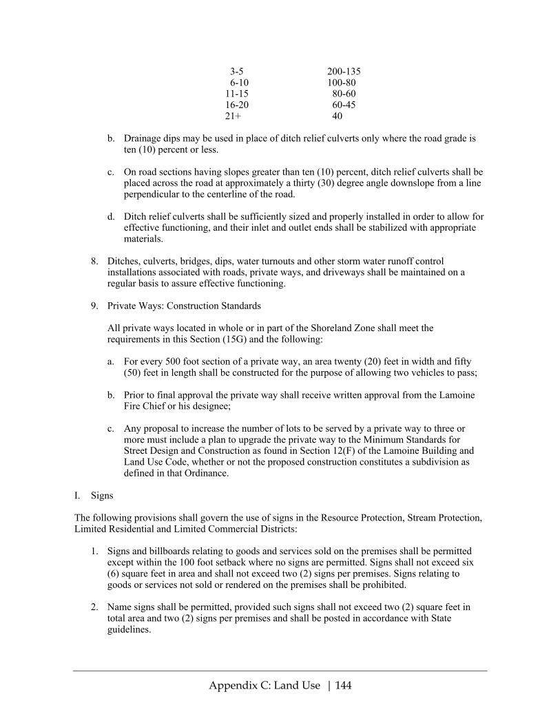
Appendix C: Land Use | 144
3-5 200-135 6-10 100-80 11-15 80-60 16-20 60-45 21+ 40
b. Drainage dips may be used in place of ditch relief culverts only where the road grade is
ten (10) percent or less. c. On road sections having slopes greater than ten (10) percent, ditch relief culverts shall be
placed across the road at approximately a thirty (30) degree angle downslope from a line perpendicular to the centerline of the road.
d. Ditch relief culverts shall be sufficiently sized and properly installed in order to allow for
effective functioning, and their inlet and outlet ends shall be stabilized with appropriate materials.
8. Ditches, culverts, bridges, dips, water turnouts and other storm water runoff control
installations associated with roads, private ways, and driveways shall be maintained on a regular basis to assure effective functioning.
9. Private Ways: Construction Standards
All private ways located in whole or in part of the Shoreland Zone shall meet the requirements in this Section (15G) and the following:
a. For every 500 foot section of a private way, an area twenty (20) feet in width and fifty
(50) feet in length shall be constructed for the purpose of allowing two vehicles to pass; b. Prior to final approval the private way shall receive written approval from the Lamoine
Fire Chief or his designee; c. Any proposal to increase the number of lots to be served by a private way to three or
more must include a plan to upgrade the private way to the Minimum Standards for Street Design and Construction as found in Section 12(F) of the Lamoine Building and Land Use Code, whether or not the proposed construction constitutes a subdivision as defined in that Ordinance.
I. Signs The following provisions shall govern the use of signs in the Resource Protection, Stream Protection, Limited Residential and Limited Commercial Districts:
1. Signs and billboards relating to goods and services sold on the premises shall be permitted except within the 100 foot setback where no signs are permitted. Signs shall not exceed six (6) square feet in area and shall not exceed two (2) signs per premises. Signs relating to goods or services not sold or rendered on the premises shall be prohibited.
2. Name signs shall be permitted, provided such signs shall not exceed two (2) square feet in
total area and two (2) signs per premises and shall be posted in accordance with State guidelines.
Appendix C: Land Use | 145
3. Residential users may display a single sign not over three (3) square feet in area relating to the sale, rental, or lease of the premises.
4. Signs relating to trespassing and hunting shall be permitted provided that no such sign shall
exceed two (2) square feet in area. 5. Signs relating to public safety shall be permitted without restriction. 6. No sign shall extend higher than eight (8) feet above the ground. 7. Only commercial signs may be illuminated and only by shielded, non-flashing lights.
J. Storm Water Runoff
1. All new construction and development shall be designed to minimize storm water runoff from the site in excess of the natural predevelopment conditions. Where possible, existing natural runoff control features, such as berms, swales, terraces and wooded areas shall be retained in order to reduce runoff and encourage infiltration of stormwaters.
2. Storm water runoff control systems shall be maintained as necessary to ensure proper
functioning.
NOTE: The Stormwater Management Law (38 M.R.S.A. section 420-D) requires a full permit to be obtained from the DEP prior to construction of a project consisting of 20,000 square feet or more of impervious area or 5 acres or more of a developed area in an urban impaired stream watershed or most-at-risk lake watershed, or a project with 1acre or more of developed area in any other stream, coastal or wetland watershed. A permit-by-rule is necessary for a project with one acre or more of disturbed area but less than 1 acre impervious area (20,000 square feet for most-at-risk lakes and urban impaired streams) and less than 5 acres of developed area. Furthermore, a Maine Construction General Permit is required if the construction will result in one acre or more of disturbed area.
K. Septic Waste Disposal
All subsurface sewage disposal systems shall be installed in conformance with the State of Maine Subsurface Wastewater Disposal Rules, and the following: a) clearing or removal of woody vegetation necessary to site a new system and any associated fill extensions, shall not extend closer than seventy-five (75) feet, horizontal distance, from the normal high-water line of a water body or the upland edge of a wetland and b) a holding tank is not allowed for a first-time residential use in the shoreland zone.
NOTE: The Maine Subsurface Wastewater Disposal Rules require new systems, excluding fill extensions, to be constructed no less than one hundred (100) horizontal feet from the normal high-water line of a perennial water body. The minimum setback distance for a new subsurface disposal system may not be reduced by variance.
L. Essential Services
1. Where feasible, the installation of essential services shall be limited to existing public ways and existing service corridors.
2. The installation of essential services is not permitted in a Resource Protection or Stream
Protection District, except to provide services to a permitted use within said district, or except

Appendix C: Land Use | 146
where the applicant demonstrates that no reasonable alternative exists. Where permitted, such structures and facilities shall be located so as to minimize any adverse impacts on surrounding uses and resources, including visual impacts.
3. Damaged or destroyed public utility transmission and distribution lines, towers and related
equipment may be replaced or reconstructed without a permit. M. Mineral Exploration and Extraction in the Shoreland Zone is NOT permitted. N. Agriculture
1. All spreading or disposal of manure shall be accomplished in conformance with the Manure Utilization Guidelines published by the Maine Department of Agriculture on November 1, 2001 and the Nutrient Management Law (7 M.R.S.A. sections 4201-4209).
2. Manure shall not be stored or stockpiled within one hundred (100) feet, horizontal distance, of
a great pond classified GPA or a river flowing to a great pond classified GPA, or within seventy- five (75) feet horizontal distance, of other water bodies, tributary streams, or wetlands. All manure storage areas within the shoreland zone must be constructed or modified such that the facility produces no discharge of effluent or contaminated storm water.
3. Agricultural activities involving tillage of soil greater than forty thousand (40,000) square
feet in surface area, or the spreading, disposal or storage of manure within the shoreland zone shall require a Soil and Water Conservation Plan to be filed with the Planning Board. Non-conformance with the provisions of said plan shall be considered to be a violation of this Ordinance.
NOTE: Assistance in preparing a soil and water conservation plan may be available through the local Soil and Water Conservation District office.
4. There shall be no new tilling of soil within one-hundred (100) feet, horizontal distance, of the
normal high-water line of a great pond classified GPA; within seventy-five (75) feet, horizontal distance, from other water bodies and coastal wetlands; nor within twenty-five (25) feet, horizontal distance, of tributary streams and freshwater wetlands. Operations in existence on the effective date of this ordinance and not in conformance with this provision may be maintained.
5. Newly established livestock grazing areas shall not be permitted within one hundred (100)
feet, horizontal distance, of the normal high-water line of a great pond classified GPA; within seventy- five (75) feet, horizontal distance, of other water bodies and coastal wetlands, nor; within twenty- five (25) feet, horizontal distance, of tributary streams and freshwater wetlands. Livestock grazing must be conducted in accordance with a Soil and Water Conservation Plan.
O. Timber Harvesting - REPEALED
Timber Harvesting in Lamoine is governed by Title 38 MRSA § 438-B (3) of the State of Maine Guidelines for Municipal Shoreland Zoning Ordinances. Rules for timber harvesting will be administered and enforced by the State of Maine Department of Conservation, Bureau of Forestry. Please consult Maine Statutes or the Maine Department of Conservation for the latest regulations.
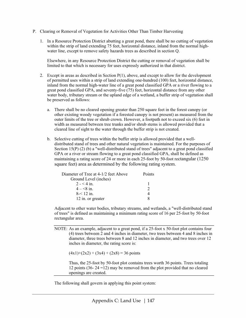
Appendix C: Land Use | 147
P. Clearing or Removal of Vegetation for Activities Other Than Timber Harvesting
1. In a Resource Protection District abutting a great pond, there shall be no cutting of vegetation within the strip of land extending 75 feet, horizontal distance, inland from the normal high-water line, except to remove safety hazards trees as described in section Q.
Elsewhere, in any Resource Protection District the cutting or removal of vegetation shall be limited to that which is necessary for uses expressly authorized in that district.
2. Except in areas as described in Section P(1), above, and except to allow for the development
of permitted uses within a strip of land extending one-hundred (100) feet, horizontal distance, inland from the normal high-water line of a great pond classified GPA or a river flowing to a great pond classified GPA, and seventy-five (75) feet, horizontal distance from any other water body, tributary stream or the upland edge of a wetland, a buffer strip of vegetation shall be preserved as follows:
a. There shall be no cleared opening greater than 250 square feet in the forest canopy (or
other existing woody vegetation if a forested canopy is not present) as measured from the outer limits of the tree or shrub crown. However, a footpath not to exceed six (6) feet in width as measured between tree trunks and/or shrub stems is allowed provided that a cleared line of sight to the water through the buffer strip is not created.
b. Selective cutting of trees within the buffer strip is allowed provided that a well-
distributed stand of trees and other natural vegetation is maintained. For the purposes of Section 15(P) (2) (b) a "well-distributed stand of trees" adjacent to a great pond classified GPA or a river or stream flowing to a great pond classified GPA, shall be defined as maintaining a rating score of 24 or more in each 25-foot by 50-foot rectangular (1250 square feet) area as determined by the following rating system.
Diameter of Tree at 4-1/2 feet Above Points Ground Level (inches)
2 - < 4 in. 1 4 – <8 in. 2 8-< 12 in. 4 12 in. or greater 8
Adjacent to other water bodies, tributary streams, and wetlands, a "well-distributed stand of trees" is defined as maintaining a minimum rating score of 16 per 25-foot by 50-foot rectangular area.
NOTE: As an example, adjacent to a great pond, if a 25-foot x 50-foot plot contains four
(4) trees between 2 and 4 inches in diameter, two trees between 4 and 8 inches in diameter, three trees between 8 and 12 inches in diameter, and two trees over 12 inches in diameter, the rating score is:
(4x1)+(2x2) + (3x4) + (2x8) = 36 points Thus, the 25-foot by 50-foot plot contains trees worth 36 points. Trees totaling
12 points (36- 24 =12) may be removed from the plot provided that no cleared openings are created.
The following shall govern in applying this point system:
Appendix C: Land Use | 148
i. The 25-foot by 50-foot rectangular plots must be established where the
landowner or lessee proposes clearing within the required buffer; ii. Each successive plot must be adjacent to, but not overlap a previous plot; iii. Any plot not containing the required points must have no vegetation removed
except as otherwise allowed by this Ordinance; iv. Any plot containing the required points may have vegetation removed down to
the minimum points required or as otherwise allowed by this Ordinance; v. Where conditions permit, no more than 50% of the points on any 25-foot by 50-
foot rectangular area may consist of trees greater than 12 inches in diameter. For the purposes of Section 15(P) (2) (b) “other natural vegetation” is defined as retaining existing vegetation under three (3) feet in height and other ground cover and retaining at least five (5) saplings less than two (2) inches in diameter at four and one half (4 ½) feet above ground level for each 25-foot by 50-foot rectangle area. If five saplings do not exist, no woody stems less than two (2) inches in diameter can be removed until 5 saplings have been recruited into the plot. Notwithstanding the above provisions, no more than 40% of the total volume of trees four (4) inches or more in diameter, measured at 4 1/2 feet above ground level may be removed in any ten (10) year period.
c. In order to protect water quality and wildlife habitat, existing vegetation under three (3) feet in height and other ground cover, including leaf litter and the forest duff layer, shall not be cut, covered, or removed, except to provide for a footpath or other permitted uses as described in Section 15(P) paragraphs (2) and (2)(a) above.
d. Pruning of tree branches on the bottom 1/3 of the tree is allowed. e. In order to maintain a buffer strip of vegetation, when the removal of storm-damaged,
diseased, unsafe, or dead trees results in the creation of cleared openings, these openings shall be replanted with native tree species in accordance with Section Q below, unless existing new tree growth is present.
f. In order to maintain the vegetation in the shoreline buffer, clearing or removal of
vegetation for allowed activities, including associated construction and related equipment operation, within or outside the shoreline buffer, must comply with the requirements of Section 15(P)(2).
Section 15(P) (2) does not apply to those portions of public recreational facilities adjacent to public swimming areas as long as cleared areas are limited to the minimum area necessary.
3. At distances greater than one hundred (100) feet, horizontal distance, from a great pond
classified GPA or a river flowing to a great pond classified GPA, and seventy-five (75) feet, horizontal distance from the normal high-water line of any other water body, tributary stream or the upland edge of a wetland, there shall be allowed on any lot, in any ten (10) year period, selective cutting of not more than forty (40) percent of the volume of trees four (4) inches or more in diameter, measured 4 1/2 feet above ground level. Tree removal in conjunction with

Appendix C: Land Use | 149
the development of permitted uses shall be included in the forty (40) percent calculation. For the purposes of these standards volume may be considered to be equivalent to basal area.
In no event shall cleared openings for any purpose, including but not limited to principal and accessory structures, driveways and sewage disposal areas, exceed, in the aggregate, 25% of the lot area within the shoreland zone or ten thousand (10,000) square feet, whichever is greater, including land previously cleared. This provision applies to the portion of a lot within the shoreland zone, including the buffer area, but shall not apply to the Commercial Fisheries/Maritime Activities District.
4. Legally existing nonconforming cleared openings may be maintained, but shall not be
enlarged, except as allowed by this Ordinance. 5. Fields and other cleared openings which have reverted to primarily shrubs, trees, or other
woody vegetation shall be regulated under the provisions of Section 15(P). Q. Hazard Trees, Storm-Damaged Trees, and Dead Tree Removal
1. Hazard trees in the shoreland zone may be removed without a permit after consultation with the Code Enforcement Officer if the following requirements are met:
a. Within the shoreline buffer, if the removal of a hazard tree results in a cleared opening in
the tree canopy greater than two hundred and fifty (250) square feet, replacement with native tree species is required, unless there is new tree growth already present. New tree growth must be as near as practicable to where the hazard tree was removed and be at least two (2) inches in diameter, measured at four and one half (4.5) feet above the ground level. If new growth is not present, then replacement trees shall consist of native species and be at least four (4) feet in height, and be no less than two (2) inches in diameter. Stumps may not be removed.
b. Outside of the shoreline buffer, when the removal of hazard trees exceeds forty (40)
percent of the volume of trees four (4) inches or more in diameter, measured at four and one half (4.5) feet above ground level in any ten (10) year period, and/or results in cleared openings exceeding twenty-five (25) percent of the lot area within the shoreland zone, or ten thousand (10,000) square feet, whichever is greater, replacement with native tree species is required, unless there is new tree growth already present. New tree growth must be as near as practicable to where the hazard tree was removed and be at least two (2) inches in diameter, measured at four and one half (4.5) feet above the ground level. If new growth is not present, then replacement trees shall consist of native species and be at least two (2) inches in diameter, measured at four and one half (4.5) feet above the ground level.
c. The removal of standing dead trees, resulting from natural causes, is permissible without
the need for replanting or a permit, as long as the removal does not result in the creation of new lawn areas, or other permanently cleared areas, and stumps are not removed. For the purposes of this provision dead trees are those trees that contain no foliage during the growing season.
d. The Code Enforcement Officer may require the property owner to submit an evaluation
from a licensed forester or arborist before any hazard tree can be removed within the shoreland zone.

Appendix C: Land Use | 150
e. The Code Enforcement Officer may require more than a one–for-one replacement for hazard trees removed that exceed eight (8) inches in diameter measured at four and one half (4.5) feet above the ground level.
2. Storm-damaged trees in the shoreland zone may be removed without a permit after
consultation with the Code Enforcement Officer if the following requirements are met:
a. Within the shoreline buffer, when the removal of storm-damaged trees results in a cleared opening in the tree canopy greater than two hundred and fifty (250) square feet, replanting is not required, but the area shall be required to naturally revegetate, and the following requirements must be met:
i. The area from which a storm-damaged tree is removed does not result in new lawn
areas, or other permanently cleared areas; ii. Stumps from the storm-damaged trees may not be removed; iii. Limbs damaged from a storm event may be pruned even if they extend beyond the
bottom one-third (1/3) of the tree; and iv. If after one growing season, no natural regeneration or regrowth is present, replanting
of native tree seedlings or saplings is required at a density of one seedling per every eighty (80) square feet of lost canopy.
b. Outside of the shoreline buffer, if the removal of storm damaged trees exceeds 40% of
the volume of trees four (4) inches or more in diameter, measured at four and one half (4.5) feet above the ground level in any ten (10) year period, or results, in the aggregate, in cleared openings exceeding 25% of the lot area within the shoreland zone or ten thousand (10,000) square feet, whichever is greater, and no natural regeneration occurs within one growing season, then native tree seedlings or saplings shall be replanted on a one-for-one basis.
R. Exemptions to Clearing and Vegetation Removal Requirements
The following activities are exempt from the clearing and vegetation removal standards set forth in Section 15(P), provided that all other applicable requirements of this chapter are complied with, and the removal of vegetation is limited to that which is necessary:
1. The removal of vegetation that occurs at least once every two (2) years for the
maintenance of legally existing areas that do not comply with the vegetation standards in this chapter, such as but not limited to cleared openings in the canopy or fields. Such areas shall not be enlarged, except as allowed by this section. If any of these areas, due to lack of removal of vegetation every two (2) years, reverts back to primarily woody vegetation, the requirements of Section 15(P) apply;
2. The removal of vegetation from the location of allowed structures or allowed uses, when
the shoreline setback requirements of section 15(B) are not applicable; 3. The removal of vegetation from the location of public swimming areas associated with an
allowed public recreational facility;

Appendix C: Land Use | 151
4. The removal of vegetation associated with allowed agricultural uses, provided best management practices are utilized, and provided all requirements of section 15(N) are complied with;
5. The removal of vegetation associated with brownfields or voluntary response action
program (VRAP) projects provided that the removal of vegetation is necessary for remediation activities to clean-up contamination on a site in a general development district, commercial fisheries and maritime activities district or other equivalent zoning district approved by the Commissioner that is part of a state or federal brownfields program or a voluntary response action program pursuant 38 M.R.S.A section 343-E, and that is located along:
a. A coastal wetland; or b. A river that does not flow to a great pond classified as GPA pursuant to 38 M.R.S.A
section 465-A.
6. The removal of non-native invasive vegetation species, provided the following minimum requirements are met:
a. If removal of vegetation occurs via wheeled or tracked motorized equipment, the
wheeled or tracked motorized equipment is operated and stored at least twenty-five (25) feet, horizontal distance, from the shoreline, except that wheeled or tracked equipment may be operated or stored on existing structural surfaces, such as pavement or gravel;
b. Removal of vegetation within twenty-five (25) feet, horizontal distance, from the
shoreline occurs via hand tools; and c. If applicable clearing and vegetation removal standards are exceeded due to the removal
of non-native invasive species vegetation, the area shall be revegetated with native species to achieve compliance.
NOTE: An updated list of non-native invasive vegetation is maintained by the Department of Agriculture, Conservation and Forestry’s Natural Areas Program: http://www.maine.gov/dacf/mnap/features/invasive_plants/invasives.htm
7. The removal of vegetation associated with emergency response activities conducted by the
Department, the U.S. Environmental Protection Agency, the U.S. Coast Guard, and their agents.
S. Revegetation Requirements
When revegetation is required in response to violations of the vegetation standards set forth in Section 15(P), to address the removal of non- native invasive species of vegetation, or as a mechanism to allow for development that may otherwise not be permissible due to the vegetation standards, including removal of vegetation in conjunction with a shoreline stabilization project, the revegetation must comply with the following requirements.
1. The property owner must submit a revegetation plan, prepared with and signed by a qualified
professional, that describes revegetation activities and maintenance. The plan must include a scaled site plan, depicting where vegetation was, or is to be removed, where existing vegetation is to remain, and where vegetation is to be planted, including a list of all vegetation to be planted.

Appendix C: Land Use | 152
2. Revegetation must occur along the same segment of shoreline and in the same area where
vegetation was removed and at a density comparable to the pre-existing vegetation, except where a shoreline stabilization activity does not allow revegetation to occur in the same area and at a density comparable to the pre-existing vegetation, in which case revegetation must occur along the same segment of shoreline and as close as possible to the area where vegetation was removed.
3. If part of a permitted activity, revegetation shall occur before the expiration of the permit. If
the activity or revegetation is not completed before the expiration of the permit, a new revegetation plan shall be submitted with any renewal or new permit application.
4. Revegetation activities must meet the following requirements for trees and saplings:
a. All trees and saplings removed must be replaced with native noninvasive species; b. Replacement vegetation must at a minimum consist of saplings; c. If more than three (3) trees or saplings are planted, then at least three (3) different species
shall be used; d. No one species shall make up 50% or more of the number of trees and saplings planted; e. If revegetation is required for a shoreline stabilization project, and it is not possible to
plant trees and saplings in the same area where trees or saplings were removed, then trees or sapling must be planted in a location that effectively reestablishes the screening between the shoreline and structures; and
f. A survival rate of at least eighty (80) percent of planted trees or saplings is required for a
minimum five (5) years period.
5. Revegetation activities must meet the following requirements for woody vegetation and other vegetation under three (3) feet in height:
a. All woody vegetation and vegetation under three (3) feet in height must be replaced with
native noninvasive species of woody vegetation and vegetation under three (3) feet in height as applicable;
b. Woody vegetation and vegetation under three (3) feet in height shall be planted in
quantities and variety sufficient to prevent erosion and provide for effective infiltration of stormwater;
c. If more than three (3) woody vegetation plants are to be planted, then at least three (3)
different species shall be planted; d. No one species shall make up 50% or more of the number of planted woody vegetation
plants; and e. Survival of planted woody vegetation and vegetation under three feet in height must be
sufficient to remain in compliance with the standards contained within this chapter for minimum of five (5) years.

Appendix C: Land Use | 153
6. Revegetation activities must meet the following requirements for ground vegetation and ground cover:
a. All ground vegetation and ground cover removed must be replaced with native
herbaceous vegetation, in quantities and variety sufficient to prevent erosion and provide for effective infiltration of stormwater;
b. Where necessary due to a lack of sufficient ground cover, an area must be supplemented
with a minimum four (4) inch depth of leaf mulch and/or bark mulch to prevent erosion and provide for effective infiltration of stormwater; and
c. Survival and functionality of ground vegetation and ground cover must be sufficient to
remain in compliance with the standards contained within this chapter for minimum of five (5) years.
T. Erosion and Sedimentation Control
1. All activities which involve filling, grading, excavation or other similar activities which result in unstabilized soil conditions and which require a permit shall also require a written soil erosion and sedimentation control plan. The plan shall be submitted to the permitting authority for approval and shall include, where applicable, provisions for:
a. Mulching and revegetation of disturbed soil. b. Temporary runoff control features such as hay bales, silt fencing or diversion ditches. c. Permanent stabilization structures such as retaining walls or rip-rap.
2. In order to create the least potential for erosion, development shall be designed to fit with the
topography and soils of the site. Areas of steep slopes where high cuts and fills may be required shall be avoided wherever possible, and natural contours shall be followed as closely as possible.
3. Erosion and sedimentation control measures shall apply to all aspects of the proposed project
involving land disturbance, and shall be in operation during all stages of the activity. The amount of exposed soil at every phase of construction shall be minimized to reduce the potential for erosion.
4. Any exposed ground area shall be temporarily or permanently stabilized within one (1) week
from the time it was last actively worked, by use of riprap, sod, seed, and mulch, or other effective measures. In all cases permanent stabilization shall occur within nine (9) months of the initial date of exposure. In addition:
a. Where mulch is used, it shall be applied at a rate of at least one (1) bale per five hundred
(500) square feet and shall be maintained until a catch of vegetation is established. b. Anchoring the mulch with netting, peg and twine or other suitable method may be
required to maintain the mulch cover. c. Additional measures shall be taken where necessary in order to avoid siltation into the
water. Such measures may include the use of staked hay bales and/or silt fences.

Appendix C: Land Use | 154
5. Natural and man-made drainage ways and drainage outlets shall be protected from erosion from water flowing through them. Drainage ways shall be designed and constructed in order to carry water from a twenty five (25) year storm or greater, and shall be stabilized with vegetation or lined with riprap.
U. Soils
All land uses shall be located on soils in or upon which the proposed uses or structures can be established or maintained without causing adverse environmental impacts, including severe erosion, mass soil movement, improper drainage, and water pollution, whether during or after construction. Proposed uses requiring subsurface waste disposal, and commercial or industrial development and other similar intensive land uses, shall require a soils report based on an on-site investigation and be prepared by state-certified professionals. Certified persons may include Maine Certified Soil Scientists, Maine Registered Professional Engineers, Maine State Certified Geologists and other persons who have training and experience in the recognition and evaluation of soil properties. The report shall be based upon the analysis of the characteristics of the soil and surrounding land and water areas maximum ground water elevation, presence of ledge, drainage conditions and other pertinent data which the evaluator deems appropriate. The soils report shall include recommendations for a proposed use to counteract soil limitations where they exist.
V. Water Quality
No activity shall deposit on or into the ground or discharge to the waters of the State any pollutant that, by itself or in combination with other activities or substances will impair designated uses or the water classification of the water body.
W. Archeological Sites
Any proposed land use activity involving structural development or soil disturbance on or adjacent to sites listed on, or eligible to be listed on the National Register of Historic Places, as determined by the permitting authority shall be submitted by the applicant to the Maine Historic Preservation Commission for review and comment, at least twenty (20) days prior to action being taken by the permitting authority. The permitting authority shall consider comments received from the Commission prior to rendering a decision on the application.
NOTE: Municipal officials should contact the Maine Historic Preservation Commission for the listing and location of Historic Places in their community.
Section 16. ADMINISTRATION A. Administering Bodies and Agents
1. Planning Board
A Planning Board shall be created in accordance with the provisions of State law.
The Planning Board shall exercise responsibility for the administration of this Ordinance. It shall issue permits as authorized in the Table of Land Uses (Section 14). The Board shall retain oversight responsibilities for any parcel under consideration for development in the Shoreland Zone, undergoing such development, or in which such development has been completed.
2. Code Enforcement Officer

Appendix C: Land Use | 155
A Code Enforcement Officer shall be appointed or reappointed annually by July 1st.
The Planning Board shall call on the services of the Code Enforcement Officer (CEO) for its administrative purposes and the Code Enforcement Officer shall be responsible to the Board in the performance of Board-related duties.
The CEO shall review all applications required to be submitted under this ordinance and shall make findings and recommendations to the Board. Permits shall be issued in accordance with the Table of Land Uses (Section 14). The CEO shall carry out all those enforcement activities and responsibilities described in Section 16(I) of this ordinance and perform other duties as the Board may request.
3. Board of Appeals
A Board of Appeals shall be created in accordance with the provisions of MRSA Title 30-A Section 2691. See Section I for powers and duties of the Board of Appeals.
4. Board of Selectmen
Any action needed to enforce the provisions of this Ordinance shall be taken by the Selectmen of the Town of Lamoine on their own motion or on the recommendation of the Planning Board or the Code Enforcement Officer. See Section J.Enforcement.
B. Permits Required
After the effective date of this Ordinance no person shall, without first obtaining a permit, engage in any activity or use of land or structure requiring a permit in the district in which such activity or use would occur; or expand, change, or replace an existing use or structure; or renew a discontinued nonconforming use. The applicant is responsible for obtaining all required permits prior to the issuance of a Lamoine Shoreland permit. A person who is issued a permit pursuant to this Ordinance shall have a copy of the permit on site while the work authorized by the permit is performed.
1. A permit is not required for the replacement of an existing road culvert as long as:
a. The replacement culvert is not more than 25% longer than the culvert being replaced; b. The replacement culvert is not longer than 75 feet; and c Adequate erosion control measures are taken to prevent sedimentation of the water, and
the crossing does not block fish passage in the watercourse. 2. A permit is not required for an archaeological excavation as long as the excavation is
conducted by an archaeologist listed on the State Historic Preservation Officer’s level 1 or level 2 approved list, and unreasonable erosion and sedimentation are prevented by means of adequate and timely temporary and permanent stabilization measures.
3. Any permit required by this Ordinance shall be in addition to any other permit required by
other law or ordinance.

Appendix C: Land Use | 156
C. Permit Application
Every applicant for a Shoreland Zoning permit shall complete all applicable sections of the Town of Lamoine Construction Application form. The application shall include all information listed below and be submitted to the appropriate official as indicated in Section 14 – Table of Land Uses. Applications submitted to the Planning Board must be signed by the Code Enforcement Officer to indicate that they have been reviewed for completeness. Application materials must be submitted in nine copies (one for each Board member, one for the CEO, and one for the Town file).
1. The Shoreland Zoning permit application shall include:
a. detailed plot plan (See Attachment A of the Construction Application) showing the names of abutting landowners, boundary lines and perimeter footage, all setback measurements, Flood Plain boundary lines, sewage plans, roads, site elevation above normal high-water mark, and location and elevation notations if required by section d and/or e below;
b. front and side elevations drawings of any proposed structures (See Attachment B of the
Construction Application); c. a completed HHE-200 (or successor form used as an application for septic system
permit), with a written statement from the Town Plumbing Inspector that the design is sufficient to allow granting of a plumbing permit (Form obtained from CEO);
d. a Flood Hazard Development permit if required, which includes, where necessary, a
letter from a registered surveyor attesting to the placement of markers indicating the boundary of the Flood Plain affecting the location of structures and other land uses (See Article III Flood Plain Management Ordinance;
e. in cases where construction will occur within 125 feet of normal high water mark, a letter
from a registered surveyor attesting to the fact that markers indicating the location and elevation of the 100 foot setback from normal high water mark have been placed on the property;
f. the signature of the owner or owners who can show evidence of right, title, or interest in
the parcel or their authorized agent (in which case a letter of authorization must be included);
g. the appropriate fee; h. any other information that the Code Enforcement Officer or Planning Board may require
as necessary to determine conformity with the provisions of this Ordinance. In addition to the above information and that information stipulated in Lamoine’s Building and Land Use Ordinance, applications for governmental, institutional, commercial or industrial principal structures or for public or private recreational facilities must be accompanied by an environmental impact study indicating the effects of the proposed land use on the parcel, on abutting landowners, on the abutting water bodies and on their customary uses.
2. Flood Hazard Development Permit Required Prior to Building Permit.

Appendix C: Land Use | 157
No building permit shall be issued for any structure or use on a parcel which, in part or in whole, falls within the Flood Plain unless the conditions of the Town of Lamoine Flood Plain Management Ordinance are met. In cases where a Flood Plain Zone restricts the proposed land use, a registered surveyor must mark the boundary of that zone on the parcel and provide a letter to the Planning Board attesting to the accurate placement of those markers. In these cases, a Flood Hazard Development permit must be obtained prior to the issuance of a Building Permit.
3. Plumbing Permit Required Prior to Building Permit
No building permit shall be issued for any structure or use involving construction, installation or alteration of plumbing facilities unless a permit for such facilities has been secured by the applicant or an authorized agent, according to the requirements of this Ordinance.
4. All applications shall be dated and the Planning Board shall note upon each application
the date and time of the Planning Board meeting at which it was received.
D. Procedure for Administering Permits 1. Notification of Completeness
Within 35 days of the date of receiving a written application, the Planning Board or Code Enforcement Officer, as indicated in Section 14, shall notify the applicant in writing either that the application is a complete application, or, if the application is incomplete, that specified additional material is needed to make the application complete.
2. Notification of Decision
When an application can be approved without public hearing, the Planning Board or the Code Enforcement Officer, as appropriate, shall approve, approve with conditions or deny all permit applications in writing within 35 days of receiving a completed application unless the Planning Board has a waiting list of applications. In such case, a decision shall occur within 35 days after the first available date on the Planning Board’s agenda following receipt of the completed application.
3. Criteria for Decision
Permits shall be approved if the proposed use or structure is found to be in conformance with the purposes and provisions of this Ordinance.
The applicant shall have the burden of proving that the proposed land use activity is in conformity with the purposes and provisions of this Ordinance. After the submission of a complete application to the Planning Board, the Board shall approve an application or approve it with conditions if it makes a positive finding based on the information presented that the proposed use:
a. Will meet requirements for the Shoreland Zone in which the proposal is located; b. Will maintain safe and healthful conditions; c. Will not result in water pollution, erosion, or sedimentation to surface waters;

Appendix C: Land Use | 158
d. Will not have an adverse impact on spawning grounds, fish, aquatic life, bird or other wildlife habitat;
e. Will protect buildings and lands from flooding and accelerated erosion; f. Will protect archaeological and historic resources as designated in the Comprehensive
Plan; g. Will not adversely affect existing commercial fishing or maritime activities in a
Commercial Fisheries/Maritime Activities district; h. Will conserve shore cover and visual, as well as actual, points of access to inland and
coastal waters; i. Will avoid problems associated with Flood Plain development and use; j. Will adequately provide for the disposal of wastewater; and k. Is in conformance with the provisions of Section 15, Land Use Standards.
4. Denial and Conditions
If a permit is either denied or approved with conditions, the reasons as well as conditions shall be stated in writing.
No approval shall be granted for an application involving a structure if the structure would be located in an unapproved subdivision or would violate any other local ordinance or regulation or any State law which the Town of Lamoine is responsible for enforcing.
E. Special Exceptions. In addition to the criteria specified in Section 16(D) above, excepting
structure setback requirements, the Planning Board may approve a permit for a single family residential structure in a Resource Protection District provided that the applicant demonstrates that all of the following conditions are met:
1. There is no location on the property, other than a location within the Resource Protection
District, where the structure can be built. 2. The lot on which the structure is proposed is undeveloped and was established and
recorded in the registry of deeds of the county in which the lot is located before the adoption of the Resource Protection District.
3. All proposed buildings, sewage disposal systems and other improvements are:
(a) Located on natural ground slopes of less than 20%; and (b) Located outside the floodway of the 100-year flood-plain along rivers and artificially
formed great ponds along rivers and outside the velocity zone in areas subject to tides, based on detailed flood insurance studies and as delineated on the Federal Emergency Management Agency's Flood Boundary and Floodway Maps and Flood Insurance Rate Maps; all buildings, including basements, are elevated at least one foot above the 100-year flood-plain elevation; and the development is otherwise in compliance with any applicable municipal flood-plain ordinance.

Appendix C: Land Use | 159
If the floodway is not shown on the Federal Emergency Management Agency Maps, it is deemed to be 1/2 the width of the 100-year flood-plain.
4. The total footprint, including cantilevered or similar overhanging extensions, of all
principal and accessory structures is limited to a maximum of 1,500 square feet. This limitation shall not be altered by variance.
5. All structures, except functionally water-dependent structures, are set back from the
normal high- water line of a water body, tributary stream or upland edge of a wetland to the greatest practical extent, but not less than 75 feet, horizontal distance. In determining the greatest practical extent, the Planning Board shall consider the depth of the lot, the slope of the land, the potential for soil erosion, the type and amount of vegetation to be removed, the proposed building site's elevation in regard to the flood-plain, and its proximity to moderate-value and high-value wetlands.
F. Expiration of Permit
A permit issued under this Ordinance shall lapse and become void if a substantial start is not made in construction or in the use of the property within one year from the date of issuance of the permit and if the project is not completed sufficiently to receive a certificate of occupancy within two years of the date of issuance of the permit. Thereafter, no further work on such construction shall be performed until the Board either renews the application or requests and approves a new application.
If an extension of these time limits is granted, the permit shall be valid for no more than one additional year.
Nothing in this section shall prohibit the Planning Board from requiring submission of additional information if needed to determine whether to grant an extension.
G. Fees.
An application for any permit required by this ordinance shall be accompanied by fee(s) as established by the Lamoine Board of Selectmen.
No action shall be taken on any application until the fee(s) have been received by the Town. The application fee(s) shall not be refundable. The fee(s) shall be paid to the Town of Lamoine and shall accrue to the Code Enforcement Fund to be used for the administration and enforcement of town ordinances. A Schedule of Fees is located at the Town Office.
H. Installation of Public Utility Service
No public utility, water district, sanitary district or any utility company of any kind may install services to any new structure located in the shoreland zone unless written authorization attesting to the validity and currency of all local permits required under this or any previous Ordinance has been issued by the appropriate municipal officials. Following installation of service, the company or district shall forward the written authorization to the Code Enforcement Officer of the Town of Lamoine, indicating that installation has been completed.
I. Appeals
1. Powers and Duties of the Board of Appeals

Appendix C: Land Use | 160
The Board of Appeals shall have the following powers: a. Administrative Appeals:
(1) To hear and decide administrative appeals on an appellate basis where it is alleged by an aggrieved party that there is an error in any order, requirement, decision, or determination made by, or failure to act by, the Planning Board in the administration of this Ordinance;
(2) To hear and decide administrative appeals on a de novo basis where it is alleged by
an aggrieved party that there is an error in any order, requirement, decision or determination made by, or failure to act by, the Code Enforcement Officer in his or her review of and action on a permit application under this Ordinance.
(3) Any order, requirement, decision or determination made, or failure to act, in the
enforcement of this ordinance is not appealable to the Board of Appeals. b. Variance Appeals:
To authorize variances upon appeal, within the limitations set forth in this Ordinance.
2. Administrative Appeals
a. When the Board of Appeals reviews a decision of the Code Enforcement Officer, it shall hold a “de novo” hearing. At this time the Board may receive and consider new evidence and testimony, be it oral or written. When acting in a “de novo” capacity the Board of Appeals shall hear and decide the matter afresh, undertaking its own independent analysis of evidence and the law, and reaching its own decision.
b. When the Board of Appeals reviews a decision of the Planning Board, it shall hold an
appellate hearing and may reverse the decision of the Planning Board only upon finding that the decision was contrary to specific provisions of the Ordinance or contrary to the facts presented to the Planning Board. The Board of Appeals may review only the record of the proceedings before the Planning Board. The Board of Appeals shall not receive or consider any evidence which was not presented to the Planning Board, but the Board of Appeals may receive and consider written or oral arguments. If the Board of Appeals determines that the record of the Planning Board proceeding are inadequate, the Board of Appeals may remand the matter to the Planning Board for additional fact finding.
3. Variance Appeals
Variances may be permitted only under the following conditions: a. Variances may be granted only from dimensional requirements including but not limited
to, lot width, structure height, percent of lot coverage and setback requirements. b. Variances shall not be granted for establishment of any uses otherwise prohibited by this
Ordinance. c. The Board shall not grant a variance unless it finds that:

Appendix C: Land Use | 161
(1) The proposed structure or use would meet the provisions of Section 15 except for the specific provision which has created the non-conformity and from which relief is sought; and
(2) The strict application of the terms of this Ordinance would result in undue hardship. The term "undue hardship" shall mean:
(a) That the land in question cannot yield a reasonable return unless a variance is granted;
(b) That the need for a variance is due to the unique circumstances of the property
and not to the general conditions in the neighborhood; (c) That the granting of a variance will not alter the essential character of the
locality; and (d) That the hardship is not the result of action taken by the applicant or a prior
owner. d. Notwithstanding Section 16(I)(2)(c)(ii) above, the Board of Appeals, or the Code
Enforcement Officer, if authorized in accordance with 30-A MRSA §4353-A, may grant a variance to an owner of a residential dwelling for the purpose of making that dwelling accessible to a person with a disability who resides in or regularly uses the dwelling. The board shall restrict any variance granted under this subsection solely to the installation of equipment or the construction of structures necessary for access to or egress from the dwelling by the person with the disability. The board may impose conditions on the variance, including limiting the variance to the duration of the disability or to the time that the person with the disability lives in the dwelling. The term “structures necessary for access to or egress from the dwelling" shall include railing, wall or roof systems necessary for the safety or effectiveness of the structure. Any permit issued pursuant to this subsection is subject to Sections 16(I)(2)(f) and 16(I)(4)(b)(iv) below.)
e. The Board of Appeals shall limit any variances granted as strictly as possible in order to
ensure conformance with the purposes and provisions of this Ordinance to the greatest extent possible, and in doing so may impose such conditions to a variance as it deems necessary. The party receiving the variance shall comply with any conditions imposed.
f. A copy of each variance request, including the application and all supporting information
supplied by the applicant, shall be forwarded by the municipal officials to the Commissioner of the Department of Environmental Protection at least twenty (20) days prior to action by the Board of Appeals. Any comments received from the Commissioner prior to action by the Board of Appeals shall be made part of the record and shall be taken into consideration by the Board of Appeals.
g. A copy of all variances granted by the Board of Appeals shall be submitted to the
Department of Environmental Protection within fourteen (14) days of the decision.
4. Appeal Procedure
a. Making an Appeal
(1) An administrative or variance appeal may be taken to the Board of Appeals by an aggrieved party from any decision of the Code Enforcement Officer or the Planning

Appendix C: Land Use | 162
Board, except for enforcement-related matters as described in Section 16(I)(1)(a) above. Such an appeal shall be taken within thirty (30) days of the date of the written decision appealed from, and not otherwise, except that the Board, upon a showing of good cause, may waive the thirty (30) day requirement.
(2) Such appeal shall be made by filing with the Board of Appeals a written notice of
appeal which includes:
(a) A concise written statement indicating what relief is requested and why it should be granted.
(b) A sketch drawn to scale showing lot lines, location of existing buildings and
structures and other physical features of the lot pertinent to the relief sought. (3) Upon being notified of an appeal to the Board of Appeals, the Code Enforcement
Officer or Planning Board, as appropriate, shall transmit to the Board of Appeals all of the papers constituting the record of the decision appealed from.
(4) The Board of Appeals shall hold a public hearing on an administrative appeal or a
variance appeal within thirty-five (35) days of its receipt of a complete written application, unless this time period is extended by agreement of both parties
b. Decision by Board of Appeals
(1) A majority of the full voting membership of the Board shall constitute a quorum for the purpose of deciding an appeal. A member who abstains shall not be counted in determining whether a quorum exists.
(2) The concurring vote of a majority of the full voting membership of the Board of
Appeals present and voting shall be necessary to reverse an order, requirement, decision, or determination of the Code Enforcement Officer or Planning Board, or to decide in favor of the applicant on any matter on which it is required to decide under this Ordinance, or to affect any variation in the application of this Ordinance from its stated terms. The board may reverse the decision, or failure to act, of the Code Enforcement Officer or Planning Board only upon a finding that the decision, or failure to act, was clearly contrary to specific provisions of this Ordinance.
(3) The person filing the appeal shall have the burden of proof. (4) The Board shall decide all administrative appeals and variance appeals within thirty
five (35) days after the close of the hearing, and shall issue a written decision on all appeals.
(5) All decisions shall become a part of the record and shall include a statement of
findings and conclusions as well as the reasons or basis thereof, and the appropriate order, relief or denial thereof.
5. Appeal to Superior Court
Except as provided by 30-A M.R.S.A. Section 2691(3)(F), any aggrieved party who participated as a party during the proceedings before the Board of Appeals may take an appeal to Superior Court in accordance with State laws within forty-five (45) days from the date of any decision of the Board of Appeals.

Appendix C: Land Use | 163
6. Reconsideration.
In accordance with 30-A M.R.S.A. section 2691(3)(F), the Board of Appeals may reconsider any decision within forty-five (45) days of its prior decision. A request to the Board to reconsider a decision must be filed within ten (10) days of the decision that is being reconsidered. A vote to reconsider and the action taken on that reconsideration must occur and be completed within forty-five (45) days of the date of the vote on the original decision. Reconsideration of a decision shall require a positive vote of the majority of the Board members originally voting on the decision, and proper notification to the landowner, petitioner, Planning Board, Code Enforcement Officer, and other parties of interest, including abutters and those who testified at the original hearing(s). The Board may conduct additional hearings and receive additional evidence and testimony.
Appeal of a reconsidered decision to Superior Court must be made within fifteen (15) days after the decision on reconsideration.
J. Enforcement
1. Nuisances
Any violation of this Ordinance shall be deemed to be a nuisance. 2. Code Enforcement Officer
a. It shall be the duty of the Code Enforcement Officer to enforce the provisions of this Ordinance. If the Code Enforcement Officer shall find that any provision of this Ordinance is being violated, he or she shall notify in writing the person responsible for such violation, indicating the nature of the violation and ordering the action necessary to correct it, including discontinuance of illegal use of land, buildings or structures or work being done, removal of illegal buildings or structures, and abatement of nuisance conditions. A copy of such notices shall be submitted to both the Selectmen and the Planning Board and be maintained as a permanent record.
b. The Code Enforcement Officer shall conduct on-site inspections to ensure compliance
with all applicable laws and conditions attached to permit approvals. The Code Enforcement Officer shall also investigate all written complaints of alleged violations of this Ordinance submitted to the Selectmen.
c. The Code Enforcement Officer shall keep a complete record of all essential transactions
of the office, including applications submitted, permits granted or denied, variances granted or denied, revocation actions, revocation of permits, appeals, court actions, violations investigated, violations found, and fees collected. On an annual basis, a summary of this record shall be submitted to the Director of the Bureau of Land Quality Control within the Department of Environmental Protection.
3. Legal Actions
When the above action does not result in the correction or abatement of the violation or nuisance condition, the Lamoine Board of Selectmen, upon notice from the Code Enforcement Officer, are hereby directed to institute any and all actions and proceedings, either legal or equitable, including seeking injunctions of violations and the imposition of fines, that may be appropriate or necessary to enforce the provisions of this Ordinance in the

Appendix C: Land Use | 164
name of the Town of Lamoine. The Board of Selectmen, or their authorized agent, are hereby authorized to enter into administrative consent agreements for the purpose of eliminating violations of this Ordinance and recovering fines without Court action. Such agreements shall not allow an illegal structure or use to continue unless there is clear and convincing evidence that the illegal structure or use was constructed or conducted as a direct result of erroneous advice given by an authorized municipal official and there is no evidence that the owner acted in bad faith, or unless the removal of the structure or use will result in a threat or hazard to public health and safety or will result in substantial environmental damage.
4. Fines
Any person, including but not limited to a landowner, a landowner's agent or a contractor, who orders or conducts any activity in violation of this Ordinance shall be penalized in accordance with Title 30-A, Maine Revised Statutes Annotated, Subsection 4452.
NOTE: Current penalties include fines of not less than $100 or more than $2500 per violation for each day that the violation continues. However, in a Resource Protection District the maximum penalty is increased to $5000 (30-A M.R.S.A. § 4452)

Appendix C: Land Use | 165
Section 17. DEFINITIONS Accessory structure or use - a use or structure which is incidental and subordinate to the principal use or structure. Accessory uses, when aggregated shall not subordinate the principal use of the lot. A deck or similar extension of the principal structure or a garage attached to the principal structure by a roof or a common wall is considered part of the principal structure. Aggrieved party - an owner of land whose property is directly or indirectly affected by the granting or denial of a permit or variance under this Ordinance; a person whose land abuts land for which a permit or variance has been granted; or any other person or group of persons who have suffered particularized injury as a result of the granting or denial of such permit or variance.
Agriculture - the production, keeping or maintenance for sale or lease, of plants and/or animals, including but not limited to: forages and sod crops; grains and seed crops; dairy animals and dairy products; poultry and poultry products; livestock; fruits and vegetables; and ornamental and green house products. Agriculture does not include forest management and timber harvesting activities.
Aquaculture - the growing or propagation of harvestable freshwater, estuarine, or marine plant or animal species. Basal Area – the area of cross-section of a tree stem at 4 ½ feet above ground level and inclusive of bark. Basement – any portion of a structure with a floor-to-ceiling height of 6 feet or more and having more than 50% of this volume below the existing ground level.
Boat Launching Facility - a facility designed primarily for the launching and landing of watercraft, and which may include an access ramp, docking area, and parking spaces for vehicles and trailers. Bunkhouses and similar structures – Structures that are not accessory to a principal structure and that are intended for use as temporary or seasonal living quarters, that have no permanent foundation and no subsurface sewage disposal system. Bureau of Forestry – State of Maine Department of Agriculture, Conservation, and Forestry, Bureau of Forestry Campground – any area or tract of land to accommodate two (2) or more parties in temporary living quarters, including, but not limited to tents, recreational vehicles or other shelters. Canopy – the more or less continuous cover formed by tree crowns in a wooded area. Coastal Bluff – the area identified on Coastal Bluff maps as being “highly unstable” or “unstable” by the Maine Geological Survey. (A coastal bluff map is available at the Town Office).
Coastal wetland - all tidal and subtidal lands; all lands in the Shoreland Zone below any identifiable debris line left by tidal action; all lands with vegetation present that is tolerant of salt water and occurs primarily in a salt water or estuarine habitat; and any swamp, marsh, bog, beach, flat or other contiguous low land which is subject to tidal action during the maximum spring tide level as identified in tide tables published by the National Ocean Service. Coastal wetlands may include portions of coastal sand dunes.

Appendix C: Land Use | 166
Commercial use - the use of lands, buildings, or structures, other than a "home occupation," defined below, the intent and result of which activity is the production of income from the buying and selling of goods and/or services, exclusive of rental of residential buildings and/or dwelling units. Development – a change in land use involving alteration of the land, water or vegetation, or the addition or alteration of structures or other construction not naturally occurring.
Dimensional requirements - numerical standards relating to spatial relationships including but not limited to setback, lot area, shore frontage and height. Disability - any disability, infirmity, malformation, disfigurement, congenital defect or mental condition caused by bodily injury, accident, disease, birth defect, environmental conditions or illness; and also includes the physical or mental condition of a person which constitutes a substantial handicap as determined by a physician or in the case of mental handicap, by a psychiatrist or psychologist, as well as any other health or sensory impairment which requires special education, vocational rehabilitation or related services.
Driveway - a vehicular access-way less than five hundred (500) feet in length serving two single-family dwellings or one two-family dwelling, or less.
Emergency operations - operations conducted for the public health, safety or general welfare, such as protection of resources from immediate destruction or loss, law enforcement, and operations to rescue human beings, property and livestock from the threat of destruction or injury.
Essential services - gas, electrical or communication facilities; steam, fuel, electric power or water transmission or distribution lines, towers and related equipment; telephone cables or lines, poles and related equipment; gas, oil, water, slurry or other similar pipelines; municipal sewage lines, collection or supply systems; and associated storage tanks. Such systems may include towers, poles, wires, mains, drains, pipes, conduits, cables, fire alarms and police call boxes, traffic signals, hydrants and similar accessories, but shall not include service drops or buildings which are necessary for the furnishing of such services.
Expansion of a structure - an increase in the floor area or volume of a structure, including all extensions such as, but not limited to, attached: decks, garages, porches and greenhouses.
Expansion of use - the addition of one or more months to a use's operating season; or the use of more footprint of a structure or ground area devoted to a particular use.
Family - two (2) or more persons related by blood, marriage, adoption or guardianship, or not more than five (5) persons not so related, occupying a dwelling unit and living as a single housekeeping unit; such a group to be distinguished from a group occupying a boarding house, lodging house, club, fraternity or hotel. Floodway - the channel of a river or other watercourse and adjacent land areas that must be reserved in order to discharge the 100-year flood without cumulatively increasing the water surface elevation by more than one foot in height.
Floor area - the sum of the horizontal areas of the floor(s) of a structure enclosed by exterior walls, plus the horizontal area of any unenclosed portions of a structure such as porches and decks. Footprint - the entire area of ground covered by the structure(s) on a lot, including but not limited to cantilevered or similar overhanging extensions, as well as unenclosed structures, such as patios and decks.

Appendix C: Land Use | 167
Forested wetland – a freshwater wetland dominated by woody vegetation that is six (6) meters tall (approximately twenty (20) feet) or taller.
Foundation - the supporting substructure of a building or other structure, excluding wooden sills and post supports, including but not limited to basements, slabs, sills, posts, frostwalls or other base consisting of concrete, block, brick or similar material
Freshwater wetland - freshwater swamps, marshes, bogs and similar areas which are:
1. of ten or more contiguous acres; or of less than 10 contiguous acres and adjacent to a surface water body, excluding any river, stream or brook such that in a natural state, the combined surface area is in excess of 10 acres; and
2. inundated or saturated by surface or ground water at a frequency and for a duration sufficient
to support, and which under normal circumstances do support, a prevalence of wetland vegetation typically adapted for life in saturated soils.
Freshwater wetlands may contain small stream channels or inclusions of land that do not conform to the criteria of this definition. Functionally water-dependent uses - those uses that require, for their primary purpose, location on submerged lands or that require direct access to, or location in, coastal and inland waters and which cannot be located away from these waters. The uses include, but are not limited to commercial and recreational fishing and boating facilities, finfish and shellfish processing, fish storage and retail and wholesale fish marketing facilities, waterfront dock and port facilities, shipyards and boat building facilities, marinas, navigation aides, basins and channels, industrial uses dependent upon water-borne transportation or requiring large volumes of cooling or processing water and which cannot reasonably be located or operated at an inland site, and uses which primarily provide general public access to marine or tidal waters. Recreational boat storage buildings are not considered to be a functionally water-dependent use.
Great pond - any inland body of water which in a natural state has a surface area in excess of ten acres, and any inland body of water artificially formed or increased which has a surface area in excess of thirty (30) acres except for the purposes of this Ordinance, where the artificially formed or increased inland body of water is completely surrounded by land held by a single owner.
Great pond classified GPA - any great pond classified GPA, pursuant to Title 38 Article 4-A Section 465-A. This classification includes some, but not all impoundments of rivers that are defined as great ponds. Ground cover – small plants, fallen leaves, needles and twigs, and the partially decayed organic matter of the forest floor. Hazard tree - a tree with a structural defect, combination of defects, or disease resulting in a structural defect that under the normal range of environmental conditions at the site exhibits a high probability of failure and loss of a major structural component of the tree in a manner that will strike a target. A normal range of environmental conditions does not include meteorological anomalies, such as, but not limited to: hurricanes; hurricane-force winds; tornados; microbursts; or significant ice storm events. Hazard trees also include those trees that pose a serious and imminent risk to bank stability. A target is the area where personal injury or property damage could occur if the tree or a portion of the tree fails. Targets include roads, driveways, parking areas, structures, campsites, and any other developed area where people frequently gather and linger.

Appendix C: Land Use | 168
Height of a structure - the vertical distance between the mean original (prior to construction) grade at the downhill side of the structure and the highest point of the structure, excluding chimneys, steeples, antennas, and similar appurtenances that have no floor area.
Home occupation - an occupation or profession which is customarily conducted on or in a residential structure or property and which is 1) clearly incidental to and compatible with the residential use of the property and surrounding residential uses; and 2) which employs no more than two (2) persons other than family members residing in the home. Increase in nonconformity of a structure – any change in a structure or property which causes further deviation from the dimensional standard(s) creating the nonconformity such as, but not limited to, reduction in water body, tributary stream or wetland setback distance, increase in lot coverage, or increase in height of a structure. Property changes or structure expansions which either meet the dimensional standard or which cause no further increase in the linear extent of nonconformance of the existing structure shall not be considered to increase nonconformity. For example, there is no increase in nonconformity with the setback requirement for water bodies, wetlands, or tributary streams if the expansion extends no further into the required setback area than does any portion of the existing nonconforming structure. Hence, a structure may be expanded laterally provided that the expansion extends no closer to the water body, tributary stream, or wetland than the closest portion of the existing structure from that water body, tributary stream, or wetland. Included in this allowance are expansions which in-fill irregularly shaped structures.
Individual private campsite - an area of land which is not associated with a campground, but which is developed for repeated camping by only one group not to exceed ten (10) individuals and which involves site improvements which may include but not be limited to gravel pads, parking areas, fire places, or tent platforms.
Industrial - The assembling, fabrication, finishing, manufacturing, packaging or processing of goods, or the extraction of minerals except when conducted as part of a home occupation or conducted wholly within an existing structure where no utility modifications are required, the operation has no more than three employees, and no more than 2000 square feet. Proposed uses beneath the above thresholds may be reviewed as commercial uses. Institutional: A non-profit or quasi-public use or institution such as a church, library, public or private school, hospital or municipally owned or operated building structure or land used for public purposes. Light Commercial Uses - Commercial uses which, because of the limited effects of traffic, noise, dust, fumes, vapors, gases, odors, hours of operation or other conditions, can coexist compatibly with residential and recreational uses. Lot area - The area of land enclosed within the boundary lines of a lot, minus the land below the normal high-water line of a water body or upland edge of a freshwater or coastal wetland and areas beneath roads serving more than two lots. Marina - a business establishment having frontage on navigable water and, as its principal use, providing for hire offshore moorings or docking facilities for boats, and which may also provide accessory services such as boat and related sales, boat repair and construction, indoor and outdoor storage of boats and marine equipment, boat and tackle shops and marine fuel service facilities.

Appendix C: Land Use | 169
Market value – The estimated price a property will bring in the open market and under prevailing market conditions in a sale between a willing seller and a willing buyer, both conversant with the property and with prevailing general price levels. Median High Water – See “Normal High Water” Mineral exploration - hand sampling, test boring, or other methods of determining the nature or extent of mineral resources which create minimal disturbance to the land and which include reasonable measures to restore the land to its original condition.
Mineral extraction - any operation which within any twelve (12) month period; removes more than one hundred (100) cubic yards of soil, topsoil, loam, sand, gravel, clay, rock, peat, or other like material from its natural location and to transport the product removed away from the extraction site. Minimum lot width - the closest distance between the side lot lines of a lot. When only two lot lines extend into the shoreland zone, both lot lines shall be considered to be side lot lines.
Multi-family dwelling - A building containing three (3) or more dwelling units, such buildings being designed exclusively for residential use and occupancy by three (3) or more families living independently of one another, with the number of families not exceeding the number of dwelling units. Native – indigenous to the local forests. Non-conforming condition – non-conforming lot, structure or use which is allowed solely because it was in lawful existence at the time this Ordinance or subsequent amendment took effect.
Non-conforming lot - a single lot of record which, at the effective date of adoption or amendment of this Ordinance, does not meet the area, frontage, or width requirements of the district in which it is located.
Non-conforming structure - a structure which does not meet any one or more of the following dimensional requirements; setback, height, or lot coverage, but which is allowed solely because it was in lawful existence at the time this Ordinance or subsequent amendments took effect.
Non-conforming use - use of buildings, structures, premises, land or parts thereof which is not permitted in the district in which it is situated, but which is allowed to remain solely because it was in lawful existence at the time this Ordinance or subsequent amendments took effect. Non-native invasive species of vegetation - species of vegetation listed by the Maine Department of Agriculture, Conservation and Forestry as being invasive in Maine ecosystems and not native to Maine ecosystems. Normal high-water line - that line which is apparent from visible markings, changes in the character of soils due to prolonged action of the water or changes in vegetation, and which distinguishes between predominantly aquatic and predominantly terrestrial land. Areas contiguous with rivers and great ponds that support non-forested wetland vegetation and hydric soils and that are at the same or lower elevation as the water level of the river or great pond during the period of normal high-water are considered part of the river or great pond. Outlet stream - any perennial or intermittent stream, as shown on the most recent highest resolution version of the national hydrography dataset available from the United States Geological Survey on

Appendix C: Land Use | 170
the website of the United States Geological Survey or the national map, that flows from a freshwater wetland. Pathway – A foot travel way for shore access not to exceed six (6) feet in width as measured between tree trunks, winding so as to preclude a clear line of sight and constructed of pervious material which follows the natural contour of land to the maximum extent possible.
Person - an individual, corporation, governmental agency, municipality, trust, estate, partnership, association, two or more individuals having a joint or common interest, or other legal entity.
Piers, docks, wharfs, bridges and other structures and uses extending over or beyond the normal high-water line or within a wetland.
Temporary: Structures which remain in or over the water for less than seven (7) months in any period of twelve (12) consecutive months.
Permanent: Structures which remain in or over the water for seven (7) months or more in any
period of twelve (12) consecutive months.
Principal structure - a building other than one which is used for purposes wholly incidental or accessory to the use of another building or use on the same lot.
Principal use - a use other than one which is wholly incidental or accessory to another use on the same lot. Private Way – A vehicular access-way five hundred (500) feet or greater in length serving two lots or less, and usually providing a means of access between a buildable back lot and a public or private road.
Public facility - any facility, including, but not limited to, buildings, property, recreation areas, and roads, which are owned, leased, or otherwise operated, or funded by a governmental body or public entity. Recent flood plain soils - the following soil series as described and identified by the National Cooperative Soil Survey:
Alluvial Cornish Charles Fryeburg Hadley Limerick Lovewell Medomak Ondawa Podunk Rumney Saco Suncook Sunday Winooski
Recreational facility - a place designed and equipped for the conduct of sports, leisure time activities, and other customary and usual recreational activities, excluding boat launching facilities. Recreational vehicle - a vehicle or an attachment to a vehicle designed to be towed, and designed for temporary sleeping or living quarters for one or more persons, and which may include a pick-up camper, travel trailer, tent trailer, camp trailer, and motor home. In order to be considered as a vehicle and not as a structure, the unit must remain with its tires on the ground, and must be registered with the State Division of Motor Vehicles.

Appendix C: Land Use | 171
Replacement system - a system intended to replace: 1.) an existing system which is either malfunctioning or being upgraded with no significant change of design flow or use of the structure, or 2.) any existing overboard wastewater discharge.
Residential dwelling unit - a room or groups of rooms designed and equipped exclusively for use as permanent, seasonal or temporary living quarters for only one family at a time and containing cooking, sleeping and toilet facilities. The term shall include mobile homes and rental units that contain cooking, sleeping and toilet facilities regardless of the time-period rented. Recreational vehicles are not residential dwelling units.
Riprap - rocks, irregularly shaped, and at least six (6) inches in diameter, used for erosion control and soil stabilization, typically used on ground slopes of two (2) units horizontal to one (1) unit vertical or less.
River - a free-flowing body of water including its associated flood plain wetlands from that point at which it provides drainage for a watershed of twenty five (25) square miles to its mouth.
NOTE: The portion of a river that is subject to tidal action is a coastal wetland.
Road - a route or track consisting of a bed of exposed mineral soil, gravel, asphalt or other surfacing material constructed for or created by the repeated passage of motorized vehicles, excluding a driveway or private way as defined.
Salt marsh. Areas of coastal wetland (most often along coastal bays) that support salt tolerant species, and where at average high tide during the growing season, the soil is irregularly inundated by tidal waters. The predominant species is saltmarsh cordgrass (Spartina alterniflora). More open areas often support widgeon grass, eelgrass and Sago pondweed.
Salt meadow - Areas of coastal wetland that support salt tolerant plant species bordering the landward side of salt marshes or open coastal water, where the soil is saturated during the growing season but which is rarely inundated by tidal water. Indigenous plant species include salt meadow cordgrass (Spartina patens) and black rush; common threesquare occurs in fresher areas. Sapling - a tree species that is less than two (2) inches in diameter at four and one half (4.5) feet above ground level.
Seedling - a young tree species that is less than four and one half (4.5) feet in height above ground level.
Service drop - any utility line extension which does not cross or run beneath any portion of a water body provided that:
1. in the case of electric service
a. the placement of wires and/or the installation of utility poles is located entirely upon the premises of the customer requesting service or upon a roadway right-of-way; and
b. the total length of the extension is less than one thousand (1,000) feet.
2. in the case of telephone service
a. the extension, regardless of length, will be made by the installation of telephone wires to existing utility poles, or

Appendix C: Land Use | 172
b. the extension requiring the installation of new utility poles or placement underground is
less than one thousand (1,000) feet in length.
Setback - The nearest horizontal distance from the normal high-water line of a water body or tributary stream or upland edge of a freshwater or coastal wetland to the nearest part of a structure, road, parking space or other regulated object or area.
Shore frontage - The length of a lot bordering on a water body or wetland measured in a straight line between the intersections of the lot lines with the shoreline at normal high-water elevation, or at the upland edge of a wetland.
Shoreland zone - The land area located within two hundred and fifty (250) feet, horizontal distance, of the normal high-water line of any great pond or river; within 250 feet, horizontal distance, of the upland edge of a coastal wetland including all areas affected by tidal action: within 250 feet of the upland edge of a freshwater wetland or within seventy-five (75) feet, horizontal distance, of the normal high-water of a stream. Shoreline: The normal high-water line or upland edge of a freshwater or coastal wetland.
Significant River Segments - See Title 38 MRSA Sec. 437. Storm-damaged tree - a tree that has been uprooted, blown down, is lying on the ground, or that remains standing and is damaged beyond the point of recovery as the result of a storm event.
Stream - a free-flowing body of water from the outlet of a great pond or the confluence of two (2) perennial streams as depicted on the most recent, highest resolution version of the national hydrography dataset available from the United States Geological Survey on the website of the United States Geological Survey or the national map to the point where the stream becomes a river or where the stream meets the shoreland zone of another water body or wetland. When a stream meets the shoreland zone of a water body or wetland and a channel forms downstream of the water body or wetland as an outlet, that channel is also a stream.
Structure – anything temporarily or permanently located, built, constructed or erected for the support, shelter or enclosure of persons, animals, goods or property of any kind or anything constructed or erected on or in the ground. The term includes structures temporarily or permanently located, such as decks, patios, and satellite dishes. Structure does not include fences; poles and wiring and other aerial equipment normally associated with service drops, including guy wires and guy anchors; subsurface waste water disposal systems as defined in Title 30-A, section 4201, subsection 5; geothermal heat exchange wells as defined in Title 32, section 4700-E, subsection 3-C; or wells or water wells, as defined in Title 32, section 4700-E, subsection 8. Substantial start - completion of thirty (30) percent of a permitted structure or use measured as a percentage of estimated total cost.
Subsurface sewage disposal system – any system designed to dispose of waste or waste water on or beneath the surface of the earth; includes, but is not limited to; septic tanks; disposal fields; grandfathered cesspools; holding tanks; pretreatment filter, piping, or any other fixture, mechanism, or apparatus used for those purposes; does not include any discharge system licensed under 38 M.R.S.A. section 414, any surface waste water disposal system, or any municipal or quasi-municipal sewer or waste water treatment system.

Appendix C: Land Use | 173
Sustained slope - a change in elevation where the referenced percent grade is substantially maintained or exceeded throughout the measured area. Tidal waters - All waters affected by tidal action during the maximum spring tide. Tree - a woody perennial plant with a well-defined trunk(s) at least two (2) inches in diameter at four and one half (4.5) feet above the ground, with a more or less definite crown, and reaching a height of at least ten (10) feet at maturity.
Tributary stream - a channel between defined banks created by the action of surface water having two (2) or more of the following characteristics:
a. It is depicted as a solid or broken blue line on the most recent edition of the U.S. Geological Survey 7.5 series topographic map or, if that is not available, a 15-minute series topographic map;
b. It contains or is known to contain flowing water continuously for a period of at least 6
months of the year in most years; c. The channel bed is primarily composed of mineral material such as sand and gravel, parent
material or bedrock that has been deposited or scoured by water; d. The channel contains aquatic animals such as fish, aquatic insects or mollusks in the water or,
if no surface water is present, within the stream bed; e. The channel contains aquatic vegetation and is essentially devoid of upland vegetation.
A tributary stream is not a ditch or other drainage way constructed, or constructed and maintained, solely for the purpose of draining storm water or a grassy swale.
This definition does not include the term “stream” as defined elsewhere in this Ordinance, and only applies to that portion of the tributary stream located within the Shoreland Zone of the receiving water body or wetland.
Upland edge of a wetland - the boundary between upland and wetland. For purposes of a coastal wetland, this boundary is the line formed by the landward limits of the salt tolerant vegetation, debris line and/or the maximum spring tide level, including all areas affected by tidal action. For purposes of a freshwater wetland the upland edge is formed where the soils are not saturated for a duration sufficient to support wetland vegetation: or where the soils support the growth of wetland vegetations, but such vegetation is dominated by woody stems that are six (6) meters (about 20 feet) tall or taller. Vegetation - all live trees, shrubs, ground cover, and other plants including without limitation, trees both over and under 4 inches in diameter, measured at 4 1/2 above ground level. Velocity Zone - an area of special flood hazard extending from offshore to the inland limit of the primary frontal dune along an open coast and any other area subject to high velocity wave action from storms or seismic sources. Volume of a structure - the volume of all portions of a structure enclosed by roof and fixed exterior walls as measured from the exterior faces of these walls and roof.
Water body - any great pond, river, stream or tidal area.
Appendix C: Land Use | 174
Water Crossing - any project extending from one bank to the opposite bank of a river, stream, tributary stream, or wetland whether under, through, or over the water course or wetland. Such projects include but may not be limited to roads, fords, bridges, culverts, water lines, sewer lines, and cables as well as maintenance work on these crossings.
Wetland - a freshwater or coastal wetland.
Wetlands associated with great ponds and rivers - wetlands contiguous with or adjacent to a great pond or river, and which during normal high water, are connected by surface water to the great pond or river. Also included are wetlands which are separated from the great pond or river by a berm, causeway, or similar feature less than 100 feet in width, and which have a surface elevation at or below the normal high water line of the great pond or river. Wetlands associated with great ponds or rivers are considered to be part of that great pond or river.
Woody Vegetation - live trees or woody, non-herbaceous shrubs.

Appendix C: Land Use | 175
Appendix A
O-1. Timber Harvesting – Statewide Standards
(1) Shoreline integrity and sedimentation. Persons conducting timber harvesting and related activities must take reasonable measures to avoid the disruption of shoreline integrity, the occurrence of sedimentation of water, and the disturbance of water body and tributary stream banks, water body and tributary stream channels, shorelines, and soil lying within water bodies, tributary streams and wetlands. If, despite such precautions, the disruption of shoreline integrity, sedimentation of water, or the disturbance of water body and tributary stream banks, water body and tributary stream channels, shorelines, and soil lying within water bodies, tributary streams and wetlands occurs, such conditions must be corrected.
(2) Slash treatment. Timber harvesting and related activities shall be conducted such that
slash or debris is not left below the normal high-water line of any water body or tributary stream, or the upland edge of a wetland. Section 15(O-1)(2) does not apply to minor, incidental amounts of slash that result from timber harvesting and related activities otherwise conducted in compliance with this section.
(a) Slash actively used to protect soil from disturbance by equipment or to stabilize
exposed soil, may be left in place, provided that no part thereof extends more than 4 feet above the ground.
(b) Adjacent to great ponds, rivers and wetlands:
(i) No accumulation of slash shall be left within 50 feet, horizontal distance, of the
normal high-water line or upland edge of a wetland; and (ii) Between 50 feet and 250 feet, horizontal distance, of the normal high-water line
or upland edge of a wetland, all slash larger than 3 inches in diameter must be disposed of in such a manner that no part thereof extends more than 4 feet above the ground.
(3) Timber harvesting and related activities must leave adequate tree cover and shall be conducted so that a well-distributed stand of trees is retained. This requirement may be satisfied by following one of the following three options:
(a) Option 1 (40% volume removal), as follows:
(i) Harvesting of no more than 40 percent of the total volume on each acre of trees 4.5 inches DBH or greater in any 10 year period is allowed. Volume may be considered to be equivalent to basal area;
(ii) A well-distributed stand of trees which is windfirm, and other vegetation
including existing ground cover, must be maintained; and,
(iii) Within 75 feet, horizontal distance, of the normal high-water line of rivers, streams, and great ponds, and within 75 feet, horizontal distance, of the upland edge of a freshwater or coastal wetlands, there must be no cleared openings. At distances greater than 75 feet, horizontal distance, of the normal high-water line of a river or great pond or upland edge of a wetland, timber harvesting and related

Appendix C: Land Use | 176
activities must not create single cleared openings greater than 14,000 square feet in the forest canopy. Where such openings exceed 10,000 square feet, they must be at least 100 feet, horizontal distance, apart. Such cleared openings will be included in the calculation of total volume removal. Volume may be considered equivalent to basal area.
(b) Option 2 (60 square foot basal area retention), as follows:
(i) The residual stand must contain an average basal area of at least 60 square feet per acre of woody vegetation greater than or equal to 1.0 inch DBH, of which 40 square feet per acre must be greater than or equal to 4.5 inches DBH;
(ii) A well-distributed stand of trees which is windfirm, and other vegetation
including existing ground cover, must be maintained; and,
(iii) Within 75 feet, horizontal distance, of the normal high-water line of water bodies and within 75 feet, horizontal distance, of the upland edge of wetlands, there must be no cleared openings. At distances greater than 75 feet, horizontal distance, of the normal high-water line of a river or great pond, or upland edge of a wetland, timber harvesting and related activities must not create single cleared openings greater than 14,000 square feet in the forest canopy. Where such openings exceed 10,000 square feet, they must be at least 100 feet, horizontal distance, apart. Such cleared openings will be included in the calculation of the average basal area. Volume may be considered equivalent to basal area.
(c) Option 3 (Outcome based), which requires: An alternative method proposed in an
application, signed by a Licensed Forester or certified wildlife professional, submitted by the landowner or designated agent to the State of Maine Department of Conservation’s Bureau of Forestry (Bureau) for review and approval, which provides equal or better protection of the shoreland area than this rule.
Landowners must designate on the Forest Operations Notification form required by 12 M.R.S.A. chapter 805, subchapter 5 which option they choose to use. If landowners choose Option 1 or Option 2, compliance will be determined solely on the criteria for the option chosen. If landowners choose Option 3, timber harvesting and related activities may not begin until the Bureau has approved the alternative method.
The Bureau may verify that adequate tree cover and a well-distributed stand of trees is retained through a field procedure that uses sample plots that are located randomly or systematically to provide a fair representation of the harvest area.
(4) Skid trails, yards, and equipment operation. This requirement applies to the construction, maintenance, and use of skid trails and yards in shoreland areas.
(a) Equipment used in timber harvesting and related activities shall not use river, stream
or tributary stream channels as travel routes except when surface waters are frozen and snow covered, and the activity will not result in any ground disturbance.
(b) Skid trails and yards must be designed and constructed to prevent sediment and
concentrated water runoff from entering a water body, tributary stream, or wetland. Upon termination of their use, skid trails and yards must be stabilized.

Appendix C: Land Use | 177
(c) Setbacks
(i) Equipment must be operated to avoid the exposure of mineral soil within 25 feet, horizontal distance, of any water body, tributary stream, or wetland. On slopes of 10 percent or greater, the setback for equipment operation must be increased by 20 feet, horizontal distance, plus an additional 10 feet, horizontal distance, for each 5 percent increase in slope above 10 percent. Where slopes fall away from the resource, no increase in the 25-foot setback is required.
(ii) Where such setbacks are impracticable, appropriate techniques shall be used to
avoid sedimentation of the water body, tributary stream or wetland. Such techniques may include the installation of sump holes or settling basins, and/or the effective use of additional ditch relief culverts and ditch water turnouts placed to avoid sedimentation of the water body, tributary stream, or wetland. If, despite such precautions, sedimentation or the disruption of shoreline integrity occurs, such conditions must be corrected.
(5) Land Management Roads. Land management roads, including approaches to crossings
of water bodies, tributary stream channels, and freshwater wetlands, ditches and other related structures, must be designed, constructed, and maintained to prevent sediment and concentrated water runoff from directly entering the water body, tributary stream or wetland. Surface water on or adjacent to water crossing approaches must be diverted through vegetative filter strips to avoid sedimentation of the watercourse or wetland. Because roadside ditches may not extend to the resource being crossed, vegetative filter strips must be established in accordance with the setback requirements in Section 15(O-1)(7) of this rule.
(a) Land management roads and associated ditches, excavation, and fill must be set
back at least:
(i) 100 feet, horizontal distance, from the normal high-water line of a great pond, river or freshwater or coastal wetland;
(ii) 50 feet, horizontal distance, from the normal high-water line of streams; and (iii) 25 feet, horizontal distance, from the normal high-water line of tributary streams
(b) The minimum 100 foot setback specified in Section 15(O-1)(5)(a)(i) above may be
reduced to no less than 50 feet, horizontal distance, and the 50 foot setback specified in Section 15(O-1)(5)(a)(ii) above may be reduced to no less than 25 feet, horizontal distance, if, prior to construction, the landowner or the landowner’s designated agent demonstrates to the Planning Board’s satisfaction that no reasonable alternative exists and that appropriate techniques will be used to prevent sedimentation of the water body, tributary stream, or wetland. Such techniques may include, but are not limited to, the installation of settling basins, and/or the effective use of additional ditch relief culverts and turnouts placed to avoid sedimentation of the water body, tributary stream or wetland. If, despite such precautions, sedimentation or the disruption of shoreline integrity occurs, such conditions must be corrected.
(c) On slopes of 10 percent or greater, the land management road setback must be
increased by at least 20 feet, horizontal distance, plus an additional 10 feet, horizontal distance, for each 5 percent increase in slope above 10 percent.

Appendix C: Land Use | 178
(d) New land management roads are not allowed within the shoreland area along
Significant River Segments as identified in 38 M.R.S.A. section 437, nor in a Resource Protection District, unless, prior to construction, the landowner or the landowner’s designated agent makes a clear demonstration to the Planning Board’s satisfaction that no reasonable alternative route exists outside the shoreland zone, and that the new road must be set back as far as practicable from the normal high-water line and screened from the river by existing vegetation.
(e) Ditches, culverts, bridges, dips, water turnouts and other water control installations
associated with roads must be maintained on a regular basis to assure effective functioning. Drainage structures shall deliver a dispersed flow of water into an unscarified filter strip no less than the width indicated in the setback requirements in Section 15(O-1)(7). Where such a filter strip is impracticable, appropriate techniques shall be used to avoid sedimentation of the water body, tributary stream, or wetland. Such techniques may include the installation of sump holes or settling basins, and/or the effective use of additional ditch relief culverts and ditch water turnouts placed to avoid sedimentation of the water body, tributary stream, or wetland. If, despite such precautions, sedimentation or the disruption of shoreline integrity occurs, such conditions must be corrected.
(f) Road closeout and discontinuance. Maintenance of the water control installations
required in Section 15(O-1)(5)(e) must continue until use of the road is discontinued and the road is put to bed by effective installation of water bars or other adequate road drainage structures at appropriate intervals, constructed to avoid surface water flowing over or under the water bar, and extending a sufficient distance beyond the traveled way so that water does not reenter the road surface.
(g) Upgrading existing roads. Extension or enlargement of presently existing roads
must conform to the provisions of Section 15(O-1). Any nonconforming existing road may continue to exist and to be maintained, as long as the nonconforming conditions are not made more nonconforming.
(h) Exception. Extension or enlargement of presently existing roads need not conform to
the setback requirements of Section 15(O-1)(5)(a) if, prior to extension or enlargement, the landowner or the landowner’s designated agent demonstrates to the Planning Board’s satisfaction that no reasonable alternative exists and that appropriate techniques will be used to prevent sedimentation of the water body, tributary stream, or wetland. Such techniques may include, but are not limited to, the installation of settling basins, and/or the effective use of additional ditch relief culverts and turnouts placed to avoid sedimentation of the water body, tributary stream, or wetland. If, despite such precautions, sedimentation or the disruption of shoreline integrity occurs, such conditions must be corrected.
(i) Additional measures. In addition to the foregoing minimum requirements, persons
undertaking construction and maintenance of roads and river, stream and tributary stream crossings must take reasonable measures to avoid sedimentation of surface waters.
(6) Crossings of waterbodies. Crossings of rivers, streams, and tributary streams must allow
for fish passage at all times of the year, must not impound water, and must allow for the maintenance of normal flows.

Appendix C: Land Use | 179
(a) Determination of flow. Provided they are properly applied and used for the circumstances for which they are designed, methods including but not limited to the following are acceptable as a means of calculating the 10 year and 25 year frequency water flows and thereby determining water crossing sizes as required in Section 15(O-1): The United States Geological Survey (USGS) Methods; specifically: Hodgkins, G. 1999. Estimating the Magnitude of Peak Flows for Streams in Maine for Selected Recurrence Intervals. U.S. Geological Survey. Water Resources Investigations Report 99-4008. 45 pp.
(b) Upgrading existing water crossings. Extension or enlargement of presently existing
water crossings must conform to the provisions of Section 15(O-1). Any nonconforming existing water crossing may continue to exist and be maintained, as long as the nonconforming conditions are not made more nonconforming; however, any maintenance or repair work done below the normal high-water line must conform to the provisions of Section 15(O-1).
(c) Other Agency Permits. Any timber harvesting and related activities involving the
design, construction, and maintenance of crossings on waterbodies other than a river, stream or tributary stream may require a permit from the Land Use Regulation Commission, the Department of Environmental Protection, or the US Army Corps of Engineers.
(d) Any timber harvesting and related activities involving the design, construction, and
maintenance of crossings of freshwater wetlands identified by the Department of Inland Fisheries and Wildlife as essential wildlife habitat require prior consultation with the Department of Inland Fisheries and Wildlife.
(e) Notice to Bureau of Forestry. Written notice of all water crossing construction
maintenance, alteration and replacement activities in shoreland areas must be given to the Bureau prior to the commencement of such activities. Such notice must contain all information required by the Bureau, including:
(i) a map showing the location of all proposed permanent crossings; (ii) the GPS location of all proposed permanent crossings; (iii) for any temporary or permanent crossing that requires a permit from state or
federal agencies, a copy of the approved permit or permits; and (iv) a statement signed by the responsible party that all temporary and permanent
crossings will be constructed, maintained, and closed out in accordance with the requirements of this Section.
(f) Water crossing standards. All crossings of rivers require a bridge or culvert sized
according to the requirements of Section 15(O-1)(6)(g)) below. Streams and tributary streams may be crossed using temporary structures that are not bridges or culverts provided:
(i) concentrated water runoff does not enter the stream or tributary stream; (ii) sedimentation of surface waters is reasonably avoided;

Appendix C: Land Use | 180
(iii) there is no substantial disturbance of the bank, or stream or tributary stream channel;
(iv) fish passage is not impeded; and, (v) water flow is not unreasonably impeded.
Subject to Section 15(O-1)(6)(f)(i-v) above, skid trail crossings of streams and tributary streams when channels of such streams and tributary streams are frozen and snow-covered or are composed of a hard surface which will not be eroded or otherwise damaged are not required to use permanent or temporary structures.
(g) Bridge and Culvert Sizing. For crossings of river, stream and tributary stream
channels with a bridge or culvert, the following requirements apply:
(i) Bridges and culverts must be installed and maintained to provide an opening sufficient in size and structure to accommodate 25 year frequency water flows or with a cross-sectional area at least equal to 3 times the cross-sectional area of the river, stream, or tributary stream channel.
(ii) Temporary bridge and culvert sizes may be smaller than provided in Section
15(O-1)(6)(g)(i) if techniques are effectively employed such that in the event of culvert or bridge failure, the natural course of water flow is maintained and sedimentation of the water body or tributary stream is avoided. Such crossing structures must be at least as wide as the channel and placed above the normal high-water line. Techniques may include, but are not limited to, the effective use of any, a combination of, or all of the following: 1. use of temporary skidder bridges; 2. removing culverts prior to the onset of frozen ground conditions; 3. using water bars in conjunction with culverts; 4. using road dips in conjunction with culverts.
(iii) Culverts utilized in river, stream and tributary stream crossings must: 1. be installed at or below river, stream or tributary stream bed elevation; 2. be seated on firm ground; 3. have soil compacted at least halfway up the side of the culvert; 4. be covered by soil to a minimum depth of 1 foot or according to the culvert manufacturer's specifications, whichever is greater; and 5. have a headwall at the inlet end which is adequately stabilized by riprap or
other suitable means to reasonably avoid erosion of material around the culvert.
(iv) River, stream and tributary stream crossings allowed under Section 15(O-1), but located in flood hazard areas (i.e. A zones) as identified on a community's Flood

Appendix C: Land Use | 181
Insurance Rate Maps (FIRM) or Flood Hazard Boundary Maps (FHBM), must be designed and constructed under the stricter standards contained in that community's National Flood Insurance Program (NFIP). For example, a water crossing may be required to pass a 100-year flood event.
(v) Exception. Skid trail crossings of tributary streams within shoreland areas and
wetlands adjacent to such streams may be undertaken in a manner not in conformity with the requirements of the foregoing subsections provided persons conducting such activities take reasonable measures to avoid the disruption of shoreline integrity, the occurrence of sedimentation of water, and the disturbance of stream banks, stream channels, shorelines, and soil lying within ponds and wetlands. If, despite such precautions, the disruption of shoreline integrity, sedimentation of water, or the disturbance of stream banks, stream channels, shorelines, and soil lying within ponds and wetlands occurs, such conditions must be corrected.
(h) Skid trail closeout. Upon completion of timber harvesting and related activities, or
upon the expiration of a Forest Operations Notification, whichever is earlier, the following requirements apply: (i) Bridges and culverts installed for river, stream and tributary stream crossings by
skid trails must either be removed and areas of exposed soil stabilized, or upgraded to comply with the closeout standards for land management roads in Section15(O-1)(6)(i) below.
(ii) Water crossing structures that are not bridges or culverts must either be removed
immediately following timber harvesting and related activities, or, if frozen into the river, stream or tributary stream bed or bank, as soon as practical after snowmelt.
(iii) River, stream and tributary stream channels, banks and approaches to crossings
of water bodies and tributary streams must be immediately stabilized on completion of harvest, or if the ground is frozen and/or snow-covered, as soon as practical after snowmelt. If, despite such precautions, sedimentation or the disruption of shoreline integrity occurs, such conditions must be corrected.
(i) Land management road closeout. Maintenance of the water control features must
continue until use of the road is discontinued and the road is put to bed by taking the following actions:
(i) Effective installation of water bars or other adequate road drainage structures at
appropriate intervals, constructed to reasonably avoid surface water flowing over or under the water bar, and extending sufficient distance beyond the traveled way so that water does not reenter the road surface.
(ii) Water crossing structures must be appropriately sized or dismantled and removed
in a manner that reasonably avoids sedimentation of the water body or tributary stream.
(iii) Any bridge or water crossing culvert in roads to be discontinued shall satisfy one
of the following requirements:

Appendix C: Land Use | 182
1. it shall be designed to provide an opening sufficient in size and structure to accommodate 25 year frequency water flows;
2. it shall be designed to provide an opening with a cross-sectional area at least
3½ times the cross-sectional area of the river, stream or tributary stream channel; or
3. it shall be dismantled and removed in a fashion to reasonably avoid
sedimentation of the river, stream or tributary stream.
If, despite such precautions, sedimentation or the disruption of shoreline integrity occurs, such conditions must be corrected.
(7) Slope Table
Filter strips, skid trail setbacks, and land management road setbacks must be maintained as specified in Section 15(O-1), but in no case shall be less than shown in the following table.
Average slope of land between exposed Width of strip between exposed Mineral soil and the shoreline (percent) mineral soil and shoreline (feet along surface of the ground) 0 25 10 45 20 65 30 85 40 105 50 125 60 145 70 165
(8) Definitions. Unless otherwise provided herein, this Section O-1 incorporates by
reference the definitions contained in the Maine Forest Service Rules Chapter 20, “Forest Regeneration and Clearcutting Standards”, and Chapter 21, “Statewide Standards for Timber Harvesting and Related Activities in Shoreland Areas”.
Effective Date: March, 1974 Amended: March, 1982
March, 1985 October, 1989 May, 1993 March, 2007 April 2, 2008
Signature Page The above ordinance was initially approved at open town meeting on March 7, 2007, approved by the Commissioner of the Department of Environmental Protection in 2007, and those changes inserted by the Commissioner approved at open town meeting on April 2, 2008 Signed April 3, 2008, /s/ S. Josephine Cooper, Chair /s/ Cynthia Donaldson

Appendix C: Land Use | 183
/s/ Richard Fennelly, Jr. The Lamoine Board of Selectmen /s/ Brett Jones /s/ Chris Tadema-Wielandt The above ordinance was amended on a majority vote at the annual town meeting on March 16, 2011. Signed April 7, 2011 by: /s/ Cynthia Donaldson } } /s/ S. Josephine Cooper } } /s/ Richard E Fennelly Jr. } The Lamoine Board } of Selectmen /s/ Gary McFarland } } /s/ William Brann }


185
Appendix D: Roads and Transportation The documents in this Appendix D describe the roads systems in Lamoine, their maintenance, traffic and crash data, and an analysis of road vulnerability under conditions of sea level rise.

Appendix D: Roads and Transportation | 186
D1: Lamoine Transportation Network

Appendix D: Roads and Transportation | 187
D2: Estimated Average Annual Daily Traffic (AADT), 2015–2017 – Map

Appendix D: Roads and Transportation | 188
D3: Estimated Average Annual Daily Traffic (AADT), 2015-2017 – Table
Location Group 2014 2015 2016 2017
SR 184 (Douglas Highway) At Ellsworth town line II 2,270 1,920 - 1,990
Buttermilk Road East of Route 3 (in Ellsworth) II 1,390 - - 1,630
SR 184 (Douglas Highway) Northwest of SR 204 (Pinkham’s Flats) II - 2,220 - -
SR 204 (Pinkham’s Flats) East of SR 184 (Douglas Highway) II - 2,580 - -
Mud Creek Road South of US Route 1 (in Hancock) II - 2,330 - -
Mud Creek Road Northwest of SR 204 (Pinkham’s Flats) II - 2,150 - -
SR 204 (Jordan River Road) West of SR 184 (Douglas Highway) II 3,280 3,640 - 3,860
SR 204 (Jordan River Road) East of Route 3 (in Trenton) II 3,140 - - 3,290
SR 184 (Douglas Highway) North of Shore Road (North Junction) II - 1,970 - -
SR 184 (Lamoine Beach Road) East of Shore Road (North Junction) II - 1,600 - -
Shore Road South of SR 184 (Douglas Highway / Lamoine Beach Road)
II - 420 - -
Mill Road East of SR 184 (Lamoine Beach Road) II - 260 - -
SR 184 (Lamoine Beach Road) Southeast of Asa's Lane II - 820 - -
Asa's Lane North of SR 184 (Lamoine Beach Road) II - 320 - -
SR 184 (Lamoine Beach Road) Southeast of State Park Entrance II - 570 - -
State Park Entrance South of SR 184 (Lamoine Beach Road) III - 260 - -
Shore Road Southwest of Gully Brook Road II - 130 - -
Walker Road Southwest of SR 204 (Partridge Cove Road) II - 410 - -

Appendix D: Roads and Transportation | 189
Location Group 2014 2015 2016 2017 SR 204 (Partridge Cove Road)
West of Needles Eye Road II - 700 - -
Needles Eye Road Southwest of SR 204 (Partridge Cove Road) II - 150 - -
Raccoon Cove Road Southeast of SR 204 (Partridge Cove Road) II - 240 - -
Group II = Arterial Group III = Recreational
Source: MaineDOT, 2017 Annual Traffic Count Report, Hancock County Traffic Counts, https://www1.maine.gov/mdot/traffic/docs/ytc/2017/CountReport_Hancock2017.pdf

Appendix D: Roads and Transportation | 190
D4: Vehicle Crashes, 2013-2017 – Map

Appendix D: Roads and Transportation | 191
D5: Public Roads Listing – Maintenance Records
Road Name Length Width Last
Paved Tonnage Last
Rebuild Use Surface Next Pave
Town Hall Parking Lot 2011 L Paved 2022 Clamshell Alley 0.20 13.50 2013 114.01 L Paved 2024 Cos Cob Avenue 0.20 14.00 2013 100.51 L Paved 2024 Lamoine Transfer Station 2014 M Paved 2025 Fire Dept. Parking Lot 0.03 50.00 2013 73.21 L Paved 2024 Lamoine Beach Parking Lot 0.01 30.00 2013 85.47 L Paved 2024 Asa’s Lane 0.83 2011 986 M Paved 2022 Shore Road Middle 1.30 2012 875 M Paved 2023 Needles Eye Road 1.28 2015 1,397.08 M Paved 2026 Mill Road Upper 0.80 2012 737 M Paved 2023 Raccoon Cove Road 0.70 20.00 2016 712 1994 M Paved 2027 Buttermilk Road (Upper) 1.00 2015 1,047.64 H Paved 2026 Walker Road (Lower) 0.66 2014 M Paved 2025 Mill Road Lower 0.40 2017 582.82 2004 M Paved 2028 Shore Road West 1.60 2017 704.58 M Paved 2028 Shore Road East 0.85 20.00 2017 1,670.69 M Paved 2028 Seal Point Road 1.90 2006 2003 H Paved 2018 Maxwell Avenue 0.20 2007 L Paved 2020 Lorimer Road 0.20 2007 L Paved 2020 Marlboro Beach Rd. 1.00 2007 M Paved 2020 Walker Road Upper 0.70 2008 1989 M Paved 2021 Birchlawn Drive 0.30 2008 L Paved 2021 South Birchlawn Drive 0.20 2008 L Paved 2021 Buttermilk (Lower) 0.95 2009 1,507 H Paved 2019 Lamoine School Parking Lot 2015 298.95 M Paved 2026 MacQuinn road 0.39 21.00 2016 363 H Paved 2027 Berry Cove Road 0.28 n/a 1996 L Gravel n/a Gully Brook Road 0.20 n/a L Gravel n/a Total Town Road Miles 16.17
*Portion Only **Portion only - privately done Mud Creek Rd. 1.87 Jordan River Rd. 0.73 Pinkhams Flats 1.47 Partridge Cove Rd. 3.20 State Plowed Roads 7.27 Total Plowing Miles 23.14

Appendix D: Roads and Transportation | 192
D6: Official Names and Detailed Descriptions of Lamoine Roads as of 2/13/15
Name Description
Alanna Lane A private, dirt road serving the Beal Estates Subdivision approved November 8, 2004, intersecting on the West Side of Douglas Highway (State Route 184) at 87 Douglas Hwy., extending westerly and ending at a cul-de-sac. (Private Road, name approved 8/18/05)
Apple Blossom Lane Off Seal Point Road, 1st right after Partridge Cove Road leads easterly. (Private road).
Artist’s Way Off Douglas Hwy 950 southerly of the Jordan River Road intersection (663 Douglas Hwy) and leading to homes belonging to Alice & Christine Schmidt (Private Road)(8/27/98)
Asa’s Lane Off Lamoine Beach Road, leads north past Blunt’s Pond to intersection with Needle’s Eye and Walker Roads (Town Road)
Ash Lane Off Maxwell Avenue to the right, heads Southwest to Salkaln residence (private Road)
Bay Road Off Lamoine Beach Road leading into Meadow Point (Bar Harbor Highlands) Subdivision. Last left before Lamoine Beach (private road)
Bear Point Way Off Shore Road, first right after entrance from Douglas Highway. A dirt road leading to the residence of Ray Stephens and other land to be developed. (Established as a private road in the fall of 1998.)
Berry Cove Rd. Off Lamoine Beach Road, first right after easterly intersection with Shore Road. Leads southwest, then south to shore after Gully Brook intersection. (Town Road to Gully Brook, private after Gully Brook).
Birchlawn Drive Off Buttermilk Road, only paved road leading into a subdivision, near intersection with Jordan River Road. (Town Road for paved portion)
Bittersweet Lane Dirt Road intersecting at 241 Needle’s Eye Road near intersection with Partridge Cove Rd. Private Road leads to Dumont and Davis houses on shore (private road, approved 11/6/96)
Bloomfield Park Road Off Asa’s Lane, leading westerly into Bloomfield Park on Blunt’s Pond, ending at the Snowmobile Club (private road).
Bob-O-Link Lane A dirt road beginning at approximately 365 Mud Creek Road and extending Northwesterly to residences presently occupied by Russell Pinkham and Lori & Robert Tilden (Private Road, approved 3/28/02).
Appendix D: Roads and Transportation | 193
Name Description
Boris Boulevard A private, gravel road intersecting on the North side of Madison Avenue in the Walker Farm Subdivision at a point approximately 550-feet from the beginning of Madison Avenue (22 Madison Avenue) and extending Northerly Approximately 330-feet ending with a cul-de-sac (as shown on the subdivision plan approved July 31, 2007. (Approved October 15, 2009)
Boulder Cove Way A private, paved road serving the Boulder Cove subdivision approved in 2005, intersecting on the West Side of Shore Road at approximately 1101 Shore Road, extending westerly and ending at a cul-de-sac in the aforementioned subdivision. (Approved May 12, 2005)
Brown Lane Off Marlboro Beach Road, 6th left after Maxwell Avenue. Leads south (private road).
Buttermilk Road Off Jordan River Road leading to Route 3 in Ellsworth (Town Road)
Cardinal Drive A private, gravel road intersecting on the West Side of Mud Creek Road at 323 Mud Creek Road, extending westerly approximately 800 feet. (Private Road, approved February 16, 2006)
Cedar Lane Off Thaddeus Lane, 2nd left, leads northeast (private road)
Celtic Drive A private, gravel road intersecting on the East Side of Lamoine Beach Road at 401 Lamoine Beach Road, extending generally easterly, approximately 1,050 feet. (Approved 9/1/2011)
Chickadee Lane A private, dirt road intersecting on the west side of Mud Creek Road at 343 Mud Creek Road, extending westerly approximately 1,650’. The road is impassable by automobile after 86 feet. Leads to two camps constructed by William Pinkham (Private Road, approved January 8, 2009)
Clamshell Alley Off Lamoine Beach Road, 2nd right after State Park (1st paved road). Leads South to Shore (town road).
Coaling Station Lane Off State Park Road, leading to DMR offices (state owned road)
Coley Cove Road A private, paved road intersecting on the southwest side of Seal Point Road (at 388 Seal Point Road) and serving as the main entrance road to the Sunset Point Subdivision (Private Road, approved 9/6/07)
Coolidge Crossing A private, gravel road intersecting on the Southeast side of Lamoine Beach Road at 201 Lamoine Beach Road, extending southerly then easterly approximately .5 miles and intersecting with Shore Road. Deeds and ancient maps may refer to this as “Berry Road”. (Private Road Approved 9/21/06)

Appendix D: Roads and Transportation | 194
Name Description
Cormorant Lane In the Partridge Cove Subdivision. Third right off Woodcock Lane heads south then ends. (Private road)
Cos Cob Avenue Off Lamoine Beach Road, 3rd right after State Park (2nd paved road). Leads South to Sanddollar Alley (Town Road)
Cottontail Lane A private, gravel road beginning at 1083 Shore Road and leading generally westerly toward Jordan River. (Private Road Approved 10/9/03)
Cove Road In Meadow Point Subdivision, left at end of Bay Road leading northeast to North road (private road)
Davis Lane Off Partridge Cove Road between Needle’s eye and Raccoon Cove Road intersections. Leads Southerly to J. Aubrey Davis home. (Private road).
Dean Lane From intersection of Partridge Cove, Seal Point and Marlboro Beach Roads it heads east (private road)
Deer Run Off Shore Road, 2nd right coming from western intersecting of Lamoine Beach Road by Graham home, leads southwest (private road)
De Laval Lane Off Lamoine Beach Road, last right before Lamoine Beach, heads south, and then east to intersect with Hamlin’s Way. (Private road)
DesIsle Lane Off Lamoine Beach Road, 3rd right after Asa’s Lane/Ice House Lane. Leads Southwest to Rosen camp (private road)
Dewey’s Lane Off Shore Road, 3rd right from westerly intersection with Lamoine Beach Road. Leads southwest to shore. (Private road)
Dick’s Rock Road Off Marlboro Beach Rd., 1st right after Maxwell Avenue leading to buildings owned by Gunnison/Frost et al and Stickney (private road, approved 4/23/97)
Dorothy’s Lane A private gravel road in the Marlboro Mist II subdivision, beginning at 29 Misty Way and extending generally easterly approximately 400 feet ending with a cul-de-sac (Private Road approved 1/12/06)
Douglas Highway State Route 184 from Route 1 in Ellsworth to intersection of Shore Road and Lamoine Beach Road (State Road)
Duckling Lane A private, gravel road intersecting on the Southeast side of Lamoine Beach Road at 663 Lamoine Beach Road, extending southeasterly approximately 740 feet to a dead end, serving residences currently owned by Gregory and Linda Mannisto. (Private Road, Approved September 21, 2006)

Appendix D: Roads and Transportation | 195
Name Description
Eagle Point Road Off Mud Creek Road, leads Easterly into Eagle Point Subdivision, ends at Falcon Lane. (Private road)
Eider Lane In the Partridge Cove Subdivision, 4th right off Woodcock Lane, heads south and ends (private road)
Eleni Trail From Heather Lane in the Eagle Point Subdivision to the Mihalopoulis property. (Private Road)
Failte Lan A private, gravel road intersecting on the East Side of Seal Point Road at 307 Seal Point Road, extending generally easterly approximately 1410 feet. (Private Road, approved 6/17/10)
Falcon Lane At end of Eagle Point Road T intersection leads North & South (Private Road)
Fennellyville Road From Jordan River Road (Route 204) Southerly near property owned by members of the Fennelly Family (private road)
Fern Lane First right off Wolf Run in Wolf Subdivision (Lamoine Narrows) leading southwest to Narrow’s Way. (Private Road)
Ford Lane Off Marlboro Beach Rd., 2nd right after Maxwell Avenue, heads south (private road).
Fox Run Off Shore Road at sharp corner on Eastern Side, leading into Lawlor subdivision branching into several driveways (private road).
Francis Drive A dirt road beginning at approximately 310 Douglas Highway and extending generally easterly toward the Hancock Town Lien on property owned by the late Francis Hodgkins, owned presently by June Bentivoglio (approved 11/1/01) (private road)
Gilpatrick Lane Off Lamoine Beach Road, 4th right after Asa’s Lane/Ice House Lane. Leads Southwest to Saliba home (private road).
Glen Mary Road A private, dirt road intersecting on the North Side of Shore Road at 1456 Shore Road, extending northerly and serving existing and future homes on the property of Raye Menzietti et al (Private Road, name approved 8/18/05)
Googins Lane Off Lamoine Beach Road, 2nd right after Asa’s Lane/Ice House Lane. Leads south. (Private road).
Great Ledge Road From Mud Creek road east to an area described as Great Ledge on the 9/11/95 OGIS map (private road).
Guardhouse Point Off Seal Point Road, 3rd right after Partridge Cove Road leads easterly. (Private Road, shares entrance with Point View Ln)

Appendix D: Roads and Transportation | 196
Name Description
Gully Brook Road Dirt road joining Berry Cove Road to Shore Road, leading northwest from Berry Cove Road (Town Road)
Hamlin’s Way First left off DeLaval Lane, leading east and dead ending at a residence (private road, name approved 2/12/97)
Heather Lane 1st right off Eagle Point Road, mostly in Hancock (private road).
Heron Lane Off Woodcock Road in Partridge Cove Road subdivision, 1st right leads to Johnston & Ouimet (private road)
Hodgkins Lane Off Lamoine Beach Road, first right after Lamoine State Park leads south past Brown/Murphy farm to Ames. (Private road, name change approved at town meeting April 19, 1997, originally Starfish Lane).
Ice House Lane Off Lamoine Beach Road, right at Asa’s Lane, leads South (private road)
Jaycee Drive Off Lamoine Beach Road, 1st right after Mill Road intersection. Leads westerly. (Private Road.)
Jessie Way A private, gravel road intersecting on the North Side of Paradise Drive at 19 Paradise Drive, extending southerly approximately 350 feet. The road serves lots 6 and 7 of the Pine Grove Estates Subdivision. (private road, approved 4/6/06)
Jordan River Road State Route 204 from Douglas Highway (route 184) to State Route 3 in Trenton. (State maintained summer, Town maintained winter).
Kelley Lane Off Lamoine Beach Road, 1st right after intersection with Asa’s Lane / Ice House leading south (private road).
Kennel Brook Drive A private, gravel road intersecting on the North Side of Partridge Cove Road at approximately 304 Partridge Cove Road, extending northerly approximately 2,000 feet, serving the Partridge Cove Estates Subdivision (private road, approved 7/14/11)
King’s Lane A private, gravel road serving a subdivision entitled Jordan River View approved by the Lamoine Planning Board in 2004. The road intersects with Douglas Highway at a point approximately addressed at 715 Douglas Highway and extends Westerly and curves to a southerly extension and ends at a cul-de-sac and is approximately 900 feet in length. (Approved 10/28/04) (private gravel road)
Kitt’s Crossing A dirt road beginning at approximately 8 Fox Run and running generally easterly toward Berry Cove, ending at property presently owned by Wayne Lawrence (approved 11/1/01) (private road).
Lamoine Beach Road State Route 184 from the western intersection of Shore Road to Lamoine Beach Park (State Maintained Road)

Appendix D: Roads and Transportation | 197
Name Description
Last Resort Lane Off Partridge Cove Road (Route 204), first right after Raccoon Cove Road, leading to property owned by Donald and Otho Knowles (private road, name approved 12/4/96)
Latona Lane Off Lamoine Beach Road, first right after Berry Cove Road leading south toward shore. (Private road)
Lightning Point Lane A private, gravel road intersecting on the East Side of Seal Point Road at 387 Seal Point Road, extending generally easterly approximately 500 feet. (Private Road, approved July 8, 2010)
Linden Lane Off Lamoine Beach Road, first left after Cos Cob Avenue (private road).
Lobster Lane A private, gravel road intersecting on the West Side of Seal Point Road at 488 Seal Point Road, extending generally westerly approximately 1525 feet where it ends at the Seal Point Lobster Pound dock. This road was previously a part of Seal Point Road but was segregated from this road with the division of Map 8 Lot 12-2 from Lot 12. (Private Road, Name Approved 4/6/06)
Loons End Off Mud Creek Road, 1st right on Hancock side of Great Ledge Road leads to Eley property. (Private road)
Lorimer Road Off Maxwell Avenue, paved road leads north along the shoreline. (Town road on paved portion, private on dirt portion)
Lumberjack Lane Off Douglas Highway left if headed toward Route 1 after MacQuinn Road, leads westerly to buildings owned by Glenn and George Crawford (private road)
Lupine Lane Off Marlboro Beach Road, 4th left after Maxwell Avenue, leading to cottages owned by the Harris family (Approved name 5/7/97)
Lydia’s Lane A private, paved road serving the Marlboro Woods subdivision approved in 2004, intersecting on the North Side of Partridge Cove Road at approximately 604 Partridge Cove Road, extending northerly then westerly and ending at a cul-de-sac in the aforementioned subdivision. (Private Road, approved October 28, 2004)
MacQuinn Road Former Pine Tree Road, right off Douglas highway if headed toward Route 1, leads northeast to MacQuinn’s pit and Route 1 in Hancock.
Madison Avenue A private, gravel road intersecting on the east side of Walker Road (at 234 Walker Road) and serving as the main entrance road to the Walker Farm Subdivision (Private Road, approved 9/6/07)
Mallard Lane In the Partridge Cove Subdivision, 2nd right off Woodcock Lane heads south and ends at water (private road).

Appendix D: Roads and Transportation | 198
Name Description
Maple Lane Off 258 Jordan River Road (even side), leading northerly to private home built by Stephen Cowles (private road)
Marilyn Lane Off Berry Cove Road, 1st left, leads south to shore (private road).
Marlboro Beach Rd. From intersection of Partridge Cove road and Seal Point Road leading southwest to end at Marlboro Beach. (Town Road).
Martin’s Cove Lane Off 107 Eagle Point Road leading to Martin’s Cove and two residences (private, gravel road, approved 6/19/03)
Maxwell Avenue Off Marlboro Beach Road, 1st paved left from intersection of Marlboro Beach and Seal Point and Partridge Cove Road, leads east to Lorimer Road (Town Road)
McFarland Road From intersection of Partridge Cove and Mud Creek Roads northeasterly to the inlet to Partridge Cove (private road).
Meadow Point Road In Meadow Point subdivision, bear right at end of Bay/Cove Road intersection, leads northeast to Catnip Island (private road).
Memory Lane A private way intersecting on the North side of Lamoine Beach Road at 122 Lamoine Beach Road and serving two residences. Road is approximately 400 feet in length and was originally a paved driveway. (Private road approved 3/9/06)
Mermont Avenue Off Marlboro Beach Road, 3rd left after Maxwell Avenue, heads south. (Private road).
Milky Way A private, dirt road, intersecting on the East Side of Partridge Cove Road at 200 Partridge Cove Road, and extending easterly and serving existing buildings on the property of Lynn Ahlblad and Barbara Brooks. (Private Road, name approved 6/14/07)
Mill Road Off Lamoine Beach Road, 1st paved left leads easterly to intersection with Walker Road.
Misty Lane A private, pave road serving the Marlboro Mist II subdivision approved in 2005, intersecting on the South Side of Partridge Cove Road (State Route 204) at approximately 393 Partridge Cove Road, extending southerly approximately 800-feet and ending at a cul-de- sac in the aforementioned subdivision (Approved June 9, 2005)
Moose Run A gravel road approved as part of a subdivision beginning at 1287 Shore Road and extending Southwesterly toward the shore serving the Jordan Bluff’s Subdivision (Approved November 15, 2001) (Private Road)

Appendix D: Roads and Transportation | 199
Name Description
Mosely Point Lane A private, gravel road intersecting on the East Side of Seal Point Road beginning at 197 Seal Point Road, extending generally easterly (private road)
Mud Creek Road At intersection of Pinkham’s Flats & Partridge Cove road leading north to Route 1 in Hancock. (State Road, town plows)
Narrows Way “T” intersections with Wolf Run and Fern Lane in Wolf Subdivision, leading east & west along shore (private road).
Needle’s Eye Road At intersection of Walker & Asa’s Lane, leads east to intersection of Partridge Cove Road (town road)
North Road In Meadow Point Subdivision, off Cove Road, follows shoreline westerly, best access by Stolt Rd. (Private road).
Ocean Bridge Blvd A private, paved drive beginning at 1 Lorimer Road (the Northern end) and proceeding generally northerly then terminating at a residence presently owned by Hancock G. Fenton, approximately 300’ in length.
Old Schoolhouse Lane Beginning on even side of Partridge Cove Rd and leading westerly serving a subdivision called Old Schoolhouse, approximately 1,900 feet (private, dirt road, named 9/12/02)
Orchard Lane A private, paved road serving the Applewood Shores Subdivision. The Road begins at 807 Douglas Highway and extends generally westerly then southwesterly toward Jordan River approximately 1,000 feet. (Approved 9/26/02)
Orlin Lane A dirt road beginning at approximately 261 Seal Point Road and extending generally easterly toward the shore of the Skillings River, ending at the present home of Dennis and Nancy Ford (approved 11/1/01) (private road)
Otter Lane A private, gravel road leading to cottages belonging to Steve & Patricia Leonard-Johnson on the western end of Shore Road at approximately 1135 Shore Road and extending westerly toward Jordan River (approved 10/28/04) (private, gravel road)
Paradise Drive A private, gravel road intersecting on the West Side of Douglas Highway at 701 Douglas Hwy, extending westerly approximately 950 feet. This is the primary service road of the Pine Grove Estates Subdivision. (Private Road named April 6, 2006)
Partridge Cove Road State Route 204 from the intersection of Mud Creek road to the intersection with Seal Point and Marlboro Beach road (State maintained in summer, town plowed in winter).

Appendix D: Roads and Transportation | 200
Name Description
Pasture Way Beginning at 137 Needle’s Eye Road and serving a subdivision called Saltwater Farm approximately 1,750’ in length (private dirt road, named 9-12-02)
Periwinkle Alley Off Cos Cob Avenue, first left, heads easterly and ends at a residence (private road).
Pheasant Lane In the Partridge Cove Subdivision, runs east from Woodcock Lane, then ends at the Aller gate (private road).
Pinkham’s Flats State Route 204 from intersection of Douglas Highway by the Town Hall to Mud Creek Road (State summer road, town plows in Winter).
Point View Lane Off Seal Point Road, 4th right after Partridge Cove Road, leads easterly (shares entrance with Guardhouse point, private road.)
Poplar Lane Leads Easterly off Buttermilk Road at 236 Buttermilk leading to residences owned by Patricia Young (dirt, private road, established 9-12-02)
Quail Lane In the Partridge Cove Subdivision, last left off Woodcock Lane, runs north then turns east and ends at water (private road.)
Rabbit Run Off Shore road between Dewey’s Lane and Wolf Run, runs toward shore, Gravel Road (private road, name approved June 2000).
Raccoon Cove Road Off Partridge Cove Road, 2nd right past Needle’s Eye intersection, paved road leads south to Marlboro Beach. (Town Road).
Riley’s Way A private dirt road beginning at 369 Douglas Highway and extending generally Southwesterly 1425’, serving SW Boatworks’ buildings and extending into the wooded area beyond said buildings.
Riverside Drive A private, dirt road beginning at 693 Douglas Highway and leading generally westerly to homes belonging to Richard & Heather Zerrien and Ronald approximately 440 feet in length.
Rusty’s Lane A private, dirt road beginning at 236 Buttermilk Road next to Poplar Lane, leading northeasterly to residences owned by Kenneth Johnson and Joseph St. Pierre (Private Road, established 12/4/03)
Saffell Drive A private, dirt road beginning at 191 Buttermilk Road and leading westerly approximately 480 feet (Private Road, established 1/8/09)
Sanddollar Alley At end of Cos Cob Avenue leading along shore, dirt road. (Private Road)
Seal Point Road At intersection of Partridge Cove Road and Marlboro Beach Road, leads northerly to a dead end at lobster pound. (Paved Town Road).

Appendix D: Roads and Transportation | 201
Name Description
Seaview Way At intersection with Marlboro Beach/Seal Point/Partridge Cove Road, leading to shore. (Private Road)
Shore Road Begins at Lamoine Corner and runs in a semi-circle ending at Lamoine Beach Road. Numbering begins at 1000. (Paved Town Road)
Silver Mine Lane Off Thaddeus Lane, goes right to Stevens property. (Private Road)
Simon Way A private, gravel road intersecting on the South Side of Paradise Drive at 32 Paradise Drive, extending southerly approximately 200 feet. The road serves lots 2 and 3 of the Pine Grove Estates Subdivision. (Private Road, approved 4/6/06)
Skillings Lane 2nd Right off Seal Point Road. (Private dirt road)
South Birchlawn Drive 1st paved left off Birchlawn Drive in Ray Subdivision, right-angle shaped road (Paved Town Road)
South Road 1st Left off Bay Road (Private dirt road)
Starfish Lane Off Marlboro Beach Road between Lupine Lane and Brown Lane, leading toward shore. (Private dirt road)
State Park Road Off Lamoine Beach Road, is entrance to Lamoine State Park, leads to shore. (State Maintained Road)
Stolt Road Intersects South Road and North Road in Bar Harbor Highlands Subdivision. (Private dirt road)
Sugarbush Drive Off Seal Point Road, 1st left after Thaddeus Lane, leads westerly and meanders to Haskell residence (private road.)
Sunset Drive A private, paved road intersecting on the north side of Coley Cove Lane (at 73 Coley Cove Rd.) and within the Sunset Bay at Seal Point Subdivision. (Private Road, approved 9/6/07)
Sutton Place From Mud Creek Road east to Martin’s Cove and houses owned by Cheryl and Thomas Bowen. (Private road).
Tall Pine Drive A private, dirt road, intersecting on the South Side of Lamoine Beach Road (State Route 184) at 143 Lamoine Beach Road, extending southerly and dead ending at the Peter Swanberg home.(Private Road, approved August 18, 2005)
Tamarack Lane A private, gravel road intersecting on the East Side of Marlboro Beach Road at 28 Marlboro Beach Road, extending easterly approximately 1150 feet to properties owned by Nathaniel and Hancock Fenton. (private road, approved August 9, 2007)

Appendix D: Roads and Transportation | 202
Name Description
Thaddeus Lane Off Seal Point Road, 5th right after Partridge Cove Road, leads easterly to Silver Mine and Cedar Lanes (private road)
Tilden Way A private, gravel road serving the Shore Road Estates Subdivision approved in 2005, intersecting on the East Side of Shore Road at 1060 Shore Road, extending easterly and ending at a cul-de-sac. (Private Road, approved name 8/18/05)
Twynahm Lane Off Douglas Highway, 2nd right after MacQuinn Road (if headed toward route 1) leading to William Davis residence. (Private road, approved name 1/15/97)
Up Back Road A private, gravel road beginning at the currently established entrance of 642 Lamoine Beach Road and leading in a generally northerly direction as access to buildings constructed on Map 2 Lot 18 (Private Road, approved name 12/16/2004)
Walker Road From Partridge Cove Road, 1st paved right after Mud Creek Road Intersection, leading southwest to Mill Road, then South to intersection at Needle’s Eye and Asa’s Lane (Town Road)
Whitcomb Lane Off Lamoine Beach Road, first right after Cos Cob Avenue & Bennett’s Pond (private road)
Wolf Run From Shore Road leading into Wolf Subdivision (sometimes called Lamoine Narrows) 5th right from westerly intersecting with Lamoine Beach Road, proceed south then bears left, ending at Narrows Way (private road)
Wood Run Off Walker Road, heads easterly into the Woodlawn Acres Subdivision. (Private road).
Woodcock Lane In the Partridge Cove Subdivision leads from Mud Creek Road and proceeds through the subdivision to the shore connecting to all side roads in the subdivision.

Appendix D: Roads and Transportation | 203
D7: Highest Annual Tide (HAT 2015) Plus 6 Foot Sea Level Rise – Predicted Roadway Vulnerability
The maps on the next three pages illustrate estimated Roadway Vulnerability in the event that a highest annual tide (“HAT”, from 2015 data) combined with sea level rise of six feet due to storm surge or other process (maps developed by Elaine Eaton, working under the direction of Dr. Tora Johnson of the University of Maine at Machias Geographic Information Systems (“GIS”) program). These maps illustrate the predicted Roadway Vulnerability for three areas of Lamoine: A. The Jordan River Marsh area along with the upper reach of Archer’s Brook, showing
potential flooding impacts on Jordan River Road and Pinkham’s Flats; B. The Mud Creek and Partridge Cove area, showing potential major flooding impacts on
Mud Creek Road, Woodcock Lane and Great Ledge Road, and lesser impacts on Eagle Point Road, Falcon Lane and Seal Point Road; and
C. The Lamoine Beach and Raccoon Cove area, showing potential major flooding impacts on Lamoine Beach Road, Bay Road, Meadow Point Road, Cove Road, and North Road.

Appendix D: Roads and Transportation | 204
D7A

Appendix D: Roads and Transportation | 205
D7B

Appendix D: Roads and Transportation | 206
D7C

207
Appendix E: Public Facilities and Services The documents in this Appendix E show (1) the location of public facilities, parks and recreational trails in Lamoine, (2) documents related to the mission of the Lamoine Consolidated School, and (3) a description of the parks and trails in Lamoine.

Appendix E: Public Facilities and Services | 208
E1: Public Facilities, Parks and Hiking Trails

Appendix E: Public Facilities and Services | 209
E2: Lamoine Consolidated School – Central Purposes and Core Principles
The Heart of It: Two Central Purposes 1. Success for Every Child: Education in Lamoine “lifts every student up”, instilling a
love of learning and ensuring that every child grows intellectually, socially, emotionally, and physically. Every child feels confident and respected as a person and as a student. Every child leaves Grade 8 well prepared for high school and leaves high school well prepared for a productive future pathway.
2. Surrounded by Community: Every Lamoine child becomes a responsible community member by being surrounded by adults who nurture respect, cooperation, and citizenship. The Lamoine community participates in the education of our children, both by bringing community values and talents to the school and by extending children’s learning into the community.
Five Core Principles 1. A Strong Work Ethic: Lamoine students have reliable work habits and know the
rewards of persistence. They demonstrate self-discipline, can work well alone, and in groups. They explore future possibilities, set goals, and make choices that prepare them for productive futures.
2. Kindling Sparks of Learning: Every Lamoine child’s curiosity has been sparked, those sparks have been fanned into meaningful learning experiences that draw out creative genius and deepen learning skills. Every child has explored learning in many forms (mention multiple intelligences?) and has actively honed his/her knowledge and skills by following his/her “sparks”.
3. Diversified Learning Paths: Lamoine students learn to cultivate their talents and address their learning challenges; their learning paths are shaped to their needs and abilities throughout their K-12 years. School staff and parents have tailored educational activities to maximize each child’s learning and growth. Our high school students graduate with skills, work habits, and aspirations that will make them productive adults.
4. Parent-Educator Partnerships Maximize Learning: Each parent works in partnership with school staff to make home and school a seamless influence on each child’s learning. Every parent says, “Lamoine Consolidated School is/was a good place for my child to grow and learn.”
5. A Learning Center for All: The Lamoine School is a resource for ALL children and adults in Lamoine. Learning, recreation, and community events bring adults to our school for their own learning

Appendix E: Public Facilities and Services | 210
E3: Lamoine Consolidated School Enrollment, 2007-2017
School Year
Grades K-8
High School/ Other
2007-2008 139 85 2008-2009 124 86 2009-2010 117 81 2010-2011 118 75 2011-2012 114 66 2012-2013 102 64 2013-2014 99 59 2014-2015 106 57 2015-2016 115 44 2016-2017 127 42 2017-2018 122 52

Appendix E: Public Facilities and Services | 211
E4: Hiking Trails of Lamoine

Appendix E: Public Facilities and Services | 212

Appendix E: Public Facilities and Services | 213

Appendix E: Public Facilities and Services | 214
E5: Resolution on the Importance of Children’s Early Years

215
Appendix F: Fiscal Capacity The document in this Appendix F is the current Capital Needs list of the Town of Lamoine.

Appendix F: Fiscal Capacity | 216
F1: Capital Needs Schedule

Appendix F: Fiscal Capacity | 217