Embed Size (px)
Citation preview
Turner Downtown Improvement Plan
June 2009
Acknowledgements
T u r n e r D o w n t o w n I m p r o v e m e n t P l a n i
otak
Turner Downtown Development Plan Draft Final Plan
Project Management
Naomi Zwerdling, Oregon Department of Transportation
David Sawyer, City Administrator, City of Turner
Project Area Improvement Committee
Richard Bates, Downtown Committee, LO BO, City of Turner
Michael Dennis, Downtown Committee, CC, City of Turner
Steve Litterll, Downtown Committee, PC, City of Turner
Glean Melow, Downtown Committee, BO, City of Turner
Maria Mitchell, Downtown Committee, HS, City of Turner
Wanda Wendt, Downtown Committee, Cit, City of Turner
Stephen Ko, Business Owner, Turner Market
Russ Squires, Planning Commission, BO, Penetrations Concrete
Carly Strauss, Mayor, City of Turner
Bruce Reed, Key Land Owner, TRH
Dan Peterson, School District, Cascade
Steve Vaezie, Business Owner, Turner Inn
D.J. Thommen, Business Owner, Pacific Sign
Consultant Team
David Siegel, Otak, Project Manager
Jennifer Mannhard, Otak, Planner
Jerry Offer, Otak, Planner
Warren Greaser, Otak, Geographic Information Systems, Planner
Amanda Owings, Otak, Transportation Planner
Martin Glastra von Loon, Otak
Barbara Blair, Otak, Project Assistant
Bendan Buckley, Johnson Reid, LLC, Real Estate Economist
This project is partially funded by a grant from the Transportation and Growth Management
Program (TGM), a joint program of the Oregon Department of Transportation and the
Oregon Department of Land Conservation and Development. This TGM grant is financed,
in part, by the federal Transportation Equity Act for the 21st Century (TEA-21), local
government, and the State of Oregon funds. The contents of this document do not
necessarily reflect views or policies of the State of Oregon.
Table of Contents
T u r n e r D o w n t o w n I m p r o v e m e n t P l a n ii
otak
Section 1—Introduction .................................................................................................................... 1
Section 2—Project Objectives Concepts ...................................................................................... 4
Section 3—Regulatory Environment Improvements .................................................................. 6
Section 4—Existing Conditions ....................................................................................................... 8
Section 5—Vision, Goals, and Policy ........................................................................................... 20
Section 6—Downtown Environment Plan Measures ............................................................... 23
Section 7—Implementation Action Plan ..................................................................................... 41
Figures
Figure 1 Turner Downtown Improvement Plan Study Area.................................................... 9
Figure 2 Existing Land Use .............................................................................................................10
Figure 3 Conceptual Sketch Plan ..................................................................................................25
Figure 4 Proposed Comprehensive Plan and Zoning Designations – Downtown ............29
Figure 5 Proposed Comprehensive Plan and Zoning Designations
3rd Street Corridor ..........................................................................................................30
Figure 6 Street Sections ..................................................................................................................32
Figure 7 Downtown Land Use Concept Plan ............................................................................37
Figure 8 Long-Term Downtown Improvement Plan ................................................................38
Appendix
Appendix A Memorandum No.1 – Existing Conditions Analysis
Appendix B Memorandum No. 2 – Redevelopment Potential
Appendix C Community Shopping Survey
Appendix D Memorandum No. 3 – Vision, Goals, and Policies
Appendix E Memorandum No. 4 – Strategies for the Project Area
Appendix F Memorandum No. 5 – Zoning Strategy
Appendix G Memorandum No. 6 – Public Event Summaries
Appendix H Memorandum No. 7 – Recommended Changes to the Regulatory
Environment
Appendix I Memorandum No. 8 – Downtown Plan Implementation Strategy
Appendix J Current City of Turner Comprehensive Plan and Land Use Districts Map
Section 1—Introduction
T u r n e r D o w n t o w n I m p r o v e m e n t P l a n 1
otak
Section 1—Introduction
The City of Turner’s Downtown Improvement Plan is comprised of two major components:
The Plan and the Technical Appendices. A description of these two components is provided
below.
The Plan – An Overview Document
The Turner Downtown Improvement Plan (TDIP) document is a summary statement of the
community’s vision, direction, and commitment to action for the future of Downtown
Turner. As such, the Plan document itself will also be presented as a summary statement.
This Plan document is focused on providing the vision, goals, and policies that comprise the
plan. The background information providing the foundation for the community’s policy
decisions is contained within a series of technical memoranda attached to this document as
appendices, and will be summarized or referred to in this overview document. The
implementation strategy for carrying out the plan is provided as a separate document, as the
plan is intended to provide direction for the long-term, while the implementation strategy is
intended to be a more dynamic document, frequently referred to and updated annually.
The Technical Appendices – The Foundation
The technical memoranda which comprise the technical foundation for the Plan have been
compiled into nine (9) appendices, as follows:
Memorandum No. 1 (Appendix A) – Existing Conditions Analysis. This memorandum
summarizes and evaluates the existing conditions of the built environment, the regulatory
environment, the transportation and infrastructure systems, and provides a discussion of key
issues and opportunities and constraints found within the project area.
Memorandum No. 2 (Appendix B) – Redevelopment Potential. Memorandum No. 2 addresses
the redevelopment potential of Downtown Turner based upon area demographic and
market conditions, and incorporates comments from the initial Project Area meeting.
Community Shopping Survey (Appendix C). This report provides the results of a community
shopping survey of Turner residents and employees, designed to gauge the interest of local
residents and employees in various small-format retail and commercial service categories in
the Downtown Turner area.
Memorandum No. 3 (Appendix D) – Vision, Goals, and Policies. Memorandum No. 3 provides
the vision, goals, and policies for the Downtown Improvement Plan. The vision statement is
a synopsis of the community’s values for long term development. The supporting goals and
policies frame how that vision can be achieved through urban design, transportation,
Section 1—Introduction
Continued
T u r n e r D o w n t o w n I m p r o v e m e n t P l a n 2
otak
redevelopment, and economic development. Taken together, these provide the guidance for
developing specific concepts and strategies for the Downtown Improvement Plan.
Memorandum No. 4 (Appendix E) – Strategies for the Project Area. This memorandum
provides the long-term improvement plan for Downtown and its recommended land uses. It
describes the strategies that can achieve the vision and goals for Downtown Turner,
informed by the previous technical studies noted above and input received from public
events. It also contains a list of capital improvement projects for carrying out the Plan and
its vision, along with order-of-magnitude, and planning-level cost estimates. This
memorandum also contains a Strategic Business Development Plan to aid in the
development of existing and new businesses Downtown.
Memorandum No. 5 (Appendix F) – Zoning Strategy. Memorandum No.5 analyzes and
provides recommendations for the General Commercial-zoned area along the 3rd Street
corridor north of downtown to ensure that future commercial uses in this area are of a type
and scale that will not compete with downtown commercial uses, and will not lead to strip
development. In addition, this memorandum provides the new zoning districts to be applied
to the Downtown project area.
In addition, the appendices contain three additional documents that support the plan and
help carry it out:
Memorandum No. 6 (Appendix G) – Public Event Summaries. Memorandum No. 6 collects the
summary notes from the public events and Project Area Improvement Committee meetings
that provided the foundation, direction (and ongoing support) for the Downtown
Improvement Plan.
Memorandum No. 7 (Appendix H) – Recommended Changes to the Regulatory Environment.
This memorandum contains the changes to four City of Turner regulatory documents
needed to carry out the Downtown Improvement Plan: 1) the Comprehensive Plan; 2) the
Land Use and Development Code; 3) the Comprehensive Plan and Zoning Districts Map;
and 4) the Transportation System Plan.
Memorandum No. 8 (Appendix I) – Implementation Strategy. Many ideas and suggestions for
improvements and actions to achieve the vision and Plan for Downtown Turner have been
generated through the planning process. This memorandum is a compendium of those
suggested capital improvement projects, organizational actions and/or administrative actions
that have ―risen to the top‖ as the most appropriate or likely to help effect change, with a
recommendation for prioritization and programming. This memorandum is intended to
Section 1—Introduction
Continued
T u r n e r D o w n t o w n I m p r o v e m e n t P l a n 3
otak
serve as a stand-alone tool that is used frequently, and updated annually as the Plan is
incrementally carried out over time.
Taken together, these appendices provide not only the foundation for the plan, but the tools
and recommendations for the community to use to inform their decisions and guide their
actions regarding carrying out the plan.
Section 2—Project Objectives
T u r n e r D o w n t o w n I m p r o v e m e n t P l a n 4
otak
Section 2—Project Objectives Concepts
Introduction
The City of Turner has an historic downtown with assorted older commercial buildings with
lots of character; a well-loved park; and small blocks in a grid pattern of public streets– all of
which combine to provide a good foundation upon which to build for the future. This
planning effort will help the community and the City of Turner balance anticipated future
population with land use and transportation goals in the Downtown area.
Objectives
The primary objectives of the Turner Downtown Improvement Plan (TDIP) are threefold.
First and foremost, the TDIP seeks to carry out the City Council’s goal to revitalize
Downtown Turner. Second, the TDIP is a downtown improvement plan, one that builds
upon the good ―bones‖ of the current Downtown area, and that builds upon the sound
foundation of community-based planning to serve as the master conceptual plan for the
area. Third, an overarching objective of the Plan is to ensure that Downtown Turner will
serve the community’s stated desire to be the focal point of a ―good neighbor town.‖
The TDIP aims to provide the blueprint for the evolution of Downtown Turner into a vital,
vibrant, mixed-use, and pedestrian-friendly environment over the next 20-30 years. The
TDIP summarizes the rationale for the conceptual design plan. It identifies development
types and projects that are needed to jumpstart other development in the area and create a
climate for investment. It promotes a multi-modal transportation system that is conducive to
the planned evolution of Downtown. How the neighborhood might change through
property development or redevelopment actions or as a result of transportation projects is
critical to the current and future lifestyle choices within the Downtown area.
The overall goal of the TDIP is to design a Downtown neighborhood that integrates
anticipated and desired changes into a clear and coherent strategy; preserves what is
desirable in the area, and promotes useful and attractive public open spaces having a
character which is consistent with the City of Turner’s standards and its vision for the
community and its Downtown.
The TDIP is intended to prevent development from occurring in an uncoordinated manner,
having the potential to preclude the development of the higher-density, and mix of uses
necessary to ensure a healthy and vibrant Downtown neighborhood. This plan is intended to
respect the flexibility of existing residents and property owners with regard to the use of
their property, while laying the framework for urbanization that will result in a distinctive,
vibrant neighborhood. The TDIP establishes a framework to guide public and private
Section 2—Project Objectives
Continued
T u r n e r D o w n t o w n I m p r o v e m e n t P l a n 5
otak
investment and development in the Downtown area, resulting in a cohesive, functional, and
attractive and ―uniquely Turner‖ Downtown.
Section 3—Regulatory Environment
T u r n e r D o w n t o w n I m p r o v e m e n t P l a n 6
otak
Section 3—Regulatory Environment Improvements
State and Local Plans and Policies
A number of state and local policies provide the context for and/or affect the Downtown
Improvement Plan. These include:
State Policies:
Oregon’s Statewide Planning Goals
Since 1973, Oregon has maintained a strong statewide program for land use planning. The
foundation of that program is a set of 19 Statewide Planning Goals–14 of which are
applicable to Turner. The goals express the state’s policies on land use and on related topics,
such as citizen involvement, housing, and natural resources. The goals are achieved through
local comprehensive planning. State law requires each city and county to adopt a
comprehensive plan and the zoning and land-division ordinances needed to put the plan into
effect.
Oregon Transportation Planning Rule
The Department of Land Conservation and Development (DLCD) created the
Transportation Planning Rule (TRP) in 1991 to guide jurisdictions in meeting the objectives
of Statewide Planning Goal 12–Transportation. The Transportation Planning Rule requires
all Oregon jurisdictions to adopt a Transportation System Plan for coordinated land use and
transportation planning.
Oregon Transportation Plan
The Oregon Transportation Plan (OTP) is the state’s long-range multimodal transportation
plan. The OTP is the overarching policy document among a series of plans that together
form the state transportation system plan. The OTP considers all modes of Oregon’s
transportation system as a single system and addresses the future needs of Oregon’s airports,
bicycle and pedestrian facilities, highways and roadways, pipelines, ports and waterway
facilities, public transportation, and railroads through 2030.
Local Plans and Policies
Turner Comprehensive Plan (2001)
The Turner Comprehensive Plan contains background data and policies regarding the future
growth and development of the community. The Plan provides guidelines for conservation
and development of community resources in compliance with the statewide planning goals.
It is the basis for the City’s more specific regulations and ordinances, which implement the
Plan.
Section 3—Regulatory Environment
Continued
T u r n e r D o w n t o w n I m p r o v e m e n t P l a n 7
otak
Turner Transportation System Plan (1999)
The Turner Transportation System Plan (TSP) provides the transportation element (Goal
12) of the Turner Comprehensive Plan. It identifies planned transportation facilities and
services needed to support land uses proposed in the Comprehensive Plan in a manner
consistent with the Transportation Planning Rule and the Oregon Transportation Plan. The
TSP guides the management and development of appropriate transportation facilities in
Turner, incorporating the community’s vision, while remaining consistent with state,
regional, and local plans.
• Land Use Development Code – The City of Turner Land Use Development Code
provides the regulations that govern development in the City. As the implementation
tool for the policies contained in the Comprehensive Plan, many sections of the Code
were amended in 2002 to comply with the 2001 update to the Comprehensive Plan.
• Capital Improvement Program – The long range financial plan estimates Turner’s
expenditures for establishing, operating and maintaining public services, and for
constructing capital improvements. The City currently has no funds allocated for
downtown related projects.
City of Turner Parks Master Plan (2005)
The City of Turner Parks Master Plan addresses current and future park needs for the city
and provides a long-term strategy to meet those needs. The plan includes an inventory of
existing parks, goals for the park system, a capital improvement program, short- and long-
term acquisition strategies, and potential funding sources. The plan calls for two to four new
mini-parks of approximately 0.5–5.0 acres in size to be created in Turner in the next 20
years. The eastern portion of the current Downtown Improvement Plan study area was
identified as a potential land acquisition area for a mini-park.
Section 4—Existing Conditions
T u r n e r D o w n t o w n I m p r o v e m e n t P l a n 8
otak
Section 4—Existing Conditions
Introduction
Downtown Turner is located within a unique setting, and possesses a transportation network
and combination of existing land uses and physical features that present both opportunities
and challenges for planning. This section provides an overview of the physical context for
the TDIP.
Project Area
Plan Area Description
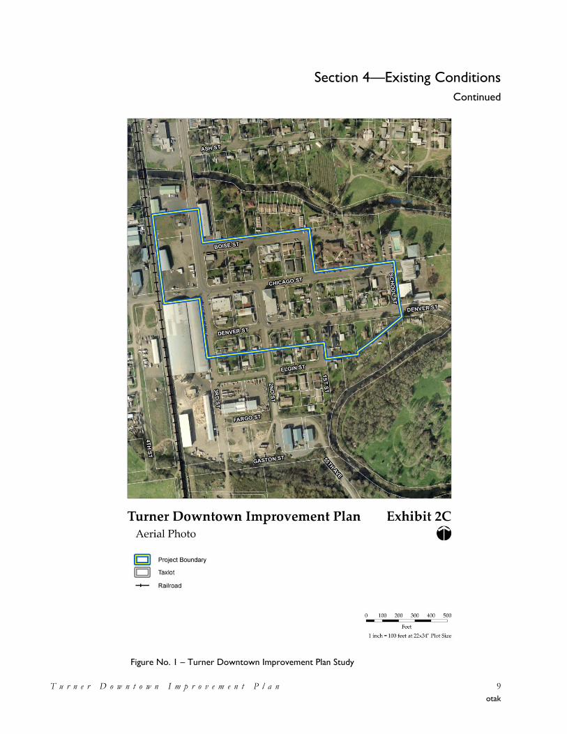
Located approximately eight miles southeast of downtown Salem, Turner’s Downtown core
(―Plan Area‖) is split by 3rd Street (Turner Highway), a Marion County minor arterial road.
The Northern Pacific main west coast rail line provides the western boundary of the
Downtown area. Mill Creek forms the northern and eastern boundaries of the Downtown
area.
Figure 1 indicates the vicinity and boundaries of the TDIP study area.
Section 4—Existing Conditions
Continued
T u r n e r D o w n t o w n I m p r o v e m e n t P l a n 9
otak
Figure No. 1 – Turner Downtown Improvement Plan Study
Area
Section 4—Existing Conditions
Continued
T u r n e r D o w n t o w n I m p r o v e m e n t P l a n 10
otak
Existing Environment
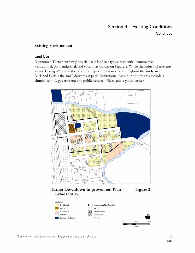
Land Use
Downtown Turner currently has six basic land use types: residential, commercial,
institutional, park, industrial, and vacant, as shown on Figure 2. While the industrial uses are
situated along 3rd Street, the other use types are intermixed throughout the study area.
Burkland Park is the small downtown park. Institutional uses in the study area include a
church, school, government and public service offices, and a youth center.
Section 4—Existing Conditions
Continued
T u r n e r D o w n t o w n I m p r o v e m e n t P l a n 11
otak
Residential districts surround the Downtown core to the north and east across Mill Creek,
and to the south across the old canal. Much of the residential development in the northern
and eastern areas of the Downtown are owned by Turner Retirement Homes and includes
independent living in individual homes and duplexes, and residential care in joint living
facilities. The mill property is to the west and southwest of Downtown.
Infill and Redevelopment Potential
A significant infill and redevelopment potential exists in the study area. Vacant parcels and
large lots provide opportunity to develop new structures and a number of vacant buildings
could be renovated. Overall redevelopment potential is the focus of Memorandum No. 2
(Appendix B) and is more fully described and discussed there.
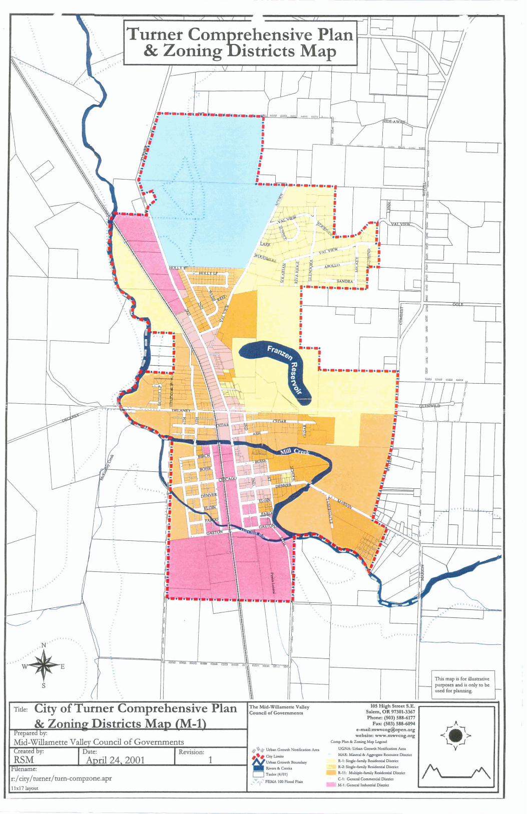
Existing Plan/Zoning Designations
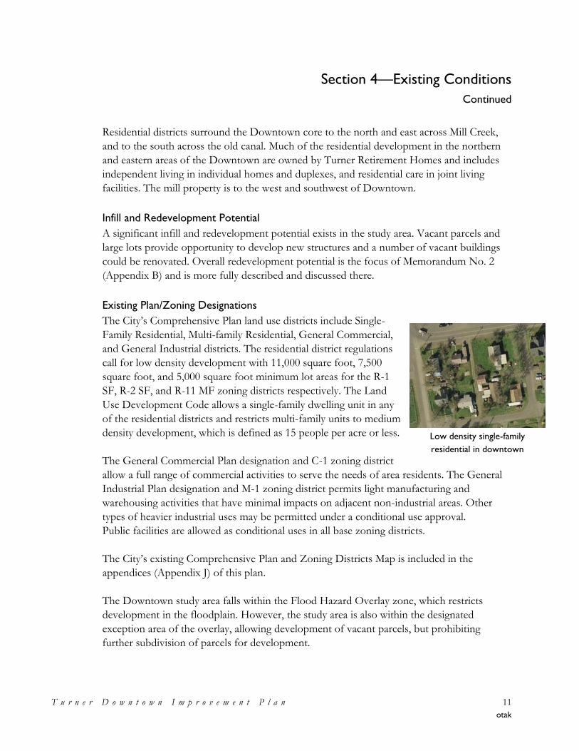
The City’s Comprehensive Plan land use districts include Single-
Family Residential, Multi-family Residential, General Commercial,
and General Industrial districts. The residential district regulations
call for low density development with 11,000 square foot, 7,500
square foot, and 5,000 square foot minimum lot areas for the R-1
SF, R-2 SF, and R-11 MF zoning districts respectively. The Land
Use Development Code allows a single-family dwelling unit in any
of the residential districts and restricts multi-family units to medium
density development, which is defined as 15 people per acre or less.
The General Commercial Plan designation and C-1 zoning district
allow a full range of commercial activities to serve the needs of area residents. The General
Industrial Plan designation and M-1 zoning district permits light manufacturing and
warehousing activities that have minimal impacts on adjacent non-industrial areas. Other
types of heavier industrial uses may be permitted under a conditional use approval.
Public facilities are allowed as conditional uses in all base zoning districts.
The City’s existing Comprehensive Plan and Zoning Districts Map is included in the
appendices (Appendix J) of this plan.
The Downtown study area falls within the Flood Hazard Overlay zone, which restricts
development in the floodplain. However, the study area is also within the designated
exception area of the overlay, allowing development of vacant parcels, but prohibiting
further subdivision of parcels for development.
Low density single-family
residential in downtown
Section 4—Existing Conditions
Continued
T u r n e r D o w n t o w n I m p r o v e m e n t P l a n 12
otak
Properties with Historic Value
While there are no nationally registered historic places in
Turner, several properties have been identified in the
Historic Context Statement prepared in 1997 as having
historic significance.
Key Project Area Attractors and Community Amenities
Downtown Turner has several attractions within and
adjacent to the study area. The key destinations are parks,
community facilities, retail, employment, religious and
educational institutions, and housing. Parks and open space
are major amenities within and near the study area. Burkland
Park is located within the heart of the Downtown, while the
Turner School recreational fields, the Burkland community
pool, and the open space associated with the Aldersgate
Christian Camp and Conference Center, and Turner
Memorial Tabernacle lie just outside the study area
boundary. Scattered commercial uses in Downtown Turner
provide specialized goods and services including Best Buy
Flooring, Turner Market, Turner Inn, and the businesses in Turner Plaza. Several light
industrial businesses in the Downtown area provide employment destinations including the
Caliber Forest Products Mill and Pacific Sign and Screen Printing. The presence of Turner
Retirement Homes in Downtown Turner provides a built-in downtown area residential
population. Turner Retirement Homes provides two key destinations in Davis Hall and the
Turner Retirement Homes Activity Center. Community facilities that serve Downtown
Turner include the Turner Rural Fire Department Station, Turner Elementary School, and
the community pool.
Existing Infrastructure Conditions
The elements that comprise public infrastructure in Downtown include sanitary sewers,
public water supply lines, storm sewers, roads, street lighting, sidewalks, and bike lanes.
Critical to proper infrastructure sizing is land use zoning and population growth projections.
Except for one block of single-family zoning, the Downtown study area currently falls
within two zones: R-11–Multiple-Family Residential and C-1–Commercial. The expected
population growth over the next 20 years is 3.8 percent. Commercial and industrial uses are
expected to grow at a rate of 4.5 percent per year (Water System Master Plan Update, 2006).
Davis Hall is one of Turner’s
properties of historic significance
Burkland Park
Section 4—Existing Conditions
Continued
T u r n e r D o w n t o w n I m p r o v e m e n t P l a n 13
otak
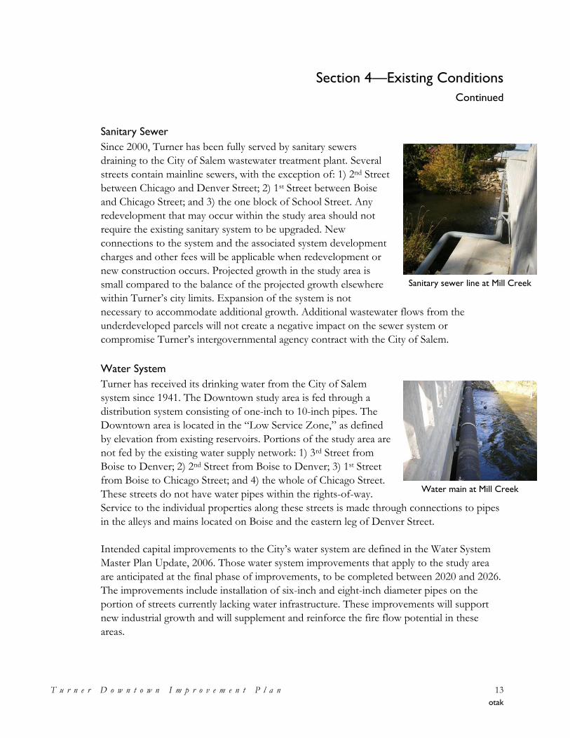
Sanitary Sewer
Since 2000, Turner has been fully served by sanitary sewers
draining to the City of Salem wastewater treatment plant. Several
streets contain mainline sewers, with the exception of: 1) 2nd Street
between Chicago and Denver Street; 2) 1st Street between Boise
and Chicago Street; and 3) the one block of School Street. Any
redevelopment that may occur within the study area should not
require the existing sanitary system to be upgraded. New
connections to the system and the associated system development
charges and other fees will be applicable when redevelopment or
new construction occurs. Projected growth in the study area is
small compared to the balance of the projected growth elsewhere
within Turner’s city limits. Expansion of the system is not
necessary to accommodate additional growth. Additional wastewater flows from the
underdeveloped parcels will not create a negative impact on the sewer system or
compromise Turner’s intergovernmental agency contract with the City of Salem.
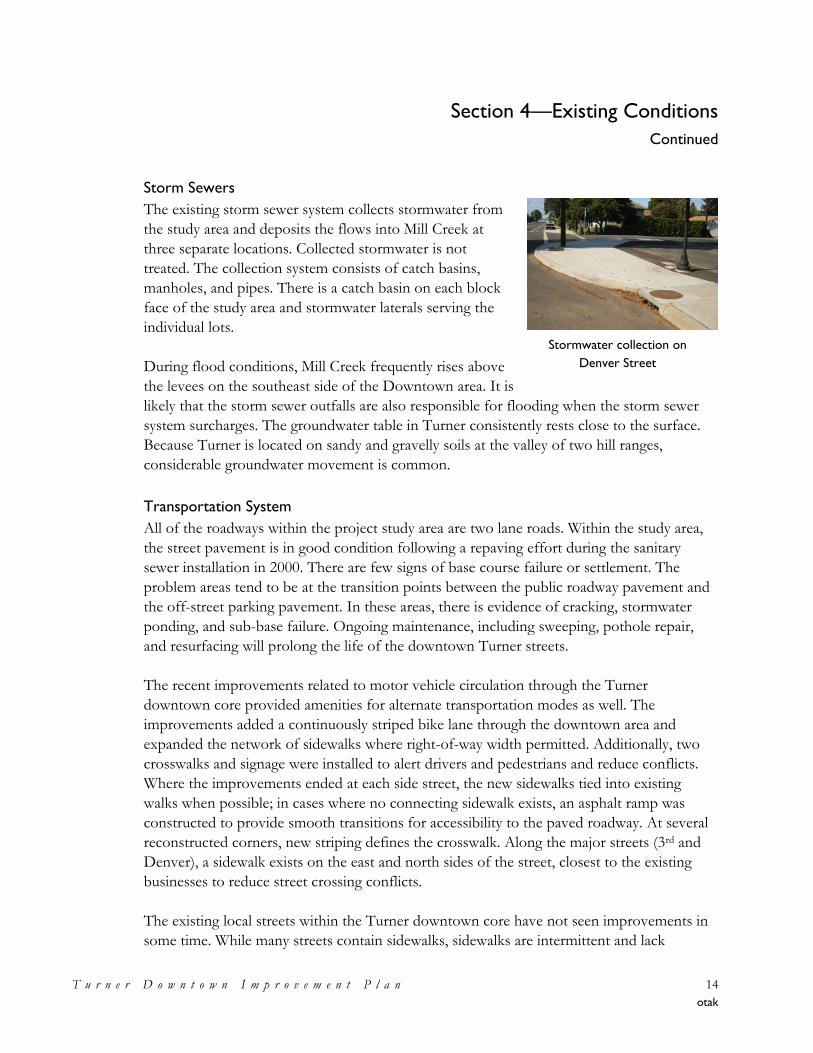
Water System
Turner has received its drinking water from the City of Salem
system since 1941. The Downtown study area is fed through a
distribution system consisting of one-inch to 10-inch pipes. The
Downtown area is located in the ―Low Service Zone,‖ as defined
by elevation from existing reservoirs. Portions of the study area are
not fed by the existing water supply network: 1) 3rd Street from
Boise to Denver; 2) 2nd Street from Boise to Denver; 3) 1st Street
from Boise to Chicago Street; and 4) the whole of Chicago Street.
These streets do not have water pipes within the rights-of-way.
Service to the individual properties along these streets is made through connections to pipes
in the alleys and mains located on Boise and the eastern leg of Denver Street.
Intended capital improvements to the City’s water system are defined in the Water System
Master Plan Update, 2006. Those water system improvements that apply to the study area
are anticipated at the final phase of improvements, to be completed between 2020 and 2026.
The improvements include installation of six-inch and eight-inch diameter pipes on the
portion of streets currently lacking water infrastructure. These improvements will support
new industrial growth and will supplement and reinforce the fire flow potential in these
areas.
Sanitary sewer line at Mill Creek
Water main at Mill Creek
Section 4—Existing Conditions
Continued
T u r n e r D o w n t o w n I m p r o v e m e n t P l a n 14
otak
Storm Sewers
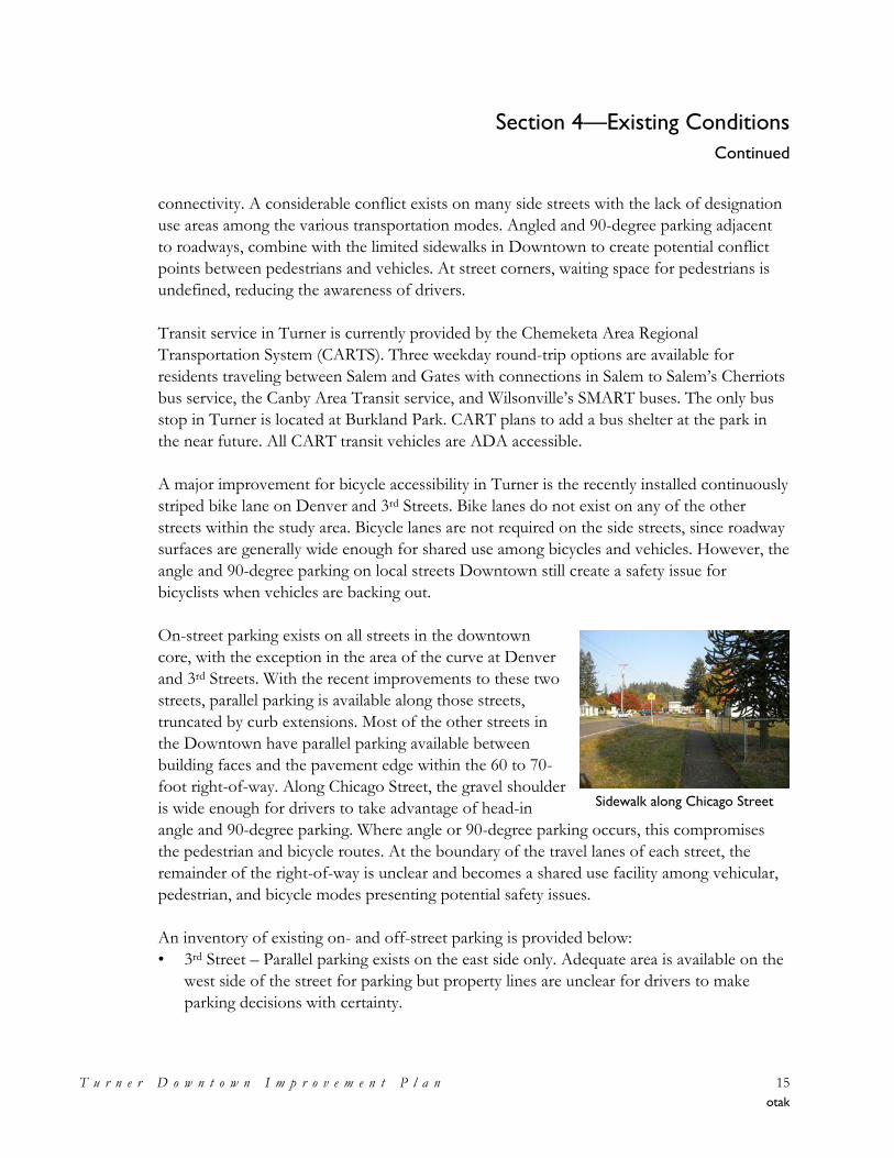
The existing storm sewer system collects stormwater from
the study area and deposits the flows into Mill Creek at
three separate locations. Collected stormwater is not
treated. The collection system consists of catch basins,
manholes, and pipes. There is a catch basin on each block
face of the study area and stormwater laterals serving the
individual lots.
During flood conditions, Mill Creek frequently rises above
the levees on the southeast side of the Downtown area. It is
likely that the storm sewer outfalls are also responsible for flooding when the storm sewer
system surcharges. The groundwater table in Turner consistently rests close to the surface.
Because Turner is located on sandy and gravelly soils at the valley of two hill ranges,
considerable groundwater movement is common.
Transportation System
All of the roadways within the project study area are two lane roads. Within the study area,
the street pavement is in good condition following a repaving effort during the sanitary
sewer installation in 2000. There are few signs of base course failure or settlement. The
problem areas tend to be at the transition points between the public roadway pavement and
the off-street parking pavement. In these areas, there is evidence of cracking, stormwater
ponding, and sub-base failure. Ongoing maintenance, including sweeping, pothole repair,
and resurfacing will prolong the life of the downtown Turner streets.
The recent improvements related to motor vehicle circulation through the Turner
downtown core provided amenities for alternate transportation modes as well. The
improvements added a continuously striped bike lane through the downtown area and
expanded the network of sidewalks where right-of-way width permitted. Additionally, two
crosswalks and signage were installed to alert drivers and pedestrians and reduce conflicts.
Where the improvements ended at each side street, the new sidewalks tied into existing
walks when possible; in cases where no connecting sidewalk exists, an asphalt ramp was
constructed to provide smooth transitions for accessibility to the paved roadway. At several
reconstructed corners, new striping defines the crosswalk. Along the major streets (3rd and
Denver), a sidewalk exists on the east and north sides of the street, closest to the existing
businesses to reduce street crossing conflicts.
The existing local streets within the Turner downtown core have not seen improvements in
some time. While many streets contain sidewalks, sidewalks are intermittent and lack
Stormwater collection on
Denver Street
Section 4—Existing Conditions
Continued
T u r n e r D o w n t o w n I m p r o v e m e n t P l a n 15
otak
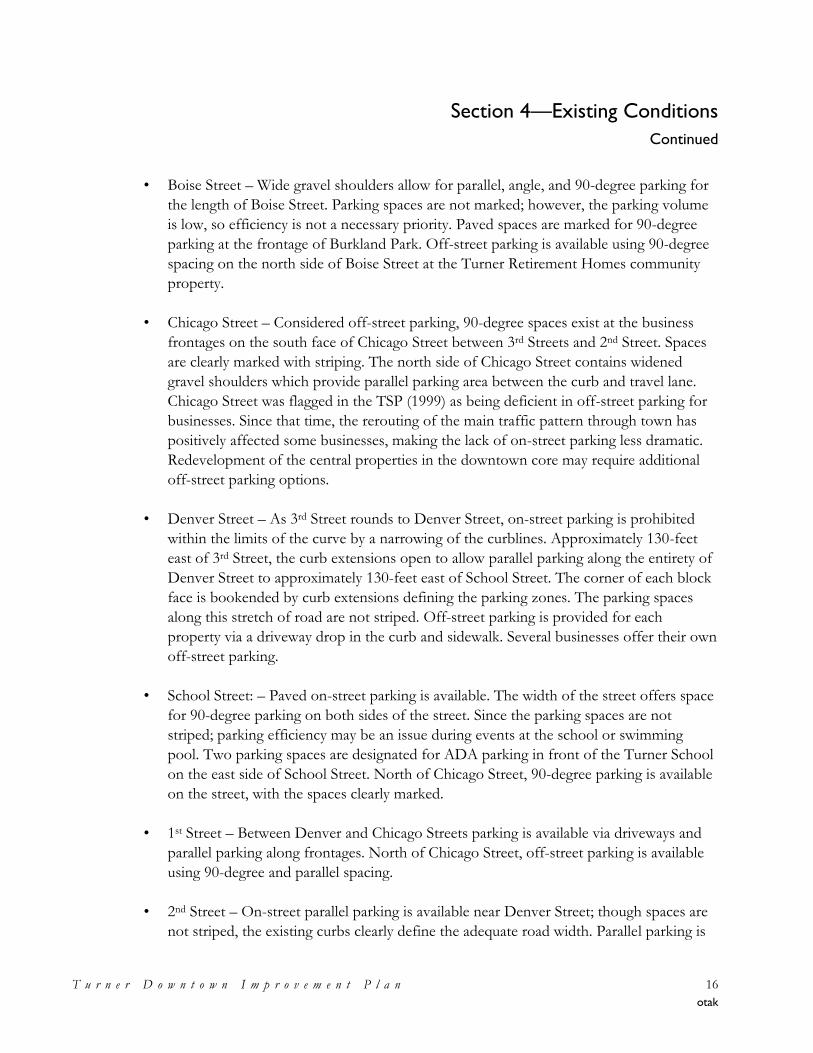
Sidewalk along Chicago Street
connectivity. A considerable conflict exists on many side streets with the lack of designation
use areas among the various transportation modes. Angled and 90-degree parking adjacent
to roadways, combine with the limited sidewalks in Downtown to create potential conflict
points between pedestrians and vehicles. At street corners, waiting space for pedestrians is
undefined, reducing the awareness of drivers.
Transit service in Turner is currently provided by the Chemeketa Area Regional
Transportation System (CARTS). Three weekday round-trip options are available for
residents traveling between Salem and Gates with connections in Salem to Salem’s Cherriots
bus service, the Canby Area Transit service, and Wilsonville’s SMART buses. The only bus
stop in Turner is located at Burkland Park. CART plans to add a bus shelter at the park in
the near future. All CART transit vehicles are ADA accessible.
A major improvement for bicycle accessibility in Turner is the recently installed continuously
striped bike lane on Denver and 3rd Streets. Bike lanes do not exist on any of the other
streets within the study area. Bicycle lanes are not required on the side streets, since roadway
surfaces are generally wide enough for shared use among bicycles and vehicles. However, the
angle and 90-degree parking on local streets Downtown still create a safety issue for
bicyclists when vehicles are backing out.
On-street parking exists on all streets in the downtown
core, with the exception in the area of the curve at Denver
and 3rd Streets. With the recent improvements to these two
streets, parallel parking is available along those streets,
truncated by curb extensions. Most of the other streets in
the Downtown have parallel parking available between
building faces and the pavement edge within the 60 to 70-
foot right-of-way. Along Chicago Street, the gravel shoulder
is wide enough for drivers to take advantage of head-in
angle and 90-degree parking. Where angle or 90-degree parking occurs, this compromises
the pedestrian and bicycle routes. At the boundary of the travel lanes of each street, the
remainder of the right-of-way is unclear and becomes a shared use facility among vehicular,
pedestrian, and bicycle modes presenting potential safety issues.
An inventory of existing on- and off-street parking is provided below:
• 3rd Street – Parallel parking exists on the east side only. Adequate area is available on the
west side of the street for parking but property lines are unclear for drivers to make
parking decisions with certainty.
Section 4—Existing Conditions
Continued
T u r n e r D o w n t o w n I m p r o v e m e n t P l a n 16
otak
• Boise Street – Wide gravel shoulders allow for parallel, angle, and 90-degree parking for
the length of Boise Street. Parking spaces are not marked; however, the parking volume
is low, so efficiency is not a necessary priority. Paved spaces are marked for 90-degree
parking at the frontage of Burkland Park. Off-street parking is available using 90-degree
spacing on the north side of Boise Street at the Turner Retirement Homes community
property.
• Chicago Street – Considered off-street parking, 90-degree spaces exist at the business
frontages on the south face of Chicago Street between 3rd Streets and 2nd Street. Spaces
are clearly marked with striping. The north side of Chicago Street contains widened
gravel shoulders which provide parallel parking area between the curb and travel lane.
Chicago Street was flagged in the TSP (1999) as being deficient in off-street parking for
businesses. Since that time, the rerouting of the main traffic pattern through town has
positively affected some businesses, making the lack of on-street parking less dramatic.
Redevelopment of the central properties in the downtown core may require additional
off-street parking options.
• Denver Street – As 3rd Street rounds to Denver Street, on-street parking is prohibited
within the limits of the curve by a narrowing of the curblines. Approximately 130-feet
east of 3rd Street, the curb extensions open to allow parallel parking along the entirety of
Denver Street to approximately 130-feet east of School Street. The corner of each block
face is bookended by curb extensions defining the parking zones. The parking spaces
along this stretch of road are not striped. Off-street parking is provided for each
property via a driveway drop in the curb and sidewalk. Several businesses offer their own
off-street parking.
• School Street: – Paved on-street parking is available. The width of the street offers space
for 90-degree parking on both sides of the street. Since the parking spaces are not
striped; parking efficiency may be an issue during events at the school or swimming
pool. Two parking spaces are designated for ADA parking in front of the Turner School
on the east side of School Street. North of Chicago Street, 90-degree parking is available
on the street, with the spaces clearly marked.
• 1st Street – Between Denver and Chicago Streets parking is available via driveways and
parallel parking along frontages. North of Chicago Street, off-street parking is available
using 90-degree and parallel spacing.
• 2nd Street – On-street parallel parking is available near Denver Street; though spaces are
not striped, the existing curbs clearly define the adequate road width. Parallel parking is
Section 4—Existing Conditions
Continued
T u r n e r D o w n t o w n I m p r o v e m e n t P l a n 17
otak
also utilized in the undefined shoulders of 2nd Street. Off-street parking is available via
garage and driveway spaces. Off-street parking is also available using 90-degree spacing
along the Burkland Park frontage.
Additional parking considerations are the parking needs of the elementary school and public
pool now and into the future. School staff parking already overflows the school’s parking
area. If the pool service is expanded to year round use and/or if the school expands, there
could be a parking shortage in the immediate vicinity for those uses.
The study area does not have a designated city parking lot or park-and-ride area; however,
public comment and the TSP recommend a public parking area at the northwest corner of
2nd Street and Denver Street.
The Transportation System Plan, developed in 1999, lists capital projects. Many relate to the
sidewalk and frontage improvements to the side streets. The existing striping within the
study area is fair; in some cases, striping could be removed since the arterial traffic has since
been redirected to the 3rd Street and Denver Street route.
Opportunities and Constraints
From the analysis of existing conditions the following opportunities and constraints have
been identified and are discussed in the sections that follow.
Opportunities
• Downtown Residents – The Turner Retirement Community and other residents provide
a solid population base to patronize new services and shops.
• Available Land – Vacant and under-developed parcels in the study provide space for
infill and redevelopment. Vacant properties can be evaluated early for feasibility for a
potential public parking area.
• Enhancements on which to Build – The realignment and improvement of 3rd and
Denver Streets provide great pedestrian and bicycle facilities on which to base further
improvements.
• Employment Uses – Industrial facilities in and adjacent to Downtown bring people to
the area. There is vacant industrial land on which to build additional employment uses.
Section 4—Existing Conditions
Continued
T u r n e r D o w n t o w n I m p r o v e m e n t P l a n 18
otak
• Infrastructure Capacity – The public water supply and sewer systems do not pose
significant limits to growth.
• Community Amenities – The study area has several attractors within or adjacent to it,
including the elementary school and play fields, the pool, and Burkland Park.
• Religious Organizations/Facilities – While just outside the Downtown study area, the
Tabernacle and Aldersgate organizations attract and host people from beyond Turner
throughout the year, particularly during the summer; bringing people to the area.
• Mill Creek – Unbuildable land near the creek provides an opportunity to define public
space and/or trail system along the creek.
• Sidewalk Improvements – There is ample right-of-way for sidewalk improvements on all
Downtown area streets.
• Additional Bicycle Facilities – Locate bicycle parking at destination areas.
• Engage and Interface with Marion County – The City of Turner can be proactive and
create partnerships with Marion County.
• Create a Civic Presence – The available land and need for civic services Downtown
combine to create an opportunity to create a civic presence in the Downtown area.
• Review Process – Use lower service development charges (SDCs) as incentives for
development.
Constraints and Needs
• Floodplain – Floodplain levees adjacent to Downtown need to be replaced or upgraded
to help relieve frequent flooding of the area.
• Limited through Traffic – While limited traffic Downtown can be good for pedestrian
and bicycle uses, limited through traffic hinders the viability of some retail and other
commercial uses.
• Cost of Renovation – Several historic properties in the area are currently vacant and in
need of extensive repair and renovation.
Section 4—Existing Conditions
Continued
T u r n e r D o w n t o w n I m p r o v e m e n t P l a n 19
otak
• Truck Traffic – The extensive truck traffic creates ongoing maintenance problems and
degrades the pedestrian and bicycle experience.
• Population – Additional Turner area residents are needed to support more commercial
activity.
• Increase Safety – Improve safety issues by increasing on-street parking efficiencies.
• Water System Additions – Incorporate water capital improvements with roadway
improvements.
• Maintenance – Conduct routine maintenance on the existing public infrastructure to
ensure its longevity.
• Proximity to Salem – Restricts ability to create Turner’s own market in terms of
development incentives.
• Price of Utilities – The cost of utility services can be prohibitive to small businesses.
Conclusions
Land use, along with transportation, economic development, and urban design, is a central
component to creating the best conditions for a vibrant downtown. The current land usage
in Downtown Turner is lacking in both medium to high-density residential dwellings and
retail uses. The Downtown area is dominated by low density residential development and
light industrial buildings with little pedestrian-friendly orientation. The existing buildings in
Downtown do not create a sense of place nor do they create a sense of serving a cohesive
function; rather, the buildings appear to be spread out, non-cohesive, and auto-dependent.
Developing improved vehicular circulation within the downtown area and between
Downtown and other activity centers within the community and improved bicycle and
pedestrian connections are needed to provide for easier access and choice in mobility.
The presence of Mill Creek, its floodplain and associated wetlands present a unique
opportunity for the future Downtown neighborhood. Such close proximity of a quality
environmental resource will allow for recreation and active or passive open space not
frequently seen in a downtown area.
Section 5—Vision, Goals, and Policies
T u r n e r D o w n t o w n I m p r o v e m e n t P l a n 20
otak
Section 5—Vision, Goals, and Policy
The Plan’s vision statement is a synopsis of the community’s values for long-term
development. The supporting goals and policies frame how that vision can be achieved
through urban design, land use, transportation, redevelopment, and economic development.
The types and arrangements of land uses, transportation facilities, public and private sector
projects, and activities greatly affect the character of a Downtown. The vision, goals, and
policies were used to guide development of specific concepts comprising the Plan and in
identifying strategies and actions for carrying out the Downtown Improvement Plan. The
vision and accompanying goals and policies are based on the compendium of work
contained within the appendices to this Plan, and meetings with the Project Area
Improvement Committee, elected and appointed officials, and the general public through
events and stakeholder interviews.
Vision and Guiding Principles
The Vision
Following an initial ―grounding,‖ perception-sharing process, and an interactive workshop,
the Project Area Improvement Committee developed a 20- to 30-year vision for Downtown
Turner, as follows:
Downtown Turner will be a complete community with a small town feel. It will continue to be “a
good neighbor town” where residents are familiar and children are safe to ride their bicycles around
town. Downtown Turner will be the heart of the community and boast plentiful amenities and
activities year-round. It will be an economically viable place to do business and shop, attracting new
employment opportunities, residents, and visitors.
Goals and Policies
To ensure that the subsequent planning effort was focused toward achieving the vision, a set
of guiding goals to reflect desired outcomes, and policies for guiding future actions being
taken to achieve them were developed. The goals and policies also served as criteria against,
which the City evaluated the success of the various iterations of the concept plan. These
goals and policies are as follows:
Urban Design – To create an attractive small town environment that facilitates community
activity and interaction for all ages.
• Downtown Turner should be the center of the community. It should contain a space
that is considered the ―heart‖ of town.
Section 5—Vision, Goals, and Policies
Continued
T u r n e r D o w n t o w n I m p r o v e m e n t P l a n 21
otak
• Open space should be incorporated into the design. The space could be a park, plaza,
amphitheater, event pavilion, or a combination of these. It should allow for community
gathering and events like a festival or farmers market.
• Downtown streetscapes should build upon the recent improvements to 3rd and Denver
Streets and include pedestrian amenities such as benches, decorative lighting, fountains,
and trees.
• A greenway should be developed along the creek or at specific points and should include
a walking and biking pathway.
• Gateways should be developed at the two main entrances to downtown.
• Destinations to enliven downtown should be centrally located. These could include a
new bandstand, dance hall, civic center, museum, library, or a relocated city hall.
• The urban design and arrangement of spaces and buildings in downtown should use
history as an inspiration and also enable community activities.
Land Use – To allow and encourage a mix of uses to create a complete downtown.
• Retail and office uses should be allowed throughout the downtown area.
• Residential uses in and adjacent to Downtown should be preserved and augmented.
• Mixed commercial and residential buildings, such as a shop below or in front of a home,
should be allowed and encouraged throughout the area.
• Light industrial uses should be limited to the area along 3rd Street. Industrial uses in that
area should be allowed to have a commercial component, such as a retail outlet or
showroom, on their property.
• Zoning for the Downtown area should provide for maximum flexibility.
Transportation – To create a safe and inviting multi-modal transportation system and
circulation.
• The entire downtown area should have accessible and continuous sidewalks for
pedestrians with marked crosswalks at appropriate locations.
• A well-designed parking lot should be incorporated into downtown for school, pool, and
other community events. Street parking should be designed to maximize pedestrian and
bicycle safety.
• Bike lanes should be limited to the lanes provided on 3rd and Denver Streets but be
augmented with routes to the school and new community facilities located in the ―heart‖
of downtown.
• Vehicle and truck circulation has been improved with the upgrades to 3rd and Denver
Streets and should be considered along with pedestrian and bicycle circulation in the
development of new parking and community uses.
• A plan for infrastructure maintenance and upgrades should be developed to keep the
streets and pedestrian and bicycle amenities in top shape.
Section 5—Vision, Goals, and Policies
Continued
T u r n e r D o w n t o w n I m p r o v e m e n t P l a n 22
otak
Redevelopment – To infill vacant land and redevelop vacant, underutilized, or dilapidated
structures to create a more inviting and active environment.
• Efforts should be taken to review the current development process in Turner and to find
ways to streamline review processes and time of review.
• The City should investigate ways to limit the cost of fees for those who seek to
redevelop under-utilized properties.
• The City should create partnerships with area businesses and/or a business community
organization such as a chamber of commerce.
• Public uses should investigate sharing facilities – such as meeting rooms.
• Design standards should guide new development and redevelopment so as to make
Downtown a special and attractive place to visit and do business, as well as to protect
property values.
Economic Development – To maintain and capitalize on small town advantages while
attracting new businesses to the area.
• Prepare a Business Development Strategy (and perhaps consider a Downtown
development or marketing theme).
• Identify niche markets for area businesses.
• Community amenities such as the pool, parks, and the shared facilities of the Turner
Retirement Homes should be maintained.
• Develop additional community amenities–create something unique to Turner which will
attract visitors.
• Older buildings in the Downtown should be refurbished and re-used. New development
should respect the appearance of the older buildings Downtown.
• Create a long-term plan and incremental strategy to reduce flooding and resulting
hazards and damage to downtown.
Taken as a whole, the vision, and the above goals and policies are intended to provide the
direction for guiding future planning and development within Downtown Turner, and
individual development decisions and decisions regarding the programming and funding of
improvements should look to this vision and its supporting goals and policies for guidance
during decision making. The further refinement of these goals and policies into a Downtown
Improvement Plan is described in the section that follows.
Section 6—Downtown Improvement Plan
T u r n e r D o w n t o w n I m p r o v e m e n t P l a n 23
otak
Section 6—Downtown Environment Plan Measures
The purpose of this section is to describe the envisioned plan for Downtown Turner and the
strategies that are intended to achieve the vision and goals for the downtown project area.
The Plan is presented in the following manner:
• The Vision and Goals for Downtown – As noted in the preceding section, for a plan to
be successful, it must be vision-based and outcomes-oriented—in other words, ―know
where you want to go‖ and what it is you want to achieve. The vision provides the
direction; the goals provide the statement of desired outcomes. Only then can you know
what steps to take to make progress at achieving the vision and desired outcomes.
• Strategies for Achieving the Vision and Goals – A ―strategy‖ is a systematic plan of
action to achieve desired outcomes. The strategies presented within this Plan are
characterized by the related themes of urban design, land use, transportation,
redevelopment, and business development. These strategies are intended to guide the
development of the initial and future iterations of an incremental implementation plan
for carrying out the vision and goals for the Downtown Improvement Plan.
• Land Use and Improvement Plan – The Land Use Plan and Improvement Plan are
provided to reflect the spatial, land use, and design aspects of the Downtown
Improvement Plan. These Plans, along with the vision, goals, and strategies included in
the above sections serve to guide the preparation of the plan as well as the
recommended changes to the City’s regulatory documents (Comprehensive Plan,
Transportation System Plan, and Zoning and Development Code).
The Vision and Goals for Downtown
The vision for Downtown Turner as it improves over the next 20-years is as follows:
Downtown Turner will be a complete community with a small town feel. It will continue to be a
good neighbor town” where residents are familiar and children are safe to ride their bicycles around
town. Downtown Turner will be the heart of the community and boast plentiful amenities and
activities year-round. Respecting the past and the future, downtown Turner will celebrate its history
while providing an economically viable place to do business and shop, attracting new employment
opportunities, residents, and visitors.
The goals/desired outcomes developed in support of this vision are presented below.
Section 6—Downtown Improvement Plan
Continued
T u r n e r D o w n t o w n I m p r o v e m e n t P l a n 24
otak
• Urban Design – To create an attractive small town environment that facilitates
community activity and interaction for all ages.
• Land Use – To allow and encourage a mix of uses to create a complete downtown.
• Transportation – To create a safe and inviting multi-modal transportation system and
circulation.
• Redevelopment – To infill vacant land and redevelop vacant, underutilized, or
dilapidated structures to create a more inviting and active environment.
• Economic Development – To maintain and capitalize on small town advantages while
attracting new businesses to the area.
Specific policies to guide actions in achieving the aforementioned vision and goals are
provided in Section 5, above.
Strategies for Achieving the Vision and Goals
In this section each of the five goals are addressed, in turn, with recommended strategies or
actions for achieving them. These strategies and actions were identified through the planning
process in consultation with the Project Area Improvement Committee and the public
through a series of public events. The resulting collection of strategies and actions provides a
wealth of ideas for carrying out the Downtown Improvement Plan. These strategies and
actions provide items for Turner’s City Council to consider implementing over time and
provided input into the incremental implementation strategy proposed within Appendix I to
this Plan.
Urban Design
Goal – To create an attractive small town environment that facilitates community activity and
interaction for all ages.
Urban design refers to the look and feel of the downtown and addresses the general
arrangement of buildings and spaces. The goals for urban design in Turner call for a new
―heart‖ of the community and to use history as an inspiration. To achieve these goals, the
recommendations that follow focus on elements that will foster a unique identity for the
town, improve the infrastructure for pedestrians, and develop a civic presence and expand
community facilities.
Section 6—Downtown Improvement Plan
Continued
T u r n e r D o w n t o w n I m p r o v e m e n t P l a n 25
otak
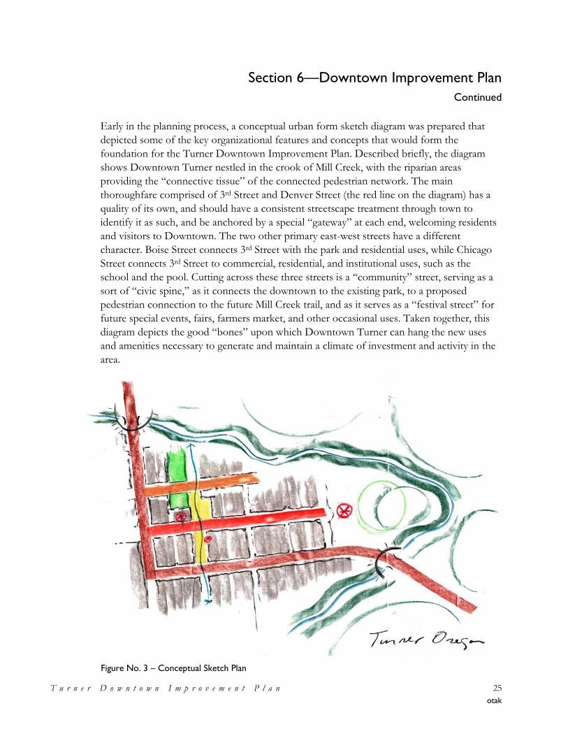
Early in the planning process, a conceptual urban form sketch diagram was prepared that
depicted some of the key organizational features and concepts that would form the
foundation for the Turner Downtown Improvement Plan. Described briefly, the diagram
shows Downtown Turner nestled in the crook of Mill Creek, with the riparian areas
providing the ―connective tissue‖ of the connected pedestrian network. The main
thoroughfare comprised of 3rd Street and Denver Street (the red line on the diagram) has a
quality of its own, and should have a consistent streetscape treatment through town to
identify it as such, and be anchored by a special ―gateway‖ at each end, welcoming residents
and visitors to Downtown. The two other primary east-west streets have a different
character. Boise Street connects 3rd Street with the park and residential uses, while Chicago
Street connects 3rd Street to commercial, residential, and institutional uses, such as the
school and the pool. Cutting across these three streets is a ―community‖ street, serving as a
sort of ―civic spine,‖ as it connects the downtown to the existing park, to a proposed
pedestrian connection to the future Mill Creek trail, and as it serves as a ―festival street‖ for
future special events, fairs, farmers market, and other occasional uses. Taken together, this
diagram depicts the good ―bones‖ upon which Downtown Turner can hang the new uses
and amenities necessary to generate and maintain a climate of investment and activity in the
area.
Figure No. 3 – Conceptual Sketch Plan
Section 6—Downtown Improvement Plan
Continued
T u r n e r D o w n t o w n I m p r o v e m e n t P l a n 26
otak
Create a Unique Identity for Downtown
• Design and construct gateways at/on/over both bridges into Downtown. The gateways
could be a combination of welcome signs and special plantings, lighting, and benches.
• Design and construct a water feature to represent the old mill race. This could include a
diversion of water from Mill Creek following the path of the old mill race if permitting
obstacles can be overcome, or this could be a much smaller water feature representative
of the mill race.
• Use history as inspiration for design guidelines for new or refurbished buildings
Downtown: encourage two-story mixed-use development all along Denver Street and
storefronts for retail/showroom commercial along 3rd Street.
• Install Downtown beautification projects, such as gardens, benches, flower baskets,
decorative lighting fixtures, and way-finding signage. A longer-term program could
involve decorative murals such as the highly popular mural programs in downtown
Silverton and downtown Oregon City.
• Design and construct a multi-use trail along Mill Creek. The trail could be developed in
segments as money becomes available to construct each section.
Improve Infrastructure
• Improve street features and install sidewalks on Chicago, Boise, 1st, 2nd, and School
Streets.
• Design and construct a drop-off and improved streetscape for the pool and school
building entrance; coordinate this with new angled street parking and new parking lot
improvements.
• Develop a pedestrian network that includes the alleys as pedestrian connections,
improved sidewalks, and the proposed multi-use trail along the creek.
Develop a Civic Presence and Improve Community Facilities
• Create a festival street that can serve pedestrian-only traffic at special times via gates or
bollards blocking vehicular traffic, but which will be open at most times to
accommodate vehicles. Potential festival streets are 2nd Street from Denver to Boise and
on Boise from 2nd to 3rd Streets.
• Create a plaza or public square along the proposed 2nd Street festival street.
Section 6—Downtown Improvement Plan
Continued
T u r n e r D o w n t o w n I m p r o v e m e n t P l a n 27
otak
• Relocate the City’s administrative functions from the current city hall to a new space
Downtown. This could be done as a two step process; rent a space first and then build a
new City hall or refurbish an existing building into a city hall.
Urban Design Framework
• Construct a new city hall and/or a multi-use civic building near the plaza to create a civic
area.
• Incorporate a public library as part of a new civic building or a separate building in the
civic area.
• Expand the existing community pool facility into a broader based, year-round
community center. Preliminary discussions have focused upon a metal-framed, fabric
covered enclosure for the pool in order to extend its season as an initial step towards
developing a community center.
Land Use
Goal – To allow and encourage a mix of uses to create a complete downtown.
Currently, the City of Turner has one commercial zoning district and a Downtown overlay
that applies to the commercially zoned lots downtown. The current designations do not
provide the focus or flexibility needed for redevelopment. Having the same commercial
zoning applied to the 3rd Street corridor north of the downtown also dilutes the focus
needed for downtown redevelopment. The following Comprehensive Plan, Land
Development Code, and Comprehensive Plan and Zoning Districts Map revisions are
intended to support and implement the urban design and redevelopment goals and to
implement the preferred Land Use Map (see Figure 7). The proposed new zoning
designations provide specific areas of focus for different uses and create a hierarchy of
spaces within the downtown to capitalize on development and design opportunities.
Recommended strategies and potential actions include:
• Create a mixed-use C-2 Downtown Commercial zoning district allowing office, retail,
service, and multi-family residential uses; through Downtown east of 3rd Street and
focused on Denver Street. This area will create a specific focus for the commercial core
of the city, while providing flexibility in the types of the establishments that can locate in
the area.
• For the area south of Denver Street, east of 2nd Street, and north of Mill Creek, the
envisioned future land uses include commercial uses fronting Denver Street. Since the
southern portion of this area is impacted by seasonal flooding, it may be necessary for
Section 6—Downtown Improvement Plan
Continued
T u r n e r D o w n t o w n I m p r o v e m e n t P l a n 28
otak
portions of these properties to be kept in resource uses or developed with uses
compatible with seasonal flooding conditions.
• Create a mixed-use M-2 General Employment zoning district allowing office, industrial,
and limited retail uses for the properties Downtown which are located west of 3rd Street.
This zone will maintain the opportunity for a large employment base while allowing for
retail and/or showroom type uses along 3rd Street to contribute to the commercial
vitality of the area.
• Maintain the Turner Retirement Homes properties and the area along Elgin Street with
residential zoning. It is essential to maintain a residential population in the area to
support new Downtown investments.
• Create a P-I Public Institutional zoning district for the school property, parks, the fire
station, churches, and franchise utility yards in the Downtown area. This zone can also
be used for these use types outside of the Downtown. The zone can be expanded in the
future to include new civic uses, such as a new city hall and a library.
• Revisit residential zoning designations and standards over time to phase out single family
uses. While residential uses are desired in the downtown, large-lot single family uses
should be phased into more dense housing types over time to provide a larger and more
diverse downtown population to patronize services.
• Revise zoning along the 3rd Street corridor north of Mill Creek to reduce the amount of
C-1 General Commercial zoning in areas which are currently developed with viable
residential areas. Protect those areas from commercial encroachment through exclusive
residential zoning and by programs to improve the residential streetscape such as street
tree or front yard fencing programs. These changes will improve the 3rd Street ―gateway‖
into downtown Turner from the north.
• Several new policies are recommended to be added to the Comprehensive Plan to
authorize and describe the creation of the new land use districts described above.
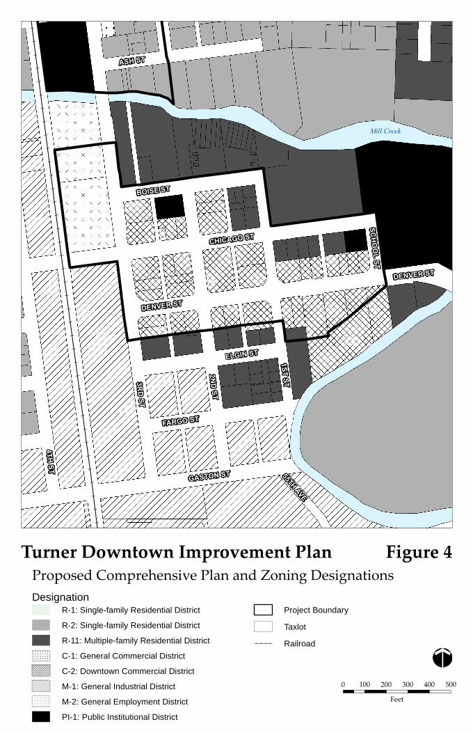
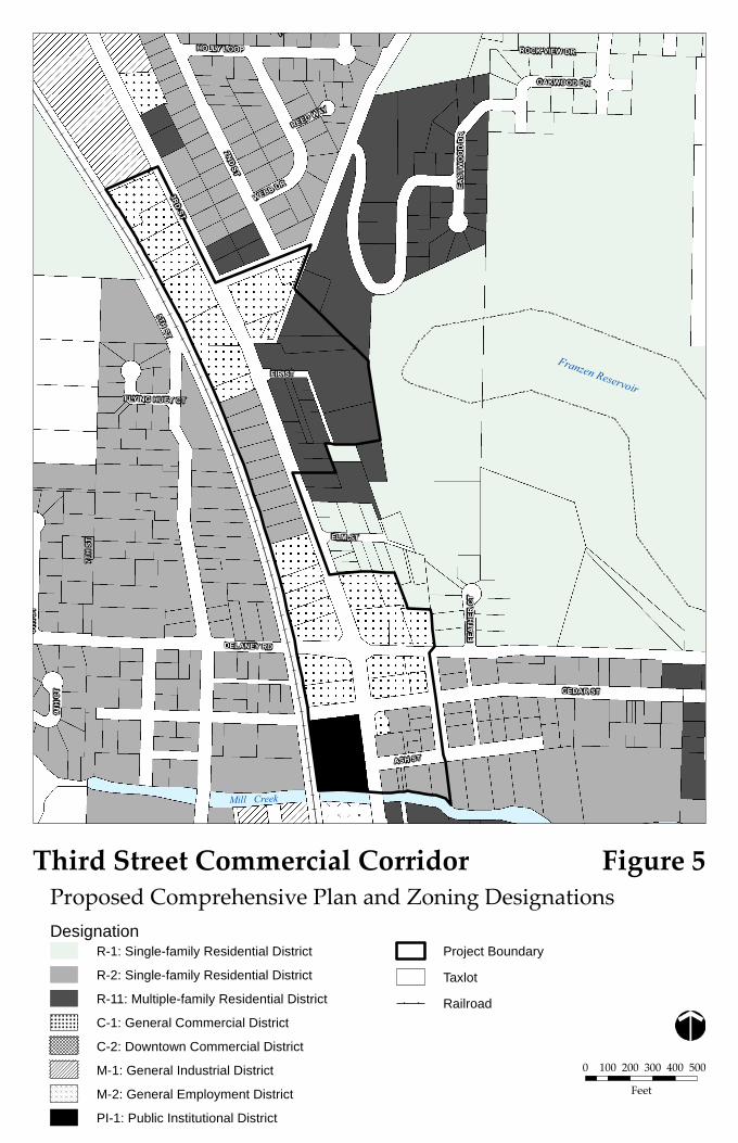
Figure Nos. 4 and 5 illustrate the proposed Plan and zoning districts for the Downtown and
3rd Street corridor areas. Note: Appendix F includes alternative maps showing areas for further
discussion and proposed zoning.
Mill Creek
3RD
ST
2ND
ST
1STST
CHICAGO ST
DENVER ST
BOISE ST
GASTON ST
4THST
ELGIN ST
FARGO ST
55THAVE
SCH
OO
LST
ASH ST
DENVER ST
0 100 200 300 400 500
Feet
Proposed Comprehensive Plan and Zoning DesignationsTurner Downtown Improvement Plan
DesignationR-1: Single-family Residential District
R-2: Single-family Residential District
R-11: Multiple-family Residential District
C-1: General Commercial District
C-2: Downtown Commercial District
M-1: General Industrial District
M-2: General Employment District
PI-1: Public Institutional District
Project Boundary
Taxlot
Railroad
Figure 4
Franzen Reservoir
HOLLY LOOP
DELANEY RD
3RDST
5THST
7TH
ST
CEDAR ST
2NDST
ELM ST
9TH
CT
H
ASH ST
WEBB DR EAST
WO
OD
DR
FIR ST
ROCK VIEW DR
OAKWOOD DR
8TH
ST
FEAT
HER
CT
REED WAY
FLYING HUEY CT
Third Street Commercial Corridor
0 100 200 300 400 500
Feet
Proposed Comprehensive Plan and Zoning DesignationsDesignation
R-1: Single-family Residential District
R-2: Single-family Residential District
R-11: Multiple-family Residential District
C-1: General Commercial District
C-2: Downtown Commercial District
M-1: General Industrial District
M-2: General Employment District
PI-1: Public Institutional District
Project Boundary
Taxlot
Railroad
Figure 5
Mill Creek
Section 6—Downtown Improvement Plan
Continued
T u r n e r D o w n t o w n I m p r o v e m e n t P l a n 31
otak
Transportation
Goal – To create a safe and inviting multi-modal transportation system and circulation.
Downtown Turner area has a well-developed street pattern to accommodate circulation. The
elements needed to achieve the goal are spaces that are welcoming to pedestrians, bicyclists,
and visitors arriving by vehicle. Improvements to these elements, combined with the proper
maintenance of the existing street system, will enhance activity levels, boost the functionality,
and extend the longevity of Downtown Turner.
Turner’s Transportation System Plan (TSP) outlines the functional classification for the
roads within the Downtown study area. Currently, the plan classifies the streets accordingly:
Street Classification
3rd Street (Mill Creek to Denver), Denver Arterial
Chicago Street, School Street, 2nd Street (south of Denver) Collector
Boise, 2nd Street (north of Denver), 1st Street, Elgin, Fargo, Gaston, 3rd
Street (Denver to Gaston)
Standard Local
Transportation enhancements to Downtown Turner do not require revisions to the TSP
classifications, with the exception of altering 2nd Street north of Denver Street from a
standard Local Street to a ―Significant Local Street.‖ The length of 2nd Street from Denver
to Boise Streets is the proposed location for a retail/commercial center, civic area, and/or
festival street. Significant Local Streets, such as 5th Street, west of downtown, are ―important
to the community‖ due to their connectivity to desirable destinations. Altering the
designation of 2nd Street north of Denver Street will give license to unique design selections.
Recommended strategies and potential actions include:
• For the remaining local streets, their designation will remain as a standard section. As
stated in the TSP, there are two options for development of standard local streets.
Considering that Turner’s downtown will be a new destination, local streets north of
Denver Street should reflect the 50-ft right-of-way design. The streets south of Denver
Street, with a focus on residential use, may consider the ―skinny street‖ option with 40-ft
right-of-way. The street sections provided in Figure No. 6 are conceptual drawings of
what the future conditions may reveal.
• The primary transportation enhancements in Downtown will consist of sidewalk and
parking improvements. While traffic volumes are currently low off of the arterial route,
the safety of pedestrians and bicyclists is compromised due to a lack of sidewalks and
improper crossing opportunities. As Turner grows or attracts more visiting traffic,
parking patterns will also need revisions to maintain a level of safety and efficiency.
Section 6—Downtown Improvement Plan
Continued
T u r n e r D o w n t o w n I m p r o v e m e n t P l a n 32
otak
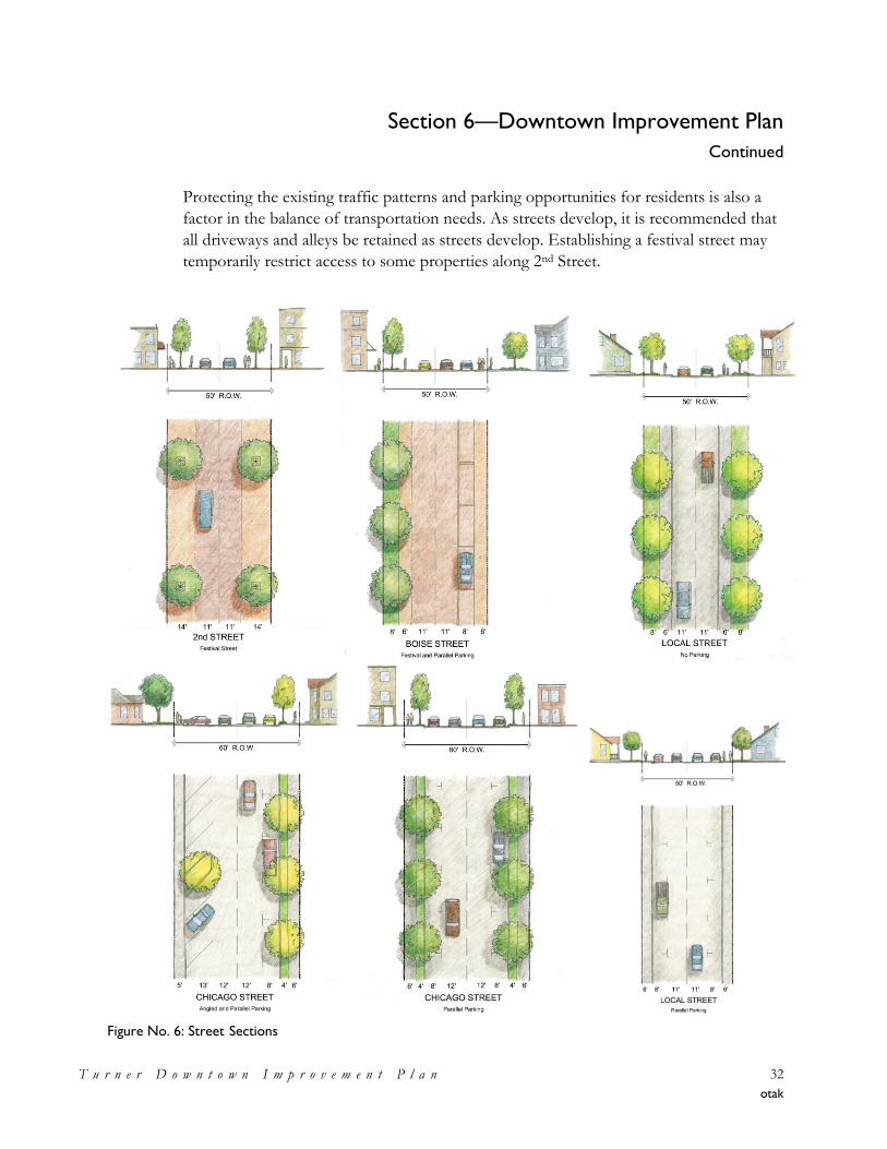
Protecting the existing traffic patterns and parking opportunities for residents is also a
factor in the balance of transportation needs. As streets develop, it is recommended that
all driveways and alleys be retained as streets develop. Establishing a festival street may
temporarily restrict access to some properties along 2nd Street.
Figure No. 6: Street Sections
Section 6—Downtown Improvement Plan
Continued
T u r n e r D o w n t o w n I m p r o v e m e n t P l a n 33
otak
• The TSP should be revised to reflect all streets in the downtown area be improved with
sidewalks. Missing links in the sidewalk system will be eliminated for the future
condition. The TSP should also be updated to include multi-modal trails on the
pedestrian and bicycle plan.
• The overhead utility lines along Turner’s street network provides electricity and
telecommunications services to the residents in the immediate area as well as serving as a
conduit to the outlying areas. As Turner experiences land use changes occurring
throughout the downtown core, the overhead infrastructure will become more intrusive
upon the landscape, impacting trees and building frontages as poles and guy anchors are
relocated. In the short-term, the City should begin working with the franchise utility
companies on the process of placing much of this infrastructure below ground. With the
long-term goal of placing power and telecommunication lines below ground, Turner’s
Downtown core can redevelop with a clean streetscape.
Redevelopment
Goal – To infill vacant land and redevelop vacant, underutilized, or dilapidated structures to
create a more inviting and active environment.
Downtown Turner has a fair amount of vacant and underutilized space to offer. However,
redevelopment is not always viable from a market perspective, particularly in a difficult
business climate, where rent levels may not be high enough to compensate for major
investment in a property. Under the current conditions, redevelopment in Downtown
Turner is likely to take the form of rehabilitation and reuse of existing properties, as the
most cost effective way to provide rentable space.
As Turner grows, new development will become more feasible. In the near future, new
development in Downtown Turner is likely to be single-story, wood-frame construction,
reliant on surface and/or street parking for customers and employees. Two-story structures
are possible and will become more likely as Downtown Turner builds new commercial
activity over the long-term, which will spur the need for more density.
The following are some potential strategies and actions that Turner should pursue to
improve the atmosphere for redevelopment activity to occur.
• Create a Unique Identity and Create Design Guidelines – Create a set of design guidelines
which clearly and concisely describe the vision for new and rehabilitated buildings in
Central Turner (see Urban Design strategies). Design guidelines should reflect the
Section 6—Downtown Improvement Plan
Continued
T u r n e r D o w n t o w n I m p r o v e m e n t P l a n 34
otak
community’s vision, but keep additional building requirements realistic and inexpensive
for the developer.
• Develop a Property Improvement Program – Develop a façade, signage, and landscaping
improvement program for commercial and retail properties located in the study area.
The program should be designed to enhance existing buildings, storefronts, signs, etc.,
and could be implemented as a low interest loan or matching grant program. The
program should be directed towards existing businesses or properties where such
improvements are considered very likely to attract businesses.
• Complete Public Infrastructure Projects – Implement the improvements to public
infrastructure (roads, sidewalks) as well as beautification initiatives (flower baskets,
benches, street trees and landscaping) described in this memorandum to the extent
possible. Public investment demonstrates to private property owners that the city is
engaged and changes are taking place.
• Target Public Investment – Select a core area of commercial and civic concentration in
which to target public investment, programs, and community activities. As public
resources are likely to be limited for some time in Turner, it will be important to target
limited improvements to those blocks where change is most desired. Adjacent areas will
experience positive overflow effects from this area of concentration.
• Examine the Development Permitting Process – The City should closely examine the
permitting process to optimize consistency, timing and responsiveness, while reducing
regulatory and paperwork burdens. The process should be standardized, to the extent
possible, so that applicants are treated consistently and subjectivity is removed from the
process. The required steps and paperwork of the application process should be easily
describable to applicants in a one-page checklist.
Economic and Business Development
Goal
To maintain and capitalize on small town advantages while attracting new businesses to the
area.
Turner has strong potential for the robust household growth it has experienced since 2000
to continue into the future. The greatest factor in increasing demand for small-scale retail
and commercial services in the local area is a growing customer base of households.
Households in the area tend to have a relatively high average income for Marion County,
and have significant buying power. Currently, most of this spending is taking place outside
Section 6—Downtown Improvement Plan
Continued
T u r n e r D o w n t o w n I m p r o v e m e n t P l a n 35
otak
of the Turner area. Some retail categories require larger markets to freeway locations, and are
therefore not realistic in Turner. But there is still excellent potential for businesses in Turner
(existing and new) to catch a share of the spending that is currently ―leaking‖ out of the
community.
In addition, and aside from retail and service businesses for the local community, Turner is a
good location for commercial service, construction, and manufacturing businesses seeking a
location in the central Willamette valley, with highly competitive property costs and relatively
convenient access to the regional transportation infrastructure.
Recommended strategies and potential actions include:
• Undertake a feasibility study for forming an Urban Renewal Area in Downtown Turner.
Urban renewal is a key public financing tool available to Oregon jurisdictions. It
provides for keeping the future growth of property tax revenues within the district itself
to help accomplish the goals of an adopted urban renewal plan.
• Form a standing body of local business people to discuss and represent the business
community in Turner (perhaps a Chamber of Commerce or similar body). This group
should have active participation in the further evolution and implementation of the
Downtown Plan.
• Maintain a current list of business and property owners, complete with pertinent contact
information and estimated employment level.
• Develop a marketing plan for downtown, focusing upon outreach to residents and
surrounding communities and how to leverage existing attractions within the region into
increased visibility and business for Downtown Turner.
• Continue participation in the Oregon Main Street program, and pursue increasing the
level of participation in order to become eligible for technical assistance in implementing
strategies for Downtown improvement.
• Establish a property improvement program for enhancing and improving commercial
and retail buildings, storefronts and facades, landscaping, signs, etc. within the
Downtown area to help increase both visibility and value.
• Establish a small or micro-business revolving loan fund designed to assist downtown
businesses with small business development, real estate property acquisition,
Section 6—Downtown Improvement Plan
Continued
T u r n e r D o w n t o w n I m p r o v e m e n t P l a n 36
otak
construction or rehabilitation, development and mitigation fees, architectural and
engineering services, and etc.
• Create a list of support programs available at the local, regional, state or federal level
available to local businesses and make the information widely available.
• Maintain and maximize involvement in local and regional economic development
organizations and efforts.
There are a number of tools and funding sources available for carrying out the overall
business development goal of maintaining and capitalizing on Downtown Turner’s small
town advantages which are attracting new business. These are presented and discussed in
detail in Appendix E to this document (see the Strategic Business Development Plan within
Memorandum No. 4 – Strategies for the Project Area).
Land Use Plan and Downtown Improvement Diagram
The vision, goals and policies developed through the public process associated with the
Downtown Improvement Plan provided the direction for the preparation of a Land Use
Plan and Downtown Improvement Diagram directing and depicting the form of future
development within Downtown Turner.
Land Use Plan
Based upon the vision, goals, and recommendations developed by the Project Area
Improvement Committee, a Land Use Plan for Downtown Turner has been developed
which indicates the location and organization of future development and redevelopment
within the project area. This Downtown Land Use Concept Plan is depicted in Figure No. 7,
below.
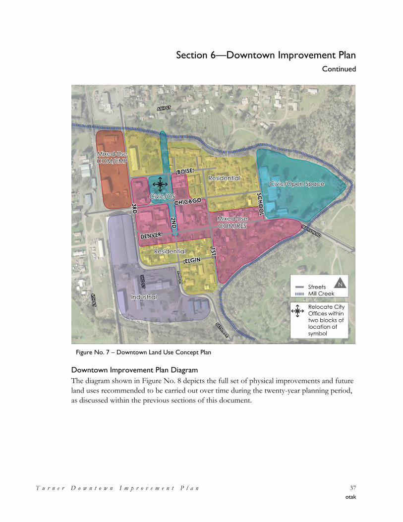
Section 6—Downtown Improvement Plan
Continued
T u r n e r D o w n t o w n I m p r o v e m e n t P l a n 37
otak
Downtown Improvement Plan Diagram
The diagram shown in Figure No. 8 depicts the full set of physical improvements and future
land uses recommended to be carried out over time during the twenty-year planning period,
as discussed within the previous sections of this document.
Figure No. 7 – Downtown Land Use Concept Plan
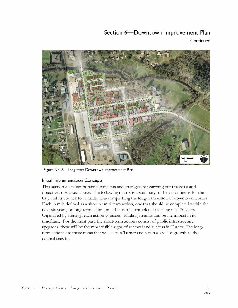
Section 6—Downtown Improvement Plan
Continued
T u r n e r D o w n t o w n I m p r o v e m e n t P l a n 38
otak
Initial Implementation Concepts
This section discusses potential concepts and strategies for carrying out the goals and
objectives discussed above. The following matrix is a summary of the action items for the
City and its council to consider in accomplishing the long-term vision of downtown Turner.
Each item is defined as a short or mid-term action, one that should be completed within the
next six years, or long-term action, one that can be completed over the next 20 years.
Organized by strategy, each action considers funding streams and public impact in its
timeframe. For the most part, the short-term actions consist of public infrastructure
upgrades; these will be the most visible signs of renewal and success in Turner. The long-
term actions are those items that will sustain Turner and retain a level of growth as the
council sees fit.
Figure No. 8 – Long-term Downtown Improvement Plan
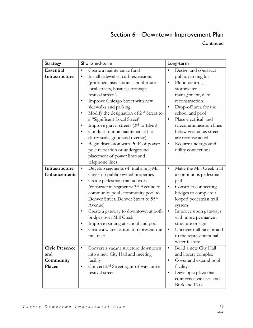
Section 6—Downtown Improvement Plan
Continued
T u r n e r D o w n t o w n I m p r o v e m e n t P l a n 39
otak
Strategy Short/mid-term Long-term
Essential
Infrastructure
• Create a maintenance fund
• Install sidewalks, curb extensions
(prioritize installation: school routes,
local streets, business frontages,
festival streets)
• Improve Chicago Street with new
sidewalks and parking
• Modify the designation of 2nd Street to
a ―Significant Local Street‖
• Improve gravel streets (3rd to Elgin)
• Conduct routine maintenance (i.e.
slurry seals, grind and overlay)
• Begin discussion with PGE of power
pole relocation or underground
placement of power lines and
telephone lines
• Design and construct
public parking lot
• Flood control,
stormwater
management, dike
reconstruction
• Drop-off area for the
school and pool
• Place electrical and
telecommunication lines
below ground as streets
are reconstructed
• Require underground
utility connections
Infrastructure
Enhancements
• Develop segments of trail along Mill
Creek on public owned properties
• Create pedestrian trail network
(construct in segments: 3rd Avenue to
community pool, community pool to
Denver Street, Denver Street to 55th
Avenue)
• Create a gateway to downtown at both
bridges over Mill Creek
• Improve parking at school and pool
• Create a water feature to represent the
mill race
• Make the Mill Creek trail
a continuous pedestrian
path
• Construct connecting
bridges to complete a
looped pedestrian trail
system
• Improve upon gateways
with more permanent
structure or sign
• Uncover mill race or add
to the representational
water feature
Civic Presence
and
Community
Places
• Convert a vacant structure downtown
into a new City Hall and meeting
facility
• Convert 2nd Street right-of-way into a
festival street
• Build a new City Hall
and library complex
• Cover and expand pool
facility
• Develop a plaza that
connects civic uses and
Burkland Park
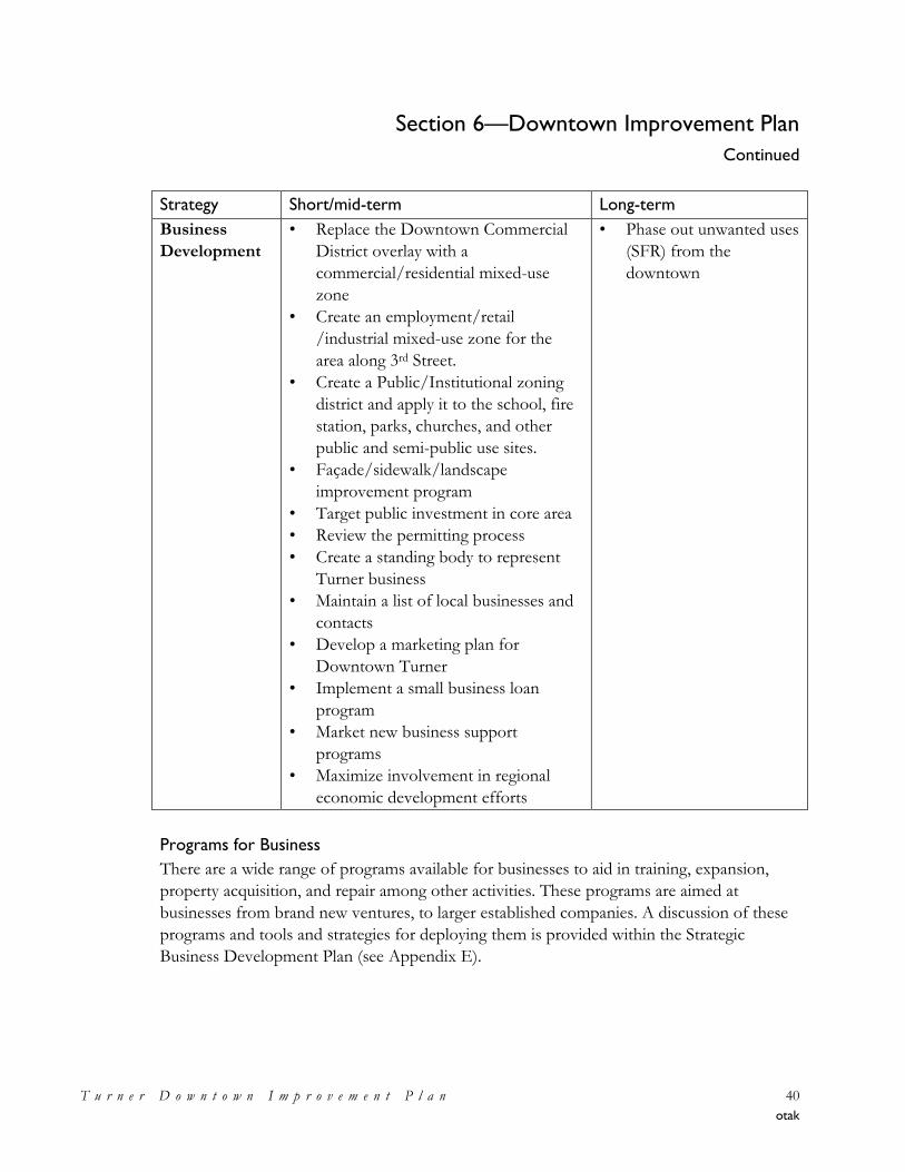
Section 6—Downtown Improvement Plan
Continued
T u r n e r D o w n t o w n I m p r o v e m e n t P l a n 40
otak
Strategy Short/mid-term Long-term
Business
Development
• Replace the Downtown Commercial
District overlay with a
commercial/residential mixed-use
zone
• Create an employment/retail
/industrial mixed-use zone for the
area along 3rd Street.
• Create a Public/Institutional zoning
district and apply it to the school, fire
station, parks, churches, and other
public and semi-public use sites.
• Façade/sidewalk/landscape
improvement program
• Target public investment in core area
• Review the permitting process
• Create a standing body to represent
Turner business
• Maintain a list of local businesses and
contacts
• Develop a marketing plan for
Downtown Turner
• Implement a small business loan
program
• Market new business support
programs
• Maximize involvement in regional
economic development efforts
• Phase out unwanted uses
(SFR) from the
downtown
Programs for Business
There are a wide range of programs available for businesses to aid in training, expansion,
property acquisition, and repair among other activities. These programs are aimed at
businesses from brand new ventures, to larger established companies. A discussion of these
programs and tools and strategies for deploying them is provided within the Strategic
Business Development Plan (see Appendix E).
Section 7—Implementation Action Plan
T u r n e r D o w n t o w n I m p r o v e m e n t P l a n 41
otak
Section 7—Implementation Action Plan
Introduction
The Downtown Improvement Plan (TDIP) is an action-oriented plan, focusing upon the
projects and actions needed to be undertaken to carry out a clearly defined vision, a set of
goals and policies, and a long-term conceptual improvement plan. The TDIP will be
implemented in pieces, or components, over the course of the next several years. Some
actions will be initiated in 2009 others will be initiated in the years to follow.
How Will The Plan Be Carried Out?
As mentioned above, the TDIP will be implemented in pieces, over time. Some of the
projects identified as being catalytic in their ability to ―jumpstart‖ other development or
create a climate for investment will require a refinement study or preliminary engineering to
pin down a concept, a location, a footprint, or criteria for subsequent development
proposals.
In addition, the identified projects will require the application of staffing resources to
establish programs, criteria, and to undertake preliminary tasks to enable projects to move
forward (e.g., land assembly, property owner coordination, etc.). The Plan recommends a
number of amendments to the City’s Comprehensive Plan and Land Development Code (to
provide greater recognition of Downtown, reflect objectives of the TDIP, etc.), as well to
create several new zoning districts to carry out the intent of the Plan and to achieve the
planned uses, character, and densities envisioned. The suggested amendments to the City’s
Comprehensive Plan and Land Development Code will be among the first recommended
actions to occur, as they will set the stage and enable other actions to follow.
It is anticipated that the City will begin talking with potential development interests
regarding making the Plan a reality. Certain major improvements will be made by the City of
Turner through a variety of funding sources, including urban renewal, if approved by the
City Council. Other improvements will be the responsibility of proposers of specific
development activities. One or more of the recommended projects may come about as a
result of a ―public-private partnership,‖ a contractual arrangement tailor-made for each
situation by which the public sector authority assigns certain functions or responsibilities to a
private developer.
The important point is that the TDIP is a long-term plan for the revitalization and growth of
Downtown Turner over the course of the next 20-30 years, in alignment with a vision for
the future established by the community.
Section 7—Implementation Action Plan
Continued
T u r n e r D o w n t o w n I m p r o v e m e n t P l a n 42
otak
Implementation Action Plan
For a plan to be the ―chart for change‖ it is intended to be, it must be accompanied by an
implementation program; a program indicating the appropriate tools, actions and timelines
for carrying out the plan. The Implementation Action Plan being recommended to carry out
the TDIP focuses on the following:
• Recommended future transportation system improvements and any suggested changes
to the City’s Transportation System Plan;
• Recommended changes to the City’s Comprehensive Plan, zoning code and
implementing ordinances;
• Recommended development and community projects important for creating a climate of
investment Downtown;
• Recommended sources of funding for TDIP-related improvements; and
• Suggested time frame for initiating key actions and projects.
These areas of focus have been discussed in depth in the technical memoranda
accompanying the Plan, and found within the Plan’s appendices.
As an effective action plan must be dynamic and open for change as funding, changes in
project priority, refinement studies and changes in community desires dictate, the
Implementation Action Plan is not contained within this overview Plan document. An initial
TDIP Implementation Strategy is provided as Appendix I to this Plan. An updated TDIP
Implementation Strategy will be maintained and kept up-to-date by City staff and will be
evolving as progress and change require.
Programming Recommendations
The suggested and recommended actions, next steps, and projects generated through the
process of developing this Plan have been compiled in the material within the TDIP’s
appendices, particularly Memorandum No. 4, Strategies for the Project Area. These
recommended actions and projects have been evaluated, refined and prioritized with regard
to relative timing over the short-term (1-3 years), mid-term (4-6 years), and longer-term (7
years or more). In addition, those short-term actions needing to occur in each of the next
three years have been determined.
It is recommended that the City of Turner develop and maintain a short-term strategic
action plan for incrementally implementing the TDIP’s recommendations for improvements
Section 7—Implementation Action Plan
Continued
T u r n e r D o w n t o w n I m p r o v e m e n t P l a n 43
otak
and actions. It is envisioned that this would be viewed as an ―Incremental Implementation
Strategy.‖
Short-Term Incremental Implementation Strategy
The City of Turner will be maintaining a short-term strategic action plan for incrementally
carrying out the TDIP’s recommendations for improvements and actions. This short-term
action plan will be known as the ―Incremental Implementation Strategy;‖ a three year,
renewable/rolling, short-term action plan that would be regularly updated, with a regularly
scheduled monitoring and updating process and a supporting budget.
By way of example, in updating this Incremental Implementation Strategy, each of the
TDIP’s goals would be examined on a regular basis to ascertain the current status of
progress in achieving them, and actions for moving ahead in each of the next three years
would be identified and planned for. The activities for Year 1 would be tied to the City’s
annual operating budget. The activities identified for Year 2 and Year 3 would serve as a
placeholder or indication of anticipated action-related resource needs for the coming two
years. Once Year 1 is nearly complete, the status of activities would be reviewed, and the
activities for Year 2 would be adjusted as necessary, as it will become the new, Year 1. Year
3 would be adjusted as appropriate in readiness for it’s becoming the new, Year 2, and
activities for a new, Year 3 would be identified. The City would identify a coordinating body
(the City Council or other special committee) responsible for the monitoring, development
and update of the Incremental Implementation Strategy, and for the coordination of the
various City activities to fund and/or carry out the strategy. City staff or the identified
coordinating body would provide the City Council with a regularly scheduled status report
on implementation activities. This regular monitoring, reporting and updating helps to keep
the TDIP flexible and current, keeps the City focused on carrying out of this important
public policy objective, and keeps the TDIP and its implementation on the ―front burner.‖
In addition, it is recommended that the City review the TDIP on a regularly-scheduled basis,
and make amendments as opportunity or changing community and economic circumstances
necessitates. Should there be a desire to change the goals or shift the emphasis of a particular
project, this plan-update process provides the mechanism for doing so within the context of
reviewing the plan as a whole.
Section 7—Implementation Action Plan
Continued
T u r n e r D o w n t o w n I m p r o v e m e n t P l a n 44
otak
Programming Concept and Conclusion
Programming Concept
A substantial number of actions, programs, and projects are being recommended to carry
out the TDIP. Not all of these can be done at once, and consideration needs to be given at
the outset and during the regularly scheduled TDIP and Implementation Strategy update
process to the grouping, phasing, or timing of particular actions. It is recommended that the
community program available/limited resources where they can do the most good, where
they can leverage other resources or supporting activities or provide the ―biggest bang for
the buck,‖ or where they can be concentrated to focus on a designated geographic target
area.
Conclusion
In conclusion, the Turner Downtown Improvement Plan represents the community’s
official framework for the revitalization of Downtown Turner into a thriving neighborhood.
As this plan represents the expression of the community’s vision and desired outcomes for
Downtown, the Plan must be a dynamic and responsive policy framework—one that
changes as needed to keep pace of changing community values and external factors, and as
opportunities arise. Over time, the TDIP is intended to continue to evolve, serving as the
framework for further refinement according to the wishes of the community.
Appendix A
Memorandum No. 1 – Existing Conditions Analysis
Turner Downtown Improvement Plan Memorandum #1 – Existing Conditions Analysis
Turner Downtown Improvement Plan Final Memorandum #1 – Existing Conditions Analysis December 12, 2008
17355 SW Boones Ferry Rd. Lake Oswego, OR 97035
Phone (503) 635-3618 Fax (503) 635-5395
Project Team:
David Siegel, FAICP Jennifer Mannhard, AICP
Amanda Owings, P.E. Warren Greaser
This memorandum is a summary and evaluation of the existing conditions, relevant background policies, and key issues, opportunities and constraints for the Turner Downtown Improvement Plan and incorporates comments received from the Project Advisory Committee Meeting #1. Submission of this memorandum satisfies, in part, subtask 2.8 of the Work Order Contract. Contents Introduction Page 1 Key Issues 2 Summary of Relevant State and Local Plans and Policies 2 Existing Land Use Conditions 4 Existing Infrastructure Conditions 6 Existing Multi-modal Transportation Circulation 8 Existing Parking Inventory 10 Opportunities and Constraints 12 Exhibits 14 Introduction Turner is a longstanding residential community whose downtown has experienced a lack of commercial activity for years. It includes many vacant properties and buildings and has only five retail operations. However, Turner has some resources on which to build including
To: David Sawyer, City Administrator, TurnerNaomi Zwerdling, Senior Planner, ODOT
From: Jennifer Mannhard, Senior Planner, Otak
Date: December 12, 2008
Subject: Final Existing Conditions Analysis Deliverable 2.H Turner Downtown Improvement Plan
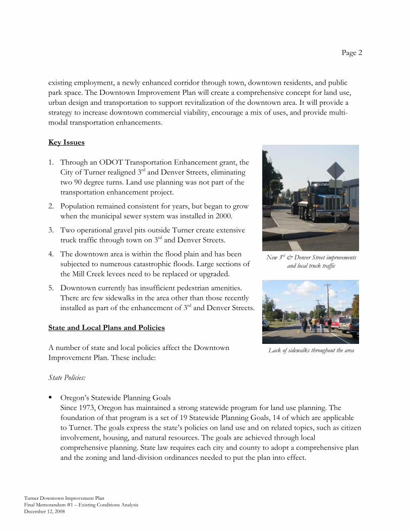
Page 2
Turner Downtown Improvement Plan Final Memorandum #1 – Existing Conditions Analysis December 12, 2008
existing employment, a newly enhanced corridor through town, downtown residents, and public park space. The Downtown Improvement Plan will create a comprehensive concept for land use, urban design and transportation to support revitalization of the downtown area. It will provide a strategy to increase downtown commercial viability, encourage a mix of uses, and provide multi-modal transportation enhancements. Key Issues 1. Through an ODOT Transportation Enhancement grant, the
City of Turner realigned 3rd and Denver Streets, eliminating two 90 degree turns. Land use planning was not part of the transportation enhancement project.
2. Population remained consistent for years, but began to grow when the municipal sewer system was installed in 2000.
3. Two operational gravel pits outside Turner create extensive truck traffic through town on 3rd and Denver Streets.
4. The downtown area is within the flood plain and has been subjected to numerous catastrophic floods. Large sections of the Mill Creek levees need to be replaced or upgraded.
5. Downtown currently has insufficient pedestrian amenities. There are few sidewalks in the area other than those recently installed as part of the enhancement of 3rd and Denver Streets.
State and Local Plans and Policies A number of state and local policies affect the Downtown Improvement Plan. These include: State Policies: Oregon’s Statewide Planning Goals
Since 1973, Oregon has maintained a strong statewide program for land use planning. The foundation of that program is a set of 19 Statewide Planning Goals, 14 of which are applicable to Turner. The goals express the state’s policies on land use and on related topics, such as citizen involvement, housing, and natural resources. The goals are achieved through local comprehensive planning. State law requires each city and county to adopt a comprehensive plan and the zoning and land-division ordinances needed to put the plan into effect.
New 3rd & Denver Street improvements and local truck traffic
Lack of sidewalks throughout the area
Page 3
Turner Downtown Improvement Plan Final Memorandum #1 – Existing Conditions Analysis December 12, 2008
Oregon Transportation Planning Rule The Department of Land Conservation and Development (DLCD) created the Transportation Planning Rule (TRP) in 1991 to guide jurisdictions in meeting the objectives of Goal 12– Transportation– of the Statewide Planning Goals. This administrative rule requires jurisdictions to adopt a Transportation System Plan for coordinated land use and transportation planning.
Oregon Transportation Plan The Oregon Transportation Plan (OTP) is the state’s long-range multimodal transportation plan. The OTP is the overarching policy document among a series of plans that together form the state transportation system plan. The OTP considers all modes of Oregon’s transportation system as a single system and addresses the future needs of Oregon’s airports, bicycle and pedestrian facilities, highways and roadways, pipelines, ports and waterway facilities, public transportation, and railroads through 2030.
Local Plans and Policies: Turner Comprehensive Plan (2001)
The Turner Comprehensive Plan contains background data and policies regarding the future growth and development of the community. It is the first complete update of the Plan since its acknowledgement by the State in 1983. The Plan provides guidelines for conservation and development of community resources in compliance with the statewide planning goals. It is the basis for the City’s more specific regulations and ordinances, which implement the Plan.
Turner Transportation System Plan (1999)
The Turner Transportation System Plan (TSP) fulfills the transportation element (Goal 12) of the Turner Comprehensive Plan. It identifies planned transportation facilities and services needed to support land uses proposed in the Comprehensive Plan in a manner consistent with the Transportation Planning Rule and the Oregon Transportation Plan. The TSP guides the management and development of appropriate transportation facilities in Turner, incorporating the community’s vision, while remaining consistent with state, regional and local plans.
Land Use Development Code
The City of Turner Land Use Development Code provides the regulations that govern development in the City. As the implementation tool for the policies contained in the Comprehensive Plan, many sections of the Code were amended in 2002 to comply with the 2001 update to the Comprehensive Plan.
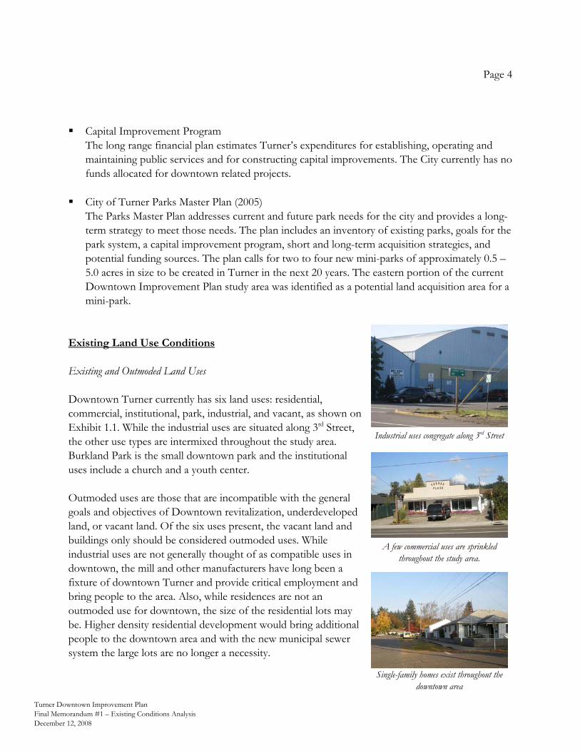
Page 4
Turner Downtown Improvement Plan Final Memorandum #1 – Existing Conditions Analysis December 12, 2008
Capital Improvement Program
The long range financial plan estimates Turner’s expenditures for establishing, operating and maintaining public services and for constructing capital improvements. The City currently has no funds allocated for downtown related projects.
City of Turner Parks Master Plan (2005)
The Parks Master Plan addresses current and future park needs for the city and provides a long-term strategy to meet those needs. The plan includes an inventory of existing parks, goals for the park system, a capital improvement program, short and long-term acquisition strategies, and potential funding sources. The plan calls for two to four new mini-parks of approximately 0.5 – 5.0 acres in size to be created in Turner in the next 20 years. The eastern portion of the current Downtown Improvement Plan study area was identified as a potential land acquisition area for a mini-park.
Existing Land Use Conditions Existing and Outmoded Land Uses Downtown Turner currently has six land uses: residential, commercial, institutional, park, industrial, and vacant, as shown on Exhibit 1.1. While the industrial uses are situated along 3rd Street, the other use types are intermixed throughout the study area. Burkland Park is the small downtown park and the institutional uses include a church and a youth center. Outmoded uses are those that are incompatible with the general goals and objectives of Downtown revitalization, underdeveloped land, or vacant land. Of the six uses present, the vacant land and buildings only should be considered outmoded uses. While industrial uses are not generally thought of as compatible uses in downtown, the mill and other manufacturers have long been a fixture of downtown Turner and provide critical employment and bring people to the area. Also, while residences are not an outmoded use for downtown, the size of the residential lots may be. Higher density residential development would bring additional people to the downtown area and with the new municipal sewer system the large lots are no longer a necessity.
Industrial uses congregate along 3rd Street
A few commercial uses are sprinkled throughout the study area.
Single-family homes exist throughout the downtown area
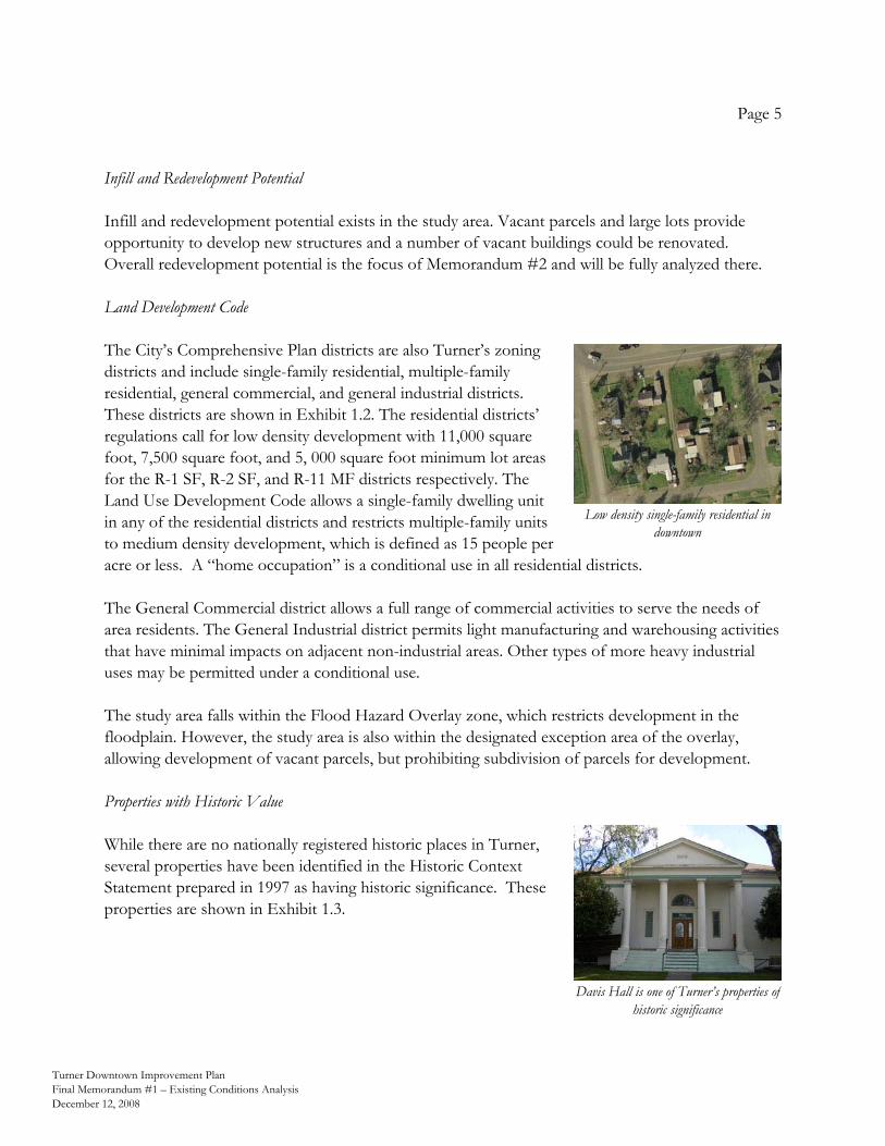
Page 5
Turner Downtown Improvement Plan Final Memorandum #1 – Existing Conditions Analysis December 12, 2008
Infill and Redevelopment Potential Infill and redevelopment potential exists in the study area. Vacant parcels and large lots provide opportunity to develop new structures and a number of vacant buildings could be renovated. Overall redevelopment potential is the focus of Memorandum #2 and will be fully analyzed there. Land Development Code The City’s Comprehensive Plan districts are also Turner’s zoning districts and include single-family residential, multiple-family residential, general commercial, and general industrial districts. These districts are shown in Exhibit 1.2. The residential districts’ regulations call for low density development with 11,000 square foot, 7,500 square foot, and 5, 000 square foot minimum lot areas for the R-1 SF, R-2 SF, and R-11 MF districts respectively. The Land Use Development Code allows a single-family dwelling unit in any of the residential districts and restricts multiple-family units to medium density development, which is defined as 15 people per acre or less. A “home occupation” is a conditional use in all residential districts. The General Commercial district allows a full range of commercial activities to serve the needs of area residents. The General Industrial district permits light manufacturing and warehousing activities that have minimal impacts on adjacent non-industrial areas. Other types of more heavy industrial uses may be permitted under a conditional use. The study area falls within the Flood Hazard Overlay zone, which restricts development in the floodplain. However, the study area is also within the designated exception area of the overlay, allowing development of vacant parcels, but prohibiting subdivision of parcels for development. Properties with Historic Value While there are no nationally registered historic places in Turner, several properties have been identified in the Historic Context Statement prepared in 1997 as having historic significance. These properties are shown in Exhibit 1.3.
Low density single-family residential in downtown
Davis Hall is one of Turner’s properties of historic significance
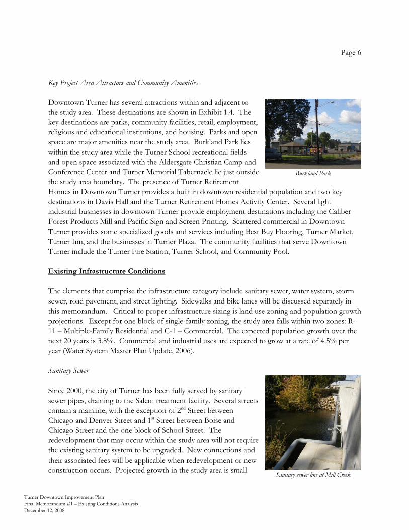
Page 6
Turner Downtown Improvement Plan Final Memorandum #1 – Existing Conditions Analysis December 12, 2008
Key Project Area Attractors and Community Amenities Downtown Turner has several attractions within and adjacent to the study area. These destinations are shown in Exhibit 1.4. The key destinations are parks, community facilities, retail, employment, religious and educational institutions, and housing. Parks and open space are major amenities near the study area. Burkland Park lies within the study area while the Turner School recreational fields and open space associated with the Aldersgate Christian Camp and Conference Center and Turner Memorial Tabernacle lie just outside the study area boundary. The presence of Turner Retirement Homes in Downtown Turner provides a built in downtown residential population and two key destinations in Davis Hall and the Turner Retirement Homes Activity Center. Several light industrial businesses in downtown Turner provide employment destinations including the Caliber Forest Products Mill and Pacific Sign and Screen Printing. Scattered commercial in Downtown Turner provides some specialized goods and services including Best Buy Flooring, Turner Market, Turner Inn, and the businesses in Turner Plaza. The community facilities that serve Downtown Turner include the Turner Fire Station, Turner School, and Community Pool. Existing Infrastructure Conditions The elements that comprise the infrastructure category include sanitary sewer, water system, storm sewer, road pavement, and street lighting. Sidewalks and bike lanes will be discussed separately in this memorandum. Critical to proper infrastructure sizing is land use zoning and population growth projections. Except for one block of single-family zoning, the study area falls within two zones: R-11 – Multiple-Family Residential and C-1 – Commercial. The expected population growth over the next 20 years is 3.8%. Commercial and industrial uses are expected to grow at a rate of 4.5% per year (Water System Master Plan Update, 2006). Sanitary Sewer Since 2000, the city of Turner has been fully served by sanitary sewer pipes, draining to the Salem treatment facility. Several streets contain a mainline, with the exception of 2nd Street between Chicago and Denver Street and 1st Street between Boise and Chicago Street and the one block of School Street. The redevelopment that may occur within the study area will not require the existing sanitary system to be upgraded. New connections and their associated fees will be applicable when redevelopment or new construction occurs. Projected growth in the study area is small
Burkland Park
Sanitary sewer line at Mill Creek
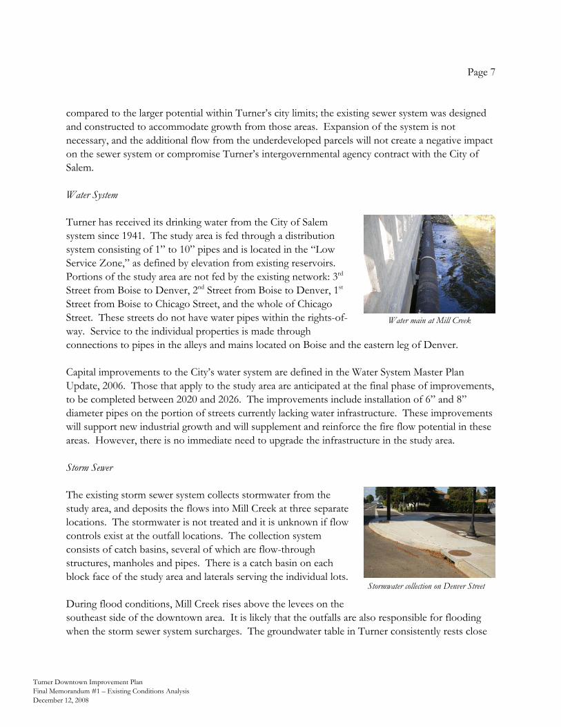
Page 7
Turner Downtown Improvement Plan Final Memorandum #1 – Existing Conditions Analysis December 12, 2008
compared to the larger potential within Turner’s city limits; the existing sewer system was designed and constructed to accommodate growth from those areas. Expansion of the system is not necessary, and the additional flow from the underdeveloped parcels will not create a negative impact on the sewer system or compromise Turner’s intergovernmental agency contract with the City of Salem. Water System Turner has received its drinking water from the City of Salem system since 1941. The study area is fed through a distribution system consisting of 1” to 10” pipes and is located in the “Low Service Zone,” as defined by elevation from existing reservoirs. Portions of the study area are not fed by the existing network: 3rd Street from Boise to Denver, 2nd Street from Boise to Denver, 1st Street from Boise to Chicago Street, and the whole of Chicago Street. These streets do not have water pipes within the rights-of-way. Service to the individual properties is made through connections to pipes in the alleys and mains located on Boise and the eastern leg of Denver. Capital improvements to the City’s water system are defined in the Water System Master Plan Update, 2006. Those that apply to the study area are anticipated at the final phase of improvements, to be completed between 2020 and 2026. The improvements include installation of 6” and 8” diameter pipes on the portion of streets currently lacking water infrastructure. These improvements will support new industrial growth and will supplement and reinforce the fire flow potential in these areas. However, there is no immediate need to upgrade the infrastructure in the study area. Storm Sewer The existing storm sewer system collects stormwater from the study area, and deposits the flows into Mill Creek at three separate locations. The stormwater is not treated and it is unknown if flow controls exist at the outfall locations. The collection system consists of catch basins, several of which are flow-through structures, manholes and pipes. There is a catch basin on each block face of the study area and laterals serving the individual lots. During flood conditions, Mill Creek rises above the levees on the southeast side of the downtown area. It is likely that the outfalls are also responsible for flooding when the storm sewer system surcharges. The groundwater table in Turner consistently rests close
Stormwater collection on Denver Street
Water main at Mill Creek
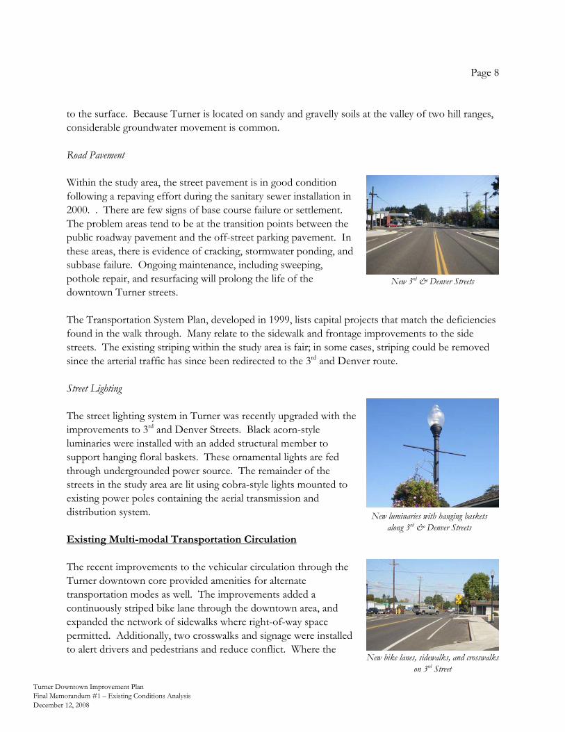
Page 8
Turner Downtown Improvement Plan Final Memorandum #1 – Existing Conditions Analysis December 12, 2008
to the surface. Because Turner is located on sandy and gravelly soils at the valley of two hill ranges, considerable groundwater movement is common. Road Pavement Within the study area, the street pavement is in good condition following a repaving effort during the sanitary sewer installation in 2000. . There are few signs of base course failure or settlement. The problem areas tend to be at the transition points between the public roadway pavement and the off-street parking pavement. In these areas, there is evidence of cracking, stormwater ponding, and subbase failure. Ongoing maintenance, including sweeping, pothole repair, and resurfacing will prolong the life of the downtown Turner streets. The Transportation System Plan, developed in 1999, lists capital projects that match the deficiencies found in the walk through. Many relate to the sidewalk and frontage improvements to the side streets. The existing striping within the study area is fair; in some cases, striping could be removed since the arterial traffic has since been redirected to the 3rd and Denver route. Street Lighting The street lighting system in Turner was recently upgraded with the improvements to 3rd and Denver Streets. Black acorn-style luminaries were installed with an added structural member to support hanging floral baskets. These ornamental lights are fed through undergrounded power source. The remainder of the streets in the study area are lit using cobra-style lights mounted to existing power poles containing the aerial transmission and distribution system. Existing Multi-modal Transportation Circulation The recent improvements to the vehicular circulation through the Turner downtown core provided amenities for alternate transportation modes as well. The improvements added a continuously striped bike lane through the downtown area, and expanded the network of sidewalks where right-of-way space permitted. Additionally, two crosswalks and signage were installed to alert drivers and pedestrians and reduce conflict. Where the
New luminaries with hanging baskets along 3rd & Denver Streets
New 3rd & Denver Streets
New bike lanes, sidewalks, and crosswalks on 3rd Street
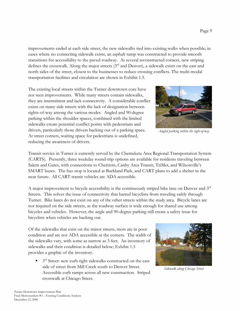
Page 9
Turner Downtown Improvement Plan Final Memorandum #1 – Existing Conditions Analysis December 12, 2008
Sidewalk along Chicago Street
improvements ended at each side street, the new sidewalks tied into existing walks when possible; in cases where no connecting sidewalk exists, an asphalt ramp was constructed to provide smooth transitions for accessibility to the paved roadway. At several reconstructed corners, new striping defines the crosswalk. Along the major streets (3rd and Denver), a sidewalk exists on the east and north sides of the street, closest to the businesses to reduce crossing conflicts. The multi-modal transportation facilities and circulation are shown in Exhibit 1.5. The existing local streets within the Turner downtown core have not seen improvements. While many streets contain sidewalks, they are intermittent and lack connectivity. A considerable conflict exists on many side streets with the lack of designation between rights-of-way among the various modes. Angled and 90-degree parking within the shoulder spaces, combined with the limited sidewalks create potential conflict points with pedestrians and drivers, particularly those drivers backing out of a parking space. At street corners, waiting space for pedestrians is undefined, reducing the awareness of drivers. Transit service in Turner is currently served by the Chemeketa Area Regional Transportation System (CARTS). Presently, three weekday round-trip options are available for residents traveling between Salem and Gates, with connections to Cherriots, Canby Area Transit, TriMet, and Wilsonville’s SMART buses. The bus stop is located at Burkland Park, and CART plans to add a shelter in the near future. All CART transit vehicles are ADA accessible. A major improvement to bicycle accessibility is the continuously striped bike lane on Denver and 3rd Streets. This solves the issue of connectivity that barred bicyclists from traveling safely through Turner. Bike lanes do not exist on any of the other streets within the study area. Bicycle lanes are not required on the side streets, as the roadway surface is wide enough for shared use among bicycles and vehicles. However, the angle and 90-degree parking still create a safety issue for bicyclists when vehicles are backing out. Of the sidewalks that exist on the minor streets, most are in poor condition and are not ADA accessible at the corners. The width of the sidewalks vary, with some as narrow as 3 feet. An inventory of sidewalks and their condition is detailed below; Exhibit 1.5 provides a graphic of the inventory.
3rd Street: new curb-tight sidewalks constructed on the east side of street from Mill Creek south to Denver Street. Accessible curb ramps across all new construction. Striped crosswalk at Chicago Street.
Angled parking within the right-of-way
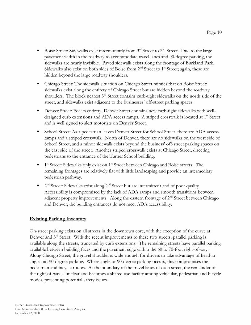
Page 10
Turner Downtown Improvement Plan Final Memorandum #1 – Existing Conditions Analysis December 12, 2008
Boise Street: Sidewalks exist intermittently from 3rd Street to 2nd Street. Due to the large pavement width in the roadway to accommodate travel lanes and 90-degree parking, the sidewalks are nearly invisible. Paved sidewalk exists along the frontage of Burkland Park. Sidewalks also exist on both sides of Boise from 2nd Street to 1st Street; again, these are hidden beyond the large roadway shoulders.
Chicago Street: The sidewalk situation on Chicago Street mimics that on Boise Street: sidewalks exist along the entirety of Chicago Street but are hidden beyond the roadway shoulders. The block nearest 3rd Street contains curb-tight sidewalks on the north side of the street, and sidewalks exist adjacent to the businesses’ off-street parking spaces.
Denver Street: For its entirety, Denver Street contains new curb-tight sidewalks with well-designed curb extensions and ADA access ramps. A striped crosswalk is located at 1st Street and is well signed to alert motorists on Denver Street.
School Street: As a pedestrian leaves Denver Street for School Street, there are ADA access ramps and a striped crosswalk. North of Denver, there are no sidewalks on the west side of School Street, and a minor sidewalk exists beyond the business’ off-street parking spaces on the east side of the street. Another striped crosswalk exists at Chicago Street, directing pedestrians to the entrance of the Turner School building.
1st Street: Sidewalks only exist on 1st Street between Chicago and Boise streets. The remaining frontages are relatively flat with little landscaping and provide an intermediary pedestrian pathway.
2nd Street: Sidewalks exist along 2nd Street but are intermittent and of poor quality. Accessibility is compromised by the lack of ADA ramps and smooth transitions between adjacent property improvements. Along the eastern frontage of 2nd Street between Chicago and Denver, the building entrances do not meet ADA accessibility.
Existing Parking Inventory On-street parking exists on all streets in the downtown core, with the exception of the curve at Denver and 3rd Street. With the recent improvements to these two streets, parallel parking is available along the streets, truncated by curb extensions. The remaining streets have parallel parking available between building faces and the pavement edge within the 60 to 70-foot right-of-way. Along Chicago Street, the gravel shoulder is wide enough for drivers to take advantage of head-in angle and 90-degree parking. Where angle or 90-degree parking occurs, this compromises the pedestrian and bicycle routes. At the boundary of the travel lanes of each street, the remainder of the right-of-way is unclear and becomes a shared use facility among vehicular, pedestrian and bicycle modes, presenting potential safety issues.
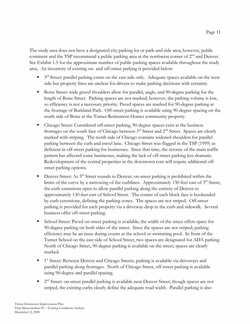
Page 11
Turner Downtown Improvement Plan Final Memorandum #1 – Existing Conditions Analysis December 12, 2008
The study area does not have a designated city parking lot or park-and-ride area; however, public comment and the TSP recommend a public parking area at the northwest corner of 2nd and Denver. See Exhibit 1.5 for the approximate number of public parking spaces available throughout the study area. An inventory of existing on- and off-street parking is provided below:
3rd Street: parallel parking exists on the east side only. Adequate spaces available on the west side but property lines are unclear for drivers to make parking decisions with certainty.
Boise Street: wide gravel shoulders allow for parallel, angle, and 90-degree parking for the length of Boise Street. Parking spaces are not marked; however, the parking volume is low, so efficiency is not a necessary priority. Paved spaces are marked for 90-degree parking at the frontage of Burkland Park. Off-street parking is available using 90-degree spacing on the north side of Boise at the Turner Retirement Homes community property.
Chicago Street: Considered off-street parking, 90-degree spaces exist at the business frontages on the south face of Chicago between 3rd Street and 2nd Street. Spaces are clearly marked with striping. The north side of Chicago contains widened shoulders for parallel parking between the curb and travel lane. Chicago Street was flagged in the TSP (1999) as deficient in off-street parking for businesses. Since that time, the reroute of the main traffic pattern has affected some businesses, making the lack of off-street parking less dramatic. Redevelopment of the central properties in the downtown core will require additional off-street parking options.
Denver Street: As 3rd Street rounds to Denver, on-street parking is prohibited within the limits of the curve by a narrowing of the curblines. Approximately 130-feet east of 3rd Street, the curb extensions open to allow parallel parking along the entirety of Denver to approximately 130-feet east of School Street. The corner of each block face is bookended by curb extensions, defining the parking zones. The spaces are not striped. Off-street parking is provided for each property via a driveway drop in the curb and sidewalk. Several business offer off-street parking.
School Street: Paved on-street parking is available; the width of the street offers space for 90-degree parking on both sides of the street. Since the spaces are not striped; parking efficiency may be an issue during events at the school or swimming pool. In front of the Turner School on the east side of School Street, two spaces are designated for ADA parking. North of Chicago Street, 90-degree parking is available on the street; spaces are clearly marked.
1st Street: Between Denver and Chicago Streets, parking is available via driveways and parallel parking along frontages. North of Chicago Street, off-street parking is available using 90-degree and parallel spacing.
2nd Street: on-street parallel parking is available near Denver Street; though spaces are not striped, the existing curbs clearly define the adequate road width. Parallel parking is also
Page 12
Turner Downtown Improvement Plan Final Memorandum #1 – Existing Conditions Analysis December 12, 2008
utilized in the undefined shoulders of 2nd Street. Off-street parking is available via garage and driveway spaces. Off-street parking is also available using 90-degree spacing along the Burkland Park frontage.
An additional parking consideration is the needs of the elementary school and public pool now and into the future. School staff already overflows the parking area. If the pool service is expanded to year round use and/or if the school expands, there could be a parking shortage in the immediate vicinity for those uses. Opportunities and Constraints From the analysis of existing conditions the following opportunities and constraints have been derived and will be considered in the next steps of the Downtown Improvement Plan. Opportunities Downtown residents: The Turner Retirement Community and other residents provide a solid
population base to patronize new services and shops. Available land: Vacant parcels in the study provide space for infill and redevelopment. Vacant
properties can be evaluated early for public parking area feasibility. Enhancements on which to build: The realignment and improvement of 3rd & Denver Streets
provide great pedestrian and bicycle facilities on which to base further improvements. Employment uses: The industrial facilities bring people to the area. There is vacant land on
which to build additional employment uses. Infrastructure capacity: Growth is not hindered by the water and sewer systems.
Community amenities: The study area has several attractors within or adjacent to it, including the
elementary school and play fields, pool, and park. Large religious organizations/facilities: While just outside the study area, the Tabernacle and
Aldersgate organizations attract and host people from beyond Turner throughout the year, particularly the summer, bringing people to the area.
Mill Creek: Unbuildable land near the creek provides an opportunity to define public space
and/or trail system along the creek.
Page 13
Turner Downtown Improvement Plan Final Memorandum #1 – Existing Conditions Analysis December 12, 2008
Sidewalk improvements: There is ample right-of-way for sidewalk improvements. Additional bicycle facilities: Locate bicycle parking at destination areas.
Engage and interface with Marion County: Turner can be proactive and create partnerships with
Marion County. Create a civic presence: The available land and need for civic services downtown combine to
create an opportunity to create a civic presence in the downtown area. Review process: Use lower service development charges (SDCs) as an incentive for
development. Constraints and Needs Floodplain: Development within the floodplain downtown will be difficult. Levees need to be
replaced or upgraded to help relieve frequent flooding of the area. Limited through traffic: While limited traffic can be good for pedestrian and bicycle uses, limited
through traffic hinders the viability of some retail and other commercial uses. Cost of renovation: Several historic properties in the area are currently vacant and in need of
extensive repair and renovation. Truck traffic: The extensive truck traffic creates ongoing maintenance problems and degrades
the pedestrian and bicycle experience. Population: Additional Turner residents are needed to support more commercial activity.
Increase safety: Improve safety issues by increasing on-street parking efficiencies.
Water system additions: Incorporate water capital improvements with roadway improvements.
Maintenance: Conduct routine maintenance on the existing infrastructure to ensure longevity.
Proximity to Salem: Restricts ability to create Turner’s own market in terms of development
incentives. Price of utilities: The cost of utilities service can be prohibitive to small businesses.
Page 14
Turner Downtown Improvement Plan Final Memorandum #1 – Existing Conditions Analysis December 12, 2008
Exhibits The following maps graphically summarize much of the existing conditions in the study area. Exhibit 1.1 Existing Land Use Exhibit 1.2 Existing Comprehensive Plan and Zoning Designations Exhibit 1.3 Properties with Historic Value Exhibit 1.4 Key Project Area Attractors and Community Amenities Exhibit 1.5 Transportation Circulation and Parking Inventory
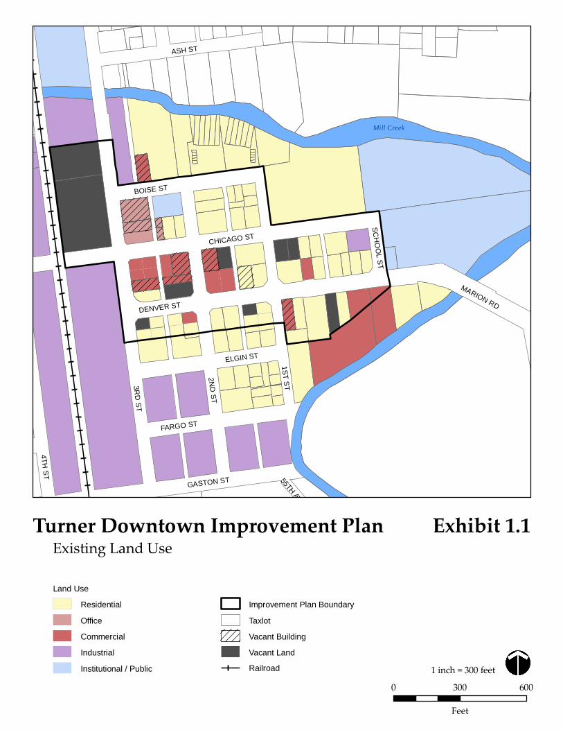
Mill Creek
3RD
ST
2ND
ST
1ST ST
CHICAGO ST
DENVER ST
ASH ST
BOISE ST
GASTON ST
4TH ST
ELGIN ST
FARGO ST
55TH AV
MARION RD
SCH
OO
L ST
Turner Downtown Improvement Plan
0 300 600Feet
1 inch = 300 feet
Existing Land UseExhibit 1.1
Land Use
Residential
Office
Commercial
Industrial
Institutional / Public
Improvement Plan Boundary
Taxlot
Vacant Building
Vacant Land
Railroad
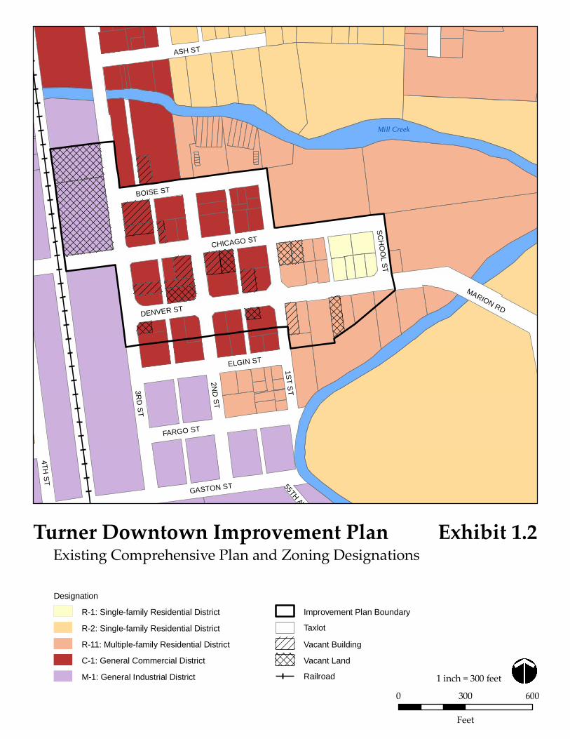
Mill Creek
3RD
ST
2ND
ST
1ST ST
CHICAGO ST
DENVER ST
ASH ST
BOISE ST
GASTON ST
4TH ST
ELGIN ST
FARGO ST
55TH AV
MARION RD
SCH
OO
L ST
Turner Downtown Improvement Plan
0 300 600Feet
1 inch = 300 feet
Existing Comprehensive Plan and Zoning DesignationsDesignation
R-1: Single-family Residential District
R-2: Single-family Residential District
R-11: Multiple-family Residential District
C-1: General Commercial District
M-1: General Industrial District
Improvement Plan Boundary
Taxlot
Vacant Building
Vacant Land
Railroad
Exhibit 1.2
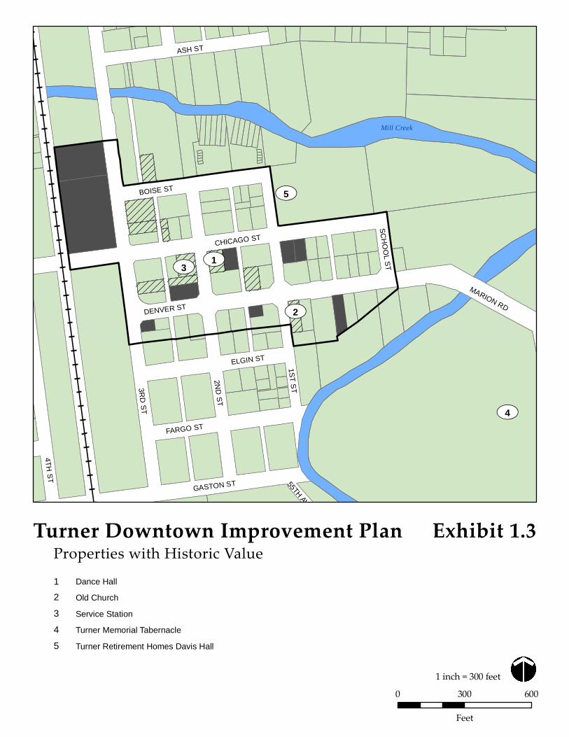
Mill Creek
UV3
UV5
UV4
UV1
UV2
3RD
ST
2ND
ST
1ST ST
CHICAGO ST
DENVER ST
ASH ST
BOISE ST
GASTON ST
4TH ST
ELGIN ST
FARGO ST
55TH AV
MARION RD
SCH
OO
L ST
Turner Downtown Improvement Plan
0 300 600Feet
1 inch = 300 feet
Properties with Historic ValueExhibit 1.3
Dance Hall1
Old Church2
Service Station3
Turner Memorial Tabernacle4
Turner Retirement Homes Davis Hall5
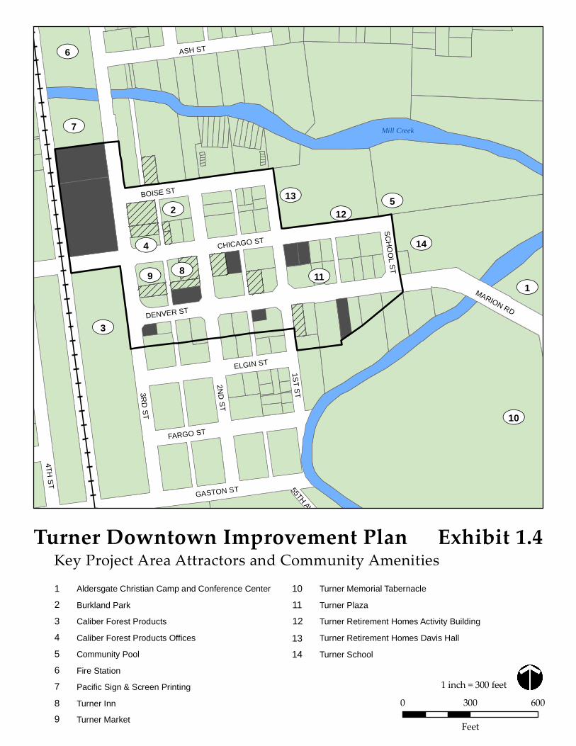
UV1
UV6
UV3
UV14
UV5UV2
UV13
UV9 UV11
UV12
UV8UV4
UV7
UV10
Mill Creek
3RD
ST
2ND
ST
1ST ST
CHICAGO ST
DENVER ST
ASH ST
BOISE ST
GASTON ST
4TH ST
ELGIN ST
FARGO ST
55TH AV
MARION RD
SCH
OO
L ST
Turner Downtown Improvement Plan
0 300 600Feet
1 inch = 300 feet
Key Project Area Attractors and Community AmenitiesExhibit 1.4
Turner Plaza11
Turner Retirement Homes Activity Building12
Turner School14
Turner Memorial Tabernacle10
Turner Retirement Homes Davis Hall13
Burkland Park2
Caliber Forest Products Offices4
Community Pool5
Fire Station6
Pacific Sign & Screen Printing7
Turner Inn8
Turner Market9
Aldersgate Christian Camp and Conference Center1
Caliber Forest Products3
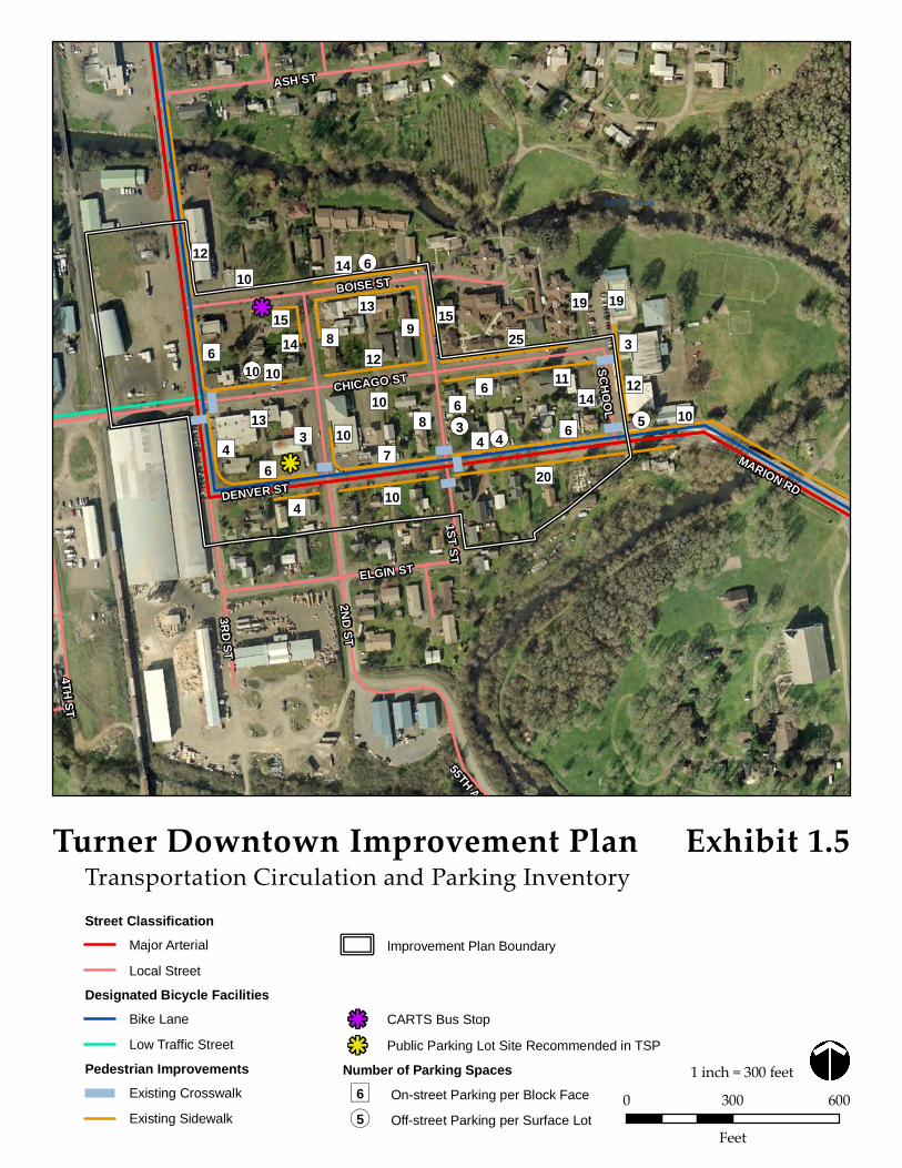
k
k
Mill Creek
")6")4
")7")6
")3")4
")4
")13
")10")6 ")14
")15
")10 ")14
")13")9
")12")8
")10")10
")10 ")8")6
")6")11")14 ")12
")10")20
")3
")19")19
")25")15
¬«5¬«4
¬«6
¬«3
¬«10
")12
SCHOOL
MARION RD
ELGIN ST
BOISE ST
ASH ST
DENVER ST
CHICAGO ST
1ST ST
2ND ST
3RD ST
4TH ST
55TH AV
Turner Downtown Improvement Plan
0 300 600Feet
1 inch = 300 feet
Transportation Circulation and Parking InventoryStreet Classification
Major Arterial
Local Street
Designated Bicycle FacilitiesBike Lane
Low Traffic Street
Pedestrian ImprovementsExisting Crosswalk
Existing Sidewalk
Improvement Plan Boundary
k CARTS Bus Stop
k Public Parking Lot Site Recommended in TSP
Number of Parking Spaces
Exhibit 1.5
On-street Parking per Block Face")6Off-street Parking per Surface Lot¬«5

Appendix B
Memorandum No. 2 – Redevelopment Potential
Turner Downtown Improvement Plan Memorandum #2 – Redevelopment Potential
Turner Downtown Improvement Plan Final Memorandum #2 – Project Area Redevelopment Potential December 12, 2008
17355 SW Boones Ferry Rd. Lake Oswego, OR 97035
Phone (503) 635-3618 Fax (503) 635-5395
Project Team:
David Siegel, FAICP Jennifer Mannhard, AICP
Amanda Owings, P.E. Warren Greaser
Brendan Buckley
Johnson Gardner , LLC
The attached memorandum prepared by Johnson Gardner addresses the redevelopment potential of Downtown Turner and incorporates comments received from the Project Advisory Committee Meeting #1. Submission of this memorandum satisfies, in part, subtask 2.8 of the Work Order Contract. Attachments Johnson Gardner Memorandum: Final Analysis of Redevelopment Potential, Downtown Turner
To: David Sawyer, City Administrator, TurnerNaomi Zwerdling, Senior Planner, ODOT
From: Jennifer Mannhard, Senior Planner, Otak
Date: December 12, 2008
Subject: Final Project Area Redevelopment Potential Deliverable 2.H Turner Downtown Improvement Plan
319 SW Washington Street, Suite 1020 Portland, OR 97204 503/295-7832 503/295-1107 (fax)
MEMORANDUM
DATE: December 10, 2008 PREPARED FOR: The City of Turner, Oregon 7250 3rd Street SE
Turner, OR 97392 FROM: JOHNSON GARDNER, LLC SUBJECT: Analysis of Redevelopment Potential, Downtown Turner This memorandum addresses the redevelopment potential of the Downtown Turner area, which serves as the current and historical commercial node for the small but growing community of Turner, Oregon. This memo is one component of a larger multi-disciplinary project considering the revitalization of the Downtown from urban planning and economic perspectives. The project is funded by the SAFETEA-LU act, with additional support from the State of Oregon through the Transportation & Growth Management program. This memo provides analysis of the current and projected redevelopment potential in Downtown Turner based on demographic and market conditions in the area, and the economics of real estate development. The memo is organized as follows:
I. EXECUTIVE SUMMARY
II. MARKET CONDITIONS
III. RETAIL MARKET CONDITIONS
IV. REAL ESTATE AND REDEVELOPMENT MARKET CONDITIONS
V. POTENTIAL AREAS OF FOCUS
VI. REGULATORY IMPACTS ON REDEVELOPMENT
VII. CONCLUSIONS
I. EXECUTIVE SUMMARY Based on our analysis of market conditions in and around Downtown Turner we find positive indicators for the addition of new business over the coming years. The following is a summary of the conclusions presented in this report:
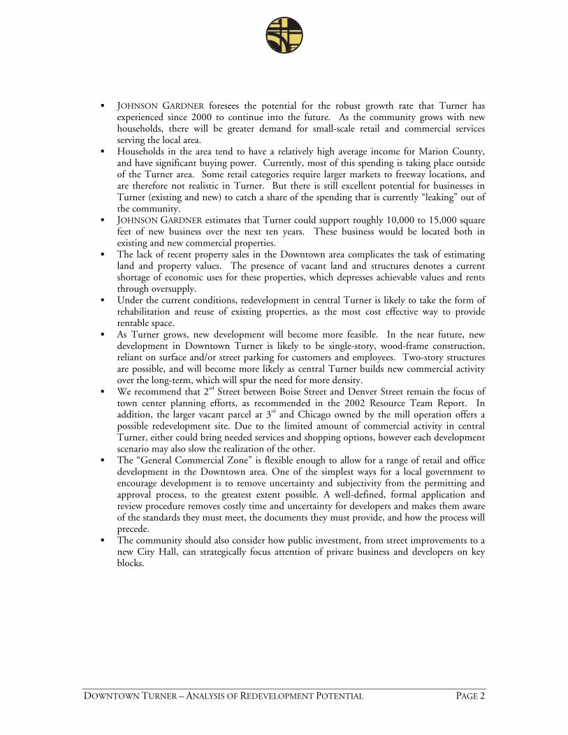
DOWNTOWN TURNER – ANALYSIS OF REDEVELOPMENT POTENTIAL PAGE 2
JOHNSON GARDNER foresees the potential for the robust growth rate that Turner has experienced since 2000 to continue into the future. As the community grows with new households, there will be greater demand for small-scale retail and commercial services serving the local area.
Households in the area tend to have a relatively high average income for Marion County, and have significant buying power. Currently, most of this spending is taking place outside of the Turner area. Some retail categories require larger markets to freeway locations, and are therefore not realistic in Turner. But there is still excellent potential for businesses in Turner (existing and new) to catch a share of the spending that is currently “leaking” out of the community.
JOHNSON GARDNER estimates that Turner could support roughly 10,000 to 15,000 square feet of new business over the next ten years. These business would be located both in existing and new commercial properties.
The lack of recent property sales in the Downtown area complicates the task of estimating land and property values. The presence of vacant land and structures denotes a current shortage of economic uses for these properties, which depresses achievable values and rents through oversupply.
Under the current conditions, redevelopment in central Turner is likely to take the form of rehabilitation and reuse of existing properties, as the most cost effective way to provide rentable space.
As Turner grows, new development will become more feasible. In the near future, new development in Downtown Turner is likely to be single-story, wood-frame construction, reliant on surface and/or street parking for customers and employees. Two-story structures are possible, and will become more likely as central Turner builds new commercial activity over the long-term, which will spur the need for more density.
We recommend that 2nd Street between Boise Street and Denver Street remain the focus of town center planning efforts, as recommended in the 2002 Resource Team Report. In addition, the larger vacant parcel at 3rd and Chicago owned by the mill operation offers a possible redevelopment site. Due to the limited amount of commercial activity in central Turner, either could bring needed services and shopping options, however each development scenario may also slow the realization of the other.
The “General Commercial Zone” is flexible enough to allow for a range of retail and office development in the Downtown area. One of the simplest ways for a local government to encourage development is to remove uncertainty and subjectivity from the permitting and approval process, to the greatest extent possible. A well-defined, formal application and review procedure removes costly time and uncertainty for developers and makes them aware of the standards they must meet, the documents they must provide, and how the process will precede.
The community should also consider how public investment, from street improvements to a new City Hall, can strategically focus attention of private business and developers on key blocks.

DOWNTOWN TURNER – ANALYSIS OF REDEVELOPMENT POTENTIAL PAGE 3
II. MARKET CONDITIONS This study focuses primarily on the development of commercial uses in the Downtown area, and therefore the market area considered is the geography from which prospective customers might be expected to travel into Turner in order to visit small-scale retail and commercial services. The area selected includes the limits of the City of Turner, but also beyond, constituting roughly a five-minute drive time to the center of town. The following map presents the Primary Market Area:
FIGURE 2.1: PRIMARY MARKET AREA
Primary Market Area
The market area is truncated at roughly half the distance to the I-5 freeway to the west, and half the distance to Aumsville to the east. The market area stops at the city limits to the north, due to the significantly stronger “draw” of retail options in Salem – households living north of Turner will be expected to visit Salem for a preponderance of their retail needs.
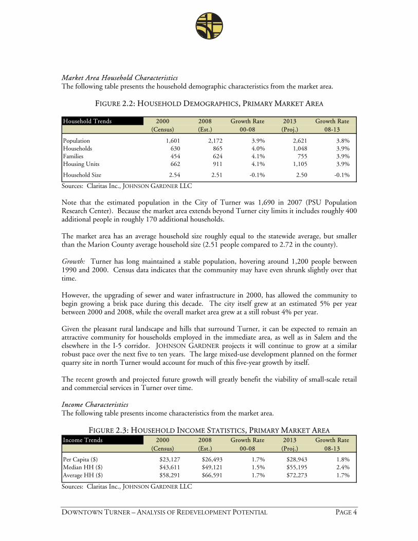
DOWNTOWN TURNER – ANALYSIS OF REDEVELOPMENT POTENTIAL PAGE 4
Market Area Household Characteristics The following table presents the household demographic characteristics from the market area.
FIGURE 2.2: HOUSEHOLD DEMOGRAPHICS, PRIMARY MARKET AREA Household Trends 2000 2008 Growth Rate 2013 Growth Rate
(Census) (Est.) 00-08 (Proj.) 08-13
Population 1,601 2,172 3.9% 2,621 3.8%Households 630 865 4.0% 1,048 3.9%Families 454 624 4.1% 755 3.9%Housing Units 662 911 4.1% 1,105 3.9%
Household Size 2.54 2.51 -0.1% 2.50 -0.1%
Sources: Claritas Inc., JOHNSON GARDNER LLC Note that the estimated population in the City of Turner was 1,690 in 2007 (PSU Population Research Center). Because the market area extends beyond Turner city limits it includes roughly 400 additional people in roughly 170 additional households. The market area has an average household size roughly equal to the statewide average, but smaller than the Marion County average household size (2.51 people compared to 2.72 in the county). Growth: Turner has long maintained a stable population, hovering around 1,200 people between 1990 and 2000. Census data indicates that the community may have even shrunk slightly over that time. However, the upgrading of sewer and water infrastructure in 2000, has allowed the community to begin growing a brisk pace during this decade. The city itself grew at an estimated 5% per year between 2000 and 2008, while the overall market area grew at a still robust 4% per year. Given the pleasant rural landscape and hills that surround Turner, it can be expected to remain an attractive community for households employed in the immediate area, as well as in Salem and the elsewhere in the I-5 corridor. JOHNSON GARDNER projects it will continue to grow at a similar robust pace over the next five to ten years. The large mixed-use development planned on the former quarry site in north Turner would account for much of this five-year growth by itself. The recent growth and projected future growth will greatly benefit the viability of small-scale retail and commercial services in Turner over time. Income Characteristics The following table presents income characteristics from the market area.
FIGURE 2.3: HOUSEHOLD INCOME STATISTICS, PRIMARY MARKET AREA Income Trends 2000 2008 Growth Rate 2013 Growth Rate
(Census) (Est.) 00-08 (Proj.) 08-13
Per Capita ($) $23,127 $26,493 1.7% $28,943 1.8%Median HH ($) $43,611 $49,121 1.5% $55,195 2.4%Average HH ($) $58,291 $66,591 1.7% $72,273 1.7%
Sources: Claritas Inc., JOHNSON GARDNER LLC
DOWNTOWN TURNER – ANALYSIS OF REDEVELOPMENT POTENTIAL PAGE 5
The Turner area enjoys relatively high household incomes relative to Marion County and the State of Oregon. The median household income is roughly 5% higher than the county median, and 3% higher than the state median. The disparity is even greater for the average (mean) household income, which is 16% higher in the Turner area than the rest of Marion County. In general, one would expect to find below average income levels in small-city, semi-rural locations, and above-average income levels in larger cities, due to cost of living disparities. The relatively high income levels in Turner suggest that the community serves as a bedroom community for above-average earners from the broader area, many employed in Salem. 2006 data from the U.S. Census Bureau reports that 42% of Turner area residents were employed in Salem, and over 30% were employed outside of Marion County. Other than Salem, a majority of residents were employed in the unincorporated areas of Marion County surrounding Turner, and in Aumsville and Stayton. The data suggest that relatively few local residents are actually employed in Turner. A majority of employees at local businesses commute to Turner from out of town, according to the Census. In 2006, there were an estimated 390 jobs in Turner – 36% filled by Salem residents, 6% by Keizer residents. The Census reports that only around 2% of these jobs are filled by Turner residents. However, the largest share of these jobs (43.4%) is filled by residents of “other locations” which includes the county lands surrounding Turner, so many of these employees may live very close to the city. As with the strong growth rate, the relatively high income levels of local households are a positive indicator for the viability of future retail and commercial services in Turner.
III. RETAIL MARKET CONDITIONS Retail is sometimes described as working on a “gravity model”, where larger clusters of shopping and service options exert more “gravity” on prospective customers than smaller nodes of retail. In general, a customer will not drive past one retail option in order to reach what they see as an equal or lesser retail option. The retail and service options located in South Salem, particularly around the I-5, Santiam Highway intersection exert significant gravity on the households in the Turner market area, offering the nearest options for full-service grocers, discount stores, home supply stores, clothing, and general merchandise. The location in the larger Salem market, and near major transportation routes, makes it natural for a large-scale commercial agglomeration. The City of Turner, being located off of a major freeway or highway, and featuring a modest but growing population is a difficult environment for large- or medium-scale retail. Traffic through Turner is largely local, as even other small cities in the area, such as Aumsville, have a more direct route in the Santiam Highway which takes them around Turner. Therefore, Turner is a good location for small-scale retail and services which serve the residents and employees in the immediate Turner area. (The market area used in this analysis is delineated to include roughly a five minute drive time from Downtown.)
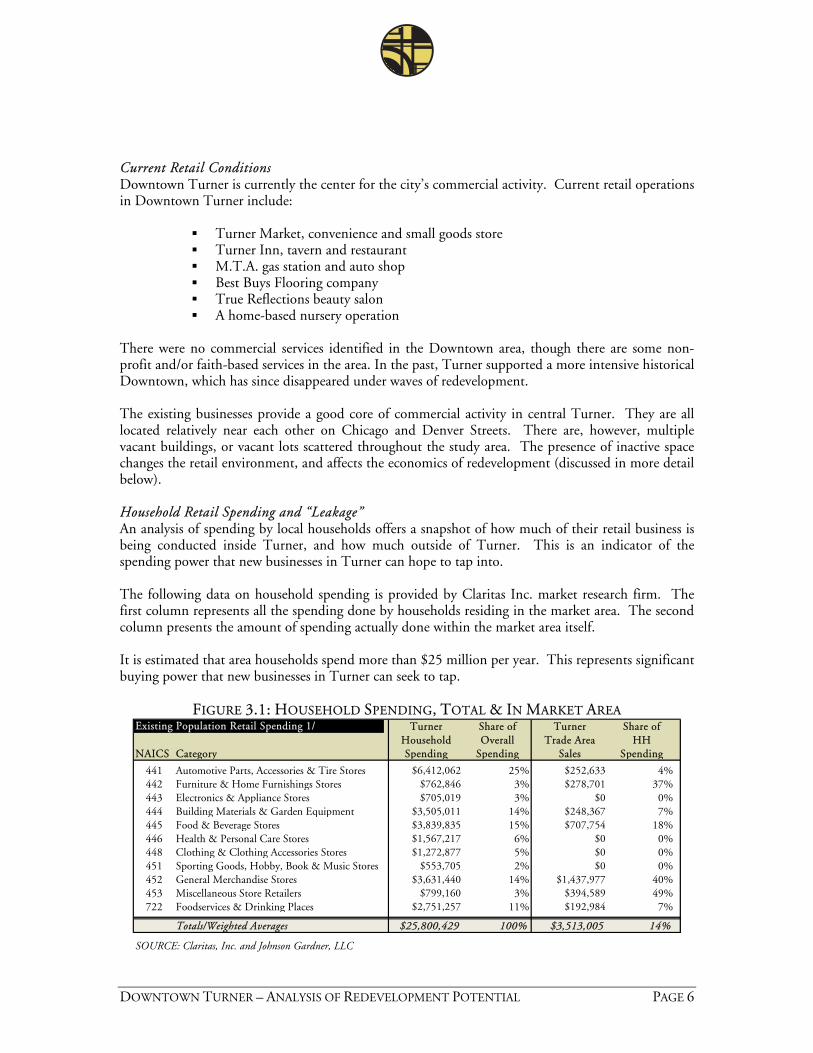
DOWNTOWN TURNER – ANALYSIS OF REDEVELOPMENT POTENTIAL PAGE 6
Current Retail Conditions Downtown Turner is currently the center for the city’s commercial activity. Current retail operations in Downtown Turner include:
Turner Market, convenience and small goods store Turner Inn, tavern and restaurant M.T.A. gas station and auto shop Best Buys Flooring company True Reflections beauty salon A home-based nursery operation
There were no commercial services identified in the Downtown area, though there are some non-profit and/or faith-based services in the area. In the past, Turner supported a more intensive historical Downtown, which has since disappeared under waves of redevelopment. The existing businesses provide a good core of commercial activity in central Turner. They are all located relatively near each other on Chicago and Denver Streets. There are, however, multiple vacant buildings, or vacant lots scattered throughout the study area. The presence of inactive space changes the retail environment, and affects the economics of redevelopment (discussed in more detail below). Household Retail Spending and “Leakage” An analysis of spending by local households offers a snapshot of how much of their retail business is being conducted inside Turner, and how much outside of Turner. This is an indicator of the spending power that new businesses in Turner can hope to tap into. The following data on household spending is provided by Claritas Inc. market research firm. The first column represents all the spending done by households residing in the market area. The second column presents the amount of spending actually done within the market area itself. It is estimated that area households spend more than $25 million per year. This represents significant buying power that new businesses in Turner can seek to tap.
FIGURE 3.1: HOUSEHOLD SPENDING, TOTAL & IN MARKET AREA Turner Share of Turner Share of
Household Overall Trade Area HHNAICS Category Spending Spending Sales Spending
441 Automotive Parts, Accessories & Tire Stores $6,412,062 25% $252,633 4%442 Furniture & Home Furnishings Stores $762,846 3% $278,701 37%443 Electronics & Appliance Stores $705,019 3% $0 0%444 Building Materials & Garden Equipment $3,505,011 14% $248,367 7%445 Food & Beverage Stores $3,839,835 15% $707,754 18%446 Health & Personal Care Stores $1,567,217 6% $0 0%448 Clothing & Clothing Accessories Stores $1,272,877 5% $0 0%451 Sporting Goods, Hobby, Book & Music Stores $553,705 2% $0 0%452 General Merchandise Stores $3,631,440 14% $1,437,977 40%453 Miscellaneous Store Retailers $799,160 3% $394,589 49%722 Foodservices & Drinking Places $2,751,257 11% $192,984 7%
Totals/Weighted Averages $25,800,429 100% $3,513,005 14%
SOURCE: Claritas, Inc. and Johnson Gardner, LLC
Existing Population Retail Spending 1/
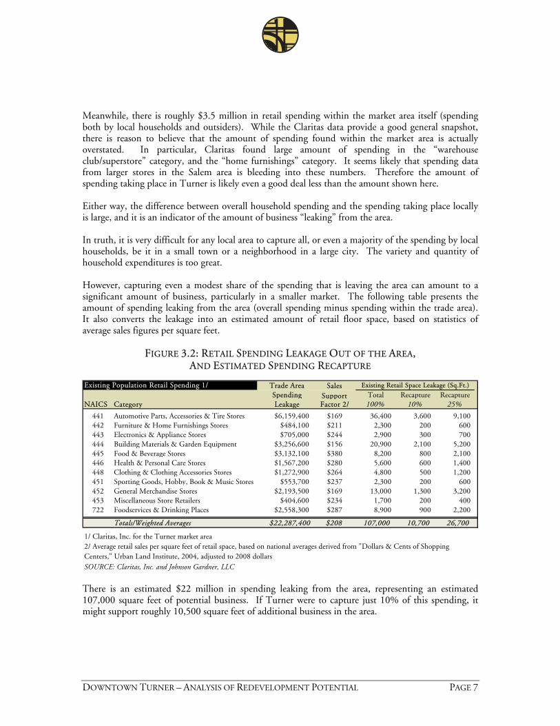
DOWNTOWN TURNER – ANALYSIS OF REDEVELOPMENT POTENTIAL PAGE 7
Meanwhile, there is roughly $3.5 million in retail spending within the market area itself (spending both by local households and outsiders). While the Claritas data provide a good general snapshot, there is reason to believe that the amount of spending found within the market area is actually overstated. In particular, Claritas found large amount of spending in the “warehouse club/superstore” category, and the “home furnishings” category. It seems likely that spending data from larger stores in the Salem area is bleeding into these numbers. Therefore the amount of spending taking place in Turner is likely even a good deal less than the amount shown here. Either way, the difference between overall household spending and the spending taking place locally is large, and it is an indicator of the amount of business “leaking” from the area. In truth, it is very difficult for any local area to capture all, or even a majority of the spending by local households, be it in a small town or a neighborhood in a large city. The variety and quantity of household expenditures is too great. However, capturing even a modest share of the spending that is leaving the area can amount to a significant amount of business, particularly in a smaller market. The following table presents the amount of spending leaking from the area (overall spending minus spending within the trade area). It also converts the leakage into an estimated amount of retail floor space, based on statistics of average sales figures per square feet.
FIGURE 3.2: RETAIL SPENDING LEAKAGE OUT OF THE AREA, AND ESTIMATED SPENDING RECAPTURE
Trade AreaSpending Total Recapture Recapture
NAICS Category Leakage Factor 2/ 100% 10% 25%
441 Automotive Parts, Accessories & Tire Stores $6,159,400 $169 36,400 3,600 9,100442 Furniture & Home Furnishings Stores $484,100 $211 2,300 200 600443 Electronics & Appliance Stores $705,000 $244 2,900 300 700444 Building Materials & Garden Equipment $3,256,600 $156 20,900 2,100 5,200445 Food & Beverage Stores $3,132,100 $380 8,200 800 2,100446 Health & Personal Care Stores $1,567,200 $280 5,600 600 1,400448 Clothing & Clothing Accessories Stores $1,272,900 $264 4,800 500 1,200451 Sporting Goods, Hobby, Book & Music Stores $553,700 $237 2,300 200 600452 General Merchandise Stores $2,193,500 $169 13,000 1,300 3,200453 Miscellaneous Store Retailers $404,600 $234 1,700 200 400722 Foodservices & Drinking Places $2,558,300 $287 8,900 900 2,200
Totals/Weighted Averages $22,287,400 $208 107,000 10,700 26,700
1/ Claritas, Inc. for the Turner market area
SOURCE: Claritas, Inc. and Johnson Gardner, LLC
2/ Average retail sales per square feet of retail space, based on national averages derived from "Dollars & Cents of Shopping Centers," Urban Land Institute, 2004, adjusted to 2008 dollars
Existing Population Retail Spending 1/ Sales Support
Existing Retail Space Leakage (Sq.Ft.)
There is an estimated $22 million in spending leaking from the area, representing an estimated 107,000 square feet of potential business. If Turner were to capture just 10% of this spending, it might support roughly 10,500 square feet of additional business in the area.
DOWNTOWN TURNER – ANALYSIS OF REDEVELOPMENT POTENTIAL PAGE 8
Additional Spending Activity In addition to local households, there are additional sources of potential spending in Turner, including year-round employees and visitors to the local faith-based meeting and retreat centers. As noted above, there are an estimated 400 employees in Turner, most of who live outside of the city. Therefore there is limited overlap between these employees and local resident households. The retreat centers in Turner, and just outside of Turner, attract an estimated 6,000 adults throughout the year, mostly on weekends, in addition to 1,700 youth during the summer weekdays. These employees and visitors all represent important potential customers for retail options in Turner, particularly new dining options. Affordable and relatively quick lunch dining options are the most likely to tap into local employee spending. Growing Into Retail The best way to think about this potential spending is not that the Turner community should attempt to capture large portions of it all at once, but rather that this supports a healthy reservoir that strategic small businesses can take advantage of over the next five to ten years. Combined with the projected growth in the number of households over this time, there is good potential to generate new business in Downtown Turner over that timeframe. (Retail needs and preferences of the Turner community are being surveyed as part of the larger revitalization project and will be reported separately. The results presented here will be compared with preferences to provide context.)
IV. REAL ESTATE AND REDEVELOPMENT MARKET CONDITIONS Real estate development in central Turner has been a slow and steady affair for years if not decades. The city maintained a very stable population before completing improvements to its water and sewer infrastructure in 2000. Since then, the community has experienced residential growth, and some employment growth, mostly in the light-industrial, manufacturing sectors. Even after recent growth, however, an inventory of the Downtown area reveals multiple vacant or underutilized properties in the area. Prominent examples are the former bank building built at the corner of 3rd and Boise in 1978, the former gas station at the southwest corner of 2nd and Chicago, and the two-story building across the street attached to the auto garage. The selection of vacant structures offers location opportunities for prospective new businesses in central Turner. It can also complicate the feasibility of building new commercial space, if it has to compete with cheaper existing vacancies for tenants. Sales Activity A search of the Regional Multiple Listing Service returned no records of commercial property sales in the recent past. Activity in the area consists largely of sales of single family homes, industrial properties along the 3rd Street corridor, and some land purchases for subdivision. There has been one recent sale in the Downtown area, of a previous residential home, which has been converted into office space (roughly across the street from the Turner Inn). The building sold in 2007 for below the assessed real market value of the Marion County assessor’s office.
DOWNTOWN TURNER – ANALYSIS OF REDEVELOPMENT POTENTIAL PAGE 9
Marion County tax lot records document two fairly recent sales of adjacent properties. One is the former gas station property on the southwest corner of 2nd Street and Chicago. The county lists an “unconfirmed sale” of this property in August 2007. The adjacent parcels to the south, which house an older garage structure and parking lot were sold in 2005. These sales support an estimated value of commercial land in central Turner of $5.25 per square foot. This estimate was used as a guide to assess the feasibility of different development types in Turner, discussed more below. The low number of recent property sales in the Downtown area complicates the task of estimating land and property values. The presence of vacant land and structures denotes a current shortage of economic uses for these properties, which depresses achievable values and rents through oversupply. Feasibility of Development Under the current conditions, redevelopment in central Turner is likely to take the form of rehabilitation and reuse of existing properties, as the most cost effective way to provide rentable space. Some properties, like the former bank building, will be close to tenant-ready, while others, such as the former gas station, would require some level of renovation to be suitable for a new use. As noted, the Downtown area fortunately has sufficient buildings available to accommodate some new business at this lowest cost of entry. In order for complete teardown and redevelopment to be economically feasible, the value of the property (land & building) must be low enough that the buyer can pay that price in order to only use the land. Therefore, a property may have an old and vacant structure on it, but that structure may still retain just enough intrinsic value to make the entire property too expensive to purchase just to reuse the land. The following table presents a general picture of the types of redevelopment, from the least expensive to the most expensive. The specifics of every individual project are always unique, so this is just a general picture. (One important caveat is that saving and reusing buildings can be more expensive than new construction depending on the level of deterioration.)
FIGURE 4.1: TYPES OF REAL ESTATE REUSE OR REDEVELOPMENT
1 Release of existing vacant commercial space2 Substantial interior renovation/rehabilitation of existing commercial space3 Substantial interior and exterior renovation/rehabilitation4 New development on vacant land5 New development on vacant land, after teardown
Economic Reuse (Least to Most Expensive)
Source: JOHNSON GARDNER
JOHNSON GARDNER anticipates re-leasing of existing space, and some renovation to be the most likely commercial real estate activity in Turner for the next five years. More intensive renovation and new development will become more feasible after some additional commercial activity is generated.
DOWNTOWN TURNER – ANALYSIS OF REDEVELOPMENT POTENTIAL PAGE 10
Likely Form of New Development As Turner grows, new development will become more feasible. Currently, estimated land costs in central Turner are quite low making new construction somewhat feasible. However, achievable rent levels and the supply of existing space will make it difficult for the development of new commercial space to pencil out. As business activity increases and available space is reused or retired, land values can be expected to climb. This will be a positive indicator that the business climate has improved, and higher lease rates are possible. For the foreseeable future, if new development occurs in Downtown Turner it is likely to be single-story, wood-frame construction, reliant on surface and/or street parking for customers and employees. Two-story structures are possible, and will become more likely as central Turner builds new commercial activity over the long-term, which will spur the need for more density. Single story wood-frame construction allows for a range of attractive design types including the classic storefront architecture found in many small historical downtowns. As two-story construction becomes feasible in the future, mixed-use buildings will be possible, with office use over retail being the most likely. Residential use encounters more conflicts with ground-floor commercial uses, and with the current selection of residential options in Turner, residential flats are unlikely for the foreseeable future. New residential uses can become more feasible as the area develops new amenities, shopping and dining choices.
V. POTENTIAL AREAS OF FOCUS The project area examined in this study includes roughly 10 blocks in central Turner, along the east/west axis of Chicago and Denver Streets. The area is bounded by School Street to the east, and 3rd Street to the west, but also includes a largely vacant parcel of land on the northwest corner of Chicago and 3rd Streets. This parcel of roughly two blocks is owned by the Caliber Forest Products operation located across Chicago St. to the south. This study area includes a majority of the existing commercial activity in central Turner, including the Turner Market, Turner Inn, gas station, and Turner Plaza, which houses multiple businesses. Our assessment of the current retail and real estate conditions suggests that the community should expect commercial development in Turner to happen slowly and incrementally. While any commercial development in the Downtown will be a positive sign, the more closely that commercial activity is “clustered” the better to kindle subsequent activity. 2nd Street vs. Denver Street The recent realignment of the Denver/3rd Street intersection allows truck traffic to move more smoothly and quickly through the Downtown area. However, it has also shifted some traffic off the traditional route onto Chicago and 2nd Street, which brought prospective customers past the Turner Market and Turner Inn.
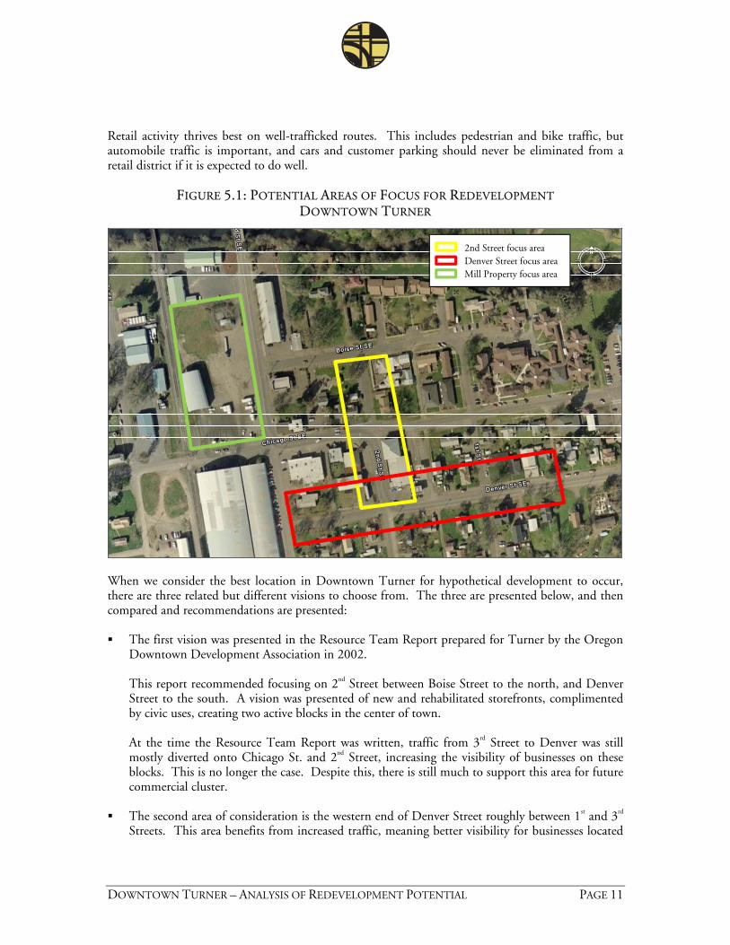
DOWNTOWN TURNER – ANALYSIS OF REDEVELOPMENT POTENTIAL PAGE 11
Retail activity thrives best on well-trafficked routes. This includes pedestrian and bike traffic, but automobile traffic is important, and cars and customer parking should never be eliminated from a retail district if it is expected to do well.
FIGURE 5.1: POTENTIAL AREAS OF FOCUS FOR REDEVELOPMENT
DOWNTOWN TURNER
2nd Street focus areaDenver Street focus areaMill Property focus area
When we consider the best location in Downtown Turner for hypothetical development to occur, there are three related but different visions to choose from. The three are presented below, and then compared and recommendations are presented: The first vision was presented in the Resource Team Report prepared for Turner by the Oregon
Downtown Development Association in 2002.
This report recommended focusing on 2nd Street between Boise Street to the north, and Denver Street to the south. A vision was presented of new and rehabilitated storefronts, complimented by civic uses, creating two active blocks in the center of town. At the time the Resource Team Report was written, traffic from 3rd Street to Denver was still mostly diverted onto Chicago St. and 2nd Street, increasing the visibility of businesses on these blocks. This is no longer the case. Despite this, there is still much to support this area for future commercial cluster.
The second area of consideration is the western end of Denver Street roughly between 1st and 3rd
Streets. This area benefits from increased traffic, meaning better visibility for businesses located
DOWNTOWN TURNER – ANALYSIS OF REDEVELOPMENT POTENTIAL PAGE 12
here. Over the long term this area could fill in with additional businesses creating a small shopping street as the main commercial cluster in Downtown Turner.
There are some disadvantages to this scenario, however. Current commercial uses in this area are somewhat dispersed, and separated by residential uses. For economic reasons discussed in the following section, there is no compelling reason to expect redevelopment of the homes along this stretch in the foreseeable future. Given this case, the vision of enough business development along these blocks to create a true town center atmosphere may be a long-term aspiration, requiring many decades of community growth.
The last potential area of focus is the large, mostly vacant parcel at the northwest corner of 3rd
and Chicago Streets. This parcel is owned by the adjacent mill operation, and owners have expressed interest in redeveloping in the past.
The combination of a large parcel with an interested owner, make this a compelling opportunity to develop a modest commercial center all at once, rather than relying on piecemeal redevelopment along 2nd or Denver Streets. Commercial space on this parcel could be oriented towards the corner of 3rd and Denver, creating a clustering affect with the Turner Market across the intersection, as well as the bank building across 3rd Street (currently vacant).
Comparison of Potential Redevelopment Areas Private real estate development tends to occur piecemeal and in a sometimes unpredictable sequence, due to the differences in ownership, property condition, value of the current use, etc. It is important to keep in mind the limitations the public sector faces in causing development to occur in any preferred manner. However, visioning and planning is an essential city function, and provides a framework to imagine and guide community growth. Turner should consider these potential redevelopment possibilities, and consider how future civic building investments, street improvements, and other public investment might influence development choices in the future. In considering the three potential scenarios described above, JOHNSON GARDNER recommends
continued focus on 2nd Street between Boise and Denver for commercial planning purposes. This is a compact area, with existing vacant parcels and buildings and a history of commercial use. It provides a small canvass on which to focus attention.
While Denver Street would not be the focus, any future commercial development on this strip would of course be beneficial to the overall Downtown core. For planning purposes, the property at the northwest corner of Denver and 2nd, which currently features a surface parking lot and vacant warehouse structure, would be a key location to tie Denver and 2nd together.
To improve the business environment, public improvements should be considered which continue to encourage car traffic to turn onto Chicago and 2nd Streets, rather than turning directly onto 3rd from Denver and vice versa. That intersection could perhaps be emphasized as a truck route.
DOWNTOWN TURNER – ANALYSIS OF REDEVELOPMENT POTENTIAL PAGE 13
Future civic improvements, such as a new City Hall, police station, library, or the like should be focused around these blocks to compliment the commercial businesses and generate visitors and activities in the area.
The large mill parcel at 3rd Street and Chicago Street presents a different sort of opportunity, which is the development of a significant amount of new commercial space at once, in one location, rather than gradual redevelopment of multiple parcels. Given the estimated amount of commercial square footage that can be absorbed in Turner over the next decade, such a development may well account for most or all of it, dampening the prospects for other commercial properties. At the same time, it could bring new retail and services to Downtown and is still located near the current commercial hub which includes the market and Turner Inn.
This redevelopment opportunity at the large mill-owned parcel, and the potential for redevelopment along 2nd Street must be understood to exist in tandem. Due to the limited amount of commercial activity in central Turner, either could bring needed services and shopping options, however each development scenario may also slow the realization of the others.
VI. REGULATORY IMPACTS ON REDEVELOPMENT Zoning A review of the City of Turner Development Code does not reveal any significant regulatory barriers to redevelopment in central Turner. The “General Commercial Zone” is flexible enough to allow for a range of retail and office development in the Downtown area. The City employs brief code language to establish permissible uses and basic development standards, followed by Site Plan Review and Planning Commission review of development specifics. The larger parcel, owned by the mill operation, is currently zoned M1 for industrial use. For a retail/commercial development to happen here would require a rezone to allow this use. Site Plan Review Plan review is an important city function which ensures that new development meets the community’s standards and goals. It is important to remember that for a private developer, the time spent in review and receiving the applicable permits quite literally costs money. The property under development is often secured with a loan, or with an option-to-purchase which the developer must pay even in the predevelopment phase. Therefore, one of the simplest ways for a local government to encourage development is to encourage transparency and predictability in the application, review and permitting process to the greatest extent possible. The current process in Turner is somewhat informal, without clearly defined standards for the development itself, and for the materials the applicant is expected to provide. A more formal, well-defined process would help create predictability and remove subjectivity from the review process for developers. The creation of new standards, forms, and procedures should still be balanced with the need to keep the process as streamlined as possible. Particularly in a slow development environment such as Turner, it is best to send the signal that the process will be as efficient as possible. Public Investment Decisions Finally, the investment decisions made by the city, county or other local jurisdiction can affect private redevelopment decisions. This can be through direct incentives, such as waivers of
DOWNTOWN TURNER – ANALYSIS OF REDEVELOPMENT POTENTIAL PAGE 14
development fees, development subsidy programs or the like, but these measures are hard to achieve in smaller communities due to funding issues. A simpler approach is to ensure that the public improvement decisions that are made focus on the areas where the community would like to see redevelopment take place. Decisions from where to plant street trees or install a bench, to where to locate a new City Hall should take a strategic look at where you would like to focus attention of the private business and development communities.
VII. CONCLUSIONS JOHNSON GARDNER foresees the potential for the robust growth rate that Turner has
experienced since 2000 to continue into the future. As the community grows with new households, there will be greater demand for small-scale retail and commercial services serving the local area.
Households in the area tend to have a relatively high average income for Marion County, and have significant buying power. Currently, most of this spending is taking place outside of the Turner area. Some retail categories require larger markets to freeway locations, and are therefore not realistic in Turner. But there is still excellent potential for businesses in Turner (existing and new) to catch a share of the spending that is currently “leaking” out of the community.
JOHNSON GARDNER estimates that Turner could support roughly 10,000 to 15,000 square feet of new business over the next ten years. These business would be located both in existing and new commercial properties.
The lack of recent property sales in the Downtown area complicates the task of estimating land and property values. The presence of vacant land and structures denotes a current shortage of economic uses for these properties, which depresses achievable values and rents through oversupply.
Under the current conditions, redevelopment in central Turner is likely to take the form of rehabilitation and reuse of existing properties, as the most cost effective way to provide rentable space.
As Turner grows, new development will become more feasible. In the near future, new development in Downtown Turner is likely to be single-story, wood-frame construction, reliant on surface and/or street parking for customers and employees. Two-story structures are possible, and will become more likely as central Turner builds new commercial activity over the long-term, which will spur the need for more density.
We recommend that 2nd Street between Boise Street and Denver Street remain the focus of town center planning efforts, as recommended in the 2002 Resource Team Report. In addition, the larger vacant parcel at 3rd and Chicago owned by the mill operation offers a possible redevelopment site. Due to the limited amount of commercial activity in central Turner, either could bring needed services and shopping options, however each development scenario may also slow the realization of the other.
The “General Commercial Zone” is flexible enough to allow for a range of retail and office development in the Downtown area. One of the simplest ways for a local government to encourage development is to remove uncertainty and subjectivity from the permitting and approval process, to the greatest extent possible. A well-defined, formal application and review procedure removes costly time and uncertainty for developers and makes them aware of the standards they must meet, the documents they must provide, and how the process will precede.
DOWNTOWN TURNER – ANALYSIS OF REDEVELOPMENT POTENTIAL PAGE 15
The community should also consider how public investment, from street improvements to a new City Hall, can strategically focus attention of private business and developers on key blocks.
Appendix C
Community Shopping Survey
Turner Downtown Improvement Plan Memorandum
Turner Downtown Improvement Plan Survey Response Report December 31, 2008
17355 SW Boones Ferry Rd. Lake Oswego, OR 97035
Phone (503) 635-3618 Fax (503) 635-5395
Project Team:
David Siegel, FAICP Jennifer Mannhard, AICP
Amanda Owings, P.E. Warren Greaser
Brendan Buckley
Johnson Gardner , LLC
The attached report prepared by Johnson Gardner provides the results of the Community Shopping Survey for both residents and employees and incorporates comments received on the draft version. Submission of this memorandum completes subtask 2.8 of the Work Order Contract. Attachments Johnson Gardner Report on Survey Results
To: Naomi Zwerdling, Senior Planner, ODOTDavid Sawyer, City Administrator, Turner
From: Jennifer Mannhard, Senior Planner, Otak
Date: December 31, 2008
Subject: Final Survey Report Deliverable 2.H Turner Downtown Improvement Plan
319 SW Washington Street, Suite 1020 Portland, OR 97204 503/295-7832 503/295-1107 (fax)
MEMORANDUM
DATE: December 29, 2008 PREPARED FOR: The City of Turner, Oregon 7250 3rd Street SE
Turner, OR 97392 FROM: JOHNSON GARDNER, LLC SUBJECT: Report on the Results of Surveys of Turner Residents and Employees
Report on Survey Results This memorandum discusses the results of a brief survey administered to residents and employees in Turner, Oregon. This memo is one component of a larger multi-disciplinary project considering the revitalization of the Downtown from urban planning and economic perspectives. The project is funded by the SAFETEA-LU act, with additional support from the State of Oregon through the Transportation & Growth Management program. The survey was designed to gauge the interest of local residents and employees in various small-format retail and commercial service categories in the Downtown Turner area. The survey was distributed to Turner residents by mail, and to local businesses which agreed to participate. There were 155 responses from residents and 73 responses from the employees of local businesses. While the surveys for residents and employees are similar to each other, they do differ somewhat. The responses from residents and employees are presented separately below, with brief discussion of the significance of the results. Summary of Conclusions
There is strong interest among both residents and employees in Turner for more retail or commercial service options.
Most agree it is needed or “desperately needed.” Only a small percentage feel that no more options are needed.
Most respondents live within walking distance of central Tuner. When ranking potential retail/service types, residents have fairly well distributed preferences.
Food service options, a bank, drugstore, or hardware store were the most preferred. In additional comments the need for a grocery store, fast food and a full-service library were cited.
Employees tend to rank any potential new food service options highly, and other types of retail/services less so.
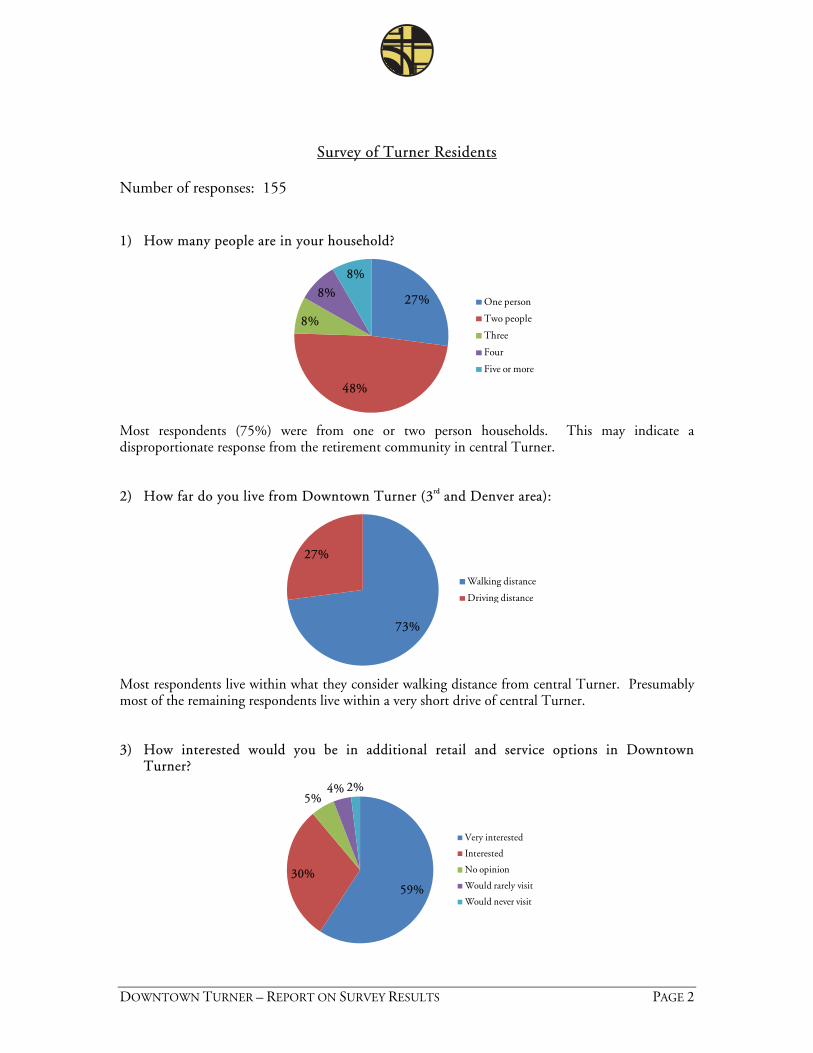
DOWNTOWN TURNER – REPORT ON SURVEY RESULTS PAGE 2
Survey of Turner Residents Number of responses: 155 1) How many people are in your household?
27%
48%
8%
8%
8%
One person
Two people
Three
Four
Five or more
Most respondents (75%) were from one or two person households. This may indicate a disproportionate response from the retirement community in central Turner. 2) How far do you live from Downtown Turner (3rd and Denver area):
73%
27%
Walking distance
Driving distance
Most respondents live within what they consider walking distance from central Turner. Presumably most of the remaining respondents live within a very short drive of central Turner. 3) How interested would you be in additional retail and service options in Downtown
Turner?
59%30%
5%4% 2%
Very interested
Interested
No opinion
Would rarely visit
Would never visit
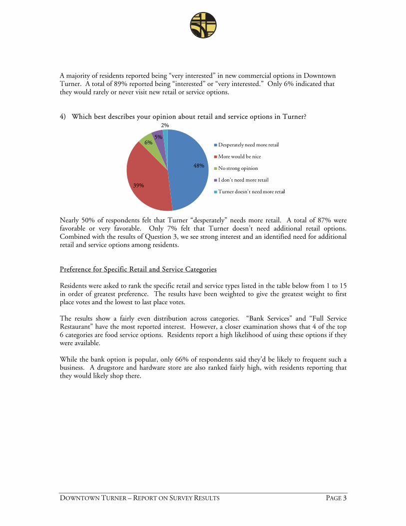
DOWNTOWN TURNER – REPORT ON SURVEY RESULTS PAGE 3
A majority of residents reported being “very interested” in new commercial options in Downtown Turner. A total of 89% reported being “interested” or “very interested.” Only 6% indicated that they would rarely or never visit new retail or service options. 4) Which best describes your opinion about retail and service options in Turner?
48%
39%
6%5%
2%
Desperately need more retail
More would be nice
No strong opinion
I don't need more retail
Turner doesn't need more retail
Nearly 50% of respondents felt that Turner “desperately” needs more retail. A total of 87% were favorable or very favorable. Only 7% felt that Turner doesn’t need additional retail options. Combined with the results of Question 3, we see strong interest and an identified need for additional retail and service options among residents. Preference for Specific Retail and Service Categories Residents were asked to rank the specific retail and service types listed in the table below from 1 to 15 in order of greatest preference. The results have been weighted to give the greatest weight to first place votes and the lowest to last place votes. The results show a fairly even distribution across categories. “Bank Services” and “Full Service Restaurant” have the most reported interest. However, a closer examination shows that 4 of the top 6 categories are food service options. Residents report a high likelihood of using these options if they were available. While the bank option is popular, only 66% of respondents said they’d be likely to frequent such a business. A drugstore and hardware store are also ranked fairly high, with residents reporting that they would likely shop there.
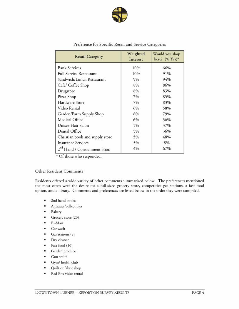
DOWNTOWN TURNER – REPORT ON SURVEY RESULTS PAGE 4
Preference for Specific Retail and Service Categories
Bank Services 10% 66%Full Service Restaurant 10% 91%Sandwich/Lunch Restaurant 9% 94%Café/ Coffee Shop 8% 86%Drugstore 8% 83%Pizza Shop 7% 85%Hardware Store 7% 83%Video Rental 6% 58%Garden/Farm Supply Shop 6% 79%Medical Office 6% 36%Unisex Hair Salon 5% 37%Dental Office 5% 36%Christian book and supply store 5% 48%Insurance Services 5% 8%
2nd Hand / Consignment Shop 4% 67%
* Of those who responded.
Retail CategoryWeighted Interest
Would you shop here? (% Yes)*
Other Resident Comments Residents offered a wide variety of other comments summarized below. The preferences mentioned the most often were the desire for a full-sized grocery store, competitive gas stations, a fast food option, and a library. Comments and preferences are listed below in the order they were compiled.
2nd hand books
Antiques/collectibles
Bakery
Grocery store (20)
Bi-Mart
Car wash
Gas stations (8)
Dry cleaner
Fast food (10)
Garden produce
Gun smith
Gym/ health club
Quilt or fabric shop
Red Box video rental
DOWNTOWN TURNER – REPORT ON SURVEY RESULTS PAGE 5
Lumber yard
Roller rink
Public transportation
Youth center
Arcade for kids
Auto/truck repair
Car lot
Community center
Dollar Stores
Farmers market
Ice cream shop
Lawn mower repair
Library (6)
Mexican food restaurant
Motel
Oriental restaurant
Pet grooming
Veterinarian One strip mall would accommodate all the goods and services I have indicated. Most people I believe (myself
included) would frequently shop at a central place, strip mall. 24 hr market, 24 hr gas station, movie/dinner theater (northern lights style), indoor swimming pool, athletic
club (Courthouse), golf course All of these businesses listed would be a great asset. Transportation of some kind - those of us who no longer
drive are pretty well stranded. Thank you for all you have done. Looking forward to some of these suggestions
All or anything would be good - I know you are trying hard to get our town going. I appreciate your efforts! Automotive repair, café with daily specials for breakfast, lunch, dinner. Any business is going to have a hard
time competing when we have a Wal-mart on Mission Street in Salem. Need cooperation from property owners in downtown section to lower their rent. No business can get started if renting or leasing fee is so excessive.
Clothing boutiques, general retail bookstore, large grocery store, library, ice cream parlor, sports park, car wash
Computer repair Dance classes or exercise classes for kids and adults; maybe even as a Chemeketa Community College
location. Day care center or Montessori school Desperately need library services!! If Turner could negotiate an arrangement with Salem Library for full
service access it would greatly improve my quality of life. Currently only 1 book or tape at a time is too restrictive! A 20 minute drive to North Salem is required to return one book and get another. Could Turner find a better arrangement for Library Services?
Drop box to pay phone bills/garbage bills (we do not have a computer!!) How about and "old fashioned" drug store that would have a counter and stools - selling milk shakes--cokes--a friendly place where kids, parents, grandparents could meet?
Have already had all the choices but they did not get enough support to stay here; too close to Salem
I really appreciate CARTS service, Our thoughts and prayers are with this community.
Knick, knack shops (like Sisters, OR), chocolate shop
Large chain like Safeway, Roth's, or Alberstons. If this was included on the list would be my No. 1
Local family doctor of ophthalmology
DOWNTOWN TURNER – REPORT ON SURVEY RESULTS PAGE 6
Organic grocery; not so expensive place to eat; coffee shop like "Rosie's" in Mill City sit down, not drive through - that would be great, instead of driving into Salem for a date night with my husband
Place for family's and/or kids to gather Public basketball court/tennis court/picnic area. It would be nice to have a place to eat after a ball game at
Cascade and a place for the kids to hang out after games. Would be great to have a place to have breakfast on Sunday mornings. The restaurant could even offer delivery service to Turner residents.
Since most people living in Turner, who work outside the home, drive to Salem daily, how would Turner be able to support ANY of the above mentioned business? We shop in Salem where prices are lowest for the things we need. We already have places to get a quick gallon of milk, etc. in a pinch. What would happen to the existing businesses if you brought in others? You might be putting them out of business. It doesn't seem very neighborly to me! If people wanted easy access to these services, it would be cheaper for them to live in Salem. Let's keep Turner special; a small town.
Since Turner is the start of the Silver Creek Falls route, it would be nice to start transitioning the community towards an art community like Sisters, Oregon. Difficult task and probably not achievable, but with the traffic that goes through here, you think we could make Turner more of a tourism community which would be good for all retail businesses.
Something for kids
Sports tournaments at the old park again - would use bank services depending on what bank it was We have to go to Salem or Stayton. It would be great to be able to bank and shop in Turner. The older
people would sure use a bank and drug store. Most don't drive! The folks most apt to use the businesses listed above are those younger than myself who still garden and or
need a hardware store or carpenter. Thrift and gift shop (consignment) since we don't have the flea market at the retirement homes anymore Turner is just the right size now, we don't need more traffic, noise, nor crime. No new housing nor
development. Update Burkland Park with more things for kinds to play on (swings, etc.)
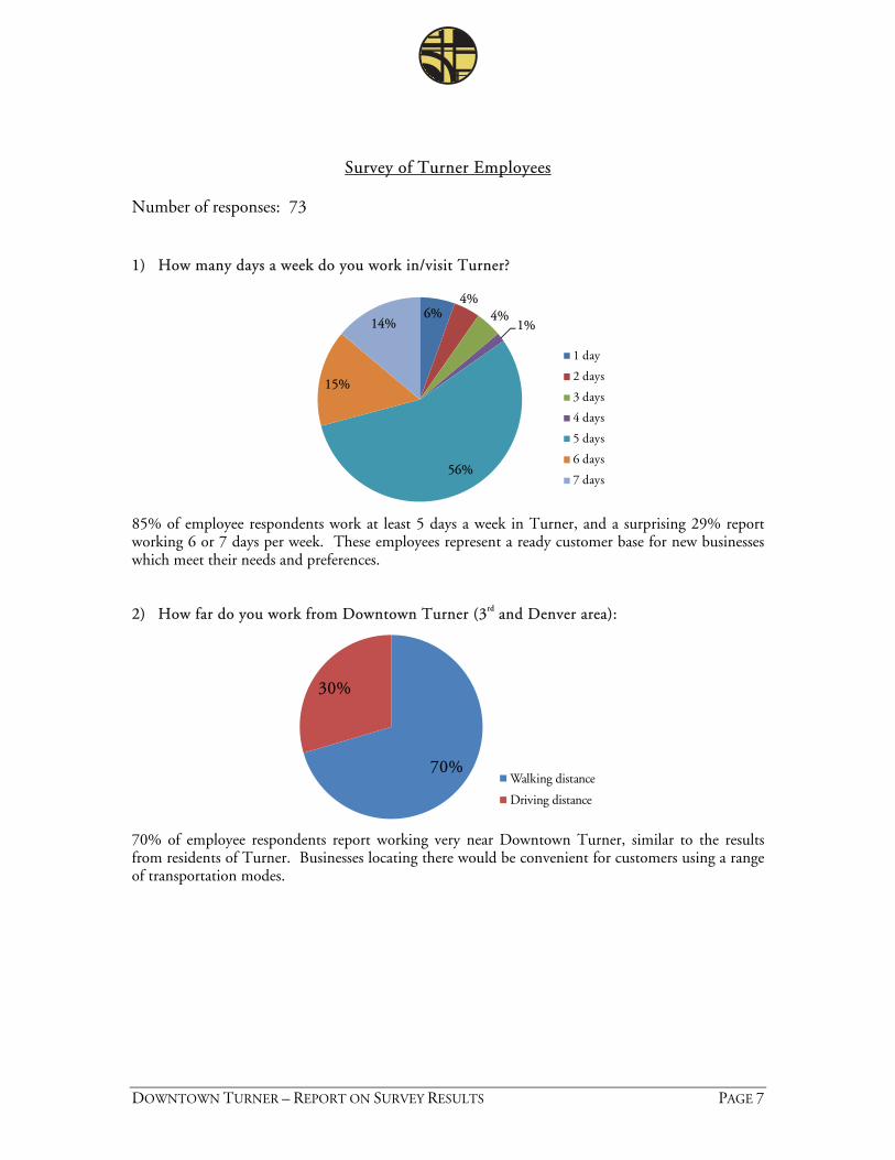
DOWNTOWN TURNER – REPORT ON SURVEY RESULTS PAGE 7
Survey of Turner Employees Number of responses: 73 1) How many days a week do you work in/visit Turner?
6%4%
4%1%
56%
15%
14%
1 day
2 days
3 days
4 days
5 days
6 days
7 days
85% of employee respondents work at least 5 days a week in Turner, and a surprising 29% report working 6 or 7 days per week. These employees represent a ready customer base for new businesses which meet their needs and preferences. 2) How far do you work from Downtown Turner (3rd and Denver area):
70%
30%
Walking distance
Driving distance
70% of employee respondents report working very near Downtown Turner, similar to the results from residents of Turner. Businesses locating there would be convenient for customers using a range of transportation modes.
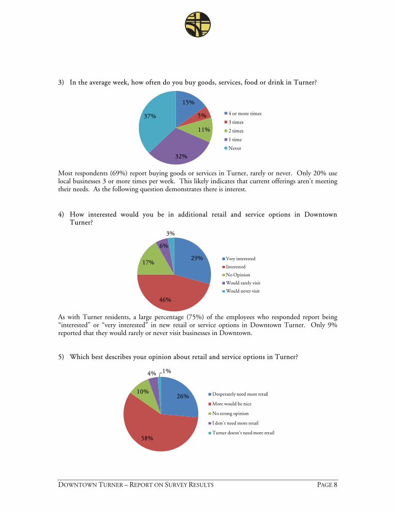
DOWNTOWN TURNER – REPORT ON SURVEY RESULTS PAGE 8
3) In the average week, how often do you buy goods, services, food or drink in Turner?
15%
5%
11%
32%
37% 4 or more times
3 times
2 times
1 time
Never
Most respondents (69%) report buying goods or services in Turner, rarely or never. Only 20% use local businesses 3 or more times per week. This likely indicates that current offerings aren’t meeting their needs. As the following question demonstrates there is interest. 4) How interested would you be in additional retail and service options in Downtown
Turner?
29%
46%
17%
6%
3%
Very interested
Interested
No Opinion
Would rarely visit
Would never visit
As with Turner residents, a large percentage (75%) of the employees who responded report being “interested” or “very interested” in new retail or service options in Downtown Turner. Only 9% reported that they would rarely or never visit businesses in Downtown. 5) Which best describes your opinion about retail and service options in Turner?
26%
58%
10%
4% 1%
Desperately need more retail
More would be nice
No strong opinion
I don't need more retail
Turner doesn't need more retail
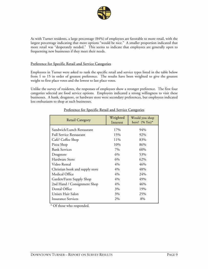
DOWNTOWN TURNER – REPORT ON SURVEY RESULTS PAGE 9
As with Turner residents, a large percentage (84%) of employees are favorable to more retail, with the largest percentage indicating that more options “would be nice.” A smaller proportion indicated that more retail was “desperately needed.” This seems to indicate that employees are generally open to frequenting new businesses if they meet their needs. Preference for Specific Retail and Service Categories Employees in Turner were asked to rank the specific retail and service types listed in the table below from 1 to 15 in order of greatest preference. The results have been weighted to give the greatest weight to first place votes and the lowest to last place votes. Unlike the survey of residents, the responses of employees show a stronger preference. The first four categories selected are food service options. Employees indicated a strong willingness to visit these businesses. A bank, drugstore, or hardware store were secondary preferences, but employees indicated less enthusiasm to shop at such businesses.
Preference for Specific Retail and Service Categories
Sandwich/Lunch Restaurant 17% 94%Full Service Restaurant 15% 92%Café/ Coffee Shop 11% 83%Pizza Shop 10% 86%Bank Services 7% 60%Drugstore 6% 53%Hardware Store 6% 62%Video Rental 4% 46%Christian book and supply store 4% 48%Medical Office 4% 24%Garden/Farm Supply Shop 4% 49%2nd Hand / Consignment Shop 4% 46%Dental Office 3% 19%Unisex Hair Salon 3% 25%Insurance Services 2% 8%
* Of those who responded.
Retail CategoryWeighted Interest
Would you shop here? (% Yes)*
DOWNTOWN TURNER – REPORT ON SURVEY RESULTS PAGE 10
Other Employee Comments Employees offered a other comments, though fewer than residents and with less detail. The preferences mentioned the most often were the desire for fast food restaurants and a grocery store.
Animal clinic Book store (2) Donut shop Fast food (12) Gift shop Grocery store (6) Library (2) Museum (2) Propane fuel Sport store Youth center Bakery Coffee shop Convenience store Theme buildings (i.e., all old west, like Sisters or all English Tudor, Bavarian), Weekly Farmers
Market, Boutique gift/local artist store (catering to locals and Aldersgate Conference Center, visitors)
Wal-mart (Borders), Drugstore (Walgreens) A better convenient store like a 7-11 or Circle K with more options. A library or even a bookmobile; a coffee shop open after 3pm so people could stop on the way
home from work Bi-Mart, Office Supplies Burger King Good fast food, Circle K or 7-11 More lunch options More lunch options such as fast food Pizza Hut, Starbucks Places to eat lunch/dinner Understands and expects to pay more for goods and services but quality of goods matters a lot. Want a Bank only if its WAMU. Want a Garden/Farm Supply if they have what they need at good
price like Wilco. Would never shop in town because of the number of warnings and tickets written; several people
avoid Turner at all costs for this reason. Would never invite a friend to this town.
Appendix D
Memorandum No. 3 – Vision, Goals, and Policies
Turner Downtown Improvement Plan Memorandum #3 – Vision, Goals, and Policies
Turner Downtown Improvement Plan Final Memo #3 – Vision, Goals, and Policies - March 3, 2009 L:\Project\14800\14840\Planning\Task 4 - Goals and Policies\Turner Final Memo3 - 030309.doc
17355 SW Boones Ferry Rd. Lake Oswego, OR 97035
Phone (503) 635-3618 Fax (503) 635-5395
Project Team:
David Siegel, FAICP Jennifer Mannhard, AICP
Amanda Owings, P.E. Warren Greaser
Brendan Buckley
Johnson Reid , LLC
This memorandum states the vision, goals, and policies for the Downtown Improvement Plan. The contents were reviewed and discussed by the City Council, Planning Commission, and Project Advisory Committee at the downtown planning work session on February 26, 2009. The vision, goals, and policies are based on the Improvement Plan work to date including the Existing Conditions and Redevelopment Potential memorandums, Community Shopping Survey Response Report, the Project Advisory Committee meeting, and Public Event #1. This revised version also incorporates comments received from the participants of the work session and insight gleaned from the stakeholder interviews. The vision statement is a synopsis of the community’s values for long term development. The supporting goals and policies frame how that vision can be achieved through urban design, land use, transportation, redevelopment, and economic development. The vision, goals, and policies will be used to guide the development of specific concepts and strategies for the Downtown Improvement Plan.
To: Naomi Zwerdling, Senior Planner, ODOT David Sawyer, City Administrator, Turner
From: Jennifer Mannhard, Senior Planner, Otak Brendan Buckley, Senior Associate, Johnson-Reid
Date: March 3, 2009
Subject: Final Memo #3 – Plan Goals and Policies Turner Downtown Improvement Plan Deliverable 4.D
Page 2
Turner Downtown Improvement Plan Final Memo #3 – Vision, Goals, and Policies – March 3, 2009 L:\Project\14800\14840\Planning\Task 4 - Goals and Policies\Turner Final Memo3 - 030309.doc
Vision: Downtown Turner will be a complete community with a small town feel. It will continue to be “a good neighbor town” where residents are familiar and children are safe to ride their bicycles around town. Downtown Turner will be the heart of the community and boast plentiful amenities and activities year-round. Respecting the past and the future, downtown Turner will celebrate its history while providing an economically viable place to do business and shop, attracting new employment opportunities, residents, and visitors.
Goals and Policies: Urban Design: To create an attractive small town environment that facilitates community activity and interaction for all ages.
Downtown Turner should be the center of the community. It should contain a space that is considered the “heart” of town.
Open space should be incorporated into the design. The space could be a park, plaza, amphitheater, event pavilion, or a combination of these. It should allow for community gathering and events like a festival or farmers’ market.
The streetscape should build upon the recent improvements to 3rd and Denver Streets and include pedestrian amenities such as benches, decorative lighting, fountains and trees.
A greenway should be developed along the creek or at specific points and should include a walking and biking pathway.
Gateways should be developed at the two main entrances to downtown. Destinations to enliven downtown should be centrally located. These could include a new
bandstand, dance hall, civic center, museum, library, or relocated city hall. The urban design and arrangement of spaces and buildings in downtown should use history as
an inspiration, enable community activities, and provide a sense of identity and continuity. Land Use: To allow and encourage a mix of uses to create a complete downtown. Retail and office uses should be allowed throughout the downtown area. Residential uses should be preserved and augmented. Mixed commercial and residential buildings, such as a shop below or in front of a home, should
be allowed and encouraged throughout the area. Light industrial uses should be limited to the area along 3rd Street. These industrial uses should
be allowed to have a commercial component, such as a retail outlet or showroom, on their property.
Zoning should provide for maximum flexibility. Transportation: To create a safe and inviting multi-modal transportation system and circulation. The entire downtown area should have accessible and continuous sidewalks for pedestrians,
including marked crosswalks at appropriate locations.
Page 3
Turner Downtown Improvement Plan Final Memo #3 – Vision, Goals, and Policies – March 3, 2009 L:\Project\14800\14840\Planning\Task 4 - Goals and Policies\Turner Final Memo3 - 030309.doc
A well-designed parking lot should be incorporated into downtown for school, pool, and other community events. Street parking should be designed to maximize pedestrian and bicycle safety.
Bike lanes should be limited to the lanes provided on 3rd and Denver Streets but be augmented with routes to the school and new community facilities located in the “heart” of downtown.
Encourage bicycle transportation to local attractions/trip generators by installing bicycle parking amenities.
Vehicle and truck circulation has been improved with the upgrades to 3rd and Denver Streets and should be considered along with pedestrian and bicycle circulation in the development of new parking and community uses.
Expand transit options in association with pedestrian amenities at trip generators. A plan for infrastructure maintenance and upgrades should be developed to keep the streets and
pedestrian and bicycle amenities in top shape. Limit through traffic on interior streets. Create a pedestrian network. Downtown should be a pedestrian hub from which paths originate
and link with existing paths. A walking or multi-use path should be added along the creek as part of this network.
Redevelopment: To infill vacant land and redevelop vacant, underutilized, or dilapidated structures to create a more inviting and active environment. The community’s vision for building character and streetscape should be clear to those
undertaking development projects. The City should establish and communicate a clear development application process, with
standardized steps and forms. Subjectivity should be removed from the development review process to the extent possible. Development charges and fees should be reasonable and not deter development. Public investment should be focused on those areas where redevelopment is most desired. Public space enhancements should add value to surrounding properties, and facilitate visibility
for businesses, and multi-modal traffic and parking. Economic Development: To maintain and capitalize on small town advantages while attracting new businesses to the area. The broader community identity or theme in Turner should be clear to business people
considering locating there. The City should maintain and provide up-to-date basic information about the local workforce
and a town profile. An on-going partnership, with regular meetings, should be formed between officials, the
community, local businesspeople. Redevelopment and refurbishment of older buildings should be encouraged to the extent
possible.
Page 4
Turner Downtown Improvement Plan Final Memo #3 – Vision, Goals, and Policies – March 3, 2009 L:\Project\14800\14840\Planning\Task 4 - Goals and Policies\Turner Final Memo3 - 030309.doc
There should be promotion and outreach to local residents encouraging them to use local businesses.
Identify and pursue possible funding programs which help businesses locate and thrive in Turner.
Create a long-term plan and incremental strategy to reduce flooding and resulting hazards and damage to downtown.
Provide incentives to current businesses to contribute to plan implementation. Increase visibility and street presence of existing businesses.
Appendix E
Memorandum No. 4 – Strategies for the Project Area
Turner Downtown Improvement Plan
Memorandum #4 – Strategies for Project Area
Turner Downtown Improvement Plan
Final Memo #4 – Strategies for Project Area – June 9, 2009
L:\Project\14800\14840\Planning\Task 5 - Recommendations\Turner Draft Memo4-060909.doc
17355 SW Boones Ferry Rd.
Lake Oswego, OR 97035
Phone (503) 635-3618
Fax (503) 635-5395
Project Team:
David Siegel, FAICP
Jennifer Mannhard, AICP
Amanda Owings, PE
Brendan Buckley
Johnson Reid, LLC
The purpose of this memorandum is to describe the strategies that will
achieve the vision and goals for the downtown Turner project area.
The strategies are characterized by the related themes of urban design,
land use, transportation, redevelopment, and business development.
They are informed by the Existing Conditions, Redevelopment
Potential, Vision, Goals and Policies memorandums, Shopping Survey
Response Report, Stakeholder Interviews Report, and input received
at public events. The substance of this memorandum will be the
foundation for the Draft Plan and Draft Implementation Strategy
documents.
This memorandum is organized into subheadings by strategy. Each strategy and its overarching goal
are presented in detail, using bulleted lists of descriptive action items targeted to achieve the goal.
The culmination of the effort within the four strategy areas are consolidated in the Implementation
Strategies section, accompanied by illustrative plans and a practical matrix. The programmatic
details directed at business and community enterprises are described in an appendix (Appendix A) to
this memorandum, and satisfy the project’s scope of work requirement for a Strategic Business
Development Plan. This Strategic Business Development Plan identifies Downtown Turner’s
business development constraints and opportunities, discusses potential future retail opportunities,
and presents implementation strategies and tools for carrying out the business development
objectives of the Downtown Plan (see Appendix A).
To: David Sawyer, City Administrator, Turner
From: David Siegel, Principal, Otak
Date: June 9, 2009
Subject: Final Memo #4 – Strategies for Project Area
Turner Downtown Improvement Plan
Page 2
Turner Downtown Improvement Plan
Final Memo #4 – Strategies for Project Area – June 9, 2009
L:\Project\14800\14840\Planning\Task 5 - Recommendations\Turner Draft Memo4-060909.doc
The vision for Downtown Turner as it improves over the next 20-years was presented to and
approved by the attendees of the Downtown Planning Session on February 26, 2009 (see Public
Event #2 Summary). The vision states:
Downtown Turner will be a complete community with a small town feel. It will continue to be “a good neighbor town”
where residents are familiar and children are safe to ride their bicycles around town. Downtown Turner will be the
heart of the community and boast plentiful amenities and activities year-round. Respecting the past and the future,
downtown Turner will celebrate its history while providing an economically viable place to do business and shop,
attracting new employment opportunities, residents, and visitors.
The following recommendations are intended to implement this vision and the specific goals and
policies that support it. They include strategies that the City of Turner could implement immediately
or in the short term, as well as long-term ideas that will unfold over the 20-year planning horizon.
The recommendations generally fall into four categories:
• Maintain and upgrade the essential infrastructure, including pedestrian network, streets and
parking, and the water, sewer, and stormwater system.
• Create a distinct identity for downtown, enhancing infrastructure with quality amenities.
• Develop a civic presence and community places and activities.
• Support business retention, expansion and, recruitment.
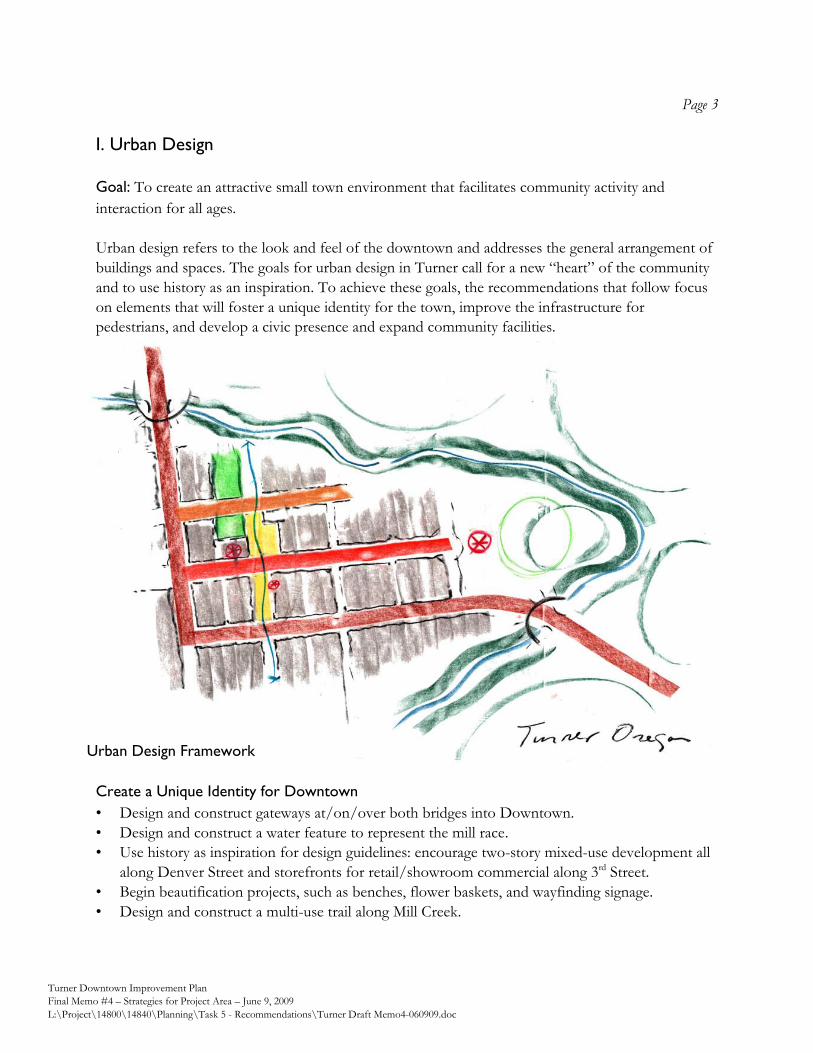
Page 3
Turner Downtown Improvement Plan
Final Memo #4 – Strategies for Project Area – June 9, 2009
L:\Project\14800\14840\Planning\Task 5 - Recommendations\Turner Draft Memo4-060909.doc
I. Urban Design
Goal: To create an attractive small town environment that facilitates community activity and
interaction for all ages.
Urban design refers to the look and feel of the downtown and addresses the general arrangement of
buildings and spaces. The goals for urban design in Turner call for a new “heart” of the community
and to use history as an inspiration. To achieve these goals, the recommendations that follow focus
on elements that will foster a unique identity for the town, improve the infrastructure for
pedestrians, and develop a civic presence and expand community facilities.
Create a Unique Identity for Downtown
• Design and construct gateways at/on/over both bridges into Downtown.
• Design and construct a water feature to represent the mill race.
• Use history as inspiration for design guidelines: encourage two-story mixed-use development all
along Denver Street and storefronts for retail/showroom commercial along 3rd Street.
• Begin beautification projects, such as benches, flower baskets, and wayfinding signage.
• Design and construct a multi-use trail along Mill Creek.
Urban Design Framework
Page 4
Turner Downtown Improvement Plan
Final Memo #4 – Strategies for Project Area – June 9, 2009
L:\Project\14800\14840\Planning\Task 5 - Recommendations\Turner Draft Memo4-060909.doc
Improve Infrastructure
• Improve street features and install sidewalks on Chicago, Boise, 1st, 2nd, and School Streets.
• Design and construct a drop off and improved streetscape for the pool and school building
entrance – coordinate with new angled street parking and a new parking lot improvements.
• Develop a pedestrian network that includes the alleys as pedestrian only connections, improved
sidewalks, and the proposed multi-use trail along the creek.
Develop a Civic Presence and Improve Community Facilities
• Create a “festival street” or plaza street that serves pedestrian-only traffic via gates or bollards,
yet can be opened to accommodate cars. Potential streets are 2nd Street from Denver to Boise
and on Boise from 2nd to 3rd Streets.
• Create a plaza or public square along the proposed 2nd Street festival street.
• Construct a new city hall and/or multi-use civic building near the plaza to create a “civic area.”
• Incorporate a public library as part of a new civic building or a separate building in the “civic
area.”
• Expand the pool into a community center facility.
II. Land Use
Goal: To allow and encourage a mix of uses to create a complete downtown.
Currently, the City of Turner has one commercial zone and an overlay that applies to the
commercially zoned lots downtown. The current designations do not provide the focus or flexibility
needed for redevelopment. Having the same commercial zoning applied to the 3rd Street corridor
north of the downtown also dilutes the focus needed for downtown. The following recommended
land use revisions are intended to support and implement the urban design and redevelopment
goals. The recommended zones provide specific areas of focus for different uses and create a
hierarchy of spaces within the downtown to capitalize on development and design opportunities.
Page 5
Turner Downtown Improvement Plan
Final Memo #4 – Strategies for Project Area – June 9, 2009
L:\Project\14800\14840\Planning\Task 5 - Recommendations\Turner Draft Memo4-060909.doc
Recommended Land Uses
• Create a mixed-use zone– allowing commercial, retail and residential – through Downtown east
of 3rd and focused on Denver Street. This creates a specific focus for the commercial core of the
city, while providing flexibility in the types of the establishments that can locate in the area. The
recommended land uses also provide an access corridor to the creek.
• For the area south of Denver Street, east of 2nd Street, and north of Mill Creek, the envisioned
future land uses include commercial uses fronting Denver Street, with the southerly portion of
those properties fronting Denver Street being developed into residential use over time. As
portions of this area are impacted by seasonal flooding, it may be necessary for portions of these
properties to be kept in a resource use or developed with a use compatible with seasonal
flooding conditions.
Page 6
Turner Downtown Improvement Plan
Final Memo #4 – Strategies for Project Area – June 9, 2009
L:\Project\14800\14840\Planning\Task 5 - Recommendations\Turner Draft Memo4-060909.doc
• Create a mixed-use zone – allowing employment, industrial, and retail – west of 3rd. This
maintains the opportunity for a large employment base while allowing for retail and/or
showroom type uses along 3rd Street to contribute to the commercial vitality of the area.
• Maintain Turner Retirement Homes and area around Elgin Street property as residential. It is
essential to maintain a resident population in the area to support new downtown investments.
• Create an institutional/civic zone for uses such as the school property and parks. The zone can
be expanded in the future to include new civic uses, such as city hall and a library.
• Revisit residential zoning designations and standards over time to phase out single family uses.
While residential uses are desired in the downtown, large lot single family uses should be phased
into more dense housing types over time to provide a larger and more diverse downtown
population to patronize services.
• Review land uses and zoning along 3rd street corridor with an eye toward determining what uses
are appropriate for this “gateway” into downtown Turner from the north.
III. Transportation
Goal: To create a safe and inviting multi-modal transportation system and circulation.
The downtown Turner area has a well-developed street pattern to accommodate circulation. The
elements needed to achieve the goal are spaces that are welcoming to pedestrians, bicyclists, and
visitors arriving by vehicle. Improvements to these elements, combined with the proper
maintenance of the existing street system, will enhance activity levels, boost the functionality, and
extend the longevity of downtown Turner.
Turner’s Transportation System Plan (TSP) outlines the functional classification for the roads within
the downtown study area. Currently, the plan classifies the streets accordingly:
Street Classification
3rd Street (Mill Creek to Denver), Denver Arterial
Chicago Street, School Avenue, 2nd Street (south of Denver) Collector
Boise, 2nd Street (north of Denver), 1st Street, Elgin, Fargo, Gaston, 3rd Street
(Denver to Gaston)
Standard Local
Transportation enhancements to downtown Turner do not require revisions to the TSP
classifications, with the exception of altering 2nd Street from a standard Local Street to a “Significant
Local Street.” The length of 2nd Street from Denver to Boise is the proposed location for a
retail/commercial center, civic area, and/or festival street. Significant Local Streets, such as 5th
Street, west of downtown, are “important to the community” due to their connectivity to desirable
destinations. Altering the designation of 2nd Street would give license to unique design selections.
Page 7
Turner Downtown Improvement Plan
Final Memo #4 – Strategies for Project Area – June 9, 2009
L:\Project\14800\14840\Planning\Task 5 - Recommendations\Turner Draft Memo4-060909.doc
For the remaining local streets, their designation shall remain as a standard section. As stated in the
TSP, there are two options for development of standard local streets. Considering that Turner’s
downtown will be a new destination, we recommend that the local streets north of Denver reflect
the 50-ft right-of-way design. The streets south of Denver, with a focus on residential use, may
consider the “skinny street” option with 40-ft right-of-way. The street sections provided in Figure 1
are concept drawings of what the future conditions may reveal.
Figure 1: Street Sections
Page 8
Turner Downtown Improvement Plan
Final Memo #4 – Strategies for Project Area – June 9, 2009
L:\Project\14800\14840\Planning\Task 5 - Recommendations\Turner Draft Memo4-060909.doc
The primary transportation enhancement will be the sidewalk and parking improvements. While
traffic volumes are currently low outside of the arterial route, safety of pedestrians and bicyclists is
compromised due to lack of sidewalks and improper crossing opportunities. As Turner grows or
attracts more visiting traffic, parking will also need revisions to maintain a level of safety and
efficiency. Protecting the existing traffic patterns and parking opportunities for residents is also a
factor in the balance of transportation needs; recommendations call for retaining all driveways and
alleys as streets develop. Establishing a festival street may temporarily restrict access to some
properties along 2nd Street.
The TSP may be revised to reflect all streets in the downtown area be improved with sidewalks. The
missing links in the sidewalk system would be eliminated for the future condition. The TSP may also
be updated to include multi-modal trails on the pedestrian and bicycle plan.
The aerial infrastructure along Turner’s street network provides electricity to the residents in the
immediate area as well as serving as a conduit to the outlying areas. As Turner finds land use
changes occurring throughout the downtown core, the aerial infrastructure will become more
intrusive on the landscape, impacting trees and building frontages as poles and guy anchors are
relocated. In the short term, the City can begin the process of undergrounding much of this
infrastructure through continuous communication and planning events with the primary utility
companies. With the long term goal of undergrounding the power and communication lines,
Turner’s downtown core can redevelop with a clean streetscape.
IV. Redevelopment
Goal: To infill vacant land and redevelop vacant, underutilized, or dilapidated structures to create a
more inviting and active environment.
Downtown Turner has a fair amount of vacant and underutilized space to offer. However,
redevelopment is not always viable from a market perspective, particularly in a difficult business
climate, where rent levels may not be high enough to compensate for major investment in a
property.
Under the current conditions, redevelopment in Downtown Turner is likely to take the form of rehabilitation and reuse of existing properties, as the most cost effective way to provide rentable space. As Turner grows, new development will become more feasible. In the near future, new development in Downtown Turner is likely to be single-story, wood-frame construction, reliant on surface and/or street parking for customers and employees. Two-story structures are possible, and will become more likely as Downtown Turner builds new commercial activity over the long-term, which will spur the need for more density.
Page 9
Turner Downtown Improvement Plan
Final Memo #4 – Strategies for Project Area – June 9, 2009
L:\Project\14800\14840\Planning\Task 5 - Recommendations\Turner Draft Memo4-060909.doc
The following are some potential strategies that Turner can pursue to improve the atmosphere for
redevelopment activity to occur.
Create a Unique Identity for Downtown
• Create Design Guidelines: Create a set of design guidelines which clearly and concisely describe
the vision for new and rehabilitated buildings in Central Turner (see Urban Design strategies).
Design guidelines should reflect the community’s vision, but keep additional building
requirements realistic and inexpensive for the developer.
Improve Infrastructure
• Develop a Property Improvement Program: Develop a façade, signage, and landscaping
improvement program for commercial and retail properties located in the study area. The
program should be designed to enhance existing buildings, storefronts, signs, etc., and could be
implemented as a low interest loan or matching grant program. The program should be directed
towards existing businesses or properties where such improvements are considered very likely to
attract businesses.
• Complete Public Infrastructure Projects: Implement the improvements to public infrastructure
(roads, sidewalks) as well as beautification initiatives (flower baskets, benches, street trees and
landscaping) described in this memorandum to the extent possible. Public investment
demonstrates to private property owners that the city is engaged and changes are taking place.
• Target Public Investment: Select a core area of commercial and civic concentration in which to
target public investment, programs, and community activities. As public resources are likely to
be limited for some time in Turner, it will be important to target limited improvements to those
blocks where change is most desired. Adjacent areas will experience positive overflow effects
from this area of concentration.
Support business retention, expansion and recruitment
• Examine Permitting Process: Examine the permitting process to optimize consistency, timing
and responsiveness, while reducing regulatory and paperwork burdens. The process should be
standardized to the extent possible, so that applicants are treated consistently, and subjectivity is
removed from the process. The required steps and paperwork of the application process should
be easily describable to applicants in a one-page checklist.
V. Business Development
Goal: To maintain and capitalize on small town advantages while attracting new businesses to the
area.
Turner has strong potential for the robust household growth it has experienced since 2000 to continue into the future. A growing customer base of households will be the greatest factor in increasing demand for small-scale retail and commercial services in the local area.
Page 10
Turner Downtown Improvement Plan
Final Memo #4 – Strategies for Project Area – June 9, 2009
L:\Project\14800\14840\Planning\Task 5 - Recommendations\Turner Draft Memo4-060909.doc
Households in the area tend to have a relatively high average income for Marion County, and have significant buying power. Currently, most of this spending is taking place outside of the Turner area. Some retail categories require larger markets to freeway locations, and are therefore not realistic in Turner. But there is still excellent potential for businesses in Turner (existing and new) to catch a share of the spending that is currently “leaking” out of the community.
Aside from retail and service businesses for the local community, Turner is a good location for
commercial service, construction, and manufacturing businesses seeking a location in the central
Willamette valley, with highly competitive property costs and relatively convenient access to the
regional transportation infrastructure.
Support business retention, expansion and recruitment
There are a number of recommended strategies for carrying out the overall business development
goal for maintaining and capitalizing on Downtown Turner’s small town advantages which attracting
new business, and these are presented and discussed in detail in Appendix A to this document, the
Strategic Business Development Plan.
VI. Initial Implementation Concepts
This section discusses potential concepts and strategies for carrying out the goals and objectives
discussed above. Information is provided in three components:
1. Long-term Improvement Plan
2. Short-term Improvement Plan
3. Initial Implementation Strategies
Long-term Improvement Plan
The diagram shown in Figure 2 depicts the full set of physical improvements and future land uses
recommended to be carried out overtime during the twenty-year planning period, as discussed
within the previous sections of this document.
Short-term Improvement Plan
Figure 3 depicts the subset of the physical improvements shown in the Long-term Improvement
Plan (Figure 2) that are suggested for completion within the short-term. These initial improvements
are recommended to be initiated or completed within the first six years following adoption of the
Downtown Improvement Plan.
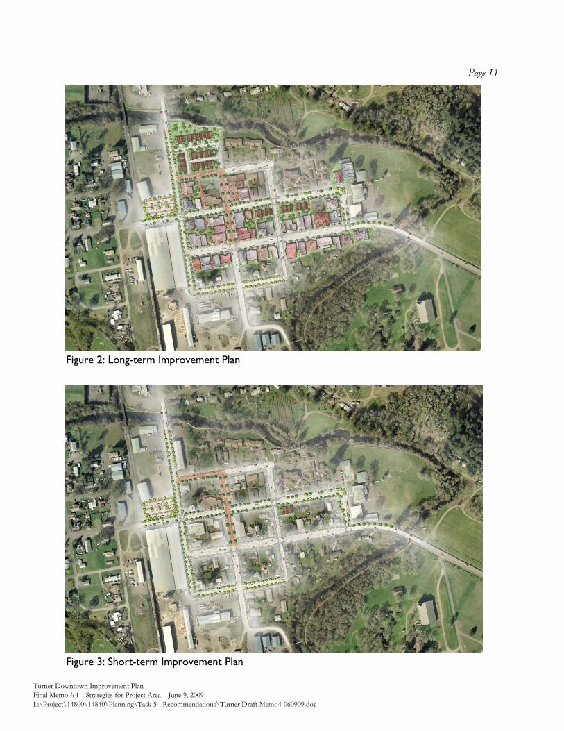
Page 11
Turner Downtown Improvement Plan
Final Memo #4 – Strategies for Project Area – June 9, 2009
L:\Project\14800\14840\Planning\Task 5 - Recommendations\Turner Draft Memo4-060909.doc
Figure 3: Short-term Improvement Plan
Figure 2: Long-term Improvement Plan
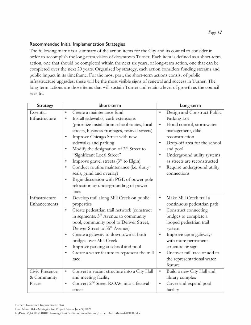
Page 12
Turner Downtown Improvement Plan
Final Memo #4 – Strategies for Project Area – June 9, 2009
L:\Project\14800\14840\Planning\Task 5 - Recommendations\Turner Draft Memo4-060909.doc
Recommended Initial Implementation Strategies
The following matrix is a summary of the action items for the City and its council to consider in
order to accomplish the long-term vision of downtown Turner. Each item is defined as a short-term
action, one that should be completed within the next six years, or long-term action, one that can be
completed over the next 20 years. Organized by strategy, each action considers funding streams and
public impact in its timeframe. For the most part, the short-term actions consist of public
infrastructure upgrades; these will be the most visible signs of renewal and success in Turner. The
long-term actions are those items that will sustain Turner and retain a level of growth as the council
sees fit.
Strategy Short-term Long-term
Essential
Infrastructure
• Create a maintenance fund
• Install sidewalks, curb extensions
(prioritize installation: school routes, local
streets, business frontages, festival streets)
• Improve Chicago Street with new
sidewalks and parking
• Modify the designation of 2nd Street to
“Significant Local Street”
• Improve gravel streets (3rd to Elgin)
• Conduct routine maintenance (i.e. slurry
seals, grind and overlay)
• Begin discussion with PGE of power pole
relocation or undergrounding of power
lines
• Design and Construct Public
Parking Lot
• Flood control, stormwater
management, dike
reconstruction
• Drop-off area for the school
and pool
• Underground utility systems
as streets are reconstructed
• Require underground utility
connections
Infrastructure
Enhancements
• Develop trail along Mill Creek on public
properties
• Create pedestrian trail network (construct
in segments: 3rd Avenue to community
pool, community pool to Denver Street,
Denver Street to 55th Avenue)
• Create a gateway to downtown at both
bridges over Mill Creek
• Improve parking at school and pool
• Create a water feature to represent the mill
race
• Make Mill Creek trail a
continuous pedestrian path
• Construct connecting
bridges to complete a
looped pedestrian trail
system
• Improve upon gateways
with more permanent
structure or sign
• Uncover mill race or add to
the representational water
feature
Civic Presence
& Community
Places
• Convert a vacant structure into a City Hall
and meeting facility
• Convert 2nd Street R.O.W. into a festival
street
• Build a new City Hall and
library complex
• Cover and expand pool
facility
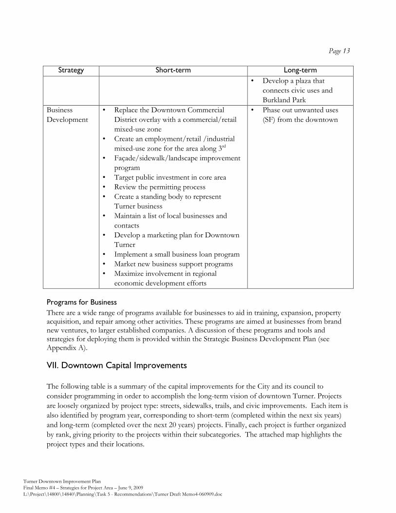
Page 13
Turner Downtown Improvement Plan
Final Memo #4 – Strategies for Project Area – June 9, 2009
L:\Project\14800\14840\Planning\Task 5 - Recommendations\Turner Draft Memo4-060909.doc
Strategy Short-term Long-term
• Develop a plaza that
connects civic uses and
Burkland Park
Business
Development
• Replace the Downtown Commercial
District overlay with a commercial/retail
mixed-use zone
• Create an employment/retail /industrial
mixed-use zone for the area along 3rd
• Façade/sidewalk/landscape improvement
program
• Target public investment in core area
• Review the permitting process
• Create a standing body to represent
Turner business
• Maintain a list of local businesses and
contacts
• Develop a marketing plan for Downtown
Turner
• Implement a small business loan program
• Market new business support programs
• Maximize involvement in regional
economic development efforts
• Phase out unwanted uses
(SF) from the downtown
Programs for Business
There are a wide range of programs available for businesses to aid in training, expansion, property acquisition, and repair among other activities. These programs are aimed at businesses from brand new ventures, to larger established companies. A discussion of these programs and tools and strategies for deploying them is provided within the Strategic Business Development Plan (see Appendix A).
VII. Downtown Capital Improvements
The following table is a summary of the capital improvements for the City and its council to
consider programming in order to accomplish the long-term vision of downtown Turner. Projects
are loosely organized by project type: streets, sidewalks, trails, and civic improvements. Each item is
also identified by program year, corresponding to short-term (completed within the next six years)
and long-term (completed over the next 20 years) projects. Finally, each project is further organized
by rank, giving priority to the projects within their subcategories. The attached map highlights the
project types and their locations.
Page 14
Turner Downtown Improvement Plan
Final Memo #4 – Strategies for Project Area – June 9, 2009
L:\Project\14800\14840\Planning\Task 5 - Recommendations\Turner Draft Memo4-060909.doc
Capital improvement costs were estimated as the total of construction cost, contingency and allied
costs. In creating this table, 2008 construction data from ODOT Region 2 contracts was used. The
associated costs include contractor mobilization, necessary traffic control and survey elements, and
construction materials. Planning-level contingencies were also added to the cost to address
preliminary character of the designs and the changing nature of construction. This contingency also
accounts for construction engineering, contract administration, legal, finance, and associated project
development costs. For those projects that were simply planning or design (no construction), the
cost reflects 15% of the proposed construction cost.
The cost estimates were for surface improvements only. Adjacent infrastructure upgrades or
detailed property improvements were not estimated. Further assumptions include:
• No right-of-way acquisition is included in this estimate of costs. Preliminary engineering will
include field survey to locate property lines.
• Geotechnical stability is adequate for all proposed improvements
• Hydraulic studies will be performed prior to or in conjunction with pedestrian bridge design.
• Environmental studies, including rare plant and threatened/endangered species, historical, and
archaeological, will be conducted under a separate phase prior to design for capital
improvements.
• Utility relocation will be addressed separately and prior to capital improvement construction
• Public utility upgrades will be handled through a separate funding source.
• Undergrounding of aerial utilities shall be designed and financed by individual utility companies.
• Estimates do not reflect reporting requirements pertaining to funding sources.
.
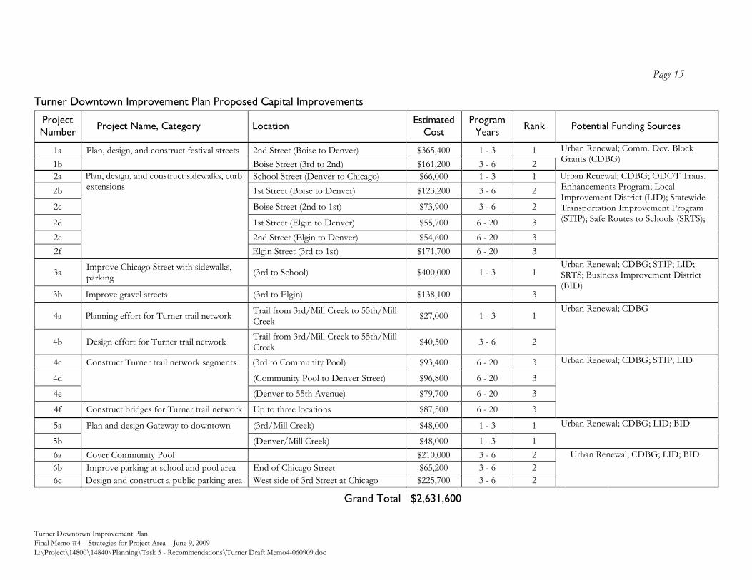
Page 15
Turner Downtown Improvement Plan
Final Memo #4 – Strategies for Project Area – June 9, 2009
L:\Project\14800\14840\Planning\Task 5 - Recommendations\Turner Draft Memo4-060909.doc
Turner Downtown Improvement Plan Proposed Capital Improvements
Project
Number Project Name, Category Location
Estimated
Cost
Program
Years Rank Potential Funding Sources
1a Plan, design, and construct festival streets 2nd Street (Boise to Denver) $365,400 1 - 3 1 Urban Renewal; Comm. Dev. Block Grants (CDBG)
1b Boise Street (3rd to 2nd) $161,200 3 - 6 2
2a Plan, design, and construct sidewalks, curb extensions
School Street (Denver to Chicago) $66,000 1 - 3 1 Urban Renewal; CDBG; ODOT Trans. Enhancements Program; Local Improvement District (LID); Statewide Transportation Improvement Program (STIP); Safe Routes to Schools (SRTS);
2b 1st Street (Boise to Denver) $123,200 3 - 6 2
2c Boise Street (2nd to 1st) $73,900 3 - 6 2
2d 1st Street (Elgin to Denver) $55,700 6 - 20 3
2e 2nd Street (Elgin to Denver) $54,600 6 - 20 3
2f Elgin Street (3rd to 1st) $171,700 6 - 20 3
3a Improve Chicago Street with sidewalks, parking
(3rd to School) $400,000 1 - 3 1 Urban Renewal; CDBG; STIP; LID; SRTS; Business Improvement District (BID)
3b Improve gravel streets (3rd to Elgin) $138,100 3
4a Planning effort for Turner trail network Trail from 3rd/Mill Creek to 55th/Mill Creek
$27,000 1 - 3 1 Urban Renewal; CDBG
4b Design effort for Turner trail network Trail from 3rd/Mill Creek to 55th/Mill Creek
$40,500 3 - 6 2
4c Construct Turner trail network segments (3rd to Community Pool) $93,400 6 - 20 3 Urban Renewal; CDBG; STIP; LID
4d (Community Pool to Denver Street) $96,800 6 - 20 3
4e (Denver to 55th Avenue) $79,700 6 - 20 3
4f Construct bridges for Turner trail network Up to three locations $87,500 6 - 20 3
5a Plan and design Gateway to downtown (3rd/Mill Creek) $48,000 1 - 3 1 Urban Renewal; CDBG; LID; BID
5b (Denver/Mill Creek) $48,000 1 - 3 1
6a Cover Community Pool $210,000 3 - 6 2 Urban Renewal; CDBG; LID; BID
6b Improve parking at school and pool area End of Chicago Street $65,200 3 - 6 2
6c Design and construct a public parking area West side of 3rd Street at Chicago $225,700 3 - 6 2
Grand Total $2,631,600
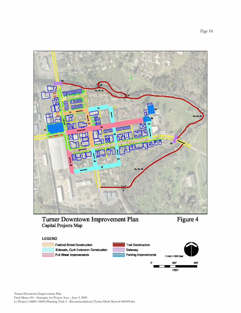
Page 16
Turner Downtown Improvement Plan
Final Memo #4 – Strategies for Project Area – June 9, 2009
L:\Project\14800\14840\Planning\Task 5 - Recommendations\Turner Draft Memo4-060909.doc
319 SW Washington Street, Suite 1020 Portland, OR 97204 503/295‐7832 503/295‐1107 (fax)
APPENDIX A:
STRATEGIC BUSINESS DEVELOPMENT PLAN
DOWNTOWN TURNER, OREGON
319 SW Washington Street, Suite 1020 Portland, OR 97204 503/295-7832 503/295-1107 (fax)
STRATEGIC BUSINESS DEVELOPMENT PLAN DOWNTOWN TURNER, OREGON
MAY 2009
I. INTRODUCTION
This document presents a succinct Plan to aid in the development of existing and new businesses in the City of Turner, Oregon. This memorandum represents a compilation of findings and recommendations related to business development that have been completed over the course of the larger Downtown planning effort. These findings are combined here with specific objectives and recommendations aimed at business development. The recommendations presented in this Plan are designed to be as practical as possible, reflecting what is realistic and achievable in a city the size of Turner, with the human and financial resources available. The document first discusses findings on business market conditions and potential small business types in Downtown Turner. It then progresses into an Implementation Strategy, which addresses the specific objectives and recommended action items of this business development plan. It is organized as follows:
I. INTRODUCTION 1
II. SUMMARY OF MARKET OPPORTUNITIES AND CONSTRAINTS 2
III. POTENTIAL RETAIL AND COMMERCIAL SERVICE MIX 3
IV. IMPLEMENTATION STRATEGY 5
V. IMPLEMENTATION TOOLS FOR BUSINESS: TABLE 9
VI. IMPLEMENTATION TOOLS FOR PUBLIC FUNDING: TABLE 14
VII. FOCUS ON URBAN RENEWAL 20
DOWNTOWN TURNER – STRATEGIC BUSINESS DEVELOPMENT PLAN Page 2
II. SUMMARY OF MARKET OPPORTUNITIES AND CONSTRAINTS
This section summarizes the major conclusions of Memorandum 2: “Analysis of Redevelopment Potential”, presented previously as part of the Downtown Improvement Planning process. Based on our analysis of market conditions in and around Downtown Turner we find positive indicators for the addition of new business over the coming years. The following is a summary of the conclusions presented in that report:
The potential for the robust growth rate that Turner has experienced since 2000 is likely to continue into the future. As the community grows with new households, there will be greater demand for small-scale retail and commercial services serving the local area.
Households in the area tend to have a relatively high average income for Marion County, and have significant buying power. Currently, most of this spending is taking place outside of the Turner area.
Some retail categories require larger markets and prefer freeway locations, and are therefore not realistic in Turner. But there is still excellent potential for businesses in Turner (existing and new) to catch a share of the spending that is currently “leaking” out of the community. (See suggested Retail Mix below).
In addition to local households, there are additional sources of potential spending in Turner, including year-round employees and visitors to the local faith-based meeting and retreat centers.
Our estimates indicate that Turner could support roughly 10,000 to 15,000 square feet of new business over the next ten years. These businesses would be located both in existing and new commercial properties.
Under the current conditions, redevelopment in central Turner is likely to take the form of rehabilitation and reuse of existing properties, as this is the most cost effective way to provide rentable space.
As Turner grows, new development will become more feasible. In the near future, new development in Downtown Turner is likely to be single-story, wood-frame construction, reliant on surface and/or street parking for customers and employees. Two-story structures are possible, and will become more likely as central Turner builds new commercial activity over the long-term, which will spur the need for more density.
DOWNTOWN TURNER – STRATEGIC BUSINESS DEVELOPMENT PLAN Page 3
III. POTENTIAL RETAIL AND COMMERCIAL SERVICE MIX Downtown is a good location for small-scale retail and services which serve the residents and employees in the immediate Turner area. The existing businesses provide a good core of commercial activity in central Turner. They are all located relatively near each other on Chicago and Denver Streets. This section concentrates on retail and businesses providing commercial services directly to customers and does not include the economic development of manufacturing or industrial businesses. (These are addressed to some extent in the Implementation Strategies section below.) Growing Into Retail It is very difficult for any local area to capture all, or even a majority of the spending by local households, be it in a small town or a neighborhood in a large city. The variety and quantity of household expenditures is too great. However, capturing even a modest share of the spending that is currently leaving the area can amount to a significant amount of business, particularly in a smaller market. The best way to think about this potential spending is not that the Turner community should attempt to capture large portions of it all at once, but rather that this supports a healthy reservoir that strategic small businesses can take advantage of over the next five to ten years. Combined with the projected growth in the number of households over this time, there is good potential to generate new business in Downtown Turner over that timeframe. Local Preferences As part of the larger Downtown Improvement Planning process, a survey was submitted to Turner residents and employees regarding their perceptions and preferences for needed businesses in Turner. The survey elicited a total of 228 responses. By the way of summary: There is strong interest among both residents and employees in Turner for more retail or
commercial service options. Most agree it is needed or “desperately needed.” Only a small percentage feels that no more
options are needed. In general, residents and employees in Turner must leave the city in order to obtain many basic services such as banking or full-service grocery.
Most respondents live within walking distance of central Turner. When ranking potential retail/service types, residents have fairly well distributed
preferences. Food service options, a bank, drugstore, or hardware store were the most preferred. In additional comments the need for a grocery store, fast food and a full-service library were cited.
Employees tend to rank any potential new food service options highly, and other types of retail/services less so.
Local Potential Turner has stronger potential to attract some types of businesses than others, in the five-to-ten year timeframe. Due to its size and location off of the major highway system, the city will have some difficulty adding some types of shops and services until the number of local households grows significantly.
DOWNTOWN TURNER – STRATEGIC BUSINESS DEVELOPMENT PLAN Page 4
Because the business mix in a community is ultimately determined by countless separate decisions by multiple entrepreneurs and customers, it is impossible to plan for a specific future business mix and have it come to fruition. However, our analysis of local spending, growth, and preferences can inform some recommendations on businesses which will have stronger potential than others. In general, those recommended below are those which can serve a small market the size of Turner, while those indentified as weak candidates, generally need a larger market area to serve.
Stronger Candidates Weaker Candidates
Full service restaurant Sandwich/lunch restaurant
(one has recently been opened) Sit-down café/coffee shop Ice cream/candy shop Independent video rental Local general practice doctor Local insurance agent Modest library branch Farmers market Veterinarian Hardware/garden/farm supply shop
Bank services Full grocery store Fast food franchise Dry cleaner Motel Dental office Drugstore Dollar store Book store
DOWNTOWN TURNER – STRATEGIC BUSINESS DEVELOPMENT PLAN Page 5
IV. IMPLEMENTATION STRATEGY
This section represents the action-oriented portion of this Strategic Business Development Plan. It outlines specific objectives related to growing existing businesses and attracting new ones to Downtown Turner. This Plan focuses mainly on the types of retail and commercial service businesses which will fit into the Downtown environment, but many of the recommendations found here would also contribute positively to development of industrial and/or office-type businesses.
The following is a list of recommended action items to address business development. Each recommendation is followed by a description, and a list of possible funding sources if appropriate. (The funding sources mentioned are all detailed in the following two sections of this report, which provide detailed tables on programs available for businesses, and sources of public funding, respectively.) Recommendation 1: Study Feasibility of Urban Renewal in Turner Undertake a feasibility study of the formation of an Urban Renewal Area in Turner. This district or districts may include up to 15% of the total land area in Turner. Urban Renewal is a key public financing tool available to jurisdictions in Oregon. It provides for keeping the future growth in property tax revenue within the district itself, to accomplish the goals of an adopted Urban Renewal Plan. The goal of forming an Urban Renewal Area (URA) that encompasses Downtown Turner would be to provide for a dedicated source of funding to spend on projects identified in the Downtown Improvement Plan, as well as those identified in this Strategic Business Development Plan. In general, Urban Renewal revenues must be used to make physical improvements to public and private property.
The first step in this process is for the community and its governing body to decide to pursue an Urban Renewal study, and delineate the basic preliminary outline of the district.
The next step is to identify funding for an Urban Renewal Feasibility Study which examines existing conditions, determine if the area meets the statutory definition of “blighted” and generate estimates of possible revenue from the URA.
If the Feasibility Study is positive, an official Urban Renewal Plan and Report must be written and adopted to establish the URA and specify its goals.
As this is a key recommendation of this Plan, a separate section discussing Urban Renewal is provided below, as part of the discussion of available funding tools. See “Section IV: Focus on Urban Renewal” below for more detail. Potential Funding Source: The Regional Investment Fund (MWVCOG) offers assistance in creation of Urban Renewal Areas.
DOWNTOWN TURNER – STRATEGIC BUSINESS DEVELOPMENT PLAN Page 6
Recommendation 2: Create a Standing Body to Represent Turner Business Form a standing body of local business people to discuss and represent the business community in Turner. This organization could range from a new Chamber of Commerce representing Turner and perhaps one or more adjacent cities, to a smaller less-formal group of Central Turner business owners. This body should have active participation in future steering committees for the Downtown and/or the implementation of the Downtown Improvement Plan. Potential Funding Sources: These types of community building activities are longest lasting if self-organized by the business members themselves. However, some assistance is available for organizing, and possible start-up costs. Currently, members of the Turner community are participating with the Ford Family Foundation of Roseburg, Oregon on community-building activities. They provide one source of assistance in community organizing. The Marion County Video Lottery Grant is another potential funding source. An Economic Improvement District, if established, could cover some organizing and marketing costs, as could an annual business license fee. Generally, the city should facilitate these efforts by offering meeting space and perhaps office resources to aid private members of the business community in organizing. Recommendation 3: Maintain a List of Local Businesses Maintain a current list of business owners and property owners in Turner, complete with mailing and emailing information, and estimated employment level if available. Entries on the list might be categorized by location (Downtown Turner, 3rd Street, etc.) Potential Funding Source: Costs are minimal. This list should be maintained by the local business organization as part of their on-going duties. Pending the establishment of a business organization, City staff should compile such a list and update it quarterly or semi-annually.
Recommendation 4: Develop a Marketing Plan for Downtown Turner The marketing plan can begin simply with outreach to residents and surrounding communities to
promote existing community events such as the Lamb and Wool Show. Marketing efforts should
address how to leverage such existing draws as the festival, the creek, or the swimming pool into
increased visibility and business for Downtown Turner.
As the marketing plan will be representing Turner to the broader region, it should be a collaboration of the efforts of the local business organization and the community. Potential Funding Sources: If an organized body, such as a Chamber of Commerce is formed, it might undertake these efforts with its own resources. A grant from the Ford Family Foundation is one potential resource for this type of effort. The Marion County Video Lottery Grant is another potential funding source. An Economic Improvement District, if established, could cover some organizing, operational, and marketing costs, as could an annual business license fee.
DOWNTOWN TURNER – STRATEGIC BUSINESS DEVELOPMENT PLAN Page 7
Recommendation 5: Continue Participation in the Oregon Main Street Program Turner has recently been selected for participation in the Oregon Main Street Program at the
“Exploring Downtown” level. The Main Street Approach is an established national approach to
revitalization of core commercial districts. Over the coming years, Turner should pursue moving to
the “Transforming Downtown” level which can provide technical assistance in implementing many
of the strategies recommended here.
Potential Funding Source: The Oregon Main Street Program (State of Oregon)
Recommendation 6: Implement a Property Improvement Program Develop a façade, signage and landscaping improvement program for commercial and retail
properties located in the study area. The program should be designed to enhance existing
buildings, storefronts, signs, etc., and could be implemented as a low interest loan or matching
grant program. The program should be directed towards existing businesses or properties where
such improvements are considered very likely to attract businesses
Low visibility and insufficient signage were identified as issues in Central Turner. In combination
with the creation of “gateways” to the area, improved business visibility will help establish
Downtown Turner as its own place.
Potential Funding Source: Grant programs or Revolving Loan Funds must be capitalized at the outset. Such improvement programs are often funded through Urban Renewal programs such as the one recommended above. Community Development Block Grants, or local improvement districts, can also provide a source of funding to establish a revolving loan fund.
Recommendation 7: Implement a Small or Micro-Business Loan Program Establish a Revolving Loan Fund (RLF) designed to assist City businesses with financing needs for
small business development, with funds available for real estate property acquisition, construction
or rehabilitation, development and mitigation fees, working capital/lines of credit, equipment
purchase, furniture and fixtures, and architectural and engineering services. Their capital base,
once it has been depleted, is replenished by principal repayments, interest income, and fees, which
are then loaned again. Loan Funds are an important source of financing for microenterprises and
small businesses that are unable to obtain credit from commercial lenders.
Potential Funding Source: Revolving Loan Funds must be capitalized at the outset. Such improvement programs are often funded through Urban Renewal programs such as the one recommended above. Community Development Block Grants, or local improvement districts, can also provide a source of funding to establish a revolving loan fund.
DOWNTOWN TURNER – STRATEGIC BUSINESS DEVELOPMENT PLAN Page 8
Recommendation 8: Market Business Support Programs Expand awareness and/or availability of business support programs. Create a list of programs
available to local business people, be it on the federal, state, regional or local level. Such programs
take the form of tax incentives, loan or grant programs, and training or education programs. Some
programs are available to existing businesses, while others are geared towards creating new jobs.
Potential Funding Source: Costs of maintaining a list should be minimal. This list should be maintained by the local business organization or by city staff. An annual business license fee could be a source of revenue to help fund this activity. The following section of this report “Implementation Tools for Businesses” provides such a list of programs. The Mid-Willamette Valley Council of Government is another important regional resource for economic development information. Active marketing or dissemination of these resources may be undertaken by the local business organization or city.
Recommendation 9: Maximize Involvement in Regional Economic Development Efforts Turner should maintain an active involvement in any economic development programs
administered by the Mid-Willamette Valley Council of Governments, and Marion County. MWVCOG
serves as the regional administrator for multiple federal and state economic development
programs. Turner officials should keep abreast of what initiatives are being undertaken, and what
programs are available regionally, and ensure that Turner is represented in any regional marketing
efforts, inventories of available lands, and the like.
Potential Funding Source: No costs other than staff time.
DOWNTOWN TURNER – STRATEGIC BUSINESS DEVELOPMENT PLAN Page 9
V. IMPLEMENTATION TOOLS FOR BUSINESS
The following table presents a wide range of program available for businesses to aid in training, expansion, property acquisition and repair, among other activities. These programs are aimed at businesses ranging from brand new ventures, to larger established companies. Programs from the federal, state, regional and county level are represented. There are two major sources for Economic Development assistance in the Turner area. One source is the State of Oregon which offers programs to aid in economic development across the state. These programs are generally administered through the Oregon Economic & Community Development Department (http://econ.oregon.gov), which offers options both to businesses and communities. The other major source for Economic Development is the Mid-Willamette Valley Council of Governments (www.mwvcog.org). MWVCOG serves as a central contact for businesses and governments in Marion, Polk and Yamhill counties seeking economic development assistance. This regional body is a designated Economic Development District for the administration of federal Economic Development Administration programs, as well as a designated Regional Investment Board for the administration of state Regional Investment Fund and Rural Investment Fund. (These programs are technically administered by the MWV Community Development Partnership, housed and staffed by MWVCOG.) The list below is meant to serve as an introduction and general description of these programs.
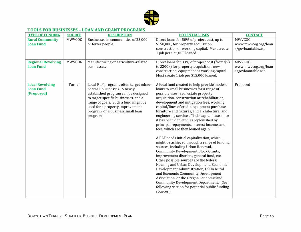
DOWNTOWN TURNER – STRATEGIC BUSINESS DEVELOPMENT PLAN Page 10
TOOLS FOR BUSINESSES – LOAN AND GRANT PROGRAMS TYPE OF FUNDING SOURCE DESCRIPTION POTENTIAL USES CONTACT
Rural Community Loan Fund
MWVCOG Businesses in communities of 25,000 or fewer people.
Direct loans for 50% of project cost, up to $150,000, for property acquisition, construction or working capital. Must create 1 job per $25,000 loaned.
MWVCOG: www.mwvcog.org/loans/govloantable.asp
Regional Revolving Loan Fund
MWVCOG Manufacturing or agriculture-related businesses.
Direct loans for 33% of project cost (from $5k to $300k) for property acquisition, new construction, equipment or working capital. Must create 1 job per $15,000 loaned.
MWVCOG: www.mwvcog.org/loans/govloantable.asp
Local Revolving Loan Fund (Proposed)
Turner Local RLF programs often target micro- or small businesses. A newly established program can be designed to target specific businesses, and a range of goals. Such a fund might be used for a property improvement program, or a business small loan program.
A local fund created to help provide modest loans to small businesses for a range of possible uses: real estate property acquisition, construction or rehabilitation, development and mitigation fees, working capital/lines of credit, equipment purchase, furniture and fixtures, and architectural and engineering services. Their capital base, once it has been depleted, is replenished by principal repayments, interest income, and fees, which are then loaned again. A RLF needs initial capitalization, which might be achieved through a range of funding sources, including Urban Renewal, Community Development Block Grants, improvement districts, general fund, etc. Other possible sources are the federal Housing and Urban Development, Economic Development Administration, USDA Rural and Economic Community Development Association, or the Oregon Economic and Community Development Department. (See following section for potential public funding sources.)
Proposed
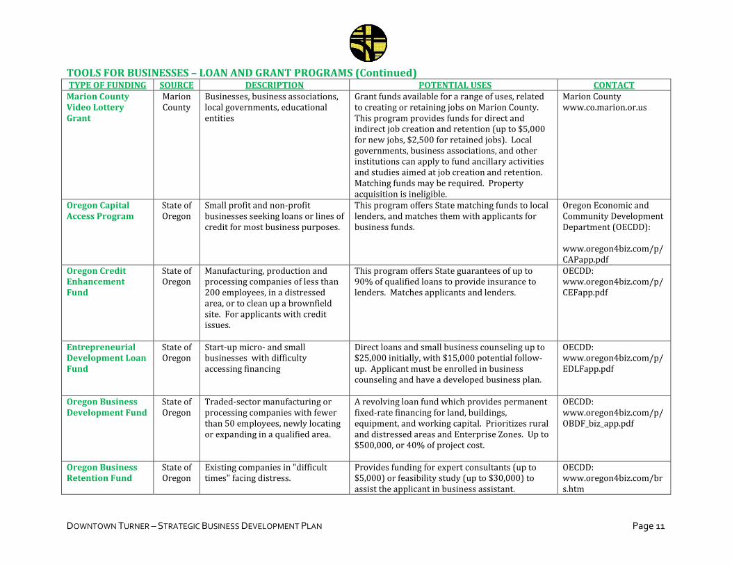
DOWNTOWN TURNER – STRATEGIC BUSINESS DEVELOPMENT PLAN Page 11
TOOLS FOR BUSINESSES – LOAN AND GRANT PROGRAMS (Continued) TYPE OF FUNDING SOURCE DESCRIPTION POTENTIAL USES CONTACT
Marion County Video Lottery Grant
Marion County
Businesses, business associations, local governments, educational entities
Grant funds available for a range of uses, related to creating or retaining jobs on Marion County. This program provides funds for direct and indirect job creation and retention (up to $5,000 for new jobs, $2,500 for retained jobs). Local governments, business associations, and other institutions can apply to fund ancillary activities and studies aimed at job creation and retention. Matching funds may be required. Property acquisition is ineligible.
Marion County www.co.marion.or.us
Oregon Capital Access Program
State of Oregon
Small profit and non-profit businesses seeking loans or lines of credit for most business purposes.
This program offers State matching funds to local lenders, and matches them with applicants for business funds.
Oregon Economic and Community Development Department (OECDD): www.oregon4biz.com/p/CAPapp.pdf
Oregon Credit Enhancement Fund
State of Oregon
Manufacturing, production and processing companies of less than 200 employees, in a distressed area, or to clean up a brownfield site. For applicants with credit issues.
This program offers State guarantees of up to 90% of qualified loans to provide insurance to lenders. Matches applicants and lenders.
OECDD: www.oregon4biz.com/p/CEFapp.pdf
Entrepreneurial Development Loan Fund
State of Oregon
Start-up micro- and small businesses with difficulty accessing financing
Direct loans and small business counseling up to $25,000 initially, with $15,000 potential follow-up. Applicant must be enrolled in business counseling and have a developed business plan.
OECDD: www.oregon4biz.com/p/EDLFapp.pdf
Oregon Business Development Fund
State of Oregon
Traded-sector manufacturing or processing companies with fewer than 50 employees, newly locating or expanding in a qualified area.
A revolving loan fund which provides permanent fixed-rate financing for land, buildings, equipment, and working capital. Prioritizes rural and distressed areas and Enterprise Zones. Up to $500,000, or 40% of project cost.
OECDD: www.oregon4biz.com/p/OBDF_biz_app.pdf
Oregon Business Retention Fund
State of Oregon
Existing companies in "difficult times" facing distress.
Provides funding for expert consultants (up to $5,000) or feasibility study (up to $30,000) to assist the applicant in business assistant.
OECDD: www.oregon4biz.com/brs.htm
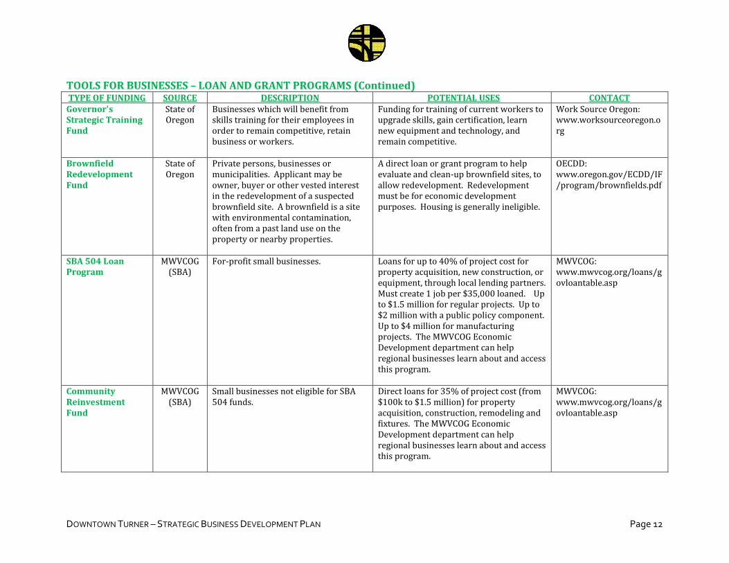
DOWNTOWN TURNER – STRATEGIC BUSINESS DEVELOPMENT PLAN Page 12
TOOLS FOR BUSINESSES – LOAN AND GRANT PROGRAMS (Continued) TYPE OF FUNDING SOURCE DESCRIPTION POTENTIAL USES CONTACT
Governor's Strategic Training Fund
State of Oregon
Businesses which will benefit from skills training for their employees in order to remain competitive, retain business or workers.
Funding for training of current workers to upgrade skills, gain certification, learn new equipment and technology, and remain competitive.
Work Source Oregon: www.worksourceoregon.org
Brownfield Redevelopment Fund
State of Oregon
Private persons, businesses or municipalities. Applicant may be owner, buyer or other vested interest in the redevelopment of a suspected brownfield site. A brownfield is a site with environmental contamination, often from a past land use on the property or nearby properties.
A direct loan or grant program to help evaluate and clean-up brownfield sites, to allow redevelopment. Redevelopment must be for economic development purposes. Housing is generally ineligible.
OECDD: www.oregon.gov/ECDD/IF/program/brownfields.pdf
SBA 504 Loan Program
MWVCOG (SBA)
For-profit small businesses. Loans for up to 40% of project cost for property acquisition, new construction, or equipment, through local lending partners. Must create 1 job per $35,000 loaned. Up to $1.5 million for regular projects. Up to $2 million with a public policy component. Up to $4 million for manufacturing projects. The MWVCOG Economic Development department can help regional businesses learn about and access this program.
MWVCOG: www.mwvcog.org/loans/govloantable.asp
Community Reinvestment Fund
MWVCOG (SBA)
Small businesses not eligible for SBA 504 funds.
Direct loans for 35% of project cost (from $100k to $1.5 million) for property acquisition, construction, remodeling and fixtures. The MWVCOG Economic Development department can help regional businesses learn about and access this program.
MWVCOG: www.mwvcog.org/loans/govloantable.asp
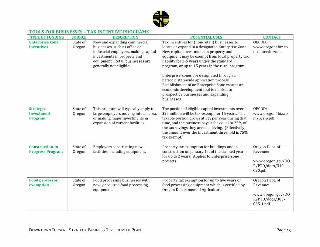
DOWNTOWN TURNER – STRATEGIC BUSINESS DEVELOPMENT PLAN Page 13
TOOLS FOR BUSINESSES – TAX INCENTIVE PROGRAMS TYPE OF FUNDING SOURCE DESCRIPTION POTENTIAL USES CONTACT
Enterprise zone incentives
State of Oregon
New and expanding commercial businesses, such as office or industrial employers, making capital investments in property and equipment. Retail businesses are generally not eligible.
Tax incentives for (non-retail) businesses to locate or expand in a designated Enterprise Zone. New capital investments in property and equipment may be exempt from local property tax liability for 3-5 years under the standard program, or up to 15 years in the rural program. Enterprise Zones are designated through a periodic statewide application process. Establishment of an Enterprise Zone creates an economic development tool to market to prospective businesses and expanding businesses.
OECDD: www.oregon4biz.com/enterthezones
Strategic Investment Program
State of Oregon
This program will typically apply to large employers moving into an area, or making major investments in expansion of current facilities.
The portion of eligible capital investments over $25 million will be tax-exempt for 15 years. The taxable portion grows at 3% per year during that time, and the business pays a fee equal to 25% of the tax savings they area achieving. (Effectively, the amount over the investment threshold is 75% tax exempt.)
OECDD: www.oregon4biz.com/p/sip.pdf
Construction-in-Progress Program
State of Oregon
Employers constructing new facilities, including equipment.
Property tax exemption for buildings under construction on January 1st of the claimed year, for up to 2 years. Applies to Enterprise Zone projects.
Oregon Dept. of Revenue: www.oregon.gov/DOR/PTD/docs/310-020.pdf
Food processor exemption
State of Oregon
Food processing businesses with newly acquired food processing equipment.
Property tax exemption for up to five years on food processing equipment which is certified by Oregon Department of Agriculture.
Oregon Dept. of Revenue: www.oregon.gov/DOR/PTD/docs/303-085-1.pdf
DOWNTOWN TURNER – STRATEGIC BUSINESS DEVELOPMENT PLAN Page 14
VI. IMPLEMENTATION TOOLS FOR PUBLIC FUNDING
The following table presents a wide range of funding and financing mechanisms available for a local jurisdiction like Turner to pursue the types of improvements described in this memo. Physical improvements to transportation, streetscapes, public and private facilities can be costly and take the investment of money, time and community dedication to make a reality. By considering which of these mechanisms might be feasible in Downtown Turner, the community can begin to predict the amount and type of resources which might be available, which will greatly aid in prioritizing and completing individual projects. As with the business programs discussed above, the tools described below come from a variety of levels including state, regional, and potential local actions. The following table presents an introduction and description of each funding tool. This section is followed by a more in-depth overview of Tax Increment Financing (Urban Renewal) as a specifically recommended tool for Downtown Turner.
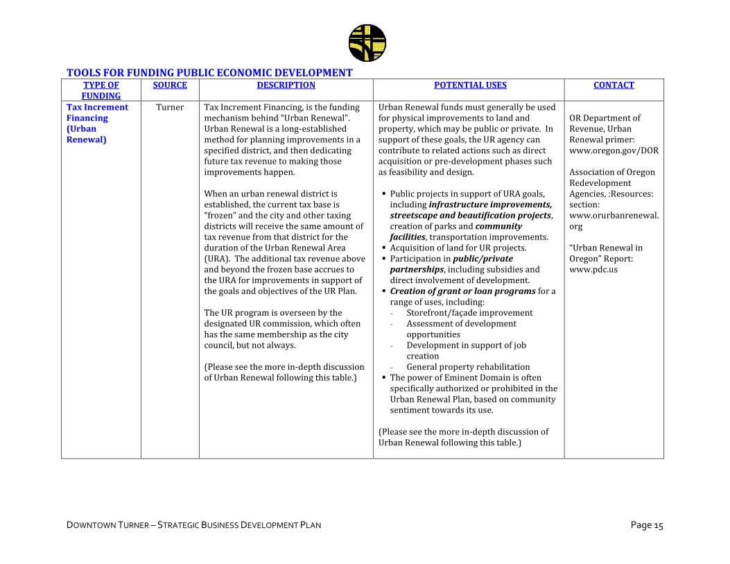
DOWNTOWN TURNER – STRATEGIC BUSINESS DEVELOPMENT PLAN Page 15
TOOLS FOR FUNDING PUBLIC ECONOMIC DEVELOPMENT TYPE OF FUNDING
SOURCE DESCRIPTION POTENTIAL USES CONTACT
Tax Increment Financing (Urban Renewal)
Turner Tax Increment Financing, is the funding mechanism behind “Urban Renewal”. Urban Renewal is a long-established method for planning improvements in a specified district, and then dedicating future tax revenue to making those improvements happen. When an urban renewal district is established, the current tax base is “frozen” and the city and other taxing districts will receive the same amount of tax revenue from that district for the duration of the Urban Renewal Area (URA). The additional tax revenue above and beyond the frozen base accrues to the URA for improvements in support of the goals and objectives of the UR Plan. The UR program is overseen by the designated UR commission, which often has the same membership as the city council, but not always. (Please see the more in-depth discussion of Urban Renewal following this table.)
Urban Renewal funds must generally be used for physical improvements to land and property, which may be public or private. In support of these goals, the UR agency can contribute to related actions such as direct acquisition or pre-development phases such as feasibility and design. Public projects in support of URA goals,
including infrastructure improvements, streetscape and beautification projects, creation of parks and community facilities, transportation improvements.
Acquisition of land for UR projects. Participation in public/private
partnerships, including subsidies and direct involvement of development.
Creation of grant or loan programs for a range of uses, including: - Storefront/façade improvement - Assessment of development
opportunities - Development in support of job
creation - General property rehabilitation
The power of Eminent Domain is often specifically authorized or prohibited in the Urban Renewal Plan, based on community sentiment towards its use.
(Please see the more in-depth discussion of Urban Renewal following this table.)
OR Department of Revenue, Urban Renewal primer: www.oregon.gov/DOR Association of Oregon Redevelopment Agencies, :Resources: section: www.orurbanrenewal. org “Urban Renewal in Oregon” Report: www.pdc.us
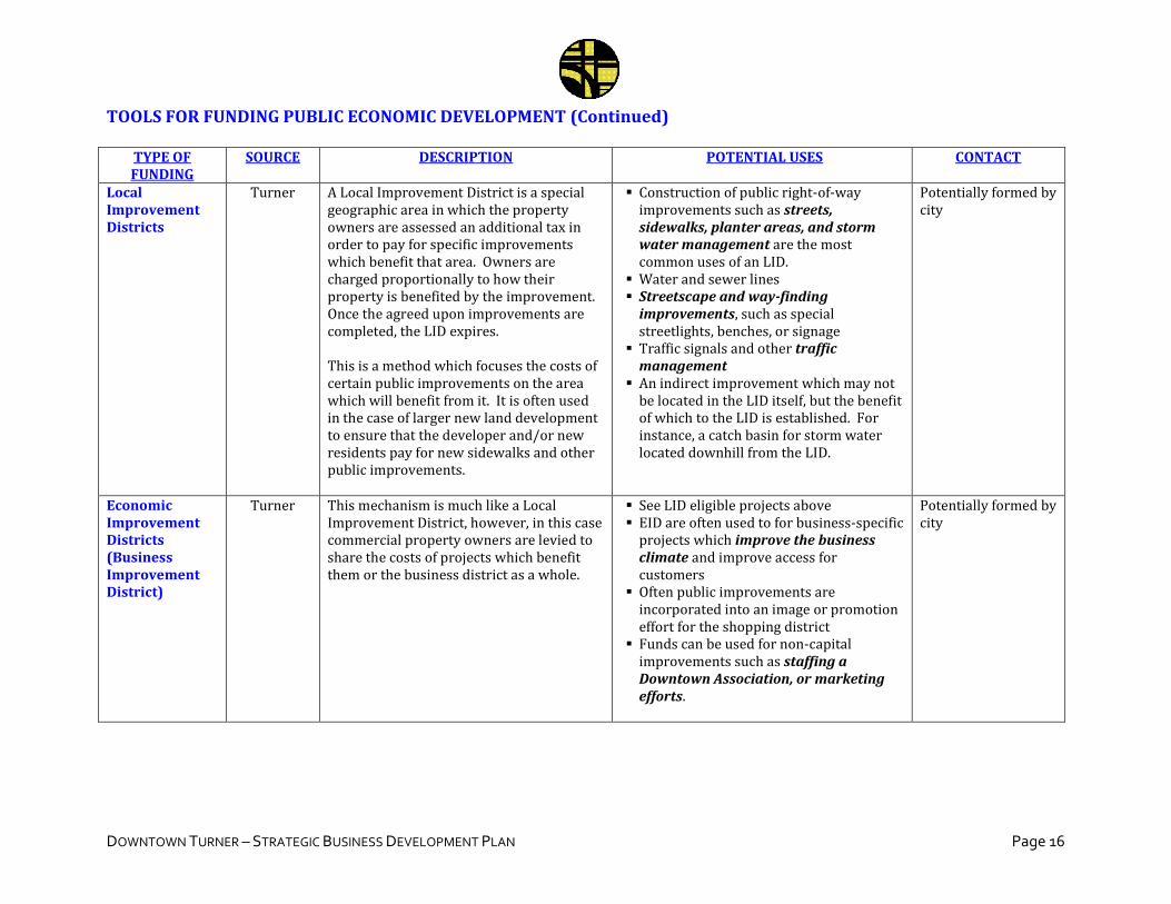
DOWNTOWN TURNER – STRATEGIC BUSINESS DEVELOPMENT PLAN Page 16
TOOLS FOR FUNDING PUBLIC ECONOMIC DEVELOPMENT (Continued)
TYPE OF FUNDING
SOURCE DESCRIPTION POTENTIAL USES CONTACT
Local Improvement Districts
Turner A Local Improvement District is a special geographic area in which the property owners are assessed an additional tax in order to pay for specific improvements which benefit that area. Owners are charged proportionally to how their property is benefited by the improvement. Once the agreed upon improvements are completed, the LID expires. This is a method which focuses the costs of certain public improvements on the area which will benefit from it. It is often used in the case of larger new land development to ensure that the developer and/or new residents pay for new sidewalks and other public improvements.
Construction of public right-of-way improvements such as streets, sidewalks, planter areas, and storm water management are the most common uses of an LID.
Water and sewer lines Streetscape and way-finding
improvements, such as special streetlights, benches, or signage
Traffic signals and other traffic management
An indirect improvement which may not be located in the LID itself, but the benefit of which to the LID is established. For instance, a catch basin for storm water located downhill from the LID.
Potentially formed by city
Economic Improvement Districts (Business Improvement District)
Turner This mechanism is much like a Local Improvement District, however, in this case commercial property owners are levied to share the costs of projects which benefit them or the business district as a whole.
See LID eligible projects above EID are often used to for business-specific
projects which improve the business climate and improve access for customers
Often public improvements are incorporated into an image or promotion effort for the shopping district
Funds can be used for non-capital improvements such as staffing a Downtown Association, or marketing efforts.
Potentially formed by city
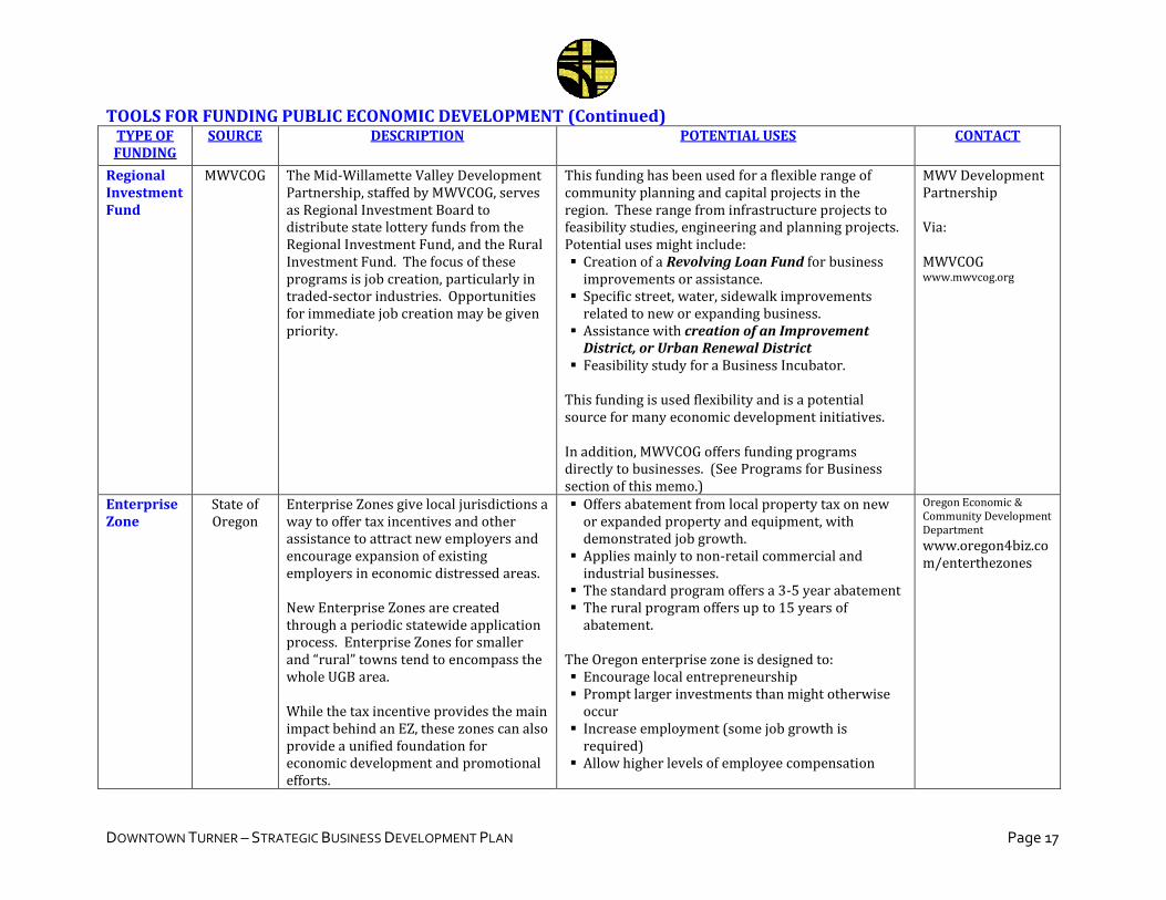
DOWNTOWN TURNER – STRATEGIC BUSINESS DEVELOPMENT PLAN Page 17
TOOLS FOR FUNDING PUBLIC ECONOMIC DEVELOPMENT (Continued) TYPE OF FUNDING
SOURCE DESCRIPTION POTENTIAL USES CONTACT
Regional Investment Fund
MWVCOG The Mid-Willamette Valley Development Partnership, staffed by MWVCOG, serves as Regional Investment Board to distribute state lottery funds from the Regional Investment Fund, and the Rural Investment Fund. The focus of these programs is job creation, particularly in traded-sector industries. Opportunities for immediate job creation may be given priority.
This funding has been used for a flexible range of community planning and capital projects in the region. These range from infrastructure projects to feasibility studies, engineering and planning projects. Potential uses might include: Creation of a Revolving Loan Fund for business
improvements or assistance. Specific street, water, sidewalk improvements
related to new or expanding business. Assistance with creation of an Improvement
District, or Urban Renewal District Feasibility study for a Business Incubator.
This funding is used flexibility and is a potential source for many economic development initiatives. In addition, MWVCOG offers funding programs directly to businesses. (See Programs for Business section of this memo.)
MWV Development Partnership Via: MWVCOG www.mwvcog.org
Enterprise Zone
State of Oregon
Enterprise Zones give local jurisdictions a way to offer tax incentives and other assistance to attract new employers and encourage expansion of existing employers in economic distressed areas. New Enterprise Zones are created through a periodic statewide application process. Enterprise Zones for smaller and “rural” towns tend to encompass the whole UGB area. While the tax incentive provides the main impact behind an EZ, these zones can also provide a unified foundation for economic development and promotional efforts.
Offers abatement from local property tax on new or expanded property and equipment, with demonstrated job growth.
Applies mainly to non-retail commercial and industrial businesses.
The standard program offers a 3-5 year abatement The rural program offers up to 15 years of
abatement. The Oregon enterprise zone is designed to: Encourage local entrepreneurship Prompt larger investments than might otherwise
occur Increase employment (some job growth is
required) Allow higher levels of employee compensation
Oregon Economic & Community Development Department
www.oregon4biz.com/enterthezones
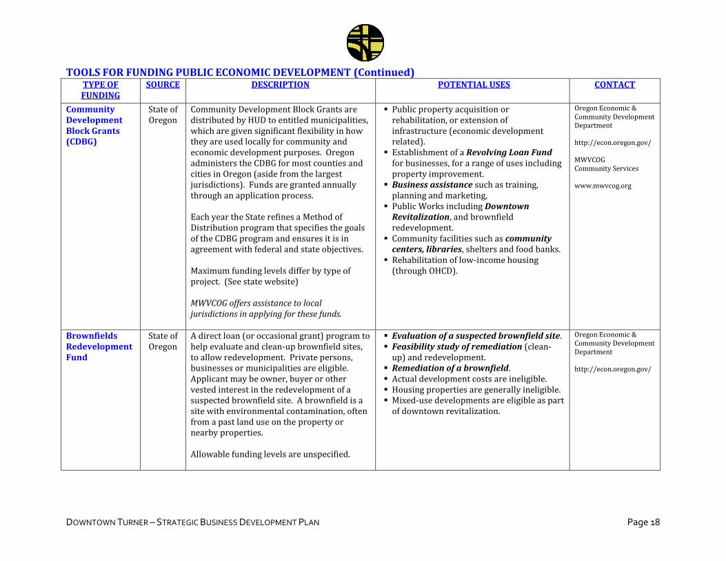
DOWNTOWN TURNER – STRATEGIC BUSINESS DEVELOPMENT PLAN Page 18
TOOLS FOR FUNDING PUBLIC ECONOMIC DEVELOPMENT (Continued) TYPE OF FUNDING
SOURCE DESCRIPTION POTENTIAL USES CONTACT
Community Development Block Grants (CDBG)
State of Oregon
Community Development Block Grants are distributed by HUD to entitled municipalities, which are given significant flexibility in how they are used locally for community and economic development purposes. Oregon administers the CDBG for most counties and cities in Oregon (aside from the largest jurisdictions). Funds are granted annually through an application process. Each year the State refines a Method of Distribution program that specifies the goals of the CDBG program and ensures it is in agreement with federal and state objectives. Maximum funding levels differ by type of project. (See state website) MWVCOG offers assistance to local jurisdictions in applying for these funds.
Public property acquisition or rehabilitation, or extension of infrastructure (economic development related).
Establishment of a Revolving Loan Fund for businesses, for a range of uses including property improvement.
Business assistance such as training, planning and marketing,
Public Works including Downtown Revitalization, and brownfield redevelopment.
Community facilities such as community centers, libraries, shelters and food banks.
Rehabilitation of low-income housing (through OHCD).
Oregon Economic & Community Development Department http://econ.oregon.gov/ MWVCOG Community Services www.mwvcog.org
Brownfields Redevelopment Fund
State of Oregon
A direct loan (or occasional grant) program to help evaluate and clean-up brownfield sites, to allow redevelopment. Private persons, businesses or municipalities are eligible. Applicant may be owner, buyer or other vested interest in the redevelopment of a suspected brownfield site. A brownfield is a site with environmental contamination, often from a past land use on the property or nearby properties. Allowable funding levels are unspecified.
Evaluation of a suspected brownfield site. Feasibility study of remediation (clean-
up) and redevelopment. Remediation of a brownfield. Actual development costs are ineligible. Housing properties are generally ineligible. Mixed-use developments are eligible as part
of downtown revitalization.
Oregon Economic & Community Development Department http://econ.oregon.gov/
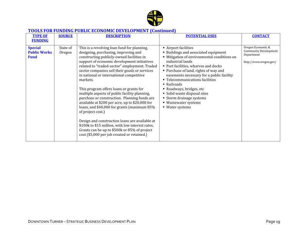
DOWNTOWN TURNER – STRATEGIC BUSINESS DEVELOPMENT PLAN Page 19
TOOLS FOR FUNDING PUBLIC ECONOMIC DEVELOPMENT (Continued) TYPE OF FUNDING
SOURCE DESCRIPTION POTENTIAL USES CONTACT
Special Public Works Fund
State of Oregon
This is a revolving loan fund for planning, designing, purchasing, improving and constructing publicly-owned facilities in support of economic development initiatives related to “traded-sector” employment. Traded sector companies sell their goods or services in national or international competitive markets. This program offers loans or grants for multiple aspects of public facility planning, purchase or construction. Planning funds are available at $200 per acre, up to $20,000 for loans, and $40,000 for grants (maximum 85% of project cost.) Design and construction loans are available at $100k to $15 million, with low interest rates. Grants can be up to $500k or 85% of project cost ($5,000 per job created or retained.)
Airport facilities Buildings and associated equipment Mitigation of environmental conditions on
industrial lands Port facilities, wharves and docks Purchase of land, rights of way and
easements necessary for a public facility Telecommunications facilities Railroads Roadways, bridges, etc Solid waste disposal sites Storm drainage systems Wastewater systems Water systems
Oregon Economic & Community Development Department http://econ.oregon.gov/
DOWNTOWN TURNER – STRATEGIC BUSINESS DEVELOPMENT PLAN Page 20
VII. FOCUS ON URBAN RENEWAL (TAX INCREMENT FINANCING) This section provides some extra detail on Tax Increment Financing (TIF) and on Urban Renewal planning and implementation. This is a recommended financing tool for implementing the improvements discussed in this memorandum, and the subsequent Turner Downtown Improvement Plan which will develop from these strategies. As the preceding table suggests, TIF is just one funding mechanism out of many, and can be used in conjunction with other programs to achieve the community’s objectives. What is Urban Renewal? Urban Renewal is a set of tools which allow cities and counties to take a more active role in redevelopment and revitalization of specific districts. Urban Renewal uses TIF to build a dedicated revenue source for the projects described in the Urban Renewal Plan. In addition, it provides additional flexibility for buying and redeveloping sites, and participating in public/private development partnerships. Urban Renewal (UR) now has a long history in Oregon, dating to the 1950’s. At first, the tool was used mainly in the City of Portland. Like many cities of the 50’s and 60’s era, Portland pursued some controversial redevelopment projects which involved largely clearly existing neighborhoods and beginning anew. Nationwide, established neighborhoods were often replaced by large housing projects, large civic and institutional uses, and generally a type of formal land use planning which has not always aged well. Unfortunately, this early era earned “Urban Renewal” a negative connotation that persists until this day. However, since this early era, the use of this tool has been greatly refined, while respect for existing communities and advancements in land use planning have allowed for neighborhoods to actually be revitalized from within rather than cleared and replaced. The modern use of UR is very different from that early era. Some jurisdictions simply use the term “Tax Increment Financing” instead to indicate this break from the past. Now Urban Renewal is used across the state by cities large and small, and in counties both urban and rural. It has been applied in all types of neighborhoods, including downtowns, residential, commercial, and industrial areas. How does Tax Increment Financing work? The main functional force behind Urban Renewal (UR) is Tax Increment Financing. TIF works by “freezing” the current property tax base in the UR district, and assigning the future tax growth to the UR district itself to pursue the identified projects. The current local taxing jurisdictions (the city, county, schools, fire districts, etc.) continue to receive the “frozen” amount of taxes throughout the life of the UR district. However, the property tax base within the district will continue to grow through appreciation, and if the UR program is successful, through new development. The UR agency uses that new “tax increment” to implement the UR Plan and meet its goals over the life of the district.
DOWNTOWN TURNER – STRATEGIC BUSINESS DEVELOPMENT PLAN Page 21
The UR agency might choose to wait for TIF revenue to grow over time before undertaking projects, but many bond or borrow against the future TIF revenue, in order to begin projects sooner. These early projects are geared towards spurring private investment and redevelopment. Thus, Urban Renewal can be “self-fulfilling” in the sense that borrowing against future TIF revenue allows for the completion of projects which will bring that future tax growth about. How is Urban Renewal implemented? A community instituting an Urban Renewal Area (URA) typically follows the following process:
1) The community, and local governing body, decides it would like to explore the use of Urban Renewal and outlines the rough boundaries of the prospective district.
2) Undertake a Feasibility Study of the area to inventory existing conditions and determine if it is eligible for Urban Renewal. The study must address whether or not there is basis for calling the area “blighted”. This study may also make preliminary estimates of the potential TIF generation in the area. The governing body assesses this study, and makes a determination to proceed or not proceed.
3) Prepare an Urban Renewal Plan and Report. These documents are required by state law in the creation of a URA. This is a public planning process and must allow for public input at each stage. The affected taxing districts are notified and allowed to comment and/or object. The Plan specifies the specific district boundaries, the goals and objectives, specific projects to be undertaken, spending limits, and rules on the acquisition and disposition of land. The Report provides technical information, including documentation of blight, detailed financing projections and impacts on overlapping taxing jurisdictions. The Plan and Report are presented to the Planning Commission for recommendations, giving a public hearing, and then adopted by the governing body.
4) State law requires the creation of a separate Urban Renewal Agency, which is activated at the time the Urban Renewal program is adopted. Often the membership of the UR Agency is the same as the governing body of the city or county. It holds separate meetings specifically for UR business. Other jurisdictions choose to create a UR Agency with independent membership. The justification for this is often to shield redevelopment decisions from politics.
5) Once the UR program is established, the UR Agency oversees the implementation over the life of the district (commonly 20 years.) The UR Plan and the projects and rules laid out within it serve as the guiding document. The Plan also describes procedures for amending it to address unforeseen contingencies over the long lifespan of the district.
DOWNTOWN TURNER – STRATEGIC BUSINESS DEVELOPMENT PLAN Page 22
Eligible Uses of Urban Renewal: Urban Renewal funds must generally be used for physical improvements to land and property, which may be public or private. In support of these goals, the UR agency can contribute to related actions such as direct acquisition or pre-development phases such as feasibility and design.
Public projects in support of UR goals, including infrastructure improvements, streetscape and beautification projects, creation of parks and community facilities, transportation improvements.
Acquisition and improvement of land for UR projects. Participation in public/private partnerships, including subsidies and direct
involvement of development. Creation of grant or loan programs in support of UR goals, including:
- Storefront/façade improvement - Assessment of development opportunities - Development in support of job creation - General property rehabilitation
The power of Eminent Domain is often specifically authorized or prohibited in the Urban Renewal Plan, based on community sentiment towards its use.
Other Considerations:
The definition of “blight” for establishing Urban Renewal Areas has been interpreted
very broadly. It generally refers to deteriorated properties and lack of adequate
infrastructure. The term “blight” has very negative connotations, but it is used as a
technical term in this case, and shouldn’t be taken as an implication that the
community is blighted in the familiar sense.
Projects undertaken which have broader benefits for the community beyond the UR
district, i.e. a new City Hall or library, must have a clear connection to the goals and
objectives of the UR district itself. Sometimes TIF revenue is allocated to such
projects in proportion to the expected benefit to the UR district, and other funds are
allocated to represent the broader community benefit.
Consultants are often retained to conduct the feasibility study, run the planning
process, and create the eventual Plan and Report documents. The Regional
Investment Fund administered by MWVCOG is one potential source for funding
these implementation activities.
VIII. CONCLUSION This Strategic Business Development Plan has been prepared in conjunction with the Downtown Turner Improvement Plan process, undertaken in 2008/2009. The project is funded by the SAFETEA-LU act, with additional support from the State of Oregon through the Transportation & Growth Management program.

DOWNTOWN TURNER – STRATEGIC BUSINESS DEVELOPMENT PLAN Page 23
Appendix F
Memorandum No. 5 – Zoning Strategy
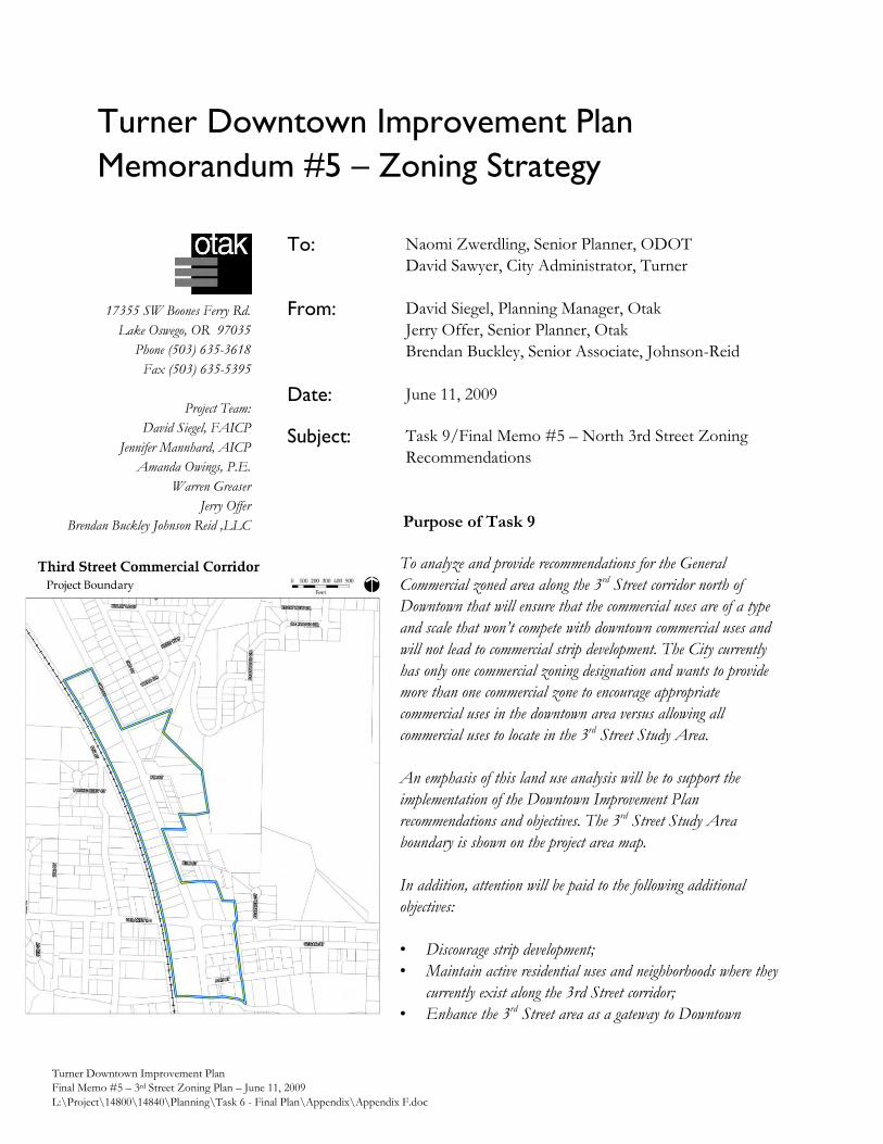
Turner Downtown Improvement Plan
Memorandum #5 – Zoning Strategy
Turner Downtown Improvement Plan
Final Memo #5 – 3rd Street Zoning Plan – June 11, 2009
L:\Project\14800\14840\Planning\Task 6 - Final Plan\Appendix\Appendix F.doc
17355 SW Boones Ferry Rd.
Lake Oswego, OR 97035
Phone (503) 635-3618
Fax (503) 635-5395
Project Team:
David Siegel, FAICP
Jennifer Mannhard, AICP
Amanda Owings, P.E.
Warren Greaser
Jerry Offer
Brendan Buckley Johnson Reid ,LLC
Purpose of Task 9
To analyze and provide recommendations for the General
Commercial zoned area along the 3rd Street corridor north of
Downtown that will ensure that the commercial uses are of a type
and scale that won’t compete with downtown commercial uses and
will not lead to commercial strip development. The City currently
has only one commercial zoning designation and wants to provide
more than one commercial zone to encourage appropriate
commercial uses in the downtown area versus allowing all
commercial uses to locate in the 3rd Street Study Area.
An emphasis of this land use analysis will be to support the
implementation of the Downtown Improvement Plan
recommendations and objectives. The 3rd Street Study Area
boundary is shown on the project area map.
In addition, attention will be paid to the following additional
objectives:
• Discourage strip development;
• Maintain active residential uses and neighborhoods where they
currently exist along the 3rd Street corridor;
• Enhance the 3rd Street area as a gateway to Downtown
To: Naomi Zwerdling, Senior Planner, ODOT
David Sawyer, City Administrator, Turner
From: David Siegel, Planning Manager, Otak
Jerry Offer, Senior Planner, Otak
Brendan Buckley, Senior Associate, Johnson-Reid
Date: June 11, 2009
Subject: Task 9/Final Memo #5 – North 3rd Street Zoning
Recommendations
Naomi Zwerdling, ODOT
David Sawyer, City of Turner Page 2
Turner Downtown Improvement Plan Memorandum #5 – Zoning Strategy June 11, 2009
Turner Downtown Improvement Plan
Final Memo #5 – 3rd Street Zoning Plan – June 11, 2009
L:\Project\14800\14840\Planning\Task 6 - Final Plan\Appendix\Appendix F.doc
Contents of This Memorandum
First, this memorandum discusses the existing land use patterns in Downtown and in the 3rd Street
commercial corridor, as well as the existing zoning for those areas. Second, this memorandum refers
to the adopted vision and some of the recommended goals and policies from Project Memorandum
#3 which have been determined to provide the most succinct direction for the Downtown
Improvement Plan related to the zoning for Downtown Turner, and which accordingly may relate to
zoning elsewhere in the city – most notably the current C-1 zoning along 3rd Street north of
Downtown.
Thirdly, Johnson-Reid LLC has provided a discussion of the typical distinctions between a typical
downtown storefront-style of development as compared to the style of commercial development
which would be anticipated to occur along an arterial street such as the northern segment of 3rd
Street.
In looking at the potential effects of the General Commercial zoning district along that portion of
3rd Street north of Downtown upon the implementation of the Downtown Improvement Plan, it is
necessary that the TAC also be familiar with the overall zoning recommendations for the
Downtown area. To that end, this memorandum presents the proposed revisions to the zoning
ordinance to add a new C-2 Downtown Mixed-Use zoning district for the “heart” of downtown and
a new M-2 Employment district which mixes industrial and commercial uses. The C-2 and M-2
zoning districts would replace the existing Downtown Commercial (DC) district. In addition, a new
P-I Public Institutional zoning district is proposed to designate properties which are in public use
such as the fire station, elementary school, parks, and the City of Salem water reservoir and semi-
public uses such as churches and franchise utility service yards. The proposed revisions are described
below in the Recommendations section of this memorandum. The proposed revisions to the zoning
ordinance text to create these districts are attached to this memorandum as Exhibit 1. Language to
be added to the zoning ordinance is highlighted and underlined in the draft revision package.
In addition, draft revisions to the City’s zoning map to apply these new districts is attached in two
parts, Exhibit 2A – Turner Downtown Improvement Plan Proposed Comprehensive Plan and
Zoning Designations, and Exhibit 3A – Third Street Commercial Corridor Proposed
Comprehensive Plan and Zoning Designations. The rationale for the proposed map revisions is
explained below in the recommendations section of this memorandum.
As background for your review of this memorandum and the proposed revisions to the zoning
ordinance and zoning map, Exhibits 2B and 3B present the Existing Comprehensive Plan and
Zoning Designations maps for Downtown and the 3rd Street Corridor. Exhibits 2C and 3C are
Naomi Zwerdling, ODOT
David Sawyer, City of Turner Page 3
Turner Downtown Improvement Plan Memorandum #5 – Zoning Strategy June 11, 2009
Turner Downtown Improvement Plan
Final Memo #5 – 3rd Street Zoning Plan – June 11, 2009
L:\Project\14800\14840\Planning\Task 6 - Final Plan\Appendix\Appendix F.doc
aerial photos of those portions of the City for your use in looking at the existing land uses in the
affected areas. Exhibit 4 is the official City of Turner Comprehensive Plan and Zoning Districts
Map for the entire city.
I. Existing Land Use and Zoning
As noted above, Exhibits 2C and 3C are aerial photos which illustrate the existing land uses in the
city and Exhibit 4 is the existing City of Turner zoning map. As can be seen by looking at these
maps, there is a very large area of C-1 General Commercial zoning nearly lining 3rd Street and
Denver Street as they head through the City from north-to-south. Most of the C-1 zoning is only
one parcel deep along the roads, except in the heart of the Downtown area. The M-1 General
Industrial district is currently utilized generally in the area of the mill on both sides of the railroad
tracks south to the southern city limits, and also further north in the area of Action Wood Products
and Pick-A-Part on the west side of 3rd Street and the Santiam Homes facility on the east side of 3rd
Street. There is one small area on the east side of 3rd Street on either side of Elm Street which has
residential zoning with the R-2 and R-11 zoning districts, even though the primary land uses along
3rd Street north of Mill Creek to Val View Road are detached single-family residences.
II. Objectives of the Draft Downtown Improvement Plan
The draft Downtown Improvement Plan’s vision statement is a synopsis of the community’s values
for long-term development. The supporting goals and policies frame how that vision can be
achieved through urban design, land use, transportation, redevelopment, and economic
development. The vision, goals, and policies will be used to guide the development of specific
concepts and strategies for the Downtown Improvement Plan.
Vision: Downtown Turner will be a complete community with a small town feel. It will continue to be “a good
neighbor town” where residents are familiar and children are safe to ride their bicycles around town. Downtown Turner
will be the heart of the community and boast plentiful amenities and activities year-round. Respecting the past and the
future, downtown Turner will celebrate its history while providing an economically viable place to do business and shop,
attracting new employment opportunities, residents, and visitors.
Goals and Policies:
Below are selected goals and policies of the draft Turner Downtown plan which are specifically
related to the issues of zoning for the Downtown and the northern 3rd Street corridor:
Urban Design: To create an attractive small town environment that facilitates community activity and interaction
for all ages.
Naomi Zwerdling, ODOT
David Sawyer, City of Turner Page 4
Turner Downtown Improvement Plan Memorandum #5 – Zoning Strategy June 11, 2009
Turner Downtown Improvement Plan
Final Memo #5 – 3rd Street Zoning Plan – June 11, 2009
L:\Project\14800\14840\Planning\Task 6 - Final Plan\Appendix\Appendix F.doc
• Downtown Turner should be the center of the community. It should contain a space that is considered the “heart”
of town.
• Destinations to enliven downtown should be centrally located. These could include a new bandstand, dance hall,
civic center, museum, library, or relocated city hall.
• The urban design and arrangement of spaces and buildings in downtown should use history as an inspiration,
enable community activities, and provide a sense of identity and continuity.
Land Use: To allow and encourage a mix of uses to create a complete downtown.
• Retail and office uses should be allowed throughout the downtown area.
• Residential uses should be preserved and augmented.
• Mixed commercial and residential buildings, such as a shop below or in front of a home, should be allowed and
encouraged throughout the area.
• Light industrial uses should be limited to the area along 3rd Street. These industrial uses should be allowed to
have a commercial component, such as a retail outlet or showroom, on their property.
• Zoning should provide for maximum flexibility.
Redevelopment: To infill vacant land and redevelop vacant, underutilized, or dilapidated structures to create a
more inviting and active environment.
• The community’s vision for building character and streetscape should be clear to those undertaking development
projects.
• The City should establish and communicate a clear development application process, with standardized steps and
forms.
• Subjectivity should be removed from the development review process to the extent possible.
Economic Development: To maintain and capitalize on small town advantages while attracting newbusinesses
to the area.
• The broader community identity or theme in Turner should be clear to business people considering locating there.
• Redevelopment and refurbishment of older buildings should be encouraged to the extent possible.
• Increase visibility and street presence of existing businesses.
III. Downtown Main Street vs. Arterial Street Commercial Environments
The type of commercial uses one might find in a historical downtown environment versus an arterial
commercial street environment differs in key ways. As the following discussion makes clear, the
issues of form and function are closely related:
Naomi Zwerdling, ODOT
David Sawyer, City of Turner Page 5
Turner Downtown Improvement Plan Memorandum #5 – Zoning Strategy June 11, 2009
Turner Downtown Improvement Plan
Final Memo #5 – 3rd Street Zoning Plan – June 11, 2009
L:\Project\14800\14840\Planning\Task 6 - Final Plan\Appendix\Appendix F.doc
• Street Orientation of Buildings: The first difference one might encounter is in the physical or
visual differences between businesses in these two environments. The classic physical unit of
downtown “main street” business is the storefront. Oriented very close to the sidewalk, often
with large windows looking into the business itself, storefront buildings are sometimes said to
have “pedestrian scale,” meaning they’re oriented towards people walking by and stopping in.
Effective storefront atmospheres have these buildings located immediately adjacent to each
other in a row, or with any gaps kept to a minimum. This creates a contiguous pedestrian
experience.
In contrast, on arterial commercial streets businesses are physically designed with the
assumption that most customers will be arriving by car. This very often means that parking is
located between the building and the street itself. For the reasons that the classic storefront
model is good for pedestrians, the auto-oriented commercial model is not. This should not be
seen as a negative, as some business types will be better suited for auto access than pedestrian
access. However, a city should recognize the differences between the styles of development and
provide zoning for each.
• Scale: Larger businesses tend to require more parking for customers, more space for deliveries
and/or outdoor storage. Therefore, these businesses will tend to locate where larger sites and
more parking are available, as on an arterial commercial strip. Classic main street retail space will
tend to appeal to smaller-scale businesses which rely on street parking and pedestrian traffic.
• Customer Base: The scale and parking orientation of businesses is related to the customer base
the business is hoping to attract. Smaller scale main street businesses tend to rely more on
serving local households and employees in the area, hoping that this more intimate customer
base is sufficient to sustain a modestly sized business. The types of services offered here will
reflect this local orientation.
While many locally-focused businesses do locate on arterial commercial streets, these streets are
well-suited to serving a larger customer base, which typically arrives by car. This auto-orientation
means that customers from further away can access the business more quickly and efficiently.
This larger customer base is symbiotic with the larger scale of businesses possible on the arterial.
IV. Recommendations
A. Modifications to the Zoning Ordinance
The biggest threat to achieving a reinvigorated Downtown is for commercial businesses which might
be interested in locating in the downtown choosing to locate elsewhere. While we can’t do much
Naomi Zwerdling, ODOT
David Sawyer, City of Turner Page 6
Turner Downtown Improvement Plan Memorandum #5 – Zoning Strategy June 11, 2009
Turner Downtown Improvement Plan
Final Memo #5 – 3rd Street Zoning Plan – June 11, 2009
L:\Project\14800\14840\Planning\Turner Final Memo 5061109.doc
about businesses which choose to locate totally outside of the community, the City can tailor its
Zoning Map and Zoning Ordinance to direct commercial uses with differing needs and markets to
different locations in the community and to allocate an appropriate amount of land for each of these
uses.
To that end, it is recommended that the Zoning Ordinance be amended to create a new C-2
Downtown Mixed Use zoning district and a new M-2 Downtown General Employment zoning
district. These new zoning districts are intended to provide for desirable downtown-sized retail and
office uses. The C-2 zoning district would also allow for a variety of multifamily residential uses
Downtown–both freestanding and on upper floors above retail or office uses. The M-2 district
would allow light industrial uses which occur wholly within a building and which may be combined
with an associated retail or office use. The recommended text for these new zoning districts is
attached in Exhibit 1 to this memorandum, along with recommended revisions to the
Comprehensive Plan and Zoning Designations map which illustrates where the project team
recommends that these new zoning districts be applied. In addition, the recommended Zoning Map
revisions include recommendations for fine-tuning the residential zoning districts adjacent to the
Downtown area.
The primary difference between the proposed C-2 Downtown Mixed-Use zoning district and the
C-1 General Commercial district is that the C-2 district intends to create a typical downtown with
storefront buildings located close to the sidewalk, a mix of land uses, and a convenient pedestrian
environment. In order to achieve these purposes, the C-2 district uses design standards and
guidelines to encourage the development of typical storefront buildings similar to what downtown
Turner used to have, and also through allowing individual uses of less than 4,000 square feet from
having to provide on-site parking. It is believed that the current supply of on-street parking spaces in
downtown should be sufficient to serve the needs of the smaller uses downtown. The purpose
statement for the C-1 zone would be modified to explain that the C-1 zone is to be utilized in
locations where the City wishes to direct commercial uses which require on-site parking and uses
which may desire land for outdoor display of goods or materials.
The primary difference between the proposed M-2 Downtown Employment zoning district and the
current M-1 General Industrial district is that the M-2 district will allow a mixture of light industrial,
office, and storefront retail uses. Uses which combine industrial assembly with associated storefront
retail areas are a primary target of this district. The design guidelines in the M-2 district encourage
the development of storefront buildings located close to the sidewalk with parking areas to be kept
to the side or rear of the building. These guidelines are, for the most part, voluntary guidelines as
opposed to the mandatory design standards of the C-2 district. At the Turner Downton Plan Public
Event #4 on May 21, 2009, it was recommended that the M-2 zone will require additional discussion
prior to adoption.
Naomi Zwerdling, ODOT
David Sawyer, City of Turner Page 7
Turner Downtown Improvement Plan Memorandum #5 – Zoning Strategy June 11, 2009
Turner Downtown Improvement Plan
Final Memo #5 – 3rd Street Zoning Plan – June 11, 2009
L:\Project\14800\14840\Planning\Task 6 - Final Plan\Appendix\Appendix F.doc
In addition to the C-2 and M-2 zoning districts, a new PI Public Institutional zoning district is
proposed which is intended to be applied to existing public uses and/or properties owned by public
institutions for future use as well as properties owned by semi-public entities such as churches and
franchise utility providers. The PI district is intended to be applied to the fire station, parks, existing
churches, the elementary school property, and utility services such as the Verizon switching facility
on Chicago Street and sewer and water pumping stations.
B. Modifications to the Zoning Map
In addition, the project team was struck by the amount of land which is currently designated
General Commercial, C-1. This significant amount of C-1 zoned land provides too many
opportunities for potential commercial land users to choose somewhere other than the Downtown
area. In addition to the majority of the Downtown area, the C-1 district extends up most of both
sides of 3rd Street to Action Wood Products, creating the potential for a significant stretch of strip
commercial development–but an area which would likely be intermixed with residential uses because
there simply will not be enough commercial demand to convert this entire area to commercial uses.
There currently is very little commercial development within the area north of Mill Creek. The
development team believes that it is unlikely that much of this area will redevelop with commercial
uses due to: 1) potential conflicts with the predominantly residential uses in this area; 2) the limited
depth of these parcels and the limited size of individual parcels; and most importantly, 3) limited
demand for commercial land in Turner.
In order to focus the limited demand for commercial land on the Downtown area and in areas along
3rd Street which are already predominantly commercial, it is recommended that the most of the
existing C-1 zoned property on the east side of 3rd Street to just beyond Elm Street be rezoned R-2
Single-Family Residential. The only exception would be the site of Perky’s restaurant and nine other
relatively small properties on the east side of the Delaney Road/3rd Street intersection, which would
remain zoned C-1. The TAC noted that those properties were a logical extension for nodal
commercial development at this important intersection. R-2 zoning would be reflective of the
existing uses of those properties and would be consistent with the zoning of neighboring properties
to the east. Slightly north of Elm Street on the east side of 3rd Street, it is recommended that
properties be rezoned to R-11, Multifamily Residential up to and including the existing City Hall
property in order to connect some existing areas of R-11 zoning, and to hopefully spur
redevelopment of this area. The four properties around the Post Office would remain zoned C-1.
The proposed rezoning of the current City Hall property to R-2 recognizes the Downtown
Improvement Plan’s recommendation to relocate the City administrative functions to downtown in
the near future.
Naomi Zwerdling, ODOT
David Sawyer, City of Turner Page 8
Turner Downtown Improvement Plan Memorandum #5 – Zoning Strategy June 11, 2009
Turner Downtown Improvement Plan
Final Memo #5 – 3rd Street Zoning Plan – June 11, 2009
L:\Project\14800\14840\Planning\Turner Final Memo 5061109.doc
On the west side of 3rd Street, it is recommended that C-1 zoning be retained for the mostly
commercial uses from Mill Creek up to and including Classic Auto Storage and Sales. Beyond that
point, there is a solid stretch of well kept single-family homes, up to Triple D Windows. It is
recommended that this area be zoned R-2 in recognition of its existing uses and to preserve this
small neighborhood. The area including and northward of Triple D Windows to just short of the
Action Wood Products is recommended to retain C-1 zoning in recognition of the mostly
commercial land uses in this area. In addition, the generally larger parcel sizes and increased depth
between the road and the railroad makes these parcels attractive for potential redevelopment with
commercial uses which require room for customer parking and/or outdoor display or storage of
materials.
In addition, fine tuning of the commercial zoning on the southern edge of Downtown is suggested
to rezone several properties fronting on Elgin Street from the existing C-1 zoning district to R-11.
These properties are currently in residential usage and are unlikely to be redeveloped with
commercial uses due to their not being located on a major through street or within the planned
Downtown improvement area.
Areas within the Downtown and 3rd Street corridor which are recommended to be zoned P-I include
Burkhardt Park, the elementary school, the Burkhardt pool, the fire station, and the Verizon
switching facility.
C. Additional Recommendations
In addition to revising the zoning for properties along the northern 3rd Street corridor to residential,
it is recommended that the City investigate ways to strengthen the existing single-family
neighborhood within that corridor. This could be as basic as having a meeting (or a neighborhood
picnic) to discuss any issues which those residential neighbors have with the nearby commercial
development and with regard to traffic on 3rd Street. There may not be much that can be done about
those concerns, but at least it will be valuable to hear what the residents’ concerns are. There may be
some surprise concerns, or there may be some surprise solutions.
Also, the City should look at methods of creating an enhanced identity for the residential
neighborhood along 3rd Street. Two simple ides may be to: 1) plant street trees to help create a visual
break from the commercial development; and 2) encourage the development of short, open fences
to separate the homes yards from the sidewalk. The fences could be picket fences or wrought iron
style aluminum fences which will provide the desired separation of the yards from the street while
not creating an unfriendly feeling as might be found with solid fences or chain link fences. The City
could investigate whether there are grant funds available for the fencing and street trees, or the City
Naomi Zwerdling, ODOT
David Sawyer, City of Turner Page 9
Turner Downtown Improvement Plan Memorandum #5 – Zoning Strategy June 11, 2009
Turner Downtown Improvement Plan
Final Memo #5 – 3rd Street Zoning Plan – June 11, 2009
L:\Project\14800\14840\Planning\Task 6 - Final Plan\Appendix\Appendix F.doc
could investigate the creation of a low interest loan program for residential streetscape
improvements.
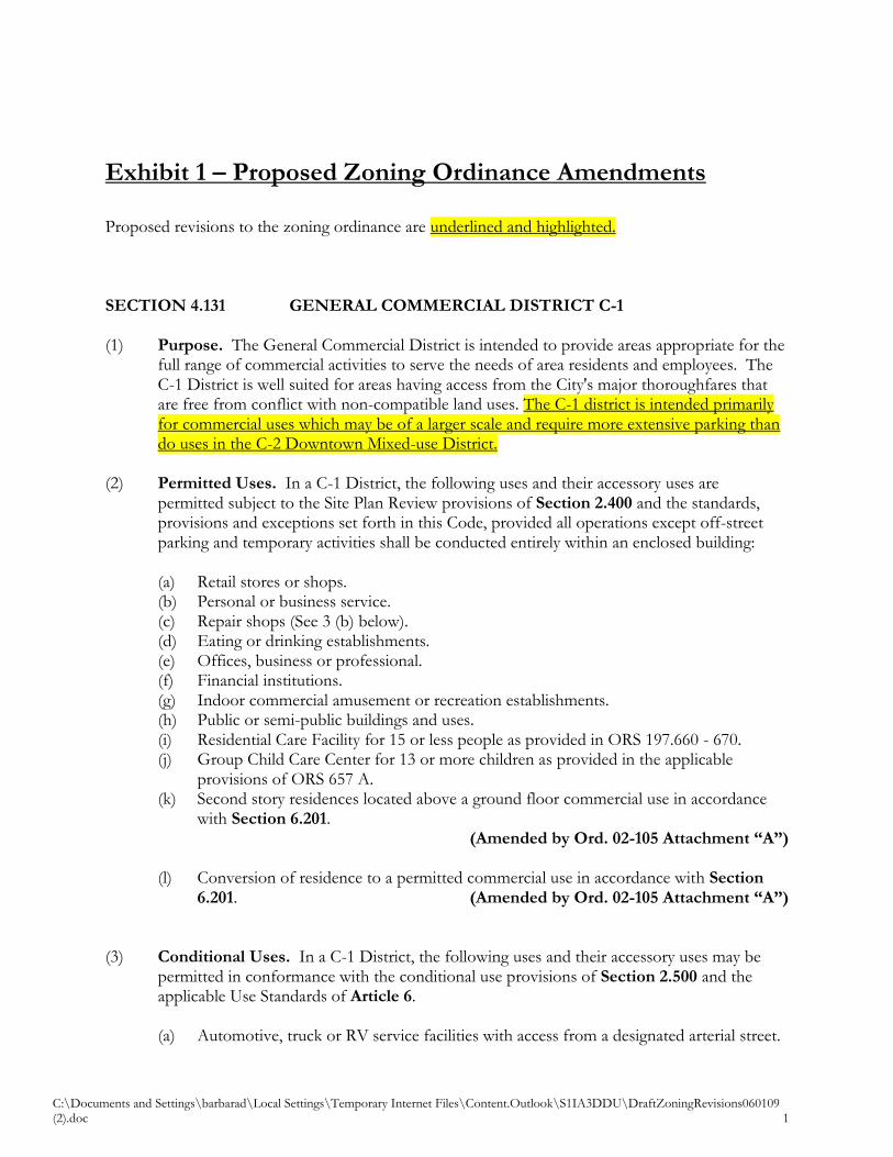
C:\Documents and Settings\barbarad\Local Settings\Temporary Internet Files\Content.Outlook\S1IA3DDU\DraftZoningRevisions060109 (2).doc 1
Exhibit 1 – Proposed Zoning Ordinance Amendments Proposed revisions to the zoning ordinance are underlined and highlighted. SECTION 4.131 GENERAL COMMERCIAL DISTRICT C-1 (1) Purpose. The General Commercial District is intended to provide areas appropriate for the
full range of commercial activities to serve the needs of area residents and employees. The C-1 District is well suited for areas having access from the City's major thoroughfares that are free from conflict with non-compatible land uses. The C-1 district is intended primarily for commercial uses which may be of a larger scale and require more extensive parking than do uses in the C-2 Downtown Mixed-use District.
(2) Permitted Uses. In a C-1 District, the following uses and their accessory uses are
permitted subject to the Site Plan Review provisions of Section 2.400 and the standards, provisions and exceptions set forth in this Code, provided all operations except off-street parking and temporary activities shall be conducted entirely within an enclosed building:
(a) Retail stores or shops. (b) Personal or business service. (c) Repair shops (See 3 (b) below). (d) Eating or drinking establishments. (e) Offices, business or professional. (f) Financial institutions. (g) Indoor commercial amusement or recreation establishments. (h) Public or semi-public buildings and uses. (i) Residential Care Facility for 15 or less people as provided in ORS 197.660 - 670. (j) Group Child Care Center for 13 or more children as provided in the applicable
provisions of ORS 657 A. (k) Second story residences located above a ground floor commercial use in accordance
with Section 6.201. (Amended by Ord. 02-105 Attachment “A”) (l) Conversion of residence to a permitted commercial use in accordance with Section
6.201. (Amended by Ord. 02-105 Attachment “A”)
(3) Conditional Uses. In a C-1 District, the following uses and their accessory uses may be permitted in conformance with the conditional use provisions of Section 2.500 and the applicable Use Standards of Article 6.
(a) Automotive, truck or RV service facilities with access from a designated arterial street.
C:\Documents and Settings\barbarad\Local Settings\Temporary Internet Files\Content.Outlook\S1IA3DDU\DraftZoningRevisions060109 (2).doc 2
(b) Automotive, truck, RV, equipment or other repair shops which possess nuisance characteristics or emissions potentially detrimental to Public health, safety and general welfare of the community such as noise, vibrations, smoke, odor, fumes, dust, heat, glare or electromagnetic interference shall not be permitted unless additional safeguards are specified by the Planning Commission. The applicant shall accurately specify the extent of emissions and nuisance characteristics relative to the proposed use.
(c) Permitted uses listed in (2) above, requiring open display or storage, including but not limited to, automobile or equipment sales.
(4) Development Standards.
(a) Minimum lot area and configuration - Lots within a General Commercial District are approved by the Planning Commission as part of the Site Plan Review procedures of Sections 2.400. Lots are required to be large enough to accommodate the building, sewage disposal system, required parking, service access and pedestrian circulation including persons with disabilities.
(b) Yards:
1. Exterior yard setbacks - none required. See Section 5.116 for additional street setbacks.
2. Interior yard setbacks - 5 feet where abutting residential property and zero where abutting commercial or industrial property subject to the requirements for building construction specified in the Oregon Structural Specialty Code.
(c) Maximum building height - two and one-half stories to a maximum of 35 feet. (d) Access shall be designed to cause a minimum interference with traffic and may be
subject to the review and approval of the County Engineer or State Department of Transportation. The dedication of additional right-of-way and construction of street improvements by the applicant may be required in order to facilitate traffic circulation.
(e) See Article 5 for additional General Development Standards and Article 6 for Use Standards that may apply in the C-1 District.
C:\Documents and Settings\barbarad\Local Settings\Temporary Internet Files\Content.Outlook\S1IA3DDU\DraftZoningRevisions060109 (2).doc 3
SECTION 4.136 DOWNTOWN MIXED-USE DISTRICT C-2 (1) Purpose. The Downtown Mixed-use District applies to the historic central business district
of the City of Turner in the area south and west of Mill Creek and east of 3rd Street. The Downtown Mixed-use District is intended to be the City of Turner’s center of vital retail activity, services, housing, civic buildings, and public spaces. Developments which mix these uses vertically or horizontally are encouraged in the Downtown Mixed-use District.
The C-2 district is intended primarily for commercial uses which are generally of a smaller
scale than uses located in the C-1 General Commercial District and uses which require less in the way of off-street automobile parking. Certain smaller scale uses in the C-2 District are not required to provide on-site parking, and instead are encouraged to utilize on-street parking and shared parking agreements with other nearby uses.
The C-2 District is also intended as the primary location of civic uses in the City of Turner.
Due to the public assembly aspect of these uses, off-street parking will generally be required for most civic uses.
In order to promote the development of a pedestrian-oriented environment and to promote
the development of a storefront character reminiscent of the historic downtown Turner, special design standards and guidelines are established for development in the C-2 District.
(2) Permitted Uses. In the C-2 Downtown Mixed-use District, the following uses and their
accessory uses are permitted subject to the Site Plan Review provisions of Section 2.400 and the standards, provisions, and exceptions set forth in this Code; provided all operations except off-street parking and temporary activities shall be conducted entirely within an enclosed building:
(a) Retail stores or shops. (b) Personal or business service. (c) Repair shops. (d) Eating or drinking establishments. (e) Offices, business or professional. (f) Financial institutions. (g) Indoor commercial amusement or recreation establishments. (h) Temporary vendors such as a farmers market, flea market, or food vending cart. (i) Conversion of residence to a permitted commercial use in accordance with Section
6.201. (j) Residential Care Facility for 15 or less people as provided in ORS 197.660 - 670. (k) Group Child Care Center for 13 or more children as provided in the applicable
provisions of ORS 657 A. (l) Second story residences located above a ground floor commercial use in accordance
with Section 6.201.
C:\Documents and Settings\barbarad\Local Settings\Temporary Internet Files\Content.Outlook\S1IA3DDU\DraftZoningRevisions060109 (2).doc 4
(m) Public or semi-public buildings and uses, including city hall, administrative offices, libraries, community centers, parks subject to the development standards in Section 6.301.
(n) Multi-family residential uses subject to the development standards of the R-11 district in Section 4.121(4) and the multi-family residential standards of Section 6.104.
(3) Conditional Uses. In the C-2 District, the following uses and their accessory uses may be
permitted in conformance with the conditional use provisions of Section 2.500 and the applicable Use Standards of Article 6. (a) Surface parking lot of any size (when not in conjunction with a permitted or
conditional use). (b) Surface parking lots with more than six parking spaces, if the parking lot is in
conjunction with a permitted or conditional use. (c) Automotive, truck, or RV service facilities. (d) Automotive, truck, RV, equipment, or other repair shops.
(4) Prohibited Uses. In the C-2 District, the following uses are specifically prohibited:
(a) Manufacturing, warehousing, wholesaling, compounding, assembling, processing, storing, researching, or testing.
(b) Scrap, waste, recycling, or wrecking yards. (c) Quarrying and related activities subject to the requirements of Statewide Planning Goal
5 and OAR 660-23-180 for Mineral and Aggregate Resources. (d) Waste or hazardous material processing, storage, or disposal. (e) Heavy equipment sales or repair. (f) Trucking operations. (g) Auto storage, towing, or wrecking yards. (h) New automotive service or sales (i) Adult video or goods.
(5) Development Guidelines and Standards. All development in the C-2 District shall
comply with the applicable provisions of the Turner Zoning Code. Where the standards of the C-2 District zone and other provisions of the Code, the standards of the C-2 District shall prevail. Standards listed in this section as “shall” are mandatory standards. Guidelines which state “should” or “encouraged” are not mandatory, but are considered desirable by the City.
(a) Purpose.
i) The purpose of these development standards is to guide the design of buildings
constructed in the C-2 district to ensure that, through appropriate use of facades, windows, building orientation, architectural details, new structures, and alterations of existing structures are physically and visually compatible with other buildings within the downtown business district.
C:\Documents and Settings\barbarad\Local Settings\Temporary Internet Files\Content.Outlook\S1IA3DDU\DraftZoningRevisions060109 (2).doc 5
ii) These standards are intended to encourage good quality design in new building construction, enhance street safety, and provide a comfortable street environment by providing features of interest to pedestrians. Good design results in buildings that are in visual harmony with nearby buildings, leading to a downtown that is attractive, interesting, active, and safe. These qualities, in turn, contribute to the creation of a downtown core which facilitates easy pedestrian movement and establishment of a rich mixture of uses.
iii) In order to encourage the development of small businesses typical of the historic character of the downtown area and to promote a denser development pattern, certain uses will be exempted from the minimum on-site parking requirements of Section 15.121 of this Code.
(b) Applicability.
i) The provisions of this ordinance shall apply to the following activities within the
C-2 District: 1. All new building construction; 2. Any exterior building or site modification that requires a building permit;
and, 3. All new signage.
ii) This ordinance shall not apply to the following activities or uses:
1. Maintenance of the exterior of an existing structure, such as re-roofing, re-siding, or repainting where similar materials and colors are used that comply with this ordinance;
2. Interior remodeling; and, 3. Exterior remodels to exclusive single-family residential homes, are exempt
from the provisions of this chapter. Single-family homes that are used for businesses or home occupations are not exempt.
iii) This ordinance shall apply only to those portions of a building or sign that are
proposed for construction or modification and shall not extend to other elements of the building or sign that may be out of compliance with the requirements of this ordinance (i.e., a permit to replace a single window shall not require that all other windows on the building that may be out of compliance with this ordinance to be replaced, unless such action is initiated by the property owner). However, if a building should be destroyed due to fire, accident, or an act of God, the new or replacement structure shall be rebuilt to conform to the requirements of this ordinance.
(c) General Standards. These standards to all uses in the C-2 District except for detached
single-family residences and multi-family development.
C:\Documents and Settings\barbarad\Local Settings\Temporary Internet Files\Content.Outlook\S1IA3DDU\DraftZoningRevisions060109 (2).doc 6
i) Minimum lot area and configuration - Lots within the C-2 Downtown Mixed-use District are approved by the Planning Commission as part of the Site Plan Review procedures of Sections 2.400. Lots are required to be large enough to accommodate the building, needed parking, service access, and pedestrian circulation to provide for the needs of persons with disabilities.
ii) Yards:
1. Front yard setback - none required, 10-foot maximum allowed. See Section
5.116 for additional street setbacks. 2. Side and rear setback – minimum 5 feet where abutting residential property
and zero where abutting commercial or industrial property subject to the requirements for building construction specified in the Oregon Structural Specialty Code.
iii) Maximum building height - three stories to a maximum of 35 feet.
iv) Access shall be designed to cause a minimum interference with traffic and may be subject to the review and approval of the County Engineer or State Department of Transportation. The dedication of additional right-of-way and construction of street improvements by the applicant may be required in order to facilitate traffic circulation.
v) See Article 5 for additional General Development Standards and Article 6 for
Use Standards that may apply in the C-2 District. (6) Design Guidelines or Standards. All development, EXCEPT for existing detached single family homes and multi-family
development shall be subject to the C-2 District design guidelines and standards listed below.
(a) Standards. Standards for new construction shall require builders to conform to the
architectural form of Turner’s historic period (1880s through 1940s) when downtown Turner had more of a typical downtown character. As such, new construction shall conform to the following standards and guidelines listed below. Reference is made to Turner’s historic period, and to buildings which display basic storefront design characteristics of that period. The following building displays characteristics intended by the standards. Other buildings, including those in other nearby communities, may also be used to demonstrate the requiredelements and/or the basis for visual compatibility.
The best existing example of a storefront building to be looked at for determining compatibility with the design standards is the Turner bank building at 3rd Street and Boise Street.

C:\Documents and Settings\barbarad\Local Settings\Temporary Internet Files\Content.Outlook\S1IA3DDU\DraftZoningRevisions060109 (2).doc 7
1. Site Development. a. Building fronts and entrances shall be oriented toward the street.
Buildings with frontages on two or more streets shall be oriented to at least one street.
b. Building facades should be set at the property edge along the sidewalk. A maximum setback of up to ten feet shall be permitted when occupied by pedestrian amenities (e.g., plaza, outdoor seating). Buildings with frontages on two or more streets should be set at the property edge on at least one street.
c. Site development should, as applicable and as practical, utilize the alley in the rear of the site for service access - such as for deliveries, trash and recycling pick-up, and employee parking. Buildings shall include doors to alley rights-of-way even if alleys are not currently in use.
2. Building Scale.
a. The overall size and proportion of new structures shall be compatible with the scale of nearby traditional storefront buildings. This standard may be met by either designing the building’s size and proportions to be similar to comparable structures in the downtown, or by the design of the façade so that it breaks a larger mass into smaller units that are similar to comparable historic structures.
b. If practical, new buildings should have the same floor height as adjoining buildings in case there is ever a desire to link the storefronts.
c. The relationship between the height and width of the main facade of the building shall be visibly compatible with adjoining or nearby buildings of the historic period or style. As with subsection (2)(i) of this section, this standard may be met through either similar height and width or, through design elements that provide visual continuity with the height and width of adjoining or nearby buildings of the historic period.
3. Building Height.
a. New buildings of at least two stories in height are encouraged. b. As specified in Section 4.136.C.3, the height of all buildings shall be
one to three stories and not more than 35 feet in maximum height.
4. Building Width. a. All new buildings should maximize lot frontage as much as is
practicable. b. New buildings whose street frontage is more than 50 feet wide shall
be designed to convey a sense of division through the use of pilasters, windows and door openings, recessed entries, off-sets, or other architectural details.
C:\Documents and Settings\barbarad\Local Settings\Temporary Internet Files\Content.Outlook\S1IA3DDU\DraftZoningRevisions060109 (2).doc 8
5. Storefronts.
a. Primary entrances shall be oriented to the street. Corner buildings shall have corner entrances, or shall provide at least one entrance within 20 feet of the street corner or a corner plaza.
b. Street-facing upper windows of multi-story buildings shall use multi-pane double-hung sash windows or the equivalent style.
c. The relationship between solid walls and window and door openings on the main facade shall be visually compatible with adjoining or nearby structures from the historic period or style. Ideally, first floor storefronts should be about 80 percent glass from approximately 2 feet above grade to approximately 10 feet above grade.
d. The relationship of width and height of window and door openings shall be visually compatible with adjoining or nearby buildings from the historic period or style.
e. Blank walls, walls without window or door openings, are not permitted along public streets.
f. Windows and doorways shall not be covered over with paper, boards, or cardboard except during times of construction or remodeling and shall be limited to a period of 120- days unless an extension is otherwise granted by the city manager.
g. Doors shall match the materials, design, and character of the display window framing.
h. Architectural features such as awnings, windows, cornices, etc., shall be provided at the second floor to differentiate the storefront from the upper levels of the building, to add visual interest, and to allow the storefront to function as the base for the rest of the building.
6. Facade Materials and Texture.
a. The materials and texture of the facade shall be compatible with those on buildings constructed during the historic period.
b. Permitted exterior facade materials include: brick, cast iron, relatively narrow horizontal wood or masonry siding, and stucco. Plywood siding, T-111, and vertical board and batten are prohibited.
c. Exposed concrete block facades facing the street are not allowed. Split-face or scored-face block may be used in small quantities for foundations or other non-dominant features.
d. All main facade materials shall be painted (except brick, for which painting is optional).
e. Metal siding shall not be used as a building material on the facade facing a street.
7. Windows.
a. Windows which allow views to the interior activity or display areas are encouraged. Windows shall include sills at the bottom and
C:\Documents and Settings\barbarad\Local Settings\Temporary Internet Files\Content.Outlook\S1IA3DDU\DraftZoningRevisions060109 (2).doc 9
pediments at the top. Glass curtain walls, reflective glass, and painted or darkly tinted glass shall not be used on the first floor.
b. Ground Floor Windows. All new buildings must provide ground floor windows along adjacent street rights-of-way. i. Required window areas must be either windows that allow views
into working areas or lobbies, pedestrian entrances, or display windows.
ii. Required windows must have a sill no more than four feet above grade. Where interior floor levels prohibit such placement, the sill must be raised to allow it to be no more than two feet above the finished floor level, up to a maximum sill height of six feet above grade.
iii. Glass curtain windows are not permitted. iv. Darkly tinted windows and mirrored windows that block two-
way visibility are prohibited as ground floor windows along street facades.
v. Any wall that faces a public right-of-way must contain at least 20 percent of the ground floor wall area in display areas, windows, or doorways. Blank walls are prohibited.
c. Upper Floor Window Standards. i. Glass area dimensions shall not exceed 5'x7'. (The longest
dimension may be taken either horizontally or vertically.) ii. Windows must have trim or molding at least two inches wide
around their perimeters iii. At least half of all the window area in upper floors must be made
up of glass panes with dimensions no greater than 2.5'x3.5'.
8. Roofs. a. Main facade roofs (lower than a 6:12 pitch) shall be concealed behind
a square or stepped parapet. Flat roofs are permitted behind a parapet.
b. All HVAC systems located on top of a roof shall be located and/or screened so that they are not visible from the street. Dish-style antennas shall be located and/or screened so that they are not visible from the street. All screening material shall be natural and shall be compatible with the facade of the front of the building.
c. New roofs on existing buildings or on additions to existing buildings, shall match the pitch and form of the original roof.
d. Shed roofs are permitted on one-story rear additions. e. Back-lit or internally illuminated roofs are prohibited.
9. Awnings and Canopies.
a. The use of awnings or canopies over sidewalks is encouraged.
C:\Documents and Settings\barbarad\Local Settings\Temporary Internet Files\Content.Outlook\S1IA3DDU\DraftZoningRevisions060109 (2).doc 10
b. Awnings shall extend out from the building front to cover at least two-thirds of the sidewalk unless it is shown that such a distance will interfere with existing trees, poles, etc., to provide pedestrian protection from the elements.
c. Awnings shall be flat or sloping. Awnings shall be made of metal, wood, canvas, or similar materials. Rounded bubble or plastic awnings are prohibited. Fully glazed awnings are not permitted.
d. Awnings shall fit within the window bays (either above the main glass or the transom light) so as not to obscure or distract from significant architectural features.
e. The color of the awning shall be compatible with its attached building.
f. Awnings shall not be internally illuminated. However, lighting which is intended to provide illumination to the sidewalk and signage is permitted.
g. Awnings shall be a minimum of eight feet above the sidewalk. h. Where feasible, awnings shall be placed at the same height as those
on adjacent buildings in order to maintain a consistent horizontal rhythm along the street front.
10. Color.
a. The painting of brick walls is permitted. b. Subtle or subdued tones commonly used during the historic period
shall be used. Bright or neon colors are prohibited. c. Different colors shall be used to accentuate and highlight trim,
windows, and other building features.
11. Site Design. a. Landscaping shall not obliterate street and sidewalk views of signage
or architectural features on historic buildings.
12. Parking. a. Individual permitted uses listed in Section 4.136 (2) (a) through (h) of
less than 4,000 sq. ft. of building area are not required to provide off-street parking spaces. It is intended that such uses shall be provided with sufficient on-street parking.
b. If off-street parking lots are provided, they shall be designed consistent with the following standards: i. Parking areas shall not be located between the front of the
building and the street. ii. Alley access to the parking lot is encouraged. iii. Street side parking lots shall be set back a minimum of five feet
from a public sidewalk.
C:\Documents and Settings\barbarad\Local Settings\Temporary Internet Files\Content.Outlook\S1IA3DDU\DraftZoningRevisions060109 (2).doc 11
iv. Parking areas with more than 12 spaces shall be divided by landscaped areas or walkways, or by a building or group of buildings.
v. Parking lot landscaping shall consist of a minimum of 10 percent of the total parking area. A minimum of one tree for every 10 parking spaces shall be provided.
vi. Knee walls are required to screen street side parking lots. Knee walls shall not exceed three feet in height and shall be constructed with masonry. Alternatively, a combination of a wall or fence and landscaping may be approved if they provide an effective buffer and low-level screen of the parking area.
13. Drive-up service windows a. Drive-up service windows are not permitted.
14. Signs.
Signs shall be subject to Section 5.136.
15. Landscaping. Landscaping is subject to the C-2 District design guidelines and standards of Section 3.107.07.
16. External Storage of Merchandise. The external storage of merchandise
and/or materials, directly or indirectly related to a business, is hereby prohibited within the C-2 District.
17. Outdoor Displays of Merchandise. Outdoor displays of merchandise are
permitted during business hours only and shall not exceed ten percent of the total retail sales area. Displays of merchandise on public sidewalks may not reduce usable walking area widths to less then six feet.
18. Outdoor Eating Areas. Outdoor dining areas are encouraged, and are
permitted on public sidewalks. Outdoor food vending carts are permitted. Eating areas and/or vending carts may not reduce usable walking area widths on public sidewalks to less than six feet.
19. Wall Murals. The use of non-advertising wall murals representing the area’s
cultural heritage or historic events are encouraged, as well as the use of artistic wall murals. A wall mural is an expression of public art painted directly on the exterior of a building or on a backing that is affixed to the building and is sanctioned by the property owner.
The City discourages the painting of murals on the actual surface of a building but instead encourages that murals be painted on boards or ceramic panels attached to a building wall. This can help avoid problems
C:\Documents and Settings\barbarad\Local Settings\Temporary Internet Files\Content.Outlook\S1IA3DDU\DraftZoningRevisions060109 (2).doc 12
down the road with needing to strip, sandblast, or pressure wash brick walls to remove a mural. The use of applied panels also will allow quick removal of the panel for restoration when a mural has been tagged with graffiti. a. A sign permit is not required for a wall mural. b. Wall murals are not permitted on the exterior wall containing the
main entrance to the building. c. Wall murals may be installed and maintained in an area not exceeding
a maximum area of 80 percent of the exterior wall area of the first three stories upon the wall or façade where the mural is located.
d. Murals may not be used for any form of commercial advertising or public information or solicitation of any kind. A mural shall be considered a wall sign if it contains words, logos, trademarks or graphic representations of any person, product, or service that identify or advertise a business.
e. Up to 10 percent of the wall mural area, at the lowest border of a mural, may be utilized as an acknowledgement recognizing the sponsor of the mural or for a signature by the mural artist. The designated area for the acknowledgement or signature must not exceed a maximum area of 6 square feet.
SECTION 4.139 PUBLIC INSTITUTIONAL DISTRICT PI (1) Purpose. The Public Institutional (PI) zoning district is intended to provide areas for civic,
public safety, or public utility uses. Such uses include schools, public administrative offices, fire stations, police stations, parks, public parking facilities, and water supply reservoirs. Development within the Public Institutional zone requires a conditional use permit to ensure compatibility with adjacent residential neighborhoods, business, or industrial areas and to minimize potential adverse impacts upon those adjacent uses and other public facilities such as roads.
(2) Permitted Uses. In the PI district, any use which has previously been approved as a
conditional use or was in existence upon the application of the PI zoning district to the property, shall be considered a permitted subject to the Site Plan Review provisions of Section 2.400 and the standards, provisions and exceptions set forth in this Code, provided all operations except off-street parking and temporary activities shall be conducted entirely within an enclosed building. This does not exempt such uses from the need to apply for conditional use approval subject to Section 2.500 to expand or alter such use.
(3) Conditional Uses. In the PI district, establishment of the following uses and their accessory uses may be permitted in conformance with the conditional use provisions of Section 2.500 and the applicable Use Standards of Article 6.
C:\Documents and Settings\barbarad\Local Settings\Temporary Internet Files\Content.Outlook\S1IA3DDU\DraftZoningRevisions060109 (2).doc 13
(a) Indoor recreation establishments, such as public pools, gymnasiums, and community
centers. (b) Public or semi-public buildings and uses such as schools, churches, libraries, public
administrative offices, police stations, and fire stations. (c) Parks and typical park structures such as rest room buildings, picnic shelters, gazebos,
and park materials/vehicle storage buildings. Cconcession stands shall be allowed in parks in the (PI) district as an accessory use, provided such use does not occupy more than 500 square feet.
d. Public works yards and buildings. e. Public or private water supply reservoirs, pumping stations, and treatment facilities. f. Public or private wastewater pumping stations and treatment facilities. g. Public or private utility electrical substations, phone switching stations, and similar
facilities. (4) Development Standards.
(a) Minimum lot area and configuration - Lots within the Public Institutional district are approved by the Planning Commission as part of the Site Plan Review procedures of Sections 2.400. Lots are required to be large enough to accommodate the building, sewage disposal system, required parking, service access, and pedestrian circulation including persons with disabilities.
(b) Yards:
1. Exterior yard setbacks - none required. See Section 5.116 for additional street setbacks.
2. Interior yard setbacks - 5 feet where abutting residential property and zero where abutting commercial or industrial property subject to the requirements for building construction specified in the Oregon Structural Specialty Code.
(c) Maximum building height - two and one-half stories to a maximum of 35 feet. (d) Access shall be designed to cause a minimum interference with traffic and may be
subject to the review and approval of the County Engineer or State Department of Transportation. The dedication of additional right-of-way and construction of street improvements by the applicant may be required in order to facilitate traffic circulation.
(e) See Article 5 for additional General Development Standards and Article 6 for Use Standards that may apply in the PI District.
(f) New buildings for institutional uses which are located or are to be established on properties located immediately adjacent to properties within the C-2 or M-2 zoning districts shall be subject to the development standards of those districts.
SECTION 4.141 GENERAL INDUSTRIAL DISTRICT M-1 (1) Purpose. The General Industrial District is intended to protect and preserve areas suitable
for industrial development to assist in supporting the area's economy. The M-1 District is suitable for light manufacturing and warehousing activities having minimal emissions or
C:\Documents and Settings\barbarad\Local Settings\Temporary Internet Files\Content.Outlook\S1IA3DDU\DraftZoningRevisions060109 (2).doc 14
nuisance characteristics that could impact adjacent non-industrial areas. The M-1 District is well suited for areas having highway and rail access that are free from conflict with non-compatible land uses.
(2) Permitted Uses. In an M-1 District, the following uses and their accessory uses are
permitted subject to the Site Plan Review provisions of Section 2.400 and the standards, provisions and exceptions set forth in this Code. (a) Interim farm use. (b) All manufacturing, warehousing, wholesaling, compounding, assembling, processing,
storing, researching, or testing uses provided all operations except off-street parking and temporary activities shall be conducted entirely within an enclosed building unless approved by the Planning Commission, and provided there are no emissions or nuisance characteristics discernible without instruments at the property line. See Section 2.140 Item (21).
(c) Public or semi-public buildings and uses. (3) Conditional Uses. In an M-1 District, the following uses and their accessory uses may be
permitted, subject to the provisions of Section 2.500.
(a) Manufacturing, warehousing, wholesaling, compounding, assembling, processing, storing, researching, or testing uses having emissions or nuisance characteristics discernible without instruments at the property line or uses requiring a permit from a local, state or federal agency.
(b) Scrap, waste, recycling or wrecking yards. (c) Quarrying and related activities subject to the requirements of Statewide Planning Goal
5 and OAR 660-23-180 for Mineral and Aggregate Resources. (d) Waste or hazardous material processing, storage or disposal. (e) Commercial activities in association with an approved industrial use. (f) A manufactured dwelling for the owner or caretaker whenever an on-site residence is
necessitated by such use. The manufactured dwelling shall comply with the standards of Article 6.
(Amended by Ord. 02-105 Attachment “A”)
(4) Development Standards. (a) Minimum lot area and configuration - Lots within a General Industrial District are
approved by the Planning Commission as part of the Site Plan Review procedures of Sections 2.400. Lots are required to be large enough to accommodate the building, sewage disposal system, required parking, service access and pedestrian circulation including persons with disabilities
(b) Yards: ii) Exterior yard setbacks - 30 feet. See Section 5.116 for additional street setbacks. iii) Interior yard setbacks - 50 feet where abutting residential property and zero
where abutting commercial or industrial property subject to the requirements for building construction specified in the Oregon Structural Specialty Code.
C:\Documents and Settings\barbarad\Local Settings\Temporary Internet Files\Content.Outlook\S1IA3DDU\DraftZoningRevisions060109 (2).doc 15
(c) Maximum Building Height - 45 feet unless a greater height is approved by the Planning Commission with conditions of approval as part of the Site Plan Review procedures of Section 2.400.
(d) (Access shall be designed to cause a minimum interference with traffic and may be subject to the review and approval of the County. The dedication of additional right-of-way and construction of street improvements by the applicant may be required in order to facilitate traffic circulation.
(Amended by Ord. 02-105 Attachment “A”) (e) See Article 5 for additional General Development Standards and Article 6 for Use
Standards that may apply in the M-1 District.
SECTION 4.143 DOWNTOWN GENERAL EMPLOYMENT DISTRICT M-2 (1) Purpose. The Downtown General Employment District is intended to provide areas
suitable for industrial or office employment development to assist in supporting the area's economy. The M-2 District is suitable for light manufacturing and warehousing activities having minimal emissions or nuisance characteristics that could impact adjacent non-industrial areas. The M-2 District is also well suited for office and limited commercial uses that will be compatible with existing and planned neighboring industrial land uses and with the uses in the neighboring Downtown area. The M-2 district is suitable for combined industrial and retail uses which utilize showrooms to display products which may have been constructed or assembled on the premises.
(2) Permitted Uses. In the M-2 District, the following uses and their accessory uses are
permitted subject to the Site Plan Review provisions of Section 2.400 and the standards, provisions and exceptions set forth in this Code. (a) All manufacturing, warehousing, wholesaling, compounding, assembling, processing,
storing, researching, or testing uses provided all operations except off-street parking and temporary activities shall be conducted entirely within an enclosed building unless approved by the Planning Commission, and provided there are no emissions or nuisance characteristics discernible without instruments at the property line. See Section 2.140 Item (21).
(b) Offices, business or professional. (c) Personal or business service. (d) Repair shops. (e) Retail uses with associated onsite manufacture or repair or other permitted use, such as
a furniture manufacturer with a retail showroom or resale of repaired items like computers.
(3) Conditional Uses
(a) Automotive, truck, or RV service facilities. All outdoor storage to be screened.
C:\Documents and Settings\barbarad\Local Settings\Temporary Internet Files\Content.Outlook\S1IA3DDU\DraftZoningRevisions060109 (2).doc 16
(b) Automotive, truck, RV, equipment or other repair shops. All outdoor storage to be screened.
(c) Surface parking lots with more than 20 parking spaces.
(4) Prohibited Uses. In an M-2 District, the following uses and their accessory uses are
specifically prohibited.
(a) Manufacturing, warehousing, wholesaling, compounding, assembling, processing, storing, researching, or testing uses having emissions or nuisance characteristics discernible without instruments at the property line or uses requiring a permit from a local, state or federal agency.
(b) Scrap, waste, recycling, or wrecking yards. (c) Towing yard. (d) Quarrying and related activities subject to the requirements of Statewide Planning Goal
5 and OAR 660-23-180 for Mineral and Aggregate Resources. (e) Waste or hazardous material processing, storage or disposal. (f) Auto, motorcycle, truck, agricultural equipment, or boat sales with outdoor storage of
vehicles or boats. (g) Residential use of any kind.
(5) Development Standards and Guidelines.
(a) Purpose.
i) The purpose of these development standards and guidelines is to guide the design of buildings constructed in the M-2 district located adjacent to Downtown to ensure that, through appropriate use of building orientation and basic architectural details, new structures, and alterations of existing structures are physically and visually compatible with buildings within the adjacent downtown business district.
ii) These standards are intended to encourage good quality design in new building
construction, enhance street safety, and provide a comfortable street environment by providing features of interest to pedestrians. Good design results in buildings that are in visual harmony with nearby buildings, leading to a downtown that is attractive, interesting, active, and safe. These qualities, in turn, contribute to the creation of a downtown core which facilitates easy pedestrian movement and establishment of a rich mixture of uses.
(b) Applicability.
i) All development in the M-2 District shall comply with the applicable provisions
of the Turner Zoning Code. Where the standards of the M-2 District zone and
C:\Documents and Settings\barbarad\Local Settings\Temporary Internet Files\Content.Outlook\S1IA3DDU\DraftZoningRevisions060109 (2).doc 17
other provisions of the Code, the standards of the M-2 District shall prevail. Standards listed in this section as “shall” are mandatory standards. Guidelines which state “should” or “encouraged” are not mandatory, but are considered desirable by the City.
1. The provisions of this ordinance shall apply to the following activities
within the M-2 District: a. All new building construction; b. Any exterior building or site modification that requires a building
permit; and, c. All new signage.
2. This ordinance shall not apply to the following activities or uses:
a. Maintenance of the exterior of an existing structure, such as re-
roofing, re-siding, or repainting where similar materials and colors are used that comply with this ordinance;
b. Interior remodeling.
3. This ordinance shall apply only to those portions of a building or sign that are proposed for construction or modification and shall not extend to other elements of the building or sign that may be out of compliance with the requirements of this ordinance (i.e., a permit to replace a single window shall not require that all other windows on the building that may be out of compliance with this ordinance to be replaced, unless such action is initiated by the property owner). However, if a building should be destroyed due to fire, accident, or an act of God, the new or replacement structure shall be rebuilt to conform to the requirements of this ordinance.
(6) General Guidelines and Standards
(a) Minimum lot area and configuration - Lots within the General Employment District
are approved by the Planning Commission as part of the Site Plan Review procedures of Sections 2.400. Lots are required to be large enough to accommodate the building, sewage disposal system, required parking, service access, and pedestrian circulation including persons with disabilities.
(b) Yards: ii) Exterior yard setbacks - zero. Minimal setbacks from adjacent streets are
encouraged. See Section 5.116 for possible additional street setbacks. iii) Interior yard setbacks - 20 feet where abutting residential property and zero
where abutting commercial or industrial property subject to the requirements for building construction specified in the Oregon Structural Specialty Code.
(c) Maximum Building Height - 35 feet unless a greater height is approved by the Planning Commission with conditions of approval as part of the Site Plan Review procedures of Section 2.400.
C:\Documents and Settings\barbarad\Local Settings\Temporary Internet Files\Content.Outlook\S1IA3DDU\DraftZoningRevisions060109 (2).doc 18
(d) Access shall be designed to cause a minimum interference with traffic and may be subject to the review and approval of the County. The dedication of additional right-of-way and construction of street improvements by the applicant may be required in order to facilitate traffic circulation.
(e) See Article 5 for additional General Development Standards and Article 6 for Use Standards that may apply in the M-2 District.
(7) Design Guidelines and Standards.
(a) Site Development.
i) Building fronts and entrances shall be oriented toward the street. Buildings with frontages on two or more streets shall be oriented to at least one street.
ii) Building facades should be set at the property edge along the sidewalk. Buildings with frontages on two or more streets should be set at the property edge on at least one street.
(b) Building Scale.
i) The overall size and proportion of new structures should be compatible with the scale of nearby traditional storefront buildings. This standard may be met by either designing the building’s size and proportions to be similar to comparable structures in the downtown area, or by the design of the façade so that it breaks a larger mass into smaller units.
(c) Building Height. i) New buildings of at least two stories in height are encouraged. ii. As specified in Section 4.141.(c), the height of all buildings shall be one to three
stories and not more than 35 feet in maximum height, unless a greater height is approved by the Planning Commission with conditions of approval as part of the Site Plan Review procedures of Section 2.400.
(d) Building Width.
i) All new buildings should maximize lot frontage use as much as is practicable. ii) New buildings whose street frontage is more than 50 feet wide should be
designed to convey a sense of division through the use of pilasters, windows and door openings, recessed entries, off-sets or other architectural details.
(e) Storefronts.
i) Primary entrances shall be oriented to the street. ii) The upper windows of multi-story buildings shall use multi-pane double-hung
sash windows or the equivalent style. iii) The relationship between solid walls and window and door openings on the main
facade shall be visually compatible with adjoining or nearby structures from the historic period or style.
iv) Blank walls, walls without window or door openings, are not permitted along public streets.
C:\Documents and Settings\barbarad\Local Settings\Temporary Internet Files\Content.Outlook\S1IA3DDU\DraftZoningRevisions060109 (2).doc 19
v) Windows and doorways shall not be covered over with paper, boards, or cardboard except during times of construction or remodeling and shall be limited to a period of 120 days unless an extension is otherwise granted by the city manager.
vi) Doors should match the materials, design, and character of the display window framing.
vii) vii. Architectural features such as awnings, windows, cornices, etc., should be provided at the second floor to differentiate the storefront from the upper levels of the building, to add visual interest, and to allow the storefront to function as the base for the rest of the building.
(f) Facade Materials and Texture.
i) Permitted exterior facade materials include: brick, cast iron, relatively narrow horizontal wood or masonry siding, and stucco. Plywood siding, T-111, and vertical board and batten are prohibited.
ii) Exposed concrete block facades facing the street are not allowed. Split-face or scored-face block may be used in small quantities for foundations or other non-dominant features.
iii) All main facade materials shall be painted (except brick, for which painting is optional).
iv) Metal siding shall not be used as a building material on the facade facing a street.
(g) Windows. i) Windows which allow views to the interior activity or display areas are
encouraged. Glass curtain walls, reflective glass, and painted or darkly tinted glass should not be used on the first floor.
ii) Ground Floor Windows. All new buildings are encouraged to provide ground floor windows along adjacent street rights-of-way.
(h) Roofs. i) Main facade roofs (lower than a 6:12 pitch) shall be concealed behind a square or
stepped parapet. Flat roofs are permitted behind a parapet. ii) All HVAC systems located on top of a roof should be located and/or screened
so that they are not visible from the street. Dish-style antennas shall be located and/or screened so that they are not visible from the street. All screening material shall be compatible with the facade of the front of the building.
iii) New roofs on existing buildings, or on additions to existing buildings, shall match the pitch and form of the original roof.
iv) Shed roofs are permitted on one-story rear additions.
(i) Awnings and Canopies. i) The use of awnings or canopies over sidewalks is encouraged. ii) Awnings shall be flat or sloping. Awnings shall be made of metal, wood, canvas
or similar materials. Rounded bubble or plastic awnings are prohibited. Fully glazed awnings are not permitted.
C:\Documents and Settings\barbarad\Local Settings\Temporary Internet Files\Content.Outlook\S1IA3DDU\DraftZoningRevisions060109 (2).doc 20
iii) The color of the awning shall be compatible with its attached building. iv) Awnings shall not be internally illuminated. However, lighting which is intended
to provide illumination to the sidewalk and signage is permitted. v) Awnings shall be a minimum of eight feet above the sidewalk.
(j) Color.
i) The painting of brick walls is permitted. ii) Subtle or subdued tones shall be used. Bright or neon colors are prohibited. iii) Different colors shall be used to accentuate and highlight trim, windows, and
other building features.
(k) Site Design. i) Landscaping shall not obliterate street and sidewalk views of.
(l) Parking.
i) Individual permitted uses listed in Section 4.136 (2) (a) through (h) of less than 4,000 sq. ft. of building area are not required to provide off-street parking spaces. It is intended that such uses shall be provided with sufficient on-street parking.
ii) If off-street parking lots are provided, they shall be designed consistent with the following standards: 1. Parking areas shall not be located between the front of the building and the
street. 2. Street side parking lots shall be set back a minimum of five feet from a
public sidewalk. 3. Parking areas with more than 12 spaces shall be divided by landscaped
areas or walkways, or by a building or group of buildings. 4. Parking lot landscaping shall consist of a minimum of 10 percent of the
total parking area. A minimum of one tree for every 10 parking spaces shall be provided.
5. Knee walls are required to screen street side parking lots. Knee walls shall not exceed three feet in height and shall be constructed with masonry. Alternatively, a combination of a wall or fence and landscaping may be approved if they provide an effective buffer and low-level screen of the parking area.
(m) Drive up businesses i) Drive up service windows are not permitted.
(8) Signs.
Signs shall be subject to Section 5.136. (9) Landscaping.
Landscaping is subject to the M-2 District design guidelines and standards of Section 3.107.07.
C:\Documents and Settings\barbarad\Local Settings\Temporary Internet Files\Content.Outlook\S1IA3DDU\DraftZoningRevisions060109 (2).doc 21
(10) External Storage of Merchandise. The external storage of merchandise and/or materials, directly or indirectly related to a business, is hereby prohibited within the M-2 District, unless such storage is completely screened from views from adjacent streets or properties by a minimum 6-foot high sight obscuring fence.
(11) Outdoor Displays of Merchandise. Outdoor displays of merchandise are permitted during business hours only and shall not exceed ten percent of the total retail sales area. Displays of merchandise on public sidewalks may not reduce usable walking area widths to less then six feet.
(12) Outdoor Displays of Merchandise. Outdoor displays of merchandise are permitted during business hours only and shall not exceed ten percent of the total retail sales area. Displays of merchandise on public sidewalks may not reduce usable walking area widths to less then six feet.
(13) Wall Murals. The use of non-advertising wall murals representing the area’s cultural heritage or historic events are encouraged, as well as the use of artistic wall murals. A wall mural is an expression of public art painted directly on the exterior of a building or on a backing that is affixed to the building and is sanctioned by the property owner.
The City discourages the painting of murals on the actual surface of a building but instead encourages that murals be painted on boards or ceramic panels attached to a building wall. This can help avoid problems down the road with needing to strip, sandblast or pressure wash brick walls to remove a mural. The use of applied panels also will allow quick removal of the panel for restoration when a mural has been tagged with graffiti.
(a) Sign permit is not required for a wall mural. (b) Wall murals are not permitted on the exterior wall containing the main entrance to the
building. (c) Wall murals may be installed and maintained in an area not exceeding a maximum area
of 80 per cent of the exterior wall area of the first three stories upon the wall or façade where the mural is located.
(d) Murals may not be used for any form of commercial advertising or public information or solicitation of any kind. A mural shall be considered a wall sign if it contains words, logos, trademarks or graphic representations of any person, product or service that identify or advertise a business.
(e) Up to 10 percent of the wall mural area, at the lowest border of a mural, may be utilized as an acknowledgement recognizing the sponsor of the mural or for a signature by the mural artist. The designated area for the acknowledgement or signature must not exceed a maximum area of 6 square feet.

Turner Downtown Improvement Plan Exhibit 2A Proposed Comprehensive Plan and Zoning Designations @ Designation
R-I : Single-family Residential District
R-2: Single-family Residential District - R-I I : Multiplefamily Residential District
C-I : General Commercial District
C-2: Downtown Commercial District
M-I : General Industrial District
M-2: General Employment District
PI-I : Public Institutional District
Mill Creek
0 Project Boundary
Taxlot
- Railroad 0 I00 200 300 400 500 - - - I
Feet
1 inch = I00 feet at 22x34" Plot Size
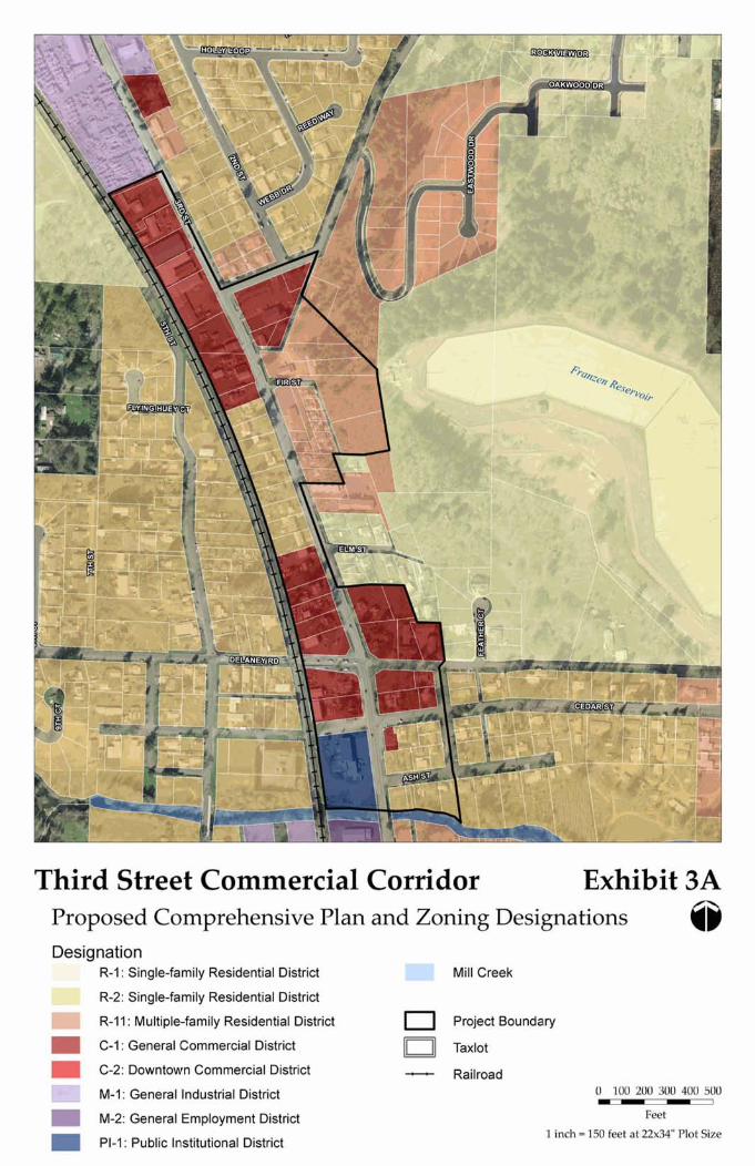
Third Street Commercial Corridor Exhibit 3A Proposed Comprehensive Plan and Zoning Designations @ Designation
R-I : Single-family Residential Districf
R-2: Single-family Residential District
R-I I : Multiplefamily Residential District
C-I : General Commercial District
C-2: Downtown Commercial District
M-I : General Industrial District
M-2: General Employment District
PI-I : Public Institutional District
Mill Creek
0 Project Boundary
- Railroad 0 100 200 300 400 500 - I
Feet
1 inch = I50 feet at 22x34" Plot Size
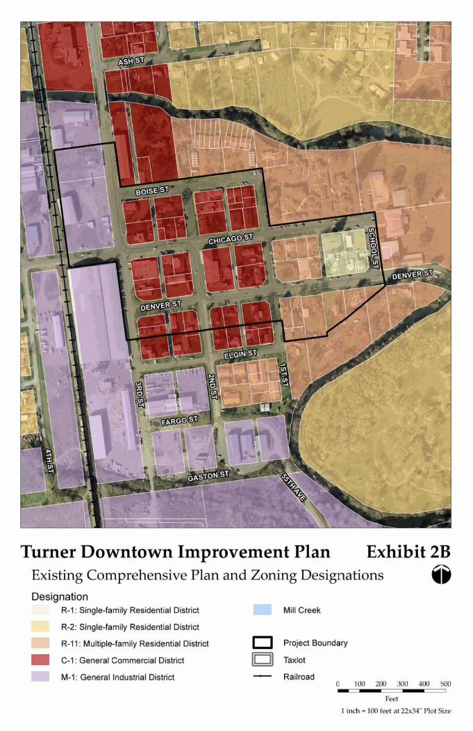
Turner Downtown Improvement Plan Exhibit 2, Existing Comprehensive Plan and Zoning Designations @ Designation
R-I : Single-family Residential District
R-2: Single-family Residential District - R-I 1 : M ultipl~family Residential District
C-I : General Commercial District
M-I : General Industrial District
Mill Creek
0 Project Boundary
Taxlot
Railroad 0 100 200 300 400 500 - - - I
Feet
1 inch = I00 feet at 22x34" Plot Size
Third Street Commercial Corridor Exhibit 3B Existing Comprehensive Plan and Zoning Designations @ Designation - R-I : Single-family Residential District
R-2: Single-family Residential District
R-I 1 : Multipl~family Residential District
C-I : General Commercial District
M-I : General Industrial District
Mill Creek
0 Project Boundary
- Railroad 0 100 200 300 400 500 - I
Feet
1 inch = 150 feet at 22x34" Plot Size
Turner Downtown Improvement Plan Exhibit 2C Aerial Photo @
Project Boundary
Taxlot
+ Railroad
o 100 200 300 400 500 - - - Feet
1 inch = 100 feet at 22x34" Plot Size
Third Street Commercial Corridor Aerial Photo
Exhibit 3C
Project Boundary
Taxlot
* Railroad
0 100 200 300 400 500 - I
Feet
1 inch = I50 feet at 22x34" Plot Size
Turner Downtown Improvement Plan Exhibit 2A-2 Proposed Comprehensive Plan and Zoning Designations @ Designation
R-I : Single-family Residential District
R-2: Single-family Residential District - R-I I : Multiple-family Residential District
C-I : General Commercial District
C-2: Downtown Commercial District
M-I : General Industrial District
M-2: General Employment District
PI-1: Public Institutional District
Study Area
Mill Creek
0 Project Baundaty
Railroad - - - I
Feet
1 inch = I00 feet at 22x34" Plot Size
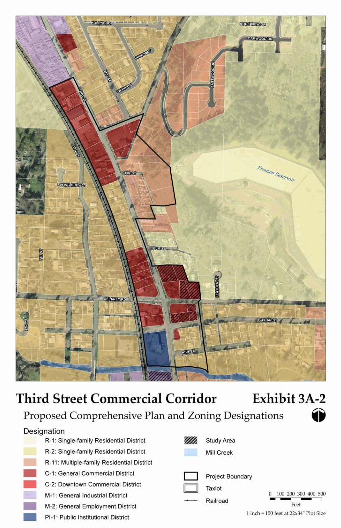
Third Street Commercial Corrido~ Exhibit 3A-2 Proposed Comprehensive Plan and Zoning Designations @ Designation
R-I : Single-family Residential District
R-2: Single-family Residential District
R-I I : Multiple-family Residential District
C-I : General Commercial District
C-2: Downtown Commercial District
M-I : General Industrial District
M-2: General Employment District
PI-1: Public Institutional District
Study Area
Mill Creek
0 Project Boundary
- Railroad 0 100 200 300 400 500 - I
Feet
1 inch = I50 feet at 22x34" Plot Size

Appendix G
Memorandum No. 6 – Public Event Summaries
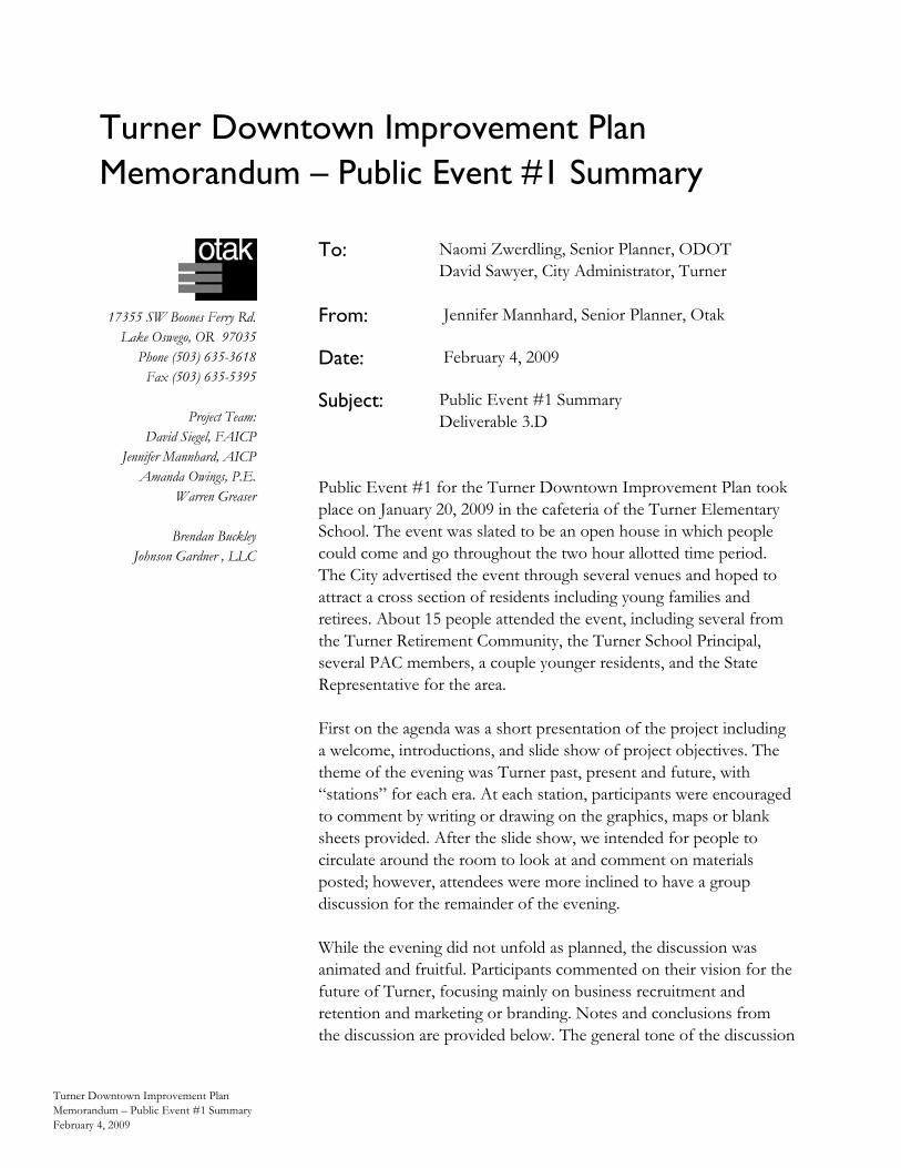
Turner Downtown Improvement Plan Memorandum – Public Event #1 Summary
Turner Downtown Improvement Plan Memorandum – Public Event #1 Summary February 4, 2009
17355 SW Boones Ferry Rd. Lake Oswego, OR 97035
Phone (503) 635-3618 Fax (503) 635-5395
Project Team:
David Siegel, FAICP Jennifer Mannhard, AICP
Amanda Owings, P.E. Warren Greaser
Brendan Buckley
Johnson Gardner , LLC
Public Event #1 for the Turner Downtown Improvement Plan took place on January 20, 2009 in the cafeteria of the Turner Elementary School. The event was slated to be an open house in which people could come and go throughout the two hour allotted time period. The City advertised the event through several venues and hoped to attract a cross section of residents including young families and retirees. About 15 people attended the event, including several from the Turner Retirement Community, the Turner School Principal, several PAC members, a couple younger residents, and the State Representative for the area. First on the agenda was a short presentation of the project including a welcome, introductions, and slide show of project objectives. The theme of the evening was Turner past, present and future, with “stations” for each era. At each station, participants were encouraged to comment by writing or drawing on the graphics, maps or blank sheets provided. After the slide show, we intended for people to circulate around the room to look at and comment on materials posted; however, attendees were more inclined to have a group discussion for the remainder of the evening. While the evening did not unfold as planned, the discussion was animated and fruitful. Participants commented on their vision for the future of Turner, focusing mainly on business recruitment and retention and marketing or branding. Notes and conclusions from the discussion are provided below. The general tone of the discussion
To: Naomi Zwerdling, Senior Planner, ODOTDavid Sawyer, City Administrator, Turner
From: Jennifer Mannhard, Senior Planner, Otak
Date: February 4, 2009
Subject: Public Event #1 Summary Deliverable 3.D
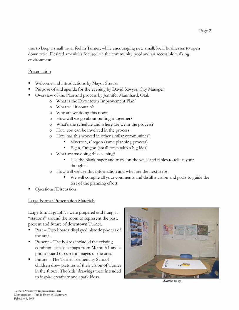
Page 2
Turner Downtown Improvement Plan Memorandum – Public Event #1 Summary February 4, 2009
was to keep a small town feel in Turner, while encouraging new small, local businesses to open downtown. Desired amenities focused on the community pool and an accessible walking environment. Presentation Welcome and introductions by Mayor Strauss Purpose of and agenda for the evening by David Sawyer, City Manager Overview of the Plan and process by Jennifer Mannhard, Otak
o What is the Downtown Improvement Plan? o What will it contain? o Why are we doing this now? o How will we go about putting it together? o What’s the schedule and where are we in the process? o How you can be involved in the process. o How has this worked in other similar communities?
Silverton, Oregon (same planning process) Elgin, Oregon (small town with a big idea)
o What are we doing this evening? Use the blank paper and maps on the walls and tables to tell us your
thoughts. o How will we use this information and what are the next steps.
We will compile all your comments and distill a vision and goals to guide the rest of the planning effort.
Questions/Discussion Large Format Presentation Materials Large format graphics were prepared and hung at “stations” around the room to represent the past, present and future of downtown Turner. Past – Two boards displayed historic photos of
the area. Present – The boards included the existing
conditions analysis maps from Memo #1 and a photo board of current images of the area.
Future – The Turner Elementary School children drew pictures of their vision of Turner in the future. The kids’ drawings were intended to inspire creativity and spark ideas.
Station set-up
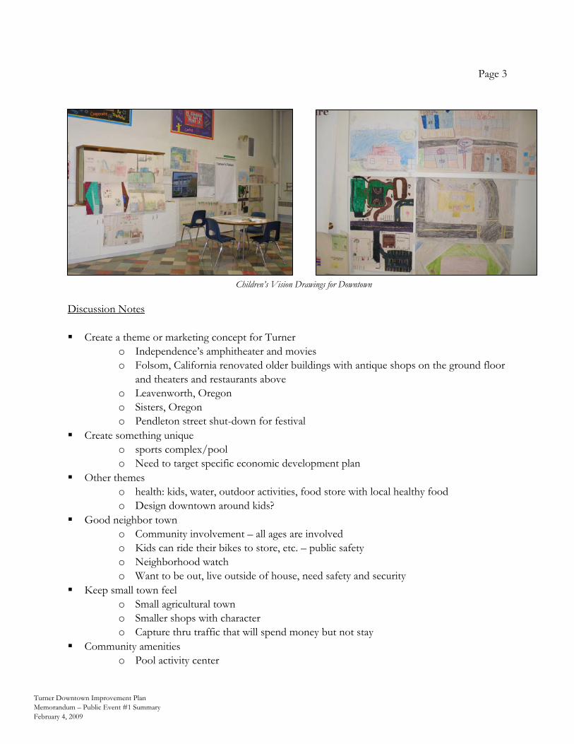
Page 3
Turner Downtown Improvement Plan Memorandum – Public Event #1 Summary February 4, 2009
Discussion Notes Create a theme or marketing concept for Turner
o Independence’s amphitheater and movies o Folsom, California renovated older buildings with antique shops on the ground floor
and theaters and restaurants above o Leavenworth, Oregon o Sisters, Oregon o Pendleton street shut-down for festival
Create something unique o sports complex/pool o Need to target specific economic development plan
Other themes o health: kids, water, outdoor activities, food store with local healthy food o Design downtown around kids?
Good neighbor town o Community involvement – all ages are involved o Kids can ride their bikes to store, etc. – public safety o Neighborhood watch o Want to be out, live outside of house, need safety and security
Keep small town feel o Small agricultural town o Smaller shops with character o Capture thru traffic that will spend money but not stay
Community amenities o Pool activity center
Children’s Vision Drawings for Downtown
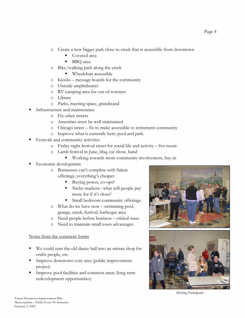
Page 4
Turner Downtown Improvement Plan Memorandum – Public Event #1 Summary February 4, 2009
o Create a new bigger park close to creek that is accessible from downtown Covered area BBQ area
o Bike/walking path along the creek Wheelchair accessible
o Kiosks – message boards for the community o Outside amphitheater o RV camping area for out-of-towners o Library o Parks, meeting space, grandstand
Infrastructure and maintenance o Fix other streets o Amenities must be well maintained o Chicago street – fix to make accessible to retirement community o Improve what is currently here: pool and park
Festivals and community activities o Friday night festival street for social life and activity – live music o Lamb festival in June, bbq, car show, band
Working towards more community involvement, buy-in Economic development
o Businesses can’t complete with Salem offerings, everything’s cheaper
Buying power, co-ops? Niche markets– what will people pay
more for if it’s close? Small bedroom community offerings
o What do we have now – swimming pool, grange, creek, festival, barbeque area
o Need people before business – critical mass o Need to maintain small town advantages
Notes from the comment forms We could turn the old dance hall into an artisan shop for
crafts people, etc. Improve downtown core area (public improvement
project) Improve pool facilities and common areas (long term
redevelopment opportunities)
Meeting Participants
Turner Downtown Improvement Plan Memorandum – Public Event #2 Summary
Turner Downtown Improvement Plan Memorandum – Public Event #2 Summary – March 18, 2009 L:\Project\14800\14840\Admin\Meetings\022609 Public Event #2\Turner Public Event 2 Summary Memo-031809.doc
17355 SW Boones Ferry Rd. Lake Oswego, OR 97035
Phone (503) 635-3618 Fax (503) 635-5395
Project Team:
David Siegel, FAICP Jennifer Mannhard, AICP
Amanda Owings, P.E. Martin Glastra van Loon
Brendan Buckley
Johnson Reid, LLC
Public Event #2 for the Turner Downtown Improvement Plan took place on February 27, 2009 in the Main Hall of the Aldersgate Retreat Center. The event was a joint work session for the members of Turner’s City Council and Planning Commission as well as the Project Advisory Committee. It was well attended by the invited members and members of the general public. The objectives of the evening were to: 1) receive confirmation of the draft vision, goals and policies; 2) solicit input for improvement of the vision, goals, and policies; and 3) brainstorm ideas for bringing the vision and goals to fruition. The agenda was as follows: 1) Welcome: Introductions, agenda overview, work session
objectives, and project status update 2) Vision, Goals and Policies: Review draft vision, goals and
policies memo, discussion and Q&A 3) Brainstorm Implementation Concepts: Quick review of concept
categories and small group work 4) Share Ideas & Wrap Up: Short reports from each group on the
ideas generated and next steps 5) Adjourn
To: Naomi Zwerdling, Senior Planner, ODOT
From: Jennifer Mannhard, Senior Planner, Otak
Date: March 18, 2009
Subject: Public Event #2 Summary Deliverable 4.C – with updated graphic
Page 2
Turner Downtown Improvement Plan Memorandum – Public Event #2 Summary – March 18, 2009 L:\Project\14800\14840\Admin\Meetings\022609 Public Event #2\Turner Public Event 2 Summary Memo-031809.doc
Vision, Goals and Policies Review and Discussion After giving a brief project status report to remind participants of the planning process and objectives, the consultant team presented the draft vision and goals. The meeting participants received the draft memorandum ahead of time, so they were not seeing the material for the first time. I explained how we wrote the vision statement and goals using information we had heard the community say at the Project Advisory Committee meeting, public event, and stakeholder interviews. The group confirmed the vision statement was appropriate and had only one suggestion for improvement. The request was to add a statement to the vision that speaks to the ideas of “preserve the old, merge with the new” and “celebrate history.” Although the policy of using history as inspiration was included in the urban design section, the group consensus was to include the idea in the vision statement as well. We presented each topic area of the goals individually, allowing for discussion and questions after each. Overall, the group confirmed the goals and policies were appropriate and correct. The comments and requests for additions were to improve upon the policies. The following bullet points reflect the comments made for each topic.
Urban design There should be a statement about continuity and how things should flow.
Transportation Limit through traffic on interior streets. Add walking or multi-use paths – take advantage of the creek– create a pedestrian network Use Downtown as a pedestrian hub from which paths originate, link with existing paths
Economic Development Provide incentives to current businesses to contribute to plan implementation. For example,
sidewalks or landscaping in front of businesses is ordinarily done only for a new development, but the city could provide an incentive or grant for existing businesses to improve their streetscape frontage.
Through the discussion there were several comments and questions related to economic and business development. We need someone to market Turner. We need to create our vision (the community’s and city’s). This will provide direction for our
marketing efforts.
Page 3
Turner Downtown Improvement Plan Memorandum – Public Event #2 Summary – March 18, 2009 L:\Project\14800\14840\Admin\Meetings\022609 Public Event #2\Turner Public Event 2 Summary Memo-031809.doc
Focus should be on fixing the streets and sidewalks. Make the town look better, and make it business-friendly and hassle-free.
What are some funding sources? o Urban renewal o Local improvement districts o State programs o Possibly stimulus package money (The Mayor comments that Chicago Street
improvements may come out of the greater county’s share of the stimulus package.) What did Silverton do? Where did they get money?
o The plan itself and a follow up redevelopment study were done through a TGM grant. We can follow up on this.
Are private foundations (such as Fred Meyer) an option as a funding source? o They are not really a viable option because they are so site specific.
Brainstorming The participants were split into three small groups, each facilitated by a member of the consultant team. A fourth member of the consultant team also rotated among the three tables to help guide discussion of urban design concepts. The facilitators led the participants in a brainstorming session to identify concepts that would fulfill the vision and goals. They prompted the participants with questions like the following and took notes on large maps provided. What do residents consider the “heart” of downtown? Where is the new town plaza, event pavilion, or amphitheater? What tells people they’ve entered downtown Turner? What uses are along Denver, Chicago, 2nd? What do the sidewalks look like? What do the buildings look like? Where is the trail that connects to the creek? What brings people to downtown on a Saturday? What now occupies the vacant land next to the mill building? Where do people park their bikes? Their cars? How has the community pool been improved? How do people travel between Turner and neighboring communities? Where is city hall? the community center?
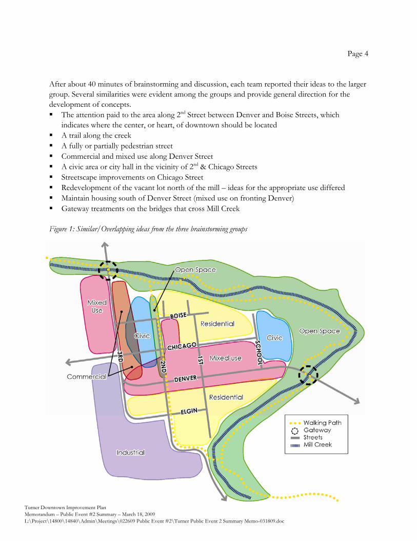
Page 4
Turner Downtown Improvement Plan Memorandum – Public Event #2 Summary – March 18, 2009 L:\Project\14800\14840\Admin\Meetings\022609 Public Event #2\Turner Public Event 2 Summary Memo-031809.doc
After about 40 minutes of brainstorming and discussion, each team reported their ideas to the larger group. Several similarities were evident among the groups and provide general direction for the development of concepts. The attention paid to the area along 2nd Street between Denver and Boise Streets, which
indicates where the center, or heart, of downtown should be located A trail along the creek A fully or partially pedestrian street Commercial and mixed use along Denver Street A civic area or city hall in the vicinity of 2nd & Chicago Streets Streetscape improvements on Chicago Street Redevelopment of the vacant lot north of the mill – ideas for the appropriate use differed Maintain housing south of Denver Street (mixed use on fronting Denver) Gateway treatments on the bridges that cross Mill Creek
Figure 1: Similar/Overlapping ideas from the three brainstorming groups
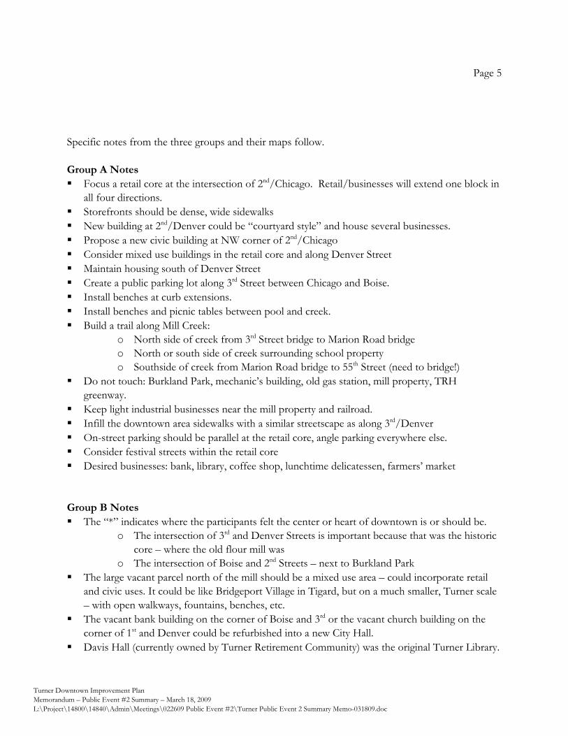
Page 5
Turner Downtown Improvement Plan Memorandum – Public Event #2 Summary – March 18, 2009 L:\Project\14800\14840\Admin\Meetings\022609 Public Event #2\Turner Public Event 2 Summary Memo-031809.doc
Specific notes from the three groups and their maps follow. Group A Notes Focus a retail core at the intersection of 2nd/Chicago. Retail/businesses will extend one block in
all four directions. Storefronts should be dense, wide sidewalks New building at 2nd/Denver could be “courtyard style” and house several businesses. Propose a new civic building at NW corner of 2nd/Chicago Consider mixed use buildings in the retail core and along Denver Street Maintain housing south of Denver Street Create a public parking lot along 3rd Street between Chicago and Boise. Install benches at curb extensions. Install benches and picnic tables between pool and creek. Build a trail along Mill Creek:
o North side of creek from 3rd Street bridge to Marion Road bridge o North or south side of creek surrounding school property o Southside of creek from Marion Road bridge to 55th Street (need to bridge!)
Do not touch: Burkland Park, mechanic’s building, old gas station, mill property, TRH greenway.
Keep light industrial businesses near the mill property and railroad. Infill the downtown area sidewalks with a similar streetscape as along 3rd/Denver On-street parking should be parallel at the retail core, angle parking everywhere else. Consider festival streets within the retail core Desired businesses: bank, library, coffee shop, lunchtime delicatessen, farmers’ market
Group B Notes The “*” indicates where the participants felt the center or heart of downtown is or should be.
o The intersection of 3rd and Denver Streets is important because that was the historic core – where the old flour mill was
o The intersection of Boise and 2nd Streets – next to Burkland Park The large vacant parcel north of the mill should be a mixed use area – could incorporate retail
and civic uses. It could be like Bridgeport Village in Tigard, but on a much smaller, Turner scale – with open walkways, fountains, benches, etc.
The vacant bank building on the corner of Boise and 3rd or the vacant church building on the corner of 1st and Denver could be refurbished into a new City Hall.
Davis Hall (currently owned by Turner Retirement Community) was the original Turner Library.
Page 6
Turner Downtown Improvement Plan Memorandum – Public Event #2 Summary – March 18, 2009 L:\Project\14800\14840\Admin\Meetings\022609 Public Event #2\Turner Public Event 2 Summary Memo-031809.doc
Open the old mill race – the green dashed line that cuts through the vacant mill property and runs down 3rd, Elgin, and 2nd over to the creek indicates its original location.
Create a trail along the creek – but how do you accommodate the yearly high water? Turner Retirement Community is not opposed to a trail along the creek but does have concerns about the proximity to their extended care facility.
Focus some redevelopment effort on the properties between Denver and Chicago and 2nd Streets. Close off part of 2nd Street to create a pedestrian walkway or plaza.
The Lamb Festival parade comes down Marion Road and cuts in front of the school to Chicago Street and up 2nd to the Burkland Park area. Events take place on the school grounds and a closed off section of Boise Street in front of the Park.
Group C Notes Participants talked at length about a continuous walking path around the city center, which
would loop from the tabernacle around the school and retirement center and through downtown as shown on the map.
The town “core” was thought to be the blocks between 3rd and 1st, and Denver and the Creek. A future civic use (city offices, police, etc. was envisioned at the north end of this core, near the
creek. The retail core was envisioned around where current shops are found, as well as the vacant mill
site at 3rd and Chicago. The church was discussed as a building to reuse for its historical nature. We discussed the importance of improved sidewalks and accessibility of pedestrians and bikes. Two blocks were identified as potential shared street, allowing cars but with a heavy multi-use
design. We discussed opening up some of the former Mill race loop, perhaps as just a water feature. We discussed the importance of connecting the core, the retirement community and the school. The owner of the vacant 2-story former “dance hall” building is considering redeveloping it as a
car wash. Potential gateways were identified as visitors cross the Creek on 3rd, and on Denver (by
Tabernacle).
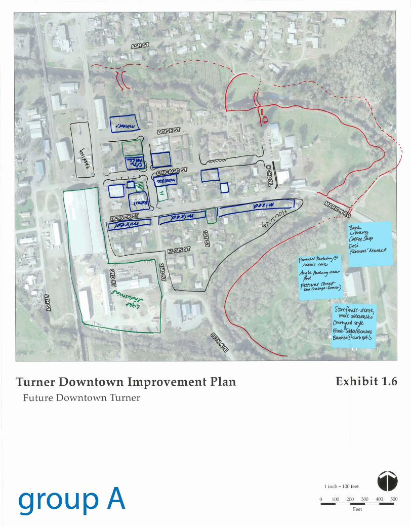
group A 1 inch = 100 feet Q
0 100 200 NX) 400 500 -- - Feet
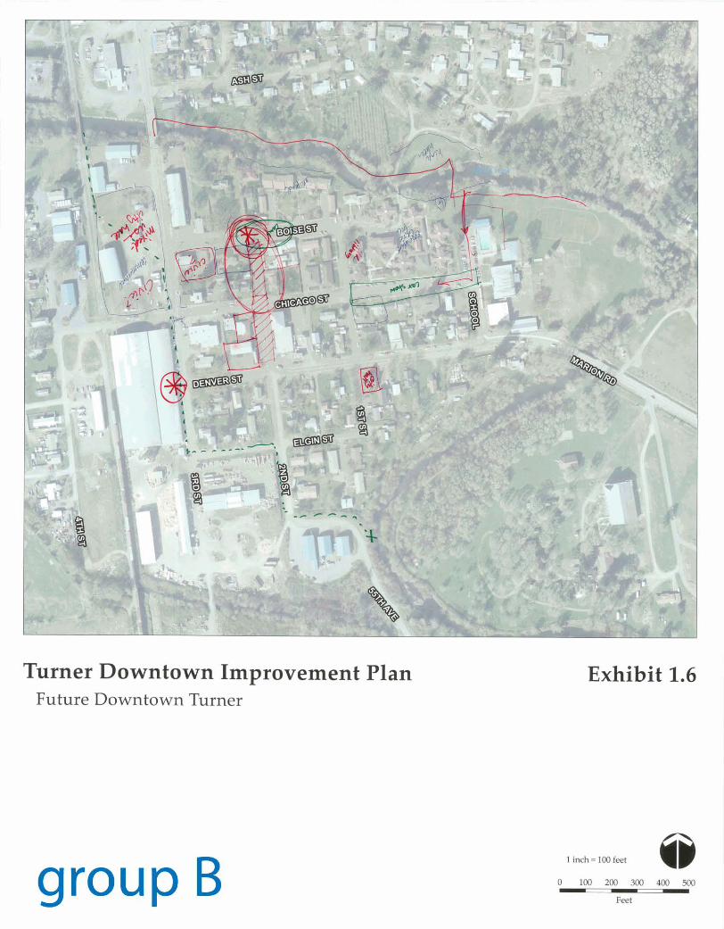
Turner Downtown Improvement Plan Future Downtown Turner
group B
Exhibit 1.6 ,
1 inch = 1W feet
0 100 200 300 400 500
Feet
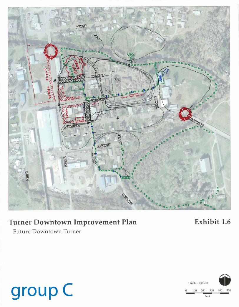
Turner Downtown Improvement Plan Future Downtown Turner
group c
Exhibit 1.6
1 inch = I00 feet @ 0 100 ZW 300 400 5W
Feet
Turner Downtown Improvement Plan
Memorandum – Public Event #3 Summary
Turner Downtown Improvement Plan
Memorandum – Public Event #2 Summary – March 18, 2009
L:\Project\14800\14840\Admin\Meetings\Public Event #3\Turner Public Event 3 Summary Memo-050509.doc
17355 SW Boones Ferry Rd.
Lake Oswego, OR 97035
Phone (503) 635-3618
Fax (503) 635-5395
Project Team:
David Siegel, FAICP
Jennifer Mannhard, AICP
Amanda Owings, P.E.
Martin Glastra van Loon
Brendan Buckley
Johnson Reid, LLC
Public Event #3 for the Turner Downtown Improvement Plan took
place on April 15, 2009 at the Turner Fire Hall, and served as both
Public Event #3 and Project Advisory Committee Meeting #2. The
objectives of the meeting were to: 1) provide a recap of the previous
agreements and direction on project vision and goals; 2) confirm
direction received at the previous workshop on plan concepts; and 3)
receive comments on Technical Memorandum #4, the proposed
strategies for achieving the project’s vision and goals.
The agenda for the meeting was as follows:
1) Welcome
• Introductions
• Agenda overview
• Meeting objectives
2) Project Status Update
3) Review Vision and Goals
4) Draft Recommendations
• Urban design
• Land use
• Transportation
• Redevelopment
• Business development
5) Draft Implementation Strategies
6) Share Ideas
7) Next Steps
8) Adjourn
A summary overview of the meeting is provided below.
To: Naomi Zwerdling, Senior Planner, ODOT
From: David Siegel, Principal, Otak
Date: May 5, 2009
Subject: Public Event #3 Summary
Turner Downtown Improvement Plan Memorandum Page 2
Public Event #3 Summary May 5, 2009
Turner Downtown Improvement Plan
Memorandum – Public Event #2 Summary – March 18, 2009
L:\Project\14800\14840\Admin\Meetings\Public Event #3\Turner Public Event 3 Summary Memo-050509.doc
Project Update and Review of Vision and Goals
After providing an update on the status of the project, David Siegel provided a presentation that
recapped the project’s vision and goals, and reviewed the major comments provided in the previous
work session addressing plan ideas and concepts. Those in attendance were asked if these still rang
true, and a positive acknowledgement was received.
Draft Recommendations and Implementation Strategies
Following the summary of previous steps, David Siegel and Brendan Buckley presented a summary
of the strategies that were covered in Technical Memorandum #4, and gave each of the group a
summary sheet that provided room for written comments. The strategies for each of the five themes
(Urban design, Land use, Transportation, Redevelopment, Business development) was discussed in
turn, with the consultants pausing after each segment of the presentation to ask the group for their
comments or questions about each of the segments. There was good discussion amongst the group
about each of the five themes. The following points were raised during the discussion:
• Third Street North. The consultant team questioned those present regarding the commercially-
zoned area north of downtown, asking if there were thoughts about how to ensure that the
commercial uses that could occur in this area in the future would be of a type and scale that
would not compete with desired Downtown commercial uses. The group had a discussion
regarding the sorts of commercial uses that would benefit or conflict with what was envisioned
for downtown. They generally agreed that the two areas were different, and picked up on the
idea of developing a different zone unique to the downtown. People liked the idea of pursuing
design guidelines…not a theme, but written guidance that would yield more attractive
development. The consultant team noted that the development of design guidelines was going to
be among the recommendations for short-term implementation actions, and that this was
something the City might wish to consider preparing in the near-term, following Plan adoption.
• Festival Street and Creekside Trail. A concern was noted about how proposals like a creek side
trail or a festival street closure might affect some of the Turner retirement home units. David
Siegel indicated that public trails almost always abut someone’s private property, and that they
were normally sited on easements obtained from private property owners. With regard to
potential concerns over privacy or trespassing, it was noted that sometimes fencing, landscaping,
or other techniques were used to provide a physical separation between a trail/pathway and
private property. Among the short term actions for implementation will be the initial planning
for the creek side trail, which will include the examination of how to ensure the trail is a good
neighbor to abutting properties. With regard to the occasional closure of the Festival Street with
bollards, it was explained that the closure would only affect a small segment of the street, and
not preclude emergency vehicle access to any part of downtown; in addition, the bollards can
easily be removed for emergency access to the temporary festival area.
Turner Downtown Improvement Plan Memorandum Page 3
Public Event #3 Summary May 5, 2009
Turner Downtown Improvement Plan
Memorandum – Public Event #2 Summary – March 18, 2009
L:\Project\14800\14840\Admin\Meetings\Public Event #3\Turner Public Event 3 Summary Memo-050509.doc
• Parking. The group discussed the issue of parking or the lack thereof, and reviewed the proposed
street cross-sections and provisions for parking. Mayor Strauss noted that the city is already
working on the issue of street redesign, and that the City’s efforts were consistent with what is
being recommended by the consultants.
• Implementation Strategies. The consultants presented Implementation Strategies and the group
discussed the proposed short-term and longer term actions, and the need for the community to
prioritize. Mayor Strauss emphasized the need for prioritizing actions while retaining the
flexibility to respond to immediate opportunities.
As noted above, the group was provided with comment forms to note suggestions during the
meeting. A summary of the comments received is as follows:
• Move the following implementation actions/strategies from ―long-term‖ to ―short-term‖:
o Undergrounding of existing utility systems and requiring new development to locate utilities
underground.
o Development of the Mill Creek trail into a continuous pedestrian path (including the bridges
to create a complete, looped system).
o Expanding and covering the pool facility should be among the short-term actions.
o Developing the plaza to connect proposed future civic uses to Burkland Park.
• Consider partnering with Aumsville to create a Chamber of Commerce.
• Recreate the gazebo/jail seen in the historical photographs of Turner.
• Creating a standing body to represent and promote Turner businesses should be an immediate
action.
• Rather than relocating City Hall to a downtown location to establish a civic presence prior to
identifying a permanent site, consider constructing a new City Hall downtown as a short-term
objective.
• When considering urban design treatments and actions, ensure that trees, landscaping and green
spaces are included. Consider the use of green streets for their double benefit: greenery and
stormwater management.
• Establishing/locating a farmers market and/or other events within the Downtown ought to be
among the short-term actions. Events should be held frequently.
• Improve signage directing visitors to Downtown.
• Consider an additional Gateway at Chicago Street.
• Allow angle parking in front of the Turner Market convenience store.
• The City needs to look at urban renewal as a tool to encourage development and redevelopment,
and needs to do so in the short-term.
• Initiate the discussions and planning on flood control
Turner Downtown Improvement Plan Memorandum Page 4
Public Event #3 Summary May 5, 2009
Turner Downtown Improvement Plan
Memorandum – Public Event #2 Summary – March 18, 2009
L:\Project\14800\14840\Admin\Meetings\Public Event #3\Turner Public Event 3 Summary Memo-050509.doc
In summary, the evening’s discussion indicated agreement with the suggested strategies within each
of the five themed categories. David Siegel wrapped up the evening’s discussion by noting that the
next step in the process will be the preparation of the draft plan, reflecting the vision, goals, plan
concept, and implementing strategies prepared to-date. He also noted that the final plan
recommendations will emphasize actions and priorities in three categories—organizational (things
that businesses can do together), physical improvements (infrastructure, etc.), and administrative
(actions the city can take such as streamlining permitting, amending the zoning ordinance and
Transportation System Plan, etc.).
The meeting was adjourned at 9:00 p.m.
Turner Downtown Improvement Plan
Memorandum – Public Event #4 Summary
Turner Downtown Improvement Plan
Memorandum – Public Event #4 Summary – June 9, 2009
L:\Project\14800\14840\Admin\Meetings\Turner Public Event 4 Summary Memo-060909 (2).doc
17355 SW Boones Ferry Rd.
Lake Oswego, OR 97035
Phone (503) 635-3618
Fax (503) 635-5395
Project Team:
David Siegel, FAICP
Jennifer Mannhard, AICP
Amanda Owings, P.E.
Jerry Offer
Martin Glastra van Loon
Brendan Buckley
Johnson Reid, LLC
Public Event #4 for the Turner Downtown Improvement Plan took
place on May 21, 2009 at 7:00 PM in City Hall. The event was open
to the public, the City Council, the Planning Commission, and the
Project Advisory Committee. The meeting was moderately attended.
A new task had been added to the scope of work for the Downtown Improvement Plan: to analyze
and provide recommendations for the General Commercial-zoned area along the 3rd Street corridor
north of Downtown that will ensure that the commercial uses are of a type and scale that will not
compete with downtown commercial uses and will not lead to commercial strip development.
The purpose of the event was twofold: 1) to present and discuss suggested revisions to the zoning
code; and 2) to present and discuss changes to the City’s zoning map being recommended for both
the Downtown area and for the area referred to as the “3rd Street Corridor” north of Downtown for
achieving the objectives of the Downtown Improvement Plan. The agenda for the meeting was as
follows:
1) Welcome
• Introductions
• Agenda Overview
• Work Session Objectives
• Project Status Update
2) Overview and Status of Draft Plan
3) Draft Changes to Zone Code
4) Application of Zoning to 3rd Street Corridor
5) Application of Zoning to Downtown
6) Wrap Up and Adjourn
To: Naomi Zwerdling, Senior Planner, ODOT
David Sawyer, City Administrator, City of Turner
From: David Siegel, Project Manager, Otak
Date: June 9, 2009
Subject: Public Event #4 Summary
3rd Street Corridor Land Use & Zoning Analysis
Project Deliverable 9.E
Turner Downtown Improvement Plan Memorandum Page 2
Public Event #4 Summary June 9, 2009
Turner Downtown Improvement Plan
Memorandum – Public Event #4 Summary – June 9, 2009
L:\Project\14800\14840\Admin\Meetings\Turner Public Event 4 Summary Memo-060909 (2).doc
Welcome, Overview and Status
A brief project status report and presentation was provided by the consultant team to remind
participants of the planning process and the Plan’s vision, goals, and objectives. The scope of the
new task regarding the analysis and recommendations for land use and zoning along the 3rd Street
corridor was reviewed. In discussing the scope, the team mentioned that attention had been paid to
the following three objectives:
• Discouraging strip commercial development;
• Maintaining active residential uses and neighborhoods where they currently exist along the
corridor; and
• Enhancing the 3rd Street corridor as a gateway to Downtown Turner.
Brendan Buckley made a brief presentation regarding the differences between the types of
commercial uses one typically finds in a historical downtown environment versus what is typically
found in an arterial street commercial environment. This portion of the presentation focused upon a
number of topics including:
• The street orientation of buildings;
• Parking;
• Scale; and
• Customer base.
Draft Changes to Zone Code
The consultant team presented the draft changes to the City’s zoning code, discussing the creation
of two new zoning districts: a C-2 Downtown Mixed-Use district and an M-2 Downtown General
Employment district. The consultant team’s presentation focused upon the intent of the proposed
zones and the various uses recommended to be permitted or excluded from each zoning district,
with discussion regarding allowed uses, prohibited uses, conditional uses, and the various standards
contained within the zones. Those attending had received ahead of time a draft memorandum
summarizing the proposed districts, a draft of the proposed zoning code language for each of the
districts, and proposed zoning maps.
Among the topics discussed or points made during the discussion of the districts included the
following:
Parking
• Advantages and disadvantages of angle and parallel parking (discussion).
• Whether there was enough parking downtown for envisioned commercial and residential uses.
Conclusion–yes. Actual individual future development projects cannot be known at this time,
and although parking appears to be ample for the amount of development that is reasonably
Turner Downtown Improvement Plan Memorandum Page 3
Public Event #4 Summary June 9, 2009
Turner Downtown Improvement Plan
Memorandum – Public Event #4 Summary – June 9, 2009
L:\Project\14800\14840\Admin\Meetings\Turner Public Event 4 Summary Memo-060909 (2).doc
projected to occur, this can be evaluated again in the future once actual development begins to
occur.
Housing
• Should new, individual single-family housing be permitted within a downtown commercial zone?
Conclusion–single-family residential should not be permitted. Multifamily residential should be
permitted downtown, and is to be encouraged. The proposed zoning ordinance will need to be
revised accordingly.
Design Standards
• Discussion of building heights. Consensus was to continue with a maximum allowed building
height of 35 feet –same as the C-1 district.
• Discussion of proposed standard requiring double-hung windows or the appearance of double-
hung windows for upper story windows in the C-2 and M-2 districts. Consensus was to keep this
standard.
• The proposal “drive-through business” prohibition for the C-s and M-2 districts was discussed.
Consensus was to modify this to prohibit drive-through windows so to not prohibit drive-
through garages or car washes.
• General approval of design standards was discussed. The attendees said that it was necessary to
have a clear physical vision for Downtown and that the proposed standards helped promote that
vision. The former Turner bank building was discussed as a good example of what the ordinance
was trying to achieve. That building has been modified through the years so that it no longer has
all of its original historic character, but it still has the storefront character which the proposed
design standards are trying to achieve.
• It was suggested that illustrations be provided within the revised zoning ordinance zones to help
convey the intention and desired result of the design standards.
• Agreement that clear standards were desired, and that downtown design standards should be
strong and capable of achieving the vision, not be watered down.
Economic Implications of Detail within Regulations
• In response to a question of what the economic implications of providing more detail within
zoning regulations might be, the consultant team replied:
o Following regulations can sometimes be more costly than not, but you gain from having
greater predictability in what the City will see in its new development.
o The proposed regulations will likely not to be a roadblock for new development, because
there are economic benefits from locating downtown, and within these new zones. You get
the benefits of the close proximity to a number of businesses and the benefit of more public
investment in infrastructure and amenities.
Turner Downtown Improvement Plan Memorandum Page 4
Public Event #4 Summary June 9, 2009
Turner Downtown Improvement Plan
Memorandum – Public Event #4 Summary – June 9, 2009
L:\Project\14800\14840\Admin\Meetings\Turner Public Event 4 Summary Memo-060909 (2).doc
o Property owners gain from having greater predictability in what to expect to see from new
development near and around them, and that this also helps preserve and protect the
investments they’ve made.
Prohibited Uses
Add “towing” to the list of prohibited uses within the M-2 zone.
As a result of the above discussion, the team made note of the above and indicated that changes
would be made to the individual zones to reflect the discussion.
Application of Zoning to 3rd Street Corridor
The consultant team moved on to the application of zoning districts to the 3rd Street corridor.
There was a brief discussion of history and why the current zoning had been put in place. The team
led those in attendance in a review of two maps; one with the current zoning, and one with the
proposed zoning; and led a property-by-property discussion of where they were recommending the
current zoning designations be retained, and where a change in designation was being
recommended.
Historically, the C-1 Commercial district has been applied to most of both sides of the 3rd Street
corridor, creating the potential for significant stretches of strip commercial development in the
future. In order to focus the limited demand for commercial land in Turner upon the Downtown
area and in areas along 3rd Street which are already in predominantly commercial use, the consultant
team recommended that a number of the existing C-1 zoned properties on the east side of 3rd Street
to just beyond Elm Street be rezoned to R-11 Single-Family Residential, as such zoning would be
reflective of the existing uses and zoning of these properties, and of neighboring properties to the
east. The property upon which the current City Hall is sited was proposed for rezoning to R-11, in
response to the draft Downtown Improvement Plan’s recommendation to relocate City Hall to a
downtown location in the future and thereby providing for the existing City Hall site to be
redeveloped. For the west side of 3rd Street, it was recommended that C-1 zoning be retained for the
mostly commercial uses from Mill Creek up to and including the Classic Auto Storage and Sales site.
Beyond that point, there is a solid stretch of single-family homes up to Triple D Windows. It was
recommended that this area be rezoned to R-2 to maintain the existing single-family uses and to help
preserve this small neighborhood. By and large, the recommended zoning was acknowledged as
being appropriate by those in attendance at the meeting, with the following exception: since the
intersection of 3rd Street and Delaney will likely be the site of a future traffic signal, and since much
of the property on the corners of this intersection were already commercial, it made sense for all of
the properties at this corner to be designated as commercial, as well. The consultant team
acknowledged the direction received and will make changes to the recommended zoning map as
noted.
Turner Downtown Improvement Plan Memorandum Page 5
Public Event #4 Summary June 9, 2009
Turner Downtown Improvement Plan
Memorandum – Public Event #4 Summary – June 9, 2009
L:\Project\14800\14840\Admin\Meetings\Turner Public Event 4 Summary Memo-060909 (2).doc
Application of Zoning to Downtown
The consultant team then addressed the application of the zoning districts discussed earlier in the
meeting to the Downtown Improvement Plan project area. The team again led a review of two
maps, one with the current zoning, and one with the proposed zoning, and led a property-by-
property discussion of where they were recommending the current zoning designations be retained,
and where a change in designation was being recommended. Discussion focused upon a few areas,
including:
• Application of the C-2 Downtown Mixed-Use District appeared appropriate in most areas for
which it was suggested. The C-2 district is intended to replace the C-1 zoning Downtown, as
well as the Downtown overlay zone.
• Several properties fronting on Elgin Street (and right as it transitions to become 3rd Street at the
curve) are proposed to be rezoned from the existing C-1 district to R-11, given their current
residential use and the unlikelihood of their being redeveloped with commercial uses in the
future, as they are not within what would be considered the Downtown’s core commercial
component.
• The southern portions of properties located on the south side of Denver Street between 1st
Street and Mill Creek were being considered for residential designation. However, as the portion
of these properties fronting on Denver Street are proposed for the C-2 designation, and given
that the southern portions of these properties were in areas subject to flooding and unlikely to
develop, it made sense for the southern portions of these properties to also be zoned the same
as the northern portion fronting Denver Street.
• The M-2 Downtown General Employment District was proposed for application to that area
west of 3rd Street and north of Chicago Street. There was agreement that the M-2 district was
appropriate, but that providing the City with additional flexibility to consider a broader range of
uses might be desired. The consultant team indicated they’d look into this. The City
Administrator indicated he would be in contact with the owners of this property to have a
discussion regarding their preferences and their plans for the future.
• Application of the M-1 General Industrial District to the property south of Chicago Street and
west of 3rd Street (and south of Elgin Street and west of 2nd Street) was discussed at some length,
and it was agreed that this designation was appropriate for the moment. Given the current
economic uncertainty of the current use on the property, the issue of zoning designations might
need to be addressed again in the near future.
It was suggested that two zoning maps be prepared. The first map would show the “initial proposed
zoning” (reflecting the consultant team’s initial draft recommendations, as amended by the
discussion at the work session); the second map would show the same designations, but with cross-
hatching provided over any areas where there was a need for more discussion prior to a decision
Turner Downtown Improvement Plan Memorandum Page 6
Public Event #4 Summary June 9, 2009
Turner Downtown Improvement Plan
Memorandum – Public Event #4 Summary – June 9, 2009
L:\Project\14800\14840\Admin\Meetings\Turner Public Event 4 Summary Memo-060909 (2).doc
being made. This cross-hatching would be placed upon the area designated M-2 Downtown General
Employment, and the area designated M-1 General Industrial.
Wrap-up and Adjournment
After concluding remarks by the City Administrator and the consultant team, the meeting was
adjourned at 9:15 p.m.
Appendix H
Memorandum No. 7 – Recommended Changes to
Regulatory Environment
Turner Downtown Improvement Plan
Memorandum #7 – Regulatory Amendments
Turner Downtown Improvement Plan
Memo #7 – Regulatory Amendments – June 16, 2009
L:\Project\14800\14840\Planning\TurnerRegulatoryAmendMemo 7 061609.doc
17355 SW Boones Ferry Rd.
Lake Oswego, OR 97035
Phone (503) 635-3618
Fax (503) 635-5395
Project Team:
David Siegel, FAICP
Jennifer Mannhard, AICP
Amanda Owings, P.E.
Warren Greaser
Jerry Offer
Brendan Buckley Johnson Reid ,LLC
Purpose of this Memorandum
This memorandum is intended to pull together the recommended amendments to the City of
Turner Comprehensive Plan, the Land Use and Development Code, the Comprehensive Plan and
Zoning Districts Map, and the Transportation Systems Plan into one package of potential
amendments to the regulatory documents of the City of Turner in order to implement the Turner
Downtown Improvement Plan.
The proposed amendments are described in brief below, with four attachments related to 1) the
Comprehensive Plan; 2) the Land Use Development Code; 3) the Comprehensive Plan and Zoning
Districts Map; and 4) the Transportation System Plan. In the attachments related to the
Comprehensive Plan, Land Use and Development Code, and the Transportation System Plan,
language to be added to is highlighted and underlined in the draft revision packages attached to this
memo. Language to be deleted is shown in [brackets and highlighted].
Draft revisions to the Comprehensive Plan and Zoning Districts Map are presented on two maps,
Exhibit 2A – Turner Downtown Improvement Plan Proposed Comprehensive Plan and Zoning
Designations, and Exhibit 3A – Third Street Commercial Corridor Proposed Comprehensive Plan
and Zoning Designations.
To: Naomi Zwerdling, Senior Planner, ODOT
David Sawyer, City Administrator, Turner
From: David Siegel, Planning Manager, Otak
Jerry Offer, Senior Planner, Otak
Date: June 16, 2009
Subject: Memo #7 – Regulatory Amendments
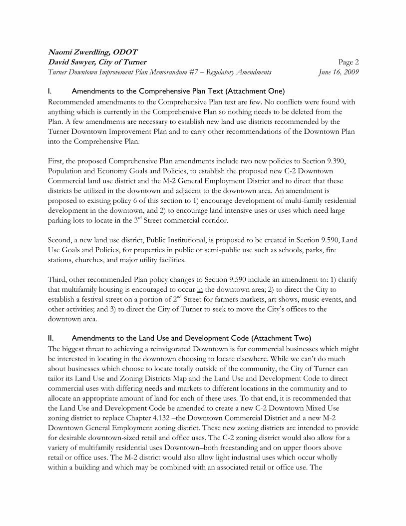
Naomi Zwerdling, ODOT
David Sawyer, City of Turner Page 2
Turner Downtown Improvement Plan Memorandum #7 – Regulatory Amendments June 16, 2009
I. Amendments to the Comprehensive Plan Text (Attachment One)
Recommended amendments to the Comprehensive Plan text are few. No conflicts were found with
anything which is currently in the Comprehensive Plan so nothing needs to be deleted from the
Plan. A few amendments are necessary to establish new land use districts recommended by the
Turner Downtown Improvement Plan and to carry other recommendations of the Downtown Plan
into the Comprehensive Plan.
First, the proposed Comprehensive Plan amendments include two new policies to Section 9.390,
Population and Economy Goals and Policies, to establish the proposed new C-2 Downtown
Commercial land use district and the M-2 General Employment District and to direct that these
districts be utilized in the downtown and adjacent to the downtown area. An amendment is
proposed to existing policy 6 of this section to 1) encourage development of multi-family residential
development in the downtown, and 2) to encourage land intensive uses or uses which need large
parking lots to locate in the 3rd Street commercial corridor.
Second, a new land use district, Public Institutional, is proposed to be created in Section 9.590, Land
Use Goals and Policies, for properties in public or semi-public use such as schools, parks, fire
stations, churches, and major utility facilities.
Third, other recommended Plan policy changes to Section 9.590 include an amendment to: 1) clarify
that multifamily housing is encouraged to occur in the downtown area; 2) to direct the City to
establish a festival street on a portion of 2nd Street for farmers markets, art shows, music events, and
other activities; and 3) to direct the City of Turner to seek to move the City’s offices to the
downtown area.
II. Amendments to the Land Use and Development Code (Attachment Two)
The biggest threat to achieving a reinvigorated Downtown is for commercial businesses which might
be interested in locating in the downtown choosing to locate elsewhere. While we can’t do much
about businesses which choose to locate totally outside of the community, the City of Turner can
tailor its Land Use and Zoning Districts Map and the Land Use and Development Code to direct
commercial uses with differing needs and markets to different locations in the community and to
allocate an appropriate amount of land for each of these uses. To that end, it is recommended that
the Land Use and Development Code be amended to create a new C-2 Downtown Mixed Use
zoning district to replace Chapter 4.132 –the Downtown Commercial District and a new M-2
Downtown General Employment zoning district. These new zoning districts are intended to provide
for desirable downtown-sized retail and office uses. The C-2 zoning district would also allow for a
variety of multifamily residential uses Downtown–both freestanding and on upper floors above
retail or office uses. The M-2 district would also allow light industrial uses which occur wholly
within a building and which may be combined with an associated retail or office use. The
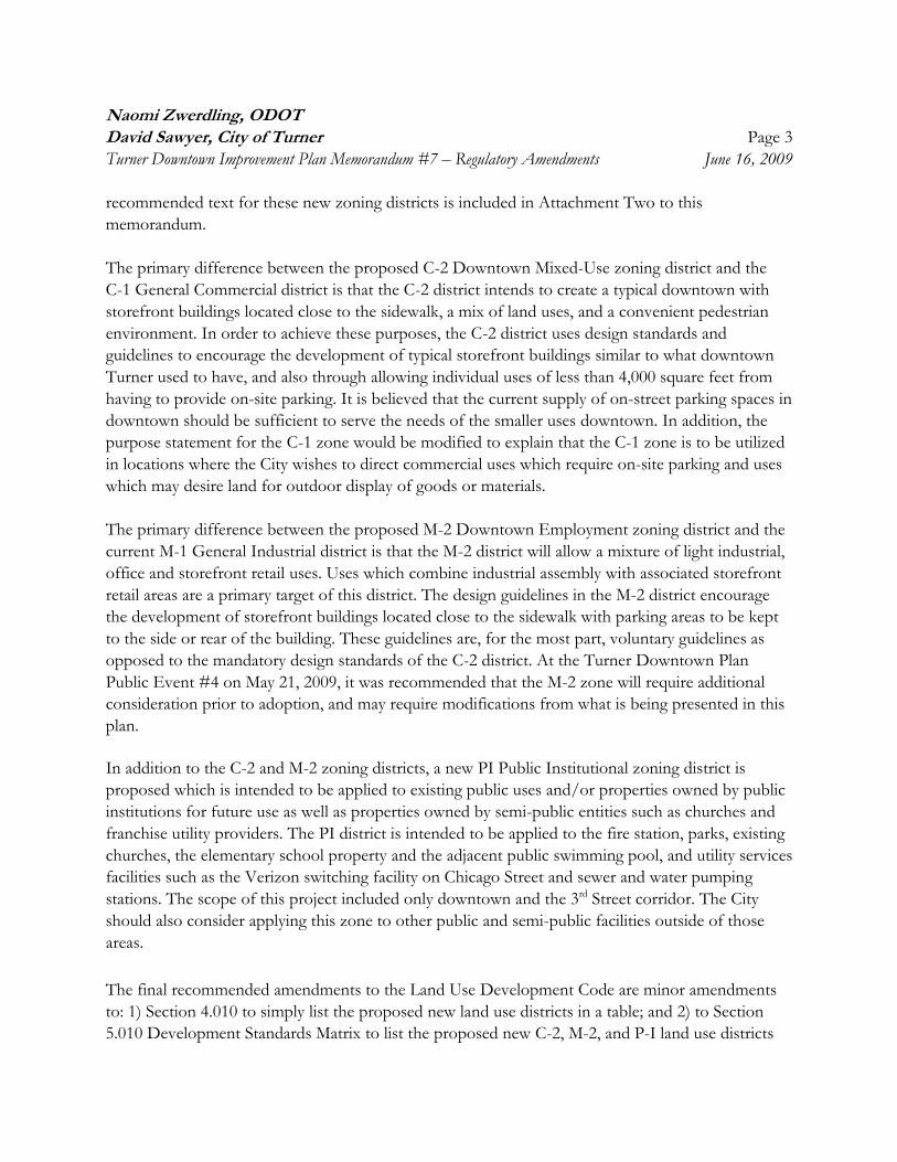
Naomi Zwerdling, ODOT
David Sawyer, City of Turner Page 3
Turner Downtown Improvement Plan Memorandum #7 – Regulatory Amendments June 16, 2009
recommended text for these new zoning districts is included in Attachment Two to this
memorandum.
The primary difference between the proposed C-2 Downtown Mixed-Use zoning district and the
C-1 General Commercial district is that the C-2 district intends to create a typical downtown with
storefront buildings located close to the sidewalk, a mix of land uses, and a convenient pedestrian
environment. In order to achieve these purposes, the C-2 district uses design standards and
guidelines to encourage the development of typical storefront buildings similar to what downtown
Turner used to have, and also through allowing individual uses of less than 4,000 square feet from
having to provide on-site parking. It is believed that the current supply of on-street parking spaces in
downtown should be sufficient to serve the needs of the smaller uses downtown. In addition, the
purpose statement for the C-1 zone would be modified to explain that the C-1 zone is to be utilized
in locations where the City wishes to direct commercial uses which require on-site parking and uses
which may desire land for outdoor display of goods or materials.
The primary difference between the proposed M-2 Downtown Employment zoning district and the
current M-1 General Industrial district is that the M-2 district will allow a mixture of light industrial,
office and storefront retail uses. Uses which combine industrial assembly with associated storefront
retail areas are a primary target of this district. The design guidelines in the M-2 district encourage
the development of storefront buildings located close to the sidewalk with parking areas to be kept
to the side or rear of the building. These guidelines are, for the most part, voluntary guidelines as
opposed to the mandatory design standards of the C-2 district. At the Turner Downtown Plan
Public Event #4 on May 21, 2009, it was recommended that the M-2 zone will require additional
consideration prior to adoption, and may require modifications from what is being presented in this
plan.
In addition to the C-2 and M-2 zoning districts, a new PI Public Institutional zoning district is
proposed which is intended to be applied to existing public uses and/or properties owned by public
institutions for future use as well as properties owned by semi-public entities such as churches and
franchise utility providers. The PI district is intended to be applied to the fire station, parks, existing
churches, the elementary school property and the adjacent public swimming pool, and utility services
facilities such as the Verizon switching facility on Chicago Street and sewer and water pumping
stations. The scope of this project included only downtown and the 3rd Street corridor. The City
should also consider applying this zone to other public and semi-public facilities outside of those
areas.
The final recommended amendments to the Land Use Development Code are minor amendments
to: 1) Section 4.010 to simply list the proposed new land use districts in a table; and 2) to Section
5.010 Development Standards Matrix to list the proposed new C-2, M-2, and P-I land use districts
Naomi Zwerdling, ODOT
David Sawyer, City of Turner Page 4
Turner Downtown Improvement Plan Memorandum #7 – Regulatory Amendments June 16, 2009
and summarize the applicable primary development standards for these districts in an existing table
which lists all the applicable basic development standards for all of the land use districts in the City
of Turner.
III. Amendments to the Land Use Districts and Zoning Map (Attachment Three)
In order to focus the limited demand for commercial land in the Downtown area and in areas along
3rd Street which are already predominantly commercial, it is recommended that most of the existing
C-1 General Commercial zoned property on the east side of 3rd Street to just beyond Elm Street be
rezoned R-2 Single-Family Residential. The only exception would be the site of Perky’s restaurant
and nine other relatively small properties on the east side of the Delaney Road/3rd Street
intersection, which would remain zoned C-1. The Technical Advisory Committee (TAC) noted that
those properties were a logical extension for nodal commercial development at this important
intersection. It is noted that the TAC would like to further consider the rezoning of the properties at
the intersection of Delaney Road and 3rd Street so those areas are illustrated with a “study area”
designation on Proposed Comprehensive Plan and Zoning Designation Map Exhibit 2A-2. Further
north along 3rd Street, R-2 zoning is recommended as reflective of the existing uses of those
properties and would be consistent with the zoning of neighboring properties to the east. Slightly
north of Elm Street on the east side of 3rd Street, it is recommended that properties be rezoned to
R-11, Multifamily Residential up to and including the existing City Hall property in order to connect
some existing areas of R-11 zoning, and to hopefully spur redevelopment of this area. The four
properties around the Post Office would remain zoned C-1. The proposed rezoning of the current
City Hall property to R-2 recognizes the Downtown Improvement Plan’s recommendation to
relocate the City administrative functions to downtown in the near future.
On the west side of 3rd Street, it is recommended that C-1 zoning be retained for the mostly
commercial uses from Mill Creek up to and including Classic Auto Storage and Sales, with the
exception of the Fire Station property being zoned P-I (see below). Beyond that point, there is a
solid stretch of well kept single-family homes, up to Triple D Windows. It is recommended that this
area be zoned R-2 in recognition of its existing uses and to preserve this small neighborhood. The
area including and northward of Triple D Windows to just short of the Action Wood Products is
recommended to retain C-1 zoning in recognition of the mostly commercial land uses in this area. In
addition, the generally larger parcel sizes and increased depth between the road and the railroad
makes these parcels attractive for potential redevelopment with commercial uses which require
room for customer parking and/or outdoor display or storage of materials.
As illustrated on the Proposed Comprehensive Plan and Zoning Districts Map Exhibit 2A-1 for the
downtown area, the current DC zoned area south of Mill Creek is proposed to be rezoned C-2,
Downtown Mixed-Use District. The properties on the west side of 3rd Street between Chicago Street
Naomi Zwerdling, ODOT
David Sawyer, City of Turner Page 5
Turner Downtown Improvement Plan Memorandum #7 – Regulatory Amendments June 16, 2009
and Mill Creek are proposed to be rezoned from M-1 General Industrial to the new M-2 General
Employment District.
In addition, fine tuning of the commercial zoning on the southern edge of Downtown is suggested
to rezone several properties fronting on Elgin Street from the existing C-1 zoning district to R-11.
These properties are currently in residential usage and are unlikely to be redeveloped with
commercial uses due to their not being located on a major through street or within the planned
Downtown improvement area. Also, one Turner Retirement Homes-owned property on the south
side of Chicago Street just west of the Verizon switching yard is recommended to be rezoned from
R-2 to R-11 so as to be consistent with the remainder of the residential property downtown between
the C-2 area to the west and the school property to the east.
Lastly, areas within downtown and within the 3rd Street corridor which are recommended to be
zoned P-I Public-Institutional on the Comprehensive Plan and Zoning Districts Map include
Burkhardt Park, the elementary school, the Burkhardt pool, the fire station, and the Verizon
switching facility. As noted above, it is recommended that the City also consider whether there are
other public or semi-public owned properties outside of the study area which should also be re-
designated with the P-I land use and zoning district.
IV. Amendments to the Transportation System Plan (Attachment Four)
Recommended changes to the Transportation System Plan (TSP) are fairly minor and limited in
scope. First, an amendment to the Functional Street Classification table in Section 6-4A is
recommended to designate the section of 2nd Street between Denver Street and Fargo Street as a
collector street. In addition, it is recommended that this table designate the segment of 2nd Street
between Boise Street and Denver Street as a significant local street, along with the segment of Boise
Street between 3rd and 2nd Streets. It is recommended that the City have the Mid-Willamette Valley
Council of Governments revise the Turner Street System Map, Map 6-4 of the TSP to correspond
with those changes.
Second, TSP text changes are recommended in two places to describe where continuous sidewalks
are desirable in the downtown area and that such sidewalks will either be built as part of property
development or through the City’s Capital Improvement Program.
Lastly, the TSP’s discussion of trails is recommended to briefly discuss the future development of a
trail along Mill Creek in four separate segments.

Attachment One
Recommended Comprehensive Plan Text Amendments
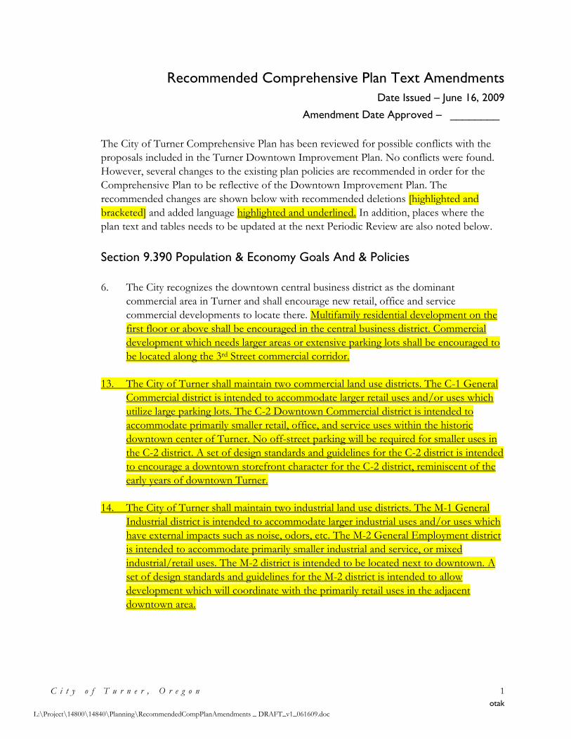
Recommended Comprehensive Plan Text Amendments
Date Issued – June 16, 2009
Amendment Date Approved – ________
C i t y o f T u r n e r , O r e g o n 1
otak
L:\Project\14800\14840\Planning\RecommendedCompPlanAmendments _ DRAFT_v1_061609.doc
The City of Turner Comprehensive Plan has been reviewed for possible conflicts with the
proposals included in the Turner Downtown Improvement Plan. No conflicts were found.
However, several changes to the existing plan policies are recommended in order for the
Comprehensive Plan to be reflective of the Downtown Improvement Plan. The
recommended changes are shown below with recommended deletions [highlighted and
bracketed] and added language highlighted and underlined. In addition, places where the
plan text and tables needs to be updated at the next Periodic Review are also noted below.
Section 9.390 Population & Economy Goals And & Policies
6. The City recognizes the downtown central business district as the dominant
commercial area in Turner and shall encourage new retail, office and service
commercial developments to locate there. Multifamily residential development on the
first floor or above shall be encouraged in the central business district. Commercial
development which needs larger areas or extensive parking lots shall be encouraged to
be located along the 3rd Street commercial corridor.
13. The City of Turner shall maintain two commercial land use districts. The C-1 General
Commercial district is intended to accommodate larger retail uses and/or uses which
utilize large parking lots. The C-2 Downtown Commercial district is intended to
accommodate primarily smaller retail, office, and service uses within the historic
downtown center of Turner. No off-street parking will be required for smaller uses in
the C-2 district. A set of design standards and guidelines for the C-2 district is intended
to encourage a downtown storefront character for the C-2 district, reminiscent of the
early years of downtown Turner.
14. The City of Turner shall maintain two industrial land use districts. The M-1 General
Industrial district is intended to accommodate larger industrial uses and/or uses which
have external impacts such as noise, odors, etc. The M-2 General Employment district
is intended to accommodate primarily smaller industrial and service, or mixed
industrial/retail uses. The M-2 district is intended to be located next to downtown. A
set of design standards and guidelines for the M-2 district is intended to allow
development which will coordinate with the primarily retail uses in the adjacent
downtown area.
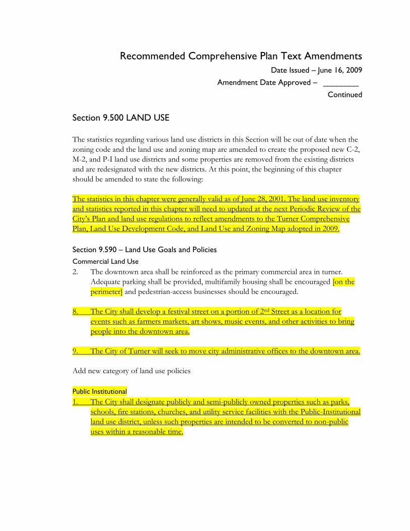
Recommended Comprehensive Plan Text Amendments
Date Issued – June 16, 2009
Amendment Date Approved – ________ Continued
Section 9.500 LAND USE
The statistics regarding various land use districts in this Section will be out of date when the
zoning code and the land use and zoning map are amended to create the proposed new C-2,
M-2, and P-I land use districts and some properties are removed from the existing districts
and are redesignated with the new districts. At this point, the beginning of this chapter
should be amended to state the following:
The statistics in this chapter were generally valid as of June 28, 2001. The land use inventory
and statistics reported in this chapter will need to updated at the next Periodic Review of the
City’s Plan and land use regulations to reflect amendments to the Turner Comprehensive
Plan, Land Use Development Code, and Land Use and Zoning Map adopted in 2009.
Section 9.590 – Land Use Goals and Policies
Commercial Land Use
2. The downtown area shall be reinforced as the primary commercial area in turner.
Adequate parking shall be provided, multifamily housing shall be encouraged [on the
perimeter] and pedestrian-access businesses should be encouraged.
8. The City shall develop a festival street on a portion of 2nd Street as a location for
events such as farmers markets, art shows, music events, and other activities to bring
people into the downtown area.
9. The City of Turner will seek to move city administrative offices to the downtown area.
Add new category of land use policies
Public Institutional
1. The City shall designate publicly and semi-publicly owned properties such as parks,
schools, fire stations, churches, and utility service facilities with the Public-Institutional
land use district, unless such properties are intended to be converted to non-public
uses within a reasonable time.
Recommended Comprehensive Plan Text Amendments
Date Issued – June 16, 2009
Amendment Date Approved – ________ Continued
Section9.800
The findings of Sections 9.840 and 9.850 and Tables 9.800 and 9.800B should be modified at
the time of the next Periodic Review of the Comprehensive Plan and land use regulations to
show current acreage figures for distributions for different land use districts and land use
needs.
Attachment Two
Proposed Land Use Development Code
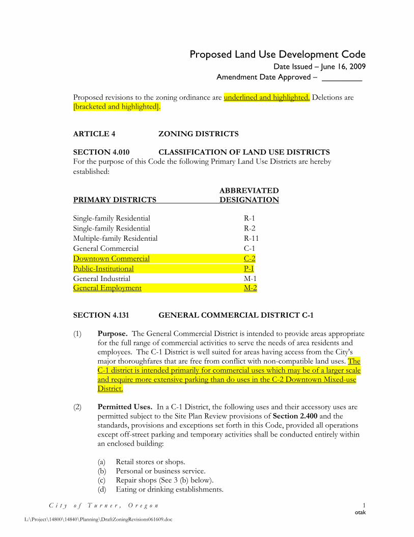
Proposed Land Use Development Code Date Issued – June 16, 2009
Amendment Date Approved – _________
C i t y o f T u r n e r , O r e g o n 1 otak
L:\Project\14800\14840\Planning\DraftZoningRevisions061609.doc
Proposed revisions to the zoning ordinance are underlined and highlighted. Deletions are [bracketed and highlighted]. ARTICLE 4 ZONING DISTRICTS SECTION 4.010 CLASSIFICATION OF LAND USE DISTRICTS For the purpose of this Code the following Primary Land Use Districts are hereby
established:
ABBREVIATED PRIMARY DISTRICTS DESIGNATION Single-family Residential R-1
Single-family Residential R-2
Multiple-family Residential R-11
General Commercial C-1
Downtown Commercial C-2
Public-Institutional P-I
General Industrial M-1 General Employment M-2 SECTION 4.131 GENERAL COMMERCIAL DISTRICT C-1 (1) Purpose. The General Commercial District is intended to provide areas appropriate
for the full range of commercial activities to serve the needs of area residents and employees. The C-1 District is well suited for areas having access from the City's major thoroughfares that are free from conflict with non-compatible land uses. The C-1 district is intended primarily for commercial uses which may be of a larger scale and require more extensive parking than do uses in the C-2 Downtown Mixed-use District.
(2) Permitted Uses. In a C-1 District, the following uses and their accessory uses are
permitted subject to the Site Plan Review provisions of Section 2.400 and the standards, provisions and exceptions set forth in this Code, provided all operations except off-street parking and temporary activities shall be conducted entirely within an enclosed building:
(a) Retail stores or shops. (b) Personal or business service. (c) Repair shops (See 3 (b) below). (d) Eating or drinking establishments.
Proposed Land Use Development Code Date Issued – June 16, 2009
Amendment Date Approved – _________
Continued
C i t y o f T u r n e r , O r e g o n 2 otak
L:\Project\14800\14840\Planning\DraftZoningRevisions061609.doc
(e) Offices, business or professional. (f) Financial institutions. (g) Indoor commercial amusement or recreation establishments. (h) Public or semi-public buildings and uses. (i) Residential Care Facility for 15 or less people as provided in ORS 197.660 -
670. (j) Group Child Care Center for 13 or more children as provided in the applicable
provisions of ORS 657 A. (k) Second story residences located above a ground floor commercial use in
accordance with Section 6.201. (Amended by Ord. 02-105 Attachment “A”) (l) Conversion of residence to a permitted commercial use in accordance with
Section 6.201. (Amended by Ord. 02-105 Attachment “A”)
(3) Conditional Uses. In a C-1 District, the following uses and their accessory uses may be permitted in conformance with the conditional use provisions of Section 2.500 and the applicable Use Standards of Article 6.
(a) Automotive, truck or RV service facilities with access from a designated arterial
street. (b) Automotive, truck, RV, equipment or other repair shops which possess
nuisance characteristics or emissions potentially detrimental to Public health, safety and general welfare of the community such as noise, vibrations, smoke, odor, fumes, dust, heat, glare or electromagnetic interference shall not be permitted unless additional safeguards are specified by the Planning Commission. The applicant shall accurately specify the extent of emissions and nuisance characteristics relative to the proposed use.
(c) Permitted uses listed in (2) above, requiring open display or storage, including but not limited to, automobile or equipment sales.
(4) Development Standards.
(a) Minimum lot area and configuration - Lots within a General Commercial District are approved by the Planning Commission as part of the Site Plan Review procedures of Sections 2.400. Lots are required to be large enough to accommodate the building, sewage disposal system, required parking, service access and pedestrian circulation including persons with disabilities.
(b) Yards:
1. Exterior yard setbacks - none required. See Section 5.116 for additional street setbacks.
Proposed Land Use Development Code Date Issued – June 16, 2009
Amendment Date Approved – _________
Continued
C i t y o f T u r n e r , O r e g o n 3 otak
L:\Project\14800\14840\Planning\DraftZoningRevisions061609.doc
2. Interior yard setbacks - 5 feet where abutting residential property and zero where abutting commercial or industrial property subject to the requirements for building construction specified in the Oregon Structural Specialty Code.
(c) Maximum building height - two and one-half stories to a maximum of 35 feet. (d) Access shall be designed to cause a minimum interference with traffic and may
be subject to the review and approval of the County Engineer or State Department of Transportation. The dedication of additional right-of-way and construction of street improvements by the applicant may be required in order to facilitate traffic circulation.
(e) See Article 5 for additional General Development Standards and Article 6 for Use Standards that may apply in the C-1 District.
[Delete all of Section 4.132 Downtown Commercial district]. SECTION 4.136 DOWNTOWN MIXED-USE DISTRICT C-2 (1) Purpose. The Downtown Mixed-use District applies to the historic central business
district of the City of Turner in the area south and west of Mill Creek and east of 3rd Street. The Downtown Mixed-use District is intended to be the City of Turner’s center of vital retail activity, services, housing, civic buildings, and public spaces. Developments which mix these uses vertically or horizontally are encouraged in the Downtown Mixed-use District.
The C-2 district is intended primarily for commercial uses which are generally of a
smaller scale than uses located in the C-1 General Commercial District and uses which require less in the way of off-street automobile parking. Certain smaller scale uses in the C-2 District are not required to provide on-site parking, and instead are encouraged to utilize on-street parking and shared parking agreements with other nearby uses.
The C-2 District is also intended as the primary location of civic uses in the City of
Turner. Due to the public assembly aspect of these uses, off-street parking will generally be required for most civic uses.
In order to promote the development of a pedestrian-oriented environment and to
promote the development of a storefront character reminiscent of the historic downtown Turner, special design standards and guidelines are established for development in the C-2 District.
Proposed Land Use Development Code Date Issued – June 16, 2009
Amendment Date Approved – _________
Continued
C i t y o f T u r n e r , O r e g o n 4 otak
L:\Project\14800\14840\Planning\DraftZoningRevisions061609.doc
(2) Permitted Uses. In the C-2 Downtown Mixed-use District, the following uses and their accessory uses are permitted subject to the Site Plan Review provisions of Section 2.400 and the standards, provisions, and exceptions set forth in this Code; provided all operations except off-street parking and temporary activities shall be conducted entirely within an enclosed building:
(a) Retail stores or shops. (b) Personal or business service. (c) Repair shops. (d) Eating or drinking establishments. (e) Offices, business or professional. (f) Financial institutions. (g) Indoor commercial amusement or recreation establishments. (h) Temporary vendors such as a farmers market, flea market, or food vending
cart. (i) Conversion of residence to a permitted commercial use in accordance with
Section 6.201. (j) Residential Care Facility for 15 or less people as provided in ORS 197.660 -
670. (k) Group Child Care Center for 13 or more children as provided in the applicable
provisions of ORS 657 A. (l) Second story residences located above a ground floor commercial use in
accordance with Section 6.201. (m) Public or semi-public buildings and uses, including city hall, administrative
offices, libraries, community centers, parks subject to the development standards in Section 6.301.
(n) Multi-family residential uses subject to the development standards of the R-11 district in Section 4.121(4) and the multi-family residential standards of Section 6.104.
(3) Conditional Uses. In the C-2 District, the following uses and their accessory uses
may be permitted in conformance with the conditional use provisions of Section 2.500 and the applicable Use Standards of Article 6. (a) Surface parking lot of any size (when not in conjunction with a permitted or
conditional use). (b) Surface parking lots with more than six parking spaces, if the parking lot is in
conjunction with a permitted or conditional use. (c) Automotive, truck, or RV service facilities. (d) Automotive, truck, RV, equipment, or other repair shops.
Proposed Land Use Development Code Date Issued – June 16, 2009
Amendment Date Approved – _________
Continued
C i t y o f T u r n e r , O r e g o n 5 otak
L:\Project\14800\14840\Planning\DraftZoningRevisions061609.doc
(4) Prohibited Uses. In the C-2 District, the following uses are specifically prohibited:
(a) Manufacturing, warehousing, wholesaling, compounding, assembling, processing, storing, researching, or testing.
(b) Scrap, waste, recycling, or wrecking yards. (c) Quarrying and related activities subject to the requirements of Statewide
Planning Goal 5 and OAR 660-23-180 for Mineral and Aggregate Resources. (d) Waste or hazardous material processing, storage, or disposal. (e) Heavy equipment sales or repair. (f) Trucking operations. (g) Auto storage, towing, or wrecking yards. (h) New automotive service or sales (i) Adult video or goods.
(5) Development Guidelines and Standards. All development in the C-2 District
shall comply with the applicable provisions of the Turner Zoning Code. Where the standards of the C-2 District zone and other provisions of the Code, the standards of the C-2 District shall prevail. Standards listed in this section as “shall” are mandatory standards. Guidelines which state “should” or “encouraged” are not mandatory, but are considered desirable by the City.
(a) Purpose.
i) The purpose of these development standards is to guide the design of
buildings constructed in the C-2 district to ensure that, through appropriate use of facades, windows, building orientation, architectural details, new structures, and alterations of existing structures are physically and visually compatible with other buildings within the downtown business district.
ii) These standards are intended to encourage good quality design in new building construction, enhance street safety, and provide a comfortable street environment by providing features of interest to pedestrians. Good design results in buildings that are in visual harmony with nearby buildings, leading to a downtown that is attractive, interesting, active, and safe. These qualities, in turn, contribute to the creation of a downtown core which facilitates easy pedestrian movement and establishment of a rich mixture of uses.
iii) In order to encourage the development of small businesses typical of the historic character of the downtown area and to promote a denser development pattern, certain uses will be exempted from the minimum on-site parking requirements of Section 15.121 of this Code.
Proposed Land Use Development Code Date Issued – June 16, 2009
Amendment Date Approved – _________
Continued
C i t y o f T u r n e r , O r e g o n 6 otak
L:\Project\14800\14840\Planning\DraftZoningRevisions061609.doc
(b) Applicability.
i) The provisions of this ordinance shall apply to the following activities within the C-2 District: 1. All new building construction; 2. Any exterior building or site modification that requires a building
permit; and, 3. All new signage.
ii) This ordinance shall not apply to the following activities or uses:
1. Maintenance of the exterior of an existing structure, such as re-roofing, re-siding, or repainting where similar materials and colors are used that comply with this ordinance;
2. Interior remodeling; and, 3. Exterior remodels to exclusive single-family residential homes, are
exempt from the provisions of this chapter. Single-family homes that are used for businesses or home occupations are not exempt.
iii) This ordinance shall apply only to those portions of a building or sign
that are proposed for construction or modification and shall not extend to other elements of the building or sign that may be out of compliance with the requirements of this ordinance (i.e., a permit to replace a single window shall not require that all other windows on the building that may be out of compliance with this ordinance to be replaced, unless such action is initiated by the property owner). However, if a building should be destroyed due to fire, accident, or an act of God, the new or replacement structure shall be rebuilt to conform to the requirements of this ordinance.
(c) General Standards. These standards to all uses in the C-2 District except for
detached single-family residences and multi-family development.
i) Minimum lot area and configuration - Lots within the C-2 Downtown Mixed-use District are approved by the Planning Commission as part of the Site Plan Review procedures of Sections 2.400. Lots are required to be large enough to accommodate the building, needed parking, service access, and pedestrian circulation to provide for the needs of persons with disabilities.
Proposed Land Use Development Code Date Issued – June 16, 2009
Amendment Date Approved – _________
Continued
C i t y o f T u r n e r , O r e g o n 7 otak
L:\Project\14800\14840\Planning\DraftZoningRevisions061609.doc
ii) Yards:
1. Front yard setback - none required, 10-foot maximum allowed. See Section 5.116 for additional street setbacks.
2. Side and rear setback – minimum 5 feet where abutting residential property and zero where abutting commercial or industrial property subject to the requirements for building construction specified in the Oregon Structural Specialty Code.
iii) Maximum building height - three stories to a maximum of 35 feet.
iv) Access shall be designed to cause a minimum interference with traffic and may be subject to the review and approval of the County Engineer or State Department of Transportation. The dedication of additional right-of-way and construction of street improvements by the applicant may be required in order to facilitate traffic circulation.
v) See Article 5 for additional General Development Standards and Article
6 for Use Standards that may apply in the C-2 District. (6) Design Guidelines or Standards. All development, EXCEPT for existing detached single family homes and multi-
family development shall be subject to the C-2 District design guidelines and standards listed below.
(a) Standards. Standards for new construction shall require builders to conform to
the architectural form of Turner’s historic period (1880s through 1940s) when downtown Turner had more of a typical downtown character. As such, new construction shall conform to the following standards and guidelines listed below. Reference is made to Turner’s historic period, and to buildings which display basic storefront design characteristics of that period. The following building displays characteristics intended by the standards. Other buildings, including those in other nearby communities, may also be used to demonstrate the required elements and/or the basis for visual compatibility.
The best existing example of a storefront building to be looked at for determining compatibility with the design standards is the Turner bank building at 3rd Street and Boise Street.
1. Site Development.
Proposed Land Use Development Code Date Issued – June 16, 2009
Amendment Date Approved – _________
Continued
C i t y o f T u r n e r , O r e g o n 8 otak
L:\Project\14800\14840\Planning\DraftZoningRevisions061609.doc
a. Building fronts and entrances shall be oriented toward the street. Buildings with frontages on two or more streets shall be oriented to at least one street.
b. Building facades should be set at the property edge along the sidewalk. A maximum setback of up to ten feet shall be permitted when occupied by pedestrian amenities (e.g., plaza, outdoor seating). Buildings with frontages on two or more streets should be set at the property edge on at least one street.
c. Site development should, as applicable and as practical, utilize the alley in the rear of the site for service access - such as for deliveries, trash and recycling pick-up, and employee parking. Buildings shall include doors to alley rights-of-way even if alleys are not currently in use.
2. Building Scale.
a. The overall size and proportion of new structures shall be compatible with the scale of nearby traditional storefront buildings. This standard may be met by either designing the building’s size and proportions to be similar to comparable structures in the downtown, or by the design of the façade so that it breaks a larger mass into smaller units that are similar to comparable historic structures.
b. If practical, new buildings should have the same floor height as adjoining buildings in case there is ever a desire to link the storefronts.
c. The relationship between the height and width of the main facade of the building shall be visibly compatible with adjoining or nearby buildings of the historic period or style. As with subsection (2)(i) of this section, this standard may be met through either similar height and width or, through design elements that provide visual continuity with the height and width of adjoining or nearby buildings of the historic period.
3. Building Height.
a. New buildings of at least two stories in height are encouraged.
b. As specified in Section 4.136.C.3, the height of all buildings shall be one to three stories and not more than 35 feet in maximum height.
Proposed Land Use Development Code Date Issued – June 16, 2009
Amendment Date Approved – _________
Continued
C i t y o f T u r n e r , O r e g o n 9 otak
L:\Project\14800\14840\Planning\DraftZoningRevisions061609.doc
4. Building Width. a. All new buildings should maximize lot frontage as much as is
practicable. b. New buildings whose street frontage is more than 50 feet
wide shall be designed to convey a sense of division through the use of pilasters, windows and door openings, recessed entries, off-sets, or other architectural details.
5. Storefronts.
a. Primary entrances shall be oriented to the street. Corner buildings shall have corner entrances, or shall provide at least one entrance within 20 feet of the street corner or a corner plaza.
b. Street-facing upper windows of multi-story buildings shall use multi-pane double-hung sash windows or the equivalent style.
c. The relationship between solid walls and window and door openings on the main facade shall be visually compatible with adjoining or nearby structures from the historic period or style. Ideally, first floor storefronts should be about 80 percent glass from approximately 2 feet above grade to approximately 10 feet above grade.
d. The relationship of width and height of window and door openings shall be visually compatible with adjoining or nearby buildings from the historic period or style.
e. Blank walls, walls without window or door openings, are not permitted along public streets.
f. Windows and doorways shall not be covered over with paper, boards, or cardboard except during times of construction or remodeling and shall be limited to a period of 120- days unless an extension is otherwise granted by the city manager.
g. Doors shall match the materials, design, and character of the display window framing.
h. Architectural features such as awnings, windows, cornices, etc., shall be provided at the second floor to differentiate the storefront from the upper levels of the building, to add visual interest, and to allow the storefront to function as the base for the rest of the building.
6. Facade Materials and Texture.
a. The materials and texture of the facade shall be compatible with those on buildings constructed during the historic period.
Proposed Land Use Development Code Date Issued – June 16, 2009
Amendment Date Approved – _________
Continued
C i t y o f T u r n e r , O r e g o n 10 otak
L:\Project\14800\14840\Planning\DraftZoningRevisions061609.doc
b. Permitted exterior facade materials include: brick, cast iron, relatively narrow horizontal wood or masonry siding, and stucco. Plywood siding, T-111, and vertical board and batten are prohibited.
c. Exposed concrete block facades facing the street are not allowed. Split-face or scored-face block may be used in small quantities for foundations or other non-dominant features.
d. All main facade materials shall be painted (except brick, for which painting is optional).
e. Metal siding shall not be used as a building material on the facade facing a street.
7. Windows.
a. Windows which allow views to the interior activity or display areas are encouraged. Windows shall include sills at the bottom and pediments at the top. Glass curtain walls, reflective glass, and painted or darkly tinted glass shall not be used on the first floor.
b. Ground Floor Windows. All new buildings must provide ground floor windows along adjacent street rights-of-way. i. Required window areas must be either windows that
allow views into working areas or lobbies, pedestrian entrances, or display windows.
ii. Required windows must have a sill no more than four feet above grade. Where interior floor levels prohibit such placement, the sill must be raised to allow it to be no more than two feet above the finished floor level, up to a maximum sill height of six feet above grade.
iii. Glass curtain windows are not permitted. iv. Darkly tinted windows and mirrored windows that block
two-way visibility are prohibited as ground floor windows along street facades.
v. Any wall that faces a public right-of-way must contain at least 20 percent of the ground floor wall area in display areas, windows, or doorways. Blank walls are prohibited.
c. Upper Floor Window Standards. i. Glass area dimensions shall not exceed 5'x7'. (The longest
dimension may be taken either horizontally or vertically.) ii. Windows must have trim or molding at least two inches
wide around their perimeters
Proposed Land Use Development Code Date Issued – June 16, 2009
Amendment Date Approved – _________
Continued
C i t y o f T u r n e r , O r e g o n 11 otak
L:\Project\14800\14840\Planning\DraftZoningRevisions061609.doc
iii. At least half of all the window area in upper floors must be made up of glass panes with dimensions no greater than 2.5'x3.5'.
8. Roofs.
a. Main facade roofs (lower than a 6:12 pitch) shall be concealed behind a square or stepped parapet. Flat roofs are permitted behind a parapet.
b. All HVAC systems located on top of a roof shall be located and/or screened so that they are not visible from the street. Dish-style antennas shall be located and/or screened so that they are not visible from the street. All screening material shall be natural and shall be compatible with the facade of the front of the building.
c. New roofs on existing buildings or on additions to existing buildings, shall match the pitch and form of the original roof.
d. Shed roofs are permitted on one-story rear additions. e. Back-lit or internally illuminated roofs are prohibited.
9. Awnings and Canopies.
a. The use of awnings or canopies over sidewalks is encouraged. b. Awnings shall extend out from the building front to cover at
least two-thirds of the sidewalk unless it is shown that such a distance will interfere with existing trees, poles, etc., to provide pedestrian protection from the elements.
c. Awnings shall be flat or sloping. Awnings shall be made of metal, wood, canvas, or similar materials. Rounded bubble or plastic awnings are prohibited. Fully glazed awnings are not permitted.
d. Awnings shall fit within the window bays (either above the main glass or the transom light) so as not to obscure or distract from significant architectural features.
e. The color of the awning shall be compatible with its attached building.
f. Awnings shall not be internally illuminated. However, lighting which is intended to provide illumination to the sidewalk and signage is permitted.
g. Awnings shall be a minimum of eight feet above the sidewalk. h. Where feasible, awnings shall be placed at the same height as
those on adjacent buildings in order to maintain a consistent horizontal rhythm along the street front.
Proposed Land Use Development Code Date Issued – June 16, 2009
Amendment Date Approved – _________
Continued
C i t y o f T u r n e r , O r e g o n 12 otak
L:\Project\14800\14840\Planning\DraftZoningRevisions061609.doc
10. Color. a. The painting of brick walls is permitted. b. Subtle or subdued tones commonly used during the historic
period shall be used. Bright or neon colors are prohibited. c. Different colors shall be used to accentuate and highlight
trim, windows, and other building features.
11. Site Design. a. Landscaping shall not obliterate street and sidewalk views of
signage or architectural features on historic buildings.
12. Parking. a. Individual permitted uses listed in Section 4.136 (2) (a)
through (h) of less than 4,000 sq. ft. of building area are not required to provide off-street parking spaces. It is intended that such uses shall be provided with sufficient on-street parking.
b. If off-street parking lots are provided, they shall be designed consistent with the following standards: i. Parking areas shall not be located between the front of
the building and the street. ii. Alley access to the parking lot is encouraged. iii. Street side parking lots shall be set back a minimum of
five feet from a public sidewalk. iv. Parking areas with more than 12 spaces shall be divided
by landscaped areas or walkways, or by a building or group of buildings.
v. Parking lot landscaping shall consist of a minimum of 10 percent of the total parking area. A minimum of one tree for every 10 parking spaces shall be provided.
vi. Knee walls are required to screen street side parking lots. Knee walls shall not exceed three feet in height and shall be constructed with masonry. Alternatively, a combination of a wall or fence and landscaping may be approved if they provide an effective buffer and low-level screen of the parking area.
13. Drive-up service windows a. Drive-up service windows are not permitted.
14. Signs.
Signs shall be subject to Section 5.136.
Proposed Land Use Development Code Date Issued – June 16, 2009
Amendment Date Approved – _________
Continued
C i t y o f T u r n e r , O r e g o n 13 otak
L:\Project\14800\14840\Planning\DraftZoningRevisions061609.doc
15. Landscaping.
Landscaping is subject to the C-2 District design guidelines and standards of Section 5.134.
16. External Storage of Merchandise. The external storage of
merchandise and/or materials, directly or indirectly related to a business, is hereby prohibited within the C-2 District.
17. Outdoor Displays of Merchandise. Outdoor displays of
merchandise are permitted during business hours only and shall not exceed ten percent of the total retail sales area. Displays of merchandise on public sidewalks may not reduce usable walking area widths to less then six feet.
18. Outdoor Eating Areas. Outdoor dining areas are encouraged, and
are permitted on public sidewalks. Outdoor food vending carts are permitted. Eating areas and/or vending carts may not reduce usable walking area widths on public sidewalks to less than six feet.
19. Wall Murals. The use of non-advertising wall murals representing
the area’s cultural heritage or historic events are encouraged, as well as the use of artistic wall murals. A wall mural is an expression of public art painted directly on the exterior of a building or on a backing that is affixed to the building and is sanctioned by the property owner.
The City discourages the painting of murals on the actual surface of a building but instead encourages that murals be painted on boards or ceramic panels attached to a building wall. This can help avoid problems down the road with needing to strip, sandblast, or pressure wash brick walls to remove a mural. The use of applied panels also will allow quick removal of the panel for restoration when a mural has been tagged with graffiti. a. A sign permit is not required for a wall mural. b. Wall murals are not permitted on the exterior wall containing
the main entrance to the building. c. Wall murals may be installed and maintained in an area not
exceeding a maximum area of 80 percent of the exterior wall area of the first three stories upon the wall or façade where the mural is located.
Proposed Land Use Development Code Date Issued – June 16, 2009
Amendment Date Approved – _________
Continued
C i t y o f T u r n e r , O r e g o n 14 otak
L:\Project\14800\14840\Planning\DraftZoningRevisions061609.doc
d. Murals may not be used for any form of commercial advertising or public information or solicitation of any kind. A mural shall be considered a wall sign if it contains words, logos, trademarks or graphic representations of any person, product, or service that identify or advertise a business.
e. Up to 10 percent of the wall mural area, at the lowest border of a mural, may be utilized as an acknowledgement recognizing the sponsor of the mural or for a signature by the mural artist. The designated area for the acknowledgement or signature must not exceed a maximum area of 6 square feet.
SECTION 4.139 PUBLIC INSTITUTIONAL DISTRICT P-I (1) Purpose. The Public Institutional (P-I) zoning district is intended to provide areas
for civic, public safety, or public utility uses. Such uses include schools, public administrative offices, fire stations, police stations, parks, public parking facilities, and water supply reservoirs. Development within the Public Institutional zone requires a conditional use permit to ensure compatibility with adjacent residential neighborhoods, business, or industrial areas and to minimize potential adverse impacts upon those adjacent uses and other public facilities such as roads.
(2) Permitted Uses. In the P-I district, any use which has previously been approved as
a conditional use or was in existence upon the application of the PI zoning district to the property, shall be considered a permitted subject to the Site Plan Review provisions of Section 2.400 and the standards, provisions and exceptions set forth in this Code, provided all operations except off-street parking and temporary activities shall be conducted entirely within an enclosed building. This does not exempt such uses from the need to apply for conditional use approval subject to Section 2.500 to expand or alter such use.
(3) Conditional Uses. In the PI district, establishment of the following uses and their accessory uses may be permitted in conformance with the conditional use provisions of Section 2.500 and the applicable Use Standards of Article 6.
(a) Indoor recreation establishments, such as public pools, gymnasiums, and
community centers. (b) Public or semi-public buildings and uses such as schools, churches, libraries,
public administrative offices, police stations, and fire stations. (c) Parks and typical park structures such as rest room buildings, picnic shelters,
gazebos, and park materials/vehicle storage buildings. Cconcession stands shall
Proposed Land Use Development Code Date Issued – June 16, 2009
Amendment Date Approved – _________
Continued
C i t y o f T u r n e r , O r e g o n 15 otak
L:\Project\14800\14840\Planning\DraftZoningRevisions061609.doc
be allowed in parks in the (PI) district as an accessory use, provided such use does not occupy more than 500 square feet.
d. Public works yards and buildings. e. Public or private water supply reservoirs, pumping stations, and treatment
facilities. f. Public or private wastewater pumping stations and treatment facilities. g. Public or private utility electrical substations, phone switching stations, and
similar facilities. (4) Development Standards.
(a) Minimum lot area and configuration - Lots within the Public Institutional district are approved by the Planning Commission as part of the Site Plan Review procedures of Sections 2.400. Lots are required to be large enough to accommodate the building, sewage disposal system, required parking, service access, and pedestrian circulation including persons with disabilities.
(b) Yards:
1. Exterior yard setbacks - none required. See Section 5.116 for additional street setbacks.
2. Interior yard setbacks - 5 feet where abutting residential property and zero where abutting commercial or industrial property subject to the requirements for building construction specified in the Oregon Structural Specialty Code.
(c) Maximum building height - three stories to a maximum of 35 feet. (d) Access shall be designed to cause a minimum interference with traffic and may
be subject to the review and approval of the County Engineer or State Department of Transportation. The dedication of additional right-of-way and construction of street improvements by the applicant may be required in order to facilitate traffic circulation.
(e) See Article 5 for additional General Development Standards and Article 6 for Use Standards that may apply in the P-I District.
(f) New buildings for institutional uses which are located or are to be established on properties located immediately adjacent to properties within the C-2 or M-2 zoning districts shall be subject to the development standards of those districts.
SECTION 4.141 GENERAL INDUSTRIAL DISTRICT M-1 (1) Purpose. The General Industrial District is intended to protect and preserve areas
suitable for industrial development to assist in supporting the area's economy. The M-1 District is suitable for light manufacturing and warehousing activities having minimal emissions or nuisance characteristics that could impact adjacent non-
Proposed Land Use Development Code Date Issued – June 16, 2009
Amendment Date Approved – _________
Continued
C i t y o f T u r n e r , O r e g o n 16 otak
L:\Project\14800\14840\Planning\DraftZoningRevisions061609.doc
industrial areas. The M-1 District is well suited for areas having highway and rail access that are free from conflict with non-compatible land uses.
(2) Permitted Uses. In an M-1 District, the following uses and their accessory uses are
permitted subject to the Site Plan Review provisions of Section 2.400 and the standards, provisions and exceptions set forth in this Code. (a) Interim farm use. (b) All manufacturing, warehousing, wholesaling, compounding, assembling,
processing, storing, researching, or testing uses provided all operations except off-street parking and temporary activities shall be conducted entirely within an enclosed building unless approved by the Planning Commission, and provided there are no emissions or nuisance characteristics discernible without instruments at the property line. See Section 2.140 Item (21).
(c) Public or semi-public buildings and uses. (3) Conditional Uses. In an M-1 District, the following uses and their accessory uses
may be permitted, subject to the provisions of Section 2.500.
(a) Manufacturing, warehousing, wholesaling, compounding, assembling, processing, storing, researching, or testing uses having emissions or nuisance characteristics discernible without instruments at the property line or uses requiring a permit from a local, state or federal agency.
(b) Scrap, waste, recycling or wrecking yards. (c) Quarrying and related activities subject to the requirements of Statewide
Planning Goal 5 and OAR 660-23-180 for Mineral and Aggregate Resources. (d) Waste or hazardous material processing, storage or disposal. (e) Commercial activities in association with an approved industrial use. (f) A manufactured dwelling for the owner or caretaker whenever an on-site
residence is necessitated by such use. The manufactured dwelling shall comply with the standards of Article 6.
(Amended by Ord. 02-105 Attachment “A”)
(4) Development Standards. (a) Minimum lot area and configuration - Lots within a General Industrial District
are approved by the Planning Commission as part of the Site Plan Review procedures of Sections 2.400. Lots are required to be large enough to accommodate the building, sewage disposal system, required parking, service access and pedestrian circulation including persons with disabilities
(b) Yards: ii) Exterior yard setbacks - 30 feet. See Section 5.116 for additional street
setbacks.
Proposed Land Use Development Code Date Issued – June 16, 2009
Amendment Date Approved – _________
Continued
C i t y o f T u r n e r , O r e g o n 17 otak
L:\Project\14800\14840\Planning\DraftZoningRevisions061609.doc
iii) Interior yard setbacks - 50 feet where abutting residential property and zero where abutting commercial or industrial property subject to the requirements for building construction specified in the Oregon Structural Specialty Code.
(c) Maximum Building Height - 45 feet unless a greater height is approved by the Planning Commission with conditions of approval as part of the Site Plan Review procedures of Section 2.400.
(d) (Access shall be designed to cause a minimum interference with traffic and may be subject to the review and approval of the County. The dedication of additional right-of-way and construction of street improvements by the applicant may be required in order to facilitate traffic circulation.
(Amended by Ord. 02-105 Attachment “A”) (e) See Article 5 for additional General Development Standards and Article 6 for
Use Standards that may apply in the M-1 District.
SECTION 4.143 DOWNTOWN GENERAL EMPLOYMENT DISTRICT M-2 (1) Purpose. The Downtown General Employment District is intended to provide areas
suitable for industrial or office employment development to assist in supporting the area's economy. The M-2 District is suitable for light manufacturing and warehousing activities having minimal emissions or nuisance characteristics that could impact adjacent non-industrial areas. The M-2 District is also well suited for office and limited commercial uses that will be compatible with existing and planned neighboring industrial land uses and with the uses in the neighboring Downtown area. The M-2 district is suitable for combined industrial and retail uses which utilize showrooms to display products which may have been constructed or assembled on the premises.
(2) Permitted Uses. In the M-2 District, the following uses and their accessory uses are
permitted subject to the Site Plan Review provisions of Section 2.400 and the standards, provisions and exceptions set forth in this Code. (a) All manufacturing, warehousing, wholesaling, compounding, assembling,
processing, storing, researching, or testing uses provided all operations except off-street parking and temporary activities shall be conducted entirely within an enclosed building unless approved by the Planning Commission, and provided there are no emissions or nuisance characteristics discernible without instruments at the property line. See Section 2.140 Item (21).
(b) Offices, business or professional.
Proposed Land Use Development Code Date Issued – June 16, 2009
Amendment Date Approved – _________
Continued
C i t y o f T u r n e r , O r e g o n 18 otak
L:\Project\14800\14840\Planning\DraftZoningRevisions061609.doc
(c) Personal or business service. (d) Repair shops. (e) Retail uses with associated onsite manufacture or repair or other permitted use,
such as a furniture manufacturer with a retail showroom or resale of repaired items like computers.
(3) Conditional Uses
(a) Automotive, truck, or RV service facilities. All outdoor storage to be screened. (b) Automotive, truck, RV, equipment or other repair shops. All outdoor storage
to be screened. (c) Surface parking lots with more than 20 parking spaces.
(4) Prohibited Uses. In an M-2 District, the following uses and their accessory uses are
specifically prohibited.
(a) Manufacturing, warehousing, wholesaling, compounding, assembling, processing, storing, researching, or testing uses having emissions or nuisance characteristics discernible without instruments at the property line or uses requiring a permit from a local, state or federal agency.
(b) Scrap, waste, recycling, or wrecking yards. (c) Towing yard. (d) Quarrying and related activities subject to the requirements of Statewide
Planning Goal 5 and OAR 660-23-180 for Mineral and Aggregate Resources. (e) Waste or hazardous material processing, storage or disposal. (f) Auto, motorcycle, truck, agricultural equipment, or boat sales with outdoor
storage of vehicles or boats. (g) Residential use of any kind.
(5) Development Standards and Guidelines.
(a) Purpose.
i) The purpose of these development standards and guidelines is to guide the design of buildings constructed in the M-2 district located adjacent to Downtown to ensure that, through appropriate use of building orientation and basic architectural details, new structures, and alterations of existing structures are physically and visually compatible with buildings within the adjacent downtown business district.
Proposed Land Use Development Code Date Issued – June 16, 2009
Amendment Date Approved – _________
Continued
C i t y o f T u r n e r , O r e g o n 19 otak
L:\Project\14800\14840\Planning\DraftZoningRevisions061609.doc
ii) These standards are intended to encourage good quality design in new building construction, enhance street safety, and provide a comfortable street environment by providing features of interest to pedestrians. Good design results in buildings that are in visual harmony with nearby buildings, leading to a downtown that is attractive, interesting, active, and safe. These qualities, in turn, contribute to the creation of a downtown core which facilitates easy pedestrian movement and establishment of a rich mixture of uses.
(b) Applicability.
i) All development in the M-2 District shall comply with the applicable
provisions of the Turner Zoning Code. Where the standards of the M-2 District zone and other provisions of the Code, the standards of the M-2 District shall prevail. Standards listed in this section as “shall” are mandatory standards. Guidelines which state “should” or “encouraged” are not mandatory, but are considered desirable by the City.
1. The provisions of this ordinance shall apply to the following
activities within the M-2 District: a. All new building construction; b. Any exterior building or site modification that requires a
building permit; and, c. All new signage.
2. This ordinance shall not apply to the following activities or uses:
a. Maintenance of the exterior of an existing structure, such as
re-roofing, re-siding, or repainting where similar materials and colors are used that comply with this ordinance;
b. Interior remodeling.
3. This ordinance shall apply only to those portions of a building or sign that are proposed for construction or modification and shall not extend to other elements of the building or sign that may be out of compliance with the requirements of this ordinance (i.e., a permit to replace a single window shall not require that all other windows on the building that may be out of compliance with this ordinance to be replaced, unless such action is initiated by the property owner). However, if a building should be destroyed due to fire, accident, or an act of God, the new or replacement structure shall be rebuilt to conform to the requirements of this ordinance.
Proposed Land Use Development Code Date Issued – June 16, 2009
Amendment Date Approved – _________
Continued
C i t y o f T u r n e r , O r e g o n 20 otak
L:\Project\14800\14840\Planning\DraftZoningRevisions061609.doc
(6) General Guidelines and Standards (a) Minimum lot area and configuration - Lots within the General Employment
District are approved by the Planning Commission as part of the Site Plan Review procedures of Sections 2.400. Lots are required to be large enough to accommodate the building, sewage disposal system, required parking, service access, and pedestrian circulation including persons with disabilities.
(b) Yards: ii) Exterior yard setbacks - zero. Minimal setbacks from adjacent streets are
encouraged. See Section 5.116 for possible additional street setbacks. iii) Interior yard setbacks - 20 feet where abutting residential property and
zero where abutting commercial or industrial property subject to the requirements for building construction specified in the Oregon Structural Specialty Code.
(c) Maximum Building Height - 35 feet unless a greater height is approved by the Planning Commission with conditions of approval as part of the Site Plan Review procedures of Section 2.400.
(d) Access shall be designed to cause a minimum interference with traffic and may be subject to the review and approval of the County. The dedication of additional right-of-way and construction of street improvements by the applicant may be required in order to facilitate traffic circulation.
(e) See Article 5 for additional General Development Standards and Article 6 for Use Standards that may apply in the M-2 District.
(7) Design Guidelines and Standards.
(a) Site Development.
i) Building fronts and entrances shall be oriented toward the street. Buildings with frontages on two or more streets shall be oriented to at least one street.
ii) Building facades should be set at the property edge along the sidewalk. Buildings with frontages on two or more streets should be set at the property edge on at least one street.
(b) Building Scale.
i) The overall size and proportion of new structures should be compatible with the scale of nearby traditional storefront buildings. This standard may be met by either designing the building’s size and proportions to be similar to comparable structures in the downtown area, or by the design of the façade so that it breaks a larger mass into smaller units.
Proposed Land Use Development Code Date Issued – June 16, 2009
Amendment Date Approved – _________
Continued
C i t y o f T u r n e r , O r e g o n 21 otak
L:\Project\14800\14840\Planning\DraftZoningRevisions061609.doc
(c) Building Height. i) New buildings of at least two stories in height are encouraged. ii. As specified in Section 4.141.(c), the height of all buildings shall be one
to three stories and not more than 35 feet in maximum height, unless a greater height is approved by the Planning Commission with conditions of approval as part of the Site Plan Review procedures of Section 2.400.
(d) Building Width.
i) All new buildings should maximize lot frontage use as much as is practicable.
ii) New buildings whose street frontage is more than 50 feet wide should be designed to convey a sense of division through the use of pilasters, windows and door openings, recessed entries, off-sets or other architectural details.
(e) Storefronts.
i) Primary entrances shall be oriented to the street. ii) The upper windows of multi-story buildings shall use multi-pane double-
hung sash windows or the equivalent style. iii) The relationship between solid walls and window and door openings on
the main facade shall be visually compatible with adjoining or nearby structures from the historic period or style.
iv) Blank walls, walls without window or door openings, are not permitted along public streets.
v) Windows and doorways shall not be covered over with paper, boards, or cardboard except during times of construction or remodeling and shall be limited to a period of 120 days unless an extension is otherwise granted by the city manager.
vi) Doors should match the materials, design, and character of the display window framing.
vii) vii. Architectural features such as awnings, windows, cornices, etc., should be provided at the second floor to differentiate the storefront from the upper levels of the building, to add visual interest, and to allow the storefront to function as the base for the rest of the building.
(f) Facade Materials and Texture.
i) Permitted exterior facade materials include: brick, cast iron, relatively narrow horizontal wood or masonry siding, and stucco. Plywood siding, T-111, and vertical board and batten are prohibited.
ii) Exposed concrete block facades facing the street are not allowed. Split-face or scored-face block may be used in small quantities for foundations or other non-dominant features.
Proposed Land Use Development Code Date Issued – June 16, 2009
Amendment Date Approved – _________
Continued
C i t y o f T u r n e r , O r e g o n 22 otak
L:\Project\14800\14840\Planning\DraftZoningRevisions061609.doc
iii) All main facade materials shall be painted (except brick, for which painting is optional).
iv) Metal siding shall not be used as a building material on the facade facing a street.
(g) Windows.
i) Windows which allow views to the interior activity or display areas are encouraged. Glass curtain walls, reflective glass, and painted or darkly tinted glass should not be used on the first floor.
ii) Ground Floor Windows. All new buildings are encouraged to provide ground floor windows along adjacent street rights-of-way.
(h) Roofs. i) Main facade roofs (lower than a 6:12 pitch) shall be concealed behind a
square or stepped parapet. Flat roofs are permitted behind a parapet. ii) All HVAC systems located on top of a roof should be located and/or
screened so that they are not visible from the street. Dish-style antennas shall be located and/or screened so that they are not visible from the street. All screening material shall be compatible with the facade of the front of the building.
iii) New roofs on existing buildings, or on additions to existing buildings, shall match the pitch and form of the original roof.
iv) Shed roofs are permitted on one-story rear additions.
(i) Awnings and Canopies. i) The use of awnings or canopies over sidewalks is encouraged. ii) Awnings shall be flat or sloping. Awnings shall be made of metal, wood,
canvas or similar materials. Rounded bubble or plastic awnings are prohibited. Fully glazed awnings are not permitted.
iii) The color of the awning shall be compatible with its attached building. iv) Awnings shall not be internally illuminated. However, lighting which is
intended to provide illumination to the sidewalk and signage is permitted. v) Awnings shall be a minimum of eight feet above the sidewalk.
(j) Color.
i) The painting of brick walls is permitted. ii) Subtle or subdued tones shall be used. Bright or neon colors are
prohibited. iii) Different colors shall be used to accentuate and highlight trim, windows,
and other building features.
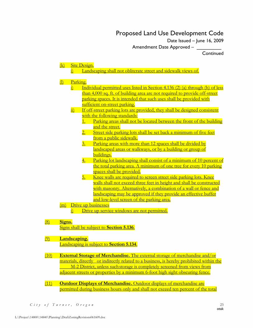
Proposed Land Use Development Code Date Issued – June 16, 2009
Amendment Date Approved – _________
Continued
C i t y o f T u r n e r , O r e g o n 23 otak
L:\Project\14800\14840\Planning\DraftZoningRevisions061609.doc
(k) Site Design. i) Landscaping shall not obliterate street and sidewalk views of.
(l) Parking.
i) Individual permitted uses listed in Section 4.136 (2) (a) through (h) of less than 4,000 sq. ft. of building area are not required to provide off-street parking spaces. It is intended that such uses shall be provided with sufficient on-street parking.
ii) If off-street parking lots are provided, they shall be designed consistent with the following standards: 1. Parking areas shall not be located between the front of the building
and the street. 2. Street side parking lots shall be set back a minimum of five feet
from a public sidewalk. 3. Parking areas with more than 12 spaces shall be divided by
landscaped areas or walkways, or by a building or group of buildings.
4. Parking lot landscaping shall consist of a minimum of 10 percent of the total parking area. A minimum of one tree for every 10 parking spaces shall be provided.
5. Knee walls are required to screen street side parking lots. Knee walls shall not exceed three feet in height and shall be constructed with masonry. Alternatively, a combination of a wall or fence and landscaping may be approved if they provide an effective buffer and low-level screen of the parking area.
(m) Drive up businesses i) Drive up service windows are not permitted.
(8) Signs.
Signs shall be subject to Section 5.136. (9) Landscaping.
Landscaping is subject to Section 5.134. (10) External Storage of Merchandise. The external storage of merchandise and/or
materials, directly or indirectly related to a business, is hereby prohibited within the M-2 District, unless such storage is completely screened from views from adjacent streets or properties by a minimum 6-foot high sight obscuring fence.
(11) Outdoor Displays of Merchandise. Outdoor displays of merchandise are permitted during business hours only and shall not exceed ten percent of the total
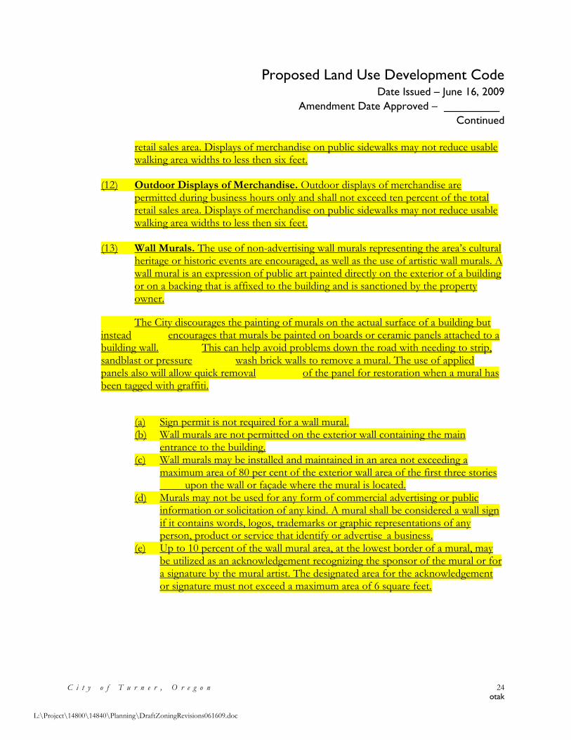
Proposed Land Use Development Code Date Issued – June 16, 2009
Amendment Date Approved – _________
Continued
C i t y o f T u r n e r , O r e g o n 24 otak
L:\Project\14800\14840\Planning\DraftZoningRevisions061609.doc
retail sales area. Displays of merchandise on public sidewalks may not reduce usable walking area widths to less then six feet.
(12) Outdoor Displays of Merchandise. Outdoor displays of merchandise are permitted during business hours only and shall not exceed ten percent of the total retail sales area. Displays of merchandise on public sidewalks may not reduce usable walking area widths to less then six feet.
(13) Wall Murals. The use of non-advertising wall murals representing the area’s cultural heritage or historic events are encouraged, as well as the use of artistic wall murals. A wall mural is an expression of public art painted directly on the exterior of a building or on a backing that is affixed to the building and is sanctioned by the property owner.
The City discourages the painting of murals on the actual surface of a building but instead encourages that murals be painted on boards or ceramic panels attached to a building wall. This can help avoid problems down the road with needing to strip, sandblast or pressure wash brick walls to remove a mural. The use of applied panels also will allow quick removal of the panel for restoration when a mural has been tagged with graffiti.
(a) Sign permit is not required for a wall mural. (b) Wall murals are not permitted on the exterior wall containing the main
entrance to the building. (c) Wall murals may be installed and maintained in an area not exceeding a
maximum area of 80 per cent of the exterior wall area of the first three stories upon the wall or façade where the mural is located.
(d) Murals may not be used for any form of commercial advertising or public information or solicitation of any kind. A mural shall be considered a wall sign if it contains words, logos, trademarks or graphic representations of any person, product or service that identify or advertise a business.
(e) Up to 10 percent of the wall mural area, at the lowest border of a mural, may be utilized as an acknowledgement recognizing the sponsor of the mural or for a signature by the mural artist. The designated area for the acknowledgement or signature must not exceed a maximum area of 6 square feet.
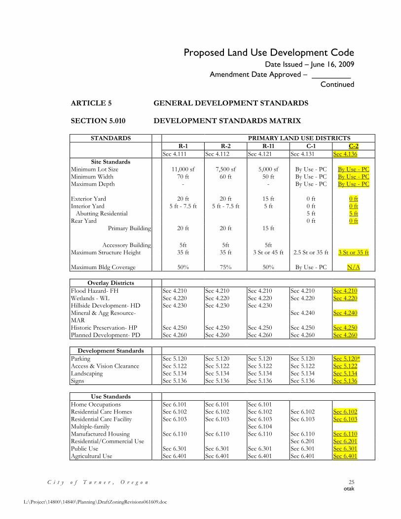
Proposed Land Use Development Code Date Issued – June 16, 2009
Amendment Date Approved – _________
Continued
C i t y o f T u r n e r , O r e g o n 25 otak
L:\Project\14800\14840\Planning\DraftZoningRevisions061609.doc
ARTICLE 5 GENERAL DEVELOPMENT STANDARDS SECTION 5.010 DEVELOPMENT STANDARDS MATRIX
STANDARDS PRIMARY LAND USE DISTRICTS
R-1 R-2 R-11 C-1 C-2
Sec 4.111 Sec 4.112 Sec 4.121 Sec 4.131 Sec 4.136
Site Standards Minimum Lot Size 11,000 sf 7,500 sf 5,000 sf By Use - PC By Use - PC Minimum Width 70 ft 60 ft 50 ft By Use - PC By Use - PC Maximum Depth - - By Use - PC By Use - PC
Exterior Yard 20 ft 20 ft 15 ft 0 ft 0 ft Interior Yard 5 ft - 7.5 ft 5 ft - 7.5 ft 5 ft 0 ft 0 ft Abutting Residential 5 ft 5 ft Rear Yard 0 ft 0 ft
Primary Building 20 ft 20 ft 15 ft
Accessory Building 5ft 5ft 5ft Maximum Structure Height 35 ft 35 ft 3 St or 45 ft 2.5 St or 35 ft 3 St or 35 ft
Maximum Bldg Coverage 50% 75% 50% By Use - PC N/A
Overlay Districts
Flood Hazard- FH Sec 4.210 Sec 4.210 Sec 4.210 Sec 4.210 Sec 4.210 Wetlands - WL Sec 4.220 Sec 4.220 Sec 4.220 Sec 4.220 Sec 4.220 Hillside Development- HD Sec 4.230 Sec 4.230 Sec 4.230 Mineral & Agg Resource- MAR
Sec 4.240 Sec 4.240
Historic Preservation- HP Sec 4.250 Sec 4.250 Sec 4.250 Sec 4.250 Sec 4.250 Planned Development- PD Sec 4.260 Sec 4.260 Sec 4.260 Sec 4.260 Sec 4.260
Development Standards
Parking Sec 5.120 Sec 5.120 Sec 5.120 Sec 5.120 Sec 5.120* Access & Vision Clearance Sec 5.122 Sec 5.122 Sec 5.122 Sec 5.122 Sec 5.122 Landscaping Sec 5.134 Sec 5.134 Sec 5.134 Sec 5.134 Sec 5.134 Signs Sec 5.136 Sec 5.136 Sec 5.136 Sec 5.136 Sec 5.136
Use Standards
Home Occupations Sec 6.101 Sec 6.101 Sec 6.101 Residential Care Homes Sec 6.102 Sec 6.102 Sec 6.102 Sec 6.102 Sec 6.102 Residential Care Facility Sec 6.103 Sec 6.103 Sec 6.103 Sec 6.103 Sec 6.103 Multiple-family Sec 6.104 Manufactured Housing Sec 6.110 Sec 6.110 Sec 6.110 Sec 6.110 Sec 6.110 Residential/Commercial Use Sec 6.201 Sec 6.201 Public Use Sec 6.301 Sec 6.301 Sec 6.301 Sec 6.301 Sec 6.301 Agricultural Use Sec 6.401 Sec 6.401 Sec 6.401 Sec 6.401 Sec 6.401
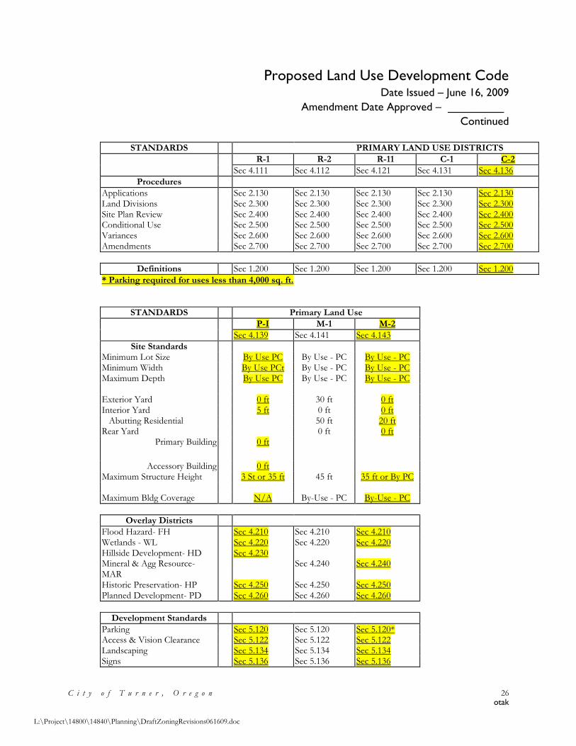
Proposed Land Use Development Code Date Issued – June 16, 2009
Amendment Date Approved – _________
Continued
C i t y o f T u r n e r , O r e g o n 26 otak
L:\Project\14800\14840\Planning\DraftZoningRevisions061609.doc
STANDARDS PRIMARY LAND USE DISTRICTS
R-1 R-2 R-11 C-1 C-2
Sec 4.111 Sec 4.112 Sec 4.121 Sec 4.131 Sec 4.136
Procedures
Applications Sec 2.130 Sec 2.130 Sec 2.130 Sec 2.130 Sec 2.130 Land Divisions Sec 2.300 Sec 2.300 Sec 2.300 Sec 2.300 Sec 2.300 Site Plan Review Sec 2.400 Sec 2.400 Sec 2.400 Sec 2.400 Sec 2.400 Conditional Use Sec 2.500 Sec 2.500 Sec 2.500 Sec 2.500 Sec 2.500 Variances Sec 2.600 Sec 2.600 Sec 2.600 Sec 2.600 Sec 2.600 Amendments Sec 2.700 Sec 2.700 Sec 2.700 Sec 2.700 Sec 2.700
Definitions Sec 1.200 Sec 1.200 Sec 1.200 Sec 1.200 Sec 1.200
* Parking required for uses less than 4,000 sq. ft.
STANDARDS Primary Land Use
P-I M-1 M-2
Sec 4.139 Sec 4.141 Sec 4.143
Site Standards Minimum Lot Size By Use PC By Use - PC By Use - PC Minimum Width By Use PCt By Use - PC By Use - PC Maximum Depth By Use PC By Use - PC By Use - PC
Exterior Yard 0 ft 30 ft 0 ft Interior Yard 5 ft 0 ft 0 ft Abutting Residential 50 ft 20 ft Rear Yard 0 ft 0 ft
Primary Building 0 ft
Accessory Building 0 ft Maximum Structure Height 3 St or 35 ft 45 ft 35 ft or By PC
Maximum Bldg Coverage N/A By-Use - PC By-Use - PC
Overlay Districts
Flood Hazard- FH Sec 4.210 Sec 4.210 Sec 4.210 Wetlands - WL Sec 4.220 Sec 4.220 Sec 4.220 Hillside Development- HD Sec 4.230 Mineral & Agg Resource- MAR
Sec 4.240 Sec 4.240
Historic Preservation- HP Sec 4.250 Sec 4.250 Sec 4.250 Planned Development- PD Sec 4.260 Sec 4.260 Sec 4.260
Development Standards
Parking Sec 5.120 Sec 5.120 Sec 5.120* Access & Vision Clearance Sec 5.122 Sec 5.122 Sec 5.122 Landscaping Sec 5.134 Sec 5.134 Sec 5.134 Signs Sec 5.136 Sec 5.136 Sec 5.136
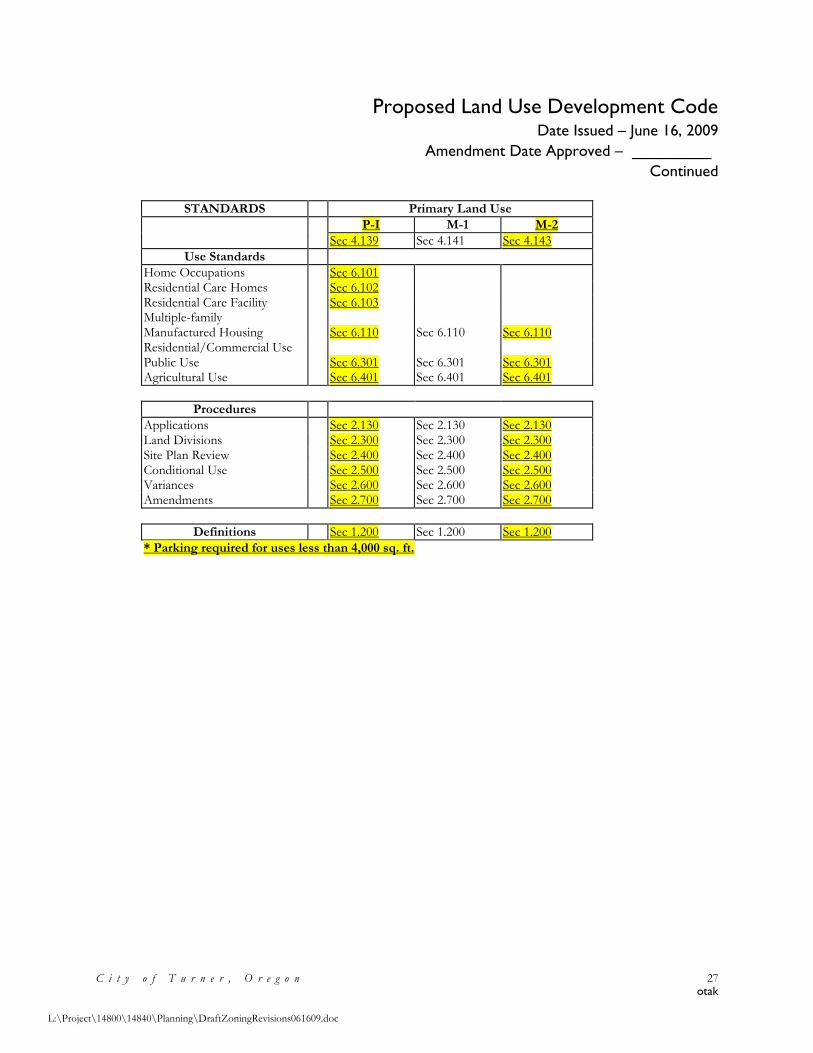
Proposed Land Use Development Code Date Issued – June 16, 2009
Amendment Date Approved – _________
Continued
C i t y o f T u r n e r , O r e g o n 27 otak
L:\Project\14800\14840\Planning\DraftZoningRevisions061609.doc
STANDARDS Primary Land Use
P-I M-1 M-2
Sec 4.139 Sec 4.141 Sec 4.143
Use Standards
Home Occupations Sec 6.101 Residential Care Homes Sec 6.102 Residential Care Facility Sec 6.103 Multiple-family Manufactured Housing Sec 6.110 Sec 6.110 Sec 6.110 Residential/Commercial Use Public Use Sec 6.301 Sec 6.301 Sec 6.301 Agricultural Use Sec 6.401 Sec 6.401 Sec 6.401
Procedures
Applications Sec 2.130 Sec 2.130 Sec 2.130 Land Divisions Sec 2.300 Sec 2.300 Sec 2.300 Site Plan Review Sec 2.400 Sec 2.400 Sec 2.400 Conditional Use Sec 2.500 Sec 2.500 Sec 2.500 Variances Sec 2.600 Sec 2.600 Sec 2.600 Amendments Sec 2.700 Sec 2.700 Sec 2.700
Definitions Sec 1.200 Sec 1.200 Sec 1.200
* Parking required for uses less than 4,000 sq. ft.
Attachment Three
Amendments to the Land Use Districts and Zoning Map Date Issued – June 16, 2009
Amendment Date Approved – ______________
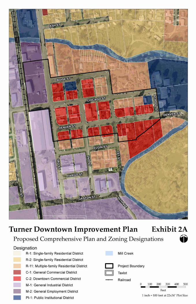
Turner Downtown Improvement Plan Exhibit 2A Proposed Comprehensive Plan and Zoning Designations @ Designation - R-I : Single-family Residential District
R-2: Single-family Residential District - R-11 : Multiple-family Residential District
C-I : General Commercial District
C-2: Downtown Commercial District
M-I : General Industrial District
M-2: General Employment District
PI-I : Public Institutional District
Mill Creek
0 Project Boundary
- Railroad
Feet
1 inch = 100 feet at 22x34 Plot Size
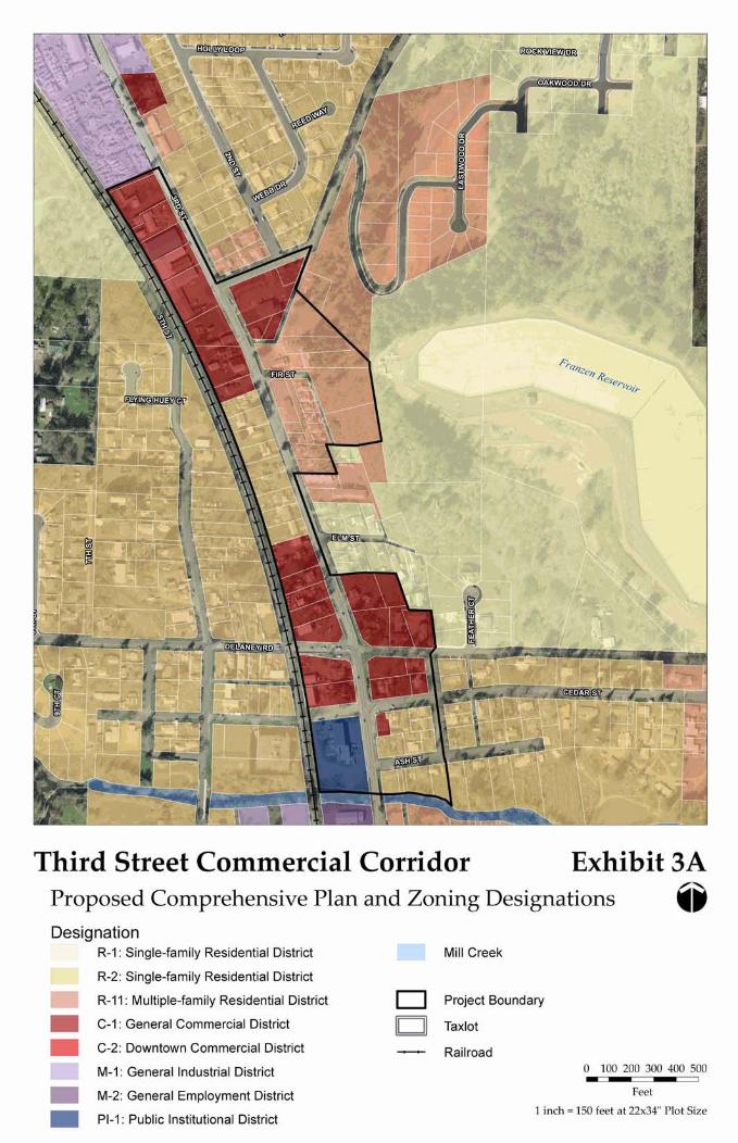
Third Street Commercial Corridor Exhibit 3A Proposed Comprehensive Plan and Zoning Designations @ Designation
R-I : Single-family Residential District
R-2: Single-family Residential District
R-11 : Multiple-family Residential District
C-I : General Commercial District
C-2: Downtown Commercial District
M-I : General Industrial District
M-2: General Employment District
PI-I : Public Institutional District
Mill Creek
0 Project Boundary
- Railroad 0 100 200 300 400 500 - I
Feet
1 inch = 150 feet at 22x34 Plot Size

Attachment Four
Amendments to the Transportation System Plan
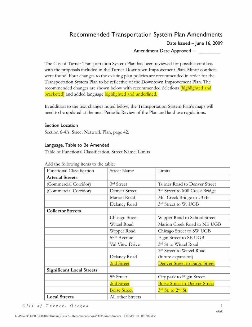
Recommended Transportation System Plan Amendments
Date Issued – June 16, 2009
Amendment Date Approved – ________
C i t y o f T u r n e r , O r e g o n 1
otak
L:\Project\14800\14840\Planning\Task 5 - Recommendations\TSP Amendments _ DRAFT_v1_061509.doc
The City of Turner Transportation System Plan has been reviewed for possible conflicts
with the proposals included in the Turner Downtown Improvement Plan. Minor conflicts
were found. Four changes to the existing plan policies are recommended in order for the
Transportation System Plan to be reflective of the Downtown Improvement Plan. The
recommended changes are shown below with recommended deletions [highlighted and
bracketed] and added language highlighted and underlined.
In addition to the text changes noted below, the Transportation System Plan’s maps will
need to be updated at the next Periodic Review of the Plan and land use regulations.
Section Location
Section 6-4A. Street Network Plan, page 42.
Language, Table to Be Amended
Table of Functional Classification, Street Name, Limits
Add the following items to the table:
Functional Classification Street Name Limits
Arterial Streets
(Commercial Corridor) 3rd Street Turner Road to Denver Street
(Commercial Corridor) Denver Street 3rd Street to Mill Creek Bridge
Marion Road Mill Creek Bridge to UGB
Delaney Road 3rd Street to W. UGB
Collector Streets
Chicago Street Wipper Road to School Street
Witzel Road Marion Creek Road to NE UGB
Wipper Road Chicago Street to SW UGB
55th Avenue Elgin Street to SE UGB
Val View Drive 3rd St to Witzel Road
Delaney Road
3rd Street to Witzel Road
(future expansion)
2nd Street Denver Street to Fargo Street
Significant Local Streets
5th Street City park to Elgin Street
2nd Street Boise Street to Denver Street
Boise Street 3rd St. to 2nd St.
Local Streets All other Streets
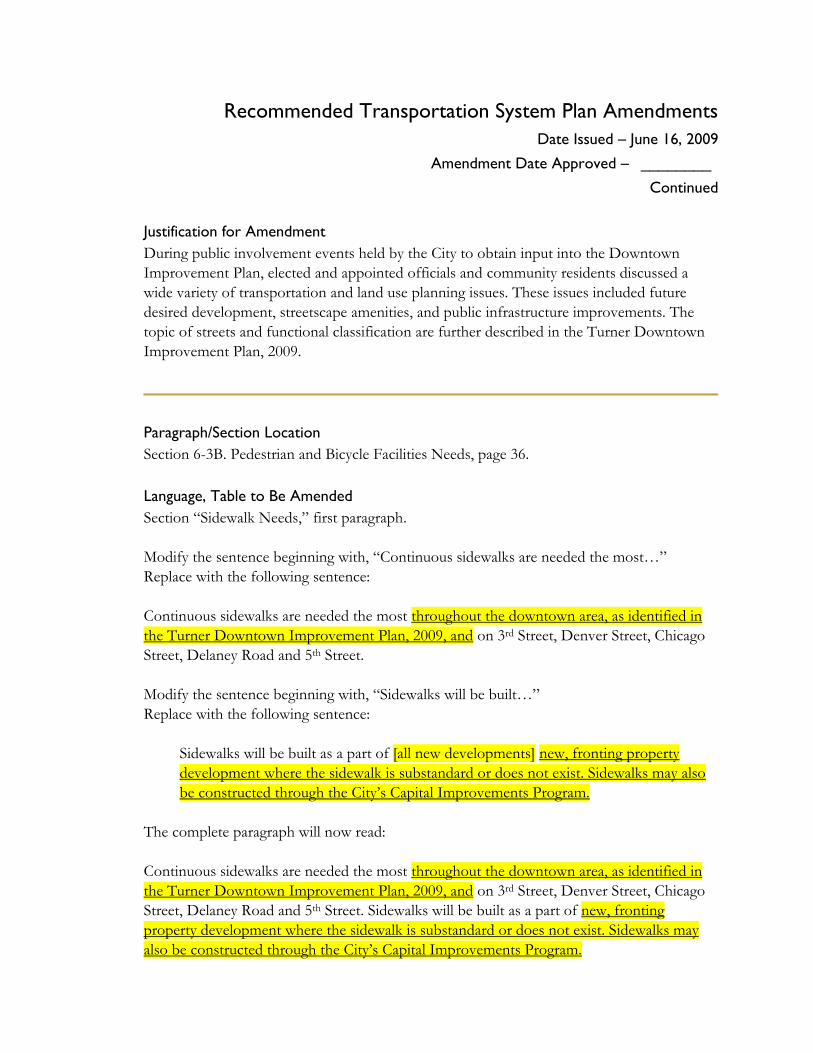
Recommended Transportation System Plan Amendments
Date Issued – June 16, 2009
Amendment Date Approved – ________ Continued
Justification for Amendment
During public involvement events held by the City to obtain input into the Downtown
Improvement Plan, elected and appointed officials and community residents discussed a
wide variety of transportation and land use planning issues. These issues included future
desired development, streetscape amenities, and public infrastructure improvements. The
topic of streets and functional classification are further described in the Turner Downtown
Improvement Plan, 2009.
Paragraph/Section Location
Section 6-3B. Pedestrian and Bicycle Facilities Needs, page 36.
Language, Table to Be Amended
Section “Sidewalk Needs,” first paragraph.
Modify the sentence beginning with, “Continuous sidewalks are needed the most…”
Replace with the following sentence:
Continuous sidewalks are needed the most throughout the downtown area, as identified in
the Turner Downtown Improvement Plan, 2009, and on 3rd Street, Denver Street, Chicago
Street, Delaney Road and 5th Street.
Modify the sentence beginning with, “Sidewalks will be built…”
Replace with the following sentence:
Sidewalks will be built as a part of [all new developments] new, fronting property
development where the sidewalk is substandard or does not exist. Sidewalks may also
be constructed through the City’s Capital Improvements Program.
The complete paragraph will now read:
Continuous sidewalks are needed the most throughout the downtown area, as identified in
the Turner Downtown Improvement Plan, 2009, and on 3rd Street, Denver Street, Chicago
Street, Delaney Road and 5th Street. Sidewalks will be built as a part of new, fronting
property development where the sidewalk is substandard or does not exist. Sidewalks may
also be constructed through the City’s Capital Improvements Program.
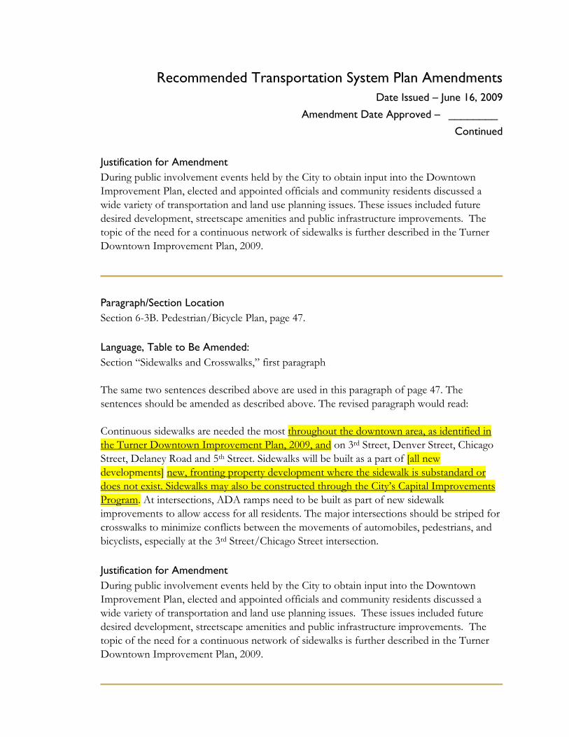
Recommended Transportation System Plan Amendments
Date Issued – June 16, 2009
Amendment Date Approved – ________ Continued
Justification for Amendment
During public involvement events held by the City to obtain input into the Downtown
Improvement Plan, elected and appointed officials and community residents discussed a
wide variety of transportation and land use planning issues. These issues included future
desired development, streetscape amenities and public infrastructure improvements. The
topic of the need for a continuous network of sidewalks is further described in the Turner
Downtown Improvement Plan, 2009.
Paragraph/Section Location
Section 6-3B. Pedestrian/Bicycle Plan, page 47.
Language, Table to Be Amended:
Section “Sidewalks and Crosswalks,” first paragraph
The same two sentences described above are used in this paragraph of page 47. The
sentences should be amended as described above. The revised paragraph would read:
Continuous sidewalks are needed the most throughout the downtown area, as identified in
the Turner Downtown Improvement Plan, 2009, and on 3rd Street, Denver Street, Chicago
Street, Delaney Road and 5th Street. Sidewalks will be built as a part of [all new
developments] new, fronting property development where the sidewalk is substandard or
does not exist. Sidewalks may also be constructed through the City’s Capital Improvements
Program. At intersections, ADA ramps need to be built as part of new sidewalk
improvements to allow access for all residents. The major intersections should be striped for
crosswalks to minimize conflicts between the movements of automobiles, pedestrians, and
bicyclists, especially at the 3rd Street/Chicago Street intersection.
Justification for Amendment
During public involvement events held by the City to obtain input into the Downtown
Improvement Plan, elected and appointed officials and community residents discussed a
wide variety of transportation and land use planning issues. These issues included future
desired development, streetscape amenities and public infrastructure improvements. The
topic of the need for a continuous network of sidewalks is further described in the Turner
Downtown Improvement Plan, 2009.
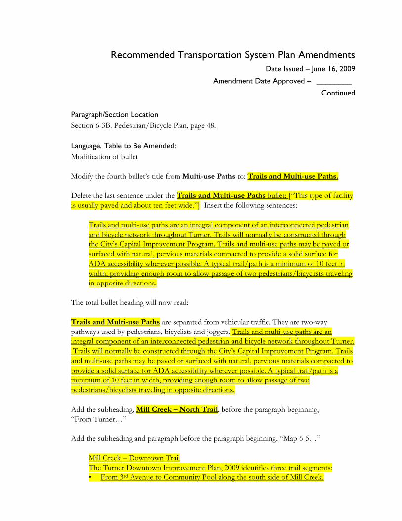
Recommended Transportation System Plan Amendments
Date Issued – June 16, 2009
Amendment Date Approved – ________ Continued
Paragraph/Section Location
Section 6-3B. Pedestrian/Bicycle Plan, page 48.
Language, Table to Be Amended:
Modification of bullet
Modify the fourth bullet’s title from Multi-use Paths to: Trails and Multi-use Paths.
Delete the last sentence under the Trails and Multi-use Paths bullet: [“This type of facility
is usually paved and about ten feet wide.”] Insert the following sentences:
Trails and multi-use paths are an integral component of an interconnected pedestrian
and bicycle network throughout Turner. Trails will normally be constructed through
the City’s Capital Improvement Program. Trails and multi-use paths may be paved or
surfaced with natural, pervious materials compacted to provide a solid surface for
ADA accessibility wherever possible. A typical trail/path is a minimum of 10 feet in
width, providing enough room to allow passage of two pedestrians/bicyclists traveling
in opposite directions.
The total bullet heading will now read:
Trails and Multi-use Paths are separated from vehicular traffic. They are two-way
pathways used by pedestrians, bicyclists and joggers. Trails and multi-use paths are an
integral component of an interconnected pedestrian and bicycle network throughout Turner.
Trails will normally be constructed through the City’s Capital Improvement Program. Trails
and multi-use paths may be paved or surfaced with natural, pervious materials compacted to
provide a solid surface for ADA accessibility wherever possible. A typical trail/path is a
minimum of 10 feet in width, providing enough room to allow passage of two
pedestrians/bicyclists traveling in opposite directions.
Add the subheading, Mill Creek – North Trail, before the paragraph beginning,
“From Turner…”
Add the subheading and paragraph before the paragraph beginning, “Map 6-5…”
Mill Creek – Downtown Trail
The Turner Downtown Improvement Plan, 2009 identifies three trail segments:
• From 3rd Avenue to Community Pool along the south side of Mill Creek.
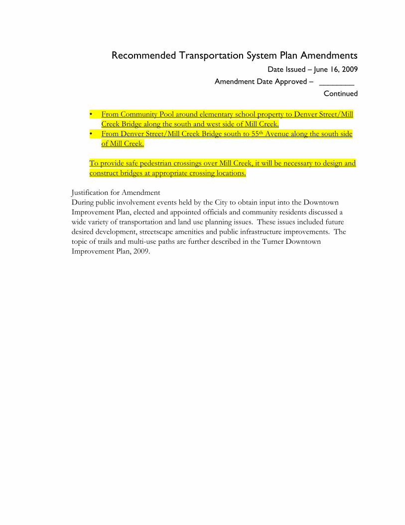
Recommended Transportation System Plan Amendments
Date Issued – June 16, 2009
Amendment Date Approved – ________ Continued
• From Community Pool around elementary school property to Denver Street/Mill
Creek Bridge along the south and west side of Mill Creek.
• From Denver Street/Mill Creek Bridge south to 55th Avenue along the south side
of Mill Creek.
To provide safe pedestrian crossings over Mill Creek, it will be necessary to design and
construct bridges at appropriate crossing locations.
Justification for Amendment
During public involvement events held by the City to obtain input into the Downtown
Improvement Plan, elected and appointed officials and community residents discussed a
wide variety of transportation and land use planning issues. These issues included future
desired development, streetscape amenities and public infrastructure improvements. The
topic of trails and multi-use paths are further described in the Turner Downtown
Improvement Plan, 2009.
Appendix I
Memorandum No. 8 – Downtown Plan
Implementation Strategy
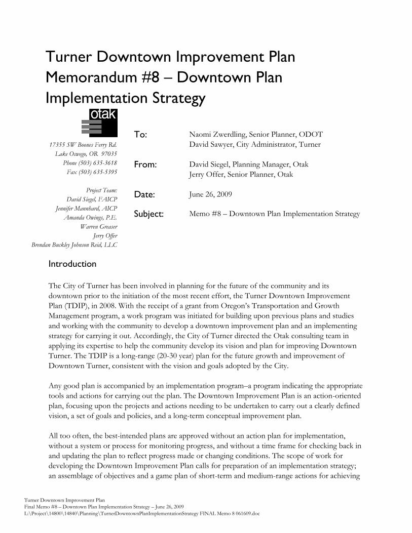
Turner Downtown Improvement Plan
Memorandum #8 – Downtown Plan
Implementation Strategy
Turner Downtown Improvement Plan
Final Memo #8 – Downtown Plan Implementation Strategy – June 26, 2009
L:\Project\14800\14840\Planning\TurnerDowntownPlanImplementationStrategy FINAL Memo 8 061609.doc
17355 SW Boones Ferry Rd.
Lake Oswego, OR 97035
Phone (503) 635-3618
Fax (503) 635-5395
Project Team:
David Siegel, FAICP
Jennifer Mannhard, AICP
Amanda Owings, P.E.
Warren Greaser
Jerry Offer
Brendan Buckley Johnson Reid, LLC
Introduction
The City of Turner has been involved in planning for the future of the community and its
downtown prior to the initiation of the most recent effort, the Turner Downtown Improvement
Plan (TDIP), in 2008. With the receipt of a grant from Oregon’s Transportation and Growth
Management program, a work program was initiated for building upon previous plans and studies
and working with the community to develop a downtown improvement plan and an implementing
strategy for carrying it out. Accordingly, the City of Turner directed the Otak consulting team in
applying its expertise to help the community develop its vision and plan for improving Downtown
Turner. The TDIP is a long-range (20-30 year) plan for the future growth and improvement of
Downtown Turner, consistent with the vision and goals adopted by the City.
Any good plan is accompanied by an implementation program–a program indicating the appropriate
tools and actions for carrying out the plan. The Downtown Improvement Plan is an action-oriented
plan, focusing upon the projects and actions needing to be undertaken to carry out a clearly defined
vision, a set of goals and policies, and a long-term conceptual improvement plan.
All too often, the best-intended plans are approved without an action plan for implementation,
without a system or process for monitoring progress, and without a time frame for checking back in
and updating the plan to reflect progress made or changing conditions. The scope of work for
developing the Downtown Improvement Plan calls for preparation of an implementation strategy;
an assemblage of objectives and a game plan of short-term and medium-range actions for achieving
To: Naomi Zwerdling, Senior Planner, ODOT
David Sawyer, City Administrator, Turner
From: David Siegel, Planning Manager, Otak
Jerry Offer, Senior Planner, Otak
Date: June 26, 2009
Subject: Memo #8 – Downtown Plan Implementation Strategy
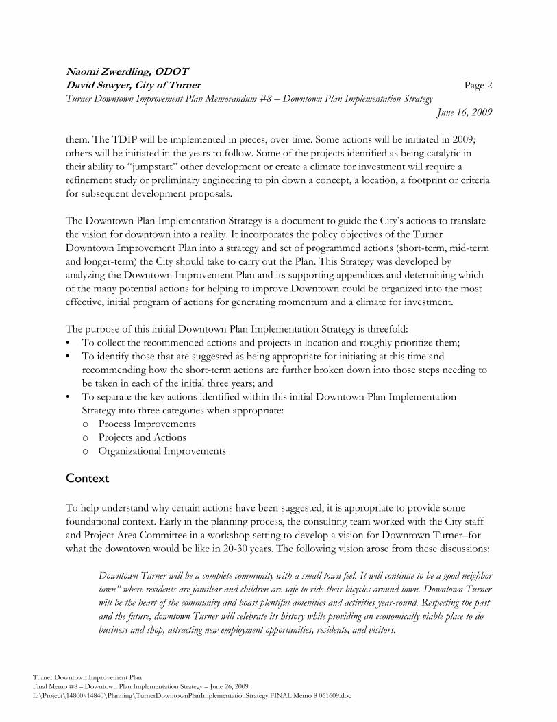
Naomi Zwerdling, ODOT
David Sawyer, City of Turner Page 2
Turner Downtown Improvement Plan Memorandum #8 – Downtown Plan Implementation Strategy
June 16, 2009
Turner Downtown Improvement Plan
Final Memo #8 – Downtown Plan Implementation Strategy – June 26, 2009
L:\Project\14800\14840\Planning\TurnerDowntownPlanImplementationStrategy FINAL Memo 8 061609.doc
them. The TDIP will be implemented in pieces, over time. Some actions will be initiated in 2009;
others will be initiated in the years to follow. Some of the projects identified as being catalytic in
their ability to ―jumpstart‖ other development or create a climate for investment will require a
refinement study or preliminary engineering to pin down a concept, a location, a footprint or criteria
for subsequent development proposals.
The Downtown Plan Implementation Strategy is a document to guide the City’s actions to translate
the vision for downtown into a reality. It incorporates the policy objectives of the Turner
Downtown Improvement Plan into a strategy and set of programmed actions (short-term, mid-term
and longer-term) the City should take to carry out the Plan. This Strategy was developed by
analyzing the Downtown Improvement Plan and its supporting appendices and determining which
of the many potential actions for helping to improve Downtown could be organized into the most
effective, initial program of actions for generating momentum and a climate for investment.
The purpose of this initial Downtown Plan Implementation Strategy is threefold:
• To collect the recommended actions and projects in location and roughly prioritize them;
• To identify those that are suggested as being appropriate for initiating at this time and
recommending how the short-term actions are further broken down into those steps needing to
be taken in each of the initial three years; and
• To separate the key actions identified within this initial Downtown Plan Implementation
Strategy into three categories when appropriate:
o Process Improvements
o Projects and Actions
o Organizational Improvements
Context
To help understand why certain actions have been suggested, it is appropriate to provide some
foundational context. Early in the planning process, the consulting team worked with the City staff
and Project Area Committee in a workshop setting to develop a vision for Downtown Turner–for
what the downtown would be like in 20-30 years. The following vision arose from these discussions:
Downtown Turner will be a complete community with a small town feel. It will continue to be a good neighbor
town” where residents are familiar and children are safe to ride their bicycles around town. Downtown Turner
will be the heart of the community and boast plentiful amenities and activities year-round. Respecting the past
and the future, downtown Turner will celebrate its history while providing an economically viable place to do
business and shop, attracting new employment opportunities, residents, and visitors.
Naomi Zwerdling, ODOT
David Sawyer, City of Turner Page 3
Turner Downtown Improvement Plan Memorandum #8 – Downtown Plan Implementation Strategy
June 16, 2009
Turner Downtown Improvement Plan
Final Memo #8 – Downtown Plan Implementation Strategy – June 26, 2009
L:\Project\14800\14840\Planning\TurnerDowntownPlanImplementationStrategy FINAL Memo 8 061609.doc
To ensure the planning effort was focused toward achieving the vision, a set of aspirational goals
were developed, as follows:
• Urban Design – To create an attractive small town environment that facilitates community
activity and interaction for all ages.
• Land Use – To allow and encourage a mix of uses to create a complete downtown.
• Transportation – To create a safe and inviting multi-modal transportation system and circulation.
• Redevelopment – To infill vacant land and redevelop vacant, underutilized, or dilapidated
structures to create a more inviting and active environment.
• Economic Development – To maintain and capitalize on small town advantages while attracting
new businesses to the area.
This vision and set of goals provide the foundation for the actions needing to be taken to achieve
desired change. For a plan to be the ―chart for change‖ it is intended to be, it must be accompanied
by an implementation program; a program indicating the appropriate projects, tools, actions and
timelines for carrying out the plan.
Programming Concept
A substantial number of actions, programs, and projects are being recommended to carry out the
TDIP. Not all of these can be done at once, and consideration needs to be given at the outset and
during the regularly scheduled TDIP and Implementation Strategy update process to the grouping,
phasing or timing of particular actions. It is recommended that the community program
available/limited resources where they can do the most good, where they can leverage other
resources or supporting activities or provide the ―biggest bang for the buck,‖ or where they can be
concentrated to focus on a designated target area. As opportunities and priorities change, or as
additional funding becomes available, there may very well be the desire to change the focus for
carrying out components of the TDIP. The Implementation Strategy and its recommended periodic
review are intended to allow for and accommodate just this sort of flexibility.
The suggested and recommended actions, next steps, and projects generated through the process of
developing this Plan have been compiled in the material within the TDIP’s appendices, particularly
Memorandum #4, Strategies for the Project Area. These recommended actions and projects have
been evaluated, refined and prioritized with regard to relative timing over the short-term (1-3 years),
Naomi Zwerdling, ODOT
David Sawyer, City of Turner Page 4
Turner Downtown Improvement Plan Memorandum #8 – Downtown Plan Implementation Strategy
June 16, 2009
Turner Downtown Improvement Plan
Final Memo #8 – Downtown Plan Implementation Strategy – June 26, 2009
L:\Project\14800\14840\Planning\TurnerDowntownPlanImplementationStrategy FINAL Memo 8 061609.doc
mid-term (4-6 years), and longer-term (7 years or more). In addition, those short-term actions
needing to occur in each of the next three years have been determined.
It is recommended that the City of Turner develop and maintain a short-term strategic action plan
for incrementally implementing the TDIP’s recommendations for improvements and actions. It is
envisioned that this would be viewed as the ―Downtown Plan Implementation Strategy.‖
Short-Term Implementation Strategy
The City of Turner will be maintaining a short-term strategic action plan for incrementally carrying
out the TDIP’s recommendations for improvements and actions. This short-term action plan will be
known as the ―Implementation Strategy‖–a three year, renewable/rolling, short-term action plan
that would be regularly updated, with a regularly scheduled monitoring and updating process and a
supporting budget.
By way of example, in updating this Implementation Strategy, each of the TDIP’s goals would be
examined on a regular basis to ascertain the current status of progress in achieving them and actions
for moving ahead in each of the next three years would be identified and planned for. The activities
for Year 1 would be tied to the City’s annual operating budget. The activities identified for Year 2
and Year 3 would serve as a placeholder or indication of anticipated action-related resource needs
for the coming two years. Once Year 1 is nearly complete, the status of activities would be reviewed,
and the activities for Year 2 would be adjusted as necessary, as it will become the new, Year 1. Year
3 would be adjusted as appropriate in readiness for it’s becoming the new, Year 2, and activities for a
new, Year 3 would be identified. The City would identify a coordinating body (the City Council or
other special committee) responsible for the monitoring, development, and update of the
Implementation Strategy, and for the coordination of the various City activities to fund and/or carry
out the strategy. City staff or the identified coordinating body would provide the City Council with a
regularly scheduled status report on implementation activities. This regular monitoring, reporting,
and updating helps to keep the TDIP flexible and current, keeps the City focused on carrying out of
this important public policy objective, and keeps the TDIP and its implementation on the ―front
burner.‖
In addition, it is recommended that the City review the TDIP on a regularly-scheduled basis and
make amendments as opportunity or changing community and economic circumstances necessitates.
Should there be a desire to change the goals or shift the emphasis of a particular project, this plan-
update process provides the mechanism for doing so within the context of reviewing the plan as a
whole.
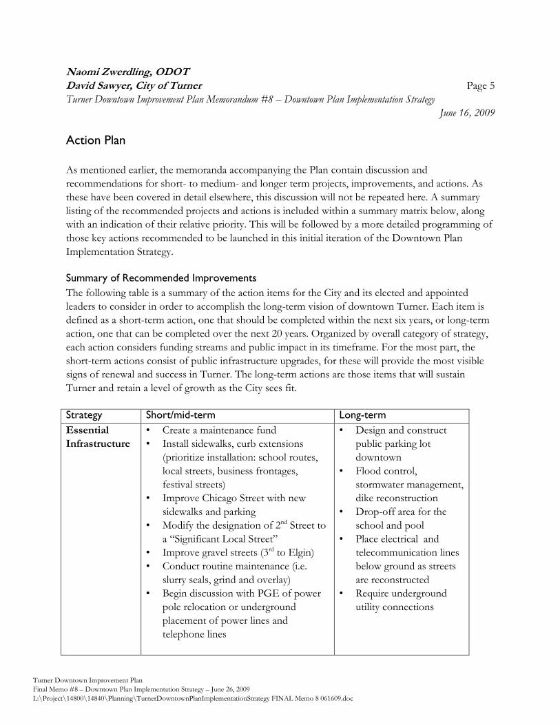
Naomi Zwerdling, ODOT
David Sawyer, City of Turner Page 5
Turner Downtown Improvement Plan Memorandum #8 – Downtown Plan Implementation Strategy
June 16, 2009
Turner Downtown Improvement Plan
Final Memo #8 – Downtown Plan Implementation Strategy – June 26, 2009
L:\Project\14800\14840\Planning\TurnerDowntownPlanImplementationStrategy FINAL Memo 8 061609.doc
Action Plan
As mentioned earlier, the memoranda accompanying the Plan contain discussion and
recommendations for short- to medium- and longer term projects, improvements, and actions. As
these have been covered in detail elsewhere, this discussion will not be repeated here. A summary
listing of the recommended projects and actions is included within a summary matrix below, along
with an indication of their relative priority. This will be followed by a more detailed programming of
those key actions recommended to be launched in this initial iteration of the Downtown Plan
Implementation Strategy.
Summary of Recommended Improvements
The following table is a summary of the action items for the City and its elected and appointed
leaders to consider in order to accomplish the long-term vision of downtown Turner. Each item is
defined as a short-term action, one that should be completed within the next six years, or long-term
action, one that can be completed over the next 20 years. Organized by overall category of strategy,
each action considers funding streams and public impact in its timeframe. For the most part, the
short-term actions consist of public infrastructure upgrades, for these will provide the most visible
signs of renewal and success in Turner. The long-term actions are those items that will sustain
Turner and retain a level of growth as the City sees fit.
Strategy Short/mid-term Long-term
Essential
Infrastructure
• Create a maintenance fund
• Install sidewalks, curb extensions
(prioritize installation: school routes,
local streets, business frontages,
festival streets)
• Improve Chicago Street with new
sidewalks and parking
• Modify the designation of 2nd Street to
a ―Significant Local Street‖
• Improve gravel streets (3rd to Elgin)
• Conduct routine maintenance (i.e.
slurry seals, grind and overlay)
• Begin discussion with PGE of power
pole relocation or underground
placement of power lines and
telephone lines
• Design and construct
public parking lot
downtown
• Flood control,
stormwater management,
dike reconstruction
• Drop-off area for the
school and pool
• Place electrical and
telecommunication lines
below ground as streets
are reconstructed
• Require underground
utility connections
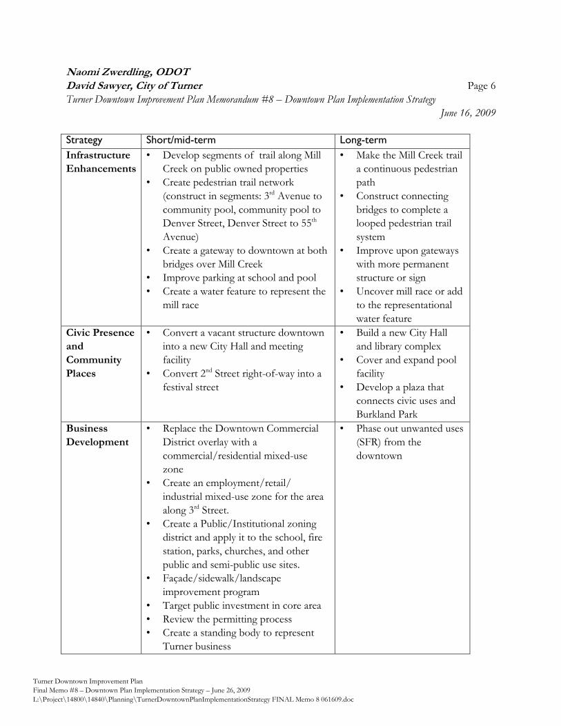
Naomi Zwerdling, ODOT
David Sawyer, City of Turner Page 6
Turner Downtown Improvement Plan Memorandum #8 – Downtown Plan Implementation Strategy
June 16, 2009
Turner Downtown Improvement Plan
Final Memo #8 – Downtown Plan Implementation Strategy – June 26, 2009
L:\Project\14800\14840\Planning\TurnerDowntownPlanImplementationStrategy FINAL Memo 8 061609.doc
Strategy Short/mid-term Long-term
Infrastructure
Enhancements
• Develop segments of trail along Mill
Creek on public owned properties
• Create pedestrian trail network
(construct in segments: 3rd Avenue to
community pool, community pool to
Denver Street, Denver Street to 55th
Avenue)
• Create a gateway to downtown at both
bridges over Mill Creek
• Improve parking at school and pool
• Create a water feature to represent the
mill race
• Make the Mill Creek trail
a continuous pedestrian
path
• Construct connecting
bridges to complete a
looped pedestrian trail
system
• Improve upon gateways
with more permanent
structure or sign
• Uncover mill race or add
to the representational
water feature
Civic Presence
and
Community
Places
• Convert a vacant structure downtown
into a new City Hall and meeting
facility
• Convert 2nd Street right-of-way into a
festival street
• Build a new City Hall
and library complex
• Cover and expand pool
facility
• Develop a plaza that
connects civic uses and
Burkland Park
Business
Development
• Replace the Downtown Commercial
District overlay with a
commercial/residential mixed-use
zone
• Create an employment/retail/
industrial mixed-use zone for the area
along 3rd Street.
• Create a Public/Institutional zoning
district and apply it to the school, fire
station, parks, churches, and other
public and semi-public use sites.
• Façade/sidewalk/landscape
improvement program
• Target public investment in core area
• Review the permitting process
• Create a standing body to represent
Turner business
• Phase out unwanted uses
(SFR) from the
downtown
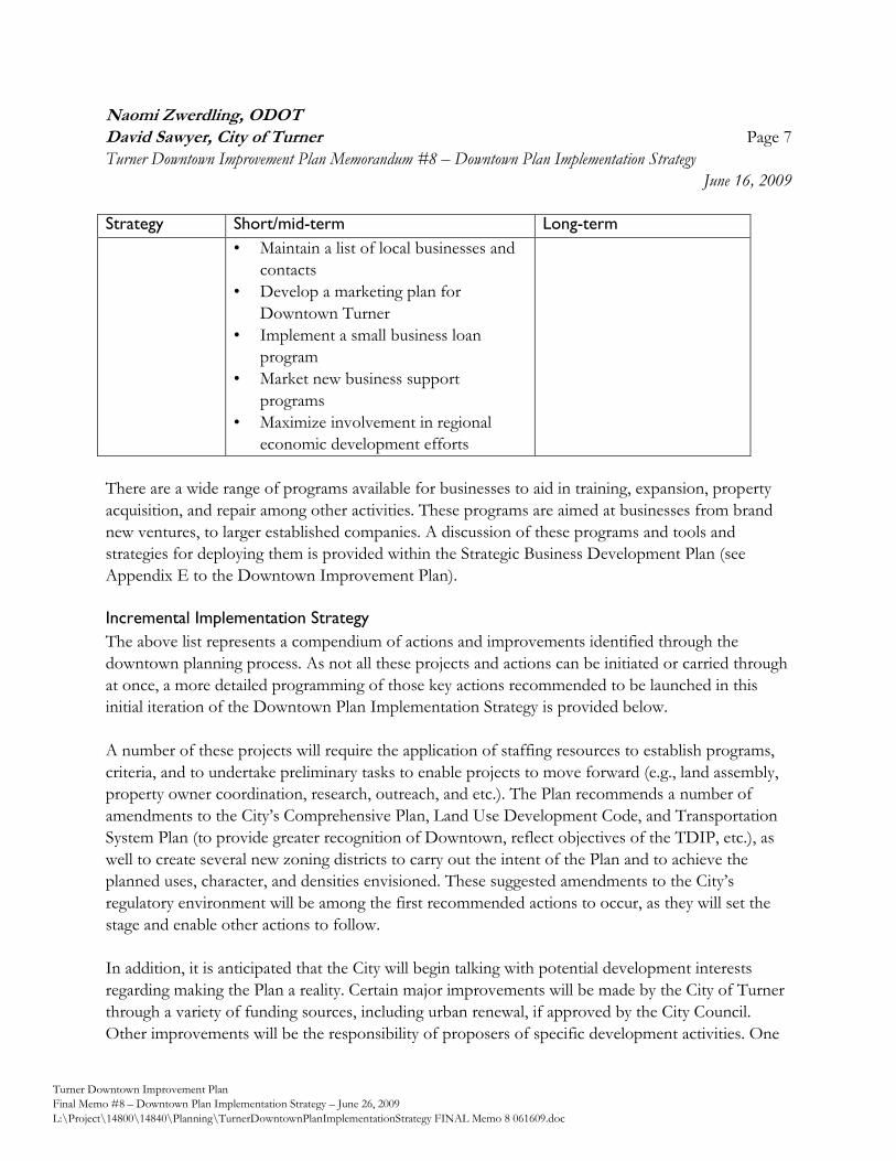
Naomi Zwerdling, ODOT
David Sawyer, City of Turner Page 7
Turner Downtown Improvement Plan Memorandum #8 – Downtown Plan Implementation Strategy
June 16, 2009
Turner Downtown Improvement Plan
Final Memo #8 – Downtown Plan Implementation Strategy – June 26, 2009
L:\Project\14800\14840\Planning\TurnerDowntownPlanImplementationStrategy FINAL Memo 8 061609.doc
Strategy Short/mid-term Long-term
• Maintain a list of local businesses and
contacts
• Develop a marketing plan for
Downtown Turner
• Implement a small business loan
program
• Market new business support
programs
• Maximize involvement in regional
economic development efforts
There are a wide range of programs available for businesses to aid in training, expansion, property
acquisition, and repair among other activities. These programs are aimed at businesses from brand
new ventures, to larger established companies. A discussion of these programs and tools and
strategies for deploying them is provided within the Strategic Business Development Plan (see
Appendix E to the Downtown Improvement Plan).
Incremental Implementation Strategy
The above list represents a compendium of actions and improvements identified through the
downtown planning process. As not all these projects and actions can be initiated or carried through
at once, a more detailed programming of those key actions recommended to be launched in this
initial iteration of the Downtown Plan Implementation Strategy is provided below.
A number of these projects will require the application of staffing resources to establish programs,
criteria, and to undertake preliminary tasks to enable projects to move forward (e.g., land assembly,
property owner coordination, research, outreach, and etc.). The Plan recommends a number of
amendments to the City’s Comprehensive Plan, Land Use Development Code, and Transportation
System Plan (to provide greater recognition of Downtown, reflect objectives of the TDIP, etc.), as
well to create several new zoning districts to carry out the intent of the Plan and to achieve the
planned uses, character, and densities envisioned. These suggested amendments to the City’s
regulatory environment will be among the first recommended actions to occur, as they will set the
stage and enable other actions to follow.
In addition, it is anticipated that the City will begin talking with potential development interests
regarding making the Plan a reality. Certain major improvements will be made by the City of Turner
through a variety of funding sources, including urban renewal, if approved by the City Council.
Other improvements will be the responsibility of proposers of specific development activities. One
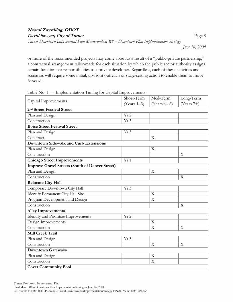
Naomi Zwerdling, ODOT
David Sawyer, City of Turner Page 8
Turner Downtown Improvement Plan Memorandum #8 – Downtown Plan Implementation Strategy
June 16, 2009
Turner Downtown Improvement Plan
Final Memo #8 – Downtown Plan Implementation Strategy – June 26, 2009
L:\Project\14800\14840\Planning\TurnerDowntownPlanImplementationStrategy FINAL Memo 8 061609.doc
or more of the recommended projects may come about as a result of a ―public-private partnership,‖
a contractual arrangement tailor-made for each situation by which the public sector authority assigns
certain functions or responsibilities to a private developer. Regardless, each of these activities and
scenarios will require some initial, up-front outreach or stage-setting action to enable them to move
forward.
Table No. 1 — Implementation Timing for Capital Improvements
Capital Improvements Short-Term
(Years 1–3)
Med-Term
(Years 4– 6)
Long-Term
(Years 7+)
2nd Street Festival Street
Plan and Design Yr 2
Construction Yr 3
Boise Street Festival Street
Plan and Design Yr 3
Construct X
Downtown Sidewalk and Curb Extensions
Plan and Design X
Construction X
Chicago Street Improvements Yr 1
Improve Gravel Streets (South of Denver Street)
Plan and Design X
Construction X
Relocate City Hall
Temporary Downtown City Hall Yr 3
Identify Permanent City Hall Site X
Program Development and Design X
Construction X
Alley Improvements
Identify and Prioritize Improvements Yr 2
Design Improvements X
Construction X X
Mill Creek Trail
Plan and Design Yr 3
Construction X X
Downtown Gateways
Plan and Design X
Construction X
Cover Community Pool
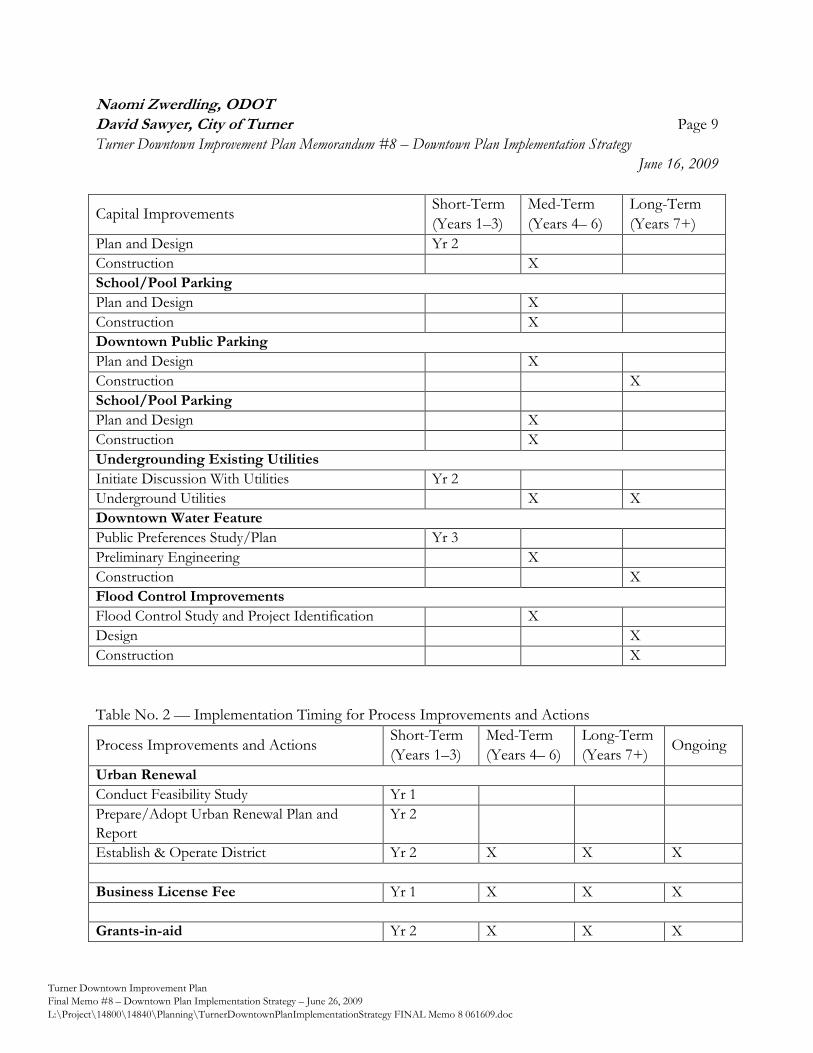
Naomi Zwerdling, ODOT
David Sawyer, City of Turner Page 9
Turner Downtown Improvement Plan Memorandum #8 – Downtown Plan Implementation Strategy
June 16, 2009
Turner Downtown Improvement Plan
Final Memo #8 – Downtown Plan Implementation Strategy – June 26, 2009
L:\Project\14800\14840\Planning\TurnerDowntownPlanImplementationStrategy FINAL Memo 8 061609.doc
Capital Improvements Short-Term
(Years 1–3)
Med-Term
(Years 4– 6)
Long-Term
(Years 7+)
Plan and Design Yr 2
Construction X
School/Pool Parking
Plan and Design X
Construction X
Downtown Public Parking
Plan and Design X
Construction X
School/Pool Parking
Plan and Design X
Construction X
Undergrounding Existing Utilities
Initiate Discussion With Utilities Yr 2
Underground Utilities X X
Downtown Water Feature
Public Preferences Study/Plan Yr 3
Preliminary Engineering X
Construction X
Flood Control Improvements
Flood Control Study and Project Identification X
Design X
Construction X
Table No. 2 — Implementation Timing for Process Improvements and Actions
Process Improvements and Actions Short-Term
(Years 1–3)
Med-Term
(Years 4– 6)
Long-Term
(Years 7+) Ongoing
Urban Renewal
Conduct Feasibility Study Yr 1
Prepare/Adopt Urban Renewal Plan and
Report
Yr 2
Establish & Operate District Yr 2 X X X
Business License Fee Yr 1 X X X
Grants-in-aid Yr 2 X X X
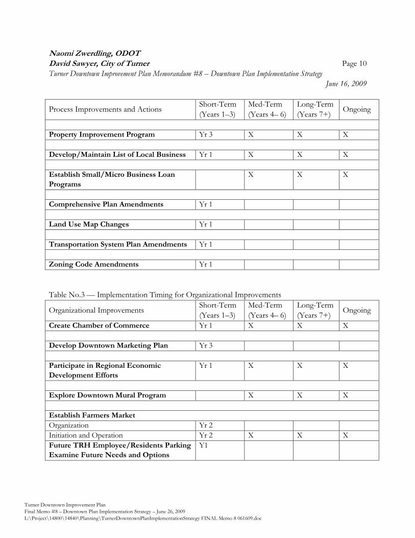
Naomi Zwerdling, ODOT
David Sawyer, City of Turner Page 10
Turner Downtown Improvement Plan Memorandum #8 – Downtown Plan Implementation Strategy
June 16, 2009
Turner Downtown Improvement Plan
Final Memo #8 – Downtown Plan Implementation Strategy – June 26, 2009
L:\Project\14800\14840\Planning\TurnerDowntownPlanImplementationStrategy FINAL Memo 8 061609.doc
Process Improvements and Actions Short-Term
(Years 1–3)
Med-Term
(Years 4– 6)
Long-Term
(Years 7+) Ongoing
Property Improvement Program Yr 3 X X X
Develop/Maintain List of Local Business Yr 1 X X X
Establish Small/Micro Business Loan
Programs
X X X
Comprehensive Plan Amendments Yr 1
Land Use Map Changes Yr 1
Transportation System Plan Amendments Yr 1
Zoning Code Amendments Yr 1
Table No.3 — Implementation Timing for Organizational Improvements
Organizational Improvements Short-Term
(Years 1–3)
Med-Term
(Years 4– 6)
Long-Term
(Years 7+) Ongoing
Create Chamber of Commerce Yr 1 X X X
Develop Downtown Marketing Plan Yr 3
Participate in Regional Economic
Development Efforts
Yr 1 X X X
Explore Downtown Mural Program X X X
Establish Farmers Market
Organization Yr 2
Initiation and Operation Yr 2 X X X
Future TRH Employee/Residents Parking
Examine Future Needs and Options
Y1
Naomi Zwerdling, ODOT
David Sawyer, City of Turner Page 11
Turner Downtown Improvement Plan Memorandum #8 – Downtown Plan Implementation Strategy
June 16, 2009
Turner Downtown Improvement Plan
Final Memo #8 – Downtown Plan Implementation Strategy – June 26, 2009
L:\Project\14800\14840\Planning\TurnerDowntownPlanImplementationStrategy FINAL Memo 8 061609.doc
Conclusion
In conclusion, the Turner Downtown Improvement Plan represents the community’s official
framework for the revitalization of Downtown Turner into a thriving neighborhood. As this plan
represents the expression of the community’s vision and desired outcomes for Downtown, the Plan
must be a dynamic and responsive policy framework; one that changes as needed to keep pace of
changing community values and external factors, and as opportunities arise. Over time, the TDIP is
intended to continue to evolve, serving as the framework for further refinement according to the
wishes of the community. The Downtown Implementation Strategy is intended to provide policy
guidance and specific actions for implementing the Downtown Improvement Plan and to provide
direction as to the priorities and focus for action. It is recommended that the City review the
Strategy on a regularly-scheduled basis and make amendments as opportunity or changing
community and economic circumstances necessitates. Should there be a desire to change the goals
or shift the emphasis of a particular project, this plan-update process provides the mechanism for
doing so within the context of reviewing the plan as a whole.
It is anticipated and intended for this Downtown Plan Implementation Strategy to be closely
monitored, reported upon to City decision makers, and updated on an annual basis. By doing so, the
City will be more likely to achieve the outcomes envisioned by the Turner Downtown Improvement
Plan in a timely and effective manner.
Appendix J
Current City of Turner Comprehensive Plan and
Land Use Districts Map