Embed Size (px)
Citation preview
www.elsevier.com/locate/epsl
Earth and Planetary Science Le
Two-phase opening of Andaman Sea:
a new seismotectonic insight
P.K. Khana,*, Partha Pratim Chakrabortyb
aDepartment of Applied Geophysics, Indian School of Mines, Dhanbad, Jharkhand, IndiabDepartment of Applied Geology, Indian School of Mines, Dhanbad, Jharkhand, India
Received 17 May 2004; accepted 1 November 2004
Editor: E. Boyle
Available online 15 December 2004
Abstract
High-resolution reconstruction of Benioff zone depth–dip angle trajectory for Burma–Java subduction margin
between 28 and 178N Lat. reveals two major episodes of plate geometry change expressed as abrupt deviation in
subduction angle. Estimation of effective rate of subduction in different time slices (and then length of subducted slab)
allowed drawing of isochrones in Ma interval through these trajectories for the time period 5–12 Ma. With these
isochrones, the deformation events on the subducting Indian plate are constrained in time as of 4–5 and 11 Ma old.
This well-constrained time connotation offered scope for the correlation of slab deformation events with the well-
established two-phase opening history of the Andaman Sea. While the 11 Ma event recorded from southern part of the
study area is correlated with early stretching and rifting phase, the 4–5 Ma event is interpreted as major forcing
behind the spreading phase of the Andaman Sea. Systematic spatio-temporal evaluation of Indian plate obliquity on the
Andaman Sea evolution shows its definite control on the early rifting phase, initiated towards south near northwest
Sumatra. The much young spreading phase recorded towards north of 78 Lat. is possibly the result of late Miocene–
Pliocene trench retreat and follow-up transcurrent movement (along Sagaing and Sumatran fault system) with NW–SE
pull-apart extension.
Nonconformity between plate shape and subduction margin geometry is interpreted as the causative force behind Mid-
Miocene intraplate extension and tearing. Enhanced stretching in the overriding plate consequently caused active forearc
subsidence, recorded all along this plate margin. Initial phase of the Andaman Sea opening presumably remains concealed
in this early–middle Miocene forearc subsidence history. The late Miocene–Pliocene pull-apart opening and spreading was
possibly initiated near the western part of the Mergui–Sumatra region and propagated northward in subsequent period. A
temporary halt in rifting at this pull-apart stage and northeastward veering of the Andaman Sea Ridge (ASR) are related
0012-821X/$ - s
doi:10.1016/j.ep
* Correspon
E-mail addr
tters 229 (2005) 259–271
ee front matter D 2004 Elsevier B.V. All rights reserved.
sl.2004.11.010
ding author.
esses: [email protected] (P.K. Khan)8 [email protected] (P.P. Chakraborty).
P.K. Khan, P.P. Chakraborty / Earth and Planetary Science Letters 229 (2005) 259–271260
with uplifting of oceanic crust in post-middle Miocene time in form of Alcock and Sewell seamounts, lying symmetrically
north and south of this spreading ridge.
D 2004 Elsevier B.V. All rights reserved.
Keywords: depth–dip angle; benioff zone; isochrone; obliquity; rifting; pull-apart
1. Introduction
Collision between the Indian and Eurasian plates
[1–5], coupling and decoupling of different platelets
[6], crustal movement along strike-slip faults [7–15],
rotation of continental blocks [16–19] and opening of
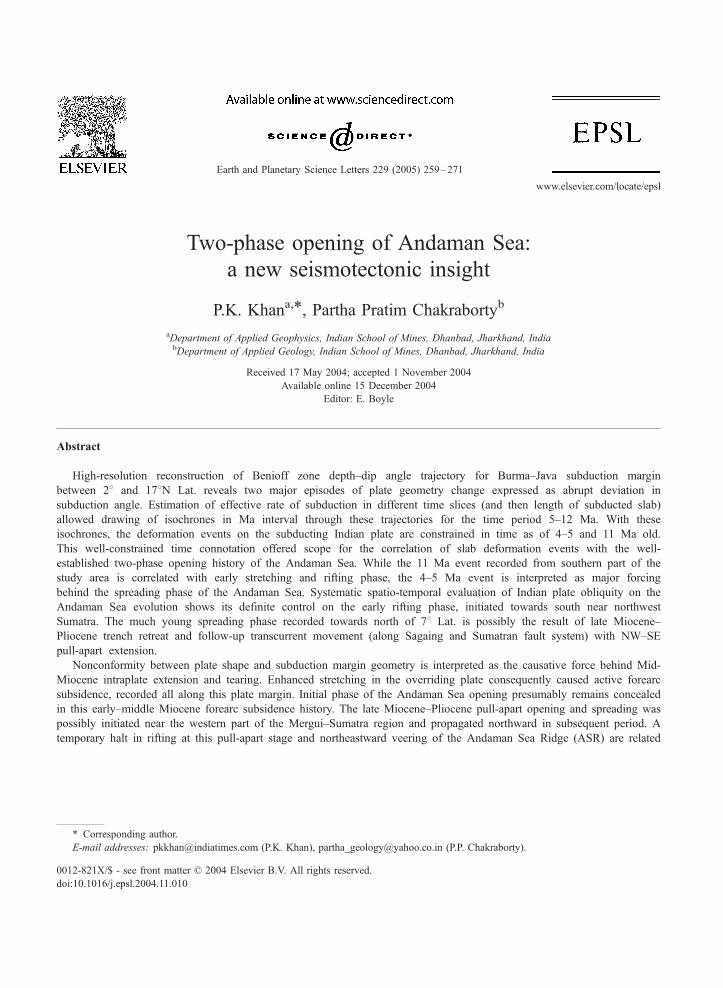
Fig. 1. Map on the left shows the regional tectonic framework of the weste
rotation of south Sumatra is from Ninkovich [16], counter-clockwise rota
north Malaysia are from Hall [19]. Left bottom open arrow indicates Indi
motion with respect to Siberia since the Miocene. The tectonic setup of
subducting Indian lithosphere showing on the right after Curray et al. [7
polygon demarcates closely spaced structure contours.
marginal basins on various scale [7,19,20] framed the
Tertiary tectonics of southeast (SE) Asia. Models
favoring both decoupling with back arc stretching
(Mariana Trough; West Philippine Sea) and transform
with pull-apart extension (Japan Sea) are sighted as
operative plate kinematics to explain the opening of
rn part of southeast Asia after Tapponnier et al. [22]. Clockwise 208tion of south Malaysia and north Sumatra and clockwise rotation of
an plate motion vector and right top open arrow is for major block
Andaman Sea with structure contour map for the top part of the
], Curray and Munasinghe [65] and Dasgupta et al. [63]. Note the
P.K. Khan, P.P. Chakraborty / Earth and Planetary Science Letters 229 (2005) 259–271 261
marginal basins through this highly dynamic geo-
tectonic province. Palaeomagnetic clue, bathymetry
data [21] and theoretical reasoning [7,18,20,22,23] on
origin of such basins, however, visualizes their
episodic evolution [24–26]; episodes may vary both
in operative tectonics and basin opening rate.
The Andaman Sea, concern of the present study,
occupy an unique position as a marginal basin in SE
Asia geography and offers scope for understanding
both intra- and inter-plate kinematic controls along
Burma–Java subduction margin in the backdrop of
other coeval tectonic structures in the region viz.
subduction of the Indian plate under the Eurasia, roll
back of the Java trench, large-scale dextral motion
along Sagaing fault, extrusion activity in SE Asia
and rotation of continental blocks (Malay peninsula
and Sumatra) [10,27,28]. A two-phase evolution for
the Andaman Sea is established in literature with an
early (Oligocene–early Miocene) rifting and subse-
quent (post-middle Miocene) active spreading [7]. It
is proposed that in post-middle Miocene Andaman
forearc witnessed three major tectonic divisions in
north–south transect; the central basin of the Anda-
man Sea with short spreading rifts and transforms
(with NW–SE spreading at the rate of 1.6–3.72 cm/
year; [21]) and right lateral shear movement in its
north (along Sagaing fault) and south (along
Sumatran fault system), respectively (Fig. 1) [7,21,
29,30]. Recent works [21,31] though provided
significant insight on spreading history (V4–5 Ma,
i.e., late Miocene–early Pliocene onward) of the
Andaman Sea, offer only little account for its early
rifting phase associated with subsidence in the entire
forearc of this plate margin including the Andaman
Sea and Burma central basin [32]. The present study
aims towards understanding this poorly known early
Andaman Sea history with focus on an area between
Lat. 28 and 178 and Long. 928 and 998. Objectivesof this study are to address some of the long-
unresolved queries on this plate margin viz.: (i) If
subduction (of the Indian plate) process was oper-
ative at this plate margin since early Cretaceous, can
we constrain how and when rifting was initiated in
the Andaman forearc region? (ii) Does deformation
in the subducting Indian slab comply with the
subduction kinematics? (iii) is change in subducting
plate shape is reflected in changes of subduction
history or radius of arc? Answers related to these
questions must be sought in reference to regional
tectonic grains, Benioff zone geometry, Tertiary
volcanic trends and rotational history of adjoining
crustal blocks. Within the constraint of available
plate kinematic database reconstruction of Benioff
zone configuration through a systematic high-reso-
lution earthquake data analysis under the present
study allowed sequential modeling of the Andaman
Sea, in general, and its early rifting phase, in
particular.
2. Tectonics and geology
Opened on the northward-moving Indian plate, the
Andaman Sea, with its subduction boundaries towards
north, west and south, is one of the challenging and
poorly understood marginal basins with strange
tectonic setting. Continuation of Oligocene continen-
tal arc volcanism between Sumatra and Burma bears
evidence in favor of Oligocene–early Miocene trench
being very close to the pre-existing continental margin
on its east [8]. Active extension was presumed on this
continental margin from late Oligocene time in form
of opening of the Mergui–Sumatra basin (the dprotoAndaman basinT? of Curray et al. [7]). History of this
extension, however, did not last long as the basin
subsequently got aborted.
The late Oligocene–early Miocene limestone–shale
(with interstratified pyroclastics) dsequencesT off
Sumatra, interpreted as product of transgressive–
regressive cycles, document signatures of active
interplay between subsidence and eustacy in the
forearc area and considered to be valid all through
the southeast Asia during this time period [15,33,34].
Analogues of these dsequencesT can also be observed
in the northern part of this geodynamic belt at the
middle and north Andaman Islands [35]. Evidences
favoring this forearc subsidence are also found in
seismic reflection transects across other parts along
this plate margin [7,36,37]. The recently described
andesitic to dacitic pyroclastic tuff units in early
Miocene archipelago sediments of the middle and
north Andaman [38] presumably represent coeval
subaerial (on the then existing continental margin)
calcalkaline volcanic trend that spanned from Burma
in the north to Sumatra–Sunda arcs of Indonesia in the
south [26,39–41]. Except for some accreted on-land
P.K. Khan, P.P. Chakraborty / Earth and Planetary Science Letters 229 (2005) 259–271262
pyroclastic debrite (described from Andaman islands
as of distal subaquous origin), the absence of any
other evidence for this volcanic trend between Burma
and northern Sumatra is probably the result of rapid
subsidence of the forearc and its adjacent continental
margin in early Miocene time that subsequently got
transected by the active spreading ridge of the
Andaman Sea.
Existing models on the Andaman Sea heavily
stress on its middle Miocene opening through pull-
apart extension in a rift system on the eastern margin
of the subducting Indian plate [9,11,22]. Subsequent
to slowing down or cessation of convergence
through early Miocene time [3,15,42,43], the Indian
plate, perhaps with partly coupled Burma plate,
resumed its northward journey and increased its
obliquity and convergence rate [12,19,44] in middle
Miocene time. The resultant northward drag of
hanging slab by India through the surrounding
asthenosphere and northward movement of the
Burma platelet [9] and counter-clockwise rotation
of north Sumatra and south Malaya [10,12] are
figured as causative forcings behind pull-apart open-
ing of the Andaman Sea that mostly got accom-
modated through right-lateral Sagaing fault on its
eastern margin [10]. The active spreading that
resulted 460 km opening of the Andaman Sea
coincides with next major tectono-volcanic episode
in this plate margin, which witnessed explosive
volcanism [45], counter-clockwise (?) rotation of
northern Sumatra and southern Malay and partition-
ing of oblique convergence of the Indian plate into
an orthogonal and a strike-parallel component
[19,30]. However, this single, steady state post-
Miocene pull-apart extension model [22] alone falls
short in explaining many of the observed structural,
bathymetric and timing complexities of the Mergui–
Sumatra–Andaman basin as a whole viz. the east–
west extensional thinning of the continental and
oceanic crust, rapid subsidence in Mergui–north
Sumatra region in late Oligocene and Miocene time
[7,8,15,33,45–47], thick Oligo-Miocene clastic sedi-
mentary package, occurrence of which can be traced
at Mergui, forearc of middle and north Andaman and
central lowland of Burma [7,8,15,29,36,38,45,48,49].
The model favoring middle Miocene (~11 Ma)
spreading and opening of the Andaman Sea [7] also
referred in Hall [50] is strongly contested in recent
times through GPS survey [31,32] and reinterpreta-
tion of magnetic anomalies recorded from the Anda-
man Sea [21]. Based on the recently acquired data, it
is concluded that the Andaman Sea witnessed oceanic
crust generation through active spreading only during
past 4–5 Ma, i.e., from late Miocene–early Pliocene
time. This recent understanding of late Miocene–early
Pliocene spreading must be accounted in reference to
well-documented 450 km post-early Miocene dextral
displacement recorded from offset of the Myanmar
arc system [27] and offsets of the Chindwin and upper
Irrawady river systems [10] if we consider local-
ization of deformations caused by spreading only
towards a single boundary. Assuming initiation of
Sagaing fault system at 5 Ma and taking 20 mm/year
as instantaneous fault motion [51], maximum 100 km
total displacement can be surmised on the fault
system [32]. The natural outcome of this reasoning
is that the Andaman Sea had a long pre-spreading
rifting history, which is poorly constrained at the
present state of knowledge. Two-phase/sequential
opening for the Andaman Sea, though suggested by
different workers [7,45,48], was backed only sketch-
ily by documentation of geologic events through
process–product relation, particularly for its early
rifting phase. The kinematic reconstruction for the
Indian plate relative to Eurasia [32] in the context of
major Miocene tectonic events brought definite
signals in favor of intraplate deformation during this
time period that also fits well with the present motion
predicted by NUVEL I-A model [52,53]. These
findings necessitated a comprehensive model illus-
trating temporal and spatial variation in tectonic
milieu through this belt to explain the opening of
the Mergui–Sumatra Basin and Andaman Sea in a
sequential manner. The present study therefore aims
towards unraveling the history accommodating all
available signatures in a two-phase model; an early
east–west extension in late Oligocene–middle Mio-
cene time and a second phase of transtensional
stretching through trench retreat and pull-apart open-
ing since late Miocene–early Pliocene time.
3. Data collection and methodology
Earthquake data (mbz4.0; maximum recorded
depth up to 260 km) lying within a lateral width of
P.K. Khan, P.P. Chakraborty / Earth and Planetary Science Letters 229 (2005) 259–271 263
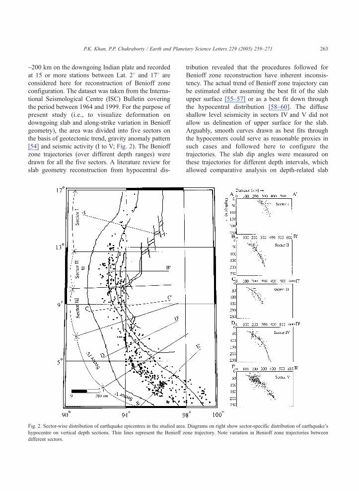
~200 km on the downgoing Indian plate and recorded
at 15 or more stations between Lat. 28 and 178 are
considered here for reconstruction of Benioff zone
configuration. The dataset was taken from the Interna-
tional Seismological Centre (ISC) Bulletin covering
the period between 1964 and 1999. For the purpose of
present study (i.e., to visualize deformation on
downgoing slab and along-strike variation in Benioff
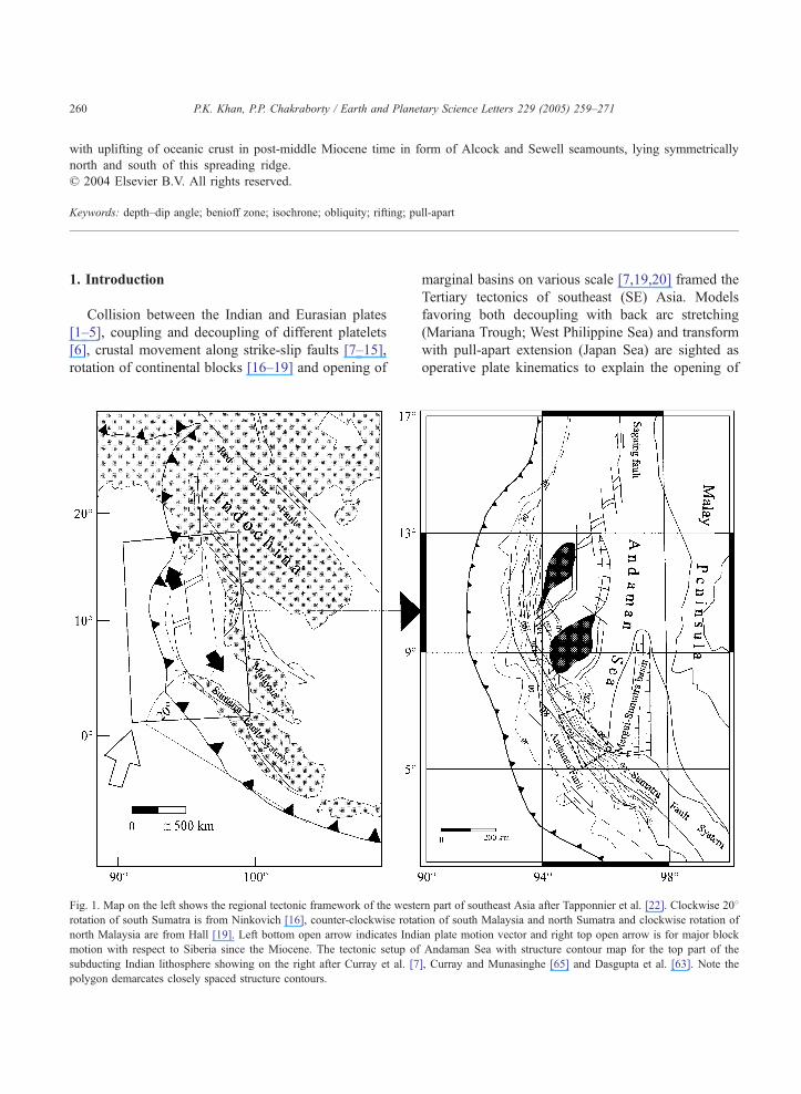
geometry), the area was divided into five sectors on
the basis of geotectonic trend, gravity anomaly pattern
[54] and seismic activity (I to V; Fig. 2). The Benioff
zone trajectories (over different depth ranges) were
drawn for all the five sectors. A literature review for
slab geometry reconstruction from hypocentral dis-
Fig. 2. Sector-wise distribution of earthquake epicentres in the studied area
hypocentre on vertical depth sections. Thin lines represent the Benioff z
different sectors.
tribution revealed that the procedures followed for
Benioff zone reconstruction have inherent inconsis-
tency. The actual trend of Benioff zone trajectory can
be estimated either assuming the best fit of the slab
upper surface [55–57] or as a best fit down through
the hypocentral distribution [58–60]. The diffuse
shallow level seismicity in sectors IV and V did not
allow us delineation of upper surface for the slab.
Arguably, smooth curves drawn as best fits through
the hypocenters could serve as reasonable proxies in
such cases and followed here to configure the
trajectories. The slab dip angles were measured on
these trajectories for different depth intervals, which
allowed comparative analysis on depth-related slab
. Diagrams on right show sector-specific distribution of earthquake’s
one trajectory. Note variation in Benioff zone trajectories between
P.K. Khan, P.P. Chakraborty / Earth and Planetary Science Letters 229 (2005) 259–271264
geometry within each sector and spatial variation in
slab geometry recorded through trajectories of differ-
ent sectors.
Estimation of subducted slab length in each
sector for different time slices were attempted
through appreciation of spatio-temporal variation in
plate obliquity (discussed later) and corresponding
Indian plate subduction rate. Considering uniform
tectonic framework and plate convergence rate the
subducted slab lengths were estimated and iso-
chrones (in Ma interval) were drawn on the
trajectories for the time period 5–12 Ma so as to
compare the subduction history of different sectors
in well-constrained time frame.
4. Obliquity, Benioff zone geometry and variability
Oblique convergence of the Indian plate with
major temporal variations in its speed and direction
was claimed as principal driving force behind
different morphotectonic features on this plate
margin viz. trench-parallel strike slip faulting,
formation of sliver plate, extension and basin
formation on overriding plate [6,7,15,30,61]. Jarrard
[62] suggested that the major forces controlling
forearc shear faulting at oblique subduction zones
are the convergence obliquity, the strength of the
overriding plate and the degree of interplate coupling.
Conforming this view, Diament et al. [44] considered
an increase of obliquity from the southern tip of
Sumatra to the Andaman Sea as major control on
spatially variable displacement gradient along Suma-
tran fault zones and arc parallel extension along this
belt. To assess the role of this obliquity on rates of
Indian plate subduction at different parts on this
subduction margin (between 28 and 178 Lat.) and to
evaluate its control on temporal variability in depth–
dip angle trajectory, Benioff zones were drawn for
different studied sectors (Fig. 2). The depth ranges
over which Benioff zone trajectories were drawn in
five studied sectors span between 3 and 129 km (57
hypocentres; sector I), between 4 and 194 km (135
hypocentres; sector II), between 25 and 149 km (76
hypocentres; sector III), between 14 and 260 km (146
hypocentres; sector IV) and between 4 and 208 km
(377 hypocentres; sector V). Inhomogeneity in seis-
micity distribution is apparent amongst the sectors;
sector V records maximum concentration of seismic
activity that decreases phenomenally in sectors IV and
III. Towards north, earthquake concentration further
increased in sector II and drops abruptly to a
minimum in sector I. With variation in concentration,
the seismic activity continued all through the Benioff
zone for the entire depth range except in sector IV
where a near seismic gap is observed between 159 and
217 km depth (line D–D in Fig. 2).
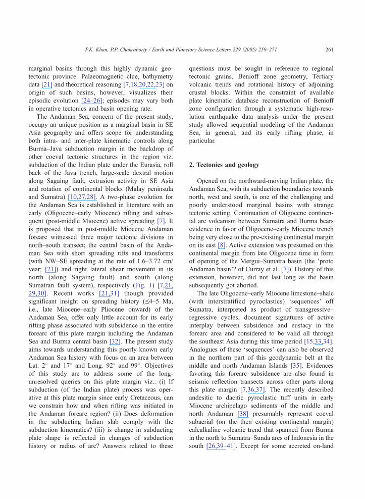
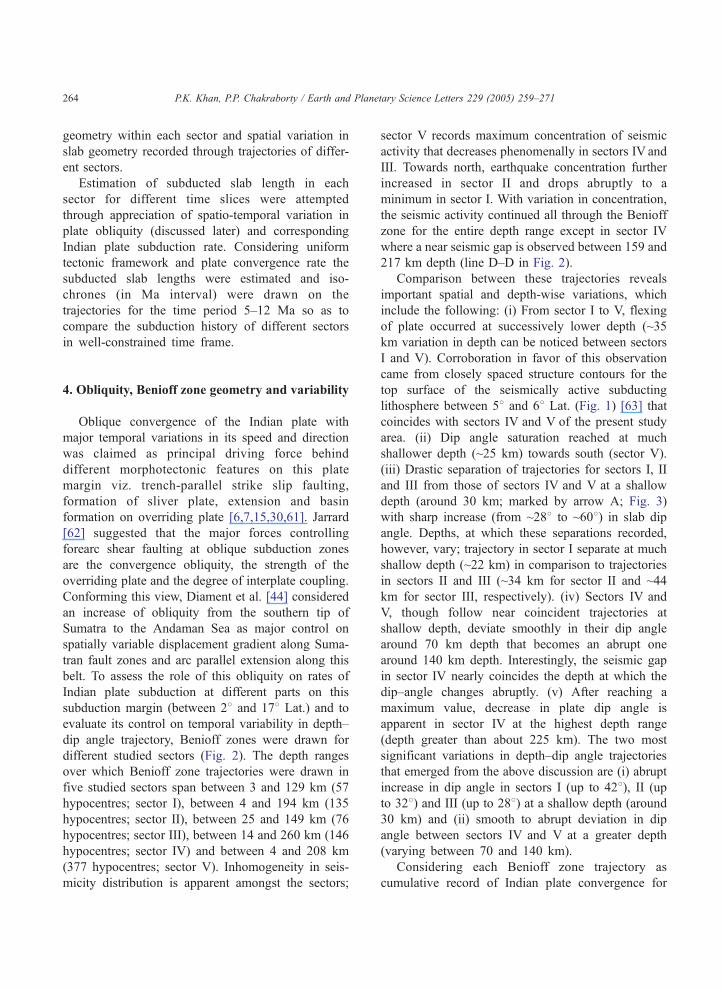
Comparison between these trajectories reveals
important spatial and depth-wise variations, which
include the following: (i) From sector I to V, flexing
of plate occurred at successively lower depth (~35
km variation in depth can be noticed between sectors
I and V). Corroboration in favor of this observation
came from closely spaced structure contours for the
top surface of the seismically active subducting
lithosphere between 58 and 68 Lat. (Fig. 1) [63] thatcoincides with sectors IV and V of the present study
area. (ii) Dip angle saturation reached at much
shallower depth (~25 km) towards south (sector V).
(iii) Drastic separation of trajectories for sectors I, II
and III from those of sectors IV and V at a shallow
depth (around 30 km; marked by arrow A; Fig. 3)
with sharp increase (from ~288 to ~608) in slab dip
angle. Depths, at which these separations recorded,
however, vary; trajectory in sector I separate at much
shallow depth (~22 km) in comparison to trajectories
in sectors II and III (~34 km for sector II and ~44
km for sector III, respectively). (iv) Sectors IV and
V, though follow near coincident trajectories at
shallow depth, deviate smoothly in their dip angle
around 70 km depth that becomes an abrupt one
around 140 km depth. Interestingly, the seismic gap
in sector IV nearly coincides the depth at which the
dip–angle changes abruptly. (v) After reaching a
maximum value, decrease in plate dip angle is
apparent in sector IV at the highest depth range
(depth greater than about 225 km). The two most
significant variations in depth–dip angle trajectories
that emerged from the above discussion are (i) abrupt
increase in dip angle in sectors I (up to 428), II (upto 328) and III (up to 288) at a shallow depth (around
30 km) and (ii) smooth to abrupt deviation in dip
angle between sectors IV and V at a greater depth
(varying between 70 and 140 km).
Considering each Benioff zone trajectory as
cumulative record of Indian plate convergence for
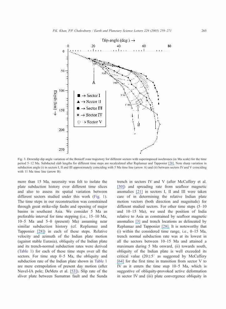
Fig. 3. Downdip dip angle variation of the Benioff zone trajectory for different sectors with superimposed isochrones (in Ma scale) for the time
period 5–12 Ma. Subducted slab lengths for different time steps are recalculated after Replumaz and Tapponier [28]. Note sharp variation in
subduction angle (i) in sectors I, II and III approximately coinciding with 5 Ma time line (arrow A) and (ii) between sectors IV and V coinciding
with 11 Ma time line (arrow B).
P.K. Khan, P.P. Chakraborty / Earth and Planetary Science Letters 229 (2005) 259–271 265
more than 15 Ma, necessity was felt to isolate the
plate subduction history over different time slices
and also to assess its spatial variation between
different sectors studied under this work (Fig. 1).
The time steps in our reconstruction was constrained
through great strike-slip faults and opening of major
basins in southeast Asia. We consider 5 Ma as
preferable interval for time stepping (i.e., 15–10 Ma,
10–5 Ma and 5–0 (present) Ma) assuming near
similar subduction history (cf. Replumaz and
Tapponier [28]) in each of these steps. Relative
velocity and azimuth of the Indian plate motion
(against stable Eurasia), obliquity of the Indian plate
and its trench-normal subduction rates were derived
(Table 1) for each of these time steps over all the
sectors. For time step 0–5 Ma, the obliquity and
subduction rate of the Indian plate shown in Table 1
are mere extrapolation of present day motion (after
Nuvel-IA pole; DeMets et al. [53]). Slip rate of the
sliver plate between Sumatran fault and the Sunda
trench in sectors IV and V (after McCaffery et al.
[30]) and spreading rate from seafloor magnetic
anomalies [21] in sectors I, II and III were taken
care of in determining the relative Indian plate
motion vectors (both direction and magnitude) for
different studied sectors. For other time steps (5–10
and 10–15 Ma), we used the position of India
relative to Asia as constrained by seafloor magnetic
anomalies [3] and trench locations as delineated by
Replumaz and Tapponier [28]. It is noteworthy that
(i) within the considered time range, i.e., 0–15 Ma,
trench normal subduction rate was at its lowest in
all the sectors between 10–15 Ma and attained a
maximum during 5 Ma onward, (ii) towards south,
obliquity of the Indian plate is well exceeded its
critical value (20F58 as suggested by McCaffery
[64] for the first time in transition from sector V to
IV as it enters the time step 10–5 Ma, which is
suggestive of obliquity-provoked active deformation
in sector IV and (iii) plate convergence obliquity in
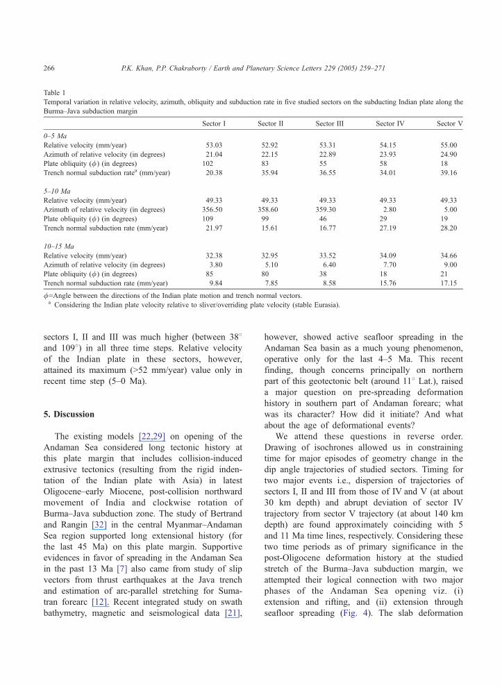
Table 1
Temporal variation in relative velocity, azimuth, obliquity and subduction rate in five studied sectors on the subducting Indian plate along the
Burma–Java subduction margin
Sector I Sector II Sector III Sector IV Sector V
0–5 Ma
Relative velocity (mm/year) 53.03 52.92 53.31 54.15 55.00
Azimuth of relative velocity (in degrees) 21.04 22.15 22.89 23.93 24.90
Plate obliquity (/) (in degrees) 102 83 55 58 18
Trench normal subduction ratea (mm/year) 20.38 35.94 36.55 34.01 39.16
5–10 Ma
Relative velocity (mm/year) 49.33 49.33 49.33 49.33 49.33
Azimuth of relative velocity (in degrees) 356.50 358.60 359.30 2.80 5.00
Plate obliquity (/) (in degrees) 109 99 46 29 19
Trench normal subduction rate (mm/year) 21.97 15.61 16.77 27.19 28.20
10–15 Ma
Relative velocity (mm/year) 32.38 32.95 33.52 34.09 34.66
Azimuth of relative velocity (in degrees) 3.80 5.10 6.40 7.70 9.00
Plate obliquity (/) (in degrees) 85 80 38 18 21
Trench normal subduction rate (mm/year) 9.84 7.85 8.58 15.76 17.15
/=Angle between the directions of the Indian plate motion and trench normal vectors.a Considering the Indian plate velocity relative to sliver/overriding plate velocity (stable Eurasia).
P.K. Khan, P.P. Chakraborty / Earth and Planetary Science Letters 229 (2005) 259–271266
sectors I, II and III was much higher (between 388and 1098) in all three time steps. Relative velocity
of the Indian plate in these sectors, however,
attained its maximum (N52 mm/year) value only in
recent time step (5–0 Ma).
5. Discussion
The existing models [22,29] on opening of the
Andaman Sea considered long tectonic history at
this plate margin that includes collision-induced
extrusive tectonics (resulting from the rigid inden-
tation of the Indian plate with Asia) in latest
Oligocene–early Miocene, post-collision northward
movement of India and clockwise rotation of
Burma–Java subduction zone. The study of Bertrand
and Rangin [32] in the central Myanmar–Andaman
Sea region supported long extensional history (for
the last 45 Ma) on this plate margin. Supportive
evidences in favor of spreading in the Andaman Sea
in the past 13 Ma [7] also came from study of slip
vectors from thrust earthquakes at the Java trench
and estimation of arc-parallel stretching for Suma-
tran forearc [12]. Recent integrated study on swath
bathymetry, magnetic and seismological data [21],
however, showed active seafloor spreading in the
Andaman Sea basin as a much young phenomenon,
operative only for the last 4–5 Ma. This recent
finding, though concerns principally on northern
part of this geotectonic belt (around 118 Lat.), raiseda major question on pre-spreading deformation
history in southern part of Andaman forearc; what
was its character? How did it initiate? And what
about the age of deformational events?
We attend these questions in reverse order.
Drawing of isochrones allowed us in constraining
time for major episodes of geometry change in the
dip angle trajectories of studied sectors. Timing for
two major events i.e., dispersion of trajectories of
sectors I, II and III from those of IV and V (at about
30 km depth) and abrupt deviation of sector IV
trajectory from sector V trajectory (at about 140 km
depth) are found approximately coinciding with 5
and 11 Ma time lines, respectively. Considering these
two time periods as of primary significance in the
post-Oligocene deformation history at the studied
stretch of the Burma–Java subduction margin, we
attempted their logical connection with two major
phases of the Andaman Sea opening viz. (i)
extension and rifting, and (ii) extension through
seafloor spreading (Fig. 4). The slab deformation
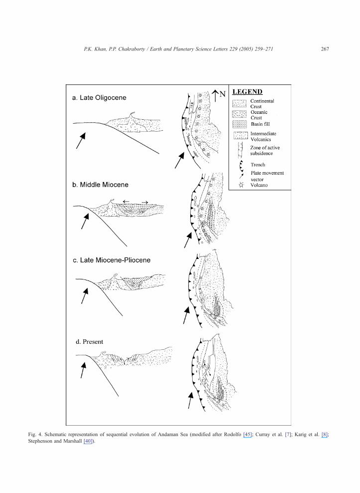
Fig. 4. Schematic representation of sequential evolution of Andaman Sea (modified after Rodolfo [45]; Curray et al. [7]; Karig et al. [8];
Stephenson and Marshall [40]).
P.K. Khan, P.P. Chakraborty / Earth and Planetary Science Letters 229 (2005) 259–271 267
P.K. Khan, P.P. Chakraborty / Earth and Planetary Science Letters 229 (2005) 259–271268
recorded around 4–5 Ma time towards northern part
of the study area (in sectors I, II and III) clearly
suggestive of its relation with back arc active
spreading recorded by Raju et al. [21] from magnetic
anomaly study. Our study shows abrupt increase in
slab dip (Fig 3) together with increased subduction
rate (Table 1) towards north of 78 Lat. around 4–5
Ma, which possibly provoked trench retreat and
active extension resulting into spreading in the back
arc region (Fig. 4d). The southern segment of the
Andaman Sea Ridge (ASR) possibly records the
initiation history of this spreading phase. The ocean–
continent transition recorded in Mergui terrace [7]
hints towards possible locale wherefrom the spread-
ing phase initiated (Fig. 4c). Subsequent veering in
orientation of ASR in NE–SW direction is possibly
an outcome of multiple tectonic forcings including
velocity inhomogeneity between the Indian and
Burma plate [10] and N–S compression caused there
from, uplifting of oceanic crust in post-middle
Miocene time through Alcock and Sewell seamounts
[7] (in the north and south of ASR, respectively) and
post-middle Miocene dstop and goT spreading charac-
ter in this ridge system. For the 11 Ma slab
deformation event recorded from the southern part
of the studied stretch (sectors IV and V), we propose
its relation with the early rifting history of the
Andaman Sea, i.e., the dproto Andaman SeaT of
Curray et al. [7] in place of present Mergui–North
Sumatra Basin. This well-controlled time connotation
for major slab deformation episodes of the subducting
Indian plate undoubtedly helped in resolving the long-
held uncertainty of early deformation history for the
Andaman Sea.
Understandably, extrusion tectonics of southeast
Asia, rotation of northern Sumatra and stretching
from the northward moving Burma platelet fall short
in explaining entire history of the Andaman Sea,
particularly for its early deformational phase. Large-
scale forearc subsidence (Fig. 4a) in late Oligocene–
early Miocene time all through this plate margin
[7,8,15,33,45–47] bear tell-tale signal for an
increased extension that predates rotation of Sumatra,
initiation of oblique convergence and northward
movement of the Burma platelet. An enhanced
subsidence around 58N (sector IV of the present
study area) between 15 and 10 Ma (Fig. 3), caused
by increased subduction angle of the Indian plate (in
adjustment to change in curvature of the subduction
margin, cf. Maung [10]), possibly led to the first
phase of rifting in the Andaman Sea (in the
northwest part of Sumatra; Fig. 4b) at around 11
Ma, when the deformation was compounded by
sudden increase in the Indian plate obliquity on
transition from sector V to sector IV (Table 1). The
dragging of the Indo-Burman Ranges and Andaman–
Nicobar Ridges towards the north by India is
suggested as the causative forcing behind the
formation of double arc in the middle Miocene time
(Maung [10]) with reduction in radius of curvature
for the Andaman–Nicobar arc [10]. The decline in
depth of plate flexure from sector I through sector V
against this smaller radius of arc curvature resulted
to nonconformity between plate shape and subduc-
tion margin geometry that might have contributed in
increasing subduction angle and intraplate extension.
Abrupt departure of plate dip amount (between
sectors IV and V) at a depth that coincides with
seismic gap registers signature of this enhanced
extension event. This abrupt deviation in dip angle
of suducting plate (Fig. 3), seismic gap and supposed
free flow in the mantle at deeper level in sector IV
(depth section in Fig. 2) prompted us to visualize
possible tear in downgoing plate, which, of course,
did not go up to the stage of plate detachment.
Systematic spatio-temporal analysis on obliquity
and subduction rate under the present study clearly
reveals that sectors I, II and III behaved differently
in their tectonic evolution from sectors IV and V.
Slowing of subduction is indicated all through this
plate margin between 15 and ~10 Ma (Table 1).
Though obliquity showed consistently high value
(exceeding critical value for Northwest Sumatra) in
sectors I, II and III for all three considered time
steps, subduction rate varied in these sectors between
these time steps; highest subduction rate being
recorded in time step 5–0 Ma. This possibly rules
out obliquity as a major control behind spreading
phase of the Andaman Sea history. Role of obliquity,
however, strongly suggested behind the early rifting
history of the Andaman Sea. Sector IV which
records signature of this early rifting phase in its
depth–dip angle trajectory definitely reveals the role
of obliquity behind it as obliquity value exceeded its
critical limit for the first time in this sector of the
Sumatran subduction zone.
P.K. Khan, P.P. Chakraborty / Earth and Planetary Science Letters 229 (2005) 259–271 269
6. Conclusions
Andaman subduction raises several questions
about the local kinematics that demand attention in
the backdrop of regional tectonics. The complexities
of this tectonic province though modeled in the earlier
studies through oblique subduction, arc volcanism and
back arc spreading activity, control of subduction
geometry on deformation history of overriding plate,
have not been attended so far. The present high-
resolution seismotectonic study supports the two-
phase evolution model for the Andaman Sea and
clearly relates major events in slab subduction history
with those well-established phases.
Comparison between depth–dip angle trajectories
from different parts of this subduction margin
revealed that subduction history differed from north
to south and the subducting slab witnessed two
major events of deformation in its geometry. Assess-
ment of effective rate of subduction vs. time (and
then length of subducted slab) allowed time con-
notation for these deformation episodes and in turn
constrained these episodes with other tectonic
parameters of this plate margin like obliquity and
subduction rate.
The middle Miocene east–west forearc extension
in the Mergui–Sumatra region towards the southern
part of the studied sector possibly resulted from long
subsidence in this part which together with stretching
from abrupt increase in plate obliquity and enhanced
rate of subduction went up to the stage of rifting.
With a time lag of about 7 Ma (11–5 Ma), the
second major event of subduction slab steepening is
recorded towards the northern part of this margin
that corresponds to back arc spreading. Trench
retreat and transcurrent movement (along the Saga-
ing and Sumatran fault system) with NW–SE pull-
apart extension possibly caused the necessary exten-
sion that initiated the active spreading since the latest
Miocene–Pliocene time. In totality, from south to
north, the Andaman Sea can be compared with the
opening of a zipper that though started its opening
towards south got aborted and subsequently opened
to the full towards north. The northward drag of
hanging Indian lithosphere through the surrounding
asthenosphere together with counter-clockwise rota-
tion of north Sumatra and south Malaya helped in
the final pull-apart opening of this zipper resulting
into complex tectonic environment and physiography
as observed in the Andaman Sea.
Acknowledgements
The authors are thankful to the Department of
Science and Technology (DST), Government of India,
New Delhi, for the financial support. The authors are
grateful to the Director, Indian School of Mines for his
constant encouragement. Special thanks are also due
to Prof. Robert Hall, University of London, for
critically going through an early version of the
manuscript and suggesting many important changes
that helped in improving the write-up. We also
acknowledge the erudite reviews from two anony-
mous reviewers, which helped us in improving the
manuscript in a great way.
References
[1] J.F. Dewey, J.M. Bird, Mountain belts and the new global
tectonics, J. Geophys. Res. 75 (1970) 2625–2647.
[2] P. Molnar, P. Tapponnier, Cenozoic tectonics of Asia: effect of
continental collision, Science 189 (1975) 419–426.
[3] P. Patriat, J. Achache, India–Eurasia collision chronology has
implications for crustal shortening and driving mechanism of
plates, Nature 311 (1984) 615–621.
[4] B.F. Windley, Tectonic framework of the Himalaya, Kara-
koram and Tibet, and the problem of their evolution, Philos.
Trans. R. Soc. Lond., A 326 (1988) 3–16.
[5] J.F. Dewey, S. Cande, W.C. Pitman III, Tectonic evolution of
the India/Eurasia collision zone, Eclogae Geol. Helv. 82
(1989) 717–734.
[6] T.J. Fitch, Plate convergence, transcurrent faults and internal
deformation adjacent to southeast Asia and western Pacific,
J. Geophys. Res. 77 (1972) 4432–4460.
[7] J.R. Curray, D.G. Moore, L.A. Lawyer, F.J. Emmel, R.W.
Raitt, M. Hennry, R. Kieckhefer, Tectonics of the Andaman
sea and Burma, in: J.S. Watkins (Ed.), Geological and
Geophysical Investigations of Continent Margins, Am.
Assoc. Pet. Geol. Mem., vol. 29, 1979, pp. 189–198.
[8] D.E. Karig, M.B. Lawrence, G.F. Moore, J.R. Curray,
Structural framework of the fore-arc basins, NW Sumatra,
Geol. Soc. London 137 (1980) 77–91.
[9] A.Y. Le Dain, P. Tapponnier, P. Molnar, Active faulting and
tectonics of Burma and surrounding regions, J. Geophys. Res.
89 (1984) 453–472.
[10] H. Maung, Transcurrent movements in the Burma–Andaman
sea region, Geology 15 (1987) 911–912.
[11] G. Peltzer, P. Tapponnier, Formation and evolution of strike-
slip faults, rifts, and basins during the India–Asia collision:
P.K. Khan, P.P. Chakraborty / Earth and Planetary Science Letters 229 (2005) 259–271270
an experimental approach, J. Geophys. Res. 93 (1988)
15085–15117.
[12] R. McCaffery, Slip vectors and stretching of the Sumatran fore
arc, Geology 19 (1991) 881–884.
[13] J.-A. Malod, B.M. Kemal, The Sumatran margin: oblique
subduction and lateral displacement of the accretionary prism,
Spec. Publ.-Geol. Soc. Lond. 106 (1996) 19–28.
[14] P.K. Khan, Evolving trends of seismicity in India and its
neighbourhood, PhD thesis, Indian School of Mines, Dhanbad,
India, 2000, p. 159.
[15] H.U. Schluter, C. Gaedicke, H.A. Roeser, B. Schreckenberger,
H. Meyer, C. Reichert, Y. Djajadihardja, A. Prexl, Tectonic
features of the southern Sumatra–western Java forearc of
Indonesia, Tectonics 21 (11) (2002) 1–15.
[16] D. Ninkovich, Late Cenozoic clockwise rotation of Sumatra,
Earth Planet. Sci. Lett. 29 (1976) 269–275.
[17] M.T. Zen, Krakatau and the tectonic importance of Sunda
Strait, Bull. Jurusan Geol. 12 (1983) 9–22.
[18] S. Nishimura, J. Nishida, T. Yokoyama, F. Hehuwat, Tectonics
of the Strait of Sunda, Indonesia, J. Asian Earth Sci. 1 (1986)
81–91.
[19] R. Hall, Cenozoic plate tectonic reconstructions of SE Asia,
in: A.J. Fraser, S.J. Matthews, R.W. Murphy (Eds.), Petro-
leum Geology of Southeast Asia, Spe. Pub. Geol. Soc.
London, vol. 126, 1997, pp. 11–23.
[20] T. Eguchi, S. Uyeda, T. Maki, Seismotectonics and tectonic
history of the Andaman Sea, Tectonophysics 57 (1979) 35–51.
[21] K.A.K. Raju, T. Ramprasad, P.S. Rao, B.R. Rao, J. Varghese,
New insights into the tectonic evolution of the Andaman basin,
northeast Indian Ocean, Earth Planet. Sci. Lett. 7024 (2004)
1–18.
[22] P. Tapponnier, G. Peltzer, A.Y. Le Dain, R. Armijo, P.
Cobbold, Propagating extrusion tectonics in Asia: new insights
from simple experiments with plasticine, Geology 10 (1982)
611–616.
[23] R. Hall, The plate tectonics of Cenozoic SE Asia and the
distribution of land and sea, in: R. Hall, J.D. Holloway (Eds.),
Biogeography and Geological Evolution of SE Asia, Back-
huys, Leiden, Netherlands, 1998, pp. 99–131.
[24] D.M. Jurdy, M. Stefanick, Flow models for back-arc spread-
ing, Tectonophysics 99 (1983) 191–206.
[25] D. Frizon de Lamotta, B. Saint Bezar, R. Bracene, The two
main steps of the Atlas building and geodynamics of the
western Mediterranean, Tectonics 19 (2000) 740–761.
[26] N. Rollet, J. Deverchere, M.O. Beslier, P. Guennoc, J.P.
Rehault, M. Sosson, C. Truffert, Back arc extension, tectonic
inheritance, and volcanism in the Ligurian Sea, Western
Mediterranean, Tectonics 21 (2002) 1–23.
[27] A.H.G. Mitchell, Phanerozoic plate boundaries in mainland SE
Asia, the Himalayas and Tibet, J. Geol. Soc. (Lond.) 138
(1981) 109–122.
[28] A. Replumaz, P. Tapponnier, Reconstruction of the deformed
collision zone between Indian and Asia by backward motion
of lithospheric blocks, J. Geophys. Res. 108 (B8) (2003)
2285.
[29] P. Tapponnier, G. Peltzer, R. Armijo, On the mechanics of the
collision between India and Asia, in: M.P. Coward, A.C. Ries
(Eds.), Collision Tectonics, Spec. Pub. Geol. Soc. London,
vol. 19, 1986, pp. 115–157.
[30] R. McCaffery, P.C. Zwick, Y. Bock, L. Prawirodirdjo, J.F.
Genrich, C.W. Stevens, S.O. Puntodewo, C. Subarya, Strain
partitioning during oblique plate convergence in northern
Sumatra: geodetic and seismologic constraints and numerical
modeling, J. Geophys. Res. 105 (2000) 28363–28376.
[31] N. Chamot-Rooke, C. Rangin, C. Nielsen, Timing and
kinematics of Andaman Basin Opening, EOS Trans. Suppl.
82 (2001) 20.
[32] G. Bertrand, C. Rangin, Tectonics of the western margin of the
Shan plateau (central Myanmar): implication for he India–
Indochina oblique convergence since the Oligocene, J. Asian
Earth Sci. 21 (2003) 1139–1157.
[33] A. Izart, B.M. Kemal, J.-A. Malod, Seismic stratigraphy and
subsidence evolution of the northwest Sumatra forearc basin,
Mar. Geol. 122 (1994) 109–124.
[34] P.P. Chakraborty, T. Pal, Anatomy of a forearc submarine fan:
upper Eocene–Oligocene Andaman flysch Group, Andaman
islands, India, Gondwana Res. 4 (2001) 477–486.
[35] T. Pal, P.P. Chakraborty, T. Duttagupta, S.C. Dasgupta,
Pyroclastic deposit of Mio-Pliocene age in Arakan Yoma–
Andaman–Java subduction complex—a document from Anda-
man islands, Bay of Bengal, India, Geochem. J. (in press).
[36] S.K. Roy, Accretionary prism in Andaman forearc, Spec.
Publ.-Geol. Surv. India 29 (1992) 273–278.
[37] L.A. Weeks, R.N. Harrison, G. Peter, Island arc system in
Andaman Sea, Am. Assoc. Pet. Geol. Bull. 51 (1967)
1803–1815.
[38] T. Pal, P.P. Chakraborty, T. Duttagupta, C.D. Singh, Geo-
dynamic evolution of the outer-arc–forearc belt in the Anda-
man Islands, the central part of the Burma–Java subduction
complex, Geol. Mag. 140 (2003) 289–307.
[39] G.W. Leo, C.E. Hedge, R.F. Marvin, Geochemistry, strontium
isotope data and potassium–argon ages of the andesite–
rhyolite association in the Padang area, west Sumatra, J.
Volcanol. Geotherm. Res. 7 (1980) 139–156.
[40] D. Stephenson, T.R. Marshall, The petrology and mineral-
ogy of Mt. Popa volcano and the nature of the late-
Cenozoic Burma volcanic arc, J. Geol. Soc. (Lond.) 141
(1984) 747–762.
[41] M.E.J. Wilson, S.W. Lokier, Siliciclastic and volcanoclastic
influences on equatorial carbonates: insights from the Neogene
of Indonesia, Sediment 49 (2002) 583–601.
[42] D.P. McKenzie, J.G. Sclater, The evolution of the Indian
Ocean since the Late Cretaceous, Geophys. J. R. Astron. Soc.
25 (1971) 437–528.
[43] J.G. Sclater, R.L. Fisher, Evolution of the east central Indian
Ocean, with emphasis on the tectonic setting of the Ninetyeast
Ridge, Geol. Soc. Amer. Bull. 85 (1974) 683–702.
[44] M. Diament, H. Harjono, K. Karta, C. Deplus, D. Dahrin, M.T.
Zen Jr., M. Gerard, O. Lassal, A. Martin, J.-A. Malod,
Mentawai fault zone off Sumatra: a new key to the geo-
dynamics of western Indonesia, Geology 20 (1992) 259–262.
[45] K.S. Rodolfo, Bathymetry and marine geology of the Anda-
man basin, and tectonic implications for southeast Asia, Geol.
Soc. Amer. Bull. 80 (1969) 1203–1230.
P.K. Khan, P.P. Chakraborty / Earth and Planetary Science Letters 229 (2005) 259–271 271
[46] D. Beaudry, G.F. Moore, Seismic stratigraphy and Cenozoic
evolution of West Sumatra forearc basin, Am. Assoc. Pet.
Geol. Bull. 69 (1985) 742–759.
[47] J.-A. Malod, K. Karta, M.O. Beslier, M.T. Zen Jr., From
normal to oblique subduction: tectonic relationships between
Java and Sumatra, J. Asian Earth Sci. 12 (1995) 85–93.
[48] W. Hamilton, Tectonics of the Indonesian region, U.S. Geol.
Sur. Prof. Pap., vol. 1078, 1979, 345 pp.
[49] C. Karunakaran, K.K. Roy, S.S. Saha, Sedimentary environ-
ment of the formation of Andaman flysch, Andaman islands,
India, Proc. 22nd Int. Geol. Cong., 1964, pp. 226–232.
[50] R. Hall, Cenozoic geological and plate tectonic evolution of
SE Asia and the SW Pacific: computer-based reconstructions
and animations, J. Asian Earth Sci. 20 (2002) 353–434.
[51] C. Vigny, C. Rangin, A. Socquet, GPS network monitors
Sagaing fault, Myanmar, EOS Trans. Suppl. 82 (2001) 20.
[52] C. DeMets, R.G. Gordon, D.F. Argus, S. Stein, Current plate
motions, Geophys. J. Int. 101 (1990) 425–478.
[53] C. DeMets, R.G. Gordon, D.F. Argus, S. Stein, Effects of
recent revisions to the geometrical reversal time scale on
estimates of current plate motions, Geophys. Res. Lett. 21
(1994) 2191–2194.
[54] M. Mukhopadhyay, Gravity anomalies and deep structure of
the Andaman arc, Mar. Geophys. Res. 9 (1988) 197–210.
[55] R.K. Cardwell, B.L. Isacks, Geometry of the subducted
lithosphere beneath the Banda Sea in Eastern Indonesia from
seismicity and fault plane solutions, J. Geophys. Res. 83
(1978) 2825–2838.
[56] K.P. Furlong, D.S. Chapman, P.W. Alfred, Thermal modeling
of the geometry of subduction with implications for the
tectonics of the overriding plate, J. Geophys. Res. 87 (1982)
1786–1802.
[57] L. Ruff, H. Kanamori, Seismic coupling and uncoupling at
subduction zones, Tectonophysics 99 (1983) 99–117.
[58] B.P. Luyendyk, Dips of downgoing lithospheric plates beneath
island arcs, Geol. Soc. Amer. Bull. 81 (1970) 3411–3416.
[59] B. Isacks, P. Molnar, Mantle earthquakes mechanisms and the
sinking of the Lithosphere, Nature 223 (1971) 1121–1124.
[60] P.K. Khan, Stress state, seismicity and subduction geometry of
the descending lithosphere below the Hindukush and Pamir,
Gondwana Res. 6 (2003) 867–877.
[61] R. McCaffery, On the role of the upper plate in great
subduction zone earthquakes, J. Geophys. Res. 98 (1993)
11953–11966.
[62] R.D. Jarrard, Relations among subduction parameters, Rev.
Geophys. 24 (1986) 217–284.
[63] S. Dasgupta, M. Mukhopadhyay, A. Bhattacharya, T.K. Jana,
The geometry of the Burma–Andaman subducting lithosphere,
J. Seismol. 7 (2003) 155–174.
[64] R. McCaffery, Oblique plate convergence, slip vectors, and
forearc deformation, J. Geophys. Res. 97 (1992) 8905–8915.
[65] J.R. Curray, T. Munasinghe, Origin of the Rajmahal Traps and
the 858E Ridge: preliminary reconstructions of the trace of the
Crozet hotspot, Geology 19 (1991) 1237–1240.


