Embed Size (px)
Citation preview

SCRS/2022/052 Collect. Vol. Sci. Pap. ICCAT, 79(2): 249-264 (2022)
249
UPDATE ON THE SATELLITE TAGGING OF ATLANTIC
AND MEDITERRANEAN SWORDFISH
D. Rosa1,2,*, F. Garibaldi3, D. Snodgrass4, E. Orbesen4, C.C. Santos1,2, D. Macias5,
J. Ortiz de Urbina5, R. Forselledo6, P. Miller6, A. Domingo6, C. Brown4, R. Coelho1,2
SUMMARY
This paper provides an update of the study on habitat use for swordfish, developed within the
working plan of the Swordfish Species Group of ICCAT. A total of 26 miniPAT tags have been
deployed so far in the North (n=13) and South Atlantic (n=9) and the Mediterranean (n=4). Data
from eight tags was analysed for horizontal and vertical habitat use. These preliminary results
showed swordfish moved in several directions, travelling considerable distances in both the
North and South stocks. Swordfish spent most of the daytime in deeper waters with a mean of
540.8 m, being closer to the surface during nighttime (mean=78.3 m). The deepest dive recorded
was of 1480 m. Regarding temperature, swordfish inhabited waters with temperatures ranging
from 3.9ºC to 30.5ºC with a mean of 11.3ºC during daytime and 21.7ºC during nighttime. The
main plan for the next phase of the project is to continue the tag deployment during 2022 in
several regions of the Atlantic Ocean and Mediterranean Sea. Currently 11 tags are with the
participating CPCs and nine tags are still to be attributed.
RÉSUMÉ
Le présent document fournit une mise à jour de l'étude sur l'utilisation de l'habitat de l'espadon,
développée dans le cadre du plan de travail du Groupe d'espèces sur l’espadon de l'ICCAT. Un
total de 26 marques miniPAT ont été déployées jusqu'à présent dans l'Atlantique Nord (n=13) et
Sud (n=9) et en Méditerranée (n=4). Les données de huit marques ont été analysées afin de
déterminer l'utilisation horizontale et verticale de l'habitat. Ces résultats préliminaires ont
montré que l'espadon se déplaçait dans plusieurs directions, parcourant des distances
considérables dans les stocks nord et sud. L'espadon a passé la majeure partie de la journée dans
des eaux plus profondes avec une moyenne de 540,8 m, étant plus proche de la surface pendant
la nuit (moyenne=78,3 m). La plongée la plus profonde enregistrée était de 1.480 m. En ce qui
concerne la température, l'espadon habite des eaux dont la température varie de 3,9ºC à 30,5ºC
avec une moyenne de 11,3ºC pendant le jour et de 21,7ºC pendant la nuit. L’objectif principal de
la prochaine phase du projet est de poursuivre le déploiement des marques en 2022 dans
plusieurs régions de l'océan Atlantique et de la mer Méditerranée. Actuellement, 11 marques ont
été distribuées aux CPC participantes et neuf marques doivent encore être attribuées.
RESUMEN
Este documento proporciona una actualización del estudio sobre el uso del hábitat del pez
espada, desarrollado dentro del plan de trabajo del Grupo de especies de pez espada de ICCAT.
Hasta ahora se han colocado un total de 26 marcas miniPAT en el Atlántico norte (n=13) y sur
(n=9) y en el Mediterráneo (n=4). Se analizaron los datos de ocho marcas para determinar el
uso horizontal y vertical del hábitat. Estos resultados preliminares mostraron que el pez espada
se movía en varias direcciones, viajando distancias considerables tanto en los stocks del norte
como en los del sur. El pez espada pasó la mayor parte del día en aguas más profundas, con una
media de 540,8 m, y permanecía más cerca de la superficie durante la noche (media de 78,3 m.
1 IPMA - Instituto Português do Mar e da Atmosfera. Av. 5 de Outubro s/n, 8700-305 Olhão, Portugal. 2 CCMAR - Centro de Ciencias do Mar da Universidade do Algarve, Campus de Gambelas 8005-139 Faro, Portugal. 3 UNIGE - Università di Genova, Dipartimento di Scienze della Terra dell'Ambiente e della Vita, Genoa, Italy. 4 United States National Marine Fisheries Service, Southeast Fisheries Science Center, 75 Virginia Beach Drive, Miami, Florida, 33149. 5 IEO - Instituto Español de Oceanografía, C.O. Málaga. Pto . Pesquero s/n, 29640, Fuengirola, España. 6 DINARA - Dirección Nacional de Recursos Acuáticos, Laboratorio de Recursos Pelágicos (LaRPe), Montevideo, Uruguay. Constituyente
1497, CP 11200, Montevideo, Uruguay.

250
La inmersión más profunda registrada fue de 1.480 m. En cuanto a la temperatura, el pez espada
habitaba en aguas con temperaturas que oscilaban entre los 3,9º C y los 30,5º C, con una media
de 11,3º C durante el día y 21,7º C durante la noche. El plan principal para la próxima fase del
proyecto es continuar el despliegue de marcas durante el año 2022 en varias regiones del océano
Atlántico y el mar Mediterráneo. En la actualidad, las CPC participantes cuentan con 11 marcas
y quedan nueve por atribuir.
KEYWORDS
Satellite tagging; Xiphias gladius; Habitat use; Movement patterns; Atlantic; Mediterranean
1. Background
Swordfish (Xiphias gladius) is an epi- and mesopelagic oceanic species with a wide geographical range within
tropical and temperate waters of all oceans (Nakamura, 1985). Globally, it is one of the most important target
species in longline fisheries (Ward et al., 2002).
Even though it is one of the most important species for longline fleets, there are still important knowledge gaps
regarding the biology, distribution and habitat use of swordfish that affect the assessments and management
options. In ICCAT (International Commission for the Conservation of Atlantic Tunas), the Standing Committee
on Research and Statistics (SCRS) has requested the revision of life history parameters, such as age and growth,
the implementation of a tagging program for improved information on movements, habitat preferences and stock
delimitation, and a detailed study on size and sex distribution of swordfish (ICCAT, 2017).
In 2018, the Swordfish Species Group initiated a collaborative tagging program to study the habitat use and
migration patterns of swordfish, and to help delimitate the stock boundaries and mixing rate of swordfish between
the Mediterranean Sea, North and South Atlantic. This working document presents an update on the satellite
tagging work.
2. Methods
2.1 Tag acquisition
MiniPAT tags built by Wildlife Computers (WC) were used in this study. Table 1 describes the numbers of tags
acquired by ICCAT during the last four years and their allocation for deployment as well as the current deployment
status. A tag from 2017 was available and is included in this study. Furthermore, 10 tags from NOAA have been
included (Table 2).
2.2 Tagging procedure
Tagging took place across a wide area of the Atlantic Ocean, including the Mediterranean Sea, from 2017 to 2021
and was conducted in the Portuguese and Spanish pelagic longline fleet, the Italian harpoon fishery and the
Uruguayan research vessel (Figure 1). The tag deployment was opportunistic when swordfish were captured
during the regular fishing operations. Swordfish were either hoisted alongside the vessel or brought on board for
tagging. A Domeier’s dart (a nylon umbrella-type dart) was used to insert the tag laterally to the dorsal musculature
below the dorsal finbase. For the harpoon fishery, the fish were tagged directly into the water with a modified
harpoon, using one Domeier’s dart and three small titanium darts. Before tag attachment, tags were tested for
accurate data collection, and were programmed to record information for periods of 180 or 240 days in case of
ICCAT tags and 240 days in the case of NOAA tags. In addition, the animals were measured for lower jaw fork
length (LJFL). Date and time were recorded, and the geographic tagging location (latitude and longitude) was
determined by Global Positioning System (GPS).
2.3 Data analysis
Geographic positions at tagging were determined by GPS, while the pop-up locations of transmitting tags were
established as the first point of transmission with an Argos satellite. In order to investigate movement patterns, the
most probable tracks between tagging and pop-up locations were calculated from miniPATs light level data using
astronomical algorithms provided by the tag manufacturer. To improve the geolocation accuracy, a state-space

251
model incorporating a sea surface temperature field was applied using the Wildlife Computers GPE3 software
(Wildlife Computers, 2018). Vertical habitat use was investigated by summarizing the depth and temperature
profiles of the tagged swordfish and analysing the depth and temperature profile plots from the 10-min interval
transmitted data for six tags, and the 6 hour binned data for two tags. All statistical analyses were carried out with
the R language (R Core Team, 2021). Analysis for the binned data was conducted in package “RchivalTag” (Bauer,
2021). Other plots were created using package “ggplot2” (Wickham, 2009).
3. Results
3.1 Tag reporting
Twenty-six MiniPAT tags were deployed so far during this study (Figure 1). Of the deployed tags, eight
individuals suffered post-release mortality (PRM), one was fished after one day, three did not transmit, three tags
had premature releases (popping up before the expected date) with less than 30 days, four had premature releases
with more than 30 days, six tags reached full term, and one individuals tag pop-up date has not occurred yet (Table
2). Post-release mortality occurred in 50% of the cases (8 tags out of 16), when excluding samples that did not
transmit or had less than 30 deployment days.
Data from the eight tags that reported and had deployment durations over 30-days were used for analysis. Six of
these tags had an identified battery issue and many data gaps exist in the depth and temperature time-series (Figure
2).
Despite several tagging studies that have been implemented in the Atlantic Ocean, the current study is
complementing previous studies by tagging swordfish mostly in the Northeast Atlantic, Equatorial South Atlantic
and Mediterranean Sea, where few or no tags have been deployed so far (Figure 3).
3.2 Horizontal movements
Of the five swordfish tagged in the North Atlantic, two individuals moved north, and three individuals moved
south (Figure 1 and 4). Of the three specimens that moved south, one was tagged in June (tag ID 179711) and
moved south until the tag detached in September. The second one was tagged in October (tag ID 176685) and
moved south up to December, before returning to the Madeira Islands area where it remained up to February, and
finally moved south through the remaining time until the tag detached in March. Lastly, a swordfish tagged in
August (tag ID 132158) close to the Cabo Verde Islands remained close to the archipelago up to January, when it
started moving south up to the end of the tagging duration in April. Both fish that moved north were tagged in
June. Fish with tag ID 179708 remained in the tagging area and started moving north in July and keeping that trend
up to the detachment (August). The other tagged fish (tag ID 179709) had a similar trajectory but started by moving
east and remained in that area up to September, and then moved north up to early December.
In the South Atlantic, one fish moved south and two remained in similar latitudes to the tagging location (Figure
1 and 4). Fish with tag ID 132157 popped-up in a southern location regarding the tagging location, from August
to January, but no large directional displacement was observed. Fish with tag ID 176688 moved east, returning to
the tagging area in September, and in December started moving west relative to the tagging position up to early
January. A swordfish tagged in May (tag ID 176686) moved east from the tagging location and in
November/December migrated approximately 13 degrees south up to January.
3.3 Vertical movements
Swordfish follow a daily vertical migration pattern, being in the surface during the night-time and diving to deeper
waters during the daytime. Figure 5 presents the vertical movement of tag ID 179708 as an example. It occupies
a wide depth range from the surface down to 1480 m, with mean depth of 327m. Water temperatures ranged
between 3.9 and 30.5 ºC with a mean of 15.8ºC. Swordfish spent most of the night-time in depths above 100 m,
with a mean of 78.3 m, and preferred a range of water temperatures from 20 to 26 ºC, with a mean of 21.7ºC.
During daytime, swordfish preferred deeper depths below 400 m with a mean of 540.8 m, and temperatures of 10
to 12ºC with a mean of 11.3ºC (Figure 6). Histogram reported data for two individual swordfish present slightly
different distribution of time at depth and temperature, with one individual spending more time at deeper waters
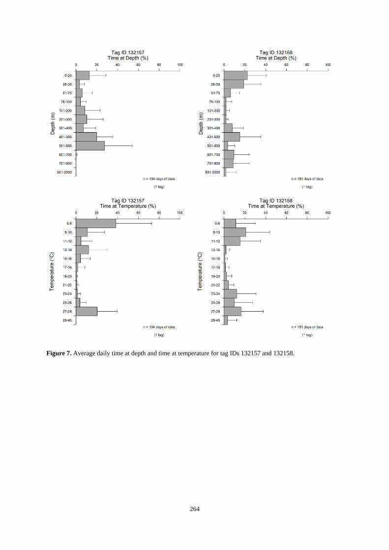
and going deeper than the other (Figure 7).

252
4. Discussion
Reporting rate of tags was high, with only 3 tags (out of 26) failing to report any data, however due to a known
battery issue, data reported by a specific batch of tags was very limited. Regarding post-release mortality, in
swordfish tagged opportunistically abord commercial longline vessels Abascal et al. (2010) in the Pacific Ocean
and Abascal et al. (2015) found possible PRM events could happen in around 40% of the tag deployment, in the
present study the PRM was around 50% of the cases. PRM tended to occur in the first few days after tagging. Most
fish died within the first day, and the maximum of days after tagging that mortality occurred in the present study
was 10 days.
Swordfish occur worldwide having a wide geographic distribution, both horizontally and vertically. With the
limited data set so far, tagged swordfish usually travelled long distances moving in multiple directions. These
extensive movements are consistent with previous studies that also demonstrated the highly migratory nature of
this species (Abascal et al., 2015; Braun et al., 2019; Dewar et al., 2011; Neilson et al., 2009, 2014). Using satellite
tagging, studies in the Northwestern Atlantic have shown directional movements to the north in the spring,
spending the summer in the foraging grounds in the far north, while in autumn the opposite migration is made to
the reproduction grounds in tropical and subtropical waters (Neilson et al., 2009, 2014). Braun et al. (2019) found
this migration pattern particularly for adult individuals in the northwest Atlantic, while juveniles tagged in the
Azores area had more regional movements. The same authors suggest that the variable movements compared to
the north-south migration of adults might be related to the foraging needs of juveniles, changing to larger-scale
movements related to spawning when adults. In the central Atlantic, Abascal et al. (2015) found that tagged
individuals had a similar north-south migration pattern overall, with fish moving south in late fall and returning
north to the feeding grounds in central Atlantic in early spring. The same authors could not infer any patterns in
movements for fish tagged in Southeastern Atlantic as the sample size was low, however a large displacement
between this area and the north-eastern area was noted. A similar observation occurred in the present study with a
fish tagged off the coast of Portugal moving south when the tagged pop-off south of the Canary Islands close to
the African coast. In the current study, where fish are likely juveniles given the size, large displacements are still
observed for these fish although more variable than the north-south migrations.
Swordfish are known for their strong daily vertical migrations (Abascal et al., 2015; Braun et al., 2019; Canese et
al., 2008; Dewar et al., 2011; Koutsikopoulos, 2012) which are also corroborated by the present study, with fish
spending the daytime in deeper colder waters and the nighttime in shallower-warmer waters. The deepest dives
and minimum temperatures observed in this study (1480 m and 3.9ºC) agree with previous observations, where
swordfish were recorded in waters as deep as 1664 m (Braun et al., 2019) and temperatures as low as 2ºC
(Takahashi et al., 2003). Several factors have been suggested to influence the vertical habitat use by swordfish.
Body size has been suggested to influence the vertical distribution of swordfish, with smaller swordfish spending
less time-at-depth (Braun et al., 2019), this could be influenced by the ongoing development of the cardiac and
vascular systems to withstand the daily vertical migrations and the ability to pursue and capture prey at depth
(Braun et al., 2019).
The pattern in vertical distribution has also been shown to be different between different areas. Abascal et al. (2015) found fish in the Cape Verde Islands to spend more time in shallower depths during nighttime than fish tagged in the central Atlantic, suggesting these differences could be due to the thermal structure of the water or variations in the distribution of prey. Dewar et al. (2011) also found differences between the north-central Pacific Ocean and the Western North Atlantic-Caribbean, with fish in the Atlantic having a wider range of depths during nighttime than in the Pacific. Nighttime depths have also been shown to be influenced by the lunar cycle (Loefer et al., 2007; Dewar et al., 2011; Lerner et al., 2013; Abascal et al., 2015;), with fish being deeper in the full moon. Abascal et al. (2015) also found that the quarter of the year and the sea surface temperature influenced the nighttime distribution, with fish being deeper in the last quarter of the year and shallower at cooler temperatures. Dewar et al. (2010) also indicated that sea surface temperature can influence the nighttime depths, as fish in cooler waters tended to spend more time in the surface mixed layer, while fish in warmer areas moved into waters deeper than the thermocline, suggesting this could be to behaviourally thermoregulate. Braun et al. (2019) also noted a tendency for fish to be deeper at night in warmer regimes but evidenced that fish were still found near the surface even with sea surface temperatures above 25ºC, however these authors relate this tendency primarily to prey distribution instead of a thermoregulation behaviour, given the extreme plasticity of thermal habitat use shown by swordfish.

253
During daytime, Dewar et al. (2011) suggest also that swordfish depth can also be influenced by the solar illumination, as swordfish forages in the deep scattering layer during daytime and the depth of this layer is influenced by solar illumination (being deeper as light penetrates deeper), meaning that in areas or times of higher solar illumination the swordfish distribution would also be deeper following the prey distribution. The vertical dial behaviour is sometimes interrupted by daytime basking, Dewar et al. (2011) defined basking events as a “rapid ascent from depth, a surface period ranging from minutes to hours, then followed by a rapid descent”. This behaviour has been reported to occur in several electronic tagging studies (Canese et al., 2008; Dewar et al., 2011; Sepulveda et al., 2010; Takahashi et al., 2003) and makes swordfish available to harpoon fisheries during daytime (Canese et al., 2008; Neilson et al., 2009). Dewar et al. (2011) refers that basking events occur more frequently in cooler coastal waters and decrease as fish move offshore. A difference between sizes was also found by Lerner et al. (2013), with larger fish showing more basking events than smaller fish. Basking in swordfish has been associated with the need to thermoregulate, the need to recover from oxygen depths after foraging at depth or to foraging success where swordfish come to the surface to accelerate digestion (Dewar et al., 2011; Takahashi et al., 2003).
This document presents preliminary analysis of acquired PSAT data so far, the tagging program will continue
during 2022 with the deployment of tags acquired up to now and analysis will continue as more data becomes
available.
Acknowledgments
The tagging activities funded by ICCAT have been carried out with the financial support of the European Union
thought Grant Agreements “Strengthening the scientific basis for decision-making in ICCAT”, as well as the
ICCAT science funds provided within the regular annual budget. Financial support for NOAA tags was provided
by the NOAA Fisheries Cooperative Research Program and the NOAA Fisheries International Science Program.
The authors are grateful to all fishery observers and longline skippers from the Nations involved in the sampling
for this study. D. Rosa and C. Santos are supported by an FCT Doctoral grant (Ref: SFRH/BD/136074/2018 and
SFRH/BD/139187/2018, respectively) funded by National Funds and the European Social Fund.
254
References
Abascal, F. J., Mejuto, J., Quintans, M., and Ramos-Cartelle, A. 2010. Horizontal and vertical movements of
swordfish in the Southeast Pacific. ICES Journal of Marine Science, 67(3), 466–474.
https://doi.org/10.1093/icesjms/fsp252
Abascal, F. J., Mejuto, J., Quintans, M., García-Cortés, B., and Ramos-Cartelle, A. 2015. Tracking of the broadbill
swordfish, Xiphias gladius, in the central and eastern North Atlantic. Fisheries Research, 162, 20–28.
https://doi.org/10.1016/j.fishres.2014.09.011
Braun, C. D., Gaube, P., Afonso, P., Fontes, J., Skomal, G. B., Thorrold, S. R., and Kaplan, D. 2019. Assimilating
electronic tagging, oceanographic modelling, and fisheries data to estimate movements and connectivity of
swordfish in the North Atlantic. ICES Journal of Marine Science, 76(7), 2305–2317.
https://doi.org/10.1093/icesjms/fsz106
Canese, S., Garibaldi, F., Relini, L. O., and Greco, S. 2008. Swordfish tagging with pop-up satellite tags in the
Mediterranean Sea. Collective Volumes of Scientific Papers of ICCAT, 62(4), 1052–1057.
Dewar, H., Prince, E. D., Musyl, M. K., Brill, R. W., Sepulveda, C., Luo, J., Foley, D., Orbesen, E. S., Domeier,
M. L., Nasby-Lucas, N., Snodgrass, D., Michael Laurs, R., Hoolihan, J. P., Block, B. A., and Mcnaughton,
L. M. 2011. Movements and behaviors of swordfish in the Atlantic and Pacific Oceans examined using pop-
up satellite archival tags. Fisheries Oceanography, 20(3), 219–241. https://doi.org/10.1111/j.1365-
2419.2011.00581.x
ICCAT. 2017. Report of the Standing Committee on Research and Statistics (SCRS). Madrid, Spain. 2-6 October
2017, 465 pp.
Koutsikopoulos, C., Afonso P., Peristeraki P., Valastro M., Di Natale A., Tserpes G. 2012. Vertical behavior of
juvenile swordfish revealed by electronic tags. MADE Project – Abstract EBFMTuna conference,
Montepellier, October 2012.
Lerner, J. D., Kerstetter, D. W., Prince, E. D., Talaue-McManus, L., Orbesen, E. S., Mariano, A., Snodgrass, D.,
and Thomas, G. L. 2013. Swordfish vertical distribution and habitat use in relation to diel and lunar cycles
in the Western North Atlantic. Transactions of the American Fisheries Society, 142(1), 95–104.
https://doi.org/10.1080/00028487.2012.720629
Loefer, J. K., Sedberry, G. R., and McGovern, J. C. 2007. Nocturnal Depth Distribution of Western North Atlantic
Swordfish (Xiphias gladius, Linnaeus, 1758) in Relation to Lunar Illumination. Gulf and Caribbean Research,
19(2), 83-88. https://doi.org/10.18785/gcr.1902.10
Nakamura, I. 1985. FAO Species catalogue, vol. 5. Billfishes of the world. An annotated and illustrated catalogue
of marlins, sailfishes, spearfishes and swordfishes known to date. FAO Fish. Synop. No. 125, 65 pp.
Neilson, J. D., Loefer, J., Prince, E. D., Royer, F., Calmettes, B., Gaspar, P., Lopez, R., and Andrushchenko, I.
2014. Seasonal distributions and migrations of northwest Atlantic Swordfish: Inferences from integration of
Pop-Up satellite archival tagging studies. PLoS ONE, 9(11). https://doi.org/10.1371/journal.pone.0112736
Neilson, J. D., Smith, S., Royer, F., Paul, S. D., Porter, J. M., and Lutcavage, M. 2009. Investigations of Horizontal
Movements of Atlantic Swordfish UsingPop-up Satellite Archival Tags. In J. L. Nielsen, H. Arrizabalaga, N.
Fragoso, A. Hobday, M. Lutcavage, and J. Sibert (Eds.), Tagging and Tracking of Marine Animals with
Electronic Devices (pp. 145–159). Springer. http://www.springer.com/series/6481
Sepulveda, C. A., Knight, A., Nasby-Lucas, N., and Domeier, M. L. 2010. Fine-scale movements of the swordfish
Xiphias gladius in the Southern California Bight. Fisheries Oceanography, 19(4), 279–289.
https://doi.org/10.1111/j.1365-2419.2010.00543.x

255
Takahashi, M., Okamura, H., Yokawa, K., and Okazaki, M. 2003. Swimming behaviour and migration of a
swordfish recorded by an archival tag. Marine and Freshwater Research, 54(4), 527–534.
https://doi.org/10.1071/MF01245
Ward, P., Porter, J.M., Elscot, S., 2000. Broadbill swordfish: status of established fisheries and lessons for
developing fisheries. Fish and Fisheries, 1:317–336.

256
Table 1. List with the distribution of ICCAT miniPATs by the participating Institutes, for the 4 project phases.
Current deployment status and additional notes are also provided.
Institute Tag quantity Deployment status
2017 DINARA (Uruguay) 1 Deployed
2018 IEO (Spain) 6 1 tag deployed
IFREMER (France) 4 No tags deployed.
UNIGE (Italy) 4 All deployed
IPMA (Portugal) 1 Deployed
2019 IPMA (Portugal) 14 6 tags deployed
2020
2021 IPMA (Portugal) 6 3 tags deployed
To be distributed 9

257
Table 2. Information on deployed tags.
Tag ID Deployment
date
Size
(LJFL,
cm)
Tracking
days
Tag
duration
Comments
132157* 03/08/2015 115 118 240 Premature release; possible mortality at 118 days
132158* 19/08/2015 115 240 240
132165* 02/07/2015 145 0 240 Mortality
132168* 13/02/2016 140 10 240 Mortality
132169* 24/06/2016 120 1 240 Mortality
167200 05/06/2017 135 1 180 Mortality
176684* 24/10/2018 115 240 Malfunction, never transmitted
176685* 25/10/2018 113 153 240 Premature release
176686* 16/05/2019 114 240 240 Popped-up on the expected date, but transmitted
data has many intervals
176688* 06/05/2019 140 240 240 Popped-up on the expected date, but transmitted
data has many intervals
176689* 14/04/2019 120 4 240 Premature release, although the track has few days
does not look like it died
62424 15/03/2019 120 0 180 Mortality
62603 26/03/2019 96 8 180 Premature release, although the track has few days
does not look like it died
179708 29/05/2019 109 67 180 Premature release
179709 08/06/2019 110 180 180 Popped-up on the expected date, but transmitted
data has many intervals
179710 13/06/2019 110 0 180 Mortality
179711 08/06/2019 105 86 180 Premature release
181044 27/10/2019 117 180 Malfunction, never transmitted
181046 15/06/2019 91 0 180 Mortality
62541 16/07/2021 135 240 240 Pop-up on date; Transmitting
62542 16/07/2021 125 1 240 Fished after 1 day
62543 14/07/2021 125 240 240 Pop-up on date; Transmitting
62544 16/07/2021 135 240 Malfunction, never transmitted
215421 06/12/2021 107 180 In the water, expected pop-up date 04/06/2022
215426 03/11/2021 112 1 180 Mortality
215427 21/11/2021 98 11 180 Premature release, although the track has few days
does not look like it died
Funding *NOAA; ICCAT

258
Figure 1. Map with the location of the swordfish (Xiphias gladius) tag deployments, and most likely tracks of
individuals that did not suffer from post-release mortality. The colored point identifies the tagging location and
the colored lines the individual tracks, the black cross indicates the location of the pop-up.

259
Figure 2. Data coverage (%) by day of data collection of swordfish tags with more than 30-day tracks. Top panels
estimates were from histogram reported data and bottom panels are from tag reported time-series. Left panels
represent the coverage of depth records and right panels the coverage of temperature records. Blank spaces
represent days where no data was transmitted.

260
Figure 3. Map with the location of the swordfish (Xiphias gladius) tag deployments for the present study and
previous studies in the Atlantic Ocean. Lines represent displacements between the tagging and pop-up location.
Circles represent approximate tagging locations ( Dewar et al. 2011; Neilson et al., 2009; Neilson et al.,
2014; Koutsikopoulos et al., 2012)

261
Figure 4. Individual tracks of swordfish tagged in the North and South Atlantic. Open circles represent tag
locations and crosses the pop-up location. Most likely tracks are coloured acording to the month.

262
Figure 5. Depth and temperature profiles of an individual swordfish with 109 cm lower jaw fork length. Top panel
represents 67 days tracking days; bottom panel represents a 3-day snapshot. Horizontal dashed lines represent the
longline depth.

263
Figure 6. Vertical habitat use of swordfish (n=6) for daytime and night-time in terms of depth and temperature.
Depth classes are categorized in 50 m intervals and temperature classes in 2ºC intervals.
264
Figure 7. Average daily time at depth and time at temperature for tag IDs 132157 and 132158.


