Embed Size (px)
Citation preview
Proceedings of an Advisory Group Meeting Vienna, 26—29 November 1979
jointly organized by )AEA and NEA (OECD)
Uranium Exploration Case Histories
tNTERNATtONAL ATOMtC ENERGY AGENCY , V!ENNA, 1981
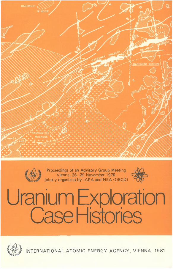
Cover picture:
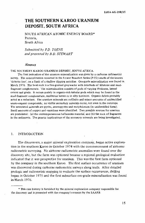
Geology of the Key Lake area (Canada) showing the location of mineralized glaciai boutders transported by an esker. The mineralized boulders were the first indication of the presence of rich uranium accum ulations in the region. Improvement of the glacial geology, together with lake sediment sampling, geophysical surveys and drilling, finally led to the discovery of tw o orebodies containing about 7 5 0 0 0 t U 3 O8 with an average grade of 3% U 3OS (from Gatzweiler et al.).
LEGEND
[ j Athabasca Form ation x *X Mieralized Boulders
Aphebian Metasediments жз=зУ Esker
f +*+!*] Archean Granitoids Fault Zones
I Ore Zones Airborne EM Conductors
URANIUM EXPLORATION CASE HISTORIES

PANEL PROCEEDINGS SERIES
URANIUM EXPLORATION CASE HISTORIES
PROCEEDINGS OF AN AD VISO RY GROUP MEETING ON CASE HISTORIES OF URANIUM EXPLORATION
JO INTLY ORGANIZED BY THE IN TE R N ATIO N AL ATOMIC ENERGY AGENCY
AND THE OECD NUCLEAR ENERGY AGENCY
AND HELD IN V IENNA,2 6 -2 9 NOVEMBER 1979
IN TE R N ATIO N AL ATOMIC ENERGY AGENCY VIENNA, 1981
URANIUM EXPLORATION CASE HISTORIES IAEA, VIENNA, 1981
STI/PUB/584 ISBN 92-0-141081-6
The Agency's Statute was approved on 23 October 1956 by the Conference on the Statute of the IAEA
held at United Nations Headquarters, New York; it entered into force on 29 July 1957. The Headquarters oí the Agency are situated in Vienna. !ts principal objective is "to accelerate and enlarge the contribution of atomic energy to peace, health and prosperity throughout the world".
O IAEA, 1981
Permission to reproduce or translate the information contained in this publication may be obtained by
writing to the International Atomic Energy Agency, Wagramerstrasse 5, P.O. Box 100, A-1400 Vienna, Austria.
Printed by the IAEA in Austria October 1981
FOREWORD
In 1976 the OECD Nuclear Energy Agency and the International Atomic Energy Agency established a Joint Group o f Experts on Research and Development in Uranium Exploration Techniques. The aim o f the Group's programme was to improve the rate o f discovery o f uranium deposits and to increase our knowledge o f the size o f the uranium resource base.
Several areas were identified in which existing techniques could, with international co-operation, be significantly improved and new techniques developed to assist in the discovery o f uranium deposits, and in this connection 'Uranium Exploration Case Histories' was identified by the Group as a subject o f prime importance.
The Joint Group considered that although there was an adequate diffusion o f information about the methodology and retrospective scope o f each available exploration technique, the effective and final performances o f each technique in different geological, topographic and climatic conditions were not well known. The Group therefore proposed to collect and systematically analyse information about general exploration practice, to indicate the degree to which each had been successful and to publicize the various approaches adopted.
It was considered that the most effective way to initiate this procedure would be to hold a meeting o f the senior exploration personnel from the world's mining industry who have participated in the discovery o f major or new-type uranium deposits during the past three decades. The purpose o f the meeting was to describe the methods used and the history o f the discovery o f these deposits.
From the various organizations and companies invited to participate in the meeting, nineteen favourable responses were received. Twenty successful programmes were described in the nineteen contributions, representing a wide spectrum o f exploration methods applied in different geographical and geological conditions o f the more important or promising uraniferous areas o f Argentina, Australia, Brazil, Canada, Czechoslovakia, Greenland, France, South Africa, Sweden, United States o f America and Zambia.
The OECD Nuclear Energy Agency and the International Atomic Energy Agency wish to express their gratitude to all the organizations and companies that contributed, by means o f papers prepared by their respective highly qualified personnel, to the success o f the meeting on Uranium Exploration Case Histories. Both Agencies would, at the same time, like to recognize the valuable financial contributions o f the United States Department o f Energy and the Bundesanstalt für Geowissenschaften und Rohstoffe o f the Federal Republic o f Germany which make possible the publication o f the present proceedings.
EDÏTORÏAL NOTE
77ie papers and с?мсм5л;'о?м /¡a^e &een edited йу t/¡e ediVori'a/ sta/f о/ t/ie /nternati'ona/ Htomi'c Energy Agency to t/¡e e ffe c t consideren/ necessary /or t/¡e reader's assistance. Г/ie fiews
expressed aad Me genera/ sty/e adopfed remain, /¡owe^er, t/¡e responsi^i/i'ty о/t/ie named ant/iors or participants. /n addition, t/¡e riews are noy neí?essari/y t/iose o/ t/¡e governments o/ t/¡e nominating ТИет^ег States or o/ t/¡e nom¡nat;';ig organizations.
Wierepapera /;aye óeen incorporated into t/iese A*oceedings wit/iOMt resetting /?y t/ie Agency, t/n's /ias óeen done wit/i t/ie ¿now/edge o/f/;eaMt/iors and MeirgovernrneHi a:<t/ior!t/es, and t/íeir
cooperarios ¡s grate/ü//y acÁ;now/edged. 77;e A-oceedings Ламе &een printed ¿y composition
typing and p/ioto-o//set /it/iograp/iy. MWn'n t/ie /imitations imposed &y t/n's met/iod, et^ery e//ort /ias Z?een made to maintain a /¡ig/i editoria/ standard, in partici</ar to ac/iieve, w/ierever practica/?/e,
consistency o/ units and sym¿o/s and con/brmity to t/ie .standards recommended &y competent internationa/ bodies.
77ie^seint/ieseA*oceedingso/particM/ardesigní!ti'ons o/ countries or territories does not
imp/у any /Mdgement /?y t/ie pM/)/is/ier, t/ie //)Fv4, as to t/ie /ega/ states o/ S M c / i countries or territories, o/t/ieiraMt/ioriti'es and ¡rMt/tMttonj or o/ t/ie de/imitation o/ t/¡eir ¿onndaries.
77ie mention o/ speci/ic companies or o/ t/¡eir products or brand names does not imp/у any endorsement or recommendation on t/ie part o/ t/ie
^Mt/iors are t/iemse/fes responsib/e /or obtaining t/¡e necessary permission to reproduce
copyrig/it materia/ /rom ot/ier .sources.
CONTENTS
The Espinharas uranium occurrence, Brazil (IAEA-ÁG-250/2) ............... 2ÆD. FMc/и, У. da Fonfe, К ДмсАгам, К ГАа/смл
Discussion .......................................................... ................................. 11The Southern Karoo uranium deposit, South Africa
(IAEA-AG-25 0/15) .............................................. .................................. 15Дои?/! И/h'can И /owí'c Energy FoardDiscussion ............................................................................................. 20
Discovery o f the Sierra Pintada uranium district, Mendoza Province,Argentina (IAEA-AG-250/6) ................................................................ 23F. /¿odn'go, A F . ßcF/мсоDiscussion ............................................................................................. 54
The Westmoreland uranium deposit, Queensland, Australia(IAEA-AG-250/3) ................................................................................ 59//. D. FMc/M, H .F. Дс/ü'nd^ayrDiscussion ............................................................................................ 71
Methodology and history o f discovery o f uranium mineralizationin North-Western Province o f Zambia (IAEA-AG-250/13) .................... 75F. Afcncg/ze/Discussion ............................................................................................ 94
Poços de Caldas and Itataia: two case histories o f uraniumexploration in Brazil (IAEA-AG-250/14) ............... .............................. 99J.AÍ.A Forman, /l.C. /1
Discussion ............................................................................................ 136Exploration o f the uranium reefs o f Cooke Section, Radfontein
Estates Gold Mining Company (Witwatersrand) Ltd, SouthAfrica (IAEA-AG-250/16) .................................... .................................. 141B.D. 5*?ewarfDiscussion ................................................. ........ ................................... 169
Discovery o f the Jabiluka uranium deposits, East Alligator RiverRegion, Northern Territory o f Australia (IAÈA-AG-250/19) ............ 171J. C. D. К Мэ.;/?ег
Exploration o f the Key Lake uranium deposits, Saskatchewan,
Canada (IAEA-AG-250/5) .................................... .................................. 195Я. Ga?zwe;7er, Д. Д. FanDiscussion ....................................... ..................................................... 219
Midwest Lake uranium discovery, Saskatchewan, Canada(IAEA-AG-25 0/1) ................................................................................ 221F. RcoffDiscussion ......................................................... ................................... 240
CASE HISTORIES
From armchair geology to a deposit in a new uranium province
(IAEA-AG-250/8) ........................................ ,...................................... 243C. FMHJrocÆDiscussion ............................................................................................ 275
Exploration o f Bernabe Montano complex o f uranium deposits,
New Mexico, USA (IAEA-AG-250/9) .................................................. 279D.Æ PorferDiscussion ............................................................................................ 291
Discovery o f uranium deposits near Oshoto, East Central PowderRiverbasin, Wyoming, USA (IAEA-AG-250/10) ................................. 293ÆF. 5Yo;'c^, & Í . ßo^fz, Ai.О. ßMsweM
The Bernardan deposit, Haute-Vienne, France (лйогГ(IAEA-AG-250/18) ............................................................................... 307P. Cé/yDiscussion ............................................................................................ 308
Exploration o f the Panna Maria uranium mine, Karnes County,Texas, USA (IAEA-AG-250/12) .............................................................. 31 1E.C. BowwwM, N.Æ. Cygan, М Я .Discussion ............................................................................................ 327
Discovery o f the Cluff deposits, Saskatchewan, Canada
(,s/io;'?co?MMM4¡'ca^'oHj(ÍAEA-AG-250/17) ..................................... 3297. D arc/e/
Discussion ............................................................................................ 330Uranium exploration in the N.Västerbotten—S.Norrbotten province,
Northern Sweden (IAEA-AG-250/4) ...................................................... 333ß.Discussion ........................................................... ................................ 350
Exploration history o f the Kvanefjeld uranium deposit,Ilimaussaq intrusion, South Greenland (IAEA-AG-250/11) ............... 353ß .i. М'е/лен
Uranium mineralization in the Bohemian Massif and itsexploration (IAEA-AG-250/19) .............................................................. 389A/. О. ЖDiscussion ............................................................................................ 396
WORKING GROUP REPORT .................................................................... 401
Chairmen o f Sessions ............................................................................... 403Secretariat ............................................................................................... 403List o f Participants ................................................................................... 405

CASE HISTORIES

IAEA-AG-250/2
THE ESPINHARAS URANIUM OCCURRENCE, BRAZIL
H.D. FUCHS Urangesellschaft mbH,Frankfurt/Main,Federal Republic o f Germany
J. da FONTE, V. SUCKAU, V. TH AKU R NUCLAM,
Recife,Brazil
Abstract
THE ESPINHARAS URANIUM OCCURRENCE, BRAZIL.
Nuclam has been exploring for uranium in Brazil since 1976. During this period one
uranium ore body has been found in the vicinity of Espinharas, a village in Paraiba State, north
east Brazil. According to present knowledge, the mineralized ore body is caused by metasomatic
action. The history of discovery and the exploration work until the end of 1979 is given,
showing the conceptual change with increasing knowledge of the mineralized zone.
INTRODUCTION
For a period o f about twenty years uranium prospecting and exploration in Brazil was conducted by the Comissâo Nacional de Energia Nuclear (CNEN), the Brazilian Atomic Energy Commission, which was superseded by Nuclebras in 1975. Most o f the results o f the work done by CNEN is published or is readily available, and CNEN was always prepared to allow visits to the areas where uranium mineralizations were reported. This and the belief that the geology o f Brazil is most favourable for uranium deposits caused Urangesellschaft to visit Brazil for the first time in 1973. In the course o f joint field trips by Brazilian and German geologists, and as a result o f the previous intensive desk research by CNEN, we were able to select specific areas which showed good potential for uranium
deposits.In 1975 Urangesellschaft was invited to perform uranium exploration in
selected areas jointly with Nuclebras. For this purpose a joint Brazilian/German Company with the name NUCLAM (Nuclebras Auxiliar de Mineraçâo) was founded in 1976. Its shareholders are Nuclebras (51%) and UrangeseHschaft (49%).
3
4 FUCHS et a).
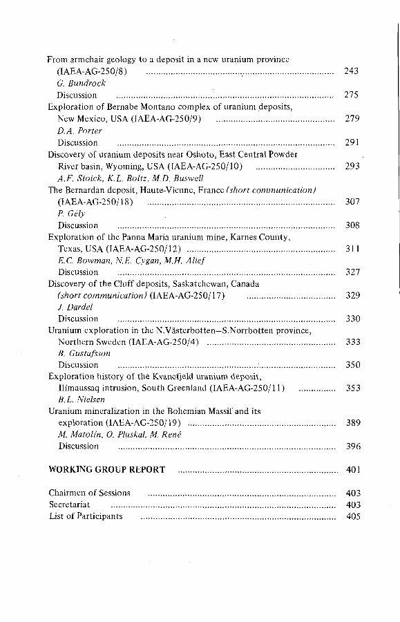
F/C. 7. Íccaíí'c/? o/ f/?e Ар:'л/:йгал ^га/!;мм pro/ecf.
Nuclam's investigations were based on the previous work o f CNEN and Nudebras. They consisted mainly in regiona] radiometric airborne surveys, a regional carborne survey, and a ground check o f discovered anomalies. On the basis o f these data, Nuclam selected various working areas, one o f which iies in the north-east o f Brazil, where the uranium occurrence o f Espinharas was discovered (F ig .l).
GEOLOGY
The following simplified description is given for a better understanding o f the geological situation o f this area:
Between two highly metamorphosed blocks possibly o f Archean age, pelitic and psammitic sediments o f the Ceara Series have been deposited. The Ceara Series can be subdivided into the older Caico and the younger, possibly conformably overlying, Serido Group. The lower part o f the Caico Group most likely belongs to the basement, where the contact is strongly migmatized. During later regional metamorphism the sediments were intruded by granites and partly migmatized.
ÏAEA-AG-250/2 5
In 1976 Nuclam started prospection in the Serido area. The size o f the prospected area was approximately 38000 km^, and it represented a terrain o f highly metamorphosed Precambrian basement rocks. The initial work resulted in finding hundreds o f airborne and carborne radiometric (Th/U) anomalies.A new, very detailed, carborne survey (average 1 km road per 1 km^) and, for selected areas, a helicopter survey were performed. The studies included recheck and reclassification o f all previously found anomalies. Anomalies with relatively high U-values, with reasonable U/Th ratios, and anomalies o f reasonable size were studied in more detail.
One o f the interesting anomalies was that o f Espinharas. It is located right inside and close to the small town o f Sâo Josë de Espinharas, which has a population o f 800 and is situated roughly 25 km north o f Patos, the third
largest city o f Paraiba State. Espinharas can be reached by an all-weather dirt road. The mineralized zone is located about 200 m above sea level. The topography changes from flat plains to rugged hills; in general, the terrain is slightly undulated. The temperatures vary between 20° and 35°C. The average precipitation, confined to the period January to May, approaches 450 to 500 mm per year.
The anomaly o f Espinharas was first discovered during a carborne survey in 1972, but it was not considered to be o f high priority. The strongly weathered and porous host rock was at that time assumed to be a meta-arkose. Re-investigations by Nuclam in 1976 revealed the 'intrusive' nature o f the radioactive rock, which was identified as a syenitic dyke. On resampling the anomaly it became obvious that it was over 2 0 0 0 m long and was related to a somewhat peculiar magmatic rock. Systematic and detailed ground prospecting o f the anomaly began late in 1976. The first surface samples o f Espinharas contained less than 250 ppm U^Og but more than 1 0 0 0 ppm ThO^.
The U/Th mineralization occurs in two different albite-rich types o f rock within the Serido Group. One o f them is possibly a completely metasomatically altered granite with apatite but hardly any primary quartz. The other is a meta- somatically altered amphibole-biotite-gneiss enriched in plagioclase and depleted in quartz.
The first step in prospecting was a systematic radiometric ground survey:
Baseline 2450 m longStriking 70°ECross-sections every 50 mReading stations every 20 mAdditional readings on radioactive outcrops
This survey indicated a radioactive zone more than 1 km long, with an average width o f over 40 m. Trenches were then dug across the anomalous zone, 200 m
PROSPECTION r
6 FUCHS et ai.
FVC.2. .митле o/ w¡'neraZi'zafi'07!.
apart, some o f them.being more closely spaced. Deep pits were dug at points o f special interest to obtain fresh rock material and to study the tectonic setting.AH the trenches and pits, both shallow and deep, were radiometrically measured in detail by scintillometer Scintrex GtS 2 and spectrometer Scintrex GIS 3; they were sampled and mapped on a 1 : 1 0 0 scale.
First leaching tests on surface rocks indicated that the uranium was not intergrown with ThO^ or P^Og. A substantial amount o f uranium was contained in limonite, formed during a period o f weathering (lateritization). This led to the assumption that, during weathering, uranium must have been available from leachable uranium minerals rather than from complex U-Th minerals or apatite, as those minerals hardly weather. On this assumption, higher primary uranium concentrations could be expected below the weathered surface.
Reconnaissance mapping in the vicinity o f the main zone resulted in the discovery o f two additional mineralized areas, one o f them located 100 m SSW and the other about 800 m north o f the main zone. Based on airphoto interpretation,
the surrounding area was mapped on a 1:10000 scale. A stream sediment survey covering an area o f approximately 82 km^ commenced in December 1976 and was completed and evaluated in 1977. This survey did not lead to any new results.
On the basis o f the mapping and trenching results o f 1976, it was decided to perform a limited drilling programme in 1977. Some additional surface work was conducted in order to better define the geometry o f the mineralized body and locate the initial drill sites. The work comprised'.
Plane table mapping, 1:1000 scale;Digging deep pits at the margins o f the mineralized zone;Magnetic survey.
IAEA-AG-250/2 7
F fC .J . F i'ríf ¡M ferpríía íí'on o/ f/¡e dr¡'H secfi'oMí w¡f/¡ гЛе sfeep/y ¿¡'ppi'ng
The plane table mapping resulted in a better delineation o f the mineralized zone at surface and in understanding the complex structure then expected. The latter had already been indicated by detailed radiometry. The magnetic survey did not produce any conclusive data which would have helped to define the mineralized body in depth at that time.
The drilling programme was set up as soon as it became evident that further surface work could not deliver additional information. Its principal aims were to find:
The geometrical shape o f the mineralized body;Any down-dip continuation o f the mineralized body; andThe possible positive change in grade and U/Th ratio towards depth.
FIRST DIAMOND D RILLING PROGRAMME
The outlined surface mineralization was drilled along 200-m sections (i.e. 1000 W, 800 W, 600 W). The borehole locations were based on the assumption that the mineralized body dips steeply and that the mineralization should be
8 FUCHS et a!.
intersected between 50 and 100 m vertical depth. A total o f thirteen coreholes were drilled in 1973, o f which only two did not intersect mineralization. Actual drilling commenced in August 1977 with three rigs. Drilling progress was unexpectedly fast and the programme was completed on time, in spite o f some minor breakdowns.
AH the holes were surveyed with a Tropari instrument. It turned out that the holes steepened and deviated more than expected, especially those with an inclination to the north. AM the radioactive cores were sampled at 50-cm intervals and analysed (U chemically, Th radiometrically). The results can be summarized as follows:
U/Th ratio is much more favourable in depth (0.3 to 1.0 at surface compared to 1 . 0 to 1 0 . 0 in core material);
U values o f core material are higher than those o f surface samples;
Minor amounts o f calcite are always present (3% to 8 %);
The body dips quite irregularly about 70° to the north;
The mineralized zone extends over 1 km.
The following statements could also be made:
The U/Th ratio is more uniform and higher in samples o f mineralized gneiss than in samples o f pure 'dyke' material;
The U/Th ratio varies widely in samples o f pure 'dyke', for no conceivable reason;
The samples collected from contact gneiss/dyke show a behaviour similar to mineralized gneiss samples.
This is consistent with the fact that the concentration o f uranium and its separation from thorium is greatly influenced by the geochemical environment. In the case o f the Espinharas anomaly, the favourable environment is furnished by biotite- gneiss and amphibole-biotite-gneiss. The metasomatic nature o f the mineralized rock was confirmed by these observations.
The geological picture at the end o f the first drilling programme looked as if we were dealing with an irregular vein-type ore body (Fig.2), which dips steeply north (Fig.3). As it was not possible to connect all mineralized sections, it was often necessary to introduce faults.
The first drilling programme proved a potential source o f uranium at Espinharas but, still, little was known about the shape, the down-dip extension, and the average grade o f the mineralized body. A more systematic drilling
IAEA-AG-250/2 9
programme during the second half o f 1978 was necessary in order to understand the mineralized body better.
SECOND DIAMOND D RILLING PROGRAMME
The objective o f the second drilling programme, which started in 1978 and was finished at the beginning o f 1979, was primarily to increase the level o f confidence o f the estimated reserves in the upper levels and to explore deeper levels for additional reserves. Detailed geological logs for each hole and the assay data for each core sample were prepared, as well as a summary o f the drill-hole data and ore zones at various cut-off grades.
The overall drilling performance-was quite satisfactory, with a core recovery o f more than 90%. In general, the mineralized rocks were easy to drill. Up to 50 m were drilled by one rig in two working shifts, although a more typical
performance was 20 m/day. The drill-holes had a tendency to deviate towards the east from their original direction and to increase their angle o f inclination.
The most important results o f the second drilling programme are only now available and can be summarized as follows:
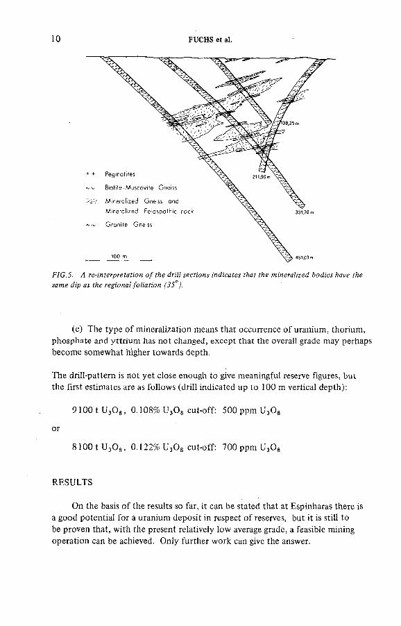
(a) The originally assumed steeply dipping dyke-like shape o f the mineralized zone is no longer valid. There are indications now (Figs 4 and 5) that there are several mineralized zones more or less parallel to the general foliation (35°) to the north-west and are positioned in a more imbricated fashion. The present drill pattern is therefore not optimal and interpretation is difficult.
(b ) There are different high-grade lenses (average grade above 0.12%) which can be followed down-dip within the general mineralized zone.
ю FUCHS et a!.
F/C.3. 4 ге-:яУегргеГаУ:оп о/^е dn'H secfi'ons ¿náícaíes í/:ar f^e wMera/;ze¿ AoA'es Aaye y/:e same <í:'p as ;Ae regona//b/i'af;on
(c ) The type o f mineralization means that occurrence o f uranium, thorium, phosphate and yttrium has not changed, except that the overaH grade may perhaps become somewhat higher towards depth.
The drill-pattern is not yet close enough to give meaningful reserve figures, but the first estimates are as follows (drill indicated up to 1 0 0 m vertical depth):
P lO O tU gO g, 0.108% U^Og cut-off: SOOppmUgOg
or
S lO O tU gO g, 0 .1 2 2 % U^Og cut-off: VOOppmU^Og
RESULTS
On the basis o f the results so far, it can be stated that at Espinharas there is a good potential for a uranium deposit in respect o f reserves, but it is still to be proven that, with the present relatively low average grade, a feasible mining operation can be achieved. Only further work can give the answer.
DISCUSSION
IAEA-AG-250/2 11
D. TA YLO R : Did you do any open-hole drilling?H.D. FUCHS: It was all diamond core drilling.D. TAYLOR.' is there any reason fo r that?H.D. FUCHS: I think we had to do core drilling for this type o f work because,
first, we had no rotary equipment and, second, we had to drill inclined because we first assumed that our ore body dipped at about 70°, and as there was thoriumwe had to have cores because logging would not work at all. We had a high thoriumcontent, sometimes ten times more than uranium, and no logging method would have helped.
D. TA YLO R : Do you think that you have a better control now than you could possibly have had with percussion drilling?
H.D. FUCHS: We shall always have problems with the material obtained from percussion drilling as we have to assay only our cores or our material which we cannot get from percussion drilling. I don't think we can change because we have to know exactly what material we penetrate, and percussion would not help there even though it would be much cheaper.
P. BARRETTO: Could you give us some idea o f the magnitude o f the drilling programme, the first and second phases, and when the uranium concentration starts changing with depth? Is there any relationship to the water table?
H.D. FUCHS: The first year we bored about 16 holes and in the second year about 30 holes with an average depth o f about 100 to 300 m. Water table is very difficult to assess there; it is a very dry area and I don't think we can really talk about a water table. However, we have a weathered zone which is about 10 to 15 m deep, and below this level more or less fresh rock is indicated by calcite.But we still do not know whether there is a cementation zone because, at an increase o f the grade to depth and between about 50 to 80 m, there seem to be higher uranium values. This 50 to 80 m would not correspond to the weathering surface, but we have a suspicion that we have a cementation zone there, which means that some uranium from the top was leached slightly down-dip (uranium was very mobile there). Again we have calcite, but there are no indications from the drill-core that we still have a porous material, so there are difficulties in transporting the uranium from the weathered zone to deep levels.
C. TEDESCO: I should like to know something about the type o f climate and the weathering one might see, and about thorium variation, and whether or not it is constant from surface to depth, and then something about the type o f deposits, and how you interpret and classify these deposits.
H.D. FUCHS: This part o f NE Brazil is rather dry. It has about 400 mm rainfall a year, but this is distributed over only a few months; lateritization is not too strong and it may be a type o f savannah. Then, the thorium variation is very difficult to assess. First, the thorium is, o f course, much higher at surface because
it is far less teachable than the uranium, so we have a ratio at surface which is favourable to thorium. When we go down in depth it changes, but within the ore body there are chnges too. We find a completely altered granitic-vein-type material which contains a relatively large amount o f thorium.
This brings us to another question. When the metasomatic solutions have gone into the host rock, the thorium content decreases and the U/Th ratio improves, this may indicate that uranium was far more mobile than thorium and was moving into the. host rock far better than the thorium.
As to the type o f deposit, we call it at the moment a metasomatic type o f mineralization, possibly similar to some in the USSR but, frankly, we cannot yet answer this question.
B.L. NIELSEN: You mentioned the intrusion o f the dyke, syenitic or granitic, as the associated metasomatism including a disappearance o f the quartz. You also mentioned the association o f uranium with the limonitic material.What is the spatial correlation between the limonitized and the metasomatized zones?
H.D. FUCHS: Most likely the feldspar-rich dyke was originally a granitic- type rock, which was completely changed by feldspathization (albitization, leading to a complete depletion o f quartz). The limonitized zone at surface is purely a weathering feature and has nothing to do with ore-forming processes.
B.L. NIELSEN: Was the uranium originally contained in the refractory minerals or within the upper schists?
H.D. FUCHS: We can say we are sure that the uranium was not and is not connected with the thorium (at least not 80%). They are separate. Probably they were introduced in different phases because the uranium is fairly fairly leachable. We have a recovery, quite a high acid consumption in the order o f 85—90%, which is an indication that the uranium is not connected with thorium.
B.L. NIELSEN: You might have had refractories containing both uranium and thorium, but the metasomatization might have broken these refractories down and caused a natural separation o f the elements.
H.D. FUCHS: We still think the refractories came in with the metasomatic action and were not primarily in this granitic-type material. I think this is more likely than to claim that they were originally there but became separated through metasomatic action.
R. GATZW EILER: What is the structural setting o f the deposit? Is metasomatism generally related to regional and local faulting?
H.D. FUCHS: Espinharas is not too far away from the east-to-west-running Patos Linement and within an area o f secondary fault zones, which may be lelated to the Patos Linement. The mineralized zone itself does not follow a distinct fault zone, but seems more to follow a wider tension zone, which is, however, not yet clearly established.
! 2 FUCHS et a!.
IAEA-AG-250/2 13
D.A. PORTER: On the selected helicopter surveys, how many times background were the valid uranium anomalies?
H.D. FUCHS: This is difficult to answer, as there were quite high uranium readings, indicating small uranium showings, and lower ones which showed more important targets. The Espinharas anomaly showed about five times background uranium values. The satellite deposit Arraras (900 m o ff the main zone) showed
no values above background.D.A. PORTER: From what altitude were the helicopter surveys made?H.D. FUCHS: The helicopter surveys were flown at an average altitude o f
25 m.

!AEA AG 250/15
THE SOUTHERN KAROO URANIUM DEPOSIT, SOUTH AFRICA
SOUTH A FR IC A N ATOMIC ENERGY BOARD*Pretoria,South Africa
b ) ' f . D . 7 1 9 E A '1 S '
prgjgM/gJ ¿у F.D.
Abstract
THE SOUTHERN KAROO URANIUM DEPOSIT, SOUTH AFRICA.The first indication of the uranium mineralization was given by a carborne radiometric
survey. The mineralization occurred in the Lower Beaufort Series (P-T2) south of the known
'dolerite line', on a flank of a shallow dipping anticline. Ore-grade mineralization was found in
March 1976. The host rock is a fine-grained greywacke with interbeds of siltstone and mud-
fragment conglomerate. The mineralization consists of pods of varying thickness, lateral
extent and grade. It occurs mainly in organic-rich tabular pods which may be found in the
mud-fragment conglomerate, sandstone lenses or in silty horizons. Organic debris probably
acted as a reductant. The uranium minerals are coffinite and minor amounts of unidentified
urano-organic compounds; no visible secondary minerals occur, not even in the outcrops.
The associated minerals are pyrite, arsenopyrite and molybdenum (in unidentified form).
Small amounts of copper and vanadium were identified. Two possible sources for uranium
are postulated, (a) the contemporaneous tuffaceons material, and (b) the rock of fragments
in the sediments. The genetic implications of the accessory minerals are being investigated.
1. INTRODUCTION
The discoverers, a major mineral exploration company, began active exploration in the southern Karoo in October 1974 with the commencement o f airborne radiometric surveying. No airborne radiometric anomalies were found over the discovery site, but the farm was optioned because a regional geological evaluation indicated that it was prospective for uranium. This was the first farm optioned by the company in the southern Karoo. The first surface occurrence o f uranium was discovered during carborne radiometric surveys along trails. A fter detailed geologic and radiometric mapping to evaluate the surface occurrences, drilling began in October 1975 and the first subsurface ore-grade mineralization was found in March 1976.
* This case history is furnished by the mineral exploration company responsible for
the discovery and is presented with the company's consent by the SAAEB.
15
2. GENERAL GEOLOGY
16 SOUTH AFRICAN ATOMIC ENERGY BOARD
2.1. Regional setting
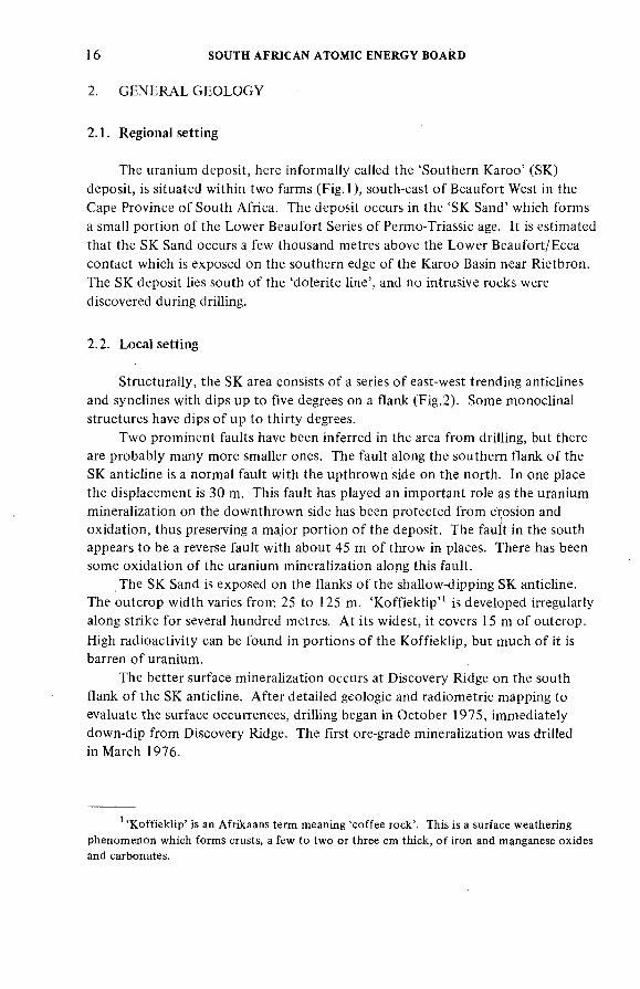
The uranium deposit, here informally called the 'Southern Karoo' (SK) deposit, is situated within two farms (Fig. 1), south-east o f Beaufort West in the Cape Province o f South Africa. The deposit occurs in the 'SK Sand' which forms a small portion o f the Lower Beaufort Series o f Permo-Triassic age. It is estimated that the SK Sand occurs a few thousand metres above the Lower Beaufort/Ecca contact which is exposed on the southern edge o f the Karoo Basin near Rietbron. The SK deposit lies south o f the 'dolerite line', and no intrusive rocks were discovered during drilling.
2.2. Local setting
Structurally, the SK area consists o f a series o f east-west trending anticlines and synclines with dips up to five degrees on a flank (F ig.2). Some monoclinal structures have dips o f up to thirty degrees.
Two prominent faults have been inferred in the area from drilling, but there are probably many more smaller ones. The fault along the southern flank o f the SK anticline is a normal fault with the upthrown side on the north. In one place the displacement is 30 m. This fault has played an important role as the uranium mineralization on the downthrown side has been protected from erosion and oxidation, thus preserving a major portion o f the deposit. The fault in the south appears to be a reverse fault with about 45 m o f throw in places. There has been some oxidation o f the uranium mineralization along this fault.
The SK Sand is exposed on the flanks o f the shallow-dipping SK anticline. The outcrop width varies from 25 to 125 m. 'K o ffiek lip " is developed irregularly along strike for several hundred metres. A t its widest, it covers 15 m o f outcrop.
High radioactivity can be found in portions o f the Koffieklip, but much o f it is barren o f uranium.
The better surface mineralization occurs at Discovery Ridge on the south flank o f the SK anticline. A fter detailed geologic and radiometric mapping to evaluate the surface occurrences, drilling began in October 1975, immediately down-dip from Discovery Ridge. The first ore-grade mineralization was drilled in March 1976.
* 'Koffieklip' is an Afrikaans term meaning 'coffee rock'. This is a surface weathering
phenomenon which forms crusts, a few to two or three cm thick, of iron and manganese oxides and carbonates.
ÍAEA-AG-250/15 17
O U TC RO P-M íN ERA U ZED
RY RtDGE
F/C.2. о/ Ж m jMÓ-yMr/cce.
18 SOUTH AFRICAN ATOMIC ENERGY BOARD
SOUTH WEST ^ ^А йэ?юп Crí7W</ /e¡/e/ '
WORTH CAST
(a)^770/t/ /!-F
WEST EAST
(b) I¿r/ммд ^arw/]/ с -z?
F/C.J?. CroM-íecf¡'o?!í fAe 5Á* ¿ерою'г.
№/ ?0/7g
Оле /7o</
3. THE URANIUM DEPOSIT
3.1. Host rock
The host rock for the uranium mineralization is a light to dark grey, very- ñne-grained to fine-grained greywacke with interbeds o f siltstone and mud-fragment conglomerate. The general composition is about one-third quartz, one-third feldspar and one-third rock fragments. The calcite content varies considerably, but is as high as 30% in places.
The SK Sand is up to 60 m thick and was deposited by a river that flowed north-easterly into the basin. The sand has all the characteristics o f a fluvial sand
!AEA AG 250/15 19
system; point-bar complexes, abandoned channels, clay plugs, mud-fragment conglomerates, etc. The sandstone comprises at least two major cycles. The uranium mineralization generally occurs in the older cycle.
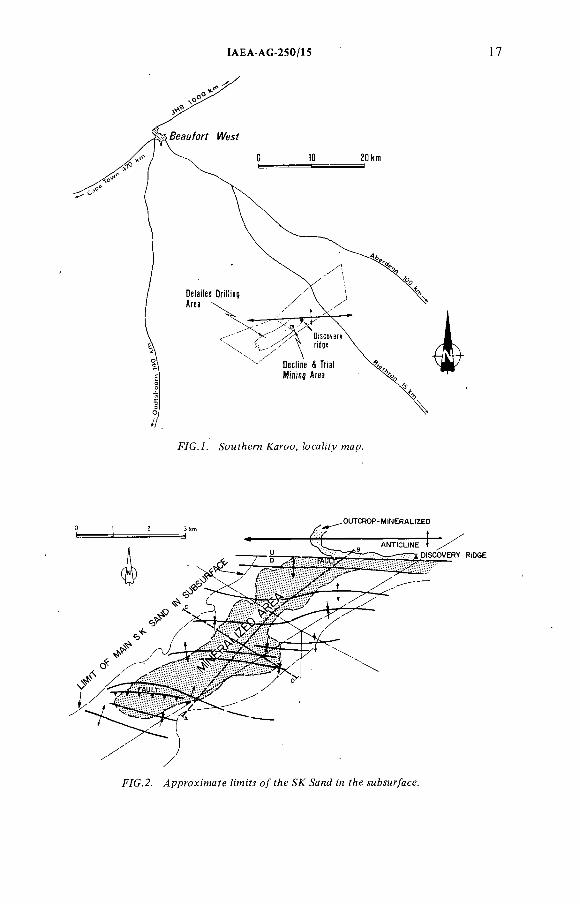
Figure 2 shows the approximate limits o f the SK Sand in the subsurface as delineated by a considerable amount o f drilling. The maximum width o f the sand system is approximately 3000 m. Figure 3 shows cross-sections through the SK deposit. In both (a) and (b ) the upper cross-sections show some o f the structures in the area. The lower cross-sections, which have the top o f the SK Sand as the datum, show more dramatically the variations in thickness in the sand.The sporadic distribution o f uranium ore pods is graphically illustrated. Sizes and geometry o f pods shown are diagrammatic.
3.2. Uranium mineralization
Detailed drilling in the SK deposit has outlined a large area o f anomalous uranium mineralization (F ig.2). Within this broad area there are ore-grade pods o f varying thickness, lateral extent and grade. The geometry and dimensions o f the pods are similar to those found in the Grants Mineral Belt in New Mexico, USA. Uranium mineralization occurs most commonly in organic-rich tabular pods which may be found in mud-fragment conglomerate, very-fine-grained sandstone lenses or in silty horizons. The organic debris probably acted as the reductant for the uranium.
The principal ore minerals are uranium silicates chemically analogous to coffinite, with a wide range o f uranium content. Minor amounts o f unidentified urano-organic compounds are also present. Uraninite is extremely rare. Pyrite, arsenopyrite and molybdenum (in unidentified form ) commonly occur with the
uranium. The calcite content in the 'ore' pods is extremely variable. Some pods contain abundant calcite while other pods, equally rich in uranium, contain no calcite at all. Small amounts o f copper and vanadium have been detected in assays, but no appreciable amounts o f thorium, silver or gold have been found.The genetic implications o f the accessory minerals are still being investigated.
No visible secondary uranium minerals have been found in the deposit, not even on outcrop.
3.3. Source o f uranium
The most likely sources o f uranium are: (a ) tuffaceous material deposited contemporaneously with the sediments, and (b ) from the matrix o f these sediments.
Tuffaceous material in the Lower Beaufort sediments has only recently been recognized and its distribution is somewhat uncertain. In the SK area, there are several 'chert' (light green, highly siliceous rocks) horizons which could be o f
20 SOUTH AFRICAN ATOMIC ENERGY BOARD
volcanic origin. Diagenesis o f indigenous volcanic material could release the contained uranium, and perhaps some o f the accessory metals, into solution.
The SK Sand contains a high proportion o f rock fragments that could have contained uranium which was remobilized during diagenesis.
4. DETAILED EXPLORATION
By the end o f 1977, exploration drilling had outlined a deposit that could be o f economic interest. However, deposits o f this kind have never been mined in the southern Karoo, so there is no established infrastructure and no history o f mining costs, best extraction methods, etc. It was decided that a pre-development programme consisting o f additional drilling, preliminary bench tests, and trial mining be commenced in 1978. A decline (or inclined shaft) was put down to the ore zone and various mining methods, including wide-raise stoping and face- scraping, were tried. I f the uranium deposits in the southern Karoo are to be exploited economically it will be necessary to find the cheapest method o f extracting the ore. This pre-development programme is now complete, and assessment o f the large volume o f data collected is under way.
5. CONCLUSIONS
The SK uranium deposit was discovered in early 1976. Uranium mineralization occurs in thin irregular pods with organic debris in very-fine-grained to finegrained sands o f fluvial origin. The principal primary ore mineral is coffinite, with pyrite, arsenopyrite and molybdenum in some form as important accessory minerals.
A mining investment decision will be made at a later date.
DISCUSSION
D.A. PORTER: Is the mineralization related to the redox-front?P.D. TOENS^ : With the exception o f the surface outcrop and the first few
metres in the subsurface, the host sandstone is entirely reduced. The concept o f redox fronts, as understood in the better known Colorado Plateau deposits, cannot be applied to this deposit or to other deposits in the Karoo.
P.D. Toens (S.A.A.E.B.) was not present at the meeting but answered the questions in a written communication.
IAEA-AG-250/15 21
D.A. PORTER: There are many alterations in the underlying mudstone. Is the ore consistently o f the same colour, and is there any study o f trace element variation through the sandstone and enclosing sediments?
P.D. TOENS: There is no visible evidence o f alteration (associated with mineralization) in the underlying mudstone. However, no detailed geochemical study has been made o f trace element variation (such as Li, В, V , etc.) through the sandstone and enclosing sediments.
D.A. PORTER: What is the average grade o f the deposit?P.D. TOENS: Both the cut-off grade used and average grade are company
confidential information and, further, under terms o f the South African Atomic Energy Act, may not be released.
C. TEDESCO: What is the nature o f the secondary minerals at surface?P.D. TOENS: There are no visible secondary uranium minerals at surface,
unlike many other occurrences in the Karoo, where uranium phosphates and arsenates are the commonest found. AH the oxidized uranium occurs in the dark brown weathering crust (referred to in the paper as 'koffiek lip ') apparently as urano-organic complexes. In the subsurface, several uranium associations have been recognized, amongst which are coffinite (dominant) and unidentifiable urano-organic complexes. Oxidation appears to have preferentially removed the former and preserved the latter.
D. TA YLO R : Was the exploration by drilling done by rotary-percussion rigs or also by rotary-coring? Could you give some information about drill-hole spacing, type o f gamma-logging, etc.?
P.D. TOENS: Most o f the exploration and pre-development drilling on the prospect was done by rotary-percussion rigs and comprised many hundreds o f holes. Hole diameters ranged from about 11.5 cm to 16.5 cm (4.5 to 6.5 inches).A limited amount o f coring was done through the host sandstone in holes precollared with percussion rigs. Information on total drilling density or the total metres drilled is not available for release. Drill-hole spacing ranged from several hundred metres to 25 metres on a grid pattern. The progress o f outlining the ore pods followed the same pattern as that documented for many sandstone uranium deposits in the USA.
A ll holes were radiometrically logged using Mt. Sopris equipment, and both gamma and electric logs were obtained for each hole. Records were taken in analog form and in about half o f the holes a printed digital tape also recorded depth and gamma signal (in cps) for expanded-scale re-runs in mineralized zones.

IAEA-AG-250/6
DISCOVERY OF THE SIERRA PINTADA URANIUM DISTRICT, MENDOZA PROVINCE, ARGENTINA
F. RODRIGO, A.E. BELLUCO
National Atom ic Energy Commission o f Argentina,Buenos Aires,Argentina
Presen fed Ay P.
Abstract
DISCOVERY OF THE SIERRA PINTADA URANIUM DISTRICT, MENDOZA PROVINCE,
ARGENTINA.Since 1956, uranium-bearing minerals have been known to exist in Sierra Pintada, Mendoza
Province, Argentina. Based on paragenetic considerations, a first radiometric prospection was
carried out, leading to the discovery of two groups of anomalies (Puesto Agua del Toro and
Cuesta de los Terneros), such as vein-type deposits, with uraninite and 'yellow minerals' and one
sandstone-type deposit (Puesto La Josefa), related to sediments with carbon trash. Many
anomalies of both types have been found prior to 1959, but aii of them turned out to be of
small size and continuity. Some recent geological research and surveys in the area, and a reduced
drilling programme carried out on selected anomalies, led to reinterpretation of the potential of
the area. Furthermore, and as a result of an airborne radiometric prospection performed in
mid-1968, numerous anomalies have been discovered. The main constellation of anomalies,
along the Hanks of the El Tigre Brachyanticline, occurs in sandstones of Permian age. Explored
by 80 000 m of drilling, they have shown the existence of several peneconcordant lens-shaped
ore bodies of economic size, with uranophane on the surface and prevailing uraninite and some
brannerite, coffinite and davidite below the water table. Reserves exceed 20 000 tonnes of UßOg. A new regional programme with a 4-km drill-grid initiated in [978 ]ed to the discovery of new
ore bodies which are at present being evaluated. The alternatives and discontinuities during the
development of the district, the prospecting and exploration techniques employed, and the
results achieved in the different stages of the operation are discussed in detail.This case history attempts to illustrate the developing philosophy which was successfully
applied in Sierra Pintada, with emphasis on the following points: (a) the need for adequate
geological knowledge of the area; (b) the advantage of a massive survey (in this case, air survey); (c) the necessity for exploration (drilling) in order to define the anomalies and make their
evaluation possible; and (d) the convenience of extending exploration when geology and control
factors have been properly surveyed and recognized.
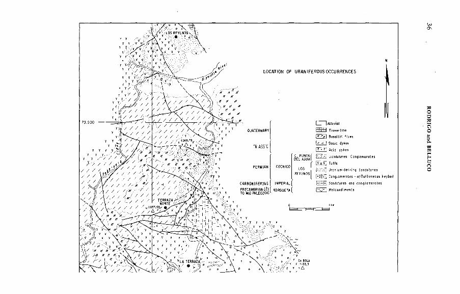
I . H ISTO RY OF THE SIERRA P INTAD A D ISTRICT
In 1956 the Comisión Nacional de Energía Atómica (CN EA) discovered several small radiometric anomalies in sandstones and volcanic rocks in the Sierra
23
24 RODRIGO and BELLUCO
Pintada District by surface reconnaissance prospecting. A ground foHow-up and some limited mining operations carried out in the 1950s did not show any significant uranium occurrences, especially in the volcanics. In 1960, CNEA sponsored an airborne survey training programme, using the San Rafael Airport, and some irregular flights were made over northern and central Sierra Pintada, using Royal 118-B equipment with one-head 3 in. X 2 in. crystal.
No interest was shown in the discovery o f two small anomalies in Permian sediments and the verification o f two earlier recorded anomalies in travertine deposits in Las Peñas and Los Reyunos. However, the discovery o f uranium ore bodies in sandstones, made in 1967 during a small-scale drilling programme, together with up-dated regional geological knowledge, made a new interpretation o f the uraniferous possible potential, and focused attention on the prospection o f the Permian sandstones. A detailed radiometric airborne survey was therefore undertaken in 1968 at a line spacing o f 250 m over an area o f 3450 km\ and many new anomalies were located. Ground follow-up o f these anomalies led to the discovery o f uranium occurrences in the Cochicó Group sandstones on the western flank o f the El Tigre Brachyanticline. These cover an area o f 96 km\ o f whichi 60 knP pertain to the 'Dr. Baulies' and 'Los Reyunos' uranium mines.
The occurrences were systematically prospected by surface trenching, sampling and drilling during the period 1968—75. More than 600 boreholes, totalling about 60 000 m, were drilled. A ll the deposits were located at the top o f the Atigradas Sandstone Member o f the Los Reyunos Formation, in a very conspicuous stratigraphie position.
On the basis o f a working hypothesis o f the favourability o f the Atigradas Sandstone Member and the existence o f sporadic outcrops in Sierra Pintada, further geological surveys o f reconnaissance drillings were initiated in 1978 on the eastern slope o f the range, north o f the El Tigre Brachyanticline. Two new deposits (Cerro Carrizalito and El Tigre Dam) and several positive holes were discovered.
2. LOCATION: GEOGRAPHICAL FEATURES
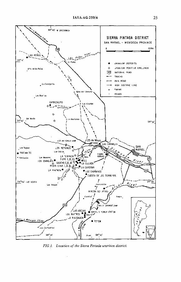
The Sierra Pintada uranium district is situated in Mendoza Province, Argentina, 25 km west o f the city o f San Rafael (population 90 000) and 250 km south o f the city o f Mendoza (population 500 000), the capital o f the province (Fig. 1). The Sierra Pintada is a 100-km-long and 30 to 40-km-wide mountain range running north-to-south, which forms the northern part o f a very conspicuous morphostructural unit, the San Rafael Block, with a core o f Paleozoic and Triassic rocks, whose borders are partially covered by Tertiary continental strata and, more gradually, by Quaternary and Recent sediments.
The hilly environment, 800 to 2000 m.a.s.l., with a relief reflecting the faulted structure, is deeply cut by the perennial rivers Diamante and Atuel, fed
!AEA AG 250/6 25
F/C .7. Locaron o/ fAe ¡'erya P:'nfa¿a мгаитм A'yfncf.
26 RODRIGO and BELLUCO
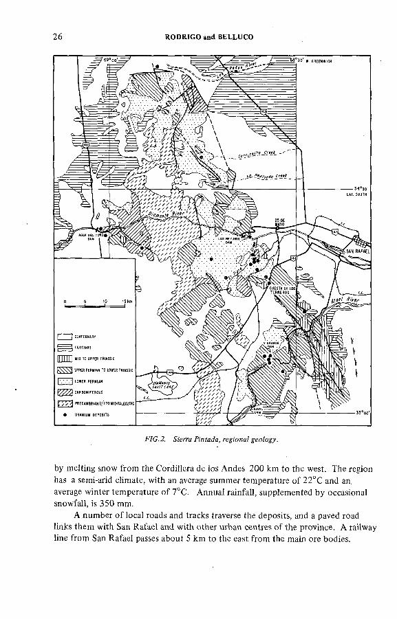
FVC.2. <&'егга Anfada, ге 'ояа/ geo/ogy.
by melting snow from the Cordillera de ios Andes 200 km to the west. The region has a semi-arid climate, with an average summer temperature o f 22°C and an. average winter temperature o f 7°C. Annual rainfall, supplemented by occasional snowfall, is 350 mm.
A number o f local roads and tracks traverse the deposits, and a paved road links them with San Rafael and with other urban centres o f the province. A railway line from San Rafael passes about 5 km to the east from the main ore bodies.
ÍAEA-AG-250/6 27
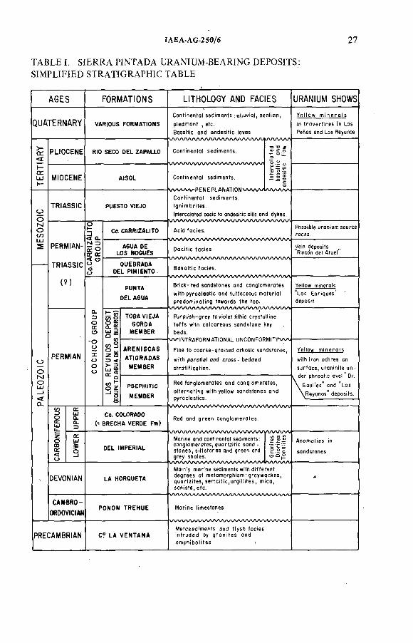
TABLE L SIERRA PINTAD A URANIUM -BEARING DEPOSITS: SIMPLIFIED STRATIGRAPHIC TABLE
AGES FORMATIONS LtTHOLOGY AND FACIES URANIUM SHOWS
QUATERNARY VARIOUS FORMATIONS p i e d m o n t , e tc .
B o s a t t i c a n d o n d e s i t i c t o v a s\/ \/\ЛЛ/\Л/ \/\Л/ \ЛЛ/ и\ЛУ\ЛЛА/\ЛЛЛ/\Л
PLIOCENE RIO SECO DEL ZAPALLO
MIOCENE AtSOL
TRIA SSIC PUESTO VIEJO
PERMIAN-
TRIA SSIC
(?)
< Q- N 35 otC CE
PERMIAN
S
Ca. CARRtZALtTO
A6UA DE LOS NOOUES
QUEBRADA DEL PIMIENTO
PUNTA
DEL AGUA
23°
l g œ t*
TOBA VíEJA GORDA
MEMBER
ARENtSCAS
AT)GRADAS
MEMBER
C o n t i n e n t o ) s e d i m e n t s .
\л/u лллPENEPLДNAI)ON\лллл/ C o n t i n e n t o ) s e d i m e n t s ,
t g n i m b r i t e s .
\ / \ / \ л л л / \ л л л л л л / \ л / ^ \ л / ^ \ л л л / \ / \ л л л / \ л
S o s Q H i c f o c i e s .
t u f f s w i th c a t c o r e o u s s a n d s t o n e ke y
b e d s .
w t N T R A F O R M A H O N A L U N C O N F O R M t T Y W ^
P S E P H ) H C
MEMBER
R e d f a n g t o m e r o t e s a n d c o n g l o m e r a t e s ,
a l t e r n a t i n g w i t h y e i to w s o n d s t o n e s a n d
Co. COLORADO (= BRECHA VERDE Pm)
DEL tMPERtAL
DEVONIAN LA HORQUETA
CAMBRO-ORDOVICIAM
PONON TREHUE
PRECAMBRIAN C? LA VENTANA
s t o n e s , s i l t s t o n e s a n d g r e e n a n d g r e y s h a l e s .
s c h i s t e , e t c .
M a r i n e l i m e s t o n e s
L o s E n r i q u e s
d e p o s i t
28 RODRIGO and BELLUCO
A jet plane service is in operation between San Rafael and Buenos Aires. San Rafael is essentialiy a farming community with hospitals, a university and other facilities, industria! development is rather limited. Near the main uranium deposits there is a small village, 25 de Mayo, located about 15 km from the site, which could be developed to provide housing during the exploitation o f the mines.
The El Nihuil and Valle Grande dams on the Atuel River provide hydroelectric power (324 MW) and the Nihuil-Mendoza 132-kV power line crosses the centre o f the uranium district. Two other dams on the Diamante River, which are in an advanced stage o f construction (Agua del Toro and Los Reyunos),will double the present electricity output. A high-voltage line connects the Sierra Pintada main uranium deposit with the Los Coroneles power plant on the Diamante River.The El Tigre stream crosses the main ore body and will have to be diverted. It has a permanent flow o f clear, slightly salty water o f 0.2 to 3.0 trP -s " ', which rises during the summer rains into short floods o f up to 1 0 0 0 m - s " '.
The main system o f the Andes Mountains is seismically active, and nine earthquakes between 6.3 and 8.0 on the Richter Scale, with epicentres near Mendoza and San Juan, 250 and 400 km north o f Sierra Pintada, respectively, have been recorded during the past 85 years. No earthquake has been recorded in - the San Rafael and Sierra Pintada areas, but ripple effects or aftershocks o f the large earthquakes further to the north are felt in the district.
3. REGIONAL GEOLOGY
In recent years an adequate geological background knowledge has been obtained. The area was totally covered by 1:200 000 regular geological surveys, and three quadrangles were published in 1956, 1964 and 1972, respectively.Special thesis papers and specific geological and photogeological surveys carried out by CNEA have contributed to a progressively increased understanding o f the region (Fig. 2).
Table I shows a simplified geological scheme, and a brief description o f the regional geology follows:
.Рт-есятл&п'яи (.?/ Cerro Z-й HenfazM Formaron
It is considered that some amphibolites and granites, strongly tectonized and intruded by quartz veinlets, aplites and pegmatites, might pertain to this period.
Ролом Гге/змс Forwafio??
Reduced outcrops o f whitish limestone overlying the above metamorphics and intrusives are assimilated to an old geosyncline in the Precordillera structural unit, 150 km northwards.
IAEA-AG-250/6 29
DetwiMM.* ¿a Сгомр
This is a complex sequence o f clastic sediments, grey wackes and pelites which crop out over large areas in a typical geosyncline flysch facies more than 1 0 0 0 m . thick. Metamorphism with sericitic and chloritic schists increases from south to north as a consequence o f intrusions o f granodiorites and diorites.
С&г^ошУегомл.' Æ/ /wpen'a/ Forwaf;'OH
Unconformably overlying the La Horqueta Group are conglomerates, sandstones and shales, with marine episodes, into a regressive facies which varies in thickness from 1 0 0 to several hundred metres.
The Upper Carboniferous layer, which consists o f red and green conglomerates,
crops out in the western and southern slopes o f Sierra Pintada. It is not present in the El Tigre Brachyanticline, where it has probably been removed by erosion from the Hercinian Orogeny, prior to the deposition o f the Permian sediments.
FerwMn. Сос/м'со G'rotvp
This is integrated by a very heterogeneous sequence o f clastic and pyroclastic sediments, with a wide distribution over the whole San Rafael Block. It is divided into two formations: Los Reyunos and Punta del Agua.
The sequence starts with red fanglomerates and conglomerates alternating with yellow sandstones and pyroclastics, deposited on a very irregularly eroded surface. Fine to very coarse-grained arkosic sandstones follow, with parallel and cross-bedded stratification interbedded w ith tu ffitic beds, presenting frequent
lateral and vertical changes o f facies. A combined fluviatile-aeolian transport is assumed. These are the main uranium-bearing rocks.
Los Reyunos Formation culminates in a compact, purplish-grey to violet, lithic crystalline tu ff with several calcareous sandstone key-beds. Punta del Agua Formation is a repeated sequence o f brick-red sandstones and conglomerates, with pyroclastic and tuffaceous materials, which predominate towards the top.
СфрегРег ;'ям-7г;'ам;'с. Cerro (hrn'za/zYo Сгомр
A very complex sedimentary-volcanic sequence overlies the Cochicó Group.It consists o f a complete effusive cycle o f basalts, followed by dacites and rhyolites. The volcanics cycle is interbedded and culminates with continental sediments o f the Lower to Middle Triassic period.
30 RODRIGO and BELLUCO
rerfMry-QMafernary
After a peneplanation stage, during the Jurassic, Cretaceous and Lower Tertiary periods, thick Miocene and Ptiocene continental clastic sediments were formed. Tertiary conglomerates, sandstones and tuffaceous sandstones are overlain by several Quaternary basaltic and andesitic flows and recent foothill deposits. Travertine deposits are also frequent.
Structural scheme and geological history
Sierra Pintada, as part o f the San Rafael Block, is a well defined geological and structural regional unit, dominated by intense and repeated faulting. The predominant structural feature o f the central uraniferous area is the 2 0 -km-long El Tigre Brachyanticline, which stretches from the Diamante River in the north to Los Chañares in the south. It is traversed by a large number o f faults, which vary in strike from NW-SE, through E-W to NE-SW.
The historical and geotectonic evolution is marked by:
(a) An Eopaleozoic geosyncline, flysch type, with intense folding and basic intrusives, reflecting variable metamorphism and deformation (Akadian-Bretonic Orogeny).
(b ) A regressive sequence with peripheral molassic deposits and an uplift, with faulted structures during Carboniferous times (Asturian Orogeny). Some acid intrusions are related.
(c ) Molassic deposits filling an active relief during the Permo-Triassic, with strong volcanism, a dominating folding and progressive block-faulting (Saalic Orogeny).
A fter the deposition o f old Mid-Triassic sediments, a long period o f pene- planation occurred up to the Miocene and it was assumed that this had a direct relation to the mobilization and deposition o f uranium. Continental sediments
coming from the western Andes covered the whole area during the Upper Tertiary, alternating with repeated episodes o f \ulcamsm (mainly basahic). A t the end of the period, a great-radio folding and a reactivation o f faulting during the uplifting o f the Andean Orogeny led to the complex and intricate fault-block structure o f the pre-Tertiary rocks, affecting the continuity and spatial position o f the uranium ore bodies. Tertiary sediments were totally eroded at the core o f Sierra Pintada, and some fluviatile terrace deposits, new basaltic volcanics and travertine deposits occurred during the Quaternary.
ÏAEA-AG-250/6 31
4.1. Ground prospection (1956-59)
At the beginning o f this period, geological information was either scarce or not available. Nevertheless, numerous small occurrences o f lead, silver, arsenic, fluorine, etc., and some paragenetic hypotheses prevailing at that time, led to the selection o f the crystalline formations o f this area for carrying out a reconnaissance ground prospection. A Precision Instrument 111-B, Ц in. X 1 in. N a l(T l) crystal scintillometer was utilized, with irregular grid itineraries, densified near the location o f the ore deposits mentioned.
Puesto Agua del Toro was the first uranium discovery on the western flank o f Sierra Pintada, in the Diamante River Valley. It is located in a brecciated fault, in the contact o f an andesite with sandstones, tuffs and volcanic agglomerates, which were postulated as Triassic. The occurrence, consisting exclusively o f yellow minerals, is 15 to 20 m long and 0.20 to 0.50 m thick, the grades varying from 0.1% to 0.2% U 3 OS. It was explored by trenches and edged near the surface. Not far away, at Puesto Agua de la Josefa, a second model o f a punctual anomaly in sandstones with trash carbon was discovered (postulated at that time as pertaining to the Carboniferous period). In addition, high radioactive values in the
acid effusives were proven.A t the same time, at La Cuesta de los Terneros, on the eastern slope o f
Sierra Pintada, 10 km south o f El Tigre Brachyanticline, several anomalies o f both models were found.
Priority was given to the more frequent occurrences, such as vein-type deposits, in relation to brecciated faults in Permo-Triassic effusive^rocks. An exploratory effort was made, by means o f a number o f minor mining operations over selected anomalies, resulting in punctual and discontinuous bodies a few metres to 30 m long and 0.5 to 2 m thick. Uraninite and yellow minerals were related to a hydro- thermal process.
Despite the discovery o f one occurrence, Los Chañares, in fluviatile sandstones, in the contact with a rhyolite dyke, no effort was expended on the sedimentary model, and the real ore genesis was not properly interpreted at that time.
4.2. Airborne prospection survey (1960)
An airborne radioactive prospecting programme was carried out, its main target being the training o f personnel on this kind o f survey, using some facilities offered by the San Rafael Airport with Cessnas 180 and 170, the property o f the local Air Club. A Royal 118-B scintillometer, with one non-collimated head o f3 in. X 2 in. Na l(T l) crystal was mounted.
4. FIRST-STAGE EXPLORATION (1956-60)
32 R O D R IG O and B E L L U C O
\
The area was selected mainly because o f its proximity to the La Cuesta de los Terneros anomalies.
The totally irregular survey, as rim or с/н'ел de с/м.ме flight itineraries over some 1 2 0 0 krrP, in spite o f the inadequate equipment and the excessive terrain clearance, led to the detection o f two sandstone-type anomalies at Los Mesones and Los Caimanes, and two more anomalies in travertine deposits (Las Peñas and Los Reyunos). Unfortunately, the ground checking did not allow the potential
mineralization o f the sedimentary formations to be defined, and the district was abandoned.
4.3. Comments on the results o f the 1956—60 period
The inadequate survey prospection, the scarcity o f geological information on a regional basis, and the erroneous priority given to the vein-type deposits, led to a ten-year delay in developing the Sierra Pintada uranium district. The negative results were based on:
(a ) Lack o f flexibility in evaluating the metaHogenetic models;(b )The tendency to sacrifice general prospecting targets by premature develop
ment o f early findings;(c ) Inadequate equipment and surveying techniques in airborne prospection;(d)Hesitation (or impossibility, because o f budgetary problems) in exploring
by drilling in some conspicuous occurrences (subsequently, at Los Mesones and Los Chañares, some interesting ore bodies were revealed);
(e )Th e limitation o f prospection to excessively restricted environments without prior regional analysis.
5. SECOND-STAGE EXPLO RATIO N (1967-75 )
5.1. Prior reconnaissance and geological reinterpretation
During the 1960s some CNEA personnel received training,including visits to the principal uranium-developed countries. A t the same time, geological knowledge o f Sierra Pintada was advancing considerably. Three regular geological quadrangles at a 1 . 2 0 0 0 0 0 scale and several theses led to a better understanding o f this complex morphostructural unit.
Late in 1967, a preliminary analysis o f existing background data on uranium within the framework o f the local geology and known world uranium deposit models led to the selection o f representative anomalies and, profiting from CNEA's recently acquired capacity to improve drilling, 30 to 50-m-deep holes were bored in each o f them.
IAEÁ-AG-250/6 33
F/C. J?. ДТЯТЯЯ мар.
34 RODRIGO and BELLUCO
Results were entirely positive in Los Chañares, where mineralization was verified in fluviatile Permian sandstones with evident sedimentary control — thickness o f up to 4 m and grades varying from 0.1% to 0.2% UgOg.
A fter a final reinterpretation o f all the available uranium data, and with the support o f new geological mapping, an airborne prospecting survey was programmed to cover the Permian Cochicó Group outcrops and especially the Atigradas Sandstones Member over an area o f 3000 km^.
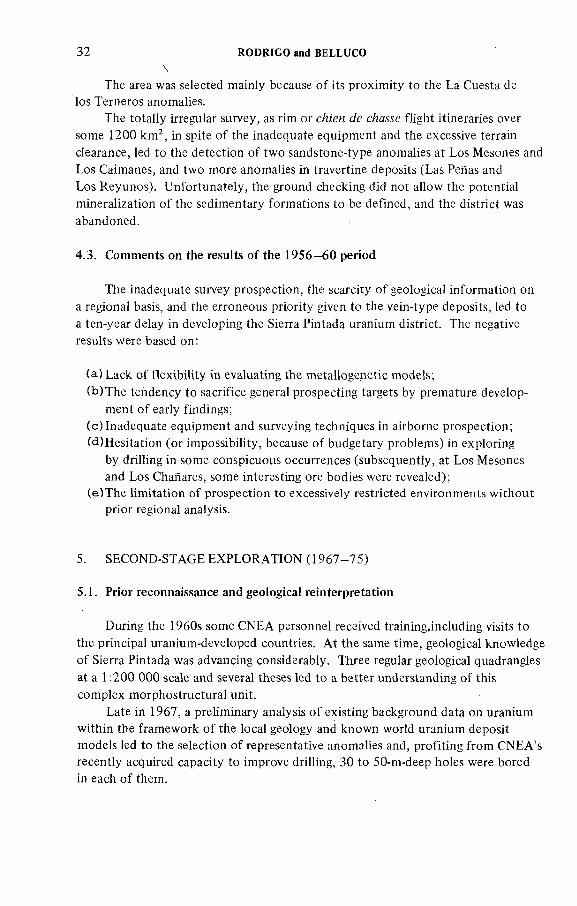
5.2. Total gamma airborne survey (mid-1968)
The main equipment, technical specifications and operating conditions were as follows:
Conventional cartographic maps at a scale o f 1:100 000 were used for the flights, and enlarged copies at a scale o f 1:50 000 were used for data plotting.
Aircraft: A Cessna 180-B.Scintillometer: MP-10 equipment made by CNEA was used, consisting o f
one-head 5 in. X 2 in. Na l(T l) crystal, with a lead collimator, with scales o f 250,500, 1000, 3000 and 10 000 cps and time constants o f 0.5, 1 and 1.5 seconds.
Radio-altimeter: AN/APN 1.The strip camera was a continuous French Cameflex, model S, with 35-mm
film.Synchronized recorders, in tandem, with fiducial mark devices: two Ester-
line Angus.Line night intervals were 250 m at a terrain clearance o f less than 100 m.
Flight directions were in general normal to main structures, except over El Tigre Brachyanticline, where topographical conditions made it compulsory to adopt N-S strike directions.
Data recovery from records was punctual, at every 250 m, and was plotted after manual clearance correction at the 1 0 0 -m base level.
Contour maps were made at intervals o f BG X values o f 1.10, 1.40, 1.70 and over 1.70 (Fig. 3).
Operative costs, including airborne photography at 1:20 000 scale over El Tigre Brachyanticline area was US $6.60/km^, at 1968 values.
In these conditions, 270 hours were flown in 135 days and on 649 lines, covering a 3450 kirP surface. The results, notably effective, can be summarized as follows:
(a) AH the later anomalies were detected;(b ) The constellation o f the El Tigre Brachyanticline anomalies was
clearly defined; and(c) Some very valuable geological data were obtained.
IAEA AG 250/6 35
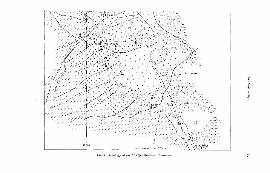
The definition o f the airborne radioactive anomalies o f the El Tigre Group had been proven from the very beginning,so, before elaborating the isocontour maps and final interpretation, a classical geological survey mapping with selected detailed cross-sections at a 1:10 000 scale was therefore launched (Fig. 4). Simultaneously, another working group started the ground-checking o f some principal anomalies, using the French scintillometer SPP 2.
As a result o f the clear stratigraphie control, and owing to topographic limitations, a regular grid prospection was exceptionally used, and the checking had to be done by means o f cross-sections 10 to 25 m apart between lines, with readings at every metre. In addition, for the follow-up o f the ore bodies in covered areas, such as La Terraza, by radon prospection, the French EPP 10 emanometer had to be used. The method proved suitable for extending the known ore bodies or main faults. However, no results were obtained over the virgin sectors.
Geochemistry applied from the very beginning to water, soils and stream samples did not give positive results even in the neighbourhood o f the main out
cropping ore body.Adequate knowledge o f the El Tigre Brachyanticline mineralized area was
obtained by means o f the ground-checking, the specific geological survey and the interpretation o f photographs taken during the airborne survey.
Late in 1968, more than 15 proven occurrences were located and their stratigraphie positions and lithostratigraphic controls defined. A ll occurrences were located in the uppermost sequence o f the then redefined 'Areniscas Atigradas Member' o f the Los Reyunos Formation in the Permian-Triassic Cochicó Group (see Table I).
During the same period, six drill-holes were bored in the El Tigre I front and the continuity o f the mineralization was proven, with thicknesses varying between4 and 18 m and with grades varying between 0.09 and 0.19 U^Og.
Subsequently, a programme was initiated for implementing a topo-geological survey at a scale o f 1 : 1 0 0 0 which would cover the whole mineralized area (5000 X 6000 m) and serve as support o f development activities and drill-hole locations.
5.3. Ground-checking (late 1968)
5.4. Exploratory operations
A total o f 600 holes were drilled in the El Tigre area (about 60 000 m). Except for the main ore body (El Tigre 1-La Terraza), the grid was rather irregular (50 m to more than 100 m), starting at the discovery sites.
The main ore body, which is divided by faults into three blocks, was recognized by the almost regular grid (50 m apart — this being established by
LOCAHON OF URANtFEROUSOCCURRENCES
Ch
¡Г ¡ AHuvial
^ 1 Bosatt ic fíows
Y У[ Acid dyhes
ГУТУ) Tuffs
RODRIG
O
and B
ELLU
CO
VG.4. Ceo/ogy о/ 6 F/ 7%re ¿zr c. bJ
IAEA-AG
-250/6
38 RODRIGO and BELLUCO
geostatistical methods). Taking into account the existing topographical problems, it was possible to bore 241 drill-holes totalling 23 628 m and distributed as follows:
O f these, 133 drill-holes were completely cored, 103 were cored only in the mineralized interval, in N X and BX diameters with excellent core recovery (average 90%), and five holes with cuttings recovery. Further, and in order to obtain suitable samples for hydrometallurgical assays, a 320-m gallery was excavated in Block A and a 35-m shaft and 206-m gallery in Block B. in addition to the core recovery, all the drill-holes were logged with GM Sensor Equipment. The radioactivity/grade correlation was positive.
Total expenditure during the exploration stage amounted to approximately5 million US $ at 1974 values. A problem that still persists is the high cost o f drilling, which is about four to five times higher than in the USA, and the contractor's explanation o f this cost is not acceptable to CNEA.
5.5. The constellation o f the El Tigre uranium deposits
3.3.7. I,oca?geo?ogy
The Permian-Triassic Cochicó Group (consisting o f sediments with repeated intercalations o f tuffs and varied pyroclastics) lies unconformably over the above-mentioned Precambrian(?) to Carboniferous basement. The group is subdivided into the Los Reyunos Deposit Formation (Permian) and the Punta del Agua Formation (Uppermost Permian to Mid-Triassic).
(a ) ¿05 Леумло.у Fo?T?Mf;'oM
This consists o f a transgressive filling which overlies an irregular relief imposed by the Hercynian Orogeny over the former basement. It comprises.
Í;) 77;e A*ep№z*c ТИйти&ег
The Psephitic Member consists o f polymictic fanglomerates and conglomerates which are composed o f angular blocks and pebbles embedded in a distinctive red arenaceous matrix. It contains small intercalations o f cross-bedded yellowish sandstone and two pyroclastic beds, the lower one agglomeradic and the upper tuffaceous.
Block A: Block B: Block C:
131 holes 11 800 m58 holes 5 634 m52 holes 6 194 m
IAEA AG-250/6 39
i;'z) i/ze yIrenMCÆS
This member, which is 70 to 100 m thick, consists o f a cross-bedding o f fine to medium grained calcareous feldspathic argillaceous sandstone, with a thin bed o f tuffite (key-bed) commonly developed about 50 m above its base (Fig. 5). The fresh sandstone varies in colour from dark greenish-grey to greenish-gray and is occasionally reddish owing to staining by iron oxides. Thin beds o f coarser-grained, less argillaceous sandstone are common.
The most abundant constituent is quartz, occurring as poorly sorted subangular to subrounded grains which frequently show bipyramidal crystal outlines characteristic o f phenocrysts in porphyritic rhyolites. Rounding o f these grains may be due to reabsorption by the groundmass o f the host rock, rather than to sedimentation processes. The feldspar grains are predominantly plagioclases, varying from albite to oligoclase in composition,and usually have a high degree o f alteration to kaolinite. The matrix, which constitutes up to 20% o f the rock, consists o f clay minerals, fine-grained sericite, chlorite and interstitially precipitated calcite. The latter also occurs as an alteration product o f feldspar, often completely replacing pre-existing grains.
The Atigradas Sandstone includes two preferential stratigraphie levels to host the uraniferous bodies. The main, or upper, position occurs in the sandstone above the tuffite, but subsidiary ore bodies are developed in the sandstone sequence below the tuffite.
The contact between the Atigradas Sandstone and the underlying Psephitic Member is characterized by interfingerings in the peripheral zones o f the El Tigre structure.
Small-scale planar cross-bedding, indicating deposition from the south-west, has been observed at the southern extremity o f Tigre I. A shallow water depositional environment is postulated, followed by minor scouring, together with an accumulation o f aeolian sands, prior to the deposition o f the overlying Toba (tu ff) Vieja Gorda Member, both o f them into a desertic climate.
77ze 7b&a He/a Gorda Ме?м&ег
This member is estimated to be up to 200 m thick. It is a purplish-grey to violet lithic tu ff made up o f quartz, feldspar, biotite and other mafic minerals. It also contains lapilli and xenoliths o f the Devonian La Horqueta Formation.A reddish agglomerate a few metres thick, containing two to three thin beds o f white tuffite, occurs between 80 and 110 m above the base o f the tuff. An erosional surface marks its top.
RODRIG
O
and B
ELLU
CO
IAEA-AG 250/6 4!
77!efMnfade/^4gMaForwaf;oM
This.formation was deposited over the Toba Vieja Gorda Member on a rugged erosional surface. It occurs westwards from the western limits o f the El Tigre-
La Terraza ore body and north o f it. The basal part consists o f brick-red sandy conglomerates with intercalations o f pale yellow and pink sandstones; the upper part is a sequence o f coarse-grained clastic sediments interbedded with pyroclastic rocks and lavas. Its thickness is estimated at several hundred metres.
f c) Loca/ л?гмс?мга/ paffern
The El Tigre Brachyanticline corresponds to a former closed anticline, superimposed by several diastrophic cycles leading to the present fault-block structure. The deformation process started with a disharmonie folding (anticlinorium), which affected the Psephitic Member, and a smooth anticline acting rather symmetrically over the subsequent formations. The uranium-bearing Areniscas Atigradas Member participates in this last deformation.
This compressive tectonism was followed by several fracturing cycles which contributed to the complex faulting o f the periclinal system in relation to the anticlinorium structure, with a parallel east-west strike on the western slope o f the structure. Stratigraphie throws vary widely, reaching up to 70 m.
3.J.2. А/а/и ore &об?;'ел
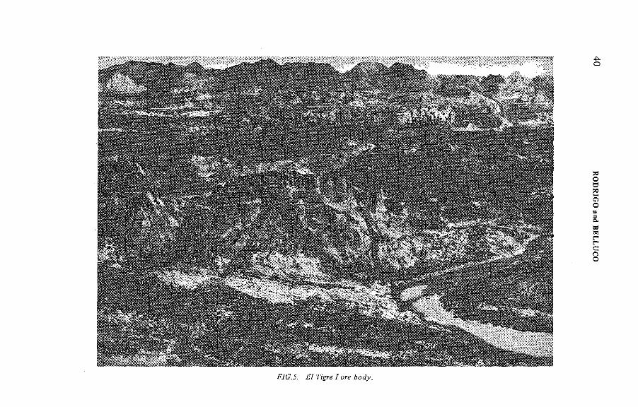
fa ) 7¡¡'gre/-Za Terraza
This ore body crops out in the central-western flank o f the El Tigre Branchyanticline. Two peneconcordant ore bodies were outlined by means o f diamond drilling surveys in the Areniscas Atigradas Member. The upper (or main) ore body covers an area o f about 1800 m from north to south and about 600 m from east to west. The lower ore body covers a surface o f 800 X 250 m.
The upper ore body top is generally 10 to 20 m below the overlying Toba Vieja Gorda Member and the lower contact may extend right down to the tuffite key-bed. It varies in thickness from a cut-off o f 0.04% to a maximum o f 30 m and an average o f 10 m. The ore body crops out, or sub-outcrops, beneath a thin overburden cover in the east and pinches out abruptly to less than 0.35 m thickness in the south and west. In the north-west and north, its boundaries have not been defined and it may continue below the 800 m.a.s.l. altitude. The lower ore body is located below the tuffite key-bed, usually about 10 to 15 m below the upper ore body in Block С and about 20 m in Block A. Its average thickness in the delineated blocks is about 5 m, petering out to below 0.5 m along the edges.
42 RODRIGO and BELLUCO
The vertical value distribution corresponds to a well-shaped, lenticular habit o f higher-grade zones which cannot be individually correlated over large distances. The average grade, at a 0.04% U^Og cut-off, is 0.125% for the main body and 0.09% U^Og for the lower one.
Two east-west transverse normal faults divide the deposit into three main blocks, referred to as A , В and C, from south to north. The major fault o f the zone, which separates Blocks A and B, has a southward downthrow o f approximately 70 m. The faults between Blocks В and С have a total southward down displacement o f about 50 m. The 'loss o f ground' caused by these faults is up to 80 m wide (which accounts for the division into separate blocks).
In addition, there are numerous normal faults with steeper dips and northwest, south-west and west trends. The first two sets are generally more significant, with displacements o f up to 35 m. The majority o f these faults have downthrows to the south-west, south and south-east. The most notable exception is the northeastern fault (exposed in the open pit), which has a downthrow o f 30 m to the north-west. No reverse faults have yet been recognized.
The main ore body dip varies between 12° and 35°. It has a general dip which varies between 20° and 30° to the north-west in Block A and towards the north-north-west in Blocks В and С
The present interpretation o f the distribution and spatial position o f the mineralization has been attained through 23 east-west cross-sections and 160 correlation sections between drill holes.
f&J Bgre íf-íí/ and Media Luna A/Í-HÍ
This is the second most important uranium ore body in the District and occurs about 1.2 km south o f Tigre I. It is about 1000 m long by 300 m wide, extending from Tigre II in the north to Media Luna III in the south. The mineralized beds, occurring 25 to 30 m below the Toba Vieja Gorda Member, crop out in the east and dip to the west at 18° to 20°. The total mineralized thickness varies from 2 to 20 m, averaging about 8 m. The grade, at a cut-off o f 0.04%, is 0.096% U 3 ()g.
Í cj ¿од СаысАол /-//
Gaucho I and II occur in the uppermost part o f the Areniscas Atigradas Member, dipping 20° to the west-north-west. They are a lens-shaped body, covered by an eroded relic o f tuffs, 15 to 2 0 m thick and located south-west from Tigre 1-La Terraza, extending about 200 X 250 m. They consist o f three pene- concordant beds, each o f them 1 to 2 m thick, separated by thin, low-grade ore intercalations. They have been explored by means o f 60 drill-holes (2500-m drillings), the average grade being 0 .1 % U^Og.
tAEA AG 250/6 43
ÍJ ) ¿a Terraza Norfe
This deposit is located close to the Tigre Í-La Terraza ore body, from which it is probably separated by a barren zone o f faulted discontinuity. Reconnaissance drilling initiated in 1978 proved the existence o f this 7-m-thick 'blind' body with a grade o f 0.09% U^Og. Its outline has not yet been deñned or delineated, but it may well be a natural extension o f the main ore body.
Isolated holes made it possible to recognize mineralization 6 km northwards in a similar position.
fe ) (№<?r deposes a? ¿7 7%re Дгясйуая^'сйле
A constellation o f small ore bodies: Gaucho IH-IV, La OHada, La Caverna and Los Chañares, crop out south-east o f Tigre I. The bodies are several tenths o f a metre wide, with thicknesses o f up to 2 m and ore grades o f less than 0 .1 % UgOg. Exploration is now in progress to define their importance.
5.6. Deposits removed from the main area
La Pintada Anticline deposits are located 6 km west-south-west from the El Tigre Brachyanticline and in the same stratigraphie position. They comprise several lenses over an area o f 500 X 200 m, with a similar type o f mineralization. Not far from these deposits, the Los Enriques deposit occurs in similar sandstones.
A group o f five radioactive anomalies with yellow uranium minerals has been found at Pantanito, 30 km west from El Tigre in the same Permian sediments.
Work has not yet been initiated.On the western slope o f North Sierra Pintada, at Cariizalito, 20 km north o f
the El Tigre deposit, uranium occurrences crop out along hundreds o f metres, with a content o f up to 0.05% U^Og. An isolated hole (4 m thick and with a similar grade) cuts the mineralization 300 m to the east at a depth o f 100 m.
A t Rincón del Atuel, on the eastern slope o f Sierra Pintada, a vein-type deposit occurs in Triassic effusives o f the Cerro Carrizalito Group. It crops out along 400 m and has been intersected by about ten drillings up to 50 m deep.The ore bodies appear discontinuous, up to 2 m thick and with up to 0.1% U^Og
grades.A group o f occurrences o f a type which is not yet well known has been located
in some Triassic effusives and sediments south-east o f the area (Las Abejas,La Rinconada, El Totem, Los Buitres and El Nihuil), some o f them with a very marked radioactive disequilibrium. They have not yet been explored.
A summary o f the results, ages o f the host rocks and types o f occurrences is
given in Table II.
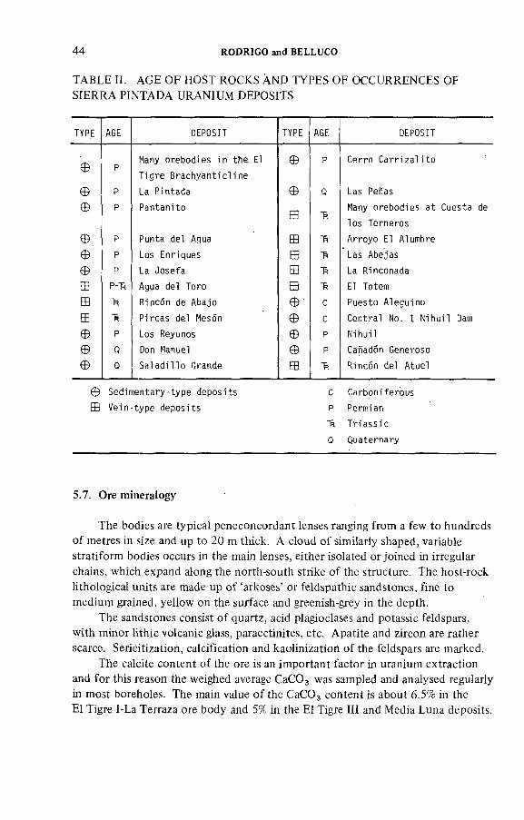
44 RODRIGO and BELLUCO
TABLE H. AGE OF HOST ROCKS AND TYPES OF OCCURRENCES OF SIERRA PINTAD A URANIUM DEPOSITS
TYPE AGE DEPOSIT TYPE AGE DEPOSIT
<DMany o r e b o d i e s i n t h e El Ф p C e r ro C a r r i z a l i to
WT i g r e B r a c h y a n t i c l i n e
Ф p La P i n t a d a Ф Q Las Peñas
Ф p P a n t a n i t oШ "R
Many o r e b o d i e s a t C u e s ta de
l o s T e rn e r o s
Ф p P u n ta d e l Agua Ш "R A rro y o El Alumbre
Ф p Los E n r iq u e s В Las A b e ja s
Ф P La J o s e f a Ш *R La R inconada
P-H Agua del Toro Ш *R El Totem
"R R incon de A bajo Ф С P u e s to A le g u in o
Ш Ü P i r c a s de l Mesón Ф c C e n t r a l No. 1 N i h u i l Oam
Ф P Los Reyunos Ф p N ih u i l
Ф Q Don Manuel Ф p Cañadón G eneroso
Ф 0 S a l a d i l l o G rande В *6 Rincón d e l A tue l
S e d i m e n t a r y - t y p e d e p o s i t s С C a r b o n i f e r o u s
V e i n - t y p e d e p o s i t s P Perm ian
"R T r i a s s i c
0 Q u a te r n a r y
5.7. Ore mineralogy
The bodies are typical peneconcordant lenses ranging from a few to hundreds o f metres in size and up to 20 m thick. A cloud o f similarly shaped, variable stratiform bodies occurs in the main lenses, either isolated or joined in irregular chains, which expand along the north-south strike o f the structure. The host-rock lithological units are made up o f 'arkoses' or feldspathic sandstones, fine to medium grained, yellow on the surface and greenish-grey in the depth.
The sandstones consist o f quartz, acid plagioclases and potassic feldspars, with minor lithic volcanic glass, paraectinites, etc. Apatite and zircon are rather scarce. Sericitization, calcification and kaolinization o f the feldspars are marked.
The calcite content o f the ore is an important factor in uranium extraction and for this reason the weighed average CaCOg was sampled and analysed regularly in most boreholes. The main value o f the CaCO^ content is about 6.5% in the El Tigre 1-La Terraza ore body and 5% in the El Tigre III and Media Luna deposits.
ÎAEA-AG-250/6 45
In the thin, highly mineralized and coarser-grained beds, black pitchblende is present interstitially in layers or patches; brannerite, coffinite, liebigite and davidite are also present, but have not been identified macroscopically. Yellow uranophane occurs near the surface as a thin film along the cleavage and joint planes in the sandstone.
Pitchblende grains o f 1 to 12 jum in size, or in veinlets 0.2 to 1.5 mm thick, occur:
(a) Interstitially and as fracture fillings in quartz and feldspar grains;(b ) Intimately associated with y Fe^O^ and iron-rich chloritic material in
the matrix; and(c) Associated with structures suggestive o f a cellular type o f organic matter.
The pitchblende has a microcrystalline texture and presents an X-ray diffraction pattern similar to uraninite but contains no thorium.
The presence o f coffinite, brannerite, davidite and liebigite was confirmed by X-ray diffraction analysis. Brannerite is frequently either completely or partially enclosed as a thin film over anastase and leucoxene. Microprobe scans have indicated that uranium is frequently found finely disseminated on the leucoxene grains. Brannerite grains may be pseudomorphous after anastase.
There is an irregular vertical distribution o f values o f the uranium minerals.In general, however, higher contents tend to occur in the central part o f the ore bodies, with a relatively abrupt decrease towards the top, and a more gradual one towards the edges and the base o f the lenses. Deep below, some pyrite occurs,2 to 5 mm in diameter, which rapidly evolves near the surface into hematite and limonite. Trash carbon has also been checked with grades o f about 0.1% C.
To summarize, the ore in the Sierra Pintada district is practically monometallic.
5.8. Ore genesis
The following hypothesis for ore genesis is supported:
The uranium is derived from Permian-Triassic acid effusives which poured out to the south or south-west o f the Sierra Pintada uranium district. During peneplanation, possibly during the Upper Mesozoic and Lower Tertiary periods, the uranium was leached and mobilized in aqueous solutions in which the presence o f CO 2 led to the formation o f stable, complex specimens, such as UDC or UTC, together with Ca, Fe, etc., which migrated to the Areniscas Atigradas Member.
The precipitation o f uranyl ion was generated by the presence o f oxygen in the aquiferous and hydrated ferric oxides, such as the a and y varieties, controlled by the СОз pressure.
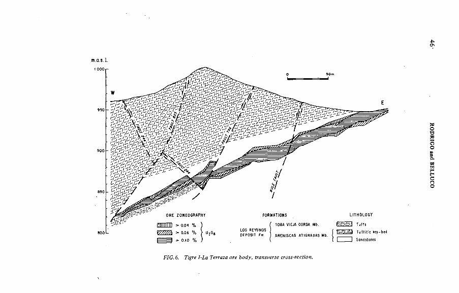
С\
8 0 0 L L O S R E Y U N O S 0 E P 0 S 4 F m .
F O R M A T i O M S
f T O B A V i E J A 6 0 R 0 A M b .
A R E N t S C A S A U G R A O A S Mb .
H T H 0 L 0 6 Y
T u f f s
T u f t i t i c k e y - b e d
] ) S a n d s t o n e s
FÍC.6. 7-íc Геггдия зге
RODRIG
O
and B
ELLU
CO
IAEA AG 250/6 47
Intimate association with the у Fe 2 0 3 iron-rich chlorite in the matrix o f the sandstone suggests that its precipitation could also be influenced by the presence o f Fe and by variations in the Eh values. Higher mineralization in the upper part o f the paleo-aquifer level, red, reddish-brown and red-violet in colour, corresponds to the location o f the у РезОз variety, where bacteria find a more favourable environment for reducing uranium. Minor participation in the uranium fixation is attributed to the action o f organic matter due to the scarce content o f carbon trash which corresponds to the arid depositional environment o f the sediments.
5.9. Ore reserves
The ore reserves estimate is based on the drilling exploration data. Although a regular 50-m grid was the aim, the rugged relief made this impossible. Spacing between boreholes is therefore less than 70 m, the borehole sheets serving as the basis for estimating the ore reserves. Co-ordinates, collar elevation, lithology, graphical representation o f total у -logs, sampling data and uranium values were obtained by this method. In addition, the СаСОд content is given for the whole or a part o f the mineralized zones in a number o f boreholes.
The following sampling procedure was used:
(a) A ll cores were radiometrically scanned to select the mineralized zone, which was then split into samples varying in length according to the radioactivity level, but generally about 1 m long. These samples were analysed radiometrically; in a large number o f boreholes, values o f over 0.05% U^Og were checked through
chemical analysis.(b ) When chemical analysis was not carried out systematically, it was carried
out at regular intervals to check calibration standards. The correspondence o f radiometrically and chemically determined values is excellent for all the boreholes, and there is no evidence o f disequilibrium. The thorium content o f the ore is relatively low, and consequently its effect on radiometric analysis is minimal.
(c ) Radiometric and chemical analyses o f drill cores made it possible to determine the mineral grade and it was necessary in a few cases — mainly at the beginning o f the drilling - to take into account the radioactivity/grade correlation for the purpose o f the estimates.
(d ) Estimates o f volumes were based on the structural interpretation made on topographical and geological profiles (Figs 6 and 7) and on plants and zoneo- graphical profiles.
(e) Thickness has been corrected for each borehole intercept on the basis o f the average dip calculated for each section o f the deposit. In the same way, the surface o f influence o f each borehole intercept was corrected to calculate the
blocks.
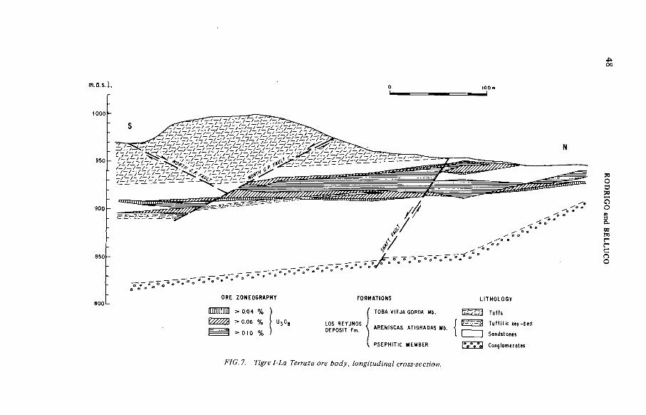
00
m.o.s.l.
^oo -
950 .
9 0 0 -
aooLO R E Z O N E O G R A P H Y
- 0 .0 4 %
^ооб % U30, ^ - - 4 > o . to %
F O R M A T I O N S
T O BA V !E JA GOROA Mb.
D E P O S i T ^ ^ ( A R E N tS C A S A U G R A D A S Mb. j
U T H O L O G Y
^ 1 ^ 7^ T u f f s
3 T u f f i t i c k e y - b i d
S o n d s t o n e s
P S E P H t H C M E M 8 ER C o n g t o m e r o t e s
/ YC. 7. /-¿c íerrcza ore crojj-jecn'o/!.
RO
DR
IGO
and
BE
LL
UC
O
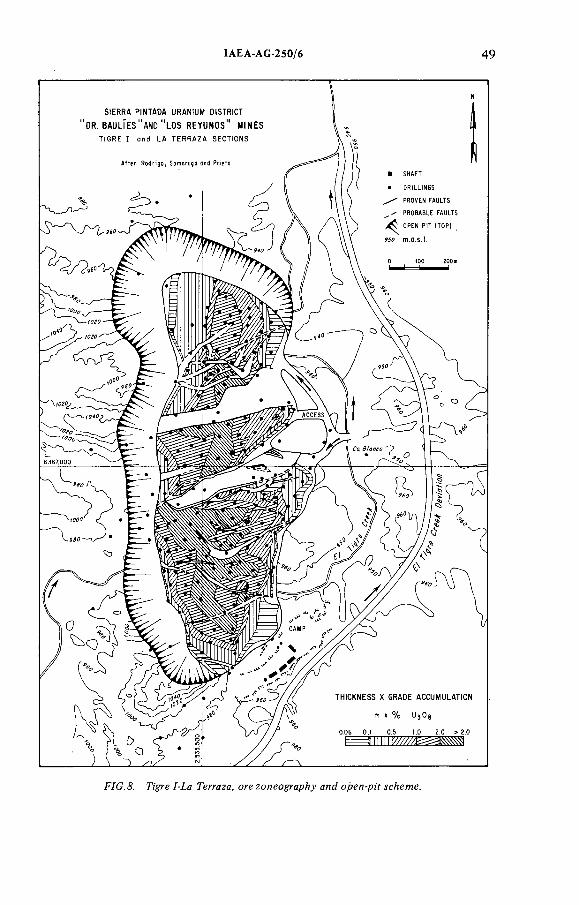
IAEA-AG-250/6 49
F7G. Д. ngye / ía Terraza, ore zoneography алс/ open-p;'f jeAeme.
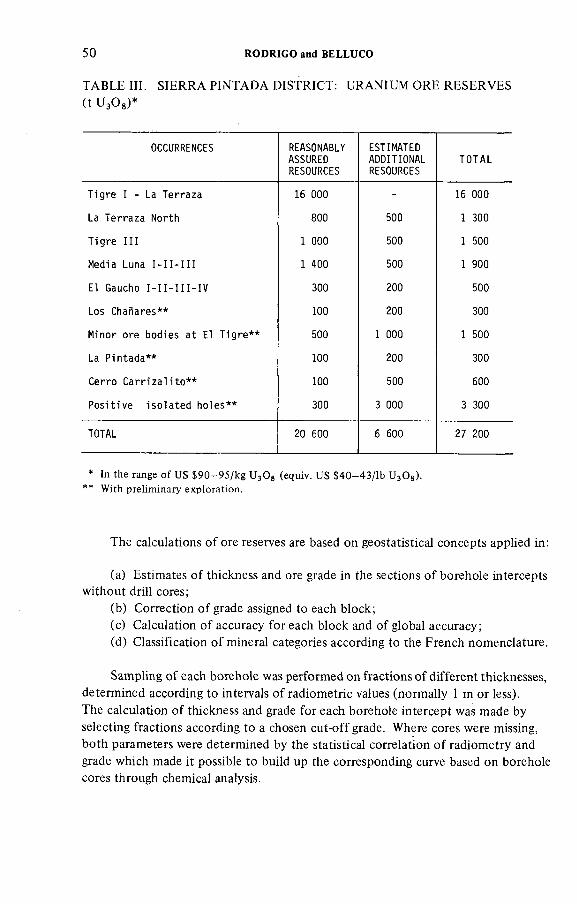
50 RODRIGO and BELLUCO
TABLE III. SIERRA P IN TAD A DISTRICT: URANIUM ORE RESERVES
(t U 3 OS)*
OCCURRENCES REASONABLYASSUREDRESOURCES
ESTIMATEDADDITIONALRESOURCES
TOTAL
T i g r e 1 - La T e r r a z a 16 000 - 16 000
La T e r r a z a N or th 800 500 1 300
T i g r e I I I 1 000 500 1 500
Media Luna 1 -11 -111 1 400 500 1 900
El Gaucho 1 - 1 1 - H I - I V 300 200 500
Los C h a ñ a re s * * 100 200 300
M inor o r e b o d i e s a t El T ig r e * * 500 1 000 1 500
La P i n t a d a * * 100 200 300
C e r r o C a r r i z a l i t o * * 100 500 600
P o s i t i v e i s o l a t e d h o l e s * * 300 3 000 3 300
TOTAL 20 600 6 600 27 200
* In the range o f US $ 9 0 - 9 5 / k g U 3OS (equiv. US $ 4 0 - 4 3 / lb UgOs).** With preliminary exploration.
The calculations o f ore reserves are based on geostatistical concepts applied in:
(a) Estimates o f thickness and ore grade in the sections o f borehole intercepts without drill cores;
(b ) Correction o f grade assigned to each block;(c) Calculation o f accuracy for each block and o f global accuracy;(d ) Classification o f mineral categories according to the French nomenclature.
Sampling o f each borehole was performed on fractions o f different thicknesses, determined according to intervals o f radiometric values (normally 1 m or less).The calculation o f thickness and grade for each borehole intercept was made by selecting fractions according to a chosen cut-off grade. Where cores were missing, both parameters were determined by the statistical correlation o f radiometry and grade which made it possible to build up the corresponding curve based on borehole cores through chemical analysis.
IAEA-AG-250/6 51
To define the average grade o f each block, the Matheron Corrector was used for correcting the grade o f the borehole centred in the block. This method made it possible to avoid over- or under-evaluation o f the blocks, the area o f influence being subject to the reconnaissance grid which was assigned, and the accuracy o f the estimate then calculated. Once the accuracy had been established, the accuracy o f the metal obtained by multiplying the product o f the thickness by the grade tonnage o f each block was classified into Reserves, Resources and Perspectives. Blocks with an accuracy level o f 6 8 % probability, which did not exceed a value o f 50%, were classified as Reserves; those exceeding this value were considered to be Resources and those which were devoid o f accuracy or whose values were higher than 100% were classified as Perspectives. The cut-off grades used were 0.04, 0.06 and 0.1% L^Og on first estimates. Recently, a cut-off o f 0.03% U^Og was added.
Calculations o f ore reserves for the Tigre 1-La Terraza ore body were also made by Golden Associates by means o f computers and taking into account the open-pit preliminary design. Estimate differences are within the normal margin o f error for ore reserve calculations.
A zoneography o f the economic ore body and a preliminary scheme for
open-pit exploitation are shown in Fig. 8 .Estimated reserves at the end o f 1979, based on the NEA-IAEA classification,
are shown in Table III.
6 . THIRD STAGE OF DEVELOPMENT (LA TE 1977 UP TO THE PRESENTTIME)
6.1. Exploration
In spite o f the positive results obtained during the second stage, the development o f the regional potential o f Sierra Pintada virtually stopped for a period o f two years.
A new programme was conceived in mid-1977 based on the geological aspects and the assumption that the Areniscas Atigradas Member is often present with no significant outcrops. The main targets include the follow-up o f its paleogeography, regional distribution and composition. Three potential uraniferous areas were postulated:
North-east Sierra Pintada, from El Tigre north towards the Carrizalito and the Las Peñas occurrences;
The central western slope o f Sierra Pintada, centred in the Agua de La Josefa and Pantanito group o f anomalies; and
The south Sierra Pintada, south o f the El Nihuil Dam, with several types o f occurrence.
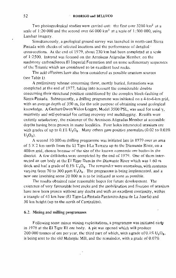
52 RODRIGO and BELLUCO
Two photogeological studies were carried out: the first over 3200 km^ at a scale o f 1 : 2 0 0 0 0 and the second over 6 6 0 0 0 krrP at a scale o f 1:500 0 0 0 , using Landsat imagery.
Simultaneously, a geological ground survey was launched in north-east Sierra Pintada with checks o f selected locations and the performance o f detailed cross-sections. A t the end o f 1979, about 230 km had been completed at a scale o f 1:2500. Interest was focused on the Areniscas Atigradas Member, on the sandstony carboniferous El Imperial Formation and on some sedimentary sequences o f the Triassic which are considered to be excellent host rocks.
The acid effusives have also been considered as possible uranium sources (see Table I).
A preliminary scheme concerning these, mostly buried, formations was completed at the end o f 1977, taking into account the considerable doubts concerning their structural position conditioned by the complex block-faulting o f Sierra Pintada. Subsequently, a drilling programme was initiated on a 4-to-6-km grid, with an average depth o f 350 m, for the sole purpose o f obtaining sound geological knowledge. AGerhartOwenWidco Logger, Model 3500 PSL, was used for total 7 , resistivity and self-potential for cutting recovery and multilogging. Results were entirely satisfactory, the existence o f the Areniscas Atigradas Member at accessible depths having been proven in many localities. Four holes intersected uranium ore with grades o f up to 0.1% U^Og. Many others gave positive anomalies (0.02 to 0.03% UsOg).
A second 10 000-m drilling programme was initiated late in 1979 over an area o f 5 X 2 km north from the El Tigre 1-La Terraza up to the Diamante River, on a 400-m grid, chosen because o f the size o f the known economic ore bodies in the district. A few drill-holes were completed by the end o f 1979. One o f them intersected an ore body at the El Tigre Dam in the Diamante River which was 1.60 m thick and had a grade o f 0.1% U^Og. The remainder were anomalous, with contents varying from 70 to 300 ppm U^Og. The programme is being implemented, and a new one involving some 2 0 0 0 0 m is to be initiated as soon as possible.
The results obtained raise reasonable hopes for future development. The existence o f very favourable host rocks and the mobilization and fixation o f uranium have now been proven without any doubt and with an excellent continuity, within a triangle o f 45 km base (El Tigre-La Pintada-Pantanito-Agua de La Josefa) and 50 km height (up to the north o f Carrizalito).
6.2. Mining and milling programmes
Following some minor mining exploitations, a programme was initiated early in 1978 at the El Tigre III ore body. A pit was opened which will produce 2 0 0 0 0 0 tonnes o f ore per year, the third part o f which, with agrade o f 0 . 1 % U^Og, is being sent to the old Malargue Mill, and the remainder, with a grade o f 0.07%
IAEA-AG-250/6 53
U^Og, is processed locally by heap-leaching methods in a plant which started operating in September 1979.
The geological concept o f the deposit was satisfactorily proven during this operation.
A major programme to exploit El Tigre 1-La Terraza, by subcontracting the engineering, erection and operation o f the mine and mill (on the basis o f an agreement to purchase a fixed volume o f yellow cake o f up to 700 t U^Og per year) is now in the final stage o f negotiations. The complex is expected to start operating early in 1983.
ACKNOWLEDGEMENTS
The authors wish to express their thanks to all the colleagues at the Nuclear Supply Direction o f CNEA who contributed by sending papers and making suggestions and who assisted in the preparation o f this document.
SELECTED BIBLIOGRAPHY
ANTONIETTI, C., Yacimiento nuclear Dr. Baulíes, San Rafael, CNEA Internat Rep. (1969).
BELLUCO, A.E., DIEZ, J.D., ANTONIETTI, C., ACHEN, H., VALERDI, C.J., "Los
depósitos uraníferos en las Provincias de Mendoza y Neuquén", in Proc. 5th Congr. Geol.
Arg., Buenos Aires, 1974, Vol. 2.
BELLUCO, A.E., PARERA, C.A., Exploración costa sur del Río Diamante, Puesto La
Josefa, CNEA Internal Rep. (1956).BELLUCO, A.E ., R O D RIG U EZ , E., Anteproyecto Pían de Expíoración, CNE A Internal
Rep. (1975).BELLUCO, A.E., SUAREZ, G., Informe Geología Distrito Uranífero Sierra Pintada, en Bases para Licitación, CNEA Internai Rep. (1979).
COCO, A.L., Relevamiento aeroradimétrico sobre áreas anómalas Los Reyunos-El Tigre-Los
Chañares, CNEA Internai Rep. (1968).DAVIDS, N., Informes reservas yacimientos Estructura El Tigre, CNEA Internai Rep.
(1978-79).DESSANTI, R., Descripción Hoja Geológica 27-C Río Diamante, Mendoza, Rep. Dir. Nac.
Geol. Miner., Buenos Aires (1956).
GONZALEZ DIAZ, E., Descripción Hoja Geológica 27-D San Rafael, Mendoza, Rep. Dir.
Nac. Geol. Miner., Buenos Aires (1972).
MAZZIERI, G., PEREZ, E., PRIETO, A.O., Informe sobre los resultados de la exploración
geoiógico-mmera en e) braquianticlinal del Tigre y sus manifestaciones nucleares más
importantes, CNEA Internal Rep. (1971).
NICOLLI, H.B., "Consideraciones sobre la génesis de depósitos uraníferos en areniscas:
Distrito Sierra Pintada, Depto. San Rafael, Prov. de Mendoza", in Proc. 5th Congr. Geol.
Arg., Buenos Aires, 1974, Vol. 2.
54 RODRIGO and BELLUCO
ORTEGA FURLOTTI, A., RODRIGUEZ, E.J., PRIETO, A.O., VALDIVIEZZO, A., "Et
nuevo distrito uranífero de Sierra Pintada, Prov. de Mendoza", ibid.
POLANSKY, J., Descripción Hoja Geológica 26-C La Tosca, Prov. de Mendoza, Rep. Dir..Nac. Geoi. M inerBuenos Aires (1964).
RODRIGO, F., Descubrimiento de importantes yacimientos de uranio en ta Sierra Pintada,San Rafael, Mendoza, Mundo Geot. № 4, Buenos Aires (1971).
RODRIGO, F., BELLUCO, A.E., "Programa nacional de desarrollo de ios recursos
uraníferos de la Argentina", Uranium Deposits in Latin America: Geology and Exploration
(Proc. Regional Advisory Group Mtg. Lima, 1978), IAEA, Vienna (1981) 395.
RODRIGUEZ, E., VALDIVIEZZO, A., Investigación geológica semiregional Sierra Pintada,
CNEA Internal Rep. (1970).
SANGUINETTI, J., Fotointerpretación geológica semidetallada, Distrito Sierra Pintada,CNEA Internal Rep. (1977).
STIPANICIC, P.N., Conceptos geoestructurales generales sobre la distribución de los
yacimientos uraníferos con control sedimentario en la Argentina y posible aplicación de
los mismos en el resto de Sudamérica", Uranium Exploration Geology (Proc. Panel Vienna,
1970), IAEA, Vienna (1970) 205.
STIPANICIC, P.N., RODRIGO, F., FRIZ, C.J.T., LINARES, E., "Provincias uraníferas
argentinas", in Proc. 23rd Int. Geolog. Congress, Prague, 1968.
DISCUSSION
P. BARRETTO: From 1969 to 1975 you carried out exploratory work in the Sierra Pintada area and used severa! techniques: airborne surveys, emanometric surveys and geochemistry. Which o f these really indicated the interesting items to follow up? What were your experience and results in other areas?
P. STIPANICIC: The first good indication o f the area's favourability was based on geological considerations. Before 1968 some airborne surveys which were carried out with lines that were too wide and irregularly spaced did not give good results, owing to the highly radioactive background prevailing in the area.The 1968 detailed airborne survey, with a grid o f 250 m, gave an excellent result because the Permian sandstone bearing the uranium mineralization is covered by a thick (up to 200 m) piroclastic tu ff with high radioactivity. When lines too widely spaced were used, the highly radioactive background o f the tu ff masked
the anomalies corresponding to the outcrops o f some ore bodies, but with a 250-m regular grid, the major part o f the uranium outcrops, including those o f small volume, could be located by airborne survey, the remaining being discovered by radiometric prospecting on foot. The altitude o f flights was around 100 m. Classical emanometry gave good results in Argentina. Many years ago (1953-56) we used the old laboratory instruments, the Ambron ionization chamber, which gave us good results for defining and following the continuation o f the buried
uranium bodies in Cosquin, Cordoba. A fter that, we used the French emanometers (by sniffers), also with excellent results, as in Paso de Indios (Chubut). In Sierra Pintada, the method proved useful for extending the known ore bodies or main
ÏAEA-AG-250/6 55
results. Geochemical surveys were not very successful in Argentina (including the
Sierra Pintada District).P. BARRETTO: What was the direction o f flights at Sierra Pintada?P. STIPANICIC: Normally, crossing the structure with few parallel lines,
when topographic conditions obliged us to do so, or for control.F. SCOTT : Did the faults limit the mineralizing process? What is the
thickness o f the ore bodies?P. STIPANICIC: They are o f typical stratiform type and lenticular shape.
Faulting is later than the mineralizing process and only produced the division o f the ore bodies in blocks. The maximum thickness o f the main ore body (Tigre I- La Terraza) is 30 m for a cut-off o f 0.04% U 3 OS, and the average thickness is
around 1 0 m.H. FUCHS: Is there any clear relation between the tu ff with abnormal
uranium content and the mineralization at Sierra Pintada?P. STIPANICIC: I presented a paper on this kind o f problem during the
IAE A Panel on Uranium Exploration Geology in Vienna in 1970. According to my idea, which was followed by other geologists, many o f the sandstone-type uranium deposits o f Argentina are closely related to the presence or availability o f large peneplanized areas sculptured in fertile uranium sources, such as granites, acidic tuffs, etc. Peneplanation and adequate climatic conditions have favoured uranium leaching from the igneous source rocks and the uranium was afterwards deposited in any kind o f host rocks offering favourable chemical and physical characteristics. The morphology o f the resulting ore body could therefore be variable, stratiform, vein-type, etc. In the Sierra Pintada geological environment, Devonian, Carboniferous, Permian and Triassic are very rich in granites, grano- diorites, andesites, rhyolites; tuffs, etc., and all this variety o f uranium source rocks was peneplanized in more than one stage. The first large peneplanation occurred between the Middle Permian and Lower Triassic; another great stage o f peneplanation was recorded at the end o f the Upper Triassic as well as during several stages in Tertiary times. The uranium could have been leached from these peneplains at different geological times. In my opinion, the more important factors are the availability o f large igneous and peneplanized outcrops and the presence o f favourable host rocks. I believe that the uranium o f the Sierra Pintada ore bodies was mainly extracted from the Permian-Triassic tuffs.
H. FUCHS: In north-eastern Australia (Queensland) we have a similar geological framework, with tuffs on top o f the Permian sandstone, but there we have indications that mineralization probably came with the younger volcanic acid tuffs and the uranium mineralization in the sandstone originated by apophysis o f the tuffs. In your example, it seems that it was just the erosional surface which allowed the uranium extraction from the source rocks.
P. STIPANICIC: I would like to emphasize the factor just mentioned: large peneplanized crystalline surface, presence o f favourable host rocks and climatic
56 RODRIGO and BELLUCO
conditions could meteorize the outcropping source rocks,allowing the uranium leaching af ялу Zwie. In Argentina, with a surface close to 3 million krrP, there are some good examples. In the central part o f the country there is a nesocraton composed o f granites, granodiorites, syenites, etc., varying in age from Ordovician to Triassic, but the majority are o f Hercynian age. Large peneplanized surfaces were sculptured from Late Cretaceous times (Laramie diastrophism) but also immediately after important Tertiary diastrophic phases. Within this crystalline environment, which covered a surface o f more than 1 0 0 0 0 0 km \ one can find exogenic uranium deposits o f different types, formed during different times, but always related to some peneplanized igneous source area, from where the uranium was leached. Thus the Cosquin stratiform uranium deposits (Punilla Valley,Córdoba Province) are included in Eocene sediments and were formed using the products coming from the crystalline Laramie peneplain. But in the same geological environment, the uranium deposits o f Los Gigantes district were formed by uranium leached in recent times from the source rocks o f a young peneplain (Upper Tertiary) and precipitated as ore shots in the same tectonized granites, in the joint o f two main fault systems. Moreover, the same superficial and recent uranium solutions were able to form small accumulations o f calcrete type (San Luis).
J. DARDEL: What are the accessory minerals?P. STIPANICIC: The mineralogy is very simple: uraninite is the prevailing
mineral with subordinate brannerite and coffinite. The relationship o f uranium mineralization with carbonaceous materials does not seem to be clear, owing to the scarcity o f the latter. In shallow levels there is a relation to the content o f some colloidal iron-oxides (y Fe^O^).
D.A. PORTER: Uraninite is below the water table; but what is the mineralization above the water table?
P. STIPANICIC: Above the water table, uranophane.D.A. PORTER: What is the control o f the mineralization?P. STIPANICIC: I don't know if Messrs Rodrigo and Belluco have a good
answer to your question, because, to my knowledge, there is not a well proven explanation o f the control o f the mineralization. There is no clear paleo-channel control; there is no clear redox-front control, in spite o f the fact that some geologists are in favour o f this idea. There is no clear relation to lithological changes, because porosity and permeability seem to be similar elsewhere. The only objective indication is the apparent control by some iron-oxides.
D.A. PORTER: What is the age o f the mineralization?P. STIPANICÍC: I am not sure, but from geological considerations I believe
it could be Tertiary. During Tertiary times there were large peneplanized surfaces o f acidic igneous rocks. Climatic conditions from Tertiary times until now did not change much (except during the Quaternary) and we have proved in some uranium districts that in very recent times a large amount o f uranium was leached from tu ff during a very short period o f time. In the Atuel Canyon, a few km
IAEA-AG 250/6 57
south-west o f Sierra Pintada, a Permiart-Triassic tu ff shows very high radioactive value, which in some cases reached up to 3000 and 4000 cps (SPP2), but corresponding chemical analyses only indicated between 30 and 50 ppm U. Dr. Nicolli carried out a very interesting study on the subject (using the Mössbauer effect) and he proved that practically all the uranium contained in the tu ff was leached in the last million years, or, more possibly, in the past half million years. For all these reasons,I believe that the uranium mineralization in the Sierra Pintada district could be Tertiary.
M. MATOL1N: What kind o f emanometric prospection was used? What type o f sampling and depth o f sampling?
P. STIPANICIC: For the particular case o f Sierra Pintada, emanometry by sniffers was used, and the air samples were normally taken between 0.50 m and less than 1 m. According to my information, trace-tracks (or similar methods) were not very successful in some testing areas.

THE WESTMORELAND URANIUM DEPOSIT, QUEENSLAND, AUSTRALIA
H.D. FUCHS Urangesellschaft mbH,Frankfurt/Main,Federal Republic o f Germany
W.E. SCHtNDLMAYR
Urangesellschaft Australia Pty. Ltd.,Melbourne,
Australia
Abstract
THE WESTMORELAND URANIUM DEPOSIT, QUEENSLAND, AUSTRALIA.
Twenty-three years have passed since the initial discovery of uranium mineralization at the Westmoreland Locality in NW Queensland, Australia, in 1956, and the exploration history of
the deposit, given in this paper, is a colourful one. Several exploration groups worked the areas
at various intervals dictated by the initial discovery efforts and their revival in the late 1960s;
financiai difficuities; resumption of work by farm-out; disappointment on reassessment of
data; further farm-outs; and, finally, resumption of systematic work that located further
mineralization and now takes the prospect towards potential feasibility.
IAEA AG 250/3
1. GEOLOGICAL SUMMARY
The Westmoreland Project is situated in NW Queensland, Australia (Fig. 1 ), and lies in an area o f sediments and volcanics at the south-western margin o f the McArthur Basin and the northern side o f the Murphy Tectonic Ridge, which separates the McArthur Basin and Nicholson Basin. Lithological units outcropping in the area are listed in Table I in order o f stratigraphy (and see Fig.2).
Basic dykes follow main structural features and have been recognized to penetrate rocks o f the 'Nicholson Granite Complex', Cliffdale Volcanics, Westmoreland Conglomerate and the Seigal Volcanics. In most cases, dykes are highly altered and extremely variable, frequently showing evidence o f brecciation and shearing. In the Westmoreland Conglomerates sills have been recognized.
The rock units are folded over the Murphy Tectonic Ridge, the folding being gentle, rarely exceeding 25°, with open concentric folds plunging slightly eastwards. There have been at least three periods o f faulting, leaving two prominent sets o f fault directions: an older NE trending fault system which is slightly offset to the NW by a younger NW trending system.
59
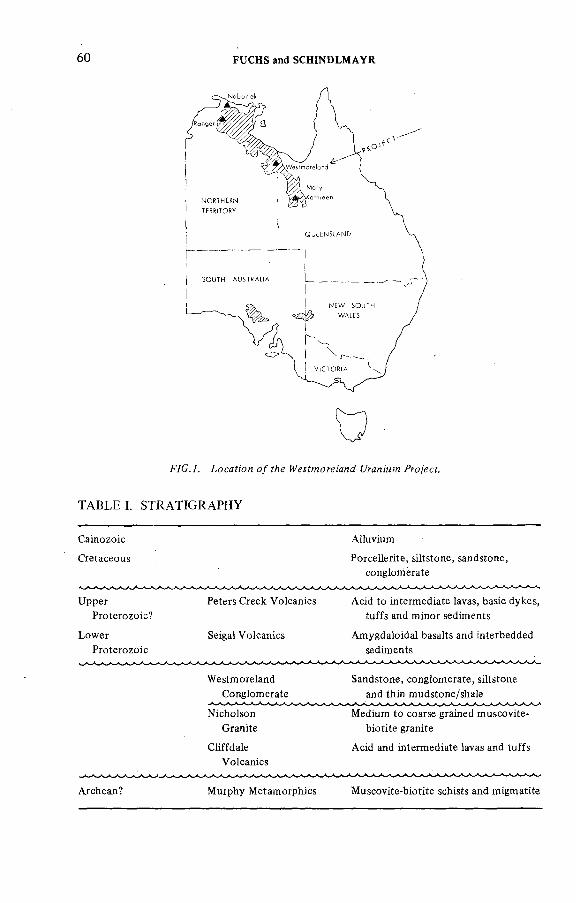
60 FUCHS and SCHINDLMAYR
FYC.7. ¿ocaf;'cn о/ гЛе ¿Л-дя/мм Fro/ecf.
TABLE I. STRATIGRAPHY
Cainozoic
Cretaceous
Upper
Proterozoic?
Lower
Proterozoic
Peters Creek Volcanics
Seigal V olcanics
Ailuvium
Porcellerite, siltstone, sandstone,
conglomerate
Acid to intermediate lavas, basic dykes,
tuffs and minor sediments
Amygdaloidal basalts and interbedded
sediments
Westmoreland
Conglomerate
Nicholson
Granite
Cliffdale
Volcanics
Sandstone, conglomerate, siltstone
and thin mudstone/shale
Medium to coarse grained muscovite-
biotite granite
Acid and intermediate lavas and tuffs
Archean? Murphy Metamorphics Muscovite-biotite schists and migmatite
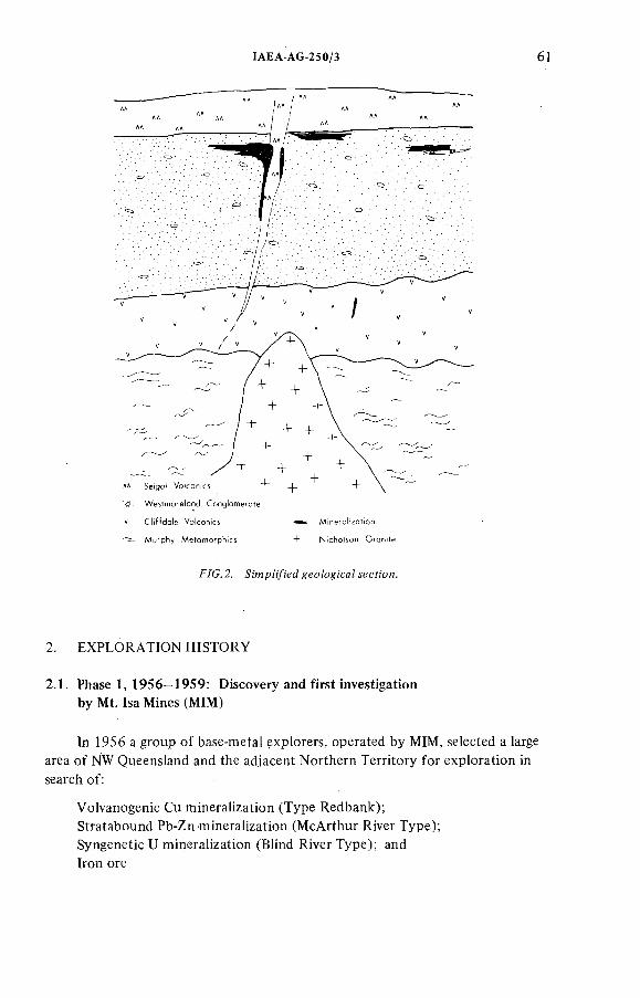
ÏAEA-AG-250/3 61
FYG. 2. eo/ogi'caZ iecfi'on.
2. EXPLORATION H ISTORY
2.1. Phase 1,1956—1959: Discovery and first investigation by Mt. Isa Mines (M IM )
In 1956 a group o f base-metal explorers, operated by MIM, selected a large area o f NW Queensland and the adjacent Northern Territory for exploration in search of:
Volvanogenic Cu mineralization (Type Redbank);Stratabound Pb-Zn mineralization (McArthur River Type);Syngenetic U mineralization (Blind River Type); and Iron ore
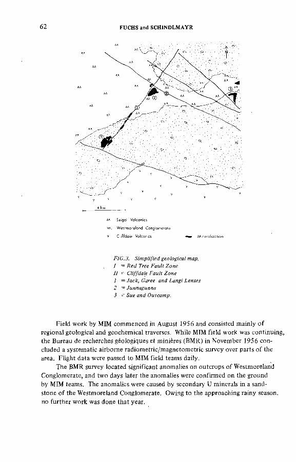
62 FUCHS and SCHINDLMAYR
F/C.J. A' pZyK'cfgec/ogica/ map. 7 = Де^ Free FaM/? Zone // = CbyjfJa/e FaM/r Zof¡e 7 = /асДг, Caree a/!cf ¿a7¡g¡ /,елм 2 = /MMHagMnna J = Зме and ОмГса?ир.
Field work by MIM commenced in August 1956 and consisted mainly o f regional geological and geochemical traverses. While MIM field work was continuing, the Bureau de recherches géologiques et minières (BM R) in November 1956 concluded a systematic airborne radiometric/magnetometric survey over parts o f the area. Flight data were passed to MIM field teams daily.
The BMR survey located significant anomalies on outcrops o f Westmoreland Conglomerate, and two days later the anomalies were confirmed on the ground by MIM teams. The anomalies were caused by secondary U minerals in a sandstone o f the Westmoreland Conglomerate. Owing to the approaching rainy season, no further work was done that year.
IAEA AG-250/3 63
Work resumed in May 1957, and mineralization in outcrop was found to occur at various levels within the sandstone as discontinuous lenses with generally low grades. In addition, mineralization was also discovered in an erosional gully, following the Red Tree Fault Zone, a regional fault structure (Fig.3).
In 1958, eleven percussion holes were drilled to test subsurface extensions o f surface mineralization followed by two diamond drill holes in early 1959.With few exceptions, the holes located only thin and discontinuous lenses o f low- grade mineralization at shallower depth well above the water table. At this stage, MIM concluded that the mineralization was o f little economic significance and work ceased. However, three Mining Leases were pegged and applied for.
In retrospect, MIM had located most o f the radiometric anomalies along the Red Tree Gully that were later to spark o f f a major drilling exercise and lead to the discovery o f high-grade vertical mineralization, but had failed to test any o f these in detail.
2.2. Phase 2, 1959-1967
From 1959 to 1967 the area lay vacant and untouched by any further systematic uranium exploration, following the worldwide lack o f interest in uranium.
2.3. Phase 3, 1967—1972: Queensland Mines
In 1967, a company called Australian Oil Exploration, which was shortly afterwards renamed Queensland Mines Ltd (QM), in its search for Blind-River-type
uranium mineralization, applied for an area o f 700 km^ in far NW Queensland, on the basis o f BMR publications containing a number o f radiometric anomalies in a conglomerate unit that could be indicative o f uranium mineralization o f some significance. Field work commenced in September 1967 from fly camps and took the form o f geological and radiometric reconnaissance traverses on foot and horseback to check on the ground the various radiometric anomalies reported by the BMR.
Early in 1968, a significant radiometric anomaly (Moogooma Prospect) was located on Westmoreland Conglomerate just north o f a major fault escarpment.This was subsequently investigated by radiometric gridding, mapping and, finally, core drilling, the light-weight core rig being transported on horseback. A small lens o f rich secondary mineralization was outlined in the vicinity o f an erosional gully (Red Tree Fault) striking north-east.
In August 1968 QM contracted a private company to carry out an airborne radiometric and magnetometric survey. The survey, flown with more sophisticated equipment than BMR had available twelve years earlier, confirmed most o f the BMR anomalies and located others. Field check commenced in the last quarter o f 1968 and continued throughout the first half o f 1969. In general, this field work

64 FUCHS and SCHINDLMAYR
TABLE H. RESERVES IN 1969
Red Tree Zone
tUiOs7830 at 0 .2 % UgOs
Jack Lens 1350 at 0.15% U 3OS
Total 9180
o f 1968 and early 1969, together with the interpretation o f the airborne geo
physics, resulted in the definition o f various prospective areas (Red Tree Fault Zone, Moogooma Prospect, Tjuambi Prospect, Vinemaree Prospect, Contact Prospect,
Long Pocket Prospect). A first assessment o f these areas revealed that U mineralization frequently occurred in or near joint zones or erosional gullies trending north
east within the Westmoreland Conglomerate.On the strength o f the 1968 assessment o f the Red Tree Fault Zone and in
view o f the mineralization obvious from surface outcrop and drilling by MIM,QM decided to embark in 1969 on a major drilling programme, with the strata- bound sandstone mineralization as the main target. The programme o f percussion and diamond drilling began in May 1969. Initially and over most o f the period, three diamond core rigs and two percussion drill rigs were employed from contractors o f Mt. Isa.
Drilling apparently started on the sandstone to the east o f the MIM N o .l Lease, where it soon encountered substantial secondary mineralization at depth (the ore body was called Jack Lens), whilst only limited attention was given to the investigation o f the mineralization associated with the dyke. It was not until a drill-hole testing secondary mineralization near the edge o f the Red Tree Gully unexpectedly penetrated dyke rock with high-grade mineralization associated with it that the emphasis o f the drilling programme swung away from testing low- gra<ie stratabound mineralization and went over to the search o f vertical-type high- grade mineralization associated with the NE-trending dyke filled joint zone (Red Tree Fault Zone).
In 1969, 179 holes with a total length o f 20 580 metres had been drilled at various prospects. This drilling led to the first publication o f the reserves shown in Table II. In 1970 and 1971, an additional 346 holes had been drilled with a total o f 24 300 m. ^
Drilling finally came to a halt in October 1971. None o f the drill-holes was ever surveyed with a down-hole radiometric logger. Drill cores and percussion chip samples were scanned with a Scintrex GS-3 Gamma Ray Differential Spectrometer. Samples normally 2 m long and in excess o f 0.05% eU^Og were sent for analysis to AMDEL, with check samples to other laboratories.
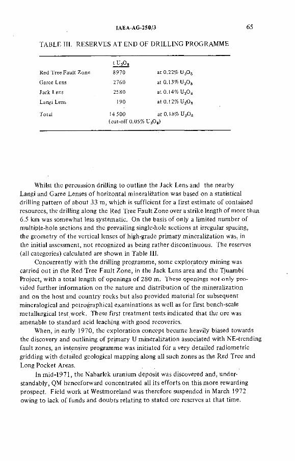
TABLE IH. RESERVES A T END OF D RILLING PROGRAMME
ÏAEA-AG-250/3 65
t U Og
Red Tree Fault Zone 8970 at 0.22% U Og
Garee Lens 2760 at 0.13%U3Ûg
Jack Lens 2580 at 0.14% U Og
Langi Lens 190 at 0.12% U Og
Totai 14500 at 0.18% U3OS
(cut-off 0.05% UgOg)
Whilst the percussion drilling to outline the Jack Lens and the nearby Langi and Garee Lenses o f horizontal mineralization was based on a statistical drilling pattern o f about 33 m, which is sufficient for a first estimate o f contained resources, the drilling along the Red Tree Fault Zone over a strike length o f more than 6.5 km was somewhat less systematic. On the basis o f only a limited number o f multiple-hole sections and the prevailing single-hole sections at irregular spacing, the geometry o f the vertical lenses o f high-grade primary mineralization was, in the initial assessment, not recognized as being rather discontinuous. The reserves (all categories) calculated are shown in Table III.
Concurrently with the drilling programme, some exploratory mining was carried out in the Red Tree Fault Zone, in the Jack Lens area and the Tjuambi Project, with a total length o f openings o f 280 m. These openings not only provided further information on the nature and distribution o f the mineralization and on the host and country rocks but also provided material for subsequent mineralogical and petrographical examinations as well as for first bench-scale metallurgical test work. These first treatment tests indicated that the ore was amenable to standard acid leaching with good recoveries.
When, in early 1970, the exploration concept became heavily biased towards the discovery and outlining o f primary U mineralization associated with NE-trending fault zones, an intensive programme was initiated for a very detailed radiometric gridding with detailed geological mapping along all such zones as the Red Tree and
Long Pocket Areas.
In mid-1971, the Nabarlek uranium deposit was discovered and, understandably, QM henceforward concentrated all its efforts on this more rewarding prospect. Field work at Westmoreland was therefore suspended in March 1972 owing to lack o f funds and doubts relating to stated ore reserves at that time.
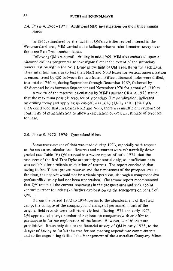
66 FUCHS and SCHÍNDLMAYR
2.4. Phase 4, 1967—1971: Additional MIM investigations on their three mining leases
In 1967, stimuiated by the fact that QM's activities revived interest in the Westmoreland area, MIM carried out a heiicopterborne scintillometer survey over the three Red Tree uranium leases.
Following QM's successful drilling in mid-1969, MIM also embarked upon a diamond-drilling programme to investigate further the extent o f the secondary
mineralization within the N o .l Lease in the light o f QM's results on the Jack Lens. Their intention was also to test their No.2 and No.3 leases for vertical mineralization as encountered by QM between the two leases. Fifteen diamond holes were drilled, to a total o f 750 m, during September through December 1969, followed by 42 diamond holes between September and November 1970 for a total o f 1710 m.
A review o f the resource calculation by MIM's partner CRA in 1973 stated that the maximum possible resource o f secondary U mineralization, indicated by drilling today and applying no cut-off, was 1630 t U 3OS at 0.115% U^Og.CRA concluded that, in Leases No.2 and No.3, there was insufficient evidence o f continuity o f mineralization to allow a calculation or even an estimate o f resource tonnage.
2.5. Phase 5, 1972—1975: Queensland Mines
Some reassessment o f data was made during 1973, especially with respect to the resources calculations. Reserves and resources were substantially downgraded (see Table IV).QM stressed in a review report o f early 1974 that the resources o f the Red Tree Dyke are strictly potential only, as insufficient data was available for a reliable calculation o f reserves. The report concluded that, owing to insufficient proven reserves and the remoteness o f the prospect area at the time, the deposit would not be a viable operation, although a comprehensive prefeasibility study had not been undertaken. The review report recommended that QM retain all the current tenements in the prospect area and seek a joint venture partner to undertake further exploration on the tenements on behalf o f QM.
During the period 1972 to 1974, owing to the abandonment o f the field camp, the collapse o f the company, and change o f personnel, much o f the original field records were unfortunately lost. During 1974 and early 1975,QM approached a large number o f exploration companies with an offer to participate in further exploration o f the leases. However, conditions were prohibitive. It was only due to the financial misery o f QM in early 1975, to the danger o f having to forfeit the area for not meeting expenditure commitments and to the negotiating skills o f the Management o f the Australian Company Mines
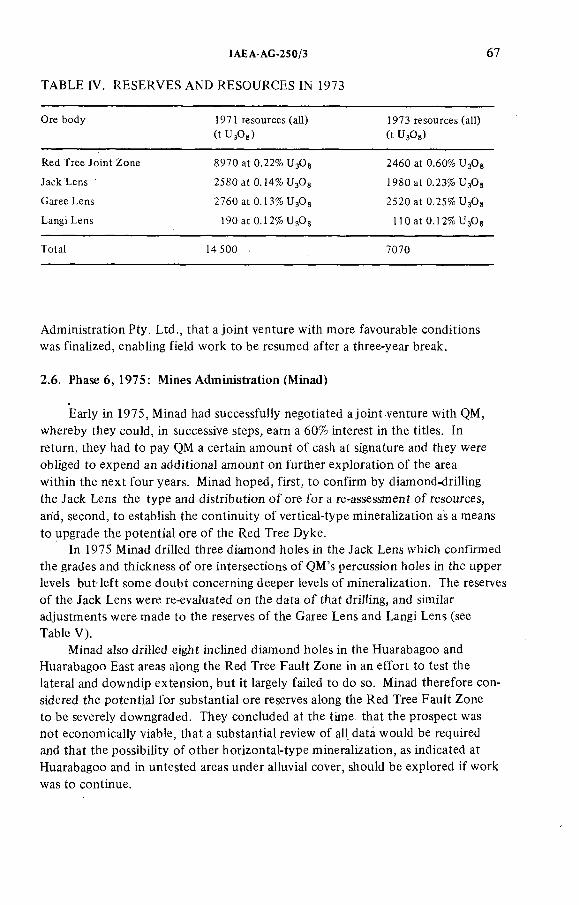
IAEA-AG-250/3
TABLE IV. RESERVES AND RESOURCES IN 1973
67
Ore body 1971 resources (all)
(t ЧзОз)1973 resources (all)
(t ИзОз)
Red Tree Joint Zone 8970 at 0.22% U Og 2460 at 0.60% U3OS
Jack Lens 2380 at0.14%U30g 1980 at 0.23%
Garee Lens 2760 at 0.13%из0з 2520 at 0.25% U3OS
Langi Lens 190 at 0.12% HOat 0.12% U3OS
Total 14 500 7070
Administration Pty. Ltd., that a joint venture with more favourable conditions was finalized, enabling field work to be resumed after a three-year break.
2.6. Phase 6 , 1975: Mines Administration (Minad)
Early in 1975, Minad had successfully negotiated a joint venture with QM, whereby they could, in successive steps, earn a 60% interest in the titles. In return, they had to pay QM a certain amount o f cash at signature and they were obliged to expend an additional amount on further exploration o f the area within the next four years. Minad hoped, first, to confirm by diamond-drilling the Jack Lens the type and distribution o f ore for a re-assessment o f resources, and, second, to establish the continuity o f vertical-type mineralization as a means
to upgrade the potential ore o f the Red Tree Dyke.In 1975 Minad drilled three diamond holes in the Jack Lens which confirmed
the grades and thickness o f ore intersections o f QM's percussion holes in the upper levels but left some doubt concerning deeper levels o f mineralization. The reserves o f the Jack Lens were re-evaluated on the data o f that drilling, and similar adjustments were made to the reserves o f the Garee Lens and Langi Lens (see Table V ).
Minad also drilled eight inclined diamond holes in the Huarabagoo and Huarabagoo East areas along the Red Tree Fault Zone in an effort to test the lateral and downdip extension, but it largely failed to do so. Minad therefore considered the potential for substantial ore reserves along the Red Tree Fault Zone to be severely downgraded. They concluded at the time that the prospect was not economically viable, that a substantial review o f all data would be required and that the possibility o f other horizontal-type mineralization, as indicated at Huarabagoo and in untested areas under alluvial cover, should be explored if work was to continue.
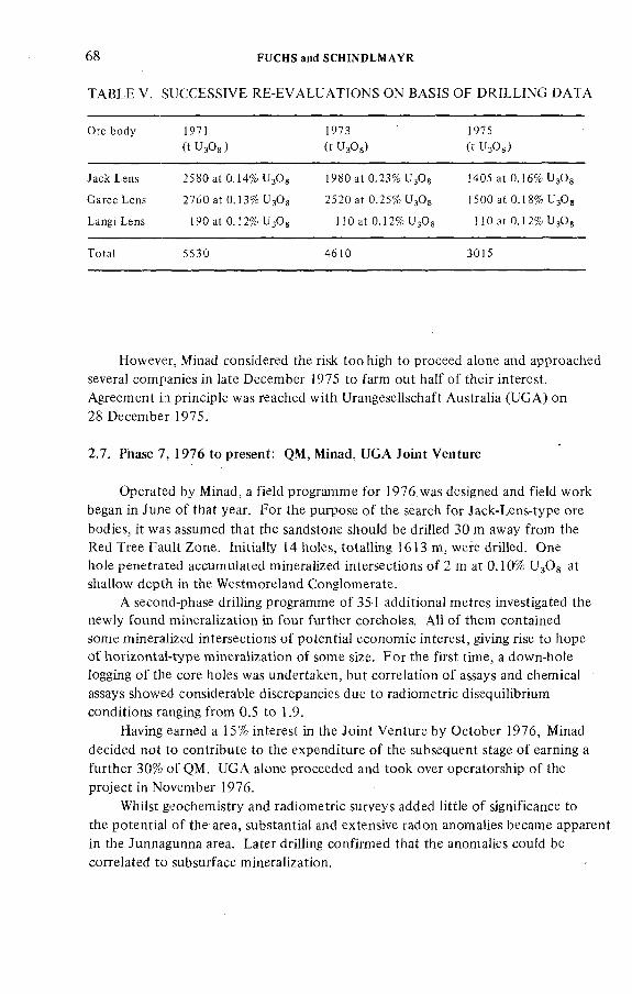
6 8 FUCHS and SCHINDLMAYR
TABLE V. SUCCESSIVE RE-EVALUATIONS ON BASIS OF D RILLING D ATA
Ore body 1971 (t U3OS)
1973(t U30g)
1975(t U3OS)
Jack Lens 2580 at 0.14% UgOg 1980 at 0.23% U3O8 1405 at 0.16% UgOg
Garee Lens 2760 at 0.13% U3O8 2520 at 0.25% U3OS 1500 at 0.18% UsOg
Langi Lens 190 at 0 . 1 2 % U3OS 1 1 0 at 0 . 1 2 % UgOs 1 1 0 at 0 . ] 2 % U3OS
Totat 5530 4610 3015
However, Minad considered the risk too high to proceed atone and approached severa! companies in !ate December 1975 to farm out haif o f their interest. Agreement in principie was reached with UrangeseMschaft Australia (U G A ) on 28 December 1975.
2.7. Phase 7, 1976 to present: QM, Minad, UGA Joint Venture
Operated by Minad, a field programme for 1976. was designed and field work began in June o f that year. For the purpose o f the search for Jack-Lens-type ore
bodies, it was assumed that the sandstone should be drilled 30 m away from the Red Tree Fault Zone. Initially 14 holes, totalling 1613 m, were drilled. One hole penetrated accumulated mineralized intersections o f 2 m at 0.10% UgOg at shallow depth in the Westmoreland Conglomerate.
A second-phase drilling programme o f 35 1 additional metres investigated the newly found mineralization in four further coreholes. AH o f them contained some mineralized intersections o f potential economic interest, giving rise to hope o f horizontal-type mineralization o f some size. For the first time, a down-hole logging o f the core holes was undertaken, but correlation o f assays and chemical assays showed considerable discrepancies due to radiometric disequilibrium conditions ranging from 0.5 to 1.9.
Having earned a 15% interest in the Joint Venture by October 1976, Minad decided not to contribute to the expenditure o f the subsequent stage o f earning a further 30% o f QM. UG A alone proceeded and took over operatorship o f the project in November 1976.
Whilst geochemistry and radiometric surveys added little o f significance to the potential o f the area, substantial and extensive radon anomalies became apparent in the Junnagunna area. Later drilling confirmed that the anomalies could be correlated to subsurface mineralization.
!AEA-AG-250/3 69
FoHow-up drilling o f the mineralization at Junnagunna successfully proved the presence o f substantia! horizontal mineraiization at shallow depth with grades locally exceeding 1% L^Og. The mineralized area remained essentially open in most directions. The potential resources were tentatively estimated at about 540 t U^Og at 0.19% ^ O g . The relationship o f the mineralization to the Red Tree Fault Zone remained open, as the drilling failed to locate the dyke. In addition, some more holes were drilled at Garee Lens to improve understanding o f the mineralization.
Several other holes were drilled to investigate continuation o f Red Tree Zone; they were barren.
In summary, exploration in 1977 proved the existence o f further areas o f significant horizontal-type mineralization at shallow depth and added substantially to the potential resources o f the whole prospect area. In 1978 the main aim was to increase the potential o f the Junnagunna Lens.
A t Junnagunna, 15 o f the 29 holes intersected mineralization o f potentially economic thickness and grade, inferring a horizontal-type ore body o f significant size. The estimate o f contained potential resources lies in the order o f 3600 t U3O8 at 0.15%. The zone o f mineralization now measures about 600 X 800 m and remains largely open to the ENE and to the north. Compared to the 1977 geological resource figure, a net gain o f 3600 t potential ore has been achieved, which, although probably inflated by the low cut-off grades and the lack o f consideration o f minimum thickness or overburden ratios, is rather encouraging.
In 1977/78 the Junnagunna, Sue, Outcamp and General Long Pocket areas were investigated (Figs 4 and 5). Eighty-one drill-holes indicate the following potential resources (at a cut-off o f 300 ppm):
Junnagunna: 3600 t UgOg at 0.15% U3ÛgJunnagunna South: 270 t U30g at 0.055% UsOgSue: 675 t U30g at 0.11% U3O 8Outcamp: 945 t U 3OS at 0.085% U30g
Together with the recalculated resources o f QM (Jack, Garee and Langi Lenses) at a cut-off o f 0.08% UgOg, the total resources are in the range o f 10 800 t ^ O g with an average grade o f 0.18% U^Og. First prefeasibility considerations during 1978 indicated that geological resources o f approximately 13 500 t would be required to establish a viable mining operation.
During 1978 the interest-earning period o f the Joint Venture expired and equities are now distributed as follows subject to adjustments on investment decision:
Queensland Mines 40%Urangesellschaft Australia (operator) 37.5%Minad 22.5%
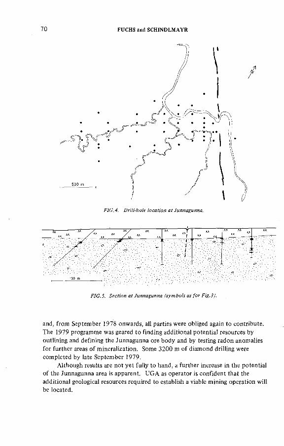
70 FUCHS and SCHîNDLMAYR
^7C.4. DriM-йо/е /осадой af Умялаумяпа.
F7C.3. ^ecfiOT! af Уияла^мяна a /o?' F¡'g..?J.
and, from September ¡978 onwards, all parties were obliged again to contribute. The 1979 programme was geared to finding additional potential resources by outlining and defining the Junnagunna ore body and by testing radon anomalies for further areas o f mineralization. Some 3200 m o f diamond drilling were completed by late September 1979.
Although results are not yet fully to hand, a further increase in the potential o f the Junnagunna area is apparent. UGA as operator is confident that the additional geological resources required to establish a viable mining operation will be located.
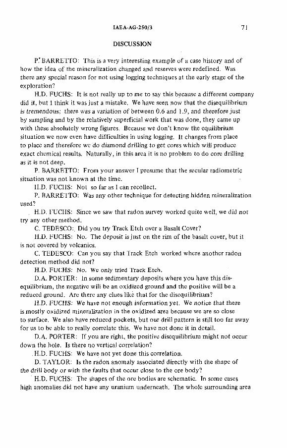
IAEA-AG-250/3 71
DISCUSSION
P.' BARRETTO: This is a very interesting example o f a case history and o f how the idea o f the mineralization changed and reserves were redefined. Was there any special reason for not using logging techniques at the early stage o f the exploration?
H.D. FUCHS: It is not really up to me to say this because a different companydid it, but I think it was just a mistake. We have seen now that the disequilibriumis tremendous; there was a variation o f between 0.6 and 1.9, and therefore just by sampling and by the relatively superficial work that was done, they came up with these absolutely wrong figures. Because we don't know the equilibrium situation we now even have difficulties in using logging. It changes from place to place and therefore we do diamond drilling to get cores which will produce exact chemical results. Naturally, in this area it is no problem to do core drilling as it is not deep.
P. BARRETTO: From your answer I presume that the secular radiometric situation was not known at the time.
H.D. FUCHS: Not so far as I can recollect.P. BARRETTO: Was any other technique for detecting hidden mineralization
used?H.D. FUCHS: Since we saw that radon survey worked quite well, we did not
try any other method.C. TEDESCO: Did you try Track Etch over a Basalt Cover?H.D. FUCHS: No. The deposit is just on the rim o f the basalt cover, but it
is not covered by volcanics.C. TEDESCO: Can you say that Track Etch worked where another radon
detection method did not?H.D. FUCHS: No. We only tried Track Etch.
D.A. PORTER: In some sedimentary deposits where you have this disequilibrium, the negative will be an oxidized ground and the positive will be a reduced ground. Are there any clues like that for the disequilibrium?
H.D. FUCHS: We have not enough information yet. We notice that there is mostly oxidized mineralization in the oxidized area because we are so close to surface. We also have reduced pockets, but our drill pattern is still too far away for us to be able to really correlate this. We have not done it in detail.
D.A. PORTER: I f you are right, the positive disequilibrium might not occur
down the hole. Is there no vertical correlation?H.D. FUCHS: We have not yet done this correlation.D. TA YLO R : Is the radon anomaly associated directly with the shape o f
the drill body or with the faults that occur close to the ore body?H.D. FUCHS: The shapes o f the ore bodies are schematic. In some cases
high anomalies did not have any uranium underneath. The whole surrounding area
72 FUCHS and SCHINDLMAYR
was anomalous, so we did not reaHy took for peaks in the radon anomaiy ; we just iooked for regionai anomalies which are quite high (3 to 4 times background areas) and we found mineralization below, but usually the higher-grade material was not
below the peaks o f the radon anomalies. We were not able to find the continuation o f the fault; it is only schematic (actually we have several other cross-cutting faults) and the fault more or less disappeared. Only this year we drilled a few inclined holes to intersect the fault somewhere. So we could not follow the zone with radon.
B. GUSTAFSSON: Were radon measurements limited to the dyke area?H.D. FUCHS: No, we measured the whole area with radon.B; GUSTAFSSON: What was the spacing o f the measuring grid?H.D. FUCHS: The grid was about 50 feet in the anomalous areas.M. M ATO LIN : You mentioned that the coefficient o f radioactive equilibrium
varied very extensively. The figures you gave prove it. Do you think that in this situation the gamma log, or probably the core analysis, you used for deposit evaluation is the correct one, or do you intend to use in the future other techniques for deposit evaluation?
H.D. FUCHS: We would prefer not to do core drilling any more and would like to find a more effective and cheaper method. There are several types o f equipment on the market but they are very difficult to get in this area, because we are not able to do down-hole logging to measure uranium only and not the decay products in order to avoid the disequilibrium problems. I don't think there is even yet a proper method in the USA. So we still have to do core drilling to get proper assays. I f somebody knows a method o f doing this, it would be very helpful.
M. M ATO LIN : There are investigations on these new methods in the USA and in other countries, but there are probably no available units at present.Some firms in the USA offer these units, but I am not sure about the performance o f this equipment.
F. SCOTT. Proto-actinium had a good correlation, but it was cheaper to do core drilling than to use this method.
H.D. FUCHS. I know there is a californium unit too, but this is too complex so I think we should be old-fashioned and still do core drilling.
D.A. PORTER: Where do surface radon anomalies stand in relation to the mineralization?
H.D. FUCHS: With quite a few exceptions, the following general statement can be made: little lateral displacement o f the soil radon anomaly was observed in relation to the underlying mineralized sandstone, in spite o f approximately 15 m thickness o f cover rocks, including at least 10 m o f basic volcanics (Seigal volcanics).
D.A. PORTER: How many times background were the radon anomalies?H.D. FUCHS: The anomalies were about two to four times background
with peaks o f up to 100 times background.
!AEA-AG-250/3 73
С. TEDESCO: Could you give us some details about (a) the characteristics o f the stratiform deposits in Proterozoic continental sediments, and (b ) the type o f geochemical prospecting that was effective and the environment in which it was applied.
H.D. FUCHS: (a) We have not yet found any sedimentological or geochemical reason for the concentration o f uranium in the uppermost part o f the Westmoreland Conglomerate. There are still two opposite views about the genesis o f the ore:(i) the uranium precipitation is closely connected with the basic dykes, sills and Seigal volcanics; and (ii) the uranium precipitation is a purely syngenetic or epigenetic process within the sediments, without any magmatic influence.(b ) The radon method (alpha-trace) was by far the most effective.

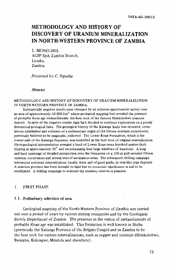
IAEA-AG-2S0/I3
METHODOLOGY AND HISTORY OF DISCOVERY OF URANIUM MINERALIZATION IN NORTH-WESTERN PROVINCE OF ZAMBIA
L. MENEGHELAGIP SpA Zambia Branch,Lusaka,Zambia
Fre.s'CMfgi/ C. fapadi'a
Abstract
METHODOLOGY AND HISTORY OF DISCOVERY OF URANIUM MINERALIZATION IN NORTH-WESTERN PROVINCE OF ZAMBIA.
Substantially negative results were obtained by an airborne spectrometer survey over an area of approximately 60 0 0 0 km^ where geological mapping had revealed the presence of probable Roan age metasediments, the host rock of the famous Shinkotobwe uranium deposit. In spite of the negative results Agip SpA decided to continue exploration on a purely theoretical geological basis. The geological history of the Katanga Basin was reviewed, correlations established and evidence of a sedimentary origin of the known uranium occurrences, previously believed to be magmatic, collected. The Lower Roan Formation, which is the lowest part of the Katanga Sequence, was identified as the host rock of original mineralization. Photogeological interpretation revealed a band of Lower Roan some hundred metres thick dipping at approximately 30° and encompassing four large windows of basement. A long and hard campaign of detailed prospection over the formation on a 1 0 0 -m grid revealed fifteen uranium occurrences and several tens of anomalous areas. The subsequent drilling campaign intersected scattered mineralization, locally thick and of good grade, in vein-like type deposits.A uranium province has been brought to light but its economic significance is still to be established. A drilling campaign to evaluate the uranium reserves is planned.
1. FIRST PHASE
1.1. Preliminary selection o f area
Geological mapping o f the North-Western Province o f Zambia was carried out over a period o f years by various mining companies and by the Geological Survey Department o f Zambia. The presence in the region o f metasediments o f probable Roan age was established. This formation is well known in Shaba (previously the Katanga Province o f the Belgian Congo) and in Zambia to be the host rock for various mineralizations, such as copper and uranium (Shinkolobwe, Swambo, Kalongwe, Mindola and elsewhere).
75
76 MENEGHEL
On the basis o f this information Agip in 1970 selected an area o f 60 000 km^ for detailed studies. Much o f the geological data concerning the region was not published, but it was available at the Geological Survey Department in Zambia on open files.
I.2. Exploration methods
The size o f the area, the difficulty o f access and the large distribution o f the outcrops suggested the use o f an airborne spectrometric survey for preliminary investigation. A total o f 100 666 line km were flown with lines spaced at 800 m, orientated perpendicular to the general geological strike.
An Aero Commander and a Britten-Norman Islander equipped with magnetometers and spectrometers with Nal(T l) detectors o f two 8 in. X 4 in. and oneII.5 in. X 4 in. crystal volume were used. The airborne spectrometric survey was carried out by a contractor.
A total o f about 1000 radiometric anomalous areas were selected, 650 o f which were classified as due to thorium, 250 to thorium and uranium, and 100 to uranium alone. O f the 1000 anomalies, 750 (o f which ten were uranium) were over magnetic rocks or schists and gneisses o f the Basement Complex (a term used to describe rocks o f Pre-Katanga age) and 250 (including 90 due to uranium) were over sedimentary and metasedimentary rocks o f Katanga age. AM the uranium anomalies and most o f the others were checked by teams consisting o f a geologist,
an assistant and a compass-man transported by a Bell 47/G 38—1 or a Bell 206/A Jet Ranger helicopter. A total o f 1300 helicopter hours were flown.
The anomalous areas were classified in groups according to their probable cause. None o f them was considered sufficiently interesting from a theoretical point o f view to justify deeper exploration.
2. SECOND PHASE
2.1. Research programme
In 1972, a new exploration philosophy was adopted which eventually proved successful in the discovery o f some mineralization. A report o f this
new philosophy and its application forms the main part o f this paper.
New discoveries o f uranium in the Northern Territories o f Australia and re-evaluations o f the genesis o f Shinkolobwe and other uranium occurrences in the Roan Group played an important part in the development o f the new approach to exploration. The new programme included a study, within the Katanga Basin, of:
(a) The conditions o f deposition o f the Roan Group, and stratigraphie correlation between Shaba, the Copperbelt and North-Western Province; and
IAEA-AG-250/Ï3 77
(b ) The conditions o f deposition o f uranium in marine environments and a study o f the origins o f uranium mineraiization in the Roan Group previousiy thought to be magmatic.
It was not possible to establish firm stratigraphie correlation between the three areas, but it was possible to establish a satisfactory depositional sequence o f sediments o f the Katanga Basin, particularly the Roan Group, which represents the base o f the sequence.
The deposition o f the Katanga Sequence, o f mainly marine origin, began between 840 and 1300 million years ago in a wide, complex basin extending from Shaba Province in Zaïre through a large part o f Zambia, notably the Copperbelt area and the North-Western Province area (the Domes area). The south-western boundaries o f the sequence are now masked by more recent formations (Fig. 1). The entire sequence is several thousands o f metres thick, and the basal parts contain the copper deposits o f the Copperbelt o f Zambia and o f Shaba Province. The sequence is subdivided from bottom to top into the Roan Group, Mwashya Group and the Kundelungu Series (Table 1 ). The lower parts o f the sequence were deposited in basins o f limited extent, so that there are many local facies changes. The sediments deposited later were more uniform in composition and o f greater lateral extent, and are therefore more readily correctable. The deposition o f the Roan Group took place in a shallow- water, near-shore, marine environment. The basal sediments o f the Group were deposited in an oxidizing environment during a major transgression, while the other sediments containing the mineralization were deposited in euxinic conditions, accompanied by local volcanic activity. Finally, the basin was filled with the rest o f the sequence under a number o f environmental conditions.
The sediments were subsequently metamorphosed and tectonized several times; in Shaba the Roan Group was thrust over higher members o f the sequence and faulted in separate masses enclosed in breccia. The mineralization has been strongly influenced by tectonic, volcanic and thermal events and alteration phenomena.
The second point o f the new programme was strongly influenced by findings in the Northern Territory o f Australia.
Taking into account the deposition conditions o f uranium in marine environments, we oriented the prospecting towards fine-grained, shallow-water, near-shore, marine sediments o f the first transgression o f the Katanga sequence where organic life and reducing conditions existed.
Evidence o f a sedimentary origin o f the known uranium occurrences in the Lower Roan was difficult to collect. It is, however, possible to prove that the known mineralization is a reworked mineralization o f sedimentary origin. Evidence supporting such a conclusion was collected during the entire second phase o f research, and is summarized below.
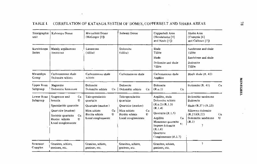
TABLE I. CORRELATION OF KATANGA SYSTEM OF DOMES, COPPERBELT AND SHABA AREAS
Stratigraphieunit
Kabompo Dome Mwombezi Dome (McGregor [3])
Solwezi Dome Copperbelt Area (Mendelsohn [4] and Binde [5])
Shaba Area (François [6 ] and Cailteux [7])
KundelunguSeries
Mainly argillaceous limestone
Limestone(tillite)
Dolomite(tillite)
ShaleTillite
Shale
Dolomite and shale Tillite
Sandstone and shale Tillite
Sandstone and shale
DolomiteTillite
MwanshyaGroup
Carbonaceous shale Dolomite schists
Carbonaceous shale schists
Carbonaceous shale Carbonaceous shale Argillite
Black shale (R. 42)
Upper Roan Subgroup
MagnesiteDolomitic limestone
DolomiteDolomitic schists Cu
DolomiteDolomitic schists Cu
Dolomite(R.u.l) Cu
Dolomite (R. 41) Cu
Lower Roan Subgroup
Soapstone and Cu breccia U
Specularitic quartzite
Quartzite (marker)
Sericitic quartzite Cu Biotite schists U Local conglomerate
T alc-specularitic quartzite
Quartzite (marker)
Mica schists Cu Biotite schists U Local conglomerate
Talc-speculariticquartzite
Quartzite (marker)
Mica schists Cu Biotite schists U Local conglomerate
Argillite, shale Dolomitic schists (R.u.2)(R.1.3)(R.1.4)
Quartzite (R.1.5)
Argillite Cu Micaceous quartzite Impure dolomite (R.1.6)QuartziteConglomerate (R.1.7)
Dolomitic sandstone Dolomite
Shale (R.3? ) (R..23)
Siliceous dolomite (R.21)(R.22) Cu Dolomitic sandstone U(R .l)
?
BasementComplex
Granites, schists, gneisses, etc.
Granites, schists, gneisses, etc.
Granites, schists, gneisses, etc.
Granites, schists, gneisses, etc.
?
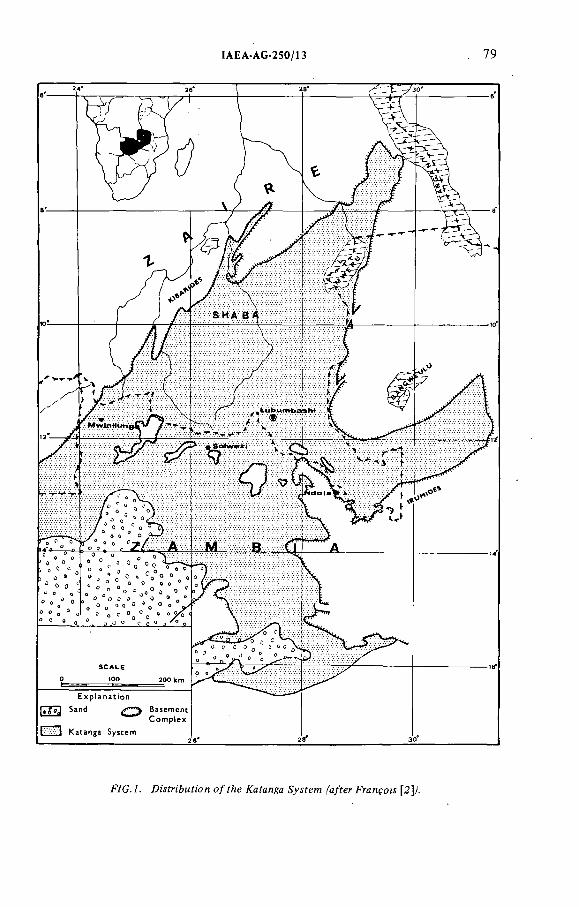
IAEA AG-250/13 79
f/G .A Di'yin'bMfi'on o/fAe Æafanga ^a/fer FrcnyoM [2p.
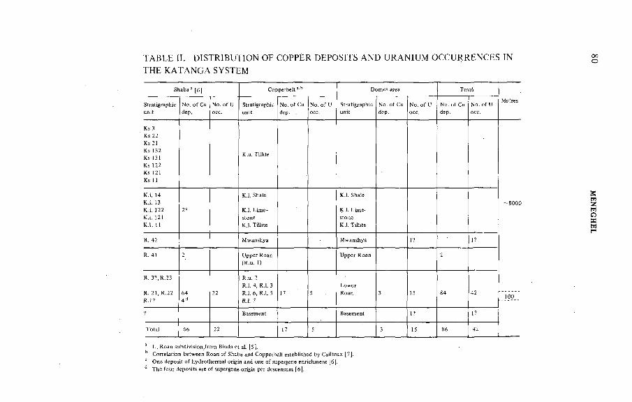
TABLE H. DISTRIBUTION OF COPPER DEPOSITS AND URANIUM OCCURRENCES IN
THE K A TA N G A SYSTEM
Shaba [6 j C opperbelt s-b D om es area T o ta l
M etres
g ra p h icN o . o fC u N o. o f U Stratigraphie N o. o f Cu N o. o f U StratisrapM c N o . o f Cu N o . o f U N o . o f Cu N o. o f U
Ks 3
Ks 22
Ks 21
Ks 132
Ks 13 !
Ks 122
Ks 121
Ks 11
K.u. T illite
- 8 0 0 0
K .i. 14
K .i. 13
K .i. 122
K .i. 12!
K .I. 11
2'
K .I. Shale
K .I. T illite
K .I. Shale
K .I. L im e-
K .l. T iH ite
R. 42 M wanshya M w anshya 1? !?
R . 4 ! 2(R .u . 1) " . a n
2
R . 3 ? ,R .2 3
R . 21, R .22
R . i?
644d
22
R.u. 2
R.I. 4, R .I. 3
R .I. 6, R .I. 5
R.Í. 7
17 5 3 15 84 42 100
*? Basement Basem ent 1? 1?
T o ta l 66 22 17 5 3 15 86 42
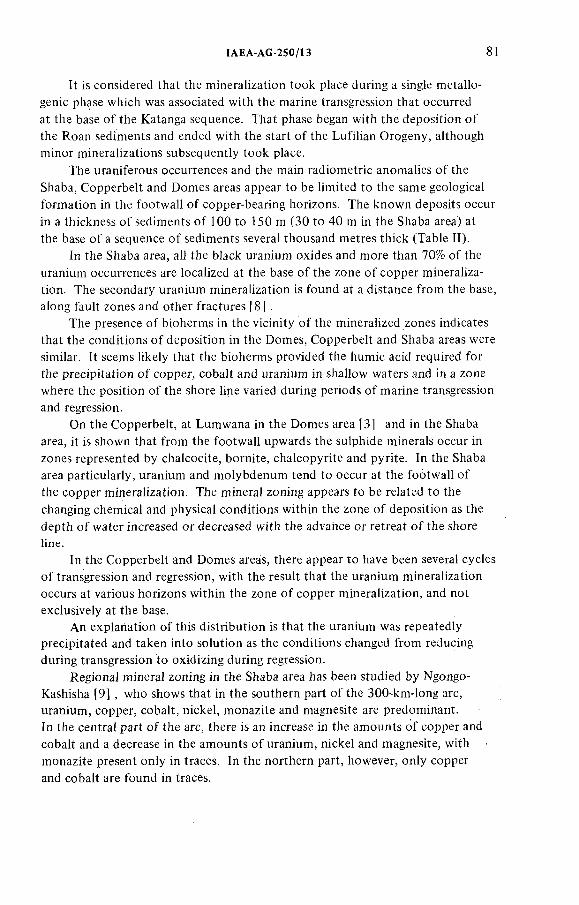
IAEA-AG 250/13 81
It is considered that the mineralization took place during a single métallogénie phase which was associated with the marine transgression that occurred at the base o f the Katanga sequence. That phase began with the deposition o f the Roan sediments and ended with the start o f the Lufilian Orogeny, although minor mineralizations subsequently took place.
The uraniferous occurrences and the main radiometric anomalies o f the Shaba, Copperbelt and Domes areas appear to be limited to the same geological formation in the footwall o f copper-bearing horizons. The known deposits occur in a thickness o f sediments o f 100 to 150 m (30 to 40 m in the Shaba area) at the base o f a sequence o f sediments several thousand metres thick (Table II).
In the Shaba area, all the black uranium oxides and more than 70% o f the uranium occurrences are localized at the base o f the zone o f copper mineralization. The secondary uranium mineralization is found at a distance from the base, along fault zones and other fractures [8 ] .
The presence o f bioherms in the vicinity o f the mineralized zones indicates that the conditions o f deposition in the Domes, Copperbelt and Shaba areas were similar. It seems likely that the bioherms provided the humic acid required for the precipitation o f copper, cobalt and uranium in shallow waters and in a zone where the position o f the shore line varied during periods o f marine transgression and regression.
On the Copperbelt, at Lumwana in the Domes area [3] and in the Shaba area, it is shown that from the footwall upwards the sulphide minerals occur in zones represented by chalcocite, bornite, chalcopyrite and pyrite. In the Shaba area particularly, uranium and molybdenum tend to occur at the footwall o f the copper mineralization. The mineral zoning appears to be related tö the changing chemical and physical conditions within the zone o f deposition as the depth o f water increased or decreased with the advance or retreat o f the shore line.
In the Copperbelt and Domes areas, there appear to have been several cycles o f transgression and regression, with the result that the uranium mineralization occurs at various horizons within the zone o f copper mineralization, and not exclusively at the base.
An explanation o f this distribution is that the uranium was repeatedly precipitated and taken into solution as the conditions changed from reducing during transgression to oxidizing during regression.
Regional mineral zoning in the Shaba area has been studied by Ngongo- Kashisha [9] , who shows that in the southern part o f the 300-km-long arc, uranium, copper, cobalt, nickel, monazite and magnesite are predominant.In the central part o f the arc, there is an increase in the amounts o f copper and cobalt and a decrease in the amounts o f uranium, nickel and magnesite, with monazite present only in traces. In the northern part, however, only copper and cobalt are found in traces.
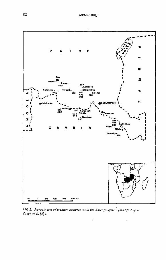
82 MENEGHEL
F7G.2. /sofopi'c о/мгая;'м?я о с с м ^ е я с м ;'я f/¡e А'аГая^а ^ í f e w ^ o ^ ¡/ ¡ 'e ¿ a/fer
Cc/¡en e f я/, [ g ] /
ÍAEA-AG-250/13 83
It is considered that the regional minerai zoning is reiated to the change in water depth, which caused a change in the deposition conditions during the period o f marine transgression at the base o f the Katanga sequence.
In the Domes area, it is seen that the higher grades o f copper occurrence, such as Kimale, are almost free from uranium, and that copper is virtualiy absent where the uranium grade is high. A similar relationship is found in the Copperbelt, where good grades o f uranium occurrences are copper-free at Mindola.
In the Shaba area, Ngongo-Kashisha [9] saw that the two mineral associations, uranium-cobalt-copper-nickel and copper-cobalt, have identical fluid inclusions,
suggesting a single métallogénie phase.The pitchblende found in Shaba [10] and in the Domes area is free o f
thorium; this is quite different from the thorium-uraninite assemblage found in rocks o f magmatic origin.
Such characteristics point to a sedimentary origin and no other. The uranium mineralization o f Shinkolobwe, Swambo and Kalongwe, however, have a vein form and have been considered by some as typical examples o f deposits o f magmatic origin. A study o f the events and processes undergone by the mineralization during geological time explained the vein-like aspect and confirmed their sedimentary origin.
Events and processes that affected the mineralization after its mainly syngene- tic original formation include metamorphism, tectonic events leading to the formation o f epigenetic deposits, supergene enrichment o f epigenetic deposits, and thermal events associated with post-tectonic metamorphism resulting in further redistribution o f uranium mineralization.
In the Shaba area, the effects o f metamorphism were slight. In the Domes and Copperbelt areas, the rocks were recrystallized, and locally economic minerals were segregated into veins which are bordered by barren zones.
The following ages o f different generations o f uranium mineralization were established: > 7 0 6 million years (m .y.) (Shinkotobwe); 670 ±2 0 m.y. (Shinkolobwe, Swambo); 620 ± 10 m.y. (Shinkolobwe, Kalongwe, Luishya);555 ± 10 m.y. (Kambove West); 520 ± 20 m.y. (Nkana, Kansanshi, Musoshi, Kamoto, Kawanga, Kimale); 468 ± 15 m.y. (Nkana); 365 ± 40 m.y. (Luanshya); and 235 ± 30 m.y. (Nkana) (Fig.2).
The uranium generations o f > 706 m.y., 670 ± 20 m.y. and 620 ± 20 m.y. are connected with the first, second and third phases o f the Lufilian Orogeny affecting the Katanga sequence. The 520 ± 20 m.y. generation is related to a thermal event associated with post-tectonic metamorphism [ 11] which affected the three areas, and had its greatest effect in the south-east. Other lesser thermal influences up to 235 m.y. ago caused further redistribution o f uranium mineralization.
Supergene alteration affected the remobilized occurrences to a greater or less extent. In places, secondary uranium mineralization occurs in structures

84 MENEGHEL
TABLE HI. PARAGENESIS OF URANIUM MINERALIZATION*
Age of mineralization ParagenesisLoss of main syngenetic elements
Ni Co Cu Fe U
670 m.y. (Swambo) Uraninite, pyrite, monazite, chlorite, vaesite, siegenite, chalcopyrite
670 and 620 m.y. (Shinkolobwe)
Magnesite, uraninite, pyrite, molybdenite, monazite, vaesite, cattierite, siegenite, chalcopyrite
620 m.y. (Kalongwe) Uraninite, pyrite, chlorite, carrolite, bornite, chalcopyrite
582 m.y. (Kamoto P.) Uraninite, chlorite, carrolite, bornite, chalcopyrite
555 m.y. (Kambove) Uraninite, carrolite, chalcopyrite
555 m.y. (Dumbwa) Uraninite, pyrite, chalcopyrite
543 m.y. (Kimale) Uraninite, quartz, muscovite, apatite, pyrite, chalcopyrite, albite, carbonate, molybdenite
535 m.y. (Kawanga) Uraninite, chlorite, kyanite, mica, pyrite
520 m.y. (Nkana) Uraninite, melonite, bornite, chalcopyrite, digenite, calcite, chalcocite, quartz, biotite, albite, chlorite, molybdenite
520 m.y. (Kansanshi) Brannerite, chalcopyrite, calcite, pyrite, rutile, bornite, molybdenite
520 m.y. (Musoshi) Albite, uraninite, pyrite, carbonate, quartz, molybdenite
520 m.y. (Kamoto P, Kawanga, Kimale)
Uraninite, carbonate, pyrite
468 m.y. (Nkana) Uraninite, carbonate, pyrite
365 m.y. (Luanshya) Pitchblende, calcite, dolomite
235 m.y. (Nkana) Pitchblende
* Modified after Ref. [8 ].
IAEA AG 250/13 85
near the ground-water level, as at Shinkoiobwe in the Shaba area and at the Kawanga and Mitukuluku occurrences in the Domes area.
Geochronology and paragenesis relation confirm remobilization processes affecting a decreasing number o f elements. A ll the main metallic elements, nickel, cobalt, copper, iron and uranium, are present at the 670 m.y. stage. At 620 m.y., nickel has disappeared, and cobalt, copper and iron disappear respectively at the 520, 468 and 365 m.y. stages, leaving only uranium at the final 235 m.y. stage (Table III).
Remobilization processes destroyed the original sedimentary mineralization, and vein-like occurrences were formed. (The deposits in the Alligator River Province
o f the Northern Territory o f Australia seem to have had the same origin as the uranium mineralization o f the Katanga sequence and to have been affected by similar
events.) Before these deposits were discovered, occurrences o f comparable grade had been found only at Shinkolobwe in the Shaba area. High-grade occurrences were also found in the Domes area but, unfortunately, they are erratic and discontinuous.
As at Alligator River, carbonates and organic materials are common in the mineralized rocks o f Shaba and in the Copperbelt: the content o f carbonates is up to 10% o f the rock and that o f carbon up to 1.5%. Bioherms occur along almost the whole length o f the mineralized arc. Observations are incomplete in the Domes area, but carbonates and organic substances are common above the marker quartzite horizon. Graphite occurs in the Dome areas at the Lumwana copper deposits [1 2 ]. Recently, probable bioherms have been discovered by the Geological Survey o f Zambia in the Lower Roan o f the Solwezi Dome area.
These considerations allowed us to conclude that the uranium mineralization o f the Katanga basin is o f sedimentary origin and to establish the more interesting areas where exploration should be concentrated.
In the Shaba area, the stratiform nature o f the uranium mineralization, closely associated with the southern facies o f cupriferous mineralization, could provide a target for exploration along 300 km o f the mineralized arc. Although enriched outcropping uranium mineralization is unlikely to be found, low-grade occurrences on the footwall o f the copper zone could provide valuable byproducts.
In the Copperbelt and Domes areas, where the uranium mineralization is not confined to the copper-bearing formation, it would be appropriate to elucidate the paleogeography and paleo-environment at the times the known uranium occurrences are presumed to have been formed.
Although the geology o f the copper deposits has been thoroughly investigated, less attention has been given to the peculiar conditions o f uranium mineralization.It has been shown at Shinkolobwe and Mindola that rich concentrations o f copper and uranium do not occur in association, so the guides to the discovery o f copper are different from those required for locating uranium.
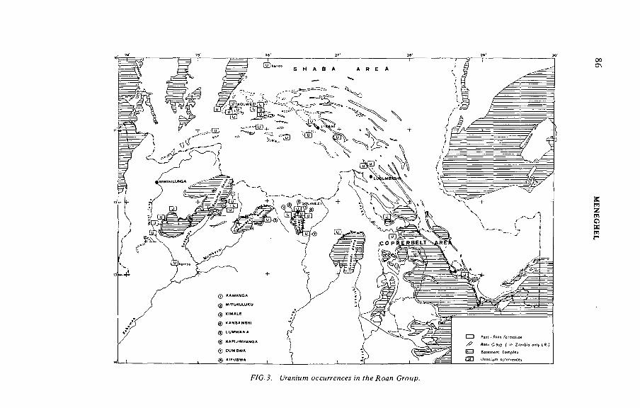
00Ch
J. ¿/гдл/м??? /я гЛе Сгомр.
MEN
EGH
EL
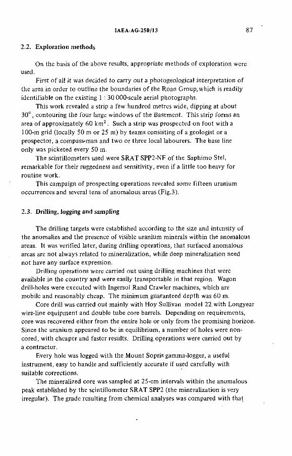
!AEA AG 25 0 /Í3 87
2.2. Exp!oration methods
On the basis o f the above resuits, appropriate methods o f exploration wereused.
First o f all it was decided to carry out a photogeological interpretation o f the area in order to outline the boundaries o f the Roan Group, which is readily identifiable on the existing 1 : 30 000-scale aerial photographs.
This work revealed a strip a few hundred metres wide, dipping at about 30°, contouring the four large windows o f the Basement. This strip forms an
area o f approximately 60 k n P . Such a strip was prospected on foot with a 100-m grid (locally 50 m or 25 m) by teams consisting o f a geologist or a prospector, a compass-man and two or three local labourers. The base line only was picketed every 50 m.
The scintillometers used were SRAT SPP2-NF o f the Saphimo Stel, remarkable for their ruggedness and sensitivity, even i f a little too heavy for routine work.
This campaign o f prospecting operations revealed some fifteen uranium occurrences and several tens o f anomalous areas (Fig.3).
2.3. DriHing, logging and sampMng
The drilling targets were established according to the size and intensity o f the anomalies and the presence o f visible uranium minerals within the anomalous areas, it was verified later, during drilling operations, that surfaced anomalous areas are not always related to mineralization, while deep mineralization need not have any surface expression.
Drilling operations were carried out using drilling machines that were available in the country and were easily transportable in that region. Wagon drill-holes were executed with Ingersol Rand Crawler machines, which are mobile and reasonably cheap. The minimum guaranteed depth was 60 m.
Core drill was carried out mainly with Hoy Sullivan model 22 with Longyear wire-line equipment and double tube core barrels. Depending on requirements, core was recovered either from the entire hole or only from the promising horizon. Since the uranium appeared to be in equilibrium, a number o f holes were noncored, with cheaper and faster results. Drilling operations were carried out by
a contractor.Every hole was logged with the Mount Sopris gamma-logger, a useful
instrument, easy to handle and sufficiently accurate if used carefully with suitable corrections.
The mineralized core was sampled at 25-cm intervals within the anomalous peak established by the scintillometer SRAT SPP2 (the mineralization is very irregular). The grade resulting from chemical analyses was compared with that
88 MENEGHEL
^ Y C .4. ÆaAompo Dom e.' р /ян о /й с^м , íAow /^f/iew e^M /a/'diJM 'AM fí'ono/M ran/M w
m weraH zafíon . The пмумЬегу a&ove c¡rcM¡ar уесМтч corre^ponJ Ю f/wse o/ m fe r íe c feJ /eyeZí,
wí'fA fAe умг/асе area p rop orfi'ow Z fo ?йе prodMcf ^/*ade ^!we^ f /че/сяея.
!AEA-AG-250/!3 89
* x W a g o n dri ll s h a l l o w e r t h a n U - b e a r i n g h o r i z o n
* B a r r e n h o l e
° L o w r a d i o a c t i v e h o l e
О L o w m i n e r a l i z e d level
ê M i n e r a l i z e d level
5 0 - W a g o n dri l l ; R - R o t a r y ; D - D i a m o n d
F7C.J. ЙаЬо?про D om e. р/ап yecfí'on о / ¿r¡7/ /¡o/es. /пУеяее?;оя о / а g o o ^ wMera/izaf/on
¡n fAe Mica jc/¡ Hf recepf¡ve /ormafion. /Vo/e f/¡e fe^ wegM/ал ¿¡уУг;^мУ;о/! о/мгдл;м/я.
MEN
EGH
EL
IAEA AG 2 5 0 /! 3 9]
calculated by radiometric logs. Significant differences were sometimes found within a single hole, but the average o f such differences is balanced. The differences are due mainly to the irregularity o f the mineralization, consisting sometimes o f isolated grains o f pitchblende.
2.4. Diagnostic feature o f the mineraHzation
The uranium mineralization discovered occurs in the Lower Roan Group, which was the target o f the exploration. The Lower Roan extends for several hundreds o f kilometres along the margins o f the domes, with widths o f a few hundreds o f metres. The main occurrences o f uranium mineralization are confined to a distinct horizon, below a quartzite marker horizon. The minerals are thorium-free pitchblende, disseminated or in small veins, and yellow secondary minerals. Five areas have been investigated by drilling.
In the Kawanga area o f the Kabompo Dome area, uranium occurs mainly as traces o f äutunite coating mica schist outcropping in the area o f two radio- metric anomalies. A t depth, drilling intersected uranium mineralization in mica schist underlying the quartzite marker horizon. Discontinuous mineralization occurs at one or more levels whose thickness can be several metres, with a U3OS content o f up to 1%. One hole intersected mineralization o f similar grade along a thickness o f about 25 metres at a depth o f more than 200 m. The mineralization consists o f small grains o f pitchblende disseminated in the schist or along fractures several cm wide, and secondary uranium minerals coating fracture surfaces (Figs 4 and 5).
A specimen o f clear-grey mineralized kyanite schist contains quartz, epidote, kyanite and muscovite, and has granoblastic and poikiloblastic textures. Quartz shows a mosaic texture, and epidote is present as irregularly shaped grains or as prismatic crystals. Kyanite occurs as individual crystals or in aggregates.Accessory minerals include iron oxides, apatite, monazite and rutile. The uranium mineral is autunite.
Dark biotite schist, in which the schistocity is marked by flakes o f biotite and muscovite and equidimensional grains o f quartz, occurs below the mineralized zone. Tourmaline, apatite, zircon and opaque minerals are also present. The rock overlying the mineralized zone is a talc schist, containing unorientated plates o f talc and crystals o f rhombic pyroxene and kyanite. Accessory minerals include monazite and scapolite.
During the course o f exploration for copper in the Mwambezhi Dome area, Mwinilunga Mines Ltd. found occurrences o f uranium on the surface and underground in the area o f Lumwana [3,12]. The uranium mineralization is found in
mica schist.In the Solwezi Dome area numerous small occurrences o f uranium mineraliza
tion have been found, and drilling has been carried out at Dumbwa, Kapijimpanga,
9 2 MENEGHEL
Kimale and Mitukuluku. The mineralization is similar to that previously described. Secondary uranium minerals are found coating flakes o f mica, talc or chlorite occurring along fractures and in veinlets containing quartz, talc, muscovite, apatite and kyanite. The uranium minerals include autunite, meta-autunite, sabugalite, phosphuranilite, vandendriesscheite and gummite. The heavy fraction o f the mineralized rock includes 40% to 60% kyanite, 25% to 40% micas, tourmaline, rutile, iron oxides, epidote and apatite.
At depth, the mineralization consists o f pitchblende occurring disseminated in the host rock, or along fractures and secondary uranium minerals, as at Kawanga. The best mineralization intersected in drill-holes occurs at the Mitukuluku, where1.4% t^Og was found over a thickness o f 9 m. The host rock is quartz-mica- kyanite-talc-epidote-apatite-chlorite schist, underlying the marker quartzite.
At the end o f the second phase o f exploration it was possible to conclude that a uranium province had been discovered but that its real significance was still uncertain and the methods to be used to locate most economically significant uranium concentrations were still to be established.
3. THIRD PHASE
3.1. Critical review o f the results
The second phase revealed that uranium enrichments are erratic and masked by barren, thick soil and rocks. The host horizon does not possess any useful physical characteristics which enable geophysical methods to be used.
The paleoconditions were difficult to establish, mainly owing to lack o f outcrops and the transformations suffered by the rocks. On the other hand, the localization o f uranium enrichments by drilling is too long and expensive.For these reasons, drilling operations were suspended and new techniques o f investigation examined. A test o f the Track-Etch technique was made in two areas, but the results were rather discouraging: they emphasised only surfaced radiometric anomalies but none o f the buried mineralization. Since no other geophysical or paleogeological studies appeared applicable, it seems necessary to resume the drilling operations.
3.2. Costs
The costs incurred during these phases are o f little general significance because they are strictly dependant on the local situation. We believe it is more useful to indicate the amount o f work involved in this type o f exploration in a country with such difficult access and such great supply problems.
IAEA-AG-250/13 93
The anomalies must be screened mainly by helicopter: the tack o f tracks and bridges makes it impossible to reach the anomalous areas by car. The helicopter must be fast, capable o f carrying four or five passengers, and powerful enough to be used even during the hottest hours o f the day. A standard prospecting team (geologist, prospector, compass-man, three local labourers) using a four-wheel-drive car can carry out an average o f 10 line km per day, taking radiometric readings every 50 m and doing geological and topographical observation. A wagon drill, with local operators, can drill an average o f 50 m a day. A core drill can drill approximately 15 m a day.
4. CONCLUSIONS
The prospecting activity in North-Western Province started late in 1970, was suspended in 1975, and was resumed for a short period in 1977. The first phase ended in 1972 with negative results. Was the decision to carry out the long and expensive second phase fair and wise? It depends on where the answer
comes from and when.We can conclude as follows: a large area with a good potential uranium
reserve has been revealed and it is open to future development; the exploration costs per pound o f the proven reserve are still relatively low. The third phase is now under consideration. What will be the wisest and fairest decision?
REFERENCES
[1] CAHEN, L., Etat actuel de la géochronologie du Katanga, Ann. Mus. Roy. Afr. Centr.,S e i . G é o l . 6 5 ( 1 9 7 0 ) .
[2] FRANÇOIS, A., "La tectonique des gisements cuprifères stratiformes du Katanga",Proc. Symp. Gisements Stratiformes de Cuivre en Afrique, Paris, 1963, Part 2.
[3] McGREGOR, J.A ., The Lumwana Copper Prospect in Zambia, Dissertation, Rhodes Univ. (1964), unpublished.
[4] MENDELSOHN, F ., The Geology of the Northern Rhodesia Copperbelt, MacDonald, London (1961).
[5] BINDA, P.L., MULGREW, T.R., "Stratigraphy of copper occurrences in the Zambian copperbelt", Proc. Symp. Gisements Stratiformes et Provinces Cuprifères, Liège, 1974.
[6] FRANÇOIS, A., "Stratigraphie, tectonique et minéralisations dans l'arc cuprifère du Shaba", ibid.
[7] CAILTEUX, S., Corrélation stratigraphique des sédiments d'âge Roan du Shaba et de Zambie, Ann. Soc. Géol. Belg. 99 (1977).
[8] CAHEN, L., FRANÇOIS, A., LEDENT, D., Sur l'âge des uraninites de Kambove ouest et de Kamoto principal et révision des connaissances relatives aux minéralisations uranifères du Katanga et du Copperbelt de Zambia, Ann. Soc. Géol. Belg. 94 (1971).
[9] NGONGO-KASHISHA, Sur la similitude entre les gisements uranifères (type Shinkolobwe) et les gisements cuprifères (type Kamoto) au Shaba, Zaïre, Ann. Soc. Géol. Belg. 98 (1975).
94 MENEGHEL
[10] BUTTGENBACK, H., Les minéraux de Belgique et du Congo belge, Paris (1947).[11] BBLLIERE, J., Manifestations métamorphiques dans la région d'Elisabethville, Publ.
Etat d'Elisabethville (1 July 1961).[12] BENHAM, D.G., GREIG, D.D., NtNK, B.W., Copper occurrences of the Mombezhi area
Northwestern Zambia, Econ. Geol. 71 2 (1976).
SELECTED BIBLIOGRAPHY
CAHEN, L., "Geological background to the copper-bearing strata of Southern Shaba (Zaire)", Proc. Symp. Gisements Stratiformes et Provinces Cuprifères, Liège, 1974.
CAHEN, L., SNELLING, N.J., Données radiométriques nouvelles par la méthode potassium- argon: Existence d'une importante élévation post-tectonique de la température dans les couches katangiennes du Sud du Katanga et du Copperbelt de la Zambia, Ann. Soc. Géol.Belg. 94 (1971).
MENEGHEL, L., "Uranium occurrence in the Katanga System of north-westem Zambia", Uranium Deposits in Africa: Geology and Exploration (Proc. Regional Advisory Group Mtg. Lusalca, 1977), IAEA, Vienna (1979) 97.
OOSTERBOSCH, R., Les minéralisations dans le système de Roan au Katanga (LOMBARD, J., NIC0L1N1, P., Eds), Proc. Symp. Gisements Stratiformes de Cuivre en Afrique, Paris, 1962 (Part 2).
DISCUSSION
B.L. NIELSEN: A tot o f money has been spent on an extensive drilling programme. Could you tell us how many targets were drilled and what were the criteria for selecting these targets?
L. MENEGHEL' : We drilled several holes on various anomalies but only in four cases was a detailed drilling campaign carried out and encouraging mineralization intersected. The drilting targets were established on the basis o f the size and intensity o f the anomalies and the presence o f visible uranium minerals at the surface. The Lower Roan near the contact with the Basement has been confirmed as the main host rock but this contact is several hundred km long and no valid criteria could be determined to select the most favourable zones. We verified that surface anomalies are not necessarily related to mineralization, while deep mineralization intersected does not necessarily have surface expression.
H.D. FUCHS: What is the metamorphic grade o f the Lower Roan Group in the working area?
' Mr. Meneghel answered some questions in writing after the meeting.
IAEA-AG-250/13 95
L. MENEGHEL: The average grade o f regional metamorphism is o f the green schist facies, although the Lower Roan has also been affected by dynamic metamorphism. The mineral assemblage in the Lower Roan mica schists, in approximate order o f mineral abundance is quartz and muscovite with some chlorite, kyanite, biotite or epidote. Kyanite is often abundant and in large crystals.
H.D. FUCHS: Have you yet been able to find any features like structures, younger granitic intrusions, etc., which could lead to a secondary enrichment process o f the already discovered proto-ores?
L. MENEGHEL: In most cases uranium has been remobilized. Secondary enrichment has been found along small fractures or coating thin layers o f chlorite or biotite. Metamorphic segregation veins are also found. I believe that in the areas studied the uranium migration was only minor and covered only short distances. The causes o f migration were multiple: metamorphism, tectonic events, thermal events and alteration. The isotopic ages o f uranium generations show a clear relation to the ages o f these events.
H.D. FUCHS: It looks as i f you are dealing with what we call proto-ores,
i.e. really with the syngenetic mineralization in these marine black shales, and you have some weak concentration with your weak metamorphism. Probably you ought to look for traps, which are the main problem in unconformity
situations.C. PAP AD IA : That is our problem. In fact, the geological potential o f the
formation is extremely high. The problem is to transform the geological potential into an exploitable ore body, owing to the particular condition o f the mineralization resolved as small pockets, small lenses, scattered without any apparent rule.We tried to establish a correlation o f the uranium lenses, but this was not possible, even though we used a close-grid for the boreholes: 20—25 m. The mineralized bodies are very rich but they are too small to allow possible correlations.
H.D. FUCHS: We have a similar situation in many other places, for example in the Wollaston Belt where we don't have unconformity but just the metamorphic belt, where the mineralization is more or less concordant to the old foliation, as well as in Pine Creek in the Schultz Lake area, etc. So I agree that the Zambian area is highly favourable. But the final step is still missing, and it is only present in Shinkolobwe where there is a higher metamorphic grade with an isoclined folding and axial plane foliation which were filled with the solutions, probably meta- morphic and not hydrothermal solutions from a genetic point o f view. So I think you will have difficulty in Zambia i f you don't come to areas with higher grade o f metamorphism or if you use some granitic intrusions which lead to a remobilization, or i f there is unconformity which we don't have in Zambia, where we have a reworking o f the solutions along unconformity.
C. PAPADIA: We have not yet found Lower Roan formation with high-grade metamorphism; generally it is low, and maybe too low.
96 MENEGHEL
P. STIPANICIC: I would like to congratulate Mr. Meneghel for clarifying the problem related to the genesis o f the parallel mineral belts o f Zambia (Cu with subordinated U) and Zaïre (U with subordinated Cu). The mineral deposits o f both belts were considered for many years to be typical vein-endogenous type, in spite o f the lack o f conclusive arguments,and serious evidence to the contrary, but especially ignoring the opinion o f a leading metallogenetist like Schneiderhohln who, about fifty years ago, stated that the Zambia Copper Belt's mineralization (which included Nkana, Nchanga, etc., uranium ore bodies) was not related to igneous-hydrothermal processes but to sedimentary-exogenous ones which were later masked by regional metamorphism^.
During private discussions at international meetings held during the last six years, and also in published papers^, I suggested the 'sedimentary-non-endogenous' origin for the Shinkolobwe, Swambo and Kolongwe uranium deposits o f Zaire, but I did not receive a very warm reaction, except only from Mr. Cameron (IA E A ) and Mr. Rodrigo (CNEA, Argentina). In this regard, I believe that the confusion about the interpretation o f the metallogenesis o f the Zaïre uranium deposits was due to a narrow focussing o f the problem and the discarding o f valuable regional geological and metallogenetic concepts.
Thus, the Shinkolobwe, Swambo and Kolongwe uranium deposits (Zaire Belt), as well as those small deposits o f Nkana, Nchanga, etc. (Zambia Copper Belt), are not only ахс/мл/уе/у contained in sedimentary rocks o f the Lower Roan Group o f the Mine Series, but they also show a dominant stratiform pattern, to which pseudo-vein sectors are sometimes connected. They are not, however localized in
the main faults but appear as small veinlets into secondary fractures.In spite o f this, Derriks and Vaes^ made a tremendous effort in 1955 to
demonstrate the 'endogenous-igneous' origin o f the Shinkolobwe deposit which then appeared to be an exception within the whole Upper Katanga mineral district. The main arguments used by Derriks and Vaes to support their idea were: (a ) the uranium abundance as opposed to scarcity o f copper; (b ) the possible genetic independence o f uranium and copper; and (c ) the connection o f the Shinkolobwe mineralization to some igneous bodies 'proved by the presence o f several 'pegmatites' or 'igneous apophyses' inside the uranium mine, according to Thoreau and du Trieu^.
2 SCHNEIDERHÖHLN, H., Min. Mag. London 46 (1932). STIPANICIC, P.N., Curso Latinam. Prosp. y Explor. Uranium Depos., Buenos Aires,
CIEN/CNEA (1978). DERRIKS, J.J., VAES, J.F ., "The Shinkolobwe uranium deposit", Peaceful Uses of
Atomic Energy (Proc. Int. Conf. Geneva, 1955) Vol. 6, UN, New York (1956) 94. s THOREAU, J., du TRIEU, R., Mem. Inst. Colon. Belge I 8 (1933).
IAEA AG-250/13 97
Two years later, Derriks and Oosterbosch^ applied the same genetic model o f Shinkolobwe to the new Swambo and Kolongwe uranium deposits, although copper was extremely abundant in the latter!
The most surprising fact, however, is that the 'igneous-hydrothermal' origin o f the Shinkolobwe-Swambo and Kolongwe deposits was also supported — or
at least accepted until recently, by many uranium geologists, in spite o f some arguments to the contrary expressed by different authors on the following points:
(a) The Shinkoiobwe and Kolongwe mineralizations (700—550 m.y.), hosted in sediments o f the Mine Series (840—620 m.y.),are much younger and obviously cannot be related to the granitic plutons o f the Katanga Geosyncline aged1100—1300 m.y. (see Drysdall et a l7 ).
(b ) The clear evidence presented by Garlick^ on two aspects related to the Zambia Copper Belt's mineralization:
(i) The total inconsistency o f the zonal mineralization; and(ii) The total inconsistency o f the relationship between the mineralizing
process and 'some igneous rocks', apparently proved by the presence o f abundant 'pegmatites', due not only to the difference in age mentioned above, but also because these 'pegmatites' turned out to be merely cross-bedded recrystallized arkoses! According to the descriptions by Thoreau and du Trieu, the Shinkolobwe 'pegmatites' also seem to be residual arkoses.
(c ) The Shinkolobwe uranium mineralization decreases downwards and shows neither endogenic roots nor vertical mineral zoning.
This work o f Dr. Meneghel is an outstanding contribution to our knowledge o f the Zambian-Zairian uranium mineralization, which apparently could be best explained through models related to Precambrian unconformities.
DERRIKS, J.J , OOSTERBOSCH, R., "The Swambo and Kalongwe deposits compared to Shinkolobwe: contribution to the study of Katanga uranium", Peaceful Uses of Atomic Energy (Proc. 2nd Int. Conf. Geneva, 1958) Vol. 2, UN, Geneva (1958) 663.
DRYSDALL, A.R., et al., J.R. Geol. Min. Soc. (Netherlands) I 3 (1972). s GARLICK, W.G., J R. Geoi. Min. Soc. (Netherlands) 1 3 (1972).

IAEA-AG 250/14
POÇOS DE CALDAS AND ITATAIA: TWO CASE HISTORIES OF URANIUM EXPLORATION IN BRAZIL
J.M.A. FORM AN, A.G. ANGEIRAS Nudebrás,Rio de Janeiro,Brazii
Abstract
POÇOS DE CALDAS AND ITATAIA. TWO CASE HISTORIES OF URANIUM EXPLORATION IN BRAZIL.
Zirconium-bearing minerals have been known in Poços de Caldas Plateau since 1887, although associated radioactive material was suspected only in 1948, following fogging on photographic plates. High U^Og contents were then discovered in caldasites (zircon + baddeleyite) which occur in the alkaline complex. Exploration commenced in 1952 with the object of evaluating uranium reserves associated with Zr ores. In 1965 amorphous uranium minerals and jordisite were found in the Agostinho deposit. This type of occurrence then became the main exploration objective. Later in 1972, pitchblende, coffinite and jordisite were found in the present Campo do Cercado deposit. Reserves exceed 26 000 t UßOg in the Plateau.
The Itataia deposits were discovered following a carborne radiometric survey in 1975 over the Precambrian basement rocks of NE Brazil, during which more than a dozen anomalies were found. The importance of the anomaly at Itataia was only appreciated in mid-1976, and a very large uranium-phosphate ore body was later suspected in 900-m.y.-old marbles and gneisses. Drilling began in mid-1977 and the deposit is at present in an advanced stage of evaluation. Mineralization is known to a depth of 300 m. The technology to be employed in the extraction of uranium has been developed by Nuclebrás. Reserves of uranium exceed 122 500 t U^Og. The grades of U^Og vary from 500 to 9000 ppm and the grades of P2O3 from 12% to 37%.
These two contrasting case histories illustrate the exploration philosophy employed on the Poços de Caldas and Itataia deposits.
Part IBR AZIL 'S URANIUM EXPLO RATIO N PROGRAMME
General Information
Uranium exploration has been carried out in Brazil since 1972 but with particular intensity during the last five years. An initial objective was evaluation o f the uranium reserves associated with zirconium ores o f the Poços de Caldas Plateau.
99
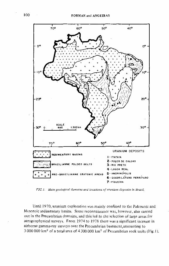
100 FORMAN and ANGEÏRAS
U RANI UM DEP OSI TSS E O t M E M T A R Y B A S I N S
) - I T A T A I A
2 - P O Ç O S D E C A L D A S
B R A Z I L I A N N E F O L D E D B E L T S 3 - R I O P R E T O
4 - L A G O A R E A L
P R E - B R A Z I L I A N N E C R A T O N I C A R E A S 5 ^ M O R I N O P O L I S
6 - Q U A D R I L A T E R O F E R R I F E R O
7- F I S U E I R A
F/C.7. yeo/oyica/ А??яя:л.! о/мгал/мм <п ßrcz;7.
Until 1970, uranium exploration was mainly confined to the Paleozoic and Mesozoic sedimentary basins. Some reconnaissance was, however, also carried out in the Precambrian domains, and this led to the selection o f large areas for aerogeophysical surveys. From 1974 to 1978 there was a significant increase in airborne gamma-ray surveys over the Precambrian basement,amounting to 3 000 000 kirP o f a total area o f 4 300 000 km^ o f Precambrian rock units (Fig. 1).
ÏAEA-AG-250/14 101
The promising results o f those surveys led to a shift in emphasis from the sedimentary basins to the Precambrian domains. Areas in a variety o f geological environments were delimited for detailed studies, including the deposits at Itataia in the north-eastern part o f the country. Here uranium is associated with phosphates in an unusual type o f mineralization.
Important, too, are the Lagoa Real deposits located in the south o f the State o f Bahia. Mineralization occurs in diatexites and metatexites with the development o f uraninite in shear zones associated with strong albitization. The mineralization has been attributed to fluids originating during a phase o f reactivation o f an ancient platform. Uraninite age is 820 m.y., while the country rocks are 2500 m.y. old. These deposits are in an advanced stage o f evaluation.
Although still at an initial stage o f drilling, the region o f Rio Preto in the Central Brazilian State o f Goiás is also a promising area. Nearly a hundred occurrences o f secondary mineralization are known in Lower Precambrian schists overlain by quartz-sandstone o f Middle Precambrian age. The geological setting favours an unconformity-type model and uraninite has been found in some drillholes at depths o f 60 metres. In the same State o f Goiás, small uranium deposits occur in Devonian arkoses at the northern border o f the Gondwana Paraná Basin. Mineralization is Cretaceous in age and related to roll-front processes. Although the known deposits have been evaluated, there is continuing regional exploration for additional similar occurrences.
The rapid progress made after 1975 (when known reserves amounted to 11 040 t) in identification and exploration o f uraniferous districts can be attributed to a rational sequence o f stages, including:
fa ) The selection and verification o f potentially favourableareas following integrated studies based on all available information. Geological
thinking is fundamental at this stage.anaf This follows as a result o f the preliminary
studies. Specific programmes are established in favourable areas based on traditional prospecting methods. During this stage, preliminary viability studies, including the calculation o f reserves, are also carried out.
For the philosophy o f evaluation, all prospects are evaluated irrespective o f the degree o f mineralization but taking into account their potential, so that expenditure does not exceed what may be found.
The estimation o f reserves is based not only on conventional techniques (blocks, isolines, parallel sections, etc.), but also on statistical and geostatistical methods such as krigeage and co-krigeage, using available programmes developed by Nuclebrás personnel. The use o f these various techniques, both consecutively and simultaneously, permits a high degree o f precision in the evaluation.
The concept o f гедеггел and ;'йй?;'ся?еб? гелегуед (reasonably assured),and щ/еггеб? гелегуел (estimated additional) is based on a series o f criteria. These include the estimation methods used, the regularity o f the sampling grid, the grid
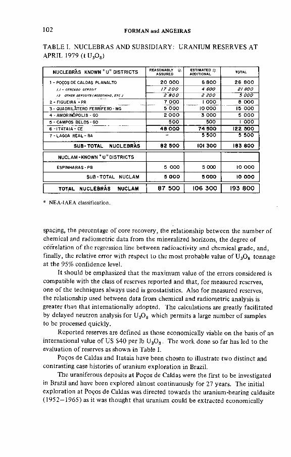
1 0 2 FORMAN and ANGEIRAS
TABLE I. NUCLEBRAS AND SUBSIDIARY: URANIUM RESERVES A T
APR IL 1979 (t UgOs)
NUCLEBRÁS KNOWN "u " DISTRICTS REASONABLY # AS SU R ED
ESTIMATEDADDITIONAL TOTAL
1 - P O Ç O S D E C A L D A S P L A N A L T O 20 ООО 6 800 26 800/ 7 F C C 4 есс F / F C C
F F C C F F C C Д C C C
2 - F I G U E I R A - P R 7 ООО 1 ООО 8 ООО3 - Q U A D R I L Á T E R O F E R R Í F E R O - M G 5 ООО 10 000 15 ООО4 - A M O R I N Ó P O L I S - G O 2 ООО 3 ООО 5 ООО5 - C A M P O S B E L O S - G O 500 500 1 ООО6 - I T A T A I A - C E 4 8 ООО 7 4 5 0 0 ¡2 2 5 0 07 - L A G O A R E A L - B A - 5 500 5 500
SUB-TOTAL NUCLEBRAS 8 2 5 0 0 )0) 3 0 0 )8 3 8 0 0
NUCLAM - KNOWN " U " DISTRICTS
E S P I N H A R A S - P B 5 ООО 5 ООО to ООО
SU B -TO TA L NUCLAM 5 ООО 5 0 0 0 Ю ООО
TOTAL NUCLEBRAS NUCLAM 8 7 5 0 0 )0 6 3 0 0 )9 3 8 0 0
* NEA-IAEA classification.
spacing, the percentage o f core recovery, the relationship between the number o f chemical and radiometric data from the mineralized horizons, the degree o f correlation o f the regression line between radioactivity and chemical grade, and, finally, the relative error with respect to the most probable value o f U^Og tonnage at the 95% confidence level.
It should be emphasized that the maximum value o f the errors considered is compatible with the class o f reserves reported and that, for measured reserves, one o f the techniques always used is geostatistics. Also for measured reserves, the relationship used between data from chemical and radiometric analysis is greater than that internationally adopted. The calculations are greatly facilitated by delayed neutron analysis for U^Og which permits a large number o f samples to be processed quickly.
Reported reserves are defined as those economically viable on the basis o f an international value o f US $40 per lb ^ O g . The work done so far has led to the evaluation o f reserves as shown in Table I.
Poços de Caldas and Itataia have been chosen to illustrate two distinct and contrasting case histories o f uranium exploration in Brazil.
The uraniferous deposits at Poços de Caldas were the first to be investigated in Brazil and have been explored almost continuously for 27 years. The initial exploration at Poços de Caldas was directed towards the uranium-bearing caldasite (1952—1965) as it was thought that uranium could be extracted economically
ÏAEA AG 250/14 103
from refractory ores. However, just as interest was beginning to decline after persevering and careful investigation o f more than 150 anomalies throughout the alkaline complex, the Agostinho mineralization was discovered in 1965, and this greatly enhanced the economic prospects o f the area. This important event caused a shift in emphasis from attempts to extract uranium from zirconium ores
to prospects with the following characteristics:
High U/Zr ratios;Presence o f hydrothermal potassic alteration;Contact between foyaite and tinguaite; and
Regions o f tectonic reactivation
The Cercado Mine was discovered partly because these factors were taken into account, but principally owing to extensive drilling on a closed grid which was facilitated by the availability o f funds for this purpose from 1970 onwards.
Drilling was o f particular significance owing to the paucity o f outcrops and the presence o f a thick weathered cover. Next to drilling, ground radiometry and rock chemistry contributed most to the discovery o f the Cercado Mine. Electroresistivity and seismic refraction were found most useful for the definition and delimitation o f the structural framework o f these deposits.
in contrast to Poços de Caldas, the itataia deposit has only been discovered and explored since mid-1976.
All known uranium occurrences in NE Brazil were identified by geological and radiometric surveys following an integrated study o f all available information. The ground surveys led to the discovery o f ore-grade deposits at Itataia, where exploration and evaluation followed a logical and usual sequence o f investigation. This was facilitated by good outcrops and an absence o f significant chemical weathering. The mineralized bodies appear on the surface and their unusual characteristics contrast with the country rocks. Consequently, geological and radiometric maps at once delimited the surface extension o f the ore bodies (0.25 km^).
Part IIPOÇOS DE CALDAS CASE HISTORY
1. LOCATION AND GENERAL GEOLOGY
The alkaline complex o f Poços de Caldas is located about 400 km west o f Rio de Janeiro in the southern part o f the State o f Minas Gerais, adjacent to the boundary with the State o f Sao Paulo. It has a favoured location near the most important industrial centres o f the country. The climate consists o f a rainy season from October to March followed by a dry season from March to September.
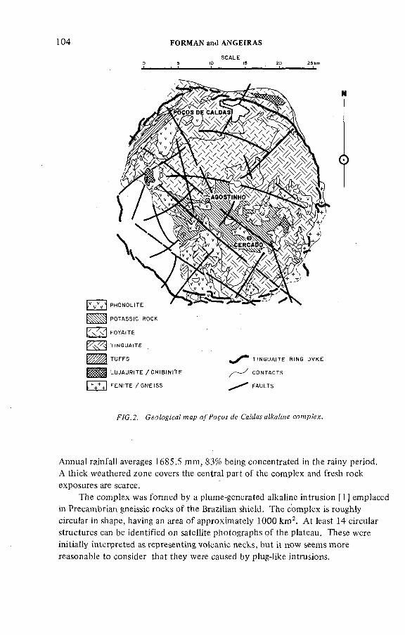
104 FORMAN and ANGEÍRAS
S C A L E
P H O N O L I T E
P O T A S S I C R O C K
F O Y A I T E
T I N G U A I T E
T U F F S
L U J A U R I T E / C H I B I N I T E
F E N I T E / G N E I S S
T I N G U A I T E R IN G D Y K E
C O N T A C T S
F A U L T S
F/C.2. Ceo/o^i'ca/ мар Je CaMaí a^aKne comp/ex.
Annual rainfall averages 1685.5 mm, 83% being concentrated in the rainy period.A thick weathered zone covers the central part o f the complex and fresh rock exposures are scarce.
The complex was formed by a plume-generated alkaline intrusion [ 1 ] emplaced in Precambrian gneissic rocks o f the Brazilian shield. The complex is roughly circular in shape, having an area o f approximately 1000 km^. A t least 14 circular structures can be identified on satellite photographs o f the plateau. These were initially interpreted as representing volcanic necks, but it now seems more reasonable to consider that they were caused by plug-like intrusions.
ÏAEA-AG-250/14 105
The Poços de Caldas complex is very interesting on account o f the wide range o f rocks present, which include coarse-grained igneous rocks, volcanics and sediments. The most common rock types belong to the nepheline-syenite family and, in order o f decreasing abundance, these are tinguaite, phonolite, nepheline syenite, foyaite, lujaurite and chibinite [2—4]. Some o f the extrusive rocks found include tuffs, ash, volcanic breccias and welded tuffs (Fig.2).
In the central part o f the structure occur very altered rocks in which potassium has been introduced by 'hydrothermal' activity. The original rocks were tinguaite and phonolite. The best outcrops o f lujaurite and chibinite are found in the north, while some Mesozoic sediments occur in the north-east. To the south-east the granitic and gneissic rocks o f the basement show intense fenitization. Outcrops on the Planalto o f Poços de Caldas are scarce, and weathering has produced a deep and extensive soil cover up to 20 m thick. The details o f the geological relationships are therefore best observed in underground workings, the Cercado Mine and the Agostinho deposit.
1.1. Tectonics
The regional and local tectonics o f the complex has greatly influenced the development o f the structure as well as the mineralization. The complex is cut by two roughly perpendicular fault systems: N60W and N40E. These faults follow the main regional trends and were reactivated at the time o f the initial intrusion. The regional fault trend can be observed in the mine in addition to a localized fault system trending N10E to N25E [5].
1.2. Evolution o f the complex
The geological evolution o f the complex was described in 1959 [6]. Recently, a different model in six simplified stages was proposed [ 1], here reduced to five and somewhat modified (Fig.3).
The first stage involved the injection o f an alkaline plug into Precambrian gneisses o f the basement complex forming a roughly circular structure. The domed rocks were fractured upon uplift and as the intrusion cooled it shrank and collapsed, forming a caldera. The second stage involved the renewal o f magmatic activity which may in part have been related to the shrinking and collapse o f the phonolite/tinguaite plug at the end o f the first stage. Tinguaite was injected between the host rock and the plug.
During the third stage o f the development o f the complex there was further collapse o f the phonolite/tinguaite plug and erosion to form a crater-like depression with tinguaite ring dykes surrounding the plug. The fourth stage was characterized by a second phase o f alkaline intrusion forming shallow emplacements o f lujaurite, chibinite and foyaite within the phonolite/tinguaite plug. The Cercado area was
106 FORMAN and ANGEIRAS
STAGE 1FORMATtON OF DOME
STAGE )CONTRACTtON OF <NTRUStON DURtNG C00U N 6 COLLAPSE
OF DOME
STAGE 2
)NTRUS)ON OF TtNGUAtTE R!N6 DYKES-UPUFT OF DOME
STAGE 3
EROStON OF DOME
MINORSU BA ER tA LVOLCANISM
PRI MA RY MINERALIZATION
TUFFICITIC BRECCIAS PRIMARY O RES
-T IN G U A IT E
B A S E M E N T
LUJAURITEC m a t N I T E
B A S E M E N T B A S E M E N T
STAGE 4 UPLtFT CERCADO AREA
TUFFtCmC BRECCtATION
STAGE 5PRESENT StTUATION
F/C. J . o/Popoí cfe СаМм cowp^x.
ÍAEA-AG-250/14 107
uplifted and tabular bodies o f tufficitic breccia were formed by the movement o f gases along penecontemporaneous fractures. Primary mineralization accompanied this thermal event and concentrated in the breccias. Some small-scale subaerial volcanism (ankaratritic lavas, tuffs and pyroclastics) occurred in the north-western part o f the Planalto.
In the final stage o f development, the Planalto was eroded and there was a redistribution o f the primary uranium mineralization and the formation o f secondary ores. Economic deposits o f bauxite formed as the result o f weathering o f the alkaline rocks.
It is suggested that the chemical evolution o f the syenitic rocks had evolved from miaskitic into strongly agpaitic characters [7]. Whole-rock К /Ar determinations carried out on the alkaline rocks have shown ages between 80 m.y. and 62 m.y. [8]. On the other hand, XU-Pb determinations performed in zircon from 11 samples o f caldasite veins have indicated an average age o f 98 m.y. [9].
2. EXPLORATION AND DEVELOPMENT
2.1. Historical background
Economic interest in the Planalto de Poços de Caldas was engendered by the works o f O.A. Derby in 1887 [10], von Sachsen Coburg in 1889, and Hussak in 1899 [11], who referred to the presence o f zirconium-bearing minerals. In September 1948, the presence o f radioactive elements in zirconium-bearing minerals was determined from fogging on photographic plates [12]. Samples studied in the Laboratorio da Produçâo Mineral showed that the radioactivity was due to uranium ( < 1% U^Og).
In 1952 in Washington, DC, White and Tolbert o f the USGS carried out radiometric determination on samples o f rocks from various sites, verifying that the samples containing zirconium-bearing minerals from Poços de Caldas were radioactive. Some o f these contained as much as 3%UgOg [13]. The radioactive material occurs in rocks known as сяИя,м7е which are a mixture o f zirconium oxide (baddeleyite) and zirconium silicate (zircon). Caldasite, first named in 1887 [ 10], was originally found in veins; it is a massive, grey-coloured and very heavy rock. In August 1952, White informed the Brazilian Conselho Nacional de Pesquisas o f the presence o f uranium in caldasite. Later, in October 1952, uranium exploration at Poços de Caldas began.
The history o f uranium exploration in Brazil with specific reference to Poços de Caldas can be divided into five clearly defined periods.
FORMAN and ANGEIRAS
At this time very little was known about the complex, although it has been established that uranium was associated with the caldasites. So, one o f the objectives was to estimate the reserves o f caldasite, and one o f the first steps was to make a survey o f all the prospects o f this rock in an area o f 440 km^ centred on Poços de Caldas. However, no metallogenetic hypothesis or model had been considered at this early stage o f exploration.
Effective exploration commenced in 1953 when the Departamento Nacional de Produçâo Mineral (DNPM) contracted Levantamento Aerofotogramétricos SA (L A S A ) to make an airborne survey o f an area o f 1330 km^. A scintillometer type EA189 made by Electronic Associates and a Fluxgate magnetometer (Model II ) made by Gulf Research and Development Corp. were mounted in a Douglas DC-3 aircraft. About 5300 line km were flown in a north-south direction at an altitude o f 150 m (line spacing was 250 m). This work revealed the presence o f 44 major radioactive anomalies and many other smaller ones. O f the 44 anomalies, 38 were considered to be important, most o f which coincided with the caldasite prospects. During this period, the exploration programme included regional mapping at a scale o f 1:50 000 over an area o f 1000 km^, some drilling (1600 m ) and the opening o f galleries.
Deposits o f thorium and rare earths had been discovered at Morro do Ferro. These were described in 1957 [14], and details o f the work carried out around the
38 prospects o f uraniferous caldasite were reported in 1966 [15]. The aspects o f the zirconium mineralization were studied in 1967 [7]. The prospects at Campo do Cercado and at Taquari were considered to be the most promising.
By the end o f this period, 50 000 to 250 000 tonnes o f caldasite concentrates had been estimated, containing approximately 60% to 85% Zr02 and an average o f 0.5% U^Og. The reserves ranged from 250 to 1250 tonnes o f U^Og.
The 'French period' o f technical co-operation marked the start o f systematic exploration at Poços de Caldas. This had as its objectives (a) the study o f the economic possibilities o f mining caldasite and extraction o f the uranium and(b ) exploration for other types o f uranium mineralization with specific reference to reserves and ease o f extraction. To achieve this, a permanent technical staff was installed to execute various types o f detailed studies. The exploration during this period was based very largely on a reinterpretation o f the geophysical survey o f 1953. Complementary field studies included the following four programmes.'
(1 ) A survey o f the old workings and prospects o f caldasite which were determined to contain uranium on the basis o f the airborne survey. Prospects with high Th/U ratios were excluded from this study. As a result, over 30 o f the old caldasite
!AEA -A G -250/!4 109
workings and prospects were examined systematically and mapped on various scales (1:10 000; 1:1000; 1:50 or 1:20). The purpose o f the programme was to study their occurrences in detail with emphasis on the topography, radiometry, petrology and mineralogy.
(2 ) 5улГеуиа^'с рголресГ/оп.' For exploration purposes the Planalto de Poços de Caldas was divided into a north, a central and a southern zone; these zones were then subdivided into sectors, each with an area o f about 20 km^. The sectors were numbered according to their chronological order o f study and were designated by the initial o f the zone where they were situated. For example, C-09 was the ninth sector to be examined in the central zone o f the Planalto.
A survey was carried out in a selected area o f about 400 krrp in the central zone, the most mineralized o f the three. The geology, with particular attention to structure, was mapped on a scale o f 1:10 000 over an area o f 363 krrP, and a radiometric map o f an area o f 389 krrP was prepared on the same scale and on a grid o f 75 X 200 m. Enlarged aerial photographs were used as base maps. One hundred and sixty-six anomalies were found, some o f which were grouped into constellations. These were later investigated.
(3 ) Defa;7ec? a d o rn e raû?;'ofne?ry.' By way o f concluding the general study o f the alkaline intrusive o f Poços de Caldas, a radiometric survey was flown over the northern and southern zones. A SPA-2 scintillometer was mounted in a Bell-300 helicopter and 682 km o f radiometric profiles were made on a500 X 250 m grid covering about 340 km. More than 40 anomalies in 13 constellations were found. Two o f them were found in the northern zone and 11 in the south, but all o f them were situated adjacent to the central zone. Most o f these anomalies were found in the alteration zones o f gneiss and fenite adjacent to the contact with syenitic rocks.
One o f the main objectives o f these surveys was a general understanding o f the geology and radiogeology o f the complex. Considerable difficulties were caused by the variety o f instruments used and the types o f measurements made. Pollution from the old caldasite workings complicated matters further.
As a result o f combined geological and radiometric investigation, the following conclusions were established (Fig.4):
(a) The rocks o f the Planalto o f Poços de Caldas have regional background values o f about 40 mR, and, in function o f this, areas having radiometric values greater than three times the.regional background were considered to be anomalous and were selected for further study.
(b ) The anomalies having the most uniform radiometric values were found to occur in areas underlain by fine-grained tinguaite near the contact with foyaite bodies.
(c ) Most o f the anomalies with values exceeding five times the regional background could be attributed to veins o f caldasite at the site o f old workings
110 FORMAN and ANGEÍRAS
20 29hm— L
О
T I N 5 U A I T E R I N G D Y K E
F A U L T .
R A D I O M E T R I C S C A L Et.8 2.3 3.3 BG
F/C.4. ^adiowefric щар o//*OfOí de CaMaí aZAraZme co^pZex.
and prospects and to concentrations in alluvial deposits. The strong anomalies at Morro do Ferro differ from the others o f this type inasmuch as they are due to concentrations o f thorium and rare earths present in magnetite dykes.
(d ) Another group o f anomalies with values 3 to 4 times the regional background are most common in areas underlain by very altered potassium-rich rocks which are often overlain by argillaceous soils up to 20 m thick. Good examples o f this are the anomalies which later developed into the Cercado Mine and Agostinho deposit. However, in many cases some o f these anomalies were attributed to superficial pollution, including tailings from the old workings.
1AEA-AG 250/14 H I
(e ) In addition to the above types, other anomalies o f different radiometric values and geological contexts were found. Such anomalies were characteristic o f areas underlain by volcanic tuffs with surface mineralization and occurrences o f lujaurite and chibinite-containing eudialyte. In the extreme south-east o f the Planalto, some anomalies were attributed to radioactive feldspathic veins.
(4 ) Defa;7ed eva/ыяП'оя a/reaJy ле/ecfed рголресй ял ßngidas,/1^ол?;'и/:ол, /ndfc;'o 70, Га^мап and 7м/о&' These prospects were chosen for their different geological and radiometric characteristics. The object was to look for mineralization types other than the caldasite.
The conclusions were as follows [16]:
(a ) The classical deposits o f caldasite, such as those occurring at Brigidas, were unlikely to be o f economic value, from considerations both o f reserves and o f the physical and chemical properties o f the ore.
(b ) The deposits at Agostinho appeared to be more interesting on account o f the high (5 times higher than usual) U/Zr ratios as exposed on the surface.Two linear structures were identified, extending to the north and south o f the main propsect for a distance o f 300 to 400 m [17]. Amorphous uranium, associated with pyrite, fluorite, tiny veins o f molybdenite and accessory microcrystalline caldasite, was found after drilling on the northern structure where oxidized rocks disappeared into a highly fractured zone. The occurrence was quite unexpected [16].
(c ) At Tufos another type o f mineralization was found, composed o f micro- crystalline caldasite associated with colloidal uranium dispersed in clays formed by weathering o f the tuffs. When surface studies were carried out at Taquari and Indicio 70, nothing o f interest was found. A t the same time, importance was being given to the Agostinho deposit.
A geological map o f the entire complex constituted part o f a final synthesis o f the four programmes carried out during the period. This included a survey o f the old caldasite workings, detailed geology, rock chemistry and radiometry. It was then possible for the first time to have a preliminary understanding o f the general relationships between the tectonic elements and the rock types with the mineralization. This allowed criteria to be established which led eventually to the discovery o f the economic deposits. These criteria included the U/Zr ratios, the distribution o f 'potassic' rocks and their confinement to a central reactivated zone.
An anomaly, designated Mancha A —C -09, was discovered in 1963 during a ground radiometric survey. This anomaly was considered to be o f minor importance compared to the others at the time o f discovery. However, it was investigated in detail in 1971 and became part o f the Cercado Mine.
1 1 2 FORMAN and ANGEÏRAS
During this period, preliminary evaluation o f the reserves was carried out at the Agostinho prospect, including the sinking o f shaft (42 m) and the opening o f galleries and cross-cuts (350 m), which followed the highly fractured breccias o f tinguaite filled with pyrite, fluorite, jordisite, zirconium-bearing minerals and iron and manganese oxides. Uranium occurs as amorphous oxides and is also associated with the zirconium-bearing minerals. This constituted the first detailed evaluation o f the reserves o f soluble uranium-molybdenum ore at Poços de Caldas [18]. The 166 anomalies found during the systematic prospecting carried out in the course o f the 'French period' in the central zone were investigated for their economic potential.
Although a number o f prospects similar to Agostinho were studied and in some cases even drilled, only the Agostinho deposit was considered to be o f economic interest at the completion o f these studies and was until 1970 the only uranium working in which galleries had been opened.
7 9 6 6 -7 9 7 0
7P77-7974
During this period exploration became more specific; the underground development at Agostinho, where beneficiation tests were performed on ore
samples, was accelerated. Reserve calculations amounted to 3200 tonnes o f U3O8 o f which 1100 tonnes were measured while the remaining 2100 tonnes were estimated. However, technical and economic viability studies concluded that the deposit was uneconomic in terms o f the market value o f uranium at the time o f this evaluation.
In 1971 the Mancha A —C—09 anomaly was drilled for the first time. A drillhole penetrating a tinguaite breccia 52 m below the surface at Campo do Cercado was found to contain coffinite and pitchblende in very small quantities. However, this was the first time distinct uranium minerals had been found in the rocks o f this alkaline complex [19]. Following the initial discovery, a number o f uranium- associated minerals were found, e.g. uranium associated with molybdenum; pitchblende and coffinite associated with a carbonaceous pyritic substance. Zirconium-bearing minerals were also found. In addition, the rocks from this area were determined to have higher U/Zr ratios than any others from the Planalto.
The geometry and characteristics o f this body were not recognized immediately owing to difficulties in determining its shape and extension. Although the geometry and trends o f the body were not known, it was thought at the time to be similar to the subvertical and faulted tinguaite breccia at Agostinho. The higher U/Zr ratio suggested that the uranium was not related to the zirconium
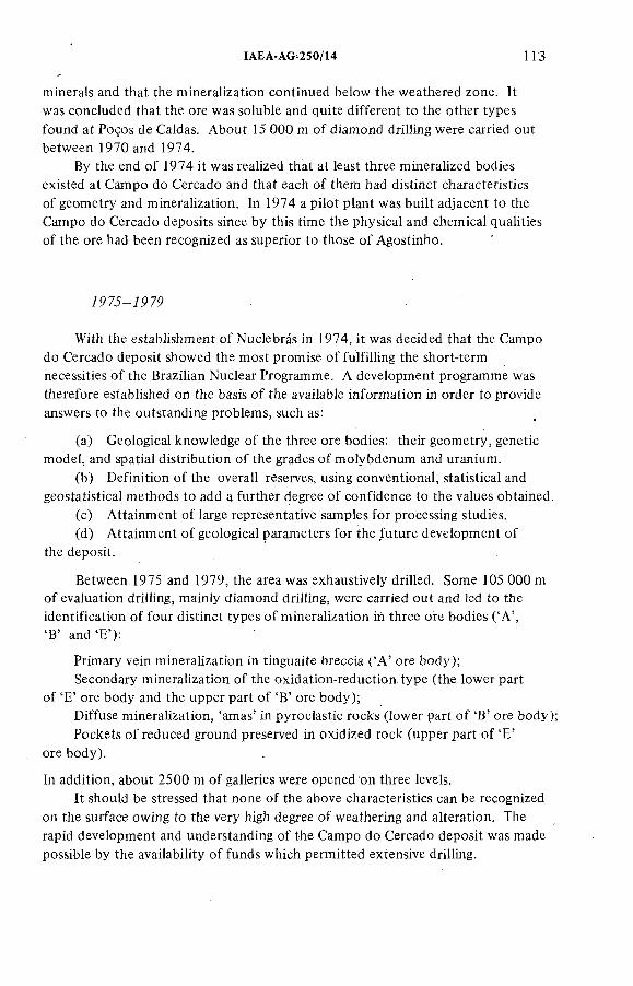
1AEA-AG 250/14 113
minerals and that the mineralization continued below the weathered zone. It was concluded that the ore was soluble and quite different to the other types
found at Poços de Caldas. About 15 000 m o f diamond drilling were carried out between 1970 and 1974.
By the end o f 1974 it was realized that at least three mineralized bodies existed at Campo do Cercado and that each o f them had distinct characteristics o f geometry and mineralization. In 1974 a pilot plant was built adjacent to the Campo do Cercado deposits since by this time the physical and chemical qualities o f the ore had been recognized as superior to those o f Agostinho.
7973-7979
With the establishment o f Nuclebrás in 1974, it was decided that the Campo do Cercado deposit showed the most promise o f fulfilling the short-term necessities o f the Brazilian Nuclear Programme. A development programme was therefore established on the basis o f the available information in order to provide answers to the outstanding problems, such as:
(a) Geological knowledge o f the three ore bodies: their geometry, genetic model, and spatial distribution o f the grades o f molybdenum and uranium.
(b ) Definition o f the overall reserves, using conventional, statistical and geostatistica! methods to add a further degree o f confidence to the values obtained.
(c ) Attainment o f large representative samples for processing studies.(d ) Attainment o f geological parameters for the future development o f
the deposit.
Between 1975 and 1979, the area was exhaustively drilled. Some 105 000 m o f evaluation drilling, mainly diamond drilling, were carried out and led to the identification o f four distinct types o f mineralization in three ore bodies ('A ','B ' and 'E '):
Primary vein mineralization in tinguaite breccia ( 'A ' ore body);Secondary mineralization o f the oxidation-reduction type (the lower part
o f 'E ' ore body and the upper part o f 'B' ore body);Diffuse mineralization, 'amas' in pyroclastic rocks (lower part o f B' ore body);Pockets o f reduced ground preserved in oxidized rock (upper part o f 'E'
ore body).
In addition, about 2500 m o f galleries were opened on three levels.It should be stressed that none o f the above characteristics can be recognized
on the surface owing to the very high degree o f weathering and alteration. The rapid development and understanding o f the Campo do Cercado deposit was made possible by the availability o f funds which permitted extensive drilling.
114 FORMAN and ANGEIRAS
TABLE II. CAMPO DO CERCADO MINE: CORE ASSAY VERSUS RADIOM ETRY
INTERVAL (m) COFE ASSAY (изОа%) RADIOMETRY (cps)
0 1.00 0.455 175
1.00 - 2.00 0.455 236
5.00 - 6.00 0.091 . 515
6.00 - 7.00 0.103 487
7.00 - 8.00 0.107 387
42.00 - 43.00 0.122 1 860
43.00 - 44.00 0.150 1 162
44.00 - 45.00 0.195 2 284
45.00 - 46.00 0.210 2 538
3. SAMPLING AND A N A L Y T IC A L PROCEDURES
Only the mineralized horizons o f the drill cores were sampled and the selection was made on the basis o f the radioactivity in excess o f 1500 cps (SRAT/SPP-2).The radioactivity was initially used as a mineralization indicator, in the primary ores the correlation between the radiometry and the chemical values was found to be fairly consistent. However, in the secondary ore zones o f the upper part o f 'E ' ore body, the correlation was found to be poor owing to positive disequilibrium conditions. Here only chemical values were found to be representative. This condition was not recognized at first, and after 1975 it was necessary to resample and analyse according to statistical procedures [20] (Table II).
4. AD D ITIO NAL METHODS
4.1. Geochemistry
A total o f 4335 geochemical samples o f water, soil and stream from different parts o f the Planalto were collected for geochemical analysis. However, owing to the pollution caused by the tailings from old workings and prospects, this technique was abandoned. Radon emanometry (Track-Etch) was also used but with little success.
!AEA-AG-250/14 115
Some 10 390 resistivity measurements were made, principally in the areas o f Brígidas and Agostinho. This technique proved useful in identifying veins and fault zones. Resistivity and seismic refraction survey contributed considerably to determining the structural characteristics o f the Cercado Mine.
5. GEOLOGY OF THE CERCADO MINE
The Cercado Mine is divided into three ore bodies which lie on the border o f a secondary crater inside the great cauldron [5]. The ore bodies were described initially by A.G. de Oliveira, M.O. Fraenkel o f Nuclebrás.and later by J.E. Tilsley[1] and J.C. Biondi [21] (see Fig.5 and Table III).
5.1. 'A 'o re body
This body (0.4 km^) consists o f tinguaite and phonolite cut by vertical or steeply inclined dykes o f tufficitic breccias. These rocks are dark in colour and composed o f fragments o f tinguaite surrounding by a fine-grained matrix o f tiny rock particles. Primary mineralization associated with these breccias includes uranium, molybdenum and pyrite. In the north-eastern part o f 'A ' ore body, the mineralization is secondary, being associated with a redox front from leaching o f the breccias. The characteristics o f this mineralization are identical to those o f 'E' ore body.
The country rocks are sometimes mineralized near the contact with highly mineralized breccias. This process is often facilitated by intense fracturing, causing a local increase in the porosity.
'A ' ore body contains about 20% o f the total reserves o f the Cercado Mine. Average grades are 0.21% U 3 O 3 and 0.95% M0O 3.
5.2. E' ore body
This body (0.4 km^) occurs in highly altered and fractured tinguaite and phonolite. It is thought to be faulted against 'B' ore body which lies to the
south-east.A ll o f the mineralization in this ore body is secondary and is very variable
in character within the same rock type. Three types o f mineralization have been recognized. The first occurs in the higher levels to a depth o f approximately 120 m but is concentrated in the upper 10 m. The uranium is found in limonite, by which it was probably adsorbed. The second and third types are more important and occur in an interval subtended between the oxidation front above and by the weathered zone below.
4.2. Ground geophysics
116 FORMAN and ANGEtRAS
CIRCULAR STRUCTURE
E Ä S 3 BRECCIAS ^ E%%%%¡AMAS [ ^ - ^ j pYROCLASTIC ROCKS
EI^HpHONOLITE^ — — FAULTS NOOULES
F7C.J. ЗсйетаГм со?ярояГе с/-ом- есУ:'о/! o/ Cercado depojí'f í/rofn [5]/
TABLE IH. POÇOS DE CALDAS PLA N A LTO RESERVES (tonnes)
DEPOSITSREASONABLYASSURED
ESTIMATEDADDITIONAL
TOTAL
CERCADO MINE 17 200 4 600 21 800 '
ЧзОа ADDITIONAL AREAS 2 800 2 200 5 000
TOTAL POÇOS CE CALDAS 20 000 6 800 26 800
DEPOSITSMEASURED AND
INDICATEDINFERRED TOTAL
МоОз CERCADO MINE NA * 25 000 25 000 ^
ZrOz CERCADO MINE NA 172 400 172 400 3
* Not announced. ' Grade 0.0847%. 3 Grade 0 .П %. Grade 0.81%.
The intense fracturing striking north-east is a factor which contributed greatly to the concentration o f the uranium mineralization as black nodules. The remobilization resulted in the formation o f secondary mineralization at the intersection o f perpendicular fault sets.
. The ore bodies associated with the redox front are variable in shape (beds, apophyses and prisms), and their distribution was controlled either by the migration
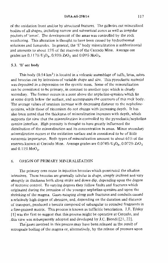
IAEA-AG-250/14 117
o f the oxidation front and/or by structural features. The galleries cut mineralized bodies o f all shapes, including narrow and subvertical zones as well as irregular pockets o f 'amas'. The development o f the amas was controlled by the rock weathering. This alteration is thought to have been caused by hydrothermal solutions and fumaroles. In general, the 'E ' body mineralization is subhorizontal and amounts to about 15% o f the reserves o f the Cercado Mine. Average ore
grades are 0.117% U^Og, 0.93% ZrO^ and 0.09% M0O 3.
5.3. 'B' ore body
This body (0.54 km^) is located in a volcanic assemblage o f tuffs, lavas, ashes and breccias cut by intrusives o f variable shape and size. This pyroclastic material was deposited in a depression on the syenite mass. Some o f the mineralization can be considered to be primary, in contrast to another type which is clearly secondary. The former occurs in a zone above the nepheline-syenites which lie at some depth below the surface, and accompanies the contours o f this rock body. The average values o f uranium increase with decreasing distancé to the nepheline- syenites, while those o f zirconium do not change with increasing depth. It has also been noted that the thickness o f mineralization increases with depth, which supports the view that the mineralization is controlled by the pyroclastic/nepheline syenite interface. High porosity is thought to have greatly influenced the distribution o f the mineralization and its concentration in amas. Minor secondary mineralization occurs at the oxidation surface and is considered to be o f little economic importance. Both types o f mineralization amount to about 65% o f the reserves known at Cercado Mine. Average grades are 0.074% U^Og, 0.072% ZrO^
and 0.11% M0O 3.
6. ORIG IN OF PR IM AR Y M IN E R ALIZATIO N
The primary ores occur in injection breccias which penetrated the alkaline intrusives. These breccias are generally tabular in shape, steeply inclined and vary abruptly in thickness both along strike and down dip, depending upon the degree o f tectonic control. To varying degrees they follow faults and fractures which originated during the intrusion o f the younger nepheline-syenites and upon the shrinking o f the magma. Gases escaping along such fractures and conduits caused a relatively high degree o f abrasion, and, depending on the duration and distance o f transport, produced a breccia composed o f subangular to rounded fragments in a fine-grained matrix. This process is known as tufficitic brecciation. J.E. Tilsley [ 1 ] was the first to suggest that this process might be operative at Cercado, and this view was subsequently adopted and developed by J.C. Biondi [21, 22].
The gases involved in this process may have been released as the result o f retrograde boiling o f the magma or, alternatively, by the release o f pressure upon
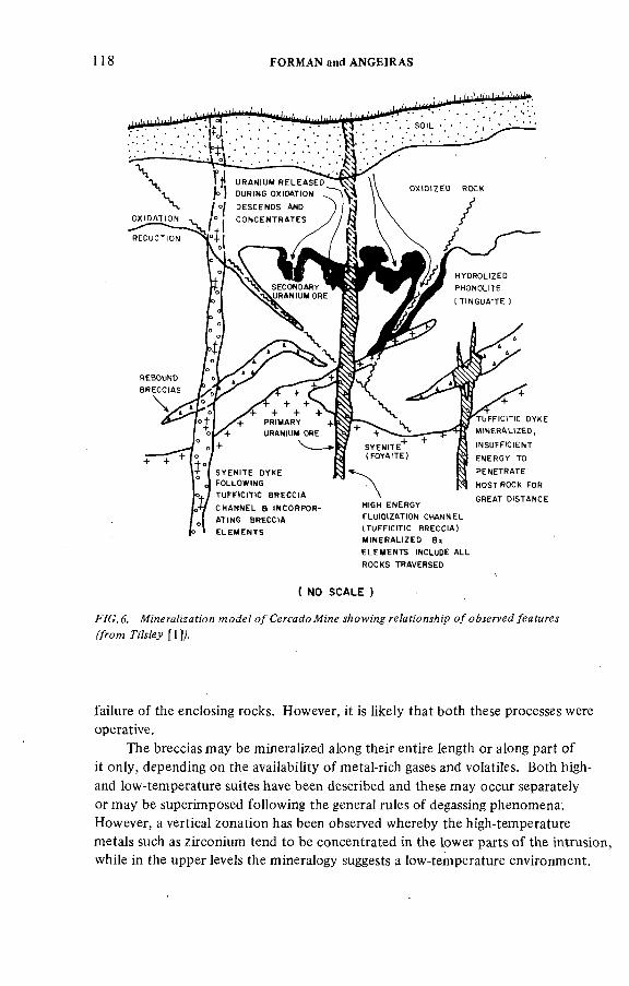
118 FORMAN and ANGEIRAS
S Y E N ! T E DY KE I FOLLOWING
T U F f t C m C B R E C O A
C H A N N EL a tN C O RP O R-
A U N C B R E C O A
E L E M E N T S
ШСН E N E R G Y
FLUtOtZ AHO N CHANNEL
( T U F F ) C ! H C B R E C C ' A )
M t N E R A L t Z E D B x
E L E M E N T S INCLUDE ALL
R O C K S T R A V E R S E D
T U F F t C m C DYKE
M t N E R A H Z E D ,
<NSUFFt C(ENT
E N E R G Y TO
P E N E T R A T E
H O ST ROCK FOR
G REA T D tS T A N C E
( NO SCALE )
.F/C.d. №'негяй2я?;'ол о/ ге/яи'<9н.уй;р o/77/л/еу [1]/
failure o f the enclosing rocks. However, it is likely that both these processes were operative.
The breccias may be mineralized along their entire length or along part o f it only, depending on the availability o f metal-rich gases and volatiles. Both high-
and low-temperature suites have been described and these may occur separately or may be superimposed following the general rules o f degassing phenomena. However, a vertical zonation has been observed whereby the high-temperature metals such as zirconium tend to be concentrated in the lower parts o f the intrusion, while in the upper levels the mineralogy suggests a low-temperature environment.
ÏAEA-AG-250/M 119
The superimposed mineral suites may represent multiple degassing events. The minerals found in these tufficitic breccias include zircon, baddeleyite, pitchblende, coffinite, pyrite, sphalerite, galena and fluorite. Thorium is also present but its mineralogy has not been defined.
7. FORM ATION OF SECONDARY ORE M INERALS
The secondary uranium ores o f the Planalto de Poços de Caldas are directly related to the weathering process. During weathering,the primary mineralization contained in the tufficitic breccias is released during oxidation and carried downwards by ground-water. When this uranium-rich water enters a reducing environment, the contained metal is precipitated as black nodules, pitchblende and pyrite. The sequence o f formation o f secondary ores has been summarized [ 1 ] with reference to Fig.6 as follows:
1. Hydrolization (complete or partial) o f the tinguaite;2. Development o f an oxidation/reduction front at a level below surface
where the chemical oxygen demand removes all free oxygen from descending ground-water;
3. Dissolution o f uranium at the oxidation front as the front advances;4. Re-precipitation o f uranium in reducing condition ahead of, and usually
below, the oxidation front.
The oxidation/reduction front is generally tabular; horizontal irregularities are common and these generally have an amplitude o f 1 to 3 m. 'Tongues' o f oxidation may follow fractures or faults tens o f metres below the general position o f the front. In addition to the secondary uranium minerals, secondary minerals o f molybdenum are formed, including jordisite and ilsemanite.
Part III IT A T A IA CASE HISTORY
1. LOCATION AND REG IO NAL GEOGRAPHY
The Itataia region is located about 170 km west o f Fortaleza, in the central part o f the State o f Ceará (NE Brazil). The climate there is semi-arid all year round. Irregular rainfall may occur from January to April and average rainfall is less than 500 m. Consequently, good and extensive fresh rock exposures are a common feature.
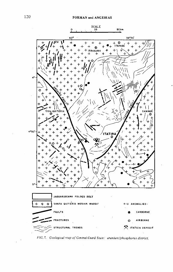
120 FORMAN and ANGEtRAS
SCALE О 25' < . ¡
50 km — L
39°30
4 °
4 °Э 0 '-
о +
t ^+ \+ ++ \ + , ,+
- r - f s t û . Q U I T E R
+ 0 . + +
-^ + + ++ + + - )^ '/
+ + + + V+ + + +
+ + yi- +
+ + *h/ "t*+ + + +
+ + / ++ ^ / + + - f^ ^ + + + + +
+ + + + + + +
+ + ' \ / + + + + \ + +
+ + * ^ + ^ - ^ + -ь + + + <+ +
+ + +
J A G U A R ! B E A N A F O L D E D B E L T
S A N T A Q U ! T E R ! A M E O t A N M A S S t F
F A U L T S
P - U A N O M A H E S :
C A R B O R N E
F R A C T U R E S
S T R U C T U R A L T R E N D S
o A i R B O R N E
^ I T A T A I A D E P O S I T
F/C. 7. Ceo/og:'ca/ /яар o / Cenfra/ Ceará ^fafe.' мгая/мм/рАоурАоял jMfn'cf.
ÏAEA-AG-250/Î4 1 2 !
ln 1965, Kegel divided the north-east o f Brazil into orogenic blocks [23] and thereby established a tectonic base which is followed to this day. Kegel's tectonic model was adapted and placed within a geochronological framework based on age determinations o f rocks from this part o f the country [24, 25].The two main tectonic elements pertinent to the Itataia deposit were described.These are the Santa Quitéria Massif to the north-west and the Jaguaribeana Fold Belt(F ig.7).
1.1. The Santa Quitéria Massif
This consists o f a highly deformed granitic crust in which two or more tectonic and magmatic cycles have been superimposed. These rocks have been
highly metamorphosed.. Sedimentary and volcanic rocks, and possibly basic rocks, have been subjected to a high degree o f migmatization in which the migma could be either allocthonous or autochthonous [26]. The evolution o f the protocontinental stage occurred 2.5 billion* years ago [27]. The primitive rocks were transformed almost completely, reactivated and homogenized by granitization o f the crust.This event may have occurred about 2.0 billion years ago, as calculated from relicts o f amphibolites in granites and migmatites, and was followed by isotopic reorganization 1.3 b.y. as well as 540 m.y. ago. This latest tectonic event occurred at the end o f the Brazilianne Cycle.
1.2. The Jaguaribeana Fold Belt
The rocks o f this tectonic domain were formed from sediments which were composed mainly o f carbonates, arkoses and sometimes marls. These sediments were deposited on a granitic basement. The rocks were metamorphosed to the grade o f the amphibolite facies. The carbonate rocks and the marls were metamorphosed to marbles and various types o f calcosilicate rocks whose varied mineralogy reflects the nature o f the original sediments.
The Jaguaribeana Fold Belt is delimited by two transcurrent faults known as the Rio Groairas and Itatira faults. The rock-units have been highly folded and faulted owing to the differential movements o f the stable blocks to the west and east. Antithetic faults with curved surfaces and with their concave faces directed southwards are clearly visible on ERTS images. These indicate a release o f tectonic compression and confirm the presence o f stable blocks to the west and east delimiting a central mobile zone.
The style o f folding has not yet been defined. It is very likely that two or more generations o f folds exist, but this will be confirmed only after a regional structural analysis. The principal phase o f folding and metamorphism occurred
' Here one billion = 10^.
1 2 2 FORMAN and ANGEIRAS
about 650 m.y. ago and was accompanied by localized crustal anatexis which gave rise to the formation o f granites at the time o f this tectonic cycle.
1.3. Granitic rocks
In regional terms, it was concluded [27, 28] that there were various phases o f magmatism and that these were related in time and space to the tectonic evolution as a whole. It appears that a high degree o f sialization occurred in the pre-orogenic phase since only a few relicts could be identified with certainty in the interior o f the older blocks (e.g. the Santa Quitéria Massif).
Katazonal granites were formed during the orogenic phase (650 m.y.). These are autochthonous and are located principally in the older stable blocks. Their pétrographie, structural and textural trends suggest an origin by anatexis related to the general mobilization o f the pre-Brazilianne Basement.
The late orogenic granites (550 m.y.) are poorly developed in Ceará [28]. However, post-orogenic granites (460-510 m .y.) are know to occur in the central north-western part o f the state. The preferential emplacement o f plutons in the Santa Quitéria Massif is noteworthy since bodies o f reduced size occur in the folded areas. The emplacement o f the post-orogenic granites was controlled by extensive regional faults, especially those formed at the time o f compressional release, in addition to those in the border zones between the different tectonic elements such as the Santa Quitéria Massif and the Jaguaribeana Fold Belt [27, 29]. These zones may have functioned as 'thermal channels' [30]. The post-orogenic magmatism originated by fusion o f the lower crust or by fractional crystallization o f a basic primary magma [28]. On the basis o f their chemical composition, these granites can be considered as leucocratic types with strong alkaline tendencies [31].
The post-orogenic granites are particularly interesting since they contain high values o f UgOg (an average o f 30 ppm). Similarly, the values o f P^Og (0.65% to1.3%) are high compared to those normally found in granitic rocks [27].
2. H ISTORICAL BACKGROUND
During the 1960s, systematic exploration and prospecting for radioactive minerals in NE Brazil were carried out almost exclusively in the Paleozoic sedimentary basins (Jatoba, Piaui-Maranhâo, etc.). In the early 1970s, some sporadic reconnaissance was undertaken in the Precambrian terrains o f the northeast. However, a systematic programme including drilling was carried out in the granitic province o f Seridó. The results were not particularly encouraging, either in the sediments or in the basement rocks.
Systematic investigation o f the Precambrian basement in the State o f Ceará began with a carborne radiometric survey in 1975. This survey covered an area
IAEA AG-250/14 123
o f 35 000 km^ in the north-central part o f that state. Although basic geological information was lacking, certain mineral occurrences were already known, including scheelite, columbite-tantalite, beryl, spodumene and ambligonite. Uranium minerals are found sporadically in the pegmatites o f the region. The results o f this survey included the discovery o f 273 anomalies during 11 167 km o f radio- geological traverses along roads and tracks. The equipment used included a portable scintillometer SRAT-SPP-2 mounted on a four-wheel-drive vehicle.
Twelve anomalous areas (Fig.7) were selected for further study on the basis o f common geological factors, geometry and chemical values. A ll twelve areas
had high values o f U^Og (1000 to 3000 ppm UgOg and 12% to 30% P ^ s ) , and were related either directly or indirectly to vuggy, quartz-poor, feldspathic rocks. The areal distribution o f this unusual rock type drew attention to the probable regional character o f the mineralizing event. No metallogenetic model had then been considered. The unusual rocks were called albite-syenites on the basis o f their mineral content, specifically the absence o f quartz. The mineralization was consequently related to alkaline rocks. This approach was later shown to be incorrect [27, 32].
One o f the anomalies discovered during this car-mounted survey was no more than a single boulder lying on a dry stream bed. The boulder was about 50 cm in diameter, reddish in colour, dense, massive, cryptocrystalline,and assaying 1500 ppm UjOg and 30% P ^ s . This was considered to be o f low priority in the schedule o f follow-up studies on account o f the form occurrence.
However, during a geological reconnaissance survey in July 1976, Nuclebrás geologists discovered an extensive outcrop o f such uranium- and phosphate-
rich rock in an area about 1.5 km to the north o f this anomaly. These rocks had radiometric values o f 7000 to 10 000 cps (SRAT-SPP-2) and, on chemical analysis, revealed exceptionally high values for this type o f association (2500 ppm U^Og and 30% РзОз). Pink feldspathic, vuggy and radioactive rocks were also found in the same place. This occurrence was referred to as Anomaly 62 and later became known as the itataia deposit.
3. PR IM AR Y EXPLO RATIO N
The importance o f Anomaly 62 (Itataia) was only recognized in July 1976 owing to the outcropping radioactive rocks. As the result o f a preliminary reconnaissance, a 2-km^ area was delimited to be investigated in detail. Exploration crews commenced primary exploration o f the Itataia anomaly during the second half o f 1976. The usual ground techniques o f detailed radiometric and geological surveys were adopted in view o f the local features o f the area.
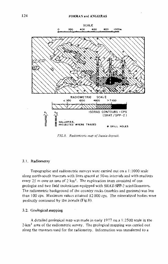
124 FORMAN and ANGEtRAS
SCALEО 200 400 600 аоо lOOOm' ' ' ' . . . <
RADIOMETRIC SCALE < 300 ¡200 4800 > 7 ) 0 0
6g ISORAD CONTOURS-CPS(SRAT/SPP-2)
! } G A L L E R I E S ,! P R O J E C T E D W H E R E T R A C E D" О D R I L L H O L E S
F 7 C .& .R a A 'o m e fr ic m a p o/7 fa fa ¡'a J ep o^ Y .
3.1. Radiometry
Topographic and radiometric surveys were carried out on a 1:1000 scale along north-south traverses with lines spaced at 50-m intervals and with readings every 25 m over an area o f 2 km^. The exploration team consisted o f one geologist and two field technicians equipped with SRAT-SPP-2 scintillometers. The radiometric background o f the country rocks (marbles and gneisses) was less than 100 cps. Maximum values attained 12 000cps. The mineralized bodies were perfectly contoured by the isorads (Fig.8).
3.2. Geological mapping
A detailed geological map was made in early 1977 on a 1.2500 scale in the 2-km^ area o f the radiometric survey. The geological mapping was carried out along the traverses used for the radiometry. Information was transferred to a
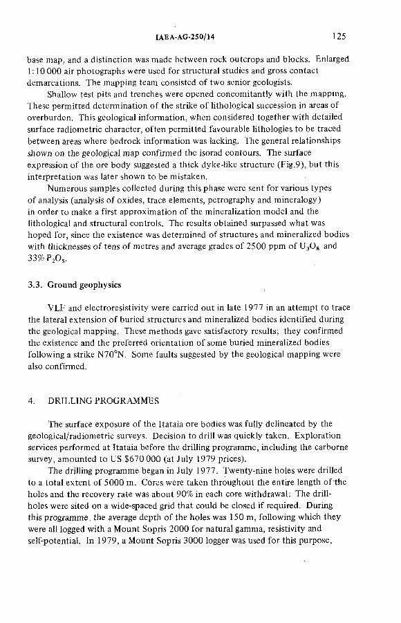
IAEA-AG-250/14 125
base map, and a distinction was made between rock outcrops and blocks. Enlarged 1:10 000 air photographs were used for structural studies and gross contact demarcations. The mapping team consisted o f two senior geologists.
Shallow test pits and trenches were opened concomitantly with the mapping. These permitted determination o f the strike o f lithological succession in areas o f overburden. This geological information, when considered together with detailed surface radiometric character, often permitted favourable lithologies to be traced between areas where bedrock information was lacking. The general relationships
shown on the geological map confirmed the isorad contours. The surface expression o f the ore body suggested a thick dyke-like structure (Fig.9), but this interpretation was later shown to be mistaken.
Numerous samples collected during this phase were sent for various types o f analysis (analysis o f oxides, trace elements, petrography and mineralogy) in order to make a first approximation o f the mineralization model and the lithological and structural controls. The results obtained surpassed what was hoped for, since the existence was determined o f structures and mineralized bodies with thicknesses o f tens o f metres and average grades o f 2500 ppm o f UgOg and 33%РзО;.
3.3. Ground geophysics
VLF and electroresistivity were carried out in late 1977 in an attempt to trace the lateral extension o f buried structures and mineralized bodies identified during the geological mapping. These methods gave satisfactory results; they confirmed the existence and the preferred orientation o f some buried mineralized bodies following a strike N70°N. Some faults suggested by the geological mapping were
also confirmed.
4. D RILLING PROGRAMMES
The surface exposure o f the Itataia ore bodies was fully delineated by the geological/radiometric surveys. Decision to drill was quickly taken. Exploration services performed at Itataia before the drilling programme, including the carborne survey, amounted to US $670 000 (at July 1979 prices).
The drilling programme began in July 1977. Twenty-nine holes were drilled to a total extent o f 5000 m. Cores were taken throughout the entire length o f the holes and the recovery rate was about 90% in each core withdrawal: The drillholes were sited on a wide-spaced grid that could be closed i f required. During this programme , the average depth o f the holes was 150 m, following which they were all logged with a Mount Sopris 2000 for natural gamma, resistivity and self-potential. In 1979, a Mount Sopris 3000 logger was used for this purpose,
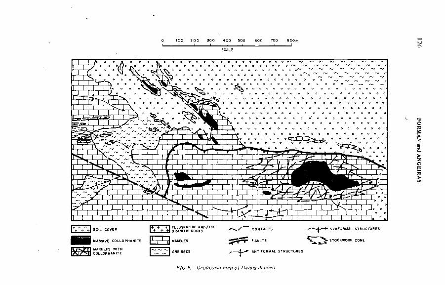
0 t o o 2 0 0 3 0 0 4 0 0 5 0 0 6 0 0 7 0 0 8 0 0 m i — i - - i ________,_______ ¡------ !
SCALE
S0)L COVER
MASStVE C0LL0PHAM)TE
f ^ + ^ + SRAWITIC ROCKS
MARBLES WtTM COLLOPWAM'TE
3
Б ЭFELDSPATWtC AM D/OR
MAR8LES
GNEiSSES
CONTACTS
& y * FAULTS
ANTtFORMAL STRUCTURES
F/C.P. map o^poy/f.
FORM
AN
and A
NG
EIRA
S
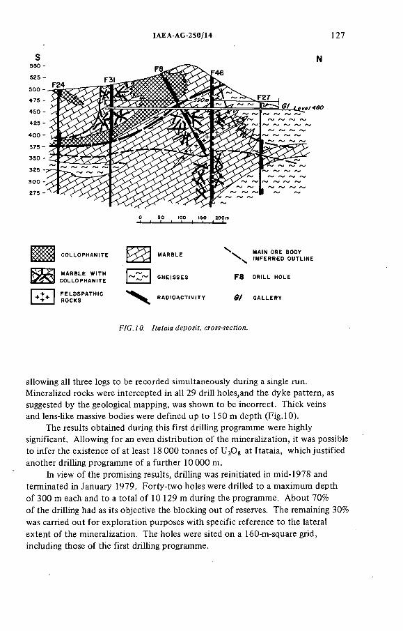
1AEA-AG 250/14 127
F/G. 70. /fafaía сго^-мсУ;ол.
allowing all three logs to be recorded simultaneously during a single run. Mineralized rocks were intercepted in all 29 drill holes,and the dyke pattern, as suggested by the geological mapping, was shown to be incorrect. Thick veins and lens-like massive bodies were defined up to 150 m depth (Fig. 10).
The results obtained during this first drilling programme were highly significant. Allowing for an even distribution o f the mineralization, it was possible to infer the existence o f at least 18 000 tonnes o f UgOg at itataia, which justified another drilling programme o f a further 10 000 m.
in view o f the promising results, drilling was reinitiated in mid-1978 and terminated in January 1979. Forty-two holes were drilled to a maximum depth o f 300 m each and to a total o f 10 129 m during the programme. About 70% o f the drilling had as its objective the blocking out o f reserves. The remaining 30% was carried out for exploration purposes with specific reference to the lateral extent o f the mineralization. The holes were sited on a 160-m-square grid, including those o f the first drilling programme.
128 FORMAN and ANGEÏRAS
The results stressed the size o f the ore body and showed that massive
mineralization occurred from the surface to depths o f 150 m and that stockwork- type mineralization continued to depths greater than 300 m. Some holes also revealed extensive stockwork mineralization some 10 m to 20 m below the outcropping marbles. This had already been suspected but was not clear from surface studies (Fig. 10).
At the end 1978, computer calculations based on the conventional method o f blocks estimation, indicated reserves o f 71 000 tonnes o f U^Og o f which 34 000 tonnes were considered to be in the category o f measured and indicated reserves (reasonably assured) and 37 000 tonnes as inferred reserves (additional estimates). By this time the great potential o f the Itataia deposits had been recognized and thus economic evaluation programmes attained a high priority and were accelerated. The drilling grid was closed to 80 m with a contract for a further 10 000 m o f diamond drilling. It had as sole objective the blocking out o f reserves.
The above programme began in January 1979 and was scheduled to end in November 1979.
Core /ogg/ng was conventional and included records o f rock types, composition, texture, colour index, structure, foliation, weathering, mineralization features (massive, veinlet, stockwork, impregnation, etc.) and additional drill-hole information. All these data were correlated with the radiometry, self-potential and resistivity logs, which resulted in a final composite hole log prepared on a 1:100 scale. This procedure proved very useful during the core sampling and facilitated geological correlations.
The ra<Awern'c /oggz'Mg was valuable for the following reasons:
(a) It permitted good approximation for the grades calculated from the logs, as the equilibrium conditions approximate 100%;
(b ) It provided assay information in horizons o f lost core and assisted in the statistical procedures o f sampling;
(c ) Radiometric backgrounds in barren holes and/or barren zones assisted considerably in differentiation and correlation o f rock types;
(d ) It provided reasonable in-situ estimates o f grade values.
The downhole SP and resistivity logs were also useful in defining lithologie boundaries. Rock types such as gneisses, marbles and mineralized horizons gave good characteristic responses which assisted in the correlation o f the lithological units.
5. SAMPLING AND A N A L Y T IC A L PROCEDURES
The cores from the mineralized horizons were first sampled according to geostatistical requirements [20] using a support o f 0.25 m for homogeneous lithologie segments. Irregularities caused by lithologie breaks and core recovery
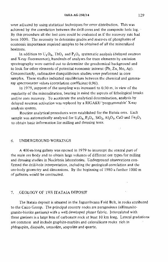
IAEA-AG-250/Ï4 129
were adjusted by using statistical techniques for error distribution. This was achieved by the correlation between the drill cores and the composite hole log.By this procedure all the lost core could be evaluated as if the recovery rate had been 100%. The necessity to determine grades and reserves o f phosphates o f economic importance required samples to be obtained o f all the mineralized horizons.
In addition to UgOg, ThO^ and P2O5 systematic analysis (delayed neutron and X-ray fluorescence), hundreds o f analyses for trace elements by emission spectrography were carried out to determine the geochemical background and to look for other elements o f potential economic interest (Pb, Zn, Mo, Ag). Concomitantly, radioactive disequilibrium studies were performed in core samples. These studies indicated equilibrium between the chemical and gamma- ray spectrometer values (correlation coefficient 0.96).
In 1979, support o f the sampling was increased to 0.50 m, in view o f the
regularity o f the mineralization, bearing in mind the aspects o f lithological breaks and/or core recovery. To accelerate the analytical determination, analysis by delayed neutron activation was replaced by a R IGAKU 'programmable' X-ray
analysis system.Routine analytical procedures were established for the Itataia ores. Each
sample was automatically analysed for U3O8, P2O3, SÍO2, А^Оз, CaO and Fe2Û3 to obtain basic information for milling and dressing tests.
6. UNDERGROUND WORKINGS
A 400-m-long gallery was opened in 1979 to intercept the central part o f the main ore body and to obtain large volumes o f different ore types for milling and dressing studies in Nuclebrás laboratories. Underground observations confirmed the drill-hole interpretation, including the geological correlation and the ore-body geometry and dimensions. By the beginning o f 1980 a further 1000 m o f galleries would be contracted.
7. GEOLOGY OF THE IT A T A IA DEPOSIT
The Itataia deposit is situated in the Jaguaribeana Fold Belt, in rocks attributed to the Caico Group. The principal country rocks are paragneisses (sillimanite- granite-biotite gneisses) with a well developed planar fabric. Intercalated with these gneisses is a large lens o f carbonate rock at least 10 km long. Lateral gradations are common and include graphite-marbles and calcosilicate rocks rich in phlogopite, diopside, tremolite, scapolite and quartz.
130 FORMAN and ANGEIRAS
Both the marbles and the gneisses are cut by several granite and granite- pegmatite apophyses in addition to small granitic cupola. These intrusives have been affected intensively by deuteric processes, and drilling has confirmed this at depth. The marbles and gneisses are very highly folded. The latest axial planes are subvertical and the fold axes dip gently to the east (5° to 10°).
The Itataia ore bodies are located on one o f the regional compressional release faults and, before the mineralization episodes, the marbles were uplifted on to the gneisses. This tectonic event accounts for the local geomorphology whereby the marbles have their topographic expression as a small hillock some 110 m high, while the surrounding lowlands are underlain by gneisses. The marbles constitute an 'upper block', while the gneisses are considered as a 'lower block', both o f which are mineralized,and have been considered as an upper and lower ore body respectively. The fault zone formed an important channel along which mineralized fluids were able to pass (Figs 9 and 10).
Most o f the exploration and evaluation to date has been carried out on the upper block, and the reserves and grades quoted elsewhere only refer to this body. The ore bodies are contained in massive lens-shaped and veinlike structures of variable sizes and shapes which are concordant with the surrounding marbles. Numerous apophyses and veinlets cut not only the gneisses and marbles but also the 'episyenitic' rocks forming stockworks (Table IV).
Two types o f ore bodies have been recognized. The first consists o f uniform massive collophanite and the second o f veinlet and stockwork ores in marbles and 'episyenitic' rocks as well as in impregnations in gneisses. In fact, impregnation is a general feature which affects all the lithologies in varying degrees. .
The uranium occurs in cryptocrystalline hydroxy-apatite, which is also of commercial interest as a phosphate source. The rock in which this mineral occurs has been referred to as сойорйаи^е because 90% of it is composed of crypto- crystalline hydroxy-apatite and the remaining 1 0 % o f calcite, ankerite, iron oxides and graphite. Anomalous values o f thorium and rare earths o f the yttrium series are found (Th - 162 ppm; Y = 300 ppm; La = 5 ! ppm; Sr = 3800 ppm). Mo, Ag, Zn and Pb may attain high values in the marbles, but this is a local phenomenon. There are also large quantities o f albite, chlorite and hematite in the feldspathic 'episyenitic' rocks, while anatase has been identified in small amounts. The present reserves o f Itataia are shown in Table V.
Uranium is evenly distributed in the collophanite, as shown by fission track and microprobe analysis. Two views have been proposed on the nature o f the uranium in the collophane. The first is that calcium has been isomorphously replaced by uranium in the collophane structure. The second holds that the uranium is associated with finely dispersed oxides or that it has been adsorbed by the collophane. However, it is significant that no discrete uranium species has yet been found.
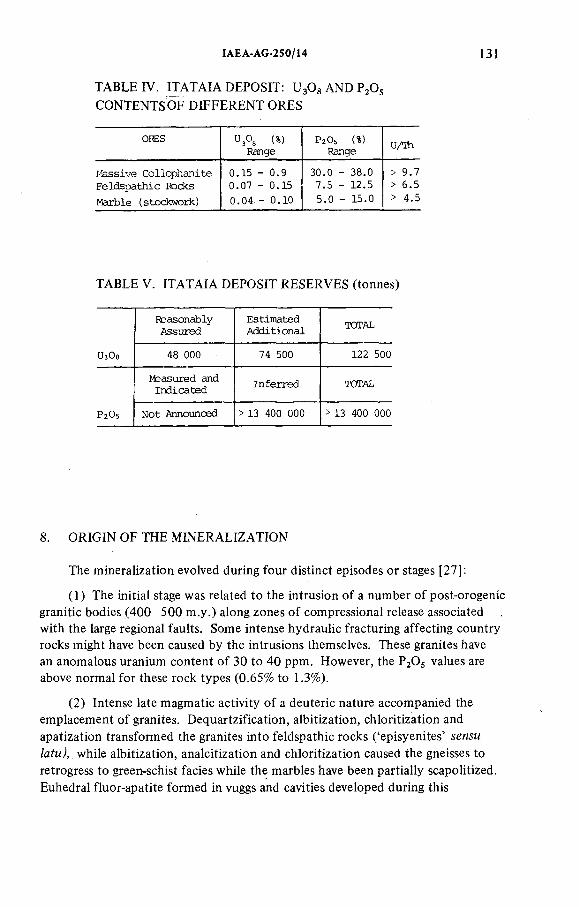
IAEA-AG-250/14 13!
TABLE IV. ITATAIA DEPOSIT: UsOgANDP^O; CONTENTSOF DIFFERENT ORES
ORES " 3° sRange
P2O 5 (%) Range
U/Th
Hassive Collophanite 0.15 - 0.9 30.0 - 38.0 > 9.7
Feldspathic Rocks 0.07 - 0.15 7.5 - 12.5 > 6.5
Marble (stockwork) 0.04 - 0.10 5.0 - 15.0 > 4.5
TABLE V. ITATA IA DEPOSIT RESERVES (tonnes)
Reasonably
Assured
Estimated
AdditionalTOTAL
ЫзОа 48 000 74 500 122 500
Measured and Indicated
Inferred TOTAL
P2O5 Not Announced > 13 400 000 > 13 400 000
8 . ORIGIN OF THE MINERALIZATION
The mineralization evolved during four distinct episodes or stages [27]:
( 1 ) The initial stage was related to the intrusion o f a number o f post-orogenic granitic bodies (400—500 m.y.) along zones o f compressional release associated with the large regional faults. Some intense hydraulic fracturing affecting country rocks might have been caused by the intrusions themselves. These granites have an anomalous uranium content o f 30 to 40 ppm. However, the P2O5 values are above normal for these rock types (0.65% to 1.3%).
(2) Intense late magmatic activity o f a deuteric nature accompanied the emplacement o f granites. Dequartzification, albitization, chloritization and apatization transformed the granites into feldspathic rocks ('episyenites' ленды ZafMÀ while albitization, analcitization and chloritization caused the gneisses to retrogress to green-schist facies while the marbles have been partially scapolitized. Euhedral fluor-apatite formed in vuggs and cavities developed during this
132 FORMAN and ANGEIRAS
epimagmatic stage. With reference to the French feldspar-episyenites [33], it is probable that this process occurred at temperatures approaching 350°C.Uranium was enriched to an average of 750 ppm and РзОз to an average of 12%.
(3) The third stage in the evolution o f the mineralization is characterized by local deformation of the country rock as well as the 'episyenites'. This caused a brecciation of the rocks and greatly increased their porosity.
(4) During the fourth and final stage, cryptocrystalline hydroxy-apatite was extensively deposited from saline heated fluids (^-130°C, and approximately 22% equivalent CaC^ [34]), which impregnated the pore-spaces and cavities formed during the previous stage. In addition, there was widespread replacement of calcite and feldspar by phosphate in the marbles and 'episyenites', respectively. Uranium and phosphorus were enriched considerably (average values are in excess of 2500 ppm UgOg and 34% P ^ ) .
Mineralization proceeded intermittently owing to pulsatory conditions (similarly with a polyascendant model). Periods o f charge (low fluid velocity) alternated with discharge (high fluid velocity), activated by a fluid convection system related to the cooling of 450—500-m.y.-old granite bodies.
Transport of large quantities o f calcium phosphate would have been possible only in acid medium (low-pH fluids). Movement o f these fluids in the host marbles provoked an increase in pH, the alkalinity favouring rapid deposition of uraniferous coHophane. Such conditions of rapid deposition are apparently confirmed by the cryptocrystalline fabric o f the collophane and the absence o f uranium minerals. The uranium would have been adsorbed by the collophane with, possibly, some replacement o f Ca in the apatite.
Fluid inclusions in the apatite indicate formation temperatures o f the order of 13 6 ° С and high salinity (^ 19.5 % to 22% equivalent CaCl ), while quartz fillings in cavities,in the collophane indicate temperatures o f 50°C and low salinity (^"5% equivalent CaCl^), evidence of a distinct decrease in salinity during deposition of the late minerals [34]. The low CO2 content suggests low pressure deposition. Daughter minerals in the fluid inclusions are quartz apatite, Mg, Ca and Ba sulphates, and Mg and Al chlorides.
It is not known in what form the uranium was transported in the fluids. However, in view of the predominance of the Cl " anion, it is possible that uranium was transported as chloride. The role of СГ in uranium mineralization is pointed out by several authors [35, 36].
9. REGIONAL INVESTIGATIONS
In view of the economic importance o f the special type o f uranium mineralization discovered by the carborne survey, especially the large Itataia ore body, Nuclebrás decided to execute additional regional investigations:
ÏAEA-AG-250/Ï4 133
9.1. Airborne geophysics
In late 1977, Levantamentos Aerofotogramétricos SA (LASA) was contracted to carry out an airborne gamma-ray magnetometer survey in view o f the wide geographical distribution of the uranium mineralization. The main factor in the choice o f airborne geophysics as a method of regional prospecting was the excellent exposure, thin soil cover, intermittent stream network, difficulties o f access and, principally, awareness that the mineralization was of a regional nature.
Two Norman-Britten Islander and one Douglas DC-3 aircraft were used in the survey in three distinct areas, totalling 38 000 knP. Operational characteristics were uniform and included altitude of 150 m, speed of 220 km-h"' and north- south flight lines spaced 500 m apart. The geophysical equipment used included a gamma-spectrometer 'Exploranium' DIGRS, Model 3001, containing nine 6 in. X 4 in. crystals as well as a 'Geometries' Model 803 magnetometer.
The data from 78 000 km o f flight lines were recorded simultaneously in analog form and digitally on magnetic tape. In the processing, 441 anomalous records were identified which, on the basis of essentially physical parameters, correspond to 42 anomalous zones.
The data obtained during the airborne gamma-ray survey were analysed in 1978 by Nuclebras personnel. Thirty new anomalies were selected for verification. As a result, fifteen showings o f phosphate-uranium mineralization were recognized, among which four were coincident with the Itataia deposit and two have been correlated with anomalies already discovered by the carborne survey carried out in 1975. The remaining anomalies represented new P-U areas (Fig.7). These anomalies are at present being investigated by field crews.
9.2. Geological mapping
An area of 260 km^ around Itataia was mapped on a 1:25 000 scale to investigate the distribution o f anomalies which had been detected by the airborne geophysics. These are distributed following marble and granitic intrusives. Geological mapping was carried out using 1:25 000 aerial photographs,and the information was transferred to photomosaic base maps at the field camp. A detailed lithologie and structural map was made which emphasized the economic importance o f the additional uranium-phosphate showings surrounding Itataia.
9.3. ERTS images
Multispectral analysis o f LANDSAT images was carried out with an Image 100 analyser in order to define characteristic standards o f the Itataia mineralization that could be used in the identification o f similar areas. This was not found very satisfactory owing to the relatively small size o f the target.
134 FORMAN and ANGEÏRAS
Satellite images did, however, prove to be very useful for the regional tectonic studies that are being undertaken.
Part IV FINAL REMARKS
The discovery and development o f the Itataia deposit cannot be easily compared with Poços de Caldas on account o f the relative scales o f the problems involved.
At Itataia the fact that the exploration target was identified from the time o f discovery permitted prospecting and exploration to be carried out in a logical sequence with minimal waste o f resources in terms o f manpower and funds. However, at Poços de Caldas the initial exploration target was abandoned following the detailed evaluation o f the caldasite deposits and the recognition o f a second and more promising target.
The good outcrop around Itataia allowed reliable geological maps to be made quickly and cheaply. At Poços de Caldas the outcrop is poor and the weathered zone very thick. Consequently, surface prospecting and mapping were slow and comparatively expensive.
At Itataia, the ore bodies appear on the surface while those at Poços de Caldas (Cercado) were found by drilling.
The mineralization chemistry o f the Itataia deposit is simple although the type o f deposit is unusual. The mineral chemistry of the Poços de Caldas deposit is more complex and, in addition, the mineralization is unconventional.
At Poços de Caldas, the anomalies were initially identified by aerogeophysics and later confirmed by ground radiometry. Rock chemistry was used to separate the caldasite zones (Zr > U) from the others (U > Zr). The ore deposits and reserves were determined by drilling and underground workings.
At Itataia, the anomalies were identified during a carbome survey while geology and ground radiometrics defined the surface expression o f the underlying deposits. The subsurface characteristics o f the ore body and associated reserves were determined by drilling.
ACKNOWLEDGEMENTS
The authors wish to express their thanks to M.Ö. Fraenkel, E.B. Bastian and M.H. Waring, who assisted in the preparation of this paper.
The work o f all Nuclebras geological staff is acknowledged.
IAEA-AG-250/14 135
REFERENCES
TILSLEY, J.E ., "Poços de Caldas", in Uranium Exploration in Brazil, David S. Robertson & Associates, Toronto (1974 /1976); Int. Rep. Nuclebrás, Rio de Janeiro (1976). ULBRICH, H.H.G.H., PUCCI, F.G., "DiferenciàçSo mineralógica nos tinguaitos da pedreira Bortolan, Poços de Caldas, MG", in Proc. 30th Congr. Soc. Brasil, de Geología, Recife, Bol.No.l (1978) 93 (abstract).ULBRICH, H.H.G.J., ULBRICH, M.N., BAGNOLI, E ., "Estrutura e petrografia do tujaurito de Poços de Caldas, MG", ibid., p.92 (abstract).ULBRICH, H.H.G .J., VLACH, S.R.F., "O nefelina sienito hibrido do Maciço Alcalino de Poços de Caldas, MG", pp.93—94 (abstract).SANTOS, R., "Geology and mining development of the C-09 uranium deposit", Uranium Deposits in Latin America: Geology and Exploration (Proc. Regional Advisory Group Mtg. Lima, 197S),IAEA, Vienna ( ¡9 8 1 ) 533.ELERT, R., Contribuiçâo a geología do Maciço Alcalino de Poços de Caldas, Bol. Fac. Fil. Ciênc. e Letr., Univ. Sâo Paulo, No.237 (Geol. 18) (1952).FORMAN, J.M.A., The geology and zirconium ore deposits of the Poços de Caldas Plateau, Brazil, MSc Thesis, Dept, of Geology, Stanford University (1966).AMARAL, G., et al., Potassium-argon ages of alkaline rocks from Southern Brazil,Geochim. Cosmochim. Acta 31 (1967) 117.DUTRA, C.V., O método Pb/a e idades de zircôes do Maciço Alcalino de Poços de Caldas, MG, Bol. Inst. Geología, Ouro Preto, 1 (1 9 6 6 ) 125 —135.DERBY, O.A., On nepheline rocks in Brazil, with special reference to the association of phonolite and foyaite, Part I, Q.J. Geol. Soc. London (1887).HUSSAK, E ., Mineralogische Notizen aus Brasilien, III. Theil, Zur Kenntniss der sog."Favas der brasilianischen Diamantsande und über die mineralischen Begleiter des Diamants von Brasilien", Tschermaks Mineral. Petrog. Mitt. 4 (1889).FRAYA, R:, Zircónio, historia, apiicaçôes e ocorrência, Rev. Min. Met. (Rio de Janeiro) 13(1 9 4 8 ).WHITE, M.G., PIERSON, C.T., Sumario da prospecçâo para minerais radioativos no Brasil: Período de 1952 a 1960, Com. Nac. Energia Nuclear, Rio de Janeiro, Bol. No.l (1974) 1 4 - 1 6 .WEDOW, H., The Morro do Ferro thorium and rare-earth ore deposit, Poços de Caldas District, Brazil, US Geol. Surv. Bull. 1185, Washington (1957) D-l/D-34.TOLBERT, G., The uraniferous zirconium deposit of the Poços de Caldas Plateau, Brazil, US Geol. Surv., Bull. 1 185-C, Washington (1966) C-l/C-28.OLIVEIRA, A.G. de, Aspectos geológicos da mineralizaçao de uranio em Poços de Caldas, in Proc. 20th Congr. Soc. Brasil, de Geología,Rio de Janeiro, Publ. No.l (1966)35 — 36 (abstract).GERSTNER, A., Missao Brasil (1961/1966): Relatório Geral de Sintese, Com.Nac.Energia Nuclear, Rio de Janeiro, Bol. No.2 (1974).OLIVEIRA, A.G. de, Uränio no Planalto de Poços de Caldas, in Proc. 22nd Congr. Soc. Bras, de Geología, Belo Horizonte, Resumo das Com. (1968) 30 (abstract).GORSKY, V.A., GORSKY, E ., Contribuiçâo à mineralogía e petrografia do Planalto de Poços de Caldas, Com. Nac. Energia Nuclear, Rio de Janeiro, Bol. N o.13 (1974).JOURNEL, A.G., Giostatistique minière, V oi.i, Centre de morpho¡ogie mathématique, Fontainebleau (1977).BIONDI, J.C., Relatório de cálculo de reservas, C-09, Internal Rep. Nuclebrás, Rio de Janeiro (1976).
136 FORMAN and ANGEIRAS
[22] BIONDI, J.C., A origem dos pipes e diques de brecha — modelo de implosao/fluidizaçào, in Proc. 30th Congr. Soc. Brasil, de Geología, Recife, Vol.3 (1978) 1202—1212.
[23] KEGEL, W., Lineament-Tektonik in Nord-est Brasilien, Geol. Rundsch. 54 (1965) 1 2 4 0 -1 2 6 0 .
[24] BRITO NEVES, B.B., Regionalizaçào geotectónica do Pré-Cambriano Nordestino, PhDThesis, Univ. Sâo Paulo (1975).
[25] BRITO NEVES, B.B., et al., Reavaliaçao dos dados geocronológicos do Pré-Cambriano do nordeste brasileiro, in Proc. 30th Congr. Soc. Brasil, de Geologia 6 (1973) 261—271.
[26] COSTA, L.A.M. da, PIRES, F .R ., ANGEIRAS, A.G., A preliminary suggestion for a migmatogenic map, Acad. Bras. Ciênc. (Rio de Janeiro) 42 (1970) 5 17—519.
[27] WERNICK, E„ HASUY, Y ., BRITO NEVES, B.B. de, As regiôes de dobramentos nordeste sudeste, in Proc. 30th Congr. Sociedade Brasil de Geologia, Recife, Vol. 6 (1979)2 9 4 3 -2 5 0 6 .
[28] SANTOS, E ., MELLO, C.B.M., Diversidade do plutonismo granítico do Nordeste, ibid., pp. 2 6 2 4 -2 6 3 4 .
[29] ANGEIRAS, A.G., NETTO, A.M., CAMPOS, M. de, Mineralizaçâo fósforo uranífera associada a epissienitos sódicos no Pré-Cambriano cearense, ibid., Bol. N o.l, p.341 (abstract).
[30] RAMBERG, H., "Model studies in relation to intrusion of plutonio bodies", Mechanism of Igneous (NEWALL, G., RAST, N., Eds), Gallery Press, Liverpool (1970) 2 7 1 —286.
[31 ] FARINA, M., "Perspectivas metalogenéticas de alguns granitos pós-orogénicos do nordeste brasileiro", 8 ° Simposio de Geologia do Nordeste, Atas, Campiña Grande (1977) 121 — 129.
[32] ANGEIRAS, A.G., Aspectos preliminares de mineralizaçâo uranífera na área de Itataia, Internal Rep. Nuclebrás, Rio de Janeiro (1977).
[33] LEROY, I., Les épisyenites non-minéralisés dans le massif de granite a deux-micas de Saint Sylvestre (Limousin, France), Thèse: Docteur de spécialité, Université de Nancy (1971).
[34] FUZIKAWA, K., Estudo preliminar de inclusoes fluidas em rochas do Projeto Itatira,Internai Rep. Nuclebrás, Rio de Janeiro (1978).
[35] KOSTOV, I., "Crystallochemical differentiation and localization of uranium ore deposits in the earth's crust", Recognition and Evaluation of Uraniferous Areas (Proc. Techn. Committee Mtg. Vienna, 1975), IAEA, Vienna (1977) 15.
[36] RICH, R.A., HOLLAND, H.D., PETERSEN, V., Hydrothermal Uranium Deposits, Developments in Economic Geology, Vol.6 , Elsevier, Amsterdam (1977).
DISCUSSION
B.L. NIELSEN: The importance o f the location o f the Cercado and Agostinho deposits at the margin of the secondary craters was pointed out. What is the relation between the craters and the formation o f the tuffaceous breccias o f stage 5 o f the intrusive history?
J.M.A. FORMAN: Image interpretation indicates that both Agostinho and Cercado deposits are associated with the secondary craters formed during stage 4 at the same time as the tuffaceous breccias. Nevertheless, intense weathering has not allowed a more direct correlation which could only be done with further drilling. As the main targets, at the moment, are elsewhere (Itataia, Lagoa, Real, etc.), drilling will only be done in the future in order to confirm the image interpretation.
IAEA-AG-250/14 137
B.L. NIELSEN: Have you any information on whether uranium has been introduced from the intrusion into the surrounding gneiss terrain; for instance, into the regional fault structures?
J.M.A. FORMAN: No uranium has been found in the basement rocks surrounding the plateau. Some uranium values are found in the basement but associated with an alkaline structure, to the south-east o f the plateau, which does not.outcrop but can be easily seen in the satellite images.
P. BARRETTO: You indicated that the post-orogenic granites have 30—40 ppm uranium, sometimes up to 100 ppm. Where is this uranium located?
A.G. ANGEIRAS: We don't know at the moment. However, when rock samples are treated with nitric acid 2jN and 30 minutes o f slow heating, 70% to 80% of total U^Og is leached. The granites are also anomalous for РзО$ (0.65% to 1.32%) so maybe the uranium is associated with apatite crystals.
P. BARRETTO: The age o f these granites is approximately 500 m.y.I suppose these are К/Ar age determinations and refer to remobilization o f the old shield rocks. Is this correct or are they o f the intrusive type?
A.G. ANGEIRAS: The ages have been determined by К/Ar and Rb/Sr methods (see Ref. [27]). The ^Sr/^Sr isotopic ratio indicates that such granites are formed at the lower crust by fusion. They are in fact stock and plug-like intrusions o f a post-orogenic magmatism, at the closure o f the Brazilianne Cycle in South America. It should also be mentioned that anomalous U3O3 values have been found in 450-500 m.y. granites from different places in Brazil.
H.D. FUCHS: I understand you use episyenitization just as a descriptive term, describing a depletion of quartz and introduction of feldspar (albite).
A.G. ANGEIRAS: Besides the dequartzification and strong albitization (Na^O up to 10%) there was widespread chloritization of the biotites, disappearance o f the К feldspars and haematitization. The sequence of alteration conforms to this described by Leroy [32] for the French feldspar episyenites, including the anomalous РдО$ values (these are by far higher in the Leará uraniferous district).
As the mode o f occurrence, source o f the vuggy, quartz-poor rocks of the district, there is some similarity with typical French episyenites. For the Itataia deposits, since the type o f mineralization is unusual, the term is being used as episyenites sensu latu as feldspathic rock is a rather descriptive expression.
M. MATOLÍN: Are the results o f gamma surveys in Brazil (airborne, carborne, ground) reported in relative values (cps) or are the instruments calibrated?
J.M.A. FORMAN: Ground surveys are reported in cps and all the calibration of instruments in specially prepared calibration pads. Aerial surveys are reported in U, Th, К and total count channels; readings are corrected for cosmic and aircraft background. Calibration pads are being built at a selected airport.
P. BARRETTO: One and a half years passed between the discovery o f the uraniferous block and the discovery o f the outcropping collophanite. What was the reason for this delay, and what led to the decision to return to the area?
138 FORMAN and ANGEtRAS
A.G. ANGEIRAS: The boulder anomaly was considered to have priority in mid-1976 on account o f the occurrence. The decision to return to the area one year later was due to Nuclebrás' policy o f field investigation o f all radiometric anomalies proven, after chemical analysis, to be uraniferous. Besides, the value o f L^Og for the boulder was found to be the highest o f the twelve anomalies detected by the car-mounted survey.
J.M.A. FORMAN: Remember I said at the beginning that it is very important in this business o f uranium exploration to keep an open mind. We had a few problems with our geologists when a boulder was found with a type o f mineralization not known elsewhere and no-one wanted to pay any attention to it. But since the boulder contained about 2 0 0 0 ppm of uranium, the decision was made to see what it was in spite o f the fact that it was not known elsewhere, and I think this is very important. If you try to tie every deposit to a genetic type that is well known and well described you might overlook something like Itataia.
D. TAYLOR: How do you get the uranium out o f the ground and out o f theore?
J.M.A. FORMAN: The mineralization phenomenon is regional. In Itataia, which is the smaller area (2 km^), as Mr. Angeiras mentioned, there is a lot of phosphate; for the whole o f the deposit we have something like 1 1 % average P2O5 . Physically it is possible to concentrate that to bring it up to about 30%P2O 3 . The process is to produce the phosphoric acid and get uranium out of that if you have a production o f phosphate and uranium. This is a common technique on sedimentary phosphates ranging up to 2 0 0 ppm uranium; it is feasible and economical. But in the case o f much higher grades in Itataia, this is easier than the present plants in France and Florida that produce uranium from phosphate.
D. TAYLOR: Could you describe the uranium extraction process to be used at Itataia? Details o f anticipated costs and recovery would be most interesting.
J.M.A. FORMAN: At present, ore-dressing studies are being carried out and the fluxogramme for the process is:
Mechanical preparation of the orePhysical concentration of phosphate and uranium by flotationAcid leachingFiltrationClarification of the phosphoric liquorExtraction and re-extraction by solventsUranium precipitationCalcination o f the precipitate to UO3
Concentration of the phosphoric acid (free from uranium) by evaporationFertilizer production
ÍAEA-AG-250/14 139
The costs will depend on the scale to be chosen for the mill. 500 tonnes per year of uranium concentrates will be produced at under US $40 per lb, with phosphoric acid at competitive costs, at the prevailing market prices. Recovery for both uranium and phosphate is above 94%.


IAEA AG 250/16
EXPLORATION OF THE URANIUM REEFS OF COOKE SECTION, RADFONTEIN ESTATES GOLD MINING COMPANY (WITWATERSRAND) LTD, SOUTH AFRICA
B.D. STEWARTJohannesburg Consolidated Investment Co. Ltd,Johannesburg,South Africa
Abstract
EXPLORATION OF THE URANIUM REEFS OF COOKE SECTION, RANDFONTEIN ESTATES GOLD MINING COMPANY (WITWATERSRAND) LTD, SOUTH AFRICA.
The Cooke Section ore bodies he in the South West Witwatersrand, South Africa, adjacent to the outcropping Centra) Rand deposits which have been exploited on a large scale since 1886. Since the early 1900s several programmes have been carried out to locate the south-westerly, subsurface extensions of the Central Rand deposits. The programme which ultimately led to the delineation of the Cooke Section deposit was initiated in the early 1950s. This programme covered an area roughly 150 km^ and holes were spaced out at intervals of 3 to 5 km. Some positive results were obtained, and this led to a follow-up programme in which 8 8 holes were drilled, resulting in the Cooke Section mining operation. Payability was found to occur in a group of conglomerates known collectively as the Middle Elsburg reefs, but not in the well-known reefs of the Central and West Rand. The Middle Elsburgs, though auriferous and uraniferous, have not been found payable along the Central Rand, and were not the primary target of the initial programme. It is estimated that the total resources amount to 72 million t of ore, of which about36 million t are considered to be viable under current economic conditions. This case study clearly demonstrates that an exploration programme must always be flexible enough to cater for the unexpected developments that are usually encountered. The exploration emphasises the need for patient, systematic analysis of all data, particularly when the ore body being prospected is deeply buried.
1. INTRODUCTION
The South African gold and uranium deposits are contained within an elliptical sedimentary basin o f early Proterozoic age, known as the Witwatersrand basin, which is situated in the central interior o f the country (F ig .l). These deposits are unique in many respects, and therefore much o f what will be described in this paper may be applicable only to other Witwatersrand-type deposits.
The purpose o f the paper, however, is to describe how the complicated stratigraphy, sedimentology and structure o f the ore bodies was unravelled, and to
141
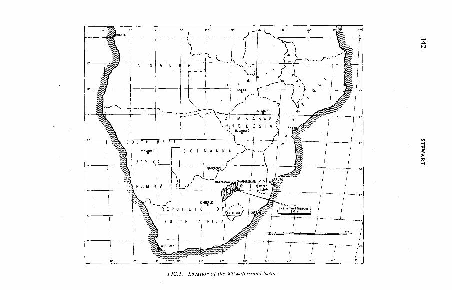
F/C.A íocaíK?H o/ íAe ¿ял'л.
142 S
TEW
AR
T
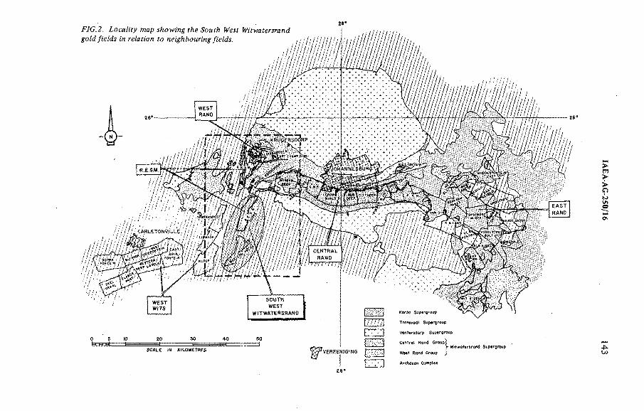
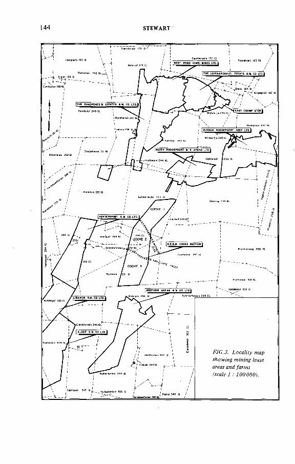
144 STEWART
IAEA A G -250/t6 145
stress the importance o f careful analysis and re-analysis o f all geological information when carrying out an exploration programme.
At the outset it must be stressed that uranium, important as it may be, is only a by-product o f the South African gold-mining industry and therefore, historically, the motivation for prospecting the Witwatersrand deposits was on the basis o f its gold potential. It is only in the past few years that uranium has in certain instances been elevated to that o f a co-product.
Cooke Section is a recent extension to a, very large, and old, gold mine called Randfontein Estates Gold Mining Co. Witwatersrand Ltd (REGM), a subsidiary of Johannesburg Consolidated Investment Co. Ltd (JCI) which is situated in the West Rand gold field (Fig.2). The new extension was found in an area referred to as the South West Witwatersrand, which lies adjacent to a very large field known as the Central Rand. There are a number o f reasons why it remained undetected for about seven decades after the discovery o f gold near Johannesburg. The most significant are that: it is concealed beneath younger formations; it occurs in a structurally complicated area; the deposits are relatively small and highly variable; and, perhaps most important, it occurs in a part o f the stratigraphy that had never before yielded any economic values. A further contributing factor is that the conglomerates that produced enormous quantities o f gold in the Central Rand were considered to be non-economic in the South West Witwatersrand and the area was therefore by-passed in favour o f more lucrative targets.
2. LOCALITY
Cooke Section lies some 40 km west o f Johannesburg, and a few km southwest o f the most westerly o f the Central Rand mines. It is situated on the farms, Luipaardsvlei 243 IQ, Gemsbokfontein 290 IQ, Panvlakte 291 IQ, and Gemspost 288 IQ (Fig.3). The area was settled more than a century ago, and REGM started mining operations in 1890. Over the years it acquired surface and mineral rights covering large tracts o f ground, including Panviakte, which it purchased in mid-1890. Prospecting on this farm, however, only started some 55 years later.
3. HISTORICAL BACKGROUND
Although the Cooke Section deposits were only located in 1962/3 (i.e. about 76 years after the discovery o f gold in the Central Rand), much was known about the Witwatersrand geology in general and about the South West Witwatersrand in particular. Prior to its discovery, the area had been comprehensively mapped, assorted papers had been written on a variety o f geological aspects, and the activities o f the mining companies operating in the area and in the surrounding fields were well known from newspaper articles and published company reports.
146 STEWART
While no formal documents reviewing all this background are to hand (Pretorius [ 1 ] has reviewed the development o f geological thought for the basin as a whole), a great deal o f what had been learnt over the years was built into the prospecting philosophy which resulted in the discovery o f Cooke Section. This understanding is reflected in some o f the early structural plans. To appreciate the problems encountered during the exploration, a brief description of the geology and the prospecting episodes is necessary.
3.1. Regional geological setting
The surface geology was mapped between 1910 and 1915 by E.T. Mellor [2] and published in 1917. This map has been found extremely reliable and has served as a base for much of the subsequent exploratory work. From a summarized version o f the map (Fig.2) it is noted that the Central Rand gold mines lie along the Upper Witwatersrand System outcrops, with the quartzites and interbedded conglomerates striking east-west and dipping southwards. These are almost conformably overlain by lavas o f the Ventersdorp System.
The Witwatersrand rocks extend relatively uniformly to the west as far as Durban Roodepoort deep gold mine, at which point they start to curve to the south-west before being terminated against an upthrown block, known as the Witpoortje horst (or gap). At this position the Witwatersrand rocks are buried by younger rocks o f the Transvaal System which form an extensive blanket persisting for tens o f km. Thus all the extensions o f the Witwatersrand ore bodies are buried at depths ranging from zero to more than 3000 m. ïn the Cooke Section area, the Transvaal rocks are 300 to 1000 m thick.
A more detailed version o f the surface geology of.the South West Witwatersrand is shown in Fig.4 (based mainly on Mellor's map, but extended southwards by Cousins [3], and the stratigraphie column' is shown in Fig.5. Payability has been found in each o f the seven zones o f conglomerate in the Upper Witwatersrand System, and each o f these groups may contain several payable conglomerate bands. In most cases, however, only one or two reefs have been found to be payable on any particular mine, while on some mines three or four conglomerates from perhaps two reef zones have proved mineable over large areas. The major exceptions to this are the mines o f the West Rand basin where at least 23 different reefs from five reef zones have been mined. Some o f those, for example the White Reef on parts o f REGM, have been mined as primary uranium ore bodies.
' The South African Geological Survey is in the process of introducing lithostratigraphic nomenclature for the entire South African stratigraphie column. Since this is not available in its final form, the original (and familiar) nomenclature is used in this paper.
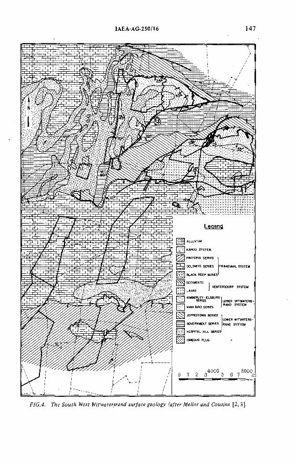
IAEA-AG-250/Í6 147
-WG.4. №eíf H^i'fwaíer^a^d iMr^acegeoZogy ['a/fer AfeZ^ora^d CoMMí [2,3].
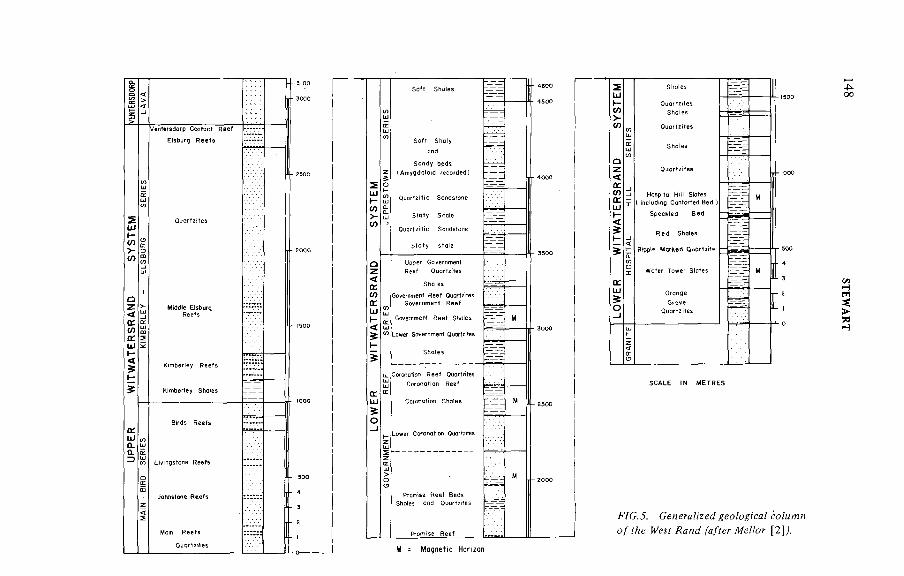
sUJ
>- (Л :
<ta:O)a:шt-<
ûi Ш < CL < CL ^ !
SY
STE
M
1
g
Г) Upper Governmentz<о: Shales0)rrШ И1b<%) - Shales
Coronation Reef Quartzites
û:U J
О
zLeer ceno,,*- Queras
z
Shdes or,d 0^.л,= в
4oo
F/C. J. Сенегя/zzeí? (7б)/м яо / H .yf [2 ]/
STE
WA
RT
IAEA AG-250/16 149
3.2. Nature o f ore bodies
The ore bodies o f the Witwatersrand are congiomerates which vary from a few cm in thickness to as much as 6 m and occur as extensive tabular sheets covering areas from a few to many tens o f krrP. Although the conglomerates are extremely extensive along strike, they degenerate rather rapidly down the paleoslope. Consequently the zone of payability is found to be a narrow strip extending several tens o f km along strike, but only 4 to 6 km down the paleoslope. Much work has been done on the sedimentology o f these deposits, yet geologists are still at variance as to the exact nature o f the sedimentary environments in which they were deposited. The general consensus is that they are either fluvial or shallow marine in origin, with the gold and uranium concentrated syngenetically.
As already mentioned, the ore bodies are primary gold deposits but virtually all o f them contain some uranium. Although there is usually a good correlation between gold and uranium content, the proportion o f uranium to gold varies from reef to reef. Furthermore, the ratio for an individual reef tends to vary gradually, but in a systematic way, across the ore body, the higher ratios usually being found in the more distal parts o f the depository. In low-grade uranium reefs the ratio may be as low as 5 to 1, while in ore bodies where uranium is the major product it may be in excess o f 1 0 0 0 to 1 .
3.3. Neighbouring mines
Before the preliminary drilling started in the vicinity o f Cooke Section, mines were operating to the west, north and north-east, and after completion of the preliminary drilling, but before the detailed prospecting started, an additional mine came into production to the south. Nevertheless, certain aspects o f the structure were not resolved, and the detailed stratigraphy in the upper part o f the system had not been described. It was also recognized that the area being examined was rather distant from the edge o f the basin, and there was therefore much speculation as to which conglomerates could still be payable so far down the paleoslope.
3.4. Previous drilling in the area
Attempts had been made to locate extensions to the Central Rand and West Rand ore bodies from about the beginning o f the century, and various programmes were conducted in the first decade. Further programmes were carried out in the early 1920s and again in the mid to late 1930s. The positions o f these holes are shown in Figs 6 and 7 [4].
Most work was carried out in the northern part o f the area and served to elucidate some o f the subsurface geology; specifically, it demonstrated that the Witpoortje horst swung southwards to the east o f Venterspost and Libanon gold
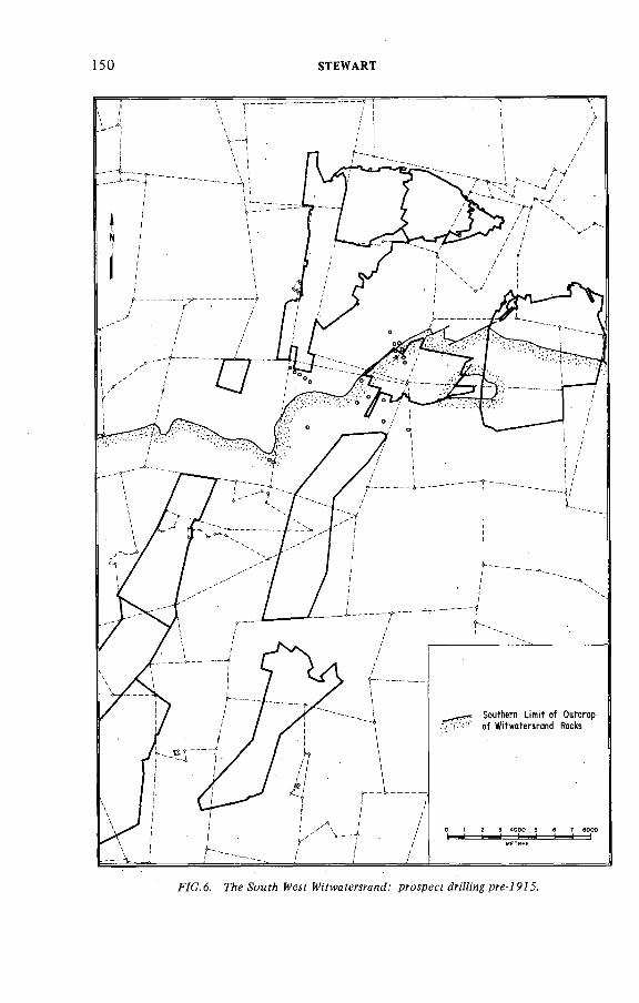
150 STEWART
F/G. 6. proipecf^nHmjpri-iP/^.
IAEA AG 250/16 151
F7C. 7. Г/:е ScMf?! M'fwafewancí.' pro^pecf 7 P7 J - ^PJO.
ÏAEA-AG-250/16 153
-WG.9. ГАе H 'fwaferírand.' proípecídr¡Hi'n^/P30-7P60.
154 STEWART
mines. Thus it could be shown that these mines were not part o f the Central Rand structural block. A simplified interpretation of the sub-Transvaal structure is shown in Fig.8 .
The drilling also provided information about the stratigraphy and the approximate elevation of the major reef zones. However, while some payable intersections were reported from the Main Reef zone o f conglomerates, none o f the driHing gave more than a vague hint that the Middle Elsburg reefs were developed, let alone highly payable, even though one borehole actually traversed the economic zone some 700 m to the north-east o f Cooke No. 1 shaft system. This borehole, called LG (drilled between 1938 and 1940), actually penetrated a part o f the mine where recovery grades are about 14 g t ' * o f gold and roughly 140 ppm U^Og, but failed to intersect the reef because it was cut out by a dyke.
The results o f this work are not compiled (some data is to hand and some results were verbally communicated), but a proportion o f what was learnt was built into the prospecting programmes of the early 1950s when a series o f holes were drilled on a wide grid across Gemsbokfontein, Panvlakte, and the area to the south (Fig.9). During this phase, a programme o f ten rather widely spaced holes were drilled in the vicinity o f Cooke Section, the actual positions being chosen to meet geological objectives. Eight o f these were intended to test the potential o f the Main-Bird Series conglomerates on the horst, while the remaining two were to check the structure and to test the potential o f the reefs in the downthrown block to the east o f the horst. As part o f this programme, a further series o f holes were drilled on Waterpan 292 IQ and Modderfontein 345 IQ. This drilling met with almost immediate success, with good values intersected in the Upper Elsburg reefs, and thus the initial exploration programme was expanded to an evaluation programme, and some ten years later, in 1960, Western Areas Gold Mining Co. Ltd (WAGM) began.
North o f WAGM, one o f the holes intersected an 'interesting' value, but owing to the WAGM evaluation programme, follow-up driHing was deferred until 1961.
3.5. Geophysics
Gravity and magnetic surveys were carried out in the area to assist in the interpretation of the structure.
Once it had been realized that the horst block swung southwards through the area, it seemed reasonable to use a gravimetric technique to delineate the position o f the lava mass, which was believed and subsequently demonstrated to be present to the east o f the fault. This proved unsuccessful since the anticipated anomaly resulting from the density difference between the lavas and quartzites was masked by the thick cover o f dolomites. However, a survey carried out in the western part o f Luipaardsvlei suggested a significant fault paralleling the main
IAEA-AG-250/16 155
structure with a downthrow to the west. To date it has not been possible to confirm this displacement.
Airborne and ground magnetic surveys were also carried out, the objective being to locate and trace the magnetic horizons o f the Lower Witwatersrand System as was done by Krahmann [5] along the West Witwatersrand Line. Although Krahmann was very successful in tracing these magnetic beds below the Transvaal cover, no anomalies were detected, and thus it was deduced that none o f them sub-outcropped immediately below the dolomites and must in fact be deeply buried below younger Witwatersrand rocks as well as the overlying systems.
3.6. The uranium boom
The presence o f radioactivity in the Witwatersrand conglomerate was first suspected by Pirow [6 ] as early as 1920; in 1924 Cooper [7] identified uraninite in concentrates gathered from Central Rand mines, it was not, however, until the uranium boom started that prospect boreholes in the South West Witwatersrand were assayed for uranium (actually L^Os). Prior to the 1950s only gold assays were carried out and thus an intersection was considered to be payable on its gold content alone. Once the importance o f uranium in the conglomerates had been appreciated and systematic sampling results became available, it was found that many conglomerates previously considered subeconomic had now become viable. This provided an added stimulus to prospecting and made the mining houses look very closely at the marginal gold deposits.
3.7. Conclusion
This then is the background against which the programme to prospect the Cooke Section areas was initiated. The general setting was understood but there were many gaps in the detail. The prime target was gold, although a contribution from uranium was recognised as a distinct possibility. The major reef zones had been intersected in places, with disappointing results, and where payability was found it was very deep (below 2000 m). One anomalous value occurred in borehole GB 2, and this was considered worthy o f follow-up work.
4. COOKE SECTION EXPLORATION
Borehole GB 2 was one o f the holes sited in the downthrown block, and although the values were not spectacular, it was decided to drill one follow-up hole in the vicinity. This hole, GB 3, proved successful, intersecting a 1.32-m-thick Middle Elsburg conglomerate at a depth o f 968 m below surface and having an average value o f 20.0 ppm o f gold and 690 ppm UgOg.
156 STEWART
The general geology o f the area to be prospected was reasonably well understood when drilling started in 1962. A contour plan o f the base o f the Transvaal System, showing a fairly flat but slightly channelled surface, was available, and early structural interpretations of the pre-Transvaal geology proved reasonably accurate. From drilling it was found that the Transvaal rocks ranged from 300 to 700 m thick. The dominant feature of the structure is the horst block which runs approximately from north to south (Fig.8 ) and is bounded on the east by the Panvlakte fault. This fault was believed to have a downthrow to the east o f at least 1 0 0 0 m.
To the west o f the fault, only rocks belonging to the Main-Bird Series had been intersected, and it was assumed that the remainder o f the succession, as well as all the overlying Ventersdorp rocks, had been eroded during the pre-Transvaal peneplanation. To the east o f the fault it was believed that almost the entire Witwatersrand succession was preserved, as well as some o f the Ventersdorp lavas. Indications o f a gentle anticline (or monocline) had been found, and it was therefore anticipated that across this fold axis the uppermost beds, including the Upper Elsburg conglomerates, would be absent.
The regional strike was believed to be roughly north-south, the dips on the horst being in excess o f 45° to the east. Dips on the downthrown side were believed to be between zero and 1 0 ° to the east.
The stratigraphie column as described by Mellor [2] had been found to apply in the area, although the description was too generalized to apply in detail. It should be noted that although the target was the Middle Elsburg reefs, they were generally found to be very poorly developed along the outcropping Central Rand, so much that Mellor made no reference to them in his original description. This is why little attention had been paid to these conglomerates. Although they had been intersected in boreholes drilled elsewhere in the area, descriptions o f the reef zone itself were inadequate and those o f the hanging wall quartzite succession were extremely generalized. The quartzites lying between the Upper Elsburg and Kimberley reefs were usually described as being 'monotonous'.
It was clear from the geology o f neighbouring mines and from the holes drilled in the area, that the Ventersdorp lavas transgressed across the Upper Witwatersrand rocks. It was to be expected therefore that in those parts o f the prospect area where lava separated the Witwatersrand from the Transvaal rocks, the lava could rest on any part o f the Kimberley/Elsburg series.
Although the regional structure was considered to be relatively simple, it was anticipated, in keeping with typical Witwatersrand ore bodies, that faults ranging in size from 1 to 2 0 0 m would be intersected in the boreholes.
The target as it was in 1962 was a zone o f conglomerates, generally poorly developed in the Central and West Rand, but shown to contain payable values in
4.1. Geology o f the prospect area
ÏAEA-AG-250/16 157
ÆiC.70. pT-oípee WZZi'n iPóO —7970.
158 STEWART
the South West Witwatersrand. The ore bodies were believed to occur at approximately 1 0 0 0 m below surface, and unconformably overlain by the younger systems o f rocks. No clearly defined stratigraphie marker beds had been described in the hanging wall o f the reef zone and there was therefore a distinct chance that the ore zone could be missed, particularly since the amount o f conglomerate in the zone represented less than 10% o f the section, the remainder being quartzite. The presence o f faults and dykes made correlation even more problematic.
4.2. Drilling programme
At the start o f the programme the area held was about 150 krn and included most o f Gemsbokfontein and Panvlakte, and part o f Luipaardsvlei and Gemspost. Part o f the area was held by REGM, while the remainder was owned by JCÎ. The prospecting was planned and supervized by JCI's own staff, and most o f the drilling was done by the JCI Drilling Division, though drilling contractors were used at times.
The initial plan was to drill holes on a 2500-ft (800-m) grid, but as results became available this was modified. Ultimately, the spacing of the holes was roughly 800 m along strike (i.e. the north-south direction) but at times holes were drilled as close as 300 m in the dip direction. A total o f 8 8 holes were drilled in and around the Cooke Section lease (Fig. 10). In the so-called Cooke 3 area, which is the most uraniferous part o f the property, a total o f 30 holes and 49 000 metres were drilled, which cost US $1.04 million. A similar programme would cost at least US $3.0 million in 1979.
4.3. Drilling procedure
The standard procedure for gold prospecting in South Africa is to prospect by means o f diamond core drilling, using narrow-diameter holes — either Nx or Bx which are, respectively, 7.6 or 6.0 cm in diameter. This was the method used to prospect the South West Witwatersrand and most o f the holes were drilled Bx diameter. Sullivan-50 drills were used and operated continuously for 136 hours each week, closing down on Sundays. The crew per rig was three drillers and fourteen labourers working three shifts per day.
The prospect area is covered by a thick succession o f Transvaal rocks, consisting almost entirely of dolomitic limestones in which are narrow chert bands. These rocks decompose at surface to form a thick clayey residuum in which are fragments o f chert. This unconsolidated layer varies from 20 m to 80 m thick and, because o f this, the upper part o f the hole was piloted using a percussion-type drill. Once core drilling started, the entire hole would be cored and thus an almost complete section would be available for examination. On completion o f the hole, wedges would be placed above the reef zone in order to make additional inter
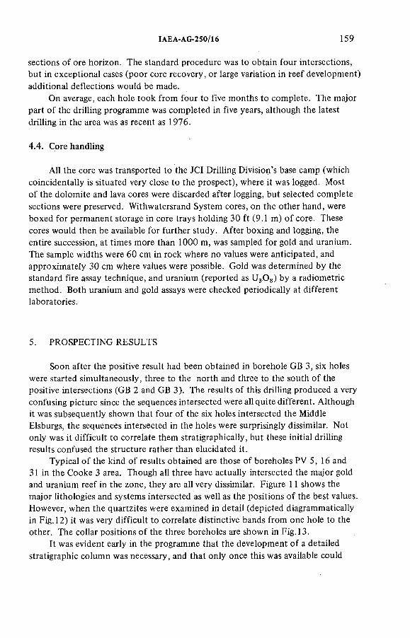
IAEA-AG-250/16 159
sections o f ore horizon. The standard procedure was to obtain four intersections, but in exceptional cases (poor core recovery, or large variation in reef development) additional deflections would be made.
On average, each hole took from four to five months to complete. The major part o f the drilling programme was completed in five years, although the latest drilling in the area was as recent as 1976.
4.4. Core handling
All the core was transported to the JCI Drilling Division's base camp (which coincidentally is situated very close to the prospect), where it was logged. Most o f the dolomite and lava cores were discarded after logging, but selected complete sections were preserved. Withwatersrand System cores, on the other hand, were boxed for permanent storage in core trays holding 30 ft (9.1 m) o f core. These cores would then be available for further study. After boxing and logging, the entire succession, at times more than 1 0 0 0 m, was sampled for gold and uranium. The sample widths were 60 cm in rock where no values were anticipated, and approximately 30 cm where values were possible. Gold was determined by the standard fire assay technique, and uranium (reported as UgOg) by a radiometric method. Both uranium and gold assays were checked periodically at different laboratories.
5. PROSPECTING RESULTS
Soon after the positive result had been obtained in borehole GB 3, six holes were started simultaneously, three to the north and three to the south of the positive intersections (GB 2 and GB 3). The results o f this drilling produced a very confusing picture since the sequences intersected were all quite different. Although it was subsequently shown that four o f the six holes intersected the Middle Elsburgs, the sequences intersected in the holes were surprisingly dissimilar. Not only was it difficult to correlate them stratigraphically, but these initial driHing results confused the structure rather than elucidated it.
Typical o f the kind o f results obtained are those o f boreholes PV 5,16 and 31 in the Cooke 3 area. Though all three have actually intersected the major gold and uranium reef in the zone, they are all very dissimilar. Figure 11 shows the major lithologies and systems intersected as well as the positions o f the best values. However, when the quartzites were examined in detail (depicted diagrammatically in Fig. 12) it was very difficult to correlate distinctive bands from one hole to the other. The collar positions o f the three boreholes are shown in Fig. 13.
It was evident early in the programme that the development o f a detailed stratigraphie column was necessary, and that only once this was available could
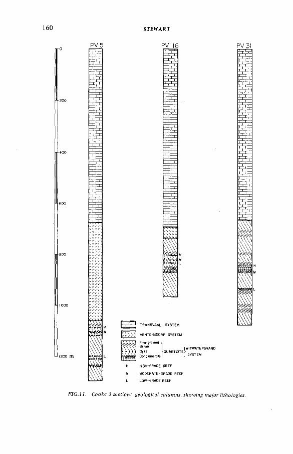
160
4 2 0 0 m
PV5
-ЬгЕ
PE
STEWART
PV 16
S E
ywvv
TRANSVAAL SYSTEM
VENTERSDORP SYSTEM
Dyke1WITWATERSRAND1-J SYSTEM
HIGH-GRADE REEF
MODERATE-GRADE REEF
LOW-GRADE REEF
PV3!
F/GJ A CcoAe íecfíon.' geoíogicaí lowing ¡¡'fhoiogiM.
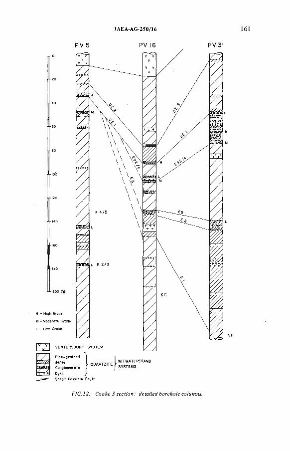
:A EA -AG -250/!6
PV 5 P V 1 6 PV3)
F7C..Z2. Coo^e^jecfMM.' ¿efa;7e¿bore/¡oíecoZMmn&
162 STEWART
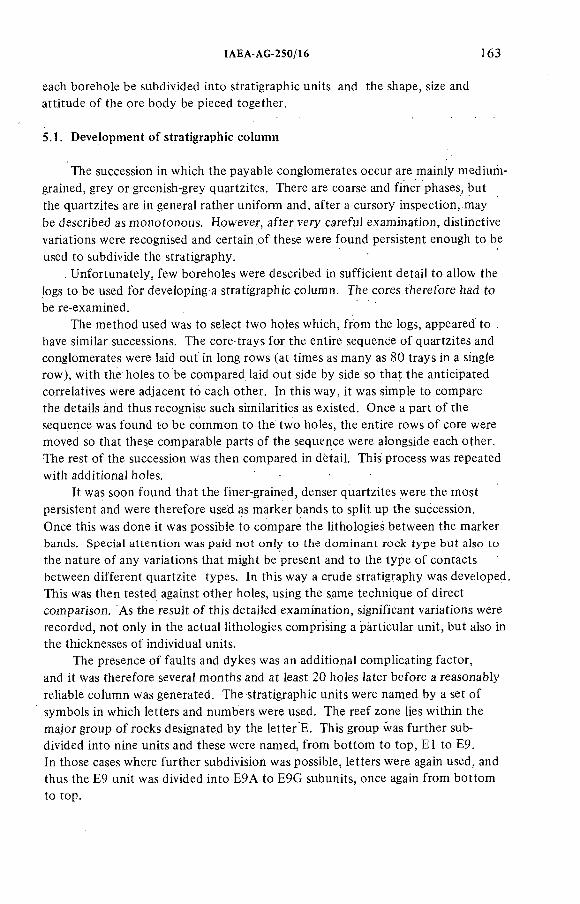
ÏAEA-AG-250/16 163
each borehole be subdivided into stratigraphie units and the shape, size and attitude of the ore body be pieced together.
5.1. Development o f stratigraphie column
The succession in which the payable conglomerates occur are mainly medium- grained, grey or greenish-grey quartzites. There are coarse and finer phases, but the quartzites are in general rather uniform and, after a cursory inspection,.may be described as monotonous. However, after very careful examination, distinctive variations were recognised and certain o f these were found persistent enough to be used to subdivide the stratigraphy.
. Unfortunately, few boreholes were described in sufficient detail to allow the logs to be used for developing a stratigraphie column. The cores therefore had to be re-examined.
The method used was to select two holes which, from the logs, appeared to . have similar successions. The core trays for the entire sequence o f quartzites and conglomerates were laid out in long rows (at times as many as 80 trays in a single row), with the holes to be compared laid out side by side so that the anticipated correlatives were adjacent to each other. In this way, it was simple to compare the details and thus recognise such similarities as existed. Once a part o f the sequence was found to be common to the two holes, the entire rows o f core were moved so that these comparable parts of the sequence were alongside each other.. The rest o f the succession was then compared in detail. This process was repeated with additional holes.
It was soon found that the finer-grained, denser quartzites were the most persistent and were therefore used as marker bands to split up the succession.Once this was done it was possible to compare the lithologies between the marker bands. Special attention was paid not only to the dominant rock type but also to
the nature o f any variations that might be present and to the type o f contacts between different quartzite types. In this way a crude stratigraphy was developed. This was then tested against other holes, using the same technique o f direct comparison. As the result o f this detailed examination, significant variations were recorded, not only in the actual lithologies comprising a particular unit, but also in the thicknesses of individual units.
The presence o f faults and dykes was an additional complicating factor, and it was therefore several months and at least 2 0 holes later before a reasonably reliable column was generated. The stratigraphie units were named by a set of symbols in which letters and numbers were used. The reef zone lies within the major group o f rocks designated by the letter E. This group was further subdivided into nine units and these were named, from bottom to top, El to E9.In those cases where further subdivision was possible, letters were again used, and thus the E9 unit was divided into E9A to E9G subunits, once again from bottom to top.
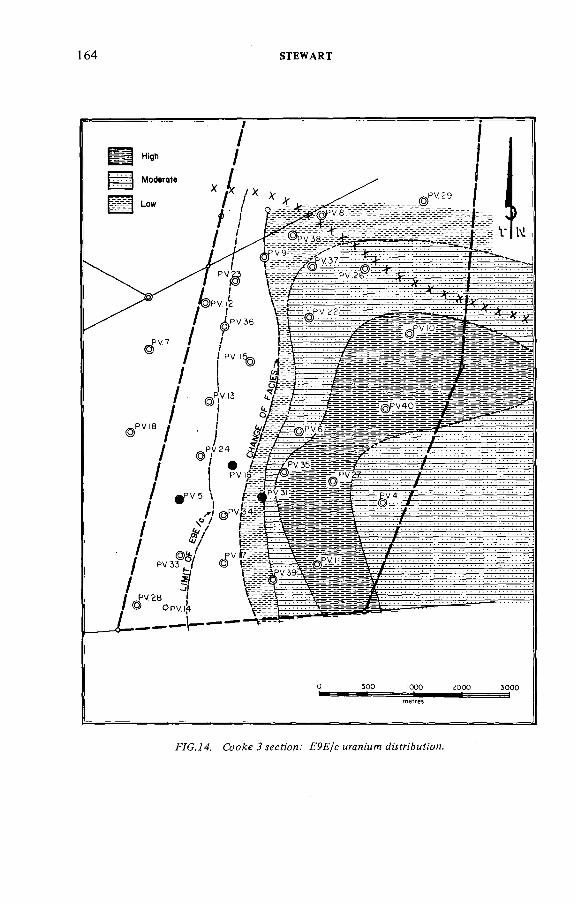
164 STEWART
F/CJ4. Соойе ^ леся'оя.' FPF/c Mrani'MfT! ^муп'ймй'ои.
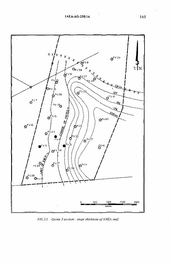
ÍAEA-AG-250/16 165
Соо^е^^еся'ои.' yfopeí/ü'c^neíío/FPF/cree/.
166 STEWART
fV G . id . CcoÆ e J лес?;'оп.' F P F / c Ю М Г7 а м ор ссА .
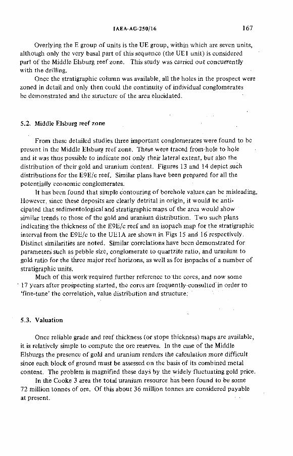
IAEA-AG-250/! 6 167
Overlying the E group of units is the UE group, within which are seven units, although only the very basal part o f this sequence (the UE1 unit) is considered part o f the Middle Elsburg reef zone. This study was carried out concurrently with the drilling.
Once the stratigraphie column was available, all the holes in the prospect were zoned in detail and only then could the continuity o f individual conglomerates be demonstrated and the structure of the area elucidated.
5.2. Middle Elsburg reef zone
From these detailed studies three important conglomerates were found to be present in the Middle Elsburg reef zone. These were traced from-hole to hole and it was thus possible to indicate not only their lateral extent, but also the distribution of their gold and uranium content. Figures 13 and 14 depict such distributions for the E9E/c reef. Similar plans have been prepared for all the potentially economic conglomerates.
It has been found that simple contouring o f borehole values can be misleading. However, since these deposits are clearly detrital in origin, it would be anticipated that sedimentological and stratigraphie maps o f the area would show similar trends to those o f the gold and uranium distribution. Two such plans indicating the thickness o f the E9E/c reef and an isopach map for the stratigraphie interval from the E9E/c to the UE1A are shown in Figs 15 and 16 respectively. Distinct similarities are noted. Similar correlations have been demonstrated for parameters such as pebble size, conglomerate to quartzite ratio, and uranium to gold ratio for the three major reef horizons, as well as for isopachs of a number o f stratigraphie units.
Much o f this work required further reference to the cores, and now some 17 years after prospecting started, the cores are frequently consulted in order to 'fine-tune' the correlation, value distribution and structure.
5.3. Valuation
Once reliable grade and reef thickness (or stope thickness) maps are available, it is relatively simple to compute the ore reserves. In the case o f the Middle Elsburgs the presence o f gold and uranium renders the calculation more difficult since each block o f ground must be assessed on the basis o f its combined metal content. The problem is magnified these days by the widely fluctuating gold price.
In the Cooke 3 area the total uranium resource has been found to be some 72 million tonnes o f ore. Of this about 36 million tonnes are considered payable at present.
168 STEWART
The ore bodies in the Middle Elsburg reef zone were found to be payable in the South West Witwatersrand many years after gold was first mined in the vicinity. That they were missed for so long seems surprising, but this was due mainly to the complexity o f the Witwatersrand geology. Additional contributing factors were:
(a) The reefs are buried beneath several hundreds of metres o f younger formations;
(b) Payability was not anticipated in the Middle Elsburgs; and(c) The early prospecting targets were the Main Reef conglomerates and,
once those were considered unpayable, interest in the area waned.
Even when payability was found in the initial boreholes, it still required a tremendous amount o f closely spaced prospect drilling and many hours o f detailed examination o f the cores before it could be shown that sufficient reserves existed to sustain a mining operation. This case history demonstrates the need to have as detailed an understanding of the structure, stratigraphy (with special reference to the conglomeratic zones) and, if possible, the nature of distribution o f the mineralization in the area before detailed prospecting starts. Detailed compilation o f all data at the outset is essential.
Much research is being carried out by the South African mining houses and the Transvaal and Orange Free State Chamber o f Mines to develop short-cut methods (such as trace-element chemistry to facilitate correlation) to aid the prospecting geologist. However, in the final analysis, the tried and tested method o f drilling fully cored boreholes is by far the most successful. Magnetometric and gravimetric surveys have also been found useful in many, but not all, areas.
All programmes must be sensitive enough to recognise all potential ore bodies irrespective o f the circumstances in which they occur, without becoming excessively cumbersome and costly. It is also essentia! that careful studies o f all cores be carried out, particularly those where indications o f payability are observed, however slight they may be.
6. CONCLUSION
ACKNOWLEDGEMENTS
The author would like to record his thanks to all his colleagues with whom he worked during the prospecting o f the Cooke Section. It was as a result o f many informal discussions that a large amount o f unpublished information was communicated and many o f the problems relating to the geology o f the area resolved.
IAEA-AG-250/16 169
A special word of thanks is due to Mr. E.H. Jones (Consulting Geologist of JCI), who supervised the prospecting and subsequent interpretation of the result, for his invaluable guidance and objective criticism.
Thanks are also extended to the staff o f JCI Geological Department for their assistance in preparing the text and diagrams and, finally, to the management o f Johannesburg Consolidated Investment Co. Ltd for permission to publish this paper.
REFERENCES
[1] FRETORIUS, D.A., The depositional environment of the Witwatersrand goldfields:A chronoiogicai review of speculations and observations, Miner. Soc. Eng. 7 1 ( i 975).
[2] MELLOR, E.T., The geology of the Witwatersrand — An explanation of the geologicalmap of the Witwatersrand Goldfield, Geol. Surv. S. Afr. (1917).
[3] COUSINS, C.A., The stratigraphy, structure and igneous rocks of the Transvaal System at Western Areas Gold Mine, Trans. Geol. Soc. S. Afr. 65 2 (1962).
[4] TECHNICAL MAP SERVICES, JOHANNESBURG, Borehole Data, Witwatersrand System (Orange Free State and Transvaal) (1950).
[5] KRAHMANN, R., The geophysical magnetometric investigations on West Witwatersrand areas: between Randfontein and Potchefstroom, Transvaal, Trans. Geol. Soc. S. Afr.39 (1937).
[6] PIROW, H., Distribution of the pebbles in the Rand banket and other features of the rock, Trans. Geol. Soc. S. Afr. 23 (1920).
[7] COOPER, R.A., Mineral constituents of Rand conglomerates, J . Chem. Metall. Min. Soc.S. Afr. 24 (1924).
DISCUSSION
J.M.A. FORMAN: Do the proximal/distal facies concepts apply to this deposit? What are the ratios o f uranium to gold?
B.D. STEWART: Distinct proximal and some distal facies exist, although they differ in certain aspects from those found elsewhere in the Witwatersrand. U/Au ratios vary across the deposit, being lowest in the proximal facies and highest in the distal facies.
J.M.A. FORMAN: Do you find differences in the colour o f the quartz pebbles associated with uranium?
B.D. STEWART: No correlation between the colour of the quartz pebbles and the uranium content has been recognized. We have noticed that in the more uraniferous conglomerates some o f the pebbles display a characteristic fracturation.
J.M.A. FORMAN: Does organic material (thucholite) play an important role in the Au/U deposition?
B.D. STEWART: Organic material is present in reefs and is associated with increased gold values, and in certain instances with enhanced uranium content.
170 STEWART
D. TAYLOR: What downhole logging techniques do you use and do they not assist in the correlation between holes?
B.D. STEWART : Downhole logging is not carried out by JCI, since all the Witwatersrand cores are sampled for uranium. Some companies are known to have used downhole radiometrics and have had a certain degree o f success — I don't know the exact degree.
R. GATZWEILER: How do you determine the payability o f an ore block? Do you treat one element as the major cost bearing and the other as by-product or are they treated equally?
B.D. STEWART : A grid is superimposed over the area, and the mean grade for gold and uranium estimated for each block. From this it is possible to establish the value o f the resource or reserve in monetary terms, and they are thus treated equally. This, o f course, only applies when both gold and uranium are recovered.
D.A. PORTER: Smoky quartz is associated with some sandstone uranium deposits. Is there much smoky quartz in the conglomerates? If so, does it appear to be associated with the uranium?
B.D. STEWART : Smoky quartz pebbles are present; their percentage in the Middle Elsburg reefs is not available, but it is probably less than 20%.No association between smoky quartz pebbles and uranium has been recognized.It should be noted that some conglomerates in the Upper Witwatersrand System have a mudi higher percentage o f smoky quartz pebbles than the Middle Elsburgs, but in these cases they contain low uranium values (less than 1 0 0 ppm).
ÍAEA-AG-250/19
DISCOVERY OF THE JABILUKA URANIUM DEPOSITS, EAST ALLIGATOR RIVER REGION, NORTHERN TERRITORY OF AUSTRALIA
J.C. ROWNTREE, D.V. MOSHER Pancontinental Mining Ltd,Sydney,Australia
Abstract
DISCOVERY OF THE JABILUKA URANIUM DEPOSITS, EAST ALLIGATOR RIVER . REGION, NORTHERN TERRITORY OF AUSTRALIA.
The Jabiluka One and Two uranium deposits occur in Lower Proterozoic metasediments of the Cahill Formation. The Jabiluka One deposit coincides with a 'window' through unconformabiy overlying Middle Proterozoic sandstone of the Kombolgie Formation;Jabiluka Two is completely covered by that sandstone. The observed part of the Cahill Formation exhibits four horizons which are favourable hosts for uranium mineralization.These have been folded into an east-southeast-striking, gently plunging, asymmetric flexure. The host rocks are mainly chlorite and/or graphite schists and their brecciated equivalents which have undergone initial regional prograde metamorphism to amphibolite facies, then retrograde metamorphism to greenschist facies. Mineralization consists of uraninite, mainly filling open spaces and to a lesser extent in disseminated form. Chlorite alteration is intimately associated with the uranium mineralization. A portion of the Jabiluka Two deposit contains economic concentrations of gold. Although the deposits are generally stratabound, structural preparation appears to be the most significant ore control on a local scale.
The Jabiluka case history illustrates an effective philosophy which was successful in exploration for stratabound uranium deposits in the East Alligator River Region. This philosophy encompassed the following points: (a) The value of regional appraisals in selection of a property; (b) The recognition of the detection limits of airborne radiometric surveys;(c) The importance of ground prospecting for low-order point-source radiometric anomalies which cannot be detected by airborne survey; (d) The importance of evaluating all anomalies and the flexibility to change priorities as further exploration results are obtained; (e) The necessity of establishing the controls on the mineralization before proceeding with further exploration; (f) The necessity of exploring extensions of favourable lithologies to test for periodicity of mineralization even where cover precludes surface expression; and (g) The desirability for modification of exploration techniques on different types of anomalies.
171
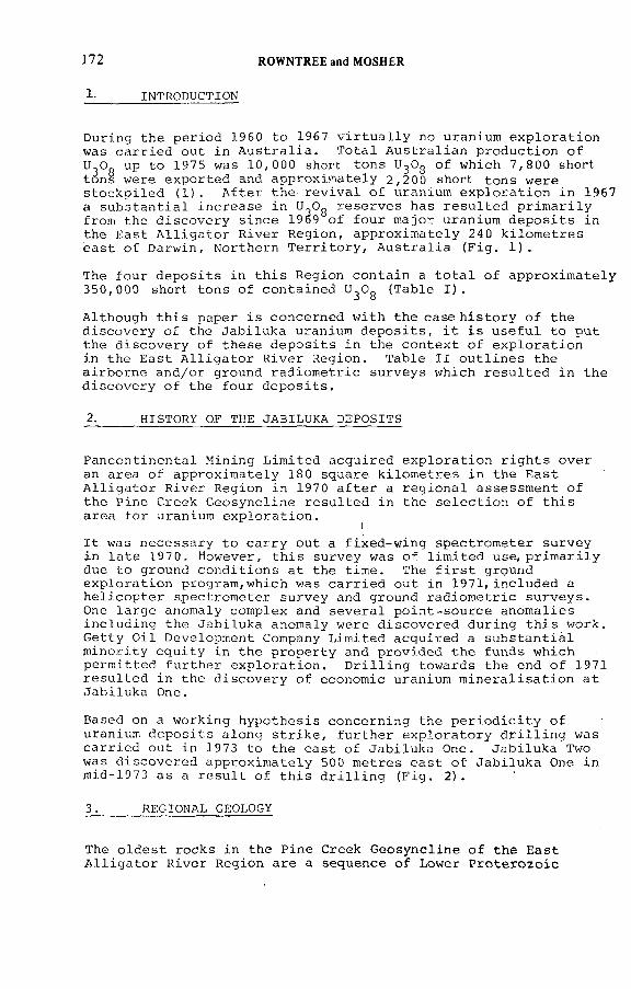
172 ROWNTREE and MOSHER
1- INTRODUCTION
D u r in g th e p e r i o d 1960 t o 1967 v i r t u a l l y no uran ium e x p l o r a t i o n was c a r r i e d o u t i n A u s t r a l i a . T o t a l A u s t r a l i a n p r o d u c t i o n o f U-Од up t o 1975 was 10 ,000 short t o n s U^Og o f w h ich 7 ,8 0 0 short tOn§ w e re e x p o r t e d and a p p r o x im a t e l y 2 ,20 0 short t o n s w e r e s t o c k p i l e d ( 1 ) . A f t e r t h e r e v i v a l , o f uran ium e x p l o r a t i o n in 1967 a s u b s t a n t i a l i n c r e a s e i n U^Og r e s e r v e s has r e s u l t e d p r i m a r i l y f rom th e d i s c o v e r y s in c e 1969 o f f o u r m a jo r uran ium d e p o s i t s in th e E a s t A l l i g a t o r R i v e r R e g io n , a p p r o x im a t e l y 240 k i l o m e t r e s e a s t o f D a rw in , N o r th e r n T e r r i t o r y , A u s t r a l i a ( F i g . 1 ) .
The f o u r d e p o s i t s i n t h i s R e g io n c o n t a in a t o t a l o f a p p r o x im a t e l y 350 ,000 short t o n s o f c o n t a in e d U^Og ( T a b l e I ) .
A l th o u g h t h i s p a p e r i s c o n c e r n e d w i t h th e c a s e h i s t o r y o f th e d i s c o v e r y o f th e J a b i lu k a uranium d e p o s i t s , i t i s u s e f u l t o p u t th e d i s c o v e r y o f t h e s e d e p o s i t s i n th e c o n t e x t o f e x p l o r a t i o n in th e E a s t A l l i g a t o r R i v e r R e g io n . T a b l e I I o u t l i n e s th e a i r b o r n e and/or ground r a d i o m e t r i c s u r v e y s w h ich r e s u l t e d i n th e d i s c o v e r y o f th e f o u r d e p o s i t s .
2. HISTORY OF THE JABILUKA DEPOSITS
P a n c o n t in e n t a l M in in g L im i t e d a c q u i r e d e x p l o r a t i o n r i g h t s o v e r an a r e a o f a p p r o x im a t e l y 18 0 s q u a re k i l o m e t r e s i n t h e E a s t A l l i g a t o r R i v e r R e g io n in 1970 a f t e r a r e g i o n a l a s s e s s m e n t o f t h e P in e C re e k G e o s y n c l in e r e s u l t e d i n th e s e l e c t i o n o f t h i s a r e a f o r uran ium e x p l o r a t i o n .
iI t was n e c e s s a r y t o c a r r y o u t a f i x e d - w i n g s p e c t r o m e t e r s u r v e y in l a t e 1970. H ow ever , t h i s s u r v e y was o f l i m i t e d u s e , p r i m a r i l y due t o g rou n d c o n d i t i o n s a t th e t im e . The f i r s t g round e x p l o r a t i o n p r o g r a m ,w h ic h was c a r r i e d o u t i n 1971, i n c lu d e d a h e l i c o p t e r s p e c t r o m e t e r s u r v e y and grou nd r a d i o m e t r i c s u r v e y s . One l a r g e anom a ly com p le x and s e v e r a l p o i n t - s o u r c e a n o m a l i e s i n c l u d i n g th e J a b i lu k a anom a ly w e r e d i s c o v e r e d d u r in g t h i s w o rk . G e t t y O i l D eve lop m en t Company L im i t e d a c q u i r e d a s u b s t a n t i a l m i n o r i t y e q u i t y in t h e p r o p e r t y and p r o v i d e d t h e fu n d s w h ic h p e r m i t t e d f u r t h e r e x p l o r a t i o n . D r i l l i n g to w a rd s th e end o f 1971 r e s u l t e d i n th e d i s c o v e r y o f e con om ic uran ium m i n e r a l i s a t i o n a t J a b i lu k a One.
Based on a w o rk in g h y p o t h e s i s c o n c e r n in g th e p e r i o d i c i t y o f uranium d e p o s i t s a l o n g s t r i k e , f u r t h e r e x p l o r a t o r y d r i l l i n g was c a r r i e d o u t in 1973 t o t h e e a s t o f J a b i lu k a One. J a b i lu k a Two was d i s c o v e r e d a p p r o x im a t e l y 500 m e t r e s e a s t o f J a b i lu k a One in m id-1973 a s a r e s u l t o f t h i s d r i l l i n g ( F i g . 2 ) .
3. REGIONAL GEOLOGY
The o l d e s t r o c k s in t h e P in e C reek G e o s y n c l in e o f th e E a s t A l l i g a t o r R i v e r R e g io n a r e a s eq u e n ce o f Low er P r o t e r o z o i c
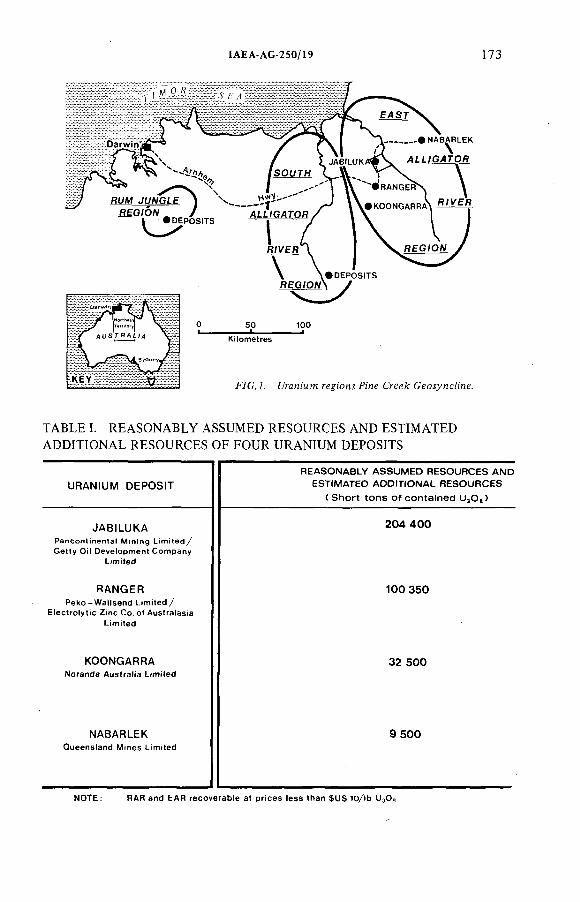
IAEA-AG-250/19 173
TABLE I. REASONABLY ASSUMED RESOURCES AND ESTIMATED ADDITIONAL RESOURCES OF FOUR URANIUM DEPOSITS
URANIUM DEPOSITREASONABLY A SSU M ED R ESO U R C ES AND
ESTIMATED ADDITIONAL R E SO U R C E S
Í S h o r t to n s o f c o n ta in e d U3 O 3 )
JABILUKA 2 0 4 4 0 0
RANGERPeko-W a l lsend Limited/
Electrolytic Zinc Co. o f Australasia
1 0 0 3 5 0
KOONGARRA 3 2 5 0 0
NABARLEKQueensland Mines Limited
9 5 0 0
NOTE: RAR and EAR recoverable at prices less than $US 10/lb
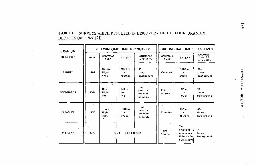
4^
TABLE II. SURVEYS WHICH RESULTED IN DISCOVERY OF THE FOUR URANIUM DEPOSITS (/rom Яе/ [2])
URANtUM
DEPOStT
. F !XED W )N G RADtOMETR)C SURVEY GROUND RAD!OMETR)C SURVEY
DATEANOMALY
TYPEEXTENT
ANOMALY
)NTENS)TYANOMALY
TYPEEXTENT
ANOMALYCENTRE
!NTENS)TY
RANGER 1969
Severa! f tight
7000 m
1500 m
15Comptex
6 0 0 0 m
5 00 m
250
KOONGARRA 1969Onettight
tine
100 mHigh
Point
Source
90 m
90 m
10
NABARLEK 1970Threeftight
1800 m
500 m
High
Comple,
150 m
1500 m
50
JABtLUKA 1970 N ОТ D E T E C T E DPoint
105m ж 45m 80m X 40m
2
ROW
NTR
EE and
MO
SHER
1AEA-AG 250/19 175
F 7 C . 2 . C e o í o ^ ra c fi'o m g fri'c .:.
p h y l l i t e s , s c h i s t s and q u a r t z i t e s o f th e Kakadu Group and c h e r t s , q u a r t z s c h i s t s , q u a r t z i t e s and c a r b o n a t e s a s s i g n e d t o th e C a h i l l F o rm a t io n o f t h e Namoona Group ( 3 ) . The C a h i l l F o rm a t io n i s th e h o s t r o c k f o r th e s t r a t a b o u n d uran ium m i n e r a l i s a t i o n in t h e R e g io n .
M ig m a t i s a t i o n o f th e Low er P r o t e r o z o i c m e ta s e d im e n ts r e s u l t e d in th e d e v e lo p m e n t o f g n e i s s , l i t p a r l i t i n j e c t i o n g n e i s s and s y n t e c t o n i c g r a n i t e s and p e g m a t i t e s r e f e r r e d t o as th e Nanambu C om p lex .
U n co n fo rm a b ly o v e r l y i n g t h e L ow er P r o t e r o z o i c r o c k s i s a t h i c k s u c c e s s i o n o f M id d le P r o t e r o z o i c s a n d s to n e s and c o n g lo m e r a t e s o f th e K o m b o lg ie F o r m a t io n . The e r o s i o n a l rem nant o f t h i s F o rm a t io n fo rm s th e Arnhem Land P l a t e a u w h ich r i s e s t o 200 m e t r e s in th e e a s t e r n p o r t i o n o f th e E a s t A l l i g a t o r R i v e r R e g io n .
P a r t i a l p e n e p l a n a t i o n d u r in g th e M e s o z o ic r e s u l t e d i n t h e d e v e lo p m e n t o f r e l a t i v e l y t h i n C r e t a c e o u s M ullamen b ed s o v e r th e l o w - l y i n g p o r t i o n o f th e n o r t h e r n p a r t o f t h e R e g io n .
F u r t h e r p a r t i a l p e n e p la n a t i o n d u r in g th e T e r t i a r y , g e n e r a l l y t o a l e v e l a f e w m e t r e s b e lo w th e M id d le P r o t e r o z o i c u n c o n fo r m i t y , r e s u l t e d in th e d e v e lo p m e n t o f e x t e n s i v e l a t e r i t e s . R e c e n t e l u v i a l and a l l u v i a l sandy d e p o s i t s fo rm a t h in b u t p e r s i s t e n t c o v e r o v e r th e l o w - l y i n g a r e a s o f th e R e g io n .
176 ROWNTREE and MOSHER
F/C.J. 7%e УдМыАд алеа.
IAEA-AG-250/19 177
4. EXPLORATION ENVIRONMENT
The c l i m a t e in t h e E a s t A l l i g a t o r R i v e r R e g io n c o n s i s t s o f a m onsoona l s ea son f r om Decem ber t o A p r i l f o l l o w e d b y d r y s ea son from May t o N ovem ber . A nnua l r a i n f a l l i s a p p r o x i m a t e l y 1400 m i l l i m e t r e s and t h e a v e r a g e d a i l y maximum t e m p e r a t u r e r a n g e s from 31 ° t o 36 ° C e l s i u s .
The l o w - l y i n g a r e a s o f th e R e g io n a r e c o v e r e d w i t h a m o d e ra te g r o w th o f e u c a l y p t u s and p a p e r b a rk t r e e s ; h o w e v e r , t h e Arnhem Land P l a t e a u s u p p o r t s a l i g h t g r o w th o f p a p e rb a rk s and s c ru b (F i g . 3 ) .
The e x t e n s i v e lo w la n d i n th e w e s t e r n p o r t i o n o f t h e R e g io n i s a p p r o x im a t e l y 10-50 m e t r e s a b o v e sea l e v e l . The l o w la n d , w h ich i s f l o o d e d in th e m onsoona l s e a s o n , c o n t a in s numerous perm anent w a t e r c h a n n e ls and s e a s o n a l d r a in a g e c h a n n e ls .
The m a j o r i t y o f t h e e x p l o r a t i o n work i s c a r r i e d o u t d u r in g th e d r y s ea so n from June t o D ecem ber when w o r k in g and a c c e s s c o n d i t i o n s a r e e a s i e s t and th e s u p p o r t c o s t s a r e l o w e s t .
The J a b i lu k a p r o p e r t y in t h e c e n t r a l p o r t i o n o f th e R e g io n l i e s a p p r o x im a t e l y 240 k i l o m e t r e s due e a s t o f D a rw in . T h e r e i s a p a ved main r o a d t o th e R e g io n f r om D a rw in ; h o w e v e r , l o c a l a c c e s s r o u t e s c o n s i s t o f g r a v e l r o a d s w h ich p r o v i d e r e a s o n a b l e a c c e s s d u r in g t h e d r y s e a s o n .
5. SELECTION OF THE PROPERTY
The p r o p e r t y was s e l e c t e d b e ca u se i t was w i t h i n t h e Low er P r o t e r o z o i c P in e C reek G e o s y n c l in e w h ich c o n t a in s known uran ium m i n e r a l i s a t i o n in t h e Sou th A l l i g a t o r R i v e r R e g io n and Rum J u n g le R e g io n ( F i g . 1 ) . The Bureau o f M in e r a l R e s o u r c e s ' p r e l i m i n a r y g e o l o g i c a l maps o f th e E a s t A l l i g a t o r R i v e r R e g io n w e r e b a sed p r i m a r i l y on a i r p h o t o g r a p h i c i n t e r p r e t a t i o n , t o g e t h e r w i t h w id e sp a ced g rou nd t r a v e r s e s and w e r e o f l i m i t e d r e l i a b i l i t y .
In 1970 P a n c o n t i n e n t a l a c q u i r e d t h e p r o p e r t y ( F i g . 4 ) and i n i t i a t e d a p r e l i m i n a r y i n v e s t i g a t i o n w h ich i n c lu d e d g e o l o g i c a l r e c o n n a i s s a n c e and r a d i o m e t r i c t r a v e r s e s as a b a s i s f o r th e f i x e d - w in g r a d i o m e t r i c s u r v e y w h ich i t was n e c e s s a r y t o c a r r y o u t due t o work com m itm ents on th e p r o p e r t y . The f i x e d - w i n g s u r v e y was o f l i m i t e d u s e , p r i m a r i l y due t o g roun d c o n d i t i o n s a t t h e t im e , and d i d n o t p r o v i d e a s u i t a b l e b a s i s f o r f u r t h e r g rou nd e x p l o r a t i o n .
P r i o r t o commencement o f g rou n d e x p l o r a t i o n in 19 71, p r e l i m i n a r y b a s e maps w e re p r e p a r e d f r om go v e rn m e n t a e r i a l p h o to s o f th e a r e a . A s t r u c t u r a l i n t e r p r e t a t i o n o f th e p r o p e r t y was a l s o c a r r i e d o u t u t i l i s i n g th e p r e l i m i n a r y g e o l o g i c a l i n f o r m a t i o n a c q u i r e d d u r in g th e p r o p e r t y r e c o n n a i s s a n c e i n 1970.
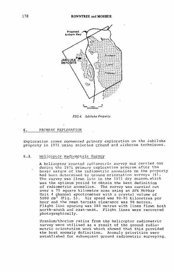
178 ROWNTREE and MOSHER
F/C. 4. УяМмАя.Ргсрег?у.
6 . PRIMARY EXPLORATION
E x p l o r a t i o n c rew s commenced p r im a r y e x p l o r a t i o n on th e J a b i lu k a p r o p e r t y i n 1971 u s in g s e l e c t e d g round and a i r b o r n e t e c h n i q u e s .
6 .1 , H e l i c o p t e r R a d io m e t r i c S u rv e y
A h e l i c o p t e r mounted r a d i o m e t r i c s u r v e y was c a r r i e d o u t d u r in g th e 19 71 p r im a r y e x p l o r a t i o n p ro g ram a f t e r t h e b a s i c n a tu r e o f th e r a d i o m e t r i c a n o m a l i e s on th e p r o p e r t y had been d e t e r m in e d by g rou n d o r i e n t a t i o n s u r v e y s ( 4 ) .The s u r v e y was f l o w n l a t e i n th e 1971 d r y s e a s o n ,w h ic h was t h e optimum p e r i o d t o o b t a i n th e b e s t d e f i n i t i o n o f r a d i o m e t r i c a n o m a l i e s . The s u r v e y was c a r r i e d o u t o v e r a 75 sq u a re k i l o m e t r e a r e a u s in g an AV4 McPhar U n i t 4 c h a n n e l s p e c t r o m e t e r w i t h a c r y s t a l vo lum e o f 5000 cm^ ( F i g . 5 ) . A i r sp eed was 90-95 k i l o m e t r e s p e r h ou r and th e mean t e r r a i n c l e a r a n c e was 90 m e t r e s .F l i g h t l i n e s p a c in g was 18 0 m e t r e s w i t h l i n e s f l o w n b o th n o r t h - s o u t h and e a s t - w e s t . F l i g h t l i n e s w e r e r e c o v e r e d p h o t o g r a p h i c a l l y .
U ran iu m /thor iu m r a t i o s f r om th e h e l i c o p t e r r a d i o m e t r i c s u r v e y w e re u t i l i s e d as a r e s u l t o f t h e g round r a d i o m e t r i c o r i e n t a t i o n work w h ich showed t h a t t h i s p r o v i d e d t h e b e s t anom aly d e f i n i t i o n . Anom aly p r i o r i t i e s w e r e e s t a b l i s h e d f o r su b seq u en t g rou n d r a d i o m e t r i c s u r v e y in g .
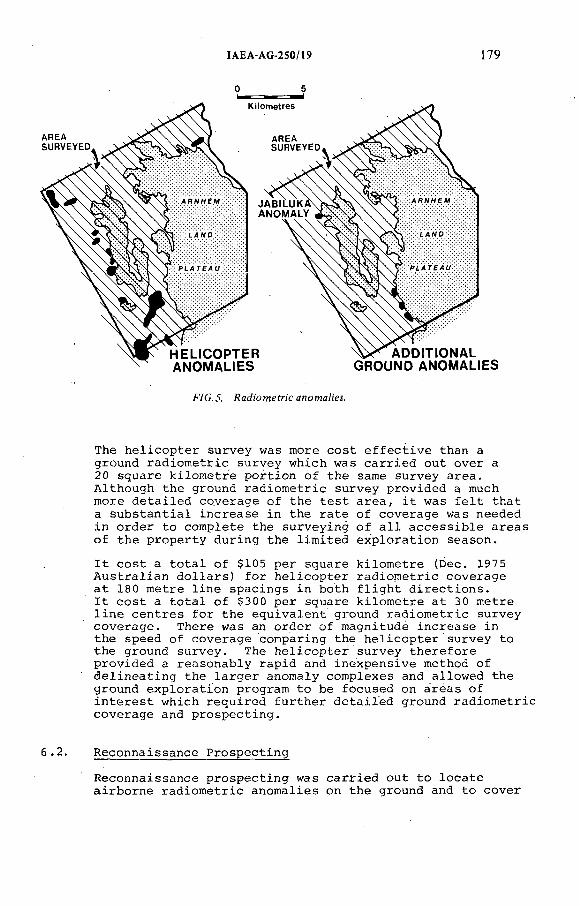
IAEA-AG-250/19 i 79
AREA SURVEYED
H EU CO PTERANOM AHES
ADDtHONAL GROUND ANOMALtES
FÍC.J. J4aá:o?nefr¡cano?naHM.
The h e l i c o p t e r s u r v e y was more c o s t e f f e c t i v e than a g rou n d r a d i o m e t r i c s u r v e y w h ich was c a r r i e d o u t o v e r a 20 s q u a r e k i l o m e t r e p o r t i o n o f t h e same s u r v e y a r e a . A l t h o u g h t h e g rou n d r a d i o m e t r i c s u r v e y p r o v i d e d a much m ore d e t a i l e d c o v e r a g e o f th e t e s t a r e a , i t was f e l t t h a t a s u b s t a n t i a l i n c r e a s e i n th e r a t e o f c o v e r a g e was n eed ed i n o r d e r t o c o m p le t e th e s u r v e y in g o f a l l a c c e s s i b l e a r e a s o f t h e p r o p e r t y d u r in g th e l i m i t e d e x p l o r a t i o n s e a s o n .
I t c o s t a t o t a l o f $105 p e r s q u a re k i l o m e t r e (D ec . 197 5 A u s t r a l i a n d o l l a r s ) f o r h e l i c o p t e r r a d i o m e t r i c c o v e r a g e a t 180 m e t r e l i n e s p a c in g s i n b o th f l i g h t d i r e c t i o n s .I t c o s t a t o t a l o f $300 p e r s q u a re k i l o m e t r e a t 30 m e t r e l i n e c e n t r e s f o r t h e e q u i v a l e n t g rou n d r a d i o m e t r i c s u r v e y c o v e r a g e . T h e r e was an o r d e r o f m a gn i tu d e i n c r e a s e i n th e sp e e d o f c o v e r a g e co m p a r in g th e h e l i c o p t e r s u r v e y t o t h e g round s u r v e y . The h e l i c o p t e r s u r v e y t h e r e f o r e p r o v i d e d a r e a s o n a b l y r a p i d and i n e x p e n s i v e method o f d e l i n e a t i n g th e l a r g e r anom a ly c o m p le x e s and a l l o w e d th e g rou n d e x p l o r a t i o n p ro g ra m t o be f o c u s e d on a r e a s o f i n t e r e s t w h ich r e q u i r e d f u r t h e r d e t a i l e d g rou n d r a d i o m e t r i c c o v e r a g e and p r o s p e c t i n g .
6 .2 . R e c o n n a is s a n c e P r o s p e c t i n g
R e c o n n a is s a n c e p r o s p e c t i n g was c a r r i e d o u t t o l o c a t e a i r b o r n e r a d i o m e t r i c a n o m a l i e s on t h e g rou n d and t o c o v e r
180 ROWNTREE and MOSHER
f a v o u r a b l e a c c e s s i b l e a r e a s i n more d e t a i l , and p a r t i c u l a r l y t o e n s u re d e t e c t i o n o f p o i n t - s o u r c e r a d i o - m e t r i c a n o m a l i e s n o t u s u a l l y p i c k e d up i n a e r i a l r a d i o - m e t r i c s u r v e y s .
E x p l o r a t i o n team s c o n s i s t i n g o f one g e o l o g i s t and one o r more f i e l d t e c h n i c i a n s w e re e q u ip p e d w i t h s p e c t r o m e t e r s w i t h th e sound l e v e l s e t a t 1^ t im e s back g rou n d b roadb an d ( B . B . ) . The in s t r u m e n t s w e re t h e same make and w e re c a l i b r a t e d s e v e r a l t im e s a day u s in g a s t a n d a r d th o r iu m d i s c . A n o m a l ie s f rom d i f f e r e n t team s w e re t h e r e f o r e r e l a t i v e and e a s y t o com pare and s t a c k a c c o r d in g t o p r i o r i t y .
Ground t r a v e r s e s w e r e made on rou g h g r i d p a t t e r n a t a p p r o x im a t e l y 30 m e t r e l i n e s p a c in g s w i t h c o n t in u o u s in s t r u m e n t o p e r a t i o n . L o c a t i o n s o f a n o m a l i e s w e re f l a g g e d and t h e h i g h e s t c o u n t s on t h e uran ium and b roadban d c h a n n e ls r e c o r d e d . Ground c o n d i t i o n s , t e r r a i n and s u r f i c i a l g e o l o g y w e r e a l s o r e c o r d e d i n an om a ly a r e a s . L a r g e a r e a s w e re c o v e r e d q u i c k l y and e f f e c t i v e l y and as a r e s u l t t-he e n t i r e p r o p e r t y e x c l u d i n g th e Arnhem Land P l a t e a u was p r o s p e c t e d . S e v e r a l new a n o m a l i e s , i n c l u d i n g J a b i lu k a , w e re d i s c o v e r e d t h a t had n o t b een i n d i c a t e d i n t h e a i r b o r n e s u r v e y s ( F i g . 5 ) .
6 .3 . G e o l o g i c a l M apping
G e o l o g i c a l m app ing was c a r r i e d o u t u s in g a e r i a l p h o to s , and th e i n f o r m a t i o n was t r a n s f e r r e d t o p h o to m o s a ic b ase maps a t th e f i e l d camp. In th e e a r l i e r p ro g ra m s th e g e o l o g i c a l m apping was c o n c e n t r a t e d a l o n g t h e m a rg in o f t h e Arnhem Land P l a t e a u w h ere o u t c r o p s o f L ow er P r o t e r o z o i c m e tam orph ic r o c k s w e re e x p o s e d . The lo w la n d a r e a s d id n o t a p p e a r t o a f f o r d much s c o p e f o r u s e f u l g e o l o g i c a l m app ing b e ca u se o f th e e x t e n s i v e o v e rb u rd e n c o v e r . F a m i l i a r i s a t i o n w i t h th e g e o m o rp h o lo g y o f th e R e g io n d u r in g l a t e r p rog ra m s r e s u l t e d i n t h e r e c o g n i t i o n t h a t th e h a r d e r w e a t h e r in g l i t h o l o g i c a l u n i t s such as c h e r t s and s i l i c i f i e d s c h i s t s w e r e r e f l e c t e d b y e l u v i a l m a t e r i a l w h ic h , when mapped, p e r m i t t e d t h e d e t e r m i n a t i o n o f t h e s t r i k e o f t h e l i t h o l o g i c a l s u c c e s s i o n i n o v e rb u rd e n c o v e r e d a r e a s . T h i s g e o l o g i c a l i n f o r m a t i o n when c o n s i d e r e d t o g e t h e r w i t h th e d e t a i l e d s u r f a c e r a d i o m e t r i c c h a r a c t e r o f t e n p e r m i t t e d f a v o u r a b l e l i t h o l o g i e s t o be t r a c e d b e tw e en a r e a s w h e re b e d ro c k i n f o r m a t i o n was o b t a in e d u s in g o t h e r t e c h n iq u e s .
6 .4 . A u g e r P rog ram s
A u g e r d r i l l i n g was c a r r i e d o u t u s in g a Gemco 210B a u g e r d r i l l mounted on a B o m b a rd ie r Muskeg t r a c t o r e q u ip p e d w i t h a h y d r a u l i c b l a d e f o r s i t e p r e p a r a t i o n .
IAEA-AG-250/19 181
A u g e r p ro g ra m s em p lo y ed w e re o f two t y p e s :
1 . G r id l i n e d r i l l i n g w i l l be c o n s i d e r e d u nderS e c t i o n 7 .2 .
2 . G r id p a t t e r n a u g e r d r i l l i n g was c a r r i e d o u t t oe v a l u a t e l a r g e a r e a s , on a g r i d p a t t e r n w i t h h o l e s i n i t i a l l y a t 150 m e t r e c e n t r e s . Somei n f i l l d r i l l i n g a t 50 m e t r e c e n t r e s wasn e c e s s a r y . G r id p a t t e r n d r i l l i n g a i d e d g e o l o g i c a l m app ing , o u t l i n e d b e d ro c k r a d i o m e t r i c anom alous a r e a s and p r o v i d e d b e d ro c k sam p les f o r a n a l y s i s i n a r e a s o f o v e rb u rd e n c o v e r .
7^_______ SECONDARY GROUND EXPLORATION
7.1. G e n e r a l
The p r im a r y e x p l o r a t i o n r a d i o m e t r i c s u r v e y in g , g e o l o g i c a l m app ing and g r i d a u g e r d r i l l i n g p r o v i d e d t h e b a s i s f o r s e c o n d a r y e x p l o r a t i o n i n a r e a s w h ich w e r e g e o l o g i c a l l y an d / o r r a d i o m e t r i c a l l y f a v o u r a b l e . S e c o n d a r y e x p l o r a t i o n commenced i n some a r e a s as soon as enough i n f o r m a t i o n had b een c o l l e c t e d from th e p r im a r y e x p l o r a t i o n phase t o e s t a b l i s h p r i o r i t i e s . The f i r s t l i s t i n g o f p r i o r i t i e s t e n d e d t o p l a c e t o o h i g h a p r i o r i t y on t h e anom a ly c o m p le x e s . I n th e f i n a l a n a l y s i s th e t h i r d p r i o r i t y an om a ly a t J a b i lu k a p r o v e d t o be t h e b e s t i l l u s t r a t i n g t h e im p o r ta n c e o f c o n t in u e d f l e x i b i l i t y t h r o u g h o u t th e e x p l o r a t i o n p ro g ram . A r i g i d p r i o r i t y c l a s s i f i c a t i o n b a s ed on t h e a i r b o r n e s u r v e y o r th e p r im a r y ph ase o f e x p l o r a t i o n w ou ld h ave c o n c e n t r a t e d m ost o f t h e e x p l o r a t i o n e f f o r t i n th e w rong a r e a s and, as a r e s u l t , d e c r e a s e d th e ch a n c e s o f d i s c o v e r i n g J a b i lu k a .
D u r in g s e c o n d a r y g rou nd e x p l o r a t i o n , d i f f e r e n t t e c h n iq u e s w e r e o f t e n used t o o b t a in i n f o r m a t i o n und er d i f f e r e n t g rou n d c o n d i t i o n s . F o r e x a m p le , s a m p l in g o f b e d r o c k g e o l o g y was c a r r i e d o u t u s in g f o u r t e c h n iq u e s a s i l l u s t r a t e d b e lo w :
T e c h n iq u e Reason Used
Channel sa m p l in g
T r e n c h in g
A u ge r d r i l l i n g
S h a l lo w p e r c u s s i o n d r i l l i n g .
B ed ro ck e x p o s e d .
O ve rb u rd en l e s s than 3m ( p r a c t i c a l l i m i t f o r t h e b a ck h o e was 4m) .
O ve rb u rd en o v e r 3m.
T h in s a n d s to n e c o v e r o v e r l y i n g m e tam orp h ic r o c k s .
1 8 2 ROWNTREE and MOSHER
7.2. The J a b i lu k a One Anom aly
The J a b i lu k a . One anom aly o c c u r s a l o n g th e w e s t e r n m arg in o f an o u t l i e r o f K o m b o lg ie F o rm a t io n s a n d s to n e ( F i g . 5 ) . T h e re i s no r a d i o m e t r i c anom aly o v e r t h e J a b i lu k a Two a r e a .
A t J a b i lu k a One th e u n c o n fo r m i t y b e tw ee n th e s a n d s to n e and u n d e r l y in g m etam orph ic r o c k s i s p r e s e n t a l o n g th e s c r e e s l o p e b u t t h e c o n t a c t i s c o m p l e t e l y o b s c u r e d by t h e s a n d s to n e s c r e e . T h e r e a r e no m etam orp h ic r o c k o u t c r o p s . The anom aly was f i r s t d e t e c t e d d u r in g th e r e c o n n a i s s a n c e p r o s p e c t i n g p rog ram as a s m a l l a r e a o f s u r f a c e anom a lism show ing a p p r o x im a t e l y 2 x b ackgrou n dB.B . ( F i g . 2 ) . A more d e t a i l e d e x a m in a t io n o f th e a r e a u n c o v e r e d an anom alous f r a g m e n t o f m e tam orph ic s c h i s t 8 x back grou n d B .B . . a n d an anom alous a n t h i l l l o c a t e d on t h e s c r e e s l o p e w h ich g a v e b roadband r e a d in g s o f 50 x b ack g rou n d B .B . The J a b i lu k a One an om a ly was p r o g r e s s i v e l y g i v e n g r e a t e r p r i o r i t y and s e v e r a l s e c o n d a r y e x p l o r a t i o n t e c h n iq u e s w e re em p lo y ed t o t e s t t h e a r e a f u r t h e r .
A d e t a i l e d r a d i o m e t r i c s u r v e y was c a r r i e d o u t o v e r an e s t a b l i s h e d g r i d a t J a b i lu k a . The s u r v e y o u t l i n e d tw o anom alous o v e rb u rd e n c o v e r e d a r e a s ( F i g . 2 ) . One a r e a (105m x 45m) e x t e n d e d n o r t h w e s t - s o u t h e a s t and a v e r a g e d2 x b a ck g ro u n d B .B . The se con d a r e a (80m x 40m) e x t e n d e d e a s t - w e s t and a v e r a g e d 1^ x backgrou n d B .B .In a d d i t i o n t o t h e g r i d , r e a d in g s b e tw ee n g r i d l i n e s w e r e r e c o r d e d . The h i g h e s t s i n g l e p o i n t r e a d in g was 6^ x b ack g rou n d B .B .
P i t s w e r e h a n d - e x c a v a t e d b e lo w th e tw o p o i n t - s o u r c e a n o m a l ie s a t J a b i lu k a and w e r e s u c c e s s f u l i n d i s c o v e r i n g uran ium m i n e r a l i s e d f l o a t . One m e t r e b e l o w th e s u r f a c e o f th e s t r o n g e r anom a ly a c o b b l e o f q u a r t z s c h i s t was u n c o v e r e d w h ich a s s a y e d 8% U^Og.
G e o l o g i c a l m app ing was c o m p le t e d t o p r o v i d e a c o n t r o l l e d b a s e map f o r p l o t t i n g r e s u l t s o f t h e s e c o n d a r y e x p l o r a t i o n p ro g ram .
In t h i n o v e rb u rd e n a r e a s a d j a c e n t t o th e s c r e e s l o p e a b a ckh oe was used t o d i g t h r e e t r e n c h e s a c r o s s th e anom a ly a x i s . T h ese t r e n c h e s c u t th e n e a r s u r f a c e e x t e n s i o n s o f t h e J a b i lu k a One o r e zo n es and p r o v id e d th e f i r s t q u a n t i t a t i v e i n f o r m a t i o n on g r a d e s o f m i n e r a l i s a t i o n , g e o l o g i c a l a s s o c i a t i o n and s t r u c t u r e ( F i g . 6 ) .
G r id l i n e a u g e r d r i l l i n g was used t o e v a l u a t e i n d i v i d u a l a n o m a l i e s i n more d e t a i l . H o le s w e re d r i l l e d a t c l o s e l y spa ced i n t e r v a l s (3-10m a p a r t ) t o t r a c e i n b e d ro c k anom alous zo n es f i r s t d e t e c t e d by o t h e r t e c h n iq u e s . H o l e s w e re g e n e r a l l y d r i l l e d t o g r e a t e r d e p th s (15-25m) than on t h e g r i d p a t t e r n a u g e r d r i l l i n g w h ich was c a r r i e d o u t

IAEA-AG-250/19 183
? O-J.<л 1 0 0 — 1
5 J -
AiRBORNE-100
GROUND
F7 C. 6 . One croM- ecfion.
d u r in g th e p r im a r y e x p l o r a t i o n p h ase on t h e p r o p e r t y i n o r d e r t o p r o v i d e a b e t t e r g e o l o g i c a l s e c t i o n . The a u g e r d r i l l i n g s u p p lem e n te d t r e n c h i n f o r m a t i o n i n a r e a s o f t h i c k o v e r b u r d e n , t h e r e b y a s s i s t i n g i n t h e p o s i t i o n i n g o f th e i n i t i a l e x p l o r a t o r y d iam ond and p e r c u s s i o n d r i l l h o l e s a t J a b i lu k a One.
A s i x t y b y s i x t y m e t r e d r i l l i n g p a t t e r n was a d o p t e d f o r th e i n i t i a l d r i l l i n g p ro g ra m b e c a u s e s u r f a c e r e s u l t s i n d i c a t e d a t a r g e t a t l e a s t t h a t l a r g e and th e s p a c in g seemed c l o s e enough t o c a r r y o u t p r e l i m i n a r y g e o l o g i c a l c o r r e l a t i o n s .
D r i l l H o le 1 was p o s i t i o n e d t o i n t e r s e c t t h e d o w n -d ip e x t e n s i o n o f t h e b e s t t r e n c h r e s u l t s b e l o w th e z o n e o f w e a t h e r in g w h e re p r im a r y uran ium m i n e r a l i s a t i o n c o u ld be e x p e c t e d . D .D .H . 1 i n t e r s e c t e d 22 m e t r e s o f p r im a r y uranium m i n e r a l i s a t i o n a v e r a g i n g 0.73% U^Og.
The n e a r - s u r f a c e uran ium zo n e a t J a b i lu k a One i s t h in n e r and o f much l o w e r g r a d e than t h e d o w n -d ip e x t e n s i o n i n t e r s e c t e d i n D .D .H . 1 ( F i g . 6 ) . In t h e E a s t A l l i g a t o r R i v e r R e g io n e x t r a p o l a t i o n s made f r o m s u r f a c e i n d i c a t i o n s w ou ld . be m i s l e a d i n g i f l e a c h i n g o r e n r ic h m e n t o f u ran ium and th e l i t h o l o g i c a l o r c o m p o s i t i o n a l c o n t r o l s on t h e m i n e r a l i s a t i o n w e r e n o t c o n s i d e r e d i n e v a l u a t i n g t h e p o t e n t i a l f o r e x t e n s i o n s .
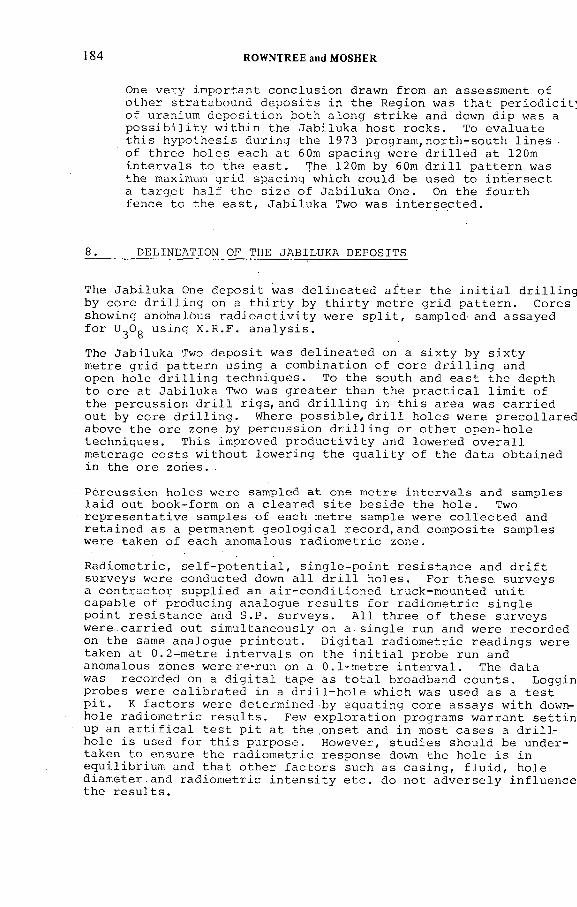
184 ROWNTREE and MOSHER
One v e r y im p o r t a n t c o n c lu s i o n drawn from an a s s e s sm e n t o f o t h e r s t r a t a b o u n d d e p o s i t s i n th e R e g io n was t h a t p e r i o d i c i t ; o f uran ium d e p o s i t i o n b o th a l o n g s t r i k e and down d i p was a p o s s i b i l i t y w i t h i n th e J a b i lu k a h o s t r o c k s . To e v a l u a t e t h i s h y p o t h e s i s d u r in g t h e 1973 p r o g r a m ,n o r t h - s o u t h l i n e s o f t h r e e h o l e s e a c h a t 60m s p a c in g w e re d r i l l e d a t 120m i n t e r v a l s t o t h e e a s t . The 120m by 60m d r i l l p a t t e r n was th e maximum g r i d s p a c in g w h ich c o u ld be used t o i n t e r s e c t a t a r g e t h a l f t h e s i z e o f J a b i lu k a One. On th e f o u r t h f e n c e t o th e e a s t , J a b i lu k a Two was i n t e r s e c t e d .
8. DELINEATION OF THE JABILUKA DEPOSITS
The J a b i lu k a One d e p o s i t was d e l i n e a t e d a f t e r t h e i n i t i a l d r i l l i n g b y c o r e d r i l l i n g on a t h i r t y by t h i r t y m e t r e g r i d p a t t e r n . C o re s sh o w in g anom alous r a d i o a c t i v i t y w e re s p l i t , sam p led and a s s a y e d f o r U^Og u s in g X .R .F . a n a l y s i s .
The J a b i lu k a Two d e p o s i t was d e l i n e a t e d on a s i x t y b y s i x t y m e t re g r i d p a t t e r n u s in g a c o m b in a t io n o f c o r e d r i l l i n g and open h o l e d r i l l i n g t e c h n iq u e s . To t h e s o u th and e a s t t h e d e p th t o o r e a t J a b i lu k a Two was g r e a t e r th a n t h e p r a c t i c a l l i m i t o f th e p e r c u s s io n d r i l l r i g s , a n d d r i l l i n g i n t h i s a r e a was c a r r i e d o u t by c o r e d r i l l i n g . Where p o s s i b l e , d r i l l h o l e s w e r e p r e c o l l a r e d a b o ve t h e o r e zon e by p e r c u s s io n d r i l l i n g o r o t h e r o p e n - h o l e t e c h n iq u e s . T h is im p ro v e d p r o d u c t i v i t y and l o w e r e d o v e r a l l m e t e r a g e c o s t s w i t h o u t l o w e r i n g th e q u a l i t y o f t h e d a t a o b t a in e d in th e o r e z o n e s . .
P e r c u s s io n h o l e s w e re sam p led a t one m e t r e i n t e r v a l s and sam p les l a i d o u t b o o k - fo rm on a c l e a r e d s i t e b e s i d e th e h o l e . Two r e p r e s e n t a t i v e sam p les o f ea ch m e t r e sam p le w e re c o l l e c t e d and r e t a i n e d a s a perm anent g e o l o g i c a l r e c o r d , a n d c o m p o s i t e sam p les w e re ta k e n o f e a ch anom alous r a d i o m e t r i c z o n e .
R a d io m e t r i c , s e l f - p o t e n t i a l , s i n g l e - p o i n t r e s i s t a n c e and d r i f t s u r v e y s w ere co n d u c te d down a l l d r i l l h o l e s . F o r t h e s e s u r v e y s a c o n t r a c t o r s u p p l i e d an a i r - c o n d i t i o n e d t ru c k -m o u n te d u n i t c a p a b l e o f p r o d u c in g a n a lo g u e r e s u l t s f o r r a d i o m e t r i c s i n g l e p o i n t r e s i s t a n c e and S .P . s u r v e y s . A l l t h r e e o f t h e s e s u r v e y s were , c a r r i e d o u t s im u l t a n e o u s l y on a s i n g l e run and w e r e r e c o r d e d on th e same a n a lo g u e p r i n t o u t . D i g i t a l r a d i o m e t r i c r e a d i n g s w e re t a k en a t 0 .2 - m e t r e i n t e r v a l s on th e i n i t i a l p ro b e run and anom alous zo n es w e r e re -ru n on a 0 .1 - m e t r e i n t e r v a l . The d a ta was r e c o r d e d on a d i g i t a l t a p e as t o t a l b roadban d c o u n t s . L o g g in p r o b e s w ere c a l i b r a t e d in a d r i l l - h o l e w h ich was u sed as a t e s t p i t . К f a c t o r s w e re d e t e r m in e d by e q u a t in g c o r e a s s a y s w i t h down- h o l e r a d i o m e t r i c r e s u l t s . Few e x p l o r a t i o n p rog ram s w a r r a n t s e t t i n up an a r t i f i c a l t e s t p i t a t t h e . o n s e t and i n m ost c a s e s a d r i l l h o l e i s u sed f o r t h i s p u rp o s e . H ow ever , s t u d i e s sh o u ld be u n d e r t a k e n t o e n su re t h e r a d i o m e t r i c r e s p o n s e down th e h o l e i s i n e q u i l i b r i u m and t h a t o t h e r f a c t o r s such as c a s i n g , f l u i d , h o l e d ia m e t e r . a n d r a d i o m e t r i c i n t e n s i t y e t c . do n o t a d v e r s e l y i n f l u e n c e t h e r e s u l t s .
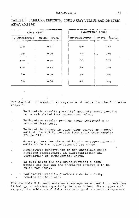
IAEA-AG-250/19 185
TABLE III JABILUKA DEPOSITS: CORE ASSAY VERSUS RADIOMETRIC ASSAY (DH 176)
CORE ASSAY RADIOMETRIC A SSA Y
INTERVAL (metres) RESULT % и з 0 в IN TERVAL (metres) RESULT % и з О в
27 0 0 41 25 6 0 49
3 9 0 06 4 0 0 06
1 1 0 0 85 10 3 0 76
13 0 0 93 14 4 0 74
5 0 0 08 6 7 0 09
5 0 0 06 4 6 0 08
The dow n h o le r a d i o m e t r i c s u r v e y s w e re o f v a l u e f o r t h e f o l l o w i n g r e a s o n s :
R a d io m e t r i c r e s u l t s p e r m i t t e d a c c u r a t e a s s a y r e s u l t s t o be c a l c u l a t e d f ro m p e r c u s s i o n h o l e s .
. - R a d i o m e t r i c r e s u l t s p r o v i d e a s s a y i n f o r m a t i o n inzo n es o f l o s t c o r e .
R a d io m e t r i c a s s a y s in c o r e - h o l e s s e r v e d a s a ch e c k a g a i n s t th e X .R .F . r e s u l t s f r o m s p l i t c o r e sam p les (T a b l e I I I ) .
Anom aly c h a r a c t e r o b s e r v e d i n th e a n a lo g u e p r i n t o u t a s s i s t e d i n th e c o r r e l a t i o n o f o r e z o n e s .
R a d i o m e t r i c b a ck g ro u n d s i n n on -an om a lou s h o l e s a s s i s t e d c o n s i d e r a b l y i n d i f f e r e n t i a t i o n and c o r r e l a t i o n o f l i t h o l o g i c a l u n i t s .
In c o r e - h o l e s th e a n a lo g u e s p r o v i d e d a f a s t m ethod f o r p i c k i n g th e anom alous i n t e r v a l s t o be s p l i t f o r a s s a y .
R a d i o m e t r i c r e s u l t s p r o v i d e d im m ed ia te a s s a y r e s u l t s i n th e f i e l d .
The d ow n h o le S .P . and r e s i s t a n c e s u r v e y s w e r e u s e f u l i n d e f i n i n g l i t h o l o g y b o u n d a r i e s , e s p e c i a l l y i n open h o l e s . Rock t y p e s such a s g r a p h i t e s c h i s t s and d o l o m i t e s g a v e good c h a r a c t e r r e s p o n s e s
1 8 6 ROWNTRBE and MOSHER
w h ich a s s i s t e d i n t h e c o r r e l a t i o n o f l i t h o l o g i c a l u n i t s . I n th e f i e l d o f f i c e , c h e c k s a g a i n s t th e dow n h o le e l e c t r i c a l and r a d i o m e t r i c s u r v e y r e s u l t s and a th o r o u g h e x a m in a t io n o f th e p e r c u s s i o n c h ip s w i t h t h e u se o f a b i n o c u l a r m ic r o s c o p e , made i t p o s s i b l e t o p ro d u ce a d e t a i l e d g e o l o g i c a l l o g o f p e r c u s s i o n h o l e s .
D r i f t s u r v e y s w e re t a k e n s e p a r a t e l y i n ea ch h o l e ( g e n e r a l l y a t 2 5 -m e t r e i n t e r v a l s ) u s in g a m u l t i - s h o t Eastman in s t r u m e n t .
C o re l o g g i n g was c o n v e n t i o n a l and in c lu d e d th e r e c o r d i n g o f t h e r o c k t y p e s , c o m p o s i t i o n , c o l o u r in d e x , t e x t u r e , s t r u c t u r e , f o l i a t i o n , w e a t h e r in g , m i n e r a l i s a t i o n and d r i l l - h o l e i n f o r m a t i o n . C o r e and p e r c u s s i o n l o g g i n g was c a r r i e d o u t u s in g a g e o l o g i c a l l o g g i n g fo rm d e s i g n e d f o r th e p r o j e c t . The fo rm s t a n d a r d i s e d t h e i n f o r m a t i o n r e c o r d and f a c i l i t a t e d g e o l o g i c a l c o r r e l a t i o n s e v e n w h e re h o l e s on t h e same s e c t i o n w e r e l o g g e d by d i f f e r e n t g e o l o g i s t s i n d i f f e r e n t y e a r s .
9 . GOLD MINERALISATION
E a r l y i n t h e e x p l o r a t i o n p rog ram on t h e p r o p e r t y , s e v e r a l s u r f a c e sa m p le s g a v e s i g n i f i c a n t g o l d v a lu e s w h ich c o n f i r m e d t h a t a g o l d a s s o c i a t i o n e x i s t e d in t h e uranium d e p o s i t s o f th e E a s t A l l i g a t o r R e g i o n . A s s a y s o f c o m p o s i t e sam p les o f th e J a b i lu k a uran ium d e p o s i t i n d i c a t e d th e p r e s e n c e o f g o l d i n p o s s i b l y econ om ic q u a n t i t i e s . A su b s e q u e n t sa m p l in g and d r i l l i n g p ro g ra m w i t h i n th e J a b i lu k a Two uran ium d e p o s i t d e l i n e a t e d a g o l d o r e b o d y c o n t a in in g , 4 10 ,000 to n n e s o f i n d i c a t e d r e s e r v e s h a v in g a g r a d e o f1 6 .1 g g o l d p e r to n n e and 120 ,000 to n n e s o f i n f e r r e d o r e a t an a v e r a g e g r a d e o f 1 2 .5 g g o l d p e r t o n n e .
10 . COMPARISON OF COSTS AND PRODUCTIVITY
A l th o u g h c o s t f i g u r e s f o r e x p l o r a t i o n d r i l l i n g a r e q u i c k l y d a t e d , i t i s u s e f u l t o show th e c o s t t r e n d s and th e c o s t e f f e c t i v e n e s s o f e x p l o r a t i o n d r i l l i n g a t J a b i lu k a o v e r t h e p e r i o d 1971 t o 1975. D u r in g t h i s p e r i o d a t o t a l o f s i x e x p l o r a t i o n p rog ram s w e r e c a r r i e d o u t , some o f w h ich w e re c a r r i e d o u t d u r in g th e d r y s ea so n and o t h e r s d u r in g t h e w e t s e a s o n . The c o s t f i g u r e s i n a b s o l u t e t e rm s w ou ld o n l y be a p p l i c a b l e t o a r e a s o f s i m i l a r p h y s io g r a p h y and t o p rog ram s i n v o l v i n g a s i m i l a r l e v e l and t y p e o f d r i l l i n g . F i g u r e s q u o t e d a r e i n December 1975 d o l l a r s . D u r in g th e p e r i o d Decem ber 1971 t o December 1975 i n f l a t i o n in A u s t r a l i a was a p p r o x im a t e l y 66% on a c u m u la t i v e b a s i s .
F i g u r e 7 shows th e b a s i c c o m p a r is o n o f c o s t s f o r d r i l l i n g and dow n h o le r a d i o m e t r i c l o g g i n g , t o g e t h e r w i t h d r i l l i n g p r o d u c t i v i t i e s d u r in g th e s i x p ro g ra m s c a r r i e d o u t f r om 1971 and 1975.
C o re d r i l l i n g c o s t s h ave r em a in ed r e l a t i v e l y c o n s t a n t i n d i r e c t c o n t r a c t o r t e rm s ; h o w e v e r , t h e r e has b e en a s u b s t a n t i a l d e c r e a s e
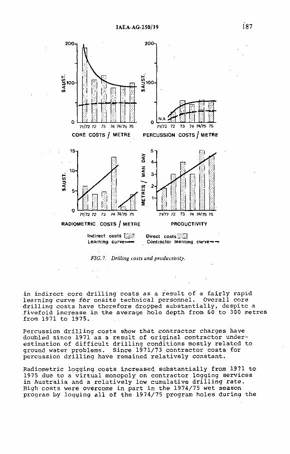
IAEA-AG-250/19 Í87
Indirect costs ¡П З Direct costs ¿-й!Learning curve— Contractor teaming curve— —
F/G. 7. Drt'/Zmg соям and prodMcí¡'v:í^.
i n i n d i r e c t c o r e d r i l l i n g c o s t s a s a r e s u l t o f a f a i r l y r a p id l e a r n i n g c u r v e f o r o n s i t e t e c h n i c a l p e r s o n n e l . O v e r a l l c o r e d r i l l i n g c o s t s h a v e t h e r e f o r e d ro p p e d s u b s t a n t i a l l y , d e s p i t e a f i v e f o l d i n c r e a s e i n t h e a v e r a g e h o l e d e p th from 60 t o 300 m e t r e s from 1971 t o 1975.
P e r c u s s io n d r i l l i n g c o s t s show t h a t c o n t r a c t o r c h a r g e s have d o u b le d s in c e 1971 as a r e s u l t o f o r i g i n a l c o n t r a c t o r u n d e r e s t im a t i o n o f d i f f i c u l t d r i l l i n g c o n d i t i o n s m o s t l y r e l a t e d t o ground w a t e r p r o b le m s . S in c e 1971/73 c o n t r a c t o r c o s t s f o r p e r c u s s io n d r i l l i n g have r e m a in e d r e l a t i v e l y c o n s t a n t .
R a d io m e t r i c l o g g i n g c o s t s i n c r e a s e d s u b s t a n t i a l l y f r om 1971 t o 1975 due t o a v i r t u a l m on op o ly on c o n t r a c t o r l o g g i n g s e r v i c e s i n A u s t r a l i a and a r e l a t i v e l y lo w c u m u la t i v e d r i l l i n g r a t e .H igh c o s t s w e re o v e rcom e i n p a r t i n th e 1974/75 w e t s ea son p rogram by l o g g i n g a l l o f th e 1974/75 p ro g ram h o l e s d u r in g th e
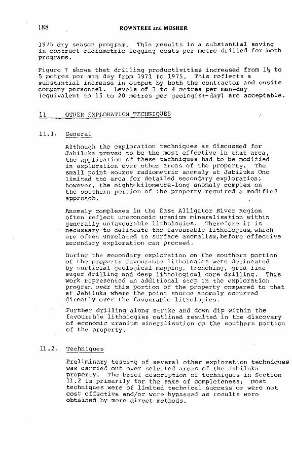
188 ROWNTREE and MOSHER
1975 d r y s ea s o n p rog ra m . T h is r e s u l t s in a s u b s t a n t i a l s a v in g in c o n t r a c t r a d i o m e t r i c l o g g i n g c o s t s p e r m e t r e d r i l l e d f o r b o th p r o g r a m s .
F i g u r e 7 shows t h a t d r i l l i n g p r o d u c t i v i t i e s i n c r e a s e d f r o m 1^ t o 5 m e t r e s p e r man d ay f ro m 1971 t o 1975. T h i s r e f l e c t s a s u b s t a n t i a l i n c r e a s e i n o u t p u t by b o th th e c o n t r a c t o r and o n s i t e company p e r s o n n e l . L e v e l s o f 3 t o 4 m e t r e s p e r m an-day ( e q u i v a l e n t t o 15 t o 20 m e t r e s p e r g e o l o g i s t - d a y ) a r e a c c e p t a b l e .
11 OTHER EXPLORATION TECHNIQUES ,
1 1 .1 . G e n e ra l
A l th o u g h th e e x p l o r a t i o n t e c h n iq u e s as d i s c u s s e d f o r J a b i lu k a p r o v e d t o be th e m ost e f f e c t i v e i n t h a t a r e a , th e a p p l i c a t i o n o f th e s e t e c h n iq u e s had t o be m o d i f i e d in e x p l o r a t i o n o v e r o t h e r a r e a s o f th e p r o p e r t y . The s m a l l p o i n t s o u r c e r a d i o m e t r i c anom aly a t J a b i lu k a One l i m i t e d th e a r e a f o r d e t a i l e d s e c o n d a r y e x p l o r a t i o n ; h o w eve r , th e e i g h t - k i l o m e t r e - l o n g anom aly co m p le x on th e s o u th e rn p o r t i o n o f t h e p r o p e r t y r e q u i r e d a m o d i f i e d a p p ro a ch .
Anom aly c o m p le x e s i n th e E a s t A l l i g a t o r R i v e r R e g io n o f t e n r e f l e c t uneconom ic uran ium m i n e r a l i s a t i o n w i t h i n g e n e r a l l y u n fa v o u r a b l e l i t h o l o g i e s . T h e r e f o r e i t i s n e c e s s a r y t o d e l i n e a t e th e f a v o u r a b l e l i t h o l o g i e s , w h i c h a r e o f t e n u n r e l a t e d t o s u r f a c e a n o m a l i s m ,b e f o r e e f f e c t i v e s e c o n d a r y e x p l o r a t i o n can p r o c e e d .
D u r in g th e s e c o n d a r y e x p l o r a t i o n on th e s o u th e r n p o r t i o n o f th e p r o p e r t y f a v o u r a b l e l i t h o l o g i e s w e r e d e l i n e a t e d by s u r f i c i a l g e o l o g i c a l m app ing , t r e n c h i n g , g r i d l i n e a u g e r d r i l l i n g and deep l i t h o l o g i c a l c o r e d r i l l i n g . T h i s work r e p r e s e n t e d an a d d i t i o n a l s t e p in th e e x p l o r a t i o n p rog ram o v e r t h i s p o r t i o n o f t h e p r o p e r t y com pared t o t h a t a t J a b i lu k a w here t h e p o i n t s o u r c e anom a ly o c c u r r e d d i r e c t l y o v e r t h e f a v o u r a b l e l i t h o l o g i e s .
F u r t h e r d r i l l i n g a l o n g s t r i k e and down d i p w i t h i n th e f a v o u r a b l e l i t h o l o g i e s o u t l i n e d r e s u l t e d i n t h e d i s c o v e r y o f e con om ic uran ium m i n e r a l i s a t i o n on th e s o u th e rn p o r t i o n o f th e p r o p e r t y .
1 1 .2 . T e ch n iq u es
P r e l i m i n a r y t e s t i n g o f s e v e r a l o t h e r e x p l o r a t i o n t e c h n iq u e s was c a r r i e d o u t o v e r s e l e c t e d a r e a s o f th e J a b i lu k a p r o p e r t y . The b r i e f d e s c r i p t i o n o f t e c h n iq u e s i n S e c t i o n11 .2 i s p r i m a r i l y f o r th e sake o f c o m p le t e n e s s ; m ost t e c h n iq u e s w e re o f l i m i t e d t e c h n i c a l s u c c e s s o r w e r e n o t c o s t e f f e c t i v e an d/ or w e re b y p a s s e d a s r e s u l t s w e re o b t a in e d by more d i r e c t m e th ods .
ÏAEA-AG-2S0/19 189
G e o c h e m ic a l S a m p l in g
L im i t e d g e o c h e m ic a l s a m p l in g was c a r r i e d o u t on a u g e r sam p les a t J a b i lu k a One. The o n l y c o n s i s t e n t l y anom alous e l e m e n t was c o p p e r ; h o w e v e r , i t d i d n o t p r o v i d e as good a d e f i n i t i o n o f th e uran ium anom a ly as g e o c h e m ic a l U ^ s .
G eob o tan y
In 1971 a g e o b o t a n i c a l o r i e n t a t i o n p ro g ram was c a r r i e d o u t t o d e t e r m in e p l a n t s i n th e a r e a t h a t c o u ld be u sed t o i n d i c a t e uran ium ( 5 ) . R e s u l t s showed a w id e v a r i a t i o n in uran ium c o n t e n t o f t h e s p e c i e s sam p led , e v e n w i t h i n known anom alous a r e a s ; h o w e ve r th e e u c a l y p t s i n c l u d i n g gums, m a l l e e and s t r in g y b a r k , s h o w e d t h e m ost e n c o u r a g in g r e s u l t s and c o u ld be u s e f u l i n d i c a t o r s i n e v a l u a t i n g o v e rb u rd e n a r e a s p r i o r t o e m p lo y in g more d i r e c t m e th od s .
The g e o b o t a n i c a l p ro g ram was d i s c o n t i n u e d b ecau se th e use o f d i r e c t b e d ro c k s a m p l in g t e c h n iq u e s such as a u g e r d r i l l i n g was p r e f e r r e d .
A l p h a - P a r t i c l e S u rv e y
A l p h a - p a r t i c l e s u r v e y s w e re c a r r i e d o u t o v e r p o r t i o n s o f J a b i lu k a One and Two as w e l l as o v e r s e v e r a l o t h e r a r e a s o f th e p r o p e r t y .
R e s u l t s o f t h e s u r v e y s i n d i c a t e :
T h a t in a r e a s o f known s u r f a c e r a d i o m e t r i c anom a lism t h e a l p h a - p a r t i c l e s u r v e y d e t e c t e d t h e same anom a lism ( F i g . 8 ) .
T h a t th e a l p h a - p a r t i c l e s u r v e y d i d n o t d e t e c t J a b i lu k a Two w h ich i s o v e r l a i n b y a minimum o f 20 m e t r e s o f K o m b o lg ie F o r m a t io n S a n ds ton e ( F i g . 8 ) .
T h a t a l p h a - p a r t i c l e s u r v e y s w ou ld a p p e a r t o be more e f f e c t i v e t o e v a l u a t e a r e a s w h ich a r e o v e r l a i n b y d r y l o o s e l y c o n s o l i d a t e d o v e r b u r d e n .
T h a t a l p h a - p a r t i c l e a n o m a l ie s can be d e t e c t e d a l o n g f a u l t s and f r a c t u r e z o n e s i n th e K o m b o lg ie F o rm a t io n s a n d s to n e s ; h o w e v e r , no a n o m a l ie s o u t l i n e d in t h i s way h ave been e v a l u a t e d by d r i l l i n g t o d a t e .
I t i s i n t e r e s t i n g t o n o t e t h a t an a u g e r h o l e can be d r i l l e d t o a d e p th o f 20 m e t r e s f o r a t o t a l c o s t o f a p p r o x im a t e l y $200 i n c l u d i n g r a d i o m e t r i c
190 ROWNTREE and MOSHER
Eо
RADON CUP SURVEY
GROUND RADiOMETRtCS
JABtLUKA ONE JAB!LUKA TWO
-.150
—t 0ÛQ
n150c¿^ V)
Oa.6
and g e o l o g i c a l l o g g i n g . An a l p h a - p a r t i c l e sam ple p o i n t c o s t s a t o t a l o f a p p r o x im a t e l y $40. The a u g e r d r i l l i n g was more e f f e c t i v e than th e e q u i v a l e n t a l p h a - p a r t i c l e sa m p l in g a s an e x p l o r a t i o n t e c h n iq u e on t h e p r o p e r t y b e c a u s e o f th e i n v a l u a b l e b e d r o c k g e o l o g i c a l i n f o r m a t i o n o b t a in e d and b e ca u s e o f th e r a p i d tu rn a ro u n d on a u g e r i n f o r m a t i o n com pared t o th e n in e week tu rn a ro u n d f o r a l p h a - p a r t i c l e r e s u l t s .
Radon Emanometry
A radon emanom eter was t e s t e d d u r in g th e 1971 e x p l o r a t i o n p rog ram t o d e t e r m in e i f t h i s t e c h n iq u e c o u ld be u t i l i s e d in o v e rb u rd e n c o v e r e d a r e a s o f t h e p r o p e r t y ( 6 ) . A l th o u g h p o s i t i v e r e s u l t s w e r e o b t a in e d , m o i s t u r e and d u s t c o n t a m in a t i o n in th e i o n i s a t i o n chamber p r e v e n t e d r e p r o d u c i b i l i t y o f r e a d in g s .
M e rcu ry S n i f f e r S u rv e y
A "m e rc u ry s n i f f e r " s u r v e y was c o n d u c te d o v e r anom alous a r e a s o f th e p r o p e r t y u s in g a t ru c k - mounted in s t r u m e n t . The s u r v e y f a i l e d t o o u t l i n e any s i g n i f i c a n t a n o m a l i e s , a p p a r e n t l y b e c a u s e o f l o w c o n c e n t r a t i o n o f m ercu ry i n th e h o s t r o c k s and b e c a u s e c l a y - r i c h o v e rb u r d e n l i m i t e d t h e m i g r a t i o n o f m ercu ry v a p o u r . T h is
IAEA-AG-250/19 191
t e c h n iq u e d o e s n o t a p p e a r t o h a ve a p p l i c a t i o n f o r u ran ium e x p l o r a t i o n in th e E a s t A l l i g a t o r R i v e r R e g io n .
A i r b o r n e M a g n e t i c S u rv e y
An a e r o m a g n e t i c s u r v e y was c a r r i e d o u t i n 197 0 w i t h th e f i x e d - w i n g a i r b o r n e r a d i o m e t r i c s u r v e y .The m a g n e t i c s w e r e u s e f u l t o d e l i n e a t e . a r e a s u n d e r l a i n by th e Nanambu Com plex and t o d e t e c t l a t e - s t a g e b a s i c i n t r u s i v e s a l o n g m a jo r s t r u c t u r a l f e a t u r e s u nder th e K o m b o lg ie F o r m a t io n .
I t was n o t p o s s i b l e f rom th e s u r v e y t o d e t e c t m a g n e t ic c o n t r a s t among t h e L ow er P r o t e r o z o i c l i t h o l o g i e s . The a e r i a l m a g n e t i c s w e r e n o t f lo w n a t optimum a l t i t u d e s b e ca u se t h e y w e re f l o w n w i t h th e r a d i o m e t r i c s .
Ground M a g n e t i c S u rv e y
R e s u l t s o b t a i n e d f r om ground m a g n e t i c s u r v e y s w e r e e r r a t i c and w e re o f l i t t l e use i n e x p l o r a t i o n . The l a t e r i t e c o v e r i s b e l i e v e d t o be p a r t l y r e s p o n s i b l e f o r s p u r io u s r e a d in g s w h ich p r e v e n t e d a r e l i a b l e i n t e r p r e t a t i o n .
VLF - E l e c t r o m a g n e t i c S u rv e y
. VLF - EM s u r v e y s w e r e c a r r i e d o u t i n th e J a b i lu k a a r e a in 1971 in an a t t e m p t t o t r a c e g r a p h i t i c z o n e s l o c a t e d d u r in g th e t r e n c h i n g p ro g ram ( 6 ) .
S e v e r a l a n o m a l i e s w e r e o u t l i n e d b u t i t was n o t p o s s i b l e t o r e l i a b l y d i s t i n g u i s h b e tw een a t r u e g r a p h i t i c c o n d u c t o r and a s im p le g e o l o g i c a l ch an ge i n c o n d u c t i v i t y . The t e c h n iq u e was n o t em p lo y e d i n su b s eq u e n t p ro g ra m s b e ca u se i t was b y p a s s e d a s r e s u l t s w e r e o b t a in e d b y more d i r e c t m e th od s .
12. CONCLUSIONS
Case h i s t o r i e s o f e x p l o r a t i o n p ro g ra m s a r e g e n e r a l l y r e g a r d e d as u s e f u l o n l y i f s p e c i f i c new t e c h n iq u e s a r e d e v e l o p e d o r i f an e x p l o r a t i o n p h i l o s o p h y i s shown t o be e f f e c t i v e i n t h e d i s c o v e r y o f an e c o n o m ic d e p o s i t .
The e x p l o r a t i o n a t J a b i lu k a i s n o t a c l a s s i c a l c a s e o f th e d e v e lo p m e n t o f new t e c h n iq u e s b e c a u s e o f t h e r a p i d p r o g r e s s i o n t o known d i r e c t e x p l o r a t i o n t e c h n iq u e s such a s t r e n c h i n g , a u g e r in g and d eep d r i l l i n g and th e b y p a s s in g o f i n d i r e c t t e c h n iq u e s in w h ich t h e r e i s th e g r e a t e s t s c o p e f o r new d e v e l o p m e n t s . D i r e c t e x p l o r a t i o n t e c h n iq u e s w e re em p lo y ed e x t e n s i v e l y b e ca u se i t was a h i g h - p r i o r i t y p r o p e r t y i n a known uran ium r e g i o n .
192 ROW NTREE and MOSHER
The J a b i l u k a case h i s t o r y i l l u s t r a t e s an e f f e c t i v e p h i lo so p h y
w h ic h was s u c c e s s f u l in e x p l o r a t i o n fo r s tr a tab o u n d uranium
d e p o s i t s in the E a st A l l i g a t o r R iv e r R e g io n . T h is p h i lo s o p h y
encom passed the f o l l o w i n g p o i n t s :
The v a lu e o f r e g io n a l a p p r a i s a l s in s e l e c t i o n o f
a p r o p e rt y .
The r e c o g n i t io n of the d e t e c t i o n l i m i t s o f a i r b o r n e
r a d io m e t r ic su r v ey s .
The im portance of ground p r o s p e c t in g fo r low-order
p o int- so urce r ad io m e tr ic a n o m a lie s w h ich can not be
d e te c t e d by a i r b o r n e s u r v e y s .
The im portance o f e v a l u a t in g a l l a n o m a lies and
the f l e x i b i l i t y to change p r i o r i t i e s as f u r t h e r
e x p l o r a t io n r e s u l t s are o b t a i n e d .
The n e c e s s i t y o f e s t a b l i s h i n g the c o n t r o l s on the
m i n e r a l i s a t i o n (fo r exam ple the l i t h o l o g i c a l c o n t r o l s
on the J a b i l u k a p ro p e rty ) b e f o r e p r o c e e d in g w it h
fu r t h e r e x p l o r a t i o n .
The n e c e s s i t y o f e x p l o r in g e x t e n s io n s o f f a v o u r a b l e
l i t h o l o g i e s to t e s t fo r p e r i o d i c i t y o f m i n e r a l i s a t i o n
ev en where cover p r e c lu d e s s u r f a c e e x p r e s s i o n .
The f l e x i b i l i t y to m o d ify e x p l o r a t i o n t e c h n iq u e s
em ployed on p o in t- so u r ce a n o m a lies in o r d e r to
p r o p e r ly e v a l u a t e anom aly c o m ple xes .
Some a s p e c t s o f t h i s p h i lo s o p h y may be u s e f u l in e x p l o r a t i o n fo r
s im i l a r uranium d e p o s i t s i n o ther a r e a s .
R E F E R E N C E S
(1) DEPARTMENT OF MINERALS AND ENERGY, BUREAU OF MINERAL
RESOURCES, GEOLOGY AND G EOPH YSICS , M in e r a l R e so u rc e s
Repo rt No. 6 Uranium D e p o s i t s , C a n b e r r a ( 1 9 7 4 ) .
(2) PEDERSON, C . , NORANDA AUSTRALIA LTD . - EUPENE, G . ,
GEOPEKO L TD . - ANTHONY, P . , QUEENSLAND MINES L T D . ,
P e r s o n a l co m m u nication , S ydney ( 1 9 7 6 ) .
(3) THE AUSTRALASIAN IN S T IT U T E OF M INING AND METALLURGY,
E igh th .C o m m o n w e alth M in in g and M e t a l l u r g i c a l C o n g r e s s ,
G eolo gy o f A u s t r a l i a n Ore D e p o s i t s , A u s t r a l i a and
New Z e a l a n d , M elbo u rn e ( 1 9 6 5 ) .

IAEA-AG-250/19 193
HOWE, A . C . A . , AUSTRALIA PTY . L IM IT E D , P r o p r i e t a r y R e p o rt ,
R e po rt on the H e l i c o p t e r R a d io m e tr ic S u r v e y , R e po rt
No. 52 , Sydney ( 1 9 7 2 ) .
HOWE, A . C . A . , A USTRALIA P T Y . L IM IT E D , P r o p r i e t a r y
R e p o rt , Report on G e o b o t a n ic a l Sam pling Program , R e po rt
No. 5 3 , Sydney ( 1 9 7 2 ) .
HOWE, A . C . A . , A U STRALIA PTY . L IM IT E D , P r o p r i e t a r y
R e po rt , I n t e r im R e po rt on the E x p l o r a t i o n Work co n d u c te d
over A u t h o r i t y to P r o s p e c t 2 0 1 3 , R epo rt N o . 4 8 ,
Sydney ( 1 9 7 1 ) .

IAEA-AG-250/5
EXPLORATION OF THE KEY LAKE URANIUM DEPOSITS, SASKATCHEWAN, CANADA
R. GATZWEILER, В. SCHMELING Uranerzbergbau GmbH,Bonn,Federal Republic o f Germany
B. TANUranerz Exploration and Mining Ltd,Saskatoon, Saskatchewan,Canada
Abstract
EXPLORATION OF THE KEY LAKE URANIUM DEPOSITS, SASKATCHEWAN, CANADA.In 1969, one year after the discovery of the Rabbit Lake uranium deposit, exploration
started in the Key Lake area as part of a major uranium rush into Northern Saskatchewan, and within the frame of a joint venture. The area was not chosen on the basis of a particular metallogenetic concept. The lack of exploratory success in 1969 and 1970, together with the introduction in March 1970 of foreign ownership restrictions for uranium mining in Canada, discouraged six of the nine companies forming the original joint venture. In 1971 the three remaining companies decided to continue under a redefined concept, based on the knowledge obtained from the Rabbit Lake deposit (Uranerz had acquired a 49% share in 1970) and from the newly discovered uranium deposits in the Pine Creek Geosynctine, Australia. In the same year, exploration work resulted in the discovery of two high-grade mineralized boulders and significant radioactive and geochemical anomalies 5 km SW of the Key Lake deposits. Subsequent exploration, aimed at finding the source of the mineralized boulders, comprised geological, glacial geological and ground radiometric surveys, boulder tracing, air-photo interpretation, lake sediment and muskeg sampling surveys, radon surveys, ground magnetic, gravity, electromagnetic and IP surveys, and driHing. The systematic exploration efforts resulted in the discovery of the Gaertner ore body in July 1975 and the Deilmann ore body in June 1976, where glacial geology, lake sediment sampling, magnetic and electromagnetic surveys were the key methods in defining the drilling targets. Three further years and a total of about 2400 drillholes were needed to fully delineate the two ore bodies.
1. INTRODUCTION
The Key Lake uranium deposits are located in Northern Saskatchewan, Canada, 700 km road distance north o f Saskatoon, the base o f Key Lake Mining Corporation (KLMC), which is the operating company for the Saskatchewan Uranium Joint Venture (Fig. 1). This comprises the Saskatchewan Mining
195
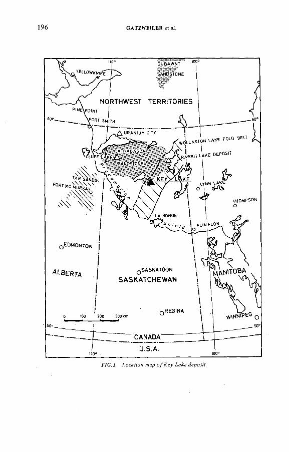
196 GATZWEILER et at.
F7C. 7. ío c a f ; 'o n w cp o/Æ ey ¿ероя7.
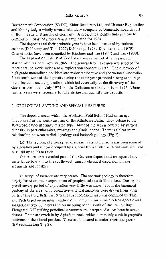
ÏAEA-AG-250/5 197
Development Corporation (SMDC), Eldor Resources Ltd, and Uranerz Exploration and Mining Ltd, a wholly owned subsidiary company o f Uranerzbergbau GmbH of Bonn, Federal Republic o f Germany. A project feasibility study is close to completion. Start o f production is anticipated for 1984.
The deposits and their probable genesis have been discussed by various authors (Dahlkamp and Tan, 1977;Dahlkamp, 1978; Kirchner et a!., 1979).Case histories have been compiled by Kirchner and Tan (1977) and Tan (1980).
The exploration history o f Key Lake covers a period o f ten years, and started with regional work in 1969. The general Key Lake area was selected for more detailed work under a new exploration concept in 1971. The discovery of. high-grade mineralized boulders and major radioactive and geochemical anomalies 5 km south-west o f the deposits during the same year provided strong encouragement for continued exploration which led eventually to the discovery o f the Gaertner ore body in July 1975 and the Deilmann ore body in June 1976. Three further years were necessary to fully define and quantify the deposits.
2. GEOLOGICAL SETTING AND SPECIAL FEATURES
The deposits occur within the Wollaston Fold Belt o f Hudsonian age (1 750 m.y.) at the south-east rim o f the Athabasca Basin. They belong to the Proterozoic unconformity related type. Most o f the area is covered by surficial deposits, in particular lakes, muskegs and glacial debris. There is a clear interrelationship between surficial geology and bedrock geology (Fig. 2):
(a) The tectonically weakened ore-bearing structural zone has been scoured by glaciation and is now occupied by a glacial trough filled with outwash sand and basal till up to 90 m thick.
(b) An esker has eroded part o f the Gaertner deposit and transported ore material up to 6 km to the south-west, causing chemical dispersion in lake sediments and muskegs.
Outcrops of bedrock are very scarce. The bedrock geology is therefore largely based on the interpretation o f geophysical and drillhole data. During the pre-discovery period o f exploration very little was known about the basement geology o f the area; only broad hypothetical analogies were drawn from other parts o f the Fold Belt. In 1976 the first geological map was compiled by Thiel and Rich based on an interpretation o f a combined airborne electromagnetic and magnetic survey (Questor) and on mapping to the south o f the area by Ray. Elongated, NE' striking periclinal structures are interpreted as Archean basement domes. These are overlain by Aphebian rocks which commonly contain graphitic horizons in their basal portion. These are indicated as major electromagnetic (EM) conductors (Fig.3).
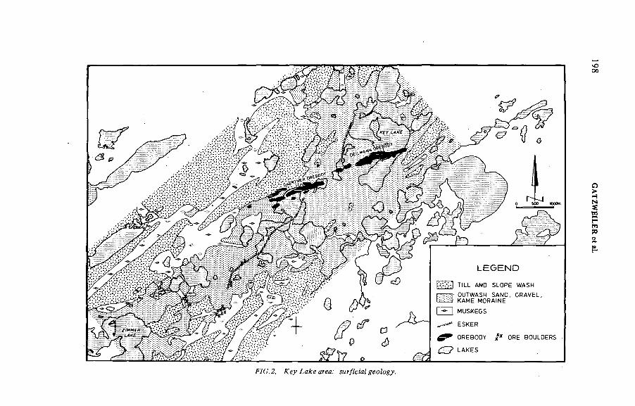
TILL AND SLOPE WASHOUTWASH SAND. GRAVEL. КАМЕ MORAINE
I I MUSKEGS
ESKER
OREBODY X* ORE BOULDERS
LAKES
00
WC.2 . area.' умгДем/ yeo/o^.
GATZW
EILER
et aï.
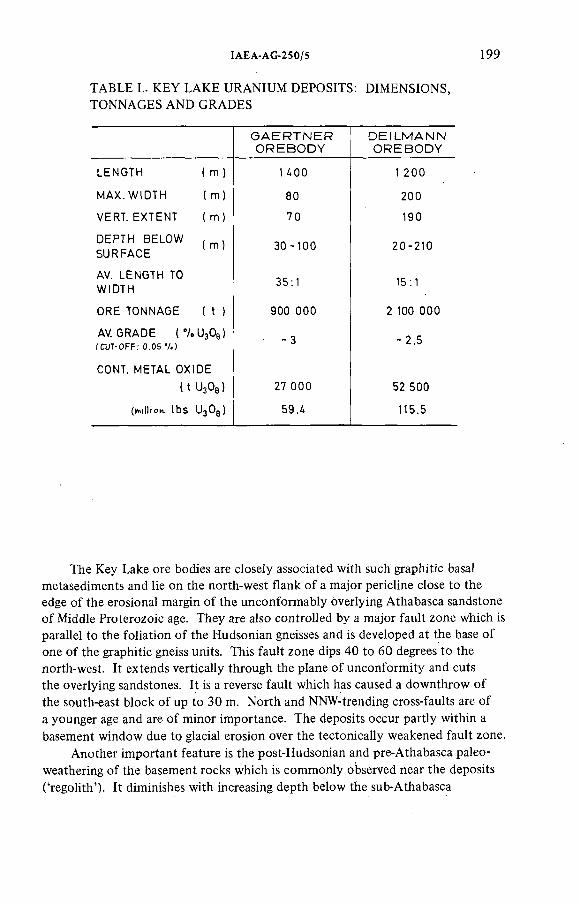
IAEA-AG-250/5 199
TABLE I.. KEY LAKE URANIUM DEPOSITS: DIMENSIONS, TONNAGES AND GRADES
G A E R T N E R D E I L M A N NO R E B O D Y O R E B O D Y
LENGTH ( m ) 1 4 0 0 1 2 0 0
MAX. WIDTH ( m) 80 2 0 0
VERT. EXTENT ( m ) 7 0 190
DEPTH BELOW( m ) 3 0 - 1 0 0 2 0 - 2 1 0
SURFACE
AV. LENGTH TO35: 1 15:1
WIDTH
ORE TONNAGE ( t ) 900 0 0 0 2 100 0 0 0
AV. GRADE t ' / .UsOa)- 3 - 2 . 5[CUT-OFF: 0.05 '/.)
CONT. METAL OXIDE
H UsOa) 27 0 0 0 52 5 0 0
(ич[)[0к lb s UsOg) 5 9 . 4 115.5
The Key Lake ore bodies are closely associated with such graphitic basal metasediments and lie on the north-west flank o f a major pericline close to the edge o f the erosional margin o f the unconformably overlying Athabasca sandstone o f Middle Proterozoic age. They are also controlled by a major fault zone which is parallel to the foliation o f the Hudsonian gneisses and is developed at the base o f one o f the graphitic gneiss units. This fault zone dips 40 to 60 degrees to the north-west. It extends vertically through the plane o f unconformity and cuts the overlying sandstones. It is a reverse fault which has caused a downthrow o f the south-east block of up to 30 m. North and NNW-trending cross-faults are o f a younger age and are o f minor importance. The deposits occur partly within a basement window due to glacial erosion over the tectonically weakened fault zone.
Another important feature is the post-Hudsonian and pre-Athabasca paleo- weathering o f the basement rocks which is commonly observed near the deposits ('regolith'). It diminishes with increasing depth below the sub-Athabasca
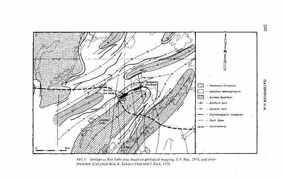
N
FÍG. Geology o / Xey La^e а;*еа, bosed од geoiogicai mapping, G.ß. Ray, J976, a^d w?er- рт-еГай'ол о/рАуд'са/ ¿ай, Æ. íeA/í y-r/ü'e/ a/¡¿ У. Я;'с/!, 7 7á.
200 G
AT
ZW
EJL
ER
et a).
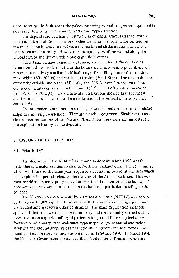
ÏAEA-AG-250/5 201
unconformity. In fault zones the paleoweathering extends to greater depth and is not easily distinguishable from hydrothermal-type alteration.
The deposits are overlain by up to 90 m of glacial gravel and lakes with a maximum depth o f 26 m. The ore bodies trend parallel to and are centred on the trace o f the intersection between the north-east striking fault and the sub- Athabasca unconformity. However, some apophyses o f ore extend along the unconformity and downwards along graphitic horizons.
Table I summarizes dimensions, tonnages and grades o f the ore bodies. Attention is drawn to the fact that the bodies are largely vein type in shape and represent a relatively small and difficult target for drilling due to their modest max. width (80—200 m) and vertical extension (70—190 m). The ore grades are extremely variable and reach 35% ЧзО§ and 20% Ni over 2-m sections. The contained metal decreases by only about 1 0 % if the cut-off grade is increased from <0.1 to 1% UgOg. Geostatistical investigations showed that the metal distribution is less anisotropic along strike and in the vertical dimension than across strike.
The ore minerals are uranium oxides plus some uranium silicates and nickel sulphides and sulpho-arsenides. They are closely intergrown. Significant trace- element concentrations o f Co, Mo and Pb exist, but they were not important in the exploration history o f the deposits.
3. HISTORY OF EXPLORATION
3.1. Prior to 1971
The discovery o f the Rabbit Lake uranium deposit in late 1968 was the beginning o f a major uranium rush into Northern Saskatchewan (Fig. 1). Uranerz, which was founded the same year, acquired an equity in two joint ventures which held exploration permits close to the margins o f the Athabasca Basin. This was then considered a more prospective location than the interior o f the basin: however, the areas were not chosen on the basis o f a particular metallogenetic concept.
The Northern Saskatchewan Uranium Joint Venture (NSUJV) was headed by Inexco with 30% equity. Uranerz held 10%, and the remaining equity was distributed amongst seven other companies. The main exploration methods applied at that time were airborne radiometry and spectrometry carried out by a contractor on a quarter-mile grid pattern with ground follow-up including footborne radiometry, reconnaissance-type mapping, geochemical and radon sampling and ground geophysics (magnetic and electromagnetic surveys). No significant exploratory success was obtained in 1969 and 1970. In March 1970 the Canadian Government announced the introduction of foreign ownership
202 GATZWEILER et al.
restrictions for uranium mining. This, together with the lack o f success, caused an exodus o f uranium explorers from Canada and from Saskatchewan in particular.
Early in 1971 only two other companies besides Uranerz remained in the NSUJV, each then holding an equity o f 33.3%. The three companies agreed to continue exploration under a redefined concept in more favourable areas.Uranerz formulated this new concept by applying its knowledge o f the Rabbit Lake deposit — the company had bought a 49% share in this deposit in 1970 — and newly discovered uranium deposits in the East Alligator River Region o f the Northern Territory o f Australia. The main criteria were:
1. Prospective areas had to cover the unconformity between Aphebian metasediments o f the Wollaston Belt and the Athabasca Formation.
2. The Aphebian metasediments had to be o f shallow water deposition, including calcareous rocks.
3. The deposits searched for were fault-controlled and - more important - such faults could intersect the overlying unmetamorphosed Athabasca Sandstone. This could consequently have an effect on the erosional pattern o f the sandstone margin.
The new target area stretched along the south-east margin o f the Athabasca Basin, and the joint venture could now work without major active competition, as the area o f main interest was vacant. Additional information became available through study o f exploration reports submitted to the Saskatchewan Government by earlier involved companies. From 1968 to 1970 the general Zimmer-Key Lake area was occupied by a small Canadian company which had carried out some airborne spectrometry and some limited prospecting, including radon surveys o f lake waters and soils. The results o f these investigations, however, did not encourage further work by that company although the reports mentioned anomalous radon content in the waters o f Zimmer Lake.
3.2. Summer 1971 Held season
The 1971 summer programme consisted o f regional reconnaissance-type work with the object o f delineating smaller target areas. The following work was carried out;
Structural airphoto interpretation;Geological and radiometric traversing to map the margins o f the sandstone; andA regional radon survey o f all lakes accessible by light aircraft on floats.
The anomalous radon concentration in Zimmer Lake was confirmed.Follow-up work located two highly radioactive swamps about 1 km east of Zimmer Lake. During a further check o f these swamps two boulders o f massive
IAEA-AG-250/5 203
uranium-nickel ore were found about 500 m north-east o f Zimmer Lake and 5 km south o f the Key Lake deposits. Late in 1971 one claimblock (CBS 1878) was staked, covering an area o f about 6 km^.
3.3. Summer 1972 field season
During the 1972 summer field season this claimblock was investigated in detail. Systematic radiometric, magnetic and electromagnetic (EM 16) surveys combined with geological mapping, lake sediment and muskeg sampling were carried out. The surrounding areas were further investigated by reconnaissance surveys. Eighty-five mineralized boulders were discovered in three areas within the claimblock. At that time the technique o f systematic boulder-tracing was not known to the operators and was therefore not employed. The purpose o f the magnetic and electromagnetic surveys was to locate tectonic structures. Results were not satisfactory.
Only towards the end of 1979 was the necessity for further land protection recognized; consequently one further claim block and two mineral prospecting permits were applied for.
3.4. Winter 1972/1973 field season
The interpretation o f the results obtained from the summer work led to the wrong assumption that a structurally controlled uranium-nickel deposit might exist in the vicinity o f the radioactive swamps and boulder fields north of Zimmer Lake. To outline drilling locations a vertical-loop EM survey was contracted. This EM survey located several zones o f higher conductivity which were then tested by a 19-hole core-drilling programme. No ore-bearing intersections were obtained.
Meanwhile, an air-photo study was contracted to an experienced glacial geologist. An esker was recognized as being responsible for the transport of the ore boulders, which were located at the termination point o f the esker. The conclusion then was that the ore boulders originated from an area around Seahorse Lake, 5 km north o f the drilled area (Fig.4).
3.5. Summer 1973 and winter 1973/! 974 field seasons
Early in 1973, B. Tan became responsible for the project and remained in charge until 1977. This is emphasized because continuity o f personnel is considered a very important factor for successful exploration. Tan implemented geochemical lake-bottom sediment sampling as a further tool. The organic-rich lake sediments produced the most effective results both at the reconnaissance and the detailed level (Tan, 1976). Very high uranium and nickel values ranging
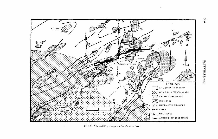
ÍAEA-AG-250/5 205
from 199 ppm to over 700 ppm were found, and a very distinct cut-off o f the anomalous zone was also indicated. The uranium content o f over 100 ppm in Kinikinik Lake decreases drastically to only 5 ppm in Key Lake (Fig. 5). The results confirmed the new target area as outlined by the glacial studies. An additional radiometric anomaly was discovered close to the north shoreline o f Seahorse Lake. Soil samples o f the anomalous area assayed up to 1% UgOg. A subsequent radon survey in the same area revealed a broad anomalous zone. The continued glacial studies could trace the esker beyond Seahorse Lake by recognizing a linear-shaped depression which was interpreted as a 'tunnel valley' or ice-walled channel. In this part o f the glacial stream no sediments were deposited. Now it became clear that somewhere along the tunnel valley a rich uranium-nickel ore body had been eroded; its location, however, was only broadly defined by the geochemical anomaly about 1 0 0 0 m wide.
The next logical step was a multiple geophysical approach to narrow down the target zone. The programme consisted o f a ground magnetic—IP/resistivity and a vertical-loop EM survey. The latter was not successfully completed because of instrument failures. All geophysical work at this time was done by contractors. The magnetic contours showed a low intensity trend parallel to the strike o f basement rocks (Fig.6 ). It indicated the presence o f an alteration zone likely to be associated with a fracture zone. The trend direction o f this magnetic 'low' coincided also with a resistivity 'low' and partly with an EM conductor (Key Lake). The IP survey produced several isolated anomalies which were interpreted at that time as bodies o f disseminated sulphidic mineralization which possibly provided the source material o f many o f the ore boulders.
3.6. Summer 1974 field season
Though several drill targets had been outlined by the foregoing geophysical surveys, the summer season of 1974 started with a radon Track Etch survey covering the area of the geophysical anomalies. The background scattered quite erratically ranging from 1 to 10 tracks/mm^. One cup location had a reading o f 45 tracks/mm . This area was subsequently tested with one drill-hole, with negative results.
Another low-order anomaly with values between 20 and 30 tracks/mm^ occurs about 50 m north-west o f the Deilmann ore body. At that time it did not arouse any attention.
The subsequent drill programme consisted o f ten holes with a total o f 1068 metres o f BQ-size diamond core. The first hole tested the crosspoint o f a VL-EM conductor with an IP anomaly in the Key Lake area. Thick graphitic gneiss was intersected but with no apparent mineralization. The graphitic horizon explained sufficiently the EM and IP anomalies. Its importance with regard to the lithostratigraphical ore control was not recognized at that time.
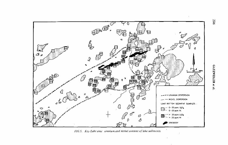
FVC.J. ÆeyiaÆecrea.' conferí
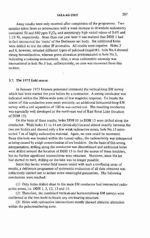
IAEA-AG-250/5 207
Assay results were only received after completion o f the programme. Two samples taken from an intersection with a weak increase in downhole radiometry contained 50 and 680 ppm U^Og and surprisingly high nickel values o f 0 .6 % and 1.1% Ni, respectively. More than one year later it was realized that DDH 1 had in fact intersected the 'roots' o f the Deilmann ore body. Six additional holes were drilled to test the other IP anomalies. AH results were negative. Holes 3 and 4, however, revealed different types o f paleosoil (regolith); hole No.4 showed strong hematitization, whereas green alteration predominated in hole No.3, indicating a reducing environment. Also, a weak radiometric anomaly was encountered in hole No.3 but, unfortunately, no core was recovered from this section.
3.7. The 1975 field season
In January 1975 Uranerz personnel continued the vertical-loop EM survey which had been started the year before by a contractor. A strong conductor was indicated within the 200-m-wide zone o f low magnetic response. To locate the centre o f this conductive zone more precisely, an additional horizontal-loop EM survey with a coil separation o f 100 m was carried out. The resulting conductor was especially well developed at the north-east end o f Karl Ernst Lake (location o f DDH 15).
On the basis o f these results, holes DDH 11 to DDH 15 were drilled along the conductor. While holes 1 1 to 14 are (ironically) located almost exactly between the two ore bodies and showed only a few weak radioactive zones, hole No. 15 intersected 7 m o f highly radioactive material. Again, no core could be recovered.Since this hole was located within the tunnel valley, the radioactivity was interpreted as being caused by a high concentration o f ore boulders. On the basis o f this wrong interpretation, drilling along the conductor was discontinued and additional holes were drilled around the location o f DDH 15 to find the source o f these boulders, but no further significant intersections were obtained. Moreover, since the ice had started to melt, drilling on the lake was no longer possible.
Since this hectic winter field season ended with such a confusing array of results, a deliberate programme o f systematic evaluation of all data obtained was collectively carried out to isolate some meaningful parameters. The following conclusions were reached:
(1) Only holes drilled close to the main EM conductor had intersected radioactive zones, i.e. DDH 1, 3, 12, 13 and 15.
(2) Therefore, the combined vertical-and horizontal-loop EM surveys were confirmed as the best tools to locate any ore-bearing structure.
(3) Holes with radioactive intersections mostly showed chloritic alteration within the paleoweathering zone.
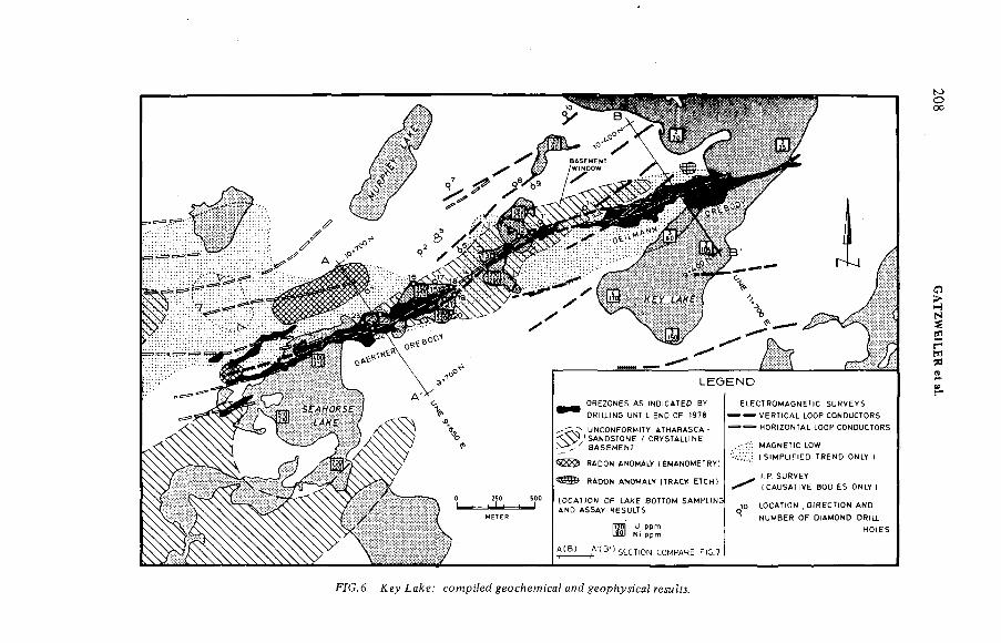
SECTION COMPARE FlG.7
E LE C TR O M A G N ET S S U R V E Y S
- — VE R H C A L LOOP CONDUCTORS
- HORIZONTAL LOOP CONDUCTORS
MAGNETIC LOW
t S !M P U F ) E D TRENO ONLY )
). P. SURVEY(CAUSATIVE BODIE S ONLY )
j o LOCATION , OiRECTfON AND
NUMBER OF DtAMOND DRtLJ
HOLES
FÍC.6. сотрйе^#еосйет;ся?ян(У#еорЬум'са?гедм??л.
208 G
ATZW
EILER
et al.
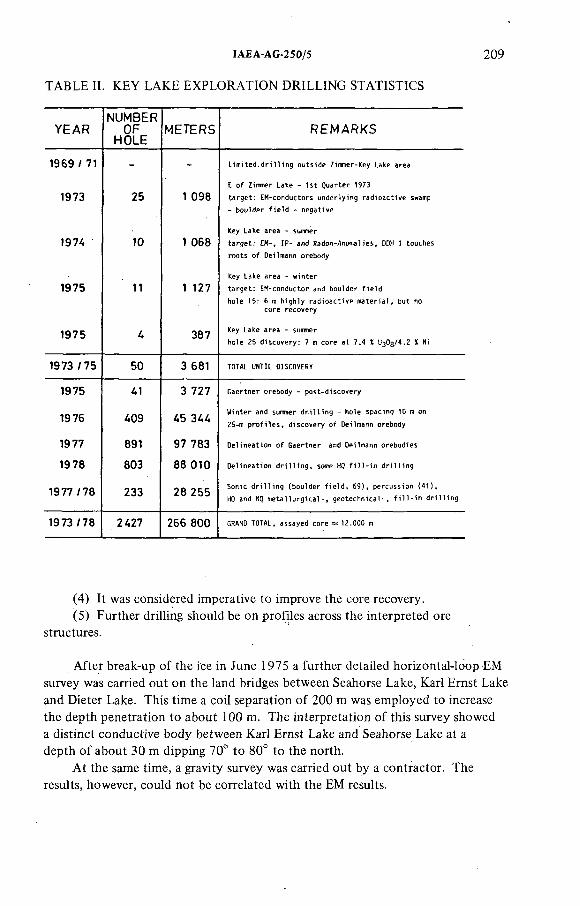
TABLE IL KEY LAKE EXPLORATION DRILLING STATISTICS
IAEA-AG-250/5 209
YE A RNUMBER
OFHOLE
METERS R E M A R K S
1969 / 71 - - L i m i t e d . d r i l l i n g o u t s i d e Zi n m er -K ey Lake a r e a
E o f Zimmer La ke - 1 s t Q u a r t e r 1 973
1973 25 1 098 t a r g e t : E M - c o n d u c to r s u n d e r l y i n g r a d i o a c t i v e swamp
1974 10 1 068
1975 11 1 127 t a r s e t ^ см - c o n d u c t o r and b o u ) d e r f i e l d ^ ^
1975 4 387 Key La ke a r e a - sunmer
h o l e 2 5 d i s c o v e r y : 7 m c o r e a t 7 . 4 1 U ^ O g / 4 .2 Ï Mi
1973/75 50 3 681 TOTAL UNTIL DISCOVERY
1975 41 3 727 G a e r t n e r o r e b o d y - p o s t - d i s c o v e r y
1976 409 45 344 ^ Îp r^ le n L ^ !^ lf*D e °L n n te L d ^
1977 891 97 783 D e l i n e a t i o n o f G a e r t n e r and De i lma nn o r e b o d i e s
1978 803 88 010 D e l i n e a t i o n d r i l l i n g , some HQ f i l l - i n d r i l l i n g
1977/78 233 28 255HQ and HQ m e t a l l u r g i c a l - , g e o t e c h n i c a ! - , f i l l - i n d r i l l i n g
1973 / 78 2427 266 800 GRAND TOTAL, a s s a y e d c o r e = 1 2 . 0 0 0 m
(4) It was considered imperative to improve the core recovery.(5) Further drilling should be on profiles across the interpreted ore
structures.
After break-up of the ice in June 1975 a further detailed horizontal-loop EM survey was carried out on the land bridges between Seahorse Lake, Karl Ernst Lake and Dieter Lake. This time a coil separation o f 200 m was employed to increase the depth penetration to about 100 m. The interpretation o f this survey showed a distinct conductive body between Karl Ernst Lake and Seahorse Lake at a depth o f about 30 m dipping 70° to 80° to the north.
At the same time, a gravity survey was carried out by a contractor. The results, however, could not be correlated with the EM results.
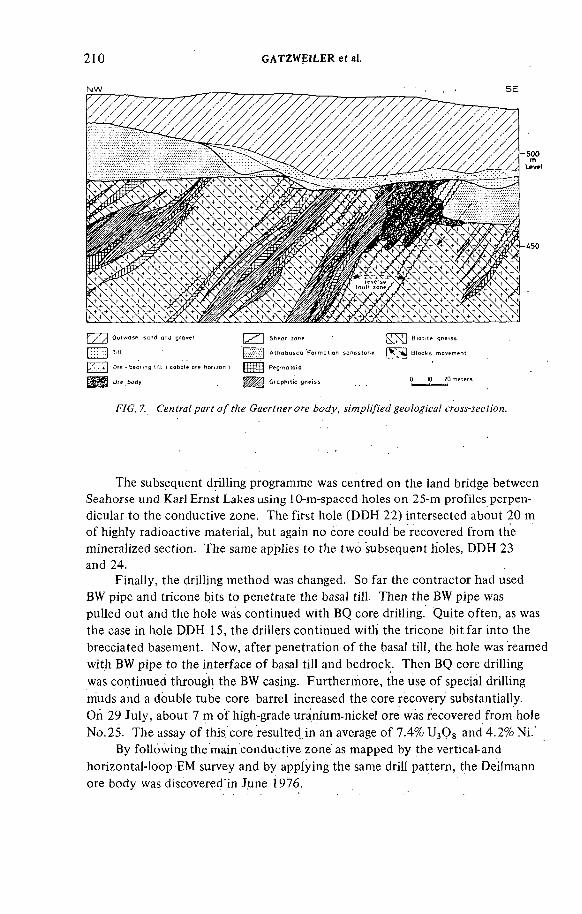
210 GATZWEILER et a).
F7C. 7. Centra/ parf o / f /м Саел^пелс^е ^eo/o^/ca/ cro^-íecí/on.
The subsequent drilling programme was centred on the land bridge between Seahorse und Karl Ernst Lakes using 10-m-spaced holes on 25-m profiles perpendicular to the conductive zone. The first hole (DDH 22) intersected about 20 m of highly radioactive material, but again no core could be recovered from the mineralized section. The same applies to the two subsequent holes, DDH 23 and 24.
Finally, the drilling method was changed. So far the contractor had used BW pipe and tricone bits to penetrate the basal till. Then the BW pipe was pulled out and the hole was continued with BQ core drilling. Quite often, as was the case in hole DDH 15, the drillers continued with the tricone bit far into the brecciated basement. Now, after penetration o f the basal till, the hole was reamed with BW pipe to the interface o f basal till and bedrock. Then BQ core drilling was continued through the BW casing. Furthermore, the use o f special drilling muds and a double tube core barrel increased the core recovery substantially.On 29 July, about 7 m o f high-grade uranium-nicke! ore was recovered from hole No. 25. The assay of this core resulted in an average o f 7.4% L^Og and 4.2% Ni.
By following the main conductive zone as mapped by the vertical-and horizontal-loop EM survey and by applying the same drill pattern, the Deilmann ore body was discovered in June 1976.
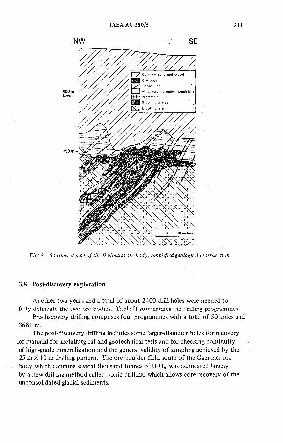
tAEA-AG-250/5 211
NW SE
FÏG .& paff o/í^e De¡7mann ore &oáy, íi'mp/:/¡'ed ^ео/о^'са/ cm^-^eefion.
3.8. Post-discovery exploration
Another two years and a total o f about 2400 drill-holes were needed to fully delineate the two ore bodies. Table It summarizes the drilling programmes.
Pre-discovery drilling comprises four programmes with a total o f 50 holes and 3681 m.
The post-discovery drilling includes some larger-diameter holes for recovery .of material for metallurgical and geotechnical tests and for checking continuity o f high-grade mineralization and the general validity o f sampling achieved by the 25 m X 10 m drilling pattern. The ore boulder field south o f the Gaertner ore body which contains several thousand tonnes o f U3OS was delineated largely by a new drilling method called sonic drilling, which allows core recovery o f the unconsolidated glacial sediments.
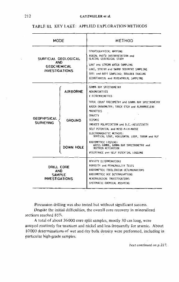
TABLE m. KEY LAKE: APPLIED EXPLORATION METHODS
212 GATZWEILER et a!.
MODE METHOD
SURFIOAL GEOLOGtCAL AND
GEOCHEMtCAL
)NVE5TtGAH0N5
STRATIGRAPHICAL MAPPING
AERIAL PHOTO INTERPRETATION and GLACIAL GEOLOGtCAL STUDY
LAKE and STREAM MATER SAMPLING
LAKE, STREAM and SWAMP SEDIMENT SAMPLING
SOIL and ROCK SAMPLING; BOULDER TRACING
GE0B0TANICAL and BIOCHEMICAL SAMPLING
AtRBORNE
GEOPHYStCALj гопнмп SURVEYtNG )
DOWN HOLE
GAMMA RAY SPECTROMETRY
AEROMAGNETICS
ELECTROMAGNETICS
TOTAL COUNT RADIOMETRY and GAMMA RAY SPECTROMETRY
RADON EMAN0METRY; TRACK ETCH and ALPHANUCLEAR
MAGNETICS
GRAVITY
SEISMIC
INDUCED POLARIZATION and D.C.-RESISTIVITY
SELF POTENTIAL and MISE-A-LA-MASSE
ELECTROMAGNETIC METHODS:VERTICAL LOOP, HORIZONTAL LOOP, TURAM and VLF
RADIOMETRIC LOGGING:GROSS GAMMA, GAMMA RAY SPECTROMETRY and NEUTRON ACTIVATION
RESISTANCE and SELF POTENTIAL LOGGING
DRtLL CORE AND
SAMPLE <NVESTIGATtONS
DENSITY DETERMINATIONS
POROSITY and PERMEABILITY TESTS
RADIOMETRIC EQUILIBRIUM DETERMINATIONS
RADIOMETRIC AGE DETERMINATIONS
MINERALOGICAL INVESTIGATIONS
SYSTEMATIC CHEMICAL ASSAYING
Percussion drilling was also tested but without significant success.Despite the initial difficulties, the overall core recovery in mineralized
sections reached 85%.A total o f about 36000 core split samples, mostly 30 cm long, were
assayed routinely for uranium and nickel and less frequently for arsenic. About 1 0 0 0 0 determinations o f wet and dry bulk density were performed, including in particular high-grade samples.
7exf continued on p .2i 7.
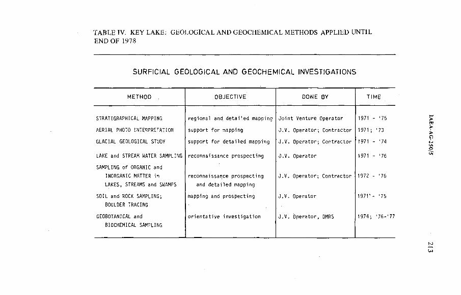
TABLE IV. KEY LAKE: GEOLOGICAL AND GEOCHEMICAL METHODS APPLIED UNTIL END OF 1978
SURFiCtAL GEOLOGtCAL AND GEOCHEMICAL tNVESDGAHONS
M E T H O D O B J E C T I V E D O N E B Y T I M E
STRATIGRAPHICAL MAPPING regional and detailed mapping Joint Venture Operator 1971 - '75
AERIAL PHOTO INTERPRETATION support for mapping J.V. Operator; Contractor 1971 '73
GLACIAL GEOLOGICAL STUOY support for detailed mapping J.V. Operator; Contractor 197) - '74
LAKE and STREAM MATER SAMPLING reconnaissance prospecting J.V. Operator 1971 - '76
SAMPLING of ORGANIC and
INORGANIC MATTER in
LAKES, STREAMS and SMAMPS
reconnaissance prospecting
and detailed mapping
J.V. Operator; Contractor 1972 - '76
SOIL and ROCK SAMPLING;
BOULDER TRACING
mapping and prospecting J.V. Operator 1971' - '75
GEOBOTANICAL and
BIOCHEMICAL SAMPLING
orientative investigation J.V. Operator, DMRS 1974 '76-'77
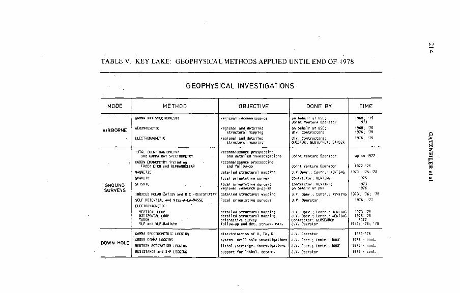
TABLE V. KEY LAKE: GEOPHYSICAL METHODS APPLIED UNTIL END OF 1978
GEOPHYStCAL INVESTIGATIONS
MODE M E T H O D O B J E C T I V E D O N E B Y H M E
GAMMA RAY SPECTROMETRY r e g i o n a l г е с о п п Ш м . с е on b e h a l f o f GSC;J o i n t V e n t u r e O p e r a to r
1 9 6 8 ; ' 7 5 1973
AtRBORNE AEROMAGNETIC" ^ r ^ r a t a p p i n g
on b e h a l f o f GSC; d i v . C o n t r a c t o r s
1 9 6 8 ; ' 7 5 1 9 7 6 ; ' 7 8
ELECTROMAGNETIC" ^ t ^ c t Ü r a / m a p ^ n g QUESTOR-.^GEOTERRÉX; SANDER
1 9 7 6 ; ' 7 3
TOTAL COUNT RAOIOMETRYand GAMMA RAY SPECTROMETRY ' l n S l e " n e d ' ^ e I ^ № i o n s J o i n t V e n t u r e O p e r a to r up t o 1977
RADON EMANOMETRY In c l u d i n g . TRACK ETCH and ALPHANUCLEAR J o i n t V e n t u r e O p e r a to r 1 9 7 2 - ' 7 6
MAGNETIC detailed structural mapping. J . V . O p e r . ; C o n t r . : RENTING 1 9 7 3 ; ' 7 5 - ' 7 8
GRAVITY l o c a l o r i e n t a t i v e su rv ey C o n t r a c t o r : KENTING 1975
GROUNDSURVEYS
SEISMIC¡ . e ^ n a i ' r e ^ r c h р г ^ г а ш
C o n t r a c t o r : KENTING; on b e h a l f o f OMR
19731976
INOUCEO POLARIZATION and O.C. -R ES IST IV IT Y d e t a i l e d s t r u c t u r a l mapping J . V . O p e r . ; C o n t r . : KENHMC 1 9 7 3 ; ' 7 6 ; ' 7 8
SELF POTENTIAL and MISE-A-LA-MASSE l o c a l o r l e n t a t i v e su r v e y s J . V . O p e r a t o r 1 9 7 6 ; '7 7
ELECTROMAGNETIC:
VERTICAL LOOP HORIZONTAL LOOP TURAMVLF and VLF-Radiohm
J . V . O p e r . ; C o n t r . : KENTING J . V . O p e r . ; C o n t r . : KENTING C o n t r a c t o r - . GEOSEARCH
1 9 7 3 - ' 7 8 1 9 7 5 - ' 7 8
197 7 1 9 7 3 ; ' 7 6 ; ' 7 8
GAMA SPECTROMETRIC LOGGING d i s c r i m i n a t i o n o f U. T h , К J . V . O p e r a t o r 1 9 7 4 - ' 7 6
DOWN HOLEGROSS GAMMA LOGGING s y s t e m , d r i l l h o l e i n v e s t i g a t i o n s J . V . O p e r . ; C o n t r . : ROKE 19 76 - c o n t .
NEUTRON ACTIVATION LOGGING H t h o l . / s t r a t l g r . I n v e s t i g a t i o n s J . V . Oper . - , C o n t r . : ROKE 19 76 - c o n t .
RESISTANCE and S- P LOGGING s u p p o rt f o r H t M . d e t e n t . J . V . O p e r a t o r 1976 - c o n t .
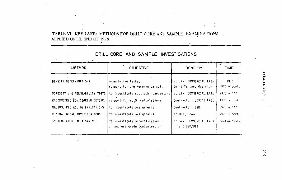
TABLE Vi. KEY LAKE: METHODS FOR DRILL CORE AND SAMPLE EXAMINATIONS APPLIED UNTIL END OF 1978
DRtLL CORE AND SAMPLE ¡NVESHGAHONS
M E T H O D O B J E C T I V E D O N E B Y T I M E
DENSITY DETERMINATIONS orientative tests; at div. COMMERCIAL LABs 1976
support for ore reserve calcul. Joint Venture Operator 1976 - cont.
POROSITY and PERMEABILITY TESTS to investigate rockmech. parameters at div. COMMERCIAL .LABs 1976 - '77
RADIOMETRIC EQUILIBRIUM DETERM. support for eU^Og calculations Contractor: LORING LAB. 1976 - cont.
RADIOMETRIC AGE DETERMINATIONS to investigate ore genesis Contractor: BGR 1976 - '77
MINERALOGICAL INVESTIGATIONS to investigate ore genesis at UEB, Bonn 1976 - cont.
SYSTEM. CHEMICAL ASSAYING to investigate mineralization at div. COMMERCIAL LABs continuously
and ore grade concentration and UEM/UEB
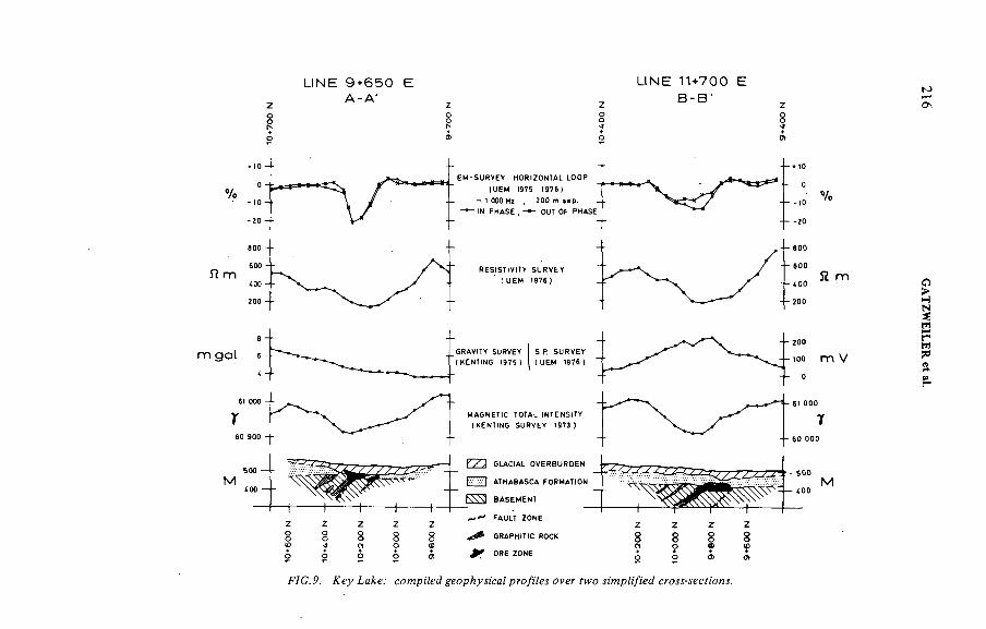
%
П m
m g a t
<
ï6
M
L)NE 9+650 E A-A '
U N E 1 1 + 7 0 0 E B - B '
EM-SURVEY HORiZONTAL LOOP
(UEM 1975 !976 )
- 1 000 Wi ¿ 2 0 0 m se p .
- * - <N PHASE ¿ OUI 0F PHASE
RES)ST)V)TY SURVEY
( UEM 1976 )
GRAV4Y SURVEY
(KENUNC 1975 1S.P SURVEY (UEM 1976 1
MAGNETtC TOTAL )NTENS)TY
( KENTtNG SURVEY 1973 )
ATHABASCA FORMATEN
BASEMENT
! i tFAULT ZONEz z z
8 8 8 G R A P H I C ROCK
О О О ) ^ ORE ZONE
Я m
Z Z z z8 8 8 8о m <0
O о O) e t
F7G.P. Хеу ¿аЛсе. coMpí'ZgdgeopAyí/ec/ pw/i'Fei ftvo я'уярй/ïei?
216 GATZW
EILER et
at.
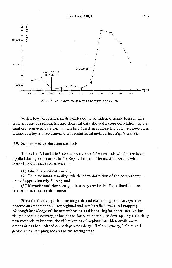
ÍAEA-AG-2S0/5 2]7
F/C. 7 0. DeveZopwenf o/Á^ey ía/ce expZorafion coíf&
With a few exceptions, alt drill-holes could be radiometrically logged. The large amount o f radiometric and chemical data allowed a close correlation, so the final ore reserve calculation is therefore based on radiometric data. Reserve calculations employ a three-dimensional geostatistical method (see Figs 7 and 8 ).
3.9. Summary o f exploration methods
Tables I I I -V I and Fig.9 give an overview o f the methods which have been applied during exploration in the Key Lake area. The most important with respect to the final success were:
(1) Glacial geological studies;(2) Lake sediment sampling, which led to definition o f the correct target
area o f approximately 5 km ; and(3) Magnetic and electromagnetic surveys which finally defined the ore-
bearing structure as a drill target.
Since the discovery, airborne magnetic and electromagnetic surveys have become an important tool for regional and semidetailed structural mapping. Although knowledge o f the mineralization and its setting has increased substantially since the discovery, it has not so far been possible to develop any essentially new methods to improve the effectiveness o f exploration. Meanwhile more emphasis has been placed on rock geochemistry. Refined gravity, helium and geobotanical sampling are still at the testing stage.
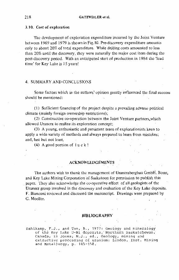
218 GATZWEILER et a).
The development o f exploration expenditure incurred by the Joint Venture between 1969 and 1979 is shown in Fig. 10. Pre-discovery expenditure amounts only to about 20% o f total expenditure. While drilling costs amounted to less than 2 0 % until the discovery, they were naturally the major cost item during the post-discovery period. With an anticipated start o f production in 1984 the 'lead time' for Key Lake is 15 years!
3.10. Cost of exploration
4. SUMMARY AND CONCLUSIONS
Some factors which in the authors'* opinion greatly influenced the final success should be mentioned:
( 1 ) Sufficient financing of the project despite a prevailing adverse political climate (mainly foreign ownership restrictions);
(2) Constructive co-operation between the Joint Venture partners,which allowed Uranerz to realize its exploration concept;
(3) A young, enthusiastic and persistent team o f explorationists keen to apply a wide variety o f methods and always prepared to learn from mistakes; and, last but not least,
(4) A good portion of 1 u с к !
ACKNOWLEDGEMENTS
The authors wish to thank the management o f Uranerzbergbau GmbH, Bonn, and Key Lake Mining Corporation of Saskatoon for permission to publish this paper. They also acknowledge the co-operative effort o f all geologists o f the Uranerz group involved in the discovery and evaluation o f the Key Lake deposits.F. Bianconi reviewed and discussed the manuscript. Drawings were prepared byG. Moeller.
BIBLIOGRAPHY
Dahlkamp, F . J . , and Tan , B . , 1 9 77 : Geology and m ineralogy
o f the Key Lake U-Ni d e p o s i t s , Northern Saskatchew an ,
Canada , in Jo n e s , M . J . , s d . , G eolo gy , m ining and
e x t r a c t iv e p ro c e s s in g of uranium : London, I n s t . M in ing
and M e t a llu r g y , p . 145- 158.
ÍAEA-AG-250/5 219
Dahlkamp, F . , 1 97 8 : G eo lo g ie a p p r a is a l of the Key Lake
U-Ni D e p o s i t s , N orthern Saskatchew an , Econ . G e o l . ,
v o l . 7 3 , 1 430- 1449 .
G a t z w e i l e r , R . , 1 9 7 8 : Case H is to ry Key L ake . U n p u b lis h e d
p re s e n t a t io n A lb e r ta S ec t io n CIM .
G a t z w e i l e r , R . , L e h n e r t- T h ie l , K . , et a l , 1 97 9 : The Key
Lake uranium - nickel d e p o s i t s . The Canadian M in ing
and M e t a l l u r g i c a l B u l l e t i n , J u l y , 1979.
K ir c h n e r , G. et a l , 1 979 ; Key Lake and J a b i l u k a models
for lower p r o t e r o z o ic uranium d e p o s i t io n . I n : I n t e r n .
Uranium Symposium on the P ine Creek G e o s y n c l in e , N .T .
A u s t r a l i a .
K i r c h n e r , G. and T a n , B . , 1 9 7 7 : P ro sp e k t io n , E x p lo r a t io n
und E n tw icklun g der U r a n la g e r s tä t te Key L ak e , Kanada .
Erzm etall Band 30 , He ft 12.
L a g a l l y , U . , 1 97 6 : A b sc h lu ß b e r ic h t über d ie Uran
pro s p ek tio n im Northern Saskatchewan J o in t V e n t u r e /
Saskatchewan Uranium J o in t V e n tu re .
U n p u b lis h e d Uranerz i n t e r n a l rep o rt .
Tan , B . , 1 976 : Geochem ical case h is t o r y in the Key
Lake a re a . Saskatchewan G e o lo g ic a l S o c ie t y . S p e c ia l
P u b l ic a t io n No. 3.
Tan , B . , 1 98 0 : P r o s p e k t io n , E x p lo ra t io n und L a g e r s t ä t t e n
erkundung der Uranvorkommen am Key Lake in Saskatchew an ,
Kanada.
D i s s e r t a t i o n am I n s t i t u t fü r L a g e r st ä t t e n fo r s c h u n g und
Rohstoffkund e an der T ech n isch e n -Universität B e r l i n .
DISCUSSION
В. GUSTAFSSON: Have you any idea o f the ice movement and have you established some kind o f boulder train?
R. GATZWEILER: The general glaciation direction is from the north-east, almost parallel to the strike o f the Wollaston Belt. The initially discovered boulders occur at an esker delta. The esker contains boulders throughout with the exception o f the section where it has not deposited sediments, i.e. the 'tunnel valley'.
B. GUSTAFSSON: If I remember, you have some till in the area.R. GATZWEILER: Yes, we have this broad magnetic low structure which
mainly indicates the strong alteration halo o f the ore-bearing structure. However, it partly coincides with a glacial trough. This is largely filled with outwash sand, but at the base we find several metres o f basal till.
J. DARDEL: Is the uranium content o f the boulders representative o f the average content o f the ore bodies?
220 GATZWEILER et ai.
R. GATZWEILER: The first two boulders found are representative for high-grade uranium-nickei basement mineraiization. Many of the boulders found in 1972 in the southern area represent sandstone ore, generally with lower contents in uranium and nickel.
H.D. FUCHS: What is the exact metamorphic grade o f the host rock?R. GATZWEILER: The metamorphic grade o f the host rocks is upper
amphibolite facies. The mineral assemblage o f biotite, cordierite and garnet points to a low-pressure metamorphic environment.
H.D. FUCHS: Could you explain a little more about the type o f alteration within the mineralized zone?
R. GATZWEILER: The alteration comprises kaolinization, chloritization and some hematitization. The alteration within the fault zone is partly due to paleoweathering and partly due to hydrothermal alteration. Research work is in progress to distinguish these two phenomena.
G. BUNDROCK: I presume that in the order o f 50 million lb UgOg have been eroded between the two ore bodies by glacial action. Do you have any idea whether some of that can be recovered or mined from the boulder field and the till?
R. GATZWEILER: I am very surprised at your assumption. But you could be roughly right; we have delineated about 5000 t o f boulder ore immediately adjacent to the ore body. This will be recovered.
D.A. PORTER: Would you discuss the model used for the source and deposition o f uranium at Key Lake?
R. GATZWEILER: Initially very little was known about the bedrock geology o f the working area. Therefore, considerations on the source o f uranium had very limited inñuence on the exploration concept. The general Kenoran and Hudsonian granitic terrain was known to be anomalously high in uranium. As regards deposition, a major tectonic structure and possibly calc-silicate lithologies were considered important. Later a model o f multicycle deposition and enrichment evolved, starting with the formation of a sedimentary-type primary deposit within the basal sequence o f Aphebian sediments close to an Archean basement dome.
ÍAEA-AG-250/1
MIDWEST LAKE URANIUM DISCOVERY, SASKATCHEWAN, CANADA
F. SCOTTEsso Minerais Canada,Toronto, Ontario,Canada
Abstract
MIDWEST LAKE URANIUM DISCOVERY, SASKATCHEWAN, CANADA.The discovery of the Midwest Lake uranium deposit in Saskatchewan came some ten
years after the start of exploration. The original mining rights were acquired on the basis of regional published, geology and proximity to the earlier discovery. Aerial radiometric surveys led to the location of a train of radioactive, glacially transported sandstone boulders and cobbles. The source of these mineralized erratics did not outcrop, and an extensive series of magnetic, electromagnetic, seismic and gravity surveys was carried out in an unsuccessful attempt to identify the source location. These surveys were followed by several programmes of diamond drilling, geochemical surveys and Pleistocene geological studies.None of these programmes or surveys encountered bedrock mineralization. When information about ore controls in the Athabasca Basin became avaiiabie, a limited programme of three 300-m wildcat diamond-drill holes was proposed. The second of these holes cut weak radioactivity in a poorly cored intersection. This intersection was at an unconformity at a depth of 200 m. The programme terminated prematurely with early melting of lake ice.The first hole in the subsequent winter's follow-up drilling intersected uranium values in excess of 8 %.
INTRODUCTION
Ten years elapsed between the acquisition of mining rights at Midwest Lake, Saskatchewan (see Fig.l), in 1968 and the first intersections o f ore-grade material in place in January 1978. Subject to limitations of weather and geological theory, exploration was carried out each year. In this study the state o f knowledge at each phase of exploration is described, together with the advances in knowledge derived from testing the various geophysical indications and geological models.
LAND ACQUISITION
In 1966, Numac Oils Ltd, a small independent Canadian Oil company, acquired a spread o f uranium prospecting lands in the Beaverlodge area o f
221
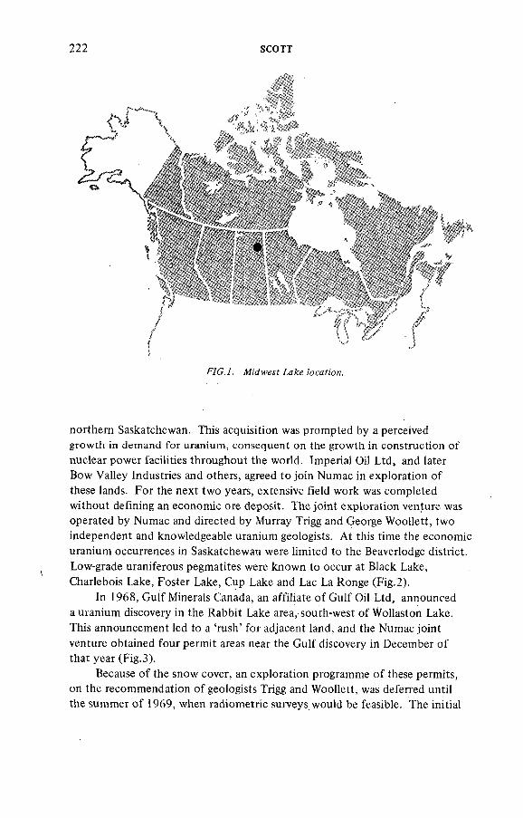
222 SCOTT
§.
northern Saskatchewan. This acquisition was prompted by a perceived growth in demand for uranium, consequent on the growth in construction o f nuclear power facilities throughout the world. Imperial Oil Ltd, and later Bow Valley Industries and others, agreed to join Numac in exploration of these lands. For the next two years, extensive field work was completed without defining an economic ore deposit. The joint exploration venture was operated by Numac and directed by Murray Trigg and George Woollett, two independent and knowledgeable uranium geologists. At this time the economic uranium occurrences in Saskatchewan were limited to the Beaverlodge district. Low-grade uraniferous pegmatites were known to occur at Black Lake, Charlebois Lake, Foster Lake, Cup Lake and Lac La Ronge (Fig.2).
In 1968, Gulf Minerals Canada, an affiliate o f Gulf Oil Ltd, announced a uranium discovery in the Rabbit Lake area, south-west o f Wollaston Lake. This announcement led to a 'rush' for adjacent land, and the Numac joint venture obtained four permit areas near the Gulf discovery in December o f that year (Fig.3).
Because o f the snow cover, an exploration programme o f these permits, on the recommendation o f geologists Trigg and Woollett, was deferred until the summer o f 1969, when radiometric surveys would be feasible. The initial
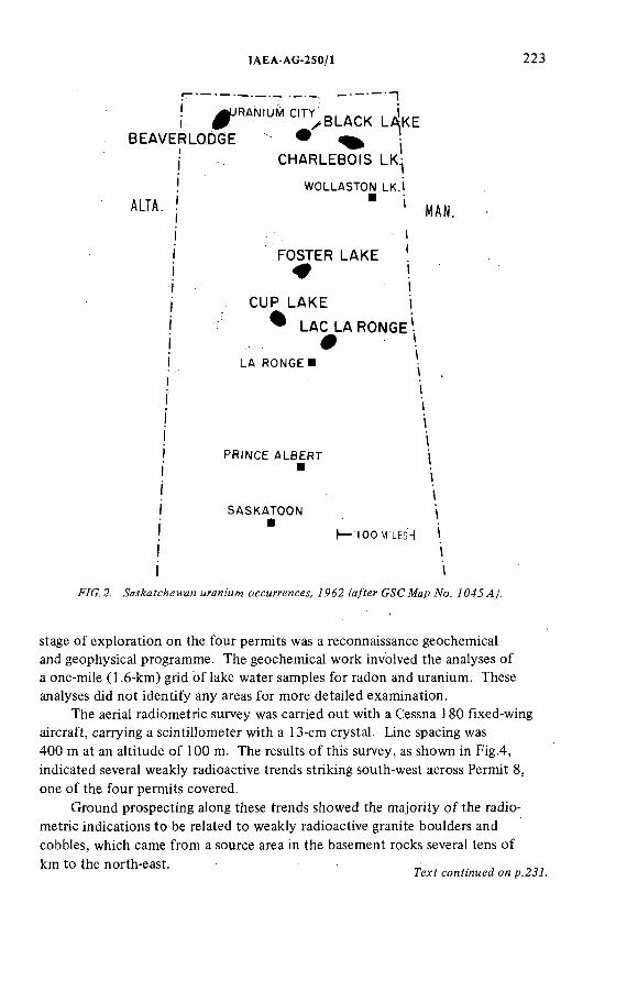
ÏAEA-AG-250/1 223
! # ^ '^ ^ B L A C K L ^ K EBEAVERLODGE
ALTA.
CHARLEBOtS LK
WOLLASTON LK.)
FOSTER LAKE*
CUP LAKE % LAC LA RONGE
#LA RONGE I
MAN.
PRtNCE ALBERT
SASKATOON t) *' t— IOOMILES4 1
¡ i i s
F/C.2 . мгди/Mw оссмггенсм, /я/fer С^СЖар №. /043 4).
stage o f exploration on the four permits was a reconnaissance geochemical and geophysical programme. The geochemical work involved the analyses o f a one-mile (1 .6 -km) grid o f lake water samples for radon and uranium. These analyses did not identify any areas for more detailed examination.
The aerial radiometric survey was carried out with a Cessna 180 fixed-wing aircraft, carrying a scintillometer with a 13-cm crystal. Line spacing was 400 m at an altitude of 100 m. The results o f this survey, as shown in Fig.4, indicated several weakly radioactive trends striking south-west across Permit 8 , one o f the four permits covered.
Ground prospecting along these trends showed the majority o f the radio-metric indications to be related to weakly radioactive granite boulders andcobbles, which came from a source area in the basement rocks several tens o fkm to the north-east.
7ex? ccnfmMea on p .2 ji .

SCOTT
ЯС.4. 4erMZ гс ;'о?яеМс я/rvey аж? АомМе;- Угс;'п, /PáP.
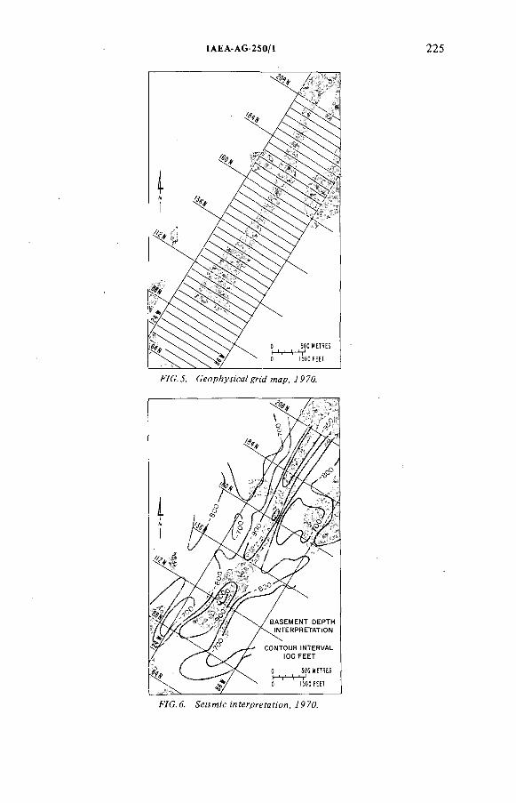
IAEA-AG-2S0/1
F/C. J. СеорА^я'сй/ ямр, / Р 70.
F/С .б. Зеймн'стМгргеУаЯ'ой, /Р70.
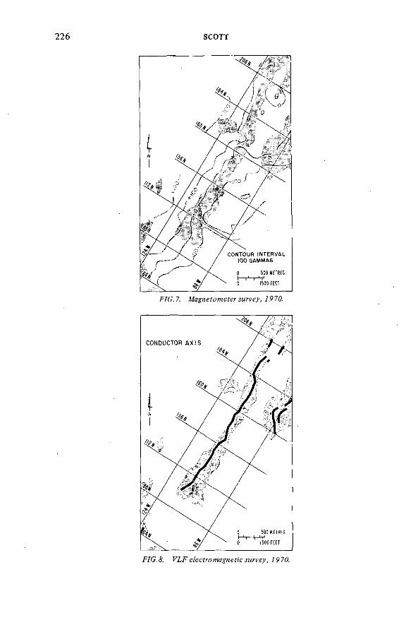
226 SCOTT
F/C .7. Afa^HefomefeT'.yMrye.)', 7970.
F/G. & FLFe?ecfrofMa Hef!'c.!Mn'gy, 7P70.
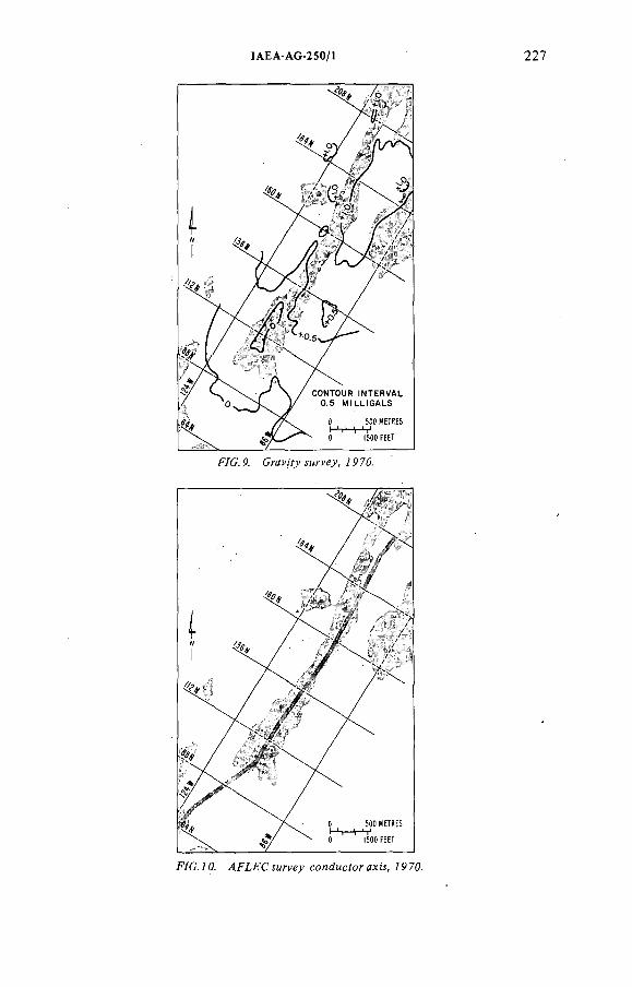
ÏAEA-AG-250/1 227
/УС. P. Cran'fy^T-ye^,/P70.
F/C./ 0. y4Fí,FC м?' 'ey conducfor ахм, /P70.

228 SCOTT
F/G.Í2 . Reároc&áríMAoíe!, 797Л
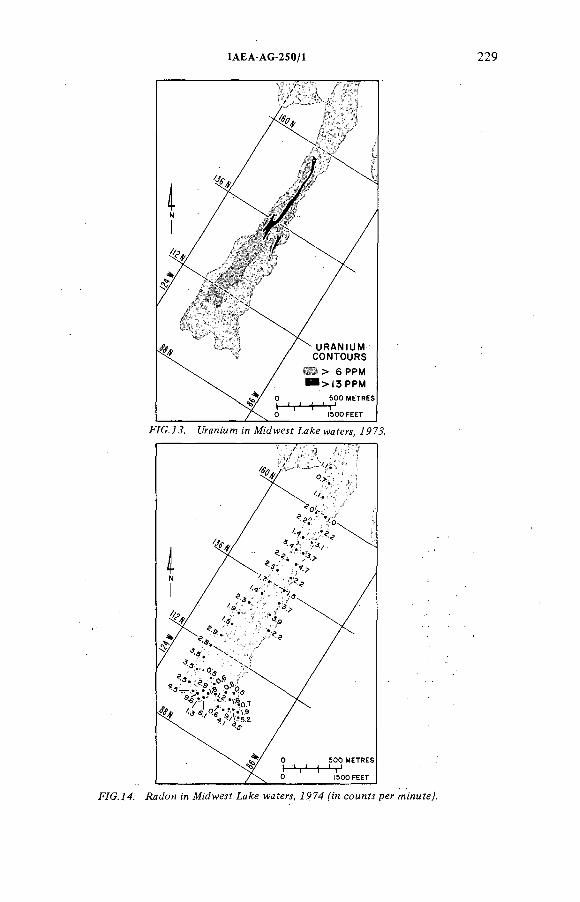
IAEA-AG-250/1 229
F7G.74. Aadon ;'я M'cfwesf LaA:e waferi, 7974 сомни per MnnMfeJ.
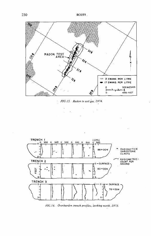
230 SCOTT
F/C. 73. /Мен m 7974.
TRENCH IО 500 0 500 О 500 О
TRENCH 2-о -
TRENCH 3- о -
R A D I O A C T I V ES A N D S T O N EC L A S T S
R A D t O M E T F n C - COUNT PER SECOND
F7C.7d. OvírAurden УгепсА pw/i/ei, /coding 797.?.
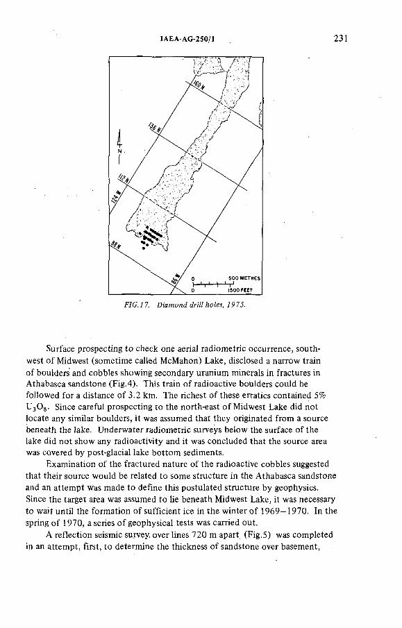
IAEA-AG-250/1 231
Surface prospecting to check one aerial radiometric occurrence, southwest o f Midwest (sometime called McMahon) Lake, disclosed a narrow train o f boulders and cobbles showing secondary uranium minerals in fractures in Athabasca sandstone (Fig.4). This train o f radioactive boulders could be followed for a distance of 3.2 km. The richest o f these erratics contained 5% U^Og. Since careful prospecting to the north-east o f Midwest Lake did not locate any similar boulders, it was assumed that they originated from a source beneath the lake. Underwater radiometric surveys below the surface o f the lake did not show any radioactivity and it was concluded that the source area was covered by post-glacial lake bottom sediments.
Examination o f the fractured nature o f the radioactive cobbles suggested that their source would be related to some structure in the Athabasca sandstone and an attempt was made to define this postulated structure by geophysics. Since the target area was assumed to lie beneath Midwest Lake, it was necessary to wait until the formation o f sufficient ice in the winter o f 1969-1970. In the spring o f 1970, a series o f geophysical tests was carried out.
A reflection seismic survey, over lines 720 m apart (Fig.5) was completed in an attempt, first, to determine the thickness o f sandstone over basement,
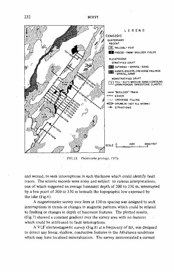
232 SCOTT
L E G E N DC E N O Z O I C
QUATERNARYRECENT
Я Н PALUDAL- PEAT
^HfREEZE-THAW-BOULDER FIELDS
PLEISTOCENE STRATIFIED DRIFT
Я Н OUTWASH -GRAVEL-SANDЗЖИ KAMES.ESKERS, CREVASSE FILLINGS
- GRAVEL, SAND
NONSTRATIFIED DRIFT П П TILL-SILTY, MEDIUM SAND (CONTAINS '---- URANIFEROUS SANDSTONE CLASTS)
улюж "BOULDER" TRAIN * ESKER
CREVASSE FILLING DRUMLIN ( NOT ALL SHOWN )
— STRIATIONS
О IOOO ZOOOFEETSCALE . . .____ i____)
FYG.7& 797$.
and second, to seek interruptions in such thickness which could identify fault traces. The seismic records were noisy and subject to various interpretations, one o f which suggested an average basement depth of 200 to 230 m, interrupted by a low point o f 300 to 330 m beneath the topographic low expressed by the lake (Fig.6 ).
A magnetometer survey over lines at 130-m spacing was designed to seek interruptions in trends or changes in magnetic patterns which could be related to faulting or changes in depth o f basement features. The plotted results,(Fig.7) showed a constant gradient over the survey area with no features which could be attributed to fault interruptions.
A VLF electromagnetic survey (Fig.8 ) at a frequency o f Hz, was designed to detect any linear, shallow, conductive features in the Athabasca sandstone which may have localized mineralization. The survey demonstrated a current
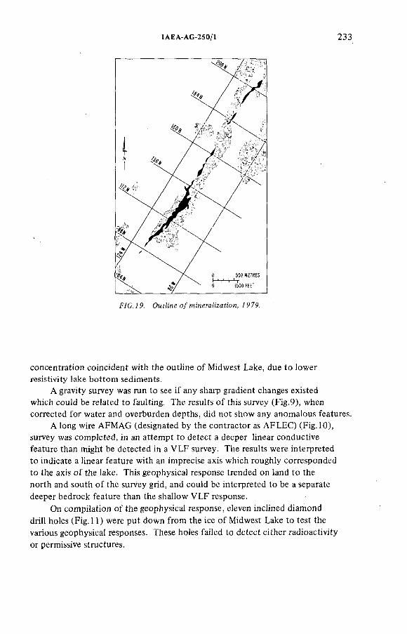
ÏAEA-AG-250/1 233
concentration coincident with the outline o f Midwest Lake, due to lower resistivity lake bottom sediments.
A gravity survey was run to see if any sharp gradient changes existed which could be related to faulting. The results o f this survey (Fig.9), when corrected for water and overburden depths, did not show any anomalous features.
A long wire AFMAG (designated by the contractor as AFLEC) (Fig. 10), survey was completed, in an attempt to detect a deeper linear conductive feature than might be detected in a VLF survey. The results were interpreted to indicate a linear feature with an imprecise axis which roughly corresponded to the axis o f the lake. This geophysical response trended on land to the north and south o f the survey grid, and could be interpreted to be a separate deeper bedrock feature than the shallow VLF response.
On compilation o f the geophysical response, eleven inclined diamond drill holes (Fig. 11) were put down from the ice o f Midwest Lake to test the various geophysical responses. These holes failed to detect either radioactivity or permissive structures.
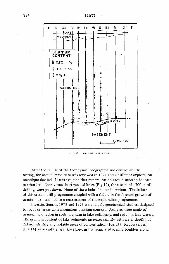
234 SCOTT
W 9! 278 93 184 95 238 97 185 99 277 E
I L A K E
O 'B U R D E N
URANtUMCONTENT
! o.i% - 1%
S 1% -5 %
S 5 % +
S A N D S T O N E
B A S E M E N T
30 METRES— )
F7G.20. Dr[7ísícfíon, Í97&
After the failure o f the geophysical programme and consequent drill testing, the accumulated data was reviewed in 1971 and a different exploration technique devised. It was assumed that mineralization should subcrop beneath overburden. Ninety-one short vertical holes (Fig. 12), for a total o f 1700 m of drilling, were put down. None o f these holes detected uranium. The failure o f this second drill programme coupled with a failure in the forecast growth of uranium demand, led to a reassessment o f the exploration programme.
Investigations in 1972 and 1973 were largely geochemical studies, designed to focus on areas with anomalous uranium content. Analyses were made o f uranium and radon in soils, uranium in lake sediments, and radon in lake waters. The uranium content o f lake sediments increases slightly with water depth but did not identify any notable areas o f concentration (Fig. 13). Radon values (Fig. 14) were slightly near the shore, in the vicinity o f granite boulders along
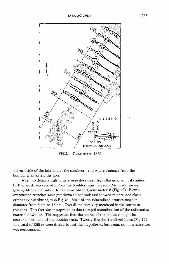
IAEA-AG-250/1 235
the east side o f the lake and at the south-east end where drainage from the boulder train enters the iake.
When no definite driii targets were developed from the geochemical studies, further work was carried out on the boulder train. A radon gas in soil survey gave additional definition to the mineralized glacial material (Fig. 15). Eleven overburden trenches were put down to bedrock and showed mineralized clasts erratically distributed, as in Fig. 16. Most o f the mineralized erratics range in diameter from 5 cm to 15 cm. Overall radioactivity increased in the southern trenches. This fact was interpreted as due to rapid comminution o f the radioactive material down-ice. This suggested that the source o f the boulders might be near the north end o f the boulder train. Twenty-five short inclined holes (Fig. 17) to a total o f 800 m were drilled to test this hypothesis, but again, no mineralization was encountered.
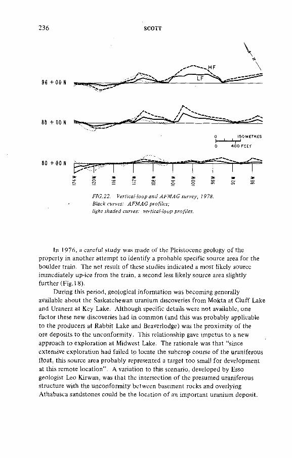
236 SCOTT
О 1 5 0 M E T R E S
! " ' h '0 4 0 0 F E E T
80 + 00 N
F/C.2 2 . P ' g r f i ù ' a M o o p 7 P 7 & Biac c curves.' 4F№4G pro/iiei;
y/:a e¿ cMr ei.' fe ù'ca/-/oop p/*o/¡7eí.
In 1976, a careful study was made o f the Pleistocene geology o f the property in another attempt to identify a probable specific source area for the boulder train. The net result o f these studies indicated a most likely source immediately up-ice from the train, a second less likely source area slightly further (Fig. 18).
During this period, geological information was becoming generally available about the Saskatchewan uranium discoveries from Mokta at Cluff Lake and Uranerz at Key Lake. Although specific details were not available, one factor these new discoveries had in common (and this was probably applicable to the producers at Rabbit Lake and Beaverlodge) was the proximity o f the ore deposits to the unconformity. This relationship gave impetus to a new approach to exploration at Midwest Lake. The rationale was that "since extensive exploration had failed to locate the subcrop course o f the uraniferous float, this source area probably represented a target too small for development at this remote location". A variation to this scenario, developed by Esso geologist Leo Kirwan, was that the intersection o f the presumed uraniferous structure with the unconformity between basement rocks and overlying Athabasca sandstones could be the location o f an important uranium deposit.
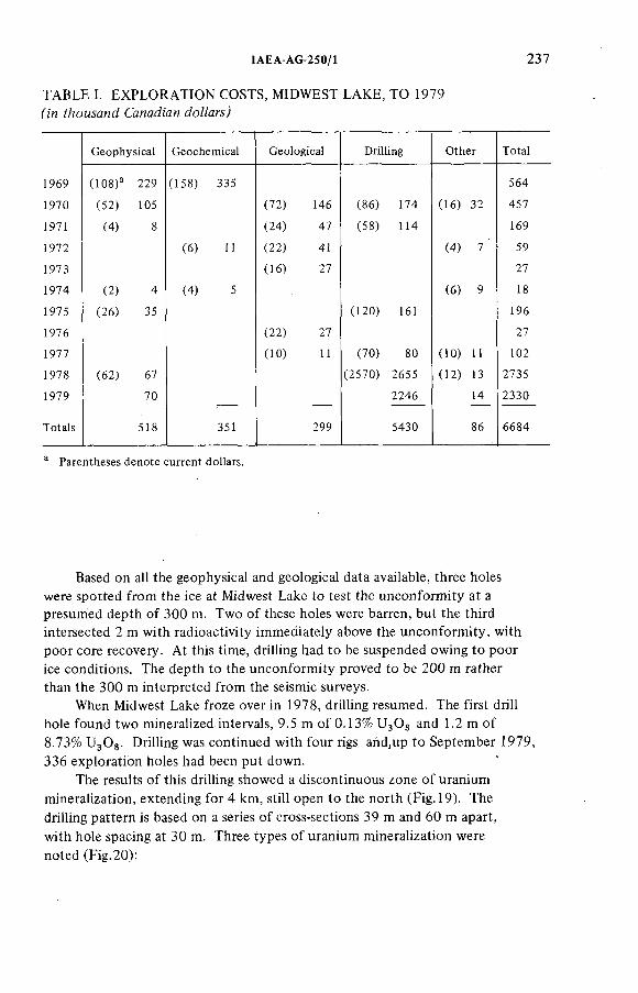
ÎAEA AG-250/1 237
TABLE I. EXPLORATION COSTS, MIDWEST LAKE, TO 1979
Geophysical Geochemical Geological Drilling Other Total
1969 (108)" 229 (158) 335 564
1970 (52) 105 (72) 146 (86) 174 (16) 32 457
1971 (4) 8 (24) 47 (58) 114 169
1972 (6) 11 (22) 41 (4) 7 59
1973 (16) 27 27
1974 (2) 4 (4) 5 (6) 9 18
1975 (26) 35 (120) 161 196
1976 (22) 27 27
1977 (10) 11 (70) 80 (10) 11 102
1978 (62) 67 (2570) 2655 (12) 13 2735
1979 70 2246 14 2330
Totals 518 351 299 5430 86 6684
" Parentheses denote current dollars.
Based on all the geophysical and geological data available, three holes were spotted from the ice at Midwest Lake to test the unconformity at a presumed depth o f 300 m. Two o f these holes were barren, but the third intersected 2 m with radioactivity immediately above the unconformity, with poor core recovery. At this time, drilling had to be suspended owing to poor ice conditions. The depth to the unconformity proved to be 200 m rather than the 300 m interpreted from the seismic surveys.
When Midwest Lake froze over in 1978, drilling resumed. The first drill hole found two mineralized intervals, 9.5 m o f 0.13% U 3 O3 and 1.2 m of 8.73% UgOg. Drilling was continued with four rigs and,up to September 1979, 336 exploration holes had been put down.
The results o f this drilling showed a discontinuous zone o f uranium mineralization, extending for 4 km, still open to the north (Fig. 19). The drilling pattern is based on a series o f cross-sections 39 m and 60 m apart, with hole spacing at 30 m. Three types o f uranium mineralization were noted (Fig.20):
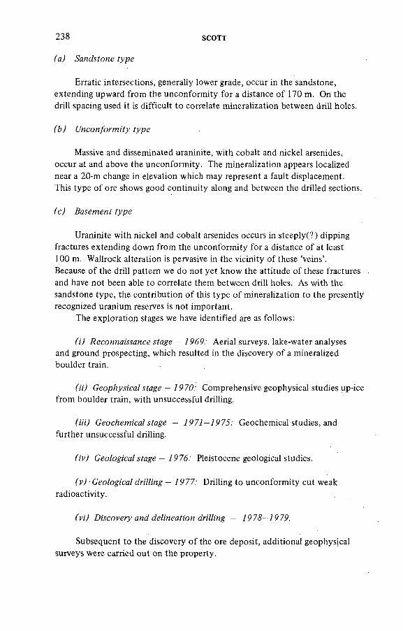
238 SCOTT
fa) -Sandsfcwe fype
Erratic intersections, generally lower grade, occur in the sandstone, extending upward from the unconformity for a distance o f 170 m. On the drill spacing used it is difficult to correlate mineralization between drill holes.
Massive and disseminated uraninite, with cobalt and nickel arsenides, occur at and above the unconformity. The mineralization appears localized near a 2 0 -m change in elevation which may represent a fault displacement.This type o f ore shows good continuity along and between the drilled sections.
fc ) .балетнем? fype
Uraninite with nickel and cobalt arsenides occurs in steeply(? ) dipping fractures extending down from the unconformity for a distance of at least 100 m. Wallrock alteration is pervasive in the vicinity o f these 'veins'.Because o f the drill pattern we do not yet know the attitude o f these fractures and have not been able to correlate them between drill holes. As with the sandstone type, the contribution o f this type o f mineralization to the presently recognized uranium reserves is not important.
The exploration stages we have identified are as follows:
f;') .йесомиаммисе — / 969 ' Aerial surveys, lake-water analyses and ground prospecting, which resulted in the discovery o f a mineralized boulder train.
fn) Geop/?y.s;'ca/ ,sfag<? — 7970.' Comprehensive geophysical studies up-ice from boulder train, with unsuccessful driHing,
— 7977 —79 7J.' Geochemical studies, andfurther unsuccessful drilling.
ffyj Geo/og;'ca/ - 7976. Pleistocene geological studies.
( у7 -C<so/og7ca/ - 7977/ DriHing to unconformity cut weakradioactivity.
f м'7 DTscorery аи(7 — 797&-7979.
Subsequent to the discovery o f the ore deposit, additional geophysical surveys were carried out on the property.
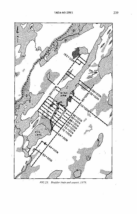
ÍAEA-AG-250/1
F7C.2J. уомгсе, 7979.
240 SCOTT
A Turam survey (Fig.2I) over the north end o f the structure showed coincidence o f a shallow conductive feature with the earlier VLF anomaly apparently related to lake bottom sediments.
Vertical-loop and AFMAG electromagnetic surveys (Fig.22) over the south end o f the structure showed a weak, shallow, linear feature which agrees roughly with the trend of the drilling. This is interpreted as weak conductivity associated with a fracture zone in the overlying sandstone.
Table I gives a rough breakdown o f our exploration costs distributed between activities and expressed in 1979 Canadian dollars.
As an example of hindsight, Fig.23 shows the boulder train in relation to the point where the 'sandstone' uranium mineralization comes closest to the present surface. Based on our interpretation o f the drill results, this source area has a maximum strike length of 100 m. This is another example o f a useful feature o f prospecting in terrain which has been subject to continental glaciation. Mineralized glacial erratics are usually detectable over a much larger area than the mineral deposit source.
The highly competitive nature o f the mining exploration industry in Canada made a large contribution to the original selection o f the mineral lands at Midwest Lake. I f the Numac Group had not made an early decision, some other group would have acquired the holdings. The early discovery o f the high-grade boulder train led to a continuing effort, in spite o f the lack o f success, for the ensuing eight years. Finally, the development o f new theories based on the dissemination o f information among Canadian geologists led to the eventual discovery o f the deposit.
DÎSCUSSION
H.D. FUCHS: From the picture you have shown, the mineralized body lies more or less horizontal, which seems to be quite different from the other mineralized bodies in the area. Is the mineralization confined mostly to the regolith? How is the distribution o f the mineralization to the sandstone, to the regolith, to the basement?
F. SCOTT: Away from the ore, the development o f regolith is only some tens of a cm thick. Because o f the strong alteration associated with mineralization, it is difficult to locate the unconformity exactly. I would estimate that 75%of the ore is in the sandstone.
G. BUNDROCK: What is the composition o f those volcanic rocks intercalated with the sandstones?
F. SCOTT: I think that the igneous rocks that cut the Athabasca sandstone are typical diabase dykes but in some cases they have been altered to muds and we assumed that some o f them may be sill-like and conformable as well as dyke-like
IAEA-AG-250/1 241
and unconformabie. The drill pattern we had o f vertical holes has not been an adequate test, and in a couple of sections we have igneous rocks which are earlier than mineralization and earlier than the alteration.
R. GATZWEILER: Do you see a zonation o f the mineralization and alteration?
F. SCOTT: The mineralization in the sandstone seems to differ from the unconformity and basement ores, and seems to have minor chalcopyrite and sphalerite as accessory minerals, rather than the nickel and cobalt arsenides.
D.A. PORTER: Is the long narrow train related to a fracture system or to the unconformity?
F. SCOTT: A 10- to 15-m change in the elevation o f the ore is associated with the long train (not directly), and we feel that that may represent some kind of fracture.
D.A. PORTER: May I ask about the alteration o f the halo — is it a radioactive halo?
F. SCOTT: We almost always have some alteration with mineralization.D.A. PORTER: Do you see alteration before you see mineralization?F. SCOTT: Generally, yes. On some of these fractures we have up in
the sandstones, it is just a matter o f a few cm of altered rocks before we get to the mineralization. I would say the alteration is always larger than the visible radioactivity.
J. DARDEL: Do you have reducate facies in the sandstones and have you identiñed some redox-front in the mineralized sandstones?
F. SCOTT: We have not identified any obvious reductants in the sandstone. In drill cores, we have seen many examples o f miniature 'roll-fronts' on a cm scale.
J. DARDEL: Are the ages o f the mineralizations in the sandstones and in the unconformity comparable?
F. SCOTT: The ages o f mineralization from Midwest Lake are comparable to other deposits in Saskatchewan.
C. TEDESCO: Did you find graphite in the mineralized gneisses?F. SCOTT: Yes, but not necessarily in the same location as mineralization.
Graphite is associated with the ore 70% o f the time, but 30% of the time it is not.C. TEDESCO: Do you believe the uranium halo in the sandstones to be
contemporaneous or more recent than the unconformity related to the main ore body?
F. SCOTT: I believe that the halo in the sandstone is earlier than the mineralization and that the mineralization is o f one age, but some o f our geologists think that the higher level sandstone ore is more recent than the unconformity deposit.
D.A. PORTER: Some publications mention Red Bed sequences in the Athabasca sandstone. Do you describe the Athabasca as such in the Midwest area?
242 SCOTT
F. SCOTT: I have seen what we would call 'Red Beds' higher up in the Athabasca sequence. The sandstones at Midwest Lake are white, grey or buff coloured.
D.A. PORTER: Would you describe the alteration associated with uranium in the sandstone host and the metasedimentary host?
F. SCOTT: The alteration in the sandstone can be described as 'sericitization', with minor chlorite, principally due to potash solutions. With the unconformity ore, alteration minerals include sericite, magnesian chlorite, serpentine (septachlorite?) diagnostic o f both magnesian and potassic solutions. In the basement rock the dominant alteration is serpentinization, chloritization and the production o f clay minerals. Some secondary quartz may be present.
P. BARRETTO: From the figures showing the lake, the drilled holes and the ore zone, it seems that you have a wide range of high-grade ore 1—5% and 25% but also above the unconformity. Is there any stratigraphie or structural control for this high-grade ore?
F. SCOTT: We feel that there are specific structural and/or lithological controls for the higher grade mineralization, but we have not yet identified such controls.
D.M. TAYLOR: Were all the drill holes cored? Were the holes down-hole logged? Is there any disequilibrium?
F. SCOTT: All holes were cored and, wherever possible, logged. We have no evidence o f disequilibrium and between 0.1% and 9.0% U^Og we have excellent agreement between the chemical assays o f core and the radiometric logs.
tAEA-AG-250/8
FROM ARMCHAIR GEOLOGY TO A DEPOSIT IN A NEW URANIUM PROVINCE
G. BUNDROCK UrangeseHschaft Canada Ltd,Toronto, Ontario,Canada
Abstract
FROM ARMCHAIR GEOLOGY TO A DEPOSIT IN A NEW URANIUM PROVINCE.Armchair geological considerations based on scarce data available in 1973 regarding
supergene uranium mineralization (unconformity-related uranium mineralization) led to a five- year exploration effort in the Baker Lake area, Northwest Territories,Canada. Exploration procedure, techniques applied, and the results of this work are reviewed. Area selection had to be based on a 1:1 000 000 geological map in the absence of more detailed information. The location of the rim of the basin is extremely poorly defined owing to extensive glacial cover in the area. Uranium had been discovered in the general area in previous exploration efforts (1 9 6 9 —1971), but in settings apparently different from the mineralization sought at the time. The initial field work entailed regional geological mapping and prospecting surveys, airborne geophysics and geochemical surveys in an area of 4000 km^. Over a period of five years this area was enlarged, and ground totalling 10 000 km^ was surveyed. Owing to the short summers, work in this remote area is generally restricted to a 2^ to 3 months field season.
In 1977 the project proceeded to exploratory drilling of a target detected in 1974 close to Sissons Lake. Mineralization was encountered, and best intersection exceeded 1% U^Og over a width of 33 m. The geological setting and certain characteristics of the mineralization suggest that the find represents mineralization of the unconformity type. Increased exploration in the Baker Lake area gave rise to local concern that the activities interfered with hunting and that caribou migration routes would be adversely affected. A land freeze and a court injunction were imposed on all explorers,which severely restricted activities during 1977—1979. In large areas, exploration could proceed during only one month per year. All work at Sissons Lake was affected and only restricted follow-up of the 1977 discovery was possible during 1978 and 1979. On the basis of present information, it is assumed that the discovery can be developed into a viable deposit. Judging from several additional anomalies detected during 1978 and 1979 by all companies, it seems likely that the area might become the second important province with unconformity-related mineralization in Canada.
243
244 BUNDROCK
Urangesellschaft mbH, Frankfurt/Main, F R G , has been active in
exploration for uranium in Canada since 1968.
During an initial period it was the company's policy to join forces
with experienced and knowledgable Canadian exploration and mining
companies as only limited expertise existed within the company.-
In 1973 Urangesellschaft substantially increased its activity in
Canada and for this purpose an exploration entity vas established
which was incorporated in 1974 as Urangesellschaft Canada Limited
(in the following abbreviated UG Canada).
During the start-up period of UG Canada a variety of genetic models
was researched. Efforts concentrated on exploration for uranium.miner
alization of the following three types:
1. Elliot Lake type quartz-pebble conglomerates,
2. Roessing-Bancroft type magmatic mineralization,
3. Rabbit Lake-East Alligator type
- "supergene mineralization" (old nomenclature)
- "unconformity related vein-type mineralization"
(new nomenclature)
This presentation is entirely restricted to UG Canada's exploration
efforts for the third type of deposit in one particular region of Canada,
the Baker Lake area. Northwest Territories (Figure 1).
Over a period of six years,exploration work has progressed from arm
chair geological evaluation to very detailed ground investigations.
During the course of this work UG Canada has encountered significant
mineralization at the Lone Gull. Showing, Sissons Lake, which we expect
to be able to develop in due course into a viable deposit. Following
this first discovery, a large area with favourable lithological and
tectonic setting is likely to develop into a new uranium province with
unconformity-related vein-type mineralization. This province would be
second in Canada to the Athabasca Basin in northern Saskatchewan and Alberta.
EXPLORATION ENVIRONMENT
The project area lies 300 km north of the tree line. The vegetation
consists of tundra grasses, bushes and lichen. Despite a prevalence
I N T R O D U C T I O N
ÏAEA AG 250/8 245
/. 0/,Й7%7- íZf¿Z.
of lakes and swamps,the area is essentially a semi-desert. The ground
is permanently frozen to a yet undetermined depth. During the field
season a top layer of a few inches to some feet thaws.
The climate is arctic. Extremely severe winter conditions last from
December to March with temperatures often around -40° to -60° C,which
is aggravated by high winds. During the summer,which is essentially a
2 to 2.5 month period between the middle of June and early September,
average daily températures reach 2° to 10° C.
Due to the northern location (200 km south of the Arctic circle) day
light is decreased to a few hours during the winter months. In the middle
of the field season extended daylight allows up to 18 hours of operation.
The area lies 50 to 100 km north and west of Baker Lake. Baker Lake is
a settlement of approximately 1200 people of mostly native origin (Eskimo).
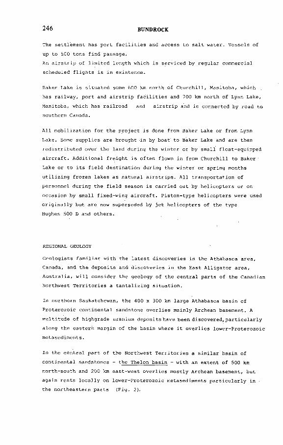
246 BUNDROCK
The settlement has port facilities and access to salt water. Vessels of
up to 500 tons find passage.
An airstrip of limited length which is serviced by regular commercial
scheduled flights is in existence.
Baker Lake is situated some 600 km north of Churchill, Manitoba, which
has railway, port and airstrip facilities and 700 km north of Lynn Lake,
Manitoba, which has railroad and airstrip and is connected by road to
southern Canada.
All mobilization for the project is done from Baker Lake or from Lynn
Lake. Some supplies are brought in by boat to Baker Lake and are then
redistributed over the land during the winter or by small float-equipped
aircraft. Additional freight is often flown in from Churchill to Baker
Lake or to its field destination during the winter or spring months
utilizing frozen lakes as natural airstrips. All transportation of
personnel during the field season is carried out by helicopters or on
occasion by small fixed-wing aircraft. Piston-type helicopters were used
originally but are now superseded by jet helicopters of the type
Hughes 500 D and others.
REGIONAL GEOLOGY
Geologists familiar with the latest discoveries in the Athabasca area,
Canada, and the deposits and discoveries in the East Alligator area,
Australia, will consider the geology of the central parts of the Canadian
Northwest Territories a tantalizing situation.
In northern Saskatchewan, the 400 x 300 km large Athabasca basin of
Proterozoic continental sandstone overlies mainly Archean basement. A
multitude of highgrade uranium deposits have been discovered,particularly
along the eastern margin of the basin where it overlies lower-Proterozoic
metasediments.
In the central part of the Northwest Territories a similar basin of
continental sandstones - the Thelon basin - with an extent of 500 km
north-south and 200 km east-west overlies mostly Archean basement, but
again rests locally on lower-Proterozoic metasediments particularly in
the northeastern parts (Fig. 2).
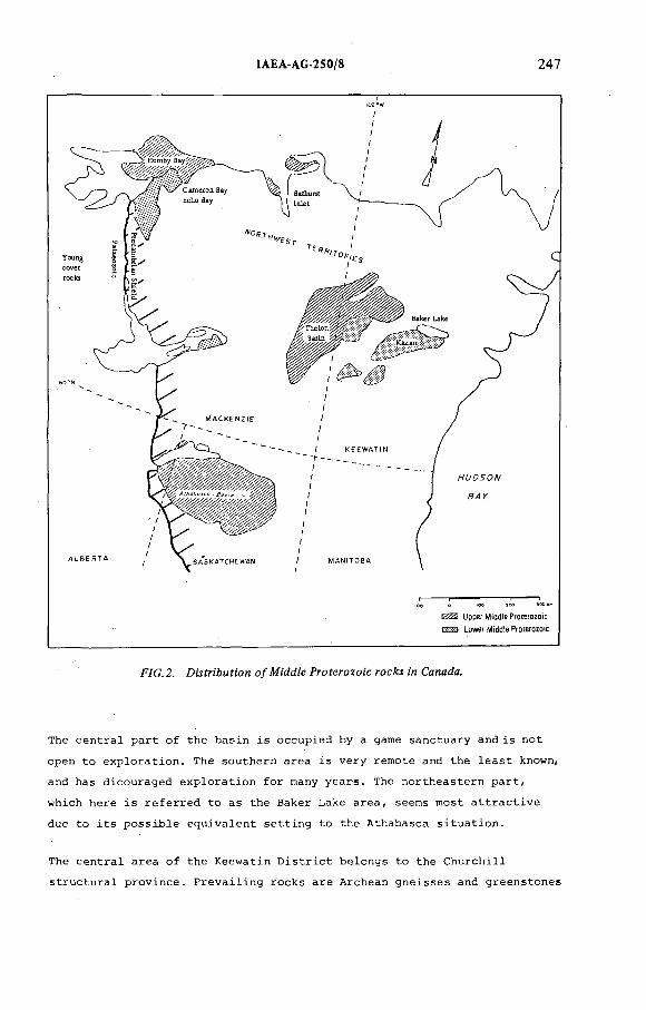
ÏAEA-AG-250/8 247
F7G.2. DMfr¡'&Mf:on o/M'íMíe Proferozo¡'c w Cenada.
The central part of the basin is occupied by a game sanctuary and is not
open to exploration. The southern area is very remote and the least known,
and has dicouraged exploration for many years. The northeastern part,
which here is referred to as the Baker Lake area, seems most attractive
due to its possible equivalent setting to the Athabasca situation.
The central area of the Keewatin District belongs to the Churchill
structural province. Prevailing rocks are Archean gneisses and greenstones
100*
hJ00
BUN
DR
OC
K
64
!0 0 °
6 4°
94°
F/G. J.. GeoJogy о/ Аойе о?*еа.
bJ4.
ÏAEA
-AG
-250/8
250 BUNDROCK
which were metamorphosed and intruded during the Kenoran Orogeny at a p p r o x i -
mateiy 2 5 0 0 million years. Following an erosional period, lower-
Proterozoic shelf sediments were deposited in an area 1 500 x 3 000 km.
These metasediments can be found,e.g., in
the Amer Belt and equivalents in the Baker Lake area,
the Hurwitz area south of the Baker Lake area,
and in the Wollaston Belt, Saskatchewan.
The lower-Proterozoic sediments were deformed and metamorphosed during
the Hudsonian Orogeny which yields dates for the Baker Lake area between
1750 and 1850 m.y. The lower-Proterozoic rocks in the Baker Lake area
show greenschist to amphibolite metamorphic grades. A number of intrusives
were emplaced. Following the Hudsonian Orogeny the area was subject to
rifting and a sequence of continental middle-Proterozoic sediments and
volcanics of the Dubawnt group were deposited. Rocks of the lower Dubawnt
group, dated around 1800 m.y., consist of redbed sediments, volcanics and
interbedded volcano-clastic sediments. Large areas were affected by the
extrusion of calc-alkaline volcanics. These extrusives are contemporaneous
with late to post-orogenetic granites which were emplaced in other parts
of the area. Following a long period of erosion,an extensive sequence of
continental sandstones (Thelon Formation) was deposited. Maximum sandstone
thickness is in excess of 2 000 m. At the later stage of deposition a
marine ingression occurred,similar to the Athabasca Basin.
Youngest rocks observed in the area are isolated outcrops of limestone of
possible Ordivician age.
SELECTION OF PROPE*RTIES
At the arm-chair geological stage of evaluation very little information
was available for the selection process. The data essentially consisted
of a geological map at a 1:1 000 000 scale covering most of the Keewatin
District, the Eastern part of the Northwest Territories, and a map at a
1:250 000 scale covering a small part of this.
According to the model of supergene uranium mineralization, ground with
highest favourability would be located in the immediate vicinity of the
unconformity, preferentially where a variety of lithologies was present
in the basement complex. On a priority basis,ground was chosen in the
infrastructurally better situated northeastern part of the Thelon basin
(Fig. 3).
IAEA AG-250/8 25!
Ground was selected which covers more than 150 km of unconformity. Of this
total,40 km overlie lower-Proterozoic metasediments, another 40 km lie on
lower-Proterozoic metasediments and what was then thought of as a greenstone
sequence of questionable Archean or Aphebian age. The remaining 70 km sand
stones were presumed tooverlie undifferentiated gneissic Archean basement.
Prospecting permits were obtained and detailed preparatory work for the
field season revealed that most permits selected had actually been pr e
viously held by other companies. In retrospect it seems likely that, had
this fact been recognized prior to the permit application, the company
might have refrained from selecting these areas. Of particular interest
in this context is the fact that the prospecting permit on which
the Sissons Lake discovery is located had been surveyed and worked for
two subsequent field seasons in 1969 and 1970 by Central Del Rio Oils L t d . .
and COMINCO Canada. Work performed included airborne radiometric and EM
survey by a leading Canadian contractor followed by a field season of
ground evaluation. Five other permits and adjacent ground had been in
vestigated by Aquitaine Canada Ltd. This.company had undertaken a large
areal assessment in the Baker Lake region similar to efforts by other
French groups, e.g. in northern Saskatchewan, which led to the discovery
of Cluff Lake..Their work entailed regional assessment,including airborne
work and geochemistry,which actually led to the first discovery of uranium
in the lower-Proterozoic Amer Belt in the Baker Lake area. Many showings
with outcropping radioactivity now held by various companies in the Baker
Lake area were actually located during Aquitaine's effort. The possible
significance of these showings, though, was obviously not recognized at a
time when little data were available on unconformity-related mineralization.
HISTORY OF LAND ACQUISITION
To put the outset of UG Canada's work in proper perspective , mention
should be made of the state of knowledge of unconformity-related uranium
mineralization in 1973. At that time, very little information on situations
in Australia and at the Rabbit Lake deposit was publicly available, data
only starting to be forthcoming in 1974.
Thus the Baker Lake project was of a very speculative grass-roots recon
naissance nature at the time of initiation in 1973 when UG Canada applied2
for 11 prospecting permits comprising 6 500 km (Fig. 4).
BU
ND
RO
CK
-fïG.4. ¡УС Canada рголресЯ'я ;и rAe йа ет- ¿aA;e area 7Р74-7Р7Р.
юLnbJ
254 BUNDROCK
Following the results of the first field season, the company acquired2
additional prospecting permits covering 3 500 km in 1975 and in 1976 a 2
further 1 000 km were added.
During the 1977 field season one of the targets which had been discovered
in 1974 was drilled and significant mineralization, e.g. H U ^ g over
33 m, was encountered in the first drill-hole. The exploration model of
unconformity-related mineralization occurring in the Baker Lake area was
thus successfully confirmed. As parts of permits had been released, the
discovery necessitated a dramatic enlargement of UG Canada's ground not
only around the discovery site, but also where low-priority anomalies from
various surveys were now significantly upgraded by the discovery. Claim
staking was not possible at the time of the discovery due to a land freeze
and this undesirable situation left favourable ground unprotected until
May 1978. Over a period of more than 6 months it was uncertain to what
extent the company had managed to keep the discovery confidential.
After termination of the freeze the most important ground could
be acquired in competition with various companies within a few days.
Landholding within the original 1974 ground, which had decreased to less
than 5% prior to staking,were increased to cover approximately 20% of
the original prospecting permits. Parts of this ground were actually re
acquired to the extent of 80% and more.
2Further permits were acquired in 1978 and 1979 totalling 1 500 km .
During the period 1974 to 1979 the company has in total performed recon-
2naissance-type work m an area close to 12 500 km on ground held by the
2company. In addition, 2 500 km of open ground was surveyed. At present
the ground held by the company in form of claims and permits amounts to2
approximately 5 000 km .
Interest in the area has recently come close to land booms in the
Athabasca Basin area.
DISCOVERY HISTORY OF THE LONE GULL DEPOSIT
The Lone Gull deposit is located in the southern part of the 1974 permits.
This part was surveyed in the second part of the 1974 field season.
Geochemical sampling was undertaken at a.density of one sample per 6 km^
using lake waters and lake sediments. A helicopter-mounted airborne system
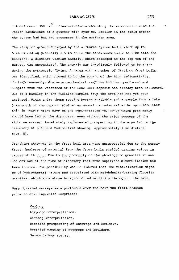
- total count 350 cm^ - flew selected areas along the erosional rim of the
Thelon sandstones at a quarter-mile spacing. Earlier in the field season
the system had had two successes in the northern area.
The strip of ground surveyed by the airborne system had a width up to
5 km extending generally 1.5 km on to the sandstones and 2 to 3 km into the
basement. A distinct uranium anomaly, which belonged to the top ten of the
survey, was encountered. The anomaly was immediately followed up by aban
doning the systematic flying. An area with a number of distinct frost boils
was identified, which proved to be the source of the high radioactivity.
Contemporaneously, drainage geochemical sampling had been performed and
samples from the watershed of the Lone Gull deposit had already been collected.
Due to a backlog in the fieldlab,samples from the area had not yet been
analysed. Witin a day these results became available and a sample from a lake
3 km south of the deposit yielded an anomalous radon value. We speculate that
this in itself might have caused semi-detailed follow-up which presumably
should have led to the discovery, even without the prior success of the
airborne survey. Immediately implemented prospecting in the area led to the
discovery of a second radioactive showing approximately 1 km distant
(Fig. 5).
Trenching attempts in the frost boil area were unsuccessful due to the perma
frost. Analyses of material from the frost boils yielded uranium values in
excess of 1% U^Og. Due to the proximity of the showings to granites it was
not obvious at the time of discovery that true supergene mineralization had
been located. The possibility was considered that the mineralization might
be of hydrothermal nature and associated with molybdenite-bearing fluorite
granites, which show above background radioactivity throughout the area.
Very detailed surveys were performed over the next two field seasons
prior to drilling,which comprised:
Geology
Airphoto interpretation,
Aeromag interpretation.
Detailed prospecting of outcrops and boulders.
Detailed mapping of outcrops and boulders,
Geomorphology survey.
tA EA A G -250/8 255
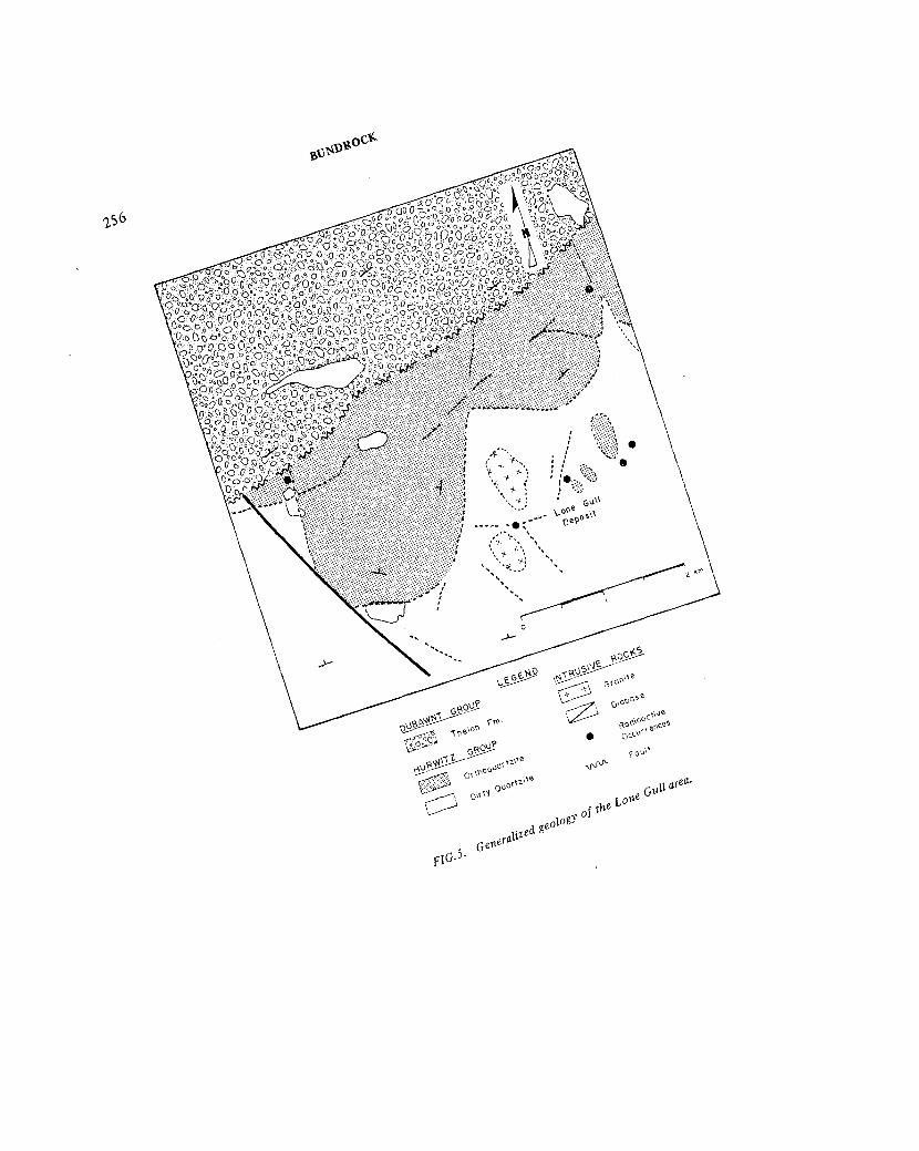
Ъ 1 3 ^ <
T.56
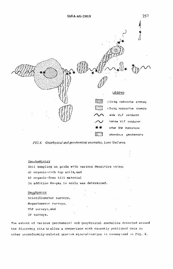
ÏAEA AG-250/3 257
^ ^ o t h e r E M i n d i c a t i o n s
fltlIHH a n o m o i o u s g e o c h e m i s t r y
.FYC.ó. Lone См/? й^а.
Geochemistry
Soil sampling on grids with various densities using:
a) organic-rich top soils,and
b) organic-free till material
In addition Rn-gas in soils was determined.
Geophysics
Scintillometer surveys,
Magnetometer surveys,
VLF surveys,and
IP surveys.
The extent of various geochemical and geophysical anomalies detected around
the discovery site to allow a comparison with recently published data on
other unconformity-related uranium mineralization is summarized in Fig. 6.
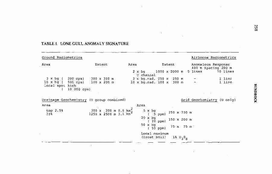
<У)00
TABLE L LONE GULL ANOMALY SIGNATURE
Ground Radiometrics Airborne Radiometrics
Area Extent Area
2 X b g 10 00
U channel
Extent
2000 m
3 X bg ( 200 cps) 300 X 300 m 3 X b g .. r a d . 25010 X bg ( 500 cps) 100 X 200 m 10 X bg., r a d . 100local spot high
( 10 000 cps)
Drainage Geochemistry (U group combined)
Area Area
top 2 .5% 300 X 200 m 0 .6 km^ 5 X bg10% 1250 X 2500 m 3 .1 km ( 5 ppm)
20 X bg
( 20 ppm)50 X bg
( 50 ppm)
250 m 300 m
Anomalous Response 400 m Spacing 200 m
lines 10 l in e s
1 l in e
1 l ine
Local maximum
(frost boil)
Grid Geochemistry (U only)
250
150
75
X 7 50 m
X 200 m
X 75 m
1%
McjZОP3ООPS
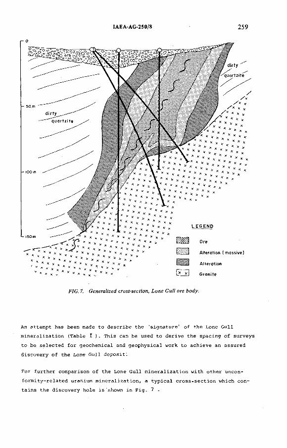
ÏAEA-AG-250/8 259
г О
F/C . 7. CeneraZized сгомчесУюп, ¿one GtvZZ ore Aody.
An attempt has been made to describe the 'signature' of the Lone Gull
mineralization (Table I ). This can be used to derive the spacing of surveys
to be selected for geochemical and geophysical work to achieve an assured
discovery of the Lone Gull deposit.
For further comparison of the Lone Gull mineralization with other uncon
formity-related uranium mineralization, a typical cross-section which con
tains the discovery hole is shown in Fig. 7 .
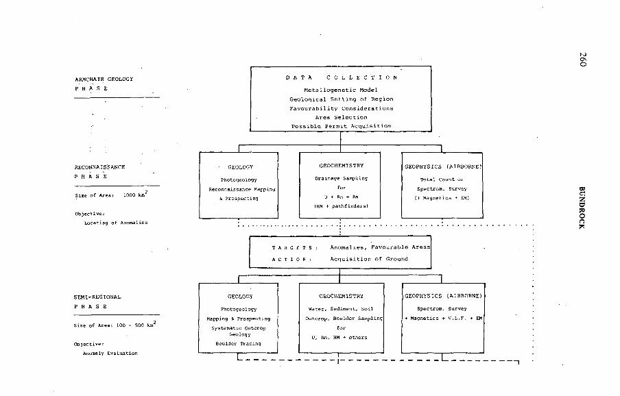
A R M C H A IR G EOLO G Y
PHASE
R E C O N N A IS S A N C E
PHASE
S E M I - R E G I O N A L
PHASE
260 B
UN
DR
OC
K
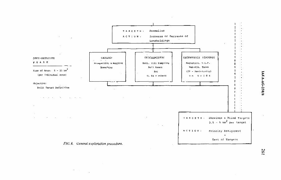
tAEA A
G-250/8
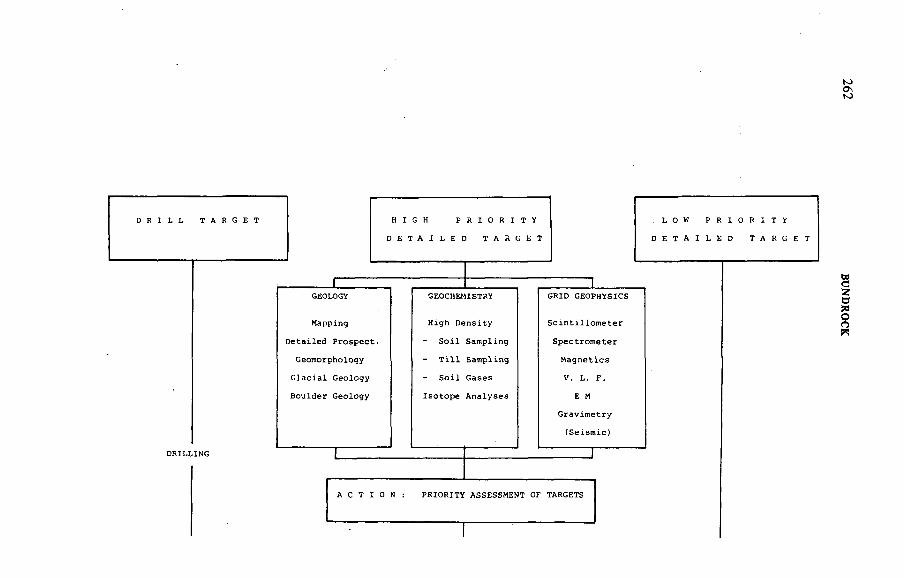
262 BU
ND
ROCK
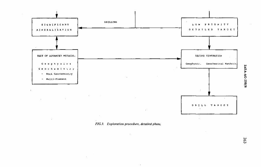
Í7G.9. Æxp?oraf!on procedure, <íeya:7e¿ pAaíe.
264 BUNDROCK
The discovery exhibits many of the features characteristic of other
unconformity-related vein type mineralization, e.g. alteration halo, d i s t
ribution of high- and low-grade mineralization etc.
EXPLORATION TECHNIQUES
The exploration techniques applied by UG Canada progressively from regional
assessment to detailed evaluation are discussed below (see Figs 8
and 9).
Airborne Geophysics
An essential component of UG Canada's regional and semi-regional areal
assessment consists of airborne radiometric surveys and multi-system air
borne work.
A tenfold enlargement of crystal volume from 350 cm^ and the addition of
a magnetometer and VLF-EM system and accessories of altitude monitoring
and flight pass control, and finally a digital data acquisition system,
reflect the significant role the system has played over the years. Emphasis
has changed from direct to indirect methods. Thousands of line km have
recently been flown with the major objective of obtaining detailed litho
logical and structural data from magnetometer and VLF-EM. The reason for
this development lies in the fact that after the Lone Gull discovery the
importance of this information was fully recognized.
To indicate the significance of the company's use of the system, it
should be mentioned that during the last three years the system flew,
on a multiproject basis, in excess of 15 000 line km per year. It is
estimated that internal costs amount to 50 to 60% of contractor costs.
The major advantage besides cost benefits lies in the extreme flexibility
of employing the system on short notice regardless of contract volume,
in priority areas.
Geochemistry
Application of geochemical surveys is a further significant component of
UG Canada's exploration efforts. This is particularly due to two facts:
1) In the project area, glacial deposits of sometimes considerable
thickness impede collection of geological information and diminish
the effectiveness of radiometric surveys.
ÏAEA-AG-250/8 265
2) On a regional scale it permits coverage of large areas in relatively
short periods with the provision to adjust sampling density to
specific requirements.
Since 1974 UG Canada has tested and applied various geochemical sampling
techniques, used a variety of sample media, field or laboratory-assayed
samples for up to 1 dozen elements, and applied various statistical
evaluation techniques. The following outlines in a brief form our experience
On a regional scale UG Canada has experimented in drainage geochemistry with
different types of lake sediment samples, e.g.
lake centre sediment samples;
near-shore lake sediment samples.
Collection of lake-centre sediment samples has become standard practice.2 2
Sample density varies from one sample per 6 km to one sample per 2 km .
Based on our present experience the latter sample density seems a minimum
in the physical environment in which we are working, especially considering
the type of mineralization searched for.
Anomalous areas defined by the above regional geochemical surveys or areas
considered favourable, based on geological, prospecting and airborne work,
are further evaluated in a semi-regional/semi-detailed phase. During this2 2
phase,sample density varies from two samples per km to four samples per km
To obtain these densities in drainage geochemistry the sampling includes
ponds, streams and swamps.
Detailed geochemistry entails surveys as follows:
1) Soil sampling on prospecting traverses:
One sample every ^ km (on traverses with b to 1 km spacing);
2) Low-density sampling of organic-rich soils o n g r i d s ;
3) Medium to high density sampling of surface till material on grids;
4) Sampling of deeper till material by portable drill.
Our experiences with organic-rich samples show that in many cases anomalies
can be sufficiently recognized using this technique on low-density sampling
(75 X 75 m) and the amount of tedious detailed work (Case 3) can be signi
ficantly decreased, which is of essence in view of costs and the brief
exploration period. -
2 6 6 BUNDROCK
A standard regional sample location yields one water and one sediment sample.
These samples are analysed for the following 'uranium group elements' :
Uranium in water
Radon in water
Uranium in sediment
Radium in sediment
Under special circumstances waters have been assayed in addition for Cu,
Pb, Zn, and lake sediments have been assayed for Cu, Pb, Zn, Co, Ni, Ag,
Mn, Fe. Lengthy shipping periods and poor turn-around at commercial labs
during the peak of the field season meant that assay results were only
obtained after termination of the field season. Partly in expectation of
this, assaying of waters for radon and sediments for radium was performed
in the field. This procedure was continued in subsequent seasons as additional
information was obtained. Availability of radon and radium results within
days after sampling allowed immediate resampling on a more detailed basis.
The effectiveness is shown by the following:
In the first year, field assaying of radon and radium (single or combined)
yielded 57 anomalies which were either resampled or directly followed up
by prospecting. After the field season, when uranium assays for water and
sediment were received,no anomalous areas additional to those 57 indicated
by radium and radon were found, although the significance of some was e n
hanced.
Over the years data from close to 10 000 locations have become available.
In retrospect it can be said that the apparent duplication of assays has
paid off well. In many cases high single anomalies of any of the four
uranium group elements, not backed up by another anomalous determination,
could be traced to mineralization. In other cases, the combined presence
of 2 or 3 elements, though only moderately anomalous, enhanced a situation
and thus established a distinct anomaly group worth prospecting. Very often
high single values, particularly uranium in water and uranium in sediment,
which might have been considered erratic, were surrounded by lower though
anomalous values in other elements and thus could be followed up without
prior reconfirmation.
Soil samples are generally only assayed for uranium, although in some cases they
have been assayed for uranium and thorium. In specific situations they have
been assayed for a multitude of elements such as uranium/thorium, cobalt,
ÏAEA-AG-250/8 267
nickel, copper, lead, zinc, chromium, molybdenum, vanadium. Significant
element association recognized at this stage are:
uranium and lead
uranium, copper, lead, zinc
uranium, copper, lead, chromium
The poor turnaround of commercial laboratories eventually led to the estab
lishment of a company laboratory, operating during the field season and
capable of analysing uranium in waters and uranium in sediments and soils.
The lab uses the newly developed uranium laser technique which requires
semi-skilled chemical technicians and achieves reasonable output. Results,
particularly of field-dried and field-sieved samples, are available on
priority samples within 12 hours after arrival in the lab. In addition, the
lab allows the flexibility of using different extraction techniques at
very short notice on small batches of samples.
Ground Geophysics
Ground geophysical methods, with the exception of radiometric prospecting,
are only applied at the semi-detailed and detailed stage. Over the years,
indirect methods have gained precedence over direct radiometric surveys.
Our standard procedure of evaluation of areas with showings detected by
prospecting or areas considered favourable on the basis of other data entails
extensive grid-controlled radiometric surveys with readings taken at inter
vals of 10 to 75 metres and recording of interstation highs.
Due to extensive glacial overburder^ very often no lithology and structural
information is available as outcrops are often kilometres away. To assist
the geological interpretation and possibly directly locate the traps con
taining mineralization indirect methods such as magnetics, VLF-EM, Horizontal
Loop EM and IP surveys are applied. In this regard, UG Canada geophysicists,
who had extensive base metal background, had to go through an educational
process,as targets in uranium exploration are very different from base
metal targets. A compilation of what type of response can be expected on
certain types of targets is presented in TableII.
After the discovery of Lone Gull,UG Canada has in the meantime tested the
application of some 'second generation geophysical methods'. One method
entails gravimeter work.
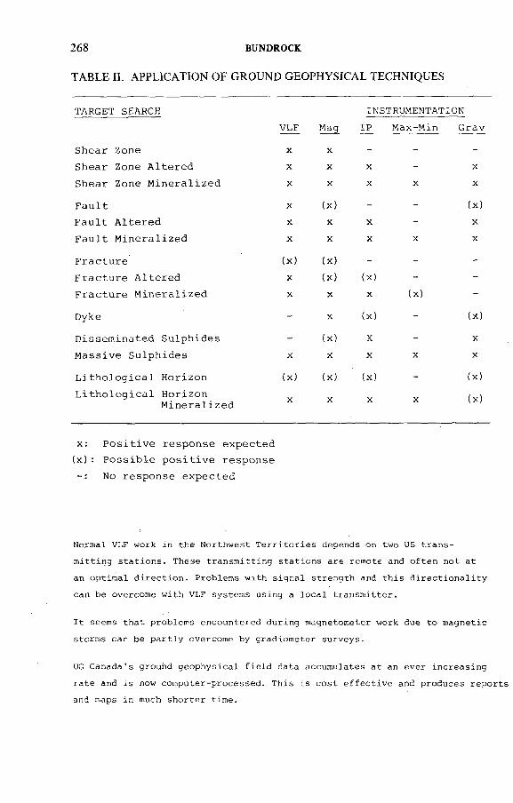
268 BUNDROCK
TABLE H. APPLICATION OF GROUND GEOPHYSICAL TECHNIQUES
TARGET SEARCH INSTRUMENTATION
Sh ear Zone
VLF
X
Mag
X
IP Max-Min Grav
Sh ear Zone A l t e r e d X X X - X
S h ear Zone M i n e r a l i z e d X X X X X
F a u l t X ( X ) - - ( X )
F a u l t A l t e r e d X X X - X
F a u l t M i n e r a l i z e d X X X X X
F r a c t u r e ( X ) (x) - - -
F r a c t u r e A l t e r e d X ( X ) (x) - -
F r a c t u r e M i n e r a l i z e d X X X (x) -
Dyke - X (x) - (x)
D is s e m in a t e d S u lp h id e s - ( X ) X - X
M a s s iv e S u lp h id e s X X X X X
L i t h o l o g i c a l H o r izo n (x) ( X ) (x) - (x)
L i t h o l o g i c a l H o r izo nX X X X (x)
M i n e r a l i z e d
x : P o s i t i v e r es po n s e exp ec te d
( x ) : P o s s i b l e p o s i t i v e respo n se
No respo n se e x p e c te d
Normal VLF work in the Northwest Territories depends on two US trans
mitting stations. These transmitting stations are remote and often not at
an optimal direction. Problems with signal strength and this directionality
can be overcome with VLF systems using a local transmitter.
It seems that problems encountered during magnetometer work due to magnetic
storms can be partly overcome by gradiometer surveys.
UG Canada's ground geophysical field data accumulates at an ever increasing
rate and is now computer-processed. This is cost effective and produces reports
and maps in much shorter time.

IAEA AG 250/8 269
TableIllattempts to show all major instrumentation presently offered
the Canadian and North American market from a variety of manufacturers.
The instruments utilized by UG Canada in its exploration efforts are in
heavy outlines.
D r i l l i n q
Diamond drilling has been performed over a period of 3 years. Major diffi
culties arise from the inclement climatic conditions, in particular from
the fact that drilling can only proceed after sufficient melt water becomes
available or outside temperatures have increased to the extent that heated
drill water pumped over long distances does not freeae in water lines.
Except for the top few feet, the ground is permanently frozen, and drilling
and particularly servicing and surveying of the holes can only be achieved
with the addition of salt to prevent freeze-up of the drill holes.
While drilling on a set-up is in progress, the permafost conditions require
that drilling continues around the clock in two or three shifts.
In 1977 unexpected problems with land use permits made it impossible to
utilize conventional drill equipment. Light-weight equipment (1000 lbs)
of the type 'Hydra Mink' with a coring capacity of approximately 500 ft
(BQ wireline) had to be utilized and six holes totalling 2 500 ft were
drilled at a multiple of normal drilling costs. Since 1978 drilling pro
ceeded with conventional equipment of the following type: BBS - 17 with
a coring capacity of 2 000 ft (BQ wireline).
Drilling is performed by a contractor with arctic experience and an average
of 80 ft per shift which includes standby and moving times is generally
achieved.
STAGES OF PHASED EXPLORATION
Due to the fact that UG Canada acquired large blocks of land over consecu
tive years, exploration work has been quite complex,with surveys at diffe
rent levels of exploration occurring at the same time.
An attempt has been made to diagrammatically present UG Canada's exploration
procedure as applied in the Baker Lake area. Field work has to be performed
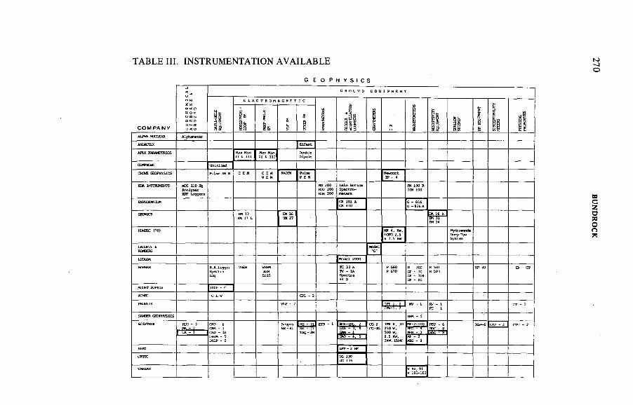
TABLE III. INSTRUMENTATION AVAILABLE
G E O P H Y S I C S
G R O U N D ECU I P M E N 1
ö " o
E L E с т а о м я : ч с т : с
C O M P A N Y o á
g S
Üis
5
§
Ж }5
! 1s a ЯЫ
§Й o!Ü
АШ* ttEbEAR Alphmeter
МЮ ЯЧ E l í „ t
í H T í t
СЖРЮЕ Unitized
oo m cK W K tcs C EMÍ í ü
mom
"-snMCMrsE r "
S i S * ° :* 2 ^
a t t ? L
ш т к no)
кмкдс
UDLiM Model 2000
E i E *
ftWT SOPRIS 1000 - сC L W СИ. - 2
кг - 1
SHCERCEOFWSICS urn s
BGS-1SL. 2HA - 2 SE - 77
- й- 3
MBS - 2
SMT SPP-2 MF
URHti "
VARI^V 100-102
270 B
UN
DR
OC
K
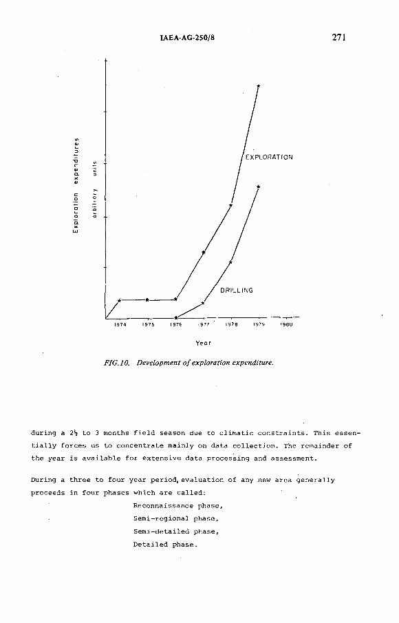
IAEA-AG-25 0/8 27!
Y e o r
during a 2^ to 3 months field season due to climatic constraints. This essen
tially forces us to concentrate mainly on data collection. The remainder of
the year is available for extensive data processing and assessment.
During a three to four year period, evaluation of any new area generally
proceeds in four phases which are called:
Reconnaissance phase.
Semi-regional phase.
Semi-detailed phase,
Detailed phase.
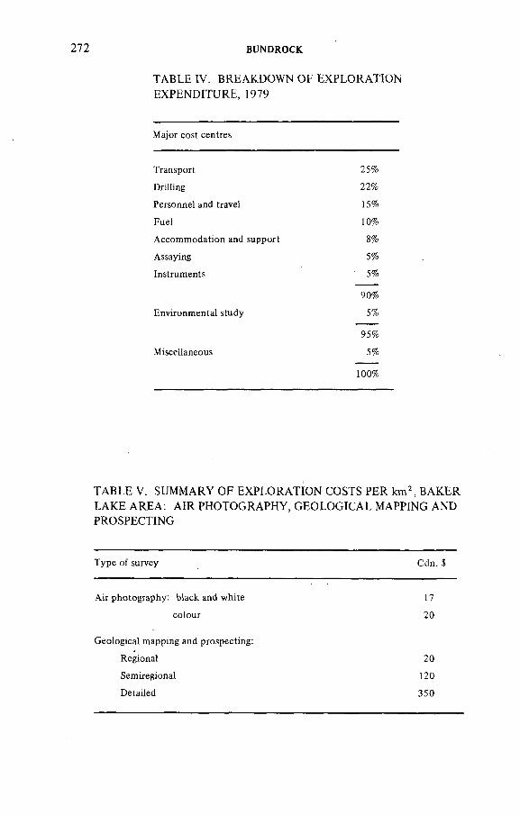
BUNDROCK
TABLE IV. BREAKDOWN OF EXPLORATIONEXPENDITURE, 1979
Major cost centres
Transport 25%
Drilling 2 2 %
Personnel and travel 15%
Fuel 1 0 %
Accommodation and support 8 %
Assaying 5%
Instruments ' 5%
90%
Environmental study 5%
95%
Miscellaneous 5%
1 0 0 %
TABLE V. SUMMARY OF EXPLORATION COSTS PER km\ BAKER LAKE AREA: AIR PHOTOGRAPHY, GEOLOGICAL MAPPING AND PROSPECTING
Type of survey Cdn. $
Air photography: black and white 17
colour 2 0
Geological mapping and prospecting:
Regional 20
Semiregional 120
Detailed 350
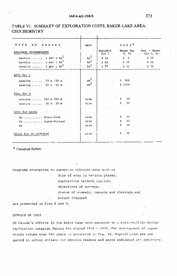
ÏAEA AG-250/8 273
TABLE VI. SUMMARY OF EXPLORATION COSTS, BAKER LAKE AREA: GEOCHEMISTRY
T Y P E 0 F S U R V E Y U N I T С 0 S T ^
S e d i m e n t W a t e r f o r S e d .D R A I N A G E G E O C H E M IS T R Y
f o r U u, Rn f o r U , Rn
d e n s i t y . 1 p e r 5 km km^ $ 10 $ 9 $ 11
d e n s i t y . 1 p e r 1 km^ k n ^ $ 40 $ 30 $ 45
d e n s i t y . . . 2 p e r 1 km^ km^ $ 60 $ 50 $ 70
S O I L f o r U
s p a c i n g . 7 5 X 1 5 0 m $ 5 0 0
s p a c i n g . 50 X 5 0 m km^ $ 3 5 0 0
T I L L f o r U
s p a c i n g . . 2 5 0 X 2 5 0 m s i t e $ 1 0
s p a c i n g . 3 0 X 3 0 m s i t e $ 35
S O I L f o r G AS ES
Rn ............... . T r a c k - E t c h s i t e $ 22
. A l p h a - N u c l e a r s i t e $ 22
He s i t e $ 55
S O I L S f o r P b - I S O T O P E S s i t e $ 25
3 Canadian dotlars.
Diagrams attempting to summarize relevant data such as
Size of area in various phases,
Exploration methods applied.
Objectives of surveys.
Status of anomaly, targets and showings,and
Action required
are presented in Figs 8 and 9.
DETAILS OF COST
UG Canada's efforts in the Baker Lake area amounted to a multi-million dollar
exploration campaign during the period 1974 - 1979. .The development of expen
diture volume over the years is presented in Fig. 10. Expenditures are not
quoted in actual dollars for obvious reasons and units indicated are arbitrary.
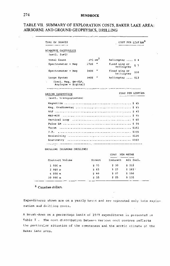
274 BUNDROCK
TABLE VH. SUMMARY OF EXPLORATION COSTS, BAKER LAKE AREA: AIRBORNE AND GROUND GEOPHYSICS, DRILLING
T Y P E O F SU RV E Y C O S T PE R L I N E k m ^
A I R B O R N E G E O P H Y S I C S
( e x c l . f u e l )
T o t a l C o u n t 3 7 5 cm ^ h e l i c o p t e r . . . . S 4
S p e c t r o m e t e r + M a g 1 7 0 0 "' " " t u ^ p t e r
$ T
S p e c t r o m e t e r + M a g 3 4 0 0 "" * t ! ^ p ° e r
S 1 0
L a r g e S y s t e m 3 4 0 0 " h e l i c o p t e r . . . . $ 1 3
( i n c l . M a g , A n a l o g u e +
E M - V L F ,D i g i t a l )
GROUND G E O P H Y S I C S C O S T P E R L I N E k m
V L F ........................................................................................................................................ $ 45
M A X - M I N .................................................................................... ..................................... $ 55
V e r t i c a l L o o p ........................................................................................................ $ 65
P u l s e EM .......................................................................................................................... $ 55
T u r a m ................................................................................................................................ $ 1 5 5
I P ........................................................................................................................................... $ 1 5 5
D R I L L I N G (D I A M O N D D R I L L I N G )
1 000 m
2 000 m
4 000 m10 000 m
$ 75
$ 65
$ 6 0
$ 55
$ 1 6 0
C O S T P E R METRE
I n d i r e c t A l l I n c l .
$ 30
$ 27
$ 27
$ 25
$ 210
$ 1 6 5 '
$ 15 0
$ 1 3 5
^ Canadian dollars.
Expenditures shown are on a yearly basis and are separated only into explo
ration and drilling costs.
A break-down on a percentage basis of 1979 expenditures is presented in
Table I . The cost distribution between various cost centres reflects
the particular situation of the remoteness and the arctic climate of the
Baker Lake area.
t AE A-AG-25 0/8 275
An attempt has been made to summarize specific exploration expenditures
for all relevant surveys and drilling operations in Tables V, VI a n d v i l .
These costs are expressed in 1979 Cdn.Dollars. Many of the detailed costs
are essentially based on the fact that expenditures for a man per day, based
on a 100-day field season, amount to $350.oo per day all-inclusive.
ACKNOWLEDGEMENTS
The success o f UG Canada's exploration in the Baker Lake area is based to a large extent on the hard work and enthusiasm of many individuals participating over the years. To name a few individuals who are no longer with the company but who were instrumental in the selection o f the area and the first discoveries, acknowledgement should be given to Dr. U. Klinge, Robert H. Morse and Eric P. Onasick.
DISCUSSION
D. TAYLOR: Could you indicate the known extent o f the mineralizations?G. BUNDROCK: The Lone Gull mineralization is now under investigation in
its third year. Due to severe land-use restrictions and a court injunction, very little work could be performed during that period and the overall picture is piecemeal. Mineralization is now known and has been confirmed by drilling over approximately 2 km strike length. Mineralization seems to be discontinuous.
C. TEDESCO r Please give some details about your experience in the use of the portable laser analyser. The manufacturer declares important interferences from Fe and Mn - do you also use it for sediments?
G. BUNDROCK: Urangesellschaft has been involved with others besides the manufacturer in R&D of the laser instrumentation and techniques. We have now been successfully using the technique in geochemical exploration for two years;Our laboratory is located at our expediting base but I see no reason why it should not work under field-lab conditions providing a 1000 to 1500 W generator with reasonable voltage stability is available. We are using the laser for determinations o f uranium in water, sediment and soils (except very organic-rich material). We have encountered problems with high organic contents in the solutions. Fe and Mn have not posed problems, maybe owing to relatively low concentrations in our samples. It should be possible to overcome problems of this sort by using a spiking method. At the present stage we do not think that laser assay results with our laboratory set-up are 'precision-assays'. This, in our opinion, is not necessary at the exploration geochemistry stage where often only top 2.5%, 5%,1 0 % and/or top 2 0 % o f the assay data is taken into consideration.
276 BUNDROCK
C. TEDESCO: Could you also use this for analysing sediments?G. BUNDROCK: Yes, that's what we are doing. You use a normal digestion
process and then you go on to subdilution, and you can process that material. Actually the 30 000 samples I quoted are probably in excess o f 25 000 samples o f lake sediments and soils and the remainder are water samples.
P. BARRETTO: Concerning Mr. Tedesco's question, I should like to add that the only problem observed so far with the UA-3 analyser was with the laser beam. Frequent changes of the laser tube (3—4 months) are needed depending on the number o f samples analysed. Concerning the technique itself, care must be taken in the case o f murky water or high content o f aluminium (causes precipitation) and iron or manganese (lower results). In analysing stream sediment samples, attention must be given to the solution pH as acidity will interfere with the fluorescence, lowering the results. It is the same for high salinity, but then the manufacturer suggests the use of FLURAN-2.
G. BUNDROCK. We have one additional problem when we are dealing with hard water. Then we would prefer to send it to our own laboratory, otherwise we do not get any explainable results.
B. GUSTAFSSON: What kind of till samples do you have? What do they look like?
G. BUNDROCK: Glacial till - we attempt to get samples from the basal till which very often we do not manage. Rather than not take anything, we attempt to take the lower parts of the normal till, which partly gets us round possible leaching problems. Large areas have been beaches some thousand years ago, and the wave action has certainly removed some of the uranium. So we think by getting a deeper horizon we might get a more representative sample. And again, very often we want to avoid volcanic-rich polluted surface material. And that's when we are satisfied with normal till sample. But it would really be optimal to get down to basal till.
B. GUSTAFSSON: Are you interested in a certain grain size in the till?Do you preconcentrate?
G. BUNDROCK: No. We have done some tests on grain size but they were o f no use to us.
F. SCOTT: Is the frost-heaved material spread out down-ice?G. BUNDROCK: The frost-heaved material seems to be developed more
or less directly over the sub-outcrop of the mineralization. The frost boils are partly located on a hill slope, and some down-hill movement can be observed.
B. TAN: How far is the ore body from the unconformity (Dubawnt Sandstone)?
G. BUNDROCK: The Lone Gull deposit is approximately 2 km south of the rim o f the Thelon Sandstones. The vertical distance from the unconformity is uncertain. No remnants o f sandstone or regolith have been found in the drilling to date. From horst and graben features observable in the area we think it might be 50 to 150 m below the unconformity.
IAEA-AG-250/8 277
D.A. PORTER: Was your first hole, which was a discovery, located on an airborne anomaly?
G. BUNDROCK: The airborne anomaly is centred on a group o f frost boils. The first drill-hole was set up to intersect ground approximately 50 m below them.
D.A. PORTER: What was the thickness of the overburden over the ore?G. BUNDROCK: Overburden thickness varied from 5 m to more than 30 m.B.L. NIELSEN: When you foresee the discovery o f a new uranium province
in the Baker Lake area, is this forecast mainly based on UG's discoveries in the area or on the geological similarities with the Athabaska region?
G. BUNDROCK: The assumption of a new uranium province is in the first place based on favourability considerations in the context o f similarities with the Athabasca area. In addition, exploration and mining companies, including UG, have come up with a number o f interesting showings and anomalies during the last two years which do indicate that direction.

ÏAEA-AG-250/9
EXPLORATION OF BERNABE MONTANO COMPLEX OF URANIUM DEPOSITS, NEW MEXICO, USA
D.A. PORTER Conoco Inc.,Denver, Colorado,United States o f America
Abstract
EXPLORATION OF BERNABE MONTANO COMPLEX OF URANIUM DEPOSITS,NEW MEXICO, USA..
The Bemabe Montano discovery is a significant eastern extension of the Grants Minerai Belt, consisting of two nearly parallel mineralized trends with a combined strike length of about 14.5 km. One deposit with approximately 10^ lb of uranium oxide has been blocked out and several km of mineralized trend require additional delineation driHing. The mineralization exhibits many similarities to Westwater Canyon Member ore deposits in other parts of the Grants Mineral Belt; one of the most significant is the continuation of the south-easterly trend that has persisted, with some breaks, for a length of over 175 km. As with other Grants Mineral Belt deposits, the mineralization is associated with multilevel húmate masses that are roughly parallel to the bedding of the Westwater Canyon Member host sandstone beds. These húmate masses and the associated uranium deposits show a marked preference for the margins of the thicker, more laterally continuous, channelways. The discovery of the Bernabe Montano complex of deposits is significant for several reasons. First, it opened up exploration in the distal fan facies where many geologists thought the uranium potential was relatively low.The discovery is potentially more significant in that it demonstrates the ability of detailed subsurface geologic mapping to suggest the location of high potential geologic trends in partially explored but favourable regions where the more traditional surface geologic and radiometric techniques are no longer effective in finding new deposits.
1. INTRODUCTION
The Grants Mineral Belt in north-western New Mexico (Fig. 1) contains some o f the largest sandstone-type uranium deposits known and more than one third o f the known uranium reserves o f the United States o f America. The deposits occur in a belt 16-48 km wide extending for about 175 km in a north-west to south-east direction (Fig. 2). The well-known Ambrosia Lake District is situated midway along the Mineral Belt to the north of the town o f Grants.
This paper describes the exploration history leading to the discovery o f the Bemabe Montano complex o f deposits, located at the extreme south-eastern end of the Grants Mineral Belt. Special emphasis is given to the exploration philosophy and events that led to this major discovery.
279
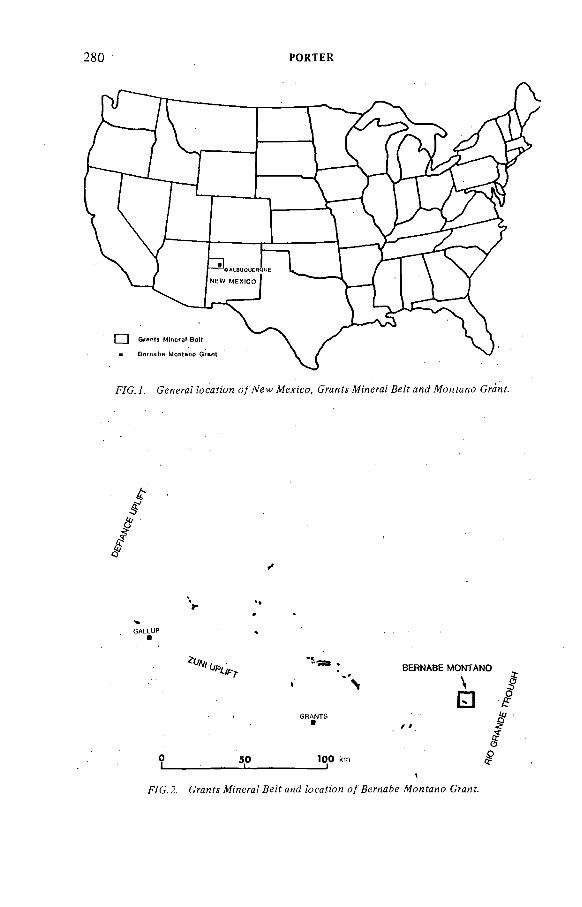
280 PORTER
F/C. i. Сеяега/ АэсаПон o / № w Л/exico, Craníí №'яега^ Де/; ан<? Monfano СгаяГ.
üp< BERNABE MONTANO
. Fш
0 5 0 1 0 0 km 1________ :____________I______________________ !
1
fYC.2. СгаяУу М'негя/ ße?f /^сс^'оя о / Ж о я г с я о Сгял?.
F#оor
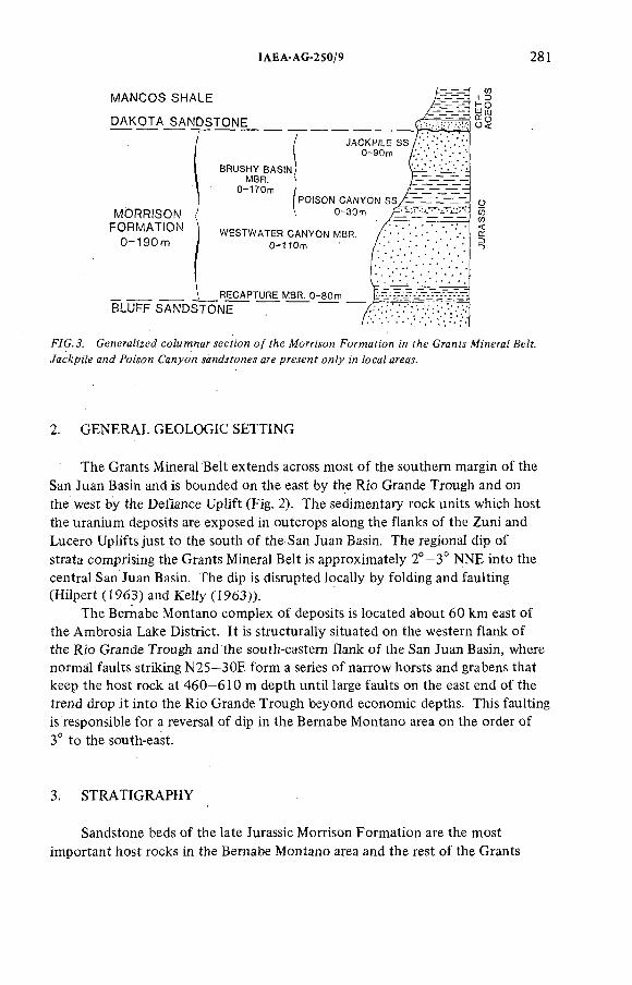
ÏAEA-AG-250/9 28!
F7G. J. Generalized ео/мтпаг лесП'оп о / fAe Aíorr^on Formafi'on ¡'л f7¡e GranM Minera/ Де/f. Уас^р;7е and *¡?M¡?n Салуол are ргелен? о л ^ ¡n ¿oca/ area,!.
2. GENERAL GEOLOGIC SETTING
The Grants Mineral Belt extends across most o f the southern margin o f the San Juan Basin and is bounded on the east by the Rio Grande Trough and on the west by the Defiance Uplift (Fig. 2). The sedimentary rock units which host the uranium deposits are exposed in outcrops along the flanks o f the Zuni and Lucero Uplifts just to the south o f the San Juan Basin. The regional dip of strata comprising the Grants Mineral Belt is approximately 2°—3° NNE into the central San Juan Basin. The dip is disrupted locally by folding and faulting (Hilpert (1963) and Kelly (1963)).
The Bernabe Montano complex o f deposits is located about 60 km east of the Ambrosia Lake District. It is structurally situated on the western flank o f the Rio Grande Trough and the south-eastern flank o f the San Juan Basin, where normal faults striking N25—ЗОЕ form a series o f narrow horsts and grabens that keep the host rock at 460—610 m depth until large faults on the east end of the trend drop it into the Rio Grande Trough beyond economic depths. This faulting is responsible for a reversal o f dip in the Bernabe Montano area on the order of 3° to the south-east.
3. STRATIGRAPHY
Sandstone beds o f the late Jurassic Morrison Formation are the most important host rocks in the Bemabe Montano area and the rest o f the Grants
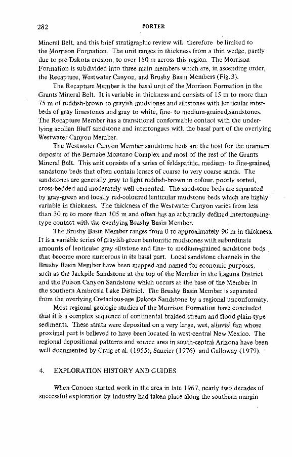
282 PORTER
Mineral Belt, and this brief stratigraphie review will therefore be limited to the Morrison Formation. The unit ranges in thickness from a thin wedge, partly due to pre-Dakota erosion, to over 180 m across this region. The Morrison Formation is subdivided into three main members which are, in ascending order, the Recapture, Westwater Canyon, and Brushy Basin Members (Fig. 3).
The Recapture Member is the basal unit o f the Morrison Formation in the Grants Mineral Belt. It is variable in thickness and consists o f 15 m to more than 75 m of reddish-brown to grayish mudstones and siltstones with lenticular interbeds o f gray limestones and gray to white, fine- to medium-grained,sandstones.The Recapture Member has a transitional conformable contact with the underlying aeolian Bluff sandstone and intertongues with the basal part o f the overlying Westwater Canyon Member.
The Westwater Canyon Member sandstone beds are the host for the uranium deposits o f the Bernabe Montano Complex and most o f the rest o f the Grants Mineral Belt. This unit consists of a series of feldspathic, medium- to fine-grained, sandstone beds that often contain lenses o f coarse to very coarse sands. The sandstones are generally gray to light reddish-brown in colour, poorly sorted, cross-bedded and moderately well cemented. The sandstone beds are separated by gray-green and locally red-coloured lenticular mudstone beds which are highly variable in thickness. The thickness of the Westwater Canyon varies from less than 30 m to more than 105 m and often has an arbitrarily defined intertonguing- type contact with the overlying Brushy Basin Member.
The Brushy Basin Member ranges from 0 to approximately 90 m in thickness. It is a variable series o f grayish-green bentonitic mudstones with subordinate amounts o f lenticular gray siltstone and fine- to medium-grained sandstone beds that become more numerous in its basal part. Local sandstone channels in the Brushy Basin Member have been mapped and named for economic purposes, such as the Jackpile Sandstone at the top o f the Member in the Laguna District and the Poison Canyon Sandstone which occurs at the base of the Member in the southern Ambrosia Lake District. The Brushy Basin Member is separated from the overlying Cretacious-age Dakota Sandstone by a regional unconformity.
Most regional geologic studies o f the Morrison Formation have concluded that it is a complex sequence o f continental braided stream and flood plain-type sediments. These strata were deposited on a very large, wet, alluvial fan whose proximal part is believed to have been located in west-central New Mexico. The regional depositional patterns and source area in south-central Arizona have been well documented by Craig et al. (1955), Saucier (1976) and Galloway (1979).
4. EXPLORATION HISTORY AND GUIDES
When Conoco started work in the area in late 1967, nearly two decades of successful exploration by industry had taken place along the southern margin
ÏAEA-AG-250/9 283
of the Grants Mineral Beit. In areas such as the Ambrosia Lake District no significant amount o f prospective exploration lands could be acquired at reasonable costs near existing deposits or at depths of less than 450 m. Conoco management, when faced with these economic barriers, decided to base its exploration strategy on the search for entirely new mineralized trends rather than buy relatively small parcels o f expensive lands that might contain extensions o f well-known mineralized trends. To implement this decision Conoco had to: (1) explore outside the Grants Mineral Belt in New Mexico, or (2) develop an exploration programme significantly different from the outcrop and mine-extension techniques in use by companies established in the Grants Mineral Belt. Conoco attempted the first approach for approximately two years — with no success. The company then reassessed the situation and decided to try the second alternative by developing a different exploration programme for the Grants Mineral Belt.
This programme was regional in scope and began with a review o f the extensive geologic data o f the Morrison Formation produced by government agencies and industry. Field studies o f the prospective host rocks and visits to active mines were conducted concurrently with the review o f the geologic literature in order to develop a foundation for the development o f a realistic exploration technique for the region. This preliminary work provided a number o f general characteristics that are common to most o f the uranium deposits in the Westwater Canyon Member host sandstones:
(1) The host sandstones were deposited in a series o f main channelways whose axes were generally parallel to the prominent, pre-Laramide north-west to south-east tectonic grain as displayed by the Zuni Uplift.
(2) Most o f the uranium deposits lie roughly parallel to the north-west to south-east tectonic grain and the axes o f the host sandstone's channelway s.
(3) Mapping in the Ambrosia Lake District by Santos (1970) suggests that ore deposits tend to be located in the more permeable zones of the host sandstones.
(4) The ore bodies often occur as separate multilevel ore bodies enclosed in long 'trends' o f low-grade uranium shows. These trends tend to be parallel to the local sedimentary and structural trends of a given area.
(5 ) Two general types o f uranium ore bodies are known. These have been termed (a) 'primary', 'trend', or 'prefault'; and (b) 'secondary', 'stack', 'redistributed', or 'postfault' ore. The first category, or 'primary' deposits, are found in . long, roughly tabular envelopes that parallel the main depositional trends. The second category, or 'secondary' deposits, are found in fracture and fault zones that generally cut obliquely across the sedimentary channelways and 'primary ore' trends.
( 6 ) Primary ore bodies are roughly tabular or blanket-shaped, but they generally have one long dimension which tends to be parallel to the trend of sedimentary channelways.
284 PORTER
(7) Primary ore is often associated with dark húmate masses that are found roughly paraHei to the bedding o f the Westwater Canyon Member sandstones.
( 8 ) Coffinite, a uranium silicate, is identified as the main unoxidized ore mineral.
(9) Uranium content in primary ores can exceed 1%, but an average grade approaching 0.20% U^Og is more common throughout the Grants Mineral Belt.
(10) Abnormally high concentrations o f vanadium, molybdenum, selenium and arsenic tend to fringe the ore bodies (Squyres, 1969).
(11) The host sandstone beds are often oxidized to a reddish-brown colour and are essentially barren on outcrops, while the uranium ore tends to be found down-dip in gray, reduced host rock.
(12) Oxidation appears to have encroached down-dip and to the north until disrupted by primary mineralization or the ore deposits.
5. EXPLORATION TECHNIQUES
Early exploration in the Grants Mineral Belt utilized airborne and surface radiometric surveys, geologic mapping, and exploration drilling down-dip from surface shows. These techniques had yielded several important discoveries, but after initial successes they were marginally effective in this region. Conoco's late entry into exploration made it necessary to employ a different exploration philosophy to provide guides towards the discovery o f new mineralized trends with no surface expression. It was determined fairly early that in this region remote sensing, geophysical, geochemical and elemental analysis techniques were apparently largely insensitive to the primary factors associated with uranium, and, on a cost-result basis, could not be justified.
A review o f the geologic literature suggested that the main favourable factors associated with uranium deposition in sandstones were related to:( 1 ) depositional trends and facies in the channelway systems o f the host sandstone beds; ( 2 ) structural elements that disrupt these channelway systems; and(3) geochemical factors that influenced deposition and later movement o f the uranium. The search for subsurface areas with these favourable characteristics required a synthesis o f all available surface and drill-hole information that could be obtained. The techniques selected for this synthesis were adapted from subsurface geologic mapping techniques, such as isopach, lithofacies, sand-shale radio and structure contour maps, as routinely practised in exploration for hydrocarbons. Available information on the geochemical state (oxidized-reduced) of the host sandstone beds was superimposed on these maps.
To develop the regional subsurface control required to make this mapping realistic, it was necessary to obtain a broad network of subsurface borehole logs. This was accomplished through many trades o f logs with other companies active
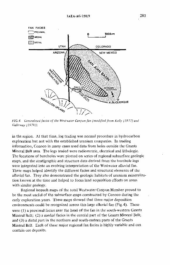
IAEA-AG-250/9 285
FAN FACIES
F/G. 4. G e n e r a t e d /ae¡'eí о/ гЛе IV eífw a íer Canyon /an /ron; Æe//y f7P77^ and
GaHotvay^P79^.
in the region. At that time, log trading was normal procedure in hydrocarbon exploration but not with the established uranium companies. In trading information, Conoco in many cases used data from holes outside the Grants Mineral Belt area. The logs traded were radiometric, electrical and lithologie.The locations o f boreholes were plotted on series o f regional subsurface geologic maps, and the stratigraphie and structure data derived from the borehole logs were integrated into an evolving interpretation o f the Westwater alluvial fan. These maps helped identify the different facies and structural elements o f the alluvial fan. They also demonstrated the geologic habitats o f uranium mineralization known at the time and helped to focus land acquisition efforts on areas with similar geology.
Regional isopach maps o f the total Westwater Canyon Member proved to be the most useful o f the subsurface maps constructed by Conoco during the early exploration years. These maps showed that three major deposition environments could be recognized across this large alluvial fan (Fig. 4). These
were (1) a proximal facies near the head o f the fan in the south-western Grants Mineral Belt; (2) a medial facies in the central part o f the Grants Mineral Belt; and (3) a distal part in the northern and south-eastern parts o f the Grants Mineral Belt. Each o f these major regional fan facies is highly variable and can contain ore deposits.
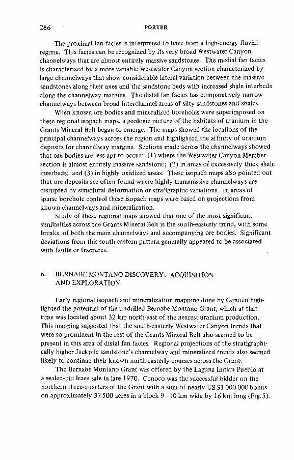
286 PORTER
The proximal fan facies is interpreted to have been a high-energy fluvia! regime. This facies can be recognized by its very broad Westwater Canyon channelways that are almost entirely massive sandstones. The medial fan facies is characterized by a more variable Westwater Canyon section characterized by large channelways that show considerable lateral variation between the massive sandstones along their axes and the sandstone beds with increased shale interbeds along the channelway margins. The distal fan facies has comparatively narrow channelways between broad interchannel areas o f silty sandstones and shales.
When known ore bodies and mineralized boreholes were superimposed on these regional isopach maps, a geologic picture o f the habitats o f uranium in the Grants Mineral Belt began to emerge. The maps showed the locations o f the principal channelways across the region and highlighted the affinity o f uranium deposits for channelway margins. Sections made across the channelways showed that ore bodies are less apt to occur: (1 ) where the Westwater Canyon Member section is almost entirely massive sandstone; ( 2 ) in areas o f excessively thick shale interbeds; and (3) in highly oxidized areas. These isopach maps also pointed out that ore deposits are often found where highly transmissive channelways are disrupted by structural deformation or stratigraphie variations. In areas of sparse borehole control these isopach maps were based on projections from known channelways and mineralization.
Study o f these regional maps showed that one o f the most significant similarities across the Grants Mineral Belt is the south-easterly trend, with some breaks, o f both the main channelways and accompanying ore bodies. Significant deviations from this south-eastern pattern generally appeared to be associated with faults or fractures.
6 . BERNABE MONTANO DISCOVERY: ACQUISITIONAND EXPLORATION
Early regional isopach and mineralization mapping done by Conoco highlighted the potential o f the undrilled Bernabe Montano Grant, which at that time was located about 32 km north-east o f the nearest uranium production.This mapping suggested that the south-easterly Westwater Canyon trends that were so prominent in the rest o f the Grants Mineral Belt also seemed to be present in this area o f distal fan facies. Regional projections o f the stratigraphi- cally higher Jackpile sandstone's channelway and mineralized trends also seemed likely to continue their known north-easterly courses across the Grant.
The Bernabe Montano Grant was offered by the Laguna Indian Pueblo at a sealed-bid lease sale in late 1970. Conoco was the successful bidder on the northern three-quarters o f the Grant with a sum o f nearly US $ 1 000 000 bonus on approximately 37 500 acres in a block 9—10 km wide by 16 km long (Fig.5).
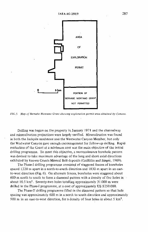
ÏAEA-AG-250/9 287
F / C . J . Ж а р о / й е г л я Ь е M o n í a n o С га я У í / ! o w i n g е л р /о г с У ю я p e r m i f а л е а o & f a i 'n e j 6 ^ C o n o c o .
Drilling was begun on the property in January 1971 and the channelway and mineralization projections were largely verified. Mineralization was found in both the Jackpile sandstone and the Westwater Canyon Member, but only the Westwater Canyon gave enough encouragement for follow-up drilling. Rapid evaluation of the Grant at a minimum cost was the main objective o f the initial drilling programme. To meet this objective, a reconnaissance borehole pattern was devised to take maximum advantage o f the long and short axial directions exhibited by known Grants Mineral Belt deposits (Griffiths and Singer, 1969).
The Phase-1 drilling programme consisted o f staggered fences o f boreholes spaced 1220 m apart in a north-to-south direction and 1830 m apart in an east- to-west direction (Fig. 6 ). On alternate fences, boreholes were staggered about 600 m north to south to form a diamond pattern with a density o f five holes in about 10.5 km^. Seventy-two holes totalling approximately 31 000 m were drilled in the Phase-1 programme, at a cost o f approximately US $250 000.
The Phase-11 drilling programme filled in the diamond pattern so that hole spacing was approximately 600 m in a north to south direction and approximately 900 m in an east-to-west direction, for a density o f four holes in about 5 km\
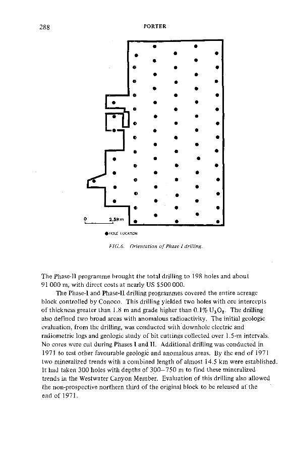
288 PORTER
)H O L E LOCATION
The Phase-11 programme brought the total drilling to 198 holes and about 91 000 m, with direct costs at nearly US $500 000.
The Phase-1 and Phase-11 drilling programmes covered the entire acreage block controlled by Conoco. This drilling yielded two holes with ore intercepts o f thickness greater than 1.8 m and grade higher than 0.1% U^Og. The drilling also defined two broad areas with anomalous radioactivity. The initial geologic evaluation, from the drilling, was conducted with downhole electric and radiometric logs and geologic study o f bit cuttings collected over 1.5-m intervals.No cores were cut during Phases 1 and 11. Additional drilling was conducted in 1971 to test other favourable geologic and anomalous areas. By the end o f 1971 two mineralized trends with a combined length o f almost 14.5 km were established. It had taken 300 holes with depths of 300-750 m to find these mineralized trends in the Westwater Canyon Member. Evaluation of this drilling also allowed the non-prospective northern third of the original block to be released at the end o f 1971.
ÏAEA-AG-250/9 289
О 5 kmL---------------- <
F/C . 7. fre ie n f acreage OMiù'ne yeneya/ ¿Mfn'&Míi'cn o / iw o wain mmeraZizan'on írenífs.
Subsequent drilling was limited primarily to delineation-type exploration o f the two main mineralized trends (Fig. 7). The first delineation phase decreased hole spacing to about 300 m and then to about 150 m on north-to-south fences spaced approximately 900 m apart. The next delineation phase decreased the 900-m fence spacing to about 300-m spaced fences in selected areas across the north-east to south-west trending mineralization. Eventually the most favourable areas were drilled on a selective spacing o f approximately 1 2 0 m with the mineable areas blocked out on about a 60-m grid. Over 2000 boreholes have been drilled to date on this project.
7. BERNABE MONTANO MINERALIZATION TRENDS
Ore mineralization is found at every stratigraphie level o f the Westwater Canyon Member in the Bernabe Montano complex o f deposits. This gives the ore trends an initial appearance o f being highly discontinuous and poddy. However, in a restricted area within the mineralized trend the ore is usually confined to the upper, middle or lower parts o f the Westwater Canyon Member.
290 PORTER
This variation is interpreted as being the resuit o f the rapid sedimentologic and geochemical changes that are characteristic o f the distal fan facies. The rapid changes in sedimentologic and geochemical conditions may also be an important factor in creating the large continuous halo around this complex o f ore deposits. More detailed studies o f the nature of these ore bodies will have to await underground mine development.
The grades o f uranium mineralization vary considerably from several times background to high-grade intercepts in excess o f 1.0% eU^Og. Average, in-place, radiometric grades for individual ore pods vary between 0 .1 2 % and 0.17% eU^Og using a 1.8 m/0.10% cut-off. Ore zones average up to 60 m or less in width. Engineered ore reserves o f over 10 000 000 lb of uranium oxide have been blocked out to date. Considerable potential for additional ore reserves remains within the ore trends. The reader is referred to the recent paper by Kozusko and Saucier (1980) for a more comprehensive description o f the Bernabe Montano Grant's geology and ore deposits.
8 . GENERAL OBSERVATIONS ON THE BERNABE MONTANO DEPOSIT
The Bernabe Montano complex o f uranium deposits is in most respects typical o f those found in the Grants Mineral Belt, but this area has some interesting geologic variations. Published data on other Grants Mineral Belt deposits indicate that they have relatively narrow mineralized halos. The halo enclosing the two mineralized trends in the Bernabe Montano area is unusually large. Other unique geologic features o f this area which do not appear to be genetically related to the mineralization are ( 1 ) the position of the oxidation interface on the north side o f the mineralized area; (2 ) structural deformation by late Tertiary-age faulting that offsets ore in a series o f horsts and grabens; and (3) the south-easterly dip o f the strata.
Oxidation along the northern edge o f the mineralized area may be responsible for the less extensive area and lower grades o f the northern trend compared to the southern trend. The later Tertiary-age faulting is younger in age than that known in other parts o f the Grants Mineral Belt but is no more extensive than that present in some other areas.
ACKNOWLEDGEMENTS
The author would like to thank Conoco Inc. for permission to publish this paper. Special acknowledgements are due Mr. L.W. Koch and Mr. L.W. Heiny, who provided important management support for this exploration venture. . Acknowledgements are also due Conoco's Albuquerque District geological staff, who worked on the development o f the Bernabe Montano exploration programme and gave data assistance for this report.
IAEA-AG-250/9 29!
BIBLIOGRAPHY
Craig, L. C., and others, 1955, Stratigraphy of the Morrison and
related formations, Colorado Plateau region, á preliminary report: U. S. Geol. Survey Bull. 1009E, p. 125-168.
Galloway, M. E., 1979, Morrison Formation of the Colorado Plateau, in Depositional and groundwater flow systems in the exploration for
uranium: Bureau of Economic Geology, Univ. of Texas at Austin,
Austin, Texas, p. 214-228.
Griffiths, J. D., and Singer, D . A . , 1969, Size, shape, and arrangement of some uranium ore bodies, pt. 2 of U. S. Atomic Energy Comm.
Rept. GJO-918-2: The College of Earth and Mineral Sciences
Experiment Station, The Pennsylvania State University, 38 p.
Hilpert, L. S.,1963, Geology and technology of the Grants uranium
region: New Mexico Bur. Mines and Min. Res., Memoir 15, 277 p.
Kelly, T. E., 1977, Geohydrology of the Westwater Canyon Member,
Morrison Formation, of the southern San Juan Basin, New Mexico,
in New Mexico Geological Society Guidebook, Twenty-eighth Field
Conference, San Juan Basin III, p. 285-290.
Kelly, v. C., 1963, Geology and technology of the Grants uranium region:
New Mexico Bur. Mines and Min. Res., Memoir 15, 277 p.
Kozusko, R. G., and Saucier, A. E., 1980, The Bernabe Montano Uranium
Deposit, Sandoval County, New Mexico, in Symposium on Grants Uranium
Region: New Mexico Bur. Mines and Min. Resources, Memoir 38 /In
Press/.
Santos, E. S., 1970, Stratigraphy of the Morrison Formation and structure of the Ambrosia Lake District, New Mexico, U. S. Geol. Survey Bull.
1272-E, 30 p.
Saucier, A. E., 1976, Tectonic influence on uraniferous trends in thelate Jurassic Morrison Formation, in Tectonics and mineral resources of southwestern North America: New Mexico Geol. Soc., Special
Publication no. 6, p. 151-157.
Squyres, J. B., 1969, Origin and depositional environment of uranium deposits of the Grants Region, New Mexico: Unpublished PhDdissertation, Stanford University, 228 p.
DISCUSSION
H.D. FUCHS: It must be quite difficult to follow the depocentres in areas where no drilling information exists. Is it possible to locate the depocentres/ channels by a detailed interpretation o f structure (by means o f air-photo interpretation, etc.)?
D.A. PORTER: The north-west to south-east trend as reflected by the Zuni Uplift is predominant and is the primary projection, especially in the
292 PORTER
Westwater depocentres closest to the uplift. Mapping the regional structure by both surface and subsurface methods is very important as Jurassic-age structures influenced depocentre trends. Some of these older structures are mappabie from the surface as they have been active through Laramide time.
P. BARRETTO: In what ways wouid the radiometric and/or geochemical halo o f Bernabe Montano mineralization differ from other Grant Mineral Belt deposits?
D.A. PORTER: From data that Conoco has been able to obtain from the literature and other companies, it appears that the low-grade mineralization or radiometric halo at Bernabe Montano is o f greater areal extent than is normally associated with deposits in the Grants Mineral Belt. One explanation for this would relate to the position o f the Bernabe Montano complex in the distal facies o f the alluvial fan. The geochemical interface between oxidized and reduced sediments hosting the ore encroaches from the north at Bernabe, whereas in the Grant Mineral Belt it is common for the redox interface to encroach from the south. This reversal o f the redox interface, however, is on the updip side in both instances, so the difference is strictly in response to structure.
D. TAYLOR: What is the depth of the main mineralization?D.A. PORTER: The depth varies. In the northern trend it ranges from
300 m to 375 m. In the southern trend the range is on the order o f 475 m to 550 m.
D. TAYLOR: What is your drill-hole spacing for blocking out the ore?D.A. PORTER: The ore was blocked out on approximately a 60-m grid.
IAEA-AG 250/10
DISCOVERY OF URANIUM DEPOSITS NEAR OSHOTO, EAST CENTRAL POWDER RIVER BASIN, WYOMING, USA
A.F. STOICK, K.L. BOLTZ, M.D. BUSWELLNuclear Dynamics, Inc.,Phoenix, Arizona,United States of America
PresenfeJ Ж. К //аллеи
Abstract
DISCOVERY OF URANIUM DEPOSITS NEAR OSHOTO, EAST CENTRAL POWDER RIVER BASIN,WYOMING, USA.
A uranium deposit on the east-central flank of the Powder River basin was discovered in 1952 by airborne radiometrics. Subsequent exploration, including driHing, paleochannel mapping, and geochemistry, between 1971 and 1977, discovered 6 million lb (2.7 million kg) of indicated and inferred uranium reserves and 34 million lb (15.4 million kg) of potential resources through an expenditure of US $4.7 million. Characteristics of the Oshoto ore body indicate that roll-front deposition is strongly influenced by facies changes within the fluvial Lance Formation.
1. INTRODUCTION
The Sundance Project area is located near Oshoto, Wyoming, approximately 25 miles (40 km) north o f Moorcroft, Wyoming. An area 10X35 miles (16 X 56 km) is included in this project. Figure 1 shows the Sundance Project in relation to the Powder River basin and surrounding structures.
2. IN ITIAL DISCOVERY
The possibility o f uranium occurrence in this area was first brought to the attention of A.F. Stoick in 1952. A local drilling contractor flew over the area with a scintillometer and noted anomalous count. Preliminary checks of all available surface outcrops revealed mineral occurrences in a light-pink oxidized- zone middle-Lance sands. Owing to unfavourable economics, additional investigation was delayed until 1970.
293
294 STOICK et ai.
L o c o t i o n o f S u n d a n c e P r o j e c t
C r e t a c e o u s r o c k s
f ^ e c a m b r i a n r o c k s
M o j o r s y n c i i n o ! a x i s
M a j o r a n t i c i i n a t a x i s
O u t ! i n e o f P o w d e r R iv e r b a s i n
^YC.7. Zocato/? Pro/ccf дяс? wc/or
TABLE I. NUBETH JOINT VENTURE; SUNDANCE PROJECT COST HISTORY
27 ООО
!20 220 98 HO
<s. P h .s .[40 ООО
950 ООО
3380,000
Totol Explor. 4 700 ООО
!n Situ L€oc .
2 600 ООО
Phose 4
Production
i 500.00 0
!970 ' 1 72 ' 1 74 1 76 t 78 } 80 ' ) 82 ) 84 '
YEAR
ÏAEA-AG-250/10 295
Between 1952 and 1970, uranium mining in Lower Cretaceous sandstones in the Black Hills and Tertiary sandstones in the Powder River basin established evidence of uranium mineralization on a regional scale. Literature studies [1 ] indicated favourable host conditions in continental sandstones and shales on the UpperCretaceous Lance Formation. Development o f oil fields in the immediate area provided subsurface information indicating radioactive anomalies in the Lance Formation.
A joint venture to explore the Sundance Project area was created between Nuclear Dynamics, Inc., and Bethlehem Steel Corporation. An investment o f US $27 000 was made, with exploration efforts focusing on airborne radiometric surveys and outcrop sampling. Table I shows the cost history.
3. RESEARCH AND RECONNAISSANCE
Airborne radiometric surveys were used to delineate favourable targets in Lance and Lance equivalents for land acquisition and subsequent exploration. Equipment used for airborne surveys included a Cessna 185 to 300 hp aircraft mounted with a Mount Sopris Model SC160-A Scintillator. The scintillator crystal was 7 in. (18 cm) in diameter and 2 in. (5 cm) thick. Flight lines were established and flown over a 15 X 35-mile area (24 X 56 km) on 1/3-mile (0.54 km) grids. Coverage was later expanded north to the Canadian border and south into Colorado.
Airborne surveys located large low-intensity radiometric anomalies which were ground-checked to determine whether radioactivity was due to uranium decay. Some anomalous radioactivity was associated with sandstone outcrops exhibiting light-pink oxidation colours.
An additional study o f oil-well logs in the vicinity was completed during Research and Reconnaissance efforts to aid in selection of land acquisition and exploration targets. Radioactive anomalies were noted and mapped according to stratigraphie position and location. Airborne and subsurface anomalies encompassed an area 10 X 35 miles (16 X 56 km) parallelling the western flank o f the Black Hills uplift (Fig. 1 ). '
4. LAND ACQUISITION
On the basis o f Research and Reconnaissance exploration results, a major land acquisition programme was organized. During 1971, 70000 acres (283 km^) incorporating State, Federal and private mineral rights, were procured for Nuclear Dynamics, Inc., at a cost o f US $120 220. An additional 44 000 acres (178 km^) were acquired, bringing the total cost o f land acquisition to US $218 330.
TABLE II. EXPLORATION COSTS (IN US $)
2 9 6 STOÏCK et al.
PHASEHOLES.DRILLED
EXPLORATIONOFFSETSPACING
DRILL ' STATISTICS
TOTAL FOOTAGE
DEPTHRANGE
DIRECTDRILLINGCOST/FOOT
TOTALEXPLORATION
COST
1 A 42 1-2 mile (1.6-3.2 km)
mile (6.4-8 km)
53 507 feet(16 309 m)
800-1800 feet
(244-549 m)
$.80/ft
($2.62/m)
В 641 25-1000
(7.6-305 m)
219 220 feet (66-818 m)
200-
800 feet (122-244 m)
. $.80/ft
($2.62/4i) $140 000
11 1432 25-1000
(7.6-305%i)
955 521 feet (291 242 m)
200-1800 feet
(122-549 m)
$.66/ft
($2.16/m) $950 000
III 2921 100-1000
(30.5-305 m)
1 763 296 feet (537 453 m)
400-
1000 feet (122-305 m)
$.73/ft
(î2.39/m) $3 380 000
TABLE III. EXPLORATION OBJECTIVES AND RESULTS
PHASE ' OBJECTIVES FIRST ENCOURAGING RESULTS
e U 30g and 10.2ft (3.1 m) of
depths of 180ft (55 m) and 1321ft (402 m ) .
15ft (4.6 m) of .31% eU^Og, along
The 345th Phase III drill hole was the discovery of a 4.7 million pound.(2 132 000 kg)
CRtTICAL EVIDENCE for CONTINUATION
6 million pounds (2 721 000 kg) UgOg
and 34 million pounds (15 422 000 kg)
IAEA-AG-250/Ï0 297
5. EXPLORATION DRILLING
Exploration drilling was conducted in three phases. Phase I consisted of wide-spaced drilling on 1 to 2-mile ( 1 . 6 to 3.2-km) centres. Exploration drilling in Phase II tested roll-fronts for grade and lateral extent o f mineralization. Phase III included wide-spaced drilling for expansion o f mineralized areas and close-spaced drilling for precise delineation of potential ore bodies. Tables II and III summarize drilling costs, objectives and results for all phases.
Phase I began with wide-spaced drilling to gain information on lithologie, stratigraphie, structural and radiometric characteristics o f the Sundance Project area. Forty-two holes provided the foundation for an expanded exploration effort. Subsequent drilling o f 642 additional sites provided data for subsurface verification o f airborne radiometric anomalies, delineation of generalized oxidation-reduction boundaries and correlation o f gross lithologie units.
Phase II exploration was accomplished on two scales. Closely spaced sites,25 to 100 ft (7.6 to 30.5 m) offset, were drilled to test width, grade and mineral continuity along delinated oxidation-reduction boundaries. Wide-spaced drilling, 400 to 1000 ft (122 to 305 m), was employed to explore and extend additional roll-fronts.
Phase III drilling included an extension o f Phase 11 wide-spaced drilling and concentration o f close-spaced development drilling to deHne in detail areas known to contain mineralization.
Roll-front boundaries were mapped (Fig.2) on the basis of gamma-curve configuration and the oxidized or reduced conditions of the host sands (Fig.3).Daily update o f these data provided a basis for selection of future drill targets.
Additional exploration methods employed were:
(a) Geochemical analysis o f core taken in series across a roll indicated that vanadium could be used as a potential pathfinder element for uranium in the barren interior zone;
(b) Radon sampling of water wells located two anomalies in areas previously unexplored; and
(c) Subsurface mapping o f sand channels to locate areas o f high groundwater transmission in relation to mapped oxidation-reduction boundaries.
6 . DRILLING AND SAMPLING
Tungsten carbide insert bits were used in drilling 4532 exploration holes. Sampling was performed at 5-ft (1.5-m) intervals. Cuttings were washed, boxed, described in detail with a binocular microscope, and stored for future reference.
T e x f confi'nMed on page
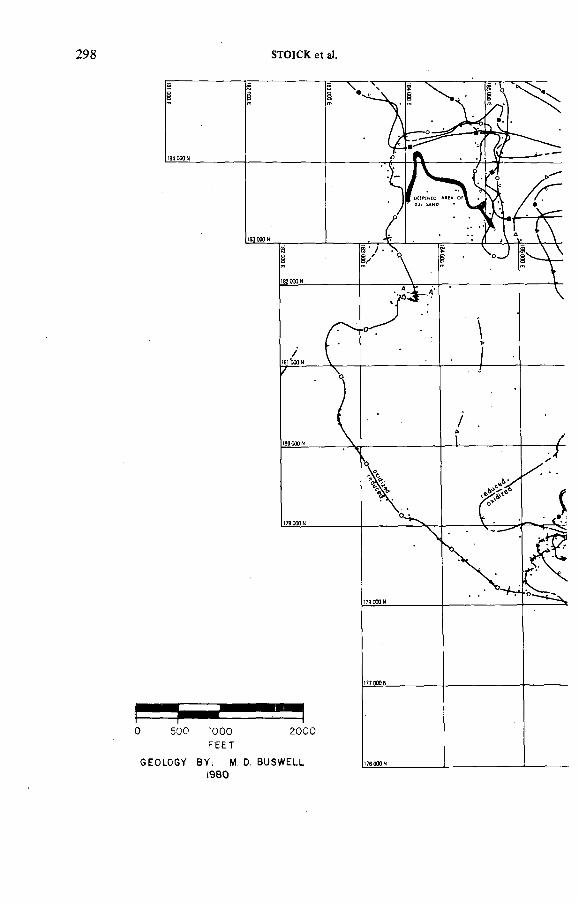
STOîCK et al.
500 tOOO 2000
FEETEOLOGY 8 Y : M. D. B U S W E L L
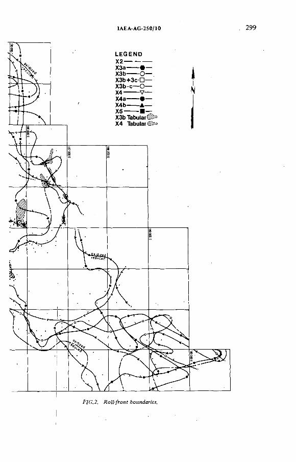
IAEA-AG-250/10 299
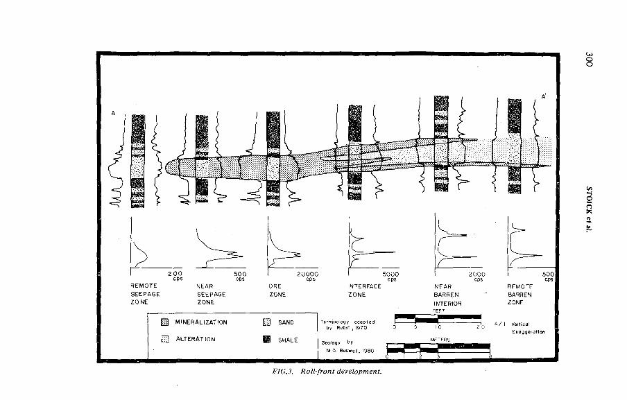
gg MINERALIZATION Э SAND
gg ALTERATION Й SWALE
500cps
by Rubin , ¡970
G e o to gy by
M.D. B u sw e i i , ) 9 8 0
4 / I Ver t ica l
ОО
Оn
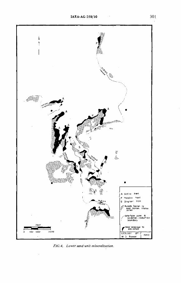
IAEA-AG-250/10 301
A Active fron!
F Passive front
S Staqnonl fron
n°er,.r
b o ^ d o ^
to
GEOLOGY BY'
M. D. Buswell1980
F7G.4. ¿owe/- sand MHiY
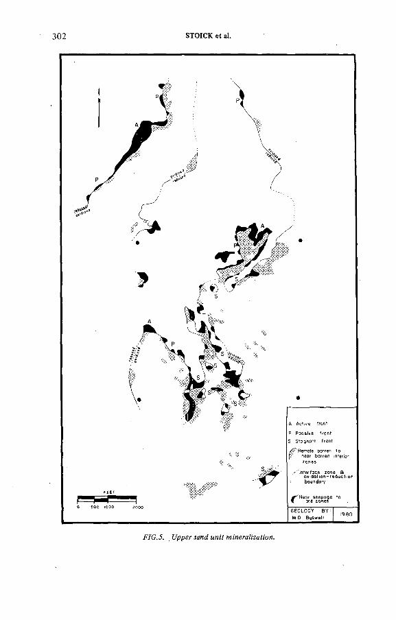
302 STOICK et al.
F /G .J. t/ppef мне? ми:'? M!'nera?;'zaf:'oM.
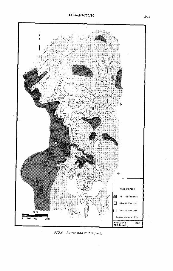
ÍAEA-AG-250/10 ßQß
О 5 0 0 !0 0 Q 2 0 0 0
S A N D IS O P A C H
7 0 - tOO F e e t th ic k
Г ? ! 4 0 - 6 9 F e e t th ic k
f ] 0 - 3 9 f e e t th ic k
G E O L O G Y B Y : f , э а оM .O . B u w e !)
F /C . 6. lo w e r м н <7 un¡Y морасЛ.
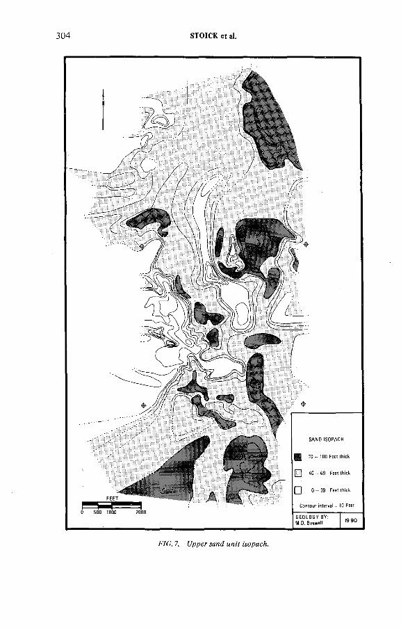
304 STOICK et d.
SA N D tSO PA CH
70 - 100 Feet thick
[Ж ] 40 - 69 Feet thick
( { 0 - 3 9 Feet thick
G E O L O G Y BY ; M .D . 8uswe4 t9 80
F/C . 7. t/pper морасА.
IAEA-AG-250/Ю 305
A 3-in. (7.6-cm) ID face-discharged diamond bit with a Ю-ft (3-m) core barrel was used to core 50 holes through mineralized horizons. Core recovery was consistently near 100% when the drilling fluid consisted of WOLF and Lowloss mixture, two Baroid, Inc., products.
Uranium chemical disequilibrium was checked periodically throughout the Sundance exploration programme. Results indicated, for values above 0.02%U 3 OS, that chemical uranium was enriched with respect to equivalent radiometric uranium oxide. Chemical disequilibrium below this value was found to be erratic and favoured neither radiometric nor chemical uranium consistently.
7. OSHOTO ORE DEPOSIT
During Phase III, 1800 exploration sites were drilled on 100 to 500 ft (30.5 to 152 m) centres to delineate ore. Indicated reserves of 4.7 million lb (2 132 000 kg) have been assigned to the Oshoto deposit.
Roll-fronts occurring in the Oshoto area form long, narrow, finger-like projections (Figs 4 and 5) oriented normal to the basin ward dip o f the sediments. Roll-fronts trending along strike were contrary to the working hypothesis of downdip migration o f oxidized groundwater. Buswell [3] shows paleochannels, trending north-south (Figs 6 and 7) to be an important factor in ore deposition in the Oshoto deposit.
Oxidation reduction boundaries in the Oshoto area are divided into active, passive and stagnant fronts as defined by Galloway et al. [5] (Figs 4 and 5).Active fronts form well-developed rolls in areas where the oxidation reduction boundaries are normal to ground-water migration. Areas o f maximum groundwater transmission occur primarily in thick channel sand sequences. Passive fronts mark boundaries between oxidized and reduced sediments parallel to front trends, forming narrow and often discontinuous mineralization. Ore deposition along passive fronts occurs near channel margins or other permeability changes. Stagnant fronts occur as stranded islands or as enlongated embayments of reduced sediments where front migration is minimal. Stagnant front formation is attributed to permeability changes due to either facies changes or faulting.
8 . FUTURE EXPLORATION ON THE SUNDANCE PROJECT
To locate ore bodies similar to the Oshoto deposit, emphasis placed on mapping regional and local paleochannel trends with respect to oxidation reduction boundaries would be an effective exploration method. Analysis of existing data would provide the basis for obtaining preliminary information on major paleochannels. The principal problem in conducting exploration in a complex fluvial system such as the Lance Formation would be the correlation and mapping of channel sand sequences.
3 0 6 STOÍCK et al.
REFERENCES
[1 ] ROBINSON, L .S., MAPEL, W.J., BERGENDAHL, M.H., Stratigraphy and structure of the northern and western flanks of the Black Hills uplift, Wyoming, Montana, and South Dakota, USGS Prof. Paper No. 404 (1964) 23—98 and 1 2 1 -1 2 3 .
[2] GRÜNER, J.W., Concentration of uranium in sediments by multiple migration-accretion, Econ. Geol. 51 (1956) 4 9 5 -5 2 0 .
[3] BUSWELL, M.D., Subsurface Geology of the Oshoto Uranium Deposit, Crook County, Wyoming, Master's thesis, South Dakota School of Mines and Technology (1980).
[4] RUBIN, B., Uranium roll-front zonation in the southern Powder River basin, Wyoming, Earth Science Bull. 3 4 (1970) 5—12.
[5] GALLOWAY, W.E., KRE1TLER, C.W., McGOWEN, J.H., Depositional and groundwater flow systems in the exploration for uranium, Bureau of Econ. Geol., Univ. of Texas at Austin, Research Colloquium (1979) 177—180.
IAEA-AG-250/18
THE BERNADAN DEPOSIT, HAUTE-VIENNE, FRANCE*
P. GELYCompagnie minière Dong Trieu,Paris,France
Д/юг? со?и?иим;ся?юм
Like many other deposits, the Bernardan was discovered during the 1960s, at the north-western corner o f the French Central Massif. The mineralized bodies consist o f vesicular episyenites carrying autunite, coffinite and pitchblende mineralizations, coffinite being the main uranium mineral. The bulk o f the assured reserves are contained in a main body o f irregular columnar shape which has been explored to a depth o f 120 m. The maximum horizontal dimensions are 1 0 0 m in the north-to-south direction and 60 m in the east-to-west direction.
There are other known bodies o f smaller size in the immediate vicinity and to a depth o f 300 m. The proven reserves at present amount to more than 3000 t o f uranium with an average grade higher than 0.5% U.
Initial exploration was focused on the two-mica granite massifs o f the region. In the absence o f previous indications, the targets were chosen on the basis of similarity to French granites o f the same type serving as supports for deposits already known. The first regional shows were detected in the course o f carborne prospecting. Helicopter exploration of a 200-km^ area with close-grid spacing did not yield any information about the Bernardan site itself.
The discovery o f the deposit was a methodological success. The sequence adopted in the first exploration was essentially as follows: prospecting on the ground, resistivity measurements and numerous short drillings (average 7 m) deep enough to pierce the bedrock beneath the thin Eocene detritic cover. After a preliminary campaign o f oblique drilling, systematic exploration to an average depth of 1 2 0 m was carried out by means of percussion vertical drilling and core drilling according to a square-grid pattern ( 8 -m spacing).
The evaluation of the deposit as well as the mining project was based entirely on the results o f these drillings. Open-cast mining operations were undertaken.The observations based on drilling have been confirmed, and the prospecting work is being continued both in extension and in depth.
* The complete text was not submitted for publication.
307
308 GELY
P. BARRETTO: Did you try a geochemical survey in this small area and, if so, what was the result?
P. GELY: No, we have not used geochemistry systematically because we felt that the contamination produced during the first reconnaissance work made the method not very effective. Secondly, the zone which we think has more interest is covered by Eocene sediments which turn out to be in discontinuity with the bedrock geochemistry. In this regard, we have a very good example in Bernardan, where a very rich mineralization (several % U^Og) is covered by only0.50 m of sediments, which have only 2 -3 ppm U. However, we use geochemistry quite systematically in other areas of France (for a large number o f elements, including uranium), and have obtained good results.
P. BARRETTO: Even if the cover is completely unrelated to the bedrock geochemistry but the water table is very close to the surface, could some kind o f transport be produced into the cover forming some sort o f uranium halo?
P. GELY : We have so far found no anomaly in the cover itself. It would be possible to have some good indications in the western part o f the area, where the cover is thinner.
P. BARRETTO: When you carried out the radon survey by sniffers, how did you avoid contamination by atmospheric air?
P. GELY: We put a plug on the top o f the hole and pumped the air for some twenty minutes. Usually we waited a few hours after the plug was taken out of the anomaly before making the radon measurements.
M. MATOLIN: The Central Massif o f France is a part o f the European Variscan chain and you have certain evidence o f the radioactivity o f this area.Does the area you describe belong to the granites with richer or with normal radioactivity? What is the normal radioactivity o f the Central Massif granites and what is the value for the areas you describe?
P. GELY. The two-mica granites represent the uranium-richer zones in the , French Central Massif in particular as well as in all the European Hercinian granites. The accumulation o f reserves in those areas represents the more important uranium potential o f France with around 20 000 to 30 000 t U. But that does not mean that the two-mica granites are necessarily the more radioactive in surface; there are some biotite granites with high radioactivity in which the uranium seems to be fixed in a very stable form and cannot be mobilized easily. The basic uranium concentration o f the two-mica granites in the two areas I described is around 15 to 20 ppm U in altered zones. It has been shown that in the fresh two-mica granites the uranium is present as very small uraninite crystals and that the uraninite was apparently oxidized in the shallow levels, passing into solution and constituting, therefore, an important source which could be mobilized and redeposited in favourable structures.
DISCUSSION
ÎAEA-AG-250/18 309
P. BARRETTO: What is the evidence to explain the genesis o f these vein deposits?
P. GELY : First o f ail, the Pegy deposit is a vein deposit. The vein structure at Pegy goes in the direction of La Marche dislocation, nearest to a fauit. The Pegy vein structure is essentially a breccia which takes up materials o f the wall rocks. The gneiss at the north is also in conformity with this location, and the gneiss is very close to the two-mica granites. We have been thinking mainly in terms o f an exogenic genesis for these uranium deposits, although we are not quite certain. But we consider it more important for a mine researcher to know about the favourable structures which are able to bear the uranium mineralization than where the uranium is coming from.
P. BARRETTO: In the case o f the Bernardan deposit you have information down to 250 m from surface. Do you have some information on the other deposits?
P. GELY: Not yet. Our efforts at present consist in preparing the open pit.P. STIPANICIC: Are the Fe^/Fe"^ ratios the same in the mineralized zones
and in the nearest normal episyenites and is this total iron content (Fe*^ +Fe*^ ) the same as the total Fe+^ content in the reduzate facies?
P. GELY: We do not yet have this information. Some time ago a systematic sampling o f the mineralized zones and o f the country rocks was carried out for mineralogical studies and to analyse the disequilibrium problems.
A.G. ANGEIRAS: In regard to exogenous versus endogenous model, I can mention some features which we found in the Itataia region. In the Lower Proterozoic we have small plugs o f granites which are intensely faulted and jointed and this type o f vug-rock is developed from fractures inside the granite body. The climate is dry, and there is no chemical weathering at all. Some holes drilled down to 200 m show granites with 20-30 ppm U. This could be a geochemical process, because we have no evidence about weathering and oxidation in this area.
J. DARDEL: What is the age o f the mineralization? Is it Tertiary?P. GELY: We did not carry out any study on the subject, but we believe
that it could possibly be Eocene. Mr. Dardel knows more about this problem because he knows the work done by CEA-COGEMA. It is very difficult to say anything about the mineralizations occurring some 50 km eastwards, 200 to 300 m.y. old, and located in large faults, but there is some residual mineralization of about 30 m.y.

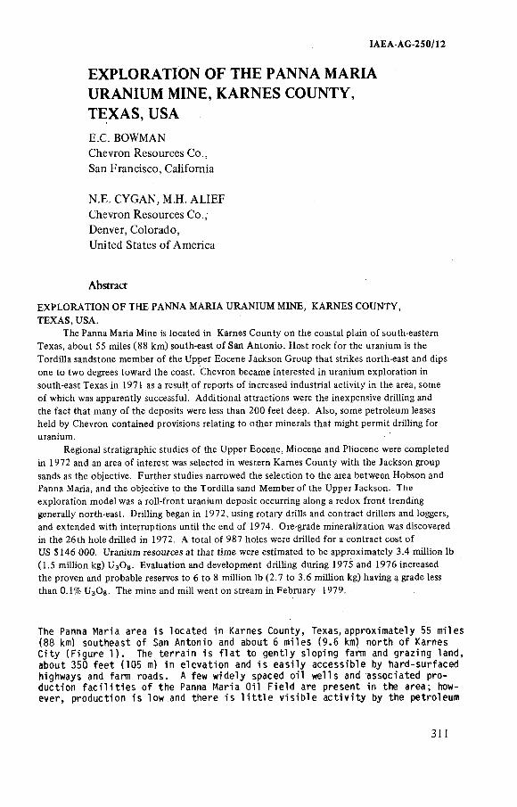
IAEA-AG 250/12
EXPLORATION OF THE PANNA MARIA URANIUM MINE, KARNES COUNTY, TEXAS, USAE C. BOWMAN Chevron Resources Co.,San Francisco, California
N E. CYGAN, M.H. ALIEF Chevron Resources Co.,Denver, Colorado,United States o f America
Abstract
EXPLORATION OF THE PANNA MARIA URANIUM MINE, KARNES COUNTY,TEXAS, USA.
The Panna Maria Mine is located in Karnes County on the coastal plain of south-eastern Texas, about 55 miles ( 8 8 km) south-east of San Antonio. Host rock for the uranium is the Tordilla sandstone member of the Upper Eocene Jackson Group that strikes north-east and dips one to two degrees toward the coast. Chevron became interested in uranium exploration in south-east Texas in 1971 as a result of reports of increased industrial activity in the area, some of which was apparently successful. Additional attractions were the inexpensive drilling and the fact that many of the deposits were less than 200 feet deep. Also, some petroleum leases held by Chevron contained provisions relating to other minerals that might permit driHing for uranium.
Regional stratigraphie studies of the Upper Eocene, Miocene and Pliocene were completed in 1972 and an area of interest was selected in western Kames County with the Jackson group sands as the objective. Further studies narrowed the selection to the area between Hobson and Panna Maria, and the objective to the Tordilla sand Member of the Upper Jackson. The exploration model was a roll-front uranium deposit occurring along a redox front trending generally north-east. DriHing began in 1972, using rotary drills and contract drillers and loggers, and extended with interruptions until the end of 1974. Ore-grade mineralization was discovered in the 26th hole drilled in 1972. A total of 987 holes were drilled for a contract cost of US $ 146 000. Uranium resources at that time were estimated to be approximately 3.4 million lb (1.5 million kg) U3 O3 . Evaluation and development driHing during 1975 and 1976 increased the proven and probable reserves to 6 to 8 million lb (2.7 to 3.6 million kg) having a grade less than 0.1% U3 ÓS. The mine and mill went on stream in February 1979.
The P a n n a M a r i a a r e a i s l o c a t e d i n K a r n e s C o u n t y , T e x a s , a p p r o x i m a t e l y 55 m i l e s ( 8 8 km) s o u t h e a s t o f San A n t o n i o a nd a b o u t 6 m i l e s ( 9 . 6 km) n o r t h o f K a r n e s C i t y ( F i g u r e 1 ) . The t e r r a i n i s f l a t t o g e n t l y s l o p i n g f a r m a nd g r a z i n g l a n d , a b o u t 3 5 0 f e e t ( 1 0 5 m) i n e l e v a t i o n a n d i s e a s i l y a c c e s s i b l e by h a r d - s u r f a c e d h i g h w a y s a n d f a r m r o a d s . A f ew w i d e l y s p a c e d o i l w e l l s a n d a s s o c i a t e d p r o d u c t i o n f a c i l i t i e s o f t h e P a n n a M a r i a O i l F i e l d a r e p r e s e n t i n t h e a r e a ; howe v e r , p r o d u c t i o n i s l o w an d t h e r e i s l i t t l e v i s i b l e a c t i v i t y by t h e p e t r o l e u m
311
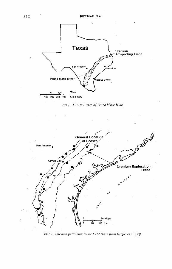
312 BOWMAN et a!.
F/G. i . ío c a f io n map o / fa n n a M ana M 'ne.
F ÍG .2 . Chevron pgí?*oZeMW ^ а ^ м 7P72 ('ba^e/row FargFe gíaZ. [2 ]/
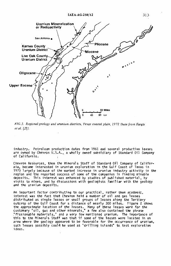
!AEA AG 250/12 313
F/G.J?. RegionalgeoZogy and мгап:'и?н JMfn'cfy, Гела^ coa^^aZ pZaZn, 7972 ^aie^om FargV e efa¿ [2 ]/
i n d u s t r y . P e t r o l e u m p r o d u c t i o n d a t e s f r o m 1961 and s e v e r a l p r o d u c t i v e l e a s e s a r e owned by C h e v r o n U . S . A . , a w h o l l y owned s u b s i d i a r y o f S t a n d a r d O i l Company o f C a l i f o r n i a . ,
C h e v r o n R e s o u r c e s , t h e n t h e M i n e r a l s S t a f f o f S t a n d a r d O i l Company o f C a l i f o r n i a , be c a me i n t e r e s t e d i n u r a n i u m e x p l o r a t i o n i n t h e G u l f C o a s t o f T e x a s i n 197 0 l a r g e l y b e c a u s e o f t h e m a r k e d i n c r e a s e i n u r a n i u m i n d u s t r y a c t i v i t y i n t h e r e g i o n a nd t h e r e p o r t e d s u c c e s s o f some o f t h e c o m p a n i e s i n f i n d i n g m i n a b l e d e p o s i t s . T h i s i n t e r e s t was e n h a n c e d by s t u d i e s o f p u b l i s h e d m a t e r i a l , by v i s i t s t o m i n e s , and by d i s c u s s i o n s w i t h g e o l o g i s t s f a m i l i a r w i t h t h e g e o l o g y a n d t h e u r a n i u m d e p o s i t s .
An i m p o r t a n t f a c t o r c o n t r i b u t i n g t o o u r p r a c t i c a l , r a t h e r t h a n a c a d e m i c , i n t e r e s t was t h e f a c t t h a t C h e v r o n h e l d a n u m b er o f o i l a nd g a s l e a s e s d i s t r i b u t e d a s s i n g l e l e a s e s o r s m a l l g r o u p s o f l e a s e s a l o n g t h e T e r t i a r y o u t c r o p o f t h e G u l f C o a s t f o r a d i s t a n c e o f n e a r l y 300 m i l e s . F i g u r e 2 shows t h e a p p r o x i m a t e l o c a t i o n o f t h e l e a s e s . Many o f t h e s e l e a s e s w e r e f o r t h e c u s t o m a r y " o i l , g a s a nd o t h e r m i n e r a l s , " a f ew a l s o c o n t a i n e d t h e p h r a s e " f i s s i o n a b l e m a t e r i a l s , " a nd a v e r y f ew m e n t i o n e d u r a n i u m . The i m p o r t a n c e o f t h i s t o t h e M i n e r a l s S t a f f was t h a t i f some o f t h e l e a s e s w e r e l o c a t e d i n an a r e a w h e r e t h e g e o l o g y a p p e a r e d t o b e f a v o r a b l e f o r t h e o c c u r r e n c e o f u r a n i u m , s u c h l e a s e s p o s s i b l y c o u l d b e u s e d a s " d r i l l i n g i s l a n d s " t o t e s t e x p l o r a t i o n i d e a s .
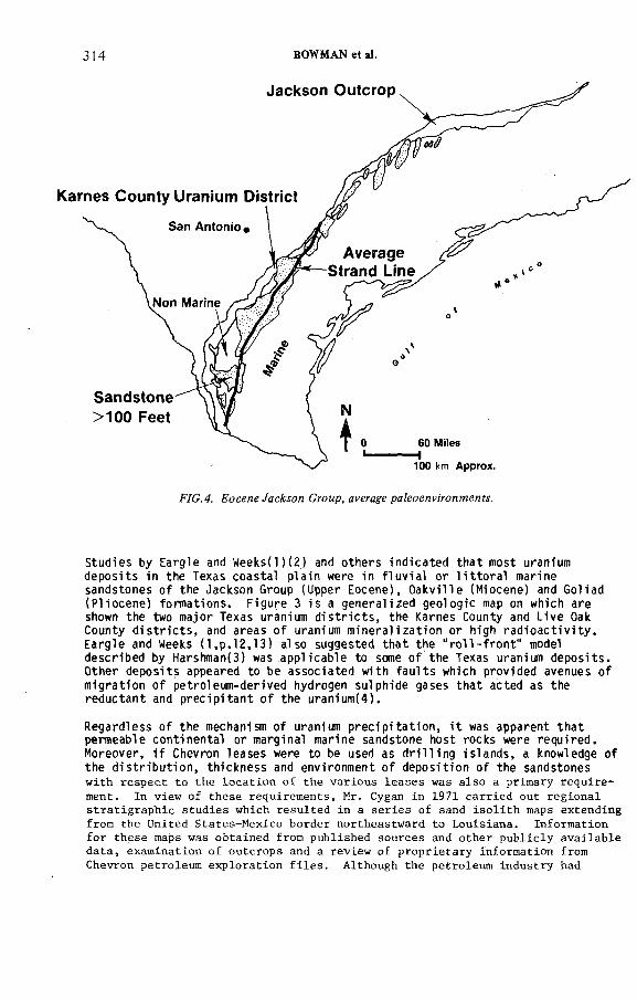
314 BOWMAN et al.
S t u d i e s by E a r g l e an d W e e k s ( l ) ( 2 ) and o t h e r s i n d i c a t e d t h a t m o s t u r a n i u m d e p o s i t s i n t h e T e x a s c o a s t a l p l a i n w e r e i n f l u v i a l o r l i t t o r a l m a r i n e s a n d s t o n e s o f t h e J a c k s o n G r o up ( U p p e r E o c e n e ) , O a k v i l l e ( M i o c e n e ) a n d G o l i a d ( P l i o c e n e ) f o r m a t i o n s . F i g u r e 3 i s a g e n e r a l i z e d g e o l o g i c map on w h i c h a r e shown t h e two m a j o r T e x a s u r a n i u m d i s t r i c t s , t h e K a r n e s C o u n t y a n d L i v e Oak C o u n t y d i s t r i c t s , an d a r e a s o f u r a n i u m m i n e r a l i z a t i o n o r h i g h r a d i o a c t i v i t y . E a r g l e a n d Weeks ( 1 , p . 1 2 , 1 3 ) a l s o s u g g e s t e d t h a t t h e " r o l l - f r o n t " model d e s c r i b e d by H a r s h m a n ( 3 ) was a p p l i c a b l e t o some o f t h e T e x a s u r a n i u m d e p o s i t s . O t h e r d e p o s i t s a p p e a r e d t o b e a s s o c i a t e d w i t h f a u l t s w h i c h p r o v i d e d a v e n u e s o f m i g r a t i o n o f p e t r o l e u m - d e r i v e d h y d r o g e n s u l p h i d e g a s e s t h a t a c t e d a s t h e r e d u c t a n t a n d p r e c i p i t a n t o f t h e u r a n i u m ( 4 ) .
R e g a r d l e s s o f t h e m e c h a n i s m o f u r a n i u m p r e c i p i t a t i o n , i t was a p p a r e n t t h a t p e r m e a b l e c o n t i n e n t a l o r m a r g i n a l m a r i n e s a n d s t o n e h o s t r o c k s w e r e r e q u i r e d . M o r e o v e r , i f C h e v ro n l e a s e s w e r e t o be u s e d a s d r i l l i n g i s l a n d s , a k n o w l e d g e o f t h e d i s t r i b u t i o n , t h i c k n e s s a n d e n v i r o n m e n t o f d e p o s i t i o n o f t h e s a n d s t o n e swith respect to the location of the various leases was also a primary requirement. In view of these requirements, Mr. Cygan in 1971 carried out regional stratigraphie studies which resulted in a series of sand isolith maps extending from the United States-Mexico border northeastward to Louisiana. Information for these maps was obtained from published sources and other publicly available data, examination of outcrops and a review of proprietary information from Chevron petroleum exploration files. Although the petroleum industry had
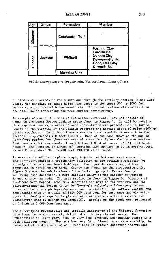
IAEA AG-250/12 315
Age Group Formation Member
ФсФоо Catahouta Tuft
2
Eocene Jackson Whitsett
Fashing Ctay Torditta Ss. Dubose Ctay Deweesevitte Ss. Conquista Ctay Diiworth Ss.
Manning Ciay
F7G.J. OMfcroppi'n^i^afi'gyap/ü'cMTM'fî, АлглмСоыл?у, Гехм.
drilled many hundreds of wells into and through the Tertiary section of the Gulf Coast, the majority of these holes were cased in the upper 500 to 1000 feet before running logs, with the result that little information was available in the cased holes concerning the near surface stratigraphy.
An example of one of the maps is the paleoenvironmental map and isolith of sands in the Upper Eocene Jackson group shown in Figure 4. It will be noted on this map that two major areas of sand accumulation are present, one in Karnes County in the vicinity of the Uranium District and another about 60 miles (100 km) to the southwest. In both of these areas the total sand thickness within the Jackson Group exceeds 400 feet (120 m ) . Much of the sand shown on the map is near-shore marine, but there are several areas from Karnes County southwestward that have a thickness, greater than 100 feet (30 m) of nonmarine, fluvial sand. However, the greatest thickness of nonmarine sand appears to be in northwestern Karnes County where 300 to 400 feet (90-120 m) is found.
An examination of the completed maps, together with known occurrences of radioactivity,enabled a preliminary selection of the optimum combination of stratigraphie unit and lease holdings. The Upper Jackson group, Whitsett formation in northwestern Karnes County was chosen as the prospective unit.Figure 5 shows the subdivisions of the Jackson group in Karnes County.Following this selection, a more detailed study of the geology of western Karnes County was made. The area studied is shown in Figure 6. Outcrops of sandstone were mapped, measured, described and sampled for uranium, and for paleoenvironmental determination by Cheyron's palynology laboratory in New Orleans. Color air photographs were used to assist in the surface mapping and topographic maps on a scale of 1:24 000 were used for base maps and elevation control. Geologic maps by Eargle and others(5) were available as were air radiometric maps by Moxham and Eargle(6). Results of the study were presented
on 1 inch to 1 000 foot base maps.
The outcropping Deweeseville and Tordilla sandstones of the Whitsett formation were found to be continental, deltaic distributary channel sands. The Deweeseville is light gray, fine to very fine grained, sub-angular quartz in a weak siliceous cement. The unit has very faint limonitic surface staining, is cross-bedded, and is made up of 6-foot beds of friable sandstone interbedded
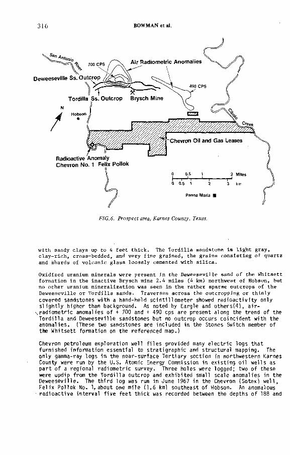
316 BOWMAN et al.
with sandy clays up Co 4 feet thick. The Tordilla sandstone is l igh t gray, clay-rich, cross-bedded, and very fine grained, the grains consisting o f quartz and shards of volcanic glass loosely cemented with s i l ica .
Oxidized uranium minerals were present in the Deweeseville sand o f the W h i t s e t t formation in the inactive Brysch mine 2.4 miles (4 km) northwest of Hobson, but no other uranium mineralization was seen in the rather sparse outcrops of the Deweeseville or Tordilla sands. Traverses across the outcropping or thinly covered sandstones with a hand-held s c i n t i l l o m e t e r showed r a d i o a c t i v i t y only s l i g h t l y higher than background. As noted by Eargle and o t h e r s ( 4 ) , a i r -
\ r a d i o m e t r i c anomalies o f + 700 and + 490 cps are pr es e nt along the trend o f the T o r d i l l a and Deweesevi l l e sandstones but no outcrop occur s c o i n c i d e n t with the a no ma l i e s . (These two sandstones are included in the Stones Switch member o f the W h i t s e t t formation on the r e f e r e nc e d map.)
Chevron petroleum e x p l o r a t i o n well f i l e s provided many e l e c t r i c l o g s t h a t f ur ni she d i nformat i on e s s e n t i a l to s t r a t i g r a p h i e and s t r u c t u r a l mapping. The onl y gamma-ray l o g s i n t he n e a r - s u r f a c e T e r t i a r y s e c t i o n in northwestern Karnes County were run by the U.S. Atomic Energy Commission in e x i s t i n g o i l w e l l s as p a r t o f a regional ra di om et r i c survey. Three hol es were logged; two o f t he s e were updip from t he T o r d i l l a outcrop and e x h i b i t e d small s c a l e anomalies in the D e we e se v i l l e . The t h i r d log was run in June 1967 in the Chevron ( S o t e x ) w e l l , F e l i x Pol l ok No. 1, about one mi le ( 1 . 6 km) s o u t h e a s t o f Hobson. An anomalous r a d i o a c t i v e i n t e r v a l f i v e f e e t t h i c k was recorded between the depths o f 188 and
IAEA AG 250/12 317
193 f e e t ( 5 7 . 3 and 5 8 . 8 m) which, by rough c a l c u l a t i o n , a l lowing f o r a t t e n u a t i o n by two s t r i n g s o f c a s i n g and cement, showed a c o n t e n t o f 0 .0 1 2 p e r c e n t eUgOg, appar en t l y in the Dewe ese vi l l e sandstone.
As a r e s u l t o f t h i s study, the group o f Chevron o i l and gas l e a s e s in t he v i c i n i t y o f the small community c e n t e r o f Panna Maria was s e l e c t e d as the i n i t i a l pr os p ec t i n g a r e a . See F i gu r e 6 . The Panna Maria p r o j e c t was i n i t i a t e d t o e v a lu a te the uranium p o t e n t i a l o f t he s e l e ase d a r e a s . Reasons f o r i d e n t i f y ing t he Panna Maria area f o r more i n t e n s i v e pros pe ct ing are summarized in t he fo l l owi ng l i s t :
1 . Previous uranium product ion from Eocene, J ac ks on Group sandstones o f t he Gulf Coas t .
2 . Co nt i nui ty o f J ac ks on sandstone u n i t s from producing a re as through the area s e l e c t e d .
3 . A i r - r a d i o m e t r i c anomalies over the T o r d i l l a and Dewe ese vi l l e s andst ones .
4 . Gamma-ray anomaly in cased well s ou t he a st o f Hobson.
5. Probable c o i n c i d e n c e in l o c a t i o n o f sands in J ac ks on Group withpetroleum l e a s e s held by Chevron.
As pre vi ous ly mentioned, E ar gl e ( 2, p. 13) suggested t h a t t he r o l l - f r o n t model was a p p l i c a b l e to many o f t he Texas uranium d e p o s i t s . Thi s sugg est io n was r e i n f o r c e d by o bs er va t i on by the w r i t e r s o f wel l -devel oped r o l l s in some o f the o p e n - p i t mines south and southwest o f Panna Maria ; t h e s e were very s i m i l a r to t he c r e s c e n t i c r o l l s seen in Wyoming. These f a c t o r s , t o ge t h e r with t he r e s u l t s o f our regional g eo lo gi c s t u d i e s , l e d us to s e l e c t a r o l l - f r o n t uranium d ep o si tin t h e J ackson sandstones as our e x p l o r a t i o n model.
According to the model, the d e p o s i t would be bordered on the updip s ide by l i g h t - c o l o r e d , oxi dized sandstone and downdip by brown to medium-gray reduced ( u n a l t e r e d ) sa ndst one . The most probabl e trend o f the d e p o s i t would be no rt he a s t , roughly p a r a l l e l to the s t r i k e o f t he bedding. Dimensions o f t he d ep o s i t i nc ludi ng the upper and lower l imb s, o r t r a i l i n g edges o f the c r e s c e n t i c r o l l probably would not exceed 300 f e e t (90 m) in t he down dip d i r e c t i o n and 1000 f e e t (300 m) p a r a l l e l to s t r i k e . I t s t h i c k n e s s would be about 20 f e e t (6 m) and the ore grade would average about 0 . 2 0 p e r c e n t U3O0 . These dimensions and grade correspond to E a r g l e ' s t y p i c a l o p e n - p i t d e p o s i t ( 2 , p. 29) in the v i c i n i t y o f the Weddington mine, approxi mate ly 8 mi l es southwest o f Hobson.
Under our plan, e x p l o r a t i o n would be c onf ined to the area between t he outcrop o f the sands and the 5 0 0 - f o o t depth c o n t o u r . The depth l i m i t a t i o n was based on the probable economic depth l i m i t o f open p i t mining in t h i s r e g io n .Underground mining o f the v i r t u a l l y unconsol idat ed sandstones was cons i der ed to be economi cal ly u n f e a s i b l e in view o f the low p r i c e o f uranium, $6 t o $7 per pound, a t t h a t t ime.
Accept ing t h i s model, four major q ue s t i on s must be answered by the e x p l o r a t i o n program:
1 . Are the J a c k s on sandst ones as well developed as t he study o f western Karnes County suggest s?
2. I s an o x i d a t i o n - - r e d u c t i o n i n t e r f a c e , or " redox f r o n t , " pre se nt ?
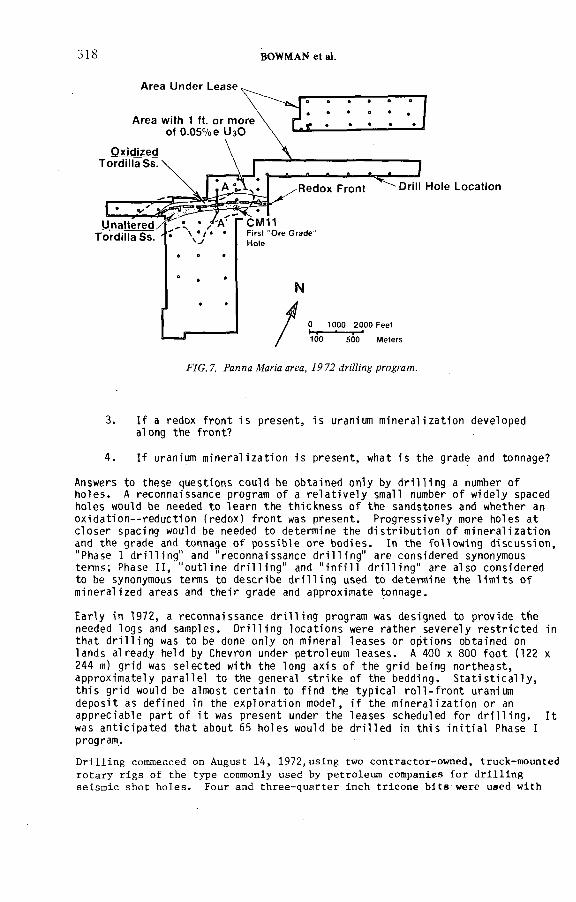
318 BOWMAN et at.
3. I f a redox f r o n t i s pr es e nt , i s uranium m i n e r a l i z a t i o n developed along the f r o n t ?
4 . I f uranium m i n e r a l i z a t i o n i s p r e s e n t , what i s the grade and tonnage?
Answers to the se que st io ns could be obt ained only by d r i l l i n g a number o f h o l e s . A r e co nna is sa nc e program o f a r e l a t i v e l y small number o f widely spaced hol es would be needed t o l e a r n the t h i c k n e s s o f t he sandstones and whether an o x i d a t i o n - - r e d u c t i o n (redox) f r o n t was p r e s e n t . P r o g r e s s i v e l y more hol es a t c l o s e r spacing would be needed to determine the d i s t r i b u t i o n o f m i n e r a l i z a t i o n and the grade and tonnage o f p o s s i b l e ore b o di e s . In the f o l l owi ng d i s c u s s i o n , "Phase I d r i l l i n g " and " r e c o n n ai s s an c e d r i l l i n g " are consi dered synonymous terms; Phase I I , " o u t l i n e d r i l l i n g " and " i n f i l l d r i l l i n g " are a l so consi dered to be synonymous terms to d e s c r i b e d r i l l i n g used to determine t he l i m i t s o f m i n e r a l i ze d areas and t h e i r grade and approximate tonnage.
Ear l y in 1972, a re c onna i ss a nc e d r i l l i n g program was designed to provide the needed l ogs and samples. D r i l l i n g l o c a t i o n s were r a t h e r s e v e r e l y r e s t r i c t e d in t h a t d r i l l i n g was to be done only on mineral l e a s e s or opt ions obtained on l ands al ready held by Chevron under petroleum l e a s e s . A 400 x 800 f o o t (122 x 244 m) gr id was s e l e c t e d with the long a x i s o f the gr id being n o r t h e a s t , approxi mat ely p a r a l l e l to the general s t r i k e o f the bedding. S t a t i s t i c a l l y , t h i s gr id would be almost c e r t a i n to f ind the t yp i c a l r o l l - f r o n t uranium d e p o s i t as def ined in the e x p l o r a t i o n model, i f the m i n e r a l i z a t i o n or an a p p r e c i a b l e pa rt o f i t was pre se nt under the l e a s e s scheduled f o r d r i l l i n g . I t was a n t i c i p a t e d t h a t about 65 h ol e s would be d r i l l e d in t h i s i n i t i a l Phase I program.
D rill ing commenced on August 14, 1972,using two contractor-owned, truck-mounted rotary rigs of the type commonly used by petroleum companies for d r i l l in g seismic shot holes. Four and three-quarter inch tricone bits were used with
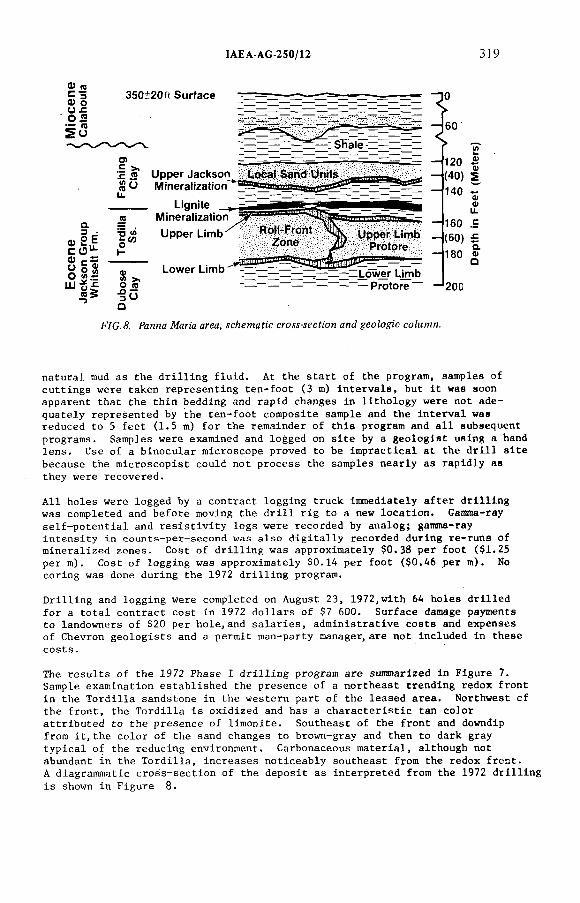
IAEA-AG 250/12 3)9
<М я С за) о о л О Д " <сS o
350±20ft Surface
<ы2Е с О"-о 5 ^Y о м О ^ Ш -g^
I — * —__—— — : Shale и —r í osе >. л д ЙО
-П V)5"
Ф
О ю^ 5о
Upper Jackson Mineralization^
L i g n i t e ____Mineraiization
Upper Limb
-*2 0 0
F/G.á'. Panna Магм crea, ícAemafíc croM-íeefíon an¿ geo/oy¡'c сс?м?ия.
natural mud as the d r i l l in g flu id. At the start of the program, samples of cuttings were taken representing ten-foot (3 m) intervals, but i t was soon apparent that the thin bedding and rapid changes in lithology were not adequately represented by the ten-foot composite sample and the interval was reduced to 5 feet (1.5 m) fo r the remainder of this program and a l l subsequent programs. Samples were examined and logged on s ite by a geologist using a hand lens. Use of a binocular microscope proved to be impractical at the d r i l l s ite because the microscopist could not process the samples nearly as rapidly as they were recovered.
A l l holes were logged by a contract logging truck immediately a fter d r i l l in g was completed and before moving the d r i l l r ig to a new location. Gamna-ray se lf-potentia l and r e s is t iv i ty logs were recorded by analog; gamma-ray intensity in counts-pet-second was also d ig i ta l ly recorded during re-runs of mineralized zones. Cost o f d r i l l in g was approximately $0.38 per foot ($1.25 per m). Cost o f logging was approximately $0.14 per foot ($0.46 per m). No coring was done during the 1972 d r i l l in g program.
D ril l ing and logging were completed on August 23, 1972,with 64 holes dr il led fo r a tota l contract cost in 1972 dollars o f $7 600. Surface damage payments to landowners of $20 per hole,and salaries, administrative costs and expenses of Chevron geologists and a permit man-party manager,are not included in these costs.
The results o f the 1972 Phase I d r i l l in g program are summarized in Figure 7. Sample examination established the presence of a northeast trending redox front in the Tordilla sandstone in the western part of the leased area. Northwest of the front, the Tordilla is oxidized and has a characteristic tan color attributed to the presence of limonite. Southeast of the front and downdip from i t , th e color of the sand changes to brown-gray and then to dark gray typical of the reducing environment. Carbonaceous material, although not abundant in the Tordilla , increases noticeably southeast from the redox front.A diagrammatic cross-section of the deposit as interpreted from the 1972 d r i l l in g is shown in Figure 8.
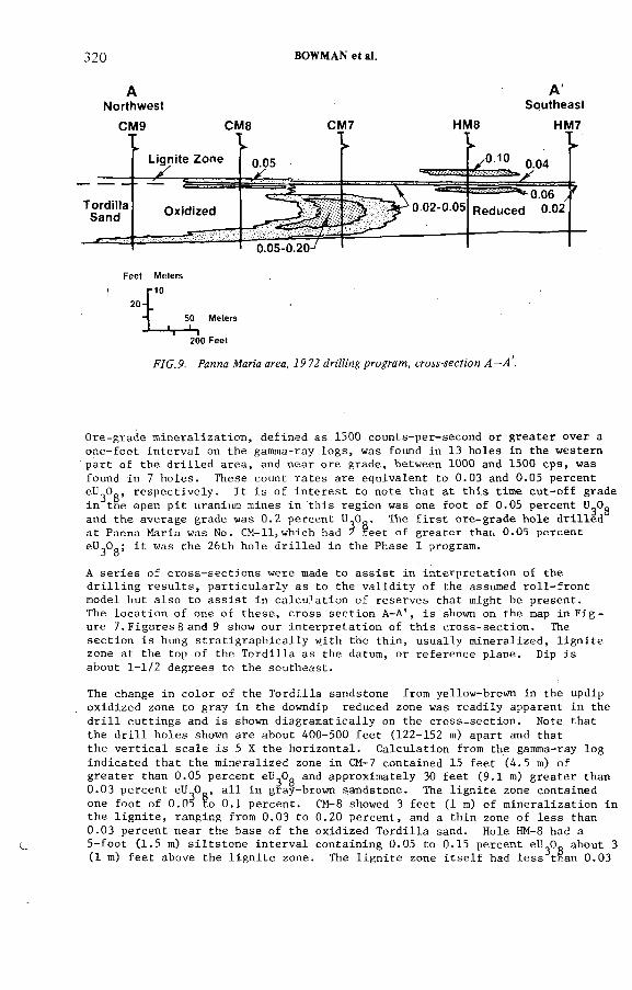
320 BOWMAN et ai.
ANorthwest
CM9 CM8 CM7
10
50 Meters -j-
200 Feet
HM8
ASoutheast
HM7
F/G. 9. Fanna Жаг:'а area, 79 72 (?ri'ZZ¡'H¿r pro^ww, c/-oyj-íeefi'oy!
Ore-grade mineralization, defined as 1500 counts-per-second or greater over a one-foot interval on the gamma-ray logs, was found in 13 holes in the western part of the d r i l led area, and near ore grade, between 1000 and 1500 cps, was found in 7 holes. These count rates are equivalent to 0.03 and 0.05 percent eU^Og, respectively. I t is of interest to note that at this time cut-off grade in tne open p it uranium mines in this region was one foot of 0.05 percent U Og and the average grade was 0.2 percent 4^0^. The f i r s t ore-grade hole d r i l led at Panna Maria was No. CM-llj which had 2 reet of greater than 0.05 percent eU^Og; i t was the 26th hole d r il led in the Phase I program.
A series of cross-sections were made to assist in interpretation of the d r i l l in g results, particularly as to the va lid ity of the assumed ro l l- fron t model but also to assist in calculation of reserves that might be present.The location o f one o f these, cross section A-A', is shown on the map in F i g ure 7.Figures 8 and 9 show our interpretation o f this cross-section. The section is hung stratigraphically with the thin, usually mineralized, l ign ite zone at the top o f the Tordilla as the datum, or reference plane. Dip is about 1-1/2 degrees to the southeast.
The change in color of the Tordilla sandstone from yellow-brown in the updipoxidized zone to gray in the downdip reduced zone was readily apparent in the d r i l l cuttings and is shown diagramatically on the cross-section. Note that the d r i l l holes shown are about 400-500 feet (122-152 m) apart and that the ver t ica l scale is 5 X the horizontal. Calculation from the gamma-ray log indicated that the mineralized zone in CM-7 contained 15 feet (4.5 m) of greater than 0.05 percent eU Og and approximately 30 feet (9.1 m) greater than 0.03 percent eU^O., a l l in gray-brown sandstone. The l ign ite zone contained one foot of 0.05 to 0.1 percent. CM-8 showed 3 feet (1 m) o f mineralization in the l ign ite , ranging from 0.03 to 0.20 percent, and a thin zone of less than0.03 percent near the base of Che oxidized Tordilla sand. Hole HM-8 had a5-foot (1.5 m) siltstone interval containing 0.05 to 0.15 percent eU^Og about 3 (1 m) feet above the l ign ite zone. The l ign ite zone i t s e l f had less than 0.03
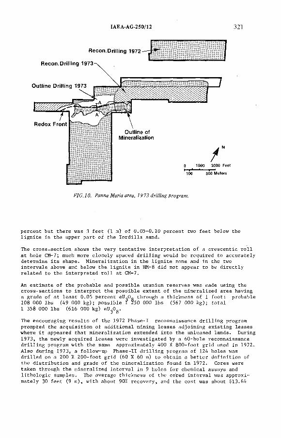
ÍAEA-AG-250/12 32]
percent but there was 3 feet (1 tn) o f 0.05-0.10 percent two feet below the l ign ite in the upper part o f the Tordilla sand.
The cross-section shows the very tentative interpretation of a crescentic r o l l at hole CM-7; much more closely spaced d r i l l in g would be required to accurately determine i ts shape. Mineralization in the l ign ite zone and in the two intervals above and below the l ign ite in HM-8 did not appear to be directly related to the interpreted r o l l at CM-7.
An estimate of the probable and possible uranium reserves was made using thecross-sections to interpret the possible extent of the mineralized area havinga grade of at least 0.05 percent eU 0- through a thickness of 1 foot: probable108 000 lbs (49 000 kg); possible I Z50 000 lbs (567 000 kg); total1 358 000 lbs (616 000 kg) eU.O..
J о
The encouraging results of the 1972 Phase-I reconnaissance d r i l l in g program prompted the acquisition of additional mining leases adjoining existing leases where i t appeared that mineralization extended into the unleased lands. During 1973, the newly acquired leases were investigated by a 60-hole reconnaissance d r i l l in g program with the same approximately 400 X 800-foot grid used in 1972. Also during 1973, a follow-up Phase-11 d r i l l in g program of 124 holes was d r i l led on a 200 X 200-foot grid (60 X 60 m) to obtain a better definition of the distribution and grade of the mineralization found in 1972. Cores were taken through the mineralized interval in 9 holes for chemical assays and l itho log ie samples. The average thickness of the cored interval was approximately 30 feet (9 m), with about 90% recovery, and the cost was about $1.3.64
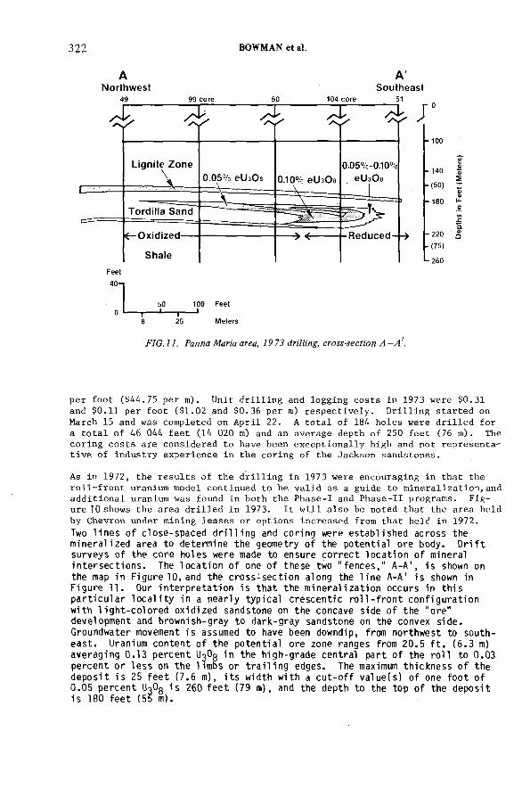
322 BOWMAN et al.
ANorthwest
A'Southeast
4 0 - ]
5 0 -J_ 1 0 0 F e e t __ <*r
8 2 5 M e t e r s
F7C.77. Ралла Afana area, 7Р7.? гййл,у, сгсю-лесУмэл -у!'
per foot ($44.75 per m). Unit d r i l l in g and logging costs in 1973 were $0.31 and $0.11 per foot ($1.02 and $0.36 per m) respectively. D ril l ing started on March 15 and was completed on April 22. A tota l of 184 holes were d r i l led for a tota l of 46 044 feet (14 020 m) and an average depth of 250 feet (76 m). The coring costs are considered to have been exceptionally high and not representat ive of industry experience in the coring of the Jackson sandstones.
As in 1972, the results of the d r i l l in g in 1973 were encouraging in that the ro l l - fron t uranium model continued to be va lid as a guide to mineralization,and additional uranium was found in both the Phase-1 and Phase-11 programs. Figure 10 shows the area dr i l led in 1973. I t w i l l also be noted that the area held by Chevron under mining leases or options increased from that held in 1972.Two l i n e s o f c l o s e - s p a c e d d r i l l i n g and c or i ng were e s t a b l i s h e d a c r o ss the mi n er a l i ze d area to determine t he geometry o f the po t e nt i a l ore body. D r i f t surveys o f the c or e hol es were made to ensure c o r r e c t l o c a t i o n o f minerali n t e r s e c t i o n s . The l o c a t i o n o f one o f t he s e two " f e n c e s , " A-A' , i s shown onthe map in Figure 10, and the c r o s s - s e c t i o n along the l i n e A-A' i s shown in F igu re 11. Our i n t e r p r e t a t i o n i s t h a t t he m i n e r a l i z a t i o n occur s in t h i s p a r t i c u l a r l o c a l i t y in a ne a r l y t yp i ca l c r e s c e n t i c r o l l - f r o n t c o n f i g u r a t i o n with l i g h t - c o l o r e d oxi dized sandstone on the concave s ide o f t he " ore" development and brownish-gray t o dark-gray sandstone on the convex s i d e . Groundwater movement i s assumed to have been downdip, from northwest to sout he a s t . Uranium c o n t en t o f the p o t e n t i a l ore zone ranges from 2 0 . 5 f t . ( 6 . 3 m) averagi ng 0 . 1 3 p e r c e n t UgOg the hi gh-grade c en t r a l p a r t o f the r o l l to 0 . 0 3 pe r c e n t o r l e s s on t he l imbs o r t r a i l i n g edges. The maximum t h i c k n e s s o f t hed e p o s i t i s 25 f e e t ( 7 . 6 m), i t s width with a c u t - o f f v a l u e ( s ) o f one f o o t o f0 . 0 5 p e r c e n t UcOg i s 260 f e e t ( 79 m), and the depth to the top o f the d e p o s i t i s 180 f e e t (55 m).
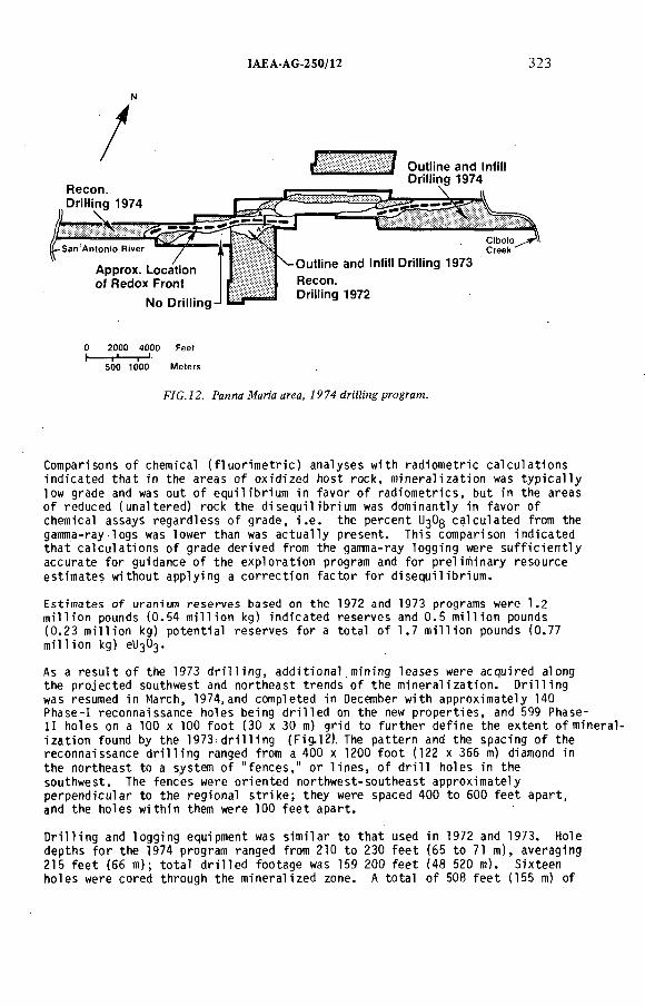
IAEA AG 250/12 323
r.
/
Recon. DriHing 1974
7Approx. Location of Redox Front
! Outiine and in(ii) Driüing 1974
No DriHing-!
^ O u tiin e and in(it) Driüing 1973 Recon.Dritting 1972
0 2000 4000 Feet 1------г*----- г-*
500 1000 M ete rs
F /G . 7 2 . P a n n a M a n a a r e a , / 9 7 4 tZrZZZZng p r o g r a m .
Comparisons o f chemical ( f l u o r i m e t r i c ) a na l ys e s with r a d io me t r i c c a l c u l a t i o n s i n d i c a t e d t h a t in the a r ea s o f ox i di ze d host rock, m i n e r a l i z a t i o n was t y p i c a l l y low grade and was out o f e q u i l i b r i u m in f av or o f r a d i o m e t r i c s , but in the areas o f reduced ( un a l t e r e d ) rock t he d i s e q u i l i b r i u m was dominantly in favor o f chemical assays r e g a r d l e s s o f gr ade , i . e . the p e rc e nt UßOg c a l c u l a t e d from the gamma-ray l ogs was lower than was a c t u a l l y p r es e nt . This comparison i n d i c a t e d t h a t c a l c u l a t i o n s o f grade der ived from the gamma-ray logging were s u f f i c i e n t l y a c c u r at e f o r guidance o f t he e x p l o r a t i o n program and f o r pre l i mi nary r es ourc e e s t i m a t e s without applying a c o r r e c t i o n f a c t o r f o r d i s e q u i l i b r i u m .
E st imat es o f uranium r e s e r v e s based on t he 1972 and 1973 programs were 1 . 2 m i l l i o n pounds ( 0 . 5 4 m i l l i o n kg) i n d i c a t e d r e s e r v e s and 0 . 5 m i l l i o n pounds ( 0 . 2 3 m i l l i o n kg) p o t e n t i a l r e s e r v e s f o r a t o t a l o f 1 . 7 m i l l i o n pounds ( 0 . 7 7 m i l l i o n kg) eU^O^.
As a r e s u l t o f the 1973 d r i l l i n g , a d d i t i o n a l . m i n i n g l e a s e s were acqui red along the p r o j e c t e d southwest and n o r t h e a s t t rends o f t he m i n e r a l i z a t i o n . D r i l l i n g was resumed in March, 1974, and completed in December with approxi mate ly 140 Phase-1 r e co nna is sa nc e hol es being d r i l l e d on the new p r o p e r t i e s , and 599 Phase- 11 ho le s on a 100 x 100 f o o t (30 x 30 m) gr id to f u r t h e r d e f i n e the e x t e n t o f mi neral i z a t i o n found by t he 1973 d r i l l i n g (Fi g. l2 ) . The p a t te rn and the spaci ng o f the r e c o n n ai s s an c e d r i l l i n g ranged from a 400 x 1200 f o o t (122 x 366 m) diamond in t he n o r t h e a s t to a system o f " f e n c e s , " o r l i n e s , o f d r i l l hol es in the sout hwes t . The f e n c e s were o r i e n t e d n or th we s t - s o u t h e a s t approxi mate ly pe rpe ndi cu la r to t he r egional s t r i k e ; they were spaced 400 t o 600 f e e t a p a r t , and the ho le s wi thi n them were 100 f e e t a p a r t .
D r i l l i n g and l oggi ng equipment was s i m i l a r to t h a t used in 1972 and 1973. Holedepths f o r the 1974 program ranged from 210 t o 230 f e e t (65 t o 71 m), averaging215 f e e t (66 m); t o t a l d r i l l e d f oo tage was 159 200 f e e t ( 48 520 m). S i x t e e nh o l e s were cored through the m i n e ra l iz e d zone. A t o t a l o f 508 f e e t (155 m) of
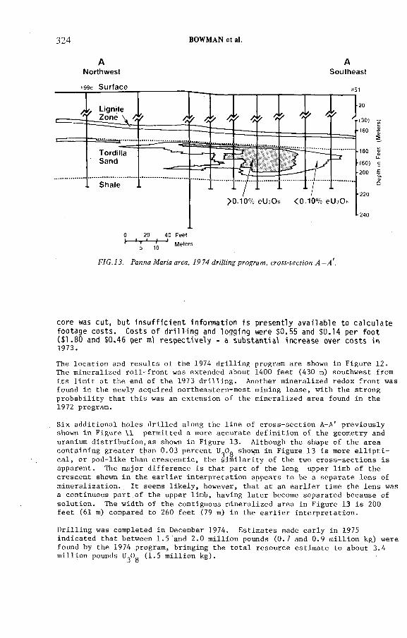
324 BOWMAN et al.
ANorthwest
ASoutheast
FJG. 7 J. Panne №zr:'a area, 79 74 dn'A'ng program, cro^-yecf;on 4 -vt'.
c or e was c u t , but i n s u f f i c i e n t inf ormat ion i s p re s e n t l y a v a i l a b l e to c a l c u l a t e fo ot a ge c o s t s . Costs o f d r i l l i n g and logging were $ 0 . 5 5 and $ 0 . 1 4 per f o o t ( $ 1 . 8 0 and $ 0 . 4 6 per ml r e s p e c t i v e l y - a s u b s t a n t i a l i n c r e a s e over c o s t s in 1973.
The location and results of the 1974 d r i l l in g program are shown in Figure 12. The mineralized ro l l - fron t was extended about 1400 feet (430 m) southwest from its l im it at the end of the 197 3 d r i l l in g . Another mineralized redox front was found in the newly acquired northeastern-most mining lease, with the strong probability that this was an extension of the mineralized area found in the1972 program.
Six additional holes dr il led along the line of cross-section A-A' previously shown in Figure 11 permitted a more accurate definition of the geometry and uranium distribution,as shown in Figure 13. Although the shape of the area containing greater than 0.03 percent U Og shown in Figure 13 is more e l l i p t i cal, or pod-like than crescentic, the sim ilarity of the two cross-sections is apparent. The major difference is that part of the long upper limb of the crescent shown in the ear l ie r interpretation appears to be a separate lens of mineralization. I t seems l ike ly , however, that at an ear l ie r time the lens was a continuous part.of the upper limb, having la ter become separated because of solution. The width of the contiguous mineralized area in Figure 13 is 2Ù0 feet (61 m) compared to 260 feet (79 m) in the earlier interpretation.
D ril l ing was completed in December 1974. Estimates made early in 1975 indicated that between 1.5 and 2.0 million pounds (0.7 and 0.9 million kg) were found by the 1974 program, bringing the total resource estimate to about 3.4 million pounds U Og (1.5 million kg).
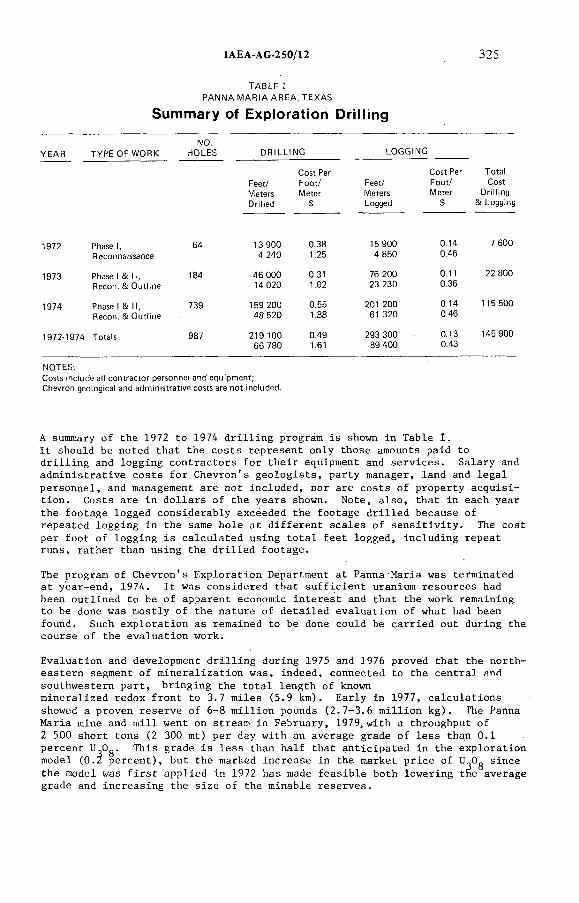
IAEA AG 250/12 325
TABLE I PANNA MARIA AREA. TEXAS
Summary of Exptoration Driüing
YEAR TYPE OF WORKNO.
HOLES DRiLLtNG
Feet/MetersDrifted
Cost PerFoot/Meter
LOGGtNG
Feet/MetersLogged
Cost Per Foot/ Meter
$
Tota! Cost
Drilling & Logging
1972 Phase I, 64 13 900
1973 Phase I & II, 184 46 000Recon. & Outline 14 020
1974 Phase I & II, 739 159 200Recon. & Outline 48 520
1972 1974 Totals 987 219 10066 780
0.38 15 900 0.14 7 6001.25 4 850 0.46
0.31 76 200 0.11 22 8001.02 23 230 0.36
0.55 201 200 0.14 115 5001.88 61 320 0.46
0.49 293 300 0.13 145 9001.61 89 400 0.43
NOTES.
A summary of the 1972 to 1974 d r i l l in g program is shown in Table I.I t should be noted that the costs represent only those amounts paid to d r i l l in g and logging contractors for their equipment and services. Salary and administrative costs for Chevron's geologists, party manager, land and legal personnel, and management are not included, nor are costs of property acquisition. Costs are in dollars o f the years shown. Note, also, that in each year the footage logged considerably exceeded the footage dr i l led because of repeated logging in the same hole at d ifferent scales of sens it iv ity . The cost per foot of logging is calculated using tota l feet logged, including repeat runs, rather than using the dr i l led footage.
The program of Chevron's Exploration Department at Panna Maria was terminated at year-end, 1974. I t was considered that su ffic ient uranium resources had been outlined to be of apparent economic interest and that the work remaining to be done was mostly o f the nature of detailed evaluation of what had been found. Such exploration as remained to be done could be carried out during the course of the evaluation work.
Evaluation and development d r i l l in g during 1975 and 1976 proved that the northeastern segment o f mineralization was, indeed, connected to the central and southwestern part, bringing the tota l length of knownmineralized redox front to 3.7 miles (5.9 km). Early in 1977, calculations showed a proven reserve of 6-8 million pounds (2.7-3.6 million kg). The Panna Maria mine and m ill went on stream in February, 1979,with a throughput of 2 500 short tons (2 300 mt) per day with an average grade of less than 0.1 percent UßOg. This grade is less than half that anticipated in the exploration model (0.Z percent), but the marked increase in the market price of sincethe model was f i r s t applied in 1972 has made feasible both lowering tne average grade and increasing the size of the minable reserves.
326 BOWMAN et al.
1. The ro l l - fron t model proved to be a valid premise on which to design an exploration program. Oxidized and reduced (unaltered) sandstones were readily iden tif iab le in d r i l l cuttings, making location of the redox front a re la t ive ly simple matter in most of the area. In cross-sectionthe mineralized ro l l - fron t is not a perfect crescent and its dimensions are different than were assumed in the model; i t is longer, narrower, thicker and of lower grade:
Length Width Thickness Grade
Model: 1000 f t 300 f t 20 f t 0.2%
Cross-section: Several 200 f t 28 ft < 0.1%1000's f t
2. In areas such as Panna Maria, fu l l use should be made of both subsurface and surface information relating to the stratigraphy of potential uranium host rocks. When exploring on a small lease holding, i t is not enough to know that a particular sandstone is productive a few miles away; one should know that there is a high probability that a good host rock is present in the specific area o f interest.
3. The spacing of d r i l l holes was satisfactory in that the redox front was readily located and most o f i ts length was found to be mineralized. Had we been certain that a l l potentially economic mineralization would occur as visualized in the model, a number of holes updip and downdip from the front could have been omitted. We considered the mode.l to be a guide only, and therefore designed the d r i l l in g program to test a l l the acreage held. As a result some small, thin areas of low-grade mineralization were found that were not d irectly connected to the main ore zone, but are presently part oí the ore reserves.
4. I t is apparent from the cross-sections that the thickest and highest grade part o f the mineralized r o l l front is approximately 100 feet (30 m) wide; fo r this reason i t s geometry cannot be closely defined by a 100 X 100 foot (30 X 30 m) outline d r i l l in g pattern. We believe that in future exploration of deposits of this type a series of "fences" o f closely spaced holes should be dr i l led across the trend o f the ro l l during the la tte r stages of the outline d r i l l in g program; the fences being 400 to 600 feet (120 to 240 m) apart and the holes within the fences being approximately 25 feet (7.6 m) apart. Also, several of the holes in each fence should be twinned by core holes through the ore zone. The additional knowledge gained by this closely spaced d r i l l in g would greatly assist the exploration group in deciding whether or not the much more detailed and expensive development d r i l l in g program should be recommended. Moreover, i f the results were encouraging, i t very l ik e ly would be most helpful in persuading management to approve the necessary funds for development d r i l l in g .
5. Although the Panna Maria o i l f i e l d , which produces from the Edwards l imest one (Lower Cr et aceous) a t a depth o f about 10 000 f e e t , l i e s beneath much o f the uranium d e p o s i t , i t i s b e l i e ve d t h a t the l eakage o f H2 S or hydrocarbon gases from the petroleum r e s e r v o i r did not play a major r o l e in p r e c i p i t a t i o n o f the uranium in the v i c i n i t y o f the Panna Maria mine.
CONCLUSIONS
IAEA AG 250/12 327
REFERENCES
1. EARGLE, D. H. and WEEKS, A.M.D. , F a c t o r s in t h e . f o r m a t i o n o f uraniumd e p o s i t s , Coastal P l a i n o f Texas , Texas Univ. Bur. Economic Geol . Guidebook, No. 3 ( 1 9 6 8 ) .
2 . EARGLE, D. H., HINDS, G. W., and WEEKS, A.M.D. , Uranium geology andmines, South Texas, Houston Geol . S o c i e t y , Houston, Texas, Guidebook,f i e l d t r i p o f the Houston Geol . Soc . f o r the American Assoc, o f Petroleum G e o l o g i s t s ( 1 9 7 1 ) .
3 . HARSHMAN,.E. N., Uranium ore r o l l s in the United S t a t e s , in UraniumE xp l or at i on Geology ( Pr oc . Panel Vienna, 1970) IAEA Vienna (1970)
' 219.
4 . KLOHN, M.L. , and PICKENS, W.R. , Geology o f the Fe lder uranium d ep o si t ,Live Oak County, Texas, S o c i e t y Mining Engi neers , p r e p r i n t No. 7 0 - 1 - 7 8 , New York, N.Y. ( 1 9 7 0 ) .
5. EARGLE, D. H., TRUMBULL, J . , and МОХНАМ, R.M., Pre l i mi na ry a e r o r a d i o -a c t i v i t y and g e o l og ic Map o f Karnes Ci t y , NW quadrangle , Karnes County, Texas, U.S. Geol Survey, Geophysical I n v e s t i g a t i o n Map GP 251 ( 1 9 6 1 ) .
6 . МОХНАМ, R.M., and EARGLE, D.H. , Airborne r a d i o a c t i v i t y and g eo lo gi c mapo f the Coastal P la i n a re a , S out he as t Texas, U.S. Geol . Survey, Geophysical I n v e s t i g a t i o n s map GP-198 ( 1 9 6 1 ) .
DISCUSSION
D.A. PORTER: What development spacing did you use for the proven reserve estimation?
E.C. BOWMAN: Development spacing was 33 m on a rectangular grid.In addition, lines o f core holes were drilled across the deposit at intervals o f
approximately 200 m with holes in these lines 17 to 33 m apart.D.A. PORTER: A t what cut-off was the reserve calculation based?E.C. BOWMAN: Reserve calculation was based on a cut-off grade o f 0.61 m
of0.03%U30g.H.D. FUCHS: You have shown that the thickening o f the sands o f the
Jackson Group is more or less parallel to the indicated shore line and does not seem to follow the river system. What is the reason for this?
E.C. BOWMAN: The thickest development o f the Jackson sands does appear, in total, to be approximately parallel to the shore line. In detail, however, the isoiiths o f the individual sands show axes o f thickness that approach perpendicularity to the coast in response to having been deposited in aggrading
fluvial distributory channels.H.D. FUCHS: Can you recognize any faulting parallel to the shore line
which may have influenced the sedimentation pattern?E.C. BOWMAN: We have not recognized the influence o f faulting on the
distribution o f the Jackson sands in the Panna Maria area.

IAEA-AG-250/17
DISCOVERY OF THE CLUFF DEPOSITS, SASKATCHEWAN, CANADA*
J. DARDELDélégation aux matières nucléaires,Commissariat à l'énergie atomique,Paris,France
5%orf СОМТЙМТНСЯЙОЯ
An airborne scintiHometric survey in 1967 over a part o f the Athabasca sandstone basin in the north-west corner o f the province o f Saskatchewan provided some contrast-free data at the centre o f the Carswell crypto-explosion structure.
As a result o f ground reconnaissance o f one o f the anomalies to the north-east o f Lake C luff in July 1968, uraninite-pitchblende pebbles were found in the vicinity o f an abnormal contact between sandstones and a gneissic-granite basement, followed by the discovery o f in-situ mineralizations in pre-Athabasca metamorphites (C lu ff D), in Athabasca sandstones (CiuffsB andE)and in 'volcanic' breccias associated with the emplacement o f the Carswell structure (C lu ff F). The uranium content o f the erratic pebbles as nodules in the breccia zone o f C luff D can be as much as 70%.
During the 1969 field season, exploration o f the contact between the gneissic- granite core and the sandstone aureole in the Carswell structure was continued together with systematic prospecting around the C luff uranium occurrences. The techniques used included scintillometry (ground and helicopter-borne), emanometry, ground magnetometry, geological survey, trenching and shallow drilling (518 m o f coring with the Winkie minidrill). The m ain findings o f this season were:
(a) The pattern o f glacial dispersion o f uranium-containing pebbles in the cover.
(b ) The diversity o f rocks with uranium mineralization.(c ) The complexity o f the geological framework o f the in-situ mineralization.(d ) The uranium-organic matter association in gneisses and sandstones, and
the frequent presence o f gold associated with high uranium content.(e ) The important mineralization in crushed gneisses in the first borehole at
occurrence N.( f ) The important mineralization in a chlorite-rich rock in the first borehole
at occurrence D o f vein type in gneisses; the mineralization would be in an overturned imbricated structure within the Athabasca sandstone near the unconformity under the metamorphic basement.
* The complete text was not submitted for publication.
329
330 DARDEL
During the subsequent seasons, from !970 to 1975, checking o f mining properties and a systematic study o f the mineralizations continued and new targets were set.
Deposit N was developed by driHing in 1970 to 1971, deposit D in 1971 to 1972, and deposit Claude or ZA in 1972 to 1973. The study o f mineralizations О-P to the north o f D, R and F, to the east and to the south o f N, o f the source o f the glacial trains S and o f occurrences A A (Dominique) began between 1969 (F ) and 1974 (A A ). Exploration o f this region was rendered difficult by the overlapping o f a glacial and periglacial cover and a circular cryptoexplosion structure, the tectonic features o f which resemble those o f a diapiric plug; outcrops are rare, and always highiy dislocated.
The techniques used were therefore numerous at the scale o f the Carswell structure (black-and-white and false-colour infra-red aerial photography, photogeology, helicopter-borne scintiHometry and spectrometry, airborne magneto- metry, regional geochemistry, study o f the cover and mapping) and at the detailed scale o f occurrences and targets (systematic scintillometry, emanometry, geochemistry, trenching, geological mapping, resistivity, magnetometry, VLF, gravity, seismic reflection and seismic refraction).
Deposit D is located in an oblique and folded imbricated and overturned structure between sandstones and basement; the mineralization occurs as a thin
layer in the sandstones a few metres away from the unconformity.The mineralization in the form o f uraninite-pitchblende is in a phytlitic
material with rpilcd detritic minerals. The ore is rich in organic carbon with appreciable concentrations o f boron, selenium and gold. Its average uranium content is 6 %.
The N and Claude deposits are located in crush zones with a radial direction in relation to the Carswell structure. Deposit N extends into a brecciated corridor between granitoid gneisses and a variated gneissic sequence with more silica and alumina, while the Claude deposit is located in a fractured quartz-feldspathic gneiss complex. The main mineralization is in the form o f uraninite-pitchblende and coffinite accompanied by phyllites and carbonaceous matter. The average uranium content varies from 0.25% to 0.4%.
The present reserves at C luff are 13 700 t o f uranium in an ore with an average uranium content o f 0.9%; in mineralizations, mainly in extension o f the deposits described above, the estimated additional resources are in the order o f 3800 t o f uranium in ores with an average uranium content o f 0.5%.
DÎSCUSSÎON
C. TEDESCO: My question pertains partly to your present paper but is more general also. I would like to know whether, in the episyenitization process
IAEA-AG-250/17
that appears to be wide-spread in the area and connected with several types o f uranium deposits, the overall balance is a significant loss o f potash and i f this loss might be represented by using the anomaly in the radiometric K-channei.
J. DARDEL: First, I am not sure that the final balance o f the episyenitization leads to the loss o f potassium. Secondly, in this case you have a granitic contribution which is quite potassic and which enriches the rock, which migmatizes in potassium. You have potassium in there that is a bit too strong and too high. I don't think the loss o f potassium is a very clear balance; what is clear, however, is that if the quartz leaves you have a loss o f quartz, and here I disagree with you a little. I f the quartz leaves, it means the rock is fractured. There is a tectonic history behind it: it crushes the rock; the rock becomes porous and permeable, so there is a loss o f quartz, and anything available becomes transported. So 1 don't think the loss o f potassium is that clear so far as the balance is concerned. Don't you think, in general, that there could be a loss o f potassium in episyenitization which is associated with that? Let us say that, as far as the alteration o f the biotite into muscovite goes, it is different.
H.D. FUCHS: I don't like the term 'episyenitization' very much because it implies a genetic term. A syenite is something which is intrusive. I think it is a good working term, especially when used in France, and Mr. Gélÿ has also mentioned it a lot in the literature, but I think we should not use the term episyenitization just for depletion o f rock or quartz or whatever when you are talking about alteration or decomposition o f rocks. It could perhaps lead to some misunderstanding because I don't believe there is any classical hydrothermal action in this process.I am just suggesting that we ought to be a bit careful with this term because it is not familiar to English- or German-speaking people, and I would, therefore, like to have this term replaced by 'alteration in general' or 'decomposition'.
P. BARRETTO.: What is the distance between the aerial survey anomaly and the first ore body?
J. DARDEL: The first boulder is right under the anomaly; 5 m according to the photopoint. The ore body I mentioned is about 100 m.
P. BARRETTO: Now that you know exactly where the ore bodies are, if you look at the aerial survey records can you identify any amplitude changes or other indications that could be related to the ore body mineralization?
J. DARDEL: The airborne radiometric profile does not pass exactly over the deposit D (in any case, the deposit D crops out in the valley). No anomalous radioactivity has been recorded in the surface over the deposit.

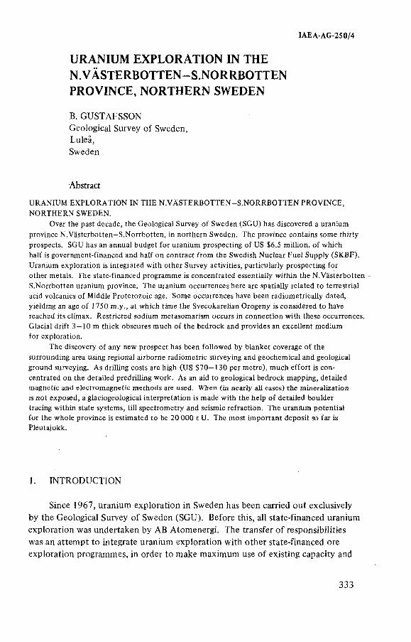
IAEA AG 250/4
URANIUM EXPLORATION IN THE N.VÄSTERBOTTEN-S.NORRBOTTEN PROVINCE, NORTHERN SWEDEN
B. GUSTAFSSON Geological Survey o f Sweden, Luleâ, Sweden
Abstract
URANIUM EXPLORATION IN THE N.VÄSTERBOTTEN-S.NORRBOTTEN PROVINCE,
NORTHERN SWEDEN.
Over the past decade, the Geological Survey of Sweden (SGU) has discovered a uranium
province N.Västerbotten-S.Norrbotten, in northern Sweden. The province contains some thirty
prospects. SGU has an annual budget for uranium prospecting of US $6.5 million, of which
half is government-financed and half on contract from the Swedish Nuclear Fuel Supply (SKBF).
Uranium exploration is integrated with other Survey activities, particularly prospecting for
other metals. The state-financed programme is concentrated essentially within the N.Västerbotten-
S.Norrbotten uranium province. The uranium occurrences here are spatially related to terrestrial acid volcanics of Middle Proterozoic age. Some occurrences have been radiometrically dated,
yielding an age of 1750 m.y., at which time the Svecokarelian Orogeny is considered to have reached its climax. Restricted sodium metasomatism occurs in connection with these occurrences.
Glacial drift 3 —10 m thick obscures much of the bedrock and provides an excellent medium for exploration.
The discovery of any new prospect has been followed by blanket coverage of the
surrounding area using regional airborne radiometric surveying and geochemical and geological
ground surveying. As drilling costs are high (US $70-130 per metre), much effort is con
centrated on the detailed predrilling work. As an aid to geological bedrock mapping, detailed magnetic and electromagnetic methods are used. When (in nearly all cases) the mineralization
is not exposed, a glaciogeological interpretation is made with the help of detailed boulder tracing within state systems, till spectrometry and seismic refraction. The uranium potential for the whole province is estimated to be 20 000 t U. The most important deposit so far is Pleutajokk.
1. INTRODUCTION
Since 1967, uranium exploration in Sweden has been carried out exclusively by the Geological Survey o f Sweden (SGU). Before this, all state-financed uranium exploration was undertaken by AB Atomenergi. The transfer o f responsibilities was an attempt to integrate uranium exploration with other state-financed ore exploration programmes, in order to make maximum use o f existing capacity and
333
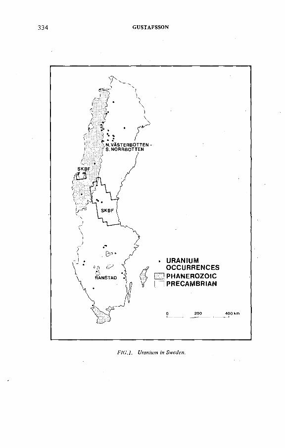
334 GUSTAFSSON
FVG.A í/гаятт м Sweden.
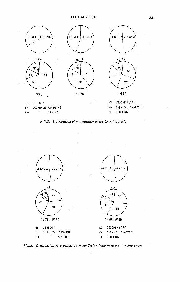
IAEA-AG-250/4
KG КА
1 9 7 7
KG КА
1978 1979
BB GEOLOGY
FF GEOPHYSIC AIRBORNE
FM " GROUND
KG GEOCHEMISTRY
KA CHEMICAL ANALYSES
ВТ DRILLING
F/C.2. D^fri&Mfícn o/expenditure ¡'л t/¡e ЖД^рго/ect.
КА
1 9 7 8 / 1 9 7 9
BB GEOLOGY
FF GEOPHYSIC AIRBORNE
FM " GROUND
КА
1979/ 1980
KG GEOCHEMISTRY
KA CHEMICAL ANALYSES
ВТ DRILLING
.ÜMfn'&MííOH о/expenditure ¡'л f e gfafe-/[nanced ыгапшт exp/orafíon.
336 GUSTAFSSON
know-how within various specialities o f exploration and geological expertise throughout the country [ 1 ]. Initially the budget was rather modest but it increased rapidly and is now at about US $6.5 million o f which half is state-financed and half on contract from the Swedish Nuclear Fuel Supply (SKBF).
The SKBF contract is restricted to a 35 000-km^ area in the central part o f Sweden and to a five-year period o f which two years remain (see Fig. 1).The invested expenditure is evenly distributed over this period. During the initial stages o f the exploration programme, regional surveys concentrating on airborne geophysics are emphasized. During the latter stages, detailed investigations involving extensive drilling consume the bulk o f the expenditure (Fig.2).
The state-financed programme relates to the remaining part o f the country, and the detailed prospecting work is for the present essentially concentrated within the N.Västerbotten—S.Norrbotten uranium province, a 20 000-km^ area in northern Sweden (Fig. 1). A financial grant is awarded on a one-year basis, and expenditure between regional and detailed surveys, as well as between different specialities, is kept in balance from one year to another (Fig.3).
2. REGIONAL METHODS
Airborne spectrometry and geochemical sampling o f organic stream material are frequently used in a regional exploration programme. For the former,100 000 line km are flown annually, covering some 20 000 km^ or 4% o f the
country. The methods used are VLF, magnetometry and gamma-ray spectrometry. Profiles 200 m apart are flown at a height o f 30 m and at a speed o f 70 m - s"* ; readings are taken during 30 m in every 40-m length. The results are plotted by computer on a three-component (three-colour) radiometric map [ 2 ].
Organic samples from stream edges are collected with a density o f 0.5 samples per km^. In anomalous areas samples are taken every 300 m along streams,which give a mean density o f about 3 to 4 samples per km^ [3]. Some 20 000 km^ are covered every year.
The main object o f most o f these regional geophysical and geochemical surveys is not only uranium exploration, but exploration for other metals and minerals closely integrated with geological mapping. It is estimated that, at the present rate o f progress, Sweden should be adequately investigated by the above methods in twenty years.
3. DETAILED METHODS
Uranium exploration in Sweden has during the last twelve years been confined to the Precambrian rocks. As exposure is generally poor, geophysical, geo
IAEA AG 250/4 337
chemical and glaciogeological studies have been an essentia! supplement to bedrock geological mapping. Fortunately, large areas have been built up by a till cover which has proved an excellent medium for exploration in northern Sweden [4]. Work on a local scale is therefore to a large extent concerned with studies involving different types o f till and moraine which characterize exploration in this area.
Ore-bearing structures have been located using ground geophysics, magnetic and EM methods. Soil emanometry and snow emanometry have been used but have not yielded satisfactory results. Snow radiometry has given good results but is often overlooked in favour o f the slower but more effective boulder-tracing [5]. Seismic refraction is used to determine the soil depth as an aid to glaciogeological
interpretation and drilling.Geochemical sampling used in uranium exploration is nowadays restricted
to organic material along streams and to peat sampling along swamp margins. Soil-mapping with glaciogeological interpretation is fundamental. Boulder-tracing and till spectrometry on the fine-grain material are two important applications to glaciogeology.
During the last decades, glacial geology has played an increasing part in complex ore exploration. Studies o f morphology and till material provide information about direction and distance o f glacial transport. Owing to the physical properties o f the glacier, the fine-grained fraction tends to occur more proximally to its source than the boulders [4], and this is utilized for geochemical till-sampling [ 6 ]. In uranium exploration, 'till spectrometry' is preferred,and for this method a 60-cm-deep pit is dug and boulders and pebbles removed. A gamma- ray spectrometer is placed at the bottom o f the pit and covered with fine-grained material from the pit walls before recording. The results are plotted as eU/eTh values which eliminate the background uranium variation, and this can be positively correlated with the thorium content. The uranium mineralizations are mainly monometallic.
A ll rock samples collected by SGU are measured radiometrically and all drillholes are gamma-logged. Carborne and snowscooter-borne methods were used earlier with some good results [ 1 ] but were discontinued because they were uneconomic. In northern Sweden, local people are encouraged to participate in private prospecting during their free time, and SGU supports this by lending out, for example, scintillometers. Promising discoveries are recognized by an award- giving board.
4. THE N .VÄSTERBO TTEN-S.NO RRBO TTEN URANIUM PROVINCE
4.1. Genera! features
The province has a gentle topography varying between 400 and 800 metres above sea-level and is bounded to the west by the Swedish Caledonide mountain
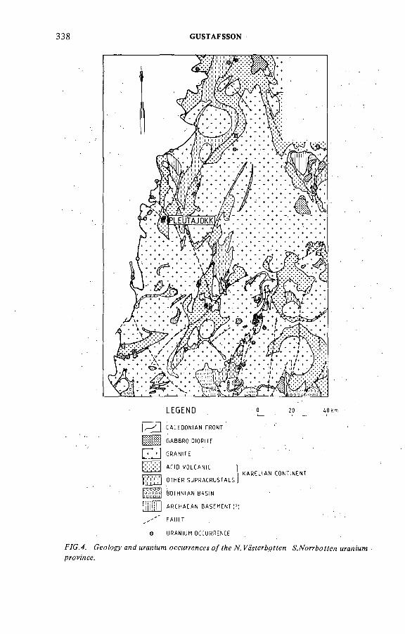
338 GUSTAFSSON
F/G. 4.
L E G E N D 0 20 40km
1 ^ * I CALEDONIAN FRONT ' '*
¡:;:;:;:g:№ ¡ GABBRO.DIORITE
j GRANITE
K?:-:- ACID VOLCANIC 1
I ! KARELIAN CONTINENT
I ; ' , I OTHER suPRACRusTALsj
^ BOTHNIAN BASIN
[¡¡¡lj!!l ARCHAEAN BASEMENT(4 . ' FAULT . . .
o URANIUM OCCURRENCE
Geo/ogy and tiraMiMW оссмг/-йлсе^ о/?йе TV. мгапштprOMHCf.
IAEA-AG 250/4 339
range. The cümate is subarctic with a mean temperature in January o f — 12°C and in July o f + 13°C. Precipitation is 500 mm per year and is evenly distributed. The dominant soit profile is podzoiic in character and nearly half o f the area is covered by lakes. The rest comprises coniferous forests, swamps and barren mountains. Less than 1% is outcropped [ 1 ].
4.2. Geological setting
The province is located at the southern margin o f the Karelian Continent close to the Bothnian Basin marine sediments to the south. Along the contact between the terrestrial and marine sediments is located the Skellefte sulphide province which possesses many characteristics o f an island arc environment. It has been postulated that the contact represents a subduction zone in terms o f a plate-tectonic model. The supracrustal rocks have been folded, faulted, recrystallized and intruded by plutonites during different stages o f the Svecokarelian Orogeny which culminated approximately 1750 m.y. ago. Volcanites are also preserved from a late stage o f the Orogeny. In Late Precambrian times an extensive erosion during 1000 m.y. took place. In Upper Precambrian times the Caledonian geosyncline was formed with deposition o f arenites and pelites on the Precambrian Peneplane [7] (Fig.4).
4.3. Uranium occurrences
The uranium occurrences are associated with areas o f both pre-Orogenic and Late Orogenic terrestrial acid volcanics. They are deposited partly in metarhyolites and synkinematic granitoids o f Svecokarelian age and partly at the contact between Upper Precambrian sediments and underlying regolith. The character o f the former type is mostly hydrothermal, monometallic or with titanium, preceded by sodium metasomatism. The mineralizationshave been dated to 1750 m.y., which coincides with the culmination o f the Svecokarelian Orogeny. The uranium is high grade (0.1% U) and spatially related to basic dykes. The sediment-regolith type is o f supergene character and occurs within the black kerogenic parts o f arenites, or in arenites with a clayish matrix, in the vicinity o f the uranium concentrations in the Precambrian basement [7] (Fig.4).
4.4. Case histories
4.4.7. DAs'coyerM
The first three uranium finds were reported in 1969 and consisted o f (a ) an archive sample o f Caledonian Front radioactive material; (b ) a radioactive drill- core from a manganese occurrence further to the north; and (c ) some uranium
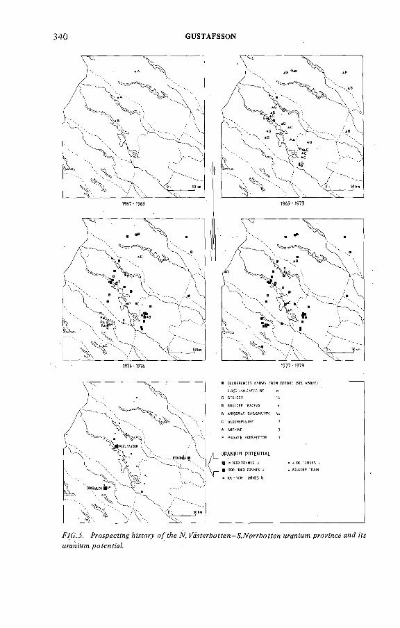
340 GUSTAFSSON
F/C.J. ProípeetMf /¡Mfoo' o/ fAe Л. ^ä'jferAoyfen-&7Vorr&offen мгап/мл? province and ¡'Я
М7*ал!'мл! potential.
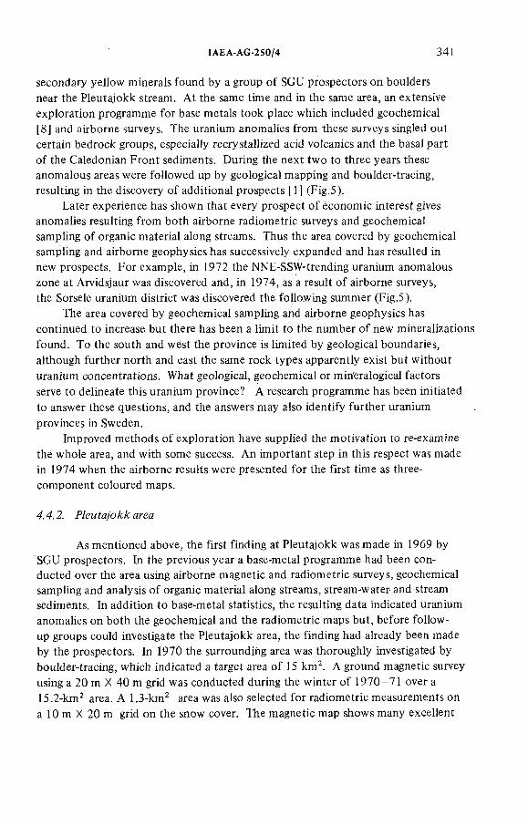
IAEA AG-250/4 341
secondary yellow minerals found by a group of SGU prospectors on boulders near the Pleutajokk stream. At the same time and in the same area, an extensive exploration programme for base metals took place which included geochemical [8] and airborne surveys. The uranium anomalies from these surveys singled out certain bedrock groups, especially recry stallized acid volcanics and the basal part o f the Caledonian Front sediments. During the next two to three years these . anomalous areas were followed up by geological mapping and boulder-tracing, resulting in the discovery o f additional prospects [1] (Fig.5).
Later experience has shown that every prospect o f economic interest gives anomalies resulting from both airborne radiometric surveys and geochemical sampling of organic material along streams. Thus the area covered by geochemical sampling and airborne geophysics has successively expanded and has resulted in new prospects. For example, in 1972 the NNE-SSW-trending uranium anomalous zone at Arvidsjaur was discovered and, in 1974, as a result o f airborne surveys, the Sorsele uranium district was discovered the following summer (Fig.5).
The area covered by geochemical sampling and airborne geophysics has continued to increase but there has been a limit to the number o f new mineralizations found. To the south and west the province is limited by geological boundaries, although further north and east the same rock types apparently exist but without uranium concentrations. What geological, geochemical or mineralogical factors serve to delineate this uranium province? A research programme has been initiated to answer these questions, and the answers may also identify further uranium provinces in Sweden.
Improved methods o f exploration have supplied the motivation to re-examine the whole area, and with some success. An important step in this respect was made in 1974 when the airborne results were presented for the first time as three- component coloured maps.
4.4.2. Р/ем fa/o area
As mentioned above, the first finding at Pleutajokk was made in 1969 by SGU prospectors. In the previous year a base-metal programme had been conducted over the area using airborne magnetic and radiometric surveys, geochemical sampling and analysis o f organic material along streams, stream-water and stream sediments. In addition to base-metal statistics, the resulting data indicated uranium anomalies on both the geochemical and the radiometric maps but, before follow- up groups could investigate the Pleutajokk area, the finding had already been made by the prospectors. In 1970 the surrounding area was thoroughly investigated by boulder-tracing, which indicated a target area o f 15 km\ A ground magnetic survey using a 20 m X 40 m grid was conducted during the winter o f 1970-71 over a 15.2-km^ area. A 1.3-knP area was also selected for radiometric measurements on a 10 m X 20 m grid on the snow cover. The magnetic map shows many excellent
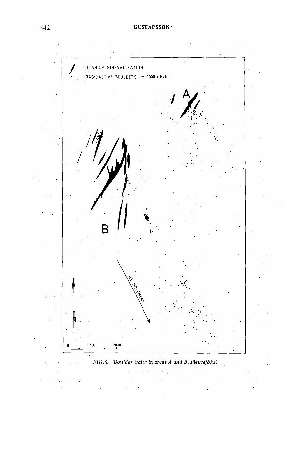
342 GUSTAFSSON
KfC.6. BouMer traim in areas ,4 ая B, Píeufa/ó^!
ÎAEA-AG-250/4 343
bedrock structures hidden by a 4—10 m-thick till cover. The radiometric survey also located boulder trains and an area comprising granite boulders o f anomalously high background radioactivity.
During the summer o f ]971 a soil emanometry survey was carried out in the same area as the snow radiometry, employing a similar measuring density. A boulder-train study was initiated which entailed detailed boulder-tr'acing carried out on a 40 m X 40 m grid in a 5.3-km^ area with the aim o f detecting every boulder o f anomalous radioactivity for a boulder-train study (Fig.6 ). A t the same time, topographic features that may have affected the shapes o f the boulder trains were mapped (e.g. lakes, swamps, steep slopes, erosional channels in the moraine).
As a result o f comparison between the boulder map, the snow radiometric map and the soil radon map, the radiometric highs could be perfectly correlated with the boulder trains, and there was an anomaly proximal to the boulder trains. The emanometry resulted only in spot anomalies, and the radon distribution in general was confusing. The boulders in areas A and В were interpreted as being locally derived.
Diamond drilling commenced in 1972 within the proximal part o f the A - boulder train (Fig.6 ), and the mineralization was cut with the first drill-hole.The boulder train in area В can be divided into three or four clusters. They were originally interpreted as different trains from more than one source, distributed along the south-west side o f the main fault between areas A and В (Fig.7).190 short percussion drill-holes, totalling 1060 m, in reconnaissance profiles across those clusters gave positive results only in the proximal part o f the large boulder train. In 1973 a diamond-drilling programme began on the indicated mineralization B, and by 1975 the principal mineralizations in areas A and В were relatively well known down to 150 m below surface, after 50 holes had been drilled yielding a total o f 11 000 m. Later drillings have given more detailed information o f the near surface geology and provided extended knowledge o f the ore to 500 m depth. The maximum depth o f the ore is still unknown, and the figures for reasonably assured resources are given in Table I.
Exploratory drilling started in area С during 1973 but was discontinued in 1976 when intensive drilling began in areas A and B. Although some mineralizations had been indicated, they have not yet been followed up.
In 1972 another airborne radiometric survey was carried out and in 1975 the results were displayed on three-component maps. Distinct uranium anomalies became apparent just north o f the mineralized area previously known.
During the ground follow-up in 1975, three new boulder trains and a radio-, active outcrop were found. The area o f detailed boulder-tracing was subsequently extended for another 5.4 km^ (Fig.8 ) and the area o f magnetic survey for 9.8 km^. An EM survey with 60-m coil spacing and 18 kHz was conducted in a 20 m X 40 m grid over 18.4 km^ to locate water-bearing crush zones, which have caused con
siderable drilling problems.
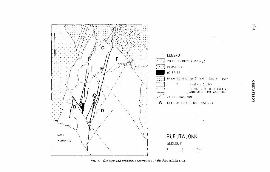
L E G E N D
YOUNG GRANITE (1600 m.y. )
PEGMATITE
DOLERITE
METAVOLCANIE , R H Y O D A C I H C , OAEITiC TUFF
, ANDES I T I C LAVA
RHYOLITE WITH INTERLAIN
, ANOESITIC LAVA AND TUFF
FAULT, ERUSHZONE
URANI UH OCEURRENCE I f750 m.y.)
PLEUTAJOKKG E O L O G Y
0 1 2 km
PVG. 7. Gic/ogy a^d мгаТ 'мтя оссмггепсе о/ ?Ле Р/емУа/о area.
344 G
USTAFSSO
N
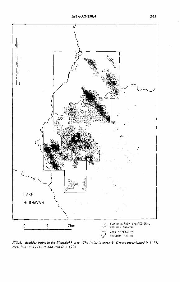
IAEA-AG-250/4 345
2km __t
F
BOULDERS FROM SEMIREGIONAL
BOULDER TRACING
AREA OF DETAILED
BOULDER TRACING
F/G.& ВсиИегУга;нл:л f/¡ePZeMfa/o area. ГАе frawsi'nareas^-Gwerewyesf^aye^w 7P77,
areas F-G :'n /$7J-7d and areaD ¡n 797d.
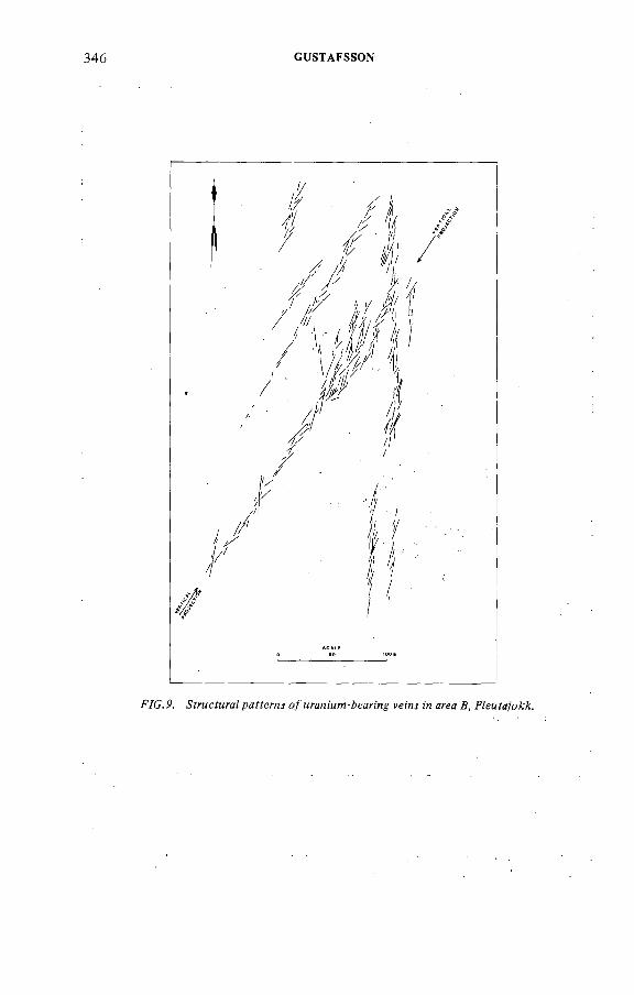
346 GUSTAFSSON
F /C . P. -S'frMcfMraZ pafferns <?/мгапшм-Аеагм^ ferns м area Д, FZeMfa/o^.
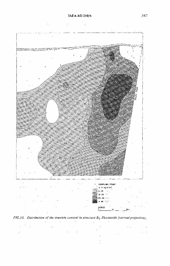
IAEA-ÀG 250/4 347
F/G./0. DMinAMfion о/ fAe KraMi'MW w Д^, P^Mfg/pMr /мг^м/р.'-о/е^Я'ои^
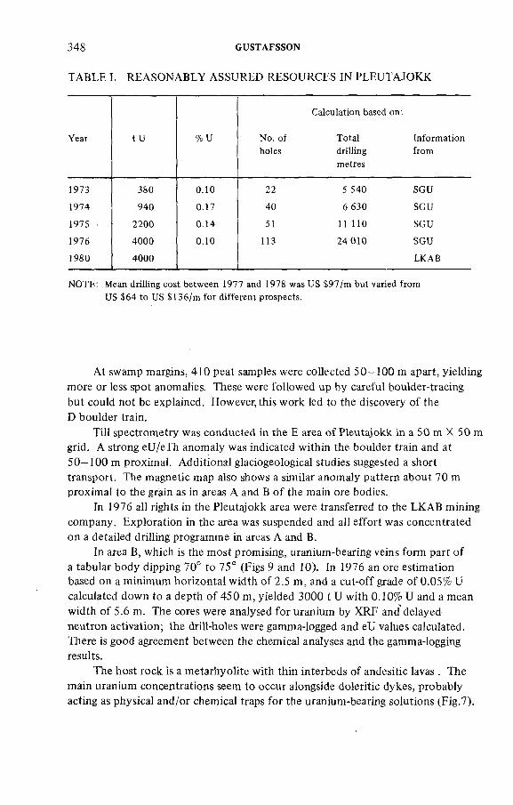
348 GUSTAFSSON
TABLE I. REASONABLY ASSURED RESOURCES IN PLEUTAJOKK
Year tu %U No. of
holes
Calculation based on .
Total
drilling
metres
Information
from
1973 380 0.10 22 5 540 SGU
1974 940 0.17 40 6 630 SGU
1975 2200 0.14 51 11 110 SGU
1976 4000 0.10 113 24 010 SGU
1980 4000 LKAB
NOTE: Mean driHing cost between 1977 and !978 was US $97/m but varied from
US $64 to US $ 136/m for different prospects.
At swamp margins, 410 peat samples were collected 50—100 m apart, yielding more or less spot anomalies. These were followed up by careful boulder-tracing but could not be explained. However, this work led to the discovery o f the D boulder train.
Till spectrometry was conducted in the E area o f Pleutajokk in a 50 m X 50 m grid. A strong eU/eTh anomaly was indicated within the boulder train and at 50—100 m proximal. Additional glaciogeological studies suggested a short transport. The magnetic map also shows a similar anomaly pattern about 70 m proximal to the grain as in areas A and В o f the main ore bodies.
In 1976 all rights in the Pleutajokk area were transferred to the LKAB mining company. Exploration in the area was suspended and all effort was concentrated on a detailed drilling programme in areas A and B.
In area B, which is the most promising, uranium-bearing veins form part o f a tabular body dipping 70° to 75° (Figs 9 and 10). In 1976 an ore estimation based on a minimum horizontal width o f 2.5 m, and a cut-off grade o f 0.05% U calculated down to a depth o f 450 m, yielded 3000 t U with 0.10% U and a mean width o f 5.6 m. The cores were analysed for uranium by XRF and delayed neutron activation; the drill-holes were gamma-logged and eU values calculated. There is good agreement between the chemical analyses and the gamma-logging results.
The host rock is a metarhyolite with thin interbeds o f andesitic lavas . The main uranium concentrations seem to occur alongside doleritic dykes, probably acting as physical and/or chemical traps for the uranium-bearing solutions (Fig.7).
IAEA AG 250/4 349
The anomalous metarhyolite comprises an area o f 35 krrP and is bounded in the north by volcanites o f different facies with iow uranium content, and to the west and east by a younger granite. To the south there is a deep trough, occupied by Lake Hornavan. It was initially considered that the mineralizations were generated from the nearby granite, but geochronological studies involving a Rb-Sr whole- rock isochron study o f the granite gave an age o f 1591 ± 35 m.y., while the uranium mineralization is significantly older, 17381'° m.y., according to a U-Pb determination [9]. The uranium mineralizations are now believed to be epigenetic, having been remobilized from the rhyolite and redeposited during (a) devitrification and (b ) the regional metamorphism which took place at that time.
5. URANIUM PO TE NTIAL OF THE N .VÂSTERBOTTEN-S.NORRBOTTENPROVINCE
The Pleutajokk deposit has now become a mining target with a reasonably assured potential in areas A and В o f 4000 t U (0.1% U). Estimated additional resources amount to 1000 t U and the potential resources o f the other parts o f Pleutajokk are estimated to be 6000 t U. The uranium potential o f the whole Pleutajokk area is considered to be in the region o f 10 000 t U. Several interesting prospects o f high quality, and estimated 1000 t U, have also been found in the immediate vicinity o f the Pleutajokk area.
One o f the most important peripheral deposits is the Dobblon mineralization, which is a stratabound uranium mineralization in rhyolitic ignimbrites o f a late orogenic stage [10]. Reasonably assured resources are 4400 t U (0.027% U ) with
richer horizons giving 1000 t U o f 0.04% U. A number o f occurrences around Dobblon are being examined but this work has so far yielded poor results, although some promising prospects remain to be investigated.
The Kvarnân deposit is situated some 150 km eastwards. The uranium mineralization occurs as parallel lenses some 700 m long in a metasupracrustal rock-type. Extensive drillings have successively increased the ore volume so that, at the moment, reasonably assured resources amount to 1000 t U (0.05% U) or 500 t U o f 0.1% U. This will probably improve during the next six months o f drilling.
Within the Pleutajokk-Dobblon-Kvarnân triangle there are still a number o f promising prospects, mostly consisting o f boulder trains which, statistically, should contribute significantly to the uranium reserves in the province. Drillings have been conducted at eighteen such prospects, o f which five were investigated thoroughly enough to be considered for exploitation. For the remaining thirteen prospects, drilling is continuing as planned. Drillings are also planned for twelve more new prospects.
350 GUSTAFSSON
The uranium potential o f the whole province is estimated to be 20 000 t U o f which two-thirds consists o f 0.1 % U or more.
in 1976, SGU relinquished exploration rights o f the Pleutajokk area to the LKAB mining company, who have estimated that i f the reasonably assured resources increase from 3000 t U (0.1 % U) to 4000 t U, this should be adequate to start mining with a back-up dressing plant. This prerequisite o f an extra 1000 t U should be obtained from several small occurrences o f high-grade ore in the province (Fig.5). ' . < .
REFERENCES
[ I ] LUNDBERG, B., "Exploration for uranium through giacial drift in the Arjeplog district,
northern Sweden", Prospecting in Areas of Giacial Terrain (Proc. Symp. Trondheim,
1973) ÏMM London (1973) 31-43.
[2] LINDEN, A.H., ÂKERBLOM, G., "Method of detecting small or indistinct radioactive
sources by airborne gamma-ray spectrometry", Geology, Mining and Extractive Processing
of Uranium (Proc. Mtg. London, 1977), IMM, London (1976) 113—120.
[3] LARSSON, J.O., Organic stream sediments in regional geochemical prospecting,
Precambrian Pajala district, Sweden, J. Geochem. Explor. 6 (1976) 233—249.
[4] MINELL, H., Glaciologicat interpretations of boulder trains for the purpose of prospecting
in till, Geol. Surv. Sweden, Mem. and Not., Ser.C, 743 (1978).
[5] GUSTAFSSON, B., MINELL, H., "Case history of discovery and exploration of Pleutajokk
uranium deposit, northern Sweden", Prospecting in Areas of Glaciated Terrain (Proc. Symp.
Helsinki, 1977), IMM, London (1977) 72—79.
[6] BRUNDIN, N.H., BERGSTRÖM, J., Regional prospecting for ores based on heavy minerals
in glacial till, J. Geochem. Explor. 7 (1977) 1 — 19.[7] ADAMEK, P.M., WILSON, M.R., The evolution of a uianium province in N. Sweden,
Proc. R. Soc. (London) 291 (1979) 355-368.[8] BRUNDIN, N.H., NAIRIS, B., Alternative sample types in regional geochemical
prospecting, J. Geochem. Explor. 1 (1972) 7—46.[9] WILSON, M.R., SUNDIN, N.O., Isotopic age determinations on rocks and minerals from
Sweden 1960—1978, Geol. Surv. Sweden, Rep. and Comm. 16 (1979).[10] LINDROOS, H., SMELLIE, J., A stratabound uranium occurrence within Middle
Precambrian ignimbrites at Dobblon, northernSweden, Econ. Geol. 74 (1979) 1118—1130.
DISCUSSION
M. M ATO LÍN : Did you experience any difficulties with the detector in the low temperature o f snow-scooter technique, and how low was the temperature?
B. GUSTAFSSON: We did not experience any difficulties due to the low temperature, which for weeks could be between —20°C and —40°C. We used the same crystals during the five winters when we carried out snow-scooter measurements. The crystals were thermo-insulated to guarantee a change in temperature iess than ]°C per hour. The same crystals were used during the summers in ordinary ground radiometry work.
ÍAEA-AG-250/4 35]
C.'TEDESCO: Did you have any difficulties in using the snow-scooter?B. GUSTAFSSON: The probiem was that work had to be done in areas far '
from roads,.and that is why.snow-scopters were used. But the scooters needed repair occasionally, and this wasted a lot o f time. So they became too expensive to use. . . .
D. TA YLO R : I know you have used both core drilling and deep percussion drilling in the Pleutajokk area. Can you comment on the use o f the two techniques?
B. GUSTAFSSON: Deep percussion drilling was used in the Pleutajokk. where a lot o f core drillings had been made before and after percussion drilling. Percussion drilling could not go deeper than 100 m owing to the water pressure. Percussion drilling costs were about two-thirds those o f core drilling, although large differences in hole-diameter gamma-logging could be obtained with the same sound and with comparable results in both core-holes and percussion holes.There are good agreements between results from chemical analyses o f cores and gamma-logging in drill holes. Percussion drilling was performed between old core- holes in a surface near parts where the mineralization was already reasonably well known. A fter the percussion drilling, a core-drilling programme was set up to penetrate the mineralization at deeper levels and where more geological information was required.
A.G. ANGEIRAS: In Brazil we have two important episodes o f uranium mineralization related to albitization. An early episode occurred at about 850 m.y. following shear zones; the country rocks are 2500 m.y. The later episode is related to the Itataia deposit, where mineralization is younger than 500 m.y. I would like to know some details about the early albitization such as:
(a) What are the additional minerals to the albitization;(b ) How are the uranium bearing albite-rich rocks graded into the country
rocks?(c) What is the Na/К ratio in the country rocks?B. GUSTAFSSON: (a) Two general types have been distinguished: (i) albite-
chiorite quartz; (ii) aibite-aegerine-riebeckite-chlorite (furthermore hematite, zircon, sericite and calcite can occur).
(b ) I do not know about this transition in detail, but for certain mineralization sudden changes can occur across one metre; for other mineralizations there is a gradual transition through the alteration zone into the country rocks.
(c ) The Na/К ratios in the country rocks, acid volcanics and granitoids vary between 3:5 and 1.1. The same ratios in the mineralizations vary between 3:1 and 100:1. Each mineralization has its specific ratio. The alkali content is 8 - 10% .
B.L. NIELSEN: What kind o f control do you think the dolerite types in the Lilljuthatten area have on the distribution o f the uranium in the granite? It seemed obvious that a substantial part o f the anomalies was parallel to the dykes.
352 GUSTAFSSON
В. GUSTAFSSON: Uranium occurrences in the vicinity o f doterite dykes have been observed in several localities in the Precambrian basement in Sweden, but the reason has not been satisfactorily explained. There are several hypotheses for various areas depending on differences in occurrence. In Lilljuthatten,NW SKBF area, we believe that the same deep-seated structure controls both the dolerite dykes and the uranium mineralizations. A ll dykes are older than the mineralizations; immediately adjacent to the dykes there may have been chemical and mechanical traps for minor concentrations within the mineralizations themselves.
B.L. NIELSEN: Did you investigate the magnitude o f the absorption o f the gamma rays in various thicknesses o f the snow layers in connection with your snow-scooter surveys, and did you make any correction for such absorption?
B. GUSTAFSSON: We did some simple tests before we started. I have not seen the results, but the absorption due to the snow was very low. We have detected radioactive boulders below 2 m o f snow cover; with a normal depth o f 1 m to 1.5 m there is no difficulty in detecting them. No corrections have been made.
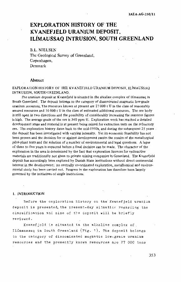
IAEA-AG-250/11
EXPLORATION HISTORY OF THE KVANEFJELD URANIUM DEPOSIT, ILÍMAUSSAQ INTRUSION, SOUTH GREENLAND
B.L. NIELSENThe Geological Survey o f Greenland, Copenhagen, Denmark
Abstract
EXPLORATION HISTORY OF THE KVANEFJELD URANIUM DEPOSIT, ILÍMAUSSAQ
INTRUSION, SOUTH GREENLAND.
The uranium deposit at Kvanefjeld is situated in the alkaline complex of Ilimaussaq in
South Greenland. The deposit belongs to the category of disseminated magmatic low-grade
uranium resources. The resources known at present are 27 000 t U in the class of reasonably
assured resources and 16 000 t U in the class of estimated additional resources. The ore body
is still open in two directions and the possibility of considerably increasing the resource figures
is high. The average grade of the ore is 340 ppm U. Exploration work has reached a detailed
development stage and material is at present being mined for extraction tests on the refractory
ore. The exploration history dates back to the mid-1950s, and during the subsequent 25 years
the deposit has been investigated with varying intensity. Yet its economic feasibility has not
been proven and the decision for or against development awaits the results of the metallurgical
pilot-plant tests and the solution of a number of environmental and legal questions. A lapse
of three to five years is expected before a final decision can be made. The character of the
exploration in the area is determined by the fact that exploration licences for radioactive
materials are traditionally not given to private mining companies in Greenland. The Kvanefjeld
deposit has accordingly been explored by Danish State institutions without direct commercial
interest in the development; no centrally co-ordinated exploration, metallurgical and environmental study has been carried out. Progress in the exploration has therefore been largely
governed by the initiatives of single institutions.
I. INTRODUCTION
B efore the e x p lo ra t io n h is t o r y on the K v a n e f je ld uranium
d ep os it i s presented, the p resen t-day s i tu a t io n re ga rd in g the
c l a s s i f i c a t i o n and s i z e o f the d ep os it w i l l be b r i e f l y
r e v ie w e d .
K v a n e f je ld is s i tu a te d in the a lk a l in e complex o f
I l im aussaq in South Greenland (F i g . 1 ) . The d ep os it belongs
to the ca tego ry o f d issem inated magmatic low -grade uranium
resources and the p r e s e n t ly known resources are 27 000 tons
353
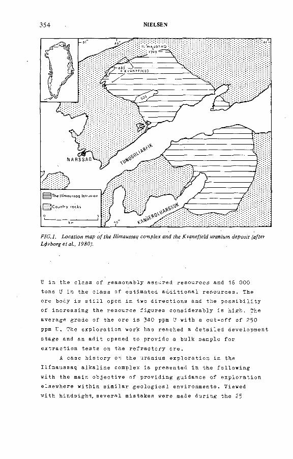
354 NÍELSEN
F/C. 7. ¿осайол wap о/ //¡' амяд comp/еж and уйе ffane/)eZd муал;'мл: ¿ерол'г fa/fer
U in the c la s s o f reasonab ly assured resources and 16 000
tons U in the c la ss o f est im ated a d d i t i o n a l r e sou rces . The
ore body i s s t i l l open in two d i r e c t io n s and the p o s s i b i l i t y
o f in c re a s in g the resource f i g u r e s con s id e ra b ly i s h igh . The
average grade o f the ore i s 340 ppm U w ith a c u t - o f f o f 250
ppm U. The e x p lo ra t io n work has reached a d e ta i l e d development
s tage and an a d i t opened to p rov id e a bulk sample f o r
e x t r a c t io n t e s t s on the r e f r a c t o r y o re .
A case h is t o r y on the uranium e x p lo ra t io n in the
I l im aussaq a lk a l in e complex is presen ted in the f o l l o w in g
w ith the main o b j e c t i v e o f p ro v id in g guidance o f e x p lo ra t io n
e lsewhere w ith in s im i la r g e o l o g i c a l environments. Viewed
w ith h inds igh t, s e v e ra l mistakes were made during the 25
IAEA AG-250/11 355
years o f e x p lo r a t io n , a lthough a l l d e c is io n s were thought
to be r i g h t or the bes t p o s s ib le ones a t the time they were
taken. I t i s hoped that the d e s c r ip t io n below o f the l o g i c
or need o f l o g i c in the long sequence o f events may help
to a d ju s t some presen t and fu tu re uranium e x p lo ra t io n
programme in the op tim a l d i r e c t i o n . Some o f the s p e c i f i c
f i e l d op e ra t ion s are l i s t e d in Table I to g e th e r w ith cost
f i g u r e s where a v a i l a b l e .
An a p p r e c ia t io n o f the uranium e x p lo ra t io n in the
I l im aussaq complex up to the presen t can on ly be made with
an understanding o f a number o f con d it ion s and c r i t e r i a ,
some o f which are s p e c i f i c f o r th is p a r t i c u la r p r o j e c t .
1) The e x p lo ra t io n h is t o r y has been v e ry long , almost 25
y ea rs , and a d e c is io n to go in to p roduct ion has s t i l l
not been taken. The background f o r th is i s mainlythe m arg inal economy o f the low-grade uranium o re .
The d ep os it has n eve r th e le s s become g ra d u a l ly more
a t t r a c t i v e in v iew o f the g e n e ra l p r ic e development
on the uranium market. The long e x p lo ra t io n h is t o r y
a lso means tha t the e x p lo ra t io n techniques used
range from ra th e r p r im i t i v e methods to re cen t advanced
techn iques .
2) T h e e x p l o r a t i o n h as , f r o m th e v e r y b e g i n n i n g , b e e n
c a r r i e d o u t b y D a n i s h S t a t e i n s t i t u t i o n s , e a c h of t h e m
w i t h o u t a n y d i r e c t i n t e r e s t or d e p e n d e n c e o n th e e c o
n o m i c f e a s i b i l i t y of the p r o j e c t .
3 ) The uranium d e p o s i t at K v a n e f je ld i s s i tu a te d w ith in
a su b a rc t ic area w ith an unusually high percen tage
o f g e o l o g i c a l exposure. This im p l ie s that g e o l o g i c a l
methods have p layed a p r in c ip a l r o l e in the e x p lo ra t io n
ra th e r than g e op h ys ica l or geochem ica l methods.
4 ) T r a d i t i o n a l l y , p r i v a t e mining companies have not obta ined
perm iss ion f o r the e x p lo ra t io n o f r a d io a c t i v e m in era ls ;
and because o f th is the uranium e x p lo ra t io n has been
c a r r ie d out by the Danish S ta te and d i r e c t e d by the
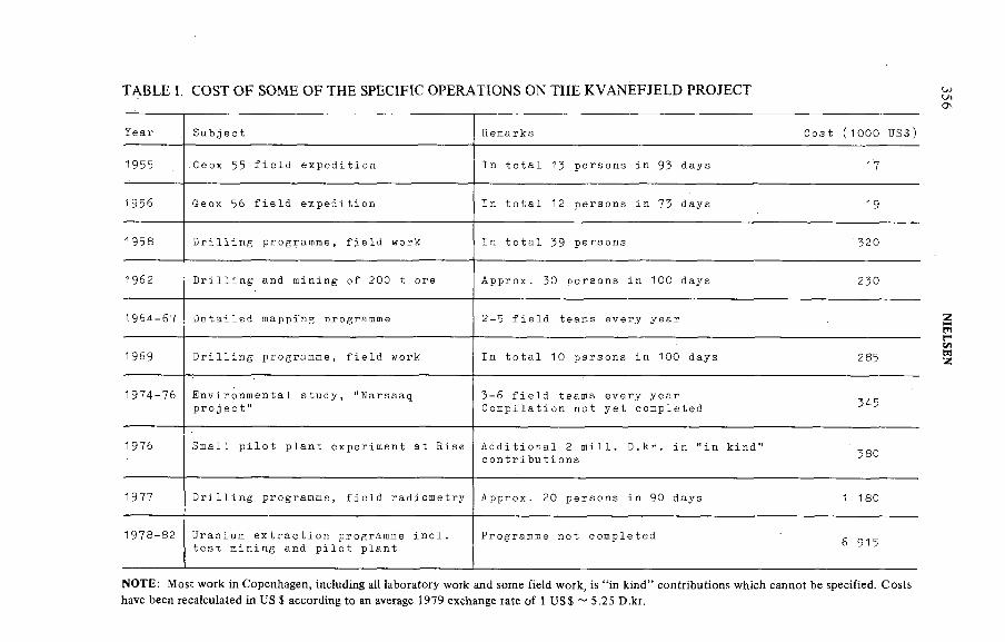
TABLE I. COST OF SOME OF THE SPECIFIC OPERATIONS ON THE KVANEFJELD PROJECT
Year Subject Remarks Cost (1000 US$)
1955 Geox 55 field expedition In total 13 persons in 93 days 1*7
1956 Geox 56 field expedition In total 12 persons in 73 days 19
1958 Drilling programme, field work In total 39 persons *320
1962 Drilling and mining of 200 t ore Approx. 30 persons in 100 days 230
1964-67 Detailed mappi'ng programme 2-5 field teams every year
1969 Drilling programme, field work In total 10 persons in 100 days 285
1974-76 Environmental study, "Narssaq project"
3 -6 field teams every year Compilation not yet completed 345
1976 Small pilot plant experiment at Risz Additional 2 mill. D.kr. in "in kind" contributions
380
1977 Drilling programme, field radiometry Approx. 20 persons in 90 days 1 180
1978-82 Uranium extraction programme incl. test mining and pilot plant
Programme not completed6 915
NOTE: Most work in Copenhagen, including all laboratory work and some field work, is "in kind" contributions which cannot be specified. Costs have been recalculated in US $ according to an average 1979 exchange rate of 1 US $ *- 5.25 D.kr.
356 N
IELSEN
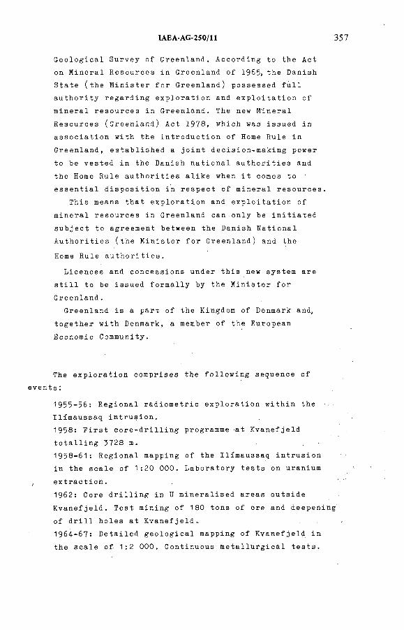
IAEA-AG 250/11 357
G e o lo g ic a l Survey o f Greenland. A ccord ing to the Act
on M inera l Resources in Greenland o f 1965, the Danish
S ta te ( th e M in is t e r f o r Greenland) possessed f u l l
a u th o r i t y re ga rd in g e x p lo ra t io n and e x p l o i t a t i o n o f
m inera l resou rces in Greenland. The new M inera l
Resources (G reen land ) Act 1978, which was issued in
a s s o c ia t io n w ith the in t r o d u c t io n o f Home Rule in
Greenland, e s ta b l is h e d a j o in t dec is ion -m ak ing power
to be ves ted in the Danish n a t io n a l a u th o r i t i e s and
the Home Rule a u th o r i t i e s a l i k e when i t comes to
e s s e n t ia l d i s p o s i t i o n in re sp ec t o f m inera l r e sou rces .
This means that e x p lo ra t io n and e x p l o i t a t i o n o f
m inera l resou rces in Greenland can on ly be i n i t i a t e d
su b jec t to agreement between the Danish N a t ion a l
A u th o r i t i e s ( th e M in is t e r f o r Greenland) and the
Home Rule a u t h o r i t i e s .
L icences and concessions under th is new system are
s t i l l to be issued fo rm a l ly by the M in is t e r f o r
Greenland.
Greenland i s a part o f the Kingdom o f Denmark and,
t o g e th e r w ith Denmark, a member o f the European
Economic Community.
The e x p lo ra t io n comprises the f o l l o w in g sequence o f
even ts :
1955-56: R eg ion a l ra d io m e tr ic e x p lo ra t io n w ith in the
I l im aussaq in t ru s io n .
1958: F i r s t c o r e - d r i l l i n g programme at K v a n e f je ld
t o t a l l i n g 3728 m.
1958-61: R eg ion a l mapping o f the Il im aussaq in t r u s io n
in the s ca le o f 1:20 000. L abo ra to ry t e s t s on uranium
, e x t r a c t io n .
1962: Core d r i l l i n g in U m in e ra l is ed areas ou ts id e
K v a n e f je ld . Tes t mining o f 180 tons o f ore and deepening
o f d r i l l h o les a t K v a n e f je ld .
1964-67: D e ta i l e d g e o l o g i c a l mapping o f K v a n e f je ld in
the s c a le o f 1:2 000. Continuous m e ta l lu r g ic a l t e s t s .

358 NIELSEN
1969: Third c o r e - d r i l l i n g programme at K v a n e f je ld ,
t o t a l l i n g 1621 m.
1970-76: L im ited f i e l d work. M e t a l lu r g i c a l work and
f e a s i b i l i t y s tu d ie s . Environmental study on the geo
chem istry in the I l im aussaq area i n i t i a t e d .
1977: Fourth c o r e - d r i l l i n g programme, t o t a l l i n g 5ЮЗ m.
E x tens ive f i e l d gamma-spectrometer survey . Resources
increased, from 5 800 tons U to 27 000 tons U. Small
p i l o t e x t r a c t io n p la n t .
1978-80: Major change in ap p l ied e x t r a c t io n techn ique.
Improvement in r e co v e ry r a te from 60% to 85%. A d it
opened f o r the mining o f 5 000 tons o f ore f o r new
p i l o t p la n t . Further environm ental in v e s t i g a t i o n s .
2 THE EARLIEST HISTORY
The onset o f the uranium e x p lo ra t io n in the Il im aussaq
in t r u s io n i s l inked w ith the estab lishm ent o f the Danish Atomic Energy Commission (AEK) in March 1955- Three months
l a t e r the la t e P r e s id e n t o f AEK, N ie l s Bohr, in a l e t t e r
to the Department o f Greenland (C ran landsdepartem entet )
s t re s s ed the importance o f i n i t i a t i n g e x p lo ra t io n f o r
r a d io a c t i v e raw m a te r ia ls on Danish t e r r i t o r y . The AEK
po in ted at the p o t e n t ia l o f three a lk a l in e in t r u s iv e
complexes in South Greenland, I l im aussaq , G rannedal-Ika
and I g a l i k o , on the bas is o f c on su lt ion w ith the G e o lo g ic a l
Survey o f Greenland (GGU). The AEK a lso po in ted at the
advantage o f a p p ly in g a number o f p rosp ec to rs in a f i e l d
programme su perv ised by g e o lo g i s t s as opposed to a
t e c h n ic a l l y more d i f f i c u l t a e r i a l survey . The f i e l d work
was recommended to beg in im m ediate ly in order to ga in the
g r e a t e s t p o s s ib le exp e r ien ce , and the 1955 season should
be regarded as a " t e s t y e a r " . GGU s e le c t e d three minor
areas w ith in I l im aussaq and Crannedal-Ika f o r the f i r s t
f i e l d season.
The gen e ra l g e o lo g y o f the I l im aussaq in tru s io n was
w e l l known and descr ibed by Ussing (191 2 ), and from the
m in e r a lo g ic a l work by Lorenzen (1881) the s teen s tru p in e
found in some o f the I l im aussaq rocks' was known to con ta in
IAEA-AG-250/11 359
thorium. The radioactivity of steenstrupine was also mentioned by Boggild ( 1 9 0 5 ) . This information was probably the main reason for the in i t i a l high priori ty of the Ilimaussaq intrusion as a favourable exploration target.
The Grannedal-Ika complex was being mapped by GGU
g e o lo g i s t s during the f i e l d work in the I v i g t u t area
fu r th e r to the north (Emeleus, 1964).
Because o f the l a t e s t a r t o f the f i e l d season no
g e o l o g i s t s were a v a i l a b l e f o r the p r o je c t and i t was
dec ided to s t a f f the p r o je c t w ith Danish m i l i t a r y personnel
under the t e c h n ic a l guidance o f one eng ineer o f geophys ics
and a p a r t - t im e g e o l o g i c a l consu ltan t from GGU's f i e l d
team in the ne ighbouring areas .
' No d e t a i l e d p lanning o f the f i e l d work was ca r r ie d
out that year and the i n i t i a l phase o f the e x p lo ra t io n was
not the bes t p o s s ib le .
The conc lus ions from the f i r s t years o f f i e l d work
were that fu r th e r work should take .place in Il im aussaq
and that a r e g io n a l a e r i a l survey should be s t r o n g ly
cons idered . The g e i g e r measurements taken a long l in e s
proved to be too slow a method f o r a r e g io n a l e x p lo ra t io n
programme. Very l i t t l e e va lu a t ion was done on the data o f
the 1955 e x p e d i t io n , and because o f th is n e i th e r GGU nor
the in v o lv e d m i l i t a r y a u th o r i t i e s expected f i e l d work to
be continued the f o l l o w in g year . N e ve r th e le ss the AEK in
the l a t e sp r ing o f 1956 made arrangements f o r a second
f i e l d season, and once again the survey was planned w ithout
adequate g e o l o g i c a l support. One g e o l o g i s t , however, took
part in the f i e l d work which in 1956 was supplemented w ith
an a irb o rn e s c in t i l l o m e t e r survey . During the 1956 opera
t io n the on ly a e r i a l survey eve r c a r r ie d out w ith in the
I l im aussaq area was completed. The sys tem atic f i e l d work
w ith the g e i g e r counters in 1955 and 1956 r e s u l te d in an
almost complete coverage o f the in t ru s io n . A lthough the
c o l la b o r a t io n between the m i l i t a r y personnel in charge o f
the " t e c h n ic a l " p rosp ec t in g and the g e o l o g i s t a t te n d in g the
f i e l d work was v e ry l im i t e d a f t e r the re tu rn to Denmark i t
was concluded that the most important r a d io a c t i v e m in e r a l is a t io n
360 NIELSEN
was found in the n e p h e l i n e syenite, lujavrite, and
p a r t i c u l a r l y in the lujavrite of the K v a n e f j e l d area. Not
only was the r a d i o a c t i v i t y g e n e r a l l y hi g h e r here, but the
l ujavrite was also p resent in c o n s i d e r a b l e q u a n t i t y and a
s u b s t a n t i a l part is e x p o s e d at the .surface.
The aerial survey was extended the same yea r to the
G r a n n e d a l - I k a and I v igtut area to the north. However, the
r e sults of this w o r k did not ju s t i f y i n t e n s i f i e d e x p l o r a t i o n
w i t h i n that region.
With the e v a l u a t i o n of the re s u l t s fro m the 1955 and
1956 programmes, the u r a n i u m d eposit at K v a n e f j e l d had been
located. A l t h o u g h some r e g i o n a l w o r k was car ried out in the
f o l l o w i n g year, the m a i n effort was t h e r e a f t e r d e v o t e d to
an e l u c i d a t i o n of the d i s c o v e r y at K v a n e f j e l d . The f o l l o w i n g
c h a pters will a c c o r d i n g l y d e s c r i b e the de p o s i t in a more
s y s t e m a t i c manner, its g e o g r a p h i c a l and g e o l o g i c a l s e t t i n g
as w ell as the d e v e l o p m e n t of the va r i o u s stag es in the
e x p l o r a t i o n of the deposit. The g e n e r a l h i s t o r y of the
g e o l o g i c a l e x p l o r a t i o n of the I l i m a u s s a q c o mplex up to
1966 was d e s c r i b e d by H. S z r e n s e n (1967); this paper deals
s o l e l y wit h the u r a n i u m e x p l o r a t i o n and w i t h the K v a n e f j e l d
area in particular.
3. GEOGRAPHICAL SETTING
2The K v a n e f j e l d area forms a 2 . 5 - k m hil l y p l a t e a u at
an e l e v a t i o n of 5 0 0 - 7 0 0 metres. It is s i t u a t e d in South
G r e e n l a n d at a g e o g r a p h i c a l p o s i t i o n of 60°58' nor t h and
46°00' west (Fig. 1). The d i s t a n c e to Narssaq, the local
a d m i n i s t r a t i v e centre and port w i t h 2 500 inhabitants, is
a bo u t 8 km. The c l imate is arctic wit h a v erage temp e r a t u r e s
at N a r s s a q of -3-3°C and +7-5°C for J a n u a r y and July
r es p e c t i v e l y . C l i m a t i c con d i t i o n s are not likely to put
a ny serious l i m i t a t i o n on a p o s s i b l e o p e n - p i t m i n i n g operation.
In g e n e r a l , a c c e s s to the area is easy and the n e a r b y deep
f jords are n a v i g a b l e for most of the year.
4. GEOLOGY
K v a n e f j e l d is situa t e d at the n o r t h e r n border of the
I l i m a u s s a q a l k a l i n e complex b e l o n g i n g to the Ga r d a r i g neous
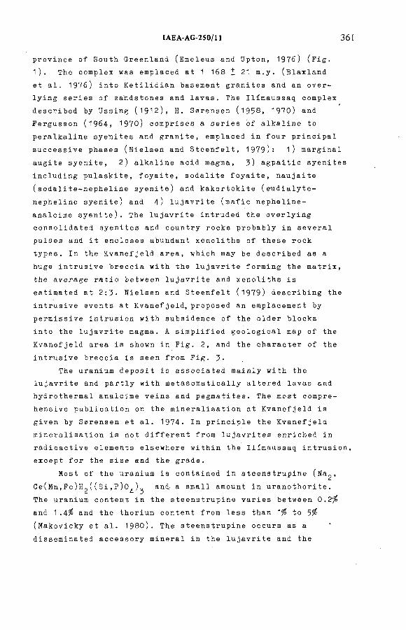
ÏAEA-AG 250/П 361
p r o v i n c e of Sou t h G r e e n l a n d ( E m eleus and Upton, 1976) (Fig.
1). The c o mplex was e m p l a c e d at 1 168 Í 21 m.y. (Blax l a n d
et al. 1976) into K e t i l i d i a n b a s e m e n t g r a n i t e s and an over-
l y i n g series of s a n d s t o n e s and lavas. The I l i m a u s s a q c o mplex
d e s c r i b e d by U s s i n g (1912), H. S 0r e n s e n (1958, 1970) and
F e r g u s s o n (1964, 1 9 7 0 ) c o m p r i s e s a series of a l k a l i n e to
p e r a l k a l i n e s y e n i t e s and granite, e m p l a c e d in four p r i n c i p a l
s u c c e s s i v e pha s e s ( N i e l s e n and S teenfelt, 1979): 1) m a r g i n a l
augite syenite, 2 ) a l k a l i n e acid magm a, 3 ) a g p a i t i c syenites
i n c l u d i n g p u laskite, foyaite, s o d a l i t e foyaite, n a u j a i t e
( s o d a l i t e - n e p h e l i n e syenite) and k a k o r t o k i t e ( e u d i a l y t e -
n e p h e l i n e syen ite) and 4) l u j a v r i t e (mafic n e p h e l i n e -
a n a l c i m e syenite). The l u j a v r i t e i n t r u d e d the o v e r l y i n g
c o n s o l i d a t e d s y e n i t e s and c o u n t r y rocks p r o b a b l y in s everal
pulses and it e n c l o s e s a b u n d a n t x e n o l i t h s of these r ock
types. In the K v a n e f j e l d area, w h i c h may be d e s c r i b e d as a
huge i n t r u s i v e b r e c c i a w ith the l u j a v r i t e f o r m i n g the matrix,
the a v e r a g e r a t i o b e t w e e n l u j a v r i t e and x e n o l i t h s is
e s t i m a t e d at 2:3- N i e l s e n and S t e e n f e l t (1979) d e s c r i b i n g the
i n t r u s i v e events at Kvanefjeld, p r o p o s e d an e m p l a c e m e n t by
p e r m i s s i v e i n t r u s i o n w ith s u b s i d e n c e of the older blocks
into the lujav r i t e magma. A s i m p l i f i e d g e o l o g i c a l map of the
K v a n e f j e l d are a is shown in Fig. 2, and the c h a r a c t e r of the
i n t r u s i v e b r e c c i a is s een from Fig. 3-
The u r a n i u m d e p o s i t is a s s o c i a t e d m a i n l y w it h the
lujav r i t e and p a r t l y w i t h m e t a s o m a t i c a l l y al t e r e d lavas and
h y d r o t h e r m a l a n a l c i m e vei n s and p e g m atites. The mos t c o m p r e
hensive p u b l i c a t i o n on the m i n e r a l i s a t i o n at K v a n e f j e l d is
giv e n by S e r e n s e n et al. 1974- In p r i n c i p l e the K v a n e f j e l d
m i n e r a l i s a t i o n is not d i f f e r e n t f rom l u j a v r i t e s e n r i c h e d in
r a d i o a c t i v e e l e m e n t s e l s e w h e r e w i t h i n the I l i m a u s s a q intrusion,
except for the size and the grade.
Most of the u r a n i u m is c o n t a i n e d in s t e e n s t r u p i n e (Na^,
C e ( M n , F e ) H ^ ( ( S i , P ) 0 ^ ) ^ and a sm all a m o u n t in u r a n o t h o r i t e .
The u r a n i u m c o n t e n t in the s t e e n s t r u p i n e varies b e t w e e n 0.2 %
and 1 .4% and the t h o r i u m c o ntent from less than 1% to 5%
( M a k o v i c k y et al. 1980). The s t e e n s t r u p i n e occurs as a
d i s s e m i n a t e d a c c e s s o r y m i n e r a l in the lujav r i t e and the
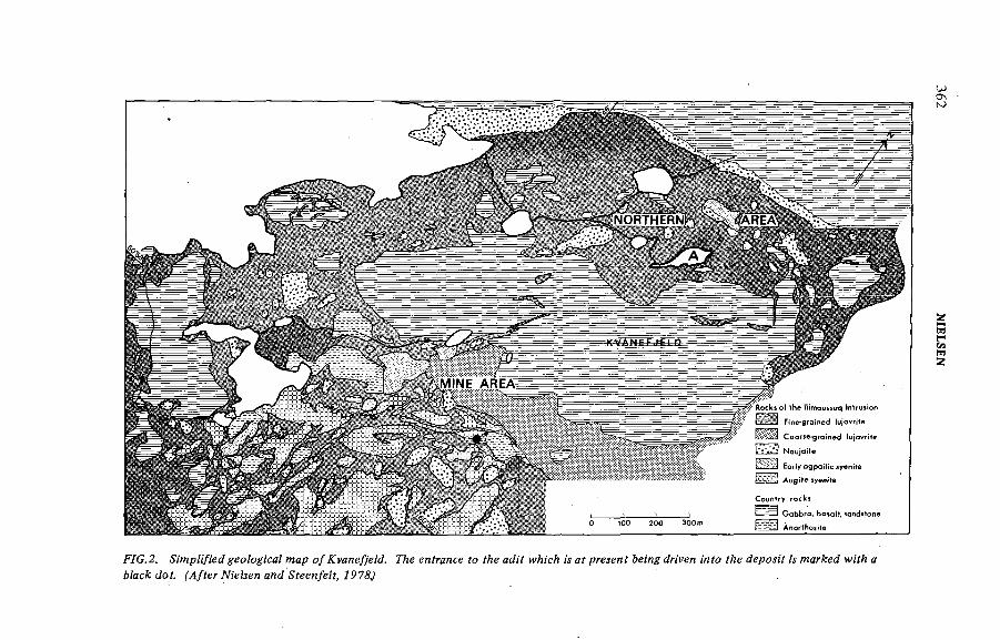
FYG.2. wap о/ Гуяне/уеМ. ГАе enhance fo Уйе аЛ7 w/н'сЛ и а/ ргелея? &e¡7!g ¿п'уея mfo Уйе JepoM'f м warA;e¿ wi'f/¡ а
Мас dof. ^/fer№'e^ewa?!d^feey!/eZ^7P75J
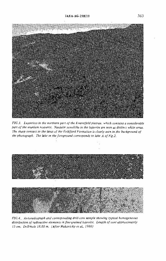
IAEA-AG-250/H 363
F/C.J. ¿м/avrifes m f/¡e nor;/¡ern parf о/ í/ie J?rane//eM p/afeaM, w/ü'c/] confai'ns c considerare
parf o/f/¡e MraniMW resoi/rce. TVaM/aiYe xenoA/As i'n ^e /м/afri'íe are seen as di'sfi'nc; wAi'fe areas.
77:e s/¡arp coníací fo í/ie Zafas o/ f e Fri'A/)'ord ForMMfion is cZear/y seen ¡n ;йе bacA:groMnd o/
f/¡e pAofoyrap/i. ГАе Za e i'n ^e /oregroMnd corresponds ?o /a e /í o/F^.2.
F/G.4.. /ÍMíoradi'ograpA and corresponding driVZ-core samp/e s/iow/ng ? pi'ca/ /icnogeneoMs
di'sfri'&Mrion o/radioacr/fe e/emen s /n /ine-grai'ned /м/afri'fe. ¿engr/i o/core approxi'maZe/y
73 cm. Dri'Z/-/!oZeJ#.¿?Ofn. ^/íerAfa^ovi'c^yeíaZ., 7P50./
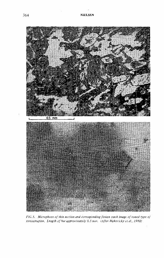
364 NtELSEN
i____________ 0.5 mm____________ ]
F/G..5. №cropAofo о / м с Я ' о я соггеурояЛ'я^Дм^и М ей ;'?Hgge o/zoned ^ р е о/
.:?еел,уУгыр;ие. íengf?; о/*Aar approxwaye(y 0.J wïw. ^ / f e r А^а^ом;с^м efa/., 7Р<У6
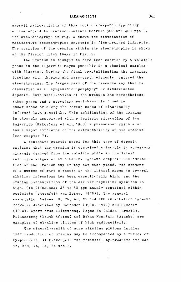
ÏAEA-AG 250/11 365
o v erall r a d i o a c t i v i t y of this rock c o r r e s p o n d s t y p i c a l l y
at K v a n e f j e l d to u r a n i u m contents b e t w e e n 300 and 400 ppm U.
The a u t o r a d i o g r a p h in Fig. 4 shows the d i s t r i b u t i o n of
r a d i o a c t i v e s t e e n s t r u p i n e c r y s t a l s in f i n e - g r a i n e d lujavrite.
The p o s i t i o n of the u r a n i u m w i t h i n the a t e e n s t r u p i n e is shown
on the f i s s i o n track image in Fig. 5.
The u r a n i u m is thought to have been c a rried by a v o l a t i l e
phase in the l u j a v r i t e mag m a p o s s i b l y in a c h e m i c a l c o mplex
wit h fluorine. D u r i n g the final c r y s t a l l i s a t i o n the uranium,
t o g e t h e r w i t h t h o r i u m and r a r e - e a r t h elements, en t e r e d the
st e e n s t r u p i n e . The l a r g e r part of the r e s o u r c e may thus be
c l a s s i f i e d as a s y n g e n e t i c "porphyry" or d i s s e m i n a t e d
depo sit. Some m o b i l i s a t i o n of the u r a n i u m has n e v e r t h e l e s s
ta ken place and a s e c o n d a r y e n r i c h m e n t is found in
shear zones or al o n g the bo r d e r zones of p l a s t i c a l l y
d e f ormed lava x e noliths. This m o b i l i s a t i o n of the u r a n i u m
is s t r o n g l y a s s o c i a t e d w i t h a d e u t e r i c a l t e r a t i o n of the
lujavrite ( M a k o v i c k y et a l . , 1980) a p h e n o m e n o n w h i c h also
has a ma j o r i n f l u e n c e on the e x t r a c t a b i l i t y of the u r a n i u m
(see chapt er 7).
A tentative g e n e t i c mo d e l for this type of d epo si t
explai ns that the u r a n i u m is c o n t ained p r i m a r i l y in a c c e s s o r y
mi n e r a l s d e rived from the v o l a t i l e ph ase in the late st
intru s i v e stages of an a l k a l i n e i g neous complex. R e d i s t r i b u
tion of the u r a n i u m may or may not take place. The content
of a num b e r of rare eleme n t s in the initial m a g m a in several
al k a l i n e i n t r u s i o n s has been e x c e p t i o n a l l y high, and the
u r a n i u m c o n c e n t r a t i o n of the ea r l i e r n e p h e l i n e s y e n i t e s is
high, (in I l i m a u s s a q 2$ to 50 ppm m a i n l y c o n t a i n e d w i t h i n
eudialyte (Ste e n f e l t and Bohse, 1975)). The g eneral
a s s o c i a t i o n b e t w e e n U, Th, Zr, Nb and REE in a l k a l i n e igneous
rocks is d e s c r i b e d by S z r e n s e n (1970, 1977) and S e m e n o v
( 1 9 7 4 ). A p a r t from Ilimaussaq, Pogos de Caldas (Brasil),
P i l a n e s b e r g (South Africa) and Bo k a n M o u n t a i n (Alaska) are
examples of a l k a l i n e p lutons of high radioac t i v i t y .
The m i n e r a l w e a l t h of some a l k a l i n e p lutons implies
that p r o d u c t i o n of u r a n i u m may be a c c o m p a n i e d by a n u m b e r of
by-products. At K v a n e f j e l d the p o t e n t i a l b y - p r o d u c t s i n clude
Th, REE, Nb, Li, Zn and F.
366 NIELSEN
5.1. Geotogica) methods
A l t h o u g h the g e n e r a l g e o l o g y of the I l i m a u s s a q i n t r u s i o n
was k n o w n from the w o r k of U s s i n g (l9 12 ) , n o d e t a i l e d g e o l o g i c a l
i n f o r m a t i o n was a v a i l a b l e in 1957 w h e n the K v a n e f j e l d area '
was s e l e c t e d for f u r t h e r u r a n i u m exploration. D e t a i l e d
g e o l o g i c a l m a p p i n g at a scale of 1:2 00 0 of the g e o l o g i c a l l y
v e r y c o m p l i c a t e d area was not i n i t i a t e d until 1964. This
m apping, w h i c h was c arried out by p e r s o n n e l and s t u d e n t s from
the I n s t i t u t e for P e t r o l o g y at the U n i v e r s i t y of Copenhagen,
was c o m p l e t e d in 1967 and the re s u l t s were p u b l i s h e d by
H. S z r e n s e n et al. (1969). The fi eld w o r k and the e v a l u a t i o n
of the g e o l o g y was m ade in c o l l a b o r a t i o n wit h the G e o l o g i c a l
Su r v e y of Gr eenland. The' a l l - i m p o r t a n t g e o l o g i c a l m a p p i n g
was more than 7 years behind the d e t a i l e d g e o p h y s i c a l
e x p l o ration, w h i c h was i n i t i a t e d as ea r l y as 1Э57. This was
c l e a r l y a d i s a d v a n t a g e for the g e n e r a l p l a n n i n g of the first
stages of the e x p l o r a t i o n , a n d se v e r a l years were lost as the
i m p o r t a n t propo s a l s for d r i l l i n g p r o g r a m m e s could only be
put f o rward with a d e t a i l e d u n d e r s t a n d i n g of the g e o l o g y
a v a i l a b l e at the time.
Aft e r the c o m p l e t i o n of the g e o l o g i c a l map in 1967, only
l i mited g e o l o g i c a l fi eld wor k was carried out except for the
g e o l o g i c a l g u i d a n c e of the d r i l l i n g p r o j e c t s i n . 1969 and 1 9 7 7 .
F o r . a n u m b e r of years a m a j o r part of the g e o l o g i c a l w o r k was
thus c a rried out as an a c a d e m i c u n i v e r s i t y project. However,
e x t e n s i v e m i n e r a l o g i c a l and g e o c h e m i c a l l a b o r a t o r y r e s e a r c h
was made, p a r t i c u l a r l y on drill core material. The r e s e a r c h
was made in c o n n e c t i o n w i t h the d r i l l i n g p r o g r a m m e s and the
m e t a l l u r g i c a l w ork on the ore ( M a k o v i c k y et al. 1980,
K u n z e n d o r f et al., in prep.). The w ork by Ni e l s e n and S t e e n f e l t
( 1 9 7 9 ) is the most re c e n t c o n t r i b u t i o n to the i n t r u s i v e
h i s t o r y of the K v a n e f j e l d area.
It is belie v e d that for f u r t h e r d e v e l o p m e n t of the
d e p o s i t there is no i m m e d i a t e need for a d d i t i o n a l fi eld
geology. D e t a i l e d g e o l o g i c a l i n v e s t i g a t i o n s are,however,
e s s e n t i a l for the e v a l u a t i o n of all f o r t h c o m i n g g e o p h y s i c a l
and g e o c h e m i c a l w o r k as well as for new d r i l l i n g programmes.
5. EXPLORATION
IAEA AG 250/П 367
F r o m the ch a p t e r bel o w on the o r g a n i s a t i o n a l s t r u c t u r e
it wil l be u n d e r s t o o d that the e x p e r t i s e on the v a r i o u s
as p e c t s of the u r a n i u m de p o s i t at K v a n e f j e l d is w i d e l y
spread a m o n g a large gro u p of people from a n u m b e r of
i n s t i t u t i o n s . This is also true for the g e o l o g i c a l k n owledge,
and the d i f f i c u l t y in m a i n t a i n i n g an "in-house" g e o l o g i c a l
expertise, for i n s t a n c e at the G e o l o g i c a l S u r v e y of
Greenland, is r e a l i s e d and is of m a j o r co n c e r n for the
future d e v e l o p m e n t of the project.
5.2. Geophysical and geochemical methods
As the ge i g e r co u n t e r was the most i m p o r t a n t p r o s p e c t i n g
tool in the v e r y e a r l y e x p l o r a t i o n phase, r a d i o m e t r i c surveys
r e m a i n e d the p r i n c i p a l e x p l o r a t i o n me t h o d s at Kva n e f j e l d .
After the d i s c o v e r y of this area a d e t a i l e d s u r v e y with
geiger r e a d i n g s in a 50 m and a 5 m grid over the most
r a d i o a c t i v e area was c a rried out in 1957. R o c k s a mples were
taken at man y su r v e y points and a s s a y e d in a fie l d l a b o r a t o r y
e s t a b l i s h e d nearby. The fie ld work, w h i c h also i n c l u d e d
t o p o g r a p h i c a l m a p p i n g and g e o l o g i c a l r e c o n n a i s s a n c e , was a
joint o p e r a t i o n b e t w e e n AEK, GGU and K r y o l i t s e l s k a b e t 0resund
A/S, a p rivate D a n i s h m i n i n g company.
H o w e v e r no s y s t e m a t i c su r v e y of the entire p l a t e a u was
carried out and the sur v e y f o cused on a m i n o r area, the "mine
area", where the r a d i o a c t i v i t y in a p e g m a t i t i c lujav r i t e
and in m e t a s o m a t i s e d lavas was c o n s i d e r a b l y h i g h e r than
e l s e w h e r e on the plateau. It was, however, a l r e a d y r e a l i s e d
that y e a r that the area of c o m p a r a t i v e l y hig h r a d i o a c t i v i t y
only c o n s t i t u t e d a " s h e l l - l i k e " s t r u c t u r e in what was
c o n s i d e r e d an i n t r u s i v e dome (Bondam, 1957, 1960). On the
basis of the field r a d i o m e t r i c su r v e y in 1 9 5 7) the first
d r i l l i n g p r o g r a m m e was p r o p o s e d and c a rried out in 1 9 5 8
(see next ch apter).
Sin ce 1957 se v e r a l field p r o g r a m m e s based on g a m m a - r a y
s p e c t r o m e t r y have been p e r f o r m e d ( L e v b o r g et al., 1 9 6 8 ,
1971; N y e g a a r d et a l . , 1977). Apart from c o n t r i b u t i n g to
the u n d e r s t a n d i n g of the d i s t r i b u t i o n of r a d i o a c t i v e e l e ments
in lujavrites, these surveys have c o n t r i b u t e d to the
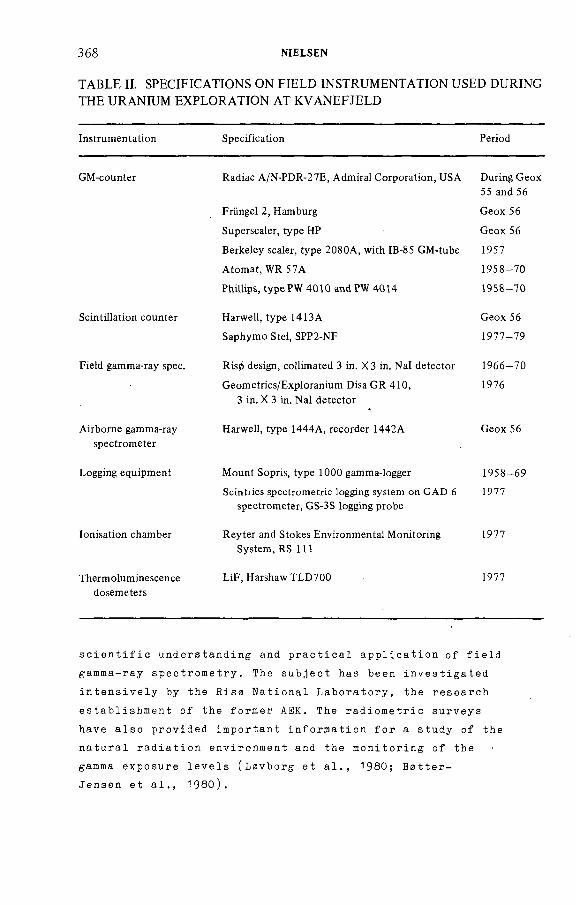
368 NíELSEN
TABLE II. SPECIFICATIONS ON FIELD INSTRUM ENTATION USED DURING THE URANIUM EXPLO RATIO N A T KVANEFJELD
Instrumentation Specification Period
GM-counter Radiac A/N-PDR-27E, Admirai Corporation, USA
Früngel 2, Hamburg
Superscaler, type HP
Berkeley scaler, type 2080A, with IB-85 GM-tube
Atomat, WR 57A
Phillips, type PW 4010 and PW 4014
During Geox
55 and 56
Geox 56
Geox 56
1957
1958-70
1958-70
Scintillation counter Harwell, type 14I3A
Saphymo Stei, SPP2-NF
Geox 56
1977-79
Field gamma-ray spec. Ris0 design, collimated 3 in. X3 in. Nal detector
Geometrics/Exploranium Disa GR 410,
3 in. X 3 in. Na! detector
1966-70
1976
Airborne gamma-ray
spectrometer
Harwell, type 1444A, recorder 1442A Geox 56
Logging equipment Mount Sopris, type 1000 gamma-logger
Scintrics spectrometric logging system on GAD 6
spectrometer, GS-3S logging probe
1958-69
1977
ionisation chamber Reyter and Stokes Environmental Monitoring
System, RS 111
1977
Thermoluminescencedosemeters
LiF, Harshaw TLD700 1977
s c i e n t i f i c u n d e r s t a n d i n g and pract i c a l a p p l i c a t i o n of field
g a m m a - r a y s pectrometry. The subject has been inve s t i g a t e d
i n t e n s i v e l y by the Rise N a t i o n a l L a b o rato ry , the r e s earch
e s t a b l i s h m e n t of the fo r m e r AEK. The r a d i o m e t r i c su rveys
have also provided i m p o r t a n t i n f o r m a t i o n for a study of the
na t u r a l r a d i a t i o n e n v i r o n m e n t and the m o n i t o r i n g of the
gamma exposure levels (Lavborg et al., 1980; B ztter-
J e n s e n et al., 1980).
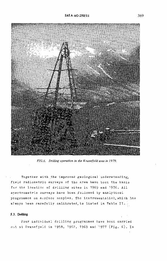
IAEA-AG-250/H 369
F/C. 6. ZMZi'ng operafí'on ¡'я íAe /^vane//eZd area ¿n /97P.
To g e t h e r with the i m p roved g e o l o g i c a l understanding,
fi eld r a d i o m e t r i c s u rveys of the area have been the basis
for the l o c a t i o n of d r i l l i n g sites in 1969 and 1976. All
s p e c t r o m e t r i c su r v e y s have b e e n . f o l l o w e d by a n a l y t i c a l
p r o g r a m m e s on s urface samples. The i n s t r u m e n t a t i o n , w h i c h has
always been c a r e f u l l y c a l i b r a t e d , i s listed in Table II.
5.3. DriMing
Fou r i n d i v i d u a l d r i l l i n g p r o g r a m m e s have b een carried
out at K v a n e f j e l d in 1958, 1962, 1969 and 1977 (Fig. 6 ). In
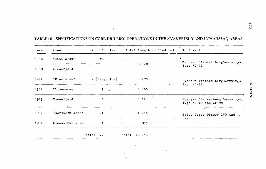
TABLE HI. SPECIFICATIONS ON CORE D R ILLING O PERATIONS IN THE KVANEFJELD AND ILÍM AUSSAQ AREAS
Year Area No. of holes Total length drilled (m) Equipment
1958 "Mine area" 30
3 728Svenska Diamant b e r g b o r r n i n g s ,
1958 Kvanefjeld 6type XC-42
1962 "Mine area" 2 (deepening) 270Svenska Diamant type XC-42
bergborrnings,
1962 Ilimaussaq 7 1 400
1969 Kvanef j eId 6 1 621 Svenska Diaman tberg borrnings, type XC-42 and XF-90
1976 "Northern area" 24 4 256 Atlas Copco Diamec 250 andD-750
.1976 Steenstrup area 4 855
Total 77 Total 10 730
370 N
IELS
EN
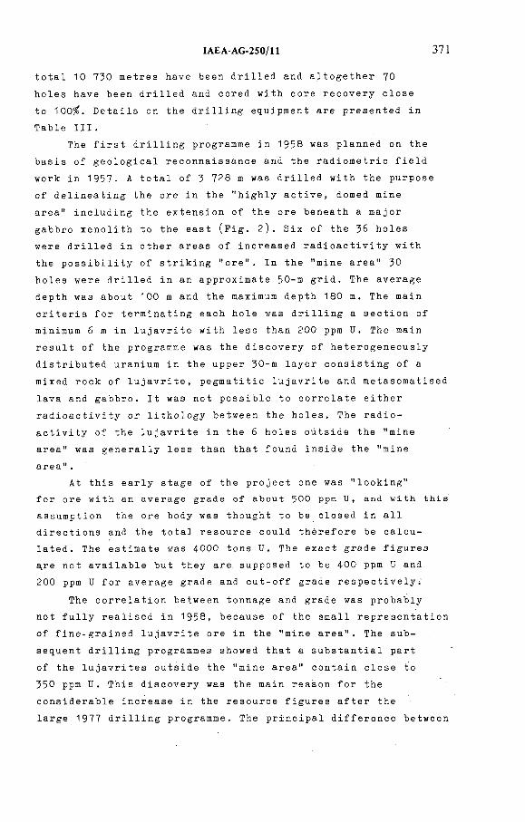
IAEA AG 250/11 371
total 10 730 me t r e s have been d r i l l e d and a l t o g e t h e r 70
ho les have bee n d r i l l e d and cor ed wit h core r e c o v e r y close
to 100%. D e t a i l s on the d r i l l i n g e q u i p m e n t are p r e s e n t e d in
Ta ble III.
The first d r i l l i n g p r o g r a m m e in 1958 was p l a n n e d on the
basis of g e o l o g i c a l r e c o n n a i s s a n c e and the r a d i o m e t r i c field
wor k in 1 9 5 7 . A total of 3 7 2 8 m was d r i l l e d wit h the purpose
of d e l i n e a t i n g the ore in the " h i g h l y active, domed mine
area" i n c l u d i n g the e x t e n s i o n of the ore be n e a t h a maj o r
gabbro x e n o l i t h to the east (Fig. 2). Six of the 36 holes
were d r i l l e d in other areas of i n c r e a s e d r a d i o a c t i v i t y w ith
the p o s s i b i l i t y of s t r i k i n g "ore". In the "mine area" 30
holes were dr i l l e d in an a p p r o x i m a t e 50-m grid. The average
depth was abo ut 100 m and the m a x i m u m dep t h 180 m. The mai n
cr i t e r i a for t e r m i n a t i n g each hole was d r i l l i n g a s e c t i o n of
m i n i m u m 6 m in l u j a v r i t e wit h less than 200 ppm U. The main
result of the p r o g r a m m e was the d i s c o v e r y of h e t e r o g e n e o u s l y
d i s t r i b u t e d u r a n i u m in the u p p e r 3 0-m lay er c o n s i s t i n g of a
mix e d r ock of lujavrite, p e g m a t i t i c lujavrite and m e t a s o m a t i s e d
lava and gabbro. It was not p o s s i b l e to corre l a t e either
r a d i o a c t i v i t y or l i t h o l o g y b e t w e e n the holes. The r a d i o
ac t i v i t y of the lujav r i t e in the 6 hol es outside the "mine
area" was g e n e r a l l y less than that found inside the "mine
a r e a " .
At this early stage of the p roject one was "looking"
for ore w i t h an a v e r a g e grade of about 500 ppm U, and w i t h this
a s s u m p t i o n the ore body was thought to be closed in all
d i r e c t i o n s and the total resou r c e could there f o r e be c a l c u
lated. The e s t im at e was 400 0 tons U. The exact gra d e fi g u r e s
a.re not a v a i l a b l e but they are s u p p o s e d to be 400 ppm U and
200 ppm U for a v e r a g e grade and c ut-off grade respectively.'
The c o r r e l a t i o n b e t w e e n tonna ge and grade was p r o b a b l y
not ful l y r e a l i s e d in 1 9 5 8 , b e cause of the small r e p r e s e n t a t i o n
of f i n e - g r a i n e d l u j a v r i t e ore in the "mine area". The s u b
sequent d r i l l i n g p r o g r a m m e s showed that a s u b s t a n t i a l part
of the l u j a v r i t e s o u tside the "mine area" c o n t a i n close to
350 ppm U. This d i s c o v e r y was the m a i n r e a s o n for the
c o n s i d e r a b l e i n c rease in the r e s ource f igures aft e r the
large 1977 d r i l l i n g programme. The p r i n c i p a l d i f f e r e n c e be t w e e n
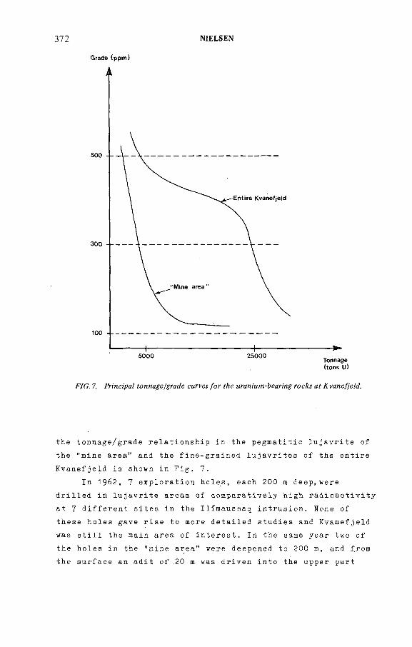
Grade (ppm)
372 NIELSEN
(tons U)
F/G. 7. Fn'nci'paZ /grade смгрел /or f e мга/ч'мт-йеапи roe^ af уале/7'еМ.
the t o n n a g e / g r a d e r e l a t i o n s h i p in the p e g m a t i t i c l u j a v r i t e of
the "m ine area" and the f i n e - g r a i n e d lujav r i t e s of the entire
K v a n e f j e l d is shown in Fig. 7.
In 1 9 6 2 , 7 e x p l o r a t i o n holes, each 200 m deep, w e r e
d r i l l e d in luj av r i t e areas of c o m p a r a t i v e l y h i g h r a d i o a c t i v i t y
at 7 d i f f e r e n t sites in the I l i m a u s s a q intrusion. None of
these hol es gave rise to more d e t a i l e d s tudies and K v a n e f j e l d
was still the mai n area of interest. In the same year two of
the holes in the "mine area" were d e e p e n e d to 200 m, and from
the s u rface an adit of .20 m was d r i v e n into the upp e r part
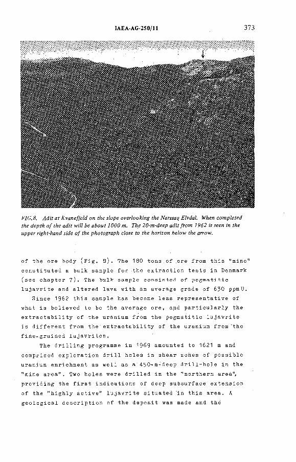
IAEA-AG 2S0/11
F/C.& af J vane/jfeZd on f/:e iZope overZoo i'ng f/:e TVarwat? FZpdaZ. №Aen comp/efed
fAe JepfA o/?Ae аЛ'У w/ZJ ¿e aíoMí J000 m. 77¡e 20-m-deep ad¡Y/rom 7962 ¡л кем :'n fAe
ыррег r¡g/!í-/¡and íMe o/ íZ¡e рйоЬ%гярй cZoíe fo fZ¡e horizon &eZow fZ¡e arrow.
of the ore b ody (Fig. 8 ). The 180 tons of ore fro m this "mine
c o n s t i t u t e d a bulk sample for the e x t r a c t i o n tests in D e n m a r k
(see c h a p t e r 7). The bulk sample c o n s i s t e d of p e g m a t i t i c
lujav r i t e and a l t e r e d lava w i t h an av e r a g e grade of 630 ppmU .
Si n c e 1962 this sample has become less r e p r e s e n t a t i v e of
what is b e l i eved to be the a v e r a g e ore, and p a r t i c u l a r l y the
e x t r a c t a b i l i t y of the u r a n i u m from the p e g m a t i t i c l u j a v r i t e
is d i f f e r e n t from t h e ' e x t r a c t a b i l i t y of the u r a n i u m f rom the
f i n e - g r a i n e d lujavrites.
The d r i l l i n g p r o g r a m m e in 1969 a m o u n t e d to 1621 m and
c o m p r i s e d e x p l o r a t i o n drill holes in shear zones of possi b l e
u r a n i u m e n r i c h m e n t as well as a ' 4 5 0 - m - d e e p d r i l l - h o l e in the
"mi ne area". Two holes were d r i l l e d in the " n o r t h e r n area",
p r o v i d i n g the first i n d i c a t i o n s of deep s u b s u r f a c e e x t e n s i o n
of the " h i g h l y active" l u j a v r i t e s i t u a t e d in this area. A
g e o l o g i c a l d e s c r i p t i o n of the d e p o s i t was made and thé
374 NIELSEN
re s o ur ce f i gures were r e - e s t i m a t e d taking the results of the
1969 d r i l l i n g into c o n s i d e r a t i o n (H. S a r e n s e n et a l . , 1974)-
The result of the blo c k estimate was now 5 800 tons U with, an
a v e r a g e grade of ЗЮ ppm and a c ut-off value of 300 ppm. No
t o n n a g e - g r a d e curve was produced, and the 300 ppm cut-off
le vel wa s d e f i n i t e l y c h o s e n too h i g h thus giving no i n f o r m a t i o n
on the c o n s i d e r a b l e amo u n t of lujav r i t e with u r a n i u m c o n c e n
tr ations b e t w e e n 250 and 300 ppm.
No t un t i l 1977 was a s y s t e m a t i c d r i l l i n g p r o g r a m m e carried
out in the " n o r t h e r n area" (Fig. 2). A total of 4 256 m was
d r i l l e d in 2 0 0- m -deep hol es w ith a grid s pacing of 1 4 5 m.
A d d i t i o n a l l y 4 e x p l o r a t i o n holes a m o u n t i n g to 855 m in total
w ere d r i l l e d alo n g the ea s t e r n c o n t i n u a t i o n of the " n o r t h e r n
a r e a " . The zones at the c o ntact of the i n t r u s i o n had a
r a d i o a c t i v i t y abo ve a v e r a g e at the surface; a fe a t u r e whi c h
was not m a i n t a i n e d at depth. W i t h ea s i e r access to c o m p u t e r
f a c i l i t i e s the r e s o u r c e f i gures fo r the entire K v a n e f j e l d
d e p o s i t we r e r e - e s t i m a t e d for the third time and a tonnage-
grade curve and c o r r e s p o n d i n g a v e r a g e grade values were
p r o d u c e d for the n o r t h e r n area. Th e f i g u r e s are g i v e n in
the I n t r o d uction, c h a p t e r 1. A strict budget p r e v e n t e d a
d e s i r a b l e f l e x i b i l i t y of the 1977 d r i l l i n g p r o g r a m m e and
s e v e r a l holes were s t opped in "ore", and the m i n e r a l i s e d body
is st ill open to the south-west. The " n o r t h e r n area" and
the "mine area" were tied t o g e t h e r w i t h this d r i l l i n g
p r o g r a m m e (Nyegaard et al., 1977).
6. LOGGING, ASSAYING, RESOURCE ESTIMATES
E v e r y d r i l l i n g p r o g r a m m e in the K v a n e f j e l d area has
been a c c o m p a n i e d by r a d i o m e t r i c l o g g i n g of the holes. The
s p e c i f i c a t i o n s of the l o gging e q u i p m e n t are o u t l i n e d in
T ab l e II. The l o g g i n g has been e x c l u s i v e l y r a d i o m e t r i c
( s c i n t i l l o m e t r i c and s p e c t r o m e t r i c ) w i t h a n a l o g u e r e c o r d i n g
in 1958, 1962 and 1969. The lo g g i n g in 1977 was s p e c t r o m e t r i c
w i t h d i g i t a l r e c o r d i n g of the r e sults (Lavb o r g et al., 1 9 8 0 ).
The mai n r e a s o n for the i n t r o d u c t i o n of the more c o m p l i c a t e d
s p e c t r o m e t r i c l o g g i n g was that the r a d i o a c t i v e rocks have
v a r y i n g T h/U ratios, t y p i c a l l y f rom 5 to 1. T hey a p p e a r i n ^
c o m p l e t e r a d i o a c t i v e equilibr ium.
In 1958 and 1977, whe n the l a r g e - s c a l e s y s t e m a t i c
d r i l l i n g p r o g r a m m e s were c arried out, the re s u l t s of the
l o g g i n g w e r e use d for the r e s o u r c e c a l c u l a t i o n s . C a l i b r a t i o n
of the i n s t r u m e n t a t i o n was in both cases p e r f o r m e d by means
of r a d i o m e t r i c and c h e m i c a l a n a l y s e s on m a t e r i a l fro m the
drill cores. The Th/и ratio i n c r eases w ith i n c r e a s i n g
r a d i o a c t i v i t y of the ore and, as the c a l i b r a t i o n curve for
the 1958 l o g g i n g was c o n s t r u c t e d w ith too m u c h w e i g h t on the
"hot" samples, the u r a n i u m r e s o u r c e s of that time w e r e o v e r
e s t i m a t e d by an u n k n o w n p e r centage. The s p e c t r o m e t r i c l o g g i n g
re s u l t s of 1977 were c o n v e r t e d into e lement c o n c e n t r a t i o n s
on the bas is of c a l i b r a t i o n w i t h an a s s a y of U and Th every
second m e t r e of the dri l l core. R e s o u r c e e s t i m a t e s were
made bot h from the lo g g i n g re s u l t s and fro m the core assays.
Th e y s h o w d i f f e r e n c e s at v a r i o u s c u t - o f f grades ( L e v b o r g
et al., 1980). W i t h a 250 ppm U c u t - o f f level the estimate
mad e fro m the l o g g i n g data is 11 per cent g r e a t e r than the
e s t i m a t e from the core analyses. This d i f f e r e n c e m a y be
explained, but it can be c o n c l u d e d that as the K v a n e f j e l d
pr o j e c t p r o g r e s s e s to a h i g h e r d e v e l o p m e n t stage m u c h more
re l i a b l e c ontrol is needed on a s s a y i n g and on r e s o u r c e
estimates. The n e c e s s i t y for this is p a r t i c u l a r l y i m p o r t a n t
at K v a n e f j e l d , whe r e one is c o n c e r n e d w i t h l o w - g r a d e d e p o s i t s
of m a r g i n a l f e a s i b i l i t y . At pr e s e n t a g e o s t a t i s t i c a l r e s ource
e s t imate is be i n g c arried out on the bas is of e x i s t i n g a n a l y
tical data, and it is f o r e s e e n that g e o s t a t i s t i c s w ill play
an i n c r e a s i n g role in the fu t u r e e v a l u a t i o n of the deposit.
The re v i s e d r e s o u r c e e s t i m a t e s f o l l o w i n g the d r i l l i n g
p r o g r a m m e in 1969 were based on g a m m a - s p e c t r o m e t r i c s c a n n i n g
of all new and e a r l i e r d r i l l - c o r e mater i a l . The t i m e - c o n s u m i n g
s c a n n i n g job was c a rried out in the l a b o r a t o r y and p r o v i d e d
the ba sis for a r e l i a b l e e s t i m a t e (L0v b o r g et al., 1971).
One of the re a s o n s for c h o o s i n g the s c a n n i n g p r o c e d u r e was
that r e l o g g i n g of the holes fro m 1958 was no lo n g e r possible.
M ost of the a n a l y t i c a l w o r k for U and Th and a n u m b e r
of oth er e l e m e n t s on roc k s a mples fro m I l i m a u s s a q has been
ÎAEA-AG-250/H 375
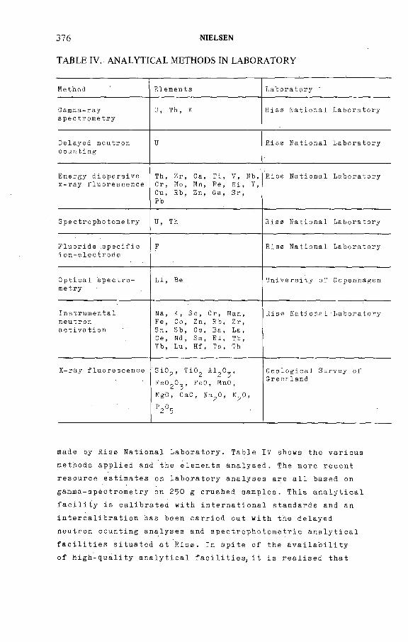
376 NtELSEN
TABLE IV. ANALYTICAL METHODS IN LABORATORY
M e t h o d E l e m e n t s L a b o r a t o r y
G a m m a - r a ys p e c t r o m e t r y
U, Th, К Risa N a t i o n a l L a b o r a t o r y
D e l a y e d n e u t r o n c o u n t i n g
U - Rise N a t i o n a l L a b o r a t o r y
E n e r g y d i s p e r s i v e x - r a y f l u o r e s c e n c e
Th, Zr, Ca, Ti, V, Nb, Cr, No, Mn, Fe, Ni, Y, Cu, Rb, Zn, Ga, Sr,РЪ
Riso N a t i o n a l L a b o r a t o r y
S p e c t r o p h o t o m e t r y U, Th Rise N a t i o n a l L a b o r a t o r y
F l u o r i d e sp e c i f i c i o n - e l e c t r o d e
F Rise N a t i o n a l L a b o r a t o r y
O p t i c a l spe c t r o - m e t r y
Li , Be U n i v e r s i t y of C o p e n h a g e n
I n s t r u m e n t a ln e u t r o na c t i v a t i o n
N a , К, Sc, C r , M a n , Fe, Co, Zn, Rb, Zr, S n , S b , C s , B a , L a , Ce, Nd, Sm, Eu, Tb, Yb, Lu, Hf, Ta, Th
Rise N a t i o n a l - L a b o r a t o r y
X- r a y f l u o r e s c e n c e 'SiC^, TiO^ AlgO^,
FeO ^O^ , FeO, MnO,
MgO, CaO, Ma^O, K^O,
P2°5
G e o l o g i c a l S u r v e y of G r e e n l a n d
made by Rise N a t ional Laboratory. Table IV shows the v a rio us
m e t h o d s a pplied and the elements analysed. The more recent
r e s o u r c e estim a t e s on l a b o r a t o r y a n a l y s e s are all based on
g a m m a - s p è c t r o m e t r y on 250 g c r ushed samples. This a n a l y t i c a l
f a c i l i t y is c a l i b r a t e d with i n t e r n a t i o n a l standards and an
i n t e r c a l i b r a t i o n has been carried out w i t h the d elayed
n e u t r o n c o u n t i n g a n a l y s e s and s p e c t r o p h o t o m e t r i c a n a l y t i c a l
f a c i l i t i e s situated at Rise. In spite of the a v a i l a b i l i t y
of h i g h - q u a l i t y a n a l y t i c a l facilities, it is r e a lised that
IAEA-ÁG-250/11 377
e x t e n s i v e a n a l y t i c a l control w o r k by other l a b o r a t o r i e s is
now needed if a d e t a i l e d economic f e a s i b i l i t y of the p r oje ct
is to be evaluated.
Mos t e l e c t r o n i c data p r o c e s s i n g is ca rried out at the
c o m p u t e r f a c i l i t y at Risa.
7. ORE PROCESSING
The u r a n i u m m i n e r a l s in the ore fro m the K v a n e f j e l d
d e posit are r e f ractory, and the effort spent on the
e x t r a c t i o n of u r a n i u m from lujav r i t e du r i n g the 25 years
is comp a r a b l e in cost, m a n p o w e r and time to all the r e m a i n i n g
e x p l o r a t i o n work. The C h e m i s t r y D e p a r t m e n t at Risa has been
in charge of this w o r k du r i n g the entire period. It.is not
the p u r p o s e here to go into d etails of the p r o b l e m s faced
over the years and only a rev iew of the r e s e a r c h wor k
will be presented.
Af ter the start in 1 9 57/58 it soon became clear that
n e ither of the c l a s s i c a l techniques, acid l e a c h i n g or c a r b onate
le a c h i n g was s u c c e s s f u l l y a p p l i c a b l e in the case of lujavrite,
and for a long pe riod of time (almost 15 years) a s u l p h a t i s i n g
r o a s t i n g of the ore was the most e f f e c t i v e e x t r a c t i o n technique.
The ore was tr eated with SO^ at abo u t 700°C and s u b s e q u e n t
l e a ching w ith water y i e l d e d f rom 40 to 70% of the u r a n i u m as
d i s s o l v e d s u l p h a t e d e p e n d i n g on the type of l u j a v r i t e and the
a l t e r a t i o n of the s t e e n s t r u p i n e (Asmund, 1971, Hansen, 1977).
O w i n g to the low gra d e of the o r e ,much w o r k has been
d e voted to p o s s i b l e p r e - c o n c e n t r a t i o n of the st e e n s t r u p i n e .
However, none of the a p p l i e d m e t h o d s have pr o v e d effe ctive.
Before, the r e s e a r c h on the. s u l p h a t i s i n g r o a s t i n g technique
was d e f i n i t i v e l y stopped, a m i n o r p i l o t - p l a n t e x p e r i m e n t was
made on the r e m a i n i n g 150 tons of ore recov e r e d f ro m the
adit of 1962 (E. S z r e n s e n et al., 1978). It was al r e a d y
r e a l i s e d at the time of this p i l o t - p l a n t st udy that the
a v a i l a b l e ore was alm ost twice as ric h in u r a n i u m andlitho-
logic a l l y v er y d i f f e r e n t from the rock type r e p r e s e n t i n g
the maj o r part of the p r e s e n t l y k n o w n resource. The m any
years of g e n e r a l l y me a g r e r e sults on the o r e - p r o c e s s i n g side
378 NIELSEN
is w i t h o u t doubt one of the ma j o r r e asons for the rather
slow pr ogr e s s of the K v a n e f j e l d p r o j e c t d u r i n g those years.
A f t e r 1978 a new car bo n a t e p r e s s u r e l e a ching process was
d e v e l o p e d and the u r a n i u m yields of the a u t o c l a v e e x p e r i m e n t s
are at p r esent in the order of 70-90%. The p r i n c i p l e is that
a m i x t u r e of ground ore and c a r b o n a t e s o l u t i o n is t reated
for 15 mi n u t e s in an a u t o c l a v e at 260°C and 75 a t m o spher es.
By this process the s t e e n s t r u p i n e is b r o k e n down and the
u r a n i u m dissolved. A f t e r filtering, the u r a n i u m is p r e c i p i t a t e d
fro m the ca rb onate s o l u t i o n by r e d u c t i o n with hydrogen.
M i n e r a l o g i c a l s t udies (Mak o v i c k y et al., 1980), i n c l u d i n g
f i s s i o n track me t h o d s and m i c r o p r o b e i n v e s t i g a t i o n s , sho w that
the p r e - t r e a t m e n t state of h y d r a t i o n or d e u ter ic a l t e r a t i o n
of the s t e e n s t r u p i n e is the main c o n t r o l l i n g fa c t o r of the
e x t r a c t i o n w i t h the h i g h e s t yi e l d s f r o m the least h y d r a t e d
l u j a v r i t e s .
A new adit, about 1000 m long is at present being
d r i v e n into the centre of the ore body (Fig. 8). The adit
will p r ovide m a t e r i a l for the s e l e c t i o n of a 5000- t o n s sample
for a new pil ot pla nt on the c a r b o n a t e p r e ssure l e a c h i n g
process, sched u l e d for 1981-1983. A l t h o u g h the u l t i m a t e
av e r a g e ore is not yet known, it is b e l i e v e d that the ore
from the tunnel can be s e l ected so as to cover most p a r a m e t e r s
that w ill influ e n c e the e x t r a c t i o n process.
8. CONSULTANTS
A n a p p r e c i a b l e n u m b e r of e x t e r n a l c o n s u l t a n t s have been
a t t a c h e d to the pr o j e c t during its 25 years history. In the
late fift ies and early sixties most c o n s u l t a t i o n was a pplied
to va r i o u s p r o blems on p r e c o n c e n t r a t i o n and leaching. A c c o r d i n g
to the C h e m i s t r y D e p a r t m e n t of Rise, most of the r e ports from
the c o n s u l t a n t s did not c o n t r i b u t e m u c h to the s o l u t i o n of the
p r o c e s s i n g problem. In v i e w of the s p e cific nature of the ore
and the m e t a l l u r g i c a l problems, the l i mited funds a s c r i b e d
to c o n s u l t a t i o n did not enable the c o n s u l t a n t s to come muc h
fu r t h e r than u n d e r s t a n d i n g the problems. O nly ra r e l y were
u s e f u l c o n t r i b u t i o n s to a s o l u t i o n obtained, and a g e n e r a l
!AEA AG-250/П 379
TABLE V. CONSULTANTS AND CONTRACTORS OF THE KVANEFJELD PROJECT
Major consultants
Atlas Copco AB, Stockholm
P.G. Kihlstedt, Kungliga Tekniska Högskola, Stockholm
Prof. R.N. Pryor, Royal School of Mines, London
David S. Robertson & Associates Ltd., Toronto
F.L. Smith and Co. A/s, Copenhagen
Major contractors
Danish Arctic Contractors A/s, Copenhagen
Geoteknisk Institut, Copenhagen
Lurgi Chemie GmbH, Frankfurt am Main
Norsk Anleggstransport AS, Oslo
Ontario Research Foundation, Ontario
Pihl & San A/S, Copenhagen
Terratest AB (Svenska Diamantbergborrnings AB), Stockholm
s c e p t i c i s m towards c o n s u l t a n t s was created. This may not be
fair - but the r e s u l t has been that the c h e m i s t s w o r k i n g on
the e x t r a c t i o n pr o c e s s have w o r k e d as a pa r t l y i s o l a t e d gro up
m a i n l y b e cause no groups in the u r a n i u m i n d u s t r y deal wit h
si m i l a r p r o b l e m s on l o w - g r a d e u r a n i u m ores. At present,
however, c o l l a b o r a t i o n has bee n e s t a b l i s h e d to i n t e r n a t i o n a l
m e t a l l u r g i c a l companies; and c o n s u l t i n g e n g i n e e r s pl a y e d an
i m p o r t a n t role in the fundamental change fro m the s u l p h a t i s i n g
r o a s t i n g to the c a r b o n a t e p r e s s u r e l e a c h i n g process. A list
of the c o n s u l t a n t s e m p l o y e d is p r e s e n t e d in a l p h a b e t i c order
in Table V .
Two m a j o r st u d i e s of the pr o j e c t i n c l u d i n g f e a s i b i l i t y
s t udies have b e e n c a rried out, the fi rst one d i r e c t e d by the
late Prof. R.N. Pryor, Roy a l Sch o o l of Mines, L o n d o n in 1974
and the second one by D.S. R o b e r t s o n and Ass. Ltd., Toronto,
in 1977 w i t h a r e v i s i o n in 1979- B o t h re p o r t s have u n d e r l i n e d
the hig h s e n s i t i v i t y of the rate of r e c o v e r y to the econo m i c s
of the project. In the latest report, based on a n u m b e r of
380 NIELSEN
assumptions, an e s t imate of an o p e r a t i n g cost of US$ 17 per
ton of ore is given. Wit h an e s t i m a t e d price of US$ 44 per
pound U^.0 , a r evenue of $ 30 per ton of ore m i l l e d wou l d be 3 оobtained. This estimate is c o nsidered s u f f i c i e n t to justify
c o n t i n u a t i o n of the study of the K v a n e f j e l d d eposit as well
as p r e p a r a t i o n of a f e a s i b i l i t y study for comm e r c i a l p r o d u c t i o n
of ura ni um. The i m m e d i a t e i n v e s t i g a t i o n s to be carried out
are: a) d e t ailed ore r eserve study and a m i n i n g plan, b)
p i l o t - p l a n t stu dy on a bul k sample in c o n n e c t i o n wit h the
d e v e l o p m e n t and t e s t i n g of a c o m plete flow sheet for the
p r o d u c t i o n of y e l l o w cake and b y - p r od uc ts , c) s t u di es of
the i n f r a s t r u c t u r e and natural e n v i r o n m e n t of the K v a n e f j e l d
area, and d) e l u c i d a t i o n of the legal and polit i c a l i m p l i c a t i o n s
in order to determine their effect on the economics of the
project.
W i t h the limited m i n i n g t rad itions in De n m a r k and
G r e e n l a n d it is felt that external cons u l t a n t s must be
i n c r e a s i n g l y i n t e g r a t e d in s u b s e q u e n t stages of the
K v a n e f j e l d project.
It is thus seen that t e c h n i c a l l y and e c o n o m i c a l l y a
c o n t i n u a t i o n of the p r oject can be argued. The i n t e n s i t y and
o r g a n i s a t i o n of the future p r o g r a m m e and an u l t i m a t e d e c i s i o n
w h e t h e r or not to go into p r o d u c t i o n de p e n d s on d e v e l o p m e n t
of the policy of the Hom e Rule A u t h o r i t i e s c o n c e r n i n g m i n e r a l
e x t r a c t i o n and in p a r t i c u l a r this project. It will also
de p e n d on D a n i s h en e r g y policy to wards the i n t r o d u c t i o n of
n u c l e a r pow e r in Denm ark.
9. ORGANIZATIONAL STRUCTURE
In the i n t r o d u c t i o n it was m e n t i o n e d that the K v a n e f j e l d
p r oject is not c o n d u c t e d by a single p rivate or S t a t e - o w n e d
c o m p a n y wit h a direct e c o n o m i c i n t e r e s t towards e x p l o i t a t i o n
of the depos it. Apart from the short coop e r a t i o n wit h the
p a r t l y S t a t e - o w n e d m i n i n g c o mpany K r y o l i t s e l s k a b e t 0r e s u n d A/S
in 1 9 5 8 , all a c t i v i t i e s have b een p l a n n e d and c o n d u c t e d by
D a n i s h State i n s t i t u t i o n s of whi c h the most i m p o r t a n t and
in v o l v e d over a long period of time are:
IAEA AG 2 5 0 /H 38!
1) The Riso N a t i o n a l Laboratory, a r e s e a r c h e s t a b l i s h m e n t
of the M i n i s t r y of Energy. Risz was the o r i g i n a l r e s e a r c h
e s t a b l i s h m e n t of the f o r m e r At o m i c E n e r g y C o m m i s s i o n (AEK).
The e x p e r t i s e n e c e s s a r y for the K v a n e f j e l d p r o j e c t
( p r o c e s s i n g of min erals, a n a l y t i c a l facilities, fi eld
r a d i o m e t r i c methods) have b e e n d e v e l o p e d i n t e r n a l l y in
the course of the project.
2) The I n s t i t u t e for P e t r o l o g y of the U n i v e r s i t y of
C o p e nhagen. The staff of the i n s t i t u t e has a wide
i n t e r e s t in the m i n e r a l o g y and m a g m a t i c p e t r o l o g y of
the a l k a l i n e I l i m a u s s a q intru sion. As a n a t u r a l c o n s e q u e n c e
of this, r e s e a r c h on the g e o l o g y of K v a n e f j e l d sensu lato
has been s t u d i e d by the i n s t i t u t e on be h a l f of and in
c o l l a b o r a t i o n w i t h the G e o l o g i c a l Sur v e y of Greenland.
3) The G e o l o g i c a l Su r v e y of G r e e n l a n d is a d i r e c t o r a t e
a s s o c i a t e d w i t h the M i n i s t r y for G r e e n l a n d and now also
the M i n e r a l R e s o u r c e A d m i n i s t r a t i o n for Green l a n d . The
G e o l o g i c a l S u r v e y of G r e e n l a n d (GGU) o f f i c i a l l y c o n ducts
all g e o l o g i c a l r e s e a r c h on the K v a n e f j e l d deposit. It
is a d v i s o r to the a d m i n i s t r a t i v e bodies above and almost
all uraniurn e x p l o r a t i o n c arried out in G r e e n l a n d is
p e r f o r m e d by GGU.
A small n u m b e r of oth er State o r g a n i s a t i o n s have been
invol v e d in v a r i o u s parts of the proje ct. Mos t e n g i n e e r i n g
field a c t i v i t i e s have b een p e r f o r m e d by c o n t r a c t i n g f o r e i g n
and D a n i s h companies.
It wi l l be s een that no s t r u c t u r e d o r g a n i s a t i o n exists.
The " K v a n e f j e l d P r o ject" is at pr e s e n t not more than a
c o l l e c t i v e name for a nu m b e r of i n d i v i d u a l i n i t i a t i v e s and
r e s e a r c h stud ies run by i n d i v i d u a l i n s t i t u t i o n s . The lack of
a firm o r g a n i ä a t i o n is not n e c e s s a r i l y a d i s a d v a n t a g e
e s p e c i a l l y d u r i n g the early stages of an e x p l o r a t i o n programme.
It is n e v e r t h e l e s s felt now that the l o g i s t i c c o m p l i c a t i o n s of
an i n t e n s i f i e d future p r o g r a m m e will need an o r g a n i s a t i o n a l
s t r u c t u r e "li ke that of a m i n i n g company" w ith a h i g h e r degree
of e c o nomic autonomy. This is n e c e s s a r y in ord er to bri n g the
p r esent and fu tu re st u d i e s into balance.
382 NIELSEN
A s u b s t a n t i a l part of the o n g o i n g r e s e a r c h on the d eposit
is f i n a n c e d by en e r g y r e s e a r c h funds fro m the D a n i s h M i n i s t r y
of C o m m erce and by the E u r o p e a n E c o n o m i c C o m m u nities. A s t e e r i n g
g r o u p w i t h a broad r e p r e s e n t a t i o n has b e e n e s t a b l i s h e d in
c o n n e c t i o n with this r e s e a r c h and the i m p r o v e m e n t of the o verall
f u t u r e o r g a n i s a t i o n of the K v a n e f j e l d pr o j e c t is b e i n g u n d e r
t ak e n by the s t e e r i n g group.
Ю. ENVIRONMENTAL RESEARCH
I n c r e a s i n g c o n c e r n over the past decad e has b een giv e n
to p r o t e c t i o n of the n a t u r a l e n v i r onment. This is also true
for the N a r s s a q area a r o u n d the K v a n e f j e l d deposit. S i n c e it
is a t h i n l y p o p u l a t e d area w i t h n e g l i g i b l e i n d u s t r i a l activity,
the area is at p r esent r e g a r d e d as w i t h o u t c h e mical pollution.
N e v e r t h e l e s s it was k n o w n from an early stage that the
I l i m a u s s a q intrusion, c o n s t i t u t i n g a r e m a r k a b l e g e o c h e m i c a l
anomaly, might r e f l e c t some of its c h a r a c t e r i s t i c el e m e n t
c o n c e n t r a t i o n on the s u r r o u n d i n g e n v i r o n m e n t and e c o l o g i c a l
system. In or der to descr i b e and q u a n t i f y this s e c o n d a r y
g e o c h e m i c a l d i s p e r s i o n a three - y e a r r e s e a r c h p roject ( 1 9 7 3 -
76), f i n a n c e d by the D a n i s h N a t i o n a l R e s e a r c h Council, was
ca rried out by g r a d u a t e students of g e o l o g y and b i o l o g y at
the U n i v e r s i t y of C o p enhagen. The r e s u l t s of this "Narssaq
P r o ject" -will p r o v i d e a f u n d a m e n t a l basis for the r e g u l a t i o n
and c o ntrol of the i n e v i t a b l e impact of the e n v i r o n m e n t in
c o n n e c t i o n wit h fu t u r e m i n i n g operations. The st aff of the
"N a rs sa q Projec t" (des c r i b e d by R o s e - H a n s e n and S 0rensen,
1979), has c o l l e c t e d more than 3000 s a mples of soils and
water, plants and a n i m a l s from the ma rine, t e r r e s t r i a l and
limn ic e n v i r o n m e n t w h i c h have b een a n a l y s e d by ne u t r o n
a c t i v a t i o n a n a lysis for about 40 elements. The re s u l t s are
not yet fu l l y r e p o r t e d an d the d i f f i c u l t y in hav i n g a
r e s e a r c h p r o g r a m m e d i s s e m i n a t e d too w i d e l y as an e d u c a t i o n a l
st u dy is once a g a i n emp hasized. D u r i n g the I n t e r n a t i o n a l
H y d r o l o g i c a l Dec a d e 1963-73 the N a r s s a q area was s t u d i e d as
one of the D a n i s h r e p r e s e n t a t i v e areas, and exten s i v e
i n f o r m a t i o n on the c l i m a t o l o g y and h y d r o l o g y was collected.
A d d i t i o n a l e n v i r o n m e n t a l studies are a s s o c i a t e d wit h the
IAEA AG-2S0/H 383
r e s e a r c h on p r o c e s s i n g of the ore and m i n i n g of the large
b ulk sample. The se studies, i n c l u d i n g c o l l e c t i n g of m e t e o r o l o
gic a l data, rad i o e c o l o g y , c h e m i s t r y of stream water, sea water,
and a n u m b e r of animals, are c o n c e n t r a t e d in the i m m e d i a t e
v i c i n i t y of K v a n e f j e l d . The y can at best only be r e g a r d e d as
an o r i e n t a t i o n stu d y before a more t h o r o u g h e n v i r o n m e n t a l
p r o g r a m m e ca n be initiated.
The lack of o r g a n i s a t i o n a l s t r u c t u r e has p r e s u m a b l y been
a d e l a y i n g fa c t o r in the e s t a b l i s h m e n t of a l a r g e - s c a l e study,
not only of the n a t u r a l environment, but also of the influ e n c e
of a m i n i n g p r o j e c t on a small, local c o m m u n i t y w i t h an
e c ono my based on f i s h i n g and sheep farming. It is ful l y
realised, and accepted, that the e n v i r o n m e n t a l c o n c e r n will
be a ver y i m p o r t a n t fa c t o r in the fut u r e d e v e l o p m e n t of the
p r o j e c t .
It. CONCLUSIONS
The d i s c o v e r y of the K v a n e f j e l d u r a n i u m d e posit in 1956
was made only one y ear aft e r r e g i o n a l e x p l o r a t i o n was
initi a t e d w i t h i n the I l i m a u s s a q complex. There is a c c o r d i n g l y
not a s o p h i s t i c a t e d s e q uence of steps to be d e s c r i b e d ending
with the d i s c o v e r y of the depos it. In this r e spect the
d i s c o v e r y was a ver y easy one. On the ba sis of the e x i s t i n g
k n o w l e d g e of the p r e sence of r a d i o a c t i v e m i n e r a l s w i t h i n the
intr usion, a s t r a i g h t f o r w a r d r a d i o m e t r i c fi eld and aerial
survey was c a rried out, and the d e p o s i t was found, e x posed
at the surface, du r i n g the second field season. W i t h this
result in mind, one could say that the e x p l o r a t i o n a p p r o a c h
was correct.
If one should start e x p l o r a t i o n w i t h i n a p h y s i c a l l y and
g e o l o g i c a l l y s i m i l a r e n v i r o n m e n t today, some kind of g e o
ch e mical e x p l o r a t i o n would p r o b a b l y also be c o n sidered. In the
case of Kvan e f j e l d , howe ver, g e o c h e m i c a l e x p l o r a t i o n r e s e a r c h
seems to be of m i n o r im portance, pa r t l y because of the ex
ce p t i o n a l expos ur e of the rocks, and partly be c a u s e of the
r e f r a c t o r y nature of the u r a n i u m - b e a r i n g minerals.
If the time fro m the start of the e x p l o r a t i o n to the
i nitial d i s c o v e r y was short, the elapsed time du r i n g
384 NtELSEN
s u c c e e d i n g stages of d e v e l o p m e n t has been e x t r a o r d i n a r i l y
long, and the b a c k g r o u n d and e x p l a n a t i o n for this is the real
point of i n t ere st in the p r esent e x p l o r a t i o n case history.
The m a i n re a s o n is the low grade of the ore and the m a r g i n a l
e c o n o m i c f e a s i b i l i t y combi n e d wit h a n - u n t r a d i t i o n a l p r oject
mana g e m e n t , no s e c u r i t y in a l o n g - t e r m budget, and no
t r a d i t i o n a l b a c k g r o u n d in mi n i n g and milling.
Part of the i n v e s t i g a t i o n in the n i n e t e e n - s i x t i e s was
there f o r e not e x p l o r a t i o n in its c l a s s i c a l sense but s c i e n t i f i c
g e o l o g i c a l research.
It is belie v e d that no private m i n i n g c ompany wou l d have
m a i n t a i n e d e x p l o r a t i o n for 25 years on a resou r c e w h i c h to
mos t m i n i n g people looks m a r g i n a l or subeconomic.
It is the a u t h o r ' s o p i n i o n that if, t h e oretically, the
K v a n e f j e l d p r oject had b een a d m i n i s t e r e d from the start on
strict comme r c i a l principles, the area wou ld have been
a b a n d o n e d and the p r o j e c t shelved after the first d r i l l i n g
p r o g r a m m e in 1958. R e n e w e d inter e s t wou l d p r o b a b l y have
a r i s e n in the mi d d l e seventies, and the p roject b rought to
the level it has r e ached today by i n t e n s i v e work. A l t h o u g h
fictive, such a d e v e l o p m e n t could have been an impor t a n t
short cut which, howev er, would only have been p o s sible un d e r
a d i f f e r e n t o r g a n i s a t i o n a l structure.
Overall, the total cost up to the p r esent stage of
d e v e l o p m e n t wo uld then also have been less.
A n a d v a n t a g e of the actual s m a l l - s c a l e w o r k over man y
years is that there has been s u f f i c i e n t time for o r g a n i s a t i o n s
i n v o l v e d to report and p ublish their i n v e s t i g a t i o n s as
i l l u s t r a t e d in the long list of references.
At p resent a r e g i o n a l u r a n i u m e x p l o r a t i o n p r o g r a m m e is
bei n g ca rried out in the entire So u t h G r e e n l a n d ( A r m o u r - B r o w n
et al., 1980), and a d e t a i l e d g a m m a - s p e c t r o m e t r i c survey of
the I l i m a u s s a q i n t r u s i o n and the s u r r o u n d i n g c o untry rocks will
be i n i t i a t e d in 1980. Thus, as a c o n s e q u e n c e of the d e v e l o p m e n t
of the e x p l o r a t i o n at Kvanefjeld, the w i s h for a syst e m a t i c
r e g i o n a l e x p l o r a t i o n p r o g r a m m e was trigg e r e d a l t h o u g h the
m a i n aim would not be to find a "new Kva n e f j e l d " . C o n trary to
the u s u a l d e v e l o p m e n t of an e x p l o r a t i o n programme, the r e g ional
IAEA-AG-250/H 385
e x p l o r a t i o n in S o u t h G r e e n l a n d was carried out after the more
d e t a i l e d su r v e y in a small area. Suc h reverse e x p l o r a t i o n
a p p r o a c h is not desirable, but it is a result of the rule
that the p r e s e n t a t i o n of some local e x p l o r a t i o n re s u l t is the
j u s t i f i c a t i o n for f u n d i n g the r e g i o n a l surveys.
ACKNOWLEDGEMENTS
The p r esent paper is p u b l i s h e d w ith the p e r m i s s i o n of
the D i r e c t o r of the G e o l o g i c a l S u r v e y of Green l a n d . I
a c k n o w l e d g e the help r e c e i v e d f rom E. Sorensen, T. Lundgaard,
J. B o n d a m and H. S o r e n s e n r e g a r d i n g the early h i s t o r y of the
K v a n e f j e l d project. A. Steenfelt, H. Sorensen, K. Secher,
J. Jensen, S. Watt and G. Vig h k i n d l y read the m a n u s c r i p t
and p r o p o s e d i m p r o v e m e n t s to the text.
BIBLIOGRAPHY
Armour- B r o w n , A., Tukiainen, T. & Wallin, B. 1980: The South
G r e e n l a n d u r a n i u m e x p l o r a t i o n programme. Rapp. G r ö n lands
geol. Unders. in press.
Asmund, G. 1971: C h e m i s t r y and k i n e t i c s of the s u l p h a t i n g
r o a s t i n g of u r a n i u m - b e a r i n g silicates. Risa R e p o r t 253,
125 PP-
Blaxland, A.B., van Breemen, 0. & Steenfelt, A. 1976: Age and
o r i g i n of the a g p a i t i c m a g m a t i s m at I l i maussaq, so uth
Greenland: Rb- S r study. Lithos 9 31-38.
Bogg ild, O.B. 1905: M i n e r a l o g í a G r o e n l a n d i c a . M e d d r G r ö n l a n d
32 625 pp.
Bondam, J. 1957: R a p p o r t over u n d e r s o g e l s e r ved u r a n f o r e k o m s t e n
pa K v a n e f j e l d e t (Narssaq) i s o m m e r e n 1957- I n t e r n a l GGU
r e p o r t .
Bondam, J. 1960: U r a n u n d e r s o g e l s e r pa K v a n e f j e l d ved Narssaq.
Med. da n s k geol. Foren. 1_i 271-272.
Bondam, J. & Sorensen, H. 1 9 5 9 : " U r a niferous n e p h e l i n e syenites
and re l a t e d ro cks in the I l i m a u s s a q area, J u l i a n e h a a b
district, S o u t h w e s t Greenland'^ P e a ceful
Use s of Ato m i c E n e r g y . ( P r o c . 2nd Int. Conf. Geneva,
Sept. 1958) Vol. 2, UN, Geneva, 555.
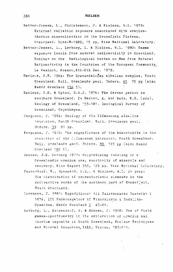
386 NIELSEN
B a t t e r - J e n s e n , L., Christensen, P. & Nielsen, B.L. 1978:
Ex t e r n a l r a d i a t i o n exposure a s s o c i a t e d wit h u r a n i u m -
thorium m i n e r a l i z a t i o n on the K v a n e f j e l d Plateau,
Greenland. Risa - M - 1 9 8 9 , 15 PP, Risa N a t i o n a l Laboratory.
B a t t e r - J e n s e n , L., Lavborg, L. & Nielsen, B.L. 1980: Ga mma
ex p osure levels f rom n a tural r a d i o a c t i v i t y in Greenland.
S e m i n a r on the R a d i o l o g i c a l b u r d e n on Man from N a t u r a l
R a d i o a c t i v i t y in the C o u n t r i e s of the E u r o p e a n Community,
Le Vesinet, F r a n c e , 4 t h - 6 t h Dec. 1979-
E meleus, C.H. 1964: The G r a n n e d a l - f k a a l k a l i n e complex, S ou t h
Greenland. Bull. G r a n l a n d s geol. Unders. 45 75 pp (also
M e d d r Gra nl a n d 172 3).
Emeleus, C.H. & Upton, B.G.J. 1976: The Gardar period in
s o u t h e r n Greenland. In Escher, A. and Watt, W.S. (eds),
G e o l o g y of G r eenland, 153-181. G e o l o g i c a l S u r v e y of
Greenland, Copenhagen.
Ferguson, J. 1964: G e o l o g y of the I l i m a u s s a q a l k aline
intrusion, S o u t h Greenland. Bull. G r ö n l a n d s geol.
U n d e r s . ¿ 9 81 p p .
Ferguson, J. 1970: The s i g n i f i c a n c e of the k a k o r t o k i t e in the
e v o l u t i o n of the I l i m a u s s a q intr usion, S o u t h Greenland.
Bull. G r ö n l a n d s geol. Unders. 89 193 pp (also Me d d r
G r ö n l a n d 1_90 1 ) .
Hansen, J.K. Ga m b o r g 1977: S u l p h a t i s i n g r o a s t i n g of a
G r e e n l a n d i c u r a n i u m ore, r e a c t i v i t y of m i n e r a l s and
re covery. R i s 0 Re p o r t 355, 129 pp. Riso N a t ional Laboratory.
Kunz e n d o r f , H., Nyegaard, P . L., & Nielsen, B.L. in prep:
The d i s t r i b u t i o n of c h a r a c t e r i s t i c elements in the
r a d i o a c t i v e rocks of the n o r t h e r n part of Kvanefjeld,
South Greenland.
Lorenzen, J. 1881: E x p e d i t i o n e n til J u l i a n e h a a b s D i s t r i k t i
1876, III U n d e r s a g e l s e r af M i n e r a l e r n e i Sodal i t h -
S yeniten. M e d d r G r ö n l a n d 2 43-81.
Lavbo rg , L., K u n zendorf, H. & Hansen, J. 1968: Use of field
g a m m a - s p e c t r o m e t r y in the e x p l o r a t i o n of u r a n i u m and
thorium d e p osits in South Greenland, Nu c l e a r T e c h n i q u e s
and M i n e r a l R e s o u r c e s , I A E A , Vienna, 197-211.
IAEA-AG-250/11 387
Lzvborg, L., W o l lenberg, H., Sorensen, P. & Hansen, J. 1971:
Fi e l d d e t e r m i n a t i o n of u r a n i u m and t h orium by g a m m a - r a y
s p e c t r o m e t r y e x e m p l i f i e d by m e a s u r e m e n t s in the
I l i m a u s s a q a l k a l i n e intrusion, S o u t h Greenland'. Econ.
Geol. ^6 368-384.
Levborg, L., W o l lenberg, H., R o s e - H a n s e n , J. & Niel sen, B.L.
1972: D r i l l - c o r e s c a n n i n g for r a d i o e l e m e n t s by gamma-
ra y s p e c t r ometry. G e o p h y s i c s 37 675-693.
Lovborg, L., B o t t e r - J e n s e n , L., C h r i s t iansen, E.M. & Nielsen,
B.L. 1980: G a m m a - r a y m e a s u r e m e n t s in an area of high
na tural r a d i o a c t i v i t y . 3rd I n t e r n a t i o n a l Symp. on the
N a t u r a l R a d i a t i o n Envi r o n m e n t , Hous ton, Texas 23- 2 8 April,
1978.
Lovborg, L., Nyegaard, P., C h r i s t i a n s e n , E . M . & Niels en, B.L.
1980: B o r e h o l e l o ggi ng for u r a n i u m by g a m m a - r a y
s p e c t r o metr y. G e o physics. June 1980 Issue.
M akovicky, M., Nielsen, B.L., K a r u p - M o l l e r , S., Makov i c k y , E.
& Sorensen, E. 1980: M i n e r a l o g i c a l , r a d i o g r a p h i c and
u r a n i u m l e a c h i n g studies on the u r a n i u m ore fro m K v a n e
fjeld, I l i m a u s s a q complex, South Greenland. Rise Report,
in press, Riso N a t i o n a l Laboratory.
Nielsen, B.L. & S t e e n f e l t , A. 1979: I n t r u s i v e events at
K v a n e f j e l d in the I l i m a u s s a q i g neous complex. Bull. geol.
Soc. D e n m a r k 2_7 143-155-
Nyegaard, P., Nielsen, B.L., Lovborg, L. & Sorensen, P. 1977:
K v a n e f j e l d U r a n i u m Proj ect, D r i l l i n g P r o g r a m m e 1977.
I n t e r n a l G G U report.
R ose - H a n s e n , J. & Sorensen, H. (eds) 1979: Geo l o g i c a l , g e o
c h e mical and e c o l o g i c a l s tudies in the I l i m a u s s a q area,
S o u t h Green l a n d . Rapp. G r ö n l a n d s geol. Unders. 95 79-81.
Semenov, E.I. 1974: E c o n o m i c m i n e r a l o g y of a l k a l i n e rocks.
In Sorensen, H. (ed) The a l k a l i n e rocks 543-552. Joh n
W i l e y and Sons, London, New York.
Steenfelt, A. & Bohse, H. 1975: V a r i a t i o n s in the c o ntent of
u r a n i u m in e u d i a l y t e from the d i f f e r e n t i a t e d a l k a l i n e
I l i m a u s s a q i ntrusion, South G reenland. Li t h o s 8 39-45.
388 NtELSEN
Sorensen, E., L u ndgaard, T., R a smussen, I. & Dibbern, H.C.
1978: Pi lot plant' testing on u r a n i u m e x t r a c t i o n fro m the
K v a n e f j e l d ore deposit. R Í S 0 - M - 2 1 O 2 , Risa N a t i o n a l
L aboratory, 63 pp.
So rensen, H. 1958: The I l i m a u s s a q batholith, a re v i e w and
d iscussion. Bull. Grönl a n d s geol. Unders. 19 48 pp
(also M e d d r G r ö n l a n d 162 3).
So rensen, H. 1967: On the hi s t o r y of e x p l o r a t i o n of the
I l i m a u s s a q a l k a l i n e intrusion, South Greenland. Bull.
G r ö n l a n d s geol. Unders. 6_8 33 pp (also Med d r G r ö n l a n d
181 3).
Sorensen, H. 1970: O c c u r r e n c e of u r a n i u m in a l k a l i n e igneous
rocks. U r a n i u m E x p l o r a t i o n G e o l o g y (Proc. Panel, V i e n n a
1970) IAEA, Vi enna, 161-168.
Sorensen, H. 1970: I n t e r n a l stru c t u r e s and g e o l o g i c a l se t t i n g
of the three a g p a i t i c intru s i o n s - K h i b i n a and L o v ozero
of the Kola P e n i n s u l a and Ilimaussaq, South G reenland.
Can. Miner. 1_0 299-334.
Sorensen, H. 1977: F e a t u r e s of the d i s t r i b u t i o n of u r a n i u m in
igneous rocks - u r a n i u m d e p osits a s s o c i a t e d w ith igneous
rocks. R e c o g n i t i o n and E v a l u a t i o n of U r a n i f e r o u s Areas
(Proc. T e c h n i c a l C o m m i t t e e Meeting, Vienna, 1975) IAEA,
V i e n n a , 4.7 -52 .
So rensen, H., Hansen, J. & Bondesen, E. 1969: P r e l i m i n a r y
a ccount of the g e o l o g y of the K v a n e f j e l d area of the
I l i m a u s s a q intrusion, South G r eenland. Rapp. G r ö n l a n d s
'geol. Unders. 1_8 4 0 pp.
So rensen, H., Ros e - H a n s e n , J., Nielsen, B.L.,. Lovborg, L.,
Sorensen, E. & Lundgaard, T., 1974: The u r a n i u m deposit
at K v a n e f j e l d , I l i m a u s s a q intrusion, S o u t h Greenland.
Rapp. G r ö n l a n d s geol. Unders. 60 54 pp.
So re n s e n , E . , L und gaard , T . , Rasmussen , I . & D ib b e r n , H . C . :
P i l o t p la n t t e s t in g on uranium e x t r a c t io n from the K v a n e f je l d
ore d e p o s i t . Riso-M-2102, Riso N a t io n a l L ab o r a to r y , 63 pp.
Ussing, N.V. 1912: G e o l o g y of the c o u n t r y around J u l i aneha ab,
G reenland. M e d d r Grönl a n d 3_8 426 pp.
IAEA-AG-250/19
URANIUM MINERALIZATION IN THE BOHEMIAN MASSIF AND ITS EXPLORATION
M. MATOLÍN, O. PLUSKAL, M. RENÉ Faculty o f Science,Charles University,Prague,Czechoslovak Socialist Republic
Abstract
URANIUM MINERALIZATION IN THE BOHEMIAN MASSIF AND ITS EXPLORATION.
Long-term systematic and planned uranium survey including airborne, carbome, ground,
logging and laboratory radiometric measurements as well as geological and geochemical
investigations have shown a difference in radioactivity of two regional geological units in
Czechoslovakia. The higher regional radioactivity of the Variscan granitoid rocks of the
Bohemian Massif differs from that of the West Carpathians and is associated with more frequent
uranium mineralization. Endogenous vein-type uranium mineralization has a spatial association
with high-radioactivity granitoids in the Bohemian Massif. Airborne prospection defined rock
radioactivity features on a regional scale while surface and subsurface radiometric and geological
investigations using various techniques localized important uranium deposits. Complex statistical
evaluation of numerous geophysical and geological data was studied in order to delineate
uranium-favourable areas.
1. INTRODUCTION
Different radioactivity values were recorded in the rocks o f the Bohemian Massif (also called the Czech Massif) and in those o f the West Carpathians, Czechoslovak Socialist Republic. The preponderance of uranium deposits in the Bohemian Massif is linked with a substantially higher radioactivity o f granitoid rocks. Investigation of the vein-type uranium mineralization revealed the spatial relation of this mineralization with Variscan granitoids. The uranium mineralization was found to be associated with the development o f disjunctive tectonics on a regional and a local scale, which is reflected in the morphology o f the ore bodies. Two basic morphological types have been distinguished in the Bohemian Massif: the vein mineralization летми and the mineralization in tectoniczones. Pre-Variscan uranium mineralization has not been known in the Bohemian Massif. Various geological and geophysical exploration methods led to discoveries of uranium mineralization in crystalline and sedimentary rocks.
389
390 MATOLÍN et al.
There are endogenous and exogenous uranium deposits in the Bohemian Massif. Following a world-wide trend, a detailed investigation o f uranium deposits in young sedimentary formations o f the Bohemian Massif is under way. Increasing attention is also being paid to the distribution principles and to the geochemical and structural conditions o f deposits in the crystalline series o f the Bohemian Massif.
The vein-type uranium mineralization occupies a significant position in the métallogénie province o f the Bohemian Massif both economically and scientifically; for example, for unravelling the important problems of distribution and geological position o f ore deposits. Published ten years ago, a report on the general characteristics o f the uranium deposits of the Bohemian Massif described the geological position and mineralogical conditions o f vein-type uranium deposits and gave a general outline o f individual genetic types [ 1 ].
From the point o f view o f geological position, the basic classification of vein-type uranium deposits o f the Bohemian Massif into three métallogénie zones remains valid (F ig.l):
(а) МэМяяиАми zone (deposits: Dylen, Chotëbor, Jasenice, Licomerice, Predborice, Pribram, Okrouhlá Radouft, Rozná-Olsí, Slavkovice, Vitkov,Zadni Chodov);
2. GEOLOGICAL CHARACTERISTICS OF URANIUM DEPOSITS
F7G.A Map o/ ?Ae CzechoyiovaA: Sociait'st RepubHc showing mefaHogeni'c zones in fAe ДоАемп'ал Afassi/.
(-^RoAemianMassif; W^esfCarpafAi'ans. ( МуМалмМсытл; ^^axoni'an-rAMri'ngi'anzone; ^ 5мб?е?;'с-.Могаи'ал zone; ^ Омгйле о/occurrences о/yein-fype ыгап;ыю nn'neraHzafton in fAe ßoAemi'an Jtiassi/!
IAEA AG 2 5 0 /Í9 391
(b) &2XOHMM-7 %Mn'Hg;an zone (deposits: Horni Siavkov, Jâchymov,Mëdënec);
(c) Зиб?е?;'с-Л?огау;'аи zo^e (deposits: Harrachov, Javornik, Medvëdin, Prehrada, Prichovice).
Two basic types o f uranium mineralization have currently been distinguished on the basis o f structural, lithological and geochemical study of the conditions o f vein-type uranium mineralization (J. Kominek in Ref. [2]):
(a) Deposits in mineralized tectonic zones;(b) Deposits o f vein type леиди
The deposits o f type (a) (Dylert, Okrouhlá Radouft, Rozná-ОШ, Zadni Chodov) are associated with the systems o f thick deep-seated dislocation zones and pertinent feathered dislocations and with joints o f lower orders with NNW—SSE and N—S strike. These deposits are distinguished by metasomatic alteration of rocks surrounding mineralized structures, frequent presence of finely dispersed graphite and organic substance in dislocation filling, and by unsharp mineralization outlines o f ore bodies. The vertical range o f the mineralization is mostly large. Study of the isotopic composition o f S, С and О revealed relations o f some deposits to the rocks of wider surroundings, which could indicate that sulphur in the sulphides or ore minerals could derive from these rocks, and that the isotopic composition of С and О of carbonates betrays the meteoric origin of water o f mineralized solutions.
The deposits o f type (b) (Jâchymov, Pribram, Slavkovice) are characterized by the vein filling o f dislocations and joints whose uranium minerals are mostly associated with carbonates. Investigations carried out in the Pribram district revealed that the localization o f mineralization is primarily controlled by structural factors and that the thickness o f mineralized sectors is closely related to the mechanical properties o f host rocks. Also significant for the localization of mineralization is the oxidation reduction potential o f individual series which build up the ore deposit district. In ore-bearing series it is two to three times higher than in the surrounding series. The deposits lying in the Upper Proterozoic series of the Barrandian Area, and in the íelezné hory zone situated to the east o f it, were found typically to contain uranium-organic complexes replacing the original, often massive, uranite mineralization. Their distribution increases either depth- wards (Pribram) or completely replaces primary mineralization (2elezné hory), preserving only unimportant relics. Judging by the latest investigation, the organic matter o f uranium-bearing antraxolites is probably o f biogene origin, as evidenced by the presence o f isoprenoid hydrocarbons of phytan and pristan along with the results o f isotopic С analysis. The sediments whose hydrocarbons were mobilized by the operation o f magmatic sources are regarded as a source o f hydrocarbons.
392 MATOLÍN et at.
FYC.2. Гурел o/^ranifoids о/ fAe RoAewian Мая;/¡n reiafion io pein-fype uranium mineraiizafion.
Craniioids wifA more /requenf occurrence о/yein-^pe иган;'мп! mineraiizaiion;
2 Cranfíoi'dí wifA rare occurrence о/ ein-fypeuranium mineraiizafion, Zoned íype о/
uranium mineraiizafion; 4 Hein-fype uranium minera/izafion sensu strictu; í/ranium
w;'nerai;'zañon in sedimeniary roc/:s.
In the majority o f deposits, attention is paid to endogenic aureoles of uranium and associated elements as weil as to the development of rock alteration in the surroundings o f ore bodies, and isotopic and geochemical study is under way. Some hydrothermally altered granites in the vicinity o f ore bodies were found to have increased uranium content and lower potassium content in the parts where mineralization is in the endocontact o f granitoids.
The processes leading to loss o f quartz and to the origin of rocks similar to episyenites occurred on a limited scale.
The generally accepted spatial association o f vein^type mineralization with Variscan granitoids is corroborated by later discovery of uranium occurrences in the endocontacts as well as in the exocontacts o f these rocks. The largest proportion o f vein-type uranium occurrences and deposits in the Bohemian Massif (Fig.2) is associated with granitoid bodies of:
The Bor Massif,The Karlovy Vary Massif and the granites o f the Saxonian side,The Krusné hory mountains,The Central Bohemian pluton,The Trebic Massif involving the apophyses lying at a distance several km
from the main body.
IAEA-AG-250/19 393
The Bohemian Massif Variscan granitoids with relatively small representation of vein-type uranium mineralization are as follows:
The Central Moldanubian Massif,The Krkonose-Jizerské hory pluton and other bodies,The Variscan granitoids in the area o f the West Sudeten,The Smrciny Massif,Granite bodies at the boundary o f the West and East Sudeten,The Zelezné hory pluton.
The investigation failed to confirm the originally postulated sterility o f the small granite bodies of the Barrandian area, yet the occurrences o f uranium mineralization belong rather to the second granitoid group.
Exogenous uranium deposits occur in Permo-Carboniferous cover (Kladno- Rakovnik Basin, Lower-Silesian Basin), in Upper Cretaceous and Tertiary (Cheb Basin, Sokolov Basin). Uranium in the Hamr deposit was encountered in fresh-water sediments and shallow marine sediments o f Cenomanian-Senonian age lying on Permo-Carboniferous phyllites and deeply weathered granites.
3- RADIOACTIVITY OF THE BOHEMIAN MASSIF GRANITOIDS
Investigation o f the granitoids is based on systematic airborne, ground and laboratory measurements of gamma activity of rocks carried out during the past twenty years, which yielded data on the radioactivity o f regional geological bodies encountered throughout the entire territory o f the Czechoslovak Socialist Republic [3,4]. These data were also instrumental in drawing some conclusions on uranium deposits.
The radioactivity map o f the rocks o f the CSR (Fig. j ) clearly shows the difference between the Bohemian Massif area, characterized by more frequent occurrence o f extensive areas made up of rocks with increased gamma activity, and the West Carpathians area, displaying regionally low concentration of radioactive elements. Tests indicating different radioactivity o f the rocks of the Bohemian Massif and those o f the West Carpathians disclosed that:
(a) There is no significant difference between sedimentary and metamorphic rocks;
(b) There is no significant difference between magmatic rocks as a whole;(c) There is a significant difference between granitoid rocks (granites,
granodiorites, diorites); and(d) 33% and 6.3% of the area of magmatic rocks in the Bohemian Massif
and in the West Carpathians, respectively, show above-average radioactivity.
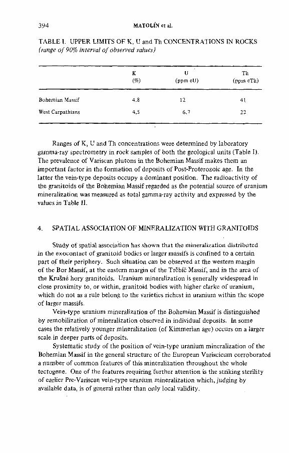
394 MATO LIN et ai.
TABLE L UPPER LIMITS OF К, U and Th CONCENTRATIONS IN ROCKS frange о/90% о/о&легум? va/мм)
К U Th
(%) (ppm eU) (ppm eTh)
Bohemian Massif 4.8 12 41
West Carpathians 4.5 6.7 22
Ranges of К, U and Th concentrations were determined by laboratory gamma-ray spectrometry in rock samples o f both the geological units (Table I). The prevalence of Variscan plutons in the Bohemian Massif makes them an important factor in the formation o f deposits o f Post-Proterozoic age. In the latter the vein-type deposits occupy a dominant position. The radioactivity of the granitoids o f the Bohemian Massif regarded as the potential source o f uranium mineralization was measured as total gamma-ray activity and expressed by the values in Table II.
4. SPATIAL ASSOCIATION OF MINERALIZATION WITH GRANITOIDS
Study of spatial association has shown that the mineralization distributed in the exocontact o f granitoid bodies or larger massifs is confined to a certain part o f their periphery. Such situation can be observed at the western margin o f the Bor Massif, at the eastern margin o f the Trèbic Massif, and in the area o f the Krusné hory granitoids. Uranium mineralization is generally widespread in close proximity to, or within, granitoid bodies with higher clarke o f uranium, which do not as a rule belong to the varieties richest in uranium within the scope o f larger massifs.
Vein-type uranium mineralization o f the Bohemian Massif is distinguished by remobilization o f mineralization observed in individual deposits. In some cases the relatively younger mineralization (o f Kimmerian age) occurs on a larger scale in deeper parts o f deposits.
Systematic study of the position o f vein-type uranium mineralization o f the Bohemian Massif in the general structure o f the European Variscicum corroborated a number o f common features o f this mineralization throughout the whole tectogene. One o f the features requiring further attention is the striking sterility o f earlier Pre-Variscan vein-type uranium mineralization which, judging by available data, is o f general rather than only local validity.
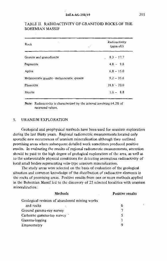
IAEA-AG-250/19 395
TABLE II. RADIOACTIVITY OF GRANITOID ROCKS OF THE BOHEMIAN MASSIF
RockRadioactivity
(ppm eU)
Granite and granodiorite 8.3-17.7
Pegmatite 4.8 - 9.8
Aplite 6.8 - 15.0
Melanocratic granite-melanocratic syenite 9.2 - 35.6
Phonolite 18.8 - 20.0
Diorite 1.0- 8.8
Note: Radioactivity is characterized by the intervai involving 64.2% of
measured values.
5. URANIUM EXPLORATION
Geological and geophysical methods have been used for uranium exploration during the last thirty years. Regional radiometric measurements located only sporadic new occurrences o f uranium mineralization although they outlined promising areas where subsequent detailed work sometimes produced positive results. In evaluating the results o f regional radiometric measurements, attention should be paid to the high degree o f geological exploration o f the area, as well as to the unfavourable physical conditions for detecting anomalous radioactivity o f local small bodies representing vein-type uranium mineralization.
The study areas were selected on the basis o f evaluation of the geological situation and common knowledge o f the distribution o f radioactive elements in the rocks o f promising areas. Positive results from one or more methods applied in the Bohemian Massif led to the discovery o f 25 selected localities with uraniummineralization:
Methods Positive results
Geological revision of abandoned mining worksand rocks 6
Ground gamma-ray survey 7Carbome gamma-ray survey * 5Gamma-logging 1Emanometry 9
396 MATOLIN et a!.
Structures o f promising localities were investigated by means of, in particular, geo-electric methods, magnetometry, gravimetry and, less often, seismic methods. Studies were undertaken o f uranium mineralization prognoses and selection o f promising areas on the basis o f complex evaluation of geological features and geophysical fields using statistical methods [5].
REFERENCES
[1] PLUSKAL, O., "Uranium mineralization in the Bohemian Massif", Uranium Exploration
Geology (Proc. Panel Vienna, 1970),IAEA, Vienna (1970) 107.
[2] HALBRSTÁT, J., KOMÍNEK, J., PLUSKAL, O., World Deposits of Radioactive Raw
Materials, Rep. Faculty of Science, Charles Univ., Prague (1979) 76 p. (in Czech).[3] MATOLÍN, М., Radioactivity of Rocks of the Bohemian Massif, Academia, Prague (1970)
(in Czech), 99 p.
[4] MATOLÍN, М., Radioactivity of RocksofWest Carpathians, Rep. Charles University,
Prague (1976) (in Czech), 127 p.
[5] MATOLÍN, М., STEHLÍK, E., DEDÁCEK, K., "Determination of prospect of raw materials
occurrences by statistical evaluation of geological and geophysical data", Proc. Symp.
Hornická Pribram ve vëdë a technice, geoph. section, Pribram (1976) (in Czech) p.17—37.
ADDITIONAL LITERATURE
BOITSOV, V.E., LEG1ERSKI, Ya., Sequence and time of mineralization on certain
hydrothermal uranium deposits, Geologiya rudnykh mestorozhdenij, Vol. XIX, No.l,(1977), p. 39—50 (in Russian).
PLUSKAL, O., RENE, M., Fundamental problems of uranium metallogeny in European Variscan belt, Internal Rep. Faculty of Science, Charles Univ., Prague (1976) (in Czech).108 p.
DISCUSSION
F. SCÖTT: You described one prospect where emanometry from a depth o f 1 m failed to find an anomaly, while 3-m measurements located a uranium deposit. What is the reason for this?
M. MATOLÍN: This is a very important question for uranium exploration in the second stage. In the first stage we covered the territory by emanometry, sampling from a depth of 1 m. As you know, this is a primitive technique. You try to get the air sample into your detection chamber, and you never know the proportion o f soil air to normal air going through the hole. The results at the first exploration stage showed that if we can make these holes deeper (which is o f course more expensive and has lower daily performances) we usually get better results. The practical problem is how to get the holes to a depth of 2 to 3 m.
!AEA-AG-250/19 397
When the Czechoslovak Uranium Industry groups worked with holes up to 1 m, the productivity o f three-personnel groups was about 300 to 500 holes per day.The productivity with 3-m holes is much lower and only a limited area can be covered with this technique. However, when we study the penetration o f gases in the soil it is quite clear from the mathematical formulae and from experience too that the first 50 cm of the soil do not correspond well to the field o f radioactivity which is underneath, and the deeper you go the more accurate results, corresponding to the radioactivity o f the bedrocks, you will get. I f there is an ore body at 3 to 4 or 6 m which cannot be detected by emanometry at 1 m, it will certainly be detected from a deeper hole.
C. TEDESCO: Emanometry is used much more systematically in your country than elsewhere. Could you explain why emanometry was used and what results you achieved?
M.MATOLÍN: Emanometry gave us very positive results. We used quite simple techniques and the personnel who carried out the work were unskilled but numerous. This was from 1958 to 1964, when emanometry was used to cover the greater part of the Bohemian Massif. The external contacts as well as the granites themselves were used as territory for emanometric measuring. The instruments we used were primarily ionization chambers from the USSR, reported as SG-11. The radioactivity o f the soil gases was read by a moving thread in the spectroscope.These were quite simple instruments, without any electronics, where you read the ionization current directly. Then later on we used the EM- 6 emanometers from the USSR where we used as a detection chamber a scintillation chamber covered by ZnS activated by silver, a well-known scintillation material for detecting alpha radiation. The results were read on the count rate meter. Finally, we are using either the Canadian ETR-1 scintillometer or our own RP-25 emanometer, which is similar. Both systems can determine whether uranium anomalies are o f uranium or thorium origin. The reason we use emanometry is that, owing to the type of cover o f our rocks, the direct techniques o f gamma-ray measuring is often unsuccessful. In these areas, however, we obtained positive results with emanometry. Measuring was done in situ; the radioactivity of soil gases was measured directly. There were many errors because the personnel were not well trained at that time, but from a statistical point o f view, when the technique was applied on a large scale we obtained some results. Now the technique is much improved and we have much more accurate results; it is, however, used on a smaller scale.
J. CAMERON: I would like to take this opportunity to congratulate Professor Matolin on his paper. We in the IAEA have been hoping for about twelve years to have a description o f the uranium deposits o f our neighbouring country, Czechoslovakia, and I am delighted to be here to hear this first presentation, not only because it is an excellent presentation in itself, but also because it is wonderful to have this new information at the IAEA. When will the compilation which Professor Matolin said might appear next year be available? Will it be in Czech and/or English?
398 MATOLÍN et at.
M. MATOLÍN: Thank you for your kind words. I think the book will probably be prepared in Czech with a summary in Russian and English. If there is sufficient interest, it should not be difficult to have it translated into any other language. The main point is that it wiH be issued.
P. BARRETTO: Was the gamma-iogging at the first discovery applied to uranium-exploration holes only or to oil or anything else?
M. MATOLÍN: Many holes were made, for example, for water, prospection for other metallic elements, and for many other geological reasons. There is a regulation that every borehole should be gamma-logged but, unfortunately, this was not always applied at the beginning o f the first stage o f exploration.
P. BARRETTO: The amount of detailed information collected and processed for the uranium resources and favourability study is very impressive. Is this a model or system developed and used by the industry or is it a research conducted by a university, where there would be much more time for such detailed analysis?
M. MATOLÍN: The entire uranium exploration activity rests with the Czechoslovak Uranium Industry, who co-operate with certain external institutions for research work. The Charles University is one o f these and that is where I collaborate. We have some data on uranium exploration and the results of exploration in Czechoslovakia. This type o f complex statistical evaluation of uranium-favourable areas was one o f the external projects which was carried out under my guidance at the University three years.ago. It has not yet been applied on a wide scale because there are certain obstacles, and therefore only minor parts o f the territory have been evaluated from this point o f view; the major part has been evaluated on the basis of individual geological and geophysical results and geological assumptions.

WORKING GROUP REPORT

WORKING GROUP REPORT*
Forty-five cases o f exploration programmes which led to the discovery o f important uranium deposits in the last three decades were selected by the NEA/IAEA Joint Group o f Experts on Research and Development in Uranium Exploration Techniques as possible good examples to be presented for the implementation o f the R&D Proposal No. 1 : 'Uranium Exploration Case Histories' (see Foreword).
The forty-five organizations or companies which conducted these exploration programmes were invited to participate in the meeting, and nineteen favourable responses were received covering the exploration case histories o f twenty uranium deposits. Some private companies were reluctant to provide information on their exploration work, considering it to be too 'sensitive'.
The twenty examples submitted to the meeting represent about 45% of the total o f the selected cases, and although they constitute only a very small fraction o f the discoveries made over the past three decades, they can be considered as very satisfactory and representative samples.
All the participants voluntarily agreed to present information for the benefit o f the nuclear energy industry and it is hoped that these descriptions will assist others in planning and operating uranium exploration programmes round the world.
In contrast to deposits o f other economic minerals, uranium is commonly not directly detectable by techniques known at present for more than a short distance from mineralization, and, in this regard, the cases presented show a wide spectrum o f exploration methods in a wide range o f geographical, geological and cultural conditions. The various exploration methods discussed demonstrate successful applications in some cases and negative results in others. One important fact that emerged from the discussions was that there was no specific technique with universal application.
In several cases, discovery resulted from the application o f more than one technique. Success or failure depended on the selection o f the correct technique to fit a particular type o f deposit in a particular area. Although there are many similar features o f a particular deposit-type, each deposit is unique. Frequently the geological type o f a deposit was not recognized until after discovery and an appreciable number o f discoveries resulted from a re-interpretation of previously available data.
The case histories presented show the basic technical and economic choices that were made in the selection o f favourable areas and in the selection of the exploration methods applied. In most cases it was important to determine favourable regions before selecting the detailed exploration techniques which
Combined report of two Sub-Working Groups.
401
402 WORKING GROUP REPORT
located the actual deposits. The size and grade o f the expected deposits are important, since a particutar quantity o f mineralization may permit extraction in one region but not in another.
In addition to the technical factors o f geology, geophysics and geochemistry, there are a large number o f other local features that must be considered, such as:
Amount o f previous activityExpected cost o f the programmeAvailable skillsLogisticsClimateProximity to infrastructure Environmental concerns Political concerns Available techniques Expected requirements for uranium.
AM these factors must be examined and evaluated before an exploration programme is decided upon.
It is recommended that the NEA/IAEA consider convening a second meeting on case histories o f uranium exploration in two to five years, the timing of such a meeting depending on the response received by the NEA/IAEA to the publication o f the papers presented at this meeting.
ScientificSecretaries
Editor
CHAÏRMEN OF SESSIONS
J. DARDEL France
C. PAPADIA Italy
G. BUNDROCK Canada
M. MATOLÍN CSSR
SECRETARIAT
P. STIPANICIC Division of Nuclear Power and Reactors,
IAEA,Wagramerstrasse 5,
P.O. Box Ю0,A-1400 Vienna, Austria
D. TAYLOR OECD Nuclear Energy Agency,
38 boulevard Suchet,
F-75016 Paris, France
M. LEWIS Division of Publications,
IAEA,Wagramerstrasse 5,
P.O. Box 100,
A-1400 Vienna, Austria
403

LIST OF PARTICIPANTS
BRAZIL
Angeiras, A.G. Nuclebrás Engenharia SA,
Forman, J.M.A. Av. Presidente Wilson 231-10,
Rio de Janeiro
CANADA
Bundrock, G. Urangesellschaft Canada Ltd,Suite 3100,
2 Bloor Street East,Toronto, Ontario M4W 1A8
Scott, F. Esso Minerais Canada,
2300 Yonge Street,P.O. Box 4029, Station A,
Toronto, Ontario M5W 1K3
Tan, B. Uranerz Exploration and Mining Ltd,
3633 Sources Boulevard,
Doilard des Ormeaux, Quebec
CZECHOSLOVAK SOCIALIST REPUBLIC
Matolín, M. Department of Applied Geophysics,
Faculty of Science,
Charles University,Albertov 6,
12843 Prague
DENMARK
Nielsen, B.L. Geological Survey of Greenland,
0sterVoldgade 10,DK-1350 Copenhagen К
406 LIST OF PARTICIPANTS
FRANCE
Darde], J.
Gély, P.
Délégation aux matières nucléaires,
Commissariat à l'énergie atomique,
31 rue de ia Fédération,
F-75015 Paris
Compagnie minière Dong Trieu,
24 avenue de ['Opéra,
F-75001 Paris
GERMANY, FEDERAL REPUBLIC OF
Fuchs, H.D. Urangeseilschaft mbH,
Bleichstrasse 60-62,
D-6000 Frankfurt/Main
Gatzweiler, R. Uranerzbergbau GmbH,
Schmeling, B. Postfach 170210,
Kölnstrasse 367,
D-5300 Bonn
ITALY
Papadia, C. AGIP SPA,
Tedesco, C. 20097 S.Donato Milanese,
Zaccaria, Maria Mitano
SOUTH AFRICA
Stewart, B.D. Johannesburg Consolidated Investment Co. Ltd,
P.O. Box 590,
Johannesburg 2000
SWEDEN
Gustafsson, B. Geological Survey of Sweden,
P.O. Box 801,
S-95128 Lulea
LIST OF PARTICIPANTS 407
UNITED STATES OF AMERICA
Bowman, E.C. Chevron Resources Co.,
225 Bush Street,
San Francisco, CA 94104
Porter, D.A. Conoco Inc.,555 Seventeenth Street,
Denver, CO 80202
ОЯСИЛУИИГЛЖУ
INTERNATIONAL ATOMIC ENERGY AGENCY (IAEA)
^Cameron, J. /сМу 7РД0./К.2) Department of Technical Assistance
and Publications
Barretto, P. Division of Nuclear Power and Reactors
Hansen, M.V.
Trocki, Linda
UNITED NATIONS DEVELOPMENT PROGRAMME (UNDP)
Reed, J.J. (Observer) Exploration for Minerals (UNDP),
P.O.Box 301,
Maseru 100, Lesotho
HOW TO ORDER )AEA PUBLICATIONS
An exctusive sates agent for )A E A pubtications, to whom at) ordersand inquiries shoutd be addressed, has been appointed in the fo4ow ing country:
UNITED STATES OF AMERICA UNIPUB, 345 Park Avenue South, New York, NY 10010
)n the foHowing countries )A E A pubtications may be purchased from the sates agents or bookseMers tisted or through your major tocat booksetters. Payment can be made in toca) currency or with UNESCO coupons.
ARGENTINA
AU STRALIABELGIUM
CZECHOSLOVAKIA
FRANCE
HUNGARY
INDIA
ISRAEL
ITALY
JAPANNETHERLANDS
PAKISTANPOLAND
ROMANIA SOUTH AFRICA
SPAIN
SWEDEN
UNITED KINGDOM
U.S.S.R.YUGOSLAVIA
Comisión Naciona) de Energía Atómica, Avenida de) Libertador 8250, RA-1429 Buenos AiresHunter Publications, 58 A Gipps Street, Coliingwood, Victoria 3066Service Courrier UNESCO, 202, Avenue du Roi, B-1060 BrusseisS.N.T.L., Spáiená 51, CS-113 02 Prague 1Aifa, PubHshers, Hurbanovo námestie 6, CS-893.31 BratistavaOffice Internationa) de Documentation et Librairie, 48, rue Gay-Lussac,F-75240 Paris Cedex 05
P.O. Box 149¡*H-1389 Budapest 6 ^Oxford Book and Stationery Co., 17, Park Street, Caicutta-700 016 Oxford Book and Stationery Co., Scindia House, New Deihi-110 001 Heitiger and Co., Ltd., Scientific and Medica) Books, 3, Nathan Strauss Street, Jerusatem 94227
ViaMeravig)i16^t-20123 MitanMaruzen Company, Ltd., P.O. Box 5050,100-31 Tokyo International Martinus N ijhoff B.V., Booksetiers, Lange Voorhout 9-11, P.O. Box 269, NL-2501 The HagueMirza Book Agency, 65, Shahrah Quaid-e-Azam, P.O. Box 729, Lahore 3 Ars Polona-Ruch, Centraia Handiu Zagranicznego,Krakowsk.e Przedmiescie 7, PL-00 068 Warsaw Üexim, P.O. Box 136*137, BucarestVan Schaik's Bookstore (Pty) Ltd., Libri Buiiding, Church Street,P.O. Box 724, Pretoria 0001Diaz de Santos, Lagasca 95, Madrid-6Diaz de Santos, Batmes 417, Barce!ona-6AB C.E. Fritzes Kung!. Hovbokhandel, Fredsgatan 2, P.O. Box 16356, S-103 27 StockhoimHer Majesty's Stationery Office, Agency Section PDtB, P.O.Box 569, London SE1 9NH
Mezhdunarodnaya Kniga, Smoienskaya-Sennaya 32-34, Moscow G-200 Jugos!ovenska Knjiga, Terazi¡e 27, P.O. Box 36, YU-1100Í Belgrade
Orders from countries where sates agents have not yet been appointed and requests for information shoutd be addressed directty to:
^ Division o f Pubiications^ ¿BP ^ tnternationa) A tom ic Energy Agency
Wagramerstrasse 5, P.O. Box 100, A 1400 Vienna, Austria

IN T E R N A T IO N A L SU B JEC T G R O U P : <VA T O M IC E N E R G Y A G E N C Y Chem istry, G eo logy and Raw Materials/GeologyV IE N N A , 1981 PR ICE : Austrian Schillings 6 3 0 ,-


![[Pennsylvania county histories]](https://img.pdfslide.net/doc/110x75/63257312e491bcb36c0a4ef1/pennsylvania-county-histories.jpg)


