Embed Size (px)
Citation preview
1http://contour.epfl.ch/ CC Attribution 3.0 License
URBAN MORPHOLOGIES IN INFORMAL SETTLEMENTS
AbstractThe emergence of urbanity is related to the ways in which urban informality, morphologies, activities, and temporality work in
relation to sociality and spatiality. Informal settlements are predominantly self-organized and incrementally transformed out of the state control where the traditional approaches to urban theory and design practices have often failed to deal with the complex dynamism of such resilient forms of urbanism. The study aims to explore urban morphologies of informal settlements to unravel the capacities of these settlements as places of self-organization in which complex relations between sociality and spatiality contribute to the emergence of urbanity. Hence, the study focuses on the ways in which informal urbanism mediates urbanity. This conception is neither an attempt to aestheticize the concentration of poverty in informal settlements nor an attempt to undermine the role of the built environment professions in enabling or constraining the possibility of emergent urbanity in the city. On the contrary, the outcomes of the study give rise to the critical role of urban designers, architects, and planners in contributing effectively to the upgrading processes in a way to encourage the affordances for self-organization and incremental transformations over time. Drawing on empirical evidence from the neighbourhood of Khlong Toei in the city of Bangkok, the study seeks to understand the ways in which urban morphologies structure the emergence of urbanity in informal settlements. The research methods are observation, archival records, visual recording, mapping, and multi-scale analysis. In this way, the study contributes to the understanding of how informal settlements work in terms of urban morphologies and the ways in which emergence of street-life intensity can be enabled or constrained by the environmental design professionals.
Hesam KamalipourThe University of Melbourne
Melbourne, [email protected]
keywords: urban morphology, informal settlement, urban mapping, informality, urbanity, Bangkok
the grounded outcome of social and economic forces, tangible shaping of intentions, and concrete transformations of the city. Thus, urban morphology is generated from the interactions between different dynamics that constitute the complexity of the city in which the flux of people and structures are in continuous change (Sobreira, 2003). In effect, poor understanding of morphology can lead to poor design intervention (Marshall & Çalişkan, 2011). This is the point where a sophisticated understanding of urban morphologies in relation to urbanity in informal settlements becomes critical for exploring the space of possibilities in further design interventions. Jacobs (1961) insightfully refers to urban vitality as the interrelations between density, grain size, permeability, and mixed-use. Hence, a combination of density, access networks, and mix is likely to describe the morphological characteristics of the built environment (Ye & Van Nes, 2013) in relation to sociocultural contexts (Kamalipour & Zaroudi, 2014) and predictors of place attachment (Kamalipour, Yeganeh, & Alalhesabi, 2012). In other words, it is likely to provide a more objective basis for further design interventions in urban developments through consideration of the interrelations between density, access, and mix (Mashhoodi & Berghauser Pont, 2011). However, the issue is that elements of
Introduction
Various articulations of urban morphology in urban studies give rise to the relations between spatial structures, functional constellations, access networks, and emergent urbanity at different scales. Moreover, the emergence of informal settlements has become one of the critical challenges of urbanisation within the last decades. The population of informal settlements is going to be around two billion people in the forthcoming thirty years (UN-HABITAT, 2011). Furthermore, the overall population of these settlements grows faster than that of people living in the urban areas (Durand-Lasserve & Royston, 2002). Since most of the studies of informal settlements have focused on the issues of policy and governance at the macro scale, urban morphologies have been less studied in these settlements. Hence, this study focuses on the ways in which informal settlements work in terms of the relations between urban morphologies and street-life intensity to explore the capacities of informal urbanism.
Urban Morphologies and Informal Settlements
Marshall and Çalişkan (2011) define urban morphology as the ‘science of urban form and structure’ that includes analysis, description, possibilities, and explanation of generation processes. Moudon (1997) refers to urban morphology as
2
Kamalipour, HesamURBAN MORPHOLOGIES IN INFORMAL SETTLEMENTSAgency/Agents of Urbanity
http://contour.epfl.ch/ CC Attribution 3.0 License
urban morphology have been largely addressed with different and in some cases problematic articulations in relation to urbanity within the past decades.
The concepts of urban density, access, mix, and interface have long been a critical issue of concern in architecture, urban design, and planning theory. Density describes the relations between an area and a certain number of entities, for instance, people, services, dwellings, or floor areas (Mashhoodi & Berghauser Pont, 2011). Although density has been addressed extensively in the past decades by urban designers and planners, the ambiguity of its definition has led to different implementations and applications (Pont & Haupt, 2007; Van Nes, Berghauser Pont, & Mashhoodi, 2012). As Dovey and Pafka (2014) argue, density is a multi-scalar multiplicity that cannot be reduced to buildings, open spaces, or people. Access networks are mainly about movement, connectivity, and permeability. Movement flows and co-presence are structured by the spatial configuration of access networks (Hillier, 2008). For Jacobs (1961), the principle of short blocks contributes to the network permeability. Mix—including formal, functional, and social mix—is about differences, co-functioning, and multiplicities in the city. For Jacobs (1961), grain size and building age are related to formal mix. Functional mix has been conceptualized as the flows between housing, working and amenities (Van den Hoek, 2008; Van Nes et al., 2012; Ye & Van Nes, 2013). As Van den Hoek (2008) argues, urban diversity is a procedural product of ‘cyclical transformation’ since an urban district can hardly begin to exist immediately with a rich diversity. The interface between public and private space is a transitional space in which the private domain plugs into the public realm (Dovey & Wood, 2015) and the interconnection processes take place (Bobić, 2004; Kamalipour, 2016). Drawing on Benjamin (1978), Dovey and Wood (2015) argue that public/private interfaces play a key role in understanding the concept of urban ‘porosity’ as the improvisational transgression of socio-spatial boundaries. Moreover, it has been argued that urbanity and character are closely related to the quality of interfaces (Bobić, 2004) since urban intensity as a ‘synergic effect’ emerges out of the complex interrelations between the concentrations of activities, people, and buildings (Dovey & Pafka, 2014; Shelton, Karakiewicz, & Kvan, 2011). Resonating with the term ‘emergence’ as it arises from the interplay between different actions (Marshall, 2009), ‘synergy’ refers to the status in
which the effects of two or more interrelated factors are more than simply the sum of their individual ones (Mashhoodi & Berghauser Pont, 2011). In effect, understanding the relations between urban density, access, mix, and interface is then a key condition for exploring the ways in which urbanity plays out in informal settlements.
Working outside of the state control, informal settlements emerge and grow through generative processes of self-organisation and incremental adaptation. Historically, the concept of informality is related to the emergence of the ‘informal sector’ in the 1970s along with the movement of labour to cities (AlSayyad, 2004). However, urban informality can hardly be accurately or profoundly defined (Gilbert, 2004) since it has not been adopted similarly throughout the past decades (Bunnell & Harris, 2012). Indeed, informal settlements, slums, and squatter settlements are not substantially the same (Dovey & King, 2012). Slums are generally linked to the poor condition of water, housing infrastructure, and sanitation; informality refers to the unplanned settlements and the practices, which are not under the formal control of the state; and squatter areas are mainly concerned with the legislative status of the tenure in terms of legality (Dovey & King, 2012; Roy & AlSayyad, 2004; UN-HABITAT, 2008). In this way, informal settlements refer to the unauthorized and unplanned settlements that are generated by the people for whom acquiring affordable housing within the formal market is almost impossible (Huchzermeyer, 2010). Hence, these settlements are ‘transgressive’ because their inhabitants move beyond the limits of the formally state-based codes in terms of tenure, urban design, planning, and construction (Dovey, 2013). That is why exploring the morphologies of these settlements for understanding the generative processes of self-organisation is a key condition to unravel the capacities of urban informality to develop in consistency with incremental upgrading of codes in terms of open spaces, pedestrian networks, constructions, and amenities. As Duarte (2009) argues, morphological analysis of informal settlements can contribute to further design interventions. Thus, drawing on empirical evidence from the case study of Bangkok, this study explores the morphologies of informal settlements.
3
Kamalipour, HesamURBAN MORPHOLOGIES IN INFORMAL SETTLEMENTSAgency/Agents of Urbanity
http://contour.epfl.ch/ CC Attribution 3.0 License
The Case Study of Bangkok
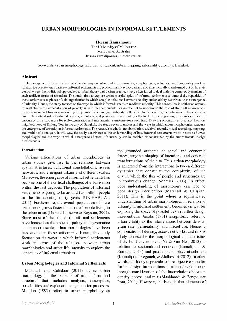
Bangkok is a water-based city that was founded in 1782 as an enclave with a maze-like khlong (canal) network on the eastern bank of the Chao Phraya River and further developed into a cosmopolitan commercial city in Southeast Asia between the 1850s and 1950s (Dick & Rimmer, 2003). The royal capital of Thailand has experienced more than five decades of contestations for imposing a neat ‘internationalised’ imagery of globalization onto what King (2011: 127) refers to as “bewilderingly muddled Bangkok”. Figure 1 shows the distribution of informal settlements across the city of Bangkok. Varying in size and shape, most of the informal settlements have emerged along the Chao Phraya
the city and changes of the rural society have led to the occupation of unused land by the rural-to-urban migrants in the 1960s, when neither the private sector nor the state could provide sufficient housing for the newcomers in the process of rapid urbanisation (Berner & Korff, 1995).
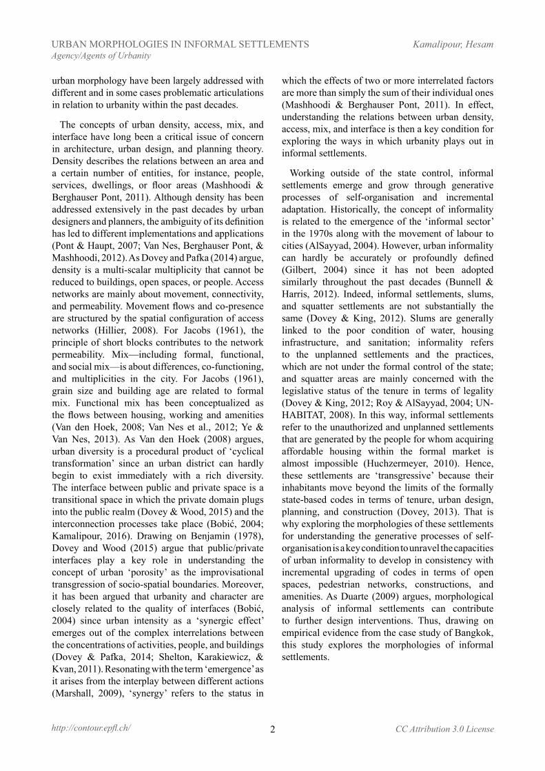
Access to jobs is related to the ways in which the informal settlements are integrated into the city at the macro scale. Integration into the city is reflected in the ways in which major public transport corridors are accessible to and affordable for the urban poor living in informal settlements. The elevated Skytrain (BST) and underground metro (MRTA) are the major public transport systems in Bangkok. Figure 2 shows the distribution of informal settlements at
Figure 1. Distribution of informal settlements across the city of Bankok.
Figure 2. Distribution of informal settlements in relation to major public transport corridors.
River to the west. Patches of informal settlements can be categorised into two distinctive types – linear and concentrated – based on their morphological patterns of emergence and growth. The linear type refers to informal settlements that have emerged along khlongs, highways, or railways. The concentrated type comprises informal settlements that have shaped a district in proximity to temples, or filled urban interstices between highways, primary roads, and khlongs. Unoccupied land and low rental rate give rise to the emergence and growth of informal settlements along the khlongs and around the temples (Wattanawanyoo, 2012). In a sense, concentration of semi-independent communities around religious nodes and markets is an already-existing urban pattern in Bangkok (Askew, 2002). Development of
metropolitan scale in relation to the major public transport corridors. Walkable catchment of 800 meters (about a 10-minute walk) from both BTS and MRTA stations has been mapped to illustrate how major public transport corridors are accessible on foot for the urban poor who are living in informal settlements across the city. Figure 2 indicates that most patches of informal settlements are located far from the major public transport corridors and nodes at the city scale. In fact, only a few patches of informal settlements are located within the walkable catchment of the mapped public transport corridors. However, even if the major public transport corridors were accessible for the urban poor, affordability would be another critical issue. This may be why motorcycles are the most popular alternative to public
4
Kamalipour, HesamURBAN MORPHOLOGIES IN INFORMAL SETTLEMENTSAgency/Agents of Urbanity
http://contour.epfl.ch/ CC Attribution 3.0 License
transport in Bangkok offering ease of circulation in congested traffic at a reasonable cost (Morichi & Acharya, 2013).
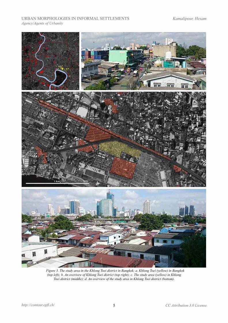
For the micro-scale analysis of urban morphologies, the study focuses on one of the largest and oldest pockets of informal settlements in the city, called Khlong Toei. The location of the selected area is typical in relation to major public transport corridors since it is neither close to the city centre nor close to the urban fringes (Figure 3a). While the selected area is specific in terms of its history of conflict and resistance, it has a range of different types of informal settlements that are typical across the city of Bangkok. There are four major types of informal settlements in the district of Khlong Toei that are linked to the general typology of informal settlements in the city of Bangkok. Drawing on the typology of informal settlements developed by Dovey and King (2011), these four types can be categorised as ‘district’, ‘easement’, ‘waterfront’, and ‘backstage’, since they either form districts of informal structures or follow linear patterns of urban infrastructures such as railways, khlongs, and elevated highways.
Khlong Toei is one of the largest patches of informal settlements that emerged in 1960s when the harbour provided employment in proximity to an unattractive and swampy land, which was formerly far from the city centre (Berner & Korff, 1995). Historically, most of the sea transportation of goods and cargo took place at the port of Khlong Toei, which was the major port located on the Chao Phraya River in the city of Bangkok and close enough to the Gulf of Thailand. Figure 3a shows the location of the area in relation to the other patches of informal settlements in the city. Accommodating more than 25,000 people on 325 acres of land (Askew, 2002), most of the informal settlements within the Khlong Toei district have been developed on the land, which belongs to the Port Authority of Thailand. Figure 3d shows how the area has become a part of the inner city due to the process of urban expansion through which a highway, large intersection, and a number of high-rise buildings have established in the Khlong Toei district. Askew (2002) argues that Khlong Toei as a site of conflict and contestation plays a paradoxical role in the city of Bangkok. While the National Housing Authority (NHA) has leased more than 60 percent of the land from the Port Authority in the process of upgrading, the tenure forms are neither entirely illegal nor legal (King & Dovey, 2013).
Figure 3c indicates that ‘district’ is the dominant type of informal settlements in the Khlong Toei area. It comprises a large number of informal structures that are concentrated on the backstage of some mid-rise slabs (Figure 3b). Building height ranges from one to two storeys (Figure 4d) while several five-storey slabs define the western and southern boundaries of the settlement. The gross coverage is about 92 percent.
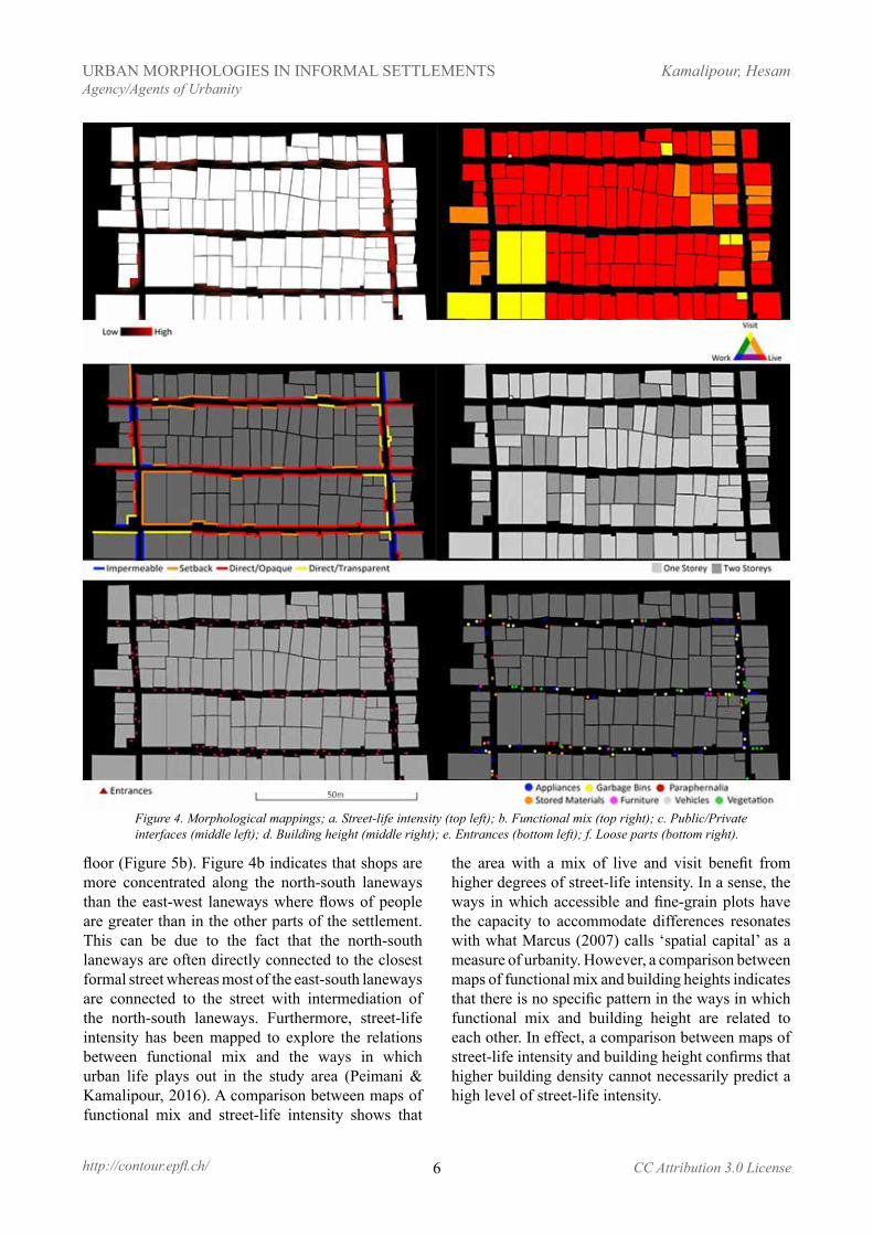
Shaping a relatively regular grid, the access network is the only public space and is limited to the narrow laneways with a width of one to 1.2 meters. Six main entrances of 2.5 meters wide, which are located in between the mid-rise slabs, provide access to the whole settlement. The access network within the settlement is relatively well connected and highly permeable with a combination of an average block size of 15 to 65 meters and a few number of dead ends less than 15 metres long. The study area benefits from 670 meters of accessible interfaces within the area of about 4300 square meters, which can be bounded in a rectangular with a perimeter of 270m (Figure 4). This length of accessible interfaces is distributed among a large number of fine-grained plots that are concentrated in the blocks. This is reflected in the presence of entrances on all sides of the blocks (Figure 4e). Figure 4e shows that there are more than 25 entrances on both sides of a public laneway with an average length of 65 meters. On average, it means an entrance in every five metres on each side of the public laneway. In other word, there are two connection points between a public laneway and private spaces in every five metres.
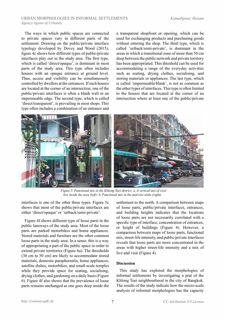
Drawing on the analytical framework of functional mix developed by Van den Hoek (2008), Figure 4b shows that the area is predominantly residential with a few community facilities, small-scale temples, and a number of mix conditions between living and visiting. The live/visit mix is either a horizontal combination of a small shop with an attached residential unit, often one room deep, or a vertical combination of a shop on the ground level and a residential unit on the upper floor (Figure 5a). In this way, the live/visit mix provides the possibility for direct linkage between the public space and private area on the ground level. In the case of the buildings that are at least two storeys high, it also provides the opportunity for natural surveillance by overlooking from upper-level residential units (Figure 5). The five-storey slabs accommodate a vertical mix of work/live on the upper levels and visit on the ground
5
Kamalipour, HesamURBAN MORPHOLOGIES IN INFORMAL SETTLEMENTSAgency/Agents of Urbanity
http://contour.epfl.ch/ CC Attribution 3.0 License
Figure 3. The study area in the Khlong Toei district in Bangkok; a. Khlong Toei (yellow) in Bangkok (top left); b. An overivew of Khlong Toei district (top right); c. The study area (yellow) in Khlong
Toei district (middle); d. An overview of the study area in Khlong Toei district (bottom).
6
Kamalipour, HesamURBAN MORPHOLOGIES IN INFORMAL SETTLEMENTSAgency/Agents of Urbanity
http://contour.epfl.ch/ CC Attribution 3.0 License
floor (Figure 5b). Figure 4b indicates that shops are more concentrated along the north-south laneways than the east-west laneways where flows of people are greater than in the other parts of the settlement. This can be due to the fact that the north-south laneways are often directly connected to the closest formal street whereas most of the east-south laneways are connected to the street with intermediation of the north-south laneways. Furthermore, street-life intensity has been mapped to explore the relations between functional mix and the ways in which urban life plays out in the study area (Peimani & Kamalipour, 2016). A comparison between maps of functional mix and street-life intensity shows that
the area with a mix of live and visit benefit from higher degrees of street-life intensity. In a sense, the ways in which accessible and fine-grain plots have the capacity to accommodate differences resonates with what Marcus (2007) calls ‘spatial capital’ as a measure of urbanity. However, a comparison between maps of functional mix and building heights indicates that there is no specific pattern in the ways in which functional mix and building height are related to each other. In effect, a comparison between maps of street-life intensity and building height confirms that higher building density cannot necessarily predict a high level of street-life intensity.
Figure 4. Morphological mappings; a. Street-life intensity (top left); b. Functional mix (top right); c. Public/Private interfaces (middle left); d. Building height (middle right); e. Entrances (bottom left); f. Loose parts (bottom right).
7
Kamalipour, HesamURBAN MORPHOLOGIES IN INFORMAL SETTLEMENTSAgency/Agents of Urbanity
http://contour.epfl.ch/ CC Attribution 3.0 License
interfaces is one of the other three types. Figure 5c shows that most of the public/private interfaces are either ‘direct/opaque’ or ‘setback/semi-private’.
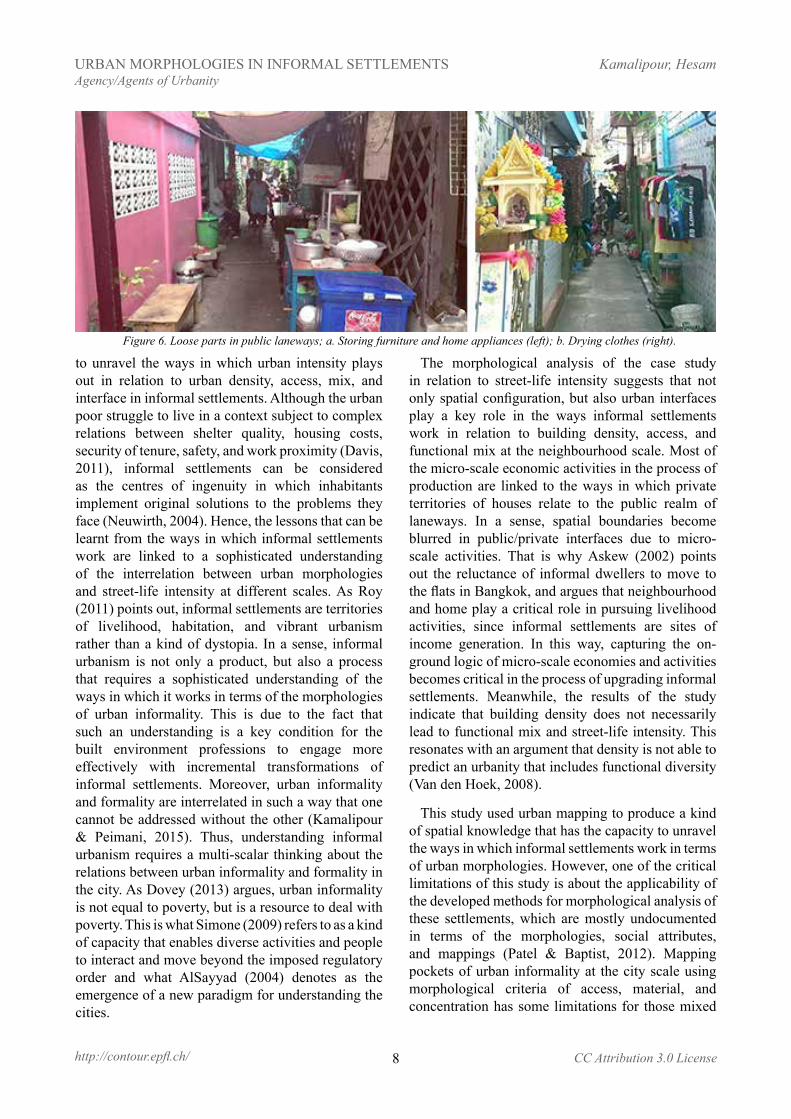
Figure 4f shows different type of loose parts in the public laneways of the study area. Most of the loose parts are parked motorbikes and home appliances. Stored materials and furniture are the other common loose parts in the study area. In a sense, this is a way of appropriating a part of the public space in order to extend private territories (Figure 6a). The thresholds (30 cm to 50 cm) are likely to accommodate stored materials, domestic paraphernalia, home appliances, satellite dishes, motorbikes, and small-scale temples while they provide space for seating, socialising, drying clothes, and gardening on a daily basis (Figure 6). Figure 4f also shows that the prevalence of loose parts remains unchanged as one goes deep inside the
settlement to the north. A comparison between maps of loose parts, public/private interfaces, entrances, and building heights indicates that the locations of loose parts are not necessarily correlated with a specific type of interface, concentration of entrances, or height of buildings (Figure 4). However, a comparison between maps of loose parts, functional mix, street-life intensity, and public/private interfaces reveals that loose parts are more concentrated in the areas with higher street-life intensity and a mix of live and visit (Figure 4).
Discussion
This study has explored the morphologies of informal settlements by investigating a prat of the Khlong Toei neighbourhood in the city of Bangkok. The results of the study indicate how the micro-scale analysis of informal morphologies has the capacity
Figure 5. Functional mix in the Khlong Toei district: a. A vertical mix of visit/live inside the area (left); b. Functional mix in the mid-rise slabs (right).
The ways in which public spaces are connected to private spaces vary in different parts of the settlement. Drawing on the public/private interface typology developed by Dovey and Wood (2015), figure 4c shows how different types of public/private interfaces play out in the study area. The first type, which is called ‘direct/opaque’, is dominant in most parts of the study area. This type often includes houses with an opaque entrance at ground level. Thus, access and visibility can be simultaneously controlled by dwellers at the entrances. If such houses are located at the corner of an intersection, one of the public/private interfaces is often a blank wall or an impermeable edge. The second type, which is called ‘direct/transparent’, is prevailing in most shops. This type often includes a combination of an entrance and
a transparent shopfront or opening, which can be used for exchanging products and purchasing goods without entering the shop. The third type, which is called ‘setback/semi-private’, is dominant in the areas in which a transitional zone of more than 50 cm deep between the public network and private territory has been appropriated. This threshold can be used for accommodating a range of the everyday activities such as seating, drying clothes, socialising, and storing materials or appliances. The last type, which is called ‘impermeable/blank’, is not as common as the other types of interfaces. This type is often limited to the houses that are located at the corner of an intersection where at least one of the public/private
8
Kamalipour, HesamURBAN MORPHOLOGIES IN INFORMAL SETTLEMENTSAgency/Agents of Urbanity
http://contour.epfl.ch/ CC Attribution 3.0 License
to unravel the ways in which urban intensity plays out in relation to urban density, access, mix, and interface in informal settlements. Although the urban poor struggle to live in a context subject to complex relations between shelter quality, housing costs, security of tenure, safety, and work proximity (Davis, 2011), informal settlements can be considered as the centres of ingenuity in which inhabitants implement original solutions to the problems they face (Neuwirth, 2004). Hence, the lessons that can be learnt from the ways in which informal settlements work are linked to a sophisticated understanding of the interrelation between urban morphologies and street-life intensity at different scales. As Roy (2011) points out, informal settlements are territories of livelihood, habitation, and vibrant urbanism rather than a kind of dystopia. In a sense, informal urbanism is not only a product, but also a process that requires a sophisticated understanding of the ways in which it works in terms of the morphologies of urban informality. This is due to the fact that such an understanding is a key condition for the built environment professions to engage more effectively with incremental transformations of informal settlements. Moreover, urban informality and formality are interrelated in such a way that one cannot be addressed without the other (Kamalipour & Peimani, 2015). Thus, understanding informal urbanism requires a multi-scalar thinking about the relations between urban informality and formality in the city. As Dovey (2013) argues, urban informality is not equal to poverty, but is a resource to deal with poverty. This is what Simone (2009) refers to as a kind of capacity that enables diverse activities and people to interact and move beyond the imposed regulatory order and what AlSayyad (2004) denotes as the emergence of a new paradigm for understanding the cities.
The morphological analysis of the case study in relation to street-life intensity suggests that not only spatial configuration, but also urban interfaces play a key role in the ways informal settlements work in relation to building density, access, and functional mix at the neighbourhood scale. Most of the micro-scale economic activities in the process of production are linked to the ways in which private territories of houses relate to the public realm of laneways. In a sense, spatial boundaries become blurred in public/private interfaces due to micro-scale activities. That is why Askew (2002) points out the reluctance of informal dwellers to move to the flats in Bangkok, and argues that neighbourhood and home play a critical role in pursuing livelihood activities, since informal settlements are sites of income generation. In this way, capturing the on-ground logic of micro-scale economies and activities becomes critical in the process of upgrading informal settlements. Meanwhile, the results of the study indicate that building density does not necessarily lead to functional mix and street-life intensity. This resonates with an argument that density is not able to predict an urbanity that includes functional diversity (Van den Hoek, 2008).
This study used urban mapping to produce a kind of spatial knowledge that has the capacity to unravel the ways in which informal settlements work in terms of urban morphologies. However, one of the critical limitations of this study is about the applicability of the developed methods for morphological analysis of these settlements, which are mostly undocumented in terms of the morphologies, social attributes, and mappings (Patel & Baptist, 2012). Mapping pockets of urban informality at the city scale using morphological criteria of access, material, and concentration has some limitations for those mixed
Figure 6. Loose parts in public laneways; a. Storing furniture and home appliances (left); b. Drying clothes (right).
9
Kamalipour, HesamURBAN MORPHOLOGIES IN INFORMAL SETTLEMENTSAgency/Agents of Urbanity
http://contour.epfl.ch/ CC Attribution 3.0 License
conditions that are not often distinguishable on the aerial photos. Hence, there is no claim here to be comprehensive since defining fixed boundaries between formal and informal can also be controversial. Even at the micro scale analysis of morphologies, some issues of reliability and accuracy need to be addressed. Mapping functional mix using the applied method can be controversial since a mix of live/work is not often recognisable without having access to the interiors of buildings. Moreover, the introduced typology of public/private interfaces for mapping urban interfaces cannot be simply applied to informal settlements due to the fact that the legally recognised boundaries of properties in the formal city become blurry thresholds of negotiation, contestation, and appropriation in informal settlements.
Acknowledgments
The author would like to thank the anonymous reviewers for detailed comments and suggestions. The author would also like to thank Michael Doyle and Dario Negueruela for editing the manuscript and organising the Agency/Agents of Urbanity Colloquium in Swiss Federal Institute of Technology (EPFL) where an earlier draft of this paper was presented.
Image credits
The photos and figures included are those of the author, unless otherwise mentioned. The satellite images are taken from Google Earth. GIS data sourced from OpenStreetMap.
ReferencesAlSayyad, N. (2004). Urban Informality as a “New” Way of
Life. In A. Roy & N. AlSayyad (Eds.), Urban informality: Transnational perspectives from the Middle East, Latin America, and South Asia (pp. 7–30). New York: Lexington.
Askew, M. (2002). Bangkok, place, practice and representation. London: Routledge.
Benjamin, W. (1978). Reflections: essays, aphorisms, autobiographical writings. New York: Harcourt Brace Jovanovich.
Berner, E., & Korff, R. (1995). Globalization and Local Resistance: The Creation of Localities in Manila and Bangkok. International Journal of Urban and Regional Research, 19(2), 208–222.
Bobić, M. (2004). Between the edges: street-building transition as urbanity interface. Bussum: Thoth Publishers.
Bunnell, T., & Harris, A. (2012). Re-viewing informality: perspectives from urban Asia. International Development Planning Review, 34(4), 339–348.
Davis, M. (2011). The prevalence of slums. In S. S. Fainstein & S. Campbell (Eds.), Readings in urban theory (3rd ed., pp. 440–459). Malden, Mass.: Wiley-Blackwell.
Dick, H. W., & Rimmer, P. J. (2003). Cities, transport, and communications: the integration of Southeast Asia since 1850. New York: Palgrave Macmillan.
Dovey, K. (2013). Informalising Architecture: The Challenge of Informal Settlements. Architectural Design, 83(6), 82–89.
Dovey, K., & King, R. (2011). Forms of informality: morphology and visibility of informal settlements. Built Environment, 37(1), 11–29.
Dovey, K., & King, R. (2012). Informal Urbanism and the Taste for Slums. Tourism Geographies, 14(2), 275–293.
Dovey, K., & Pafka, E. (2014). The urban density assemblage: Modelling multiple measures. Urban Design International, 19(1), 66–76.
Dovey, K., & Wood, S. (2015). Public/private urban interfaces: Type, adaptation, assemblage. Journal of Urbanism: International Research on Placemaking and Urban Sustainability, 8(1), 1–16.
Duarte, P. G. B. (2009). Informal settlements: A neglected aspect of morphological analysis. Urban Morphology, 13(2), 138–139.
Durand-Lasserve, A., & Royston, L. (2002). International Trends and Country Contexts – From Tenure Regularization to Tenure Security. In A. Durand-Lasserve & L. Royston (Eds.), Holding their ground: secure land tenure for the urban poor in developing countries (pp. 1–34). London: Earthscan.
Gilbert, A. (2004). Love in the Time of Enhanced Capital Flows: Reflections on the Links between Liberalization and Informality. In A. Roy & N. AlSayyad (Eds.), Urban informality: Transnational perspectives from the Middle East, Latin America, and South Asia (pp. 33–66). New York: Lexington.
Hillier, B. (2008). Space and spatiality: what the built environment needs from social theory. Building Research & Information, 36(3), 216–230.
Huchzermeyer, M. (2010). Pounding at the Tip of the Iceberg: The Dominant Politics of Informal Settlement Eradication in South Africa. Politikon, 37(1), 129–148.
Jacobs, J. (1961). The death and life of great American cities. New York: Random House.
Kamalipour, H. (2016). Mapping Urban Interfaces: A Typology of Public/Private Interfaces in Informal Settlements. Spaces & Flows: An International Journal of Urban & Extra Urban Studies, in press.
Kamalipour, H., & Peimani, N. (2015). Assemblage Thinking and the City: Implications for Urban Studies. Current Urban Studies, 3(4), 402–408.
Kamalipour, H., Yeganeh, A. J., & Alalhesabi, M. (2012). Predictors of Place Attachment in Urban Residential Environments: A Residential Complex Case Study. Procedia - Social and Behavioral Sciences, 35, 459–467.
Kamalipour, H., & Zaroudi, M. (2014). Sociocultural Context and Vernacular Housing Morphology: A Case Study. Current Urban Studies, 2(3), 220–232.
King, R. (2011). Reading Bangkok. Singapore: NUS Press.
10
Kamalipour, HesamURBAN MORPHOLOGIES IN INFORMAL SETTLEMENTSAgency/Agents of Urbanity
http://contour.epfl.ch/ CC Attribution 3.0 License
King, R., & Dovey, K. (2013). Active interstices. In A. M. Brighenti (Ed.), Urban Interstices: The Aesthetics and the Politics of the In-between (pp. 183–203). Burlington, VT: Ashgate.
Marcus, L. (2007). Spatial Capital and how to measure it: an outline of an analytical theory of the social performativity of urban form. 6th International Space Syntax Symposium, Istanbul.
Marshall, S. (2009). Cities, Design & Evolution. New York: Routledge.
Marshall, S., & Çalişkan, O. (2011). A Joint Framework for Urban Morphology and Design. Built Environment, 37(4), 409–426.
Mashhoodi, B., & Berghauser Pont, M. (2011). Studying land-use distribution and mixed-use patterns in relation to density, accessibility and urban form. 18th International Seminar on Urban Form, Montreal.
Morichi, S., & Acharya, S. (2013). Specialties of Asian Megacities. In S. Morichi & S. R. Acharya (Eds.), Transport Development in Asian Megacities (pp. 33–50). Heidelberg: Springer.
Moudon, A. V. (1997). Urban morphology as an emerging interdisciplinary field. Urban Morphology, 1, 3–10.
Neuwirth, R. (2004). Shadow cities: a billion squatters, a new urban world. New York: Routledge.
Patel, S., & Baptist, C. (2012). Editorial: Documenting by the undocumented. Environment and Urbanization, 24(1), 3–12.
Peimani, N., & Kamalipour, H. (2016). Where Gender Comes to the Fore: Mapping Gender Mix in Urban Public Spaces. Spaces & Flows: An International Journal of Urban & Extra Urban Studies, 8(1), 19–30.
Pont, M. B., & Haupt, P. (2007). The relation between urban form and density. Urban Morphology, 11(1), 62–66.
Roy, A. (2011). Slumdog Cities: Rethinking Subaltern Urbanism. International Journal of Urban and Regional Research, 35(2), 223–238.
Roy, A., & AlSayyad, N. (2004). Urban informality: Transnational perspectives from the Middle East, Latin America, and South Asia. New York: Lexington.
Shelton, B., Karakiewicz, J., & Kvan, T. (2011). The Making of Hong Kong. London: Routledge.
Simone, A. (2009). City life from Jakarta to Dakar: movements at the crossroads. New York: Routledge.
Sobreira, F. (2003). Squatter settlements consolidation: Spatial analysis in an agent-based environment. 4th International Space Syntax Symposium, London.
UN-HABITAT. (2008). The state of the world’s cities 2010/2011: bridging the urban divide. London: Earthscan.
UN-HABITAT. (2011). Key Findings and Messages. In R. T. LeGates & F. Stout (Eds.), The city reader (5th ed., pp. 583–589). New York: Routledge.
Van den Hoek, J. W. (2008). The MXI (Mixed-use Index) as Tool for Urban Planning and Analysis. Corporations and Cities: Envisioning Corporate Real Estate in the Urban Future, Brussels.
Van Nes, A., Berghauser Pont, M., & Mashhoodi, B. (2012). Combination of Space syntax with spacematrix and the mixed use index: The Rotterdam South test case. 8th International Space Syntax Symposium, Santiago.
Wattanawanyoo, K. (2012). Poverty tourism as advocacy: a case in Bangkok. In F. Frenzel, K. Koens, & M. Steinbrink (Eds.), Slum tourism: Poverty, power and ethics (pp. 207–214). London: Routledge.
Ye, Y., & Van Nes, A. (2013). Measuring urban maturation processes in Dutch and Chinese new towns: Combining street network configuration with building density and degree of land use diversification through GIS. The Journal of Space Syntax, 4(1), 18–37.


