Embed Size (px)
Citation preview

3rd International Geography Symposium - GEOMED 2013Symposium Proceedings, ISBN: 978-605-62253-8-3
142
Using GIS and Remote Sensing Technology to DetermineGeographical Features of Watersheds,Example of Nilufer Creek Watershed
UFUK FATİH KÜÇÜKALİDepartment of Architecture, Istanbul Aydin University, İstanbul - Turkey
AbstractThis study forms an example of how medium and large scale watershed studies are coupled
with Geographical Information Systems in the determination of the past and presentenvironmental characteristics. In this study, Nilufer Creek Watershed has been studied throughthe aid of GIS and Remote Sensing Technologies. Within this context, various thematic layerslike administrative boundaries, watershed and sub-watershed boundaries, land-use distribution,geology, geomorpholgy, soil, water quality are produced. Besides maps showing the streamnetwork, drainage, sub-watersheds, and Digital Elevation Model of the watershed are presentedas examples. These maps are generated to be further used as input data in the modeling of boththe watershed and the receiving water quality studies. Thus, while in Turkey, watershed plansand local area plans, with GIS and Remote Sensing Technologies determine the current state ofnatural resources, physical - biological - ecological characteristics underlined the need to reflectthe decisions of land use as it should be examined.Keywords: Land Use, Nilufer Creek Watershed, Remote Sensing, Water Resources, WatershedManagement.
1. IntroductionWhen examining geographical characteristics of study area as an underlay for the catchment
basin planning, geographical position, geomorphologic characteristics, hydraulic structure,structure of soil, climate and vegetation have to be considered.
2. Material and MethodFor the purpose of interpretation of data gained from this study and generation of new data,
ArgGIS which is a software of GIS has been used. In the Ecological Risk Analysis approach,pollutions in natural resources in the study area and risks stemming from the pollutions have beenestablished. This detection has been made with the support of digitalization of geographical data,evaluation of existing data and association of them with one another, interpretation of chemicalanalysis results for the catchment basin and CBS maps. However, analysis studies have beenassessed by using GIS measurement, inquiring, classification and overlay analysis methods.
2.1. Research AreaProvince of Bursa is located in the north west of Turkey between northern latitude of 28°10’
and 30°00’ as well as eastern longitudes of 40°40' and 39°35'. Province of Bursa is located inMarmara region, the most developed region of Turkey, in Eastern Marmara and has a total landarea of 10.819 km². Study area has a land area of 1.288,96 km².
Study area covers portions of counties Yıldırım, Nilüfer, Osmangazi, Gürsu and Kestel ofthe province of Bursa. Catchment basin of the Stream Nilüfer has been divided into 9 lower

3rd International Geography Symposium - GEOMED 2013Editors: Recep Efe, Ibrahim Atalay, Isa Cürebal
143
catchment basins from perspective of methodological approach and position of pollutionmeasurement stations, and by taking into consideration flow of Stream Nilüfer from source todownward, and drainage conditions from upper catchment basins to lower catchment basins andwater division lines. These sub basins include Nilüfer Stream Branch Sub-Basin, Ayvalı CreekBranch Sub-Basin, Cilimboz Creek Branch Sub-Basin, Gökdere Branch Sub-Basin, HacivatCreek Sub-Basin, Demirtaş Creek Sub-Basin, Hasanağa Creek Sub-Basin, Üçpınar Creek BranchSub-Basin and Karaağaç Creek Sub-Basin (Fig. 2.).
Fig. 1. Research area
3. Findings and Discussion
3.1. Geomorphologic CharacteristicsDecisive character of physiographic structure over the micro-macro climate of the catchment
basin varies proportionally depending on what morphologic formation shapes catchment basincontains (Atabay, 2003). It is seen that Bursa Plain’s latitude above the sea level is 100 to 150meters, and surface shapes of Bursa are separated from one another with thresholds composed ofrift areas and mountains. Around 35% of the terrain within province of Bursa is composed ofmountains. The most obvious geomorphologic threshold located to the south of study area is theMount Uludağ. Major rift areas include the lakes İznik and Uluabat and Yenşehir, İnegöl andBursa plains. “Bursa Plain is located within Southern Marmara boundaries of Marmara Region.Plain is bordered by the Mount Uludağ (2543 m) that is the highest peak of Marmara region andto the south and Mudanya Hills and the Mount Katırlı to the north. Plain is bordered by, to theeast, Aksu-Kazancı Hill threshold separating İnegöl Basin from Bursa Plain and the VillageTuran (Boşnak) threshold separating Bursa form Yenişeehir Plain which goes up to 400 meters,and, to the west, is bordered by a threshold area separating the lake Ulubat and Karacabey Plain

3rd International Geography Symposium - GEOMED 2013Symposium Proceedings, ISBN: 978-605-62253-8-3
144
which is 237 meters high. Within the boundaries set out, Bursa Plain has a land area of 530 km²when the contour line of 200 m is taken as basis, and has a land area of 295 km² when contourline of 100 m is taken as basis ” (Arınç, 2010). Due to extremely high inclination values of themountains, geomorphologic formations, there is reduced risk of underground and surface waterpollution during process of infiltration of the rain waters or pollution discharges by the soil.These values demonstrate medium risk in the plateaus and high risk in the plains due to drainagecharacteristics determined by the inclination characteristics.
3.2. Digital Elevation Model (DEM)Digital elevation model may be defined as digital design of elevations and/or levels defined
with combination of point elevation values established with the measurements in the land basedon a system or randomly (Turoğlu, 2000).
Fig. 2. Digital Elevation Model
In this study, existing topographic maps have been digitalized and elevation curves havebeen drawn after definition of corner edge coordinate systems. In the next phase, these elevationcurves have been converted into irregular triangularized network (TIN) system via AreView and,then, raster data by using the same program, and digital elevation model has (DEM) has beengenerated (fig. 2). Inclination and exposure maps have been generated by using the digitalelevation model in this study. In this study, existing topographic maps have been digitalized andelevation curves have been drawn after definition of corner edge coordinate systems. In the nextphase, these elevation curves have been converted into irregular triangularized network (TIN)system via AreView and, then, raster data by using the same program, and digital elevationmodel has (DEM) has been generated (fig. 2). Inclination and exposure maps have beengenerated by using the digital elevation model in this study.
3rd International Geography Symposium - GEOMED 2013Editors: Recep Efe, Ibrahim Atalay, Isa Cürebal
145
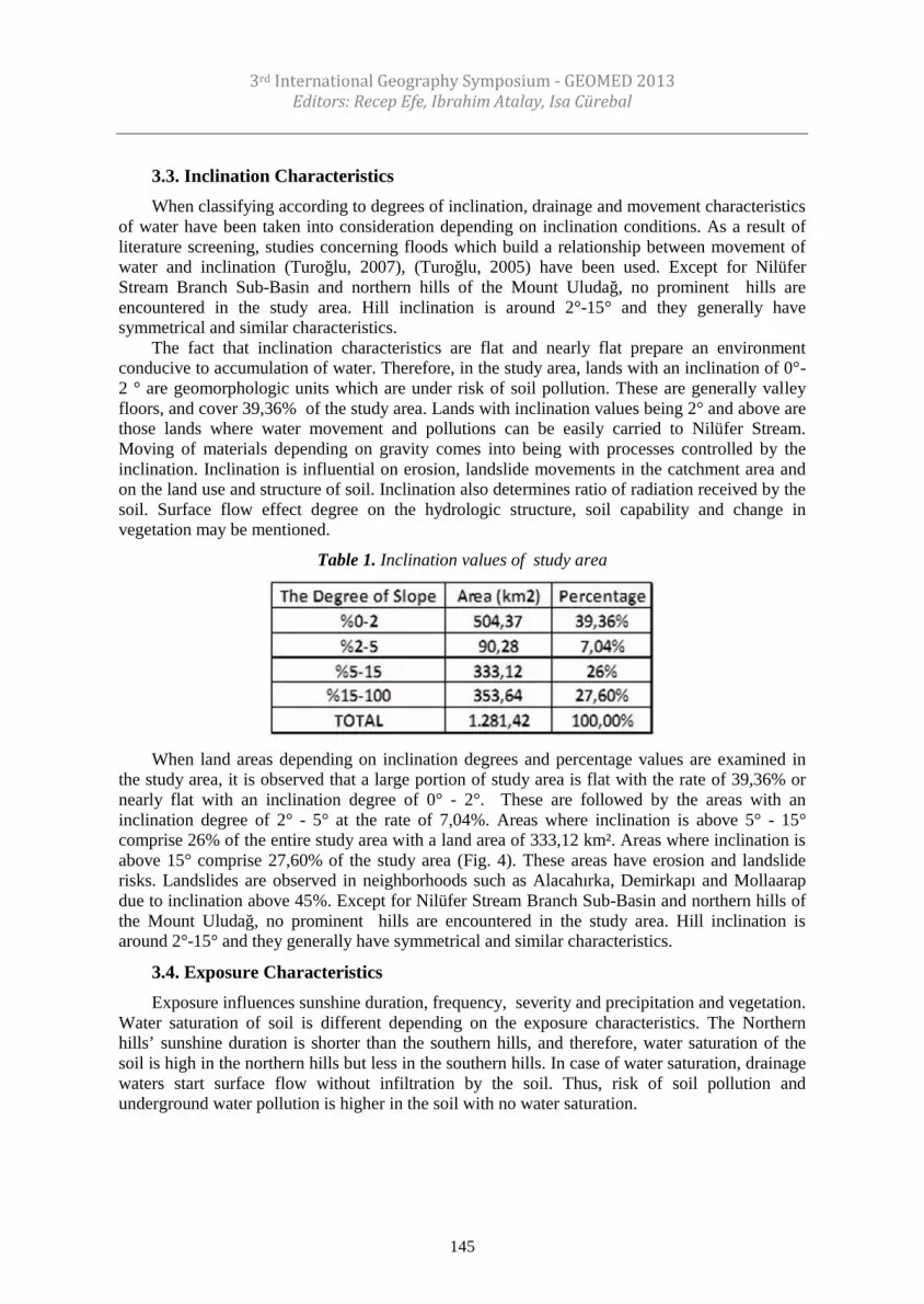
3.3. Inclination CharacteristicsWhen classifying according to degrees of inclination, drainage and movement characteristics
of water have been taken into consideration depending on inclination conditions. As a result ofliterature screening, studies concerning floods which build a relationship between movement ofwater and inclination (Turoğlu, 2007), (Turoğlu, 2005) have been used. Except for NilüferStream Branch Sub-Basin and northern hills of the Mount Uludağ, no prominent hills areencountered in the study area. Hill inclination is around 2°-15° and they generally havesymmetrical and similar characteristics.
The fact that inclination characteristics are flat and nearly flat prepare an environmentconducive to accumulation of water. Therefore, in the study area, lands with an inclination of 0°-2 ° are geomorphologic units which are under risk of soil pollution. These are generally valleyfloors, and cover 39,36% of the study area. Lands with inclination values being 2° and above arethose lands where water movement and pollutions can be easily carried to Nilüfer Stream.Moving of materials depending on gravity comes into being with processes controlled by theinclination. Inclination is influential on erosion, landslide movements in the catchment area andon the land use and structure of soil. Inclination also determines ratio of radiation received by thesoil. Surface flow effect degree on the hydrologic structure, soil capability and change invegetation may be mentioned.
Table 1. Inclination values of study area
When land areas depending on inclination degrees and percentage values are examined inthe study area, it is observed that a large portion of study area is flat with the rate of 39,36% ornearly flat with an inclination degree of 0° - 2°. These are followed by the areas with aninclination degree of 2° - 5° at the rate of 7,04%. Areas where inclination is above 5° - 15°comprise 26% of the entire study area with a land area of 333,12 km². Areas where inclination isabove 15° comprise 27,60% of the study area (Fig. 4). These areas have erosion and landsliderisks. Landslides are observed in neighborhoods such as Alacahırka, Demirkapı and Mollaarapdue to inclination above 45%. Except for Nilüfer Stream Branch Sub-Basin and northern hills ofthe Mount Uludağ, no prominent hills are encountered in the study area. Hill inclination isaround 2°-15° and they generally have symmetrical and similar characteristics.
3.4. Exposure CharacteristicsExposure influences sunshine duration, frequency, severity and precipitation and vegetation.
Water saturation of soil is different depending on the exposure characteristics. The Northernhills’ sunshine duration is shorter than the southern hills, and therefore, water saturation of thesoil is high in the northern hills but less in the southern hills. In case of water saturation, drainagewaters start surface flow without infiltration by the soil. Thus, risk of soil pollution andunderground water pollution is higher in the soil with no water saturation.

3rd International Geography Symposium - GEOMED 2013Symposium Proceedings, ISBN: 978-605-62253-8-3
146
Fig.3 Percentage distribution of study area depending on inclination degrees
Fig. 4 Inclination map
Exposure direction land areas in the study area and percentage values are examined, it isseen that a large portion of study area is flat with the ratio of 28,27% and these are the areas withthe highest soil and underground water pollution. Following the flat areas, the exposure valuewith the largest land area in the study area seems to be in the areas with northern exposure withthe ratio of 13,22%. Due to water saturation of soil in these areas, soil and underground water

3rd International Geography Symposium - GEOMED 2013Editors: Recep Efe, Ibrahim Atalay, Isa Cürebal
147
pollution risk is lower than the other exposures. Besides, the fact that pollution discharge in thenorthern exposures shift to surface flow without being infiltrated by the soil with rain waters ishighly likely to create water pollution risk in the Stream Nilüfer. In all other directions, it isobserved that there is a balanced distribution in terms of exposure of the study area.
Fig. 5 Exposure map
3.5. Geological StructureLithology characteristics related to geologic structure have been inspected. Lithologic and
stratigraphic characteristics are important since they determine cracks formed and horizonationdue to temperature - cooling difference, drainage conditions depending on the distribution ofrocks, water excess that starts to flow, and infiltration capability and permeability of the ground.Tectonic characteristics are influential on development of morphology of the catchment basinand hydrographic characteristics.
Existing geological structure play a decisive role on the natural source structure of the studyarea and characteristics of pollution movement. Distribution of the rock types found in thecatchment basin, whether or not these rocks have a porous form, movements of slabs and leakagedetermine infiltration which is effective in mixing of the pollutions found in the study area withthe underground water and routes of underground water movements.
3.5.1. LithologyRisks posed by different lithologic formations in the study area vary largely. Hydrologic
relations between soil type and surface waters, processes assuring movement of the water in thesoil depending on formation of soil according to rock types found in the catchment basin(infiltration, percolation, permeability) vary largely. Infiltration is high in the areas where thereare rocks with large clearance. This, in turn, increases risk of soil and underground water

3rd International Geography Symposium - GEOMED 2013Symposium Proceedings, ISBN: 978-605-62253-8-3
148
pollution. Formations of this type found in the study area are alluvia, sandstone – mudstone –limestone, gneiss, travertine and vulcanite deposition rocks.
Table 2. Exposure values of study area
In those areas where there are rocks with small clearance, infiltration is low, pollutiondischarges and rain waters do not permeate into underground and join drainage system either bysurface flow over soil ground taking place over these rocks and in line with the horizon to whichmain rock joins through soil horizon. Thus, risk of soil and underground water pollution isreduced. Formations of this type found in the study area metamorphic rocks, metadetritic rocksand metavolcanites.
Lithology is decisive in soil structure of catchment basin, land slide and mass movementsand erosion. Changes caused in the hydraulic structure by the lithology determine undergroundwater formation, thermal waters, spring waters, aquifers, sediment status, form and ages,movement and storage situations and hydrologic relations between underground and surfacewaters.
Lithology of the study area and nearby areas is composed of masses of varying ages.Foundation of the Mount Uludağ located in the south of downtown Bursa is composed ofPaleozoic granite (magnetic mass ) and metamorphic masses such as gneiss and clay stoneformed as a result of transformation of granite under high temperature and pressure. Marbleshave spread above these masses in the form of a stripe in the northern skirts of the mount. Kelesis covered with the formations dating back to Neogene era, and schists pertaining to main rockappear in patches around Tepedağ region which is a part of Uludağ system (Ternek et al. 1997).
Neogene lime stones which cover a vast area around İnegöl (sedimentary mass ) havepenetrated into the Paleozoic mass composed of granite and gneiss. In Mudanya, Neogenesedimentary masses such as sand stone and lime stone cover a vary large area. Vicinity ofYenişehir Plain is covered with Neogene hills, and to the west of the region, Paleozoic schist(easily disintegrated clay stone) and lime stones as well as Mesozoic lime stones appear. BursaPlain is a typical depression area and floor of plain is composed of alluvia. Overall inclination isfrom east to the west, and drainage is assured by Stream Nilüfer which has its main branches inthe Mount Uludağ. This river, as from the west of Nişan Tepe (148 m), embeds into its bed andforms embedded meanders. Northern and southern edges of Bursa Plain is bordered by faultlines of east-west direction. Therefore, hot springs appear in patches along the said fault lines andturned Bursa into a region of thermal spring. Travertine deposits precipitated by the hot springsarising out of fault lines are located in the region between plain and mountainous –hillside areas(Ternek and others. 1997).

3rd International Geography Symposium - GEOMED 2013Editors: Recep Efe, Ibrahim Atalay, Isa Cürebal
149
Area covered by the lithologic formations found in Stream Nilüfer Catchment Basin (fig. 6),their positions within the study area and general characteristics are listed below (MTA):
Table 3. Surface distributions of the lithologic formations in Stream Nilüfer Catchment Basin
Table 4. Geologic formations of Stream Nilüfer Catchment Basin
3.6. Hydrologic Structure – Surface Waters
3.6.1. The Stream NilüferStemming from south western hills of the Mount Tepel (2012 m) 10 km north eastern of
Keles county center stretches along south western skirts of the Mount Uludağ. Around the villageMisi, its flow turns towards the north and enters Bursa Plain. It flows through the plain throughan improved bed in a south to north direction and turns towards the west in the north of thevillage Dereçavuş. By the way, waters of the major creeks stemming from the south of BursaPlain and flowing downwards from northern hills of Uludağ such as Aksu, Kestel, Deliçay andGökdere and the creeks Narlıdere, Sarpdere and Kelesen which flow from the north aredischarged and combined in one branch. After this point, Ayvalı Creek stemming from ÇakırköyPlain joins the stream which flows towards the west around the village Göbelye.
The Stream Nilüfer flows through a large valley and joins the River Susurluk around thevillage Hayırlar. Length of the Stream Nilüfer which has an overall inclination of 2% is ~168km, its average water volume is 458.848.800 cubic meters /year, its water catchment basin is 680

3rd International Geography Symposium - GEOMED 2013Symposium Proceedings, ISBN: 978-605-62253-8-3
150
km², and its annual average flow rate is 16,77 cubic meters /second. Immense changes take placein the level of Stream Nilüfer throughout the year, and it has an irregular regimen. Flow rate ofthe Stream Nilüfer ranges from 1,13 cubic meters³/s to 55 cubic meters/s (Buski, 2010).
Fig. 6 Geology Map
Stream Nilüfer is one of the important water sources of Bursa. Apart from potable and utilitywater supply for the city, it is also partially used for irrigation in those plains where the StreamNilüfer passes through. Stream Nilüfer is directly exposed to direct discharge of the majority ofdomestic and industrial waste waters. Until 1997, domestic waste water of the settlementslocated in the catchment basin used to be discharged into the Stream Nilüfer. Waste waters of thesettlements such as Ürünlü, Tahtalı, Çalı, Demirci, Kayapa, Yaylacık and Alaadinbey to the westof the city Reach the Stream Nilüfer through DSİ irrigation channels and Ayvalı creek. Also,various industrial establishments located in the Stream Nilüfer also pollute the catchment basinwith their waste waters (Kaynak, 2002).
Average waste water quantity taken by the stream at the places it passes through the cityfrom the treatment plant discharges is at the level of 370.000 cubic meters/day and correspondsto the value of 4,2 cubic meters/s (Üstün, 2006).
3.7. Soil StructureWithin framework of thesis, soil structure has been evaluated under two meta titles such as
large soil groups and land capability classes. Different soil types of the study area and landcapability classes have differences in terms of risks posed by them. Soil develops depending ontopography, geomorphologic structure, geologic structure and hydrologic structurecharacteristics. Whether soil has clay or sand structure affects erosion, mass and landslidemovements as well as surface flow and processes assuring movement of water within the soil(infiltration, percolation, permeability). Physical characteristics of soil and surface of soil,

3rd International Geography Symposium - GEOMED 2013Editors: Recep Efe, Ibrahim Atalay, Isa Cürebal
151
moisture of soil, wetting capability of soil, viscosity of the soil surface, and vegetation are thefactors determining the infiltration capacity. With the sandy soils, infiltration is too high andsurface flow is low. This, in turn, increases risk of soil and underground water pollution. Thesetypes of soil found in the study area alluvial and colluvial soils. With the clay soils, infiltration istoo low and surface flow is high. Pollution discharges and rain waters do not permeate into theunderground and join the drainage system either through surface flow from the soil surface and inthe direction of horizon where soil horizon and parent rock combine. Thus, risk of soil andunderground water pollution is reduced. These types of soils found in the study area are brownred Mediterranean soil, brown forest soil without lime, brown forest soil, rendzina and vertisolsoils. Detailed characteristics of these soil types are explained below.
Fig. 7. Hydrography map of the research area
Although characteristics of the soil are shaped by physical geography features such as parentrock characteristics, geomorphologic characteristics and climate, there is an ecologicalinteraction between soil type and land capability class and land use which is human geographyfeature in the study area. As a result of accumulation of the organic materials caused by the forestdead cover over the forest areas, characteristics of soil and, thereby, soil texture, structure andinfiltration characteristics vary. Likewise, soil’s physical and chemical characteristics vary as aresult of the basic activities in the agriculture fields. While location should be selected accordingto land capability class and soil type, land use also modifies the characteristics of the soil and isdecisive on the risks of pollution.
Assessment of characteristics, surface areas and percentage distributions of the major soilgroups found in the study area (fig. 8);

3rd International Geography Symposium - GEOMED 2013Symposium Proceedings, ISBN: 978-605-62253-8-3
152
Fig. 8. Map of soil groups
Table 5. Surface area and percentage distribution of soil groups in Stream NilüferCatchment Basin
As can be understood from the above figure, 79,45% of study area soils is composed ofbrown red Mediterranean soil, brown forest soil without lime, brown forest soil, rendzina andvertisol soils. Common feature of these types of soils is low infiltration capacity. In other words,soils covering almost 80% of the catchment basin have features that enable water dropping on the

3rd International Geography Symposium - GEOMED 2013Editors: Recep Efe, Ibrahim Atalay, Isa Cürebal
153
soil to start flowing directly. Despite reduce risk of soil pollution and underground waterpollution in these areas, surface water pollution is high.
Fig. 9 Percentage distribution of soil groups in the Stream Nilüfer Catchment Basin
When features, surface areas and percentage distributions of the major soil groups found inthe study area are evaluated on the basis of sub-basins;
Table 6 Surface area of the sub-basins in the Stream Nilüfer Catchment Basin
3.8. Land Capability ClassificationAs a result of digitalization and evaluation on the basis of sub-basins at the study area scale
of the land capability classification map for province of Bursa drawn up by Directorate-Generalof Rural Works, land capability classification surface areas and percentage distributions ofStream Nilüfer Catchment Basin has been established (Fig. 10 – Fig. 11).

3rd International Geography Symposium - GEOMED 2013Symposium Proceedings, ISBN: 978-605-62253-8-3
154
As can be see in the Table 8, the 7th class soils cover 55,99% of the study area while theyform the upper value within the capability classification. The lower value is formed by the 3rd
class soils with 3,32%. Ratio of the 1st class soils that have agricultural and ecological value isclose to the lower limit value with 4,70%. Bursa Plain has the 1st and 2nd class soil capability,major part of the plain area is used by the settlement and industry, and agricultural fields shrinkevery year.
When surface areas and percentage distributions of the major land capability classes foundin the study area are evaluated on the basis of sub-basins;
Table. 7. Land capability classification surface areas and percentage distribution of the StreamNilüfer Catchment Basin
Fig. 10. Land capability classes

3rd International Geography Symposium - GEOMED 2013Editors: Recep Efe, Ibrahim Atalay, Isa Cürebal
155
Fig. 11. Percentage distribution of land capability classification of the Stream Nilüfer CatchmentBasin (KHGM, 2005)
Table 8. Surface areas of the land capability classes of sub-basins in the Stream NilüferCatchment Basin
ResultsStudy area is under the influence of an important environmental pollution stemming from a
dense urbanization pressure caused by the planning decisions passed at different times. In orderto reveal these environmental pollutions and pollution risks, it is obvious that it is not likely towalk through and examine the catchment basin with land studies. When medium and large scalecatchment basins are taken into consideration, use of CBS and remote sensing devices is

3rd International Geography Symposium - GEOMED 2013Symposium Proceedings, ISBN: 978-605-62253-8-3
156
inevitable. Also, studies are accelerated by using these devices and, in turn, costs are reduced.Owing to this study conducted in the Stream Nilüfer Catchment Basin and sub-basins, it hasbeen demonstrated how beneficial and useable CBS technique is in terms of determiningcharacteristics of catchment basin required for catchment basin and water quality modelingstudies which are the foundation of decision supporting system. It is of paramount importance togenerate different thematic studies concerning different scenarios linked with the catchment basinwith regards to basin studies and share the same with decision makers.
ReferencesArınç K. (2010). Environmental Impact Assessment of Land Use and Ecological Aspects of the
Bursa Plain. East Geographical Journal, 10 (1), 58-69.Atabay S. (2003). Turkey and the European Landscape Convention, ed. S. Atabay, pp.8-20.
Yildiz Technical University Press.BUSKİ. (2010). Bursa Water and Sewage Administration, 2010 Environment Technical Report
no:18, Bursa, Turkey.Erdoğan B. (I982). Avnik (Bingöl) Region Geology and Structural Properties, Ph D Thesis, pp.
106, Dokuz Eylül University, Izmir, Turkey.Kaynak A.G. (2002). Wastewaters Originating from Bursa City Center, Their Treatment and
Effects on Nilüfer Stream, Master of Thesis in Science and Technology Institute of UludağUniversity, Bursa.
KHGM. (2005). General Directorate of Rural Services, Soil and Water Resources ResearchYearbook. Pp.68-70, Ankara, Turkey.
Ternek Z., Erentöz C., Pamir H.N., Akyürek B. (1987). Scale 1:500.000 Geological Map ofTurkey, General Directorate of MTA, Ankara, Turkey.
Turoğlu H. (2000). Analysis of the Natural Environment and Regulatory - Planning Studies,Istanbul University Journal of Geography, 12 (1), 78-89.
Turoğlu H. (2005). Mitigation of Floods and Floods Occurred in Bartin and PreventionRecommendations, ITU Turkey Quaternary Symposium Proceedings, Istanbul, pp. 104-110.
Turoğlu H. (2007). Flood and Flash Floods Analysis for Bartin River Basin, International RiverBasin Management Congress, pp. 0-14.
Üstün G.E. (2006). The Reuseability Investigation of Wastewater from Bursa OrganizedIndustrial District (BOID) Treatment Plant Effluent, PhD Thesis, Uludağ University, Bursa,Turkey.


