Embed Size (px)
Citation preview

Variability in an edaphic indicator in alpine tundra
G.P. Malanson a,*, D.R. Butler b, D.M. Cairns c,T.E. Welsh a, L.M. Resler b
aDepartment of Geography, University of Iowa, Iowa City, IA 52242, USAbDepartment of Geography, Southwest Texas State University, San Marcos, TX 78666, USA
cDepartment of Geography, Texas A&M University, College Station, TX 77843, USA
Received 24 October 2001; received in revised form 12 March 2002; accepted 28 March 2002
Abstract
Spatial patterns of soil in alpine tundra just above timberline may determine patterns of advance
by woody species. Patterns of advance since the Little Ice Age show spatial aggregation. If soil
resources have similar patterns of aggregation, they might determine the pattern of vegetation
change. Effective soil depth (ESD), which takes into account stoniness, was measured in tundra just
above present timberline on regular grids at two scales and across solifluction treads and risers. No
non-random spatial pattern was found, nor was there any difference related to relict solifluction
patterns. Current patterns of woody vegetation could not have developed in direct response to the
pattern of effective soil depth found in tundra. These patterns may develop in response to other soil
factors, but may also include positive feedback. D 2002 Elsevier Science B.V. All rights reserved.
Keywords: Treeline; Rock fragments; Solifluction; Spatial pattern
1. Introduction
The patterns of vegetation at timberlines may indicate the processes that produced them
and so may help in developing prediction of future ecotone dynamics (Malanson, 1999).
Ecotone change has been identified as a potential early indicator of climatic change
because species are at some limit to their distribution. If the limit is climatic, then the gross
pattern of species presence or absence should react sensitively to climatic change in this
environment.
0341-8162/02/$ - see front matter D 2002 Elsevier Science B.V. All rights reserved.
PII: S0341 -8162 (02 )00045 -0
* Corresponding author. Tel.: +1-319-335-0540; fax: +1-319-335-2725.
E-mail address: [email protected] (G.P. Malanson).
www.elsevier.com/locate/catena
Catena 49 (2002) 203–215

If vegetation pattern is a direct reflection of the pattern of the abiotic environmental
controls on plant establishment and growth, then we might expect responses to changes in
those factors without critical thresholds; if, conversely, pattern reflects positive feedbacks,
wherein plants modify the environment to improve their own reproduction and growth and
lessen that for others, we might expect critical points. The determination of the quantitative
form of the relations between pattern and process are necessary to assess timberlines as
useful indicators of climatic change; the range of variation among interacting variables
will complicate this effort (Kupfer and Cairns, 1996).
Most studies have addressed the response of timberline in terms of the tree species. If
we consider the advance of tree species from the perspective of the invasibility of tundra,
we need to examine why some areas of tundra are invaded and others not (Malanson and
Butler, 1994). Increasingly, attention is being paid to the spatial pattern of tree species
advances since the Little Ice Age (Malanson, 1997). Tree species patterns at timberline
vary depending on their topographic setting (Allen and Walsh, 1996). The observed
patterns are distinctly aggregated (Fig. 1). Our objective is to examine spatial patterns in
tundra that might determine the spatial pattern of their invasibility and thus the develop-
ment of tree species patterns. We assess the variability in soil resources that might affect
the advance of tree species into tundra at alpine timberline.
The pattern of soil resources could be the basis for the pattern of tree species. The
resource averaging hypothesis of treelines (Stevens and Fox, 1991) identifies soil
resources as a basis for a boundary between trees and vegetation of smaller stature, and
Fig. 1. Patches of krummholz at timberline are a component of aggregated patterns.
G.P. Malanson et al. / Catena 49 (2002) 203–215204

the processes are such that the pattern of vegetation would closely reproduce the pattern of
resources (Malanson et al., 2001). The effects of geomorphic soil resources on specific
patterns of vegetation, or the reverse, have been shown repeatedly (e.g., Valentin et al.,
1999; Zonneveld, 1999); effects at ecotones have been elucidated (e.g., Bednorz et al.,
2000); and effects specifically at alpine timberline have been identified (Bamberg and
Major, 1968; Holtmeier and Broll, 1992; Malanson and Butler, 1994; Seastedt and
Vaccaro, 2001; Shiels and Sanford, 2001). Thus, we expect that soil conditions should
affect the invasibility of tundra. Higher levels of soil fertility could support greater plant
growth, and thus trees (cf. Stevens and Fox, 1991) but high soil fertility could support
denser tundra that could inhibit tree species seedlings in their initial stages of development
(Malanson and Butler, 1994).
We expect pattern in tundra soils. A basic catena on slopes, which could be affected
by slope shape and by local geomorphology such as landforms of patterned ground, is
likely (e.g., Klimowicz and Uziak, 1996; Bockheim et al., 2000, cf. Macdonald et al.,
1999). Burns and Tonkin (1982) proposed a Synthetic Alpine Slope model in which
catena development can lead to geomorphic thresholds–and thus pattern. Pedogenesis
along environmental gradients has been described for several sites near timberline (e.g.,
Stanton et al., 1994). Patterned ground could also affect the catena, but it too is
correlated with slope position and shape (Butler and Malanson, 1989; Butler and
Malanson, 1999; Walsh et al., 2002). All of these factors would create pattern either
at larger or smaller scales than that observed in recent tree species advances. Vegetation
itself also creates pattern in soils near timberline (e.g., Holtmeier and Broll, 1992; Pauker
and Seastedt, 1996; Seastedt and Adams, 2001). Allen et al. (2002) reported some spatial
patterning in soil nutrients, but these were for data that included tundra and krummholz
in the sampling grid. Some patterns in tundra soils may be relict from periods with
higher timberline.
Among soil resources, a variety of factors could be important to the advance of tree
species. Cairns and Malanson (1998) found that soil depth could be a limitation for tree
growth because it would limit the amount of water available; this factor may be
generally important in montane landscapes (e.g., Urban et al., 2000). At least for the
establishment phase, ongoing research indicates that tundra soils are deep enough that
soil depth would not be limiting (G. Schmid, personal communication). Surface
stoniness and penetrability could be a factor, but where this factor is controlled by
solifluction treads and risers, the overall pattern of advancing tree species does not
correspond (Walsh et al., 2002). Nutrients do not seem to vary at this scale either. Here,
we investigate a measure that may summarize aspects of all of these: the effective soil
depth (ESD). By ESD, we mean the soil that is available to plant roots; i.e., soil that is
below large clasts is not effective from the perspective of providing water or nutrients to
roots.
Our approach to ESD is derived from studies of the edaphic effects of rock fragments, or
stoniness. Poesen and Lavee (1994) noted that rock fragments could affect hydrological,
thermal, and productivity aspects of soils. The effects on plant growth are not straightfor-
ward: they may be positive, negative, or ambivalent (cf. Ingelmo et al., 1994). Kosmas et al.
(1994) noted that rock fragments would decrease plant productivity under wet conditions but
could increase it under dry conditions (also see van Wesemael et al., 2000). Rock fragments
G.P. Malanson et al. / Catena 49 (2002) 203–215 205

can also potentially limit root development in the early post-germination stage (e.g., Funes et
al., 1999). Whatever the particular effects, it is clear that soil depth and rock fragments can
affect patterns of vegetation.
We address these questions about the variability of ESD in alpine tundra soils: How
variable is this soil resource in the tundra just upslope of timberline? How stationary is the
variability from site to site? Is there a spatial structure in the variation?
2. Study area
We examined tundra just above timberline in Glacier National Park (GNP), Montana
(Fig. 2). Alpine soils in GNP have been described as Lithic Cryochrepts in the
Ptarmigan Series (Dutton and Marrett, 1997), which are thin, but have a well developed
Fig. 2. Location of Glacier National Park, MT, USA showing the continental divide.
G.P. Malanson et al. / Catena 49 (2002) 203–215206

Fig. 3. Geomorphic pattern of solifluction terraces at timberline.
Fig. 4. Effective soil depth was sampled with a steel rod.
G.P. Malanson et al. / Catena 49 (2002) 203–215 207

O2 horizon and stony to very stony sandy loam to sand A, B and C horizons (Nimlos
and McConnell, 1962). Cairns (1999) found that differences between krummholz and
tundra soils varied with spatial aggregation; they differed regionally in nitrogen and
carbon, but locally in these plus phosphorous and potassium, especially on more xeric
sites. Tree species at timberline are usually Abies lasiocarpa and/or Picea engelmannii;
Pseudotsuga menziesii, Pinus albicaulis, and even Pinus flexilis are occasionally
present.
Becwar and Burke (1982) estimated that 80% of the transition from forest to tundra in
GNP occurs over a 550-m range; in contrast, in Rocky Mountain National Park, 80% of
the transition occurs over 200 m. Most research on timberline in GNP has focused on its
elevation (e.g., Habeck, 1969; Walsh and Kelly, 1990; Brown, 1994). The variability in
alpine timberline ecotone elevation in GNP may be due to combinations of variability in
macroclimate, microclimate, topography, and snow and debris avalanches, and competi-
tion with tundra (Walsh et al., 1992, 1994; Butler and Walsh, 1994; Malanson and Butler,
1994; Cairns and Malanson, 1997; Cairns, 2001).
Major patterns include patches of krummholz above continuous forest, fingers of trees
and krummholz extending above continuous forest into tundra, and abrupt upright tree-to-
tundra boundaries (Allen and Walsh, 1996; Malanson, 1997). It appears that the present
extent of tree species is as high as it has been in ca. 600 years. Many timberline sites,
including those examined here, are found on relict solifluction terraces (Fig. 3). Butler and
Malanson (1989) described some basic relations on and among these terraces, and Walsh
et al. (2002) expanded this description.
3. Methods and materials
On 12 tundra sites just above timberline, we randomly located and laid out a 40� 40 m
plot with a 10� 10 m grid, giving 25 intersections. Within the lower left corner of 11 of
these plots, we established a 4� 4 m subplot with a 1�1 m grid for another 25 points.
The baseline corner point, designated as 0/0, was the same for both plots. At each
intersection, we randomly chose one of four points 50 cm from the intersection point and
at 45j to the grid layout. To sample ESD we pushed a steel rod into the ground three times
within 5 cm of this point and recorded the deepest measure (Fig. 4). While penetration is a
poor measure of total soil depth, it can be a good indicator of stoniness or ESD. Erikssom
and Holmgren (1996) found what appears to be a very close, if nonlinear, relation between
penetration and stoniness.
To differentiate treads and risers, we ran five 50 m line transects along the slope in
places where solifluction was evident. We sampled ESD for each intercepted tread and
riser as above.
4. Analyses and results
A t-test found no significant differences between means of treads and risers (15.91 and
15.27, respectively). The CVs (0.49 and 0.46) were similar to those measured on the grids.
G.P. Malanson et al. / Catena 49 (2002) 203–215208

We analyzed the ESD by computing the means and the coefficient of variation (CV) for
the 12 coarse scale and 11 fine scale grids. We analyzed the spatial pattern in ESD by
computing Moran’s I and semivariograms for the 12 coarse scale and 11 fine scale grids.
Moran’s I indicates correlation among measures as a function of location; the semivario-
gram can also test for spatial autocorrelation, and can quantify pattern intensity and scale
(Fortin, 1999).
Mean ESD ranged from 6.52 to 39.7 cm on the coarser grid and from 5.54 to 45.36 cm
on the finer grid (Table 1). The mean depth for all 10 m and all 1 m grid samples was
identical: 17.36 cm. Individual CVs ranged from 35% to 53% on the coarse grid and from
Table 1
Statistics on effective soil depth (ESD) (N= 25 per grid)
40 m grids 4 m grids
Mean S.D. CV Mean S.D. CV
Site 1 15.54 6.69 0.43
Site 2 16.72 12.30 0.74 22.44 10.95 0.49
Site 3 10.64 7.88 0.74 11.16 4.97 0.45
Site 4 39.70 27.91 0.70 21.72 15.80 0.73
Site 5 10.84 5.01 0.46 11.20 6.05 0.54
Site 6 12.36 7.58 0.61 8.08 5.24 0.65
Site 7 11.18 9.25 0.83 9.62 7.18 0.75
Site 8 21.61 7.61 0.35 22.52 13.35 0.59
Site 9 18.16 10.02 0.55 10.84 8.21 0.76
Site 10 6.52 4.45 0.68 5.54 5.64 1.00
Site 11 26.64 12.00 0.45 22.44 11.12 0.50
Site 12 18.32 11.49 0.63 45.36 25.33 0.56
All Data 17.36 14.41 0.83 17.36 15.92 0.92
Table 2
Moran’s I-statistics
Plot 40 m grids 4 m grids
Corr z-Stat p value Corr z-stat p value
1 � 0.2037 � 0.7906 0.4292 NA NA NA
2 � 0.4187 � 2.0223 0.0431 � 0.0686 � 0.2906 0.7713
3 � 0.0711 � 0.0698 0.9444 � 0.0642 � 0.2488 0.8036
4 � 0.0769 � 0.097 0.9227 � 0.2103 � 1.7036 0.0885
5 � 0.3748 � 1.7133 0.0867 0.0417 0.8233 0.4104
6 0.0362 0.5627 0.5736 � 0.0394 0.006 0.9952
7 0.0298 0.4746 0.6351 � 0.1355 � 1.0042 0.3153
8 � 0.2566 � 0.8428 0.3993 0.0201 0.6289 0.5294
9 0.2509 1.6709 0.0947 � 0.0776 � 0.376 0.7069
10 � 0.0462 0.0858 0.9316 � 0.0312 0.0913 0.9272
11 � 0.1587 � 0.551 0.5817 0.0655 1.0864 0.2773
12 0.0861 0.8713 0.3836 � 0.1301 � 0.9046 0.3657
All points within 11 and 1.5 m of each other are considered connected for the 40- and 4-m grids, respectively.
G.P. Malanson et al. / Catena 49 (2002) 203–215 209
45% to 100% on the fine grid. The range and the CV were greater for the combined 1 m
samples even though they were within the coarser scale grids.
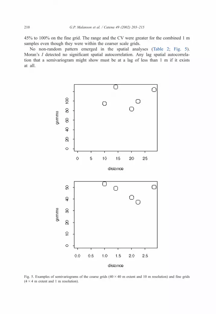
No non-random pattern emerged in the spatial analyses (Table 2; Fig. 5).
Moran’s I detected no significant spatial autocorrelation. Any lag spatial autocorrela-
tion that a semivariogram might show must be at a lag of less than 1 m if it exists
at all.
Fig. 5. Examples of semivariograms of the coarse grids (40� 40 m extent and 10 m resolution) and fine grids
(4� 4 m extent and 1 m resolution).
G.P. Malanson et al. / Catena 49 (2002) 203–215210

5. Discussion
The variance in ESD is consistent across scale from a 4� 4 m at 1 m resolution to
40� 40 m at 10 m resolution. The variability at the fine scale is simply repeated up to and
possibly exceeding the coarse scale. At greater scale, features such as breaks in slope,
avalanche paths, debris flows, and lithologic and stratigraphic differences would create
spatial patterning in ESD. The finer scale geomorphic features, such as the treads and
risers of solifluction terraces, also do not create non-random spatial pattern in ESD at the
4� 4 m scale in our sampling design. The similarity in ESD below both treads and risers
indicates that the process produces potentially ecologically relevant pattern only at the
surface.
The spatial pattern of the advance of trees and krummholz into tundra is not
controlled by ESD. The patterns that are seen, primarily fingers and patches, are of
extent greater than 1 m and less than 20 m. Non-random patterns of ESD do not exist at
this scale. Even with resource averaging, the patterns of the vegetation would still match
the patterns of the resource. The pattern of tree species could be related in some way to
solifluction patterns in terms of the surface characteristics experienced by a seed
beginning to germinate, but these are at a scale of about 1 m. Other forms of potential
geomorphic control that may be relevant elsewhere are not relevant at this site. No
incised channels exist across the study area such as might concentrate (or preclude)
moisture to aid in seedling establishment. Although minor amounts of animal pedo-
turbation exist in the area (sensu Butler, 1995) in the form of burrowing ground
squirrels, it is spatially limited to a few protected sites behind boulders, or within or
adjacent to already existing treeline patches where soil is deeper. Fine-scale frost sorting,
as evidenced by unvegetated frost boils such as occur throughout tundra sites in eastern
Glacier Park (Butler and Malanson, 1999) has been observed on the higher parts of Lee
Ridge, but at a scale of less than 20 cm, certainly not at a scale sufficient to explain
patterns of fingers at scales in excess of 1 m. The role of underlying lithology and past
glaciation (cf. Butler et al., 2002) seem equally unlikely as possible explanations,
particularly since the ridge is of uniform lithology and lies well above the elevation of
the highest adjacent Pleistocene terminal/lateral moraine complex. One possibility, which
we are in the process of examining, is soil penetrability. Neither treads nor risers vary
notably in the ease with which they may be penetrated by a soil penetrometer, but turf
exfoliation (Rasenabschalung) (sensu Perez, 1992) exists at several locations on Lee
Ridge, and those sites possess soils that are significantly easier to penetrate (Butler et al.,
manuscript in preparation). To the degree it is represented by ESD, geomorphology
alone cannot determine the vegetative pattern because there is a mismatch in scale. Even
if recent advances were into areas with relict soils from earlier high timberlines, the
initial process would still be unrelated to ESD.
We hypothesize that the pattern of vegetation is a result of patterns of resources other
than ESD, such as good sites for seedling establishment, that are extended in space by
positive feedbacks (Wilson and Agnew, 1992; Timoney et al., 1993; Malanson, 1997)
wherein the growing woody plants modify the environment to improve the conditions for
woody plant establishment and growth. Good sites for seedling establishment could
involve soil surface characteristics, such as faunal pedoturbation by mammals (Butler,
G.P. Malanson et al. / Catena 49 (2002) 203–215 211

1995) not studied here. Positive feedback could produce both the larger patches and the
fingers observed in addition to a straighter switch.
By improving the local environment for trees, trees can produce more spatial
autocorrelation than would be determined by the underlying resources. Positive feedbacks
could improve the local environment in at least three categories:
� increasing organic matter, soil nutrients, fine soil and correlated water holding
capacity (cf. Cairns, 1999);� decreasing wind and thus trapping snow and increasing soil moisture and reducing
desiccation (e.g., Cairns, 2001);� raising canopy temperatures through lower albedo (but see Korner, 1998 for lower
root temperatures).
These positive feedbacks can create patches where only a smaller area of resource
sufficient for establishment and growth existed. Fingers can result if there is a directional
component to the feedback. Such directional components could include slope and wind
(Holtmeier, 1982). Other linear patterns, such as ‘‘tiger bush’’ in southern Africa, result
from positive feedback (e.g., Leprun, 1999).
Temporal dynamics that capture intraspecific positive feedbacks (cf. Noble, 1993) as
well as positive interactions between species (Callaway, 1997; Brooker and Callaghan,
1998) are needed in order to create a more complete model of the ecotone. Efforts to
improve our understanding of the alpine timberline ecotone through computer models
have indicated that such feedbacks are important, but none can yet adequately simulate the
interaction of pattern and process (Bekker et al., 2001).
Acknowledgements
This research was funded by NSF grant SBR-9714347 to GPM and by a grant from the
USGS Biological Resources Division to D.R.B., D.M.C. and G.P.M. We thank Dan Fagre,
our USGS PI, for coordinating our field research. Chelsea Kelley assisted in the field. This
is a contribution of the Mountain GeoDynamics Research Group.
References
Allen, T.R., Walsh, S.J., 1996. Spatial composition and pattern of alpine treeline, Glacier National Park, Montana.
Photogrammetric Engineering and Remote Sensing 62, 1261–1268.
Allen, T.R., Walsh, S.J., Cairns, D.M., Messina, J., Butler, D.R., Malanson, G.P., 2002. Geostatistics and spatial
analysis: characterizing form and pattern at the alpine treeline. In: Bishop, M., Shroder, J. (Eds.), Geographic
Information Science and Mountain Geomorphology. Springer-Praxis, London, in press.
Bamberg, S.A., Major, J., 1968. Ecology of the vegetation and soils associated with calcareous parent materials in
three alpine regions of Montana. Ecological Monographs 38, 127–167.
Becwar, M.R., Burke, M.J., 1982. Winter hardiness limitations and physiography of woody timberline flora. In:
Li, P.H., Sakai, A. (Eds.), Plant Cold Hardiness and Freezing Stress: Mechanisms and Crop Implications,
vol. 2. Academic Press, New York, pp. 307–323.
G.P. Malanson et al. / Catena 49 (2002) 203–215212

Bednorz, F., Reichstein, M., Broll, G., Holtmeier, F.K., Urfer, W., 2000. Humus forms in the forest –alpine tundra
ecotone at Stillberg (Dischmatal, Switzerland): spatial heterogeneity and classification. Arctic, Antarctic and
Alpine Research 32, 21–29.
Bekker, M.F., Malanson, G.P., Alftine, K.J., Cairns, D.M., 2001. Feedback and pattern in computer simu-
lations of the alpine treeline ecotone. In: Millington, A.C., Walsh, S.J., Osborne, P.E. (Eds.), GIS and
Remote Sensing Applications in Biogeography and Ecology. Kluwer Academic Publishing, Dordrecht, pp.
123–138.
Bockheim, J.G., Munroe, J.S., Douglass, D., Koerner, D., 2000. Soil development along an elevational gradient in
the southeastern Uinta Mountains, Utah, USA. Catena 39, 169–185.
Brooker, R.W., Callaghan, T.V., 1998. The balance between positive and negative plant interactions and its
relationship to environmental gradients: a model. Oikos 81, 196–207.
Brown, D.G., 1994. Comparison of vegetation– topography relationships at the alpine treeline ecotone. Physical
Geography 15, 125–145.
Burns, S.F., Tonkin, P.J., 1982. Soil-geomorphic models and the spatial distribution and development of alpine
soils. In: Thorn, C.E. (Ed.), Space and Time in Geomorphology. George Allen and Unwin, London, pp.
25–43.
Butler, D.R., 1995. Zoogeomorphology: Animals as Geomorphic Agents. Cambridge Univ. Press, Cambridge.
Butler, D.R., Malanson, G.P., 1989. Periglacial patterned ground, Waterton-Glacier International Peace Park,
Canada and USA. Zeitschrift fur Geomorphologie 33, 43–57.
Butler, D.R., Malanson, G.P., 1999. Site locations and characteristics of miniature patterned ground, eastern
Glacier National Park, Montana, USA. Landform Analysis 2, 45–49.
Butler, D.R., Walsh, S.J., 1994. Site characteristics of debris flows and their relationship to alpine treeline.
Physical Geography 15, 181–199.
Butler, D.R., Malanson, G.P., Bekker, M.F., Reseler, L., 2002. Lithologic, structural, and geomorphic controls on
ribbon forest patterns. Geomorphology, in review.
Cairns, D.M., 1999. Multi-scale analysis of soil nutrients at alpine treeline in Glacier National Park, Montana.
Physical Geography 20, 256–271.
Cairns, D.M., 2001. Patterns of winter dessication in krummholz forms of Abies lasiocarpa at treeline sites in
Glacier National Park, Montana, USA. Geografiska Annaler 83A, 157–168.
Cairns, D.M., Malanson, G.P., 1997. Examination of the carbon balance hypothesis of alpine treeline location,
Glacier National Park, Montana. Physical Geography 18, 125–145.
Cairns, D.M., Malanson, G.P., 1998. Environmental variables influencing carbon balance at the alpine treeline
ecotone: a modeling approach. Journal of Vegetation Science 9, 679–692.
Callaway, R.M., 1997. Positive interactions in plant communities and the individualistic-continuum concept.
Oecologia 112, 143–149.
Dutton, B.L., Marrett, D.J., 1997. Soils of Glacier National Park East of the Continental Divide. Land and Water
Consulting, Missoula, MT.
Eriksson, C.P., Holmgren, P., 1996. Estimating stone and boulder content in forest soils—evaluating the potential
of surface penetration methods. Catena 28, 121–134.
Fortin, M.-J., 1999. Spatial statistics in landscape ecology. In: Klopatek, J.M., Gardner, R.H. (Eds.), Landscape
Ecological Analysis. Springer, New York, pp. 253–279.
Funes, G., Basconcelo, S., Diaz, S., Cabido, M., 1999. Seed bank dynamics of Lachemilla pinnata (Rosaceae)
in different plant communities of mountain grasslands in central Argentina. Annales Botanici Fennici 36,
109–114.
Habeck, J.R., 1969. A gradient analysis of a timberline zone at Logan Pass, Glacier National Park, Montana.
Northwest Science 43, 65–73.
Holtmeier, F.-K., 1982. ‘‘Ribbon-forest’’ and ‘‘hedges.’’ Strip-like distribution patterns of trees at the upper
timberline in the Rocky Mountains. Erdkunde 36, 142–153.
Holtmeier, F.-K., Broll, G., 1992. The influence of tree islands and microtopography on pedoecological con-
ditions in the forest–alpine tundra ecotone on Niwot Ridge, Colorado Front Range, USA. Arctic and Alpine
Research 24, 216–228.
Ingelmo, F., Cuadrado, S., Ibanez, A., Hernandez, J., 1994. Hydric properties of some Spanish soils in relation to
their rock fragment content: implications for runoff and vegetation. Catena 23, 73–85.
G.P. Malanson et al. / Catena 49 (2002) 203–215 213

Klimowicz, Z., Uziak, S., 1996. Arctic soil properties associated with micro-relief forms in the Bellsund region
(Spitsbergen). Catena 28, 135–149.
Korner, C., 1998. A reassessment of high-elevation treeline positions and their explanation. Oecologia 115,
445–459.
Kosmas, C., Moustakas, N., Danalatos, N.G., Yassoglou, N., 1994. The effect of rock fragments on wheat
biomass production under highly variable moisture conditions in Mediterranean environments. Catena 23,
191–198.
Kupfer, J.A., Cairns, D.M., 1996. The suitability of montane ecotones as indicators of global climatic change.
Progress in Physical Geography 20, 253–272.
Leprun, J.C., 1999. The influence of ecological factors on tiger bush and dotted bush patterns along a gradient
from Mali to northern Burkina Faso. Catena 37, 25–44.
Macdonald, B.C.T., Melville, M.D., White, I., 1999. The distribution of soluble cations within chenopod-pat-
terned ground, arid western New South Wales, Australia. Catena 37, 89–105.
Malanson, G.P., 1997. Effects of feedbacks and seed rain on ecotone patterns. Landscape Ecology 12,
27–38.
Malanson, G.P., 1999. Considering complexity. Annals, Association of American Geographers 89, 746–753.
Malanson, G.P., Butler, D.R., 1994. Competitive hierarchies, soil fertility gradients, and the elevation of treeline
in Glacier National Park, Montana. Physical Geography 15, 166–180.
Malanson, G.P., Xiao, N., Alftine, K.J., 2001. A simulation test of the resource averaging hypothesis of ecotone
formation. Journal of Vegetation Science 12, 743–748.
Nimlos, T.J., McConnell, R.C., 1962. The morphology of alpine soils in Montana. Northwest Science 36,
99–112.
Noble, I.R., 1993. A model of the responses of ecotones to climate change. Ecological Applications 3, 396–403.
Pauker, S.J., Seastedt, T.R., 1996. Effects of mobile tree islands on soil carbon storage in tundra ecosystems.
Ecology 77, 2563–2567.
Perez, F.L., 1992. Processes of turf exfoliation (Rasenabschalung) in the high Venezuelan Andes. Zeitschrift fur
Geomorphologie 36, 81–106.
Poesen, J., Lavee, H., 1994. Rock fragments in top soils– significance and processes. Catena 23, 1–28.
Seastedt, T.R., Adams, G.A., 2001. Effects of mobile tree islands on alpine tundra soils. Ecology 82, 8–17.
Seastedt, T.R., Vaccaro, L., 2001. Plant species richness, productivity, and nitrogen and phosphorus limitations
across a snowpack gradient in alpine tundra, Colorado, USA. Arctic, Antarctic and Alpine Research 33,
100–106.
Shiels, A.B., Sanford, R.L., 2001. Soil nutrient differences between two krummholz-form tree species and
adjacent alpine tundra. Geoderma 102, 205–217.
Stanton, M.L., Rejmanek, M., Galen, C., 1994. Changes in vegetation and soil fertility along a predic-
table snowmelt gradient in the Mosquito Range, Colorado, USA. Arctic and Alpine Research 26,
364–374.
Stevens, G.C., Fox, J.F., 1991. The causes of treeline. Annual Review of Ecology and Systematics 22, 177–191.
Timoney, K.P., La Roi, G.H., Dale, M.R.T., 1993. Subarctic forest-tundra vegetation gradients: the sigmoid wave
hypothesis. Journal of Vegetation Science 4, 387–394.
Urban, D.L., Miller, C., Halpin, P.N., Stephenson, N.L., 2000. Forest gradient response in Sierran landscapes: the
physical template. Landscape Ecology 15, 603–620.
Valentin, C., d’Herbes, J.M., Poesen, J., 1999. Soil and water components of banded vegetation patterns. Catena
37, 1–24.
van Wesemael, B., Mulligan, M., Poesen, J., 2000. Spatial patterns of soil water balance on intensively cultivated
hillslopes in a semi-arid environment: the impact of rock fragments and soil thickness. Hydrological Processes
14, 1811–1828.
Walsh, S.J., Kelly, N.M., 1990. Treeline migration and terrain variability: integration of remote sensing digital
enhancements and digital elevation models. Proceedings, Applied Geography Conference 13, 24–32.
Walsh, S.J., Malanson, G.P., Butler, D.R., 1992. Alpine treeline in Glacier National Park, Montana. In: Janelle,
D.G. (Ed.), Geographical Snapshots of North America. Guilford Press, New York, pp. 167–171.
Walsh, S.J., Butler, D.R., Allen, T.R., Malanson, G.P., 1994. Influence of snow patterns and snow avalanches on
the alpine treeline ecotone. Journal of Vegetation, 657–672.
G.P. Malanson et al. / Catena 49 (2002) 203–215214

Walsh, S.J., Butler, D.R., Malanson, G.P., Crews-Meyer, K.A., Messina, J.P., Xiao, N., 2002. Mapping, modeling,
and visualization of the influences of geomorphic processes on the alpine treeline ecotone, Glacier National
Park, Montana, USA. Geomorphology, (in press).
Wilson, J.B., Agnew, A.D.Q., 1992. Positive-feedback switches in plant communities. Advances in Ecological
Research 23, 263–336.
Zonneveld, I.S., 1999. A geomorphological based banded (‘tiger’) vegetation pattern related to former dune fields
in Sokoto (Northern Nigeria). Catena 37, 45–56.
G.P. Malanson et al. / Catena 49 (2002) 203–215 215


![Oeggl_Patzelt_Schaefer 1997 Alpine Vorzeit in Tirol [Alpine Prehistory in Tyrol] Ausstellungsführer / Exhibition Guide](https://img.pdfslide.net/doc/110x75/631b5738d5372c006e03e5f6/oegglpatzeltschaefer-1997-alpine-vorzeit-in-tirol-alpine-prehistory-in-tyrol.jpg)


