Embed Size (px)
Citation preview
Prepared byHamilton County Regional Planning CommissionDraft Revised 9/19/09
Village of Greenhills, Ohio
COMPREHENSIVE PLANDefining Our Future 1939 - 2009 - 2029
Public Hearing Draft

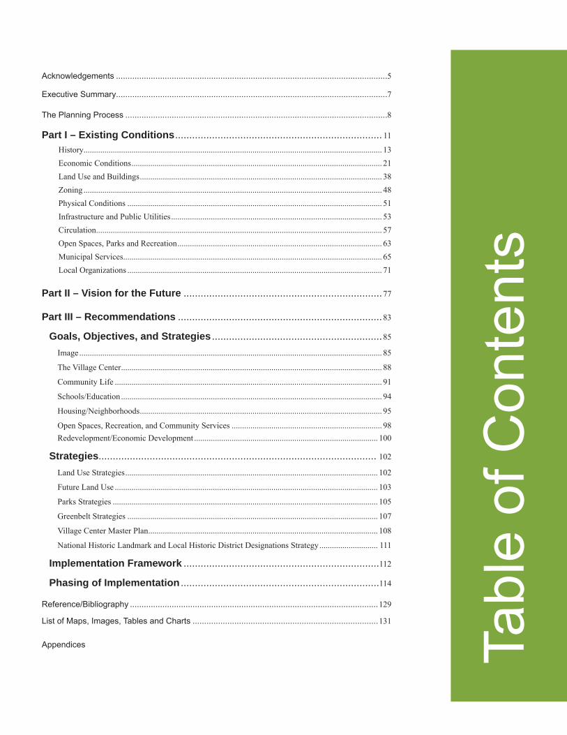
Acknowledgements .....................................................................................................................5
Executive Summary.....................................................................................................................7
The Planning Process .................................................................................................................8
Part I – Existing Conditions ......................................................................... 11
History............................................................................................................................................... 13 Economic Conditions ........................................................................................................................ 21 Land Use and Buildings .................................................................................................................... 38 Zoning ............................................................................................................................................... 48 Physical Conditions .......................................................................................................................... 51 Infrastructure and Public Utilities ..................................................................................................... 53 Circulation ......................................................................................................................................... 57 Open Spaces, Parks and Recreation .................................................................................................. 63 Municipal Services ............................................................................................................................ 65 Local Organizations .......................................................................................................................... 71
Part II – Vision for the Future ......................................................................77
Part III – Recommendations ........................................................................83
Goals, Objectives, and Strategies ............................................................85
Image ................................................................................................................................................. 85
The Village Center ............................................................................................................................. 88
Community Life ................................................................................................................................ 91
Schools/Education ............................................................................................................................. 94
Housing/Neighborhoods .................................................................................................................... 95
Open Spaces, Recreation, and Community Services ........................................................................ 98 Redevelopment/Economic Development ........................................................................................ 100
Strategies.................................................................................................. 102
Land Use Strategies ......................................................................................................................... 102
Future Land Use .............................................................................................................................. 103
Parks Strategies ............................................................................................................................... 105
Greenbelt Strategies ........................................................................................................................ 107
Village Center Master Plan .............................................................................................................. 108
National Historic Landmark and Local Historic District Designations Strategy ............................ 111
Implementation Framework .....................................................................112
Phasing of Implementation ......................................................................114
Reference/Bibliography ...........................................................................................................129
List of Maps, Images, Tables and Charts ................................................................................131
Appendices Tabl
e of
Con
tent
s

4 VILLAGE OF GREENHILLS
5 COMPREHENSIVE PLAN
Village of GreenhillsComprehensive Plan
2009
MayorOscar Hoffmann
Council MembersKenny BurckGlenn DreesGreg HermesFred MurellChris VisnichBud Wolterman
Planning CommissionDavid Moore, ChairmanDavid AdamsJudith MuehlenhardOscar HoffmanGlenn DreesJane Berry, Ex-Offi cio Advisory
Municipal ManagerJane Berry
Consultant AgencyHamilton County Regional Planning Commission (HCRPC)
Steering CommitteeDavid AdamsJane BerryBarbara BradfordErin Coddington Ashley Corbett (until 2/26/2009)Jason CovalcineGlenn DreesAnn KrebsDavid MooreDr. Camile NasbeChristopher Newcomer (until 3/19/2009)Jeff PalmerTerri TreinenBev VenturaMike ViolaNeil White
Guest Speakers
Housing: Michael Dinn, Dinn Focused Marketing LLCPublic Relations and Branding: Nick Vehr, Vehr CommunicationsSustainable Development: Chad Edwards, Emersion Design LLCHistoric Preservation: Beth SullebargerHamilton County Park District: Russ HamreHistoric District/Economic Development: Pam Holbrook, Milford Ohio
6 VILLAGE OF GREENHILLS
Hamilton CountyRegional Planning Commission
Project Staff
Project Manager Catalina Landivar-Simon, AICPSenior Planner
Todd Kinskey, AICPExecutive Director
Maps, Research, Technical Assistance
Geoffrey Lyons and Dustin ClarkUniversity of Cincinnati Co-op Students
K.D. RexSenior Planner
John HuthSenior Planner
Graphics Jay SpringerGraphics Specialist
Report Layout Karen AmbrosiusAdministrative Coordinator
Other Technical Support
Mark AbellSubdivision Coordinator
Bryan Snyder, AICPDevelopment Services Administrator
Andy Dobson, AICPSenior Planner
Dean Niemeyer, AICPSenior Planner
Bob EatonSystem Administrator/Assistant Director
Sharon StewartDevelopment Review Specialist
7 COMPREHENSIVE PLAN
Executive Summary
The Village of Greenhills, in the 70th anniversary of its incorporation, is taking steps to move from a Federal Government experiment in suburban housing for the working class into a mature community capable of dreaming of a successful future and willing to take the steps to get there. In November 2008, the Village of Greenhills contracted with the Hamilton County Regional Planning Commission (HCRPC) for consultant services for the preparation of a Comprehensive Plan. Although Greenhills had been the focus of numerous studies, mostly academic in nature, the Village did not have the benefi t of a current comprehensive analysis, evaluation, or vision to guide its future. HCRPC staff worked with a core Steering Committee appointed by Village Council from November 2008 to August 2009 to prepare the fi rst Comprehensive Plan for Greenhills.
Rapid suburban growth in the United States after World War II characterized by a booming economy and quickly expanding federal highway system helped Greenhills grow in population until the early 1970s. Unfortunately, these same factors allowed easy expansion of new subdivisions beyond I-275 and out-migration by many of Hamilton County’s residents. In Greenhills, population loss has affected valued community institutions such as schools and volunteer organizations. Housing stock has aged, in some cases, not gracefully. The shopping center and community services located in the heart of the community are not as lively and vibrant as they once were. Other than in academic circles, many people in the Greater Cincinnati region do not know, nor do they have a reason to know or visit, Greenhills. There is an increased pressure to generate revenues to pay for services and infrastructure to maintain the quality of life of the community. The Steering Committee set out to address these issues by developing a plan that will help guide decisions of the Greenhills Village Council, Planning Commission, and Administration.
The Collective Vision for the Future of Greenhills is a multi-prong approach that builds on the Village’s historic past, its physical development respectful of the natural environment, its collaborative and friendly atmosphere where residents are afforded opportunities for community life, and its supportive approach of commercial activity that provides fi nancial stability and much needed products and services to the community.
The Greenhills Comprehensive Plan grouped its goals and objectives into seven overarching themes:
• Image• The Village Center• Community Life• Schools/Education• Housing/Neighborhoods• Open Spaces, Recreation, and Community Services• Redevelopment/Economic Development
By focusing on the implementation of strategies that aim to advance one or more of the key elements of the Vision, the Village will maximize the use of available resources. With the information available at this time, the Steering Committee has outlined goals, objectives, and strategies as a roadmap for implementation. However, periodic revisions are recommended to accommodate events and circumstances unforeseen at the time of the plan preparation.
8 VILLAGE OF GREENHILLS
Considerable input from residents, careful oversight by the Steering Committee, in depth research, and experts’ advice resulted in a long list of recommendations for the Village of Greenhills. The Steering Committee is mindful of the fi nite resources the Village has at hand, therefore a decision was made to “grade” recommendations as “A= must do it,” “B=should do it,” and “C=could do it” as a suggestion to the Greenhills Village Council. As part of this document a “Phasing of Implementation” Table provides a simplifi ed overview of all the recommendations, their importance (from the Steering Committee point of view), the persons or organizations that should be involved in their implementation, who should play a leadership role, and a suggested trimeframe, where appropriate.
Purpose of the StudyVillage offi cials were aware of changing physical, economic and social conditions in the Village of Greenhills and its surroundings. Those changes undoubtedly already have had, are having, or will have an impact on the future viability of the Village. The purpose of this study is to devise a series of recommendations that the Village can consider when looking at future development and redevelopment of the community.
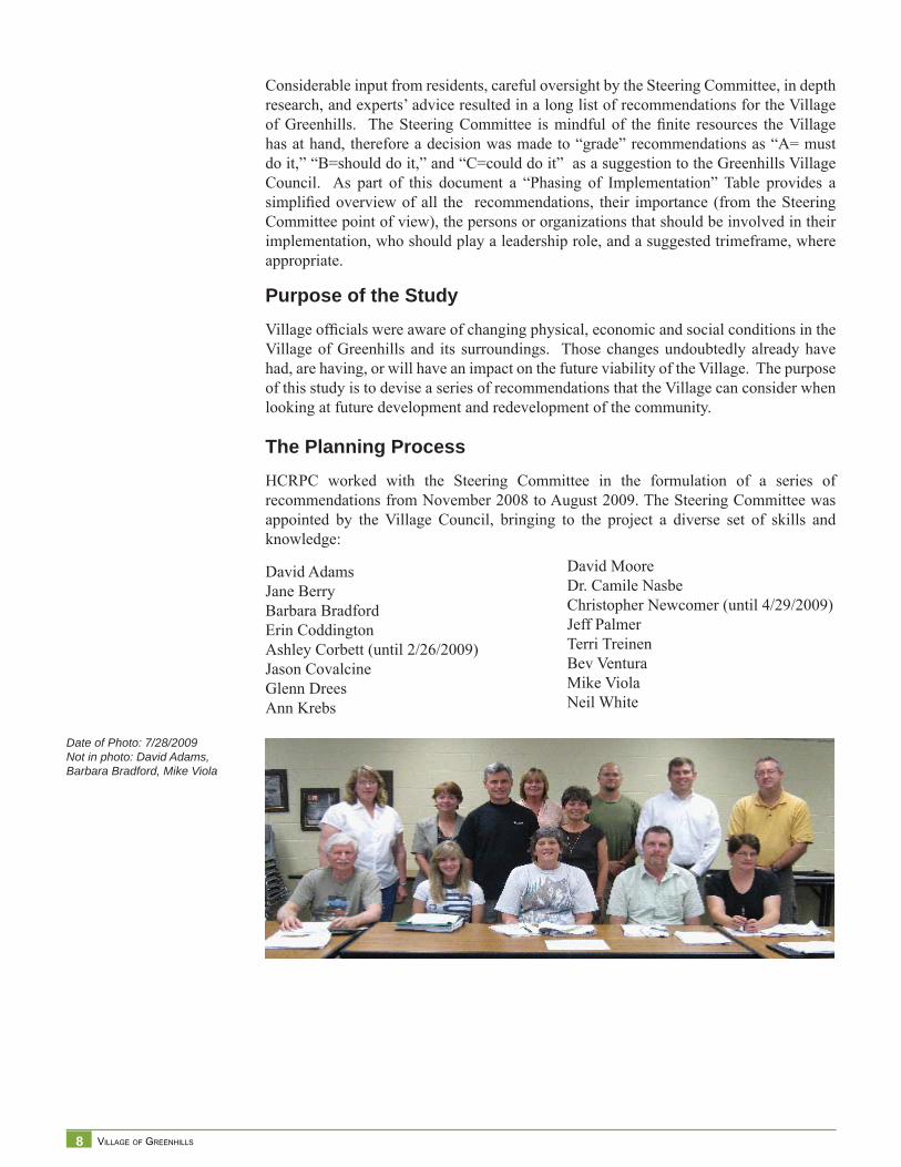
The Planning ProcessHCRPC worked with the Steering Committee in the formulation of a series of recommendations from November 2008 to August 2009. The Steering Committee was appointed by the Village Council, bringing to the project a diverse set of skills and knowledge:
David AdamsJane BerryBarbara BradfordErin Coddington Ashley Corbett (until 2/26/2009)Jason CovalcineGlenn DreesAnn Krebs
David MooreDr. Camile NasbeChristopher Newcomer (until 4/29/2009)Jeff PalmerTerri TreinenBev VenturaMike ViolaNeil White
Date of Photo: 7/28/2009Not in photo: David Adams, Barbara Bradford, Mike Viola
9 COMPREHENSIVE PLAN
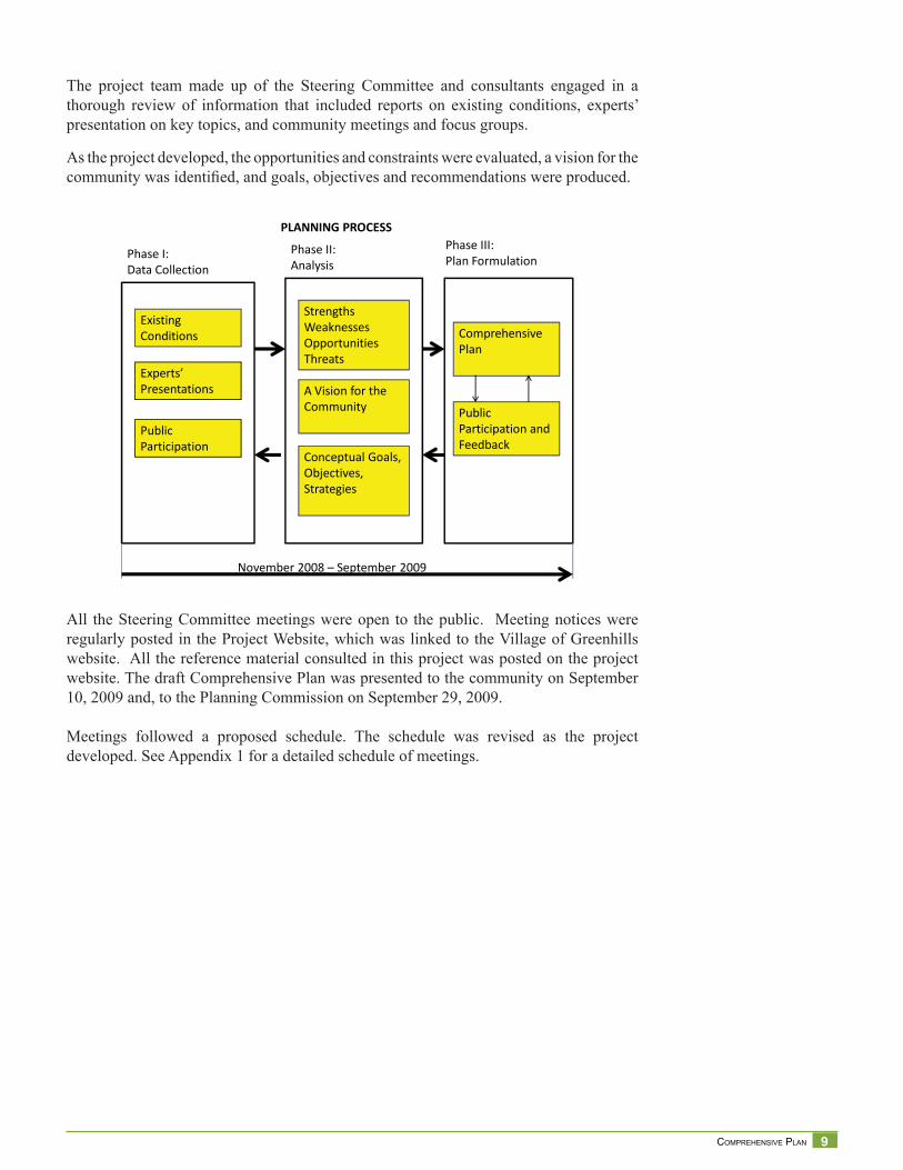
The project team made up of the Steering Committee and consultants engaged in a thorough review of information that included reports on existing conditions, experts’ presentation on key topics, and community meetings and focus groups.
As the project developed, the opportunities and constraints were evaluated, a vision for the community was identifi ed, and goals, objectives and recommendations were produced.
All the Steering Committee meetings were open to the public. Meeting notices were regularly posted in the Project Website, which was linked to the Village of Greenhills website. All the reference material consulted in this project was posted on the project website. The draft Comprehensive Plan was presented to the community on September 10, 2009 and, to the Planning Commission on September 29, 2009.
Meetings followed a proposed schedule. The schedule was revised as the project developed. See Appendix 1 for a detailed schedule of meetings.
Existing Conditions
Experts’ Presentations
Public Participation
StrengthsWeaknessesOpportunities Threats
A Vision for the Community
Comprehensive Plan
Public Participation and Feedback
Conceptual Goals, Objectives, Strategies
November 2008 – September 2009
Phase I: Data Collection
Phase II: Analysis
Phase III: Plan Formulation
PLANNING PROCESS

10 VILLAGE OF GREENHILLS
11 COMPREHENSIVE PLAN
Existing Conditions
Par
t I

12 VILLAGE OF GREENHILLS
13 COMPREHENSIVE PLAN
Village of GreenhillsBackground StudyIn November 2008, the Hamilton County Regional Planning Commission (HCRPC) en-tered into a contract with the Village of Greenhills to provide technical support to its Steering Committee in the preparation of a comprehensive plan for the community. This plan will include the development of a common vision for the future, and setting goals and strategies for implementation.
Where is Greenhills?The Village of Greenhills is a municipality in Hamilton County Ohio. The population is 3,675 (2007 Census Estimate) and it is 1.23 square miles. The Village, whose main con-nector road is Winton Road, is located south of I-275 and west of I-75, abutting Forest Park to the north, and surrounded by Winton Woods, a Hamilton County Park, to the east, south, and west.
Brief HistoryThe Village of Greenhills was built by the Federal government in the mid 1930s ”to provide constructive work for persons on unemployment relief, and to supply adequate housing for families of low income, at rents they could afford.”1 The new settlement was located on the outskirts of Cincinnati and in close proximity to a developing industrial corridor to facilitate access to employment centers. Greenhills was incorporated as a municipality in 1938.
Greenhills was modeled after Ebenezer Howard’s Garden City Model.2 In the United States, the model was called “Greenbelt Towns.” Only three greenbelt towns were built in the United States: Greenhills in Ohio, Greendale in Wisconsin, and Greenbelt in Mary-land. The purpose of the planned suburban community was to provide housing in a gar-den-like setting for working families. The new development was to be an improvement to the physical environment and social conditions that plagued older, densely populated industrial areas.
1 Ladislas Segoe & Associates, 1964. Greenhills Ohio Planning Administration. Page I.2 Ebenezer Howard: Garden Cities of Tomorrow. 1902 http://www.library.cornell.edu/Reps/DOCS/howard.htm H
isto
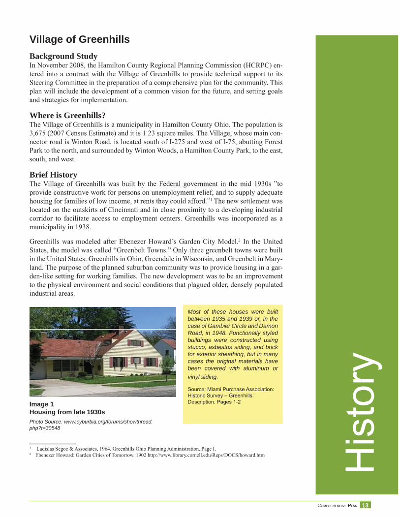
ryImage 1Housing from late 1930sPhoto Source: www.cyburbia.org/forums/showthread.php?t=30548
Most of these houses were built between 1935 and 1939 or, in the case of Gambier Circle and Damon Road, in 1948. Functionally styled buildings were constructed using stucco, asbestos siding, and brick for exterior sheathing, but in many cases the original materials have been covered with aluminum or vinyl siding.
Source: Miami Purchase Association: Historic Survey – Greenhills: Description. Pages 1-2
14 VILLAGE OF GREENHILLS
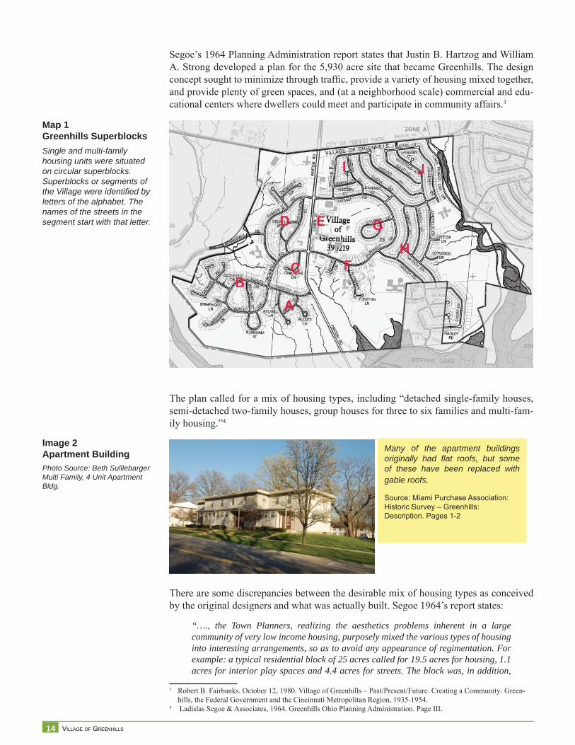
Segoe’s 1964 Planning Administration report states that Justin B. Hartzog and William A. Strong developed a plan for the 5,930 acre site that became Greenhills. The design concept sought to minimize through traffi c, provide a variety of housing mixed together, and provide plenty of green spaces, and (at a neighborhood scale) commercial and edu-cational centers where dwellers could meet and participate in community affairs.3
The plan called for a mix of housing types, including “detached single-family houses, semi-detached two-family houses, group houses for three to six families and multi-fam-ily housing.”4
There are some discrepancies between the desirable mix of housing types as conceived by the original designers and what was actually built. Segoe 1964’s report states:
“…., the Town Planners, realizing the aesthetics problems inherent in a large community of very low income housing, purposely mixed the various types of housing into interesting arrangements, so as to avoid any appearance of regimentation. For example: a typical residential block of 25 acres called for 19.5 acres for housing, 1.1 acres for interior play spaces and 4.4 acres for streets. The block was, in addition,
3 Robert B. Fairbanks. October 12, 1980. Village of Greenhills – Past/Present/Future. Creating a Community: Green-hills, the Federal Government and the Cincinnati Metropolitan Region, 1935-1954.
4 Ladislas Segoe & Associates, 1964. Greenhills Ohio Planning Administration. Page III.
Many of the apartment buildings originally had fl at roofs, but some of these have been replaced with gable roofs.
Source: Miami Purchase Association: Historic Survey – Greenhills: Description. Pages 1-2
Image 2Apartment BuildingPhoto Source: Beth SulllebargerMulti Family, 4 Unit Apartment Bldg.
Map 1Greenhills SuperblocksSingle and multi-family housing units were situated on circular superblocks. Superblocks or segments of the Village were identifi ed by letters of the alphabet. The names of the streets in the segment start with that letter.
15 COMPREHENSIVE PLAN
tied into the greenbelt. It was to contain 14 one-family houses, 10 two-family houses, and 19 houses containing three or more families. As far as can be ascertained at this time by diligent research, the original proposal called for approximately 3,000 total housing units in the community, of which only 2.5% or 75 would be single detached houses, 18.0% or 540 would be two family units, and the remainder or 79.5% multi-family for three or more families.
As of this date, it is estimated that almost 50% of the structures have been built for single-family occupancy – which is a much higher proportion than originally proposed….”5
While the 1991 Miami Purchase Association Survey states: “Although a few single fam-ily houses were constructed, the majority of the 676 dwelling units were multi-family ranging from duplexes to 12-unit apartment buildings. “6
Independently of the proportion of single family to multi-family, buildings in the resi-dential areas in the Village of Greenhills have different characteristics based on when they were built.
In the center of the town was the community center, providing administrative, shopping, and school facilities to residents. The original Plan proposed 3,000 housing units. One thousand housing units were to be built in the fi rst phase, however only 676 were built due to shortage of funds.7 According to Segoe’s report, “it was intended to immediately develop the area of rolling and well-wooded terrain in the southern section of the tract, meanwhile leaving the northern section undeveloped as a reservoir from which land could be withdrawn at a future date for residential and related development.”8
In the later 1940s, due to the housing demand created by Veterans returning from the War, the Federal Government allowed development on Damon Road and Gambier Circle by private developers. Greenhills was the only greenbelt community whose residents organized a Homeowners Association to buy the property from the Government in 1950. This action allowed former renters to become property owners and to preserve most of the greenbelt surrounding the community. The Federal Government sold to the Warner-Kanter Corporation the northern undeveloped land acquired for the Greenhills project. In Ohio, of the original 5,930-acre site, approximately 3,500 acres were sold for the devel-opment of another, this time a privately planned community, the city of Forest Park.
5 Ladislas Segoe & Associates, 1964. Greenhills Ohio Planning Administration. Page 5.6 Miami Purchase Association became the Cincinnati Preservation Association. Historic Inventory Greenhills. His-
tory/Signifi cance Page 2.7 Ladislas Segoe & Associates, 1964. Greenhills Ohio Planning Administration. Page IV.8 Idem
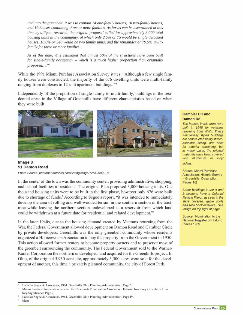
Image 351 Damon RoadPhoto Source: photonet.hotpads.com/listingimage/125405822_s.
Gambier Cir and Damon RdThe houses in this area were built in 1948 for veterans returning from WWII. These functionally styled buildings are constructed using stucco, asbestos siding, and brick for exterior sheathing, but in many cases the original materials have been covered with aluminum or vinyl siding.
Source: Miami Purchase Association: Historic Survey – Greenhills: Description. Pages 1-2
Some buildings in the A and B sections have a Colonial Revival Flavor, as seen in the slate covered, gable roofs and solid brick exteriors. See Image on top right of page.
Source: Nomination to the National Register of Historic Places 1989
16 VILLAGE OF GREENHILLS
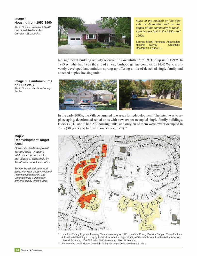
No signifi cant building activity occurred in Greenhills from 1971 to up until 19999. In 1999 on what had been the site of a neighborhood garage complex on FDR Walk, a pri-vately developed landominium sprung up offering a mix of detached single family and attached duplex housing units.
In the early 2000s, the Village targeted two areas for redevelopment. The intent was to re-place aging, deteriorated rental units with new, owner-occupied single-family buildings. Blocks C, D, and F had 279 housing units, and only 28 of them were owner occupied in 2005 (30 years ago half were owner occupied).10
9 Hamilton County Regional Planning Commission, August 1999: Hamilton County Decision Support Manual Volume 4. Residential Building Activity by Political Jurisdiction. Page 30. City of Greenhills New Residential Units by Year: 1960-69 243 units, 1970-79 5 units, 1980-89 0 units, 1990-1998 0 units.
10 Statement by David Moore, Greenhills Village Manager 2005 based on 2001 data.
Map 2Redevelopment Target AreasGreenhills Redevelopment Target Areas - Housing Infi ll Sketch produced for the Village of Greenhills by Triantafi llou and Associates
Source: Housing Forum, April 2005. Hamilton County Regional Planning Commission. The Community as a Developer presentation by David Moore.
Much of the housing on the east side of Greenhills and on the edges of the community is ranch-style houses built in the 1950s and 1960s
Source: Miami Purchase Association: Historic Survey – Greenhills: Description. Pages 1-2
Image 5 Landominiums on FDR WalkPhoto Source: Hamilton County Auditor
Image 4Housing from 1950-1960Photo Source: Website REMAX Unliminted Realtors: Pat Chrysler - 28 Japonica
17 COMPREHENSIVE PLAN
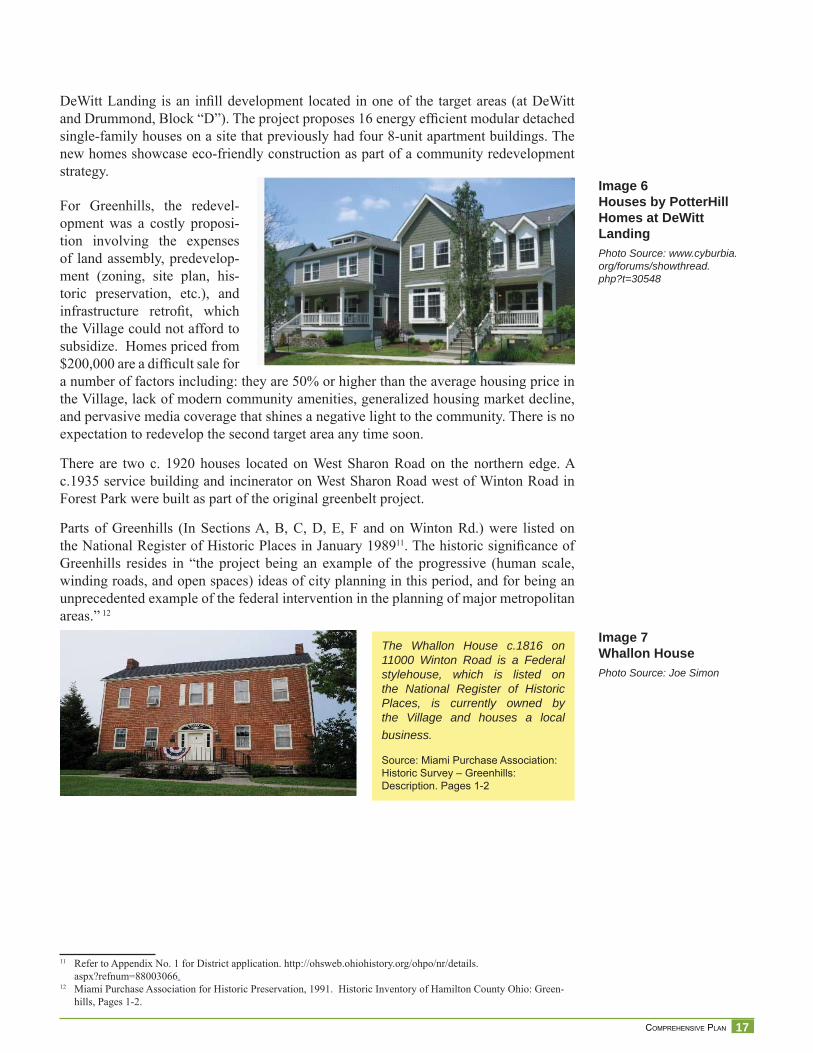
DeWitt Landing is an infi ll development located in one of the target areas (at DeWitt and Drummond, Block “D”). The project proposes 16 energy effi cient modular detached single-family houses on a site that previously had four 8-unit apartment buildings. The new homes showcase eco-friendly construction as part of a community redevelopment strategy.
For Greenhills, the redevel-opment was a costly proposi-tion involving the expenses of land assembly, predevelop-ment (zoning, site plan, his-toric preservation, etc.), and infrastructure retrofi t, which the Village could not afford to subsidize. Homes priced from $200,000 are a diffi cult sale for a number of factors including: they are 50% or higher than the average housing price in the Village, lack of modern community amenities, generalized housing market decline, and pervasive media coverage that shines a negative light to the community. There is no expectation to redevelop the second target area any time soon.
There are two c. 1920 houses located on West Sharon Road on the northern edge. A c.1935 service building and incinerator on West Sharon Road west of Winton Road in Forest Park were built as part of the original greenbelt project.
Parts of Greenhills (In Sections A, B, C, D, E, F and on Winton Rd.) were listed on the National Register of Historic Places in January 198911. The historic signifi cance of Greenhills resides in “the project being an example of the progressive (human scale, winding roads, and open spaces) ideas of city planning in this period, and for being an unprecedented example of the federal intervention in the planning of major metropolitan areas.” 12
11 Refer to Appendix No. 1 for District application. http://ohsweb.ohiohistory.org/ohpo/nr/details.aspx?refnum=88003066.
12 Miami Purchase Association for Historic Preservation, 1991. Historic Inventory of Hamilton County Ohio: Green-hills, Pages 1-2.
The Whallon House c.1816 on 11000 Winton Road is a Federal stylehouse, which is listed on the National Register of Historic Places, is currently owned by the Village and houses a local business.
Source: Miami Purchase Association: Historic Survey – Greenhills: Description. Pages 1-2
Image 7Whallon HousePhoto Source: Joe Simon
Image 6Houses by PotterHill Homes at DeWitt LandingPhoto Source: www.cyburbia.org/forums/showthread.php?t=30548
18 VILLAGE OF GREENHILLS
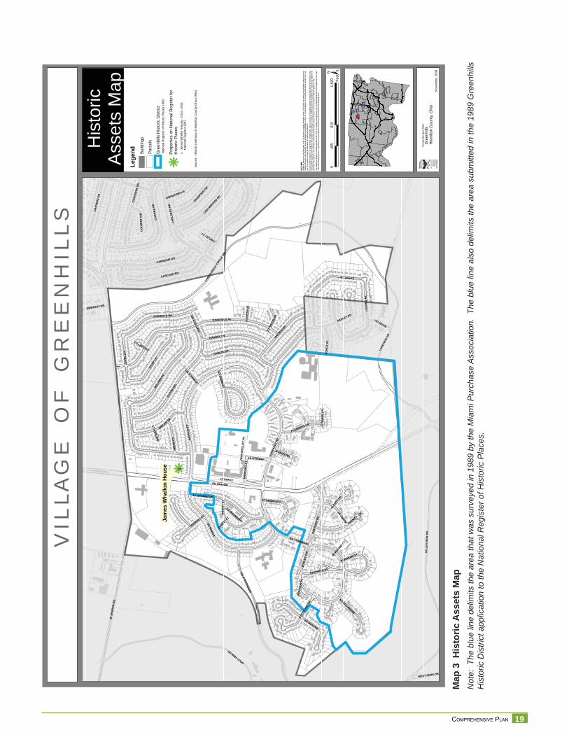
About Historic DesignationsIn 1991, the Miami Purchase Association published the Historic Survey of Hamilton County, which included a survey of Greenhills’ buildings13. The area surveyed, depicted in Map No 3, is the completed portion of the town built by the federal government be-tween 1935 and 1938. Although there is not a municipally designated “Historic District,” people loosely refer to the boundaries defi ned by this survey as the Greenhills Historic District. A portion of the district as identifi ed in the Survey was listed on the National Register of Historic Places as the Greenhills Historic District in January 1989.
The National Register of Historic Places is a federal program administered by the Na-tional Park Service in partnership with state governments. The National Register was created by the National Historic Preservation Act of 1966 to recognize and protect prop-erties of historic and cultural signifi cance that warrant consideration. National Register listing is primarily an honor, meaning that a property has been researched and evaluated according to established procedures and determined to be worthy of preservation for its historical value. The listing of a historic or archaeological property in the National Register does not obligate or restrict a private owner in any way unless the owner seeks a federal benefi t such as a grant or tax credit.
National Register listing does not automatically invoke local historic district zoning or local landmark designation.14 National Register listing should not be confused with lo-cal historic property and historic district designations. A local governing board on the recommendation of a local historic preservation commission makes these designations.
The National Historic Landmarks Program’s purpose is to focus attention on properties of exceptional value to the nation as a whole rather than to a particular State or locality. There is a difference between listing in the National Register of Historic Places (NRHP) and designation as a National Historic Landmark (NHL).15 There are many NRHP-listed properties and few NHLs. An NHL is a place of higher national signifi cance like the Roebling Bridge (and Glendale), while NRHP-listings can have local, state, or national signifi cance. The National Parks Service does the selection of a property or a place to be included in the NHL primarily internally. Some local organizations lobbied for NHL designation of Mariemont and the Observatory.16
13 Historic Inventory of Hamilton County - Ohio: Elmwood Place, Forest Park, Greenhills, Glendale, Golf Manor. “An Historic Survey of 42 Suburban Communities.” June 1991.
14 http://www.nps.gov/history/nr/national_register_fundamentals.htm15 The National Historic Landmark listing for Ohio current as of January does not include Greenhills. http?//www.nps.
gov/history/nhl/designations/Lists/OH01.pdf.16 Beth Sullebarger, Historic Preservation Consultant. March 4, 2009
19 COMPREHENSIVE PLAN
Map
3 H
isto
ric A
sset
s M
apN
ote:
The
blu
e lin
e de
limits
the
area
that
was
sur
veye
d in
198
9 by
the
Mia
mi P
urch
ase
Ass
ocia
tion.
The
blu
e lin
e al
so d
elim
its th
e ar
ea s
ubm
itted
in th
e 19
89 G
reen
hills
H
isto
ric D
istri
ct a
pplic
atio
n to
the
Nat
iona
l Reg
iste
r of H
isto
ric P
lace
s.
VIL
LAG
EO
FG
RE
EN
HIL
LS
His
toric
Ass
ets
Map
§̈ ¦I-74
§̈ ¦I-75
§̈ ¦I-75
§̈ ¦I-275
Nov
embe
r,20
08
DISC
LAIM
ER:
Neith
er th
e pro
vider
nor a
ny o
f the
partie
s of
the C
incinn
ati a
rea g
eogra
phic
inform
ation
syste
m (C
AGIS)
mak
e an
y wa
rranty
or re
prese
ntatio
n, eit
her e
xpres
sed
or im
plied
, with
resp
ect to
this
inform
ation
, its
quali
ty, pe
rform
ance
, merc
hanta
bility
, or f
itnes
s for
a pa
rticula
r purp
ose.
As a
resu
lt this
infor
matio
n is
provid
ed “a
s is”,
and
yo
u, the
recip
ient, a
re as
sumi
ng th
e enti
re ris
k as t
o its
quali
ty an
d per
form
ance
. In
no ev
ent, w
ill the
prov
ider o
r any
part
y of
CAGI
S be
liable
for d
irect,
indir
ect, i
ncide
ntal, o
r con
sequ
entia
l dam
ages
resu
lting
from
any
defec
t in th
e inf
ormati
on or
any
other
part o
f the m
ap pr
oduc
t, eve
n if a
dvise
d of th
e pos
sibility
of su
ch da
mage
s. In
partic
ular,
neith
er the
prov
ider n
or an
y par
ty of
CAGI
S sh
all ha
ve an
y lia
bility
for a
ny
other
inform
ation
, prog
rams o
r data
used
with
or co
mbin
ed w
ith th
e info
rmati
on re
ceive
d, inc
luding
the c
ost o
f reco
verin
g suc
h info
rmati
on, p
rogra
ms or
data
. An
y flo
odwa
y an
d flo
od fri
nge
inform
ation
prov
ided o
n thi
s map
is fo
r con
ceptu
al pla
nning
purpo
ses
only.
For
offic
ial de
term
inatio
n of
limits
recip
ient m
ust r
efer t
o the
19
82 F
EMA
flood
way f
ringe
map
s. La
rge di
fferen
ces c
an ex
ist be
twee
n actu
al flo
od pr
one a
rea an
d offic
ial FE
MA
flood
fring
e are
as.
Jam
esW
hallo
nH
ouse k1
WSH
AR
ON
RD
WINTONRD
JUNEFIELD AVHADLEY RD
LAKE
FORE
STCI
RCLE
DR
CASCADE RD
IREL
AND
AV
GOLFVIEWDR
ING
RA
MR
D
DAM
ON
RD
FARR
AGUT
RD
SPRI
NGDA
LERD
VALL
EYVI
EWD
R
LAKE
VIEW
DR
CO
RO
NA
RD
CA
RLS
BA
DR
D
ENFIELDST
JULE
PLN
CARINILN
ILLO
NADR
HAMLIN DR
CARNEGIE DR
HAYDEN
DR
HANDEL LN
ESWINST
JUNEDALE DR
DRUMMONDST
IMBLER DR
CO
NVE
RSE
DR
BAYHAMDR
DA
NVE
RS
DR
CROMWELLRD
AN
DO
VER
RD
JEW
ELLN
JAPO
NICA
DR
CHELMSFORD
RD
LIG
OR
IOAV
AVENELL LN
BU
RLE
YC
IR
CRANFORD
DR
INM
AN
LN
ASHBY
ST
BACHMAN ST
FLANDERS LN
DEW
ITT
ST
BECK
FORD
DR
BROMPTONLN
CO
NC
AST
BOSSILN
DEERHILL LN
CRENSHAW LN
GA
MB
IER
CIR
CHALMERSLN
ALCOTT
LN
EMBASSY DR
END
ICO
TTST
BURNHAM ST
CO
LBER
TC
IR
FALCONLN
WEST PARK DR
JOYW
OOD
DR
JENNIN
GSRD
JOH
NM
OLL
OY
LNJU
STIC
IALN
BR
AD
NO
RPL
FUN
STO
NLN
CHIPLEYCT
DRUMMONDCT
DEWITT
CT
BURWOOD
CT
JANUARYCT
IMBO
DEN
CT
±0
810
1,62
040
5Fe
et
Com
preh
ensi
veP
lan
Gre
enhi
llsH
amilt
onC
ount
y,O
hio
kLege
nd Build
ings
Parc
els
Gre
enhi
llsH
isto
ricD
istri
ct
Prop
ertie
son
Nat
iona
lReg
iste
rfor
His
toric
Plac
es
Nat
iona
lReg
iste
rofH
isto
ricPl
aces
1989
1.Ja
mes
Wha
llon
Hou
se-C
irca.
1816
Nat
iona
lReg
iste
r198
7
Sour
ce:
His
toric
Inve
ntor
yof
Ham
ilton
Cou
nty
Ohi
o(1
991)

20 VILLAGE OF GREENHILLS
21 COMPREHENSIVE PLAN
Eco
nom
ic C
ondi
tions
Economic ConditionsCensus information collected by the U.S. Census Bureau, is one source of information used to create a picture of past and current conditions in Greenhills. The last population census was conducted in 2000. Census estimates are conducted on an annual basis to track changes until the next decennial national census takes place in 2010. Data series for births, deaths, and domestic and international migration are used to update the decennial census base counts. In addition, the Economic Census conducted by the U.S. Census Bureau every fi ve years profi les economic conditions of communities with population of at least 2,500. The 2007 Economic Census data sets are being released over time, from December 2008 through late 2011. Finally, ESRI On-demand reports and maps from Business Analyst Online provided another set of data in this analysis.
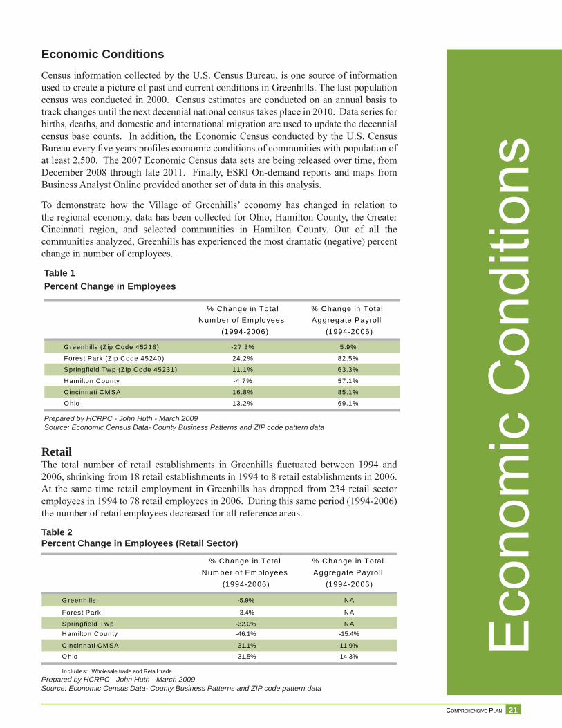
To demonstrate how the Village of Greenhills’ economy has changed in relation to the regional economy, data has been collected for Ohio, Hamilton County, the Greater Cincinnati region, and selected communities in Hamilton County. Out of all the communities analyzed, Greenhills has experienced the most dramatic (negative) percent change in number of employees.
RetailThe total number of retail establishments in Greenhills fl uctuated between 1994 and 2006, shrinking from 18 retail establishments in 1994 to 8 retail establishments in 2006. At the same time retail employment in Greenhills has dropped from 234 retail sector employees in 1994 to 78 retail employees in 2006. During this same period (1994-2006) the number of retail employees decreased for all reference areas.
Table 1Percent Change in Employees
Prepared by HCRPC - John Huth - March 2009Source: Economic Census Data- County Business Patterns and ZIP code pattern data
% Change in TotalNum ber of Em ployees
(1994-2006)
% Change in TotalAggregate Payro ll
(1994-2006)
G reenhills (Z ip Code 45218) -27.3% 5.9%
Forest Park (Zip Code 45240) 24.2% 82.5%
Springfie ld Twp (Zip Code 45231) 11.1% 63.3%
Ham ilton County -4.7% 57.1%
Cincinnati CM SA 16.8% 85.1%
O hio 13.2% 69.1%
% Change in TotalNum ber of Em ployees
(1994-2006)
% Change in TotalAggregate Payro ll
(1994-2006)
G reenhills NA
Forest Park NA
Springfie ld Twp NAHam ilton County
C incinnati CM SA
O hio
Includes: Wholesale trade and Retail trade
-5.9%
-3.4%
-32.0%-46.1% -15.4%
-31.1% 11.9%
-31.5% 14.3%
Table 2Percent Change in Employees (Retail Sector)
Prepared by HCRPC - John Huth - March 2009Source: Economic Census Data- County Business Patterns and ZIP code pattern data
22 VILLAGE OF GREENHILLS
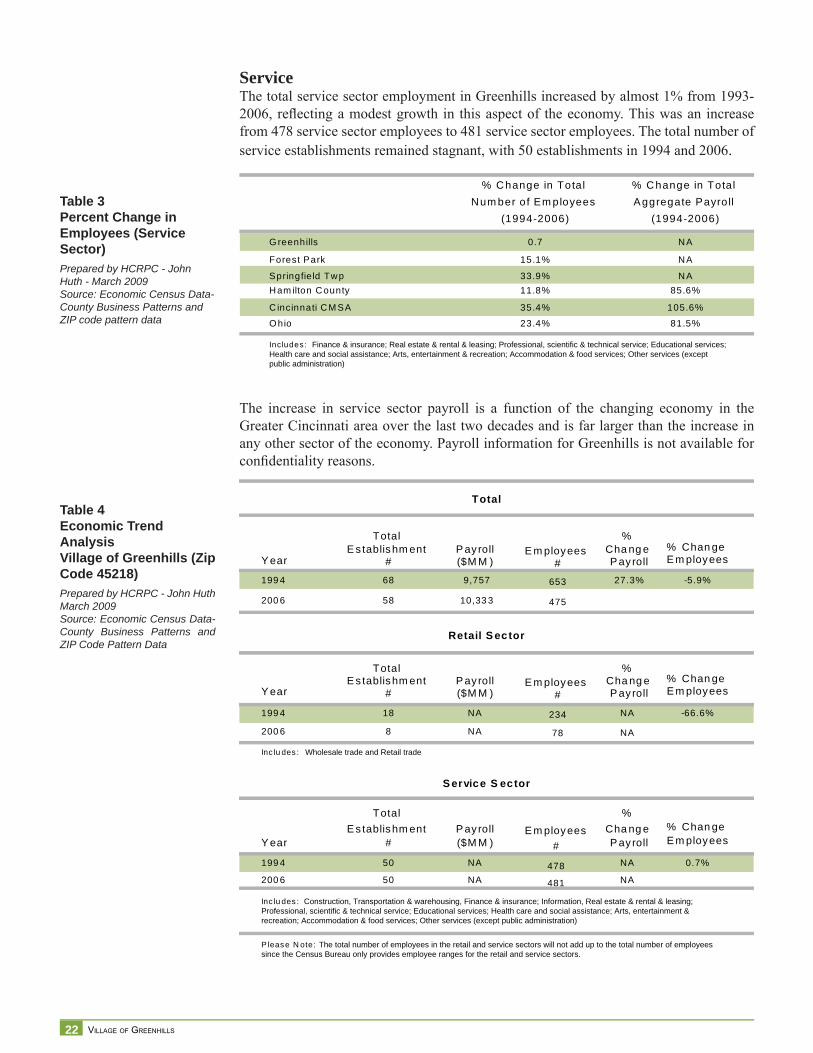
Table 3Percent Change in Employees (Service Sector)Prepared by HCRPC - John Huth - March 2009Source: Economic Census Data- County Business Patterns and ZIP code pattern data
ServiceThe total service sector employment in Greenhills increased by almost 1% from 1993-2006, refl ecting a modest growth in this aspect of the economy. This was an increase from 478 service sector employees to 481 service sector employees. The total number of service establishments remained stagnant, with 50 establishments in 1994 and 2006.
The increase in service sector payroll is a function of the changing economy in the Greater Cincinnati area over the last two decades and is far larger than the increase in any other sector of the economy. Payroll information for Greenhills is not available for confi dentiality reasons.
% Change in TotalNum ber of Em ployees
(1994-2006)
% Change in TotalAggregate Payro ll
(1994-2006)
G reenhills NA
Forest Park NA
Springfie ld Twp NAHam ilton County
C incinnati CM SA
O hio
Includes: Finance & insurance; Real estate & rental & leasing; Professional, scientific & technical service; Educational services;Health care and social assistance; Arts, entertainment & recreation; Accommodation & food services; Other services (exceptpublic administration)
0.7
15.1%
33.9%11.8% 85.6%
35.4% 105.6%
23.4% 81.5%
Table 4Economic Trend AnalysisVillage of Greenhills (Zip Code 45218)Prepared by HCRPC - John Huth March 2009Source: Economic Census Data- County Business Patterns and ZIP Code Pattern Data
Total
Y ear
TotalE s tablishm ent
#P ayroll($M M )
E m ployees#
%Cha ng eP ayroll
% Chan geE m ployees
199 4 68 9,757 653 27.3% -5.9%
200 6 58 10,33 3 475
Retail S ector
Y ear
TotalE s tablishm ent
#P ayroll($M M )
E m ployees#
%Cha ng eP ayroll
% Chan geE m ployees
199 4 18 NA 234 NA -66.6%
200 6 8 NA 78 NA
Inc lu des : Wholesale trade and Retail trade
S ervice S ector
Y ear
TotalE s tablishm ent
#P ayroll($M M )
E m ployees#
%Cha ng eP ayroll
% Chan geE m ployees
199 4 50 NA 478 NA 0.7%
200 6 50 NA 481 NA
Inc lu des : Construction, Transportation & warehousing, Finance & insurance; Information, Real estate & rental & leasing;Professional, scientific & technical service; Educational services; Health care and social assistance; Arts, entertainment &recreation; Accommodation & food services; Other services (except public administration)
P lease N ote: The total number of employees in the retail and service sectors will not add up to the total number of employeessince the Census Bureau only provides employee ranges for the retail and service sectors.
23 COMPREHENSIVE PLAN
Table 5Industry StatisticsDetailed Industry Information for 2002 by SectorSource: US Bureau of Census, 2002 Economic CensusSummary Statistics by 2002 NAICS
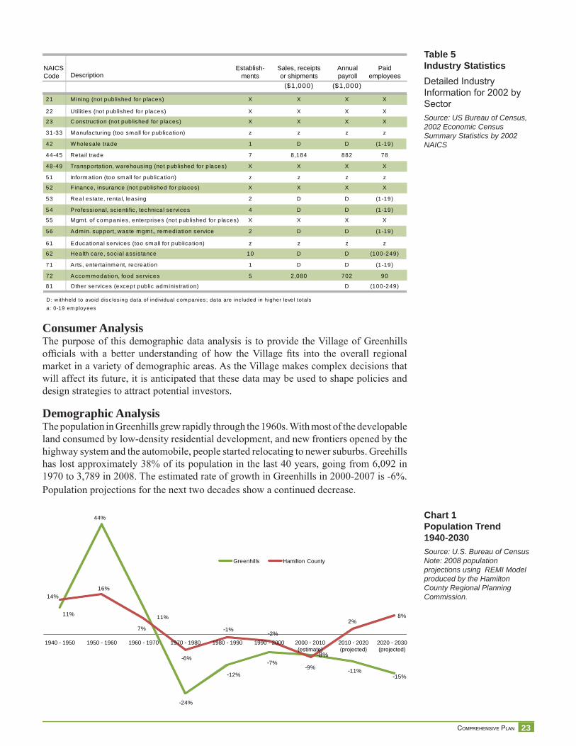
Chart 1Population Trend1940-2030Source: U.S. Bureau of CensusNote: 2008 population projections using REMI Model produced by the Hamilton County Regional Planning Commission.
Consumer Analysis The purpose of this demographic data analysis is to provide the Village of Greenhills offi cials with a better understanding of how the Village fi ts into the overall regional market in a variety of demographic areas. As the Village makes complex decisions that will affect its future, it is anticipated that these data may be used to shape policies and design strategies to attract potential investors.
Demographic AnalysisThe population in Greenhills grew rapidly through the 1960s. With most of the developable land consumed by low-density residential development, and new frontiers opened by the highway system and the automobile, people started relocating to newer suburbs. Greehills has lost approximately 38% of its population in the last 40 years, going from 6,092 in 1970 to 3,789 in 2008. The estimated rate of growth in Greenhills in 2000-2007 is -6%. Population projections for the next two decades show a continued decrease.
($1,000) ($1,000)
21 Mining (not published for p laces) X X X X
22 Utilities (not published for p laces) X X X X
23 C onstruction (not published for p laces) X X X X
31-33 Manufacturing (too small for publication) z z z z
44-45 Retail trade 7 8,184 882 78
48-49 Transportation, warehousing (not published for p laces) X X X X
51 Information (too small for publication) z z z z
53 Real estate, renta l, leasing 2 D D (1-19)
55 Mgmt. of companies, enterprises (not published for p laces) X X X X
61 E ducational services (too small for publication) z z z z
71 A rts, enterta inment, recreation 1 D D (1-19)
72 A ccommodation, food services 5 2,080 702 90
81 Other services (except public administration) D (100-249)
D: withheld to avoid disc los ing data of individual com panies ; data are inc luded in higher level totalsa: 0-19 em ployees
Paidemployees
NAICSCode Description
Establish-ments
Sales, receiptsor shipments
Annualpayroll
62 Health care, socia l assistance 10 D D (100-249)
56 A dmin. support, waste mgmt., remediation service 2 D D (1-19)
54 P rofessional, scientific, technical services 4 D D (1-19)
52 F inance, insurance (not published for p laces) X X X X
42 W holesale trade 1 D D (1-19)
11%
44%
11%
-24%
-12%
-7%-8%
-11%-15%
14%16%
7%
-6%
-1% -2%
-9%
2%8%
Greenhills Hamilton County
1940 - 1950 1950 - 1960 1960 - 1970 1970 - 1980 1980 - 1990 1990 - 2000 2000 - 2010(estimate)
2010 - 2020(projected)
2020 - 2030(projected)
24 VILLAGE OF GREENHILLS
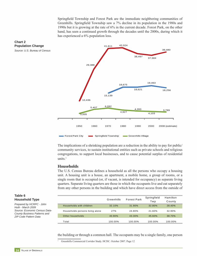
Springfi eld Township and Forest Park are the immediate neighboring communities of Greenhills. Springfi eld Township saw a 7% decline in its population in the 1980s and 1990s but it is growing at the rate of 6% in the current decade. Forest Park, on the other hand, has seen a continued growth through the decades until the 2000s, during which it has experienced a 6% population loss.
The implications of a shrinking population are a reduction in the ability to pay for public/community services, to sustain institutional entities such as private schools and religious congregations, to support local businesses, and to cause potential surplus of residential units.1
HouseholdsThe U.S. Census Bureau defi nes a household as all the persons who occupy a housing unit. A housing unit is a house, an apartment, a mobile home, a group of rooms, or a single room that is occupied (or, if vacant, is intended for occupancy) as separate living quarters. Separate living quarters are those in which the occupants live and eat separately from any other persons in the building and which have direct access from the outside of
the building or through a common hall. The occupants may be a single family, one person 1 Greenhills Commercial Corridor Study. HCDC. October 2007. Page 12
Chart 2Population ChangeSource: U.S. Bureau of Census
15,139
18,675
18,621
19,463
18,256
3,005
5,407 6,092
4,9274,393
4,1033,789
10,436
29,388
41,611 42,024
38,49737,584
39,480
1950 1960 1970 1980 1990 2000 2008 (estimate)
Greenhills VillageSpringfield TownshipForest Park City
Table 6Household TypePrepared by HCRPC - John Huth - March 2009Source: Economic Census Data- County Business Patterns and ZIP Code Pattern Data
G reenhills Forest ParkSpringfield
Tw pHam ilton
CountyHouseholds w ith children 32.10% 31.90% 32.80% 28.40%
Households persons living alone 27% 24.80% 21.60% 32.90%
O ther households 40.90% 43.30% 45.60% 38.70%
Total 100.00% 100.00% 100.00% 100.00%
25 COMPREHENSIVE PLAN
Table 7IncomePrepared by HCRPC - John Huth - March 2009Source: Economic Census Data- County Business Patterns and ZIP Code Pattern Data
Table 8Population Age CohortsPrepared by HCRPC - John Huth - March 2009Source: Economic Census Data- County Business Patterns and ZIP Code Pattern Data
living alone, two or more families living together, or any other group of related or unrelated persons who share living arrangements. (People not living in households are classifi ed as living in group quarters.)2 Census data provide the following picture for Greenhills. Households are shrinking in number and size. Approximately a third of all households have children and another third of households are composed of people living alone. This is a higher rate than that found in Forest Park and Springfi eld Township. Household income is higher than the County average, but falls short when compared to neighboring communities. Commercial, public, and private services should cater to the needs of these market segments.
In 2000, Greenhills had 1,687 households, 6.49% fewer than in the previous decade. Census estimates a 5.8% loss in the number of households in the 2000-2005 period and forecasts an additional 6.8% loss for the 2005-2010 period.3 The average household size is shrinking from 2.62 in 1990 to 2.45 in 2000. This may be an indication that there are fewer families with children. Out of the households that live alone, 18.5% are under 65 years old and 8.5% are 65 years old and older. Household incomes have increased by the same percentage in 2000-2007 in the selected communities.
Age of the PopulationThe median age of the population in Greenhills is getting older, and the 5-17 year-old cohort is shrinking. The closing off of a local parochial school, Our Lady of the Rosary, is a casualty of the changing demographics that have affected the Archdiocese of Cincinnati’s education system. Data analyzed include age cohorts in the 2000 U.S. Census for Greenhills, Forest Park, Springfi eld Township and Hamilton County; and ESRI On-demand reports prepared on December 31, 2008.4
2 http://quickfacts.census.gov/qfd/meta/long_HSD310200.htm3 Greenhills Commercial Corridor Study. HCDC. October 2007. Page 12
4 ESRI provides aggregated numbers of demographic data based on geography. Concentric circles of one-mile, two-mile and fi ve-mile radius with center at 22 Endicott Street (Greenhills shopping center address) were drawn to ana-lyze population and consumer spending. The one-mile radius includes the entire Village of Greenhills and portions of the surrounding neighborhoods of Springfi eld Township and Forest Park; as the circles become larger, population from Springdale, Woodlawn, Lincoln Heights, Sharonville, Evendale, Wyoming, Finneytown, North College, Mt. Healthy. Colerain is included.
2000 (1)2007 (Estimate)
(2)
Greenhills $ 44,886 $ 53,051
Forest Park $ 49,298 $ 58,266
Springfield Twp $ 52,139
Hamilton County $ 40,964 $ 48,416
M edian Household Incom e inSelected Com m unities
Greenhills Forest Park Springfield TwpHamiltonCounty
School Age (5-17) 19.40% 20.50% 21.40% 9.80%
W ork Force (18-64) 58% 63.80% 57.50% 60.70%
Elderly 65+ 15.60% 9.10% 14.80% 13.70%
M edian Age 35.9 33.9 37.9 35.5
Total Population 4,103 19,463 37,587 845,303
26 VILLAGE OF GREENHILLS
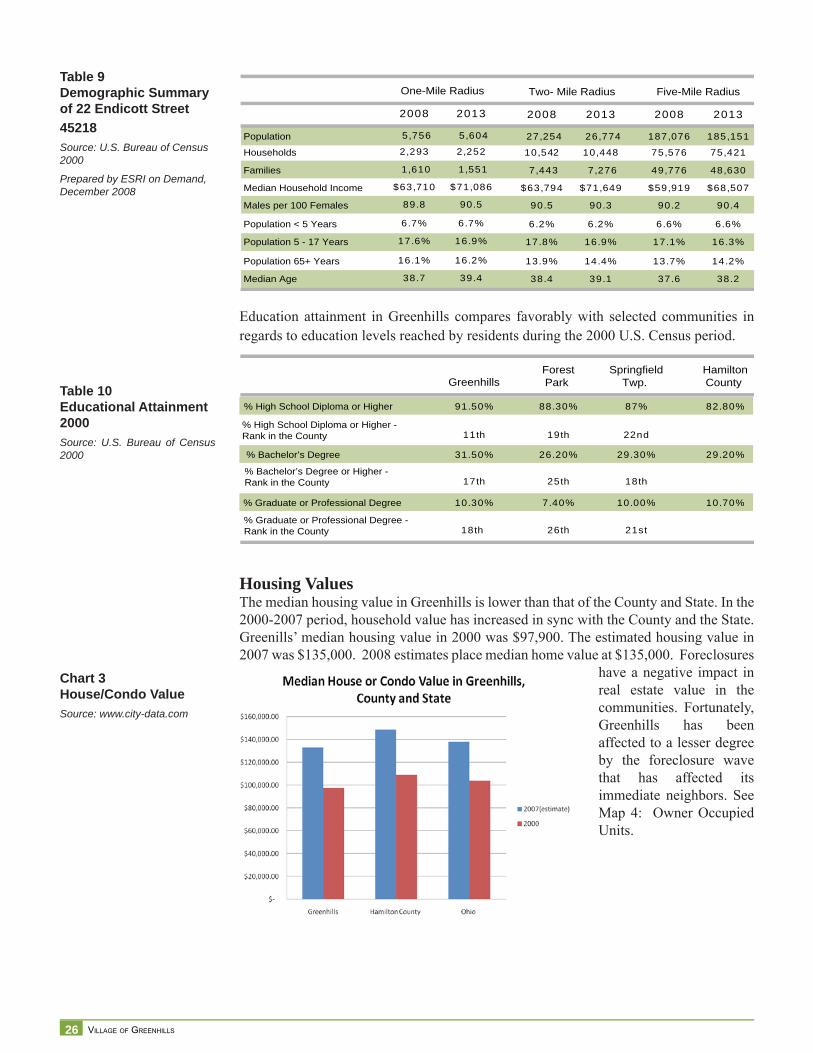
Education attainment in Greenhills compares favorably with selected communities in regards to education levels reached by residents during the 2000 U.S. Census period.
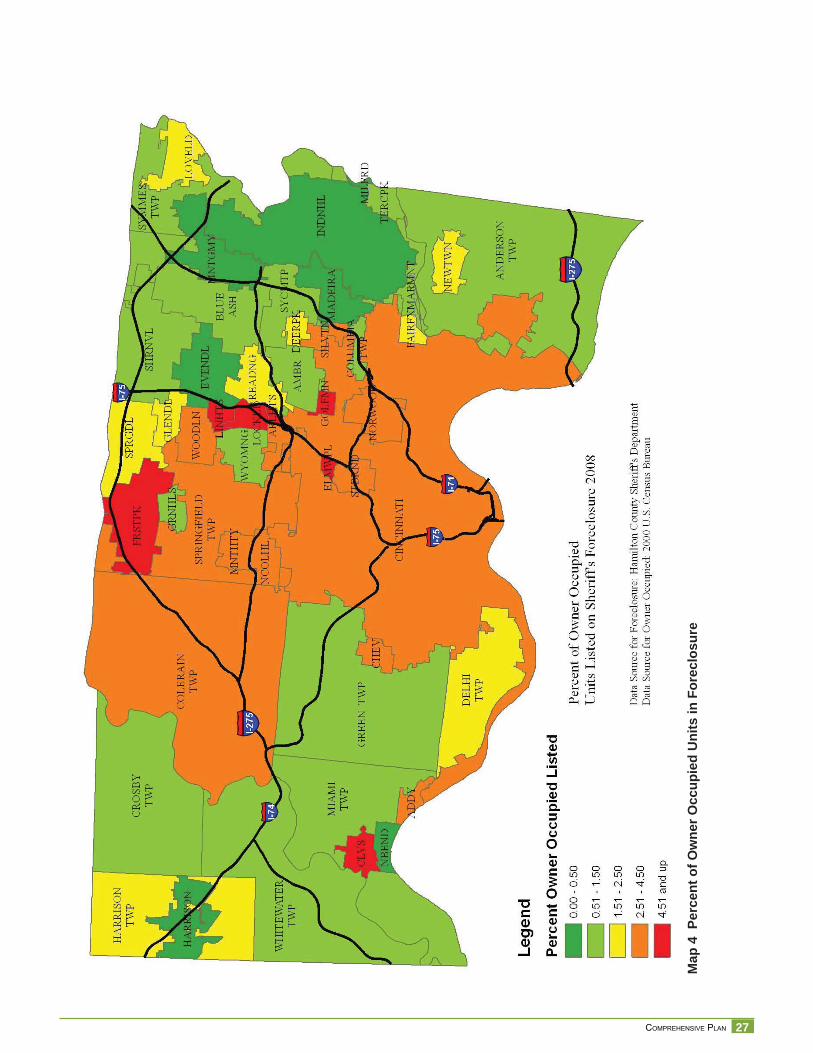
Housing ValuesThe median housing value in Greenhills is lower than that of the County and State. In the 2000-2007 period, household value has increased in sync with the County and the State. Greenills’ median housing value in 2000 was $97,900. The estimated housing value in 2007 was $135,000. 2008 estimates place median home value at $135,000. Foreclosures
have a negative impact in real estate value in the communities. Fortunately, Greenhills has been affected to a lesser degree by the foreclosure wave that has affected its immediate neighbors. See Map 4: Owner Occupied Units.
Table 9Demographic Summaryof 22 Endicott Street 45218Source: U.S. Bureau of Census 2000
Prepared by ESRI on Demand, December 2008
Table 10Educational Attainment2000Source: U.S. Bureau of Census 2000
Population
Households
Families
Median Household Income
Males per 100 Females
Population < 5 Years
Population 5 - 17 Years
Population 65+ Years
Median Age
2008 2013
27,254 26,774
10,542 10,448
7,443 7,276
$63,794 $71,649
90.5 90.3
6.2% 6.2%
17.8% 16.9%
13.9% 14.4%
38.4 39.1
Two- Mile Radius
2008 2013
187,076 185,151
75,576 75,421
49,776 48,630
$59,919 $68,507
90.2 90.4
6.6% 6.6%
17.1% 16.3%
13.7% 14.2%
37.6 38.2
Five-Mile Radius
2008 2013
5,756 5,604
2,293 2,252
1,610 1,551
$63,710 $71,086
89.8 90.5
6.7% 6.7%
17.6% 16.9%
16.1% 16.2%
38.7 39.4
One-Mile Radius
GreenhillsForestPark
SpringfieldTwp.
HamiltonCounty
% High School Diploma or Higher 91.50% 88.30% 87% 82.80%
% High School Diploma or Higher -Rank in the County 11th 19th 22nd
% Bachelor’s Degree 31.50% 26.20% 29.30% 29.20%
% Bachelor’s Degree or Higher - Rank in the County 17th 25th 18th
% Graduate or Professional Degree 10.30% 7.40% 10.00% 10.70%
% Graduate or Professional Degree - Rank in the County 18th 26th 21st
Chart 3House/Condo ValueSource: www.city-data.com
27 COMPREHENSIVE PLAN
Map
4 P
erce
nt o
f Ow
ner O
ccup
ied
Uni
ts in
For
eclo
sure
28 VILLAGE OF GREENHILLS
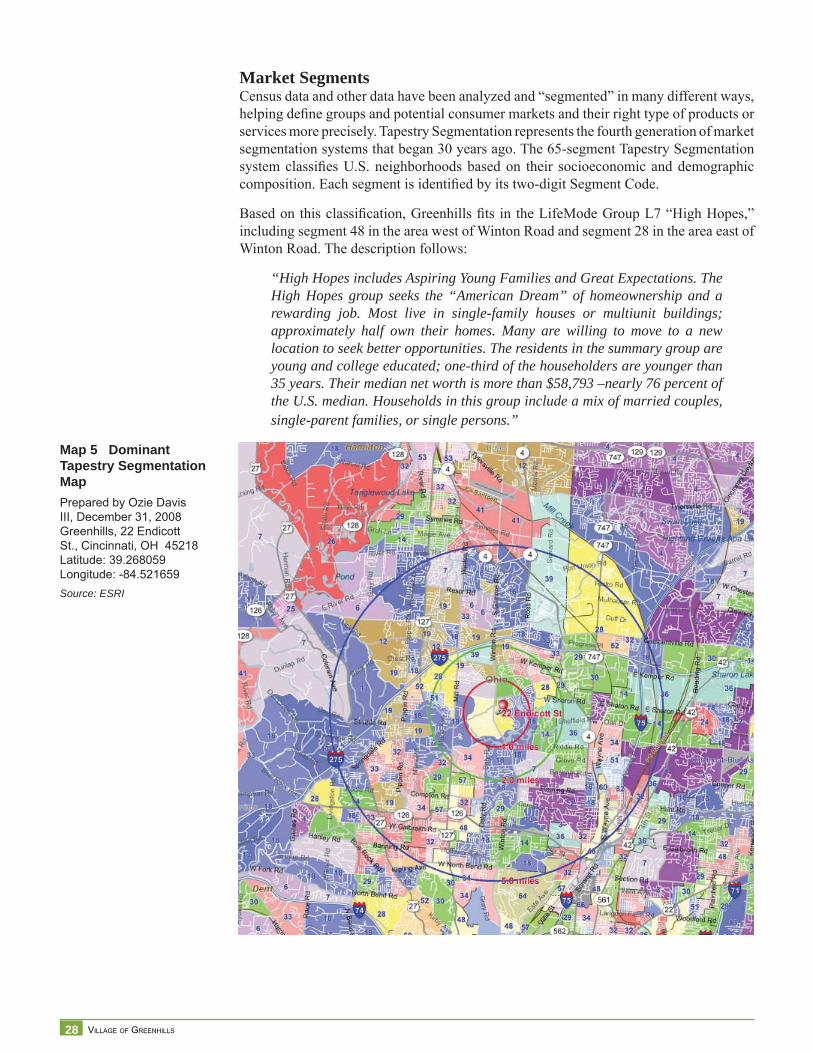
Market SegmentsCensus data and other data have been analyzed and “segmented” in many different ways, helping defi ne groups and potential consumer markets and their right type of products or services more precisely. Tapestry Segmentation represents the fourth generation of market segmentation systems that began 30 years ago. The 65-segment Tapestry Segmentation system classifi es U.S. neighborhoods based on their socioeconomic and demographic composition. Each segment is identifi ed by its two-digit Segment Code.
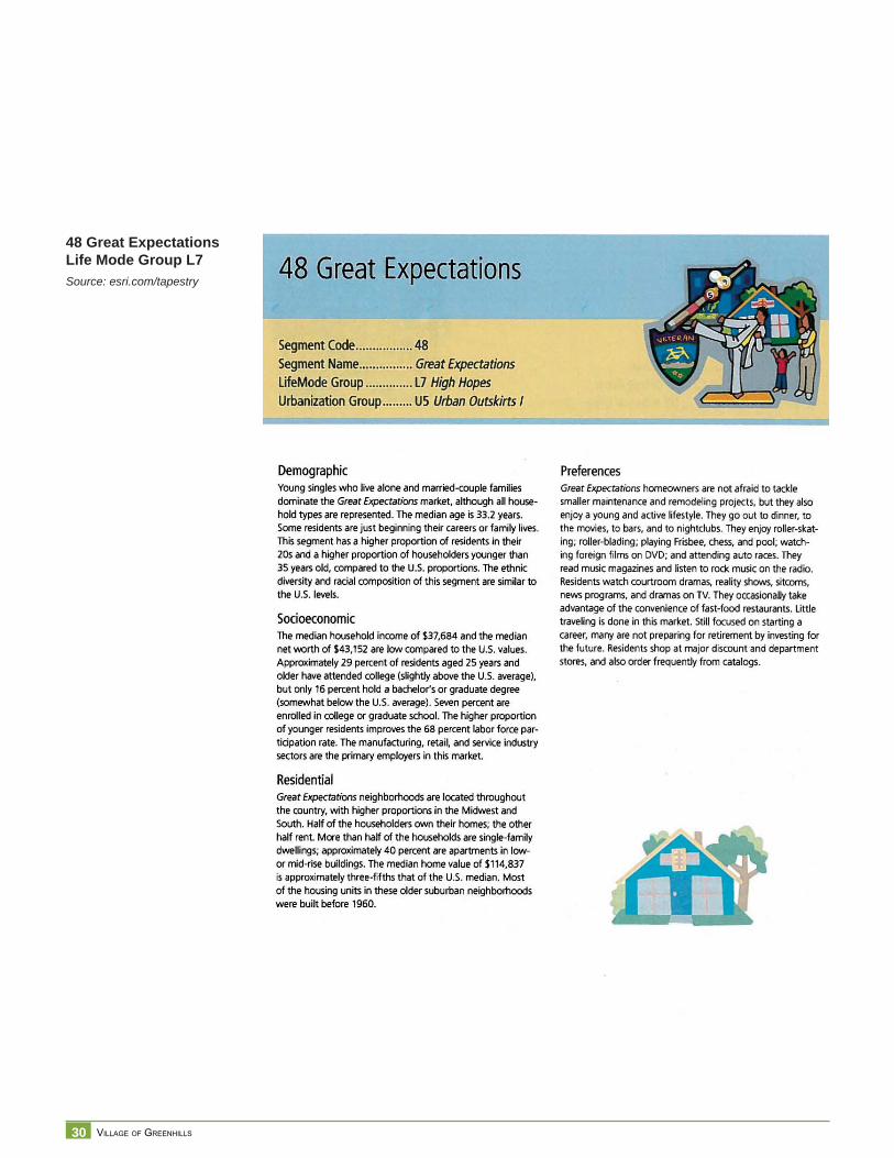
Based on this classifi cation, Greenhills fi ts in the LifeMode Group L7 “High Hopes,” including segment 48 in the area west of Winton Road and segment 28 in the area east of Winton Road. The description follows:
“High Hopes includes Aspiring Young Families and Great Expectations. The High Hopes group seeks the “American Dream” of homeownership and a rewarding job. Most live in single-family houses or multiunit buildings; approximately half own their homes. Many are willing to move to a new location to seek better opportunities. The residents in the summary group are young and college educated; one-third of the householders are younger than 35 years. Their median net worth is more than $58,793 –nearly 76 percent of the U.S. median. Households in this group include a mix of married couples, single-parent families, or single persons.”
Map 5 Dominant Tapestry Segmentation MapPrepared by Ozie Davis III, December 31, 2008 Greenhills, 22 Endicott St., Cincinnati, OH 45218 Latitude: 39.268059 Longitude: -84.521659Source: ESRI
29 COMPREHENSIVE PLAN
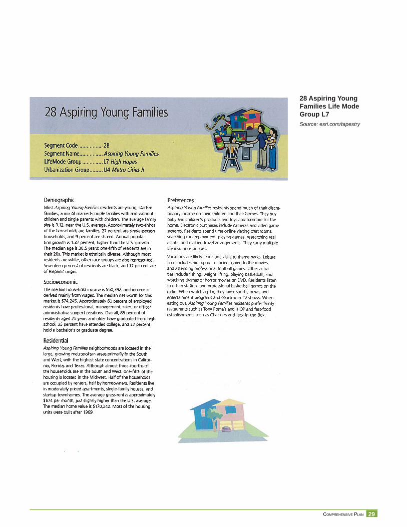
28 Aspiring Young Families Life Mode Group L7Source: esri.com/tapestry
30 VILLAGE OF GREENHILLS
48 Great Expectations Life Mode Group L7Source: esri.com/tapestry
31 COMPREHENSIVE PLAN
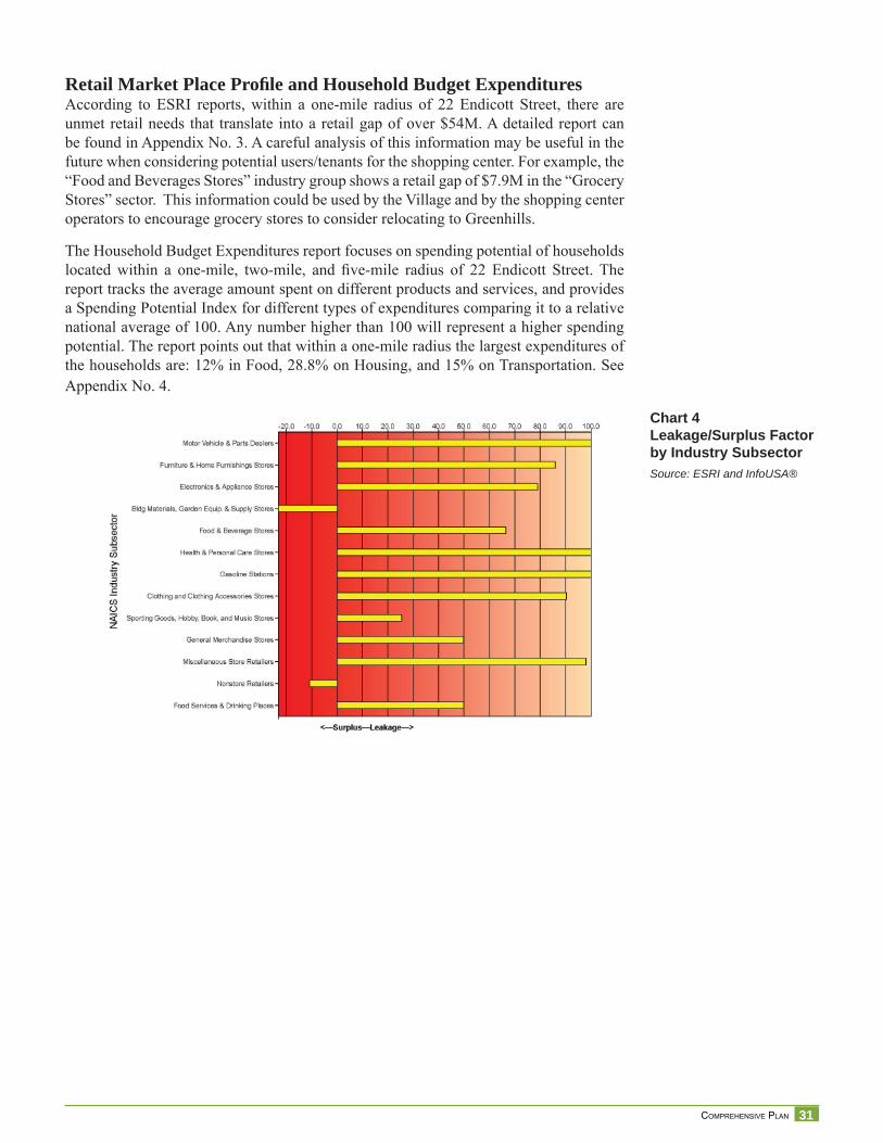
Chart 4Leakage/Surplus Factor by Industry SubsectorSource: ESRI and InfoUSA®
Retail Market Place Profi le and Household Budget ExpendituresAccording to ESRI reports, within a one-mile radius of 22 Endicott Street, there are unmet retail needs that translate into a retail gap of over $54M. A detailed report can be found in Appendix No. 3. A careful analysis of this information may be useful in the future when considering potential users/tenants for the shopping center. For example, the “Food and Beverages Stores” industry group shows a retail gap of $7.9M in the “Grocery Stores” sector. This information could be used by the Village and by the shopping center operators to encourage grocery stores to consider relocating to Greenhills.
The Household Budget Expenditures report focuses on spending potential of households located within a one-mile, two-mile, and fi ve-mile radius of 22 Endicott Street. The report tracks the average amount spent on different products and services, and provides a Spending Potential Index for different types of expenditures comparing it to a relative national average of 100. Any number higher than 100 will represent a higher spending potential. The report points out that within a one-mile radius the largest expenditures of the households are: 12% in Food, 28.8% on Housing, and 15% on Transportation. See Appendix No. 4.
32 VILLAGE OF GREENHILLS
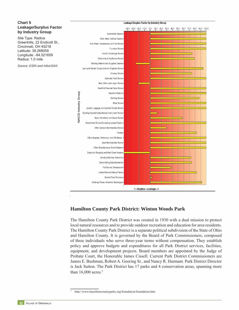
Chart 5Leakage/Surplus Factor by Industry GroupSite Type: RadiusGreenhills, 22 Endicott St., Cincinnati, OH 45218Latitude: 39.268059Longitude: -84.521659Radius: 1.0 mile
Source: ESRI and InfoUSA®
Hamilton County Park District: Winton Woods Park
The Hamilton County Park District was created in 1930 with a dual mission to protect local natural resources and to provide outdoor recreation and education for area residents. The Hamilton County Park District is a separate political subdivision of the State of Ohio and Hamilton County. It is governed by the Board of Park Commissioners, composed of three individuals who serve three-year terms without compensation. They establish policy and approve budgets and expenditures for all Park District services, facilities, equipment, and development projects. Board members are appointed by the Judge of Probate Court, the Honorable James Cissell. Current Park District Commissioners are James E. Bushman, Robert A. Goering Sr., and Nancy R. Harmant. Park District Director is Jack Sutton. The Park District has 17 parks and 4 conservation areas, spanning more than 16,000 acres.5
5 http://www.hamiltoncountyparks.org/foundation/foundation.htm
33 COMPREHENSIVE PLAN
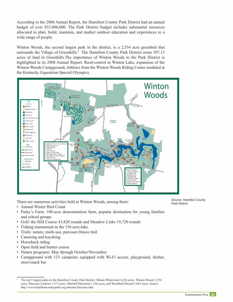
According to the 2008 Annual Report, the Hamilton County Park District had an annual budget of over $33,000,000. The Park District budget includes substantial resources allocated to plan, build, maintain, and market outdoor education and experiences to a wide range of people.
Winton Woods, the second largest park in the district, is a 2,554 acre greenbelt that surrounds the Village of Greenhills.6 The Hamilton County Park District owns 107.13 acres of land in Greenhills.The importance of Winton Woods to the Park District is highlighted in its 2008 Annual Report: fl ood-control in Winton Lake, expansion of the Winton Woods Campground, Athletes from the Winton Woods Riding Center medaled at the Kentucky Equestrian Special Olympics.
There are numerous activities held at Winton Woods, among them:• Annual Winter Bird Count• Parky’s Farm: 100-acre demonstration farm, popular destination for young families
and school groups• Golf: the Mill Course 43,828 rounds and Meadow Links 19,720 rounds• Fishing tournament in the 156 acre-lake• Trails: nature, multi-use, parcours fi tness trail• Canoeing and kayaking• Horseback riding• Open fi eld and hunter course• Nature programs: May through October/November• Campground with 123 campsites equipped with Wi-Fi access, playground, shelter,
store/snack bar
6 The top 5 largest parks in the Hamilton County Park District: Miami-Whitewater 4,326 acres, Winton Woods 2,554 acres, Shawnee Lookout 1,517 acres, Mitchell Memorial 1,336 acres, and Woodland Mound 1,063 acres. Source: http://www.hamiltoncountyparks.org/aboutus/directory.htm.
Source: Hamilton CountyPark District
34 VILLAGE OF GREENHILLS
The Park District is exempt from paying taxes over property owned in Greenhills. According to Park District Planning staff, wooded areas immediately surrounding Greenhills are to be preserved in their natural state. The potential infestation of ash trees with the Emerald Ash Borer is seen as a natural occurrence and no plans are in place to take down infected or dead trees, unless they are on a trail or public right-of-way.
A paper trail proposed by planners in the Park District in the early 90’s that surrounds the Village of Greenhills has not been built. According to Park Planners, interest from the community and other organized groups dwindled, resulting in the placement of the project very low in the implementation schedule.
Members of the Cincinnati Off-Road Alliance (CORA) are very interested in taking a closer look at the proposed trail to evaluate the possibility of collaborating with the Park District and the Village of Greenhills to build an offi cial mountain bike trail. The Park District has had a positive experience with CORA, which built a 3.9 mile mountain bike trail in Mitchell Memorial Park.
Park District planning staff acknowledges that there may be benefi ts to enhance the experience of Winton Woods’ visitors by identifying destination points and events hosted in Greenhills that are complementary to services provided by the Park.
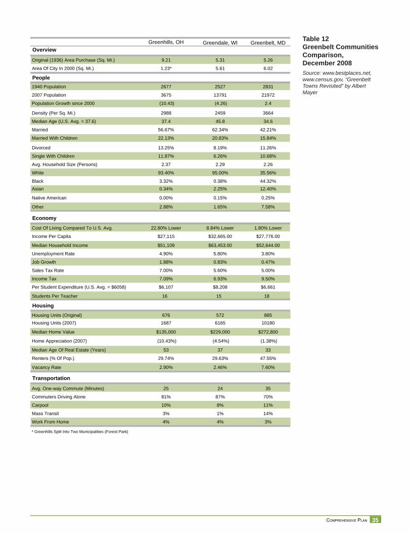
Tax and Revenue AnalysisOf the original conceptual design of a planned community, only a small portion was actually built. See Greenbelt Communities Comparison Table on next page. The part that was built and is known as the Village of Greenhills was always conceived as a bedroom
community in near proximity to a developing industrial corridor as the main source of employment.
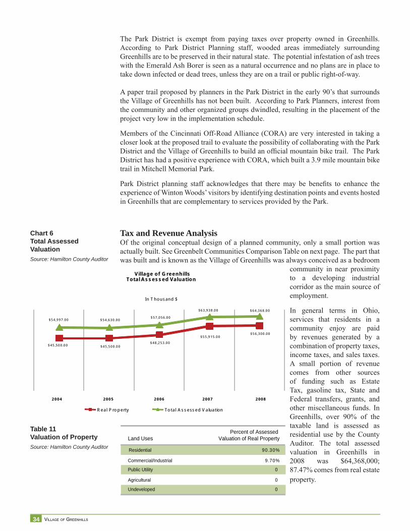
In general terms in Ohio, services that residents in a community enjoy are paid by revenues generated by a combination of property taxes, income taxes, and sales taxes. A small portion of revenue comes from other sources of funding such as Estate Tax, gasoline tax, State and Federal transfers, grants, and other miscellaneous funds. In Greenhills, over 90% of the taxable land is assessed as residential use by the County Auditor. The total assessed valuation in Greenhills in 2008 was $64,368,000; 87.47% comes from real estate property.
Chart 6Total Assessed ValuationSource: Hamilton County Auditor
$45 ,500 .00 $45 ,500 .00$48 ,253 .00
$55 ,915 .00$56 ,300 .00
$54 ,997 .00 $54 ,630 .00$57 ,056 .00
$63 ,938 .00 $64 ,368 .00
2008
V illage of G reenhillsTota l Assessed Va lua tion
In T housand $
Real P ro p erty To tal A s sessed V aluat ion
2007200620052004
Table 11Valuation of PropertySource: Hamilton County Auditor
Land UsesPercent of Assessed
Valuation of Real Property
Residential 90.30%
Commercial/Industrial 9.70%
Public Utility 0
Agricultural 0
Undeveloped 0
35 COMPREHENSIVE PLAN
Table 12Greenbelt CommunitiesComparison, December 2008Source: www.bestplaces.net, www.census.gov, “Greenbelt Towns Revisited” by Albert Mayer
People
2007 Population
Density (Per Sq. Mi.)
Married
Divorced
Avg. Household Size (Persons)
Black
Native American
Economy
Income Per Capita
Unemployment Rate
Sales Tax Rate
Per Student Expenditure (U.S. Avg. = $6058)
Housing
Housing Units (2007)
Home Appreciation (2007)
Renters (% Of Pop.)
Transportation
Commuters Driving Alone
Mass Transit
Greenhills, OH
3675
2988
56.67%
13.25%
2.37
3.32%
0.00%
$27,115
4.90%
7.00%
$6,107
1687
(10.43%)
29.74%
81%
3%
Greendale, WI
13791
2459
62.34%
8.19%
2.29
0.38%
0.15%
$32,665.00
5.80%
5.60%
$8,208
6165
(4.54%)
29.63%
87%
1%
Greenbelt, MD
21972
3664
42.21%
11.26%
2.26
44.32%
0.25%
$27,776.00
3.80%
5.00%
$6,661
10180
(1.38%)
47.55%
70%
14%
* Greenhills Split Into Two Municipalities (Forest Park)
Work From Home 4% 4% 3%
Carpool 10% 8% 11%
Avg. One-way Commute (Minutes) 25 24 35
Vacancy Rate 2.90% 2.46% 7.60%
Median Age Of Real Estate (Years) 53 37 33
Median Home Value $135,000 $229,000 $272,800
Housing Units (Original) 676 572 885
Students Per Teacher 16 15 18
Income Tax 7.09% 6.93% 9.50%
Job Growth 1.88% 0.83% 0.47%
Median Household Income $51,109 $63,453.00 $52,644.00
Cost Of Living Compared To U.S. Avg. 22.80% Lower 8.84% Lower 1.80% Lower
Other 2.88% 1.65% 7.58%
Asian 0.34% 2.25% 12.40%
White 93.40% 95.00% 35.56%
Single With Children 11.87% 6.26% 10.68%
Married With Children 22.13% 20.83% 15.84%
Median Age (U.S. Avg. = 37.6) 37.4 45.8 34.6
Population Growth since 2000 (10.43) (4.26) 2.4
1940 Population 2677 2527 2831
Overview
Original (1936) Area Purchase (Sq. Mi.)
Area Of City In 2000 (Sq. Mi.)
9.21
1.23*
5.31
5.61
5.26
6.02
36 VILLAGE OF GREENHILLS
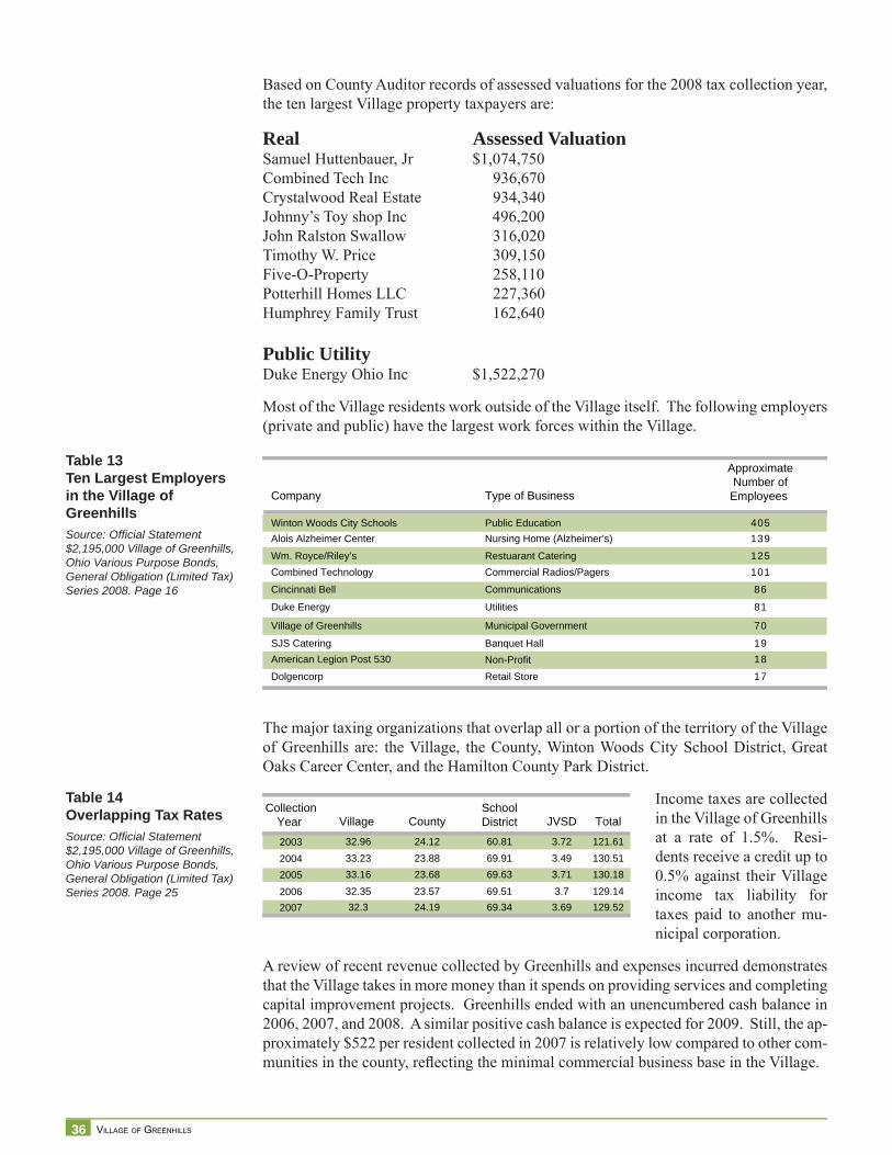
Based on County Auditor records of assessed valuations for the 2008 tax collection year, the ten largest Village property taxpayers are:
Real Assessed ValuationSamuel Huttenbauer, Jr $1,074,750Combined Tech Inc 936,670Crystalwood Real Estate 934,340Johnny’s Toy shop Inc 496,200John Ralston Swallow 316,020Timothy W. Price 309,150Five-O-Property 258,110Potterhill Homes LLC 227,360Humphrey Family Trust 162,640
Public UtilityDuke Energy Ohio Inc $1,522,270
Most of the Village residents work outside of the Village itself. The following employers (private and public) have the largest work forces within the Village.
The major taxing organizations that overlap all or a portion of the territory of the Village of Greenhills are: the Village, the County, Winton Woods City School District, Great Oaks Career Center, and the Hamilton County Park District.
Income taxes are collected in the Village of Greenhills at a rate of 1.5%. Resi-dents receive a credit up to 0.5% against their Village income tax liability for taxes paid to another mu-nicipal corporation.
A review of recent revenue collected by Greenhills and expenses incurred demonstrates that the Village takes in more money than it spends on providing services and completing capital improvement projects. Greenhills ended with an unencumbered cash balance in 2006, 2007, and 2008. A similar positive cash balance is expected for 2009. Still, the ap-proximately $522 per resident collected in 2007 is relatively low compared to other com-munities in the county, refl ecting the minimal commercial business base in the Village.
Table 13Ten Largest Employersin the Village of GreenhillsSource: Offi cial Statement $2,195,000 Village of Greenhills, Ohio Various Purpose Bonds, General Obligation (Limited Tax) Series 2008. Page 16
Company Type of Business
ApproximateNumber ofEmployees
Winton Woods City Schools Public Education 405Alois Alzheimer Center Nursing Home (Alzheimer’s) 139
Wm. Royce/Riley’s Restuarant Catering 125Combined Technology Commercial Radios/Pagers 101
Cincinnati Bell Communications 86
Duke Energy Utilities 81
Village of Greenhills Municipal Government 70
SJS Catering Banquet Hall 19American Legion Post 530 Non-Profit 18
Dolgencorp Retail Store 17
Table 14Overlapping Tax RatesSource: Offi cial Statement $2,195,000 Village of Greenhills, Ohio Various Purpose Bonds, General Obligation (Limited Tax) Series 2008. Page 25
CollectionYear Village County
SchoolDistrict JVSD Total
2003 32.96 24.12 60.81 3.72 121.612004 33.23 23.88 69.91 3.49 130.512005 33.16 23.68 69.63 3.71 130.18
2006 32.35 23.57 69.51 3.7 129.142007 32.3 24.19 69.34 3.69 129.52

37 COMPREHENSIVE PLAN
Total Revenues2006
$ 1,862, 929Rate of change from previous year
2007$ 1,975, 749
6%
2008$ 2, 520, 675 (1)
22%
2009 (estim ate)$ 2, 091, 666
-21%Note: (1) Unexpected windfall $570,000 Estate tax
Local Taxes
Contribution to Total Revenues in %
2006$ 1, 384, 300
74%
2007$ 1, 534, 855
78%
2008$ 1, 603, 003
64%
2009 (estimate)$ 1,653, 800
79%
Intergovernmental Revenues
Contribution to Total Revenues in %
2006$ 282,254
15%
2007$209,424
11%
2008$ 716,172 (1)
28%
2009 (estimate)$ 216, 966
10%Note: (1) Unexpected windfall %570, 000 Estate tax
Miscellaneous (fees, and other financing sources)
Contribution to Total Revenues in %
2006$ 196, 375
11%
2007$ 231, 470
12%
2008$ 201,500
8%
2009 (estimate)$ 220,900
11%
Total Expenditures2006
$ 2, 089, 860Rate of change from previous year
2007$ 1,949, 919
-7%
2008$ 2,388,600
18%
2009 (estimate)$ 2, 234,730
-7%
Expenditure/Services
Security of Persons and PropertyRate of change from previous yearContribution to Total Expenditures in %
2006$ 579,544
28%
2007$ 610,848
5%31%
2008$ 659,858
7%28%
2009 (estimate)$ 709,915
7%32%
Leisure Time Activities: ParksRate of change from previous yearContribution to Total Expenditures in %
$ 63,974
3%
$ 50,470-27%3%
$ 46,323-9%2%
$ 56,74118%3%
Community Environment $ 21,627
1%
$ 36,36141%2%
$ 33,374-9%1%
$ 40,87718%2%
Basic Utility Service (includes Rumpke) $ 341,501
16%
$ 395.24814%20%
$ 459,29114%19%
$ 502,3579%
22%
General Government $ 1,032,399
49%
$ 788,238-31%40%
$ 827,7545%
35%
$ 861,8404%
39%
Other uses of funds including transfers andIncome Tax Refunds $ 50,815
2%
$ 68,75426%4%
$ 362,00081%15%
$63,000-475%
3%
Revenues over/(under) ExpendituresBeginning Unencumbered BalanceEnding case fund balance
2009 (estimate)$ (143,064)$ 235,326$ 92,262
Voided old outstanding checks
Est. Ending Unencumbered Fund Balance
2006$ (226,931)$ 304,337$ 77,406
$ 77,406
2007$ 25,830$ 77,406
$ 103,236$ 16
$103,251
2008$ 132,075$ 103,251$ 235,326
$235,326
Sources of Revenues
Rate of change from previous yearContribution to Total Expenditures in %
Rate of change from previous yearContribution to Total Expenditures in %
Rate of change from previous yearContribution to Total Expenditures in %
Rate of change from previous yearContribution to Total Expenditures in %
Table 15Greenhills General FundSource: 2009 Village of Greenhills General Tax Budget
38 VILLAGE OF GREENHILLS
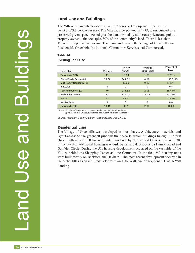
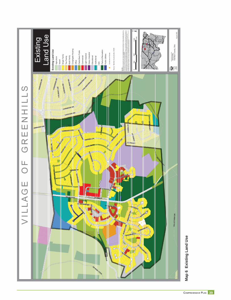
Land Use and BuildingsThe Village of Greenhills extends over 807 acres or 1.23 square miles, with a density of 3.3 people per acre. The Village, incorporated in 1939, is surrounded by a preserved green space - zoned greenbelt and owned by numerous private and public property owners - that occupies 30% of the community’s land. There is less than 1% of developable land vacant. The main land uses in the Village of Greenhills are Residential, Greenbelt, Institutional, Community Services and Commercial.
Residential UsesThe Village of Greenhills was developed in four phases. Architecture, materials, and layout/access to the greenbelt pinpoint the phase to which buildings belong. The fi rst phase, with almost 700 housing units, was built by the Federal Government in 1938. In the late 40s additional housing was built by private developers on Damon Road and Gambier Circle. During the 50s housing development occurred on the east side of the Village behind the Shopping Center and the Commons. In the 60s, 243 housing units were built mostly on Beckford and Bayham. The most recent development occurred in the early 2000s as an infi ll redevelopment on FDR Walk and on segment “D” at DeWitt Landing.
Table 16Existing Land Use
Land Use ParcelsArea inAcres
AverageParcel Size
Percent ofTotal
Commercial / Office 11 16.84 1.53 2.00%
Single Family Residential 1,286 244.52 0.19 30.3 0%
Multi-Family Residential (1) 42.59 0.26 5.28%
Industrial 0 0 0 0%
Public Institutional (2) 79 233.52 2.96 28.94%
Parks & Recreation 13 172.63 13.28 21.39%
Vacant 97 96.9 1 12.01%
Not Available 0 0 0 0%
Community Total 1,649 807 2.04 100%
Notes: (1) Includes Two-family, Congregate Housing, and Multi-family land uses(2) Includes Public Utilities, Institutional, and Public/Semi-Public land uses
Land
Use
and
Bui
ldin
gs
Source: Hamilton County Auditor - Existing Land Use CAGIS
39 COMPREHENSIVE PLAN
Map
6 E
xist
ing
Land
Use
V I L
L A
G E
O
F
G R
E E
N H
I L
L S
Exi
stin
gLa
nd U
se
§̈ ¦I-74
§̈ ¦I-75
§̈ ¦I-75
§̈ ¦I-275
Aug
ust 2
009
DISC
LAIM
ER:
Neith
er th
e pro
vider
nor a
ny o
f the
partie
s of
the C
incinn
ati a
rea g
eogra
phic
inform
ation
syste
m (C
AGIS)
mak
e an
y wa
rranty
or re
prese
ntatio
n, eit
her e
xpres
sed
o r im
plied
, with
resp
ect to
this
inform
ation
, its
quali
ty, pe
rform
ance
, merc
hanta
bility
, or f
itnes
s for
a pa
rticula
r purp
ose.
As a
resu
lt this
infor
matio
n is
provid
ed “a
s is”,
and
yo
u, the
recip
ient, a
re as
sumi
ng th
e enti
re ris
k as t
o its
quali
ty an
d per
form
ance
.In
no ev
ent, w
ill the
prov
ider o
r any
part
y of
CAGI
S be
liable
for d
irect,
indir
ect, i
ncide
ntal, o
r con
sequ
entia
l dam
ages
resu
lting
from
any
defec
t in th
e inf
ormati
on or
any
other
part o
f the m
ap pr
oduc
t, eve
n if a
dvise
d of th
e pos
sibility
of su
ch da
mage
s. In
partic
ular,
neith
er the
prov
ider n
or an
y par
ty of
CAGI
S sh
all ha
ve an
y lia
bility
for a
ny
other
inform
ation
, prog
rams o
r data
used
with
or co
mbin
ed w
ith th
e info
rmati
on re
ceive
d, inc
luding
the c
ost o
f reco
verin
g suc
h info
rmati
on, p
rogra
ms or
data
. An
y flo
odwa
y an
d flo
od fri
nge
inform
ation
prov
ided o
n thi
s map
is fo
r con
ceptu
al pla
nning
purpo
ses
only.
For
offic
ial de
term
inatio
n of
limits
recip
ient m
ust r
efer t
o the
19
82 F
EMA
flood
way f
ringe
map
s. La
rge di
fferen
ces c
an ex
ist be
twee
n actu
al flo
od pr
one a
rea an
d offic
ial FE
MA
flood
fring
e are
as.
WSH
AR
ON
RD
WINTONRD
JUNE
FIEL
DAV
HADLEY
RD
LAKE
FORE
STCI
RCLE
DR
CASCADE RD
IREL
AN
DAV
GOLFVIEWDR
ING
RA
MR
D
DAMON RD
FARR
AGUT
RD
SPR
ING
DA
LER
D
LAKEVIE
WDR
CO
RO
NA
RD
VALL
EYVI
EWD
R
CA
RLS
BA
DR
D
ENFIELDST
JULE
PLN
CA
RIN
ILN
ILLO
NADR
HAMLIN DR
CARNEGIE DR
HAYDENDR
HANDEL LN
ESWINST
JUNEDALE DR
DRUMMONDST
IMBLER DR
DA
NVE
RS
DR
CO
NVER
SED
R
CROMWELLRD
BAYHAMDR
ANDO
VER
RD
JEW
ELLN
CHELMSFO
RDRD
JAPO
NICA
DR
LIG
OR
IOAV
AVENELL LN
BURL
EYCI
R
CRANFORDDR
INM
AN
LN
ASHBYST
BACHMAN ST
DEW
ITT
ST
FLANDERS LN
BROMPTONLN
CO
NC
AST
DEERHILL LN
EMBASSY DR
GAM
BIER
CIR
CHALMERSLN
BURNHAM ST
CO
LBER
TC
IR
LATINACT
JENNIN
GSRD
JUST
ICIA
LN
±0
700
1,40
035
0Fe
et
Com
preh
ensi
ve P
lan
Gre
enhi
llsH
amilt
on C
ount
y, O
hio
Sou
rce:
Ham
ilton
Cou
nty
Aud
itor,
CA
GIS
Agric
ultu
re
Sin
gle
Fam
ily
Two
Fam
ily
Mul
ti Fa
mily
Offi
ce
Pub
lic/S
emi P
ublic
Com
mer
cial
Ligh
t Ind
ustri
al
Hea
vy In
dust
rial
Educ
atio
nal
Inst
itutio
nal
Par
ks &
Rec
reat
ion
Exis
ting
Land
Use
Con
greg
ate
Hou
sing
Pub
lic U
tiliti
es
N/A
Vaca
nt
[
[C
ondo
min
ium
Par
cels
[
40 VILLAGE OF GREENHILLS
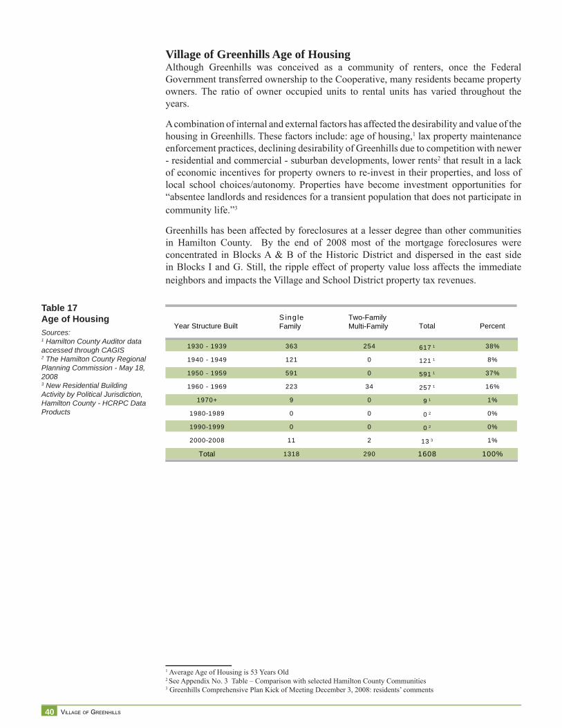
Village of Greenhills Age of HousingAlthough Greenhills was conceived as a community of renters, once the Federal Government transferred ownership to the Cooperative, many residents became property owners. The ratio of owner occupied units to rental units has varied throughout the years.
A combination of internal and external factors has affected the desirability and value of the housing in Greenhills. These factors include: age of housing,1 lax property maintenance enforcement practices, declining desirability of Greenhills due to competition with newer - residential and commercial - suburban developments, lower rents2 that result in a lack of economic incentives for property owners to re-invest in their properties, and loss of local school choices/autonomy. Properties have become investment opportunities for “absentee landlords and residences for a transient population that does not participate in community life.”3
Greenhills has been affected by foreclosures at a lesser degree than other communities in Hamilton County. By the end of 2008 most of the mortgage foreclosures were concentrated in Blocks A & B of the Historic District and dispersed in the east side in Blocks I and G. Still, the ripple effect of property value loss affects the immediate neighbors and impacts the Village and School District property tax revenues.
1 Average Age of Housing is 53 Years Old2 See Appendix No. 3 Table – Comparison with selected Hamilton County Communities3 Greenhills Comprehensive Plan Kick of Meeting December 3, 2008: residents’ comments
Table 17Age of HousingSources:1 Hamilton County Auditor data accessed through CAGIS2 The Hamilton County Regional Planning Commission - May 18, 20083 New Residential Building Activity by Political Jurisdiction, Hamilton County - HCRPC Data Products
Year Structure Built S ing leFamily
Two-FamilyMulti-Family Percent
1930 - 1939
1940 - 1949
1950 - 1959
1960 - 1969
1970+
1980-1989
1990-1999
2000-2008
Total
363
121
591
223
9
0
0
11
1318
254
0
0
34
0
0
0
2
290
617 1
121 1
591 1
257 1
9 1
0 2
0 2
13 3
1608
38%
8%
37%
16%
1%
0%
0%
1%
100%
S
Total
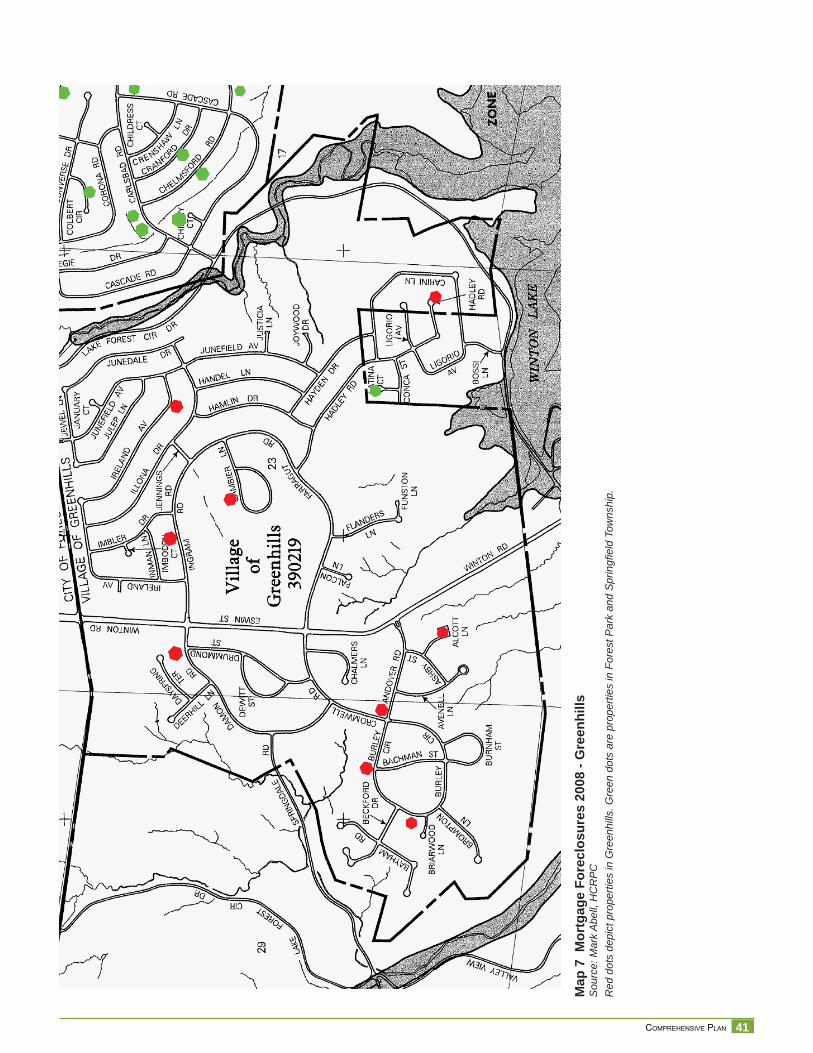
41 COMPREHENSIVE PLAN
Map
7 M
ortg
age
Fore
clos
ures
200
8 - G
reen
hills
Sou
rce:
Mar
k A
bell,
HC
RP
CR
ed d
ots
depi
ct p
rope
rties
in G
reen
hills
. Gre
en d
ots
are
prop
ertie
s in
For
est P
ark
and
Spr
ingfi
eld
Tow
nshi
p.
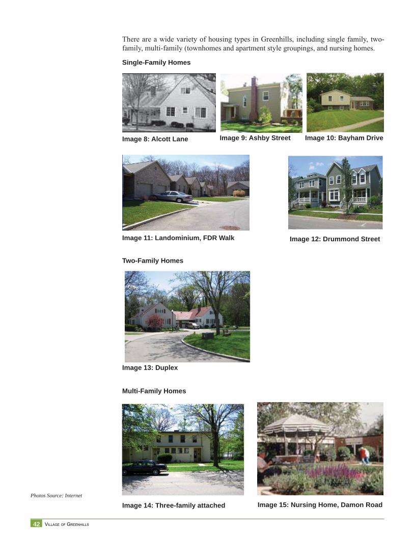
42 VILLAGE OF GREENHILLS
There are a wide variety of housing types in Greenhills, including single family, two-family, multi-family (townhomes and apartment style groupings, and nursing homes.
Single-Family Homes
Image 12: Drummond StreetImage 11: Landominium, FDR Walk
Multi-Family Homes
Image 13: Duplex
Image 14: Three-family attached Image 15: Nursing Home, Damon Road
Image 8: Alcott Lane Image 9: Ashby Street Image 10: Bayham Drive
Two-Family Homes
Photos Source: Internet
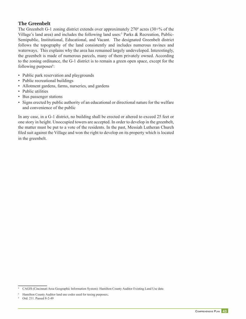
43 COMPREHENSIVE PLAN
The GreenbeltThe Greenbelt G-1 zoning district extends over approximately 2704 acres (30+% of the Village’s land area) and includes the following land uses:5 Parks & Recreation, Public-Semipublic, Institutional, Educational, and Vacant. The designated Greenbelt district follows the topography of the land consistently and includes numerous ravines and waterways. This explains why the area has remained largely undeveloped. Interestingly, the greenbelt is made of numerous parcels, many of them privately owned. According to the zoning ordinance, the G-1 district is to remain a green open space, except for the following purposes6:
• Public park reservation and playgrounds• Public recreational buildings• Allotment gardens, farms, nurseries, and gardens• Public utilities• Bus passenger stations• Signs erected by public authority of an educational or directional nature for the welfare
and convenience of the public
In any case, in a G-1 district, no building shall be erected or altered to exceed 25 feet or one story in height. Unoccupied towers are accepted. In order to develop in the greenbelt, the matter must be put to a vote of the residents. In the past, Messiah Lutheran Church fi led suit against the Village and won the right to develop on its property which is located in the greenbelt.
4 CAGIS (Cincinnati Area Geographic Information System): Hamilton County Auditor Existing Land Use data5 Hamilton County Auditor land use codes used for taxing purposes.6 Ord. 211. Passed 8-2-49
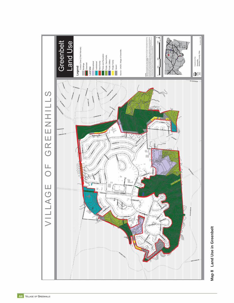
44 VILLAGE OF GREENHILLS
Map
8
Land
Use
in G
reen
beltV
I L L
A G
E
O F
G
R E
E N
H I
L L
SG
reen
belt
Land
Use
§̈ ¦I-74
§̈ ¦I-75
§̈ ¦I-75
§̈ ¦I-275
Nov
embe
r 200
8
DISC
LAIM
ER:
Neith
er th
e pro
vider
nor a
ny o
f the
partie
s of
the C
incinn
ati a
rea g
eogra
phic
inform
ation
syste
m (C
AGIS)
mak
e an
y wa
rranty
or re
prese
ntatio
n, eit
her e
xpres
sed
or im
plied
, with
resp
ect to
this
inform
ation
, its
quali
ty, pe
rform
ance
, merc
hanta
bility
, or f
itnes
s for
a pa
rticula
r purp
ose.
As a
resu
lt this
infor
matio
n is
provid
ed “a
s is”,
and
yo
u, the
recip
ient, a
re as
sumi
ng th
e enti
re ris
k as t
o its
quali
ty an
d per
form
ance
.In
no ev
ent, w
ill the
prov
ider o
r any
part
y of
CAGI
S be
liable
for d
irect,
indir
ect, i
ncide
ntal, o
r con
sequ
entia
l dam
ages
resu
lting
from
any
defec
t in th
e inf
ormati
on or
any
other
part o
f the m
ap pr
oduc
t, eve
n if a
dvise
d of th
e pos
sibility
of su
ch da
mage
s. In
partic
ular,
neith
er the
prov
ider n
or an
y par
ty of
CAGI
S sh
all ha
ve an
y lia
bility
for a
n y
other
inform
ation
, prog
rams o
r data
used
with
or co
mbin
ed w
ith th
e info
rmati
on re
ceive
d, inc
luding
the c
ost o
f reco
verin
g suc
h info
rmati
on, p
rogra
ms or
data
. An
y flo
odwa
y an
d flo
od fri
nge
inform
ation
prov
ided o
n thi
s map
is fo
r con
ceptu
al pla
nning
purpo
ses
only.
For
offic
ial de
term
inatio
n of
limits
recip
ient m
ust r
efer t
o th e
19
82 F
EMA
flood
way f
ringe
map
s. La
rge di
fferen
ces c
an ex
ist be
twee
n actu
al flo
od pr
one a
rea an
d offic
ial FE
MA
flood
fring
e are
as.
G-1
R-2
R-1
PU
D
WSH
ARO
NRD
WINTONRD
VALL
EYVI
EWD
R
GOLFVIEWDR
JUNE
FIEL
DAV
SPR
ING
DA
LE R
D
HADLEY RD
IRELANDAV
ING
RA
MR
D
DAMON RD
FARR
AGUT
RD
CASC
ADE
RD
CARL
SBA
DR
D
LAKEV
IEW
DR
CO
RO
NA
RD
ENFIELDST
JULE
PLN
CARINILN
ILLO
NADR
HAMLIN DR
CARNEGIE DR
CONV
ERSE
DR
HAYDENDR
HANDEL LN
ESWINST
JUNEDALE DR
CHELMSFORDRD
IMBLER DR
DANV
ERS
DR
CROMWELLRD
BAYHAMDR
ANDO
VER
RD
JEW
ELLN
EMBASSY DR
JAPO
NICA
DR
NORTHLA
NDBLV
D DANBURYRD
CRANFORD D
R
LIG
OR
IOAV
DONORALN
DECAT
URCT
AVENELL LN
BU
RLE
YC
IR
INM
AN
LN
ASHBY
ST
BACHMAN ST
MCKELVEYRD
DEW
ITT
ST
FLANDERS LN
DAPH
NECT
BECK
FORD
DR
WEST PARK DR
BROMPTONLN
CO
NC
AST
BOSSILN
DEERHILL LN
GAM
BIER
CIR
CHALMERSLN
EXMOOR DR
BURNHAM ST
CO
LBER
TC
IR
JENNIN
GSRD
JOH
NM
OLL
OY
LNJU
STIC
IALN
FUN
STO
NLN
CHIPLEYCT
CHILDRESSCT
BURWOOD
CT
IMBO
DEN
CT
±0
900
1,80
045
0Fe
et
Com
preh
ensi
ve P
lan:
Gre
enhi
llsH
amilt
on C
ount
y, O
hio
Sour
ce:
CAG
IS, V
illage
of G
reen
hills
Lege
nd
Land
Use Ed
ucat
iona
l
Inst
itutio
nal
Mul
ti-Fa
mily
Park
s an
d R
ecre
atio
n
Publ
ic /
Sem
i-Pub
lic
Publ
ic U
tiliti
es
Sing
le F
amily
Vace
nt
Con
tour
Lin
es (2
feet
inte
rval
s)
Build
ings
Gre
enbe
lt
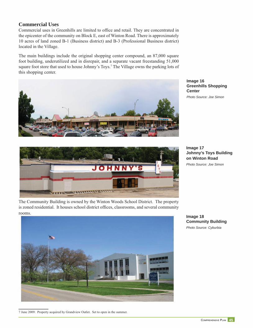
45 COMPREHENSIVE PLAN
Commercial UsesCommercial uses in Greenhills are limited to offi ce and retail. They are concentrated in the epicenter of the community on Block E, east of Winton Road. There is approximately 10 acres of land zoned B-1 (Business district) and B-3 (Professional Business district) located in the Village.
The main buildings include the original shopping center compound, an 87,000 square foot building, underutilized and in disrepair, and a separate vacant freestanding 51,000 square foot store that used to house Johnny’s Toys.7 The Village owns the parking lots of this shopping center.
The Community Building is owned by the Winton Woods School District. The property is zoned residential. It houses school district offi ces, classrooms, and several community rooms.
7 June 2009: Property acquired by Grandview Outlet. Set to open in the summer.
Image 17Johnny’s Toys Building on Winton RoadPhoto Source: Joe Simon
Image 18Community BuildingPhoto Source: Cyburbia
Image 16Greenhills Shopping CenterPhoto Source: Joe Simon
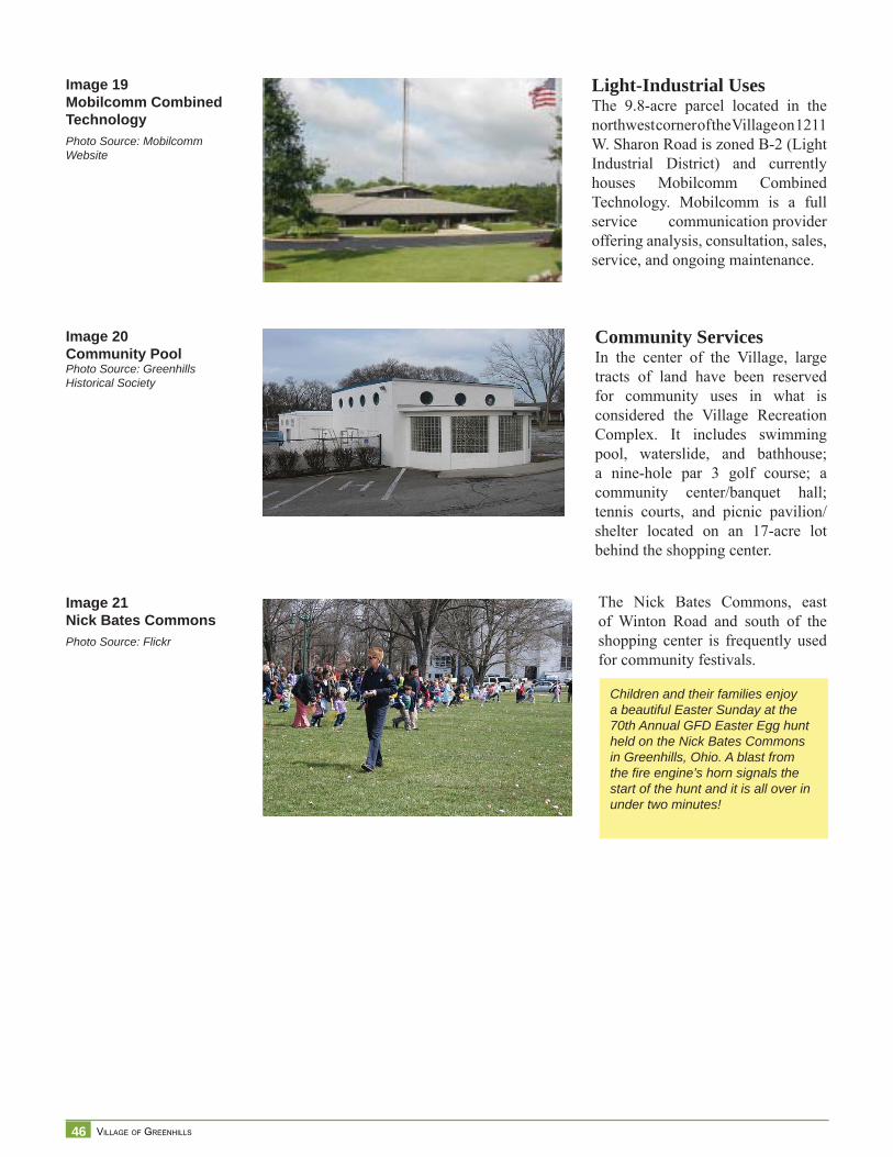
46 VILLAGE OF GREENHILLS
Image 19Mobilcomm CombinedTechnologyPhoto Source: Mobilcomm Website
Image 20Community PoolPhoto Source: Greenhills Historical Society
Light-Industrial UsesThe 9.8-acre parcel located in the northwest corner of the Village on 1211 W. Sharon Road is zoned B-2 (Light Industrial District) and currently houses Mobilcomm Combined Technology. Mobilcomm is a full service communication provider offering analysis, consultation, sales, service, and ongoing maintenance.
Community ServicesIn the center of the Village, large tracts of land have been reserved for community uses in what is considered the Village Recreation Complex. It includes swimming pool, waterslide, and bathhouse; a nine-hole par 3 golf course; a community center/banquet hall; tennis courts, and picnic pavilion/shelter located on an 17-acre lot behind the shopping center.
The Nick Bates Commons, east of Winton Road and south of the shopping center is frequently used for community festivals.
Image 21Nick Bates CommonsPhoto Source: Flickr
Children and their families enjoy a beautiful Easter Sunday at the 70th Annual GFD Easter Egg hunt held on the Nick Bates Commons in Greenhills, Ohio. A blast from the fi re engine’s horn signals the start of the hunt and it is all over in under two minutes!
47 COMPREHENSIVE PLAN
Winton Road Corridor Study1 SummaryIn early 1997, a corridor study was commissioned to PKG Consultants Inc. to analyze and recommend the best uses and improvements on the Winton Road Corridor. For purposes of the study, the corridor was analyzed in two segments. The fi rst segment, studied during Phase I, extends from Damon/Ingram Road to Sharon Road. Phase II extends from Damon/Ingram Road to the southern corporate limits. The following is a summary of fi ndings and recommendations.
Phase I -Damon/Ingram Road to Sharon Road - Findings:• Properties along the corridor are zoned G-1 Greenbelt District (west side of Winton
Road),. On the east side, a R-1 One-family residence district extends for about 600’ from Ingram Road to the north. The remaining properties to Sharon Road are zoned G-1 Greenbelt District.
• The zoning ordinance establishes a minimum setback of 85’ along Winton Road.• Permitted uses for zoning districts are primarily limited to recreational, residential,
and institutional uses.• Existing uses: municipal and institutional uses and open space greenbelt areas.• Ownership and topography: Municipal Building, American Legion Post and the First
Baptist Church are the current owners and users of the buildings in the corridor. Only minor expansions of uses are anticipated. Natural topographic conditions may help maintain as open space the current Greenbelt district.
• Controlled access points on Winton Road allow traffi c to move continuously and reduces potential confl icts.
• Traffi c volume, on January 13, 1997 was 23,720 on a 24-hour count.• Potential for redevelopment was identifi ed on the Greenbelt “stub” on the west side
area immediately north of Damon Road. It is not clear what specifi c use it could be, but access to the site should be on Damon Road, provided that street trees are maintained.
• A redevelopment site of approximately 2.3 acres zoned R-1 single family residence is partially used by the American Legion for parking. Access to this can be provided through a stub street connecting to Ireland Avenue.
Phase II -Damon/Ingram Road to the southern corporate limits - Findings:• Properties along the corridor are zoned B-1 Business District, B-3 Professional
Business District, R-1 Single-Family District, R-2 Multi-Family District, and G-1 Greenbelt District.
• The zoning ordinance establishes a minimum setback of 85’ along Winton Road.• Existing uses: business and institutional uses and open space greenbelt areas. Residential
uses of diverse density and quality are located behind the properties fronting Winton Road.
• Topographic conditions may assist in keeping the Greenbelt District in the southern border.
• Potential for reuse of Community Building, currently owned by the School district and used for a mix of uses.
• Shopping center and commons are expected to have same type of uses in the future.
Recommendations:• Preserve and enlarge greenbelt whenever possible• Encourage redevelopment of some residential sections• Enhance attractiveness of shopping center• Utilize street fi xtures and other public structures that are compatible with the residential
character of area
1 1997 Winton Corridor Study Phase I and Phase II commissioned to PKG Consultants Inc.
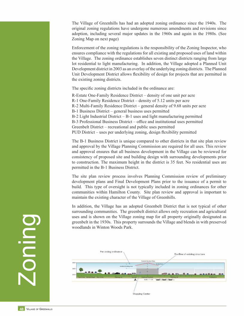
48 VILLAGE OF GREENHILLS
Zoni
ngThe Village of Greenhills has had an adopted zoning ordinance since the 1940s. The original zoning regulations have undergone numerous amendments and revisions since adoption, including several major updates in the 1960s and again in the 1980s. (See Zoning Map on next page)
Enforcement of the zoning regulations is the responsibility of the Zoning Inspector, who ensures compliance with the regulations for all existing and proposed uses of land within the Village. The zoning ordinance establishes seven distinct districts ranging from large lot residential to light manufacturing. In addition, the Village adopted a Planned Unit Development district in 2003 as an overlay of the underlying zoning districts. The Planned Unit Development District allows fl exibility of design for projects that are permitted in the existing zoning districts.
The specifi c zoning districts included in the ordinance are:R-Estate One-Family Residence District – density of one unit per acreR-1 One-Family Residence District – density of 5.12 units per acreR-2 Multi-Family Residence District – general density of 9.68 units per acreB-1 Business District – general business uses permittedB-2 Light Industrial District – B-1 uses and light manufacturing permittedB-3 Professional Business District – offi ce and institutional uses permittedGreenbelt District – recreational and public uses permittedPUD District – uses per underlying zoning, design fl exibility permitted
The B-1 Business District is unique compared to other districts in that site plan review and approval by the Village Planning Commission are required for all uses. This review and approval ensures that all business development in the Village can be reviewed for consistency of proposed site and building design with surrounding developments prior to construction. The maximum height in the district is 35 feet. No residential uses are permitted in the B-1 Business District.
The site plan review process involves Planning Commission review of preliminary development plans and Final Development Plans prior to the issuance of a permit to build. This type of oversight is not typically included in zoning ordinances for other communities within Hamilton County. Site plan review and approval is important to maintain the existing character of the Village of Greenhills.
In addition, the Village has an adopted Greenbelt District that is not typical of other surrounding communities. The greenbelt district allows only recreation and agricultural uses and is shown on the Village zoning map for all property originally designated as greenbelt in the 1930s. This property surrounds the Village and blends in with preserved woodlands in Winton Woods Park.
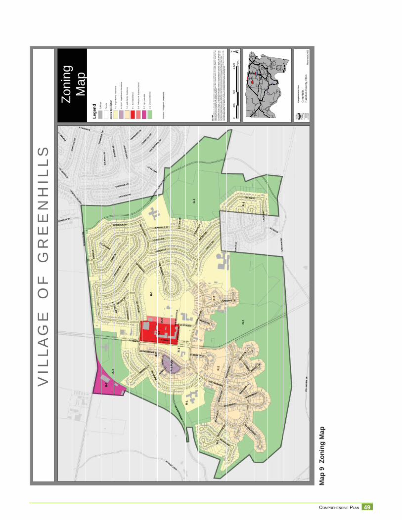
49 COMPREHENSIVE PLAN
Map
9 Z
onin
g M
ap
VIL
LAG
EO
FG
RE
EN
HIL
LS
Zoni
ngM
ap
§̈ ¦I-74
§̈ ¦I-75
§̈ ¦I-75
§̈ ¦I-275
Nov
embe
r200
8
DISC
LAIM
ER:
Neith
er th
e pro
vider
nor a
ny o
f the
partie
s of
the C
incinn
ati a
rea g
eogra
phic
inform
ation
syste
m (C
AGIS)
mak
e an
y wa
rranty
or re
prese
ntatio
n, eit
her e
xpres
sed
or im
plied
, with
resp
ect to
this
inform
ation
, its
quali
ty, pe
rform
ance
, merc
hanta
bility
, or f
itnes
s for
a pa
rticula
r purp
ose.
As a
resu
lt this
infor
matio
n is
provid
ed “a
s is”,
and
yo
u, the
recip
ient, a
re as
sumi
ng th
e enti
re ris
k as t
o its
quali
ty an
d per
form
ance
. In
no ev
ent, w
ill the
prov
ider o
r any
part
y of
CAGI
S be
liable
for d
irect,
indir
ect, i
ncide
ntal, o
r con
sequ
entia
l dam
ages
resu
lting
from
any
defec
t in th
e inf
ormati
on or
any
other
part o
f the m
ap pr
oduc
t, eve
n if a
dvise
d of th
e pos
sibility
of su
ch da
mage
s. In
partic
ular,
neith
er the
prov
ider n
or an
y par
ty of
CAGI
S sh
all ha
ve an
y lia
bility
for a
ny
other
inform
ation
, prog
rams o
r data
used
with
or co
mbin
ed w
ith th
e info
rmati
on re
ceive
d, inc
luding
the c
ost o
f reco
verin
g suc
h info
rmati
on, p
rogra
ms or
data
. An
y flo
odwa
y an
d flo
od fri
nge
inform
ation
prov
ided o
n thi
s map
is fo
r con
ceptu
al pla
nning
purpo
ses
only.
For
offic
ial de
term
inatio
n of
limits
recip
ient m
ust r
efer t
o the
19
82 F
EMA
flood
way f
ringe
map
s. La
rge di
fferen
ces c
an ex
ist be
twee
n actu
al flo
od pr
one a
rea an
d offic
ial FE
MA
flood
fring
e are
as.
G-1
R-2
R-1
PUD
R-1
G-1
R-2
G-1
R-1
R-2
R-1
R-1
B-1
B-2
R-1
B-3
WSH
AR
ON
RD
WINTONRD
JUNEFIELD AV
HADLEY
RD
LAKE
FORE
STCI
RCLE
DR
CASCADE RD
IREL
AND
AV
GOLFVIEWDR
ING
RA
MR
D
DAM
ON
RD
FARR
AGUT
RD
SPRI
NGDA
LERD
LAK
EVIE
WD
R
CO
RO
NA
RD
CA
RLS
BA
DR
D
ENFIELDST
JULE
PLN
CARINILN
ILLO
NADR
HAMLIN DR
VALL
EYVI
EWD
R
CARNEGIE DR
HAYDEN
DR
HANDEL LN
ESWINST
JUNEDALE DR
DRUMMONDST
IMBLER DR
DA
NVE
RS
DR
CO
NVE
RSE
DR
BAYHAMDR
CROMWELLRD
AN
DO
VER
RD
JEW
ELLN
CHELMSFORD
RD
JAPO
NICA
DR
LIG
OR
IOAV
AVENELL LN
BU
RLE
YC
IR
CRANFORD
DR
INM
AN
LN
ASHBY
ST
BACHMAN ST
FLANDERS LN
DEW
ITT
ST
BECK
FORD
DR
BROMPTONLN
CO
NC
AST
BOSSILN
EMBASSY DR
DEERHILL LN
CRENSHAWLN
NORTHLA
NDBLV
D
CHALMERSLN
ALCOTT
LN
DONORALN
END
ICO
TTST
BURNHAM ST
CO
LBER
TC
IR
FALCONLN
GA
MB
IER
CIR
DAPHNECT
JOYW
OOD
DR
DANBURYRD
JENNIN
GSRD
JOH
NM
OLL
OY
LNJU
STIC
IALN
BR
AD
NO
RPL
CHIPLEYCT
DEWITT
CT
BURWOOD
CT
JANUARYCT
IMBO
DEN
CT
±0
710
1,42
035
5Fe
et
Com
preh
ensi
vePl
an:
Gre
enhi
llsH
amilt
onC
ount
y,O
hio
Lege
nd Build
ings
Parc
els
Zoni
ngD
escr
iptio
n
R-1
Sing
leFa
mily
Res
iden
ce
R-1
PU
DS
ingl
eFa
mily
Res
iden
ce
R-2
Mul
ti-Fa
mily
Res
iden
ce
B-1
Bus
ines
sD
istri
ct
B-3
Pro
fess
iona
lBus
ines
sD
istri
ct
B-2
Ligh
tInd
ustri
al
G-1
Gre
enbe
ltD
istri
ct
Sour
ce:
Villa
geof
Gre
enhi
lls
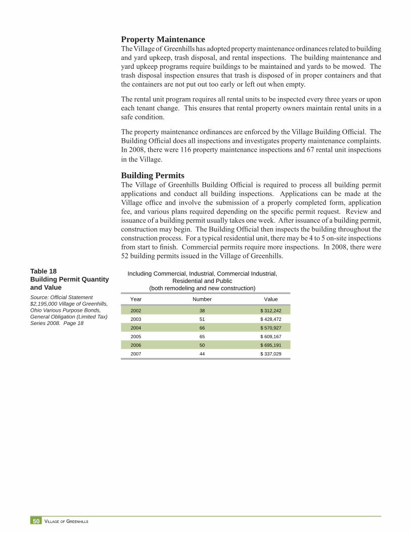
50 VILLAGE OF GREENHILLS
Property MaintenanceThe Village of Greenhills has adopted property maintenance ordinances related to building and yard upkeep, trash disposal, and rental inspections. The building maintenance and yard upkeep programs require buildings to be maintained and yards to be mowed. The trash disposal inspection ensures that trash is disposed of in proper containers and that the containers are not put out too early or left out when empty.
The rental unit program requires all rental units to be inspected every three years or upon each tenant change. This ensures that rental property owners maintain rental units in a safe condition.
The property maintenance ordinances are enforced by the Village Building Offi cial. The Building Offi cial does all inspections and investigates property maintenance complaints. In 2008, there were 116 property maintenance inspections and 67 rental unit inspections in the Village.
Building PermitsThe Village of Greenhills Building Offi cial is required to process all building permit applications and conduct all building inspections. Applications can be made at the Village offi ce and involve the submission of a properly completed form, application fee, and various plans required depending on the specifi c permit request. Review and issuance of a building permit usually takes one week. After issuance of a building permit, construction may begin. The Building Offi cial then inspects the building throughout the construction process. For a typical residential unit, there may be 4 to 5 on-site inspections from start to fi nish. Commercial permits require more inspections. In 2008, there were 52 building permits issued in the Village of Greenhills.
Year Number Value
2002 38 $ 312,242
2003 51 $ 428,472
2004 66 $ 570,927
2005 65 $ 609,167
2006 50 $ 695,191
2007 44 $ 337,029
Including Commercial, Industrial, Commercial Industrial,Residential and Public
(both remodeling and new construction)
Table 18Building Permit Quantity and ValueSource: Offi cial Statement $2,195,000 Village of Greenhills, Ohio Various Purpose Bonds, General Obligation (Limited Tax) Series 2008. Page 18
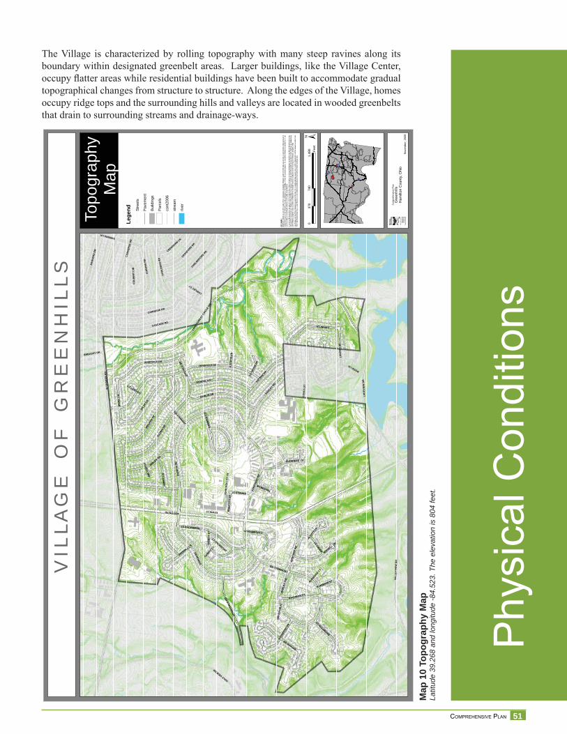
51 COMPREHENSIVE PLAN
Phy
sica
l Con
ditio
ns
VIL
LAG
EO
FG
RE
EN
HIL
LS
Topo
grap
hyM
ap
Nov
embe
r,20
08
DISC
LAIM
ER:
Neith
er th
e pro
vider
nor a
ny o
f the
partie
s of
the C
incinn
ati a
rea g
eogra
phic
inform
ation
syste
m (C
AGIS)
mak
e an
y wa
rranty
or re
prese
ntatio
n, eit
her e
xpres
sed
or im
plied
, with
resp
ect to
this
inform
ation
, its
quali
ty, pe
rform
ance
, merc
hanta
bility
, or f
itnes
s for
a pa
rticula
r purp
ose.
As a
resu
lt this
infor
matio
n is
provid
ed “a
s is”,
and
yo
u, the
recip
ient, a
re as
sumi
ng th
e enti
re ris
k as t
o its
quali
ty an
d per
form
ance
. In
no ev
ent, w
ill the
prov
ider o
r any
part
y of
CAGI
S be
liable
for d
irect,
indir
ect, i
ncide
ntal, o
r con
sequ
entia
l dam
ages
resu
lting
from
any
defec
t in th
e inf
ormati
on or
any
other
part o
f the m
ap pr
oduc
t, eve
n if a
dvise
d of th
e pos
sibility
of su
ch da
mage
s. In
partic
ular,
neith
er the
prov
ider n
or an
y par
ty of
CAGI
S sh
all ha
ve an
y lia
bility
for a
ny
other
inform
ation
, prog
rams o
r data
used
with
or co
mbin
ed w
ith th
e info
rmati
on re
ceive
d, inc
luding
the c
ost o
f reco
verin
g suc
h info
rmati
on, p
rogra
ms or
data
. An
y flo
odwa
y an
d flo
od fri
nge
inform
ation
prov
ided o
n thi
s map
is fo
r con
ceptu
al pla
nning
purpo
ses
only.
For
offic
ial de
term
inatio
n of
limits
recip
ient m
ust r
efer t
o the
19
82 F
EMA
flood
way f
ringe
map
s. La
rge di
fferen
ces c
an ex
ist be
twee
n actu
al flo
od pr
one a
rea an
d offic
ial FE
MA
flood
fring
e are
as.
WSH
AR
ON
RD
WINTONRD
JUNEFIELD AV
HADLEY
RD
LAKE
FORE
STCI
RCLE
DR
CASCADE RD
IREL
AND
AV
GOLFVIEWDR
ING
RA
MR
D
DAM
ON
RD
FARR
AGUT
RD
SPRI
NGDA
LERD
VALL
EYVI
EWD
R
LAK
EVIE
WD
R
CO
RO
NA
RD
CA
RLS
BA
DR
D
ENFIELDST
JULE
PLN
CARINILN
ILLO
NADR
HAMLIN DR
CARNEGIE DR
HAYDEN
DR
HANDEL LN
ESWINST
JUNEDALE DR
DRUMMONDST
IMBLER DR
CO
NVE
RSE
DR
BAYHAMDR
CROMWELLRD
DA
NVE
RS
DR
AN
DO
VER
RD
JEW
ELLN
CHELMSFORD
RD
JAPO
NICA
DR
LIG
OR
IOAV
AVENELL LN
BU
RLE
YC
IR
CRANFORD
DR
INM
AN
LN
ASHBY
ST
BACHMAN ST
FLANDERS LN
DEW
ITT
ST
BECK
FORD
DR
BROMPTONLN
CO
NC
AST
BOSSILN
DEERHILL LN
CRENSHAWLN
CHALMERSLN
ALCOTT
LN
EMBASSY DR
DONORALN
END
ICO
TTST
BURNHAM ST
CO
LBER
TC
IR
FALCONLN
GA
MB
IER
CIR
JOYW
OOD
DR
JENNIN
GSRD
JOH
NM
OLL
OY
LNJU
STIC
IALN
BR
AD
NO
RPL
CHIPLEYCT
DRUMMONDCT
DEWITT
CT
BURWOOD
CT
JANUARYCT
IMBO
DEN
CT
±0
740
1,48
037
0Fe
et
Com
preh
ensi
veP
lan
Gre
enhi
llsH
amilt
onC
ount
y,O
hio
Lege
nd Stre
ets
Pave
men
t
Build
ings
Parc
els
cont
2006
stre
am
river
§̈ ¦I-74
§̈ ¦I-75
§̈ ¦I-75
§̈ ¦I-275
Map
10
Topo
grap
hy M
apLa
titud
e 39
.268
and
long
itude
-84.
523.
The
ele
vatio
n is
804
feet
.
The Village is characterized by rolling topography with many steep ravines along its boundary within designated greenbelt areas. Larger buildings, like the Village Center, occupy fl atter areas while residential buildings have been built to accommodate gradual topographical changes from structure to structure. Along the edges of the Village, homes occupy ridge tops and the surrounding hills and valleys are located in wooded greenbelts that drain to surrounding streams and drainage-ways.
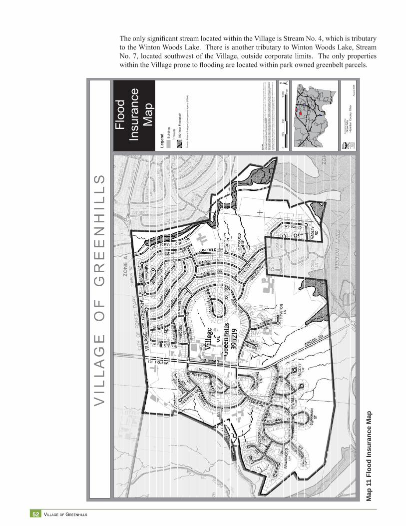
52 VILLAGE OF GREENHILLS
Map
11
Floo
d In
sura
nce
Map
V I L
L A
G E
O
F
G R
E E
N H
I L
L S
Floo
dIn
sura
nce
Map
§̈ ¦I-74
§̈ ¦I-75
§̈ ¦I-75
§̈ ¦I-275
Aug
ust 2
009
DISC
LAIM
ER:
Neith
er th
e pro
vider
nor a
ny o
f the
partie
s of
the C
incinn
ati a
rea g
eogra
phic
inform
ation
syste
m (C
AGIS)
mak
e an
y wa
rranty
or re
prese
ntatio
n, eit
her e
xpres
sed
or im
plied
, with
resp
ect to
this
inform
ation
, its
quali
ty, pe
rform
ance
, merc
hanta
bility
, or f
itnes
s for
a pa
rticula
r purp
ose.
As a
resu
lt this
infor
matio
n is
provid
ed “a
s is”,
and
yo
u, the
recip
ient, a
re as
sumi
ng th
e enti
re ris
k as t
o its
quali
ty an
d per
form
ance
.In
no ev
ent, w
ill the
prov
ider o
r any
part
y of
CAGI
S be
liable
for d
irect,
indir
ect, i
ncide
ntal, o
r con
sequ
entia
l dam
ages
resu
lting
from
any
defec
t in th
e inf
ormati
on or
any
other
part o
f the m
ap pr
oduc
t, eve
n if a
dvise
d of th
e pos
sibility
of su
ch da
mage
s. In
partic
ular,
neith
er the
prov
ider n
or an
y par
ty of
CAGI
S sh
all ha
ve an
y lia
bility
for a
ny
other
inform
ation
, prog
rams o
r data
used
with
or co
mbin
ed w
ith th
e info
rmati
on re
ceive
d, inc
luding
the c
ost o
f reco
verin
g suc
h info
rmati
on, p
rogra
ms or
data
. An
y flo
odwa
y an
d flo
od fri
nge
inform
ation
prov
ided o
n thi
s map
is fo
r con
ceptu
al pla
nning
purpo
ses
only.
For
offic
ial de
term
inatio
n of
limits
recip
ient m
ust r
efer t
o the
19
82 F
EMA
flood
way f
ringe
map
s. La
rge di
fferen
ces c
an ex
ist be
twee
n actu
al flo
od pr
one a
rea an
d offic
ial FE
MA
flood
fring
e are
as.
±0
750
1,50
037
5Fe
et
Com
preh
ensi
ve P
lan
Gre
enhi
llsH
amilt
on C
ount
y, O
hio
Sou
rce:
Fed
eral
Em
erge
ncy
Man
agem
ent A
genc
y (F
EM
A)
Lege
nd Bui
ldin
gs
Parc
els
100-
Year
Flo
odpl
ain
The only signifi cant stream located within the Village is Stream No. 4, which is tributary to the Winton Woods Lake. There is another tributary to Winton Woods Lake, Stream No. 7, located southwest of the Village, outside corporate limits. The only properties within the Village prone to fl ooding are located within park owned greenbelt parcels.
53 COMPREHENSIVE PLAN
Infra
stru
ctur
e an
d U
tility
Ser
vice
s
Water, Sewer, and StormwaterWater service within the Village is provided by the Greater Cincinnati Water Works (GCWW) System and is purchased directly by the consumers. Waterlines in the Village are 6”, 8” and 12” in diameter. Capital Improvement Projects (CIP), mostly maintenance of water pipelines in service since 1936, are scheduled for 2010, 2013, and 2015 at an estimated cost of $2,248,000 to GCWW.
2010 and 2013 Capital Improvements are scheduled in the western area of Greenhills on Burley Circle, Bachman Street, Brompton Lane, Andover Road, Cromwell Road, Ashby Street, Avenell Lane, Chalmers Lane, Dewitt Street, and Drumond Street. 2015 Improvements will be on the eastern area of Greenhills on Ireland Avenue, Illona Drive and Jennings Road. See Map 12 (2010 Water Improvements), and CIP Table.
Sewage collection and disposal are provided by the Metropolitan Sewer District. Greenhills has separate sewer and stormwater throughout the Village. Pipes range in diameter from 2”, 4”, 6”, 12”, and the main lines are 18”. The Village does not have current MSD Sanitary Sewer Capital Improvement information.1
Greenhills is part of the Hamilton County Storm Water District.2 To address the National Pollution Discharge Elimination System (NPDES) Phase II unfunded mandate of the Clear Water Act, and to improve storm water quality on a countywide basis, the Village of Greenhills joined the Hamilton County Storm Water District in 2003.
The Hamilton County Engineer administers the overall management of the Storm Water District on behalf of the Hamilton County Board of County Commissioners. The District utilizes the expertise of several Partner Agencies, including the Hamilton County Soil and Water Conservation District, the Hamilton County Department of Public Works, the Hamilton County General Health District, and the Metropolitan Sewer District of Greater Cincinnati, to conduct various aspects of the Phase II program in partnership with member jurisdictions. Cost to the jurisdiction is commensurate with the amount of impervious surface (i.e., hard surfaces that do not allow the direct infi ltration of rain fall and snowmelt, such as driveways and rooftops).
1 Jane Berry, Village Administrator. July 14, 20092 Source: Todd Long, Hamilton County Engineer’s Offi ce. February 2009
Table 19Greater Cincinnati Water Works - Greenhills Capital Improvement Projects
PlanningYear
CIPYear
CIPTable Street From To Project ID Age EX. Prop Length $ / FT
Cost(1,000s) Type
6666 650 8522010 2010 T12 Burley Cir Andover Cromwell NEW PROJ-167 1936 12"./8" 8" 3050 125 382 Maintenance2010 2010 T12 Bachman St Burley Burley NEW PROJ-167 1936 8" 8" 825 125 103 Maintenance2010 2010 T12 Bromptoon Ln Burley S Terminus NEW PROJ-167 1936 6" 8" 860 125 108 Maintenance2010 2010 T12 Andover Rd Burley Winton NEW PROJ-167 1936 8" 8" 1210 125 151 Maintenance2010 2010 T12 Cromwell Rd Andover Damon NEW PROJ-167 1937 12" 12" 721 150 108 Maintenance
Total Length 5108 Total Cost 690
2013 2013 T12 Ashby St AVenell Andover NEW PROJ-284 1936 8" 8" 664 135 90 Maintenance2013 2013 T12 Avenell Ln Andover S Terminus NEW PROJ-284 1936 8" 8" 938 135 127 Maintenance2013 2013 T12 Chalmers Ln Cromwell Cromwell NEW PROJ-284 1936 6" 8" 986 135 133 Maintenance2013 2013 T12 Dewitt St Drummond Drummond NEW PROJ-284 1937 6" 8" 958 135 130 Maintenance2013 2013 T12 Drummond St Cromwell Damon NEW PROJ-284 1937 8" 8" 1562 135 210 Maintenance
Total Length 5762 Total Cost 779
2015 2015 T12 Ireland Ave Ingram Junefield NEW PROJ-283 1954 6" 8" 3936 135 532 Maintenance2015 2015 T12 IIlona Dr Ireland Jennings NEW PROJ-283 1954 6" 8" 1497 135 2022 Maintenance2015 2015 T12 Jennings Rd Illona Ingram NEW PROJ-283 1956 8" 8" 329 135 45 System
Upgrade
Total Length 5762 Total Cost 779
Source: Russ Weber, [email protected], 27-May-2009
54 VILLAGE OF GREENHILLS
In summary, the NPDES permit requires that storm water be managed on site to avoid pollution of the water (quality) and to avoid discharge of water from one site to another (quantity). The NPDES permit requires that storm water pollution be minimized by complying with six minimum control measures: (1) Public Education and Outreach, (2) Public Participation and Involvement, (3) Illicit Discharge Detection and Elimination, (4) Construction Site Storm Water Runoff Control, (5) Post-Construction Storm Water Runoff Controls, and (6) Good Housekeeping/Pollution Prevention for Municipal Operations.
Additionally, the Metropolitan Sewer district is negotiating a consent decree with the U.S. EPA, and has submitted a proposal that consists in part of the implementation of a series of “green” storm water best management practices, such as green roof, rain garden, vegetated swales, porous pavements, etc., that will reduce the need for expensive infrastructure retrofi t (underground pipes and other engineering solutions).
Other Infrastructure and Utility Services3
The Village does not have current capital improvement information from Duke Energy in terms of gas and electric utility services. There is a defi nite need for upgraded, preferably buried, electrical service in the Village due to numerous circuits and overhead lines. They are diffi cult to maintain and suffer from frequent power outages.
The last major street and curb project in the Village was in 1996. Brandstetter Carroll, an engineering consultant fi rm, is working on a pavement management study for the Village that will become a multi-year work program for street and road improvements. The Study will be complete in the Fall of 2009.
Time Warner Cable provides broadband access/cable service in the Village through the terms outlined in a franchise agreement. The agreement is an ordinance as well as a multi-year plan.
The Village has plans to upgrade/enhance/expand and/or renovate several Village facilities, including parks, golf course and clubhouse/banquet center, pool, ball fi elds, playgrounds, service garage, municipal building, and public safety facilities.
The Village has received a 2010 Community Development Block Grant through Hamilton County for a sidewalk along Winton Road. The sidewalk will create a safe route to the WWCSD High School in Forest Park since there is no busing for high school students. Village of Greenhills engineers are developing plans and construction documents currently for this project.
3 Jane Berry, Village Administrator. July 14, 2009
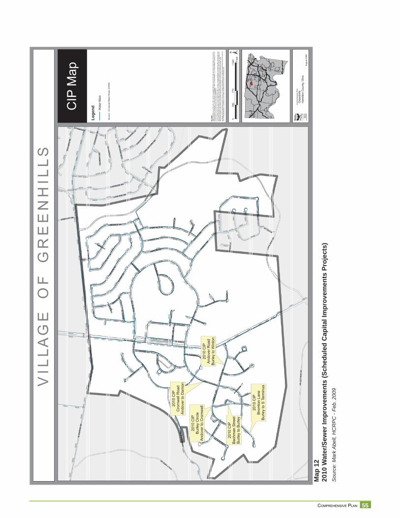
55 COMPREHENSIVE PLAN
Map
12
2010
Wat
er/S
ewer
Impr
ovem
ents
(Sch
edul
ed C
apita
l Im
prov
emen
ts P
roje
cts)
Sou
rce:
Mar
k A
bell,
HC
RP
C -
Feb.
200
9
V I L
L A
G E
O
F
G R
E E
N H
I L
L S
CIP
Map
§̈ ¦I-74
§̈ ¦I-75
§̈ ¦I-75
§̈ ¦I-275
Aug
ust 2
009
DISC
LAIM
ER:
Neith
er th
e pro
vider
nor a
ny o
f the
partie
s of
the C
incinn
ati a
rea g
eogra
phic
inform
ation
syste
m (C
AGIS)
mak
e an
y wa
rranty
or re
prese
ntatio
n, eit
her e
xpres
sed
or im
plied
, with
resp
ect to
this
inform
ation
, its
quali
ty, pe
rform
ance
, merc
hanta
bility
, or f
itnes
s for
a pa
rticula
r purp
ose.
As a
resu
lt this
infor
matio
n is
provid
ed “a
s is”,
and
yo
u, the
recip
ient, a
re as
sumi
ng th
e enti
re ris
k as t
o its
quali
ty an
d per
form
ance
.In
no ev
ent, w
ill the
prov
ider o
r any
part
y of
CAGI
S be
liable
for d
irect,
indir
ect, i
ncide
ntal, o
r con
sequ
entia
l dam
ages
resu
lting
from
a ny
defec
t in th
e inf
ormati
on or
any
other
part o
f the m
ap pr
oduc
t, eve
n if a
dvise
d of th
e pos
sibility
of su
ch da
mage
s. In
partic
ular,
neith
er the
prov
ider n
or an
y par
ty of
CAGI
S sh
all ha
ve an
y lia
bility
for a
ny
other
inform
ation
, prog
rams o
r data
used
with
or co
mbin
ed w
ith th
e info
rmati
on re
ceive
d, inc
luding
the c
ost o
f reco
verin
g suc
h info
rmati
on, p
rogra
ms or
data
. An
y flo
odwa
y an
d flo
od fri
nge
inform
ation
prov
ided o
n thi
s map
is fo
r con
ceptu
al pla
nning
purpo
ses
only.
For
offic
ial de
term
inatio
n of
limits
recip
ient m
ust r
efer t
o the
19
82 F
EMA
flood
way f
ringe
map
s. La
rge di
fferen
ces c
an ex
ist be
twee
n actu
al flo
od pr
one a
rea an
d offic
ial FE
MA
flood
fring
e are
as.
2010
CIP
Bur
ley
Circ
leA
ndov
er to
Cro
mw
ell20
10 C
IPC
rom
wel
l Roa
dA
ndov
er to
Dam
on
2010
CIP
Bac
hman
Stre
etB
urle
y to
Bur
ley
2010
CIP
Bro
mto
n La
neB
urle
y to
S T
erm
inus
2010
CIP
And
over
Roa
dB
urle
y to
Win
ton
WSH
AR
ON
RD
WINTONRD
JUNEFIELD AV
HADLEY
RD
LAKE
FORE
STCI
RCLE
DR
CASCADE RD
IREL
AND
AV
GOLFVIEWDR
ING
RA
MR
D
DAMONRD
FARR
AGUT
RD
SPR
ING
DA
LER
D
VALL
EYVI
EWD
R
LAKE
VIEW
DR
CO
RO
NA
RD
CA
RLS
BA
DR
D
ENFIELDST
JULE
PLN
CARINILN
ILLO
NADR
HAMLIN DR
CARNEGIE DR
HAYDENDR
HANDEL LN
ESWINST
JUNEDALE DR
DRUMMONDST
IMBLER DR
CO
NVE
RSE
DR
DA
NVE
RS
DR
CROMWELLRD
BAYHAMDR
ANDO
VER
RD
JEW
ELLN
CHELMSFO
RDRD
JAPO
NICA
DR
LIG
OR
IOAV
AVENELL LN
BURL
EYCI
R
CRANFORD
DR
INM
AN
LN
ASHB
YSTD
EWIT
TST
FLANDERS LN
BECK
FORD
DR
CO
NC
AST
BOSSILN
DEERHILL LN
CRENSHAWLN
GAM
BIER
CIR
CHALMERSLN
EMBASSY DR
ALCOTT
LN
DONORALN
END
ICO
TTST
CO
LBER
TC
IR
FALCONLN
JOYW
OOD
DR
JENNIN
GSRD
JOH
NM
OLL
OY
LNJU
STIC
IALN
FUN
STO
NLN
CHIPLEYCT
BURWOOD
CT
JANUARYCT
IMBO
DEN
CT
1471
57
1450
36
1471
91
1471
60
1472
17
147139
149408
148521
1471
81
149027
1446
73
1471
88
147250146651
147247
1451
01
1493
5514
5097
1446
11
147243
147499
1471
87
147410
147669
1476
27
1493
95
1445
61
1466
45
148514
146672
147363
144677
1493
48
148465
147516
147728
147234
1466
41
1450
57
1484
84
147259
1493
90
147304
1445
63
1450
52
1493
59
1473
69
1486
66
1473
90
1475
28
1445
96
148872
1449
64
146702
1493
76
1450
44
1445
87
1484
85
1476
52
147510
147235
1476
55
147677
1488
89
1446
16
1475
26
14464114
7218
1488
75
147616
147413
1451
05
1449
61
144682
147672
1486
78
1450
38
1475
43
147684
1467
01
1475
33
149350
147477
148721
1475
22
1487
26
1450
28
1489
31
1493
78
1513
27
149384
1487
16
146653
147245147254
1484
61
1470
92
1473
10
1476
49
148753
148965
1450
43
1477
49
148735
147485
1473
85
148914
1466
80
1476
57
1472
66
1475
74
1477
09
1471
73
1474
52
147345
147577
1466
44
148517
147619
1475
8115
1258
1446
66
1474
53
14874
3
1474
44
148499
144956
1488
59
148488
1474
36
147309
148901
1471
79
1475
12
145074
147725
147482
147530
147631
1475
15
147679
1487
15
147339
144639
147271
147374
147163
1473
54
147614
147745
1473
79
147238
148778
147731
147200
1450
40
148740
1473
27
147715
1445
95
1467
00
148689
145116
148528
1488
22
1476
26
1474
74
144643
145077
145115
1475
47
1450
67
147417
147593
1475
61
1488
19
1471
17
144623
146640
147424
1494
02
1446
10
1487
03
147399
1446
40
148454
1475
57
148897
144630
148744
1466
46
147647
1475
09
148999
1476
61
148749
147409
1476
33
1473
86
14723714
7350
147457
148975
1476
64
148737
144900
147343
1475
01
148519
149006
148798
147313
148741
147192
147265
148524
147622
147223
1493
98
1472
03
1472
86
1489
04
148796
147566
1474
29
14734
4
148933
147360
1477
35
145062
1489
80
1471
67
147449
148531
1474
80
147404
1489
52
14735914
7351
1446
48
1475
5314
7406
146708
1477
14
1477
10
1449
65
149404
1488
87
147301
1471
58
1471
71
144533
148476
1476
78
148507
145070
147209
147165
1477
03
1476
38
1487
55
1494
09
1466
47
147328
1488
14
145023
145121
148785
1487
23
1477
53
1474
39
1467
11
147608
147683
1446
19
147202
1489
61
148462
147700
1487
06
1487
84
1471
99
147648
1493
42
1490
08
147676
1446
64
±0
770
1,54
038
5Fe
et
Com
preh
ensi
ve P
lan
Gre
enhi
llsH
amilt
on C
ount
y, O
hio
Sou
rce:
Cin
cinn
ati W
ater
Wor
ks (C
WW
)
Lege
nd Wat
er M
ain
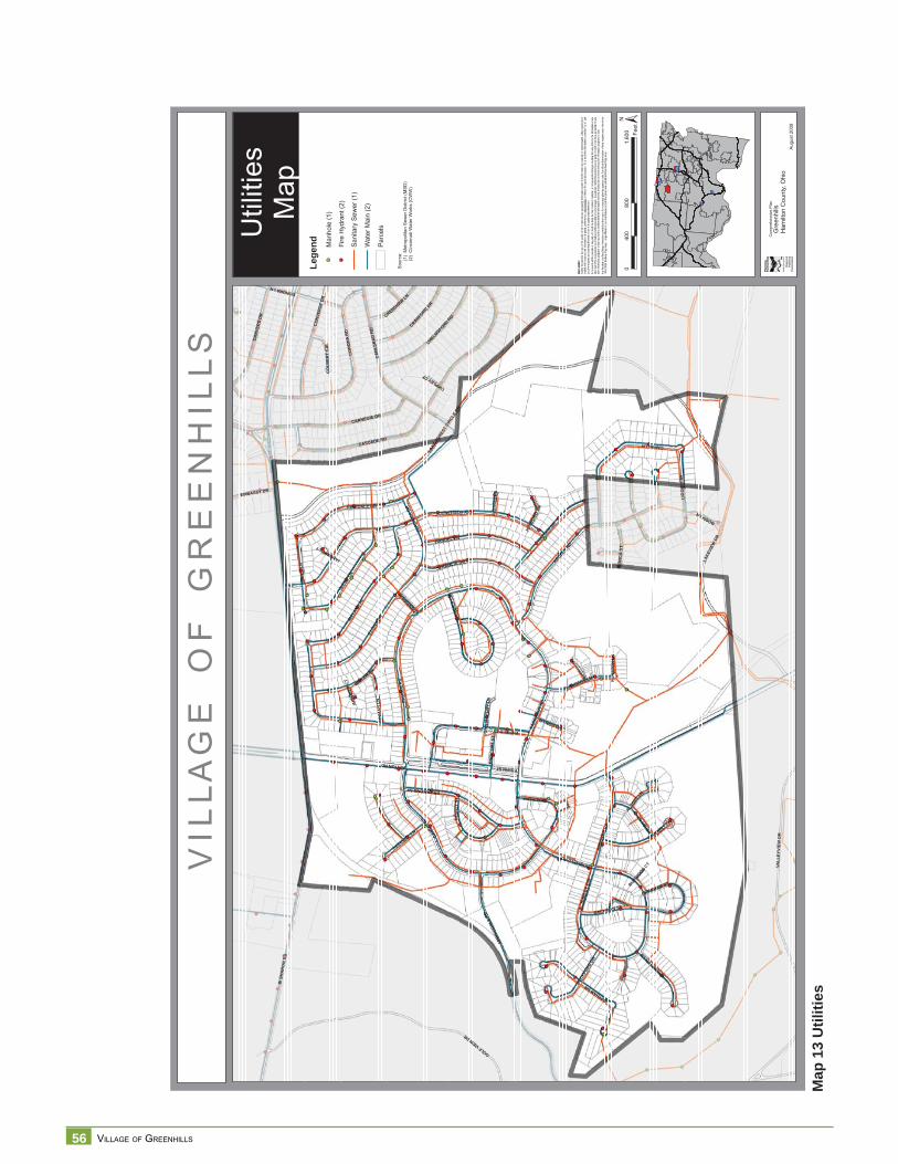
56 VILLAGE OF GREENHILLS
Map
13
Util
ities
V I L
L A
G E
O
F
G R
E E
N H
I L
L S
Util
ities
Map
§̈ ¦I-74
§̈ ¦I-75
§̈ ¦I-75
§̈ ¦I-275
Aug
ust 2
009
DISC
LAIM
ER:
Neith
er th
e pro
vider
nor a
ny o
f the
partie
s of
the C
incinn
ati a
rea g
eogra
phic
inform
ation
syste
m (C
AGIS)
mak
e an
y wa
rranty
or re
prese
ntatio
n, eit
her e
xpres
sed
or im
plied
, with
resp
ect to
this
inform
ation
, its
quali
ty, pe
rform
ance
, merc
hanta
bility
, or f
itnes
s for
a pa
rticula
r purp
ose.
As a
resu
lt this
infor
matio
n is
provid
ed “a
s is”,
and
yo
u, the
recip
ient, a
re as
sumi
ng th
e enti
re ris
k as t
o its
quali
ty an
d per
form
ance
.In
no ev
ent, w
ill the
prov
ider o
r any
part
y of
CAGI
S be
liable
for d
irect,
indir
ect, i
ncide
ntal, o
r con
sequ
entia
l dam
ages
resu
lting
from
any
defec
t in th
e inf
ormati
on or
any
other
part o
f the m
ap pr
oduc
t, eve
n if a
dvise
d of th
e pos
sibility
of su
ch da
mage
s. In
partic
ular,
neith
er the
prov
ider n
or an
y par
ty of
CAGI
S sh
all ha
ve an
y lia
bility
for a
ny
other
inform
ation
, prog
rams o
r data
used
with
or co
mbin
ed w
ith th
e info
rmati
on re
ceive
d, inc
luding
the c
ost o
f reco
verin
g suc
h info
rmati
on, p
rogra
ms or
data
. An
y flo
odwa
y an
d flo
od fri
nge
inform
ation
prov
ided o
n thi
s map
is fo
r con
ceptu
al pla
nning
purpo
ses
only.
For
offic
ial de
term
inatio
n of
limits
recip
ient m
ust r
efer t
o th e
19
82 F
EMA
flood
way f
ringe
map
s. La
rge di
fferen
ces c
an ex
ist be
twee
n actu
al flo
od pr
one a
rea an
d offic
ial FE
MA
flood
fring
e are
as.
WSH
AR
ON
RD
WINTONRD
JUNEFIELD AV
HADLEY
RD
LAKE
FORE
STCI
RCLE
DR
CASCADE RD
IREL
AND
AV
GOLFVIEWDR
ING
RA
MR
D
DAMONRD
FARR
AGUT
RD
SPRI
NGDA
LERD
VALL
EYVI
EWD
R
LAKE
VIEW
DR
CO
RO
NA
RD
CA
RLS
BA
DR
D
ENFIELDST
JULE
PLN
CARINILN
ILLO
NADR
HAMLIN DR
CARNEGIE DR
HAYDENDR
HANDEL LN
ESWINST
JUNEDALE DR
DRUMMONDST
IMBLER DR
CO
NVE
RSE
DR
DA
NVE
RS
DR
CROMWELLRD
BAYHAMDR
ANDO
VER
RD
JEW
ELLN
CHELMSFO
RDRD
JAPO
NICA
DR
LIG
OR
IOAV
AVENELL LN
BURL
EYCI
R
CRANFORD
DR
INM
AN
LN
ASHB
YST
BACHMAN ST
DEW
ITT
ST
FLANDERS LN
BECK
FORD
DR
BROMPTONLN
CO
NC
AST
BOSSILN
DEERHILL LN
CRENSHAWLN
GAM
BIER
CIR
CHALMERSLN
EMBASSY DR
ALCOTT
LN
DONORALN
END
ICO
TTST
BURNHAM ST
CO
LBER
TC
IR
FALCONLN
JOYW
OOD
DR
JENNIN
GSRD
JOH
NM
OLL
OY
LNJU
STIC
IALN
FUN
STO
NLN
CHIPLEYCT
BURWOOD
CT
JANUARYCT
IMBO
DEN
CT
±0
800
1,60
040
0Fe
et
Com
preh
ensi
ve P
lan
Gre
enhi
llsH
amilt
on C
ount
y, O
hio
Sou
rce:
(1)
Met
ropo
litan
Sew
er D
istri
ct (M
SD
)
(2
) C
inci
nnat
i Wat
er W
orks
(CW
W)
Lege
nd Parc
els
Man
hole
(1)
Fire
Hyd
rant
(2)
Wat
er M
ain
(2)
Sani
tary
Sew
er (1
)
57 COMPREHENSIVE PLAN
Circ
ulat
ion
Roads and Vehicular CirculationWinton Road is a major arterial in the Hamilton County Thoroughfare Plan. It has a required right of way (ROW) of 120’. Winton Road travels north-south, linking the Village to I-275 to the north and to Ronald Reagan (Cross County) Highway to the south. The speed limit on Winton Road is 35 MPH. Speed limit on local streets is 25 MPH.
The average daily traffi c count was 25,000 in 20001 on Winton Road, north of Lakeview Dr. Winton Road splits the Village into east and west sections. East and west sections connect at two intersections: Winton at Damon/Ingram Road, and Winton at Cromwell/Farragut Road. Winton Road carries the majority of through traffi c with heavy usage at peak hours.
The Village of Greenhills has 14 miles of local roads. The street network in Greenhills includes a major arterial (Winton Road), local streets that play a connector role (Damon/Ingram and Cromwell/Farragut), local streets that traverse the neighborhoods, and cul-de-sacs.
Many of the suburban houses originally built included one off-street parking space. Sets of stand alone garages were also provided for rent to residents. Several of the stand alone garages are gone because of redevelopment as apartments and condos. Parking needs in residential areas have increased. Parking in the business district is provided on surface lots that surround the buildings. Parking in the business district seems adequate at this time. There are over fi ve acres of municipal parking lots.
Walkability, Pedestrian, and Bicyclist CirculationSidewalks enhance pedestrian and cyclist mobility within a community. Safe pedestrian dedicated paths increase the “walkability” of the Village, connecting residents to destination points. Greenhills has approximately 25 miles of sidewalks/pedestrian pathways. Typical amenities for pedestrians and cyclists are bike racks and benches. In Greenhills, they are mostly concentrated in the Village center. Benches can also be found throughout the residential areas.
Community facilities, which are typical destination points, are mainly located on the east side of the Village. They include the swimming pool, golf course, library, the commons, an assortment of retail and service stores, village administration, schools, churches, and parks. There are a number of parks and churches on the west side of the Village that also function as destination points. In general terms, walking and biking are considered leisure activities not transportation modes in Greenhills.
Walk Score2 is a non profi t organization that ranks 2,508 neighborhoods in the largest 40 U.S. cities based on walkability. This helps interested people fi nd walkable places to live. Walk Score calculates the walkability of an address by locating nearby stores, restaurants, schools, parks, etc. Walk Score measures how easy it is to live a “car-lite” lifestyle; not how pretty the area is for walking. Some of the Greenhills neighborhoods ranked in the 50-69 range, “Somewhat Walkable,” in which some stores and amenities are within walking distance, but many everyday trips still require a bike, public transportation, or a car. Other areas fell in the 25-49 range, the “Car Dependent,” in which only a few destinations are within easy walking distance. For most errands, driving or public transportation is a must.
1 OKI – Traffi c Count – Hamilton County Directory 1995-20062 http://www.walkscore.com/how-it-works.shtml
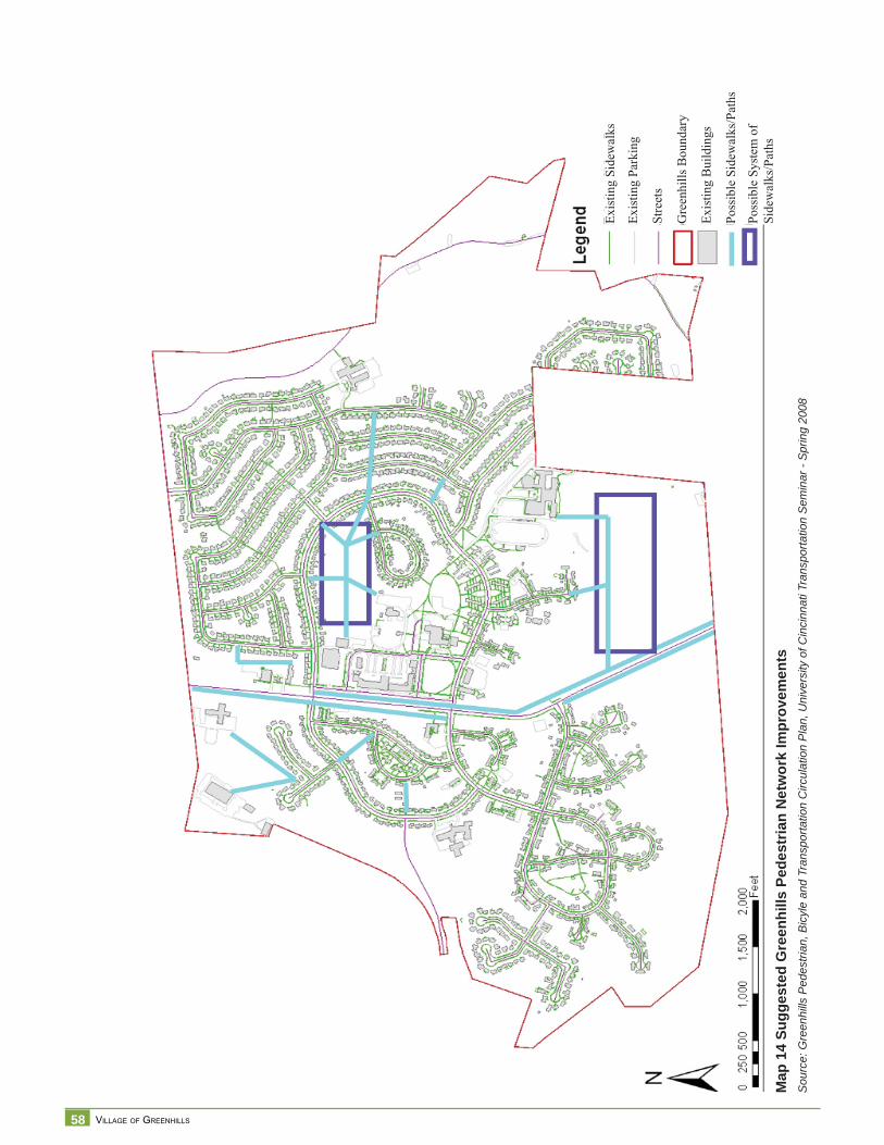
58 VILLAGE OF GREENHILLS
Map
14
Sugg
este
d G
reen
hills
Ped
estr
ian
Net
wor
k Im
prov
emen
tsS
ourc
e: G
reen
hills
Ped
estri
an, B
icyl
e an
d Tr
ansp
orta
tion
Circ
ulat
ion
Pla
n, U
nive
rsity
of C
inci
nnat
i Tra
nspo
rtatio
n S
emin
ar -
Spr
ing
2008
Exis
ting
Side
wal
ks
Exis
ting
Park
ing
Stre
ets
Gre
enhi
lls B
ound
ary
Exis
ting
Bui
ldin
gs
Poss
ible
Sid
ewal
ks/P
aths
Poss
ible
Sys
tem
of
Side
wal
ks/P
aths
59 COMPREHENSIVE PLAN
In Greenhills, most local streets have sidewalks on both sides of the street. Wider sidewalks can be found on streets near the elementary school and middle school. Along Winton Road there is a sidewalk only on one side of the street at any given point. From the southern border to Farragut, the sidewalk is on the west side. From Farragut to the northern border, the sidewalk is on the east side of Winton Road.
Winton Road splits the Village into east and west sides. Connectivity between both sides of the Village is automobile-dependent. There are traffi c lights on Winton Road at Farragut and at Damon Roads. They are not timed for pedestrian crossing, making it unsafe for pedestrian or cyclist to cross the street.
The University of Cincinnati conducted a Transportation Seminar in the spring of 2008 that evaluated local conditions and regional plans to address connectivity and circulation issues focusing on pedestrian and bicycle transit.3 Recommendations from the Greenhills Pedestrian, Bicycle and Transportation Circulation Plan include:
• Establish Greenhills as a cultural and recreational destinationo Build on cultural and historic resources in the Villageo Ease access to/from Winton Woodso Promote awareness of recreational opportunities in and near Greenhills
• Enhance internal pedestrian and bicycle transit safety and access o Enhance crosswalks, internal sidewalkso Utilize traffi c calming tools to reduce speed of traffi c throughout the Villageo Add amenities (bike racks, water fountains, benches, restrooms)o Enhance sidewalks and crosswalks on Winton Road.
• Increase pedestrian and bicycle connectivity to Winton Woods and Forest Parko Coordinate bike trail connection/extension with Hamilton County Park systemo Coordinate bicycle trail connections with Forest Park
• Improve infrastructure to serve diverse mobility needs of population o Comply with Americans with Disabilities Act (ADA) accessibility regulations,
crosswalks and curb ramps, selection of materials for trail surfaceso Enhance bus stop amenities, signage, and upgrade shelters
3 Greenhills Pedestrian, Bicycle and Transportation Circulation Plan. University of Cincinnati. Transportation Seminar. Spring 2008
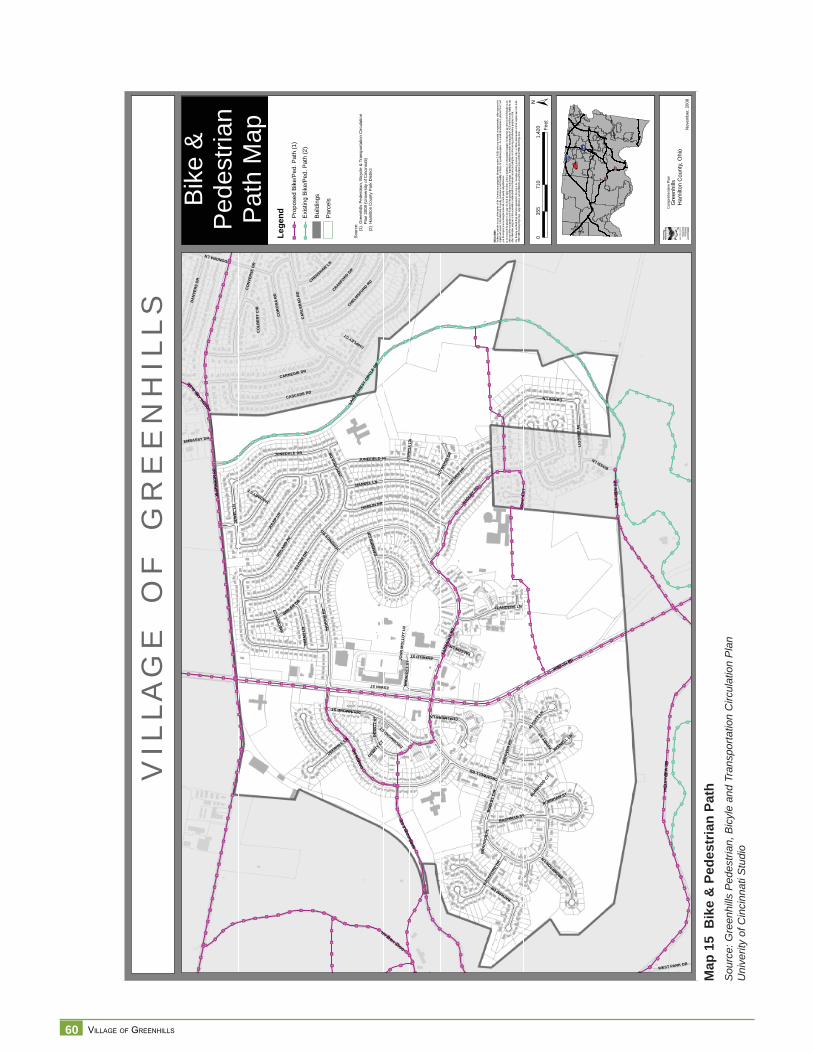
60 VILLAGE OF GREENHILLS
Map
15
Bik
e &
Ped
estr
ian
Path
S
ourc
e: G
reen
hills
Ped
estri
an, B
icyl
e an
d Tr
ansp
orta
tion
Circ
ulat
ion
Pla
nU
nive
rity
of C
inci
nnat
i Stu
dio
VIL
LAG
EO
FG
RE
EN
HIL
LS
Bike
&P
edes
trian
Pat
hM
ap
§̈ ¦I-74
§̈ ¦I-75
§̈ ¦I-75
§̈ ¦I-275
Nov
embe
r,20
08
DISC
LAIM
ER:
Neith
er th
e pro
vider
nor a
ny o
f the
partie
s of
the C
incinn
ati a
rea g
eogra
phic
inform
ation
syste
m (C
AGIS)
mak
e an
y wa
rranty
or re
prese
ntatio
n, eit
her e
xpres
sed
or im
plied
, with
resp
ect to
this
inform
ation
, its
quali
ty, pe
rform
ance
, merc
hanta
bility
, or f
itnes
s for
a pa
rticula
r purp
ose.
As a
resu
lt this
infor
matio
n is
provid
ed “a
s is”,
and
yo
u, the
recip
ient, a
re as
sumi
ng th
e enti
re ris
k as t
o its
quali
ty an
d per
form
ance
. In
no ev
ent, w
ill the
prov
ider o
r any
part
y of
CAGI
S be
liable
for d
irect,
indir
ect, i
ncide
ntal, o
r con
sequ
entia
l dam
ages
resu
lting
from
any
defec
t in th
e inf
ormati
on or
any
other
part o
f the m
ap pr
oduc
t, eve
n if a
dvise
d of th
e pos
sibility
of su
ch da
mage
s. In
partic
ular,
neith
er the
prov
ider n
or an
y par
ty of
CAGI
S sh
all ha
ve an
y lia
bility
for a
ny
other
inform
ation
, prog
rams o
r data
used
with
or co
mbin
ed w
ith th
e info
rmati
on re
ceive
d, inc
luding
the c
ost o
f reco
verin
g suc
h info
rmati
on, p
rogra
ms or
data
. An
y flo
odwa
y an
d flo
od fri
nge
inform
ation
prov
ided o
n thi
s map
is fo
r con
ceptu
al pla
nning
purpo
ses
only.
For
offic
ial de
term
inatio
n of
limits
recip
ient m
ust r
efer t
o the
19
82 F
EMA
flood
way f
ringe
map
s. La
rge di
fferen
ces c
an ex
ist be
twee
n actu
al flo
od pr
one a
rea an
d offic
ial FE
MA
flood
fring
e are
as.
¾¾½
¾¾½
¾¾½
¾¾½
¾¾½
¾¾½
¾¾½¾¾½¾¾½¾¾½¾¾½
¾¾½
¾¾½
¾¾½
¾¾½¾¾½
¾¾½¾¾½
¾¾½¾¾½
¾¾½
¾¾½
¾¾½
¾¾½
¾¾½
¾¾½
¾¾½
¾¾½
¾¾½
¾¾½
¾¾½
¾¾½
¾¾½¾¾½¾¾½
¾¾½¾¾½
¾¾½¾¾½¾¾½¾¾½¾¾½
¾¾½
¾¾½
¾¾½
¾¾½
¾¾½
¾¾½
¾¾½
¾¾½
¾¾½ ¾¾½¾¾½
¾¾½¾¾½
¾¾½¾¾½
¾¾½¾¾½
¾¾½¾¾½
¾¾½
¾¾½
¾¾½¾¾½
¾¾½¾¾½
¾¾½
¾¾½ ¾¾½
¾¾½
¾¾½
¾¾½
¾¾½¾¾½
¾¾½
¾¾½¾¾½
¾¾½
¾¾½ ¾¾½
¾¾½
¾¾½¾¾½
¾¾½¾¾½
¾¾½
¾¾½
¾¾½¾¾½
¾¾½¾¾½
¾¾½¾¾½
¾¾½
¾¾½
¾¾½
¾¾½
¾¾½
¾¾½¾¾½
¾¾½¾¾½
¾¾½
¾¾½
¾¾½¾¾½
¾¾½¾¾½
¾¾½¾¾½
¾¾½¾¾½
¾¾½
¾¾½
¾¾½
¾¾½
¾¾½
¾¾½
¾¾½
¾¾½
¾¾½
¾¾½
¾¾½
¾¾½
¾¾½¾¾½
¾¾½
¾¾½
¾¾½
¾¾½
¾¾½
¾¾½
¾¾½
¾¾½
¾¾½
¾¾½
¾¾½
¾¾½
¾¾½
¾¾½
¾¾½¾¾½¾¾½¾¾½¾¾½¾¾½¾¾½¾¾½¾¾½
¾¾½
¾¾½¾¾½
¾¾½¾¾½
¾¾½¾¾½
¾¾½¾¾½
¾¾½¾¾½
¾¾½¾¾½
¾¾½¾¾½
¾¾½¾¾½
¾¾½¾¾½
¾¾½¾¾½
¾¾½¾¾½
¾¾½
¾¾½¾¾½
¾¾½
¾¾½¾¾½
¾¾½¾¾½
¾¾½¾¾½
¾¾½¾¾½
¾¾½¾¾½¾¾½
¾¾½
¾¾½¾¾½
¾¾½¾¾½
¾¾½¾¾½
¾¾½¾¾½
¾¾½¾¾½
¾¾½¾¾½
¾¾½¾¾½
¾¾½¾¾½
¾¾½¾¾½
¾¾½¾¾½
¾¾½¾¾½
¾¾½¾¾½¾¾½
¾¾½¾¾½
¾¾½¾¾½
¾¾½
¾¾½¾¾½
¾¾½¾¾½
¾¾½
¾¾½
¾¾½¾¾½
¾¾½¾¾½
¾¾½¾¾½
¾¾½
¾¾½
¾¾½
¾¾½¾¾½
¾¾½ ¾¾½
¾¾½
¾¾½¾¾½¾¾½¾¾½¾¾½
¾¾½
¾¾½¾¾½¾¾½¾¾½¾¾½¾¾½¾¾½¾¾½¾¾½¾¾½¾¾½¾¾½¾¾½¾¾½¾¾½
¾¾½¾¾½
¾¾½
¾¾½
¾¾½
¾¾½¾¾½¾¾½¾¾½
¾¾½
¾¾½¾¾½¾¾½¾¾½
¾¾½¾¾½¾¾½¾¾½
¾¾½
¾¾½
¾¾½
¾¾½
¾¾½
¾¾½
¾¾½
¾¾½
¾¾½
¾¾½¾¾½
¾¾½¾¾½
¾¾½¾¾½
¾¾½¾¾½
¾¾½¾¾½
¾¾½¾¾½
¾¾½¾¾½
¾¾½¾¾½
¾¾½¾¾½
¾¾½¾¾½
¾¾½
¾¾½
¾¾½¾¾½
¾¾½
¾¾½
¾¾½¾¾½
¾¾½¾¾½
¾¾½¾¾½
¾¾½
¾¾½¾¾½
¾¾½¾¾½
¾¾½
¾¾½
¾¾½¾¾½
¾¾½¾¾½
¾¾½
¾¾½
¾¾½
¾¾½
¾¾½
¾¾½
¾¾½ ¾¾½
¾¾½¾¾½
¾¾½¾¾½¾¾½
¾¾½¾¾½
¾¾½¾¾½
¾¾½¾¾½
¾¾½
¾¾½¾¾½
¾¾½¾¾½
¾¾½¾¾½
¾¾½¾¾½
¾¾½¾¾½
¾¾½¾¾½
¾¾½
¾¾½
¾¾½¾¾½
¾¾½¾¾½
¾¾½¾¾½
¾¾½
¾¾½
¾¾½¾¾½
¾¾½
¾¾½
¾¾½
¾¾½¾¾½
¾¾½¾¾½
¾¾½
¾¾½¾¾½
¾¾½¾¾½
¾¾½
¾¾½¾¾½
¾¾½¾¾½¾¾½¾¾½
¾¾½¾¾½
¾¾½¾¾½
WSH
AR
ON
RD
WINTON RDVA
LLEY
VIEW
DR
JUNEFIELD AVHADLE
YRD
LAKE
FORE
STCI
RCLE
DR
CASCADE RD
IREL
AND
AV
GOLFVIEWDR
ING
RA
MR
D
DAM
ON
RD
FARR
AGUT
RD
SPRI
NGDA
LERD
LAK
EVIE
WD
R
CO
RO
NA
RD
CA
RLS
BA
DR
D
ENFIELDST
JULE
PLN
CARINILN
ILLO
NADR
HAMLIN DR
CARNEGIE DR
HAYDEN
DR
HANDEL LN
ESWINST
JUNEDALE DR
DRUMMONDST
IMBLER DR
CO
NVE
RSE
DR
BAYHAMDR
CROMWELLRD
AN
DO
VER
RD
JEW
ELLN
CHELMSFORD
RD
DA
NVE
RS
DR
JAPO
NICA
DR
LIG
OR
IOAV
AVENELL LN
CRANFORD
DR
BU
RLE
YC
IR
INM
AN
LN
ASHBY
ST
BACHMAN ST
FLANDERS LN
DEW
ITT
ST
BECK
FORD
DR
BROMPTONLN
CO
NC
AST
BOSSILN
DEERHILL LN
CRENSHAWLN
DONORALN
CHALMERSLN
ALCOTT
LN
WEST PARK DR
END
ICO
TTST
BURNHAM ST
CO
LBER
TC
IR
FALCONLN
EMBASSY DR
GA
MB
IER
CIR
NORTHLA
NDBLV
D
JOYW
OOD
DR
JENNIN
GSRD
JOH
NM
OLL
OY
LNJU
STIC
IALN
BR
AD
NO
RPL
CHIPLEYCT
DRUMMONDCT
DEWITT
CT
BURWOOD
CTJANUARYCT
IMBO
DEN
CT
±0
710
1,42
035
5Fe
et
Com
preh
ensi
veP
lan
Gre
enhi
llsH
amilt
onC
ount
y,O
hio
Lege
nd¾¾½
¾¾½
¾¾½¾¾½
Prop
osed
Bike
/Ped
.Pat
h(1
)
Exis
ting
Bike
/Ped
.Pat
h(2
)
Build
ings
Parc
els
Sour
ce:
(1)
Gre
enhi
llsPe
dest
rian,
Bicy
cle
&Tr
ansp
orta
tion
Circ
ulat
ion
Plan
2008
(Uni
vers
ityof
Cin
cinn
ati)
(2)
Ham
ilton
Cou
nty
Park
Dis
trict
61 COMPREHENSIVE PLAN
Public TransportationResidents in Greenhills do not depend on public transportation to get to work. According to 2000 Census data 88.6% of residents work outside the Village and 92.1% drive to work. Around 80% of Greenhills’ residents travel 15-20 minutes every day to work.
The bus routes4 that currently serve Greenhills are the 20 Winton-Tri-County and 20x Forest Park Express. The express service offers fi ve morning and fi ve afternoon trips, plus the local service on the 20 that runs throughout the day during the week and on Saturdays (but not Sundays). This service basically runs along Winton Road. Only 45% of all residential units within Greenhills have pedestrian access to a bus stop.5
(See Bus Route Map on next page)
4 Greenhills is served by SORTA (South Ohio Regional Transit Authority) Queen City Metro Bus service. The bus ser-vice functions with a hub downtown. The radial system links suburbs to downtown with little east-west connectivity provided.
5 Greenhills Pedestrian, Bicycle and Transportation Circulation Plan. University of Cincinnati. Transportation Semi-nar. Spring 2008. Page 17.
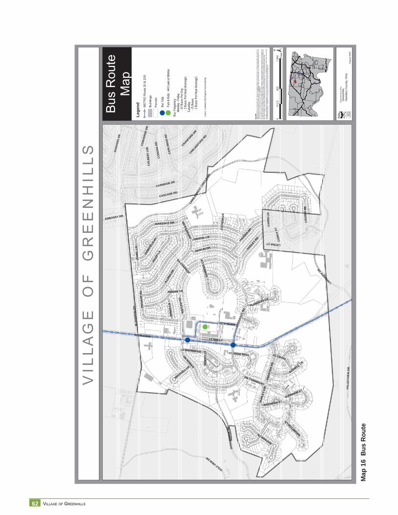
62 VILLAGE OF GREENHILLS
Map
16
Bus
Rou
te
V I L
L A
G E
O
F
G R
E E
N H
I L
L S
Bus
Rou
teM
ap
§̈ ¦I-74
§̈ ¦I-75
§̈ ¦I-75
§̈ ¦I-275
Aug
ust 2
009
DISC
LAIM
ER:
Neith
er th
e pro
vider
nor a
ny o
f the
partie
s of
the C
incinn
ati a
rea g
eogra
phic
inform
ation
syste
m (C
AGIS)
mak
e an
y wa
rranty
or re
prese
ntatio
n, eit
her e
xpres
sed
or im
plied
, with
resp
ect to
this
inform
ation
, its
quali
ty, pe
rform
ance
, merc
hanta
bility
, or f
itnes
s for
a pa
rticula
r purp
ose.
As a
resu
lt this
infor
matio
n is
provid
ed “a
s is”,
and
yo
u, the
recip
ient, a
re as
sumi
ng th
e enti
re ris
k as t
o its
quali
ty an
d per
form
ance
.In
no ev
ent, w
ill the
prov
ider o
r any
part
y of
CAGI
S be
liable
for d
irect,
indir
ect, i
ncide
ntal, o
r con
sequ
entia
l dam
ages
resu
lting
from
any
defec
t in th
e inf
ormati
on or
any
other
part o
f the m
ap pr
oduc
t, eve
n if a
dvise
d of th
e pos
sibility
of su
ch da
mage
s. In
partic
ular,
neith
er the
prov
ider n
or an
y par
ty of
CAGI
S sh
all ha
ve an
y lia
bility
for a
ny
other
inform
ation
, prog
rams o
r data
used
with
or co
mbin
ed w
ith th
e info
rmati
on re
ceive
d, inc
luding
the c
ost o
f reco
verin
g suc
h info
rmati
on, p
rogra
ms or
data
. An
y flo
odwa
y an
d flo
od fri
nge
inform
ation
prov
ided o
n thi
s map
is fo
r con
ceptu
al pla
nning
purpo
ses
only.
For
offic
ial de
term
inatio
n of
limits
recip
ient m
ust r
efer t
o the
19
82 F
EMA
flood
way f
ringe
map
s. La
rge di
fferen
ces c
an ex
ist be
twee
n actu
al flo
od pr
one a
rea an
d offic
ial FE
MA
flood
fring
e are
as.
¾¾À ¾¾À ¾¾À ¾¾À ¾¾À ¾¾À ¾¾À ¾¾À
¾¾À ¾¾À ¾¾À ¾¾À ¾¾À ¾¾À
¾¾À¾¾À¾¾À¾¾À¾¾À¾¾À¾¾À¾¾À
¾¾À¾¾À
¾¾À
¾¾À ¾¾À ¾¾À ¾¾À
¾¾À¾¾À¾¾À
¾¾À
¾¾À
¾¾À
¾¾À
¾¾À
¾¾À
¾¾À
¾¾À
¾¾À
¾¾À
¾¾À
¾¾À
¾¾À
¾¾À
¾¾À
¾¾À
¾¾À
¾¾À¾¾À¾¾À¾¾À¾¾À¾¾À
¾¾À
¾¾À¾¾À
¾¾À
¾¾À ¾¾À
¾¾À ¾¾À ¾¾À ¾¾À ¾¾À ¾¾À ¾¾À ¾¾À
¾¾À ¾¾À
¾¾À¾¾À¾¾À¾¾À¾¾À¾¾À¾¾À¾¾À¾¾À
¾¾À
¾¾À
¾¾À
¾¾À
¾¾À
¾¾À
¾¾À
¾¾À
¾¾À
¾¾À
¾¾À
¾¾À
¾¾À
¾¾À
¾¾À
¾¾À
¾¾À
¾¾À¾¾À¾¾À¾¾À¾¾À¾¾À
¾¾À¾¾À¾¾À¾¾À
WSH
AR
ON
RD
WINTONRD
JUNE
FIEL
DAV
HADLEY
RD
LAKE
FORE
STCI
RCLE
DR
CASCADE RD
IREL
AN
DAV
GOLFVIEWDR
ING
RA
MR
D
DAMON RD
FARR
AGUT
RD
SPR
ING
DA
LER
D
LAKEVIE
WDR
CO
RO
NA
RD
CA
RLS
BA
DR
D
ENFIELDST
JULE
PLN
CA
RIN
ILN
ILLO
NADR
VALL
EYVI
EWD
R
HAMLIN DR
CARNEGIE DR
HAYDENDR
HANDEL LN
ESWINST
JUNEDALE DR
DRUMMONDST
IMBLER DR
CO
NVE
RSE
DR
DA
NVE
RS
DR
CROMWELLRD
BAYHAMDR
AN
DO
VER
RD
JEW
ELLN
CHELMSFO
RDRD
JAPO
NICA
DR
LIG
OR
IOAV
CRANFORD
DR
AVENELL LN
BU
RLE
YC
IR
INM
AN
LN
ASHBYST
BACHMAN ST
DEW
ITT
ST
FLANDERS LN
BROMPTONLN
CO
NC
AST
DEERHILL LN
EMBASSY DR
GA
MB
IER
CIR
CHALMERSLN
BURNHAM ST
CO
LBER
TC
IR
LATINACT
JENNIN
GSRD
JUST
ICIA
LN
±0
825
1,65
041
2.5
Feet
Com
preh
ensi
ve P
lan
Gre
enhi
llsH
amilt
on C
ount
y, O
hio
Bus S
top
Lege
nd¾¾À
¾¾ÀM
ETR
O R
oute
20
& 2
0X
Bui
ldin
gs
Par
cels
Park
& Ri
de: 4
4 Esw
in at
Wint
on
Bus F
requ
ency
:
Mon
day -
Frid
ay
- 4
7 Bus
es P
er D
ay
- 3 B
uses
Per
Hou
r (Av
erag
e)
Satu
rday
- 25 B
uses
- 2 B
uses
Per
Hou
r (Av
erag
e)
Sour
ce: S
outhw
est O
hio R
egion
al Tr
ansit
Auth
ority
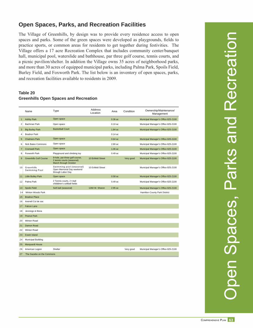
63 COMPREHENSIVE PLAN
Ope
n S
pace
s, P
arks
and
Rec
reat
ion
Open Spaces, Parks, and Recreation FacilitiesThe Village of Greenhills, by design was to provide every residence access to open spaces and parks. Some of the green spaces were developed as playgrounds, fi elds to practice sports, or common areas for residents to get together during festivities. The Village offers a 17 acre Recreation Complex that includes community center/banquet hall, municipal pool, waterslide and bathhouse, par three golf course, tennis courts, and a picnic pavilion/shelter. In addition the Village owns 35 acres of neighborhood parks, and more than 30 acres of equipped municipal parks, including Palma Park, Spoils Field, Burley Field, and Foxworth Park. The list below is an inventory of open spaces, parks, and recreation facilities available to residents in 2009.
Table 20Greenhills Open Spaces and Recreation
Name Type AddressLocation Area Condition Ownership/Maintenance/
Management
1 Ashby Park Open space 0.36 ac Municipal Manager’s Office 825-2100
2 Bachman Park Open space 0.10 ac Municipal Manager’s Office 825-2100
3 Big Burley Park Basketball Court 1.84 ac Municipal Manager’s Office 825-2100
4 Bradnor Park 0.14 ac
5 Chalmers Park Open space 0.64 ac Municipal Manager’s Office 825-2100
6 Nick Bates Commons Open space 2.80 ac Municipal Manager’s Office 825-2100
8 Foxworth Park Playground and climbing toy 0.49 ac Municipal Manager’s Office 825-2100
9 Greenhills Golf Course 9-hole, par-three golf course,2 tennis courts (seasonal)March through October
10 Enfield Street Very good Municipal Manager’s Office 825-2100
10 G reenhillsSw im m ing Pool
Sw im m ing pool (seasonal)Open Memorial Day weekendthrough Labor Day
10 Enfield Street Municipal Manager’s Office 825-2100
12 Palma Park 2 Tennis courts, 2 t-ballchilddren’s softball fields
0.49 ac Municipal Manager’s Office 825-2100
14 Winton Woods Park Hamilton County Park District
16 Avenell Cul de sac
18 Jennings & Illona
20 Winton Road
22 Winton Road
24 Municipal Building
26 American Legion
27 The Gazebo on the Commons
Shelter Very good Municipal Manager’s Office 825-2100
25 Marquardt House
23 Eswin Island
21 Damon Road
19 Peanut Park
17 Falcon Lane
15 Bradnor Place
13 Spoils Field Soft ball (seasonal) 1260 W. Sharon 2.95 ac Municipal Manager’s Office 825-2100
11 Little Butley Park Open space 0.58 ac Municipal Manager’s Office 825-2100
7 Cromwell Park Open space 1.06 ac Municipal Manager’s Office 825-2100

64 VILLAGE OF GREENHILLS
Map
17
Par
ks a
nd R
ecre
atio
n
V I L
L A
G E
O
F
G R
E E
N H
I L
L S
§̈ ¦I-74
§̈ ¦I-75
§̈ ¦I-75
§̈ ¦I-275
Apr
il, 2
009
DISC
LAIM
ER:
Neith
er th
e pro
vider
nor a
ny o
f the
partie
s of
the C
incinn
ati a
rea g
eogra
phic
inform
ation
syste
m (C
AGIS)
mak
e an
y wa
rranty
or re
prese
ntatio
n, eit
her e
xpres
sed
o r im
plied
, with
resp
ect to
this
inform
ation
, its
quali
ty, pe
rform
ance
, merc
hanta
bility
, or f
itnes
s for
a pa
rticula
r purp
ose.
As a
resu
lt this
infor
matio
n is
provid
ed “a
s is”,
and
yo
u, the
recip
ient, a
re as
sumi
ng th
e enti
re ris
k as t
o its
quali
ty an
d per
form
ance
.In
no ev
ent, w
ill the
prov
ider o
r any
part
y of
CAGI
S be
liable
for d
irect,
indir
ect, i
ncide
ntal, o
r con
sequ
entia
l dam
ages
resu
lting
from
any
defec
t in th
e inf
ormati
on or
any
other
part o
f the m
ap pr
oduc
t, eve
n if a
dvise
d of th
e pos
sibility
of su
ch da
mage
s. In
partic
ular,
neith
er the
prov
ider n
or an
y par
ty of
CAGI
S sh
all ha
ve an
y lia
bility
for a
n y
other
inform
ation
, prog
rams o
r data
used
with
or co
mbin
ed w
ith th
e info
rmati
on re
ceive
d, inc
luding
the c
ost o
f reco
verin
g suc
h info
rmati
on, p
rogra
ms or
data
. An
y flo
odwa
y an
d flo
od fri
nge
inform
ation
prov
ided o
n thi
s map
is fo
r con
ceptu
al pla
nning
purpo
ses
only.
For
offic
ial de
term
inatio
n of
limits
recip
ient m
ust r
efer t
o th e
19
82 F
EMA
flood
way f
ringe
map
s. La
rge di
fferen
ces c
an ex
ist be
twee
n actu
al flo
od pr
one a
rea an
d offic
ial FE
MA
flood
fring
e are
as.
WSH
AR
ON
RD
WINTONRD
JUNEFIELD AV
HADLEY
RD
LAKE
FORE
STCI
RCLE
DR
CASCADE RD
IREL
AND
AV
GOLFVIEWDR
ING
RA
MR
D
DAMONRD
FARR
AGUT
RD
SPRI
NGDA
LERD
VALL
EYVI
EWD
R
LAKE
VIEW
DR
CO
RO
NA
RD
CA
RLS
BA
DR
D
ENFIELDST
JULE
PLN
CARINILN
ILLO
NADR
HAMLIN DR
CARNEGIE DR
HAYDENDR
HANDEL LN
ESWINST
JUNEDALE DR
DRUMMONDST
IMBLER DR
CO
NVE
RSE
DR
DA
NVE
RS
DR
CROMWELLRD
BAYHAMDR
ANDO
VER
RD
JEW
ELLN
CHELMSFO
RDRD
JAPO
NICA
DR
LIG
OR
IOAV
CRANFORD
DR
AVENELL LN
BURL
EYCI
R
INM
AN
LN
ASHB
YST
BACHMAN ST
DEW
ITT
ST
FLANDERS LN
BECK
FORD
DR
BROMPTONLN
CO
NC
AST
BOSSILN
DEERHILL LN
CRENSHAWLN
GA
MBI
ERC
IR
EMBASSY DR
CHALMERSLN
DONORALN
ALCOTT
LN
END
ICO
TTST
BURNHAM ST
CO
LBER
TC
IR
FALCONLN
JOYW
OOD
DR
JENNIN
GSRD
JOH
NM
OLL
OY
LNJU
STIC
IALN
FUN
STO
NLN
CHIPLEYCT
BURWOOD
CT
JANUARYCT
IMBO
DEN
CT
±0
780
1,56
039
0Fe
et
Com
preh
ensi
ve P
lan
Gre
enhi
llsH
amilt
on C
ount
y, O
hio
3
11
1
12
8
5
7
6
2
10
9
13
14
14
14
14
1.
Ash
by P
ark
2.
Bac
hman
Par
k3.
B
ig B
urle
y P
ark
4.
Bra
dnor
Par
k5.
C
halm
ers
Par
k6.
C
omm
ons
7.
Cro
mw
ell P
ark
8.
Fox
wor
th P
ark
9.
Gre
enhi
lls G
olf C
ours
e10
. G
reen
hills
Sw
imm
ing
Poo
l11
. Li
ttle
Bur
ley
Par
k12
. P
alm
a P
ark
13.
Spo
ils F
ield
14.
Win
ton
Woo
ds
Park
/Gre
ensp
ace
Loca
tor
Lege
nd
Park
s/G
reen
spac
e
Win
ton
Woo
ds
Park
s in
Gre
enhi
lls
15.
Bra
dnor
Pla
ce16
. Av
enel
l Cul
de
sac
17.
Falc
on L
ane
18.
Jenn
ings
& Il
lona
19.
Pea
nuts
Par
k20
. W
into
n R
d.21
. D
amon
Rd.
22.
Win
ton
Rd.
23.
Esw
in Is
land
24.
Mun
icip
al B
ldg.
25.
Mar
quar
dt H
ouse
26.
Am
eric
an L
egio
n27
. G
azeb
o on
the
Com
mon
s
15
16
17
18
19
20
21
22
23242526
Par
ks &
Rec
reat
ion
Map
27S
ourc
e: V
illage
of G
reen
hills
Gre
enbe
lt
Parc
els
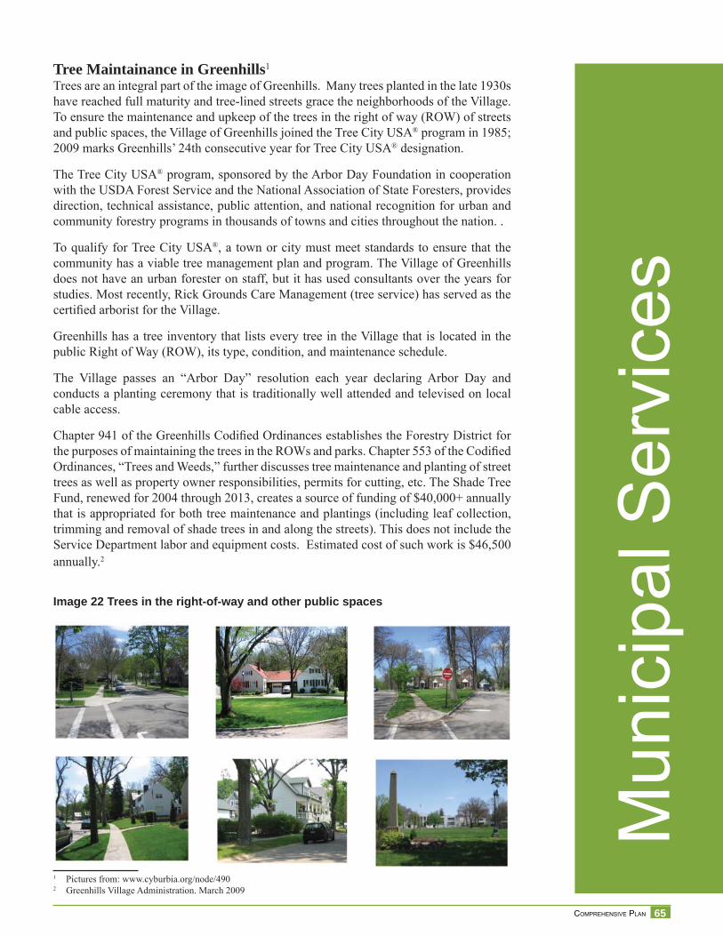
65 COMPREHENSIVE PLAN
Mun
icip
al S
ervi
ces
Tree Maintainance in Greenhills1
Trees are an integral part of the image of Greenhills. Many trees planted in the late 1930s have reached full maturity and tree-lined streets grace the neighborhoods of the Village. To ensure the maintenance and upkeep of the trees in the right of way (ROW) of streets and public spaces, the Village of Greenhills joined the Tree City USA® program in 1985; 2009 marks Greenhills’ 24th consecutive year for Tree City USA® designation.
The Tree City USA® program, sponsored by the Arbor Day Foundation in cooperation with the USDA Forest Service and the National Association of State Foresters, provides direction, technical assistance, public attention, and national recognition for urban and community forestry programs in thousands of towns and cities throughout the nation. .
To qualify for Tree City USA®, a town or city must meet standards to ensure that the community has a viable tree management plan and program. The Village of Greenhills does not have an urban forester on staff, but it has used consultants over the years for studies. Most recently, Rick Grounds Care Management (tree service) has served as the certifi ed arborist for the Village.
Greenhills has a tree inventory that lists every tree in the Village that is located in the public Right of Way (ROW), its type, condition, and maintenance schedule.
The Village passes an “Arbor Day” resolution each year declaring Arbor Day and conducts a planting ceremony that is traditionally well attended and televised on local cable access.
Chapter 941 of the Greenhills Codifi ed Ordinances establishes the Forestry District for the purposes of maintaining the trees in the ROWs and parks. Chapter 553 of the Codifi ed Ordinances, “Trees and Weeds,” further discusses tree maintenance and planting of street trees as well as property owner responsibilities, permits for cutting, etc. The Shade Tree Fund, renewed for 2004 through 2013, creates a source of funding of $40,000+ annually that is appropriated for both tree maintenance and plantings (including leaf collection, trimming and removal of shade trees in and along the streets). This does not include the Service Department labor and equipment costs. Estimated cost of such work is $46,500 annually.2
Image 22 Trees in the right-of-way and other public spaces
1 Pictures from: www.cyburbia.org/node/4902 Greenhills Village Administration. March 2009
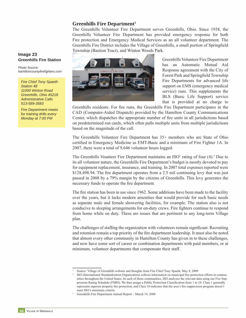
66 VILLAGE OF GREENHILLS
Greenhills Fire Department1
The Greenhills Volunteer Fire Department serves Greenhills, Ohio. Since 1938, the Greenhills Volunteer Fire Department has provided emergency response for both Fire protection and Emergency Medical Services as an all volunteer department. The Greenhills Fire District includes the Village of Greenhills, a small portion of Springfi eld Township (Bastion Tract), and Winton Woods Park.
Greenhills Volunteer Fire Department has an Automatic Mutual Aid Response agreement with the City of Forest Park and Springfi eld Township Fire Departments for advanced life support on EMS (emergency medical service) runs. This supplements the BLS (Basic Life Support) service that is provided at no charge to
Greenhills residents. For fi re runs, the Greenhills Fire Department participates in the CAD (Computer-Aided Dispatch) provided by the Hamilton County Communications Center, which dispatches the appropriate number of fi re units in all jurisdictions based on predetermined run cards, which often pulls multiple units from multiple jurisdictions based on the magnitude of the call.
The Greenhills Volunteer Fire Department has 35+ members who are State of Ohio certifi ed in Emergency Medicine as EMT-Basic and a minimum of Fire Fighter 1A. In 2007, there were a total of 9,646 volunteer hours logged.
The Greenhills Vounteer Fire Department maintains an ISO2 rating of four (4).3 Due to its all volunteer nature, the Greenhills Fire Department’s budget is mostly devoted to pay for equipment replacement, insurance, and training. In 2007 total expenses reported were $128,498.94. The fi re department operates from a 2.5 mil continuing levy that was just passed in 2008 by a 79% margin by the citizens of Greenhills. This levy generates the necessary funds to operate the fi re department.
The fi re station has been in use since 1962. Some additions have been made to the facility over the years, but it lacks modern amenities that would provide for such basic needs as separate male and female showering facilities, for example. The station also is not conducive to sleeping arrangements for on-duty crews. Fire fi ghters continue to respond from home while on duty. These are issues that are pertinent to any long-term Village plan.
The challenges of staffi ng the organization with volunteers remain signifi cant. Recruiting and retention remain a top priority of the fi re department leadership. It must also be noted that almost every other community in Hamilton County has given in to these challenges, and now have some sort of career or combination departments with paid members, or at minimum, volunteer departments that compensate their staff.
1 Source: Village of Greenhills website and thoughts from Fire Chief Tony Spaeth, May 8, 20092 ISO (International Standardization Organization) collects information on municipal fi re-protection efforts in commu-
nities throughout the United States. In each of those communities, ISO analyzes the relevant data using our Fire Sup-pression Rating Schedule (FSRS). We then assign a Public Protection Classifi cation from 1 to 10. Class 1 generally represents superior property fi re protection, and Class 10 indicates that the area’s fi re-suppression program doesn’t meet ISO’s minimum criteria.
3 Greenhills Fire Department Annual Report – March 19, 2008
Image 23Greenhills Fire Station
Photo Source: hamiltoncountyfi refi ghters.com
Fire Chief Tony SpaethStation 4811000 Winton RoadGreenhills, Ohio 45218Administrative Calls513-589-3583
Fire Department meets for training drills every Monday at 7:00 PM
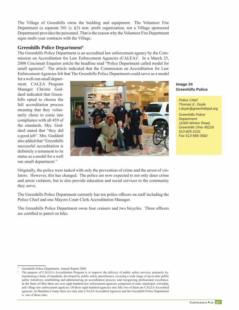
67 COMPREHENSIVE PLAN
The Village of Greenhills owns the building and equipment. The Volunteer Fire Department (a separate 501 (c )(3) non- profi t organization, not a Village sponsored Department) provides the personnel. That is the reason why the Volunteer Fire Department signs multi-year contracts with the Village.
Greenhills Police Department4
The Greenhills Police Department is an accredited law enforcement agency by the Com-mission on Accreditation for Law Enforcement Agencies (CALEA)5. In a March 25, 2008 Cincinnati Enquirer article the headline read “Police Department called model for small agencies”. The article indicated that the Commission on Accreditation for Law Enforcement Agencies felt that The Greenhills Police Department could serve as a model for a well-run small depart-ment. CALEA Program Manager Christie God-dard indicated that Green-hills opted to choose the full accreditation process meaning that they volun-tarily chose to come into compliance with all 459 of the standards. Mrs. God-dard stated that “they did a good job”. Mrs. Goddard also added that “Greenhills successful accreditation is defi nitely a testament to its status as a model for a well run small department.”
Originally, the police were tasked with only the prevention of crime and the arrest of vio-lators. However, this has changed. The police are now expected to not only deter crime and arrest violators, but to also provide education and social services to the community they serve.
The Greenhills Police Department currently has ten police offi cers on staff including the Police Chief and one Mayors Court Clerk Accreditation Manager.
The Greenhills Police Department owns four cruisers and two bicycles. Three offi cers are certifi ed to patrol on bike.
4 Greenhills Police Department. Annual Report 20085 The purpose of CALEA’s Accreditation Program is to improve the delivery of public safety services, primarily by:
maintaining a body of standards, developed by public safety practitioners, covering a wide range of up-to-date public safety initiatives; establishing and administering an accreditation process; and recognizing professional excellence. In the State of Ohio there are over eight hundred law enforcement agencies comprised of state, municipal, township, and village law enforcement agencies. Of those eight hundred agencies only fi fty two of them are CALEA Accredited agencies. In Hamilton County there are only nine CALEA Accredited Agencies and the Greenhills Police Department is one of those nine.
Image 24Greenhills Police
Police ChiefThomas E. [email protected]
Greenhills Police Department11000 Winton Road,Greenhills Ohio 45218513-825-2101Fax 513-589-3582
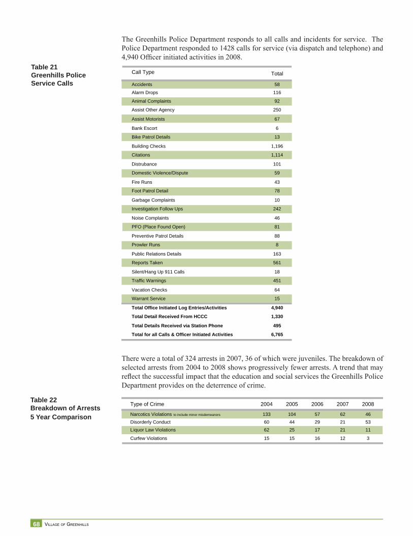
68 VILLAGE OF GREENHILLS
The Greenhills Police Department responds to all calls and incidents for service. The Police Department responded to 1428 calls for service (via dispatch and telephone) and 4,940 Offi cer initiated activities in 2008.
There were a total of 324 arrests in 2007, 36 of which were juveniles. The breakdown of selected arrests from 2004 to 2008 shows progressively fewer arrests. A trend that may refl ect the successful impact that the education and social services the Greenhills Police Department provides on the deterrence of crime.
Call Type Total
Accidents 58
Alarm Drops 116
Animal Complaints 92
Assist Other Agency 250
Assist Motorists 67
Bank Escort 6
Bike Patrol Details 13
Building Checks 1,196
Citations 1,114
Distrubance 101
Domestic Violence/Dispute 59
Fire Runs 43
Foot Patrol Detail 78
Garbage Complaints 10
Investigation Follow Ups 242
Noise Complaints 46
PFO (Place Found Open) 81
Preventive Patrol Details 88
Prowler Runs 8
Public Relations Details 163
Reports Taken 561
Silent/Hang Up 911 Calls 18
Traffic Warnings 451
Vacation Checks 64
Warrant Service 15
Total Office Initiated Log Entries/Activities 4,940
Total Detail Received From HCCC 1,330
Total Details Received via Station Phone 495
Total for all Calls & Officer Initiated Activities 6,765
Table 21Greenhills Police Service Calls
Type of Crime 2004 2005 2006 2007 2008
Narcotics Violations to include minor misdemeanors 133 104 57 62 46Disorderly Conduct 60 44 29 21 53Liquor Law Violations 62 25 17 21 11
Curfew Violations 15 15 16 12 3
Table 22Breakdown of Arrests5 Year Comparison
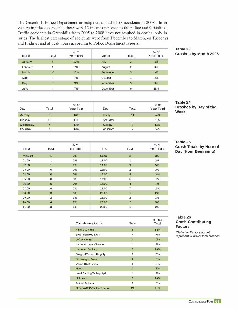
69 COMPREHENSIVE PLAN
The Greenhills Police Department investigated a total of 58 accidents in 2008. In in-vestigating these accidents, there were 13 injuries reported to the police and 0 fatalities. Traffi c accidents in Greenhills from 2005 to 2008 have not resulted in deaths, only in-juries. The highest percentage of accidents were from December to March, on Tuesdays and Fridays, and at peak hours according to Police Department reports.
Day Total% of
Year Total Day Total% of
Year Total
Monday 6 10% Friday 14 24%
Tuesday 10 17% Saturday 5 9%
Wednesday 7 12% Sunday 9 13%Thursday 7 12% Unknown 0 0%
Time Total% of
Year Total Time Total% of
Year Total
Midnight 1 2% Noon 2 3%
01:00 1 2% 13:00 1 2%
02:00 1 2% 14:00 3 5%
03:00 0 0% 15:00 2 3%
04:00 0 0% 16:00 8 14%
05:00 0 0% 17:00 6 10%
06:00 0 0% 18:00 4 7%
07:00 4 7% 19:00 7 12%
08:00 3 5% 20:00 1 2%
09:00 2 3% 21:00 2 3%
10:00 4 7% 22:00 2 3%
11:00 3 5% 23:00 1 2%
Contributing Factor Total% YearTotal
Failure to Yield 5 12%
Stop Sign/Red Light 4 7%
Left of Center 0 0%
Improper Lane Change 1 2%
Improper Backing 9 16%
Stopped/Parked Illegally 0 0%
Swerving to Avoid 2 3%
Vision Obstruction 0 0%None 3 5%
Load Shifting/Falling/Spill 1 2%
Unknown 9 16%
Animal Actions 0 0%
Other /ACDA/Fail to Control 24 41%
Month Total% of
Year Total Month Total% of
Year Total
January 7 12% July 2 3%
February 4 7% August 2 3%
March 10 17% September 5 9%
April 4 7% October 1 2%
May 5 9% November 5 9%
June 4 7% December 9 16%
Table 24Crashes by Day of the Week
Table 25Crash Totals by Hour of Day (Hour Beginning)
Table 26Crash Contributing Factors*Selected Factors do not represent 100% of total crashes
Table 23Crashes by Month 2008
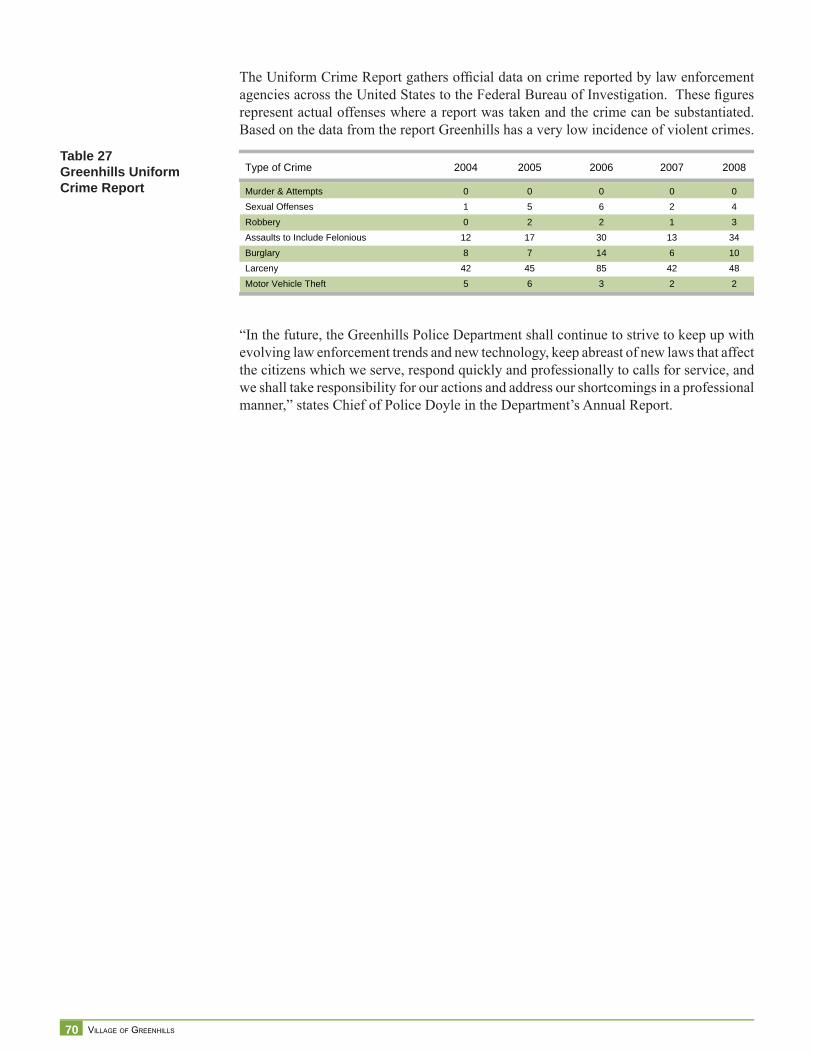
70 VILLAGE OF GREENHILLS
The Uniform Crime Report gathers offi cial data on crime reported by law enforcement agencies across the United States to the Federal Bureau of Investigation. These fi gures represent actual offenses where a report was taken and the crime can be substantiated. Based on the data from the report Greenhills has a very low incidence of violent crimes.
“In the future, the Greenhills Police Department shall continue to strive to keep up with evolving law enforcement trends and new technology, keep abreast of new laws that affect the citizens which we serve, respond quickly and professionally to calls for service, and we shall take responsibility for our actions and address our shortcomings in a professional manner,” states Chief of Police Doyle in the Department’s Annual Report.
Type of Crime 2004 2005 2006 2007
Murder & Attempts 0 0 0 0 0Sexual Offenses 1 5 6 2 4Robbery 0 2 2 1 3Assaults to Include Felonious 12 17 30 13 34Burglary 8 7 14 6 10Larceny 42 45 85 42 48Motor Vehicle Theft 5 6 3 2 2
2008Table 27Greenhills Uniform Crime Report
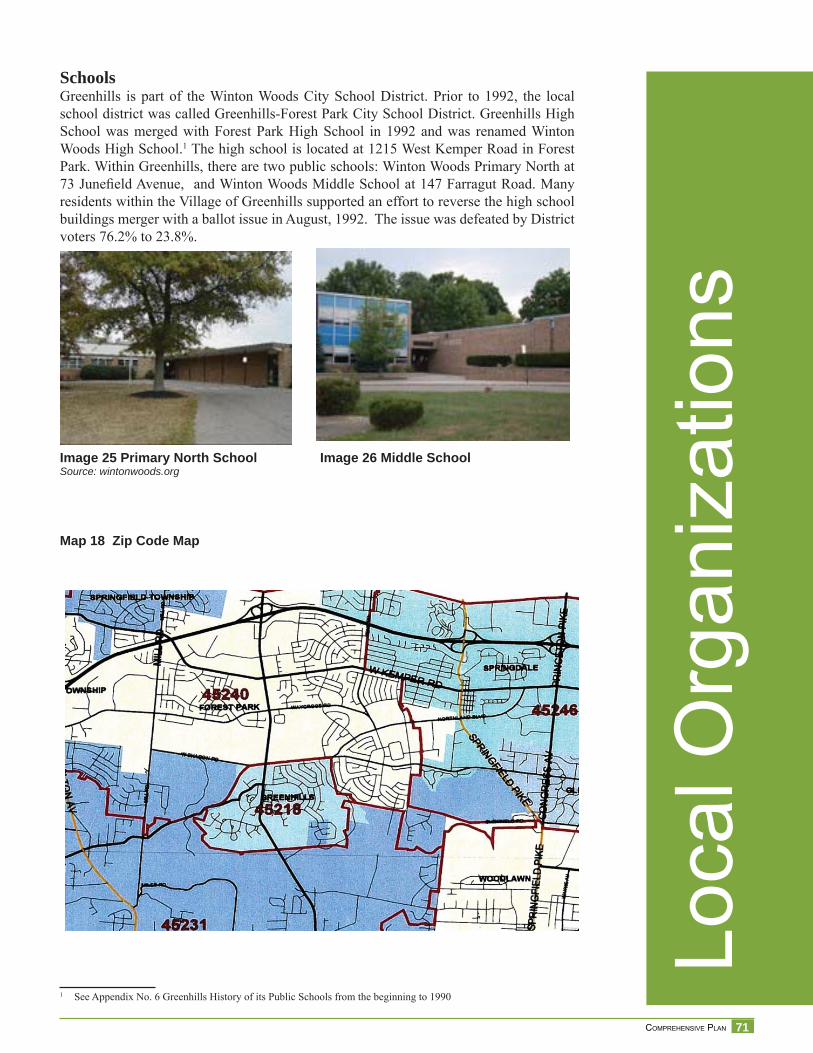
71 COMPREHENSIVE PLAN
SchoolsGreenhills is part of the Winton Woods City School District. Prior to 1992, the local school district was called Greenhills-Forest Park City School District. Greenhills High School was merged with Forest Park High School in 1992 and was renamed Winton Woods High School.1 The high school is located at 1215 West Kemper Road in Forest Park. Within Greenhills, there are two public schools: Winton Woods Primary North at 73 Junefi eld Avenue, and Winton Woods Middle School at 147 Farragut Road. Many residents within the Village of Greenhills supported an effort to reverse the high school buildings merger with a ballot issue in August, 1992. The issue was defeated by District voters 76.2% to 23.8%.
1 See Appendix No. 6 Greenhills History of its Public Schools from the beginning to 1990
Map 18 Zip Code Map
Image 25 Primary North School Image 26 Middle SchoolSource: wintonwoods.org
Loca
l Org
aniz
atio
ns
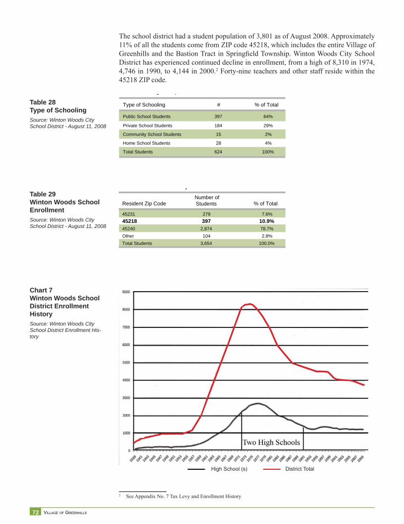
72 VILLAGE OF GREENHILLS
The school district had a student population of 3,801 as of August 2008. Approximately 11% of all the students come from ZIP code 45218, which includes the entire Village of Greenhills and the Bastion Tract in Springfi eld Township. Winton Woods City School District has experienced continued decline in enrollment, from a high of 8,310 in 1974, 4,746 in 1990, to 4,144 in 2000.2 Forty-nine teachers and other staff reside within the 45218 ZIP code.
2 See Appendix No. 7 Tax Levy and Enrollment History
District Total
Type of Schooling # % of Total
Public School Students 397 64%
Private School Students 184 29%
Community School Students 15 2%
Home School Students 28 4%
Total Students 624 100%
g p
Resident Zip CodeNumber ofStudents % of Total
45231 279 7.6%45218 397 10.9%45240 2,874 78.7%Other 104 2.8%Total Students 3,654 100.0%
y
Table 28Type of SchoolingSource: Winton Woods City School District - August 11, 2008
Table 29Winton Woods SchoolEnrollmentSource: Winton Woods City School District - August 11, 2008
Chart 7Winton Woods School District Enrollment HistorySource: Winton Woods City School District Enrollment His-tory
High School (s)
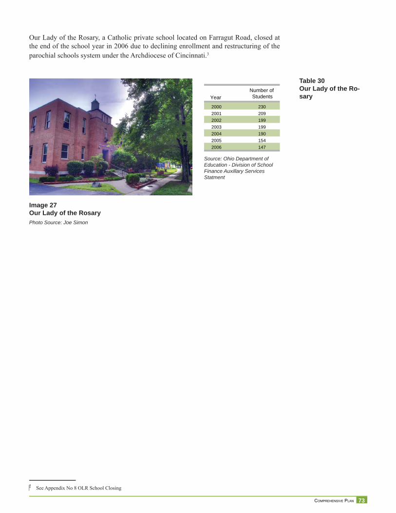
73 COMPREHENSIVE PLAN
Our Lady of the Rosary, a Catholic private school located on Farragut Road, closed at the end of the school year in 2006 due to declining enrollment and restructuring of the parochial schools system under the Archdiocese of Cincinnati.3
4 See Appendix No 8 OLR School Closing
YearNumber of Students
2000 2302001 2092002 1992003 1992004 1902005 1542006 147
Source: Ohio Department of Education - Division of School Finance Auxillary Services Statment
Table 30Our Lady of the Ro-sary
Image 27Our Lady of the RosaryPhoto Source: Joe Simon
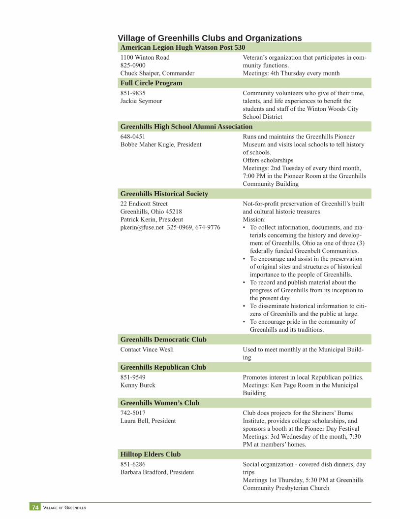
74 VILLAGE OF GREENHILLS
American Legion Hugh Watson Post 5301100 Winton Road825-0900Chuck Shaiper, Commander
Veteran’s organization that participates in com-munity functions.Meetings: 4th Thursday every month
Full Circle Program851-9835Jackie Seymour
Community volunteers who give of their time, talents, and life experiences to benefi t the students and staff of the Winton Woods City School District
Greenhills High School Alumni Association648-0451Bobbe Maher Kugle, President
Runs and maintains the Greenhills Pioneer Museum and visits local schools to tell history of schools.Offers scholarshipsMeetings: 2nd Tuesday of every third month, 7:00 PM in the Pioneer Room at the Greenhills Community Building
Greenhills Historical Society22 Endicott StreetGreenhills, Ohio 45218Patrick Kerin, [email protected] 325-0969, 674-9776
Not-for-profi t preservation of Greenhill’s built and cultural historic treasuresMission:
To collect information, documents, and ma-terials concerning the history and develop-ment of Greenhills, Ohio as one of three (3) federally funded Greenbelt Communities.To encourage and assist in the preservation of original sites and structures of historical importance to the people of Greenhills.To record and publish material about the progress of Greenhills from its inception to the present day.To disseminate historical information to citi-zens of Greenhills and the public at large.To encourage pride in the community of Greenhills and its traditions.
•
•
•
•
•
Greenhills Democratic ClubContact Vince Wesli Used to meet monthly at the Municipal Build-
ingGreenhills Republican Club851-9549Kenny Burck
Promotes interest in local Republican politics.Meetings: Ken Page Room in the Municipal Building
Greenhills Women’s Club742-5017Laura Bell, President
Club does projects for the Shriners’ Burns Institute, provides college scholarships, and sponsors a booth at the Pioneer Day FestivalMeetings: 3rd Wednesday of the month, 7:30 PM at members’ homes.
Hilltop Elders Club851-6286Barbara Bradford, President
Social organization - covered dish dinners, day tripsMeetings 1st Thursday, 5:30 PM at Greenhills Community Presbyterian Church
Village of Greenhills Clubs and Organizations
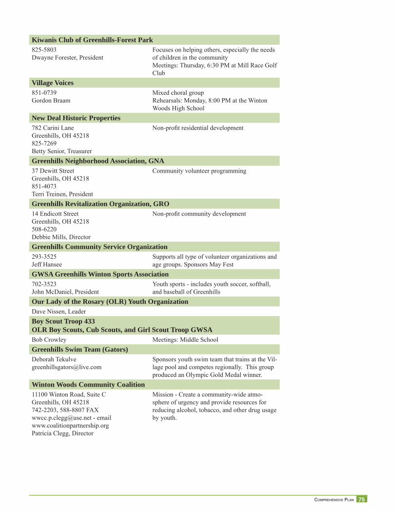
75 COMPREHENSIVE PLAN
Kiwanis Club of Greenhills-Forest Park825-5803Dwayne Forester, President
Focuses on helping others, especially the needs of children in the communityMeetings: Thursday, 6:30 PM at Mill Race Golf Club
Village Voices851-0739Gordon Braam
Mixed choral groupRehearsals: Monday, 8:00 PM at the Winton Woods High School
New Deal Historic Properties782 Carini LaneGreenhills, OH 45218825-7269Betty Senior, Treasurer
Non-profi t residential development
Greenhills Neighborhood Association, GNA37 Dewitt StreetGreenhills, OH 45218851-4073Terri Treinen, President
Community volunteer programming
Greenhills Revitalization Organization, GRO14 Endicott StreetGreenhills, OH 45218508-6220Debbie Mills, Director
Non-profi t community development
Greenhills Community Service Organization293-3525Jeff Hansee
Supports all type of volunteer organizations and age groups. Sponsors May Fest
GWSA Greenhills Winton Sports Association702-3523John McDaniel, President
Youth sports - includes youth soccer, softball, and baseball of Greenhills
Our Lady of the Rosary (OLR) Youth OrganizationDave Nissen, LeaderBoy Scout Troop 433OLR Boy Scouts, Cub Scouts, and Girl Scout Troop GWSABob Crowley Meetings: Middle SchoolGreenhills Swim Team (Gators)Deborah [email protected]
Sponsors youth swim team that trains at the Vil-lage pool and competes regionally. This group produced an Olympic Gold Medal winner.
Winton Woods Community Coalition11100 Winton Road, Suite CGreenhills, OH 45218742-2203, 588-8807 [email protected] - emailwww.coalitionpartnership.orgPatricia Clegg, Director
Mission - Create a community-wide atmo-sphere of urgency and provide resources for reducing alcohol, tobacco, and other drug usage by youth.
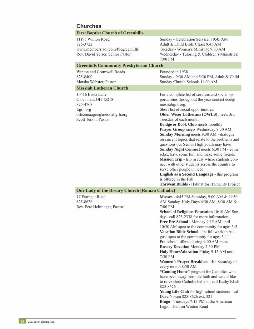
76 VILLAGE OF GREENHILLS
ChurchesFirst Baptist Church of Greenhills11195 Winton Road825-3722www.members.aol.com/fbcgreenhillsRev. David Yeiser, Senior Pastor
Sunday - Celebration Service: 10:45 AMAdult & Child Bible Class: 9:45 AMTuesday - Women’s Ministry: 9:30 AMWednesday - Tutoring & Children’s Ministries: 7:00 PM
Greenhills Community Presbyterian ChurchWinton and Cromwell Roads825-8400Marsha Webster, Pastor
Founded in 1938Sunday - 9:30 AM and 5:30 PM, Adult & Child Sunday Church School: 11:00 AM
Messiah Lutheran Church10416 Bossi LaneCincinnati, OH 45218825-4768Egrh.orgoffi [email protected] Tessin, Pastor
For a complete list of services and social op-portunities throughout the year contact [email protected] list of social opportunities:Older Wiser Lutherans (OWLS) meets 3rd Tuesday of each monthBridge or Book Club meets monthlyPrayer Group meets Wednesday 9:30 AMSunday Morning meets 9:30 AM - dialogue on current topics that relate to the problems and questions our Senior High youth may haveSunday Night Connect meets 6:30 PM - come relax, have some fun, and make some friendsMission Trip - trip in July where students con-nect with other students across the country to serve other people in needEnglish as a Second Language - this program is offered in the FallThrivent Builds - Habitat for Humanity Project
Our Lady of the Rosary Church (Roman Catholic)17 Farragut Road825-8626Rev. Pete Helminger, Pastor
Masses - 4:45 PM Saturday, 9:00 AM & 11:30 AM Sunday, Holy Days 6:30 AM, 8:30 AM & 7:00 PMSchool of Religious Education 10:10 AM Sun-day - call 825-2338 for more informationFree Pre-School - Monday 9:15 AM until 10:30 AM open to the community for ages 3-5Vacation Bible School - 1st full week in Au-gust open to the community for ages 3-11Pre-school offered during 9:00 AM massRosary Devotion Monday 7:30 PMHoly Hour/Adoration Friday 9:15 AM until 7:30 PMWomen’s Prayer Breakfast - 4th Saturday of every month 8:30 AM“Coming Home” program for Catholics who have been away from the faith and would like to re-explore Catholic beliefs - call Kathy Klich 825-8626Young Life Club for high school students - call Dave Nissen 825-8626 ext. 321Bingo - Tuesdays 7:15 PM at the American Legion Hall on Winton Road
77 COMPREHENSIVE PLAN
Par
t II
Community Input
Vision for the Future

78 VILLAGE OF GREENHILLS
79 COMPREHENSIVE PLAN
Community IssuesOn December 3, 2008, the Village of Greenhills hosted a community meeting at Molloy’s on the Green Banquet Hall. Stakeholders identifi ed what they saw as the Village’s strengths, opportunities, weaknesses and threats. Participants were also asked to select or “vote” for what issue, idea, or statement was the most important to them. The Greenhills Planning Committee reviewed the comments, sorted them out, and consolidated them in manageable groups with homogeneous themes. The themes are listed from the most “voted” to the least one.
Strengths: those assets we want to maintain, build, and leverage:• Green space, greenbelt and parks: surrounded by green• Greenhills: the small town feel• Government and community services: Volunteer Fire Department, great Police
Department, Community services, Recreation Complex/services, Infrastructure• Federal Government Planned Community: history and design• Location and accessibility• Safety: low crime• Pedestrian friendly: walkable community• Urban design of the community and its adaptability to “new urbanism”• Destination retail and services: library, post offi ce, pool, Commons, places of
worship• Diverse and affordable housing
Weaknesses: those situations or issues we want to remedy or exit:• Business district: Vacant Johnny’s Toys, and physical condition of shopping center,
underutilized space and lack of businesses that cater to local residents (grocery, gas station)
• Property maintenance: [lack of] enforcement of codes that result in poor condition of properties
• Housing: too many housing turning into low-rent investment properties, aging housing stock that cannot easily be modernized, Dewitt Landing/Potterhill housing
• Education/Schools• Public facilities and services: upkeep and maintenance of parks and public places,
accessibility issues for seniors• Sources of revenues: taxes are too high, there is not enough commercial tax base• Public Image/Branding: lack of a public identity/recognition, beautifi cation of
Commons area• Declining population in an aging community• Greenhills defi ned: small mindedness, unwelcomed new residents, division
Opportunities: those resources, events, and leads we want to take advantage of:• Business district redevelopment: Johnny’s Toys and underutilized shopping center
present many opportunities for redevelopment• Public image/Branding: build a stronger public image by reinforcing “street” appeal
(Winton Road), the history of the Village, and reinforcing the “new urbanism” characteristics of the community
• Infrastructure: beautifi cation (new town square, Commons), improve sidewalks, bike paths/walking trails, youth activity center, expanding library and parks. Wireless internet
• Housing: redevelop residential areas, newer infi ll house, more owner-occupied, OLR into housing
80 VILLAGE OF GREENHILLS
• Activities/ events: activities for seniors, farmers’ market• Education/ schools: adult education, charter school, improve schools• Redevelopment sites: Damon & Winton corner, OLR, unused green space, lower fi elds
behind middle school
Threats: those situations and trends we want to counter• Image and branding: deterioration of Greenhills and surrounding communities, losing
historic district, resistance to change• Housing: functionality of housing, decrease in housing value, lack of property
maintenance• Revenue sources: not enough of a tax base to pay for municipal services, state and
federal government funds cut to local governments, higher taxes• Population trend: aging population, no new families to replace them, decreasing
median income• Education/schools: school district performance and declining studetn enrollment a
threat to property value• Business district unattractive as a destination: shopping center• Infrastructure: aging infrastructure, lack of community transportation• National trends: potential state library cuts, eminent domain, regionalization, and
metrogoverment
On March 26, 2009, a second community-wide meeting was held at Molloy’s on the Green. The event that gathered over 120 people allowed Greenhills stakeholders to review a draft of a Vision for the future, and provide feedback on preliminary goals and strategies for implementation. Participants showed vivid interest in the proposed ideas. Some comments and suggestions made it clear that there were, on certain issues, divergent points of view. It was decided to provide stakeholders the opportunity to come together and discuss at length those issues.
On May 21, 2009, three focus group sessions were held at the Community Building. The sessions centered on the following topics: Housing and Historic Preservation, Greenbelt, and the Village Center. The purpose of the meetings was to fi nd the common ground on seemingly confl icting aspirations of the community to base fi nal recommendations for the Village.
For example, there has been a movement to designate part of the Village as a Historic District. A couple of questions arose: how to balance a historic district designation with the expressed interest to promote infi ll housing? Is there a legitimate reason for property owners to fear restrictions that a historic district designation may bring? What is the price residents and property owners are willing to pay to bear the honor of a historic district designation? What are the possible fi nancial gains?
The “greenbelt” evokes images of a continuous belt of undeveloped land and lush vegetation around the village of Greenhills. In ownership terms, the greenbelt is not continuous, but a patchwork of numerous owners, including individual property owners, business owners, the school district, the park district, churches, and the village. To complicate the picture more, there is a “greenbelt” zoning district designation that includes not only the “belt” but also the land along Winton Road, and in the heart of the community, the golf course/recreation complex area. On the other hand, Winton Woods Park completely surrounds the Village and is the true and even larger greenbelt of Greenhills. However, when Greenhills residents say “preserve the greenbelt,” what does it mean? Who is responsible? What are the costs to maintain the greenbelt? Do you treat differently the land along Winton Road and in the golf course?
81 COMPREHENSIVE PLAN
The concept of a “Village Center” seeks to create a central hub of community life that includes the shopping center, the recreation complex, the commons, the buildings that frame the commons, the Winton Road Corridor, and the adjacent residences. The “center” is conceived as a mixed use development where higher densities are allowed in designated areas. What does it mean to be the “Center” of the Village? What should a resident expect from the “center?” How can current business owners partner with the Village and the Park District to grow business? How to develop a win-win relationship between Greenhills business center/community and Winton Woods and the Park District? What can the Village do to foster redevelopment of the area?
Participants included residents and property owners from the historic district, historic preservation consultants, property owners of parcels located in the greenbelt, property owners of parcels located in the “village center,” business owners and business operators, representatives from the school district and the park district, green development designers, elected and appointed offi cials, steering committee members, and guests from Milford (for the community’s experience in creating an inviting atmosphere for development in the Historic Milford district) and Glendale (for the community’s experience in creating and administering Historic District guidelines).
It is important to note that residents are passionate about schools. Some have expressed interest and concerns about public schools: their location, performance, consideration to secede, suggestions to create a charter school, among others. Realisticly, the Village of Greenhills has no power or control over the Winton Woods City School District. The School District is, by Ohio Revised Code, a separate entity, with its own boundaries, taxing powers, rules and regulations, and elected leaders who sit on the Board of Education. It was suggested that residents work within the School District structure to lobby for any desired changes. At this point, the Village of Greenhills acknowledges the importance of a successful school for the community, and will continue to strengthen communication and collaboration with the School District for the benefi t of its residents.
82 VILLAGE OF GREENHILLS
After thorough consideration of the community input; evaluation of existing conditions, experts’ presentations and readings on trends (socioeconomics, development, zoning, communications, technology, and more); and lengthy discussions of what Greenhills should be in the future, the Steering Committee crafted a Vision for the Future. It is the intent that this long-term vision sets the tone for the implementation of strategies that, in a cumulative effect, will fulfi ll the picture envisioned of Greenhills in 2029.
Collective Vision Greenhills – 2029Greenhills, a National Historic Landmark, is a progressive community that seamlessly connects strong neighborhoods to a vibrant Village Center and the natural environment. The Village embraces its tradition of innovative planning, design and sensitivity to the environment.
Commerce within the Village is a key component to the community’s quality of life and ongoing fi nancial stability. At the heart of Greenhills is a vibrant, welcoming, mixed-use Village Center where citizens have access to a variety of shopping and cultural opportunities. Eco-friendly, sustainable buildings populate the Village Center, providing a broad range of employment opportunities.
The Village is a friendly, well-maintained, and accessible community where neighbors are active, caring, and informed. Families and residents of all ages enjoy parks, public spaces, tree-lined streets, neighborhood events, and places of worship, volunteer opportunities, safe neighborhoods, and recreational, art, and cultural amenities. The Village supports, recognizes and utilizes the time and talents of its residents and organizations; and helps shape and form the community now and in the future.
The Village works in unison with public and private entities to foster a commitment to high quality education. Volunteers and citizens work to provide exceptional educational opportunities for all ages. Innovative school facilities and programs play an integral part in the cultural and civic life of the community.
The Village of Greenhills is an inviting residential community that offers a wide variety of sustainable housing choices that meets the needs of residents of all ages. A system of pedestrian paths and walkways links historic and new neighborhoods. The Village offers a small town feel and strong sense of community.
The Village of Greenhills invests in its open spaces, parks, recreation programs, tree-lined streets, walkways, and community services. Greenhills leads by example and is widely recognized for its distinguished police, volunteer fi re, and administrative services. The Village is responsive to the needs of its citizens and encourages active public involvement. Bicyclists and pedestrians can easily reach adjacent communities and Winton Woods-Hamilton County Park.
Redevelopment in Greenhills is characterized by its practice of mixing retail, housing and offi ce spaces which maximizes the use of available land resulting in a stable and diverse local economy. Best practices have streamlined the development process fostering increased interest in the overall redevelopment effort. Innovative developments and alternative modes of mobility have renewed the interest in inherent benefi ts of community focal points.
83 COMPREHENSIVE PLAN
Par
t III
Recommendations

84 VILLAGE OF GREENHILLS
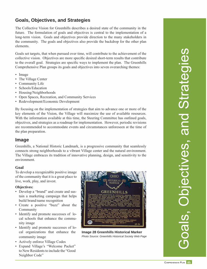
85 COMPREHENSIVE PLAN
Goals, Objectives, and StrategiesThe Collective Vision for Greenhills describes a desired state of the community in the future. The formulation of goals and objectives is central to the implementation of a long-term vision. Goals and objectives provide direction to the many stakeholders in the community. The goals and objectives also provide the backdrop for the other plan elements.
Goals set targets, that when pursued over time, will contribute to the achievement of the collective vision. Objectives are more specifi c desired short-term results that contribute to the overall goal. Strategies are specifi c ways to implement the plan. The Greenhills Comprehensive Plan groups its goals and objectives into seven overarching themes:
• Image• The Village Center• Community Life• Schools/Education• Housing/Neighborhoods• Open Spaces, Recreation, and Community Services• Redevelopment/Economic Development
By focusing on the implementation of strategies that aim to advance one or more of the key elements of the Vision, the Village will maximize the use of available resources. With the information available at this time, the Steering Committee has outlined goals, objectives, and strategies as a roadmap for implementation. However, periodic revisions are recommended to accommodate events and circumstances unforeseen at the time of the plan preparation.
ImageGreenhills, a National Historic Landmark, is a progressive community that seamlessly connects strong neighborhoods to a vibrant Village center and the natural environment. The Village embraces its tradition of innovative planning, design, and sensitivity to the environment.
GoalTo develop a recognizable positive image of the community that it is a great place to live, work, play, and invest. Objectives:• Develop a “brand” and create and sus-
tain a marketing campaign that helps build brand/name recognition
• Create a positive “buzz” about the Community
• Identify and promote successes of lo-cal schools that enhance the commu-nity image
• Identify and promote successes of lo-cal organizations that enhance the community image
• Actively enforce Village Codes• Expand Village’s “Welcome Packet”
to New Residents to include the “Good Neighbor Code”
Image 28 Greenhills Historical MarkerPhoto Source: Greenhills Historical Society Web Page
Goa
ls, O
bjec
tives
, and
Stra
tegi
es
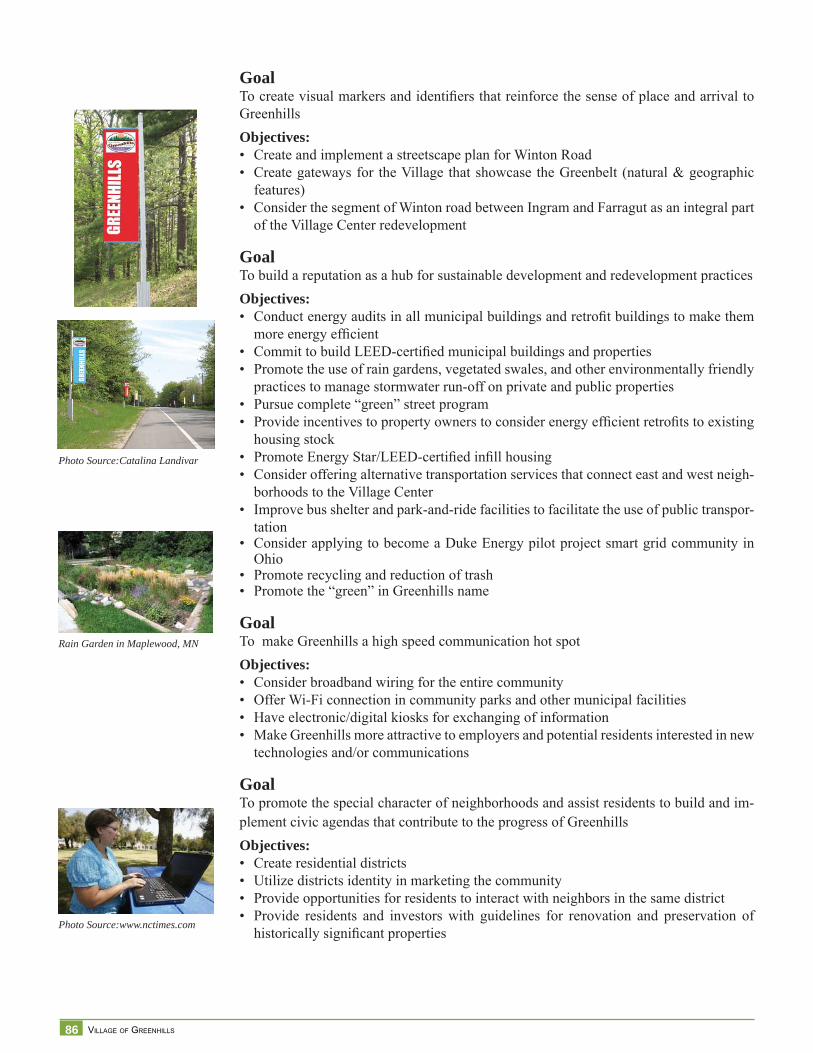
86 VILLAGE OF GREENHILLS
GoalTo create visual markers and identifi ers that reinforce the sense of place and arrival to Greenhills Objectives:• Create and implement a streetscape plan for Winton Road• Create gateways for the Village that showcase the Greenbelt (natural & geographic
features)• Consider the segment of Winton road between Ingram and Farragut as an integral part
of the Village Center redevelopment
GoalTo build a reputation as a hub for sustainable development and redevelopment practices Objectives:• Conduct energy audits in all municipal buildings and retrofi t buildings to make them
more energy effi cient• Commit to build LEED-certifi ed municipal buildings and properties• Promote the use of rain gardens, vegetated swales, and other environmentally friendly
practices to manage stormwater run-off on private and public properties• Pursue complete “green” street program• Provide incentives to property owners to consider energy effi cient retrofi ts to existing
housing stock• Promote Energy Star/LEED-certifi ed infi ll housing• Consider offering alternative transportation services that connect east and west neigh-
borhoods to the Village Center• Improve bus shelter and park-and-ride facilities to facilitate the use of public transpor-
tation• Consider applying to become a Duke Energy pilot project smart grid community in
Ohio• Promote recycling and reduction of trash• Promote the “green” in Greenhills name
GoalTo make Greenhills a high speed communication hot spot Objectives:• Consider broadband wiring for the entire community• Offer Wi-Fi connection in community parks and other municipal facilities• Have electronic/digital kiosks for exchanging of information• Make Greenhills more attractive to employers and potential residents interested in new
technologies and/or communications
GoalTo promote the special character of neighborhoods and assist residents to build and im-plement civic agendas that contribute to the progress of GreenhillsObjectives:• Create residential districts • Utilize districts identity in marketing the community• Provide opportunities for residents to interact with neighbors in the same district• Provide residents and investors with guidelines for renovation and preservation of
historically signifi cant properties
Photo Source:Catalina Landivar
Rain Garden in Maplewood, MN
Photo Source:www.nctimes.com
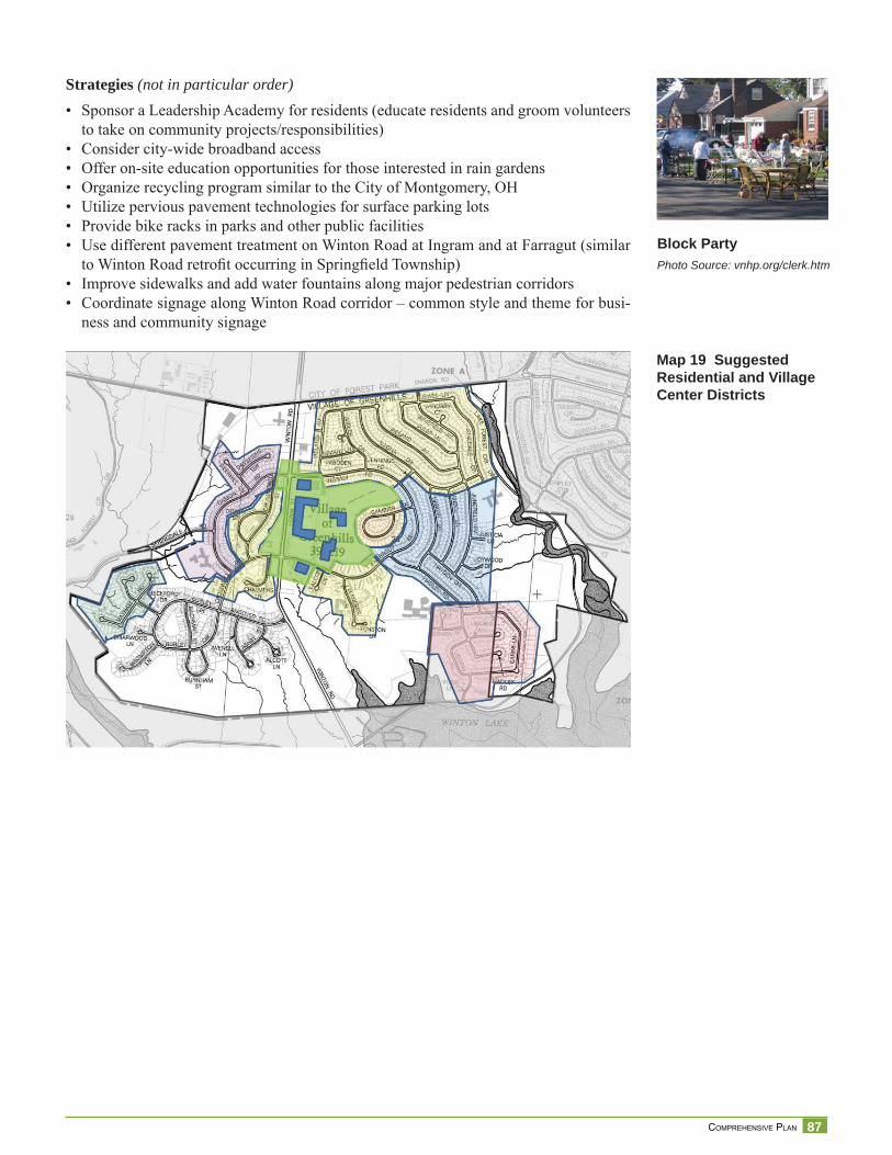
87 COMPREHENSIVE PLAN
Strategies (not in particular order)• Sponsor a Leadership Academy for residents (educate residents and groom volunteers
to take on community projects/responsibilities)• Consider city-wide broadband access • Offer on-site education opportunities for those interested in rain gardens• Organize recycling program similar to the City of Montgomery, OH• Utilize pervious pavement technologies for surface parking lots• Provide bike racks in parks and other public facilities• Use different pavement treatment on Winton Road at Ingram and at Farragut (similar
to Winton Road retrofi t occurring in Springfi eld Township)• Improve sidewalks and add water fountains along major pedestrian corridors• Coordinate signage along Winton Road corridor – common style and theme for busi-
ness and community signage
Block PartyPhoto Source: vnhp.org/clerk.htm
Map 19 Suggested Residential and Village Center Districts
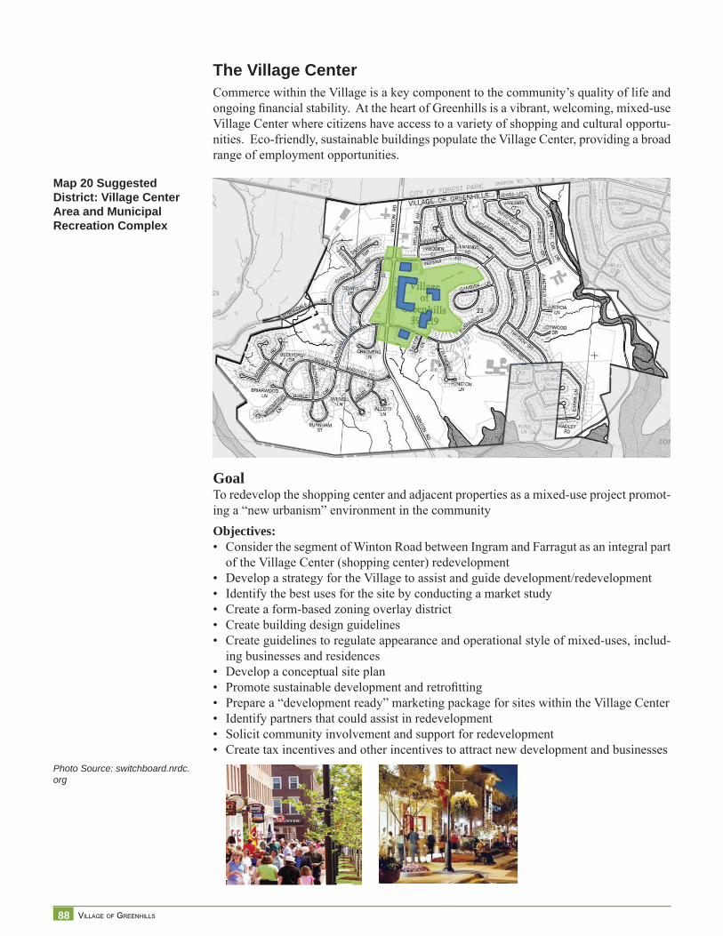
88 VILLAGE OF GREENHILLS
The Village CenterCommerce within the Village is a key component to the community’s quality of life and ongoing fi nancial stability. At the heart of Greenhills is a vibrant, welcoming, mixed-use Village Center where citizens have access to a variety of shopping and cultural opportu-nities. Eco-friendly, sustainable buildings populate the Village Center, providing a broad range of employment opportunities.
GoalTo redevelop the shopping center and adjacent properties as a mixed-use project promot-ing a “new urbanism” environment in the communityObjectives: • Consider the segment of Winton Road between Ingram and Farragut as an integral part
of the Village Center (shopping center) redevelopment• Develop a strategy for the Village to assist and guide development/redevelopment• Identify the best uses for the site by conducting a market study • Create a form-based zoning overlay district• Create building design guidelines• Create guidelines to regulate appearance and operational style of mixed-uses, includ-
ing businesses and residences• Develop a conceptual site plan• Promote sustainable development and retrofi tting• Prepare a “development ready” marketing package for sites within the Village Center• Identify partners that could assist in redevelopment• Solicit community involvement and support for redevelopment• Create tax incentives and other incentives to attract new development and businesses
Map 20 Suggested District: Village Center Area and Municipal Recreation Complex
Photo Source: switchboard.nrdc.org
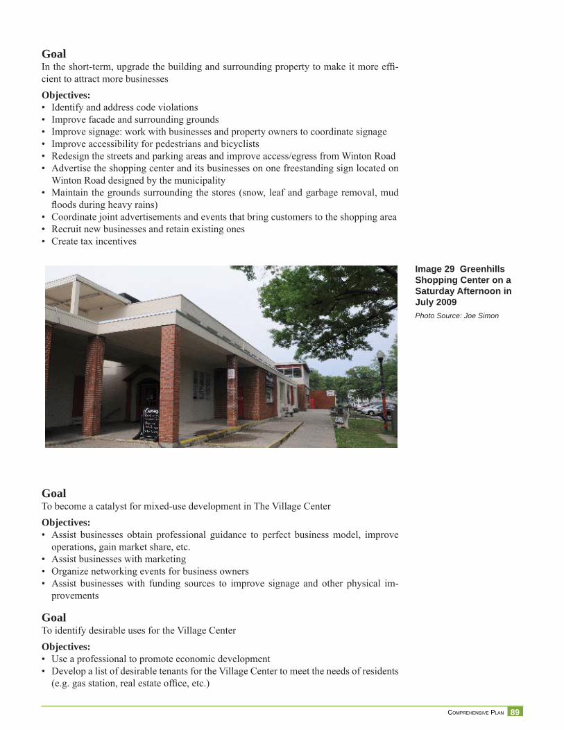
89 COMPREHENSIVE PLAN
GoalIn the short-term, upgrade the building and surrounding property to make it more effi -cient to attract more businessesObjectives:• Identify and address code violations• Improve facade and surrounding grounds• Improve signage: work with businesses and property owners to coordinate signage• Improve accessibility for pedestrians and bicyclists • Redesign the streets and parking areas and improve access/egress from Winton Road• Advertise the shopping center and its businesses on one freestanding sign located on
Winton Road designed by the municipality• Maintain the grounds surrounding the stores (snow, leaf and garbage removal, mud fl oods during heavy rains)
• Coordinate joint advertisements and events that bring customers to the shopping area• Recruit new businesses and retain existing ones• Create tax incentives
GoalTo become a catalyst for mixed-use development in The Village CenterObjectives:• Assist businesses obtain professional guidance to perfect business model, improve
operations, gain market share, etc.• Assist businesses with marketing• Organize networking events for business owners• Assist businesses with funding sources to improve signage and other physical im-
provements
GoalTo identify desirable uses for the Village CenterObjectives:• Use a professional to promote economic development • Develop a list of desirable tenants for the Village Center to meet the needs of residents
(e.g. gas station, real estate offi ce, etc.)
Image 29 Greenhills Shopping Center on a Saturday Afternoon in July 2009Photo Source: Joe Simon
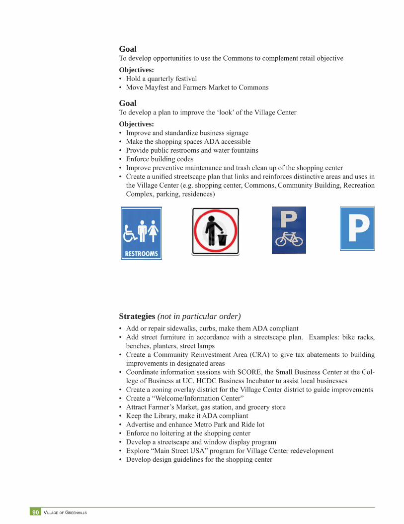
90 VILLAGE OF GREENHILLS
GoalTo develop opportunities to use the Commons to complement retail objectiveObjectives:• Hold a quarterly festival• Move Mayfest and Farmers Market to Commons
GoalTo develop a plan to improve the ‘look’ of the Village CenterObjectives:• Improve and standardize business signage• Make the shopping spaces ADA accessible• Provide public restrooms and water fountains• Enforce building codes • Improve preventive maintenance and trash clean up of the shopping center• Create a unifi ed streetscape plan that links and reinforces distinctive areas and uses in
the Village Center (e.g. shopping center, Commons, Community Building, Recreation Complex, parking, residences)
Strategies (not in particular order)• Add or repair sidewalks, curbs, make them ADA compliant• Add street furniture in accordance with a streetscape plan. Examples: bike racks,
benches, planters, street lamps• Create a Community Reinvestment Area (CRA) to give tax abatements to building
improvements in designated areas• Coordinate information sessions with SCORE, the Small Business Center at the Col-
lege of Business at UC, HCDC Business Incubator to assist local businesses• Create a zoning overlay district for the Village Center district to guide improvements• Create a “Welcome/Information Center”• Attract Farmer’s Market, gas station, and grocery store• Keep the Library, make it ADA compliant• Advertise and enhance Metro Park and Ride lot• Enforce no loitering at the shopping center• Develop a streetscape and window display program• Explore “Main Street USA” program for Village Center redevelopment• Develop design guidelines for the shopping center
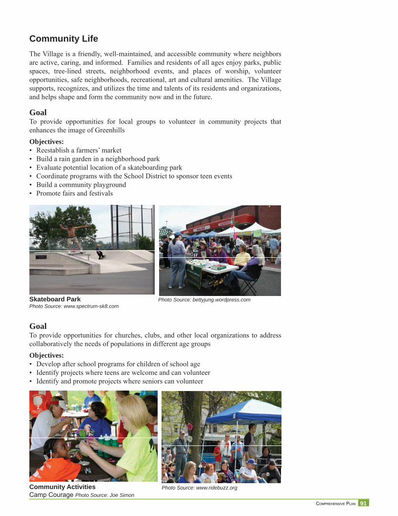
91 COMPREHENSIVE PLAN
Community LifeThe Village is a friendly, well-maintained, and accessible community where neighbors are active, caring, and informed. Families and residents of all ages enjoy parks, public spaces, tree-lined streets, neighborhood events, and places of worship, volunteer opportunities, safe neighborhoods, recreational, art and cultural amenities. The Village supports, recognizes, and utilizes the time and talents of its residents and organizations, and helps shape and form the community now and in the future.
GoalTo provide opportunities for local groups to volunteer in community projects that enhances the image of GreenhillsObjectives:• Reestablish a farmers’ market• Build a rain garden in a neighborhood park• Evaluate potential location of a skateboarding park• Coordinate programs with the School District to sponsor teen events• Build a community playground• Promote fairs and festivals
GoalTo provide opportunities for churches, clubs, and other local organizations to address collaboratively the needs of populations in different age groupsObjectives:• Develop after school programs for children of school age• Identify projects where teens are welcome and can volunteer• Identify and promote projects where seniors can volunteer
Skateboard ParkPhoto Source: www.spectrum-sk8.com
Community Activities Camp Courage Photo Source: Joe Simon
Photo Source: www.ridebuzz.org
Photo Source: bettyjung.wordpress.com
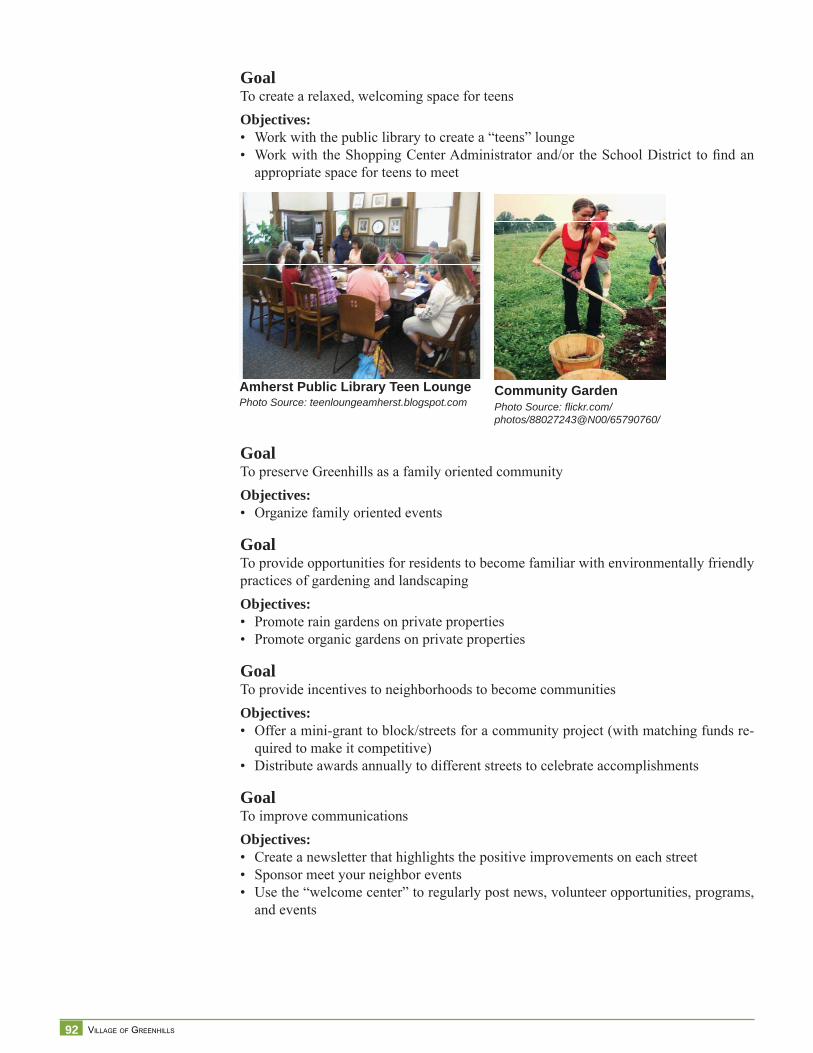
92 VILLAGE OF GREENHILLS
Community GardenPhoto Source: fl ickr.com/photos/88027243@N00/65790760/
Amherst Public Library Teen LoungePhoto Source: teenloungeamherst.blogspot.com
GoalTo create a relaxed, welcoming space for teensObjectives:• Work with the public library to create a “teens” lounge• Work with the Shopping Center Administrator and/or the School District to fi nd an
appropriate space for teens to meet
Goal To preserve Greenhills as a family oriented communityObjectives:• Organize family oriented events
GoalTo provide opportunities for residents to become familiar with environmentally friendly practices of gardening and landscapingObjectives:• Promote rain gardens on private properties• Promote organic gardens on private properties
GoalTo provide incentives to neighborhoods to become communities Objectives:• Offer a mini-grant to block/streets for a community project (with matching funds re-
quired to make it competitive)• Distribute awards annually to different streets to celebrate accomplishments
GoalTo improve communicationsObjectives:• Create a newsletter that highlights the positive improvements on each street• Sponsor meet your neighbor events• Use the “welcome center” to regularly post news, volunteer opportunities, programs,
and events
93 COMPREHENSIVE PLAN
Goal Greenhills is a community where its citizens can age in placeObjectives:• Create a senior center• Continue to support programs for active older adults
GoalTo raise funds to pay for community events and programsObjectives:• Offer annual grants to selected programs • Fund a volunteer coordinator position
GoalTo collaborate with the School District to improve the education conditions and opportunities of Greenhills residentsObjectives:• Create a Community-Parents-Teacher Association (so people who do not have children
in the school district can still play an active role in improving the education system)• Create a mentor program so every Greenhills student is set to excel
GoalTo diversify recreation and performing arts opportunities within the VillageObjectives:• Support school district projects to preserve/maintain/upgrade the Community Building
(e.g., Performing Arts Center
Strategies (not in any particular order)• Sponsor a Leadership Academy for residents (educate residents and groom volunteers
to take on community projects/responsibilities)• Create a “clearing house” of volunteer opportunities for teens and other Greenhills
residents• Create a fair and events committee• Create a volunteer coordinator position• Build a community park using the Thousand Hands method• Promote block/street parties• Have block/street groups to compete at an annual festival• Utilize the Commons more • Identify activities appropriate for every age bracket• Evaluate retrofi tting community building’s basketball court as a performing arts
center
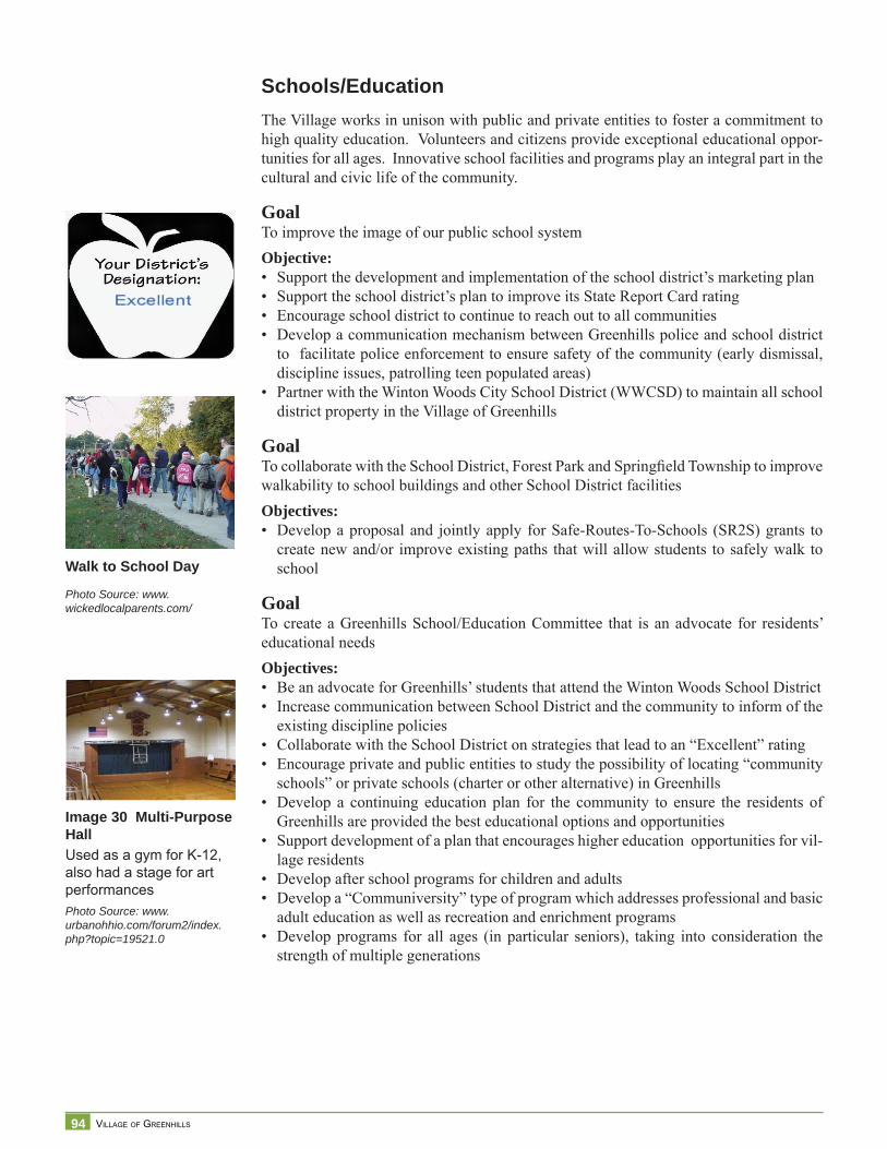
94 VILLAGE OF GREENHILLS
Image 30 Multi-Purpose HallUsed as a gym for K-12, also had a stage for art performancesPhoto Source: www.urbanohhio.com/forum2/index.php?topic=19521.0
Walk to School Day
Photo Source: www.wickedlocalparents.com/
Schools/EducationThe Village works in unison with public and private entities to foster a commitment to high quality education. Volunteers and citizens provide exceptional educational oppor-tunities for all ages. Innovative school facilities and programs play an integral part in the cultural and civic life of the community.
GoalTo improve the image of our public school systemObjective:• Support the development and implementation of the school district’s marketing plan• Support the school district’s plan to improve its State Report Card rating• Encourage school district to continue to reach out to all communities• Develop a communication mechanism between Greenhills police and school district
to facilitate police enforcement to ensure safety of the community (early dismissal, discipline issues, patrolling teen populated areas)
• Partner with the Winton Woods City School District (WWCSD) to maintain all school district property in the Village of Greenhills
GoalTo collaborate with the School District, Forest Park and Springfi eld Township to improve walkability to school buildings and other School District facilitiesObjectives: • Develop a proposal and jointly apply for Safe-Routes-To-Schools (SR2S) grants to
create new and/or improve existing paths that will allow students to safely walk to school
GoalTo create a Greenhills School/Education Committee that is an advocate for residents’ educational needs Objectives: • Be an advocate for Greenhills’ students that attend the Winton Woods School District• Increase communication between School District and the community to inform of the
existing discipline policies• Collaborate with the School District on strategies that lead to an “Excellent” rating• Encourage private and public entities to study the possibility of locating “community
schools” or private schools (charter or other alternative) in Greenhills • Develop a continuing education plan for the community to ensure the residents of
Greenhills are provided the best educational options and opportunities• Support development of a plan that encourages higher education opportunities for vil-
lage residents• Develop after school programs for children and adults • Develop a “Communiversity” type of program which addresses professional and basic
adult education as well as recreation and enrichment programs • Develop programs for all ages (in particular seniors), taking into consideration the
strength of multiple generations
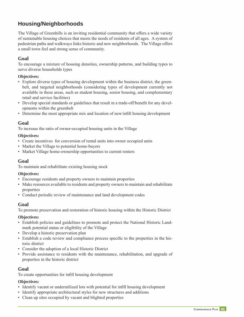
95 COMPREHENSIVE PLAN
Housing/NeighborhoodsThe Village of Greenhills is an inviting residential community that offers a wide variety of sustainable housing choices that meets the needs of residents of all ages. A system of pedestrian paths and walkways links historic and new neighborhoods. The Village offers a small town feel and strong sense of community.
GoalTo encourage a mixture of housing densities, ownership patterns, and building types to serve diverse households typesObjectives:• Explore diverse types of housing development within the business district, the green-
belt, and targeted neighborhoods (considering types of development currently not available in these areas, such as student housing, senior housing, and complementary retail and service facilities)
• Develop special standards or guidelines that result in a trade-off/benefi t for any devel-opments within the greenbelt
• Determine the most appropriate mix and location of new/infi ll housing development
GoalTo increase the ratio of owner-occupied housing units in the VillageObjectives:• Create incentives for conversion of rental units into owner occupied units• Market the Village to potential home-buyers• Market Village home-ownership opportunities to current renters
GoalTo maintain and rehabilitate existing housing stockObjectives:• Encourage residents and property owners to maintain properties• Make resources available to residents and property owners to maintain and rehabilitate
properties• Conduct periodic review of maintenance and land development codes
GoalTo promote preservation and restoration of historic housing within the Historic DistrictObjectives:• Establish policies and guidelines to promote and protect the National Historic Land-
mark potential status or eligibility of the Village• Develop a historic preservation plan• Establish a code review and compliance process specifi c to the properties in the his-
toric district• Consider the adoption of a local Historic District• Provide assistance to residents with the maintenance, rehabilitation, and upgrade of
properties in the historic district
GoalTo create opportunities for infi ll housing developmentObjectives:• Identify vacant or underutilized lots with potential for infi ll housing development• Identify appropriate architectural styles for new structures and additions • Clean up sites occupied by vacant and blighted properties
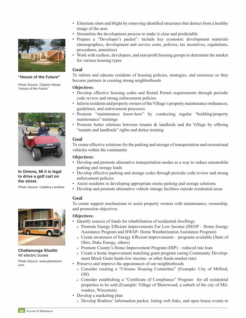
96 VILLAGE OF GREENHILLS
“House of the Future”
Photo Source: Clayton House“House of the Future”
In Omena, MI it is legal to drive a golf cart on the street.Photo Source: Catalina Landivar
Chattanooga ShuttleAll electric busesPhoto Source: www.planetizen.com
• Eliminate slum and blight by removing identifi ed structures that detract from a healthy image of the area
• Streamline the development process to make it clear and predictable• Prepare a “Developer’s packet”: include key economic development materials
(demographics, development and service costs, policies, tax incentives, regulations, procedures, amenities)
• Work with realtors, developers, and non-profi t housing groups to determine the market for various housing types
GoalTo inform and educate residents of housing policies, strategies, and resources so they become partners in creating strong neighborhoodsObjectives:• Develop effective housing codes and Rental Permit requirements through periodic
code review and strong enforcement policies• Inform residents and property owners of the Village’s property maintenance ordinances,
guidelines, and enforcement processes• Promote “maintenance know-how” by conducting regular “building/property
maintenance” trainings• Promote better relations between tenants & landlords and the Village by offering
“tenants and landlords” rights and duties training
GoalTo create effective solutions for the parking and storage of transportation and recreational vehicles within the communityObjectives:• Develop and promote alternative transportation modes as a way to reduce automobile
parking and storage loads• Develop effective parking and storage codes through periodic code review and strong
enforcement policies• Assist residents in developing appropriate onsite parking and storage solutions• Develop and promote alternative vehicle storage facilities outside residential areas
GoalTo create support mechanisms to assist property owners with maintenance, ownership, and promotion objectivesObjectives:• Identify sources of funds for rehabilitation of residential dwellings
o Promote Energy Effi cient improvements For Low Income (HEOP – Home Energy Assistance Program and HWAP- Home Weatherization Assistance Program)
o Create awareness of Energy Effi cient improvements – programs available (State of Ohio, Duke Energy, others)
o Promote County’s Home Improvement Program (HIP) – reduced rate loano Create a home improvement matching grant program (using Community Develop-
ment Block Grant funds-low income- or other funds-market rate)• Preserve and improve the appearances of our neighborhoods
o Consider creating a “Citizens Housing Committee” (Example: City of Milford, OH)
o Consider establishing a “Certifi cate of Compliance” Program for all residential properties to be sold (Example: Village of Shorewood, a suburb of the city of Mil-waukee, Wisconsin)
• Develop a marketing plano Develop Realtors’ information packet, listing web links, and open house events to

97 COMPREHENSIVE PLAN
introduce realtors to Village resources (amenities and services that help sell a prop-erty)
o Create a portfolio of amenities, services, and other benefi ts available to Greenhills residents
• Promote home “ownership” (property owners and renters)o Form partnerships with local employers to market the community to their employ-
eeso Create cash incentives for employees of local organizations, including the School
District, to relocate in Greenhills (Example: Columbus’ Nationwide Children’s Hospital $5K per employee)
o Create a Good Neighbor Next Door type of program
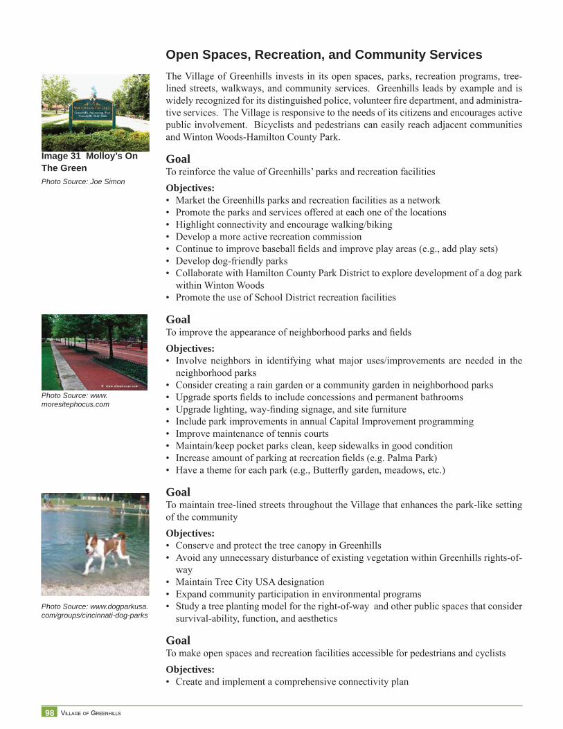
98 VILLAGE OF GREENHILLS
Image 31 Molloy’s On The GreenPhoto Source: Joe Simon
Photo Source: www.dogparkusa.com/groups/cincinnati-dog-parks
Open Spaces, Recreation, and Community ServicesThe Village of Greenhills invests in its open spaces, parks, recreation programs, tree-lined streets, walkways, and community services. Greenhills leads by example and is widely recognized for its distinguished police, volunteer fi re department, and administra-tive services. The Village is responsive to the needs of its citizens and encourages active public involvement. Bicyclists and pedestrians can easily reach adjacent communities and Winton Woods-Hamilton County Park.
GoalTo reinforce the value of Greenhills’ parks and recreation facilitiesObjectives:• Market the Greenhills parks and recreation facilities as a network• Promote the parks and services offered at each one of the locations• Highlight connectivity and encourage walking/biking• Develop a more active recreation commission • Continue to improve baseball fi elds and improve play areas (e.g., add play sets)• Develop dog-friendly parks• Collaborate with Hamilton County Park District to explore development of a dog park
within Winton Woods• Promote the use of School District recreation facilities
GoalTo improve the appearance of neighborhood parks and fi eldsObjectives:• Involve neighbors in identifying what major uses/improvements are needed in the
neighborhood parks• Consider creating a rain garden or a community garden in neighborhood parks• Upgrade sports fi elds to include concessions and permanent bathrooms• Upgrade lighting, way-fi nding signage, and site furniture• Include park improvements in annual Capital Improvement programming• Improve maintenance of tennis courts• Maintain/keep pocket parks clean, keep sidewalks in good condition• Increase amount of parking at recreation fi elds (e.g. Palma Park)• Have a theme for each park (e.g., Butterfl y garden, meadows, etc.)
GoalTo maintain tree-lined streets throughout the Village that enhances the park-like setting of the communityObjectives:• Conserve and protect the tree canopy in Greenhills• Avoid any unnecessary disturbance of existing vegetation within Greenhills rights-of-
way• Maintain Tree City USA designation• Expand community participation in environmental programs• Study a tree planting model for the right-of-way and other public spaces that consider
survival-ability, function, and aesthetics
GoalTo make open spaces and recreation facilities accessible for pedestrians and cyclistsObjectives:• Create and implement a comprehensive connectivity plan
Photo Source: www.moresitephocus.com
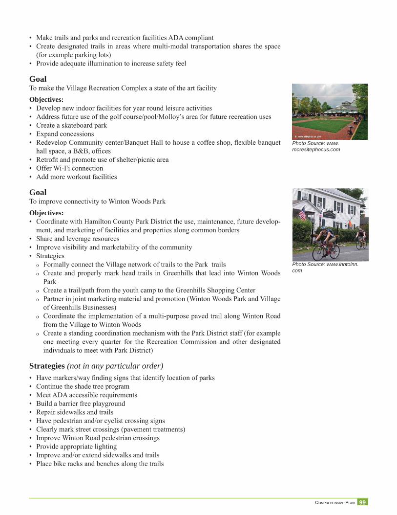
99 COMPREHENSIVE PLAN
• Make trails and parks and recreation facilities ADA compliant• Create designated trails in areas where multi-modal transportation shares the space
(for example parking lots)• Provide adequate illumination to increase safety feel
GoalTo make the Village Recreation Complex a state of the art facilityObjectives:• Develop new indoor facilities for year round leisure activities• Address future use of the golf course/pool/Molloy’s area for future recreation uses• Create a skateboard park• Expand concessions• Redevelop Community center/Banquet Hall to house a coffee shop, fl exible banquet
hall space, a B&B, offi ces• Retrofi t and promote use of shelter/picnic area• Offer Wi-Fi connection• Add more workout facilities
GoalTo improve connectivity to Winton Woods ParkObjectives:• Coordinate with Hamilton County Park District the use, maintenance, future develop-
ment, and marketing of facilities and properties along common borders• Share and leverage resources• Improve visibility and marketability of the community• Strategies
o Formally connect the Village network of trails to the Park trailso Create and properly mark head trails in Greenhills that lead into Winton Woods
Parko Create a trail/path from the youth camp to the Greenhills Shopping Centero Partner in joint marketing material and promotion (Winton Woods Park and Village
of Greenhills Businesses)o Coordinate the implementation of a multi-purpose paved trail along Winton Road
from the Village to Winton Woodso Create a standing coordination mechanism with the Park District staff (for example
one meeting every quarter for the Recreation Commission and other designated individuals to meet with Park District)
Strategies (not in any particular order)• Have markers/way fi nding signs that identify location of parks• Continue the shade tree program• Meet ADA accessible requirements• Build a barrier free playground• Repair sidewalks and trails• Have pedestrian and/or cyclist crossing signs• Clearly mark street crossings (pavement treatments)• Improve Winton Road pedestrian crossings• Provide appropriate lighting• Improve and/or extend sidewalks and trails• Place bike racks and benches along the trails
Photo Source: www.moresitephocus.com
Photo Source: www.inntoinn.com
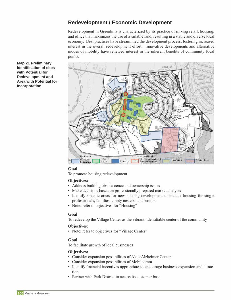
100 VILLAGE OF GREENHILLS
Redevelopment / Economic DevelopmentRedevelopment in Greenhills is characterized by its practice of mixing retail, housing, and offi ce that maximizes the use of available land, resulting in a stable and diverse local economy. Best practices have streamlined the development process, fostering increased interest in the overall redevelopment effort. Innovative developments and alternative modes of mobility have renewed interest in the inherent benefi ts of community focal points.
GoalTo promote housing redevelopmentObjectives:• Address building obsolescence and ownership issues• Make decisions based on professionally prepared market analysis• Identify specifi c areas for new housing development to include housing for single
professionals, families, empty nesters, and seniors• Note: refer to objectives for “Housing”
GoalTo redevelop the Village Center as the vibrant, identifi able center of the communityObjectives:• Note: refer to objectives for “Village Center”
GoalTo facilitate growth of local businessesObjectives:• Consider expansion possibilities of Alois Alzheimer Center• Consider expansion possibilities of Mobilcomm• Identify fi nancial incentives appropriate to encourage business expansion and attrac-
tion• Partner with Park District to access its customer base
Map 21 Preliminary Identifi cation of sites with Potential for Redevelopment and Area with Potential for Incorporation
101 COMPREHENSIVE PLAN
GoalTo identify acceptable revenue generating uses of lands in the greenbelt districtObjectives:• Review and evaluate Greenbelt district for potential development opportunities• Promote infi ll development, where appropriate, that increases density and revenues to
support the Village, the School District, and local businesses
GoalTo incorporate the Bastion Tract into the VillageObjectives:• Create awareness of the benefi ts of incorporation• Engage Bastion Tract property owners in conversation about annexation• Provide services to the area
GoalTo redevelop the Winton Woods corridor (on both sides of the road including Johnny’s Toys and shopping center) as a mixed retail, housing, offi ce and recreation space that is architecturally cohesive, enhances the image of Greenhills, and inreases Village’s re-sourcesObjectives:• Create a strategic economic development plan for the Winton Road Corridor utilizing
existing economic studies (i.e., HCDC plan, etc.)
102 VILLAGE OF GREENHILLS
Stra
tegi
esLand Use StrategiesGreenhills is looking ahead toward the redevelopment and reuse potential of certain ar-eas. Planning and/or infl uencing the future land use and development or redevelopment is one area where the Village of Greenhills has greater control than in other areas. How-ever, there are limits on what the Village can accomplish through zoning, the primary tool for land use plans. Specifi c recommendations are:
Planning• Create a future land use plan map and text that spells out the desired land use or reuse
of areas in the Village• Prepare detailed site specifi c land use plans for sub-areas, such as the Village Center
Redevelopment Plan, to address issues that this plan cannot address in detail• Prepare a streetscape plan for Winton Road Corridor• Prepare a map that identifi es the network of open spaces, parks and recreation facili-
ties
Zoning• Develop a new overlay historic district and design standards• Develop an overlay district for the Village Center that addresses mixed uses, higher
densities, connectivity (utilize form based code approach)• Develop an overlay district for the Winton Road Corridor• Develop zoning regulations that focus on the character of the neighborhoods• Develop standards and regulations that address the appearance and usage of the com-
mercial/shopping area of the Village Center• Evaluate and revise the greenbelt zoning district• Make necessary zoning map and text amendments to refl ect recommendations of this
plan
Plan Administration• Require commitment to attend Planning Commissioners’ Training to all who serve on
the Planning Commission or the Zoning Board of Appeals within the fi rst 6 months of appointment
• Develop and adopt a procedures manual and bylaws for the Planning Commission and Zoning Board of Appeals
• Meet annually to review progress, determine which objectives or strategies will be worked on over the upcoming year, and create benchmarks to measure progress
• Plan amendments and updates: review the plan every fi ve years or sooner if unforeseen events occur
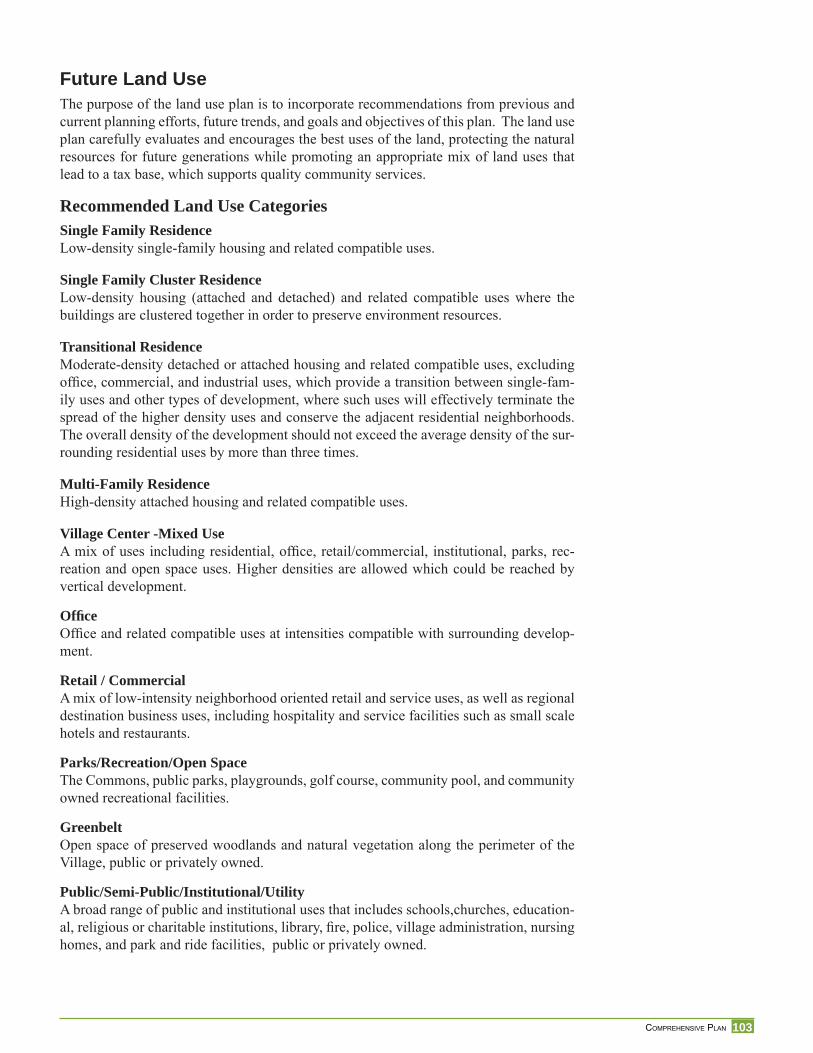
103 COMPREHENSIVE PLAN
Future Land UseThe purpose of the land use plan is to incorporate recommendations from previous and current planning efforts, future trends, and goals and objectives of this plan. The land use plan carefully evaluates and encourages the best uses of the land, protecting the natural resources for future generations while promoting an appropriate mix of land uses that lead to a tax base, which supports quality community services.
Recommended Land Use CategoriesSingle Family ResidenceLow-density single-family housing and related compatible uses.
Single Family Cluster ResidenceLow-density housing (attached and detached) and related compatible uses where the buildings are clustered together in order to preserve environment resources.
Transitional ResidenceModerate-density detached or attached housing and related compatible uses, excluding offi ce, commercial, and industrial uses, which provide a transition between single-fam-ily uses and other types of development, where such uses will effectively terminate the spread of the higher density uses and conserve the adjacent residential neighborhoods. The overall density of the development should not exceed the average density of the sur-rounding residential uses by more than three times.
Multi-Family ResidenceHigh-density attached housing and related compatible uses.
Village Center -Mixed UseA mix of uses including residential, offi ce, retail/commercial, institutional, parks, rec-reation and open space uses. Higher densities are allowed which could be reached by vertical development.
Offi ceOffi ce and related compatible uses at intensities compatible with surrounding develop-ment.
Retail / CommercialA mix of low-intensity neighborhood oriented retail and service uses, as well as regional destination business uses, including hospitality and service facilities such as small scale hotels and restaurants.
Parks/Recreation/Open SpaceThe Commons, public parks, playgrounds, golf course, community pool, and community owned recreational facilities.
GreenbeltOpen space of preserved woodlands and natural vegetation along the perimeter of the Village, public or privately owned.
Public/Semi-Public/Institutional/UtilityA broad range of public and institutional uses that includes schools,churches, education-al, religious or charitable institutions, library, fi re, police, village administration, nursing homes, and park and ride facilities, public or privately owned.
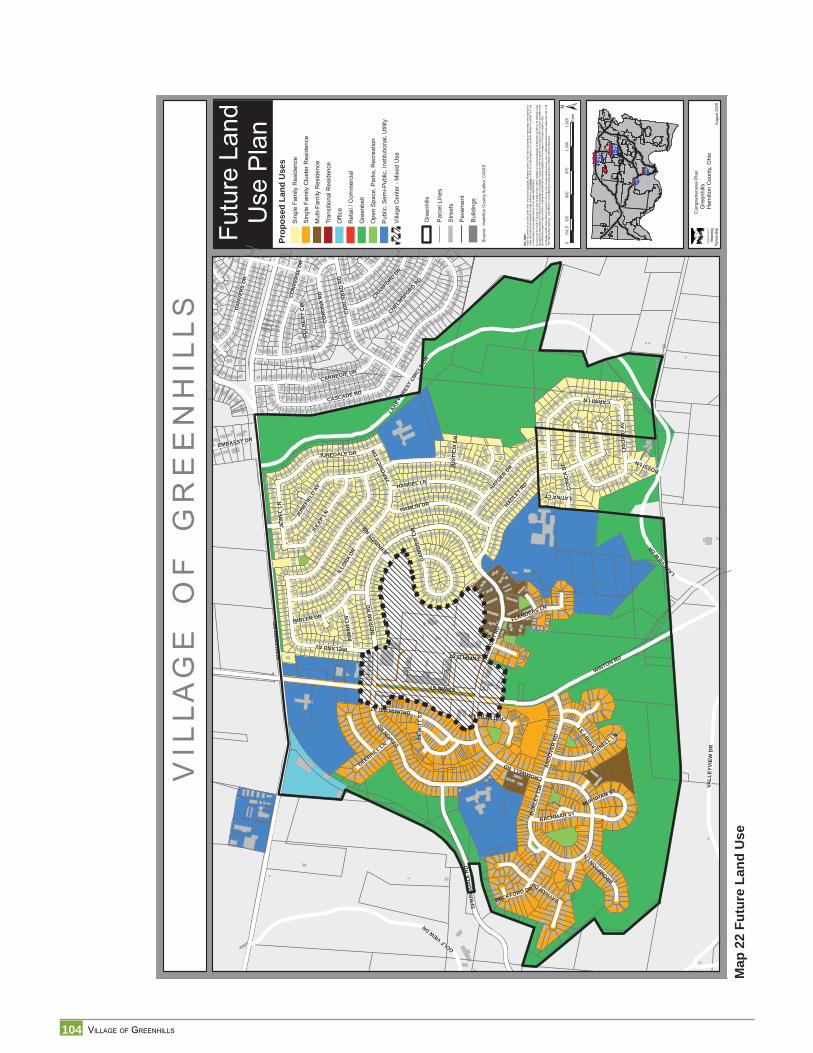
104 VILLAGE OF GREENHILLS
Map
22
Futu
re L
and
Use
V I L
L A
G E
O
F
G R
E E
N H
I L
L S
Futu
re L
and
Use
Pla
n
§̈ ¦I-74
§̈ ¦I-75
§̈ ¦I-75
§̈ ¦I-275
Augu
st 2
009
DISC
LAIM
ER:
Neith
er th
e pro
vider
nor a
ny o
f the
partie
s of
the C
incinn
ati a
rea g
eogra
phic
inform
ation
syste
m (C
AGIS)
mak
e an
y wa
rranty
or re
prese
ntatio
n, eit
her e
xpres
sed
orim
plied
, with
resp
ect to
this
inform
ation
, its
quali
ty, pe
rform
ance
, merc
hanta
bility
, or f
itnes
s for
a pa
rticula
r purp
ose.
As a
resu
lt this
infor
matio
n is
provid
ed “a
s is”,
and
you,
the re
cipien
t, are
assu
ming
the e
ntire
risk a
s to i
ts qu
ality
and p
erfor
man
ce.
In no
even
t, will
the p
rovide
r or a
ny p
arty
of CA
GIS
be lia
ble fo
r dire
ct, in
direc
t, inc
identa
l, or c
onse
quen
tial d
amag
es re
sultin
g fro
m an
y de
fect in
the
inform
ation
or an
yoth
er pa
rt of th
e map
prod
uct, e
ven i
f adv
ised o
f the p
ossib
ility of
such
dama
ges.
In pa
rticula
r, ne
ither
the pr
ovide
r nor
any p
arty
of CA
GIS
shall
have
any
liabil
ity fo
r any
other
inform
ation
, prog
rams o
r data
used
with
or co
mbin
ed w
ith th
e info
rmati
on re
ceive
d, inc
luding
the c
ost o
f reco
verin
g suc
h info
rmati
on, p
rogra
ms or
data
. An
y flo
odwa
y an
d flo
od fri
nge
inform
ation
prov
ided o
n thi
s map
is fo
r con
ceptu
al pla
nning
purpo
ses
only.
For
offic
ial de
term
inatio
n of
limits
recip
ient m
ust r
efer t
o th e
1982
FEM
A flo
odwa
y frin
ge m
aps.
Large
diffe
rence
s can
exist
betw
een a
ctual
flood
pron
e area
and o
fficial
FEM
A flo
od fr
inge a
reas
.
WSH
AR
ON
RD
WINTON RD
JUNE
FIEL
DAV
HADLEY
RD
LAKE
FORE
STCI
RCLE
DR
CASCADE RD
IRELANDAV
GOLFVIEWDR
ING
RA
MR
D
DAMONRD
FARR
AGUT
RD
SPR
ING
DA
LER
D
LAKEVIE
WDR
CO
RO
NA
RD
CA
RLS
BA
DR
D
VALL
EYVI
EWD
R
ENFIELDST
JULE
PLN
CARINILN
ILLO
NADR
HAMLIN DR
CARNEGIE DR
HAYDENDR
HANDEL LN
ESWINST
JUNEDALE DR
DRUMMONDST
IMBLER DR
DA
NVE
RS
DR
CO
NVER
SED
R
CROMWELLRD
BAYHAMDR
AND
OVE
RR
D
JEW
ELLN
CHELMSFO
RDRD
JAPO
NICA
DR LIG
OR
IOAV
AVENELL LN
BUR
LEY
CIR
CRANFORDDR
INM
AN
LN
ASHBY
ST
BACHMAN ST
DEW
ITT
ST
FLANDERS LN
BECKFORD DR
BROMPTON
LN
CO
NC
AST BOSSILN
DEERHILL LN
EMBASSY DR
GA
MB
IER
CIR
CHALMERSLN
BURNHAM ST
CO
LBER
TC
IR
LATINACT
JENNIN
GSRD
JUST
ICIA
LN
±
Gre
enhi
llsH
amilt
on C
ount
y, O
hio
Prop
osed
Lan
d U
ses
Sin
gle
Fam
ily R
esid
ence
Gre
enbe
lt
Offi
ce
Ret
ail /
Com
mer
cial
Ope
n Sp
ace,
Par
ks, R
ecre
atio
n
Pub
lic, S
emi-P
ublic
, Ins
titut
iona
l, U
tility
Tran
sitio
nal R
esid
ence
Sing
le F
amily
Clu
ster
Res
iden
ce
Mul
ti-Fa
mily
Res
iden
ce
Sou
rce:
Ham
ilton
Cou
nty
Aud
itor,
CA
GIS
Stre
ets
Pav
emen
t
Bui
ldin
gs
Villa
ge C
ente
r - M
ixed
Use
Gre
enhi
lls
Parc
el L
ines
Com
preh
ensi
ve P
lan
032
565
097
51,
300
1,62
516
2.5
Feet
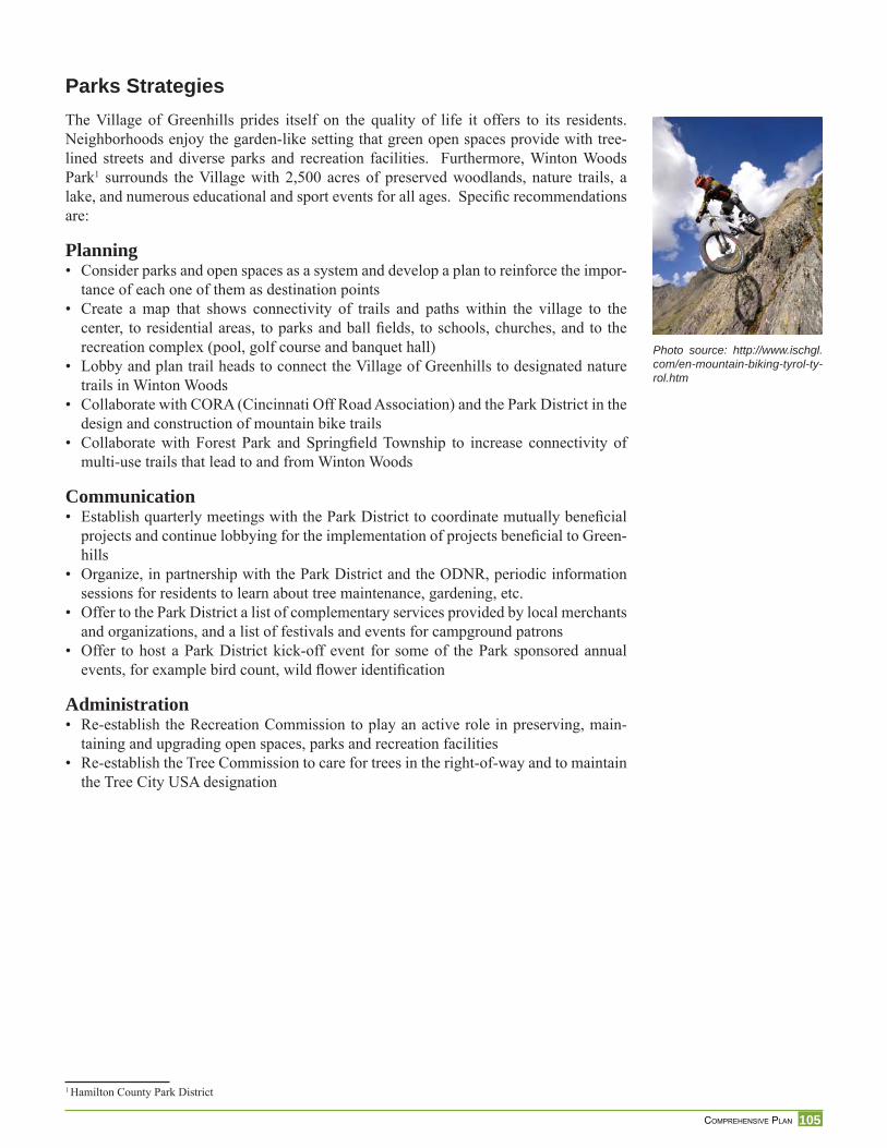
105 COMPREHENSIVE PLAN
Photo source: http://www.ischgl.com/en-mountain-biking-tyrol-ty-rol.htm
Parks Strategies The Village of Greenhills prides itself on the quality of life it offers to its residents. Neighborhoods enjoy the garden-like setting that green open spaces provide with tree-lined streets and diverse parks and recreation facilities. Furthermore, Winton Woods Park1 surrounds the Village with 2,500 acres of preserved woodlands, nature trails, a lake, and numerous educational and sport events for all ages. Specifi c recommendations are:
Planning• Consider parks and open spaces as a system and develop a plan to reinforce the impor-
tance of each one of them as destination points• Create a map that shows connectivity of trails and paths within the village to the
center, to residential areas, to parks and ball fi elds, to schools, churches, and to the recreation complex (pool, golf course and banquet hall)
• Lobby and plan trail heads to connect the Village of Greenhills to designated nature trails in Winton Woods
• Collaborate with CORA (Cincinnati Off Road Association) and the Park District in the design and construction of mountain bike trails
• Collaborate with Forest Park and Springfi eld Township to increase connectivity of multi-use trails that lead to and from Winton Woods
Communication• Establish quarterly meetings with the Park District to coordinate mutually benefi cial
projects and continue lobbying for the implementation of projects benefi cial to Green-hills
• Organize, in partnership with the Park District and the ODNR, periodic information sessions for residents to learn about tree maintenance, gardening, etc.
• Offer to the Park District a list of complementary services provided by local merchants and organizations, and a list of festivals and events for campground patrons
• Offer to host a Park District kick-off event for some of the Park sponsored annual events, for example bird count, wild fl ower identifi cation
Administration• Re-establish the Recreation Commission to play an active role in preserving, main-
taining and upgrading open spaces, parks and recreation facilities• Re-establish the Tree Commission to care for trees in the right-of-way and to maintain
the Tree City USA designation
1 Hamilton County Park District
106 VILLAGE OF GREENHILLS
Map
23
Rec
omm
ende
d Tr
ailh
ead
Con
nect
ion
to W
into
n W
oods
Nat
ure
Trai
ls
VIL
LAG
EO
FG
RE
EN
HIL
LS
Wor
king
Map
Bike
&P
edes
trian
Path
s
§̈ ¦I-74
§̈ ¦I-75
§̈ ¦I-75
§̈ ¦I-275
April
,200
9
DISC
LAIM
ER:
Neith
er th
e pro
vider
nor a
ny o
f the
partie
s of
the C
incinn
ati a
rea g
eogra
phic
inform
ation
syste
m (C
AGIS)
mak
e an
y wa
rranty
or re
prese
ntatio
n, eit
her e
xpres
sed
or im
plied
, with
resp
ect to
this
inform
ation
, its
quali
ty, pe
rform
ance
, merc
hanta
bility
, or f
itnes
s for
a pa
rticula
r purp
ose.
As a
resu
lt this
infor
matio
n is
provid
ed “a
s is”,
and
yo
u, the
recip
ient, a
re as
sumi
ng th
e enti
re ris
k as t
o its
quali
ty an
d per
form
ance
. In
no ev
ent, w
ill the
prov
ider o
r any
part
y of
CAGI
S be
liable
for d
irect,
indir
ect, i
ncide
ntal, o
r con
sequ
entia
l dam
ages
resu
lting
from
any
defec
t in th
e inf
ormati
on or
any
other
part o
f the m
ap pr
oduc
t, eve
n if a
dvise
d of th
e pos
sibility
of su
ch da
mage
s. In
partic
ular,
neith
er the
prov
ider n
or an
y par
ty of
CAGI
S sh
all ha
ve an
y lia
bility
for a
ny
other
inform
ation
, prog
rams o
r data
used
with
or co
mbin
ed w
ith th
e info
rmati
on re
ceive
d, inc
luding
the c
ost o
f reco
verin
g suc
h info
rmati
on, p
rogra
ms or
data
. An
y flo
odwa
y an
d flo
od fri
nge
inform
ation
prov
ided o
n thi
s map
is fo
r con
ceptu
al pla
nning
purpo
ses
only.
For
offic
ial de
term
inatio
n of
limits
recip
ient m
ust r
efer t
o the
19
82 F
EMA
flood
way f
ringe
map
s. La
rge di
fferen
ces c
an ex
ist be
twee
n actu
al flo
od pr
one a
rea an
d offic
ial FE
MA
flood
fring
e are
as.
¾¾½¾¾½
¾¾½¾¾½
¾¾½¾¾½
¾¾½
¾¾½¾¾½
¾¾½
¾¾½¾¾½
¾¾½¾¾½¾¾½¾¾½
¾¾½¾¾½
¾¾½¾¾½
¾¾½
¾¾½¾¾½
¾¾½¾¾½¾¾½
¾¾½
¾¾½¾¾½
¾¾½¾¾½
¾¾½¾¾½
¾¾½¾¾½
¾¾½¾¾½
¾¾½
¾¾½
¾¾½¾¾½
¾¾½
¾¾½¾¾½
¾¾½
¾¾½¾¾½
¾¾½
¾¾½
¾¾½¾¾½
¾¾½¾¾½ ¾¾½
¾¾½
¾¾½¾¾½¾¾½
¾¾½¾¾½
¾¾½
¾¾½ ¾¾½
¾¾½
¾¾½
¾¾½
¾¾½
¾¾½¾¾½
¾¾½
¾¾½
¾¾½
¾¾½
¾¾½
¾¾½
¾¾½¾¾½
¾¾½
¾¾½¾¾½¾¾½
¾¾½
¾¾½¾¾½
¾¾½¾¾½¾¾½¾¾½¾¾½¾¾½
¾¾½¾¾½
¾¾½¾¾½
¾¾½
¾¾½¾¾½
¾¾½
¾¾½
¾¾½
¾¾½
¾¾½
¾¾½
¾¾½¾¾½¾¾½
¾¾½¾¾½¾¾½¾¾½
¾¾½
¾¾½
¾¾½
¾¾½
¾¾½¾¾½¾¾½¾¾½¾¾½
¾¾½ ¾¾½ ¾¾½
¾¾½¾¾½
¾¾½
¾¾½¾¾½
¾¾½¾¾½
¾¾½
¾¾½¾¾½¾¾½
¾¾½
¾¾½¾¾½
¾¾½¾¾½¾¾½
¾¾½¾¾½
¾¾½
¾¾½
¾¾½
¾¾½¾¾½
¾¾½¾¾½
¾¾½¾¾½
¾¾½¾¾½
¾¾½¾¾½
¾¾½¾¾½
¾¾½¾¾½
¾¾½¾¾½
¾¾½¾¾½
¾¾½¾¾½
¾¾½
¾¾½
¾¾½¾¾½
¾¾½¾¾½
¾¾½
¾¾½
¾¾½ ¾¾½ ¾¾½ ¾¾½¾¾½
¾¾½
¾¾½
¾¾½
¾¾½
¾¾½
¾¾½
¾¾½
¾¾½
¾¾½
¾¾½
¾¾½
¾¾½
¾¾½
¾¾½
¾¾½
¾¾½¾¾½¾¾½¾¾½
¾¾½
¾¾½¾¾½
¾¾½¾¾½
¾¾½¾¾½
¾¾½
¾¾½
¾¾½
¾¾½
¾¾½
¾¾½
¾¾½¾¾½¾¾½
¾¾½¾¾½¾¾½¾¾½
¾¾½
¾¾½
¾¾½
¾¾½
¾¾½
¾¾½
¾¾½¾¾½
¾¾½
¾¾½¾¾½
¾¾½
¾¾½
¾¾½ ¾¾½ ¾¾½
¾¾½
¾¾½
¾¾½
¾¾½
¾¾½
¾¾½
¾¾½
¾¾½¾¾½
¾ ¾½¾¾½
¾¾½
¾¾½
¾¾½¾¾½
¾¾½ ¾¾½¾¾½
¾¾½
¾¾½
¾¾½
¾¾½
¾¾½
¾¾½
¾¾½ ¾¾½
¾¾½
¾¾½¾¾½
¾¾½¾¾½
¾¾½¾¾½
¾¾½
¾¾½
¾¾½
¾¾½¾¾½
¾¾½¾¾½
¾¾½
¾¾½¾¾½
¾¾½
¾¾½
¾¾½¾¾½
¾¾½
¾¾½
¾¾½¾¾½
¾¾½ ¾¾½¾¾½
¾¾½¾¾½
¾¾½¾¾½¾¾½
¾¾½¾¾½
¾¾½
¾¾½
¾¾½
¾¾½¾¾½
¾¾½¾¾½
¾¾½ ¾¾½
¾¾½¾¾½¾¾½
¾¾½
¾¾½¾¾½
¾¾½
¾¾½
¾¾½ ¾¾½
¾¾½
¾¾½¾¾½
¾¾½¾¾½
D
D
D
DD
D
D
D
D
D
D
WSH
AR
ON
RD
WINTONRD
MIL
ESRD
MILLRD
VALL
EYVI
EWD
R
LAK
ERID
GE
DR
SPRINGDALE
RD
WAYCROSSRD
GOLF VIEW DR
JUNE
FIEL
DAV
HADLEY
RD
SOUTHLAND RD
IREL
AN
DAV
ING
RA
MR
D
MCKELVEYRD
TOULONDR
DAMONRD
CA
RLS
BA
DR
D
FARR
AGUT
RD
CASCADE RD
SOUTHSHOREDR
NORTHLA
NDBLV
D
CO
RO
NA
RD
ENFIELDST
JULE
PLN
CA
RIN
ILN
ILLO
NADR
EMBASSY DR
HAMLIN DR
DANBURY RD
BRUNNERDR
STARGATELN
SHEFFIELDRD
CARNEGIE DR
DO
NO
RA
LN
CO
NVE
RSE
DR
HAYDEN
DR
WEST PARK DR
HANDEL LN
ESWINST
CORBETTRD
JUNEDALE DR
CHELMSFORD
RD
DALYRD
RIDDLERD
DRUMMONDST
BRUNSWIC
KDR
DA
NVE
RS
DR
EXMOORDR
BESSINGERDR
CROMWELLRD
BAYHAMDR
ASH
BU
RN
RD
LOCHCRESTDR
AN
DO
VER
RD
AC
REV
IEW
DR
VER
SAIL
LES
JAPO
NICA
DR
SILVERBROOKDR
CRANFORD
DR
LIG
OR
IOAV
DECAT
URCT
AVENELL LN
BU
RLE
YC
IR
HANOVER RD
WIN
LAK
ED
R
BRAD
BURY
DR
DEAU
VILL
ERD
DEWDROP CIR
LAKE
SIDE
DR
INM
AN
LN
ASHBYST
BACHMANST
DEW
ITT
ST
FLANDERS LN
DAPH
NECT
BALLINGERRD
BROMPTONLN
CO
NC
AST
BOSSILN
DEERHILL LN
GA
MB
IER
CIR
BEAUFORT CT
BURNHAM ST
ENDORCT
CO
LBER
TC
IR
LATINACT
JENNIN
GSRD
JUST
ICIA
LN
CLO
VER
TON
CT
CHILDRESSCT
MCKELVEYRD
±0
1,40
02,
800
700
Feet
Com
preh
ensi
veP
lan
Gre
enhi
llsH
amilt
onC
ount
y,O
hio
311
1
128
57
6
2
10
9
1314
14
14
14
1.As
hby
Par
k2.
Bac
hman
Par
k3.
Big
Bur
ley
Par
k4.
Bra
dnor
Par
k5.
Cha
lmer
sP
ark
6.C
omm
ons
7.C
rom
wel
lPar
k8.
Foxw
orth
Par
k9.
Gre
enhi
llsG
olfC
ours
e10
.G
reen
hills
Sw
imm
ing
Pool
11.
Littl
eBu
rley
Par
k12
.P
alm
aP
ark
13.
Spo
ilsFi
eld
14.
Win
ton
Woo
ds
Park
/Gre
ensp
ace
Loca
tor
Lege
nd
¾¾½¾¾½
Exis
ting
Ped.
/Bik
ePa
th¾¾½
¾¾½Pr
opos
edPe
d./B
ike
Path
Park
s/G
reen
spac
eW
into
nW
oods
Ham
ilton
Cou
nty
Park
s
Park
sin
Gre
enhi
lls
15.
Bra
dnor
Pla
ce16
.Av
enel
lCul
desa
c17
.Fa
lcon
Lane
18.
Jenn
ings
&Ill
ona
19.
Pea
nuts
Par
k20
.W
into
nR
d.21
.D
amon
Rd.
22.
Win
ton
Rd.
23.
Esw
inIs
land
24.
Mun
icip
alB
ldg.
25.
Mar
quar
dtH
ouse
26.
Amer
ican
Legi
on27
.G
azeb
o28
.An
dove
r
15
16
17
18
19
20 21 222324
2526G
reen
hills Su
gges
ted
Trai
lSu
gges
ted
Trai
lHea
ds/C
onne
ctio
nsD
A
BC
D
E
F
G
H
I
J
KL
27
28
107 COMPREHENSIVE PLAN
Greenbelt StrategiesThe “greenbelt” is a zoning district, a physical collection of wooded property owned by various parties (village, residents, schools, and park district). The greenbelt is an integral part of the village’s identity and history that needs preservation from development and natural threats such as the Emerald Ash Borer. Since 1988, the Village Charter has re-quired a community referendum for any change to the G-1 Greenbelt zoning (rezoning). The Village charter only allows residents to vote. Specifi c recommendations are:
Marketing the Community• The greenbelt makes Greenhills unique and should be included in a marketing cam-
paign to attract new residents and businesses to the Village• The tree canopy located in much of the greenbelt improves air quality, reduces the heat
island effect and should be included in the marketing campaign
Woodland Preservation and Emerald Ash Borer (EAB)EAB and the spread of invasive species, such as honeysuckle, are serious threats to the forested areas and need to be addressed.
• Partner with Ohio Department of Natural Resources (ODNR) to educate property owners on how to deal with EAB
• Partner with the Park District to jointly address EAB infestation in areas immediately surrounding the Village
• Revise G-1 zoning district to insert language that will allow clearing under certain circumstances
Zoning• Evaluate and improve the G-1 greenbelt zoning district to eliminate discrepancies and
to provide clearer direction as to how it can be utilized.• Evaluate separation of the actual “belt” from the land along Winton Road and the Rec-
reation Complex/Golf Course areas
108 VILLAGE OF GREENHILLS
Village Center Master PlanThe Village of Greenhills needs a cohesive image and a physically attractive central area where people can live, shop, work and play. Specifi c recommendations for the Village Center master plan include:
Planning and Zoning• Create a master plan for the specifi c area of the Village Center• Conduct a feasibility study to evaluate scenarios of mixed uses and other alternatives
that demonstrate increased tax revenues• Create an overlay zoning district• Consider creating a zoning district using form based code• Revise and enforce property maintenance ordinances and nuisance regulations
Study Area - Criteria• Physical Features:
o It should include the shopping center, the recreation complex, Winton Road, the green space west of Winton Road, and the buildings in the periphery that frame the common spaces of the Village Center
o It should have a clear internal circulation patterno It should exhibit connectivity to other parts of the Villageo It should allow multi-modes of transportationo It should allow mixed uses (residential, offi ce, retail, institutional, parks, recreation
and open spaces)o It should maximize fl exibility of spaceso Density in center should be increased to preserve lower density in residential areaso It should require energy effi cient design and building practiceso It should regulate storefront signageo Buildings and grounds should ensure accessibility for all (Americans with Disabili-
ties Act compliant)o Way fi nding signage should be in place to point to and from center to other parts of
the communityo It should bring the Park District bike trail into the Village Center and include bike
racks throughouto It should include a Queen City Metro Park & Ride loto Design landscape should include trees and other plant material to soften the hard-
scapeo A streetscape design plan for the entire Village Center district should include mini-
mum standards for outdoor furnishings
Winton Road Corridor• Winton Road corridor, at Greenhills, should have a distinctive look. It should be a
stretch of road with streetscape and treatment that sets it apart from the rest of Winton Road and creates a sense of place, so you know that you have arrived in the heart of Greenhills
• Evaluate use of textured pavement on Winton Road to reinforce arrival to the Village Center
• Evaluate use of a raised median on Winton Road
Qualitative Features of the Village Center• Promotes/conducive to spatial interaction• Shopping (as an experience)• Public restrooms are readily available for patrons• Outdoor living
109 COMPREHENSIVE PLAN
• Energy (meeting place of people, events)• Better access/egress• It is a place where you come to celebrate the community• Includes residential uses• Well maintained (buildings and grounds)• Enjoyable – a place where a resident can relax and enjoy the sights, smells, and the
atmosphere• Promotes civic life and communication
Other Features: Business Mix for the Retail Component• Niche businesses (perhaps around Winton Woods Park complementary business or
services)• Destination and convenience type of businesses• Amenities so it can function all day [ 24-7]• Build on existing businesses and attract new businesses• Hamilton County Parks wants/needs:
o Coffee shop o Sports related storeso Kayak related serviceso Complimentary services, not offered by the park, that can enhance the experience of
the park’s patrons (e.g. medical support)o Festivals and events that campers could attend
• Village can offer to the Park:o Walking tourso Historic building tourso Art class and/or art exhibitso Post Offi ce, Library
Marketing and Promotion• Reinforce in promotion:
o Near to I-275o Garden City designo Continuous Tree City USA Designation since 1981o History: Historic tours, museumo Festivals and Community sponsored events
• Conduct regular meetings between the Park District & Village Administration to iden-tify specifi c areas of collaboration
• Organize and sponsor community events• Joint marketing and promotion
Short Term Solutions for Shopping Center• Fix pot holes – Village is the owner of streets and parking lots• Place pavers – to mark pedestrian paths• Re-evaluate vehicular circulation in the area, in particular in the shopping center area.
Short term solution: Deliveries – north only• Identify services and products offered by local businesses that can complement pro-
grams offered by the Recreation Commission (for example bowling for youth pro-grams)
• Spruce up store fronts• Merchants Association:
o Revive the Association and promote personal contact among business owners and operator
o Organize a meeting with a guest speaker from Hamilton County Parks
110 VILLAGE OF GREENHILLS
o Prepare a packet of information with services, retail, events offered in the Village that can be distributed by the Campground manager
Incentives (created or sponsored by the municipality)• Streetscape – apply for Community Development Block Grant (CDBG) grants to help
pay for improvements to sidewalks, street furniture, etc. • Façade Improvement Grant – apply for CDBG for matching grants for façade im-
provements (windows, roofs, doors, awnings, painting, etc.)• Create a Community Reinvestment Area (CRA) – tax incentive (waives taxes on build-
ing improvements over a certain period of time)• Explore historic tax credits and grants for preservation of original structures
111 COMPREHENSIVE PLAN
National Historic Landmark and Local Historic District Designations Strategy
Local Historic District Designations and National Historic Landmark Designations have helped other communities in their branding efforts. The Designation creates economic development and relocation opportunities because of the added historic value of residen-tial and commercial districts. Specifi c recommendations are:
Evaluate Local Historic District Landmark Designation and National Historic Landmark Designation• Defi ne what is “historic.”• Propose specifi c vision, criteria, and standards for the Historic District:
o Identify appropriate architectural styles and design patterns for infi ll development, and for rehabilitation and additions to existing buildings in Historic District
o Recommend standards for new construction to ensure compatibility with density, mass and volume, and set backs in historic district
o Outline recommended administrative process including architectural and design guidelines, architectural review board role and relationship with planning commis-sion, fees, and others
• Defi ne the responsibilities and rights of owners in the historic district• Outline steps and costs to achieve National Landmark Status
Marketing and Promotion of Historic District• Promote History of Greenhills• Promote Heritage tourism• Create a Beautifi cation Awards program• Create a Visitor’s Center• Facilitate location of small scale hospitality facility(s)• Collaborate with other area National Historic Landmark communities for regional
marketing
112 VILLAGE OF GREENHILLS
Impl
emen
tatio
n Fr
amew
ork
Implementation Framework
OverviewThe Comprehensive Plan establishes the Village’s position on a number of issues it faces today. The plan also serves as an information source for developers, property owners and the public at large. The implementation framework provides an outline of strategies for the implementation of recommendations and related goals and objectives. Finally, the Plan provides the basis for future, more specifi c plans to be prepared as part of the imple-mentation process. The focus of this implementation section is on what role the Village should play regarding each one of these strategies. Tentatively, it will identify those relevant organizations whose cooperation and collaboration are important to ensure the collective future vision of the community.
Recommended general strategies to leverage the Village’s resources to implement the plan include:
(a) consistently involving the public in community affairs,(b) seeking regional cooperation and coordination with other jurisdictions and agen-
cies,(c) participating in regional planning efforts,(d) networking and partnering with other local, state and national organizations, and(e) considering public-private partnerships that help advance the interests of the Village
of Greenhills.
The Village of Greenhills should provide opportunities to its residents to become in-volved and volunteer their time and efforts in Village sanctioned committees. The Vil-lage should also collaborate with other committees that are not affi liated with the Village but work to improve the quality of life in the community.
Implementing the Plan requires three essential actions by the Village:
1) Adopting the comprehensive plan,2) Updating the zoning ordinance to refl ect the recommendations contained in the plan,
and3) Utilizing the recommendations outlined in the plan.
Each year, the Village should meet to determine which objective or strategies they will work on over the upcoming year. At the same time, the Village can look back over the previous year and evaluate what the community accomplished and where there is a need for improvement. This annual review allows for fl exibility in determining the tasks the Village should undertake based on budgetary constraints and/or community input.
This annual review can also be used to create specifi c, quantitative goals for various objectives. A specifi c benchmark will allow the Village the ability to monitor annual accomplishments, and to consider various factors such as community priorities, budgets, and available staff and resources.
Plan Amendments and UpdateThe Greenhills Comprehensive Plan presents a snapshot of existing conditions, trends, community issues and desires, a long-term vision for the future, and a series of recom-mendations for implementing that vision. Although the plan presents a 20-year vision, the Plan should be updated every fi ve years. The fi ve-year comprehensive review should review current conditions, and modify, as necessary, goals, objectives and strategies. With each update, there should be an evaluation of the effectiveness of the strategies and the extent to which they should be fi ne-tuned.
113 COMPREHENSIVE PLAN
This Plan provides for two types of amendments: corrections, which may occur at any time during the planning period; and the update, which is recommended to take place every fi ve years.
One of the primary objectives of the fi ve-year update is to provide the community, devel-opers, and individuals the opportunity to review and suggests revisions to the Plan. The Village Planning Commission should initiate the fi ve-year updates.
While the Plan provides some leeway to accommodate some unforeseen events, there are times when an interim amendment may be necessary. The Village should design a process to outline how amendments may be initiated by the Village or by individuals (if desired). The following are guidelines for amending the plan prior to the recommended fi ve-year update.
Special PlansThe Comprehensive Plan is a general overview and guide with enough fl exibility to re-spond to most local conditions. Situations may arise in which more specifi c, localized planning efforts are needed. These plans may be prepared in response to the Village’s desire to refi ne the Plan as it applies to a sub-area (for example Village Center, Winton Road Corridor or Historic District), a major development proposal, or the construction of a major infrastructure improvement.
Projections and AssumptionsThe Comprehensive Plan is based on projections of populations, household size, and housing units as well as employment conditions. The Plan relies on forecasts provided by the U.S. Census Bureau. With the Census 2010 approaching, if projections prove inaccurate, the plan will require adjusting. The Plan is also based on assumptions about trends, such as business/ industry locations, and about public investments in infrastruc-ture. Should such assumptions not bear out, again, the Plan must be adjusted accord-ingly.
New IssuesOccasionally new issues emerge that the Plan does not anticipate, often in response to changes in State or Federal policy. In such situations, the goals, objectives and strategies as well as the comprehensive plan, may require revisions.
ComprehensivenessAlthough the Plan elements address issues adequately on a district scale, there may be situations in which a more detailed analysis is necessary. For example, an urban design master plan, or potential development areas for new retail may be needed for successful implementation. When such plans are adopted, an amendment to the Comprehensive Plan may be necessary.
Data UpdatesThe many maps and tables that support this Plan are based on the best information avail-able at the time of preparation. This data may change to such an extent as to justify an amendment to the plan.
114 VILLAGE OF GREENHILLS
Pha
sing
of I
mpl
men
tatio
n Phasing of ImplementationConsiderable input from residents, careful oversight of the Steering Committee, in depth research and experts’ advice have resulted in a long list of recommendations for the Vil-lage of Greenhills. The Steering Committee is mindful of the fi nite resources the Village has at hand, therefore a decision was made to “grade” recommendations as A - “must do it,” B - “should do it,” and C - “could do it” as a suggestion to the Greenhills governing body.
The table “Phasing of Implementation” provides a simplifi ed overview of all the recom-mendations (which are grouped in larger categories), their importance (or grade), the persons or organizations that should be involved in their implementation, who should play a leadership role, and when appropriate, a suggested timeframe.
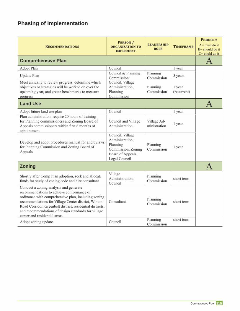
115 COMPREHENSIVE PLAN
RECOMMENDATIONSPERSON /
ORGANIZATION TO IMPLEMENT
LEADERSHIP ROLE TIMEFRAME
PRIORITYA= must do it
B= should do itC= could do it
Comprehensive Plan AAdopt Plan Council 1 year
Update Plan Council & Planning Commission
Planning Commission 5 years
Meet annually to review progress, determine which objectives or strategies will be worked on over the upcoming year, and create benchmarks to measure progress
Council, Village Administration, Planning Commission
Planning Commission
1 year (recurrent)
Land Use AAdopt future land use plan Council 1 yearPlan administration: require 20 hours of training for Planning commissioners and Zoning Board of Appeals commissioners within fi rst 6 months of appointment
Council and Village Administration
Village Ad-ministration 1 year
Develop and adopt procedures manual for and bylaws for Planning Commission and Zoning Board of Appeals
Council, Village Administration, Planning Commission, Zoning Board of Appeals, Legal Council
Planning Commission 1 year
Zoning AShortly after Comp Plan adoption, seek and allocate funds for study of zoning code and hire consultant
Village Administration, Council
Planning Commission short term
Conduct a zoning analysis and generate recommendations to achieve conformance of ordinance with comprehensive plan, including zoning recommendations for Village Center district, Winton Road Corridor, Greenbelt district, residential districts; and recommendations of design standards for village center and residential areas
Consultant Planning Commission short term
Adopt zoning update Council Planning Commission
short term
Phasing of Implementation
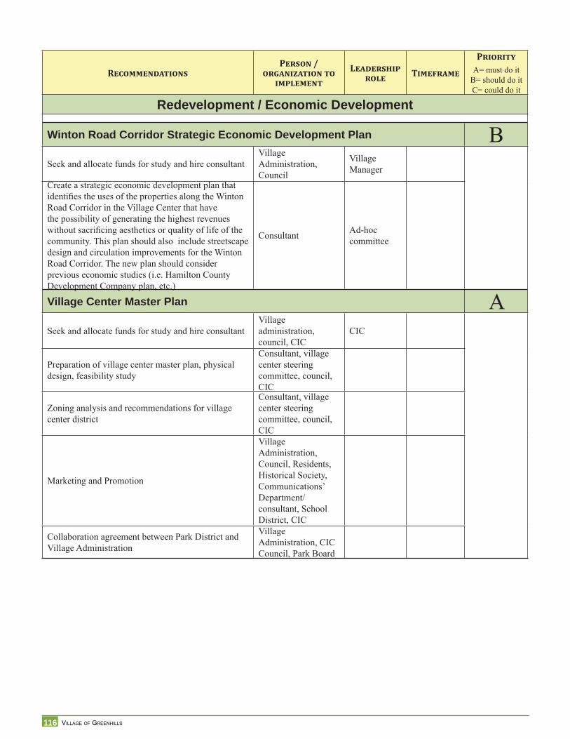
116 VILLAGE OF GREENHILLS
RECOMMENDATIONSPERSON /
ORGANIZATION TO IMPLEMENT
LEADERSHIP ROLE TIMEFRAME
PRIORITYA= must do it
B= should do itC= could do it
Redevelopment / Economic Development
Winton Road Corridor Strategic Economic Development Plan BSeek and allocate funds for study and hire consultant
Village Administration, Council
Village Manager
Create a strategic economic development plan that identifi es the uses of the properties along the Winton Road Corridor in the Village Center that have the possibility of generating the highest revenues without sacrifi cing aesthetics or quality of life of the community. This plan should also include streetscape design and circulation improvements for the Winton Road Corridor. The new plan should consider previous economic studies (i.e. Hamilton County Development Company plan, etc.)
Consultant Ad-hoc committee
Village Center Master Plan ASeek and allocate funds for study and hire consultant
Village administration, council, CIC
CIC
Preparation of village center master plan, physical design, feasibility study
Consultant, village center steering committee, council, CIC
Zoning analysis and recommendations for village center district
Consultant, village center steering committee, council, CIC
Marketing and Promotion
Village Administration, Council, Residents, Historical Society, Communications’ Department/consultant, School District, CIC
Collaboration agreement between Park District and Village Administration
Village Administration, CIC Council, Park Board
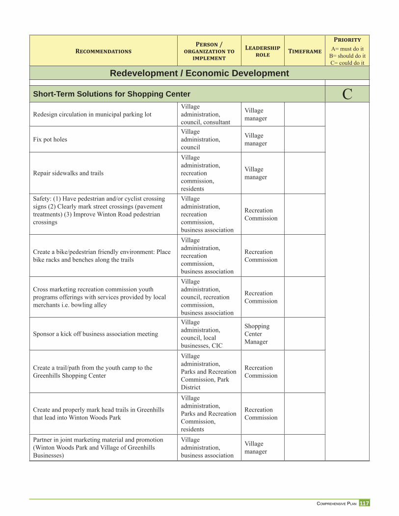
117 COMPREHENSIVE PLAN
RECOMMENDATIONSPERSON /
ORGANIZATION TO IMPLEMENT
LEADERSHIP ROLE TIMEFRAME
PRIORITYA= must do it
B= should do itC= could do it
Redevelopment / Economic Development
Short-Term Solutions for Shopping Center CRedesign circulation in municipal parking lot
Village administration, council, consultant
Village manager
Fix pot holesVillage administration, council
Village manager
Repair sidewalks and trails
Village administration, recreation commission, residents
Village manager
Safety: (1) Have pedestrian and/or cyclist crossing signs (2) Clearly mark street crossings (pavement treatments) (3) Improve Winton Road pedestrian crossings
Village administration, recreation commission, business association
Recreation Commission
Create a bike/pedestrian friendly environment: Place bike racks and benches along the trails
Village administration, recreation commission, business association
Recreation Commission
Cross marketing recreation commission youth programs offerings with services provided by local merchants i.e. bowling alley
Village administration, council, recreation commission, business association
Recreation Commission
Sponsor a kick off business association meeting
Village administration, council, local businesses, CIC
Shopping Center Manager
Create a trail/path from the youth camp to the Greenhills Shopping Center
Village administration, Parks and Recreation Commission, Park District
Recreation Commission
Create and properly mark head trails in Greenhills that lead into Winton Woods Park
Village administration, Parks and Recreation Commission, residents
Recreation Commission
Partner in joint marketing material and promotion (Winton Woods Park and Village of Greenhills Businesses)
Village administration, business association
Village manager
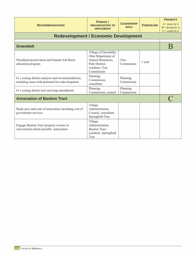
118 VILLAGE OF GREENHILLS
RECOMMENDATIONSPERSON /
ORGANIZATION TO IMPLEMENT
LEADERSHIP ROLE TIMEFRAME
PRIORITYA= must do it
B= should do itC= could do it
Redevelopment / Economic Development
Greenbelt BWoodland preservation and Emeral Ash Borer education program
Village of Greenhills, Ohio Department of Natural Resources, Park District, residents, Tree Commission
Tree Commission 1 year
G-1 zoning district analysis and recommendations, including areas with potential for redevelopment
Planning Commission, consultant
Planning Commission
G-1 zoning district text and map amendment Planning Commission, council
Planning Commission
Annexation of Bastion Tract CStudy pros and cons of annexation including cost of government services
Village Administration, Council, consultant, Springfi eld Twp
Engage Bastion Tract property owners in conversation about possible annexation
Village Administration, Bastion Tract residents, Springfi eld Twp
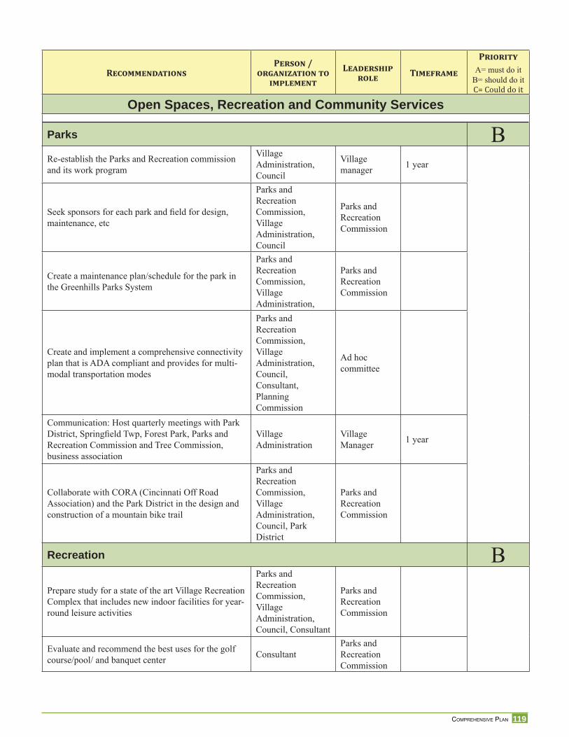
119 COMPREHENSIVE PLAN
RECOMMENDATIONSPERSON /
ORGANIZATION TO IMPLEMENT
LEADERSHIP ROLE TIMEFRAME
PRIORITYA= must do it
B= should do itC= Could do itOpen Spaces, Recreation and Community Services
Parks BRe-establish the Parks and Recreation commission and its work program
Village Administration, Council
Village manager 1 year
Seek sponsors for each park and fi eld for design, maintenance, etc
Parks and Recreation Commission, Village Administration, Council
Parks and Recreation Commission
Create a maintenance plan/schedule for the park in the Greenhills Parks System
Parks and Recreation Commission, Village Administration,
Parks and Recreation Commission
Create and implement a comprehensive connectivity plan that is ADA compliant and provides for multi-modal transportation modes
Parks and Recreation Commission, Village Administration, Council, Consultant, Planning Commission
Ad hoc committee
Communication: Host quarterly meetings with Park District, Springfi eld Twp, Forest Park, Parks and Recreation Commission and Tree Commission, business association
Village Administration
Village Manager 1 year
Collaborate with CORA (Cincinnati Off Road Association) and the Park District in the design and construction of a mountain bike trail
Parks and Recreation Commission, Village Administration, Council, Park District
Parks and Recreation Commission
Recreation BPrepare study for a state of the art Village Recreation Complex that includes new indoor facilities for year-round leisure activities
Parks and Recreation Commission, Village Administration, Council, Consultant
Parks and Recreation Commission
Evaluate and recommend the best uses for the golf course/pool/ and banquet center Consultant
Parks and Recreation Commission
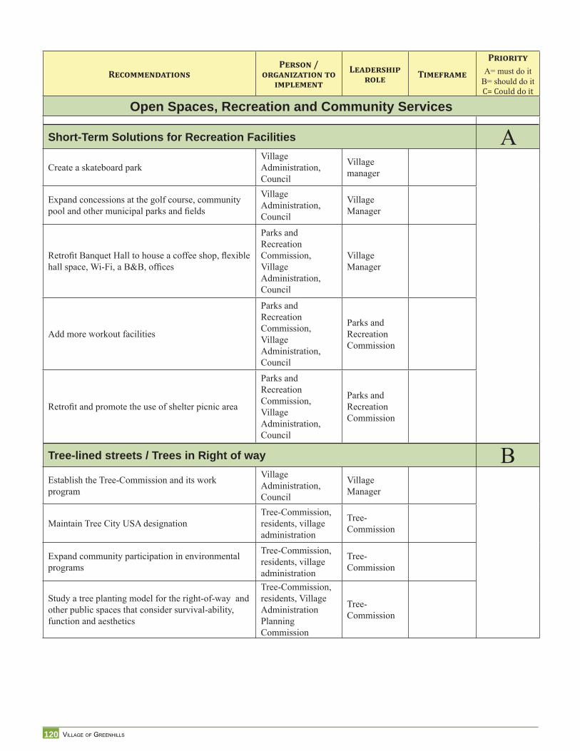
120 VILLAGE OF GREENHILLS
RECOMMENDATIONSPERSON /
ORGANIZATION TO IMPLEMENT
LEADERSHIP ROLE TIMEFRAME
PRIORITYA= must do it
B= should do itC= Could do itOpen Spaces, Recreation and Community Services
Short-Term Solutions for Recreation Facilities ACreate a skateboard park
Village Administration, Council
Village manager
Expand concessions at the golf course, community pool and other municipal parks and fi elds
Village Administration, Council
Village Manager
Retrofi t Banquet Hall to house a coffee shop, fl exible hall space, Wi-Fi, a B&B, offi ces
Parks and Recreation Commission, Village Administration, Council
Village Manager
Add more workout facilities
Parks and Recreation Commission, Village Administration, Council
Parks and Recreation Commission
Retrofi t and promote the use of shelter picnic area
Parks and Recreation Commission, Village Administration, Council
Parks and Recreation Commission
Tree-lined streets / Trees in Right of way BEstablish the Tree-Commission and its work program
Village Administration, Council
Village Manager
Maintain Tree City USA designationTree-Commission, residents, village administration
Tree-Commission
Expand community participation in environmental programs
Tree-Commission, residents, village administration
Tree-Commission
Study a tree planting model for the right-of-way and other public spaces that consider survival-ability, function and aesthetics
Tree-Commission, residents, Village AdministrationPlanning Commission
Tree-Commission
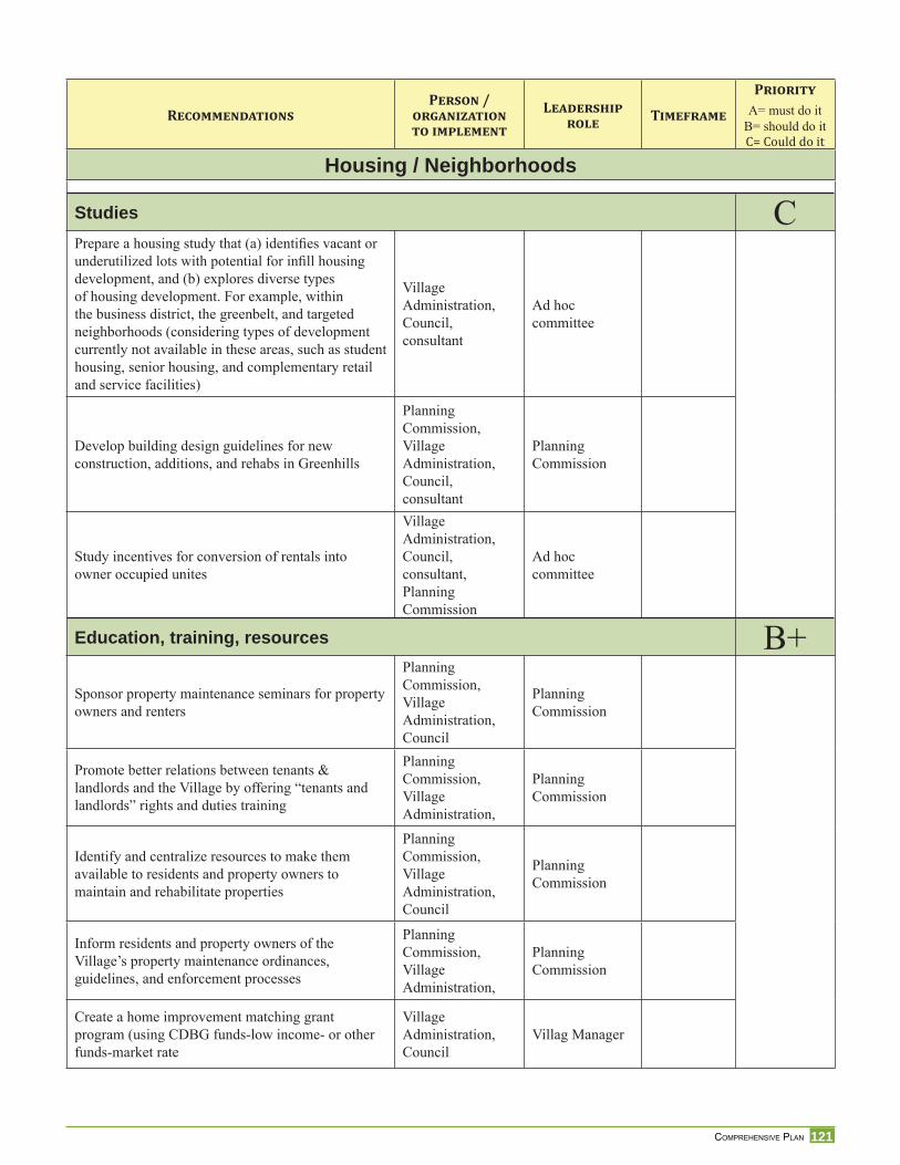
121 COMPREHENSIVE PLAN
RECOMMENDATIONSPERSON /
ORGANIZATION TO IMPLEMENT
LEADERSHIP ROLE TIMEFRAME
PRIORITYA= must do it
B= should do itC= Could do itHousing / Neighborhoods
Studies CPrepare a housing study that (a) identifi es vacant or underutilized lots with potential for infi ll housing development, and (b) explores diverse types of housing development. For example, within the business district, the greenbelt, and targeted neighborhoods (considering types of development currently not available in these areas, such as student housing, senior housing, and complementary retail and service facilities)
Village Administration, Council, consultant
Ad hoc committee
Develop building design guidelines for new construction, additions, and rehabs in Greenhills
Planning Commission, Village Administration, Council, consultant
Planning Commission
Study incentives for conversion of rentals into owner occupied unites
Village Administration, Council, consultant, Planning Commission
Ad hoc committee
Education, training, resources B+Sponsor property maintenance seminars for property owners and renters
Planning Commission, Village Administration, Council
Planning Commission
Promote better relations between tenants & landlords and the Village by offering “tenants and landlords” rights and duties training
Planning Commission, Village Administration,
Planning Commission
Identify and centralize resources to make them available to residents and property owners to maintain and rehabilitate properties
Planning Commission, Village Administration, Council
Planning Commission
Inform residents and property owners of the Village’s property maintenance ordinances, guidelines, and enforcement processes
Planning Commission, Village Administration,
Planning Commission
Create a home improvement matching grant program (using CDBG funds-low income- or other funds-market rate
Village Administration, Council
Villag Manager
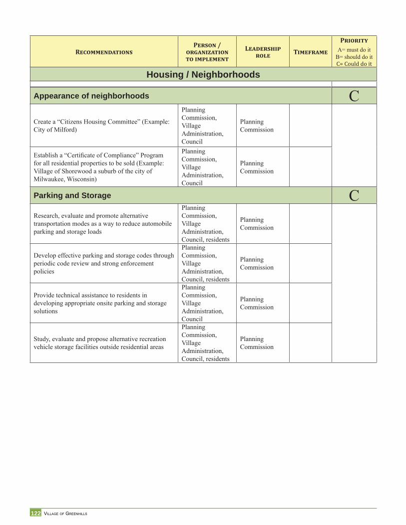
122 VILLAGE OF GREENHILLS
RECOMMENDATIONSPERSON /
ORGANIZATION TO IMPLEMENT
LEADERSHIP ROLE TIMEFRAME
PRIORITYA= must do it
B= should do itC= Could do itHousing / Neighborhoods
Appearance of neighborhoods CCreate a “Citizens Housing Committee” (Example: City of Milford)
Planning Commission, Village Administration, Council
Planning Commission
Establish a “Certifi cate of Compliance” Program for all residential properties to be sold (Example: Village of Shorewood a suburb of the city of Milwaukee, Wisconsin)
Planning Commission, Village Administration, Council
Planning Commission
Parking and Storage CResearch, evaluate and promote alternative transportation modes as a way to reduce automobile parking and storage loads
Planning Commission, Village Administration, Council, residents
Planning Commission
Develop effective parking and storage codes through periodic code review and strong enforcement policies
Planning Commission, Village Administration, Council, residents
Planning Commission
Provide technical assistance to residents in developing appropriate onsite parking and storage solutions
Planning Commission, Village Administration, Council
Planning Commission
Study, evaluate and propose alternative recreation vehicle storage facilities outside residential areas
Planning Commission, Village Administration, Council, residents
Planning Commission
123 COMPREHENSIVE PLAN
RECOMMENDATIONSPERSON /
ORGANIZATION TO IMPLEMENT
LEADERSHIP ROLE TIMEFRAME
PRIORITYA= must do it
B= should do itC= Could do itHousing / Neighborhoods
Housing Market/ Redevelopment / Marketing AClean up sites occupied by vacant and blighted properties
Village Administration, Council
Building/zoning inspector
Streamline the development process to make it clear and predictable
Planning Commission, Village Administration, Council
Planning Commission
Develop Realtors’ information packet, listing-share web link, and open house events to introduce them to the Village resources (amenities and services that help sell a property)
Planning Commission, Village Administration, Council, Business Association, Historical Society
Planning Commission
Create a portfolio of amenities, services, and other benefi ts available to Greenhills residents
Village Administration Planning Commission
Village manager
Work with realtors, developers, and non-profi t housing groups to determine the market for various housing types
Village Administration, Planning Commission
Village manager
Develop effective housing codes and Rental Permit requirements through periodic code review and strong enforcement policies
Planning Commission, Village Administration, Council
Planning Commission
Form partnerships with local employers to market the community to their employees
Planning Commission, Village Administration, Council
Village manager
Create cash incentives for employees of local organizations, including the School District, to relocate in Greenhills (Example: Columbus’ Nationwide Children’s Hospital $5K per employee)
Planning Commission, Village Administration, Council, School District
Village manager
Create a Good Neighbor Next Door type of program
Planning Commission, Village Administration, Council
Village manager
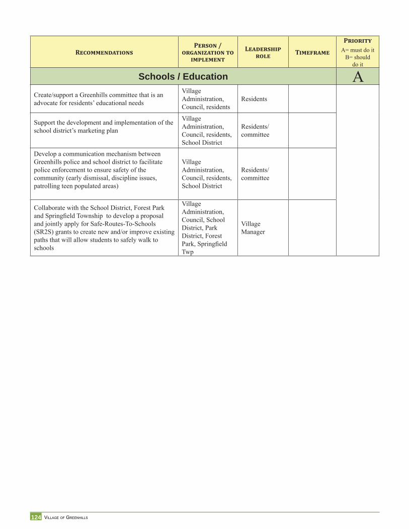
124 VILLAGE OF GREENHILLS
RECOMMENDATIONSPERSON /
ORGANIZATION TO IMPLEMENT
LEADERSHIP ROLE TIMEFRAME
PRIORITYA= must do it
B= should do it
Schools / Education ACreate/support a Greenhills committee that is an advocate for residents’ educational needs
Village Administration, Council, residents
Residents
Support the development and implementation of the school district’s marketing plan
Village Administration, Council, residents, School District
Residents/committee
Develop a communication mechanism between Greenhills police and school district to facilitate police enforcement to ensure safety of the community (early dismissal, discipline issues, patrolling teen populated areas)
Village Administration, Council, residents, School District
Residents/committee
Collaborate with the School District, Forest Park and Springfi eld Township to develop a proposal and jointly apply for Safe-Routes-To-Schools (SR2S) grants to create new and/or improve existing paths that will allow students to safely walk to schools
Village Administration, Council, School District, Park District, Forest Park, Springfi eld Twp
Village Manager
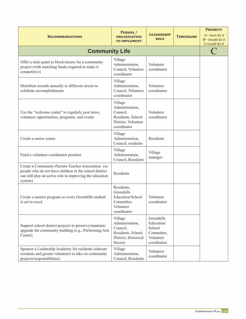
125 COMPREHENSIVE PLAN
RECOMMENDATIONSPERSON /
ORGANIZATION TO IMPLEMENT
LEADERSHIP ROLE TIMEFRAME
PRIORITYA= must do it
B= should do itC=could do itCommunity Life C
Offer a mini-grant to block/streets for a community project (with matching funds required to make it competitive)
Village Administration, Council, Volunteer coordinator
Volunteer coordinator
Distribute awards annually to different streets to celebrate accomplishments
Village Administration, Council, Volunteer coordinator
Volunteer coordinator
Use the “welcome center” to regularly post news, volunteer opportunities, programs, and events
Village Administration, Council, Residents, School District, Volunteer coordinator
Volunteer coordinator
Create a senior centerVillage Administration, Council, residents
Residents
Fund a volunteer coordinator positionVillage Administration, Council, Residents
Village manager
Create a Community-Parents-Teacher Association (so people who do not have children in the school district can still play an active role in improving the education system)
Residents
Create a mentor program so every Greenhills student is set to excel
Residents, Greenhills Education/School Committee, Volunteer coordinator
Volunteer coordinator
Support school district projects to preserve/maintain/upgrade the community building (e.g., Performing Arts Center)
Village Administration, Council, Residents, School District, Historical Society
Greenhills Education/School Committee, Volunteer coordinator
Sponsor a Leadership Academy for residents (educate residents and groom volunteers to take on community projects/responsibilities)
Village Administration, Council, Residents
Volunteer coordinator
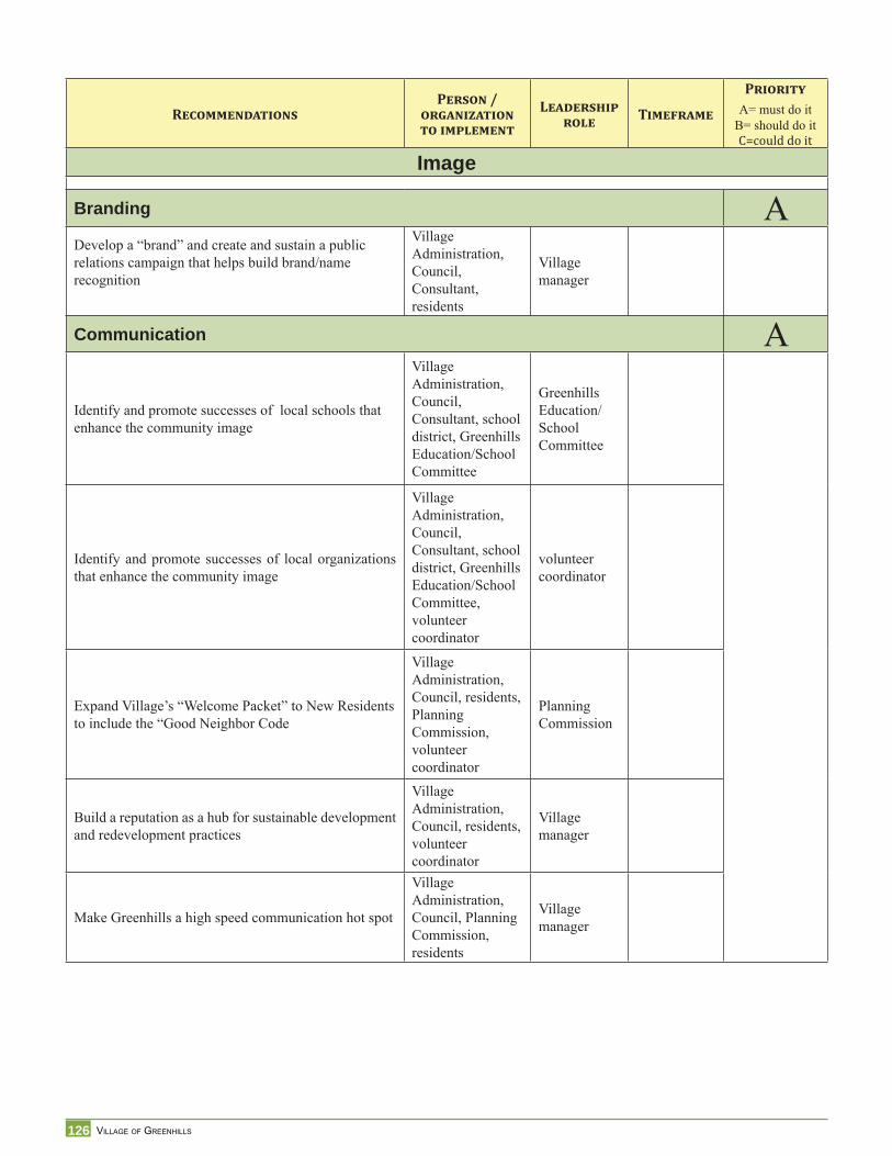
126 VILLAGE OF GREENHILLS
RECOMMENDATIONSPERSON /
ORGANIZATION TO IMPLEMENT
LEADERSHIP ROLE TIMEFRAME
PRIORITYA= must do it
B= should do itC=could do itImage
Branding ADevelop a “brand” and create and sustain a public relations campaign that helps build brand/name recognition
Village Administration, Council, Consultant, residents
Village manager
Communication A
Identify and promote successes of local schools that enhance the community image
Village Administration, Council, Consultant, school district, Greenhills Education/School Committee
Greenhills Education/School Committee
Identify and promote successes of local organizations that enhance the community image
Village Administration, Council, Consultant, school district, Greenhills Education/School Committee, volunteer coordinator
volunteer coordinator
Expand Village’s “Welcome Packet” to New Residents to include the “Good Neighbor Code
Village Administration, Council, residents, Planning Commission, volunteer coordinator
Planning Commission
Build a reputation as a hub for sustainable development and redevelopment practices
Village Administration, Council, residents, volunteer coordinator
Village manager
Make Greenhills a high speed communication hot spot
Village Administration, Council, Planning Commission, residents
Village manager
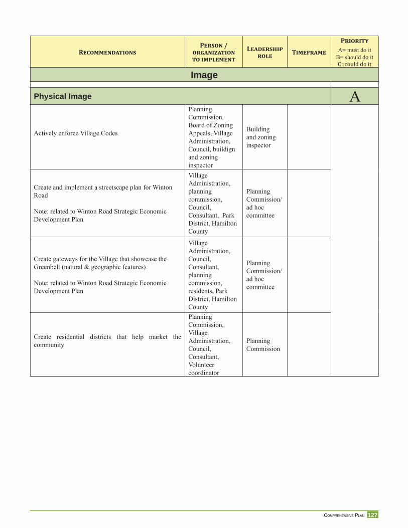
127 COMPREHENSIVE PLAN
RECOMMENDATIONSPERSON /
ORGANIZATION TO IMPLEMENT
LEADERSHIP ROLE TIMEFRAME
PRIORITYA= must do it
B= should do itC=could do itImage
Physical Image A
Actively enforce Village Codes
Planning Commission, Board of Zoning Appeals, Village Administration, Council, buildign and zoning inspector
Building and zoning inspector
Create and implement a streetscape plan for Winton Road
Note: related to Winton Road Strategic Economic Development Plan
Village Administration, planning commission, Council, Consultant, Park District, Hamilton County
Planning Commission/ad hoc committee
Create gateways for the Village that showcase the Greenbelt (natural & geographic features)
Note: related to Winton Road Strategic Economic Development Plan
Village Administration, Council, Consultant, planning commission, residents, Park District, Hamilton County
Planning Commission/ad hoc committee
Create residential districts that help market the community
Planning Commission, Village Administration, Council, Consultant, Volunteer coordinator
Planning Commission
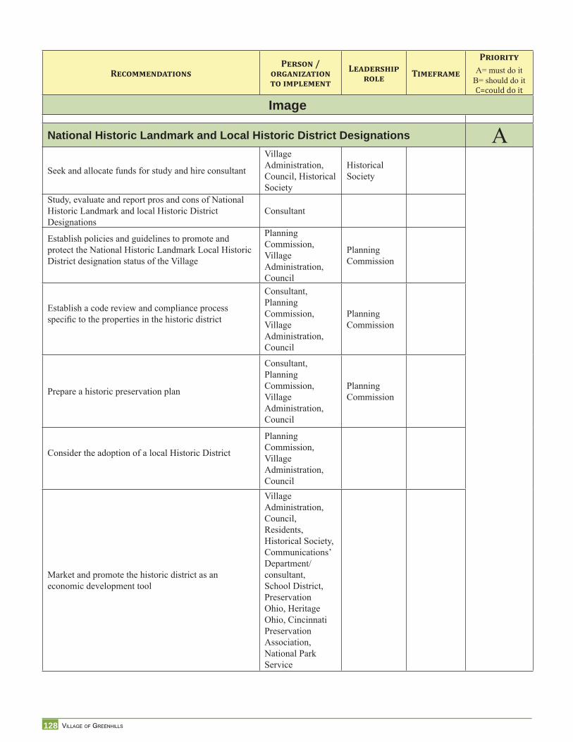
128 VILLAGE OF GREENHILLS
RECOMMENDATIONSPERSON /
ORGANIZATION TO IMPLEMENT
LEADERSHIP ROLE TIMEFRAME
PRIORITYA= must do it
B= should do itC=could do itImage
National Historic Landmark and Local Historic District Designations ASeek and allocate funds for study and hire consultant
Village Administration, Council, Historical Society
Historical Society
Study, evaluate and report pros and cons of National Historic Landmark and local Historic District Designations
Consultant
Establish policies and guidelines to promote and protect the National Historic Landmark Local Historic District designation status of the Village
Planning Commission, Village Administration, Council
Planning Commission
Establish a code review and compliance process specifi c to the properties in the historic district
Consultant, Planning Commission, Village Administration, Council
Planning Commission
Prepare a historic preservation plan
Consultant, Planning Commission, Village Administration, Council
Planning Commission
Consider the adoption of a local Historic District
Planning Commission, Village Administration, Council
Market and promote the historic district as an economic development tool
Village Administration, Council, Residents, Historical Society, Communications’ Department/consultant, School District, Preservation Ohio, Heritage Ohio, Cincinnati Preservation Association, National Park Service
129 COMPREHENSIVE PLAN
Ref
eren
ces/
Bib
liogr
aphy
References2000 U.S. Bureau of Census: Demographic Profi les
2009 Village of Greenhills Tax Budget. Ord. 2008-17F. Passed 7/1/08
Carol A. Lippmeier, 1976. Greenhills, Ohio 1938-1976 – Greenhills Civic Foundation History.
Charter of the Village of Greenhills Ohio, 1988
Ebenezer Howard: Garden Cities of Tomorrow. 1902 http://www.library.cornell.edu/reps/DOCS/howard.htm
ESRI: Market segmentation: http://www.esri.com/library/whitepapers/pdfs/community-tapestry.pdf
Fundamentals of National Historic Register designation. http://www.nps.gov/history/nr/natona_register_fundamentals.htm
Greater Cincinnati Water Works, May 27, 2009. Russ Weber [email protected]
Greenhills Fire Department Annual Report – March 19, 2008
Greenhills History of its Public Schools from the beginning to 1990
Greenhills Police Department. Annual Report 2008
Hamilton County Auditor land use codes used for taxing purposes.
Hamilton County Auditor: 2007 State Abstract Report – Tax Rates and Assessed Valuation. Page 109 of 115 http://www.hamiltoncountyauditor.org/pdf/pp_207stateabstract.pdf
Hamilton County Development Company, October 2007. Greenhills Commercial Corridor Study.
Hamilton County Engineer’s Offi ce. February 2009: Todd Long
Hamilton County Park District http://www.hamilcountyparks.org/foundation/foundation.htm
Hamilton County Regional Planning Commission April 2005. Housing Forum: The Community as a Developer presentation by David Moore.
Hamilton County Regional Planning Commission, August 1999: Hamilton County Decision Support Manual Volume 4. Residential Building Activity by Political Jurisdiction.
ISO (International Standardization Organization)
Ladislas Segoe & Associates, 1964. Greenhills Ohio Planning Administration
Miami Purchase Association for Historic Preservation, June 1991 Historic Inventory of Hamilton County - Ohio: Elmwood Place, Forest Park, Greenhills, Glendale, Golf Manor. “An Historic Survey of 42 Suburban Communities.”
National Register of Historic Places January 1989 Application http://ohsweb.ohiohistory.org/ohpo/nr/detail.aspx?refnum=88003066
130 VILLAGE OF GREENHILLS
Offi cial Statement $2,195,000 Village of Greenhills, Ohio Various Purpose Bonds, General Obligation (Limited Tax) Series 2008.
OKI – Traffi c Count – Hamilton County Directory 1995-2006
Robert B. Fairbanks. October 12, 1980. Village of Greenhills – Past/Present/Future. Creating a Community: Greenhills, the Federal Government and the Cincinnati Metropolitan Region, 1935-1954.
SORTA (South Ohio Regional Transit Authority) Queen City Metro Bus service
Sullebarger Associates Historic Preservation Consultants. June 16, 2006.
The National Historic Landmark listing for Ohio. http://www.nps.gov/history/nhl/designations/Lists/OHO1.pdf
University of Cincinnati. Transportation Seminar. Spring 2008: Greenhills Pedestrian, Bicycle and Transportation Circulation Plan.
Unversity of Cincinnati. Master Thesis MCP, Frederick Lutt, 2004:The Planning Theories of Greenhills.
Village of Greenhills Annual Report for 2007
Village of Greenhills Income Tax Bureau
Village of Greenhills Ord. 211. Passed 8-2-49 (Greenbelt uses)
Vision Statement. Village of Greenhills. May 2, 2000. Prepared by The Greenhills Vision Committee with assistance by McBride Dale Clarion. May 2, 2000.
Walk Score http://www.walkscore.com/how-it-works.shtml
Winton Corridor Study Phase I and Phase II,1997. Study commissioned to PKG
Winton Woods Cities School DistrictTax Levy and Enrollment History
Winton Woods High School. 2007-2008 School Year Report Card.
Winton Woods Middle School. 2007-2008 School Year Report Card.
Winton Woods Primary North 2007-2008 School Year Report Card.
131 COMPREHENSIVE PLAN
List
of M
aps,
Tab
les,
Imag
es, a
nd C
harts
List of MapsMap 1: Greenhills Superblocks .............................................................................14Map 2: Redevelopment Target Areas ....................................................................16Map 3: Historic Assets Map ..................................................................................19Map 4: Percent of Owner Occupied Units in Foreclosure ....................................27Map 5: Dominant Tapestry Segmentation Map ....................................................28Map 6: Existing Land Use Map ............................................................................39Map 7: Mortgage Foreclosures 2008 - Greenhills ................................................41Map 8: Greenbelt Land Use Map .........................................................................44Map 9: Zoning Map ..............................................................................................49Map 10: Topography ...............................................................................................51Map 11: Flood Insurance ........................................................................................52Map 12: 2010 Water/Sewer Updates ......................................................................55Map 13: Utilities .....................................................................................................56Map 14: Suggested Greenhills Pedestrian Network Improvements .......................58Map 15: Bike & Pedestrian Path Map ....................................................................60Map 16: Bus Route Map .........................................................................................62Map 17: Parks & Recreation Map ..........................................................................64Map 18: ZIP Code Map ..........................................................................................71Map 19: Residential and Village Center Districts ...................................................87Map 20: Suggested District: Village Center and Municipal Recreation Complex .88Map 21: Preliminary Identifi cation of Sites with Potential for Redevelopment ...100Map 22: Future Land Use .....................................................................................104Map 23: Recommended Trailhead Connection to Winton Wds Nature Trails .....106
List of ImagesImage 1: Housing from late 1930s ..........................................................................13Image 2: Apartment Building ..................................................................................14Image 3: 51 Damon Road ........................................................................................15Image 4: Housing from 1950-1960 .........................................................................16Image 5: Landominiums on FDR Walk ...................................................................16Image 6: Houses by PotterHill ................................................................................17Image 7: Whallon House .........................................................................................17Image 8 Alcott ........................................................................................................42Image 9: Ashby ........................................................................................................42Image 10: Bayham .....................................................................................................42Image 11: Landominium ...........................................................................................42Image 12: Drummond ................................................................................................42Image 13: Duplex ......................................................................................................42Image 14: 3-Famly Attached .....................................................................................42Image 15: Nursing Home ..........................................................................................42Image 16: Greenhills Shopping Center .....................................................................45Image 17: Johnny’s Toys ...........................................................................................45Image 18: Community Building ................................................................................45Image 19: Mobilcomm Combined Technology .........................................................46Image 20: Community Pool .......................................................................................46Image 21: Nick Bates Commons ...............................................................................46Image 22: Trees in the ROW ....................................................................................65Image 23: Greenhills Fire Station ............................................................................66Image 24: Greenhills Police .....................................................................................67
Image 25: Primary North School ..............................................................................71Image 26: Middle School .........................................................................................71Image 27: Our Lady of the Rosary School ...............................................................73Image 28: Greenhills Historical Marker ...................................................................85Image 29: Greenhills Shopping Center ....................................................................89Image 30: View of Theatre Space ............................................................................94Image 31: Molloy’s on the Green .............................................................................98
List of TablesTable 1: Percent Change in Employees .................................................................21Table 2: Percent Change in Employees (Retail Sector) ........................................21Table 3: Percent Change in Employees (Service Sector) ......................................22Table 4: Economic Trend Analysis ........................................................................22Table 5: Industry Statistics 1999 ...........................................................................23Table: 6 Household Type .......................................................................................24Table 7: Income .....................................................................................................25Table 8: Population Age Cohorts ..........................................................................25Table 9: Demographic Summary ...........................................................................26Table 10: Educational Attainment ...........................................................................26Table 11: Valuation of Property ..............................................................................34Table 12: Greenbelt Communities Comparison ......................................................35Table 13: 10 Largest Employers in Greenhills ........................................................36Table 14: Overlapping Tax Rates ............................................................................36Table 15: Greenhills General Fund .........................................................................37Table 16: Existing Land Use ...................................................................................38Table 17: Age of Housing .......................................................................................40Table 18: Building Permit Quantity and Value .......................................................50Table 19: Greenhills Capital Improvement Projects ...............................................53Table 20: Open Space and Recreation .....................................................................63Table 21: Police Service Calls .................................................................................68Table 22: Breakdown of Arrests ..............................................................................68Table 23: Crashes by Month 2008 ...........................................................................69Table 24: Crashes by Day of the Week ...................................................................69Table 25: Crashes by Hour of the Day ....................................................................69Table 26: Crash Contributing Factors .....................................................................69Table 27: Uniform Crime Report ............................................................................70Table 28: Type of Schooling ...................................................................................72Table 29: Winton Woods School District Enrollment .............................................72Table 30: Our Lady of the Rosary School Enrollment ............................................73
List of ChartsChart 1: Population Trend 1940-2030 ...................................................................23Chart 2: Population Change ..................................................................................24Chart 3: House/Condo Value .................................................................................26Chart 4: Leakage/Surplus Factor by Industry Subsector .......................................31Chart 5: Leakage/Surplus Factor by Industry Subsector .......................................32Chart 6: Total Assessed Valuation .........................................................................34Chart 7: Winton Woods School District Enrollment History ................................72
132 VILLAGE OF GREENHILLS
133 COMPREHENSIVE PLAN
App
endi
ces
1. Schedule of Meetings
2. Ohio Historic Preservation Offi ce. National Register Reference Number 88003066 http://ohsweb.ohiohistory.org/ohpo/nr/details.aspx?refnum=88003066
3. Market Study ESRI On-demand Reports 12/31/2008 a. Retail Market Place Profi le b. Income and Tapestry Maps c. Retail Market Study
4. Table: Greenhills Comparison with Selected Hamilton County Communities
5. Greenhills Community Profi le
6. History of Public Schools from the Beginning to 1990 provided by Jack Lee, President of the School Board, Winton Woods City School District, June 3, 2009
7. Winton Woods City School District Tax Levy and Enrollment History, April 8, 2008
8. Our Lady of the Rosary Documents Regarding its Closing
9. City of Montgomery: “Coolest” Civics Class Turns Residents Into Citizens. Frank Davis, UPDATE The Planning Partnership Newsletter, April 2009
10. City of Milford Property Maintenance Code
11. Village of Shorewood Certifi cate of Compliance Program
12. Village of Greenhills Great Neighborhoods 2006. “Cincinnati Magazine”
13. Village of Greenhills Shopping Center Patterns Survey Summary, December 3,2008
14. Village of Greenhills Focus Groups May 21, 2009