Embed Size (px)
Citation preview

VISITOR SAFETY RISK ASSESSMENT – FORT GEORGE
Version – 2.0 Date of Issue – 25/05/2018 VSRA – Fort George Page 1 of 52
VISITOR SAFETY RISK ASSESSMENT FORT GEORGE

VISITOR SAFETY RISK ASSESSMENT – FORT GEORGE
Version – 2.0 Date of Issue – 25/05/2018 VSRA – Fort George Page 2 of 52
HAZARDS MAIN HAZARDS TO VISITORS AT THE PROPERTY • Fall from height from built structure or through openings • Slips on grass and flat surfaces • Being struck by falling masonry • Car park vehicle and pedestrian movement
PREVIOUS RISK ASSESSMENTS There are in excess of 100 site specific risk assessments for Fort George on the assess-net system – few relate to visitor safety. These date back to the 2005 period and reference significant hazards including falls from height, workplace transport and slips trips and falls. There are many visitor services and conservation risk assessments available locally that cover the significant risks on site. The photographs are from the original assessment unless otherwise stated. INFORMATION ABOUT KNOWN INCIDENTS There have been several staff interventions and near misses when events have been held, predominantly with visitors climbing ramparts. A visitor broke an arm having slipped on the principal bridge - this resulted in an anti-slip surface being applied. A visitor fell from a cannon which resulted in medical assistance being required.

VISITOR SAFETY RISK ASSESSMENT – FORT GEORGE
Version – 2.0 Date of Issue – 25/05/2018 VSRA – Fort George Page 3 of 52
SITE LAYOUT DIFFERENT AREAS CONSIDERED WITHIN THE DETAILED RISK ASSESSMENT • Visitor car park and overspill parking area • Glacis and covered way • South exterior including harbour and fort personnel car parks • Beach – seaward side of the fort • Ravelin and visitor centre • Principal gate and bridge • Guardrooms and Parade • Rampart and Bastion • Casemates • Barracks • Grand magazine • Ordnance and provision stores • Chapel • Visitor café

VISITOR SAFETY RISK ASSESSMENT – FORT GEORGE
Version – 2.0 Date of Issue – 25/05/2018 VSRA – Fort George Page 4 of 52
MAP OF THE PROPERTY

VISITOR SAFETY RISK ASSESSMENT – FORT GEORGE
Version – 2.0 Date of Issue – 25/05/2018 VSRA – Fort George Page 5 of 52
VISITORS CATEGORISATION FOR RISKS TO VISITORS 76,126 visitors 2017/18 – Category A VISITOR ACTIVITIES SCHOOL GROUPS School groups are welcome at the fort and both an ‘Information for Teachers’ note, and hazard information sheet are available online. These provide brief health and safety details regarding the need for risk assessment and supervision by visiting groups.
EVENTS The annual ‘Celebration of the Centuries’ event occurs in August which depicts centuries of history, from the Picts to WWII. This is a ticketed event. Event specific assessments are completed by the events team. The Highland Military Tattoo is a recent addition to the event calendar at Fort George and takes place each September. This is managed by the tattoo and an organised ticketed event. Contractors are on site during the construction of viewing stands etc. and their movements are not managed by Historic Environment Scotland. Visitors are welcomed during this construction phase and segregation of visitors and contractor is managed by the military.
VISITORS WITH DISABILITIES The access guide (page 90) provides information for visitors with disabilities. Guidance covers car parking provision, the approach to the site, wheelchair provision and surface conditions within the fort. General guidance on the website identifies the significant risks of the site. WEDDINGS, CEREMONIES AND PHOTOGRAPHY Fort George is not advertised on the portfolio of wedding venues. Requests should be forwarded to the weddings team based at Longmore House.
OPENING AND STAFFING ARRANGEMENTS During the summer (25 March – 30 September) the fort is open daily from 0930 - 1730. Winter sees the fort remain open - the hours reduce to 1000 – 1600. The visitor centre is staffed throughout the year.

VISITOR SAFETY RISK ASSESSMENT – FORT GEORGE
Version – 2.0 Date of Issue – 25/05/2018 VSRA – Fort George Page 6 of 52
THE VISITOR EXPERIENCE The Fort consists of a ravelin, foreworks and ramparts with 6 bastions, within parts of the ramparts are casemates, providing additional bomb-proof accommodation for the garrison. The internal buildings are symmetrically laid to either side of a road which forms the central axis. The parade ground is in the east of the Fort, flanked by the imposing artillery and staff blocks. Beyond them are 2 large U-shaped barrack blocks around a barrack square, then the ordnance and provision stores and at the western end is the garrison chapel. The design of Fort George derives from an international architectural vocabulary developed by military engineers across Europe in the preceding 300 years. The designer, Major General Skinner travelled widely, and drew on this experience and on the recent innovative work by the French engineer, Cormontaigne. He designed the bastions to be solid; increasing the manoeuvrability of guns and allowing the installation of raised gun batteries, en barbette, on the eastward facing bastions. The flanks of the bastions are elongated, requiring fewer guns to cover the approaches. But it is the refinements to the outworks that are most significant when compared to earlier defences in the UK. The 1745 Rising was the last attempt by the Stewart dynasty to unseat the Hanoverian monarchy ultimately finished at the battle of Culloden in April 1746. In the aftermath of Culloden, Prince Charles Edward Stewart fled the country and Government forces under the Duke of Cumberland’s brutally restored order in the Highlands. A system of patrols was put in place, adapting existing buildings such as Corgarff and Braemar Castles for their use. In addition, the Great Glen Forts would be repaired and in the case of Inverness, rebuilt. Construction began on 11 June 1748, to the designs of William Skinner, Engineer for North Britain. The building work was overseen by William Adam (after his death later in 1748 his sons continued the work). This was the biggest construction job ever completed in the Highlands, requiring 1,000 men to build and all the materials to be brought in by sea. Security in the early years was seen as a constant threat. The defences were constructed first. Only when these were well underway did work on the domestic accommodation begin. In 1760, the Fort received its main armament of 65 guns.
In 1859, during the French emergency the defences were remodelled as a coastal-defence battery and rearmed with traversing guns. A reorganisation of the Army in 1881 made Fort George the home depot for the Seaforth Highlanders, a regiment formed by the amalgamation of the 72nd and 78th Highlanders. The 78th had a long association with the Fort, having first paraded there in July 1793. The Fort continued as a regimental depot until 1961 when the Seaforths were amalgamated with the Cameron Highlanders to for the Queen’s Own Highlanders. They marched out in 1964, the regimental association and museum remained.

VISITOR SAFETY RISK ASSESSMENT – FORT GEORGE
Version – 2.0 Date of Issue – 25/05/2018 VSRA – Fort George Page 7 of 52
SIGNIFICANCE STATEMENT OF SIGNIFICANCE – KEY POINTS Fort George is the finest example of eighteenth-century military engineering in the British Isles and is virtually unaltered since its completion in 1769. Set within its military landscape, it remains the most accomplished of Britain’s 18th century artillery fortifications. The association with Scotland’s best-known architectural dynasty, the Adam family, throughout the work, gives the fort particular importance. Many ex-soldiers and many ex-national service men retain strong links to the fort, particularly through the association with the Seaforth Regiment and its successors. Fort George serves as a modern reminder of the political divisions within the nation.
SHARED RESPONSIBILITY
In the spirit of co-operation and joint responsibility for the safety of employees and others who may be affected by our activities or properties, this assessment is shared with the Defence Infrastructure Organisation (DIO) and the Regimental Museum. This document compliments the memorandum of understanding between HES and the DIO.

VISITOR SAFETY RISK ASSESSMENT – FORT GEORGE
Version – 2.0 Date of Issue – 25/05/2018 VSRA – Fort George Page 8 of 52
DETAILED RISK ASSESSMENT – 25 MAY 2018
EXTERNAL
VISITOR CAR PARK & OVERSPILL PARKING AREA On approach to Fort George from the village of Ardersier, visitors with vehicles are directed into the designated car park. The surface is level and laid to tarmac (picture 1). Further parking provision is available, during busy periods, on the grassed area on the north side of the approach road. To the south of the approach is another grassed area with provision made, in the form of a footpath from Ardersier, for those visiting on foot. Both the south side of the road and the adjacent shoreline have been sectioned off with roped white bollards and wire fence respectively. Warning signs are positioned by the wire fence highlighting that the visitor should not enter the area. An opening is provided between the bollards and the end of the footpath where the visitor can cross the road towards the fort (picture 2). This crossing is in close proximity to the entrance down towards the fort personnel car parking areas. This creates a potential pedestrian and vehicle interaction that cannot be eliminated. Fort George personnel are aware of the designated speed limits within this area and adequate signage is provided to the standard of UK highway convention. The south side of the personnel car park entrance is a grass slope and can be accessed from the crossing point of the footpath. The area is lightly sectioned off but can be easily defeated by the visitor wishing to get closer to the shoreline (picture 3). A warning sign is fixed into the grass at the tip of the slope – the edge/drop and wall head become clear upon approach.
1. Visitor Car Park 2. Footpath Crossing Point 3. South Side of Personnel Car Park Entrance

VISITOR SAFETY RISK ASSESSMENT – FORT GEORGE
Version – 2.0 Date of Issue – 25/05/2018 VSRA – Fort George Page 9 of 52
GLACIS & COVERED WAY Returning to the main car park, the visitor will instinctively head north-west towards the entrance path into the fort. It is at this point that the main risk of falling from height is first highlighted in the form of a sign (picture 4). To the south side of the path is a grassed area that leads up to the edge of the glacis. A warning sign has been placed approx. 4m from the edge. The wall head is visible upon approach though more overgrown than other examples found on site. To the south of this area is the approach road to the personnel car parks where a drop of 3.2m to tarmac is present. The wall head is defined, and a sign is also placed at the edge. To the north of the entrance path, along the external boundary, the visitor walks upon the well-maintained grass bank that is the glacis. This zigzags across the neck of the promontory and is constructed from the earth excavated from the great ditches behind it. To the north-east, a DIO firing range is hidden from sight by established whin and gorse bushes (picture 5). The area is fenced with two access gates provided for walkers leaving the curtilage of the fort – warning signage is in place and both a sentry and red flags are present when the range is live. The initial outer defences of the glacis are edged/bordered by a 400mm wide wall head that provides some delineation. At the entrance, a small section of reconstructed palisade timbers provides additional visual warning of the approaching 2m drop into a gulley that is edged with stone and filled with a light covering of bark (picture 6).
4. Entrance Fall From height Warning Sign 5. Grassed Glacis Looking Toward Firing Range 6. Palisade & Wall Head Illustrating Drop

VISITOR SAFETY RISK ASSESSMENT – FORT GEORGE
Version – 2.0 Date of Issue – 25/05/2018 VSRA – Fort George Page 10 of 52
Continuing north along the east of the outer defence the visitor is continually exposed to the fall from height risk. The wall head becomes more obvious upon approach though there are some areas with significant growth that may become a problem. From this vantage the visitor can look upon a further drop into the ditch that is currently highlighted by warning signs fixed into the grass (picture 7). Reliance on the visibility of the wall head of the eastern outer defences to delineate the approaching drop, whilst providing warning signage to the edge of the southern outer defences and inner ditch, does not illustrate a consistent approach to similar risks the visitor will be exposed to. This inconsistency is replicated along the eastern defences. Identified Risk (IR)1 The walkway (Nairn road) to the east of the fort provides access into the covered way defensive line. The edge of the walkway is obvious upon approach, as the north wall on the slope is visible from a significant distance and provides adequate warning of the fall from height risk (picture 8). The north edge of the site has a drop of approx. 5m to the shingle beach and is delineated by a 600mm wide wall head – this should be considered in conjunction with identified risk 1 (picture 9).
Identified risk 1 – Falls from height – East External Outer Defences (Glacis)
Area and location Hazard People at risk Typical outcome Current precautions
East outer defences – glacis wall edge
Fall from height Visitors, with an emphasis on children. Army personnel. *Pet dogs
Major injury Entrance warning sign. Reliance on risk becoming evident upon approach

VISITOR SAFETY RISK ASSESSMENT – FORT GEORGE
Version – 2.0 Date of Issue – 25/05/2018 VSRA – Fort George Page 11 of 52
Discussion Decision and rationale Action required Time scale Action completed
There are circa 60,000 visitors to Fort George on an annual basis - range from mature visitors to families. The consequences of a fall from height from the outer defences are severe i.e. major injury. It is foreseeable that visitors may allow children to walk ahead of them towards the areas in question. It is also foreseeable that the majority of visitors will see the risk manifest as they approach. A fall from height would adversely affect the visitor experience. The introduction of physical safety measures would not adversely damage the monument however it may impact the setting and adversely affect the aesthetic. There is a distinct inconsistency of approach to the same risk that would be difficult to argue against in the event of an incident. It would not be physically difficult or costly to introduce similar safety measures. There is a nominal risk to persons introducing additional safety measures. As the majority of visitors will go directly into the fort, they will become exposed to the warning signs at an early stage of the visit. This may result in an illusion of safety should they subsequently decide to visit the glacis on exit as they will have an expectation of dangerous falls being highlighted to them. Family expectation should also be noted i.e. more likely to allow children to walk ahead if no warning is provided. There is a substantive argument that the risks are obvious upon approach to the majority of visitors. OPTIONS: 1. Introduce additional signage on the glacis; 2. Remove all warning signs for falls; 3. Accept the risk.
Following a complaint from a member of the public, additional signs were fitted to the edge of the glacis – to the left of the entrance walkway. This presented an inconsistency of approach to the initial external fall from height risks found to the left of the walkway. It was agreed that a similar approach was required at the initial walk-up to the east of the glacis – the rationale for this is based upon the fact the slope of the glacis (as was its design) hides the initial fall from height risk. The following fall from height risks were seen from a distance and the initial forewarning agreed to be suitable illustration of the potential fall from height risks the visitor will come to as part of the experience.
Pictorial signs consistent with those found throughout the site were fitted by the initial approach to the glacis (east side) from the car park.

VISITOR SAFETY RISK ASSESSMENT – FORT GEORGE
Version – 2.0 Date of Issue – 25/05/2018 VSRA – Fort George Page 12 of 52
7. Outer Defences Looking Towards Ditch 8. Approach to East Access Route to Covered Way 9. North Edge Looking Towards Beach Returning south towards the car park the visitor can enter into the ‘covered way’ via the former Nairn road entrance. Walking back towards the north (turning right) the visitor will come upon a grassed walkway and the edge/drop of the Principal ditch. The edge is initially highlighted by warning signs positioned at set distances along the entire ditch (picture 10). The edge is delineated by a stone wall head and is obvious upon approach. Continuing to the North Sea boundary wall, the visitor can approach an opening to view the Moray Firth (picture 11). There is a step up to this viewpoint where a delta bronze rail has been fitted to act as a barrier (1.1m high). A 350mm stone lip at toe level reduces the gap to 750mm. There is potential for visitors, especially children, to fall a distance in excess of 3m to the shingle beach. IR2 Also situated along the north wall is a platform that is accessed down ten stone steps (picture 12). The steps and platform are 1.8m wide though in part the platform widens by 600mm. The inner edge of both platform and steps is unprotected, with a drop of 3.5m to the grass of the Principal ditch. Growth is evident and increases the likelihood of a slip trip and fall. The steps are in good condition and level. IR3 Identified risk 2 – Opening in north wall
Area and location Hazard People at risk Typical outcome Current precautions
North wall – looking over Moray Firth
Fall from height Visitors – with an emphasis on children
Major – moderate injury
Delta bronze bar and stone lip at foot level

VISITOR SAFETY RISK ASSESSMENT – FORT GEORGE
Version – 2.0 Date of Issue – 25/05/2018 VSRA – Fort George Page 13 of 52
Discussion Decision and rationale Action required Time scale Action completed
The severity of the consequences of a fall could vary as there is the potential for vulnerable visitors to fall through the 750mm gap between the bar and stone lip. For the majority the protection afforded is reasonable. In addition, there is an external lip that could prevent a fall to the beach. It is foreseeable that visitors will be attracted to the viewpoint and the risk becomes more evident upon approach – the closer to the opening the visitor gets, the less severe the opening appears. Further intervention may impact the aesthetic and damage the monument – though intervention has occurred already. The intervention is consistent with other examples found in similar situations at other sites e.g. Earls and Bishops Palaces in Kirkwall. Introducing additional measures may create an illusion of a safe environment – especially when considered against the fall risk present on the adjacent platform (see IR3). Any additional measures would not be cost prohibitive and only represent a nominal risk to those contracted with introducing them. Introducing further measures may impact the consistency of approach of similar intervention at other sites. OPTIONS: 1. Introduce additional physical barrier or grill; 2. Introduce signage to delta bar; 3. Close the area; 4. Accept the risk.
The decision was made to accept this risk as the opening becomes less severe on approach and the fall is obvious upon approach. Ensuring consistency of approach to similar risks was also seen as appropriate.
None.

VISITOR SAFETY RISK ASSESSMENT – FORT GEORGE
Version – 2.0 Date of Issue – 25/05/2018 VSRA – Fort George Page 14 of 52
10. Warning Signs by the Principal Ditch Drop 11. Opening in North Facing Shore Wall 12. Platform on North Facing Shore Wall
Identified risk 3 & 8 – Platform in north facing shore wall & firing platform on south facing defence wall
Area and location Hazard People at risk Typical outcome Current precautions
Platform - north shore wall & south defence wall
Fall from height Visitors and maintenance personnel Major injury None

VISITOR SAFETY RISK ASSESSMENT – FORT GEORGE
Version – 2.0 Date of Issue – 25/05/2018 VSRA – Fort George Page 15 of 52
Discussion Decision and rationale Action required Time scale Action completed
Persons falling from the platforms or steps will fall 3.5m or 5m respectively, on to grass. This will result in significant injury. It is foreseeable that visitors will access the platforms. It is also foreseeable that many will avoid the areas as the risk is clear prior to access. Pictorial signage is evident along the approach to the areas – identifying the risk throughout this locus. Physical safety measures may damage the structure, affect the aesthetic and detract from the visitor experience. Any growth on the platforms increases the likelihood of a fall and presents a moderate risk to maintenance teams during removal activity. Installation of physical measures would present risk to contractors and represent a significant cost to the organisation OPTIONS: 1. Introduce physical safety measures; 2. Accept the risk.
Introducing physical barriers would represent a significant precedent for both the rest of the fort and other monuments found throughout the estate. The obvious nature of the risk and the impact intervention would have on the site were also factors in the decision to accept the risk and inform the SMT of this decision.
Accept the risk. Inform the SMT, in the first instance, via the corporate safety forum. This and other after mentioned fall from height risks will be added to the register of risk.
09/11/2016 – next corporate health and safety forum
2017
Walking back (south) from the north boundary of the covered way, the visitor can approach some climbing opportunities (picture 13). The wall heads are in poor condition in this area and may pose a slip trip and fall opportunity to the risk taker. The condition of the stonework has been intentionally left in its current state of repair to highlight deterioration from the original condition and also provides testing panels for future intervention. The condition and risks are obvious upon approach. The visitor approaches a set of steps down into the principal ditch at this point within the covered way – looking towards the principal gate (picture 14). The platform and 27 steps are level and in good condition. The steps were dry and clear of growth at the time of assessment. There are warning signs placed next to the steps. There is an open edge to the platform and steps with a 5.5m drop on to grass at the highest point. IR4 Continuing towards the south point of the ravelin for approx. another 100m, the visitor will approach another set of steps descending into the ditch (picture 15). The edge of the ditch has warning signs placed along at set distances. The steps are almost identical to those identified in risk 4 though there is a growth of white algae that makes the conditions greasy under foot. IR5

VISITOR SAFETY RISK ASSESSMENT – FORT GEORGE
Version – 2.0 Date of Issue – 25/05/2018 VSRA – Fort George Page 16 of 52
Identified risks 4, 5 & 7
Area and location Hazard People at risk Typical outcome Current precautions
Access steps and platforms into the principal ditch
Fall from height Visitors and others visiting the external of the fort e.g. dog walkers
Major injury with potential for fatality
Warning signs are placed in the vicinity of the edge of the entire ditch
Discussion Decision and rationale Action required Time scale Action completed
Of the circa 70,000 visitors, it can be fair to suggest that many may not visit the outer defences or covered way as they are separate from the initial visitor route from the car park. Those visiting without entering the fort are able to gain access to the covered way. It is foreseeable that visitors will approach and use the steps to gain access into the ditch. Vulnerable visitors may not descend/ascend the steps. A fall from height would have significant consequences. There would be physical damage to the steps and platforms should an intervention be implemented. There would also be risks to those installing physical measures as the process would be difficult. To provide a consistent approach to the risk, a significant part of the fort and other monuments with similar risks would need to be considered, should physical measures be introduced. The cost of this would be considerable, impact the aesthetic and may detract from the visitor experience. OPTIONS: 1. Fit barriers, handrails and additional warning signs; 2. Provide additional stewards (especially during events, busy periods etc.); 3. Accept the risk.
Introducing physical barriers would represent a significant precedent for both the rest of the fort and other monuments found throughout the estate. The obvious nature of the risk and the impact intervention would have on the site were also factors in the decision to accept the risk and inform the SMT of this decision.
Accept the risk. Inform the SMT, in the first instance, via the corporate safety forum. This and other mentioned fall from height risks will be added to the register of risk
09/11/2016 – next corporate health and safety forum
2017

VISITOR SAFETY RISK ASSESSMENT – FORT GEORGE
Version – 2.0 Date of Issue – 25/05/2018 VSRA – Fort George Page 17 of 52
13. Example of Damaged Wall Heads 14. Steps Platform (Looking Towards Gate) 15. View of Ditch Steps (Looking South) Continuing south-west along the grassed walkway of the covered way, the visitor comes to the south edge of the ditch. The glacis is to the left (south) side of the visitor where a small 900mm ditch is visible upon approach (picture 16). The outer bridge across the ditch is found at this point and is bordered by a robust wooden fence for a short length (picture 17). Warning signs continue along the exposed edge of the ditch. IR6
16. Palisade Ditch by Glacis Wall 17. Ravelin Bridge & Barriers 18. Platform & Steps Looking North-West

VISITOR SAFETY RISK ASSESSMENT – FORT GEORGE
Version – 2.0 Date of Issue – 25/05/2018 VSRA – Fort George Page 18 of 52
Identified risk 6 – Partial barrier & open edge warning signs (found along the entire edge of the ditch)
Area and location Hazard People at risk Typical outcome Current precautions
Ravelin bridge & along ditch edge within covered way
Fall from height Visitors Major injury potential for fatality
Warning signage
Discussion Decision and rationale Action required Time scale Action completed
It is at the entrance by the Ravelin bridge that the majority of visitors will first have the fall from height risks associated with many areas of the monument illustrated. The robust wooden barrier is provided for limited sections where the likelihood of a fall is greater. For the most part there is no edge protection. Warning signs have been spaced along the entire length of the ditch edge. The hazard is obvious and relatively easy to see. Consequences and likelihood of a fall from height have been discussed earlier and are relevant to this hazard. Impact on the experience, structures and aesthetic are also similar. The signs provide a proportionate response to a real hazard that is well documented throughout the site and on the official website. The sign intervention is not consistent with the approach to the outer defences to the north-east i.e. there are no signs to the north-east. Signs have been placed at the south-west boundary of the outer defences. For the most part, the signs have not detrimentally affected the visitor experience. OPTIONS: 1. Introduce physical barriers; 2. Remove existing warning signs from edge; 3. Introduce periodic signage to the north-east outer defence edges; 4. Accept the risk.
Introducing physical barriers would represent a significant precedent for both the rest of the fort and other monuments found throughout the estate. The obvious nature of the risk and the impact intervention would have on the site were also factors in the decision to accept the risk and inform the SMT of this decision.
Accept the risk. Inform the SMT, in the first instance, via the corporate safety forum. This and other mentioned fall from height risks will be added to the register of risk.
09/11/2016 – next corporate health and safety forum
2017

VISITOR SAFETY RISK ASSESSMENT – FORT GEORGE
Version – 2.0 Date of Issue – 25/05/2018 VSRA – Fort George Page 19 of 52
South-west of the Ravelin Bridge, the walkway remains level and grassed with warning signs in place at the ditch edge. A third platform and steps into the ditch are found at this point. The conditions and risks here are similar to those illustrated in identified risks four and five (picture 18). IR7 Continuing south and by the tip of the Prince of Wales’s Bastion, there is a firing platform presenting similar risks to those found on the north boundary wall (picture 19). This platform is accessed via four steps, is overgrown and the open edge presents a fall from height risk in excess of 5m on to grass. This identified risk should be reviewed in tandem with identified risk three. IR8 South-east of the firing platform, visitors can look out towards the Moray Firth (and personnel car parks) from a raised vantage point behind the glacis wall (picture 20). A fall from height risk of approx. 900mm (replicated along the entire base of the glacis wall) is present and obvious upon approach. The likelihood of a person falling into the gulley in this area may be increased slightly as visitors view the firth from the afforded vantage point. The visitor has to retrace their steps back from the vantage point and can turn right (north-east) towards the outer gates and palisade (picture 21). A post and chain link barrier is in place to encourage visitors entering from the car park to continue to the right (north-east) on the path to the outer bridge. Visitors can also return to the car park from here. The edge of the glacis slopes from 1.7m in height to ground level as the visitor leaves via the path. This presents a potential fall from height risk as illustrated earlier in the assessment.
19. Firing Platform (By Prince of Wales Bastion) 20. Vantage Point to Moray Firth 21. North East Access to Outer Gates & Palisade

VISITOR SAFETY RISK ASSESSMENT – FORT GEORGE
Version – 2.0 Date of Issue – 25/05/2018 VSRA – Fort George Page 20 of 52
SOUTH EXTERIOR - FORT PERSONNEL CAR PARKING, HARBOUR & BEACH Although not promoted, many visitors access the south exterior of the fort via the shoreline and the road to the personnel car parks (picture 22). There is potential for vehicle and pedestrian interaction though the speed limit and clear viewpoint of the road reduce the likelihood of this occurring. There are risks associated with the use of car parks in this area. The visitor can continue west along the outer south casemate and on to the external area of the Prince William Henry bastion (picture 23). There are wall heads in this area that are not as well defined as those found within the authorised visitor areas. The risk is obvious upon approach. Heading west past the bastion towards the overspill car park, the grass is not kept in good condition – this will discourage many visitors from approaching the outer wall areas (picture 24). The harbour to the south of Prince William’s bastion is currently sealed from the firth and is clear upon approach.
22. Entrance to Personnel Car Parks 23. Bastion & Casemate (Looking East) 24. Overgrown Boundary of Bastion Prince Frederick William’s demi-bastion can be approached via the overspill car park. The surface is in poor condition and presents a slip and trip risk (picture 25). This leads on to the shingle beach. Visitors can continue north past the point battery and Duke of Marlborough’s demi-bastion (picture 26). Access is via the beach or a small strip of grass to the base of the outer wall. The visitor can continue, tide dependent, north-east along the seaward length of the fort (picture 27).

VISITOR SAFETY RISK ASSESSMENT – FORT GEORGE
Version – 2.0 Date of Issue – 25/05/2018 VSRA – Fort George Page 21 of 52
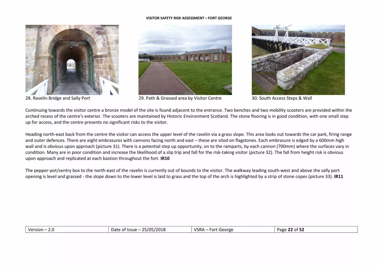
25. Overspill Car Park & Shoreline 26. Point Battery & M’ Borough’s Demi-Bastion 27. Seaward Side of Fort & Shingle Beach INTERNAL RAVELIN & VISITOR CENTRE The paying visitor first enters via the Ravelin Bridge and cobbles of the sally port. The bridge deck is of timber construction and has anti-slip strips fitted. The cobbles are covered by the port which protects the surface from the elements (picture 28). The cobbles were gritted at the time of assessment. The green studded timber doors at each end of the sally port are heavy and difficult to move. These are in the open position during opening hours. The visitor continues from the cobbles on to a tarred path that is level and in good condition. At this point, heading towards the visitor centre, the path is flanked by a grassed area (picture 29). To the west of the path a small grass slope is visible and has two warning signs fitted. To the north and south of the entrance to the principal bridge there are two sets of steps that lead down (approx. 17 steps) to a locked access door for the principal ditch. The steps are in reasonable condition and metal handrails are fitted. The top of the steps are edged by a small wall with a 460mm wide copestone. This presents a climbing opportunity and there is potential to fall a distance of 2.6m on to the steps (picture 30). There are pictorial warning signs in this area and the edge is clear upon approach. IR9
VISITOR SAFETY RISK ASSESSMENT – FORT GEORGE
Version – 2.0 Date of Issue – 25/05/2018 VSRA – Fort George Page 22 of 52
28. Ravelin Bridge and Sally Port 29. Path & Grassed area by Visitor Centre 30. South Access Steps & Wall Continuing towards the visitor centre a bronze model of the site is found adjacent to the entrance. Two benches and two mobility scooters are provided within the arched recess of the centre’s exterior. The scooters are maintained by Historic Environment Scotland. The stone flooring is in good condition, with one small step up for access, and the centre presents no significant risks to the visitor. Heading north-east back from the centre the visitor can access the upper level of the ravelin via a grass slope. This area looks out towards the car park, firing range and outer defences. There are eight embrasures with cannons facing north and east – these are sited on flagstones. Each embrasure is edged by a 600mm high wall and is obvious upon approach (picture 31). There is a potential step up opportunity, on to the ramparts, by each cannon (700mm) where the surfaces vary in condition. Many are in poor condition and increase the likelihood of a slip trip and fall for the risk-taking visitor (picture 32). The fall from height risk is obvious upon approach and replicated at each bastion throughout the fort. IR10 The pepper-pot/sentry box to the north-east of the ravelin is currently out of bounds to the visitor. The walkway leading south-west and above the sally port opening is level and grassed - the slope down to the lower level is laid to grass and the top of the arch is highlighted by a strip of stone copes (picture 33). IR11

VISITOR SAFETY RISK ASSESSMENT – FORT GEORGE
Version – 2.0 Date of Issue – 25/05/2018 VSRA – Fort George Page 23 of 52
31. Cannon Base & Embrasure 32. Embrasure Surface (Good Example) 33. Edge of Sally Port & Grassed Slope An HES glass fibre flagpole is positioned by the rampart wall above the sally port – there are no obvious visible signs of damage. The edge of the walkway/principal ditch is highlighted upon approach by a stone wall head and warning pictorial signage (picture 34). The fall is in excess of 10m on to grass. IR12 Returning back along the walkway the visitor can continue west along the rear of the visitor centre towards the edge of the principal ditch (picture 35). There is a grass slope down to ground level that presents a nominal risk to the visitor. The edge of the walkway replicates the risks highlighted in identified risk 12 (picture 36).
34. Ravelin Edge into Ditch (South of Centre) 35. Slope Behind Visitor Centre 36. Ravelin Edge into Ditch (North of Centre)

VISITOR SAFETY RISK ASSESSMENT – FORT GEORGE
Version – 2.0 Date of Issue – 25/05/2018 VSRA – Fort George Page 24 of 52
Identified risk 9 – Fall from height by Principal Bridge
Area and location Hazard People at risk Typical outcome Current precautions
Steps and wall by Principal bridge
Fall from height Visitors with an emphasis on children
Major injury Warning pictorial signage
Discussion Decision and rationale Action required Time scale Action completed
The low wall by the steps is replicated in similar situations within the fort. There is a low likelihood of persons falling from this area as the risk is obvious and clear on approach. The consequences would be serious should an incident occur. The cope stone may be seen as a place to sit. The drop is evident before this would take place. Pictorial signs provide forewarning of the hazard and site colleagues regularly inform visitors of the fall from height risks on site at time of ticket purchase. Signage is a lower standard of protection than other physical measures that could be introduced e.g. barriers. Such an intervention would significantly impact the monument - the historic fabric and the aesthetic. Many visitors come to see the fort as it was designed. The approach to the hazard is consistent to that taken throughout the site – the visitor is aware of the level of protection afforded from the outset. OPTIONS: 1. Introduce physical safety measures; 2. Accept the risk.
Introducing physical barriers would represent a significant precedent for both the rest of the fort and other monuments found throughout the estate. The obvious nature of the risk and the impact intervention would have on the site were also factors in the decision to accept the risk and inform the SMT of this decision.
Accept the risk. Inform the SMT, in the first instance, via the corporate safety forum. This and other mentioned fall from height risks have been added to a register of risks.
09/11/2016 – next corporate health and safety forum
2017

VISITOR SAFETY RISK ASSESSMENT – FORT GEORGE
Version – 2.0 Date of Issue – 25/05/2018 VSRA – Fort George Page 25 of 52
Identified risk 10 – Fall from height at ravelin ramparts & embrasures
Area and location Hazard People at risk Typical outcome Current precautions
Ravelin ramparts & embrasures
Fall from height Visitors with an emphasis on children & risk takers
Major injury None
Discussion Decision and rationale Action required Time scale Action completed
There are a multitude of rampart platforms throughout the site, many of which have cannons sited by them. This can be argued as a means to aid the risk-taking visitor to climb up on to the rampart or alternatively, as a deterrent. A deliberate act is required to gain access out on to the platform. The condition of the embrasures vary, and loose stone can act as a potential trip hazard should visitors access them. After mentioned areas are perhaps more likely to be accessed by the visitor e.g. when looking for dolphin activity. Within the fort identified risks IR26, 27, 29, 30, 33, 36 & 39 review this issue. OPTIONS: 1. Introduce physical safety measures; 2. Accept the risk.
Introducing physical barriers would represent a significant precedent for both the rest of the fort and other monuments found throughout the estate. The obvious nature of the risk and the impact intervention would have on the site were also factors in the decision to accept the risk and inform the SMT of this decision.
Accept the risk. Inform the SMT, in the first instance, via the corporate safety forum. This and other mentioned fall from height risks have been added to a register of risk.
09/11/2016 – next corporate health and safety forum
2017

VISITOR SAFETY RISK ASSESSMENT – FORT GEORGE
Version – 2.0 Date of Issue – 25/05/2018 VSRA – Fort George Page 26 of 52
Identified risk 11 & 12 – Fall from height above sally port and into principal ditch
Area and location Hazard People at risk Typical outcome Current precautions
Sally port & ravelin drop into ditch
Fall from height Visitors with an emphasis on children & risk takers
Major injury Warning signage
Discussion Decision and rationale Action required Time scale Action completed
There are a multitude of open edges throughout the site. The sally port fall from height hazard is clearly defined by the cope stones on the arch and is maintained. The edge into the principal ditch has warning signs fitted and the stone cope is also obvious as the visitor walks closer to the edge. A fall would typically result in a major injury due to the distances involved. The chance of this occurring is regarded as low due to the edge being obvious. Measures already introduced provide warning of the hazard and set a standard for the remainder of the visit. Visitor centre employees regularly inform visitors of the hazards at the point of purchase. The aesthetic and historic fabric may be damaged by further intervention. Many visit to see the monument as it was designed. OPTIONS: 1. Introduce physical safety measures; 2. Accept the risk.
Introducing physical barriers would represent a significant precedent for both the rest of the fort and other monuments found throughout the estate. The obvious nature of the risk and the impact intervention would have on the site were also factors in the decision to accept the risk and inform the SMT of this decision.
Accept the risk. Inform the SMT, in the first instance, via the corporate safety forum. This and other mentioned fall from height risks have been added to a register of risk.
09/11/2016 – next corporate health and safety forum
2017

VISITOR SAFETY RISK ASSESSMENT – FORT GEORGE
Version – 2.0 Date of Issue – 25/05/2018 VSRA – Fort George Page 27 of 52
PRINCIPAL GATE, BRIDGE & GUARDROOMS The visitor enters Fort George via the Principal Bridge. The deck is in good condition with anti-slip strips and handrails fitted though there are some temporary repairs currently in place (picture 37). The Principal gate has similar heavy doors to those found by the Ravelin Bridge. The cobbles are under cover and in good condition. To the south (left) on entry is the soldiers’ guardroom. Access is via an alcove and through a doorway with a low lintel. The door is fixed open, the floor is part timber part concrete and in good condition. The examples of beds, a table and fire present a nominal risk and are clearly visible due to good natural lighting from the three windows (picture 38). North-west and adjacent to the soldiers guardroom is the officers guardroom/interpretation room. The door is narrower with a higher lintel and houses a plan of the fort. The floor is level and in good condition.
37. Principal Bridge & Gate (2018) 38. Soldiers Guardroom 39. Parade Grounds from Guardhouses GROUND LEVEL PARADE & SOUTH CASEMATED CURTAIN On exiting the guardrooms, the visitor is presented with a large grass parade area (picture 39). The surface is level and well maintained. The primary vehicle route within the fort dissects the parade into three sections and presents a nominal risk to the visitor. Personnel and other visitors accessing the internals of the fort with a vehicle are made aware of the applicable restrictions and rules.

VISITOR SAFETY RISK ASSESSMENT – FORT GEORGE
Version – 2.0 Date of Issue – 25/05/2018 VSRA – Fort George Page 28 of 52
Turning left (south) from the guardrooms the visitor follows a tar path along the outer wall of the soldiers guardroom towards the base of the Prince of Wales’s Bastion ramp (picture 40). The stone ramp has growth blocks fitted where grass has been promoted to grow. Conditions underfoot were good at the time of assessment and presented a nominal slip risk. A two rail barrier is fitted to the open edge of the ramp. Continuing west from the base of the ramp, the visitor walks along the south casemated curtain to the sally port entrance. These casemates are for military use only and closed to the public. The path is concrete with a lip gulley running the entire length of the casemates – this gulley drain is replicated throughout the fort. This is clear upon approach. A 700mm wall borders the north side of the path – the wall head is clear when approaching from the parade ground (picture 41). The south sally port is the main personnel and vehicle entrance (picture 42). A zebra style crossing has been painted on the road by the sally port and signage informs drivers on entry to limit speed to 5mph and to sound the vehicle horn as a warning to pedestrians.
40. Ramp up to Prince of Wales’s Bastion 41. South Casemates Path, Gulley & Wall 42. South Sally Port & Zebra Crossing Past the sally port, the casemates continue for a period and house further military functions e.g. the post room. The edge of the parade is bordered by a 400mm wall and clear on approach. Several casemates have recently undergone refurbishment into an armoury for the military, these are adjacent to the Governor’s house and artillery block – all of which are out of bounds to the public. Military car parking is provided by the south gable of the Governor’s house, this illustrates one of several examples where vehicle and visitor interaction is present within the fort and represents a moderate risk to the visitor. IR13 It is at this juncture the visitor can head north and walk along the road to the rear of the Governor’s house, artillery and staff blocks and regimental museum (picture 43). Public toilets are found in this location and fitted to modern standards. There are limited points of interest in this area so most visitors continue west to access the grand magazine on the south wall or the adjacent historic barracks display.

VISITOR SAFETY RISK ASSESSMENT – FORT GEORGE
Version – 2.0 Date of Issue – 25/05/2018 VSRA – Fort George Page 29 of 52
HISTORIC BARRACKS & GRAND MAGAZINE There is a slight step into the historic barracks that is obvious on approach. Entry is through two timber doors that are fixed open during opening times. The floor is flagstone construction and in very good condition (picture 44). The area is well lit with three interpretation rooms that are roped-off to dissuade full access into the rooms. There are two storage heaters in the corridor, both of which were switched off at the time of assessment – one of these heaters represents a significant burn risk, especially to the younger visitor, when operational. They are both currently live. IR14 On exit, the doorway presents a nominal risk to the taller visitor as the above stair risers are at head height. A fire exit sign helps to highlight this risk (picture 45).
43. Looking North to Rear of Blocks 44. Historic Barracks (Storage Heater Example) 45. Exit from Historic Barrack (Riser by Sign)
Identified risks 13, 16, 20 & 22 - Car parking within Fort George
Area and location Hazard People at risk Typical outcome Current precautions
Various areas within the fort: IR13 Governor’s House; IR16 Ramp by latrines; IR20 Rear of ordnance stores; IR22 Rear of HES office
Workplace transport Visitors and personnel with an emphasis on children and other vulnerable groups
Moderate injury -struck by vehicle at low speed
Warning and speed limit signage. Vehicle access pass system in place

VISITOR SAFETY RISK ASSESSMENT – FORT GEORGE
Version – 2.0 Date of Issue – 25/05/2018 VSRA – Fort George Page 30 of 52
Discussion Decision and rationale Action required Time scale Action completed
In addition to circa 70,000 paying visitors, there are a significant amount of regular fort personnel interacting with the movement of vehicles. The severity of a vehicle and pedestrian incident could range from fatality to minor bumps and scrapes. Speed limits in place will limit the consequences of an incident – this relies on the driver following rules. The layout of the site allows, in the main, for clear visual forewarning of vehicle movement. It is foreseeable that most visitors will avoid vehicle movement. Visitors using audio guides may be less aware of their environment and inadvertently interact with vehicles. Introducing further physical measures may impact on the aesthetic and damage the monument. Current measures are consistent with those taken at e.g. Stirling Castle and Fort Charlotte. Removing the car parking facility within the fort may impact safety within the personnel car parking areas. Segregating the road would not be a consistent approach to that taken on the ramparts and may set a precedent for further intervention in those areas. Physical measures would be costly and perhaps provide an illusion of safety throughout the site. OPTIONS: 1. Remove all vehicle parking within the fort; 2. Barrier all vehicle routes within the fort; 3. Introduce further signage; 4. Monitor vehicle adherence to safety rules; 5. Accept the risk.
Current interventions are seen as sufficient and proportionate. This risk will be monitored via the prime incident recording database.
None.

VISITOR SAFETY RISK ASSESSMENT – FORT GEORGE
Version – 2.0 Date of Issue – 25/05/2018 VSRA – Fort George Page 31 of 52
Identified risks 14, 15, 23 & 24 – Uncovered radiators producing high temperatures
Area and location Hazard People at risk Typical outcome Current precautions
Various locations within the fort: IR14 Historic Barracks IR15 Grand Magazine IR23 Camp Cinema IR24 FG Story Casemate
Burns Visitors with an emphasis on young visitors
Burns Some radiators are covered and some were deactivated at the time of assessment
Discussion Decision and rationale Action required Time scale Action completed
This was an issue also highlighted by local safety representatives. Although many may not obtain serious burns by touching the radiators, children are more vulnerable to the effects. There is a lack of consistency in approach to hot radiators/heaters in visitor areas of the fort, several having been covered in the past – there appears to be no apparent rationale for this. Touching one of the radiators would have an adverse effect on the visitor experience. It is foreseeable that visitors may touch radiators, especially during inclement weather. Protective measures would not impact the historic fabric or the aesthetic, as there has been some intervention already. Intervention would not be cost prohibitive and not expose contractors to additional risk. OPTIONS: 1. Switch off all radiators within reach of visitors; 2. Fit warning signs to all exposed heat sources; 3. Cover/section off unprotected radiators/heaters; 4. Accept the risk.
The historic barracks and grand magazine radiators will be reviewed, removed or protected as part of an overall refresh of these locations during the next 6 months. DA states there are currently no environmental requirements preventing action. It was agreed that there is an inconsistency in approach to the covering of radiators/heaters that can become very hot at certain times of the year – specific note within the cinema and exhibition rooms. It was agreed that covering the remainder of radiators would provide uniformity and be relatively inexpensive.
Historic barracks and grand magazine – removal or covering of radiators. Cinema and exhibition room radiators to be fitted with covers. Dates to revisit these actions are required (following an update discussion with the DA) as radiators are still active or remain uncovered.
01/04/2017 12/12/2016 02/07/2018

VISITOR SAFETY RISK ASSESSMENT – FORT GEORGE
Version – 2.0 Date of Issue – 25/05/2018 VSRA – Fort George Page 32 of 52
Adjacent to the historic barrack rooms, are the grounds of the grand magazine (picture 46). This area is grassed with a whin dust path, level and in good condition underfoot. Picnic tables are available in the grounds. The path into the magazine changes to modern slab bordered by chippings. The visitor steps into the building on to worn timber flooring that is reasonably level. The timber door is wedged open during opening times. Continuing into the vaulted building, the entrance is lined by stacked barrels. The white lime painted walls and limited lighting provide a light and airy environment. A small presentation area and interpretation model present a nominal risk to visitors (picture 47). The Seaforth collection is situated in the magazine (behind safety glass) and is safe by position. Two of the four storage heaters on the wall of the magazine were extremely hot to the touch in 2017 and present a moderate risk of burns as they remain live – though off at the time of assessment (picture 48). IR15 (refer to IR14 discussion)
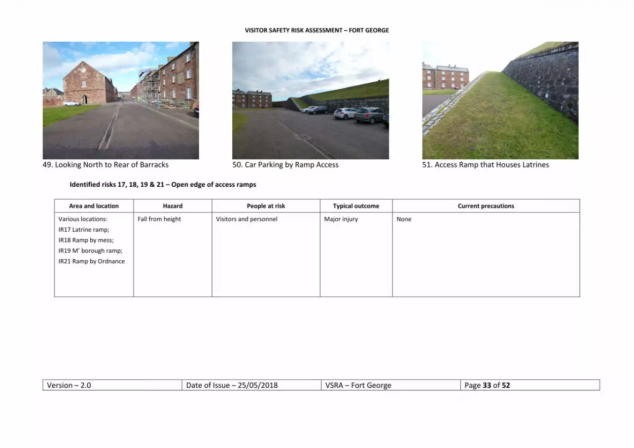
46. Grounds of Grand Magazine 47. Presentation & Interpretation Area 48. Grand Magazine (Storage Heater Example) Leaving the grand magazine and continuing west past the barracks, the visitor approaches a ramp that facilitates the officers latrines. At this juncture, the visitor can head north along the road to the rear of the barracks (picture 49) or continue west to the base of the ramp. Several cars are parked in this location (picture 50) and present similar risks to those identified earlier. IR16 (refer to IR13 discussion) The ramp surface is covered by grass with a 600mm open edge defined in stone (cope and original cobbles). The grass was dry under foot at the time of assessment and presents a nominal slip risk (picture 51). No handrail/edge protection is fitted, as found by the entrance ramps. IR17
VISITOR SAFETY RISK ASSESSMENT – FORT GEORGE
Version – 2.0 Date of Issue – 25/05/2018 VSRA – Fort George Page 33 of 52
49. Looking North to Rear of Barracks 50. Car Parking by Ramp Access 51. Access Ramp that Houses Latrines
Identified risks 17, 18, 19 & 21 – Open edge of access ramps
Area and location Hazard People at risk Typical outcome Current precautions
Various locations: IR17 Latrine ramp; IR18 Ramp by mess; IR19 M’ borough ramp; IR21 Ramp by Ordnance
Fall from height Visitors and personnel Major injury None

VISITOR SAFETY RISK ASSESSMENT – FORT GEORGE
Version – 2.0 Date of Issue – 25/05/2018 VSRA – Fort George Page 34 of 52
Discussion Decision and rationale Action required Time scale Action completed
There are several ramps within the fort that are not consistent with the approach taken at the ramps by the entrance gatehouses. Edges are well defined and the ramp suitably wide. The risk is obvious upon approach from ground and rampart level. Warning signs are in place on the upper level – consistent with the overall intervention throughout the fort. A fall would result in significant injury. Introducing handrails would present contractors with risk. The aforementioned fitted handrails were introduced in the late 19th early 20th century and rationale for the intervention is unknown. Current rationale is based on the fact that vehicle access to the upper level is only undertaken by the entrance ramps and the rails provide definition for drivers. Removing the existing or retro fitting additional rails may have a significant cost implication and damage the historic fabric of the monument. OPTIONS: 1. Remove existing rails for consistency; 2. Retro fit rails to all ramps; 3. Accept the risk.
Introducing physical barriers would represent a significant precedent for both the rest of the fort and other monuments found throughout the estate. The obvious nature of the risk and the impact intervention would have on the site were also factors in the decision to accept the risk and inform the SMT of this decision.
Accept the risk. Inform the SMT, in the first instance, via the corporate safety forum. This and other mentioned fall from height risks have been added to a register of risk.
09/11/2016 – next corporate
health and safety forum
2017
To the west of the latrines is another ramp access – adjacent to the sergeants’ mess / south of the chapel (picture 52). The risks and conditions replicate those found in the aforementioned ramp. IR18 (refer to IR17 discussion) A mortar is positioned within the grassed area between and adjacent to the aforementioned ramps by the front of the Seaforth’s Regimental Institute. This represents a climbing opportunity for children and the risk taker (picture 53). Continuing at ground level past the ramp to Prince Frederick William’s demi-bastion, the visitor reaches the point battery magazine and the grounds of the chapel. The magazine is currently closed to the public. The chapel grounds are laid to grass, level and present a nominal risk to visitors. A tar path provides good access to seating situated to the exterior of the chapel. A well is found to the south-east of the envelope of the chapel grass, by the former stables and anti-tank garage. The opening is protected by an 850mm wall and protective grill. The grill is a consistent approach to similar risks found throughout the HES estate (picture 54). The entrance into the stables are floored in concrete and level. The cobbles, drains and stables present a moderate trip risk – natural light makes the risk obvious.

VISITOR SAFETY RISK ASSESSMENT – FORT GEORGE
Version – 2.0 Date of Issue – 25/05/2018 VSRA – Fort George Page 35 of 52
52. Access Ramp South of Chapel 53. Mortar Gun 54. Well with Stables & Garage in Background CHAPEL On exit from the stables, the visitor can walk towards the chapel. The main entrance door to the chapel is fixed open during opening periods (picture 55). The visitor can continue through two sprung doors into the chapel, or alternatively climbs a spiral shaft of approx. 16 stone steps to the upper level – the upper level is closed to the public, this is not documented at ground level. A distribution box is found behind a curtain at ground level. This area also stores a vacuum cleaner. On entering the body of the chapel, the stone floor is level and in good condition. Timber seating is provided and the pulpit roped off. Heaters are found along the north and south walls – these were not generating heat at the time of assessment. An emergency exit is found through sprung doors on the south wall of the chapel where the spiral steps example by the main entrance is replicated. On exiting the chapel, the visitor can head east through the arch to the rear of the provisions store (towards the NAFFI and mortar) or north-east towards the base of the ramp to the Duke of Marlborough’s demi-bastion (picture 56). IR19 (refer to IR17 discussion) Continuing north-east at ground level, the visitor passes the plant room doors where personnel car parking is visible. IR20 (refer to IR13 discussion) A former latrine (currently in disrepair and sectioned off to the public) and the rear of the ordnance stores building are also passed at this point. Another ramp is situated to the north of the ordnance stores that provides access up to Prince Henry Frederick’s bastion. IR21 (refer to IR17 discussion)

VISITOR SAFETY RISK ASSESSMENT – FORT GEORGE
Version – 2.0 Date of Issue – 25/05/2018 VSRA – Fort George Page 36 of 52
North-east of the ramp is the location of the LPG tanks (no access to the public). It is at this point the visitor can continue north-east towards the café and conference rooms, or alternatively walk southwards along the rear of the barracks and north front of the ordnance stores. There is a small area the visitor can access prior to reaching the café and yard – this provides only a nominal risk.
55. Entrance to Chapel 56. Access to D of M’ borough Demi-Bastion 57. Car Parking & Access to Prince H-F’s Bastion The yard of the conference rooms and café are tarred and in reasonable condition. Benches are provided outside the café area. The café is to modern standards with a small step at the door threshold which is highlighted by a small sign on the door. On exiting north-east from the ordnance yard, the visitor passes further barracks on their right-hand side (south) and the site boiler room to their left (north) – both areas are closed to the public. At the corner of the barracks, the visitor can continue north-east towards the north casemated curtain and parade or turn right (south) along the rear of the museum and HES staff block where public toilets are provided (picture 58). Significant numbers of parked cars are evident along the rear and north gable of the block of buildings. IR22 (refer to IR13 discussion) Several of the initial north casemates are occupied by the military and closed to the public. As the visitor approaches the walled edge of the grass parade ground the path surface changes from tar to concrete (picture 59). The wall is 450mm high and edges the north casemate curtain. Three sets of steps are built into the wall at specific points and are clear upon approach. The path has a slight slope towards the casemates and the aforementioned gulley drain is evident in this area. Approx. 30m along the path are the entrance doors of the north sally port. This is closed to the public – during peak times in the season guided tours are undertaken by visitor services personnel (a separate risk assessment has been completed by visitor services for this activity).

VISITOR SAFETY RISK ASSESSMENT – FORT GEORGE
Version – 2.0 Date of Issue – 25/05/2018 VSRA – Fort George Page 37 of 52
Continuing along the casemate path the visitor approaches the exhibition and camp cinema casemates (picture 60). The exhibition room presents no significant risks to the visitor. Metal ramps have been fitted over the gulley into these casemates.
58. Car Parking to Rear of HES Block 59. North Casemates Path & Parade Wall 60. Exhibition & Cinema Entrances with Ramps The camp cinema provides a short film about the Black Watch. A mock projector is fixed to the floor on entry and presents a nominal risk to the younger visitor. The floor is of timber construction, level and in good condition. Lighting is adequate. There are four seating benches and the cupboard doors are locked (picture 61). An access door to the adjacent exhibition room has been roped off to the public – this door has a low-level lintel that has been padded at some stage. Four wall hung heaters are fitted with protective covers – this is not a consistent approach to similar risks found throughout the visitor experience of Fort George. IR23 (refer to IR14 discussion) Leaving the cinema, the visitor continues north-east (left) towards the ‘Fort George Story’ casemate. Entry is via a gulley ramp and down slightly on to the timber floor that is in good condition (picture 62). Lighting is adequate. Nine benches and a small table are provided. Four uncovered wall hung heaters were very hot to the touch at the time of the 2017 assessment. These were off at the time of assessment – this is not a consistent approach to similar risks throughout the site. IR24 (refer to IR14 discussion) On exiting the casemate the visitor can head south-east to the base of the ramp leading to the Duke of Cumberland’s bastion or north-east into additional casemates under the ramp (picture 63). The ramp is similar to that found leading to the Prince of Wales’s bastion (picture 40).

VISITOR SAFETY RISK ASSESSMENT – FORT GEORGE
Version – 2.0 Date of Issue – 25/05/2018 VSRA – Fort George Page 38 of 52
Under the ramp there is access into three further casemates. The first two are lit and the flooring is initially timber and concrete respectively - this changes to whin dust/dirt floor as visitors approach the fireplaces in the openings of the north wall of the rooms. Only one room has a timber door. The first casemate has a gulley drain by the entrance - this has not had a ramp fitted and is inconsistent in approach to the other examples. This risk has been evident upon approach throughout the visit and does not pose a significant risk to the visitor. The distribution boxes above the doors (internal) are locked off and safe by position. The low-level door lintels between the unoccupied casemates are not padded as found in earlier examples. The area is well lit and the risk obvious upon approach. A wooden slope provides access into the final casemate. The room is unlit though lighting is in place. A bin, trestles and HES vehicle are currently stored in this location.
61. Camp Cinema Casemate 62. Fort George Story Casemate 63. North Casemate & Ramp Access Heading south back towards the entrance, the visitor passes the door to the prison. There is a small step/lip up into the prison. The door is fixed in the open position and the timber floor is level and in good condition. CENTRAL AREA – PUBLIC TOILETS, BARRACK SQUARE & NAFFI On returning to the guardhouses from the prison the visitor can walk along the well-maintained tarred roads or parade ground towards the middle of the site. The Highlanders museum is to the west corner of the main parade and readily accessible (picture 64). Visitor safety within the museum is not assessed or monitored by HES. To the rear of the museum and staff block are the public toilets. There are two steps up to the toilets with ramp provision for the disabled and baby changing facilities – these are to modern standards.

VISITOR SAFETY RISK ASSESSMENT – FORT GEORGE
Version – 2.0 Date of Issue – 25/05/2018 VSRA – Fort George Page 39 of 52
The central location of the fort is barrack square (picture 65). The area is bordered by a gulley drain and is home to the Battalion Company and the medical centre. It is laid to tar, level and has limited car parking areas. Vehicle movement is regular in this location but unlike aforementioned parking areas, there is a clear line of sight with no visual obstructions in place at the time of assessment. One-way systems are in place and well signposted. The NAFFI (Red Hackle Café) is found to the west of the square and is open to the public. The steps into the building have small chips in the tread that present a small slip trip and fall risk (picture 66). The condition is monitored by the district architect.
64. Highlanders Museum Entrance 65. Barrack Square (Looking North) 66. NAFFI Entrance – Damaged Step UPPER LEVEL Returning to the south-east corner and the ramp up to the Prince of Wales’s Bastion, the visitor ascends to the upper level of the ramparts. Grass is worn in places and dry underfoot at the time of assessment. This is the first time during the experience that the visitor is exposed to the significant fall from height risks that are encountered around the entire envelope of the ramparts (picture 67). There is a consistent fall risk of approx. 5m that has been highlighted by yellow warning signage throughout and is generally clear upon approach IR25

VISITOR SAFETY RISK ASSESSMENT – FORT GEORGE
Version – 2.0 Date of Issue – 25/05/2018 VSRA – Fort George Page 40 of 52
67. Ramp Access & Casemated Curtain 68. Embrasure – Prince of Wales’s Bastion 69. Embrasure - Fall from Height Example
Identified risks 25, 28, 31, 32, 34, 35, 37 & 38 – Rampart edges
Area and location Hazard People at risk Typical outcome Current precautions
IR25 – PoW Bastion & South Casemated Curtain IR28 – PWH Bastion & PFW Demi-Bastion IR31 – Point Battery IR32 – DoM’Borough Demi-Bastion IR34 – Walkway IR35 – PHF Bastion IR37 – North Casemated Curtain IR38 – Open Edge Above Prison & Guardrooms
Fall from height Visitors – particular emphasis on children
Major injury – potential for fatal injury
Significant amount of pictorial warning signage in place Warning information provided by visitor services staff The risk is evident prior to deciding to access upper level

VISITOR SAFETY RISK ASSESSMENT – FORT GEORGE
Version – 2.0 Date of Issue – 25/05/2018 VSRA – Fort George Page 41 of 52
Discussion Decision and rationale Action required Time scale Action completed
A significant number of visitors access the ramparts and in order to do so must make a conscious decision to climb the ramps. This highlights the risks provided by the open edges prior to stepping on to the grass of the ramparts. The fall from height is approx. 5m and would result in major injury should one occur. The severity may increase in certain areas e.g. by the south sally port entrance. Currently the grass verges/edges are cut differently to the rampart walkways – this provides a delineation of the surfaces. In addition, pictorial warning signs are located throughout the entire border of the internal rampart edge. The risk is evident upon approach and clearly visible from ground level prior to accessing the area. Physical intervention may significantly damage both the historic fabric of the monument and the visitor experience. The aesthetic of the fort may also be compromised by such interventions. OPTIONS: 1. Fit barriers along the rampart edge; 2. Barrier off the upper levels; 3. Increase staff visibility/numbers in this area; 4. Accept the risk.
This risk has been extensively examined in the past and both accident and visitor behaviour monitored. There are no recorded fall from height incidents and visitors tend to be well aware of the edge and have been seen to keep away. The warning signage has previously been seen as a suitable deterrent (in combination with verbal instruction at the visitor centre). Introducing physical barriers would represent a significant precedent for both the rest of the fort and other monuments found throughout the estate. The obvious nature of the risk and the impact intervention would have on the site were also factors in the decision to accept the risk and inform the SMT of this decision.
Accept the risk. Inform the SMT, in the first instance, via the corporate safety forum. This and other after mentioned fall from height risks have been added to a register of risk.
09/11/2016 – next corporate health and safety forum
2017
PRINCE OF WALES’S BASTION & SOUTH CASEMATED CURTAIN Within the bastion are 13 embrasures constructed of stone cobbles - some have been repaired in brick. These openings are 750mm at the narrowest point and require a 650mm step up should the visitor attempt to gain access (picture 68). Cannon are sited on flagstone platforms within the walls – these are partially edged by small 650mm walls with clearly defined wall heads. The stone and brick of the embrasures are in various states of repair and lead to a drop in excess of 5m into the ditch or exterior of the casemated curtain (picture 69). IR26
VISITOR SAFETY RISK ASSESSMENT – FORT GEORGE
Version – 2.0 Date of Issue – 25/05/2018 VSRA – Fort George Page 42 of 52
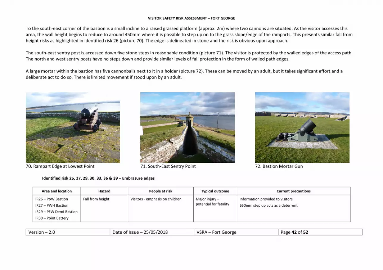
To the south-east corner of the bastion is a small incline to a raised grassed platform (approx. 2m) where two cannons are situated. As the visitor accesses this area, the wall height begins to reduce to around 450mm where it is possible to step up on to the grass slope/edge of the ramparts. This presents similar fall from height risks as highlighted in identified risk 26 (picture 70). The edge is delineated in stone and the risk is obvious upon approach. The south-east sentry post is accessed down five stone steps in reasonable condition (picture 71). The visitor is protected by the walled edges of the access path. The north and west sentry posts have no steps down and provide similar levels of fall protection in the form of walled path edges. A large mortar within the bastion has five cannonballs next to it in a holder (picture 72). These can be moved by an adult, but it takes significant effort and a deliberate act to do so. There is limited movement if stood upon by an adult.
70. Rampart Edge at Lowest Point 71. South-East Sentry Point 72. Bastion Mortar Gun
Identified risk 26, 27, 29, 30, 33, 36 & 39 – Embrasure edges
Area and location Hazard People at risk Typical outcome Current precautions
IR26 – PoW Bastion IR27 – PWH Bastion IR29 – PFW Demi-Bastion IR30 – Point Battery
Fall from height Visitors - emphasis on children Major injury – potential for fatality
Information provided to visitors 650mm step up acts as a deterrent

VISITOR SAFETY RISK ASSESSMENT – FORT GEORGE
Version – 2.0 Date of Issue – 25/05/2018 VSRA – Fort George Page 43 of 52
IR33 – DoM’Borough Demi-Bastion IR36 – PHF Bastion IR39 – Cumberland’s Bastion
Discussion Decision and rationale Action required Time scale Action completed
Access out on to the embrasure platforms throughout the fort requires a concerted effort to step up 650mm in order to gain access. The drop becomes clear upon approach and risk-taking behaviour would be required to continue further than the initial step up. The platform conditions vary considerably between good repair to those with significant damage. In addition, at certain locations vegetal growth is present. Growth and disrepair increase the likelihood of a slip, trip and perhaps significant fall in these locations. Cannons, it can be argued, present a barrier for access. They may also present an aid to gain access. At certain points the visitor may access the embrasures to gain better vantage for dolphin watching activity. Examples of persons in this area have been noted by staff at various times. During events, additional staff monitoring of the upper level is introduced. Introducing physical measures would significantly impact the monument aesthetic. OPTIONS: 1. Barrier all embrasures; 2. Increase staff visibility/numbers in this area; 3. Continue to inform visitors on entry; 4. Accept the risk.
This risk has been extensively examined in the past and both accident and visitor behaviour monitored. There are no recorded fall from height incidents and visitors tend to be well aware of the edge and generally do not access the embrasure platform. It was agreed that specific warning information be provided in ‘hot spot’ locations i.e. where interpretation boards highlight dolphin watching. DA will liaise with interpretation. Introducing physical barriers would represent a significant precedent for both the rest of the fort and other monuments found throughout the estate. The obvious nature of the risk and the impact intervention would have on the site were also factors in the decision to accept the risk and inform the SMT of this decision.
Warnings to be embedded within existing signage at ‘hot spots’ or additional pictograms be provided. Temp signs in place. Accept the risk. Inform the SMT, in the first instance, via the corporate safety forum. This and other after mentioned fall from height risks have been added to a register of risk.
12/12/2016 02/07/2018 09/11/2016 – next corporate health and safety forum
2017

VISITOR SAFETY RISK ASSESSMENT – FORT GEORGE
Version – 2.0 Date of Issue – 25/05/2018 VSRA – Fort George Page 44 of 52
Heading west along the top of the south casemated curtain the visitor is exposed to the open edge of the grassed walkway to the north and is protected by the 1.2m rampart wall to the south. The open edge is highlighted by yellow pictorial signs along the curtain and throughout the site. The stone wall head is obvious upon approach (picture 73). A metal flagpole is found directly above the south sally port entrance and appears in good repair – this is a military flagpole and not maintained or inspected by HES. At the end of the south casemated curtain run the visitor approaches a 970mm high stone wall (picture 74). This provides adequate protection from a 7m drop into the grounds of the Grand Magazine. PRINCE WILLIAM HENRY’S BASTION TO PRINCE FREDERICK WILLIAM’S DEMI-BASTION Prince William Henry’s Bastion contains three sentry posts with similar dimensions and issues as those aforementioned for the Prince of Wales’s Bastion. Nine embrasures and platforms also replicate the risks detailed earlier in identified risk 26. IR27 (refer to IR26 discussion)
73. South Casemated Curtain Edge 74. PWH’s Bastion & Grand Magazine Wall 75. Embrasure with Bench A bench is currently placed to the front of an embrasure which may provide a step-up opportunity for visitors (picture 75). Following the walkway, heading west, the visitor is again exposed to an unprotected drop to the top of the ramp that incorporates latrines below. This continues west towards the Prince Frederick William’s Demi-Bastion (picture 76). There are two sentry/pepper pots in the area, one of which is currently fenced off for repair. The internal edge is sloped, rather than edged in stone, which provides less definition upon approach. Warning signs are fitted along the edge. Another ramp leading up to Prince Frederick William’s Demi-Bastion presents similar fall from height risks (picture 77). IR28 (refer to IR25 discussion)

VISITOR SAFETY RISK ASSESSMENT – FORT GEORGE
Version – 2.0 Date of Issue – 25/05/2018 VSRA – Fort George Page 45 of 52
Prince Frederick William’s Demi-Bastion contains four embrasures. IR29 (refer to IR26 discussion) Three replicate those discussed earlier, and one previously housed a larger cannon/mortar – this opening provides adequate edge protection. The two embrasures looking west have cannon in position that may provide an aid to access the platform for the risk-taking visitor. The likelihood of this occurring is increased in this area as dolphin viewing is brought to the visitors’ attention via the interpretation information (picture 78). The south-east facing embrasure has no cannon in place. The sentry box reflects those discussed earlier in the assessment.
76. Ramp & Walkway (looking west) 77. Slope & Ramp by PFW Demi-Bastion 78. Embrasure Facing Moray Firth POINT BATTERY The external wall of the Point Battery has nine embrasures, all of which currently house cannon (one facing west, four facing south-west and four facing north-west). Vegetal growth on these embrasure platforms has been removed since the 2016 assessment. The return of this growth may, in conjunction with the dolphin watching attraction, increase the likelihood of a fall from height in this area (picture 79). IR30 (refer to IR26 discussion) The west facing traversing cannon provides adequate edge protection though climbing on the gun would reduce this (picture 80). The open internal edge of the battery exposes the visitor to a potential fall from height into the currently unused powder magazine. The edge is clear and warning signage is in place (picture 81). IR31 (refer to IR25 discussion)

VISITOR SAFETY RISK ASSESSMENT – FORT GEORGE
Version – 2.0 Date of Issue – 25/05/2018 VSRA – Fort George Page 46 of 52
79. Embrasure Platform Cleaned (2018) 80. Traversing Cannon at Point Battery 81. Internal Edge of Point Battery DUKE OF MARLBOROUGH’S DEMI-BASTION TO PRINCE FREDERICK HENRY’S BASTION On approach to the Duke of Marlborough’s Demi-Bastion the visitor passes another access ramp and unprotected edge (picture 82). IR32 (refer to IR25 discussion) A military flagpole is positioned in the demi-bastion and of the same construction as that found on the south casemated curtain. A north facing sentry post reflects those discussed earlier in the assessment. Two north-west facing embrasures house two 18 pounder cannons whilst the north-east facing opening sites a 12 pounder. There is limited vegetal growth in this area. IR33 (refer to IR26 discussion) A former traversing cannon position looks west and provides adequate edge protection. Continuing east towards Prince Frederick Henry’s Bastion, the visitor is protected to the exterior (north) by a wall, with the interior (south) open edge reflecting similar risks to those discussed earlier. Another access ramp is found prior to turning north at the end of this walkway (picture 83). IR34 (refer to IR25 discussion)

VISITOR SAFETY RISK ASSESSMENT – FORT GEORGE
Version – 2.0 Date of Issue – 25/05/2018 VSRA – Fort George Page 47 of 52
82. Access Ramp to M’Borough’s Demi-Bastion 83. Ramp by Henry Frederick’s Bastion 84. 32lb Climbing Opportunity Prince Henry Frederick’s Bastion is accessed past the open edge of the gas storage tank enclosure. Two north-west embrasures are currently empty – two of the three north-east facing have cannon in place. IR35 (refer to IR26 discussion) A north facing traversing cannon provides a climbing opportunity out on to the grass rampart area (picture 84) where there is a potential fall from height risk down to the beach. There are two empty former gun stations in this area. Small magazines and recesses are found on the external wall – these are currently closed to the public. There are six steps down to the magazine door – the edge is bordered in stone and provides a potential sitting opportunity. The fall from height risk is obvious upon approach (picture 85). The north and north-west sentry posts present similar dimensions and risks as discussed earlier in the assessment. The inner edge of the bastion looks down into the café and conference room courtyard area. A small area has a 1.9m drop on to a flat copper roof. The majority of the area is bordered by a small wall with a sloped tile roof leading down to the courtyard (picture 86). IR36 (refer to IR25 discussion)

VISITOR SAFETY RISK ASSESSMENT – FORT GEORGE
Version – 2.0 Date of Issue – 25/05/2018 VSRA – Fort George Page 48 of 52
85. Steps and Border of Magazine 86. Inner Edge of PHF Bastion 87. North Casemated Curtain (looking north-east) NORTH CASEMATED CURTAIN TO DUKE OF CUMBERLAND’S BASTION Continuing north-east along the north casemated curtain the open internal edge is again replicated (picture 87). IR37 (refer to IR25 discussion) A military flagpole of similar construction to those discussed earlier is found in this area. The external wall provides adequate protection from the fall from height risk. To the north-east end of the casemated curtain a further access ramp is found. This has been fitted with a wooden rail/barrier similar to that found by the Prince of Wales’s Bastion and is inconsistent to the approach taken throughout the fort (picture 63). The open edge continues along the upper level above the prison and guard houses. IR38 (refer to IR25 discussion) The sentry posts of the Duke of Cumberland’s Bastion present similar dimensions and risks as discussed earlier in the assessment – the north-west post finial is no longer in situ. There are nine embrasures that house no cannon and present similar risks to those discussed earlier in the assessment. IR39 (refer to IR26 discussion) A north facing traversing cannon presents a possible climbing opportunity out on to the ramparts – the risk is obvious upon approach (picture 88). A mortar and ammunition stack is found within the grassed area of the bastion – this presents similar risks to that found within the Prince of Wales’s Bastion. Magazines similar to that found at the Prince Henry Frederick’s Bastion can be found in this bastion and provide similar risks to the visitor. The wall of the rampart is as low as 500mm in places and could provide access on to the rampart grass (picture 89). This presents a similar fall from height risks as highlighted in identified risk 26. The edge is delineated in stone and the risk is obvious upon approach.

VISITOR SAFETY RISK ASSESSMENT – FORT GEORGE
Version – 2.0 Date of Issue – 25/05/2018 VSRA – Fort George Page 49 of 52
To conclude the experience, the visitor can walk along the wide grassed walkway above the entrance guardhouses and exit via the ramp. Two mortars and ammunition are positioned in this area along with a military flagpole (picture 90).
88. Traversing Cannon Climbing Opportunity 89. Low Point of Rampart Wall 90. Walkway above Main Entrance INFORMATION FOR VISITORS There is a significant amount of information provided for Fort George, predominantly found on the general website where significant risks are clearly advertised. Hazard identification is reiterated on approach and throughout the site with visitor services staff briefing on the main hazards at time of ticket purchase. The information for teachers’ document gives a brief illustration of basic health and safety requirements for school visits to site. SUMMARY This is a moderately complex site in terms of hazard and risk identification. A detailed explanation of proposed actions has been provided in the assessment to reflect the decision-making process and the rationale behind incorporating intervention measures that are lower on the hierarchy of considered possible controls. The risks identified within this document, for review and acceptance by the board, have previously been identified and accepted by the senior management team. The visitor safety risk assessment process sets out to update and renew this process.

VISITOR SAFETY RISK ASSESSMENT – FORT GEORGE
Version – 2.0 Date of Issue – 25/05/2018 VSRA – Fort George Page 50 of 52
Assessment carried out by
Alan Mackinnon Ruth Vaughan Date of previous assessment 19/04/2016
Job title Health & Safety Advisor District Architect Date of this assessment 25/05/2018
Signed Next assessment before 25/05/2020
Item Date Raised Summary of Issue
Action Proposed Target Date Action By Regional Progress Update
Date Completed
IR1 East outer defences – glacis
wall edge not consistent
Warning pictograms to be
fitted
12/12/2016 R. Vaughan Instruction given TBC by 27/7/17
07/2017
IR2 Opening in north wall – fall from
height risk
Accept risk N/A N/A
IR3 & IR8 Fall from height risk – north shore
wall & south defence wall
Accept risk – Inform SMT & place on risk
register
09/11/2016 – next corporate
health and safety forum
A. Mackinnon 2017
IR4, IR5 & IR7 Fall from height risk – access
steps & platforms into the principal
ditch
Accept risk – Inform SMT & place on risk
register
09/11/2016 – next corporate
health and safety forum
A. Mackinnon 2017
IR6 Fall from height risk – outer
bridge & along ditch edge within
covered way
Accept risk – Inform SMT & place on risk
register
09/11/2016 – next corporate
health and safety forum
A. Mackinnon 2017

VISITOR SAFETY RISK ASSESSMENT – FORT GEORGE
Version – 2.0 Date of Issue – 25/05/2018 VSRA – Fort George Page 51 of 52
IR9 Fall from height – steps and wall by principal bridge
Accept risk – Inform SMT & place on risk
register
09/11/2016 – next corporate
health and safety forum
A. Mackinnon 2017
IR10 Fall from height – ravelin ramparts
& embrasures
Accept risk – Inform SMT & place on risk
register
09/11/2016 – next corporate
health and safety forum
A. Mackinnon 2017
IR11 & IR12 Fall from height – sally port &
ravelin drop into ditch
Accept risk – Inform SMT & place on risk
register
09/11/2016 – next corporate
health and safety forum
A. Mackinnon 2017
IR13, IR16, IR20 & IR22
Workplace transport & internal car
parking – various areas
Accept risk – Inform SMT & place on risk
register
09/11/2016 – next corporate
health and safety forum
A. Mackinnon 2017
IR14, IR15, IR23 & IR24
Burns from unprotected
radiators
Barracks & Magazine –
review during refurbishment.
Cinema & Exhibition
casements – covers fitted
01/04/2017
12/12/2016
R. Vaughan
R. Vaughan
Radiators update from DA
07/2018
IR17, IR18, IR19 & IR21
Fall from height – open ramp edges
Accept risk – Inform SMT & place on risk
register
09/11/2016 – next corporate
health and safety forum
A. Mackinnon 2017

VISITOR SAFETY RISK ASSESSMENT – FORT GEORGE
Version – 2.0 Date of Issue – 25/05/2018 VSRA – Fort George Page 52 of 52
IR25, IR28, IR31, IR32, IR34, IR35,
IR37 & IR38
Fall from height – inner edge of
rampart walkways
Accept risk – Inform SMT & place on risk
register
09/11/2016 – next corporate
health and safety forum
A. Mackinnon 2017
IR26, IR27, IR29, IR30, IR33, IR36
& IR39
Fall from height – embrasure
platforms within the fort.
Special note to dolphin watching
area
Accept risk – Inform SMT & place on risk
register. Specific dolphin hot spot fitted with warning
09/11/2016 – next corporate
health and safety forum
A. Mackinnon
Dolphin sign update from DA
2017
07/2018
Document ID Comments / Amendments Date of Issue Version 0.1 Draft Circulated for comment 25/04/2016 Version 0.2 Draft Circulated to District Architect & Head of
Conservation for comment and decision process 31/05/2016
Version 1.0 Actions agreed & assessment issued 27/09/2016 Version 2.0 Assessment issued 25/05/2018


