Embed Size (px)
Citation preview
WARTA GEOLOGIPERSATUAN GEOLOGI MALAYSIA
Jilid 41 JULY–DECEMBER Volume 41 No. 3-4 2015 No. 3-4
ISSN 0126 - 5539 PP2509/07/2013(032786)
NEWSLETTER of the GEOLOGICAL SOCIETY OF MALAYSIA
Warta GeologiNewsletter of the Geological Society of Malaysia
EditorNg Tham Fatt (University of Malaya)
Editorial BoardProf. Dr. Abdul Rahim Samsudin
(Universiti Kebangsaan Malaysia)Prof. Dr. Azman A. Ghani
(University of Malaya)Prof. Dr. Basir Jasin
(Universiti Kebangsaan Malaysia)Assoc. Prof. Dr. Chow Weng Sum
(Universiti Teknologi Petronas)Prof. Dr. Felix Tongkul
(Universiti Malaysia Sabah)Prof. Emeritus Dr. H.D. Tjia
(Universiti Kebangsaan Malaysia)Prof. Dato’ Dr. Ibrahim Komoo
(Universiti Kebangsaan Malaysia)Prof. Dr. J.J. Pereira
(Universiti Kebangsaan Malaysia)Prof. Dr. John K. Raj
(University of Malaya)Prof. Dr. Lee Chai Peng
(University of Malaya)Prof. Dr. Mohd Shafeea Leman
(Universiti Kebangsaan Malaysia)Mr. Tan Boon Kong
(Consultant)Prof. Dr. Wan Hasiah Abdullah
(University of Malaya)Dato’ Yunus Abdul Razak
(Minerals & Geoscience Department Malaysia)
SecretariatAnna Lim
Cover photo: Folded quartzo-feldspathic in schist, Sg. Kenerong, Kelantan. T.F. Ng
PERSATUAN GEOLOGI MALAYSIAGeological Society of Malaysia
Council 2015/2016
President : Dr. Mazlan MadonVice President : Mr. Abd Rasid JaaparSecretary : Mr. Lim Choun SianAssistant Secretary : Mr. Nicholas JacobTreasurer : Mr. Ahmad Nizam Hasan Editor : Assoc. Prof. Dr. Ng Tham FattImmediate Past President : Prof. Dr. Joy Jacqueline PereiraCouncillors : Assoc. Prof. Askury Abd Kadir Dr.JasmiHafizAbdulAziz Dr. Meor Hakif Amir Hassan Mr. Mohd Badzran Mat Taib Dr. Nur Iskandar Taib Mr. Robert Wong Mr. Tan Boon Kong Dr. Tanot Unjah
The Geological Society of Malaysia was founded in 1967 with the aim of promoting the advancement of geoscience, particularly in Malaysia and Southeast Asia. The Society has a membership of about 600 local and international geoscientists.
Warta Geologi (Newsletter of the Geological Society of Malaysia) is published quarterly by the Society. Warta Geologi covers short geological communications and original research, as well as reports on activities and news about the Society. It is distributed free-of-charge to members of the Society. Further information can be obtained from:
The EditorGeological Society of Malaysiac/o Department of Geology, University of Malaya, 50603 Kuala Lumpur, MalaysiaTel: 603-79577036 Fax: 603-79563900 Email: [email protected]
CATATAN GEOLOGIGEOLOGICAL NOTES
ISSN 0126–5539 Warta Geologi, Vol. 41, No. 3-4, July – December 2015
Northwest Sarawak: A complete geologic profile from the Lower Miocene to the Pliocene covering the Upper Setap Shale, Lambir
and Tukau Formations
Franz L. KessLer1 & John Jong2
1Petroleum and Geoscience Consultant, previously Curtin University MiriEmail address: [email protected]
2JX Nippon Oil and Gas Exploration (Deepwater Sabah) LimitedEmail address: [email protected]
Abstract: Rarely seen in other outcrop examples, a well-preserved outcrop profile along the rebuilt Miri to Long Lama road (NW Sarawak) was logged and is described in this paper. The ca. 1000 m of profile section displays two major regional unconformities: an older Mid-Miocene Unconformity (MMU) is seen separating the gray Upper Setap Shale from the Lambir Formation, and located stratigraphically above, a pronounced angular Pliocene unconformity is observed separating the folded Lambir rocks from the unfolded Tukau Formation. The angular unconformity between the dipping Lambir and the flat-lying Tukau formations suggests a significant erosion and possibly also a major hiatus. Admittedly, the geological timing of the unconformities observed is yet-to-be fully established; however, the stratigraphic importance and the presence of the mentioned unconformities may be related to other established regional events mapped in offshore Sarawak and Sabah with better seismic coverage. Their significance cannot be under-estimated and may provide a better understanding on the regional uplift history and the tectonic evolution of the structurally complex NW Borneo margin.
Keywords: Lambir Formation, Mid-Miocene Unconformity, NW Sarawak, Pliocene Unconformity, Tukau Formation, Setap Shale, uplift
INTRODUCTIONIt is rare to find long and well-preserved outcrop
sections in Sarawak, as the tropical vegetation covers the exposed surfaces in months, if not weeks with weathering a detrimental element for the preservation of the outcrops. A unique opportunity to investigate the Lower/Middle Miocene to Pliocene foreland molasses emerged when major road construction works started in 2012 between Beluru and Lapok, leading to Long Lama in the Marudi constituency of NW Sarawak, and fresh rock was exposed over a stretch of 3-4 kilometres (Figure 1). The study of this outcrop was carried out in the context of field mapping, as well as for geochemical sampling in Curtin University Miri. This work is essential for capturing and preserving onshore geological information in tropical environment.
GEOLOGICAL SETTING AND STRATIGRAPHYFrom a tectonic standpoint, the logged outcrop
profile is located in the Luconia/Tinjar Block. The area is moderately folded, and characterized by a number of synclines including the Grabit, with minor overthrusting observed (Figure 1). Detailed discussions on the regional tectonic evolution of the study area, in particular comments
Figure 1: Approximately location of the logged outcrop profile shown in context of a regional tectonic index map dissecting the northern leg of the Grabit Syncline (Figure 2a in pink), located some 10 km from Beluru in the direction of Lapok/Long Lama (see “pink” road section along the trunk road between Beluru – Lapok in the inset map). The orange Baram Line constitutes an important facies boundary, with carbonate dominate in Luconia/Tinjar and clastics in the Baram Delta Block. Inversion features such as Bukit Lambir and Engkabang-Karap (Jong et al., in prep) are seen along the lineament. Legends: Faults (red); Syncline Axis (pale blue); Baram Line (orange fill); approximate locations of Figure 2a (pink line) and Figure 2b (yellow line).
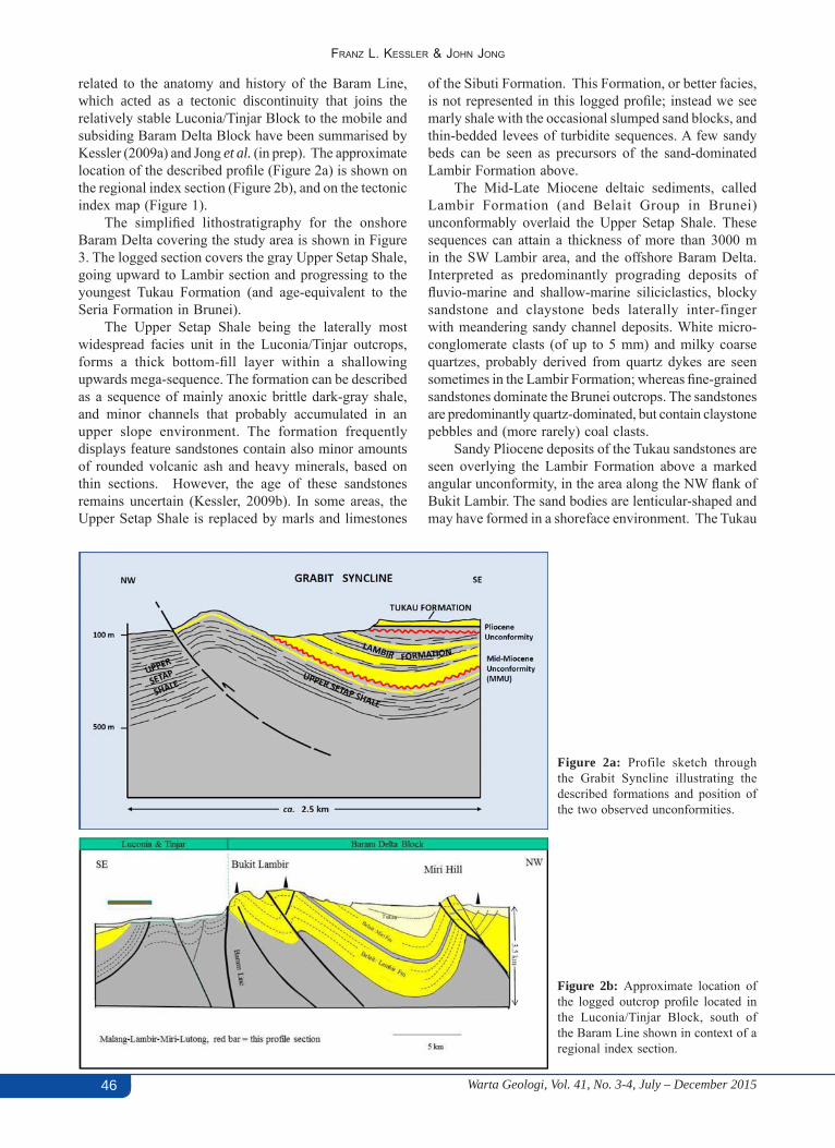
Warta Geologi, Vol. 41, No. 3-4, July – December 201546
Franz L. KessLer & John Jong
related to the anatomy and history of the Baram Line, which acted as a tectonic discontinuity that joins the relatively stable Luconia/Tinjar Block to the mobile and subsiding Baram Delta Block have been summarised by Kessler (2009a) and Jong et al. (in prep). The approximate location of the described profile (Figure 2a) is shown on the regional index section (Figure 2b), and on the tectonic index map (Figure 1).
The simplified lithostratigraphy for the onshore Baram Delta covering the study area is shown in Figure 3. The logged section covers the gray Upper Setap Shale, going upward to Lambir section and progressing to the youngest Tukau Formation (and age-equivalent to the Seria Formation in Brunei).
The Upper Setap Shale being the laterally most widespread facies unit in the Luconia/Tinjar outcrops, forms a thick bottom-fill layer within a shallowing upwards mega-sequence. The formation can be described as a sequence of mainly anoxic brittle dark-gray shale, and minor channels that probably accumulated in an upper slope environment. The formation frequently displays feature sandstones contain also minor amounts of rounded volcanic ash and heavy minerals, based on thin sections. However, the age of these sandstones remains uncertain (Kessler, 2009b). In some areas, the Upper Setap Shale is replaced by marls and limestones
of the Sibuti Formation. This Formation, or better facies, is not represented in this logged profile; instead we see marly shale with the occasional slumped sand blocks, and thin-bedded levees of turbidite sequences. A few sandy beds can be seen as precursors of the sand-dominated Lambir Formation above.
The Mid-Late Miocene deltaic sediments, called Lambir Formation (and Belait Group in Brunei) unconformably overlaid the Upper Setap Shale. These sequences can attain a thickness of more than 3000 m in the SW Lambir area, and the offshore Baram Delta. Interpreted as predominantly prograding deposits of fluvio-marine and shallow-marine siliciclastics, blocky sandstone and claystone beds laterally inter-finger with meandering sandy channel deposits. White micro-conglomerate clasts (of up to 5 mm) and milky coarse quartzes, probably derived from quartz dykes are seen sometimes in the Lambir Formation; whereas fine-grained sandstones dominate the Brunei outcrops. The sandstones are predominantly quartz-dominated, but contain claystone pebbles and (more rarely) coal clasts.
Sandy Pliocene deposits of the Tukau sandstones are seen overlying the Lambir Formation above a marked angular unconformity, in the area along the NW flank of Bukit Lambir. The sand bodies are lenticular-shaped and may have formed in a shoreface environment. The Tukau
Figure 2a: Profile sketch through the Grabit Syncline illustrating the described formations and position of the two observed unconformities.
Figure 2b: Approximate location of the logged outcrop profile located in the Luconia/Tinjar Block, south of the Baram Line shown in context of a regional index section.
Warta Geologi, Vol. 41, No. 3-4, July – December 2015 47
Northwest sarawak: a complete geologic profile from the lower mioceNe to the plioceNe
sequence in the profile is particularly coal rich, whereas clays are rich in coaly material, amber and volcanic ash.
The youngest deposits, in another outcrop located some 20 km NW away from the logged profile area, are cross-bedded sands, with high organic content, fossil wood, roots (frequently coated by iron/manganese oxides) and volcanic ash are commonly seen in outcrops in a ca. 500 m wide strip along the new coastal Miri-Bintulu road. The common elevation is ca. 10-20 m above sea level. These horizontally-lying sediments were deposited on a terrace that appears to be eroded by marine coastal erosion. C14 age dating showed ages between Late Pleistocene and Early Holocene (Kessler and Jong, 2014).
KEY OBSERVATIONS OF THE LOGGED OUTCROP PROFILE
The logged outcrop profile is somewhat unique given it shows an undisturbed section covering almost the entire Neogene section within the foreland molasses. It leads from the Long Lama/ Empresa oil palm road junction several kilometres along the Long Lama road that dissects the northern leg of the Grabit Syncline (Figure 1). The first 500 profile meters are formed by gray Upper Setap Shale, which dips SE; the upper section is formed mainly by Lambir Formation, and above it a little preserved section of Tukau Formation. The latter filled the centre of the Grabit syncline, after folding had ceased (Figure 2a). Although the fossil record was not investigated at this point, rock characteristics can be compared with adjacent outcrops sampled with generic lithological descriptions as summarised in the previous section, and dated in the literature (e.g., Hutchison, 2005). Regional maps such as those generated by Liechti et al. (1960) describe the regional context of these rock formations.
Rarely seen in other outcrop examples, the profile also dissects two major regional unconformities, namely the MMU, separating the Upper Setap Shale from the Lambir Formation, and further stratigraphically above, a pronounced angular Pliocene unconformity separating the folded Lambir rocks from the unfolded Tukau Formation.
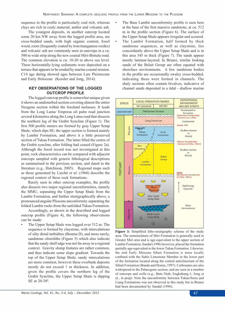
Accordingly, as shown in the described and logged outcrop profile (Figure 4), the following observations can be made:• The Upper Setap Shale was logged over 512 m. The
sequence is formed by claystone, with intercalations of silty distal turbidites (Bouma D), and more rarely, sandstone olistoliths (Figure 5) which also indicate that the sandy shelf edge was not far away in a regional context. Gravity slump features are rather common, and thus indicate some slope gradient. Towards the top of the Upper Setap Shale, sandy intercalations are more common, however these overbank deposits mostly do not exceed 1 m thickness. In addition, given the profile covers the northern leg of the Grabit Syncline, the Upper Setap Shale is dipping SE at 20-300.
Figure 3: Simplified litho-stratigraphy scheme of the study area. The nomenclature of Miri Formation is generally used inGreater Miri area and is age-equivalent to the upper section of Lambir Formation, Sandal (1996) however, placed the formation partially age-equivalent to the lower Tukau Formation. Likewise, the mid Early Miocene Sibuti Formation is more locally confined with the Subis Limestone Member in the lower part of the formation located along the central anticlinorium of the Sibuti Formation (Banda and Honza, 1997). Carbonates are also widespread in the Palaeogene section, and are seen in a number of outcrops and wells (e.g., Batu Niah, Engkabang-1; Jong et al., in prep). Note the unconformity between Tukau/Seria and Liang Formations was not observed in this study but in Brunei had been documented by Sandal (1996).
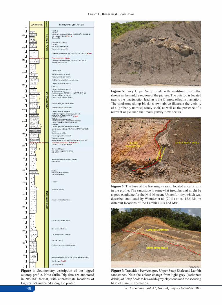
• The Base Lambir unconformity profile is seen here at the base of the first massive sandstone, at ca. 512 m in the profile section (Figure 6). The surface of the Upper Setap Shale appears irregular and scoured.
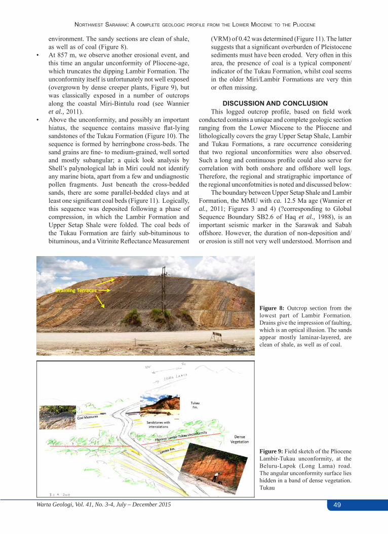
• The Lambir Formation, half formed by thick sandstone sequences, as well as claystone, lies concordantly above the Upper Setap Shale and is in this area 345 m thick (Figure 7). The sands appear mostly laminar-layered; In Brunei, similar looking sands of the Belait Group are often equated with shoreface environments. A few sandstone bodies in the profile are occasionally swaley cross-bedded, indicating these were formed in channels. The shaly sections often contain bivalves, indicative of channel sands deposited in a tidal - shallow marine
Warta Geologi, Vol. 41, No. 3-4, July – December 201548
Franz L. KessLer & John Jong
Figure 4: Sedimentary description of the logged outcrop profile. Note Strike/Dip data are annotated in 20/25SE format, with approximate locations of Figures 5-9 indicated along the profile.
Figure 5: Grey Upper Setup Shale with sandstone olistoliths, shown in the middle section of the picture. The outcrop is located near to the road junction leading to the Empresa oil palm plantation. The sandstone slump blocks shown above illustrate the vicinity of a (probably narrow) sandy shelf, as well as the presence of a relevant angle such that mass gravity flow occurs.
Figure 6: The base of the first mighty sand, located at ca. 512 m in the profile. The sandstone is somewhat irregular and might be a good candidate for the Mid-Miocene Unconformity, which was described and dated by Wannier et al. (2011) at ca. 12.5 Ma, in different locations of the Lambir Hills and Miri.
Figure 7: Transition between grey Upper Setap Shale and Lambir sandstones. Note the colour change from light grey (carbonate debris) of Setap Shale to brownish-grey claystones and the scouring base of Lambir Formation.
Warta Geologi, Vol. 41, No. 3-4, July – December 2015 49
Northwest sarawak: a complete geologic profile from the lower mioceNe to the plioceNe
environment. The sandy sections are clean of shale, as well as of coal (Figure 8).
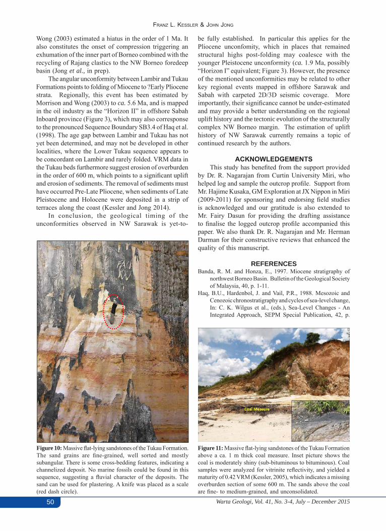
• At 857 m, we observe another erosional event, and this time an angular unconformity of Pliocene-age, which truncates the dipping Lambir Formation. The unconformity itself is unfortunately not well exposed (overgrown by dense creeper plants, Figure 9), but was classically exposed in a number of outcrops along the coastal Miri-Bintulu road (see Wannier et al., 2011).
• Above the unconformity, and possibly an important hiatus, the sequence contains massive flat-lying sandstones of the Tukau Formation (Figure 10). The sequence is formed by herringbone cross-beds. The sand grains are fine- to medium-grained, well sorted and mostly subangular; a quick look analysis by Shell’s palynological lab in Miri could not identify any marine biota, apart from a few and undiagnostic pollen fragments. Just beneath the cross-bedded sands, there are some parallel-bedded clays and at least one significant coal beds (Figure 11). Logically, this sequence was deposited following a phase of compression, in which the Lambir Formation and Upper Setap Shale were folded. The coal beds of the Tukau Formation are fairly sub-bituminous to bituminous, and a Vitrinite Reflectance Measurement
(VRM) of 0.42 was determined (Figure 11). The latter suggests that a significant overburden of Pleistocene sediments must have been eroded. Very often in this area, the presence of coal is a typical component/indicator of the Tukau Formation, whilst coal seems in the older Miri/Lambir Formations are very thin or often missing.
DISCUSSION AND CONCLUSIONThis logged outcrop profile, based on field work
conducted contains a unique and complete geologic section ranging from the Lower Miocene to the Pliocene and lithologically covers the gray Upper Setap Shale, Lambir and Tukau Formations, a rare occurrence considering that two regional unconformities were also observed. Such a long and continuous profile could also serve for correlation with both onshore and offshore well logs. Therefore, the regional and stratigraphic importance of the regional unconfotmities is noted and discussed below:
The boundary between Upper Setap Shale and Lambir Formation, the MMU with ca. 12.5 Ma age (Wannier et al., 2011; Figures 3 and 4) (?corresponding to Global Sequence Boundary SB2.6 of Haq et al., 1988), is an important seismic marker in the Sarawak and Sabah offshore. However, the duration of non-deposition and/or erosion is still not very well understood. Morrison and
Figure 8: Outcrop section from the lowest part of Lambir Formation. Drains give the impression of faulting, which is an optical illusion. The sands appear mostly laminar-layered, are clean of shale, as well as of coal.
Figure 9: Field sketch of the Pliocene Lambir-Tukau unconformity, at the Beluru-Lapok (Long Lama) road. The angular unconformity surface lies hidden in a band of dense vegetation.Tukau
Warta Geologi, Vol. 41, No. 3-4, July – December 201550
Franz L. KessLer & John Jong
Wong (2003) estimated a hiatus in the order of 1 Ma. It also constitutes the onset of compression triggering an exhumation of the inner part of Borneo combined with the recycling of Rajang clastics to the NW Borneo foredeep basin (Jong et al., in prep).
The angular unconformity between Lambir and Tukau Formations points to folding of Miocene to ?Early Pliocene strata. Regionally, this event has been estimated by Morrison and Wong (2003) to ca. 5.6 Ma, and is mapped in the oil industry as the “Horizon II” in offshore Sabah Inboard province (Figure 3), which may also corresponse to the pronounced Sequence Boundary SB3.4 of Haq et al. (1998). The age gap between Lambir and Tukau has not yet been determined, and may not be developed in other localities, where the Lower Tukau sequence appears to be concordant on Lambir and rarely folded. VRM data in the Tukau beds furthermore suggest erosion of overburden in the order of 600 m, which points to a significant uplift and erosion of sediments. The removal of sediments must have occurred Pre-Late Pliocene, when sediments of Late Pleistocene and Holocene were deposited in a strip of terraces along the coast (Kessler and Jong 2014).
In conclusion, the geological timing of the unconformities observed in NW Sarawak is yet-to-
Figure 10: Massive flat-lying sandstones of the Tukau Formation. The sand grains are fine-grained, well sorted and mostly subangular. There is some cross-bedding features, indicating a channelized deposit. No marine fossils could be found in this sequence, suggesting a fluvial character of the deposits. The sand can be used for plastering. A knife was placed as a scale (red dash circle).
Figure 11: Massive flat-lying sandstones of the Tukau Formation above a ca. 1 m thick coal measure. Inset picture shows the coal is moderately shiny (sub-bituminous to bituminous). Coal samples were analyzed for vitrinite reflectivity, and yielded a maturity of 0.42 VRM (Kessler, 2005), which indicates a missing overburden section of some 600 m. The sands above the coal are fine- to medium-grained, and unconsolidated.
be fully established. In particular this applies for the Pliocene unconfomity, which in places that remained structural highs post-folding may coalesce with the younger Pleistocene unconformity (ca. 1.9 Ma, possibly “Horizon I” equivalent; Figure 3). However, the presence of the mentioned unconformities may be related to other key regional events mapped in offshore Sarawak and Sabah with carpeted 2D/3D seismic coverage. More importantly, their significance cannot be under-estimated and may provide a better understanding on the regional uplift history and the tectonic evolution of the structurally complex NW Borneo margin. The estimation of uplift history of NW Sarawak currently remains a topic of continued research by the authors.
ACKNOWLEDGEMENTSThis study has benefited from the support provided
by Dr. R. Nagarajan from Curtin University Miri, who helped log and sample the outcrop profile. Support from Mr. Hajime Kusaka, GM Exploration at JX Nippon in Miri (2009-2011) for sponsoring and endorsing field studies is acknowledged and our gratitude is also extended to Mr. Fairy Dasun for providing the drafting assistance to finalise the logged outcrop profile accompanied this paper. We also thank Dr. R. Nagarajan and Mr. Herman Darman for their constructive reviews that enhanced the quality of this manuscript.
REFERENCESBanda, R. M. and Honza, E., 1997. Miocene stratigraphy of
northwest Borneo Basin. Bulletin of the Geological Society of Malaysia, 40, p. 1-11.
Haq, B.U., Hardenbol, J. and Vail, P.R., 1988. Mesozoic and Cenozoic chronostratigraphy and cycles of sea-level change, In: C. K. Wilgus et al., (eds.), Sea-Level Changes - An Integrated Approach, SEPM Special Publication, 42, p.
Warta Geologi, Vol. 41, No. 3-4, July – December 2015 51
Northwest sarawak: a complete geologic profile from the lower mioceNe to the plioceNe
71-108.Hutchison, C.S, 2005. Geology of North West Borneo: Sarawak,
Brunei and Sabah. Elsevier, Amsterdam, 421 p.Jong, J, Kessler, F.L., Noon, S. and Tran, Q.T. (in prep). Structural
development, depositional model and petroleum system of Palaeogene carbonate of the Engkabang-Karap Anticline, onshore Sarawak, Berita Sedimentologi, 34.
Kessler, F.L., 2005. Comments on the evolution of the Bukit Lambir Area, Sarawak, Malaysia. Paper presented at the GSM conference, Kuala Lumpur, December 2005.
Kessler, F.L., 2009a. The Baram Line in Sarawak: Comments on its anatomy, history and implications for potential non-conventional gas deposits. Warta geologi, 35(3), p. 105-110.
Kessler, F.L., 2009b. Observations on sediments and deformation characteristics of the Sarawak Foreland, Borneo Island. Warta Geologi, 35(1), p. 1 -10.
Kessler, F. L. and Jong, J., 2014. Habitat and C-14 ages of lignitic deposits along the northern Sarawak coastline. Bulletin of the Geological Society of Malaysia, 60, p. 27-34.
Liechti, P., Roe, F. W., and Haile, N. S., 1960. The Geology of Sarawak, Brunei and the western part of North Borneo. British Territories of Borneo, Geological Survey Department, Bulletin (Two volumes), 3, 360 p.
Morisson, K., and Wong, C. L., 2003. Sequence stratigraphic framework of Northwest Borneo. Bulletin of the Geological Society of Malaysia, 47, p. 127-138.
Sandal, T. (ed.), 1996. The geology and hydrocarbon resources of Negara Brunei Darussalam, Brunei Shell Petroleum Co. Sdn. Bhd. and Brunei Museum, 243 p.
Wannier, M., Lesslar, P., Lee, C. Raven, H., Jorkhabi, R. and Ibrahim, A., 2011. Geological Excursions around Miri, Sarawak, EcoMedia, 279 p.
52
PERTEMUAN PERSATUAN (MEETiNgS of ThE SociETy)
Warta Geologi, Vol. 41, No. 3-4, July – December 2015
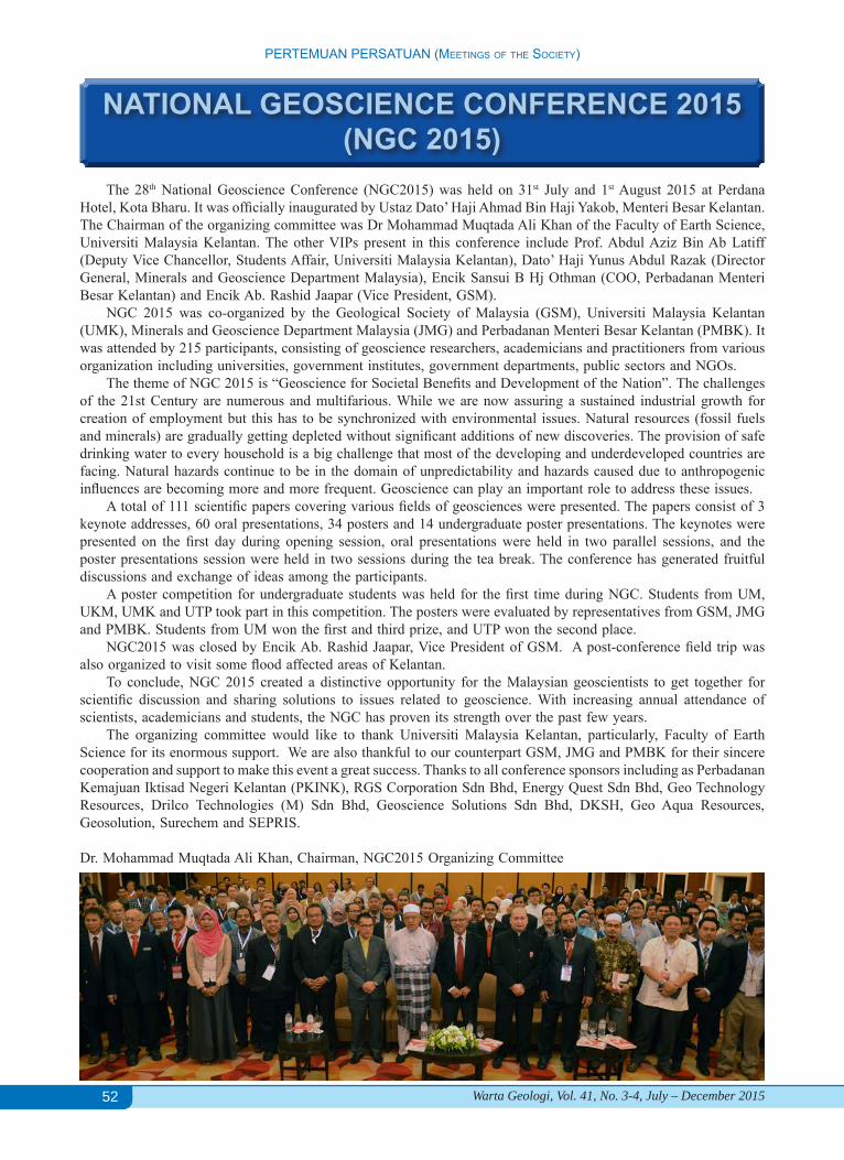
NATIONAL GEOSCIENCE CONFERENCE 2015(NGC 2015)
The 28th National Geoscience Conference (NGC2015) was held on 31st July and 1st August 2015 at Perdana Hotel, Kota Bharu. It was officially inaugurated by Ustaz Dato’ Haji Ahmad Bin Haji Yakob, Menteri Besar Kelantan. The Chairman of the organizing committee was Dr Mohammad Muqtada Ali Khan of the Faculty of Earth Science, Universiti Malaysia Kelantan. The other VIPs present in this conference include Prof. Abdul Aziz Bin Ab Latiff (Deputy Vice Chancellor, Students Affair, Universiti Malaysia Kelantan), Dato’ Haji Yunus Abdul Razak (Director General, Minerals and Geoscience Department Malaysia), Encik Sansui B Hj Othman (COO, Perbadanan Menteri Besar Kelantan) and Encik Ab. Rashid Jaapar (Vice President, GSM).
NGC 2015 was co-organized by the Geological Society of Malaysia (GSM), Universiti Malaysia Kelantan (UMK), Minerals and Geoscience Department Malaysia (JMG) and Perbadanan Menteri Besar Kelantan (PMBK). It was attended by 215 participants, consisting of geoscience researchers, academicians and practitioners from various organization including universities, government institutes, government departments, public sectors and NGOs.
The theme of NGC 2015 is “Geoscience for Societal Benefits and Development of the Nation”. The challenges of the 21st Century are numerous and multifarious. While we are now assuring a sustained industrial growth for creation of employment but this has to be synchronized with environmental issues. Natural resources (fossil fuels and minerals) are gradually getting depleted without significant additions of new discoveries. The provision of safe drinking water to every household is a big challenge that most of the developing and underdeveloped countries are facing. Natural hazards continue to be in the domain of unpredictability and hazards caused due to anthropogenic influences are becoming more and more frequent. Geoscience can play an important role to address these issues.
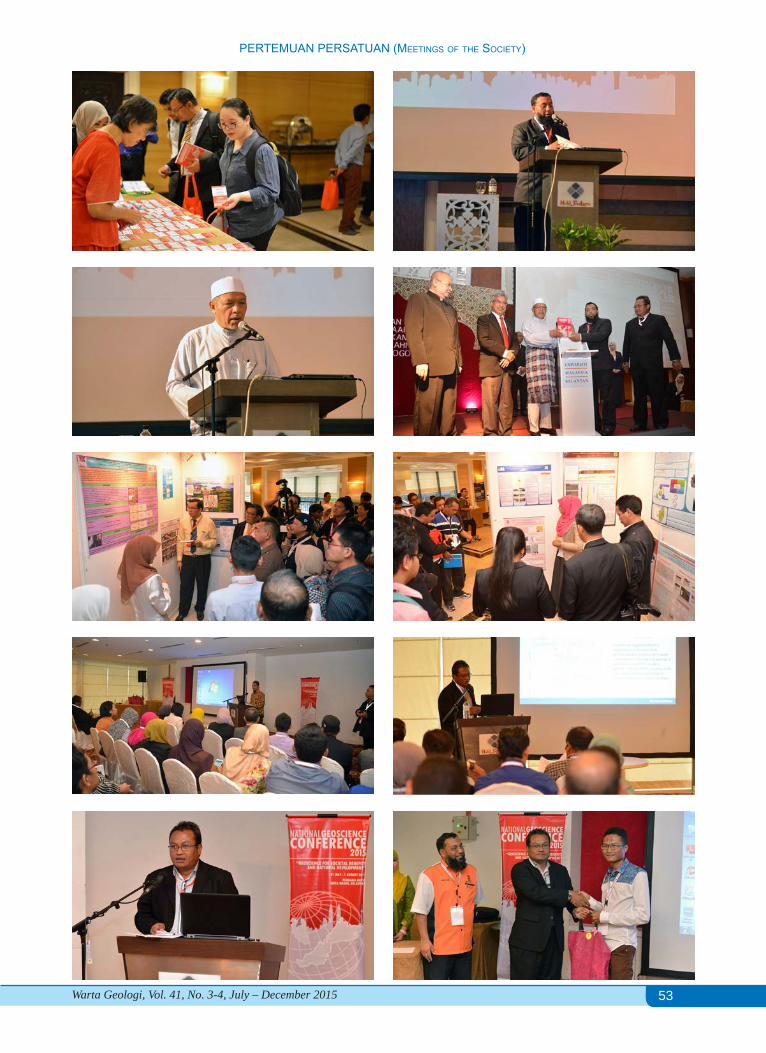
A total of 111 scientific papers covering various fields of geosciences were presented. The papers consist of 3 keynote addresses, 60 oral presentations, 34 posters and 14 undergraduate poster presentations. The keynotes were presented on the first day during opening session, oral presentations were held in two parallel sessions, and the poster presentations session were held in two sessions during the tea break. The conference has generated fruitful discussions and exchange of ideas among the participants.
A poster competition for undergraduate students was held for the first time during NGC. Students from UM, UKM, UMK and UTP took part in this competition. The posters were evaluated by representatives from GSM, JMG and PMBK. Students from UM won the first and third prize, and UTP won the second place.
NGC2015 was closed by Encik Ab. Rashid Jaapar, Vice President of GSM. A post-conference field trip was also organized to visit some flood affected areas of Kelantan.
To conclude, NGC 2015 created a distinctive opportunity for the Malaysian geoscientists to get together for scientific discussion and sharing solutions to issues related to geoscience. With increasing annual attendance of scientists, academicians and students, the NGC has proven its strength over the past few years.
The organizing committee would like to thank Universiti Malaysia Kelantan, particularly, Faculty of Earth Science for its enormous support. We are also thankful to our counterpart GSM, JMG and PMBK for their sincere cooperation and support to make this event a great success. Thanks to all conference sponsors including as Perbadanan Kemajuan Iktisad Negeri Kelantan (PKINK), RGS Corporation Sdn Bhd, Energy Quest Sdn Bhd, Geo Technology Resources, Drilco Technologies (M) Sdn Bhd, Geoscience Solutions Sdn Bhd, DKSH, Geo Aqua Resources, Geosolution, Surechem and SEPRIS.
Dr. Mohammad Muqtada Ali Khan, Chairman, NGC2015 Organizing Committee
53
PERTEMUAN PERSATUAN (MEETiNgS of ThE SociETy)
Warta Geologi, Vol. 41, No. 3-4, July – December 2015
54
PERTEMUAN PERSATUAN (MEETiNgS of ThE SociETy)
Warta Geologi, Vol. 41, No. 3-4, July – December 2015
The December 2014 flood in Kelantan: A post-event perspective
nuruL syazwani yahaya, Choun-sian Lim, umi amira JamaLuddin & Joy JaCqueLine Pereira
Southeast Asia Disaster Prevention Initiative (SEADPRI-UKM), Universiti Kebangsaan Malaysia
INTRODUCTIONThe “Science to Action” (S2A) initiative was
inspired by the Honourable Prime Minister Dato’ Sri Mohd Najib Tun Haji Abdul Razak in 2013 to make science relevant for governance, industry and community well-being. A prominent S2A initiative is the partnership between Malaysian Industry-Government Group for High Technology (MIGHT) and the British Council to promote collaboration between Malaysia and the United Kingdom in science, technology and innovation through the establishment of the Newton-Ungku Omar Fund. The Newton-Ungku Omar Fund is a five-year programme launched in 2014 jointly funded by the Governments of UK and Malaysia to address issues on “Climate Change and Sustainability” through innovative capacity building anchored in science.
The Geological Society of Malaysia supported by the Institute of Geology Malaysia, Universiti Kebangsaan Malaysia’s Southeast Asia Disaster Prevention Research Initiative (SEADPRI-UKM), University Malaya’s Geology Department and other parties is helming the flagship on Geoscience to Action for Disaster Risk Reduction (G2A4DRR). Funding has been secured from the Newton-Ungku Omar Fund via SEADPRI-UKM to mobilise coordinated measures underpinned by science to address the risks of climate related multi-hazards, in conjunction with partners from the UK. In the context of geoscience, the focus is on capacity building and professional development to build the nation’s resilience to climate induced disasters and natural hazards.
In conjunction with the Geological Society’s 2015 National Geoscience Conference hosted by the Universiti Malaysia Kelantan, the Department of Minerals and Geoscience Malaysia and Perbadanan Menteri Besar Kelantan, a field visit was organised to get an overview of the impacts of flooding in Kelantan in late 2014. About 20 participants from various institutions joined the visit to get an overview of affected areas in Kuala Krai and Dabong in Kelantan. This report provides a brief account of floods in Kelantan, features some physical impacts of the 2014 flood as observed eight months after the event and highlights the potential for geoscience inputs to improve the situation.
FLOODS IN KELANTANDue to the geographical location adjacent to the coast
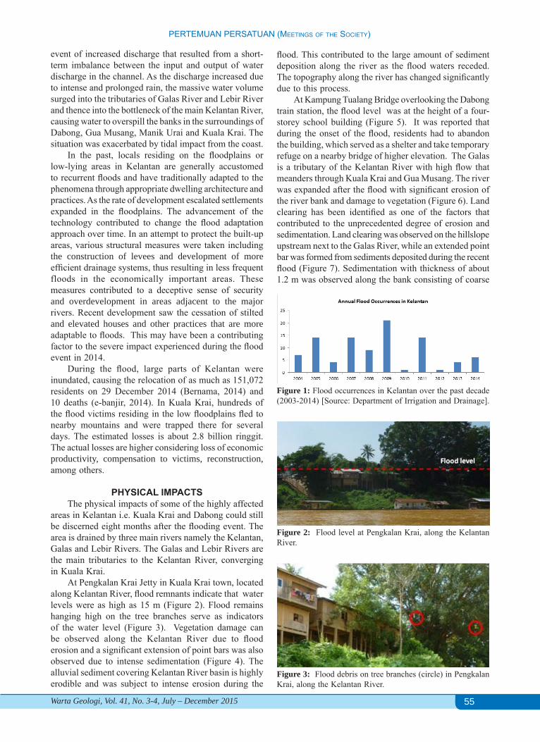
of South China Sea and the expansion of settlements on plain topography, a majority of the population in Kelantan are highly exposed to floods, especially during the northeast monsoon seasons occurring from November to March. Floods have been recorded in the state every year over the past decade (Figure 1). Small floods are frequent, occurring every 2-3 years on average while large floods are generally less frequent.
The December 2014 flood in Kelantan was unprecedented and the largest recorded flooding event in the century. The flood was preceded by more than a week of continuous rains, with intense raining period from 14th to 19th December 2014 with rivers exceeded the danger level by 17th December. This was an extreme
55
PERTEMUAN PERSATUAN (MEETiNgS of ThE SociETy)
Warta Geologi, Vol. 41, No. 3-4, July – December 2015
event of increased discharge that resulted from a short-term imbalance between the input and output of water discharge in the channel. As the discharge increased due to intense and prolonged rain, the massive water volume surged into the tributaries of Galas River and Lebir River and thence into the bottleneck of the main Kelantan River, causing water to overspill the banks in the surroundings of Dabong, Gua Musang, Manik Urai and Kuala Krai. The situation was exacerbated by tidal impact from the coast.
In the past, locals residing on the floodplains or low-lying areas in Kelantan are generally accustomed to recurrent floods and have traditionally adapted to the phenomena through appropriate dwelling architecture and practices. As the rate of development escalated settlements expanded in the floodplains. The advancement of the technology contributed to change the flood adaptation approach over time. In an attempt to protect the built-up areas, various structural measures were taken including the construction of levees and development of more efficient drainage systems, thus resulting in less frequent floods in the economically important areas. These measures contributed to a deceptive sense of security and overdevelopment in areas adjacent to the major rivers. Recent development saw the cessation of stilted and elevated houses and other practices that are more adaptable to floods. This may have been a contributing factor to the severe impact experienced during the flood event in 2014.
During the flood, large parts of Kelantan were inundated, causing the relocation of as much as 151,072 residents on 29 December 2014 (Bernama, 2014) and 10 deaths (e-banjir, 2014). In Kuala Krai, hundreds of the flood victims residing in the low floodplains fled to nearby mountains and were trapped there for several days. The estimated losses is about 2.8 billion ringgit. The actual losses are higher considering loss of economic productivity, compensation to victims, reconstruction, among others.
PHYSICAL IMPACTSThe physical impacts of some of the highly affected
areas in Kelantan i.e. Kuala Krai and Dabong could still be discerned eight months after the flooding event. The area is drained by three main rivers namely the Kelantan, Galas and Lebir Rivers. The Galas and Lebir Rivers are the main tributaries to the Kelantan River, converging in Kuala Krai.
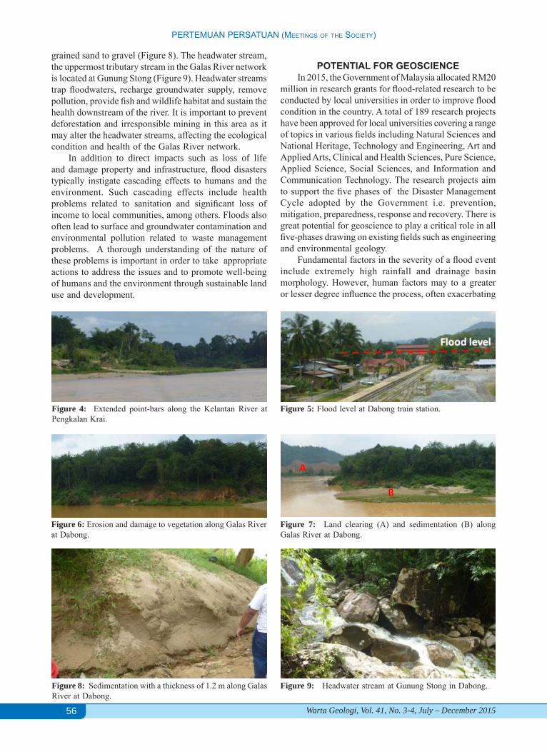
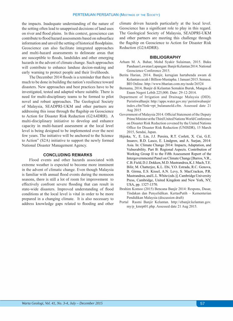
At Pengkalan Krai Jetty in Kuala Krai town, located along Kelantan River, flood remnants indicate that water levels were as high as 15 m (Figure 2). Flood remains hanging high on the tree branches serve as indicators of the water level (Figure 3). Vegetation damage can be observed along the Kelantan River due to flood erosion and a significant extension of point bars was also observed due to intense sedimentation (Figure 4). The alluvial sediment covering Kelantan River basin is highly erodible and was subject to intense erosion during the
Figure 1: Flood occurrences in Kelantan over the past decade (2003-2014) [Source: Department of Irrigation and Drainage].
Figure 2: Flood level at Pengkalan Krai, along the Kelantan River.
Figure 3: Flood debris on tree branches (circle) in Pengkalan Krai, along the Kelantan River.
flood. This contributed to the large amount of sediment deposition along the river as the flood waters receded. The topography along the river has changed significantly due to this process.
At Kampung Tualang Bridge overlooking the Dabong train station, the flood level was at the height of a four-storey school building (Figure 5). It was reported that during the onset of the flood, residents had to abandon the building, which served as a shelter and take temporary refuge on a nearby bridge of higher elevation. The Galas is a tributary of the Kelantan River with high flow that meanders through Kuala Krai and Gua Musang. The river was expanded after the flood with significant erosion of the river bank and damage to vegetation (Figure 6). Land clearing has been identified as one of the factors that contributed to the unprecedented degree of erosion and sedimentation. Land clearing was observed on the hillslope upstream next to the Galas River, while an extended point bar was formed from sediments deposited during the recent flood (Figure 7). Sedimentation with thickness of about 1.2 m was observed along the bank consisting of coarse
56
PERTEMUAN PERSATUAN (MEETiNgS of ThE SociETy)
Warta Geologi, Vol. 41, No. 3-4, July – December 2015
grained sand to gravel (Figure 8). The headwater stream, the uppermost tributary stream in the Galas River network is located at Gunung Stong (Figure 9). Headwater streams trap floodwaters, recharge groundwater supply, remove pollution, provide fish and wildlife habitat and sustain the health downstream of the river. It is important to prevent deforestation and irresponsible mining in this area as it may alter the headwater streams, affecting the ecological condition and health of the Galas River network.
In addition to direct impacts such as loss of life and damage property and infrastructure, flood disasters typically instigate cascading effects to humans and the environment. Such cascading effects include health problems related to sanitation and significant loss of income to local communities, among others. Floods also often lead to surface and groundwater contamination and environmental pollution related to waste management problems. A thorough understanding of the nature of these problems is important in order to take appropriate actions to address the issues and to promote well-being of humans and the environment through sustainable land use and development.
Figure 6: Erosion and damage to vegetation along Galas River at Dabong.
POTENTIAL FOR GEOSCIENCEIn 2015, the Government of Malaysia allocated RM20
million in research grants for flood-related research to be conducted by local universities in order to improve flood condition in the country. A total of 189 research projects have been approved for local universities covering a range of topics in various fields including Natural Sciences and National Heritage, Technology and Engineering, Art and Applied Arts, Clinical and Health Sciences, Pure Science, Applied Science, Social Sciences, and Information and Communication Technology. The research projects aim to support the five phases of the Disaster Management Cycle adopted by the Government i.e. prevention, mitigation, preparedness, response and recovery. There is great potential for geoscience to play a critical role in all five-phases drawing on existing fields such as engineering and environmental geology.
Fundamental factors in the severity of a flood event include extremely high rainfall and drainage basin morphology. However, human factors may to a greater or lesser degree influence the process, often exacerbating
Figure 9: Headwater stream at Gunung Stong in Dabong.Figure 8: Sedimentation with a thickness of 1.2 m along Galas River at Dabong.
Figure 7: Land clearing (A) and sedimentation (B) along Galas River at Dabong.
Figure 5: Flood level at Dabong train station. Figure 4: Extended point-bars along the Kelantan River at Pengkalan Krai.
57
PERTEMUAN PERSATUAN (MEETiNgS of ThE SociETy)
Warta Geologi, Vol. 41, No. 3-4, July – December 2015
the impacts. Inadequate understanding of the nature of the setting often lead to unapprised decisions of land uses on river and flood plains. In this context, geoscience can contribute to flood hazard assessments based on subsurface information and unveil the setting of historical floodplains. Geoscience can also facilitate integrated approaches and multi-hazard assessments to delineate areas that are susceptible to floods, landslides and other emerging hazards in the advent of climate change. Such approaches will contribute to enhance landuse decion-making and early warning to protect people and their livelihoods.
The December 2014 floods is a reminder that there is much to be done in building the nation’s resilience toward disasters. New approaches and best practices have to be investigated, tested and adapted where suitable. There is need for multi-disciplinary teams to be formed to pilot novel and robust approaches. The Geological Society of Malaysia, SEADPRI-UKM and other partners are addressing this issue through the flagship on Geoscience to Action for Disaster Risk Reduction (G2A4DRR). A multi-disciplinary initiative to develop and enhance capacity in multi-hazard assessment at the local level level is being designed to be implemented over the next few years. The initiative will be anchored to the Science to Action” (S2A) initiative to support the newly formed National Disaster Management Agency.
CONCLUDING REMARKSFlood events and other hazards associated with
extreme weather is expected to become more imminent in the advent of climatic change. Even though Malaysia is familiar with annual flood events during the monsoon seasons, there is still a lot of room for improvement to effectively confront severe flooding that can result in state-wide disasters. Improved understanding of flood conditions at the local level is vital in order to be more prepared in a changing climate. It is also necessary to address knowledge gaps related to flooding and other
climate driven hazards particularly at the local level. Geoscience has a significant role to play in this regard. The Geological Society of Malaysia, SEADPRI-UKM and other partners are meeting this challenge through the flagship on Geoscience to Action for Disaster Risk Reduction (G2A4DRR).
BIBLIOGRAPHYArham M. A. Bahar, Mohd Syakir Sulaiman, 2015. Buku
Panduan Lawatan Lapangan: Banjir Kelantan 2014. National Geoscience Conference 2015.
Berita Harian, 2014. Banjir, kerugian hartabenda awam di Kelantan cecah 1 Billion-Mustapha. 1 Januari 2015. Semasa. BH Online. http://www.bharian.com.my/node/26524
Bernama, 2014, Banjir di Kelantan Semakin Buruk, Mangsa di Enam Negeri Lebih 225,000. Date: 29-12-2014.
Department of Irrigation and Drainage Malaysia (DID). PeristiwaBanjir. http://apps.water.gov.my/ peristiwabanjir/index.cfm?link=rpt_bulananold.cfm. Assessed date 21 Aug 2015
Government of Malaysia 2014. Official Statement of the Deputy Prime Minister at the Third United Nations World Conference on Disaster Risk Reduction covened by the United Nations Office for Disaster Risk Reduction (UNISDR), 15 March 2015, Sendai, Japan.
Hijioka, Y., E. Lin, J.J. Pereira, R.T. Corlett, X. Cui, G.E. Insarov, R.D. Lasco, E. Lindgren, and A. Surjan, 2014: Asia. In: Climate Change 2014: Impacts, Adaptation, and Vulnerability. Part B: Regional Aspects. Contribution of Working Group II to the Fifth Assessment Report of the Intergovernmental Panel on Climate Change [Barros, V.R., C.B. Field, D.J. Dokken, M.D. Mastrandrea, K.J. Mach, T.E. Bilir, M. Chatterjee, K.L. Ebi, Y.O. Estrada, R.C. Genova, B. Girma, E.S. Kissel, A.N. Levy, S. MacCracken, P.R. Mastrandrea, and L.L. White (eds.)]. Cambridge University Press, Cambridge, United Kingdom and New York, NY, USA, pp. 1327-1370.
Ibrahim Komoo (2015) Bencana Banjir 2014: Respons, Dasar, Tindakan dan Penyelidikan. KertasPutih – Kementerian Pendidikan Malaysia (discussion draft)
Portal Rasmi Banjir Kelantan. http://ebanjir.kelantan.gov.my/p_kmrpt01.php. Assessed date 21 Aug 2015.
58
PERTEMUAN PERSATUAN (MEETiNgS of ThE SociETy)
Warta Geologi, Vol. 41, No. 3-4, July – December 2015
Documentary: On the Trail of Primitive Life (the Cambrian Period)José Antonio Gámez Vintaned (Universiti Teknologi Petronas)29 September 2015, Department of Geology, University of Malaya
Associate Professor Dr José Antonio Gámez Vintaned, from the Department of Geosciences, Universiti Teknologi Petronas presented the talk at the Lecture Hall of the Department of Geology, University of Malaya. The talk was attended by faculties and graduate students of the Geology Department and geologists from the industry.
Abstract: The documentary explains one of the biggest events in the history of life to a general audience: the Cambrian explosion of life. It opens with a summary description of Precambrian Earth and life, with particular emphasis on the biota of the Ediacaran Period. It then focuses on palaeontological highlights of the Precambrian/Cambrian transition and the probable causes of the “Cambrian Explosion” (with a short discussion on the nature and reality of the event). The history of Cambrian studies is briefly presented, followed by a review of the importance of fossil sites with exceptional preservation in reconstructing Cambrian “wonderful life”. Sites in Wales, Canada’s Burgess Shale, Chengjiang, China, and Sinsk in Siberia are featured, with special reference to the 100th anniversary of the discovery of the Burgess Shale and its remarkable fossils. The final part of the documentary deals with the Cambrian Lagerstätte of Murero (Spain), stressing its fossil content, long and continuous record (lower to middle Cambrian), and its contribution to the understanding of sexual dimorphism in trilobites. The film ends with some brief reflections on scientific progress in palaeontology and on the unique nature of the human mind.
CERAMAH TEKNIK TECHNICAL TALK
A review of the Bentong-Raub Suture vis-à-vis new insight of the tectonic evolution of Malay Peninsula
Aftab Alam Khan and Mustaffa Kamal Shuib (University of Malaya)27 August 2015, Department of Geology, UM, and 7 October 2015, Universiti Kebangsaan Malaysia
The talk on the Bentong-Raub suture was presented by Prof. Dr. Aftab Alam Khan, a visiting lecturer to the Department of Geology, University of Malaya from the University of Dhaka, Bangladesh. The talk was presented twice, first at the Lecture Hall of the Department of Geology UM, and then at the Meeting Room, Faculty of Science & Technology, UKM. Both talks were well attended by faculties and graduate students of both universities.
Abstract: Longitudinal and medial morpho-tectonic ridge that makes up the spine of Malay Peninsula is known as the “Bentong–Raub Suture” where typical suture zone assemblages such as ophiolite, pillow basalt, glaucophane schist, melange, flysch, jaditized greywacke are missing. Earlier recognized Bentong–Raub Suture is not a subduction-related collision margin rather, it is a rift-related fault zone separating the Central Belt and the Western belt of the peninsula that has accommodated most of the transpressive motions of the crust resulting in the closure and exhumation of the Central Belt along the fault zone. Similar crustal thickness (average ~35 km) of the Western, Central and Eastern belts derived from gravity modelling suggests a single continental block of Malay Peninsula that has drifted from East Gondwanaland and collided with South China during Permo-Triassic. Westward subduction of the intervening ocean between Malay Peninsula and South China resulted widespread granitization in the Triassic along with volcanics. Granite plutons are characterized by continental arc, rift-related continental eruption and upliftment related magmatism. Extensive occurrences of Triassic Pahang Volcanics of predominantly rhyolitic tuff suggest its derivation from back-arc extension. Back-arc extension, basin development and sedimentation of the Central Belt continued until Cretaceous. A-Type granite of metaluminous to peraluminous character indicate their emplacement in an intraplate tectonic setting. Westward extrusion of Malay Peninsula resulted an anticlockwise rotation in the Late Cretaceous–Early Tertiary due to the rifting of Luconia–Dangerous Grounds from the east Asia. Extensive ductile and brittle deformations including crustal segmentation, pull-apart fracturing and faulting occurred during the closure and exhumation of the Central Belt along the Bentong–Raub morphotectonic zone. Crustal shortening of the Central Belt is accomodated through strikeslip displacement, shearing and uplift.
59
PERTEMUAN PERSATUAN (MEETiNgS of ThE SociETy)
Warta Geologi, Vol. 41, No. 3-4, July – December 2015
CERAMAH TEKNIK TECHNICAL TALK
Mapping of the contaminant dispersion in the sub-surface using ground electromagnetic (GEM-2) survey and resistivity imaging
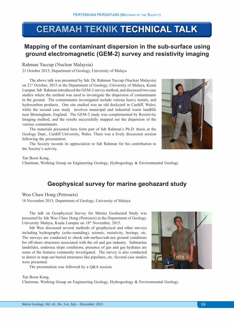
Rahman Yaccup (Nuclear Malaysia)21 October 2015, Department of Geology, University of Malaya
The above talk was presented by Sdr. Dr. Rahman Yaccup (Nuclear Malaysia) on 21st October, 2015 at the Department of Geology, University of Malaya, Kuala Lumpur. Sdr Rahman introduced the GEM-2 survey method, and discussed two case studies where the method was used to investigate the dispersion of contaminants in the ground. The contaminants investigated include various heavy metals, and hydrocarbon products. One site studied was an old dockyard in Cardiff, Wales; while the second case study involves municipal and industrial waste landfills near Birmingham, England. The GEM-2 study was complemented by Resistivity Imaging method, and the results successfully mapped out the dispersion of the various contaminants.
The materials presented here form part of Sdr Rahman’s Ph.D. thesis at the Geology Dept., Cardiff University, Wales. There was a lively discussion session following the presentation.
The Society records its appreciation to Sdr Rahman for his contribution to the Society’s activity.
Tan Boon Kong,Chairman, Working Group on Engineering Geology, Hydrogeology & Environmental Geology
Geophysical survey for marine geohazard studyWoo Chaw Hong (Petroseis)18 November 2015, Department of Geology, University of Malaya
The talk on Geophysical Survey for Marine Geohazard Study was presented by Sdr Woo Chaw Hong (Petroseis) at the Department of Geology, University Malaya, Kuala Lumpur on 18th November, 2015.
Sdr Woo discussed several methods of geophysical and other surveys including hydrography (echo-sounding), seismic, resistivity, borings, etc. The surveys are conducted to check sub-surface/sub-sea ground conditions for off-shore structures associated with the oil and gas industry. Submarine landslides, undersea slope conditions, presence of gas and gas hydrates are some of the features commonly investigated. The survey is also conducted to detect or map out buried structures like pipelines, etc. Several case studies were presented.
The presentation was followed by a Q&A session.
Tan Boon Kong,Chairman, Working Group on Engineering Geology, Hydrogeology & Environmental Geology
60
PERTEMUAN PERSATUAN (MEETiNgS of ThE SociETy)
Warta Geologi, Vol. 41, No. 3-4, July – December 2015
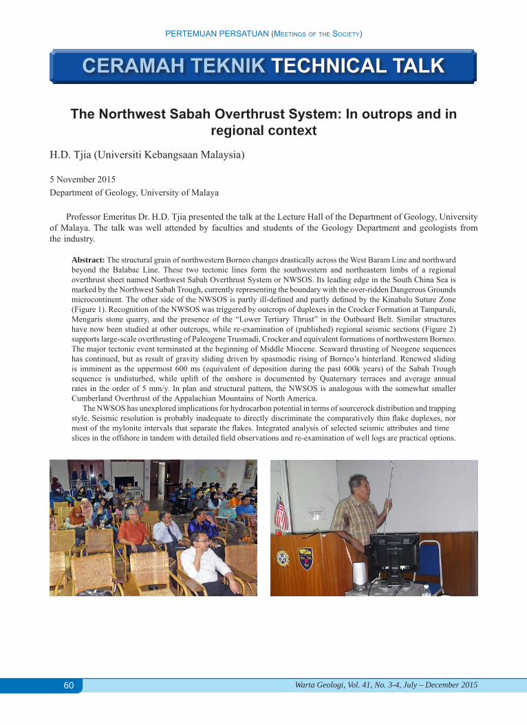
The Northwest Sabah Overthrust System: In outrops and in regional context
H.D. Tjia (Universiti Kebangsaan Malaysia)
5 November 2015Department of Geology, University of Malaya
Professor Emeritus Dr. H.D. Tjia presented the talk at the Lecture Hall of the Department of Geology, University of Malaya. The talk was well attended by faculties and students of the Geology Department and geologists from the industry.
Abstract: The structural grain of northwestern Borneo changes drastically across the West Baram Line and northward beyond the Balabac Line. These two tectonic lines form the southwestern and northeastern limbs of a regional overthrust sheet named Northwest Sabah Overthrust System or NWSOS. Its leading edge in the South China Sea is marked by the Northwest Sabah Trough, currently representing the boundary with the over-ridden Dangerous Grounds microcontinent. The other side of the NWSOS is partly ill-defined and partly defined by the Kinabalu Suture Zone (Figure 1). Recognition of the NWSOS was triggered by outcrops of duplexes in the Crocker Formation at Tamparuli, Mengaris stone quarry, and the presence of the “Lower Tertiary Thrust” in the Outboard Belt. Similar structures have now been studied at other outcrops, while re-examination of (published) regional seismic sections (Figure 2) supports large-scale overthrusting of Paleogene Trusmadi, Crocker and equivalent formations of northwestern Borneo. The major tectonic event terminated at the beginning of Middle Miocene. Seaward thrusting of Neogene sequences has continued, but as result of gravity sliding driven by spasmodic rising of Borneo’s hinterland. Renewed sliding is imminent as the uppermost 600 ms (equivalent of deposition during the past 600k years) of the Sabah Trough sequence is undisturbed, while uplift of the onshore is documented by Quaternary terraces and average annual rates in the order of 5 mm/y. In plan and structural pattern, the NWSOS is analogous with the somewhat smaller Cumberland Overthrust of the Appalachian Mountains of North America. The NWSOS has unexplored implications for hydrocarbon potential in terms of sourcerock distribution and trapping style. Seismic resolution is probably inadequate to directly discriminate the comparatively thin flake duplexes, nor most of the mylonite intervals that separate the flakes. Integrated analysis of selected seismic attributes and timeslices in the offshore in tandem with detailed field observations and re-examination of well logs are practical options.
CERAMAH TEKNIK TECHNICAL TALK
61
PERTEMUAN PERSATUAN (MEETiNgS of ThE SociETy)
Warta Geologi, Vol. 41, No. 3-4, July – December 2015
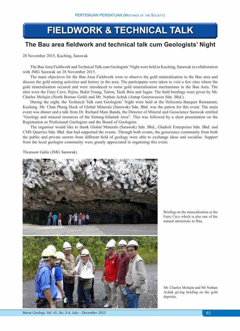
The Bau area fieldwork and technical talk cum Geologists’ Night28 November 2015, Kuching, Sarawak
The Bau Area Fieldwork and Technical Talk cum Geologists’ Night were held in Kuching, Sarawak in collaboration with JMG Sarawak on 28 November 2015.
The main objectives for the Bau Area Fieldwork were to observe the gold mineralisation in the Bau area and discuss the gold mining activities and history in the area. The participants were taken to visit a few sites where the gold mineralisation occured and were introduced to some gold mineralisation mechanisms in the Bau Area. The sites were the Fairy Cave, Pejiru, Bukit Young, Taiton, Tasik Biru and Jugan. The field briefings were given by Mr. Charles Molujin (North Borneo Gold) and Mr. Nathan Achuk (Antap Georesources Sdn. Bhd.).
During the night, the Technical Talk cum Geologists’ Night were held at the Heliconia Banquet Restaurant, Kuching. Mr. Chan Pheng Hock of Global Minerals (Sarawak) Sdn. Bhd. was the patron for this event. The main event was dinner and a talk from Dr. Richard Mani Banda, the Director of Mineral and Geoscience Sarawak entitled “Geology and mineral resources of the Sintang-Silantek Area”. This was followed by a short presentation on the Registration as Profesional Geologists and the Board of Geologists.
The organiser would like to thank Global Minerals (Sarawak) Sdn. Bhd., Gladioli Enterprises Sdn. Bhd. and CMS Quarries Sdn. Bhd. that had supported the events. Through both events, the geoscience community from both the public and private sectors from different field of geology were able to exchange ideas and socialise. Support from the local geologist community were greatly appreciated in organising this event.
Thomson Galin (JMG Sarawak)
FIELDWORK & TECHNICAL TALK
Briefing on the mineralisation at the Fairy Cave which is also one of the natural attractions in Bau.
Mr. Charles Molujin and Mr Nathan Achuk giving briefing on the gold deposits.
62
PERTEMUAN PERSATUAN (MEETiNgS of ThE SociETy)
Warta Geologi, Vol. 41, No. 3-4, July – December 2015
Tectono-stratigraphic framework & tertiary paleogeogeography of Southeast Asia: Gulf of Thailand to South Vietnam shelf
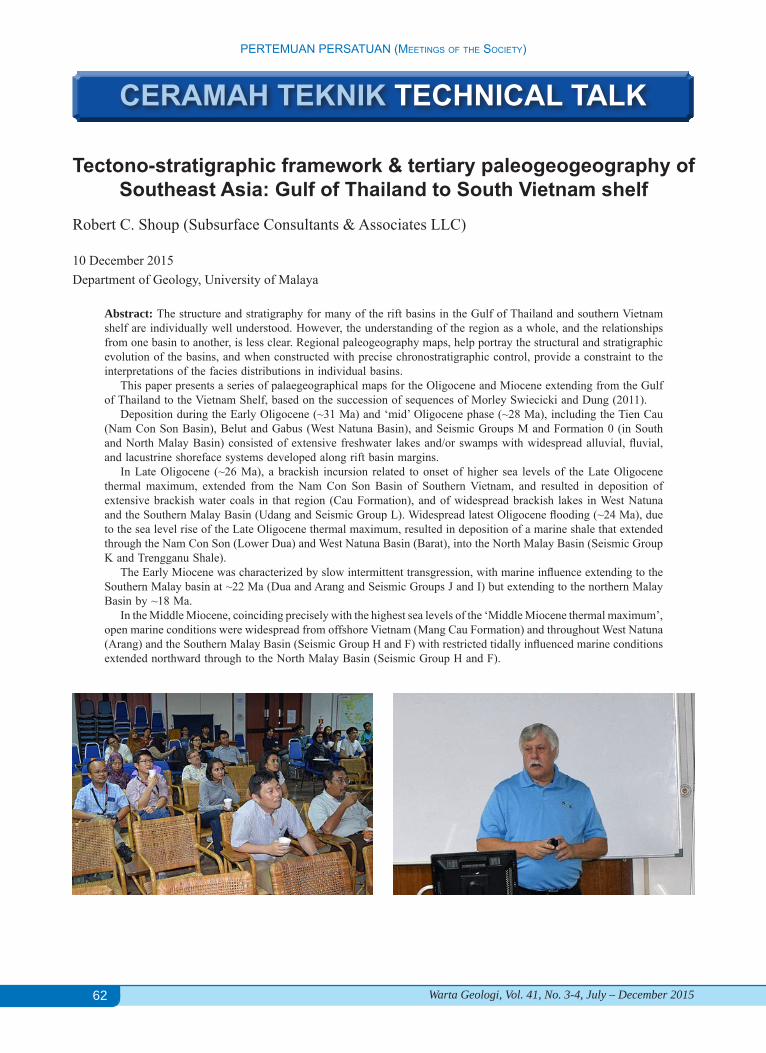
Robert C. Shoup (Subsurface Consultants & Associates LLC)
10 December 2015Department of Geology, University of Malaya
Abstract: The structure and stratigraphy for many of the rift basins in the Gulf of Thailand and southern Vietnam shelf are individually well understood. However, the understanding of the region as a whole, and the relationships from one basin to another, is less clear. Regional paleogeography maps, help portray the structural and stratigraphic evolution of the basins, and when constructed with precise chronostratigraphic control, provide a constraint to the interpretations of the facies distributions in individual basins. This paper presents a series of palaegeographical maps for the Oligocene and Miocene extending from the Gulf of Thailand to the Vietnam Shelf, based on the succession of sequences of Morley Swiecicki and Dung (2011). Deposition during the Early Oligocene (~31 Ma) and ‘mid’ Oligocene phase (~28 Ma), including the Tien Cau (Nam Con Son Basin), Belut and Gabus (West Natuna Basin), and Seismic Groups M and Formation 0 (in South and North Malay Basin) consisted of extensive freshwater lakes and/or swamps with widespread alluvial, fluvial, and lacustrine shoreface systems developed along rift basin margins. In Late Oligocene (~26 Ma), a brackish incursion related to onset of higher sea levels of the Late Oligocene thermal maximum, extended from the Nam Con Son Basin of Southern Vietnam, and resulted in deposition of extensive brackish water coals in that region (Cau Formation), and of widespread brackish lakes in West Natuna and the Southern Malay Basin (Udang and Seismic Group L). Widespread latest Oligocene flooding (~24 Ma), due to the sea level rise of the Late Oligocene thermal maximum, resulted in deposition of a marine shale that extended through the Nam Con Son (Lower Dua) and West Natuna Basin (Barat), into the North Malay Basin (Seismic Group K and Trengganu Shale). The Early Miocene was characterized by slow intermittent transgression, with marine influence extending to the Southern Malay basin at ~22 Ma (Dua and Arang and Seismic Groups J and I) but extending to the northern Malay Basin by ~18 Ma. In the Middle Miocene, coinciding precisely with the highest sea levels of the ‘Middle Miocene thermal maximum’, open marine conditions were widespread from offshore Vietnam (Mang Cau Formation) and throughout West Natuna (Arang) and the Southern Malay Basin (Seismic Group H and F) with restricted tidally influenced marine conditions extended northward through to the North Malay Basin (Seismic Group H and F).
CERAMAH TEKNIK TECHNICAL TALK
63
PERTEMUAN PERSATUAN (MEETiNgS of ThE SociETy)
Warta Geologi, Vol. 41, No. 3-4, July – December 2015
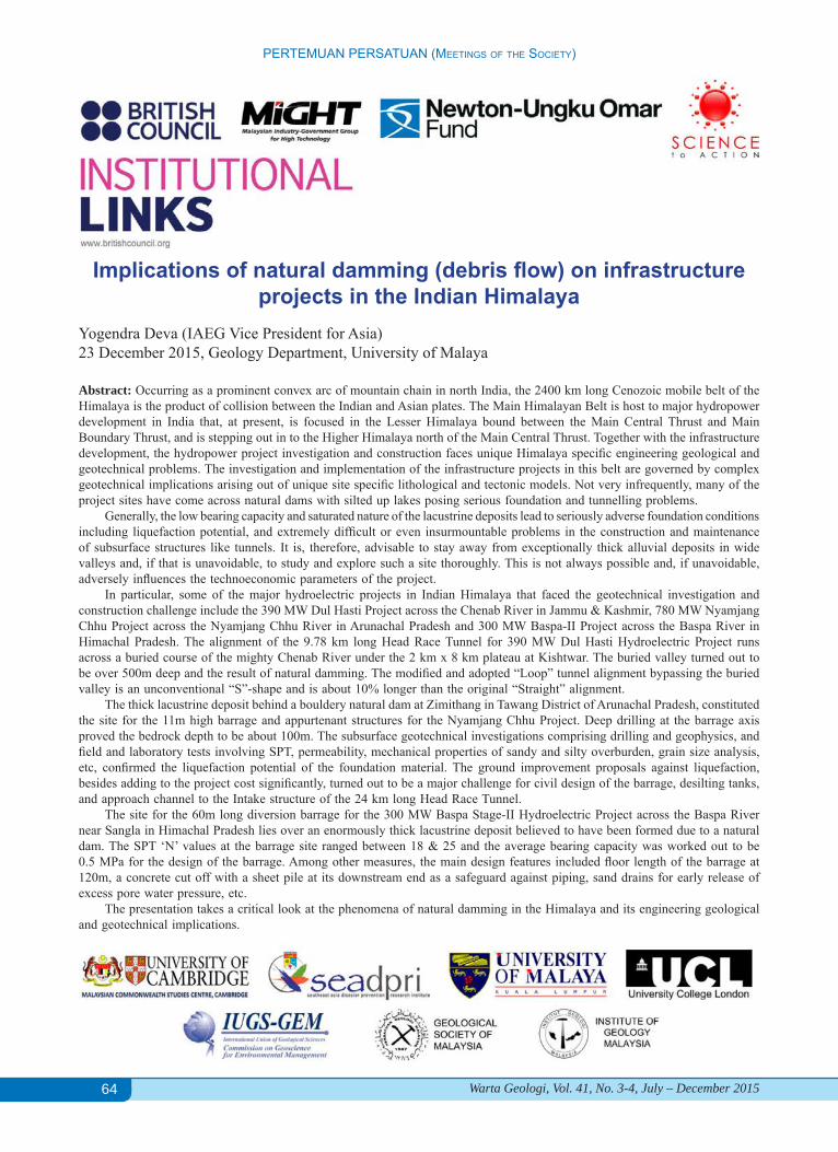
Crustal structure and buried paleo-sedimentary basins in the north-eastern Black Sea-Azov Sea area and tectonic implications
(DOBRE-2 project)Randell Stephenson (University of Aberdeen)
17 December 2015, Department of Geology, University of Malaya
Dr. Randell Stephenson is Professor in Lithosphere Geophysics at University of Aberdeen, Scotland, and Visiting Professor at the Department of Geology, University of Malaya. He was born and educated in Canada. He worked at Australian National University as a postdoctoral fellow, Geological Survey of Canada as a research scientist. He started his academic career at VU University Amsterdam and before joining the School of Geosciences at University of Aberdeen in 2009. Dr. Stephensen presented the talk at the Lecture Hall of the Department of Geology, University of Malaya. The talk was well attended by faculties and graduate students of the Geology Department.
Abstract: Sedimentary basin inversion and accompanying ongoing development of marginal basin depocentres in the north-eastern Black Sea – which is closely tied to the formation of the Greater Caucasus orogen – is a Cenozoic phenomenon, starting in the middle Eocene and proceeding until the present day. The DOBRE-2 project was about the crustal structure of the northern margin of the eastern Black Sea basin, north across the Azov Sea onto the East European Craton – the deeper expression of sedimentary basins and what controls the geometry of their inversion, the processes forming syn-inversional basins and the role of inherited lithosphere (crustal) structure. The sedimentary basin/crust/lithosphere geometry of the study area has been characterised across a range of scales using regional seismic reflection profiling, long-offset refraction/wide-angle reflection profiling and local earthquake tomography. These are described, integrated and used as the basis of a new model of tectonic evolution of the area.
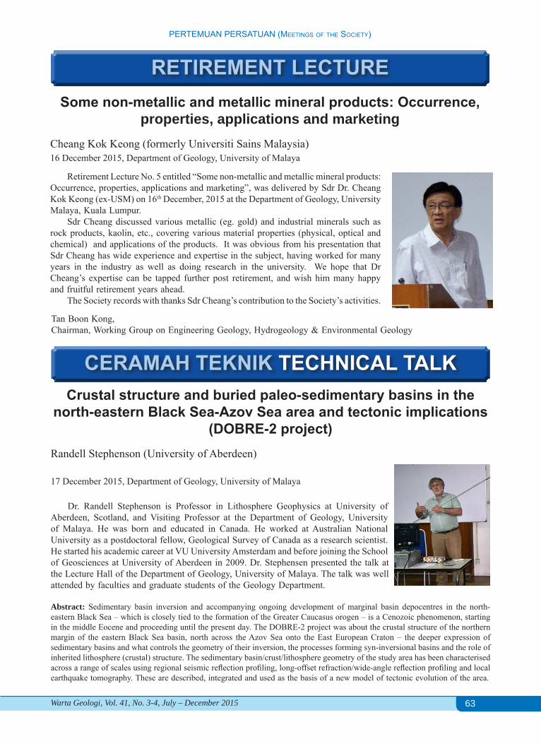
RETIREMENT LECTURESome non-metallic and metallic mineral products: Occurrence,
properties, applications and marketingCheang Kok Keong (formerly Universiti Sains Malaysia)16 December 2015, Department of Geology, University of Malaya
Retirement Lecture No. 5 entitled “Some non-metallic and metallic mineral products: Occurrence, properties, applications and marketing”, was delivered by Sdr Dr. Cheang Kok Keong (ex-USM) on 16th December, 2015 at the Department of Geology, University Malaya, Kuala Lumpur.
Sdr Cheang discussed various metallic (eg. gold) and industrial minerals such as rock products, kaolin, etc., covering various material properties (physical, optical and chemical) and applications of the products. It was obvious from his presentation that Sdr Cheang has wide experience and expertise in the subject, having worked for many years in the industry as well as doing research in the university. We hope that Dr Cheang’s expertise can be tapped further post retirement, and wish him many happy and fruitful retirement years ahead.
The Society records with thanks Sdr Cheang’s contribution to the Society’s activities.
Tan Boon Kong,Chairman, Working Group on Engineering Geology, Hydrogeology & Environmental Geology
CERAMAH TEKNIK TECHNICAL TALK
64
PERTEMUAN PERSATUAN (MEETiNgS of ThE SociETy)
Warta Geologi, Vol. 41, No. 3-4, July – December 2015
Implications of natural damming (debris flow) on infrastructure projects in the Indian Himalaya
Yogendra Deva (IAEG Vice President for Asia)23 December 2015, Geology Department, University of Malaya
Abstract: Occurring as a prominent convex arc of mountain chain in north India, the 2400 km long Cenozoic mobile belt of the Himalaya is the product of collision between the Indian and Asian plates. The Main Himalayan Belt is host to major hydropower development in India that, at present, is focused in the Lesser Himalaya bound between the Main Central Thrust and Main Boundary Thrust, and is stepping out in to the Higher Himalaya north of the Main Central Thrust. Together with the infrastructure development, the hydropower project investigation and construction faces unique Himalaya specific engineering geological and geotechnical problems. The investigation and implementation of the infrastructure projects in this belt are governed by complex geotechnical implications arising out of unique site specific lithological and tectonic models. Not very infrequently, many of the project sites have come across natural dams with silted up lakes posing serious foundation and tunnelling problems.
Generally, the low bearing capacity and saturated nature of the lacustrine deposits lead to seriously adverse foundation conditions including liquefaction potential, and extremely difficult or even insurmountable problems in the construction and maintenance of subsurface structures like tunnels. It is, therefore, advisable to stay away from exceptionally thick alluvial deposits in wide valleys and, if that is unavoidable, to study and explore such a site thoroughly. This is not always possible and, if unavoidable, adversely influences the technoeconomic parameters of the project.
In particular, some of the major hydroelectric projects in Indian Himalaya that faced the geotechnical investigation and construction challenge include the 390 MW Dul Hasti Project across the Chenab River in Jammu & Kashmir, 780 MW Nyamjang Chhu Project across the Nyamjang Chhu River in Arunachal Pradesh and 300 MW Baspa-II Project across the Baspa River in Himachal Pradesh. The alignment of the 9.78 km long Head Race Tunnel for 390 MW Dul Hasti Hydroelectric Project runs across a buried course of the mighty Chenab River under the 2 km x 8 km plateau at Kishtwar. The buried valley turned out to be over 500m deep and the result of natural damming. The modified and adopted “Loop” tunnel alignment bypassing the buried valley is an unconventional “S”-shape and is about 10% longer than the original “Straight” alignment.
The thick lacustrine deposit behind a bouldery natural dam at Zimithang in Tawang District of Arunachal Pradesh, constituted the site for the 11m high barrage and appurtenant structures for the Nyamjang Chhu Project. Deep drilling at the barrage axis proved the bedrock depth to be about 100m. The subsurface geotechnical investigations comprising drilling and geophysics, and field and laboratory tests involving SPT, permeability, mechanical properties of sandy and silty overburden, grain size analysis, etc, confirmed the liquefaction potential of the foundation material. The ground improvement proposals against liquefaction, besides adding to the project cost significantly, turned out to be a major challenge for civil design of the barrage, desilting tanks, and approach channel to the Intake structure of the 24 km long Head Race Tunnel.
The site for the 60m long diversion barrage for the 300 MW Baspa Stage-II Hydroelectric Project across the Baspa River near Sangla in Himachal Pradesh lies over an enormously thick lacustrine deposit believed to have been formed due to a natural dam. The SPT ‘N’ values at the barrage site ranged between 18 & 25 and the average bearing capacity was worked out to be 0.5 MPa for the design of the barrage. Among other measures, the main design features included floor length of the barrage at 120m, a concrete cut off with a sheet pile at its downstream end as a safeguard against piping, sand drains for early release of excess pore water pressure, etc.
The presentation takes a critical look at the phenomena of natural damming in the Himalaya and its engineering geological and geotechnical implications.
65
BERITA-BERITA PERSATUAN (NEwS of ThE SocIETy)
Warta Geologi, Vol. 41, No. 3-4, July – December 2015
NEW MEMBERSHIPFull Member1. Arjan Brem2. Chong Kok Leong3. Edward J Jansen4. Muhammad Azrief Azahar5. Muhammad Hakimi Ismail6. Muhammad Syazwan Adzhar7. Nasaruddin Ahmad8. Norzita Mat Fiah9. Robert C Shoup10. Rosni Lokmannul Hakim11. Sahibin Abd Rahim12. Sandip Kumar Roy13. Shaidatul Munirah Musa14. Zafizul Afizi Md Mudazir
Student Member1. Abdul Qudus Abd Manaff2. Abdullah Shukry3. Ardila Adnan4. Fadhilah Muchlis5. Hamizah Abu Bakar6. Helmi Fahmie Rosli
7. Md Mostafizur Rahman8. Mohamad Asraf Mohd Yaacob9. Mohd Noor Raffee Usli10. Muhammad Amirul Bahri Mohd Ridzwan11. Muhammad Azim Mohd Asri12. Muhammad Fahmi Abdul Ghani13. Muhammad Ridwan Ibrahim @ Zahari14. Muzaffar Yusry15. Nazur Riza Norkaman16. Nik Nurul Shahira Shaharani17. Nor Emy Shazana Sohaimi18. Nora Norshafira Mohamand Nazari19. Noran Nabilla Nor Azlan20. Norfara Azhbi21. Nur Adila Syakirah Mohd Redzuan22. Nur Amirah Mohd Yusof23. Nur Shafiqka Zulkfli24. Nur Shaizah Ismail25. Nur’Ain Marlan26. Siti Amira Zolkepli27. Syahidaton Akmal Hassan28. T Muhhammad Aliff Azman29. Zatil Atiqah Mohd Amin
CHANGE OF ADDRESSPhlemon GeorgePEXCO SARAWAK N.VLevel 5, Menara Maxis, 50088 Kuala Lumpur
Jawati Abu Naim54, Jalan 4A, Ampang Jaya,68000 Ampang, Selangor Darul Ehsan
Muhammad Abdullah4249, Jalan Masjid, Kampung Padang Air,21060, Kuala Terengganu, Terengganu
Khalid AmeenInternational Energy Resources Co45 Kee Sun Avenue, Singapore 457055
Calvin Cheah42 Jalan Penaga 3, Bandar Botanic41200 Klang, Selangor Darul Ehsan
Zuhar Zahir Tuan HarithNo 42, Jalan P15H 4/5Precincts 15, 62050 Putrajaya, Wilayah Persekutuan
Sven M JensenB4105, BSA Twin TowersBank Drive, Mandaluyong City, 1550 Philippines
Dato’ Yunus Abdul RazakD'Villa 10, Jalan Sunway 5/7Bandar Sunway Semenyih43500 Semenyih, Selangor Darul Ehsan
ADDRESS WANTED1. Muhammad Ammar Aziz Mohd Nasir2. Nor Ridhwah Abdol Malek3. Voon Hian Fah4. Nurul Aysha Abd Razak
5. Mohd Shazmeer Mohd Jamaludin6. S. S. Subramaniam7. Nur Hasmin Kamarolizaman
66
BERITA-BERITA PERSATUAN (NEwS of ThE SocIETy)
Warta Geologi, Vol. 41, No. 3-4, July – December 2015
Please be informed that nominations for the D.J. Gobbett Award (formerly known as the Geosceintist Award) are now invited from all members of the Society. Relevant excerpts concerning the nomination of geoscientists and conditions of the award are listed below:
Eligibility
1. The D.J. Gobbett Award is open to any individual or group of individuals working on the same project who are members of the Society.
2. The nomination shall be made for geoscientists who have done excellent research and contributed significantly to the development of Malaysian geology.
3. The research work must be original and should have been published before the nomination date.
4. The submission of research works which are known to have been already awarded at national or international levels would be automatically disqualified.
Procedure
1. Nomination for the award must be proposed and seconded by corporate members of the Society
2. The nomination should be on prescribed forms that can be obtained from:
The Secretary Geological Society of Malaysia c/o Department of Geology University of Malaya 50603 Kuala Lumpur, Malaysia Tel: 603 7957 7036 Fax: 603 7956 3900 Email: [email protected]
3. Nominations should be received by the Chairman of the D.J. Gobbett Award Committee before 31st March 2016.
Dr. Jasmi Hafiz Abdul AzizChairman, D.J. Gobbett Award
D.J. Gobbett Award
67
BERITA-BERITA PERSATUAN (NEwS of ThE SocIETy)
Warta Geologi, Vol. 41, No. 3-4, July – December 2015
N.S. Haile Publication Award
Please be informed that nominations of author(s) for the N.S. Haile Publication Award (formerly known as the Young Geoscientist Publication Award) are now invited from all members of the Society except Student and Associate Members. Nominations should be of young geoscientist(s) who have published papers in 2015. Relevant excerpts concerning the nomination and condition of award are listed below:
Eligibility Procedure1. No person shall be considered for the award
unless he satisfies the Board:(a) that he/she is thirty years old or younger
at the time of the publication of the paper or acceptance of the paper for publication.
(b) that he/she has been a resident of Malaysia for at least 3 years prior to the publication of the paper.
(c) that he/she belongs to any one of the membership of the Society.
(d) that the paper was published or has been accepted for publication in the previous calendar year, in which case written proof from the publisher must be shown.
(e) that the paper has been published in any Malaysian or international scientific publication.
1.
2.
(a) Nominations for an award must be made by a member who is not a Student or Associate Member
(b) An author cannot nominate himself for the award.
(c) The written consent of the author is required.
(a) The award, in the opinion of the Board, shall be made to the author of the best paper in geology about Malaysia or the region and/or should be a general interest to the local community of geoscientists.
(b) Papers with joint authorship may be considered, if a statement as to the relative responsibility of the authors, signed by all the authors, is attached.
(c) In the case of joint authorships, the board may make the award to one author, or to two or more authors, provided these qualify under subsection on eligibility.
Nominations should be on prescribed forms that can be obtained from:
The Secretary Geological Society of Malaysia c/o Department of Geology, University of Malaya 50603 Kuala Lumpur, Malaysia Tel: 603 7957 7036, Fax: 603 7956 3900 Email: [email protected]
Nominations should be received by the Chairman or the N.S. Haile Publication Award before the 31st March 2016.
Dr. Jasmi Hafiz Abdul AzizChairman, N.S. Haile Publication Award
68
BERITA-BERITA PERSATUAN (NEwS of ThE SocIETy)
Warta Geologi, Vol. 41, No. 3-4, July – December 2015
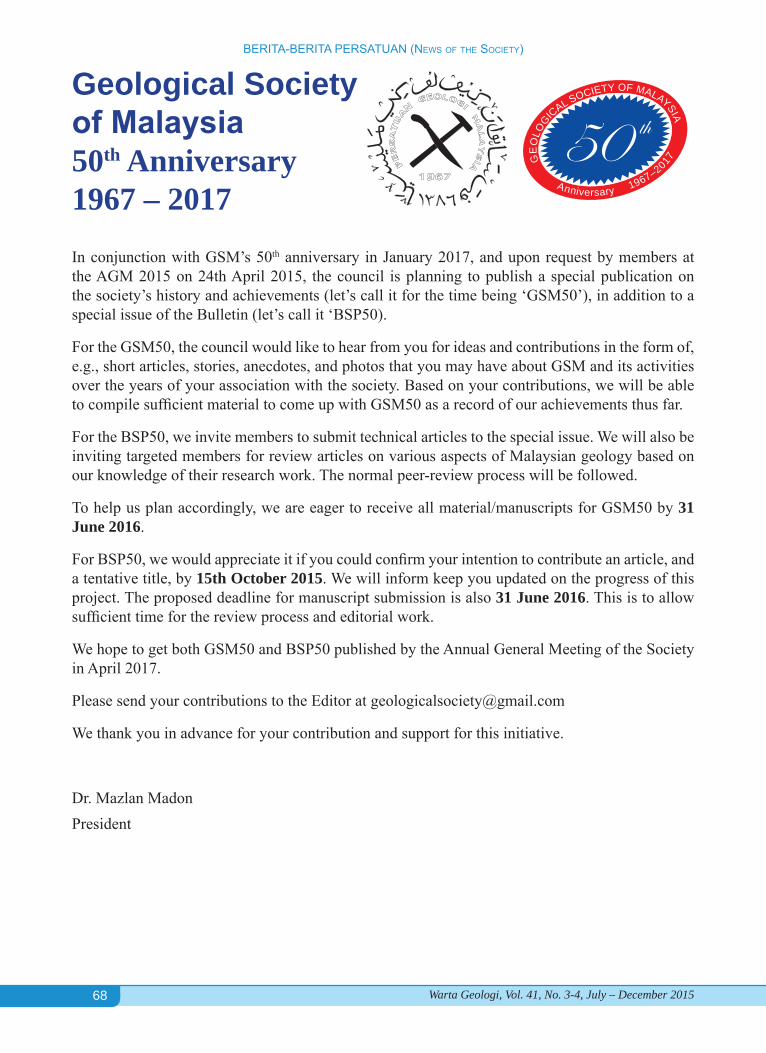
In conjunction with GSM’s 50th anniversary in January 2017, and upon request by members at the AGM 2015 on 24th April 2015, the council is planning to publish a special publication on the society’s history and achievements (let’s call it for the time being ‘GSM50’), in addition to a special issue of the Bulletin (let’s call it ‘BSP50).
For the GSM50, the council would like to hear from you for ideas and contributions in the form of, e.g., short articles, stories, anecdotes, and photos that you may have about GSM and its activities over the years of your association with the society. Based on your contributions, we will be able to compile sufficient material to come up with GSM50 as a record of our achievements thus far.
For the BSP50, we invite members to submit technical articles to the special issue. We will also be inviting targeted members for review articles on various aspects of Malaysian geology based on our knowledge of their research work. The normal peer-review process will be followed.
To help us plan accordingly, we are eager to receive all material/manuscripts for GSM50 by 31 June 2016.
For BSP50, we would appreciate it if you could confirm your intention to contribute an article, and a tentative title, by 15th October 2015. We will inform keep you updated on the progress of this project. The proposed deadline for manuscript submission is also 31 June 2016. This is to allow sufficient time for the review process and editorial work.
We hope to get both GSM50 and BSP50 published by the Annual General Meeting of the Society in April 2017.
Please send your contributions to the Editor at [email protected]
We thank you in advance for your contribution and support for this initiative.
Dr. Mazlan MadonPresident
GE
OLO
GICAL SOCIETY OF MALAYSIA
Anniversary 1967–2017
Geological Society of Malaysia50th Anniversary1967 – 2017
69
BERITA-BERITA LAIN (OThER NEws)
Warta Geologi, Vol. 41, No. 3-4, July – December 2015
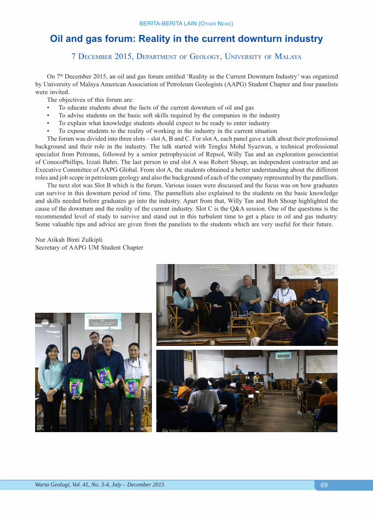
On 7th December 2015, an oil and gas forum entitled ‘Reality in the Current Downturn Industry’ was organized by University of Malaya American Association of Petroleum Geologists (AAPG) Student Chapter and four panelists were invited.
The objectives of this forum are:• To educate students about the facts of the current downturn of oil and gas• To advise students on the basic soft skills required by the companies in the industry• To explain what knowledge students should expect to be ready to enter industry• To expose students to the reality of working in the industry in the current situationThe forum was divided into three slots – slot A, B and C. For slot A, each panel gave a talk about their professional
background and their role in the industry. The talk started with Tengku Mohd Syazwan, a technical professional specialist from Petronas, followed by a senior petrophysicist of Repsol, Willy Tan and an exploration geoscientist of ConocoPhillips, Izzati Bahri. The last person to end slot A was Robert Shoup, an independent contractor and an Executive Committee of AAPG Global. From slot A, the students obtained a better understanding about the different roles and job scope in petroleum geology and also the background of each of the company represented by the panellists.
The next slot was Slot B which is the forum. Various issues were discussed and the focus was on how graduates can survive in this downturn period of time. The pannellists also explained to the students on the basic knowledge and skills needed before graduates go into the industry. Apart from that, Willy Tan and Bob Shoup highlighted the cause of the downturn and the reality of the current industry. Slot C is the Q&A session. One of the questions is the recommended level of study to survive and stand out in this turbulent time to get a place in oil and gas industry. Some valuable tips and advice are given from the panelists to the students which are very useful for their future.
Nur Atikah Binti ZulkipliSecretary of AAPG UM Student Chapter
Oil and gas forum: Reality in the current downturn industry
7 deCember 2015, dePartment oF geoLogy, university oF maLaya
70
BERITA-BERITA LAIN (OThER NEws)
Warta Geologi, Vol. 41, No. 3-4, July – December 2015
71
BERITA-BERITA LAIN (OThER NEws)
Warta Geologi, Vol. 41, No. 3-4, July – December 2015
UPCOMING EVENTSFebruary 8 - 12, 2016: IGS Workshop. IUGG. Sydney, Australia. http://kb.igs.org/hc/en-us/articles/205944657-IGS-Workshop-2016-Information
February 14 - 18, 2016: The Minerals Metals & Materials Society 145th Annual Meeting & Exhibition. Nashville, TN, USA. http://tinyurl.com/nbdyqeh
February 24 - 26, 2016: 49th International Conference on Water Management Modeling. Brampton, Ontarion, Canada. http://www.chiwater.com/Training/Conferences/conferencetoronto.asp
February 25 - 26, 2016: 24th Geotechnical Conference - Design, Construction and Controls of Soil Improvement Systems, Torino, Italy. http://www.cgttorino.org/
March 7-10, 2016: 12th Middle East Geosciences Conference & Exhibition, Bahrain. Contact: International Explo Management, Tel: +65 62336777; Fax: +65 62336768; email: [email protected]; website: www.allworldexhibitions.com
March 22 - 25, 2016: OTCASIA 2016 - Offshore Technology Conference, Kuala Lumpur, Malaysia. http://2016.otcasia.org/
March 30 - 31, 2016: International Conference on Geotechnical Research and Engineering (ICGRE’16). Prague, Czech Republic. http://icgre.org/
April 3 - 6, 2016: AAPG/SEG’s (ICE) American Association of Petroleum Geologists and Society of Exploration Geophysicists - Barcelona International Conference & Exhibition. Barcelona, Spain. http://barcelona2016.iceevent.org/sponsor
April 4 - 8, 2016: RSCy2016. Fourth International Conference on Remote Sensing and Geo-information of Environment. ISPRS. Paphos, Cyprus. http://www.cyprusremotesensing.com/rscy2016/
April 25 - 28, 2016: 2nd Conference/Workshop on “Forward Modelling of Sedimentary Systems”. Trondheim, Norway. http://www.eage.org/event/index.php?eventid=1415
April 27-28, 2016: Janet Watson Frontiers Meeting 2016: The Future of Hydrocarbon Exploration, London, UK. Contact: Jess Aries, email: [email protected]
May 1 2016: Southern African Rock Engineering Symposium - an ISRM Regional Symposium, Cape Town, South Africa. http://www.isrm.net/conferencias/detalhes.php?id=3267&show=conf
May 10 - 12, 2016: 7th In-Situ Rock Stress Symposium 2016 - an ISRM Specialised Conference, Tampere, Finland. http://www.isrm.net/conferencias/detalhes.php?id=3297&show=conf
May 16 - 18, 2016: 7th Geochemistry Symposium with International Participation. Side, Turkey. http://jeokimya.ankara.edu.tr/en
May 16 - 19, 2016: Electron Microprobe Microanalysis Topical Conference (EPMA 2016). University of Wisconisn, Madison, Wisconsin, USA. http://www.microprobe.org/topical-conferences/epma-2016-1/epma-2016
May 18 - 20, 2016: 7th International Water Resources Management Conference of ICWRS. Bochum, Germany. http://iahs-rub.hydrology.ruhr-uni-bochum.de/
May 23 - 25, 2016: International Sedimentological Congress. Marrakech, Morocco. https://www.sedimentologists.org/ims2016
May 25 - 27, 2016: GEOSAFE: 1st International Symposium on Reducing Risks in Site Investigation, Modelling and Construction for Rock Engineering - an ISRM Specialized Conference, X’ian, China. http://www.isrm.net/conferencias/detalhes.php?id=3289&show=conf
June 12 - 19, 2016: 12th International Symposium on Landslides. Naples, Italy. http://www.isl2016.it/index.php?option=com_content&view=category&layout=blog&id=27&Itemid=121&lang=en
June 19-22, 2016: AAPG Annual Convention & Exhibition 2016, Calgary, Alberta, Canada. Contact: [email protected]
June 26 - 30, 2016: Australian Earth Sciences Convention. Adelaide, Australia. http://aesc2016.gsa.org.au/
July 25 - 27, 2016: 5th International Conference on Earth Science and Climate Change. Bangkok, Thailand. http://www.ccop.or.th/activity/364
August 29 - 31, 2016: EUROCK 2016 - The 2016 ISRM International Symposium - Rock Mechanics & Rock Engineering: From Past to the Future, Ürgüp-Nevşehir, Turkey. Website: http://eurock2016.org/
August 27 to September 5 2016: The 35th International Geological Congress: Cape Town, South Africa. Danie Barnado, Secretary-General: 35th IGC. [email protected]; http://www.35igc.org
October 1, 2016: ARMS 9 - the 9th Asian Rock Mechanics Symposium - ISRM Regional Symposium, Bali, Indonesia. http://www.isrm.net/conferencias/detalhes.php?id=3268&show=conf
October 16 - 18, 2016: Recent Advances in Rock Engineering - RARE 2016, Bangalore, India. http://www.isrm.net/conferencias/detalhes.php?id=3312&show=conf
Bulletin 1 (1968). Studies in Malaysian Geology. 79 p. Edited by P.H. Stauffer. (out of stock) Bulletin 2 (1968). Bibliography and Index of the Geology of West Malaysia and Singapore. 152 p. D.J. Gobbett. Price: RM5.00. Bulletin 3 (1970). Papers in Geomorphology and Stratigraphy (with Bibliography supplement). 146 p. Edited by P.H. Stauffer. Price: RM5.00. Bulletin 4 (1971). Papers in Petrology, Structure and Economic Geology. 100 p. Edited by P.H. Stauffer. Price: RM5.00. Bulletin 5 (1973). The Search for Tungsten Deposits. 70 p. K.F.G. Hosking. (out of stock) Bulletin 6 (1973). Proceedings, Regional Conference on the Geology of Southeast Asia. A Collection of papers, Kuala Lumpur, March, 1972. 334 p. Edited by B.K. Tan. Price: RM5.00. Bulletin 7 (1974). A collection of papers on geology. 138 p. Edited by B.K. Tan. Price RM5.00. Bulletin 8 (1977). A collection of papers on geology. 158 p. Edited by T.T. Khoo. (out of stock) Bulletin 9 (1977). The relationship between granitoids and associated ore deposits of the Circum Pacific region. 277 p. Edited by J.A. Roddick & T.T. Khoo. (out of stock) Bulletin 10 (1978). A collection of papers on geology. 95 p. Edited by C.H. Yeap. (out of stock) Bulletin 11 (1979). Geology of tin deposits. A collection of papers presented at the International Symposium on Geology of Tin Deposits. 393 p. Edited by C.H. Yeap. (out of stock) Bulletin 12 (1980). A collection of papers on geology. 86 p. Edited by G.H. Teh. (out of stock) Bulletin 13 (1980). A collection of papers on geology of Malaysia and Thailand. 111 p. Edited by G.H. Teh. Price RM5.00. Bulletin 14 (1981). A collection of papers on geology of Southeast Asia. 151 p. Edited by G.H. Teh. (out of stock) Bulletin 15 (1982). A collection of papers on geology. 151 p. Edited by G.H. Teh. (out of stock) Bulletin 16 (1983). A collection of papers on geology. 239 p. Edited by G.H. Teh. (out of stock) Bulletin 17 (1984). A collection of papers on geology. 371 p. Edited by G.H. Teh. (out of stock) Bulletin 18 (1985) Special issue on Petroleum Geology. 209 p. Edited by G.H. Teh. & S. Paramanathan. (out of stock) Bulletins 19 (1986). GEOSEA V Proceedings Fifth Regional Congress on Geology, Mineral and Energy Resources of SE Asia. Vol. I. 652 p. Edited by G.H. Teh & S. Paramanathan. Members: RM30.00: Non-members: RM60.00 Bulletins 20 (1986). GEOSEA V Proceedings Fifth Regional Congress on Geology, Mineral and Energy Resources of SE Asia. Vol. II. 881 p. Edited by G.H. Teh & S. Paramanathan. Members: RM30.00: Non-members: RM60.00 Bulletin 21 (1987). Special issue on Petroleum Geology. 271 p. Edited by G.H. Teh. Price: RM20.00. Bulletin 22 (1988). Special issue on Petroleum Geology. 272 p. Edited by G.H. Teh. Price: RM20.00. Bulletin 23 (1989). A collection of papers on the geology of Malaysia, Thailand and Burma. 215 p. Edited by G.H. Teh. Price: RM10.00. Bulletin 24 (1989). A collection of papers presented at Annual Geological Conference 1987 & 1988. 199 p. Edited by G.H. Teh. Price: RM10.00. Bulletin 25 (1989). Special issue on Petroleum Geology. 161 p. Edited by G.H. Teh. Price: RM20.00. Bulletin 26 (1990). A collection of papers presented at Annual Geological Conference 1989 and others. 223 p. Edited by G.H. Teh. Price: RM10.00. Bulletin 27 (1990). Special issue on Petroleum Geology 292 p. Edited by G.H. Teh. Price: RM20.00. Bulletin 28 (1991). Special issue on Petroleum Geology 292 p. Edited by G.H. Teh. Price: RM20.00. Bulletin 29 (1991). A collection of papers presented at Annual Geological Conference 1990 and others. 255 p. Edited by G.H. Teh. Price: RM10.00 Bulletin 30 (1992). Annotated bibliography of the geology of the South China Sea and adjacent parts of Borneo. 90 p. N.S. Haile. Price: RM10.00. Bulletin 31 (1992). A collection of papers presented at Annual Geological Conference 1991 and others. 176 p. Edited by G.H. Teh. Price: RM10.00. Bulletin 32 (1992). Special issue on Petroleum Geology. 283 p. Edited by G.H. Teh. Price: RM30.00. Bulletin 33 (1993). Proceedings Symposium on Tectonic Framework and Energy Resources of the Western Margin of the Pacific Basin. 419 p. Edited by G.H. Teh. Price: RM40.00. Bulletin 34 (1993). Bibliography and Index – Publications of the Geological Society of Malaysia 1967-1993. 181 p. Compiled by T.F. Ng. Edited by G.H. Teh. Price: RM20.00. Bulletin 35 (1994). A collection of papers presented at Annual Geological Conference 1992 and others. 174 p. Edited by G.H. Teh. (out of stock) Bulletin 36 (1994). Special issue on Petroleum Geology. 186 p. Edited by G.H. Teh. Price: RM50.00. Bulletin 37 (1995). Proceedings AAPG-GSM International Conference 1994. Southeast Asian Basins: Oil and Gas for the 21st Century. 506 p. Edited by G.H. Teh. Price: RM60.00.
Bulletin 38 (1995). A collection of papers presented at GSM Annual Geological Conference 1994 and others. 190 p. Edited by G.H. Teh. Price: RM30.00. Bulletin 39 (1996). A collection of papers on geology. 258 p. Edited by G.H. Teh. (out of stock) Bulletin 40 (1997). A collection of papers presented at Annual Geological Conference 1996 and others. 247 p. Edited by G.H. Teh. Price: RM30.00. Bulletin 41 (1997). A collection of papers presented at Petroleum Geology Conference 1996 and others. 165 p. Edited by G.H. Teh. (out of stock) Bulletin 42 (1998). Papers from Petroleum Geology Conference 1997, Seminar on Tertiary Basins of Peninsular Malaysia and others. 268 p. Edited by G.H. Teh. (out of stock) Bulletin 43 (1999). Papers from GEOSEA ’98 (Ninth Regional Congress on Geology, Mineral and Energy Resources of Southeast Asia). 698 p. Edited by G.H. Teh. Price: RM70.00. Bulletin 44 (2000). A collection of papers from Annual Geological Conference 1999. Western Belt & Paleozoic of Peninsular Malaysia Seminar 1999 & others. 178 p. Edited by G.H. Teh. Price: RM30.00 Bulletin 45 (2002). Annual Geological Conference 2002. Conference Issue. 375 p. Edited by G.H.Teh, Ismail Yusoff, Azman A. Ghani & T.F. Ng. Price: RM50.00. Bulletin 46 (2003). Annual Geological Conference 2003 Issue. 489 p. Edited by G.H. Teh, Alex Unya Ambun, Askury Abd. Kadir & T.F. Ng (out of stock) Bulletin 47 (2003). Petroleum Ceology Conference & Exhibition 2002. 179 p. Edited by G.H. Teh. Price: RM30.00. Bulletin 48 (2004). Annual Geological Conference 2004 Issue. 130 p. Edited by Lee Chai Peng, Mohd. Shafeea Leman, J.J. Pereira & T.F. Ng. (out of stock) Bulletin 49 (2006). Collection of Geological Papers. 167 p. Edited by K.K. Liew, Nur Iskandar Taib & T.F. Ng. Price: RM30.00. Bulletin 50 (2007). Bibliography and Index of GSM Publications 1994 – 2004. 160 p. Compiled by Robert B. Tate. Price: RM30.00 Bulletin 51 (2005). Annual Geological Conference 2005 Issue. 199 p. Edited by Nur Iskandar Taib. Price: RM30.00 Bulletin 52 (2006). Collection of geological papers. 135 p. Edited by Nur Iskandar Taib. Price: RM30.00. Bulletin 53 (2007). Collection of geological papers. 128 p. Edited by T.F. Ng, Nur Iskandar Taib & Joy J. Pereira. Price: RM30.00. Bulletin 54 (2008). Collection of geological papers. 169 p. Edited by T.F. Ng, Nur Iskandar Taib & Samsudin Hj Taib. Price: RM30.00. Bulletin 55 (2009). Collection of geological papers. 100 p. Edited by T.F. Ng & Y.L. Lau. Price: RM30.00. Bulletin 56 (2010). Collection of geological papers. 132 p. Edited by Mohd Shafeea Leman, Basir Jasin, T.F. Ng & C.S. Lim. Price: RM30.00. Bulletin 57 (2011). Collection of geological papers. 84 p. Edited by T.F. Ng, R.L. Kugler, J.J. Pereira & Ibrahim Komoo. Price: RM30.00.Bulletin 58 (2012). Collection of geological papers. 96 p. Edited by T.F. Ng & M. Johansson. Price: RM30.00.Bulletin 59 (2013). Collection of geological papers. 107 p. Edited by A.J. Reedman, Nguyen Thi Minh, C.S. Lim & T.F. Ng. Price: RM30.00.Bulletin 60 (2014). Charles S. Hutchison Memorial Issue. 99 p. Edited by Lee Chai Peng & T.F. Ng. Price: RM30.00.Bulletin 61 (2014). Collection of geological papers. 97 p. Edited by T.F. Ng. Price: RM30.00.Proceedings of the Workshop on Stratigraphic Correlation of Thailand and Malaysia. Volume 1 Technical papers. (1983) Jointly published by Geological Society of Thailand and Geological Society of Malaysia. 383 p. (out of stock)Proceedings Annual Geological Conference 2000. 435 p. Edited by G.H. Teh, Joy J. Pereira and T.F. Ng. (out of stock) Proceedings Annual Geological Conference 2001. 320 p. Edited by G.H. Teh, Mohd. Shafeea Leman and T.F. Ng. Price: RM50.00. Geology of Borneo Island (2001) (CD, Map (2 sheets) and explanatory notes. Compiled by Robert B. Tate. Price: RM60.00. Stratigraphic Lexicon of Malaysia (2004). By Lee Chai Peng, Mohd. Shafeea Leman, Kamaludin Hassan, Bahari Md. Nasib & Roshidah Karim. 162 p. Price: RM30.00. Geological Evolution of Southeast Asia (1996) Reprinted Edition. By C. S. Hutchison. 368 p. (out of stock) Geological Evolution of Southeast Asia (2007) (Second Edition) by C. S. Hutchison. 433 p. Price: RM100.00; Student :RM50.00. Geology of Peninsular Malaysia (2009) 479 p. Hardcover. Edited by C.S. Hutchison & D.N.K. Tan. Inclusive of Geological Map of Peninsular Malaysia. Price: Member RM150.00; Student Member RM70.00; Non-Member RM200.00 Geological Map of Peninsular Malaysia (2008). Scale 1:1 000 000. Price: RM50.00; Student: RM20.00. Warta Geologi (Newsletter of the Geological Society of Malaysia). Price: RM5.00 per issue from July 1966. All prices quoted are not inclusive of postage. Please write in for details on postage. Allow 8-10 weeks for delivery. For orders, please write to the Society and you will be invoiced. Cheques, money orders and bank drafs must accompany all orders. Orders should be addressed to:
Geological Society of Malaysia, c/o Department of Geology, University of Malaya,50603 Kuala Lumpur, MALAYSIA Tel: 603-79577036, Fax: 603-79563900, email: [email protected]
GEOLOGICAL SOCIETY OF MALAYSIA PUBLICATIONS
Geological Society of Malaysia Publications
General PolicyPapers should be as concise as possible.
They may include original results of basic, applied and policy research of national or international significance, current reviews, or discussions on techniques, research programs, organisations, information, or national and international policies in geoscience.
SubmiSSion of PaPerSOnly papers that have not been published
elsewhere will be considered for publication. Authors must agree not to publish elsewhere a paper submitted and accepted. All papers will be subjected to review by two or more reviewers. Authors wishing to include published and unmodified figures or text passages are required to obtain permission from the copyright owner(s). Authors of English papers are strongly urged to have their manuscript edited for language before submission by a person whose first language is English.
The Editor reserves the right to reject all or any part of the paper submitted. The Geological Society of Malaysia assumes no responsibility for statements made by authors.
Three (3) original copies of the paper should be submitted to: The Editor, Geological Society of Malaysia c/o Department of Geology University of Malaya 50603 Kuala Lumpur, Malaysia Tel: (603) 7957 7036 Fax: (603) 7956 3900 Email: [email protected]
manuScriPtThe paper can be written in Bahasa
Malaysia (Malay) or English. For English papers, use either British or American spelling but not a combination of both. The paper should be checked thoroughly for spelling and grammar. The manuscript must be printed at 1.5 spacing in a single column on one side of A4 paper. All pages should be numbered. Length of paper should be between 3,000 and 6,000 words for the Bulletin and between 2,000 and 3000 words for Warta Geologi, excluding tables and illustrations. Metric units should be used and all non-standard symbols, abbreviations and acronyms must be defined.
titleTitle must be informative and reflects
the content of the paper. Title in Malay should include an English translation. It should be concise (less than 20 words). Avoid using abbreviation in the title.
author’S addreSSAddresses of all authors must be provided.
The addresses should be sufficient for correspondence. Please include email address, telephone and fax of the corresponding author.
abStractAbstract in both Malay and English, each
in one paragraph and should not exceed 300 words. It should clearly identify the subject matter, results obtained, interpretations discussed and conclusions reached.
KeywordSPlease include 3 to 8 keywords that best
describe the content of the paper.
referenceSIn the text, references should be cited
by author and year and listed chronologically (e.g. Smith, 1964; Jones et al., 1998; Smith & Tan, 2000). For both Malay and English paper, all references must be listed in English. Title of non-English articles should be translated to English.
The list of references should only include articles cited in the text. The list should be arranged in alphabetical order. Please ensure that the reference list is complete and the bibliographical details are accurate. The references should be in the following manner:Journal article:Suntharalingam, T., 1968. Upper Palaeozoic
stratigraphy of the area west of Kampar, Perak. Geol. Soc. Malaysia Bull., 1, 1-15.
Book:Hutchison, C.S., 1989. Geological Evolution of
South-east Asia. Clarendon Press, Oxford. 368 p.
Chapter of book and Symposium volume:Hosking, K.F.G., 1973. Primary mineral deposits.
In: Gobbett, D.J. and Hutchison, C.S. (Eds.), Geology of the Malay Peninsular (West Malaysia and Singapore). Wiley-Interscience, New York, 335-390.
Article in Malay:Lim, C.H. & Mohd. Shafeea Leman, 1994.
The occurrence of Lambir Formation in Ulu Bok Syncline, North Sarawak. Geol. Soc. Malaysia Bull., 35, 1-5. (in Malay with English abstract)
tableSAll tables should be cited in the text and
numbered consecutively. Tables should have a title and a legend explaining any abbreviation or symbol used. Each table must be printed on a separate piece of paper. Do not insert the tables within the text. Data in tables should be aligned using tab stops rather than spaces. Avoid excessive tabulation of data.
illuStrationSPlease make sure that all illustrations
are useful, necessary and of good quality. A maximum of ten (10) illustrations (photographs, graphs and diagrams) are allowed and these should be cited in the text and numbered consecutively as Figures. The papers are usually published in black-and-white but it may sometimes be possible to include colour figures at the author’s expense. The scales for maps and photomicrographs should be drawn on the figure and not given as a magnification. Originals should not be greater than A4 size and annotations should be capable of being reduced down to 50 percent. The caption should be listed on a separate piece of paper. Do not insert the illustration within the text.
SubmiSSion of electronic fileSAuthors are required to submit electronic
files together with three hardcopies of their papers. Submission should be made using CD-ROM. The CD-ROM should be accompanied with a listing of all files and the software (name and version) used. The file names should reflect the content of the files (e.g. Ali_Fig1.tif). Please make sure that the files and the hardcopies are the same.
Preferred SoftwareText: Microsoft Word. Please save in two versions, Word (.doc) and Rich Text Format (.rtf). Do not insert tables and illustration within the text.Tables: Microsoft Word or Microsoft Excel. Please submit as separate files.Illustrations – Vector Graphics: Adobe Illustrator (preferred), CorelDraw and Freehand. Final line thickness should be at least 0.5 point or 0.17 mm. For other software, please submit one copy in the native file format and export one copy as a PDF file with all fonts embedded and one copy as a high resolution TIFF or JPEG image.Photographs or bitmap (raster) images: Adobe Photoshop. Please save as TIFF or PSD files. Save/scan line art at 600 to 1200 dpi and greyscale figures at 300 to 600 dpi. High resolution JPEG, TIFF or GIF files from other sources are also acceptable. The resolution must be high enough for printing at 300 dpi.
rePrintSTwenty five copies of each article
published are supplied free of charge. Additional reprints are available at cost price provided that orders are placed prior to publication. Authors will also received a softcopy of the article published in .pdf format.
PP2509/07/2013(032786) ISSN 0126-5539
PERSATUAN GEOLOGI MALAYSIANewsletter of the Geological Society of MalaysiaJilid 41, No. 3-4 • Volume 41, No. 3-4 • July–December 2015
Published by the GEOLOGICAL SOCIETY OF MALAYSIADepartment of Geology, University of Malaya, 50603 Kuala Lumpur, MALAYSIA
Tel: 603-7957 7036 Fax: 603-7956 3900 E-mail: [email protected]
Printed by Art Printing Works Sdn. Bhd.29, Jalan Riong, 59100 Kuala Lumpur, MALAYSIA
KANDUNGAN (CONTENTS)
CATATAN GEOLOGI (Geological Notes)franz l. KeSSler & John JonG: Northwest Sarawak: A complete geologic profile from the Lower Miocene to the Pliocene covering the Upper Setap Shale, Lambir and Tukau Formations 45
PERTEMUAN PERSATUAN (Meetings of the Society)national GeoScience conference 2015 (nGc2015) 52nurul Syazwani yahaya, choun-Sian lim, umi amira Jamaluddin & Joy Jacqueline Pereira: The December 2014 flood in Kelantan: A post-event perspective 54technical talK: Aftab Alam Khan and Mustaffa Kamal Shuib – A review of the Bentong-Raub Suture vis-à-vis new insight of the tectonic evolution of Malay Peninsula 58technical talK: José Antonio Gámez Vintaned – Documentary: On the Trail of Primitive Life 58technical talK: Rahman Yaccup – Mapping of the contaminant dispersion in the sub-surface using ground electromagnetic (GEM-2) survey and resistivity imaging 59technical talK: Woo Chaw Hong – Geophysical survey for marine geohazard study 59technical talK: H.D. Tjia – The Northwest Sabah Overthrust System: In outrops and in regional context 60The Bau area fieldwork and technical talk cum Geologists’ Night 61technical talK: Robert C. Shoup – Tectono-stratigraphic framework & tertiary paleogeogeography of Southeast Asia: Gulf of Thailand to South Vietnam shelf 62retirement talK: Cheang Kok Keong – Some non-metallic and metallic mineral products: Occurrence, properties, applications and marketing 63technical talK: Randell Stephenson – Crustal structure and buried paleo-sedimentary basins in the north-eastern Black Sea-Azov Sea area and tectonic implications (DOBRE-2 project) 63technical talK: Yogendra Deva – Implications of natural damming (debris flow) on infrastructure projects in the Indian Himalaya 64
BERITA–BERITA PERSATUAN (News of the Society)New Membership 65Change of Address 65D.J. Gobbett Award – Call for nomination 66N.S. Haile Publication Award – Call for nomination 67Geological Society of Malaysia’s 50th Anniversary 1967 – 2017: Call for publications 68
BERITA LAIN (Other News)Oil and gas forum: Reality in the current downturn industry 69GEOSEA XIV & IAGI 45th Annual Convention 70Upcoming Events 71
WARTA GEOLOGI


