Embed Size (px)
Citation preview
4 0 6
Western Orissa ❘ brandter · misra · mohanty · yule ❘
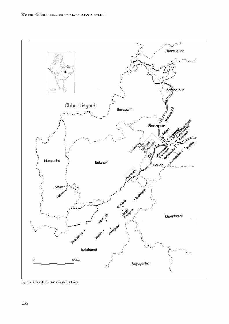
Fig. 1 – Sites referred to in western Orissa.
4 0 7
Western Orissa (November - December 2000): Preliminary Report of a SurveyM. BRANDTNER, B. MISRA, P. MOHANTY & P. YULE
I n t r o d u c t i o n
Archaeological research during the 1980s in Orissarevealed on the one hand great potential for new knowl-edge, on the other, neglect relative to other parts of India.Even into the 1980s few usable publications existed forthe archaeology of the region between coastal Orissa andthe Vidarbha region toward Nagpur.1 More particularly,numerous, haphazard, and repetitively published site listsprovide little real information, and all of western Orissa aswell as the Chhattisgarh region (some 220,000 km2)remain archaeologically terra incognita. This includes thearea known in antiquity as DakÒina Kosala as well as theadjacent land in northern Andhra Pradesh, that is all ofeastern Central India. For prehistoric and protohistoricartefactual parallels in this area one must turn toward thewestern part of India, where vastly more research hastaken place.
The main category of lower peninsular iron age India,including so-called megalithic sites, seems little repre-sented in Orissa.2 The term “megalithic” is frequentlymisused in India and elsewhere to designate any rusticstructure constructed of stones, and in practice includesdiverse undated monuments. While the classic southIndian iron age manifests in itself Orissa in large part interms of pottery, this is far less the case with its charac-teristic burial structures. In absolute years, this age is rep-resented by rare “chalcolithic” sites such as the latest(IIb) phase of coastal Golabai (Dist. Khurda) andKameswaripali (Dist. Sonepur). But in western Orissa,the remains as yet provide little basis for a chronology.Moreover, the absolute chronology is far less certain thanthe relative one, so that the temporal overlap betweenchalcolithic and iron age, for example, remains unstruc-
tured. Classic archaeological manifestations of early his-toric India, such as Northern Black Polished Ware(NBP) are regretably lacking in the area. The interface ofthe so-called iron age and early historic periods in west-ern Orissa forms the basis of our inquiry (Fig. 1).
State of Research
Two geographic areas must be highlighted at the out-set: First, western Orissa contains a broad spectrum of monuments dating into the medieval period which onlyrecently have become known. Not unexpectedly, inneighbouring Chhattisgarh, a new study reveals a con-centration of iron age tomb structures immediately adja-cent to our working area.3 Our colleagues in the interiorof Orissa, B. Misra and P. Mohanty, have culled onlysurface finds from there and chronology rests solely onexternal comparisons. This holds also for the continuedefforts of J.P. Singh Deo (yuvaraja of Khariar) and hisantiquarian-interested colleagues, who in fact do obtaininteresting strayfinds. But archaeologists often overesti-mate the range of their method in interpreting such sur-face and other stray finds, for lack of good excavatedones. The authors strive to rise above a merely antiquar-ian amateurism, limited in its historical range, and put thearchaeology on a sounder footing.
A good step ahead for the archaeology of Orissa is anew anthology, recently published by K.K. Basa andP. Mohanty, which contains several substantial articleswhich bring the archaeology of Orissa further than oneessentially of local interest. In particular, one new contri-bution on the archaeology of Baudh (interior Orissa) dis-trict contains hitherto unknown sites of different periods
4 0 8
Western Orissa ❘ brandter · misra · mohanty · yule ❘
and is relevant to our work.4 It also updates our knowl-edge of the pottery of the region.
Coastal Orissa shows some progress in dating the pro-tohistoric pottery, although till now their publication doeslittle more than highlight attractive finds. South of LakeChilka recently some sites yielded fragments of early his-toric fine black and red ware. While the coastal variety iscoarse, that of the interior is fine5 – which provides a hintof a new picture of the iron age and early historic periodsother than the present one.
Since the archaeology of Orissa rests principally onsurface finds and those excavated without documenta-tion, it supports only the most superficial archaeologicalinterpretation. Site plans are neither published, or arepublished in such a way that they are of little use regard-
ing the size, date, or importance of a given place. Oftenone experiences unreflected adherence to obsoletechronological notions and regional patriotic beliefs, suchas N.K. Sahu’s interpretation of Narla/Asurgarh as anA†avi stronghold against Akoka and 600 years later thefort of Vyaghraraja.6
Research Goal
The central topic of the Indian-Kiel work group is toelucidate the polycentric nature of sub regional and hege-monial identity in historic Orissa. In this context the wide-spread modern centric perception of interior Orissa asperipheral, as opposed to the coastal area, is challenged.
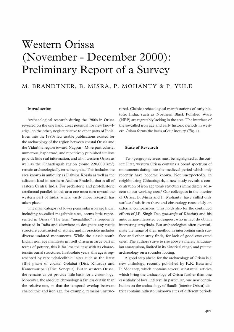
Fig. 2 – Profile and plan of an iron age tomb in Khariar/Sandohel.
4 0 9
Sites Surveyed in 2000
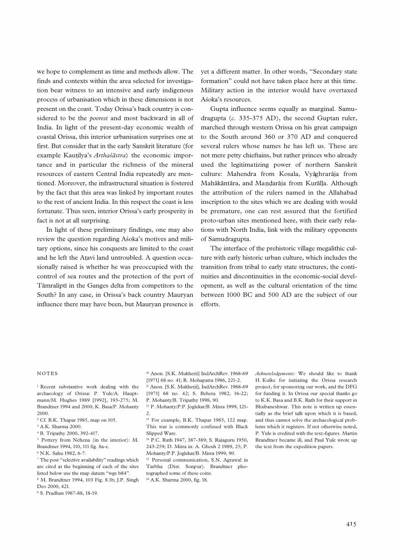
We concentrated our research resources in the fieldon eight sites which illuminate the late proto- and earlyhistoric culture of western Orissa, but registered other(Table 1). In addition, we surveyed for unknown sites.The following sites commanded our attention:
1- Khariar/Sandohel (Dist. Nuaparha 20°15’01”N; 82°47’03”E) 7 (Fig. 2)In 1998 students from Khariar college excavated a site
which in the late 1980s was identified as an iron age“megalithic” grave.8 Without documenting the site, theydestroyed it. The finds said to come from here are a mix-ture of iron age pottery and iron finds, the provenance of
which is uncertain. They are stored in a cardboard box inthe college. The grave circle nearly 7 m in outside diam-eter.
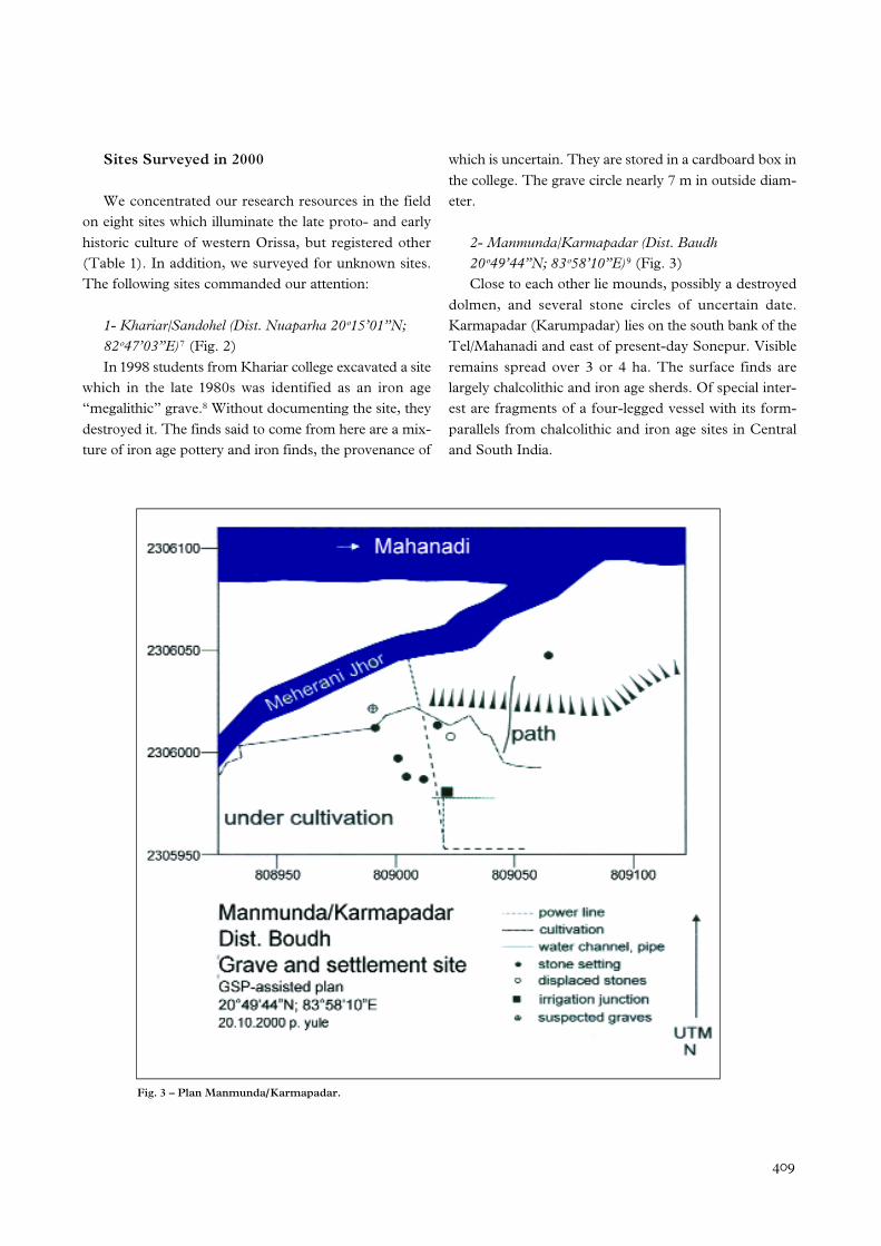
2- Manmunda/Karmapadar (Dist. Baudh 20°49’44”N; 83°58’10”E) 9 (Fig. 3)Close to each other lie mounds, possibly a destroyed
dolmen, and several stone circles of uncertain date.Karmapadar (Karumpadar) lies on the south bank of theTel/Mahanadi and east of present-day Sonepur. Visibleremains spread over 3 or 4 ha. The surface finds arelargely chalcolithic and iron age sherds. Of special inter-est are fragments of a four-legged vessel with its form-parallels from chalcolithic and iron age sites in Centraland South India.
Fig. 3 – Plan Manmunda/Karmapadar.
4 1 0
Western Orissa ❘ brandter · misra · mohanty · yule ❘
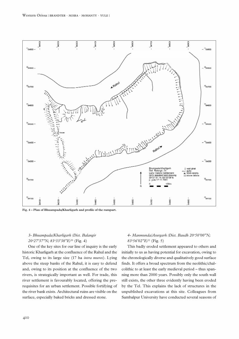
3- Bhuampada/Kharligarh (Dist. Balangir20°27’37”N; 83°33’38”E) 10 (Fig. 4)One of the key sites for our line of inquiry is the early
historic Kharligarh at the confluence of the Rahul and theTel, owing to its large size (17 ha intra muros). Lyingabove the steep banks of the Rahul, it is easy to defendand, owing to its position at the confluence of the tworivers, is strategically important as well. For trade, thisriver settlement is favourably located, offering the pre-requisites for an urban settlement. Possible fortifying ofthe river bank exists. Architectural ruins are visible on thesurface, especially baked bricks and dressed stone.
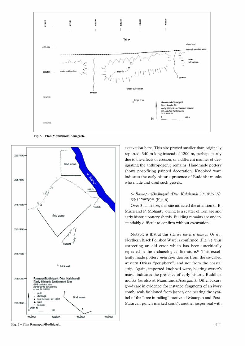
4- Manmunda/Asurgarh (Dist. Baudh 20°50’00”N; 83°56’02”E) 11 (Fig. 5)This badly eroded settlement appeared to others and
initially to us as having potential for excavation, owing tothe chronologically diverse and qualitatively good surfacefinds. It offers a broad spectrum from the neolithic/chal-colithic to at least the early medieval period – thus span-ning more than 2000 years. Possibly only the south wallstill exists, the other three evidently having been erodedby the Tel. This explains the lack of structures in theunpublished excavations at this site. Colleagues fromSambalpur University have conducted several seasons of
Fig. 4 – Plan of Bhuampada/Kharligarh and profile of the rampart.
4 1 1
excavation here. This site proved smaller than originallyreported: 340 m long instead of 1200 m, perhaps partlydue to the effects of erosion, or a different manner of des-ignating the anthropogenic remains. Handmade potteryshows post-firing painted decoration. Knobbed wareindicates the early historic presence of Buddhist monkswho made and used such vessels.
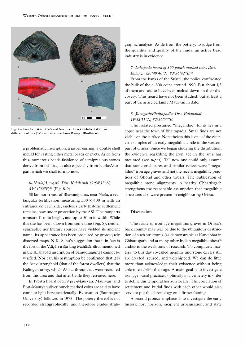
5- Ramapur/Budhigarh (Dist. Kalahandi 20°18’29”N;83°32’09”E) 12 (Fig. 6)Over 3 ha in size, this site attracted the attention of B.
Misra and P. Mohanty, owing to a scatter of iron age andearly historic pottery sherds. Building remains are under-standably difficult to confirm without excavation.
Notable is that at this site for the first time in Orissa,Northern Black Polished Ware is confirmed (Fig. 7), thuscorrecting an old error which has been uncriticallyrepeated in the archaeological literature.13 This excel-lently made pottery nota bene derives from the so-calledwestern Orissa “periphery”, and not from the coastalstrip. Again, imported knobbed ware, bearing owner’smarks indicates the presence of early historic Buddhistmonks (as also at Manmunda/Asurgarh). Other luxurygoods are in evidence: for instance, fragments of an ivorycomb, seals fashioned from jasper, one bearing the sym-bol of the “tree in railing” motive of Mauryan and Post-Mauryan punch marked coins), another jasper seal with
Fig. 5 – Plan Manmunda/Asurgarh.
Fig. 6 – Plan Ramapur/Budhigarh.
4 1 2
Western Orissa ❘ brandter · misra · mohanty · yule ❘
a problematic inscription, a jasper earring, a double shellmould for casting either metal beads or rivets. Aside fromthis, numerous beads fashioned of semiprecious stonesderive from this site, as also especially from Narla/Asur-garh which we shall turn to now.
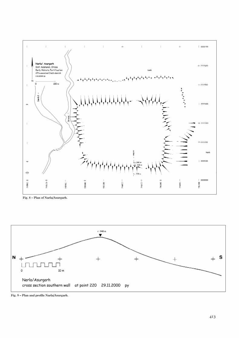
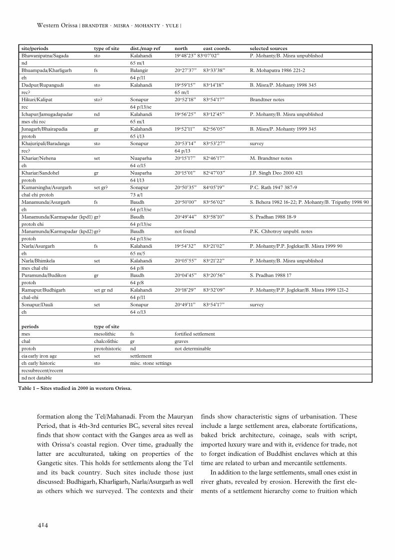
6- Narla/Asurgarh (Dist. Kalahandi 19°54’32”N;83°21’02”E) 14 (Fig. 8-9)30 km north-east of Bhawanipatna, near Narla, a rec-
tangular fortification, measuring 500 µ 400 m with anentrance on each side, encloses early historic settlementremains, now under protection by the ASI. The rampartsmeasure 11 m in height, and up to 50 m in width. Whilethis site has been known from some time (Fig. 8), neitherepigraphic nor literary sources have yielded its ancientname. Its appearance has been obscured by grotesquelydistorted maps. N.K. Sahu’s suggestion that it in fact isthe fort of the Vyag h r a raja king Mahakan tara, mentionedin the Allahabad inscription of Samudragupta) cannot beverified. Nor can his assumption be confirmed that it isthe A†avi stronghold (that of the forest dwellers) that theKalingan army, which Akoka throunced, were recruitedfrom this area and that after battle they retreated here.
In 1958 a hoard of 539 pre-Mauryan, Mauryan, andPost-Mauryan silver punch marked coins are said to havecome to light here accidentally. Excavation (SambalpurUniversity) followed in 1973. The pottery thereof is notrecorded stratigraphically, and therefore eludes strati-
graphic analysis. Aside from the pottery, to judge fromthe quantity and quality of the finds, an active beadindustry is in evidence.
7- Lokapada hoard of 300 punch marked coins Dist.Balangir (20°49’40”N; 83°36’42”E) 15
From the banks of the Suktel, the police confiscatedthe bulk of the c. 800 coins around 1990. But about 1/3of them are said to have been melted down on their dis-covery. This hoard have not been studied, but at least apart of them are certainly Mauryan in date.
8- Junagarh/Bhairapadia (Dist. Kalahandi 19°52’11”N; 82°56’05”E)The isolated presumed “megalithic” tomb lies in a
copse near the town of Bhairapadia. Small finds are notvisible on the surface. Nonetheless this is one of the clear-est examples of an early megalithic circle in the westernpart of Orissa. Since we began studying the distribution,the evidence regarding the iron age in the area hasmounted (see supra). Till now one could only assumethat stone enclosures and similar relicts were “mega-lithic” iron age graves and not the recent megalithic prac-tices of Ghond and other tribals. The publication ofmegalithic stone alignments in nearby Chhattisgarhstrengthens the reasonable assumption that megalithicstructures also were present in neighbouring Orissa.
D i s c u s s i o n
The rarity of iron age megalithic graves in Orissa’sback country may well be due to the ubiquitous destruc-tion of such structures (as demonstrable at Karkabhat inChhattisgarh and at many other Indian megalithic sites)16
and/or to the weak state of research. To complicate mat-ters, to this day so-called menhirs and stone circles stillare erected, reused, and worshipped. We can do littlemore than acknowledge their existence without beingable to establish their age. A main goal is to investigateiron age burial practices, optimally in a cemetery in orderto define this temporal horizon locally. The correlation ofsettlement and burial finds with each other would alsoserve to put the chronology on a firmer footing.
A second project-emphasis is to investigate the earlyhistoric fort horizon, incipient urbanisation, and state
Fig. 7 – Knobbed Ware (1-2) and Northern Black Polished Ware in different colours (3-5) said to come from Rampur/Budhigarh.
1
2
5
3
4
4 1 3
Fig. 8 – Plan of Narla/Asurgarh.
Fig. 9 – Plan and profile Narla/Asurgarh.
4 1 4
Western Orissa ❘ brandter · misra · mohanty · yule ❘
formation along the Tel/Mahanadi. From the MauryanPeriod, that is 4th-3rd centuries BC, several sites revealfinds that show contact with the Ganges area as well aswith Orissa‘s coastal region. Over time, gradually thelatter are acculturated, taking on properties of theGangetic sites. This holds for settlements along the Teland its back country. Such sites include those justdiscussed: Budhigarh, Kharligarh, Narla/Asurgarh as wellas others which we surveyed. The contexts and their
finds show characteristic signs of urbanisation. Theseinclude a large settlement area, elaborate fortifications,baked brick architecture, coinage, seals with script,imported luxury ware and with it, evidence for trade, notto forget indication of Buddhist enclaves which at thistime are related to urban and mercantile settlements.
In addition to the large settlements, small ones exist inriver ghats, revealed by erosion. Herewith the first ele-ments of a settlement hierarchy come to fruition which
site/periods type of site dist./map ref north east coords. selected sourcesBhawanipatna/Sagada sto Kalahandi 19°48’23” 83°07’02” P. Mohanty/B. Misra unpublishednd 65 m/1Bhuampada/Kharligarh fs Balangir 20°27’37” 83°33’38” R. Mohapatra 1986 221-2eh 64 p/11Dadpur/Rupangudi sto Kalahandi 19°59’15” 83°14’18” B. Misra/P. Mohanty 1998 345rec? 65 m/1Hikuri/Kalipat sto? Sonapur 20°52’18” 83°54’17” Brandtner notesrec 64 p/13/seIchapur/Jamugadapadar nd Kalahandi 19°56’25” 83°12’45” P. Mohanty/B. Misra unpublishedmes ehi rec 65 m/1Junagarh/Bhairapadia gr Kalahandi 19°52’11” 82°56’05” B. Misra/P. Mohanty 1999 345protoh 65 i/13Khajuripali/Baradanga sto Sonapur 20°53’14” 83°53’27” surveyrec? 64 p/13Khariar/Nehena set Nuaparha 20°15’17” 82°46’17” M. Brandtner noteseh 64 o/15Khariar/Sandohel gr Nuaparha 20°15’01” 82°47’03” J.P. Singh Deo 2000 421protoh 64 l/13Kumarsingha/Asurgarh set gr? Sonapur 20°50’35” 84°05’19” P.C. Rath 1947 387-9chal ehi protoh 73 a/1Manamunda/Asurgarh fs Baudh 20°50’00” 83°56’02” S. Behera 1982 16-22; P. Mohanty/B. Tripathy 1998 90eh 64 p/13/seManamunda/Karmapadar (kpd1) gr? Baudh 20°49’44” 83°58’10” S. Pradhan 1988 18-9protoh ehi 64 p/13/seManamunda/Karmapadar (kpd2)gr? Baudh not found P.K. Chhotroy unpubl. notesprotoh 64 p/13/seNarla/Asurgarh fs Kalahandi 19°54’32” 83°21’02” P. Mohanty/P.P. Joglekar/B. Misra 1999 90eh 65 m/5Narla/Bhimkela set Kalahandi 20°05’55” 83°21’22” P. Mohanty/B. Misra unpublishedmes chal ehi 64 p/8Puramunda/Budikon gr Baudh 20°04’45” 83°20’56” S. Pradhan 1988 17protoh 64 p/8Ramapur/Budhigarh set gr nd Kalahandi 20°18’29” 83°32’09” P. Mohanty/P.P. Joglekar/B. Misra 1999 121-2chal-ehi 64 p/11Sonapur/Dauli set Sonapur 20°49’11” 83°54’17” surveyeh 64 o/13
periods type of sitemes mesolithic fs fortified settlementchal chalcolithic gr gravesprotoh protohistoric nd not determinableeiaearly iron age set settlementeh early historic sto misc. stone settingsrecsubrecent/recentnd not datable
Table 1 – Sites studied in 2000 in western Orissa.
4 1 5
we hope to complement as time and methods allow. Thefinds and contexts within the area selected for investiga-tion bear witness to an intensive and early indigenousprocess of urbanisation which in these dimensions is notpresent on the coast. Today Orissa’s back country is con-sidered to be the poorest and most backward in all ofIndia. In light of the present-day economic wealth ofcoastal Orissa, this interior urbanisation surprises one atfirst. But consider that in the early Sanskrit literature (forexample Kau†ilya’s Arthakastra) the economic impor-tance and in particular the richness of the mineralresources of eastern Central India repeatedly are men-tioned. Moreover, the infrastructural situation is fosteredby the fact that this area was linked by important routesto the rest of ancient India. In this respect the coast is lessfortunate. Thus seen, interior Orissa’s early prosperity infact is not at all surprising.
In light of these preliminary findings, one may alsoreview the question regarding Akoka’s motives and mili-tary options, since his conquests are limited to the coastand he left the A†avi land untroubled. A question occa-sionally raised is whether he was preoccupied with thecontrol of sea routes and the protection of the port ofTamralipti in the Ganges delta from competitors to theSouth? In any case, in Orissa’s back country Mauryaninfluence there may have been, but Mauryan presence is
yet a different matter. In other words, “Secondary stateformation” could not have taken place here at this time.Military action in the interior would have overtaxedAkoka’s resources.
Gupta influence seems equally as marginal. Samu-dragupta (c. 335-375 AD), the second Guptan ruler,marched through western Orissa on his great campaignto the South around 360 or 370 AD and conquered several rulers whose names he has left us. These are not mere petty chieftains, but rather princes who alreadyused the legitimatizing power of northern Sanskrit culture: Mahendra from Kosala, Vyag h r a raja fromMahakantara, and Man∂araja from Kuralla. Although the attribution of the rulers named in the Allahabadinscription to the sites which we are dealing with wouldbe premature, one can rest assured that the fortifiedproto-urban sites mentioned here, with their early rela-tions with North India, link with the military opponentsof Samudragupta.
The interface of the prehistoric village megalithic cul-ture with early historic urban culture, which includes thetransition from tribal to early state structures, the conti-nuities and discontinuities in the economic-social devel-opment, as well as the cultural orientation of the timebetween 1000 BC and 500 AD are the subject of ourefforts.
N O T E S
1 Recent substantive work dealing with thearchaeology of Orissa: P. Yule/A. Haupt-mann/M. Hughes 1989 [1992], 193-275; M.Brandtner 1994 and 2000; K. Basa/P. Mohanty2000.2 Cf. B.K. Thapar 1985, map on 105.3 A.K. Sharma 2000.4 B. Tripathy 2000, 392-417.5 Pottery from Nehena (in the interior): M.Brandtner 1994, 110, 111 fig. 8a-e.6 N.K. Sahu 1982, 6-7.7 The post “selective availability” readings whichare cited at the beginning of each of the siteslisted below use the map datum “wgs b84”.8 M. Brandtner 1994, 103 Fig. 8.1b; J.P. SinghDeo 2000, 421.9 S. Pradhan 1987-88, 18-19.
10 Anon. [S.K. Mukherji] IndArchRev. 1968-69[1971] 68 no. 41; R. Mohapatra 1986, 221-2.11 Anon. [S.K. Mukherji], IndArchRev. 1968-69[1971] 68 no. 42; S. Behera 1982, 16-22;P. Mohanty/B. Tripathy 1998, 90.12 P. Mohanty/P.P. Joglekar/B. Misra 1999, 121-2.13 For example, B.K. Thapar 1985, 122 map.This war is commonly confused with BlackSlipped Ware.14 P.C. Rath 1947, 387-389; S. Rajaguru 1950,243-259; D. Mitra in: A. Ghosh 2 1989, 25; P.Mohanty/P.P. Joglekar/B. Misra 1999, 90.15 Personal communication, S.N. Agrawal inTarbha (Dist. Sonpur). Brandtner pho-tographed some of these coins.16 A.K. Sharma 2000, fig. 18.
Acknowledgements: We should like to thankH . Kulke for initiating the Orissa researchproject, for sponsoring our work, and the DFGfor funding it. In Orissa our special thanks goto K.K. Basa and B.K. Rath for their support inBhubaneshwar. This note is written up essen-tially as the brief talk upon which it is based,and thus cannot solve the archaeological prob-lems which it registers. If not otherwise noted,P. Yule is credited with the text-figures. MartinBrandtner became ill, and Paul Yule wrote upthe text from the expedition papers.
4 1 6
Western Orissa ❘ brandter · misra · mohanty · yule ❘
R E F E R E N C E S
Basa, K.K. & Mohanty, P. eds. (2000) Archae-ology of Orissa. Delhi.
Behera, P.K. (2000-2001) Excavations atKhameswaripali – A Proto Historic Settlementin the Middle Mahanadi Valley Orissa: A Pre-liminary Report. Pragdhara 11, pp. 13-34.
Behera, S.C. (1982) Manamunda. in S.C.Behera (ed.), Interim Excavation Reports. Sam-balpur, pp. 16-22.
Brandtner, M. (1994) Archaeology of WesternOrissa: Finds from Nehena. South AsianArchaeology 1993. Helsinki, pp. 101-114.
Brandtner, M. (2000) Kalinga und seine Haupt-stadt in frühgeschichtlicher Zeit. Studien zurGeschichtsforschung des Altertums 7. Ham-burg.
Ghosh, A. (1989) Encyclopedia of Indian Archae-ology 2 vols. Delhi.
Mohanty, P. & Joglekar, P., Misra, B. (1998-99)Early Historic Investigations in Kalahandi Dis-trict, Orissa: A Preliminary Report. Puratattva29, pp. 120-131.
Mohanty, P. & Misra, B. (2001) Early HistoricKalahandi. Orissa Revisited, Marg specialmonograph issue, Mumbai, pp. 17-26.
Mohanty, P. & Tripathy, B. (1997-98) The Pre-historic and Early Historic Cultures of Orissa.Pragdhara 8, pp. 70-98.
Mohapatra, R. (1986) Archaeology of Orissa.Delhi.
Pradhan, S. (1987-88) Megalithic Remains inthe Upper Mahanadi Valley of Orissa. Journalof Ancient Indian History 17,1-2, pp. 16-22.
Rajaguru, S. (1950) Annual Report of theResearch Assistant for the Year 1947-48.Kalinga Historical Research Society I I . 4 ,pp. 243-259.
Ramachandra Murthy, P. (2000) MegalithicCulture of the Godavari Basin. Delhi.
Rath, P.C. (1947) Notes on Important Archae-oliogical Sites Asur-gada in Sonpur State.Kalinga Historical Research Society I . 4 ,pp. 387-389.
Sahu, N.K. (1982) Asurgarh, in: S.C. Behera, 1-8.
Sharma, A.K. (2000) Archaeo-Anthropology ofChhattisgarh. Delhi.
Sinha, B. K. (2000) Golabai: A ProtohistoricSite on the Coast of Orissa, in: Basa/Mohanty2000, pp. 322-355.
Singh Deo, J.P. (2000), Archaeology of Kala-handi and Nuapada Districts, Orissa, in: Basa& Mohanty 2000, pp. 418-430.
Thapar, B.K. (1985) Recent Archaeological Dis-coveries in India. Paris.
Tripathy, B. (2000), Archaeology of Boudh,Central Orissa, in: Basa/Mohanty 2000,pp. 392-417.
Yule, P., Hauptmann, A. & Hughes, M. (1989[1992]) The Copper Hoards of the IndianSubcontinent: Preliminaries for an Interpreta-tion. Jahrbuch des Römisch Germanischen Zen-tralmuseums Mainz 36, pp. 193-275.
Yule, P., Rath, B.K. & Hojgaard, K. (2000)Sankarjang: A Metals Period Burial Site in theDhenkanal Uplands of Orissa, in: Basa &Mohanty 2000, pp. 285-321.