Embed Size (px)
Citation preview
Whose street is it anyway? Regaining lost ground for pedestrians
Fanis Grammenos, Senior Researcher, Canada Mortgage and Housing Corporation
Barry Craig, Senior Researcher,
Canada Mortgage and Housing Corporation Contact Information: Fanis Grammenos, Senior Researcher, Canada Mortgage and Housing Corporation, 700 Montreal Rd, Ottawa, ON, Canada, K1R 0P7 [email protected] Barry Craig, Senior Researcher, Canada Mortgage and Housing Corporation, 700 Montreal Rd, Ottawa, ON, Canada, K1R 0P7 [email protected] Abstract: During the 20th century the pedestrian domain has incrementally lost ground to the car. This gradual erosion has manifested itself in reduced space in which to walk, absence of convenient links to desired destinations, dearth of opportunities for detente in tranquil settings, reduced acoustic space, curtailed opportunities for social interaction and limited attention depth. This paper traces the onset of these negative symptoms, describes the planning reaction to them and proposes a new model for street networks that recovers part of the lost domain and reintroduces the characteristics that make walking convenient, healthy and enjoyable.
Fanis Grammenos is a Senior Researcher in sustainable community planning at Canada Mortgage and Housing Corporation. He has covered areas of research such as energy efficiency, passive solar design, user needs in housing, housing affordability, adaptable building design, planning regulations, and sustainable development. Before joining CMHC he was a developer/builder heading a design-built firm which specialized in infill housing and passive solar design. He is a graduate of Environmental Studies and Architecture from Waterloo University. Barry Craig has been a Senior Researcher in housing technology at CMHC since 2003. His work includes research in the performance of envelope components in wood frame and high rise buildings, acoustic and fire performance of separations and closures, and development of Best Practices for residential construction. He has given workshops on design for acoustics and wood frame construction , and has prepared articles on Air Quality, Sound Control and Renovation. Prior to joining CMHC, Barry was a principal of an Ottawa architectural practice. His work includes non-profit housing, condominiums, luxury private residences, office buildings and retail plazas. Several of his completed projects have received design awards, including two national awards. Barry is a member of the Ontario Association of Architects and the Ordre des architectes du Québec.
Whose street is it anyway? Regaining lost ground for pedestrians
Fanis Grammenos, Senior Researcher, Canada Mortgage and Housing Corporation
Barry Craig, Senior Researcher,
Canada Mortgage and Housing Corporation
Introduction In the second half of the 20th century, neighbourhoods of many cities started to revolt against the negative effects of cars on their quality of life. A relative newcomer in the 4000-year history of cities, the car disturbed tranquility, degraded air quality, and threatened the health, safety and wellbeing of people in neighbourhoods. It gave access to every street to fast-moving vehicles, thus weakening the social fabric weaved through the familiarity of pedestrians. Dissatisfaction with the prevailing conditions fostered a new intellectual climate toward the car and its use. The car was now perceived as an intruder, an imposition, an unwelcome controlling agent. This new perspective spurred city managers to take action by closing streets, creating one-way directional routes, narrowing pavements, and adding humps and bumps and a proliferation of signs to prohibit or restrict the use of streets. During these 50 years of revolt and reaction, car ownership rose steadily, as did kilometers traveled per person and the average car size. Trucks took an increasing share of goods transport. These changes meant that there were more vehicles on the streets and more of them required bigger spaces to maneuver. Consequently standards evolved to mandate wider street sections and pavement. With all these changes, by the dawn of the 21st century, walking scored as the most dangerous mode of travel, despite a considerable drop in accidents during its last years of the 20th century. The contrast between the critical attitudes toward the car and its continued rise in use worldwide underscores the imperative to find planning alternatives that balance the advantages and convenience of driving and the benefits and pleasure of walking. This balance can only be restored when pedestrians regain the ground lost to the car. This paper shows how an alternative model, the Fused Grid, achieves this balance in new districts. Old districts could apply similar methods cautiously and incrementally to achieve similar results. A brief review of street space and shape Pre-wheel societies, which were based entirely on human and animal transport, produced streets that were sized to the dimensions of pedestrians and beasts of burden, often no wider than two arm stretches (Fig.1 #2,3 and 4) The street was one uniform surface between buildings and movement on it was carefree and unconstrained. The street pattern, often the result of gradual accretion and of uneven topography, was irregular, meandering and, for strangers, confusing and labyrinthine (fig 2 #1). Streets,
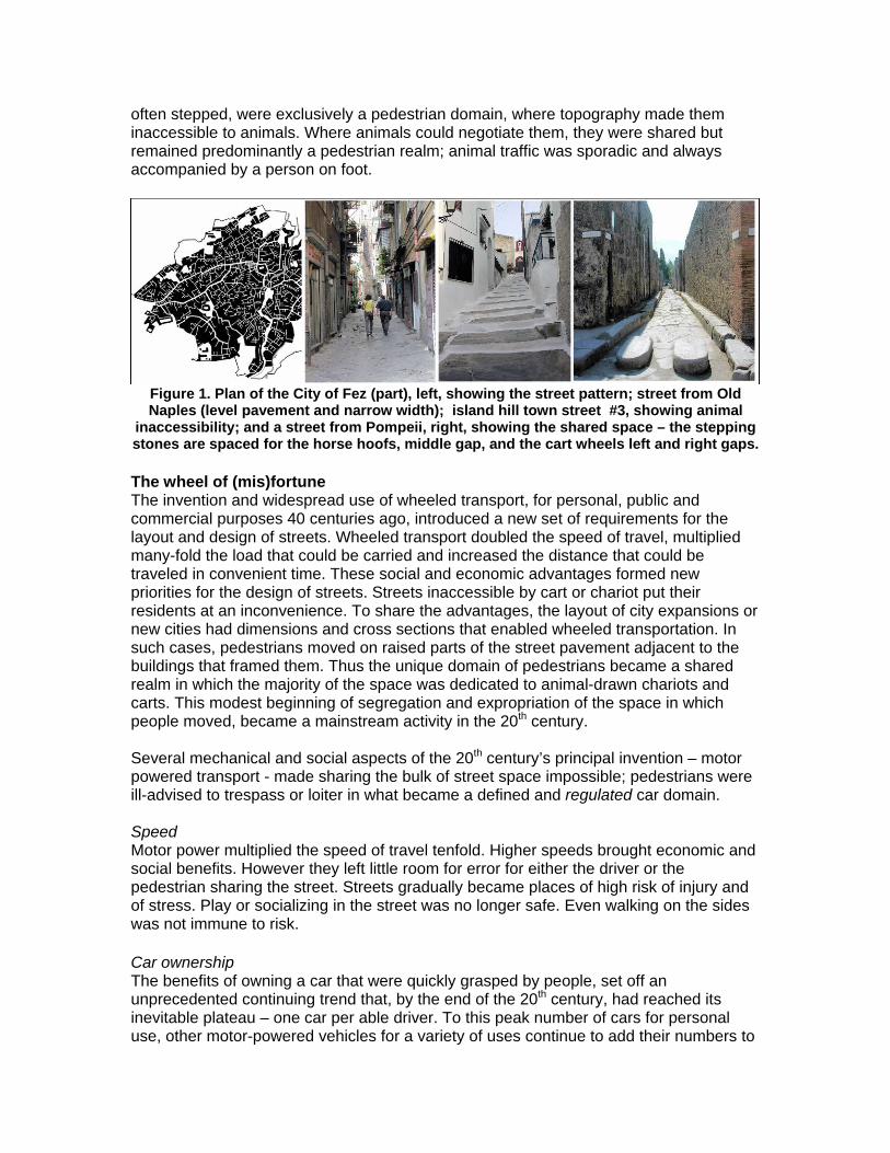
often stepped, were exclusively a pedestrian domain, where topography made them inaccessible to animals. Where animals could negotiate them, they were shared but remained predominantly a pedestrian realm; animal traffic was sporadic and always accompanied by a person on foot.
Figure 1. Plan of the City of Fez (part), left, showing the street pattern; street from Old Naples (level pavement and narrow width); island hill town street #3, showing animal
inaccessibility; and a street from Pompeii, right, showing the shared space – the stepping stones are spaced for the horse hoofs, middle gap, and the cart wheels left and right gaps. The wheel of (mis)fortune The invention and widespread use of wheeled transport, for personal, public and commercial purposes 40 centuries ago, introduced a new set of requirements for the layout and design of streets. Wheeled transport doubled the speed of travel, multiplied many-fold the load that could be carried and increased the distance that could be traveled in convenient time. These social and economic advantages formed new priorities for the design of streets. Streets inaccessible by cart or chariot put their residents at an inconvenience. To share the advantages, the layout of city expansions or new cities had dimensions and cross sections that enabled wheeled transportation. In such cases, pedestrians moved on raised parts of the street pavement adjacent to the buildings that framed them. Thus the unique domain of pedestrians became a shared realm in which the majority of the space was dedicated to animal-drawn chariots and carts. This modest beginning of segregation and expropriation of the space in which people moved, became a mainstream activity in the 20th century. Several mechanical and social aspects of the 20th century’s principal invention – motor powered transport - made sharing the bulk of street space impossible; pedestrians were ill-advised to trespass or loiter in what became a defined and regulated car domain. Speed Motor power multiplied the speed of travel tenfold. Higher speeds brought economic and social benefits. However they left little room for error for either the driver or the pedestrian sharing the street. Streets gradually became places of high risk of injury and of stress. Play or socializing in the street was no longer safe. Even walking on the sides was not immune to risk. Car ownership The benefits of owning a car that were quickly grasped by people, set off an unprecedented continuing trend that, by the end of the 20th century, had reached its inevitable plateau – one car per able driver. To this peak number of cars for personal use, other motor-powered vehicles for a variety of uses continue to add their numbers to
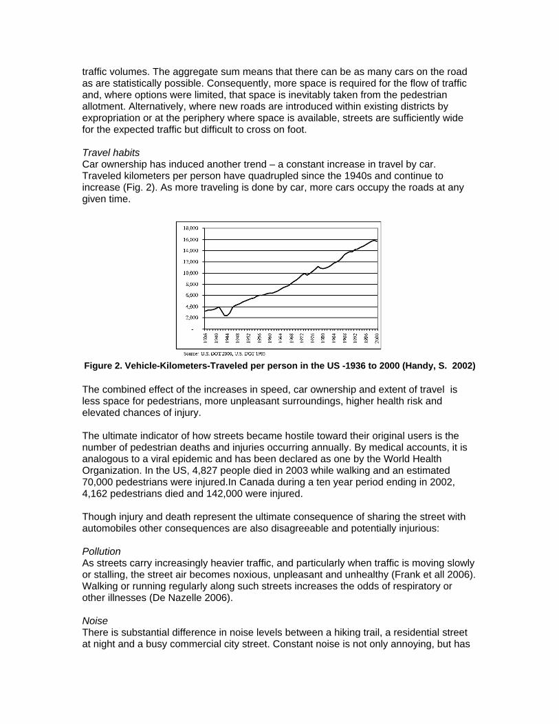
traffic volumes. The aggregate sum means that there can be as many cars on the road as are statistically possible. Consequently, more space is required for the flow of traffic and, where options were limited, that space is inevitably taken from the pedestrian allotment. Alternatively, where new roads are introduced within existing districts by expropriation or at the periphery where space is available, streets are sufficiently wide for the expected traffic but difficult to cross on foot. Travel habits Car ownership has induced another trend – a constant increase in travel by car. Traveled kilometers per person have quadrupled since the 1940s and continue to increase (Fig. 2). As more traveling is done by car, more cars occupy the roads at any given time.
Figure 2. Vehicle-Kilometers-Traveled per person in the US -1936 to 2000 (Handy, S. 2002) The combined effect of the increases in speed, car ownership and extent of travel is less space for pedestrians, more unpleasant surroundings, higher health risk and elevated chances of injury. The ultimate indicator of how streets became hostile toward their original users is the number of pedestrian deaths and injuries occurring annually. By medical accounts, it is analogous to a viral epidemic and has been declared as one by the World Health Organization. In the US, 4,827 people died in 2003 while walking and an estimated 70,000 pedestrians were injured.In Canada during a ten year period ending in 2002, 4,162 pedestrians died and 142,000 were injured. Though injury and death represent the ultimate consequence of sharing the street with automobiles other consequences are also disagreeable and potentially injurious: Pollution As streets carry increasingly heavier traffic, and particularly when traffic is moving slowly or stalling, the street air becomes noxious, unpleasant and unhealthy (Frank et all 2006). Walking or running regularly along such streets increases the odds of respiratory or other illnesses (De Nazelle 2006). Noise There is substantial difference in noise levels between a hiking trail, a residential street at night and a busy commercial city street. Constant noise is not only annoying, but has
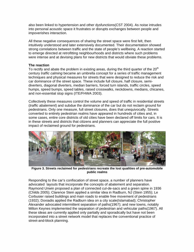
also been linked to hypertension and other dysfunctions(CST 2004). As noise intrudes into personal acoustic space it frustrates or disrupts exchanges between people and impoverishes interaction. All these negative consequences of sharing the street space were first felt, then intuitively understood and later extensively documented. Their documentation showed strong correlations between traffic and the state of people’s wellbeing. A reaction started to emerge directed at retrofitting neighbourhoods and districts where such problems were intense and at devising plans for new districts that would obviate these problems. The reaction To rectify and abate the problem in existing areas, during the third quarter of the 20th century traffic calming became an umbrella concept for a series of traffic management techniques and physical measures for streets that were designed to reduce the risk and car dominance of the street space. These include full closure, half closure, semi-diverters, diagonal diverters, median barriers, forced turn islands, traffic circles, speed humps, speed bumps, speed tables, raised crosswalks, neckdowns, medians, chicanes, and non-essential stop signs (ITE/FHWA 2003). Collectively these measures control the volume and speed of traffic in residential streets (traffic abatement) and subdue the dominance of the car but do not reclaim ground for pedestrians. Only one measure, full street closures, does that unequivocally. Streets converted to entirely pedestrian realms have appeared in hundreds of cities and, in some cases, entire core districts of old cities have been declared off limits for cars. It is in these streets and districts that citizens and planners can appreciate the full positive impact of reclaimed ground for pedestrians.
Figure 3. Streets reclaimed for pedestrians recreate the lost qualities of pre-automobile
public realms Responding to the car’s confiscation of street space, a number of planners have advocated layouts that incorporate the concepts of abatement and separation. Raymond Unwin proposed a plan of connected cul-de-sacs and a green spine in 1936 (Childs 2005); Clarence Stein applied a similar idea in Radburn, NJ (Stein 1955); Le Corbusier raised buildings and main roads to enable free movement of pedestrians (1932); Doxiadis applied the Radburn idea on a city scale(Islamabad); Christopher Alexander advocated intermittent separation of paths(1967); and new towns, notably Milton Keynes implemented the separation of pedestrian and vehicular paths(1967). All these ideas are currently applied only partially and sporadically but have not been incorporated into a street network model that replaces the conventional practice of street-and-block planning.
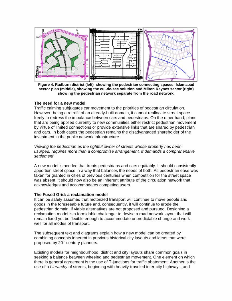
Figure 4. Radburn district (left) showing the pedestrian connecting spaces; Islamabad sector plan (middle), showing the cul-de-sac solution and Milton Keynes sector (right)
showing the pedestrian network separate from the road network. The need for a new model Traffic calming subjugates car movement to the priorities of pedestrian circulation. However, being a retrofit of an already-built domain, it cannot reallocate street space freely to redress the imbalance between cars and pedestrians. On the other hand, plans that are being applied currently to new communities either restrict pedestrian movement by virtue of limited connections or provide extensive links that are shared by pedestrian and cars. In both cases the pedestrian remains the disadvantaged shareholder of the investment in the public network infrastructure. Viewing the pedestrian as the rightful owner of streets whose property has been usurped, requires more than a compromise arrangement. It demands a comprehensive settlement. A new model is needed that treats pedestrians and cars equitably. It should consistently apportion street space in a way that balances the needs of both. As pedestrian ease was taken for granted in cities of previous centuries when competition for the street space was absent, it should now also be an inherent attribute of the circulation network that acknowledges and accommodates competing users. The Fused Grid: a reclamation model It can be safely assumed that motorized transport will continue to move people and goods in the foreseeable future and, consequently, it will continue to erode the pedestrian domain, if viable alternatives are not proposed and pursued. Designing a reclamation model is a formidable challenge: to devise a road network layout that will remain fixed yet be flexible enough to accommodate unpredictable change and work well for all modes of transport. The subsequent text and diagrams explain how a new model can be created by combining concepts inherent in previous historical city layouts and ideas that were proposed by 20th century planners. Existing models for neighbourhood, district and city layouts share common goals in seeking a balance between wheeled and pedestrian movement. One element on which there is general agreement is the use of T-junctions for traffic abatement. Another is the use of a hierarchy of streets, beginning with heavily-traveled inter-city highways, and
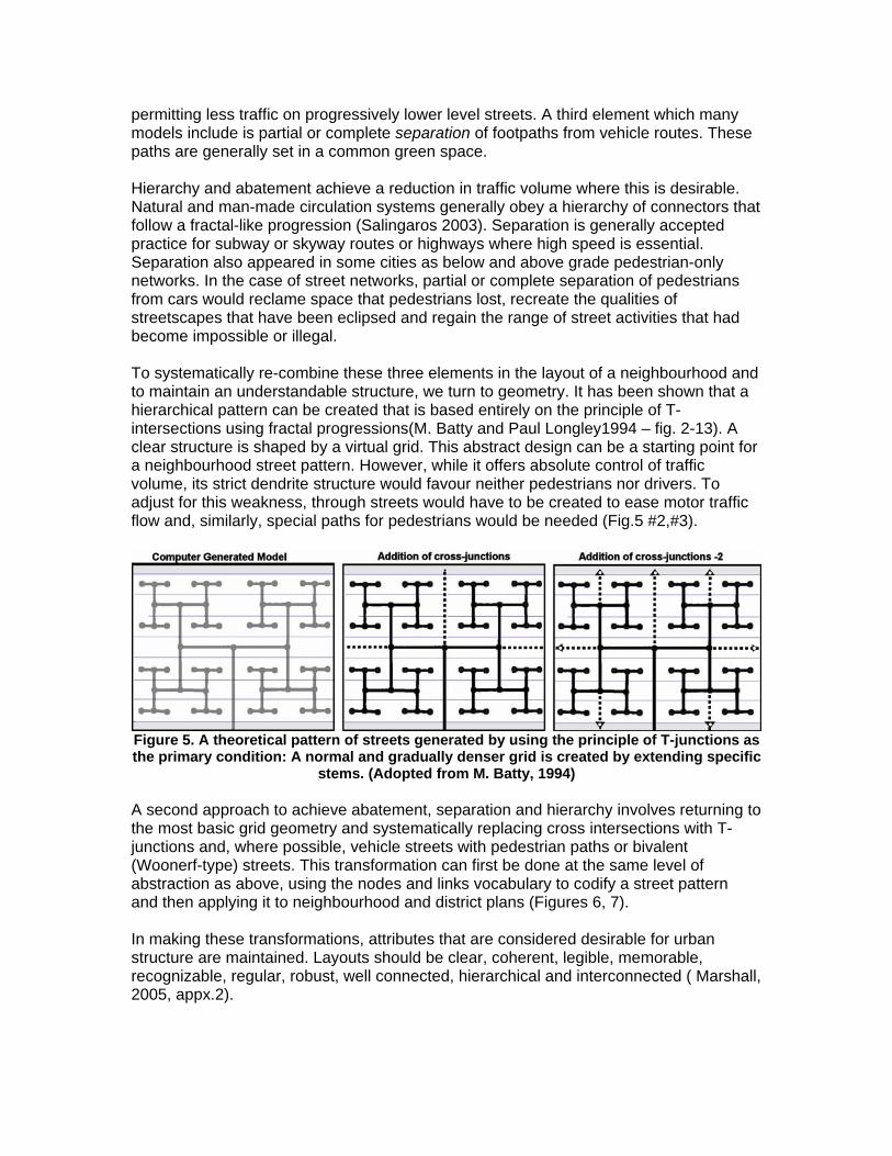
permitting less traffic on progressively lower level streets. A third element which many models include is partial or complete separation of footpaths from vehicle routes. These paths are generally set in a common green space. Hierarchy and abatement achieve a reduction in traffic volume where this is desirable. Natural and man-made circulation systems generally obey a hierarchy of connectors that follow a fractal-like progression (Salingaros 2003). Separation is generally accepted practice for subway or skyway routes or highways where high speed is essential. Separation also appeared in some cities as below and above grade pedestrian-only networks. In the case of street networks, partial or complete separation of pedestrians from cars would reclame space that pedestrians lost, recreate the qualities of streetscapes that have been eclipsed and regain the range of street activities that had become impossible or illegal. To systematically re-combine these three elements in the layout of a neighbourhood and to maintain an understandable structure, we turn to geometry. It has been shown that a hierarchical pattern can be created that is based entirely on the principle of T-intersections using fractal progressions(M. Batty and Paul Longley1994 – fig. 2-13). A clear structure is shaped by a virtual grid. This abstract design can be a starting point for a neighbourhood street pattern. However, while it offers absolute control of traffic volume, its strict dendrite structure would favour neither pedestrians nor drivers. To adjust for this weakness, through streets would have to be created to ease motor traffic flow and, similarly, special paths for pedestrians would be needed (Fig.5 #2,#3).
Figure 5. A theoretical pattern of streets generated by using the principle of T-junctions as the primary condition: A normal and gradually denser grid is created by extending specific
stems. (Adopted from M. Batty, 1994) A second approach to achieve abatement, separation and hierarchy involves returning to the most basic grid geometry and systematically replacing cross intersections with T-junctions and, where possible, vehicle streets with pedestrian paths or bivalent (Woonerf-type) streets. This transformation can first be done at the same level of abstraction as above, using the nodes and links vocabulary to codify a street pattern and then applying it to neighbourhood and district plans (Figures 6, 7). In making these transformations, attributes that are considered desirable for urban structure are maintained. Layouts should be clear, coherent, legible, memorable, recognizable, regular, robust, well connected, hierarchical and interconnected ( Marshall, 2005, appx.2).
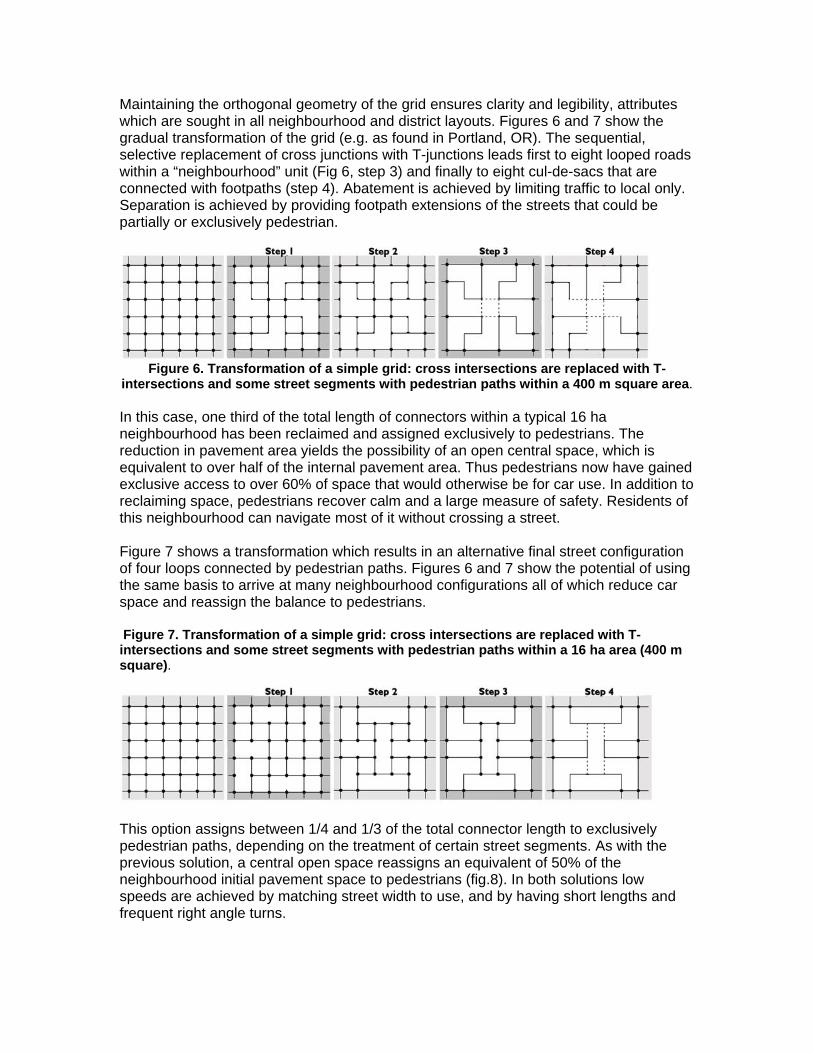
Maintaining the orthogonal geometry of the grid ensures clarity and legibility, attributes which are sought in all neighbourhood and district layouts. Figures 6 and 7 show the gradual transformation of the grid (e.g. as found in Portland, OR). The sequential, selective replacement of cross junctions with T-junctions leads first to eight looped roads within a “neighbourhood” unit (Fig 6, step 3) and finally to eight cul-de-sacs that are connected with footpaths (step 4). Abatement is achieved by limiting traffic to local only. Separation is achieved by providing footpath extensions of the streets that could be partially or exclusively pedestrian.
Figure 6. Transformation of a simple grid: cross intersections are replaced with T-
intersections and some street segments with pedestrian paths within a 400 m square area. In this case, one third of the total length of connectors within a typical 16 ha neighbourhood has been reclaimed and assigned exclusively to pedestrians. The reduction in pavement area yields the possibility of an open central space, which is equivalent to over half of the internal pavement area. Thus pedestrians now have gained exclusive access to over 60% of space that would otherwise be for car use. In addition to reclaiming space, pedestrians recover calm and a large measure of safety. Residents of this neighbourhood can navigate most of it without crossing a street. Figure 7 shows a transformation which results in an alternative final street configuration of four loops connected by pedestrian paths. Figures 6 and 7 show the potential of using the same basis to arrive at many neighbourhood configurations all of which reduce car space and reassign the balance to pedestrians. Figure 7. Transformation of a simple grid: cross intersections are replaced with T-intersections and some street segments with pedestrian paths within a 16 ha area (400 m square).
This option assigns between 1/4 and 1/3 of the total connector length to exclusively pedestrian paths, depending on the treatment of certain street segments. As with the previous solution, a central open space reassigns an equivalent of 50% of the neighbourhood initial pavement space to pedestrians (fig.8). In both solutions low speeds are achieved by matching street width to use, and by having short lengths and frequent right angle turns.
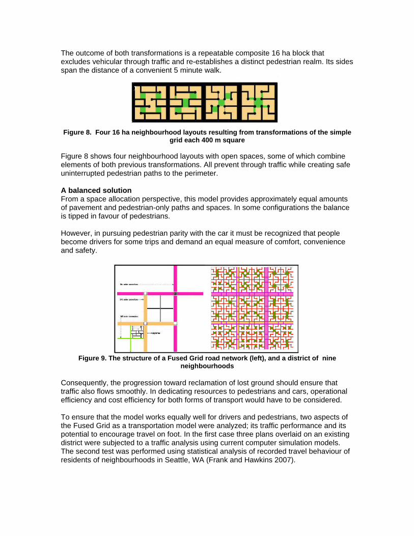
The outcome of both transformations is a repeatable composite 16 ha block that excludes vehicular through traffic and re-establishes a distinct pedestrian realm. Its sides span the distance of a convenient 5 minute walk.
Figure 8. Four 16 ha neighbourhood layouts resulting from transformations of the simple
grid each 400 m square Figure 8 shows four neighbourhood layouts with open spaces, some of which combine elements of both previous transformations. All prevent through traffic while creating safe uninterrupted pedestrian paths to the perimeter. A balanced solution From a space allocation perspective, this model provides approximately equal amounts of pavement and pedestrian-only paths and spaces. In some configurations the balance is tipped in favour of pedestrians. However, in pursuing pedestrian parity with the car it must be recognized that people become drivers for some trips and demand an equal measure of comfort, convenience and safety.
Figure 9. The structure of a Fused Grid road network (left), and a district of nine
neighbourhoods Consequently, the progression toward reclamation of lost ground should ensure that traffic also flows smoothly. In dedicating resources to pedestrians and cars, operational efficiency and cost efficiency for both forms of transport would have to be considered. To ensure that the model works equally well for drivers and pedestrians, two aspects of the Fused Grid as a transportation model were analyzed; its traffic performance and its potential to encourage travel on foot. In the first case three plans overlaid on an existing district were subjected to a traffic analysis using current computer simulation models. The second test was performed using statistical analysis of recorded travel behaviour of residents of neighbourhoods in Seattle, WA (Frank and Hawkins 2007).
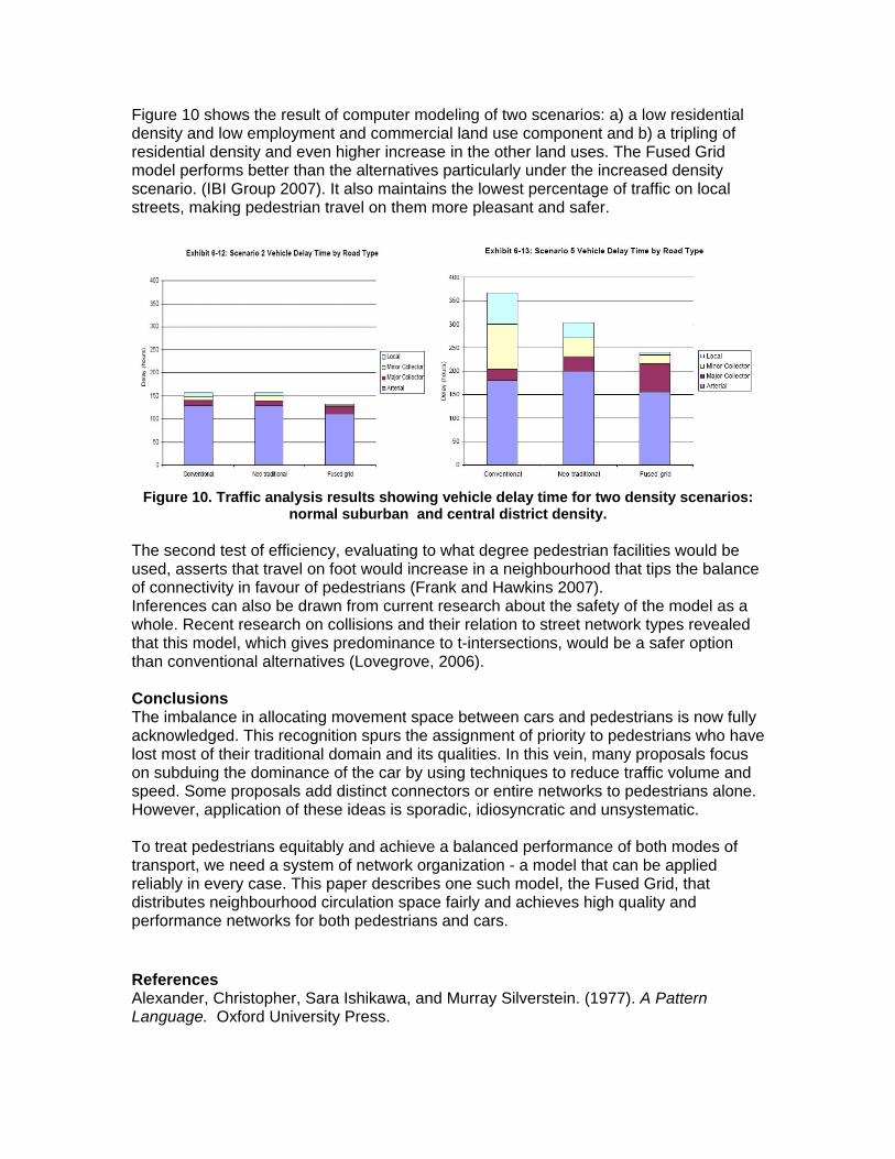
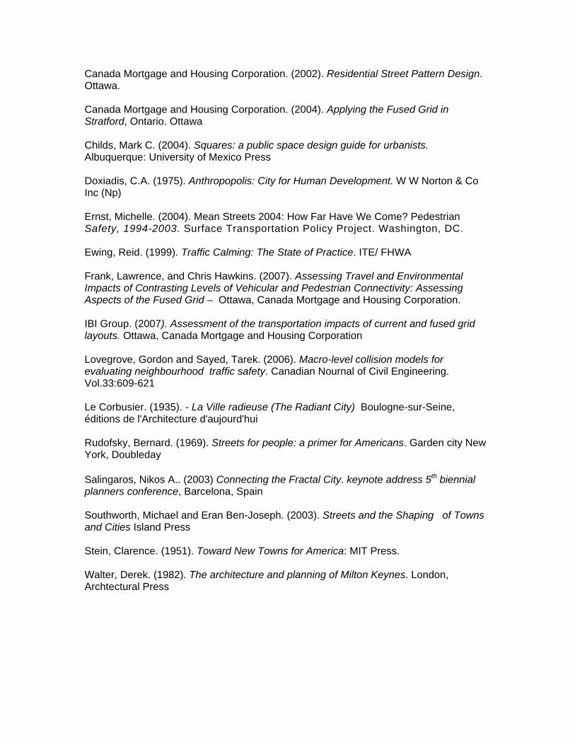
Figure 10 shows the result of computer modeling of two scenarios: a) a low residential density and low employment and commercial land use component and b) a tripling of residential density and even higher increase in the other land uses. The Fused Grid model performs better than the alternatives particularly under the increased density scenario. (IBI Group 2007). It also maintains the lowest percentage of traffic on local streets, making pedestrian travel on them more pleasant and safer.
Figure 10. Traffic analysis results showing vehicle delay time for two density scenarios:
normal suburban and central district density. The second test of efficiency, evaluating to what degree pedestrian facilities would be used, asserts that travel on foot would increase in a neighbourhood that tips the balance of connectivity in favour of pedestrians (Frank and Hawkins 2007). Inferences can also be drawn from current research about the safety of the model as a whole. Recent research on collisions and their relation to street network types revealed that this model, which gives predominance to t-intersections, would be a safer option than conventional alternatives (Lovegrove, 2006). Conclusions The imbalance in allocating movement space between cars and pedestrians is now fully acknowledged. This recognition spurs the assignment of priority to pedestrians who have lost most of their traditional domain and its qualities. In this vein, many proposals focus on subduing the dominance of the car by using techniques to reduce traffic volume and speed. Some proposals add distinct connectors or entire networks to pedestrians alone. However, application of these ideas is sporadic, idiosyncratic and unsystematic. To treat pedestrians equitably and achieve a balanced performance of both modes of transport, we need a system of network organization - a model that can be applied reliably in every case. This paper describes one such model, the Fused Grid, that distributes neighbourhood circulation space fairly and achieves high quality and performance networks for both pedestrians and cars. References Alexander, Christopher, Sara Ishikawa, and Murray Silverstein. (1977). A Pattern Language. Oxford University Press.
Canada Mortgage and Housing Corporation. (2002). Residential Street Pattern Design. Ottawa. Canada Mortgage and Housing Corporation. (2004). Applying the Fused Grid in Stratford, Ontario. Ottawa Childs, Mark C. (2004). Squares: a public space design guide for urbanists. Albuquerque: University of Mexico Press Doxiadis, C.A. (1975). Anthropopolis: City for Human Development. W W Norton & Co Inc (Np) Ernst, Michelle. (2004). Mean Streets 2004: How Far Have We Come? Pedestrian Safety, 1994-2003. Surface Transportation Policy Project. Washington, DC. Ewing, Reid. (1999). Traffic Calming: The State of Practice. ITE/ FHWA Frank, Lawrence, and Chris Hawkins. (2007). Assessing Travel and Environmental Impacts of Contrasting Levels of Vehicular and Pedestrian Connectivity: Assessing Aspects of the Fused Grid – Ottawa, Canada Mortgage and Housing Corporation. IBI Group. (2007). Assessment of the transportation impacts of current and fused grid layouts. Ottawa, Canada Mortgage and Housing Corporation Lovegrove, Gordon and Sayed, Tarek. (2006). Macro-level collision models for evaluating neighbourhood traffic safety. Canadian Nournal of Civil Engineering. Vol.33:609-621 Le Corbusier. (1935). - La Ville radieuse (The Radiant City) Boulogne-sur-Seine, éditions de l'Architecture d'aujourd'hui Rudofsky, Bernard. (1969). Streets for people: a primer for Americans. Garden city New York, Doubleday Salingaros, Nikos A.. (2003) Connecting the Fractal City. keynote address 5th biennial planners conference, Barcelona, Spain Southworth, Michael and Eran Ben-Joseph. (2003). Streets and the Shaping of Towns and Cities Island Press Stein, Clarence. (1951). Toward New Towns for America: MIT Press. Walter, Derek. (1982). The architecture and planning of Milton Keynes. London, Archtectural Press


![[What is garbage, anyway? The opinions of women from an outlying neighborhood in a large Brazilian city]](https://img.pdfslide.net/doc/110x75/63571e275108319c8703a02b/what-is-garbage-anyway-the-opinions-of-women-from-an-outlying-neighborhood-in.jpg)


