Embed Size (px)
Citation preview

CAPPOQUINA Brief Guide to an Area’s Rich Heritage
Contents:
1. Down by the River Page 3
2. West and South-West of Cappoquin Page 7
3. The Western Side of Town Page 10
7. Map Guides Pages 15-18
4. From the Centre, Southwards Page 19
5. South from Cappoquin Page 23
6. Moving Eastwards through the Town Page 26
7. To the East and North-East Page 30
7. Acknowledgements Page 32
1

CAPPOQUINA Brief Guide to an Area’s Rich Heritage
(A series of seven guided heritage trails in and around the town)
Produced by
Cappoquin Heritage Group
June 2007
Most of the places and people identified in this booklet are commemorated bya series of stone plaques and lecterns placed in appropriate locations. We hopeyou will enjoy the experience of Cappoquin’s rich and varied heritage, andthat the plaques and lecterns will complement the material contained in thebooklet and maps. Our front-cover picture is based on Arthur Maderson’sdrawing of Walsh’s Hotel, formerly the Cappoquin Barracks. The drawing onthe back is Arthur’s depiction of the Market House in other days.
2
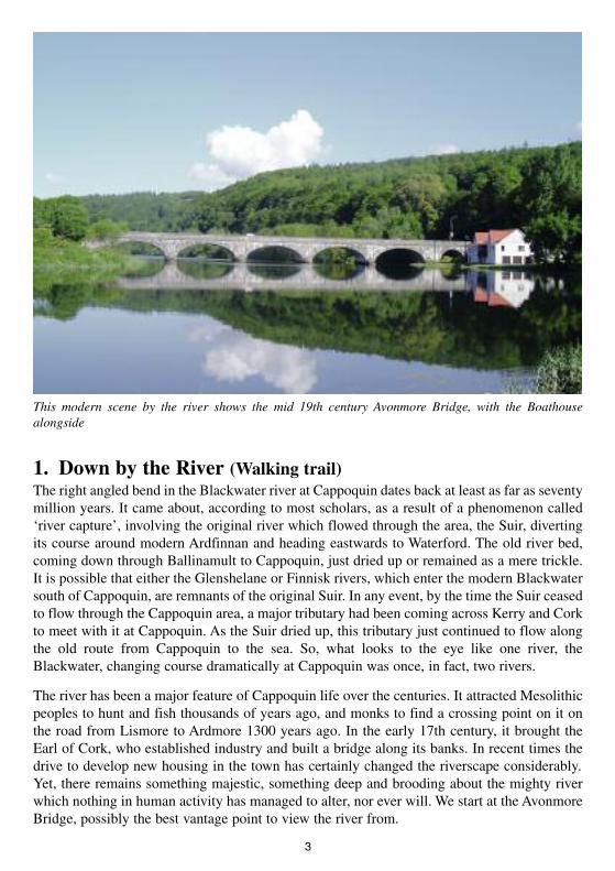
1. Down by the River (Walking trail)The right angled bend in the Blackwater river at Cappoquin dates back at least as far as seventymillion years. It came about, according to most scholars, as a result of a phenomenon called‘river capture’, involving the original river which flowed through the area, the Suir, divertingits course around modern Ardfinnan and heading eastwards to Waterford. The old river bed,coming down through Ballinamult to Cappoquin, just dried up or remained as a mere trickle.It is possible that either the Glenshelane or Finnisk rivers, which enter the modern Blackwatersouth of Cappoquin, are remnants of the original Suir. In any event, by the time the Suir ceasedto flow through the Cappoquin area, a major tributary had been coming across Kerry and Corkto meet with it at Cappoquin. As the Suir dried up, this tributary just continued to flow alongthe old route from Cappoquin to the sea. So, what looks to the eye like one river, theBlackwater, changing course dramatically at Cappoquin was once, in fact, two rivers.
The river has been a major feature of Cappoquin life over the centuries. It attracted Mesolithicpeoples to hunt and fish thousands of years ago, and monks to find a crossing point on it onthe road from Lismore to Ardmore 1300 years ago. In the early 17th century, it brought theEarl of Cork, who established industry and built a bridge along its banks. In recent times thedrive to develop new housing in the town has certainly changed the riverscape considerably.Yet, there remains something majestic, something deep and brooding about the mighty riverwhich nothing in human activity has managed to alter, nor ever will. We start at the AvonmoreBridge, possibly the best vantage point to view the river from.
3
This modern scene by the river shows the mid 19th century Avonmore Bridge, with the Boathousealongside
Avonmore Bridge: This great Faminerelief project of the Keane family wasopened in 1851 but the name,‘Victoria Bridge’ was later chiselledout by nationalists. The originalplaque is still visible at the mid-pointof the bridge, which once carried themain Cappoquin-Lismore road. Thisbridge was also a target of attackduring the Troubles of the 1920s. Youcan still see where an explosionrequired extensive repairs to be done,if you look very closely.
Looking northwards, you will see the beautiful woods which attracted the Earl of Cork toCappoquin in search of charcoal for his iron smelting industries in the 1600s. It was alsothrough this area, ChapelWood, that the churchgoers of Cappoquin’s first Catholic parish wentto mass in the 18th century, near the site of the restored gate lodge of Salterbridge House.
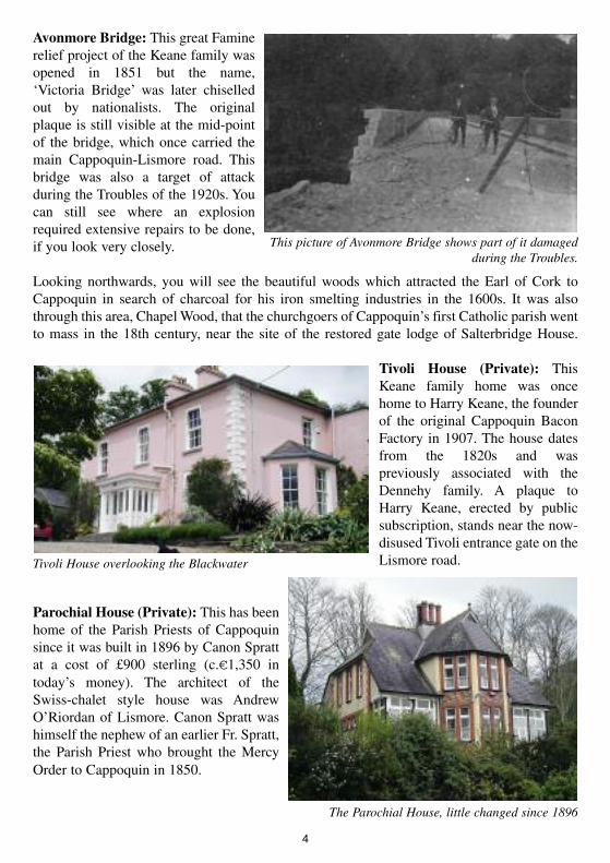
Tivoli House (Private): ThisKeane family home was oncehome to Harry Keane, the founderof the original Cappoquin BaconFactory in 1907. The house datesfrom the 1820s and waspreviously associated with theDennehy family. A plaque toHarry Keane, erected by publicsubscription, stands near the now-disused Tivoli entrance gate on theLismore road.
Parochial House (Private): This has beenhome of the Parish Priests of Cappoquinsince it was built in 1896 by Canon Sprattat a cost of £900 sterling (c.€1,350 intoday’s money). The architect of theSwiss-chalet style house was AndrewO’Riordan of Lismore. Canon Spratt washimself the nephew of an earlier Fr. Spratt,the Parish Priest who brought the MercyOrder to Cappoquin in 1850.
4
This picture of Avonmore Bridge shows part of it damagedduring the Troubles.
Tivoli House overlooking the Blackwater
The Parochial House, little changed since 1896
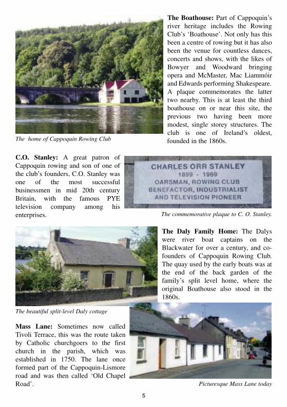
The Boathouse: Part of Cappoquin’sriver heritage includes the RowingClub’s ‘Boathouse’. Not only has thisbeen a centre of rowing but it has alsobeen the venue for countless dances,concerts and shows, with the likes ofBowyer and Woodward bringingopera and McMaster, Mac Liammóirand Edwards performing Shakespeare.A plaque commemorates the lattertwo nearby. This is at least the thirdboathouse on or near this site, theprevious two having been moremodest, single storey structures. Theclub is one of Ireland’s oldest,founded in the 1860s.
C.O. Stanley: A great patron ofCappoquin rowing and son of one ofthe club’s founders, C.O. Stanley wasone of the most successfulbusinessmen in mid 20th centuryBritain, with the famous PYEtelevision company among hisenterprises.
The Daly Family Home: The Dalyswere river boat captains on theBlackwater for over a century, and co-founders of Cappoquin Rowing Club.The quay used by the early boats was atthe end of the back garden of thefamily’s split level home, where theoriginal Boathouse also stood in the1860s.
Mass Lane: Sometimes now calledTivoli Terrace, this was the route takenby Catholic churchgoers to the firstchurch in the parish, which wasestablished in 1750. The lane onceformed part of the Cappoquin-Lismoreroad and was then called ‘Old ChapelRoad’.
5
The home of Cappoquin Rowing Club
The commemorative plaque to C. O. Stanley.
The beautiful split-level Daly cottage
Picturesque Mass Lane today
Strolling from Mass Lane (carefully) across the Lismore Road brings us down ‘WoodenbridgeLane’, to the main site of Cappoquin’s trade and industry heritage.
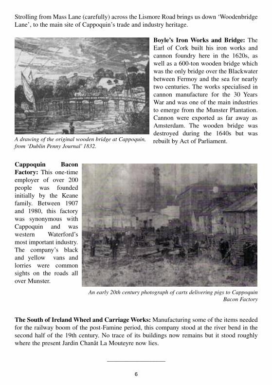
Boyle’s Iron Works and Bridge: TheEarl of Cork built his iron works andcannon foundry here in the 1620s, aswell as a 600-ton wooden bridge whichwas the only bridge over the Blackwaterbetween Fermoy and the sea for nearlytwo centuries. The works specialised incannon manufacture for the 30 YearsWar and was one of the main industriesto emerge from the Munster Plantation.Cannon were exported as far away asAmsterdam. The wooden bridge wasdestroyed during the 1640s but wasrebuilt by Act of Parliament.
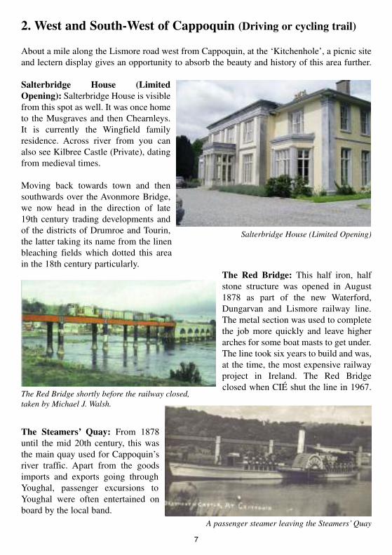
Cappoquin BaconFactory: This one-timeemployer of over 200people was foundedinitially by the Keanefamily. Between 1907and 1980, this factorywas synonymous withCappoquin and waswestern Waterford’smost important industry.The company’s blackand yellow vans andlorries were commonsights on the roads allover Munster.
The South of IrelandWheel and CarriageWorks:Manufacturing some of the items neededfor the railway boom of the post-Famine period, this company stood at the river bend in thesecond half of the 19th century. No trace of its buildings now remains but it stood roughlywhere the present Jardin Chanât La Mouteyre now lies.
__________________
6
A drawing of the original wooden bridge at Cappoquin,from ‘Dublin Penny Journal’ 1832.
An early 20th century photograph of carts delivering pigs to CappoquinBacon Factory
2. West and South-West of Cappoquin (Driving or cycling trail)
About a mile along the Lismore road west from Cappoquin, at the ‘Kitchenhole’, a picnic siteand lectern display gives an opportunity to absorb the beauty and history of this area further.
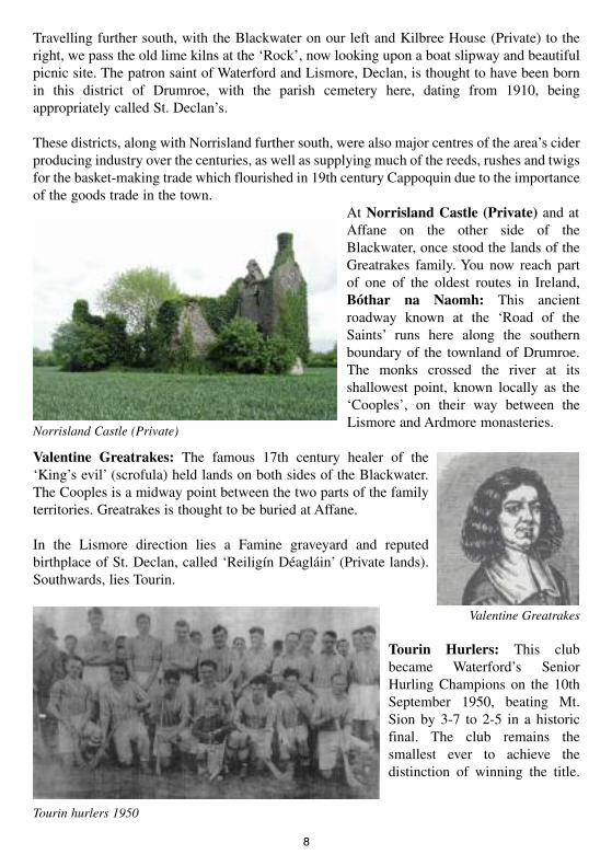
Salterbridge House (LimitedOpening): Salterbridge House is visiblefrom this spot as well. It was once hometo the Musgraves and then Chearnleys.It is currently the Wingfield familyresidence. Across river from you canalso see Kilbree Castle (Private), datingfrom medieval times.
Moving back towards town and thensouthwards over the Avonmore Bridge,we now head in the direction of late19th century trading developments andof the districts of Drumroe and Tourin,the latter taking its name from the linenbleaching fields which dotted this areain the 18th century particularly.
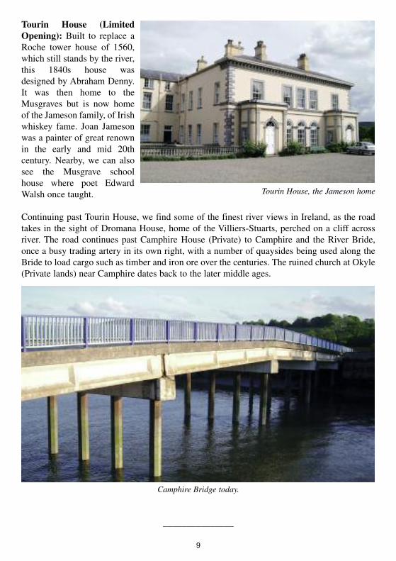
The Red Bridge: This half iron, halfstone structure was opened in August1878 as part of the new Waterford,Dungarvan and Lismore railway line.The metal section was used to completethe job more quickly and leave higherarches for some boat masts to get under.The line took six years to build and was,at the time, the most expensive railwayproject in Ireland. The Red Bridgeclosed when CIÉ shut the line in 1967.
The Steamers’ Quay: From 1878until the mid 20th century, this wasthe main quay used for Cappoquin’sriver traffic. Apart from the goodsimports and exports going throughYoughal, passenger excursions toYoughal were often entertained onboard by the local band.
7
Salterbridge House (Limited Opening)
A passenger steamer leaving the Steamers’Quay
The Red Bridge shortly before the railway closed,taken by Michael J. Walsh.
Travelling further south, with the Blackwater on our left and Kilbree House (Private) to theright, we pass the old lime kilns at the ‘Rock’, now looking upon a boat slipway and beautifulpicnic site. The patron saint of Waterford and Lismore, Declan, is thought to have been bornin this district of Drumroe, with the parish cemetery here, dating from 1910, beingappropriately called St. Declan’s.
These districts, along with Norrisland further south, were also major centres of the area’s ciderproducing industry over the centuries, as well as supplying much of the reeds, rushes and twigsfor the basket-making trade which flourished in 19th century Cappoquin due to the importanceof the goods trade in the town.
At Norrisland Castle (Private) and atAffane on the other side of theBlackwater, once stood the lands of theGreatrakes family. You now reach partof one of the oldest routes in Ireland,Bóthar na Naomh: This ancientroadway known at the ‘Road of theSaints’ runs here along the southernboundary of the townland of Drumroe.The monks crossed the river at itsshallowest point, known locally as the‘Cooples’, on their way between theLismore and Ardmore monasteries.
Valentine Greatrakes: The famous 17th century healer of the‘King’s evil’ (scrofula) held lands on both sides of the Blackwater.The Cooples is a midway point between the two parts of the familyterritories. Greatrakes is thought to be buried at Affane.
In the Lismore direction lies a Famine graveyard and reputedbirthplace of St. Declan, called ‘Reiligín Déagláin’ (Private lands).Southwards, lies Tourin.
Tourin Hurlers: This clubbecame Waterford’s SeniorHurling Champions on the 10thSeptember 1950, beating Mt.Sion by 3-7 to 2-5 in a historicfinal. The club remains thesmallest ever to achieve thedistinction of winning the title.
8
Norrisland Castle (Private)
Tourin hurlers 1950
Valentine Greatrakes
Tourin House (LimitedOpening): Built to replace aRoche tower house of 1560,which still stands by the river,this 1840s house wasdesigned by Abraham Denny.It was then home to theMusgraves but is now homeof the Jameson family, of Irishwhiskey fame. Joan Jamesonwas a painter of great renownin the early and mid 20thcentury. Nearby, we can alsosee the Musgrave schoolhouse where poet EdwardWalsh once taught.
Continuing past Tourin House, we find some of the finest river views in Ireland, as the roadtakes in the sight of Dromana House, home of the Villiers-Stuarts, perched on a cliff acrossriver. The road continues past Camphire House (Private) to Camphire and the River Bride,once a busy trading artery in its own right, with a number of quaysides being used along theBride to load cargo such as timber and iron ore over the centuries. The ruined church at Okyle(Private lands) near Camphire dates back to the later middle ages.
_______________
9
Tourin House, the Jameson home
Camphire Bridge today.
3. The Western Side of Town (Walking trail)
Back in Cappoquin itself, moving eastwards from the river, Main Street, Church Street andMill Street all developed as the early town settlement expanded in the 1700s. The fact thatCappoquin had a bridge across the Blackwater from the 1620s, was accessible to shippingbecause the Blackwater was tidal well beyond it and lay on the road network connecting westWaterford, south Tipperary and east Cork all helped in this development.
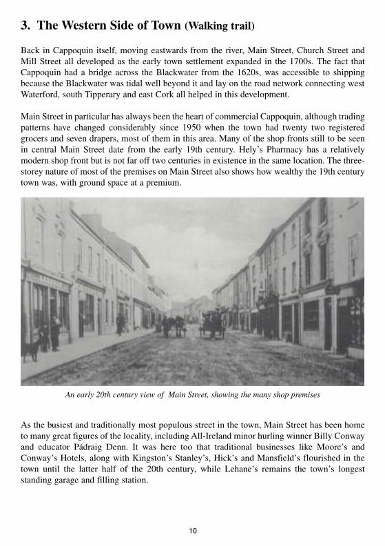
Main Street in particular has always been the heart of commercial Cappoquin, although tradingpatterns have changed considerably since 1950 when the town had twenty two registeredgrocers and seven drapers, most of them in this area. Many of the shop fronts still to be seenin central Main Street date from the early 19th century. Hely’s Pharmacy has a relativelymodern shop front but is not far off two centuries in existence in the same location. The three-storey nature of most of the premises on Main Street also shows how wealthy the 19th centurytown was, with ground space at a premium.
As the busiest and traditionally most populous street in the town, Main Street has been hometo many great figures of the locality, including All-Ireland minor hurling winner Billy Conwayand educator Pádraig Denn. It was here too that traditional businesses like Moore’s andConway’s Hotels, along with Kingston’s Stanley’s, Hick’s and Mansfield’s flourished in thetown until the latter half of the 20th century, while Lehane’s remains the town’s longeststanding garage and filling station.
10
An early 20th century view of Main Street, showing the many shop premises
Noel Mulcahy: Noel Mulcahy wasseveral times Irish chess champion.From Main Street, Cappoquin, he waskilled in the Aer Lingus Viscount crashin 1967 at the age of just thirty eight.Noel was noted locally for beingcapable of playing up to five opponentssimultaneously. He rarely lost.
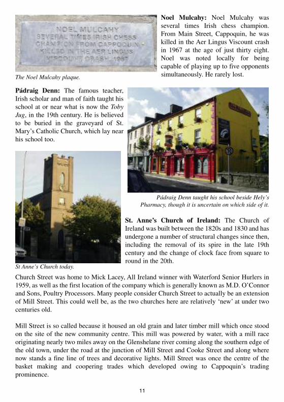
Pádraig Denn: The famous teacher,Irish scholar and man of faith taught hisschool at or near what is now the TobyJug, in the 19th century. He is believedto be buried in the graveyard of St.Mary’s Catholic Church, which lay nearhis school too.
St. Anne’s Church of Ireland: The Church ofIreland was built between the 1820s and 1830 and hasundergone a number of structural changes since then,including the removal of its spire in the late 19thcentury and the change of clock face from square toround in the 20th.
Church Street was home to Mick Lacey, All Ireland winner with Waterford Senior Hurlers in1959, as well as the first location of the company which is generally known as M.D. O’Connorand Sons, Poultry Processors. Many people consider Church Street to actually be an extensionof Mill Street. This could well be, as the two churches here are relatively ‘new’ at under twocenturies old.
Mill Street is so called because it housed an old grain and later timber mill which once stoodon the site of the new community centre. This mill was powered by water, with a mill raceoriginating nearly two miles away on the Glenshelane river coming along the southern edge ofthe old town, under the road at the junction of Mill Street and Cooke Street and along wherenow stands a fine line of trees and decorative lights. Mill Street was once the centre of thebasket making and coopering trades which developed owing to Cappoquin’s tradingprominence.
11
The Noel Mulcahy plaque.
St Anne’s Church today.
Pádraig Denn taught his school beside Hely’sPharmacy, though it is uncertain on which side of it.
The Convent Site (Private houses):Although the first residence of theSisters of Mercy who came toCappoquin in 1850 was somewhere inMain Street, these buildings wereoccupied for a considerable time by theSisters, prior to building the newconvent after 1901. The RIC also usedpart of the structure as a barracks priorto Irish independence, although themain police barracks from then until the1970s lay near the junction of MassLane and Main Street.
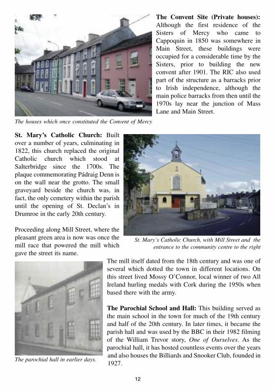
St. Mary’s Catholic Church: Builtover a number of years, culminating in1822, this church replaced the originalCatholic church which stood atSalterbridge since the 1700s. Theplaque commemorating Pádraig Denn ison the wall near the grotto. The smallgraveyard beside the church was, infact, the only cemetery within the parishuntil the opening of St. Declan’s inDrumroe in the early 20th century.
Proceeding along Mill Street, where thepleasant green area is now was once themill race that powered the mill whichgave the street its name.
The mill itself dated from the 18th century and was one ofseveral which dotted the town in different locations. Onthis street lived Mossy O’Connor, local winner of two AllIreland hurling medals with Cork during the 1950s whenbased there with the army.
The Parochial School and Hall: This building served asthe main school in the town for much of the 19th centuryand half of the 20th century. In later times, it became theparish hall and was used by the BBC in their 1982 filmingof the William Trevor story, One of Ourselves. As theparochial hall, it has hosted countless events over the yearsand also houses the Billiards and Snooker Club, founded in1927.
12
The houses which once constituted the Convent of Mercy
St. Mary’s Catholic Church, with Mill Street and theentrance to the community centre to the right
The parochial hall in earlier days.
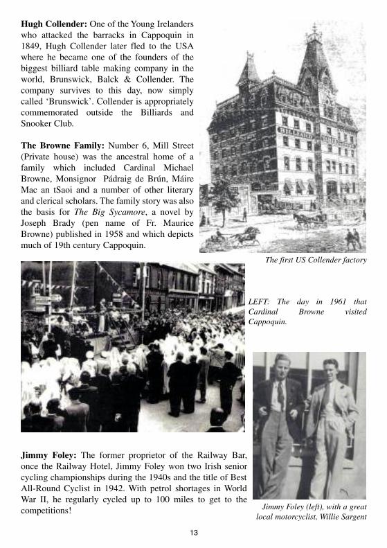
Hugh Collender: One of the Young Irelanderswho attacked the barracks in Cappoquin in1849, Hugh Collender later fled to the USAwhere he became one of the founders of thebiggest billiard table making company in theworld, Brunswick, Balck & Collender. Thecompany survives to this day, now simplycalled ‘Brunswick’. Collender is appropriatelycommemorated outside the Billiards andSnooker Club.
The Browne Family: Number 6, Mill Street(Private house) was the ancestral home of afamily which included Cardinal MichaelBrowne, Monsignor Pádraig de Brún, MáireMac an tSaoi and a number of other literaryand clerical scholars. The family story was alsothe basis for The Big Sycamore, a novel byJoseph Brady (pen name of Fr. MauriceBrowne) published in 1958 and which depictsmuch of 19th century Cappoquin.
Jimmy Foley: The former proprietor of the Railway Bar,once the Railway Hotel, Jimmy Foley won two Irish seniorcycling championships during the 1940s and the title of BestAll-Round Cyclist in 1942. With petrol shortages in WorldWar II, he regularly cycled up to 100 miles to get to thecompetitions!
13
Jimmy Foley (left), with a greatlocal motorcyclist, Willie Sargent
The first US Collender factory
LEFT: The day in 1961 thatCardinal Browne visitedCappoquin.

As Mill Street meets Cooke Street, on anow-redeveloped site once stood themain premises of M.D. O’Connor andSons, until it moved to Lefanta out theroad in the 1970s. O’Connors’ has beenmuch more than a poultry processingconcern over the years, with a longtradition in salmon, rabbit and fruitshipment as well. From an initialhandful of workers, by the 21st century,O’Connor’s gave employment to closeon 200 people.
Beside O’Connors’ stood Harrington’s Hotel, one of six such establishments which served theneeds of travellers in the 19th and early 20th centuries.
________________
14
Harrington’s Hotel, where Mill Street meets Cooke Street, in its heyday of the early20th century
As well as the many full-time workers,O’Connor’s employed lots of local part-timehelpers over the years.

15
16

17

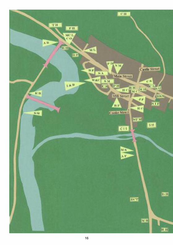
Town Map Key
Trail 1:Avonmore Bridge (A B)Tivoli House (T V)Parochial House (P H)Boathouse (B H)Mac Liammóir and Edwards (MC L)C.O. Stanley (C ))Daly Family Home (D F)Mass Lane (M L)Boyle’s Iron Works and Bridge (I & B)Cappoquin Bacon Factory (B F)Wheel and Carriage Works (W&C)
Trail 2:Red Bridge (R B)Steamers’ Quay (S Q)
Trail 3:Noel Mulcahy (N M)Pádraig Denn (P D)St. Anne’s Church of Ireland S A)The Convent Site (C S)St. Mary’s Catholic Church (S M)Parochial School and Hall (P H)Hugh Collender (H C)Browne Family (B F)Jimmy Foley (J F)
Trail 4:The Cornerstone (C S)The Market House (M H)Barron’s Bakery (B B)Michael Cavanagh (M C)Robert Cooke (R C)St. Michael’s (ST M)Station House (S H)Church of Ireland School (C I S)Magnificent Seven (M S)Affane Senior Footballers (A F)
Trail 5:Derriheen House/Drs. White (D H)Rectory (RCT)Mulcahy brothers (M B)Richmond House (R H)
Trail 6:Carnegie Free Library C L)Sargent’s Garage (S G)Walsh’s Hotel/The Barracks (BKS)Star Foundry and Implement Works (SIF)Cappoquin House (C H)The Desmond (D C)Vocational School (VEC)Convent Primary School (C P)St. Anne’s (ST A)Convent of Mercy (C M)Dane’s Field (D F)
Trail 7:The Monument (MT)
18
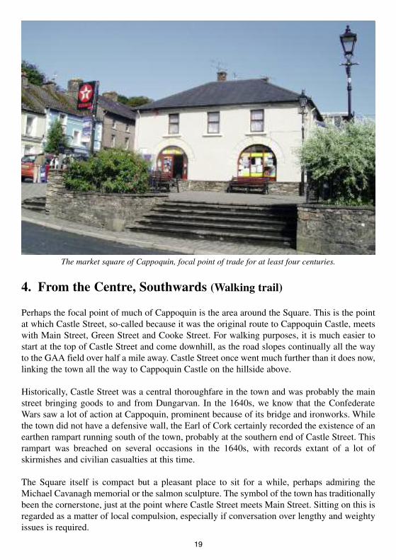
4. From the Centre, Southwards (Walking trail)
Perhaps the focal point of much of Cappoquin is the area around the Square. This is the pointat which Castle Street, so-called because it was the original route to Cappoquin Castle, meetswith Main Street, Green Street and Cooke Street. For walking purposes, it is much easier tostart at the top of Castle Street and come downhill, as the road slopes continually all the wayto the GAA field over half a mile away. Castle Street once went much further than it does now,linking the town all the way to Cappoquin Castle on the hillside above.
Historically, Castle Street was a central thoroughfare in the town and was probably the mainstreet bringing goods to and from Dungarvan. In the 1640s, we know that the ConfederateWars saw a lot of action at Cappoquin, prominent because of its bridge and ironworks. Whilethe town did not have a defensive wall, the Earl of Cork certainly recorded the existence of anearthen rampart running south of the town, probably at the southern end of Castle Street. Thisrampart was breached on several occasions in the 1640s, with records extant of a lot ofskirmishes and civilian casualties at this time.
The Square itself is compact but a pleasant place to sit for a while, perhaps admiring theMichael Cavanagh memorial or the salmon sculpture. The symbol of the town has traditionallybeen the cornerstone, just at the point where Castle Street meets Main Street. Sitting on this isregarded as a matter of local compulsion, especially if conversation over lengthy and weightyissues is required.
19
The market square of Cappoquin, focal point of trade for at least four centuries.

The Cornerstone: The symbol of thetown, with a remarkable Fausteanlegend attached to it. The legend dealswith a local nobleman, Tomas BánFitzgerald, who made a tragicagreement with the hounds of the Devilin order to gain fleeting riches. Mostlocal people consider the smaller stoneto the right to be the originalcornerstone, although it remains nicelybalanced by the other, larger stone onthe left as you look from the Squarenorth towards Castle Street.
The Market House: This isprobably the oldest building inCappoquin, dating in its originalform from 1628. It functioned as acourthouse until the 1970s and, asfar as anyone can tell, has been acontinuous trading centre in thetown for nearly four centuries. Ifso, this may well be the oldestshop-site in Ireland. In the 1980s, a17th century well was uncoveredduring building work nearby,while today the Market House andSquare are the departure points forall Cappoquin sports teams.
Barron’s Bakery: This is one ofIreland’s oldest commercialbakeries, with original Scotchbrick ovens intact. Barron’s wasfounded here in the mid 1880s.Note the hanging sign over thedoor. 19th and much of 20thcentury Cappoquin was a hive ofindustry and small, self-containedbusinesses. Barron’s Coffee Shopserved as Keating’s Saddlery forover 60 years.
20
The Cornerstone, Cloch an Chúinne.
An unusual team about to depart at the Market House
Barron’s Bakery

Michael Cavanagh: The patriot and author whosestatue stands at the Square was born in a house inCooke Street, directly across the road from St.Michael’s. He went to America after the failedrebellion of 1849 and became, among other things, theofficial biographer of Thomas Francis Meagher, theYoung Ireland leader and Civil War hero. Cavanagh isalso credited with being the first man to publish thelegend of the Cornerstone in 1864.
Robert Cooke: As Castle Street moves southwards, it becomes Cooke Street, called after oneof Cappoquin’s more eccentric former inhabitants, a man who insisted on wearing only whitelinen clothing. More curiously still, Cooke also insisted on keeping a herd of only-white cattlealthough he was a vegan himself. Cooke wrote some fascinating philosophical tracts and wasone of Cappoquin’s Quaker community, which had a meeting house somewhere in Mill Streetin the 18th century.
St. Michael’s: In this building, theSisters of Mercy ran a major industrialschool, mainly for boys, between the1870s and the 1970s. It has since beenmodernised and redeveloped asRiverview Guesthouse. At its height St.Michael’s catered for nearly 100children.
The Station House (Private): Between1878 and 1967, the station house was ahive of activity in Cappoquin as it servedthe passengers and handled the freightwhich passed through en route to Mallow,Waterford, Mount Melleray and so on.
21
The Cooke plaque.
A view of life in St. Michael’s circa 1900
The station at Cappoquin, in its prime, photographedby Michael J. Walsh
The Michael Cavanagh statue
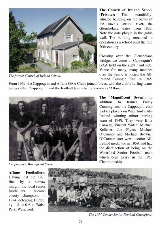
The Church of Ireland School(Private): This beautifully-situated building on the banks ofthe town’s second river, theGlenshelane, dates from 1832.Note the date plaque in the gablewall. The building remained inoperation as a school until the mid20th century.
Crossing over the GlenshelaneBridge, we come to Cappoquin’sGAA field on the right hand side.Venue for many, many matchesover the years, it hosted the All-Ireland Camogie Final in 1945.
From 1969, the Cappoquin andAffane GAA Clubs joined forces, with the club’s hurling teamsbeing called ‘Cappoquin’ and the football teams being known as ‘Affane’.
The ‘Magnificent Seven’: Inaddition to trainer PaddyCunningham, the Cappoquin clubhad six players onWaterford’s All-Ireland winning minor hurlingteam of 1948. They were BillyConway, Vincent Walsh, MichaelKelleher, Joe Flynn, MichaelO’Connor and Michael Browne.O’Connor later won a senior All-Ireland medal too in 1959, and hadthe disctinction of being on theWaterford Senior Football teamwhich beat Kerry in the 1957Championship.
Affane Footballers:Having lost the 1973final by a narrowmargin, the local seniorfootballers becamecounty champions in1974, defeating Dunhillby 1-8 to 0-6 at WalshPark, Waterford.
22
The former Church of Ireland School.
Cappoquin’s Magnificent Seven.
The 1974 County Senior Football Champions.

5. South from Cappoquin (Driving or cycling trail)
Leaving the GAA field behind, the eight kilometre stretch from Cappoquin to Villierstown,taking in ‘old’Affane on the way, is steeped in history and beauty.
Doctors William and WinnieWhite: A footpath plaque herecommemorates Cappoquin’sMedical Officer, 1914-53, ahumanitarian whose legacycontinued with his daughter, Dr.Winnie. The family lived for along time at Derriheen House(Private). The famous travel writerDervla Murphy, among manyothers, was born in DerriheenHouse, which was the localmaternity hospital.
The Rectory (Private): This mid19th century house is the formerrectory of the Church of Irelandministers in Cappoquin. The fatherof poet Louis McNeice started anillustrious clerical career as ahumble Church of Ireland curatein Cappoquin before proceeding tobecome a celebrated bishop laterin life.
The road forks at this point, with the main road to Dungarvan going eastwards but the route toVillierstown keeping us alongside the river Blackwater’s floodplain.
The Mulcahy brothers: A wall plaque here remembers John and James Mulcahy. Comradesof Edmund Rice, came to Cappoquin from the Christian Brothers School in Dungarvan to opena free school near Cappoquin in 1813. John ran the school for over thirty years, mainly underthe auspices of the bishop, until his death. In 1832, following the Stanley Education Act, thisschool became Cappoquin’s first National School. It closed in 1847.
23
Derriheen House(Private).
The Rectory (Private).
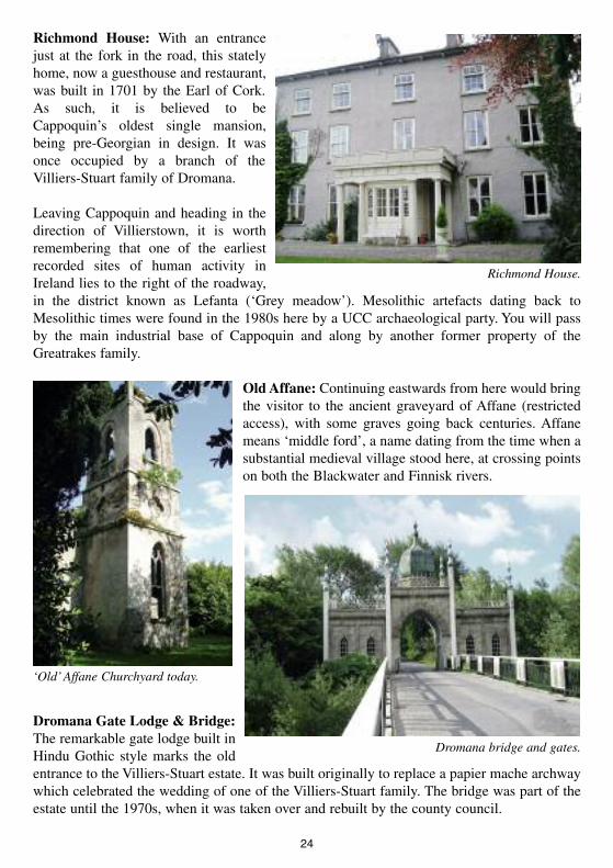
Richmond House: With an entrancejust at the fork in the road, this statelyhome, now a guesthouse and restaurant,was built in 1701 by the Earl of Cork.As such, it is believed to beCappoquin’s oldest single mansion,being pre-Georgian in design. It wasonce occupied by a branch of theVilliers-Stuart family of Dromana.
Leaving Cappoquin and heading in thedirection of Villierstown, it is worthremembering that one of the earliestrecorded sites of human activity inIreland lies to the right of the roadway,in the district known as Lefanta (‘Grey meadow’). Mesolithic artefacts dating back toMesolithic times were found in the 1980s here by a UCC archaeological party. You will passby the main industrial base of Cappoquin and along by another former property of theGreatrakes family.
OldAffane: Continuing eastwards from here would bringthe visitor to the ancient graveyard of Affane (restrictedaccess), with some graves going back centuries. Affanemeans ‘middle ford’, a name dating from the time when asubstantial medieval village stood here, at crossing pointson both the Blackwater and Finnisk rivers.
Dromana Gate Lodge & Bridge:The remarkable gate lodge built inHindu Gothic style marks the oldentrance to the Villiers-Stuart estate. It was built originally to replace a papier mache archwaywhich celebrated the wedding of one of the Villiers-Stuart family. The bridge was part of theestate until the 1970s, when it was taken over and rebuilt by the county council.
24
Richmond House.
‘Old’Affane Churchyard today.
Dromana bridge and gates.
The Battle of Affane: At Dromana Bridge there standsanother lectern, commemorating the Battle of Affane. Theroad northwards past old Affane graveyard and headingtowards Cappoquin again is known locally asBoheravaggera (Bóthar a’ Mhachaire) the ‘road of thebattle’. It was along this route that the bloody Battle ofAffane was fought in February, 1565, setting in motion theevents which led to the Desmond Rebellions andsubsequently the Plantation of Munster.
Beyond Dromana Bridge lies abeautiful area of rolling pasturesand dense woods, with glimpses ofthe Blackwater in between.Dromana House (LimitedOpening) was once home of theFitzgeralds but for severalcenturies has been the base of theVilliers-Stuarts. Beyond it, andcreated by the Villiers-Stuartfamily, lies Villierstown, an 18thcentury village, purpose-built tohouse Ulster linen weaversbrought to work on locally grownflax.
Villierstown itself has a number ofplaques and depictions of its history,the most modern being a tribute toits famous athletic son, John Treacy,whose early training involved a fivemile run to school in Cappoquin,and back again each day. The quayat Villierstown once had a ferry boatwhich brought passengers across tothe western side of the Blackwaterand still gives fine views of the deepvalley through which the great riverwinds its way southwards toYoughal.
25
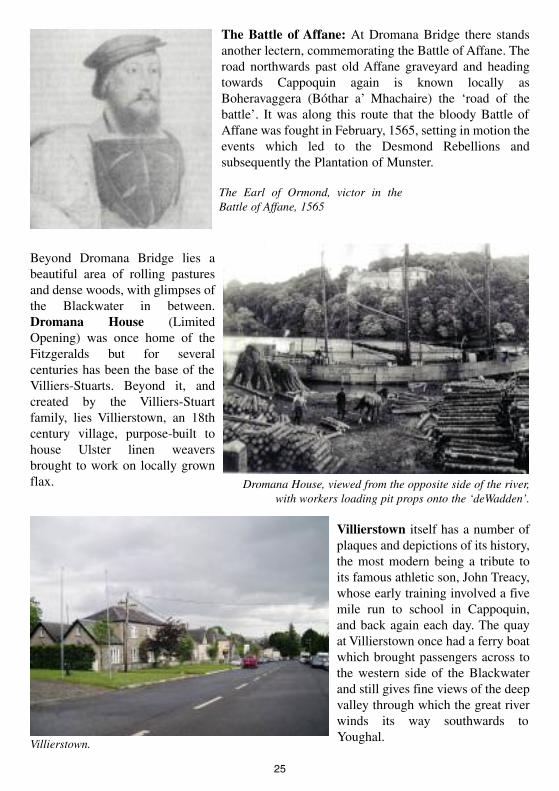
Dromana House, viewed from the opposite side of the river,with workers loading pit props onto the ‘deWadden’.
The Earl of Ormond, victor in theBattle of Affane, 1565
Villierstown.
6. Moving Eastwards through the Town (Walking trail)
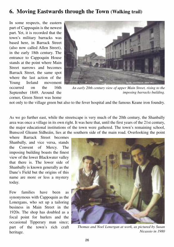
In some respects, the easternpart of Cappoquin is the newestpart. Yet, it is recorded that thetown’s military barracks wasbased here, in Barrack Street(also now called Allen Street),in the early 18th century. Theentrance to Cappoquin Housestands at the point where MainStreet narrows and becomesBarrack Street, the same spotwhere the last action of theYoung Ireland movementoccurred on the 16thSeptember 1849. Around thecorner, Green Street was homenot only to the village green but also to the fever hospital and the famous Keane iron foundry.
As we go further east, while the streetscape is very much of the 20th century, the Shanballyarea was once a village in its own right. It was here that, until the first years of the 21st century,the major educational institutions of the town were gathered. The town’s remaining school,Bunscoil Gleann Sídheáin, lies at the southern side of the main road. Overlooking the pointwhere Barrack Street becomesShanbally, and vice versa, standsthe Convent of Mercy. Theimposing building boasts the finestview of the lower Blackwater valleythat there is. The lower side ofShanbally is known generally as theDane’s Field but the origins of thisname are more or less a mysterytoday.
Few families have been assynonymous with Cappoquin as theLonergans, who set up a tailoringbusiness in Main Street in the1920s. The shop has doubled as afocal point for hurlers and theoccasional Tipperary man since;part of the town’s rich craftheritage.
26
An early 20th century view of upper Main Street, rising to theimposing barracks building.
Thomas and Noel Lonergan at work, as pictured by SusanNicassio in 1980

The Library: The town’s Carnegie Free Library wasbuilt in the early years of the 20th century with fundsfrom the famous Carnegie Foundation of the USA. Ithas also served as the town’s courthouse on occasion,and is now both a meeting venue and a regularexhibition centre.
Sargent’s Garage: One of the first cardealerships in County Waterford,Sargent’s Garage operated on this sitefor over fifty years under the auspices ofone of the town’s great sportingfamilies. The Sargent Cup countyhurling league is named after WillieSargent, a champion motorcyclist whowas killed in a crash.
Walsh’s Hotel/The Barracks: The buildingnow known as Walsh’s Hotel was originallythe army barracks and then constabularybarracks in Cappoquin. The site housed atroop of horse or more and was the focalpoint of the 1849 Young Ireland attack inCappoquin, which was the last element of themovement’s activities in the country.
The Foundry and Implement Works:Here stood the internationally known farmimplement works of R & F Keane. Itemployed 120 workers in the late 19thcentury and exported farm machineryunder the famous STAR brand as far awayas Romania and South Africa. A feverhospital also stood nearby, between thefoundry and the barracks.
27
Cappoquin’s Carnegie Library
Sargent’s Garage, during the early 1960s, with MichaelSargent (right) and Jack Fraher in attendance.
The focal point of the 1849 rebellion.
A Star plough, as made at Cappoquin.

Cappoquin House (LimitedOpening): The Georgian home of theKeane family since the 18th century alsostands on the site of an Elizabethanhouse built by Sir Christopher Hattonand of an earlier, medieval castle ownedby the Fitzgeralds. Destroyed during theTroubles of the 1920s, the main buildingwas destroyed and later rebuilt, with aflat roof replacing the original slatedone, and the main entrance door wasmoved to the courtyard.
The Desmond: Cappoquin’s formercinema and theatre stood on this sitefrom 1945 to 2005. The Desmond hostedlocally produced shows, as well asvisiting players like Maureen Potter andJimmy O’Dea. It served as the ParishChurch during renovations of St. Mary’sin 1967 and later still as a tyre centre andgarage.
Cappoquin Vocational School: Second leveleducation was provided in this building for muchof the 20th century, from the 1920s as theCappoquin VEC school and from the 1960s aspart of St. Anne’s. In addition to the regularclasses held in this school, it won considerablefame for its night classes, not least in Irish, underthe leadership of Labhrás Ó Cadhla and PádraigÓ Fiannusa.
The Convent Primary School: Theconvent primary school was opened on thissite in 1903 and continued to offer excellenteducational service to the community forover a century afterwards.
28
Cappoquin House
The Desmond as it once was.
The Cappoquin Vocational School.
A Jack Fraser drill display at the convent in the1960s
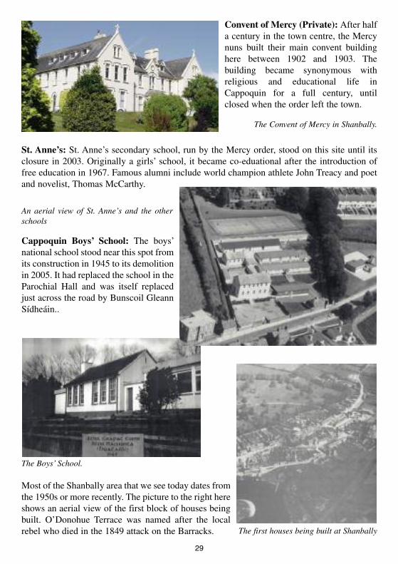
Convent of Mercy (Private): After halfa century in the town centre, the Mercynuns built their main convent buildinghere between 1902 and 1903. Thebuilding became synonymous withreligious and educational life inCappoquin for a full century, untilclosed when the order left the town.
St. Anne’s: St. Anne’s secondary school, run by the Mercy order, stood on this site until itsclosure in 2003. Originally a girls’ school, it became co-eduational after the introduction offree education in 1967. Famous alumni include world champion athlete John Treacy and poetand novelist, Thomas McCarthy.
Cappoquin Boys’ School: The boys’national school stood near this spot fromits construction in 1945 to its demolitionin 2005. It had replaced the school in theParochial Hall and was itself replacedjust across the road by Bunscoil GleannSídheáin..
Most of the Shanbally area that we see today dates fromthe 1950s or more recently. The picture to the right hereshows an aerial view of the first block of houses beingbuilt. O’Donohue Terrace was named after the localrebel who died in the 1849 attack on the Barracks.
29
An aerial view of St. Anne’s and the otherschools
The Boys’ School.
The Convent of Mercy in Shanbally.
The first houses being built at Shanbally
7. To the East and North-East (Driving or cycling trail)
Moving from Shanbally out of Cappoquin, the rolling plain which stretches down toDungarvan is clearly visible to the south, as are the hills which eventually finish at HelvickHead.
The Monument: Thismonument was erected in the1960s by the survivors of theold West Waterford Brigade ofthe IRA to commemorate thepeople who had fought anddied locally during theTroubles of the early 20thcentury. Local fundraising,involving people of manypolitical viewpoints, coveredthe cost.
With the Monument situated at a fork in the road eastwards from Cappoquin, one is faced witha choice of routes. Taking the one to the right (south) of the Monument brings one down asteep hill, passing Glenshelane, a beautiful signposted forest walk.
Apart from its natural beauty, watch for an old engineering device built into the river to bringwater up hill from the river to the Keane demesne. This wooded valley was the first home ofCappoquin Hurling Club and held a number of sites of archaeological interest. GlenshelaneHouse (Private) nestles in its midst. Towards the north east of Glenshelane wood stands an oldIron Age lios (Private lands) at Cluttahina, further evidence of the prehistoric activity whichdotted the landscape locally.
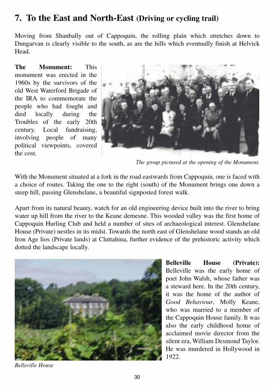
Belleville House (Private):Belleville was the early home ofpoet John Walsh, whose father wasa steward here. In the 20th century,it was the home of the author ofGood Behaviour, Molly Keane,who was married to a member ofthe Cappoquin House family. It wasalso the early childhood home ofacclaimed movie director from thesilent era, William Desmond Taylor.He was murdered in Hollywood in1922.
30
The group pictured at the opening of the Monument.
Belleville House

The Earl’s Stone: On the side of the Bóthar Garbh, theold route to Clonmel, stands the huge boulder thoughtto be the resting place of the wounded Earl of Desmonden route to Clonmel prison after the Battle of Affane.
Although moving well outside Cappoquin parish at thispoint, this adjoining area of Affane (also covered inTrails 4 and 5) has many natural links with Cappoquin.Beyond here lie Modeligo, Touraneena and other areassteeped in heritage, famed for Irish dancing, the Irishlanguage and their natural beauty. Their heritage hasbeen well charted elsewhere.
Just a note to add that, to the south, at‘new’ Affane, stands the lovely localparish church, and the school housewhich served the community until itsclosure due to the rationalisation ofthe 1960s. Continuing past herebrings one again to the site of theBattle of Affane further south.
Going back to the Monument outsideCappoquin and then taking the left ornorthern route, one now moves in thedirection of Mount Melleray. Thearea itself is a marvellous mix ofmountains and valleys, of woodlandsand heather.
A very popular Marian grotto standsbeside Melleray bridge but thecentrepiece of Mount Melleray is, ofcourse, the Cistercian monastery whichhas stood on the mountain side for over175 years. The school buildings here nolonger stand, but the monastery’schurches, café, shop and heritage centreare very well worth a visit.
31
The Earl’s Stone.
Affane schoolhouse.
Left: The Old Forge at Melleray Bridge
Mount Melleray Abbey, a mid 20th century photograph
Acknowledgements
This first Cappoquin heritage guide has been an ongoing project of the Cappoquin HeritageGroup since June 2006. In some respects, a heritage guide should always be seen as anongoing project, never completed, always ready to acknowledge new elements of our area’spast. We ask readers to accept that this is a first edition, a first attempt to provide a user-friendly guide to our place. We hope there will be a second edition, if not more than that, andwill do everything possible to ensure that any omissions or errors will be rectified as things goon.
We would like to acknowledge the fantastic support we have been given locally in our effortsto develop this heritage trail. The generosity of Aidan Walsh in providing the stone plaqueswhich identify many of the people and places on the trail is really beyond the level of fantastic.So too has been the time and talent of a number of artists, who did artwork for some of thelectern displays and are named on them. Seamus Ó Rodaigh, Antón Daltún and Fr. John Kielyassisted us hugely in translation work on the lectern displays. The skills of Arthur Butler,Michael O’Doherty and Jacinta Uniacke in creating the various display units are there for allto see, and we thank them greatly for their work also. The text of this booklet has beendeveloped and edited by different members of the Heritage Group, with modern photographycourtesy of group member, Helen McGrath.Where identifiable, other photographers have beencredited individually.
Moving beyond Cappoquin, the practical help of Noel Healy, Paddy Walsh and the workers ofWaterford County Council is very gratefully acknowledged. So too is the financial assistanceof the Heritage Council, which part-funded elements of the work, including some publicationcosts of this booklet. Our printers, Modern Printers of Kilkenny, have become firm friends atthis stage, not least because their work on our group’s first publication, Cappoquin: A Windowon the Past, helped to fund the major costs involved in setting up the group’s operations.
Finally, we thank the people of Cappoquin and its surrounding areas. It is impossible to definewhere these surrounding areas end. We have generally, for the purposes of this booklet,confined things to the town, parish and river bend area. In doing so, we hope sincerely that wehave not trespassed on the identity of any other place unduly, or that we have not omitted toomuch that should have been included in this first edition. In other respects, the Cappoquin areaextends toAustralia, the USA, Canada and many other places. We are also reminded that manynew ‘Cornerstone’ dwellers have come from other places around the world and we hope thisbooklet helps to give them some flavour of what Cappoquin is all about too.
As Cappoquin Heritage Group comes under the umbrella of Cappoquin Civic Link, readerscan find more details on our activities at www.cappoquin.net.
32