Embed Size (px)
Citation preview
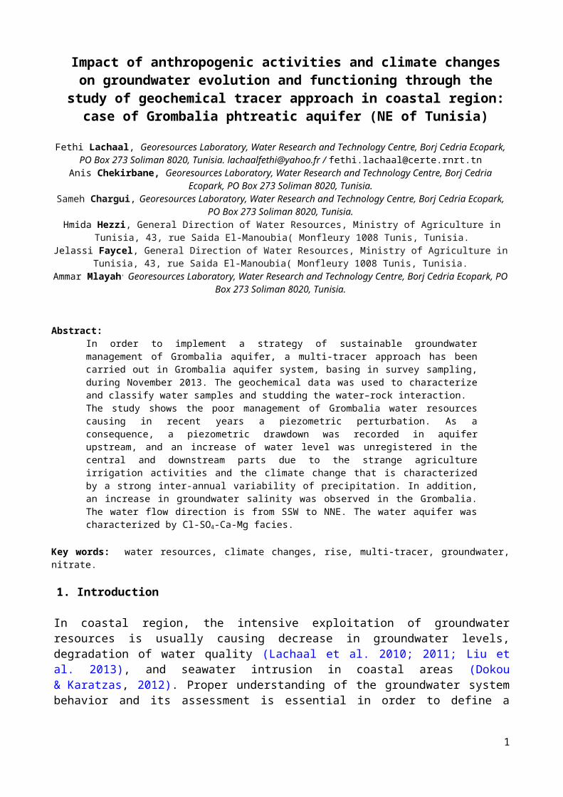
Impact of anthropogenic activities and climate changes on groundwater evolution and functioning through the study of geochemical tracer approach in coastal region: case of
Grombalia phtreatic aquifer (NE of Tunisia)Fethi Lachaal, Georesources Laboratory, Water Research and Technology Centre, Borj Cedria Ecopark, PO Box 273 Soliman 8020, Tunisia. [email protected] / [email protected]
Anis Chekirbane, Georesources Laboratory, Water Research and Technology Centre, Borj Cedria Ecopark, PO Box 273 Soliman 8020, Tunisia.
Sameh Chargui, Georesources Laboratory, Water Research and Technology Centre, Borj Cedria Ecopark, PO Box 273 Soliman 8020, Tunisia.
Hmida Hezzi, General Direction of Water Resources, Ministry of Agriculture in Tunisia, 43, rue Saida El-Manoubia( Monfleury 1008 Tunis, Tunisia.
Jelassi Faycel, General Direction of Water Resources, Ministry of Agriculture in Tunisia, 43, rue Saida El-Manoubia( Monfleury 1008 Tunis, Tunisia.
Ammar Mlayah, Georesources Laboratory, Water Research and Technology Centre, Borj Cedria Ecopark, PO Box 273 Soliman 8020, Tunisia.
Abstract: In order to implement a strategy of sustainable groundwater management of Grombalia aquifer, a multi-tracer approach has been carried out in Grombalia aquifer system, basing in survey sampling, during November 2013. The geochemical data was used to characterize and classify water samples and studding the water–rock interaction. The study shows the poor management of Grombalia water resources causing in recent years a piezometric perturbation. As a consequence, a piezometric drawdown was recorded in aquifer upstream, and an increase of water level was unregistered in the central and downstream parts due to the strange agriculture irrigation activities and the climate change that is characterized by a strong inter-annual variability of precipitation. In addition, an increase in groundwater salinity was observed in the Grombalia. The water flow direction is from SSW to NNE. The water aquifer was characterized by Cl-SO4-Ca-Mg facies.
Key words: water resources, climate changes, rise, multi-tracer, groundwater, nitrate.
1. Introduction
In coastal region, the intensive exploitation of groundwater resources is usually causing decrease in groundwater levels, degradation of water quality (Lachaal et al. 2010; 2011; Liu et al. 2013), and seawater intrusion in coastal areas (Dokou & Karatzas, 2012). Proper understanding of the groundwater system behavior and its assessment is essential in order to define a sustainable management plan which can cope with the future impact of the global change on water resources.
Grombalia aquifer (north east of Tunisia) is one of the typical examples of coastal aquifers in semi-arid regions which have been intensively exploited during the last few years (Ennabli, 1980; Ben Moussa et al. 2011; Tlili-Zrelli et al. 2013; Gaaloul et al. 2014). In fact, the piezometric levels are decreased and the water quality is relatively deteriorated. To solve this problem, the government have added the use of surface water resources from the North-West Tunisia (Oued Medjerda and Ichkeul basin), unless 1984. Then, a program of artificial groundwater recharge from surface water has been initialized in 1999 in order to reduce the piezometric depression. The aim of the paper is to
1
study of the impact of anthropogenic activities and climate changes on groundwater evolution and functioning.
2. Geology and hydrogeology
The study area covers the Grombalia plain (North east Tunisia) with 100 km2
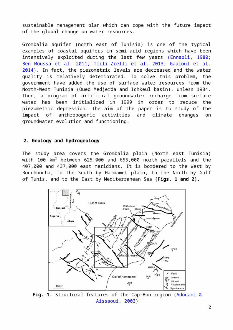
between 625,000 and 655,000 north parallels and the 407,000 and 437,000 east meridians. It is bordered to the West by Bouchoucha, to the South by Hammamet plain, to the North by Gulf of Tunis, and to the East by Mediterranean Sea (Figs. 1 and 2).
Fig. 1. Structural features of the Cap-Bon region (Adouani & Aissaoui, 2003)
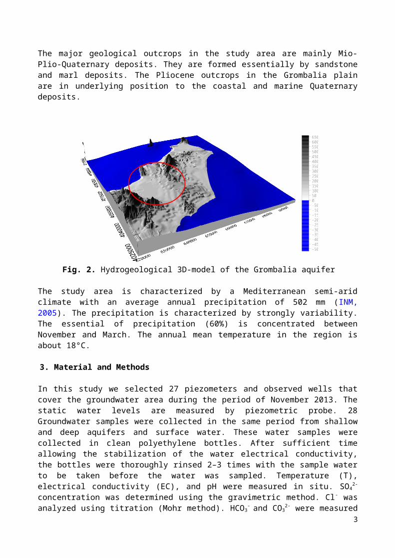
The major geological outcrops in the study area are mainly Mio-Plio-Quaternary deposits. They are formed essentially by sandstone and marl deposits. The Pliocene outcrops in the Grombalia plain are in underlying position to the coastal and marine Quaternary deposits.
2
-500-450-400-350-300-250-200-150-100-50050100150200250300350400450500550600650
Fig. 2. Hydrogeological 3D-model of the Grombalia aquifer
The study area is characterized by a Mediterranean semi-arid climate with an average annual precipitation of 502 mm (INM, 2005). The precipitation is characterized by strongly variability. The essential of precipitation (60%) is concentrated between November and March. The annual mean temperature in the region is about 18°C.
3. Material and Methods
In this study we selected 27 piezometers and observed wells that cover the groundwater area during the period of November 2013. The static water levels are measured by piezometric probe. 28 Groundwater samples were collected in the same period from shallow and deep aquifers and surface water. These water samples were collected in clean polyethylene bottles. After sufficient time allowing the stabilization of the water electrical conductivity, the bottles were thoroughly rinsed 2–3 times with the sample water to be taken before the water was sampled. Temperature (T), electrical conductivity (EC), and pH were measured in situ. SO42- concentration was determined using the gravimetric method. Cl- was analyzed using titration (Mohr method). HCO3- and CO32- were measured by titration with sulphuric acid. Cations Ca2+, Na+, Mg2+ and K+ were analyzed by atomic absorption spectrometer. The piezometric and salinity distribution maps were drawn using the kriging interpolation method, Surfer.10 software and ARC Info 10.0 software package.
4. Results and discussion
4.1. Piezometric behavior
The piezometric map of 1948 is the oldest existing data for the Grombalia aquifer (Fig. 2a). The map shows a piezometric level varying between 10 and 60 m. It shows a divergent flow from the aquifer boundary to the Oued el bay, the Sebkhat Soliman and to the sea. In the right, the water flow is from ESE to WNW directions and in the left is from the WSW to the ENE.
3
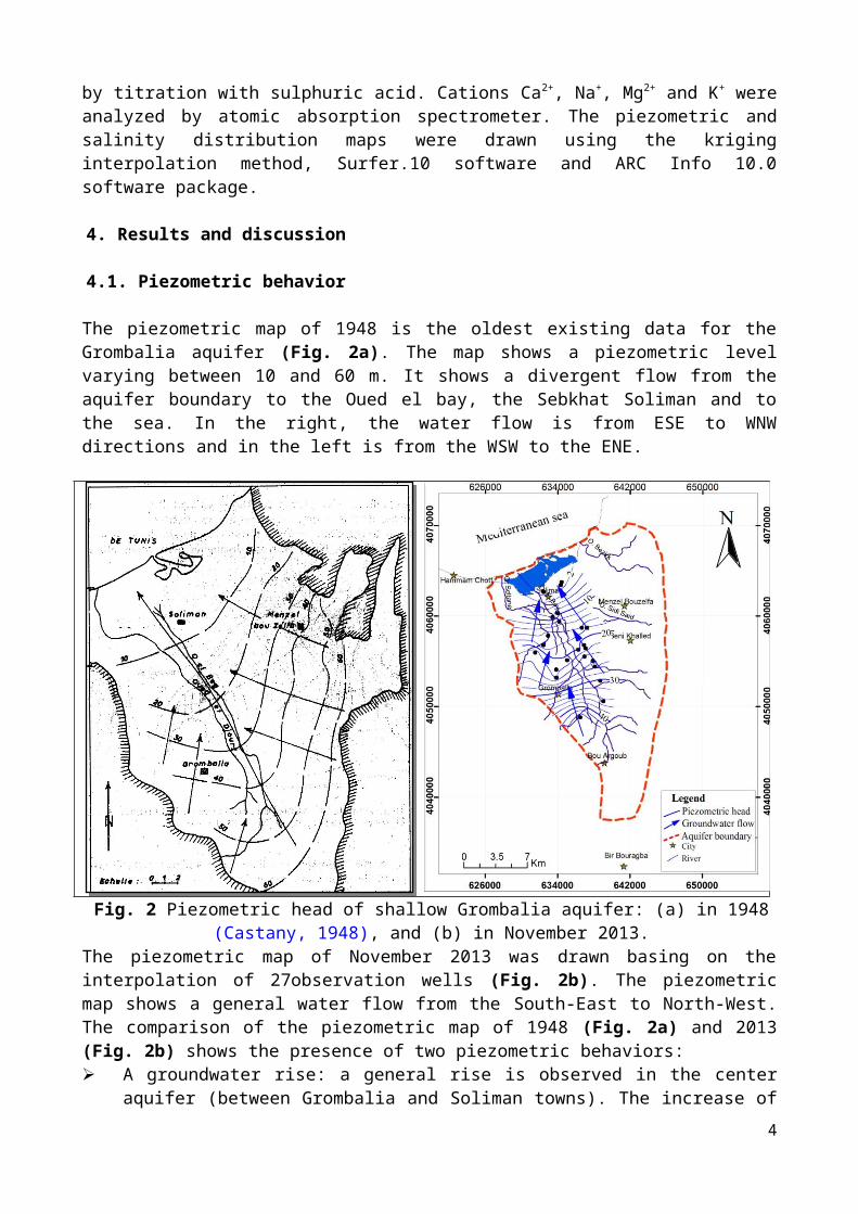
Fig. 2 Piezometric head of shallow Grombalia aquifer: (a) in 1948 (Castany, 1948), and (b) in November 2013.
The piezometric map of November 2013 was drawn basing on the interpolation of 27observation wells (Fig. 2b). The piezometric map shows a general water flow from the South-East to North-West. The comparison of the piezometric map of 1948 (Fig. 2a) and 2013 (Fig. 2b) shows the presence of two piezometric behaviors: A groundwater rise: a general rise is observed in the center aquifer
(between Grombalia and Soliman towns). The increase of water level can be explained by the irrigation returns effect and the climate changes characterized by strongly variability of precipitation. The increase of water level in the central and downstream parts beyond 2 m depth from the surface creates many agricultural, environmental, and economic problems. These problems are related to the asphyxia of plants, trees and crops, accumulation of salts in the soil especially in irrigated areas and groundwater pollution by nitrates. In some area a whole fields of citrus (oranges, Clementine and lemons ...) are asphyxiated.
A piezometric drawdown: the excessive withdrawal of groundwater for irrigation in some area is causing secular declines in water levels throughout the region. According to DGRE data, the Grombalia groundwater system extraction increased from 53.8 Mm3yr-1 in 1980 (DGRE, 1980) to 104.6 Mm3yr-1 in 2010 (DGRE, 2010). The overexploitation was provoked a piezometric decrease.
4.2. Groundwater salinization and nitrate contamination
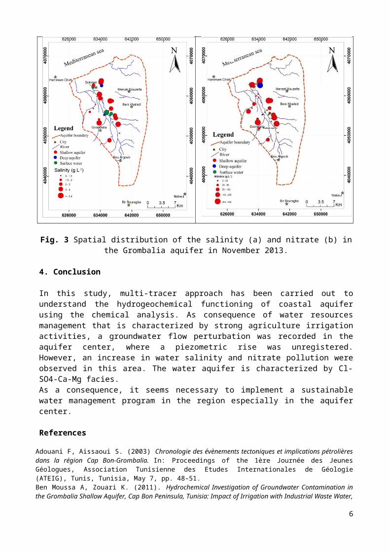
The Grombalia aquifer water is characterized by pH values varying from 7.12 to 7.44 being in the range of natural waters standard. The EC is ranging from 2.41 to 7.2 mS/cm. The salinity of Grombalia aquifer water varies between 1.8 and 5.4 g L-1(Fig. 3a). The salinity distribution map of November 2013 revealed the
4
presence of salinization gradient from South-East to North-West in the direction to the sea, corresponding to the main groundwater flow direction. In addition, a high salinity is observed in the aquifer center which coincides with the piezometric rise and groundwater management problem. According to the piper Diagram, the water aquifer is characterized by Cl-SO4-Ca-Mg facies. The Grombalia groundwater presents a very high nitrate concentration varying between 11.5 and 346 mg/l (Fig. 3b). The nitrate contaminated area coincides with the high salinity zone.
Fig. 3 Spatial distribution of the salinity (a) and nitrate (b) in the Grombalia aquifer in November 2013.
4. Conclusion
In this study, multi-tracer approach has been carried out to understand the hydrogeochemical functioning of coastal aquifer using the chemical analysis. As consequence of water resources management that is characterized by strong agriculture irrigation activities, a groundwater flow perturbation was recorded in the aquifer center, where a piezometric rise was unregistered. However, an increase in water salinity and nitrate pollution were observed in this area. The water aquifer is characterized by Cl-SO4-Ca-Mg facies. As a consequence, it seems necessary to implement a sustainable water management program in the region especially in the aquifer center.
ReferencesAdouani F, Aissaoui S. (2003) Chronologie des évènements tectoniques et implications pétrolières dans la région Cap Bon-Grombalia. In: Proceedings of the 1ère Journée des Jeunes Géologues, Association Tunisienne des Etudes Internationales de Géologie (ATEIG), Tunis, Tunisia, May 7, pp. 48–51.
5
Ben Moussa A, Zouari K. (2011). Hydrochemical Investigation of Groundwater Contamination in the Grombalia Shallow Aquifer, Cap Bon Peninsula, Tunisia: Impact of Irrigation with Industrial Waste Water, Waste Water - Evaluation and Management, Prof. Fernando Sebastián GarcÃa Einschlag (Ed.), ISBN: 978-953-307-233-3, InTech, Available from: http://www.intechopen.com/books/waste-water-evaluation-andmanagement/hydrochemical-investigation-of-groundwater-contamination-in-the-grombalia-shallow-aquifercap-bon-peCastany G. (1948) les fosses d’effondrement de Tunisie, Géologie et hydrogéologie, premier fascicule : Plaine de Grombalia et cuvettes de la Tunisie Orientale. Annales des mines et de la géologie, 3. Publications du service Géologique, Direction des travaux publics de Tunisie.DGRE (2008) Annuaire de l’exploitation des nappes profondes de l’année 2008. Technical report : DGRE, Tunis.DGRE (2010) Annuaire de l’exploitation des nappes profondes de l’année 2010. Technical report : DGRE, Tunis.Dokou Z, Karatzas G.P. (2012) Saltwater intrusion estimation in a karstified coastal system using density-dependent modelling and comparison with the sharp-interface approach. Hydrol. Sci. J. 57(5), 985-999Ennabli, M. (1980) Etude hydrogéologique des aquifères au nord-est de la Tunisie pour une gestion intégrée des ressources en eau. Doctorat d’État, Université de Paris.Gaaloul N, Candela L, Chebil A, Soussi A, Tamoh K. (2014) Groundwater flow simulation at the Grombalia phreatic aquifer (Cap Bon, Northeastern Tunisia), Desalination and Water Treatment, 52, 1997–2008, DOI: 10.1080/19443994.2013.821026INM (2005) Institut National de la Météorologie; Tableaux climatiques mensuels. Archive INM pour la période de 1985–2005. Station Nabeul.Lachaal F, Bédir M, Tarhouni J, Leduc C. (2010) Hydrodynamic and hydrochemical changes affecting groundwater in a semi-arid region: the deep Miocene aquifers of the Tunisian Sahel (central east Tunisia). IAHS Publ 340, 374–381.Lachaal F, Bédir M, Tarouni J, Ben Gacha A, Leduc C. (2011) Characterizing a complex aquifer system using geophysics, hydrodynamics and geochemistry: a new distribution of Miocene aquifers in the Zéramdine and Mahdia–Jébéniana blocks (east-central Tunisia). Journal of African Earth Sciences. 60, 222–236. Liu, X., Sun, S., Ji, P. & Šimůnek, J. (2013) Evaluation of historical nitrate sources in groundwater and impact of current irrigation practices on groundwater quality. Hydrol. Sci. J. 58(1), 198-212Tlili-Zrelli B, hamzaoui-Azaza F, Gueddari M, Bouhlila R. (2013) Geochemistry and quality assessment of groundwater using graphical and multivariate statistical methods. A case study: Grombalia phreatic aquifer (Northeastern Tunisia). Arab J Geosci, 6, 3545–3561. DOI 10.1007/s12517-012-0617-3
6