Embed Size (px)
Citation preview

Corner Inlet Ramsar Site
Strategic Management Plan

Parks Victoria developed the Strategic Management Plan in consultation with the Department of Natural Resources and Environment and key stakeholders, and coordinated the public comment process on the draft document.
This report was prepared with financial support from the National Wetlands Program, under the Natural Heritage Trust.
© The State of Victoria, Department of Natural Resources and Environment, 2002
This publication is copyright. Apart from any fair dealing for the purposes of private study, research, criticism or review as permitted under the Copyright Act 1968, no part may be reproduced, copied, transmitted in any form or by any means (electronic, mechanical or graphic) without the prior written permission of the State of Victoria, Department of Natural Resources and Environment. All requests and enquiries should be directed to the Copyright Officer, Library Information Services, Department of Natural Resources and Environment, 5/250 Victoria Parade, East Melbourne, Victoria 3002.
DisclaimersThis publication may be of assistance to you and every effort has been made to ensure that the information in the report is accurate. The Department of Natural Resources and Environment does not guarantee that the report is without flaw of any kind or is wholly appropriate for your particular purposes and therefore disclaims all liability for any error, loss or other consequence which may arise from you relying on any information in this publication.
The views and opinions expressed in this document are those of the authors and do not necessarily reflect the views and opinions of the Commonwealth Government of Australia, the Federal Minister for Environment and Heritage, or Environment Australia.
This report is prepared without prejudice to any negotiated or litigated outcome of any native title determination applications covering land or waters within the plan's area. It is acknowledged that any future outcomes of native title determination applications may necessitate amendment of this report; and the implementation of this plan may require further notifications under the procedures in Division 3 Part 2 of the Native Title Act 1993 (Cwlth).
The plan is also prepared without prejudice to any future negotiated outcomes between the Government/s and Victorian Aboriginal communities. It is acknowledged that such negotiated outcomes may necessitate amendment of this plan.
Published in May 2002 by the Department of Natural Resources and Environment Level 14, 8 Nicholson Street, East Melbourne, Victoria 3002
Copies of this document are available at
www.nre.vic.gov.au National Library of Australia
Cataloguing-in-Publication entry
Victoria. Department of Natural Resources and Environment. Corner Inlet Ramsar Site: Strategic Management Plan
Bibliography.
ISBN 1 74106 016 8
Cover: Snake Island (Photograph: Parks Victoria
collection) Printed on recycled paper


Contents
1 INT RODU C T ION 1
1.1 STRATEGIC DIRECTIONS STATEMENT 11.2 PURPOSE OF THE STRATEGIC MANAGEMENT PLAN 11.3 CONSULTATIVE FRAMEWORK 2
2 R A M S A R S ITE DE S CRIPTION 2
2.1 LOCATION 32.2 WETLAND TYPE 32.3 CRITERIA MET FOR RAMSAR LISTING 32.4 LAND TENURE AND MANAGEMENT AGENCY 32.5 ADJACENT LAND USE 72.6 CATCHMENT SETTING 72.7 LOCAL GOVERNMENT 7
3 POUICYF R A MEWORK 8
3.1 STRATEGIES 83.2 MUNICIPAL STRATEGIC STATEMENTS, ZONING AND OVERLAYS 8
4 V A U U ES 9
4.1 WETLAND REPRESENTATIVENESS 94.2 FLORA AND FAUNA 94.3 WATERBIRDS 104.4 NATURAL FUNCTION 104.5 CULTURAL HERITAGE 114.6 SCENIC 114.7 ECONOMIC114.8 EDUCATION AND INTERPRETATION 114.9 RECREATION AND TOURISM 124.10 SCIENTIFIC 124.11 CONDITION 12
5 M A N A G E MENTO F RISKS 1 4
5.1 POLLUTION145.2 PEST PLANTS AND ANIMALS 155.3 RESOURCE UTILISATION 165.4 DREDGING 165.5 RECREATION 175.6 EROSION 175.7 FIRE 185.8 LEVEL OF RISK TO RAMSAR VALUES 18
6 SIT E M A N A G EMENT S T R A TEGIES 20
STRATEGIC MANAGEMENT PLAN FOR THE CORNER INLET RAMSAR SITE PAGE I

RE F E R ENC ES 23
A PP ENDIX 1 U ISTOF CO N TRIB U TORS 2 8
A PP ENDIX 2 T HR E A TE N E D S T AT U S OF FUO R A 2 9
A PP ENDI X3 T HR E A T E N E D S T A T US O F FA U N A 3 0
A PP ENDIX 4 J AM B A , C A M B A A N D BO N N S P ECI E S 31
A PP ENDIX 5 CORNERINUET R A M S A R I NFO R M A TION SH E ET 3 2
STRATEGIC MANAGEMENT PLAN FOR THE CORNER INLET RAMSAR SITE PAGE II

1 Introduction
The Strategic Management Plan for the Corner Inlet Ramsar site is an integral component of a program to develop a comprehensive management framework for Victoria's Wetlands of International Importance (or 'Ramsar sites') listed under the Convention on Wetlands (Ramsar, Iran, 1971). The primary goal of the management framework is to maintain the ecological character of Victoria's Ramsar sites through conservation and wise use.
1.1 Strategic Directions Statement
The Strategic Directions Statement establishes Management Objectives for Victoria's Ramsar sites and Statewide Management Strategies to achieve these objectives. The Strategic Management Plans for individual Victorian Ramsar sites apply the Management Objectives and Statewide Management Strategies, promoting a range of specific Site Management Strategies that will maintain, and in some cases restore, the ecological character of the sites. Individual plans cover 10 of Victoria's 11 Ramsar sites. Victoria's eleventh Ramsar site, the Edithvale-Seaford Wetlands, was listed in 2001 and is covered by a separate management plan. A diagram of the framework and related documents is shown below in Figure 1.1.
The Strategic Directions Statement provides the overarching policy framework for managing Ramsar sites in Victoria. It establishes Management Objectives for Ramsar site management across the State, which are then translated to the site-specific level by each of the Strategic Management Plans. The Management Objectives outlined by the Strategic Directions Statement are as follows:
1. Increase the scientific understanding of wetland ecosystems and their management requirements.
2. Maintain or seek to restore appropriate water regimes.
3. Address adverse processes and activities.
4. Manage Ramsar sites within an integrated catchment management framework.
5. Manage resource utilisation on a sustainable basis.
6. Protect, and where appropriate enhance, ecosystem processes, habitats and species.
7. Encourage strong partnerships between management agencies.
8. Promote community awareness and understanding and provide opportunities for involvement in management.
9. Ensure recreational use is consistent with the protection of natural and cultural values.
10. Develop ongoing consistent programs to monitor ecological character.
The Strategic Directions Statement also provides background information on the suite of relevant international conventions, as well as related Commonwealth and State policy and legislation which directs and supports the management of Ramsar sites. The Strategic Directions Statement and Strategic Management Plans are therefore intended to be read as complementary documents.
1.2 Purpose of the Strategic Management Plan
The primary purpose of the Strategic Management Plan (SMP) for the Corner Inlet Ramsar site is to facilitate conservation and wise use of the site so as to maintain, and where practical restore, the ecological values for which it is recognised as a Ramsar wetland. This will be achieved by implementing site-specific management strategies under each of the key objectives (derived from the Strategic Directions Statement).
The SMP for the Corner Inlet Ramsar site provides management agencies and stakeholders with an appropriate management framework and the necessary information to ensure that decisions regarding land use and development, and ongoing management are made with full regard for wetland values in environmental, social and economic terms.
Figure 1.1 Framework for the strategic management of Victoria's Ramsar sites
STRATEGIC DIRECTIONS STATEMENT FOR
VICTORIA'S RAMSAR SITES
BARMAH CORNER GIPPSLAND GUNBOWER KERANG HATTAH- LAKE PORT WESTERN WESTERNFOREST INLET LAKES FOREST WETLANDS KULKYNE
LAKES ALBACUTYA PHILLIP BAY DISTRICTLAKES PORT

STRATEGIC MANAGEMENT PLAN FOR THE CORNER INLET RAMSAR SITE PAGE 1

The SMP has been structured in order to:
• provide a comprehensive site description;
• examine the legislation, policy and any related management instruments which direct or otherwise influence management both within and adjacent to the site;
• clarify the roles and responsibilities of management agencies;
• identify the values for which the site is recognised as a Ramsar site;
• assess threats to these values through systematic analysis of both current and potential risks; and
• give priority to Site Management Strategies that minimise and, where possible, eliminate identified risks to values.
1.3 Consultative framework
The SMP has been developed collaboratively through a multi-disciplinary team comprised of Parks Victoria and Department of Natural Resources and Environment staff from regional and central offices. Throughout the process key local stakeholders have provided input (see Figure 1.2).
The SMP is a public document that has been formalised through a government approval process. As such, the SMP was subject to a public comment phase commensurate with State Government consultative processes. All comments received during the public consultation phase were considered in finalising the document.
The SMP is intended to operate over a six-year time frame and will be reviewed every three years to coincide with national reporting requirements under the Convention on Wetlands.
Figure 1.2 Process for developing the SMP for the Corner Inlet Ramsar site
MuLTI-DISCIPLIMARY
PROJECT TEAM
KEY LOCAL STAKEHOLDERS
LOCAL REFERENCE
GROuP
PuBLIC COMMENT ON DRAFT DOCuMENT
CORNER INLET STRATEGIC
MANAGEMENT PLAN

STRATEGIC MANAGEMENT PLAN FOR THE CORNER INLET RAMSAR SITE PAGE 2

2 Ramsar Site Description
2.1 Location
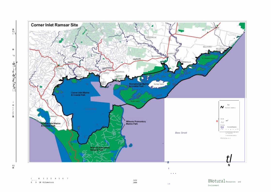
Situated approximately 260 km south-east of Melbourne, the Corner Inlet Ramsar site covers 67,192 ha and represents the most southerly marine embayment and tidal mudflat system of mainland Australia. The Inlet is bounded to the west and north by the South Gippsland coastline, in the south-east by a series of barrier islands and sandy spits lying end to end and separated by narrow entrances, and to the south by the hills of Wilsons Promontory.
2.2 Wetland type
Within the Corner Inlet Ramsar site the four wetland types recognised under the classification system used by the Ramsar Convention are: permanent shallow marine waters, intertidal mud, sand or salt flats, intertidal marshes and intertidal forested wetlands.
In Victoria wetlands are classified into eight categories (Corrick and Norman 1980). The Corner Inlet Ramsar site includes areas of three wetland types under this system: permanent saline (14,151 ha), semi-permanent saline (666 ha), and deep freshwater marsh (162 ha). The remaining 52,213 ha of the Ramsar site is not categorised by the Victorian wetland classification system.
2.3 Criteria met for Ramsar listing
To be listed as Wetlands of International Importance or 'Ramsar sites', wetlands must meet one or more internationally accepted criteria in relation to their zoology, botany, ecology, hydrology or limnology and importance to waterfowl. The Ramsar Convention updated the criteria in 1999. The new criteria will be applied to Corner Inlet when the site Ramsar Information Sheet is next updated in 2005. The criteria met by the Corner Inlet Ramsar site when listed in 1982 were:
1(a) - a particularly good representative of a natural or near-natural wetland characteristic of one, or common to more than one, biogeographical region;
1(b) - representative of a wetland which plays an important role in the natural functioning of a major river basin or coastal system, especially where located in a trans-border position;
1(c) - a rare or unusual type of wetland in the biogeographical region;
2(b) - is of special value for maintaining the genetic and ecological diversity of the flora and fauna of the region;
3(a) - it regularly supports 20,000 waterfowl;
3(b) - it regularly supports substantial numbers
ofindividuals from particular groups ofwaterfowl, indicative of wetland values, productivity or diversity; and,
3(c) - regularly supports 1% of the individuals of a population of one species or subspecies of waterfowl.
Information on how the Corner Inlet Ramsar site meets these criteria is detailed in Chapter 4.
2.4 Land tenure and management
The land in the Corner Inlet Ramsar site has a variety of tenures and is managed by a number of different agencies under the provisions of the relevant legislation.
The majority of the public land and waters that comprise the Corner Inlet Ramsar site is included in the Nooramunga and Corner Inlet Marine and Coastal Parks. Marine and Coastal Parks are set aside primarily to conserve and protect natural ecosystems and to provide opportunities for recreation and education associated with the enjoyment and understanding of natural environments.
The 1986 Orders proclaiming Corner Inlet and Nooramunga Marine and Coastal Parks to be reserved and added to Schedule Four of the National Parks Act 1975 (Vic.) included only previously unreserved Crown Land. They excluded 'any land reserved as National Park or declared or deemed to be reserved for any other purpose or under any other Act which reserves Crown land'. Consequently, a range of reservations exists for the public land included in the Corner Inlet Ramsar site.
Doughboy Island, Bennison Island, Granite Island, Long Island and Corner Island and the intertidal area in the southern section of Corner Inlet are part of Wilsons Promontory National Park. These areas are reserved and managed under the provisions of the National Parks Act 1975.
The remaining area of the Ramsar site is either freehold land, unreserved crown land or included in various public purpose or coastal reserves.
In May 2002, the Government introduced legislation into Parliament to establish a Marine National Park in Corner Inlet, adjacent to the Wilsons Promontory National Park (in the vicinity of Bennison Island and Granite Island). This area would include representative marine habitats.

STRATEGIC MANAGEMENT PLAN FOR THE CORNER INLET RAMSAR SITE PAGE 3

-N
mG)('5
m
"U
.,0;o-;J:m()0;ozm;ozr!:!1
;o(/)=im
Key
N Rarooar ocumary
N"'""NStreams
•••"
Bass Strait
N flillllflnilll
N ..,..rt
- I'KIIIlods &l'rl!!ll:lrVIIS)
- I'KIIIlods(oblr)
Plilicla-r:J
G)m
1,..... 0 1 2 3 4 5 6 7 8 9 10
KilometersJune 2000
·a
'... (I
tl
8Notural Resources and EnvironmentAUI,ULTUIE • au acu • c uun11UN • un IUUUIUT
Marine National Parks are highly protected areas which contribute to a system representing the range of marine environments in Victoria, and in which no fishing, extractive or damaging activities are permitted.
The Government accepted the recommendation of the Environment Conservation Council that the area of Corner Inlet Marine and Coastal Park not recommended for inclusion in the Corner Inlet Marine National Park, and the whole of the Nooramunga Marine and Coastal Park, be retained and managed for a variety of uses which do not impact on their values and objectives.
Parks Victoria manages almost all the public land and waters within the Corner Inlet Ramsar site. This includes Corner Inlet Marine and Coastal Park, Nooramunga Marine and Coastal Park, Wilsons Promontory National Park and part of the Port
Franklin - Port Welshpool Coastal Reserve. The foreshore with the Port Welshpool and Port Albert townships and the Red Bluff/Foley Road area are managed by Committee's of Management. The waters of the commercial ports of Port Welshpool and Port Albert are managed by Gippsland Ports. Sunday Island, Dog Island, Little Dog Island, Hunter Island and Bullock Island included within the Ramsar site are privately owned (Table 2.1).
In addition a range of agencies are responsible for ensuring that management of the site complies with a broad range of legislative requirements. The successful management of the Corner Inlet Ramsar site therefore relies on effective cooperation and partnership between the various management agencies. Lead management agencies and their key responsibilities are summarised in Table 2.2
Table 2.1 Uand tenure and management
Area Uand tenure Uegal status Management
Wilsons Promontory National Park National Park National Parks Act 1975 Parks Victoria
Corner Inlet Marine and Marine and Coastal Park Coastal Park National Parks Act 1975 Parks Victoria
Nooramunga Marine andMarine and Coastal
Park Coastal ParkNational Parks Act 1975 Parks Victoria
Nooramunga Faunal Wildlife Reserve Reserve Wildlife Act 1975 Parks Victoria
Port Franklin - Port Coastal Reserve Welshpool Coastal Reserve Crown Land (Reserves) Act 1978 Parks Victoria
Yanakie (Red Bluff) CoastalCoastal Reserve Crown Land (Reserves) Act 1978 Parks Victoria
Reserve
Foreshore within PortPublic Purposes Reserve
Welshpool townshipCrown Land (Reserves) Act 1978
Committee of Management
(South Gippsland Shire)
Foreshore within Port AlbertPublic Purposes Reserve Crown Land (Reserves) Act 1978
Committee of Management
township (Wellington Shire)Shipping Channels Unreserved Crown land Land Act 1958 NRE
Land and waters within Portareas (Port Welshpool & Reserved Crown land Crown Land (Reserves) Act 1978 Gippsland Ports Port Albert)
Dog Island
Little Dog Island
Bullock Island Freehold Private land Private
Hunter Island
Sunday Island
STRATEGIC MANAGEMENT PLAN FOR THE CORNER INLET RAMSAR SITE PAGE 5

Table 2.2 Uead management agencies and their key responsibilities
Agency Responsibility Uocal agency Responsibility
Department of Natural Resources and Environment (NRE)
Provide strategic direction for: park and reserve management; management of flora and fauna; fisheries management and research; catchment management and agricultural services; coastal and port management; licence management; land use planning; and the implementation of the Ramsar Convention in Victoria.
Provide statewide policy on, and funding for: establishing, managing, dredging and maintaining channels in local port waters; providing and maintaining navigation aids; and direction and control of vessel movement within local port waters.
NRE Yarram
Gippsland Ports
Provide policy advice for the management of the Corner Inlet Ramsar site. Responsible for land use planning, management of hunting, and commercial and recreational fishing at the Corner Inlet Ramsar site.
Manage local port activity of Port Welshpool and Port Albert. Maintain navigational aids and channels and local port infrastructure.
Parks Victoria Manage parks and reserves. Parks Victoria (Foster)
Manage the two Marine and Coastal Parks, Wilsons Promontory National Park, Nooramunga State Faunal Reserve and Port Franklin - Port Welshpool Foreshore Reserve (area not under Committee of Management).
Local Government/Shires
Regulate local development through planning schemes, on-ground works and manage urban (and some rural)
South Gippsland Shire
Administer the planning scheme.
drainage. Wellington Shire
Committees of Management
Manage reserved Crown Land on behalf of the Minister. Committees are usually the local Shire or publicly
South Gippsland Shire
Manage foreshore within Port Welshpool township and Coastal Reserve within Red Bluff/Foley Road area.
elected. Wellington Shire
Manage foreshore within Port Albert township.
Victorian Catchment Management Council
Advise State Government on catchment management, and land and water resource issues and priorities. Encourage cooperation between land and water managers. Promote community awareness on catchment management issues.
West Gippsland Catchment Management Authority
Implement the Regional Catchment Strategy. Prepare and implement Action Plans. Manage surrounding catchment and inflowing streams and drainage.
Environment Protection Authority (EPA)
Responsibility for and coordination of all activities relating to the discharge of waste into the environment and the generation, storage, treatment, transport and disposal of industrial waste and the emission of noise and for preventing or controlling pollution and noise and protecting and improving the quality of the environment.
EPA Traralgon License sewerage and other discharges. Monitor water quality.
Non-Metropolitan Urban Water Authorities
Provide urban water supplies and waste water disposal services.
South Gippsland Water Authority
Provide water and sewerage services to the townships neighbouring the Ramsar site. Manage water supply catchments and sewerage treatment plants.

STRATEGIC MANAGEMENT PLAN FOR THE CORNER INLET RAMSAR SITE PAGE 6

Agency Responsibility Uocal agency Responsibility
Victorian Coastal Council
Strategic statewide coastal planning; preparation of the Victorian Coastal Strategy; advise the Minister; monitor development of Coastal ActionPlans; and coordinate the implementation of the Victorian Coastal Strategy and Coastal Action Plans.
Gippsland Coastal Board
Develop Coastal Action Plans and guidelines for coastal planning and management within the region; provide advice to Minister and Council on coastal development within the region; and implementation of, and facilitating public awareness of the Victorian Coastal Strategy, Coastal Action Plans and coastal guidelines.
Commercial Port
Establish, manage and maintain port facilities under management agreement with the state government.
Esso Manage and maintain port facilities of the Barry Beach Marine Terminal.
2.5 Adjacent land use
The majority of the land adjacent to the Corner Inlet Ramsar site is privately owned and, over the last 140 years, has been cleared for agriculture, principally dairying and stock grazing. The coastal settlements of Manns Beach, Robertsons Beach and McLoughlins Beach neighbour the site.
Corner Inlet encompasses four ports, Port Albert, Port Franklin and Port Welshpool which service the commercial fishing industry, and Barrys Beach marine terminal which is the main construction and launch facility for the Bass Strait oil-field platforms.
South Gippsland and Wellington Shires plan for and regulate land use and development on public and private land in and Corner Inlet. Consents under the Coastal Management Act 1995 (Vic.) are also required for development on public coastal land and in Victorian waters.
To the south of the Corner Inlet Ramsar site is the Wilsons Promontory National Park and the open waters of Bass Strait.
2.6 Catchment setting
The catchment of the Corner Inlet Ramsar site is approximately 2,300 square kilometres (NRE 1996). As mentioned above, the catchment surrounding the site has been largely cleared to allow for agricultural activities, mostly dairy farming and sheep and cattle grazing (DCNR 1995). Consequently, freshwater runoff has probably changed in quality and quantity, with runoff now likely to be carrying increased silt loads, dairy effluent, fertiliser, pesticides and herbicides (DCNR 1995). Dairy farming is particularly intensive and often causes significant nutrient runoff to waterways.
The numerous rivers, creeks and runoff points into the site carry pollutants from the catchment, including urban stormwater, nutrient-laden agricultural runoff, and sediment, which may reduce water quality in the site (NRE 1996). This will in turn affect seagrass and other bottom-dwelling biota, leading to significant ecological changes in the vicinity of creeks and drains.
Forestry activities have been prominent in the catchment since European settlement with many areas of native forest having now been logged. Increasingly, areas of plantation forestry involving both native (e.g. Tasmanian Blue Gum) and exotic(e.g. Radiata Pine) species are being developed.
The catchment of the Corner Inlet Ramsar site lies within the area managed by the West Gippsland Catchment Management Authority (CMA). The aim of the CMA is to manage the natural resources of the region using a whole of catchment approach.
2.7 Local Government
The Corner Inlet Ramsar site is located in two local government shires. The South Gippsland Shire covers the area to the west of Port Welshpool including the Corner Inlet basin. The Wellington Shire covers the area to the east of Port Welshpool including the waters and islands of Nooramunga Marine and Coastal Park.

STRATEGIC MANAGEMENT PLAN FOR THE CORNER INLET RAMSAR SITE PAGE 7

3 Policy Framework
A suite of relevant international conventions, and the Commonwealth and Victorian legislation and policy that directs management and use of Ramsar sites, are outlined in the Strategic Directions Statement. This Chapter covers the local policy framework comprising plans, strategies and municipal planning provisions.
3.1 Strategies
There are a range of existing plans and strategies that provide for the protection and enhancement of the natural and cultural values of the Corner Inlet Ramsar site. Victoria has a strong planning framework and as a result these plans and strategies have a high level of integrated planning and address many aspects of wise and sustainable use. These plans include:
• Corner Inlet and Nooramunga Marine and Coastal Parks Draft Management Plan (1996);
• Corner Inlet Fisheries Draft Management Plan (1995);
• Draft Gippsland Coastal Waters Coastal Action Plan (1999);
• Draft Gippsland Boating Coastal Action Plan (2001);
• Draft West Gippsland Weed Action Plan (2000);
• Gippsland Fire Protection Plan (1999);
• Municipal Strategic Statements for the South Gippsland and Wellington Shires under the Planning and Environment Act 1987 (Vic.);
• West Gippsland Regional Catchment Strategy (1997); and
• Wilsons Promontory National Park Management Plan (1997).
3.2 Municipal Strategic Statements, zoning and overlays
The South Gippsland and Wellington Shires have produced Municipal Strategic Statements that cover the Corner Inlet Ramsar site. Although these Statements address a number of important land management and environmental issues, the South Gippsland and Wellington Municipal Strategic Statements do not emphasise the environmental values of the Corner Inlet Ramsar Site and its catchment or the risks to its values.
Zoning pursuant to the Planning and Environment Act 1987 has been applied to the Corner Inlet Ramsar site, as part of a review of the planning schemes, to control land use and development. The Public Conservation and Resource Zone (PCRZ) and Public Park Recreation Zones (PPRZ) apply to the Ramsar site.
The PCRZ aims to:
• protect and conserve the natural environment and natural processes for their historic, scientific, landscape, habitat or cultural values;
• provide facilities which assist in public education and interpretation of the natural environment with minimal degradation of the natural environment or natural processes; and
• provide for appropriate resource-based
uses. The PPRZ aims to:
• recognise areas for public recreation and open space;
• protect and conserve areas of significance where appropriate; and
• provide for commercial uses where appropriate.
Furthermore, as part of the local planning scheme review, a number of Overlays have been applied to areas within and adjacent to the Ramsar site. Overlays operate in addition to zone requirements and generally concern environmental, landscape, heritage, built form, and land and site management issues. The Overlays applied to the Corner Inlet Ramsar Site are broad, and do not provide adequate protection to rare and threatened species and wetland, riparian and instream habitats. The Overlays are:
• ESO1 - Environmental Significance Overlay - Areas of Natural Significance
• ESO4 - Environmental Significance Overlay - Sewerage Treatment Plant and Environs
• ESO6 - Environmental Significance Overlay - Areas Susceptible to Flooding
• LSIO - Land Subject to Inundation

STRATEGIC MANAGEMENT PLAN FOR THE CORNER INLET RAMSAR SITE PAGE 8

4 Values
The key environmental values of the Corner Inlet Ramsar site for which it was listed (i.e. representativeness, flora and fauna, and waterbirds) are summarised below. Other values described include natural function, cultural heritage, scenic, economic, education and interpretation, recreation and tourism, and scientific.
4.1 Wetland representativeness
The Corner Inlet Ramsar site includes areas of three wetland types under the Victorian wetland classification system including areas of the State's most depleted wetland habitats and wetlands least represented in Victoria's protected area network (Table 4.1). It should be noted that 52,213 ha of the Ramsar site are not categorised by the Victorian system. Of interest, the Corner Inlet Ramsar site represents approximately 10% of the remaining permanent saline wetlands in the State.
4.2 Flora and fauna
More than 390 species of indigenous flora and 160 species of indigenous fauna have been recorded at the Corner Inlet Ramsar site. Of these, one flora species and six fauna species are considered to be nationally threatened under the Commonwealth's Environment Protection and Biodiversity Conservation Act 1999 (see Appendices 2 and 3) (NRE 1999a; NRE 1999b).
A total of 14 flora species and 31 fauna species considered to be threatened in Victoria have been recorded at the Corner Inlet Ramsar site. Nine of the fauna species recorded are also listed under the Victorian Flora and Fauna Guarantee Act 1988 (see Appendices 2 and 3) (NRE 1999a; NRE 1999b).
A total of 24 bird species listed under the Japan - Australia Migratory Birds Agreement (JAMBA) and 26 species under the China - Australia Migratory Birds Agreement (CAMBA) have been recorded at
the Corner Inlet Ramsar site. Twenty-two of these species are common to both agreements (see Appendix 4).
The Corner Inlet Ramsar site has records of 25 bird species listed under the Bonn Convention (see Appendix 4).
Fifteen vegetation communities, ranging from woodland to fringing saltmarsh and intertidal mangrove scrubland, occur at the Corner Inlet Ramsar site (NRE 1996). There are also at least 14 known sites of botanical interest in the area, as well as vegetation communities that are rare or have restricted distribution, due mainly to past clearing and other disturbance (NRE 1996). Few other areas in Victoria have such a large area of saltmarsh and mangroves with an extensive hinterland of undisturbed indigenous vegetation as the southern part of Corner Inlet (NRE 1996).
The islands of Corner Inlet are of national botanical significance (Frood 1986), particularly for their flora. The islands contain significant areas of saltmarsh and mangroves, both of which are communities of very limited distribution (Frood 1986).
Other communities of interest and value are the seagrass beds because of their large area, high faunal diversity and sensitivity to environmental change (NRE 1996). Corner Inlet contains the only extensive beds of the Broad-leafed Seagrass in Victoria (Frood 1986). Four species of seagrass occur in Corner Inlet and their distribution within the Inlet has been mapped as part of a detailed survey by the Marine and Freshwater Resources Institute (Roob et al. 1998).
In addition to seagrass beds numerous soft sediment habitats exist throughout Corner Inlet. These range from fine mud and silt deposits to sandy bottoms and occur in both intertidal and subtidal areas.
Table 4.1 Representativeness of Victorian wetland types in the Corner Inlet Ramsar site
Pre-European Area (ha) Area (ha) in Ramsar Corner Inlet
Victoria Victoria protected area Victoria (ha) (ha)
Deep Freshwater Marsh 176,601 54,860 21,877 9,041 162
Permanent Saline 155,607 154,191 70,778 131,743 14,151
Semi-permanent Saline 67,403 70,271 40,409 12,867 666
Unclassified 52,2131 Includes areas of Ramsar sites.

STRATEGIC MANAGEMENT PLAN FOR THE CORNER INLET RAMSAR SITE PAGE 9

Over 390 species of marine invertebrates have been recorded in Corner Inlet (Morgan 1986). The invertebrate fauna are dominated by polychaetes, amphipods, gastropod and bivalve molluscs and echinoderms (Morgan 1986). Three species of marine invertebrates, which appear to be restricted to Corner Inlet, have been recommended for listing as vulnerable species under the Flora and Fauna Guarantee Act 1988 (O'Hara & Barmby 2000).
A variety of marine mammals have been recorded in the Corner Inlet Ramsar site. Bottlenose Dolphins and Australian Fur Seals are common visitors and occasional records exist for Common Dolphins, New Zealand Fur Seals and Leopard Seals. The Southern Right Whale, listed under the Flora and Fauna Guarantee Act 1988, is a winter visitor to the site as part of its seasonal migration to southern Australia. Various other species of whales have been recorded as strandings on the Inlet's beaches (NRE 1996).
4.3 Waterbirds
The Corner Inlet Ramsar site provides internationally important feeding, resting and breeding habitat for fifty-seven waterbird species including a range of waders; Pied Oystercatcher, Sooty Oystercatcher, Eastern Curlew, Bar-tailed Godwit, Red Knot, Grey Plover, Double-banded Plover, Curlew Sandpiper, Red-necked Stint, Sanderling, Pacific Golden Plover, Greenshank and Ruddy Turnstone (Watkins 1993).
During summer the Corner Inlet Ramsar site supports between 30,000 and 40,000 waders. This number represents 21.5% of the total known Victorian wader population and includes the majority of the State's population of less abundant wader species (see Appendix 5). Over winter Corner Inlet sustains nearly half of the juvenile population of Northern Hemisphere migrants in Victoria (Martindale 1982).
The Corner Inlet Ramsar site supports a high percentage of the Victorian populations of the following species (see also Appendix 5):
• Grey Plover 95%
• Bar-tailed Godwit 89%
• Pied Oystercatcher 68%
• Red Knot 65%
• Lesser Sand Plover 65%
• Eastern Curlew 46%
• Sooty Oystercatcher 44%
• Great Knot 26%
• Curlew Sandpiper 19%
• Red-necked Stint 17%
• Sanderling 11%
Corner Inlet's extensive tidal flats, which are exposed at low tide, are important feeding areas for waders. When the tide covers the feeding areas the waders congregate at specific roosting sites (49 have been recorded). The roosting sites are located above the high water mark on the numerous islands and the extensive coastal strip around the Inlet (Watkins 1993). The area provides important breeding habitat for the threatened Fairy Tern (vulnerable in Victoria), and Crested Terns (400 to 500 pairs) and Caspian Terns (30 to 90 pairs) (NRE 1996).
The Corner Inlet Ramsar site is one of the most important breeding and non-breeding sites in Victoria for Pied Oystercatchers and regularly supports over 12% of the Australian population of this species (Watkins 1993). The Corner Inlet Ramsar site may also support 10% of the world's population of Eastern Curlew (Watkins 1993).
The proportions of waders utilising the Corner Inlet Ramsar site between summer and winter varies significantly with greater numbers of waders usually being present in the summer. The Red-necked Stint, Curlew Sandpiper, Red Knot, Bar-tailed Godwit and Pied Oystercatcher form the highest proportion of waders using the Inlet in both summer and winter.
The Corner Inlet Ramsar site provides important habitat for Chestnut Teal and Black Swan, as well as a drought refuge and shelter for a range of waterbirds when they are temporarily flightless during moulting (see Appendix 5).
The Corner Inlet Ramsar site is included in the East Asian-Australasian Shorebird Site Network in recognition of its high value as habitat for migratory waders and other shorebirds. The Corner Inlet Ramsar site is one of eleven sites within the Network that occur in Australia and is also listed on the Register of the National Estate in recognition of its importance for wading birds.
4.4 Natural function
The Corner Inlet Ramsar site provides a range of important functions that contribute to the maintenance of the wetland and surrounding ecosystems. The saltmarsh and mangrove communities filter pollutants, stabilise sediments, trap and process nutrients, and protect the shoreline from erosion. The site provides food, nesting, and nursery areas for many animals including a variety of reptile and amphibian species, mammal species, fish species and a number of endangered or threatened bird species.
The mudflat ecosystem provides an essential link in the food chain and supports a number of important marine species. This sensitive inter-tidal area

STRATEGIC MANAGEMENT PLAN FOR THE CORNER INLET RAMSAR SITE PAGE 10

depends on the surrounding beaches and soil for the nutrients that sustain its invertebrate populations.
4.5 Cultural heritage
The Bratauolong Clan of the Gunai/Kurnai Tribe has strong cultural traditions and practices associated withthe Corner Inlet area. Many Aboriginal sites including scarred trees, burial sites, artefact scatters, camps and shell middens have been recorded in the area. The cultural heritage responsibilities of Corner Inlet lie with the Aboriginal community of the Central Gippsland Aboriginal Cooperative in Morwell.
There are two current applications for a determination of Native Title by members of the Gunai/Kurnai Aboriginal Community and the Gunai/Kurnai/Boonerwrung Aboriginal Community over the Ramsar site.
Europeans first settled the Port Albert area in the early 1840s (NRE 1996). The coastal port townships of Port Albert and Port Welshpool have historically been important for shipping cattle from Gippsland to Tasmania, serving as a means of opening up Gippsland for agriculture (ANCA 1993). Historic townships are thus one of the main European cultural features of the area (NRE 1996).
Thirty-one shipwrecks are present in the site, with 23 of these being in the Port Albert area (NRE 1996). Many of these ships were wrecked as a result of sudden changes to channel conditions around the entrance to Port Albert (NRE 1996). Shipwrecks are important cultural features as they illustrate aspects of European settlement, primarily the history of trade, ship building and propulsion (NRE 1996).
4.6 Scenic
Landscape features primarily contribute to the 'high' scenic values of the Corner Inlet Ramsar site (NRE 1996). Notable landscape features include the spectacular back-drop of granite peaks from Wilsons Promontory, extensive exposed mudflats at low tide, islands dotted throughout the Inlet, low marshy shorelines, and sandy beaches with long exposed sand bars on the outer barrier islands (NRE 1996). Cetaceans, such as the Southern Right Whale, may be appreciated in winter.
There are a number of significant geological and geomorphological features within the Corner Inlet Ramsar site, including sites of National and State significance described by Rosengren (1989) which are visual attractions (NRE 1996). The abundant and diverse bird life, distinctive communities of flora and fauna (both terrestrial and aquatic), and heritage sites are other scenic features.
4.7 Economic
The components, functions and attributes of the Corner Inlet Ramsar site provide a variety of direct and indirect economic values to the area. Direct economic values of the Corner Inlet Ramsar site include fisheries and recreation/tourism.
Commercial and recreational fishing is socio- economically significant to the local area and the broader fishing community. In catch terms Corner Inlet the third largest commercial bay and inlet fishery in Victoria after Port Phillip Bay and the Gippsland Lakes. The main species include King George Whiting, Flathead, Flounder, Sea Garfish, Silver Trevally, Southern Calamari, Gummy Shark., Pike and Yellow Eye Mullet. A number of other species are also caught and the catch composition varies on a seasonal basis, influenced both through marketing and stock recruitment forces. NRE annually publishes commercial fisheries statistics in the "Fisheries Victoria Catch and Effort Information Bulletin" (NRE 2000). A total of 20 fishing licenses are authorised to access the Corner Inlet fishery. The ten-year average annual catch from June 1990 to June 2000 was 308 tonnes, which represents an estimated average catch value of about $1.5 million. Some of the catch is processed and sold locally and the rest sold into the Victorian Fish Markets.
Recreational fishing is popular in Corner Inlet and, as with commercial fishing, economic benefits flow through to the wider community contributing mainly to the retail and tourism sectors of the local economy.
Corner Inlet contains a number of shipping channels for commercial fishing, as well as shipping trade, and recreational boating (NRE 1996). The main ports of Corner Inlet - i.e. Barry Beach, Port Welshpool, Port Franklin and Port Albert - service the commercial fishing industry, minor coastal trade, offshore oil and natural gas production, and boating visitors (NRE 1996).
Current proposals to develop industrial port and recreational boating facilities within Corner Inlet have the potential to generate significant economic returns for the region. All proposals will require detailed investigation prior to approval to ensure they have minimal impact on the environmental values of the Corner Inlet Ramsar site.
4.8 Education and interpretation
The Corner Inlet Ramsar site offers a wide range of opportunities for education and interpretation of wildlife, marine ecosystems, geomorphological processes and various assemblages of aquatic and terrestrial vegetation (NRE 1996). For instance, outstanding opportunities exist for the public to view

STRATEGIC MANAGEMENT PLAN FOR THE CORNER INLET RAMSAR SITE PAGE 11

large numbers of wading birds in their natural environment (NRE 1996). An interpretive sign is located at Port Albert as part of the Victorian Ramsar Wetland Interpretation Project which aims to promote understanding and community support for Ramsar sites and other wetlands.
Due to the diversity, complexity and productivity of wetlands, they are often used to teach and demonstrate many of the scientific principles of ecology, biology, hydrology, chemistry, geology and geomorphology. For example, Snake Island, which is part of the Corner Inlet Ramsar site, is used annually by the University of Melbourne to study floristic composition and fire ecology.
4.9 Recreation and tourism
Corner Inlet is a popular visitor destination attracting an estimated 150,000 visitor days per year. This popularity may be attributed to its proximity to Melbourne and to the LaTrobe Valley.
The main activities undertaken by visitors are recreational fishing, boating, swimming, sea kayaking, camping and horse riding (NRE 1996). Less popular activities include jet skiing, wind surfing, bushwalking, nature appreciation and hunting for duck and hog deer (NRE 1996). The opportunities for remote camping are a unique attraction for which there is a strong and increasing demand (NRE 1996). Similarly, the importance of the Inlet for recreational fishing with Victorian, and in particular Melbourne- based anglers is growing (DCNR 1995).
Nearly all fishing in Corner Inlet is boat-based, as shoreline access is very limited (DCNR 1995). In 1995, the recreational catch consisted primarily of King George Whiting, Flathead, Trevally and Australian Salmon (DCNR 1995).
Commercial tour operators offer a range of activities within the Ramsar site including fishing, horse riding, sea kayaking, and boat tours. The range of recreational activities undertaken at the site is likely to increase as tourism opportunities are promoted (NRE 1996).
4.10 Scientific
Various scientific investigations are currently being undertaken at Corner Inlet.
• The Arthur Rylah Institute uses the Inlet as a long-term monitoring site for Chestnut Teal (NRE 1996);
• Birds Australia (the Australasian Wader Studies Group and the Victorian Wader Study Group) use this site for long-term monitoring of waterbirds and waders (DCE 1993);
• Birds Australia also uses the site for the long- term monitoring of Orange-bellied Parrots.
• NRE has recently completed a project mapping and monitoring the extent of seagrass in the Corner Inlet; and
• The former National Parks Service established grazing exclusion plots in 1992 on Snake Island to assess the effects of grazing by stock on vegetation communities (NRE 1996).
• Parks Victoria is monitoring the recovery of Manna Gums on Snake Island in response to overbrowsing by koalas.
• The Museum of Victoria is undertaking seagrass monitoring and a macro benthic fauna survey in the southern section of Corner Inlet.
The Ramsar site provides opportunities for further scientific research in the fields of botany, zoology and marine biology.
4.11 Condition
Vegetation
Approximately 90% of the shorelines and islands of the Corner Inlet Ramsar site supports remnant native vegetation. This site supports extensive areas of Coastal Grassy Woodlands, Coastal Scrubs, Heath and Heathy Woodlands. Much of the coast is fringed by saltmarsh and mangroves.
The largest islands within the Corner Inlet Ramsar site (i.e. Snake Island and St Margaret Island) support large stands of Coastal Grassy Woodlands and extensive heaths.
Other smaller islands are dominated by Coastal Scrubs, saltmarsh and mangroves. The outer barrier islands such as Clonmel and Box Bank consist mainly of large bare sand bars and small areas of grass and scrub.
Native vegetation communities of the Corner Inlet Ramsar site are in relatively good condition and show little sign of disturbance. Woodlands on Snake Island have been depleted through over-browsing by Koalas, and grazing and trampling of the understorey by cattle and deer. Grazing by managed herds of Hog and Fallow Deer have depleted the understorey of remnant vegetation communities on Sunday Island.
The seagrass communities in Corner Inlet have been found to be extremely variable in their distribution and abundance. The condition of Narrow Leaf Seagrass has shown considerable variation over the last 30 years, progressing through successive periods of growth and decline. Currently Narrow Leaf Seagrass

STRATEGIC MANAGEMENT PLAN FOR THE CORNER INLET RAMSAR SITE PAGE 12
communities appear to be expanding in many areas and are in good condition. Broad Leaf Seagrass is in medium condition with some areas exhibiting strong growth while others appear to be declining. Increased nutrient loads from the surrounding catchments pose a potential risk to all seagrass communities,
particularly broadleaf seagrass, by promoting the growth of epiphytic algae which can smother seagrass leading to dieback.
Water quality
The condition of water quality in Corner Inlet and the major rivers flowing into the Inlet is greatly dependent on the surrounding land-based practices (DCNR 1995). The quality of water entering Corner Inlet via rivers, creeks and drains is monitored through the community-based Waterwatch Program. Past indiscriminate clearing and inappropriate agricultural and forestry practices have increased soil erosion and stream frontage degradation, increasing sediment, fertiliser and nutrient levels in the streams. In addition, treated wastewater is discharged directly into the Inlet (NRE 1996).
STRATEGIC MANAGEMENT PLAN FOR THE CORNER INLET RAMSAR SITE PAGE 13

5 Management of Risks
The key risks to the environmental values at the Corner Inlet Ramsar site are discussed below. The risks include pollution, pest plants and animals, inappropriate resource utilisation, dredging, recreation, erosion and fire which were in some cases established prior to the listing of the site.
These risks result from activities in the wetland, on adjoining land and in the catchment. Protection of the site therefore requires an integrated approach. A wide variety of measures are being implemented at the Corner Inlet Ramsar site to deal with risks. They include planning, research, site works, catchment works and education. A brief summary of these measures relevant to each risk is provided.
5.1 Pollution
The main sources of point source pollutants to Corner Inlet are from the sewage discharge points at Toora, Foster and Welshpool, and from approximately 30 stormwater and agricultural drains.
Diffuse source pollution, carried in runoff from the catchment, is a major concern during high rainfall events, as septic systems become flooded causing raw sewage to discharge into Corner Inlet via the stormwater drains (NRE 1996). High quantities of agricultural runoff containing pollutants such as biocides, oils, sediments and nutrients and other diffuse source pollutants enter the Inlet via waterways or stormwater drains. Runoff from forest harvest areas within the catchment may contribute sediment and nutrients to waterways and the Ramsar wetland.
Spills of oil, fuels and lubricants (from offshore drilling, accidents or disposal of ships' wastes) could have
devastating implications on the natural values of the Corner Inlet Ramsar site. The spilt substance and/or the clean-up techniques used have the potential to cause damage or death to aquatic organisms, wildlife and essential habitat such as feeding and nursery areas (DCNR 1995). The large areas of habitat exposed during low tide, especially muddy intertidal areas, and mangrove and saltmarsh communities, are extremely vulnerable to oil or chemical spills (DCNR 1995). Proposals to develop industrial estate and port facilities at Barry Beach and Port Welshpool may increase the risk of chemical and oil spills within the site.
Litter is not only aesthetically unpleasing, but has the potential to kill wildlife (NRE 1996). Plastic litter is particularly problematic, as wildlife (including waterbirds) sometimes consume or become entangled in it (NRE 1996). Stormwater drains, particularly from urban areas, are a possible source of litter, as is inappropriate litter disposal by boat users in the inlet.
The risk of pollution is being addressed through a range of measures including the fencing and revegetation of waterways by local Landcare groups, the West Gippsland Catchment Management Authority's willow reduction program, implementation of the Code of Forest Practices for Timber Production, maintaining an effective Oil Spill Response Plan and ensuring that staff are appropriately trained and through the participation of management agencies in statutory planning processes.
Table 5.1 Occurrence of introduced animals on the main islands of Nooramunga
Island Fox Rabbit Black Rat Hog Deer Fallow Deer HouseMouse
St Margaret ✔ ✔ ? ✔ ✔
Dream ✔ ✔ ? ?
Box Bank ✔ ✔ ?
Clonmel ✔ ✔ ✔
Snake ✔ ✔ ✔ ? ✔
Sunday ✔ # # ✔
Source: Williamson pers. comm.
Note: Distribution of feral cats and dogs on the islands is unknown. ✔ Present # Managed population on private land and adjoining park areas ? Status unknown

STRATEGIC MANAGEMENT PLAN FOR THE CORNER INLET RAMSAR SITE PAGE 14

5.2 Pest plants and animals
Terrestrial
Introduced plant species occurring within the Corner Inlet Ramsar Site represent about 24% (93 species) of the flora of the area. Many of these species have the potential to become environmental weeds, therefore posing a serious threat to the site's values (NRE 1996). If not controlled, pest plants may dramatically alter the structure and composition of remaining native plant communities, leading to a loss of indigenous plant species and changes in habitat characteristics for indigenous fauna (NRE 1996).
'Environmental' weeds are non-indigenous plants that invade indigenous vegetation and adversely affect its survival (Carr et al. 1992). The most serious environmental weed species of coastal vegetation communities include African Box-thorn, Blackberry, Sea Spurge, English Broom, Ragwort, Spear Thistle, Californian Thistle and Spartina (NRE 1996).
Sea Spurge is widely distributed along the Victorian coastline and occurs on a number of islands and beaches within Corner Inlet. Sea Spurge is an invasive species and in some coastal areas it has become the dominant species on foredunes. There is concern that if Sea Spurge becomes established within Corner Inlet, the Hooded Plover may be forced to nest in the storm tide zones on the beach resulting in breeding failure. Sea Spurge infestations also have the potential to threaten coastal processes by altering dune morphology and to degrade recreational areas (Belbin 1999).
Introduced animals known to be present at the Corner Inlet Ramsar site are the Black Rat, House Mouse, Starling, Sparrow, Blackbird, Rabbit, Red Fox, feral cat and domestic dog (NRE 1996). Although the Hog Deer and Fallow Deer are introduced species, they are protected wildlife and declared game under the Wildlife Act 1975 (Vic.). Table 5.1 provides a summary of the distribution of introduced animals on selected islands within the Ramsar site.
The inner islands (Sunday Island and St Margaret Island) are susceptible to land-based predators, such as cats, dogs, foxes and rats (Martindale 1982). These predators are widespread and are a major threat to shore-breeding birds and roosting waders (NRE 1996).
Sunday, Box Bank and Clonmel islands are fox-free and they support the highest breeding densities of Pied Oystercatcher and Hooded Plover in the entire site (Minton pers. comm.). A control program on other barrier islands is currently underway as a cooperative program between the Victorian Wader Study Group
and Parks Victoria. This program may have eliminated foxes from Dream Island, although more work is required to confirm this (Minton pers. comm.).
The Black Rat and House Mouse are most abundant in coastal dune scrub, particularly where refuse has been left by campers and other visitors, while rabbits are abundant along the entire coast (NRE 1996). The species compete with small native mammals for food and habitat space (NRE 1996). Rabbit burrows often initiate more extensive wind or water erosion, particularly in slightly steeper dune country.
The risk of terrestrial pest plants and animals is being addressed through a range of measures including: a fox baiting program on the barrier islands targeting important roosting and breeding site of shorebirds and migratory waders; rabbit poisoning program on McLoughlins Point; and spraying programs to contain and, as far as possible, eradicate environmental weeds.
Intertidal and marine
The introduction of exotic organisms into Victorian marine waters threatens the biodiversity and ecological integrity of Victoria's marine ecosystems and is therefore listed as a potentially threatening process under the Flora and Fauna Guarantee Act 1988 (Vic.).
There are populations of Northern Pacific Seastar in Port Phillip Bay and the Derwent River Estuary. Corner Inlet is vulnerable to secondary introductions from these sources.
Broccoli Weed is present in Corner Inlet and is a potentially serious problem. Management options for its control have recently been reviewed by Trowbridge (1999). This pest is spreading, particularly near the western entrance to Corner Inlet, although its full extent is unknown (Williamson pers. comm.). Broccoli Weed is highly invasive and has the potential to occupy substantial areas of sub-tidal habitat in Corner Inlet, posing significant risk to shellfish and native algal species.
The European Green Crab has been present in Corner Inlet for over 60 years. This species is common and widespread but little is known of its impact on indigenous crab populations or on the populations of other marine biota.
The introduced grass Spartina grows in marine intertidal areas. Introduction and spread of Spartina to Victorian estuarine environments is a listed threatening process under the Flora and Fauna Guarantee Act 1988. Spartina is also declared as a noxious aquatic species in Victoria under the Fisheries Act 1995. Infestations occur throughout Corner Inlet, particularly in the west, and these are

STRATEGIC MANAGEMENT PLAN FOR THE CORNER INLET RAMSAR SITE PAGE 15
being successfully controlled. Spartina is known to seriously degrade habitats for waterbirds, particularly shorebirds, by occupying and rendering unsuitable both feeding and roosting areas (Lane 1991). The invasion of the Franklin Island roosting site and nearby feeding grounds appears to be the greatest current risk resulting from Spartina.
Marine Pests are a systemic risk to Victorian marine waters and actions on the risks to the Corner Inlet Ramsar site are assessed and managed in this context. Action on the systemic risk is outlined in the Flora and Fauna Guarantee Act 1988 'Action Statement - Introduction of Exotic Organisms into Victorian Marine Waters'. This approach gives priority to reducing the risk of further introductions of marine pests - key actions include the development of a Ballast Water Management System and an associated Industrial Waste Management Policy (Ships' Ballast Water and Hull Cleaning). The Action Statement also calls for a rapid response in the event of a marine pest introduction and this is detailed in Interim Victorian Protocol for Managing Marine Organism Incursions (NRE 1999).
5.3 Resource utilisation
Grazing
Licensed grazing of stock occurs on 10% of the Corner Inlet Ramsar site. Cattle grazing on the eastern two thirds of Snake Island occurs under licence to the Snake Island Cattlemen's Association. Grazing also occurs on the freehold land included within the Ramsar site including Hunter Island, Bullock Island and Dog Island. Additional areas of Ramsar site are grazed by sheep and cattle from the adjacent freehold land due to the inadequate fencing and an ill-defined public land boundary.
Grazing and trampling by Hog Deer and domestic stock can destroy and hinder regeneration of indigenous flora, causing a reduction in plant density, diversity and structure, and may expose small mammals to increased rates of predation. Such conditions provide an ideal niche for invasion by weed species that may eventually replace indigenous vegetation.
Grazing close to waterways and wetlands reduces water quality, causes muddying and fouling of the water, increases nutrients and depletes oxygen levels. This results in an overall loss of freshwater biodiversity.
Commercial and recreational fishing
Commercial and Recreational fishing are undertaken within Corner Inlet. Main catch and target species include King George Whiting, Flathead, flounder, sea
garfish, silver trevally, southern calamari, gummy shark, pike and yellow eye mullet.
In the ten year period, June 1990 to June 2000, the annual commercial catch has ranged from 225 tonnes to 380 tonnes. The total catch in 1999/2000 was 315 tonnes. The stabilisation of commercial fishing catch has been assisted by the consolidation of fishing licences before transferability is permitted and the implementation of a voluntary fisheries buyback scheme. The later process reduced Corner Inlet Access fishery licensees from 30 in 1995 to the current 20 licensees.
Fishing practices, both by commercial and recreational fishers have potential to impact on native fish stocks by disturbing fish habitat and increasing under size, immature and by-catch species. This habitat disturbance and alteration in fish stock abundance may detrimentally affect fish-eating species of native fauna (NREC 1991). Fishing and associated activities may also disturb migratory waders and shorebirds particularly near feeding and roosting sites.
Fisheries habitat and catch care issues are improving with community awareness, by promotion of sustainable practices through information programs by NRE Fisheries, Parks Victoria and Natural Heritage Trust funded programs such as Fishcare and Coastcare.
5.4 Dredging
Dredging to improve navigational channels has occurred at Corner Inlet since the 1960's. The major shipping channel in Corner Inlet is the Lewis Channel, which passes from Entrance Point to Port Welshpool and Barry Beach Marine Terminal (DCNR 1995). Dredge spoil from this area has been dumped immediately south of the marine terminal where it has been entrained by local wave action and moved in an easterly direction smothering a small area of saltmarsh and mangrove (Lane pers. comm.)
Other significant channels provide access to Port Franklin and Port Albert (DCNR 1995). Dredging in Corner Inlet is infrequent, with the main Lewis Channel probably requiring maintenance dredging once every five years (DCNR 1995). The volume of spoil generated through this activity has not been documented.
Dredging on the Victorian Coast requires the consent of the Minister for Environment and Conservation under the Coastal Management Act 1995. In evaluating proposals for dredging, the Department of Natural Resources and Environment consults with the Environment Protection Authority's Technical Advisory Committee. The Committee has regard to

STRATEGIC MANAGEMENT PLAN FOR THE CORNER INLET RAMSAR SITE PAGE 16

draft best practice Environmental Guidelines for Dredging which encourage environmentally sound approaches to dredging to minimise impacts.
5.5 Recreation
Recreational activities have both positive and negative consequences for the values of the Corner Inlet Ramsar Site. Recreational enjoyment of the amenity and natural values of the area contributes to increased awareness of these values. In turn, this can lead to greater community support for effective programs to maintain the ecological character of the area.
Duck hunting is not a widespread activity in the Corner Inlet Ramsar site and it involves a comparatively small number of hunters. Contamination of wetlands from the accumulation of lead shot poses a significant environmental risk and is listed as a threatening process under the Flora and Fauna Guarantee Act 1988.
Fishing, hunting and other recreational activities (e.g. wind surfing, jet skiing and other boating activities) occur within the Ramsar site and may cause disturbance to fauna species, particularly roosting, feeding and breeding waterbirds (Martindale 1982). According to Martindale (1982) disturbance of roosts will displace populations elsewhere and have several undesirable consequences, including:
• removal of birds from their feeding grounds, which may result in mortality, especially among migrating species;
• inadequate roosts to accommodate larger populations at other locations, resulting in increased competition and mortality; and
• loss of species that are highly specialised and adapted to particular areas of the Inlet, which may be out-competed by generalist species.
Disturbance by visitors during the breeding season may pose additional threats to the survival of breeding species such as the Crested Tern, Caspian Tern and Pied Oystercatcher, and to breeding threatened species including the Fairy Tern and Hooded Plover. These species can change their breeding sites from year to year, requiring regular monitoring to manage disturbance.
Jet skis and windsurfers can access quite shallow water that has, until recently, been comparatively inaccessible. Hovercraft have the ability to travel across both land and water areas of the Ramsar site. The rapidity of these forms of transport enables often quite remote and undisturbed areas to be accessed. The disturbance associated with these activities and the associated noise has the potential, if it becomes widespread, to seriously limit secure habitat
availability for many waterbirds (Colins et al. 2000). This could, in turn, lead to significant population declines in sensitive species. This form of recreation will require intensive management to avoid conflict with other recreational users. This may include the provision of extensive sanctuary areas off-limits to jet skis, windsurfers and hovercraft.
Many visitors are unaware of the regulations and restrictions that apply to recreational activities undertaken within the Corner Inlet Ramsar site. This lack of awareness has resulted in minor conflicts between visitors and the protection of natural and cultural values.
The risks associated with recreation are being addressed through a range of measures including: introducing regulations restricting access to shallow water areas for hovercraft and jet skis; providing interpretative information to orientate visitors and foster an understanding and appreciation of the site values; introducing seasonal restrictions for entry to wading and shorebird breeding and roosting sites; encouraging use of recreational codes of conduct; and through the licensing of commercial tourism operations. In addition, the use of toxic shot (with some minor exemptions) for duck hunting is prohibited in Victoria.
5.6 Erosion
Erosion is a natural process in a dynamic environment such as the coast (NRE 1996). The tidal channels between the barrier islands in the Nooramunga Marine and Coastal Park are naturally dynamic environments where sandy spits form, erode and reform many times. The Corner Inlet Ramsar site is also affected by accelerated coastal erosion caused by human interference (NRE 1996).
Although seawalls are generally used to protect particular features such as buildings or pastures from inundation by the sea, particularly during storms, they may cause amplified erosion under certain conditions(e.g. at Robertsons Beach and Foster Beach) (NRE 1996). Tyre walls and sand bagging have been used on Sunday and Snake Islands with limited success to protect jetties and moorings.
5.7 Fire
Fire management on public land in Victoria is governed by the Code of Practice for Fire Management on Public Land (CNR 1995). The Gippsland Fire Protection Plan (NRE 1999) defines fire protection objectives, strategies and practices to be adopted in the management of wildfires and prescribed burning. Two Fuel Management zones apply to the Corner Inlet Ramsar Site. Zone 4 areas are managed specifically for flora and fauna or

STRATEGIC MANAGEMENT PLAN FOR THE CORNER INLET RAMSAR SITE PAGE 17

vegetation communities that have critical fire regime requirements. Zone 5 areas provide for the exclusion of prescribed burning from areas where there would be potential for economic, ecological or cultural loss.
In the Corner Inlet Ramsar site, high fire danger conditions generally occur during the summer months. The most recent wildfire within the site occurred in January 2000 when 830 ha of coastal heathy woodlands and heathlands on Snake Island were burnt. In 1996 a wildfire burnt 1,800 ha ofSt Margaret Island (almost half the island). Most of the remainder of the Corner Inlet and Nooramunga Marine and Coastal Parks have not been burnt for a number of decades.
Recently Parks Victoria has commenced an ecological burning program to promote the recovery of heathy woodlands on Snake Island. To date three ecological burns have occurred (450 ha in April 2000, 45 ha in May 1998, and 150 ha in October 1997).
The risk of fire is being addressed through the implementation of the Code of Practice for Fire Management on Public Land (1995). The development of the Guidelines and Procedures for Ecological Burning on Public Land in Victoria which when finalised will provide a consistent framework and process for planning and implementing ecological burning programs by NRE and Parks Victoria.
5.8 Level of risk to Ramsar values
The goal of the integrated management framework (incorporating the Strategic Directions Statement and corresponding Strategic Management Plans) is to facilitate the maintenance of ecological character at Victoria's Ramsar sites by minimising risks to values. This objective will be achieved through the implementation of strategically prioritised
management actions. The proposed management actions are prioritised according to their ability to address the identified threats or risks.
A strategic risk assessment process based on the broad concepts and principles of ecological risk assessment has been undertaken for the Strategic Directions Statement and Strategic Management Plans. This process relied on a clear understanding of the range of direct and indirect pressures facing the wetlands, as well as the legislative and policy context.
A systematic and strategic analysis of risk provides the necessary information to site managers; and facilitates priority setting, resource allocation and informed decision-making. It also provides a better understanding of management issues.
The strategic risk assessment process has established the basis for objectively assigning higher, medium and lower priority levels to risks at Ramsar sites and the management actions designed to address them. The strategic risk assessment approach also facilitates an understanding of the relationship between specific risks and values. The strategic risk assessment framework draws on two major relevant documents: the US Environment Protection Authority's Guidelines for Ecological Risk Assessment (1997), and the Ramsar Convention's Wetland Risk Assessment (1999).
To enable comparison of risks within sites and across sites the main risks to the environmental values and ecological character of the Corner Inlet Ramsar site are summarised below in Table 5.2. It should be noted that the level of risk has not been assessed against the effort currently being applied to mitigating the risk.

STRATEGIC MANAGEMENT PLAN FOR THE CORNER INLET RAMSAR SITE PAGE 18

Table 5.2 Uevel of risk at the Corner Inlet Ramsar site
••• Higher priority risk - risks that currently or may potentially result in the significant loss of the site's environmental values and ecological character.
•• Medium priority risk - risks that currently or may potentially result in the moderate loss of the site's environmental values and ecological character.
• Lower priority risk - risks that currently or may potentially result in the minor loss of the site's environmental values and ecological character.
STRATEGIC MANAGEMENT PLAN FOR THE CORNER INLET RAMSAR SITE PAGE 19

6 Site Management Strategies
Site Management Strategies have been developed in response to the analysis of risks to the values at the Corner Inlet Ramsar site. The Site Management Strategies are grouped under the relevant Management Objectives established by the Strategic Directions Statement.
The Site Management Strategies for the Corner Inlet Ramsar site promote a range of specific management actions that will maintain, and in some cases restore the ecological character of the site. The Site Management Strategies are designed to:
a) address risks that are having an adverse impact, or are likely to have an adverse impact on ecological character; and
b) highlight existing strategies and actions that are consistent with wise use principles.
The successful coordination and cooperation of the lead agencies, as well as the continued efforts of the many community and interest groups, is essential for the long-term conservation of the Corner Inlet Ramsar site. The Strategic Directions Statement, statutory mechanisms, management plans and management strategies will guide the implementation of this Strategic Management Plan.
The Department of Natural Resources and Environment will have overall responsibility for:
• facilitating the implementation of the Strategic Directions Statement and Strategic Management Plans for Ramsar sites by ensuring relevant agencies incorporate relevant strategies into their work programs;
• coordinating and reporting on the progress with implementation of the Strategic Directions Statement and Strategic Management Plans for Ramsar sites;
• ensuring monitoring programs are established in accordance with the Strategic Directions
Statement and Strategic Management Plans for Ramsar sites;
• ensuring the regular review of Strategic Management Plans for Ramsar sites;
• reporting triennially, in line with National Reporting commitments, to the Conference of the Contracting Parties to the Ramsar Convention; and
• the six yearly update of the Ramsar Information Sheets for each site.
In order to clarify accountabilities, the lead agency responsible for the implementation of each strategy is identified. Lead agencies will monitor implementation of the strategies for which they are responsible. Lead agencies are encouraged to record progress on their responsibilities and extent of implementation and provide information in the form of annual summary reports to the Department of Natural Resources and Environment (NRE). This information will be consistent with a format developed by NRE and will contribute to Victoria's chapter in the National Report to the Convention on Wetlands, prepared every three years.
A rating of relative priority accompanies each Site Management Strategy. Definitions of these priorities are as follows:
Higher: Strategies that, when implemented, will significantly contribute to the maintenance of ecological character.
Medium: Strategies that, when implemented in conjunction with Higher priority strategies, will support the maintenance and contribute to the restoration of ecological character.
Uower: Strategies that, when implemented in conjunction with Higher and Medium priority strategies, will result in enhancement of ecological character.
Management Objective 1Increase the scientific understanding of wetland ecosystems and their management requirements
Site Management Strategy Uead agency Priority
1.1 Support research needed to determine the impact of adjacent land use on site PV, NRE, WGCMA Higher
1.2 Assist and encourage surveys and research into natural and cultural values of PV, NRE Medium

STRATEGIC MANAGEMENT PLAN FOR THE CORNER INLET RAMSAR SITE PAGE 20

Management Objective 2Maintain or seek to restore appropriate water regimes
Site Management Strategy Uead agency Priority
2.1 Map and investigate the flows and water quality of drainage schemes in the water catchments draining into the Ramsar site. SGSC, WSC Higher
2.2 Ensure no new drains (surface or sub surface) are constructed in the water catchments surrounding Corner Inlet without a permit from the appropriate Shire.
SGSC, WSC Medium
Management Objective 3Address adverse processes and activities
Site Management Strategy Uead agency Priority
3.1 Implement a monitoring program to identify risks to breeding terns, Hooded Plovers and Oystercatchers on the islands of Corner Inlet at the beginning ofthe breeding season, and take necessary steps to protect colonies from
PV, NRE Higher
disturbance.3.2 Ensure that all dredging activities are in accordance with the Environment
Protection Authority's draft Best Practice Environmental Guidelines for GP, NRE, EPA Higher Dredging.
3.3 Ensure that the environmental values of Corner Inlet, including its Ramsar status, are recognised and included in the Wellington and South GippslandShire planning schemes. Ensure that strategic planning and development WSC, SGSC Higher
control provisions are based on best practice environmental management.
3.4 Continue current Spartina control program with the objective of eradicatingSpartina from the Ramsar site. Negotiate with adjoining landholders to control PV Higher Spartina on private land adjoining the site.
3.5 Maintain strong contingency plans and capabilities for dealing with oil spills GP, AMSA from mobile or fixed facilities, or from offshore oil production platforms. Higher
3.6 Ensure that Environmental Impact Assessments are prepared for all proposed coastal protection works (including the extension or upgrading of existingworks). Maintain existing seawalls only where significant economic benefits NRE, SGSC, WSC Higher can be demonstrated. Ensure that all new private seawalls are not constructedon public land.
3.7 Seek to prevent the introduction of marine pest plant and animal species and EPA, NRE implement the Victorian Protocol for Managing Marine Organism Incursions. Higher
3.8 Ensure all waste and sewage discharges within the water catchments EPA surrounding the Corner Inlet Ramsar site are appropriately licensed. Higher
3.9 Ensure all applications for amending use of land adjacent to the Corner InletRamsar site are referred to CMAs, NRE and Parks Victoria to ensure potential SGSC, WSC Higher impacts are identified and appropriately addressed.
3.10 Provide for, or participate in, appropriate consents for use and developmentunder the Planning and Environment Act 1987 and during the Environment WSC, SGSC, NRE Higher Effects Statement process, where impacts on the Corner Inlet Ramsar site are
possible.
3.11 Manage fire in the site consistent with the Code of Practice for FireManagement on Public Land (1995) and the Gippsland Fire Protection Plan PV, NRE Higher (1999).
3.12 Continue West Gippsland Catchment Management Authority's willowreduction and waterway management program for streams within the Corner WGCMA, NRE Higher Inlet catchment.
3.13 Continue pest plant and animal control programs in conjunction with adjacent PV, NRE landholders. Higher
3.14 Ensure all dairies manage waste so it is retained within the boundary of the NRE, EPA,property as required under the State Environment Protection Policy - Waters WGCMA Mediumof Victoria (EPA 1988).
STRATEGIC MANAGEMENT PLAN FOR THE CORNER INLET RAMSAR SITE PAGE 21

Management Objective 3 continued
Site Management Strategy Uead agency Priority
3.16 Liaise with adjoining landowners to ensure adequate fencing to protect NRE, PV saltmarsh from grazing stock. Medium
3.15 Liaise with SGW and the EPA to ensure that proposed changes to thedischarge point of the Toora Sewage Treatment Plant will not have a negative PV, NRE Medium impact on the environmental values of the site.
3.17 Ensure that all boating facilities, including jetties and moorings, areappropriately licensed. Assess proposals for new facilities to ensure that they NRE, GP Medium do not impact on the environmental values of the Ramsar site.
3.18 Investigate extent of wastewater pollution of Corner Inlet from contaminatedgroundwater in small, unsewered towns (i.e. Port Franklin, Manns Beach, EPA, SGWA Lower Robertson's Beach) and rectify if necessary.
3.19 Develop and implement an ecological fire management Plan for Corner Inlet and Nooramunga Marine and Coastal Parks consistent with operationalpolicies and with NRE's Interim Guidelines and Procedures for Ecological
NRE, PV Lower
Burning on Public Land in Victoria.
Management Objective 4Manage within an integrated catchment management framework
Site Management Strategy Uead agency Priority
4.1 Complete and implement the South Gippsland Water Quality Management Strategy.
WGCMA, SGWA, Higher EPA
4.2 Prepare an Environmental Action Plan for Corner Inlet and Nooramunga PV Medium Marine and Coastal Parks.
4.3 Implement the actions of the West Gippsland Regional Catchment Strategy WGCMA Medium particularly in relation to pest plant and waterway management.
4.4 Implement a rigorous water quality monitoring program for the site and for WGCMA, NRE,streams, drains and other discharge points entering it and ensure coordinated SGWA Mediumimplementation across relevant agencies.
4.5 Ensure pest plant and animal control efforts are coordinated across land NRE, PV Medium tenures.
4.6 Based on the outcome of the water quality monitoring program, identify areaswhere particular problems arise and take necessary remedial action (e.g. WGCMA, EPA Lower sewering, waterway management, urban stormwater management).
Management Objective 5Manage resource utilisation on a sustainable basis
Site Management Strategy Uead agency Priority
5.1 Ensure that any proposed aquaculture developments in or adjacent to CornerInlet are consistent with the protection of the natural ecological values of the NRE, PV Higher area.
5.2 Monitor the impacts of recreational and commercial fishing on the resources ofthe site; particularly juvenile fish, bait species, resident fish species and NRE Higher seagrass beds. If necessary use education programs and regulations to
enforce sustainable fishing practices.
5.3 Assess the impacts of cattle grazing on Snake Island, and review the future of PV this practice based on this assessment. Higher
5.4 Assess the impacts of duck hunting within the Corner Inlet Ramsar site inconjunction with relevant hunting organisations, and review the future NRE, PV Medium management of this practice based on this assessment.
5.5 Continue to consolidate commercial fishing licences in Corner Inlet consistent NRE Medium with the Bay and Inlets review of commercial fishing.
5.6 Manage deer hunting to ensure that there is no impact on Ramsar values. PV, NRE Medium
STRATEGIC MANAGEMENT PLAN FOR THE CORNER INLET RAMSAR SITE PAGE 22

Management Objective 6Protect, and where appropriate enhance, ecosystem processes, habitats and species
Site Management Strategy Uead agency Priority
6.1 Implement relevant actions in action statements for threatened species and threatening processes under the Flora and Fauna Guarantee Act 1988 including:
• White-bellied Sea-eagle
• Hooded Plover
• Orange-bellied Parrot NRE, PV Higher• Little Tern
• Southern Right Whale
• Predation of native wildlife by introduced Red Fox
• Introduction of exotic organisms into Victorian marine waters
• The use of lead shot in cartridges for hunting waterfowl.
6.2 Continue intensive fox baiting and control programs on selected islands in Corner Inlet in cooperation with community groups, with the objective ofmaintaining Dream, Box Bank and Clonmel Islands fox-free and eradicating
PV Higher
foxes on Snake and Little Snake Islands.6.3 Encourage conservation and sound land management practices on private WGCMA, NRE land within and adjoining the Ramsar site. Medium
6.4 Monitor the occurrence of human disturbance at principal high tide shorebirdroosts and tern breeding colonies. Where necessary, introduce restrictions PV Medium and visitor management methods at these sites.
6.5 Seek to consolidate and rationalise park/private land boundaries. NRE, PV Medium
Management Objective 7Encourage strong partnerships between management agencies
Site Management Strategy Uead agency Priority
7.1 Establish and maintain regular communication and links between all relevant management agencies at the Corner Inlet Ramsar site. NRE, PV Higher
Management Objective 8Promote community awareness and understanding and provide opportunities for involvement in management
Site Management Strategy Uead agency Priority
8.1 Liase with local community groups and landowners and involve them in relevant aspects of planning and managing the Corner Inlet Ramsar site.
NRE, PV, WSC, Higher
8.2 Promote greater understanding, awareness and protection of the Corner Inlet Ramsar site through the provision of educational and promotional material including information shelters at key access points.
NRE, PV, WGCMA Higher
8.3 Identify opportunities and encourage community involvement in ecological monitoring activities (e.g. AWSG, VSWG, Coast Action, Waterwatch, etc).
PV, NRE Medium
8.4 Identify opportunities and encourage involvement in community based conservation programs (e.g. Coast Action, Land for Wildlife, Waterwatch and Landcare).
PV, NRE, WGCMA Medium
STRATEGIC MANAGEMENT PLAN FOR THE CORNER INLET RAMSAR SITE PAGE 23

Management Objective 9Ensure recreational use is consistent with the protection of natural and cultural values
Site Management Strategy Uead agency Priority
9.1 Introduce seasonal closures of areas to prevent public access to the feeding, roosting and breeding sites of migratory waders and shorebirds within theRamsar site. Publicise seasonal closures in newspapers, tourism brochures,
PV Higher
information shelters at boat ramps and through local information outlets.9.2 Maintain and develop appropriate visitor facilities, including interpretation PV, SGSC, WSC signs, consistent with the protection of natural and cultural values. Higher
9.3 Monitor the use of the Corner Inlet Ramsar site by recreational fishers and NRE enforce regulations to control illegal fishing practices. Higher
9.4 Formalise a process for consulting with the local Aboriginal community on thetraditional use and cultural significance of features within the Corner Inlet NRE, PV Higher Ramsar site.
9.5 Liaise with Aboriginal Affairs Victoria and cooperate with the local Aboriginal AAV, NRE, PV community in surveying and managing significant sites. Higher
9.6 Through appropriate modifications to related regulations and increasedpatrolling, ensure that access to shallow water areas of Corner Inlet is MBV, PV, NRE Medium restricted for wind surfers, jet skis and hovercraft.
9.7 Restrict dogs to designated mainland areas of the parks, ensuring they arerestrained on a leash at all times. To protect shorebirds, do not permit dogs on PV Medium any of the islands within the Corner Inlet Ramsar site.
9.8 Develop a recreational boating guide for South Gippsland Marine and Coastal PV, GP, GCB Parks. Medium
9.9 Ensure compliance with boating regulations and speed restrictions under the GP, MBV Medium Marine Act 1988.
9.10 Establish appropriate maximum levels of camping in particular areas and seekmeasures to restrict or modify the activity if these levels are exceeded or the PV Medium natural values of the site are compromised.
9.11 Encourage visitors to practice minimal impact techniques and to adhere to PV codes of conduct. Medium
9.12 Protect and interpret, where appropriate sites of European historical interest NRE, PV Medium and significance in consultation with local historical societies.
9.13 Develop and implement landscape and facility plans for areas of high visitor PV, NRE, WSC,use including picnic areas, boat ramps, jetties and areas of foreshore reserve SGSC Mediumneighbouring townships.
9.14 Monitor the use of the Corner Inlet Ramsar site for game hunting. Enforce NRE, PV Lower regulations as required.
9.15 Should aircraft intrusion become a problem negotiate a 'Fly Neighbourly' NRE, PV agreement with Air Services Australia. Lower
9.16 Monitor the impacts of bushwalking and seek to exclude bushwalkers from or PV Lower restrict access to areas as necessary to protect wildlife or other park values.
9.17 Allow horse riding only on existing tracks within Gellions Run and on Snake and Little Snake Islands. Apply seasonal closures to prevent horse riding onall beaches (including Snake Island) to protect breeding Hooded Plovers and PV Lower other shorebirds. Monitor levels of use and modify conditions as required toprotect the natural values of the area.
9.18 Prevent vehicle access to beach areas of the parks except in areas PV, NRE Lower designated for the launching and retrieving of boats.
9.19 Investigate all access tracks (including unused road reserves) and prepare aplan that identifies tracks to be closed and those to be retained for PV, NRE Lower management and visitor purposes.
STRATEGIC MANAGEMENT PLAN FOR THE CORNER INLET RAMSAR SITE PAGE 24

Management Objective 10Develop ongoing consistent programs to monitor ecological character
Site Management Strategy Uead agency Priority
10.1 Develop an ongoing consistent program to monitor the ecological character of the Corner Inlet Ramsar site. Ecological indicators should be measured in a statistically sound way and recorded in appropriate databases.
NRE, PV Higher
10.2 Design and implement a program to monitor condition and extent of sea-grass within Corner Inlet. NRE Higher
10.3 Continue to record fauna species usage of the Corner Inlet Ramsar site and provide data to update the Atlas of Victorian Wildlife and the Wetlands database.
NRE, PV Higher
10.4 Monitor populations of shorebirds at Corner Inlet, consistent with nationally accepted methodologies and in coordination with relevant community groups.
PV, AWSG, VWSG Higher
10.5 Continue to advocate for support of the volunteer-based Waterwatch program so that water quality monitoring of streams flowing into Corner Inlet continues.
NRE, WGCMA Higher
10.6 Monitor the effectiveness of rehabilitation, revegetation and habitat protection works. PV, NRE, WGCMA Medium
Lead agency key:
AAV Aboriginal Affairs Victoria
AWSG Australian Wader Studies
Group EPA Environment Protection
Authority GCB Gippsland Coastal
Board
GP Gippsland Ports
MBV Marine Board of Victoria
NRE Department of Natural Resources and Environment
PV Parks Victoria
SGSC South Gippsland Shire Council
SGWA South Gippsland Water
Authority VWSG Victorian Wader Study
Group
WGCMA West Gippsland Catchment Management Authority
WSC Wellington Shire Council

STRATEGIC MANAGEMENT PLAN FOR THE CORNER INLET RAMSAR SITE PAGE 25

References
Australian Nature Conservation Agency (1996) A Directory of Important Wetlands in Australia, 2nd edition. Australian Nature Conservation Agency,Australia.
Belbin, P. (1999) A Report on Sea Spurge in the Western Section of the Mornington Peninsula National Park. Unpublished report prepared for Parks Victoria.
Carr, G.W., Yugovic, J.V. and Robinson, K.E. (1992) Environmental Weed Invasions in Victoria: Conservation and Management Implications. Department of Conservation and Environment and Ecological Horticulture, Victoria.
Colins, P., Jessop, R., Weston, M. A. and Taylor, S.R. (2000) Review of the Impacts on Waterbirds and their habitat from Jetskis and Hovercraft, Unpublished report to the Wetlands Unit, Environment Australia, Canberra.
Corner Inlet Fisheries Habitat Association (2000) A Counter-Proposal to Protect Mangroves and Saltmarsh - Fish Nursery Grounds (A Response to the ECC), Corner Inlet Fisheries Habitat Association, Foster, Victoria.
Corrick, A.H. and Norman, F.I. (1980) Wetlands of Victoria. In: Wetlands and waterbirds of the Snowy River and Gippsland Lakes catchments. Proceedings of the Royal Society of Victoria 91:1-15.
Department of Conservation and Environment (1993) Wetlands Conservation Program for Victoria, Scientific Committee Evaluation, 44. Corner Inlet. Department of Conservation and Environment, Victoria.
Department of Conservation and Natural Resources (1995) Draft Corner Inlet Fisheries Management Plan. Department of Conservation and Natural Resources, Victoria.
Department of Natural Resources and Environment (1996) Corner Inlet and Nooramunga Marine and Coastal Parks Draft Management Plan. Department of Natural Resources and Environment, Victoria.
Department of Natural Resources and Environment, (1999) Gippsland Fire Protection Plan. Department of Natural Resources and Environment, East Melbourne, Victoria .
Department of Natural Resources and Environment (1999a). Flora Information System. Department of Natural Resources and Environment, Victoria.
Department of Natural Resources and Environment (1999b). Atlas of Victorian Wildlife. Department of Natural Resources and Environment, Victoria.
Department of Natural Resources and Environment (2000). Fisheries Victoria Catch and Effort Information Bulletin 2000. Department of Natural Resources and Environment, Victoria.
Department of Natural Resources and Environment, (2000) West Gippsland Weed Action Plan - Draft 2000 - 2003. Department of Natural Resources and Environment, East Melbourne, Victoria.
Environment Conservation Council (1999) Marine, Coastal and Estuarine Investigation: Draft Report for Public Comment. ECC. Melbourne.
Environment Conservation Council (2000) Marine, Coastal and Estuarine Investigation: Final Report. ECC. East Melbourne.
Environment Protection Authority (1999) Draft Industrial Waste Management Policy (Ships' Ballast Water and Hull Cleaning).
Frood, D. (1986) Vegetation Types and Significant Terrestrial Flora in the Proposed South Gippsland Marine and Wildlife Reserves. Department of Conservation, Forests and Lands, Victoria.
Gippsland Coastal Board (1999) Draft Gippsland Coastal Waters Coastal Action Plan. Gippsland Coastal Board, Bairnsdale, Victoria.
Lane, B.A . (1987) Shorebirds in Australia. Nelson, Melbourne.
Martindale, J. (1982) A Study of Wading Birds in Corner Inlet. Arthur Rylah Institute for Environmental Research, Victoria.
Morgan, G.J. (1986) A Survey of Macrobenthos in the Waters of Corner Inlet and the Nooramunga Marine and Coastal Park, Southern Victoria, With an Assessment of the Extent of Posidonia Seagrass. Fisheries and Wildlife Paper No. 31, Fisheries and Wildlife Service, Melbourne.
O'Hara, T. & Barmby, V. (2000) Victorian Marine Species of Conservation Concern: Molluscs, Echinoderms and Decapod Crustaceans. Parks Flora and Fauna Division, Dept. of Natural Resources and Environment, East
Parks Victoria (2000) Strategic Directions Statement for Victoria's Ramsar Sites. Parks Victoria, Melbourne.

STRATEGIC MANAGEMENT PLAN FOR THE CORNER INLET RAMSAR SITE PAGE 26
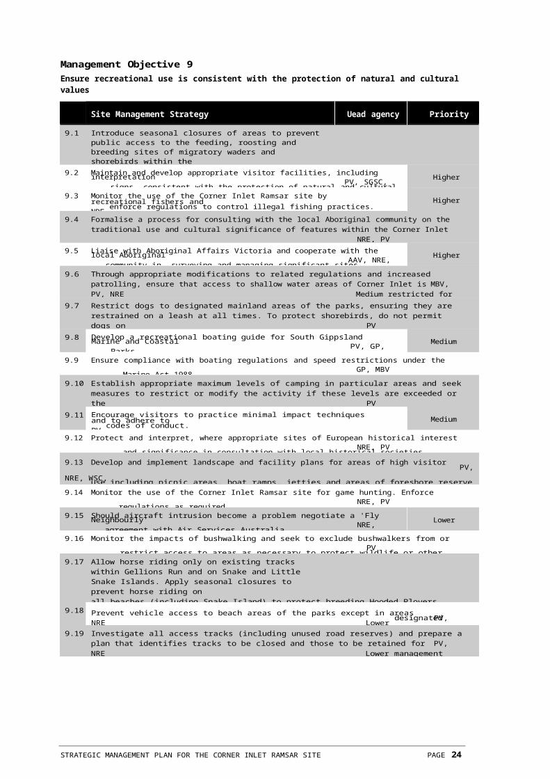
Parks Victoria (1997) Wilsons Promontory National Park Management Plan. Parks Victoria, Melbourne.
Rosengren, N.J. (1989) Sites of geological and geomorphological significance in the South Gippsland Marine and Coastal Parks. An unpublished report to the Department of Conservation, Forests and Lands.
Roob, R., Morris, P. & Werner, G. (1998) Victorian Marine Habitat Database - Seagrass Corner Inlet & Nooramunga. The Marine & Freshwater Resources Institute, Report No. 10. Dept. Natural Resources & Environment, Melbourne, Australia.
Trowbridge, C.D. (1999) An Assessment of the Potential Spread and Options for Control of the
Introduced Green Macroalga Codium fragile Ssp. tomentosoides on Australian Shores. Technical Report of CSIRO Centre for Research on Introduced Marine Pests.
Watkins, D. (1993) A National Plan for Shorebird Conservation in Australia. Australasian Wader Studies Group. Royal Australasian Ornithologists Union and World Wide Fund for Nature, Australia.
West Gippsland Regional Catchment & Land Protection Board, (1997) West Gippsland Regional Catchment Strategy, West Gippsland Regional Catchment and Land Protection Board, Victoria, Australia.

STRATEGIC MANAGEMENT PLAN FOR THE CORNER INLET RAMSAR SITE PAGE 27

Appendix 1 List of Contributors
Multi-disciplinary Project Team Members
Kate Maltby Conservation Strategy Officer, National Parks Policy and Strategy Division, Parks Victoria
Graeme Davis Chief Ranger, West Gippsland
District, Parks Victoria
Ross Williamson Ranger In Charge, WestGippsland District, Parks Victoria
Greg Mattingley District Project Manager, WestGippsland District, Parks Victoria
Brett Lane Natural Resource Specialist, PPK Environment and Infrastructure Pty Ltd
Public Submissions
Australasian Wader Study Group
Australian Conservation
Foundation Bird Observers Club
of Australia Birds Australia
Chris Harty Planning and Environmental
Management Environment Australia
Field and Game Australia
Inc. Gippsland Ports
NRE (Gippsland
Region) Forests Service
(NRE) Fisheries
Victoria (NRE) Prom
Coast Tourism Inc.
Stuart, Peter
Victorian National Parks
Association Victorian Wader Study
Group Inc.

STRATEGIC MANAGEMENT PLAN FOR THE CORNER INLET RAMSAR SITE PAGE 28

Appendix 2 Threatened Status of Flora
Threatened in Victoria
Nationally threatenedScientific name Common name FFG Uisted
Acacia verticillata var. latifolia Broad-leaf Prickly Moses r
Atriplex australasica Native Orache k
Avicennia marina ssp. australasica White Mangrove r
Berula ? erecta Water Parsnip k
Caladenia aurantiaca Orange-tip Caladenia r
Correa reflexa var. speciosa Eastern Correa r
Corybas fimbriatus Fringed Helmet-orchid r
Eucalyptus kitsoniana Bog Gum r R
Exocarpos syrticola Coast Ballart r
Lepidium desvauxii Bushy Pepper-cress r
Limonium australe Yellow Sea-lavender r
Senecio diaschides Shingle Fireweed r
Stackhousia spathulata Coast Stackhousia k
Triglochin minutissimum Tiny Arrowgrass r
Source: Flora Information System (1998)
e Endangered in Victoria, i.e. rare and at risk of disappearing from the wild state if present land use and other causal factors continue to operate.
v Vulnerable in Victoria, i.e. rare, not presently endangered but likely to become so soon due to continued depletion, or which largely occur on sites likely to experience changes in land use which would threaten the survival of the species in the wild.
r Plants which are rare in Victoria but which are not considered otherwise threatened. This category does not necessarily imply that plants are substantially threatened, but merely that there are relatively few known stands.
k species poorly known, suspected of being in one of the above categories.
E Endangered species in serious risk of disappearing from the wild state within one or two years if present land use and other causal factors continue to operate.
V Vulnerable species not presently endangered but at risk over a longer period through continued depletion, or which largely occur on sites likely to experience changes in land use whic h would threaten the survival of the species in the wild.
R Species that are rare in Australia but which are not currently considered endangered or vulnerable. Such species may be represented by a relatively large population in very restricted areas or by smaller populations spread over a wider range.
L Listed under the Flora and Fauna Guarantee Act 1988.
STRATEGIC MANAGEMENT PLAN FOR THE CORNER INLET RAMSAR SITE PAGE 29

Appendix 3 Threatened Status of Fauna
Threatened in Victoria
Nationally threatenedScientific name Common name FFG Uisted
Birds
Ardea alba Great Egret L End
Biziura lobata Musk Duck Vul
Cereopsis novaehollandiae Cape Barren Goose Vul
Coturnix australis Brown Quail DD
Egretta garzetta Little Egret CEn
Haliaeetus leucogaster White-bellied Sea-Eagle L End
Hylacola pyrrhopygia Chestnut-rumped Heathwren DD
Larus dominicanus Kelp Gull CEn
Larus pacificus Pacific Gull LR
Lathamus discolor Swift Parrot L End Vul
Macronectes halli Northern Giant-Petrel End
Morus serrator Australasian Gannet Vul
Neophema chrysogaster Orange-bellied Parrot L CEn End
Numenius madagascariensis Eastern Curlew LR
Pezoporus wallicus Ground Parrot L Vul
Phalacrocorax fuscescens Black-faced Cormorant Vul
Phalacrocorax varius Pied Cormorant LR
Platalea regia Royal Spoonbill Vul
Rallus pectoralis Lewin's Rail End
Sterna albifrons Little Tern L Vul End
Sterna bergii Crested Tern LR
Sterna caspia Caspian Tern Vul
Sterna nereis Fairy Tern L Vul
Sterna nilotica Gull-billed Tern End
Thinornis rubricollis Hooded Plover L End Vul
Other
Antechinus minimus Swamp Antechinus LR
Dermochelys coriacea Leathery Turtle End Vul
Egernia coventryi Swamp Skink Vul
Eubalaena australis Southern Right Whale L CEn End
Litoria raniformis Warty Bell Frog Vul
Pseudemoia rawlinsoni Glossy Grass Skink LR
CEn Critically Endangered: A taxon facing an extremely high risk of extinction in the wild in the immediate future.
End Endangered: A taxon that is not Critically Endangered but is facing a very high risk of extinction in the wild in the immediate future.
Vul Vulnerable: A taxon that is not Critically Endangered or Endangered but is facing a high risk of extinction in the wild in the medium-term future.
LR Lower Risk - near threatened: A taxon that does not satisfy criteria for any of the threatened categories, but
which is close to qualifying for Vulnerable. In practice, these species are likely to move into a threatened category should current declines continue or catastrophes befall the species.
DD Data Deficient: A taxon that has inadequate information to make a dire ct or indirect assessment of its risk of extinction based on its distribution or population status. Listing of taxa in this category indicates that more information is required and acknowledges the possibility that future investigations will show that a threatened classification is appropriate.
L Listed under the Flora and Fauna Guarantee Act 1988.
STRATEGIC MANAGEMENT PLAN FOR THE CORNER INLET RAMSAR SITE PAGE 30

Appendix 4 JAMBA, CAMBA and Bonn Species
Scientific Name Common name JAMBA CAMBA Bonn
Ardea alba Great Egret ✓ ✓
Ardea ibis Cattle Egret ✓ ✓
Arenaria interpres Ruddy Turnstone ✓ ✓ ✓
Calidris acuminata Sharp-tailed Sandpiper ✓ ✓ ✓
Calidris alba Sanderling ✓ ✓ ✓
Calidris canutus Red Knot ✓ ✓ ✓
Calidris ferruginea Curlew Sandpiper ✓ ✓ ✓
Calidris ruficollis Red-necked Stint ✓ ✓ ✓
Calidris tenuirostris Great Knot ✓ ✓ ✓
Charadrius leschenaultii Greater Sand Plover ✓ ✓ ✓
Charadrius mongolus Lesser Sand Plover ✓ ✓ ✓
Gallinago hardwickii Latham's Snipe ✓ ✓ ✓
Haliaeetus leucogaster White-bellied Sea-Eagle ✓ ✓
Heteroscelus brevipes Grey-tailed Tattler ✓ ✓ ✓
Hirundapus caudacutus White-throated Needletail ✓
Limosa lapponica Bar-tailed Godwit ✓ ✓ ✓Limosa limosa Black-tailed Godwit ✓ ✓ ✓
Numenius madagascariensis Eastern Curlew ✓ ✓ ✓
Numenius phaeopus Whimbrel ✓ ✓ ✓
Pluvialis fulva Pacific Golden Plover ✓
Pluvialis squatarola Grey Plover ✓ ✓ ✓
Puffinus tenuirostris Short-tailed Shearwater ✓ ✓
Sterna albifrons Little Tern ✓ ✓ ✓Sterna caspia Caspian Tern ✓ ✓
Sterna hirundo Common Tern ✓ ✓ ✓
Tringa nebularia Common Greenshank ✓ ✓ ✓
Tringa stagnatilis Marsh Sandpiper ✓ ✓ ✓
Xenus cinereus Terek Sandpiper ✓ ✓ ✓
STRATEGIC MANAGEMENT PLAN FOR THE CORNER INLET RAMSAR SITE PAGE 31

Appendix 5 Corner Inlet Ramsar Information Sheet1
Information Sheet on Ramsar Wetlands
Categories approved by Recommendation 4.7 of the Conference of the Contracting Parties.
1. Date this sheet was completed/updated:May 1999
2. Country:Australia
3. Name of wetland:Corner Inlet, Victoria
4. Geographical coordinates:Latitude: 38°36' to 38° 55'S
Longitude: 146° 11' to 146° 53'E
5. Altitude:Less than 20 metres
6. Area:67,186 ha
Note: This is a revised area figure based on GIS Mapping (1995) and does not represent any change to the Ramsar Site boundary.
7. Overview:The Corner Inlet Ramsar site is the most southerly marine embayment and tidal mudflat system of mainland Australia. The site is of international zoological significance as habitat for migratory wading birds. The barrier islands are of national botanical significance due to their biogeographic importance, and national geomorphological significance as an example of barrier island formation.
8. Wetland Type:Marine : A, G, H and I
9. Ramsar Criteria:1a, 1b, 1c, 2b, 3a, 3b and 3c
Please specify the most significant criterion applicable to the site:
10. Map of site included?Please tick yes ✓ -or- no D
11. Name and address of the compiler of this form:
Parks Victoria 378 Cotham RoadKew VIC 3101 Australia
12. Justification of the criteria selected under point 9:1(a) The wetland is a particularly good representative example of a natural or near-natural wetland characteristic of the appropriate biogeographical region.
Corner Inlet is the best example of a wetland enclosed by barrier islands in the South East Coastal Plain.
1(b) The wetland is a particularly good representative example of a natural or near-natural wetland common to more than one biogeographical region.
Corner Inlet is a very good example of a wetland enclosed by barrier islands in Victoria and contains the most extensive intertidal mudflats in Victoria.
1(c) The wetland is a particularly good representative example of a natural or near-natural wetland common to more than one biogeographical region.
Corner Inlet plays a substantial hydrological role in the natural functioning of a major coastal system.
2(b) A wetland is of special value for maintaining the genetic and ecological diversity of a region because of the quality and peculiarities of its flora and fauna.
Corner Inlet contains the most southerly occurrence of White Mangrove (Avicennia marina) in the world (Frood 1986).
3(a) Regularly supports 20,000
waterfowl and
3(b) Regularly supports substantial numbers of waterfowl from particular groups
and
3(c) Regularly supports 1% on the individuals in a population of one species or subspecies
Corner Inlet regularly supports over 20% of the total known Victorian wader population and an estimated 50% of the over-wintering Victorian population of migratory wader species (Martindale 1982).

1 Ramsar Information Sheets are updated every six years. The last update was in 1999. New or revised information will be
incorporated in the next update, due in 2005.
STRATEGIC MANAGEMENT PLAN FOR THE CORNER INLET RAMSAR SITE PAGE 32

Corner inlet supports more than 1% of the national wader population and may contain 15% of the world population of Eastern Curlew (Numenius madagascariensis) (Mansergh & Norris 1982).
Corner Inlet supports a high percentage of the Victorian populations of the following species:• Pied Oystercatcher (Haematopus
ostralegus) 68%• Sooty Oystercatcher (Haematopus
fuliginosus) 44%• Grey Plover (Pluvialis squatarola) 95%• Mongolian Plover (Charadrius mongolus) 65%• Eastern Curlew 46%• Bar-tailed Godwit (Limosa lapponica) 89%• Red Knot (Calidris canutus) 65%• Great Knot (Calidris tenuirostris) 26%• Red-necked Stint (Calidris ruficollis) 17%• Curlew Sandpiper (Calidris ferruginea) 17%• Sandeling (Calidris alba) 11% (Mansergh
and Norris 1982).
Corner Inlet supports at least 5% of the State's population of Chestnut Teal (Anas castanea) (Corrick pers. comm.).
Corner Inlet contains 10% of the State's breeding population of Little Tern (Sterna albifrons) (Corrick pers. comm.) and Pied Oystercatcher (Haematopus ostralegus) (Dann pers. comm.). The area is used by Black Swans (Cygnus atracus) as a feeding and moulting area after breeding. Up to 10,000 Swans occur in the inlet at these times. This is over 5% of the State population and over 10% of the regional population (Norman pers. comm., Hewish 1988, Peter 1989, Peter 1990, Peter 1991).
13. General location:South eastern coast of Victoria, Australia, north east of Wilsons Promontory.
14. Physical features:Corner Inlet is bounded to the west and north by the South Gippsland coastline, in the south-east by a series of barrier islands and sandy spits lying end to end and separated by narrow entrances and to the south by the hills of Wilsons Promontory.
The chain of barrier islands are a westward extension of the Ninety Mile Beach and are of complex form and origin. They provide an outstanding example of the processes involved in barrier island formation including the development of multiple beach ridges, lagoons and swamps, tidal creeks, tidal deltas, and tidal washovers. As well as providing localities for the monitoring of sediment dynamics associated with marine and aeolian processes, they are of critical importance in the analysis of the evolution of the entire coastal barrier system between Wilsons Promontory and Lakes Entrance.
The main channels of the Inlet are continuous with the Franklin, Albert and Tarra Rivers which drain the catchment area of some 2300 km2 into the embayment and out into Bass Strait through the Main, Port Albert, Kate Kearney, Shoal and McLoughlins Beach Entrances.
15. Hydrological values:Seven secondary treated effluents licensed by the Environmental Protection Agency are discharged into the embayment.
16. Ecological features:The mainland coast and several sandy islands are covered with mangroves, saltmarshes, sandy beaches and very extensive intertidal mudflats. The area contains the only extensive bed of the broad- leafed seagrass Posidonia australis in Victoria. The fine-leafed seagrasses, Zostera muelleri and Heterzostera tasmanica, occur in shallow water throughout the whole of the embayment.
Organisms living on the sea floor and within the sediment of the mudflats and sand flats are typical of unpolluted, non-estuarine soft sediments. There is a wide variety of species of polychaetes and amphipods, and large numbers of several species of bivalve molluscs, crabs, and burrowing sea anemones.
17. Noteworthy flora:The islands of Corner Inlet are of national botanical significance. Although not floristically rich, the islands are of high biogeographical significance as a result of their past submergences. The islands also contain significant areas of saltmarsh and mangroves, both of which are communities of very limited distribution. It is thought that the five main vegetation communities on Sunday and Clonmel Islands represent stages in primary plant succession on coastal islands.
Threatened Flora
• Adriana quadripartita s.s (globulous form) (Rare Bitter-bush) - endangered in Victoria
• Asplenium obtusatum (Shore Spleenwort) -vulnerable in Victoria
• Austrofestuca littoralis (Coast Fescue) - vulnerable in Victoria
• Cyathodes juniperinum (Crimson Berry) -vulnerable in Victoria
• Eucalyptus kitsoniana (Bog Gum) - vulnerable in Australia, rare in Victoria
• Exocarpus syrticola (Coast Ballart) - rare inVictoria
• Lepidium desvauxi (Bushy Pepper-cress) - rare in Victoria
• Prasophyllum paruifloum (Slender Leek-orchid) - vulnerable in Victoria

STRATEGIC MANAGEMENT PLAN FOR THE CORNER INLET RAMSAR SITE PAGE 33

• Pterostylis aciculiforris (Slender Ruddyhood) - insufficiently known in Victoria
• Pterostylis grandiflora (Cobra Greenhood) - rare
in Victoria• Senecio diagchides (Erect Groundsel) -
rare in Victoria• Thelymitra epipactoides (Metallic Sun-orchid) -
endangered in Australia and Victoria• Triglochin minutissima (Tiny Arrow-grass) -
rare in Victoria• Helichrysum dealbatum (Silver Everlasting) -
rare in Victoria.
The most southerly occurrence of Avicennia marina(White Mangrove) is at Corner Inlet.
18. Noteworthy fauna:Corner Inlet is of international zoological significance for its migratory wader population. Thirty-two wader species have been recorded. The area regularly supports an estimated 29000 waders (migratory and non-migratory) which represents 21.5% of the total known Victorian wader population and includes the majority of Victoria's population of less abundant wader species. It is estimated that nearly 50% of the overwintering migratory waders in Victoria occur in Corner Inlet. The overwintering birds are predominantly juveniles.
While in Australia these waders have two major habitat requirements - feeding and roosting sites. Corner Inlet provides extensive tidal flats that are exposed at low tide, which are important feeding areas for waders. When the tide covers the feeding areas the waders congregate at specific roosting sites, which are located above high-water mark on the numerous islands and the extensive coastal strip around the inlet. Over forty roosting sites have been located around here.
Corner Inlet supports more than 10% of the Victorian population of the following waders: Pied Oystercatcher (68%), Sooty Oystercatcher (44%), Grey Plover (95%), Mongolian Plover (65%), Eastern Curlew (46%), Bar-tailed Godwit (89%), Red Knot (65%), Great Knot (26%), Red-necked Stint (17%),Curlew Sandpiper (19%), Sanderling (11%).
The threatened species Little Tern (endangered in Victoria) and Fairy Tern (vulnerable in Victoria) breed at Corner Inlet.
The Inlet supports large numbers of waterfowl particularly Black Swan and is used by up to 20% of Victorian Populations of Chestnut Teal during summer and autumn. During drought numbers of other ducks e.g. Black Duck and Grey Teal are greatest.
It is thought that the area may contain over 15% of the world population of the Eastern Curlew.
Threate n ed
S p e c i es Birds:
• Great Egret (Ardea alba) - restricted colonialbreeding in Victoria
• Cape Barron Goose (Cereopsis novaehollandiae) - rare in Victoria
• Spot-tailed Quoll (Dasyurus maculatus) - vulnerable in Victoria
• Caspian Tern (Hydroprogne caspia) - restrictedcolonial breeding in Victoria (this species breeds at Corner Inlet)
• White-bellied Sea-Eagle (Haliaeetusleucogaster) - rare in Victoria
• Pacific Gull (Larus pacificus) - restricted colonial breeding in Victoria
• Swift Parrot (Lathamus discolor) - endangered in
Victoria and vulnerable nationally• Orange-bellied Parrot (Neophema chrysogaster)
- endangered in Victoria and nationally• Eastern Curlew (Numenius
madagascariensis) - rare in Victoria• Australian Pelican (Pelecanus conspicillatus) -
restricted colonial breeding in Victoria• Ground Parrot (Pezoporus wallicus) -
rare in Victoria• Black-faced Cormorant (Phalacrocorax
fuscescens) - restricted colonial breeding in Victoria
• Lewin's Rail (Rallus pectoralis) - rare in Victoria• Little Tern (Sterna albifrons) -
endangered in Victoria and nationally• Crested Tern (Sterna bergii) - restricted colonial
breeding in Victoria• Fairy Tern (Sterna nereis) - vulnerable in Victoria• Hooded Plover (Thinornis
rubricollis) - vulnerable in Victoria• Tasmanian Pademelon (Thylogale billardierii) -
presumed extinct
Mammals:
• Southern Right Whale (Eubalaena australis) -endangered in Victoria and nationally
• Glossy Grass Skink (Pseudemoia rawlinsoni) - insufficiently known
• New Holland Mouse (Pseudomysnovaehollandiae) - endangered in Victoria
• Swamp Antechinus (Antechinus minimus) - rare in Victoria
The islands also support a major proportion of the Victorian Hog Deer population. The Victorian population is apparently the only wild population extant outside the native range of the species. Within its native range the species has declined,

in India it is
STRATEGIC MANAGEMENT PLAN FOR THE CORNER INLET RAMSAR SITE PAGE 34

Corner Inlet and Nooramunga Marine andCoastal Parks
• 6,473 hectares - other public land• 1,824 hectares - freehold
largely confined to sanctuaries and in Ceylon it is perhaps extinct.
19. Social and cultural values:There are numerous shipwreck sites in Corner Inlet and around the barrier islands.
20. Uand tenure/ownership:• 58,889 hectares - parks and reserves including
21. Current land use:(a) the site: Reserve for biological conservation; ports with servicing facilities for off-shore oil and natural gas exploration, licensed waste discharges, commercial fishing, recreational fishing, intertidal collecting (for bait), recreation.
(b) the surroundings/catchment: Forestry, grazing, dairying.
22. Factors (past, present or potential) adversely affecting the site's ecological character, including changes in land use and development projects:No significant ecological change has occurred since the last update of the Ramsar information sheet in 1992. Factors affecting the ecological character at selected areas within the site include:
• The potential for oil spillages from either offshore drilling, accident or disposal of ship's waste.
• Spread of introduced Spartina sp.
• Dieback of Posidonia beds (approximately 20- 25% of Posidonia present in 1976 had disappeared by 1984).
In the late 1980s Codium fragile ssp tomentosoides, an introduced algal subspecies, was detected and the infested area is continuing to expand. The ecological impact of Codium fragile ssp tomentosoides is unknown and, other than physical removal, there is no known control method.
23. Conservation measures taken:The Draft Corner Inlet and Nooramunga Marine and Coastal Parks Management Plan (1996) outlines strategies for protection of the natural values of the parks. It is due to be finalised by the end of 1998.
A cord grass (Spartina sp.) control program has been implemented which has resulted in a significant reduction of the weed since 1996 in the treated area. However, some areas still require treatment.
A fox control program on selected barrier islands to protect nesting shore birds such as terns and
hooded plovers has been implemented.

A ongoing nesting shore birds monitoring program has been implemented.
Action Statements under the Flora and Fauna Guarantee Act 1988 have been produced for the following fauna species which occur in the Ramsar site. They outline measures to conserve these species.
• White-bellied Sea-eagle (1994)• Orange-bellied Parrot (1993)• Little Tern (1994)• Hooded Plover (1992)• Tasmanian Pademelon (presumed
extinct) (1997)• New Holland Mouse (1996)
24. Conservation measures proposed but not yet implemented:Seagrass in Corner Inlet has been mapped and a report is currently being finalised. The mapping provides a baseline for future seagrass monitoring.
A literature review of the ecological impacts of Codium fragile ssp tomentosoides and possible control techniques has been initiated and will be completed by 1 August 1998.
A fisheries habitat assessment report is being prepared.
In an integrated approach to planning at Ramsar sites, management strategies are being prepared for all Ramsar sites in Victoria, including Corner Inlet, to provide general strategic direction and site specific strategies. The strategies will be completed by June 1999.
25. Current scientific research and facilities:Long term monitoring of Chestnut Teal numbers.
26. Current conservation education:Snake Island is used annually as a field site to study floristic composition and fire ecology by Melbourne University.
27. Current recreation and tourism:Recreational fishing, swimming, surfing, boating, sightseeing, yachting, canoeing, hunting.
28. Jurisdiction:Government of Victoria.
29. Management authority:Managed under the Department of Natural Resources and Environment Parks Program by Parks Victoria - 58,910 Ha (88%)
Private Freehold - 1,824 Ha (2.7%)
Victorian Channels Authority - 6,452 Ha (9.27%)
STRATEGIC MANAGEMENT PLAN FOR THE CORNER INLET RAMSAR SITE PAGE 35

30. Bibliographical references:Department of Conservation and Environment (1996) Corner Inlet and Nooramunga Marine and Coastal Parks Draft Management Plan. Department of Conservation and Environment, Victoria.
Fisheries and Wildlife Division and National Parks Service (1984) Draft Zoning Plan for Proposed Wilsons Promontory Marine Reserve and Corner Inlet, Nooramunga and Shallow Inlet Marine and Wildlife Reserves, April 1984. Department of Conservation, Forests and Lands.
Frood, D. (1986) Vegetation Types and Significant Terrestrial Flora in the Proposed South Gippsland Marine and Wildlife Reserves. National Parks Service, Department of Conservation, Forest and Lands.
Hewish, M. (1988) Waterfowl Count in Victoria, February 1988. Report No. 42.
Mansergh, I.E. & Norris R.C. (1982) Sites of Zoological Significance in Central Gippsland. E.S.P. No.359. Ministry for Conservation Victoria.
Martindale, J. (1982) A Study of Wading Birds in Corner Inlet. Arthur Rylah Institute Technical Report No. 4. Fisheries and Wildlife Department, Ministry for Conservation.
Norman, F. I. (1983) Grey Teal, Chestnut teal and Pacific black duck at a saline habitat in Victoria. EMU 83: 262-71.
Peter, J. (1989) Waterfowl Count in Victoria, February 1989. Report No. 57.
Peter, J. (1990) Waterfowl Count in Victoria, February 1990. Report No. 72.
Peter, J. (1991) Waterfowl Count in Victoria, February 1991. Report No. 79.
Personal CommunicationsCorrick, Andrew. Department of Conservation and Environment, Arthur Rylah Institute.
Dann, Peter. Research Biologist. Penguin
Reserve. Norman, Ian. Department of
Conservation andEnvironment. Arthur Rylah Institute.
STRATEGIC MANAGEMENT PLAN FOR THE CORNER INLET RAMSAR SITE PAGE 36


![untitled [parkweb.vic.gov.au]parkweb.vic.gov.au/__data/assets/word_doc/0003/... · Web viewThe MCMC has a long history in advocacy and on‐ground works for the protection and enhancement](https://img.pdfslide.net/doc/110x75/5a718b767f8b9a98538cff18/untitled-parkwebvicgovauparkwebvicgovaudataassetsworddoc0003doc.jpg)