Embed Size (px)
Citation preview

www.ssoar.info
Religion, space and social status: monasteryfounders in the Curvature Carpathians, RomaniaButerez, Cezar
Veröffentlichungsversion / Published VersionZeitschriftenartikel / journal article
Empfohlene Zitierung / Suggested Citation:Buterez, C. (2015). Religion, space and social status: monastery founders in the Curvature Carpathians, Romania.Cinq Continents, 5(11), 5-19. https://nbn-resolving.org/urn:nbn:de:0168-ssoar-453529
Nutzungsbedingungen:Dieser Text wird unter einer CC BY Lizenz (Namensnennung) zurVerfügung gestellt. Nähere Auskünfte zu den CC-Lizenzen findenSie hier:https://creativecommons.org/licenses/by/4.0/deed.de
Terms of use:This document is made available under a CC BY Licence(Attribution). For more Information see:https://creativecommons.org/licenses/by/4.0

RELIGION, SPACE AND SOCIAL STATUS. MONASTERY FOUNDERS IN
THE CURVATURE CARPATHIANS, ROMANIA
Cezar BUTEREZ
Contents: 1. INTRODUCTION .............................................................................................................................................................................. 7 2. STUDY AREA .................................................................................................................................................................................... 8 3. METHODS .......................................................................................................................................................................................... 9 4. RESULTS .......................................................................................................................................................................................... 11 5. CONCLUSIONS .............................................................................................................................................................................. 17 6. ACKNOWLEDGEMENTS ........................................................................................................................................................... 17 7. REFERENCES................................................................................................................................................................................. 18
Cite this document: Buterez, C., 2015. Religion, space and social status. Monastery founders in the Curvature Carpathians, Romania. Cinq Continents 5 (11): 5-19
Volume 5 / Numéro 11
Eté 2015
ISSN: 2247 - 2290
p. 5-19
Faculty of Geography, University of Bucharest [email protected]

Cinq Continents Volume 5, Numéro 11, 2015, p. 5-19
[6]
Religion, space and social status. Monastery founders in the Curvature Carpathians, Romania
Cezar Buterez
Religie, spațiu și statut social. Ctitorii de mănăstiri de la Curbura Carpaților, România. Regiunea Carpaților de Curbură a reprezentat unul din cele mai mari trei centre monahale din statele românești medievale și totodată singurul care a fost concentrat în jurul unui vast complex de biserici rupestre. Studiile privitoare la o posibilă origine paleocreștină precum și istoriile individuale au constituit baza cercetărilor științifice cu privire la mănăstiri, în timp ce studiile de ansamblu au evitat examinarea problemei ctitorilor. Cu toate acestea, actul de ctitorire purta o semnificație simbolică, iar statutul de ctitor avea o importanță aparte, atât din punct de vedere social, cât și spiritual. Bazându-se pe o abordare istorico-geografică, această lucrare va încerca să analizeze distribuția spațială a mănăstirilor în funcție de statutul social al ctitorilor acestora și să ofere o interpretare a modului în care acest statut social, precum și tradițiile religioase au contribuit la apariția și dezvoltarea mănăstirilor și a vieții monahale.Cuvinte cheie: împădurire, GIS, Model Builder, Buzău, scurgere de suprafață. Cuvinte cheie: istoria monahismului, geografie istorică, GIS, Carpații de Curbură, România
Religion, space and social status. Monastery founders in the Curvature Carpathians, Romania. The area of the Curvature Carpathians was one of the three largest monastic centres in the mediaeval Romanian countries, and the only one which had concentrated around a previous vast network of rock-hewn churches. The themes of an early Christian origin and that of individual histories have been central to the scholarly investigation of the monasteries, while overview studies generally avoided exploring them in relation to their founders. Yet, the act of founding bore a symbolic meaning and one’s capacity as founder was something of great importance, both social and spiritually. Drawing on a historical-geographical approach, this paper will try to analyse the spatial distribution of the monasteries according to their founders’ social status and offer an interpretation of how this social status and religious traditions have contributed to the emergence and growth of the monasteries and monastic life. Keywords: history of monasticism, historical geography, GIS, Curvature Carpathians, Romania.

C. BUTEREZ
1. INTRODUCTION
Monasticism has always been a vital part of the Orthodox Christian faith. It is
considered to be based on the words of Christ who was asked by a young man: “What
good thing shall I do, that I may have eternal life?” He answered: “If thou wilt be perfect,
go and sell that thou hast, and give to the poor, and thou shalt have treasure in heaven:
and come and follow me” (Mt. 19:16, 21) [1]. Thus monasticism is not an obligation for
all people; it is a burden only for those who willingly take it in pursuit of spiritual
accomplishment. Beginning in Egypt, with saints such as St. Anthony the Great and St.
Paul the Anchorite, it continuously spread to Rome, Constantinople, and Cappadocia, and
ultimately it arrived and became a central aspect of life in Eastern Europe [2] .
The beginnings of Romanian monasticism are considered to be as old as
Christianity itself, the teachings of Jesus Christ being propagated to Dobrudja, according
to tradition, by Saint Andrew the Apostle [3]. Most of the citadels and places of worship
of Dobrudja were destroyed by Slavs in the eight century, some theologians arguing that
the monks took refuge in the Buzău Mountains (part of the Curvature Carpathians),
where they gave rise to one of the largest monastic centres in the Carpathians [4]. This
theory revolves around the existence in the Buzău Mountains of a complex of rock-hewn
vestiges similar to that of Ivanovo in Bulgaria [5], first studied by the renowned
Romanian archaeologist Alexandru Odobescu in 1871 [6]. Most researchers see these
remains as the clearest expression of early Christianity and anchoritic monasticism at
the Carpathian Curvature [4], though we still lack any piece of documentary or
archaeological evidence in support to this statement. According to other opinions based
on the scarce information found in mediaeval documents, the monasticism of the
Curvature Carpathians would be of later origin, possibly linking with the activity of Saint
Theodosius at Kelifarevo, Bulgaria, and its promotion of hesychasm in the fourteenth
century, beyond the river Danube [7] [8]. Indeed, hesychasm was practiced by hermit
monks in the Buzău region, but, like their counterparts from the Orthodox world, details
about their solitary lives went almost unrecorded in history [9]. Some clues about the
anchoritic past may lie in the patron saints (in Romanian ‘hramuri’) of the oldest sketes,
all of them considered to be of hesychast origin [7]. Other clues can be found in the
oldest historical document kept, which only mentions the transition from the anchoritic
to the coenobitic way of life, which dates to the second half of the sixteenth century [10].
Of the three sketes mentioned in the document, at least one of them, Agaton, had a rock-
hewn church, the second, Motnău, had a wooden church, and the third, Bogoslovul, still
remains unidentified, although most researchers believe that it had a rock-hewn church
too [11] [12] [10]. Even after the establishment of the coenobiums, hermit monks
continued to exist, and all forms of monasticism flourished in the seventeenth century to
such an extent that the Buzău region became famous for its monasteries and sketes, and
Cinq Continents Volume 5, Numéro 11, 2015, p. 5-19
[8]
the Steward Constantin Cantacuzino recorded this on his Map of Walachia from 1700, as
“Schiturile monahilor” (The hermitages of the monks, [13]). Despite the slight overall
downfall of monasticism in the eighteenth century caused by the harsh politics of the
Phanariote Princes and the never-ending conflicts with local peasants and boyars, the
monks started yearning about hesychasm and some decided to retreat again to more
remote areas. The rock-hewn churches and cells were once again used, as seen from
their abundance of mediaeval inscriptions [14]. It becomes no wonder that the
foundations of the southern Curvature Carpathians have sparked the interest of
researchers.
Individual studies have been made to almost all of the important monasteries
[15] [12] [16] [17], and several overview studies tried to build a historical database of
the places of worship from Buzău region [18] [19] [10]. The paradox is that although all
of these studies have dealt with the issue of the monastery founders, only one author
attempted to study the relationship between the founder and its foundation for more
than just one monastery [10]. In this paper we aim to continue and expand this
approach, by exploring the monasticism of Buzău region not only from a historical point
of view, but also from a geographical one, integrating information about both the social
status of the founders, church patrons and local characteristics of the monastic life as
revealed from historical documents and other primary unused sources..
2. STUDY AREA
The study area is located in the external Curvature of the Romanian Carpathians,
comprising both the extreme south of the Eastern Carpathians (Ivănețu Massif) and the
extended hilly lands situated south-east, which geographers have called the Buzău Sub-
Carpathians [20] (figure 1). This region, ranging from Teleajen river valley in the west,
and Râmnicu Sărat river valley in the east, stands out because it has been crossed only
by a single great commercial road in the Middle Ages [21]. The rest of it, especially the
north and north-eastern parts were relatively isolated, and are suspected to have been
part of a mediaeval micro-state run by an association of village communities [22].

C. BUTEREZ
Figure 1. The study area
3. METHODS
The main instrument used was the compilation of all the monastic establishments
that existed throughout the study area from the fifteenth to the nineteenth centuries. For
this arduous operation we have used a large number of historical documents from the
National State Archives, the Romanian Academy Library, the Buzău Diocese, and private
collections, part of them being already published in the Documente privind Istoria
României and the Documenta Romaniae Historica collections, or by other researchers.
All of these were coupled with the results from numerous field campaigns, conducted
systematically over the years 2008 – 2015. The final table contained one hundred and
ten monasteries and sketes attested in the historical documents at least once. For each
of them, we gathered basic information about its oldest name, year of founding or
attestation, age, founder, and patron saint (see Table 1).

Cinq Continents Volume 5, Numéro 11, 2015, p. 5-19
[10]
Table 1. Information collected for each monastery and skete
Locating them on the field was the next step. Most of them were identified using
the Romanian Topographical Maps known as the Army Shooting Plans (scale 1:20.000),
which were published and updated between 1916 and 1959, and considered to be the
best in respect to local toponymy [23]. Other places of worship were located using the
results of archaeological excavations which uncovered building ruins that could be
identified, based on the material found, with monastery and skete churches [24] [25]
[26]. Finally, with the help of micro-toponymy and collective memory, some
establishments were identified on the field, and their position recorded using a Garmin
GPSMAP 60CSx GPS receiver. From the total of one hundred monasteries and sketes,
only forty-eight were surely identified. Because of insufficient information, the
remaining fifty-two could not be precisely located, and therefore cannot be fully used in
this study.
All localized monasteries and sketes along with their basic information were
included as SHP vector files in a Geographical Information System (GIS) database, using
the Romanian National Stereografic 1970 projection system.
Data from the GPS was transferred to a PC using MapSource 6.15.11 software in
GPX format, which was then converted into SHP (shapefile) and reprojected to
Attribute GIS type Description name
string It contains the official name of the monastery as recorded in historical documents; if more than one name appears, the most accurate name is considered to be the oldest one attested.
year of founding or attestation
string It contains the year in which the monastery was founded, according to historical documents or church inscriptions (‘pisanie’); for the places of worship with no information about the date of founding, we introduced the year of their first attestation.
age short It contains the century in which the monastery was founded or was first attested.
location string Brief information about the location of the monastery as against settlements and main rivers.
founder string The social status of the monastery’s founder; where no reliable information is available, the field is marked unknown.
patron saint string The patron saint of the monastery, according to historical documents or church inscriptions (‘pisanie’); where no reliable information is available, the field is marked unknown.
current status short A code from 0 to 5, representing the current status of the monastery, from disappeared and identified (0) to functional (5)

C. BUTEREZ
15 16 17 18 19 20-21 unknown
0
10
20
30
40
50
century
nu
mb
er
of
est
ablis
hm
en
ts
identified unidentified
Stereografic 1970. Data processing was conducted using ESRI ArcGIS 10 and QGIS 2.6.0
Brighton. Further cartographic work was done using Inkscape 0.48.5.
Finally, for all of the eighty-nine monasteries and sketes, we added an attribute
which describes their current status, complementary to the location. The establishments
we consider as disappeared cease, at a given time, to be mentioned by historical
documents or cartographic materials. On the other hand, some of them are explicitly
documented as having been dissolved by the Bishop, although the exact reasons for this
are unknown. In some cases, even though the monastery or skete disappeared or was
dissolved, its church continued to be used for a village parish, or, when it was severely
damaged, a new church was constructed on another site for the same reason [4].
4. RESULTS
The age of the monasteries and sketes
Discussing the temporal point of view, we can refer to all one hundred and
fourteen monasteries and sketes that we could find, even if not located, since only three
of them are of unknown age. Yet, there is an important weakness of our approach, since
if a monastery is attested in the fifteenth century, it doesn’t necessarily mean that it was
established in that century.
What we can immediately assert is that the number of monasteries attested
increased progressively in each century up to the seventeenth, where there is the
maximum (thirty-six). After this moment, during the eighteenth century, their number
slightly decreased, for it to fall heavily during the nineteenth century (figure 2).
Figure 2. Graphic of the relative age of all one hundred and fourteen monasteries and sketes
Many of the monasteries received estates, new churches and other favours from
the Wallachian princes or other benefactors [19]. Also, a new trend appeared during the
seventeenth century: that of small sketes and hermitages founded by simple villagers,

Cinq Continents Volume 5, Numéro 11, 2015, p. 5-19
[12]
although their existence was usually quite short. Only the richest and most active of
them survived through the eighteenth century. The nineteenth century was crushing for
Romanian monasticism because of the Secularization of monastery estates proposed by
the prince Alexandru Ioan Cuza and approved by the Romanian Parliament in 1863 [27].
Only a few monasteries survive, and we think that apart from Nifon and Cetățuia , the
remaining seven must have been founded at least a century earlier, since the political
and economic situation of Wallachia (Romanian Principalities after 1859) was unstable.
To obtain an expressive view of how the age of the monasteries varies across
space, we interpolated the age attribute of the eighty-nine entries using the Topo to
Raster function of the 3D Analyst extension in Esri ArcMap 10 software package. The
result was a 300 m spatial resolution raster which in fact represents a digital age model
of the monasteries.
Figure 3. Map of the relative age of monastic settlements
The map reveals some extremely important issues (figure 3). We can distinguish
two areas of old age. The first is located on the Nișcov valley, and it appears as a linear
group on the ranging from west to east, continuing with newer establishments towards
the north-west of Buzău. The second core is in the north, in the Ivăneţu Massif. Unlike
that of Nișcov valley, this one is more homogeneous in terms of both space and time. Not
coincidentally, it overlaps almost perfectly over the area of the rock-hewn vestiges. Both
of these cores have developed far from trade routes, through hidden valleys, to which
C. BUTEREZ
the roads, even in the nineteenth century, were still considered inaccessible and
dangerous [28]. As we approach the main valleys and trade routes, the monasteries and
sketes become newer.
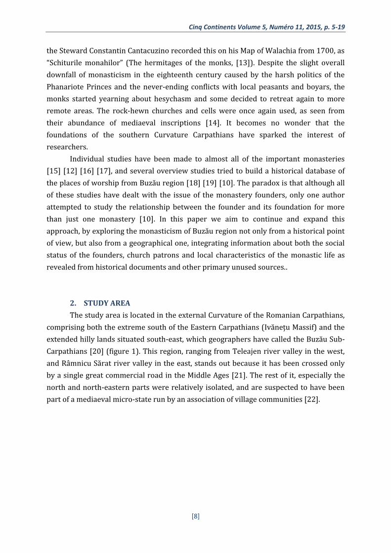
The current status of the monasteries and sketes
We have already discussed about the two old centers of monasticism in the Buzău
region, and about how it developed during the Middle Ages. Yet, if we look at today’s
monastic life, the picture is totally different. From the eighty-nine known monasteries
and sketes, only eighteen are still in function in 2015 (figure 4). Most of them have
disappeared (nineteen), or have been abolished (three), although in some cases, the
church is still used as a village parish.
Figure 4. Map of the current status of the monastic settlements
If we take a look at the distribution of the disappeared monasteries and sketes,
we can notice that again we have two core areas, which not surprisingly overlap almost
perfectly over the oldest monastic centers, Nișcov valley and Ivănețu Massif (figure 5). It
may be a clue that sometime in the past, the practice of monasticism undertook a major
change. The hesychasm loving hermits which found shelter in the rock-hewn cells of the
Ivănețu Massif were no longer a model of mediaeval monasticism. Apart from the overall
changes in the society, more and more laymen of different ranks interfered in their lives
and forced them to come out in the world, or to retreat even further. The spread of

Cinq Continents Volume 5, Numéro 11, 2015, p. 5-19
[14]
coenobitic life meant less predisposition to hesychasm. However, as the map points, the
age of hermits didn’t end until the eighteenth century, when the Wallachian throne was
taken over by Phanariote princes and the country was caught in the middle of the wars
between Russia, Austria and the Ottoman Empire [29].
Figure 5. Map of the disappeared monasteries and sketes, but identified on the field
The social status of the founders
In mediaeval times, the area between Teleajen and Râmnicu Sărat rivers was part
of Saac, Buzău and Râmnicu Sărat counties, located at the north-eastern edge of
Wallachia. Some historians and geographers consider that this area has had a particular
identity throughout the Middle Ages [30] [31], which resulted especially from the rare
contact between the boyars from Buzău and Râmnicu Sărat, and the princely authority
[32]. Until the eighteenth century, there was a series of extremely influent boyar
families, such as those of Vlaicu clucer, Mihalcea Cândescu, Neagu Bragă and those of
other high and mighty boyars attested in historical documents [33], whose vast lands on
the valleys of Buzău and Nișcov are attested starting with the fifteenth century, later
than other regions from Wallachia. Therefore, as other researchers have shown [32], in
the background of the influent boyars until the fifteenth century, the princely authority
in this area has been almost non-existent. The implication of the boyars in the fight for
the princely authority has been developing gradually and it culminated in the first half of
the sixteenth century with the enthronement of Vlad Vintilă, boyar from Buzău [34].

C. BUTEREZ
A bird’s eye view of the monastic establishments classified according to the social
status of the founders confirms to us the power, especially the financial one, of the local
boyars. This was the more significant as to the monasteries and sketes located with
certainty (and thus represented on the map) there can be added at least other four
monasteries founded undoubtedly by boyars, not precisely located, but attested all in
the sixteenth century, and considered to have existed immediately to the north of Buzău
valley in the sector Cislău – Berca [10]. Nevertheless, we can notice that they are only
concentrated on the valleys of Buzău and Nișcov, while to the north they are almost
absent (figure 6). Even the only boyar foundation from this area, Găvanele monastery,
founded by the Greceanu family, would only be their secondary foundation, built on the
spot of an older skete, of a hermitage origin [12].
Figure 6. Map of the monasteries and sketes classified according to the social status of the founders
We believe that this irregular distribution of the boyar foundations, only in the
southern half of the Buzău region shows, in fact, the extension of their ownership, where
their infiltration among the village communities took place earlier and in a more
significant way. Their number might be even bigger here, as we have information of only
three princely foundations built before the sixteenth century – Sfântu Gheorghe,
Menedic and Cârnu monasteries. Regarding the founder of the former one, there is a
dissent among researchers between Mihnea Turcitul [10] and Mihai Viteazul [19] [12],

Cinq Continents Volume 5, Numéro 11, 2015, p. 5-19
[16]
but in the case of Cârnu monastery, at the end of the sixteenth century, it has ended
under the possession of a boyar family.
The circumstances change starting with the seventeenth century, when the
majority of the boyar monasteries attested in the previous centuries vanishes from
documents, and Matei Basarab makes the symbolic gesture of reconstructing Pinu
monastery, by which he actually transferred all the little sketes under the princely
authority.
To see the importance of boyar foundations from another perspective, we can
note that their monasteries and sketes were, together with the clerics’, the only ones
who bore the name of their founders (figure 7). Apostolache, Barbu, Negoiță and the less
known monasteries of Radu Postelnic and Iordăcheanu, are all named after the boyars
who founded them, though the documents suggest that these names weren’t used until
the death of the founders. For example, the Barbu monastery is first attested as “the
monastery of Barbu the chancellor” [35]. Not surprisingly, some of the powerful boyar
foundations, by remaining in the care of later generations and with the help of the Buzău
Diocese, are still functional today.
Figure 7. Map of the monasteries and sketes which bore the name of their founders

C. BUTEREZ
5. CONCLUSIONS
In this paper we have proposed an alternate approach for analysing the
monasteries and sketes in the southern Curvature Carpathians in relation to the social
status of their founders. For such an historical and geographical analysis it is necessary
to have a wide range of data sources and methodologies, including archives, old
inscriptions, toponyms as well as a good knowledge of the study area. Our analysis
highlighted the power of the information contained in historical data when they are
stored and analysed using a Geographic Information System.
Such an approach has, like all of those in historical geography, has methodological
limitations. First, the data collection is based on information from historical documents
which exist only for a limited number of monasteries and sketes. Even in those available,
geographical descriptions or toponyms are not always present. As a result, of the one
hundred monasteries and sketes attested, only forty-eight could be identified on the
field and used in the analysis.
Nevertheless, the results obtained allowed us to better understand the role of the
social status founders in the apparition and development of their foundations. It
becomes more evident that monasticism in the Buzău region appeared in the areas that
were previously inhabited by monks who practiced hesychasm. Yet, this type of
monastic life was already very limited in the sixteenth century, when by a mixture of
factors, especially the involvement of boyars and the princes, coenobitic monasticism
was wide-spread. Up to the eighteenth century, the boyar foundations dominated the
south of the Buzău region due to their older possessions in the area, while the north
inherited the rock-hewn churches and still functioned as a magnet for hesychasm loving
monks.
Ultimately, the social instability of the nineteenth century and the Secularization
of 1863 led to the disappearance or dissolution of almost all of the monasteries and
sketes. While the tradition of the hermits from Ivănețu Massif became famous later and
their rock-hewn churches are now seen as having formed a small Mount Athos, the
boyar foundations from Nișcov valley have disappeared almost entirely, not only
physically, but also from local conscience, and no-one ever mentions that this area was
an important mediaeval monastic center.
6. ACKNOWLEDGEMENTS
This work has been supported from the strategic grant
POSDRU/159/1.5/S/133391, Project “Doctoral and Post-doctoral programs of
excellence for highly qualified human resources training for research in the field of Life
sciences, Environment and Earth Science” cofinanced by the European Social Fund
within the Sectorial Operational Program Human Resources Development 2007 – 2013.
Cinq Continents Volume 5, Numéro 11, 2015, p. 5-19
[18]
7. REFERENCES
[1] THE HOLY BIBLE. King James Version. New York: American Bible Society; 1999.
[2] MCGUCKIN JA. The Orthodox Church: An introduction to its history, doctrine, and
spiritual culture. Malden - Oxford: Blackwell; 2010. 480 p.
[3] PĂCURARIU M. Romanian Christianity. In: Parry K, editor. The Blackwell Companion
to Eastern Christianity. Chichester: John Wiley & Sons; 2010. p. 186-206.
[4] BĂLAN I. Vetre: de sihăstrie românească. I ed. București: Editura Institutului Biblic și
de Misiune Ortodoxă; 1982. 575 p.
[5] ANGELOV L, BEKIAROV T, KOZHUKHAROV S, KHANDZHIĬSKI A. Monuments of
Culture: The Kazanluk Tomb, the Madara Horseman, the Boyana Church, the Rock-
cut Churches of Ivanovo. Sofia: Sofia Press; 1983. 82 p.
[6] BUTEREZ C. Following a gentleman's expedition: Odobescu and the crypts from
northern Buzău. Journal of Maps. 2012;8(1):125-7.
[7] CHIHAIA P. Date noi despre bisericuțele rupestre din Munții Buzăului. Glasul
Bisericii. 1974:5-6.
[8] TURDEANU E. La littérature bulgare du XIVe siècle et sa diffusion dans les pays
roumains. Paris: Imprimerie Nationale, Librairie Droz; 1947. 188 p.
[9] BAKER ARH. “The dead don't answer questionnaires”: Researching and writing
historical geography. Journal of Geography in Higher Education. 1997;21(2):231-43.
[10] LUPU E. Ctitori și ctitorii la Curbura Carpaților în veacurile XIV-XVIII. Iași:
Doxologia; 2011. 355 p.
[11] CHIHAIA P. Un complex necunoscut de sihăstrii din Munții Buzăului din vremea lui
Neagoe Basarab. SCIA, seria Artă plastică. 1973;1:3-20.
[12] MÂNDRICEL I. Chemarea clopotelor scufundate. Buzău: Editura Vega; 2006. 324 p.
[13] GIURESCU CC. Harta Stolnicului Cantacuzino. O descriere a Munteniei la 1700.
București: Imprimeria Națională; 1943. 28 p.
[14] ŞTEFAN C, DRÂMBOCIANU V. Repertoriul vestigiilor rupestre din Munții Buzăului.
In: Ștefan C, editor. Vestigiile rupestre din Munții Buzăului,. Buzău: Arhivele
Statului Buzău; 1980. p. 47-65.
[15] GEORGIAN P, DOBRE C. Monografia sfintei Mănăstiri Ciolanu, jud. Buzău. București:
Cartea Românească; 1930. 116 p.
[16] CONSTANTINESCU H, COCORA G. Poiana Mărului. Glasul Bisericii. 1964;5-6:466-
500.
[17] COCORA G. Biserica de la Berca, monument de artă brâncovenească. Glasul Bisericii.
1963;5-6:515-34.

C. BUTEREZ
[18] STOICA N, STOICESCU N. Așezăminte monahale din eparhia Buzăului. In:
Plămădeală A, editor. Spiritualitate și istorie la Întorsura Carpaților. Buzău: Editura
Episcopiei Buzăului; 1983. p. 268-73.
[19] NOROCEL E. Ctitorii voievodale în Eparhia Buzăului: importante valori ale
patrimoniului țării noastre. Buzău: Editura Episcopiei Buzăului; 1988. 528 p.
[20] TUFESCU V. Subcarpații și depresiunile marginale ale Transilvaniei. București:
Editura Științificǎ; 1966. 256 p.
[21] CRUCERU AI, BUTEREZ C. Drumul Teleajenului și Drumul Buzăului. Noi repere
geografice și istorice. Mousaios. 2012(17):249-75.
[22] STAHL HH. Contribuții la studiul satelor devălmașe românești. București: Editura
Academiei R.S.R.; 1965.
[23] CRĂCIUNESCU V, RUS I, CONSTANTINESCU Ș, OVEJANU I, ZSOMBOR-BARTOS E.
Romanian maps under ‘Lambert-Cholesky’ (1916-1959) projection system2012
January 31, 2014. Available from: http://www.geo-
spatial.org/download/planurile-directoare-de-tragere?lang=en.
[24] DRĂGHICEANU V. Săpăturile din Buda-Lapoș și Tisău - Buzău. Buletinul Comisiunii
Monumentelor Istorice. 1931;24:159-76.
[25] DRĂGHICEANU V. Mănăstirea Vintilă Vodă (Buzău). Săpături la prima fundație.
Buletinul Comisiunii Monumentelor Istorice. 1933;26(78):167-71.
[26] LUPU E. Raport de cercetare arheologică – „Schitul lui Negoiță”. CCAR. 2002:280-1.
[27] HITCHINS K. The Romanians, 1774-1866: Clarendon Press Oxford; 1996.
[28] IORGULESCU B. Dicționar geografic, statistic, economic și istoric al județului Buzău.
București: Stabilimentul Grafic I. V. Socecu; 1892. 569 p.
[29] STONE DR. A military history of Russia: from Ivan the Terrible to the war in
Chechnya. Westport: Greenwood Publishing Group; 2006. 280 p.
[30] CAZACU M. La Valachie médiévale et moderne: esquisse historique. Cahiers
Balkaniques. 1994;21:95-158.
[31] TURNOCK D, MUICĂ N. Settlement of the Pătârlagele Depression (Romanian
Subcarpathians). Colne: LAP Lambert Academic Publishing; 2010. 368 p.
[32] COMAN M. Putere și teritoriu. Țara Românească medievală (secolele XIV-XVI).
București: Polirom; 2013. 360 p.
[33] STOICESCU N. Dicționar al marilor dregători din Țara Românească și Moldova.
București: Editura enciclopedică română; 1971. 456 p.
[34] IORGA N. Mănăstirea Vintilă Vodă. Observații și note istorice. Buletinul Comisiunii
Monumentelor Istorice. 1933;26(78):178-81.
[35] GRECIANU Ș. Genealogiile documentate ale familiilor boierești. București: MI; 1913.
480 p.