Embed Size (px)
Citation preview

SOCCOM.Act.PDS.1.1TrackingOceanCurrents
SOCCOM.Act.PDS.1.1: Tracking Ocean Currents
GoalsIn this activity you will: • Use SOCCOM float data to learn about ocean currents.• Learn about circulation in the Great Southern Ocean.• Find where Huey, Dewey, and Louie are.• Investigate the nature of ocean gyres.
What To Turn In • This first page, as a cover sheet• Your written answers, properly formatted• A filled-in copy of the “Reported Locations For Several Floats In The Southern Ocean” table• A neatly made “Calculated Drift Rates For Several Floats In The Southern Ocean” table• A neatly marked map of the world showing where selected Floats are located

SOCCOM.Act.PDS.1.1TrackingOceanCurrents
VisitthehomepagefortheSOCCOMproject,whichisathttp://soccom.princeton.edu.
Clickonthe“Observations”drop-downmenu,andchoose“MapRoom.”ThiswilltakeyoutotheSOCCOMMapRoom.
IntheMapRoom,clickonthelinkfortheOceanographicAutonomousObservationsMap(thelinkisembeddedintheline“SOCCOMfloattrackinganddataprofiles”).(http://www.oao.obs-vlfr.fr/maps/en/)
ThisinteractiveOAOmapwillallowyoutotracknotjusttheSOCCOMfloats,butthefloatsofseveralotherprojectsaswell.Ifyoucan’tfindafloatontheOAOMap,itmightbebecauseit’snotpartoftheSOCCOMgroup.Makesureyouhavechangedthe“Project”settingtoshowallfloats.PartA:CurrentsAndTheSouthernOcean1. Obtainfromyourteacheracopyoftheblanktableentitled“ReportedLocationsFor
SeveralFloatsInTheSouthernOcean.”Fillitin,usingtheinteractiveOAOMaplistedabove.Reportyourlatitudesandlongitudestothenearesttenthofadegree.
Thiswebsitemayhelpyoutocalculatethedistancesbetweenmaplocations(http://stevemorse.org/nearest/distance.php).
Thiswebsitemayhelpyoutocalculatethenumberofdaysbetweentwogivendates(http://www.timeanddate.com/date/duration.html).2. Usingthedatafromthetableyoufilledinforquestion#1,createabrandnew,
separatetable.Itshouldbesetuplikethis:
SOCCOM.Act.PDS.1.1TrackingOceanCurrents
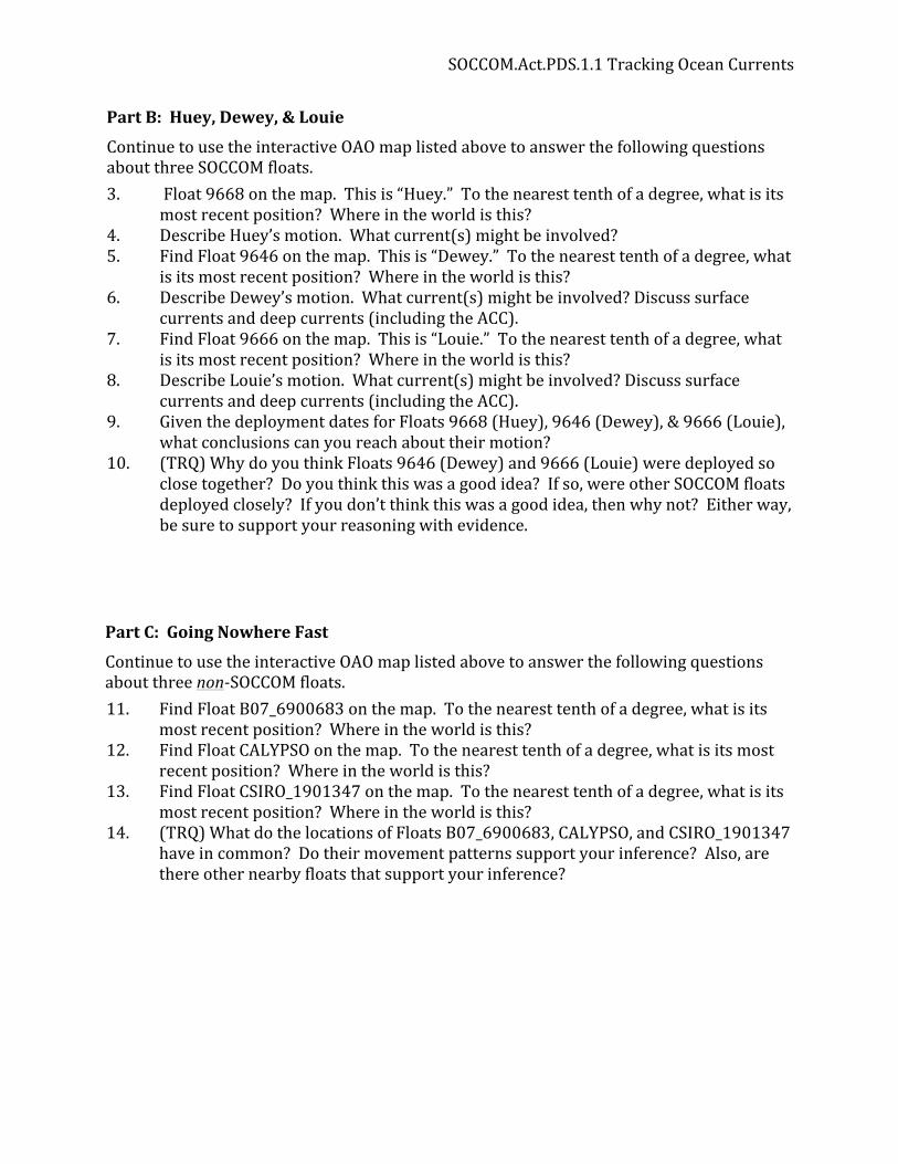
PartB:Huey,Dewey,&Louie
ContinuetousetheinteractiveOAOmaplistedabovetoanswerthefollowingquestionsaboutthreeSOCCOMfloats.3. Float 9668 on the map. This is “Huey.” To the nearest tenth of a degree, what is its most recent position? Where in the world is this?4. Describe Huey’s motion. What current(s) might be involved?5. Find Float 9646 on the map. This is “Dewey.” To the nearest tenth of a degree, what is its most recent position? Where in the world is this?6. Describe Dewey’s motion. What current(s) might be involved? Discuss surface currents and deep currents (including the ACC).7. Find Float 9666 on the map. This is “Louie.” To the nearest tenth of a degree, what is its most recent position? Where in the world is this?8. Describe Louie’s motion. What current(s) might be involved? Discuss surface currents and deep currents (including the ACC).9. Given the deployment dates for Floats 9668 (Huey), 9646 (Dewey), & 9666 (Louie), what conclusions can you reach about their motion?10. (TRQ) Why do you think Floats 9646 (Dewey) and 9666 (Louie) were deployed so close together? Do you think this was a good idea? If so, were other SOCCOM floats deployed closely? If you don’t think this was a good idea, then why not? Either way, be sure to support your reasoning with evidence.
PartC:GoingNowhereFast
ContinuetousetheinteractiveOAOmaplistedabovetoanswerthefollowingquestionsaboutthreenon-SOCCOMfloats.11. Find Float B07_6900683 on the map. To the nearest tenth of a degree, what is its most recent position? Where in the world is this?12. Find Float CALYPSO on the map. To the nearest tenth of a degree, what is its most recent position? Where in the world is this?13. Find Float CSIRO_1901347 on the map. To the nearest tenth of a degree, what is its most recent position? Where in the world is this?14. (TRQ) What do the locations of Floats B07_6900683, CALYPSO, and CSIRO_1901347 have in common? Do their movement patterns support your inference? Also, are there other nearby floats that support your inference?

SOCCOM.Act.PDS.1.1TrackingOceanCurrents
PartD:WhereAreAllTheseFloats,Anyway?15. Obtainfromyourteacheracopyofablankmapoftheworld.Plotthemostrecent
locationsofthefollowingfloats,bywritingthenumberofthefloatinthecorrectlocationonthemap(remembertokeepyourmapneatandlegible!).Attachakeytoyourmap.Thekeyshouldlooklikethis:
Number On Map Float Name
1 7552
2 6901004
3 5146
4 9260
5 6968
6 9092
7 9031
8 _0508
9 6901585
10 9668 ("Huey")
11 9646 ("Dewey")
12 9666 ("Louie")
13 B07_6900683
14 CALYPSO
15 CSIRO_1901347
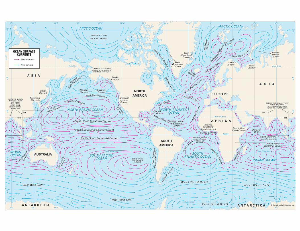
16. Why is a Mercator projection map difficult to use when studying the Southern Ocean?17. The arrows in the map are schematic only. Discuss the difficulties of knowing how currents at different depths actually behave in reality.
18. Discuss how floats enable scientists to understand deeper current behavior.

Float Name
SOCCOM?
Which part of the Southern
OceanDeployment Date Last Reported
DateDeployment
LatitudeDeployment Longitude
Last Reported Latitude
Last Reported Longitude
7552 Indian Ocean Near Australia
6901004 Indian Ocean Near Australia
5146 Indian Ocean Near Africa
9260 Indian Ocean Near Africa
6968 Pacific Ocean
9092 Pacific Ocean
9031 Pacific Ocean
_0508 Atlantic Ocean Near Africa
6901585 Atlantic Ocean Near Africa
Reported Locations For Several Floats In The Southern Ocean