Embed Size (px)
Citation preview
14. TC Diurnal Cycle Experiment
Principal Investigator: Jason Dunion
Links to IFEX:
● Goal 1: Collect observations that span the TC life cycle in a variety of environments for model initialization and evaluation.
● Goal 3: Improve understanding of the physical processes important in intensity change for a TC at all stages of its lifecycle.
Motivation: Numerous studies have documented the existence of diurnal maxima and minima associated with tropical convection. However, predicting the timing and extent of this variability remains a difficult challenge. Recent research using GOES satellite imagery has identified a robust signal of TC diurnal pulses. These diurnal pulses can be tracked using new GOES infrared satellite image differencing that reveals a “cool ring” (i.e. diurnal pulse) in the infrared that begins forming in the storm’s inner core near local sunset each day. This diurnal pulse continues to propagate away from the storm overnight, reaching areas several hundred km from the storm center by the following afternoon. There appear to be significant structural changes to TCs [as indicated by GOES infrared and microwave (37 and 85 GHz) satellite imagery and P-3 LF radar data] as diurnal pulses move out from the inner core each day and their timing/propagation also appears to be remarkably predictable. Although the relationships between the TC diurnal cycle and TC structure and intensity are unclear at this time, this phenomenon may be an important and fundamental TC process. The main objectives of the TC Diurnal Cycle Experiment are as follows:
Collect aircraft datasets that can be used to improve the initialization and evaluation of 3-D numerical models.
Improve the understanding of the thermodynamic and kinematic environment of radially propagating diurnal pulses at various stages of their life cycles, including their initial formation and subsequent evolution, and to observe any corresponding fluctuations in TC structure and intensity during these events.
Quantify the capabilities of the operational coupled model forecast system to accurately capture thermodynamic (e.g. cirrus canopy cooling at sunset) and kinematic (e.g. periods of enhanced upper-level outflow and low-level inflow) characteristics of the TC diurnal cycle and associated diurnal pulses.
Background: Although numerous studies have documented the existence of diurnal maxima and minima associated with tropical oceanic convection and the TC upper-level cirrus canopy, we lack a thorough understanding of the nature and causes of these variations and especially the extent to which these variations are important for TCs. It is well known that the coherent diurnal cycle of deep cumulus convection and associated rainfall is different over the land and ocean (Gray and Jacobson 1977; Yang and Slingo 2001). While over the land it tends to peak in the late afternoon/early evening due to daytime boundary layer heating, over the ocean it peaks in the early morning. In addition, Gray and Jacobson (1977), Mapes and Houze (1993), and Liu and Moncrieff (1998) found that the oceanic peak was more prominent when the preexisting convection was more intense and associated with an organized weather system such as an African easterly wave or mesoscale convective system. Numerous studies have also highlighted diurnal changes in the cirrus anvils of tropical deep convection and TCs. Weikmann et al. (1977) noted that anvils emanating from large cumulonimbus clouds tended to grow preferably between 2200 and 0300 local standard time (LST). Browner et al. (1977) found that the areal extent of the TC
cirrus canopy was a minimum at 0300 LST and a maximum at 1700 LST and suggested that this diurnal oscillation might be important for the TC. More recently, Kossin (2002) used storm-centered GOES infrared imagery to calculate azimuthally averaged brightness temperatures and create Hovmöller-type diagrams of brightness temperature diurnal oscillations over time. That study concluded that although a clear diurnal oscillation of the TC cirrus canopy was present at larger radii (e.g., 300 km), few storms exhibited diurnal oscillation signals in their innermost 100 km. It was hypothesized that different processes might be forcing periodic oscillations in the TC deep inner-core convection and the TC cirrus canopy.
Dunion et al. (2014) examined all North Atlantic major hurricanes from 2001 to 2010 and documented a phenomenon they referred to as the TC diurnal cycle and associated diurnal pulses in mature TCs. They found an intriguing diurnal pulsing pattern that appears to occur with remarkable regularity through a relatively deep layer of the TC. Storm-centered GOES and Meteosat infrared imagery were used to create 6-h brightness temperature difference fields of the storm’s inner core and its surrounding environment (R 5 100–600 km). The imagery revealed periodic oscillations of cooling and warming in the IR brightness temperature field over time. One prominent characteristic of these oscillations is a cold ring (i.e., local cooling of the brightness temperatures with time) that begins forming in the storm’s inner core (R~≤150 km; Rogers et al. 2012) near the time of sunset each day. This cold ring feature (that they referred to as a diurnal pulse) continues to move away from the storm overnight, reaching areas several hundred kilometers from the circulation center by the following afternoon. A marked warming of the cloud tops occurs behind this propagating feature and structural changes in the storm are noted as it moves away from the inner core. This systematic variation of cloud-top temperatures suggests that TC diurnal pulses are a distinguishing characteristic of the TC diurnal cycle may have implications for TC intensity change and structure.
Hypotheses:
● Hypothesis 1: TC diurnal cycle may be driven by rapid changes in incoming shortwave radiation resulting in rapid cooling at the cirrus canopy level around the time of local sunset each day.
● Hypothesis 2: TC diurnal pulses may be signatures of outwardly propagating gravity waves, harmonic oscillations of the CDO as it cools near the time of sunset, diurnally-driven changes in inertial stability in the upper-levels (i.e. cirrus canopy) of the storm, or temperature responses that lead to previously documented anvil expansion.
● Hypothesis 3: TC diurnal pulses manifest as semi-circular rings of enhanced convection that radially propagate away from the storm each day and may be associated with periods of enhanced upper-level outflow and lower-level inflow that extend through a relatively deep layer of the troposphere.
● Hypothesis 4: Observations of the TC diurnal cycle can be used to improve our understanding of this recently discovered phenomenon and test its observability in model simulations.
Experiment/Module Description: The experimental UW-CIMSS/HRD TC diurnal cycle web page (http://tropic.ssec.wisc.edu/real-time/tc_diurnal_cycle/tc_diurnal_cycle.php) will be used to monitor the development and propagation of TC diurnal pulses for storms of interest. The timing and propagation of diurnal pulses appears to be remarkably predictable: after its initial formation in the inner core region, it propagates outward at ~5-10 m s-1 and reaches peripheral radii (e.g. 200-500 km) at very specific times of day (local time). Therefore, a 24-hr conceptual clock describing the evolution of this phenomenon has been developed. Figure 1 shows the TC diurnal cycle clock that predicts the approximate times that diurnal pulse passes various radii and will be used in concert with the UW-CIMSS/HRD real-time diurnal pulsing imagery to plan aircraft sampling strategies and takeoff times.
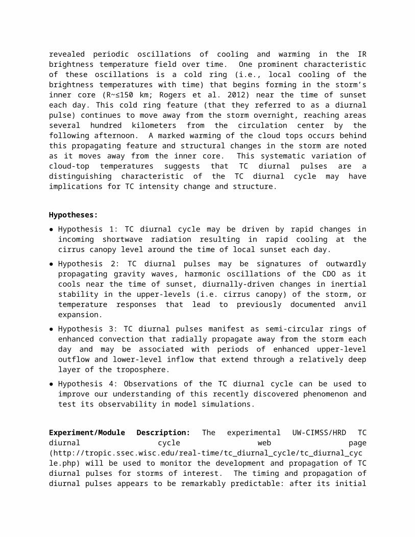
Fig. 1. Conceptual 24-hr TC diurnal cycle clock that estimates the radial location of TC diurnal pulses propagating away from storm. TC diurnal pulses typically form at local sunset (~ 1800-2030 LST, gray shading) and begin to propagate away from the inner core, passing the 200 km radius at ~0400-0800 LST (green shading) the following morning. It eventually reaches the 400 km radius at ~1200-1500 LST (orange shading) in the early to middle afternoon.
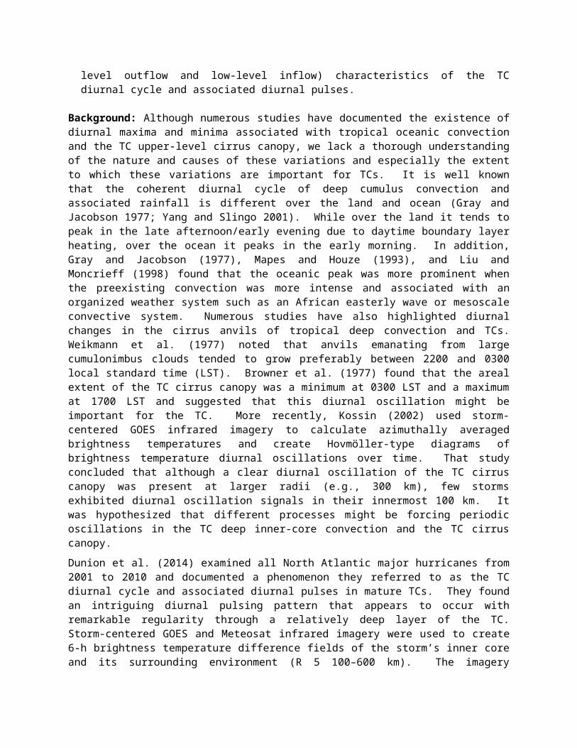
The circular outer band convective features depicted in Fig. 2 show examples of TC diurnal pulses as seen by the P-3 LF radar during missions in to 2010 Earl and 2014 Edouard. These features should be high priority targets during the mission and in order to adequately sample their 3-dimensional structure with the TDR, the P-3 and/or G-IV should completely transect through them on during inbound or outbound legs. The aircraft may also fly an arc cloud module (P-3 and/or G-IV) or convective burst module (P-3) as opportunities present. Since large arc cloud events have been noted to appear along the leading edge of diurnal pulses, the P-3 LPS and/or G-IV ground-based LPS should monitor TC diurnal cycle and visible satellite imagery and the P-3 LF radar for opportunities to conduct the former module. The execution of these optional modules will be at the discretion of the P-3 LPS and/or G-IV ground based LPS.

Fig. 2. P-3 lower fuselage radar showing 25-40 dBZ circular convective bands in the environments of (left) 2010 Hurricane Earl (R=~200-250 km) and (right) 2014 Hurricane Edouard (R=~200-300 km). These circular outer band features appear to be coincident with TC diurnal pulses and may be linked to the TC diurnal cycle.
Fig. 3. Sample G-IV star pattern with endpoints that alternate between 90 and 215 nm (165 and 400 km). The endpoints can be adjusted inward or outward depending on the exact position of the outwardly propagating diurnal pulse and the size of the TC inner core. The pattern is overlaid on (left) GOES IR imagery and (right) UW-CIMSS IR diurnal cycle imagery. Yellow to pink shading in the latter image indicates a diurnal pulse propagating away from the storm during this time and shows its typical radial evolution at ~1100 LST when it has reached R=~160 nm (~300 km).
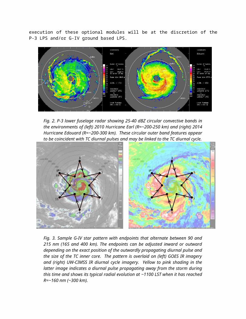
Fig. 4. Same as in Fig. 3, except that a circumnavigation of the storm is performed after or before the star pattern is completed. The hexagon circumnavigation that is shown has points that are 90 nm (165 km) from the storm center, but can be adjusted inward (if possible) or outward for safety considerations (depending on the strength and size of the TC).
There are a few possible configurations for the execution of this experiment that are outlined below:
1. Both the P-3 and G-IV are available: This is the optimal configuration for this experiment with the P-3 and G-IV coordinating operations with staggered take-off times that would allow both aircraft to optimally sample the radially propagating TC diurnal pulse. The P-3 will sample the inner-core and near environments of the TC (see P-3 Module 1), while the G-IV will sample the near and peripheral environments of the storm (see G-IV Module 1). Sample G-IV Module 1 flight patterns overlaid on GOES infrared and TC diurnal cycle imagery are shown for reference (Figs. 3 and 4).
2. Only the P-3 is available:When the G-IV is not available for coordinated operations, either because of operational tasking requirements or aircraft unavailability, P-3 targeted observations in the inner core and near environments using P-3 Module 1 can still contribute towards the objectives of the experiment.
3. Only the G-IV is available:When the P-3 is not available for coordinated operations, either because of operational tasking requirements or aircraft unavailability, G-IV targeted observations in the near and peripheral environments using G-IV Module 1 can still contribute towards the objectives of the experiment. Sample G-IV Module 1 flight patterns overlaid on GOES infrared and TC diurnal cycle imagery are shown for reference in Figs. 3 and 4).
Analysis Strategy: This experiment seeks to observe the formation and evolution of the TC diurnal cycle and associated TC diurnal pulses. Specifically, GPS dropsonde and radar observations will be used to analyze both the inner-core and environmental kinematics and thermodynamics that may lead to the formation of TC diurnal pulses and to document the kinematics, thermodynamics, and precipitation patterns that are associated with radially propagating TC diurnal pulses at various stages of their evolution.
References:
Browner, S. P., W. L. Woodley, and C. G. Griffith, 1977: Diurnal oscillation of cloudiness associated with tropical storms. Mon. Wea. Rev., 105, 856–864.
Dunion, J.P., C.D. Thorncroft, and C.S. Velden, 2014: The tropical cyclone diurnal cycle of mature hurricanes. Mon. Wea. Rev., 142, 3900-3919.
Gray, W. M., and R. W. Jacobson, 1977: Diurnal variation of deep cumulus convection. Mon. Wea. Rev., 105, 1171–1188.
Kossin, J. P., 2002: Daily hurricane variability inferred from GOES infrared imagery. Mon. Wea. Rev., 130, 2260–2270.
Liu, C., and M. W. Moncrieff, 1998: A numerical study of the diurnal cycle of tropical oceanic convection. J. Atmos. Sci., 55, 2329–2344.
Mapes, B. E., and R. A. Houze Jr., 1993: Cloud clusters and superclusters over the oceanic warm pool. Mon. Wea. Rev., 121, 1398–1415.
Rogers, R. F., S. Lorsolo, P. Reasor, J. Gamache, and F. Marks, 2012: Multiscale analysis of tropical cyclone kinematic structure from airborne Doppler radar composites. Mon. Wea. Rev., 140, 77–99.
Weickmann, H. K., A. B. Long, and L. R. Hoxit, 1977: Some examples of rapidly growing oceanic cumulonimbus clouds. Mon. Wea. Rev., 105, 469–476.
Yang, G., and J. Slingo, 2001: The diurnal cycle in the tropics. Mon. Wea. Rev., 129, 784–801.