Embed Size (px)
Citation preview
1
Tunisia
Ex-Post Evaluation of Japanese ODA Loan Project
Rades - La Goulette Bridge Construction Project
External Evaluator: Yasuhiro Kawabata, Sanshu Engineering Consultant
0. Summary
The objectives of the project were to: i) mitigate traffic congestion in the regions surrounding
the Tunis Lake by diverting traffic concentration into the Tunis central district; and ii) improve
accessibility between La Goulette and Rades ports by constructing a bridge connecting La
Goulette, located in the north of the Tunis Lake canal, and Rades, located in the south, and thereby
contributing to the regional economic development and industrial promotion in the Tunis Lake
coastal region. The project has been highly relevant to the development plans and needs of Tunisia,
as well as Japan’s ODA policies. Regarding mitigation of traffic congestion in the regions
surrounding the Tunis Lake by diverting traffic concentration into the Tunis central district and
improvement of accessibility between La Goulette and Rades ports which are the project’s
objectives, since the project has somewhat achieved its objectives, its effectiveness is fair.
Although the project cost was lower than planned, the project period was significantly longer than
planned. Therefore, the efficiency of the project is fair. Some problems have been observed in
terms of budget allocation for maintenance work, therefore sustainability of the project is fair.
In light of the above, this project is evaluated to be satisfactory.
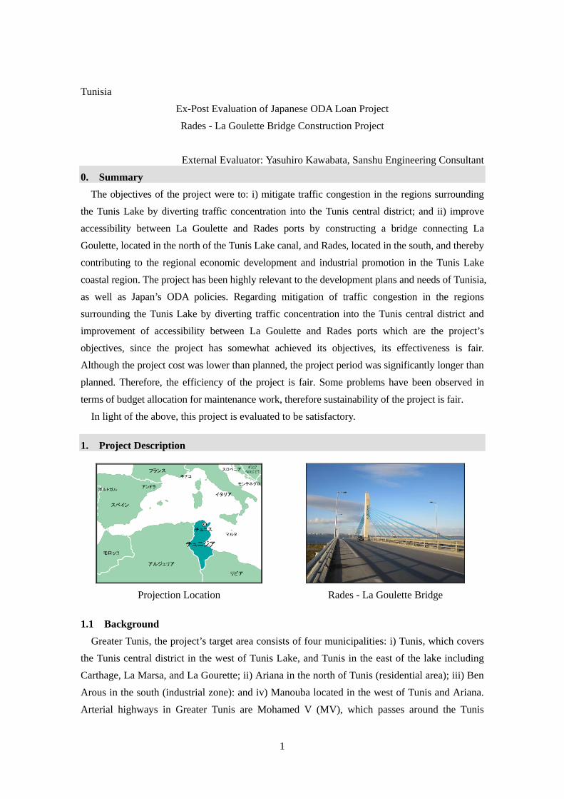
1. Project Description
Projection Location Rades - La Goulette Bridge
1.1 Background
Greater Tunis, the project’s target area consists of four municipalities: i) Tunis, which covers
the Tunis central district in the west of Tunis Lake, and Tunis in the east of the lake including
Carthage, La Marsa, and La Gourette; ii) Ariana in the north of Tunis (residential area); iii) Ben
Arous in the south (industrial zone): and iv) Manouba located in the west of Tunis and Ariana.
Arterial highways in Greater Tunis are Mohamed V (MV), which passes around the Tunis
2
central district, and other highways such as Z4 (Republique), Regional Roads 33 and 34,
National Roads 1, 3, and 9, and Sortie Sud, radiating from the city center. The average daily
traffic on these highways at the time of appraisal (1999) was 10,000-20,000 vehicles/day.
However, the highways with the heaviest traffic had already recorded the highest traffic volume
of MV with 100,000 vehicles/day and National Road 9 with 50,000 vehicles/day. Since most of
these highways are two-lane highways, the traffic volume had already exceeded its highway
capacity. The transporting capacity of the ferries crossing the Tunis Lake at the location where
the bridge was planned under the project was 4,000 vehicles/day (only vehicles with less than
3.5 tons loading capacity were permitted), and the waiting time for boarding was at least 30
minutes. Thus, roads around the terminal area had always been congested. Under these
circumstances, further increase in traffic volume was expected in the project affected area, and,
thus mitigation of traffic congestion was anticipated.
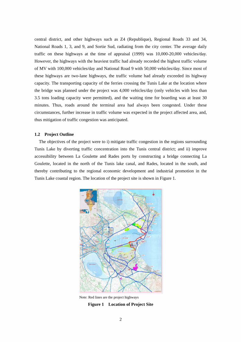
1.2 Project Outline
The objectives of the project were to i) mitigate traffic congestion in the regions surrounding
Tunis Lake by diverting traffic concentration into the Tunis central district; and ii) improve
accessibility between La Goulette and Rades ports by constructing a bridge connecting La
Goulette, located in the north of the Tunis lake canal, and Rades, located in the south, and
thereby contributing to the regional economic development and industrial promotion in the
Tunis Lake coastal region. The location of the project site is shown in Figure 1.
Note: Red lines are the project highways
Figure 1 Location of Project Site

3
Loan Approved Amount/ Disbursed Amount
8,403 million yen/8,402 million yen
Exchange of Notes Date/ Loan Agreement Signing Date
March 1999/March 1999
Terms and Conditions For work: Interest Rate: 2.20%, Repayment Period: 25 years (Grace Period: 7 years) Conditions for Procurement: General untied For Consulting services: Interest Rate: 0.75% Repayment Period: 40 years (Grace Period: 10 years) Conditions for Procurement: Bilateral tied
Borrower / Executing Agency (ies)
Republic of Tunisia/Ministry of Equipment (Department of Bridges and Highways)
Final Disbursement Date June 2009 Main Contractor (Over 1 billion yen)
Taisei Corp., Kajima/Sumitomo/ARABCO (Egypt), Taisei Corp., SOMATRA Get (Tunisia), SENELEC (Tunisia)
Main Consultant (Over 100 million yen)
Nippon Koei/Pacific Consultant International/SCET Tunisie/STUDI (Tunisia)
Feasibility Studies, etc. Feasibility Study by JICA (1991), SAPROF (February 1997) Related Projects (if any)) -
2. Outline of the Evaluation Study
2.1 External Evaluator
Yasuhiro Kawabata, Sanshu Engineering Consultant
2.2 Duration of Evaluation Study
Duration of the Study: July 2011 –September 2012
Duration of the Field Study: December 5 – 19, 2011, January 28 – February 7, 2012, and
May 5 – 15, 2012
2.3 Constraints during the Evaluation Study
none
3. Results of the Evaluation (Overall Rating: B1)
3.1 Relevance (Rating: ③2)
3.1.1 Relevance with the Development Plan of Tunisia
The Tunisian 9th Five-Year Plan (1997-2001) stated that in order to integrate the Tunisian
economy with the world economy, the “grading up” efforts was aimed at enhancing
productivity to strengthen competiveness, and a new development strategy to diversify the
1 A: Highly satisfactory, B: Satisfactory, C: Partially satisfactory, D: Unsatisfactory 2 ③: High, ② Fair, ① Low
4
Tunisian economy was adopted. Enhancement of industry’s productivity, increase of
exports, and control of inflation were the major issues to be addressed. The importance of
transport sector was emphasized particularly in order to achieve the smooth and speedy
logistics and enhance the industrial competiveness. With respect to highway sector
projects to be implemented during the 9th Five-Year Plan, mitigation of traffic congestion in
the Greater Tunis was identified as a priority agenda. The project was considered to be an
important link in the metropolitan ring road, which connects the southeast region and
northwest region in the metropolitan area.
Under the 11th Five-Year Plan (2007-2011), the Tunisian government aimed to achieve
the economic development at 6.1% per annum through open market, enhancement of
productivity, and creation of new job opportunities. Under the government policy, the
transport sector has been an important part to strengthen its industrial competitiveness. The
development of arterial highway network is particularly considered a required investment
in order to expedite the economic exchange and trade with neighboring countries, and
promote the human exchange, such as tourism. Furthermore, promotion of development
of arterial highways and rural roads (under the project, National Roads 9 and 10 will be
connected with Route 1 in the eastern coastal region), development of the road network
connecting the industrial zones and commercial cities, and promotion of the infrastructure
development are also considered essential.
3.1.2 Relevance with the Development Needs of Tunisia
At the appraisal stage, Greater Tunis was divided into north and south regions by Tunis
Lake Canal, and two alternative routes connecting the south and the north are as follows: i)
the route passing through Tunis central district (road), and ii) the route connecting La
Gourette and Rades ports by ferry boats. However, since the ferry service had some
constraints on the operating hours and its transporting capacity (number of vehicles per
vessel and maximum loading capacity of each vehicle), most traffic traveling the north -
south direction selected the route passing through the Tunis central district. As a result,
there was traffic congestion in the Tunis central district, and the environment, such as air
pollution and water pollution3, deteriorated (partly due to drained water from highways) in
Tunis Lake. Due to the increase in traffic volume, as a result of the development of
economic activities, increase in tourism, demand and integrated development around the
lake coastal area in Greater Tunis, mitigation of traffic congestion was anticipated.
Upon completion of the project, since the alternative route, which crosses the bridge
3 The project is located around the channel opening at the eastern edge of Tunis Lake and consideration to water
conservation by construction was sought.
5
constructed under the project was created in addition to the route passing through the city
central district, the traffic congestion seen in the central district before the project has
somewhat improved. Thus, it is recognized that the project has contributed to the
development needs, which is mitigation of traffic congestion.
3.1.3 Relevance with Japan’s ODA Policy
At appraisal, the previous version of Japan’s ODA Charter (1992) emphasized that
infrastructure development was an essential foundation for the economic and social
development. Moreover, in the Overseas Economic Cooperation Implementation Strategy
(December 1999- March 2002) at appraisal (1999), the basic infrastructure to strengthen
Tunisia’s international competitiveness and promote private investment to the country was
considered a priority sector in Tunisia. Since the objective of the project was to construct a
bridge and highways, which is considered to be the basic infrastructure for the regional
development and promotion of industry development, the project was in accordance with
the Japanese aid policies.
Accordingly, the project has been highly relevant with the Tunisian development plan
and needs, as well as Japan’s ODA policies. Its relevance is therefore considered high.
3.2 Effectiveness (Rating: ③)
3.2.1 Quantitative Effects (Operation and Effect Indicators)
Since the project’s outcome is to mitigate traffic congestion in the regions surrounding
Tunis Lake by diverting traffic concentration into the Tunis central district and improve
accessibility between La Goulette and Rades ports, the quantified effects were examined.
(1) Mitigation of Traffic Congestion in the Regions surrounding Tunis Lake
In order to examine the contribution of the project in mitigating traffic congestion,
changes in traffic volume on the main arterial roads in the Tunis central district need to be
examined in terms of traffic volume before and after the project taking into account the
increase in vehicles (traffic volume) due to economic development. However, in Tunisia,
the traffic volume on main roads is counted every five years. The previous counting was
undertaken in 2007 and the next counting is scheduled for this year 2012. Since the data on
traffic volume after completion of the project is not available, the traffic counting around
the Rades – La Gourette Bridge section (North Extension Highway, Canal Highway,
Rades-La Gourette Bridge, and Rades South Approach Road) were carried out under this
evaluation work. By analyzing the data on counted traffic, the contribution to mitigation of
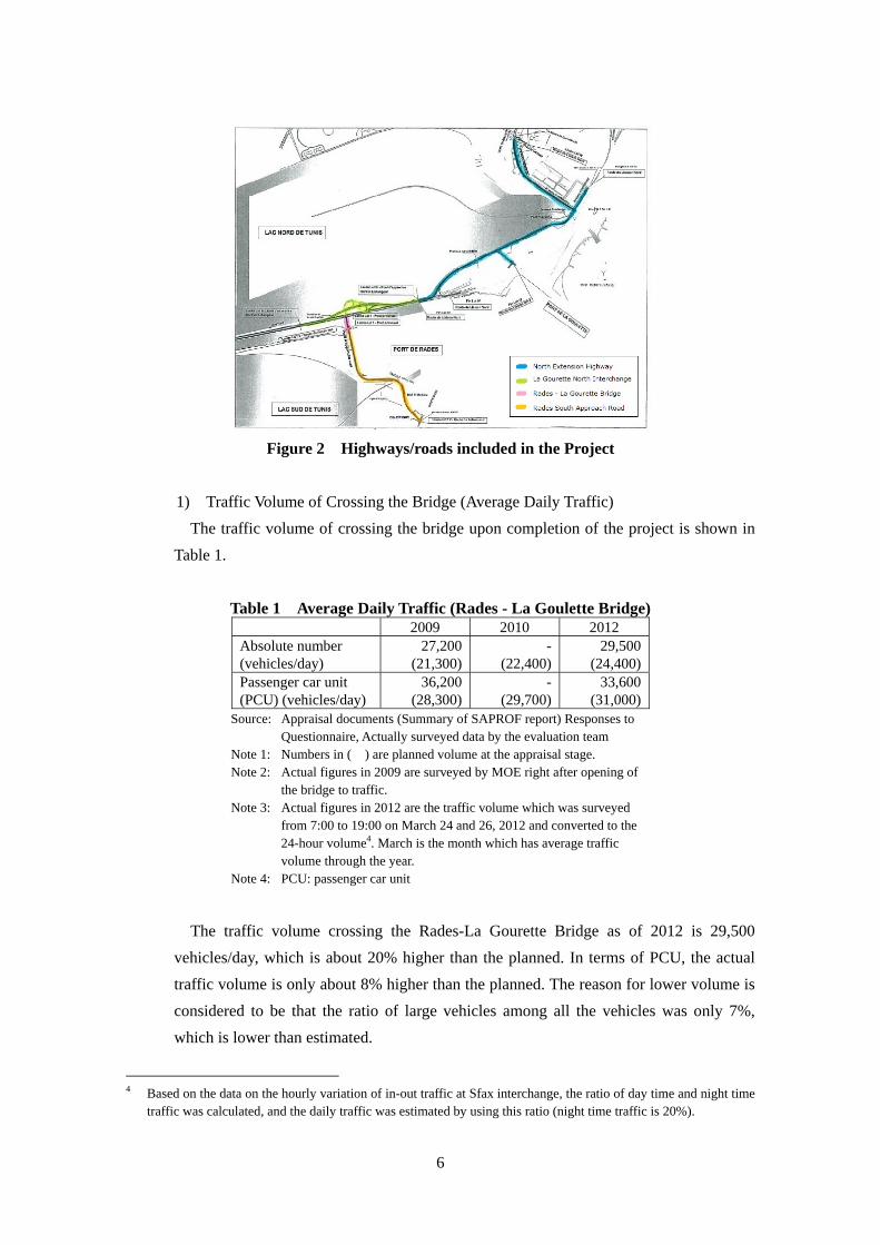
traffic congestion was examined. Highways/roads included in the project are shown in
Figure 2.
6
Figure 2 Highways/roads included in the Project
1) Traffic Volume of Crossing the Bridge (Average Daily Traffic)
The traffic volume of crossing the bridge upon completion of the project is shown in
Table 1.
Table 1 Average Daily Traffic (Rades - La Goulette Bridge) 2009 2010 2012
Absolute number (vehicles/day)
27,200(21,300)
-(22,400)
29,500 (24,400)
Passenger car unit (PCU) (vehicles/day)
36,200(28,300)
-(29,700)
33,600 (31,000)
Source: Appraisal documents (Summary of SAPROF report) Responses to Questionnaire, Actually surveyed data by the evaluation team
Note 1: Numbers in ( ) are planned volume at the appraisal stage. Note 2: Actual figures in 2009 are surveyed by MOE right after opening of
the bridge to traffic. Note 3: Actual figures in 2012 are the traffic volume which was surveyed
from 7:00 to 19:00 on March 24 and 26, 2012 and converted to the 24-hour volume4. March is the month which has average traffic volume through the year.
Note 4: PCU: passenger car unit
The traffic volume crossing the Rades-La Gourette Bridge as of 2012 is 29,500
vehicles/day, which is about 20% higher than the planned. In terms of PCU, the actual
traffic volume is only about 8% higher than the planned. The reason for lower volume is
considered to be that the ratio of large vehicles among all the vehicles was only 7%,
which is lower than estimated.
4 Based on the data on the hourly variation of in-out traffic at Sfax interchange, the ratio of day time and night time
traffic was calculated, and the daily traffic was estimated by using this ratio (night time traffic is 20%).
7
According to the traffic count and movement survey conducted in March 2012, the
breakdown of crossing traffic by direction is as follows: i) traffic of Rades-La Gourette
direction is 24,600 vehicles/day, and ii) traffic of Tunis-Rades direction is about 4,900
vehicles/day. Before the project was completed, ferries connecting between Rades and
La Gpourette transported about 4,000 vehicles/day5 (only vehicles with less than 3.5
tons loading capacity were permitted). Thus, it is considered that about 25,000
vehicles/day (29,500 - 4,000), which should have passed through the Tunis central
district have contributed to the mitigation of traffic congestion around the central district.
However, since the traffic of 25,000 vehicles/day includes generated/induced6 traffic,
which has occurred after the project was completed, these traffic needs to be excluded. It
is considered that the project has contributed to the reduction of at least 20,000
vehicles/day among the traffic passing through the Tunis central district.
2) Traffic Volume of North Extension Highway (Average Daily Traffic)
The traffic volume of the North Extension Highway is shown in Table 2.
Table 2 Average Daily Traffic (North Extension Highway) (vehicles/day)
2009 2010 2012 Motorway - MC33E2 -
(14,300)-
(15,900)44,900
(19,100) Source: Appraisal documents (Summary of SAPROF report) Responses to
Questionnaire, Actually survey data by the evaluation team Note: Numbers in ( ) are planned numbers assuming that the project would
be completed by 2002.
Because of the improvement to the expressway standard and extension of the route,
the traffic volume of the North Extension Highway is substantially higher than planned
(about 2.4 times) and the actual traffic volume was 44,900 vehicles/day. The reason for
higher traffic volume would be that more traffic than expected at the planning stage
heading Carthage and La Marsa in the northeastern region from the Tunis central district
avoided National Roads 8 and 9 along the Tunis Lake north coast, which were heavily
travelled and made detours to the Canal Crossing Highway and North Extension
Highway. More traffic uses North Extension Highway, which was constructed under the
project, and consequently contributed to the mitigation of traffic congestion on National
5 Transporting capacity per day by two ferries. The operating hour is from 6:00 AM to 9:30 PM and the average
crossing time by ferry is about 40 minutes. When the weather was adverse or commercial vessels cross the canal, the ferry operation was stopped.
6 Generally, generated and induced traffic is assumed to be 5-10% each. It was conservatively assumed here that each traffic would be 10% and the total 20%.

8
Roads 8 and 9, which connect directly with the Tunis central district.
(2) Improvement of accessibility between La Goulette and Rades ports
1) Improvement of Accessibility between La Goulette and Rades ports
Before the project, it took 15 minutes (including time for embarkation, crossing and
disembarkation) to travel between La Gourette and Rades ports by ferry. However,
drivers needed to allow 30-40 minutes given the weather condition, and waiting time.
Upon completion of the project, it is now possible to travel in five minutes regardless of
the weather condition.
(3) Reduction of Travel Time
In order to examine how much benefits (reduction of travel time, namely enhancement
of accessibility) were brought in to users who travel in the high demand section between
the Tunis northeastern and southeastern regions, the time needed to travel between two
specified points by two routes - the one passing through the Tunis central district (a shortest
route passing through arterial highways) and another crossing the bridge - were compared
under the post evaluation work. The selected points are the probable center of each
northeastern and southeastern region. The selected point in the northeastern region is the
merging point of National Road 9 and Gammarth Road in Marsa District, and in the
southeastern region is the merging point of National Road 1 and Environment Road in
Hammam Lif.
Table 3 Travel Time by the Route Passing through the Central District
and the Route Crossing the Bridge
Section (Route) Distance
(km) Travel Time
(minutes) Route Passing through the Central District
Passing through Tunis Central District (National Road 9, 9, and 1)
32 55
Route Crossing the Bridge
Crossing Rades – La Gourette Bridge (Route Express, Route 33, Environment Road)
24 31
Source: The time was actually surveyed by the evaluation team during the period of 10:30 AM - 3:00 PM on December 10 (Saturday), 2011. Since Tunisia is an Islamic country, Saturday is a working day (half day) and traffic volume is high.
9
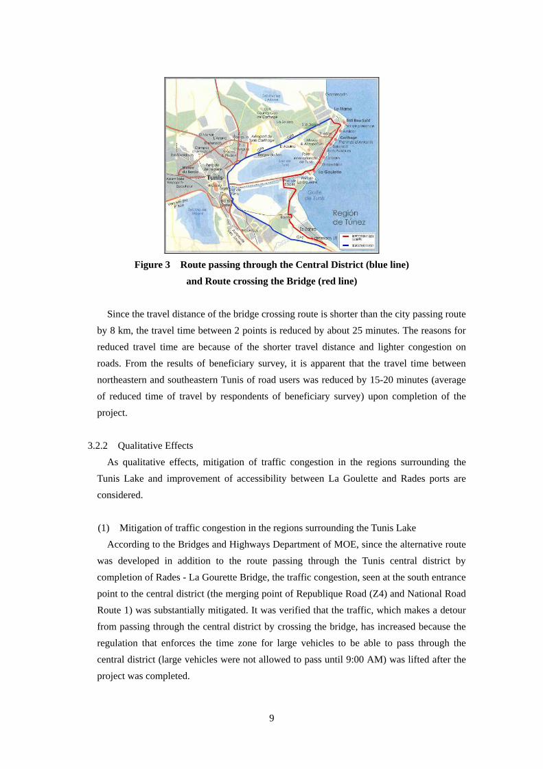
Figure 3 Route passing through the Central District (blue line)
and Route crossing the Bridge (red line)
Since the travel distance of the bridge crossing route is shorter than the city passing route
by 8 km, the travel time between 2 points is reduced by about 25 minutes. The reasons for
reduced travel time are because of the shorter travel distance and lighter congestion on
roads. From the results of beneficiary survey, it is apparent that the travel time between
northeastern and southeastern Tunis of road users was reduced by 15-20 minutes (average
of reduced time of travel by respondents of beneficiary survey) upon completion of the
project.
3.2.2 Qualitative Effects
As qualitative effects, mitigation of traffic congestion in the regions surrounding the
Tunis Lake and improvement of accessibility between La Goulette and Rades ports are
considered.
(1) Mitigation of traffic congestion in the regions surrounding the Tunis Lake
According to the Bridges and Highways Department of MOE, since the alternative route
was developed in addition to the route passing through the Tunis central district by
completion of Rades - La Gourette Bridge, the traffic congestion, seen at the south entrance
point to the central district (the merging point of Republique Road (Z4) and National Road
Route 1) was substantially mitigated. It was verified that the traffic, which makes a detour
from passing through the central district by crossing the bridge, has increased because the
regulation that enforces the time zone for large vehicles to be able to pass through the
central district (large vehicles were not allowed to pass until 9:00 AM) was lifted after the
project was completed.

10
(2) Improvement of accessibility between La Goulette and Rades ports
By completion of the project, the missing link (Rades - La Gourete Bridge section) in the
ring road surrounding the Tunis Lake has been satisfied, and the network has been
completed. Thus, it has enabled the dispersing of traffic, which used to concentrate into the
central district. At the same time, La Gourette and Rades ports were connected by land and
the accessibility was substantially enhanced. The role allotment of both ports was clarified
and the integrated operation of both ports is now possible. La Gourette Port is now a
passenger-specific port with some cargo handling, while Rades Port is a cargo-specific port.
During project implementation, the old Rades Port was demolished and its functions were
integrated into the new Rades Port. During the meeting with the Deputy Director of OMMP
Rades Port, he testified that by completion of the Rades-La Gourette Bridge, Rades and La
Gourette were integrated, the pressure to Rades region was mitigated, and the trucking
firms are pleased with the effective operations in both ports.
In this ex-post evaluation work, beneficiary surveys were conducted, through interviews,
in three districts near the Rades - La Gourette Bridge, including Lac 1, Le Kram, and Rades.
The number of respondents at each district was 40, with a total number of 120 (50 females
and 70 males). Regarding the mitigation of traffic congestion in the Tunis central district,
54% of respondents recognize that the contribution of the project is substantial and 41%
think that it is fair. The remaining 5% recognize that the project has made some
contribution. Thus, it reveals that the project has contributed to mitigation of congestion,
which was one of the obstacles in the promotion of economic activities.
3.3 Impact
3.3.1 Intended Impacts (Contribution to the Regional Development and Industrial
Promotion in the Tunis Lake Coastal Region
(1) Regional Development and Industrial Promotion in the Tunis Lake Coastal Region
As the regional development proceeds, the number of enterprises starting up a new
business generally increases, as well as the migration of people as a result of increase in
land prices. The comparison of land prices in the project affected area before and after the
project showed that there were no major changes in land prices in the northern and
southern regions around Rades - La Gourette Bridge. It was determined that there were no
major changes in the northern region because there was no vacant land and the subject area
was already a well-developed commercial area. The southern region (Rades side) is an
industrial and warehouse zone. However, the development projects are planned in the
project affected areas, including the area between National Road 9 and the Tunis Lake
northern area (Bergus du Lac, and Lac 2 districts with a total area of about 1,300 ha), Ain
11
Zaghouan district located in the north of Lac 2, and Bhar Lazrak located in further north.
The residents who would live in these developed areas will have access to the route passing
through North Extension Highway, which was constructed under the project and the
existing Canal Crossing Expressway when National Road 9 is congested. Completion of an
alternative highway route (this project) will provide more benefits to the residents. This
could be a factor in generating more economic development.
(2) Mitigation of Air Pollution in Greater Tunis
Among the substances, which are the sources of air pollution, major substances
originating from exhausted gas from motor vehicles, includes suspended particulate matter
and nitrogen dioxide. Since sulfur compounds are included in the low quality petroleum, its
combustion generates a trace of sulfur oxides, which is also one of pollutants. In order to
assess the air quality (air pollution), the yearly changes of three substances monitored in
Tunis, including suspended particulate matter, nitrogen dioxide and sulfur dioxides are
discussed below.
1) TSP
Regarding TSP, changes in suspended particulate matter (in PM10) monitored at two
locations in Tunis are shown in Table 4 and 5.
Table 4 Changes of Suspended Particulate Matter in Tunis Central District ( in PM10) microgramme/m3
Monitoring location 2006 2007 2008 2009Allowable
limit Recommended
targets Bab Saadoun 316 328 190 170 260 120
Source: Agence Nationale de Protection de l’Environment (ANPE) – Indicateurs régionaux d’amélioration des conditions de vie-OTEDD- Juin 2010
Note 1: Figures are the maximum value recorded within 24 hours. Note 2: The allowable limit and recommended targets are Tunisian standards. Note 3: Bab Saadoun is in the central district.
Since 2007, the maximum value within 24 hours of PM10 has been decreasing.
Although the actual recorded value is within the allowable limit, it has not reached the
recommended target level.

12
Table 5 Changes of Suspended Particulate Matter ( in PM10)
(at the monitoring station close to the project site) microgramme/m3
Monitoring location 2007 2008 2009 2010 Allowable
limit Recommended
targets Monthly variation in Ben Arous
71 - 87 57 - 90 61 - 84 56 - 150260 120
Annual monthly average
81 76 72 94
Source: ANPE Note 1: Figures are 24 hours average Note 2: The monitoring station is located about 7 km (linear distance) away from the project site.
Since 2007, the urban air quality has been improving. However, due to increase in
traffic volume, it deteriorated in 2010. Since the PM10 values deteriorated, particularly
in the summer time (exceeded the recommended targets in August and September), the
annual monthly average was also higher than the previous year.
2) Nitrogen Dioxide (NO2)
Changes of Nitrogen Dioxide (NO2) in Greater Tunis are shown in Table 6.
Table 6 Changes of Nitrogen Dioxide (NO2) microgramme/m3
Monitoring location
2006 2007 2008 2009 2010
Allowable limit (1-hour average)
Recommended targets (1-hour average)
WHO standards (1-hour average)
Bab Saadoun
104 56 150 -
126(Dec.)
660 400 200
El Ghazela - - 139 98 48 - 102(Jan. - Nov.)
Bab Alioua - - 365 395 133 - 363(Jan.- Jun.)
Mannouba - - 122 115 81 - 151(Jun. - Sept.)
Source: ANPE - Indicateurs régionaux d’amélioration des conditions de vie-OTEDD- Juin 2010 Rapport National sur l’Etat de l’environnement en 2006, 2008, Ministère de l’Environnement et du Développement durable and Bulletin de l’air-2010 ANPE
Note 1: The Bab Saadoun monitoring station is in the Tunis central district. Note 2: The El Ghazela monitoring station is about 12 km north of Tunis central district and near Ennahli Park. Note 3: The Bab Alioua monitoring station is in the Tunis central district, and about 1.2 km west of Tunis Marina. Note 4: The Mannouba monitoring station is about 8 km west of the Tunis central district.
For the past five years (2006 - 2010), the concentration of NO2 at three monitoring
stations, except at Bab Alioua, was within the WHO standards. The higher NO2 value at
Bab Alioua was due to heavy traffic in the area since the monitoring station is close to
Tunis railway station and Z4, which is located along the Tunis Lake west coast.

13
3) Sulfur Dioxide (SO2)
Changes of Sulfur Dioxide (SO2) in Greater Tunis are shown in Table 7.
Table 7 Changes of Sulfur Dioxide (SO2) microgramme/m3
Monitoring location
2008 2009 2010 Allowable
limit Recommended
targets WHO
standards El Ghazela 13 30 3 - 8
365 125 20 Bab Alioua 32 40 11 - 27
Source: ANPE - Indicateurs régionaux d’amélioration des conditions de vie-OTEDD- Juin 2010, Rapport National sur l’Etat de l’environnement en 2008, Ministère de l’Environnement et du Développement durable and Bulletin de l’air – 2010- ANPE
Note 1: Figures are 24 hours average Note 2: The allowable limit and recommended targets are Tunisian standards. Note3: The El Ghazela monitoring station is about 12 km north of Tunis central district and near
Ennahli Park. Note 4: The monitoring station at Bab Alioua is about 1.2 km west of Tunis Marina.
As shown in Table 7, for the past two years (2008 and 2009), the concentration of SO2
was worst. However, the pollution level both in the central district and suburban area has
improved in 2010.
It is difficult to examine the effects on mitigation of air pollution by the project by
referring to changes in the amount of air pollutants because: i) the locations of
monitoring stations in the regions are irrelevant to the project; and ii) the traffic volume
has been increasing yearly. However, it is apparent that SO2 and NO2 values, which
originate in the exhaust gas emitted from motor vehicles has been decreasing.
(3) Promotion of Economic Development in Greater Tunis
By completion of the project, the missing link (Rades - La Gourete Bridge section) in the
ring road surrounding the Tunis Lake has been satisfied, and the network has been
completed. Thus, the accessibility for road users has been substantially enhanced. Because
of completion of an alternative route, which goes around the Tunis central district, plans for
development of residential areas, and attraction and promotion of industry promotion in the
lake coastal regions (particularly in the northern coastal regions) have been developed.
Thus, it is expected that the project will greatly contribute to the promotion of the
economic development in Greater Tunis.
The beneficiary surveys showed that the project has contributed to the regional economic
development around Tunis Lake, with 14% of respondents recognized the contribution as
substantial, 66% think that it is fair, and that 20% acknowledged that it has made some
14
contribution. With regards to contribution in the promotion of business opportunities
around the Tunis Lake, 41%, and 50% recognized that it is substantial and fair, respectively.
Nine percent (9%) acknowledged that it has made some contribution.
Regarding the overall assessment of the project, 83% of respondents answer that the
quality of life has improved with the completion of a detour route, not passing through the
central district. Thus, it was confirmed that citizens also acknowledged the effectiveness of
the project.
3.3.2 Other Impacts
(1) Impacts on the natural environment
The main issues before commencement of the project were conservation of the water
quality in Tunis Lake and protection of traffic noise to the houses along the North
Extension Highway corridor during the project implementation and operation stage.
Although MOE has entrusted the monitoring of the water quality in Tunis Lake to a private
firm engaged in the development of the south lake, no problems have been reported. These
were due to the: i) revision of the alignment of North Extension Highway so that the area,
where seaweeds are expected to proliferate, was also minimized by installing the geotextile
screens and floating barriers when implementing the embankment work along the coast;
and ii) flow of water in the channel connecting between the lake and sea was eased by
reducing the obstacles, such as bridge piers in the channel.
Regarding the noise protection, the realigned route is located along the coast, therefore
no houses exist along the right-of-way. There were no issues reported. Planting work has
been undertaken in order to improve the aesthetic environment.
(2) Land Acquisition and Resettlement
The total land area acquired was 64 ha, of which 54 ha of public land and 10 ha of
private land. Among two ordinary houses to be relocated, one was demolished and the
other was relocated under the national solidarity program. Since it was discovered that the
elementary school that was originally to be relocated was outside the right-of-way,
relocation did not take place. The total amount spent for land acquisition and compensation
is 4.3 million dinars. Resettlement was implemented as per the implementation schedule
and there have been no compensation complaints received.
(3) Other Positive and Negative Impacts
Upon completion of Rades - La Gourette Bridge, the ferry service was stopped, and
crews and staff were reassigned to the positions in Tunis Regional Bureau.
15
This project has largely achieved its objectives, therefore its effectiveness and impact are
considered high.
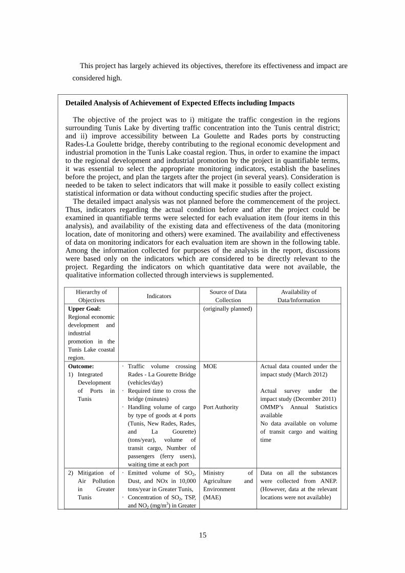
Detailed Analysis of Achievement of Expected Effects including Impacts
The objective of the project was to i) mitigate the traffic congestion in the regions surrounding Tunis Lake by diverting traffic concentration into the Tunis central district; and ii) improve accessibility between La Goulette and Rades ports by constructing Rades-La Goulette bridge, thereby contributing to the regional economic development and industrial promotion in the Tunis Lake coastal region. Thus, in order to examine the impact to the regional development and industrial promotion by the project in quantifiable terms, it was essential to select the appropriate monitoring indicators, establish the baselines before the project, and plan the targets after the project (in several years). Consideration is needed to be taken to select indicators that will make it possible to easily collect existing statistical information or data without conducting specific studies after the project.
The detailed impact analysis was not planned before the commencement of the project. Thus, indicators regarding the actual condition before and after the project could be examined in quantifiable terms were selected for each evaluation item (four items in this analysis), and availability of the existing data and effectiveness of the data (monitoring location, date of monitoring and others) were examined. The availability and effectiveness of data on monitoring indicators for each evaluation item are shown in the following table. Among the information collected for purposes of the analysis in the report, discussions were based only on the indicators which are considered to be directly relevant to the project. Regarding the indicators on which quantitative data were not available, the qualitative information collected through interviews is supplemented.
Hierarchy of Objectives
Indicators Source of Data
Collection Availability of
Data/Information
Upper Goal: Regional economic development and industrial promotion in the Tunis Lake coastal region.
(originally planned)
Outcome: 1) Integrated
Development of Ports in Tunis
• Traffic volume crossing Rades - La Gourette Bridge (vehicles/day)
• Required time to cross the bridge (minutes)
• Handling volume of cargo by type of goods at 4 ports (Tunis, New Rades, Rades, and La Gourette) (tons/year), volume of transit cargo, Number of passengers (ferry users), waiting time at each port
MOE Port Authority
Actual data counted under the impact study (March 2012) Actual survey under the impact study (December 2011)OMMP’s Annual Statistics available No data available on volume of transit cargo and waiting time
2) Mitigation of Air Pollution in Greater Tunis
• Emitted volume of SO2, Dust, and NOx in 10,000 tons/year in Greater Tunis,
• Concentration of SO2, TSP, and NO2 (mg/m3) in Greater
Ministry of Agriculture and Environment (MAE)
Data on all the substances were collected from ANEP. (However, data at the relevant locations were not available)
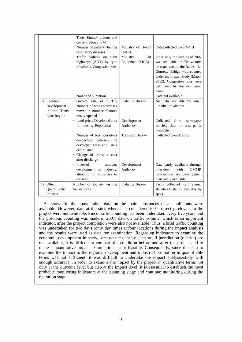
16
Tunis, Emitted volume and concentration of PM
• Number of patients having respiratory diseases
• Traffic volume on main highways (ADT) by type of vehicle, Congestion rate
• Noise and Vibration
Ministry of Health (MOH) Ministry of Equipment (MOE)
Data collected from MOH Since only the data as of 2007 was available, traffic volume on roads around the Rades - La Gourette Bridge was counted under the Impact Study (March 2012), Congestion rates were calculated by the evaluation team. Data not available
3) Economic Development in the Tunis Lake Region
• Growth rate of GRDP, Number of new enterprises moved in, number of stores newly opened
• Land price, Developed area for housing, Population
• Number of bus operations
connecting between the developed areas and Tunis central area.
• Change of transport cost after discharge
• Invested amount, development of industry, attraction of industries to the west
Statistics Bureau Development Authority Transport Bureau Development Authority
No data available by small jurisdiction /district Collected from newspaper articles, Data on area partly available Collected from Transtu Data partly available through interview with OMMP, Information on development plan partly available
4) Other Quantifiable Impacts
Number of tourists visiting tourist spots
Statistics Bureau Partly collected form annual statistics (data not available by spot)
As shown in the above table, data on the main substances of air pollutants were
available. However, data at the sites where it is considered to be directly relevant to the project were not available. Since traffic counting has been undertaken every five years and the previous counting was made in 2007, data on traffic volume, which is an important indicator, after the project completion were also not available. Thus, a brief traffic counting was undertaken for two days (only day time) at four locations during the impact analysis and the results were used as data for examination. Regarding indicators to examine the economic development impacts, because the data by each small jurisdiction (district) are not available, it is difficult to compare the condition before and after the project and to make a quantitative impact examination is not feasible. Consequently, since the data to examine the impact to the regional development and industrial promotion in quantifiable terms was not sufficient, it was difficult to undertake the impact analysis/study with enough accuracy. In order to examine the impact by the project in quantitative terms not only at the outcome level but also at the impact level, it is essential to establish the most probable monitoring indicators at the planning stage and continue monitoring during the operation stage.
17
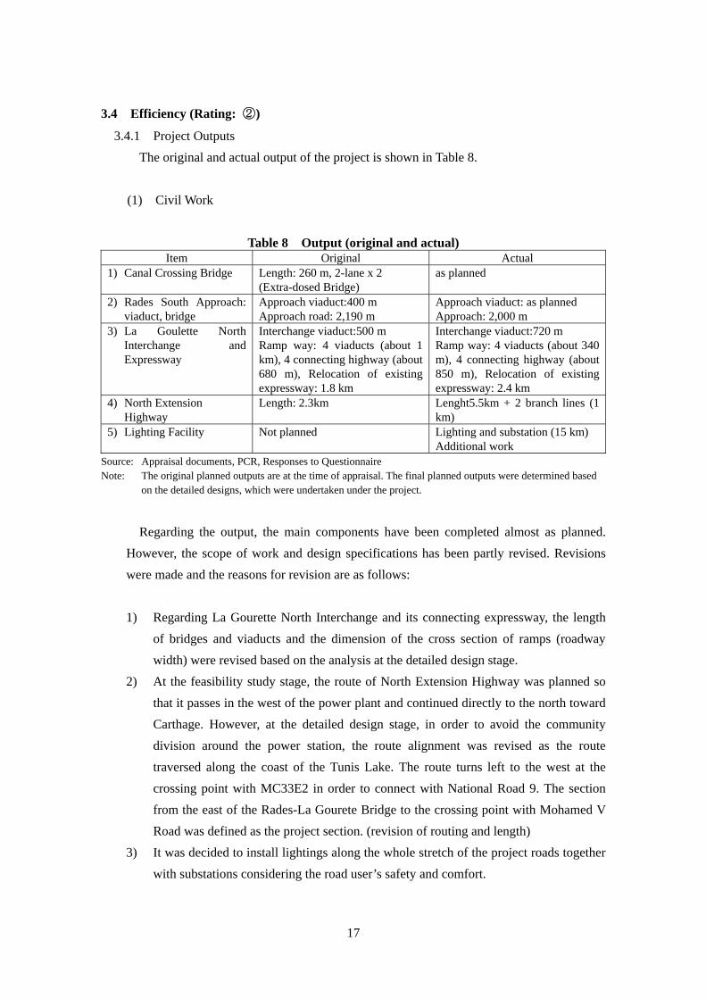
3.4 Efficiency (Rating: ②)
3.4.1 Project Outputs
The original and actual output of the project is shown in Table 8.
(1) Civil Work
Table 8 Output (original and actual) Item Original Actual
1) Canal Crossing Bridge Length: 260 m, 2-lane x 2 (Extra-dosed Bridge)
as planned
2) Rades South Approach: viaduct, bridge
Approach viaduct:400 m Approach road: 2,190 m
Approach viaduct: as planned Approach: 2,000 m
3) La Goulette North Interchange and Expressway
Interchange viaduct:500 m Ramp way: 4 viaducts (about 1 km), 4 connecting highway (about 680 m), Relocation of existing expressway: 1.8 km
Interchange viaduct:720 m Ramp way: 4 viaducts (about 340 m), 4 connecting highway (about 850 m), Relocation of existing expressway: 2.4 km
4) North Extension Highway
Length: 2.3km Lenght5.5km + 2 branch lines (1 km)
5) Lighting Facility Not planned Lighting and substation (15 km) Additional work
Source: Appraisal documents, PCR, Responses to Questionnaire Note: The original planned outputs are at the time of appraisal. The final planned outputs were determined based
on the detailed designs, which were undertaken under the project.
Regarding the output, the main components have been completed almost as planned.
However, the scope of work and design specifications has been partly revised. Revisions
were made and the reasons for revision are as follows:
1) Regarding La Gourette North Interchange and its connecting expressway, the length
of bridges and viaducts and the dimension of the cross section of ramps (roadway
width) were revised based on the analysis at the detailed design stage.
2) At the feasibility study stage, the route of North Extension Highway was planned so
that it passes in the west of the power plant and continued directly to the north toward
Carthage. However, at the detailed design stage, in order to avoid the community
division around the power station, the route alignment was revised as the route
traversed along the coast of the Tunis Lake. The route turns left to the west at the
crossing point with MC33E2 in order to connect with National Road 9. The section
from the east of the Rades-La Gourete Bridge to the crossing point with Mohamed V
Road was defined as the project section. (revision of routing and length)
3) It was decided to install lightings along the whole stretch of the project roads together
with substations considering the road user’s safety and comfort.

18
North Extension Road Rades-La Gourette Bridge and Ramps
(2) Consulting Services
The original consulting services included detailed designs/field surveys, assistance in
bidding, construction supervision, detailed environmental impact assessment,
training/technical assistance, and monitoring (5 months) the assignments of 96 M/M by
foreign experts and 344 M/M by local experts. However, because of additional work
(review of work implementation related documents, which was not included in the original
scope of work) and delay of the implementation period, the actual assigned man/months
were 147 M/M by foreign experts and 482 M/M by local experts. The original scope of
work was implemented almost as planned.
3.4.2 Project Inputs
3.4.2.1 Project Cost
The estimated project cost at appraisal was 11.205 billion yen, of which the total
Japanese ODA loan of 8.43 billion yen was to be used on foreign currency and part of local
currency portions, and the rest was to be funded by the Tunisian government. The actual
project cost was 11.477 billion yen, of which the Japanese ODA loan used was 8.42 billion
yen and the rest was funded by the Tunisian government. Thus, the actual cost was slightly
higher than planned, which is equivalent to 102% of the planned cost. In terms of the local
currency, the actual cost exceeded the plan, which is equivalent to 141% of the plan. As
mentioned above, the length of North Extension Highway was extended by 2.4 times and
the lighting facilities were added, which resulted in higher scope of work against the
original plan. If the total cost included the cost for the additional work (about 370 million
yen) and officially amended in the contract, is compared with the plan, the actual cost was
within the plan (99.7% of the plan).
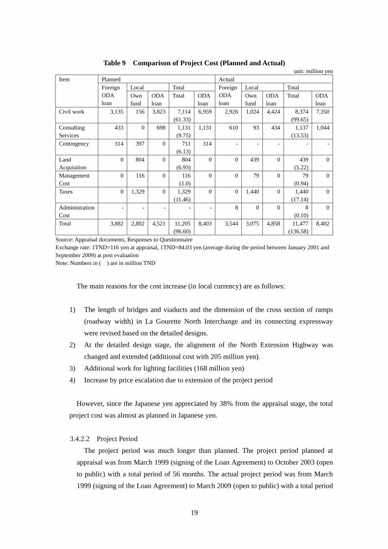
19
Table 9 Comparison of Project Cost (Planned and Actual) unit: million yen
Item Planned Actual
Foreign ODA loan
Local Total ForeignODA loan
Local Total
Own fund
ODA loan
Total ODAloan
Own fund
ODA loan
Total ODA loan
Civil work 3,135 156 3,823 7,114(61.33)
6,959 2,926 1,024 4,424 8,374 (99.65)
7,350
Consulting Services
433 0 698 1,131(9.75)
1,131 610 93 434 1,137 (13.53)
1,044
Contingency 314 397 0 711(6.13)
314 - - - - -
Land Acquisition
0 804 0 804(6.93)
0 0 439 0 439 (5.22)
0
Management Cost
0 116 0 116(1.0)
0 0 79 0 79 (0.94)
0
Taxes 0 1,329 0 1,329(11.46)
0 0 1,440 0 1,440 (17.14)
0
Administration Cost
- - - - - 8 0 0 8 (0.10)
0
Total 3,882 2,802 4,521 11,205(96.60)
8,403 3,544 3,075 4,858 11,477 (136.58)
8,402
Source: Appraisal documents, Responses to Questionnaire Exchange rate: 1TND=116 yen at appraisal, 1TND=84.03 yen (average during the period between January 2001 and September 2009) at post evaluation Note: Numbers in ( ) are in million TND
The main reasons for the cost increase (in local currency) are as follows:
1) The length of bridges and viaducts and the dimension of the cross section of ramps
(roadway width) in La Gourette North Interchange and its connecting expressway
were revised based on the detailed designs.
2) At the detailed design stage, the alignment of the North Extension Highway was
changed and extended (additional cost with 205 million yen).
3) Additional work for lighting facilities (168 million yen)
4) Increase by price escalation due to extension of the project period
However, since the Japanese yen appreciated by 38% from the appraisal stage, the total
project cost was almost as planned in Japanese yen.
3.4.2.2 Project Period
The project period was much longer than planned. The project period planned at
appraisal was from March 1999 (signing of the Loan Agreement) to October 2003 (open
to public) with a total period of 56 months. The actual project period was from March
1999 (signing of the Loan Agreement) to March 2009 (open to public) with a total period
20
of 121 months, or equivalent to 216% of the plan.
The main reasons for the delay are as follows:
1) Commencement of the consultant selection process was delayed by 5 months, and
it took 21 months, which is about double the plan to complete the selection process.
2) Due to delay in the consultant selection process, commencement of detailed designs
was delayed by 14 months and the detailed design took 17 months, which is about
double the plan.
3) Due to delay in the completion of detailed designs, the advertisement for bidding
for civil work commenced with a 21-month delay from the original schedule.
Moreover, it took longer to complete the bidding procedures (particularly to secure
clearance on the bidding results), an actual total of 39 months, which is more than
double the planned period.
4) Since the geotechnical and soil investigation at the design stage was not
comprehensive enough, the following countermeasures were needed during project
implementation: i) changes in construction methodologies because it was found that
the planned boring machine was not suitable; and ii) soft ground treat work since
the surcharge in the soft ground area was not planned in the original design.
5) Preparation of equipment (support members for viaduct sections, pre-stress
concrete members and others) and its delivery was delayed.
Delay in the project period is partly due to the problems that occurred during project
implementation. However, it is considered that the main reason is the implementation
schedule prepared at the appraisal stage, which was not practical in Tunisia. For instance,
9 months for consultant selection, 7 months for detailed designs (including bidding
documents), 15 months for procurement of civil work through the ICB procedures and
36 months for construction work are considered to be optimistic.
3.4.3 Results of Calculations of Internal Rates of Return (IRR)
(1) Economic Internal Rate of Return (EIRR)
EIRR at the appraisal stage was estimated at 14.4%. Since data on the construction cost
spent by year, the spending plan for operation and maintenance work and details of benefits
(vehicle operating costs, time saving costs and others) are not available, calculation of
EIRR at the post evaluation stage is difficult to carry out.
Although the project cost was lower than planned, the project period was significantly
longer than planned. Therefore, efficiency of the project is considered fair.
21
3.5 Sustainability (Rating: ②)
3.5.1 Structural Aspects of Operation and Maintenance
As originally planned, the executing agency, Department of Highways and Bridges of
Ministry of Equipment (MOE) has been responsible for operation and maintenance of the
project after completion of the project. However, with regards to the actual routine
inspection and maintenance (signals, safety facilities, lighting facilities, changes of pars,
repairs), Tunis Regional Bureau (staffed with about 50 employees for 268 km road
sections) is responsible for the crossing bridge, La Gourette North Interchange and its
connecting expressways, and North Extension Highway; while Ben Arous Regional Bureau
(for 313 km road sections) is responsible for Rades South approach viaducts and bridges.
The operation and maintenance of the monitoring system for the crossing bridge, detailed
inspection of completed work, maintenance of plants and drainage facilities, and cleaning
of expansion joints and rain water catchment facilities are entrusted to private companies.
Each team, responsible for the project components among the staff responsible for
maintenance within the Tunis and Ben Arous Regional Bureaus, consists of a Chief
Engineer responsible for maintenance work, an Engineer responsible for the region, three
workers and a Lighting Engineer. Since the periodic maintenance work requires high
technology (particularly on the extra-dosed bridge) and major repairs/improvement work
are planned in the near future, the high-level planning strategy, including establishment of
medium/long-term maintenance work implementation plans and decision making on
priority of work to be done, needs to be developed. Thus, engineers and technicians, who
are specialized in maintenance of bridges and structures are required, and increasing the
number of staff in charge of maintenance and operation needs to be considered.
3.5.2 Technical Aspects of Operation and Maintenance
The technical capacity of staff in charge of operation and maintenance (routine
inspection and maintenance) at both Regional Bureaus is considered appropriate.
Regarding the training of staff, the consultant in charge of construction supervision invited
a few engineers responsible for maintenance to Japan and UAE for overseas study training.
The periodic inspection/maintenance and major rehabilitation work (particularly bridge
sections), which will occur in the near future, will be contracted out to private companies
since the number of assigned technical staff is insufficient. However, it is essential to
prepare the future maintenance work schedule, and determine the work priority to be
implemented under the budget constraints on a timely basis, as well as further training of
staff on the new maintenance technology and methodology, which was introduced under
the project.
The monitoring and maintenance manuals for the structures completed under the project

22
were prepared by a local consultant on behalf of contractors, and they are now being
reviewed by MOE for final approval.
3.5.3 Financial Aspects of Operation and Maintenance
Among the total budget allocated to the Department of Highways and Bridges of MOE,
88% are used for new construction of roads and improvement, and 12% are allocated for
maintenance work. The ratio of budget allocation is more or less the same compared to
other developing countries. The maintenance budget allocated to Tunis and Ben Arous
Regional Bureaus for the past four years - covering 2009 through 2012 - after completion
of the project is shown in Table 10.
Table 10 Maintenance Budget for the past Four Years unit: million TND
Regional Bureau 2009 2010 2011 2012 Tunis 2,345 2,605 2,805 2,920 Ben Arous 875 1,265 1,255 1,350
Note 1: Maintenance budget for Tunis Regional Bureau includes 1,600 million TND for electricity for lighting.
Note 2: Fiscal year is from January 1 to December 31
From the maintenance budget allocated to the Regional Bureau, one million TND per
year have been spent for the maintenance of the project sections (routine inspection and
maintenance) for the past three years. It is reported that the budget allocated has been
sufficient. While the completed infrastructure facilities are still new, this amount of budget
might be sufficient for routine inspection and maintenance. However, when the periodic
maintenance work and large-scale rehabilitation develops in the future, additional budget
allocation is needed. MOE also acknowledged that they are concerned about the financial
source for increase in budget for major rehabilitation and maintenance.
3.5.4 Current Status of Operation and Maintenance
The routine inspection and maintenance on roads and bridges constructed under the
project has been implemented as per the annual implementation plan by MOE. However,
the overlay of asphalt pavement and pavement of shoulders are contracted out to
contractors by selecting contractors through competitive bidding. To-date after completion
of the project, no major repairs have been undertaken, except for some minor work during
the defect liability period, and thus, the surface condition has been well maintained. During
the ocular inspection in the field, no cracks, pot holes and damaged joints were found on
the surface of bridge and viaducts sections. As traffic volume (particularly large trucks)
increases, the degree of damage to the bridge decks needs to be inspected from the bottom
23
of the decks (this applies to the existing bridges as well), and thus, procurement of special
equipment for bridge inspection needs to be considered. The operation and maintenance of
the project has been properly implemented, and the effectiveness by the project is expected
to continue. However, it is essential to continuously monitor the degree of damage of the
crossing bridge with increase in traffic volume, and properly maintain the completed work.
Some problems have been observed in terms of budget to be allocated for maintenance
work, therefore sustainability of the project effect is considered fair.
4. Conclusion, Lessons Learned and Recommendations
4.1 Conclusion
The objectives of the project were to: i) mitigate traffic congestion in the regions surrounding
the Tunis Lake by diverting traffic concentration into the Tunis central district; and ii) improve
accessibility between La Goulette and Rades ports by constructing a bridge connecting La
Goulette, located in the north of the Tunis Lake canal, and Rades, located in the south, and
thereby contributing to the regional economic development and industrial promotion in the
Tunis Lake coastal region. The project has been highly relevant to the development plans and
needs of Tunisia, as well as Japan’s ODA policies. Regarding mitigation of traffic congestion in
the regions surrounding the Tunis Lake by diverting traffic concentration into the Tunis central
district and improvement of accessibility between La Goulette and Rades ports which are the
project’s objectives, since the project has somewhat achieved its objectives, its effectiveness is
fair. Although the project cost was lower than planned, the project period was significantly
longer than planned. Therefore, the efficiency of the project is fair. Some problems have been
observed in terms of budget allocation for maintenance work, therefore sustainability of the
project is fair.
In light of the above, this project is evaluated to be satisfactory.
4.2 Recommendations
4.2.1 Recommendations to the Executing Agency
It is recommended to conduct regular traffic counting at the same location and same time
of the year. The traffic volume is a fundamental data in planning and programming its
yearly and future maintenance and management work, and for preparation of future road
development plans. The Maintenance Bureau of MOE could be an appropriate unit
responsible for collecting data on traffic count, and analyzing and storing the data.
24
4.2.2 Recommendations to JICA
It is recommended to continue monitoring the maintenance and management condition
focusing on the bridge section (the bridge has unique structure, which is new to Tunisia). It
is also essential to implement the training program on the maintenance methodology for the
special bridge structure and assist financially in procuring special maintenance equipment
(for bridge inspection).
4.3 Lessons Learned
After the project had commenced, design changes on the substance of the project scope
(changes of cross section, extension of the North Extension Highway, addition of lighting
facilities) were made. Consequently, along with the optimistic project implementation schedule
prepared at the appraisal stage, the project period was substantially delayed. Thus, it is
considered that the review on the technical appropriateness of the project at the appraisal stage
was insufficient. It is essential in an infrastructure project that requires high-technology, such as
the extra-dosed bridge introduced under this project (first bridge type in Tunisia), to invite
outside expert/s or specialist/s in the relevant sector (bridge planning and designs in this case) to
review the appropriateness of the plans and designs, and maintenance plans from the technical
viewpoints at the appraisal stage.

25
Comparison of the Original and Actual Scope of the Project
Item Original Actual
1. Output 1) Canal Crossing
Bridge 2) Rades South
Approach: 3) La Goulette North
Interchange and Expressway
4) North Extension
Highway 5) Lighting Facility 6) Consulting
Services
Length: 260 m, 2-lane x 2 Approach viaduct:400 m Approach road: 2,190 m Interchange viaduct:500 m Ramp way: 4 viaducts (about 1 km), 4 connecting highway (about 680 m) , Relocation of existing expressway: 1.8 km Length: 2.3km Not planned Foreign experts 96M/M, Local experts 344M/M
as planned Approach viaduct: as planned Approach: 2,000 m Interchange viaduct:720 m Ramp way: 4 viaducts (about 340 m), 4 connecting highway (about 850 m), Relocation of existing expressway: 2.4 km Lenght5.5km + 2 branch lines (1 km) Lighting and substation (15 km) Additional work) Foreign experts 147M/M., Local experts 482M/M
2. Project Period
March 1999 -October 2003 (56 months)
March 1999 - March 2009
(121 months) 3. Project Cost
Amount paid in Foreign currency Amount paid in Local currency Total Japanese ODA loan portion Exchange rate
3,882 million yen
7,323 million yen
11,205 million yen 8,403 million yen
1TND = 116 yen (as of July 1998)
3,544 million yen
7,933 million yen
11,477 million yen 8,402 million yen
1TND = 84.3 yen
(average between January 2001and September 2009)
26
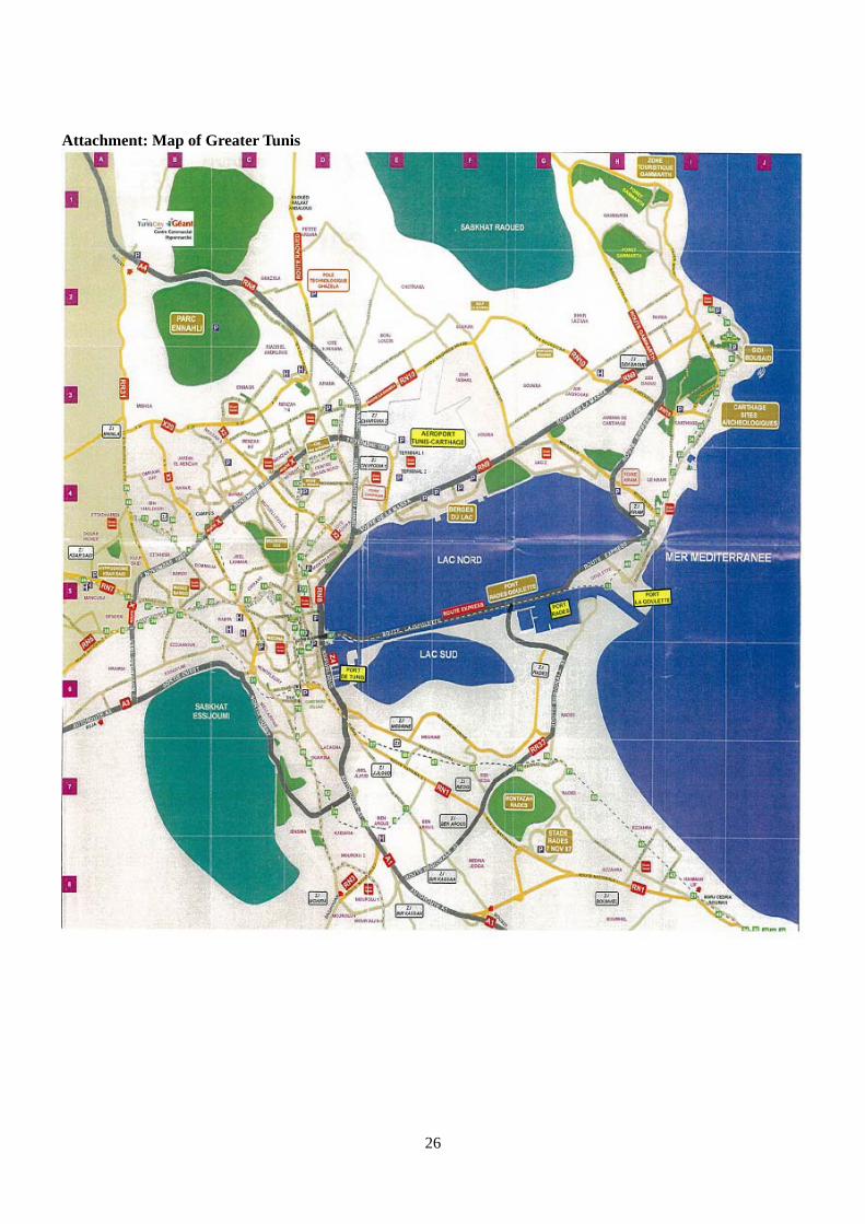
Attachment: Map of Greater Tunis