Embed Size (px)
Citation preview
REPORT
Shom – 13 rue du Chatellier – CS 92803 – 29228 Brest CEDEX 2 BCRM de Brest – Shom – CC 08 – 29240 Brest CEDEX 9 N° SIRET : 130 003 981 000 11
www.shom.fr
MINISTÈRE DES ARMÉES
Direction des missions institutionnelles et des relations internationales Division Relations extérieures
Dossier suivi par l’IPETA Eric Langlois Tél. +33 (1) 53 66 97 81 Mail : [email protected]
BREST, le 30 juin 2017 N° 009 Shom/DMI/REX/NP
FRENCH NATIONAL REPORT
TO THE TO THE 20TH
CONFERENCE OF THE MEDITERRANEAN AND BLACK SEAS
HYDROGRAPHIC COMMISSION
1. Hydrographic Service: General
Following up its targets and performance contract for the 2013-2016 period, Shom is pursuing the
achievement of its different commitments based on the National Maritime Strategy and the Defence Policy
according to a new 4 years target and performance contract covering the 2017-2020 period, which has
recently been approved by Shom’s Executive Board. In addition to that, survey works are being conducted
according to the prioritized 4-years survey plan for all the waters under French jurisdiction.
2. Surveys
2.1. Coverage of new surveys
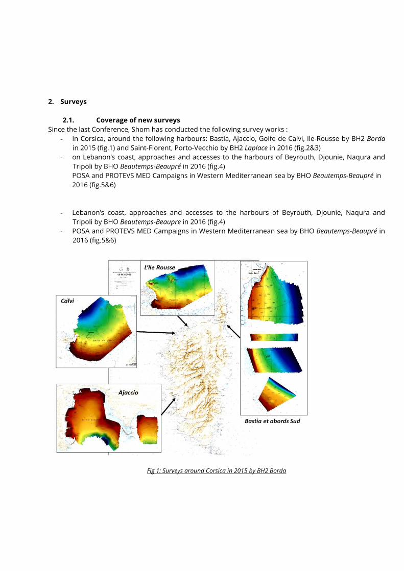
Since the last Conference, Shom has conducted the following survey works :
- In Corsica, around the following harbours: Bastia, Ajaccio, Golfe de Calvi, Ile-Rousse by BH2 Borda
in 2015 (fig.1) and Saint-Florent, Porto-Vecchio by BH2 Laplace in 2016 (fig.2&3)
- on Lebanon’s coast, approaches and accesses to the harbours of Beyrouth, Djounie, Naqura and
Tripoli by BHO Beautemps-Beaupré in 2016 (fig.4)
POSA and PROTEVS MED Campaigns in Western Mediterranean sea by BHO Beautemps-Beaupré in
2016 (fig.5&6)
- Lebanon’s coast, approaches and accesses to the harbours of Beyrouth, Djounie, Naqura and
Tripoli by BHO Beautemps-Beaupre in 2016 (fig.4)
- POSA and PROTEVS MED Campaigns in Western Mediterranean sea by BHO Beautemps-Beaupré in
2016 (fig.5&6)
Fig 1: Surveys around Corsica in 2015 by BH2 Borda
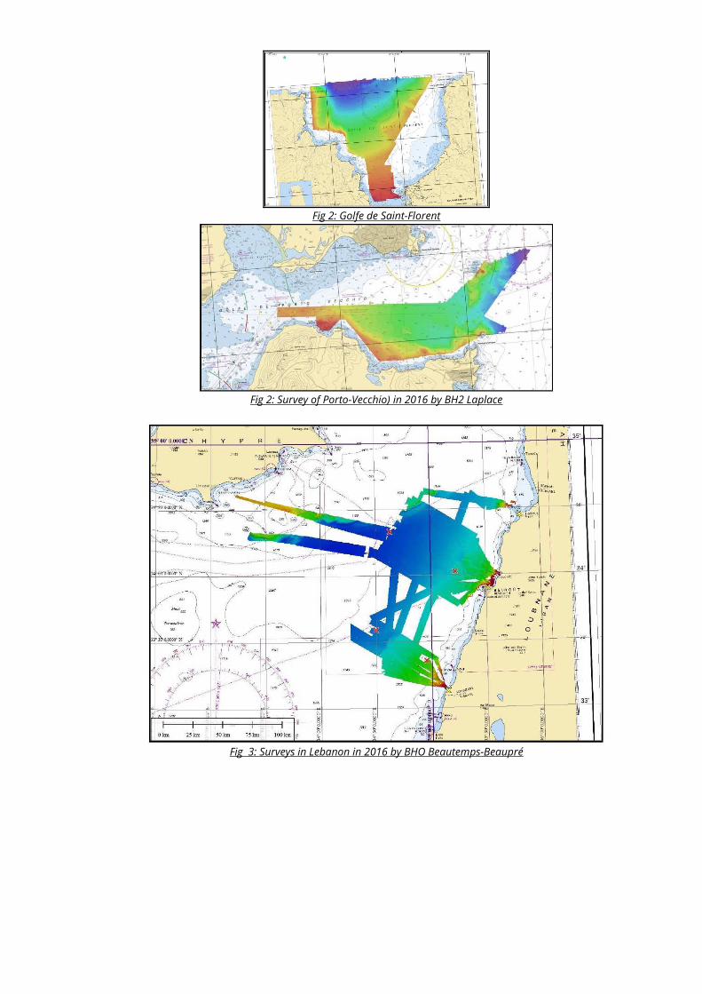
Fig 2: Golfe de Saint-Florent
Fig 2: Survey of Porto-Vecchio) in 2016 by BH2 Laplace
Fig 3: Surveys in Lebanon in 2016 by BHO Beautemps-Beaupré
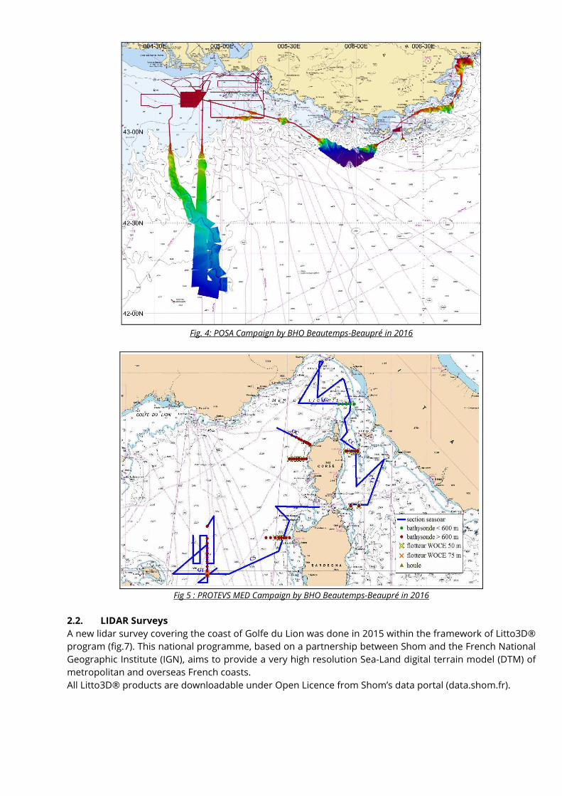
Fig. 4: POSA Campaign by BHO Beautemps-Beaupré in 2016
Fig 5 : PROTEVS MED Campaign by BHO Beautemps-Beaupré in 2016
2.2. LIDAR Surveys
A new lidar survey covering the coast of Golfe du Lion was done in 2015 within the framework of Litto3D®
program (fig.7). This national programme, based on a partnership between Shom and the French National
Geographic Institute (IGN), aims to provide a very high resolution Sea-Land digital terrain model (DTM) of
metropolitan and overseas French coasts.
All Litto3D® products are downloadable under Open Licence from Shom’s data portal (data.shom.fr).
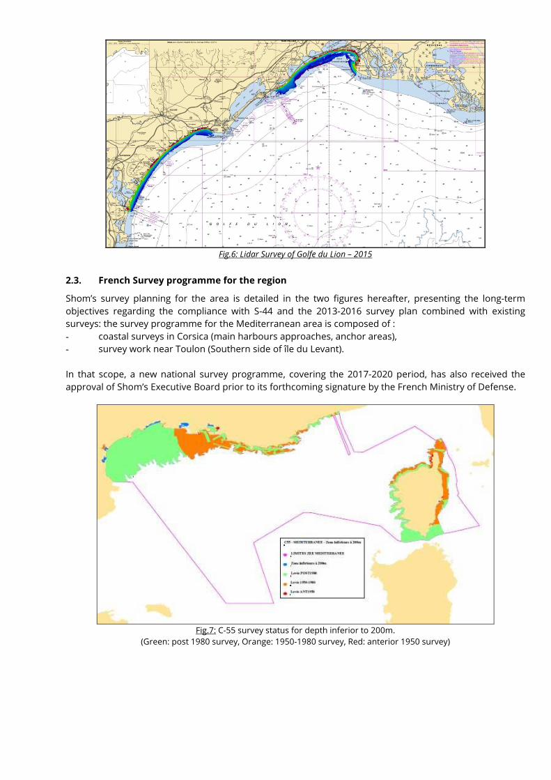
Fig.6: Lidar Survey of Golfe du Lion – 2015
2.3. French Survey programme for the region
Shom’s survey planning for the area is detailed in the two figures hereafter, presenting the long-term
objectives regarding the compliance with S-44 and the 2013-2016 survey plan combined with existing
surveys: the survey programme for the Mediterranean area is composed of :
- coastal surveys in Corsica (main harbours approaches, anchor areas),
- survey work near Toulon (Southern side of île du Levant).
In that scope, a new national survey programme, covering the 2017-2020 period, has also received the
approval of Shom’s Executive Board prior to its forthcoming signature by the French Ministry of Defense.
Fig.7: C-55 survey status for depth inferior to 200m.
(Green: post 1980 survey, Orange: 1950-1980 survey, Red: anterior 1950 survey)
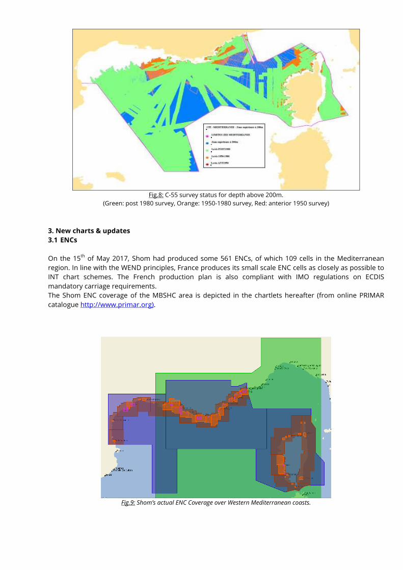
Fig.8: C-55 survey status for depth above 200m.
(Green: post 1980 survey, Orange: 1950-1980 survey, Red: anterior 1950 survey)
3. New charts & updates
3.1 ENCs
On the 15th
of May 2017, Shom had produced some 561 ENCs, of which 109 cells in the Mediterranean
region. In line with the WEND principles, France produces its small scale ENC cells as closely as possible to
INT chart schemes. The French production plan is also compliant with IMO regulations on ECDIS
mandatory carriage requirements.
The Shom ENC coverage of the MBSHC area is depicted in the chartlets hereafter (from online PRIMAR
catalogue http://www.primar.org).
Fig.9: Shom’s actual ENC Coverage over Western Mediterranean coasts.
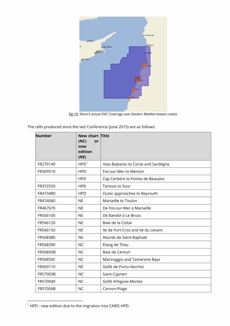
Fig.10: Shom’s actual ENC Coverage over Eastern Mediterranean coasts.
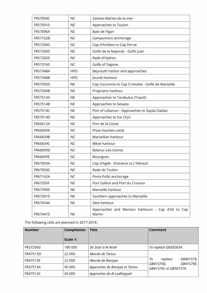
The cells produced since the last Conference (June 2015) are as follows:
Number New chart
(NC) or
new
edition
(NE)
Title
FR270140 HPD1 Islas Baleares to Corse and Sardegna
FR369510 HPD Fos-sur-Mer to Menton
HPD Cap Cerbère to Pointe de Beauduc
FR372550 HPD Tartous to Sour
FR473480 HPD Outer approaches to Beyrouth
FR474060 NE Marseille to Toulon
FR467670 NE De Fos-sur-Mer à Marseille
FR566100 NE De Bandol à Le Brusc
FR566120 NE Baie de la Ciotat
FR566150 NE Ile de Port-Cros and Ile du Levant
FR568380 NE Abords de Saint-Raphaël
FR568390 NC Etang de Thau
FR56850B NC Baie de Centuri
FR56850C NC Macinaggio and Tamarone Bays
FR569110 NE Golfe de Porto-Vecchio
FR57003B NC Saint-Cyprien
FR570040 NC Golfe d'Aigues-Mortes
FR57004B NC Carnon-Plage
1 HPD : new edition due to the migration into CARIS HPD.
FR57004C NC Saintes-Maries-de-la-mer
FR570910 NE Approaches to Toulon
FR57096A NC Baie de Figari
FR57162B NC Campomoro anchorage
FR572000 NC Cap d'Antibes to Cap Ferrat
FR572050 NE Golfe de la Napoule - Golfe Juan
FR572820 NE Rade d'Hyères
FR573160 NC Golfe of Sagone
FR57348A HPD Beyrouth harbor and approaches
FR57348B HPD Jounié Harbour
FR573920 NE Cap Couronne to Cap Croisette - Golfe de Marseille
FR57436B NE Propriano harbour
FR57514A NE Approaches to Tarabulus (Tripoli)
FR57514B NE Approaches to Selaata
FR57514C NE Port of Lebanon - Approaches to Sayda (Saïda)
FR57514D NE Approaches to Sur (Tyr)
FR66612A NE Port de la Ciotat
FR66839A NC Pisse-Saumes canal
FR66839B NC Marseillan harbour
FR66839C NC Mèze harbour
FR66839D NC Balaruc-Les-Usines
FR66839E NC Bouzigues
FR67003A NC Cap d'Agde - Entrance to L'Hérault
FR670930 NE Rade de Toulon
FR67162A NC Porto Pollo anchorage
FR67205F NE Port Gallice and Port du Crouton
FR673900 NE Marseille harbour
FR673910 NE Southern approaches to Marseille
FR67434A NE Sète harbour
FR674410 NE
Approaches and Monaco harbours - Cap d'Ail to Cap
Martin
The following cells are planned in 2017-2018 :
Number Compilation
Scale 1:
Title Comment
FR372560 180 000 De Soûr à Al Arish To replace GB302634.
FR47513D 22 000 Abords de Tartus
To replace GB401579,
GB41579D, GB41579E,
GB41579C et GB501579.
FR47513E 22 000 Abords de Baniyas
FR37513A 90 000 Approches de Baniyas et Tartus
FR47513C 45 000 Approches de Al Ladhiqiyah
FR57513B 12 000 Port de Al Ladhiqiyah
The status of ENC production in the area is :
Usage Band Produced Cells Planned Cells %
1 0 0 /
2 1 1 100,0
3 4 6 66,7
4 22 25 88,0
5 44 83 98,8
6 38
Total 109 115 94,8
3.2. ENC Distribution method
All French ENCs (S-63 encrypted format) are distributed to End User Service Providers by PRIMAR RENC. FR
is providing its support to the IC-ENC-PRIMAR Cooperation Committee working groups to develop a RENC-
to-RENC cooperation concept.
3.3. RNCs
NTR.
3.4. INT charts
See next section for details.
The overall planning of SHOM for INT charts production in the region is as follow:
Scale Produced INT charts Planned INT charts %
Small (<1/1 000 000) 1 1 100
Medium 5 5 100
Large (>1/100 000) 13 17 76,5
Total 19 23 82,6
3.5. National paper charts
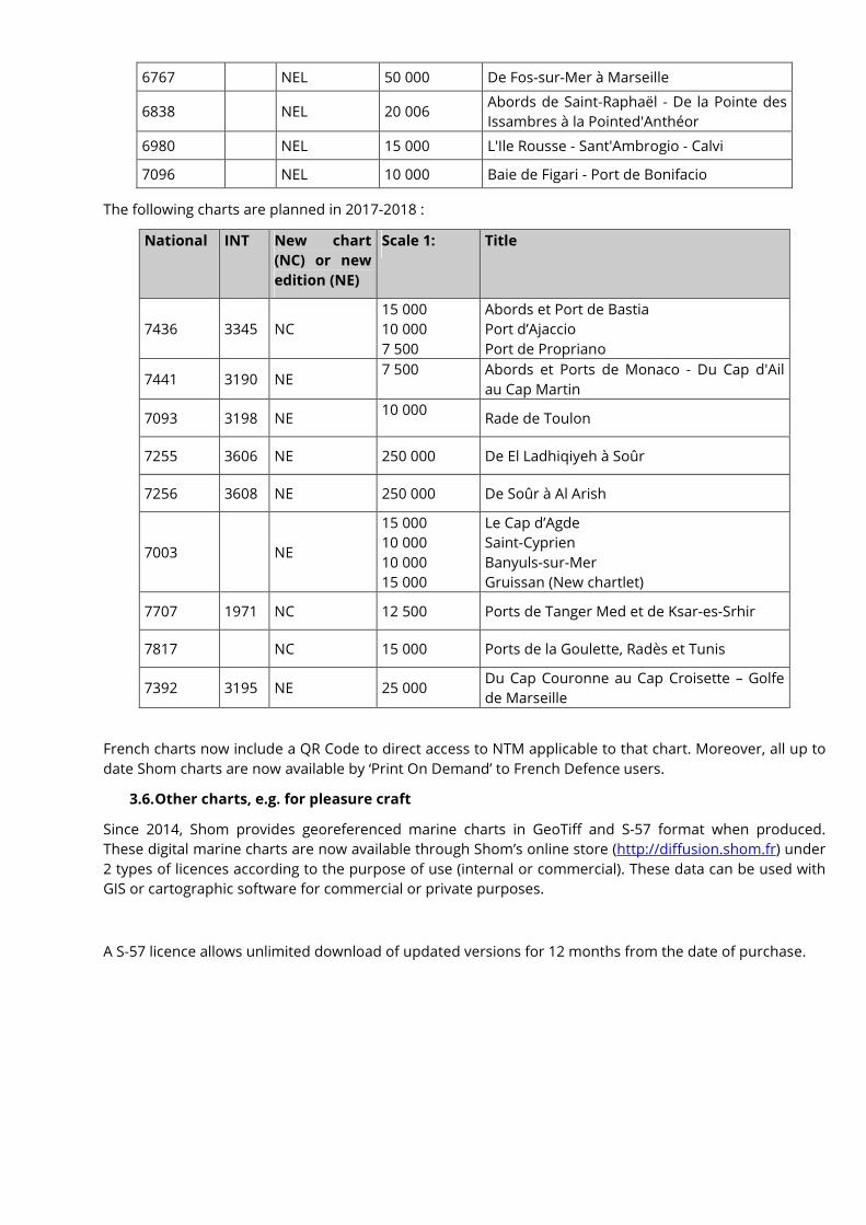
Hereafter the charts produced since the last Conference (June 2015):
National INT
New chart
(NC) or new
edition (NE)
Scale 1 : Title
En 2015
6615 NE 25 000 Iles de Port-Cros et du Levant (Iles d'Hyères)
7282 NE 25 000 Rade d'Hyères
7434 NE 15 000 Ports de Sète, Port-la-Nouvelle, Port-
Vendres et Collioure
6855 NEL 50 000 Du Phare d'Alistro à Solenzara
6911 NEL 15 000 Golfe de Porto-Vecchio
6970 NEL 50 000 De Punta di l'Acciolu à Capo Cavallo
7050 NEL 50 000 De Calvi à Cargèse
7091 NEL 25 000 Abords de Toulon
3024 NEL 100 000 Partie comprise entre le Cap Toukoush et le
Cap Rose
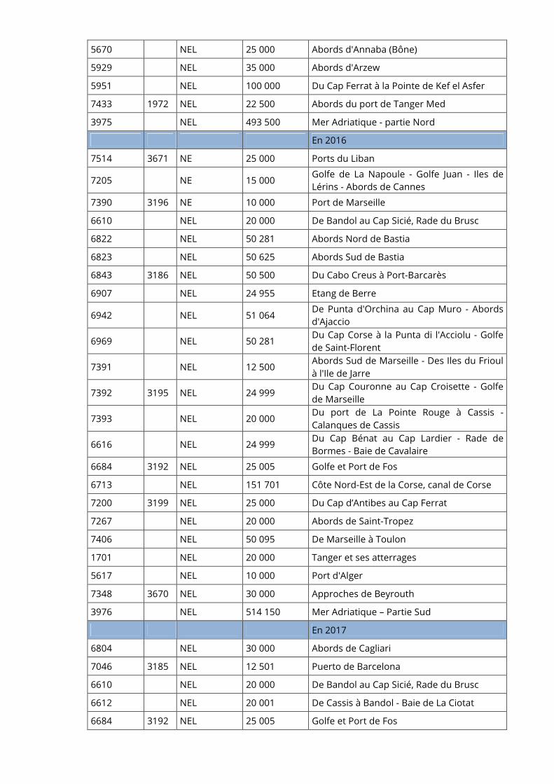
5670 NEL 25 000 Abords d'Annaba (Bône)
5929 NEL 35 000 Abords d'Arzew
5951 NEL 100 000 Du Cap Ferrat à la Pointe de Kef el Asfer
7433 1972 NEL 22 500 Abords du port de Tanger Med
3975 NEL 493 500 Mer Adriatique - partie Nord
En 2016
7514 3671 NE 25 000 Ports du Liban
7205 NE 15 000 Golfe de La Napoule - Golfe Juan - Iles de
Lérins - Abords de Cannes
7390 3196 NE 10 000 Port de Marseille
6610 NEL 20 000 De Bandol au Cap Sicié, Rade du Brusc
6822 NEL 50 281 Abords Nord de Bastia
6823 NEL 50 625 Abords Sud de Bastia
6843 3186 NEL 50 500 Du Cabo Creus à Port-Barcarès
6907 NEL 24 955 Etang de Berre
6942 NEL 51 064 De Punta d'Orchina au Cap Muro - Abords
d'Ajaccio
6969 NEL 50 281 Du Cap Corse à la Punta di l'Acciolu - Golfe
de Saint-Florent
7391 NEL 12 500 Abords Sud de Marseille - Des Iles du Frioul
à l'Ile de Jarre
7392 3195 NEL 24 999 Du Cap Couronne au Cap Croisette - Golfe
de Marseille
7393 NEL 20 000 Du port de La Pointe Rouge à Cassis -
Calanques de Cassis
6616 NEL 24 999 Du Cap Bénat au Cap Lardier - Rade de
Bormes - Baie de Cavalaire
6684 3192 NEL 25 005 Golfe et Port de Fos
6713 NEL 151 701 Côte Nord-Est de la Corse, canal de Corse
7200 3199 NEL 25 000 Du Cap d’Antibes au Cap Ferrat
7267 NEL 20 000 Abords de Saint-Tropez
7406 NEL 50 095 De Marseille à Toulon
1701 NEL 20 000 Tanger et ses atterrages
5617 NEL 10 000 Port d'Alger
7348 3670 NEL 30 000 Approches de Beyrouth
3976 NEL 514 150 Mer Adriatique – Partie Sud
En 2017
6804 NEL 30 000 Abords de Cagliari
7046 3185 NEL 12 501 Puerto de Barcelona
6610 NEL 20 000 De Bandol au Cap Sicié, Rade du Brusc
6612 NEL 20 001 De Cassis à Bandol - Baie de La Ciotat
6684 3192 NEL 25 005 Golfe et Port de Fos
6767 NEL 50 000 De Fos-sur-Mer à Marseille
6838 NEL 20 006 Abords de Saint-Raphaël - De la Pointe des
Issambres à la Pointed'Anthéor
6980 NEL 15 000 L'Ile Rousse - Sant'Ambrogio - Calvi
7096 NEL 10 000 Baie de Figari - Port de Bonifacio
The following charts are planned in 2017-2018 :
National INT New chart
(NC) or new
edition (NE)
Scale 1: Title
7436 3345 NC
15 000
10 000
7 500
Abords et Port de Bastia
Port d’Ajaccio
Port de Propriano
7441 3190 NE 7 500 Abords et Ports de Monaco - Du Cap d'Ail
au Cap Martin
7093 3198 NE 10 000
Rade de Toulon
7255 3606 NE 250 000 De El Ladhiqiyeh à Soûr
7256 3608 NE 250 000 De Soûr à Al Arish
7003 NE
15 000
10 000
10 000
15 000
Le Cap d’Agde
Saint-Cyprien
Banyuls-sur-Mer
Gruissan (New chartlet)
7707 1971 NC 12 500 Ports de Tanger Med et de Ksar-es-Srhir
7817 NC 15 000 Ports de la Goulette, Radès et Tunis
7392 3195 NE 25 000 Du Cap Couronne au Cap Croisette – Golfe
de Marseille
French charts now include a QR Code to direct access to NTM applicable to that chart. Moreover, all up to
date Shom charts are now available by ‘Print On Demand’ to French Defence users.
3.6. Other charts, e.g. for pleasure craft
Since 2014, Shom provides georeferenced marine charts in GeoTiff and S-57 format when produced.
These digital marine charts are now available through Shom’s online store (http://diffusion.shom.fr) under
2 types of licences according to the purpose of use (internal or commercial). These data can be used with
GIS or cartographic software for commercial or private purposes.
A S-57 licence allows unlimited download of updated versions for 12 months from the date of purchase.
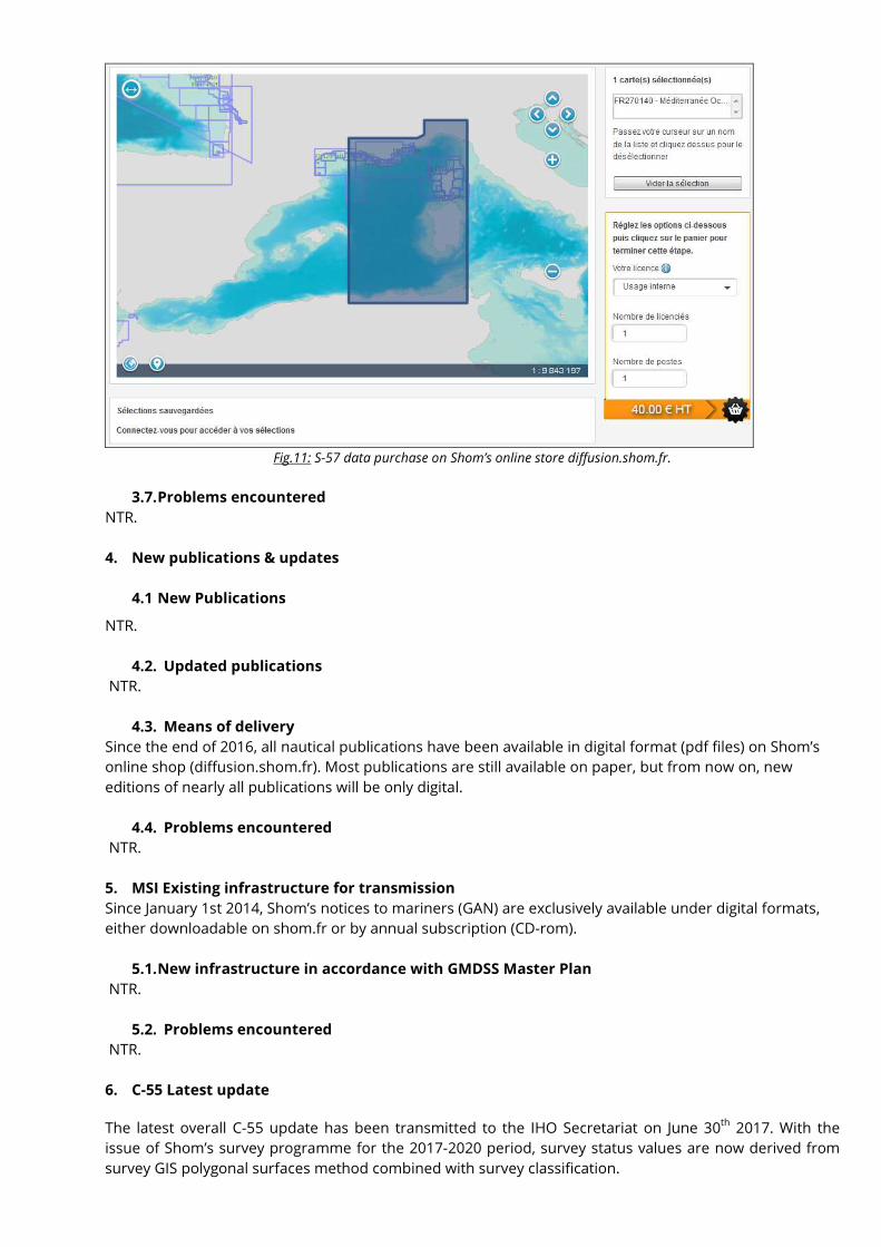
Fig.11: S-57 data purchase on Shom’s online store diffusion.shom.fr.
3.7. Problems encountered
NTR.
4. New publications & updates
4.1 New Publications
NTR.
4.2. Updated publications
NTR.
4.3. Means of delivery
Since the end of 2016, all nautical publications have been available in digital format (pdf files) on Shom’s
online shop (diffusion.shom.fr). Most publications are still available on paper, but from now on, new
editions of nearly all publications will be only digital.
4.4. Problems encountered
NTR.
5. MSI Existing infrastructure for transmission
Since January 1st 2014, Shom’s notices to mariners (GAN) are exclusively available under digital formats,
either downloadable on shom.fr or by annual subscription (CD-rom).
5.1. New infrastructure in accordance with GMDSS Master Plan
NTR.
5.2. Problems encountered
NTR.
6. C-55 Latest update
The latest overall C-55 update has been transmitted to the IHO Secretariat on June 30th
2017. With the
issue of Shom’s survey programme for the 2017-2020 period, survey status values are now derived from
survey GIS polygonal surfaces method combined with survey classification.
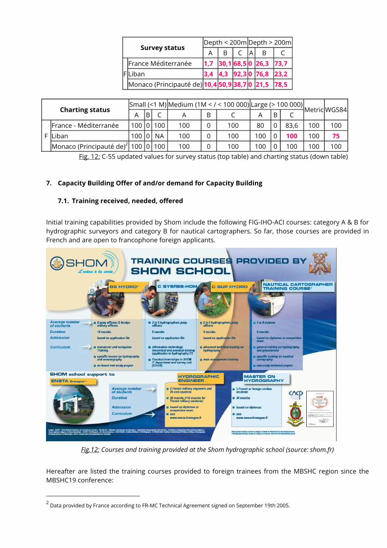
Survey status Depth < 200m Depth > 200m
A B C A B C
F
France Méditerranée 1,7 30,1 68,5 0 26,3 73,7
Liban 3,4 4,3 92,3 0 76,8 23,2
Monaco (Principauté de) 10,4 50,9 38,7 0 21,5 78,5
Charting status Small (<1 M) Medium (1M < / < 100 000) Large (> 100 000)
Metric WGS84 A B C A B C A B C
F
France - Méditerranée 100 0 100 100 0 100 80 0 83,6 100 100
Liban 100 0 NA 100 0 100 100 0 100 100 75
Monaco (Principauté de)2 100 0 100 100 0 100 100 0 100 100 100
Fig. 12: C-55 updated values for survey status (top table) and charting status (down table)
7. Capacity Building Offer of and/or demand for Capacity Building
7.1. Training received, needed, offered
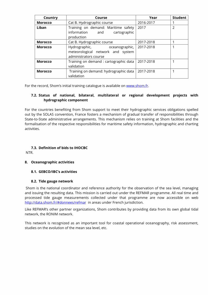
Initial training capabilities provided by Shom include the following FIG-IHO-ACI courses: category A & B for
hydrographic surveyors and category B for nautical cartographers. So far, those courses are provided in
French and are open to francophone foreign applicants.
Fig.12: Courses and training provided at the Shom hydrographic school (source: shom.fr)
Hereafter are listed the training courses provided to foreign trainees from the MBSHC region since the
MBSHC19 conference:
2 Data provided by France according to FR-MC Technical Agreement signed on September 19th 2005.
Country Course Year Student
Morocco Cat B. Hydrographic course 2016-2017 1
Liban Training on demand: Maritime safety
information and cartographic
production
2017 2
Morocco Cat B. Hydrographic course 2017-2018 1
Morocco Hydrographic, oceanographic,
meteorological network and system
administrators course
2017-2018 1
Morocco Training on demand : cartographic data
validation
2017-2018 1
Morocco Training on demand: hydrographic data
validation
2017-2018 1
For the record, Shom’s initial training catalogue is available on www.shom.fr.
7.2. Status of national, bilateral, multilateral or regional development projects with
hydrographic component
For the countries benefiting from Shom support to meet their hydrographic services obligations spelled
out by the SOLAS convention, France fosters a mechanism of gradual transfer of responsibilities through
State-to-State administrative arrangements. This mechanism relies on training at Shom facilities and the
formalisation of the respective responsibilities for maritime safety information, hydrographic and charting
activities.
7.3. Definition of bids to IHOCBC
NTR.
8. Oceanographic activities
8.1. GEBCO/IBC’s activities
8.2. Tide gauge network
Shom is the national coordinator and reference authority for the observation of the sea level, managing
and issuing the resulting data. This mission is carried out under the REFMAR programme. All real time and
processed tide gauge measurements collected under that programme are now accessible on web
http://data.shom.fr/#donnees/refmar in areas under French jurisdiction.
Like REFMAR’s other partner organizations, Shom contributes by providing data from its own global tidal
network, the RONIM network.
This network is recognized as an important tool for coastal operational oceanography, risk assessment,
studies on the evolution of the mean sea level, etc.
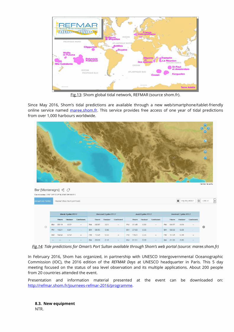
Fig.13: Shom global tidal network, REFMAR (source shom.fr).
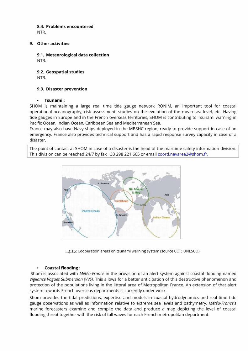
Since May 2016, Shom’s tidal predictions are available through a new web/smartphone/tablet-friendly
online service named maree.shom.fr. This service provides free access of one year of tidal predictions
from over 1,000 harbours worldwide.
Fig.14: Tide predictions for Oman’s Port Sultan available through Shom’s web portal (source: maree.shom.fr)
In February 2016, Shom has organized, in partnership with UNESCO Intergovernmental Oceanographic
Commission (IOC), the 2016 edition of the REFMAR Days at UNESCO headquarter in Paris. This 5 day
meeting focused on the status of sea level observation and its multiple applications. About 200 people
from 20 countries attended the event.
Presentation and information material presented at the event can be downloaded on:
http://refmar.shom.fr/journees-refmar-2016/programme.
8.3. New equipment
NTR.
8.4. Problems encountered
NTR.
9. Other activities
9.1. Meteorological data collection
NTR.
9.2. Geospatial studies
NTR.
9.3. Disaster prevention
• Tsunami :
SHOM is maintaining a large real time tide gauge network RONIM, an important tool for coastal
operational oceanography, risk assessment, studies on the evolution of the mean sea level, etc. Having
tide gauges in Europe and in the French overseas territories, SHOM is contributing to Tsunami warning in
Pacific Ocean, Indian Ocean, Caribbean Sea and Mediterranean Sea.
France may also have Navy ships deployed in the MBSHC region, ready to provide support in case of an
emergency. France also provides technical support and has a rapid response survey capacity in case of a
disaster.
The point of contact at SHOM in case of a disaster is the head of the maritime safety information division.
This division can be reached 24/7 by fax +33 298 221 665 or email [email protected].
Fig.15: Cooperation areas on tsunami warning system (source COI ; UNESCO).
• Coastal flooding :
Shom is associated with Météo-France in the provision of an alert system against coastal flooding named
Vigilance Vagues Submersion (VVS). This allows for a better anticipation of this destructive phenomenon and
protection of the populations living in the littoral area of Metropolitan France. An extension of that alert
system towards French overseas departments is currently under work.
Shom provides the tidal predictions, expertise and models in coastal hydrodynamics and real time tide
gauge observations as well as information relative to extreme sea levels and bathymetry. Météo-France’s
marine forecasters examine and compile the data and produce a map depicting the level of coastal
flooding threat together with the risk of tall waves for each French metropolitan department.
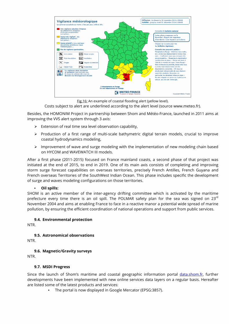
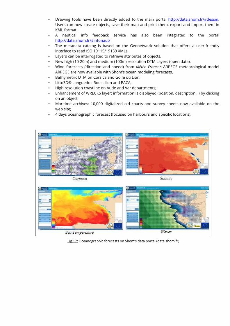
Fig.16: An example of coastal flooding alert (yellow level).
Costs subject to alert are underlined according to the alert level (source www.meteo.fr).
Besides, the HOMONIM Project in partnership between Shom and Météo-France, launched in 2011 aims at
improving the VVS alert system through 3 axis:
� Extension of real time sea level observation capability,
� Production of a first range of multi-scale bathymetric digital terrain models, crucial to improve
coastal hydrodynamics modeling,
� Improvement of wave and surge modeling with the implementation of new modeling chain based
on HYCOM and WAVEWATCH III models.
After a first phase (2011-2015) focused on France mainland coasts, a second phase of that project was
initiated at the end of 2015, to end in 2019. One of its main axis consists of completing and improving
storm surge forecast capabilities on overseas territories, precisely French Antilles, French Guyana and
French overseas Territories of the SouthWest Indian Ocean. This phase includes specific the development
of surge and waves modeling configurations on those territories.
• Oil spills:
SHOM is an active member of the inter-agency drifting committee which is activated by the maritime
prefecture every time there is an oil spill. The POLMAR safety plan for the sea was signed on 23rd
November 2004 and aims at enabling France to face in a reactive manor a potential wide spread of marine
pollution, by ensuring the efficient coordination of national operations and support from public services.
9.4. Environmental protection
NTR.
9.5. Astronomical observations
NTR.
9.6. Magnetic/Gravity surveys
NTR.
9.7. MSDI Progress
Since the launch of Shom’s maritime and coastal geographic information portal data.shom.fr, further
developments have been implemented with new online services data layers on a regular basis. Hereafter
are listed some of the latest products and services:
• The portal is now displayed in Google Mercator (EPSG:3857).
• Drawing tools have been directly added to the main portal http://data.shom.fr/#dessin.
Users can now create objects, save their map and print them, export and import them in
KML format.
• A nautical info feedback service has also been integrated to the portal
http://data.shom.fr/#infonaut/
• The metadata catalog is based on the Geonetwork solution that offers a user-friendly
interface to read ISO 19115/19139 XMLs.
• Layers can be interrogated to retrieve attributes of objects.
• New high (10-20m) and medium (100m) resolution DTM Layers (open data).
• Wind forecasts (direction and speed) from Météo France’s ARPEGE meteorological model
ARPEGE are now available with Shom’s ocean modeling forecasts,
• Bathymetric DTM on Corsica and Golfe du Lion;
• Litto3D® Languedoc-Roussillon and PACA;
• High resolution coastline on Aude and Var departments;
• Enhancement of WRECKS layer: information is displayed (position, description…) by clicking
on an object;
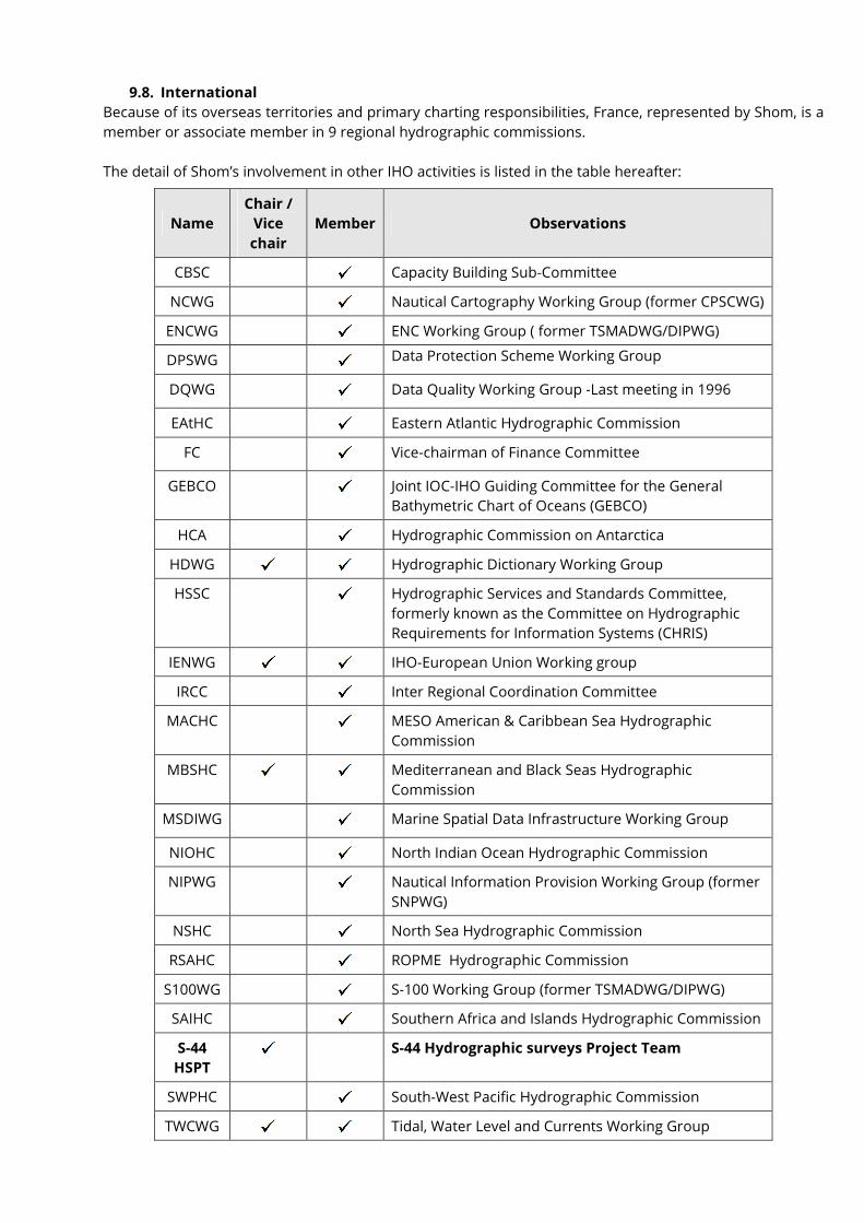
• Maritime archives: 10,000 digitalized old charts and survey sheets now available on the
web site;
• 4 days oceanographic forecast (focused on harbours and specific locations).
Fig.17: Oceanographic forecasts on Shom’s data portal (data.shom.fr)
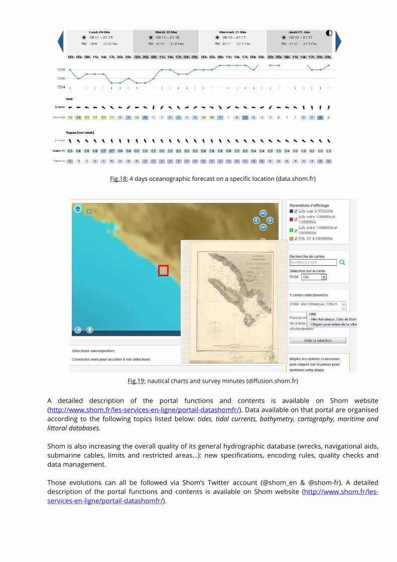
Fig.18: 4 days oceanographic forecast on a specific location (data.shom.fr)
Fig.19: nautical charts and survey minutes (diffusion.shom.fr)
A detailed description of the portal functions and contents is available on Shom website
(http://www.shom.fr/les-services-en-ligne/portail-datashomfr/). Data available on that portal are organised
according to the following topics listed below: tides, tidal currents, bathymetry, cartography, maritime and
littoral databases.
Shom is also increasing the overall quality of its general hydrographic database (wrecks, navigational aids,
submarine cables, limits and restricted areas…): new specifications, encoding rules, quality checks and
data management.
Those evolutions can all be followed via Shom’s Twitter account (@shom_en & @shom-fr). A detailed
description of the portal functions and contents is available on Shom website (http://www.shom.fr/les-
services-en-ligne/portail-datashomfr/).
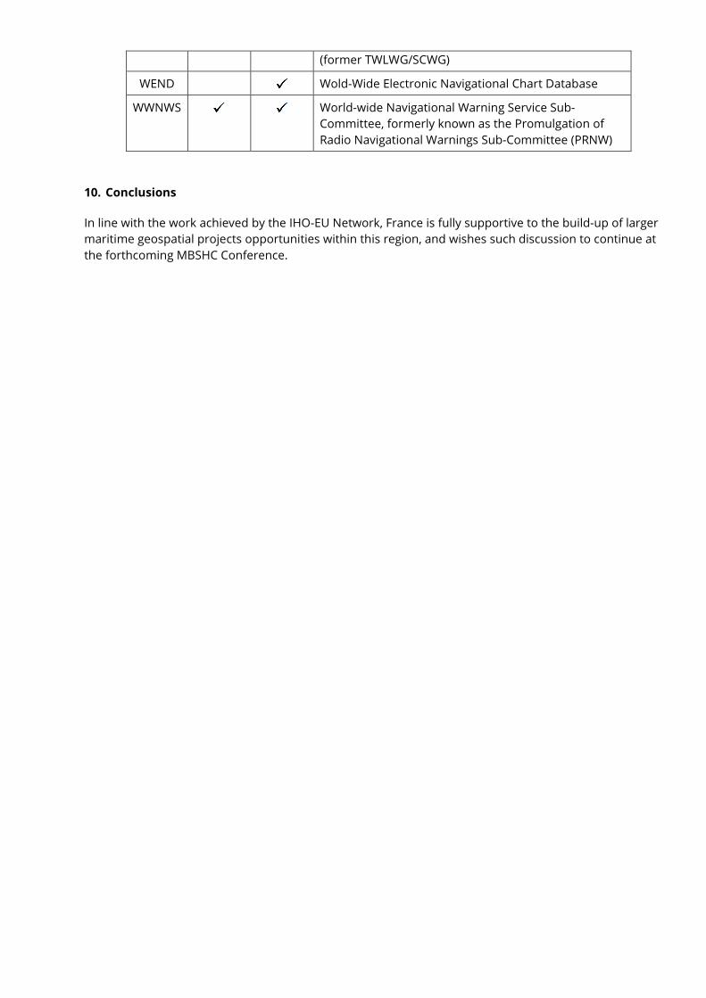
9.8. International
Because of its overseas territories and primary charting responsibilities, France, represented by Shom, is a
member or associate member in 9 regional hydrographic commissions.
The detail of Shom’s involvement in other IHO activities is listed in the table hereafter:
Name
Chair /
Vice
chair
Member Observations
CBSC Capacity Building Sub-Committee
NCWG Nautical Cartography Working Group (former CPSCWG)
ENCWG ENC Working Group ( former TSMADWG/DIPWG)
DPSWG Data Protection Scheme Working Group
DQWG Data Quality Working Group -Last meeting in 1996
EAtHC Eastern Atlantic Hydrographic Commission
FC Vice-chairman of Finance Committee
GEBCO Joint IOC-IHO Guiding Committee for the General
Bathymetric Chart of Oceans (GEBCO)
HCA Hydrographic Commission on Antarctica
HDWG Hydrographic Dictionary Working Group
HSSC Hydrographic Services and Standards Committee,
formerly known as the Committee on Hydrographic
Requirements for Information Systems (CHRIS)
IENWG IHO-European Union Working group
IRCC Inter Regional Coordination Committee
MACHC MESO American & Caribbean Sea Hydrographic
Commission
MBSHC Mediterranean and Black Seas Hydrographic
Commission
MSDIWG Marine Spatial Data Infrastructure Working Group
NIOHC North Indian Ocean Hydrographic Commission
NIPWG Nautical Information Provision Working Group (former
SNPWG)
NSHC North Sea Hydrographic Commission
RSAHC ROPME Hydrographic Commission
S100WG S-100 Working Group (former TSMADWG/DIPWG)
SAIHC Southern Africa and Islands Hydrographic Commission
S-44
HSPT S-44 Hydrographic surveys Project Team
SWPHC South-West Pacific Hydrographic Commission
TWCWG Tidal, Water Level and Currents Working Group
(former TWLWG/SCWG)
WEND Wold-Wide Electronic Navigational Chart Database
WWNWS World-wide Navigational Warning Service Sub-
Committee, formerly known as the Promulgation of
Radio Navigational Warnings Sub-Committee (PRNW)
10. Conclusions
In line with the work achieved by the IHO-EU Network, France is fully supportive to the build-up of larger
maritime geospatial projects opportunities within this region, and wishes such discussion to continue at
the forthcoming MBSHC Conference.
Page 22 sur 22
Destinataire : OHI
Copies intérieures : DG – DMI/REX – Archives (DMIDSD/2.018)