Embed Size (px)
Citation preview
Tel: +27 21 7872412 Fax: +27 21 7872233 Email: [email protected]
South African Navy Hydrographic Office Private Bag X1 Tokai 7966 REPUBLIC OF SOUTH AFRICA
03 February 2017
File ref: FOF/HYD/R/320/19/1
SAIHC Letter No. 1/2017
Mr Thomas Dehling [email protected] Chair of the IHO Capacity Building Sub Committee
Dear Mr Dehling Subject: SAIHC Capacity Building Projects The Southern Africa and Islands Hydrographic Commission, at its last meeting (August 2016, Cape Town, South Africa), considering the IHO CBSC guidelines, approved a Capacity Building Plan which follows as Enclosure 1 to this letter. As can be seen, the SAIHC CB Plan considers the IHO Objectives and Strategic Directions, together with the peculiarities of the SAIHC region. Therefore the derived projects focus on achieving these objectives and are not just desirable events. According to the referred procedures, I submit to the IHO CBSC two projects to be carried out during 2018, which may be found at Enclosure 2. On behalf of the SAIHC membership, may I express my sincere appreciation to the IHO CBSC for the continued support to this Regional Hydrographic Commission.
Yours sincerely
Chairman Southern Africa & Islands Hydrographic Commission (SAIHC)
Copy: IHB Att. Capt Alberto Costa Neves [email protected] Enclosure 1: SAIHC Capacity Building Plan 2: SAIHC Capacity Building Projects
- 2 -
Enclosure 1
INTERNATIONAL HYDROGRAPHIC ORGANIZATION
SOUTHERN AFRICA & ISLANDS HYDROGRAPHIC COMMISSION
CAPACITY BUILDING PLAN
Programme document for the period 2018-2020 1. INTRODUCTION
1.1. Rationale
The Southern Africa & Islands (SAIHC) region contains three of the world’s 64 major large marine ecosystems, the Benguela current, the Agulhas current and the Somali current. Some of the species and habitats of these currents are unique. The main traffic to the west of the region are the routes from ports in NW Africa to the Cape of Good Hope together with the transatlantic routes for traffic between North and South America and the ten ports in this area.
The shipping lanes along the East Africa coast carry over 30% of the world’s crude oil supplies. This region contains thirteen important commercial ports serving as hubs for traffic emanating from, and destined for Europe, Asia, the Americas and the east and western coasts of Africa. In addition to the large cargo ships travelling internationally, many smaller boats serving local needs ply the coastal waters and harbours. Oil and gas exploration programmes operating throughout the region bring additional risks.
For these reasons, it is crucial that SOLAS contracting Governments undertake hydrographic surveys as and when required, that they arrange for the compilation and publication of hydrographic data, the dissemination and keeping up to date of all nautical information necessary for safe navigation.
The IHO Capacity Building Strategy classifies the development of hydrographic
services into three phases:
those which are in Phase 1: Collection and circulation of nautical information, necessary to maintain existing charts and publications up to date;
those which are in Phase 2: Creation of a surveying capability to conduct coastal and offshore projects; and
those which are in Phase 3: Produce paper charts, ENC and publications independently. Coastal/maritime states have certain treaty obligations (SOLAS) placed on them and the IHO/SAIHC effort aims at assisting states in meeting these obligations. To achieve this a national understanding and coordination effort is required noting that: - resources (human, time, finance etc) are limited, consequently prioritization is a fundamental issue; - planning must be realistic; - longer term training such as CAT A or B are not covered because such training is out of the scope of the IHO CB budget.
Nowadays, the rapidly evolving technology has replaced old navigation paradigms and demands continuous investments in education and training so that the Hydrographic Services can continue to provide high quality products and services which satisfy new demands of the maritime community.
SAIHC is aware of its Member States’ efforts to provide quality service to the
international maritime community in order to contribute to the safety and security of navigation and human life at sea as well as the preservation of the environment in its region

- 3 -
and, as part of the IHO community, to contribute to the achievement of the objectives and directions of the Organization.
1.2. Aims and objectives
The aims of the Plan are: a) to train staff, at various levels, to ensure a much needed capability on hydrography
and nautical cartography, particularly after natural disaster or other incidents which could affect water depths in harbours and approaches; and
b) to comply with the IHO resolutions and guidelines regarding hydrographic and nautical cartographic activities.
The medium term objective of this Plan are: a) to ensure a basic level of MSI is established in all coastal states to, produce
Local/Coastal/NAVAREA Warnings, communicate effectively with the charting authority and implement the MSI elements of GMDSS;
The longer term objectives are: a) to instruct staff in the region on the methods of carrying out hydrographic surveys,
to improve safety of navigation through enhanced navigational products; b) to promote the establishment of Hydrographic Services (HS) and the evolution of
CB Phases of the established ones.
1.3. Priorities Despite the breadth of need existing in the Region, for the period of 2018 to 2020,
priorities should be set in the sequence of the following list, the first of which are the highest: 0 - activities which may promote awareness of national hydrographic obligations; 1 - activities which may improve the capacity of existing HS in Phase 1; 2 - activities which may improve the capacity of existing HS in Phase 2; and 3 - activities which may improve the capability of existing HS in Phase 3.
Note the link between the training activities listed in paragraph 2. Activities below, and phases 0 to 3 listed above
The current hydrographic capacity status of countries/territories of the region is in
Annex A.
1.4. Methodology and Procedures This Plan will be reviewed each year, and adjustments made as necessary. Each year the Commission will decide responsibilities for the programmed events of
the subsequent year. The SAIHC Capacity Building Coordinator will send to the Chair, no later than
January 31st of each year details of all planned projects. The projects must be written in the standards established by the IHO CBSC (see Annex B).
Projects supported by IHO CB Fund must follow the IHO CBSC procedures published at the IHO website.
The Chair will check the proposed projects and, if requesting IHO CB Fund support, will send them to the IHO CBSC Chair and Secretary no later than MARCH 15th, otherwise, will take the appropriate action. 2. Activities
Phase Activity Project Objective Target Audience
Technical and Advisory Visits
0.1 High-level visit to governmental authorities
To raise government awareness of their SOLAS treaty obligations
Related Ministries and Heads of

- 4 -
Phase Activity Project Objective Target Audience
National Agencies, particularly governmental decision makers
0.2 Technical assessment and advice visit
Provide advice to identify how coastal states meet their hydrographic and MSI reponsibilities
Maritime Sector National Agencies. Stakeholders and decision makers
0.3 Technical Implementation Visit
To audit the state of recommendations made as a result of previous technical visits
Maritime Sector National Agencies. Stakeholders and decision makers
0.4 Seminar on Raising Awareness of Hydrography
Maritime Sector National Agencies. Stakeholders and decision makers
Technical Workshops, Seminars, Short Courses
1.1 MSI Course (3 days) Training on establishment of MSI structure and basic MSI procedures
To establish a core group of trained persons to deal with MSI
MSI Practioners
1.2 Phase 1 Skills (5 days) An introduction to the assessment and promulgation of navigationally significant data
To provide a core group with the skills and knowledge to assess and promulgate navigationally significant information to the wider maritime community (this course supports the MSI course)
MSI Practioners
1.3 MSI Workshop (3 days) To reinforce the learning at 1.1 above
MSI Practioners
2.1 Basic Hydrographic Survey Course (10 days)
To provide awareness of national hydrography, hydrographic surveying and nautical cartography
Maritime Sector Decision Makers
2.2 Port and Shallow Water Survey Course (5 days)
A workshop to aid exchange of information and ideas about the challenges faced by port and shallow water surveyors in the SAIHC region
Port Surveyors
2.3 MBES Processing (5 days)
To train a group of hydrographic surveyors the techniques required to post-process MBES data
Hydrographic Practioners
2.4 MSDI and Database Management (5 days)
To give participants an understanding of spatial data infrastructures (SDI) including the importance and role of data management and databases
Government Planners
2.5 Tides and Water Level Workshop (5 days)
To provide fundamental knowledge and understanding of tides and water level, and their applications
Hydrographic Practioners

- 5 -
Phase Activity Project Objective Target Audience
for hydrographic surveying and mapping activities
2.6 Seabed Classification Workshop (5 days)
To provide a group of professionals with the skill and knowledge to use acoustic techniques to map extensive seabed surfaces and to determine the products of seabed mapping
Hydrographic Practioners
3.1 Basic ENC and ENC Production course (10 days)
To train a group of professionals with a practical introduction to S-57 data
Cartographic Practioners
3.2 ENC Production and QA (5 days)
To train a group of professionals to verify and validate S-57 data
Cartographic Practioners
4.1 Law of the Sea Workshop (5 days)
To teach participants the basic technical principles applicable to maritime boundary delimitation. The delegates should be from technical hydrographic or cartographic backgrounds
Maritime Sector Decision Makers
4.2 Tsunami inundation mapping workshop (5 days)
To improve the modelling and presentation of regional tsunami inundation maps
Maritime Sector and emergency planning
4.3 Foundation Module of the Marine Cartography & Data Assessment (MCDA) CAT B Course (3 weeks)
To provide participants with the knowledge of cartographic basics covering the underlying details of the nautical chart.
Cartographic Practioners
4.4 Compilation Module of the Marine Cartography & Data Assessment (MCDA) CAT B Course (5 weeks)
A highly practical module where the student will compile into a database all the relevant nautical chart content in compliance with IHO S-57 using CARIS S-57 Composer software.
Cartographic Practioners
4.5 Product Construction Module of the Marine Cartography & Data Assessment (MCDA) CAT B Course (2 weeks)
This module covers the production of an ENC base cell including ENC validation and exchange set creation using CARIS S-57 Composer together with the production of a Paper Chart using CARIS Paper Chart Composer.
Cartographic Practioners
4.6 Data Assessment Module of the Marine Cartography & Data Assessment (MCDA) CAT B Course (3 weeks)
This module focuses on decision making and processing of new information using software and traditional checking processes.
Cartographic Practioners
4.7 Maintenance Module of the Marine Cartography & Data Assessment (MCDA) CAT B Course (2 weeks)
Another highly practical module which features Notice to Mariner updating of digital and paper products together with New Edition maintenance of the ENC and Paper Chart.
Cartographic Practioners
Long Courses and Programmes
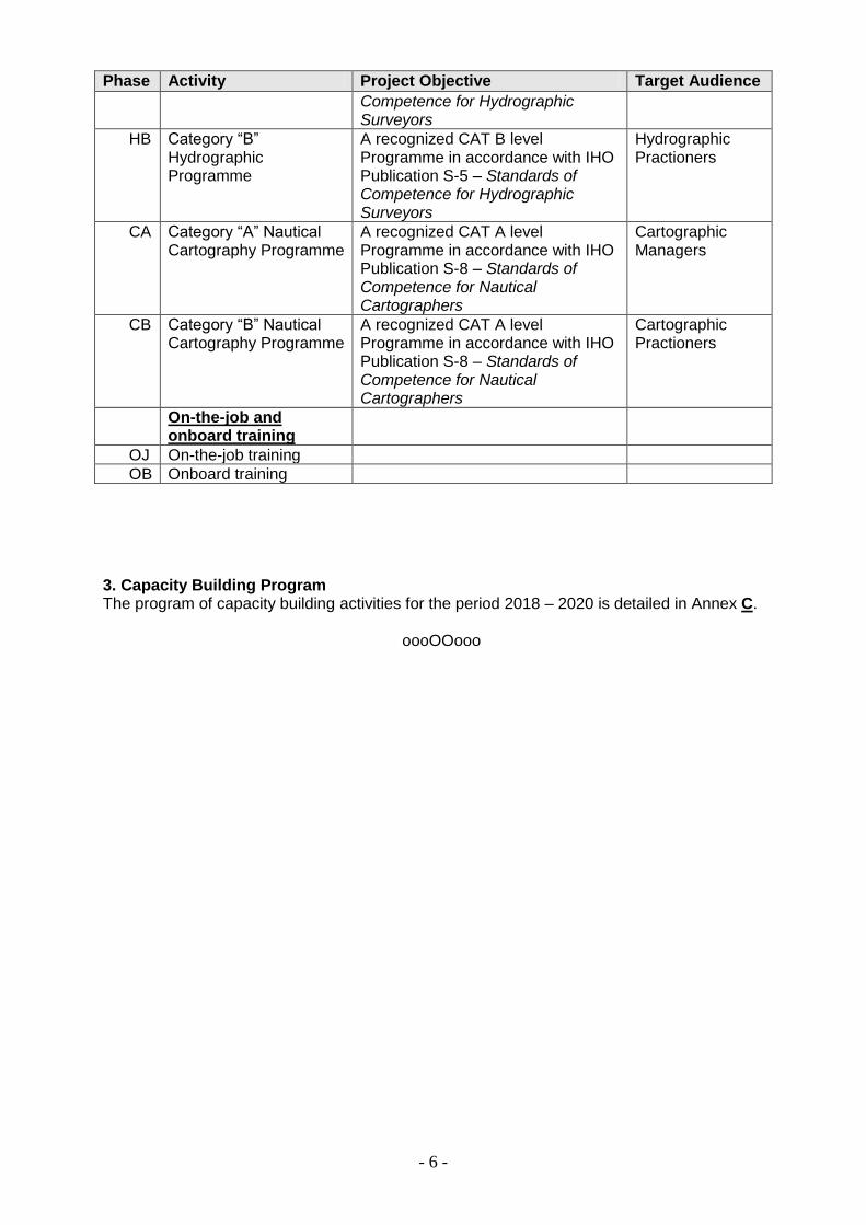
HA Category “A” Hydrographic Programme
A recognized CAT A level Programme in accordance with IHO Publication S-5 – Standards of
Hydrographic Managers
- 6 -
Phase Activity Project Objective Target Audience
Competence for Hydrographic Surveyors
HB Category “B” Hydrographic Programme
A recognized CAT B level Programme in accordance with IHO Publication S-5 – Standards of Competence for Hydrographic Surveyors
Hydrographic Practioners
CA Category “A” Nautical Cartography Programme
A recognized CAT A level Programme in accordance with IHO Publication S-8 – Standards of Competence for Nautical Cartographers
Cartographic Managers
CB Category “B” Nautical Cartography Programme
A recognized CAT A level Programme in accordance with IHO Publication S-8 – Standards of Competence for Nautical Cartographers
Cartographic Practioners
On-the-job and onboard training
OJ On-the-job training
OB Onboard training
3. Capacity Building Program The program of capacity building activities for the period 2018 – 2020 is detailed in Annex C.
oooOOooo

- A-1 -
Annex A to CB Plan
SAIHC Counties/Territories Capacity Building Phase Stage Reference: http://www.iho-ohi.net/mtg_docs/CB/CBA_TechnicalVisits.htm
Country / Territory NHC or NHCC
CB Phase 1
CB Phase
2
CB Phase 3 Last TV
1 Angola -1 1 1 4 2008
2 France 2 3 3 3 N/R
3 Kenya 2 2 2 4 2012
4 Madagascar -1 1 1 4 2011
5 Malawi -1 1 2 3 2011
6 Mauritius -1 2 2 4 2012
7 Mozambique -1 2 3 3 2012
8 Namibia -1 1 1 4 2011
9 Norway 2 3 3 3 N/R
10 Portugal 2 3 3 3 N/R
11 Republic of South Africa 2 3 3 3 N/R
12 Seychelles -1 1 1 4 2012
13 Tanzania 2 1 2 4 2012
14 United Kingdom 2 3 3 3 N/R
15 Comoros -1 1 1 4 2011
KEY
1. The numerical grid below describes the status of the National Hydrographic Committee (NHC)/National Hydrographic Coordination Committee (NHCC):
Value Assessment
-1 No information available
0 The country does not have a NHC/NHCC
1 The country is in the process of establishing a NHC/NHCC
2 The country has established a NHC/NHCC
2. The numerical grid below applies to the Phases:
Value Assessment
-1 No information available
0 The country is unaware of its national obligations
1 The county is aware of its national obligations but does not have the means to do it
2 The country has the ability to fulfil national obligations
3 The country fulfils its national obligations through a third party
4 The country fulfils its national obligations in a sustainable manner
Note: the assessment represented by 3 is an alternative to 4 as explained in the IHO’s Capacity Building Strategy
3. Those coastal states with a mature hydrographic service and consequently don’t require a technical visit are marked as N/R (not required)
- B-1 -
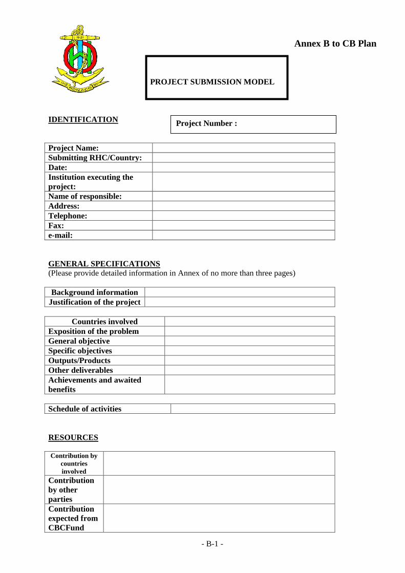
Annex B to CB Plan
PROJECT SUBMISSION MODEL
IDENTIFICATION
Project Name:
Submitting RHC/Country:
Date:
Institution executing the
project:
Name of responsible:
Address:
Telephone:
Fax:
e-mail:
GENERAL SPECIFICATIONS
(Please provide detailed information in Annex of no more than three pages)
Background information
Justification of the project
Countries involved
Exposition of the problem
General objective
Specific objectives
Outputs/Products
Other deliverables
Achievements and awaited
benefits
Schedule of activities
RESOURCES
Contribution by
countries
involved
Contribution
by other
parties
Contribution
expected from
CBCFund
Project Number :

- B-2 -
Total Cost
(euros)
Breakdown of
costs
From CBC
Fund (item
and amount)

- B-3 -
PROJECT SUMMARY
Sponsor
RHC
Year of
Execution
Country/
Countries
involved
Priority/
Status
Project
Name
Project
Objective
Benefits Assistance
required
Cost Allocation and
Priority (to be
filled by CBC)
Contact
Person
Name and Signature of the RHC Chairman ………………………………………….

-4 -
Annex C to CB Plan
Capacity Building Program for the period 2018 – 2020
With two thirds of the SAIHC membership only qualifying for Phase 1 activities (because Phase 2 and 3 activities are designated IHO members only) the SAIHC CB Coordinator will endeavor to identify opportunities for the higher level training and workshops in adjoining regions.
2018
Activity Beneficiaries Countries / Territories
Responsible Period Obs.
Seminar on Raising Awareness of Hydrography
SAIHC Associate and Non Members
SAIHC CB Coordinator
MSDI and Database Management (5 days)
For identified coastal states
SAIHC CB Coordinator
Technical Implementation Visits
For identified coastal states
SAIHC CB Coordinator
2019
Activity Beneficiaries Countries / Territories
Responsible Period Obs.
Technical Implementation Visits
For identified coastal states
SAIHC CB Coordinator
MSI Course (3 days) For identified coastal states
SAIHC CB Coordinator
MBES Processing (5 days)
For identified coastal states
SAIHC CB Coordinator
2020
Activity Beneficiaries Countries / Territories
Responsible Period Obs.
Technical Implementation Visits
For identified coastal states
SAIHC CB Coordinator
Tides and Water Level Workshop (5 days)
For identified coastal states
SAIHC CB Coordinator

Enclosure 2
PROJECT SUBMISSION MODEL
IDENTIFICATION
Project Name: Seminar on Raising Awareness of Hydrography (for
SAIHC Associate and Non Members)
Submitting
RHC/Country:
SAIHC (as part of the approved SAIHC CB Plan)
Date: 2018
Institution executing the
project:
SAIHC/UKHO
Name of responsible: Jeff Bryant, SAIHC CB Coordinator
Address: UKHO, Taunton, Somerset TA1 2DN
Telephone: +44 1823 483821
Fax: N/A
e-mail: [email protected]
GENERAL SPECIFICATIONS
(Please provide detailed information in Annex of no more than three pages)
Background information An awareness of hydrography is missing in many of
the Southern Africa and Islands coastal states. This is
evidenced by the lack of engagement with the RHC
where few, if any, of the Associate member states
attend meetings unless they are sponsored.
Justification of the project It is suggested that a fully-funded seminar or workshop
on hydrographic awareness to precede the next meeting
of the SAIHC would assist in the crucial task of raising
awareness of the subject. It would provide a platform
to get greater involvement from the SAIHC Associate
Members.
Countries involved Angola, Comoros, Kenya, Madagascar, Malawi,
Mauritius, Mozambique, Namibia, Seychelles and
Tanzania
Exposition of the problem The benefits of good hydrography to support all
manner of maritime activity is not well understood at
the higher levels of Government in many SIDS in the
SAIHC region. This manifests itself in the poor
attendance at the Regional Hydrographic Commission
(SAIHC) meetings where such benefits are promoted.
The target audience for an awareness raising seminar
would be Permanent Secretary (or equivalent) level
from a relevant national Ministry, who would then also
attend SAIHC15.
General objective To ensure that countries in the SAIHC region are made
Project Number :

aware that the provision of hydrographic services is an
international obligation under treaty law affecting all
Member States (MS) of the IMO and also provides
significant national infrastructure and long-term
economic benefits. The Seminar is configured to assist
countries on how they take the necessary steps to meet
their obligation noting that most SAIHC countries are
IMO MS but not IHO MS.
Specific objectives To understand the importance of nautical
information
The basic activities of hydrographic offices: the
IHO M-2 publication and how it relates to
National Maritime Policies and Hydrographic
Services
The organization of a National Hydrographic
Office
The application of hydro-cartographic products
and services
Working with a PCA (primary charting
authority)
Outputs/Products Participants will gain a better understanding of the
regulatory framework which supports hydrography and
how this can benefit a coastal state (Blue Economy etc)
Other deliverables Participants will be encouraged to join the IHO
Achievements and
awaited benefits
Schedule of activities 1-day Seminar to proceed the 15th SAIHC meeting,
venue to be decided
RESOURCES
Contribution
by countries
involved
Nil
Contribution
by other
parties
None
Contribution
expected from
CBCFund
Yes
Total Cost
(euros)
€22,500
Breakdown of
costs (subject
to
confirmation)
The contribution from the CBSC fund will cover travel and
subsistence for one representative from each of the 10 countries
involved. The representatives will be expected to stay on for the
15th SAIHC meeting and be active participants - at the very least
delivering a National Report
From CBC
Fund (item
and amount)
€22,500

PROJECT SUBMISSION MODEL
IDENTIFICATION
Project Name: Development of a Regional Marine Spatial Data
Infrastructure (MSDI) Workshop
Submitting
RHC/Country:
SAIHC (as part of the approved SAIHC CB Plan)
Date: 2018
Institution executing the
project:
SAIHC/UKHO
Name of responsible: Jeff Bryant, SAIHC CB Coordinator
Address: UKHO, Taunton, Somerset TA1 2DN
Telephone: +44 1823 337900 x3821
Fax: +44 1823 284077
e-mail: [email protected]
GENERAL SPECIFICATIONS
Background information The IHO definition of Hydrography supports “…marine
activities including economic development, security and
defence, scientific research and environmental protection”.
One of the objectives of the organization identifies the
importance of the development of the sciences in the field of
hydrography and the techniques employed in descriptive
oceanography.
Within the HO community, there remains an incomplete
understanding of the interacting systems and sciences that
operate in the world’s oceans and coastal areas. Pressure is
now growing globally to improve that understanding. This
Workshop approach highlights the relevance of Data
Management “best practice”; a key enabler to MSDI, that
would support development of a framework for Coastal and
Marine Spatial Planning programs (MSP) and other
initiatives at the enterprise, national and/ or regional levels.
It introduces and informs how MSDI inter reacts as a
component within the framework of a National Spatial Data
Infrastructure (NSDI) through the development and later
delivery of a series of global workshops. The workshops
will utilize a panel of recognized leaders and experts in the
various components of MSDI development as well as
expertise and experience in developing NSDI. The
workshops will build on the work undertaken by the
MSDIWG by providing a practical platform of knowledge
transfer to enable MS’s to engage and actively participate in
MSDI and MSP development. In this way the HO
community will be able to inform and shape the way MSDI
is delivered.
Justification of the project Regional and / or National requirement
Project Number :

Countries involved SAIHC Member and Associate States will be beneficiaries
of this workshop
Exposition of the problem Individual Nations cannot fund appropriate staff to
undertake any recognized course just at the time when they
are required to respond to global challenges in the marine
and coastal zone.
General objective There is a particular urgent need to address issues associated
with MSDI in this region due to the conflicting use of the
regional sea space, dwindling resources, lack of up to date
and reliable hydrographic and oceanographic data, the
threats posed by climate change, coastal inundation and the
need for parties to work more closely together to ensure
long term economic and social development and
sustainability at the national and regional level.
The workshop will enhance knowledge, understanding and
confidence by providing delegates with practical insight as
to what measures can be taken to develop and manage an
MSDI framework. It will also provide an insight into what
can be accomplished through development of robust and
active programs of real time data monitoring; data capture
and evaluation, data management, data sharing and
exchange as well as improved access to information to
underpin modeling and visualization of the underwater and
coastal environment. The workshop will develop an
appreciation of what is needed and how to measure and
monitor progress over time against defined achievable goals.
Specific objectives Introduce MSDI to the attending delegates as the marine
component of an SDI and provide practical assistance in
developing capability at the regional and national level.
MSDI encompasses all marine geographic and business
information that supports decision making processes and
asset management.
Outputs/Products Increased and enhanced understanding of MSDI and its
contribution to delivering successful national, regional, and
potentially, global development in the marine space. It will
do this through the provision of knowledge, understanding,
tools and processes, solutions and case studies to better meet
the challenges we all now face..
Other deliverables Creation of a new knowledge base within the IHO
community which MS’s can access and learn from. The
workshop approach will be supported by FIG and IOC.
Achievements and
awaited benefits
Schedule of activities 5 day course
RESOURCES
Contribution by
countries
involved
Venue to be decided at the next SAIHC meeting
Contribution
by other
parties
2 international subject matter experts plus regional representation will be
assembled to provide content preparation, organization, presentation of lectures,
sharing of best practice, delivery of case studies and factual information for the
workshop across the spectrum of MSDI subject areas including Governance,
Data, ICT and Standards. This course will take into account current key global
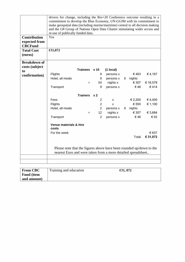
drivers for change, including the Rio+20 Conference outcome resulting in a
commitment to develop the Blue Economy, UN-GGIM with its commitment to
make geospatial data (including marine/maritime) central to all decision making
and the G8 Group of Nations Open Data Charter stimulating wider access and
re-use of publically funded data.
Contribution
expected from
CBCFund
Yes
Total Cost
(euros)
€31,072
Breakdown of
costs (subject
to
confirmation)
Trainees x 10 (1 local)
Flights 9 persons x € 463 € 4,167
Hotel, all meals 9 persons x 6 nights
= 54 nights x € 307 € 16,578
Transport 9 persons x € 46 € 414
Trainers x 2
Fees 2 x € 2,200 € 4,400
Flights 2 x € 550 € 1,100
Hotel, all meals 2 persons x 6 nights
= 12 nights x € 307 € 3,684
Transport 2 persons x € 46 € 92
Venue materials & hire costs
For the week € 637
Total € 31,072
Please note that the figures above have been rounded up/down to the
nearest Euro and were taken from a more detailed spreadsheet..
From CBC
Fund (item
and amount)
Training and education €31, 072
-1 -
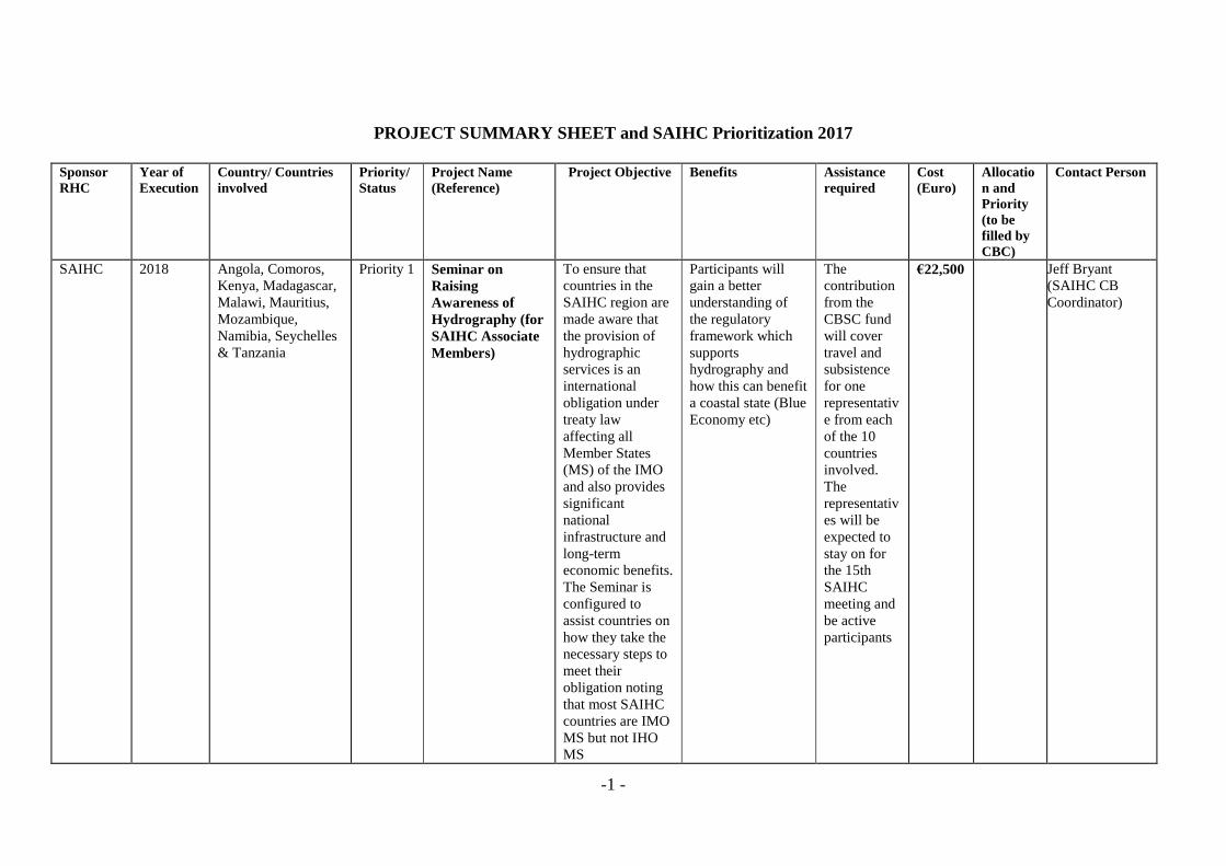
PROJECT SUMMARY SHEET and SAIHC Prioritization 2017
Sponsor
RHC
Year of
Execution
Country/ Countries
involved
Priority/
Status
Project Name
(Reference)
Project Objective Benefits Assistance
required
Cost
(Euro)
Allocatio
n and
Priority
(to be
filled by
CBC)
Contact Person
SAIHC 2018 Angola, Comoros,
Kenya, Madagascar,
Malawi, Mauritius,
Mozambique,
Namibia, Seychelles
& Tanzania
Priority 1 Seminar on
Raising
Awareness of
Hydrography (for
SAIHC Associate
Members)
To ensure that
countries in the
SAIHC region are
made aware that
the provision of
hydrographic
services is an
international
obligation under
treaty law
affecting all
Member States
(MS) of the IMO
and also provides
significant
national
infrastructure and
long-term
economic benefits.
The Seminar is
configured to
assist countries on
how they take the
necessary steps to
meet their
obligation noting
that most SAIHC
countries are IMO
MS but not IHO
MS
Participants will
gain a better
understanding of
the regulatory
framework which
supports
hydrography and
how this can benefit
a coastal state (Blue
Economy etc)
The
contribution
from the
CBSC fund
will cover
travel and
subsistence
for one
representativ
e from each
of the 10
countries
involved.
The
representativ
es will be
expected to
stay on for
the 15th
SAIHC
meeting and
be active
participants
€22,500
Jeff Bryant
(SAIHC CB
Coordinator)

-2 -
SAIHC 2018 Angola, Comoros,
Kenya, Madagascar,
Malawi, Mauritius,
Mozambique,
Namibia, Seychelles
& Tanzania
Priority 2 Development of a
Regional Marine
Spatial Data
Infrastructure
(MSDI)
Workshop
Introduce MSDI to
the attending
delegates as the
marine component
of an SDI and
provide practical
assistance in
developing
capability at the
regional and
national level.
MSDI encompasses
all marine
geographic and
business
information that
supports decision
making processes
and asset
management.
Increased and
enhanced
understanding of
MSDI and its
contribution to
delivering successful
national, regional,
and potentially,
global development
in the marine space.
It will do this
through the provision
of knowledge,
understanding, tools
and processes,
solutions and case
studies to better meet
the challenges we all
now face..
The
contribution
from the
CBSC fund
will cover
travel and
subsistence
for one
representative
from each of
the 10
countries
involved
together with
travel &
subsistence
(and
professional
fees) for x2
instructors
€31,072
Jeff Bryant
(SAIHC CB
Coordinator)
Chairman Southern Africa & Islands Hydrographic Commission (SAIHC)


![IHO S-100: The New IHO Hydrographic Geospatial … hydrographic review may 2009 →iho s-100) iho s-100 [] .Published in: International Hydrographic Review · 2009Authors: Robert Ward](https://img.pdfslide.net/doc/110x75/5ae4a48c7f8b9a495c8ed661/iho-s-100-the-new-iho-hydrographic-geospatial-hydrographic-review-may-2009.jpg)