Embed Size (px)
Citation preview

™
TMTM
™
TMTM
AZ-SG-FLD004-01
04 Geography
This test is now delivered as a computer-based test. See www.aepa.nesinc.com for current program information.

Readers should be advised that this study guide, including many of theexcerpts used herein, is protected by federal copyright law.
Copyright © 2005 by National Evaluation Systems, Inc. (NES®)
"AEPA," "Arizona Educator Proficiency Assessments," and the "AEPA" logo are trademarks ofthe Arizona Department of Education and National Evaluation Systems, Inc. (NES®).
"NES®" and its logo are registered trademarks of National Evaluation Systems, Inc.™

TM
TABLE OF CONTENTSField 04: Geography
PART 1: GENERAL INFORMATION ABOUT THE AEPA AND TEST PREPARATION
AN OVERVIEW OF THE AEPA........................................................................................... 1-1
Test Development ProcessCharacteristics of the AEPATest AdministrationHow AEPA Test Scores Are Computed and Reported
HOW TO PREPARE FOR THE TESTS ................................................................................... 1-3
Study the Test ObjectivesFocus Your StudiesIdentify ResourcesDevelop Study TechniquesAnswer the Practice QuestionsReview the Sample Answer Sheet and Written Response BookletTest DirectionsSample Answer SheetSample Written Response Booklet
WHAT TO EXPECT THE DAY OF THE TEST........................................................................ 1-12
The Morning of the AdministrationAt the Test Site
SAMPLE TEST OBJECTIVES AND QUESTIONS .................................................................. 1-13
Organization of the Test ObjectivesQuestion Formats and StrategiesSelected-Response-Question FormatsPerformance Assignment FormatsEvaluation of the Sample Written Performance Assignment Response
PART 2: FIELD-SPECIFIC INFORMATION
INTRODUCTION ................................................................................................................. 2-1
TEST OBJECTIVES .............................................................................................................. 2-2
PRACTICE QUESTIONS ...................................................................................................... 2-7
ANSWER KEY ..................................................................................................................... 2-18
STUDY GUIDE ORDER FORM

TM
PART 1:GENERAL INFORMATION ABOUTTHE AEPA™ AND TEST PREPARATION
Part 1 of this study guide is contained in a separate PDF file. Click the link below to view orprint this section:
General Information About the AEPA and Test Preparation

Arizona Educator Proficiency Assessments Study Guide 2-1
TM
PART 2:FIELD-SPECIFIC INFORMATIONField 04: Geography
INTRODUCTION
This section includes a list of the test objectives, practice questions, and an answer key for the selected-response questions.
Test objectives. As noted earlier, the test objectives are broad, conceptual statements that reflect theknowledge, skills, and understanding an entry-level educator needs to practice effectively in Arizona schools.The list of test objectives for each test field is the only source of information about what a specific test willcover and therefore should be studied carefully.
Practice questions. The practice selected-response questions and practice performance assignments includedin this section are designed to give you an introduction to the nature of the questions included in the AEPAtests. The practice questions represent the various types of questions you may expect to see on an actual test;however, they are not designed to provide diagnostic information to help you identify specific areas ofindividual strengths and weaknesses or to predict your performance on the test as a whole.
When you answer the practice questions, you may wish to use the sample answer sheet and sample WrittenResponse Booklet provided in Part 1 to acquaint yourself with these materials. Use the answer key locatedafter the practice questions to check your answers. Sample responses are provided immediately followingeach written performance assignment. The sample responses in this guide are for illustrative purposes only.Your written response should be your original work, written in your own words, and not copied orparaphrased from some other work.
To help you identify how the test objectives are measured, the objective statement to which the questioncorresponds is listed in the answer key. When you are finished with the practice questions, you may wish togo back and review the entire list of test objectives and descriptive statements for your test field.

2-2 Arizona Educator Proficiency Assessments Study Guide
TEST OBJECTIVES
Field 04: Geography
SUBAREAS:
1. Geographic Concepts and Skills2. World Geography3. United States and Arizona Geography4. Contemporary Issues and Future Trends
GEOGRAPHIC CONCEPTS AND SKILLS
0001 Understand basic geographic terms, themes, and specialized fields of geography.
For example: defining basic geographic terms and concepts (e.g., habitat, resource, acculturation);relating these terms and concepts to appropriate geographic situations; using the five themes oflocation, place, relationship within places, movement, and region to analyze ecological, economic,social and political relationships and processes; employing basic concepts of geography to analyzethe geographic dimension of human cultures and institutions; and recognizing approaches,techniques, and materials of specialized fields of geography.
0002 Understand how to use maps and globes to answer geographic questions.
For example: demonstrating familiarity with commonly used maps (e.g., political, relief, resource);using latitude and longitude to find places on maps; distinguishing between maps and globes; andrecognizing basic map projections (e.g., Mercator, Robinson).
0003 Understand the basic natural processes that shape the earth.
For example: demonstrating familiarity with the geological processes that alter the earth's surface(e.g., volcanic activity, sedimentation), hydrological processes that circulate moisture and erodelandforms (e.g., evaporation, condensation), atmospheric processes that create weather(e.g., atmospheric pressure, radiation), and biological processes through which living organismsinteract with the physical environment (e.g., the food chain); and using this knowledge to analyzesuch geographic phenomena as continental drift, wind patterns, and the characteristics of particularenvironments and ecosystems.
0004 Understand the relationship of the earth to other bodies in space.
For example: recognizing how the relationship of the earth to other bodies in space is influencedby such physical forces as gravity, inertia, centrifugal force, and radiation; and understanding theseforces and using that knowledge to analyze such phenomena as tidal movements, weather, andseasonal variations in climate and daylight hours.
0005 Understand the interrelationship between geography and history.
For example: recognizing the ways in which the development of human societies has been shapedby environmental influences; examining the impact of technological innovations on human socie-ties and the physical environment (e.g., the internal combustion engine); and analyzing humansources of pollution and the environmental effects of pollution.
Geography
Arizona Educator Proficiency Assessments Study Guide 2-3
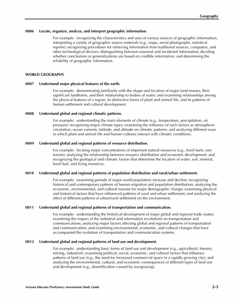
0006 Locate, organize, analyze, and interpret geographic information.
For example: recognizing the characteristics and uses of various sources of geographic information;interpreting a variety of geographic source materials (e.g., maps, aerial photographs, statisticalreports); recognizing procedures for retrieving information from traditional sources, computers, andother technological devices; distinguishing between essential and incidental information; decidingwhether conclusions or generalizations are based on credible information; and determining thereliability of geographic information.
WORLD GEOGRAPHY
0007 Understand major physical features of the earth.
For example: demonstrating familiarity with the shape and location of major land masses, theirsignificant landforms, and their relationship to bodies of water; and examining relationships amongthe physical features of a region, its distinctive forms of plant and animal life, and its patterns ofhuman settlement and cultural development.
0008 Understand global and regional climatic patterns.
For example: understanding the main elements of climate (e.g., temperature, precipitation, airpressure); recognizing major climate types; examining the influence of such factors as atmosphericcirculation, ocean currents, latitude, and altitude on climatic patterns; and analyzing different waysin which plant and animal life and human cultures interact with climatic conditions.
0009 Understand global and regional patterns of resource distribution.
For example: locating major concentrations of important natural resources (e.g., fossil fuels, rainforests); analyzing the relationship between resource distribution and economic development; andrecognizing the geological and climatic factors that determine the location of water, soil, mineral,fossil fuel, and living resources.
0010 Understand global and regional patterns of population distribution and rural/urban settlement.
For example: examining periods of major world population increase and decline; recognizinghistorical and contemporary patterns of human migration and population distribution; analyzing theeconomic, environmental, and cultural reasons for major demographic change; examining physicaland historical factors that have influenced patterns of rural and urban settlement; and analyzing theeffect of different patterns of urban/rural settlement on the environment.
0011 Understand global and regional patterns of transportation and communication.
For example: understanding the historical development of major global and regional trade routes;examining the impact of the industrial and information revolutions on transportation andcommunications; analyzing major factors affecting global and regional patterns of transportationand communication; and examining environmental, economic, and cultural changes that haveaccompanied the evolution of transportation and communication systems.
0012 Understand global and regional patterns of land use and development.
For example: understanding basic forms of land use and development (e.g., agricultural, forestry,mining, industrial); examining political, social, economic, and cultural factors that influencepatterns of land use (e.g., the need for increased commercial space in a rapidly growing city); andanalyzing the environmental, cultural, and economic consequences of different types of land useand development (e.g., desertification caused by overgrazing).
Geography
2-4 Arizona Educator Proficiency Assessments Study Guide
0013 Understand global and regional patterns of culture and society.
For example: demonstrating familiarity with the major cultural groups associated with particularregions and recognizing significant cultural variations within and among the peoples of theseregions (e.g., Jewish and Arab residents of Israel, immigrant populations in the United States);using knowledge of world and regional cultures to analyze interactions of human societies witheach other and with their environments; and understanding how culture and experience influenceperceptions of places and regions.
0014 Understand global and regional patterns of economic self-sufficiency and interdependence.
For example: understanding different types of economies (e.g., capitalist, socialist, mixed);recognizing major patterns of world trade; examining factors encouraging and discouragingeconomic self-sufficiency and interdependence; and analyzing the relationship of economic choicesto issues of resource conservation.
UNITED STATES AND ARIZONA GEOGRAPHY
0015 Understand major climatic and physical features of Arizona and the United States.
For example: identifying major state and national landforms and major rivers and other bodiesof water; recognizing the principal climate and vegetation patterns found within Arizona and theUnited States; and analyzing interactions among physical features, climatic conditions, humancommunities, and regional ecologies.
0016 Understand patterns of natural resource distribution within Arizona and the United States.
For example: identifying major state and national resources; examining geological, climatic, andbiological factors that have influenced the location of resources; analyzing the connection betweenresource distribution and the social, economic, and political development of Arizona and thenation; and examining ways in which natural resources have shaped regional environments withinArizona and the United States.
0017 Understand patterns of population growth, distribution, and movement within Arizona and the UnitedStates.
For example: locating significant areas of historical and contemporary settlement; examiningeconomic, technological, and historical factors that have shaped state and national patterns ofpopulation growth and decline; and analyzing the effects of population change on the physicalenvironment and human communities of Arizona and the United States.
0018 Understand patterns of transportation and communication within Arizona and the United States.
For example: understanding the physical and historical conditions and developments that haveshaped the evolution of transportation and communication systems in Arizona and the UnitedStates; examining the influence of technology on those systems; analyzing the impact of state andnational systems of transportation and communication on human activity and the naturalenvironment; and using this information to examine contemporary problems.
0019 Understand patterns of land use and development within Arizona and the United States.
For example: recognizing basic forms of land use and development within Arizona and the UnitedStates (e.g., residential, agricultural, industrial, commercial); examining physical, historical, andpolitical factors that influence state and national land use decisions; and analyzing theenvironmental, cultural, and economic consequences of regional land use and developmentpatterns.

Geography
Arizona Educator Proficiency Assessments Study Guide 2-5
0020 Understand social, political, and cultural characteristics of Arizona and the United States.
For example: understanding the social, political, economic, and religious principles that haveshaped the culture of Arizona and the United States (e.g., democracy, free enterprise, religiousfreedom); analyzing the structure and functions of the private and public institutions through whichthose principles operate; understanding the impact of those principles and institutions on humanactivity and the environment within Arizona and the United States; demonstrating familiarity withthe racial and ethnic groups in Arizona and U.S. society; analyzing social, political, and culturalinteractions among those groups; and understanding the importance of cultural pluralism in U.S.history.
CONTEMPORARY ISSUES AND FUTURE TRENDS
0021 Understand the relationship of geography to contemporary issues in human-environment interactions.
For example: understanding major issues related to the global environment; analyzing local andnational policies in terms of their global impact on the environment; determining immediate andindirect causes of environmental problems; and predicting possible future effects of existing patternsof environmental destruction and reclamation.
0022 Understand contemporary issues in demographic change and economic development andinterdependence.
For example: examining physical, social, economic, political, and technological factors that affectpopulation growth and movement; evaluating the effects of population growth and decline onecologies, economies, and resources at local, national, and global levels; and analyzing thepotential effects of current economic trends on particular societies, on relations among nations, andon the physical environment.
0023 Understand contemporary issues in energy and resource use.
For example: understanding the global supply and distribution of major natural resources;examining ways in which particular resources are used; analyzing factors that influence demand forresources and energy; evaluating resource and energy policy; and analyzing the effects of varioustypes of resource use on society and the physical environment.
0024 Understand contemporary cultural, ethnic, and geopolitical issues.
For example: demonstrating familiarity with contemporary world events; recognizing ideologicaland military factors influencing recent geopolitical developments; understanding the roles ofnationalism and internationalism in world affairs; evaluating the implications of current geopoliticaltrends (e.g., the redrawing of political boundaries, ethnic conflicts, the emergence of new politicalalignments); and assessing the possible effects of political change on human uses of theenvironment.
Geography
2-6 Arizona Educator Proficiency Assessments Study Guide
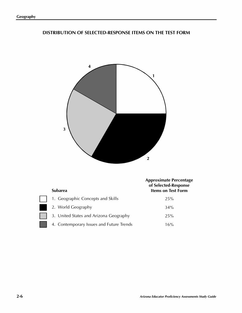
DISTRIBUTION OF SELECTED-RESPONSE ITEMS ON THE TEST FORM
1
4
Subarea
Approximate Percentageof Selected-ResponseItems on Test Form
1. Geographic Concepts and Skills
2. World Geography
3. United States and Arizona Geography
4. Contemporary Issues and Future Trends
25%
34%
25%
16%
2
3

Arizona Educator Proficiency Assessments Study Guide 2-7
PRACTICE QUESTIONS
Field 04: Geography
1. An economic geographer is planninga study to test the validity of the profit-maximization theory of industrial location.The geographer can best ensure the study'scredibility by focusing attention on whichof the following matters when developinga research design?
A. the average distance firms in theresearch sample traveled to relocate
B. the range of industries representedby firms in the research sample
C. the average capitalization of firms inthe research sample
D. the variety of regions represented byfirms in the research sample
2. The theory of plate tectonics can best beused to explain which of the followinggeographic phenomena?
I. the distribution of climate types
II. the growth of continents
III. the location of major mountainranges
IV. the organization of ecosytems
A. I and II only
B. I and IV only
C. II and III only
D. III and IV only
Geography
2-8 Arizona Educator Proficiency Assessments Study Guide
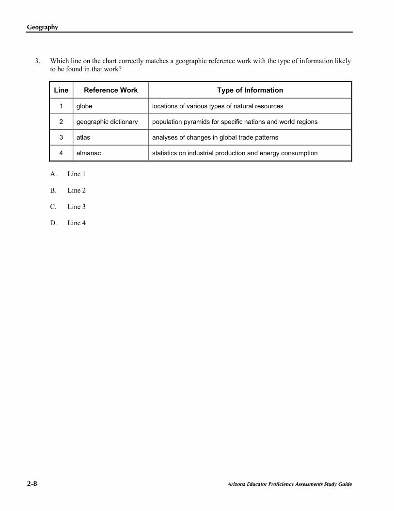
3. Which line on the chart correctly matches a geographic reference work with the type of information likelyto be found in that work?
Line Reference Work Type of Information
1 globe locations of various types of natural resources
2 geographic dictionary population pyramids for specific nations and world regions
3 atlas analyses of changes in global trade patterns
4 almanac statistics on industrial production and energy consumption
A. Line 1
B. Line 2
C. Line 3
D. Line 4

Geography
Arizona Educator Proficiency Assessments Study Guide 2-9
4. Use the passage below aboutaquaculture in Asia to answerthe question that follows.
Throughout Asia, people have long knownthe benefits of aquaculture. Pond farmingtechniques allow traditional mainlandfarmers to raise a rich source of dietaryprotein as well as produce an excellentnatural fertilizer from harvested fishdroppings. In land-poor Japan, theshallow coastal areas become the pond.Today, Japanese farmers of the sea, ormariculturalists, grow increasing amountsof the sea plants and shellfish that are aregular part of the Japanese diet.
The pattern of resource distribution andexploitation described in the passageaffects regional development mainly by:
A. increasing the percentage ofregional income derived fromexportable goods.
B. encouraging economic over-dependence on a single resource.
C. increasing the self-sufficiency ofregional food suppliers.
D. encouraging investment by outsidedevelopers.
5. Because air masses have a limitedcapacity to carry moisture, people livingin which of the following areas are likelyto experience the greatest problemsobtaining sufficient water for supportingplant and animal life?
A. an inland country with much of itsland below sea level
B. a country located in a region withfew forest lands
C. an inland country surrounded bymountains
D. a country located in a middlelatitude temperature zone

Geography
2-10 Arizona Educator Proficiency Assessments Study Guide
6. Which of the following best describes therelationship between resource distribution,economic organization, and politicalauthority in Japan?
A. To prevent shortages of vital rawmaterials, the Japanese governmentregulates the inputs used to producecertain manufactured goods.
B. To ensure a reasonably equitabledistribution of national resources,the Japanese government placessharp limitations on the size andinvestment practices of majoreconomic enterprises.
C. To obtain scarce resources, theJapanese government creates state-run purchasing organizations thatoperate throughout East Asia.
D. To achieve important nationaleconomic aims, the Japanesegovernment helps provideenterprises with the resources toundertake major projects withoutworrying about short-term returns.
7. Two adjoining nations will most oftenbecome economically interdependentwhen:
A. each country specializes in theproduction of different types ofgoods.
B. the labor force of each countryis well educated and highlyproductive.
C. each country has similar topo-graphical conditions and materialresources.
D. the government of each countryis committed to economicdiversification.
8. An individual driving from Kansas City toPhoenix would pass through whichof the following North Americanecosystems?
A. prairie—mountain—desert
B. steppe—mountain—broadleaf forest
C. prairie—broadleaf forest—desert
D. steppe—desert—needle leaf forest

Geography
Arizona Educator Proficiency Assessments Study Guide 2-11
9. Which of the following statements bestdescribes the resource base of the UnitedStates?
A. The United States possessesmajor reserves of important rawmaterials, but the projected costsof extraction are so high that manyof these resources are of limitedvalue.
B. The United States has a broadlydiversified resource base, thoughhigh depletion rates and uncertainenergy prospects could causeproblems in the future.
C. Long-standing disregard for theenvironmental consequences ofeconomic activity has sharplyreduced the U.S. resource baseand made the country almostcompletely dependent on othernations for its raw material needs.
D. Although the United States has arelatively narrow resource base, theraw materials that it does possessare likely to be extremely valuablein a postindustrial economic world.
10. Which of the following factors stronglyinfluenced the patterns of spatial mobilityof African Americans during the first halfof the twentieth century in the UnitedStates?
I. the development of transportationfacilities linking the Southwest tonational markets
II. the mechanization of agriculturaloperations throughout much of theSouth
III. the changing labor needs ofmanufacturing industries in northernindustrial centers
IV. the growing diversification ofeconomic activity along the PacificCoast
A. I and II only
B. I and IV only
C. II and III only
D. III and IV only

Geography
2-12 Arizona Educator Proficiency Assessments Study Guide
11. Which of the following have stronglyinfluenced contemporary land use anddevelopment patterns in the southwesternstates of Arizona, New Mexico, andTexas?
I. ample supplies of coal, iron ore,and other minerals used in manu-facturing industries
II. widespread automobile ownershipto minimize transportation problemsassociated with low-densitysettlement patterns
III. easy access to timber resourcessuitable for use in residentialconstruction
IV. development of ways to makegroundwater resources availablefor crop irrigation and humanconsumption
A. I and III only
B. I and IV only
C. II and III only
D. II and IV only
12. Which of the following contemporaryenvironmental problems poses the greatestthreat to the earth's biological diversity?
A. the pollution of lakes and streamsby the acid rain caused by smokeand soot released from the chimneysof factories and power plants inindustrial nations
B. the destruction of tropical rainforests as a consequence of develop-mental activities in parts of Asia,Africa, and Latin America
C. the inadequacy of the various meansused to dispose of the growingaccumulation of rubbish and solidwastes in urban areas of the UnitedStates and other industrial nations
D. the spread of desertlike landscapesin arid environments as a conse-quence of overgrazing and thedestruction of vegetation

Geography
Arizona Educator Proficiency Assessments Study Guide 2-13
Below are the directions for the Geography performance assignment.
DIRECTIONS FOR THE PERFORMANCE ASSIGNMENT
This section of the test consists of a performance assignment. The assignment can be found on the nextpage. You are asked to prepare a written response of approximately 2–3 pages on the assigned topic. Youshould use your time to plan, write, review, and edit your response for the assignment.
Read the assignment carefully before you begin to work. Think about how you will organize your response.You may use any blank space in this test booklet to make notes, write an outline, or otherwise prepare yourresponse. However, your score will be based solely on the version of your response written in WrittenResponse Booklet B.
As a whole, your response must demonstrate an understanding of the knowledge and skills of the field. Inyour response to the assignment, you are expected to demonstrate the depth of your understanding of thecontent area through your ability to apply your knowledge and skills rather than merely to recite factualinformation.
Your response will be evaluated based on the following criteria.
• PURPOSE: the extent to which the response achieves the purpose of the assignment
• SUBJECT MATTER KNOWLEDGE: accuracy and appropriateness in the application of subjectmatter knowledge
• SUPPORT: quality and relevance of supporting details
• RATIONALE: soundness of argument and degree of understanding of the subject matter
The performance assignment is intended to assess subject knowledge content and skills, not writing ability.However, your response must be communicated clearly enough to permit scorers to make a valid evaluationof your response according to the criteria listed above. Your response should be written for an audience ofeducators in this field. The final version of your response should conform to the conventions of editedAmerican English. This should be your original work, written in your own words, and not copied orparaphrased from some other work.
Be sure to write about the assigned topic. Please write legibly. You may not use any reference materialsduring the test. Remember to review your work and make any changes you think will improve your response.
Geography
2-14 Arizona Educator Proficiency Assessments Study Guide
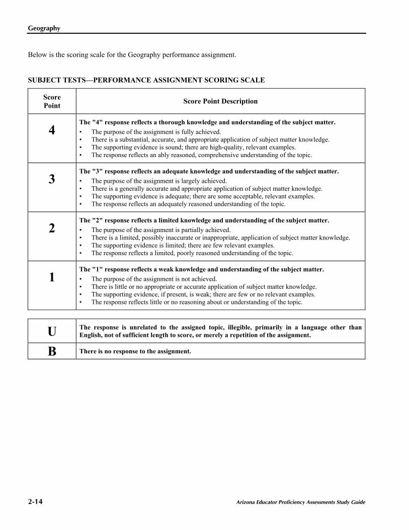
Below is the scoring scale for the Geography performance assignment.
SUBJECT TESTS—PERFORMANCE ASSIGNMENT SCORING SCALE
ScorePoint Score Point Description
4The "4" response reflects a thorough knowledge and understanding of the subject matter.• The purpose of the assignment is fully achieved.• There is a substantial, accurate, and appropriate application of subject matter knowledge.• The supporting evidence is sound; there are high-quality, relevant examples.• The response reflects an ably reasoned, comprehensive understanding of the topic.
3The "3" response reflects an adequate knowledge and understanding of the subject matter.• The purpose of the assignment is largely achieved.• There is a generally accurate and appropriate application of subject matter knowledge.• The supporting evidence is adequate; there are some acceptable, relevant examples.• The response reflects an adequately reasoned understanding of the topic.
2The "2" response reflects a limited knowledge and understanding of the subject matter.• The purpose of the assignment is partially achieved.• There is a limited, possibly inaccurate or inappropriate, application of subject matter knowledge.• The supporting evidence is limited; there are few relevant examples.• The response reflects a limited, poorly reasoned understanding of the topic.
1The "1" response reflects a weak knowledge and understanding of the subject matter.• The purpose of the assignment is not achieved.• There is little or no appropriate or accurate application of subject matter knowledge.• The supporting evidence, if present, is weak; there are few or no relevant examples.• The response reflects little or no reasoning about or understanding of the topic.
U The response is unrelated to the assigned topic, illegible, primarily in a language other thanEnglish, not of sufficient length to score, or merely a repetition of the assignment.
B There is no response to the assignment.

Geography
Arizona Educator Proficiency Assessments Study Guide 2-15
Practice Performance Assignment
13. Read the information below; then complete the exercise that follows.
Throughout history, technological and conceptual advances in geography and cartography have bothresulted from and aided people's efforts to explore regions of the world previously unknown to them.
Using your knowledge of geography, write an essay in which you:
• identify a specific shortcoming in geographic knowledge that became apparent as a result of people'sinterest in exploration; and
• describe a technological or conceptual advance in geography that came about as a result of efforts toovercome the shortcomings.
Geography
2-16 Arizona Educator Proficiency Assessments Study Guide
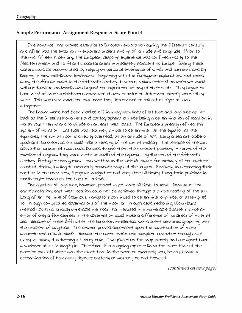
Sample Performance Assignment Response: Score Point 4
One advance that proved essential to European exploration during the fifteenth centuryand after was the evolution in explorers' understanding of latitude and longitude. Prior tothe mid-fifteenth century, the European seagoing experience was confined mostly to theMediterranean and to Atlantic coastal areas immediately adjacent to Europe. Sailing thesewaters could be accomplished by relying on personal experience of winds and currents and bykeeping in view well-known landmarks. Beginning with the Portuguese explorations southwardalong the African coast in the fifteenth century, however, sailors entered an unknown worldwithout familiar landmarks and beyond the experience of any of their pilots. They began tohave need of more sophisticated maps and charts in order to determine exactly where theywere. This was even more the case once they determined to sail out of sight of landaltogether.
The known world had been marked off in imaginary lines of latitude and longitude as farback as the Greek astronomers and cartographers—latitude being a determination of location innorth-south terms and longitude on an east-west basis. The Europeans greatly refined thissystem of notation. Latitude was relatively simple to determine. At the equator at theequinoxes, the sun at noon is directly overhead, at an altitude of 90°. Using a sea astrolabe orquadrant, European sailors could take a reading of the sun at midday. The altitude of the sunabove the horizon at noon could be used to give them their present position, in terms of thenumber of degrees they were north or south of the equator. By the end of the fifteenthcentury, Portuguese navigators had written in the latitude values for virtually all the easterncoast of Africa, leading to extremely accurate maps of this region. Similarly, in determing theirposition in the open seas, European navigators had very little difficulty fixing their positions innorth-south terms on the basis of latitude.
The question of longitude, however, proved much more difficult to solve. Because of theearth's rotation, east-west location could not be achieved through a simple reading of the sun.Long after the time of Columbus, navigators continued to determine longitude, or attemptedto, through complicated observations of the moon or through dead reckoning (Columbus'smethod)—both notoriously unreliable methods that resulted in innumerable disasters, since anerror of only a few degrees in the observation could make a difference of hundreds of miles atsea. Because of these difficulties, the European intellectual world spent centuries grappling withthe problem of longitude. The answer proved dependent upon the construction of moreaccurate and reliable clocks. Because the earth makes one complete revolution through 360°every 24 hours, it is turning 15° every hour. Two places on the map exactly an hour apart havea variance of 15° in longitude. Therefore, if a seagoing explorer knew the exact time of theplace he had left shore and the exact time in the place he currently was, he could make adetermination of how many degrees easterly or westerly he had traveled.
(continued on next page)

Geography
Arizona Educator Proficiency Assessments Study Guide 2-17
Sample Performance Assignment Response: Score Point 4 (continued)
The truth of this proposition had been grasped by certain scientists and inventors, includingGalileo, for a considerable period. The problem boiled down to the lack of a reliable seagoingclock that would keep accurate time during the entire period of a seagoing voyage. Conventionalpendulum and spring models customized for seagoing use proved unable to stand up to therigors of an ocean voyage. The problem was not solved until nearly the eighteenth centurywhen Robert Hooke and later, definitively, John Harrison perfected a portable clock using abalance spring that proved successful. Harrison's model, which was used on a voyage to theNew World around 1760, lost only a few seconds during a voyage of several months, enablingnavigators to plot their longitudinal location within a few minutes or so. In the aftermath ofthis discovery, a line of zero longitude was established at the Royal Observatory in Greenwich,England, and determinations of longitude were subsequently recorded using this point ofreference. With the refinement of their understanding of latitude and longitude, European navigatorswere able to plot their location anywhere on the globe with considerable accuracy. Thistechnological advance made possible the production of the first truly accurate maps of theworld and led, for the first time, to a true understanding of the location of places in the worldand the distances between them.
2-18 Arizona Educator Proficiency Assessments Study Guide
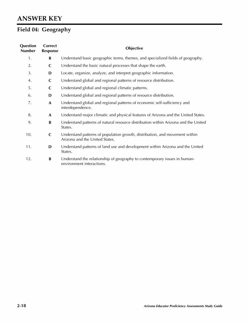
ANSWER KEY
Field 04: Geography
QuestionNumber
CorrectResponse
Objective
1. B Understand basic geographic terms, themes, and specialized fields of geography.
2. C Understand the basic natural processes that shape the earth.
3. D Locate, organize, analyze, and interpret geographic information.
4. C Understand global and regional patterns of resource distribution.
5. C Understand global and regional climatic patterns.
6. D Understand global and regional patterns of resource distribution.
7. A Understand global and regional patterns of economic self-sufficiency andinterdependence.
8. A Understand major climatic and physical features of Arizona and the United States.
9. B Understand patterns of natural resource distribution within Arizona and the UnitedStates.
10. C Understand patterns of population growth, distribution, and movement withinArizona and the United States.
11. D Understand patterns of land use and development within Arizona and the UnitedStates.
12. B Understand the relationship of geography to contemporary issues in human-environment interactions.