Embed Size (px)
Citation preview
Irish National Hydrology Conference 2019 Flynn et al.
04 - SUMMER RAINFALL RUNOFF RELATIONSHIPS FROM
RELATIVELY INTACT IRISH BLANKET PEAT COVERED CATCHMENTS
Raymond Flynn1*, Francis Mackin1,2, Sorcha Cahill1,2, Claire McVeigh1 1School of the Natural and Built Environment, Queen’s University Belfast 2RPS Consulting Engineers, Belfast
Abstract
Widespread, often conflicting, claims exist concerning the capacity of blanket peat covered catchments
to dampen runoff from intense precipitation events in upland areas. Comments abound in scientific and
popular literature, despite limited corroborating data and a poor understanding of the mechanisms
underpinning associated rainfall-runoff responses. This dearth is particularly lacking for areas
displaying little to no impact from human activity.
Monitoring rainfall-runoff responses at the outlet of a 140.9ha relatively intact blanket peat covered
catchment formed part of a holisitic monitoring programme to evaluate the capacity of upland bogs to
buffer against precipitation events. This occurred by continuously monitoring stream discharge with
rainfall, evapotranspiration, groundwater levels and stream water quality between June 2018 and
October 2018.
Much of the earlier half of the monitoring period (to 27th July) proved exceptionally dry. Stream
hydrograph data for the period revealed that base flow recession displayed a broadly log-linear
behaviour below 20litres/sec, although recession proved steeper during higher flows. Over the same
period discharge displayed a remarkably strong inverse relationship with the specific electrical
conductance of stream water, ranging from approximately 40 - 70µS/cm during high flow, to
approximately 300µS/cm during the prolonged base flow period observed to late-July.
Groundwater level data collected over the monitoring period showed that water tables varied
significantly across the catchment, depending strongly on the topographic index of monitoring points.
Although levels broadly followed trends observed in stream discharge, they proved more sensitive to
rainfall events. This is exemplified by rainfall over an eight-day period toward the end of July when
28mm of low intensity prolonged rainfall caused water tables in peat to rise by up to 26cm. Over the
same period neither stream discharge nor water quality displayed any significant response.
By contrast stream discharge and water quality displayed a much closer relationship during the latter
(and wetter) half of the summer. This corresponded to periods when the water table at monitoring points
lay within 20cm of the ground surface. Study results highlight the capacity of blanket peat to store
water that would otherwise lead to runoff. However, responses depend strongly on antecedent
conditions with the water table depths comparable to those observed in mid-July 2018, observed less
than 9.5 ± 4.5% of the time over a longer (three year) monitoring period.
1. INTRODUCTION
Peatlands and peat soils underlie approximately one fifth of the island of Ireland (Holden and Connolly
2011). Of these, upland blanket bogs, in which peat frequently overlies high relief terrain, dominate
upland areas, particularly in the north and west. Although historically considered as low value land, a
more recent appreciation of societal benefits provided through ecosystem services has prompted a
Irish National Hydrology Conference 2019 Flynn et al.
reappraisal of the wider importance of these areas. Services include claims that intact blanket peatlands
can buffer against the impacts intense runoff, thus helping to reduce the risk of downstream flooding.
This in part has led to significant efforts and economic investment to restore upland blanket bog,
particularly across northern and western parts of Great Britain (Wallenge and Holden, 2011, Gao et al.,
2015). These activities have been based on the assumption that restoration to near natural conditions
will allow bogs to act as buffers that limit the effects of intense precipitation on runoff.
Despite the claims concerning the capacity of relatively undamaged blanket bogs to buffer against
flooding, a review of published literature reveals a dearth hydrological data about the hydrological
functioning of streams and rivers draining relatively intact blanket peat-covered catchments. This
information is necessary to provide a baseline against which the efficiency of efforts to restore the
natural functioning of damaged blanket peat-covered catchments may be assessed. To address this issue,
and in part to satisfy EU requirements for the mapping and assessment of ecosystems services (MAES),
the EPA-funded study “Towards the quantification of blanket bog ecosystem services to water
(QUBBES)” aimed to characterise the water quality and flow regimes of streams draining intact blanket
peat covered catchments across Ireland as one of its project goals. This paper describes activity aimed
at characterising the capacity of blanket bog to assist in mitigating against flooding in one of the
project’s study catchments.
2. SITE SELECTION
A review of 341 blanket peat covered catchments, considered most likely to contain significant cover
of intact peat, and completed using recent and historical aerial imagery (Bing Maps, Google Maps)
revealed that all sites investigated display some evidence of physical anthropogenic disturbance; this
considered effects of forestry, peat cutting, overgrazing, and more recently, wind turbine installations
(including access roads). Given the findings, the QUBBES research team focused on those sites
displaying minimal damage, and used this information, in conjunction with details of geological setting,
climate and site accessibility to carry out a multiple criterion analysis to facilitate the selection of three
test sites for detailed investigation. Of these sites, the Northern Ireland Water-owned Garron Plateau
Catchment (Garron) was considered the most intact and ranked as the top site in the selection process.
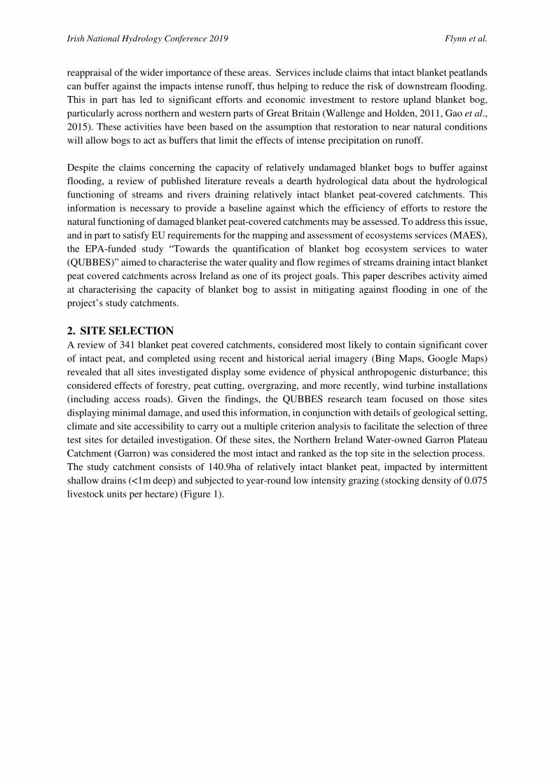
The study catchment consists of 140.9ha of relatively intact blanket peat, impacted by intermittent
shallow drains (<1m deep) and subjected to year-round low intensity grazing (stocking density of 0.075
livestock units per hectare) (Figure 1).
Irish National Hydrology Conference 2019 Flynn et al.
Figure 1: Location map of the Garron Plateau Catchment, Co. Antrim, showing the location of hydrometric
monitoring points and topographic relief superimposed upon hydrological model simulation.
Topography ranges from 431.6mAMSL to 278.7mAMSL with a median height of 338.7mAMSL.
Basaltic bedrock, locally overlain by basalt-rich glacial till underlies the peat. Bedrock outcrop occupies
less than 5% of the area investigated. The Collin Burn stream acts as the focus of drainage for the area.
3. INSTRUMENTATION
Collin Burn discharge, at rates of up to 20l/sec, is diverted to the nearby Dungonnell drinking water
reservoir at the outlet from the study catchment; this occurs after flowing over a compound thin plate
rectangular notch weir; higher flow rates result in excess water being discharged further downstream.
Irish National Hydrology Conference 2019 Flynn et al.
Installation of a submersible pressure transducer (Solinst Levelogger, 1m range), at the weir, permitted
stage measurement at 15-minute intervals over a 2.25-year period, including three summer periods (July
2017 - October 2019). Direct discharge measurements at lower flows, coupled with dilution gauging at
higher flows permitted rating across 98% of the flow range encountered.
Piezometer nests, consisting of 3 - 4 piezometers, installed at six locations determined from a spatially
distributed hydrological model (Mackin et al. 2017), allowed groundwater monitoring in peat (Figure
1). Model outputs suggested that the locations selected reflect the range of hydrogeological conditions
and topographic indices encountered across the site. Water quality monitoring at the weir permitted
measurement of specific electrical conductance (SEC) and temperature at 15-minute intervals, while
monthly 24/7 sampling, using an ISCO autosampler, allowed physical sample collection for more
detailed laboratory analyses.
A Davis portable weather station provided data necessary to determine rainfall and evapotranspiration
on a half hourly basis from 22 July 2018, while 30cm diameter mini lysimeters facilitated determination
of crop factors for representative vegetation communities. In all cases it is noteworthy that the
vegetation encountered was dominated by shallow-rooted vascular plants and mosses, with heather
(Calluna sp.) having the deepest rooting depths of 50cm (Caitriona Douglas, NPWS, pers. comm.).
4. ANALYSIS AND RESULTS
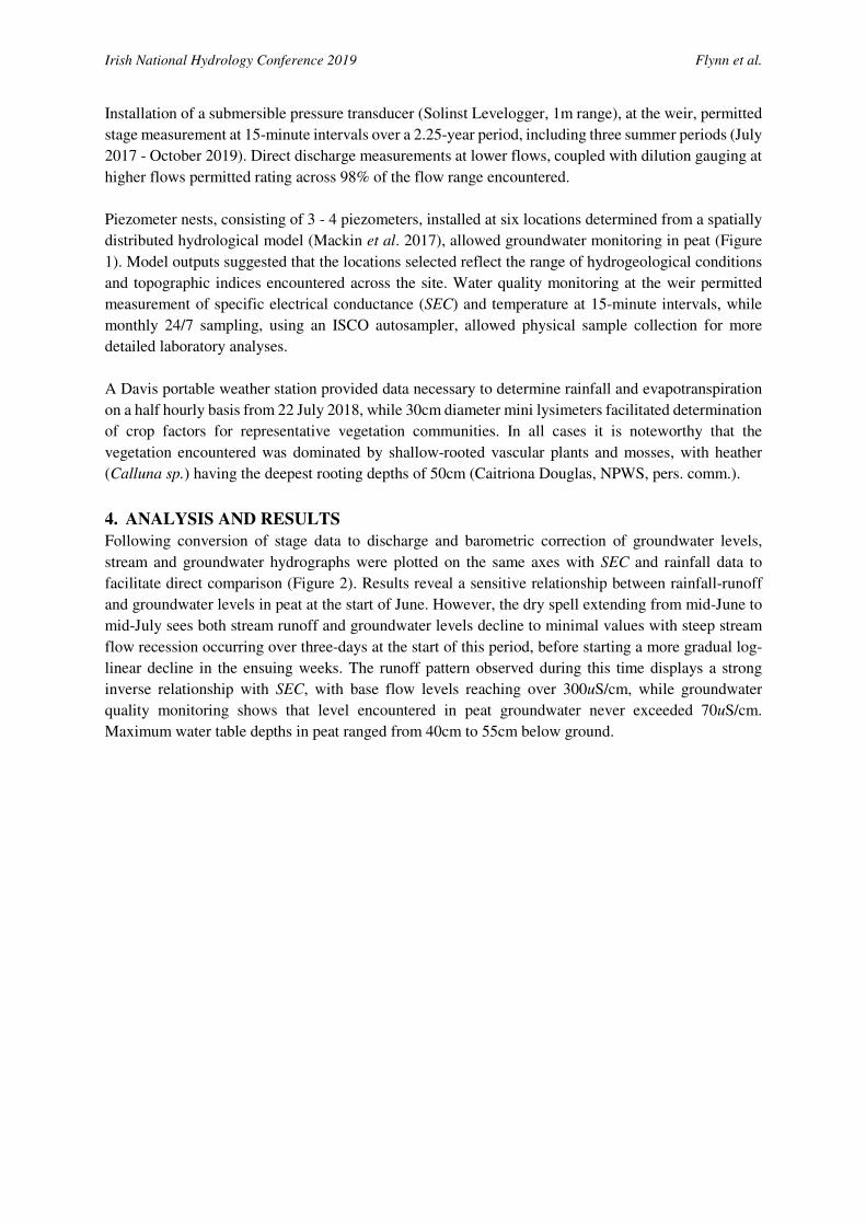
Following conversion of stage data to discharge and barometric correction of groundwater levels,
stream and groundwater hydrographs were plotted on the same axes with SEC and rainfall data to
facilitate direct comparison (Figure 2). Results reveal a sensitive relationship between rainfall-runoff
and groundwater levels in peat at the start of June. However, the dry spell extending from mid-June to
mid-July sees both stream runoff and groundwater levels decline to minimal values with steep stream
flow recession occurring over three-days at the start of this period, before starting a more gradual log-
linear decline in the ensuing weeks. The runoff pattern observed during this time displays a strong
inverse relationship with SEC, with base flow levels reaching over 300uS/cm, while groundwater
quality monitoring shows that level encountered in peat groundwater never exceeded 70uS/cm.
Maximum water table depths in peat ranged from 40cm to 55cm below ground.
Irish National Hydrology Conference 2019 Flynn et al.
Figure 2: Flow, rainfall, specific electrical conductance and groundwater levels generated for the Collin Burn,
Garron Catchment, Co. Antrim from June to October 2018. Above, stream hydrograph, hyteograph and
chemograph; Centre and Bottom, peat groundwater level hydrographs (mBGS: metres below ground surface).
Mid July 2018 witnessed the end of the dry spell. Intermittently intense rainfall resulted in increased in
groundwater levels, whose magnitude varied with hydrological setting, while levels declined at
Irish National Hydrology Conference 2019 Flynn et al.
comparable rates to those in the earlier dry spell; these rises and falls occur despite specific yield data
for lysimeters showing comparable values for each monitoring point, typically between 0.25 and 0.4.
Over the same period no significant increases in stream discharge or SEC occurred.
This regime continued until the final week of July when a prolonged period of intense rainfall, initiated
by 28mm event, saw the restoration of groundwater levels to those observed at the start of the June,
after which the intimate rainfall runoff relationship, observed prior to and following the period of
interest, was re-established.
5. DISCUSSION
The data collected from the Garron during the summer of 2018 reveal that prolonged dry spells can
cause significant declines in blanket bog stream runoff and associated water tables in peat. Outside of
these periods both parameters display an intimate relationship. That the levels observed in June 2018
were rarely observed over the longer 2.25-year monitoring period reflects climatic conditions prevailing
in the Garron Catchment, namely frequent effective rainfall that manages to maintain elevated water
tables in peat. The correspondence between more elevated groundwater levels at many locations and
increased stream discharge, coupled with the inverse relationship between SEC and stream flow reflect
the variable, yet temporally intense contributions of bog water to runoff.
Conversely the significant decline in runoff rate, observed from mid-June to mid-July corresponds to a
period when a significant rise in SEC, to levels exceeding those observed in any samples collected from
in peat piezometers, occurred. This implies that non-peat water with a contrasting chemical signature,
namely higher SEC and pH, also contributed to stream flow. End member mixing analysis indicates that
this contribution remained relatively constant throughout the monitoring period and that the rise in SEC
arises due to declining contributions of lower-SEC bog water. Consequently, the variation in water
quality over the prolonged dry spell suggests that, after short periods, following peak discharge in mid-
June, that runoff derived directly from peat made up a progressively smaller contribution to stream flow
and that the declines in peat water tables over this period must thus be largely attributed to
evapotranspiration.
The resumption of regular, often intense rainfall from mid-July onwards, and the absence of a response
in the runoff record during the days immediately following this, reflect the decline in the moisture
deficit in the peat and highlights the capacity of blanket bog to store water. Critically, once water levels
lay below approximately 20cm below ground surface (BGS) rainfall failed to generate a corresponding
rise in discharge, while above this saw the re-establishment of the previous strong relationship.
Examination of longer-term groundwater data for the full monitoring period reveals that over this time,
levels lay below the 20cm threshold for less than 10% of the time. More critically, during winter
(beginning October to end March) water levels never dropped this low over most of the catchment.
The findings of this study suggest that although relatively intact blanket bog has a significant intrinsic
storage capacity, climatic conditions in which this habitat occurs mean that groundwater levels remain
high over prolonged periods, thus limiting its capacity accommodate significant fresh inputs of water.
As a consequence, relatively intact blanket peat bogs must be considered to have a limited capacity to
buffer against large-magnitude flooding events associated with high and/or prolonged precipitation
events, particularly during winter periods. Any comments concerning their capacity to provide
ecosystem services in this capacity must thus be considered with caution.
Irish National Hydrology Conference 2019 Flynn et al.
ACKNOWLEDGEMENTS
This research was supported by the Environmental Protection Agency (EAP), Grant: Towards
the quantification of blanket bog ecosystems services to water, 2015-NC-MS-5. The opinions
expressed by the authors do not neceessaryily correspond to those of the EPA.
REFERENCES
Holden, Nicholas M., and John Connolly. "Estimating the carbon stock of a blanket peat region using
a peat depth inference model." Catena 86.2 (2011): 75-85.
Gao, Jihui, Joseph Holden, and Mike Kirkby. "A distributed TOPMODEL for modelling impacts of
land�cover change on river flow in upland peatland catchments." Hydrological Processes 29.13
(2015): 2867-2879.
Mackin, F., Flynn, R., Barr, A., & Fernandez-Valverde, F. “Use of geographical information system-
based hydrological modelling for development of a raised bog conservation and restoration
programme.” Ecological Engineering, 106(Part A) (2017), 242-252.
Wallage, Z. E., and J. Holden. "Near�surface macropore flow and saturated hydraulic conductivity in
drained and restored blanket peatlands." Soil Use and Management 27.2 (2011): 247-254.